EDMOND PLANNING COMMISSION 20 S. Littler, Edmond, Oklahoma Tuesday, May 17, :30 p.m.
|
|
|
- Abraham Morton
- 5 years ago
- Views:
Transcription

1 City of Edmond NOTICE OF PUBLIC MEETING The City of Edmond encourages participation from all its citizens. To request an accommodation due to a disability, please allow at least 48 hours prior to the scheduled meeting. Contact the ADA Coordinator by phone: , TDD: , or ADAcoordinator@edmondok.com. Notice: Members of the Planning Commission will gather prior to the regular meeting in the Planning and Public Works Building, Room #127 beginning at 4:55 p.m. this time for dinner. No Planning Commission business will be discussed or acted upon at this time. This is an informal gathering and members of the public and press are welcome to attend. Meals will only be provided to members of the Planning Commission and staff. AGENDA EDMOND PLANNING COMMISSION 20 S. Littler, Edmond, Oklahoma Tuesday, May 17, :30 p.m. CITY COUNCIL WORKSHOP 1. Call to Order: 2. Approval of Minutes: May 3, Case #PR Public Hearing and Consideration of Preliminary Plat for 2nd and Saints Addition, located on the north side of East 2nd Street and east of Saints Boulevard. (St. George Holdings, LLC) 4. Case #Z Public Hearing and Consideration of Edmond Plan Amendment from General Agricultural to Commercial Planned Unit Development ( E-1 Level 1 uses) on 3.21 acres and a change from General Agricultural to Multi-family Residential Planned Unit Development on acres (to include 252 apartments and 70 single family lots) generally located south of Danforth Road and east I-35, north of Arbor Creek Summit. (Danforth Crossing Happy Land, LLC) Continued to the June 7, 2016 Planning Commission meeting. 5. Case #Z Public Hearing and Consideration of Rezoning from G-A General Agricultural to Commercial Planned Unit Development ( E-1 Level 1 uses) on 3.21 acres and rezoning from G-A General Agricultural to Multi-family Residential Planned Unit Development on acres (to include 252 apartments and 70 single family lots) generally located south of Danforth Road and east I-35, north of Arbor Creek Summit. (Danforth Crossing Happy Land, LLC) Continued to the June 7, 2016 Planning Commission meeting. 6. Case #Z Public Hearing and Consideration of Edmond Plan Amendment for Town Square Commons, LLC from Single Family to Residential Planned Unit Development, located north of Danforth Road and one half-mile west of Sooner Road. (Town Square Commons, LLC)
2 7. Case #Z Public Hearing and Consideration of Rezoning from A Single Dwelling to Residential Planned Unit Development, located north of Danforth and one half-mile west of Sooner Road. (Town Square Commons, LLC) 8. Case #ES Public Hearing and Consideration of street easement closing on Skyview Drive, generally located on the west side of the Leawood Addition, one-quarter mile north of Danforth Road, and west of Sooner Road. (Beryl Jones and Timothy McGraw) 9. Case #Z Public Hearing and Consideration of Edmond Plan Amendment from Single Family Planned Unit Development to Commercial PUD located on the northeast corner of Coffee Creek and Douglas Boulevard and the northeast corner of Covell Road and Douglas Boulevard and amending the Edmond Plan from Commercial PUD to Residential PUD, south of Coffee Creek Road, a quarter of a mile east of Douglas Boulevard. (Matt Austin, Woodland Park Edmond, LLC) 10. Case #Z Public Hearing and Consideration of Rezoning from Single Family Planned Unit Development to Commercial PUD located on the northeast corner of Coffee Creek and Douglas Boulevard and the northeast corner of Covell Road and Douglas Boulevard and rezoning from Commercial PUD to Residential PUD, south of Coffee Creek Road, a quarter of a mile east of Douglas Boulevard. (Matt Austin, Woodland Park Edmond, LLC) 11. Case #PR Public Hearing and Consideration of Preliminary Plat approval for the Highgarden Addition Phase 1 with private streets located a one quarter mile south of Sorghum Mill Road and east of Douglas Boulevard. (Highgarden Development, LLC) 12. Case #PR Consideration of Final Plat for The Villas of Edmond located on the east side of Kelly Avenue, a quarter of a mile north of 15th Street. (Philip Patterson) 13. Case #Z Public Hearing and Consideration of Edmond Plan Amendment from Single Family Dwelling District to Restricted Retail Commercial located on the southwest corner of Covell Road and Western Avenue. (Andrew and Teaona Njoo) 14. Case #Z Public Hearing and Consideration of Rezoning from A Single Family Dwelling District to D-1 Restricted Retail Commercial generally located on the southwest corner of Covell Road and Western Avenue. (Andrew and Teaona Njoo) 15. Case #U Public Hearing and Consideration of Specific Use Permit and Case #SP to include a Site Plan, for a Victory Car Wash located at 1101 West Danforth Road. (Muhammad N. Siddiqui) 16. New Business - (In accordance with the Open Meeting Act, new business is defined as any matter not known about or which could not have been reasonably foreseen prior to the time of posting of the agenda.) 17. Adjournment.
3 Planning Commission 2. Meeting Date: 05/17/2016 From: Bob Schiermeyer Department: Planning/Zoning RE: Approval of Minutes: May 3, 2016 Information Minutes Attachments
4 Edmond Planning Commission 75 May 3, 2016 EDMOND PLANNING COMMISSION MEETING Tuesday, May 3, :30 P.M. The Edmond Planning Commission Meeting was called to order by Chairperson Barry K. Moore at 5:30 p.m., Tuesday May 3, 2016, in the City Council Chambers at 20 South Littler. Other members present were Robert Rainey, Bill Moyer, Mark Hoose and Kenneth Wohl. Present for the City were Robert L. Schiermeyer, City Planner; Kristi McCone, City Planner; Steve Manek, City Engineer; and Steve Murdock, City Attorney. The first item on the agenda was the approval of the April 19, 2016 minutes. Motion by Moyer, seconded by Hoose, to approve the minutes as written. Motion carried by a vote of as follows: AYES: Moyer, Hoose and Wohl NAYS: None ABSTAIN: Rainey and Chairperson Moore The next item on the agenda was Case #ES Public Hearing and Consideration of street easement closing on Skyview Drive, generally located on the west side of the Leawood Addition, one-quarter mile north of Danforth Road, and west of Sooner Road. (Beryl Jones and Timothy McGraw) The property owners on the north and south sides of Skyview Drive, west of Leawood Drive, in the Leawood Addition, would like to close the street for public access. There may be a benefit to maintaining a utility easement in the 60 feet of right-of-way for electric distribution, and possible waterline distribution in the future. Leawood residents operate with water wells at this point; someday they may request public waterlines. The area to be closed is 60 feet by 325 feet along the side yards of the applicants properties. A fence may need to be placed on the west end of Skyview Drive, if it is closed, to communicate that the road cannot be used. Edmond Electric does serve this Addition, and there is also phone and gas service. This type of request is not new to the city; there have been numerous streets that have been closed. Francis Tuttle Vo-Tech has purchased 20 acres of land west of Leawood that extends north to the Skyview Drive area. A rezoning application has been submitted by Caleb McCaleb for a single-family development, incorporating some cottage-type zero lot line lots with alleys generally to the west of this location. Some of the previous streets that have been closed include the following: Most Additions that have private streets do not connect, such as Olde Edmond, which could have connected to Town Square, but since the streets were private there is no connection. Walnut Hill Addition, connecting to Iron Horse Ranch, also a private street Addition.
5 Edmond Planning Commission 76 May 3, 2016 Copperfield Addition, south of West Edmond Road, west of Kelly Avenue, connecting with Chisholm Lake, both Public Streets. Woodhill Addition, with acreage lots connecting to the Oak Tree Park Addition at Coffee Creek and Kelly, as well as the Sorghum Mill Addition, also connecting to Oak Tree Park. Thornbrooke Addition, connecting to acreage lots in Old Farm Estates at 33 rd and Bryant. Forest Oaks Addition, connecting to Tall Oaks III, east of Bryant. Bradbury Corner, connecting to Thunderhead Hills. Ketch Acres, connecting to Pebble Creek. The street continuation issue is usually discussed based on private streets developing next to public streets, or where the densities are substantially different on the adjoining areas. Tim McGraw and Beryl Jones were present. Tim McGraw lives at 1609 Leawood Drive and has lived their 6 years. Mr. Beryl Jones has lived in the neighborhood for 15 years. Mr. McGraw spoke indicating that there were several reasons why the street needs to be closed. The lots planned to the west will produce too many vehicles to share the streets with Leawood Addition, which are bar ditch lesser paved streets. With access to Sooner Road and Danforth Road there will be cut through traffic using the Leawood streets, which is dangerous and lessens the standards of the Leawood lots. Another reason against connecting is that water will specifically drain down Skyview Drive, which cannot handle any more water, even with the natural conditions to the west. People walk in the streets because of the bar ditches. Caleb McCaleb who owns the property to the west, planned for an addition called Town Square Commons felt like the item needs to be continued so that the closing could be discussed with the details planned for his project. Beryl Jones also spoke in opposition indicating that all of the roads in the area connecting to Covell Road and Danforth Road are backing up to a critical level in the mornings and evenings. People will definitely cut through the Leawood Addition as an alternative to the congestion. Jay Evans with Francis Tuttle indicated that in working with the public schools there will be students coming from the new high school and since there was a road in place when the 20 acres was purchased they felt that access should remain. He indicated that if there was a need to evacuate the campus the Skyview Drive would be important. Mitch Harris indicated that this was a compatibility issue. The acreage lots in Leawood Addition would be totally incompatible with the development plan to the west, regarding traffic volume, drainage, cut through traffic to both Sooner Road and Danforth Road.
6 Edmond Planning Commission 77 May 3, 2016 The development of the new homes would be appropriate with no access. The runoff from the newly developed property even with detention could affect water well and septic tanks in Leawood Addition. Lugene Jones with the ENA supported the closing indicating that there had been a clear precedent with many similar streets being closed. Dave Clark supported the closing indicating that he has 4½ inches of water on his property on Leawood Drive during the heavy rains with the existing undeveloped conditions. Commissioner Hoose asked if the applicant wanted to continue this project until the next Planning Commission meeting on May 17, Chairman Barry K. Moore felt it was in the best interest to continue to the next Planning Commission meeting. Motion by Rainey, seconded by Wohl, to continue this item to the May 17, 2016 Planning Commission meeting. Motion carried by a vote of 5-0 as follows: AYES: Rainey, Wohl, Moyer, Hoose and Chairperson Moore NAYS: None The next item on the agenda was Case #SP Public Hearing and Consideration of Site Plan approval for a new Braum s restaurant located on the southwest corner of I-35 and Covell Road. (Braum s Ice Cream & Dairy Store) Planning Department 1. Existing zoning E-1 Planned Unit Development 2. Setbacks The front setback is 115 feet from the property line, side set back is 37 feet to the east, the west setback is 68 feet, and the south setback is 42 feet. All the land surrounding the property is commercial and no sensitive border. 3. Height of building One story, 28 feet. 4. Parking The building is 6,059 square feet, 57 parking spaces. Parking can be based on the maximum setting and or square footage. The restaurant is not over parked. Bicycle parking will be provided and Jan Fees will inspect. 5. Lot size 53,750 square feet or 1.23 acres 6. Lighting Plan Light poles will not be any taller than 24 feet tall. Including the base. This area is not a sensitive border. 7. Signage One ground sign 30 feet tall, 75 square feet per side with a stone pole cover. Located on the southeast corner of Market Street and Covell Road. 8. General architectural appearance The Braum s will be combination of brick and stone. Hardie board will be used above the entry and on the tower and will be placed on the canopies. These are masonry panels that are not EIFS. The pole sign will be stone veneer from the ground to the sign. Pole covers exceed
7 Edmond Planning Commission 78 May 3, 2016 code requirement. The Hardie board is less than 15% of the extension wall surface. 9. Sensitive borders N/A 10. Mechanical equipment Located on the roof, screened by a parapet wall. 11. Fencing/screening Not required, except for the dumpster location. Engineering Department 12. Driveways, access management and paving All the driveways have been approved. There is a street to the west called Market Street and a street to the east called Exchange Drive. ODOT has delayed the Covell paving bid until April on the Covell improvements. 13. Water and wastewater plans Sewer and water lines are already installed. The property is platted as the Cross Timbers Park Southwest. 14. Drainage, detention and grading Drainage is being installed to the north, offsite as originally planned. Building and Fire Code Services Project is compliant with all building codes. Dimensions-Fire apparatus access roads shall have an unobstructed width of not less than 20 feet, the closest edge of which must be at least 10 feet from the building, except for approved security gates in accordance with Section 503.6, and an unobstructed vertical clearance of not less than 14 feet. Surface-Fire apparatus access roads shall be designed and maintained to support the imposed loads of fire apparatus and shall be surfaced so as to provide hard surface allweather driving capabilities. Such access roads shall be complete before construction progresses to the first use of combustible materials. Grade-Fire apparatus access roads shall not exceed eight percent in grade. Exception: Grades steeper than eight percent as approved by the Fire Chief. Access road width with a hydrant-where a fire hydrant is located on a fire apparatus access road, the minimum road width shall be 26 feet, exclusive of shoulders. Plans do not show fire hydrant locations. The building is to be equipped with an automatic sprinkler system. Landscaping/Urban Forestry
8 Edmond Planning Commission 79 May 3, Lot area = 52,802 sf % required = 15 Landscape area required: 7,812.3 SP Landscape area: 9,146 Frontage area required: 3,906 SP Frontage area: 9,146 Total PU required: 1,250 SP Total PU: 2,036 PU within frontage required: 625 SP PU within frontage: 2,036 Evergreen PU required: 500 SP Evergreen PU: Solid Waste Department Dumpster location is on the southwest corner of the property fully screened. 17. Edmond Electric Department Edmond Electric will serve. Mr. Harris Wilson with Braum s was in attendance. Lugene Jones with the ENA requested additional redbuds on site. Motion by Hoose, seconded by Rainey, to approve this request as submitted. Motion carried by a vote of 5-0 as follows: AYES: Hoose, Rainey, Moyer, Wohl and Chairperson Moore NAYS: None The next item on the agenda was Case # PR Consideration of Final Plat for Ferrell-Johnson Wealth Management located on the east side Bryant Avenue, one eight-mile south of 9 th Street. (Ferrell-Johnson Properties LLC) Engineer Keith Beaty is representing the applicant requesting that the 1.08 acre plat located north of the Convention and Visitors Bureau, south of Gourley Masters Medical Office on the east side of Bryant be approved for an office development. The owners are considering if they want to build one building or two buildings but the subdivision improvements including water, sewer, and water detention can be reviewed with the plat. The applicant has already been to the City Council for a driveway variance since the property only contains 110 foot of frontage on Bryant. The right-of-way required by the Master Transportation Plan is being provided and the driveway variance was approved. The owners are considering connecting to the Convention and Visitors Bureau parking lot Hafer Park is located to the east along a tributary of Spring Creek. Easements are being provided with the plat. Keith Beatty represented the applicant. Motion by Moyer, seconded by Wohl, to approve this request. Motion carried by a vote of 5-0 as follows: AYES: Moyer, Wohl, Hoose, Moyer and Chairperson Moore NAYS: None
9 Edmond Planning Commission 80 May 3, 2016 The next item on the agenda was Case #SP Public Hearing and Consideration of Site Plan approval for Market Square II located on the south side of Covell Road and south of Mitch Park. (Covell & Kelly Group, LLC) Keith Beatty is requesting site plan approval. This project includes two buildings, one 5,460 square foot building The Garage Restaurant located south of the Qdoba Restaurant and west of the Uptown Market. The other building located east of Damon Johnson DDS, south of Covell is a shopping center type building that may include 8 tenants. This building is west of Qdoba Restaurant. Hopefully all the parking lots interconnect along with the driveway along Covell which enhances the circulation for the Planned Unit Development. The strip center contains 16, 381 square feet. This site plan contains both of these buildings. Planning Department 1. Existing zoning E-2 Open Display PUD 2. Setbacks Front setback on Covell is 82 feet, setback to the west next to Damon Johnson DDS is 53 feet, and setback to the south is 125 feet. This area is not in a sensitive border condition. The Garage is sitting near the drive west of Uptown market and the plan is fully compliant. 3. Height of building 30 feet, at the highest peak. 4. Parking 178 spaces are provided, anticipating more restaurants in the strip shopping center in addition to the free standing The Garage Restaurant. The project is not over parked. Bicycle parking has been provided and will be inspected by Jan Fees. 5. Lot size 112,547 square feet or 2.58 acres 6. Lighting Plan Same lighting as existing the Covell Village PUD. 7. Signage The Garage Restaurant will qualify for a sign 6 feet tall and 42 square foot sign. The shopping center will also qualify for a 6 foot tall and 42 square foot sign. Other businesses in the area such as Damon Johnson and Uptown Market have requested variances to install the signs in the right-of-way. A sign variance is not part of this request, at this time, it would be consistent to consider an equivalent variance approved in the past. 8. General architectural appearance Both buildings will be brick veneer on all four sides. The exterior will be similar to the Covell Village project. EIFS trim materials will be used. 9. Sensitive borders N/A
10 Edmond Planning Commission 81 May 3, Mechanical equipment Equipment will be located on the roof and will need to be screened by a parapet wall. The Peperoni Grill provides a good example of the height of the parapet wall for effective screening. 11. Fencing/screening No screening needed except for the dumpsters Engineering Department 12. Driveways, access management and paving A driveway variance has been approved by the City Council for a drive on the west side of the property. 13. Water and wastewater plans The property is platted as the Market Square II at Covell Village, water and sewer are connected for individual service. Now that buildings are identified some additional utilities may be needed particularly for fire protection. 14. Drainage, detention and grading - This is completed on an area wide basis for the Covell Village PUD Building and Fire Code Services Project is compliant Building will be fire sprinkled. Hydrants adequate Fire department access adequate 15. Applicable Building Code, Fire Code Landscaping/Urban Forestry 16. Lot area = 112,547sf % required = 10 Landscape area required: SP Landscape area: 11,963 Frontage area required: 5,627 SP Frontage area: 6,415 Total PU required: 900 SP Total PU: 911 PU within frontage required: 450 SP PU within frontage: 450 Evergreen PU required: 360 SP Evergreen PU: Solid Waste Department The dumpster location for the shopping center is accessed from the west driveway. There will be shared dumpsters for the 8 or more tenants. The Garage Restaurant will have their own dumpster on the south side of the building.
11 Edmond Planning Commission 82 May 3, 2016 Edmond Electric Department It is critical that there be a utility easement on the west side of this project for Edmond Electric service. An easement was not identified on the plat but it is critical now for the distribution loop for the electric service requirement. Keith Beatty represented the applicant. Motion by Hoose, seconded by Rainey, to approve this request. Motion carried by a vote of 5-0 as follows: AYES: Hoose, Rainey, Moyer, Wohl and Chairperson Moore NAYS: None The next item on the agenda was Case #PR Consideration of Final Plat of Golden Gate Twin Bridges 6 th Addition located south of Sorghum Mill Road, west of Bryant Avenue. (Golden Gate Development, LLC) Doug Klassen is representing Bud Bartley in requesting approval of acre final plat containing 83 single family lots. The streets will be public. The lot sizes are generally 10,400 square feet or larger. The access to this phase will be from within the Twin Bridges plat. The addition will be served with full city utilities. There is no access planned to Bryant Avenue. There is a lake to the west and south. There is one other separate owner to the south with access to Bryant Avenue. The final plat matches the preliminary plat. This will be one of the final phases of Golden Gate at Twin Bridges. A representative from MKEC Engineering was in attendace. Motion by Hoose, seconded by Wohl, to approve this request. Motion carried by a vote of 5-0 as follows: AYES: Hoose, Wohl, Moyer, Rainey and Chairperson Moore NAYS: None The next item on the agenda was Case #SP Public Hearing and Consideration of a Site Plan variance, or modification, to allow a ground sign at The Station/Mill Creek Flooring Center, located on the southeast corner of 12th Street and Broadway. (Ryan Smith) Item was continued to the May 3, 2016 Planning Commission Meeting. Mr. Ray Toraby was going to consider other alternatives. The reason why this is being reviewed is that the applicant agreed not to have a ground sign because of the limited space on the site. The building that is there was allowed with a number of variances due to the small size of the property. A restaurant use was prohibited for lack of parking. Almost any variance to the sign will require more variances based on the standards of the sign code. The business believes that they need a sign for site identification. Sign Contractor, Ray Toraby, is representing Ryan Smith and Mill Creek Flooring Center, requesting a ground sign at 1200 South Broadway. Mill Creek Flooring Center is
12 Edmond Planning Commission 83 May 3, 2016 the only business in the building. This site plan was discussed by the Planning Commission on June 19, 2012 and by the City Council on July 9, Because the site is so small, there were numerous site plan variances. The variances included the number of parking spaces, the amount of landscaping, the sensitive border standard to the east of the building (70 feet required), and even a 50 foot setback on the front of the building along Broadway. The Broadway Corridor allows a 20 foot tall sign, 75 square feet. The applicant originally requested a monument type signs, but the difficulty is where the sign can be placed. The plan submitted by the applicant shows the sign on the immediate southeast corner of 12th and Broadway. That location is in the sight triangle to view northbound traffic, as drivers turn onto Broadway. That is also the location for the majority of the landscaping that has been installed on the property. Mr. Toraby has turned in three sign options that were discussed at the last Planning Commission meeting The applicant feels the wall sign that extends on the canopy in front of the building is not enough signage to have customers readily observe the business. Ray Toraby represented Mill Creek Flooring. Mr. Toraby submitted a new drawing for a 12 foot sign 40 square feet in what he said was an undersized parking space south of the landscaping island. The location was outside the sight triangle and he felt it was critical for the business to have a ground sign because people are not finding the business. He indicated that the blade signs suggested on the building are too far back. The existing wall sign has not been sufficient to find Mill Creek Flooring. Chairman Moore asked how many variances there had been, at least four. Commissioner Hoose indicated that the building was too large for the site and that is why there are numerous problems even with the variances. He felt the blade sign was sufficient. Motion by Hoose, seconded by Wohl, to approve this request. Motion failed by a vote of 1-4 as follows AYES: Moyer NAYS: Hoose, Wohl, Rainey and Chairperson Moore The next item on the agenda was Case #DD Consideration of Request for a Deed Certification for David Lambeth located west of Douglas, half of a mile north of Sorghum Mill Road. (David Lambeth) David Lambeth is requesting a deed approval for three lots just inside the city limits, west of Douglas Boulevard. There is already a house at 6101 N. Douglas and on the larger parcel to the west at 6133 N. Douglas. The property is zoned R-1 Rural Estate allowing two acre lots. Mr. Lambeth would like to create two additional lots between the two addresses shown as Tract 1 and Tract 2. The new lots are 90,160 square feet. The lots will be developed with private water wells and septic tanks. A private street easement will be required for the 50 foot private street foot easement on the north side of
13 Edmond Planning Commission 84 May 3, 2016 the parcels and that easement will need to be recorded at the County Courthouse once the lot size is modified to meet the zoning lot size. David Lambeth was present. City Engineer. Steve Manek indicated that the drainage pipe crossing the flood plain for the private street would need to be inspected for compliance with Title 23 drainage. It is understood that there is a house to the west, that uses the street, but for the two new lots the drainage pipe and finished floor elevation will need to be checked. Motion by Moyer, seconded by Wohl, to approve this request based on the staff s comments. Commission Mark Hoose was not in the Council Chambers during the discussion of this item. Motion carried by a vote of 4-0 as follows: AYES: Moyer, Wohl, Rainey and Chairperson Moore NAYS: None The next item on the agenda was Case # Case #ES Public Hearing and Consideration of request by The City of Edmond to close a 24 x 270 access, fire lane and utility easement north of 15 th Street and West of Kelly Avenue. (City of Edmond) The City of Edmond is requesting that a 24 foot by 270 foot parcel of land shown on the Westbrooks Center 1 st Addition, a commercial plat identifying, access, fire lane and utility easement be closed. The City of Edmond owns 2.1 acres at this location, north of 15 th Street, west of Pet Medical Center of Edmond. A fire station is planned on this property. When the property to the west was platted, which now includes a vacant convenience store and a strip shopping center, the engineer for the plat identified a series of easements for a future layout of buildings. Improvements have not been constructed in these easements and the second phase of the shopping center was never constructed. The City s land is unplatted. The easements are not needed. It is common practice for engineers to show a potential easement on the adjoining property even though it is not owned by the sub-divider at the time of the plat. To be sure that no one expects that an access lane, fire lane or utility easement be maintained at the subject location the city is requesting that the easement be closed. The City Clerk will need to file the closing Ordinance of Record at the county courthouse after City Council approval. Plans are being developed for the fire station at this time. No private utility company objected to the closing, they have no improvements in this easement. Staff represented the request to remove the easement prior to the fire station being built. Motion by Rainey, seconded by Hoose, to approve this request. Motion carried by a vote of 5-0 as follows: AYES: Rainey, Hoose, Wohl, Moyer and Chairperson Moore NAYS: None
14 Edmond Planning Commission 85 May 3, 2016 There was no New Business. Motion by Hoose, seconded by Wohl, to adjourn. Motion carried by a vote of 5-0 as follows: AYES: Hoose, Wohl, Moyer, Rainey and Chairperson Moore NAYS: None Meeting adjourned at 6:21 p.m. Barry K. Moore, Chairperson Edmond Planning Commission Robert Schiermeyer, Secretary Edmond Planning Commission
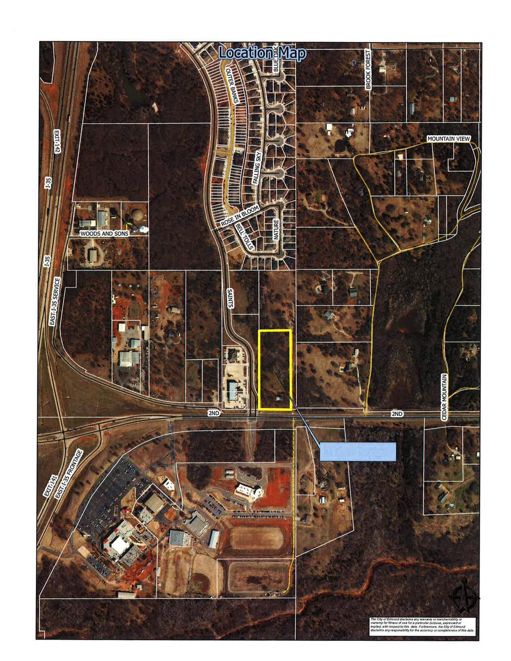
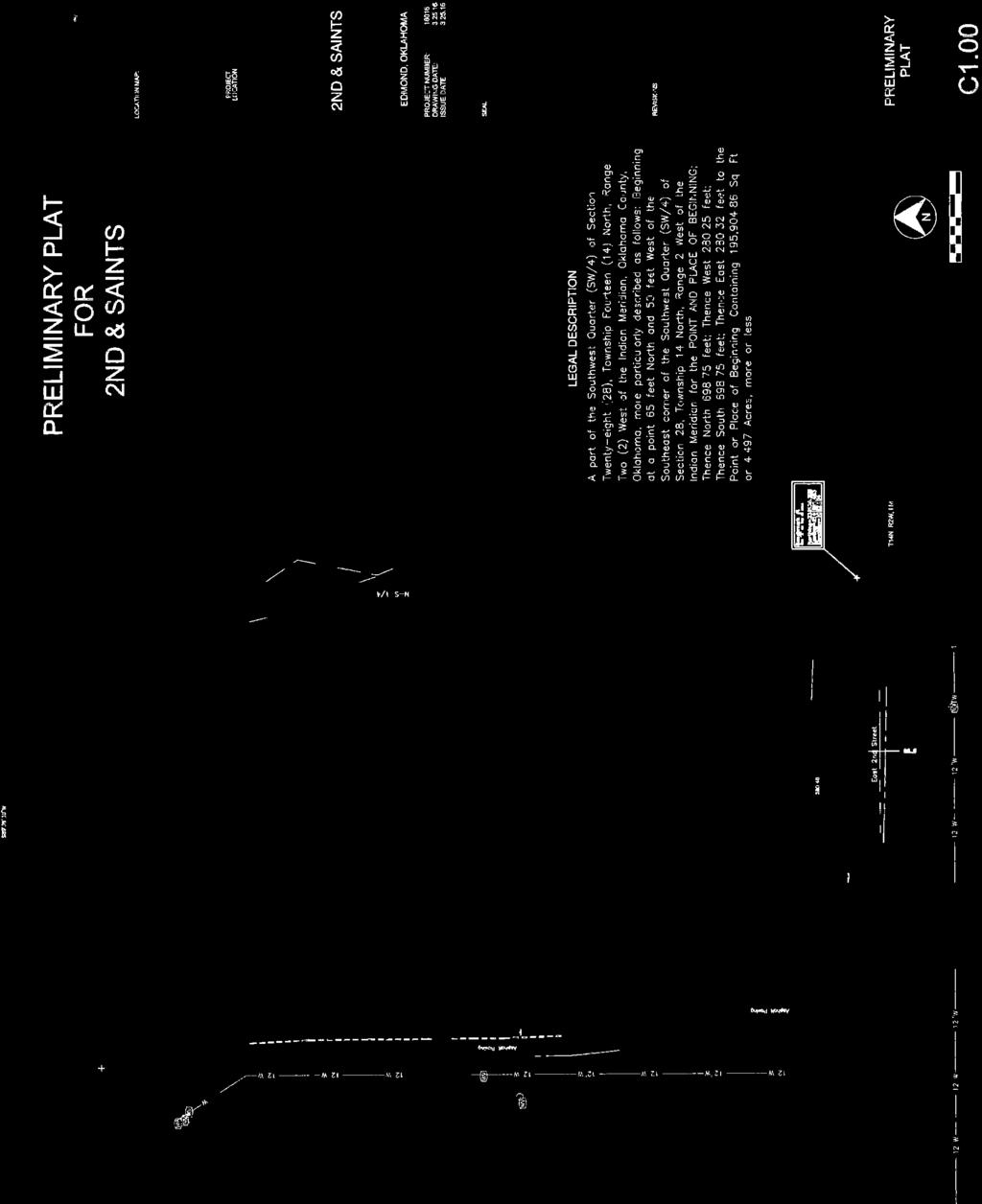
15 Planning Commission 3. Meeting Date: 05/17/2016 From: Bob Schiermeyer Department: Planning/Zoning Information RE: Case #PR Public Hearing and Consideration of Preliminary Plat for 2nd and Saints Addition, located on the north side of East 2nd Street and east of Saints Boulevard. (St. George Holdings, LLC) Jason Emmett with Cedar Creek Engineering is requesting preliminary plat approval for a 4.4 acre tract on east Second Street, east of the Hargrove Orthopedic Solutions. This property is projected for commercial zoning on the Edmond Plan but is not zoned at this time. The owner s engineers have been working on a drainage solution and would like to proceed with the plat to demonstrate that all the requirements can be met and that the offsite drainage pipe requirement can be accomplished. The Knights of Columbus own the land to the north and a narrow access east of the subject property. The driveway to most of their property contains a low water crossing at this time. With the detention improvements, on the subject property and the grading and fill needed for the subject property a new drainage structure will need to be installed on the Knights of Columbus access drive. They have generally agreed to the improvement and will provide a temporary construction easement to the developer for the offsite improvements. The drainage plans that have been reviewed are more detailed than they would be with a standard preliminary plat in order to work out this solution with the adjoining neighbor. Access to the property will be from Saints Boulevard. An office building is planned on the property which will contain one lot and one block. City sewer and water are available. There will be fill dirt placed on the property to prepare the site and that will need to come from an approved land disturbance permit location, if located in the City of Edmond. 2nd & Saints Attachments
16

17
18 Planning Commission 4. Meeting Date: 05/17/2016 From: Bob Schiermeyer Department: Planning/Zoning Information RE: Case #Z Public Hearing and Consideration of Edmond Plan Amendment from General Agricultural to Commercial Planned Unit Development ( E-1 Level 1 uses) on 3.21 acres and a change from General Agricultural to Multi-family Residential Planned Unit Development on acres (to include 252 apartments and 70 single family lots) generally located south of Danforth Road and east I-35, north of Arbor Creek Summit. (Danforth Crossing Happy Land, LLC) Continued to the June 7, 2016 Planning Commission meeting. No file(s) attached. Attachments
19 Planning Commission 5. Meeting Date: 05/17/2016 From: Bob Schiermeyer Department: Planning/Zoning Information RE: Case #Z Public Hearing and Consideration of Rezoning from G-A General Agricultural to Commercial Planned Unit Development ( E-1 Level 1 uses) on 3.21 acres and rezoning from G-A General Agricultural to Multi-family Residential Planned Unit Development on acres (to include 252 apartments and 70 single family lots) generally located south of Danforth Road and east I-35, north of Arbor Creek Summit. (Danforth Crossing Happy Land, LLC) Continued to the June 7, 2016 Planning Commission meeting. No file(s) attached. Attachments
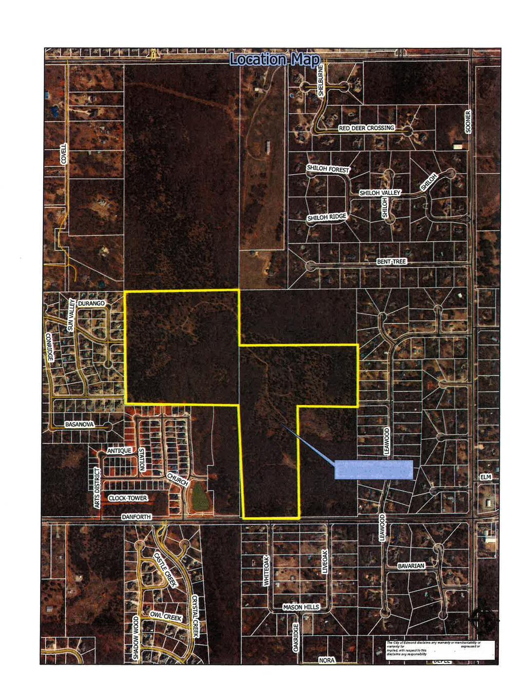
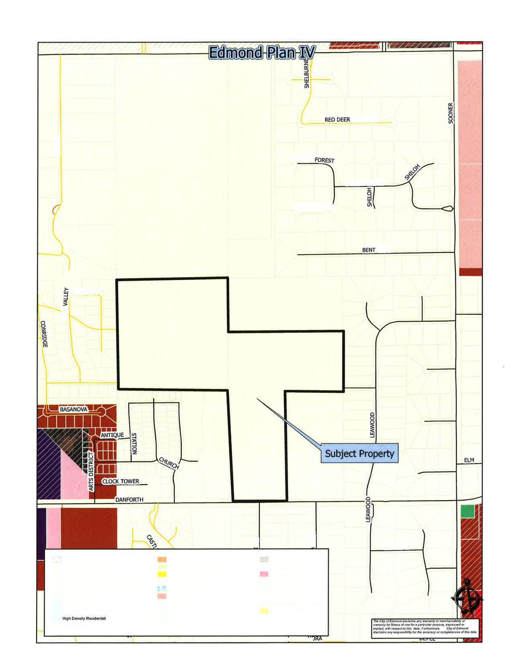
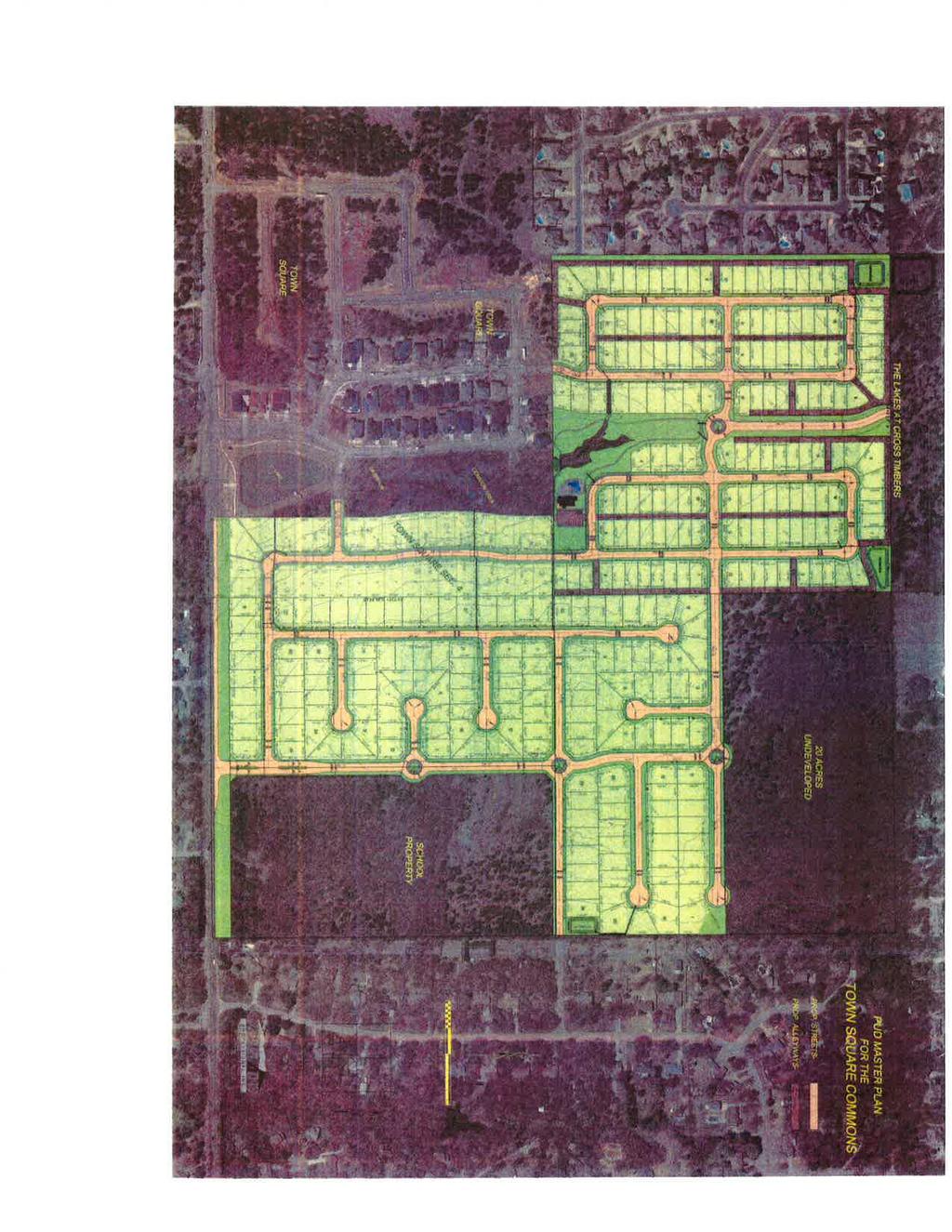
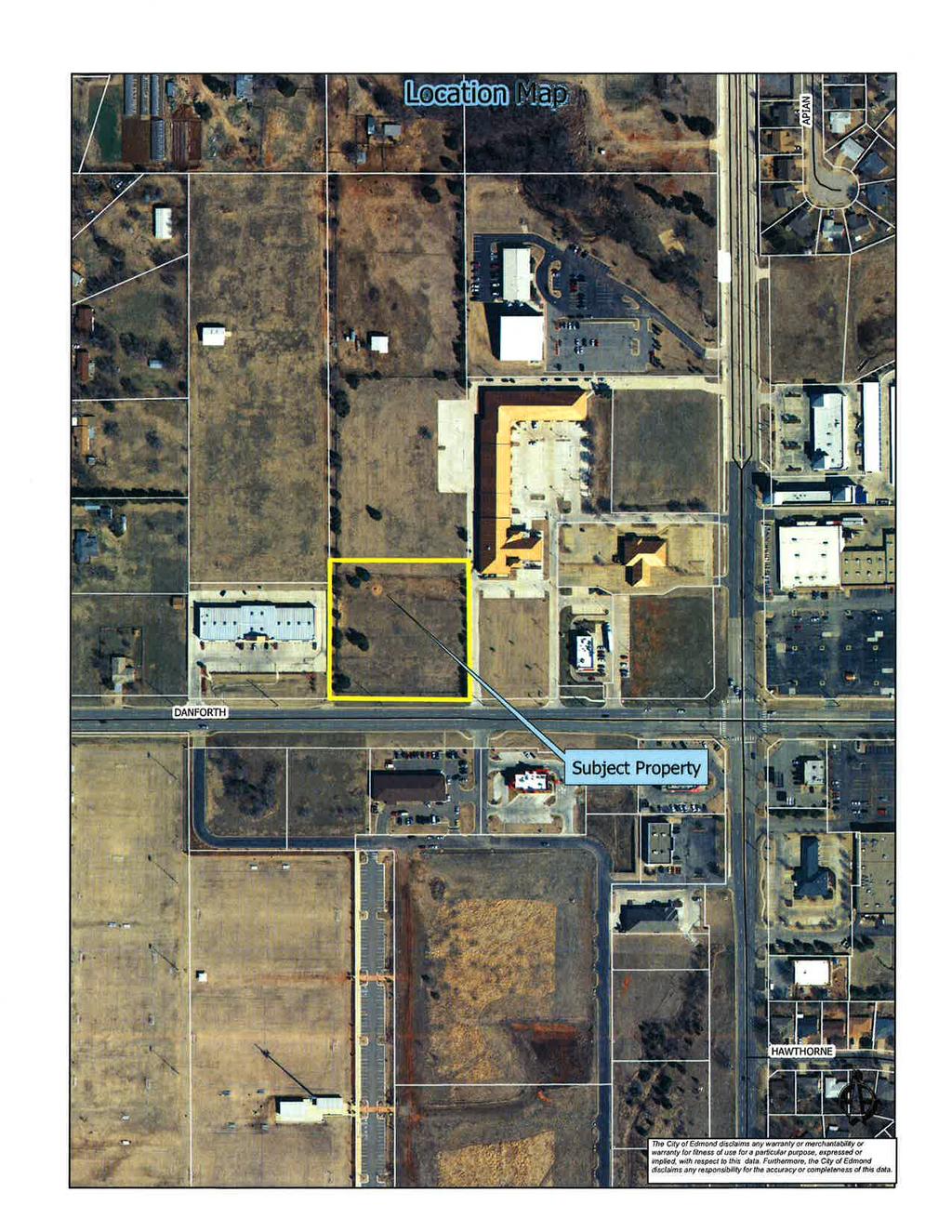
20 Planning Commission 6. Meeting Date: 05/17/2016 From: Bob Schiermeyer Department: Planning/Zoning Information RE: Case #Z Public Hearing and Consideration of Edmond Plan Amendment for Town Square Commons, LLC from Single Family to Residential Planned Unit Development, located north of Danforth Road and one half-mile west of Sooner Road. (Town Square Commons, LLC) The following general planning considerations represent some of the factors evaluated in reviewing justifications for Plan Map Amendments. 1. Infrastructure: Water and sewer are available along Danforth Road and within the existing Town Square Addition to serve 309 more lots. Traffic studies are required when the development would add 100 vehicles more during the peak traffic times. Mr. McCaleb has provided three outlets to Danforth Road from Town Square to provide for traffic alternatives and distribution. Town Square I, 40 lots, Town Square II, 53 lots, Town Square III, 24 lots. There will be a total of 426 lots in this total development. 2. Traffic: Danforth Road is planned to be a major arterial street based on the Master Transportation Plan. Right-of-way requirements will apply on Danforth Road and bicycle facilities as shown on the Bike Master Plan would be constructed with the paving improvements. With Covell improvements starting this summer west of I-35 and west of Sooner Road, additional traffic would be expected along Danforth Road until Covell Road is completed. 3. Existing zoning pattern: North A Single Family South A Single Family and Urban Estate East Urban Estate, one acre lots West Single Family 4. Land Use: North Undeveloped South Developed with acreage lots East Developed with acreage lots West Urban Lot sizes 5. Density: 3.86 units per acre, considering the entire 80 acre ownership 6. Land ownership pattern: North Larger tract ownerships South Acreage lots East Acreage lots West Urban lots 7. Physical features: Rolling terrain, native trees.
21 7. Physical features: Rolling terrain, native trees. 8. Special conditions: There is a 20 acre tract adjacent that will be developed by Francis Tuttle Vo-tech. Skyview Drive may not connect to the east. There is another 20 acre tract to the northeast that is a different owner at this time and may develop with different lot sizes depending on the utility availability. 9. Location of Schools and School Land: Not directly a factor, the nearest elementary school is Centennial on Coltrane Road, north of Coffee Creek Road. Francis Tuttle has indicated that there will be a connection to the high school for classes that will be offered in the future. 10. Compatibility to Edmond Plan: The reason this application is a PUD is because the owner wishes to get variances in the setbacks for the alley type lots. The density planned is not affected by the property being zoned as a PUD 11. Site Plan Review: No site plan but there will be a preliminary and final plat. Town Square PlAm Attachments
22

23
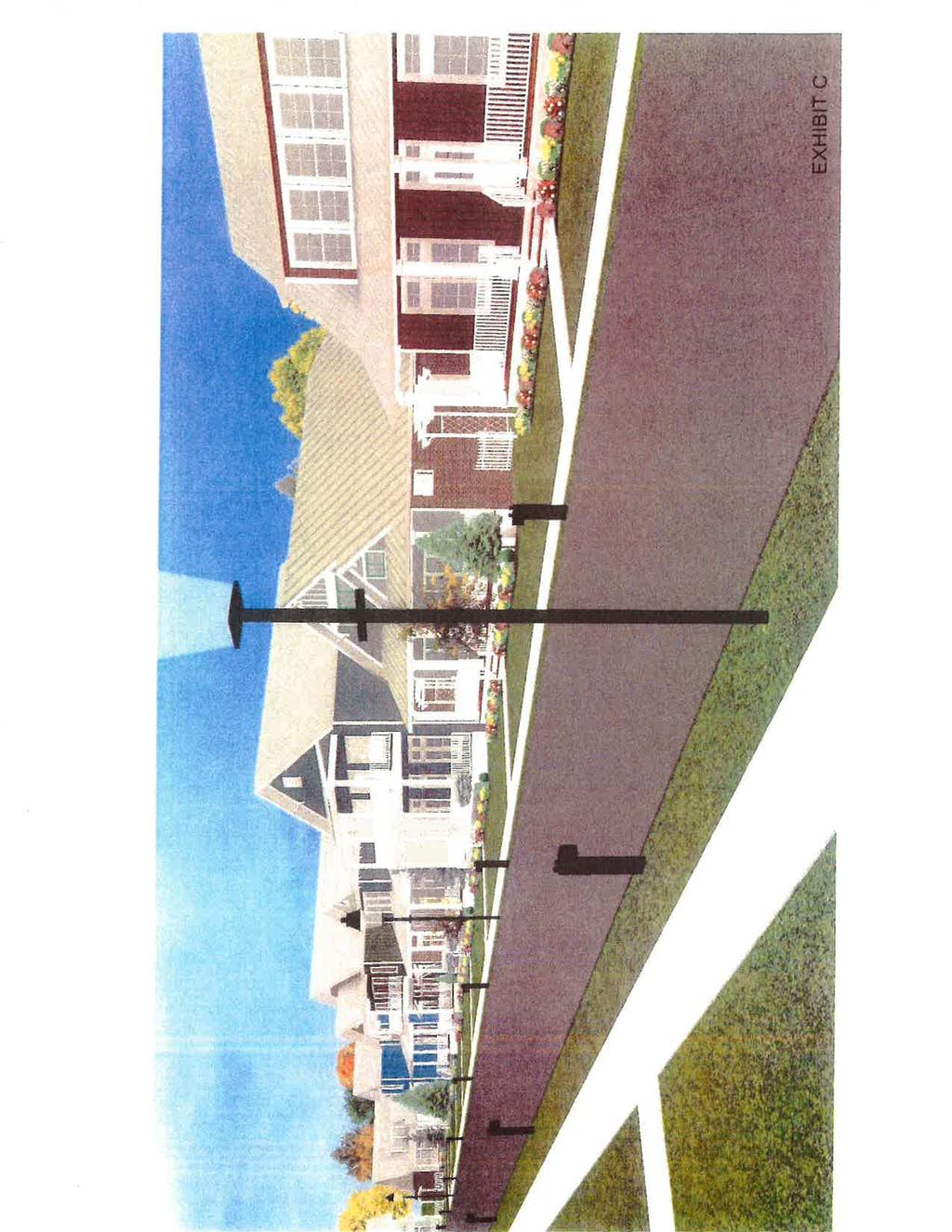
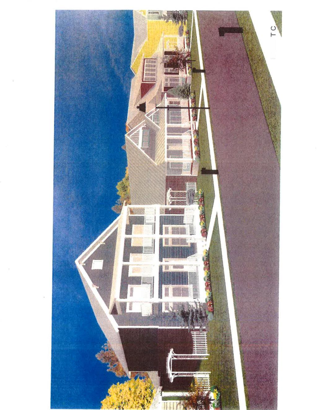
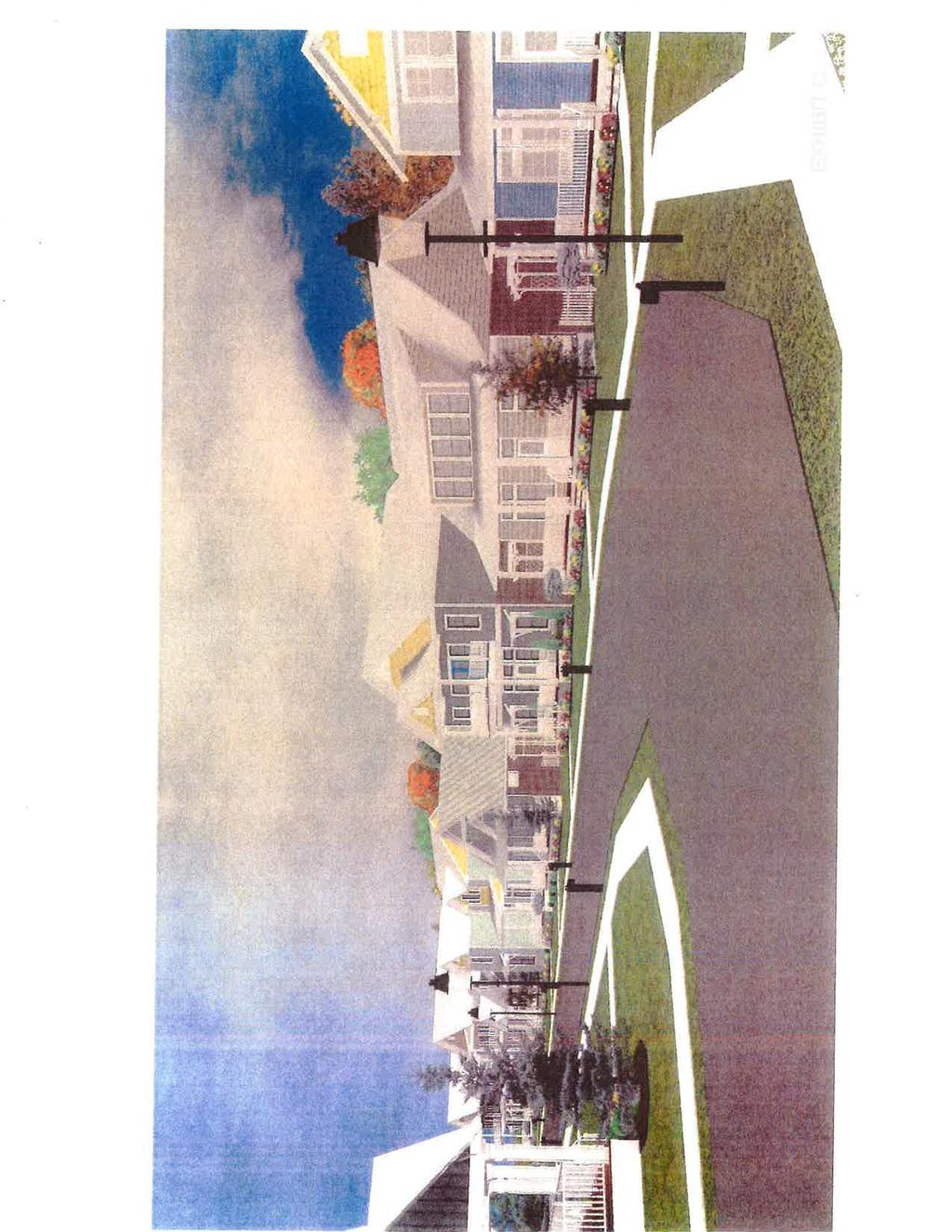
24 Planning Commission 7. Meeting Date: 05/17/2016 From: Bob Schiermeyer Department: Planning/Zoning Information RE: Case #Z Public Hearing and Consideration of Rezoning from A Single Dwelling to Residential Planned Unit Development, located north of Danforth and one half-mile west of Sooner Road. (Town Square Commons, LLC) Caleb McCaleb is requesting 80 acres of single family PUD zoning allowing variations in setbacks for 146 of the 309 lots proposed. With the existing three phases of Town Square there will be 426 lots. This addition is north of the existing Town Square Addition, east of Olde Edmond Addition, west of the Leawood Addition and south of a project planned as the Lakes at Cross Timbers. Francis Tuttle Vo-tech owns 20 acres of undeveloped property west of Leawood Addition and north of Danforth Road. With this development there would be three access points into Town Square from Danforth Road. A stub out street has been shown to the north to connect with the future Lakes at Cross Timbers. Streets in the Olde Edmond Addition will not connect because they are private and Olde Edmond is a gated addition. Francis Tuttle will be able to use the collector type street planned along the west side of their property. The current PUD plan identifies a connection to Skyview Drive in Leawood. A hundred and forty six of the lots in the northwest portion of the property will have alleys. This will allow garages in the rear yard and there will not be a 20 foot setback from the property line, accounting for one of the variances in the PUD. There will be 20 foot setback/buffer adjacent to the Old Towne Addition on the west, next to Old Edmond Addition. Garbage trucks will not use the alleys they are not large enough, residential pick up will be from the street following the typical service. Most of the utilities are in the street. Some of the alleys dead-end, which works for homeowners access but not solid waste access. None of the lots are less than 6, 000 square feet the minimum in A Single Family zoning. The developer describes the density as 3.86 units per acre. Some of the homes will have a zero rear yard setback, 10 foot front yard setback and a zero side yard setback. There will be a 10 foot setback on the corner lots. The non-alley lots will have a 20 foot front setback and a modified rear yard setback of 10 feet. A traffic study should be required at least with the final plat. A traffic signal may be justified on Danforth Road. Town Square Rez Attachments
25

26
27
28
29
30
31
32
33
34
35
36
37
38

39
40
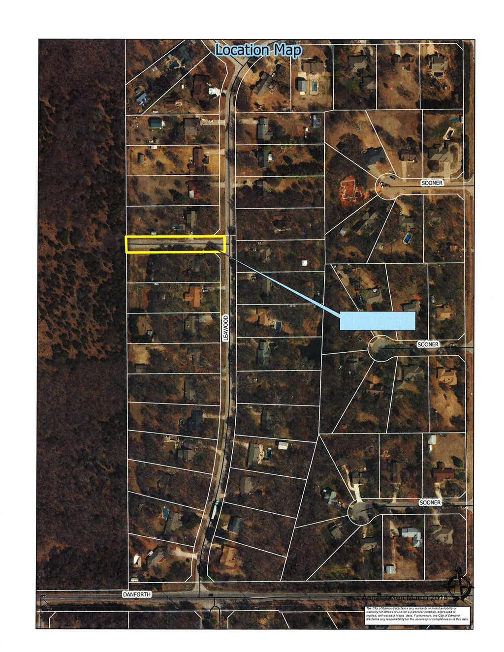
41 Planning Commission 8. Meeting Date: 05/17/2016 From: Bob Schiermeyer Department: Planning/Zoning Information RE: Case #ES Public Hearing and Consideration of street easement closing on Skyview Drive, generally located on the west side of the Leawood Addition, one-quarter mile north of Danforth Road, and west of Sooner Road. (Beryl Jones and Timothy McGraw) The property owners on the north and south sides of Skyview Drive, west of Leawood Drive, in the Leawood Addition, would like to close the street for public access. There may be a benefit to maintaining a utility easement in the 60 feet of right-of-way for electric distribution, and possible waterline distribution in the future. Leawood residents operate with water wells at this point; someday they may request public waterlines. The area to be closed is 60 feet by 325 feet along the side yards of the applicants properties. A fence may need to be placed on the west end of Skyview Drive, if it is closed, to communicate that the road cannot be used. Edmond Electric does serve this Addition, and there is also phone and gas service. This type of request is not new to the city; there have been numerous streets that have been closed. Francis Tuttle Vo-Tech has purchased 20 acres of land west of Leawood that extends north to the Skyview Drive area. A rezoning application has been submitted by Caleb McCaleb for a single-family development, incorporating some cottage-type zero lot line lots with alleys generally to the west of this location. Some of the previous streets that have been closed include the following: Most Additions that have private streets do not connect, such as Olde Edmond, which could have connected to Town Square, but since the streets were private there is no connection. Walnut Hill Addition, connecting to Iron Horse Ranch, also a private street Addition. Copperfield Addition, south of West Edmond Road, west of Kelly Avenue, connecting with Chisholm Lake, both Public Streets. Woodhill Addition, with acreage lots connecting to the Oak Tree Park Addition at Coffee Creek and Kelly, as well as the Sorghum Mill Addition, also connecting to Oak Tree Park. Thornbrooke Addition, connecting to acreage lots in Old Farm Estates at 33rd and Bryant. Forest Oaks Addition, connecting to Tall Oaks III, east of Bryant. Bradbury Corner, connecting to Thunderhead Hills. Ketch Acres, connecting to Pebble Creek.
42 The street continuation issue is usually discussed based on private streets developing next to public streets, or where the densities are substantially different on the adjoining areas. Jones - McGraw EC Attachments
43
44

45
46
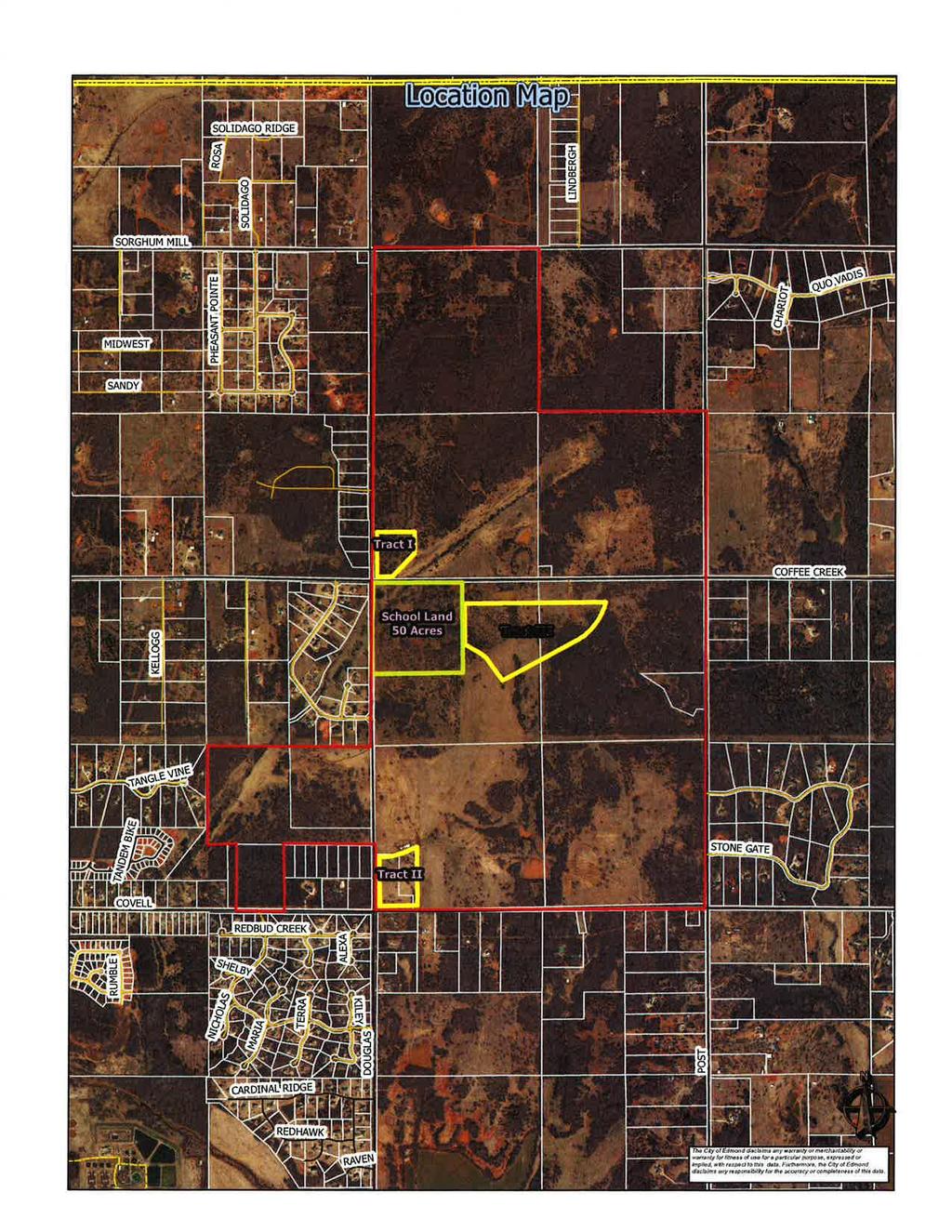
47 Planning Commission 9. Meeting Date: 05/17/2016 From: Bob Schiermeyer Department: Planning/Zoning Information RE: Case #Z Public Hearing and Consideration of Edmond Plan Amendment from Single Family Planned Unit Development to Commercial PUD located on the northeast corner of Coffee Creek and Douglas Boulevard and the northeast corner of Covell Road and Douglas Boulevard and amending the Edmond Plan from Commercial PUD to Residential PUD, south of Coffee Creek Road, a quarter of a mile east of Douglas Boulevard. (Matt Austin, Woodland Park Edmond, LLC) The following general planning considerations represent some of the factors evaluated in reviewing justifications for Plan Map Amendments. 1. Infrastructure: The original Woodland Park developer extended public water along Covell Road, along Air Depot Boulevard and west to the water supply towers on I-35. Sanitary sewer lines were also extended offsite from Woodland Park through the Thunder Canyon Addition to the Coffee Creek Wastewater Treatment Plant. Those utilities have been connected by several developers along those streets. Water and sewer are generally available to the 1,240 acre Woodland Park project, except the southeast portion of the property which will not be a gravity flow sewer. This condition has been understood from the original approval. 2. Traffic: Covell Road, Douglas Boulevard and Post Road are arterial streets that do need to meet the Master Transportation Plan for right-of-way. 3. Existing zoning pattern: The zoning requests are adjoining the land uses planned in the Wood Land Park PUD. North PUD South G-A and R-1 East G-A Stonegate Addition West Acreage lots, R-1 and G-A District 4. Land Use: North Undeveloped South Acreage lots East Acreage lots West Acreage lots 5. Density: Single family, 6 units per acre for the residential. For the two commercials sites density is not applicable. 6. Land ownership pattern: Other than the changes for the school property and the sale 19.2 acres, west of Post Road at Coffee Creek to Mr. Matherly the ownership parcels have stayed the same. North Woodland Park
48 South Individual acreage ownerships East Individual acreage ownerships West Individual acreage ownerships 7. Physical features: Rolling wooded terrain 8. Special conditions: No sewer on the southeastern part of the properly without a lift station. Septic tanks preferred. Wastewater solution/aerobic systems for 30,000 square foot net residential lots. 9. Location of Schools and School Land: 50 acre undeveloped tract, southeast corner of Coffee Creek Road and Douglas Boulevard. 10. Compatibility to Edmond Plan: Represents a new policy direction for the Edmond Plan. 11. Site Plan Review: Plats would be required for residential and site plans for commercial. Woodland PlAm Attachments
49
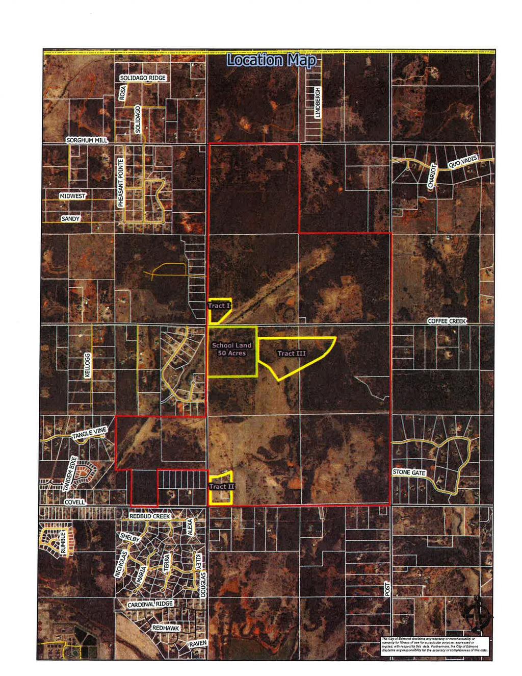
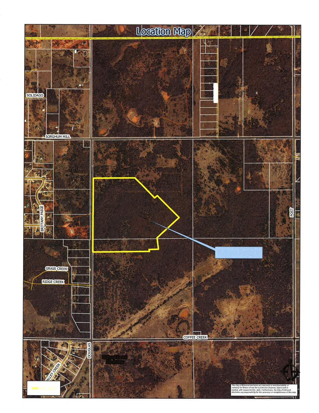
50 Planning Commission 10. Meeting Date: 05/17/2016 From: Bob Schiermeyer Department: Planning/Zoning Information RE: Case #Z Public Hearing and Consideration of Rezoning from Single Family Planned Unit Development to Commercial PUD located on the northeast corner of Coffee Creek and Douglas Boulevard and the northeast corner of Covell Road and Douglas Boulevard and rezoning from Commercial PUD to Residential PUD, south of Coffee Creek Road, a quarter of a mile east of Douglas Boulevard. (Matt Austin, Woodland Park Edmond, LLC) Several months ago Matt Austin the current developer of Woodland Park wanted to change to add two commercial corners and to exclude some of the retail in favor of residential east of the new school site at Douglas Boulevard and Coffee Creek Road. The original request involved a mile long area of commercial zoning from Douglas Boulevard to Post Road on the north side of Covell Road. That request has been amended to exclude all the land except acres on the northeast corner of Covell Road and Douglas Boulevard and 8.26 acres on the northeast corner of Coffee Creek Road and Douglas Boulevard. The original theory of the Woodland Park PUD is that the commercial would be located in the center of the 1,240 acre project. In 1950 homes were planned in 2007 it is likely that there will be less homes developed in this project. Land has been sold to the school district at Coffee Creek Road and Douglas Boulevard since 2007 and another owner has bought 20 acres at Post Road and Coffee Creek Road and there is a substantial area of aerobic type lots not available to city sewer in the southeast portion of the property. The owner could build 1,950 homes in that part of the PUD not being changed but those homes will be built on less acreage than was available in The developer is now saying at the interior commercial parcel planned at the beginning of the project is not feasible and he would rather move the sites to the section line corner locations. The developer would like E-1 General Commercial usage on the subject property. The second commercial tract at Covell Road and Douglas Road contains acres. This parcel is adjacent to water but is not available to city sewer. Septic tanks could be used for commercial uses. In addition to the two commercial changes, Matt Austin wants to change from commercial to residential on 40.9 acres, south of Coffee Creek Road, east of the 50 acre school site. There would still be some retail along Coffee Creek Road but a majority of the commercial planned would now be built as single family homes. City utilities could be available to this site. Mr. Austin that the retail is not feasible in the center of this project. The major change that has occurred since the Planning Commission last saw this item is that the majority of the land on the north side of Covell Road, originally requested for commercial has been withdrawn. Woodland Park Rez Attachments
51
52
53
54
55
56
57
58
59
60
61
62
63
64
65
66

67


68
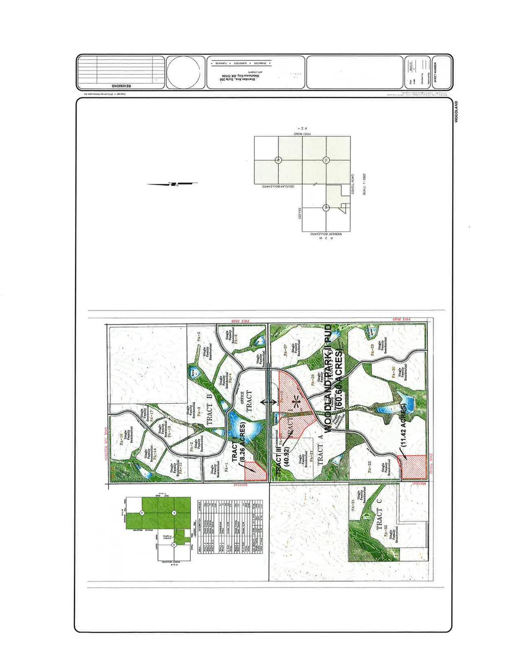
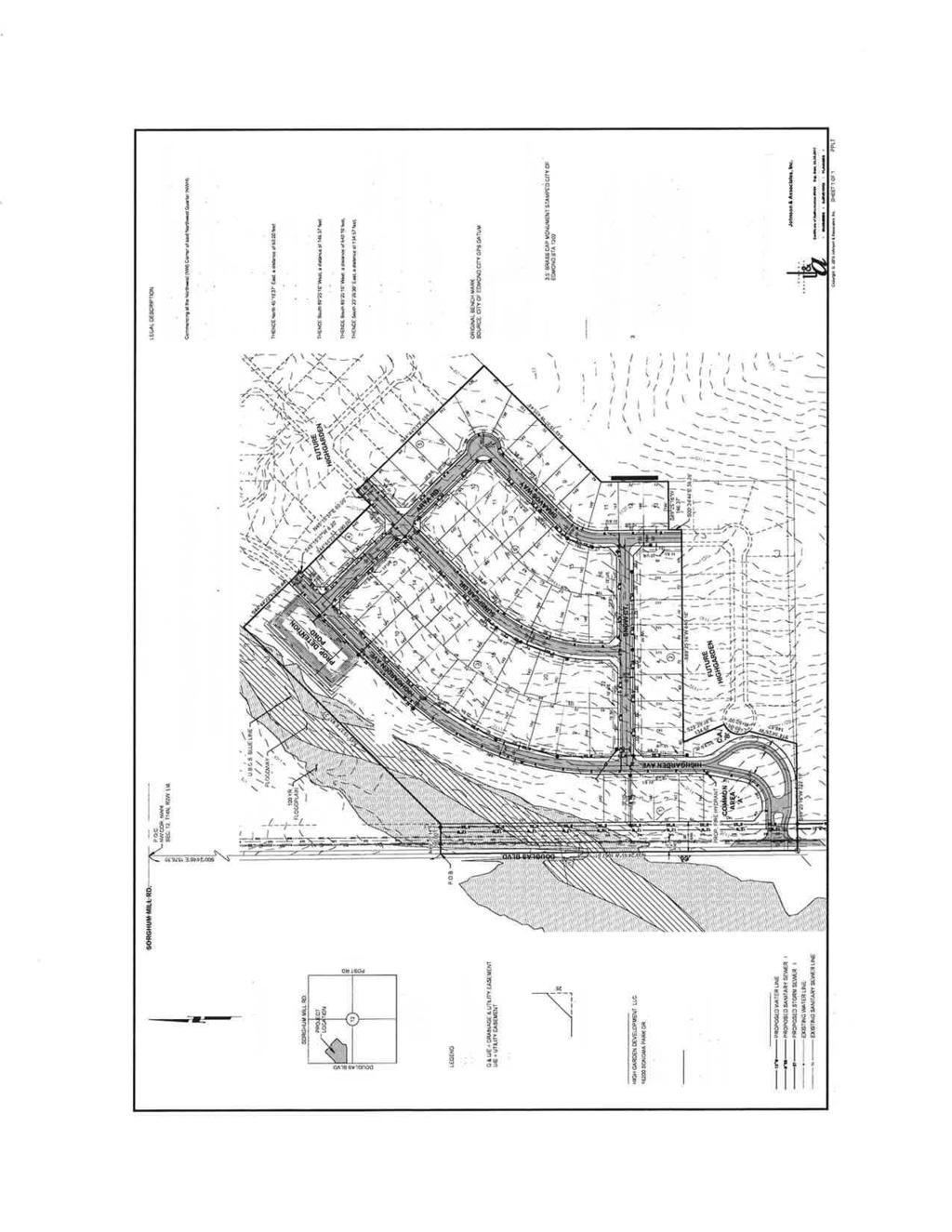
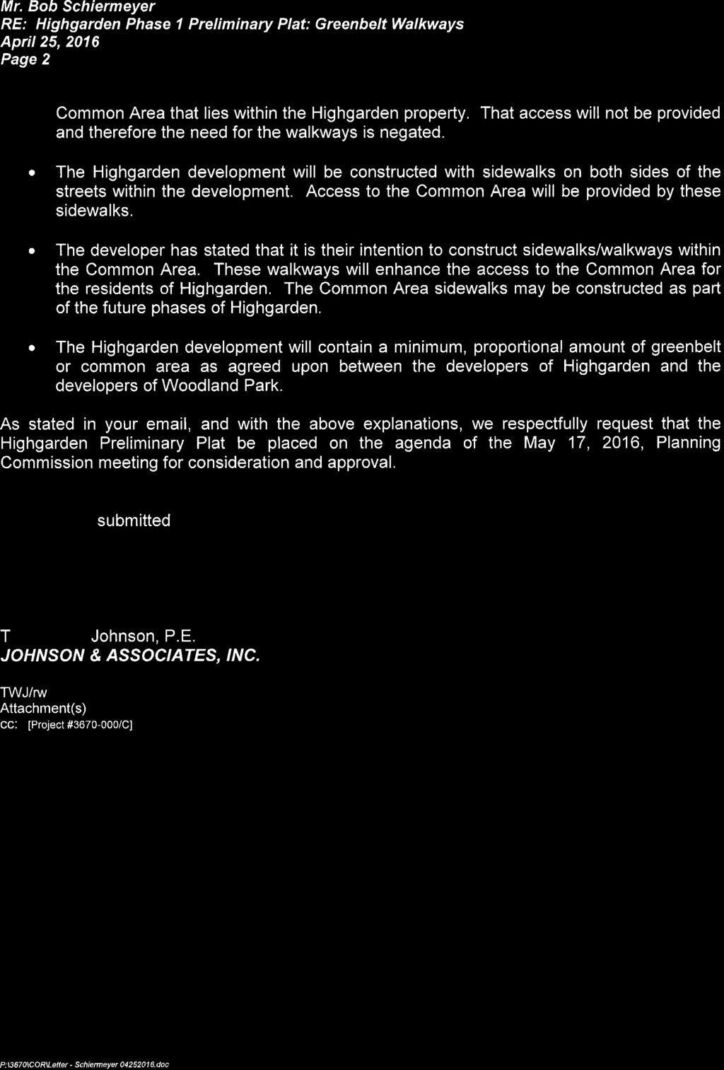
69 Planning Commission 11. Meeting Date: 05/17/2016 From: Bob Schiermeyer Department: Planning/Zoning RE: Information Case #PR Public Hearing and Consideration of Preliminary Plat approval for the Highgarden Addition Phase 1 with private streets located a one quarter mile south of Sorghum Mill Road and east of Douglas Boulevard. (Highgarden Development, LLC) Highgarden development is planning 65 single family homes on 31 acres in the Woodland Park Planned Unit Development. These lots will connect to city water and sewer. The streets will be private. The notices have been given to the Planning Commission for the preliminary plat/private street discussion. Bob Birchell was hired by the owner as a consulting forester to perform a Sensitive Areas Conservation Assessment, which in part includes evaluation of the proposed tree preservation areas for Woodland Park. That requirement is in the PUD and needs to be completed prior to City Council review. The lot size is generally 75 x 145 for a total of 10,730 square foot lots. The developer has completed a drainage study and plans for a detention pond adjacent to the creek. There are several common areas and the project will be gated. The gate location needs to meet the Gate Standards with a queuing lane allowing four cars to back up outside of the Douglas traffic lanes. Ninety foot of right-of-way is provided along Douglas Boulevard to meet the Master Transportation Plan. The preliminary plat indicates that there will be several other sections to Highgarden Addition. The Woodland Park PUD identifies a series of greenbelts, one of which that does extend through this addition in the center of the blocks. In the letter from April 25, 2016 the developers engineer indicates that he does not wish to have the greenbelt set aside in the plat. Even with private streets sidewalks are expected and are valuable to disabled residents. The developer is leaving the creek area with the largest common area being Area C. In this particular PUD there is no density credit needed to offset a high density area with the lesser density from another area. The open space is additional land that may be flood plain, detention or common area that is part of an amenity for the addition including the entry area, which takes up more space due to the gate. It would be a policy judgment, but it may be more significant to leave groups of tree preservation areas rather than to leave the greenbelts that would likely be graded for the lot, street and utility installation. The exception would be if the trees exist on the greenbelt shown on the original PUD Master Plan. Highgarden PH I PP Attachments
70

71

72
73
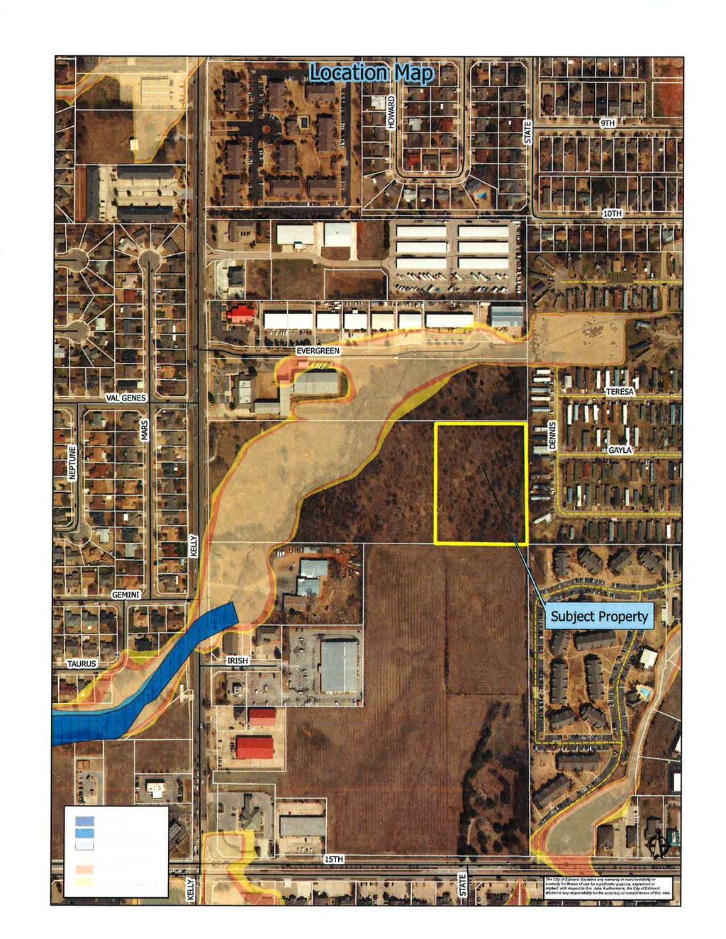
74 Planning Commission 12. Meeting Date: 05/17/2016 From: Bob Schiermeyer Department: Planning/Zoning Information RE: Case #PR Consideration of Final Plat for The Villas of Edmond located on the east side of Kelly Avenue, a quarter of a mile north of 15 th Street. (Philip Patterson) Phil Patterson is working with the buyer for The Villas of Edmond Senior Housing planned at this location. The immediate developer is Rich Smith. The overall land area is 5.97 acres for the Villas Senior Housing. The Patterson property would be 2.65 acres consisting of Lot 1 and Lot 3. The remainder of the property along the front of Kelly Avenue is common area due to an extensive flood plain. The access drive and cross access is shown as Lot 1 but may need to be identified as Common Area A to emphasize the cross access to Lots 1 and Lot 3. The Villas property is zoned multi-family allowing for 52 units. The Villas Apartment building is three stories in height. The Patterson property is zoned Restricted Light Industrial. The offsite detention area is on the Phil Patterson property south of the drive and is critical for The Villas project, otherwise there is no detention for the apartments. As discussed with the preliminary plat, The Villas have made an arrangement with the mobile home park to the east for a second access. This primarily is an emergency access and maybe gated in accordance to fire department requirements and standards. The plat provides for the necessary utility easements. The Apple Village Mobile Home Park is located to the east. There are commercial buildings to the south, except for an undeveloped commercial parcel south of The Villas main lot. There is also commercial to the north accessible by Evergreen Street. The conditions for approval include the following: 1. The access easement from Kelly Avenue shall allow for the Patterson ownership to cross access. 2. The public water line shall also be accessible to the Patterson property. 3. The sanitary sewer access shall also be accessible to the Patterson property. 4. All public or private utility easements, particularly for the private detention area shall be provided or labeled as needed, including the access to the mobile home park. Villas of Ed FP Attachments

75
76
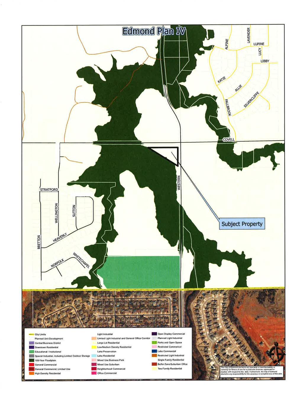
77 Planning Commission 13. Meeting Date: 05/17/2016 From: Bob Schiermeyer Department: Planning/Zoning Information RE: Case #Z Public Hearing and Consideration of Edmond Plan Amendment from Single Family Dwelling District to Restricted Retail Commercial located on the southwest corner of Covell Road and Western Avenue. (Andrew and Teaona Njoo) The following general planning considerations represent some of the factors evaluated in reviewing justifications for Plan Map Amendments. 1. Infrastructure: City water is located along Covell Road. A new line was extended even further west to serve the two schools on Pennsylvania Avenue. There is a sewer line in the creek west of the site. A septic tank may be the best solution for wastewater. The Oklahoma City sewer line will be very difficult to access. Mr. Njoo is generally familiar drainage detention requirements. 2. Traffic: Covell Road has been discussed as a major east west. The right-of-way is being provided for that major improvement either with the site plan or the plat. Western Avenue right-of-way would be provided with the right-of-way standard required. 3. Existing zoning pattern: North A Single Family, Covell right-of-way South A Single Family, is also in a flood plain. East A Single Family, Western Avenue right-of-way West A Single Family. but is unbuildable due to the flood plain 4. Land Use: North Undeveloped South Immediately South Undeveloped East Undeveloped West Undeveloped 5. Density: N/A 6. Land ownership pattern: North Single 12+ acre parcel South Large ownerships East Large ownerships West Large ownerships 7. Physical features: Only the corner is buildable, the remainder of the land is flood plain. 8. Special conditions: Flood plain, right-of-way requirements for Covell Road improvements later.
78 9. Location of Schools and School Land: nearest school is on Pennsylvania Avenue, south of Covell Road. 10. Compatibility to Edmond Plan: Not projected in This site is limited for many uses, not the best location for a home. 11. Site Plan Review: Would be required if zoned commercial. Njoo PlAm Attachments
79
80
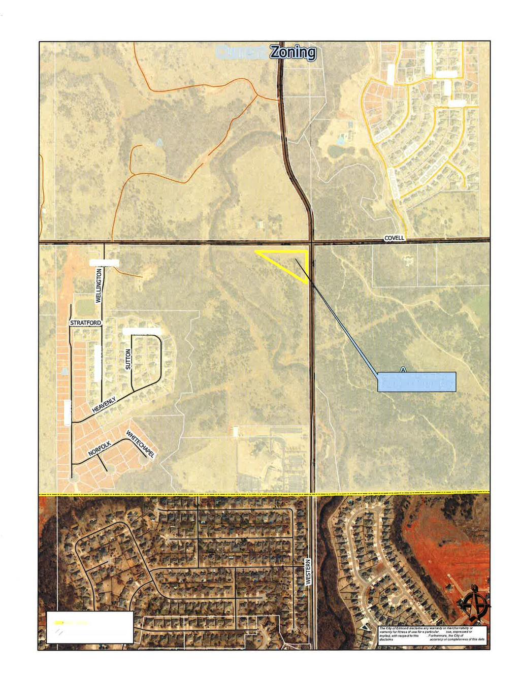
81 Planning Commission 14. Meeting Date: 05/17/2016 From: Bob Schiermeyer Department: Planning/Zoning Information RE: Case #Z Public Hearing and Consideration of Rezoning from A Single Family Dwelling District to D-1 Restricted Retail Commercial generally located on the southwest corner of Covell Road and Western Avenue. (Andrew and Teaona Njoo) Andrew and Teaona Njoo is requesting acres to be rezoned from A Single Family to Restricted Retail Commercial at Covell Road and Western. This land is vacant. The uses in the general area St. Monica Catholic Church at 2001 North Western. The Kingsbury Addition located west of the bridge, west of this property, several 100 feet to the west and the Fall Brook Addition several 100 feet to the northeast. The land to the northwest is undeveloped and is adjacent to a major creek. City water is adjacent to this property. Sewer is located to the west. The site is large enough for a septic tank for limited commercial usage. Mr. Njoo is aware of the right-of-way needed on Covell Road and Western Avenue based on the Master Transportation Plan. The owner has worked with an engineer and studied the flood plan, which has a major impact to the property. The D-1 usage will allow for office and light retail uses. Njoo Rez Attachments

82
83
84 Planning Commission 15. Meeting Date: 05/17/2016 From: Bob Schiermeyer Department: Planning/Zoning Information RE: Case #U Public Hearing and Consideration of Specific Use Permit and Case #SP to include a Site Plan, for a Victory Car Wash located at 1101 West Danforth Road. (Muhammad N. Siddiqui) Planning Department 1. Existing zoning Commercial Planned Unit Development to allow a car wash and other limited commercial uses. 2. Setbacks From the property line to the vacuum area would be 60 feet. The building itself sets back 140 feet from the property area. The side yard setback to the east is 80 feet, side yard setback to the west 132 feet, and setback to the north 97 feet. 3. Height of building 28 feet 4. Parking The parking spaces are oriented to the car wash process. There is a flow of traffic around the building on the north with 29 spaces for vacuum and other finishing of the car after the wash. There is a queuing lane to stack a considerable number of cars around the building. The building is on 3,840 square feet. Bicycle parking will be required and Jan Fees will inspect. 5. Lot size Is 334 feet by 342 feet before the right-of-way is only provided along Danforth Road. This site is approximately 96,860 square feet. 6. Lighting Plan This area is not a sensitive border. The School District owns property to the east. There is a strip shopping center to the west and Hibdon Tire Center to the south. The School District also owns property to the north, as well as, the original property owner Mr. Novotny. 7. Signage One ground sign is planned out of the 70 foot right-of-way required. The sign will be six foot tall and 42 square feet. Wall signs may also be used, meeting the code. 8. General architectural appearance The building is a combination of light brown brick veneer and a dark blue EIFS. The front of the building will have a number of windows, common to car washes. 9. Sensitive borders N/A 10. Mechanical equipment Will be located on the roof. 11. Fencing/screening Not required except for the dumpster enclosure.
85 Engineering Department 12. Driveways, access management and paving There is one driveway into the property located on the west side of the property. That driveway meets the Access Management Standard between the shopping center and School District driveway on either side of the property. Mr. Novotny will also use the driveway to care for his horse pasture to the north. 13. Water and wastewater plans Are available for service and will be connected. 14. Drainage, detention and grading Engineering has completed their drainage review. Building and Fire Code Services 15. Applicable Building Code, Fire Code a. A fire hydrant will need to be added on site along a fire department access road. b. fire department access is adequate Landscaping/Urban Forestry 16. Lot area = 96,860 sf % required = 10 Landscape area required: 9,686 SP Landscape area: 28,000 Frontage area required: 4,843 SP Frontage area: 6,800 Total PU required: 775 SP Total PU: 775 PU within frontage required: 387 SP PU within frontage: 412 Evergreen PU required: 310 SP Evergreen PU: Solid Waste Department There is a dumpster adjacent to the front parking area, nearest to the building. 18. Edmond Electric Department Will serve. Victory Car Wash SUP SP Attachments
86
EDMOND PLANNING COMMISSION 20 S. Littler, Edmond, Oklahoma Tuesday, June 7, :30 p.m.
 City of Edmond NOTICE OF PUBLIC MEETING The City of Edmond encourages participation from all its citizens. To request an accommodation due to a disability, please allow at least 48 hours prior to the scheduled
EDMOND PLANNING COMMISSION 20 S. Littler, Edmond, Oklahoma Tuesday, May 6, :30 p.m.
 City of Edmond NOTICE OF PUBLIC MEETING The City of Edmond encourages participation from all its citizens. If participation at any Public meeting is not possible due to a disability, notification to the
AGENDA. EDMOND PLANNING COMMISSION 20 S. Littler, Edmond, Oklahoma Tuesday, February 18, :30 p.m. CITY COUNCIL WORKSHOP
 City of Edmond NOTICE OF PUBLIC MEETING The City of Edmond encourages participation from all its citizens. If participation at any Public meeting is not possible due to a disability, notification to the
Planning Commission 16 February 4, 2014 EDMOND PLANNING COMMISSION MEETING. Tuesday, February 4, 2014
 Planning Commission 16 EDMOND PLANNING COMMISSION MEETING Tuesday, 5:30 P.M. The Edmond Planning Commission Meeting was called to order by Chairperson Barry K. Moore at 5:30 p.m., Tuesday,, in the City
EDMOND PLANNING COMMISSION 20 S. Littler, Edmond, Oklahoma Tuesday, July 21, :30 p.m.
 City of Edmond NOTICE OF PUBLIC MEETING The City of Edmond encourages participation from all its citizens. If participation at any Public meeting is not possible due to a disability, notification to the
AGENDA. EDMOND PLANNING COMMISSION 20 S. Littler, Edmond, Oklahoma Tuesday, January 7, :30 p.m. CITY COUNCIL WORKSHOP
 City of Edmond NOTICE OF PUBLIC MEETING The City of Edmond encourages participation from all its citizens. If participation at any Public meeting is not possible due to a disability, notification to the
EDMOND PLANNING COMMISSION MEETING. Tuesday, October 5, 2004
 124 EDMOND PLANNING COMMISSION MEETING Tuesday, 5:30 P.M. The Edmond Planning Commission Meeting was called to order by Chairperson David Woods at 5:30 p.m., Tuesday,, in the City Council Chambers at 20
EDMOND PLANNING COMMISSION 20 S. Littler, Edmond, Oklahoma Tuesday, August 4, :30 p.m.
 City of Edmond NOTICE OF PUBLIC MEETING The City of Edmond encourages participation from all its citizens. If participation at any Public meeting is not possible due to a disability, notification to the
EDMOND PLANNING COMMISSION MEETING. Tuesday, December 16, 2003
 EDMOND PLANNING COMMISSION MEETING Tuesday, December 16, 2003 5:30 P.M. The Edmond Planning Commission Meeting was called to order by Chairperson David Woods at 5:30 p.m., Tuesday, December 16, 2003, in
Planning Commission 75 June 3, 2014 EDMOND PLANNING COMMISSION MEETING. Tuesday, June 3, 2014
 Planning Commission 75 EDMOND PLANNING COMMISSION MEETING Tuesday, 5:30 P.M. The Edmond Planning Commission Meeting was called to order by Chairperson Barry K. Moore at 5:30 p.m., Tuesday,, in the City
Planning Commission 116 August 20, 2013 EDMOND PLANNING COMMISSION MEETING. Tuesday, August 20, 2013
 Planning Commission 116 EDMOND PLANNING COMMISSION MEETING Tuesday, 5:30 P.M. The Edmond Planning Commission Meeting was called to order by Chairperson Barry K. Moore at 5:30 p.m., Tuesday,, in the City
AGENDA. EDMOND PLANNING COMMISSION 20 S. Littler, Edmond, Oklahoma Tuesday, February 21, :30 p.m. CITY COUNCIL WORKSHOP
 City of Edmond NOTICE OF PUBLIC MEETING The City of Edmond encourages participation from all its citizens. If participation at any Public meeting is not possible due to a disability, notification to the
AGENDA. EDMOND PLANNING COMMISSION 20 S. Littler, Edmond, Oklahoma Tuesday, August 6, :30 p.m. CITY COUNCIL WORKSHOP
 City of Edmond NOTICE OF PUBLIC MEETING The City of Edmond encourages participation from all its citizens. If participation at any Public meeting is not possible due to a disability, notification to the
EDMOND PLANNING COMMISSION 20 S. Littler, Edmond, Oklahoma Tuesday, May 22, :30 p.m.
 City of Edmond NOTICE OF PUBLIC MEETING The City of Edmond encourages participation from all its citizens. To request an accommodation due to a disability, please allow at least 48 hours prior to the scheduled
EDMOND PLANNING COMMISSION MEETING. Tuesday, August 22, 2006
 187 EDMOND PLANNING COMMISSION MEETING Tuesday, August 22, 2006 5:30 P.M. The Edmond Planning Commission Meeting was called to order by Chairperson Leroy Cartwright at 5:30 p.m., Tuesday,, in the City
PLANNED UNIT DEVELOPMENT (East), PLANNED UNIT DEVELOPMENT (West) STAFF REPORT Date: September 18, 2014
, PLANNED UNIT DEVELOPMENT (West) STAFF REPORT Date: September 18, 2014") PLANNED UNIT DEVELOPMENT (East), PLANNED UNIT DEVELOPMENT (West) STAFF REPORT Date: September 18, 2014 DEVELOPMENT NAME LOCATION McGowin Park, LLC PLANNED UNIT DEVELOPMENT (East) 1401 Satchel Paige Drive
PLANNED UNIT DEVELOPMENT (East), PLANNED UNIT DEVELOPMENT (West) STAFF REPORT Date: September 18, 2014 DEVELOPMENT NAME LOCATION McGowin Park, LLC PLANNED UNIT DEVELOPMENT (East) 1401 Satchel Paige Drive
McGowin Park, LLC. B-3, Community Business District
 # 10, 11, 12 SUB2014-00024 ZON2014-00500 ZON2014-00501 SUBDIVISION, PLANNED UNIT DEVELOPMENT (East), PLANNED UNIT DEVELOPMENT (West) STAFF REPORT Date: April 3, 2014 DEVELOPMENT NAME LOCATION McGowin Park,
REPORT TO THE SHELBY COUNTY PLANNING COMMISSION From the Department of Development Services Planning Services. February 4, 2019
 REPORT TO THE SHELBY COUNTY PLANNING COMMISSION From the Department of Development Services Planning Services February 4, 2019 Case No. Request for Rezoning Approval From E-1 to E-2 SD This is a request
M E M O R A N D U M. Meeting Date: October 23, Item No. F-1. Planning and Zoning Commission. Daniel Turner, Planner I
 M E M O R A N D U M Meeting Date: October 23, 2017 Item No. F-1 To: From: Subject: Planning and Zoning Commission Daniel Turner, Planner I PUBLIC HEARING: Consider a recommendation of a of Planned Development
CHAPTER 26 PLANNING AND ZONING ARTICLE VII. MOBILE HOMES AND RECREATIONAL VEHICLE (RV) PARKS. Recreational Vehicle (RV) Park Development Standards
 PARKS. Recreational Vehicle (RV) Park Development Standards") CHAPTER 26 PLANNING AND ZONING ARTICLE VII. MOBILE HOMES AND RECREATIONAL VEHICLE (RV) PARKS. Section 26-VII-1. Section 26-VII-2. Section 26-VII-3. Section 26-VII-4. Section 26-VII-5. Purpose Permitted
CHAPTER 26 PLANNING AND ZONING ARTICLE VII. MOBILE HOMES AND RECREATIONAL VEHICLE (RV) PARKS. Section 26-VII-1. Section 26-VII-2. Section 26-VII-3. Section 26-VII-4. Section 26-VII-5. Purpose Permitted
Planning Department Oconee County, Georgia
 Planning Department Oconee County, Georgia STAFF REPORT REZONE CASE #: 6985 DATE: October 31, 2016 STAFF REPORT BY: Andrew C. Stern, Planner APPLICANT NAME: Williams & Associates, Land Planners PC PROPERTY
SUBDIVISION DESIGN PRINCIPLES AND STANDARDS
 SECTION 15-200 SUBDIVISION DESIGN PRINCIPLES AND STANDARDS 15-201 STREET DESIGN PRINCIPLES 15-201.01 Streets shall generally conform to the collector and major street plan adopted by the Planning Commission
URBANDALE PLANNING AND ZONING COMMISSION MINUTES. November 2, 2015
 URBANDALE PLANNING AND ZONING COMMISSION MINUTES The Urbandale Planning and Zoning Commission met in regular session on Monday,, at the Urbandale City Hall, 3600 86 th Street. Chairperson Julie Roethler
ZONING AMENDMENT, PLANNED UNIT DEVELOPMENT & SUBDIVISION STAFF REPORT Date: September 15, 2011
 ZONING AMENDMENT, PLANNED UNIT DEVELOPMENT & SUBDIVISION STAFF REPORT Date: September 15, 2011 NAME SUBDIVISION NAME LOCATION Stratford, L.L.C. Grelot Office Park Subdivision North side of Grelot Road,
M E M O R A N D U M. Meeting Date: May 1, Item No. H-4. Steve Polasek, Interim City Manager. David Hawkins, Senior Planner
 M E M O R A N D U M Meeting Date: May 1, 2012 Item No. H-4 To: From: Subject: Steve Polasek, Interim City Manager David Hawkins, Senior Planner PUBLIC HEARING: Consider an ordinance approving a planned
Department of Planning & Development Services
 Department of Planning & Development Services S T A F F R E P O R T February 9, 2015 CASE NO: PROJECT: EXECUTIVE SUMMARY: ZA14-154 Plat Revision for Lots 25R-1A, 25R-1B and 25R-1C, Block 1, Woodland Heights
URBANDALE PLANNING AND ZONING COMMISSION MINUTES. July 9, 2018
 URBANDALE PLANNING AND ZONING COMMISSION MINUTES The Urbandale Planning and Zoning Commission met in regular session on Monday,, at the Urbandale City Hall, 3600 86th Street. Chairperson Jeff Hatfield
TOWN OF MINNESOTT BEACH PLANNING BOARD MEETING August 6, 2009
 TOWN OF MINNESOTT BEACH PLANNING BOARD MEETING August 6, 2009 MEMBERS PRESENT: Tim Fowler, Buddy Belangia, Bill Schmidt, Dave Gaskins, and Mac Rubel via telephone. Valerie Calcavecchia arrived after the
CHECKLIST FOR DEVELOPMENT REVIEW
 CHECKLIST FOR DEVELOPMENT REVIEW Petitions and related documents and plans for land development or other proposals regulated by Title 16 of the Municipal Code (Development Ordinance) and Title 17 of the
Medical Marijuana Special Exception Use Information
 Medical Marijuana Special Exception Use Information The Special Exception Use information below is a modified version of the Unified Development Code. It clarifies the current section 5:104 Special Exceptions
PLANNED UNIT DEVELOPMENT & SUBDIVISION STAFF REPORT August 18, 2016
 PLANNED UNIT DEVELOPMENT & SUBDIVISION STAFF REPORT August 18, 2016 DEVELOPMENT NAME SUBDIVISION NAME Mullinax Ford Subdivision Mullinax Ford Subdivision LOCATION CITY COUNCIL DISTRICT District 6 Southeast
PLANNING & DEVELOPMENT
 PLANNING & DEVELOPMENT STAFF REPORT Rezoning PETITION: APPLICANT: PROPERTY OWNER: TYPE OF REQUEST: SIZE OF TRACT: LOCATION: (#17-22) Rezone from A-PUD (Agri-Business Planned Unit Development) to A-PUD
Staff Report to the North Ogden Planning Commission
 Staff Report to the North Ogden Planning Commission SYNOPSIS / APPLICATION INFORMATION Application Request: Consideration and action on an administrative application for final approval for the Legacy North
PLANNED UNIT DEVELOPMENT & SUBDIVISION STAFF REPORT Date: November 17, 2016
 PLANNED UNIT DEVELOPMENT & SUBDIVISION STAFF REPORT Date: November 17, 2016 DEVELOPMENT NAME SUBDIVISION NAME LOCATION Autonation Ford of Mobile Autonation Ford of Mobile Subdivision 901, 909, and 925
THE AREA PLAN COMMISSION OF ST. JOSEPH COUNTY, IN AGENDA
 THE AREA PLAN COMMISSION OF ST. JOSEPH COUNTY, IN AGENDA Tuesday, June 20, 2017 Fourth-Floor Council Chambers 3:30 p.m. County-City Building, South Bend, IN PUBLIC HEARINGS: 1. Rezonings: A. A combined
ZONING AMENDMENT & SUBDIVISION STAFF REPORT Date: November 3, 2016
 ZONING AMENDMENT & SUBDIVISION STAFF REPORT Date: November 3, 2016 APPLICANT NAME SUBDIVISION NAME David Shumer 5955 Airport Subdivision CITY COUNCIL DISTRICT District 6 5955 Airport Boulevard, 754 Linlen
ATTENDING THE MEETING Robert Balogh, Vice-Chairman Sonia Stopperich, Supervisor Marcus Staley, Supervisor Bob Ross, Supervisor
 SPECIAL HEARING - TUESDAY, APRIL 12, 2016 PAGE 1 The North Strabane Township Board of Supervisors held a Special Meeting- Conditional Use Hearing, Tuesday, April 12, 2016, at approximately 6:30 P.M., at
AGENDA PLANNING COMMISSION Tuesday, April 18, :00 PM City Council Chambers 125 East Avenue B, Hutchinson, Kansas
 AGENDA PLANNING COMMISSION Tuesday, April 18, 2017 5:00 PM City Council Chambers 125 East Avenue B, Hutchinson, Kansas 1. ROLL CALL Macklin Woleslagel Bisbee (Chair) Hamilton Peirce Vacant Carr Hornbeck
STAFF REPORT. Guttman Development Group, LLC. PUD-R (Residential Planned Unit Development Plan)
") P a g e 1 STAFF REPORT CASE: APPLICANT: LOCATION: ZONED: REQUEST: ZC09-2017 Guttman Development Group, LLC 4990 Wilmington Pike PUD-R (Residential Planned Unit Development Plan) A Major Change to an Approved
P a g e 1 STAFF REPORT CASE: APPLICANT: LOCATION: ZONED: REQUEST: ZC09-2017 Guttman Development Group, LLC 4990 Wilmington Pike PUD-R (Residential Planned Unit Development Plan) A Major Change to an Approved
Preliminary Subdivision Application (Major) (Four (4) lots or more)
 (Four (4) lots or more)") Gunnison City Offices www.gunnisoncity.org 38 West Center Gunnison, Utah 84634 (435) 528 7969 Date of Application: Preliminary Subdivision Application (Major) (Four (4) lots or more) APPLICANT INFORMATION
Gunnison City Offices www.gunnisoncity.org 38 West Center Gunnison, Utah 84634 (435) 528 7969 Date of Application: Preliminary Subdivision Application (Major) (Four (4) lots or more) APPLICANT INFORMATION
Community Dev. Coord./Deputy City Recorder
 1 2 3 4 5 6 7 8 9 10 11 12 13 14 15 16 17 18 19 20 21 22 23 24 25 26 27 28 29 30 31 32 33 34 35 36 37 38 39 40 41 42 43 44 45 46 NORTH OGDEN PLANNING COMMISSION MEETING MINUTES December 18, 2013 The North
Cover Letter with Narrative Statement
 Cover Letter with Narrative Statement March 31, 2017 rev July 27, 2017 RE: Rushton Pointe Residential Planned Unit Development Application for Public Hearing for RPUD Rezone PL2015 000 0306 Mr. Eric Johnson,
LINCOLN COUNTY PLANNING & INSPECTIONS DEPARTMENT
 LINCOLN COUNTY PLANNING & INSPECTIONS DEPARTMENT 302 NORTH ACADEMY STREET, SUITE A, LINCOLNTON, NORTH CAROLINA 28092 704-736-8440 OFFICE 704-736-8434 INSPECTION REQUEST LINE 704-732-9010 FAX To: Board
CITY OF ALBERT LEA PLANNING COMMISSION ADVISORY BOARD
 CITY OF ALBERT LEA PLANNING COMMISSION ADVISORY BOARD 9/1/2015, 5:30 p.m. City Council Chambers AGENDA A. CALL TO ORDER AND ROLL CALL B. APPROVAL OF THE AGENDA C. APPROVAL OF MINUTES 1. PC Minutes from
Appendix J - Planned Unit Development (PUD)
") Appendix J - Planned Unit Development (PUD) Intent and Purpose The purpose of the PUD is: 1. To provide development that is consistent with the Comprehensive Land Use Plan and promote the goals and objectives
Appendix J - Planned Unit Development (PUD) Intent and Purpose The purpose of the PUD is: 1. To provide development that is consistent with the Comprehensive Land Use Plan and promote the goals and objectives
Preliminary Subdivision Application (Minor) (Three (3) lots or less)
 (Three (3) lots or less)") Gunnison City Offices www.gunnisoncity.org 38 West Center Gunnison, Utah 84634 (435) 528 7969 Date of Application: Preliminary Subdivision Application (Minor) (Three (3) lots or less) APPLICANT INFORMATION
Gunnison City Offices www.gunnisoncity.org 38 West Center Gunnison, Utah 84634 (435) 528 7969 Date of Application: Preliminary Subdivision Application (Minor) (Three (3) lots or less) APPLICANT INFORMATION
COUNCIL ACTION FORM. 1. The City Council can approve the Preliminary Plat for Menards Ames Subdivision
 ITEM #: 49 DATE: 03-27-18 COUNCIL ACTION FORM SUBJECT: PRELIMINARY PLAT FOR MENARDS BACKGROUND: Menards Ames Subdivision is a proposed 41-acre development on SE 16 th Street just west of the Skunk River.
ALPINE TOWNSHIP PLANNING COMMISSION REGULAR MEETING August 17, 2017
 Page 1 of 9 ALPINE TOWNSHIP PLANNING COMMISSION REGULAR MEETING 17-37 CALL TO ORDER / APPROVAL OF THE REGULAR MEETING MINUTES OF JULY 20, 2017 AND THE / PUBLIC COMMENT ON NON-AGENDA ITEMS The Alpine Township
NOTICE OF A REGULAR MEETING OF THE ENID-GARFIELD COUNTY METROPOLITAN AREA PLANNING COMMISSION
 NOTICE OF A REGULAR MEETING OF THE ENID-GARFIELD COUNTY METROPOLITAN AREA PLANNING COMMISSION Notice is hereby given that the Enid-Garfield County Metropolitan Area Planning Commission will meet in regular
ELK RAPIDS TOWNSHIP ANTRIM COUNTY, MICHIGAN ORDINANCE NO
 ELK RAPIDS TOWNSHIP ANTRIM COUNTY, MICHIGAN ORDINANCE NO. 3-2011 AN ORDINANCE TO REPLACE THE SUBDIVISION CONTROL ORDINANCE WITH A NEW SUBDIVISION DEVELOPMENT ORDINANCE, IN ACCORD WITH THE LAND DIVISION
RP-2, RP-3, RP-4, AND RP-5 PLANNED RESIDENTIAL DISTRICTS
 6.10 - RP-2, RP-3, RP-4, AND RP-5 PLANNED RESIDENTIAL DISTRICTS 6.10.1 GENERAL DESCRIPTION: 6.10.1.1 The regulations established in this Section are intended to provide optional methods of land development
Staff Report to the North Ogden City Council
 Staff Report to the North Ogden City Council SYNOPSIS / APPLICATION INFORMATION Application Request: Consideration and action on an administrative application to provide comments on the preliminary plan
ZONING BOARD OF APPEALS MINUTES MAY 28, 2013
 ZONING BOARD OF APPEALS MINUTES MAY 28, 2013 The meeting was called to order by Acting Chairman Edward Kolar at 7:33 p.m. Board Members Gregory Constantino, Barbara Fried, Meg Maloney and John Micheli
APPLICATION PROCEDURE
 ANTRIM PLANNING BOARD P. O. Box 517 Antrim, New Hampshire 03440 Phone: 603-588-6785 FAX: 603-588-2969 APPLICATION FORM AND CHECKLIST FOR MINOR OR MAJOR SITE PLAN REVIEW File Date Received By APPLICATION
9. REZONING NO Vicinity of the northwest corner of 143 rd Street and Metcalf Avenue
 9. REZONING NO. 2002-15 Vicinity of the northwest corner of 143 rd Street and Metcalf Avenue 1. APPLICANT: Andrew Schlagel is the applicant for this request. 2. REQUESTED ACTION: The applicant is requesting
M-43 CORRIDOR OVERLAY ZONE
 ARTICLE 26.00 M-43 CORRIDOR OVERLAY ZONE Section 26.01 Findings A primary function of the M-43 state highway is to move traffic through the Township and to points beyond. As the primary east-west arterial
ARTICLE 5.0 SCHEDULE OF REGULATIONS
 ARTICLE 5.0 SCHEDULE OF REGULATIONS Section 5.101 Table of Dimensional Standards by District. Dimensional Standards AG AG with sewer Districts Rural Residential Business Other SF SF with sewer R-1 R-1
SUBDIVISION, PLANNED UNIT DEVELOPMENT, ZONING AMENDMENT, & SIDEWALK WAIVER STAFF REPORT Date: July 19, 2018
 SUBDIVISION, PLANNED UNIT DEVELOPMENT, ZONING AMENDMENT, & SIDEWALK WAIVER STAFF REPORT Date: July 19, 2018 NAME SUBDIVISION NAME LOCATION West Mobile Properties, LLC U.S. Machine Subdivision 556, 566,
PLANNING COMMISSION REPORT REGULAR AGENDA. PC Staff Report 08/25/10 ITEM NO 6: PRELIMINARY PLAT; HALLMARK ADDITION; ACRES; 151 MCDONALD DR (MKM)
") PP-6-6-10 Item No. 6-1 PLANNING COMMISSION REPORT REGULAR AGENDA PC Staff Report 08/25/10 ITEM NO 6: PRELIMINARY PLAT; HALLMARK ADDITION; 5.252 ACRES; 151 MCDONALD DR (MKM) PP-6-6-10: Consider a Preliminary
PP-6-6-10 Item No. 6-1 PLANNING COMMISSION REPORT REGULAR AGENDA PC Staff Report 08/25/10 ITEM NO 6: PRELIMINARY PLAT; HALLMARK ADDITION; 5.252 ACRES; 151 MCDONALD DR (MKM) PP-6-6-10: Consider a Preliminary
CITY OF BELLEVIEW PLANNING & ZONING BOARD AGENDA
 CITY OF BELLEVIEW PLANNING & ZONING BOARD AGENDA BELLEVIEW CITY HALL COMMISSION ROOM 5:30 PM IF A PERSON SHOULD DESIRE TO APPEAL ANY DECISION MADE BY THE BOARD, A VERBATIM RECORD OF THE PROCEEDINGS WHICH
EDMOND CITY COUNCIL MINUTES
 EDMOND CITY COUNCIL MINUTES May 12, 2008 Mayor Dan O Neil called the regular meeting of the Edmond City Council to order at 5:30 p.m., Monday, May 12 2008, in the City Council Chambers. 2. Approval of
PLANNING AND ZONING COMMISSION FEBRUARY 20, :30 P.M. PLANNING AND ZONING MEMBERS PRESENT MEMBERS ABSENT: STAFF PRESENT:
 PLANNING AND ZONING COMMISSION FEBRUARY 20, 2018 5:30 P.M. PLANNING AND ZONING MEMBERS PRESENT Chair Lester Fettig Omar Crisp Paulino Castillo Lydia Alaniz Bryant Ward Jessica Walker Jeremy Langley MEMBERS
M E M O R A N D U M. Planning and Zoning Commission. Daniel Turner, Planner I
 M E M O R A N D U M Meeting Date: Monday, April 10, 2017 Item No. F-4 To: From: Planning and Zoning Commission Daniel Turner, Planner I Subject: Consider a recommendation of a Preliminary Site Evaluation
DEWITT CHARTER TOWNSHIP 1401 W. HERBISON ROAD, DeWITT, MI PLANNING COMMISSION MINUTES MONDAY, APRIL 7, 2008
 DEWITT CHARTER TOWNSHIP 1401 W. HERBISON ROAD, DeWITT, MI PLANNING COMMISSION MINUTES MONDAY, APRIL 7, 2008 The regularly scheduled meeting of the DeWitt Charter Township Planning Commission was called
ACTION FORM BRYAN CITY COUNCIL
 ACTION FORM BRYAN CITY COUNCIL DATE OF COUNCIL MEETING: July 8, 2014 DATE SUBMITTED: June 17, 2014 DEPARTMENT OF ORIGIN: Development Services SUBMITTED BY: Maggie Dalton MEETING TYPE: CLASSIFICATION: ORDINANCE:
PLANNED UNIT DEVELOPMENT & SUBDIVISION STAFF REPORT Date: July 20, 2017
 PLANNED UNIT DEVELOPMENT & SUBDIVISION STAFF REPORT Date: July 20, 2017 DEVELOPMENT NAME SUBDIVISION NAME LOCATION Rangeline Crossing III Subdivision Rangeline Crossing III Subdivision 5289 Halls Mill
AGENDA ADDITIONS / DELETIONS: REYNOLDS MOVED, SECOND BY JOHNSON, TO APPROVE THE AGENDA. UPON THE VOTE, THERE WERE 4 AYES, 0 NAYS. MOTION CARRIED.
 THE MEETING OF THE PLANNING COMMISSION HELD ON APRIL 16, 2018, AT 7:00 P.M., AT THE CITY HALL COUNCIL CHAMBERS ****************************************************************************** The meeting
ZONING AMENDMENT & PLANNED UNIT DEVELOPMENT STAFF REPORT Date: June 7, 2012
 ZONING AMENDMENT & PLANNED UNIT DEVELOPMENT STAFF REPORT Date: June 7, 2012 NAME DEVELOPMENT NAME LOCATION Mayo Blackmon Mayo Blackmon 1446 Navco Road & 2452 McLaughlin Drive. (North side of McLaughlin
SECTION 10.7 R-PUD (RESIDENTIAL PLANNED UNIT DEVELOPMENT) ZONE
 ZONE") Article X Zones 10-20 SECTION 10.7 R-PUD (RESIDENTIAL PLANNED UNIT DEVELOPMENT) ZONE A. PURPOSE AND INTENT: The R-PUD Residential PUD Zone is intended to provide alternative, voluntary zoning procedures
Article X Zones 10-20 SECTION 10.7 R-PUD (RESIDENTIAL PLANNED UNIT DEVELOPMENT) ZONE A. PURPOSE AND INTENT: The R-PUD Residential PUD Zone is intended to provide alternative, voluntary zoning procedures
ALPINE TOWNSHIP PLANNING COMMISSION REGULAR MEETING June 15, 2017
 Page 1 of 6 ALPINE TOWNSHIP PLANNING COMMISSION REGULAR MEETING 17-26 CALL TO ORDER / APPROVAL OF THE REGULAR MEETING MINUTES OF MAY 18, 2017 AND THE / PUBLIC COMMENT ON NON-AGENDA ITEMS The Alpine Township
SITE DEVELOPMENT PLAN REQUIREMENTS CHECKLIST
 SITE DEVELOPMENT PLAN REQUIREMENTS CHECKLIST Completed DRC Application for Review Required for Application Process DRC Processing Fee 1 Commercial $2,500.00 Fire Department Review Fee 150.00 Total $2,650.00
4 June 11, 2014 Public Hearing
 4 June 11, 2014 Public Hearing APPLICANT: FRANKLIN JOHNSTON MANAGEMENT DEVELOPMENT, L.L.C. PROPERTY OWNER: TRUSTEES OF FIRST LYNNHAVEN BAPTIST CHURCH STAFF PLANNER: Stephen J. White REQUEST: Change of
Community Development Department 333 Broadalbin Street SW, P.O. Box 490 Albany, OR 97321
 SUMMARY Community Development Department 333 Broadalbin Street SW, P.O. Box 490 Albany, OR 97321 STAFF REPORT Application for Tentative Partition Plat Review Planning File PA-06-17 Phone: 541-917-7550
ARTICLE 15. RULES, REGULATIONS AND DEFINITIONS
 ARTICLE 15. RULES, REGULATIONS AND DEFINITIONS Section 1. Interpretation and Construction: The following rules and regulations regarding interpretation and construction of the Ulysses-Grant County, Kansas,
ZONING AMENDMENT & PLANNED UNIT DEVELOPMENT STAFF REPORT Date: July 5, 2012
 ZONING AMENDMENT & PLANNED UNIT DEVELOPMENT STAFF REPORT Date: July 5, 2012 NAME DEVELOPMENT NAME LOCATION Mayo Blackmon Mayo Blackmon 1446 Navco Road & 2452 McLaughlin Drive. (North side of McLaughlin
ZONING AMENDMENT, PLANNED UNIT DEVELOPMENT & SUBDIVISION STAFF REPORT Date: August 8, 2013
 ZONING AMENDMENT, PLANNED UNIT DEVELOPMENT & SUBDIVISION STAFF REPORT Date: August 8, 2013 NAME SUBDIVISION NAME PV-Magnolia, LLC Twelve Trees Subdivision LOCATION 2860, 2862 and 2866 Pleasant Valley Road
ARTICLE IV: DEVELOPMENT STANDARDS
 ARTICLE IV: DEVELOPMENT STANDARDS IV-53 409 PRIVATE STREETS A private street means any way that provides ingress to, or egress from, property by means of vehicles or other means, or that provides travel
Jaime Pineda. 200 Rayburn Street
 Planning Report File No. 14-10/District 2 Meeting: City Council Date: May 6, 2014 Jaime Pineda 200 Rayburn Street REQUEST Approval of a Specific Use Permit for Contractor Equipment and Storage on a property
Residential Minor Subdivision Review Checklist
 Residential Minor Subdivision Review Checklist Plan Submittal Requirements: 2 full sets of stamped plans Electric submittal - all plans contained in a single PDF 3 full sets if commercial kitchen or dining
ARTICLE 15 - PLANNED UNIT DEVELOPMENT
 Section 15.1 - Intent. ARTICLE 15 - PLANNED UNIT DEVELOPMENT A PUD, or Planned Unit Development, is not a District per se, but rather a set of standards that may be applied to a development type. The Planned
Rezoning Petition Zoning Committee Recommendation June 29, 2017
 Rezoning Petition 2017-076 Zoning Committee Recommendation June 29, 2017 REQUEST Current Zoning: MUDD-O (mixed use development, optional) and R-4 (single family residential) Proposed Zoning: UR-2(CD) (urban
CHARTER TOWNSHIP OF LYON PLANNING COMMISSION MEETING MINUTES April 11, 2005
 CHARTER TOWNSHIP OF LYON PLANNING COMMISSION MEETING MINUTES April 11, 2005 Approved as corrected May 9, 2005. DATE: April 11, 2005 TIME: 7:00 PM PLACE: 58800 Grand River Call to Order: Chairman Barber
PROPOSED AMENDMENTS TO THE DERBY ZONING REGULATIONS AUGUST 12, 2008
 ARTICLE II Definitions and word usage 195-7. Definitions and word usage. Modify the following: HOUSING FOR THE ELDERLY OLDER PERSONS Housing in accordance with and as defined in the United States Fair
PLANNED DEVELOPMENT DISTRICT STANDARDS. Cadence Site
 PLANNED DEVELOPMENT DISTRICT STANDARDS Cadence Site A Planned Development District 1. Statement of General Facts, Conditions and Objectives Property Size: Approximately 57.51 Acres York County Tax Map
Residential Major Subdivision Review Checklist
 Residential Major Subdivision Review Checklist Plan Submittal Requirements: 2 full sets of stamped plans Electric submittal - all plans contained in a single PDF 3 full sets if commercial kitchen or dining
PLANNING COMMISSION REPORT REGULAR AGENDA
 PP-4-4-11 Item No. 9-1 PLANNING COMMISSION REPORT REGULAR AGENDA PC Staff Report 06/22/11 ITEM NO 9: PRELIMINARY PLAT; KASOLD WATER TOWER ADDITION; SE OF TAM O SHANTER & KASOLD DR (MKM) PP-4-4-11: Consider
MAJOR SUBDIVISION PRELIMINARY PLAT CHECKLIST
 TOWNSHIP OF EGG HARBOR PLANNING BOARD/ZONING BOARD OF ADJUSTMENT 3515 BARGAINTOWN ROAD EGG HARBOR TOWNSHIP, NJ 08234 MAJOR SUBDIVISION PRELIMINARY PLAT CHECKLIST The following checklist is designed to
WESTMINSTER PARK PLACE SUBDIVISION
 WESTMINSTER PARK PLACE SUBDIVISION Engineering Comments: FINAL PLAT COMMENTS (should be addressed prior to submitting the FINAL PLAT for review and/or signature by the City Engineer): A. Provide all of
TOWNSHIP OF BORDENTOWN LAND DEVELOPMENT APPLICATION CHECKLIST. General Requirements for all Applications
 TOWNSHIP OF BORDENTOWN LAND DEVELOPMENT APPLICATION CHECKLIST This CHECKLIST has been adopted in accordance with Section 25:807 of the Land Development Ordinance of the Township of Bordentown and will
ZONING AMENDMENT & SUBDIVISION STAFF REPORT Date: July 9, 2015
 ZONING AMENDMENT & SUBDIVISION STAFF REPORT Date: July 9, 2015 APPLICANT NAME 2513 Dauphin Street, Inc. SUBDIVISION NAME Audubon Place Extension No. 3, Resubdivision of Lots 1-5 LOCATION 2513 Dauphin Street
Development Plan DP13-3 (Arlington Lofts) Planning and Zoning Meeting Date: Document Being Considered: Ordinance
 Planning and Zoning Meeting Date: Document Being Considered: Ordinance") Staff Report Development Plan DP13-3 (Arlington Lofts) Planning and Zoning Meeting Date: 6-19-13 Document Being Considered: Ordinance RECOMMENDATION Following the public hearing, consider Development Plan
Staff Report Development Plan DP13-3 (Arlington Lofts) Planning and Zoning Meeting Date: 6-19-13 Document Being Considered: Ordinance RECOMMENDATION Following the public hearing, consider Development Plan
MINUTES JOINT MEETING LINCOLN COUNTY and SIOUX FALLS PLANNING COMMISSIONS 7:00 pm August 10, 2011
 MINUTES JOINT MEETING LINCOLN COUNTY and SIOUX FALLS PLANNING COMMISSIONS 7:00 pm August 10, 2011 Commissioners Room - Lincoln County Court House A joint meeting of the Lincoln County and Sioux Falls Planning
STERLING HEIGHTS ZONING BOARD OF APPEALS REGULAR MEETING CITY HALL October 27, 2016
 STERLING HEIGHTS ZONING BOARD OF APPEALS REGULAR MEETING CITY HALL October 27, 2016 LOCATION: City Council Chambers, 40555 Utica Road, Sterling Heights, MI SUBJECT: Minutes of the Regular Meeting of the
MEETING MINUTES GRAND HAVEN CHARTER TOWNSHIP PLANNING COMMISSION JULY 6, 2015
 MEETING MINUTES GRAND HAVEN CHARTER TOWNSHIP PLANNING COMMISSION JULY 6, 2015 I. CALL TO ORDER LaMourie called the meeting of the Grand Haven Charter Township Planning Commission to order at 7:30 p.m.
ZONING BOARD OF APPEALS MINUTES JUNE 14, Chairman Garrity thanked ZBA Member Michael Waterman for his many years of service on the ZBA.
 ZONING BOARD OF APPEALS MINUTES JUNE 14, 2011 The meeting was called to order by Chairman Richard Garrity at 7:30 p.m. Board Members Gregory Constantino, Barbara Fried, Edward Kolar, Mary Ozog, Dale Siligmueller
DAUPHIN CREEK ESTATES SUBDIVISION
 # 12 SUB-000076-2017 DAUPHIN CREEK ESTATES SUBDIVISION Engineering Comments: FINAL PLAT COMMENTS (should be addressed prior to submitting the FINAL PLAT for review and/or signature by the City Engineer):
Marion County Board of County Commissioners
 Marion County Board of County Commissioners Date: 12/29/2015 P&Z: 12/28/2015 BCC: 1/12/2016 Item Number 160113Z Type of Application Rezoning Request From: A-1 (General Agriculture) To: PUD (Planned Unit
MINUTES Consent Agenda Planning Commission Meeting: January 9, MINUTES Planning Commission Meeting: January 9, 2017
 MINUTES Consent Agenda Planning Commission Meeting: City of Olathe City Planning Division The meeting was called to order by Chairman Dean Vakas, with the following members present: Mike Rinke, Barry Sutherland,
COMMUNITY DEVELOPMENT DEPARTMENT
 COMMUNITY DEVELOPMENT DEPARTMENT SUBDIVISION APPLICATION - PRELIMINARY FOR CITY USE ONLY Date Received: Date Determined Complete: Fees Paid: PC Meeting: CC Meeting: $250 + $25 per lot; plus all applicable
All items include discussion and possible action to approve, modify, deny, or continue unless marked otherwise.
 Storey County Planning Commission Meeting and Public Workshop Agenda Thursday April 18, 2019 6:00 p.m. Lockwood Senior/Community Center 800 Peri Ranch Road, Lockwood, NV Jim Hindle Chairman Jim Collins