Hamilton City Council 29 October Waters Modelling Project - Stormwater
|
|
|
- Amy Shaw
- 5 years ago
- Views:
Transcription

1 Hamilton City Council 3 Waters Modelling Project - Stormwater
2 Prepared for Hamilton City Council Prepared by AECOM New Zealand Limited Level 2, AECOM House, 8 Mahuhu Crescent, Auckland New Zealand, PO Box 4241, Shortland Street, Auckland 1140 New Zealand T F AECOM in Australia and New Zealand is certified to the latest version of ISO9001 and ISO AECOM New Zealand Limited (AECOM). All rights reserved. AECOM has prepared this document for the sole use of the Client and for a specific purpose, each as expressly stated in the document. No other party should rely on this document without the prior written consent of AECOM. AECOM undertakes no duty, nor accepts any responsibility, to any third party who may rely upon or use this document. This document has been prepared based on the Client s description of its requirements and AECOM s experience, having regard to assumptions that AECOM can reasonably be expected to make in accordance with sound professional principles. AECOM may also have relied upon information provided by the Client and other third parties to prepare this document, some of which may not have been verified. Subject to the above conditions, this document may be transmitted, reproduced or disseminated only in its entirety.
3 Quality Information Document Date Prepared by Reviewed by Mike Summerhays Craig Davidson Revision History Revision Revision Date Details Name/Position Authorised Signature 29 Oct 2012 Final Craig Davidson Regional Manager
4 Table of Contents Executive Summary i 1.0 Introduction Background Purpose of this report Stormwater Modelling Overview Flood Hazard Design Inputs Industry Practice Review Flood Hazard Design Inputs General Climate Change Design Storm Flooding Threshold Depths Flooding Hazard Matrix Summary of Design Flood Hazard Inputs Flood Hazard Assessments General Rapid Flood Assessment (RFA) Detailed Flood Hazard Modelling Catchment Management Plan modelling Comparison of RFA and Detailed Flood Hazard Modelling Outputs Waikato River Flood Hazard Modelling General Option 1 Rapid Flood Assessment Option 2 Current Detailed Modelling Information Option 3 Extend the Detailed Modelling to cover the city Option 4 Complete CMP programme Preferred Option District Plan Flood Hazard Maps Cleansing of data Smoothing Recommendations for District Plan Flood Hazard Maps Limitation 8 Appendix A Flood Hazard Matrices Appendix B Flood Hazard Classifications Appendix C RFA Assessment Areas Appendix D Detailed Modelling Areas Appendix E Comparison of RFA and Intermediate Assessment Outputs A B C D E
5 i Executive Summary Hamilton City Council (HCC) has a programme to develop computer models to represent the behaviour and performance of its wastewater, water supply and stormwater networks. The programme was divided into three phases and commenced in 2010, with Phase 1 substantially completed in June The long term goal for HCC is to complete Catchment Management Plans (CMPs) across the entire city. HCC have allocated $3.4M over the next 10 years to assist in completion of these CMPs. HCC are in the process of reviewing the District Plan and propose to include Flood Hazard Mapping in the Proposed District Plan. The purpose of the Flood Hazard Mapping is to identify areas that may be subject to flooding in a 100yr event, and to manage subdivision, use and development in light of the perceived risk. HCC propose to use the results of the stormwater modelling work undertaken in Phase 1 to inform the Proposed District Plan. The first step in Phase 1 of the modelling programme was to undertake a Rapid Flood Assessment (RFA) across the entire city. The purpose of the RFA phase was to identify and prioritise areas for more detailed modelling assessment. Detailed modelling has currently been completed for approximately 11% of the city. The RFA outputs are not considered sufficiently accurate to identify flood hazard areas in the Proposed District Plan. The outputs of the detailed modelling however are considered suitable for this process. It is recommended that the detailed modelling information be augmented with historical HCC flooding information. The Waikato Regional Council flood hazard information for the Waikato River has been utilised for the Proposed District Plan. It is also recommended that the District Plan be regularly updated as CMP or if further detailed modelling is completed.
6 1 1.0 Introduction 1.1 Background Hamilton City Council (HCC) has a five year strategy to develop computer models to represent the behaviour and performance of its wastewater, water supply and stormwater networks. AECOM was engaged by HCC in 2010 to help deliver the HCC 3 Waters Modelling programme which is a key component of the five year strategy. The programme was split into the following three phases: Phase 1 - Develop trunk models for the water supply and wastewater systems - High level identification of flooding issues followed by more detailed assessments in key flooding areas - Support stormwater catchment management planning (e.g. Peacocke Stage 1). This phase was substantially completed in June Phase 2 - Develop detailed models for the water supply and wastewater systems - Support stormwater catchment management planning Phase 2 is currently underway and is scheduled to be completed by June 2014 at the latest. Phase 3 - Development of a web based portal for operating the water supply, stormwater and wastewater models. 1.2 Purpose of this report HCC are in the process of reviewing their District Plan and propose to include a Flood Hazard Mapping in the Proposed District Plan. The purpose of the Flood Hazard Mapping is to identify areas that may be subject to flooding in a 100yr event, and to manage subdivision, use and development in light of the perceived risk. HCC propose to use the results of the stormwater modelling work undertaken in Phase 1 to inform the District Plan Flood hazard map. The purpose of this report is to provide: - An overview of the stormwater modelling work undertaken in Phase 1, - Engineering recommendations for development of the Proposed District Plan Flood Hazard Mapping. 2.0 Stormwater Modelling Overview A three phase approach was adopted for the stormwater modelling programme with each phase building on the work of the previous phase. The phases adopted were: Flood Hazard Scoping Detailed Flood Hazard Modelling Catchment Management Planning. A Rapid Flood Assessment (RFA) was undertaken in the Flood Hazard Scoping. The purpose of the RFA assessment was to provide a high level understanding of areas that may flood in a significant storm event to enable prioritisation of areas for Detailed Flood Hazard Modelling. The RFA assessment did not include the primary stormwater network in the model (apart from road culverts) and assumed that all ground acts like an impervious surface i.e. all rainfall becomes surface runoff.
7 2 The information from the RFA was used to prioritise areas of the city for Detailed Flood Hazard modelling based on the number of properties affected and the cost for completing the modelling. Detailed Flood Hazard modelling was undertaken over approximately 11% of the total Hamilton City area. The final phase of the stormwater modelling journey is the development of Catchment Management Plans (CMPs) for the entire city. HCC have allocated around $3.4M over the next 10 years in the Long Term Plan (LTP) programme for completion of the CMPs. While development of the CMPs is outside the scope of the HCC 3 Waters Modelling programme, it is intended that the stormwater model will be used to support the development of the CMPs. 3.0 Flood Hazard Design Inputs 3.1 Industry Practice Review There is currently no national guidance on what criteria and methodology should be adopted for citywide stormwater hazard mapping for extreme events. A review of what other councils have done in the area of stormwater hazard mapping was therefore undertaken as part of this assessment to assist HCC in their decision making process. The following councils were included in the review: - Tauranga City Council (TCC) - Auckland Council (AC) - Dunedin City Council (DCC) - Christchurch City Council (CCC) The results of the review are presented in Table 1 below. The information indicates that all four Councils have adopted broadly similar criteria for their flood hazard assessments. Table 1 Flood Hazard Assessment criteria for Extreme Storm Events Assessment Criteria TCC AC DCC CCC Climate change temperature increase (refer Section 3.2.2) Yes Yes Yes Yes Extreme Event Design Storm (refer Section 3.2.3) 100 year 100 year 100 year 50 year Flooding threshold depth level (refer Section 3.2.4) 100mm 100mm 1 50mm 400mm Notes: 1. The Auckland Council flooding threshold depth criteria are applied differently to the others. They still use a depth of 100mm to identify a risk but for ponded areas greater than 300mm depth, the water surface extent is mapped to the edge of the ponded area. This means that properties can be identified as being prone to flooding with a ponding depth less than 50mm where the associated flooding exceeds 300mm elsewhere. The Proposed Waikato Regional Policy Statement requires an extreme event deign storm of 100years return period. 3.2 Flood Hazard Design Inputs General As noted above, there is currently no national guidance on the design criteria for establishing Flood Hazard Maps for inclusion in the District Plan. The Flood Hazard criteria outlined in the following sections are based on a review of industry practice augmented with our experience in stormwater management and Flood Hazard mapping Climate Change Inclusion of climate change forecasts in the analyses increases the likelihood and magnitude of the predicted flooding. Climate change guidance in the HCC Development Manual is based on a report prepared by NIWA (NIWA Client Report WLG ). The report recommends the use of a median temperature increase of 2.08 degrees Celsius from 1990 to 2090.
8 3 A review of industry practice has highlighted that most Councils have adopted the climate change recommendations in the NIWA report in their flood hazard assessment. The NIWA recommendations have been adopted for the HCC flood hazard assessment Design Storm The Building Act requires the 50 year design storm as a minimum. The difference in terms of flood levels between the 50 year and 100 year design storms is typically minor and therefore Councils typically adopt the 100 year design storm to assess flooding risks as recommended by NZS 4404:2010. This approach provides some degree of future proofing for system upgrade works aimed at flood alleviation where a 100 year level of service is required for floor flood protection. The flood analyses were based on a long duration storm event that contained rainfall information from shorter duration storms within it (known as a nested storm). This approach provides the critical storm parameters (intensity and duration) that yield the worst case rainfall scenario in all parts of the catchment. A six-hour duration, 100 year nested storm was adopted as the design storm for flood hazard assessment Flooding Threshold Depths The flooding threshold depth level can have a significant impact on the number of properties determined to be affected by flooding i.e. for a lower threshold depth, a greater number of properties are likely to be classified as being at risk from flooding. The sensitivity of changing the flood threshold depth for the Detailed Flood Hazard modelling areas is presented in Table 2 below. The table includes the number of properties where flood coverage is greater than 10% of the property area. Table 2 Impact of Flood Threshold depth on Properties Flooding Flood Threshold Depth Number of Properties Predicted to be affected by flooding 100mm 5, mm 5, mm 4, mm 3,843 A flood threshold depth of 100mm was adopted for the flood hazard assessment. This was considered to be a practical depth whereby flooding below this depth was unlikely to cause significant damage to residential dwellings as the Building Code requires a minimum of 150mm between floor levels and adjacent outside surfaces. We note that the proposed Waikato Regional Policy Statement has the effect of creating a minimum flooding threshold depth level of 0mm (refer Appendix A). This was considered too low for practical assessment purposes. The proposed flood threshold depth of 100mm was discussed with Waikato Regional Council staff prior to implementation Flooding Hazard Matrix In addition to identifying the flooding threshold level discussed above, the Waikato Regional Council (WRC) and other councils have adopted a hazard matrix for quantifying flooding risks. The hazard matrix defines the level of risk i.e. low, medium or high in terms of flood depth and velocity. The various flood hazard matrices adopted by WRC and a number of other councils are presented in Appendix A. The adopted flood hazard matrix is presented below as Figure 1. The rationale for the selection and definition of various flood hazard classifications are presented in Appendix B. It is noted that the flood hazard matrix is similar to that adopted by the WRC. The key difference between the WRC matrix and the adopted flood hazard matrix is the inclusion of an additional category in the adopted flood hazard matrix for floods between 0.1m and 0.5m depth with velocities less than 1m/s. The additional risk category was included in recognition that the step between 0m and 1m flood depth in the WRC matrix was too coarse for practical urban flood management purposes within the Proposed District Plan.


9 4 Figure 1: HCC Flood Hazard Matrix Summary of Design Flood Hazard Inputs The following summarises the flood hazard inputs adopted for the flood hazard assessment: NIWA climate change recommendations 100 year nested storm event Six hour storm duration Flood threshold depth of 100mm HCC Flood Hazard Matrix (Figure 1). 4.0 Flood Hazard Assessments 4.1 General As noted earlier, a phased approach was adopted for the stormwater modelling programme with each phase building on the work of the previous phase. The following sections outline the scope of work undertaken for each phase of the assessment. 4.2 Rapid Flood Assessment (RFA) The RFA was undertaken using HCC LiDAR survey data to develop a three dimensional ground surface profile. Generally LiDAR data is understood to have an accuracy level of +/- 250mm. The RFA was completed across the entire city using a 5m x 5m grid. The grid models the ground surface as a single level by averaging the surveyed ground levels within the grid i.e. the smaller the grid spacing, the more accurate the model surface. A second RFA assessment using a smaller 2m x 2m grid was undertaken on part of the Rototuna and Kirikiriroa catchments to assess the sensitivity of grid size on the model outputs. The purpose of the RFA was to provide a high level understanding of areas that may flood in a significant storm event in order to enable prioritisation of areas for Detailed Flood Hazard Modelling. The RFA assessment did not include the primary stormwater i.e. pipes, watercourses, culverts, drains, ponds and catchpits network in the model and assumed that the ground acts like an impervious surface i.e. all rainfall becomes surface runoff.
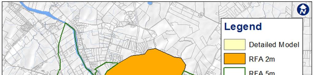
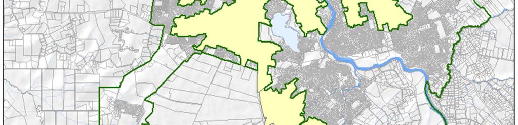
10 5 For the 5m x 5m grid spacing RFA, road culverts greater than 900mm in diameter were included in the model to more accurately reflect surface water flows. These pipes were included in the model as the likelihood of pipes of this size blocking in extreme events (100yr + climate change) was considered lower than for smaller culverts (>900mm). For the 2m x 2m grid spacing RFA, road culverts less than 900mm diameter were also added to the model. Inclusion of the smaller culverts more accurately reflect surface water flows from upper parts of the catchment that may have been held back in the 5m x 5m grid spacing RFA to more accurately model the catchment behaviour in a significant storm event. The range of uncertainty in flood water level from the RFA process as a result of the combined effect of LiDAR and other inaccuracies could in some situations be in excess of 0.5 metres. The data is therefore not considered sufficiently accurate for use as a formal mechanism for assessing flood risk. HCC and other users of the data should take appropriate care in using the results taking into account these uncertainties. A map showing areas where the RFA assessments were undertaken are presented in Appendix C. 4.3 Detailed Flood Hazard Modelling Detailed flood hazard modelling was undertaken on the following sub-catchment areas identified in the RFA as having the highest number of properties at risk of flooding within the budget: Hamilton East Mangakotukutuku Waitawhiriwhiri catchments City CBD Callum Brae The above sub-catchments represent approximately 11% of the total Hamilton City area. A map showing areas where the detailed flood hazard modelling was undertaken is presented in Appendix D. The detailed flood hazard modelling adopted a 2m by 2m grid (industry standard) and included all primary drainage infrastructure in the model i.e. pipes, culverts, watercourses, drains, ponds and catchpits. The outputs from the detailed modelling were reviewed by representatives from AECOM and HCC to confirm the validity of the data. In particular, HCC field operations staff confirmed that the model results aligned with their experience of where flooding generally occurred during large storm events. 4.4 Catchment Management Plan modelling CMP assessments are the final and most detailed level of stormwater assessment and include the work undertaken in the Detailed Flood Hazard Modelling outlined above. CMP modelling normally covers the whole catchment being considered and incorporates the entire stormwater pipe network as well as secondary flow paths. The CMP process also considers the effects of proposed future development as well as range of rainfall events. CMPs are currently being developed for Peacocke Stage 1 and the proposed Ruakura development. As noted previously, HCC have allocated around $3.4M over the next 10 years in their LTP to complete CMPs across the entire city. 4.5 Comparison of RFA and Detailed Flood Hazard Modelling Outputs A comparison of model outputs from the 5m by 5m grid RFA and the detailed flood hazard modelling for Callum Brae was undertaken in order to assess the accuracy of the RFA. Callum Brae was selected for the comparison as the RFA indicated extensive flooding which was considered unlikely given that it was a recently developed area, designed and constructed in accordance with the HCC Development Manual. Results of the comparison are presented in Appendix E. The Callum Brae detailed flood hazard assessment indicates that flooding is primarily contained within road reserves which was the design philosophy adopted for secondary flow path management for the subdivision.
11 6 While the Callum Brae example is likely to be an extreme example, it does highlight the conservatism and inaccuracies associated with the RFA modelling. 4.6 Waikato River Flood Hazard Modelling The Waikato River flood hazard modelling was undertaken by the WRC. The methodology used by the WRC to develop the Waikato River flood hazard mapping differed to that used by AECOM in the urban environment. The WRC methodology used to determine the 100yr ARI water level profile and hazard classification was based on: Developing a river model derived using the software Mike 11 and three approaches to obtain the water level: 1. Using the water level records for various stations along the Waikato River. 2. Hydraulic investigation looking at the effects of land-use changes in the upper catchment. 3. the river flow is based on the expected 100 year outflow from the Karapiro Dam (approximately 1,100m 3 /s) as assessed by Mighty River Power. WRC then spatially mapped the inundation extent using specialist software (WaterRide) and the 2007/2008 LiDAR survey. The resulting inundation information was provided to AECOM in the form of water depth raster files. AECOM converted the raster files into 1m x 1m square polygons with depth attributes. At this stage some gaps were filled where no data existed within the extent of Waikato River. The water depth was used for each square polygon and the hazard classified accordingly. Note that the data for the Waikato River is derived from a 1D hydraulic model and water speed information is not available. This means a full hazard analysis based on depth and velocity cannot be carried out. The Flood Hazard Matrix for the Waikato River is therefore different as it is only based on depth. In terms of the 100yr ARI event level, it should be noted that the Waikato River catchment is large and complex (includes the Waikato Hydro Scheme). This introduces a high variability regarding how the river will respond during periods of heavy rainfall. The flood flow in the Waikato River through Hamilton City depends on the operation of the Waikato Hydro Scheme and the resulting outflow from the Karapiro Dam. The flood flow may also be the result of greater storm durations than used to develop the urban flood hazard maps. The WRC water levels through the Hamilton City area are considered to be appropriate to use for the Proposed District Plan and flooding hazard maps. 4.7 General As noted HCC propose to include Flood Hazard Maps to identify areas that may be at risk of flooding in the Proposed District Plan. HCC propose to use stormwater hazard information obtained in Phase 1 of HCC 3 Waters Modelling programme as the basis for the Flood Hazard Mapping. It is noted however that HCC is currently part way through the proposed modelling programme and that detailed modelling information is not available for all parts of the city. This section provides options and engineering recommendations for development of the Proposed District Plan Flood Hazard Mapping. The following four options were considered for development of the District Plan Flood Hazard Maps: 1. Use the RFA citywide results (2m and 5m grids) with some data cleansing and engineering assessment 2. Use the detailed modelling results augmented with the WRC Waikato River Hazard Modelling and historic HCC flood hazard information for parts of the city not covered by the detailed modelling work 3. Extend the detailed modelling work across the city 4. Complete the CMP work across the city Further discussion on the four options is presented in the following sections Option 1 Rapid Flood Assessment The purpose of the RFA phase was to identify and prioritise areas for detailed modelling. The RFA outputs are not considered to be sufficiently accurate for the purposes of defining flood hazard areas in the Proposed District
12 7 Plan. We therefore we do not recommend that the RFA information be used for this purpose. We note also that other Councils do not use RFA outputs to identify flood hazard areas in their District Plans. Notwithstanding the above, a desk top assessment using data cleansing and engineering experience to refine the outputs from the RFA assessment was considered. This approach would provide a low cost method to provide preliminary citywide flood hazard information. However, this approach would be difficult to defend as the model assumptions are too simplistic. The results may predict flooding in areas where it may not occur. Conversely flooding may not be predicted in areas where it may occur Option 2 Current Detailed Modelling Information The outputs from the detailed modelling assessments are considered to be sufficiently accurate to be used to identify flood hazard areas in the Proposed District Plan. However, it is noted that to date, detailed modelling has only been completed for 11% of the city. Historical HCC flood assessment maps could be utilised for areas outside of the detailed modelling assessments until such time as more detailed information becomes available. It is noted that this data has not been tested against current best practice. However, this information is currently used in the existing District Plan and therefore the risks associated with using this information remain the same. The Waikato River Flood hazard modelling undertaken by the WRC would be used to augment the results of the detailed modelling assessments Option 3 Extend the Detailed Modelling to cover the city This option will provide citywide information that will be sufficiently accurate to be used to identify flood hazard risks in the District Plan. However, extending the detailed modelling assessment across the city will require a significant level of investment both in terms of time and cost. For preliminary budgeting purposes we estimate that that it would cost approximately $1.5 Million to extend the detailed modelling to cover the city and take approximately 12 months to complete Option 4 Complete CMP programme CMP assessments are the final and most detailed level of stormwater assessment and include the work undertaken in the Detailed Flood Hazard Modelling. HCC have allocated approximately $3.4M over the next 10 years for CMPs in their LTP programme. HCC have the option to accelerate this programme. However, acceleration of the programme may mean that HCC will have to fully fund the CMPs rather than requiring developers to complete CMPs as part of their subdivision design process e.g. the developer is currently completing a CMP for the proposed Ruakura Structure Plan Preferred Option In consultation with HCC, Option 2 was adopted as the preferred option. 4.8 District Plan Flood Hazard Maps The outputs of the detailed flood hazard assessment were cleansed and smoothed to simplify and improve the visual appearance of the District Plan Flood Hazard Maps. Details of the cleansing and smoothing process are described below: Cleansing of data The outputs of the detailed flood hazard assessment contained areas of small isolated flood hazards which were likely to be related to localised depressions or inaccuracies in the LiDAR data (e.g. through tree cover, building coverage). These isolated areas were reviewed to confirm their accuracy and determine whether they should be included on the District Plan Flood Hazard Maps. The process adopted is summarised below. Isolated flood hazard squares Isolated flood hazard squares were defined as groups of flood hazard squares not touching other flood hazard squares. The following criteria were adopted to determine whether the isolated flood hazard squares were removed for the District Plan Flood Hazard Maps: 0 to 3 isolated flood hazard squares (less than 12m 2 area) were automatically removed.
13 8 4 to 6 isolated flood hazard squares (less than 24m 2 area) were reviewed to assess the risk associated with the flood hazard. Isolated flood hazard squares considered to pose a low flood risk to the property were removed. Greater than 6 isolated flood hazard squares, the hazard rating remained unchanged. Touching flood hazard squares Touching flood hazard squares were defined as small groups of flood hazard squares adjacent to or surrounded by a lower hazard classification i.e. a small group of high hazard squares surrounded by a medium hazard squares. It is noted that no changes were made in the case where a lower hazard group was surrounded by a higher hazard i.e. there were no increases in hazard classifications. The following criteria were adopted to determine whether the hazard classification of the touching squares was reduced to that of the surrounding squares for the purposes of the District Plan Flood Hazard Maps: 0 to 3 touching flood hazard squares (less than 12m 2 area) were automatically reduced to the lower hazard classification of the surrounding squares. 4 to 6 touching flood hazard squares (less than 24m 2 area) were reviewed to assess the risk associated with the flood hazard from the touching flood hazard squares. Cases where the touching flood hazard squares were considered to pose a similar flood risk to the surrounding squares were adjusted i.e. the touching squares were reduced to the lower hazard classification of the surrounding squares. Greater than 6 isolated hazard cells, the hazard rating remained unchanged Smoothing After the cleansing process was completed the raster (square cell) results were smoothed to provide an improved visual output. This was applied to both the detailed flood hazard assessment areas and the Waikato River data. 5.0 Recommendations for District Plan Flood Hazard Maps Councils are required to make available flood hazard information either through the District Plan or on property LIMs if the information is considered to be reliable. The outputs of the detailed modelling completed to date are considered to be reliable and therefore we support the earlier decision made in consultation with HCC staff that the Proposed District Plan Flood Hazard Maps be based on this information i.e. Option 2 along with cleansing and smoothing of the GIS outputs. It is noted that the detailed modelling information currently available only covers 11% of the city. We therefore recommend that this information be augmented by the historical HCC flood assessment information and the WRC flood hazard information for the Waikato River. We recommend that the District Plan maps be updated in the future as CMPs are completed or if detailed modelling is completed on other parts of the city. 6.0 Limitation This report has been prepared for the particular project described in the brief to us and no responsibility is accepted for the use of any part of this report in other contexts or for any other purposes. For further information regarding the modelling process and limitations the final AECOM Flood Hazard Report dated should be referred to.
14 AAppendix A Flood Hazard Matrices
15 Waikato Regional Council Flood Hazard Matrix Depth (m) Velocity (m/s) High Medium Tauranga City Flood Hazard Matrix Depth (m) Velocity (m/s) Extreme Significant Hazard


16 Auckland City Flood Hazard Matrix Dunedin City Flood Hazard Matrix
17 BAppendix B Flood Hazard Classifications
18 Classification Depth Criteria Velocity Criteria Depth x Velocity Criteria Justification Insignificant 0-0.1m Any velocity N/A Subjective value. At this depth surface water is unlikely to be a hazard to people and unlikely to cause damage to property. NZBC E1 specifies 150mm freeboard to floors, therefore, theoretically habitable floors should be protected from significant damage. Also takes into account inaccuracies found in lidar and modelling. Low 0.1 to 0.5m <1.0m/s N/A At this depth and velocity flood hazards are normally traversable by emergency vehicles and damage to property is minor to moderate. Humans can usually stand. Scour is unlikely to occur. Medium 0.5 to 1.0m <2.0m/s N/A At this depth and velocity human stability in water is at risk. According to the Federal Emergency Management Agency (1979), a moderate sized person begins to lose stability in 0.91 m (3 ft) deep water flowing 0.61 m/s (2 ft/s). Damage to property can be financially significant (Auckland Council Flood Damage Analysis) High >1.0m >2.0m/s >1 At velocities in excess of 2m/s the stability of foundations can be significantly affected by scour (NSW Flood Plain Development Manual). At depths in excess of 1m significant damage to building and risk to life and limb is very likely
19 CAppendix C RFA Assessment Areas


20
21 DAppendix D Detailed Modelling Areas

22
23 EAppendix E Comparison of RFA and Intermediate Assessment Outputs
 medium hazard (0.")

24 E-1 Rapid Flood Assessment Results Green Blue Red low hazard (0.05 to 0.1m deep) medium hazard (0.1 to 1m deep) high hazard (greater than 1m deep) Intermediate Modelling Results Green Blue Red low hazard (0.05 to 0.1m deep) medium hazard (0.1 to 1m deep) high hazard (greater than 1m deep)
Flood Hazard Modelling
 Flood Hazard Modelling Identification Information Dataset Name: Rapid Flood Hazard Model, Detailed Flood Hazard Model Dataset Abstract: The flood hazard model identifies areas that may be subject to flooding
River Road - Civil Design Report. Appendix D. Flood Hazard Map. Beca //04 August // NZ // page 38
 River Road - Civil Design Report Appendix D Flood Hazard Map Beca //04 August 2016 3124460 // NZ1-12891696-39 0.39 // page 38 Regional scale flood hazard mapping Waikato Regional Council holds regional
Chapter 5. Floodplain Management. 5.0 Introduction. 5.1 Floodplain Management and Regulation
 5.0 Introduction This chapter summarizes the Town s rules and regulations regarding floodplain management and development. The requirements presented in this chapter should be used by the design engineer
DRAFT REPORT. Boudreau Developments Ltd. Hole s Site - The Botanica: Fiscal Impact Analysis. December 18, 2012
 Boudreau Developments Ltd. Hole s Site - The Botanica: Fiscal Impact Analysis DRAFT REPORT December 18, 2012 2220 Sun Life Place 10123-99 St. Edmonton, Alberta T5J 3H1 T 780.425.6741 F 780.426.3737 www.think-applications.com
Trip Rate and Parking Databases in New Zealand and Australia
 Trip Rate and Parking Databases in New Zealand and Australia IAN CLARK Director Flow Transportation Specialists Ltd ian@flownz.com KEYWORDS: Trip rates, databases, New Zealand developments, common practices
Chapter 5. Floodplain Management. 5.0 Introduction. 5.1 Douglas County Comprehensive Master Plan. 5.2 Floodplain Management and Regulation
 5.0 Introduction This chapter summarizes the County s rules and regulations regarding floodplain management and development. The requirements presented in this chapter should be used by the design engineer
GUIDE TO SUBDIVISION & LAND DEVELOPMENT
 GUIDE TO SUBDIVISION & LAND DEVELOPMENT The Fraser Thomas Difference: Fraser Thomas Ltd is an engineering and surveying consulting firm based in Highbrook, and has been providing; Surveying, Engineering,
PIP practice note 1 planning assumptions. How to use this practice note. Planning assumptions. What are planning assumptions? Type.
 PIP PRACTICE NOTE 1 How to use this practice note This practice note has been prepared to support in the preparation or amending of planning assumptions within a priority infrastructure plan (PIP). It
Hutt River City Centre Upgrade Project Preliminary Integrated Design
 Report 2016.24 Date 5 February 2016 File N/03/18/22 Committee Author Hutt Valley Flood Management Subcommittee Daya Atapattu, Senior Project Engineer Hutt River City Centre Upgrade Project Preliminary
ENVIRONMENT CANTERBURY S WEB-BASED CONTAMINATED LAND INFORMATION TRANSFER SYSTEM
 ENVIRONMENT CANTERBURY S WEB-BASED CONTAMINATED LAND INFORMATION TRANSFER SYSTEM Davina McNickel 1, Helen Davies 2, Vincent Salomon 2 1 Environment Canterbury, PO Box 345, Christchurch. Telephone: 03 365
Project Appraisal Guidelines for National Roads Unit Project Appraisal Plan
 Project Appraisal Guidelines for National Roads Unit 2.1 - Project Appraisal Plan October 2016 TRANSPORT INFRASTRUCTURE IRELAND (TII) PUBLICATIONS About TII Transport Infrastructure Ireland (TII) is responsible
Guide to Subdivision and Land Development
 Guide to Subdivision and Land Development Fraser Thomas Ltd......is an engineering and surveying consulting firm based in Highbrook which has provided Surveying, Engineering, Planning and Resource Management
Research & Forecast Report New Zealand Workplace Report. Occupational trends across New Zealand. Accelerating success.
 Research & Forecast Report New Zealand 14 Workplace Report Occupational trends across New Zealand Accelerating success. Introduction In the seventh edition of our biennial CBD office workplace report,
Scheme Sample Report. Firstname Lastname. Address, Suburb, City 0000
 Scheme Sample Report Firstname Lastname Address, Suburb, City 0000 1 Disclaimer and Copyright The Urban Options reports provide those considering residential development with an understanding of the range
Housing Need in South Worcestershire. Malvern Hills District Council, Wychavon District Council and Worcester City Council. Final Report.
 Housing Need in South Worcestershire Malvern Hills District Council, Wychavon District Council and Worcester City Council Final Report Main Contact: Michael Bullock Email: michael.bullock@arc4.co.uk Telephone:
Project Appraisal Guidelines for National Roads Unit Introduction
 Project Appraisal Guidelines for National Roads Unit 1.0 - Introduction October 2016 TRANSPORT INFRASTRUCTURE IRELAND (TII) PUBLICATIONS About TII Transport Infrastructure Ireland (TII) is responsible
Report to COUNCIL for decision
 16 368 Title: Section: Prepared by: Waipaoa Flood Control Scheme Resilience Project Update Environmental & Regulatory Services Neil Daykin (Rivers, Drainage and Coastal Manager) Meeting Date: 1 December
Impact Assessment (IA)
") Title: Permission in principle for development plans and brownfield registers IA No: RPC-3069(2)-CLG Lead department or agency: Department for Communities and Local Government Other departments or agencies:
Title: Permission in principle for development plans and brownfield registers IA No: RPC-3069(2)-CLG Lead department or agency: Department for Communities and Local Government Other departments or agencies:
First Experiences under the Tauranga Housing Accord
 First Experiences under the Tauranga Housing Accord Richard Coles Boffa Miskell, Tauranga - Richardc@boffamiskell.co.nz Paul Taylor Classic Builders/PMP Developments, Bay of Plenty/Waikato - Paul.taylor@classicbuilders.co.nz
Note on housing supply policies in draft London Plan Dec 2017 note by Duncan Bowie who agrees to it being published by Just Space
 Note on housing supply policies in draft London Plan Dec 2017 note by Duncan Bowie who agrees to it being published by Just Space 1 Housing density and sustainable residential quality. The draft has amended
FLOOD HAZARD AREA LAND USE MANAGEMENT
 FLOOD HAZARD AREA LAND USE MANAGEMENT Introduction Guidance For Selection of Qualified Professionals and Preparation of Flood Hazard Assessment Reports This document is intended to provide guidance for
Request for Development Land in the Palm Springs Subdivision to be Granted Special Housing Area Status under the Tauranga Housing Accord
 Request for Development Land in the Palm Springs Subdivision to be Granted Special Housing Area Status under the Tauranga Housing Accord Development Proposal Overview of proposal This request is lodged
Activity Centre Parking Demand: a Novel Forecasting Model, its Applications and Extensions
 JACOB MARTIN Team Leader Transport Planning Cardno jacob.martin@cardno.com PAPER TITLE There is a growing recognition that parking is an essential contributor to the function of the transport system. Widely
DAYLIGHT SIMULATION FOR CODE COMPLIANCE: CREATING A DECISION TOOL. Krystle Stewart 1 and Michael Donn 1
 DAYLIGHT SIMULATION FOR CODE COMPLIANCE: CREATING A DECISION TOOL Krystle Stewart 1 and Michael Donn 1 1 School of Architecture, Victoria University of Wellington, Wellington, New Zealand ABSTRACT The
Alberta Flood Hazard Identification Program
 Alberta Flood Hazard Identification Program Peter Onyshko, P.Eng., CFM River Forecast Section Alberta Environment and Parks November 5, 2015 Flood Hazard Identification Program Presentation Outline Introduction
Historic Environment Scotland
 Historic Environment Scotland 1 of 14 Condition Monitoring System for properties in the care of Scottish Ministers and associated collections. September 2015 2 of 14 Purpose and Scope This document sets
Orange Water and Sewer Authority Water and Sewer System Development Fee Study
 Orange Water and Sewer Authority Water and Sewer System Development Fee Study March 6, 2018 March 6, 2018 Mr. Stephen Winters Director of Finance and Customer Service 400 Jones Ferry Road Carrboro, NC
Section One: General Information
 Version no 1.0 CM Reference 17138891 Adopted 21 September 2017 Last review date (if applicable) NA Next review date Select review period 9/10/2017 1yr 2yr 3yr The policy is divided into the following sections:
Economic Significance of the Property Industry to the. OTAGO Economy PREPARED FOR PROPERTY COUNCIL NEW ZEALAND BY URBAN ECONOMICS
 Economic Significance of the Property Industry to the OTAGO Economy PREPARED FOR PROPERTY COUNCIL NEW ZEALAND BY URBAN ECONOMICS 2016 ABOUT PROPERTY COUNCIL NEW ZEALAND Property Council New Zealand is
NEM GENERATOR TRANSFER GUIDE
 NEM GENERATOR TRANSFER GUIDE Purpose AEMO has prepared this document to provide information about the process for becoming a registered as a participant in the National Electricity Market, as at the date
CONTACT(S) Annamaria Frosi +44 (0) Rachel Knubley +44 (0)
 Annamaria Frosi +44 (0) Rachel Knubley +44 (0)") IASB Agenda ref 11 STAFF PAPER IASB Meeting Project Paper topic Materiality Practice Statement Sweep issues covenants CONTACT(S) Annamaria Frosi afrosi@ifrs.org +44 (0)20 7246 6907 Rachel Knubley rknubley@ifrs.org
IASB Agenda ref 11 STAFF PAPER IASB Meeting Project Paper topic Materiality Practice Statement Sweep issues covenants CONTACT(S) Annamaria Frosi afrosi@ifrs.org +44 (0)20 7246 6907 Rachel Knubley rknubley@ifrs.org
DRAFT FEASIBILITY REPORT CENTRAL HILL ESTATE LONDON BOROUGH OF LAMBETH
 DRAFT FEASIBILITY REPORT For the Project At Prepared On Behalf Of LONDON BOROUGH OF LAMBETH Date: 6 th July 2016 Reference: 14/124 Central Hill Version 5 Version Control Version Date Author Page No(s)
1. *Does the document clearly specify the aims, objectives and scope of the proposed programme of archaeological work?
 Notes and Guidance This document provides curatorial advisors, archaeological practitioners and other interested parties with additional information and guidance on the standards and expectations for archaeological
CONTACT(S) Annamaria Frosi +44 (0) Rachel Knubley +44 (0)
 Annamaria Frosi +44 (0) Rachel Knubley +44 (0)") IASB Agenda ref 11 STAFF PAPER IASB Meeting Project Paper topic Materiality Practice Statement Sweep issues covenants CONTACT(S) Annamaria Frosi afrosi@ifrs.org +44 (0)20 7246 6907 Rachel Knubley rknubley@ifrs.org
IASB Agenda ref 11 STAFF PAPER IASB Meeting Project Paper topic Materiality Practice Statement Sweep issues covenants CONTACT(S) Annamaria Frosi afrosi@ifrs.org +44 (0)20 7246 6907 Rachel Knubley rknubley@ifrs.org
BUSI 330 Suggested Answers to Review and Discussion Questions: Lesson 10
 BUSI 330 Suggested Answers to Review and Discussion Questions: Lesson 10 1. The client should give you a copy of their income and expense statements for the last 3 years showing their rental income by
State Highway Revocation: Policy and Guidance
 State Highway Revocation: Policy and Guidance Revocation and consultation 1. Where there are changes to the state highway network that create duplicate sections of State highway serving the same function
R E Q U E S T F O R P R O P O S A L S
 P.O. Box 3209, Houghton, 2041 Block A, Riviera Office Park, 6-10 Riviera Road, Riviera R E Q U E S T F O R P R O P O S A L S M A R K E T S U R V E Y T O I N F O R M R E S I D E N T I A L H O U S I N G
Section 12A Purpose of Subdivision Provisions
 Section 12A 12A Purpose of Subdivision Provisions Subdivision is primarily about creating land parcels that define and redefine property rights and, in most instances, the creation of new parcels of land
IASB Exposure Draft ED/2013/6 - Leases
 ACAG AUSTRALASIAN COUNCIL OF AUDITORS GENERAL 13 September 2013 Mr Hans Hoogervorst Chairman International Accounting Standards Board 30 Cannon Street London EC4M 6XH United Kingdom Dear Mr Hoogervorst
Hamilton s Housing Market and Economy
 Hamilton s Housing Market and Economy Growth Indicator Report December 217 hamiltoninvest.co.nz Contents 3. Introduction 4. New Residential Building Consents 5. New Residential Sections and Titles (224c)
Mooroopna West Growth Corridor Development Contribution Plan
 Mooroopna West Growth Corridor Development Contribution Plan Adopted at the July 7 2009 Ordinary Council Meeting Amended following approval of Amendment C160 and Amendment C167 to the Greater Shepparton
Community Occupancy Guidelines
 Community Occupancy Guidelines Auckland Council July 2012 Find out more: phone 09 301 0101 or visit www.aucklandcouncil.govt.nz Contents Introduction 4 Scope 5 In scope 5 Out of scope 5 Criteria 6 Eligibility
Agreements for the Construction of Real Estate
 HK(IFRIC)-Int 15 Revised August 2010September 2018 Effective for annual periods beginning on or after 1 January 2009* HK(IFRIC) Interpretation 15 Agreements for the Construction of Real Estate * HK(IFRIC)-Int
SECTION 10: FLOOD HAZARD EVALUATION 10-1
 10) SECTION 10: FLOOD HAZARD EVALUATION A. General. Land subject to being flooded by a Flood of 100-Year Frequency as defined by Title 76, Chapter 5, MCA, or land subject to flooding pursuant to these
National Policy Statement on Urban Development Capacity Price efficiency indicators technical report: Price-cost ratios
 National Policy Statement on Urban Development Capacity Price efficiency indicators technical report: Price-cost ratios Acknowledgements: SensePartners is acknowledged for the development of this technical
Explanation The policies ensure that land is suitable for subdivision and will not increase risks to people, the environment and property.
 23 Subdivision 23.1 Purpose a) Subdivision is essentially the process of dividing a parcel of land or a building into one or more further parcels, or changing an existing boundary location. Subdivision
LOCAL GOVERNMENT INFRASTRUCTURE PLAN SUPPORTING DOCUMENT PLANNING ASSUMPTIONS SUMMARY REPORT
 LOCAL GOVERNMENT INFRASTRUCTURE PLAN SUPPORTING DOCUMENT PLANNING ASSUMPTIONS SUMMARY REPORT 2000 2016 TABLE OF CONTENTS 1.0 INTRODUCTION... 1 1.1 PREAMBLE...1 1.2 BACKGROUND...1 1.3 OVERVIEW...2 2.0 IPSWICH
A NOMINAL ASSET VALUE-BASED APPROACH FOR LAND READJUSTMENT AND ITS IMPLEMENTATION USING GEOGRAPHICAL INFORMATION SYSTEMS
 A NOMINAL ASSET VALUE-BASED APPROACH FOR LAND READJUSTMENT AND ITS IMPLEMENTATION USING GEOGRAPHICAL INFORMATION SYSTEMS by Tahsin YOMRALIOGLU B.Sc., M.Sc. A thesis submitted for the Degree of Doctor of
Depreciation A QUICK REFERENCE GUIDE FOR ELECTED OFFICIALS AND STAFF
 Depreciation A QUICK REFERENCE GUIDE FOR ELECTED OFFICIALS AND STAFF This booklet is a quick reference guide to help you to: understand the purpose and function of accounting for and reporting on the depreciation
Land Information Memorandum
 Land Information Memorandum Rhonda G Evans Solicitors PO Box 19196 Avondale Auckland 1746 Applicant LIM address Application number Client name/ref Date issued Legal description Certificates of title Rhonda
Economic Significance of the Property Industry to the. WELLINGTON Economy PREPARED FOR PROPERTY COUNCIL NEW ZEALAND BY URBAN ECONOMICS
 Economic Significance of the Property Industry to the WELLINGTON Economy PREPARED FOR PROPERTY COUNCIL NEW ZEALAND BY URBAN ECONOMICS 2016 ABOUT PROPERTY COUNCIL NEW ZEALAND Property Council New Zealand
7829 Glenwood Avenue Canal Winchester, Ohio November 19,2013
 7829 Glenwood Avenue Canal Winchester, Ohio 43110 614-920-1425 November 19,2013 Technical Director File Reference Number 2013-270 Financial Standards Accounting Board 401 Merritt 7 Norwalk, Connecticut
Proposed Strategic Housing and Employment Land Availability Assessment (SHELAA) Methodology 2018
 Methodology 2018") Proposed Strategic Housing and Employment Land Availability Assessment (SHELAA) Methodology 2018 1.1 This section of the report sets out the methodology to be used in preparing the three South Worcestershire
Proposed Strategic Housing and Employment Land Availability Assessment (SHELAA) Methodology 2018 1.1 This section of the report sets out the methodology to be used in preparing the three South Worcestershire
Comparative Market Analysis
 Australian Buyers Agent Services L29 Chifley Tower, Sydney, NSW, 2000 Ph: 1300 319 809 Comparative Market Analysis Contact Details Australian Buyers Agent Services Mobile: 1300 319 809 Email: info@austbas.com.au
City of Bellingham Urban Growth Area - Land Supply Analysis Summary
 City of Bellingham Urban Growth Area - Land Supply Analysis Summary Population & Employment Growth Forecasts APPENDIX D, ATTACHMENT 3 The ECONorthwest Whatcom County Population & Economic Forecasts report
Current Situation and Issues
 Handout 13: Impervious and Gross Area Charges The purpose of this handout is to frame the issues around the gross and impervious parcel area based charges. Current Situation and Issues Current Structure
Paragraph 47 National Planning Policy Framework. rpsgroup.com/uk
 To boost significantly the supply of housing, local planning authorities should use their evidence base to ensure that their Local Plan meets the full, objectively assessed needs for market and affordable
Corporate Services Planning and Economic Development. Memorandum
 Corporate Services Planning and Economic Development Memorandum TO: FROM: Committee of the Whole Paul Freeman, Chief Planner DATE: June 21, 2018 RE: York Region C omments on Draft Provinci al Guidance
ASSESSMENT METHODOLOGY
 2018 ASSESSMENT METHODOLOGY COST APPROACH A summary of the methods used by the City of Edmonton in determining the value of residential and non-residential properties valued using the cost approach in
Strategic Housing Market Assessment South Essex. Executive Summary. May 2016
 Strategic Housing Market Assessment South Essex Executive Summary May 2016 Executive Summary 1. Turley in partnership with specialist demographic consultancy Edge Analytics were commissioned by the Thames
Administration and Calculation of Servicing Agreement Fees and Development Levies
 Administration and Calculation of Servicing Agreement Fees and Development Levies Policy Title: Applies to: Reference # Administration and Calculation of Servicing Agreement Fees and City of Regina ###-XXX-##
Southern Water Infrastructure Charges Scheme
 Southern Water Infrastructure Charges Scheme 2018-19 Contents Preface Statement of Board Assurance provided to the Water Services Regulation Authority 2018-19 Charges... 3 Part 1 - Introduction and Commencement...
2019 Development Charges By-law Update Project Plan
 Staff Report for Committee of the Whole Meeting Department: Division: Subject: Corporate and Financial Services Financial Services 2019 Development Charges By-law Update Project Plan Purpose: This report
LIM Application for 1/ 240 Hurstmere Road Takapuna 0622
 21 October 2015 G Bogiatto and B J Malcolm 23B Riverside Road OREWA 0931 LIM Application for 1/ 240 Hurstmere Road Takapuna 0622 This Land Information Memorandum (LIM) details information known to Council
Vested Assets Deep Dive Report
 Vested Assets Deep Dive Report Recommendation That the Board: i. Receive the report. Executive summary AT receives vested assets from developers and the NZ Transport Agency, with more than half a billion
Presentation to the Real Estate Institute of New Zealand 28 October 2016
 Presentation to the Real Estate Institute of New Zealand 28 October 2016 Disclaimer This presentation provides a high level overview of specific parts of the Proposed Auckland Unitary Plan Decisions Version
RE: Proposed Accounting Standards Update, Leases (Topic 842): Targeted Improvements (File Reference No )
: Targeted Improvements (File Reference No )") KPMG LLP Telephone +1 212 758 9700 345 Park Avenue Fax +1 212 758 9819 New York, N.Y. 10154-0102 Internet www.us.kpmg.com 401 Merritt 7 PO Box 5116 Norwalk, CT 06856-5116 RE: Proposed Accounting Standards
KPMG LLP Telephone +1 212 758 9700 345 Park Avenue Fax +1 212 758 9819 New York, N.Y. 10154-0102 Internet www.us.kpmg.com 401 Merritt 7 PO Box 5116 Norwalk, CT 06856-5116 RE: Proposed Accounting Standards
JOINT CORE STRATEGY FOR BROADLAND, NORWICH AND SOUTH NORFOLK EXAMINATION MATTER 3A GENERAL STRATEGY FOR THE GROWTH LOCATIONS
 Matter 3A General Strategy for the Growth Locations Representor No. 8826 JOINT CORE STRATEGY FOR BROADLAND, NORWICH AND SOUTH NORFOLK EXAMINATION MATTER 3A GENERAL STRATEGY FOR THE GROWTH LOCATIONS SUBMISSION
Policy on Development and Financial Contributions Detailed Supporting Document Version of 1/07/15
 Policy on Development and Financial Contributions Detailed Supporting Document Version of 1/07/15 Effective Date: 1 July 2015 Document Status: Final QUEENSTOWN LAKES DISTRICT COUNCIL POLICY ON DEVELOPMENT
Business Combinations
 Business Combinations Indian Accounting Standard (Ind AS) 103 Business Combinations Contents Paragraphs OBJECTIVE 1 SCOPE 2 IDENTIFYING A BUSINESS COMBINATION 3 THE ACQUISITION METHOD 4 53 Identifying
INVENTORY POLICY For Real Property
 INVENTORY POLICY For Real Property (Broader Public Sector Entities) Page 1-12 CONTENTS 1. TITLE... 3 2. OVERVIEW... 3 3. PURPOSE... 3 4. POLICY STATEMENT... 3 5. APPLICATION... 7 6. EVALUATION AND REVIEW...
City Of Attleboro Conservation Commission
 City Of Attleboro Conservation Commission GOVERNMENT CENTER, 77 PARK STREET ATTLEBORO, MASSACHUSETTS 02703 (508) 223 2222 FAX 222 3046 GENERAL INSTRUCTIONS AND CHECKLIST FOR COMPLETING STORMWATER MANAGEMENT
IFRS 16 Lease overview and EY s enabling toolkit
 IFRS 16 Lease overview and EY s enabling toolkit Content Page Section I IFRS 16 overview 2 Appendix I EY Lease enabling technology suite 9 Appendix II EY Contacts 17 Page 1 IFRS 9 Classification and measurement
EVGN 11. The Valuer s Use of Statistical Tools
 EVGN 11 The Valuer s Use of Statistical Tools 1. Introduction 2. Preconditions for the use of AVMs 3. Limitations on the use of AVMs once the preconditions have been met 4. Portfolio valuation 1. Introduction
2017 ROAD ASSET VALUATION
 Appendix 1 2017 ROAD ASSET VALUATION Prepared for Gisborne District Council July 2017 This document has been prepared for the benefit of Gisborne District Council. No liability is accepted by this company
Build Over Easement Guidelines
 Build Over Easement Guidelines Document Owner Creation Date 13/04/2015 Revision Date 20/04/2015 Manager Engineering Services Engineering Services Please check Council s Intranet to ensure this is the latest
Before the Minnesota Public Utilities Commission State of Minnesota. Docket No. E002/GR Exhibit (LMC-1) Property Taxes
 Property Taxes") Direct Testimony and Schedules Leanna M. Chapman Before the Minnesota Public Utilities Commission State of Minnesota In the Matter of the Application of Northern States Power Company for Authority to Increase
Direct Testimony and Schedules Leanna M. Chapman Before the Minnesota Public Utilities Commission State of Minnesota In the Matter of the Application of Northern States Power Company for Authority to Increase
Intangible Assets Web Site Costs
 HK(SIC)-Int 32 Revised May 2014 September 2018 Effective for annual periods beginning on or after 1 January 2005 Hong Kong (SIC) Interpretation 32 Intangible Assets Web Site Costs COPYRIGHT Copyright 2018
RESOLUTION NO ( R)
") RESOLUTION NO. 2013-06- 088 ( R) A RESOLUTION OF THE CITY COUNCIL OF THE CITY OF McKINNEY, TEXAS, APPROVING THE LAND USE ASSUMPTIONS FOR THE 2012-2013 ROADWAY IMPACT FEE UPDATE WHEREAS, per Texas Local
RESOLUTION NO. 2013-06- 088 ( R) A RESOLUTION OF THE CITY COUNCIL OF THE CITY OF McKINNEY, TEXAS, APPROVING THE LAND USE ASSUMPTIONS FOR THE 2012-2013 ROADWAY IMPACT FEE UPDATE WHEREAS, per Texas Local
How to Read a Real Estate Appraisal Report
 How to Read a Real Estate Appraisal Report Much of the private, corporate and public wealth of the world consists of real estate. The magnitude of this fundamental resource creates a need for informed
Nottingham City Council Whole Plan & Community Infrastructure Levy Viability Assessment. January Executive Summary NCS. Nationwide CIL Service
 Nottingham City Council Whole Plan & Community Infrastructure Levy Viability Assessment January 2016 Executive Summary NCS Nationwide CIL Service Contents 1. Executive Summary Page 2 2. Introduction Page
Statement of Proposal
 Christchurch City Council Statement of Proposal that the Council Restructures its Social Housing Portfolio Contents 1 Statement of Proposal 7 Attachment A: Description of Options for Social Housing Portfolio
The survey also examines the underlying causes of FVM and impairment audit
 Acuitas, Inc. s Survey of Fair Value Audit April 20122 Executive Summary Public Company Accounting Oversight Board (PCAOB) inspections have noted a dramatic increase in the number of fair value measurement
Volume Three Appendix 7. Scheme Plan and other subdivision requirements
 Volume Three Appendix 7 Appendix 7 Scheme Plan and other subdivision requirements Any application for subdivision consent must be accompanied by a Scheme Plan that contains the information set out in this
CORPORATE STANDARD FUNDING AND DELIVERY OF GROWTH INFRASTRUCTURE VERSION: 1.0
 CORPORATE STANDARD FUNDING AND DELIVERY OF GROWTH INFRASTRUCTURE VERSION: 1.0 Contents 1. Purpose... 3 2. Scope... 3 3. Definitions... 3 4. Growth Plan... 4 5. Funding and delivery categories... 4 5.1
REPORT HUTT CITY COUNCIL. Preliminary Land Development Assessment 8 Harold Grove, Stokes Valley. Report prepared for: HUTT CITY COUNCIL
 REPORT HUTT CITY COUNCIL Preliminary Land Development Assessment 8 Harold Grove, Stokes Valley Report prepared for: HUTT CITY COUNCIL Report prepared by: TONKIN & TAYLOR LTD Distribution: HUTT CITY COUNCIL
Applying IFRS. A closer look at the new leases standard. August 2016
 Applying IFRS A closer look at the new leases standard August 2016 Contents Overview 3 1. Scope and scope exceptions 5 1.1 General 5 1.2 Determining whether an arrangement contains a lease 6 1.3 Identifying
CORPORATION OF THE TOWNSHIP OF LEEDS AND THE THOUSAND ISLANDS BY-LAW
 CORPORATION OF THE TOWNSHIP OF LEEDS AND THE THOUSAND ISLANDS BY-LAW 16-025 BEING A BY-LAW TO ADOPT A TANGILBLE CAPITAL ASSET POLICY FOR THE TOWNSHIP OF LEEDS AND THE THOUSAND ISLANDS. WHEREAS Section
PROJECT INFORMATION DOCUMENT (PID) CONCEPT STAGE Report No.: AB3229 Project Name. Land Registry and Cadastre Modernization Project Region
 CONCEPT STAGE Report No.: AB3229 Project Name. Land Registry and Cadastre Modernization Project Region") PROJECT INFORMATION DOCUMENT (PID) CONCEPT STAGE Report No.: AB3229 Project Name Land Registry and Cadastre Modernization Project Region EUROPE AND CENTRAL ASIA Sector Central government administration
PROJECT INFORMATION DOCUMENT (PID) CONCEPT STAGE Report No.: AB3229 Project Name Land Registry and Cadastre Modernization Project Region EUROPE AND CENTRAL ASIA Sector Central government administration
INVENTORY POLICY For Real Property
 INVENTORY POLICY For Real Property (Consolidated Revenue Fund Entities) Page 1-10 CONTENTS 1. TITLE... 3 2. OVERVIEW... 3 3. PURPOSE... 3 4. POLICY STATEMENT... 3 5. APPLICATION... 7 6. EVALUATION AND
Administration and Calculation of Servicing Agreement Fees and Development Levies
 Administration and Calculation of Servicing Agreement Fees and Development Levies Policy Title: Applies to: Administration and Calculation of Servicing Agreement Fees and City of Regina City Planning and
APPENDIX A: VALUATION OF REAL ESTATE OWNED PROPERTIES A-1 REAL ESTATE OWNED (REO)
") APPENDIX A: VALUATION OF REAL ESTATE OWNED PROPERTIES 4150.2 A-1 REAL ESTATE OWNED (REO) FHA s Real Estate Owned (REO) properties are a result of paying a claim to a lending institution and the lender
APPENDIX A: VALUATION OF REAL ESTATE OWNED PROPERTIES 4150.2 A-1 REAL ESTATE OWNED (REO) FHA s Real Estate Owned (REO) properties are a result of paying a claim to a lending institution and the lender
Council 20 December Midlothian Strategic Housing Investment Plan 2017/ /22. Report by Eibhlin McHugh, Joint Director, Health & Social Care
 Council 20 December 2016 Midlothian Strategic Housing Investment Plan 2017/18 2021/22 Report by Eibhlin McHugh, Joint Director, Health & Social Care 1 Purpose of Report This Report summarises the key points
Regeneration and Property Committee. 16 March 2017
 Regeneration and Property Committee 16 March 2017 Subject: Director/Head of Service: Access rights relating to the compulsory purchase of land to the rear of 7-10 St Margaret's Street, Canterbury, CT1
12 September Mr Hans Hoogervorst Chairman The International Accounting Standards Board 30 Cannon Street London EC4M 6XH United Kingdom
 12 September 2013 Mr Hans Hoogervorst Chairman The International Accounting Standards Board 30 Cannon Street London EC4M 6XH United Kingdom Email: commentletters@ifrs.org. Dear Hans Exposure Draft ED/2013/6
File Reference No Re: Proposed Accounting Standards Update, Leases (Topic 842): Targeted Improvements
: Targeted Improvements") Deloitte & Touche LLP 695 East Main Street Stamford, CT 06901-2141 Tel: + 1 203 708 4000 Fax: + 1 203 708 4797 www.deloitte.com Ms. Susan M. Cosper Technical Director Financial Accounting Standards Board
Deloitte & Touche LLP 695 East Main Street Stamford, CT 06901-2141 Tel: + 1 203 708 4000 Fax: + 1 203 708 4797 www.deloitte.com Ms. Susan M. Cosper Technical Director Financial Accounting Standards Board
Application for a sewer requisition and/or the diversion of an existing sewer
 SWW Reference No: WR Application for a sewer requisition and/or the diversion of an existing sewer This form can be used to apply for a new sewer requisition, under section 98-101, and/or a new sewer diversion,
 South Worcestershire Development Plan Examination Representation Form Additional Pages Consultation on Proposed Modifications to SWDP: 6 October 14 November 2014 South Worcestershire Councils Additional
Repsol is very pleased to provide comments on the Exposure Draft Leases (ED2013/6), issued by the IASB on 16 May 2013.
, issued by the IASB on 16 May 2013.") Madrid, 13 September, 2013 International Accounting Standards Board 30 Cannon Street London EC4M 6XH United Kingdom Dear Sir/Madam, Re: Leases Repsol is very pleased to provide comments on the Exposure
Madrid, 13 September, 2013 International Accounting Standards Board 30 Cannon Street London EC4M 6XH United Kingdom Dear Sir/Madam, Re: Leases Repsol is very pleased to provide comments on the Exposure
City of Grande Prairie Development Services Department
 City of Grande Prairie Development Services Department COUNTRYSIDE SOUTH OUTLINE PLAN Prepared by: GPEC Consulting Ltd. #202, 10712-100th Street Grande Prairie, AB Council Resolution of August 20, 2001