TOWN OF MANCHESTER PLANNING AND ZONING COMMISSION. 7:00 P.M. 494 Main Street AGENDA
|
|
|
- Nancy Bradley
- 5 years ago
- Views:
Transcription
1 TOWN OF MANCHESTER PLANNING AND ZONING COMMISSION July 16, 2018 Lincoln Center Hearing Room 7:00 P.M. 494 Main Street AGENDA PUBLIC HEARING: 1. KRISTINE CARLSON Re-subdivision of the existing lot at 637 South Main Street into eight lots, including construction of six additional residential properties and one open space parcel. Resubdivision ( ) NEW BUSINESS: 1. KRISTINE CARLSON Re-subdivision of the existing lot at 637 South Main Street into eight lots, including construction of six additional residential properties and one open space parcel. Inland Wetlands Permit Determination of Significance ( ) Inland Wetlands Permit ( ) Resubdivision ( ) Erosion & Sedimentation Control Plan ( ) 2. AREC 21, LLC Request 5-year extensions of the previously approved special exception modification F-147 and erosion control plan F-148 at and 71 Spencer Street. Extension of Previously Approved Special Exception Modification ( ) Extension of Previously Approved Erosion & Sedimentation Control Plan ( ) 3. BRIAN BASILE For a building addition and installation of a swimming pool within the 100' upland review area at 35 Glendale Road. Inland Wetlands Permit Determination of Significance ( ) Inland Wetlands Permit ( ) 4. TOWN OF MANCHESTER PUBLIC WORKS DEPARTMENT For construction of two water quality basins at 100 Spring Street. Inland Wetlands Permit Determination of Significance ( ) Inland Wetlands Permit ( ) Erosion & Sedimentation Control Plan ( ) Flood Plain Permit ( ) 5. ADMINISTRATIVE REPORTS
2 6. APPROVAL OF MINUTES June 18, 2018 Public Hearing/Business Meeting 7. RECEIPT OF NEW APPLICATIONS R:\Planning\PZC\2018\07 - July 16\Agenda 16 JUL 2018.docx
3 TOWN OF MANCHESTER LEGAL NOTICE The Planning and Zoning Commission will hold a public hearing on July 16, 2018, at 7:00 P.M. in the Lincoln Center Hearing Room, 494 Main Street, Manchester, Connecticut to hear and consider the following petition: KRISTINE CARLSON Resubdivision ( ) Re-subdivision of an existing lot at 637 South Main Street, Rural Residence zone, into eight lots, including construction of six additional residential properties and one open space parcel. At this hearing interested persons may be heard and written communications received. A copy of this petition is in the Planning Department, Lincoln Center Building, 494 Main Street, and may be inspected during regular business hours (8:30 a.m. 4:30 p.m., Monday through Friday). Planning and Zoning Commission Eric Prause, Chair
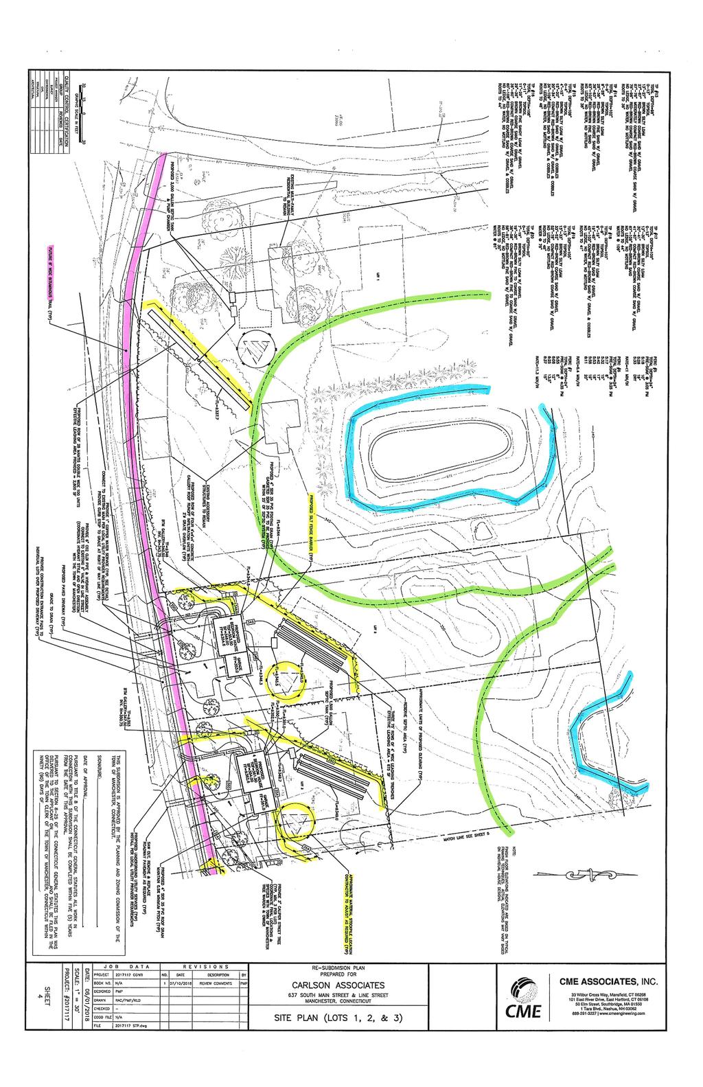
4 TOWN OF MANCHESTER PLANNING DEPARTMENT TO: FROM: Planning and Zoning Commission/Inland Wetlands Agency Matthew R. Bordeaux, Senior Planner DATE: July 11, 2018 RE: Kristine Carlson 637 South Main Street Inland Wetlands Permit and Determination of Significance ( ) Resubdivision ( ) Erosion and Sedimentation Control ( ) Introduction The applicant is proposing a resubdivision of the 11-acre parcel at 637 South Main Street, Rural Residence zone. The property is located on the northeast corner of South Main Street (Rt. 83) and Line Street. The property is abutted by the Town-owned Manchester Country Club to the north and east, and a single-family residence to the north on South Main Street. The property includes three structures (one house and two barns) close in proximity to South Main Street. The remainder of the property is heavily wooded and includes two ponds and associated wetlands. The proposed project involves the creation of a cluster subdivision in accordance with the provisions of Article III, Section 4 of the Manchester Zoning Regulations. The subject parcel will be re-subdivided into eight total lots. The three existing structures will be on one parcel at a size of approximately 3.68 acres (160,495 sq. ft.). Six proposed parcels with frontage and access on Line Street will contain single-family residences on lot sizes ranging from 0.58 acres (25,540 sq. ft.) to 1.40 acres (61,230 sq. ft.) The eighth lot is proposed to be open space, at an area of 2.84 acres (123,510 sq. ft.). Project Description In accordance with Zoning Regulations Article III, Section 4, A cluster subdivision permits the residential lots in Rural Residence zones and Residence AA zones to be reduced in dimension and designed to occupy less than the total tract area of the subdivision provided that the maximum building density is not exceeded. The undeveloped portion of the tract shall be designed and dedicated as public open space. The minimum area of subdivision shall be not less than 10 acres and the open space requirement shall be not less than 25 percent of the entire tract. Article III, Section 4.03 provides for the cluster subdivision of tracts of land in the Rural Residence zone by permitting the reduction of dimension and design to the standards set forth in Article II, Section for the Residence AA zone. In other words, minimum lot area is
5 Carlson 637 S. Main St. Page 2 of 4 reduced from 30,000 square feet to 18,000 square feet; minimum lot frontage from 150 feet to 120 feet; and minimum front yard from 50 feet to 40 feet. Accordingly, the applicant is proposing six new single-family house lots on Line Street. The proposed homes will have four (4) bedrooms and attached garages. Public water will be provided from a service in Line Street and each house will include a private septic system. The remaining utilities (i.e. electric, telephone, etc.) will be installed underground. The plans also depict street trees in accordance with the Subdivision Regulations Section 4.10, which have been provided at a rate of one for every 50 feet of street frontage. Stormwater on site flows generally northwesterly towards the pond located on Proposed Lot 1. The applicant s drainage report states that the existing pond appears to be a glacial kettle hole, or manmade depression, and does not have any apparent outlet. Therefore, the increase of peak flow from the 100-year storm will not have any negative impact on downstream properties, and will be recharged to groundwater via the permeable soils in the area of the pond. Storm flows from the proposed roofs will be discharged to underground infiltration chambers. In response to staff comments, the applicant has revised plans to depict the approximate layout of a future bituminous trail and associated grading in the Line Street right-of-way. Per Section (b) of the Subdivision Regulations and the Town of Manchester Sidewalk and Curb Plan, the property owner is required to install a bituminous trail along the property frontage on Line Street. Staff recommends that the developer make a payment in lieu of installation at this time. Open Space Requirement As stated above, in accordance with the Cluster Subdivision Regulations Article III, Section , The area of undeveloped land which shall be conveyed to the Town of Manchester for public open space municipal purpose shall be not less than 25 percent of the entire tract. Section further states that the location and nature of the dedicated open space shall be suitable for the purpose intended and shall be approved by the Commission. The proposed open space is heavily wooded and would act as a buffer between the golf course and the proposed houses. A portion of the pond that straddles the property line will also remain undisturbed in the proposed open space area. The applicant has provided a 20-foot access strip in accordance with the Subdivision Regulations Open Space General Requirements Section (b). At their June 19, 2018 regular meeting, the Conservation Commission reviewed the project with Mr. Peter Parent, a project engineer with CME Associates, Inc. A memo that addresses the Conservation Commission s comments on the application is attached. The Commission shall apply the provisions of the Town of Manchester Subdivision Regulations Section 4.07 Open Space in consideration of the open space dedication.
6 Carlson 637 S. Main St. Page 3 of 4 Erosion and Sedimentation Control The applicant has provided an Erosion and Sedimentation Control Plan in accordance with Section 4.17 of the Subdivision Regulations. The applicant s operations and maintenance narrative states that all measures shall conform to the 2002 Connecticut Guidelines for Soil Erosion and Sedimentation Control. Erosion and Sedimentation Control Measures are indicated on Sheets 4 and 5 attached. Inland Wetlands Permit Wetlands found on the site were reflagged by Highland Soils on December 12, The results of the wetland flagging indicated two wetland areas, depicted on the existing conditions plan. Two small wetlands exist immediately adjacent to the water edge of two small ponds. One wetland is situated within the northeast portion of Proposed Lot 1 and west of the northern portion of Proposed Lot 2. The other wetland is situated in the northwest portion of the open space, where half is owned by the adjoining property owner. There is no activity proposed in the regulated area of either resource located in the project area. Nonetheless, in accordance with the Connecticut General Statutes Section 8-26 (e), an inland wetlands permit is required when any land regulated as an inland wetland or watercourse is included in the tract of land to be subdivided. Determination of Significance The Inland Wetlands Agency is required to make a determination of the significance of the impact of the proposed activities on the wetlands, watercourses, and/or water bodies. In making its determination, the Commission should be guided by the definition of "Significant Impact Activity" as found in the Inland Wetlands and Watercourses Regulations, which means any activity, including, but not limited to, the following activities which may have a major effect or significant impact: a. Any activity involving a deposition or removal of material which will or may have a substantial effect on the wetland or watercourse or on wetlands or watercourses outside the area for which the activity is proposed; or b. Any activity which substantially changes the natural channel or may inhibit the natural dynamics of a watercourse system; or c. Any activity which substantially diminishes the natural capacity of an inland wetland or watercourse to support aquatic, plant or animal life, prevent flooding, supply water, assimilate waste, facilitate drainage, provide recreation or open space or perform other functions; or d. Any activity which is likely to cause or has the potential to cause substantial turbidity, siltation or sedimentation in a wetland or watercourse; or
7 Carlson 637 S. Main St. Page 4 of 4 e. Any activity which causes a substantial diminution of flow of a natural watercourse or groundwater levels of the wetland or watercourse; or f. Any activity which is likely to cause or has the potential to cause pollution of a wetland or watercourse; or g. Any activity which damages or destroys unique wetland or watercourse areas or such areas having demonstrable scientific or educational value. If the Agency finds the proposed activity will have a significant impact on the wetlands, a public hearing is required. Should the Agency find this activity will not create a significant impact, then no public hearing is required. Staff Review Staff has reviewed the plans and documents submitted with the project application. Comments were provided to the applicant and revised plans were submitted. At the time this report was drafted, the revised plans were under review. A complete report of the staff s review of revised plans will be provided at the meeting. MRB R:\Planning\PZC\2018\07 - July 16\Packet Memos\ ,057 Carlson.docx Attachments
8 TOWN OF MANCHESTER PLANNING DEPARTMENT TO: FROM: Planning and Zoning Commission/Inland Wetlands Agency Matthew R. Bordeaux, Senior Planner/Environmental Planner DATE: June 20, 2018 RE: Kristine Carlson 637 South Main Street At the June 19, 2018 Conservation Commission meeting, the Commission reviewed the proposed Inland Wetlands Permit ( ) and Resubdivision ( ) application with a representative of CME Associates, Inc., Mr. Peter Parent. Mr. Parent described the proposal and responded to the Commission s questions. The Commission ultimately had three concerns they wished to be conveyed to the Planning and Zoning Commission (PZC) regarding the dedication of open space to the Town: 1. The Commission questioned the location of the proposed 25 strip required to provide public access to the open space. The access strip is located between two proposed lots and the Commission anticipates encroachment and maintenance issues. The Commission recommended the applicant consider locating the access strip adjacent to the golf course parking area on Line Street, at the eastern-most extent of the area to be subdivided. 2. The Commission recommends that the PZC require the applicant provide clear demarcation of the limits of open space to be donated to prevent residential encroachment. If the applicant were to dedicate the open space in the form of a Conservation Easement, the Planning Department has medallions that could be placed on pressure-treated 4x4 posts and installed at appropriate intervals at the property line. 3. The Conservation Commission recommends that the PZC accept the open space as an area left in its natural, undisturbed state, as expressed in the definition of open space in the Subdivision Regulations Section (a). The intent in this case would be to maintain the wildlife habitat, minimize impacts on the regulated wetland and provide a dense wooded buffer between the proposed residential lots and the Manchester Country Club. R:\Planning\Conservation Commission\2018\06-19 JUN 2018\ ,057 Referral.docx

9 Lines Street Estates CBD - Central Business District CUD - Comprehensive Urban D EHD - Elderly Housing Develop FBZ - Form-Based Zone GB - General Business H - Historic IND - Industrial NB - Neighborhood Business OSP - Off Street Parking PRD - Planned Residence Deve RA - Residence A RB - Residence B RC - Residence C Line Street Estates RM - Residence M RR - Rural Residence Residence AA (Cluster Regulati Rural Residence (Cluster Regul SDC - Special Design Commerc Street Right-of-Way Manchester GIS Town of Manchester, CT DISCLAIMER: This map is compiled from other maps, deeds, dimensions and other sources of information. Not to be construed as accurate surveys and subject to final changes as a more accurate survey may disclose. NOTES:Original planimetric and topographic data were compiled by stereophotogrammetric methods from photography dated April 1999 in accordance with ASPR accuracy standards for 1inch = 40ft large scale Class I mapping. The updating of the GIS data is performed by the GIS/Maps & Records Unit on a continual basis utilizing the best and most appropriated sources available. 1 inch = 1,000 feet Author: µ Date: 7/11/2018

10
11
12

13
14 TOWN OF MANCHESTER PLANNING DEPARTMENT TO: FROM: Planning and Zoning Commission Matthew R. Bordeaux, Senior Planner DATE: July 10, 2018 RE: AREC 21, LLC & 71 Spencer Street Extension of Previously Approved Special Exception Modification ( ) Extension of Previously Approved Erosion and Sedimentation Control Plan ( ) Background The Special Exception Modification (F-147) and Erosion and Sedimentation Control Plan (F- 148) applications were approved by the Planning and Zoning Commission at their August 12, 2009 meeting. In accordance with Public Act 11-05, an automatic extension was granted that expires on August 12, The applicant is now requesting the final 5-year extension of time to complete the project at the addresses noted above. The project consists of the construction of a 3-building addition to the existing 11-building selfstorage facility on the 4.4 acre industrially zoned site on the north side of Spencer Street (see Vicinity Plan attached). The site is across the street from the Squire Village apartment complex and abuts the Holiday Lanes bowling alley, a single-family house and the Town Landfill property. The approval was for a modification to the special exception received in February 2000 under Article II Section (a) of the zoning regulations, and an associated erosion and sediment control plan. Public Act 11-05: An Act Extending the Time of Expiration of Certain Land Use Permits The Planning and Zoning Commission approved the above referenced applications on August 12, The Connecticut General Statutes require that all work in connection with approved site plans be completed within five years of the date of the approval. On August 21, 2009, the property owners were sent a decision letter for the above referenced applications outlining the completion requirements and advising them that all work approved under the above referenced special exception modification and its associated erosion and sediment control plan must be completed before its expiration date of August 12, On April 27, 2011 the Connecticut State Senate passed a Public Act (PA 11-05, SB 859) giving developers more time to complete certain projects without seeking re-approval from a land use commission. The Public Act applied an automatic 4-year extension to site plan approvals which were granted by a land use commission between July 1, 2006 and July 1, In lieu of this
15 legislative change, the work in connection with Spencer Street LLC applications F-147 and F-148 was to be completed within nine years of the date of the original approval or by August 12, Request for Extension In accordance with the state statutes, the Commission may grant one or more extensions of time to complete all or part of the work in connection with such a site plan, provided no approval, including all extensions, shall be valid for more than fourteen years from the date the site plan was approved. The applicant is seeking a 5 year extension of the previously approved permits. A 5 year extension will be the last extension available for this project. MRB R:\Planning\PZC\2018\07 - July 16\Packet Memos\ ,061 AREC 21\ ,061 AREC 21.docx Attach.
16
17 TOWN OF MANCHESTER PLANNING DEPARTMENT TO: FROM: Inland Wetlands Agency Matthew R. Bordeaux, Senior Planner DATE: July 10, 2018 RE: Brian Basile 35 Glendale Road Inland Wetlands Permit and Determination of Significance ( ) Project Description The applicant is proposing to construct a building addition to the existing single family home at the above noted address. The proposed 20 x 17 addition will be located on the north side of the house, on the same line as the existing front face of the structure. Excavation of earthen material around the existing foundation will be required to frame the addition at one step up from the existing foundation floor. The addition will be set on 9 to 12-inch piers. A small retaining wall will be installed at the front (west face) of the addition. The applicant is also proposing to install an above ground pool in the rear yard. The proposed pool is a 12 x 24 oval. Inland Wetlands Permit The applicant is using the Town s official Inland Wetlands and Watercourses Map to depict the regulated area. The area to be improved is currently a mowed grass lawn. The total disturbance in the regulated upland review area for the construction of the addition and installation of the pool is approximately 630 square feet and will include excavation of dirt, minor grading, installation of concrete piers and stabilization of any disturbed surfaces with grass. The applicant has stated that all excavated material will be removed from the site. Determination of Significance The Inland Wetlands Agency is required to make a determination of the significance of the impact of the proposed activities on the wetlands, watercourses, and/or water bodies. In making its determination, the Commission should be guided by the definition of "Significant Impact Activity" as found in the Inland Wetlands and Watercourses Regulations, which means any activity, including, but not limited to, the following activities which may have a major effect or significant impact: a. Any activity involving a deposition or removal of material which will or may have a substantial effect on the wetland or watercourse or on wetlands or watercourses outside the area for which the activity is proposed; or
18 Brian Basile 35 Glendale Road Page 2 of 2 b. Any activity which substantially changes the natural channel or may inhibit the natural dynamics of a watercourse system; or c. Any activity which substantially diminishes the natural capacity of an inland wetland or watercourse to support aquatic, plant or animal life, prevent flooding, supply water, assimilate waste, facilitate drainage, provide recreation or open space or perform other functions; or d. Any activity which is likely to cause or has the potential to cause substantial turbidity, siltation or sedimentation in a wetland or watercourse; or e. Any activity which causes a substantial diminution of flow of a natural watercourse or groundwater levels of the wetland or watercourse; or f. Any activity which is likely to cause or has the potential to cause pollution of a wetland or watercourse; or g. Any activity which damages or destroys unique wetland or watercourse areas or such areas having demonstrable scientific or educational value. If the Agency finds the proposed activity will have a significant impact on the wetlands, a public hearing is required. Should the Agency find this activity will not create a significant impact, then no public hearing is required. Staff Review Town staff has reviewed the plans and documents submitted with the application and provided the applicant with comments. The applicant has been informed that a variance to construct the addition within the front yard setback (50 in the Rural Residence zone) must be approved prior to issuance of a building permit. MRB R:\Planning\PZC\2018\07 - July 16\Packet Memos\ Basile.docx Attach.

19 Town of Manchester, CT Project Location Town of Manchester, CT DISCLAIMER: This map is compiled from other maps, deeds, dimensions and other sources of information. Not to be construed as accurate surveys and subject to final changes as a more accurate survey may disclose. NOTES:Original planimetric and topographic data were compiled by stereophotogrammetric methods from photography dated April 1999 in accordance with ASPR accuracy standards for 1inch = 40ft large scale Class I mapping. The updating of the GIS data is performed by the GIS/Maps & Records Unit on a continual basis utilizing the best and most appropriated sources available. 1 inch = 500 feet Author: µ Date: Manchester GIS 7/12/2018

20
21 TOWN OF MANCHESTER PLANNING DEPARTMENT TO: FROM: Planning and Zoning Commission/Inland Wetlands Agency Matthew R. Bordeaux, Senior Planner DATE: July 10, 2018 RE: Town of Manchester Public Works Department 100 Spring Street Inland Wetlands Permit and Determination of Significance ( ) Erosion & Sedimentation Control Plan ( ) Flood Plain Permit ( ) Introduction The Town of Manchester proposes to construct two water quality basins at 100 Spring Street to treat stormwater runoff from Spring Street and the Globe Hollow Swimming Area parking lot (see Location Map attached). The project is a collaborative effort between the Town s Public Works Department and the North Central Conservation District to improve the water quality of tributary watercourses to the Hockanum River. Town Engineer Jeff LaMalva states in the project narrative that based on a conditions assessment, the two outfalls to Globe Hollow Brook located west of the Globe Hollow Swimming Area parking lot at 100 Spring Street were identified as a high priority retrofit. The project is partially funded through the CT Department of Energy and Environmental Protection s 319 Nonpoint Source Program of the Federal Clean Water Fund. The proposed project requires an Inland Wetlands Permit, Flood Plain Permit and an Erosion and Sedimentation Control Plan certification. Existing Conditions The parking lot serving the Globe Hollow Swimming Area is approximately 68,000 square feet (1.56 acres) of impervious surface that drains overland in a westerly direction to a single catch basin draining directly to Globe Hollow Brook. There is also a gravel area approximately 0.25 acres in size off the western side of the parking lot that has been used for excess snow storage by the Public Works Department. There is a narrow (30 +/-) tree belt between the brook and the gravel area. The eastbound lane of the 1,200 long section of Spring Street between the Globe Hollow Water Treatment Plant driveway (125 Spring Street) and the house at 214 Spring Street drains westerly to a catch basin in Spring Street that directly discharges to Globe Hollow Brook in the vicinity of the gravel area of the parking lot.
22 Public Works Dept 100 Spring St Page 2 of 3 Project Description The project consists of the construction of two water quality basins in the area between the Globe Hollow parking lot and Globe Hollow Brook. The larger of the basins (approximately 7,000 square feet) will be installed in the existing gravel area west of the parking lot and will treat the watershed that includes the entire parking lot and associated grass and wooded areas. The smaller basin (approximately 2,700 square feet) will be constructed at the outlet from Spring Street. Both basins are designed in accordance with the 2002 CT Guidelines for Soil Erosion and Sediment Control. The basins will be constructed with grass-lined bottoms of wetlands seed mix and erosion control blanketed side slopes and will include riprap scour holes and spillways. Inland Wetlands and Watercourses The Globe Hollow Brook flows from the Globe Hollow Reservoir, through the Globe Hollow Swimming Area, under Spring Street and northerly through Town and State owned property to its confluence with the Hop Brook. The project site is located within a regulated wetlands area as well as within a designated Special Flood Hazard Area. The wetlands were delineated by John Ianni, Soil Scientist of Highland Soils, LLC. The total area of disturbance for the project is approximately 0.5 acres. The project will directly impact 800 square feet (0.018 acres) of wetlands and approximately 22,000 square feet (0.51 acres) of upland review area. Approximately 2,250 square feet of the FEMA Special Flood Hazard Area (100 year flood zone) will be impacted. The net volume of earthwork within the flood zone is balanced, meaning the project will result in no net filling within the 100 year flood zone. No work is proposed in the FEMA Floodway limits. Approximately 1,600 CY of excavation is proposed within the upland review area. Determination of Significance The Inland Wetlands Agency is required to make a determination of the significance of the impact of the proposed activities on the wetlands, watercourses, and/or water bodies. In making its determination, the Commission should be guided by the definition of "Significant Impact Activity" as found in the Inland Wetlands and Watercourses Regulations, which means any activity, including, but not limited to, the following activities which may have a major effect or significant impact: a. Any activity involving a deposition or removal of material which will or may have a substantial effect on the wetland or watercourse or on wetlands or watercourses outside the area for which the activity is proposed; or b. Any activity which substantially changes the natural channel or may inhibit the natural dynamics of a watercourse system; or
23 Public Works Dept 100 Spring St Page 3 of 3 c. Any activity which substantially diminishes the natural capacity of an inland wetland or watercourse to support aquatic, plant or animal life, prevent flooding, supply water, assimilate waste, facilitate drainage, provide recreation or open space or perform other functions; or d. Any activity which is likely to cause or has the potential to cause substantial turbidity, siltation or sedimentation in a wetland or watercourse; or e. Any activity which causes a substantial diminution of flow of a natural watercourse or groundwater levels of the wetland or watercourse; or f. Any activity which is likely to cause or has the potential to cause pollution of a wetland or watercourse; or g. Any activity which damages or destroys unique wetland or watercourse areas or such areas having demonstrable scientific or educational value. If the Agency finds the proposed activity will have a significant impact on the wetlands, a public hearing is required. Should the Agency find this activity will not create a significant impact, then no public hearing is required. Erosion and Sedimentation Control Plan Control measures will include installation of a construction fence, silt sacks in catch basins and a combination of silt fence/hay bale protection between disturbed areas and the brook. Identifying a suitable location for temporary stockpiles during construction is the contractor s responsibility; however, erosion controls will be installed surrounding any temporary soil stockpiles. The contractor will be required to continuously monitor weather forecasts during construction and ensure sufficient erosion control measures are provided. All sedimentation and erosion control devices will be installed in accordance with the 2002 CT Guidelines for Soil Erosion and Sediment Control prior to the start of construction and maintained or replaced by the contractor as required by the Town. The project is anticipated to commence in August 2018 and take approximately three months to complete. Staff Review Staff have reviewed the plans and documents submitted with this application and have no outstanding comments. MRB R:\Planning\PZC\2018\07 - July 16\Packet Memos\ Town.docx Attach.

24 Location Map Globe Hollow Brook Project Location Globe Hollow Swimming Area Wetlands Sidewalks Aprons Unpaved Driveways Bridges Parking Paved Manchester GIS Town of Manchester, CT DISCLAIMER: This map is compiled from other maps, deeds, dimensions and other sources of information. Not to be construed as accurate surveys and subject to final changes as a more accurate survey may disclose. NOTES:Original planimetric and topographic data were compiled by stereophotogrammetric methods from photography dated April 1999 in accordance with ASPR accuracy standards for 1inch = 40ft large scale Class I mapping. The updating of the GIS data is performed by the GIS/Maps & Records Unit on a continual basis utilizing the best and most appropriated sources available. 1 inch = 250 feet Author: µ Date: 7/11/2018

25
26 DRAFT MINUTES OF PUBLIC HEARING HELD BY THE PLANNING AND ZONING COMMISSION JUNE 18, 2018 ROLL CALL: Members Present: Eric Prause, Chairman Andy Kidd, Vice Chairman Michael Stebe, Secretary Timothy Bergin Alternate Member Sitting: Patrick Kennedy Alternates: Julian Stoppelman Teresa Ike Absent: Jessica Scorso Also Present: Gary Anderson, Director of Planning Matthew Bordeaux, Acting Senior Planner Nancy Martel, Recording Secretary PZC PH 6/18/18-1
27 The Chairman opened the public hearing at 7:03 P.M. The Secretary read the legal notice when the call was made. ASSOCIATION OF MUSLIM COMMUNITY (AMC) Request a zone change from Central Business District to Residence B zone at 35 Oak Street and 50 Cottage Street. Zone Change ( ) Mr. Anwar Hussein, a retired architect and volunteer for the Association Muslim Community (AMC), introduced himself. Mr. Hussein reminded the Commission of a previous meeting in which he had indicated why the growing Muslim community in Manchester needed a larger building. He explained the Muslims in Manchester are planting their roots in the community as residents, business owners and taxpayers. Mr. Hussein noted Manchester lacks a good-sized house of worship. The current house of worship does not have adequate space for religious education for children, community outreach programs, interfaith dialog opportunities, and social events. He reported that the building represented in this application would give the AMC the freedom to provide the needed services. If the zone change is granted, Mr. Hussein stated, there will be no impact on the character or appearance of the neighborhood. There is no plan for any exterior changes to the building or the site, he explained. If the application is granted, according to Mr. Hussein, the area will have the same feeling as it has currently. Mr. Hussein reported the AMC has been a good neighbor in its location for many years and he assured the Commission that would remain the same at the proposed location. Mr. Prause asked for clarification where the AMC is currently located. PZC PH 6/18/18-2
28 Mr. Hussein demonstrated the area on the plan, pointing out the new building as well as the parking area and stating there will be no changes to the parking lot or the building. Mr. Stebe requested clarification that it is a single building with two street numbers, which Mr. Hussein confirmed. Mr. Stebe questioned whether the building was previously a Key Bank. Mr. Hussein stated that the last occupant was the bank. Mr. Stebe reported that, as part of its review of a zone change application, the Commission must consider how the proposal would fit the neighborhood character. He questioned how the building would fit into the residential area. Mr. Hussein responded there will be no change, as they are essentially moving from the current building into the new building, and utilizing the current building for the Imam residence. Therefore, he noted, the building will not remain empty. He reported that the new building will not be filled immediately, so there is opportunity for future growth. Mr. Prause questioned Mr. Hussein about the surrounding zoning in the area. He asked if there were other existing Residence B zones in the area. Pointing to the proposed plan, Mr. Hussein indicated the Residence B zoned area. Mr. Prause noted that a special exception would be required for a place of worship. Mr. Hussein explained that the applicant is aware of that requirement. Mr. Prause reiterated that Residence B zoning would allow residences of certain sizes, twofamily houses, and many other uses. PZC PH 6/18/18-3
29 Mr. Hussein stated that many times the words zone change are intimidating. However, the AMC believes this proposal will allow a growing community worshipping next to the proposed building to make no changes to the building and the character of the neighborhood will remain exactly the same. Mr. Bordeaux noted there are no outstanding Staff comments. He reminded the Commission that the decision before them was the zone change application. Should the Commission decide to approve the zone change, the applicant would be required to apply for a special exception to use the property for a house of worship. Mr. Stebe asked Mr. Bordeaux whether the special exception use would be due to the expansion into the 50 Cottage Street/35 Oak Street building. The applicant s current location has the special exception approval and is the same entity, but the proposed building is a different property, he said. Mr. Bordeaux noted that the current property, which is north of the current subject of the zone change application, has the special exception approval for the occupation of only that site as a house of worship. Ms. Tana Parseliti, Downtown Manager of the Special Services District, introduced herself and read a letter provided by the Special Services District Board of Commissioners: Dear Mr. Prause: In 2003, the Downtown Manchester Special Services District (DMSSD) championed a series of revisions to the Central Business District (CDB) zone regulations. Among the PZC PH 6/18/18-4
30 requested amendments was the elimination of new places of worship as a permitted use in the zone. The DMSSD supported this zone change for several specific reasons: - To preserve the commercial identity of the downtown. - Promote pedestrian activity. - Retain and grow the tax base. Over the intervening 15 years, the reasoning that caused us to support the zone change has not altered. A recent Downtown Manchester Strategic Planning Workshop reaffirmed the need to buttress the commercial fabric of the downtown. The ongoing vitality of the district is still dependent on a concentration of specialty retail, office, service, and residential uses to produce a vibrant mix of activities on the street and provide for successful business enterprises. The DMSSD Board of Commissioners requests that the Planning and Zoning Commission not approve the application for a change of zoning district for 35 Oak Street and 50 Cottage Street from CBD zone to Residence B zone for the reasons stated above. Further, we believe the Planning and Zoning Commission would be setting a precedent by removing a property from a zoning district in order to allow it to conduct a nonpermitted use. If approved, what will prevent other property owners from requesting that their property may be moved to an abutting zoning district to allow for a non-permitted use? This may result in a nibbling away of the District, weakening its tax base and commercial identity. The properties at 35 Oak Street and 50 Cottage Street have enjoyed a history of successful commercial use, and, as currently zoned, remain a valuable opportunity for owners interested in that type of endeavor. Removing the properties from PZC PH 6/18/18-5
31 the District tax rolls will lessen the DMSSD and Town tax base while increasing the burden on other property owners within the district. Further, we believe it may diminish the ability of the DMSSD to fund and carry out routine maintenance as well as future improvements and plans. The decision by the DMSSD Board of Commissioners not to support the change of zone request was not an easy one. The Commissioners empathize with the desire of the applicant to serve its worthy mission and expand its outreach to the neighborhood. Nonetheless, we believe that retaining 35 Oak Street and 50 Cottage Street as a part of the CBD zone serves the best interest of the Central Business District as a whole. Mr. Vinny Quast, a property owner at the Watkins Centre as well as the owner of a business downtown, introduced himself. He noted he is also a Commissioner with the Downtown Manchester Special Services District. Mr. Quast reported he has concerns about allowing a zone change because the building is actually an office building. He explained he is a supporter of bringing companies to downtown Manchester, especially technology companies. The future for downtown Manchester is to bring foot traffic to support all the restaurants and retail, and that foot traffic can be generated by attracting companies with employees who will spend their lunch time in the area. It is also his belief, he stated, that the 2003 amendment prohibiting houses of worship from expanding may cause other houses of worship to be at a disadvantage. Mr. Quast noted that there are about 19 houses of worship available for sale in Connecticut that remain empty. As a property owner in the district, he is concerned that other property owners downtown will have to carry the tax burden as the proposed property will not have to pay any taxes. PZC PH 6/18/18-6
32 Mr. Hussein suggested that the Town look at the broader picture. He stated the applicant understands all the stated concerns. Noting that Manchester is a diverse community, he said it is the applicant s desire that for the overall picture, as well as for the greater vision of the Town, the application should be considered. Mr. Stoppelman, acknowledging the statement that approval of the application would set a precedent, stated it is not his opinion that this would set a precedent, noting it is definitely not a legal precedent. He explained that the Commission is interested in the best use of the property and the best use of the area. MOTION: Mr. Kennedy moved to close the public hearing on this application. Mr. Bergin seconded the motion and all members voted in favor. PLAZA AT BUCKLAND HILLS, LLC. Resubdivision to create two parcels for outbuildings out of the Plaza at Buckland Hills shopping center at 1524 Pleasant Valley Road (a.k.a Pleasant Valley Road), resulting in three lots. Resubdivision ( ) Attorney Steve Penny, an attorney practicing in Manchester, introduced himself. Attorney Penny explained he is representing the applicant, Plaza at Buckland Hills, LLC. The request is for a two-lot commercial resubdivision to separate two outparcels from the main shopping center parcel at the Plaza at Buckland Hills shopping center, according to Attorney Penny. He presented the plan, detailing the subject parcels. The address of the main part of the shopping center is 1448 Pleasant Valley Road, Attorney Penny explained. The entire shopping center is currently 29.5 acres in size, and these two parcels would be the 5 th and 6 th outparcels to be separated from the original shopping center parcel since its initial development in PZC PH 6/18/18-7
33 Attorney Penny reported that the property is bounded northerly by two undeveloped parcels of land in South Windsor. Of those properties, one has frontage on Wheeler Road and the other sits behind houses on Smith Street; neither is developed and both are owned by the parent company of the Plaza at Buckland Hills, LLC. The property is also bounded by Buckland Street on the east, across from which is Lowe s; southerly is Pleasant Valley Road, across from which is a restaurant and the J. C. Penney Catalog Distribution Center. Westerly, according to Attorney Penny, the property is bounded by other commercially-developed land in South Windsor, the Hampton Inn and Suites. The subject property is zoned General Business, as is the land south of Pleasant Valley Road, other than J. C. Penney, which is zoned Industrial. Attorney Penny reported that the shopping center site at 1448 Pleasant Valley Road is the Plaza at Buckland Hills. The outparcel at 1524 is currently a Taco Bell restaurant and will remain so; the parcel at 1550 Pleasant Valley Road is occupied, and has been for many years, by an Olive Garden restaurant, which would also be retained. Public water and sewer are already in place at the three sites affected by this application, according to Attorney Penny. The three affected properties are all currently owned by the applicant, stated Attorney Penny, and a copy of the applicant s deed is in the Planning Department file. He noted there are no wetlands or water courses on the three sites. Attorney Penny gave a brief and broad overview of the subdivision. The applicant is seeking a resubdivision approval to divide two outparcels from the shopping center site, which will be the fifth and sixth outparcels conveyed out for ownership by a third party. Both outparcels would have frontage on Pleasant Valley Road. There is no length of frontage requirement in the General Business zone, and the parcels could actually have been as little as one foot on Pleasant Valley Road, according to Attorney Penny, and that would have qualified as frontage. All three PZC PH 6/18/18-8
34 lots meet the dimensional requirements of the regulations for the General Business zone there is no minimum lot area, no side yard setback and no rear yard setback requirement in the regulations. Attorney Penny noted the exception is the 25 ft. front yard setback requirement, and that is met in both instances, these building having been in place for some time now. He explained that no physical changes are being made to the three parcels or to the structures that are currently located on them as a result of the resubdivision proposal, and no construction activity is required. In addition to the parking spaces shown on each of the two outparcels, stated Attorney Penny, 37 for Taco Bell and 41 spaces for the Olive Garden restaurant, both parcels will be conveyed subject to cross-easements for access, parking and utilities such that the outparcel owners will have non-exclusive rights to the access, parking and utilities on the shopping center site. The shopping center owner, he explained, will have similar rights with respect to the outparcels. This circumstance, according to Attorney Penny, is similar to what happened with respect to the prior four outparcels that were conveyed. He reported to the Chairman that he will make a part of the record copies of the draft cross easement documents for both the Olive Garden and the Taco Bell uses. Mr. Andrew Bushnell, Licensed Professional Engineer and Land Surveyor with Bushnell Associates, introduced himself. Mr. Bushnell explained that his firm prepared the map projected. He noted there is access to the Plaza at Buckland Hills at the north end onto Buckland Street, which is a two-way in and out. He stated there is an entrance driveway to the west of the Taco Bell parcel and there is another access driveway further down on Pleasant Valley Road. There are no proposed changes to egress or ingress to the site, he noted. Mr. Bushnell stated there are no anticipated changes in traffic. PZC PH 6/18/18-9
35 Regarding utilities, reported Mr. Bushnell, all sites are served by Town of Manchester water and sewer, which comes from Pleasant Valley Road. Sewer directly feeds out to Pleasant Valley Road; water is provided by an interior water main, according to Mr. Bushnell. There has been a note added to the plan at the request of the Engineering Department stating that anything inside the plaza is privately owned and maintenance is the responsibility of the owners, not the Town of Manchester. Mr. Bushnell reported there is no anticipated increase in demand for utilities. He explained that there is a series of catch basins on the subject parcels that discharge into a main storm line coming down along the plaza that drains the entire area, which will be part of the blanket easement which will cover all parties for any future problems that arise. Mr. Bushnell reiterated the parking plans for the sites. Attorney Penny noted there are no outstanding Staff comments which would preclude an approval. The project design is already in place and meets all the criteria of the zoning and subdivision regulations. The use of the two outparcels and the proposed lot configurations are compatible with the lots and uses in this large commercial area. He stated the proposal will not adversely affect the character of the area and will also not adversely impact the roads, intersections or utilities in the area. Mr. Bordeaux reported the application was referred to CRCOG, and the comment received was: The staff of the Regional Planning Commission of the Capital Region Council of Governments has reviewed the referral and finds no apparent conflict with regional plans or policies or concerns of neighboring towns. Mr. Bordeaux stated there are two outstanding comments from Staff: PZC PH 6/18/18-10
36 Michelle Handfield, Assistant Town Engineer, sought clarity on the plans, specifically labeling Lots 5 and 6 on Sheet 1. Ray Myette, Jr., Design Engineer, Water and Sewer Department, had several comments seeking additional notes, labels and the location of certain utilities. MOTION: Mr. Kennedy moved to close the public hearing on this application. Mr. Bergin seconded the motion and all members voted in favor. The Chairman closed the public hearing at 7:38 P.M. I certify these minutes were adopted on the following date: Date Eric Prause, Chairman NOTICE: A DIGITAL RECORDING OF THIS PUBLIC HEARING CAN BE HEARD IN THE PLANNING DEPARTMENT. PZC PH 6/18/18-11
37 DRAFT MINUTES OF BUSINESS MEETING HELD BY THE PLANNING AND ZONING COMMISSION JUNE 18, 2018 ROLL CALL: Members Present: Eric Prause, Chairman Andy Kidd, Vice Chairman Michael Stebe, Secretary Timothy Bergin Alternate Member Sitting: Patrick Kennedy Alternates: Julian Stoppelman Teresa Ike Absent: Jessica Scorso Also Present: Gary Anderson, Director of Planning Matthew Bordeaux, Acting Senior Planner Nancy Martel, Recording Secretary The Chairman opened the business meeting at 7:38 P.M. PZC BM 6/18/18-1
38 NEW BUSINESS: ASSOCIATION OF MUSLIM COMMUNITY (AMC) Request a zone change from Central Business District to Residence B zone at 35 Oak Street and 50 Cottage Street. Zone Change ( ) Mr. Kennedy noted this is a difficult item, but ultimately the objections of the Central Business District property owners are well taken. He shared the concern about the Central Business District, a key economic development area, being nibbled away, noting that the effect of this proposal would isolate the Central Business District parcel on the northeastern corner of Oak and Cottage Street. In his opinion, the situation is similar to taking land off the industrial rolls. If the land was practically unusable for the Central Business District purpose, he could see rezoning it, but that does not seem to be the case and he would lean against approving the zone change application. Mr. Kidd commented that, based on the testimony and understanding more about the Special Services District and the concern of eating away at the tax rolls, he agrees with Mr. Kennedy s direction. It is a close call, and he was leaning towards approval before the testimony. Mr. Kidd stated he is concerned about precedents and being consistent with applying considerations for zone changes or other things. He expressed his concern over having future applicants use the logic that, if this is allowed for one applicant, it should be allowed for others. Mr. Stebe acknowledged the comments and concerns about the proposal, but stated the church community has been at the adjoining property for at least five years. When the discussion arose PZC BM 6/18/18-2
39 in 2002 or 2003, there were at least eight large and formidable churches on Main Street. If Full Gospel or Christian Fellowship went to a private entity, those would quadruple the amount of anything possibly lost off the tax rolls, he reported. It was his opinion that the churches and religious organizations that owned property on and were purchasing property on Main Street at the time were not be allowed to expand further. Mr. Stebe commented that AMC is a valuable addition to the neighborhood and to Manchester as a whole. While it may pull off approximately 1% of an income tax budget, over $210,000 per year that would be $2,000 at most, he explained, and suggested the Board of Directors and Town Manager could address any shortfall. He reported he would be in favor of this change because AMC is an existing, thriving community and is joining corners of Manchester that need to be joined. Mr. Stebe challenged the members to find an existing church that borders the District that wants to expand or has room to expand; they do not exist and none of the other churches has any room to expand, he said. Mr. Prause stated his view that the zone change is for an area on the border of a Mixed Use Center and the Core Neighborhood. The Core Neighborhood is Residence B and the Central Business District is very much a Mixed Use Center. He explained a Mixed Use Center is defined as A tight network of streets with wide sidewalks, trees, plants and a street wall created by building frontages. These areas are centers of activity serving as a transit hub and containing residential, commercial and office uses. Parking is typically on street or behind primary buildings. Additional uses include parks, libraries, schools and other institutions with net residential densities from 10 to over 20 units per acre. A Core Neighborhood is A compact mixed use neighborhood consisting of single family, duplex and multi-family housing. All streets include sidewalks and all housing is within walking district to transit, a neighborhood school and mixed use corridors and commercial centers. Buildings are typically two or three PZC BM 6/18/18-3
40 stories with small setbacks and higher floor/area ratios. Non-residential units include schools, parks and similar commercial uses, with the residence densities of 5-20 units per acre. He stated the subject property could fall into either category. It could be argued that it is more appropriate because it is existing quite well in the Central Business District and would be fitting in the Core Neighborhood. Mr. Prause expressed his concern about breaking up the zone and isolating the lot across Cottage Street and creating spot zoning occurring outside the zone. He agreed that it would not be a good precedent, and felt it would be unlikely for the zoning to ever change back to CBD. When there is a zone change to Industrial from Commercial, it is easier to change that zoning back, he said. It would be harder to expand the Central Business District because there are a lot of restrictions on what can be done in that district and, therefore, he understands the hesitance. Mr. Prause concurred that the church could move to other areas of town or move out of town, which would create another lot not being utilized. He understands the impact to foot traffic. If there are properties being used on weekends and not providing the Monday through Friday foot traffic for restaurants, that is a real concern. The plan does not appear to be an attempt to avoid downtown tax, Mr. Prause commented, as they are obviously looking to expand and have a use that is not allowed in the current zoning. He stated it is good to see growth and this situation is very similar to what happened with the Form Based Zone, which was a planned-out zone from which pieces started being removed because it was not being utilized and there was a need to expand what could be done in that zone. Mr. Prause agreed with Mr. Stebe that when there is growth and when there is opportunity, that should be nourished. Zone Change ( ) MOTION: Mr. Stebe moved to approve the request for a zone change from Central Business District to Residence B zone at 35 Oak Street and 50 Cottage Street. Mr. Bergin PZC BM 6/18/18-4
41 seconded the motion. Mr. Stebe, Mr. Bergin, and Mr. Prause voted in favor of the motion. Mr. Kidd and Mr. Kennedy voted against the motion. The motion passed three to two. The reason for the approval is that the proposed amendment is consistent with the Manchester Plan of Conservation and Development Aspirations in Section III, such as There is a desire for Manchester to be a vibrant, thriving and energetic community. The characteristics of such a community include a diverse population, and Equally important to creating community is the soft infrastructure of neighborhood groups, clubs, and activities organized by government agencies, non-profits or social networks. The zoning map amendment will be effective on July 6, PLAZA AT BUCKLAND HILLS, LLC Resubdivision to create two parcels for outbuildings out of the Plaza at Buckland Hills shopping center at 1524 Pleasant Valley Road (a.k.a Pleasant Valley Road), resulting in three lots. Resubdivision ( ) MOTION: Mr. Kennedy moved to approve the resubdivision to create two parcels for outbuildings out of the Plaza at Buckland Hills shopping center at 1524 Pleasant Valley Road (a.k.a Pleasant Valley Road), resulting in three lots, with the modifications as specified in Staff memoranda from: 1. Raymond Myette, Jr., Design Engineer, dated June 8, 2018; and 2. Michelle Handfield, Assistant Town Engineer, dated June 12, 2018 to Matthew Bordeaux, Acting Senior Planner. PZC BM 6/18/18-5
42 Mr. Stebe seconded the motion and all members voted in favor. The reason for the approval is that the proposal meets the Subdivision Regulations criteria. TOWN OF MANCHESTER WATER & SEWER DEPARTMENT For reconstruction of the Globe Hollow Water Treatment Plant parking lot and access drives at 125 Spring Street. Inland Wetlands Permit Determination of Significance ( ); Inland Wetlands Permit ( ); Erosion and Sedimentation Control Plan ( ); Special Exception Modification ( ) Ms. Michelle Handfield, Assistant Town Engineer, Town of Manchester, introduced herself. Ms. Handfield explained the proposal is for parking lot reconstruction for the Globe Hollow Water Treatment Plant. She reported that 125 Spring Street is a 13-acre parcel located in the Rural Residential zone, bounded to the north by Interstate 384, to the east, west and south by municipal-owned property, and immediately to the south by two single-family homes. According to Ms. Handfield, generally the site consists of paved access drives, paved parking areas, a paved storage area and a municipal utility building. For the application, there is no modification proposed to the building or to the operation onsite, she stated; it is strictly replacement of deteriorating pavement. Ms. Handfield projected pictures of the rear access drive, the paved storage area and the front parking, and pointed to the pavement condition of the rear access drive, which is a fairly steep area around the rear of the building typically used by vehicles making deliveries as well as the Water Department vehicles themselves. Ms. Handfield referred to the front parking area, where there have been minor drainage improvements over the years, as well as the deteriorating PZC BM 6/18/18-6
43 bituminous curbing. She continued to point to other areas of the property where the pavement is deteriorating. The proposal is primarily replacement of the existing bituminous pavement, according to Ms. Handfield. There will be 1.9 acres of total disturbance, she noted, and generally the existing edge of pavement will be matched throughout with the exception of the rear access drive. That area will be widened to accommodate a 16 ft. access drive, she explained. Ms. Handfield reported that, regarding the pavement restoration, there are some shallow utilities onsite, necessitating a partial depth reconstruction. There will be some isolated areas of pavement removal, reducing the total impervious area onsite by approximately 150 sq. ft. Additionally, Ms. Handfield explained, there will be replacement of all bituminous curbing onsite with extruded curbing for longevity and durability. She stated there will be no change to the existing parking onsite, just restriping. For drainage improvements, she informed the Commission there will be minor regrading to improve the flow onsite. Any catch basin tops that are new will be reset and catch basin tops that are old will be replaced. Ms. Handfield pointed to an area with an existing paved leak-off which will be removed and replaced with a new paved leak-off and new rip rap swale to accommodate the runoff. Ms. Handfield reported that the site generally drains toward the southwest and pointed out the Globe Hollow Brook. She explained there will be erosion control measures installed down gradient of all work, in the form of silt fence and silt sacks and, if required, soil stockpiles will be surrounded with silt fence. Construction entrances will be installed for access. She explained that all disturbed areas will be restored to lawn. Ms. Handfield pointed out Globe Hollow Brook and the mapped wetlands, noting there will be no work in the wetland, though there will be disturbance within the regulated 100 ft. upland review area. Total disturbance, she reported, will PZC BM 6/18/18-7
44 be approximately 0.36 acres, which will consist of pavement restoration, installation of the extruded curb, and restoration of lawn. She reported there will be no adverse impact to the upland review area. Mr. Prause requested clarification about the erosion control measures. Ms. Handfield stated there will be silt fence installed down grade of all disturbed work. She explained there is an existing rip rap swale on both sides of the access drive which will collect any runoff and sediment. All catch basins will have silt sacks installed in them. Currently, Ms. Handfield stated she does not anticipate any soil stockpiles, though if there were, they would be small to accommodate the minor restoration of the lawn. Mr. Prause questioned whether an anti-tracking pad is required. Ms. Handfield replied an anti-tracking pad is not required at this point. Given the type of reconstruction, which is not raw land, there will be something to contain the sediment. Mr. Prause assumed the main entrance will be used for the construction vehicles. Ms. Handfield stated they will be using the main entrance. She explained that there is a saw cut line within the existing access drive and they will be stopping at that point, not extending onto Spring Street proper. Mr. Prause inquired what the access drive in the back is used for. Ms. Handfield replied that it is primarily used for deliveries. There was discussion about eliminating the access drive but it was added to allow for circulation. She described the area and explained the reason why the access drive will be maintained, which is to allow different PZC BM 6/18/18-8
45 vehicles to maneuver. Ms. Handfield noted the area is very narrow and steep, and the intent is to widen it and adjust the grade. Mr. Prause asked if there is still access to the water spigot onsite. According to Ms. Handfield, there is still access to the water spigot, and she demonstrated the location on the plan. She stated it may be limited access but will not be a full closure. Inland Wetlands Permit Determination of Significance ( ) MOTION: Mr. Kennedy moved to find the proposed activity at the above-referenced location as shown on the inland wetlands permit application will not have a significant impact on the wetlands and therefore will not require a public hearing. Mr. Bergin seconded the motion and all members voted in favor. Inland Wetlands Permit ( ) MOTION: Mr. Kennedy moved to approve the inland wetlands permit for reconstruction of the Globe Hollow Water Treatment Plant parking lot and access drives at 125 Spring Street. Mr. Bergin seconded the motion and all members voted in favor. The reason for the approval is that the proposed activity does not disturb the natural or indigenous character of the wetland by significant impact or major effect. The approval is valid for 5 years. The work in the regulated area must be completed within one year of commencement. Erosion and Sedimentation Control Plan ( ) PZC BM 6/18/18-9
46 MOTION: Mr. Kennedy moved to certify the Erosion and Sedimentation Control Plan. Mr. Bergin seconded the motion and all members voted in favor. Special Exception Modification ( ) MOTION: Mr. Kennedy moved to approve the special exception modification for reconstruction of the Globe Hollow Water Treatment Plant parking lot and access drives at 125 Spring Street in accordance with Art. II, Sec of the Zoning Regulations. Mr. Bergin seconded the motion and all members voted in favor. The reason for the approval is that the proposed activity meets the special exception criteria. ADMINISTRATIVE REPORTS Administrative Approvals: - Highland Oaks Corporation Lot Line Revision ( ) 6, 10, and 20 Collingridge Drive Mr. Bordeaux informed the Commission the approval is for the lot line revision requested by the Highland Oaks Corp., the owner of the Planned Residential Development (PRD) behind Shady Glen. The lot line revision will affect Lots 6, 10 and 20 Collingridge Drive. He explained that the owners received an offer on one lot, but it was a duplex lot and they wanted the entire site for a single family. Rather than alter the number of lots overall and the ratio of duplex vs. single family, the lot lines were modified, according to Mr. Bordeaux. With the lot line revision, a PRD detailed plan modification will be required. However, because of the minor change, the PZC BM 6/18/18-10
47 application is being referred for administrative approval between the Chairman and the Director of Planning. Mr. Anderson reported that part of this year s calendar for the Planning Department is to look at re-doing the Downtown Design Guidelines. Staff will put together a Request for Proposals, and he wanted to check with the Commission for members that may be interested in serving on a steering committee. He is seeking a couple of members from this Commission, a couple of members from the Special Services District Board, and perhaps some design/architecture expertise as well. Mr. Anderson stated Staff would like assistance and think it is important to have the Commission involved in the beginning of this project. A question was asked about the level of effort. Mr. Anderson said he believes it will be a few meetings. APPROVAL OF MINUTES June 4, 2018 Public Hearing/Business Meeting MOTION: Mr. Kennedy moved to approve the minutes of the public hearing and business meeting for June 4, Mr. Bergin seconded the motion and all members voted in favor. RECEIPT OF NEW APPLICATIONS 1. AREC 21, LLC Extension of Previously-Approved Special Exception Modification ( ); Extension of Previously-Approved Erosion & Sedimentation Control Plan ( ) PZC BM 6/18/18-11
48 Request 5-year extensions of the previously-approved special exception modification F-147 and erosion control plan F-148 at and 71 Spencer Street. 2. BRIAN BASILE Inland Wetlands Permit ( ) For a building addition and installation of a swimming pool within the 100 ft. upland review area at 35 Glendale Road. 3. TOWN OF MANCHESTER PUBLIC WORKS DEPARTMENT Inland Wetlands Permit ( ); Erosion & Sedimentation Control Plan ( ); Flood Plain Permit ( ) For construction of two water quality basins at 100 Spring Street. MOTION: Mr. Kennedy moved to close the business meeting. Mr. Bergin seconded the motion and all members voted in favor. The Chairman closed the business meeting at 8:18 PM. I certify these minutes were adopted on the following date: Date Eric Prause, Chairman NOTICE: A DIGITAL RECORDING OF THIS BUSINESS MEETING CAN BE HEARD IN THE PLANNING DEPARTMENT. PZC BM 6/18/18-12
49

50
51

52
53

54
55

56
57
58
59
60
61
62

63
64
TOWN OF MANCHESTER PLANNING AND ZONING COMMISSION. Lincoln Center Hearing Room 7:00 P.M. 494 Main Street AGENDA
 TOWN OF MANCHESTER PLANNING AND ZONING COMMISSION May 21, 2018 Lincoln Center Hearing Room 7:00 P.M. 494 Main Street AGENDA PUBLIC HEARING: 1. ASSOCIATION OF MUSLIM COMMUNITY (AMC) Request a zone change
TOWN OF MANCHESTER PLANNING AND ZONING COMMISSION. 7:00 P.M. 494 Main Street AGENDA
 TOWN OF MANCHESTER PLANNING AND ZONING COMMISSION October 17, 2016 Lincoln Center Hearing Room 7:00 P.M. 494 Main Street AGENDA PUBLIC HEARING: 1. CALAMAR, INC. Request a zone change for Parcel B of 188
BRISTOL CONSERVATION COMMISSION INLAND WETLANDS AGENCY FORM IW-1 (Application for a Wetlands Permit)
") APPLICATION NO. BRISTOL CONSERVATION COMMISSION INLAND WETLANDS AGENCY FORM IW-1 (Application for a Wetlands Permit) DATE FILED: APPROVED: DENIED: 1. APPLICANT: Name: Signature: Address: City: State: Zip
APPLICATION NO. BRISTOL CONSERVATION COMMISSION INLAND WETLANDS AGENCY FORM IW-1 (Application for a Wetlands Permit) DATE FILED: APPROVED: DENIED: 1. APPLICANT: Name: Signature: Address: City: State: Zip
APPLICATION PROCEDURE
 ANTRIM PLANNING BOARD P. O. Box 517 Antrim, New Hampshire 03440 Phone: 603-588-6785 FAX: 603-588-2969 APPLICATION FORM AND CHECKLIST FOR MINOR OR MAJOR SITE PLAN REVIEW File Date Received By APPLICATION
BRIDGETON SUBDIVISION APPLICATION CHECKLIST
 APPLICATION NAME AND # CHECKLIST COMPLETED BY: DATE: Signature and printed name BRIDGETON SUBDIVISION APPLICATION CHECKLIST TO SUBDIVISION APPLICANTS: The attached checklist is to assist you in the submission
Community Development
 Land Use Petition RZ-16-002 Date of Staff Recommendation Preparation: April 15, 2016 (CEL) Date of Planning Commission Recommendation: May 3, 2016 PROJECT LOCATION: DISTRICT/SECTION/LANDLOT(S): ACREAGE
Residential Major Subdivision Review Checklist
 Residential Major Subdivision Review Checklist Plan Submittal Requirements: 2 full sets of stamped plans Electric submittal - all plans contained in a single PDF 3 full sets if commercial kitchen or dining
Special Use Permit - Planned Unit Development Checklist. Property Address:
 Special Use Permit - Planned Unit Development Checklist Special Use Permit Number. Parcel Code/s #28-11- - - Property Address: Applicant: ARTICLE VIII Ordinance Reference - Section 8.1.2 Permit Procedures:
E L M E R B O R O U G H L A N D U S E B O A R D APPLICATION COVER SHEET (to be completed for all applications and appeals)
") E L M E R B O R O U G H L A N D U S E B O A R D APPLICATION COVER SHEET (to be completed for all applications and appeals) 1. Name(s): 2. Address: 3. Telephone Number(s): 4. E-mail: 5. Owner Name(s) (if
E L M E R B O R O U G H L A N D U S E B O A R D APPLICATION COVER SHEET (to be completed for all applications and appeals) 1. Name(s): 2. Address: 3. Telephone Number(s): 4. E-mail: 5. Owner Name(s) (if
Chapter 100 Planned Unit Development in Corvallis Urban Fringe
 100.100 Scope and Purpose. Chapter 100 Planned Unit Development in Corvallis Urban Fringe (1) All applications for land divisions in the Urban Residential (UR) and Flood Plain Agriculture (FPA) zones within
Residential Minor Subdivision Review Checklist
 Residential Minor Subdivision Review Checklist Plan Submittal Requirements: 2 full sets of stamped plans Electric submittal - all plans contained in a single PDF 3 full sets if commercial kitchen or dining
BUFFALO TOWNSHIP PLANNING COMMISSION REGULAR MONTHLY MEETING AUGUST 2, 2017
 The Regular Monthly Meeting of the Buffalo Township Planning Commission was called to order on August 2, 2017, at 7:40 p.m. in the Buffalo Township Municipal Building by the Chairman, Ray Smetana. This
Cover Letter with Narrative Statement
 Cover Letter with Narrative Statement March 31, 2017 rev July 27, 2017 RE: Rushton Pointe Residential Planned Unit Development Application for Public Hearing for RPUD Rezone PL2015 000 0306 Mr. Eric Johnson,
Napa County Planning Commission Board Agenda Letter
 Agenda Date: 9/20/2017 Agenda Placement: 8C Napa County Planning Commission Board Agenda Letter TO: FROM: Napa County Planning Commission Charlene Gallina for David Morrison - Director Planning, Building
Final Plats for Major Residential and Commercial Subdivisions Checklist
 Project Name: : This form is a checklist of Zoning Ordinance requirements for major residential and commercial subdivision plats to assist the applicant in their submittal. It is not intended to be a comprehensive
FREQUENTLY USED PLANNING & ZONING TERMS
 City Of Mustang FREQUENTLY USED PLANNING & ZONING TERMS Abut: Having property lines, street lines, or zoning district lines in common. Accessory Structure: A structure of secondary importance or function
Application for Sketch Plan Review
 Town of Standish 175 Northeast Road Standish, ME - 04084 Phone: (207)642-3461 Fax: (207) 642-5181 Application for Sketch Plan Review Applicant & Owner Information 1) Name of Applicant: Address: Phone:
ARTICLE 7: PLOT PLANS AND SITE PLAN REQUIREMENTS AND REVIEW
 ARTICLE 7: PLOT PLANS AND SITE PLAN REQUIREMENTS AND REVIEW Section 7.0 - Purpose The purpose of this article is to specify the documents and/or drawings required for a Site Plan Review or a Plot Plan
PRELIMINARY PLAT CHECK LIST
 PRELIMINARY PLAT CHECK LIST Name of Proposed Subdivision: The following items must be included with the initial submittal of a Preliminary Plat: Application, filled out completely Project Narrative Pre-application
CHAPTER 3 PRELIMINARY PLAT
 10-3-1 10-3-3 SECTION: CHAPTER 3 PRELIMINARY PLAT 10-3-1: Consultation 10-3-2: Filing 10-3-3: Requirements 10-3-4: Approval 10-3-5: Time Limitation 10-3-6: Grading Limitation 10-3-1: CONSULTATION: Each
610 LAND DIVISIONS AND PROPERTY LINE ADJUSTMENTS OUTSIDE A UGB
 ARTICLE VI: LAND DIVISIONS AND PROPERTY LINE ADJUSTMENTS VI-21 610 LAND DIVISIONS AND PROPERTY LINE ADJUSTMENTS OUTSIDE A UGB 610-1 Property Line Adjustments (Property Line Relocation) A property line
STAFF REPORT. Arthur and Kathleen Quiggle 4(b)
") STAFF REPORT Application: Requests related to the construction of a 28' x 41' dwelling and 6' wrap-around open deck to replace an existing 24' x 32' cabin and wrap-around open deck and the installation
STAFF REPORT Application: Requests related to the construction of a 28' x 41' dwelling and 6' wrap-around open deck to replace an existing 24' x 32' cabin and wrap-around open deck and the installation
ARTICLE 24 SITE PLAN REVIEW
 ARTICLE 24 SITE PLAN REVIEW 24.1 PURPOSE: The intent of these Ordinance provisions is to provide for consultation and cooperation between the land developer and the Township Planning Commission in order
FINAL DRAFT 12/1/16, Rev. to 7/18/17
 FINAL DRAFT 12/1/16, Rev. to 7/18/17 (As Adopted 8/8/17 Effective 9/1/17) SHELTON PLANNING AND ZONING COMMISSION Proposed Amendments to Zoning Regulations I. Amend Section 23 PERMITTED USES by inserting
REPORT TO THE SHELBY COUNTY PLANNING COMMISSION From the Department of Development Services Planning Services. February 4, 2019
 REPORT TO THE SHELBY COUNTY PLANNING COMMISSION From the Department of Development Services Planning Services February 4, 2019 Case No. Request for Rezoning Approval From E-1 to E-2 SD This is a request
Town of Lisbon, Maine SUBDIVISION REVIEW APPLICATION
 Date Received: Fee Paid (amount): Applicant: Town of Lisbon, Maine SUBDIVISION REVIEW APPLICATION Subdivision Name/Title: This application must be received at the Town Office by close of business on the
Town of Cary, North Carolina Rezoning Staff Report 12-REZ-27 Morris Branch Town Council Public Hearing January 24, 2013
 Town of Cary, North Carolina Rezoning Staff Report 12-REZ-27 Morris Branch Town Council Public Hearing January 24, 2013 REQUEST To amend the Town of Cary Official Zoning Map to rezone approximately 9.0
Chapter 5. Floodplain Management. 5.0 Introduction. 5.1 Floodplain Management and Regulation
 5.0 Introduction This chapter summarizes the Town s rules and regulations regarding floodplain management and development. The requirements presented in this chapter should be used by the design engineer
Community Development Department 333 Broadalbin Street SW, P.O. Box 490 Albany, OR 97321
 SUMMARY Community Development Department 333 Broadalbin Street SW, P.O. Box 490 Albany, OR 97321 STAFF REPORT Application for Tentative Partition Plat Review Planning File PA-06-17 Phone: 541-917-7550
APPLICATION FOR SUBDIVISION APPROVAL OF A SKETCH PLAN with checklist
 Prior to filing any application for SUBDIVISION approval, the applicant shall request in writing that the zoning administrator schedule a pre-submission conference. APPLICATION TO THE PLANNING BOARD TOWN
Project File #: SF Project Name: Jackson Ranch Filing No. 4 Parcel Nos.: , and
 COMMISSIONERS: DARRYL GLENN (PRESIDENT) MARK WALLER (PRESIDENT PRO TEMPORE) STAN VANDERWERF LONGINOS GONZALEZ PEGGY LITTLETON PLANNING AND COMMUNITY DEVELOPMENT DEPARTMENT CRAIG DOSSEY, EXECUTIVE DIRECTOR
Minutes of a Regular Meeting of the Development Review Board Held on the fifth day of December, 2018
 Minutes of a Regular Meeting of the Development Review Board Held on the fifth day of December, 2018 Members Present: Member(s) Absent: Others Present: Chairman Craig Powers, Vice Chair Orland Campbell,
ARTICLE IV: DEVELOPMENT STANDARDS
 ARTICLE IV: DEVELOPMENT STANDARDS IV-53 409 PRIVATE STREETS A private street means any way that provides ingress to, or egress from, property by means of vehicles or other means, or that provides travel
TOWNSHIP OF DOYLESTOWN APPLICATION FOR REVIEW OF SUBDIVISION OR LAND DEVELOPMENT PROPOSAL. Please PRINT; all information MUST be filled out completely
 TOWNSHIP OF DOYLESTOWN APPLICATION FOR REVIEW OF SUBDIVISION OR LAND DEVELOPMENT PROPOSAL Please PRINT; all information MUST be filled out completely Date: Name of Subdivision or Land Development: Location:
MAJOR SUBDIVISION PRELIMINARY PLAT CHECKLIST
 TOWNSHIP OF EGG HARBOR PLANNING BOARD/ZONING BOARD OF ADJUSTMENT 3515 BARGAINTOWN ROAD EGG HARBOR TOWNSHIP, NJ 08234 MAJOR SUBDIVISION PRELIMINARY PLAT CHECKLIST The following checklist is designed to
Also present were Bill Mann, Senior Planner and Senior Secretary Amber Lehman.
 held Monday, August 26, 2013, at 7:00 P.M. in the Council Chambers, 11 North 3 rd Street, Jacksonville Beach, Florida Call to Order The meeting was called to order by Chairman Greg Sutton. Roll Call Greg
7) Contact information of the responsible design professional.
 Contact information of the responsible design professional.") SECTION 14 EROSION AND SEDIMENTATION CONTROL PLAN THE PURPOSE of an Erosion and Sedimentation Control Plan is to minimize soil erosion and sedimentation that is caused by construction activity. The intent
SECTION 14 EROSION AND SEDIMENTATION CONTROL PLAN THE PURPOSE of an Erosion and Sedimentation Control Plan is to minimize soil erosion and sedimentation that is caused by construction activity. The intent
Open Space Model Ordinance
 Open Space Model Ordinance Section I. Background Open space development has numerous environmental and community benefits, including: 1) Reduces the impervious cover in a development. Impervious cover
Planned Residential Development Zone
 SECTION 55 Planned Residential Development Zone 55.0 [Reserved] 55.1 General The Planned Residential Development (PRD) Zone is a class of zone in addition to and overlapping a portion or portions of the
13-2 SUBDIVISION PLANS AND PLATS REQUIRED EXCEPTIONS Subdivision Plats Required To be Recorded
 ARTICLE XIII SUBDIVISIONS 13-1 INTENT AND PURPOSE 13-1-1 Intent: It is the intent of the County Commission through the adoption of this Article to more fully avail itself of the power granted under 17-27-601
BEFORE THE HEARING EXAMINER FOR THURSTON COUNTY
 COUNTY COMMISSIONERS Cathy Wolfe District One Diane Oberquell District Two Robert N. Macleod District Three HEARING EXAMINER BEFORE THE HEARING EXAMINER FOR THURSTON COUNTY In the Matter of the Application
UPPER MOUNT BETHEL TOWNSHIP NORTHAMPTON COUNTY, PENNSYLVANIA
 UPPER MOUNT BETHEL TOWNSHIP NORTHAMPTON COUNTY, PENNSYLVANIA JOINDER DEED / LOT CONSOLIDATION TOWNSHIP REVIEW PROCESS When accepting proposed Joinder Deeds / Lot Consolidations, review the Joinder Deed
Group Sewer Only** 80 Ft Frontage* 20,000 Sq. Ft. (.46 acre) Minimum** 120 Ft Frontage* 20,000 Sq. Ft. (.46acre) Minimum** 150 Ft Frontage*
 Minimum** 120 Ft Frontage* 20,000 Sq. Ft. (.46acre) Minimum** 150 Ft Frontage*") Residential Lots Minimum Chart The minimum lot size of any minor subdivision where there is no public sewers shall be as shown below or as required by township zoning and/or the Tuscarawas General Health
Residential Lots Minimum Chart The minimum lot size of any minor subdivision where there is no public sewers shall be as shown below or as required by township zoning and/or the Tuscarawas General Health
Zoning Board of Appeals
 Zoning Board of Appeals Minutes (meeting taped) Monthly meeting: Thursday, July 15, 2010 in the City Hall Aldermanic Chambers. The meeting was called to order at 6:35 p.m. Without objection the chair called
COLUMBIA COUNTY LAND DEVELOPMENT SERVICES COURTHOUSE 230 STRAND ST. HELENS, OREGON (503) APPLICANT: Name:
 APPLICANT: Name:") COLUMBIA COUNTY LAND DEVELOPMENT SERVICES COURTHOUSE 230 STRAND ST. HELENS, OREGON 97051 (503) 397-1501 PARTITION General Information File No. APPLICANT: Name: Mailing address: City State Zip Code Phone
COLUMBIA COUNTY LAND DEVELOPMENT SERVICES COURTHOUSE 230 STRAND ST. HELENS, OREGON 97051 (503) 397-1501 PARTITION General Information File No. APPLICANT: Name: Mailing address: City State Zip Code Phone
ZONING AMENDMENT & SUBDIVISION STAFF REPORT Date: November 3, 2016
 ZONING AMENDMENT & SUBDIVISION STAFF REPORT Date: November 3, 2016 APPLICANT NAME SUBDIVISION NAME David Shumer 5955 Airport Subdivision CITY COUNCIL DISTRICT District 6 5955 Airport Boulevard, 754 Linlen
PLANNED UNIT DEVELOPMENT & SUBDIVISION STAFF REPORT Date: July 20, 2017
 PLANNED UNIT DEVELOPMENT & SUBDIVISION STAFF REPORT Date: July 20, 2017 DEVELOPMENT NAME SUBDIVISION NAME LOCATION Rangeline Crossing III Subdivision Rangeline Crossing III Subdivision 5289 Halls Mill
Guide to Combined Preliminary and Final Plats
 Guide to Combined Preliminary and Final Plats Introduction The Douglas County is committed to providing open, transparent application processes to the public. This Guide is provided to assist anyone interested
MINOR SUBDIVISION PLAT CHECKLIST
 MINOR SUBDIVISION PLAT CHECKLIST Project Name: Tax ID #: Project Number: Date: _ Reviewed By: Telephone: NOTES: All lots on septic systems must comply with the Fulton County Health Department requirements
REGULAR MEETING MINUTES Thursday, September 21, :00 P.M. LOCATION: MONTVILLE TOWN HALL, Council Chambers
 TOWN OF MONTVILLE INLAND WETLANDS COMMISSION 310 NORWICH-NEW LONDON TURNPIKE UNCASVILLE, CONNECTICUT 06382 TELEPHONE: (860) 848-6779 FAX: (860) 848-2354 REGULAR MEETING MINUTES Thursday, 7:00 P.M. LOCATION:
Level III Preliminary and Final Site Plans Development Review Application Portland, Maine Planning and Urban Development Department Planning Division
 Level III Preliminary and Final Site Plans Development Review Application Portland, Maine Planning and Urban Development Department Planning Division Portland s Planning and Urban Development Department
Planning Department Oconee County, Georgia STAFF REPORT
 Planning Department Oconee County, Georgia STAFF REPORT REZONE CASE #: 7332 DATE: November 28, 2017 STAFF REPORT BY: Gabriel Quintas, Planner APPLICANT NAME: Smith Planning Group PROPERTY OWNER: John Hadden
ARTICLE FIVE FINAL DRAFT
 ARTICLE FIVE 021218 FINAL DRAFT Sec. 503.6 Open Space Preservation Option Open Space Preservation Option Open Space Preservation developments may be approved in the AR, R-1, R-2 and R-3 zoning districts,
***** Subchapter A. GENERAL PROVISIONS ***** PERMIT APPLICATIONS
 105.11. Permit requirements. 105.12. Waiver of permit requirements. Title 25 Environmental Protection Part I. Department of Environmental Protection Subpart C. Protection of Natural Resources Article I.
CITY OF GROVER BEACH COMMUNITY DEVELOPMENT DEPARTMENT Tentative Map Checklist
 CITY OF GROVER BEACH COMMUNITY DEVELOPMENT DEPARTMENT Tentative Map Checklist The following list includes all of the items you must submit for a complete application. Some specific types of information
Cobb County Community Development Agency Zoning Division 1150 Powder Springs St. Marietta, Georgia 30064
 Cobb County Community Development Agency Zoning Division 1150 Powder Springs St. Marietta, Georgia 30064 Case # Z-63 Public Hearing Dates: PC: 11-06-18 BOC: 11-20-18 SITE BACKGROUND Applicant: Loyd Development
Community Dev. Coord./Deputy City Recorder
 1 2 3 4 5 6 7 8 9 10 11 12 13 14 15 16 17 18 19 20 21 22 23 24 25 26 27 28 29 30 31 32 33 34 35 36 37 38 39 40 41 42 43 44 45 46 NORTH OGDEN PLANNING COMMISSION MEETING MINUTES December 18, 2013 The North
Chapter 5. Floodplain Management. 5.0 Introduction. 5.1 Douglas County Comprehensive Master Plan. 5.2 Floodplain Management and Regulation
 5.0 Introduction This chapter summarizes the County s rules and regulations regarding floodplain management and development. The requirements presented in this chapter should be used by the design engineer
REPORT TO PLANNING AND DESIGN COMMISSION City of Sacramento
 REPORT TO PLANNING AND DESIGN COMMISSION City of Sacramento 915 I Street, Sacramento, CA 95814-2671 www.cityofsacramento.org 9 PUBLIC HEARING December 10, 2015 To: Members of the Planning and Design Commission
PLANNING BOARD REPORT PORTLAND, MAINE
 PLANNING BOARD REPORT PORTLAND, MAINE India Newbury Residences Subdivision & Conditional Use Review 2016-096 India Newbury Residences, LLC Submitted to: Portland Planning Board Date: May 20, 2016 Public
CITY OF OAK HARBOR Development Services Department
 CITY OF OAK HARBOR Development Services Department Shortt Subdiiviisiions Shorrtt Pllatt Reviiew Prrocess IIII What is a Short Plat, and when is it necessary? A short plat is a map that represents a short
1.94 acres. Gwinnett Prado, L.P. c/o Brogdon Consulting Duluth, GA Contact: Ted Sandler
 Land Use Petition RZ-15-006 Date of Staff Recommendation Preparation: April 21, 2015 Revised to Incorporate Planning Commission Recommendations: 5/6/15 PROJECT LOCATION: 10800 Block of State Bridge Road
1. Roll Call. 2. Minutes a. September 24, 2018 Special Joint Meeting with Clay County Planning Commission. 3. Adoption of the Agenda
 1. Roll Call City of Vermillion Planning Commission Agenda 5:30 p.m. Regular Meeting Tuesday, October 9, 2018 City Council Chambers 2 nd Floor City Hall 25 Center Street Vermillion, SD 57069 2. Minutes
WASECA PLANNING COMMISSION TUESDAY, FEBRUARY 14, :00 P.M. CITY COUNCIL CHAMBERS 508 SOUTH STATE STREET
 WASECA PLANNING COMMISSION TUESDAY, FEBRUARY 14, 2017 7:00 P.M. CITY COUNCIL CHAMBERS 508 SOUTH STATE STREET Any person speaking to the Commission shall first give to the Recording Secretary of the Commission
A favorable recommendation to the City Council is requested.
 To: Sycamore Plan Commission From: Brian Gregory, City Manager Date: November 9, 2017 Re: November 13, 2017 Plan Commission Meeting The Plan Commission has one action item and three workshop items. I.
LETTER OF APPLICATION
 Description of Proposed Land Division: LETTER OF APPLICATION The proposed land division would split a 1.94 acres rectangular lot into two lots. The general configuration would have one lot in front of
Waseca County Planning and Zoning Office
 Waseca County Planning and Zoning Office 300 North State Street Waseca, Minnesota 56093 Phone: 507-835-0650 Fax: 507-837-5310 Form no. PZ 081009 Web Site: www.co.waseca.mn.us FEES: 1) CUP FEE- $400.00
Article 2 Application Type and Standards Requirements
 Article 1 Article 2 Division 1 Application Type and Standards Requirements General Provisions Sec. 2.1.1 Division 2 Division 3 Division 4 Division 5 Division 6 Division 7 Division 8 Division 9 Sec. 2.9.1
-MENDOCINO COUNTY PLANNING AND BUILDING SERVICES- DIVISION OF LAND REGULATIONS TITLE 17
 ARTICLE VI -- GENERAL REGULATIONS AND PROVISIONS Sec. 17-50. Sec. 17-51 General Plan. Sec. 17-52 Lot and Block Design and Configuration. Sec. 17-53 Lot Access. Sec. 17-54 Private Roads. Sec. 17-55 Water
O-I (Office-Institutional) and AG-1(Agricultural)
 and AG-1(Agricultural)") PROPERTY INFORMATION ADDRESS 3503 and 3505 Bethany Bend DISTRICT, LAND LOTS 2/1 973 and 974 OVERLAY DISTRICT State Route 9 PETITION NUMBERS EXISTING ZONING O-I (Office-Institutional) and AG-1(Agricultural)
PROPERTY INFORMATION ADDRESS 3503 and 3505 Bethany Bend DISTRICT, LAND LOTS 2/1 973 and 974 OVERLAY DISTRICT State Route 9 PETITION NUMBERS EXISTING ZONING O-I (Office-Institutional) and AG-1(Agricultural)
Understanding the Conditional Use Process
 Understanding the Conditional Use Process The purpose of this document is to explain the process of applying for and obtaining a conditional use permit in the rural unincorporated towns of Dane County.
Draft Zoning Changes for the 2nd Planning Board Public Hearing, January 22, 2018.
 Draft Zoning Changes for the 2nd Planning Board Public Hearing, January 22, 2018. No changes were made at the 1st Public Hearing. Proposed wording for the 1 st Public Hearing in red, eliminated text in
ZONING BOARD OF APPEALS APPLICATION
 ZONING BOARD OF APPEALS APPLICATION Town of Westbrook ZBA Appeal No. Land Use Department Mulvey Municipal Center, 866 Boston Post Road, Connecticut 06498 (860)-399-3047 Fax (860)-399-2084 ZBA App. Fee
PLANNING BOARD APPLICATION FORM TOWNSHIP OF BETHLEHEM 405 MINE ROAD ASBURY, NEW JERSEY Date of Application: Township Application Number:
 Township of Bethlehem Page 1 of 8 PLANNING BOARD APPLICATION FORM TOWNSHIP OF BETHLEHEM 405 MINE ROAD ASBURY, NEW JERSEY 08802 Date of Application: Township Application Number: Jurisdiction: Planning Board
Guide to Preliminary Plans
 Guide to Preliminary Plans Introduction The Douglas County is committed to providing open, transparent application processes to the public. This Guide is provided to assist anyone interested in the procedures
TOWNSHIP OF EGG HARBOR ZONING BOARD ADJUSTMENT CHECK LIST
 TOWNSHIP OF EGG HARBOR ZONING BOARD ADJUSTMENT CHECK LIST Schedule A - General Requirements 1. Where the application involves only a variance one (1) original and nineteen (19) copies of the appropriate
DRAFT FOR PUBLIC HEARING (rev. March, 2016)
") Chapter 200. ZONING Article VI. Conservation/Cluster Subdivisions 200-45. Intent and Purpose These provisions are intended to: A. Guide the future growth and development of the community consistent with
Chapter 200. ZONING Article VI. Conservation/Cluster Subdivisions 200-45. Intent and Purpose These provisions are intended to: A. Guide the future growth and development of the community consistent with
Town of Shelburne, Vermont
 Town of Shelburne, Vermont CHARTERED 1763 P.O. BOX 88 5420 SHELBURNE ROAD SHELBURNE, VT 05482 www.shelburnevt.org 802-985-5118 * * Also available in alternate formats in accordance with the Americans With
CHECKLIST FOR DEVELOPMENT REVIEW
 CHECKLIST FOR DEVELOPMENT REVIEW Petitions and related documents and plans for land development or other proposals regulated by Title 16 of the Municipal Code (Development Ordinance) and Title 17 of the
TOWN OF WATERVILLE VALLEY NEW HAMPSHIRE SITE PLAN REVIEW REGULATIONS
 TOWN OF WATERVILLE VALLEY NEW HAMPSHIRE Effective date March 17, 1981 Revised March 16, 1982 Revised March 13, 1986 Revised March 10, 1987 Revised March 14, 2013 Revised March 8, 2016 TOWN OF WATERVILLE
Tentative Map Application Review Procedures
 FOR REFERENCE ONLY This page is not part of the application. Tentative Map Application Review Procedures The tentative map process in Churchill County is designed to provide a mechanism in order to divide
ARTICLE 900 PLAT AND PLAN REQUIREMENTS
 ARTICLE 900 PLAT AND PLAN REQUIREMENTS SEC. 900.1 ITEMS TO BE SHOWN ON PLAT OR PLAN General (1) Property lines of all property owners adjacent to the exterior boundaries of the project shall be located
Joint City-County Planning Commission of Barren County, Kentucky. November 18, 2013
 Joint City-County Planning Commission of Barren County, Kentucky The Joint City-County Planning Commission of Barren County, Kentucky met in regular session on Monday, at 7:00 PM in the Glasgow City Building.
Article III. Erosion and Sedimentation Control
 Article III. Erosion and Sedimentation Control Section 9.6 Erosion and Sedimentation Control Plan Requirements Section 9.6.1 Plan Submission A plan shall be prepared for all land-disturbing activities
STAFF REPORT FOR MAJOR SUBDIVISION
 STAFF REPORT FOR MAJOR SUBDIVISION FINAL PLAT CASE NO. FA-13-001 HEARING DATE: November 6, 2013 CASE NAME: Solterra Subdivision Filing No. 14 PROCEDURE: Planning Commission ADDRESS OF MAJOR SUBDIVISION
ARTICLE V PRELIMINARY PLAN SUBMISSION
 ARTICLE V PRELIMINARY PLAN SUBMISSION 501. Plan Requirements a. On or before the 25 th day of the month prior to a regularly scheduled meeting of the Planning Commission, the applicant shall submit two
TOWNSHIP OF MENDHAM Ord. No
 ORDINANCE SUPPLEMENTING THE LAND USE ORDINANCE OF THE TOWNSHIP OF MENDHAM BY A NEW CHAPTER XXIVA ESTABLISHING THE REQUIREMENT OF AN ENVIRONMENTAL PERMIT AND AMENDING AND SUPPLEMENTING SAID ORDINANCE WITH
MONTGOMERY COUNTY PLANNING DEPARTMENT THE MARYLAND-NATIONAL CAPITAL PARK AND PLANNING COMMISSION
 MONTGOMERY COUNTY PLANNING DEPARTMENT THE MARYLAND-NATIONAL CAPITAL PARK AND PLANNING COMMISSION MCPB Item No. 8 Date: 03-07-13 Sonoma, Preliminary Plan, 120130040 Melissa Williams, Senior Planner, Melissa.williams@montgomeryplanning.org,
ARTICLE 15 - PLANNED UNIT DEVELOPMENT
 Section 15.1 - Intent. ARTICLE 15 - PLANNED UNIT DEVELOPMENT A PUD, or Planned Unit Development, is not a District per se, but rather a set of standards that may be applied to a development type. The Planned
PLANNED UNIT DEVELOPMENT & SUBDIVISION STAFF REPORT Date: April 18, 2019
 PLANNED UNIT DEVELOPMENT & SUBDIVISION STAFF REPORT Date: April 18, 2019 DEVELOPMENT NAME SUBDIVISION NAME Springhill Village Subdivision Springhill Village Subdivision LOCATION 4350, 4354, 4356, 4358,
PLANNED UNIT DEVELOPMENT & SUBDIVISION STAFF REPORT August 18, 2016
 PLANNED UNIT DEVELOPMENT & SUBDIVISION STAFF REPORT August 18, 2016 DEVELOPMENT NAME SUBDIVISION NAME Mullinax Ford Subdivision Mullinax Ford Subdivision LOCATION CITY COUNCIL DISTRICT District 6 Southeast
PRELIMINARY SUBDIVISION PLAN APPLICATION INSTRUCTIONS
 City of Chesapeake Department of Planning Post Office Box 15225 Chesapeake, Virginia 23328-5225 (757) 382-6176 FAX (757) 382-6406 PRELIMINARY SUBDIVISION PLAN APPLICATION INSTRUCTIONS PURPOSE A preliminary
To provide for the review of the final engineering plans, the subdivision improvement agreement, public dedications, and other legal agreements.
 ARTICLE 5 FINAL PLAT 501 Intent DOUGLAS COUNTY SUBDIVISION RESOLUTION To provide for the review of the final engineering plans, the subdivision improvement agreement, public dedications, and other legal
TOWN OF WHITBY REPORT RECOMMENDATION REPORT
 TOWN OF WHITBY REPORT RECOMMENDATION REPORT REPORT TO: Planning and Development Committee REPORT NO: PL 4-08 DATE OF MEETING: January 21, 2008 FILE NO(S): MI-01-07 (SW- 2002-03) PREPARED BY: Planning Department
DRAFT Findings of Fact Major Development Review Final Subdivision Plan September 10, 2015
 DRAFT Findings of Fact Major Development Review Final Subdivision Plan September 10, 2015 Project Name: Meadow Rose Farm Subdivision Case Number: 15-015 Tax Map: Map 17, Lot 126 Applicant: Two Clarks,
These matters are addressed in this report and other technical reports provided with this submission.
 September 14, 2012 Lorraine Stevens, Planner II City of Ottawa Planning and Growth Management 110 Laurier Ave. West 4th Floor Ottawa, ON K1P 1J1 Re: Jock River Estates Phase 2 Revised Draft Plan - Lot
City of Sanibel. Planning Department STAFF REPORT
 City of Sanibel Planning Department STAFF REPORT Planning Commission Meeting: July 23, 2013 Planning Commission Agenda Item: No 7b. Application Number: 13-7438DP Applicant Name: Attorney Beverly Grady
MINOR & MAJOR SUBDIVISION APPLICATION
 TOW OF HOOKSETT APPLICATIO # DATE MIOR & MAJOR SUBDIVISIO APPLICATIO Application for: Completeness Map and Lot o. Public Hearing o. of Lots LOCATIO: (Specify Street Address) OWER: APPLICAT: ADDRESS: ADDRESS:
Guide to Minor Developments
 Guide to Minor Developments Introduction The Douglas County (DCD) is committed to providing open, transparent application processes to the public. This Guide is provided to assist anyone interested in
PLAINFIELD CHARTER TOWNSHIP COMMUNITY DEVELOPMENT DEPARTMENT PLANNING, ZONING & BUILDING SERVICES MEMORANDUM
 PLAINFIELD CHARTER TOWNSHIP COMMUNITY DEVELOPMENT DEPARTMENT PLANNING, ZONING & BUILDING SERVICES 6161 BELMONT AVENUE N.E. BELMONT, MI 49306 PHONE 616-364-1190 FAX: 616-364-1170 www.plainfieldchartertwp.org