TOWN OF BERTHOUD PLANNING COMMISSION TOWN HALL 807 Mountain Avenue THURSDAY, April 13, :30 P.M.
|
|
|
- Erin Powell
- 5 years ago
- Views:
Transcription
1 own of Berthoud 807 Mountain Avenue Berthoud, CO OWN OF BERHO PLANNING COMMISSION OWN HALL 807 Mountain Avenue HURSDAY, April 13, :30 P.M. 1. Call to Order 2. Roll Call Scott Banzhaf, Chair Jennifer Baker, Vice Chair William Gilmore Kelly Dunkelberger Christine Celentano, Secretary Richard Shepard im Hardy All matters listed under Item 3, Consent Agenda, are considered to be routine by the Planning Commission and will be enacted with a single vote. If discussion is deemed necessary on an item, that item should be removed from the consent Agenda and considered separately. 3. Consent Agenda: a. Minutes from the meeting of March 23rd, Justus Bebo, agent for L and M Enterprises, sign variance request from Section G. 6. (a) to allow an additional commercial sign; from Section G. 6. (c) for a sign height variance of 6 feet; from Section G. 6. (e) to allow a sign in the right-ofway, and from Section to allow a flashing, moving, blinking, chasing or other animation effects on a sign. 5. B group, agent for Bill Zech, Vantage Preliminary Plat. 6. Craig Wrigley, applicant, request to rezone 2.28 acres from Planned Unit Development (P) to Mixed Use (R-4) district, and Concept Plan approval. 7. Reports. 8. Adjourn. If you require a special accommodation, please contact the own Clerk 24 hours in advance at (970)
2 OWN OF BERHO PLANNING COMMISSION REGULAR MEEING March 23, 2016 PAGE 1 OF 2 he Planning Commission of the own of Berthoud convened a regular meeting on March 23, Chairman Banzhaf called the meeting to order at 6:35 p.m. Members Present: Scott Banzhaf, Chairman Dick Shepard Jen Baker Bill Gilmore Kelly Dunkelberger Christine Celentano im Hardy Members Absent: Staff/own: Curt Freese, Community Director Patti Swiger, Building and Planning Clerk CONSEN AGENDA he consent agenda consisted of the meeting minutes from the meeting of March 9, Baker moved to accept the Consent Agenda as presented. Second by Hardy. All members voted YES. Chairman Banzhaf moved Item 4 (Sign Variance Request for Brookside Gardens) to the #5 as the applicant had not yet arrived. Reports will be heard at this time. REPORS Freese said that the Development Code Update Committee went well. hey addressed how to be relevant. Potential to inspire the building of Row or Pair homes. Good imput from developers. hey indicated that higher density and smaller lots would be favorable with greater design standards. Discussed nice product mix, good designs. Building Department has been busy. More Single Family Dwelling permits have been issued so far this year than in all of last year. And last year was a record year for home permits.
3 OWN OF BERHO PLANNING COMMISSION REGULAR MEEING March 23, 2016 PAGE 2 OF 2 BROOKSIDE GARDENS SIGN VARIANCE Applicant is not present. Freese advised options. Banzhaf was favorable to tabling this item to a later date. He opened a public hearing on this item. With no one wishing to speak, the public hearing portion was closed. Gilmore made a motion to postpone the Brookside Gardens Sign Variance due to the applicants not being in attendance. Second by Dunkelberger. Discussion that the motion should be amended to a specific time due to at the previous meeting of March 9, 2017 conditions were to be met within 30 days. onight s meeting was to confirm that those conditions had been met. Gilmore withdrew his motion. Motion by Shepard to extend the Brookside Gardens Sign Variance to the next Planning Commission meeting of April 13, If the applicants do not show, at that time a determination will be made. Second by Baker. All members voted YES with Hardy voting NO. Gilmore moved to adjourn the meeting. Second by Baker. ALL in favor. Meeting adjourned at 6:58 p.m. Christine Celentano,Secretary Patti Swiger, Building Department
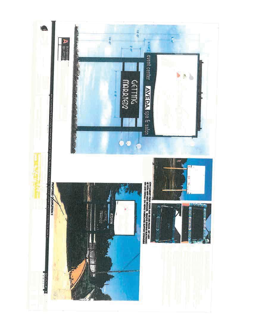
4 March 17, 2017 Subject: Bebo Sign Variance o: Planning Commission From: Curt Freese, Community Development Director o recap the Feb. 23 rd meeting, the sign height variance of 6 was approved unanimously with the following conditions: 1) he applicant must remove the older existing sign within 30 days; 2) he applicant must remove the message board within 30 days; 3) he applicant must provide an accurate survey, showing the sign is out of the ROW within 30 days. 4) he applicant must come back to the March 23rd meeting, to verify all of these conditions have been satisfied. As of today, the Applicant has sent over a new survey (found in this packet), and also confirmed they have removed the message board and old sign (pictures of their removal are within the packet) as per the conditions of the Feb. 23rd PC meeting. herefore, conditions #1 and #2 have been met. Unfortunately for the Applicant, the survey does show that the sign is encroaching into the ROW, and thus condition #3 has not been satisfied. In light of Condition #3 not being satisfied, Staff finds that there are two options for the Commission to consider: 1) Approve a variance for a sign in the ROW, on the condition that an encroachment permit and any other agreements required by the State to place a permanent structure in the ROW are obtained within a reasonable time frame ( days would be Staff s recommendation); 2) Deny the variance to allow a sign in the ROW, and require the Applicant to move the sign out of the ROW within a reasonable time frame (30 days). Staff cannot recommend a variance for any structure within the ROW, and thus recommends the second option. Sincerely, Curt Freese, AICP Community Development Director
5 DAE: FEBRUARY 9, 2017 GENERAL INFORMAION Applicant: Justus Bebo, applicant for L & M Enterprises Site Location: 619 E HWY 56 Applicant's Request: Sign Variance Request Current Zoning: Neighborhood Commercial (C-1) Variance Consider a sign variance request from Section G. 6. (a) to allow an additional commercial sign; from Section G. 6. (c) for a sign height variance of 6 feet; from Section G. 6. (e) to allow a sign in the right-of-way, and from Section to allow a flashing, moving, blinking, chasing or other animation effects on a sign. ZONING DISRIC INFORMAION Neighborhood Commercial (C-1) Min. Lot Size Floor Area Ratio of 2 to 1 Min. Lot Width 25 Front Setback 0 Side Setback 0 ; or 20 differing zoning district boundary (does not apply) Rear Setback 0 ; or 20 from centerline of alley Building Height: 40 SURROUNDING ZONING, LAND USE AND REQUIRED BUFFERS Adjacent Zoning Adjacent Land Uses North: County/ AG Farm/House South: P (empty field), Empty field/cropland O Malley Glen P East: P/County Parcel L and M, Little hompson Water District West: P/M-2/County Brothers Door Supply, House AACHMENS 1. Application 2. Site Plan 3. Sign Details 4. Picture of existing sign
6 BACKGROUND he applicant erected a new sign on their property in December of 2016 without a permit and in violation of the sign code. he sign erected is a pole sign 18 high, and 12 wide, with a 6 8 x 2 9 LED message board underneath. he sign was placed on the property in addition to the existing Brookside Garden pole sign. Moreover, according to the Site Plan submitted with this application, the sign is more than 9 into the State ROW on HWY 56. he Community Development Director noticed the sign after it had been installed, researched the ordinance, and then issued a Stop Work Order that day (December 6) through the Larimer County Sheriff s office (said Stop Work Order is in this packet). Soon after being served with notice, the Applicant came in, and submitted the Variance Application. he Applicant contends they were unaware they needed a sign permit. Moreover, the Applicant informed Staff that the message board was removed from the L and M building, (granted a variance on appeal by the own Board, after being denied by the PC in 2008). he variance application process stays any pending enforcement action. Should this variance be denied, the enforcement action will continue. Variances Required: his unpermitted sign requires four variances from the Berthoud Sign code, which include: 1) Section G. 6. (a), which allows one monument or pole sign per property in the C-1 zoning district. he variance would allow an additional pole/monument sign on this property, in addition to the existing pole sign (a picture is in this packet). 2) Section G. 6. (c) allows for a 12 high pole or monument sign. he unpermitted sign is 18 in height, which would result in a sign height variance of 6 feet. 3) Section G. 6. (e) requires that signs be out of the ROW. As aforementioned this sign is more than 9 into the State ROW, and no encroachment has been provided. herefore a variance from this section would allow a sign in the right-of-way, however an encroachment permit from the State would still be needed. 4) Section prohibits flashing, moving, blinking and chasing signs. hus, the LED message board installed with this sign, requires a variance from this section. VARIANCE REQUIREMENS: he Planning Commission under Section has the authority to authorize variances from the terms of Chapter 30-2, Design Standards, Chapter 30-3, Zoning; and Chapter 30-7 Signs, where the strict enforcement
7 of this title would create a situation which would result in unreasonable application of these standards, considering whether (with Staff analysis regarding each point below): a. Such relief may be granted without substantial detriment to the neighborhood or the public good and without substantially impairing the intent and purposes of this code, and; x. Allowing an additional unpermitted sign that is close to 300 sq. ft. in size and fails to satisfy a number of the basic requirements of the sign ordinance, subverts the purpose of the sign code and substantially impairs the intent and purposes of this code. x. In addition, the variance allows the applicant to enjoy more than double (the sign being 6 higher than allowed as well) the signage allowed for every other business and property in own, and the opportunity to use scrolling, blinking, and animated signage. x. Approving a sign in the ROW is a dangerous precedent without an encroachment permit from the State. Should the State widen the road, the sign would have to be removed, and Staff has concerns allowing such a sign may have legal implications should the State need to widen the road. x. Moreover, the variance would contribute to increased sign clutter along a major corridor, which is one of the primary intents of the sign ordinance. b. Provided that there are exceptional circumstances applying to the specific piece of property which do not generally apply to the remaining property in the same zoning area or neighborhood, and; x. his is the only commercially zoned land within the general area. However, that should not entitle the business to double the signage allowed to any other own business, nor allow the flashing and digital sign that is also prohibited for the rest of the commercial businesses. c. hat the requested variance shall not authorize any permanent use not permitted in the zoning district, and; x. Not applicable. d. If the hardship on which the request for variance is based, in whole or in part, is self-inflicted, that will be a highly significant fact which is a material element bearing on the issue, and will weigh heavily against the owner or applicant seeking the variance, or; x. he hardship was created by the Applicant who erected the sign in violation of multiple sections of the sign code, and without a permit from the own. e. In circumstances where the property owners affected most directly, e.g. neighbors, concur in writing with the variance that fact shall be given significant (but not conclusive) weight in favor of the request x. No neighbors or letters from neighbors have been provided in support.
8 FINDINGS AND RECOMMENDAIONS Move for denial of the sign variance request from Section G. 6. (a) to allow an additional commercial sign; from Section G. 6. (c) for a sign height variance of 6 feet; from Section G. 6. (e) to allow a sign in the right-of-way; and from Section to allow a flashing, moving, blinking, chasing or other animation effects on a sign, finding that the requests do not satisfy the conditions laid out in Section (1) of the Development Code: 1. he Applicant has not satisfied any of the applicable conditions of Section (1) of the Development Code, as found on page 3 of the Staff Report, and 2. he Applicant has specifically not met Section (1) (d), in which the variance requested was self-inflicted, in that the Applicant erected the sign in violation of the code and without a permit, and this weighs heavily against the applicant or owner seeking a variance. Reminder: When making a motion for or against, please provide clear findings in support of the proposed motion utilizing the findings in support of the Criteria necessary for approving or denying a Variance (found on pages 3).
9 SIGN SPECS


10
11 SIE PLAN
12
13 PICURES

14

15
16 MAP VIEW BEFORE SIGN

17
18 PICURES (CURREN) WIH OLD SIGN REMOVED AND MESSAGE BOARD REMOVED
19
20
21 CURREN SURVEY SHOWING SIGN IN ROW
22
23
24
25
26
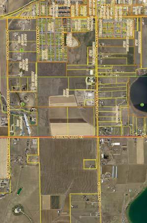
27 SAFF REPOR VANAGE PRELIMINARY DAE: April 13, 2017 Applicant: Site Location: Applicant's Request: Current Zoning: GENERAL INFORMAION Bill Zech, agent for ALC V, Berthoud LLC A site located at the intersection of Bunyan Avenue and County Road 17 (aft Avenue). o obtain preliminary plat approval for the Second Filing of the Vantage Development. (On portions related to this request): Single Family (R-1), Multi-Family (R-3) Size (in acres): ~201 acres ZONING DISRIC INFORMAION Related Zoning District Requirements P R-1 R-2/ R-3 Min. Lot Size SF only 3,500 sq. ft. 3,500 sq. ft. Min. Lot Width Front Setback BY FDP 15 ; 22 gar. 15 ; 22 gar. R-2: 20 Side Setback BY FDP 5 and and 7 6 Rear Setback BY FDP Building Height: BY FDP 40 prin; 30 acc 40 prin; 30 acc SURROUNDING ZONING, LAND USE AND REQUIRED BUFFERS Adjacent Zoning Adjacent Land Uses Setbacks for Adjacent Zoning /Buffer required if rezoned North: E1 Estate (Larimer Co.) Single Family Homes N/A Berthoud Lake Ranchettes, (FA1) South: P Berthoud Hollow ODP, Single Family Homes N/A R1 North Park Subdivision, (FA1) (Larimer Co.) East: Garden Fair, North Park, and Single Family Homes N/A Fickel Subdivisions (R-1) West: Westhaven (approved in 2015) R-1 and R-2 Single Family homes N/A Attachments: 1. Concept Plan 2. Easthaven Concept Plan 3. Future Land Use Map 4. POR Map
28 PROPOSAL he applicant is proposing a Preliminary Plat for 473 lots on 201 acres. Single family lots comprise acres of these 201 acres, with almost 40 acres of open space to be maintained by the Metro district. More than 30 acres has been reserved for future multi-family (townhouse) development. BACKGROUND he property was formerly approved as rails at Sugar Creek, then Easthaven, and Westhaven, until it was combined and renamed Vantage last year. he land related to this request is part of 157 acres that were formerly approved as Easthaven (and previously rails at Sugar Creek) and includes over 40 acres zoned R-1 in 2014 as part of Westhaven. he majority of the property was originally annexed into the own in 2006 as the rails of Sugar Creek that later became Easthaven, while the 41 acre Westhaven portion to the Northwest, was originally annexed and rezoned to P in A Concept Plan for this section of the Vantage subdivision was approved in April of 2016, and a rezoning subsequently after. Description of Plan: he preliminary plan follows the Concept Plan approved in April of Overall, there has been a slight reduction in density (from potentially 495 single family lots to 473 single family lots) from the concept plan, to the engineered preliminary plat. he overall layout and lot sizes are roughly similar to the Concept Plan, with more than 300 lots ranging from 7,150 sq. ft. to 8,000 sq. ft. in size; while the remainder of the lots range from 8,000 sf to 10,000 sf in size. he two townhome areas from the Concept Plan, are listed as future development, one located at the north end of the property near LCR 10-E, and the other in the center of the development. he Handy Ditch runs through this site near the north portion of the property and separates the northern townhome area from the rest of the development to the south. At this time no crossing of this ditch is proposed but the idea of a crossing should not be ruled out for connectivity purposes. Access Points and Road System he applicant proposes multiple access points into this property, including making future and existing connections to adjoining neighborhoods. o the South, the plan depicts one street connection to Bunyan Avenue (an additional connection however will be provided through the southwest portion (or Filing 1) approved by Final Plat), o the East, connections through Evergreen and Longs Peak Avenues through the North Park subdivision will eventually access 4th St, in addition to the requested stub (added at the Concept Plan approval) of Little Cone Drive; also a future ROW for Water Street, should it be extended in the future has been provided; And to the West, access to LCR 17 will be through multiple roads that provide connectivity through the previously approved first filing of the Vantage development, including the construction of a Water Street connector. he applicant is also proposing to ensure that the vacant lot west of Berthoud Elementary will be provided with road access in the future. 2
29 Open Space and rails Around 40 acres is proposed for open space, making up ~20% of the project. his includes pocket parks, a substantial landscaped buffer area, as well as a number of sections of open space provided for internal trail connectivity, as well as detention areas, and buffers for adjoining existing neighborhoods. hese areas will be privately maintained by the Metro District, and not accepted into the own s park system. rails are proposed to be located along LCR 17, the south side of Handy Ditch and Water Avenue in compliance with the own s Parks, Open Space and rails Plan. he internal trails will connect with the trails along LCR 17 and Bunyan and the internal trails found in the previously approved Filing 1. In addition sidewalks will be provided along all streets including LCR 10-E and Bunyan Avenue. PREFERRED LAND USE he own s Preferred Land Use Map designates this area as Moderate density residential, with residential development at 2 6 units per gross acre. his preliminary plat would be consistent with the Preferred Land use Plan. FINDINGS NECESSARY FOR PRELIMINARY PLA 1. he Preliminary Plat represents a functional system of land use and is consistent with the rationale and criteria set forth in this Code. he Applicant is providing a substantial 50 landscaped buffer area on the East, and along LCR 17 to mitigate both impacts from the road, and the adjacent subdivisions. his area will be maintained by the Metro district hree road connections to the East provide for excellent connectivity. Drainage flows to the South/Southeast corner of the property, and thus the said acre area is best suited for the park/open space/drainage area depicted on the plat on the South/Southeast corner of Bunyan and Vantage Parkway he location of future townhouse development in the center of the property, and along 10E is consistent with the comments from the Concept Plan approval and represents a functional system of land use. here is a mixture of lot sizes and street layout throughout the project. he plan also proposes a substantial network of inner trails and open space. 2. he application is consistent with the approved concept plan and incorporates the own s recommendations and any conditions of approval. he overall density and uses are consistent with the approved Concept Plan and rezoning, as well as the Planning Commission and own Board recommendations. 3. he land use mix within the project conforms to Berthoud s Zoning District Map and Preferred Land Use Map and furthers the goals and policies of the Comprehensive Plan and POR Plan. 3
30 he density is within conformance of the Preferred Land Use Plan, which calls for moderate density residential. he preliminary plat is in conformance with the Zoning code and all other Development Code standards. 4. he utility and transportation design is adequate, given existing and planned capacities of those systems. he design of infrastructure has been reviewed by the own Engineer and considered to be of sufficient size and design to accommodate the project. he Applicant is also providing off-site improvements along Bunyan, and off-site drainage improvements, which should serve to relieve issues with the subdivisions to the South. he own has capacity available to service this development. 5. Negative impacts on adjacent land uses including, but not limited to: solar access, heat, dust, glare, traffic and noise have been identified and satisfactorily mitigated. As aforementioned, the 50 landscaped buffer areas around this entire project, serve to mitigate any such impacts. 6. here is a need or desirability within the community for the applicant s development and the development will help achieve a balance of land use and/or housing types within Berthoud. his represents the entire remaining single family portion of Vantage. As discussed in the past, Berthoud lags behind many communities in housing diversity. However, there is a range of single family lot sizes, which serve to provide price and building diversity within the subdivision. PUBLIC NOICE Notice of the Planning Commission public hearing has been mailed to property owners within 300 feet of the subject property, a legal ad published, and the property was posted as required by the Development Code. FINDINGS AND RECOMMENDAIONS Move to recommend approval of the Vantage Second Filing Preliminary Plat, with the findings that it is consistent with Section C (found on pages 3-4 of this Staff Report): Reminder: When making a motion for or against a Preliminary Plat, please provide clear findings in support of the proposed motion utilizing the findings in support of the Criteria necessary for approval or denial (found on pages 2-3). 4
31 CONCEP PLAN
 R2 FUURE WAER AVENUE CONNECION VICINIY MAP LAND USE SUMMARY 65' X 110'...323 70' X 110'...155 OWNHOME...125 Site PROJEC OAL.")


32 WAER AVENUE LARIMER COUNY R1 VANAGE PHASE 2B R2 VANAGE PHASE 2A CR 10E (80' FUURE ROW) OWNHOMES (7.8 AC) +/- 8 UNIS/AC 62 UNIS R3 OIL & GAS PAD (4.0 AC) R3 ZONING P R1 CENRAL PARK (5.9 AC) R2 FUURE WAER AVENUE CONNECION VICINIY MAP LAND USE SUMMARY 65' X 110' ' X 110' OWNHOME Site PROJEC OAL LAND USE SAISICS OAL ACREAGE = ~201 ACRES ROW ACREAGE = ~ 38 ACRES R1 ACREAGE = ~96.6 ACRES R1 PROPOSED DENSIY = 5.1 DU/AC R3 ACREAGE = ~19.7 ACRES R3 PROPOSED DENSIY 7.9 DU/AC* (* HIS EXCLES HE OIL & GAS PAD. DENSIY WIHIN HIS AREA O BE DEERMINED WIH FUURE ENILEMEN PACKAGE.) OPEN SPACE ACREAGE = ~46 ACRES % OF SIE AS OPEN SPACE = 22% SHEE INDEX SHEE 1 - OVERALL CONCEP PLAN SHEE 2 - CONCEP PLAN ENLARGEMEN SHEE 3 - CONCEP PLAN ENLARGEMEN 0 300' 450' 600' SCALE 1" = 300'-0" NORH SEAL PROJEC ILE VANAGE Berthoud, Colorado PREPARED FOR ACCESS LAND COLORADO, LLC Carey Court Stockton, CA CALL UILIY NOIFICAION CENER OF COLORADO Know what'sbelow. Call before you dig. CALL 3 BUSINESS DAYS IN ADVANCE BEFORE YOU DIG, GRADE, OR EXCAVAE FOR HE MARKING OF UNDERGROUND MEMBER UILIIES. REVISIONS DAE Staff Comments Staff Comments PC Comments ISSUE DAE DAE JANUARY 18, 2016 SHEE ILE OVERALL CONCEP PLAN SHEE INFORMAION ZONING R-1 Sheet Number: R1 LOCAL ROADS (58' ROW) WESHAVEN PHASE 1 OPEN SPACE/ DEENION 80' FUURE ROW BUNYAN AVENUE 1 R1 Of: 3 F.O. H2O LARIMER COUNY FINAL RAIL LOCAION O BE RESOLVED WIH HANDY DICH COMPANY AS A PAR OF PLA SUBMIAL. R LOCAL ROADS (58' ROW) LARIMER COUNY OWNHOMES (7.9 AC) +/- 8.0 UNIS/AC 63 UNIS R3 ZONING R-1 LAKE VIEW AVENUE BERHO ELEMENARY SCHOOL HABIA FOR HUMANIY (MJR COLLECOR) LOVELAND RESERVOIR LCR 17
33 PROPOSED PRELIMINARY PLA
34
35
36
37
38
39
40
41
42
43
44
45
46 42" W CV V ELEC W F.O. 42" W CV COUNY ROAD 17 V MH CABLE //////// K 42" W H2O E 20" W K util FO X //////// GAS //////// GAS ES VE DRI SSIN 8"NA MOU 1" W 12" W 42 "W 5' RAIL YP. H OO WA E R EN UE 42" W AV E NU 42" W AVE OR W SP 8" WE S util 1" W BUNYAN AVENUE 1" W 12" W 12" W 1" W V.P. F.O. H VAUL Y 6" W S K 12" W H2O MH AVENUE LON G PEA LAKE VIEW AVENUE 12" W GAS 14" W 6" W 12" W ANNA BELLE DRIVE 42" W 5' RAIL YP. M MH EL HUNSMAN RIDGE DRIVE ZONING: R3 42" W NUE AVE H2O 8" W EL M W W 6" W 12" W M CS W D 6" W CS GAS W 12" MH 12" W 12" W MH H Y D CENENNIAL DRIVE 12" W WAY MH 6" W 12" W M 42" W 12"MOUN SS CENENNIAL DRIVE MOUN PARK 6" W AGE VAN ANNA BELLE DRIVE PEAK DRIVE WILLIAMS BISON PEAK DRIVE CROSS MOUNAIN8" DRIVE SS ZONING: R3 CROSS MOUNAIN DRIVE 42" W DRIVE 8"PARKWES SS MH MACGREGOR LANE DRIVE PARKWES LONE OAK DRIVE 8" SS BLACK MOUNAINDRIVE WAER AVENUE 42" W 12" SS 12" W EL MOUN CENENNIAL DRIVE 12" SS MOUN CENENNIAL DRIVE LAKE VIEW AVENUE ZONING: R1 CS 42" W CROSS MOUNAIN DRIVE 12" W CROSS MOUNAIN DRIVE PARKWES DRIVE SS 8" MACGREGOR LANE DRIVE PARKWES BLACK MOUNAIN DRIVE ZONING: R1 LONE OAK DRIVE ZONING: R3 ZONING: R3 42" W W 12" W 6" W MH WV MH MH (COUNY ROAD 8-E) 12" W 14" W VANAGE PARKWAY ER WA GAS 1" W S 14" W Y D BUNYAN AVENUE V.P. W H2O H2O 42" W H 12" W H2O CAV H2O 1" W ZONING: R1 ZONING: R2 42" W 5' RAIL YP. 12" W GAS WW 20"12" WESHAVEN PHASE 1 UE D ZONING: LARIMER COUNY VANAGE FIRS FILING LAKE VI EW AVEN ZONING: R1 42" W DRI SS VE X ZONING: R2 AIN 8" UN MO 12" W 20" W WESHAVEN PHASE 2 SAW X 12" W 20" W 12" SS 12" W 42" W H util Y DIC HAND X ES 12" W 20" W ZONING: R1 S GAS F VANAGE FIRS FILING util H2O 20" W 12" W "W 42 ELEC X ES 12" SS 1" W "W 42 WAER AVENUE X 20" W DUCH PEAK DRIVE H OO SAW ES X util 20" W F WAER AVENUE K K K KK K LOVELAND RESERVOIR VAUL FO F F E E C ZONING: AG C FO FO FO FO FO FO FO X X FO X (60' PUBLIC ROW) CV CV CV CV FO FO FO LCR 17 SAWOOH MOUNAIN DRIVE F DRIVE SAWOOH MOUNAIN WESPOR AVENUE WESPOR AVENUE ES UE EN 20" W //////// AV GAS OR WESPOR AVENUE VANAGE PARKWAY V.P. Y ELEC WA G RK PA ELEC SP WE G AG E W 8" W N VA 12" W 12" W 12" W 12" W 12" W G LCR 17 SS 12" 12" W MM 6" W EL 12" W 5' RAIL YP. 5' RAIL YP. 5' RAIL YP. 42" W LILE CONE DRIVE 5' RAIL YP. MH 14" W 10"SS 10" SS VANAGE PARKWAY 10" SS MOUN JACKSON DRIVE E W D DRIVE HUNSMAN RIDGE HUNSMAN RIDGE DRIVE VANAGE PARKWAY 10" SS CANAAN SREE 10" SS CANAAN SREE 10" SS Y E PARKWA VANAG 10" SS AY E PARKW VANAG //////// 10" SS VANAGE PARKWAY SS 10" SS 8" PEAK DRIVE BISON BLACK MOUNAIN DRIVE PARKWES DRIVE //////// CROSS MOUNAIN DRIVE //////// BISON PEAK DRIVE X MOUN CENENNIAL DRIVE //////// "W X //////// X //////// 8"SS //////// W //////// 8" SS H2O 14" W 12" W 14" W SS 12" W 8" 12 M C MH MH MH MH MH ELE S W CS MH MH MH 6" W OHU ZONING: R1 MH 42" W ZONING: P 14" W 3 5 Sheet Key: Plant List ,095 S.F. 83,964 S.F. Legend BUILDER INSALLED REES EXISING REES SEEL EDGER, ROUNDED OP ALL SHRUB BED AREAS O RECEIVE MINIMUM 4"-6" SHREDDED CEDAR WOOD MULCH SHREDDED CEDAR WOOD MULCH DURA-URF SOD IRRIGAED URF 1,401,864 S.F. SF BD A FDP. IRRIGAED REES IN NAIVE URF AREAS ARKANSAS VALLEY SEED MIX (OR APPROVED EQUAL) IRRIGAED NAIVE FOOHILLS GRASS MIX SCALE 1" = 250'-0" 0 250' 375' 500' NORH Call before you dig. SHEE 2 OF 18 SHEE INFORMAION Overall Site & Landscape Plan SHEE ILE DAE NOVEMBER 9, 2016 ISSUE DAE DAE Staff Comments REVISIONS CALL 3 BUSINESS DAYS IN ADVANCE BEFORE YOU DIG, GRADE, OR EXCAVAE FOR HE MARKING OF UNDERGROUND MEMBER UILIIES. Know what's below. R CALL UILIY NOIFICAION CENER OF COLORADO NO FOR CONSRUCION FOR REVIEW ONLY 8678 Carey Court Stockton, CA ACCESS LAND COLORADO, LLC. PREPARED FOR Berthoud, Colorado Preliminary Landscape Plans VANAGE PROJEC ILE SEAL
47 PREFERRED LAND USE PLAN/ZONING MAP AND POR PLAN FOR REFERENCE
48 AG Lonetree Reservoir Coleman Reservoir R1 P AG P R3 P C P R2 R1 P 11 P 15 R R2 M1 P Bacon Lake R3 R3 R3 M2 C1 R2 R1 P M1 C2 10 R1 AG R1 P C2 M2 P Newell Lake Little hompson River Revisions: Date Project Ordinance 3/31/11 Annual Update 3/27/12 Rezone C2 to C1 9/1/13 Annual Update 1121, 1160, , /9/14 Annual Update 5/30/14 Annual Update 3/13/15 Annual Update homas Reservoir AG 27 C2 his map product 34 and all underlying data are developed for use by the own of Berthoud for its internal purposes and for general use by members of the public. he own makes no representation or warranty as to its accuracy, timeliness, or completeness, and in particular, its accuracy in labeling or displaying dimensions, property boundaries, or placement of location of any map features thereon. he own of Berthoud makes no warranty of merchantability or warranty for fitness of use for particular purpose, expressed or implied, with respect to this map product. Any users of this map product accepts same as is, with all faults, and assumes all responsibility of the use thereof, and further covenants and agrees to hold the own harmless from and against all damage, loss, or liability arising from any use of this map product, in consideration of the own having made this information available Dry Creek Welch Reservoir McNeil Reservoir Loveland Reservoir P Ish Reservoir M2 Berthoud Reservoir C1 R1 R3 R3 R3 R2 R1 R2 R2 AG R AG R3 R3 M2 M1 R5 R1 M2 C2 R2 R3 R1 Sunnyslope Reservoir 12 P C M2 Baxter Lake M2 AG Rockwell Reservoir Chapman Reservoir Hummel Reservoir own of Berthoud, Colorado Multi-Family DeFrance Reservoir District P P AG AG P Davis Reservoir Districts Zoning Map Agriculture District Single Family District Limited Multi-Family District 287 Larimer County Weld County Æÿ NR69W 04NR69W City of Loveland 05NR68W 04NR68W AG RI R2 R3 R4 R5 N Mixed Use District Manufactured Home District raditional Neighborhood District 04NR69W 04NR68W own of Mead C1 C2 M1 M2 P Neighborhood Commercial District General Commercial District Light Industrial Johnstown District Reservoir Industrial District Planned Unit Development District ransition District 25 Berthoud Growth Management Boundary ,500 3,000 Feet 1 inch = 1,575 feet Map prepared by Barkeen Landscape Design, LLC Data provided by Larimer County, Weld County and the own of Berthoud. F
49 BERHO Jaskowski Conservation Easement Hopkins Conservation Easment Dunkin CE kj kj Yeager Farm CE kj Loveland kj LCR 17 1st Street C 23 LCR 10 WCR 7 LCR 19 LCR 8 Mountain Ave Neil CE kj LCR WCR 44 WCR 5 WCR 3 WCR 1 LCR 13 Larimer County Weld County High Density Mixed Use Residential his designation supports higher density residential development, such as townhomes, condominiums and traditional multi-family, but also mixed uses including retail, commercial, office, service, business, workshop, and related uses. Land within this designation may grow to be a rich pedestrian oriented and mixed-use environment where shops, housing, employment and services would all be found. Residential densities are supported between 6 and 14 dwelling units per gross acre in this land use designation. LCR 4 Heron Lakes Regional Open Space LCR 6 LCR 14 LCR 4E LCR WCR 40 Æÿ 56 WCR 48 Burlington Northern Railroad Low Density Suburban Residential Lonetree Reservoir Coleman Reservoir Welch Reservoir Reservoir LCR 10E Bunyan Ave Spartan Ave 287 LCR 10 Bacon Lake Baxter Lake Æÿ 60 Berthoud Reservoir Sunnyslope Reservoir Commercial/Office his Plan designation supports small-scale downtown commercial uses such as resturants, specialty retail, pharmacies, civic uses as well as larger regional commercial opportunities, office spaces, and technology companies. Low Density Rural Residential his land use designation is intended to support traditional residential neighborhoods primarily, but not exclusively, in single-family home development. Overall residential density in these areas may range from 2 to 6 dwelling units per gross acre. While single family residential is the primary land use, additional uses such as churches, schools, medical and dental clinics, offices and general retail are permitted. his designation is characterized by single and multi-tenant uses and corporate campuses. Employment uses commonly include corporate headquarters, research and development facilities, laboratories, offices, and industrial. Both light and heavy industrial land uses are supported within this land use designation. WCR 46 Newell Lake Rockwell Farm CE Hummel Reservoir Hofmeister Farm CE WCR 42 LCR 15 he Low Density Rural Residential land use designation represents the most natural, least developed, most rural residential areas within the Berthoud GMA. It is intended to support rural-oriented residential development that preserves significant areas of either farmland or open space. Residential lot size in this designation would be a minimum of 2 acres, yielding a maximum density of less than 0.5 dwelling unit per gross acre. his designation is essentially intended to support existing development in either Weld or Larimer counties, as they would be annexed into Berthoud. A reduction in lot size is possible if development is clustered on the property. Employment Loveland GMA Boundary Johnstown GMA Boundary Larimer County Boulder County 0 Ish Reservoir Park, Civic, Natural Preserve and Open Space Mead GMA Boundary 1,250 2,500 5,000 Feet Boulder County Weld County his designation identifies areas of the incorporated own as well as within the larger GMA that have been, or could be, preserved as conservation easements or for use by the public. Adopted April 10, 2014 and ratified on May 6, Low Density Rural Residential (Up to 0.5 DU/AC) Low Density Suburban Residental (Up to 2 DU/AC) Moderate Density Residential (2 to 6 DU/AC) High Density Mixed Use Residential (6-14 DU/AC) Commercial/Office Employment Berthoud Growth Management Area/Boundary Natural Preserve/Open Lands (Parks, Bodies of Water, Hwy 287 Buffer, rail Corridor Conservation Easement (CE) Irrigation Ditches)!!!!! he Low Density Suburban Residential land use designation represents a transition from rural residential to higher density traditional single family neighborhoods. his designation supports a slightly higher overall density that remains single-family detached home developments on larger lots. Overall residential density in these areas could range up to 2 units per gross acre. A reduction in lot size is possible if development is clustered on the property. Moderate Density Residential!! Dry Cre ek! Little hompson River!!! I-25 Sub-Area Plan Boundary kj View Corridor Areas that may serve to preserve views to agricultural lands, natural areas and mountains along major roadway corridors. Mixed Use General Commercial Neighborhood Commercial Low Density Residential (1-3 DU/AC) Medium Density Residential (3-8 DU/AC) High Density Residential (8-20 DU/AC) Convenience Commercial Parks and Open Space Employment Flex - Office/Residential Little hompson River Corridor/ ertiary Drainage Corridor ransit 1. Open space illustrated on the I-25 Sub-Area Land Use Plan includes the Little hompson River floodplain and secondary intermittent drainages. It is the intent of the Land Use Plan that permanent open space shall represent a minimum of 30 percent of the total gross land area upon buildout. 2. Road alignments and land use areas shall be in substantial compliance with this Land Use Plan. Minor deviations in road alignments and the size of Land Use category acreages (ten percent minmum) may be allowed, subject to Administration approval, but shall not increase the allowable number of dwelling units or the gross floor area of the land use categories original size. Notes to the Preferred Land Use Plan: 1. Approved final plats shall supercede preferred land uses shown herein. 2. he I-25 Sub-Area Plan adopted June 3, 2003, is incorporated into the 2014 Comprehensive Land Use Plan as adopted.,,,,, View Corridor Locations on or adjacent to public lands or rights-of-way that have great views of agriculture lands, natural areas and mountain areas to the west and south of Berthoud. View preservation techniques will be explored for these areas. Area of Community Influence Along the I-25 corridor, just outside of the GMA, the town has established an Area of Community Influence, where future land use activities may have an impact on land uses or infrastructure within the own of Berthoud. hese areas are where Berthoud is near or adjacent to the towns of Johnstown and Loveland and where land in the Area of Community Influence could become incorporated into the Berthoud GMA over time and eventually annex to the community.!,,,, 640 Acres 360 Acres 160 Acres 40 Acres 1 Mile own of Berthoud Area of Community Influence (ACI)!
50
51 SAFF REPOR REZONING/CONCEP PLAN GAEWAY PARK DAE: April 13, 2017 Applicant: GENERAL INFORMAION Craig Wrigley, agent for Sunriver Development Corporation, LLC Size: 2.28 P parcel Site Location: Applicant's Request: Current Zoning: 2.28 acres P Comm he property is located at the Northwest Corner of LCR 17 and Lake Ave. o rezone 2.28 acres from Planned Unit Development (P) to Singlefamily Residential (R-1), and to rezone acres from ransitional () to Limited Multi-family (R-2) Proposed Zoning: 2.28 acres to Mixed Use (R-4) ZONING DISRIC INFORMAION Existing District and P; Proposed District R-2 P R-4 Min. Lot Size Commercial 3,500 Min. Lot Width SF ; 25 attached Front Setback BY FDP 20 Side Setback BY FDP 5 one story; 7 6 two stories Rear Setback BY FDP 20 min; 4 on alley Building Height: BY FDP 50 SURROUNDING ZONING, LAND USE AND REQUIRED BUFFERS Adjacent Zoning Adjacent Land Uses Setbacks for Adjacent Zoning /Buffer required if rezoned North: Gateway Outlot Outlot Vacant for Stormwater N/A P/County Agricultural Zoning ransitional Zone has SF home South: P Gateway Vacant to Lake Drive. Adams Bank N/A across Lake Drive East: ransitional-waggener Park Waggener Farm Park N/A West: P Gateway Single Family attached homes N/A Attachments: 1. Concept Plan 2. Rezoning Map
52 PROPOSAL he applicant is proposing to rezone 2.28 acres from Planned Unit Development (P) to Mixed Use (R- 4). Residential (R-2), and acres from ransitional (), also to Limited Multi-family Residential (R- 2). he rezoning of the northern acre section of this property from ransitional () to Limited Multi-family Residential (R-2) was approved at the March 28 th own Board meeting. At the same meeting, the own Board turned down the request on this property for this 2.28 acre portion from P to R-2, and also sent the application back to the Planning Commission with a recommendation for the Mixed Use (R-4) district. he own Board also did not approve the Concept Plan, as it was contingent on the R-2 zoning for the entire property. he Applicant has revised the Concept Plan based on comments the Applicant received from the own Board. he new Concept Plan depicts 55 lots, with 55 overall dwelling units, 49 as single family houses, and 6 as attached single family homes or duplexes. his amounts to a reduction of 16 dwelling units, with an increase of 15 single family units, and a reduction of 28 duplexes. he new layout removes the hammerhead road (which previously accessed the existing private alley) to the Northwest of the acre portion and instead is replaced by a stub street, with a partial cul-de-sac that provides the necessary turn around for emergency vehicles. 13 th Avenue will still be extended from the South, and will loop to the West to the interior of the proposed lots. A small cul-de sac will be built on the East, instead of a curved street section. he 2.28 acre R-4 section is now comprised of a detention pond, a commercial lot utilizing the existing entrances off of Lake Avenue, and six duplexes. All streets except for one continued private alley will be public and have been widened to satisfy the own s street standards. BACKGROUND he 2.28 acre parcel was part of the Gateway Park P, which was approved by the own in 2002 and consisted of over 77 acres. he approved P allows a mixture of uses, from commercial/office, multifamily and single family, assisted living, and a medical campus. Since 2002, the property has been revised a number of times, with the last change consisting of a FDP allowing the townhouses/attached single family houses to the west of the 2.28 acre portion the applicant is proposing to rezone, and commercial/office approved for the 2.28 acre portion as depicted on the plans included in this packet. Infrastructure was installed on this 2.28 acre portion, including two commercial curb cuts, and a section of commercial parking. 2
53 he acre portion was annexed into the own over ten years ago, with a ransitional zoning classification. An older farm house sits on the property, with a driveway off of LCR 17. he ransitional zoning classification is intended as a temporary holding district while the property owner and the own decide what zoning classification best fits the future land use plan and existing uses. In this case however, the tag was never removed and the property owner is only allowed the existing uses on the property, and any changes, including building additions, require a rezoning action. A rezoning proposed by the Applicant to Single-Family (R-1) for nine single-family lots on a cul-de sac was previously applied for on the 2.28 acre parcel, and turned down by the Planning Commission in July 2016 with a 6-1 vote. PREFERRED LAND USE he own s Preferred Land Use Map designates the entirety of the 2.28 acre area as Commercial, and half of the acre area as commercial, with the remainder as high density residential (6-14 dwelling units per acre). Commercial according to the Comprehensive Plan: Supports small-scale downtown commercial uses as well as larger regional commercial opportunities, office spaces, and technology companies. Staff finds that 2.28 acre portion requested as Mixed Use (R-4) with this rezoning is consistent with the Preferred Land Use Plan. REZONING CRIERIA/FINDINGS he criteria in Section B of the Development Code for amending the official zoning map requires at least one of the following criteria to be met (with Staff analysis regarding each point below): 1. o correct a manifest error in an ordinance establishing the zoning for a specific property; or x. Staff is not aware of any error on the 2.28 portion. 2. o rezone an area or extend the boundary of an existing district because of changed or changing conditions in a particular area or in the own generally; or he own has adopted a new Development Code, which has changed the conditions of the previous approvals for Gateway Park. It is not appropriate for the own to continue to approve sections of long expired P s based on the standards of the old Development Code. Residential development has been recently planned and approved in the surrounding area, and should serve to increase the demand and need for nearby commercially zoned properties. 3. he land to be rezoned was zoned in error and as presently zoned is inconsistent with the policies and goals of the own Comprehensive Plan; or 3
54 x. Staff is not aware of any error on the 2.28 parcel: 4. he proposed rezoning is necessary to provide land for a community-related use that was not anticipated at the time of the adoption of the own Comprehensive Plan, and the rezoning will be consistent with the policies and goals of the Comprehensive Plan; or he proposed use of mixed use conforms with the own s Preferred Land Use Map, which designates this property for Commercial development, which supports small-scale downtown commercial uses as well as larger regional commercial opportunities, office spaces, and technology companies. 5. he area requested for rezoning has changed or is changing to such a degree that it is in the public interest to encourage development or redevelopment of the area; or In regards to the 2.28 acre parcel: As aforementioned in factor #2, the commercial office nature of this portion of the Gateway P has not occurred, while the townhouse/attached residential uses have been built. Since this section was also anticipated for attached townhouses, the proposed duplex/attached homes a similar product and use. he property was clearly developed to service the heavier traffic and demands of a commercial/office use as this rezoning would serve, as commercial grade entrances and even some parking has already been constructed. he entrance off of aft to Lake Avenue would also meet commercial standards. Residential development has been recently planned and approved in the surrounding area, and should serve to increase the demand for nearby commercially zoned properties. Rezoning a commercially zoned property in one of the major corridors of the own does not serve to encourage the overall development of the surrounding area, or the own. 6. A rezoning to Planned Unit Development Overlay (P) district is requested and approved per provisions of this code. x. his factor is not applicable to either parcel. Final Staff Findings on Rezoning Staff finds that the 2.28 parcel proposal clearly satisfies the rezoning criteria, and also the preferred land use map. CONCEP PLAN he own shall use the following criteria in addition to other applicable provisions of this Code to evaluate the applicant s concept plan application: 1. he land use mix within the project conforms to Berthoud s Zoning District Map and Comprehensive Plan Preferred Land Use Map and furthers the goals and policies of the Comprehensive Plan. 4
55 he proposed use of mixed use in the 2.28 acre portion does not conform to the own s Preferred Land Use Map, which designates this property for Commercial development, which supports small-scale downtown commercial uses as well as larger regional commercial opportunities, office spaces, and technology companies. High Density residential was planned for a portion of the Northern acre area, and the R-2 zoning district does allow density of up to 8 units per acre which is within the 6-14 dwelling unit per acre range, making it partially consistent with the Preferred Land Use Plan of the Comprehensive Plan. 2. he concept plan represents a functional system of land use and is consistent with the rationale and criteria set forth in this Chapter, the own Comprehensive Plan, and the Parks, Open Space and Recreation (POR) Plan as amended. A functional transition of land uses would locate higher order uses such as commercial and multifamily next to the major streets, and plan for lower density uses away from the major streets. his proposal satisfies this with the R-4 zoning as the Southern and Southwestern portions have a section of duplexes in between the proposed commercial. he landscape area would not satisfy the 7% open space requirement. However, there is quite a bit of open space and parks within the adjoining Gateway development. 3. he utility and transportation design is adequate, given existing and planned capacities of those systems. he Concept Plan traffic and utility design allows for the use and extension of the infrastructure (roads, sewer, etc.) of the Gateway development. he Concept Plan also does not add any additional curb cuts onto LCR 17, and utilizes the existing commercial entrances as road/access to the Northern lots, for a partial continuation of the grid pattern of Gateway. he commercial entrances, as well as the entrance off of Lake Avenue, were built for the higher needs of commercial/office uses, and would serve this R-4 development. he design is quite a bit more elegant and functional than previous concept plan submittals from the Applicant. 4. Negative impacts on adjacent land uses have been identified and satisfactorily mitigated. As aforementioned, generally, low density residential development is located well off of main roads in major developments and away from the main commercial entrances. his is done to reduce traffic, glare and noise produced by such roads and commercial entrances. he northern section does plan for lower density houses adjacent to LCR 17. he landscaped outlot to the southeast does provide a noise and sound buffer from LCR 17, and now only two single family lots abut LCR 17, which is a significant improvement from the last Concept Plan. 5
56 5. here is a need or desirability within the community for the development and the development will help achieve a balance of land use and/or housing types within Berthoud according to own goals. his project will add to the own s housing stock and diversity by adding s mixture of uses commercial, duplexes, and singly homes marketed to retirement age adults. 6. he project has shown efforts to preserve wetlands, view corridors and natural features of the site. here are no wetlands on site, and the site is relatively flat. As aforementioned in #4, the Concept Plan is a significant improvement from previous iterations. PUBLIC NOICE Notice of the Planning Commission public hearing has been mailed to property owners within 300 feet of the subject property, a legal ad published, and the property was posted as required by the Development Code. FINDINGS AND RECOMMENDAIONS Staff recommends approval of the request to rezone 2.28 acres from Planned Unit Development (P) to Mixed Use (R-4), finding that: 1. he request satisfies the applicable zoning amendment criteria of Section B of the own s Development Code as found on pages 3-4 of this Staff Report; and 2. Is consistent with the own of Berthoud s Comprehensive Plan and Preferred Land Use Map. Staff recommends approval of the Concept Plan finding that : 1. he Concept Plan satisfies the applicable requirements of the Development Code and the respective zoning districts requested; Reminder: When making a motion for or against a map amendment, please provide clear findings in support of the proposed motion utilizing the findings in support of the Criteria necessary for approving or denying a Rezoning and Concept Plan (found on pages 3-6). 6
57 CONCEP PLAN


58 DRAWN: JN DAE: 03/28/17 CHECKED: AH 03/28/17 REVISION #: --- DAE: --- JOB NO: CO1317A CONCEP PLAN DAE: GAEWAY GREENS SUBDIVISION SUNRIVER DEVELOPMEN BERHO, COLORADO CONCEP PLAN SUBMIAL: 04/06/17 CONCEP PLAN GAEWAY GREENS SUBDIVISION N CP 1


59 DRAWN: JN DAE: 04/03/17 CHECKED: AH DAE: 04/03/17 REVISION #: --- DAE: --- JOB NO: CO1317A CONCEP PLAN GAEWAY PARK NORHEAS SUNRIVER DEVELOPMEN BERHO, COLORADO CONCEP PLAN SUBMIAL: 04/06/17 CONCEP PLAN GAEWAY PARK NORHEAS N CP 1
60 PREVIOUSLY SUBMIED CONCEP PLAN


61 DRAWN: JN DAE: 08/15/16 CHECKED: AH 01/06/17 REVISION #: 2 DAE: 01/06/17 JOB NO: CO1317A CONCEP PLAN DAE: GAEWAY PARK NORHEAS SUNRISE DEVELOPMEN BERHO, COLORADO CONCEP PLAN SUBMIAL: 01/06/17 CONCEP PLAN GAEWAY PARK NORHEAS N CP 1


62
TOWN OF BERTHOUD PLANNING COMMISSION TOWN HALL 807 Mountain Avenue THURSDAY, February 23, :30 P.M.
 Town of Berthoud 807 Mountain Avenue Berthoud, CO 80513 970.532.2643 1. Call to Order TOWN OF BERTHOUD PLANNING COMMISSION TOWN HALL 807 Mountain Avenue THURSDAY, February 23, 2017 6:30 P.M. 2. Roll Call
TOWN OF BERTHOUD PLANNING COMMISSION TOWN HALL 807 Mountain Avenue THURSDAY, November 9th, :30 P.M.
 Town of Berthoud 807 Mountain Avenue Berthoud, CO 80513 970.532.2643 1. Call to Order TOWN OF BERTHOUD PLANNING COMMISSION TOWN HALL 807 Mountain Avenue THURSDAY, November 9th, 2017 6:30 P.M. 2. Roll Call
DAUPHIN CREEK ESTATES SUBDIVISION
 # 12 SUB-000076-2017 DAUPHIN CREEK ESTATES SUBDIVISION Engineering Comments: FINAL PLAT COMMENTS (should be addressed prior to submitting the FINAL PLAT for review and/or signature by the City Engineer):
Letter of Intent May 2017 (Revised November 2017)
") THE BEACH AT WOODMOOR LETTER OF INTENT MAY 2017 (REVISED NOVEMBER 2017) OWNER/APPLICANT: CONSULTANT: Lake Woodmoor Holdings LLC N.E.S. Inc. 1755 Telstar Drive, Suite 211 619 North Cascade Avenue Colorado
THE BEACH AT WOODMOOR LETTER OF INTENT MAY 2017 (REVISED NOVEMBER 2017) OWNER/APPLICANT: CONSULTANT: Lake Woodmoor Holdings LLC N.E.S. Inc. 1755 Telstar Drive, Suite 211 619 North Cascade Avenue Colorado
PLANNING AND ZONING COMMISSION AGENDA MEMORANDUM
 City and County of Broomfield, Colorado PLANNING AND ZONING COMMISSION AGENDA MEMORANDUM To: Planning and Zoning Commission From: John Hilgers, Planning Director Anna Bertanzetti, Principal Planner Meeting
Staff Report: Date: Applicant: Property Identification: Acreage of Request: Current Zoning of Requested Area: Requested Action: Attached:
 Staff Report: Completed by Jeff Palmer Director of Planning & Zoning Date: November 7, 2018, Updated November 20, 2018 Applicant: Greg Smith, Oberer Land Developer agent for Ronald Montgomery ET AL Property
TOWN OF ORO VALLEY PLANNING & ZONING COMMISSION MEETING DATE: December 6, 2011
 PLANNING & ZONING COMMISSION MEETING DATE: December 6, 2011 TO: FROM: SUBJECT: PLANNING & ZONING COMMISSION Matt Michels, Senior Planner mmichels@orovalleyaz.gov; tel. 229-4822 Public Hearing: Rancho de
DEVELOPMENT DEPARTMENT STAFF REPORT THE PARK AT 5 TH
 DEVELOPMENT DEPARTMENT STAFF REPORT ARB Meeting Date: July 3, 2018 Item #: _PZ2018-293_ THE PARK AT 5 TH Request: Site Address: Project Name: Parcel Number: Applicant: Proposed Development: Current Zoning:
ZONING AMENDMENT & SUBDIVISION STAFF REPORT Date: November 3, 2016
 ZONING AMENDMENT & SUBDIVISION STAFF REPORT Date: November 3, 2016 APPLICANT NAME SUBDIVISION NAME David Shumer 5955 Airport Subdivision CITY COUNCIL DISTRICT District 6 5955 Airport Boulevard, 754 Linlen
Planning Department Oconee County, Georgia
 Planning Department Oconee County, Georgia STAFF REPORT REZONE CASE #: 6985 DATE: October 31, 2016 STAFF REPORT BY: Andrew C. Stern, Planner APPLICANT NAME: Williams & Associates, Land Planners PC PROPERTY
PALM BEACH COUNTY PLANNING, ZONING AND BUILDING DEPARTMENT ZONING DIVISION ZONING COMMISSION VARIANCE STAFF REPORT 06/05/2014
 PALM BEACH COUNTY PLANNING, ZONING AND BUILDING DEPARTMENT ZONING DIVISION ZONING COMMISSION VARIANCE STAFF REPORT 06/05/2014 APPLICATION NO. ZV-2013-03120 CODE SECTION REQUIRED PROPOSED VARIANCE (V1)
SITE PLAN REVIEW ADMINISTRATIVE REVIEW. Please Note: Once submitted to the County, all application materials become a matter of public record.
 200 W. Oak Street, 3rd Floor Fort Collins, CO 80521 (970) 498-7683 / larimer.org/planning SITE PLAN REVIEW ADMINISTRATIVE REVIEW The submittal requirements listed in this packet are intended to collect
Staff Report: Date: Applicant: Property Identification: Acreage of Request: Current Zoning of Requested Area: Requested Action: Attached:
 Staff Report: Completed by Jeff Palmer Director of Planning & Zoning Date: November 7, 2018 Applicant: Greg Smith, Oberer Land Developer agent for Ronald Montgomery ET AL Property Identification: Frontage
PLANNED UNIT DEVELOPMENT & SUBDIVISION STAFF REPORT Date: April 18, 2019
 PLANNED UNIT DEVELOPMENT & SUBDIVISION STAFF REPORT Date: April 18, 2019 DEVELOPMENT NAME SUBDIVISION NAME Springhill Village Subdivision Springhill Village Subdivision LOCATION 4350, 4354, 4356, 4358,
City of Ferndale CITY COUNCIL STAFF REPORT
 SUBJECT: Final Plat Approval DATE: January 19, 2016 FROM: Haylie Miller, Assistant Planner PRESENTATION BY: Haylie Miller City of Ferndale CITY COUNCIL STAFF REPORT MEETING DATE: January 19, 2016 AGENDA
Condominium Unit Requirements.
 ARTICLE 19 CONDOMINIUM REGULATIONS Section 19.01 Purpose. The purpose of this Article is to regulate projects that divide real property under a contractual arrangement known as a condominium. New and conversion
DEVELOPMENT DEPARTMENT STAFF REPORT DRESDEN HEIGHTS PHASE II DCI
 DEVELOPMENT DEPARTMENT Meeting Date: January 10, 2019 Item #: PZ2019-393 Project Name: Applicant and Owner: Proposed Development: Requests: STAFF REPORT DRESDEN HEIGHTS PHASE II DCI Dresden Heights Phase
PLANNED UNIT DEVELOPMENT & ZONING AMENDMENT STAFF REPORT Date: December 21, 2017
 # 14 PUD-000324-2017 & ZON-000326-2017 PLANNED UNIT DEVELOPMENT & ZONING AMENDMENT STAFF REPORT Date: December 21, 2017 APPLICANT NAME DEVELOPMENT NAME LOCATION Dewberry/Preble-Rish Longleaf Gates Subdivision,
PLANNING COMMISSION REPORT Regular Agenda - Public Hearing Item
 Z-14-00056 Item No. 1-1 PLANNING COMMISSION REPORT Regular Agenda - Public Hearing Item PC Staff Report 4/21/2014 ITEM NO. 1: RSO TO CN1;.126 ACRES; 512 & 514 LOCUST ST (DRG) Z-14-00056: Consider a request
Planning Commission Application Summary
 Planning Commission Application Summary Project Name: Creekside Estates Zone Change and Land Use Amendment Address: 571 West 11400 South Current Zoning: RA1 Hearing Date: July 14, 2016 Summary of Request
O-I (Office-Institutional) and AG-1(Agricultural)
 and AG-1(Agricultural)") PROPERTY INFORMATION ADDRESS 3503 and 3505 Bethany Bend DISTRICT, LAND LOTS 2/1 973 and 974 OVERLAY DISTRICT State Route 9 PETITION NUMBERS EXISTING ZONING O-I (Office-Institutional) and AG-1(Agricultural)
PROPERTY INFORMATION ADDRESS 3503 and 3505 Bethany Bend DISTRICT, LAND LOTS 2/1 973 and 974 OVERLAY DISTRICT State Route 9 PETITION NUMBERS EXISTING ZONING O-I (Office-Institutional) and AG-1(Agricultural)
ZONING VARIANCES ADMINISTRATIVE
 200 W. Oak Street, 3rd Floor Fort Collins, CO 80521 (970) 498-7683 / larimer.org/planning ZONING VARIANCES ADMINISTRATIVE The submittal requirements listed in this packet are intended to collect all of
SUBDIVISION, PLANNED UNIT DEVELOPMENT, ZONING AMENDMENT, & SIDEWALK WAIVER STAFF REPORT Date: July 19, 2018
 SUBDIVISION, PLANNED UNIT DEVELOPMENT, ZONING AMENDMENT, & SIDEWALK WAIVER STAFF REPORT Date: July 19, 2018 NAME SUBDIVISION NAME LOCATION West Mobile Properties, LLC U.S. Machine Subdivision 556, 566,
ZONING AMENDMENT, PLANNED UNIT DEVELOPMENT & SUBDIVISION STAFF REPORT Date: August 8, 2013
 ZONING AMENDMENT, PLANNED UNIT DEVELOPMENT & SUBDIVISION STAFF REPORT Date: August 8, 2013 NAME SUBDIVISION NAME PV-Magnolia, LLC Twelve Trees Subdivision LOCATION 2860, 2862 and 2866 Pleasant Valley Road
SKETCH PLAN REVIEW SPECIAL EXCEPTION, SPECIAL REVIEW,
 www.larimer.org Planning Department 200 W. Oak Street 3 rd Floor Fort Collins, CO 80521 970-498-7683 SKETCH PLAN REVIEW SKETCH PLAN REVIEW for Conservation Developments, Planned Land Divisions, Subdivisions,
PLANNED UNIT DEVELOPMENT & SUBDIVISION STAFF REPORT Date: July 20, 2017
 PLANNED UNIT DEVELOPMENT & SUBDIVISION STAFF REPORT Date: July 20, 2017 DEVELOPMENT NAME SUBDIVISION NAME LOCATION Rangeline Crossing III Subdivision Rangeline Crossing III Subdivision 5289 Halls Mill
PRELIMINARY PLATS. The following documents are provided as required by the City of Conroe for use in the above titled platting submittals:
 Public Works Engineering Division CITY OF CONROE PRELIMINARY PLATS The following documents are provided as required by the City of Conroe for use in the above titled platting submittals: Submittal Questionnaire
ZONING VARIANCES - ADMINISTRATIVE
 Planning Department 200 W. Oak Street 3 rd Floor Fort Collins, CO 80521 970-498-7683 www.larimer.org/planning ZONING VARIANCES - ADMINISTRATIVE The submittal requirements listed in this packet are intended
PLANNING COMMISSION STAFF REPORT. Merrimac PLNSUB Planned Development 38 West Merrimac November 9, Request. Staff Recommendation
 PLANNING COMMISSION STAFF REPORT Merrimac PLNSUB2011-00374 Planned Development 38 West Merrimac November 9, 2011 Planning and Zoning Division Department of Community and Economic Development Applicant:
PC Staff Report 11/18/2013 Z Item No. 1-1
 Z-13-00401 Item No. 1-1 PLANNING COMMISSION REPORT Regular Agenda - Public Hearing Item PC Staff Report 11/18/2013 ITEM NO. 1: Z-13-00401 IG (General Industrial) District TO CS (Strip Commercial) District;
Operating Standards Attachment to Development Application
 Planning & Development Services 2255 W Berry Ave. Littleton, CO 80120 Phone: 303-795-3748 Mon-Fri: 8am-5pm www.littletongov.org Operating Standards Attachment to Development Application 1 PLANNED DEVELOPMENT
HERON LANDING SUBDIVISION
 HERON LANDING SUBDIVISION Engineering Comments: Per FEMA guidelines, any development greater than 5 acres in size or subdivision 50 lots in size, requires a flood study. Width of drainage easement to be
WESTMINSTER PARK PLACE SUBDIVISION
 WESTMINSTER PARK PLACE SUBDIVISION Engineering Comments: FINAL PLAT COMMENTS (should be addressed prior to submitting the FINAL PLAT for review and/or signature by the City Engineer): A. Provide all of
PLANNING BOARD AGENDA
 PLANNING BOARD AGENDA Public Hearing and Administrative Meeting Wednesday,, 1:30 P.M. Omaha/Douglas Civic Center 1819 Farnam Street Legislative Chamber DISPOSITION AGENDA This document states the disposition
Faribault Place 3 rd Addition Preliminary Plat, Final Plat, & PUD
 Faribault Small Town Pride Big City Opportunities! December 5, 2016 Planning Commission Public Hearing Faribault Place 3 rd Addition Preliminary Plat, Final Plat, & PUD Location Maps Faribault 2 Requests
Courtyards at Kinnamon Park Sketch Plan
 Courtyards at Kinnamon Park Sketch Plan Courtyards at Kinnamon Park Sketch Plan Staff Analysis PART 1: PROJECT SUMMARY Applicant: EPCON Communities Property Owner: Johnsie M. Kinnamon Heirs, Douglas and
SUBJECT PARCEL(S) Property Owner(s) TMS Number Approximate Acreage Carolina Park Development, LLC
 Property Owner(s) TMS Number Approximate Acreage Carolina Park Development, LLC") Staff Report Special Planning Commission Meeting November 19, 2014 For reference, the Zoning Code and Land Development Regulations are available online. AGENDA ITEM 5c. SKETCH PLAN APPROVAL REQUEST: Request
Staff Report Special Planning Commission Meeting November 19, 2014 For reference, the Zoning Code and Land Development Regulations are available online. AGENDA ITEM 5c. SKETCH PLAN APPROVAL REQUEST: Request
ZONING AMENDMENT & SUBDIVISION STAFF REPORT Date: March 1, 2018
 #13 SUB-000406-2018 & ZON-000407-2018 ZONING AMENDMENT & SUBDIVISION STAFF REPORT Date: March 1, 2018 NAME SUBDIVISION NAME LOCATION Creekside @ Kooiman Dairy Creekside @ Kooiman Dairy Subdivision (South
STAFF RECOMMENDATION
 Snohomish County STAFF RECOMMENDATION Planning & Development Services Commercial/Land Use Division Project File Number: 06-126088-000-00-LU Tax Acct. Number: 270516-003-043-00 Hearing Date: July 18, 2007
Town of Cary, North Carolina Rezoning Staff Report 14-REZ-31 Cary Park PDD Amendment (Waterford II) Town Council Meeting January 15, 2015
 Town Council Meeting January 15, 2015") Town of Cary, North Carolina Rezoning Staff Report 14-REZ-31 Cary Park PDD Amendment (Waterford II) Town Council Meeting January 15, 2015 REQUEST To amend the Town of Cary Official Zoning Map by amending
Town of Cary, North Carolina Rezoning Staff Report 14-REZ-31 Cary Park PDD Amendment (Waterford II) Town Council Meeting January 15, 2015 REQUEST To amend the Town of Cary Official Zoning Map by amending
CITY OF GROVER BEACH COMMUNITY DEVELOPMENT DEPARTMENT Tentative Map Checklist
 CITY OF GROVER BEACH COMMUNITY DEVELOPMENT DEPARTMENT Tentative Map Checklist The following list includes all of the items you must submit for a complete application. Some specific types of information
Article Optional Method Requirements
 Article 59-6. Optional Method Requirements [DIV. 6.1. MPDU DEVELOPMENT IN RURAL RESIDENTIAL AND RESIDENTIAL ZONES Sec. 6.1.1. General Requirements... 6 2 Sec. 6.1.2. General Site and Building Type Mix...
the conditions contained in their respective Orders until January 1, 2025, at the discretion of the Director of Planning, Property and Development.
 Part 4: Use Regulations Temporary Uses and Structures Purpose the conditions contained in their respective Orders until January 1, 2025, at the discretion of the Director of Planning, Property and Development.
M E M O R A N D U M. Meeting Date: October 23, Item No. F-1. Planning and Zoning Commission. Daniel Turner, Planner I
 M E M O R A N D U M Meeting Date: October 23, 2017 Item No. F-1 To: From: Subject: Planning and Zoning Commission Daniel Turner, Planner I PUBLIC HEARING: Consider a recommendation of a of Planned Development
ARTICLE 3: Zone Districts
 ARTICLE 3: Zone Districts... 3-1 17.3.1: General...3-1 17.3.1.1: Purpose and Intent... 3-1 17.3.2: Districts and Maps...3-1 17.3.2.1: Applicability... 3-1 17.3.2.2: Creation of Districts... 3-1 17.3.2.3:
1. Consider approval of the June 13, 2017 Regular Meeting Minutes
 Board of Adjustment Regular Meeting Agenda Tuesday August 8, 2017-6:30 PM Town Hall A. Roll Call, Determination of Quorum B. Approval of Minutes of Previous Meeting 1. Consider approval of the June 13,
CITY OF ALBERT LEA PLANNING COMMISSION ADVISORY BOARD
 CITY OF ALBERT LEA PLANNING COMMISSION ADVISORY BOARD 9/1/2015, 5:30 p.m. City Council Chambers AGENDA A. CALL TO ORDER AND ROLL CALL B. APPROVAL OF THE AGENDA C. APPROVAL OF MINUTES 1. PC Minutes from
SUBMITTAL REQUIREMENTS: The number indicates the number of copies for submittal (if applicable).
.") Office Use Only Preliminary Long Plat Long Subdivision Applicant Checklist PLANNING, COMMUNITY, & ECONOMIC DEVELOPMENT DEPARTMENT FINAL LONG PLAT LONG SUBDIVISION CHECKLIST Mailing Address: P.O. Box 547,
Office Use Only Preliminary Long Plat Long Subdivision Applicant Checklist PLANNING, COMMUNITY, & ECONOMIC DEVELOPMENT DEPARTMENT FINAL LONG PLAT LONG SUBDIVISION CHECKLIST Mailing Address: P.O. Box 547,
WESTMINSTER PARK SUBDIVISION
 WESTMINSTER PARK SUBDIVISION Engineering Comments: FINAL PLAT COMMENTS (should be addressed prior to submitting the FINAL PLAT for review and/or signature by the City Engineer): A. Provide all of the required
Glades County Staff Report and Recommendation REZONING
 Glades County Staff Report and Recommendation REZONING CASE NUMBER: RZ15-01 DATE: October 2, 2015 CASE TYPE: Application for Rezoning REQUEST: J.J. Wiggins Memorial Trust is requesting a rezoning of 22.1±
City of Fayetteville, Arkansas Page 1 of 1
 City of Fayetteville, Arkansas 113 West Mountain Street Fayetteville, AR 72701 (479) 575-8323 Legislation Text File #: 2015-0400, Version: 1 RZN 15-5148 (402 E. 7TH ST./NIEDERMAN): AN ORDINANCE REZONING
Town of Windham Land Use Ordinance Sec. 400 Zoning Districts SECTION 400 ZONING DISTRICTS
 Town of Windham Land Use Ordinance Sec. 400 Zoning Districts Sections SECTION 400 ZONING DISTRICTS SECTION 400 ZONING DISTRICTS 4-1 401 Districts Enumerated 4-2 402 Location of districts; Zoning Map 4-2
City and County of Broomfield, Colorado
 City and County of Broomfield, Colorado CITY COUNCIL AGENDA MEMORANDUM To: From: Mayor and City Council George Di Ciero, City and County Manager Teri Malies, Principal Planner Terrance Ware, Planning Director
Jerome Street Mixed Use
 Jerome Street Mixed Use Aerial Site Map 287 N Mason St 1 «Douglas 25 Pinon St _ ^ Vine 287 Mulberry Horsetooth Timberline Drake Lemay Shields Prospect N College Ave 14 U V Taft Hill Mountain Vista Jerome
Staff Report to the North Ogden Planning Commission
 Staff Report to the North Ogden Planning Commission SYNOPSIS / APPLICATION INFORMATION Application Request: Consideration and action on an administrative application for final approval for the Legacy North
VILLAGE OF DOWNERS GROVE PLAN COMMISSION VILLAGE HALL COUNCIL CHAMBERS 801 BURLINGTON AVENUE. June 2, :00 p.m. AGENDA
 VILLAGE OF DOWNERS GROVE PLAN COMMISSION VILLAGE HALL COUNCIL CHAMBERS 801 BURLINGTON AVENUE June 2, 2014 7:00 p.m. AGENDA 1. Call to Order 2. Roll Call a. Pledge of Allegiance 3. Approval of Minutes April
McGowin Park, LLC. B-3, Community Business District
 # 10, 11, 12 SUB2014-00024 ZON2014-00500 ZON2014-00501 SUBDIVISION, PLANNED UNIT DEVELOPMENT (East), PLANNED UNIT DEVELOPMENT (West) STAFF REPORT Date: April 3, 2014 DEVELOPMENT NAME LOCATION McGowin Park,
To: Planning and Zoning Commission Anna Bertanzetti, Planning Director Alice Hanson, Senior Planner
 To: Planning and Zoning Commission From: Anna Bertanzetti, Planning Director Alice Hanson, Senior Planner Meeting Date Agenda Category Agenda Item # June 26, 2017 Business 4.b 1. Public Hearing on a Proposed
ZONING AMENDMENT & SUBDIVISION STAFF REPORT Date: July 9, 2015
 ZONING AMENDMENT & SUBDIVISION STAFF REPORT Date: July 9, 2015 APPLICANT NAME 2513 Dauphin Street, Inc. SUBDIVISION NAME Audubon Place Extension No. 3, Resubdivision of Lots 1-5 LOCATION 2513 Dauphin Street
CITY COUNCIL STUDY SESSION MEMORANDUM
 City and County of Broomfield, Colorado To: From: Prepared by: Owner Applicant Property Size Property Location: CITY COUNCIL STUDY SESSION MEMORANDUM Mayor and City Council Charles Ozaki, City and County
LINCOLN COUNTY PLANNING & INSPECTIONS DEPARTMENT
 LINCOLN COUNTY PLANNING & INSPECTIONS DEPARTMENT 30 NORTH ACADEMY STREET, SUITE A, LINCOLNTON, NORTH CAROLINA 809 704-736-8440 OFFICE 704-736-8434 INSPECTION REQUEST LINE 704-73-900 FAX To: Board of Commissioners
1.94 acres. Gwinnett Prado, L.P. c/o Brogdon Consulting Duluth, GA Contact: Ted Sandler
 Land Use Petition RZ-15-006 Date of Staff Recommendation Preparation: April 21, 2015 Revised to Incorporate Planning Commission Recommendations: 5/6/15 PROJECT LOCATION: 10800 Block of State Bridge Road
VILLAGE OF DOWNERS GROVE PLAN COMMISSION VILLAGE HALL COUNCIL CHAMBERS 801 BURLINGTON AVENUE. January 7, :00 p.m. AGENDA
 VILLAGE OF DOWNERS GROVE PLAN COMMISSION VILLAGE HALL COUNCIL CHAMBERS 801 BURLINGTON AVENUE January 7, 2019 7:00 p.m. 1. Call to Order AGENDA 2. Roll Call a. Pledge of Allegiance 3. Approval of Minutes
CITY OF FAYETTEVILLE, ARKANSAS FINAL PLAT FOR STAFF USE ONLY FINAL PLAT FEE: $ $ Date Application Submitted: Date Accepted as Complete:
 CITY OF FAYETTEVILLE, ARKANSAS FINAL PLAT FOR STAFF USE ONLY FINAL PLAT FEE: $200.00-$800.00 Date Application Submitted: Date Accepted as Complete: Project Number: Public Hearing S-T-R: PP#: Zone: Please
RESOLUTION NO CITY OF MAPLE GROVE
 RESOLUTION NO. 18-122 CITY OF MAPLE GROVE RESOLUTION GRANTING PLANNED UNIT DEVELOPMENT CONCEPT STAGE PLAN, PLANNED UNIT DEVELOPMENT - DEVELOPMENT STAGE PLAN, AND PRELIMINARY PLAT FOR TERRITORIAL GREENS
Project File #: SF Project Name: Jackson Ranch Filing No. 4 Parcel Nos.: , and
 COMMISSIONERS: DARRYL GLENN (PRESIDENT) MARK WALLER (PRESIDENT PRO TEMPORE) STAN VANDERWERF LONGINOS GONZALEZ PEGGY LITTLETON PLANNING AND COMMUNITY DEVELOPMENT DEPARTMENT CRAIG DOSSEY, EXECUTIVE DIRECTOR
Town of Cary, North Carolina Rezoning Staff Report 12-REZ-27 Morris Branch Town Council Public Hearing January 24, 2013
 Town of Cary, North Carolina Rezoning Staff Report 12-REZ-27 Morris Branch Town Council Public Hearing January 24, 2013 REQUEST To amend the Town of Cary Official Zoning Map to rezone approximately 9.0
PALM BEACH COUNTY PLANNING, ZONING AND BUILDING DEPARTMENT ZONING DIVISION
 PALM BEACH COUNTY PLANNING, ZONING AND BUILDING DEPARTMENT ZONING DIVISION Application No.: CA-2012-00688 Control No.: 2011-00552 Applicant: Garry Bernardo Owners: Garry Bernardo Agent: Frogner Consulting,
AAAA. Planning and Zoning Staff Report Lake Shore Land Holdings, LLC CU-PH Analysis
 AAAA Planning and Zoning Staff Report Lake Shore Land Holdings, LLC CU-PH2016-28 Hearing Date: April 21, 2016 Development Services Department Applicant: BRS Architects/Cindy Huebert Staff: Kyle McCormick,
A. Location. A MRD District may be permitted throughout the County provided it meets the standards established herein.
 752. Multi-Residential District (MRD) The Multi-Residential (MRD) District is intended to provide opportunities for rural, suburban and urban density mixed-residential developments consistent with the
Rapid City Planning Commission
 Rapid City Planning Commission Initial Planned Development Overlay Project Report March 9, 2017 Item #15 Applicant Request(s) Case # 17PD007 Initial Planned Development Overlay to allow a residential development
IN THE OFFICE OF ADMINISTRATIVE HEARINGS CASE NUMBER S SNYDER DEVELOPMENT CORPORATION THIRD ASSESSMENT DISTRICT DATE HEARD: JULY 2, 2014
 IN THE OFFICE OF ADMINISTRATIVE HEARINGS CASE NUMBER 2014-0039-S SNYDER DEVELOPMENT CORPORATION THIRD ASSESSMENT DISTRICT DATE HEARD: JULY 2, 2014 ORDERED BY: DOUGLAS CLARK HOLLMANN ADMINISTRATIVE HEARING
Staff Report to the North Ogden City Council
 Staff Report to the North Ogden City Council SYNOPSIS / APPLICATION INFORMATION Application Request: Consideration and action on an administrative application to provide comments on the preliminary plan
4.2 RESIDENTIAL ZONING DISTRICTS
 4.2 RESIDENTIAL ZONING DISTRICTS A. Purpose: To define regulations and standards for each residential zoning district in the City. The following sections identify uses, regulations, and performance standards
Planning Commission Application Summary
 Planning Commission Application Summary Project Name: Lone Peak Business Park Minor Subdivision request Address: 12044 South Lone Peak Pkwy. Current Zoning: CSD-LP (Lone Peak Commercial Special District)
THE CITY OF RAYMORE, MISSOURI Single-Family Residential Zoning Districts
 THE CITY OF RAYMORE, MISSOURI Single-Family Residential Zoning Districts REGULATIONS COMMON TO ALL DISTRICTS: Uses permitted in each district include detached single-family dwellings, manufactured homes
Staff Report for Town Council
 Staff Report for Town Council Meeting Date: June 22, 2017 16-REZ-24 Trimble Avenue Residential Rezoning Purpose: Consider action on proposed rezoning request Prepared by: Katie Drye, Planning Speaker:
REPORT TO THE SHELBY COUNTY PLANNING COMMISSION From the Department of Development Services Planning Services. February 4, 2019
 REPORT TO THE SHELBY COUNTY PLANNING COMMISSION From the Department of Development Services Planning Services February 4, 2019 Case No. Request for Rezoning Approval From E-1 to E-2 SD This is a request
Planning Department Oconee County, Georgia STAFF REPORT
 Planning Department Oconee County, Georgia STAFF REPORT REZONE CASE #: 7332 DATE: November 28, 2017 STAFF REPORT BY: Gabriel Quintas, Planner APPLICANT NAME: Smith Planning Group PROPERTY OWNER: John Hadden
Conditional Use Permit case no. CU 14-06: Bristol Village Partners, LLC
 PLANNING AND ZONING COMMISSION STAFF REPORT August 7, 2014 Conditional Use Permit case no. CU 14-06: Bristol Village Partners, LLC CASE DESCRIPTION: LOCATION: LEGAL DESCRIPTION: EXISTING LAND USE: ZONING:
EXHIBIT D. Planned Unit Development Written Description April 13, 2016 Rouen Cove Phase II PUD
 1 EXHIBIT D Planned Unit Development Written Description April 13, 2016 Rouen Cove Phase II PUD Development # 8986.001 Developer: Curtis L. Hart Hart Resources LLC 8051 Tara Lane Jacksonville, Florida
PLANNED UNIT DEVELOPMENT & SUBDIVISION STAFF REPORT Date: November 17, 2016
 PLANNED UNIT DEVELOPMENT & SUBDIVISION STAFF REPORT Date: November 17, 2016 DEVELOPMENT NAME SUBDIVISION NAME LOCATION Autonation Ford of Mobile Autonation Ford of Mobile Subdivision 901, 909, and 925
PLANNING COMMISSION REPORT REGULAR AGENDA
 PP-4-4-11 Item No. 9-1 PLANNING COMMISSION REPORT REGULAR AGENDA PC Staff Report 06/22/11 ITEM NO 9: PRELIMINARY PLAT; KASOLD WATER TOWER ADDITION; SE OF TAM O SHANTER & KASOLD DR (MKM) PP-4-4-11: Consider
HB-S RM8-S RS9 RM18 HB-S RS9 DOCKET #: W2872. PROPOSED ZONING: RM8-S (Child Day Care Center) EXISTING ZONING: RS9 and RM8-S
 EXISTING ZONING: RS9 and RM8-S") 150' 80' RS9 UNIVERSITY PW STANLEYVILLE DR HB-S LB 123' 70' PROPOSED BELTWAY!( RM8-S S 289' NOEL DR 202' NITA AV MILL CREEK DOCKET #: W2872 PROPOSED ZONING: RM8-S (Child Day Care Center) EXISTING ZONING:
150' 80' RS9 UNIVERSITY PW STANLEYVILLE DR HB-S LB 123' 70' PROPOSED BELTWAY!( RM8-S S 289' NOEL DR 202' NITA AV MILL CREEK DOCKET #: W2872 PROPOSED ZONING: RM8-S (Child Day Care Center) EXISTING ZONING:
ARTICLE 900 PLAT AND PLAN REQUIREMENTS
 ARTICLE 900 PLAT AND PLAN REQUIREMENTS SEC. 900.1 ITEMS TO BE SHOWN ON PLAT OR PLAN General (1) Property lines of all property owners adjacent to the exterior boundaries of the project shall be located
SUBMITTAL REQUIREMENTS: The number indicates the number of copies for submittal (if applicable).
.") Office Use Only Preliminary Long Plat Long Subdivision Applicant Checklist PLANNING, COMMUNITY, & ECONOMIC DEVELOPMENT DEPARTMENT PRELIMINARY LONG PLAT LONG SUBDIVISION CHECKLIST Mailing Address: P.O.
Office Use Only Preliminary Long Plat Long Subdivision Applicant Checklist PLANNING, COMMUNITY, & ECONOMIC DEVELOPMENT DEPARTMENT PRELIMINARY LONG PLAT LONG SUBDIVISION CHECKLIST Mailing Address: P.O.
PALMER WOODS SUBDIVISION, PHASE III
 PALMER WOODS SUBDIVISION, PHASE III Engineering Comments: Must comply with the Mobile County Flood Damage Prevention Ordinance. MAWSS Comments: MAWSS has NO water and sewer services available. The plat
610 LAND DIVISIONS AND PROPERTY LINE ADJUSTMENTS OUTSIDE A UGB
 ARTICLE VI: LAND DIVISIONS AND PROPERTY LINE ADJUSTMENTS VI-21 610 LAND DIVISIONS AND PROPERTY LINE ADJUSTMENTS OUTSIDE A UGB 610-1 Property Line Adjustments (Property Line Relocation) A property line
Marion County Board of County Commissioners
 Marion County Board of County Commissioners Date: 12/2/2015 P&Z: 11/30/2015 BCC: 12/16/2015 Item Number 151210SU Type of Application Special Use Permit Request To establish a Clay Electric Co-Operative
CONDOMINIUM REGULATIONS
 ARTICLE 37 CONDOMINIUM REGULATIONS SECTION 37.01. Purpose The purpose of this Article is to regulate projects that divide real property under a contractual arrangement known as a condominium. New and conversion
ZONING AMENDMENT & SUBDIVISION STAFF REPORT Date: June 18, 2015
 ZONING AMENDMENT & SUBDIVISION STAFF REPORT Date: June 18, 2015 APPLICANT NAME SUBDIVISION NAME EAA LLC / Eryka Rogers Aaiden Place Subdivision LOCATION 2480 Government Boulevard (North side of Government
EDMOND PLANNING COMMISSION 20 S. Littler, Edmond, Oklahoma Tuesday, May 6, :30 p.m.
 City of Edmond NOTICE OF PUBLIC MEETING The City of Edmond encourages participation from all its citizens. If participation at any Public meeting is not possible due to a disability, notification to the
DIVISION 1 PURPOSE OF DISTRICTS
 ARTICLE 2 ZONING DISTRICTS AND MAP DIVISION 1 PURPOSE OF DISTRICTS Section 2.101 Zoning Districts. For the purpose of this Ordinance, the City of Richmond is hereby divided into districts as follows: DISTRICT
ARTICLE 23 CONDOMINIUM STANDARDS
 ARTICLE 23 CONDOMINIUM STANDARDS Section 23.01 Intent. The intent of this Article is to provide regulatory standards for condominiums and site condominiums similar to those required for projects developed
STAFF REPORT FOR MAJOR SUBDIVISION
 STAFF REPORT FOR MAJOR SUBDIVISION FINAL PLAT CASE NO. FA-13-001 HEARING DATE: November 6, 2013 CASE NAME: Solterra Subdivision Filing No. 14 PROCEDURE: Planning Commission ADDRESS OF MAJOR SUBDIVISION
Town of Truckee. Contents. Article I - Development Code Enactment and Applicability. Chapter Purpose and Effect of Development Code...
 Town of Truckee TITLE 18 - DEVELOPMENT CODE Article I - Development Code Enactment and Applicability Chapter 18.01 - Purpose and Effect of Development Code... I-3 18.01.010 - Title... I-3 18.01.020 - Purposes
Initial Project Review
 Pierce County Department of Planning and Land Services, 2401 South 35th Street, Tacoma, WA (253) 798-7037 Initial Project Review Major Amendment to Preliminary Plat: Hawks Ridge Division 1 Application
REPORT TO THE PLANNING COMMISSION
 Agenda Number: PC14-50 MEETING DATE: February 5, 2015 REPORT TO THE PLANNING COMMISSION SUBJECT: Villas of Tara Oaks Request approval of a Preliminary Subdivision Plat for 29 lots, on 9.14 acres located
MINUTES. May 1, Chairman Smith called the City Plan Commission Meeting to order at 7 p.m.in the City Council Chambers.
 MINUTES May 1, 2018 Chairman Smith called the City Plan Commission Meeting to order at 7 p.m.in the City Council Chambers. The following Commission members were in attendance: Michael Smith, Chairman Ken
STAFF REPORT. Raymond Management Company 8333 Greenway Blvd, Suite 2000 Middleton, WI 53562
 STAFF REPORT Planning and Zoning Case 16-26FDP Staff: Katherine Sharp, Assistant Director of Planning & Development Date: June 27, 2016 GENERAL INFORMATION Application: Applicant: Location: Site Acreage: