City of Maple Ridge PUBLIC HEARING
|
|
|
- Garry Haynes
- 6 years ago
- Views:
Transcription

1 City of Maple Ridge PUBLIC HEARING February 20, 2018
2 CITY OF MAPLE RIDGE PUBLIC HEARING PUBLIC HEARING AGENDA February AGENDA 20, :00 pm Council Chambers, 1 st Floor, City Hall The purpose of the Public Hearing is to allow all persons who deem themselves affected by any of these bylaws a reasonable opportunity to be heard before Council on the matters contained in the bylaws. Persons wishing to speak for or against a bylaw will be given opportunities. You will be asked to give your name and address. Please note that all written submissions provided in response to this consultation including names and addresses will become part of the public record which includes the submissions being made available for public inspection. Further consideration of bylaws on this agenda will be at the next regular Council meeting. The meeting is recorded by the City of Maple Ridge. 1) RZ Street Lot 39 Section 28 Township 12 New Westminster District Plan Maple Ridge Zone Amending Bylaw No To rezone from RS-2 (One Family Suburban Residential) and RS-3 (One Family Rural Residential) to RM-1 (Townhouse Residential). The current application is to permit the future development of 31 townhouse units. 2) RZ Marc Road Lot 3 Section 32 Township 12 New Westminster District Plan LMP14126 Maple Ridge Official Community Plan Amending Bylaw No To amend Silver Valley Area Plan Figure 2 from Eco Cluster and Conservation to Conservation, Eco Cluster and Neighbourhood Park. To Amend Silver Valley Area Plan Figure 4: Trail/Open Space as shown; to Add to Conservation, Add to Neighbourhood Park, to Remove from Conservation and Add to Trail Maple Ridge Zone Amending Bylaw No To rezone from A-2 (Upland Agricultural) to R-1 (Residential District) and R-2 (Urban Residential District). The current application is to permit a future subdivision of approximately 109 lots.
3 3) RZ Text Amendment Maple Ridge Zone Amending Bylaw No PART 4, GENERAL REGULATIONS, SECTION 401 USES OF LAND, BUILDINGS AND STRUCTURES, Subsection (3) Prohibited Uses of Land, Buildings and Structures is amended as follows: By inserting the following as item (h): (h) the retail sale of cannabis A bylaw to prohibit the retail sale of cannabis. The bylaw is an interim measure intended to prevent business operations establishing in advance of the Federal and Provincial regulations. Once the Provincial context is known, future zoning bylaw amendments may be warranted.
4 CITY OF MAPLE RIDGE NOTICE OF PUBLIC HEARING TAKE NOTICE THAT a Public Hearing will be held in the Council Chamber of the City Hall, Haney Place, Maple Ridge, North-East corner entrance, at 7:00 pm., Tuesday, February 20, 2018 to consider the following bylaws: 1) RZ Street Lot 39 Section 28 Township 12 New Westminster District Plan Maple Ridge Zone Amending Bylaw No To rezone from RS-2 (One Family Suburban Residential) and RS-3 (One Family Rural Residential) to RM-1 (Townhouse Residential). The current application is to permit the future development of 31 townhouse units.

 To Amend Silver Valley Area Plan Figure 4: Trail/Open Space as shown; to Add to")
5 2) RZ Marc Road Lot 3 Section 32 Township 12 New Westminster District Plan LMP14126 Maple Ridge Official Community Plan Amending Bylaw No To amend Silver Valley Area Plan Figure 2 from Eco Cluster and Conservation to Conservation, Eco Cluster and Neighbourhood Park (as shown on Map 969) To Amend Silver Valley Area Plan Figure 4: Trail/Open Space as shown; to Add to Conservation, Add to Neighbourhood Park, to Remove from Conservation and Add to Trail (as shown on Map 970) Map 969 Map 970
6 Maple Ridge Zone Amending Bylaw No To rezone from A-2 (Upland Agricultural) to R-1 (Residential District) R-2 (Urban Residential District). The current application is to permit a future subdivision of approximately 109 lots. and 3) RZ Text Amendment Maple Ridge Zone Amending Bylaw No PART 4, GENERAL REGULATIONS, SECTION 401 USES OF LAND, BUILDINGS AND STRUCTURES, Subsection (3) Prohibited Uses of Land, Buildings and Structures is amended as follows: By inserting the following as item (h): (h) the retail sale of cannabis A bylaw to prohibit the retail sale of cannabis. The bylaw is an interim measure intended to prevent business operations establishing in advance of the Federal and Provincial regulations. Once the Provincial context is known, future zoning bylaw amendments may be warranted.
7 AND FURTHER TAKE NOTICE that a copy of the aforesaid bylaws and copies of staff reports and other information considered by Council relevant to the matters contained in the bylaws will also be available for public inspection at the Planning Department Counter of City Hall, between 8:00 am and 4:00 pm from February 8, 2018 to February 20, 2018, weekends and Statutory Holidays excepted. The Public Hearing Agenda with full reports can be viewed on the City website at ALL PERSONS who deem themselves affected by any of these bylaws shall be afforded a reasonable opportunity to be heard at the Public Hearing before Council on the matters contained in the bylaws or by making a written submission to the attention of the Corporate Officer or by sending an to the Clerk s Department at clerks@mapleridge.ca, by 4:00 pm, February 20, Please note that all written submissions provided in response to this consultation will become part of the public record which includes the submissions being made available for public inspection. Dated this 8 th day of February, Laura Benson, CPA, CMA Corporate Officer
8 DEVELOPMENT APPLICATION CHECKLIST FOR FILE RZ File Manager: Adam Rieu Official Community Plan or Zoning Bylaw Amendments: RECEIVED NOT REQUIRED 1. A completed Application Form (Schedule A Development Procedures Bylaw No ) 2. An application fee, payable to the City of Maple Ridge, in accordance with Development Application Fee Bylaw no A Certificate of Title and Consent Form if the applicant is different from the owner shown on the Certificate of Title. 4. A legal survey of the property(ies) 5. Subdivision plan layout 6. Neighbourhood context plan 7. Lot grading plan 8. Landscape plan *+ 9. Preliminary architectural plans including site plan, building elevations, accessory off-street parking and general bylaw compliance reconciliation *+. * These items may not be required for single-family residential applications + These items may be required for two-family residential applications, as outlined in Council Policy No Additional reports provided: 1.
9 City of Maple Ridge TO: Her Worship Mayor Nicole Read MEETING DATE: January 16, 2018 and Members of Council FILE NO: RZ FROM: Chief Administrative Officer MEETING: Council SUBJECT: Second Reading Zone Amending Bylaw No Street EXECUTIVE SUMMARY: An application has been received to rezone the subject property, located at Street, from RS-3 (One Family Rural Residential) and RS-2 (One Family Suburban Residential) to RM-1 (Townhouse Residential) to permit the future development of 31 townhouse units. Council granted first reading to Zone Amending Bylaw No on February 23, Pursuant to Council policy, this application is subject to the Community Amenity Contribution Program at a rate of $4, per townhouse dwelling unit, for an estimated amount of $127, RECOMMENDATIONS: 1) That Zone Amending Bylaw No be given second reading, and be forwarded to Public Hearing; 2) That the following terms and conditions be met prior to final reading: i) Registration of a Rezoning Servicing Agreement as a Restrictive Covenant and receipt of the security deposit, as outlined in the Agreement; ii) iii) iv) Registration of a Restrictive Covenant for the Geotechnical Report, which addresses the suitability of the subject property for the proposed development; Registration of a Restrictive Covenant for protecting the Visitor Parking; Registration of a Restrictive Covenant for Tree Protection; v) Registration of a Restrictive Covenant for Stormwater Management; vi) vii) Removal of existing buildings; In addition to the site profile, a disclosure statement must be submitted by a Professional Engineer advising whether there is any evidence of underground fuel storage tanks on the subject property. If so, a Stage 1 Site Investigation Report is required to ensure that the subject property is not a contaminated site; and - 1 -
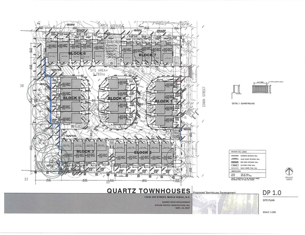
10 viii) That a voluntary contribution, in the amount of $127, be provided in keeping with the Council Policy with regard to Community Amenity Contributions. DISCUSSION: 1) Background Context: Applicant: Legal Description: OCP: Existing: Zoning: Existing: Proposed: Michael Oord Lot 39 Section 28 Township 12 New Westminster District Plan Medium/High Density Residential RS-3 (One Family Rural Residential) and RS-2 (One Family Suburban Residential) RM-1 (Townhouse Residential) Surrounding Uses: North: Use: Multi-Family Residential Zone: RST-SV (Street Townhouse) Designation: Medium/High Density Residential South: Use: Single Family Residential Zone: RS-2 (One Family Suburban Residential), under application for RM-1 (Townhouse Residential) Designation: Medium/High Density Residential East: Use: Multi-Family Residential Zone: RM-1 (Townhouse Residential) Designation: Medium/High Density Residential West: Use: Single Family Residential Zone: RS-3 (One Family Rural Residential) and RS-2 (One Family Suburban Residential), under application for RM-1 (Townhouse Residential) Designation: Neighbourhood Park; Medium/High Density Residential; Conservation Existing Use of Property: Proposed Use of Property: Site Area: Access: Servicing requirement: Single Family Residential Multi-Family Residential 0.78 ha (1.93 acres) 236 Street Urban Standard 2) Project Description: The subject property is located in the River Village of the Silver Valley Area Plan and is approximately 0.78 ha (1.93 acres) in size. A single family home is currently located on the property and is bound by a proposed townhouse development ( RZ) to the south, a proposed townhouse development to the west, Larch Avenue and street townhouses to the north, and an existing townhouse development to the east. Larch Avenue has recently been constructed in a new alignment further north of the property; therefore, the adjacent road right-of-way to the north of the property will be maintained as a trail. The north-eastern portion of the subject property is higher in - 2 -
11 elevation and slopes down towards the south-west. There is a considerable amount of vegetation and tree cover surrounding the existing house on the subject property (see Appendices A and B). The applicant is proposing a townhouse development consisting of 31 units to be accessed from 236 Street. Double-car garages are proposed for 28 of the units, with the remaining 3 units proposed to have tandem garages. A common activity area is proposed along the northern property boundary. There are significant trees located on the western property boundary that will be retained through a tree protection covenant. Retaining walls will be required to mitigate the grade changes on site. The architectural aesthetics of the proposed development will utilize West Coast inspiration of incorporating natural environment into the design, and this will be the subject of a future report to Council. 3) Planning Analysis: i) Official Community Plan: The subject property is located just north of the intersection of 236 Street and 132 Avenue, within the River Village of the Silver Valley Area Plan. The Official Community Plan (OCP) designation for the subject property is Medium/High Density Residential, which allows both single family and multifamily housing forms. Silver Valley Area Plan Policy 5.2. states: River Village is located along a main arterial route in the Silver Valley area, on Fern Crescent, between Maple Ridge Park to the south and an escarpment to the north and east. Principle a) identifies that the River Village is to be a complete community, with a main shopping street, integrated multi-family housing, mixed-use buildings, civic buildings and community facilities, including a high school, and an elementary school. Densities of units per hectare are encouraged for the River Village area and may include attached as well as detached fee-simple housing. The proposed RM-1 (Townhouse Residential) development, at 31 units per 0.78 hectare, is approximately 40 units per hectare, and therefore complies with the Medium/High Density Residential designation within the Silver Valley Area Plan. ii) Zoning Bylaw: The current application proposes to rezone the subject property from RS-3 (One Family Rural Residential) and RS-2 (One Family Suburban Residential) to RM-1 (see Appendix C) (Townhouse Residential) to permit the future development of approximately 31 townhouse units (see Appendix D). The maximum allowable density of the RM-1 (Townhouse Residential) zone is a floor space ratio of 0.6 times the net lot area, excluding a maximum of 50 m² of habitable basement area per unit. This development has a floor space ratio of 0.58, so it complies with the allowable maximum density. A preliminary review of the plans indicates that the proposal generally complies with the Zoning Bylaw and the Subdivision and Development Services Bylaw; however, several variances will be requested, as outlined below. iii) Proposed Variances: A Development Variance Permit application has been received for this project and involves the following relaxations (see Appendix D): 1. To reduce the minimum front yard setback for Blocks 1 and 2 from 7.5 m (25 ft.) to 4.5 m (15 ft.) to the principal building at its shortest distance and to 2.8 m (9 ft.) to the deck 2. To reduce the minimum rear yard setback for Block 6 from 7.5 m (25 ft.) to 5.7 m (19 ft.) at its shortest distance
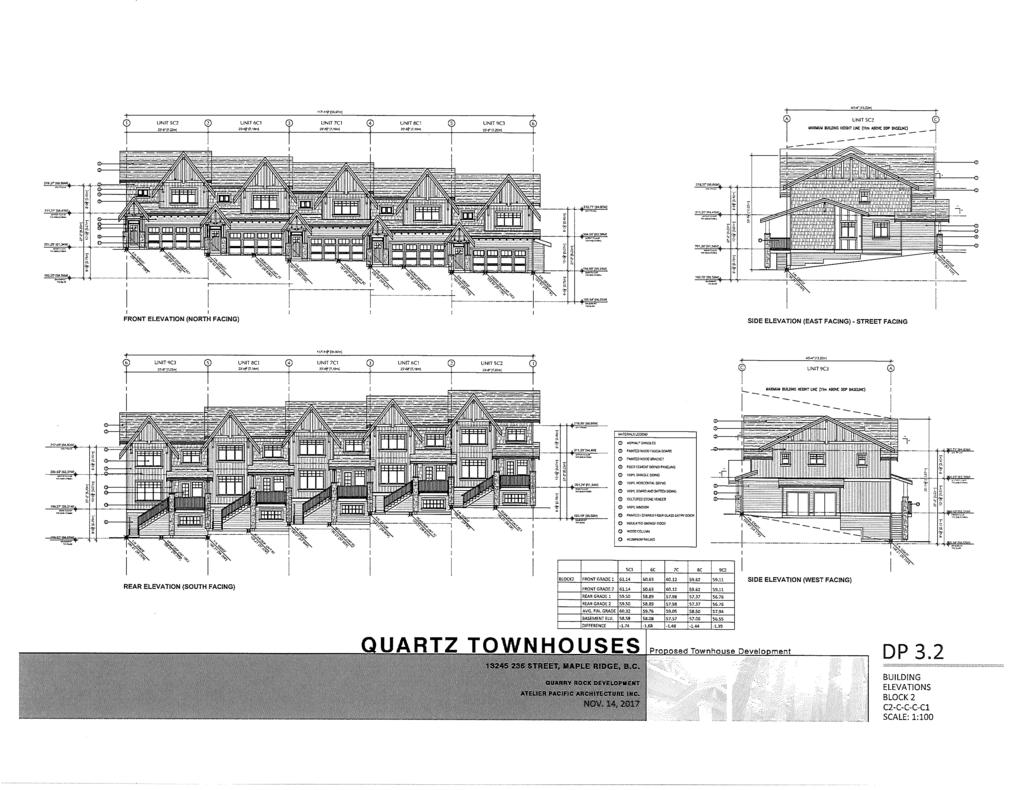
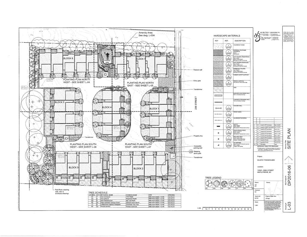
12 3. To reduce the minimum side yard setback for Blocks 6 and 7 from 7.5 m (25 ft.) to 5.5 m (18 ft.) to the principal building at its shortest distance and for Blocks 2, 3, 6 and 7 to 2.8 m (9 ft.) to the deck. 4. To reduce the minimum required Usable Open Space per three bedroom unit with a minimum dimension of not less than 6 m (20 ft.) for Blocks 1, 3, 5, 6 and 7 down to 4.5 m (15 ft.) for its shortest length. (Note that the shortfall of 26 m² (280 ft²) of Usable Open Space is provided in Community Amenity Space. Overall, the required amount of Community Amenity Space is 155 m² (1,668 ft²) and 184 m² (1,981 ft²) is being provided). 5. To increase the maximum retaining wall height from 1.2 m (4 ft.) to 4.1 m (13 ft.) at its highest point. 6. To increase the maximum building height for Blocks 1, 3, 4, 5, 6 and 7 from 11 m (36 ft.) to 11.8 m (39 ft.) at its highest point. 7. To reduce the required 3 m (10 ft.) parking radius arc for visitor parking stalls 4 and 6. The requested variances to the RM-1 (Townhouse Residential) zone will be the subject of a future report to Council. iv) Off-Street Parking And Loading Bylaw: The Off-Street Parking and Loading Bylaw No requires that the RM-1 (Townhouse Residential) zone provide two off-street parking spaces per dwelling unit, plus 0.2 spaces per dwelling unit designated for visitors. There are 31 dwelling units proposed, therefore, 62 resident parking spaces are provided and 7 visitor parking spaces, including one accessible parking space. Some of the driveway aprons of individual units are also capable of providing additional off-street parking spaces within the development. v) Development Permits: Pursuant to Section 8.7 of the OCP, a Multi-Family Development Permit application is required to ensure the current proposal enhances existing neighbourhoods with compatible housing styles that meet diverse needs, and minimize potential conflicts with neighbouring land uses. Pursuant to Section 8.10 of the OCP, a Natural Features Development Permit application is required for all development and subdivision activity or building permits for: All areas designated Conservation on Schedule B or all areas within 50 metres of an area designated Conservation on Schedule B, or on Figures 2, 3 and 4 in the Silver Valley Area Plan; All lands with an average natural slope of greater than 15 percent; All floodplain areas and forest lands identified on Schedule C to ensure the preservation, protection, restoration and enhancement of the natural environment and for development that is protected from hazardous conditions. Pursuant to Section 8.12 of the OCP, a Wildfire Protection Development Permit application is required for all development and subdivision activity or building permits for areas identified as wildfire risk areas, as identified on the Wildfire Development Permit Area map. vi) Advisory Design Panel: The Advisory Design Panel (ADP) reviewed the form and character of the proposed development and the landscaping plans at a meeting held on October 18, 2017 (see Appendices E and F). Following presentations by the project Architect and Landscape Architect, the ADP made the following resolutions: - 4 -
13 Provide alternate solution in case hedge row of trees won t be saved during the construction. Provide site sections to show transition including different types of retaining walls and transitions. Provide exterior stairs for exit and entry. Show light wells where necessary for occupied basement areas. Consider moving entrances forward where possible. The ADP concerns have been addressed and are reflected in the current plans (see Appendices A and B). A detailed description of how these items were incorporated into the final design will be included in a future development permit report to Council. vii) Development Information Meeting: A Development Information Meeting was held at Yennadon Elementary School on November 16, 2017 and 5 people attended the meeting. A summary of the main comments and discussions with the attendees was provided by the applicant and include the following main points: Concern regarding the removal of the trees along the northern property boundary, adjacent to the municipal trail; and Suggestion that additional landscaping and trees within the municipal trail would help to enhance the neighbourhood and keep the privacy. The following are provided in response to the issues raised by the public: Trees along the northern property line are proposed to be retained through a Tree Protection Covenant; and The applicant will not be providing any additional landscaping within the municipal trail. 4) Environmental Implications: An Environmental Assessment, prepared by Keystone Environmental; an Arborist Report, prepared by Van Der Zalm and Associates; and a Geotechnical Report, prepared by Geopacific Consultants, were all provided as part of the development application. The north-eastern portion of the subject property is higher in elevation and slopes down towards the south-west, where retaining walls will be used to mitigate those grade changes. Vegetation on the subject property consists of native and introduced trees, shrubs and grasses and the western property boundary has significant trees that will be retained through a Tree Protection Covenant. A Natural Features Development Permit, DP, will be the subject of a future report to the Director of Planning. 5) Interdepartmental Implications: i) Engineering Department: The Engineering Department has identified this application will require upgrades, including: curb, gutter and sidewalk along the property frontage; road widening on the west side of 236 Street to the urban collector standard, as well as the ditch enclosure along 236 Street; street trees and street lights to be located along the property frontage, as well as new storm, sanitary and water connections. ii) Licences, Permits and Bylaws Department: The Licences, Permits and Bylaws Department reviewed the development application and has provided comments related to Building Code requirements which have been provided to the developer. These comments will be incorporated at the Building Permit stage
14 6) School District No. 42 Comments: The School District has noted that the subject property falls within the Yennadon Elementary and Garibaldi Secondary school catchments. Numbers for the school year indicate that Yennadon Elementary is at 106% utilization, with 580 students, including 130 students from out of catchment. For secondary school enrollment capacity, numbers for the school year indicate that Garibaldi Secondary is at 75% utilization, with 795 students, including 258 students from out of catchment. 7) Citizen/Customer Implications: A Development Information Meeting was held on November 16, The results of the concerns expressed at that meeting are discussed above. The Public Hearing will provide an additional opportunity for citizens to express their concern or support of the development. CONCLUSION: It is recommended that second reading be given to Zone Amending Bylaw No , and that application RZ be forwarded to Public Hearing. Original signed by Adam Rieu Prepared by: Adam Rieu Planning Technician Original signed by Christine Carter Approved by: Christine Carter, M.PL, MCIP, RPP Director of Planning Original signed by Frank Quinn Approved by: Frank Quinn, MBA, P.Eng GM: Public Works & Development Services Original signed by Paul Gill Concurrence: Paul Gill, CPA, CGA Chief Administrative Officer The following appendices are attached hereto: Appendix A Subject Map Appendix B Ortho Map Appendix C Zone Amending Bylaw No Appendix D Site Plan Appendix E Example Building Elevation Appendix F Landscape Plan - 6 -
15 SUBJECT PROPERTY Scale: 1:2,500 Legend Stream Ditch Centreline Edge of River Indefinite Creek River Centreline Major Rivers & Lakes RZ DATE: Jan 20, St 2011 Image PLANNING DEPARTMENT BY: JV
16 SUBJECT PROPERTY Scale: 1:2,500 Legend Stream Edge of River Indefinite Creek River Centreline Major Rivers & Lakes RZ DATE: Jan 20, 2016 Aerial Imagery from the Spring of St 2011 Image PLANNING DEPARTMENT BY: JV
17 CITY OF MAPLE RIDGE BYLAW NO A Bylaw to amend Map "A" forming part of Zoning Bylaw No as amended WHEREAS, it is deemed expedient to amend Maple Ridge Zoning Bylaw No as amended; NOW THEREFORE, the Municipal Council of the City of Maple Ridge enacts as follows: 1. This Bylaw may be cited as "Maple Ridge Zone Amending Bylaw No " 2. That parcel or tract of land and premises known and described as: Lot 39 Section 28 Township 12 New Westminster District Plan and outlined in heavy black line on Map No a copy of which is attached hereto and forms part of this Bylaw, is hereby rezoned to RM-1 (Townhouse Residential). 3. Maple Ridge Zoning Bylaw No as amended and Map "A" attached thereto are hereby amended accordingly. READ a first time the 23 rd day of February, READ a second time the 16 th day of January, PUBLIC HEARING held the day of, 20 READ a third time the day of, 20 ADOPTED the day of, 20 PRESIDING MEMBER CORPORATE OFFICER
18 236 ST PARK RW LMP LARCH AVE. 30 LMP LMP LMP P LM AVE ST. RP Rem A BCS /40 32 P P BCP *PP159 L EPP 9002 Rem 3 PP X4138 EPP EPP EPP P EPP EPP EPP EPP P EPP LARCH AVE EPP *PP157 1 EPP EPP EPP EPP EPP EPP EPP LMP EPP EPP LMP EPP 121 EPP BCP EPP EPP P P BRYANT DRIVE 13 BCP EPP LMP AVE. EPP BCP EPP EPP (EPS 2081) LMP PARK LMP EPP AVE. 132 AVE Urban Area Boundary P LMP P 2637 Rem P 1105 MAPLE RIDGE ZONE AMENDING Bylaw No. Map No. From: To: RS-2 (One Family Suburban Residential) RS-3 (One Family Rural Residential) RM-1 (Townhouse Residential) Urban Area Boundary EP A P 2 SCALE 1:2,500
19
20
21
22 DEVELOPMENT APPLICATION CHECKLIST FOR FILE RZ File Manager: Diane Hall Official Community Plan or Zoning Bylaw Amendments: RECEIVED NOT REQUIRED 1. A completed Application Form (Schedule A Development Procedures Bylaw No ) 2. An application fee, payable to the City of Maple Ridge, in accordance with Development Application Fee Bylaw no A Certificate of Title and Consent Form if the applicant is different from the owner shown on the Certificate of Title. 4. A legal survey of the property(ies) 5. Subdivision plan layout 6. Neighbourhood context plan 7. Lot grading plan 8. Landscape plan *+ 9. Preliminary architectural plans including site plan, building elevations, accessory off-street parking and general bylaw compliance reconciliation *+. * These items may not be required for single-family residential applications + These items may be required for two-family residential applications, as outlined in Council Policy No Additional reports provided: 2.
23 City of Maple Ridge TO: Her Worship Mayor Nicole Read MEETING DATE: January 16, 2018 and Members of Council FILE NO: RZ FROM: Chief Administrative Officer MEETING: Council SUBJECT: First and Second Reading Official Community Plan Amending Bylaw No ; Second Reading Zone Amending Bylaw No ; Marc Road EXECUTIVE SUMMARY: An application has been received to rezone the subject property located at Marc Road from A-2 (Upland Agricultural) to R-1 (Residential District), and R-2 (Urban Residential District), to permit a future subdivision of approximately 109 lots. Council granted first reading to Zone Amending Bylaw No and considered the early consultation requirements for the Official Community Plan (OCP) amendment on June 14, The minimum lot size for the current A-2 Upland Agricultural Zone is 4.0m 2 (10.0 acres). The proposed development is in compliance with the policies of the Silver Valley Area Plan of the Official Community Plan (OCP). Ground-truthing on the site has established the developable areas, and as a result, an OCP amendment is required to revise the boundaries of the land use designations to fit the site conditions. Ground truthing has also led to significant revisions of the original proposal that accompanied the first reading report. The site plan accompanying this report, attached as Appendix E, proposes a reduced lot yield and only single family lots (no townhouse units). Pursuant to Council policy, this application is subject to the Community Amenity Contribution Program at a rate of $5, per single family lot, for an estimated amount of $555, RECOMMENDATIONS: 1) That, in accordance with Section 475 of the Local Government Act, opportunity for early and on-going consultation has been provided by way of posting Official Community Plan Amending Bylaw No on the municipal website and requiring that the applicant host a Development Information Meeting (DIM), and Council considers it unnecessary to provide any further consultation opportunities, except by way of holding a Public Hearing on the bylaw; 2) That Official Community Plan Amending Bylaw No be considered in conjunction with the Capital Expenditure Plan and Waste Management Plan; 3) That it be confirmed that Official Community Plan Amending Bylaw No is consistent with the Capital Expenditure Plan and Waste Management Plan; - 1 -
24 4) That Official Community Plan Amending Bylaw No be given first and second readings and be forwarded to Public Hearing; 5) That Zone Amending Bylaw No be amended as identified in the staff report dated January 16, 2018, be given second reading, and be forwarded to Public Hearing; 6) That the following terms and conditions be met prior to final reading: i) Registration of a Rezoning Servicing Agreement as a Restrictive Covenant and receipt of the deposit of a security, as outlined in the Agreement; ii) iii) iv) Amendment to to Official Community Plan Schedule A, Chapter 10.3, Part VI, A Silver Valley, Figure 2 - Land Use Plan, and Figure 4 - Trails / Open Space, Park dedication as required, including construction of multi-purpose trails, emergency access roads; and removal of all debris and garbage from park land; Registration of a Restrictive Covenant for the Geotechnical, which addresses the suitability of the subject property for the proposed development; v) Registration of a Restrictive Covenant for the protection of the Environmentally Sensitive areas on the subject property; vi) vii) viii) ix) Registration of a Restrictive Covenant for Tree Protection; Registration of a Restrictive Covenant for Stormwater Management; Notification to the Department of Fisheries and Oceans and the Ministry of Environment for in-stream works on the site; and That a voluntary contribution, in the amount of $555, ( $5,100.00/lot), be provided in keeping with the Council Policy with regard to Community Amenity Contributions. DISCUSSION: a) Background Context: Applicant: Legal Description: OCP: Existing: Proposed: Zoning: Existing: Proposed: Morningstar Homes Ltd. Ryan Lucy Lot 2, Section 32, Township 12, Plan: LMP14126, Lot 3, Section 32, Township 12, Plan: LMP14126 ECO (Eco Clusters), Conservation, Rural Residential Eco Clusters, Conservation A-2 (Upland Agricultural) R-1 (Residential District) and R-2 (Urban Residential District - 2 -
25 Surrounding Uses: North: Use: Vacant Zone: A-2 (Upland Agricultural) Designation Rural Residential & Agricultural South: Use: Single Family Residential Zone: R-1 (Residential District) Designation: Eco Clusters East: Use: Single Family Residential Zone: RS-3 (One Family Rural Residential) Designation: Eco Clusters and Conservation West: Use: Blaney Bog Zone: A-5 (Agriculture Only) Designation: Park within the ALR and Rural Residential Existing Use of Property: Proposed Use of Property: Site Area: Access: Servicing requirement: Vacant Urban Residential Ha. (74.32 acres) Marc Road Urban Standard BACKGROUND: A previous application for this site (RZ/008/09, not completed) proposed a development of 137 units, which is more lots than proposed by the current application. A central feature of the Silver Valley Plan and the Eco-cluster designation is for the land to inform development, thereby enabling the built form to be sensitive to the natural features of the land base. The Plan s goals are to preserve the character and features of the lands as much as possible and to avoid wholesale regrading or blasting to enlarge development envelopes. Slopes in excess of 25% should not be disturbed or built on. A complete assessment of these elements by this applicant has resulted in a proposal of fewer lots than proposed in the first reading report, providing a better fit with developable portions of the site. b) Project Description: The current application proposes to rezone the subject properties from A-2 (Upland Agricultural) to R-1 (Residential District), and R-2 (Urban Residential Districtl). The proposed lot yield includes a total of 109 single family lots with 28 R-1 (Residential District) lots and 81 R-2 (Urban Residential District) lots. Large tracts of conservation lands enclose the site, amounting to 23.7 hectares (58.6 acres) of dedicated parkland. In addition, a 0.31 hectare neighbourhood park will be located in the centre of the developable portion of the site. The total percentage of park dedication will be roughly 80% of the lot. Trail development as indicated in the Silver Valley Area Plan will be constructed as part of this application
26 c) Planning Analysis: i) Official Community Plan: The subject properties are split designated Eco-cluster and Conservation (the smaller northern parcel is also designated 46% Rural Residential). The Eco-cluster designation refers to the developable portions of the site. Some adjustments in the designations have been made in response to ground truthing. These have been adjusted as shown in Appendix C, as attached. Section of the Silver Valley Area Plan speaks to Eco-Cluster densities, as follows: a) Densities and housing types should be diversified within and between Eco-Clusters. b) The densities of Eco-Clusters in the eastern sector should be lower than other Eco-Clusters due to limited access and the requirements for accommodating equestrian activities, i.e. pastures and stables. c) An Eco-Cluster includes varying levels of density, ranging from 5 to 15 units per hectare, in the form of single and/or multi-family units, dependent on proximity to a Hamlet centre, slope constraints, view impacts, and existing development. d) Residential areas should be developed in a manner to allow a gradual and natural increase in density over time. The Eco-Cluster designation is intended to provide development opportunities in sparsely developed or rural areas, in a cluster form which supports sensitive implementation, minimal site regrading and tree clearing, and integration of housing into a natural forest setting. Eco-clusters are located in areas where topography is difficult, where view impacts need to be minimized, and where the existing rural character should be retained. The portions of the 30.0 hectare subject site that are designated Eco-Cluster amount to 18.3 hectares. For a site of this size, the number of units within the 5 15 units per hectare density range amount to between 100 to 300 units. The proposed 109 units of this development are within the lower end of this range. As this site is near the periphery of the Plan boundaries, adjacent to a rural context, and to land that is within the Agricultural Land Reserve, these lower densities are supportable. Agricultural Policies: The Official Community Plan also contains policies aimed at protecting the productivity of agricultural land. The subject property is adjacent to Blaney Bog Regional Park to its West. As this park site is within the Agricultural Land Reserve, policy 6-12 b) will apply, as follows: Maple Ridge will protect the productivity of its agricultural land by: b) Requiring agricultural impact assessments (AIAs) and Groundwater Impact Assessment of non-farm development and infrastructure projects and identifying measures to off-set impacts on agricultural capability ZONING BYLAW: The minimum lot size for the current A-2 Upland Agriculture zone is 4 hectares. The proposed R-1 (Residential District) Zone has a minimum parcel size of 371 m 2 and the proposed R-2 (Urban Residential District) Zone has a minimum parcel size of 315 m 2. The initial proposal included some multi-family development but has since been revised as shown on the site plan, attached as Appendix E
27 ii) Off-Street Parking And Loading Bylaw: Single family uses generate a required off-street parking complement of 2 off-street parking stalls per lot. However, the R-1 (Residential District) Zone permits a secondary suite as an accessory use, which has an additional required parking complement of 1 stall. Parking considerations will be addressed through the building permit process upon completion of the rezoning and subdivision application. iii) Development Permits: Pursuant to Sections 8.9 and 8.10 of the OCP, a Watercourse Protection Development Permit and a Natural Features Development Permit application is required to ensure the preservation, protection, restoration and enhancement of watercourse and riparian areas, and for all development and subdivision activity or building permits for: All areas designated Conservation on Schedule B or all areas within 50 metres of an area designated Conservation on Schedule B, or on Figures 2, 3 and 4 in the Silver Valley Area Plan; All lands with an average natural slope of greater than 15 percent; All floodplain areas and forest lands identified on Schedule C to ensure the preservation, protection, restoration and enhancement of the natural environment and for development that is protected from hazardous conditions. iv) Development Information Meeting: A Development Information Meeting was held at Yennadon School Gymnasium on November 30, people attended the meeting. A summary of the main comments and discussions with the attendees was provided by the applicant and include the following main points: Anderson Creek road emergency access would become road in response to traffic demand. Schools and commercial development needed in Silver Valley, more residential development needed in Town Centre. Impacts of Marc Road development on adjacent neighbourhood. The following are provided in response to the issues raised by the public: Municipal departments have agreed that the Anderson Creek Drive access could be developed for emergency access only. This was not the original plan in the OCP, which shows a fully accessible road. However, the proposed lot layout and road pattern has been determined to be adequate for access and egress purposes. This residential development proposal is consistent with the subject property s land use designation. Lots proposed on Marc Road have been moved further south for tree protection and reduced neighbourhood impacts. v) Parkland Requirement: As there are more than two additional lots proposed to be created, the developer will be required to comply with the park dedication requirements of Section 510 of the Local Government Act prior to subdivision approval. For this project, there is sufficient land that is proposed to be dedicated as park on the subject property and this land will be required to be dedicated as a condition of Final Reading
28 d) Environmental Implications: The site plan has been developed through collaboration with the Environmental Planner and the applicant s consultant team. The lot layout has considered conservation lands and tree protection measures in its current form. e) Agricultural Impact: An agricultural impact assessment will be required, due to the proximity of the site to the Blaney Bog, which is within the Agricultural Land Reserve. This requirement can be met as a condition of subdivision. f) Interdepartmental Implications: i) Engineering Department: Engineering comments focused on the need for servicing upgrades for road construction, sanitary sewer, storm sewer, street trees, street lighting, and the watermain. As adjacent parcels will benefit from the provision of this infrastructure, a latecomers agreement is proposed to reimburse the developer for these costs when adjacent properties develop in the future. ii) Parks & Leisure Services Department: Both municipal and regional park department involvement have been sought, due to the proximity of the site to Blaney Bog. Park dedication is required as a condition of rezoning. iii) Fire Department: The Fire Department agrees to allowing the Anderson Creek drive access to be downgraded to emergency access only. Further input will be sought at the subdivision stage for the wildfire development permit that must be approved prior to development occurring on the site. The applicant has provided a preliminary wildfire hazard assessment. This work will need to be updated upon review of the subdivision layout as a requirement of the subdivision application. g) Intergovernmental Issues: i) Local Government Act: An amendment to the OCP requires the local government to consult with any affected parties and to adopt related bylaws in compliance with the procedures outlined in Section 477 of the Local Government Act. The amendment required for this application, to conservation boundaries, is considered to be minor in nature. It has been determined that no additional consultation beyond existing procedures is required, including referrals to the Board of the Regional District, the Council of an adjacent municipality, First Nations, the School District or agencies of the Federal and Provincial Governments. The amendment has been reviewed with the Financial Plan/Capital Plan and the Waste Management Plan of the Greater Vancouver Regional District and determined to have no impact. h) Citizen/Customer Implications: The applicant has been consulting with the neighbourhood extensively as this application has progressed. To meet the City s formal consultation requirements, a Development Information Meeting was held on November 30, A public hearing will be required as part of this rezoning application
29 CONCLUSION: It is recommended that first and second reading be given to OCP Amending Bylaw No , that second reading be given to Zone Amending Bylaw No , and that application RZ be forwarded to Public Hearing. Original signed by Diana Hall Prepared by: Diana Hall, M.A., MCIP, RPP Planner 2 Original signed by Chuck Goddard for Approved by: Christine Carter, M.PL, MCIP, RPP Director of Planning Original signed by Frank Quinn Approved by: Frank Quinn, MBA, P.Eng GM: Public Works & Development Services Original signed by Paul Gill Concurrence: Paul Gill, CPA, CGA Chief Administrative Officer The following appendices are attached hereto: Appendix A Subject Map Appendix B Ortho Map Appendix C OCP Amending Bylaw No Appendix D Zone Amending Bylaw No Appendix E Site Plan - 7 -
30 SUBJECT PROPERTY Legend Stream MARC ROAD Ditch Centreline PLANNING DEPARTMENT Edge of Marsh Indefinite Creek River Centreline Lake or Reservoir Ścale: 1:5,000 Marsh FILE: RZ DATE: Jan 3, 2018 BY: PC

31 SUBJECT PROPERTY Aerial Imagery from the Spring of 2016 City of Pitt Meadows District of Langley ^ District of Mission MARC ROAD PLANNING DEPARTMENT Ścale: 1:5,000 FRASER R. FILE: RZ DATE: Jan 3, 2018 BY: PC
32 CITY OF MAPLE RIDGE BYLAW NO A Bylaw to amend the Official Community Plan Bylaw No WHEREAS Section 477 of the Local Government Act provides that the Council may revise the Official Community Plan; AND WHEREAS it is deemed expedient to amend Schedule "A" to the Official Community Plan; NOW THEREFORE, the Municipal Council of the City of Maple Ridge, enacts as follows: 1. This Bylaw may be cited for all purposes as "Maple Ridge Official Community Plan Amending Bylaw No " 2. Schedule A, Chapter 10.3, Part VI, A Silver Valley, Figure 2 - Land Use Plan, is hereby amended for the parcel or tract of land and premises known and described as: Lot 3 Section 32 Township 12 New Westminster District Plan LMP14126 and outlined in heavy black line on Map No. 969, a copy of which is attached hereto and forms part of this bylaw, is hereby designated as shown. 3. Schedule A, Chapter 10.3, Part VI, A Silver Valley, Figure 4 Trails / Open Space is hereby amended for the parcel or tract of land and premises known and described as: Lot 3 Section 32 Township 12 New Westminster District Plan LMP14126 and outlined in heavy black line on Map No. 970, a copy of which is attached hereto and forms part of this bylaw, is hereby designated as shown. 4. Maple Ridge Official Community Plan Bylaw No as amended is hereby amended accordingly. READ a first time the 16 th day of January, 2018 READ a second time the 16 th day of January, 2018 PUBLIC HEARING held the day of, 20 READ a third time the day of, 20 ADOPTED, the day of, 20. PRESIDING MEMBER CORPORATE OFFICER
33 Urban Area Boundary MARC RD. MARC RD. 141 AVE. ANDERSON PARKSIDE CRES. CREEK DRIVE MAPLE RIDGE OFFICIAL COMMUNITY PLAN AMENDING Bylaw No. Map No. Purpose: From: To Amend Silver Valley Area Plan Figure 2 Eco CLuster and Conservation To: Conservation Eco Cluster Neighbourhood Park Urban Area Boundary SCALE 1:5,000
34 Urban Area Boundary MARC RD. MARC RD. 141 AVE. ANDERSON PARKSIDE CRES. CREEK DRIVE MAPLE RIDGE OFFICIAL COMMUNITY PLAN AMENDING Bylaw No. Map No. Purpose: To Amend Silver Valley Area Plan Figure 4: Trail/Open Space as shown Add to Conservation Remove from Conservation Urban Area Boundary Add to Neighbourhood Park Add to Trail SCALE 1:5,000
35 CITY OF MAPLE RIDGE BYLAW NO A Bylaw to amend Map "A" forming part of Zoning Bylaw No as amended WHEREAS, it is deemed expedient to amend Maple Ridge Zoning Bylaw No as amended; NOW THEREFORE, the Municipal Council of the City of Maple Ridge enacts as follows: 1. This Bylaw may be cited as "Maple Ridge Zone Amending Bylaw No " 2. Those parcel or tract of land and premises known and described as: Lot 3 Section 32 Township 12 New Westminster District Plan LMP14126 and outlined in heavy black line on Map No a copy of which is attached hereto and forms part of this Bylaw, are hereby rezoned to R-1 (Residential District), R-2 (Urban Residential District), 3. Maple Ridge Zoning Bylaw No as amended and Map "A" attached thereto are hereby amended accordingly. READ a first time the 14 th day of June, READ a second time the 16 th day of January, PUBLIC HEARING held the day of, 20 READ a third time the day of, 20 ADOPTED, the day of, 20 PRESIDING MEMBER CORPORATE OFFICER
 To: R-1 (Residential District) R-2 (Urban Residential District) Urban Area Boundary")
36 Urban Area Boundary MARC RD. 141 AVE. ANDERSON PARKSIDE CRES. CREEK DRIVE MAPLE RIDGE ZONE AMENDING Bylaw No. Map No. From: A-2 (Upland Agricultural) To: R-1 (Residential District) R-2 (Urban Residential District) Urban Area Boundary SCALE 1:5,000

37
38 DEVELOPMENT APPLICATION CHECKLIST FOR FILE RZ File Manager: Diane Hall Official Community Plan or Zoning Bylaw Amendments: RECEIVED NOT REQUIRED 1. A completed Application Form (Schedule A Development Procedures Bylaw No ) 2. An application fee, payable to the City of Maple Ridge, in accordance with Development Application Fee Bylaw no A Certificate of Title and Consent Form if the applicant is different from the owner shown on the Certificate of Title. 4. A legal survey of the property(ies) 5. Subdivision plan layout 6. Neighbourhood context plan 7. Lot grading plan 8. Landscape plan *+ 9. Preliminary architectural plans including site plan, building elevations, accessory off-street parking and general bylaw compliance reconciliation *+. * These items may not be required for single-family residential applications + These items may be required for two-family residential applications, as outlined in Council Policy No Additional reports provided: 3.

39 City of Maple Ridge TO: Her Worship Mayor Nicole Read MEETING DATE: January 30, 2018 and Members of Council FILE NO: RZ FROM: Chief Administrative Officer MEETING: Council SUBJECT: First and Second Reading Zone Amending Bylaw No EXECUTIVE SUMMARY: On January 9, 2018, Council reviewed a staff report recommending the prohibition of cannabis sales in all zones. In response, Council passed the following resolution: That City of Maple Ridge staff begin the preparation of a Zoning Bylaw amendment in the form of a bylaw as attached in Appendix III of the staff report dated January 9, 2018 to prohibit the sale of cannabis in any zone. The proposed zoning bylaw text amendment is appended to this report as Appendix A. Federal legislation to legalize non-medical cannabis is expected to become law in July This provision to prohibit cannabis sales should be considered as an interim step until the Provincial government has confirmed details regarding its approach to the retail sale of cannabis. Most importantly, this measure is being used to prevent business operations from being set up in advance of the provincial retail model. This approach taken is consistent with legal advice given at the 2017 UBCM Convention. Other BC municipalities, such as the City of White Rock, are also following this direction. This proposed amendment will provide Council with an opportunity to consider appropriate land use options for the sale of cannabis once the Provincial retail model is made clear. RECOMMENDATION: That Maple Ridge Zone Amending Bylaw No be given First and Second Reading and be forwarded to Public Hearing. BACKGROUND: 1) PROJECT DESCRIPTION: It is generally understood that the proposed Federal legislative changes are in process to make the recreational use and sale of cannabis legal. However, in advance of a provincial cannabis retail framework, it is a challenge for local governments to determine the most appropriate municipal
40 approach to these upcoming changes. In recognition of this challenge, Council has directed that a prohibition be placed on cannabis sales within municipal limits. It is recognized that further Zoning Bylaw amendments may be warranted once there is greater clarity in the Federal and Provincial context regarding this use. 2) PLANNING ANALYSIS: This proposed amendment to the Zoning Bylaw is an interim regulatory measure. It will provide Council and the community with an opportunity to review appropriate regulations for this particular land use activity, once the Province has presented its regulatory framework. This bylaw is intended to prevent businesses from setting up in contravention of existing bylaws, and ensure that future cannabis retail sales outlets are established in appropriate locations in the municipality. Currently, cannabis is regulated under the Controlled Drugs and Substances Act and the Access to Cannabis for Medical Purpose Regulations (formerly known as the Marihuana for Medical Purposes Regulations). Under this legislation, there is no provision allowing for the commercial sale or dispensing of cannabis and associated products. The anticipated date for Canadian legalization is July Zoning Bylaw: Most commercial zones in Maple Ridge permit retail sales. In the absence of zoning bylaw regulations, there is a risk that cannabis sales, once legalized, could be established in any of these commercial zones throughout the City, and retain legal non-conforming status once zoning bylaw amendments are made. The proposed text amendment to the Zoning Bylaw is to be made by adding section (h) below as follows: Part 4, General Regulations, Section 401 Uses of Land, Buildings and Structures, (3) Prohibited Uses of Land Buildings, and Structures. The following uses shall be prohibited in all zones. (h) the retail sale of cannabis. 3) INTERGOVERNMENTAL ISSUES: Proposed legislative changes to cannabis will involve Federal, Provincial and Local governments. A summary of responsibilities is listed below. Government of Canada. Under the new legislation, the Federal government is responsible for establishing and maintaining a comprehensive and consistent national framework for regulating production, setting standards for health and safety, and establishing criminal prohibitions
City of Maple Ridge PUBLIC HEARING
 City of Maple Ridge PUBLIC HEARING December 4, 08 CITY OF MAPLE RIDGE PUBLIC HEARING PUBLIC HEARING AGENDA December AGENDA 4, 08 7:00 pm Council Chambers, st Floor, City Hall The purpose of the Public
City of Maple Ridge PUBLIC HEARING
 City of Maple Ridge PUBLIC HERING June 9, 208 CITY OF MPLE RIDGE PUBLIC HERING PUBLIC HERING GEND June GEND 9, 208 7:00 pm Council Chambers, st Floor, City Hall The purpose of the Public Hearing is to
COMMITTEE OF THE WHOLE AGENDA September 15, :00 p.m. Council Chamber. Chair: Acting Mayor
 City of Maple Ridge COMMITTEE OF THE WHOLE AGENDA September 15, 2014 1:00 p.m. Council Chamber Committee of the Whole is the initial venue for review of issues. No voting takes place on bylaws or resolutions.
2. Rezone a portion of the lot from R2 (Small Lot Residential) to RD2 (Duplex: Housing Lane).
 to RD2 (Duplex: Housing Lane).") Public Notice September 6, 2018 Subject Property Subject Property: 337 Hastings Ave Lot 24, District Lot 1, Group 7, Similkameen Division Yale (Formerly Yale-Lytton) District, Plan 932 Application: The
Public Notice September 6, 2018 Subject Property Subject Property: 337 Hastings Ave Lot 24, District Lot 1, Group 7, Similkameen Division Yale (Formerly Yale-Lytton) District, Plan 932 Application: The
For Vintages of Four Mile Creek Town of Niagara on the Lake, Ontario
 Planning Impact Analysis For Vintages of Four Mile Creek Town of Niagara on the Lake, Ontario Prepared by: Upper Canada Consultants 261 Martindale Road Unit #1 St. Catharines, Ontario L2W 1A1 Prepared
COUNCIL MEETING AGENDA March 25, :00 p.m. Council Chamber
 District of Maple Ridge COUNCIL MEETING AGENDA March 25, 2014 7:00 p.m. Council Chamber MEETING DECORUM Council would like to remind all people present tonight that serious issues are decided at Council
PUBLIC HEARING INFORMATION PACKAGE
 PUBLIC HEARING INFORMATION PACKAGE ADDRESS: APPLICANT: 8522 Nottman Street Analytical Consulting PLANNING FILE(S): OCP17-002 R17-015 This Public Hearing Information Package has been compiled to provide
SPECIAL COUNCIL MEETING AGENDA December 12, 2017 Following Council Workshop Blaney Room 1 st Floor, Maple Ridge City Hall
 City of Maple Ridge SPECIAL COUNCIL MEETING AGENDA December 12, 2017 Following Council Workshop Blaney Room 1 st Floor, Maple Ridge City Hall 1.0 CALL TO ORDER 2.0 APPROVAL OF THE AGENDA 3.0 REPORTS AND
LIN AVE The applicant is proposing to construct a four-unit Lot A R.P
 Public Notice June 21, 2018 Subject Property: 125 Calgary Avenue Lot 4, District Lot 250, Similkameen Division Yale District, Plan 1164, Except Plan B5473 Application: Rezone PL2018-8261 The applicant
*DO NOT REMOVE * R (Redekop) Darbyshire Drive
 Darbyshire Drive") *DO NOT REMOVE * R16-022 (Redekop) 33770 Darbyshire Drive This Public Hearing Information Package has been compiled to provide information pertaining to the subject property. If you have questions regarding
*DO NOT REMOVE * R16-022 (Redekop) 33770 Darbyshire Drive This Public Hearing Information Package has been compiled to provide information pertaining to the subject property. If you have questions regarding
CITY OF KAMLOOPS BYLAW NO A BYLAW TO AMEND THE ZONING BYLAW OF THE CITY OF KAMLOOPS
 67 68 CITY OF KAMLOOPS BYLAW NO. 5-1-2796 A BYLAW TO AMEND THE ZONING BYLAW OF THE CITY OF KAMLOOPS The Municipal Council of the City of Kamloops, in open meeting assembled, enacts as follows: 1. This
Planning and Building Department
 Page 1 of Report PB-83-13 TO: Development and Infrastructure Committee Planning and Building Department SUBJECT: OP & Rezoning 5001 Corporate Drive Appleby Gardens LJM Developers Report Number: PB-83-13
Lot 5. 8t 8. Lot 4. Lot 4. Lot 4. Lot 3 E Lot 4. Lot 3. Lot 3. Lot 3. Lot 1. Lot 1. Lot 5. Lot 5. Lot 5. Lot 4. Lot 4.
 Lot 2 Lot 1 Lot 12 Lot 11 Lot 3 Lot A Lot 10 Lot 4 Lot A Lot 5 Lot 7 Lot 8 Lot 8 Lot 6 Lot 7 Lot 9 Lot 6 Lot 1 Lot 2 Lot A Lot 5 Lot 10 Lot 9 Lot 6 Lot 5 Lot 8 8t 8 Lot 3 Lot 4 Lot 9 Lot 1 Lot 4 Lot 1
Property Location: 2970 Bank Road
 When? Where? Why? Tuesday, May 29, 2018, 7:00 pm Council Chambers, City Hall, 7 Victoria Street West Kamloops City Council will hold a Public Hearing to consider the following proposed amendments to City
D. Oakman. File: /RZ 1B 16. January 27, Via
 Office of the Chief Administrative Officer 600 Comox Road, Courtenay, BC V9N 3P6 Tel: 250-334-6000 Fax: 250-334-4358 Toll free: 1-800-331-6007 www.comoxvalleyrd.ca File: 3360-20/RZ 1B 16 January 27, 2017
SUBJECT: Official Plan and Zoning By-law Amendment Applications for 4853 Thomas Alton Boulevard
 Page 1 of Report PB-100-16 SUBJECT: Official Plan and Zoning By-law Amendment Applications for 4853 Thomas Alton Boulevard TO: FROM: Development and Infrastructure Committee Planning and Building Department
OCP Amendment Rezoning Development Permit Development Variance Permit
 City of Surrey PLANNING & DEVELOPMENT REPORT Files: 7906-0297-00 OCP Amendment Rezoning Development Permit Development Variance Permit Proposal: OCP Amendment of a portion from Commercial to Multiple Residential.
NCP Amendment Rezoning Development Variance Permit
 City of Surrey PLANNING & DEVELOPMENT REPORT File: NCP Amendment Rezoning Development Variance Permit Proposal: NCP amendment from "Single Family Residential" to "Single Family Residential Small Lots";
Lot 1 KAP Lot 1. Lot 1. Lot 4. ot 5
 Public Notice January 11, 2018 Subject Property: 237 Phoenix Avenue Lot 4, District Lot 5, Group 7 Similkameen Division Yale (Formerly Yale-Lytton) District, Plan 10974 Application: The applicant is proposing
3.1. OBJECTIVES FOR RESIDENTIAL LAND USE DESIGNATIONS GENERAL OBJECTIVES FOR ALL RESIDENTIAL DESIGNATIONS
 3. RESIDENTIAL LAND USE DESIGNATIONS INTRODUCTION The Residential land use designations provide for housing and other land uses that are integral to, and supportive of, a residential environment. Housing
Consolidated as of May 14, 2012
 THE CORPORATION OF THE CITY OF WHITE ROCK BYLAW NO. 1869 A Bylaw to amend the provisions of City of White Rock Planning Procedures Bylaw, 2009, No. 1869. DISCLAIMER: THIS BYLAW IS CONSOLIDATED FOR CONVENIENCE
Non-Medical Cannabis Retail Stores Application Form
 Development Services City of West Kelowna 2760 Cameron Road West Kelowna, BC V1Z 2T6 Phone: 778-797-8830 Fax: 778-797-1001 Non-Medical Cannabis Retail Stores Application Form An application for a non-medical
PUBLIC HEARING INFORMATION PACKAGE
 PUBLIC HEARING INFORMATION PACKAGE ADDRESS: APPLICANT: PLANNING FILE(S): R16-034 33880, 33904 and 33930 Prentis Avenue J. Tiegen and G. Toor This Public Hearing Information Package has been compiled to
City of Maple Ridge. Rental Housing Program: Secondary Suite Update and Next Steps
 City of Maple Ridge TO: Her Worship Mayor Nicole Read MEETING DATE: September 19, 2017 and Members of Council FROM: Chief Administrative Officer MEETING: Council Workshop SUBJECT: Rental Housing Program:
CITY OF CAMPBELL RIVER PUBLIC HEARING AGENDA
 CITY OF CAMPBELL RIVER PUBLIC HEARING AGENDA PUBLIC HEARING MEETING, Monday, July 10, 2017 at 6:30 PM in the City Hall Council Chambers, 301 St. Ann's Road, Campbell River, BC. Page The agenda presents
AGENDA FOR THE SPECIAL MEETING OF THE COUNCIL OF THE CITY OF NANAIMO (PUBLIC HEARING) SCHEDULED RECESS AT 9:00 P.M.
 SCHEDULED RECESS AT 9:00 P.M.") AGENDA FOR THE SPECIAL MEETING OF THE COUNCIL OF THE CITY OF NANAIMO (PUBLIC HEARING) Thursday, October 4, 2018, 7:00 P.M. SHAW AUDITORIUM, VANCOUVER ISLAND CONFERENCE CENTRE 80 COMMERCIAL STREET, NANAIMO,
AGENDA FOR THE SPECIAL MEETING OF THE COUNCIL OF THE CITY OF NANAIMO (PUBLIC HEARING) Thursday, October 4, 2018, 7:00 P.M. SHAW AUDITORIUM, VANCOUVER ISLAND CONFERENCE CENTRE 80 COMMERCIAL STREET, NANAIMO,
STAFF REPORT PLN September 11, 2017
 Page: 1 TO: SUBJECT: GENERAL COMMITTEE APPLICATIONS FOR OFFICIAL PLAN AMENDMENT AND ZONING BY-LAW AMENDMENT 37 JOHNSON STREET WARD: WARD 1 PREPARED BY AND KEY CONTACT: SUBMITTED BY: GENERAL MANAGER APPROVAL:
REPORT TO THE CHIEF ADMINISTRATIVE OFFICER FROM THE DEVELOPMENT, ENGINEERING, AND SUSTAINABILITY DEPARTMENT
 April 19, 2018 REPORT TO THE CHIEF ADMINISTRATIVE OFFICER FROM THE DEVELOPMENT, ENGINEERING, AND SUSTAINABILITY DEPARTMENT ON REZONING APPLICATION NO. REZ00631 DEVELOPMENT PERMIT APPLICATION NO. DPM00627
PLANNING RATIONALE REPORT
 PLANNING RATIONALE REPORT Zoning By-law Amendment Application 2920 Danbury Way Prepared for: Bravar Custom Builders Inc. and Village View Estates Ltd. by: 6393 Roslyn Street Ottawa (Orleans), Ontario K1C
*DO NOT REMOVE * R Sharp McRae Avenue
 *DO NOT REMOVE * R16-003 - Sharp 32385 McRae Avenue This Public Hearing Information Package has been compiled to provide information pertaining to the subject property. If you have questions regarding
*DO NOT REMOVE * R Watt Street (New Country Homes Ltd. / Grohmueller)
") *DO NOT REMOVE * R16-007 9957 Watt Street (New Country Homes Ltd. / Grohmueller) This Public Hearing Information Package has been compiled to provide information pertaining to the subject property. If
*DO NOT REMOVE * R16-007 9957 Watt Street (New Country Homes Ltd. / Grohmueller) This Public Hearing Information Package has been compiled to provide information pertaining to the subject property. If
Rezoning Development Permit Development Variance Permit
 City of Surrey PLANNING & DEVELOPMENT REPORT Rezoning Development Permit Development Variance Permit Proposal: Rezone from RA to RM-30 and DP to permit development of a 58-unit townhouse development. DVP
PUBLIC HEARING INFORMATION PACKAGE
 PUBLIC HEARING INFORMATION PACKAGE ADDRESS: APPLICANT: PLANNING FILE: 33093 7 th Avenue District of Mission LUC18-007 This Public Hearing Information Package has been compiled to provide information pertaining
Bylaw No , being "Official Community Plan Bylaw, 2016" Schedule "A" DRAFT
 Bylaw No. 2600-2016, being "Official Community Plan Bylaw, 2016" Schedule "A" Urban Structure + Growth Plan Urban Structure Land use and growth management are among the most powerful policy tools at the
WELCOME! TO THE UNIVERSITY ENDOWMENT LANDS BLOCK F PUBLIC OPEN HOUSE
 WELCOME! TO THE UNIVERSITY ENDOWMENT LANDS BLOCK F PUBLIC OPEN HOUSE The UEL & Block F What is the UEL? Site Location The University Endowment Lands (UEL) is a separate jurisdiction from the City of Vancouver
City of Surrey PLANNING & DEVELOPMENT REPORT File:
 City of Surrey PLANNING & DEVELOPMENT REPORT PROPOSAL: Partial LUC Discharge Planning Report Date: April 28, 2008 Rezoning from RF to RF-9 in order to allow subdivision into three small single family lots.
Zoning Amendment Bylaw No.47l6, 2016 (l RZ) Proposed Subdivision at 961 Walls Avenue and a 29.9 m^ portion of 374 Lebleu Street
 Proposed Subdivision at 961 Walls Avenue and a 29.9 m^ portion of 374 Lebleu Street") CoQuitlam For Council September 26, 2016 Our file: 16 104987 RZ Doc#: 2393664.V1 To: From: Subject: For: City Manager General Manager Planning and Development Zoning Amendment Bylaw No.47l6, 2016 (l6 104987
CoQuitlam For Council September 26, 2016 Our file: 16 104987 RZ Doc#: 2393664.V1 To: From: Subject: For: City Manager General Manager Planning and Development Zoning Amendment Bylaw No.47l6, 2016 (l6 104987
Rezoning. Rezone from RA to RF-12 to allow subdivision into approximately 8 small single family lots. Approval to Proceed
 City of Surrey PLANNING & DEVELOPMENT REPORT File: 7904-0228-00 Rezoning Proposal: Rezone from RA to RF-12 to allow subdivision into approximately 8 small single family lots. Recommendation: Approval to
Zoning Bylaw Amendment 1926 Vera Drive (Thomas) Lazo North (Electoral Area B) Lot C, Block 29, Comox District, Plan 32630, PID
 Lazo North (Electoral Area B) Lot C, Block 29, Comox District, Plan 32630, PID") Staff report DATE: March 27, 2018 TO: FROM: RE: Chair and Directors Electoral Areas Services Committee Russell Dyson Chief Administrative Officer Zoning Bylaw Amendment 1926 Vera Drive (Thomas) Lazo North
Staff report DATE: March 27, 2018 TO: FROM: RE: Chair and Directors Electoral Areas Services Committee Russell Dyson Chief Administrative Officer Zoning Bylaw Amendment 1926 Vera Drive (Thomas) Lazo North
Corporate Report. 2. That the Interim Control By-law prohibit within the Low Density Residential Suburban Neighbourhood (R1) zone, the following:
 zone, the following:") Corporate Report Report from Planning and Building Services, Planning Services Date of Report: November 23,2016 Date of Meeting: December 5, 2016 Report Number: PBS-330-2016 File: 60.35.2.1 Subject: Interim
Corporate Report Report from Planning and Building Services, Planning Services Date of Report: November 23,2016 Date of Meeting: December 5, 2016 Report Number: PBS-330-2016 File: 60.35.2.1 Subject: Interim
CITY OF CAMPBELL RIVER PUBLIC HEARING AGENDA
 CITY OF CAMPBELL RIVER PUBLIC HEARING AGENDA PUBLIC HEARING MEETING, Tuesday, September 6, 2016 at 6:30 PM in the City Hall Council Chambers, 301 St. Ann's Road, Campbell River, BC. Page The agenda presents
Staff Report for Council Public Meeting
 Agenda Item 3.3 a Staff Report for Council Public Meeting Date of Meeting: April 11, 2018 Report Number: SRPRS.18.087 Department: Division: Subject: Planning and Regulatory Services Development Planning
Date to Committee: October 13, 2015 Date to Council: November 2, 2015
 Page 1 of Report PB-76-15 TO: FROM: Development and Infrastructure Committee Planning and Building SUBJECT: Statutory public meeting and information report regarding 1371975 Ontario Inc. (Markay Homes)
NCP Amendment Rezoning Development Permit
 City of Surrey PLANNING & DEVELOPMENT REPORT NCP Amendment Rezoning Development Permit Proposal: NCP Amendment from "Townhouses 15 upa max" to "Townhouses 20 upa max". Rezone from RA to CD and a DP to
PUBLIC HEARING INFORMATION PACKAGE
 PUBLIC HEARING INFORMATION PACKAGE ADDRESS: APPLICANT: PLANNING FILE: R16-053 32973 10 th Avenue K. Docksteader This Public Hearing Information Package has been compiled to provide information pertaining
City of Surrey PLANNING & DEVELOPMENT REPORT File:
 City of Surrey PLANNING & DEVELOPMENT REPORT PROPOSAL: Planning Report Date: February 9, 2009 Development Variance Permit in order to permit a reduced lot frontage to allow subdivision into two half-acre
Rezoning. Rezone from RA to RF to create 3 residential lots and a remainder lot in Fraser Heights. Approval to Proceed
 City of Surrey PLANNING & DEVELOPMENT REPORT Rezoning Proposal: Rezone from RA to RF to create 3 residential lots and a remainder lot in Fraser Heights. Recommendation: Approval to Proceed Location: 16156-112
MINTO COMMUNITIES INC. AVALON WEST STAGE 4 PLANNING RATIONALE. July Prepared for:
 MINTO COMMUNITIES INC. AVALON WEST STAGE 4 PLANNING RATIONALE July 2015 Prepared for: MINTO COMMUNITIES INC. 200 180 Kent Street Ottawa, Ontario K1P 0B6 Prepared by: J.L. RICHARDS & ASSOCIATES LIMITED
Rezoning. Rezone a portion of the property from CD to RF-9 to allow subdivision into approximately 8 small single family lots with rear lane access.
 City of Surrey PLANNING & DEVELOPMENT REPORT File: Rezoning Proposal: Rezone a portion of the property from CD to RF-9 to allow subdivision into approximately 8 small single family lots with rear lane
DEVELOPMENT PERMIT APPLICATION REQUIREMENTS
 DEVELOPMENT PERMIT APPLICATION REQUIREMENTS Where a parcel is designated within a development permit area (DPA) by an official community plan and a proposed development is not exempt from the DPA guidelines,
City of Surrey PLANNING & DEVELOPMENT REPORT File:
 City of Surrey PLANNING & DEVELOPMENT REPORT File: 7907-0215-00 Planning Report Date: October 17, 2011 PROPOSAL: Rezoning a portion from IL-1 to CHI Development Permit Development Variance Permit in order
Frequently Asked Questions
 Frequently Asked Questions Cambridge West Land Use Planning Matters January 10, 2018 Q1 What is proposed for the undeveloped lands within the Cambridge West area? A. Four separate landowners each own part
250, 252, 254 and 256 Royal York Road and 8 and 10 Drummond Street - Zoning By-law Amendment Application - Preliminary Report
 STAFF REPORT ACTION REQUIRED 250, 252, 254 and 256 Royal York Road and 8 and 10 Drummond Street - Zoning By-law Amendment Application - Preliminary Report Date: May 28, 2013 To: From: Wards: Reference
Staff Report for Council Public Meeting
 Agenda Item 3.3 Staff Report for Council Public Meeting Date of Meeting: September 27, 2017 Report Number: SRPRS.17.134 Department: Division: Subject: Planning and Regulatory Services Development Planning
Financial Impact Statement There are no immediate financial impacts associated with the adoption of this report.
 STAFF REPORT Planning and Development Department Subject: Application by RYC Property to rezone a portion of lands on John Murray Dr. and Megan Lynn Dr. from R2 to R3 and to enter into a Development Agreement
Sheppard Ave East and 6, 8 and 10 Greenbriar Road - Official Plan Amendment and Zoning Amendment Applications - Preliminary Report
 STAFF REPORT ACTION REQUIRED 625-627 Sheppard Ave East and 6, 8 and 10 Greenbriar Road - Official Plan Amendment and Zoning Amendment Applications - Preliminary Report Date: April 15, 2016 To: From: Wards:
Members of the City of Brantford Committee of Adjustment. 1.0 TYPE OF REPORT Committee of Adjustment Decision Regarding an Application for Consent
 DATE: October 18 th 2017 REPORT NO. CD2017-168 TO: Members of the City of Brantford Committee of Adjustment FROM: Brandon Kashin, Current Development Planner 1.0 TYPE OF REPORT Committee of Adjustment
These matters are addressed in this report and other technical reports provided with this submission.
 September 14, 2012 Lorraine Stevens, Planner II City of Ottawa Planning and Growth Management 110 Laurier Ave. West 4th Floor Ottawa, ON K1P 1J1 Re: Jock River Estates Phase 2 Revised Draft Plan - Lot
PUBLIC HEARING AGENDA. Monday, October 23, :00 P.M. Council Chambers, Langley City Hall Douglas Crescent
 PUBLIC HEARING AGENDA Monday, October 23, 2017 7:00 P.M. Council Chambers, Langley City Hall 20399 Douglas Crescent Pages 1. CALL TO ORDER Mayor Schaffer calls the Public Hearing to order. Mayor Schaffer
BYLAW NO. 199 A BYLAW TO AMEND BYLAW NO. 1404, BEING CAMPBELL RIVER AREA ZONING BYLAW, 1991
 BYLAW NO. 199 A BYLAW TO AMEND BYLAW NO. 1404, BEING CAMPBELL RIVER AREA ZONING BYLAW, 1991 WHEREAS the former Comox-Strathcona Regional District has, by Bylaw No. 1404, adopted zoning regulations for
City of Surrey PLANNING & DEVELOPMENT REPORT
 City of Surrey PLANNING & DEVELOPMENT REPORT File: 7915-0418-00 Planning Report Date: September 12, 2016 PROPOSAL: Development Permit Development Variance Permit to permit an expansion of the existing
City of Surrey PLANNING & DEVELOPMENT REPORT File: Rezoning from RA to RF in order to allow subdivision into 2 single family lots.
 City of Surrey PLANNING & DEVELOPMENT REPORT File: 7911-0033-00 Planning Report Date: April 23, 2012 PROPOSAL: Rezoning from RA to RF in order to allow subdivision into 2 single family lots. LOCATION:
Rezoning Development Permit
 City of Surrey PLANNING & DEVELOPMENT REPORT File: Rezoning Development Permit Proposal: Rezone from RF to RM-D in order to allow subdivision into 2 duplex lots. A Development Permit to allow development
City of Surrey ADDITIONAL PLANNING COMMENTS File:
 City of Surrey ADDITIONAL PLANNING COMMENTS File: 7915-0183-00 Planning Report Date: October 24, 2016 PROPOSAL: Development Variance Permit to reduce the minimum streamside setback, in order to permit
The Corporation of Delta COUNCIL REPORT Regular Meeting
 E.02 The Corporation of Delta COUNCIL REPORT Regular Meeting To: Mayor and Council File No.: LU007986 From: Community Planning & Development Department Date: April 25, 207 Bylaw Nos.: 766 and 7662 Official
50+54 BELL STREET NORTH
 50+54 BELL STREET NORTH SITE PLAN CONTROL APPLICATION OCTOBER 2014 PREPARED BY: FOTENN Consultants Inc. 223 Mcleod Street Ottawa, ON K2P OZ8 (613) 730-5709 PREPARED FOR: Ottawa Chinese Alliance Church
REGIONAL DISTRICT OF CENTRAL OKANAGAN PUBLIC HEARING AGENDA
 REGIONAL DISTRICT OF CENTRAL OKANAGAN PUBLIC HEARING AGENDA Monday, February 27, 2017 7:00 p.m. Woodhaven Board Room 1450 K.L.O. Road, Kelowna, BC Pages 1. CALL TO ORDER This Special Meeting is being held
25 Leonard Avenue - Official Plan Amendment and Zoning Amendment Applications - Preliminary Report
 STAFF REPORT ACTION REQUIRED 25 Leonard Avenue - Official Plan Amendment and Zoning Amendment Applications - Preliminary Report Date: March 8, 2017 To: From: Wards: Reference Number: Toronto and East York
These can be obtained at the City s Engineering Department or on the City s website (
 Subdivision Application Guide This handout provides information on the requirements and processes for a subdivision of land. It is intended for general guidance only. Applicants should also refer to: Official
2. THAT the Mayor and Corporate Officer be authorized to execute all documents relating to this matter.
 So t~a ABBOTSFORD Report No. PDS 006-2016 COUNCIL REPORT Executive Committee January 21, 2016 File No: 3360-30/ZB-013 To: From: Subject: Mayor and Council James Bryndza City Initiated Land Use Contract
Director, Community Planning, Scarborough District ESC 44 OZ & ESC 44 SB
 STAFF REPORT ACTION REQUIRED 6175, 6183 Kingston Road and 1, 2, 4, 5, 7,10 & 11 Franklin Avenue - Official Plan Amendment, Zoning Amendment and Draft Plan of Subdivision Applications Preliminary Report
In the case of Lot 206, DL 587, SDYD, Plan 466, located at 3550 Valleyview Road, agri-tourism accommodation is a permitted use.
 Public Notice January 10, 2019 Subject Property: 3550 Valleyview Road Subject Property Lot 206, District Lot 587, Similkameen Division Yale District, Plan 466 Application: Rezone PL2018-8291 The applicant
LAND USE PROCEDURES (LUP) BYLAW NO. 1235, 2007
 BYLAW NO. 1235, 2007") TOWN OF OSOYOOS LAND USE PROCEDURES (LUP) BYLAW NO. 1235, 2007 Adopted August 13, 2007 PART 1 PART 2 PART 3 PART 4 PART 5 PART 6 PART 7 PART 8 TABLE OF CONTENTS Index provided for ease of use and was not
TOWN OF OSOYOOS LAND USE PROCEDURES (LUP) BYLAW NO. 1235, 2007 Adopted August 13, 2007 PART 1 PART 2 PART 3 PART 4 PART 5 PART 6 PART 7 PART 8 TABLE OF CONTENTS Index provided for ease of use and was not
Council Public Meeting
 Agenda 3.1 a Council Public Meeting Department: Division: Subject: Planning and Regulatory Services Development Planning Request for Comments Zoning By-law Amendment and Draft Plan of Subdivision Applications
STAFF REPORT. DATE: February 26, 2018 FILE: EASC. Chair and Directors, Electoral Areas Services Committee. Chief Administrative Officer
 STAFF REPORT DATE: February 26, 2018 TO: Chair and Directors, Electoral Areas Services Committee FILE: 0540-04 EASC FROM: RE: Dave Leitch Chief Administrative Officer BYLAWS NO. 305 & 306 CONSULTATION
O-I (Office-Institutional) and AG-1(Agricultural)
 and AG-1(Agricultural)") PROPERTY INFORMATION ADDRESS 3503 and 3505 Bethany Bend DISTRICT, LAND LOTS 2/1 973 and 974 OVERLAY DISTRICT State Route 9 PETITION NUMBERS EXISTING ZONING O-I (Office-Institutional) and AG-1(Agricultural)
PROPERTY INFORMATION ADDRESS 3503 and 3505 Bethany Bend DISTRICT, LAND LOTS 2/1 973 and 974 OVERLAY DISTRICT State Route 9 PETITION NUMBERS EXISTING ZONING O-I (Office-Institutional) and AG-1(Agricultural)
EXCERPTS FROM HALIFAX REGIONAL MUNICIPALITY CHARTER
 EXCERPTS FROM HALIFAX REGIONAL MUNICIPALITY CHARTER Municipal planning strategy 227 The Council may adopt a municipal planning strategy for all, or part, of the Municipality and there may be separate strategies
CoQuitlam. .ItjiiMliiaiii'iili
 CoQuitlam.ItjiiMliiaiii'iili The intent of Bylaw 4555, 2015 is to amend City ofcoquitlam Zoning Bylaw No. 3000,1996 to rezone the subject property outlined in black on the map marked Schedule 'A' to Bylaw
Islington Avenue - Official Plan and Zoning By-law Amendment Application - Preliminary Report
 STAFF REPORT ACTION REQUIRED 3002-3014 Islington Avenue - Official Plan and Zoning By-law Amendment Application - Preliminary Report Date: Febuary 2, 2016 To: From: Wards: Reference Number: Etobicoke York
Islington Avenue Official Plan Amendment, Zoning By-law Amendment and Plan of Subdivision Applications Final Report
 STAFF REPORT ACTION REQUIRED 3002-3014 Islington Avenue Official Plan Amendment, Zoning By-law Amendment and Plan of Subdivision Applications Final Report Date: December 12, 2017 To: From: Wards: Reference
Development Permit. Development Permit to permit the construction of an industrial building. Approval
 City of Surrey PLANNING & DEVELOPMENT REPORT Development Permit Proposal: Development Permit to permit the construction of an industrial building. Recommendation: Approval Location: 18485-53 Avenue Zoning:
Appendix C. Zoning Matrix
 Appendix C Zoning Matrix C. ZONING 1. CONDITIONS: a) This Matrix is to be read in conjunction with the policies and criteria in the Official Community Plan and is not the only source for determining applicable
12, 14, 16 and 18 Marquette Avenue and 7 Carhartt Street Zoning By-law Amendment Application - Preliminary Report
 STAFF REPORT ACTION REQUIRED 12, 14, 16 and 18 Marquette Avenue and 7 Carhartt Street Zoning By-law Amendment Application - Preliminary Report Date: July 17, 2014 To: From: Wards: Reference Number: North
Public Notice. June 7, Application: New Zoning Schedule: RD3 (Residential Infill)
") Public Notice June 7, 2018 Application: New Zoning Schedule: RD3 (Residential Infill) The new zoning designation RD3 (Residential Infill) can support smart growth by increasing density in areas where existing
Public Notice June 7, 2018 Application: New Zoning Schedule: RD3 (Residential Infill) The new zoning designation RD3 (Residential Infill) can support smart growth by increasing density in areas where existing
Address: 751 Edgar Avenue
 Item 2 Address: 751 Edgar Avenue The intent of Bylaw 4892, 2018 is to amend City of Coquitlam Zoning Bylaw No. 3000, 1996 to rezone the subject property outlined in black on the map marked Schedule A to
STAFF REPORT TO COUNCIL 1100 Patricia Blvd. I Prince George, BC, Canada V2L 3V9 I
 t CITYOF PRINCE GEORGE STAFF REPORT TO COUNCIL 1100 Patricia Blvd. I Prince George, BC, Canada V2L 3V9 I www.princegeorge.ca DATE: April 17, 2018 TO: NAME AND TITLE: SUBJECT: MAYOR AND COUNCIL IAN WELLS,
Authority: Etobicoke York Community Council Item 25.2, as adopted by City of Toronto Council on April 6, 2009 Enacted by Council: April 30, 2009
 Authority: Etobicoke York Community Council Item 25.2, as adopted by City of Toronto Council on April 6, 2009 Enacted by Council: April 30, 2009 CITY OF TORONTO BY-LAW No. 501-2009 To amend Chapters 320
STAFF REPORT ACTION REQUIRED
 STAFF REPORT ACTION REQUIRED 7, 8, 9, 11 and 15 Foundry Avenue and 31 Powerhouse Street (Phase 5 Lands) - Zoning By-law Amendment Application to Lift the Holding (H) Symbol - Final Report Date: February
Residential Strata Title Conversion Policy, 2010
 Policy No. 8.6 Adopted by Council: October 25, 2010 Residential Strata Title Conversion Policy, 2010 Policy Statement: The District of Sooke Strata Title Conversion Policy is designed to outline the various
PLANNING RATIONALE ONTARIO LTD. APLLICATION FOR PLAN OF SUBDIVISION APPROVAL
 PLANNING RATIONALE 1384341 ONTARIO LTD. APLLICATION FOR PLAN OF SUBDIVISION APPROVAL PART OF LOTS 18 & 19, CONCESSION 1 GEOGRAPHIC TOWNSHIP OF MARCH NOW IN CITY OF OTTAWA FEBRUARY 2013 1 Planning Rationale
Town of Whitby By-law #
 Town of Whitby By-law # 7015-15 Site Plan Control By-law Being a By-law to designate the Town of Whitby as a Site Plan Control Area and to delegate to the Commissioner of Planning the approval of plans
City of Grande Prairie Development Services Department
 City of Grande Prairie Development Services Department COUNTRYSIDE SOUTH OUTLINE PLAN Prepared by: GPEC Consulting Ltd. #202, 10712-100th Street Grande Prairie, AB Council Resolution of August 20, 2001
Planning & Strategic Initiatives Committee
 REPORT TO: DATE OF MEETING: February 2, 2015 SUBMITTED BY: Planning & Strategic Initiatives Committee Alain Pinard, Director of Planning PREPARED BY: Katie Anderl, Senior Planner, 519-741-2200 ext. 7987
TOTTENHAM SECONDARY PLAN
 TOTTENHAM SECONDARY PLAN AMENDMENT NO. 11 TO THE OFFICIAL PLAN OF THE TOWN OF NEW TECUMSETH The following text and schedules to the Official Plan of the Town of New Tecumseth constitute Amendment No. 11
City of Surrey PLANNING & DEVELOPMENT REPORT File:
 City of Surrey PLANNING & DEVELOPMENT REPORT File: 7915-0154-00 Planning Report Date: May 30, 2016 PROPOSAL: Development Variance Permit to reduce lot depth and south rear yard setback requirements for
ARTICLE FIVE FINAL DRAFT
 ARTICLE FIVE 021218 FINAL DRAFT Sec. 503.6 Open Space Preservation Option Open Space Preservation Option Open Space Preservation developments may be approved in the AR, R-1, R-2 and R-3 zoning districts,
R-11. REPORT ON SUBDIVISION WITHIN THE AGRICULTURAL LANDRESERVE FILE NO. 212/2017 (Simpson) PEACE RIVER REGIONAL DISTRICT DEVELOPMENT SERVICES
 PEACE RIVER REGIONAL DISTRICT DEVELOPMENT SERVICES") PEACE RIVER REGIONAL DISTRICT DEVELOPMENT SERVICES REPORT ON SUBDIVISION WITHIN THE AGRICULTURAL LANDRESERVE FILE NO. 212/2017 (Simpson) OWNER: David A. Simpson DATE: October 19, 2017 AREA: Electoral Area
PEACE RIVER REGIONAL DISTRICT DEVELOPMENT SERVICES REPORT ON SUBDIVISION WITHIN THE AGRICULTURAL LANDRESERVE FILE NO. 212/2017 (Simpson) OWNER: David A. Simpson DATE: October 19, 2017 AREA: Electoral Area
CoQuitlam. iliiiiilliiiiliiii^
 CoQuitlam iliiiiilliiiiliiii^ The intent of Bylaw 4376, 2013 is to amend City of Coquitlam Zoning Bylaw No. 3000,1996 to rezone the subject property outlined in blacl< on the map marked Schedule 'A' to
REPORT TO THE CHIEF ADMINISTRATIVE OFFICER FROM THE DEVELOPMENT, ENGINEERING, AND SUSTAINABILITY DEPARTMENT
 September 25, 2018 REPORT TO THE CHIEF ADMINISTRATIVE OFFICER FROM THE DEVELOPMENT, ENGINEERING, AND SUSTAINABILITY DEPARTMENT ON REZONING APPLICATION NO. REZ00657 DEVELOPMENT VARIANCE PERMIT APPLICATION
Regular Council Meeting June 12, On-Table Items
 Regular Council Meeting June 12, 2018 On-Table Items Item Type Date Item No. Item Name Reason For On-Table Distribution Presentation June 12, 2018 1.1 Introduction of Art at Council Received after agenda