Section III LAND USE PLAN ELEMENT
|
|
|
- Sherman Collins
- 6 years ago
- Views:
Transcription
1 Section III LAND USE PLAN ELEMENT
2 INTRODUCTION The Land Use Plan Element is designed to guide the future development of West Windsor Township by recommending appropriate land use categories for various areas of the Township. The Land Use Plan is based on a synthesis of the existing land use patterns in West Windsor, the goals and objectives of the Township, an analysis of remaining vacant land and all other elements included in the Master Plan. The Land Use Plan provides a logical framework for future Township decisions relating to land use and projected community needs for housing, commercial and industrial development, infrastructure, schools, parks, various other community facilities and open space. GOALS/POLICY STATEMENT A. Goal: Achieve a desirable balance of nonresidential, residential, open space, recreational, cultural, civic and agricultural uses. Policies 1. Pursue an aggressive policy of open space and farmland protection, particularly in those areas of the Township where large tracts of farm-assessed land remain and where open space and farmland of regional importance are located, such as the Millstone River Corridor and the Old Trenton Road Corridor. To the extent possible, maintain the rural and open space character of these areas. 2. Preserve remaining open space, farmland and natural areas in the Township through all practical means, including, but not limited to the fee simple acquisition of lands, development rights purchase, dedication and greenbelt protection measures. 3. Pursue opportunities to achieve a greater balance of nonresidential to residential land use in appropriate areas of the Township. 4. Encourage the continuation of planned office and research parks in the vicinity of the Route 1 corridor north of the Amtrak line and at other specific locations elsewhere in the Township as determined as part of this land use plan. 5. The use of the transfer of development technique will be encouraged if it permits greater flexibility in development design so that lands can be preserved for recreation and conservation purposes and allowable development can be concentrated to facilitate potential mass transit service and pedestrian accessibility. 6. Promote adequacy, variety, and convenience of shopping for local residents by providing for community scale neighborhood/village business centers and convenience service areas. Where practical, improve opportunities for local retail and services, particularly in the southeast portion of the Township, in existing centers or designated locations along arterial roadways. 7. Promote new economic development in the southeast portion of the Township in the vicinity of Route 571, Old Trenton Road (east of Big Bear Brook), and the nearby Hightstown Bypass as specified in this Plan. 1
3 8. Concentrate large-scale regional retail use in comprehensively planned centers along Route Preserve and encourage improvement of existing commercial centers. 10. Encourage local retail and the enhancement and expansion of goods and services opportunities and moderately scaled office uses in designated areas of Princeton Junction. 11. Increase community cohesiveness between disparate residential projects through the creation of pedestrian linkages and community focal points such as the West Windsor Community Park, an improved Princeton Junction village center, and expanded municipal center complex and through the creation of new meeting places within major shopping centers. 12. In recognition of the limited resources available to all levels of government and in recognition of the growing demand for recreational opportunities and community services throughout the Township, provide opportunities for the provision of recreational, cultural and civic opportunities and community services by private organizations and groups B. Goal: Maintain strict performance standards for residential uses wherever the Residential Site Improvement Standards do not govern for the development of industrial, office, research or commercial uses such that development compatible with the environment will be assured and negative impacts on individual sites and community infrastructure will be minimized. C. Goal: Provide for a wide range of housing densities and housing types to meet the varied income and age level needs as well as to preserve established residential areas. Policies 1. Continue to develop land use strategies to encourage development of a range of residential densities and building types appropriate to local needs. 2. Encourage residential development policies that provide a balanced residential character in the community, providing a range of life-cycle housing types. 3. Maximize advantages afforded by existing regional access roads, utility infrastructure and potential mass transit service in locating higher density residential land uses. 4. Maintain lower residential densities in areas not planned for sewer or where environmental, open space or rural qualities are to be preserved. 5. Where needed, amend zoning to recognize well-established and predominant residential development characteristics. 6. Continue support for planned residential development and clustering to increase opportunities for satisfactory housing at lower prices and to protect environmental resources and the overall quality of life in the Township. 7. Include opportunities in the housing program for senior housing including a variety of housing types such as small-lot singles, townhouses, assisted-living and congregate-care 2
4 facilities. Where possible these should be closely related or integrated to provide stable housing opportunities allowing residents to age in place. 8. Identify opportunities and appropriate locations to provide for lower cost and nonfamily housing types to provide opportunities for young families, couples without children, and empty nesters and singles (particularly in existing and planned centers). D. Goal: Meet affordable housing obligation Policies 1. Reduce dependence on private construction to meet affordable housing requirements and increase use of rehabilitation, regional contribution agreements, municipally sponsored housing programs and other alternative housing as needed. 2. Encourage municipal action to sponsor affordable housing programs. 3. Identify opportunities to meet future affordable housing obligations. E. Goal: Continue to maintain the high quality of existing housing stock and the character of existing residential areas. Policies 1. Encourage the development of recreation and preservation of open space and natural areas in close proximity to residential neighborhoods to preserve and promote an enhanced quality of life for all West Windsor residents. Continue to encourage the use of park-like suburban landscaping in connection with new development, particularly along major road frontages where this helps to maintain a landscape design theme and visually unite the community. 2. Where possible, encourage appropriate improvements and in-fill development by relating land use standards to prevailing conditions in established residential neighborhoods. Through such standards, ensure that alterations to existing housing and new in-fill construction are compatible with surrounding housing. 3. Monitor the need for site and structural maintenance codes and enforcement regulations and vigorously enforce existing maintenance requirements. 4. Maintain the quality of municipal services to residential areas. 5. Encourage efficiencies in the design of new residential development that will minimize public service costs. CHANGES IN DEVELOPMENT/EXISTING LAND USE PATTERN In the late 1970's, West Windsor Township was still a largely rural community. At this time, approximately 60% of the community was undeveloped as either vacant or farm assessed property. Today, about 75% of the Township has been developed with residential or nonresidential uses, or has been preserved as park, farmland or open space. As of the 1979 Master Plan, traditional single-family residential development was largely centered in or around existing villages and hamlets located at major crossroads, and, in the instance of Princeton Junction and Penns Neck, located along or near the railroad. Much of the 3
5 Township's central and southern areas were still largely farmland. In all, about 15% of the Township was developed residentially, compared to about 24% today. 1 In 1979, 53% of the Township was assessed as farmland, whereas today, only about 20% of the Township is currently in agriculture. 2 Local convenience retail goods and services were generally concentrated in Princeton Junction. Vacant or farmland parcels located between Wyeth (American Cyanamid) and Sarnoff on Route 1 were just beginning to evolve into new, larger, planned commercial developments, beginning the transformation of this corridor into a regional business center. Older commercial sites along Alexander Road and portions of Clarksville Road were being converted into business parks and office complexes. Recognizing growing development pressures and the importance of environmentally sensitive areas to the overall quality of life, the Township also developed at this time a Natural Resource Inventory. A Green Belt Plan was included as part of this inventory and later as a Master Plan amendment designed to protect a wide, largely uninterrupted expanse of woodland and meadow straddling the major stream corridors of the Township. In 1986, the West Windsor Master Plan Update described the municipality as a "developing community" that still had large expanses of agricultural and vacant developable lands. Higher density and mixed land use activities were anticipated along Route 1, while lowdensity housing was envisioned east of the railroad. Areas without public sewer were to be developed either with rural/large lot residential development or, as possible, preserved as farmland. During the 1980's and continuing into the early 1990's most of the farms previously located in the center of the Township gave way to new single family housing projects. The area between Old Trenton Road and the railroad, including areas near the Millstone River corridor, underwent massive change. Suburban style development replaced most of what had been productive farmland, except in that area preserved around Mercer County Lake, which is part of the County Park system, and Mercer County College. As new development was proposed, nearby stream corridor and woodland areas associated with the Township Green Belt Plan were placed in protective easements or otherwise acquired by the Township. While new single-family developments were being created in the central area of the Township, multi-family developments were approved and built, primarily in the Township's northwestern area, substantially increasing the variety of housing types available in the Township. This same time period saw major increases in nonresidential development, particularly in the Route 1 corridor and Alexander Road. Significant developments such as Carnegie Center, Nassau Park and Windsor Green were constructed. More recent years have seen the slowdown in the number of new single-family housing projects approved in the central portion of the Township. Major new housing has been approved in the form of multi-family and mixed housing projects located just west and east of the railroad. These are anticipated to begin construction within in the next few years. The area east of Old Trenton Road remains largely undeveloped, with the exception of the Bear Creek senior citizen/affordable housing project, currently under construction. Otherwise, the area east of Old 1 Preserved lands resulting from cluster development are not included in this figure as these are now identified as preserved open space and are illustrated on the Existing Land Use Map as such. 2 Prelude to Planning. 1979, page 69. The current 20% figure corresponds to Table III-1. It does not include farmland that has been preserved through the Township Open Space Acquisition Program, which is now considered in the acreage devoted to "Parks and Preserved Open Space on Table III-1. The majority of this land is now devoted to open space, not agriculture. 4
6 Trenton Road contains the majority of the Township's remaining active and viable farm sites. The majority of commercial development remains in and along the Route 1 corridor, along Alexander Road and in smaller, discrete areas of Route 571. These areas continue to be developed with commercial projects, many with longstanding approvals. New commercial projects continue to be proposed on remaining vacant sites, and, despite phenomenal growth over the last 20 years, the Route 1 corridor continues to attract new development. There remain significant amounts of development potential in the area, both in smaller infill sites and in larger, underdeveloped sites, such as the Wyeth (American Cyanamid) and Sarnoff tracts. The Route 1 corridor has become and will remain one of the major regional office and regional retail cores in New Jersey. At the present time, only about 25% of the Township remains in vacant or agricultural land subject to development. The overall pattern of development for the Township has largely been established either by existing construction or anticipated construction that has already been approved. As originally envisioned, the Route 1 corridor contains the highest densities of residential and nonresidential development, while medium and lower density residential development has occurred east of the railroad. However, most of the farmland that it had been hoped would be preserved in this area has been developed. Only in the vicinity of Old Trenton Road and Windsor Road and, to a lesser degree, along the Millstone River corridor do larger areas of farmland remain. The task before the present Board is to direct development and preservation efforts for remaining lands in a manner that will create a desirable balance of nonresidential, residential, open space and agricultural uses. While opportunities to create this balance still exist, given the relatively small amount of remaining undeveloped land, the need for the Township to be more proactive in defining future development character and preservation areas becomes more pronounced. 5
7 EXISTING LAND USE A breakdown of current land use, by acres and percent, has been developed, and is shown on the following Table. The development pattern is shown on the following "Existing Land Use" exhibit. Existing land use for the Township's 16,830 acres is broken down as follows: Table III-1 Percentage of Existing Land Use by Category Category Percentage of Total* Vacant Land 5.1% Residential (includes all multifamily, attached and detached single family) 23.7% Commercial Property (includes all office, retail and related property) 6.4% Research/Industrial Property 7.4% Public / Quasi Public 6.1% House of Worship and Charitable Organizations.7% Undeveloped Agriculture and Agricultural /Residential 18.27% Parks and Preserved Open Space 25.33%* Other (Local, County and State right-of-way, water bodies) 7.0% Source: Current West Windsor Real Property Listing, West Windsor Engineering Department, West Windsor Department of Community Development, Consultant Field Adjustments *All totals approximate. Figures rounded. Development conditions as of April, APPROVED BUT UNBUILT DEVELOPMENT, PROJECTS CURRENTLY UNDER CONSTRUCTION AND MAJOR PROJECTS UNDER CONCEPTUAL REVIEW The Table of Existing Land Use and Existing Land Use Exhibit represent the current development character of the community, however, these do not reflect the new development that has already been approved and for which construction is pending. Assuming these projects are built as approved, the remaining developable land (vacant and agricultural) will be substantially reduced. The following is a summary of major new projects approved and/or under construction that will add significantly to existing residential and nonresidential use in the Township. 3 New Residential Development Combined, new single family and multi-family residential dwellings approved for construction, but not yet built, equal 2,847 new units. The majority of this anticipated development is located in three projects, all of which are part of the Township's affordable housing compliance program. 3 Survey at the end of April Significant changes otherwise noted 6
8 These are Windsor Ponds (Village Road West) Estates at Princeton Junction, (Bear Brook Road) and the Bear Creek Village Senior Citizen development (Old Trenton Road). New Nonresidential Development There is also substantial new nonresidential development with development approval. There are presently 3,977,927 square feet of office development approved, of which 1,192,698 square feet is currently under construction. 4 The majority of this approved and/or under construction development is located along the Route 1 corridor, primarily in the various Carnegie Center projects. Most of the remainder is located in the vicinity of Alexander Road, located north of Princeton Junction. In addition to Nassau Pavilion, which is nearing completion (435,652 square feet), another 247,322 square feet of retail construction has also been approved for development, all of this along the Route 1 corridor. The majority of this development (220,000 square feet) will be in the Square at West Windsor retail mall now under construction at the intersection of Route 1 and Meadow Road. 4 This total includes The Palladium office complex on Route 1 adjacent to Carnegie Center II, which has since been approved for 749,000 s.f. as of December 31, 2000, but is in debate over its affordable housing contributions. 7
9 Table III-2 Approved but Unbuilt Residential Development and Projects Under Construction 5 Residential Approved and/or Under Construction Map # Single Family (excluding those found in mixed projects above) Dwellings 1-7 Various Subdivisions 185 Multi-family Projects (including associated single family detached dwelling) 8 Windsor Ponds Presbyterian Homes Meadow Lane Apartments Bear Creek Estates at Princeton Junction* 1,165 Total Units 2847 *All totals approximate. Figures rounded. Development conditions as of April, 2000 amended to include all projects approved, under construction or under concept review. 5 As of April,
10 Table III-3 Approved but Unbuilt Nonresidential Development & Projects Under Construction 6 Map # Offices Approved and/or Under Construction Square Feet E Alexander Court 40,000 I University Square 303,798 A Alexander Park 72,000 0 Striper Associates 27,900 Total 443,698 Offices Approved but Unbuilt B Princeton Junction Office Park II 97,024 H Princeton Overlook 140,000 J Carnegie Center II 441,609 K Carnegie Center III 1,165,000 L West Windsor Commerce Center 186,000 M Wiltshire 39,675 N Eden Institute 32,947 Total 2,102,255 Retail/Commercial Under Construction P Nassau Pavilion 435,652 U Nassau Park (retail outparcel) 10,000 Total 445,652 Q S Retail/Commercial Approved but Unbuilt Palmer Inn (addition) Square at West Windsor Total 17, , ,322 Existing land use, amended to include projects with approvals and/or projects under con- 6 1) Dey Farm (13 single family), (2) Shadow Oaks (11 single family), (3) Southfield Meadows (1 single family), (4) Milner (4 single family), (5) Y&R (3 single family), Chamberlain (16 single family), (7) Crown Point 2 (21 single family) 9
11 struction, is illustrated on the following exhibit. The following exhibits represent "existing" land use amended to include all projects currently approved and/or under construction. Also two projects under conceptual review at the time of this study identified as Hilton Gardens Office and Hotel and WWM Properties would add another 407,987 square feet of office, retail and hotel space if developed as proposed. Table III-4 Existing and Committed Land Use by Category Category Percentage of Total* Vacant Land 3.8% Residential (includes all multifamily, attached and detached single family) 29. 2% Agriculture and Agricultural/Residential 11.47% Commercial Property (includes all office, retail and related property) 9.0% Industrial Property 7.4% Public / Quasi Public 6.1% House of Worship and Charitable Organizations.7% Parks and Preserved Open Space including Agriculture Conservation 23.3% Other 7.0% Source: Current West Windsor Real Property Listing, West Windsor Engineering Department, West Windsor Department of Community Development, Consultant Field Adjustments *All totals approximate. Figures rounded. Development conditions as of April, 2000 amended to include all projects approved, under construction or under concept review. ACREAGE BY CURRENT ZONING DISTRICT Following is the amount of acreage located in each of the current thirty-three zone districts. Roadways and waterways located in each zone are included in the totals. As indicated, the majority of the Township is zoned primarily for residential use (75.26%). The remainder is zoned primarily for research, office or manufacturing (22.26%) or retail business use (2.48%). It should be noted that these figures do not represent specific development potential, as zoning boundaries do not necessarily reflect existing site or area conditions. For example, many hundreds of acres of land zoned R-1A are taken up by Mercer County Lake and surrounding county parkland. As protected open space, these areas are not and will not be used for housing. 10
12 However, as parks are a permitted use in residential zones, this is not inconsistent with zoning. Also, much of the area zoned as residential has been preserved as open space, either through the use of clustering, the development of municipal parks or through other means. LAND USE PLAN The land use plan shows the basic elements of the Master Plan with respect to land use. It indicates the location, extent and general intensity of proposed development and preservation areas desired for West Windsor and is designed to promote the goals and policies for future growth. It is intended to be used as a general guide to the community for developing more detailed land use proposals and regulations to be implemented through revision to the Township Development Ordinance. 11
13 CHART OF CURRENT ZONING TO JUNE Zone Acreage % of Twp. Acreage % FAR/Density R sfd/ac R-1A sfd/ac RR/C Residential sfd/ac R-1C Residential sfd/ac R-2 Residential sfd/ac R-3 Residential sfd 32 PH 3 du/ac (gross) R-3A Residential du/ac (gross) R-4 Residential sfd 5 du/ac (PH) 10 du/ac (TH) 15 du/ac (GA) 25 du/ac (MRA) R-4A Residential sfd 5 du/ac (PH) 8 du/ac (2F) 10 du/ac (TH) 25 du/ac (GA) R-4B Residential sfd 5 du/ac (PH) 8 du/ac (2P) 10 du/ac (TH) 25 du/ac (GA) R-5A Residential sfd Other-See R-4 PRN-1 Residential sfd 8.5 du/ac (total tract) PRRC Residential sfd 1.45 du/ac (total tract) PRRC-1 Residential sfd/ac Market units Low/moderate Exempt from density EH Residential See R-4 (elderly housing) R-1/O Residential/Office One story 23 Multi-story B-1 Business B-2 Business One story 20 Two story B-3 Business B-4 Business to.10 w/greenbelt bonus P Professional Office P-1 Office/Mixed Use
14 P-3 Office R&D Research & Dev ROM-1 Research/ Office/Manufacturing Single story 30 Multi story ROM-2 Research/ Office/Manufacturing Office/Research Manufacturing/ Warehousing ROM Office/Research Manufacturing/ Warehousing ROM-4 Research/ Office/Manufacturing One story 30 Multi story ROM-5 Research/ Office/Manufacturing Single story 30 Multi story RO Research/Office Single story 30 Multi story RO-1 Research Office Individual 18 Planned Development ROR Research, Office, Recreation E Educational One story 35 Multi-story Zone Districts 16, *Figures rounded **The Princeton Junction Overlay District encompasses acres in the B-2 District and 8.29 acres in the P district totaling acres or.23% of the Township s total land area. Note: Total acres per WW Township Engineering, including area in roadway, waterways, etc. District acreage planimetered by John Madden and Associates. MRA-Mid-rise Apartments TH-Townhouse PH-Patio Home GA-Garden Apartments 2F-Two Family Dwelling SFD-Single Family Dwelling DU/AC-Dwelling Units Per Acre R/D/O-Research/Development/Office M/W Manufacturing/Warehouse The 2002 Land Use Plan retains much of the overall land use pattern of earlier Master Plans and builds on this pattern. In already developed areas, a goal of the plan is to better recognize existing conditions. At the same time, however, the plan seeks to modify, where appropriate, permitted land use intensity, land use designations, related bulk standards and other existing or potential conditions, in support of the goals of the overall Master Plan and to direct future development in a manner that supports these goals. It is recognized that at present the Township is substantially developed, particularly if one includes as "existing" the substantial number of projects approved but not yet completed. The current plan recognizes this development pattern and modifies proposed land use in undeveloped areas to help support remaining goals and policies. The Land Use Plan is divided into three major parts. The first part addresses the Township-wide plan designations. The second part addresses unique areas in need of special consideration and more detailed "Planning Area" study. These areas include Princeton Junction and Edinburg Village. The third part includes additional recommendations not necessarily associated with a specific land use category or land area. The overall Plan for the Township is graphically illustrated on the following maps: "Land Use Plan/Development Categories - 1 of 3" "Land Use Plan /Preservation Areas - 2 of 3" and Land Use Plan/Composite 3 of 3". The first two Plan maps 13
15 illustrate intended land use development groupings and the preservation plan for the Township. The Land Use Plan/Composite Map represents the overall desired land development and preservation plan for the Township. TOWNSHIP-WIDE LAND USE POLICY Open Space, Greenbelt and Farmland Preservation A major goal and purpose of the current land use plan is to increase the amount of protected open space, greenbelt, farmland and recreation area (passive and active) throughout the Township. The objective is to maintain as much as possible of West Windsor's remaining open space, natural lands, agricultural lands and rural character and also to acquire adequate land area to meet the recreation needs of the Township's current and future population. It is the existence of these lands and conditions that add significantly to the overall quality of life for all Township residents and which play a significant role in making West Windsor a desirable place to live, work and conduct business. It is the intent of this plan to maintain these conditions so as to protect and, where possible, enhance the overall quality of life for those living and working in the municipality. Preservation of these areas also reduces stormwater runoff associated with residential or commercial development, protects wildlife habitat, reduces traffic congestion, provides breaks in otherwise sprawling development patterns, provides scenic viewsheds, and results in significantly reduced demands on local services. Protecting these areas within the community also contribute to the health and welfare of the entire region, particularly in terms of protecting water quality, reducing downstream flooding and preserving wildlife corridors. The intent of the Master Plan is to achieve this preservation by four central means. First is through the continued use of appropriate development standards. These include controls on maximum impervious cover, maximum floor area ratios, minimum lot sizes, clustering, required open space and mandatory open space and simultaneous development transfer for non-residential projects. These zoning standards provide limits to the intensity and location of development on individual sites. The second major method is through the Greenbelt Plan, which has been a part of the Township's Master Plan since The Plan provides the basis for the preservation of natural areas and is located primarily along and adjacent to stream corridors that may also include wetlands and floodplains. The plan also seeks to protect substantial areas of remaining woodlands and other natural areas. As detailed in the Open Space and Recreation Plan, continued environmental protection through the Greenbelt Plan remains a key aspect of land use planning in the Township. This Plan is described in greater detail in the Conservation Element. The third means of increasing the balance of protected open space and farmland is to directly acquire key open space or agricultural parcels through purchase or dedication or to acquire the development rights for such parcels. To this end, the Township has adopted an Open Space Tax and is using additional funding and assistance available from various State, County and non-profit programs to increase the ability to protect these lands. These funds can also be used to assist in the maintenance of these lands, improve conservation of natural resources and preserve related historic sites. The Township has identified 99 sites in the Township that are to be acquired or deed restricted for open space, recreation or farmland. These lands have been selected due to environmental sensitivity, relation to the Greenbelt 14
16 Plan, relationship to stream or river corridors, agricultural use and/or relation to agricultural areas, suitability for passive or active recreation for nearby residential areas, scenic qualities and similar considerations. These are located through-out the Township, however, the greatest concentrations are in the current RR/C and R-1C zones, generally corresponding to agricultural areas, the Millstone River Corridor and significant portions of as yet unprotected greenbelt. As of this writing, about 8,000 acres of open space in West Windsor has been preserved in State, County and Municipal parkland, deed-restricted homeowner association properties or have had development rights purchased or are under contract for purchase. The open space acquisition program is described in greater detail in the Open Space and Recreation Plan Element. The fourth method of preservation is through the use of a Farmland Preservation Plan. The State of New Jersey has recently amended the Municipal Land Use Law to allow the incorporation of a Farmland Preservation Plan Element as part of the Master Plan. The Farmland Preservation Plan encompasses key areas along the Township's eastern border where the majority of active farmland is located. It also abuts similar agricultural land in the abutting Townships, helping to create by association a viable agricultural preserve that is consistent with County plans that identify this area as an agricultural development district. Farmland preservation and the preservation of agriculture are described in both the Open Space and Recreation Plan Element and the Farmland Preservation Plan Element. It is a primary intent of this Master Plan to support these open space, greenbelt, recreation and farmland preservation initiatives. Although underlying zoning is identified in areas where open space, greenbelt, recreation and farmland are planned, the first priority of the Land Use Plan in these areas is preservation and protection. Those open space and farmland protection goals for specific areas of the Township as related in the Open Space and Recreation Plan Element and the Farmland Preservation Element are to be considered an integral part of the Township's overall Land Use Plan. Residential Land Use A basic intent of residential land use planning in the Township has been and continues to be to provide for a diversity of housing types and, and at the same time, to maintain a favorable balance of residential development with the growth of commercial and industrial uses. Over the last 20 years, a variety of housing types have been produced and/or approved for development, including affordable housing, senior housing and more traditional single-family development. As a result, the population has risen from 8,452 persons in 1980 to a current estimate of 21,572 persons. This population is estimated to increase by another 6,668 persons once all currently approved but unbuilt residential projects are complete. 7 These existing and anticipated increases are largely the result of the development of high and medium density housing projects, including those associated with COAH housing requirements. Another basic premise of the Master Plan has been to preserve, to the greatest extent possible, open space, farmland, rural character, environmentally sensitive lands and other natural features that provide the overall land use setting for existing residents. Owing to the rapid pace of residential development, there are now many fewer remaining opportunities for the preservation of these areas than there were at the time of the Master Plan update in Therefore, this plan seeks to contain the majority of residential construction to those areas where it currently exists or has been approved. Proposed land use categories reflect existing development patterns, maintaining higher and moderate density housing where presently 7 West Windsor Department of Community Development estimates, August 15,
17 existing or planned. Other areas, not otherwise preserved as part of the Township's Open Space or Farmland Preservation Plan, are designated for lower density housing. Other major guidelines in development of the plan included the following: Maintain a range of residential development patterns (rural/low density, medium density, and high density). In general, the location of housing shall correspond to existing patterns, i.e., higher density housing shall be located near major circulation corridors where there is public water and sewer and where areas have already been zoned or developed for such use. Moderate density housing shall be located in the Township's central residential core where there has already been developed a moderate density housing character and where there are public sewer and water. To the extent possible, remaining open space, agricultural land and environmentally sensitive areas shall be preserved to maintain a desirable setting for existing residential areas and to improve the quality of life for all Township residents. Where land is not otherwise preserved, low and rural-density single-family development patterns shall be maintained in areas where there remains substantial open space, agricultural and environmentally sensitive lands, particularly in the Old Trenton Road and Millstone River Corridor areas. Maintain an appropriate scale of building in established residential neighborhoods, most particularly in the Township's earlier residential settlements. Bring current zoning into greater compatibility with established development patterns. Limit the location of inclusionary developments for COAH housing to those locations currently identified for such use. To the extent that new affordable housing quotas require additional construction, this obligation should be met as possible through methods such as regional contribution agreements (RCA's), rehabilitation, municipally sponsored housing programs and alternative housing solutions other than inclusionary housing development, as needed. Prior to this Master Plan Update, there were fourteen residential land use categories. This Plan renames two of the existing categories and adds eleven new categories resulting in a total of 24 categories of residential land use. The R-1 category has been renamed RR/C (Rural Residential/Conservation) and the R- la category has been renamed R-1/C (Low Density Residential/Conservation), better reflecting the intended land use direction. The new categories are named R-20, R-20A, R-20B, R-24, R-30, R-30A, R-30B, R-30C, R-30D, R- 3.5 and R-7.5, reflecting the minimum lot size requirements for the areas. The proposed residential land use plan is summarized below in the following major groupings, which are also indicated on the Land Use Plan. Residential land use categories are grouped as follows: Low Density, Medium Density, High Density, Medium to High Density/Planned Residential Development and Senior Housing. LOW DENSITY SINGLE FAMILY RESIDENTIAL These areas are generally located in the vicinity of Mercer County Park, south of Old Trenton Road and in the Millstone River Corridor area. Much of this area lacks public sewer and, in some instances, public water. In addition, much of this area is environmentally sensitive and contains substantial portions of designated greenbelt. The RR/C and R-1 areas also contain large areas of the Township's remaining farmland. 16
18 Rural Residential / Conservation (RR/C) This area is located primarily in the southern-most area of the Township and in smaller areas located north of Village Road and North Post Road. Formerly identified as the R-1 District; this land use category contains the majority of West Windsor's remaining undeveloped and uncommitted open space and actively farmed agricultural land. The largest portion of this area located south of Old Trenton Road abuts other active agricultural areas in Washington and East Windsor Townships and contains major portions of Green Belt and open space protection sites as identified in the Open Space and Recreation Plan. Other portions are located along North Post and Village Road where there remain large tracts of actively farmed and/or preserved agricultural lands. Most of the lands in this designation are not located in the Township's sewer service area and are also located in a Mercer County agricultural development area, where the intent is to preserve the agricultural economy to the greatest degree possible. (Mercer County Growth Management Plan, Open Space and Recreation. Updated, 1999, Page 27). This category has been renamed from R-1 to RR/C in recognition of the primary land use intent, which is to preserve, to the greatest degree possible, remaining open space, farmland and environmentally sensitive areas. Where development is proposed, this should be at a rural residential density of not more than 1 unit per three and one-third acres. The plan continues to promote clustering on large tracts of land to allow for more creative site design, preservation of open space and conservation of environmentally sensitive areas. As currently required, lots may be permitted to reduce to 50,000 square feet. but only in such instances where a minimum tract area is provided, where public water and sewer are utilized, and where there results no increase in total number of units as a result of the subdivision. Low Density Residential/Conservation (R-1/C) This land use category consists primarily of larger vacant and farm assessed or preserved properties in the Millstone River Corridor that forms the Township's eastern boundary and in the vicinity of Mercer Lake and the surrounding area. This area also contains significant amounts of Green Belt and proposed open space. The general intent in this zone is to preserve environmentally sensitive and open space areas and, where development is proposed, to maintain a lower density development pattern. The minimum lot size for conventional residential lots is one and two-thirds acre. To promote more desirable development patterns. clustering continues to be supported. In this area, lot sizes may be reduced to ½ acre with public sewer and water and one acre with septic service as long as the total number of lots developed may not be greater than that which could be developed with a conventional subdivision and the area remaining after lot reduction is permanently preserved as open space. Low Density Residential (R-2) The purpose of the R-2 category is to recognize residential areas where conventional singlefamily lots of one acre have been developed. In the current plan, this category is limited to areas that display existing lot size characteristics compatible with the one-acre minimum lot size requirement and where it is the intent to maintain these sizes. As part of this plan, several new areas have been designated as R-2 in recognition of an established development pattern consistent with R-2 requirements. MEDIUM DENSITY SINGLE FAMILY RESIDENTIAL 17
19 Ten new classes of medium density residential district have been developed for this Master Plan, covering the majority of the residential core in the center of the community and other applicable areas of the Township. These have been developed in response to a study of predominant existing lot size and bulk conditions throughout these areas. The majority of the change has occurred in the central and eastern portion of the Township where the bulk of residential development has occurred over the last 25 years. Past zoning in these areas (R-2) permitted one-acre lots by right. but also encouraged cluster style development. Clustering allowed lots to be reduced to between 20,000 square feet and 30,000 square feet where sewer or water was provided and where a portion of the development tract was preserved as permanent open space. In fact, most residential construction was accomplished in this manner. This resulted in the development of lots on parcels in the range of about 20,000 square feet to 30,000 square feet, and the preservation of various associated open space parcels. Most of this area is now developed and, as a consequence of previous cluster development patterns, most residential lots do not meet the former R-2 conventional one-acre requirement or, more importantly a conventional lot size requirement of one and two-thirds acre. The majority of lots were nonconforming as to lot size and most remaining land has been preserved as open space. The intent of the redistricting is to bring the zoning into greater conformance with existing lots sizes and bulk conditions and eliminate the majority of nonconformity with the zoning that now exists. M edium Density Residential (R-20, R-20A, and R-20B) The central and north central portion of the Township comprising twenty-one developed residential neighborhoods previously zoned for one and two thirds acre minimum lot sizes have been placed into three medium density residential zoning districts: the R-20, R-20A, R-20B. This area is, for all practical purposes, entirely developed with a predominant lot size of 20,000 square feet. The main intent of creating three zoning districts where the minimum lot size is 20,000 square feet is to closely as possible match the bulk requirements with the specific conditions found in the existing residential developments which were built during different periods. Residential neighborhoods designated by respective R-20, R-20A, R-20B zone districts with their specific lot area and bulk requirements are indicated as follows: Zone District Lot Area in Sq. Ft. Lot Width Front Yard Side Yard Rear Yard FAR (%) MIC (%) R-20 20, R-20A 20, R-20B 20, R-20 Jefferson Park, Golfview Manor, LeParc 1 and 2, Charter Club, Stonybrook, Wellington Estates, Benford Estates, Windsor Estates, Sunrise 1 and 2, Windsor Chase, Mill View Manor, Nassau Colonial, Johill Estates, Princeton Ivy Estates, Battista Estates, Brookside, Grover s Mill Estates, Penns Neck, Glen Acres East R-20A Hunters Run R-20B Sherbrook Estates 18
20 Medium Density Residential (R-24) The Colonial Park neighborhood located in the area fronting on Penn Lyle Road south of the high school has been placed in the R-24 district. Like those residential districts placed in the three R-20 districts, the Colonial Park neighborhood is entirely developed. The predominant lot size of about 24,000 square feet and lot widths of 125 feet slightly differentiates this neighborhood from the other three R-20 districts. The specific lot area and bulk requirements for the R-24 district are as follows: Zone Square Lot Front Side Rear FAR (%) MIC (%) Feet Width Yard Yard Yard R-24 24, Mediuim Density Residential R-30, R-30A, R-30B, R-30C and R-30D The R-30 area is also found predominantly in the central portion of the Township covering areas that have been developed in a cluster style with lots of a size of approximately 30,000 square feet. As with the R-20 and R-24 designations, the five R-30 categories recognize the dominant subdivision pattern of existing development and eliminate, to the degree practical, the amount of nonconforming residential lots. The main intent of the designation is to acknowledge existing development patterns and to encourage the further preservation of open space, where existing, to maintain the quality of life found in these areas. The main intent of creating five zoning districts where the required minimum lot size is 30,000 square feet, is to closely as possible match the bulk requirements with the specific conditions found in existing residential developments which were built during different periods. Residential neighborhoods designated by their respective R-30, R-30A, R-30B, R-30C and R- 30D residential districts with their specific lot area and bulk requirements are indicated as follows: Zone District Lot Area in Sq. Ft. Lot Width Front Yard Side Yard Rear Yard FAR (%) MIC (%) R-30 30, R-30A 30, R-30B 30, R-30C 30, R-30D 30, R-30 Dutch Neck Estates, Windsor Hunt, Windsor Park Estates, Heatherfield West, Windsor Crossing, Crown Pointe, Millbrook, Princeton Ivy East, Brookshyre 1 and 2, Kings Pointe, Princeton View, West Windsor Estates 1 and 2, Heatherfield, Princeton Ridge, Glen Acres West R-30A Woodhollow, Princeton Manor, Windsor Green, Forest Lane, Princeton Ivy East, Princeton Ivy Estates, Heatherly Estates R-30B Wellington Estates West (part of) Birchwood Estates 19
21 R-30C Princeton Chase R-30D Old Mill Farms, Joanne Street, Stobbe Lane TRADITIONAL RESIDENTIAL DENSITY (R-7.5) This designation has been created in recognition of the unique residential development patterns established in the Berrien City area of Princeton Junction. This area of detached single family dwelling units was originally sub-divided in the 1920's and 1930 ' s into multiple small lots, some as small as 5,000 s.f. As was the custom, a family would often purchase multiple lots, depending on their budget and anticipated home size. As a result, homes are constructed in this area on single or combined lots of less than 10,000 square feet. An examination of the area reveals that about 18% of the lots, including combined lots, fall below even a 7,500 square foot size. At present, the area is zoned so that only lots one and two-thirds acre in size are conforming. There are no single or combined lots in this area that meet the required lot size. The intent of this new land use category is to recognize the existing development pattern, reduce the amount of nonconformity and maintain the established development character in the area. It is also the intent to balance the preservation of the existing character and scale of development with the reasonable expectations of the modem homeowner with regard to on-site parking, size of bedrooms, number of bathrooms, etc. For any new in-fill lot proposed in the area, a minimum of 10,000 square feet is proposed. This larger lot will provide added room for on-site parking, garage space and to accommodate more modern building requirements (multiple bathrooms. larger bedrooms. etc). Other bulk standards will also be reviewed in the context of existing development as part of zoning revisions for this area. Additional standards will be added to reduce the potential for tear-downs and replacement of the existing housing with significantly larger dwellings, out of character with the surrounding neighborhood. It is the intent in this area that all new residences be developed at a scale substantially consistent with the scale of existing housing in the area. This area is totally within the sewer service district. MEDIUM TO HIGH DENSITY/PLANNED RESIDENTIAL DEVELOPMENT The following residential land use categories allow the development of single family housing at low to medium density. However, these categories also provide various opportunities for a wide range of alternate housing types and higher densities, including multi-family development, within the context of planned residential developments where water and sewer are available. It is also within the context of these categories that much of the Township's low and moderate income housing is planned and/or has been produced. Specific sites and additional information pertaining to the planned development of low and moderate income housing are described in detail in the Housing Element and Fair Share Plan. Revisions to the Land Use Plan to address additional future affordable housing were made prior to May 2004 when West Windsor's court compliance plan period ended. The amount, location and type of housing options available to West Windsor will depend on the affordable housing obligation generated by the Council on Affordable Housing's (COAH) third cycle of Mount Laurel housing determination. 20
22 The medium to high density, planned residential development areas are generally located between Village Road West and Clarksville Road. and further north along Bear Brook Road. Meadow Road and south of the D R Canal in the area between the canal and the Route 1 corridor. These areas contain sewer and water infrastructure and are convenient to many of the Township's major roadways and most of the Township's major employment areas. Base densities for these areas correspond to the RRC and R-2 districts. However, where planned residential development is proposed in accordance with established criteria, gross densities may be provided in the range of 3 dwelling units per acre to 15 dwelling units per acre, depending on the category. Each of these categories provides the opportunity for the development of low and moderate income in accordance with State requirements in amounts ranging from 15% to 30% of all units. At the present time, all of these areas have either been developed with a mix of market rate and low and moderate income housing. or have been approved for such housing. Each category also allows for the development of a variety of housing types, such as single family, patio zero lot line, townhomes, garden apartments, two-family homes and maisonette units adding to the diversity of housing available in the Township. Under this plan revision, these residential categories remain intact without substantial revision. The plan continues to support these in recognition of their existing development character and continuing role the production of a diversified and affordable housing in the Town-ship. Briefly, these are described as follows: R esidential (R-3.5) The R-3.5 category is located in the central section of the Township on a acre parcel accessed from Ward Road off Penn Lyle Road. It comprises Westwinds, a residential development consisting of a mixture of signle family detached and attached dwelling units in an open space setting. The minimum lot size permitted for individual lots is 3,500 square feet. A floor area ratio of 60 percent and a maximum impervious coveralge of 80 percent are permitted within the individual lots. The R-35 area is completely developed and this planning category is in recognition of the existing development characteristics. The R-3.5 zoning requirements are as follows: Minimum Lot Area: Minimum Lot Width: Minimum Front Yard: Minimum Side Yard: Minimum Rear Yard: 3,500 square feet 50 feet 18 feet 5 & 0 feet 5 feet Maximum Floor Area Ratio: 60% Maximum Impervious Coverage: 80% R esidential (R-3) The R-3 category is located between the D & R Canal and Route 1 in the northeast section of the Township. Single family homes are permitted in accordance with R-2 requirement 21
23 However, within a planned development, detached dwellings on smaller lots, town-houses, patio houses or single-family zero lot line detached dwellings are permitted at a gross density of between 3 and 5 dwelling units per acre. This area is completely developed, and the continuation of this planning category is in recognition of this existing development pattern. Residential (R-3A) The R-3A category is located immediately north of Bear Brook Road and south of the Carnegie Center II development. Single family homes are permitted in accordance with the RR/C requirements, but within a planned development, housing may be produced at a gross density of up to four dwelling units per acre, provided 20% of the total units produced are available for low and moderate income households. Permitted development types also include patio/zero lot line homes, townhomes and garden apartments. This area is partially developed with the Windsor Haven and Bootstraps residential developments. The intent of this category is to recognize this existing development and to allow the development of other housing types on remaining lands. R esidential (R-4) This category is located immediately south of the D and R canal next to the R-3 area. It promotes the development of single-family homes in accordance with the R-2 residential requirements and, under the planned development option, allows the construction of a variety of dwelling types at a gross density of between five and eight dwelling units per acre. Permitted dwelling types in a planned development include single-family patio/zero lot line detached dwellings, townhomes, garden apartments and mid-rise apartments. These standards are consistent with the Canal Point residential development, which is completely developed in this land use category. Residential (R-4A) The R-4A area is located north of Village Road West and south of the railroad line in the west- permits single-family development under central portion of the Township. While the category RR/C conditions, it also allows the creation of planned development with a gross density of up to six dwelling units per acre, provided that 20% of the units produced are available as low and moderate-income housing. Dwelling types permitted include single-family patio/zero lot line, two-family, townhomes, and garden apartments. Although currently vacant, the R-4A area has been approved for full development of 370 dwellings to be known as Windsor Ponds, which is currently under development. Residential (R-4B) This land use category supports the single family dwellings under RR/C standards, and under the planned development option, the construction of patio/zero lot line detached dwellings, twofamily and semidetached dwellings, townhouses and garden apartments at a gross density of up to eight dwelling units per acre. These higher densities require that a minimum of 20% of these units are reserved for low and moderate income housing. Presently, the R-4B area is confined to a single site located on Clarksville Road that is the location of the Avalon Watch residential neighborhood, which is a fully constructed garden apartment development. The R-4B zone is expanded to accommodate two inclusionary housing sites, the Akselrad and DiMeglio parcels. Both sites are adjacent to each other and are located between Clarksville Road, the railroad and the ROM-1 zone. The Akselrad parcel (Block lots 8,13,166 and Block 94, lots 1 and 2) are approved as an inclusionary housing site as part of a litigation settlement agreement. It is 22
24 anticipated this parcel will generate 340 units of which 68 will be affordable family rentals. The DiMeglio parcel (Block 15.14, lots 14, 15 and 34) is a logical extension of the Akselrad site and is anticipated to be able to yield 114 units of which 23 would be affordable family rentals. The remaining lot (Block 15,14, lot 16) proposed for inclusion in the expanded R-4B zone is owned by the Township. This 7.5-acre parcel could be used to satisfy future affordable housing obligations. Residential (R-5A) T he category is located immediately south of the D and R canal and west of the Canal Point (R-4) area. In addition to single-family construction under the RR/C standards, this category supports the development of garden apartments, townhouses or maisonette dwelling units within a planned development at a gross density not to exceed 10 dwelling units per acre. As part of such development, at least 20% of the units must be set aside for low and moderate-income housing. Developable land in this area is fully developed with the Princeton Theological Seminary apartments. R esidential (R-5B) The R-5B land use category is located along Meadow Road just south of Route 1. This category allows all uses currently allowed in the R-5 category, however, it allows the gross density of housing to be increased to as much as 15 dwelling units per acre, provided the low and moderate dwelling set aside is increased to at least 30% of all units. 8 The R-5B area is currently developed with the Meadow Lane Apartment Complex, which has recently received approval for renovation and expansion. Planned Reside ntial Neighborhood (PRN-1) The PRN-1 area is located south of Bear Brook Road and east of Meadow Road. This land use category contains several lots making up nearly 300 acres. The base permitted density for the area is that of the RR/C district. However, a planned development is permitted with a gross density of up to 8.5 dwelling units per acre, provided at least 20% of the units are devoted to low and moderate income housing. Permitted dwelling types in planned development include: singlefamily, zero lot line, two-family detached, single-family semi-detached, townhouse, maisonette, garden apartments or senior housing. At present, there are 1,165 dwelling units approved for development in this category as the "Estates at Princeton Junction". SENIOR HOUSING There are three residential land use categories in which the production of housing specifically to meet the needs of elderly residents is permitted. Among the three, a variety of apartments, single family, townhome and specialized assisted living units are allowed. All categories also require the construction of low and moderate income senior housing as part of any residential development. It is reasonable to assume the market for senior housing will continue to grow beyond the current 8 The R-5B zone permits an increase in permitted density when 30% of the total units are set aside for low and moderate income housing 23
25 capacity of West Windsor's two occupied senior housing zones, the PRRC and EH. According to the 2000 Census, West Windsor has a lower percent of its population who are 65 years old or older than both Mercer County and the State of New Jersey. This population cohort is expected to rise as the "Baby Boom" generation ages. According to a West Windsor planning study, it will be necessary to add one thousand units of age restricted housing through the year 2020 for the percentage of West Windsor citizens over the age of 55 to equal that of Mercer County and comparable neighboring townships. Accordingly, the Planning Board has added a new zone, the PRRC-1, to create new opportunities for senior housing, and will continue to monitor the situation to meet the demonstrated need for diverse senior housing products. Elderly Housing (EH) The EH area is located within Princeton Junction along Route 571. It is the intent of this category to promote the development of all dwelling types permitted in the R-5 category, provided that these dwellings are for senior citizen housing developed by a non-profit or limited dividend owner or sponsor. Development of a mixed-use project, which may include both offices and senior citizen housing, is also supported under specific planned development conditions. As part of a planned development, the EH area has been partially developed with professional offices. The remainder has been developed as an 85-unit, low-income senior citizen affordable housing development. Planned Residential Retirement Community (PRRC) The PRRC area is located along Old Trenton Road in the southeastern portion of the Township. The purpose of this category is to provide for a wide variety of market and low and moderate- dwelling types and services for the 55 year old and older population. The underlying income density for the area is that of the RR/C district. However, under the planned residential retirement option, a gross density of 1.45 dwelling units per acre is permitted, provided that at least 15% of the total dwelling units are reserved for low and moderate income housing. The land use category is also unique in scope in that the planned development must contain a minimum tract area of at least 400 acres, of which 30% must be devoted to open space accessible to the public. Planned Residential Retirement Community (PRRC-1) The PRRC-1 area is located along Old Trenton Road in the southeastern portion of the Township. The purpose of this category is to provide for a variety of single family attached and/or detached market and low and moderate-income dwelling types and services for the 55 year old and older population. The underlying density for the area is that of the RR/C district. However, under the planned residential retirement option, a gross density of approximately one dwelling unit per acre is permitted provided that at least 15% of the total dwelling units are reserved for low and moderate income housing and that a proportion of those units be provided on-site. This land use category also provides that there be no disturbance to the greenbelt as shown in the Conservation Element of the Master Plan. NONRESIDENTIAL AND MIXED LAND USE There are currently thirteen nonresidential/mixed-use land use categories. This land use plan adds ten new categories and eliminates two existing categories. These additions reflect modifications and expansions to existing commercial areas and the creation of new office, commercial or mixed-use districts designed to address specific needs and area character. For the purpose of general organization, nonresidential land use categories are grouped as follows: 24
26 Research/Office/Manufacturing, Research/Office, Commercial Business, Professional Office, Professional Office/ Residential, Municipal Complex. Overall land use goals are included at the beginning of this plan. Specific land use proposals are described for each of the following categories; however, the basic intent for non-residential use in general is summarized as follows: Maintain a high quality of office, retail and other commercial development is areas appropriate for this development Promote a wide variety of retail goods and services to meet the needs of local residents in areas convenient to the local population. Expand the potential for new nonresidential use in select areas of the Township. Encourage development types and controls that support construction that minimizes impacts on local roads and adjacent or nearby residential areas. Promote intensities of development through the use of the floor area ratio standard that are reasonable to the associated use, that do not unduly burden the existing roadway system or other infrastructure, that do not cause substantial negative impacts to the environment and that provide a reasonable balance between development needs and the considerations of the Township. This plan continues to direct the majority of nonresidential land use to specific areas along major arterial and collector roadways. Major research office and manufacturing uses are concentrated in the northern portion of the Township in the Route 1 Corridor area, along Quaker Bridge Road and along Alexander Road. Commercial uses serving both regional and local needs are also located along the Route 1 Corridor. This area is suitable to a wide variety of commercial and corporate users due to the availability of appropriate infrastructure, its accessibility, proximity to regional markets, and relationship to scientific and research organizations associated with or oriented around Princeton University. Smaller scale research, office and/or light manufacturing is oriented to existing locations south of Clarksville Road or at the southeastern gateway to the Township at Route 571 near the East Windsor border in proximity to similar uses concentrated in East Windsor. More locally focused retail and office uses are supported at discrete areas along Route 571, which is more accessible to the majority residential homes located east and west of Princeton Hightstown Road, particularly in the Southfield Road area and in the vicinity of Princeton Junction. This plan continues to pursue a policy of concentrating such uses and avoiding the unplanned and haphazard spread of commercial use along this roadway. However, this plan does identify specific sites and areas that have been recognized as appropriate for particular nonresidential or mixed use expansion in keeping with the desire of the Board to increase local retail and services opportunities and to provide suitable uses for various transitional sites. As part of this Master Plan, eight new categories of nonresidential and/or mixed land use have been added: Research and Development R&D Research / Office -1 RO-1 Planned Village Service P-1 25
27 Professional Office -3 P-3 Professional Office/Residential 1PO/R-1 Professional Office/Residential 2PO/R-2 Municipal Complex MC Planned Retail Village Center B-4 These new categories are reflective of a variety of conditions. They may recognize existing development patterns or intensities reflect desires to add new nonresidential opportunities in appropriate locations, or represent a change in the potential scale and character of development to make it complementary to the locations and surroundings in which they are proposed. In addition to amending the categories of nonresidential development, a second major initiative of this Plan is to modify permitted floor area ratios (FAR) in the identified districts. This modification is based on several factors. These include an examination of typical existing FAR's in the nonresidential districts, the relationship of FAR to the desired intensity of use, and relationship of FAR to the character of the district and the surrounding area, particularly when in the vicinity of residential development. These modifications also reflect a desire to primarily reduce the negative environmental impacts caused by new development, to minimize increased traffic in the Township and reduce the cumulative impacts of development on all community infrastructure. The current two-tiered system of FAR which provides one FAR for single story buildings and one FAR for multi-story building in the same district is also eliminated in this plan in favor of a single permitted FAR for structures in a district. Further consideration of the intensity of floor area ratios in all nonresidential zones is expected to be the subject of future Master Plan studies as the Planning Board evaluates the benefits and impacts of nonresidential development. RESEARCH/OFFICE/MANUFACTURING The current ROM areas of the Township are centered on the Route 1 and Alexander Road corridors, north of the railroad. These categories largely reflect established development patterns or areas where substantial development has been approved, but has not yet been built. The ROM areas continue to attract new research and development uses due to their central New Jersey location, access to a major regional corridor and because of the proximity and availability of the educational and research facilities located in Princeton. The attraction of new development to these areas is also supported by the existence of the well-established and high quality office uses that have already been constructed and that set the tone for additional high quality office investment. There are four major Research Office and Manufacturing districts included in this plan. They are currently identified as ROM-1, ROM-2, ROM-4 and ROM-5. The non- numbering is a result of the deletion in this Plan of the former ROM-3 located sequential in the southeastern portion of the Township and its replacement with a new Research/Office (RO-1) category. For ease of review, this plan keeps the current name designations. These may be changed as the zoning for these areas is reviewed. Research Office Manufacturing / ROM-1 This area is primarily located in the vicinity of the Route 1 Corridor and along portions of Clarksville and Alexander Road. It encompasses various areas of existing research, office and industrial developments, including the planned Carnegie Center III development and portions of Carnegie Center II. It also includes large sites with significant amounts of development potential 26
28 remaining, such as Sarnoff and Wyeth (American Cyanamid). The intent of this district is to support a wide variety of research, office and manufacturing uses. This district also encourages the development of planned single or multi-tenanted office/industrial parks wherein smaller lot sizes are permitted in conjunction with an overall development plan on large tracts of land with available public sewer and water. The Circulation Plan proposes that future development within or adjacent to office parks in the Route 1 corridor incorporate or retrofit their design and rights-of-way for a bus rapid transit/light rail transit system to reduce anticipated vehicular traffic demand and to encourage transit friendly development design. Roughly acres of ROM-1 remain undeveloped or significantly underdeveloped, although much of this has been approved for development. For example, on the southbound portion of Route 1, there appears to be about 100 acres of "vacant" land south of Canal Point, however, this area is approved for the development of Carnegie Center III and Princeton Overlook which, when fully constructed, will add nearly 1.3 million square feet of office use. The remainder of the major vacant or underutilized lands exists along the northbound side of Route 1. Many have been the subject of recent approvals or conceptual review, such as Homestead Village Hotel, Hilton Garden Inn Hotel and Offices and the Square at West Windsor. The majority of this land, however, remains undeveloped, or in the case of Wyeth (American Cyanamid) and Sarnoff, developed well below currently permitted floor area ratios would allow. The land area devoted to the ROM-1 category is changed substantially in this plan. The major change includes the removal of the Wyeth (American Cyanamid) and Sarnoff sites, which are now included in the new Research and Development category. Other minor modifications have occurred along Quaker Bridge Road and along Washington Road. Three small lots along Quaker Bridge Road have been removed from this zone and placed in the P zone category. Two additional lots along Washington Road have been removed from the R-2 zone and added to the ROM-1 category. Basic permitted uses would generally be those now allowed in the existing ROM-1 district, except as indicated below and elsewhere in this report. First, it is proposed that zoning be expanded to allow limited retail convenience goods and services as accessory uses in large planned developments. At present such uses are only permitted in planned mixed-use developments. It is recommended that limited retail and service uses also be permitted as parts of large planned office developments and open to both office project tenants and the public. The intent is to reduce lunchtime traffic from these large employment centers by providing economically viable retail uses on site. This expands the current accessory use provision that allows banking and cafeteria uses only for employees of office development and only inside office buildings. In reality many employees travel off-site during the lunch period due to limited internal options compared with the variety of restaurant options and retail services found along Route 1. It is envisioned that a center would provide between 25,000 and 35,000 square feet of retail use. Standards could be included that require at least half of the proposed retail to be devoted to sitdown restaurants with the remainder apportioned to specifically defined convenience retail (such as banks, dry cleaners, pharmacies, etc). Specific site and architectural design controls would be created to ensure that such use is compatible with the center, and open and accessible to the 27
29 general public but one which prevents the development of a highway strip commercial appearance. Further design and bulk requirements would be developed during zoning review. Another change in the current plan is the elimination of the affordable housing development option as part of a mixed-use development. Currently, developers are offered a floor area bonus for nonresidential use, provided they develop affordable units on site or dedicate land to the Township for such use. No developer has used or expressed interest in this FAR bonus option, and the Township has sufficient land zoned elsewhere to meet its COAH obligations. Further amendments are proposed for the ROM-1 zone to increase the current buffer requirements when abutting residential districts. Where abutting a residential district, the plan recommends increasing the buffer area from 60 to 100 feet. As with all districts, new development is encouraged which accompanies preservation of the existing and proposed greenbelt. This continues to be a major concern in this and all other districts. Under this plan a consolidated FAR of.30 is proposed. 9 Additional modifications to this district including allowable FAR may be expected in a future study of nonresidential development in the Route 1 corridor. Research Office Manufacturing / ROM-2 The location of the ROM-2 District remains largely as it presently exists, this being primarily along Alexander and Roszel Roads and portions of Carnegie Center. Two small changes have been made in the Bear Brook Road vicinity concerning the creation of two new districts. Research offices and limited manufacturing parks will continue to be permitted under current planned development standards. The district will continue to allow the conversion of existing residential structures to office use, subject to special requirements relating to curb cut access, landscaping and similar controls. Overall basic uses in the zone remain the same, with a modification allowing the use of existing structures for commercial recreation. The permitted floor area ratio is consolidated into a single allowable FAR of.30. Research Office Manufacturing / ROM-4 10 It is the intent of this district to recognize the existing character of industrial uses in locations south and directly adjacent to the railroad line and to continue to support research, office and limited manufacturing uses. Further expansion of industrial use along the railroad line is not envisioned. Basic permitted uses would be as now permitted in the zone, with the inclusion of commercial recreation use in structures formerly used for industrial purposes. In this plan, one area previously identified as ROM-4, located at the corner of Quaker Bridge Road and Village Road, has been eliminated from this category. This area contains no manufacturing use and has recently seen the introduction of a modern professional office. Further development of this area is recommended to be for professional office use, which would be more compatible with nearby residential and open space uses. This plan proposes a single FAR of.22 be adopted in this district, which will accommodate the majority of existing uses in the ROM-4 category. Research Office Manufacturing / ROM-5 9 Additional discussion of FAR changes is included in Part 3, of the Land Use Plan Element. 10 The ROM-3 land use category has been eliminated and replaced with the RO-1 land use category. This plan does not change the ROM-4 and ROM-5 designations to maintain consistent naming of the areas in question. 28
30 The ROM-5 category permits all uses allowed in the ROM-1 zone under the same general conditions, except that there are additional provisions for the generation of low and moderateincome housing based on a proportion of total proposed development. Originally part of the Township's affordable housing plan, the current zone allows the option of providing affordable housing on site in conjunction with other ROM development, or the creation of off-site affordable housing through various methods. No change is proposed to the district location, uses or bulk controls for this district, except as may otherwise be made as a result of changes to the ROM-1 provisions. RESEARCH OFFICE RECREATION Research/Office Recreation (ROR) Recreation/Office Research (ROR) is a new designation created for areas formerly designated ROM-I and ROM-5. This new designation has been applied to fourteen (14) contiguous properties in the vicinity of Clarksville and Meadow Roads where there is an opportunity to provide for both private and public recreational, cultural and community service activities and to make heretofore nonconforming existing uses conforming. The new zone would permit all of the uses currently permitted in the ROM-1 Zone, except for limited manufacturing. Warehousing will not be permitted as a principal use but will be allowed as an accessory use. A mix of community facilities, public and private non-profit recreational and cultural uses would provide the necessary services to the residential community. Outdoor recreation facilities are a particularly suitable use for this area of West Windsor with its extensive network of wetlands and greenbelt lands. Planning of individual projects in the ROR zone should accommodate a number of circulation plan improvements including an alignment for the planned bus rapid transit/light rail system, a pedestrian and bicycle network connecting neighboring properties and a new right- of-way for the relocated intersection of Meadow Road and Clarksville Road shown on the Circulation Plan Element. Additionally, in recognition of the increasing amount of recreational, cultural, civic and community services provided by both government and private (as opposed to governmental) nonprofit organizations and the need for these services in the Township, the new zone would permit government and private cultural and social community campuses, as well as places of worship as part of cultural and social community campuses and as stand alone uses. Cultural and social community campuses in the ROR zone may contain one (1) or any combination of the following uses: gymnasiums, indoor and outdoor swimming pools, fitness centers, athletic fields of all types, indoor and outdoor tennis and basketball courts, playgrounds, year round sports programs, summer day camps, early childhood centers (daycare, nursery school), primary and/or secondary schools, auditoriums, conference and meeting facilities, classrooms, senior citizen and youth centers, places of worship and associated parish houses and religious school buildings and general and professional offices for recreational, religious, social, social service and/or cultural organizations. A.21 FAR is proposed. On cultural and social campuses of twenty (20) acres or less, recreation uses up to 90,000 square feet would be exempt from FAR requirements in recognition of their smaller tract size and proximity to Duck Pond Run Park. Circumstances permitting relaxed building and parking setbacks could include adjacency to dedicated open space, Township-owned 29
31 land, nonresidential uses, wetlands buffers or shared service, parking or access arrangements. RESEARCH OFFICE These categories allow most uses permitted in the ROM districts, with the general exception of manufacturing. The standards applied to these districts recognize the unique characteristics of the subject areas and/or the specific development intentions promoted by the Planning Board for their development in accordance with the overall goals and policies of the Township. R esearch and Development (R&D) Research and Development (R&D) is a new designation created from areas formerly designated ROM-I. This designation has been applied to two large development tracts currently under single ownership. These are contiguous lands owned by Wyeth (American Cyanamid) site (over 640 acres) and the Sarnoff Corp (over 332 acres). Both of these sites are located at the entries to the Township, marking the gateways to traffic traveling north and south along Route 1. While both sites are developed with several hundred thousand square feet of research facility and associated office, there is still substantial development potential remaining. Under current permitted intensity levels, large amounts of new passenger and truck traffic could be generated that would be distributed not only along Route 1, but also through other areas of the Township. It is the intent of this new designation to discourage the possible development and redevelopment of these areas with traditional manufacturing uses, but rather to preserve them for high quality research, testing, analytical and product development, with only very limited manufacturing or fabrication incidental to the research and development function. The designation will allow most other uses currently permitted in the ROM-1 district, such as corporate office, data processing, and mixed use planned development. Like the ROM-1 designation, in the R&D district, limited retail convenience goods and services will be permitted as accessory uses to reduce lunchtime traffic from these large employment centers by providing economically viable retail uses on site. These retail accessory uses will have controls similar to those proposed for the ROM-1 area. It is further the intent of this designation to reduce the potential amount of development that can occur on these sites, and thereby reduce environmental impacts to these largely undisturbed areas and significantly lessen peak hour traffic. Development of these areas at currently permitted intensities would have a severe impact on traffic flow throughout the northern portion of the Township and would also result in the creation of significant impervious coverage and environmental disturbance. Therefore, this plan proposes that these areas maintain a significantly lower FAR than currently existing in more intensely developed areas of the Township. For this new designation, a FAR.21 is recommended. To discourage further subdivision and the fragmentation of development and to promote greater-sized blocks of undisturbed open space, it is recommended that a comprehensive plan for development and open space preservation be prepared for all tracts of land under common ownership or control prior to the grant of subdivision approval. The Wyeth (Cyanamid) tract is designated an R&D zone with the observation that this 640-acre tract, a major gateway of West Windsor and the largest underutilized property on Route 1, will be the subject of a special planning study in 2002 to April 2003 to consider other land use options and their potential benefits and impacts on West Windsor. Whatever the eventual land use policy outcome of the future use of the Wyeth tract, there will be a FAR limit of.21 and basic circulation improvements and programs which will have to be a part of any future use of this property such as transit friendly design and the preservation of a BRT/LRT right-of-way. 30
32 The Circulation Plan proposes that future development within or adjacent to office parks in the Route 1 corridor incorporate or retrofit their design and rights-of-way for a bus rapid transit/light rail transit system to reduce anticipated vehicular traffic demand and to encourage transit friendly development design. Municipal Complex (MC) The MC category encompasses lands identified in previous Master Plans as the RO District and includes municipally owned lands located between North Post Road and Everett Drive and along Clarksville Road. The intent in this area is to allow for the continued growth of community facilities and services at this central location. The area also provides a transitional buffer between manufacturing uses located to the west and moderate density housing found to the east. Unlike the previous Research Office designation of this area, the name change better reflects the existing and potential use of this area. As municipal facilities are commonly permitted in all zoning districts, for the purposes of zoning, past Master Plans and subsequent zoning ordinances have identified the underlying zoning in the area for research office. This plan continues to support development of this area as a community focal point to include major government and community service functions such as, but not limited to municipal offices, police, court facilities, rescue squad and EMT services, fire services, library, senior center, recreational facilities and community center facilities. This intent to concentrate municipal services at a central location has been furthered through the Township's recent acquisition of property for the purpose of developing the new Princeton Junction Firehouse and other municipal facilities, bringing all land in the category under municipal control. This area is intended to accommodate the majority of West Windsor s present and future community facility needs. A FAR of.22 is recommended for the MC District. Research Office (RO-1) The RO-1 is a new land use category located along the southern portion of Route 571 and along a portion of Old Trenton Road. See Exhibit 3. Much of this area was previously designated ROM-3, which is now eliminated. The former ROM-3 District allowed stand-alone manufacturing and warehousing in this area at FAR levels reaching as high as.40, with substantial potential for generating large quantities of vehicular and truck traffic. This area is located at one of the main "gateways" to the Township, is largely undeveloped but has an excellent potential for future regionally oriented economic development due to access to Route 571 and the Hightstown Bypass. The current Plan intent is to promote moderately scaled research/office use in a planned setting. All research office uses permitted in the previously designated RO district, which is no longer a part of the Plan, will be permitted in this category. In addition, the new district would permit commercial recreation and support the creation of research and business development incubator facilities, providing flexible designed spaces that could accommodate shared administrative, laboratory, computer and related research support services. Limited manufacturing/storage will also be permitted where related to these facilities, but only in conjunction with a planned development park, including start up and incubator firms. Limiting such use to larger planned developments will allow better site design so as to reduce environmental impacts and potential conflicts with surrounding neighborhoods. Restaurants, physically attached to and part of other buildings, and accessory retail business and personal services would be permitted in a planned development. It is intended that the 31
33 scale and placement of all development be controlled to provide substantial compatibility with the residential/agricultural nature of the surrounding area and to protect any associated greenbelt, existing or proposed. The minimum lot size for conventional development in the RO-1 District will be 5 acres. Planned developments will be encouraged on lots of 25 acres or more. To limit visibility from residential areas, building heights will be limited to 2.5 stories, but not to exceed 35 feet, except that modest increases in height may be permitted where such use is substantially screened from any residential use by distance, topographic and vegetation features. A minimum 200-foot vegetative buffer will be required where any nonresidential use abuts a residential district. Design guidelines and landscaping standards will be reviewed to ensure the creation of a pleasing visual environment. In order to maintain a moderate scale of overall development and encourage the use of planned development, a FAR structure will be used which favors planned developments on larger tracts over smaller stand-alone uses. For this new designation, the proposed FAR is.15 for conventional development and.18 for planned developments on larger tracts. It is the specific intent of this district to promote desired development, but to accomplish this in a manner that protects proposed and existing greenbelt areas. COMMERCIAL BUSINESS As in past plans, an underlying principle for commercial land uses is to locate these by the compatible grouping of uses considering service activities needs, market trade areas and land use requirements. This plan continues to concentrate commercial services into compact areas, avoiding random spread of such uses and thereby reducing traffic conflicts on major streets. The current plan does, however, identify minor expansions of these areas in recognition of changes in the existence of these uses, and the needs of new population concentrations either existing or approved. The categories described below provide a range of regional, local, and neighborhood business opportunities representing a variety of size and type of retail or service use. The retail opportunities identified as part of planned commercial developments in the ROM-1 and P-1 zones will also augment the more traditional retail service zones identified below. Neighborhood Convenience Business (B-1) The B-1 area is located on Clarksville Road across from the Avalon Watch housing development. It is the intent of this district to provide neighborhood convenience goods to the surrounding residential area. As the B-1 zone is completely developed, no substantial change is recommended to this district. The currently permitted single FAR of.16 is to remain for this category. This is consistent with the current development intensity of the area. No additional B-1 areas are proposed at this time. This plan supports convenience commercial uses in other areas, but in conjunction with planned developments associated with the B-4 District and as part of larger planned developments in the ROM-1 District. The B-2 District also allows the development of convenience commercial uses, along with more regionally oriented retail outlets. Neighborhood Center Business (B-2) The neighborhood center business district has evolved to include both neighborhood and regionally oriented retail and service businesses. For example, the B-2 districts located in 32
34 Princeton Junction, in the southeast portion of the Township at Route 571 and Southfield Road and at Old Trenton Road, cater to a more locally oriented clientele and provide local convenience and neighborhood oriented goods and services primarily. By contrast, the B-2 areas located along Route 1 have produced substantially larger commercial centers that include locally oriented goods and services, but also provide goods and services that attract a more regional clientele. These areas are located in proximity to some of the Township's most dense housing developments and the established and still emerging job center located along this corridor. Market Fair and Windsor Green Shopping Centers are examples of the larger centers existing in this area. These are augmented by a variety of smaller, individual commercial uses located in the vicinity of Emmons Drive and Farber Road. The largest single remaining vacant B-2 parcel is located at the intersection of Meadow Road and Route 1. This site was envisioned in the 1986 Master Plan as providing a community convenience center to provide a wide array of retail and convenience stores for the residents of West Windsor. This is the site of the recently approved Square at West Windsor regional retail shopping center which has been designed in accordance with the planned commercial development technique, which continues to be supported in this plan. This technique allows larger tracts of land to be planned as a unified commercial center with benefits arising from site design flexibility, marketing, controlled traffic patterns and minimal curb cuts. When constructed, the majority of the B-2 will be fully developed. This plan includes two small modifications to the B-2 location. The first is a minor modification along Route 571 that is designed to recognize an existing retail use adjacent to Southfield Road within the adjacent B-2 District. The second is located along Station Drive in an area south of Washington Road near the railroad. This area contains small retail and business uses generally compatible with current B-2 zoning provisions. This plan proposes to retain an FAR of.25 for this category of land use for highway commercial uses and a FAR of.18 for retail districts in non-highway locations such as Princeton Junction. Recommendation from the study of the Princeton Junction area indicates that retail and office development should occur west of the railroad as part of a future redevelopment of the current parking area in connection with a bus rapid transit/light rail system. It is uncertain at this time whether this area would be designated B-2 or given another designation based on a development plan specifically designed for the area. Business Retail Node District (B-3) The B-3 District encompasses a 162 acre area located east of the intersection of Route 1 and Quaker Bridge Road and is the present location of the Nassau Park and Nassau Pavilion Shopping Centers. This area, originally envisioned as a mixed-use center, was rezoned for planned retail development in the mid 1990's due to changes in the market for office use, a desire to increase retail opportunities, and an abundance of other sites along the Route 1 corridor planned for office development. To encourage a unified development, the minimum tract area of the zone encompasses the boundaries of the entire district. No changes are proposed to the boundaries or the uses permitted in this area. It remains the objective of this district to support regional retail use designed to support a cohesive environment throughout the district and to provide a public amenity and a strong visual identity in accordance with a single design theme. The district also supports the preservation of large areas of greenbelt and open space along the D & R Canal and along the Duck Pond Run. These were placed in permanent preservation in conjunction with the development of the remainder of this property. No changes are proposed to the general bulk 33
35 requirements of this area. The existing permitted FAR in this category is.10, and no changes are proposed. Planned Retail Village Center District (B-4) A new retail and office zone district is proposed for the acre area on Route 571 east of Southfield Road and divided by McGetrick Lane. The objective of this district is to encourage lot assemblage, sensitive environmental area preservation and a comprehensive design for the entire B-4 district as a village-scaled center comprised of individual neighborhood convenience retail uses no larger than 11,000 square feet and business and professional offices. For sites of 13 acres or greater, one "anchor" type retail store, professional office or daycare center of 20,000 square feet in floor area may be permitted within the B-4 zone village center, if the architecture employed by the 20,000 square foot facade conveys an exterior appearance of being of two or more smaller scale stores or uses with projected or recessed sections, facade and roofline breaks and other acceptable architectural design techniques. The zoning would require an architectural style consistent with a small-scale traditional village with discreet signage. Other design requirements would include a decorative corner treatment at the intersection of Southfield Road and Route 571. All properties within the B-4 zone district must be planned conceptually as if they were under a single control to assure the coordination of development even if development occurs with several individual projects. The intention of the B-4 zone would be to discourage uses with high parking or traffic generating characteristics and encourage shared parking, on-site and off-site pedestrian and bicycle circulation. Restaurants would be permitted, provided there parking demand does not create excessive parking areas and their architecture and operations are consistent with fine dining establishments and other uses in the planned development. The zone would permit a parking setback of 25 feet and a building setback of 60 feet on Southfield Road. Along Route 571, a parking setback of 50 feet and a building setback of 100 feet should be required. A landscaped buffer should be designed along both road frontages to soften the view of parked vehicles. Drivethrough lanes would be limited to two buildings with a total of three drive-through lanes for a site of up to 18 acres, with an additional drive-through lane allowed for an assembled site of 18 acres or greater. An automatic teller machine associated with a bank building would be additionally allowed on a bypass lane consistent with safe circulation design. The proposed floor area ratio of the B-4 zone would begin at a base of.07. To encourage the maximum preservation of greenbelt lands, an increase of 2,000 square feet of floor area and impervious coverage should be permitted for each acre of non-environmentally critical land undisturbed and permanently preserved in the planned Township Greenbelt. This preservation incentive would be limited to a FAR of.10 and a maximum impervious coverage of 40% for the entire B-4 district. The vacating of McGetrick Lane is recommended in order to create one undivided development parcel permitting optimal site design. Planned Mixed Use Neighborhood Center (PMN) The PMN category encompasses a single 46-acre site located between Bear Brook Road, Old Bear Book Road, Alexander Road and the railroad, just south of the Windsor Haven multi-family development and immediately northeast of the Estates at Princeton Junction residential development. The intent of this district is to provide a neighborhood center serving both the large residential populations and the office employees in the immediate area. This center is also intended to provide a compatible setting for affordable housing close to mass transit services and employment opportunities. A minimum of five (5) acres of developable land will be required to 34
36 be dedicated for the use of a municipally not-for-profit affordable housing development. The Planned Mixed Use Neighborhood Center district will allow a mix of neighborhood commercial retail uses, offices and a limited amount of housing. Hotels as well as corporate residential suites, a new concept in the long-term extended stay hotel market, are proposed as potential center uses in recognition of the proximity of the train and Route 1 office uses. The PMN district would require the development of the entire lot as a planned development in a neotraditional village-style arrangement that encourages pedestrian flow from the surrounding neighborhood and within the center. A minimum of 20,000 square feet of retail goods and services would be required in order to provide limited convenience items within walking distance of the residents of this recently built up area of the municipality. Architectural and site design standards of the PMN district would promote ground floor retail and office and apartments on the upper floors. A building height of 45 feet would allow for alternative architectural design such as steeply pitched gable and hipped roofs or articulated cornices. Housing in the form of townhouse, single family attached duplex, multi-family and live-work dwelling units would be limited to a total of 100 units, including a 20 percent affordable housing setaside. All residential parking would be provided through rear access garage or parking courts. A plaza of 5,000 square feet or greater in area is envisioned as a central public meeting place for the Bear Brook Road neighborhood. Parking would be accommodated on street and in side and rear parking areas. The development plan for the overall tract should provide ample room to create a sophisticated stormwater control system to supplement existing and future stormwater management in the sensitive Bear Brook watershed. PROFESSIONAL OFFICE This commercial use category recognizes the existence of several existing professional office areas and provides expansion potential in other defined areas. At present, there are two professional office categories. This plan includes two new categories to allow the expansion of professional office services in appropriate locations. Professional Office (P) The intent of this zone is to recognize existing professional and medical office locations, and provide areas for expansion of this use in appropriate locations. The zone will continue to support professional office uses of varying types on lots with a minimum area of 50,000 square feet. This plan recommends reducing the currently permitted multi-story FAR of.23 with a single FAR of. 18. Residential uses existing as of the date of this Plan should also be incorporated as permitted uses in the zone. This land use category is located along Princeton-Hightstown Road at Princeton Junction, at the intersection of Princeton-Hightstown Road and Slayback Drive and at a third location in the vicinity of Quakerbridge Road and Village Road West. The location of the P zone in Princeton Junction is unchanged in this plan, pending further review of the Princeton Junction Planning Area or a Princeton Junction Area Redevelopment Plan. The P zone at Princeton Hightstown Road and Slayback Drive has been slightly enlarged to include an existing vacant lot, which can be accessed only through the existing P zone. The P zone located along Quakerbridge Road and Village Road has been formed from several lots formerly zoned ROM-1 and ROM-4. This area already contains professional offices and contains smaller lots not suitable to the ROM-1 and ROM-4 categories. The area is also more appropriate to smaller scale office use due to the size of existing lots and the relationship to 35
37 nearby residential properties. Professional office use provides a more desirable development option that is more compatible with the surrounding area. A new P zone is also designated for the acre area (Block 21.27, Lot 1) bounded by McGetrick Lane and Westbrook Boulevard. No direct access from Westbrook Boulevard would be permitted except as may be needed for emergency purposes. Adequate buffer planting and landscape treatment will be required to provide a year-round screen for residences located along Westbrook Boulevard. Planned Village Service District (P-1) The P-1 area is located between Route 571 and McGetrick Lane across from the Southfield Commercial Shopping Center. It is the intent of this land use category to promote a village-style, low-profile neighborhood center consisting of offices and personal service retail uses. This acre area currently consists of a mixture of lots and office uses. It is the intention of the P-1 zone to encourage a consistent architectural character, pitched roofs and other residentially scaled features and the merging of smaller lots into larger more useable parcels. The primary incentive the zoning would offer to lot merger and redevelopment conforming to architectural guidelines would be the right to develop professional office and personal service retail uses such as veterinary offices, funeral homes, beauty salons and the like. Residential uses existing in the P-1 zone at the time of zoning ordinance adoption would be considered a permitted use. Professional Office (P-2) The P-2 category is newly created to provide increased opportunities for professional office and service uses and to increase opportunities for assisted living and nursing home development. This type of development can provide a suitable transitional use option for several large vacant sites located along Route 571. This category is being created for one area presently zoned R-1C and ROM-3. For that portion of the new district currently zone ROM-3, the close proximity to the nearby Kingspoint East and Brookside residential areas makes the potential of higher intensity ROM-3 uses undesirable for residential living. The new land use category will permit professional and medical office use, day care, assisted living facilities and nursing homes. The intent is to provide for an overall planned commercial or mixed-use development that is of a scale and character compatible with nearby residential uses, providing a suitable transition area from Route 571 to lower density residential areas. It is intended that these sites be developed as a single planned entity, thereby reducing traffic conflicts and allowing for comprehensive design of the area. Therefore, a minimum development tract of 25 acres will be required within which smaller lots may be permitted in conjunction with an overall planned development. A FAR of.12 adjacent to single family residences is suggested for nonresidential uses. Building heights will be kept at the 2.5 story residential standard. Significant buffers will be required adjacent to any residential district sufficient to provide a year round screen for these areas. Special standards would be developed to address issues associated with assisted living and nursing homes. Other design requirements, including architectural standards requiring features such as pitched roofs, and residential building materials, will be included to enhance the compatibility of proposed uses with the surrounding area. Additionally, where portions of proposed greenbelt exist, new development should be designed in a manner to preserve this area. It should also be noted that parcels identified in this designation have also been identified as open space parcels. In the event that these areas are not acquired as open space, the intent of this new category is to provide a zone with the appropriate transitional uses for this area. 36
38 Professional Service Zone (P-3) This category has been identified northeast of the intersection of Route 571 and Rabbit Hill Road. The area in question contains a combined residence and dry cleaner, several residential homes and a 4,000 square foot office building, currently under construction which was approved in Across Rabbit Hill Road, this area faces on existing medical offices and day care use, which are included in the newly designated P-2 land use category. The intent of the P-3 land use category is to recognize the changing character of this location and provide reasonable redevelopment options for the area. Under the P-3 land use category, existing residential uses would permitted by right as well as professional and medical office would also be permitted. Existing residences may be converted to 100% office use. However, any enlargement of an existing dwelling for office or construction of a new office use would require a lot size of at least 50,000 square feet. The maximum FAR proposed is.08, for lots under five acres in area. Parcels of five acres or greater in area can have an increased FAR of.12. As part of zoning, additional standards regarding such issues as design, location of parking, signage, buffering and landscaping for both conversions and any new construction will be addressed. Where possible, nonresidential access from Rabbit Hill Road will be strongly encouraged. PROFESSIONAL OFFICE/RESIDENTIAL The intent of this land use category is to permit residential uses to convert to small-scale offices in several discrete areas of the Township, while maintaining residential character and the viability of remaining residences in the areas. These districts acknowledge that existing conditions have created opportunities for flexible use of sites that were once wholly residential in character but that may now be on the edge of commercial areas or may be impacted by heavy regional/commercial traffic, conditions that lessen the applicability of residential-only zoning. Residential / Professional Office (R-1/O) The R-1/O District is located northeast of the intersection of Meadow Road and Clarksville Road. The intent of this zone is to permit, by right, the development of low density housing under the RR/C provisions, which are in keeping with the substantial greenbelt and environmentally sensitive areas found on site. An additional consideration for this category is its location between the ROM-5 and PRN-1 affordable housing district. Due to this unique siting between two very high intensity uses, the district also permits the development of offices for professional, financial, administrative and service activities under the P-District requirements. This option provides an appropriate transitional use between ROM-5 and PRN-1 areas. For the nonresidential option, this district also requires the development of affordable housing, either on site or through another defined arrangement. Like the P District, the maximum FAR for nonresidential uses in this area is proposed at.18. Professional Office - Residential (PO/R-32) This category is identified in two areas. The first is in a small area located north of the Princeton Junction Bridge where several lots are currently surrounded by commercial and industrial uses. 37
39 This area was included in the Princeton Junction Area in Need of Redevelopment and would be subject to the requirements of a future Redevelopment Plan. The second area is situated between Old Bear Brook, Bear Brook and Alexander Road just north of the RO-2 land use category. This area contains several residential homes that were previously located in the ROM-2 district but which are more appropriate to small scale office conversions that would be more compatible with remaining homes. It is the intent of this land use category to allow both small-scale professional or medical office and single-family residential uses. Both conversion of existing dwellings or new office construction is permitted in this new district; however, the scale of development will be kept modest so as to increase compatibility with nearby residences. Any existing residential structure may be converted to 100% office, regardless of lot size, provided that adequate parking, setbacks and buffers can be provided. No structure may be enlarged, however, unless a minimum lot size of 50,000 square feet is provided. A maximum FAR of.10 is recommended. However, office structures would also be subject to a maximum size limitation so as not to overwhelm nearby residences. Building size will also be limited by the ability to provide adequate on-site parking and other design requirements that would be included to maintain a compatible building scale and appearance for both new construction and residential conversions and to assure proper site design. Requirements will address the location of parking, shared access, landscaping and buffering, signage, architectural and other design considerations. The minimum lot size in this area will be 32,000 s.f. Structures may have a dual use and contain dwelling units above offices, provided adequate parking is provided and other requirements for accessory apartments, such as separate entrances, are met. Educational - (E) There are two areas shown on the plan corresponding to this designation. The first includes lands located off of Washington Road and Alexander Road, west of Route 1. These are lands owned by Princeton University. The second area is located in the southwestern portion of the Township and includes Mercer County College and Vo-Tech School along Old Trenton Road. The plan has been amended to include the Vo-Tech School in this category as this was omitted in prior zoning designation. It is the plan intent to encourage a combination of educational, research and associated uses in this land use category. No change is proposed regarding current bulk or FAR standards. PLANNING AREAS During the development of the Master Plan, The Princeton Junction and Edinburg Village areas were identified for more specific analysis by a subcommittee of the Planning Board to prepare recommended goals and policies for these two areas for inclusion in the Master Plan. The Planning Areas are illustrated on the following exhibits. Princeton Junction Princeton Junction has been the subject of various planning studies, resulting primarily from changing economic conditions and the differing visions of past Planning Boards relating to the 38
40 area's ultimate use and function within the community. Based on information gathered primarily during the late 1980's, a master plan for this area was adopted in This plan supported an increase in the intensity of office use in Princeton Junction, particularly west of the railroad, to take advantage of the rail stop at Princeton junction, making this a major employment center. Between 1992 and 1998, several projects were approved in this area, most significantly, the Princeton Junction Metro Park, portions of which are built or under construction. In 1998, after examining the potential traffic impact of further intensification of the area, the plan was amended. The plan adopted at that time envisioned a development intensity not significantly greater than that already existing. The plan placed a major emphasis on the development and redevelopment of the area with small-scale commercial use with traditional architectural forms, stressing a visual improvement plan for the entire area and with greater importance placed on pedestrian connections. During the general Master Plan examination, a number of interrelated issues in Princeton Junction were identified that required more attention to develop appropriate recommendations. Issues affecting Princeton Junction include: The location of the Alexander Road Bridge and impact on traffic patterns throughout the area. The Alexander Road Bridge has long been planned for replacement. Questions regarding the most appropriate alignment and its impact on Princeton Junction dominated the public discussions during this Master Plan review. Function of Route 571 as a regional thoroughfare. There has been continued debate regarding the ultimate design of Route 571, its function as a carrier of regional traffic, and the impact of the ultimate design of this roadway on the character of the Princeton Junction business center. Narrowing the roadway or otherwise slowing traffic through the Junction may force it through nearby residential neighborhoods. However, widening the roadway or otherwise increasing traffic flow through the business area may have a negative impact on the planned redevelopment of the area as a pedestrian oriented village center. Public consensus has been to not widen Route 571 or other roads in the Princeton Junction area since it would create hazards to pedestrians. Route 571 should be improved to two through lanes and one turning lane in the Princeton Junction area. In addition, the County Planning Board is currently reviewing design standards for all its roadways and the result of this study may further influence eventual design of this roadway. Improvement of retail/service development in the commercial core. It has been suggested prior to this Master Plan review that the business area of Princeton Junction should be redeveloped as a more concentrated, pedestrian oriented downtown center, capable of providing local convenience goods, service and entertainment for the surrounding community. Redevelopment to this level of use would require greater intensity in the commercial core, amended bulk standards, additional retail, service and entertainment use, greater emphasis on pedestrian access and connections special signage and commercial design standards. It would also require the use of traffic calming techniques, amendments to parking standards and the inclusion of shared parking and, possibly, parking structures. The major concern with an increase in retail and service development is its potential impact on existing residential neighborhoods. Rationalization of residential bulk requirements. Formerly zoned for one-acre lots and zoned for 1.66 acre lots. Princeton Junction is fully developed with lots typically less than one-half acre and. in the Berrien City area, substantially less. The Land Use Plan calls for a reduction in the minimum lot size in this area to correspond to existing conditions. 39
41 Further review of existing site conditions and mapping analysis needs to be developed to determine appropriate residential bulk amendments and other unique design conditions applicable to this area. Emphasis should be placed on the retention of the existing development pattern and scale of residential development. Recommendations As a result of the Princeton Junction study area review, the following recommendations were approved for inclusion in the Master Plan: 1. The Princeton Junction study area was expanded by acres to include lots abutting Clarksville Road in the Wellington/Sunrise neighborhoods: and on the west side of the railroad tracks, the 292-acre Estates at Princeton Junction site. 2. Future development of the Princeton Junction area should be village-scale, with distinct residential and nonresidential activity areas served by improved circulation. Strict compliance with the center designation requirements of the Office of State Planning is not recommended for the Princeton Junction area. 3. The replacement of the Alexander Road bridge should be sited in the same location as the current bridge. 4. The following planning area. goals and objectives are recommended for the Princeton Junction 1. Develop a center in Princeton Junction to enhance community identity and pride and to serve as a commercial, civic and cultural focal point that can integrate the diverse needs of various residential neighborhoods, local commuters and employees. Proposals Promote village-scale activity areas on both sides of the tracks to serve the needs of existing and projected residents, commuters and local employees. Encourage a greater diversity of retail uses serving every day needs and the expressed desires for more specialty goods and services. Encourage development of nonprofit or commercial uses which add to the center's function and identity as a community meeting place, e.g. acquisition of the firehouse for community purposes and development of a health/ recreational facility etc. Create a town green, plaza or central gathering place with civic features east of the tracks and incorporate other open spaces throughout the center Beautify or redevelop the commercial area on both sides of CR 571 between Wallace and Alexander Roads in a more traditional main street style design. Improve the appearance and functioning of the Railroad Station by improving pedestrian movement through the station and by adding retail goods and services and local employment opportunities which allow for the performance of multiple retail tasks in one easy-to-walk-to location which can reduce vehicular trips in the peak hour. 40
42 Promote use of the Maneely tract and plan it as a mixed-use village-scale area to serve the needs of existing and future residents, commuters and local employees. Plan for retail and office development along an extended Vaughn Drive, with structured parking to replace existing surface parking lots that are located in the future rights-of-way for the reconstructed Vaughn Drive and BRT system. 2. Protect and enhance the quality of life of the existing residential neighborhoods in the Princeton Junction study area. Proposals Retain two travel lane road cross-section on roads in the study area. Promote development of CR571 through the center area with two travel lanes, left hand turn lanes at appropriate locations (including a left turn arrow at Wallace Road), and, if feasible, shoulders to facilitate snow removal and bicycle access and safety and medians to promote safe pedestrian crossings at key points. Employ traffic calming techniques to maintain speed limits and promote safe pedestrian and bike access (e.g. lighted brick crosswalks and sidewalks for pedestrians, and paths and road shoulders for bicyclists). Preserve existing features such as the Acme Woods and the Wallace Road Pond as natural buffers, and incorporate other open space areas as part of center design. Bury or relocate utility and power lines less than 69 KV and buffer power station and township facility on Wallace Road (and possibly relocate the latter). Enhance the physical appearance of the center area by better organization, and a design vocabulary including street trees and plantings, street lights, signage, benches etc. Evaluate all options to relocate the compost area remote from residential neighborhoods. 3. Develop multimodal transportation solutions to deal with peak hour traffic congestion. Proposals Promote the construction of the Penns Neck Bypass as an essential component of the center's traffic solution. Extend Vaughn Drive to a realigned CR 571 on the west side of the railroad tracks linking the Penns Neck Bypass to Alexander Road (and Meadow Road to the south), to reduce the impact of peak hour traffic on Alexander Road and to divert regional traffic from minor residential streets. Promote replacement of the Alexander Road Railroad Bridge to better distribute traffic and limit it to two travel lanes with shoulders for bicycles and /or sidewalks for pedestrians and bicycles. Facilitate the development of bus rapid transit as a long-term solution for the Princeton Junction area as a way to improve circulation by offering an opportunity to reduce vehicular trips in the center and Route I Corridor, and to give an organizational structure to future development of the center. Improve conventional bus service as an interim solution. 41
43 Encourage alternatives to vehicular travel to reduce traffic in the center, including all modes of non-automobile dependent travel (mass transit, pedestrian and bicycle), or such traffic management programs as park and ride facilities. 4. Improve the circulation connections of all modes of travel within the center and from the center area to key community points like Community Park. Proposals Improve all modes of east-west circulation movement across the railroad line. Recognize the need to protect safety in accessing such community facilities as town hall, churches, the library and schools etc. Facilitate safe pedestrian and bicycle crossing over the Alexander and Washington Road bridges and elsewhere in the study area. Install sidewalk improvements on both sides of all streets, where possible, to pro-vide safe access to and from the train station and other locations in the center. Construct road improvements which serve to reduce peak hour traffic congestion, improve access by emergency vehicles and divert traffic from minor residential streets. CENTER IMPLEMENTATION RECOMMENDATIONS To implement the Princeton Junction area planning recommendations, the following actions are proposed: Planning Board Prepare alternative center plan concepts with visual illustrations of center proposals. Prepare detailed circulation plans for autos, pedestrians and bicycles. Conduct a zoning review on land use changes needed to implement a center plan. Prepare design criteria to guide future center redevelopment. Administration Conduct a community survey on center goals and development options. Include center issues and proposals on the West Windsor website. Pursue financing options to implement center proposals. Follow-up on the Alexander Road bridge construction project. Pursue an interim solution to current bridge congestion. The full Princeton Junction Study Area Subcommittee Report is presented in the Appendix. Edinburg Village and the Edinburg Bypass 42
44 The Village of Edinburg continues to be under pressure from ever increasing traffic passing through Old Trenton Road and Edinburg Road. Traffic at this intersection has long been a problem, which has only increased as new development has occurred in the Township and the surrounding region. As part of previous Circulation Plans, various alignments for a bypass road were proposed to take traffic along Old Trenton Road (County Route 535) around the Village, alleviating east/west traffic at this location. In the 1986 Plan, this alignment was shown north of the Village: in the 1991 Circulation Plan, this alignment was shown south of the Village. Neither has been constructed, largely due to inherent difficulties related to environmental conditions, as well as substantial cost. Current wetlands legislation makes it unlikely that either alignment for a bypass road could be built. As a result of a detailed review of the environmental, circulation and land use issues affecting Edinburg Village and the feasibility of the Edinburg Bypass, the following subcommittee recommendations were approved for inclusion in the Master Plan: Provide for the installation of interim improvements to provide immediate relief to existing traffic conditions in the Village of Edinburg. Implement actions to further study the historic significance of the Village of Edinburg. This effort will help justify village relocation efforts if such is determined appropriate. Remove the bypass alternative from the Master Plan as a feasible alternative at this time and within the foreseeable future for addressing traffic related issues within Edinburg. The continued showing of the Bypass in the Master Plan at this time seriously jeopardizes Green Acres funding of continued open space acquisition within the vicinity of Edinburg. This situation would result in exacerbating future area traffic through Edinburg. The full Edinburg Village/Edinburg Bypass Subcommittee report is presented in the Appendix. OTHER RECOMMENDATIONS NONRESIDENTIAL RECOMMENDATIONS Nonresidential FAR The Master Plan supports the development of nonresidential development in various parts of the Township to provide a desirable balance between residential and nonresidential uses. Various existing and new nonresidential areas have been identified as appropriate and desirable for varied nonresidential uses. Even as such appropriate areas are identified, however, there remains concern over the intensity of this development as related to individual sites, impacts on adjacent or nearby residential areas and the cumulative negative impacts new nonresidential construction may have on community infrastructure and the environment. While such development provides employment and a ratable base, it also has implications with regard to traffic generation and congestion, impervious cover, stormwater controls and drainage, disturbance of natural systems and wildlife corridors, greenbelt protection and scenic character, all factors influencing the overall quality of life for Township residents. This Master Plan recognizes the need to fiscally balance the level of intensity for nonresidential uses against the community impacts generated by new nonresidential development. In addition, modifications to the allowable FARs in the ROM-1, ROM-2, B-2 and B-3 zones may be expected in a future 43
45 study of nonresidential development in the Route 1 corridor. This plan also supports the consolidation of the current multi-level FAR standards that currently exist for all nonresidential land uses. Presently, the ordinance provides a FAR bonus for multi-story buildings. With the exception of retail, most new development occurs on a multi-story level. Also, due to increases in associated parking, access lanes, drainage areas and the like, this bonus results in greater site coverage needs and subsequent site disturbance. A single FAR standard is proposed, with possible exceptions for those areas where greater intensification is encouraged. Current zoning also awards a substantial FAR bonus for manufacturing and warehouse use in some zones. It is the intent of this plan to generally eliminate this bonus. Unless otherwise noted, permitted manufacturing and warehousing will now be regulated under the same FAR as other uses permitted in a District. Finally, it should be noted that it is the intent of the Master Plan to map out the overall planning strategy for the Township. While specific FAR's are indicated for the various land use categories, slight alterations in permitted FAR may occur during the development of more specific zoning regulations due to consideration of new or amended bulk controls that will have to be established as part of the zoning process Specific Uses: As with the issue of FAR, it is the intent of the Master Plan to map out the overall planning strategy for the Township, including general land use strategies. These identify proper locations for relatively broad categories of residential and nonresidential use. Several more specific uses have come up in the Master Plan analysis and are addressed below. This plan supports the continued examination of specific uses in each zone to determine if any additions/deletions are required, which may be added or deleted during the zoning process. Child Care Centers It shall be the policy of this plan to continue to allow child care centers by right in all nonresidential zones in accordance with the requirements of the Municipal Land Use Law. This plan recommends eliminating the current provision that restricts such centers to not more than 100 students in nonresidential district. Provided adequate staff, room size and play area are provided within the guidelines of State licensing requirements, there does not appear to be a reason for this limit. Assisted Living/Nursing Home Policy With the changing demographic patterns of the state, a great deal of interest has been expressed relating to the creation of specialized housing for senior citizens. Recent local gains have been made in this category with the approval of the Presbyterian Homes in Princeton Junction and the Bear Creek Senior Village project on Old Trenton Road. In addition, all new assisted living facilities and nursing homes should include an affordable housing unit/room component. This plan seeks to increase opportunities for these types of uses, particularly in areas along or near the Route 571 corridor. In this area, this type of housing can provide a reasonable transitional use between residential areas and more intense roadways and commercial sites. To facilitate this policy, Assisted Living 44
46 Facilities and Nursing Homes will be permitted in the P, P-1, P-2 and P-3 land use categories where special requirements relating to these facilities are met. These facilities shall also be permitted in the MC District when part of a municipally sponsored project and as a conditional use in the EH District. The Planning Board has also identified several individual sites in other zones where development of an assisted living facility and/or nursing home use would be considered appropriate. Although these uses are not considered suitable everywhere in the identified zones, the plan identifies sites where such use would be permitted with special requirements related to said sites and surrounding conditions. The following are illustrative examples of appropriate sites for assisted living nursing home uses. These are Block 7.15, Lot in the ROM-1 zone, Block 10, Lot in the ROM-4 zone and Block 15, Lot 1 in the RR/C zone. Commercial Recreation Commercial recreation has increased in popularity in recent years. Originally, it took the form of health clubs, ice skating, dance and marital arts schools but has evolved to include in line skating, gymnastics schools, skateboarding and new forms of technology-based recreation such as lasertag. These types of uses require large indoor spaces with high ceilings. This need, coupled with a lowering of demand for some of the Township's older warehouse space, has led to the creation of several of these uses in the ROM-2 and ROM-4 zones where they have made adaptive reuse of older buildings. This plan supports the adaptive reuse of existing structures for this purpose in the ROM-2 and ROM-4 zones. To encourage a more active and family oriented use, the use of arcade video games in such facilities should be limited. Ancillary eating facilities within such uses would also be permitted. However, these may not be freestanding and must be oriented to patrons of the commercial recreation use only. Other conditions relating to the location of such uses relative to any nearby residential zone will be addressed as part of zoning. Funeral Homes Funeral homes are not presently permitted in any district in the Township. Such facilities provide an essential service that should be permitted in the community to meet the desire of families to have memorial services for their loved ones in their hometown. As a land use, funeral homes can provide an appropriate transitional use between residential and commercial areas. These uses have a very low intensity character and are generally designed to be compatible with both residential and commercial areas. As such, this plan supports this as a permitted use, with special design requirements, within the P, P-1, P-2 and P-3 designations. The plan also supports this as a conditional use in the B-2 District as there are several B-2 areas where such a use would be appropriate and compatible with surrounding uses. These include the B-2 area located along Farber Road and in Princeton Junction. Conditions for this use would relate to these specific locations. Veterinary Clinics Zoning has recently been amended to allow veterinary clinics in the R-1, P-1, ROM-1 and ROM-2 zone districts under specific standards, one of which is a 3.33 lot size requirement. While this is appropriate in the R-1 (renamed RR/C) district where this is the standard residential lot size, it does not reflect the lot size needs of the nonresidential zones in which it is permitted. This plan recommends amending the lot size requirement in these zones to better 45
47 reflect the lot size standard of the nonresidential zone in which it is permitted. Since this use is also similar to a professional or medical office, this plan also recommends permitting veterinary clinics in other nonresidential zones where such use may be anticipated and where conflicts with nearby residential uses would be minimal. This use will therefore also be allowed in the B-1, B-2, P, P-2, P-3, and ROM-4 Districts under the basic bulk conditions of those zones. Special requirements such as those relating to the keeping of animals, relationship to nearby residential use and required buffers would be in addition to any existing bulk standards. Restaurants - Pad Sites / Fast Food Drive-Through The Planning Board has reviewed the issue of fast food restaurants and associated drive-through windows to determine locations where these might be appropriate and not have a negative impact on desired development character or create circulation difficulties. The Board has determined that fast food restaurants with drive-through windows should only be permitted in commercial loca- tions where their aesthetic and circulation impacts can be suitably controlled. Accordingly, these uses shall be limited to Route 1 B-2 District sites and only within planned commercial developments of 20 acres or greater. These may stand as individual structures, but no more than two fast food restaurants per individual planned commercial development shall be permitted. Zoning should be amended to address this issue and should include other special requirements related to aesthetics, circulation and compatibility of this use with the planned development. For example: 1) access may not be from a public road but must be entirely within a planned commercial development 2) building design must be compatible with the rest of the planned development in terms of style, materials and colors, and materials 3) loading and service areas must be screened from public view 4) temporary signage and banners would be prohibited 5) loud speakers may not be located near any residential zone, hotel, motel or inn. Houses of Worship Recent applications involving houses of worship indicate a need to review bulk, intensity and parking standards related to these uses. This Plan recommends a review and modification of these requirements, where necessary, as part of subsequent ordinance revisions, to ensure appropriate standards are used in the review of these uses. Parking Standards. It is recommended that current nonresidential parking standards be reviewed in connection with recent office and retail developments to determine whether actual parking demands are reflected in Township requirements. Additionally, modifications concerning the allowance of compact parking stalls should be considered. Recent trends in automobile size have called into question the wisdom of allowing reductions from standard parking stall dimension. Nonresidential Design Guidelines As part of the zoning revisions made subsequent to this Master Plan, it is recommended that the Planning Board review, and amend where appropriate, design guidelines related to commercial development throughout the Township, particularly with regard to signage, architecture, lighting, building placement, parking, creating vehicular/pedestrian link-ages and landscaping. These guidelines may also be developed to reflect the different characteristics of different nonresidential areas of the Township. For example, Route 1 corridor business areas will require different design standards than the Princeton Junction business areas due to the scale, intensity of use, and relationship to residential neighborhoods. 46
48 Buffers As part of future zoning revisions, all buffer standards should be reviewed to ensure that adequate screening is provided between non-residential and residential uses. RESIDENTIAL RECOMMENDATIONS. Review Residential Bulk Controls. In established residential areas, bulk standards should be reviewed and amended where appropriate to support the preservation of desirable residential development patterns and densities. This plan recommends an examination of frontage requirements, setbacks, residential FAR and other bulk requirements to determine if additional adjustments are needed. These should also be reviewed in relation to variances granted by the Planning Board or Zoning Board in recent years. Special Neighborhood Conservation Districts The majority of West Windsor's residents once lived in very distinct neighborhoods surrounded by relatively open and farmland areas. The place names: Penns Neck, Grovers Mill, Port Mercer, Dutch Neck, Edinburg, Berrien City and Princeton Junction identify areas of local significance that are central to the unique identity of West Windsor. This plan recommends that these areas be surveyed in detail to identify unique land use, bulk, natural, historic, architectural and other characteristics with the intent of preserving and, where possible, enhancing the positive attributes of these original residential clusters. This may also be done in conjunction with historic district assessment. Once identified, overlay zoning may be created to address special design standards identified in these areas to protect and preserve this unique heritage. Flag Lot Subdivision At present, residential flag lots are a permitted subdivision technique in the Township. These are lots not fronting on a public road where access to the public road is by a narrow private right-of-way. For such lots, the front of one dwelling will generally face the rear of another, which raises concerns with regard to privacy and adequate separation between structures. These types of lots are more often found in rural communities where access roads may be less developed. There are very few flag lots in West Windsor and this plan recommends prohibiting additional subdivision using this technique to reduce potential subdivision that is inconsistent with established residential lotting patterns. Residential Development Signage A number of variances have been issued over recent years for subdivision identification signs for new residential subdivisions within the community. This signage is not specifically addressed in the Township ordinance. This issue should be further examined and specific requirements and design guidelines should be identified for inclusion in the Township regulations concerning such items as size, setbacks, height, lighting and similar issues. OTHER GENERAL RECOMMENDATIONS 47
49 Public Uses Amend all zones to permit, by right, municipal facilities, parks, open space, and agriculture. Allow any public use or publicly sponsored use (municipally constructed assisted living affordable housing etc.). Any municipally sponsored or constructed affordable housing use should be sited on main roads with services available nearby. Agri-business Preservation The comprehensive Master Plan seeks to protect not only farmland, but also the business of farming or agriculture. The viability of agricultural business should be protected and, where possible, enhanced through the introduction of compatible and related uses. To help support the agricultural economy in this area, this plan recommends permitting agriculturally related accessory uses such as farm stands and cooperative farm sales. Such uses would only be permitted in association with permanent agricultural preservation of related property. These would also be subject to other bulk and use conditions related to the proposed accessory use that will support the continuation of agricultural and agriculturally related activity while promoting compatibility with surrounding properties. This plan also recommends review of buffer standards as they relate to the development of residential use adjacent to farmland. These should be expanded, where necessary to reduce conflicts between these two uses. Environmental Adjustments As part of a general rezoning, review and modify, where necessary, the environmental constraints ordinance to ensure effective application to residential and nonresidential properties. MLUL Updates Update the Land Use Ordinance, where necessary, to correspond with any recent changes to the New Jersey Municipal Land Use Law. Minimum Lot Size Without Sewers The majority of the Township is within a sewer service area. However, there remain areas reliant on individual septic for wastewater treatment. In order to insure adequate land area for septic treatment and associated design issues, the absolute minimum lot size for subdivision in these areas should be one acre. The ordinance should be amended to include a statement to this effect, requiring a minimum lot size of at least one acre where public sewer is not available, with the provision that public water be provided and, where the standard lot size in a district is above one acre, this larger standard lot size will apply if the property meets or exceeds the zone requirements. 48
50
51
52
53

54
55
56
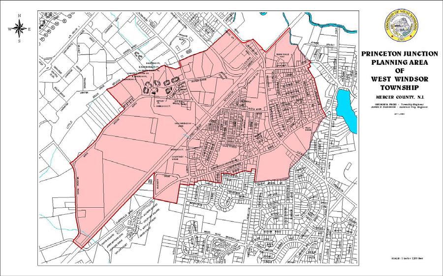
57
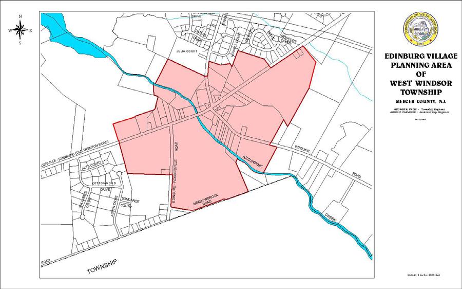
58
Appendix A: Guide to Zoning Categories Prince George's County, Maryland
 Appendix A: Guide to Zoning Categories Prince George's County, Maryland RESIDENTIAL ZONES 1 Updated November 2010 R-O-S: Reserved Open Space - Provides for permanent maintenance of certain areas of land
Comprehensive Plan /24/01
 IV The is a central component of the Comprehensive Plan. It is an extension of the general goals and policies of the community, as well as a reflection of previous development decisions and the physical
A. Location. A MRD District may be permitted throughout the County provided it meets the standards established herein.
 752. Multi-Residential District (MRD) The Multi-Residential (MRD) District is intended to provide opportunities for rural, suburban and urban density mixed-residential developments consistent with the
Land Use. Land Use Categories. Chart 5.1. Nepeuskun Existing Land Use Inventory. Overview
 Land Use State Comprehensive Planning Requirements for this Chapter A compilation of objectives, policies, goals, maps and programs to guide the future development and redevelopment of public and private
Article XII. R-1 Agricultural-Low Density Residential District
 Article XII R-1 Agricultural-Low Density Residential District Section 1200. Declaration of Legislative Intent In expansion of the Declaration of Legislative Intent and Statement of Community Development
Midwest City, Oklahoma Zoning Ordinance
 2010 Midwest City, Oklahoma Zoning Ordinance 9/2/2010 Table of Contents Section 1. General Provisions... 5 1.1. Citation... 5 1.2. Authority... 5 1.3. Purpose... 5 1.4. Nature and Application... 5 1.5.
ARTICLE FIVE FINAL DRAFT
 ARTICLE FIVE 021218 FINAL DRAFT Sec. 503.6 Open Space Preservation Option Open Space Preservation Option Open Space Preservation developments may be approved in the AR, R-1, R-2 and R-3 zoning districts,
Implementation. Approved Master Plan and SMA for Henson Creek-South Potomac 103
 Implementation Approved Master Plan and SMA for Henson Creek-South Potomac 103 104 Approved Master Plan and SMA for Henson Creek-South Potomac Sectional Map Amendment The land use recommendations in the
FINAL DRAFT 12/1/16, Rev. to 7/18/17
 FINAL DRAFT 12/1/16, Rev. to 7/18/17 (As Adopted 8/8/17 Effective 9/1/17) SHELTON PLANNING AND ZONING COMMISSION Proposed Amendments to Zoning Regulations I. Amend Section 23 PERMITTED USES by inserting
Article Optional Method Requirements
 Article 59-6. Optional Method Requirements [DIV. 6.1. MPDU DEVELOPMENT IN RURAL RESIDENTIAL AND RESIDENTIAL ZONES Sec. 6.1.1. General Requirements... 6 2 Sec. 6.1.2. General Site and Building Type Mix...
Amendment to the Zoning and Subdivision Ordinances; Consider Repeal Cluster Development Standards
 2 Board of Supervisors Meg Bohmke, Chairman Gary F. Snellings, Vice Chairman Jack R. Cavalier Thomas C. Coen L. Mark Dudenhefer Wendy E. Maurer Cindy C. Shelton February 28, 2018 Thomas C. Foley County
PLANNING FOR OUR FUTURE
 PLANNING FOR OUR FUTURE ELLSWORTH TOWNSHIP LAND USE AND POLICY PLAN The purpose of this Plan is to serve as a guide for the Township Trustees, Zoning Commission, Board of Zoning Appeals, developers, employers,
TOWN OF ORO VALLEY PLANNING & ZONING COMMISSION MEETING DATE: December 6, 2011
 PLANNING & ZONING COMMISSION MEETING DATE: December 6, 2011 TO: FROM: SUBJECT: PLANNING & ZONING COMMISSION Matt Michels, Senior Planner mmichels@orovalleyaz.gov; tel. 229-4822 Public Hearing: Rancho de
In order to permit maximum applicability of the PUD District, PUD-1 and PUD-2 Districts are hereby created.
 ARTICLE III. PUD ned Unit Development Overlay District 205-128. Purpose. The PUD ned Unit Development Overlay District is intended to provide flexibility in the design of planned projects; to encourage
PLANNING COMMISSION WILLIAMSBURG, VIRGINIA WORK SESSION AGENDA Wednesday, May 23, 2012
 PLANNING COMMISSION WILLIAMSBURG, VIRGINIA WORK SESSION AGENDA Wednesday, May 23, 2012 The meeting will be called to order in the third floor Conference Room (Room 310), Williamsburg Municipal Building,
PROPOSED AMENDMENTS TO THE DERBY ZONING REGULATIONS AUGUST 12, 2008
 ARTICLE II Definitions and word usage 195-7. Definitions and word usage. Modify the following: HOUSING FOR THE ELDERLY OLDER PERSONS Housing in accordance with and as defined in the United States Fair
PLANNED UNIT DEVELOPMENT & SUBDIVISION STAFF REPORT Date: April 18, 2019
 PLANNED UNIT DEVELOPMENT & SUBDIVISION STAFF REPORT Date: April 18, 2019 DEVELOPMENT NAME SUBDIVISION NAME Springhill Village Subdivision Springhill Village Subdivision LOCATION 4350, 4354, 4356, 4358,
CHAPTER Committee Substitute for Committee Substitute for Senate Bill No. 2188
 CHAPTER 2004-372 Committee Substitute for Committee Substitute for Senate Bill No. 2188 An act relating to land development; amending s. 197.502, F.S.; providing for the issuance of an escheatment tax
Land Use. Existing Land Use
 8 Land Use 8.1 Land Use Chapter Purpose and Contents This element includes a brief summary of existing land use conditions and trends followed by a series of goals, objectives, and recommendations to guide
2014 Plan of Conservation and Development. Development Plan & Policies
 The Town of Hebron Section 3 2014 Plan of Conservation and Development Development Plan & Policies C. Residential Districts I. Residential Land Analysis This section of the plan uses the land use and vacant
A. Land Use Relationships
 Chapter 9 Land Use Plan A. Land Use Relationships Development patterns in Colleyville have evolved from basic agricultural and residential land uses, predominate during the early stages of Colleyville
DRAFT FOR PUBLIC HEARING (rev. March, 2016)
") Chapter 200. ZONING Article VI. Conservation/Cluster Subdivisions 200-45. Intent and Purpose These provisions are intended to: A. Guide the future growth and development of the community consistent with
Chapter 200. ZONING Article VI. Conservation/Cluster Subdivisions 200-45. Intent and Purpose These provisions are intended to: A. Guide the future growth and development of the community consistent with
Village WASHINGTON TOWNSHIP MASTER PLAN SYNTHESIS. Page 197
 Village P l a n WASHINGTON TOWNSHIP MASTER PLAN SYNTHESIS Page 197 SECTION 11.0 MASTER PLAN SYNTHESIS INTRODUCTION The proposals presented in the various plans result in a graphic synthesis: The Land Use
4 LAND USE 4.1 OBJECTIVES
 4 LAND USE The Land Use Element of the Specific Plan establishes objectives, policies, and standards for the distribution, location and extent of land uses to be permitted in the Central Larkspur Specific
Bylaw No , being "Official Community Plan Bylaw, 2016" Schedule "A" DRAFT
 Bylaw No. 2600-2016, being "Official Community Plan Bylaw, 2016" Schedule "A" Urban Structure + Growth Plan Urban Structure Land use and growth management are among the most powerful policy tools at the
STAFF REPORT. Permit Number: Lee. Kitsap County Board of Commissioners; Kitsap County Planning Commission
 STAFF REPORT Permit Number: 15 00689 Lee DATE: March 2, 2016 TO: FROM: Kitsap County Board of Commissioners; Kitsap County Planning Commission Katrina Knutson, AICP, Senior Planner, DCD and Jeff Arango,
FUTURE LAND USE. City of St. Augustine Comprehensive Plan EAR-Based Amendments
 FUTURE LAND USE City of St. Augustine Comprehensive Plan EAR-Based Amendments Future Land Use Element FLU Goal To create an environment within the City and adjacent areas in which its residents have the
Place Type Descriptions Vision 2037 Comprehensive Plan
 Place Type Descriptions Vision 2037 Comprehensive Plan The Vision 2037 Comprehensive Plan establishes a range of place types for Oxford, ranging from low intensity (limited development) Rural and Natural
DIVISION 7. R-6 AND R-6A RESIDENTIAL ZONES* The purpose of the R-6 residential zone is:
 Date of Draft: March 6, 2015 DIVISION 7. R-6 AND R-6A RESIDENTIAL ZONES* Sec. 14-135. Purpose. The purpose of the R-6 residential zone is: (a) To set aside areas on the peninsula for housing characterized
Housing & Residential Intensification Study Discussion Paper Township of King
 Housing & Residential Intensification Study Discussion Paper Prepared by Planning Department January 2011 1.0 Background 1.1 Provincial Policies (Greenbelt and Growth Plan) Since 2001, the Province of
4. facilitate the construction of streets, utilities and public services in a more economical and efficient manner;
 PVPC MODEL BYLAW BY-RIGHT CLUSTER ZONING BYLAW Prepared by Pioneer Valley Planning Commission Revised: October 2001 1.00 Development 1.01 Development Allowed By Right Development in accordance with this
Chapter 10: Implementation
 Chapter 10: Introduction Once the Comprehensive Plan has been adopted by the City of Oakdale, the City can begin to implement the goals and strategies to make this vision a reality. This chapter will set
PLANNED RESIDENTIAL DEVELOPMENT (PRD)
") PLANNED RESIDENTIAL DEVELOPMENT SECTION 10. PLANNED RESIDENTIAL DEVELOPMENT (PRD) 10.1 Purpose Planned Residential Development allows by special permit from the Board an alternative pattern of residential
PLANNED RESIDENTIAL DEVELOPMENT SECTION 10. PLANNED RESIDENTIAL DEVELOPMENT (PRD) 10.1 Purpose Planned Residential Development allows by special permit from the Board an alternative pattern of residential
HOUSING ELEMENT GOALS, OBJECTIVES, & POLICIES
 HOUSING ELEMENT GOALS, OBJECTIVES, & POLICIES GOAL H-1: ENSURE THE PROVISION OF SAFE, AFFORDABLE, AND ADEQUATE HOUSING FOR ALL CURRENT AND FUTURE RESIDENTS OF WALTON COUNTY. Objective H-1.1: Develop a
POLK COUNTY DEVELOPMENT REVIEW COMMITTEE CASE OVERVIEW
 POLK COUNTY DEVELOPMENT REVIEW COMMITTEE CASE OVERVIEW DRC Date: January 10, 2019 Level of Review: 4 PC Date: March 6, 2019 Type: Text Amendments BoCC Date: May 7, 2019 July 2, 2019 Case Numbers: Case
Chapter Planned Residential Development Overlay
 Chapter 19.29 Planned Residential Development Overlay Sections 010 Purpose 020 Scope 030 Definitions 030 Minimum Size 040 Allowable Uses 050 Minimum Development Standards 060 Density Bonus 070 Open Space
2014 Plan of Conservation and Development
 The Town of Hebron Section 1 2014 Plan of Conservation and Development Community Profile Introduction (Final: 8/29/13) The Community Profile section of the Plan of Conservation and Development is intended
Rule 80. Preservation of Primary Agricultural Soils Revised and approved by the Land Use Panel during its public meeting on January 31, 2006.
 Rule 80. Preservation of Primary Agricultural Soils Revised and approved by the Land Use Panel during its public meeting on January 31, 2006. (A) Purpose. In accordance with 10 V.S.A. Sections 6025(b)
Town of Gorham Development Transfer Fee Program SECTION XVIII DEVELOPMENT TRANSFER OVERLAY DISTRICT
 Town of Gorham Development Transfer Fee Program SECTION XVIII DEVELOPMENT TRANSFER OVERLAY DISTRICT [Note: The Development Transfer Overlay District (a Development Transfer Fee program) is included as
ARTICLE 15 - PLANNED UNIT DEVELOPMENT
 Section 15.1 - Intent. ARTICLE 15 - PLANNED UNIT DEVELOPMENT A PUD, or Planned Unit Development, is not a District per se, but rather a set of standards that may be applied to a development type. The Planned
ARTICLE I ZONE BASED REGULATIONS
 ARTICLE I ZONE BASED REGULATIONS RZC 21.08 RESIDENTIAL REGULATIONS 21.08.290 Cottage Housing Developments A. Purpose. The purpose of the cottage housing requirements is to: 1. Provide a housing type that
SPECIFIC RESPONSES TO AREA COMMISSION OPPOSITION :
 SPECIFIC RESPONSES TO AREA COMMISSION OPPOSITION 3-14-19: Area Commission reasons for opposition in black APPLICANT S RESPONSE IN RED. The comprehensive planning and design of stream restoration efforts
Existing Land Use. Typical densities for single-family detached residential development in Cumberland County: 1
 Existing Land Use A description of existing land use in Cumberland County is fundamental to understanding the character of the County and its development related issues. Economic factors, development trends,
1. Future Land Use FLU6.6.8 Land uses within the Rural Service Area portion of the Wekiva Study Area shall be limited to very low and low intensity
 1. Future Land Use FLU6.6.8 Land uses within the Rural Service Area portion of the Wekiva Study Area shall be limited to very low and low intensity uses to the greatest extent possible. Existing land uses
Land Use Survey Summer 2014
 Land Use Survey Summer 2014 North Ogden City, Utah Robert Scott, City Planner Travis Lund, Planning Intern Contents General Information... 1 Land Use Groups... 1 Urbanized Land Uses... 1 Residential...
Town of. River Falls. Land Use Element Vierbicher Associates, Inc
 Town of River Falls 2005 Vierbicher Associates, Inc Contents Contents s. 66.1001(2)(h) Wis. Stats................................................. ii Introduction................................................................
PIN , Part 1, Plan SR-713 in Lot 2, Concession 5, Township of McKim (1096 Dublin Street, Sudbury)
") STAFF REPORT Applicant: Dalron Construction Limited Location: PIN 02124-0103, Part 1, Plan SR-713 in Lot 2, Concession 5, Township of McKim (1096 Dublin Street, Sudbury) Official Plan and Zoning By-law:
STAFF REPORT Applicant: Dalron Construction Limited Location: PIN 02124-0103, Part 1, Plan SR-713 in Lot 2, Concession 5, Township of McKim (1096 Dublin Street, Sudbury) Official Plan and Zoning By-law:
Comprehensive Plan Amendment #PLN , Reserve at Cannon Branch (Coles Magisterial District)
") COUNTY OF PRINCE WILLIAM 5 County Complex Court, Prince William, Virginia 22192-9201 PLANNING (703) 792-7615 FAX (703) 792-4758 OFFICE Internet www.pwcgov.org Christopher M. Price, AICP Director of Planning
COUNTY OF PRINCE WILLIAM 5 County Complex Court, Prince William, Virginia 22192-9201 PLANNING (703) 792-7615 FAX (703) 792-4758 OFFICE Internet www.pwcgov.org Christopher M. Price, AICP Director of Planning
Staff Report: Date: Applicant: Property Identification: Acreage of Request: Current Zoning of Requested Area: Requested Action: Attached:
 Staff Report: Completed by Jeff Palmer Director of Planning & Zoning Date: November 7, 2018, Updated November 20, 2018 Applicant: Greg Smith, Oberer Land Developer agent for Ronald Montgomery ET AL Property
Attachment A First Submittal JAZB Safety Zones A and B
 Attachment A First Submittal JAZB Safety Zones A and B Attachment B Second Submittal JAZB Safety Zones A and B Attachment C Flying Cloud Airport (FCM) Draft Airport Zoning Ordinance Social and Economic
Lacey UGA Residential density
 Thurston County Planning Department BOARD OF COUNTY COMMISSIONERS PUBLIC HEARING DRAFT AMENDMENTS TO THE CRITICAL AREAS REGULATIONS Residential density amendment to Title 21 Title 21 6/1/2012 Lacey UGA
8Land Use. The Land Use Plan consists of the following elements:
 8Land Use 1. Introduction The Land Use Plan consists of the following elements: 1. Introduction 2. Existing Conditions 3. Opportunities for Redevelopment 4. Land Use Projections 5. Future Land Use Policies
2030 General Plan. December 6, 7 pm
 2030 General Plan GPAC Meeting #9 GPAC Meeting #9 December 6, 7 pm City Council Input on Working Draft Land Use Map Council discussed GPAC & PC versions of the working draft land use map 11/28 Council
Generic Environmental Impact Statement. Build-Out Analysis. City of Buffalo, New York. Prepared by:
 Generic Environmental Impact Statement Build-Out Analysis City of Buffalo, New York 2015 Prepared by: TABLE OF CONTENTS 1.0 INTRODUCTION 1 2.0 METHODOLOGY 2 3.0 EXISTING LAND USE 3 4.0 EXISTING ZONING
STAFF REPORT. Permit Number: Porter. Kitsap County Board of Commissioners; Kitsap County Planning Commission
 STAFF REPORT Permit Number: 15 00461 Porter DATE: November 9, 2015 TO: FROM: Kitsap County Board of Commissioners; Kitsap County Planning Commission Katrina Knutson, AICP, Senior Planner, DCD and Jeff
TOTTENHAM SECONDARY PLAN
 TOTTENHAM SECONDARY PLAN AMENDMENT NO. 11 TO THE OFFICIAL PLAN OF THE TOWN OF NEW TECUMSETH The following text and schedules to the Official Plan of the Town of New Tecumseth constitute Amendment No. 11
Provide a diversity of housing types, responsive to household size, income and age needs.
 8 The City of San Mateo is a highly desirable place to live. Housing costs are comparably high. For these reasons, there is a strong and growing need for affordable housing. This chapter addresses the
Article 04 Single Family Residential Districts
 Article 04 Article 04 Section 04.01 Intent (a) R1A Residence District. The R1A Single Family Residential District is established to include areas of low density single-family residences and limited agricultural
Poughkeepsie City Center Revitalization Plan
 Purpose and Need Purpose Increase job and educational opportunities for all residents Maximize fiscal productivity of downtown land uses Diversify retail mix Eliminate surface and building vacancies Create
DIVISION 1 PURPOSE OF DISTRICTS
 ARTICLE 2 ZONING DISTRICTS AND MAP DIVISION 1 PURPOSE OF DISTRICTS Section 2.101 Zoning Districts. For the purpose of this Ordinance, the City of Richmond is hereby divided into districts as follows: DISTRICT
DRAFT. Amendment to the Master Plan Land Use Element for Block 5002, Lot Township of Teaneck, Bergen County, New Jersey.
 DRAFT Amendment to the Master Plan Land Use Element for Block 5002, Lot 18.01 Township of Teaneck, Bergen County, New Jersey Prepared for: Township of Teaneck Planning Board Prepared by: Janice Talley,
Land Use Planning Analysis. Phase 2 Drayton Valley Annexation Proposal
 Land Use Planning Analysis Phase 2 Drayton Valley Annexation Proposal Prepared for Town of Drayton Valley Prepared by Mackenzie Associates Consulting Group Limited March, 2011 TABLE OF CONTENTS 1.0 INTRODUCTION...
Staff Report: Date: Applicant: Property Identification: Acreage of Request: Current Zoning of Requested Area: Requested Action: Attached:
 Staff Report: Completed by Jeff Palmer Director of Planning & Zoning Date: November 7, 2018 Applicant: Greg Smith, Oberer Land Developer agent for Ronald Montgomery ET AL Property Identification: Frontage
b. providing adequate sites for new residential development
 DIVISION 2.200 SECTION 2.201 INTRODUCTION A. Purpose The purpose of the Housing Element is to establish the goal, objectives, and policies to guide housing development within Polk County over the next
PUBLIC DRAFT May 2017 Zoning Districts Use Regulations Definitions (partial)
") PUBLIC DRAFT May 2017 Zoning Districts Use Regulations Definitions (partial) Table of Contents Subchapter 1: General Provisions... 1 Subchapter 2: Administration & Procedures... 3 Subchapter 3: Zoning
PUBLIC DRAFT May 2017 Zoning Districts Use Regulations Definitions (partial) Table of Contents Subchapter 1: General Provisions... 1 Subchapter 2: Administration & Procedures... 3 Subchapter 3: Zoning
Planning Justification Report
 Planning Justification Report, Township of Puslinch FARHI HOLDINGS CORPORATION Updated January 27, 2017 Zelinka Priamo Ltd. Page i TABLE OF CONTENTS Page No. 1.0 1.1 1.2 1.3 2.0 2.1 2.2 2.3 2.4 2.5 3.0
INDIAN RIVER COUNTY, FLORIDA. The Honorable Members of the Planning and Zoning Commission DEPARTMENT HEAD CONCURRENCE
 Public Hearing Legislative INDIAN RIVER COUNTY, FLORIDA M E M O R A N D U M TO: The Honorable Members of the Planning and Zoning Commission DEPARTMENT HEAD CONCURRENCE Robert M. Keating, AICP; Community
ARTICLE 3: Zone Districts
 ARTICLE 3: Zone Districts... 3-1 17.3.1: General...3-1 17.3.1.1: Purpose and Intent... 3-1 17.3.2: Districts and Maps...3-1 17.3.2.1: Applicability... 3-1 17.3.2.2: Creation of Districts... 3-1 17.3.2.3:
LAND USE. Land Cover. Current Land Use
 LAND USE Land Cover To begin the process at a more general level, land cover information was assembled to identify general patterns of developed/undeveloped areas. The data used to present this information
Town of Falmouth s Four Step Design Process for Subdivisions in the Resource Conservation Zoning Overlay District
 Town of Falmouth s Four Step Design Process for Subdivisions in the Resource Conservation Zoning Overlay District All subdivisions shall be designed in accordance with the following four-step process.
3.1. OBJECTIVES FOR RESIDENTIAL LAND USE DESIGNATIONS GENERAL OBJECTIVES FOR ALL RESIDENTIAL DESIGNATIONS
 3. RESIDENTIAL LAND USE DESIGNATIONS INTRODUCTION The Residential land use designations provide for housing and other land uses that are integral to, and supportive of, a residential environment. Housing
4.0. Residential. 4.1 Context
 4. 0Residential 4.1 Context In 1986, around the time of Burnaby s last Official Community Plan, the City had a population of 145,000 living in 58,300 residential units. By 1996, there were 179,000 people
STAFF REPORT. Permit Number: Unlimited. Kitsap County Board of Commissioners; Kitsap County Planning Commission
 STAFF REPORT Permit Number: 15 00550 Unlimited DATE: March 2, 2016 TO: FROM: Kitsap County Board of Commissioners; Kitsap County Planning Commission Katrina Knutson, AICP, Senior Planner, DCD and Jeff
Town of Windham Land Use Ordinance Sec. 400 Zoning Districts SECTION 400 ZONING DISTRICTS
 Town of Windham Land Use Ordinance Sec. 400 Zoning Districts Sections SECTION 400 ZONING DISTRICTS SECTION 400 ZONING DISTRICTS 4-1 401 Districts Enumerated 4-2 402 Location of districts; Zoning Map 4-2
Glades County Staff Report and Recommendation Unified Staff Report for Small Scale Plan Amendment and Rezoning
 Glades County Staff Report and Recommendation Unified Staff Report for Small Scale Plan Amendment and Rezoning CASE NUMBERS: COMP17-02 and RZ17-02 DATE of STAFF REPORT: May 1, 2017 CASE TYPE: Application
ARTICLE V AGRICULTURAL PRESERVATION AND RURAL RESIDENTIAL DISTRICT
 ARTICLE V AP AGRICULTURAL PRESERVATION AND RURAL RESIDENTIAL DISTRICT Section 500. PURPOSE It is the purpose of the AP, Agricultural Preservation and Rural Residential District, to foster the preservation
Town of Cary, North Carolina Rezoning Staff Report 14-REZ-31 Cary Park PDD Amendment (Waterford II) Town Council Meeting January 15, 2015
 Town Council Meeting January 15, 2015") Town of Cary, North Carolina Rezoning Staff Report 14-REZ-31 Cary Park PDD Amendment (Waterford II) Town Council Meeting January 15, 2015 REQUEST To amend the Town of Cary Official Zoning Map by amending
Town of Cary, North Carolina Rezoning Staff Report 14-REZ-31 Cary Park PDD Amendment (Waterford II) Town Council Meeting January 15, 2015 REQUEST To amend the Town of Cary Official Zoning Map by amending
Open Space Model Ordinance
 Open Space Model Ordinance Section I. Background Open space development has numerous environmental and community benefits, including: 1) Reduces the impervious cover in a development. Impervious cover
1. Cuyler-Brownsville planned neighborhood conservation (P-N-C) districtphase I (section ). (2) Single-family semiattached dwellings;
 districtphase I (section ). (2) Single-family semiattached dwellings;") Sec. 8-3035. Planned unit development multifamily (PUD-M). A. Purpose. The PUD-M district is intended to allow a variety of residential development including single-family residential, two-family residential,
Sec. 8-3035. Planned unit development multifamily (PUD-M). A. Purpose. The PUD-M district is intended to allow a variety of residential development including single-family residential, two-family residential,
SECTION 7. RESIDENTIAL DISTRICTS
 SECTION 7. RESIDENTIAL DISTRICTS 7.1 RESIDENTIAL DISTRICTS PURPOSE 7.2 PERMITTED AND SPECIAL USES 7.3 YARD AND BULK REGULATIONS 7.4 GENERAL STANDARDS OF APPLICABILITY 7.5 FLOOR AREA RATIO MEASUREMENT AND
Eleven Tindall Road Middletown, New Jersey 07748
 MASTER PLAN REVISION TO THE HOUSING PLAN ELEMENT AND FAIR SHARE PLAN AMENDMENT MANALAPAN TOWNSHIP MONMOUTH COUNTY, NEW JERSEY NOVEMBER 24, 2008 REVISED APRIL 9, 2010 PREPARED FOR: MANALAPAN TOWNSHIP PLANNING
MONTGOMERY COUNTY PLANNING DEPARTMENT THE MARYLAND-NATIONAL CAPITAL PARK AND PLANNING COMMISSION
 MONTGOMERY COUNTY PLANNING DEPARTMENT THE MARYLAND-NATIONAL CAPITAL PARK AND PLANNING COMMISSION MCPB Item No. 8 Date: 03-07-13 Sonoma, Preliminary Plan, 120130040 Melissa Williams, Senior Planner, Melissa.williams@montgomeryplanning.org,
610 LAND DIVISIONS AND PROPERTY LINE ADJUSTMENTS OUTSIDE A UGB
 ARTICLE VI: LAND DIVISIONS AND PROPERTY LINE ADJUSTMENTS VI-21 610 LAND DIVISIONS AND PROPERTY LINE ADJUSTMENTS OUTSIDE A UGB 610-1 Property Line Adjustments (Property Line Relocation) A property line
13 Sectional Map Amendment
 13 Sectional Map Amendment Introduction This chapter reviews land use and zoning policies and practices in Prince George s County and presents the proposed zoning in the sectional map amendment (SMA) to
AMENDMENT NUMBER 38 TO THE OFFICIAL PLAN OF THE TOWNSHIP OF WEST LINCOLN (COMPLIANCE)
") AMENDMENT NUMBER 38 TO THE OFFICIAL PLAN OF THE TOWNSHIP OF WEST LINCOLN (COMPLIANCE) 2013 AMENDMENT NUMBER 38 TO THE OFFICIAL PLAN OF THE TOWNSHIP OF WEST LINCOLN PART 1 - THE PREAMBLE 1.1 TITLE This
AMENDMENT NUMBER 38 TO THE OFFICIAL PLAN OF THE TOWNSHIP OF WEST LINCOLN (COMPLIANCE) 2013 AMENDMENT NUMBER 38 TO THE OFFICIAL PLAN OF THE TOWNSHIP OF WEST LINCOLN PART 1 - THE PREAMBLE 1.1 TITLE This
Cluster Development Princeton Township, Mercer County
 Cluster Development Princeton Township, Mercer County Division 9 Residential Clusters Section 10B-189 Statement of purposes. The township committee to implement the goals and objectives of the Princeton
P o p u l a t i o n, L a n d U s e, a n d Z o n i n g
 P o p u l a t i o n, L a n d U s e, a n d Z o n i n g The Town of Upper Marlboro is located only 15 miles southeast of the District of Columbia, in the central portion of Prince George s County in the
City of Tacoma Zoning Reference Guide
 City of Tacoma Zoning Reference Guide Planning and Development Services 747 Market Street, Room 345 Tacoma, WA 98402 (253) 591-5577 This document should not be used as a substitute for codes and regulations.
Mohave County General Plan
 63 64 65 66 67 68 69 70 71 The Land Use Diagram is not the County's zoning map. 13 It is a guide to future land use patterns. Zoning and area plan designations may be more restrictive than the land use
Town of Cary, North Carolina Rezoning Staff Report 14-REZ-20 Habitat for Humanity Evans Road Town Council Meeting October 16, 2014
 Town of Cary, North Carolina Rezoning Staff Report 14-REZ-20 Habitat for Humanity Evans Road Town Council Meeting October 16, 2014 REQUEST To amend the Town of Cary Official Zoning Map by rezoning 0.53
SECTION 16. "PUD" PLANNED UNIT DEVELOPMENT OVERLAY DISTRICT
 SECTION 6. "PUD" PLANNED UNIT DEVELOPMENT OVERLAY DISTRICT Subsection. Purpose. This district is established to achieve the coordinated integration of land parcels and large commercial and retail establishments
Chapter 6 Future Land Use and Housing Plan
 Chapter 6 Future Land Use and Housing Plan The Future Land Use Plan is one of the most important elements of the Comprehensive Plan. It graphically brings together all of the chapters of the plan and evaluates
LONG-RANGE LAND USE PLAN
 LONG-RANGE LAND USE PLAN INTENT Completion of the I-66/Route 29 interchange and future expansion of improved telecommunication networks will substantially improve the desirability of the Gainesville area
CITY OF PORT ORCHARD
 CITY OF PORT ORCHARD ZONING DESIGNATIONS (Adapted from POMC Chapter 20.34 Zoning Districts, as adopted 6/13/2017) 20.34.110 Greenbelt zone (Gb). (1) Purpose. It is the purpose of the greenbelt zone to
b) Tangerine Corridor Overlay District 1) Tangerine Corridor District Regulations
 Tangerine Corridor Overlay District 1) Tangerine Corridor District Regulations") Attachment 1 Tangerine Road Corridor Overlay District Section 27.10.D.3.f.vi.b Initiation of Code Amendment September 2, 2014, Planning and Zoning Commission b) Tangerine Corridor Overlay District 1) Tangerine
Attachment 1 Tangerine Road Corridor Overlay District Section 27.10.D.3.f.vi.b Initiation of Code Amendment September 2, 2014, Planning and Zoning Commission b) Tangerine Corridor Overlay District 1) Tangerine
Article Floating Zone Requirements
 Division 5.1. In General Article 59-5. Floating Zone Requirements Section 5.1.1. Zone Categories There are 4 categories of Floating zones: A. Residential Floating zones (Division 5.2); B. Commercial/Residential
MEMORANDUM. Critical Areas Ordinance Density Requirements
 COUNTY COMMISSIONERS Creating Solutions for Our Future Cathy Wolfe District One Sandra Romero District Two Karen Valenzuela District Three PLANNING DEPARTMENT Scott Clark Director MEMORANDUM TO: FROM:
Clustering & Cluster Development Regulations New York Municipal Town of Clinton
 Topic: Resource Type: State: Jurisdiction Type: Municipality: Year (adopted, written, etc.): 1991 Community Type applicable to: Title: Clustering & Cluster Development Regulations New York Municipal Town
ARTICLE OPTIONAL METHOD REGULATIONS
 ARTICLE 59-6. OPTIONAL METHOD REGULATIONS DIV. 6.1. MPDU DEVELOPMENT IN RURAL RESIDENTIAL AND RESIDENTIAL ZONES SEC. 6.1.1. GENERAL REQUIREMENTS... 6 2 SEC. 6.1.2. GENERAL SITE AND BUILDING T PE MIX...
ARTICLE XI - CONSERVATION SUBDIVISIONS
 ARTICLE XI - CONSERVATION SUBDIVISIONS Section 1101: Purpose and Intent. This Article is intended to provide for residential subdivisions that are designed based first and foremost on the preservation