ADDENDUM 14SN0504. Glen Abbey Partners LLC
|
|
|
- Georgiana Bradford
- 6 years ago
- Views:
Transcription
 to Residential (R-12) with conditional use planned development to permit exceptions to ordinance requirements.")
1 CASE MANAGER: Darla Orr April 23, 2014 BS ADDENDUM 14SN0504 Glen Abbey Partners LLC Matoaca Magisterial District Woolridge Elementary, Tomahawk Creek Middle and Cosby High Schools Attendance Zones North line of Woolridge Road 6100 Woolridge Road REQUEST: Rezoning from Agricultural (A) to Residential (R-12) with conditional use planned development to permit exceptions to ordinance requirements. PROPOSED LAND USE: A single-family residential subdivision with a maximum density of two (2) dwelling units per acre, yielding approximately fifty-one (51) dwelling units, is planned. (Proffered Condition 3) The purpose of this Addendum is to provide revised comments from Schools. Schools revised their comments for this case to include projected membership and capacity trends. Staff continues to recommend approval, as outlined in the Request Analysis. Providing a FIRST CHOICE community through excellence in public service
2 Schools: Residential Yield: 51 School Name Student Yield From Residential Development * Membership, Functional Capacity, % of Capacity, No. of Trailers ** Elementary: Woolridge % 3 Middle: Tomahawk Creek 6 1,294 1,366 95% 1 High: Cosby 8 2,025 1, % 9 Total 25 Projected Membership and Capacity Trends Over Time *** School Name Projected Membership, % of Capacity, Projected Membership, % of Capacity, Projected Membership, % of Capacity, Elementary: Woolridge % % % Middle: Tomahawk Creek 1,340 98% 1, % 1, % High: Cosby 1, % 2, % 2, % NOTE: * The Student Yield is based on the FY2014 Cash Proffer Methodology as provided by the Chesterfield County Finance Department. NOTE: ** If a school is less than 90% of capacity and has trailers, those trailers are not identified in the staff report. Student Membership is based on membership as of School Capacity is based on the Space Utilization Study. *** DISCLAIMER: Please note that Projected Membership AND Functional Capacity are updated on an ANNUAL BASIS and are based on the September 30 membership for a given year and the Space Utilization Study Report which is conducted every year. The Space Utilization Study is a report that is conducted annually whereby Planning staff conducts a site visit of every school in the county and the Principal reviews his or her floor plan and identifies the use of every classroom. From that information a report is prepared that calculates the Functional Capacity of that school. The school system needs to know how each of their facilities is utilized for funding and space allocation purposes. Again, it is important to note that these numbers change every year. After review of this request, the proposed rezoning case will have a significant impact on the aforementioned schools especially at the elementary and high school levels. Cosby High School is operating near the over capacity threshold of 120 percent with its percentage of capacity currently at 116 percent. Over time this case, combined with other tentative residential developments, infill developments and other zoning cases in the area, will continue to push these 2 14SN APR23-BOS-ADD
3 schools over capacity necessitating some form of relief in the future. Therefore, the aforementioned units should be subject to full cash proffers in order to mitigate the impact that this proposed development would have on schools. The applicant has offered measures to address the impact of the development on school facilities. (Proffered Condition 5) The projected student membership and capacity trends at this time indicate that there will be an overall increase in membership at the secondary level by Staff continues to monitor student membership on a regular basis in these districts and membership projections are analyzed and updated annually. 3 14SN APR23-BOS-ADD
4 CASE MANAGER: Darla Orr BS Time Remaining: 365 days STAFF S REQUEST ANALYSIS AND RECOMMENDATION 14SN0504 Glen Abbey Partners LLC December 17, 2013 CPC January 21, 2014 CPC January 23, 2014 CPC March 18, 2014 CPC April 23, 2014 BS Matoaca Magisterial District Woolridge Elementary, Tomahawk Creek Middle and Cosby High Schools Attendance Zones North line of Woolridge Road 6100 Woolridge Road REQUEST: Rezoning from Agricultural (A) to Residential (R-12) with conditional use planned development to permit exceptions to ordinance requirements. PROPOSED LAND USE: A single-family residential subdivision with a maximum density of two (2) dwelling units per acre, yielding approximately fifty-one (51) dwelling units, is planned. (Proffered Condition 3) PLANNING COMMISSION RECOMMENDATION RECOMMEND APPROVAL AND ACCEPTANCE OF THE PROFFERED CONDITIONS ON PAGES 2 THROUGH 6. Recommend approval for the following reasons: STAFF RECOMMENDATION A. The proposed zoning and land use comply with the Comprehensive Plan, which suggests the property is appropriate for Suburban Residential I (maximum of 2.0 dwellings per acre). B. The proffered conditions adequately address the impacts of this development on necessary capital facilities thereby ensuring adequate service levels are maintained to protect the health, safety and welfare of County citizens. Providing a FIRST CHOICE community through excellence in public service
5 (NOTE: CONDITIONS MAY BE IMPOSED OR THE PROPERTY OWNER(S) MAY PROFFER CONDITIONS. CONDITION(S) NOTED STAFF/CPC WERE AGREED UPON BY BOTH STAFF AND THE COMMISSION.) PROFFERED CONDITIONS (STAFF/CPC) 1. Master Plan. The Textual Statement dated February 28, 2014 shall be considered the Master Plan. (P) (STAFF/CPC) 2. Buffers. All required buffers shall be located within recorded open space. (P) (STAFF/CPC) 3. Density. The maximum density of this development shall not exceed two (2) dwelling units per acre. (P) (STAFF/CPC) 4. Architectural/Design Elements. A. Sidewalks/Driveways 1. Sidewalks: Sidewalks shall be provided on both sides of all public streets of general circulation where houses are fronting. 2. Driveways: All private driveways serving residential uses shall be hardscaped. 3. Front Walks: A minimum of a four (4) foot wide hardscaped front walk shall be provided to each dwelling unit. B. Landscaping and Yards 1. Street Trees: Street trees shall be planted or retained along both sides of all streets that provide general circulation. 2. Supplemental Trees: Prior to the issuance of a Certificate of Occupancy for each dwelling unit, a minimum of one (1) flowering tree shall be planted in each front yard. At the time of planting, these supplemental trees shall have a minimum caliper of 2 measured at breast height (4-10 above ground). 3. Front Yards: Except for the foundation planting bed, all front yards shall be sodded and irrigated. 2 14SN APR23-BOS-RPT
6 4. Front Foundation Planting Beds: Foundation planting is required along the entire front façade of all dwelling units, and shall extend along all sides facing a street. Foundation Planting Beds shall be a minimum of 4 wide from the unit foundation. Planting beds shall include medium shrubs spaced a maximum of four (4) feet apart. Unit corners shall be visually softened with vertical accent shrubs (4-5 ) or small evergreen trees (6-8 ) at the time of planting. C. Architecture and Materials 1. Style and Form: The architectural styles shall be interpretations of traditional Richmond architecture, using forms and elements compatible with those in the adjacent FoxCreek Subdivision such as Georgian, Adam, Classical Revival Colonial, Greek Revival, Queen Anne, and Craftsman Styles. 2. Repetition: Dwellings with the same elevations may not be located adjacent to, directly across from, or diagonally across from each other on the same street. This requirement does not apply to units on different streets backing up to each other. 3. Foundations: The exposed portion of any foundation shall be brick or stone. Synthetic or natural stucco foundations may be permitted for facades constructed entirely of stucco. Rear walkout basement walls may be sided or cast concrete painted to match house. 4. Exterior Facades: Acceptable siding materials include brick, stone, masonry, stucco synthetic stucco (E.I.F.S), and approved horizontal lap siding. Horizontal lap siding may be manufactured from natural wood or cement fiber board or may be premium quality vinyl siding. Plywood and metal siding are not permitted. Additional siding requirements: a. Where a dwelling borders more than one street, all street-facing facades shall be finished in the same materials. 3 14SN APR23-BOS-RPT
7 (STAFF/CPC) 5. Cash Proffer. b. Cementitious and vinyl siding is permitted in traditional wide beaded styles only, unless otherwise approved by the Architectural Board for special design conditions. Premium quality vinyl is defined as vinyl siding with a minimum wall thickness of.044. c. Synthetic Stucco (E.I.F.S.) siding shall be finished in smooth, sand or level texture. Rough textures are not permitted. D. Roof Material: Roofing material shall be dimensional architectural shingles or better with a minimum 30 year warranty. E. Porches, Stoops and Decks Front Porches: All front entry stoops and front porches shall be constructed with continuous masonry foundation wall or on 12 x12 masonry piers. Extended front porches shall be a minimum of five (5) deep. Space between piers under porches shall be enclosed with framed lattice panels. Handrails and railings shall be finished painted wood or metal railing with vertical pickets or swan balusters. Pickets shall be supported on top and bottom rails that span between columns. F. Front Porch Flooring: Porch flooring may be concrete, exposed aggregate concrete, or a finished paving material such as stone, tile or brick, finished (stained dark) wood, or properly trimmed composite decking boards. Unfinished treated wood decking is not acceptable. All front steps shall be masonry to match the foundation. (P) A. For each dwelling unit, the applicant, sub-divider, or assignee(s) shall pay the following to the County of Chesterfield, prior to the issuance of a building permit for infrastructure improvements within the service district for the property; provided however that for the period through June 30, 2017, the applicant, sub-divider, or assignee(s) shall pay the following to the County of Chesterfield, immediately after completion of the final inspection: 4 14SN APR23-BOS-RPT
8 1. $18, per dwelling unit, if paid prior to July 1, 2017; or 2. If paid after June 30, 2017, and before July 1, 2018, $18, per dwelling unit, adjusted for the four year cumulative change in the Marshall and Swift Building Cost Index between July 1 of the fiscal year in which the case was approved and July 1 four years later. Thereafter, the per dwelling unit cash proffer amount shall be automatically adjusted, annually, by the annual change in the Marshall and Swift Building Cost Index on July 1 of each year. 3. In the event the cash payment is not used for which proffered within 15 years of receipt the cash shall be returned in full to the payer. 4. Should any impact fees be imposed by Chesterfield County at any time during the life of the development that are applicable to the property, the amount paid in cash proffers shall be in lieu of or credited toward but not to be in addition to any impact fees in a manner determined by the County. B. Cash proffer payments shall be spent for the purposes proffered or as otherwise permitted by law. (B&M) (STAFF/CPC) 6. Timbering. Timber management, for the purpose of enhancing the health and viability of the forest, shall occur under the supervision of a qualified forester, and will only be allowed upon the submission and approval of the appropriate forest management plan to include, but not limited to, erosion control, Chesapeake Bay Act/Wetland Restrictions and the issuance of a land disturbance permit by the Environmental Engineering Department. Any other timbering shall be incorporated into the site development erosion and sediment control plan/narrative as the initial phase of infrastructure construction and will not commence until the issuance of the actual site development land disturbance permit. (EE) (STAFF/CPC) 7. Swift Creek Watershed Protection. The developer shall leave in place temporary sediment control devices and/or construct new BMP s or combinations of BMP s, which would achieve a maximum phosphorous runoff limit from the property of 0.22 pounds per acre per year. (EE) 5 14SN APR23-BOS-RPT
9 (STAFF/CPC) 8. Access. There shall be no direct vehicular access from the property to Woolridge Road. (T) (STAFF/CPC) 9. Right of Way Dedication. In conjunction with the recordation of the initial subdivision plat, prior to any site plan approval, or within ninety (90) days of a request by the Transportation Department, whichever occurs first, the developer shall dedicate, free and unrestricted to and for the benefit of Chesterfield County, right of way and easements on the property as shown on the Woolridge Road and Otterdale Road Improvements, prepared by Timmons Group, dated 8/21/13. (T) (STAFF/CPC) 10. Road Improvements. In conjunction with development of the initial section, the developer shall be responsible for widening/improving the north side of Woolridge Road to an eleven (11) foot wide travel lane, measured from the existing centerline of each road, with an additional one (1) foot wide paved shoulder plus a seven (7) foot wide unpaved shoulder, and overlaying the full width of the roads with one and a half (1.5) inch of compacted bituminous asphalt concrete, with any modifications approved by the Transportation Department, for the entire property frontage. (T) (STAFF/CPC) 11. As shown in the Natural Resources Inventory (NRI), the large area of wetlands on the northern side of the property which projects into existing limits of Wynwood Phase I, shall be impacted only to the extent necessary to provide for infrastructure and shall be protected by its placement within common open areas. (EE) (STAFF/CPC) 12. The public water and wastewater systems shall be used. (U) Location: GENERAL INFORMATION The request property fronts the north line of Woolridge Road, west of Swift Fox Drive. Tax ID Existing Zoning: Size: A 25.7 acres 6 14SN APR23-BOS-RPT
10 Existing Land Use: Single-family residential or vacant Adjacent Zoning and Land Use: North, East and West R-15 with CUPD; Single-family residential or vacant South A; Single-family residential or vacant Public Water System: UTILITIES The request site is located within the Clover Hill water pressure zone. There is a sixteen (16) inch water line located along the south side of Woolridge Road. The applicant has proffered the use of the public water system. (Proffered Condition 12) Public Wastewater System: The request site is located within the Upper Swift Creek service area. There is a twelve (12) inch wastewater line currently terminating approximately 400 feet northwest of the request site. The applicant has proffered the use of the public wastewater system. (Proffered Condition 12) ENVIRONMENTAL The Zoning Ordinance requires a Natural Resource Inventory (NRI) to be submitted to the Environmental Engineering Department for zoning applications within the Upper Swift Creek Watershed. The NRI for the current proposal was submitted by the applicants. Proffered Condition 11 would require the large area of wetlands identified in the NRI along the northern side of the request property to be protected within common open space. The original Wynwood, Phases 1 and 2, on adjacent property, because of its vested status is only required to meet the 0.45 standard for Water Quality Compliance by virtue of onsite BMPs. That vesting would not apply to this property. Therefore, the Swift Creek Water Quality Regulation would require that the full 0.22 standard be achieved through onsite BMPs. The original Wynwood preliminary Water Quality Compliance Plans have made no provision for Water Quality Compliance of this property. In conjunction with the tentative plat submittal there must be a preliminary Water Quality Compliance Plan which demonstrates the feasibility for the 0.22 Water Quality Standard to be achieved by this project. (Proffered Condition 7) Since zoning of this property will have occurred after July 1, 2012, the applicant has until June 30, 2014 to get a DCR construction general permit or the project will be subject to the locally delegated new VSMP regulations that come into effect on July 1, At that time, the State mandated minimum compliance standard will be 0.41, which must be achieved by utilization of 7 14SN APR23-BOS-RPT
11 the runoff reduction method spreadsheet. It is our understanding that this spreadsheet can be altered so that compliance with the required 0.22 standard can also be demonstrated but the spreadsheet will require a considerably increased level of BMP utilization over the 0.41 requirement. In addition, employment of the Notice of Compliance BMP, which is utilized on original Wynwood will not be available for this project because it is not listed on the Virginia BMP Clearinghouse website which provides for the only BMPs that are allowed to be utilized per the VSMP regulations. The property is forested. The standard timbering proffer has been offered to ensure the appropriate erosion control devices are in place prior to any land disturbance. (Proffered Condition 6) PUBLIC FACILITIES The need for schools, parks, libraries, fire stations, and transportation facilities in this area is identified in the County's adopted Public Facilities Plan, Thoroughfare Plan and Capital Improvement Program and further detailed by specific departments in the applicable sections of this request analysis. Fire Service: The Public Facilities Plan, part of the Comprehensive Plan, indicates that fire and emergency medical service (EMS) calls increased by forty-four (44) percent from 2001 to 2011, significantly faster than the County s population increase of seventeen (17) percent. Of the total incidents in 2011, nearly seventy-six (76) percent were medical emergencies and twenty-four (24) percent were fire-related. It is expected with the general aging of the population that medical emergency incidents will increase faster than the rate of population growth over time. Five (5) new fire/rescue stations are recommended for construction by 2022 in the Plan. In addition to the five (5) new stations, the Plan also recommends the replacement/revitalization of four (4) existing stations. Based on fifty-one (51) dwelling units, this request will generate approximately five (5) calls for fire and EMS each year. The applicant has addressed the impact on fire and EMS. (Proffered Condition 5) The Clover Hill Fire Station, Company Number 7, and Manchester Volunteer Rescue Squad currently provide fire protection and EMS. When the property is developed, the number of hydrants, quantity of water needed for fire protection, and access requirements will be evaluated during the plans review process. 8 14SN APR23-BOS-RPT
12 Schools: Residential Yield: 51 School Name Student Yield From Residential Development * Membership Functional Capacity % of Capacity No. of Trailers ** Elementary: Woolridge % 3 Middle: Tomahawk Creek 6 1,294 1,366 95% 1 High: Cosby 8 2,025 1, % 9 Total 25 NOTE: * The Student Yield is based on the FY2014 Cash Proffer Methodology as provided by the Chesterfield County Finance Department. NOTE: ** If a school is less than 90% of capacity and has trailers, those trailers are not identified in the staff report. Student Membership is based on membership as of School Capacity is based on the Space Utilization Study. Libraries: After review of this request, the proposed rezoning case will have a significant impact on the aforementioned schools especially at the elementary and high school levels. Cosby High School is operating near the over capacity threshold of 120 percent with its percentage of capacity at 116 percent. Over time this case, combined with other tentative residential developments, infill developments and other zoning cases in the area, will continue to push these schools over capacity necessitating some form of relief in the future. The applicant has offered measures to address the impact of the development on school facilities. (Proffered Condition 5) Development in this area of the County would impact the Clover Hill Library or one (1) of the two (2) proposed new libraries. The Public Facilities Plan identifies a need to expand or replace the existing Clover Hill Library and to construct two (2) new libraries. One (1) new library is proposed in the Otterdale-Hull Street Road vicinity and one (1) is 9 14SN APR23-BOS-RPT
13 proposed for the Otterdale-Genito Road vicinity. The applicant has offered measures to address the impact of this development on libraries. (Proffered Condition 5) Parks and Recreation: The Public Facilities Plan identifies the need for three (3) regional parks totaling 600 acres, ten (10) community parks totaling 790 acres, nine (9) neighborhood parks totaling 180 acres, and three (3) water-based special purpose parks. The Plan also identifies the need for urban parks within mixed use developments to compliment and provide linkages to the County s park system. The Plan identifies the need for linear parks and trails and resource-based special purpose parks (historical, cultural and environmental) and makes suggestions for their locations. The Plan also addresses the need to expand existing park sites to meet level of service standards. The Plan also identifies the need to improve access to blueways through the acquisition of easements and properties. Co-location with schools and other compatible public facilities is desired. The applicant has offered measures to address the impact of this development on Parks and Recreation facilities (Proffered Condition 5). In addition, pedestrian connections between the request property and the adjacent Wynwood development will facilitate connectivity with the planned trails within that development along the Blackman Creek and Deep Creek stream corridors. County Department of Transportation: The property (25.7 acres) is currently zoned Agricultural (A), and the applicant is requesting rezoning to Residential (R-12). The applicant has proffered a maximum density of 2.0 dwelling units per acre, which allows fifty-one (51) units to be developed on the property (Proffered Condition 3). Based on single-family trip rates, development could generate approximately 565 average daily trips. These vehicles will be initially distributed along Woolridge Road, which had a 2014 traffic count of 2,115 vehicles per day. This section of Woolridge Road has an acceptable level of service (Level of Service C) for the volume of traffic it carries. The Thoroughfare Plan identifies Wooldridge Road as a major arterial with a recommended right-of-way width of ninety (90) feet. As part of developing a large mixed-use project (Magnolia Green), located to the west of the property, a Community Development Authority (CDA) was established for the 4-lane widening of Otterdale Road from Hull Street Road (Route 360) to Woolridge Road and Woolridge Road from Otterdale Road to the Swift Creek Reservoir. Construction plans for those improvements are nearly complete. The applicant has proffered to dedicate right-of-way and easements as shown on those construction plans. (Proffered Condition 9) If development of the property occurs prior to the CDA project, the developer will be required to widen/improve the north side of Woolridge Road to an eleven (11) foot wide travel lane with an additional one (1) foot wide paved shoulder plus a seven (7) foot wide unpaved shoulder, and overlay with asphalt the full width of the road for the entire property frontage. (Proffered Condition 10) 10 14SN APR23-BOS-RPT
14 Access to major arterials, such as Woolridge Road, should be controlled. The applicant has proffered that no direct vehicular access will be provided from the property to Woolridge Road (Proffered Condition 8). Access for development of the property will be provided through streets within the adjacent subdivision, Wynwood. The traffic impact of this development must be addressed. Area roads need to be improved to address safety and accommodate the increase in traffic generated by this development. The applicant has proffered to contribute cash, in an amount consistent with the Board of Supervisors Policy, towards mitigating the traffic impact of the development (Proffered Condition 5). As development continues in this part of the County, traffic volumes on area roads will substantially increase. Cash proffers alone will not cover the cost of the improvements needed to accommodate the traffic increases. Virginia Department of Transportation (VDOT): To date, no comments have been received. Financial Impact on Capital Facilities: Per Dwelling Unit Potential Number of New Dwelling Units Population Increase Number of New Students Elementary Middle High Total Net Cost For Schools $ 481,695 $ 9,445 Net Cost for Parks $ 63,597 $ 1,247 Net Cost for Libraries $ 16,473 $ 323 Net Cost For Fire Stations $ 36,159 $ 709 Average Net Cost Roads $ 408,969 $ 8,019 Total Net Cost $ 1,006,893 $ 19,743 *Based on the maximum density of two (2) dwelling units per acre. (Proffered Condition 3) This proposed development will have an impact on capital facilities. Staff has calculated the fiscal impact of every new dwelling unit on schools, roads, parks, libraries and fire stations at $19,743 per unit. The applicant has requested a rezoning from A to R-12 with a maximum density of two (2) dwelling units per acre, which would yield approximately fifty-one (51) dwelling units. To address the impact of this development on capital facilities, the applicant has proffered $18, SN APR23-BOS-RPT
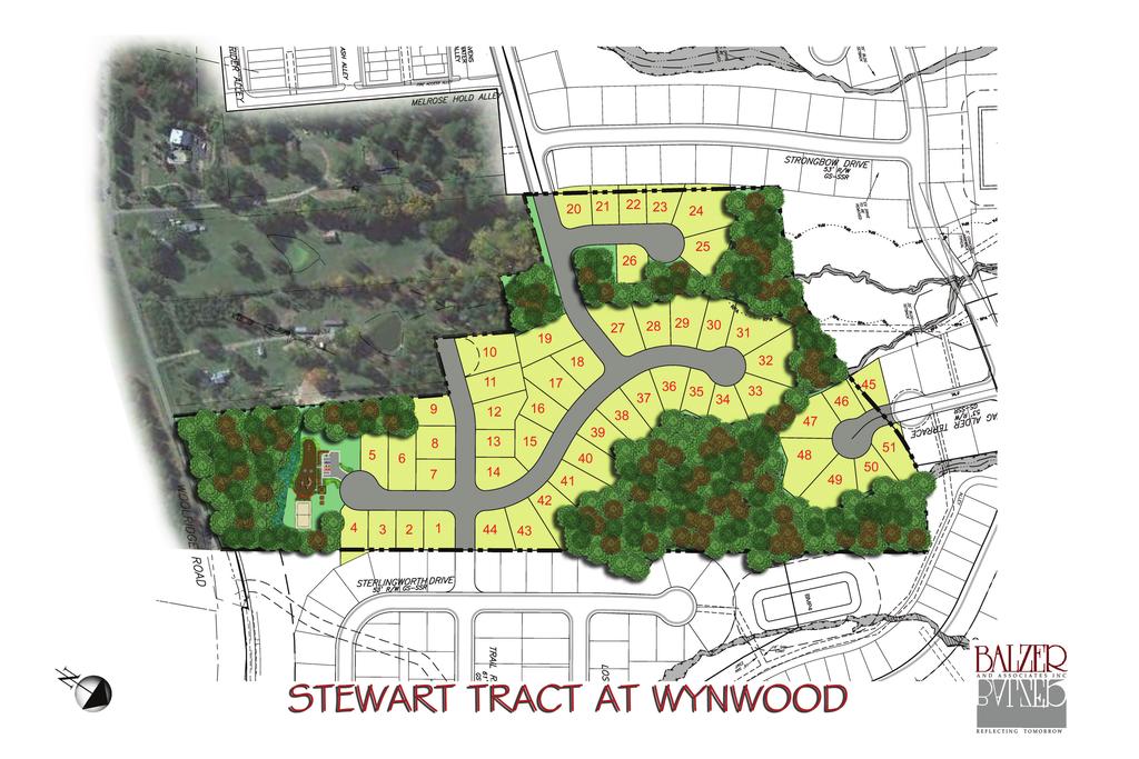
15 per dwelling unit which is the maximum cash proffer in place. The proffer also includes language that would freeze the $18,966 contribution for a period of four (4) years after which it would be escalated by the cumulative change in the Marshall and Swift Building Code Index, a provision recently adopted by the Board of Supervisors. Note that circumstances relevant to this case, as presented by the applicant, have been reviewed and it has been determined that it is appropriate to accept the maximum cash proffer of $18,966 for each dwelling unit in this case. Comprehensive Plan: LAND USE The Comprehensive Plan suggests the property is appropriate for Suburban Residential I (maximum of 2.0 dwellings per acre). Area Development Trends: Site Design: Properties to the north, east and west are zoned Residential (R-15) with conditional use planned development and are occupied by single-family residential use within the Wynwood at FoxCreek development or are vacant. Properties to the south are zoned Agricultural (A) and are occupied by single-family residential use on acreage parcels or are vacant. It is anticipated that single-family residential development will continue in the area, as suggested by the Plan. The applicant plans to develop the request property for single-family residential homes on smaller clustered lots (as outlined in the proffered conditions and Textual Statement) in conjunction with the Wynwood at FoxCreek development which surrounds the property to the north, east and west (Proffered Condition 1 and Textual Statement Items I and II). The Wynwood development is planned for a mixture of residential uses, to include single-family, multifamily, cluster and townhome residential, commercial and recreational uses with a neo-traditional design which includes sidewalks, street trees, open spaces and alleys serving the rear of dwelling units. Exhibit A is a conceptual plan offered by the applicant to portray how the request property could be developed as part of the Wynwood development. Density, Residential Uses and Open Space: Proffered Condition 3 limits the density to a maximum of two (2) dwelling units per acre, yielding approximately fifty-one (51) dwelling units. Single-family residential uses on lots ranging in size from a minimum of 4,500 square feet to a maximum of 9,600 square feet in area are planned. These proposed lot sizes are smaller than the minimum 12,000 square feet of lot area required in the Zoning 12 14SN APR23-BOS-RPT
16 Ordinance for lots zoned Residential (R-12). The ordinance requires permanent open space in an amount equivalent to the area by which each lot is being reduced below 12,000 square feet to be provided as common area within the development. Minimum setbacks offered accommodate the proposed cluster design. (Textual Statement Item III.E.) Cluster Standards: The requirements offered for the proposed cluster development such as sidewalks, street trees and minimizing the impact of garage doors facing streets are consistent with those typically required by the Planning Commission and Board of Supervisors on projects where lot sizes are reduced below Residential (R-12) standards. The development standards offered are also consistent with those approved for the adjacent Wynwood development, except that the size of the focal point areas fails to meet the typical standard (0.75 acre) established for small lot developments (Proffered Condition 4.A. and B and Textual Statement Items III.C and D). In addition, Proffered Condition 2 would require any required buffers to be located in recorded open space. (Proffered Condition 2) Architectural Standards and Materials: Landscaping: The applicant has proffered the use of architectural standards which include compatibility with the adjacent FoxCreek development, the use of a variety of architectural styles, a prohibition on repetitive facades adjacent to each other, and treatment and materials for foundations, front porches and stoops, roofs and exterior facades. (Proffered Condition 4.C, D and E) Additional landscaping to include supplemental trees on individual lots, sodded front yards, and foundation planting beds is guaranteed. (Proffered Condition 4.B.2 4) Recreational Facilities: Passive and active recreational uses limited to facilities and uses that primarily serve the surrounding residential community would be permitted. Such uses include but are not limited to picnic areas, trails, sidewalks, ponds, swimming pools, tennis and basketball courts, playgrounds and clubhouses. The Textual Statement provides for setbacks, buffers and other restrictions to minimize the impact of such recreational uses on surrounding residential uses. (Textual Statement III.A) 13 14SN APR23-BOS-RPT
17 CONCLUSION The proposed zoning and land use complies with the Comprehensive Plan which suggests the property is appropriate for Suburban Residential I (maximum of 2.0 dwellings per acre). In addition, the proffered conditions adequately address the impacts of this development on necessary capital facilities thereby ensuring adequate service levels are maintained to protect the health, safety and welfare of County citizens. Given these considerations, approval of this request is recommended. CASE HISTORY Planning Commission Meeting (12/17/13): On their own motion, and with the applicant s consent, the Commission deferred this case to their January 21, 2014 public hearing. Staff (12/18/13): The applicant was advised in writing that any significant, new or revised information should be submitted no later than December 23, 2013 for consideration at the Commission s January 21, 2014 public hearing. Staff (1/8/14): No new or revised information has been received. Planning Commission Meeting (1/21/14): Due to inclement weather, the Planning Commission meeting was postponed to January 23, Planning Commission Meeting (1/23/14): On their own motion and with the applicant s consent, the Commission deferred this case to their March 18, 2014 public hearing. AYES: Messrs. Wallin, Patton, Brown and Waller. ABSENT: Mr. Gulley SN APR23-BOS-RPT
18 Staff (1/24/14): The applicant was advised in writing that any significant, new or revised information should be submitted no later than January 27, 2014 for consideration at the Commission s March 18, 2014 public hearing. Applicant (3/5 and 3/6/14): Revisions to the proffered conditions and Textual Statement were submitted. Planning Commission Meeting (3/18/14): The applicant s representative accepted the recommendation. There was no opposition present. Dr. Wallin indicated that this case fully addresses impacts of the proposed dwelling units on public facilities and includes provisions for a quality project. On motion of Dr. Wallin, seconded by Mr. Waller, the Commission recommended approval and acceptance of the proffered conditions on pages 2 through 6. AYES: Messrs. Wallin, Patton, Brown, Gulley and Waller. The Board of Supervisors, on Wednesday, April 23, 2014 beginning at 6:30 p.m., will take under consideration this request SN APR23-BOS-RPT
19 TEXTUAL STATEMENT STEWART TRACT Last Revised February 28, 2014 I. Rezone from A to R-12 for the uses permitted in R-12 District with a Conditional Use Planned Development ("CUPD") to permit use and ordinance requirement exceptions, as described herein, and as provided in the accompanying proffers. II. General Conditions A. Uses shall be limited to uses permitted by right or with restrictions in the R-12 District. The development shall have a cluster design which includes sidewalks, street trees, and open spaces. III. Requirements and Exceptions If any of the following facilities are to be provided they shall be identified on the overall conceptual subdivision plan and on the record plat for any lot adjacent to such facilities. A. Recreational Facilities. 1. Recreational facilities shall be permitted within the property. These uses shall be limited to facilities and uses that primarily serve the surrounding residential community and may include passive recreation (i.e. picnic areas, trails, paths, sidewalks, ponds, open space, and vistas) and may include active facilities (i.e. swimming pools, tennis courts, basketball courts, volleyball courts, playgrounds, and clubhouses). 2. Outside public address systems or speakers shall not be used between the hours of 11:00 p.m. and 8:00 a.m. and shall only be used in conjunction with a pool. 3. With the exception of playground areas which accommodate swings, jungle gyms or similar such facilities, outdoor play fields, courts, swimming pools and similar active recreational facilities shall be located a minimum of 50 feet from any proposed or existing single family residential lot line and a minimum of fifty (50) feet from any existing or proposed public road. Nothing herein shall prevent development of indoor facilities and/or parking within the 50 foot setback. Within the fifty (50) foot setbacks, a fifty (50) foot buffer shall be provided along the perimeter of all active recreational facilities except where adjacent to any existing or proposed public roads. These buffers shall conform to the requirements of the Zoning Ordinance for fifty (50) foot buffers. These buffers and setbacks may be modified by the Planning Commission at the time of plan review. 1
20 4. Any playground area (i.e., areas accommodating swings, jungle gyms or similar such facilities) shall be located a minimum of forty (40) feet from all property lines. A forty (40) foot buffer shall be provided along the perimeter of these recreational facilities except where adjacent to any existing or proposed public roads. These buffers shall conform to the requirements of the Zoning Ordinance for fifty (50) foot buffers. These setbacks and buffers may be modified by the Planning Commission at the time of plan review. B. Focal Point/Recreation Area. A minimum of 0.40 acres of open space/recreation area shall be provided within this property to provide focal points. Part of each focal point area shall be hardscaped and have benches and other amenities that accommodate and facilitate gatherings. A portion of the focal points may include areas devoted to best management/stormwater facilities. The focal points shall be developed concurrent with the phase of development that the focal point is intended to serve. C. Garages. Front loaded attached garages shall be permitted to extend as far forward from the front line of the main dwelling as the front line of the front porch provided that the rooflines of the porch and garage are contiguous. Where the rooflines are not contiguous, garages shall be permitted to project a maximum of two (2) feet forward of the front line of the main dwelling. D. Development shall conform to the following: (1) Principal Structures. (i) (ii) (iii) (iv) (v) (vi) (vii) Lot area and width. Each lot shall have an area of not less than 4,500 square feet and not more than 9,600 square feet and a lot width of not less than fifty (50) feet. Percentage of lot coverage. All buildings, including accessory buildings, on any lot shall not cover more than seventy (70) percent of the lot s area. Front yard. Minimum of ten (10) feet in depth. Minimum setbacks shall be increased where necessary to obtain the required lot width at the front building line. Side yard. Two (2) side yards, each a minimum of three (3) feet in width. Corner side yard. Minimum of fifteen (15) feet. Rear yard. Minimum of four (4) feet. Dwelling Size. The minimum gross floor area for each dwelling unit shall be 1,800 square feet for 2
21 one-story and 2,500 square feet for more than onestory. (2) Accessory Structures. Setbacks for accessory structures shall conform to the setback requirements for such structures in the R-12 District except as follows: (i) (ii) One (1) story accessory structures: The rear, side and corner side yard setbacks shall be half the required yards for principal structures defined above. More than one (1) story accessory structures: The rear, side and corner side yard setbacks shall be the required setbacks for principal structures defined above. 3


22 FO X R-15 HL I FO X GA TE R-12 X FO LN IA BR R LN FOX ZC FOX C LUB C T ES T CR FO X W OO Aerial photos taken in 2009 FOX HA AN G BR FOX HA V EN TE R CHA SE RD R RS G ID R L E CI CT WA L KE C T ES V N CR LN ST L CRE PL ER FOX X FO T ET ZC WA Y X HAV E N DS RE R-12 LU B FOX CLUB LN A FO XC CT C HANCOCKS QUARTER AT FOXCREEK FO XV AL EW AY TRAIL CT CT HO FO XV AL E RD ZC ATE XG FO F IF C PL C IN LILT Feet OO GE D I LR RD M B LU XC FO FOX E GAT CL 600 ER FOXCROFT H AT HE S 0 TT FOXFIRE DR V 300 ZC A OX W / R TE ZC R-15 WEXLEY AT FOXCREEK HT FIRE LIG HT PL ZC 14SN0504 Rez: A TO R-12R-12 w/c.u.p.d. A SK G LI IG H EL A DU C A TF WYNWOOD AT FOXCREEK L PL FIR IF SW C SS O HT IG ZC RIDE DR C V MA RS M E LN QUARTER HO RS ZC ZC R-15 PK W LI GH T ZC FOXFIELD 600 RE C T Y ZC C S FI TRA IL RI A MOS DE C T A B
23 14SN0504-1
CASE NUMBER: 16SN0504 APPLICANT: Windswept Development LLC
 CASE NUMBER: 16SN0504 APPLICANT: Windswept Development LLC ADDENDUM CHESTERFIELD COUNTY, VIRGINIA Magisterial District: MIDLOTHIAN 2200 N Otterdale Road Board of Supervisors (BOS) Public Hearing Date:
CASE NUMBER: 12SN0154 (Amended) APPLICANT: Charles Edward Townes, Managing Partner, Dominion Investment Partners, LLC
 APPLICANT: Charles Edward Townes, Managing Partner, Dominion Investment Partners, LLC") CASE NUMBER: 12SN0154 (Amended) APPLICANT: Charles Edward Townes, Managing Partner, Dominion Investment Partners, LLC STAFF S ANALYSIS AND RECOMMENDATION Board of Supervisors (BOS) Public Hearing Date:
CASE NUMBER: 12SN0154 (Amended) APPLICANT: Charles Edward Townes, Managing Partner, Dominion Investment Partners, LLC STAFF S ANALYSIS AND RECOMMENDATION Board of Supervisors (BOS) Public Hearing Date:
STAFF S REQUEST ANALYSIS AND RECOMMENDATION 07SN0341. Acquisitions Plus LLC
 STAFF S REQUEST ANALYSIS AND RECOMMENDATION September 18, 2007 CPC November 20, 2007 CPC December 18, 2007 CPC January 15, 2008 CPC February 19, 2008 CPC March 18, 2008 CPC April 23, 2008 BS 07SN0341 Acquisitions
CASE NUMBER: 15SN0562 APPLICANT: R. E. Collier Builder, Inc. APPLICANT S REQUEST
 CASE NUMBER: 15SN0562 APPLICANT: R. E. Collier Builder, Inc. ADDENDUM CHESTERFIELD COUNTY, VIRGINIA Magisterial District: CLOVER HILL Board of Supervisors (BOS) Public Hearing Date: JANUARY 28, 2015 BOS
CASE NUMBER: 15SN0652 APPLICANT: JMS Investments, LLC and J. Mark Sowers
 CASE NUMBER: 15SN0652 APPLICANT: JMS Investments, LLC and J. Mark Sowers ADDENDUM CHESTERFIELD COUNTY, VIRGINIA Magisterial District: MIDLOTHIAN 1600 Huguenot Springs Road Board of Supervisors (BOS) Public
CASE NUMBER: 15SN0652 APPLICANT: JMS Investments, LLC and J. Mark Sowers
 CASE NUMBER: 15SN0652 APPLICANT: JMS Investments, LLC and J. Mark Sowers ADDENDUM CHESTERFIELD COUNTY, VIRGINIA Magisterial District: MIDLOTHIAN 1600 Huguenot Springs Road Planning Commission (CPC) Public
CASE NUMBER: 16SN0591 APPLICANT: Glenn M. Hill
 CASE NUMBER: 16SN0591 APPLICANT: Glenn M. Hill CHESTERFIELD COUNTY, VIRGINIA CLOVER HILL DISTRICT STAFF S ANALYSIS AND RECOMMENDATION Board of Supervisors Hearing: NOVEMBER 15, 2017 Board of Supervisors
STAFF S REQUEST ANALYSIS AND RECOMMENDATION 05SN0239 (AMENDED) The Cheatham Family Limited Partnership
 The Cheatham Family Limited Partnership") February 20, 2007 CPC May 15, 2007 CPC July 17, 2007 CPC August 21, 2007 CPC September 18, 2007 CPC October 16, 2007 CPC November 20, 2007 CPC January 9, 2008 BS March 12, 2008 BS May 28, 2008 BS September
February 20, 2007 CPC May 15, 2007 CPC July 17, 2007 CPC August 21, 2007 CPC September 18, 2007 CPC October 16, 2007 CPC November 20, 2007 CPC January 9, 2008 BS March 12, 2008 BS May 28, 2008 BS September
CASE NUMBER: 13SN0132 (AMENDED) APPLICANTS: Chesterfield Business Partners LLC, Eastwood Homes of Richmond, LLC and Kingsland Towncenter LLC
 APPLICANTS: Chesterfield Business Partners LLC, Eastwood Homes of Richmond, LLC and Kingsland Towncenter LLC") CASE NUMBER: 13SN0132 (AMENDED) APPLICANTS: Chesterfield Business Partners LLC, Eastwood Homes of Richmond, LLC and Kingsland Towncenter LLC CHESTERFIELD COUNTY, VIRGINIA DALE DISTRICT STAFF S ANALYSIS
CASE NUMBER: 13SN0132 (AMENDED) APPLICANTS: Chesterfield Business Partners LLC, Eastwood Homes of Richmond, LLC and Kingsland Towncenter LLC CHESTERFIELD COUNTY, VIRGINIA DALE DISTRICT STAFF S ANALYSIS
CASE NUMBER: 15SN0657 APPLICANT: The Grove at Lucks Lane, LLC
 CASE NUMBER: 15SN0657 APPLICANT: The Grove at Lucks Lane, LLC STAFF S ANALYSIS AND RECOMMENDATION CHESTERFIELD COUNTY, VIRGINIA Magisterial District: CLOVER HILL 11700 Lucks Lane Board of Supervisors (BOS)
CASE NUMBER: 18SN0824 APPLICANT: Chesterfield County Board of Supervisors
 CASE NUMBER: 18SN0824 APPLICANT: Chesterfield County Board of Supervisors CHESTERFIELD COUNTY, VIRGINIA MATOACA DISTRICT STAFF S ANALYSIS AND RECOMMENDATION Planning Commission Hearing: JUNE 19, 2018 Planning
STAFF S REQUEST ANALYSIS AND RECOMMENDATION 07SN0341. Acquisitions Plus LLC
 September 18, 2007 CPC November 20, 2007 CPC December 18, 2007 CPC January 15, 2008 CPC February 19, 2008 CPC arch 18, 2008 CPC April 23, 2008 BS June 25, 2008 BS September 24, 2008 BS January 28, 2009
CASE NUMBER: 17SN0606 APPLICANT: Twin Rivers, LLC CHESTERFIELD COUNTY, VIRGINIA BERMUDA DISTRICT
 CASE NUMBER: 17SN0606 APPLICANT: Twin Rivers, LLC CHESTERFIELD COUNTY, VIRGINIA BERMUDA DISTRICT STAFF S ANALYSIS AND RECOMMENDATION Planning Commission Hearing: JULY 18, 2017 Planning Commission Time
CASE NUMBER: 15SN0649 APPLICANT: Chad White
 ADDENDUM CASE NUMBER: 15SN0649 APPLICANT: Chad White CHESTERFIELD COUNTY, VIRGINIA Magisterial District: MIDLOTHIAN Board of Supervisors (BOS) Public Hearing Date: JUNE 24, 2015 BOS Time Remaining: 365
CASE NUMBER: 16SN0676 APPLICANT: Christopher Neil Carty
 Board of Supervisors (BOS) Public Hearing Date: APRIL 27, 2016 BOS Time Remaining: 365 DAYS CASE NUMBER: 16SN0676 APPLICANT: Christopher Neil Carty STAFF S ANALYSIS AND RECOMMENDATION Applicant s Contact:
CASE NUMBER: 16SN0581 APPLICANT: Pocoshock Green Development, LLC
 CASE NUMBER: 16SN0581 APPLICANT: Pocoshock Green Development, LLC STAFF S ANALYSIS AND RECOMMENDATION Planning Commission (CPC) Public Hearing Date: APRIL 19, 2016 CPC Time Remaining: 100 DAYS Applicant
CASE NUMBER: 15SN0596 APPLICANT: Colony Village LLC
 ADDENDUM CASE NUMBER: 15SN0596 APPLICANT: Colony Village LLC CHESTERFIELD COUNTY, VIRGINIA Magisterial District: BERMUDA Board of Supervisors (BOS) Public Hearing Date: NOVEMBER 19, 2014 CPC Time Remaining:
CASE NUMBER: 16SN0581 APPLICANT: Pocoshock Green Development, LLC
 CASE NUMBER: 16SN0581 APPLICANT: Pocoshock Green Development, LLC STAFF S ANALYSIS AND RECOMMENDATION Planning Commission (CPC) Public Hearing Date: JULY 19, 2016 CPC Time Remaining: 100 DAYS Applicant
STAFF S REQUEST ANALYSIS AND RECOMMENDATION 11SN0184. Clodfelter Properties LLC. Clover Hill Magisterial District Genito Road
 CSE MNGER: Darla Orr February 15, 2011 CPC March 9, 2011 BS STFF S REQUEST NLYSIS ND RECOMMENDTION 11SN0184 Clodfelter Properties LLC Clover Hill Magisterial District 12621 Genito Road REQUEST: Conditional
STAFF S REQUEST ANALYSIS AND RECOMMENDATION 13SN0520. Fountain Square Condominiums LLC
 ASE MANAGER: Ryan Ramsey June 18, 2013 P July 17, 2013 BS August 28, 2013 BS BS Time Remaining: 365 days STAFF S REQUEST ANALYSIS AND REOMMENDATION 13SN0520 Fountain Square ondominiums LL Bermuda Magisterial
ARTICLE C. ZONING TEXT, DISTRICT CLASSIFICATIONS AND BOUNDARIES
 ARTICLE C. ZONING TEXT, DISTRICT CLASSIFICATIONS AND BOUNDARIES Sec. 10-2054. ZONING TEXT, DISTRICT CLASSIFICATIONS AND BOUNDARIES. In order to regulate the location of structures, the height and bulk
STAFF S REQUEST ANALYSIS AND RECOMMENDATION 07SN0340. Francis Beers
 September 18, 2007 CPC November 20, 2007 CPC February 19, 2008 CPC June 17, 2008 CPC August 19, 2008 CPC September 24, 2008 BS STAFF S REQUEST ANALYSIS AND RECOMMENDATION 07SN0340 Francis Beers Matoaca
Staff Planner Carolyn A.K. Smith
 Applicant Property Owner, Pamela K. & Steven A. Gray Public Hearing April 13, 2016 City Council Election District Princess Anne Agenda Item 8 Request Modification of Proffers (Modification to the proffer
Article 7: Residential Land Use and Development Requirements
 Article 7: Residential Land Use and Section 701: Statement of Intent (A) (B) (C) The intent of Article 7 is to develop certain land use and development requirements for the residential uses within Cumru
CASE NUMBER: 15SN0648 APPLICANT: Wegmans Food Markets
 CASE NUMBER: 15SN0648 APPLICANT: Wegmans Food Markets STAFF S ANALYSIS AND RECOMMENDATION Board of Supervisors (BOS) Public Hearing Date: JULY 22, 2015 BOS Time Remaining: 365 DAYS Applicant s Agent: BRENNEN
ORDINANCE NO
 APPROVED BY ORANGE COUNTY BOARD OF COUNTY COMMISSIONERS BCC Mtg. Date: May 24, 2016 EFFECTIVE DATE June 1, 2016 ORDINANCE NO. 2016-10 AN ORDINANCE AFFECTING THE USE OF LAND IN ORANGE COUNTY, FLORIDA; AMENDING
Chapter Planned Residential Development Overlay
 Chapter 19.29 Planned Residential Development Overlay Sections 010 Purpose 020 Scope 030 Definitions 030 Minimum Size 040 Allowable Uses 050 Minimum Development Standards 060 Density Bonus 070 Open Space
ANDERSON HALL PUD TEXT AMENDMENT PRESENTED BY STEVEN D. HARDIN, ESQ.
 ANDERSON HALL PUD TEXT AMENDMENT PRESENTED BY STEVEN D. HARDIN, ESQ. TOWN COUNCIL REQUEST FOR THIRD READING MARCH 17, 2014 TABLE OF CONTENTS 141ST STREET & PROMISE ROAD PUD Petitioner Craig H. Lintner
Cluster Development Princeton Township, Mercer County
 Cluster Development Princeton Township, Mercer County Division 9 Residential Clusters Section 10B-189 Statement of purposes. The township committee to implement the goals and objectives of the Princeton
A. Preserve natural resources as identified in the Comprehensive Plan.
 1370.08 Conservation Residential Overlay District. Subd. 1 Findings. The City finds that the lands and resources within the Conservation Residential Overlay District are a unique and valuable resource
Charter Township of Plymouth Zoning Ordinance No. 99 Page 208 Article 21: Residential Unit Developments Amendments: ARTICLE XXI
 Charter Township of Plymouth Zoning Ordinance No. 99 Page 208 ARTICLE XXI RESIDENTIAL UNIT DEVELOPMENTS PURPOSE The purpose of the Residential Unit Development (RUD) is to permit two (2) optional methods
Request Conditional Rezoning (R-7.5 Residential to Conditional A-18 Apartment) Staff Recommendation Approval. Staff Planner Jimmy McNamara
 Staff Recommendation Approval. Staff Planner Jimmy McNamara") Applicants Property Owners Baker Villas, LLC; Ocean Rental Properties, LLC; James Edward Sollner; & Linda Susan Sollner Public Hearing November 8, 2017 City Council Election District Kempsville Agenda
Applicants Property Owners Baker Villas, LLC; Ocean Rental Properties, LLC; James Edward Sollner; & Linda Susan Sollner Public Hearing November 8, 2017 City Council Election District Kempsville Agenda
LINCOLN COUNTY PLANNING & INSPECTIONS DEPARTMENT
 LINCOLN COUNTY PLANNING & INSPECTIONS DEPARTMENT 302 NORTH ACADEMY STREET, SUITE A, LINCOLNTON, NORTH CAROLINA 28092 704-736-8440 OFFICE 704-736-8434 INSPECTION REQUEST LINE 704-732-9010 FAX To: Board
4 June 11, 2014 Public Hearing
 4 June 11, 2014 Public Hearing APPLICANT: FRANKLIN JOHNSTON MANAGEMENT DEVELOPMENT, L.L.C. PROPERTY OWNER: TRUSTEES OF FIRST LYNNHAVEN BAPTIST CHURCH STAFF PLANNER: Stephen J. White REQUEST: Change of
MONTGOMERY COUNTY PLANNING DEPARTMENT THE MARYLAND-NATIONAL CAPITAL PARK AND PLANNING COMMISSION
 MONTGOMERY COUNTY PLANNING DEPARTMENT THE MARYLAND-NATIONAL CAPITAL PARK AND PLANNING COMMISSION MCPB Item No.: Date: 06-21-12 The Plantations, Preliminary Plan -120090240 Benjamin Berbert, Senior Planner,
SECTION 10.7 R-PUD (RESIDENTIAL PLANNED UNIT DEVELOPMENT) ZONE
 ZONE") Article X Zones 10-20 SECTION 10.7 R-PUD (RESIDENTIAL PLANNED UNIT DEVELOPMENT) ZONE A. PURPOSE AND INTENT: The R-PUD Residential PUD Zone is intended to provide alternative, voluntary zoning procedures
Article X Zones 10-20 SECTION 10.7 R-PUD (RESIDENTIAL PLANNED UNIT DEVELOPMENT) ZONE A. PURPOSE AND INTENT: The R-PUD Residential PUD Zone is intended to provide alternative, voluntary zoning procedures
Cover Letter with Narrative Statement
 Cover Letter with Narrative Statement March 31, 2017 rev July 27, 2017 RE: Rushton Pointe Residential Planned Unit Development Application for Public Hearing for RPUD Rezone PL2015 000 0306 Mr. Eric Johnson,
AN ORDINANCE AMENDING THE CITY ZONING ORDINANCE AND THE OFFICIAL CODE OF THE CITY OF CLARKSVILLE RELATIVE TO CLUSTER OPTION DEVELOPMENTS
 ORDINANCE 74-2012-13 AN ORDINANCE AMENDING THE CITY ZONING ORDINANCE AND THE OFFICIAL CODE OF THE CITY OF CLARKSVILLE RELATIVE TO CLUSTER OPTION DEVELOPMENTS BE IT ORDAINED BY THE CITY COUNCIL OF THE CITY
The following standards are not applicable to manufactured homes that are subject to Section
 ARTICLE IV: DEVELOPMENT STANDARDS IV 259 430 75 Manufactured Dwelling (General Standards) 430 75.1 Minimum Standards for All Manufactured Dwellings The following standards are not applicable to manufactured
3 July 13, 2011 Public Hearing APPLICANT / PROPERTY OWNER: MARQUETTE & ASSOCIATES, L.L.C. /G.S. DEVELOPERS, L.L.C.
 3 July 13, 2011 Public Hearing APPLICANT / PROPERTY OWNER: MARQUETTE & ASSOCIATES, L.L.C. /G.S. DEVELOPERS, L.L.C. STAFF PLANNER: Faith Christie REQUEST: Conditional Change of Zoning (AG-2 Agricultural
ARTICLE IV DISTRICT REGULATIONS
 PART 1. RESIDENTIAL DISTRICTS 4-101. RS. Single-Family Residential Suburban District. The RS District is designed for single-family dwellings, and compatible uses, at a density no greater than one dwelling
PERSIMMON GROVE. Developer Pulte Group North Meridian Street, Suite 530 Carmel, IN 46032
 PERSIMMON GROVE A RESIDENTIAL PLANNED UNIT DEVELOPMENT In Avon, Indiana Developer Pulte Group 11590 North Meridian Street, Suite 530 Carmel, IN 46032 Attorney Comer Law Office Ben Comer 71 West Marion
Development Plan DP13-3 (Arlington Lofts) Planning and Zoning Meeting Date: Document Being Considered: Ordinance
 Planning and Zoning Meeting Date: Document Being Considered: Ordinance") Staff Report Development Plan DP13-3 (Arlington Lofts) Planning and Zoning Meeting Date: 6-19-13 Document Being Considered: Ordinance RECOMMENDATION Following the public hearing, consider Development Plan
Staff Report Development Plan DP13-3 (Arlington Lofts) Planning and Zoning Meeting Date: 6-19-13 Document Being Considered: Ordinance RECOMMENDATION Following the public hearing, consider Development Plan
CASE NUMBER 15SN0665 APPLICANT: Henry E. Myers, Jr.
 CASE NUMBER 15SN0665 APPLICANT: Henry E. Myers, Jr. STAFF S ANALYSIS AND RECOMMENDATION Planning Commission (CPC) Public Hearing Date: JULY 21, 2015 CPC Time Remaining: 100 DAYS Applicant s Agent: BENJAMIN
Chapter Residential Mixed Density Zone
 Chapter 19.16 Residential Mixed Density Zone 19.16.010 Purpose and Intent 19.16.020 Permitted Uses 19.16.030 Accessory Permitted Uses 19.16.040 Secondary Permitted Uses 19.16.050 Conditional Uses 19.16.060
STAFF S REQUEST ANALYSIS AND RECOMMENDATION 12SN0117. Smith Iron and Metal Co., Inc. Bermuda Magisterial District North line of Bellwood Road
 SE NGER: Robert lay October 18, 2011 P November 30, 2011 BS BS Time Remaining: 365 days STFF S REQUEST NLYSIS ND REOENDTION 12SN0117 Smith Iron and etal o., Inc. Bermuda agisterial District North line
ARTICLE V AGRICULTURAL PRESERVATION AND RURAL RESIDENTIAL DISTRICT
 ARTICLE V AP AGRICULTURAL PRESERVATION AND RURAL RESIDENTIAL DISTRICT Section 500. PURPOSE It is the purpose of the AP, Agricultural Preservation and Rural Residential District, to foster the preservation
CHAPTER34 PRUD - PLANNED RESIDENTIAL UNIT DEVELOPMENT
 CHAPTER34 PRUD - PLANNED RESIDENTIAL UNIT DEVELOPMENT 17-34-1 17-34-2 17-34-3 17-34-4 17-34-5 17-34-6 17-34-7 17-34-8 17-34-9 Purpose Planned Residential Unit Development Defined Planned Residential Unit
R3 (MULTIPLE-FAMILY RESIDENCE)
") Planning and Building Agency Planning Division 20 Civic Center Plaza P.O. Box 1988 (M-20) Santa Ana, CA 92702 (714) 647-5804 R3 (MULTIPLE-FAMILY RESIDENCE) Sec. 41-258. Sec. 41-258.5. Sec. 41-259. Purpose.
Planning and Building Agency Planning Division 20 Civic Center Plaza P.O. Box 1988 (M-20) Santa Ana, CA 92702 (714) 647-5804 R3 (MULTIPLE-FAMILY RESIDENCE) Sec. 41-258. Sec. 41-258.5. Sec. 41-259. Purpose.
4.2 RESIDENTIAL ZONING DISTRICTS
 4.2 RESIDENTIAL ZONING DISTRICTS A. Purpose: To define regulations and standards for each residential zoning district in the City. The following sections identify uses, regulations, and performance standards
Town of Cary, North Carolina Rezoning Staff Report 12-REZ-27 Morris Branch Town Council Public Hearing January 24, 2013
 Town of Cary, North Carolina Rezoning Staff Report 12-REZ-27 Morris Branch Town Council Public Hearing January 24, 2013 REQUEST To amend the Town of Cary Official Zoning Map to rezone approximately 9.0
SPECIAL ZONING DISTRICTS
 SPECIAL ZONING DISTRICTS 5.01 5.99 RESERVED 5.100 PLANNED DEVELOPMENTS: Purpose: This district is intended to accommodate unified design of residential, commercial, office, professional services, retail
Composition of traditional residential corridors.
 Page 1 of 7 St. Petersburg, Florida, Code of Ordinances >> PART II - ST. PETERSBURG CITY CODE >> Chapter 16 - LAND DEVELOPMENT REGULATIONS >> SECTION 16.20.060. CORRIDOR RESIDENTIAL TRADITIONAL DISTRICTS
1 November 13, 2013 Public Hearing APPLICANT & PROPERTY OWNER: HOME ASSOCIATES OF VIRGINIA, INC.
 1 November 13, 2013 Public Hearing APPLICANT & PROPERTY OWNER: HOME ASSOCIATES OF VIRGINIA, INC. STAFF PLANNER: Carolyn A.K. Smith REQUEST: Conditional Change of Zoning (AG-1 & AG-2 Agricultural Districts
CHAPTER 5. PLANNED UNIT DEVELOPMENT REGULATIONS
 Section 5.1. Purpose CHAPTER 5. PLANNED UNIT DEVELOPMENT REGULATIONS 5.1. PURPOSE The purpose for Planned Unit Developments (PUDs) is established in Section 4.5 Zoning District Purpose Statements. 5.2.
PALM BEACH COUNTY PLANNING, ZONING AND BUILDING DEPARTMENT ZONING DIVISION
 PALM BEACH COUNTY PLANNING, ZONING AND BUILDING DEPARTMENT ZONING DIVISION Application No.: CA-2012-00688 Control No.: 2011-00552 Applicant: Garry Bernardo Owners: Garry Bernardo Agent: Frogner Consulting,
a. To insure compatible relationships between land use activities;
 PART B SECTION VIII INSTITUTIONAL DISTRICTS Article 1 Planned Institutional District 1. Purpose and Intent: It is the purpose and intent of this district to permit and encourage the orderly, cooperative
ARTICLE IV: DEVELOPMENT STANDARDS
 ARTICLE IV: DEVELOPMENT STANDARDS IV-53 409 PRIVATE STREETS A private street means any way that provides ingress to, or egress from, property by means of vehicles or other means, or that provides travel
Washington County, Minnesota Ordinances
 Washington County, Minnesota Ordinances Ordinance No. 153 Text Amendment to the Washington County Development Code - Chapter One, Section 2 and Chapter Two, Part 1, Part 2, Part 3, of the Development Code
2 November 9, 2011 Public Hearing APPLICANT: ASHVILLE PARK, L.L.C.
 2 November 9, 2011 Public Hearing APPLICANT: ASHVILLE PARK, L.L.C. PROPERTY OWNER: ATC REALTY SIXTEEN, INC. STAFF PLANNER: Faith Christie REQUEST: Modification of Conditional Change of Zoning approved
PALM BEACH COUNTY PLANNING, ZONING AND BUILDING DEPARTMENT ZONING DIVISION
 PALM BEACH COUNTY PLANNING, ZONING AND BUILDING DEPARTMENT ZONING DIVISION Application No.: Z/CA-2013-00493 Application Name: Trails Charter School Control No.: 2013-00085 Applicant: MG3 ALF Military LLC
ARTICLE III: LAND USE DISTRICTS 304 R 9 DISTRICT
 ARTICLE III: LAND USE DISTRICTS III 23 304 R 9 DISTRICT (RESIDENTIAL 9 UNITS PER ACRE) 304 1 Intent and Purpose The R 9 District is intended to implement the policies of the Comprehensive Plan for areas
AMENDED ZONING BY-LAW ARTICLE SENIOR LIVING COMMUNITY
 AMENDED ZONING BY-LAW ARTICLE 13.5 - SENIOR LIVING COMMUNITY ARTICLE : To see if the Town will vote to amend the Zoning Bylaw as follows: 2. By deleting existing Section 13.5, Senior Living Community,
Montgomery Village - South Valley Park: Subdivision Regulation Waiver SRW , and Site Plan No
 Montgomery Village - South Valley Park: Subdivision Regulation Waiver SRW - 201402, and Site Plan No. 820140070 12 SUBDIVISION REGULATION WAIVER RECOMMENDATION AND CONDITIONS OF APPROVAL Staff recommends
LINCOLN COUNTY PLANNING & INSPECTIONS DEPARTMENT
 LINCOLN COUNTY PLANNING & INSPECTIONS DEPARTMENT 302 NORTH ACADEMY STREET, SUITE A, LINCOLNTON, NORTH CAROLINA 28092 704-736-8440 OFFICE 704-736-8434 INSPECTION REQUEST LINE 704-732-9010 FAX To: Board
EXCERPT Planned Residential Development (PRD)
") LAND DEVELOPMENT CODE ESTABLISHING ZONING DISTRICTS AND REGULATIONS FOR LAND DEVELOPMENT AND SUBDIVISION IN THE CITY OF HATTIESBURG, MISSISSIPPI ORDINANCE NO. 2330 ADOPTED DECEMBER 05, 1989 EXCERPT Planned
LAND DEVELOPMENT CODE ESTABLISHING ZONING DISTRICTS AND REGULATIONS FOR LAND DEVELOPMENT AND SUBDIVISION IN THE CITY OF HATTIESBURG, MISSISSIPPI ORDINANCE NO. 2330 ADOPTED DECEMBER 05, 1989 EXCERPT Planned
THE CITY OF RAYMORE, MISSOURI Single-Family Residential Zoning Districts
 THE CITY OF RAYMORE, MISSOURI Single-Family Residential Zoning Districts REGULATIONS COMMON TO ALL DISTRICTS: Uses permitted in each district include detached single-family dwellings, manufactured homes
Community Development Department Staff Report. FILE NUMBER: GPA 06-01, ZC 06-01, SPR 06-03, TPM (Boundary Line Adjustment) John Wagener
 John Wagener") Community Development Department Staff Report DATE: December 5, 2007 FILE NUMBER: GPA 06-01, ZC 06-01, SPR 06-03, TPM 06-06 (Boundary Line Adjustment) APPLICANT: TYPE OF APPLICATION: GENERAL LOCATION:
Community Development Department Staff Report DATE: December 5, 2007 FILE NUMBER: GPA 06-01, ZC 06-01, SPR 06-03, TPM 06-06 (Boundary Line Adjustment) APPLICANT: TYPE OF APPLICATION: GENERAL LOCATION:
Charter Township of Plymouth Zoning Ordinance No. 99 Page 35 Article 7: R-M Mobile Home Residential Districts Amendments:
 Charter Township of Plymouth Zoning Ordinance No. 99 Page 35 PURPOSE ARTICLE VII R-M MOBILE HOME RESIDENTIAL DISTRICTS This District is designed primarily to provide locations for mobile home parks thus
PD No. 15 Authorized Hearing
 PD No. 15 Authorized Hearing Community Meeting No. 2 February 19, 2019 6:30 p.m. Hyer Elementary School Cafetorium 8385 Durham St Andrew Ruegg Senior Planner PD No. 15 Authorized Hearing On September 7,
GWINNETT COUNTY CSO CONSERVATION SUBDIVISION OVERLAY DISTRICT REQUIREMENTS
 GWINNETT COUNTY CSO CONSERVATION SUBDIVISION OVERLAY DISTRICT REQUIREMENTS Section 1316. CSO Conservation Subdivision Overlay District. 1. Purposes. The purposes of this overlay district are as follows:
Article XII. R-1 Agricultural-Low Density Residential District
 Article XII R-1 Agricultural-Low Density Residential District Section 1200. Declaration of Legislative Intent In expansion of the Declaration of Legislative Intent and Statement of Community Development
8.5.1 R1, Single Detached Residential District
 8.5.1 R1, Single Detached Residential District The purpose of this district is to provide for residential development in the form of single detached dwellings. Dwelling, Single Detached Home Business,
Request Subdivision Variance (4.1 (m)(1) of the Subdivision Regulations) Staff Recommendation Approval. Staff Planner Jonathan Sanders
(1) of the Subdivision Regulations) Staff Recommendation Approval. Staff Planner Jonathan Sanders") Applicant Property Owner Jo Stallard Woolling Hodges Public Hearing December 12, 2018 (Deferred November 14, 2018) City Council Election District Beach Agenda Item D4 Request Subdivision Variance (4.1
Applicant Property Owner Jo Stallard Woolling Hodges Public Hearing December 12, 2018 (Deferred November 14, 2018) City Council Election District Beach Agenda Item D4 Request Subdivision Variance (4.1
PLANNED DEVELOPMENT DISTRICT STANDARDS. Cadence Site
 PLANNED DEVELOPMENT DISTRICT STANDARDS Cadence Site A Planned Development District 1. Statement of General Facts, Conditions and Objectives Property Size: Approximately 57.51 Acres York County Tax Map
ARTICLE 5. COMMERCIAL AND OFFICE DISTRICTS 5.1 PURPOSE STATEMENTS 5.2 USES 5.3 DIMENSIONAL STANDARDS 5.4 DESIGN STANDARDS 5.5 DK DISTRICT STANDARDS 5
 ARTICLE 5. COMMERCIAL AND OFFICE DISTRICTS 5.1 PURPOSE STATEMENTS 5.2 USES 5.3 DIMENSIONAL STANDARDS 5.4 DESIGN STANDARDS 5.5 DK DISTRICT STANDARDS 5.6 CU DISTRICT STANDARDS 5.7 SW DISTRICT STANDARDS THE
STAFF S REQUEST ANALYSIS AND RECOMMENDATION 10SN0142 (AMENDED) Carrie E. Coyner
 Carrie E. Coyner") ecember 15, 2009 P February 16, 2010 P arch 10, 2010 BS STFF S EQUEST NLYSIS N EOENTION 10SN0142 (ENE) arrie E. oyner atoaca agisterial istrict Watkins Elementary; idlothian iddle; and idlothian High Schools
ecember 15, 2009 P February 16, 2010 P arch 10, 2010 BS STFF S EQUEST NLYSIS N EOENTION 10SN0142 (ENE) arrie E. oyner atoaca agisterial istrict Watkins Elementary; idlothian iddle; and idlothian High Schools
TOWNSHIP OF EVESHAM ORDINANCE NO
 TOWNSHIP OF EVESHAM ORDINANCE NO. 14-6-2018 ORDINANCE OF THE TOWNSHIP OF EVESHAM AMENDING CHAPTER 160, THE ZONING CODE OF THE TOWNSHIP OF EVESHAM TO CREATE A NEW ZONE TO BE KNOWN AS THE WORKFORCE AFFORDABLE
Rezoning Petition Zoning Committee Recommendation June 29, 2017
 Rezoning Petition 2017-076 Zoning Committee Recommendation June 29, 2017 REQUEST Current Zoning: MUDD-O (mixed use development, optional) and R-4 (single family residential) Proposed Zoning: UR-2(CD) (urban
Staff Planner Jimmy McNamara. Location 3736 & 3744 Shore Drive GPINs & Site Size 24,288 square feet AICUZ Less than 65 db DNL
 Applicant Property Owner 3744 Shore Associates, LLC Public Hearing October 12, 2016 (Previously deferred 09/14/2016) City Council Election District Bayside Agenda Item D4 Requests Conditional Rezoning
ARTICLE I ZONE BASED REGULATIONS
 ARTICLE I ZONE BASED REGULATIONS RZC 21.08 RESIDENTIAL REGULATIONS 21.08.290 Cottage Housing Developments A. Purpose. The purpose of the cottage housing requirements is to: 1. Provide a housing type that
PLANNED MIXED-USE DEVELOPMENT DISTRICT ( PMUD ) ZONING TEXT AMENDMENT
 ZONING TEXT AMENDMENT") PLANNED MIXED-USE DEVELOPMENT DISTRICT ( PMUD ) ZONING TEXT AMENDMENT Upon final approval of this PMUD zoning text amendment, development of the herein described property shall remain in strict compliance
PLANNED MIXED-USE DEVELOPMENT DISTRICT ( PMUD ) ZONING TEXT AMENDMENT Upon final approval of this PMUD zoning text amendment, development of the herein described property shall remain in strict compliance
CASE NUMBER: 16SN0674 APPLICANT: Shawn D. Dunn
 STAFF S ANALYSIS AND RECOMMENDATION Board of Supervisors (BOS) Public Hearing Date: APRIL 27, 2016 BOS Time Remaining: 365 DAYS Applicant s Agent: DEAN E. HAWKINS (804-748-6519) Applicant s Contact: SHAWN
MEMORANDUM. DATE: August 31, Honorable Mayor and City Councilmembers Patrick Klaers, City Administrator. Matthew Bachler, Associate Planner
 NEW BUSINESS 8B MEMORANDUM DATE: August 31, 2015 TO: FROM: Honorable Mayor and City Councilmembers Patrick Klaers, City Administrator Matthew Bachler, Associate Planner SUBJECT: Planning Case #15-016 Applicant:
Appendix J - Planned Unit Development (PUD)
") Appendix J - Planned Unit Development (PUD) Intent and Purpose The purpose of the PUD is: 1. To provide development that is consistent with the Comprehensive Land Use Plan and promote the goals and objectives
Appendix J - Planned Unit Development (PUD) Intent and Purpose The purpose of the PUD is: 1. To provide development that is consistent with the Comprehensive Land Use Plan and promote the goals and objectives
Midwest City, Oklahoma Zoning Ordinance
 2010 Midwest City, Oklahoma Zoning Ordinance 9/2/2010 Table of Contents Section 1. General Provisions... 5 1.1. Citation... 5 1.2. Authority... 5 1.3. Purpose... 5 1.4. Nature and Application... 5 1.5.
ARTICLE 10 SPECIAL PURPOSE DISTRICTS
 ARTICLE 10 SPECIAL PURPOSE DISTRICTS Sec. 29.1000. SPECIAL PURPOSE DISTRICTS. (1) Purpose. Each Special Purpose District will appear on the City's Zoning Map as a Base Zone. The Special Purpose Districts
ML-4 MULTIFAMILY RESIDENTIAL ZONE. [Added by Ord. No ]
![ML-4 MULTIFAMILY RESIDENTIAL ZONE. [Added by Ord. No ]](/thumbs/90/103301433.jpg "ML-4 MULTIFAMILY RESIDENTIAL ZONE. [Added by Ord. No ]") 55-26. ML-4 MULTIFAMILY RESIDENTIAL ZONE. [Added 2-2-98 by Ord. No. 1998-1 2] The following regulations apply in the ML-4 Zone. A. Permitted Uses. (1) Garden apartments, together with accessory structures
55-26. ML-4 MULTIFAMILY RESIDENTIAL ZONE. [Added 2-2-98 by Ord. No. 1998-1 2] The following regulations apply in the ML-4 Zone. A. Permitted Uses. (1) Garden apartments, together with accessory structures
PLANNED RESIDENTIAL DEVELOPMENT (PRD)
") PLANNED RESIDENTIAL DEVELOPMENT SECTION 10. PLANNED RESIDENTIAL DEVELOPMENT (PRD) 10.1 Purpose Planned Residential Development allows by special permit from the Board an alternative pattern of residential
PLANNED RESIDENTIAL DEVELOPMENT SECTION 10. PLANNED RESIDENTIAL DEVELOPMENT (PRD) 10.1 Purpose Planned Residential Development allows by special permit from the Board an alternative pattern of residential
PLANNING AND ZONING DEPARTMENT
 Town of Minturn Development Review Process: Guide To Planned Unit Developments (Concept Plan) This guide describes the Planned Unit Development Process. This guide should be utilized in conjunction with
Planned Unit Development (PUD). Sections:
. Sections:") Chapter 19.07. Planned Unit Development (PUD). Sections: 19.07.01. Purpose. 19.07.02. PUD Definition and Design Compatibility. 19.07.03. General PUD Standards. 19.07.04. Underlying Zones. 19.07.05. Permitted
Chapter 19.07. Planned Unit Development (PUD). Sections: 19.07.01. Purpose. 19.07.02. PUD Definition and Design Compatibility. 19.07.03. General PUD Standards. 19.07.04. Underlying Zones. 19.07.05. Permitted
May 12, Chapter RH HILLSIDE RESIDENTIAL ZONES REGULATIONS Sections:
 May 12, 2017 Chapter 17.13 RH HILLSIDE RESIDENTIAL ZONES REGULATIONS Sections: 17.13.010 Title, intent, and description. 17.13.020 Required design review process. 17.13.030 Permitted and conditionally
CHAPTER 29 ARTICLE 8. 20,000 sf 30,000 sf 100,000 sf (with approval by Special Use Permit according to Sec
 CHAPTER 29 ARTICLE 8 (3) Zone Development Standards. The zone development standards for the NC Zone are set forth in Table 29.81(3) below: Table 29.81(3) Neighborhood Commercial (NC) Zone Development Standards
Section 7.22: Multifamily Assisted Housing in AA-30 Residential Zone (MAHZ) [Note: an additional line will be added to the Table in Article 3, 3.1.
 [Note: an additional line will be added to the Table in Article 3, 3.1.") Section 7.22: Multifamily Assisted Housing in AA-30 Residential Zone (MAHZ) [Note: an additional line will be added to the Table in Article 3, 3.1.1A] 7.22.1 Purpose The purpose of this Special Regulation
Section 7.22: Multifamily Assisted Housing in AA-30 Residential Zone (MAHZ) [Note: an additional line will be added to the Table in Article 3, 3.1.1A] 7.22.1 Purpose The purpose of this Special Regulation
Staff Report: Date: Applicant: Property Identification: Acreage of Request: Current Zoning of Requested Area: Requested Action: Attached:
 Staff Report: Completed by Jeff Palmer Director of Planning & Zoning Date: November 7, 2018, Updated November 20, 2018 Applicant: Greg Smith, Oberer Land Developer agent for Ronald Montgomery ET AL Property
PLANNED UNIT DEVELOPMENT & SUBDIVISION STAFF REPORT Date: April 18, 2019
 PLANNED UNIT DEVELOPMENT & SUBDIVISION STAFF REPORT Date: April 18, 2019 DEVELOPMENT NAME SUBDIVISION NAME Springhill Village Subdivision Springhill Village Subdivision LOCATION 4350, 4354, 4356, 4358,
PLANNING COMMISSION REPORT Regular Agenda -Public Hearing Item
 PDP-13-00518 Item No. 3B- 1 PLANNING COMMISSION REPORT Regular Agenda -Public Hearing Item PC Staff Report 2/24/14 ITEM NO. 3B PRELIMINARY DEVELOPMENT PLAN FOR HERE @ KANSAS; 1101 INDIANA ST (SLD) PDP-13-00518:
STAFF S REQUEST ANALYSIS AND RECOMMENDATION 12SN0117. Smith Iron and Metal Co., Inc. Bermuda Magisterial District North line of Bellwood Road
 SE NGER: Robert lay October 18, 2011 P P Time Remaining: 100 days STFF S REQUEST NLYSIS ND REOENDTION 12SN0117 Smith Iron and etal o., Inc. Bermuda agisterial District North line of Bellwood Road REQUEST:
TOOELE COUNTY LAND USE ORDINANCE CHAPTER 31 Page 1
 CHAPTER 31 PLANNED COMMUNITY ZONE (P-C) Section 31-1 Definitions. 31-2 Purpose. 31-3 Land use districts. 31-4 P-C zone area minimum requirements. 31-5 Permitted uses. 31-6 Conditional uses. 31-7 Planning