PLANNED MIXED-USE DEVELOPMENT DISTRICT ( PMUD ) ZONING TEXT AMENDMENT
|
|
|
- Lisa Griffith
- 6 years ago
- Views:
Transcription
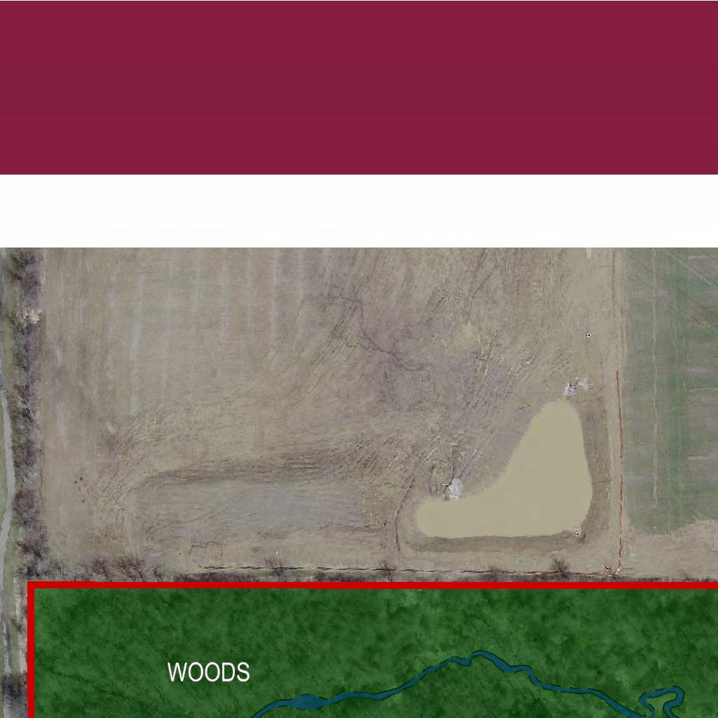
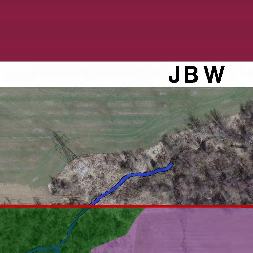
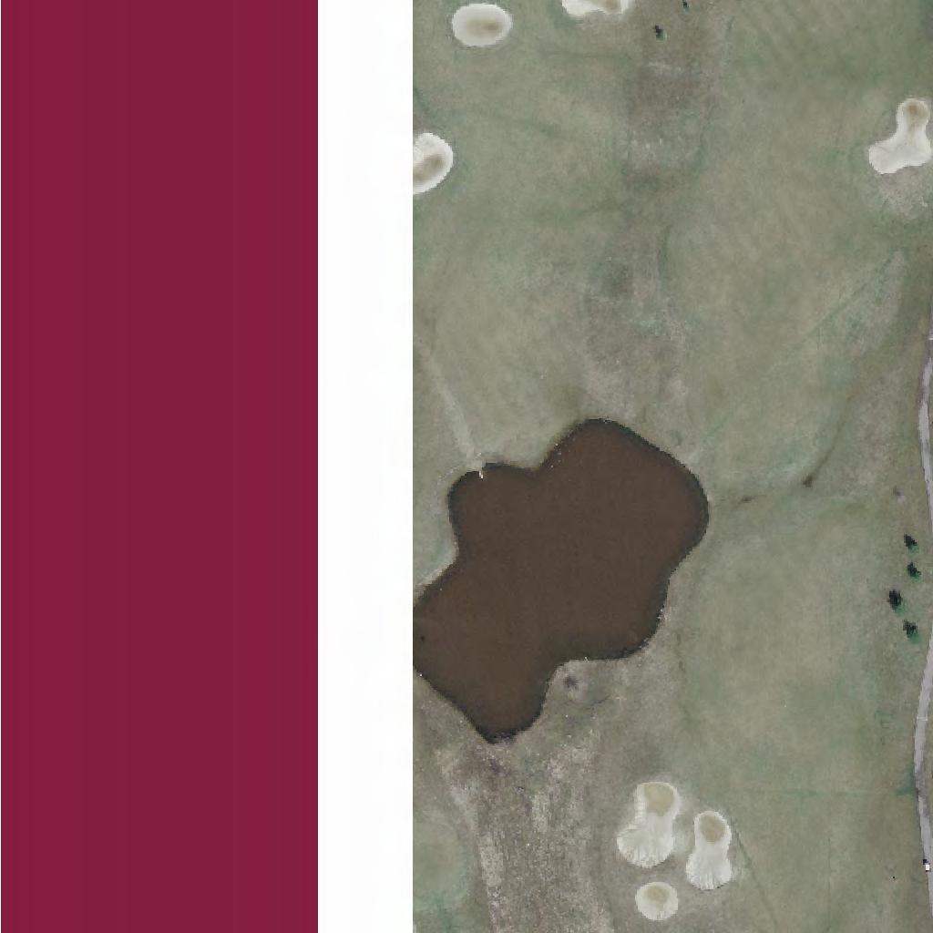
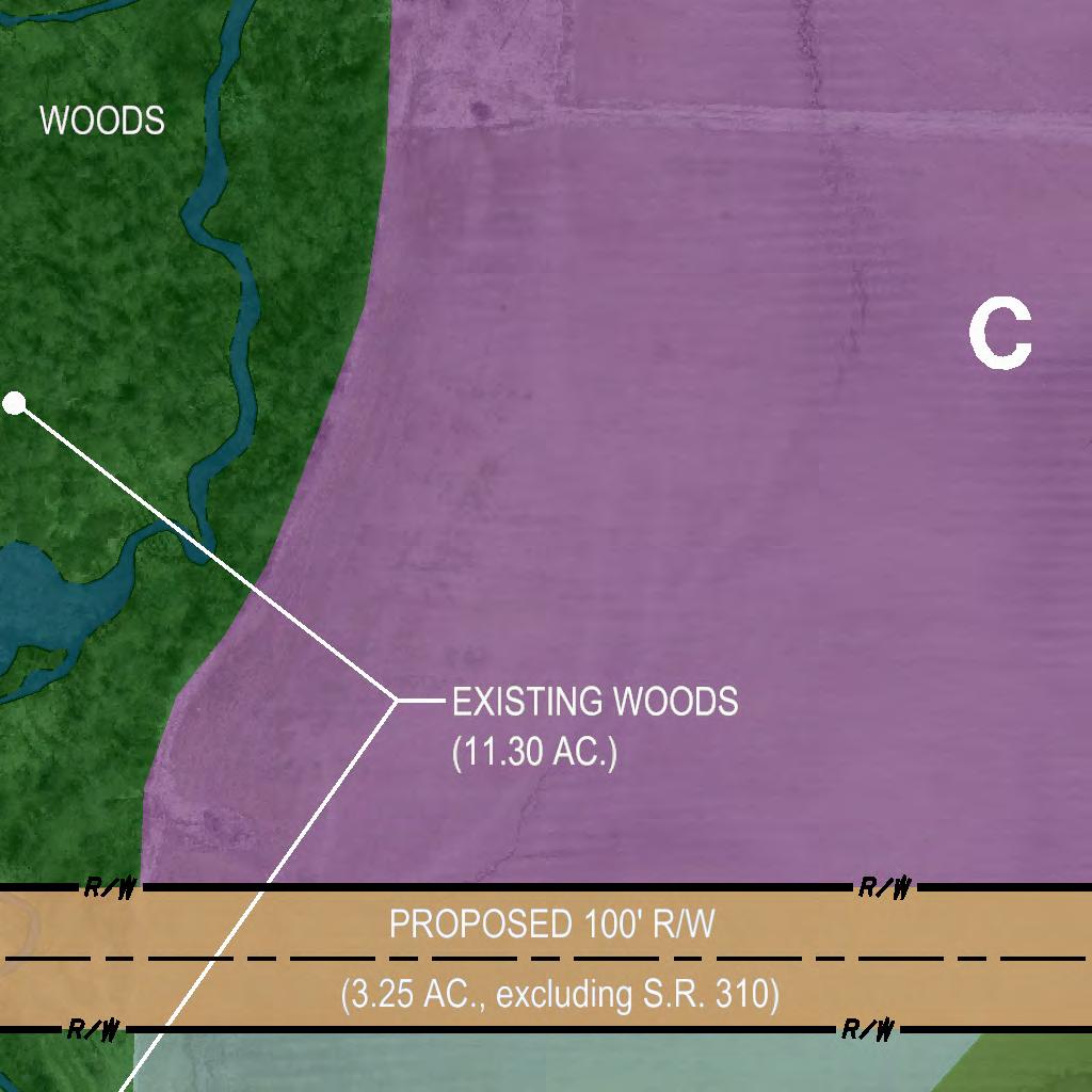
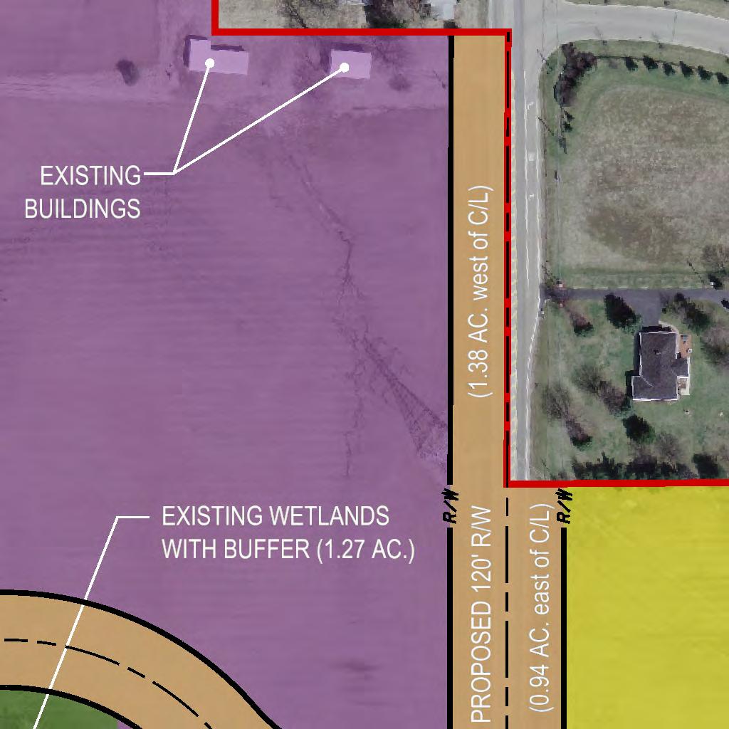
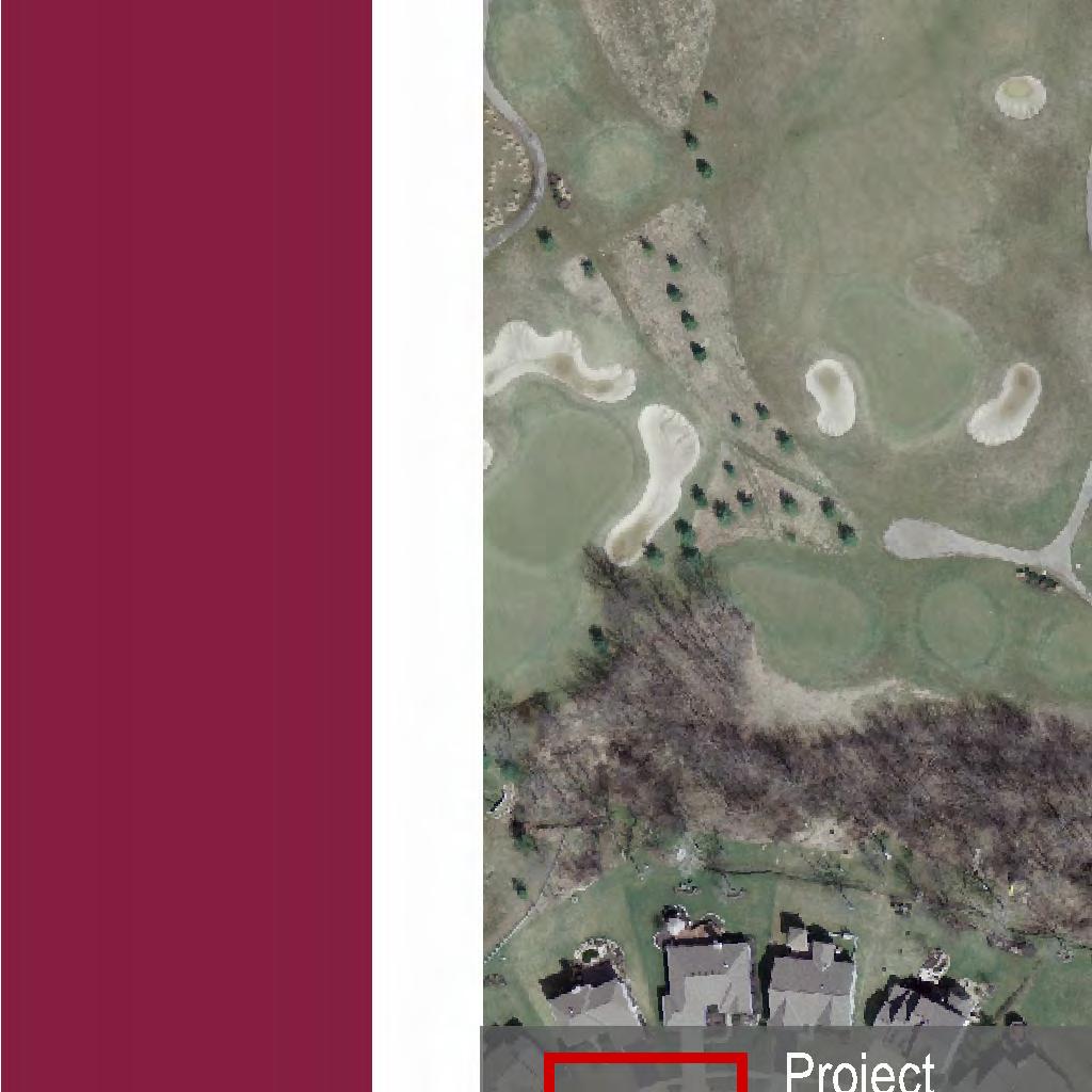
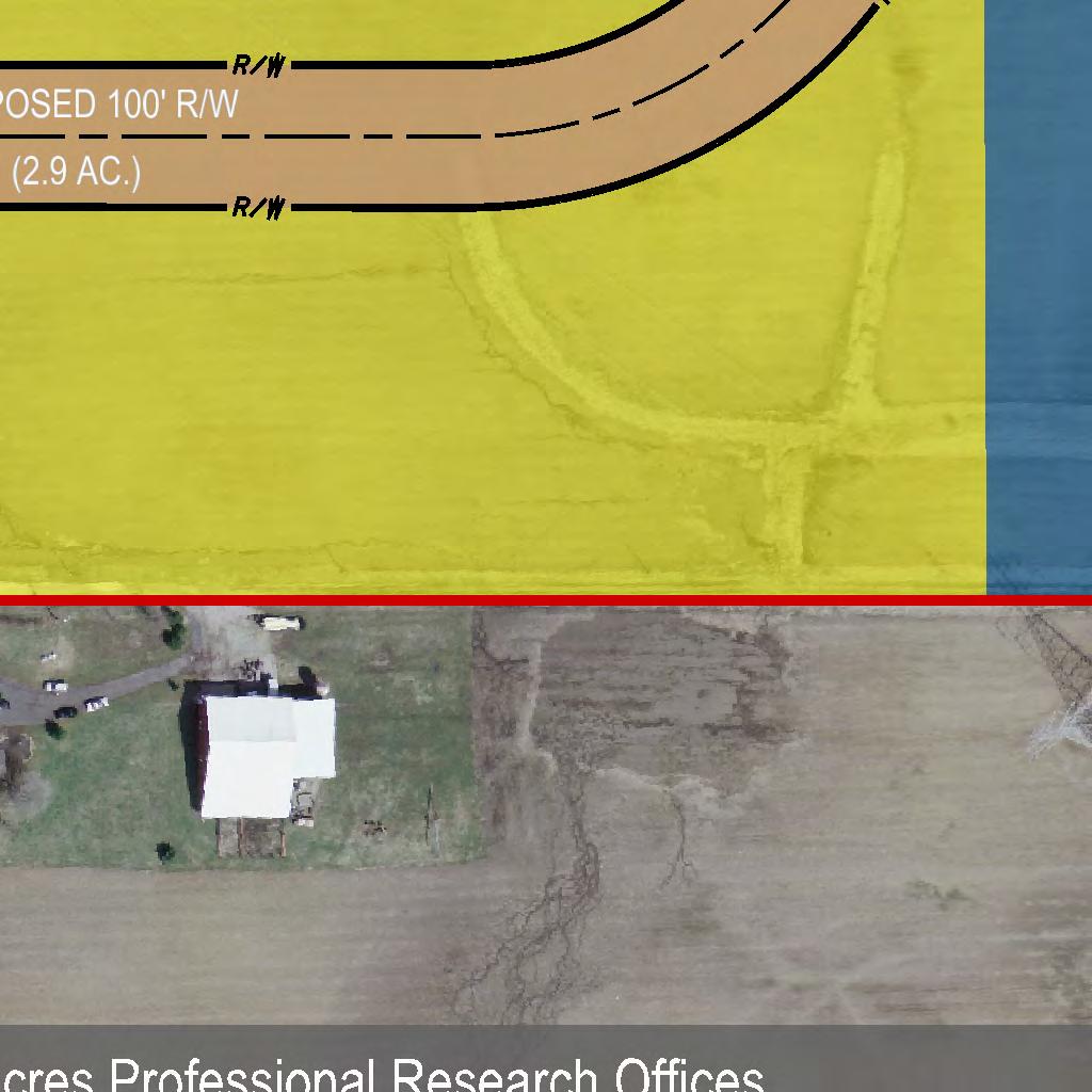
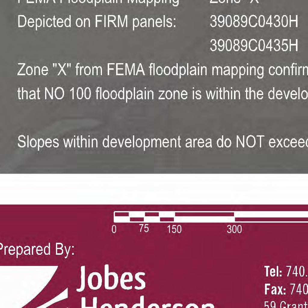
1 PLANNED MIXED-USE DEVELOPMENT DISTRICT ( PMUD ) ZONING TEXT AMENDMENT Upon final approval of this PMUD zoning text amendment, development of the herein described property shall remain in strict compliance with a Final Development Plan, as hereafter approved or modified in accordance with sub-section 1903(D)(5) of the Etna Township Zoning Resolution ( Resolution ) and all general non-district regulations/standards in the Resolution shall apply to this PMUD unless they conflict with this PMUD, at which time all conflicting general non-district regulations/standards in this PMUD shall take precedence. THE FOLLOWING TEXT AMENDMENT CONTAINS ZONING REQUIREMENTS FOR THE TOTAL ACREAGE (DEFINED BELOW): TOTAL ACREAGE INFORMATION: Size & Location of the PMUD District: The subject property is located on the east and west side of Hazelton-Etna Road ( SR310 ) in the northern area of Etna Township and consists of three parcels with the following approximate acreage: > West Side of SR310 Parcel No : acres; Parcel No : acres: Total acres: acres; and > East Side of SR310 Parcel No : acres. TOTAL ACREAGE acres. (Legal Description is in the deed recorded at Instrument No Licking County, Ohio Recorder s Office) USE OF ENVIRONMENTALLY SENSITIVE AREAS: The west acreage has a wooded area that extends from the south border to the north border of the west acreage that is approximately 11.3 acres (net of a roadway) ( Woods ). A stream flows through the Woods ( Stream ). The west acreage has a wetland that is approximately 1.3 acres ( Wetland ). Any environmentally sensitive areas identified when the Final Development Plan is prepared shall be accommodated in accordance with Article 19 of the Resolution (the PMUD). The Woods and Stream and Wetland will be preserved and dedicated for Natural Open Space except area occupied by a roadway that will pass through/over the Woods/Stream. (As defined in the Resolution: Natural Open Space: Land set aside in its natural condition. Typical natural conditions might be, but are not limited to ravines, wetlands, floodplains, woods, tree rows, stream corridors, scenic views, or agricultural elements such as fence rows.) None of the Total Acreage is located in the FEMA 100 year flood plain. None of the Total Acreage has slopes greater than twenty (20) percent. 1
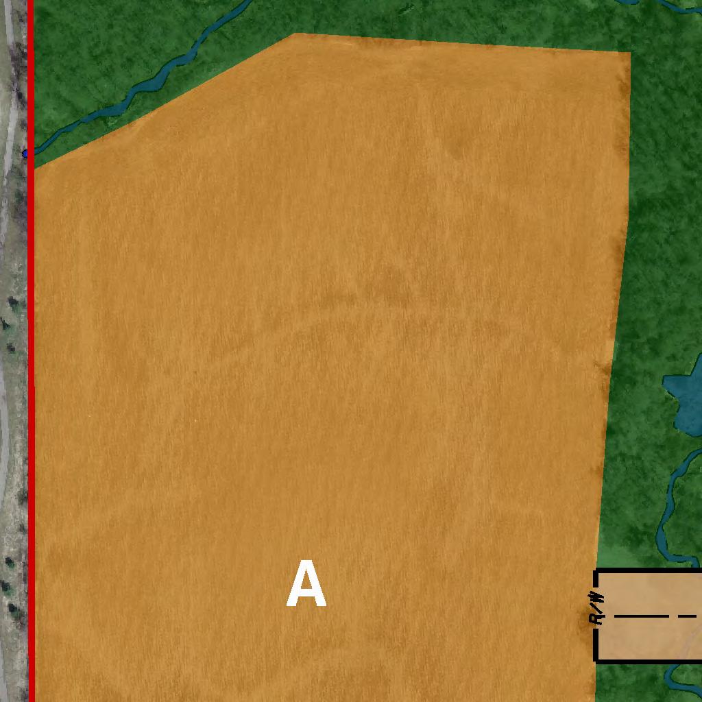
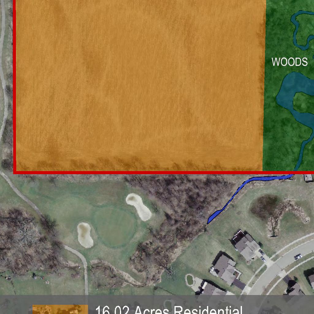
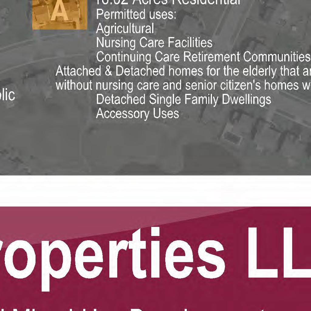
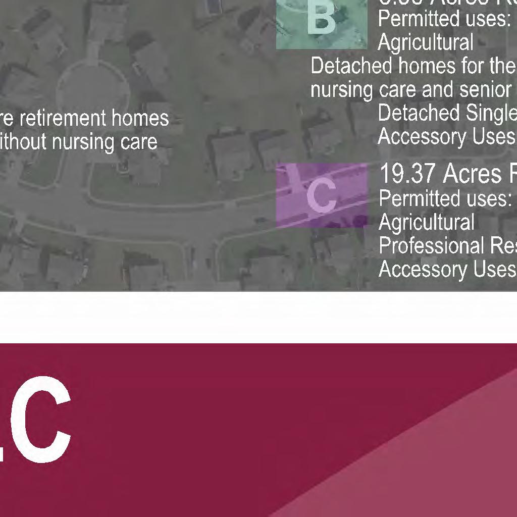
2 LAND USES AND DENSITY: (For clarification: >The requirements and regulations delineated herein are applicable to all uses unless indentified as being applicable to a specific use. > the following densities represent the maximum densities permitted in each land use area for residential uses which include attached and detached homes for the elderly (NAICS CODE ) that are retirement homes without nursing care and senior citizen s homes without nursing care, and detached single family dwellings. In referencing residential uses, the words homes, dwellings, structures, and units shall be used interchangeably. WEST SIDE: The West Side shall be divided as follows into separate use and restrictive areas for zoning purposes: ( A ) Approximately 16.0 acres located on the west beginning on the west property line of the West Side surrounded on the north and east by the Woods and Stream: PERMITTED USES: agricultural uses permitted pursuant to Ohio Revised Code Section ; nursing care facilities (NAICS CODE ); continuing care retirement communities (NAICS CODE ); attached and detached homes for the elderly that are retirement homes without nursing care and senior citizen s homes without nursing care (NAICS CODE )(SEE *); detached single family dwellings; accessory uses (As defined in the Resolution: Accessory Use or Structure: A use or structure on the same lot with, and of a nature customarily incidental and subordinate to the principal use or structure.). * Attached and detached homes for the elderly that are retirement homes without nursing care and senior citizen s homes without nursing care (NAICS CODE ) as permitted herein, shall be developed in accordance with the definition of housing for older persons, as that term is defined under 42 USC 3607(b)(2)(C). Specifically, the development of Attached and detached homes for the elderly that are retirement homes without nursing care and senior citizen s homes without nursing care (NAICS CODE ) must: (1) Be intended and operated for occupancy by persons 55 years of age or older; and, a. At least eighty percent (80%) of the occupied units shall be occupied by at least one person who is 55 years of age or older; and, b. The housing facility or community publishes and adheres to policies and procedures that demonstrate the intent that the housing is in fact operated and for occupancy by persons 55 years of age or older; and, c. The housing facility or community complies with Title 24, Part 100, subpart e of the Code of Federal Regulations. On or before thirty (30) days after the final approval of this PMUD zoning text amendment, the owner of the West Side shall prepare and record a restrictive covenant stating that attached and detached homes for the elderly that are retirement homes 2
3 without nursing care and senior citizen s homes without nursing care are permitted to be developed in area A of the PMUD on the condition that they are developed in accordance with the PMUD zoning text and PMUD plan requirements applicable to attached and detached homes for the elderly that are retirement homes without nursing care and senior citizen s homes without nursing care, and that said development shall be developed under the regulations governing housing for older persons as that term is defined under the Fair Housing Act, as may be amended from time to time, under applicable federal and state regulations, and that said regulations shall be enforced by the developer, the owners association, such other organization formed for the management of the community, or by the unit owners as tenants in common under a condominium plan. Said restriction shall also provide that said restriction shall run with the land until and unless the PMUD zoning text is amended to permit otherwise in accordance with the requirements of the Etna Township Zoning Resolution. RESIDENTIAL DENSITY: > applicable to: attached and detached homes for the elderly (NAICS CODE ) that are retirement homes without nursing care and senior citizen s homes without nursing care: Four (4) residential units per acre; no more than four (4) residential units may be attached. > Applicable to: detached single family dwellings: One (1) detached single family dwelling per acre. SQUARE FOOTAGE OF RESIDENTIAL UNITS: >Floor area of attached and detached homes for the elderly (NAICS CODE ) that are retirement homes without nursing care and senior citizen s homes without nursing care shall have a minimum floor area of one thousand (1000) square feet. >Floor area of each detached single family dwelling shall have a minimum floor area of eighteen hundred (1800) square feet. (Floor Area of a Residential Building: The sum of the gross horizontal area of the several floors of a residential building, excluding basement floor areas not devoted to residential use and the exterior areas of roofed porches and roofed terraces. All dimensions shall be measured between interior faces of walls.) DESIGN CRITERIA: (It is understood that the 16.0 acres may be developed with a single plan, or may be developed in parts with two or more plans and by two or more developers. Each plan for each development shall be referred to herein as a Development.) OPEN SPACE REQUIREMENTS FOR DEVELOPMENTS OF ATTACHED AND DETACHED HOMES FOR THE ELDERLY THAT ARE RETIREMENT HOMES WITHOUT NURSING CARE AND SENIOR CITIZEN S HOMES WITHOUT NURSING CARE AND DETACHED SINGLE FAMILY DWELLINGS: 3
4 In addition to any acreage of the Woods and Stream included in each Development, which provides a Natural Open Space, at least 10% of the gross developable acreage in each residential Development will be developed and used for Common Open Space (As defined in the Resolution: Common Open Space: Open space designed specifically to benefit the residents of a planned development through aesthetics, buffering, parks, recreation, entrance features, etc. Common Open Space is intended to be fully open and accessible by all residents of the planned development. Common Open Space can be improved or natural in character.) OWNERS ASSOCIATION: Prior to the sale, lease, or occupancy of any residential structure in a Development of which it is a part, the Natural Open Space and Common Open Space shall be conveyed to an owners association, to such other similar organization formed for the maintenance of the Development, or owned by unit owners as tenants in common under a condominium plan. The Natural Open Space and Common Open Space must be conveyed by covenants under such an arrangement subject to approval by the Zoning Commission. Such covenants shall restrict the Natural Open Space to a continuation of its natural condition and Common Open Space to the uses specified in the Final Development Plan and provide for maintenance of Common Open Space in a manner which insures it continuing use for its intended purpose. Membership in the owners association or such other similar organization, or ownership as a unit owner in a condominium shall, by deed restriction, be mandatory for any owner within each residential Development. >DEED RESTRICTIONS/COVENANTS: Deed restrictions and covenants must be provided by the applicant of each Final Development Plan associated with each residential Development and approved by the Zoning Commission to further regulate the intended use of these Natural Open Spaces and Common Open Spaces. Prior to the sale, lease, or occupancy of any residential structure in a Development of which it is a part, deed restrictions and covenants for said Development must be recorded. Such covenants shall restrict the Natural Open Spaces to their natural conditions and Common Open Spaces to the uses specified in each Final Development Plan and provide for the maintenance of the Common Open Spaces in a manner which assures their continuing use for their intended purposes regardless of ownership. The restrictions and covenants shall require the Common Open Spaces to remain accessible to all residents and guest of residents within each residential Development. >Attached and detached residential units will have access to Common Open Space in the Development of which they are a part either by sidewalks or walking trails. USE OF RESIDENTIALUNITS AS MODEL UNITS Model units, defined as residential units used as sales offices by builders/developers to display the builder/developer s product, are permitted subject to the following restrictions: 1. Lighting: All exterior lighting must be fully shielded down-lighting, so that no lighting shall be cast onto adjoining residential units that is not otherwise permitted in this text. Off street parking areas must be illuminated. All exterior lighting, except for security lighting, shall be extinguished at the closing time of the model home. 4
5 2. Parking: Each model unit shall provide two (2) off street parking spaces in close proximity to the model unit to be used by the public. A driveway serving the model unit may be used for two (2) parking spaces. 3. Screening: Landscaping for a model unit shall be approved by the Township and installed prior to the use of a model unit. 4. Model Unit Sign: Etna Township may approve one (1) model unit sign provided the following conditions are met: a) The sign shall not exceed sixteen (16) square feet per side with thirty-two (32) square feet maximum total display area; b) The overall height of the sign shall be no more than four (4) feet above grade; c) The model unit sign shall be located in the model unit s yard area; d) The model unit sign must be removed when the model unit is discontinued as a sales office. STREET TREES REQUIRED IN ALL DEVELOPMENTS/USES THAT HAVE PRIVATE STREETS: Deciduous, broad leaf street trees with a minimum caliper of three (3) inches at planting, shall be placed one (1) for every fifty (50) foot of lineal private road frontage on at least one side of the street. Such street trees shall be selected from the Licking County Subdivision Regulations at Appendix XXVI, List of Acceptable Street Trees. STREET LIGHTING REQUIRED IN ALL DEVELOPMENTS/USES THAT HAVE PRIVATE STREETS: All private streets shall require lighting that is uniform in each Development and must be of white light, maximum height of twenty (20) feet, placed in equal lineal distances along the private road frontage with fully shielded downward cast lighting. REQUIREMENT IN ALL DEVELOPMENTS/USES THAT HAVE PRIVATE STREETS: Private streets in a Development shall interconnect and provide at least one (1) access point to a public street. The Final Development Plan shall provide that construction of private streets shall be in accordance with the following requirements: (i) the minimum width of the right of way and street pavement shall not interfere on availability for utilities and safety for pedestrian and vehicular traffic, (ii) the pavement thickness and material used shall be constructed in accordance with the Licking County Subdivision Regulations for public streets, and (iii) an owners association, other such similar organization formed for the maintenance of the Development, or the unit owners association of a condominium shall be required to own, maintain, and repair said private streets. PEDESTRIAN CIRCULATION SYSTEM REQUIRED FOR ALL DEVELOPMENTS/USES: 5
6 A pedestrian circulation system will be designed/constructed to provide a bike and walking path interior to each Development and shall provide connections to contiguous pedestrian circulation systems with a minimum width of 5 surfaced with asphalt or such other hard surface as approved by Etna Township. Sidewalks that interconnect with the bike and walking path circulation system shall be extended to residential units not directly accessed by a bike and/or walking path. EXTERIOR DESIGN STANDARDS/REQUIREMENTS FOR ALL DEVELOPMENTS/USES: All structures will have an exterior design consistent with the exterior design of other structures in the Development of which they are a part. The exterior design of structures in each Development shall give due regard to the footprints, building orientation, massing, roof shape, pitch and exterior materials to blend with other architectures in the community. Deed restrictions, recorded prior to the construction of any structure in a Development, shall require that the exterior of all structures shall be finished with one or more of the following materials: brick, stone (or fabricated stone finish products), stucco, wood, hardiplank siding (or similar product). Vinyl siding is not permitted but vinyl products can be used for soffit purposes and such other exterior finishes. BUFFERING: Buffering shall be required as provided in Article16 of the Resolution. LOT SIZES, SETBACKS AND YARDS FOR ALL DEVELOPMENTS/USES: >Setbacks: All structures shall be setback forty (40) feet from the edge of pavement on private streets, and forty (40) feet from the street right of way on public streets. No structure shall be closer than fifteen (15) feet from a side or rear property line. >Minimum side, rear, internal yards for attached and detached homes for the elderly: (1) No multi-family structure or single family detached unit shall be closer than thirty (30) feet to another multi-family structure or single family detached unit or fifteen (15) feet from a side or rear property line; >Lot sizes for detached single family dwellings and non-residential structures: Every lot shall have a minimum width of one hundred (100) feet and a minimum lot area of not less than one (1) acre (43,560 square feet) exclusive of road right-of-way, and shall be in addition to any easement of record. HEIGHT FOR ALL DEVELOPMENTS/USES: No structure shall exceed thirty-five (35) feet in height. (As defined in the Resolution: Building, Height: The vertical distance measured from the average elevation of the proposed finished grade at the front of the building to the highest point of the roof for flat roofs, to the deck line of mansard roofs, and the mean height between eaves and ridge for gable, hip or gambrel roofs.) 6
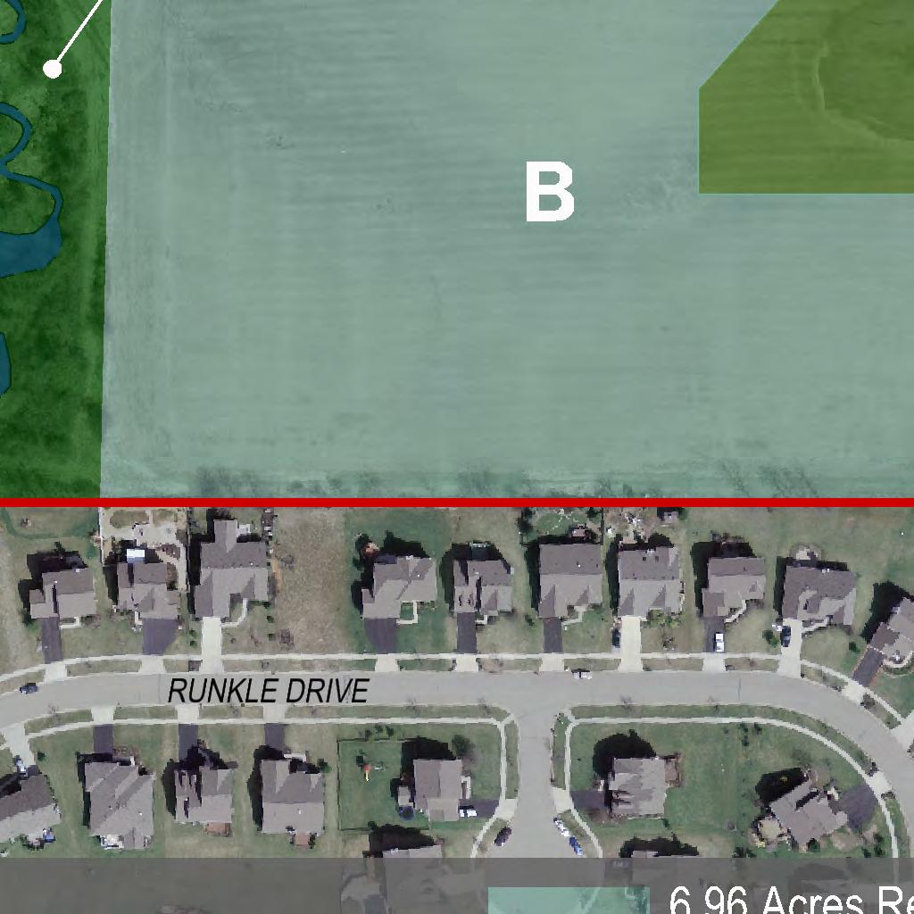
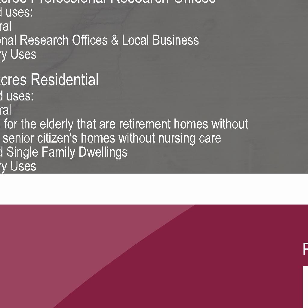
7 PARKING REGULATIONS FOR ALL DEVELOPMENTS/USES: At the time of construction of any improvement in a Development, off-street parking shall be provided with adequate provisions for ingress and egress. Parking requirements for permanent parking in all Developments shall be as regulated in Article 11 of the Resolution. LANDSCAPING FOR ALL DEVELOPMENTS/USES: Yards and all improved spaces and non-residential use areas shall be landscaped in accordance with a landscape plan showing the caliper, height, numbers, name and placement of all material, and shall be approved as part of the Final Development Plan for each Development. In the event that Etna Township has adopted regulations governing landscaping in its Resolution, then said landscape plan shall be in accordance therewith. UTILITIES: Centralized water and sanitary sewer service is available and shall be extended/constructed in each Development as required by Southwest Licking Community Water Sewer District, its successors and assigns. All fire and emergency provisions required by West Licking Joint Fire District shall be provided in each Development. All local service lines for electric, cable, internet or any other utility service provided shall be buried underground. High voltage overhead electric transmission lines are not considered local service lines for the purpose of this text. ( B ) Approximately 7.0 Acres located at the south border of the west acreage contiguous to home sites in Cumberland Trail and bordered on its west side by the Woods and Stream, and on its northeast corner by the Wetland: PERMITTED USES: agricultural uses permitted pursuant to Ohio Revised Code Section , detached homes for the elderly that are retirement homes without nursing care and senior citizen s homes without nursing care (NAICS CODE )(SEE *); detached single family dwellings; accessory uses (As defined in the Resolution: Accessory Use or Structure: A use or structure on the same lot with, and of a nature customarily incidental and subordinate to the principal use or structure.) * Attached and detached homes for the elderly that are retirement homes without nursing care and senior citizen s homes without nursing care (NAICS CODE ) as permitted herein, shall be developed in accordance with the definition of housing for older persons, as that term is defined under 42 USC 3607(b)(2)(C). Specifically, the development of Attached and detached homes for the elderly that are retirement homes without nursing care and senior citizen s homes without nursing care (NAICS CODE ) must: (1) Be intended and operated for occupancy by persons 55 years of age or older; and, 7
8 a. At least eighty percent (80%) of the occupied units shall be occupied by at least one person who is 55 years of age or older; and, b. The housing facility or community publishes and adheres to policies and procedures that demonstrate the intent that the housing is in fact operated and for occupancy by persons 55 years of age or older; and, c. The housing facility or community complies with Title 24, Part 100, subpart e of the Code of Federal Regulations. On or before thirty (30) days after the final approval of this PMUD zoning text amendment, the owner of the West Side shall prepare and record a restrictive covenant stating that detached homes for the elderly that are retirement homes without nursing care and senior citizen s homes without nursing care are permitted to be developed in area B of the PMUD on the condition that they are developed in accordance with the PMUD zoning text and PMUD plan requirements applicable to detached homes for the elderly that are retirement homes without nursing care and senior citizen s homes without nursing care, and that said development shall be developed under the regulations governing housing for older persons as that term is defined under the Fair Housing Act, as may be amended from time to time, under applicable federal and state regulations, and that said regulations shall be enforced by the developer, the owners association, such other organization formed for the management of the community, or by the unit owners as tenants in common under a condominium plan. Said restriction shall also provide that said restriction shall run with the land until and unless the PMUD zoning text is amended to permit otherwise in accordance with the requirements of the Etna Township Zoning Resolution. RESIDENTIAL DENSITY: > applicable to: detached homes for the elderly (NAICS CODE ) that are retirement homes without nursing care and senior citizen s homes without nursing care: Four (4) residential units per acre; > Applicable to: detached single family dwellings: One (1) detached single family dwelling per acre. SQUARE FOOTAGE OF RESIDENTIAL UNITS >Floor area of detached homes for the elderly (NAICS CODE ) that are retirement homes without nursing care and senior citizen s homes without nursing care shall have a minimum floor area of twelve hundred (1200) square feet. >Floor area of each detached single family dwelling shall have a minimum floor area of eighteen hundred (1800) square feet. (Floor Area of a Residential Building: The sum of the gross horizontal area of the several floors of a residential building, excluding basement floor areas not devoted to residential use and the exterior areas of roofed porches and roofed terraces. All dimensions shall be measured between interior faces of walls.) DESIGN CRITERIA: (It is understood that the 7.0 acres will be developed with a single plan which shall be referred to herein as the Development.) 8
9 OPEN SPACE REQUIREMENTS FOR DEVELOPMENTS OF DETACHED HOMES FOR THE ELDERLY THAT ARE RETIREMENT HOMES WITHOUT NURSING CARE AND SENIOR CITIZEN S HOMES WITHOUT NURSING CARE AND DETACHED SINGLE FAMILY DWELLINGS: In addition to any acreage of the Woods and Stream included in each Development, which provides a Natural Open Space, at least 10% of the gross developable acreage in the residential Development will be developed and used for Common Open Space (As defined in the Resolution: Common Open Space: Open space designed specifically to benefit the residents of a planned development through aesthetics, buffering, parks, recreation, entrance features, etc. Common Open Space is intended to be fully open and accessible by all residents of the planned development. Common Open Space can be improved or natural in character.) OWNERS ASSOCIATION: Prior to the sale, lease, or occupancy of any residential structure in the Development, the Natural Open Space and Common Open Space shall be conveyed to an owners association, to such other similar organization formed for the maintenance of the Development, or owned by unit owners as tenants in common under a condominium plan. The Natural Open Space and Common Open Space must be conveyed by covenants under such an arrangement subject to approval by the Zoning Commission. Such covenants shall restrict the Natural Open Space to a continuation of its natural condition and Common Open Space to the uses specified in the Final Development Plan and provide for maintenance of Common Open Space in a manner which insures it continuing use for its intended purpose. Membership in the owners association or such other similar organization, or ownership as a unit owner in a condominium shall, by deed restriction, be mandatory for any owner within the Development. >DEED RESTRICTIONS/COVENANTS: Deed restrictions and covenants must be provided by the applicant of the Final Development Plan and approved by the Zoning Commission to further regulate the intended use of these Natural Open Spaces and Common Open Spaces. Prior to the sale, lease, or occupancy of any residential structure in the Development, deed restrictions and covenants for the Development must be recorded. Such covenants shall restrict the Natural Open Spaces to their natural conditions and Common Open Spaces to the uses specified in the Final Development Plan and provide for the maintenance of the Common Open Spaces in a manner which assures their continuing use for their intended purposes regardless of ownership. The restrictions and covenants shall require the Common Open Spaces to remain accessible to all residents and guest of residents within the Development. >Each residential unit will have access to Common Open Space in the Development either by sidewalks or walking trails. USE OF RESIDENTIAL UNITS AS MODEL UNITS Model units, defined as residential units used as sales offices by builders/developers to display the builder/developer s product, are permitted subject to the following restrictions: 9
10 1. Lighting: All exterior lighting must be fully shielded down-lighting, so that no lighting shall be cast onto adjoining residential units that is not otherwise permitted in this text. Off street parking areas must be illuminated. All exterior lighting, except for security lighting, shall be extinguished at the closing time of the model home. 2. Parking: Each model unit shall provide two (2) off street parking spaces in close proximity to the model unit to be used by the public. A driveway serving the model unit may be used for two (2) parking spaces. 3. Screening: Landscaping for a model unit shall be approved by the Township and installed prior to the use of a model unit. 4. Model Unit Sign: Etna Township may approve one (1) model unit sign provided the following conditions are met: a) The sign shall not exceed sixteen (16) square feet per side with thirty-two (32) square feet maximum total display area; b) The overall height of the sign shall be no more than four (4) feet above grade; c) The model unit sign shall be located in the model unit s yard area; d) The model unit sign must be removed when the model unit is discontinued as a sales office. STREET TREES REQUIRED IN THE DEVELOPMENT ALONG PRIVATE STREETS: Deciduous, broad leaf street trees with a minimum caliper of three (3) inches at planting, shall be placed one (1) for every fifty (50) foot of lineal private road frontage on at least one side of the street. Such street trees shall be selected from the Licking County Subdivision Regulations at Appendix XXVI, List of Acceptable Street Trees. STREET LIGHTING REQUIRED IN THE DEVELOPMENT ALONG PRIVATE STREETS: All private streets shall require lighting that is uniform in the Development and must be of white light. Said lighting shall require matching exterior lighting fixtures placed on matching decorative posts along private streets at fifty-foot intervals on the opposite side of the road from the required trees. REQUIREMENT IN THE DEVELOPMENT REGARDING PRIVATE STREETS: Private streets in the Development shall interconnect and provide at least one (1) access point to a public street. The Final Development Plan shall provide that construction of private streets shall be in accordance with the following requirements: (i) the minimum width of the right of way and street pavement shall not interfere on availability for utilities and safety for pedestrian and vehicular traffic, (ii) the pavement thickness and material used shall be constructed in accordance with the Licking County Subdivision Regulations for public streets, and (iii) an owners association, other such similar organization formed for the maintenance of the Development, or the unit owners 10
11 association of a condominium shall be required to own, maintain, and repair said private streets. No vehicle access will be extended from the Development to Cumberland Trail. PEDESTRIAN CIRCULATION SYSTEM REQUIRED FOR THE DEVELOPMENT: A pedestrian circulation system will be designed/constructed to provide a bike and walking path interior to the Development and shall provide connections to contiguous pedestrian circulation systems with a minimum width of 5 surfaced with asphalt or such other hard surface as approved by Etna Township. Sidewalks that interconnect with the bike and walking path circulation system shall be extended to residential units not directly accessed by a bike and/or walking path. EXTERIOR DESIGN STANDARDS/REQUIREMENTS FOR THE DEVELOPMENT: All structures will have an exterior design consistent with the exterior design of other structures in the Development. The exterior design of structures the Development shall give due regard to the footprints, building orientation, massing, roof shape, pitch and exterior materials to blend with other architectures in the community. Deed restrictions, recorded prior to the construction of any structure in the Development shall require that the exterior of all structures shall be finished with one or more of the following materials: brick, stone (or fabricated stone finish products), stucco, wood, hardiplank siding (or similar product). Vinyl siding is not permitted but vinyl products can be used for soffit purposes and such other exterior finishes. BUFFERING: Buffering shall be required as provided in Article16 of the Resolution. LOT SIZES, SETBACKS AND YARDS: >Setbacks: All structures shall be setback forty (40) feet from the edge of pavement on private streets, and forty (40) feet from the street right of way on public streets. No structure shall be closer than fifteen (15) feet from a side or rear property line. >Minimum side, rear, internal yards for detached homes for the elderly: (1) No detached single family unit shall be closer than thirty (30) feet to another detached single family unit or fifteen (15) feet from a side or rear property line; >Lot sizes for detached single family dwellings: Every lot shall have a minimum width of one hundred (100) feet and a minimum lot area of not less than one (1) acre (43,560 square feet) exclusive of road right-of-way, and shall be in addition to any easement of record. HEIGHT FOR THE DEVELOPMENT: No structure shall exceed thirty-five (35) feet in height. (As defined in the Resolution: Building, Height: The vertical distance measured from the average elevation of the proposed 11
12 finished grade at the front of the building to the highest point of the roof for flat roofs, to the deck line of mansard roofs, and the mean height between eaves and ridge for gable, hip or gambrel roofs.) PARKING REGULATIONS FOR THE DEVELOPMENT: At the time of construction of any improvement in the Development, off-street parking shall be provided with adequate provisions for ingress and egress. Parking requirements for permanent parking in the Development shall be as regulated in Article 12 of the Resolution. LANDSCAPING FOR THE DEVELOPMENT: Yards and all improved spaces shall be landscaped in accordance with a landscape plan showing the caliper, height, numbers, name and placement of all material, and shall be approved as part of the Final Development Plan for the Development. In the event that Etna Township has adopted regulations governing landscaping in its Resolution, then said landscape plan shall be in accordance therewith. UTILITIES: Centralized water and sanitary sewer service is available and shall be extended/constructed in the Development as required by Southwest Licking Community Water Sewer District, its successors and assigns. All fire and emergency provisions required by West Licking Joint Fire District shall be provided in each Development. All local service lines for electric, cable, internet or any other utility service provided shall be buried underground. High voltage overhead electric transmission lines are not considered local service lines for the purpose of this text. ( C ) Approximately 19.3 acres located at the northeast side of the west acreage and bordering SR310: PERMITTED USES &PROHIBITED USES: Permitted: agricultural uses permitted pursuant to Ohio Revised Code Section , retail, professional, and business uses as permitted in Article 9, Section 910 (Professional-Research-Office District) and Section 911 (Local Business District) of the Resolution, accessory uses (As defined in the Resolution: Accessory Use or Structure: A use or structure on the same lot with, and of a nature customarily incidental and subordinate to the principal use or structure.) Prohibited: automobile driving schools (NAICS Code ), car washes (NAICS Code ), landscaping services (NAICS Code ), and elementary and secondary schools (NAICS Code ). CONDITIONAL USES: uses permitted as conditional uses in Article 9, Section 910 (Professional-Research-Office District) and Section 911 (Local Business District) of the Resolution 12
13 MAXIMUM SQUARE FOOTAGE: Buildings used for permitted uses under Retail Trade in Section 911 (Local Business District) of the Resolution shall contain no more than 16,250 gross square feet of floor area per building. DESIGN CRITERIA: (Whether designed by a single plan or multiple plans, the 19.3 acres shall be referred to as the Development ). SETBACK AT SR310 SETBACK AT SR310: A 150 setback from the right-of- way shall be maintained along SR310 and shall be improved with a bike and walking path providing connections to contiguous circulation systems in the West Side Developments with a minimum width of 5 surfaced with asphalt or such other hard surface as approved by Etna Township. BUILDING & IMPROVEMENT FACADES: All buildings located next to SR310 (those buildings that are the first buildings west of SR310 along its corridor) shall have a façade that faces SR310. All other buildings shall have facades that face the location of the pedestrian s main access/entry thereto. Pedestrian access shall be permitted on all sides of the building including at the façade. Service/delivery entries shall be on the west, south or north side of all buildings. SERVICE STRUCTURES & SCREENING No utilities, dumpsters, mechanicals or other service structures may be placed in front of the building façade unless existing prior to construction or required by applicable regulations. Service structures shall be screened. Service structures shall include but not be limited to loading docks, storage tanks, dumpsters, electrical transformers, utility vaults which extend above the surface, cooling towers, roof top units and other equipment or elements providing service to a building or a site. Service structures may be grouped together; however, screening height shall be based upon the tallest of the structures. Roof top mechanical units must be screened to the full height of the unit. SCREENING OF SERVICE STRUCTURES: A continuous (having 100 percent opacity) planting, hedge, fence, wall of earth, which would enclose any service structure on all sides is required, unless such structure must be frequently moved, in which case screening on all but one side is required. The height of the screening material shall be one foot more than the height of the enclosed structure, but shall not be required to exceed 12 feet in height. Whenever a service structure is located next to a building wall, perimeter landscaping material or vehicular use area landscaping material, such walls or screening material, may fulfill the screening requirement for that side of the service structure if that wall or screening material is of sufficient height to meet the height requirement set out in this section. Plant material used to screen a service structure shall be an evergreen species which retains its needles throughout the year. Deciduous plant material cannot be used to 13
14 fulfill this screening requirement. The height of the evergreen plant material at installation must be equal to, or greater than, two-thirds of the height of the service structure(s), and meet the height and opacity requirements within four years. No interior landscaping shall be required within an area screened for service structures. Whenever screening material is placed around any trash disposal unit or waste collection unit which is emptied or removed mechanically on a regularly occurring basis, a curb to contain the placement of the container shall be provided within the screening material on these sides where there is such material. The curbing shall be at least one foot from the material and shall be designed to prevent possible damage to the screening when the container is moved or emptied. PARKING Parking shall not dominate the Development as viewed from SR310 and shall be located to the south, west or north side of structures that face SR310 unless permitted otherwise in accordance with the approved Final Development Plan. Shared parking in the Development is permitted. Parking and loading facilities shall be designed in accordance with Article 11 of the Resolution. At the time of construction of any improvement in the Development, off-street parking shall be provided with adequate provisions for ingress and egress. BUILDING DESIGN, SCALE & ACCESS Buildings shall have a neighborhood design, being human in scale, permitting and promoting pedestrian walking access by means of improved sidewalks and paths that connect to residential developments. A network of concrete sidewalks shall provide access to buildings in the Development. All sidewalks providing access to buildings in the Development shall have, or be connected to a sidewalk that has at least one access point to a paved walking/biking trail that extends to other paved walking/biking trails in the PMUD. In addition to sidewalks, a pedestrian circulation system will be designed/constructed to provide a bike and walking path interior to the Development and shall provide connections to contiguous circulation systems with a minimum width of 5 surfaced with asphalt or such other hard surface as approved by Etna Township. Each building shall be related to other buildings in the Development with respect to connections, building placement, landscaping, screening, and green space. Store windows and entries will face and be served by the pedestrian access-ways. All buildings in the Development will have a uniform exterior design. Deed restrictions shall be recorded that require that the exterior of all buildings shall be finished with one or more of the following materials: brick, stone (or fabricated stone finish products), stucco, wood, hardiplank siding (or similar product). Vinyl siding is not permitted but vinyl products can be used for soffit purposes and such other exterior finishes. HEIGHT LIMIT: No building shall be erected or enlarged to exceed two and one-half (2 ½) stories or thirty-five (35) feet. 14
15 LOT AREA, WIDTH & DEPTH: Every lot shall have minimum width of one hundred (100) feet and minimum lot area of not less than one-half (.5) acre (21,780 square feet) exclusive of public road right of way and shall be in addition to any easement of record. FRONT YARD: There shall be a front yard of not less than twelve (12) feet in depth. SIDE YARD: There shall be side yards of not less than twelve (12) feet on each side. REAR YARD: There shall be a rear yard of not less than twelve (12) feet in depth. STREET LIGHTING All access-ways that provide connection from the public access to and from each building or building cluster, and all bike and walking trails, shall require lighting that is uniform in the Development and must be of white light, maximum height of twenty (20) feet, placed in equal lineal distances along the private street, access-way, or walking and bike trail frontage with fully shielded downward cast lighting. Cross access easements will be established for said access-ways when needed. STREET TREES Deciduous, broad leaf street trees with a minimum caliper of three (3) inches at planting, shall be placed one (1) for every fifty (50) foot of lineal private street and access-way frontage on at least one side of the street or access-way. Such street trees shall be selected from the Licking County Subdivision Regulations at Appendix XXVI, List of Acceptable Street Trees. BUFFERING: Buffering shall be required as provided in Article16. SIGNAGE Signage shall be uniform in design in the Development and as regulated in Article 12 of the Resolution. LANDSCAPING All improved spaces that are not used for parking, access, or structures shall be landscaped in accordance with a landscape plan uniform for the Development showing the caliper, height, numbers, name and placement of all material, and shall be approved as part of the Final Development Plan for the Development. In the event that Etna Township has adopted regulations governing landscaping in its Resolution, then said landscape plan shall be in accordance therewith. 15
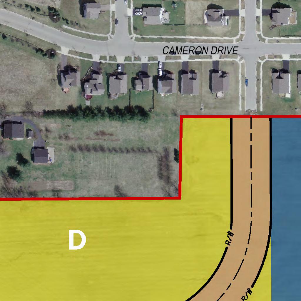
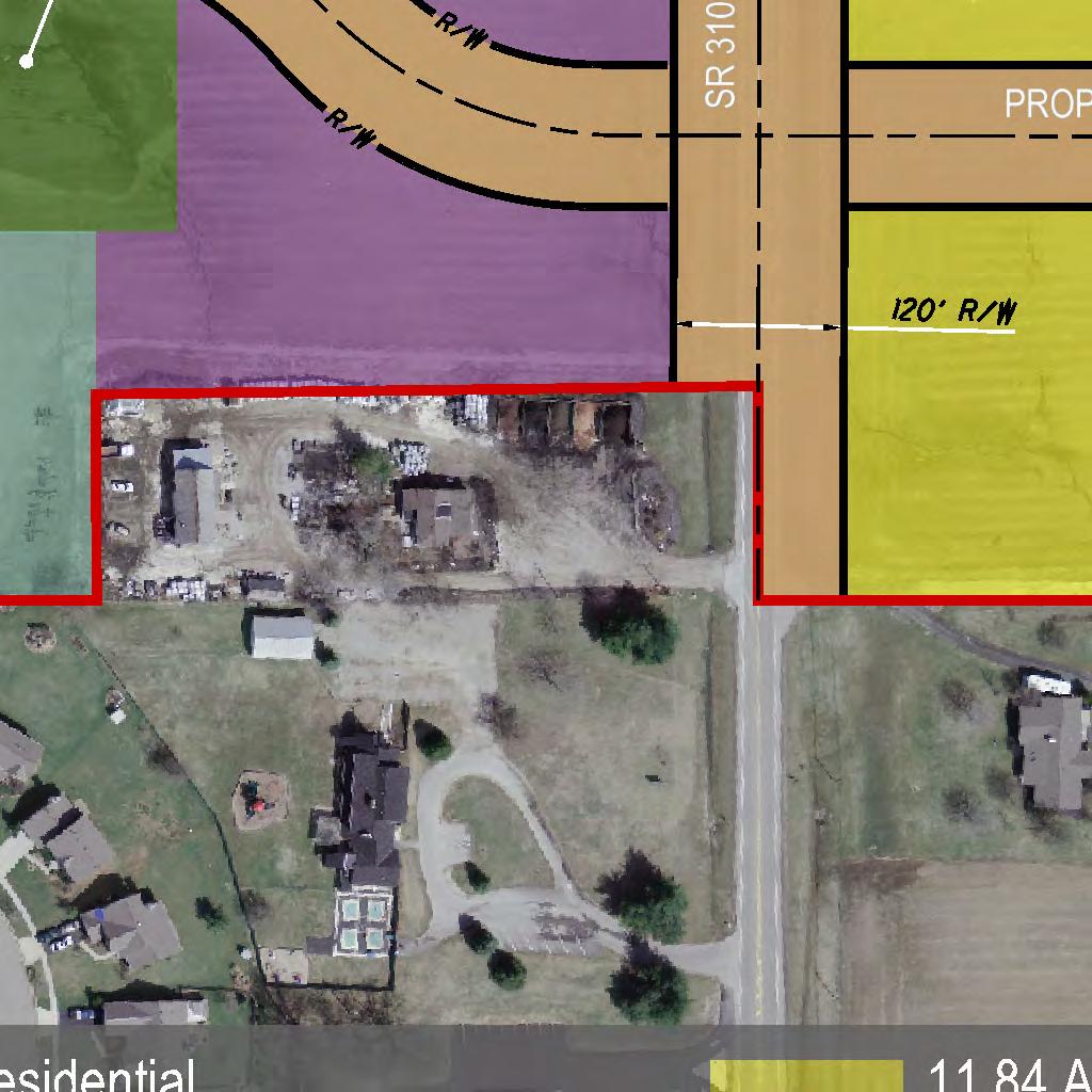
16 UTILITIES Centralized water and sanitary sewer service is available and shall be extended/constructed in the Development as required by Southwest Licking Community Water Sewer District, its successors and assigns. All fire and emergency provisions required by West Licking Joint Fire District shall be provided in each Development. All local service lines for electric, cable, internet or any other utility service provided shall be buried underground. High voltage overhead electric transmission lines are not considered local service lines for the purpose of this text. EAST SIDE: The East Side shall be divided as follows into separate use and restrictive areas for zoning purposes: ( D ) Approximately 11.9 acres located on the east side of SR310 fronting on SR310: PERMITTED USES: agricultural uses permitted pursuant to Ohio Revised Code Section , business and professional uses as permitted in Article 9, Section 910 (Professional-Research-Office District), and Section 911 (Local Business District) of the Resolution, accessory uses (As defined in the Resolution: Accessory Use or Structure: A use or structure on the same lot with, and of a nature customarily incidental and subordinate to the principal use or structure.) CONDITIONAL USES: uses permitted as conditional uses in Article 9, Section 910 (Professional-Research-Office District) and Section 911 (Local Business District) of the Resolution MAXIMUM SQUARE FOOTAGE: Buildings used for permitted uses under Retail Trade in Section 911 (Local Business District) of the Resolution shall contain no more than 16,250 gross square feet of floor area per building. DESIGN CRITERIA: (Whether designed by a single plan or multiple plans, the 11.9 acres shall be referred to as the Development ). SETBACK AT SR310 SETBACK AT SR310: A 150 setback from the right-of-way shall be maintained along SR310 and shall be improved with a bike and walking path providing connections to contiguous circulation systems with a minimum width of 5 surfaced with asphalt or such other hard surface as approved by Etna Township. OPEN SPACE 16
17 At least 30% of the gross developable acreage in the Development will be developed and used for Common Open Space (As defined in the Resolution: Common Open Space: Open space designed specifically to benefit the residents of a planned development through aesthetics, buffering, parks, recreation, entrance features, etc. Common Open Space is intended to be fully open and accessible by all residents of the planned development. Common Open Space can be improved or natural in character.) OWNERS ASSOCIATION: Prior to the sale, lease, or occupancy of any structure in the Development, the Common Open Space shall be conveyed to an owners association, to such other similar organization formed for the maintenance of the Development, or owned by unit owners as tenants in common under a condominium plan. The Common Open Space must be conveyed by covenants under such an arrangement subject to approval by the Zoning Commission. Such covenants shall restrict the Common Open Space to the uses specified in the Final Development Plan and provide for maintenance of Common Open Space in a manner which insures it continuing use for its intended purpose. Membership in the owners association or such other similar organization, or ownership as a unit owner in a condominium shall, by deed restriction, be mandatory for any owner within the each Development. DEED RESTRICTIONS/COVENANTS: Deed restrictions and covenants must be provided by the applicant of the Final Development Plan and approved by the Zoning Commission to further regulate the intended use of the Common Open Spaces. Prior to the sale, lease, or occupancy of any structure in the Development, deed restrictions and covenants for said Development must be recorded. Such covenants shall restrict Common Open Spaces to the uses specified in the Final Development Plan and provide for the maintenance of the Common Open Spaces in a manner which assures their continuing use for their intended purposes regardless of ownership. BUILDING & IMPROVEMENT FACADES: All buildings located next to SR310 (those buildings that are the first buildings east of SR310 along its corridor) shall have a façade that faces SR310. All other buildings shall have facades that face the location of the pedestrian s main access/entry thereto. Pedestrian access shall be permitted on all sides of the building including at the façade. Service/delivery entries shall be on the west, south or north side of all buildings. SERVICE STRUCTURES & SCREENING No utilities, dumpsters, mechanicals or other service structures may be placed in front of the building façade unless existing prior to construction or required by applicable regulations. Service structures shall be screened. Service structures shall include but not be limited to loading docks, storage tanks, dumpsters, electrical transformers, utility vaults which extend above the surface, cooling towers, roof top units and other equipment or elements providing service to a building or a site. Service structures may be grouped together; however, screening height shall be based upon the tallest of the structures. Roof top mechanical units must be screened to the full height of the unit. 17
18 SCREENING OF SERVICE STRUCTURES: A continuous (having 100 percent opacity) planting, hedge, fence, wall of earth, which would enclose any service structure on all sides is required, unless such structure must be frequently moved, in which case screening on all but one side is required. The height of the screening material shall be one foot more than the height of the enclosed structure, but shall not be required to exceed 12 feet in height. Whenever a service structure is located next to a building wall, perimeter landscaping material or vehicular use area landscaping material, such walls or screening material, may fulfill the screening requirement for that side of the service structure if that wall or screening material is of sufficient height to meet the height requirement set out in this section. Plant material used to screen a service structure shall be an evergreen species which retains its needles throughout the year. Deciduous plant material cannot be used to fulfill this screening requirement. The height of the evergreen plant material at installation must be equal to, or greater than, two-thirds of the height of the service structure(s), and meet the height and opacity requirements within four years. No interior landscaping shall be required within an area screened for service structures. Whenever screening material is placed around any trash disposal unit or waste collection unit which is emptied or removed mechanically on a regularly occurring basis, a curb to contain the placement of the container shall be provided within the screening material on these sides where there is such material. The curbing shall be at least one foot from the material and shall be designed to prevent possible damage to the screening when the container is moved or emptied. PARKING Parking shall not dominate the Development as viewed from SR310 and shall be located to the south, east or north side of structures that face SR310 unless permitted otherwise in accordance with the approved Final Development Plan. Shared parking in the Development is permitted. Parking and loading facilities shall be designed in accordance with Article 11 of the Resolution. At the time of construction of any improvement in the Development, off-street parking shall be provided with adequate provisions for ingress and egress. BUILDING DESIGN, SCALE & ACCESS Buildings shall have a neighborhood design, being human in scale, permitting and promoting pedestrian walking access by means of improved sidewalks and paths. A network of concrete sidewalks shall provide access to buildings in the Development. All sidewalks providing access to buildings in the Development shall have, or be connected to a sidewalk that has at least one access point to a paved walking/biking trail that extends to other paved walking/biking trails in the PMUD. In addition to sidewalks, a pedestrian circulation system will be designed/constructed to provide a bike and walking path interior to the Development and shall provide connections to contiguous circulation systems with a minimum width of 5 surfaced with asphalt or such other hard surface as approved by Etna Township. 18
19 Each building shall be related to other buildings in the Development with respect to connections, building placement, landscaping, screening, and green space. Store and office windows and entries will face and be served by the pedestrian access-ways. All buildings in the Development will have a uniform exterior design. Deed restrictions shall be recorded that require that the exterior of all buildings shall be finished with one or more of the following materials: brick, stone (or fabricated stone finish products), stucco, wood, hardiplank siding (or similar product). Vinyl siding is not permitted but vinyl products can be used for soffit purposes and such other exterior finishes. HEIGHT LIMIT: No building shall be erected or enlarged to exceed two and one-half (2 ½) stories or thirty-five (35) feet. LOT AREA, WIDTH & DEPTH: Every lot shall have minimum width of one hundred (100) feet and minimum lot area of not less than one-half (.5) acre (21,780 square feet) exclusive of public road right of way and shall be in addition to any easement of record. FRONT YARD: There shall be a front yard of not less than twelve (12) feet in depth. SIDE YARD: There shall be side yards of not less than twelve (12) feet on each side. REAR YARD: There shall be a rear yard of not less than twelve (12) feet in depth. STREET LIGHTING All access-ways that provide connection from the public access to and from each building or building cluster, and all walking and bike trails, shall require lighting that is uniform in the Development and must be of white light, maximum height of twenty (20) feet, placed in equal lineal distances along the private road frontage with fully shielded downward cast lighting. Cross access easements will be established for said access-ways when needed. STREET TREES Deciduous, broad leaf street trees with a minimum caliper of three (3) inches at planting, shall be placed one (1) for every fifty (50) foot of lineal private street and access-way frontage on at least one side of the street or access-way. Such street trees shall be selected from the Licking County Subdivision Regulations at Appendix XXVI, List of Acceptable Street Trees. BUFFERING: Buffering shall be required as provided in Article16. SIGNAGE 19
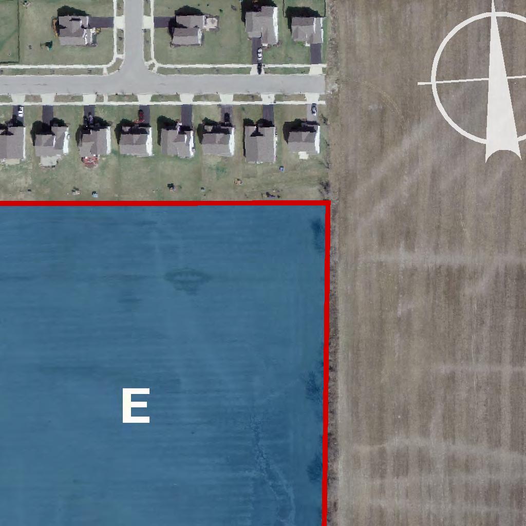
20 Signage shall be uniform in design in the Development and as regulated in Article 12 of the Resolution. LANDSCAPING All improved spaces that are not used for parking, access, or structures shall be landscaped in accordance with a landscape plan uniform for the Development showing the caliper, height, numbers, name and placement of all material, and shall be approved as part of the Final Development Plan for the Development. In the event that Etna Township has adopted regulations governing landscaping in its Resolution, then said landscape plan shall be in accordance therewith. UTILITIES Centralized water and sanitary sewer service is available and shall be extended/constructed in the Development as required by Southwest Licking Community Water Sewer District, its successors and assigns. All fire and emergency provisions required by West Licking Joint Fire District shall be provided in each Development. All local service lines for electric, cable, internet or any other utility service provided shall be buried underground. High voltage overhead electric transmission lines are not considered local service lines for the purpose of this text. ( E ) Approximately 11.3 acres located east of the 11.9 acres: PERMITTED USES: agricultural uses permitted pursuant to Ohio Revised Code Section , detached homes for the elderly that are retirement homes without nursing care and senior citizen s homes without nursing care (NAICS CODE )(SEE *); detached single family dwellings; accessory uses (As defined in the Resolution: Accessory Use or Structure: A use or structure on the same lot with, and of a nature customarily incidental and subordinate to the principal use or structure.) * Attached and detached homes for the elderly that are retirement homes without nursing care and senior citizen s homes without nursing care (NAICS CODE ) as permitted herein, shall be developed in accordance with the definition of housing for older persons, as that term is defined under 42 USC 3607(b)(2)(C). Specifically, the development of Attached and detached homes for the elderly that are retirement homes without nursing care and senior citizen s homes without nursing care (NAICS CODE ) must: (1) Be intended and operated for occupancy by persons 55 years of age or older; and, a. At least eighty percent (80%) of the occupied units shall be occupied by at least one person who is 55 years of age or older; and, 20
21 b. The housing facility or community publishes and adheres to policies and procedures that demonstrate the intent that the housing is in fact operated and for occupancy by persons 55 years of age or older; and, c. The housing facility or community complies with Title 24, Part 100, subpart e of the Code of Federal Regulations. On or before thirty (30) days after the final approval of this PMUD zoning text amendment, the owner of the East Side shall prepare and record a restrictive covenant stating that detached homes for the elderly that are retirement homes without nursing care and senior citizen s homes without nursing care are permitted to be developed in area E of the PMUD on the condition that they are developed in accordance with the PMUD zoning text and PMUD plan requirements applicable to detached homes for the elderly that are retirement homes without nursing care and senior citizen s homes without nursing care, and that said development shall be developed under the regulations governing housing for older persons as that term is defined under the Fair Housing Act, as may be amended from time to time, under applicable federal and state regulations, and that said regulations shall be enforced by the developer, the owners association, such other organization formed for the management of the community, or by the unit owners as tenants in common under a condominium plan. Said restriction shall also provide that said restriction shall run with the land until and unless the PMUD zoning text is amended to permit otherwise in accordance with the requirements of the Etna Township Zoning Resolution. RESIDENTIAL DENSITY: > applicable to: detached homes for the elderly (NAICS CODE ) that are retirement homes without nursing care and senior citizen s homes without nursing care: Four (4) residential units per acre; > applicable to: detached single family dwellings: One (1) detached single family dwelling per acre. SQUARE FOOTAGE OF RESIDENTIAL UNITS >Floor area of detached homes for the elderly (NAICS CODE ) that are retirement homes without nursing care and senior citizen s homes without nursing care shall have a minimum floor area of twelve hundred (1200) square feet. >Floor area of each detached single family dwelling shall have a minimum floor area of eighteen hundred (1800) square feet. Floor Area of a Residential Building: The sum of the gross horizontal area of the several floors of a residential building, excluding basement floor areas not devoted to residential use and the exterior areas of roofed porches and roofed terraces. All dimensions shall be measured between interior faces of walls.) DESIGN CRITERIA: (Whether designed by a single plan or multiple plans, the residential development shall be referred to as the Development ) OPEN SPACE 21
22 At least 30% of the gross developable acreage in the Development will be developed and used for Common Open Space (As defined in the Resolution: Common Open Space: Open space designed specifically to benefit the residents of a planned development through aesthetics, buffering, parks, recreation, entrance features, etc. Common Open Space is intended to be fully open and accessible by all residents of the planned development. Common Open Space can be improved or natural in character.) OWNERS ASSOCIATION: Prior to the sale, lease, or occupancy of any residential unit in the Development, the Common Open Space shall be conveyed to an owners association, to such other similar organization formed for the maintenance of the Development, or owned by unit owners as tenants in common under a condominium plan. The Common Open Space must be conveyed by covenants under such an arrangement subject to approval by the Zoning Commission. Such covenants shall restrict the Common Open Space to the uses specified in the Final Development Plan and provide for maintenance of Common Open Space in a manner which insures it continuing use for its intended purpose. Membership in the owners association or such other similar organization, or ownership as a unit owner in a condominium shall, by deed restriction, be mandatory for any owner within the Development. DEED RESTRICTIONS/COVENANTS: Deed restrictions and covenants must be provided by the applicant with the Final Development Plan associated with the residential Development and approved by the Zoning Commission to further regulate the intended use of the Common Open Spaces. Prior to the sale, lease, or occupancy of any residential unit in the Development, deed restrictions and covenants for the Development must be recorded. Such covenants shall restrict the Common Open Spaces to the uses specified in the Final Development Plan and provide for the maintenance of the Common Open Spaces in a manner which assures their continuing use for their intended purposes regardless of ownership. The restrictions and covenants shall require the Common Open Spaces to remain accessible to all residents and guest of residents within the Development. Each residential unit will have access to Common Open Space in the Development either by sidewalks or walking trails. USE OF RESIDENTIAL UNITS AS MODEL UNITS Model units, defined as residential units used as sales offices by builders/developers to display the builder/developer s product, are permitted subject to the following restrictions: 1. Lighting: All exterior lighting must be fully shielded down-lighting, so that no lighting shall be cast onto adjoining residential units that is not otherwise permitted in this text. Off street parking areas must be illuminated. All exterior lighting, except for security lighting, shall be extinguished at the closing time of the model home. 2. Parking: Each model unit shall provide two (2) off street parking spaces in close proximity to the model unit to be used by the public. A driveway serving the model unit may be used for two (2) parking spaces. 3. Screening: Landscaping for a model unit shall be approved by the Township and installed prior to the use of a model unit. 22
23 4. Model Unit Sign: Etna Township may approve one (1) model unit sign provided the following conditions are met: a) The sign shall not exceed sixteen (16) square feet per side with thirty-two (32) square feet maximum total display area; b) The overall height of the sign shall be no more than four (4) feet above grade; c) The model unit sign shall be located in the model unit s yard area; d) The model unit sign must be removed when the model unit is discontinued as a sales office. STREET TREES REQUIRED IN THE DEVELOPMENT ALONG PRIVATE STREETS: Deciduous, broad leaf street trees with a minimum caliper of three (3) inches at planting, shall be placed one (1) for every fifty (50) foot of lineal private road frontage on at least one side of the street. Such street trees shall be selected from the Licking County Subdivision Regulations at Appendix XXVI, List of Acceptable Street Trees. STREET LIGHTING REQUIRED IN THE DEVELOPMENT ALONG PRIVATE STREETS: All private streets shall require lighting that is uniform in the Development and must be of white light. Said lighting shall require matching exterior lighting fixtures placed on matching decorative posts along private streets at fifty-foot intervals on the opposite side of the street from the required trees. REQUIREMENT IN THE DEVELOPMENT REGARDING PRIVATE STREETS: Private streets in the Development shall interconnect and provide at least one (1) access point to a public street. The Final Development Plan shall provide that construction of private streets shall be in accordance with the following requirements: (i) the minimum width of the right of way and street pavement shall not interfere on availability for utilities and safety for pedestrian and vehicular traffic, (ii) the pavement thickness and material used shall be constructed in accordance with the Licking County Subdivision Regulations for public streets, and (iii) an owners association, other such similar organization formed for the maintenance of the Development, or the unit owners association of a condominium shall be required to own, maintain, and repair said private streets. ACCESS FROM THE DEVELOPMENT TO CAMERON CHASE SUBDIVSION: Any vehicular access from the Development to Cameron Chase, whether public or private, shall provide calming features that slow and/or restrict vehicular access to and from Cameron Chase. Said calming features shall be designed and constructed as required by Etna Township and the Licking County Planning Commission. 23
24 PEDESTRIAN CIRCULATION SYSTEM REQUIRED FOR THE DEVELOPMENT: A pedestrian circulation system will be designed/constructed to provide a bike and walking path interior to the Development and shall provide connections to contiguous pedestrian circulation systems with a minimum width of 5 surfaced with asphalt or such other hard surface as approved by Etna Township. Sidewalks that interconnect with the bike and walking path circulation system shall be extended to residential units not directly accessed by a bike and/or walking path. EXTERIOR DESIGN STANDARDS/REQUIREMENTS FOR THE DEVELOPMENT: All structures will have an exterior design consistent with the exterior design of other structures in the Development. The exterior design of structures in the Development shall give due regard to the footprints, building orientation, massing, roof shape, pitch and exterior materials to blend with other architectures in the community. Deed restrictions, recorded prior to the construction of any structure in a Development, shall require that the exterior of all structures shall be finished with one or more of the following materials: brick, stone (or fabricated stone finish products), stucco, wood, hardiplank siding (or similar product). Vinyl siding is not permitted but vinyl products can be used for soffit purposes and such other exterior finishes. BUFFERING: Buffering shall be required as provided in Article16 of the Resolution. SETBACKS AND YARDS FOR THE DEVELOPMENT: >Setbacks: All structures shall be setback forty (40) feet from the edge of pavement on private streets, and forty (40) feet from the street right of way on public streets. No structure shall be closer than fifteen (15) feet from a side or rear property line. >Minimum side, rear, internal yards for detached homes for the elderly: (1) No single family detached unit shall be closer than thirty (30) feet to another single family detached unit or fifteen (15) feet from a side or rear property line; >Lot sizes for detached single family dwellings and non-residential structures: Every lot shall have a minimum width of one hundred (100) feet and a minimum lot area of not less than one (1) acre (43,560 square feet) exclusive of road right-of-way, and shall be in addition to any easement of record. HEIGHT FOR THE DEVELOPMENT: 24
25 No structure shall exceed thirty-five (35) feet in height. (As defined in the Resolution: Building, Height: The vertical distance measured from the average elevation of the proposed finished grade at the front of the building to the highest point of the roof for flat roofs, to the deck line of mansard roofs, and the mean height between eaves and ridge for gable, hip or gambrel roofs.) PARKING REGULATIONS FOR THE DEVELOPMENT: At the time of construction of any improvement in the Development, off-street parking shall be provided with adequate provisions for ingress and egress. Parking requirements for permanent parking in the Development shall be as regulated in Article 12 of the Resolution. LANDSCAPING FOR THE DEVELOPMENT: Yards and all improved spaces shall be landscaped in accordance with a landscape plan showing the caliper, height, numbers, name and placement of all material, and shall be approved as part of the Final Development Plan for the Development. In the event that Etna Township has adopted regulations governing landscaping in its Resolution, then said landscape plan shall be in accordance therewith. UTILITIES: Centralized water and sanitary sewer service is available and shall be extended/constructed in the Development as required by Southwest Licking Community Water Sewer District, its successors and assigns. All fire and emergency provisions required by West Licking Joint Fire District shall be provided in each Development. All local service lines for electric, cable, internet or any other utility service provided shall be buried underground. High voltage overhead electric transmission lines are not considered local service lines for the purpose of this text. Requirements for Fire Hydrants & Surface Drainage: All fire hydrant locations and spacing will be in compliance with the West Licking Joint Fire District (see attached Regulations). The Final Development Plan shall be developed with the WLJFD representatives review and comment so that all concerns are addressed. All surface drainage will be handled in accordance with the requirements of the OEPA. Also, the Phase II requirements for water quality and quantity control relative to site construction run-off as described in the NPDES permit will be adhered to. Design of Reserve Areas, Open Spaces & their Uses and Maintenance: 25
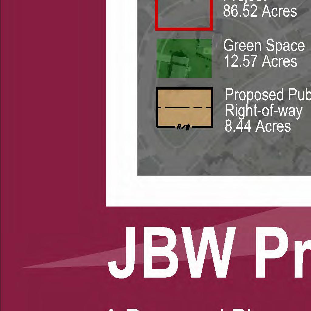
26 The West side provides more than 12 acres of Natural Open Space (Woods, Stream, Wetland). In addition to the Natural Open Space, each residential development in the west acreage is required to provide Common Open Space totaling at least 10% of its gross developable acreage. The East side has no Natural Open Space, and therefore, the professional office, local business, and residential development in the east acreage is required to provide Common Open Space of at least 30% of its gross developable area, thereby resulting in Common Open Spaces in the east acreage totaling 30% of the gross developable eastern acreage. In all residentially and commercially used developments, the developer shall form a homeowners association or such other organization, or condominium unit ownership to oversee and control the Open Spaces in accordance with Ohio Revised Code Section All open spaces shall be designed in accordance with the design criteria delineated above. 26


27
Article 7: Residential Land Use and Development Requirements
 Article 7: Residential Land Use and Section 701: Statement of Intent (A) (B) (C) The intent of Article 7 is to develop certain land use and development requirements for the residential uses within Cumru
ARTICLE SCHEDULE OF REGULATIONS
 ARTICLE 21.00 SCHEDULE OF REGULATIONS FOOTNOTES TO ARTICLE 21.00 SCHEDULE OF REGULATIONS a. If one or both public sanitary sewers and/or public water supply are not available minimum lot size shall be
ARTICLE XVII SCHEDULE OF REGULATIONS
 ARTICLE XVII SCHEDULE OF REGULATIONS SECTION 1700. LIMITING HEIGHT, BULK, DENSITY, AND AREA BY DISTRICT TYPE Use Minimum Size Lot Per Unit Maximum Height of Structures Minimum Yard Setback (Per Lot in
ARTICLE V AGRICULTURAL PRESERVATION AND RURAL RESIDENTIAL DISTRICT
 ARTICLE V AP AGRICULTURAL PRESERVATION AND RURAL RESIDENTIAL DISTRICT Section 500. PURPOSE It is the purpose of the AP, Agricultural Preservation and Rural Residential District, to foster the preservation
CHAPTER34 PRUD - PLANNED RESIDENTIAL UNIT DEVELOPMENT
 CHAPTER34 PRUD - PLANNED RESIDENTIAL UNIT DEVELOPMENT 17-34-1 17-34-2 17-34-3 17-34-4 17-34-5 17-34-6 17-34-7 17-34-8 17-34-9 Purpose Planned Residential Unit Development Defined Planned Residential Unit
ARTICLE 5.0 SCHEDULE OF REGULATIONS
 ARTICLE 5.0 SCHEDULE OF REGULATIONS Section 5.101 Table of Dimensional Standards by District. Dimensional Standards AG AG with sewer Districts Rural Residential Business Other SF SF with sewer R-1 R-1
Ridge Road Elverson, PA
 2578 Ridge Road Elverson, PA Partnership. Performance. PERFECT OPPORTUNITY FOR COMMERCIAL OWNER OCCUPIER > 8.26 acre development site in Warwick Township > 8.321 VPD > Zoning: R2/B2 - Residential/Business
Charter Township of Plymouth Zoning Ordinance No. 99 Page 208 Article 21: Residential Unit Developments Amendments: ARTICLE XXI
 Charter Township of Plymouth Zoning Ordinance No. 99 Page 208 ARTICLE XXI RESIDENTIAL UNIT DEVELOPMENTS PURPOSE The purpose of the Residential Unit Development (RUD) is to permit two (2) optional methods
CHAPTER VII R-2 LOW DENSITY RESIDENTIAL DISTRICT
 CHAPTER VII R-2 LOW DENSITY RESIDENTIAL DISTRICT SECTION 7.01 DESCRIPTION AND PURPOSE. This Zoning District is intended for low density residential uses together with required recreational, religious and
Chapter Residential Mixed Density Zone
 Chapter 19.16 Residential Mixed Density Zone 19.16.010 Purpose and Intent 19.16.020 Permitted Uses 19.16.030 Accessory Permitted Uses 19.16.040 Secondary Permitted Uses 19.16.050 Conditional Uses 19.16.060
ML-4 MULTIFAMILY RESIDENTIAL ZONE. [Added by Ord. No ]
![ML-4 MULTIFAMILY RESIDENTIAL ZONE. [Added by Ord. No ]](/thumbs/90/103301433.jpg "ML-4 MULTIFAMILY RESIDENTIAL ZONE. [Added by Ord. No ]") 55-26. ML-4 MULTIFAMILY RESIDENTIAL ZONE. [Added 2-2-98 by Ord. No. 1998-1 2] The following regulations apply in the ML-4 Zone. A. Permitted Uses. (1) Garden apartments, together with accessory structures
55-26. ML-4 MULTIFAMILY RESIDENTIAL ZONE. [Added 2-2-98 by Ord. No. 1998-1 2] The following regulations apply in the ML-4 Zone. A. Permitted Uses. (1) Garden apartments, together with accessory structures
(a) Commercial uses on Laurel Avenue, abutting the TRO District to the
 Commercial uses on Laurel Avenue, abutting the TRO District to the") 32X Zoning Code 150.36 TRANSITIONAL RESIDENTIAL OVERLAY DISTRICT. (A) Intent and purpose. (1) It is the intent of the Transitional Residential Overlay District (hereinafter referred to as the "TRO District")
32X Zoning Code 150.36 TRANSITIONAL RESIDENTIAL OVERLAY DISTRICT. (A) Intent and purpose. (1) It is the intent of the Transitional Residential Overlay District (hereinafter referred to as the "TRO District")
ARTICLE SCHEDULE OF REGULATIONS
 ARTICLE 16.00 SCHEDULE OF REGULATIONS Section 16.01 Schedule of Regulations Yard Requirements 11 R-1 Single Family Single Family 12,000 sq. ft. 2 80 feet 25 6 8 40 2 ½ 35 1,200 20 R-2 Single Family Single
AN ORDINANCE OF THE CITY OF MINNEAPOLIS. By Palmisano
 AN ORDINANCE OF THE CITY OF MINNEAPOLIS By Palmisano Amending Title 20, Chapter 520 of the Minneapolis Code of Ordinances relating to Zoning Code: Introductory Provisions. The City Council of the City
The following regulations shall apply in the R-E District:
 "R-E" RESIDENTIAL ESTATE DISTRICT (8/06) The following regulations shall apply in the R-E District: 1. Uses Permitted: The following uses are permitted. A Zoning Certificate may be required as provided
ARTICLE III: LAND USE DISTRICTS 304 R 9 DISTRICT
 ARTICLE III: LAND USE DISTRICTS III 23 304 R 9 DISTRICT (RESIDENTIAL 9 UNITS PER ACRE) 304 1 Intent and Purpose The R 9 District is intended to implement the policies of the Comprehensive Plan for areas
City of Fraser Residential Zoning District
 City of Fraser Residential Zoning District The one-family districts are established to provide principally for one-family dwellings at varying densities. The specific interest of these districts is to
ARTICLE FIVE FINAL DRAFT
 ARTICLE FIVE 021218 FINAL DRAFT Sec. 503.6 Open Space Preservation Option Open Space Preservation Option Open Space Preservation developments may be approved in the AR, R-1, R-2 and R-3 zoning districts,
ARTICLE ZONING DISTRICTS AND OFFICIAL MAP SEC SUPPLEMENTAL AREA, YARD AND HEIGHT RESTRICTIONS.
 SEC. 27-310. SUPPLEMENTAL AREA, YARD AND HEIGHT RESTRICTIONS. The following requirements provide exceptions or qualify and supplement the specific district regulations set forth in this part. Planned developments
SECTION 822 "R-1-A" AND "R-1-AH" - SINGLE FAMILY RESIDENTIAL DISTRICTS
 SECTION 822 "R-1-A" AND "R-1-AH" - SINGLE FAMILY RESIDENTIAL DISTRICTS The "R-1-A" and "R-1-AH" Districts are intended to provide for the development of single family residential homes at urban standards
ARTICLE 7 R-1 LOW DENSITY ONE-FAMILY RESIDENTIAL DISTRICT Updated 5/4/13
 ARTICLE 7 R-1 LOW DENSITY ONE-FAMILY RESIDENTIAL DISTRICT Updated 5/4/13 Sec. 7.01. DESCRIPTION AND PURPOSE. This is the most restricted, low-density zone, composed chiefly of low-density one-family homes
Community Design Standards
 In accordance with the Zoning Ordinance Update Adopted December 15, 2015 MOBILE HOME PARK DESIGN STANDARDS Sections: 2.1 Pedestrian circulation 2.2 Street width 2.3 Access 2.4 Parking 2.5 Boat and trailer
Draft Zoning Changes for the 2nd Planning Board Public Hearing, January 22, 2018.
 Draft Zoning Changes for the 2nd Planning Board Public Hearing, January 22, 2018. No changes were made at the 1st Public Hearing. Proposed wording for the 1 st Public Hearing in red, eliminated text in
AN ORDINANCE AMENDING THE CITY ZONING ORDINANCE AND THE OFFICIAL CODE OF THE CITY OF CLARKSVILLE RELATIVE TO CLUSTER OPTION DEVELOPMENTS
 ORDINANCE 74-2012-13 AN ORDINANCE AMENDING THE CITY ZONING ORDINANCE AND THE OFFICIAL CODE OF THE CITY OF CLARKSVILLE RELATIVE TO CLUSTER OPTION DEVELOPMENTS BE IT ORDAINED BY THE CITY COUNCIL OF THE CITY
Washington County, Minnesota Ordinances
 Washington County, Minnesota Ordinances Ordinance No. 153 Text Amendment to the Washington County Development Code - Chapter One, Section 2 and Chapter Two, Part 1, Part 2, Part 3, of the Development Code
ARTICLE IV R-1A, R-1B, R-1C, R-1, R-2, R-3, AND R-4, ONE FAMILY RESIDENTIAL DISTRICTS
 ARTICLE IV R-1A, R-1B, R-1C, R-1, R-2, R-3, AND R-4, ONE FAMILY RESIDENTIAL DISTRICTS PREAMBLE These residential districts are designed to provide for one family low density dwelling sites and residentially
Chapter 21 MOBILE HOME PARK REGULATIONS.
 Chapter 21 MOBILE HOME PARK REGULATIONS. Sec. 21.1 SCOPE. For the preservation of the interests of various types of residential developments which should be permitted in every community and for the protection
I. Requirements for All Applications. C D W
 108-16.1. Application checklists. Checklist for Required Submissions to the Planning Board or Zoning Board of Adjustment of Monroe Township All required submissions are to be made to the Administrative
ORDINANCE NO. O-5-10
 ORDINANCE NO. O-5-10 AN ORDINANCE OF THE TOWN COMMISSION OF THE TOWN OF PALM BEACH SHORES, FLORIDA, AMENDING THE TOWN CODE OF ORDINANCES AT APPENDIX A. ZONING. SECTION VI. DISTRICT B REGULATIONS BY AMENDING
PLANNED DEVELOPMENT DISTRICT STANDARDS. Cadence Site
 PLANNED DEVELOPMENT DISTRICT STANDARDS Cadence Site A Planned Development District 1. Statement of General Facts, Conditions and Objectives Property Size: Approximately 57.51 Acres York County Tax Map
ARTICLE 15 - PLANNED UNIT DEVELOPMENT
 Section 15.1 - Intent. ARTICLE 15 - PLANNED UNIT DEVELOPMENT A PUD, or Planned Unit Development, is not a District per se, but rather a set of standards that may be applied to a development type. The Planned
SECTION 827 "R-2" AND "R-2-A" - LOW DENSITY MULTIPLE FAMILY RESIDENTIAL DISTRICTS
 SECTION 827 "R-2" AND "R-2-A" - LOW DENSITY MULTIPLE FAMILY RESIDENTIAL DISTRICTS The "R-2" and "R-2-A" Districts are intended to provide for the development of low density multiple family residential
ARTICLE 9 SPECIFICATIONS FOR DOCUMENTS TO BE SUBMITTED
 ARTICLE 9 SPECIFICATIONS FOR DOCUMENTS TO BE SUBMITTED SECTION 950 GENERALLY All applications shall be properly signed and filed by the owner or, with the owner s specific written consent, a contract purchaser
ARTICLE 5 GENERAL REQUIREMENTS
 5.1 SUITABILITY OF THE LAND ARTICLE 5 GENERAL REQUIREMENTS 5.1.1 Land subject to flooding, improper drainage or erosion, and land deemed to be unsuitable for development due to steep slope, unsuitable
FINAL DRAFT 12/1/16, Rev. to 7/18/17
 FINAL DRAFT 12/1/16, Rev. to 7/18/17 (As Adopted 8/8/17 Effective 9/1/17) SHELTON PLANNING AND ZONING COMMISSION Proposed Amendments to Zoning Regulations I. Amend Section 23 PERMITTED USES by inserting
City of Midland Application for Site Plan Review
 City of Midland Application for Site Plan Review Submission Date: Property Owner: Mailing Address: Phone number: ( ) Cell phone: ( ) Email address: Fax: ( ) Owner s Signature: Applicant Name (if not owner):
ARTICLE VII - RESIDENTIAL DISTRICT R-2. be for one or more of the following uses:
 ARTICLE VII - RESIDENTIAL DISTRICT R-2 7-1 USE REGULATIONS In Residential District R-2, structures to be erected or land to be used shall be for one or more of the following uses: 7-1.1 Single-family dwellings.
May 12, Chapter RH HILLSIDE RESIDENTIAL ZONES REGULATIONS Sections:
 May 12, 2017 Chapter 17.13 RH HILLSIDE RESIDENTIAL ZONES REGULATIONS Sections: 17.13.010 Title, intent, and description. 17.13.020 Required design review process. 17.13.030 Permitted and conditionally
Box Elder County Land Use Management & Development Code Article 3: Zoning Districts
 Chapter 3-6 Mobile Homes, Mobile Home Subdivisions, & Recreational Vehicle Parks Box Elder Zoning Ordinance as Adopted October 2007 Sections. 3-6-010. Purpose and Intent. 3-6-020. Conditional Use Permit
CHAPTER 1268 R-1-F (SINGLE FAMILY RESIDENTIAL, GOLF COURSE COMMUNITY)
") CHAPTER 1268 R-1-F (SINGLE FAMILY RESIDENTIAL, GOLF COURSE COMMUNITY) 1268.01 PURPOSE: The R-1-F (Single Family Residential - Golf Course Community) zoning district has been established to permit residential
CHAPTER 1268 R-1-F (SINGLE FAMILY RESIDENTIAL, GOLF COURSE COMMUNITY) 1268.01 PURPOSE: The R-1-F (Single Family Residential - Golf Course Community) zoning district has been established to permit residential
Proposed Overland Park Kansas Ordinance RE-1 Residential Estates Community
 18.171 RE-1 Residential Estate Community 18.171.010 Statement of intent. The zoning of property as RE-1, (Residential Estates Community, 1 dwelling unit per Gross acre density), is intended to provide
City of Lynden Title 19 ZONING
 City of Lynden Title 19 ZONING Chapters Page Number 19.03 Comprehensive Plan 2 19.05 General Provisions 3 19.09 Maps and District Boundaries 4 19.11 Districts Established 5 19.13 Agricultural Zone 6 19.15
Town of Brookeville Zoning Ordinance
 Town of Brookeville Zoning Ordinance Article I. In General Section 10-101. Purpose: The Town of Brookeville has been included on the National Register of Historic Places since 1979 and designated as an
CHAPTER 8. REVISION HISTORY
 CHAPTER 8. REVISION HISTORY CHAPTER 8. RESIDENTIAL DISTRICTS Ordinance # Plan Commission Town Council Approval Date Adoption Date Description 2002-14 09-24-02 11-14-02 Adoption of Chapter 8. 2010-20 09-27-10
Section 7.22: Multifamily Assisted Housing in AA-30 Residential Zone (MAHZ) [Note: an additional line will be added to the Table in Article 3, 3.1.
 [Note: an additional line will be added to the Table in Article 3, 3.1.") Section 7.22: Multifamily Assisted Housing in AA-30 Residential Zone (MAHZ) [Note: an additional line will be added to the Table in Article 3, 3.1.1A] 7.22.1 Purpose The purpose of this Special Regulation
Section 7.22: Multifamily Assisted Housing in AA-30 Residential Zone (MAHZ) [Note: an additional line will be added to the Table in Article 3, 3.1.1A] 7.22.1 Purpose The purpose of this Special Regulation
ARTICLE VII-A - RESIDENTIAL DISTRICT R-2 FH 9. be for one or more of the following uses:
 ARTICLE VII-A - RESIDENTIAL DISTRICT R-2 FH 9 7-1A USE REGULATIONS In Residential District R-2 F, structures to be erected or land to be used shall be for one or more of the following uses: 7-1.1A Single-family
EXHIBIT D. Planned Unit Development Written Description April 13, 2016 Rouen Cove Phase II PUD
 1 EXHIBIT D Planned Unit Development Written Description April 13, 2016 Rouen Cove Phase II PUD Development # 8986.001 Developer: Curtis L. Hart Hart Resources LLC 8051 Tara Lane Jacksonville, Florida
ARTICLE IV R-1A, R-1B, R-1C, R-1, R-2, R-3, AND R-4, ONE FAMILY RESIDENTIAL DISTRICTS
 ARTICLE IV R-1A, R-1B, R-1C, R-1, R-2, R-3, AND R-4, ONE FAMILY RESIDENTIAL DISTRICTS PREAMBLE These residential districts are designed to provide for one family low density dwelling sites and residentially
15.02 PERMITTED USES: The following uses and no other shall be deemed Residential, R-1, uses and permitted in all R-1 districts:
 Amended October 3, 1994, Effective November 3, 1994 Revised effective November 16, 1995, Revised effective 12/1/04, Revised effective 7/06/06, Revised effective 7/18/07, Revised effective 9/03/09, Revised
Charter Township of Plymouth Zoning Ordinance No. 99 Page 58 Article 11: OS-ARC Office Service-Ann Arbor Road Corridor District ARTICLE XI OS-ARC
 Charter Township of Plymouth Zoning Ordinance No. 99 Page 58 PURPOSE ARTICLE XI OS-ARC OFFICE SERVICE ANN ARBOR ROAD CORRIDOR DISTRICT Recognizing the importance of a viable Ann Arbor Road Corridor with
CITY AND BOROUGH OF SITKA PLANNING AND COMMUNITY DEVELOPMENT DEPARTMENT VARIANCES
 CITY AND BOROUGH OF SITKA PLANNING AND COMMUNITY DEVELOPMENT DEPARTMENT VARIANCES VARIANCES WHAT? A variance is a waiver of development standards as outlined by municipal code. Variances may be sought
GWINNETT COUNTY CSO CONSERVATION SUBDIVISION OVERLAY DISTRICT REQUIREMENTS
 GWINNETT COUNTY CSO CONSERVATION SUBDIVISION OVERLAY DISTRICT REQUIREMENTS Section 1316. CSO Conservation Subdivision Overlay District. 1. Purposes. The purposes of this overlay district are as follows:
CITY PLAN COMMISSION STAFF REPORT
 CITY PLAN COMMISSION STAFF REPORT SUBJECT: Request for a Change of Zoning and Preliminary Development Plan FROM: Mara Perry, Director of Planning & Development MEETING DATE: November 6, 2017 PETITION:
DEVELOPMENT STANDARDS FOR RESIDENTIAL PROJECTS RESIDENTIAL BUILDING TYPES: APPROPRIATE ZONES AND DENSITIES 2-1
 2 DEVELOPMENT STANDARDS FOR RESIDENTIAL PROJECTS RESIDENTIAL BUILDING TYPES: APPROPRIATE ZONES AND DENSITIES 2-1 This Chapter presents the development standards for residential projects. Section 2.1 discusses
Staff Report: Date: Applicant: Property Identification: Acreage of Request: Current Zoning of Requested Area: Requested Action: Attached:
 Staff Report: Completed by Jeff Palmer Director of Planning & Zoning Date: November 7, 2018, Updated November 20, 2018 Applicant: Greg Smith, Oberer Land Developer agent for Ronald Montgomery ET AL Property
Approved 58 Unit Residential Condo Development for Sale. For Sale: Price Upon Request
 Approved 58 Unit Residential Condo Development for Sale 185 Thorpe Street Fairfield, 06824 For Sale: Price Upon Request u u u u Approved 58 Unit Residential Condo Development For Sale on 6.7 Acres in Fairfield
PERMITTED USES: Within the MX-1 Mixed Use Neighborhood District the following uses are permitted:
 6.25 MX-1 - MIXED USE NEIGHBORHOOD 6.25.1 INTENT: The purpose of the MX-1 Mixed Use Neighborhood District is to accommodate the development of a wide-range of residential and compatible non-residential
ORDINANCE NO The Town Council of the Town of Yucca Valley does ordain as follows:
 ORDINANCE NO. 141 AN ORDINANCE OF THE TOWN COUNCIL OF THE TOWN OF YUCCA VALLEY, CALIFORNIA, AMENDING TITLE 8, DIVISION 12, CHAPTER 1 RELATING TO DEFINITIONS AND TITLE 8, DIVISION 8, CHAPTER 3, RELATING
MIXED USE DEVELOPMENT AGREEMENT
 MIXED USE DEVELOPMENT AGREEMENT THIS MIXED USE DEVELOPMENT AGREEMENT (hereinafter "Agreement") made and entered into this day of, 2007, pursuant to Section 205-30 of the Zoning Ordinances of the City of
Multiple Family Residential Districts, RM-1 & RM-2
 Section 7.00 Preamble (amended 03.02.00) The Multiple Family Residential Districts are intended to provide locations for a variety of residential land uses to meet the housing needs of people who cannot
City of Dade City, Florida Land Development Regulations ARTICLE 5: DENSITY, INTENSITY & DIMENSIONAL STANDARDS
 City of Dade City, Florida Land Development Regulations ARTICLE 5: DENSITY, INTENSITY & DIMENSIONAL STANDARDS ADOPTED AUGUST 12, 2014 ARTICLE 5: DENSITY, INTENSITY & DIMENSIONAL STANDARDS SECTION 5.1 DIMENSIONAL
THE CITY COUNCIL OF NORTH ROYALTON, OHIO
 THE CITY COUNCIL OF NORTH ROYALTON, OHIO ORDINANCE NO. 16-113 INTRODUCED BY: Nickell, Kasaris, Antoskiewicz AN ORDINANCE AMENDING THE CODIFIED ORDINANCES OF THE CITY OF NORTH ROYALTON, PART 12 PLANNING
NORMAN, OKLAHOMA OWNER: RCB BANK APPLICATION FOR 2025 PLAN CHANGE PLANNED UNIT DEVELOPMENT PRELIMINARY PLAT. 12 December 2011 Revised 5 January 2012
 THE VILLAGE AT OAKHURST ADDITION NORMAN, OKLAHOMA OWNER: RCB BANK APPLICATION FOR 2025 PLAN CHANGE PLANNED UNIT DEVELOPMENT PRELIMINARY PLAT 12 December 2011 Revised 5 January 2012 PREPARED BY: THE RIEGER
Site Plan Application
 Site Plan Application City of St. Pete Beach Community Development Department 155 Corey Avenue St. Pete Beach, Florida 33706 (727) 367-2735 www.stpetebeach.org Case Number: PROPERTY OWNER: Name: Address:
 Page 1 of 8 Laguna Beach Municipal Code Up Previous Next Main Collapse Search Print No Frames Title 25 ZONING Chapter 25.10 R-1 RESIDENTIAL LOW DENSITY ZONE 25.10.002 Intent and purpose. This zone is intended
NOW, THEREFORE BE IT ORDAINED,
 ORDINANCE 2087 AN ORDINANCE OF THE BOROUGH OF SOUTH PLAINFIELD, COUNTY OF MIDDLESEX, AND STATE OF NEW JERSEY, AMENDING AND SUPPLEMENTING CHAPTER 540, ENTITLED ZONING, OF THE CODE OF THE BOROUGH OF SOUTH
Waseca County Planning and Zoning Office
 Waseca County Planning and Zoning Office 300 North State Street Waseca, Minnesota 56093 Phone: 507-835-0650 Fax: 507-837-5310 Form no. PZ 081009 Web Site: www.co.waseca.mn.us FEES: 1) CUP FEE- $400.00
Charter Township of Plymouth Zoning Ordinance No. 99 Page 52 Article 10: OS Office Service District
 Charter Township of Plymouth Zoning Ordinance No. 99 Page 52 PURPOSE ARTICLE X OS OFFICE SERVICE DISTRICT To provide a district to accommodate office uses of an administrative, business, governmental or
Chapter 17-2 Residential Districts
 Chapter 17-2 Residential Districts 17-2-0100 District Descriptions...2-1 17-2-0200 Allowed Uses...2-2 17-2-0300 Bulk and Density Standards...2-5 17-2-0400 Character Standards...2-18 17-2-0500 Townhouse
ARTICLE V Section Age Restricted Housing Community
 ARTICLE V Section 5-75 Age Restricted Housing Community Section 5-75.1 Purpose. This ordinance is established by the City of Westfield to achieve the following public purposes: to encourage the development
FREQUENTLY USED PLANNING & ZONING TERMS
 City Of Mustang FREQUENTLY USED PLANNING & ZONING TERMS Abut: Having property lines, street lines, or zoning district lines in common. Accessory Structure: A structure of secondary importance or function
the conditions contained in their respective Orders until January 1, 2025, at the discretion of the Director of Planning, Property and Development.
 Part 4: Use Regulations Temporary Uses and Structures Purpose the conditions contained in their respective Orders until January 1, 2025, at the discretion of the Director of Planning, Property and Development.
PRELIMINARY DEVELOPMENT PLAN REVIEW - CITY OF MARYLAND HEIGHTS
 APPLICATION NUMBER: PDP16-0004 APPLICATION (PROJECT) NAME: MARYLAND OAKS APPLICANT: McBride Maryland Oaks, LLC 16091 Swingley Ridge Road, Suite 300 Chesterfield, MO 63017 PROPERTY OWNER NAME: Basston Holdings
WRIGHT TOWNSHIP Ottawa County 1565 Jackson Street, P.O. Box 255, Marne, Michigan 49435
 WRIGHT TOWNSHIP Ottawa County 1565 Jackson Street, P.O. Box 255, Marne, Michigan 49435 SITE PLAN REVIEW APPLICATION _ Instructions For an application to be considered complete, ALL information must be
Planning Commission Text & Map Amendments Pavluk Properties Hinckley Township EXECUTIVE SUMMARY
 Planning Commission Text & Map Amendments Pavluk Properties Hinckley Township Meeting: August, 08 App. No.: 05-08-MA & TA Owner: The Pavluk Family Limited Partnership Applicant: Zoning Commission (Terry
ARTICLE 15. RULES, REGULATIONS AND DEFINITIONS
 ARTICLE 15. RULES, REGULATIONS AND DEFINITIONS Section 1. Interpretation and Construction: The following rules and regulations regarding interpretation and construction of the Ulysses-Grant County, Kansas,
Exhibit D. Tallow Ridge PUD. Written Description. Date: January 5, E. City Development Number:
 Exhibit D Tallow Ridge PUD Written Description Date: January 5, 2016 I. SUMMARY DESCRIPTION OF THE PROPERTY A. Current Land Use Designation: RR B. Current Zoning District: PUD C. Requested Zoning District:
BONNER COUNTY PLANNING DEPARTMENT
 BONNER COUNTY PLANNING DEPARTMENT 1500 HIGHWAY 2, SUITE 208, SANDPOINT, ID 83864 (208) 265-1458 (208) 265-1463 (FAX) planning@bonnercountyid.gov (email) www.bonnercounty.us (web page) INFORMATION SHEET
Sec Table of height, bulk, density and area by land use.
 Sec. 18-276. - Table of height, bulk, density and area by land use. The following is the table of height, bulk, density and area by land use for each zoning district: LIMITING HEIGHT, BULK, DENSITY AND
Sec. 3-1 Single Family R- Use Districts.
 Section - R-Use Districts 0 0 Sec. - Single Family R- Use Districts. A. Purpose and applicability. Single-Family Districts are intended to accommodate low density, single-family dwelling units with adequate
-MENDOCINO COUNTY PLANNING AND BUILDING SERVICES- DIVISION OF LAND REGULATIONS TITLE 17
 ARTICLE VI -- GENERAL REGULATIONS AND PROVISIONS Sec. 17-50. Sec. 17-51 General Plan. Sec. 17-52 Lot and Block Design and Configuration. Sec. 17-53 Lot Access. Sec. 17-54 Private Roads. Sec. 17-55 Water
ORDINANCE NO. 208 BE IT ORDAINED BY THE CITY COUNCIL OF THE CITY OF UNIVERSITY HEIGHTS, JOHNSON COUNTY, IOWA:
 ORDINANCE NO. 208 AN ORDINANCE AMENDING ORDINANCE NO. 79 (ZONING) TO CREATE A COMMERCIAL HOTEL ZONE AND PERMIT DEVELOPMENT PURSUANT TO A COMMERCIAL HOTEL PUD BE IT ORDAINED BY THE CITY COUNCIL OF THE CITY
FRONT YARD MP 35 FT 35 FT 10 FT A 20 FT A 2 35 FT 30% NOT PERMITTED NOT PERMITTED
 RESIDENTIAL/AGRICULTURAL COMMERCIAL/INDUSTRIAL ZONING DISTRICT Charter Township of Fort Gratiot Code of Ordinances Chapter 38-Zoning, Article III-District Regulations DIVISION 12. SCHEDULE OF DISTRICT
ARTICLE IV DISTRICT REGULATIONS
 PART 1. RESIDENTIAL DISTRICTS 4-101. RS. Single-Family Residential Suburban District. The RS District is designed for single-family dwellings, and compatible uses, at a density no greater than one dwelling
ORDINANCE NO AN ORDINANCE AMENDING CHAPTER OF THE MOSES LAKE MUNICIPAL CODE ENTITLED "RESIDENTIAL ZONES"
 ORDINANCE NO. 2510 AN ORDINANCE AMENDING CHAPTER 18.20 OF THE MOSES LAKE MUNICIPAL CODE ENTITLED "RESIDENTIAL ZONES" THE CITY COUNCIL OF THE CITY OF MOSES LAKE, WASHINGTON ORDAINS AS FOLLOWS: Section 1.
SECTION 10.7 R-PUD (RESIDENTIAL PLANNED UNIT DEVELOPMENT) ZONE
 ZONE") Article X Zones 10-20 SECTION 10.7 R-PUD (RESIDENTIAL PLANNED UNIT DEVELOPMENT) ZONE A. PURPOSE AND INTENT: The R-PUD Residential PUD Zone is intended to provide alternative, voluntary zoning procedures
Article X Zones 10-20 SECTION 10.7 R-PUD (RESIDENTIAL PLANNED UNIT DEVELOPMENT) ZONE A. PURPOSE AND INTENT: The R-PUD Residential PUD Zone is intended to provide alternative, voluntary zoning procedures
PLANNED UNIT DEVELOPMENTS
 PLANNED UNIT DEVELOPMENTS SECTION 9.01 DESCRIPTION AND PURPOSE. A. The purpose of a planned unit development (PUD) is to permit greater flexibility in development than is generally possible under standard
"R-1" SINGLE-FAMILY RESIDENCE DISTRICT
 ARTICLE IV. "R-1" SINGLE-FAMILY RESIDENCE DISTRICT SECTION 400.060: "R-1" SINGLE-FAMILY RESIDENCE DISTRICT The regulations set forth in this Article or set forth elsewhere in this Chapter when referred
ARTICLE VI. SPECIAL EXCEPTION REGULATIONS
 ARTICLE VI. SPECIAL EXCEPTION REGULATIONS SECTION 601. GENERAL DESCRIPTION Special exceptions are deemed to be permitted uses in their respective districts, subject to the satisfaction of the requirements
4. facilitate the construction of streets, utilities and public services in a more economical and efficient manner;
 PVPC MODEL BYLAW BY-RIGHT CLUSTER ZONING BYLAW Prepared by Pioneer Valley Planning Commission Revised: October 2001 1.00 Development 1.01 Development Allowed By Right Development in accordance with this
30% 10 FT 10 FT A 20 FT A 16 FT 35 FT 35 FT 10 FT A 20 FT A 2 35 FT PERMITTED PERMITTED NOT AN ACCESSORY STRUCTURE MAY NOT EXCEED THE.
 Charter Township of Fort Gratiot Code of Ordinances DIVISION 12. SCHEDULE OF DISTRICT REGULATIONS Section 38-441. Schedule of District Regulations ZONING DISTRICT MINIMUM FLOOR AREA OF STRUCTURE MINIMUM
ARTICLE III ZONING DISTRICTS AND GENERAL REGULATIONS
 ARTICLE III ZONING DISTRICTS AND GENERAL REGULATIONS 3.1 Districts. The City of Wheaton, Illinois, is hereby divided into the following zoning districts. The following are general descriptions, but not
Article 2. Rules of Interpretation
 Article 2. Rules of Interpretation Article 2. Rules of Interpretation Sec. 2.1. Building Types 2.1.1. Building Type Descriptions... 2-2 Sec. 2.2. Rules Applicable to all Districts 2.2.1. Site... 2-5 2.2.2.
ARTICLE I ZONE BASED REGULATIONS
 ARTICLE I ZONE BASED REGULATIONS RZC 21.08 RESIDENTIAL REGULATIONS 21.08.290 Cottage Housing Developments A. Purpose. The purpose of the cottage housing requirements is to: 1. Provide a housing type that
BOROUGH OF HOPATCONG ORDINANCE No
 BOROUGH OF HOPATCONG ORDINANCE No. 10-2014 AN ORDINANCE OF THE BOROUGH OF HOPATCONG, SUSSEX COUNTY, NEW JERSEY TO ADOPT A FORM BASED CODE AS AN OVERLAY DISTRICT AFFECTING PORTIONS OF THE B-1 AND R-1 ZONING
ARTICLE 44. PD 44. Unless otherwise stated, the definitions and interpretations in Chapter 51 apply to this
 ARTICLE 44. PD 44. SEC. 51P-44.101. LEGISLATIVE HISTORY. PD 44 was established by Ordinance No. 13164, passed by the Dallas City Council on January 25, 1971. Ordinance No. 13164 amended Ordinance No. 10962,
b. Forestry, subject to the provisions of Section 511 of this Ordinance.
 Section 405. R RECREATION-RESIDENTIAL DISTRICT 405.1 SPECIFIC INTENT It is the purpose of this district to provide areas for use as full-size golf courses, excluding driving ranges, miniature golf courses
PLANNED RESIDENTIAL DEVELOPMENT (PRD)
") PLANNED RESIDENTIAL DEVELOPMENT SECTION 10. PLANNED RESIDENTIAL DEVELOPMENT (PRD) 10.1 Purpose Planned Residential Development allows by special permit from the Board an alternative pattern of residential
PLANNED RESIDENTIAL DEVELOPMENT SECTION 10. PLANNED RESIDENTIAL DEVELOPMENT (PRD) 10.1 Purpose Planned Residential Development allows by special permit from the Board an alternative pattern of residential
ARTICLE 13 CONDOMINIUM REGULATIONS
 ARTICLE 13 CONDOMINIUM REGULATIONS Section 13.01 Purpose. The purpose of this Article is to regulate projects that divide real property under a contractual arrangement known as a condominium. New and conversion
SECTION 23 PLANNED RESIDENTIAL DEVELOPMENT FOR ELDERLY PERSONS
 SECTION 23 PLANNED RESIDENTIAL DEVELOPMENT FOR ELDERLY PERSONS 23.1 General: In order to provide for the special needs of elderly and handicapped persons who may require multifamily type living accommodations,