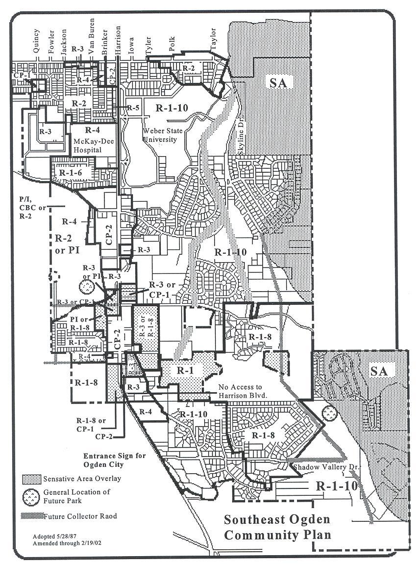
Southeast Ogden Community Plan
|
|
|
- Clemence Stokes
- 6 years ago
- Views:
Transcription
1 The Southeast Ogden Community was the fourth community to have a plan done for it. Its format followed the format developed in the Lynn Community. A set of policies which were first used as part of the Lynn Community (Another growth community which was done just prior to Southeast Ogden) were adopted as part of the plan and have come to be known as Ogden Southeast Ogden Community Plan Community Policies. The Community was originally named the Grandview Community after the elementary school located at th Street. The name was changed as the plan was developed to Southeast Ogden to better identify the area. 1
2 Southeast Ogden Community Background Population Characteristics The community is located between 36 th Street and the south City limits and Gramercy Avenue and the east City limits as shown on the map on the previous page. Below are some of the population characteristics of the community are shown: The Community has a college age population which is larger than the rest of the City. This is because the Weber State University is located in the community. The minority population in the community I also smaller than the City as a whole. Population Characteristics in the Southeast Ogden Community Southeast % of % of Population Ogden Community Ogden Ogden Total Population 6, % 63, % Population Characteristics Sex: Male 2,879 46% 31,211 49% Female 3,342 54% 32,698 51% Age: Under 5 years 374 6% 5,870 9% ,028 16% 12,677 20% ,137 18% 7,726 12% ,386 22% 18,423 29% % 4,837 8% % 5,044 8% 65 and over 1,008 16% 9,332 15% Race: White 5,850 94% 55,885 87% Black 76 1% 1,741 3% American Indian, Eskimo, Aluet 34.5% 687 1% Asian or Pacific Islander 209 3% 1,123 2% Other 52.8% 4,473 7% Hispanic Origin (of any race) 150 2% 7,669 12% Source: U.S. Census of Population, 1990 Land Use The major land uses in the Southeast Ogden Community are single family homes, transportation (i.e., roads) vacant land and government and institutional uses. The majority of the vacant land left is in areas of over 30% slope and is not buildable. Large areas of vacant land existed when the plan was done but have since been developed. Weber State University and McKay-Dee Hospital make up the bulk of the government and institutional uses. Almost all of the commercial uses are located along Harrison Boulevard which is the major arterial street running through the center of the community. The major growth categories since the plan was done in 1987 have been single-family homes and commercial uses. Southeast Ogden has been the fastest growing area in the City since the plan was done. Land Uses in the Southeast Ogden Community Land Use Acres % of Community Single-family % Duplex 5.2 Multi-family 3-4 units 2.1% Multi-family 5+ units 45 2% Condominium 59 3% Gov t/institutional % Commercial sales 57 3% Commercial service 13.6% Park 25 1% Transportation/Utility % Vacant % Total 2, % Source: Ogden City Land Use Survey,
3 Zoning Over 90% of the Southeast Ogden Community is zoned for residential uses. Most of the residential zoned property has been developed. There are still some islands of unincorporated property which could be annexed, zoned and developed in the future. The residentially-zoned property figures are somewhat skewed because the Weber State University campus is zoned R Almost all of the commercial zoning falls into two categories, CP-2 and PI. CP-2 zoning is a medium intensity commercial zone. These are found exclusively in Southeast Ogden along Harrison Boulevard. The PI zone is for offices and institutional uses. The majority of the PI zoning is contained in the McKay-Dee Hospital site. Zoning in the Southeast Ogden Community % of Zone Acres Community R-1-6 (single-family on 6,000 sq. ft. lots) 22 1% R-1-8 (single-family on 8,000 sq. ft. lots) % R-1-10 (single-family on 10,000 sq. ft. lots) 1,058 63% R-2 (single-family and duplex residential) % R-3 (multi-family residential up to 15.4 units per acre) 63 4% R-4 (multi-family residential up to 23 units/acre) 9.5% PI (Professional offices) 46 3% CP-2 (community commercial) 69 4% CP-1 (neighborhood commercial) 3.1% R-5 (multi-family residential up to 23 units/acre) 2.1% Total 1, % Note: Does not include acreage for roads Housing The Southeast Ogden community has a wide variety of housing type. The most prevalent type of housing units are single-family homes. 57% of the total housing units are single-family which is slightly less than the City as a whole which is 62%. Weber State University is located within the community and is the reason some of the multi-family housing has been built. 29% of the housing stock in the community is multi-family housing. This too is less than the rest of the City. Because this is one of the newer areas of the City, most of the housing stock is new and in good condition. The table below shows the types and numbers of dwelling units in the community and the entire City. Housing in the Southeast Ogden Community Type of dwelling units # of dwelling units % of Community Single-family 1,284 55% Condominiums % 2-4 Units 169 7% 5+ Units % Source: U.S. Census of Population and Housing,
4 SOUTHEAST OGDEN CONCERNS (1987) Community Identity and Design 1. The south end of Harrison is a key entrance to the City and should have a definite identification or look about it. An attractive Welcome Sign would enhance and mark that entrance. 2. The streetscape is beginning to form on Harrison Boulevard. A streetscape plan could tie the area together by giving a choice of variety of trees which have similar characteristics, e.g., height. 3. Care should be given to draw a definite edge of types of uses so the neighborhood knows where certain types of uses are going and where they are not. These edges can be enhanced visually with good design and landscaping. 4. Naming focal points within the neighborhood and commercial centers will help identify them not only to travelers, but also to residents of the City coming home. Zoning 5. Zoning boundaries which split development. 6. Zoning which does not reflect the use. 7. Scattered use of R-4 zone for professional office buildings. R-4 is primarily used for offices rather than residential use. 8. Development on steep hillside must take into account the various environmental hazards which exist in the area. 9. Apartment complexes appear to exceed densities allowed in those zones. 10. Zoning dividing subdivisions once they have developed. 11. Development problems of R-2 zone west of Harrison Boulevard. Developer will need to coordinate very closely with South Ogden City. 12. Distinctions should be made between the various types of commercial centers and zoning occurring on Harrison Boulevard, e.g., professional offices, shopping centers, strip commercial. 13. The turning movements are further complicated by the lack of connections between separate shopping centers, forcing the shopping to turn onto the arterial out of one center and turn into the next which may be 50 feet away. 14. Design of some of the commercial parking lots tend to be disjointed and cumbersome. 15. Because of their traffic impacts on Harrison Boulevard, which is near capacity and the turning movement problems, commercial uses should be encouraged to develop as centers, rather than strip commercial. Circulation 16. Traffic accidents at the intersection of 36 th and Harrison Boulevard, and Country Hills Drive and Harrison Boulevard, exceed the State average rate. Installation of left-turn phasing would help to reduce the accident rate for the two intersections. 17. Bus routes do not extend to the eastern part of the Southeast Ogden Community. Parks 18. An analysis of the Southeast Ogden Community Parks meets the national park guidelines for acreage of parks and size of parks, but the service area of those parks indicate a void in the Shadow Valley area and the area west of Harrison Boulevard between Country Hills Drive and the southern City limits. Schools and Hospital 19. The elementary school boundaries have the potential of sending students of one neighborhood to separate schools. 20. The impacts of Weber State College a. Expansion: The College has been acquiring land on the northeast ridge of campus on Skyline Drive and Taylor Avenue, along Edvalson Street. Concern for the edge of the development and how far it will go into the adjacent subdivision. b. Parking: Because of the student parking problems between the College and 36 th Street, the City has adopted on-street parking restrictions: (1) some areas have no parking at anytime, and (2) no parking between 7:00 a.m. and 1:00 p.m., Monday through Friday. c. Student Housing: Where students are renting rooms or basements in single-family houses nearby, especially on Edgehill Drive, Taylor Avenue, and College Drive. 21. The impacts of McKay-Dee Hospital: The Hospital is buying up lots along the south side of its development with future plans to expand. Utilities 22. The connection fee policies for water mains should be reviewed to ensure Ogden City is adequately reimbursed for the costs of extending or upgrading the size of water mains. 23. Storm drainage in the Bartlett Heights and Oxford Place Subdivisions is inadequate. 24. Storm drainage and sewerage service to the undeveloped area south of Country Hills Drive may be a problem when the area develops. Cooperation with South Ogden City will be essential. Natural Hazards 25. Development within the 100 year floodplain must comply with the City s Floodplain Ordinance. 26. Much of the eastern portion of the Southeast Ogden Community consists of steep and possibly 4
5 incompetent slopes. Future development in these areas must be closely scrutinized. 27. The Wasatch Fault should be given due consideration prior to future development along the eastern foothills of this community. 5
6 1. Additions to Community Policies: A. Design and erect a Welcome Sign for placement at the entrances to the City. B. encourage developers to provide attractive entrances and signs to their development, e.g., subdivisions, planned unit developments, mobile homes, apartments, commercial centers, etc. The City also should be aware of using name identification signs for its facilities, e.g., buildings, parks. C. Zoning boundaries should not cut across individual lots (i.e., placing a lot on two separate zones). Redraw illogical zone boundaries to follow property lines. D. Utilize vacant inner block parcels and corner lots for higher densities, avoiding disruption to lots on a street having primarily single-family homes. New inner block developments should be compatible (e.g., heights) with the surrounding single-family homes. E. Multiple-density developments should be phased, i.e., let vacant land develop first and consider rezoning single family areas only as demand increases and multiple family developments creep closer to single-family homes. F. Discourage single-lot development of multiple density uses. G. Commercial development should be located on collector and arterial streets, avoiding local streets. H. Encourage commercial uses to be developed as strip centers, rather than strip commercial 2. Immediate Changes to the Zoning Map A. Zoning to reflect the use: (1) R-2 to R-3 Brook Hollow Apartments (2) R-1-6 to R-4 - The Apartments south of McKay-Dee Hospital (3) R-3 to R-4 - Offices west of McKay-Dee Hospital B. Zoning boundary adjustment to avoid cutting lots R-2 on 36 th Street and Lark Circle C. Avoid isolated parcels R-1-8 west of Harrison south City limits D. Area in transition 1. Weber County School Board Property at 4901 Harrison Boulevard, front piece at 7.4 acres (as shown on map): Rezone from CP-1 to R-1-8. Southeast Ogden Community Plan 2. Weber County School Board Property at Harrison Boulevard, back piece of 22 acres (as shown on map): Rezone from R-2 to R Planning Guidelines for the Future A. Community Identity and Design 1. Place entrance sign on South Harrison. 2. Prepare Streetscape Plan 3. Encourage names on developments and City facilities. B. Transportation 1. Adopt a Transportation Plan for collectors a. Skyline Drive b. Jackson Avenue 2. Limit access on 4275 South, vacate planting section and give to adjoining property owners. 3. Limit access onto Harrison Boulevard south of R-4 zone. 4. Design of Skyline Drive a. 80 right-of-way b. Construct the roadway along Skyline Drive to the standard width of 61 backof-curb to back-of-curb; c. Limit the Skyline Drive roadway improvements to two parking lanes, two through-traffic lanes, and a combination planted median/turning lane. d. As guidelines for the planted medina, as much existing natural vegetation should be retained as possible and where new plantings are required, use low water/low maintenance plant material. e. Where there are problems with terrain along one side of Skyline Drive, consider placing sidewalk only on one side. 5. Do not allow commercial development along Skyline Drive. 6. Notify property owners along the street and within the surrounding neighborhood, if there is a proposal for a Plan Amendment to allow another design for Skyline Drive. 7. Prohibit through truck traffic on 36 th Street and Country Hills Drive east of Harrison and Skyline Drive. Any trucks on these roadways must be in the area to deliver or provide a local service. (R adopted 7/27/93) 6
7 8. Transportation and circulation around Weber State University: a. Continue to work with Weber State University in considering and developing ways of improving access to the University from Harrison boulevard and discouraging access through local residential streets. Background: An important concern regarding University traffic is the difficulty of directly accessing the University from Harrison Boulevard, especially when coming from the north. Another concern is that street signs do not clearly mark the entrances, connections between Harrison Boulevard and Dixon Drive may or may not be effectively configured and a modeling study is to be done by Wasatch Front Regional Council looking at short-term and long-term approaches to the problem. b. Cooperate with the University in helping to identify means of improving internal traffic circulation. Background: Certain aspects of the internal loop system on campus make it less effective than it might be. These include narrow travelways which impede the smooth flow of traffic, heavily used pedestrian crossings with no signal lights, no turnouts for campus shuttle or UTA buses. The improvement of internal circulation patterns is seen as a means of making vehicular traffic flow more smooth and desirable and lessening the impacts of University traffic on adjacent residential neighborhoods. c. Provide an opportunity for stakeholders to consider the management of local streets currently used to access the University after operational characteristics have been determined. Background: The University and associated uses have and can impact residential neighborhoods in negative ways. In reviewing this item, it was felt important to try and focus these impacts away from the neighborhoods to the greatest extent possible, and yet realize that there may be a need to strike a balance between the needs and desires of the neighborhood and residents, the larger community of people who use the University and the University itself. 9. Glasmann Way. Remove Glasmann Way as a future collector street from the plan map and cul-de-sac it at its current location north of 4600 South. Background: Future extensions of Glasmann Way at 4400 South were removed from the Plan as a result of the McKay-Dee Hospital petitioning the City to relocate the hospital to the Glasmann Farm property. The streets were removed, among other reasons, to prevent traffic to and from the hospital from traveling through the surrounding neighborhoods South. Remove 4400 South as a future collector street from the Plan Map conditioned upon requiring the extension of 4400 South from its current dead-end at the west edge of the Harrison Depot property as necessary to provide access to the Nature Park from Harrison Boulevard. (R-98-1 adopted 1/6/98) 11. Properties south of Cedar Village. Commercial zoning may be appropriate only if development shares access and design themes with the existing Cedar Village commercial development. C. Parks 1. Shadow Valley 2. West of Harrison D. Impacts of McKay-Dee Hospital 1. Review future master plan with Hospital Board 2. Review future placement of parking. E. Possible Future Zoning 1. South side of Country Hills Drive Options: Professional/Institutional (PI); Commercial Business Center (CBC) or R Harrison Boulevard, South Options: CP-1 and R-3 3. Old Post Road a. East side: R-3 or R-1 b. West side : R-3 4. East Harrison Boulevard, south end; R-1 5. Weber County School Board property at 4901 Harrison, front piece on 7.4 acres (as shown on map): Amend the Southeast Ogden Plan to allow R-1-8 and CP Weber County School Board property at 4901 Harrison Boulevard, back piece of 22 acres (as shown on map): Amend the Southeast Ogden Plan to allow R-1-8 and delete R-2. Future development of this property will require the developer to address all of the Ogden City Community Policies, with particular attention to the following policies: #1 A definite edge to a development and buffering between types of uses should be provided to protect the 7
8 integrity of each use, e.g., between commercial and residential uses, between types of residential uses. #11 Avoid isolating neighborhoods. #15 The intensity and location of commercial zoning should be based on market patterns, circulation, traffic counts and space requirement considerations. Space requirements for expansion of existing commercial uses also should be taken into consideration. #16 Commercial developments should be located on collector and arterial streets, avoiding local streets. #18. Encourage commercial uses to be developed as centers rather than as strip commercial. 7. The Lasater property at 5001 Harrison Boulevard: R-1-8 and CP-1. In order for CP-1 to be considered, this property must tie into other commercial developments. 8. Property located at 4550 South Harrison Boulevard (Ligori property): Add CP-1 to the existing R-3 option. (R adopted 10/17/95) 9. Property located on the northwest corner of Harrison Boulevard and 4600 South (Niel Wall and U.S. Government property): Delete CP-1 option and add PI to the existing R-1-8 option on the south property and R-3 on the north property. Future rezoning decisions should consider the ability of the property owner to resolve the existing concerns and physical limitations regarding the property, specifically: a. Relocation of the canal which currently divides the properties. b. Correct illegal subdivision of p0reoprties which created a lot with no access from a public right-of-way. c. Establish whether wetlands exist on the properties and mitigate as required. d. Address topographical concerns associated with the property. (R adopted 7/30/96) 10. Glasmann Farm Property: Consider extending the PI zone for all or a portion of thee property south of Country Hills Drive between South Ogden City limits and Country Hills Square Condominiums if the following parameters are met: a. The zone boundary lines meet the needs of the planned facility but may be restricted to avoid the rezoning of large sections of land with no identified plans for development. b. The uses in the proposed development are limited to hospital-related uses. c. Adequate buffering to surrounding neighborhoods is provided. d. The number, general location and size of buildings (square footage and height) are known. e. The general layout of roads and circulation pattern are agreed to. f. Adequate access for and visibility of the park to the south is provided. g. Appropriate tools for conditional zoning and/or a development agreement are established. h. Provisions are made that the rezoning applies only when IHC owns the property. i. The neighborhood is involved in the creation of the development agreement and/or conceptual plan. R adopted 12/2/97) 11. Properties south of Cedar Village: Commercial zoning may be appropriate only if development shares access and design themes with the existing Cedar Village commercial development. (R adopted 2/19/02) 12. Southeast corner of Harrison and Shadow Valley Drive: a. Consider an option for R-3/CO b. the use would need to be a low trafficgenerating use c. the development would need to be sensitive to maintaining existing vegetation and natural topography to protect the residence and the visual impact of the corner. d. the development will need to incorporate design and materials of thee residential structures in the area. e. no access would be allowed for the use on Winchester Lane. (R adopted 7/13/04) 4. Plan Map --- See Attached 5. Directions to the Staff A. Prepare a separate zone designation for professional offices. B. Prepare a zone to deal with strip commercial. C. Revise site plan review process to work on interconnecting parking lots of various commercial centers. 8
9 D. Continue to request UDOT to monitor the intersections of Harrison at 36 th Street and at Country Hills Drive to install left-turn phasing when the State standards are met. E. Contact UTA regarding lack of bus service to the eastern part of the Southeast Ogden Community. F. Engineering Division investigate possible options to mitigate the drainage problem in this Community. G. Review connection fee policies to ensure appropriate sewer, appropriate sewer/water reimbursements to the City. H. Engineering Division investigate possible options to mitigate the drainage problem on Jackson Avenue in the vicinity of the McKay- West Professional Office Building and the Berean Baptist Church. I. Schedule a meeting with representatives of the Planning Commission and McKay-Dee Hospital officials to review the Hospital Master Plan when it has been completed. J. Review Sensitive Area Zone to see if the boundary of the zones are still appropriate given recent geologic reports and data. K. Legal Staff should prepare wording for an amendment to the Zoning Ordinance regarding vested rights. L. Reconstruct the intersection of Skyline Drive and Country Hills Drive where the connection forms a triangle (to eliminate the hazardous configuration). If the triangular piece of property is to remain, it must be landscaped. M. Redesign and reconstruct the connection between 36 th Street and Skyline Drive for better traffic flow and increased safety, but not to facilitate higher speeds. N. See quicker response from the Utah State Department of Transportation regarding the synchronization of the traffic signals in Ogden (presently projected from 3 to 5 years). O. Improve identification signage, e.g., Country Hills Drive location, indication of approaching Weber State University keep right. P. Work with UDOT to stripe parking along both sides of Harrison Boulevard in front of the University. Q. Work with surrounding communities to develop a uniform policy regarding through traffic on Skyline Drive. (R adopted 7/27/93) Adopted May 28, 1987; amended January 10, 1991, July 27, 1993, October 17, 1995, December 5, 1995, July 30, 1996, December 2, 1997, January 6, 1998, February 19, 2002, July 13, 2004 (R-9-90, adopted 2/8/90) (R adopted 7/27/93) R adopted 10/17/95) (R adopted 7/30/96) (R adopted 12/2/97) (R-98-1 adopted 1/6/98) (R adopted 2/19/02) (R adopted 7/13/04) 9
10 10
Draft Model Access Management Overlay Ordinance
 Draft Model Access Management Overlay Ordinance This model was developed using the City of Hutchinson and the Trunk Highway 7 corridor. The basic provisions of this model may be adopted by any jurisdiction
O-I (Office-Institutional) and AG-1(Agricultural)
 and AG-1(Agricultural)") PROPERTY INFORMATION ADDRESS 3503 and 3505 Bethany Bend DISTRICT, LAND LOTS 2/1 973 and 974 OVERLAY DISTRICT State Route 9 PETITION NUMBERS EXISTING ZONING O-I (Office-Institutional) and AG-1(Agricultural)
PROPERTY INFORMATION ADDRESS 3503 and 3505 Bethany Bend DISTRICT, LAND LOTS 2/1 973 and 974 OVERLAY DISTRICT State Route 9 PETITION NUMBERS EXISTING ZONING O-I (Office-Institutional) and AG-1(Agricultural)
M-43 CORRIDOR OVERLAY ZONE
 ARTICLE 26.00 M-43 CORRIDOR OVERLAY ZONE Section 26.01 Findings A primary function of the M-43 state highway is to move traffic through the Township and to points beyond. As the primary east-west arterial
REPORT TO THE SHELBY COUNTY PLANNING COMMISSION From the Department of Development Services Planning Services. February 4, 2019
 REPORT TO THE SHELBY COUNTY PLANNING COMMISSION From the Department of Development Services Planning Services February 4, 2019 Case No. Request for Rezoning Approval From E-1 to E-2 SD This is a request
Cover Letter with Narrative Statement
 Cover Letter with Narrative Statement March 31, 2017 rev July 27, 2017 RE: Rushton Pointe Residential Planned Unit Development Application for Public Hearing for RPUD Rezone PL2015 000 0306 Mr. Eric Johnson,
Planning Department Oconee County, Georgia
 Planning Department Oconee County, Georgia STAFF REPORT REZONE CASE #: 6985 DATE: October 31, 2016 STAFF REPORT BY: Andrew C. Stern, Planner APPLICANT NAME: Williams & Associates, Land Planners PC PROPERTY
COUNTY OF ALBEMARLE PLANNING STAFF REPORT SUMMARY
 COUNTY OF ALBEMARLE PLANNING STAFF REPORT SUMMARY Project Name: ZMA 2010-00015, Cedar Hill Planning Commission Worksession: February 15, 2011 Public Hearing: Not scheduled Staff: Judith C. Wiegand, AICP
HERON LANDING SUBDIVISION
 HERON LANDING SUBDIVISION Engineering Comments: Per FEMA guidelines, any development greater than 5 acres in size or subdivision 50 lots in size, requires a flood study. Width of drainage easement to be
8Land Use. The Land Use Plan consists of the following elements:
 8Land Use 1. Introduction The Land Use Plan consists of the following elements: 1. Introduction 2. Existing Conditions 3. Opportunities for Redevelopment 4. Land Use Projections 5. Future Land Use Policies
3.1. OBJECTIVES FOR RESIDENTIAL LAND USE DESIGNATIONS GENERAL OBJECTIVES FOR ALL RESIDENTIAL DESIGNATIONS
 3. RESIDENTIAL LAND USE DESIGNATIONS INTRODUCTION The Residential land use designations provide for housing and other land uses that are integral to, and supportive of, a residential environment. Housing
Section 1: US 19 Overlay District
 Section 1: US 19 Overlay District Section 1.1 Intent and Purpose The purpose of the US Highway 19 Overlay District is to manage access to land development along US Highway 19 in a manner that preserves
Staff Report: Date: Applicant: Property Identification: Acreage of Request: Current Zoning of Requested Area: Requested Action: Attached:
 Staff Report: Completed by Jeff Palmer Director of Planning & Zoning Date: November 7, 2018, Updated November 20, 2018 Applicant: Greg Smith, Oberer Land Developer agent for Ronald Montgomery ET AL Property
AN ANALYSIS OF THE LAND USE AND VALUE OF WEBER STATE UNIVERSITY S MOUNTAINSIDE PARCEL. Prepared For Weber State University
 AN ANALYSIS OF THE LAND USE AND VALUE OF WEBER STATE UNIVERSITY S MOUNTAINSIDE PARCEL Prepared For Weber State University Prepared By James Wood Francis Lilly Bureau of Economic and Business Research Davis
Chapter 100 Planned Unit Development in Corvallis Urban Fringe
 100.100 Scope and Purpose. Chapter 100 Planned Unit Development in Corvallis Urban Fringe (1) All applications for land divisions in the Urban Residential (UR) and Flood Plain Agriculture (FPA) zones within
ARTICLE 23 CONDOMINIUM STANDARDS
 ARTICLE 23 CONDOMINIUM STANDARDS Section 23.01 Intent. The intent of this Article is to provide regulatory standards for condominiums and site condominiums similar to those required for projects developed
CITY OF PISMO BEACH PLANNING COMMISSION AGENDA REPORT
 CITY OF PISMO BEACH PLANNING COMMISSION AGENDA REPORT DATE: October 27, 2015 TO: FROM: HONORABLE CHAIR AND MEMBERS OF THE PLANNING COMMISSION Jan Di Leo, Planner (805) 773-7088 jdileo@pismobeach.org APPLICATION:
9. REZONING NO Vicinity of the northwest corner of 143 rd Street and Metcalf Avenue
 9. REZONING NO. 2002-15 Vicinity of the northwest corner of 143 rd Street and Metcalf Avenue 1. APPLICANT: Andrew Schlagel is the applicant for this request. 2. REQUESTED ACTION: The applicant is requesting
Town of Falmouth s Four Step Design Process for Subdivisions in the Resource Conservation Zoning Overlay District
 Town of Falmouth s Four Step Design Process for Subdivisions in the Resource Conservation Zoning Overlay District All subdivisions shall be designed in accordance with the following four-step process.
Rezoning Petition Final Staff Analysis May 21, 2018
 Rezoning Petition 2017-182 Final Staff Analysis May 21, 2018 REQUEST LOCATION Current Zoning: R-3 (single family) and no zoning (current NC State right-of-way) Proposed Zoning: B-2(CD) (general business,
PETITION # TO AMEND ZONING ORDINANCE TO ALLOW STUDENT HOUSING CREATING A DEFINITION AND ZONES USE WOULD BE ALLOWED IN
 PETITION #2017-2 TO AMEND ZONING ORDINANCE TO ALLOW STUDENT HOUSING CREATING A DEFINITION AND ZONES USE WOULD BE ALLOWED IN CONSIDERATIONS April 12, 2017 town hall meeting at WSU Planning Commission recommendation
r t h c t y w e s t * THESE PAGES REPLACE THE PAGES HAVING THE SAME PAGE NUMBER AS THOSE IN THE DEVELOPMENT UNIT 4A PLAN TEXT DATED OCTOBER 26, 1987.
 n 0 r t h c i t y w e s t * THESE PAGES REPLACE THE PAGES HAVING THE SAME PAGE NUMBER AS THOSE IN THE DEVELOPMENT UNIT 4A PLAN TEXT DATED OCTOBER 26, 1987. Amendment Adopted By City Council Resolution
ZONING AMENDMENT, SUBDIVISION & SIDEWALK WAIVER REQUEST STAFF REPORT Date: November 16, 2006
 ZONING AMENDMENT, SUBDIVISION & SIDEWALK WAIVER REQUEST STAFF REPORT Date: November 16, 2006 NAME SUBDIVISION NAME Terhaar & Cronley Investment Partnership P & E Subdivision LOCATION 4210 and 4218 Halls
THE REDEVELOPMENT PLAN
 PAGE 37 THE REDEVELOPMENT PLAN FUTURE LAND USE The Silver Terrace Redevelopment Area is currently designated as Redevelopment Area #4 on the City of Delray Beach Future Land Use Map (FLUM). This designation
SECTION 7000 LAND DEVELOPMENT REQUIREMENTS
 SECTION 7000 LAND DEVELOPMENT REQUIREMENTS 7000 LAND DEVELOPMENT REQUIREMENTS... 1 7001 LEGISLATIVE AUTHORITY... 1 7001.1 LAND DEVELOPMENT... 1 7001.1.1 Title 40, Idaho Code... 1 7001.1.2 Idaho Code 40-1415
COUNTY OF ALBEMARLE PLANNING STAFF REPORT SUMMARY
 COUNTY OF ALBEMARLE PLANNING STAFF REPORT SUMMARY Project Name: ZMA 2011-00006, Albemarle Health and Rehab Center and SP 2011-00014, Albemarle Health and Rehab Center Planning Commission Public Hearing:
2.2.2 The Land Use Setting
 2-6 Planning Area pearance varies dramatically from season to season. The absence of significant topographic or man-made features within the District contributes to a very open visual character that allows
DEVELOPMENT DEPARTMENT STAFF REPORT THE PARK AT 5 TH
 DEVELOPMENT DEPARTMENT STAFF REPORT ARB Meeting Date: July 3, 2018 Item #: _PZ2018-293_ THE PARK AT 5 TH Request: Site Address: Project Name: Parcel Number: Applicant: Proposed Development: Current Zoning:
Planned Unit Development (PUD). Sections:
. Sections:") Chapter 19.07. Planned Unit Development (PUD). Sections: 19.07.01. Purpose. 19.07.02. PUD Definition and Design Compatibility. 19.07.03. General PUD Standards. 19.07.04. Underlying Zones. 19.07.05. Permitted
Chapter 19.07. Planned Unit Development (PUD). Sections: 19.07.01. Purpose. 19.07.02. PUD Definition and Design Compatibility. 19.07.03. General PUD Standards. 19.07.04. Underlying Zones. 19.07.05. Permitted
United States Post Office and Multi-Family Residential; and, Single- Family Residence with an Apartment
 Planning Commission File No.: AME2013 0009 January 9, 2014 Page 2 of 9 Existing Land Use: United States Post Office and Multi-Family Residential; and, Single- Family Residence with an Apartment Surrounding
Town of Cary, North Carolina Rezoning Staff Report 14-REZ-31 Cary Park PDD Amendment (Waterford II) Town Council Meeting January 15, 2015
 Town Council Meeting January 15, 2015") Town of Cary, North Carolina Rezoning Staff Report 14-REZ-31 Cary Park PDD Amendment (Waterford II) Town Council Meeting January 15, 2015 REQUEST To amend the Town of Cary Official Zoning Map by amending
Town of Cary, North Carolina Rezoning Staff Report 14-REZ-31 Cary Park PDD Amendment (Waterford II) Town Council Meeting January 15, 2015 REQUEST To amend the Town of Cary Official Zoning Map by amending
City of Astoria Comprehensive Plan URBAN GROWTH
 URBAN GROWTH CP.110 CP.110. Background Summary. Astoria has a population of 9,477 (2010 US Census). The total land area within the Urban Growth Boundary (UGB) is 3,474.2 acres with total land area of 4,450
Chapter Plat Design (LMC)
") Chapter 18.14 Plat Design (LMC) Sections: 18.14.010 Lot width 18.14.020 Right-of-way requirements 18.14.030 Pipe stem lots 18.14.040 Division resulting in minimum lot sizes 18.14.050 Flood prone and bad
Chapter 18.14 Plat Design (LMC) Sections: 18.14.010 Lot width 18.14.020 Right-of-way requirements 18.14.030 Pipe stem lots 18.14.040 Division resulting in minimum lot sizes 18.14.050 Flood prone and bad
GENERAL PLAN UPDATE SPECIFIC AREAS OF THE CITY
 GENERAL PLAN UPDATE SPECIFIC AREAS OF THE CITY Background There are a total of 14 specific areas that are being reviewed as part of the update of the General Plan. Requests to review these areas came from
EXHIBIT D. Planned Unit Development Written Description April 13, 2016 Rouen Cove Phase II PUD
 1 EXHIBIT D Planned Unit Development Written Description April 13, 2016 Rouen Cove Phase II PUD Development # 8986.001 Developer: Curtis L. Hart Hart Resources LLC 8051 Tara Lane Jacksonville, Florida
Staff Report: Date: Applicant: Property Identification: Acreage of Request: Current Zoning of Requested Area: Requested Action: Attached:
 Staff Report: Completed by Jeff Palmer Director of Planning & Zoning Date: November 7, 2018 Applicant: Greg Smith, Oberer Land Developer agent for Ronald Montgomery ET AL Property Identification: Frontage
PLANNING & ZONING DEPARTMENT Town Hall Annex, 66 Prospect St., Ridgefield, CT Fax
 PLANNING & ZONING DEPARTMENT Town Hall Annex, 66 Prospect St., Ridgefield, CT 06877 203-431-2766 Fax 203-431-2737 ADOPTED AMENDMENT TO THE ZONING REGULATIONS NEW Section 5.6 Neighborhood Business Zone
Public Facilities and Finance Element
 This Element of the General Plan addresses the following public facilities issues: Water Service, including both potable (drinkable) and non-potable water delivery. Sewer Service, and Financing and construction
Letter of Intent May 2017 (Revised November 2017)
") THE BEACH AT WOODMOOR LETTER OF INTENT MAY 2017 (REVISED NOVEMBER 2017) OWNER/APPLICANT: CONSULTANT: Lake Woodmoor Holdings LLC N.E.S. Inc. 1755 Telstar Drive, Suite 211 619 North Cascade Avenue Colorado
THE BEACH AT WOODMOOR LETTER OF INTENT MAY 2017 (REVISED NOVEMBER 2017) OWNER/APPLICANT: CONSULTANT: Lake Woodmoor Holdings LLC N.E.S. Inc. 1755 Telstar Drive, Suite 211 619 North Cascade Avenue Colorado
TOTTENHAM SECONDARY PLAN
 TOTTENHAM SECONDARY PLAN AMENDMENT NO. 11 TO THE OFFICIAL PLAN OF THE TOWN OF NEW TECUMSETH The following text and schedules to the Official Plan of the Town of New Tecumseth constitute Amendment No. 11
PLAINFIELD CHARTER TOWNSHIP COMMUNITY DEVELOPMENT DEPARTMENT PLANNING, ZONING & BUILDING SERVICES MEMORANDUM
 PLAINFIELD CHARTER TOWNSHIP COMMUNITY DEVELOPMENT DEPARTMENT PLANNING, ZONING & BUILDING SERVICES 6161 BELMONT AVENUE N.E. BELMONT, MI 49306 PHONE 616-364-1190 FAX: 616-364-1170 www.plainfieldchartertwp.org
Glades County Staff Report and Recommendation REZONING
 Glades County Staff Report and Recommendation REZONING CASE NUMBER: RZ15-01 DATE: October 2, 2015 CASE TYPE: Application for Rezoning REQUEST: J.J. Wiggins Memorial Trust is requesting a rezoning of 22.1±
Memorandum City of Lawrence Planning & Development Services
 Memorandum City of Lawrence Planning & Development Services TO: City Commission FROM: Planning Staff Date: July 11, 2017 RE: Industrial District Review Attachments: 1. Existing Industrial Zoning Map 2.
Courtyards at Kinnamon Park Sketch Plan
 Courtyards at Kinnamon Park Sketch Plan Courtyards at Kinnamon Park Sketch Plan Staff Analysis PART 1: PROJECT SUMMARY Applicant: EPCON Communities Property Owner: Johnsie M. Kinnamon Heirs, Douglas and
Staff Report PLANNED DEVELOPMENT. Salt Lake City Planning Commission. From: Lauren Parisi, Associate Planner; Date: December 14, 2016
 Staff Report PLANNING DIVISION COMMUNITY & NEIGHBORHOODS To: Salt Lake City Planning Commission From: Lauren Parisi, Associate Planner; 801-535-7932 Date: December 14, 2016 Re: 1611 South 1600 East PLANNED
RIGHT-OF-WAY OR EASEMENT VACATION POLICIES
 RIGHT-OF-WAY OR EASEMENT VACATION POLICIES INTRODUCTION PURPOSE OF POLICIES The purpose of these comprehensive, Citywide right-of-way or easement vacation policies are to provide consistency, equity, and
SUBDIVISION, PLANNED UNIT DEVELOPMENT, ZONING AMENDMENT, & SIDEWALK WAIVER STAFF REPORT Date: July 19, 2018
 SUBDIVISION, PLANNED UNIT DEVELOPMENT, ZONING AMENDMENT, & SIDEWALK WAIVER STAFF REPORT Date: July 19, 2018 NAME SUBDIVISION NAME LOCATION West Mobile Properties, LLC U.S. Machine Subdivision 556, 566,
L. LAND USE. Page L-1
 L. LAND USE 1. Purpose This section discusses current and likely future land use patterns in Orland. An understanding of land use trends is very important in determining Orland's ability to absorb future
Land Use Survey Summer 2014
 Land Use Survey Summer 2014 North Ogden City, Utah Robert Scott, City Planner Travis Lund, Planning Intern Contents General Information... 1 Land Use Groups... 1 Urbanized Land Uses... 1 Residential...
PALM BEACH COUNTY PLANNING, ZONING AND BUILDING DEPARTMENT ZONING DIVISION
 PALM BEACH COUNTY PLANNING, ZONING AND BUILDING DEPARTMENT ZONING DIVISION Application No.: Z/CA-2013-00493 Application Name: Trails Charter School Control No.: 2013-00085 Applicant: MG3 ALF Military LLC
ZONING AMENDMENT & SUBDIVISION STAFF REPORT Date: November 3, 2016
 ZONING AMENDMENT & SUBDIVISION STAFF REPORT Date: November 3, 2016 APPLICANT NAME SUBDIVISION NAME David Shumer 5955 Airport Subdivision CITY COUNCIL DISTRICT District 6 5955 Airport Boulevard, 754 Linlen
A. Land Use Relationships
 Chapter 9 Land Use Plan A. Land Use Relationships Development patterns in Colleyville have evolved from basic agricultural and residential land uses, predominate during the early stages of Colleyville
1. Allow a workable, interrelated mix of diverse land uses;
 5-24 PUD Planned Unit Development 5-24.1 Purpose A. The Planned Unit Development (PUD) District is intended to encourage flexible and innovative design in the development of appropriate sites as integrated
MIDWAY CITY Municipal Code
 MIDWAY CITY Municipal Code TITLE 9 ANNEXATION CHAPTER 9.01 PURPOSE CHAPTER 9.02 GENERAL REQUIREMENTS CHAPTER 9.03 PROPERTY OWNER INITIATION OF ANNEXATION CHAPTER 9.04 PROCEDURES FOR CONSIDERATION OF PETITION
Policy and Standards for Public Local Residential Streets And Private Streets
 Appendix A City of Toronto Development Infrastructure Policy & Standards Policy and Standards for Public Local Residential Streets And Private Streets November 2005 Policy and Standards For Public Local
DEVELOPMENT DEPARTMENT STAFF REPORT DRESDEN HEIGHTS PHASE II DCI
 DEVELOPMENT DEPARTMENT Meeting Date: January 10, 2019 Item #: PZ2019-393 Project Name: Applicant and Owner: Proposed Development: Requests: STAFF REPORT DRESDEN HEIGHTS PHASE II DCI Dresden Heights Phase
2030 General Plan. December 6, 7 pm
 2030 General Plan GPAC Meeting #9 GPAC Meeting #9 December 6, 7 pm City Council Input on Working Draft Land Use Map Council discussed GPAC & PC versions of the working draft land use map 11/28 Council
Staff Report to the North Ogden City Planning Commission
 Staff Report to the North Ogden City Planning Commission SYNOPSIS / APPLICATION INFORMATION Application Request: Public Hearing regarding a legislative application, special exception for the Stone Crest
Washington Boulevard + Kirkwood Road Special General Land Use Plan (GLUP) Study "Plus"
 Study Plus") Washington Boulevard + Kirkwood Road Special General Land Use Plan (GLUP) Study "Plus" Long Range Committee of the Planning Commission Meeting #4 May 18, 2017 Department of Community Planning, Housing
Washington Boulevard + Kirkwood Road Special General Land Use Plan (GLUP) Study "Plus" Long Range Committee of the Planning Commission Meeting #4 May 18, 2017 Department of Community Planning, Housing
TOWN OF ORO VALLEY PLANNING & ZONING COMMISSION MEETING DATE: December 6, 2011
 PLANNING & ZONING COMMISSION MEETING DATE: December 6, 2011 TO: FROM: SUBJECT: PLANNING & ZONING COMMISSION Matt Michels, Senior Planner mmichels@orovalleyaz.gov; tel. 229-4822 Public Hearing: Rancho de
CITY OF MERCED SMALL LOT SINGLE-FAMILY HOME DESIGN GUIDELINES
 CITY OF MERCED SMALL LOT SINGLE-FAMILY HOME DESIGN GUIDELINES Development Services Department Planning and Permitting Adopted August 15, 2005 SMALL LOT SINGLE FAMILY HOME GUIDELINES A. Purpose and Applicability.
The following information is for use by the Lincoln County Planning Board at their meeting/public hearing on February 3, 2014.
 LINCOLN COUNTY PLANNING & INSPECTIONS DEPARTMENT 302 NORTH ACADEMY STREET, SUITE A, LINCOLNTON, NORTH CAROLINA 28092 704-736-8440 OFFICE 704-736-8434 INSPECTION REQUEST LINE 704-732-9010 FAX To: Planning
Community Development Department 333 Broadalbin Street SW, P.O. Box 490 Albany, OR 97321
 SUMMARY Community Development Department 333 Broadalbin Street SW, P.O. Box 490 Albany, OR 97321 STAFF REPORT Application for Tentative Partition Plat Review Planning File PA-06-17 Phone: 541-917-7550
City of Grande Prairie Development Services Department
 City of Grande Prairie Development Services Department COUNTRYSIDE SOUTH OUTLINE PLAN Prepared by: GPEC Consulting Ltd. #202, 10712-100th Street Grande Prairie, AB Council Resolution of August 20, 2001
PLANNED UNIT DEVELOPMENT (East), PLANNED UNIT DEVELOPMENT (West) STAFF REPORT Date: September 18, 2014
, PLANNED UNIT DEVELOPMENT (West) STAFF REPORT Date: September 18, 2014") PLANNED UNIT DEVELOPMENT (East), PLANNED UNIT DEVELOPMENT (West) STAFF REPORT Date: September 18, 2014 DEVELOPMENT NAME LOCATION McGowin Park, LLC PLANNED UNIT DEVELOPMENT (East) 1401 Satchel Paige Drive
PLANNED UNIT DEVELOPMENT (East), PLANNED UNIT DEVELOPMENT (West) STAFF REPORT Date: September 18, 2014 DEVELOPMENT NAME LOCATION McGowin Park, LLC PLANNED UNIT DEVELOPMENT (East) 1401 Satchel Paige Drive
Guide to Minor Developments
 Guide to Minor Developments Introduction The Douglas County (DCD) is committed to providing open, transparent application processes to the public. This Guide is provided to assist anyone interested in
Town of Cary, North Carolina Rezoning Staff Report 14-REZ-24 Indian Wells Road Properties Town Council Meeting November 20, 2014
 Town of Cary, North Carolina Rezoning Staff Report 14-REZ-24 Indian Wells Road Properties Town Council Meeting November 20, 2014 REQUEST To amend the Town of Cary Official Zoning Map by revising a condition
ADMINISTRATIVE HEARING STAFF REPORT
 ADMINISTRATIVE HEARING STAFF REPORT Providence Place Apartments Utility Box No. 2 Conditional Use Petition PLNPCM2011-00426 309 East 100 South September 22, 2011 Planning and Zoning Division Department
HB-S RM8-S RS9 RM18 HB-S RS9 DOCKET #: W2872. PROPOSED ZONING: RM8-S (Child Day Care Center) EXISTING ZONING: RS9 and RM8-S
 EXISTING ZONING: RS9 and RM8-S") 150' 80' RS9 UNIVERSITY PW STANLEYVILLE DR HB-S LB 123' 70' PROPOSED BELTWAY!( RM8-S S 289' NOEL DR 202' NITA AV MILL CREEK DOCKET #: W2872 PROPOSED ZONING: RM8-S (Child Day Care Center) EXISTING ZONING:
150' 80' RS9 UNIVERSITY PW STANLEYVILLE DR HB-S LB 123' 70' PROPOSED BELTWAY!( RM8-S S 289' NOEL DR 202' NITA AV MILL CREEK DOCKET #: W2872 PROPOSED ZONING: RM8-S (Child Day Care Center) EXISTING ZONING:
DEVELOPMENT DEPARTMENT STAFF REPORT STAFF REPORT MCDONALD S ZONING MAP AMENDMENT AND CONCURRENT VARIANCES
 DEVELOPMENT DEPARTMENT STAFF REPORT Meeting Date: October 12, 2017 Item #: _PZ2017-172_ STAFF REPORT MCDONALD S ZONING MAP AMENDMENT AND CONCURRENT VARIANCES Request: Rezone property from MU-BC to CC,
Conditional Use Permit case no. CU 14-06: Bristol Village Partners, LLC
 PLANNING AND ZONING COMMISSION STAFF REPORT August 7, 2014 Conditional Use Permit case no. CU 14-06: Bristol Village Partners, LLC CASE DESCRIPTION: LOCATION: LEGAL DESCRIPTION: EXISTING LAND USE: ZONING:
CASE SUMMARY Conditional District Zoning Modification Planning Commission January 9, 2013 CD M1212
 CASE SUMMARY Conditional District Zoning Modification Planning Commission January 9, 2013 CD-3-109-M1212 Jim Diepenbrock, Associate Planner jim.diepenbrock@wilmingtonnc.gov 910-341-3257 Staff recommendation
Belmead Neighbourhood Structure Plan
 Belmead Neighbourhood Structure Plan Office Consolidation November 2005 Prepared by: Planning and Policy Services Branch Planning and Development Department City of Edmonton Bylaw 6619 was adopted by Council
ARTICLE 14 PLANNED UNIT DEVELOPMENT (PUD) DISTRICT
 DISTRICT") ARTICLE 14 PLANNED UNIT DEVELOPMENT (PUD) DISTRICT Section 14.01 Intent. It is the intent of this Article to allow the use of the planned unit development (PUD) process, as authorized by the Michigan Zoning
ARTICLE 14 PLANNED UNIT DEVELOPMENT (PUD) DISTRICT Section 14.01 Intent. It is the intent of this Article to allow the use of the planned unit development (PUD) process, as authorized by the Michigan Zoning
That the Planning Commission finds and advises EBMUD that the proposed disposal of property is in conformance with the County General Plan.
 STAFF ANALYSIS JUNE 19, 2006 GPC 2006-02 DISPOSAL OF PROPERTY EAST BAY MUNICIPAL UTILITY DISTRICT PROPOSED SALE OF EAST BAY MUNICIPAL UTILITY DISTRICT S SYDNEY RESERVOIR PROPERTY: Request by the Real Estate
REPORT OF THE PLANNING AND DEVELOPMENT DEPARTMENT FOR APPLICATION FOR REZONING ORDINANCE TO PLANNED UNIT DEVELOPMENT MAY 18, 2017
 BEL REPORT OF THE PLANNING AND DEVELOPMENT DEPARTMENT FOR APPLICATION FOR REZONING ORDINANCE 2016-805 TO PLANNED UNIT DEVELOPMENT MAY 18, 2017 The Planning and Development Department hereby forwards to
CITY OF EAU CLAIRE, WISCONSIN. SPECIAL ASSESSMENT POLICY (Dated: November 8, 2016)
") CITY OF EAU CLAIRE, WISCONSIN SPECIAL ASSESSMENT POLICY (Dated: November 8, 2016) (Adopted by reference by Ordinance No. 7207 adopted November 8, 2016) PURPOSE The purpose of this Policy is to assure fair
CITY OF EAU CLAIRE, WISCONSIN SPECIAL ASSESSMENT POLICY (Dated: November 8, 2016) (Adopted by reference by Ordinance No. 7207 adopted November 8, 2016) PURPOSE The purpose of this Policy is to assure fair
Implementation. Approved Master Plan and SMA for Henson Creek-South Potomac 103
 Implementation Approved Master Plan and SMA for Henson Creek-South Potomac 103 104 Approved Master Plan and SMA for Henson Creek-South Potomac Sectional Map Amendment The land use recommendations in the
SUBJECT: Application for Planned Unit Development and Rezoning 1725 Winnetka Road
 TO: FROM: CHAIRMAN BILL VASELOPULOS AND MEMBERS OF THE PLAN & ZONING COMMISSION STEVE GUTIERREZ DIRECTOR OF COMMUNITY DEVELOPMENT MEETING DATE: September 5, 2017 SUBJECT: Application for Planned Unit Development
Medical Marijuana Special Exception Use Information
 Medical Marijuana Special Exception Use Information The Special Exception Use information below is a modified version of the Unified Development Code. It clarifies the current section 5:104 Special Exceptions
610 LAND DIVISIONS AND PROPERTY LINE ADJUSTMENTS OUTSIDE A UGB
 ARTICLE VI: LAND DIVISIONS AND PROPERTY LINE ADJUSTMENTS VI-21 610 LAND DIVISIONS AND PROPERTY LINE ADJUSTMENTS OUTSIDE A UGB 610-1 Property Line Adjustments (Property Line Relocation) A property line
CITY PLANNING COMMISSION COMPREHENSIVE PLAN AND REVIEW CRITERIA
 Page 3 CITY PLANNING COMMISSION COMPREHENSIVE PLAN AND REVIEW CRITERIA COMPREHENSIVE PLAN: The City Planning Commission uses the Comprehensive Plan as a guide in all land use matters. The Plan is available
Planning and Zoning Commission STAFF REPORT REQUEST. DSA : Zone Change from R-3 (Multi-Family Residential) to B-4 (Community Services).
 to B-4 (Community Services).") Planning and Zoning Commission STAFF REPORT AGENDA # TO: FROM: PLANNING AND ZONING COMMISSION Joseph Horn, City Planner MEETING DATES: August 4, 2016 SUBJECT: Gino Tarantini zone change requests REQUEST
Planning and Zoning Commission STAFF REPORT AGENDA # TO: FROM: PLANNING AND ZONING COMMISSION Joseph Horn, City Planner MEETING DATES: August 4, 2016 SUBJECT: Gino Tarantini zone change requests REQUEST
ORDINANCE NO. 41. PRIVATE ROAD ORDINANCE As Amended Through April 10, 2008
 ORDINANCE NO. 41 PRIVATE ROAD ORDINANCE As Amended Through April 10, 2008 An Ordinance to protect the health, safety, and general welfare of the inhabitants of Port Sheldon Township. The Township of Port
REPORT OF THE PLANNING AND DEVELOPMENT DEPARTMENT FOR APPLICATION FOR REZONING ORDINANCE TO PLANNED UNIT DEVELOPMENT SEPTEMBER 22, 2016
 BEL REPORT OF THE PLANNING AND DEVELOPMENT DEPARTMENT FOR APPLICATION FOR REZONING ORDINANCE 2016-576 TO PLANNED UNIT DEVELOPMENT SEPTEMBER 22, 2016 The Planning and Development Department hereby forwards
Primary Districts Established 4
 4.1 GENERAL PURPOSE SECTION 4 PRIMARY DISTRICTS ESTABLISHED The Town of Waxhaw, North Carolina is hereby divided into PRIMARY ZONING DISTRICTS as designated herein and as shown on the Official Zoning Map.
NORTHWEST QUADRANT NEIGHBORHOOD STUDY
 City of Novato General Plan 2035 Focus Area NORTHWEST QUADRANT NEIGHBORHOOD STUDY May, 2015 Why a Neighborhood Study? The Northwest Quadrant Neighborhood, north of the Grant Avenue business district,
PALM BEACH COUNTY PLANNING, ZONING AND BUILDING DEPARTMENT ZONING DIVISION
 PALM BEACH COUNTY PLANNING, ZONING AND BUILDING DEPARTMENT ZONING DIVISION Application No.: CA-2012-00688 Control No.: 2011-00552 Applicant: Garry Bernardo Owners: Garry Bernardo Agent: Frogner Consulting,
the conditions contained in their respective Orders until January 1, 2025, at the discretion of the Director of Planning, Property and Development.
 Part 4: Use Regulations Temporary Uses and Structures Purpose the conditions contained in their respective Orders until January 1, 2025, at the discretion of the Director of Planning, Property and Development.
8.5.1 R1, Single Detached Residential District
 8.5.1 R1, Single Detached Residential District The purpose of this district is to provide for residential development in the form of single detached dwellings. Dwelling, Single Detached Home Business,
DEVELOPMENT STANDARDS FOR RESIDENTIAL PROJECTS RESIDENTIAL BUILDING TYPES: APPROPRIATE ZONES AND DENSITIES 2-1
 2 DEVELOPMENT STANDARDS FOR RESIDENTIAL PROJECTS RESIDENTIAL BUILDING TYPES: APPROPRIATE ZONES AND DENSITIES 2-1 This Chapter presents the development standards for residential projects. Section 2.1 discusses
City of Peachtree City. Annexation Review Process
 City of Peachtree City Annexation Review Process Page 1 Annexation Review Process Step One: Initial annexation information The following information is to be completed by the property owner and/ or their
Condominium Unit Requirements.
 ARTICLE 19 CONDOMINIUM REGULATIONS Section 19.01 Purpose. The purpose of this Article is to regulate projects that divide real property under a contractual arrangement known as a condominium. New and conversion
PLANNED UNIT DEVELOPMENT & SUBDIVISION STAFF REPORT Date: April 18, 2019
 PLANNED UNIT DEVELOPMENT & SUBDIVISION STAFF REPORT Date: April 18, 2019 DEVELOPMENT NAME SUBDIVISION NAME Springhill Village Subdivision Springhill Village Subdivision LOCATION 4350, 4354, 4356, 4358,
Pima Country, Arizona Code of Ordinances : Residential recreation areas.
 Pima Country, Code of Ordinances 18.69.090: Residential recreation areas. A. Purpose. 1. The purpose of this section is to ensure that recreation areas are available for the use and enjoyment of subdivision
1 September 9, 2015 Public Hearing
 1 September 9, 2015 Public Hearing APPLICANT & PROPERTY OWNER: HOLLOMON- BROWN FUNERAL HOME, INC. STAFF PLANNER: Carolyn A.K. Smith REQUEST: Change of Zoning (R-5D Residential District to Conditional O-2
RC ; Reclassification The Garrison at Stafford Proffer Amendment (formerly Stafford Village Center)
") Board of Supervisors Robert Bob Thomas, Jr., Chairman Laura A. Sellers, Vice Chairman Meg Bohmke Jack R. Cavalier Wendy E. Maurer Paul V. Milde, III Gary F. Snellings Anthony J. Romanello, ICMA CM County
Board of Supervisors Robert Bob Thomas, Jr., Chairman Laura A. Sellers, Vice Chairman Meg Bohmke Jack R. Cavalier Wendy E. Maurer Paul V. Milde, III Gary F. Snellings Anthony J. Romanello, ICMA CM County
Request Conditional Rezoning (AG-1 & AG-2 Agricultural to Conditional R-10 Residential & P- 1 Preservation District) Staff Recommendation Approval
 Staff Recommendation Approval") Applicant & Property Owner Public Hearing February 14, 2018 City Council Election District Princess Anne Agenda Item 7 Request Conditional Rezoning (AG-1 & AG-2 Agricultural to Conditional R-10 Residential
Applicant & Property Owner Public Hearing February 14, 2018 City Council Election District Princess Anne Agenda Item 7 Request Conditional Rezoning (AG-1 & AG-2 Agricultural to Conditional R-10 Residential
The following regulations shall apply in the R-E District:
 "R-E" RESIDENTIAL ESTATE DISTRICT (8/06) The following regulations shall apply in the R-E District: 1. Uses Permitted: The following uses are permitted. A Zoning Certificate may be required as provided
"Department" shall mean the East Point Department of Planning and Zoning, or any successor to that department.
 CHAPTER 8. UNIFORM ROADWAY ADDRESSING SYSTEM ARTICLE A. Sec. 10-8001. PURPOSE AND INTENT The City Council finds that the efficient and prompt provision of emergency services is essential to the health,
TOOELE COUNTY LAND USE ORDINANCE CHAPTER 31 Page 1
 CHAPTER 31 PLANNED COMMUNITY ZONE (P-C) Section 31-1 Definitions. 31-2 Purpose. 31-3 Land use districts. 31-4 P-C zone area minimum requirements. 31-5 Permitted uses. 31-6 Conditional uses. 31-7 Planning