r t h c t y w e s t * THESE PAGES REPLACE THE PAGES HAVING THE SAME PAGE NUMBER AS THOSE IN THE DEVELOPMENT UNIT 4A PLAN TEXT DATED OCTOBER 26, 1987.
|
|
|
- Chester Morgan
- 5 years ago
- Views:
Transcription

1 n 0 r t h c i t y w e s t * THESE PAGES REPLACE THE PAGES HAVING THE SAME PAGE NUMBER AS THOSE IN THE DEVELOPMENT UNIT 4A PLAN TEXT DATED OCTOBER 26, Amendment Adopted By City Council Resolution No On August 2, 1989

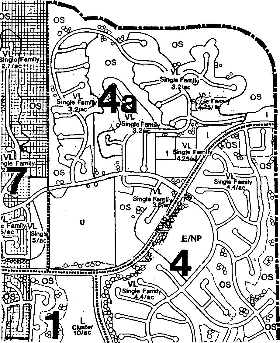
2 .detached 3.2du/ac deiached 3.2du/a*Av'.-. : :-'. rav.'&tfs 5 detached residential residential/institutiona passive recreation areas open space undesignated areas these areas may be either attached or detached single family housing LAND USE PLAN 10
3 12
4 2. A plan preserving a significant amount of natural open space and affording substantial opportunities for views. 3. A land use and circulation system providing public view outlooks to the exterior natural open space areas reserved in accordance with the Community Plan. 4. A "low-volume" curvilinear street system (dictated by the relatively low density of development), gaining primary community access via Del Mar Heights Road but providing linkages to Neighborhoods Four and Seven. 5. Neighborhood connections to a community level bikeway pedestrian system extending along Del Mar Heights Road. 6. Strong circulation linkages to the high school (to the west) in Unit Seven and the elementary school and neighborhood park (to the south) in Unit Four. LAND USE SUMMARY Table 1 summarizes land use acreage allocations for the precise plan area. Approximately acres, or 44 percent of the acreage, is allocated to residential uses. The remaining property is specified for institutional uses, streets, and open space. A total of 373 dwelling units are proposed. Housing areas will accommodate an estimated peak population of 958 residents. Table 1 LAND USE ACREAGE ALLOCATIONS Percent Land Use Acreage of Total Detached Residential Institutional* Undesignated Passive Recreational Areas 1.1 Major Streets and Collectors Open Space TOTAL *Includes an existing religious institution site of 2.5 acres. 13
5 RESIDENTIAL LAND USE Figure 6 shows the proposed distribution of residential development in the precise plan area. The housing mix is summarized in Table 2. All acreages are subject to minor modification during detailed engineering and design; consequently, the dwelling unit calculations provided in the precise plan may be subject to some corresponding modification at the time that development plans and subdivision maps are submitted. A total of 373 dwelling units are proposed on acres, resulting in an average density of 3.43 housing units per residential acre. The detached housing density is based on the total area included in the residential area (lots, internal slopes and streets, but excluding open space, the collector street, and the major street). On the basis of the total precise plan area (exclusive of undesignated areas), the plan produces a gross density of roughly 1.51 units per acre. A small number of additional units may result from: 1) City approval of a conversion of a portion of the institutional area to very low density housing with a maximum density of 4.25 units per acre; 2) conversion to a single-family residential lot of that area of the existing church site presently lying within a City of San Diego street reservation for Del Mar Heights Road (once the City of San Diego determines that such reservation can be relinquished); and 3) adoption of undesignated areas of the plan for residential uses which will require Precise Plan amendments. Housing Type The single-family detached category corresponds to the "very-low density" category in the North City West Community Plan. Proposed detached units are of the conventional lot, very low density, single-family type. It should be emphasized that while certain housing areas are designated for detached housing (see "asterisks" in Figure 6), future development could appropriately take the form of attached clustered housing because of topographic conditions and limitations imposed by small ownerships. As shown in Table 2, a population of 1,044 persons is estimated for Unit Four-A. 14
6 Housing Category Table 2 Single Family Detached Density DU/AC AC Housing Mix Persons D U. Per DU Estimated Population 1,044 Housing Location The distribution of residential areas and the designation of housing categories evolved from the following considerations: o The overall land use and residential patterns established by the North City West Community Plan. o The environmental setting and its impact upon project siting and densities with respect to grading, selection of housing types, view enhancement, and the provision of drainage and utilities. o Compatible land use relationships and buffering as necessary. o Circulation around and through the neighborhood with respect to vehicular, pedestrian and bikeway access. The single-family areas to the north and east offer panoramic views of the surrounding areas. The single-family residences to the west offer more limited canyon view opportunities. Balanced Community The North City West Community Plan calls for the enforcement of a balanced community housing program consistent with Council Policy This means that a range of housing unit types and prices should be available in the community, suitable to households at a variety of income levels. The Community Plan provides for this balance by correlating income levels to proposed housing categories and locations. The very-low density categories in the Community Plan are designated for "lower-middle income families and up." 15

7 major street collector local traffic signal * ( INCLUDES 500 THROUGH TRIPS FROM DEVELOPMENT UNIT 7) DAILY TRIPS. SHOWN ON THIS MAP ARE BASED ON PROJECTED UNIT COUNTS FOR UNDESIGNATED AREAS 9 UNIT STREET SYSTEM
8 24

9 gonzales canyon cul-de-sac pass-through create "" ^nmmmin.nfifffmsatkikxw^ reserve natural.-j 98 0B - ^«^^-1 slnglejvv loade.df.x-o; residential. *: unit 7 i^l fill area!±j cut area ^school/ Dark maximum views thru terracing public view outlook natural open space "daylight* cuts undesignated areas 14 UNIT DESIGN APPROACH 34
10 Passive Recreation Areas Two areas of the land use plan are proposed as passive recreation areas. The first of these, Passive Recreation Area "A," occurs northeast of the main entrance off Del Mar Heights Road. A preliminary design is shown on Figure 17 and proposes a serpentine pathway and mounded play areas with canopy-like trees. Tree clustering is suggested to screen this passive recreation area from the adjacent residences to the north. Intended activities for this area include walking, picnicking and resting points for residents out for a bicycle ride. The other "mini-park," Passive Recreation Area "B," is located west of the eastern intersection of the loop road and Black Mountain Road. An initial conceptual design as depicted on Figure 22 proposes an informal turf area, with canopy-like trees separating it from the adjacent streets, and low shrubs acting as a transition to the natural open space. Additionally, benches are to be provided along with a pedestrian sidewalk around the area. Neither of the passive recreation areas are intended to function as or take the place of a neighborhood park. A neighborhood park is located across Del Mar Heights Road in Development Unit 4. Maintenance of the passive recreation areas is to be accomplished through a neighborhood homeowners association. DETACHED RESIDENTIAL PROJECTS The precise plan for Unit Four-A provides a total of 373 detached, single-family dwelling units. While a minimum pad area of 6,000 square feet is contemplated for most detached lots, the average size of those lots shown in the plan will more nearly approximate 7,500 square feet. As indicated in Chapter 2, areas designated for detached units could optionally be developed as clustered housing. All single-family projects will be developed in conformance with the SF1 Zone or the SF1-A Zone as described in Chapter 5 and incorporated into the Planned District Ordinance. The following guidelines should be considered in the design, review, and approval of subdivision maps and development plans. Design Guidelines o Each project area should be given an identity through common design treatments, delineation of project boundaries, and distinctive entrances. 56
11 SF1! precise plan boundary planned district zoning SF1- A H - -,i A-1-10 existing zone zone boundary 23 ZONING PLAN 62
TOWN OF ORO VALLEY PLANNING & ZONING COMMISSION MEETING DATE: December 6, 2011
 PLANNING & ZONING COMMISSION MEETING DATE: December 6, 2011 TO: FROM: SUBJECT: PLANNING & ZONING COMMISSION Matt Michels, Senior Planner mmichels@orovalleyaz.gov; tel. 229-4822 Public Hearing: Rancho de
Planning Department Oconee County, Georgia
 Planning Department Oconee County, Georgia STAFF REPORT REZONE CASE #: 6985 DATE: October 31, 2016 STAFF REPORT BY: Andrew C. Stern, Planner APPLICANT NAME: Williams & Associates, Land Planners PC PROPERTY
TOTTENHAM SECONDARY PLAN
 TOTTENHAM SECONDARY PLAN AMENDMENT NO. 11 TO THE OFFICIAL PLAN OF THE TOWN OF NEW TECUMSETH The following text and schedules to the Official Plan of the Town of New Tecumseth constitute Amendment No. 11
2030 General Plan. December 6, 7 pm
 2030 General Plan GPAC Meeting #9 GPAC Meeting #9 December 6, 7 pm City Council Input on Working Draft Land Use Map Council discussed GPAC & PC versions of the working draft land use map 11/28 Council
Exhibit D. Tallow Ridge PUD. Written Description. Date: January 5, E. City Development Number:
 Exhibit D Tallow Ridge PUD Written Description Date: January 5, 2016 I. SUMMARY DESCRIPTION OF THE PROPERTY A. Current Land Use Designation: RR B. Current Zoning District: PUD C. Requested Zoning District:
PLANNED DEVELOPMENT DISTRICT STANDARDS. Cadence Site
 PLANNED DEVELOPMENT DISTRICT STANDARDS Cadence Site A Planned Development District 1. Statement of General Facts, Conditions and Objectives Property Size: Approximately 57.51 Acres York County Tax Map
SECTION 7000 LAND DEVELOPMENT REQUIREMENTS
 SECTION 7000 LAND DEVELOPMENT REQUIREMENTS 7000 LAND DEVELOPMENT REQUIREMENTS... 1 7001 LEGISLATIVE AUTHORITY... 1 7001.1 LAND DEVELOPMENT... 1 7001.1.1 Title 40, Idaho Code... 1 7001.1.2 Idaho Code 40-1415
EXHIBIT D. Planned Unit Development Written Description April 13, 2016 Rouen Cove Phase II PUD
 1 EXHIBIT D Planned Unit Development Written Description April 13, 2016 Rouen Cove Phase II PUD Development # 8986.001 Developer: Curtis L. Hart Hart Resources LLC 8051 Tara Lane Jacksonville, Florida
Appendix J - Planned Unit Development (PUD)
") Appendix J - Planned Unit Development (PUD) Intent and Purpose The purpose of the PUD is: 1. To provide development that is consistent with the Comprehensive Land Use Plan and promote the goals and objectives
Appendix J - Planned Unit Development (PUD) Intent and Purpose The purpose of the PUD is: 1. To provide development that is consistent with the Comprehensive Land Use Plan and promote the goals and objectives
CHAPTER34 PRUD - PLANNED RESIDENTIAL UNIT DEVELOPMENT
 CHAPTER34 PRUD - PLANNED RESIDENTIAL UNIT DEVELOPMENT 17-34-1 17-34-2 17-34-3 17-34-4 17-34-5 17-34-6 17-34-7 17-34-8 17-34-9 Purpose Planned Residential Unit Development Defined Planned Residential Unit
Town of Falmouth s Four Step Design Process for Subdivisions in the Resource Conservation Zoning Overlay District
 Town of Falmouth s Four Step Design Process for Subdivisions in the Resource Conservation Zoning Overlay District All subdivisions shall be designed in accordance with the following four-step process.
Article Floating Zone Requirements
 Division 5.1. In General Article 59-5. Floating Zone Requirements Section 5.1.1. Zone Categories There are 4 categories of Floating zones: A. Residential Floating zones (Division 5.2); B. Commercial/Residential
Note: Staff reports can be accessed at
 The Maryland-National Capital Park and Planning Commission Prince George's County Planning Department Development Review Division 301-952-3530 Note: Staff reports can be accessed at www.mncppc.org/pgco/planning/plan.htm.
RP-2, RP-3, RP-4, AND RP-5 PLANNED RESIDENTIAL DISTRICTS
 6.10 - RP-2, RP-3, RP-4, AND RP-5 PLANNED RESIDENTIAL DISTRICTS 6.10.1 GENERAL DESCRIPTION: 6.10.1.1 The regulations established in this Section are intended to provide optional methods of land development
CITY COUNCIL STUDY SESSION MEMORANDUM
 City and County of Broomfield, Colorado To: From: Prepared by: Owner Applicant Property Size Property Location: CITY COUNCIL STUDY SESSION MEMORANDUM Mayor and City Council Charles Ozaki, City and County
Belmead Neighbourhood Structure Plan
 Belmead Neighbourhood Structure Plan Office Consolidation November 2005 Prepared by: Planning and Policy Services Branch Planning and Development Department City of Edmonton Bylaw 6619 was adopted by Council
Memorandum City of Lawrence Planning & Development Services
 Memorandum City of Lawrence Planning & Development Services TO: City Commission FROM: Planning Staff Date: July 11, 2017 RE: Industrial District Review Attachments: 1. Existing Industrial Zoning Map 2.
RECOMMENDATION: Approval subject to the following conditions:
 RECOMMENDATION: Approval subject to the following conditions: 1) Approval under this preliminary plan is limited to 2 lots for 2 dwelling units 2) The record plat must note that the preliminary plan is
Chapter 22 PLANNED UNIT DEVELOPMENT.
 Chapter 22 PLANNED UNIT DEVELOPMENT. Sec. 22.1 INTENT. The use of land and the construction and use of buildings and other structures as Planned Unit Developments in Georgetown Township may be established
CONDOMINIUM REGULATIONS
 ARTICLE 37 CONDOMINIUM REGULATIONS SECTION 37.01. Purpose The purpose of this Article is to regulate projects that divide real property under a contractual arrangement known as a condominium. New and conversion
A. Location. A MRD District may be permitted throughout the County provided it meets the standards established herein.
 752. Multi-Residential District (MRD) The Multi-Residential (MRD) District is intended to provide opportunities for rural, suburban and urban density mixed-residential developments consistent with the
Cover Letter with Narrative Statement
 Cover Letter with Narrative Statement March 31, 2017 rev July 27, 2017 RE: Rushton Pointe Residential Planned Unit Development Application for Public Hearing for RPUD Rezone PL2015 000 0306 Mr. Eric Johnson,
UPPER MOUNT BETHEL TOWNSHIP NORTHAMPTON COUNTY, PENNSYLVANIA
 UPPER MOUNT BETHEL TOWNSHIP NORTHAMPTON COUNTY, PENNSYLVANIA JOINDER DEED / LOT CONSOLIDATION TOWNSHIP REVIEW PROCESS When accepting proposed Joinder Deeds / Lot Consolidations, review the Joinder Deed
Truax Park Apartments
 Truax Park Apartments Master Planning and Site Development Study Prepared by The Community Development Authority of the City of Madison In association with SMITH & SMITH ASSOCIATES, Inc CONSTRUCTION COST
4.1 Overview. 4.2 Land Use Plan
 4.1 Overview The Sierra Vista Specific Plan provides for a mix of land uses to achieve the desired community form and Plan Area objectives. These land use designations include low-, medium-, and high-density
YELLOWSTONE COUNTY BOARD OF PLANNING FINDINGS OF FACT
 YELLOWSTONE COUNTY BOARD OF PLANNING FINDINGS OF FACT The City-County Planning staff has prepared the Findings of Fact for the Aspen Ridge Subdivision, 2 nd Filing. These findings are based on the preliminary
Development Program Report for the Alamo Area of Benefit
 Julia R. Bueren, Director Deputy Directors Brian M. Balbas, Chief Mike Carlson Stephen Kowalewski Carrie Ricci Joe Yee ADOPTED BY BOARD OF SUPERVISORS ON Development Program Report for the Alamo October,
EXCERPT Planned Residential Development (PRD)
") LAND DEVELOPMENT CODE ESTABLISHING ZONING DISTRICTS AND REGULATIONS FOR LAND DEVELOPMENT AND SUBDIVISION IN THE CITY OF HATTIESBURG, MISSISSIPPI ORDINANCE NO. 2330 ADOPTED DECEMBER 05, 1989 EXCERPT Planned
LAND DEVELOPMENT CODE ESTABLISHING ZONING DISTRICTS AND REGULATIONS FOR LAND DEVELOPMENT AND SUBDIVISION IN THE CITY OF HATTIESBURG, MISSISSIPPI ORDINANCE NO. 2330 ADOPTED DECEMBER 05, 1989 EXCERPT Planned
ARTICLE 12 PLANNED UNIT DEVELOPMENT DISTRICTS (PUDS) Sec Intent CHARTER TOWNSHIP OF BRIGHTON ZONING ORDINANCE
 Sec Intent CHARTER TOWNSHIP OF BRIGHTON ZONING ORDINANCE") ARTICLE 12 PLANNED UNIT DEVELOPMENT DISTRICTS (PUDS) Sec. 12-01 Intent 1 2 (a) The intent of this Article is to permit the coordinated development on larger sites, protect significant natural features
ARTICLE 12 PLANNED UNIT DEVELOPMENT DISTRICTS (PUDS) Sec. 12-01 Intent 1 2 (a) The intent of this Article is to permit the coordinated development on larger sites, protect significant natural features
WHEREAS, the staff of The Maryland-National Capital Park and Planning Commission recommended APPROVAL of the application with conditions; and
 R E S O L U T I O N WHEREAS, Redeemed Christian Church of God is the owner of a 2.83-acre parcel of land known as Lot 9, Lot 19, P/O Lot 1 and P/O Lot 18, Block B, Plat Book A, Plat 5, said property being
(a) Commercial uses on Laurel Avenue, abutting the TRO District to the
 Commercial uses on Laurel Avenue, abutting the TRO District to the") 32X Zoning Code 150.36 TRANSITIONAL RESIDENTIAL OVERLAY DISTRICT. (A) Intent and purpose. (1) It is the intent of the Transitional Residential Overlay District (hereinafter referred to as the "TRO District")
32X Zoning Code 150.36 TRANSITIONAL RESIDENTIAL OVERLAY DISTRICT. (A) Intent and purpose. (1) It is the intent of the Transitional Residential Overlay District (hereinafter referred to as the "TRO District")
CITY OF WEST PALM BEACH PLANNING BOARD Meeting Date: July 17, 2018 Planning Board Case No. 1670I
 CITY OF WEST PALM BEACH PLANNING BOARD Meeting Date: July 17, 2018 Planning Board Case No. 1670I Palms Gateway Commercial Planned Development (CPD) Southeast Corner of Belvedere Road and Australian Avenue
Courtyards at Kinnamon Park Sketch Plan
 Courtyards at Kinnamon Park Sketch Plan Courtyards at Kinnamon Park Sketch Plan Staff Analysis PART 1: PROJECT SUMMARY Applicant: EPCON Communities Property Owner: Johnsie M. Kinnamon Heirs, Douglas and
ZONING AMENDMENT, PLANNED UNIT DEVELOPMENT & SUBDIVISION STAFF REPORT Date: August 8, 2013
 ZONING AMENDMENT, PLANNED UNIT DEVELOPMENT & SUBDIVISION STAFF REPORT Date: August 8, 2013 NAME SUBDIVISION NAME PV-Magnolia, LLC Twelve Trees Subdivision LOCATION 2860, 2862 and 2866 Pleasant Valley Road
Planned Unit Development (PUD). Sections:
. Sections:") Chapter 19.07. Planned Unit Development (PUD). Sections: 19.07.01. Purpose. 19.07.02. PUD Definition and Design Compatibility. 19.07.03. General PUD Standards. 19.07.04. Underlying Zones. 19.07.05. Permitted
Chapter 19.07. Planned Unit Development (PUD). Sections: 19.07.01. Purpose. 19.07.02. PUD Definition and Design Compatibility. 19.07.03. General PUD Standards. 19.07.04. Underlying Zones. 19.07.05. Permitted
Article 7: Residential Land Use and Development Requirements
 Article 7: Residential Land Use and Section 701: Statement of Intent (A) (B) (C) The intent of Article 7 is to develop certain land use and development requirements for the residential uses within Cumru
Staff Report: Date: Applicant: Property Identification: Acreage of Request: Current Zoning of Requested Area: Requested Action: Attached:
 Staff Report: Completed by Jeff Palmer Director of Planning & Zoning Date: November 7, 2018, Updated November 20, 2018 Applicant: Greg Smith, Oberer Land Developer agent for Ronald Montgomery ET AL Property
MONTGOMERY COUNTY PLANNING DEPARTMENT THE MARYLAND-NATIONAL CAPITAL PARK AND PLANNING COMMISSION
 MONTGOMERY COUNTY PLANNING DEPARTMENT THE MARYLAND-NATIONAL CAPITAL PARK AND PLANNING COMMISSION MCPB Item No. Date: 12/4/14 Preliminary Plan No. 120140200, Northwood Knolls Description Patrick Butler,
Community Development
 Land Use Petition RZ-16-002 Date of Staff Recommendation Preparation: April 15, 2016 (CEL) Date of Planning Commission Recommendation: May 3, 2016 PROJECT LOCATION: DISTRICT/SECTION/LANDLOT(S): ACREAGE
Clearcreek Township Zoning Staff Report Soraya Farms Section 6 Stage 3 Review Page 1 of 8
 Staff Report: Completed by Jeff Palmer Director of Planning & Zoning Report Date: September 10, 2018 Meeting Date: October 1, 2018 Applicant: Shery Oakes, agent for Soraya Farms Requested Action: Soraya
GROSVENOR-STRATHMORE METRO STATION MANDATORY REFERRAL APPLICATION NORTH BETHESDA, MD
 GROSVENOR-STRATHMORE METRO STATION MANDATORY REFERRAL APPLICATION NORTH BETHESDA, MD Submission by: Fivesquares JDA at Grosvenor Metro, LLC On behalf of Washington Metropolitan Area Transit Authority 1
Conditional Use Permit case no. CU 14-06: Bristol Village Partners, LLC
 PLANNING AND ZONING COMMISSION STAFF REPORT August 7, 2014 Conditional Use Permit case no. CU 14-06: Bristol Village Partners, LLC CASE DESCRIPTION: LOCATION: LEGAL DESCRIPTION: EXISTING LAND USE: ZONING:
MONTGOMERY COUNTY PLANNING DEPARTMENT THE MARYLAND-NATIONAL CAPITAL PARK AND PLANNING COMMISSION
 MONTGOMERY COUNTY PLANNING DEPARTMENT THE MARYLAND-NATIONAL CAPITAL PARK AND PLANNING COMMISSION MCPB Item No.: Date: 06-21-12 The Plantations, Preliminary Plan -120090240 Benjamin Berbert, Senior Planner,
Article 3. SUBURBAN (S-) NEIGHBORHOOD CONTEXT
 NEIGHBORHOOD CONTEXT") Article 3. SUBURBAN (S-) NEIGHBORHOOD CONTEXT this page left intentionally blank Contents ARTICLE 3. SUBURBAN (S-) NEIGHBORHOOD CONTEXT DIVISION 3.1 NEIGHBORHOOD CONTEXT DESCRIPTION...3.1-1 Section 3.1.1
Article 3. SUBURBAN (S-) NEIGHBORHOOD CONTEXT this page left intentionally blank Contents ARTICLE 3. SUBURBAN (S-) NEIGHBORHOOD CONTEXT DIVISION 3.1 NEIGHBORHOOD CONTEXT DESCRIPTION...3.1-1 Section 3.1.1
PERMITTED USES: Within the MX-1 Mixed Use Neighborhood District the following uses are permitted:
 6.25 MX-1 - MIXED USE NEIGHBORHOOD 6.25.1 INTENT: The purpose of the MX-1 Mixed Use Neighborhood District is to accommodate the development of a wide-range of residential and compatible non-residential
Condominium Unit Requirements.
 ARTICLE 19 CONDOMINIUM REGULATIONS Section 19.01 Purpose. The purpose of this Article is to regulate projects that divide real property under a contractual arrangement known as a condominium. New and conversion
ARTICLE 23 CONDOMINIUM STANDARDS
 ARTICLE 23 CONDOMINIUM STANDARDS Section 23.01 Intent. The intent of this Article is to provide regulatory standards for condominiums and site condominiums similar to those required for projects developed
Memorandum City of Lawrence Planning Department
 Memorandum City of Lawrence Planning Department TO: FROM: CC: Lawrence Douglas County Planning Commission Sandra Day, AICP, Planning Staff Applicant Date: January 14, 2013 RE: Item No. 3: Langston Heights
REPORT OF THE PLANNING AND DEVELOPMENT DEPARTMENT FOR APPLICATION FOR REZONING ORDINANCE TO PLANNED UNIT DEVELOPMENT SEPTEMBER 3, 2015
 AAG REPORT OF THE PLANNING AND DEVELOPMENT DEPARTMENT FOR APPLICATION FOR REZONING ORDINANCE TO PLANNED UNIT DEVELOPMENT SEPTEMBER 3, 2015 The Planning and Development Department hereby forwards to the
Composition of traditional residential corridors.
 Page 1 of 7 St. Petersburg, Florida, Code of Ordinances >> PART II - ST. PETERSBURG CITY CODE >> Chapter 16 - LAND DEVELOPMENT REGULATIONS >> SECTION 16.20.060. CORRIDOR RESIDENTIAL TRADITIONAL DISTRICTS
Cobb County Community Development Agency Zoning Division 1150 Powder Springs St. Marietta, Georgia 30064
 Cobb County Community Development Agency Zoning Division 1150 Powder Springs St. Marietta, Georgia 30064 Case # Z-63 Public Hearing Dates: PC: 11-06-18 BOC: 11-20-18 SITE BACKGROUND Applicant: Loyd Development
Chapter SPECIAL USE ZONING DISTRICTS
 Chapter 20.20 Sections: 20.20.010 Urban Transition (U-T) Zoning District 20.20.020 Planned Development (P-D) Zoning Districts 20.20.010 Urban Transition (U-T) Zoning District A. Purpose. The purpose of
PLANNING COMMISSION REPORT Regular Agenda -Public Hearing Item
 PDP-13-00518 Item No. 3B- 1 PLANNING COMMISSION REPORT Regular Agenda -Public Hearing Item PC Staff Report 2/24/14 ITEM NO. 3B PRELIMINARY DEVELOPMENT PLAN FOR HERE @ KANSAS; 1101 INDIANA ST (SLD) PDP-13-00518:
Initial Subdivision Applications Shall Include the Following:
 Initial Subdivision Applications Shall Include the Following: 1) Subdivision Application Form: completely filled out (12 copies) 2) Plat: The Plat must adhere to the requirements set forth in the Town
Section Preliminary Plat Checklist and Application Forms
 Section 201 - Preliminary Plat Checklist and Application Forms PRELIMINARY SUBDIVISION PLAT REVIEW PROCESS CHART PRELIMINARY SUBDIVISION PLAT APPLICATION PRELIMINARY PLAT REVIEW CHECKLIST CITY OF NAMPA
REPORT OF THE PLANNING AND DEVELOPMENT DEPARTMENT FOR APPLICATION FOR REZONING ORDINANCE TO PLANNED UNIT DEVELOPMENT AUGUST 20, 2015
 BEL REPORT OF THE PLANNING AND DEVELOPMENT DEPARTMENT FOR APPLICATION FOR REZONING ORDINANCE TO PLANNED UNIT DEVELOPMENT AUGUST 20, 2015 The Planning and Development Department hereby forwards to the Planning
REPORT OF THE PLANNING AND DEVELOPMENT DEPARTMENT FOR APPLICATION FOR REZONING ORDINANCE TO PLANNED UNIT DEVELOPMENT SEPTEMBER 22, 2016
 BEL REPORT OF THE PLANNING AND DEVELOPMENT DEPARTMENT FOR APPLICATION FOR REZONING ORDINANCE 2016-576 TO PLANNED UNIT DEVELOPMENT SEPTEMBER 22, 2016 The Planning and Development Department hereby forwards
CITY OF PISMO BEACH PLANNING COMMISSION AGENDA REPORT
 CITY OF PISMO BEACH PLANNING COMMISSION AGENDA REPORT DATE: October 27, 2015 TO: FROM: HONORABLE CHAIR AND MEMBERS OF THE PLANNING COMMISSION Jan Di Leo, Planner (805) 773-7088 jdileo@pismobeach.org APPLICATION:
REPORT TO THE SHELBY COUNTY PLANNING COMMISSION From the Department of Development Services Planning Services. February 4, 2019
 REPORT TO THE SHELBY COUNTY PLANNING COMMISSION From the Department of Development Services Planning Services February 4, 2019 Case No. Request for Rezoning Approval From E-1 to E-2 SD This is a request
THE REDEVELOPMENT PLAN
 PAGE 37 THE REDEVELOPMENT PLAN FUTURE LAND USE The Silver Terrace Redevelopment Area is currently designated as Redevelopment Area #4 on the City of Delray Beach Future Land Use Map (FLUM). This designation
ARTICLE 9 SPECIFICATIONS FOR DOCUMENTS TO BE SUBMITTED
 ARTICLE 9 SPECIFICATIONS FOR DOCUMENTS TO BE SUBMITTED SECTION 950 GENERALLY All applications shall be properly signed and filed by the owner or, with the owner s specific written consent, a contract purchaser
PLANNING COMMISSION REPORT Regular Agenda - Public Hearing Item
 Z-11-25-09; Z-11-26-09; Z-11-28-09 Item No. 2-1 PC Staff Report 3/28/11 PLANNING COMMISSION REPORT Regular Agenda - Public Hearing Item ITEM NO. 2A RM32 TO MU;.19 ACRES; 1340 TENNESSEE ST (MJL) Z-1-1-11:
WIREGRASS RANCH DRI/MPUD MASTER ROADWAY PLAN CONDITIONS OF APPROVAL PDD DRC
 WIREGRASS RANCH DRI/MPUD MASTER ROADWAY PLAN CONDITIONS OF APPROVAL DRC 1. This Master Roadway Plan (the MRP) replaces and supersedes the Roadway Alignment and Construction Phasing Plan (File No. GM06-737)
Request Conditional Rezoning (AG-1 & AG-2 Agricultural to Conditional R-10 Residential & P- 1 Preservation District) Staff Recommendation Approval
 Staff Recommendation Approval") Applicant & Property Owner Public Hearing February 14, 2018 City Council Election District Princess Anne Agenda Item 7 Request Conditional Rezoning (AG-1 & AG-2 Agricultural to Conditional R-10 Residential
Applicant & Property Owner Public Hearing February 14, 2018 City Council Election District Princess Anne Agenda Item 7 Request Conditional Rezoning (AG-1 & AG-2 Agricultural to Conditional R-10 Residential
PLANNED UNIT DEVELOPMENT & SUBDIVISION STAFF REPORT Date: April 18, 2019
 PLANNED UNIT DEVELOPMENT & SUBDIVISION STAFF REPORT Date: April 18, 2019 DEVELOPMENT NAME SUBDIVISION NAME Springhill Village Subdivision Springhill Village Subdivision LOCATION 4350, 4354, 4356, 4358,
The following regulations shall apply in the R-E District:
 "R-E" RESIDENTIAL ESTATE DISTRICT (8/06) The following regulations shall apply in the R-E District: 1. Uses Permitted: The following uses are permitted. A Zoning Certificate may be required as provided
ARTICLE FIVE FINAL DRAFT
 ARTICLE FIVE 021218 FINAL DRAFT Sec. 503.6 Open Space Preservation Option Open Space Preservation Option Open Space Preservation developments may be approved in the AR, R-1, R-2 and R-3 zoning districts,
SECTION 22 PLANNED RESIDENTIAL DEVELOPMENT OVERLAY DISTRICT
 SECTION 22 PLANNED RESIDENTIAL DEVELOPMENT OVERLAY DISTRICT 22.1 Purpose: The purpose of the Planned Residential Development Overlay District ( PRD ) is (1) to provide for diversity of housing types and
County of Loudoun. Department of Planning and Zoning MEMORANDUM
 County of Loudoun Department of Planning and Zoning MEMORANDUM DATE: November 10, 2015 TO: FROM: Joe Griffiths, Project Manager Land Use Review Kelly Williams, Planner III Community Planning SUBJECT: ZRTD
4 June 11, 2014 Public Hearing
 4 June 11, 2014 Public Hearing APPLICANT: FRANKLIN JOHNSTON MANAGEMENT DEVELOPMENT, L.L.C. PROPERTY OWNER: TRUSTEES OF FIRST LYNNHAVEN BAPTIST CHURCH STAFF PLANNER: Stephen J. White REQUEST: Change of
Rosslyn Sector Plan Implementation Zoning Ordinance Amendments. NAIOP Meeting April 13, 2016
 Rosslyn Sector Plan Implementation Zoning Ordinance Amendments NAIOP Meeting April 13, 2016 Agenda Background, Process & Schedule Preliminary Amendments to C-O Rosslyn Building Height & Step-backs Density
RIVER VALE MASTER PLAN PZ CITY COUNCIL PUBLIC HEARING JULY 19, 2017 CITY OF BEND
 RIVER VALE MASTER PLAN PZ-16-0954 CITY COUNCIL PUBLIC HEARING JULY 19, 2017 RIVER VALE MASTER PLAN Master Plan process Required for developments over 20 acres Application submitted under old Master Plan
STAFF SUMMARY FOR Z18-09 CONDITIONAL ZONING DISTRICT APPLICATION
 STAFF SUMMARY FOR Z18-09 CONDITIONAL ZONING DISTRICT APPLICATION APPLICATION SUMMARY Case Number: Z18-09 Request: Conditional R-10 Zoning District in order to develop a performance residential development
Chapter 100 Planned Unit Development in Corvallis Urban Fringe
 100.100 Scope and Purpose. Chapter 100 Planned Unit Development in Corvallis Urban Fringe (1) All applications for land divisions in the Urban Residential (UR) and Flood Plain Agriculture (FPA) zones within
MONTGOMERY COUNTY PLANNING DEPARTMENT THE MARYLAND-NATIONAL CAPITAL PARK AND PLANNING COMMISSION
 MONTGOMERY COUNTY PLANNING DEPARTMENT THE MARYLAND-NATIONAL CAPITAL PARK AND PLANNING COMMISSION MCPB Item No. 3 Date: 01-31-13 Preliminary Plan 120090300, Boyds Highlands Calvin Nelson, Jr. Planner Coordinator,
Community Development Department 333 Broadalbin Street SW, P.O. Box 490 Albany, OR 97321
 SUMMARY Community Development Department 333 Broadalbin Street SW, P.O. Box 490 Albany, OR 97321 STAFF REPORT Application for Tentative Partition Plat Review Planning File PA-06-17 Phone: 541-917-7550
STAFF REPORT. Guttman Development Group, LLC. PUD-R (Residential Planned Unit Development Plan)
") P a g e 1 STAFF REPORT CASE: APPLICANT: LOCATION: ZONED: REQUEST: ZC09-2017 Guttman Development Group, LLC 4990 Wilmington Pike PUD-R (Residential Planned Unit Development Plan) A Major Change to an Approved
P a g e 1 STAFF REPORT CASE: APPLICANT: LOCATION: ZONED: REQUEST: ZC09-2017 Guttman Development Group, LLC 4990 Wilmington Pike PUD-R (Residential Planned Unit Development Plan) A Major Change to an Approved
REPORT OF THE PLANNING AND DEVELOPMENT DEPARTMENT FOR APPLICATION FOR REZONING ORDINANCE TO PLANNED UNIT DEVELOPMENT MAY 18, 2017
 BEL REPORT OF THE PLANNING AND DEVELOPMENT DEPARTMENT FOR APPLICATION FOR REZONING ORDINANCE 2016-805 TO PLANNED UNIT DEVELOPMENT MAY 18, 2017 The Planning and Development Department hereby forwards to
1.0 Introduction. November 9, 2017
 November 9, 2017 Andrew Bone, Planner III Regional Planning Policy and Strategic Initiatives Halifax Regional Municipality 40 Alderney Drive Dartmouth, NS, B2Y 2N5 Subject: Application to amend the Bedford
DEVELOPMENT DEPARTMENT STAFF REPORT THE PARK AT 5 TH
 DEVELOPMENT DEPARTMENT STAFF REPORT ARB Meeting Date: July 3, 2018 Item #: _PZ2018-293_ THE PARK AT 5 TH Request: Site Address: Project Name: Parcel Number: Applicant: Proposed Development: Current Zoning:
POLK COUNTY DEVELOPMENT REVIEW COMMITTEE CASE OVERVIEW
 POLK COUNTY DEVELOPMENT REVIEW COMMITTEE CASE OVERVIEW DRC Date: January 10, 2019 Level of Review: 4 PC Date: March 6, 2019 Type: Text Amendments BoCC Date: May 7, 2019 July 2, 2019 Case Numbers: Case
SUBDIVISION REGULATIONS
 CHAPTER 14 SUBDIVISION REGULATIONS 14-100 Provisions 14-200 Preliminary Plat 14-300 Final Plat 14-400 Replat 14-500 Minor Subdivision 14-600 Administrative Replat 14-700 Vacation of Roadways, Public Easements,
Medical Marijuana Special Exception Use Information
 Medical Marijuana Special Exception Use Information The Special Exception Use information below is a modified version of the Unified Development Code. It clarifies the current section 5:104 Special Exceptions
ARTICLE 13 CONDOMINIUM REGULATIONS
 ARTICLE 13 CONDOMINIUM REGULATIONS Section 13.01 Purpose. The purpose of this Article is to regulate projects that divide real property under a contractual arrangement known as a condominium. New and conversion
ARTICLE 15. RULES, REGULATIONS AND DEFINITIONS
 ARTICLE 15. RULES, REGULATIONS AND DEFINITIONS Section 1. Interpretation and Construction: The following rules and regulations regarding interpretation and construction of the Ulysses-Grant County, Kansas,
ARTICLE XXI GENERAL SITE DEVELOPMENT PLAN REQUIREMENTS
 1 2 3 4 5 6 7 8 9 10 11 12 13 14 15 16 17 18 19 20 21 22 23 24 25 ARTICLE XXI GENERAL SITE DEVELOPMENT PLAN REQUIREMENTS Section 21.1 Purpose and Intent... 2 Section 21.2 Administrative Site Plan Review
CITY OF FERNDALE HEARING EXAMINER
 CITY OF FERNDALE HEARING EXAMINER RE: Planned Unit Development ) 16001-PUD Preliminary Plat ) 16018-SE Plat Variance ) 16002-VAR Application by ) ) MD General, L.L.C. ) FINDINGS OF FACT, Malloy Heights
PIN , Part 1, Plan SR-713 in Lot 2, Concession 5, Township of McKim (1096 Dublin Street, Sudbury)
") STAFF REPORT Applicant: Dalron Construction Limited Location: PIN 02124-0103, Part 1, Plan SR-713 in Lot 2, Concession 5, Township of McKim (1096 Dublin Street, Sudbury) Official Plan and Zoning By-law:
STAFF REPORT Applicant: Dalron Construction Limited Location: PIN 02124-0103, Part 1, Plan SR-713 in Lot 2, Concession 5, Township of McKim (1096 Dublin Street, Sudbury) Official Plan and Zoning By-law:
CHRIS ANARADIAN, DEVELOPMENT SERVICES DIRECTOR BRETT BURNINGHAM, PLANNING ADMINISTRATOR; CHRISTINE SHEEHY, PRINCIPAL PLANNER
 Requesting Department: Development Services TO: THROUGH: FROM: RE: PLANNING AND ZONING COMMISSION CHRIS ANARADIAN, DEVELOPMENT SERVICES DIRECTOR BRETT BURNINGHAM, PLANNING ADMINISTRATOR; CHRISTINE SHEEHY,
42-Acre Parcel Rezoning and Master Plan Amendment. Danny Cagle and Patrick Stanley 6301 Duckweed Rd. Lake Worth, FL 33449
 STAFF REPORT CITY OF PARKLAND DEVELOPMENT SERVICES DEPARTMENT Date Prepared: May 2, 2014 I. Petition Description Petition No.: Project Name: Owners: RZ14-001; MPA14-002 42-Acre Parcel Rezoning and Master
Multifamily Development Land
 FOR SALE $420,000 Possible Self Storage Conversion Site Property Details PRICE $420,000 PARCEL ID 3414-501-0713-400-3 LAND SIZE 209,088 sf Exceptional purchase opportunity of 4.8 acres of land ideal for
PLANNED UNIT DEVELOPMENT (PUD)
") SECTION 38.01. ARTICLE 38 PLANNED UNIT DEVELOPMENT (PUD) Purpose The purpose of this Article is to implement the provisions of the Michigan Zoning Enabling Act, Public Act 110 of 2006, as amended, authorizing
SECTION 38.01. ARTICLE 38 PLANNED UNIT DEVELOPMENT (PUD) Purpose The purpose of this Article is to implement the provisions of the Michigan Zoning Enabling Act, Public Act 110 of 2006, as amended, authorizing
ARTICLE 14 PLANNED UNIT DEVELOPMENT (PUD) DISTRICT
 DISTRICT") ARTICLE 14 PLANNED UNIT DEVELOPMENT (PUD) DISTRICT Section 14.01 Intent. It is the intent of this Article to allow the use of the planned unit development (PUD) process, as authorized by the Michigan Zoning
ARTICLE 14 PLANNED UNIT DEVELOPMENT (PUD) DISTRICT Section 14.01 Intent. It is the intent of this Article to allow the use of the planned unit development (PUD) process, as authorized by the Michigan Zoning
RESIDENTIAL DISTRICTS
 RESIDENTIAL DISTRICTS RESIDENTIAL DISTRICTS The residential district standards have been revised to reflect on-the-ground development conditions, while continuing to respect the use patterns established
Affordable Housing Plan
 Affordable Housing Plan CORDOVA HILLS SPECIAL PLANNING AREA 1 Proposed Project Conwy LLC is the master developer ( Master Developer ) of that certain real property in the County of Sacramento ( County
ARTICLE 15 - PLANNED UNIT DEVELOPMENT
 Section 15.1 - Intent. ARTICLE 15 - PLANNED UNIT DEVELOPMENT A PUD, or Planned Unit Development, is not a District per se, but rather a set of standards that may be applied to a development type. The Planned
City of Valdosta Land Development Regulations
 Chapter 206 Section 206-1 Base Zoning Districts Standards for Uses, Structures, and Property Development (B) (C) Principal Uses and Structures. Principal uses and structures permitted in each base zoning
1. APPLICANT: The City of Overland Park is the applicant for this request.
 8. UNIFIED DEVELOPMENT ORDINANCE AMENDMENT - ZRR 2590 - Residential Neighborhood District 1. APPLICANT: The City of Overland Park is the applicant for this request. 2. REQUESTED ACTION: The applicant is
Development Plan DP13-3 (Arlington Lofts) Planning and Zoning Meeting Date: Document Being Considered: Ordinance
 Planning and Zoning Meeting Date: Document Being Considered: Ordinance") Staff Report Development Plan DP13-3 (Arlington Lofts) Planning and Zoning Meeting Date: 6-19-13 Document Being Considered: Ordinance RECOMMENDATION Following the public hearing, consider Development Plan
Staff Report Development Plan DP13-3 (Arlington Lofts) Planning and Zoning Meeting Date: 6-19-13 Document Being Considered: Ordinance RECOMMENDATION Following the public hearing, consider Development Plan
Z-MAX BLVD HARRISBURG, NC OFFERING MEMORANDUM
 Z-MAX BLVD HARRISBURG, NC OFFERING MEMORANDUM INVESTMENT HIGHLIGHTS List Price: $2,445,500 Location: Southeast quadrant of NC Hwy 49 and I-485 at the southern terminus of Z-Max Boulevard extending south