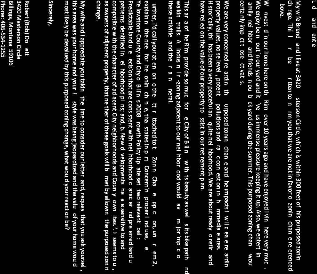
NOTICE TO THE PUBLIC. Introduction of the Yellowstone County Zoning Commission Members and Planning Department Staff.
|
|
|
- Adam Lang
- 6 years ago
- Views:
Transcription
 11:00 a.m.")
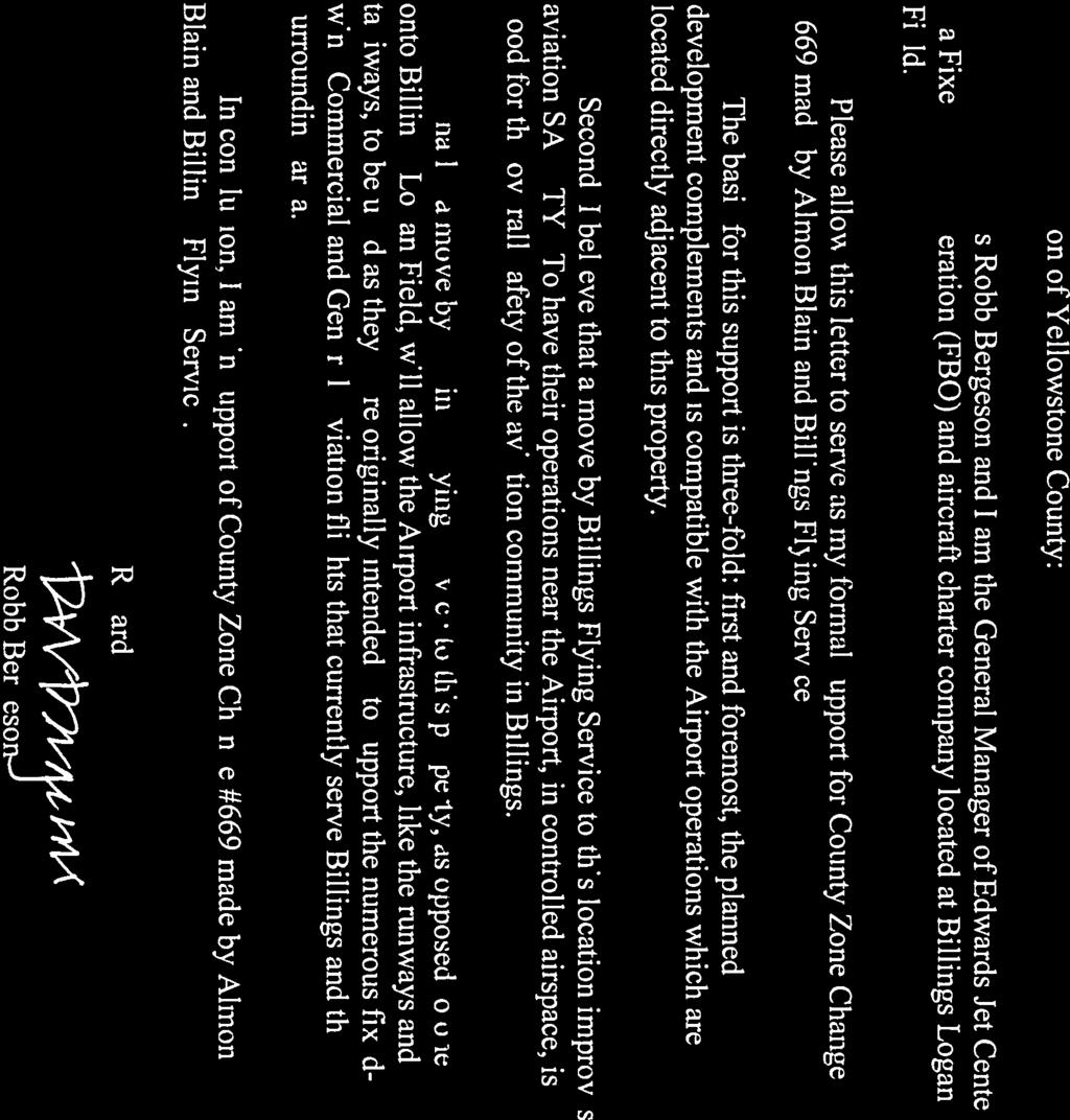
1 COUNTY OF YELLOWSTONE ZONING COMMISSION AGENDA-Friday, February 12, 2016 (Continued from February 8, 2016) 11:00 a.m. Billings Library Community Meeting Room 510 North Broadway, 1st Floor, Billings, Montana NOTICE TO THE PUBLIC Public Comment: There will be a Public Comment Section as noted on the agenda. This is the time members of the public may comment on any item not appearing on the agenda. Under State law, matters presented under this section cannot be discussed or acted upon by the Zoning Commission during this time. For items appearing on the agenda, the public will be invited to make comments at the appropriate time. It is very important to speak clearly, and state your name and address for the record. Please limit your comments to three (3) minutes or less. Call the meeting to order. Introduction of the Yellowstone County Zoning Commission Members and Planning Department Staff. Public Comment Disclosure of any Conflict of Interest-Members of the Commission and Staff Disclosure of an Outside (Ex Parte Communication)-Members of the Commission and Staff a.the Exparté Communication Binder is available at the Sign-In and Agenda Station. Regular Business: A. Opening of public hearings. B. Reading of rules for the procedure by which the public hearings will be conducted. C. Reading of notices of the public hearings on the following items: Public Hearings:
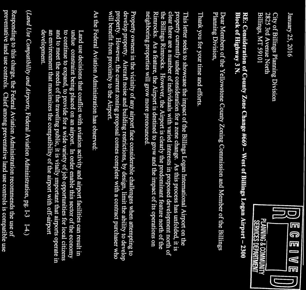
2 a. Item #1 (continued from February 8, 2016) - County Zone Change #669 West of Billings Logan Airport 2300 Block of Highway 3 North A zone change request from Agriculture-Open Space (A-1) to Public (P) on the north 600 feet of Tracts 13 and 14 of C/S 2037 (~18.49 acres), and Controlled Industrial (CI) on 20 acres directly south of the proposed Public zone on Tracts 13 & 14, C/S 2037, a acre parcel of land. The 20 acres immediately north of Highway 3 will remain in the A-1 zoning district.a pre-application meeting was conducted on November 20, 2015 at the Tolliver Law Firm, 1004 Division Street. Tax IDs: D04575L, D04575M. Presented by: Nicole Cromwell, Zoning Coordinator Other Business/Announcements Adjournment Following the public hearing, the County Zoning Commission will make a recommendation to the Yellowstone County Commissioners. The Board of County Commissioners public hearing for Zone Change #671 only will be held on Tuesday, February 23, 2016, at 9:45 a.m. in Room 403A, 4 th Floor of the Yellowstone County Courthouse. The Board of County Commissioners public hearing for Zone Changes #670 and #669 will be held on Tuesday, March 1, 2016, at 9:45 am, in Room 403A, 4 th Floor of the Yellowstone County Courthouse. The Board of County Commissioners will hear all persons wishing to speak relative to the proposed zone changes. Information on the preceding item may be obtained at the Yellowstone County Planning Department, rd Avenue North, 4 th Floor or phone Anyone wishing to be heard on this matter may appear at this hearing. Public hearings are accessible to individuals with physical disabilities. Special arrangements for participation in the public hearings by individuals with hearing, speech, or vision impairment may be made upon request at least three days prior to the hearing. Please notify Tammy Deines, Planning Clerk, at or at deinest@ci.billings.mt.us
3 County Zoning Commission Meeting Date: 02/12/2016 SUBJECT: Zone Change West of Billings Logan Airport - Highway 3 THROUGH: Candi Millar, Planning & Community Services Department Director PRESENTED BY: Nicole Cromwell Information REQUEST Item #1 (continued from February 8, 2016) - County Zone Change #669 West of Billings Logan Airport 2300 Block of Highway 3 North A zone change request from Agriculture-Open Space (A-1) to Public (P) on the north 600 feet of Tracts 13 and 14 of C/S 2037 (~18.49 acres), and Controlled Industrial (CI) on 20 acres directly south of the proposed Public zone on Tracts 13 & 14, C/S 2037, a acre parcel of land. The 20 acres immediately north of Highway 3 will remain in the A-1 zoning district. A pre-application meeting was conducted on November 20, 2015 at the Tolliver Law Firm, 1004 Division Street. Tax IDs: D04575L, D04575M. Presented by: Nicole Cromwell, Zoning Coordinator RECOMMENDATION The Planning Division recommends denial based on the proposed findings of the 11 criteria for Zone Change 669. APPLICATION DATA OWNER: Bruce Crippen; Frederick, Cameron & Lynn Longan; Richard & Ellen Rozehnal; Almon Blain (contract buyer) AGENT: Barb Potzman and Ken Tolliver LEGAL DESCRIPTION: Tracts 13 & 14, C/S 2037 ADDRESS: None yet assigned Block of Highway 3 CURRENT ZONING: A-1 EXISTING LAND USE: Grazing PROPOSED USE: Heliport and ancillary businesses with 20 acres of A-1 to remain adjacent to Highway 3 SIZE OF PARCEL: acres CONCURRENT APPLICATIONS None. APPLICABLE ZONING HISTORY The subject property is in the original zoning designated by the County in Agriculture-Open Space (A-1). There have been no applications to change the zoning on the subject property. West of the subject property on Tract 2 of C/S 1889, an application to change zoning from A-1 to Highway Commercial (HC) was denied by the County Commissioners in Other zone changes in the area were from A-1 to Agriculture Suburban (AS) or Residential 15,000 (R-150) and these have been approved. The Public zone is a zone described as "intended to reserve land exclusively for public or semi-public uses in order to preserve and provide adequate land for a variety of community facilities which serve the public health, safety and general welfare." The CI is a zone described as intended to "accommodate a variety of business, warehouse and light industrial uses related to wholesale plus other
4 business and light industries not compatible with other commercial zones, but which need not be restricted in industrial or general commercial zones, and to provide locations directly accessible to arterial and other transportation systems where they can conveniently serve the business and industrial centers of the city and county." SURROUNDING LAND USE & ZONING NORTH: Zoning: A-1 Land Use: Grazing land and vacant SOUTH: EAST: Zoning: R-70 and R-96 (city) Land Use: Single family dwellings Zoning: Public (city) Land Use: Billings Logan Airport property WEST: Zoning: A-1 Land Use: Agricultural land BACKGROUND This is an application to change zoning on 2 parcels of land directly west of the Billings Logan Airport to allow the contract buyer to construct a heliport and to allow development of ancillary or related businesses directly adjacent to the proposed heliport. The prosed zoning would be split between Public for the north 600 feet (about 18 acres) and Controlled Industrial (CI) for the 20 acres directly south of the proposed Public zone. The remaining 20 acres just north of Highway 3 would remain in the A-1 zone for the foreseeable future. The applicant has modified the request from the original submittal that included 40 acres of proposed CI zoning. The applicant and agents do not yet have a future land use plan that includes the south 20 acres that would remain in A-1 zoning. The applicant and agents currently plan to develop the proposed Public zoned area for a heliport. The adjacent 20 acres of CI zoning may be marketed to complementary businesses and service providers but no firm land use plan has been developed for this area. The property is not within the short term limits of annexation area for the City of Billings so all uses on the property will need to provide domestic water supply and waste water disposal. However, this area is within the Long Range Urban Planning Area of the City's Annexation Policy and future improvements to services in this area are expected to enable development in the City at some time in the future. The Public zone is the only zoning district that currently allows the development of a heliport except for the Medical Corridor (without fueling or maintenance) and certain Planned Development zones. Prior to 1997, the city and the county maintained separate zoning codes. The county code prior to 1997 allowed heliports by special review approval in 4 zoning districts (HC, CI, HI and Public) and allowed airports only in the Public zone. The city zoning code, prior to code unification in 1997, had been changed to only allow airports and heliports in the Public zoning district or heliports without fueling and maintenance facilities in the Medical Corridor. When the codes were unified, the city and county agreed to the move forward with the city's adopted code for many of the commercial and industrial zones. Special review is no longer possible for heliports. The change in the zoning code through the unification of the regulations was not intended to preclude the development of private aviation facilities but it now requires these facilities to be located in a Public zoning district. The proposed Public zone is adjacent to Public zoning for the Billings Logan Airport property directly to the east. The proposed use and development for Billings Flying Service has been reviewed by the airport staff and they have not forwarded any concerns with the proposal. There are 13 private heliports in Montana with 20 additional heliports associated with health care facilities or state facilities. Many of these private facilities are near tourist areas or serve ranches. Development of the heliport will need to be approved by the FAA and other aviation authorities due to its proximity to the public airport. The property is within the adopted Airport Influence Zone for the Billings airport. The height and use of any new structures on the property will be restricted through the adopted regulations (Chapter 5 of the Billings, MT City Code (BMCC)). The adopted influence zone is shown on the attached Zoning Map. The Airport Influence area regulations apply regardless of the underlying zoning district. The proposed 20 acres of CI zoning is not similar to the surrounding zoning. The surrounding zoning is residential (city) and agricultural and residential (county). The CI zone is a zone "to accommodate a variety of business, warehouse and light industrial uses related to wholesale plus other business and light industries not compatible with other commercial zones, but which need not be restricted in industrial or general commercial zones, and to
5 provide locations directly accessible to arterial and other transportation systems where they can conveniently serve the business and industrial centers of the city and county." On parcels outside the city limits, the CI zone supports businesses ranging from petroleum supply, personal storage warehousing as well as business service providers such as sign shops, machine repair shops and wholesale suppliers. The CI zone also allows some intense commercial development such large retailers and building supply businesses. While some of these uses may be compatible or benign in their effect on adjacent uses, many would not be compatible or desirable along a gateway area to the city or near residential neighborhoods. The applicant has modified the original request to exclude the south 20 acres of the parcel from the proposed CI zoning so any development for CI uses in the County would be at least 600 feet north of Highway 3 and 700 to 800 feet north of the closest residential building south of Highway 3. However, uses allowed in the CI zone may have more of a noise impact than the heliport depending on the type of use. Manufacturing uses may generate more noise and traffic than retail or service businesses. Uses allowed in the CI zone are also more likely to generate noise and traffic outside of normal business hours and have more impact on the health and general welfare of the residential neighborhoods south of Highway 3 and the residences along the north side of Highway 3 to the west of the subject property. The Planning Division recently completed a Highway 3 Corridor study to identify safety improvements for motorized and nonmotorized traffic in the area. South of Highway 3, the City and County own and manage park land atop the rims. Safe access to these parklands is a concern. In addition, control and management of storm water runoff from paved and unpaved areas is also a concern. The study concluded there are several needed safety improvements along this section of Highway 3, including traffic roundabouts at Zimmerman Trail and Rod & Gun Club Road intersections, and center turn lanes or raised medians to better control left turn movements. The study indicated Highway 3 has enough road capacity at least through 2035 for increasing levels of traffic including residential or commercial traffic. The 2015 traffic count for this section of Highway 3 averages about 9,600 vehicles per day. This is not a high volume for a principal arterial street but steady 3 to 4 percent increases in traffic volume have been noted in the past 5 years. The proposed zoning will have a measurable effect on traffic generation. The property currently has 2 access points. The primary access is a shared access along the east property line of Tract 14. There is a subsequent access easement granted along the south and westerly property lines to benefit Tracts 9, 10 and 12 to the north and west. There is a gated access from Highway 3 onto to Tract 14 that appears to be little used. A new or improved state-approved access will be needed to provide safe access to the proposed development for Billings Flying Service. The current use of the property occasional grazing of livestock generates little or no traffic on a daily basis. The types of traffic generated from Public and CI zoning are different than current traffic patterns in the area. MDT may require some traffic analysis and improvements dependent on the type and volume of traffic generated from specific developments on the property. If the property is annexed and developed, the City Traffic Engineer may require a traffic impact analysis to determine the appropriate mitigation or street development to accommodate the new uses. The proposed Public zoning is within the character of the adjacent airport property. The proposed area for the CI zoning may be compatible with some of the adjacent Public zoning uses (related to aircraft operations) but would have negative effects on the adjacent agricultural and residential uses. Due to the current lack of public services to the site, uses will be limited in both proposed zoning districts unless the property annexes in the future. Allowed uses within the CI zone range from small warehouses and mini storage to manufacturing. It is likely any development on the CI zoned area without public services will be limited to repair shops, contractor storage, offices and personal storage warehouses. This would be similar to recent developments on the east side of Sugar Avenue or on Cerise Road in Lockwood. Uses allowed in the CI zone may have more of a noise impact than the heliport depending on the type of use. Manufacturing uses may generate more traffic and noise than retail or service businesses. Uses allowed in the CI zone are also more likely to generate noise and traffic outside of normal business hours and have more impact on the health and general welfare of the residential neighborhoods south of Highway 3 and the residences along the north side of Highway 3 to the west of the subject property. The subject property is currently limited by the Airport Overlay zoning which discourages residential zoning and uses, and limits the height of buildings and trees so as not to interfere with aircraft departing or arriving at the Billings Airport. The proposed heliport is compatible with the existing airport.
6 The Planning Division has reviewed the application and the 11 criteria for all County zone changes. The proposal for the Public zoning has merit under the criteria given its location on the north portion of the property and its shared property line with the existing Public zoning for the city airport. The proposal also seeks 20 acres of Controlled Industrial (CI) zoning for the area directly south of the Public zone so compatible and support uses for the heliport may be developed. The proposed CI zoning is not compatible with the adjacent zoning in the city and county and is not a predictable land use given the adopted Growth Policy. The requested zoning must be reviewed in its entirety including both the Public zoning and the CI zoning, and staff finds that the CI zoning is not supported by the 11 criteria. The 20 acres directly north of Highway 3 will remain in the A-1 zoning district at this time under the updated proposal. The property is not within the short-term limits of annexation area on the City of Billings' Limits of Annexation Map. It is within the Long Range Urban Planning Area of the City's Limits of Annexation Map. While the property could not be annexed immediately under the City's Annexation Policy, the owner could request the City review including the property in the Red Area of the map in the future, so that annexation might be possible. One of the current challenges to urban development in this area in the City is limitations on current water and sewer infrastructure and access to other City services. Developments in similar CI zones in Yellowstone County include machine shops, personal warehouse storage, contractor storage yards and small manufacturing plants. Some of these developments might be appropriate in this area but many would not be compatible with adjacent neighbors or uses. Uses allowed in the CI zone may have more of a noise impact than the heliport depending on the type of use. Uses allowed in the CI zone are also more likely to generate noise and traffic outside of normal business hours and have more impact on the health and general welfare of the residential neighborhoods in the area.the south 20 acres of the property in close proximity to the residential uses south of the rims will remain as an A-1 zoning district under the revised applicant proposal. RECOMMENDATION The Planning Division recommends denial based on the proposed findings of the 11 review criteria for Zone Change 669. Zoning Map Findings of the Review Criteria Site photos Applicant Letter and pre application materials Similar CI zones in County Public Comment Dossett Public Comment Beley Public Comment Sather Public Comment Filz pt 1 Public Comment Filz pt 2 Public Comment Filz pt 3 Public Comment Filz pt 4 Public Comment Edwards Tolliver pt 1 Tolliver pt 2 Attachments

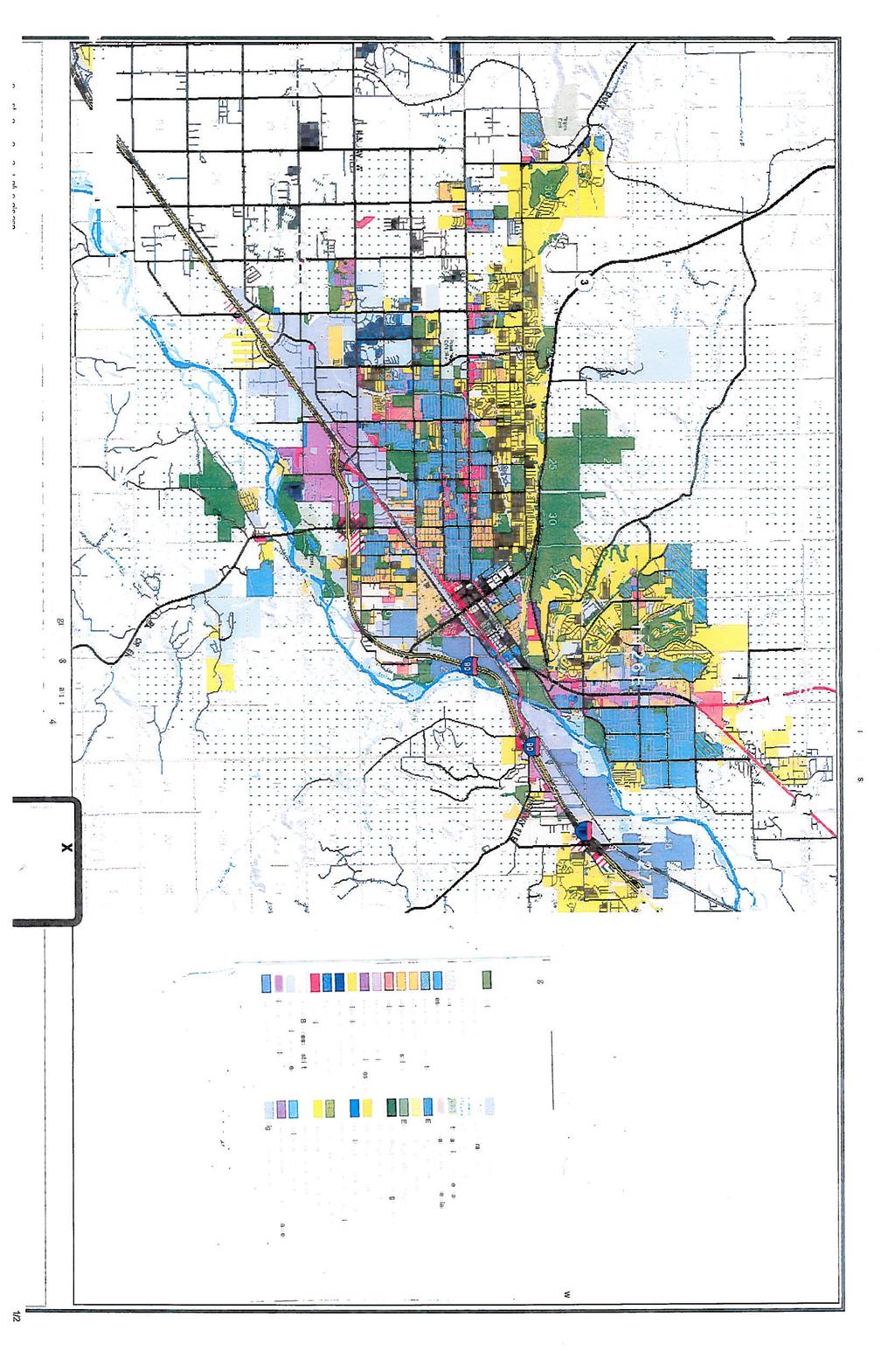
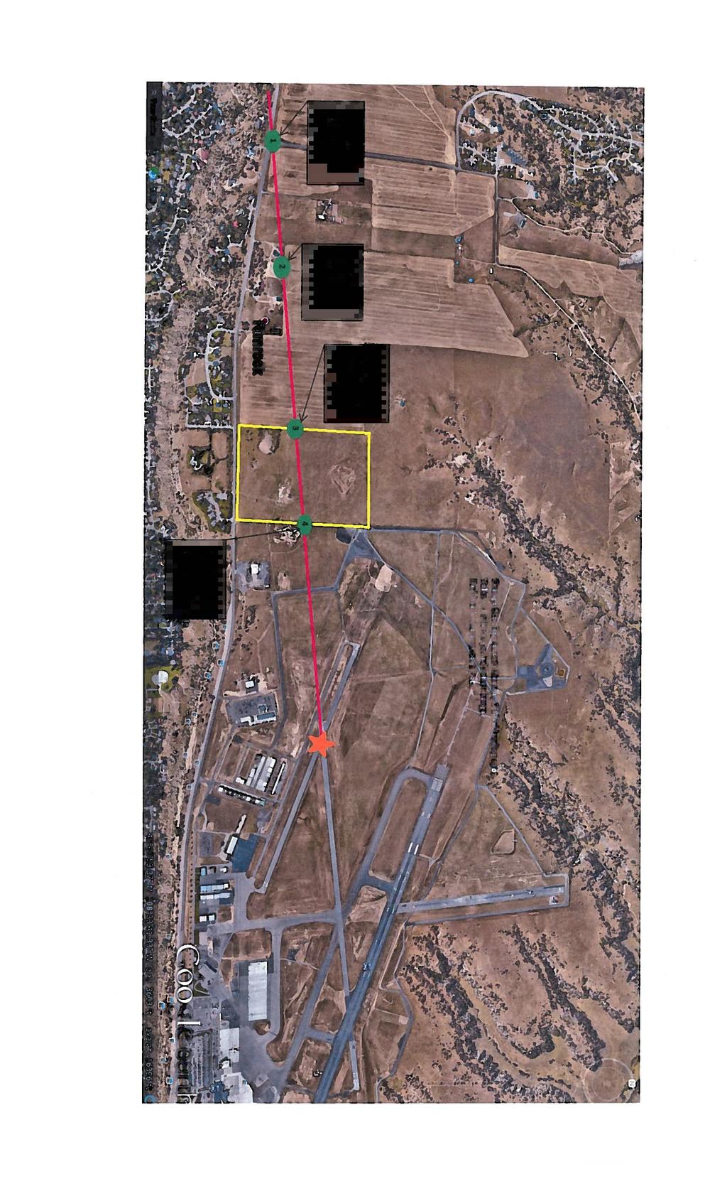
7 Zone Change #669 Proposed Zoning Map Public Billings Logan International Airport Subject property Current zoning: Agriculture Open Space (A-1) Proposed zoning: Public acres Controlled Industrial (CI) 20 acres South 20 acres stays A-1 zoning A-1 Proposed Public Proposed CI AS R-70 R-96
8 REVIEW CRITERIA Zone Change Block Highway 3 Billings Flying Service The Yellowstone County Zoning Commission, prior to any recommendation, shall consider the following: 1. Is the new zoning designed in accordance with the Yellowstone County and City of Billings 2008 Growth Policy? The proposed zoning does comply with the following goals of the Yellowstone County and City of Billings 2008 Growth Policy and area plans: Predictable land use decisions that are consistent with neighborhood character and preferred land use patterns identified in the growth policy. (Land Use Element, page 6). Zoning this property to Public (18.5 acres) and CI (20 acres) zoning would be consistent with the neighborhood character and land use patterns in the area. This area of the County west of the airport is primarily grazing and ranch land with some low density residential uses. The airport influence zone will preclude any taller structures that would otherwise be allowed in the proposed zoning districts. The Airport Influence and Noise Overlay zone also discourages incompatible uses such as residential homes and other living spaces. The proposed Public zone is a predictable zone given the adjacent Billings Airport zoning. The Public zone is the only zone is the only district where heliports are allowed. The proposed CI zone directly south of the proposed Public zone is intended to accommodate ancillary businesses that would support the Billings Flying Service heliport. The remaining 20 acres adjacent to Highway 3 will stay A-1 zoning. South of the subject property are residential subdivisions within the city limits. The proposed Public zoning on the north 600 feet of the subject parcels is consistent with the adjacent airport Public zoning district. The proposed CI zoning for 20 acres and not along the frontage of Highway 3 is consistent with the adjacent uses. CI zoning allows more intense uses but those uses will be limited by the lack of public services and the Airport Overlay zone. There is little potential for conflict between existing uses and future uses. Goal: New developments that are sensitive to and compatible with the character of adjacent development. (Land Use Element Goal, page 6). This property is adjacent to airport property and state Highway 3. The development of a heliport is compatible with the adjacent airport to the east and not out of character in this area. Residential zones south of the rims are also included within the Airport Influence zone and already experience some noise impacts from airport operations. The proposed Public zone for the heliport development is more than ¼ mile north of the closest residential home south of Highway 3. The proposed CI zone for 20 acres just south of the Public zone may have some negative effect on the adjacent grazing land. The proposed CI zoning will not be along the Highway 3 frontage. Buildings in this zoning will be height limited due to the Airport Influence zone but will be visible from the highway. Any development in this CI zone will require landscaping installed at the time of
9 development. The Airport Influence zone combined with the lack of public services will limit the types of development in this proposed CI zone. Goal: Coordinated economic development efforts (Economic Development Element, page 7) The proposed use of the property in the Public zone is to locate a private heliport for the Billings Flying Service. Billings Flying Service is currently located at 6309 Jellison Road, south of the Yellowstone River and west of the Billings Regional Landfill Jellison Road is in an Agriculture-Open Space (A-1) zone. The existing uses at this location are legal nonconforming uses. The existing site cannot expand due to the zoning restrictions on nonconforming uses. The applicant could locate on a leased space at the Billings Airport. A leased space on airport property is a generally a preferred option for this type of business but this may not fit with the applicant s long-term business plan. The proximity to the existing airport and limited development potential of this property for uses other than the proposed uses allows expansion of this economic sector in a coordinated manner. 2. Is the new zoning designed to secure from fire and other danger? The subject property is currently served by the Billings Urban Fire Service Area and pays a small assessment based on the structure (a livestock shelter) currently on the property. Any new structures would trigger additional fees to the fire service district but would not guarantee the availability of specialized fire suppression equipment for aircraft or aviation fuel accidents or fires. The Billings Airport Aircraft Rescue and Firefighting division is a specialized suppression and response unit that is not part of the BUFSA district services. The closest fire station is Fire Station 1 in North Park about 3.5 miles south and east of this location. The Fire Department or BUFSA may require special construction or site protection measures depending on the specific uses in any development. The existing and proposed zoning requires building separations, setbacks and height limits that should provide security from fire or other public safety emergencies except for aircraft rescue and firefighting activities. The fire department may call on the Airport Aircraft Rescue and Firefighting services for these specialized services. 3. Will the new zoning facilitate the provision of transportation, water, sewerage, schools, parks and other public requirements? Transportation: The proposed zoning will have a measurable effect on traffic generation. The property currently has 2 access points. The primary access is a shared access along the east property line of Tract 14. There is a subsequent access easement granted along the south and westerly property lines to benefit Tracts 9, 10 and 12 to the north and west. There is a gated access from Highway 3 onto to Tract 14 that appears to be little used. A new or improved state-approved access will be needed to provide safe access to the proposed development for Billings Flying Service. The current use of the property occasional grazing of livestock generates little or no traffic on a daily basis. The City and County recently completed a Highway 3 Corridor transportation study in partnership with the Montana Department of Transportation (MDT). The study has several recommendations for improving traffic safety, pedestrian access and storm water
10 management. The study included traffic volume projections out to It appears Highway 3, with a few minor improvements, may handle any additional traffic. The study recommended upgrades to the intersections with Rod & Gun Club Road and to Zimmerman Trail. The types of traffic generated from Public and CI zoning are different than current traffic patterns in the area. MDT may require some traffic analysis depending on the type and volume of traffic generated from specific developments on the property. If the property is annexed and developed, the City Traffic Engineer may require a traffic impact analysis to determine the appropriate mitigation or street development to accommodate the new uses. Water and Sewerage: The property will not be served by public water and sewer systems unless it is annexed to the City. The property is not yet within the limits of annexation for the City for annexation in the next five years. Schools and Parks: The proposed zoning should not impact the student population. The proposed zoning does not allow residential uses by right. Fire and Police: The subject property is serviced by BUFSA and the Yellowstone County Sheriff s Department. Fire protection will be evaluated at the time of any development of the site. If the property is annexed to the city, public safety services will be provided by the City Police Department and the Fire Department. As noted in criteria #2, specialized fire suppression services may be necessary. 4. Will the new zoning promote health and general welfare? Noise generation from a heliport is not predicted by the applicant to have any substantial or sustained impact on the adjacent residential uses south of Highway 3. The Airport Influence and Noise Overlay zone includes an area around the existing runways to the east that estimates noise levels based on aircraft take-offs and landings. The subject property is not within these noise overlay zones but is within the influence area for limitations on building height. The applicant proposes to place the Public zone on the north 18.5 acres where noise generation will have the least amount of impact on nearby residential neighbors. Noise from airport or heliport operations does have an impact on the general health and welfare of nearby residents. It is not known what decibel level the helicopters will generate off-site or on-site without a specific noise level study. The applicant has presented some generalized statements on how frequently helicopters will take off or land at the facility and the type of helicopters to be used. Other uses allowed in the CI zone may have more of a noise impact than the heliport depending on the type of use. Manufacturing uses may generate more noise than retail or service businesses. Uses allowed in the CI zone are also more likely to generate noise outside of normal business hours and have more impact on the health and general welfare of the residential neighborhoods south of Highway 3. The closest residential home to the proposed CI zone is over 700 feet so noise from any of these uses would not be likely to impact these residences.
11 5. Will the new zoning provide adequate light and air? The proposed zoning would require minimum setbacks, maximum building heights and maximum lot coverage. The Airport Influence and Noise Overlay zone will also limit some uses and building heights. These requirements should allow adequate light and air to reach the subject property and adjacent properties. 6. Will the new zoning effect motorized and non-motorized transportation? The proposed zoning itself will not generate more traffic on any of the adjacent streets or highways. Pedestrian traffic in the area is limited due to the lack of sidewalks and trails. The Highway 3 Corridor Study identified the need for a multi-use trail on the north side of Highway 3 at this location and tunnel connections to the south side of Highway 3 to access the public park area along the rims. Residential development is generally located south of the property and the main motorized access to the rim top parks are along the south side of Highway Will the new zoning be compatible with urban growth in the vicinity? The proposed zoning may be compatible with the adjacent zoning to the south and west and is compatible with the zoning to the east. Property west of the subject parcels is zoned A-1 and used for occasional grazing and very low density residential purposes. Property to the south is zoned for higher density residential neighborhoods within the city limits. The zone change is limited to the north 38.5 acres of the total acres of the subject property. There is no current plan for urban growth to the north and west. This area is within the Long Range Urban Planning Area of the City s Limits of Annexation Map but outside the short term limits of annexation area for immediate annexation. The property to the north may be acquired by the airport for runway improvements and the property to the east is already owned by the airport for security purposes and general aviation businesses. 8. Does the new zoning consider the character of the district and the suitability of the property for particular uses? The proposed Public zoning is within the character of the adjacent airport property and the proposed 20 acres of CI zoning is in character with the adjacent Public zoning. The allowed uses within the CI zone range from small warehouses and mini storage to manufacturing. It is likely the development on the property without public services for the proposed 20 acres of CI zoning will become repair shops, contractor storage, and service businesses for Billings Flying Service, small offices and personal storage warehouses. This would be similar to recent developments on the east side of Sugar Avenue or on Cerise Road in Lockwood. The proposed zoning may be suitable for the proposed uses and compatible with the adjacent airport development. 9. Will the new zoning conserve the value of buildings? The new zoning is not expected to alter the value of the existing agricultural buildings in the area. It is not known if its proximity to residential property in the area may affect the value of residential buildings.
12 10. Will the new zoning encourage the most appropriate use of land in Yellowstone County? The proposed zoning does encourage the most appropriate use of land in this area of the County. The property is directly west of the Billings Airport and east of dryland grazing property. The south 20 acres of the property will remain A-1 zoning. 11. Will the new zoning be as compatible as possible with adjacent zoning in the City of Billings? The 2 proposed zoning districts Public and CI are zoning districts that are also present in the City of Billings. The Public zoning is adjacent to Public zoning in the City and the proposed CI is not adjacent to the city limits. CI zoning could allow more intense uses than currently allowed in adjacent A-1 zoning districts but should be compatible with existing and future uses on these lands.


13 Zone Change #669 Site Photographs Subject property Highway 3 View west and north along Highway 3


14 Zone Change #669, continued Site Photographs View south and east across Highway 3 View west across Highway 3


15 Zone Change #669, continued Site Photographs 6309 Jellison Road existing location of Billings Flying Service Aerial view of subject property
16 Zone Change #669 Applicant Letter & Pre-application neighborhood meeting minutes
17
18
19
20
21
22
23

24
25
26
27
28


29 Potential Similar Developments in County CI zones Zone Change 669 CI zone King Avenue East CI zone Cerise Rd Lockwood


30 CI zone Cerise Rd Lockwood ELI zone Cole St Lockwood

31 CI zone Sugar Avenue


32


33


34


35
36


37


38

39
40
41
42

43

44

45
46
47
48
49
50
51
52
53
54
55
56

57

58


59


60


61
62


63


64


65
66


67


68
Introduction of the Yellowstone County Zoning Commission Members and Planning Department Staff.
 COUNTY OF YELLOWSTONE ZONING COMMISSION AGENDA-Monday, March 9, 2015 Miller Building, 1st Floor Conference Room 2825 3rd Avenue North, Billings, Montana NOTICE TO THE PUBLIC Public Comment: There will
CITY OF NORTH LAS VEGAS MEMORANDUM
 CITY OF NORTH LAS VEGAS MEMORANDUM TO: FROM: SUBJECT: Planning Commission Community Development and Compliance Department # 28 ) AMP-03-15; Coleman Airpark II & III - Comprehensive Plan Amendment (Public
YELLOWSTONE COUNTY BOARD OF PLANNING FINDINGS OF FACT
 YELLOWSTONE COUNTY BOARD OF PLANNING FINDINGS OF FACT The City-County Planning staff has prepared the Findings of Fact for the Aspen Ridge Subdivision, 2 nd Filing. These findings are based on the preliminary
FINDINGS OF FACT. Page 1 of 8
 FINDINGS OF FACT The City/County Planning staff has prepared the Findings of Fact for the Emerald View Park Subdivision, Amended Lot 1A, Block 3. These findings are based on the preliminary plat application
Planning Department Oconee County, Georgia
 Planning Department Oconee County, Georgia STAFF REPORT REZONE CASE #: 6985 DATE: October 31, 2016 STAFF REPORT BY: Andrew C. Stern, Planner APPLICANT NAME: Williams & Associates, Land Planners PC PROPERTY
E X E C U T I V E S U M M A R Y
 E X E C U T I V E S U M M A R Y CASE PLANNER: Aaron Wilson & Janet Rhoades VINE REVIEWED AND APPROVED BY: Mary McCrea BROADWAY INTERSTATE 90 INTERSTATE 90 PUBLIC HEARINGS: CC: August 22, 2011 AGENDA ITEM:
PC Staff Report 11/18/2013 Z Item No. 1-1
 Z-13-00401 Item No. 1-1 PLANNING COMMISSION REPORT Regular Agenda - Public Hearing Item PC Staff Report 11/18/2013 ITEM NO. 1: Z-13-00401 IG (General Industrial) District TO CS (Strip Commercial) District;
CITY ZONING COMMISSION CITY OF BILLINGS, MONTANA Tuesday, May 7, 2013
 CITY ZONING COMMISSION CITY OF BILLINGS, MONTANA Tuesday, May 7, 2013 SUBJECT: THROUGH: PRESENTED BY: Special Review #905 - Apostles Evangelical Lutheran Church 3140 Broadwater Avenue Candi Beaudry, AICP,
3. What is the requested zoning for the property (including intensity designator)? RM1-45 Residential (Multi-Dwelling).
? RM1-45 Residential (Multi-Dwelling).") B. SUBJECT PROPERTY INFORMATION General location of subject property and address (if address has been assigned): Northside- 819 Stoddard St. Missoula, MT 59802 Legal Description - complete and unabbreviated:
B. SUBJECT PROPERTY INFORMATION General location of subject property and address (if address has been assigned): Northside- 819 Stoddard St. Missoula, MT 59802 Legal Description - complete and unabbreviated:
AAAA. Planning and Zoning Staff Report Lake Shore Land Holdings, LLC CU-PH Analysis
 AAAA Planning and Zoning Staff Report Lake Shore Land Holdings, LLC CU-PH2016-28 Hearing Date: April 21, 2016 Development Services Department Applicant: BRS Architects/Cindy Huebert Staff: Kyle McCormick,
Bethel Romanian Church - Rezone, RZ
 / Planning and Zoning Staff Report Bethel Romanian Church - Rezone, RZ2018-0023 Hearing Date: November 15, 2018 Development Services Department Owners: Bethel Romanian Church, Corp. Applicant: Viorel Botos
PLANNING COMMISSION REPORT Regular Agenda Public Hearing Item
 PC Staff Report 11/12/12 Item No. 2B- 1 PLANNING COMMISSION REPORT Regular Agenda Public Hearing Item ITEM NO. 2B: A TO GPI; 110 ACRES; E OF K-10 & N OF W 6 TH ST (MKM) : Consider a request to rezone approximately
CITY OF TYLER PLANNING AND ZONING COMMISSION STAFF COMMENTS
 CITY OF TYLER PLANNING AND ZONING COMMISSION STAFF COMMENTS Date: September 4, 2018 Subject: PD18-019 ZB3 PROPERTIES, LLC (2469 EARL CAMPBELL PARKWAY) Request that the Planning and Zoning Commission consider
UPPER MOUNT BETHEL TOWNSHIP NORTHAMPTON COUNTY, PENNSYLVANIA
 UPPER MOUNT BETHEL TOWNSHIP NORTHAMPTON COUNTY, PENNSYLVANIA JOINDER DEED / LOT CONSOLIDATION TOWNSHIP REVIEW PROCESS When accepting proposed Joinder Deeds / Lot Consolidations, review the Joinder Deed
1. Roll Call. 2. Minutes a. September 24, 2018 Special Joint Meeting with Clay County Planning Commission. 3. Adoption of the Agenda
 1. Roll Call City of Vermillion Planning Commission Agenda 5:30 p.m. Regular Meeting Tuesday, October 9, 2018 City Council Chambers 2 nd Floor City Hall 25 Center Street Vermillion, SD 57069 2. Minutes
Financial Impact Statement There are no immediate financial impacts associated with the adoption of this report.
 STAFF REPORT Planning and Development Department Subject: Application by RYC Property to rezone a portion of lands on John Murray Dr. and Megan Lynn Dr. from R2 to R3 and to enter into a Development Agreement
Understanding the Conditional Use Process
 Understanding the Conditional Use Process The purpose of this document is to explain the process of applying for and obtaining a conditional use permit in the rural unincorporated towns of Dane County.
Residential Project Convenience Facilities
 Standards for Specific Land Uses 35.42.220 E. Findings. The review authority shall approve a Land Use Permit in compliance with Subsection 35.82.110.E (Findings required for approval) or a Conditional
Final. Chapter Four: Land Use
 Chapter Four: Land Use Purpose and Intent Goals and Policies Existing Land Use Patterns AICUZ Airport Overlay Zone Zoning Existing Land Use Land Use Designations Land Use Demand and Forecast Existing Population
RESOLUTION NO WHEREAS, an airport land use report was subsequently prepared by Johnson Aviation for the City of Perris; and
 RESOLUTION NO. 4202 A RESOLUTION OF THE CITY COUNCIL OF THE CITY OF PERRIS, COUNTY OF RIVERSIDE, STATE OF CALIFORNIA, OVERRULING THE RIVERSIDE COUNTY AIRPORT LAND USE COMMISSION (ALUC) FINDING OF INCONSISTENCY
EDGERTON CITY HALL PLANNING COMMISSION MEETING REGULAR SESSION March 12, 2019
 EDGERTON CITY HALL PLANNING COMMISSION MEETING REGULAR SESSION The met in regular session with Chair John Daley calling the meeting to order at 7:00 p.m. All present participated in the Pledge of Allegiance.
PLANNING DIVISION COMMUNITY & ECONOMIC DEVELOPMENT. To: Salt Lake City Planning Commission. PLNPCM John Glenn Road Zoning Map Amendments
 Staff Report PLANNING DIVISION COMMUNITY & ECONOMIC DEVELOPMENT To: Salt Lake City Planning Commission From: John Anderson, 801-535-7214, john.anderson@slcgov.com Date: March 22, 2017 Re: PLNPCM2017-00063
Section 1: US 19 Overlay District
 Section 1: US 19 Overlay District Section 1.1 Intent and Purpose The purpose of the US Highway 19 Overlay District is to manage access to land development along US Highway 19 in a manner that preserves
DIVISION 1 PURPOSE OF DISTRICTS
 ARTICLE 2 ZONING DISTRICTS AND MAP DIVISION 1 PURPOSE OF DISTRICTS Section 2.101 Zoning Districts. For the purpose of this Ordinance, the City of Richmond is hereby divided into districts as follows: DISTRICT
Planning 101: Annexation and Municipal & County Zoning. Annexation Title 7, Chapter 2, Parts Required Provision of Services
 Planning 101: Annexation and Municipal & County Zoning September 9, 2013 Chris Saunders, AICP Annexation Title 7, Chapter 2, Parts 42-47 Brings new territory into the boundaries of a municipality All annexations
Midwest City, Oklahoma Zoning Ordinance
 2010 Midwest City, Oklahoma Zoning Ordinance 9/2/2010 Table of Contents Section 1. General Provisions... 5 1.1. Citation... 5 1.2. Authority... 5 1.3. Purpose... 5 1.4. Nature and Application... 5 1.5.
Planning and Zoning Staff Report Pestcom Pest Management LLC CU-PH
 AAAA Planning and Zoning Staff Report Pestcom Pest Management LLC CU-PH2016-49 Hearing Date: October 6, 2016 Development Services Department Applicant: Charles F. Cooley Sr. Pestcom Pest Management LLC
CHAPTER 4: DISTRICT REGULATIONS
 CHAPTER 4: DISTRICT REGULATIONS 4.1 COMPLIANCE WITH DISTRICT STANDARDS 4.1.1 No building or structure may be erected, converted, enlarged, reconstructed, altered for use, or used except in accordance with
CITY OF PALM BEACH GARDENS CITY COUNCIL Agenda Cover Memorandum Meeting Date: November 1, 2018 Ordinance 24, 2018 / *Ordinance 25, 2018
 CITY OF PALM BEACH GARDENS CITY COUNCIL Agenda Cover Memorandum Meeting Date: November 1, 2018 Subject/Agenda Item: 11940 U.S. Highway One Small-Scale Comprehensive Plan Future Land Use Map Amendment and
PALM BEACH COUNTY PLANNING, ZONING AND BUILDING DEPARTMENT ZONING DIVISION ZONING COMMISSION VARIANCE STAFF REPORT 06/05/2014
 PALM BEACH COUNTY PLANNING, ZONING AND BUILDING DEPARTMENT ZONING DIVISION ZONING COMMISSION VARIANCE STAFF REPORT 06/05/2014 APPLICATION NO. ZV-2013-03120 CODE SECTION REQUIRED PROPOSED VARIANCE (V1)
THE CITY OF RAYMORE, MISSOURI Single-Family Residential Zoning Districts
 THE CITY OF RAYMORE, MISSOURI Single-Family Residential Zoning Districts REGULATIONS COMMON TO ALL DISTRICTS: Uses permitted in each district include detached single-family dwellings, manufactured homes
REPORT OF THE PLANNING AND DEVELOPMENT DEPARTMENT FOR APPLICATION FOR REZONING ORDINANCE TO PLANNED UNIT DEVELOPMENT SEPTEMBER 22, 2016
 BEL REPORT OF THE PLANNING AND DEVELOPMENT DEPARTMENT FOR APPLICATION FOR REZONING ORDINANCE 2016-576 TO PLANNED UNIT DEVELOPMENT SEPTEMBER 22, 2016 The Planning and Development Department hereby forwards
/ Planning and Zoning Commission Staff Report Jay Walker- All Terra Consulting - RZ
 / Planning and Zoning Commission Staff Report Jay Walker- All Terra Consulting - Hearing Date: January 17, 2019 Development Services Department Applicant: Jay Walker All Terra Consulting Staff: Jennifer
MEMORANDUM. DATE: November 9, 2016 PC Agenda Item 3.B. Planning Commission Chair Thompson and Commissioners
 MEMORANDUM DATE: November 9, 2016 PC Agenda Item 3.B TO: FROM: SUBJECT: Planning Commission Chair Thompson and Commissioners Matthew Bachler, Senior Planner Planning Case #16-028 Public Hearing Required
Zoning Most Frequently Asked Questions
 Zoning Most Frequently Asked Questions Zoning is needed to achieve the following: Orderly development consistent with utility location/capacity, street network, public services; Compatible land uses in
Mike & Sherry Dudley Rezone, RZ
 / Planning and Zoning Staff Report Mike & Sherry Dudley Rezone, RZ2019-0005 Hearing Date: April 18, 2019 Development Services Department Applicant: Mike & Sherry Dudley Staff: Deb Root, 454-7340 droot@canyonco.org
AGENDA ITEM SUMMARY GLADES COUNTY BOARD OF COUNTY COMMISSIONERS
 AGENDA ITEM SUMMARY GLADES COUNTY BOARD OF COUNTY COMMISSIONERS SUBJECT: Case Number COMP17-01, Legend Moto LLC This is a Legislative Hearing. DEPARTMENT REQUEST: The Community Development Department requests
CITY OF RIO VISTA PLANNING COMMISSION STAFF REPORT
 MEETING DATE: January10, 2018 CITY OF RIO VISTA PLANNING COMMISSION STAFF REPORT AGENDA ITEM #4.2 PREPARED BY: Lamont Thompson, Planning Manager SUBJECT: Vesting Tentative Tract No. 2017-001: To consider
City Council Briefing Clear Creek Holdings, LLC. April 16, 2019 Robert J. Tajan, Director Planning and Community Development
 City Council Briefing April 16, 2019 Robert J. Tajan, Director Planning and Community Development 1 AICUZ Background Air Installation Compatible Use Zones Established in response to the Noise Control Act
PLANNING COMMISSION STAFF REPORT
 PLANNING COMMISSION STAFF REPORT West Capitol Hill Zoning Map Amendment Petition No. PLNPCM2011-00665 Located approximately at 548 W 300 North Street, 543 W 400 North Street, and 375 N 500 West Street
Planning and Zoning Commission STAFF REPORT REQUEST. DSA : Zone Change from R-3 (Multi-Family Residential) to B-4 (Community Services).
 to B-4 (Community Services).") Planning and Zoning Commission STAFF REPORT AGENDA # TO: FROM: PLANNING AND ZONING COMMISSION Joseph Horn, City Planner MEETING DATES: August 4, 2016 SUBJECT: Gino Tarantini zone change requests REQUEST
Planning and Zoning Commission STAFF REPORT AGENDA # TO: FROM: PLANNING AND ZONING COMMISSION Joseph Horn, City Planner MEETING DATES: August 4, 2016 SUBJECT: Gino Tarantini zone change requests REQUEST
PLANNING COMMISSION STAFF REPORT. QUEST ASSISTED LIVING CONDITIONAL USE PLNPCM West 800 North Hearing date: October 14, 2009
 PLANNING COMMISSION STAFF REPORT QUEST ASSISTED LIVING CONDITIONAL USE PLNPCM2009-00971 1820 West 800 North Hearing date: October 14, 2009 Planning Division Department of Community & Economic Development
Glades County Staff Report and Recommendation Unified Staff Report for Small Scale Plan Amendment and Rezoning
 Glades County Staff Report and Recommendation Unified Staff Report for Small Scale Plan Amendment and Rezoning CASE NUMBERS: COMP17-02 and RZ17-02 DATE of STAFF REPORT: May 1, 2017 CASE TYPE: Application
PLANNING COMMISSION REPORT Regular Agenda Public Hearing Item
 PC Staff Report 06/21/10 Item No. 4-1 PLANNING COMMISSION REPORT Regular Agenda Public Hearing Item ITEM NO. 4: PD-[TANGER PCD-1] TO CS; 1025 N. 3 rd STREET (SLD) : Consider a request to rezone approximately
WOODLAND AREA GENERAL PLAN URBAN DEVELOPMENT POLICY
 APPENDIX A WOODLAND AREA GENERAL PLAN URBAN DEVELOPMENT POLICY The following text indicates proposed amendments to the Woodland Area General Plan Urban Development Policy currently adopted and included
Mount Airy Planning Commission March 26, Staff Report
 Mount Airy Planning Commission March 26, 2018 Staff Report Special Exception Request Mixed Use Development in CC District Recommendation to Board of Appeals CASE MA-A-18-01 Applicant: Location: Zoning:
ARTICLE 2 ZONING DISTRICTS AND MAPS
 ARTICLE 2 ZONING DISTRICTS AND MAPS SECTION 2.100 PURPOSE OF DISTRICTS Section 2.101. For the purpose of this Ordinance, Billings Township is hereby divided into districts as follows: DISTRICT NAME SYMBOL
Ricker - PH / Planning and Zoning Commission Staff Report
 / Planning and Zoning Commission Staff Report Ricker - PH2018-20 Hearing Date: April 19, 2018 Development Services Department Applicant: Don Ricker Staff: Dan Lister, Planner II dlister@canyonco.org Tax
7 August 14, 2013 Public Hearing
 7 August 14, 2013 Public Hearing APPLICANT & OWNER: STAFF PLANNER: Stephen J. White REQUEST: Conditional Use Permit (motor vehicle sales) ADDRESS / DESCRIPTION: 4717 Hollis Road / 4740 Shore Drive GPIN:
ADMINISTRATIVE HEARING STAFF REPORT
 ADMINISTRATIVE HEARING STAFF REPORT Providence Place Apartments Utility Box No. 2 Conditional Use Petition PLNPCM2011-00426 309 East 100 South September 22, 2011 Planning and Zoning Division Department
PLANNING COMMISSION REPORT REGULAR AGENDA. PC Staff Report 08/25/10 ITEM NO 6: PRELIMINARY PLAT; HALLMARK ADDITION; ACRES; 151 MCDONALD DR (MKM)
") PP-6-6-10 Item No. 6-1 PLANNING COMMISSION REPORT REGULAR AGENDA PC Staff Report 08/25/10 ITEM NO 6: PRELIMINARY PLAT; HALLMARK ADDITION; 5.252 ACRES; 151 MCDONALD DR (MKM) PP-6-6-10: Consider a Preliminary
PP-6-6-10 Item No. 6-1 PLANNING COMMISSION REPORT REGULAR AGENDA PC Staff Report 08/25/10 ITEM NO 6: PRELIMINARY PLAT; HALLMARK ADDITION; 5.252 ACRES; 151 MCDONALD DR (MKM) PP-6-6-10: Consider a Preliminary
City and County of Broomfield, Colorado
 City and County of Broomfield, Colorado CITY COUNCIL AGENDA MEMORANDUM To: From: Mayor and City Council George Di Ciero, City and County Manager Teri Malies, Principal Planner Terrance Ware, Planning Director
COMMUNITY PLAN PLANNING & URBAN DESIGN
 WHALE COVE COMMUNITY PLAN PLANNING & URBAN DESIGN WHALE COVE COMMUNITY PLAN Prepared for: Department of Community and Government Services Government of Nunavut Rankin Inlet, Nunavut Prepared by: FoTenn
Implementation. Approved Master Plan and SMA for Henson Creek-South Potomac 103
 Implementation Approved Master Plan and SMA for Henson Creek-South Potomac 103 104 Approved Master Plan and SMA for Henson Creek-South Potomac Sectional Map Amendment The land use recommendations in the
ACTION FORM BRYAN CITY COUNCIL
 ACTION FORM BRYAN CITY COUNCIL DATE OF COUNCIL MEETING: July 8, 2014 DATE SUBMITTED: June 17, 2014 DEPARTMENT OF ORIGIN: Development Services SUBMITTED BY: Maggie Dalton MEETING TYPE: CLASSIFICATION: ORDINANCE:
Metropolitan Planning Commission. DATE: April 5, 2016
 TO: FROM: Metropolitan Planning Commission MPC Staff DATE: April 5, 2016 SUBJECT: Petition of Nine Line Inc. Robert McCorkle, Agent PIN: 2-1034-01-002 380.5 Acres Aldermanic District: 5 (Shabazz) County
PLANNED UNIT DEVELOPMENT (PUD)
") SECTION 38.01. ARTICLE 38 PLANNED UNIT DEVELOPMENT (PUD) Purpose The purpose of this Article is to implement the provisions of the Michigan Zoning Enabling Act, Public Act 110 of 2006, as amended, authorizing
SECTION 38.01. ARTICLE 38 PLANNED UNIT DEVELOPMENT (PUD) Purpose The purpose of this Article is to implement the provisions of the Michigan Zoning Enabling Act, Public Act 110 of 2006, as amended, authorizing
3 NOVEMBER 9, 2011 Public Hearing APPLICANT:
 REQUEST: Conditional Change of Zoning (B-2 & I-1 to Conditional A-18) 3 NOVEMBER 9, 2011 Public Hearing APPLICANT: S.L. NUSBAUM REALTY COMPANY PROPERTY OWNER: USF PROPCO II, LLC STAFF PLANNER: Leslie Bonilla
Town of Gorham Development Transfer Fee Program SECTION XVIII DEVELOPMENT TRANSFER OVERLAY DISTRICT
 Town of Gorham Development Transfer Fee Program SECTION XVIII DEVELOPMENT TRANSFER OVERLAY DISTRICT [Note: The Development Transfer Overlay District (a Development Transfer Fee program) is included as
DENTON Developer's Handbook
 DENTON Developer's Handbook A guide for land development in the City of Denton Department of Development Services 2017 2 Table of Contents 1. City of Denton Development Process...5 Role of the Development
INDIAN RIVER COUNTY, FLORIDA. The Honorable Members of the Planning and Zoning Commission DEPARTMENT HEAD CONCURRENCE
 Public Hearing Legislative INDIAN RIVER COUNTY, FLORIDA M E M O R A N D U M TO: The Honorable Members of the Planning and Zoning Commission DEPARTMENT HEAD CONCURRENCE Robert M. Keating, AICP; Community
MPC STAFF REPORT REZONING MAP AMENDMENT ALDERMANIC DISTRICT 1 COUNTY COMMISSION DISTRICT 5 April 3, 2013 MPC FILE NUMBER.
 MPC STAFF REPORT REZONING MAP AMENDMENT ALDERMANIC DISTRICT 1 COUNTY COMMISSION DISTRICT 5 April 3, 2013 MPC FILE NUMBER. 13-000929-ZA REZONING SUMMARY Report Status Initial Report Petitioner/Property
PLANNING COMMISSION REPORT Regular Agenda - Public Hearing Item
 Z-14-00056 Item No. 1-1 PLANNING COMMISSION REPORT Regular Agenda - Public Hearing Item PC Staff Report 4/21/2014 ITEM NO. 1: RSO TO CN1;.126 ACRES; 512 & 514 LOCUST ST (DRG) Z-14-00056: Consider a request
Glades County Staff Report and Recommendation REZONING
 Glades County Staff Report and Recommendation REZONING CASE NUMBER: RZ15-01 DATE: October 2, 2015 CASE TYPE: Application for Rezoning REQUEST: J.J. Wiggins Memorial Trust is requesting a rezoning of 22.1±
BARROW COUNTY, GEORGIA
 BARROW COUNTY, GEORGIA Application For Rezoning, Special Use, and Change in Conditions BARROW COUNTY DEPARTMENT OF PLANNING AND DEVELOPMENT 30 North Broad Street Winder, Georgia 30680 770-307-3034 APPLICATION
Town zoning: A good option for your town?
 Photo credit: Landslides Aerial Photography Town zoning: A good option for your town? Lynn Markham Town of Auburn May 27, 2015 Main points 1. Zoning is one tool to implement community plans 2. What does
ARVIAT COMMUNITY PLAN - TABLE OF CONTENTS -
 ARVIAT COMMUNITY PLAN - TABLE OF CONTENTS - Page Arviat Community Plan By-law No. 206 SECTION 1 - INTRODUCTION...1 1.1 Purpose of the Plan...1 1.2 Goals of the Community Plan...1 1.3 Administration of
David J. Gellner, AICP, Principal Planner; (801) ; Zoning Map Amendment
 ; Zoning Map Amendment") Staff Report PLANNING DIVISION DEPARTMENT of COMMUNITY and NEIGHBORHOODS To: From: Salt Lake City Planning Commission David J. Gellner, AICP, Principal Planner; (801) 535-6107; david.gellner@slcgov.com
Staff Report PLANNING DIVISION DEPARTMENT of COMMUNITY and NEIGHBORHOODS To: From: Salt Lake City Planning Commission David J. Gellner, AICP, Principal Planner; (801) 535-6107; david.gellner@slcgov.com
STAFF REPORT. Permit Number: Lee. Kitsap County Board of Commissioners; Kitsap County Planning Commission
 STAFF REPORT Permit Number: 15 00689 Lee DATE: March 2, 2016 TO: FROM: Kitsap County Board of Commissioners; Kitsap County Planning Commission Katrina Knutson, AICP, Senior Planner, DCD and Jeff Arango,
PLANNING AND DEVELOPMENT DEPARTMENT STAFF REPORT SAVOY DRIVE AREA ZONING MAP AMENDMENT II
 PLANNING AND DEVELOPMENT DEPARTMENT STAFF REPORT Meeting Date: March 14, 2019 Item #: PZ2019-429 SAVOY DRIVE AREA ZONING MAP AMENDMENT II Project Name: Savoy Drive Area Zoning Map Amendment II Site Addresses:
Appendix A: Guide to Zoning Categories Prince George's County, Maryland
 Appendix A: Guide to Zoning Categories Prince George's County, Maryland RESIDENTIAL ZONES 1 Updated November 2010 R-O-S: Reserved Open Space - Provides for permanent maintenance of certain areas of land
Draft Model Access Management Overlay Ordinance
 Draft Model Access Management Overlay Ordinance This model was developed using the City of Hutchinson and the Trunk Highway 7 corridor. The basic provisions of this model may be adopted by any jurisdiction
Be linked by an internal circulation system (i.e., walkways, streets, etc.) to other structures within the IPUD;
 to other structures within the IPUD;") 2. HALIFAX ACTIVITY CENTER A. DESCRIPTIONS OF FUTURE LAND USE DESIGNATIONS Each of the future land use designations specified by Phase I of the Halifax Activity Center Plan, and the relationship of these
2. HALIFAX ACTIVITY CENTER A. DESCRIPTIONS OF FUTURE LAND USE DESIGNATIONS Each of the future land use designations specified by Phase I of the Halifax Activity Center Plan, and the relationship of these
DRAFT Smithfield Planning Board Minutes Thursday, May 7, :00 P.M., Town Hall, Council Room
 DRAFT Smithfield Planning Board Minutes Thursday, May 7, 2015 6:00 P.M., Town Hall, Council Room Members Present: Chairman Eddie Foy Vice-Chairman Stephen Upton Daniel Sanders Gerald Joyner Mark Lane Jack
Planning and Zoning Staff Report JT Ventures, LLC Staging Area, CU-PH
 Planning and Zoning Staff Report JT Ventures, LLC Staging Area, CU-PH2016-60 Hearing Date: December 15, 2016 Development Services Department Applicant: JT Ventures, LLC Jason Stewart and Tony Brown Staff:
Public Facilities and Finance Element
 This Element of the General Plan addresses the following public facilities issues: Water Service, including both potable (drinkable) and non-potable water delivery. Sewer Service, and Financing and construction
NOTICE OF MEETING AND AGENDA FOR THE PLANNING COMMISSION OF SPRINGVILLE, UTAH... JANUARY 23, 2018
 NOTICE OF MEETING AND AGENDA FOR THE PLANNING COMMISSION OF SPRINGVILLE, UTAH............................ JANUARY 23, 2018 Notice is hereby given that the Planning Commission will hold a public meeting
Planned Unit Development (PUD). Sections:
. Sections:") Chapter 19.07. Planned Unit Development (PUD). Sections: 19.07.01. Purpose. 19.07.02. PUD Definition and Design Compatibility. 19.07.03. General PUD Standards. 19.07.04. Underlying Zones. 19.07.05. Permitted
Chapter 19.07. Planned Unit Development (PUD). Sections: 19.07.01. Purpose. 19.07.02. PUD Definition and Design Compatibility. 19.07.03. General PUD Standards. 19.07.04. Underlying Zones. 19.07.05. Permitted
PLANNING COMMISSION REPORT Regular Agenda Public Hearing Item
 CUP-15-00474 Item No. 5-1 PC Staff Report 11/16/15 ITEM NO. 5 PLANNING COMMISSION REPORT Regular Agenda Public Hearing Item CONDITIONAL USE PERMIT FOR PUBLIC WHOLESALE WATER SUPPLY DISTRICT NO. 25; E 1300
A Affordable Storage CUP Amendment, in Section 20, T35N R2W NMPM, at 4340B US Hwy 160W and 122 Meadows Dr.
 Archuleta County Development Services Planning Department 1122 HWY 84 P. O. Box 1507 Pagosa Springs, Colorado 81147 970-264-1390 Fax 970-264-3338 MEMORANDUM TO: Archuleta County Planning Commission FROM:
Tracie & Dennis Jones Rezone, RZ
 / Planning and Zoning Staff Report Tracie & Dennis Jones Rezone, RZ2018-0014 Applicant: Tracie & Dennis Jones Staff: Deb Root, 454-7340 droot@canyonco.org Tax ID: R37886012 Current Zone: A (Agricultural)
City of Placerville Planning Commission STAFF REPORT
 Placerville, a Unique Historical Past Forging into a Golden Future City of Placerville STAFF REPORT SUBJECT: Consideration of a request to operate the automobile brokerage business in the Highway Commercial
AN ORDINANCE TO AMEND SECTION OF THE RAPID CITY MUNICIPAL CODE TO ALLOW FOR ADMINISTRATIVE DISSOLUTION OF PLANNED DEVELOPMENTS
 Ordinance No. 6231 AN ORDINANCE TO AMEND SECTION 17.50.050 OF THE RAPID CITY MUNICIPAL CODE TO ALLOW FOR ADMINISTRATIVE DISSOLUTION OF PLANNED DEVELOPMENTS WHEREAS, the City of Rapid City has adopted a
MIDWAY CITY Municipal Code
 MIDWAY CITY Municipal Code TITLE 9 ANNEXATION CHAPTER 9.01 PURPOSE CHAPTER 9.02 GENERAL REQUIREMENTS CHAPTER 9.03 PROPERTY OWNER INITIATION OF ANNEXATION CHAPTER 9.04 PROCEDURES FOR CONSIDERATION OF PETITION
CHAPTER COMMERCIAL ZONING DISTRICTS
 CHAPTER 27.10 - COMMERCIAL ZONING DISTRICTS 27.10.010 - Purpose of Chapter This Chapter lists the land uses that may be allowed within the commercial zoning districts established by Section 27.04.020 (Zoning
09/15 Agenda. Documents: 9.3 PB AGENDA.PDF Documents: STAFF REPORT.PDF Documents: STAFF REPORT.PDF.
 1. 09/15 Agenda Documents: 9.3 PB AGENDA.PDF 2. 1509-1 Documents: 1509-1 STAFF REPORT.PDF 3. 1509-2 Documents: 1509-2 STAFF REPORT.PDF 4. 09/15 Minutes Documents: 09.02.15 PB MINUTES.PDF IREDELL COUNTY
SUBJECT: Application for Planned Unit Development and Rezoning 1725 Winnetka Road
 TO: FROM: CHAIRMAN BILL VASELOPULOS AND MEMBERS OF THE PLAN & ZONING COMMISSION STEVE GUTIERREZ DIRECTOR OF COMMUNITY DEVELOPMENT MEETING DATE: September 5, 2017 SUBJECT: Application for Planned Unit Development
PUBLIC DRAFT May 2017 Zoning Districts Use Regulations Definitions (partial)
") PUBLIC DRAFT May 2017 Zoning Districts Use Regulations Definitions (partial) Table of Contents Subchapter 1: General Provisions... 1 Subchapter 2: Administration & Procedures... 3 Subchapter 3: Zoning
PUBLIC DRAFT May 2017 Zoning Districts Use Regulations Definitions (partial) Table of Contents Subchapter 1: General Provisions... 1 Subchapter 2: Administration & Procedures... 3 Subchapter 3: Zoning
Cover Letter with Narrative Statement
 Cover Letter with Narrative Statement March 31, 2017 rev July 27, 2017 RE: Rushton Pointe Residential Planned Unit Development Application for Public Hearing for RPUD Rezone PL2015 000 0306 Mr. Eric Johnson,
BEFORE THE GALLATIN COUNTY COMMISSION GALLATIN COUNTY, MONTANA
 BEFORE THE GALLATIN COUNTY COMMISSION GALLATIN COUNTY, MONTANA IN THE MATTER OF THE APPLICATION OF TOM MURPHY, MANAGING MEMBER OF THE BRIDGER CENTER, LLC, FOR A ZONE MAP AMENDMENT TO THE GALLATIN COUNTY/BOZEMAN
INTENT GENERAL PROVISIONS PART 1 ZONING REGULATIONS SECTION 3400 OVERLAY DISTRICT AIRPORT INFLUENCE AREA
 PART 1 ZONING REGULATIONS SECTION 3400 OVERLAY DISTRICT AIRPORT INFLUENCE AREA 1-3401 INTENT The Airport Influence Area District is hereby established as an overlay district which includes within its boundaries
# Coventry Rezoning, Variation and Preliminary/Final PUD Project Review for Planning and Zoning Commission
 #2018-21 460 Coventry Rezoning, Variation and Preliminary/Final PUD Project Review for Planning and Zoning Commission Meeting Date: May 2, 2018 public intro meeting and May 16, 2018 public hearing Requests:
Diamond Falls Subdivision PROPOSED YELLOWSTONE COUNTY BOARD OF PLANNING FINDINGS OF FACT
 Diamond Falls Subdivision PROPOSED YELLOWSTONE COUNTY BOARD OF PLANNING FINDINGS OF FACT The City/County Planning Staff has prepared the Findings of Fact for the Diamond Falls Subdivision. These findings
DEVELOPMENT DEPARTMENT STAFF REPORT DRESDEN HEIGHTS PHASE II DCI
 DEVELOPMENT DEPARTMENT Meeting Date: January 10, 2019 Item #: PZ2019-393 Project Name: Applicant and Owner: Proposed Development: Requests: STAFF REPORT DRESDEN HEIGHTS PHASE II DCI Dresden Heights Phase
BOARD OF ADJUSTMENT MEETING CITY OF ST. PETE BEACH
 BOARD OF ADJUSTMENT MEETING CITY OF ST. PETE BEACH 155 Corey Avenue St. Pete Beach, Florida Wednesday, 11/15/2017 2:00 p.m. Call to Order Pledge of Allegiance Roll Call 1. Changes to the Agenda Agenda
SANDOVAL COUNTY PLANNING AND ZONING COMMISSION DECEMBER 10, 2015 PUBLIC HEARING
 SANDOVAL COUNTY PLANNING AND ZONING COMMISSION DECEMBER 10, 2015 PUBLIC HEARING To: Sandoval County Planning and Zoning Commission From: Sandoval County Planning and Zoning Division Staff Date: December
PLANNING COMMISSION REPORT Regular Agenda Public Hearing Item
 PC Staff Report 6/20/16 Item No. 4-1 PLANNING COMMISSION REPORT Regular Agenda Public Hearing Item PC Staff Report 06/20/16 ITEM NO. 4: IG to CS 1.56 ACRES; 706 E 23 RD STREET (MKM) : Consider a request
DIVISION I. GENERAL ZONING... 6
 TABLE OF CONTENTS DIVISION I. GENERAL ZONING... 6 CHAPTER 17.02 GENERAL PROVISIONS... 6 17.02.010 AUTHORITY... 6 17.02.020 SHORT TITLE... 6 17.02.030 APPLICABILITY AND JURISDICTION... 6 17.02.040 PURPOSE...
CHAPTER 50 LAND USE ZONES ARTICLE 50 BASIC PROVISIONS
 CHAPTER 50 LAND USE ZONES ARTICLE 50 BASIC PROVISIONS 50.010 - PURPOSE The purposes of this chapter are to establish land use zones required to implement the goals and policies of the Klamath County Comprehensive
CITY PLANNING COMMISSION COMPREHENSIVE PLAN AND REVIEW CRITERIA
 Page 3 CITY PLANNING COMMISSION COMPREHENSIVE PLAN AND REVIEW CRITERIA COMPREHENSIVE PLAN: The City Planning Commission uses the Comprehensive Plan as a guide in all land use matters. The Plan is available