CATALOGUE FOR MEASURING AND CREATING CADASTRAL UNITS
|
|
|
- Mercy Bell
- 6 years ago
- Views:
Transcription
1 1 CATALOGUE FOR MEASURING AND CREATING CADASTRAL UNITS Prishtinë, August 2013
2 2 EDITOR: PROF. DR. Murat MEHA Authors: Murat Meha, Qemajl Kadiri, Muzafer Çaka, Reshat Murati, Avni Ahmeti, Bashkim Shaqiri, Faik Kelmendi, Qazim Sinani, Esat Xani, Korab Ahmetaj Publisher: Kosovo Cadastral Agency
3 3 Acronyms: KCA Kosovo Cadastral Agency US Unknown source σ Standard deviation GNSS Global satellite navigation system GPS Global positioning system ITF Official format for exchanging graphic data based on INTERLIS CD Coordinates from digitalization CM Coordinates from original measurements field NC Coordinate not checked CC Completely checked coordinate QC Quality Control BC Building Cadastre KOPOS Kosovo Positioning System Kosovaref01 Kosovo Coordinate Referent System RC Reconstruction Commission MESP Ministry of Environment Spatial Planning SDI Spatial Data Infrastructure NSDI National Spatial Data Infrastructure EO Economic Operator (Contractor) CR Cadastre Reconstruction PD Public Display SIKTK/KCLIS Kosovo Cadastre Land Information System TS Total Station AI Administrative Instruction CZ Cadastral Zone MCO Municipal Cadastral Office
4 4 Preface Cadastre Reconstruction is quite necessary for the territory of Republic of Kosovo in updating and registering the property and the property rights. During the process of implementing large projects such as: cadastre reconstruction, building cadastre but also during cadastre maintenance it was seen as necessary to define as clearly as possible with concrete examples the method of measuring the cadastre units (parcels, buildings and other parts of building) in the field. The catalogue has been compiled with the aim of facilitating the process of carrying out measurements in the field, when updating and creating cadastral units. The catalogue will be of help to all cadastre experts that are engaged in public as well as in private sector. The material offered in the catalogue has been prepared by KCA experts. There are used experiences from implemented projects, discussions with MCO experts and other information s from international experts based on actual legislation for cadastral surveying in Kosovo. Developed countries have made a great achievement in offering spatial data (SDI) and while providing easy, safe and fast access. Spatial data infrastructure contains data from KCLIS system. Spatial Data Infrastructure (SDI) contains also data from Cadastral Information System which are the base data for aanalysisi and development of national standards for Nationa Spatial data Infrastructure (NSDI)
5 5 Introduction Catalogue for measuring and creating cadastral units for property rights through systematic and sporadic system of updating the cadastral data is a legal obligation. In the catalogue have been analyzed all types of cadastral measurements for sporadic maintenance and systematic registration through Reconstruction projects. Updating of the cadastral data is done through: Cadastre Reconstruction (CR), Building Cadastre (BC), Land Consolidation in urban and rural zones, Regular maintenance of cadastre. The examples used in this catalogue are an illustration of different cases. When the catalogue will be implemented completely it would enable raising the quality, the security and the accuracy of the cadastral data in cadastral institutions. Just as the cadastre also the catalogue is dynamic; therefore new ideas from experts in the future will enrich the quality of cadastral works. The catalogue is based on the Law on Cadastre, Law on IPRR, Administrative Instruction and Guidelines. Therefore this catalogue is an integral part of the legal framework for cadastre, which continuous to be implemented. You can find the Laws and Administrative Instructions at KCA s website:
6 6 Definitions Immovable Property - specific part of the land surface, which has boundaries or boundaries can be set to. Immovable properties include: land, natural objects affixed to the land, business buildings, residential buildings and parts of the buildings (apartments) as a separate units of residential buildings as well as mineral wealth; Cadastral parcel - an determined land surface identified by the parcel number and registered in cadastre map with a real surface in mapping projection and surface recorded at IPRR;. Building - a building is a structure where a person may enter and is designed for permanent or temporary residence, and for conducting a business or any other activity; Part of building - an apartment, business premises or one or several rooms in a building, which can be separate physical entirety or subject to property transactions; Cadastral map - shows the boundaries of cadastral parcels, references to boundary corner marks, buildings on the parcels, and the parcel and building identifiers; Boundary - one physical object marking the limits of a parcel or an imagined line or surface marking the division between two parcels. Also used to describe the division between features with different administrative, legal, land-use, topographic or other characteristics. A boundary taken from cadastral map takes precedence over other boundaries; Final boundary of parcel - legal boundaries of a cadastral parcel, where precise line has been set and marked pursuant to State Coordinates; Subdivision creation of two or more new parcels from the original parcel;
7 7 Amalgamation creation of a new parcel from two or more original parcels, or from new subdivided parcels where the owner is the same or is an owner in co-ownership; Temporary marks - marks set on parcel s boundaries when carrying out cadastral surveys; Permanent marks - marks set on parcel s boundaries following completion of cadastral surveys, and revealed after registration of the official boundary in cadastre; Cadastral survey - measurements and other collection of data in the field for the purpose of a registration in the Cadastre, or rearrangement of a cadastral boundary based on the data at Cadastre and the cadastral reconstruction; Cadastral Zone - a territorial area within a municipality with a unique name and cadastral number. The cadastral zone is further divided into cadastral parcels; Utility - a construction to serve infrastructure purposes like high voltage power lines, water and sewerage mains, pipes for transport of gas and oil, etc.; Surface of cadastral parcel - the real surface of cadastral parcel determined through coordinates of parcel boundary at mapping projection; Surface of cadastral parcel recorded at IPRR - the surface determined by analogue plans and recorded at IPRR; KCA Kosovo Cadastral Agency MCO Municipal Cadastral Office
8 8 1. Public awareness and information campaign 1.1 Public Awareness campaign during Cadastre Reconstruction process Public Awareness campaign is developed in the beginning and during the process of Cadastre Reconstruction (CR) and Building Cadastre (BC). The campaign is led by the Commission of CR/BC and Contractor (CN) through its office operating in the Cadastral Zone (CZ). This campaign goes through several phases such a opening of the office, meeting with citizens up to the Public Display. The Public Awareness for CR/BC will be held for all Kosovo citizens, and especially those of the municipality and the Cadastral Zone where the reconstruction is being implemented. Information should be made through local and central media in electronic and written form Opening and operation of the Contractor s office Field work for CR and BC in the respective Cadastral Zone (CZ) should go through the Contractor s (CN) office. a. the office is provided by the contractor, b. the office in a place that is easily accessible by citizens and near of public institutions such as: public administration, scholl, house of culture, local cimmunity etc, c. the office shall fulfill the technical conditions and shall be equipped with inventory and shall be suitable to citizens, d. the office shall be opened during the working hours and as requested by citizens, e. the office personnel shall be contacted through phone and . Public Awareness should be presented in the KCA s webpage.
9 Meeting with the Cadastral Zone citizens Prior to commencing implementation of Cadastre Reconstruction Plan, meetings with the residents of each and every CZ included in CR/BC should take place. The invitation for the meeting shall be announced no less than 7 days before the meeting takes place. The invitation shall contain: the date, venue and the exact time of holding the meeting, the agenda of the meeting with citizens shall be drafted, posters and leaflets such as: posters shall be posted in public places leaflets shall be handed out to citizens, but also sent to homes Information shall be done also through radio, TV and local newspapers more than once. The CR/BC Commission and KCA are regularly informed about these. The contractor is obliged to provide suitable premises for holding the meeting with residents of the respective CZ. The meetings with the residents may be held in certain neighborhoods in order to get in touch with the residents directly and to achieve larger turn out. Cadastre Reconstruction Commission s representatives as well as MCO and the Contractor shall attend the meeting with the residents. The meeting is led by the Commission. In the course of the meeting the residents shall be informed about: - the importance of the project, the CR plan, the implementation dynamic plan, - the obligations of KCA, MCOs, and the Cadastre Reconstruction Commission during Cadastre Reconstruction process,
10 10 - the obligations of the contractor when implementing Cadastre Reconstruction Plan, - the obligations of CZ s residents in due course of cadastre reconstruction process. The obligations of residents are to submit the documents related to the properties they own, submitting of the requests, cooperation with the Commission and the Contractor. Cooperation and coordination of all stakeholders involved is mandatory in the process of reconstruction. 1.2 Public Display The law foresees that Public Display shall begin after the meetings, preparation and presentation of the property data to citizens. Whereas the AI on Awareness Campain describes the needed steps to be taken during the respective process Steps to be undertaken for Public Display are: - A special awareness campaign shall be undertaken for CR/BC data. - The data collected, created, processed during the CR/BC implementation process shall be subject to Public Display. - Public Display s starting date shall be advertised in media such as local radio stations, TV broadcasters, in at least two national newspapers and in the internet. This information shall be re-advertized for five (5) consecutive days before the Public Display and during the last five (5) consecutive days of the Public Display. - Special arrangements shall be made for disabled and illiterate people in order to inform them fully about their properties. - The posters shall be posted in public places and the leaflets shall be delivered to the residents of the CZ at least three (3) days before Public Display takes place. The posters and the leaflets shall indicate Public Display starting and completion date, the venue, the working hours when the reconstruction data shall be available to the public, and the right of owners to file applications for clarifications and complaints when they feel that the data are incomplete or erroneous. The posters shall be posted and the leaflets shall be delivered to the
11 11 residents during the whole time of the Public Display. In cases where the posters are damaged or where the currier runs out of leaflets, the posters shall be posted and the leaflets shall be redelivered. - Public Display lasts sixty (60) days when the data from CR/BC are presented in analogue and digital format. - Public Display of the CR data shall be carried out also through KCA s Webpage, twenty-four-seven (24/7). - The contractor shall provide the premises for holding the Public Display, and the Commission approves it in written. The office shall fulfill the technical conditions and shall be equipped with inventory and shall be suitable for meeting, for placing the documents in the wall and for communication with citizens. - Experts of the Contractor shall be present the whole time while the Public Display is carried out in order to provide clarifications to owner s requests. Experts of the Contractor might require help also from the Cadastre Reconstruction Commission. - At least one (1) Commission s members and one Contractor s representative shall be present in the office premises where the Public Display takes place. Each finalized case shall be entered into official KCLIS tekstual and graphic module. Note: Activities listed in Chapter 1 are applyed only during the systematic registration projects. 2. The measurement campaign Geodetic and cadastral measurements with GPS for providing accuracy. Accuracy should be checked at the beginning and at the end of carrying out measurements. This accuracy check is achieved by reading a checking point. The checking point should be a referent point with adjusted and verified coordinates. Whereas at the measurements with Total Station there should be two orienting points and a centering point (Station). Additional stabilized points for continuing detail measurements with total station could have a standard deviation σ 25 mm which presents the accuracy of the measurements as in the table below.
12 Measurement standards field measurements for control points and detail points should be delivered in the original measurement file. two independent measurements should be carried out for each stabilized and detail point measured with GNSS Rover. for GNSS measurements, a control point should be measured in a distance from the detail up to 5km. for measurements with total station there should be three (3) points (one station and two orienting points). standard deviation should be implemented according to the tables presented below Digital cadastral map is a public evidence of the immovable property. Digital cadastral map should contain the origin, accuracy and reliability of the data. Final coordinates determined with cadastral measurements present the accurate positioning of the point/points of the object in graphical cadastral base. As an ultimate aim this way we gradually move into the digital coordinate cadastre. In the coordinate cadastre are not handled the areas but only the coordinates of detail points of the property boundary. Measuring standards are incorporated from the coordinate system KOSOVAREF01 (2012), with KOPOS services. The source of the coordinates is specified in three categories, as follows: Surveying coordinate (SC) Digitized coordinate (DC) Unknown source (US)
13 13 Accuracy of coordinates (related to the control points of 1st order and to the permanent reference stations of KOPOS) is specified according to standard deviation (σ) in field categorizing as in the table below: Class Standard deviation (σ) in horizontal plane Description 1 Coordinates are treated as error-free geodetic control points of 1st order and KOPOS permanent reference stations 2 σ 15 mm geodetic control points 2nd order 3 σ 20 mm geodetic control points 3rd order 4 σ 25 mm Additional point stabilized for continuing detail measurements 5 σ 30 mm Detail points of the cadastral unit in urban area 6 σ 50 mm Detail points of the cadastral unit in rural area 7 σ 100 mm Detail points of the cadastral unit in mountain regions The reliability of the coordinates is specified in the following two categories: Completely checked coordinate (CC) Coordinate not checked (NC)
14 14 For status final coordinates in the digital cadastral map the following standards have to be fulfilled: point type region source accuracy class (σ) Reliability Parcel detail point Urban KM (σ 30 mm) KV Rural KM (σ 50 mm) KV Mountain KM (σ 100 mm) KV Building detail point Urban KM (σ 30 mm) KV Rural KM (σ 50 mm) KV Mountain KM (σ 100 mm) KV Coordinates of cadastral units borders should meet the standards mentioned in the table above, while the criteria for double measurement applies only to control points and points of parcel boundary. Double measurements of buildings points is applied only when the building corner is also the boundary of the parcel. Based on Article 6 of AI 2013/02 allowed error (Δ) for measurement and cadastral surveying is approved according to the formula for standard deviation (σ): = ±2 σ
15 Standards for the use of KOPOS KOPOS offers official services of the positioning for determining the coordinates directly in the geodetic datum for Kosovo KOSOVAREF01 (2012). Determination of the position can be done directly in the field in real time (preferred method) or later in the office with post-processing method (complementary method). For determining the independent position of the points the main condition for double measurement of each point (one measurement is not a measurement) should be fulfilled as well as these preconditions: two independent surveys with GNSS Rover for each measurement, time difference between the first measurement and the second measurement should be not less than 35 minutes, The complete function of the used GNSS inclusive the determined coordinates in KOSOVAREF01 (2012) in real-time is to check at the same day by a comparison measurement on a well-known geodetic control point of 3rd or higher order. This comparison point has to be selected not further away than 5 km from the concerned cadastral surveying part within the day. 2.3 Controll points and boundary points During the measurement campaign in the parcel should be measured the detail points of the existing boundaries in the field. The measured points should have the code based on the list of codes and unique number. Within one CZ there cannot be two points with the same number. The table below presents the code and its description. Description of codes:
16 16 Code Description Boundary points of the parcels 1 Monument (stone, engraved stone etc) 2 Peg metallic pole 3 wall 4 Peg plastic pole 5 Building detail point (object) 6 Peg wood pole 7 Pipe 8 Peg concrete pole Checking points 11 Monument (stone, engraved stone etc) 12 Metallic pole 13 Cross 14 Pipe 15 Peg 16 High peak (antenna, church, mosque) Other detail points 40 Building points, walls 41 Waters 42 Mountain peak 43 Side road 44 Other signs 45 Axis of road 46 Milestone on the road 47 Important tree 48 Pylon, air pole 49 Transmission lines 50 Transformer 60 Public buildings and for collective housing Numbering checking points: The checking point s number should have 6 digits as below: XXYYYY
17 17 XX municipality code YYYY ordinal number of points 2.4. Reconstruction of parcel boundaries Original measurements for parcel boundaries serve as a base for Cadastre Reconstruction. These original data should be archived in the database to be used as final measurement up to the next measurements of reconstructed parcels Creation and numbering of new parcels New parcels in CR/BC process can be created only if they exist with real boundaries in the field, whereas the parcels in urban areas are created according to the urban plan. During the regular maintenance process of cadastre, in urban areas the surveyor creates parcels according to the urban plan, whereas in rural areas according to the owner/authorizer s request. Numbering of parcels is done based on the existing legislation. In a part of the cadastral zone involved in land consolidation, the creation and numbering of new parcels is done based on the Law Land Regulation.
18 Division of base parcel (e.g ) The parcel 100 is divided in two other parcels as presented in the figure below. In this case the new parcels get the number and whereas the base parcel remains is archived.
19 Division of parcels with subdivisions The parcel with the number later on has three subdivisions which will get the number e.g , 100-5, etc. Whereas the parcel is archived
20 Amalgamation of parcels Through amalgamation of parcels is created a new property, therefore the property gets a new number. The parcel created will get the last number (n) and a plus (n+1) within the Cadastral Zone as in the figure below, providing the number
21 Public property Public property cannot be alienated without the legal binding decision from the institution itself for the respective property. The current situation of the public properties: roads, railways, rivers, streams and others during CR/BC should be surveyed. And by comparing those surveys with the situation in the cadastral documents is evidenced their property. If the respective institution has expropriated the roads, railways, rivers etc., then the Commission together with the Contractor shall provide the elaborate by making a request in written to this institution for the data of this elaborate. The Contractor in cooperation with the Commission and based on the elaborate should update the graphical as well as the textual part. If the expropriation is carried out but the elaborate is not provided, then the current situation measured for that unit is delivered to the respective institution and is required that until the end of the project to be commented and the data to be official. Existing situation in the official graphical base
22 22 When dividing and creating new parcels we should refer to Chapter Parcel Actual Situation Current situation on the field
23 Updated situation after expropriation 23
 the parcels based on the")
24 24 Reconstruction of public parcels In the case as in the figure above when the CZ are under Reconstruction we are dealing with public parcels such as: rivers, streams, lakes, roads etc., the contractor surveys the current situation and proposes that the Commission together with the support of the municipal representative should reconstruct (consolidate) the parcels based on the current situation. Shall be adjusted the parcel (river) the parcel (in this case the mosque garden) as well as the parcel (public road).

 then the road parcel is")

25 Handling crossroads of parcels Crossroad road-river In cases where the river is crossed by a road and there is a bridge of strong material (concrete, metal material) then the road parcel is stopped and priority is given to the river, see the interrupted lines in the figure below. Rruga Lumi Crossroad road-railway The crossroad road-railway on the same level as in the figure below, the road parcel is stopped and priority is given to railway parcel.


26 Crossroad road-stream In cases of crossroad road-stream as in the figure below, the parcel of stream is stopped and priority is given to road parcel Crossroad river-railway In cases of crossroad river-railway as in the picture below, the railway parcel is stopped and priority is given to the river parcel.

27 Creation of new parcels Amalgamation of parcels Case 1 if in the graphical part is more than one parcel, whereas in the field there is only one parcel, their amalgamation cannot be done without owner s request. Such case can be seen in the figure below where in the map the parcel 518 is dividend. Case 2 if the parcels with subdivisions are of the same owner and are registered in IPRR, but they are not registered in the graphical part, the owner shall be informed. During this process the owner shall require to amalgamate them or to identify the borders of each parcel in order to update also the graphical part.
28 28 Case 3 Handling parcels with different culture and class (of the same owner) is done by current survey, whereas after surveying parcels are divided based on the current situation in the field. Changing the culture and the classes is done based on the existing legislation. Old situation New situation Old points New Points Old parcel New parcel Nr. old point Nr new point Case 4 In the case where the situation in the field is different from the graphical part, and there are two or more parcels and the owner is the same, then those parcels should be amalgamated and afterwards divide the parcels based on the current situation in the field. During the reconstruction process should not be created parcels of small area and unadjusted as in the figure below. The parcels with small area that are in IPRR should be amalgamated with a bigger parcel based on the created documentation (figure below).
29 29 Very small parcel or part of parcel that should not be registered Division If the current situation is different from the data in the cadastral register, because the owners of the parcels are different, this is how it is proceeded: First step is surveyed and are created parcels according to the current situation in the field. In the figure below the red line presents the surveyed situation in the field, whereas the black line presents the situation in the cadastral register. Second step creation of the minutes for the new parcels as a change between the two situations (situation in the cadastral register and the situation surveyed). New created parcels from the difference between two situations are presented with a red colour in the figure below.
30 30 Old situation New situation Nr. old parc Nr new parc Points Ocupied area Third step after finalizing the ownership process then is created the new parcel through amalgamation.
31 31
32 32 Final situation The area with yellow colour should be created with its feature and those should be considered as information for review by the Commission and the road owner (respective institution), in order to legalize them or to handle them as occupies properties. The figure presents the final situation.
33 Private roads If the road is created in private property/properties of different owners, it should be created as a cadastral unit with co-ownership between those owners through whose properties that road passes by or based on a possible mutual agreement between owners. If co-owners agree for the road to be transferred into a public property then the Commission should proceed by sending their request to the respective institution for changing the ownership. Old situation New situation Old points New Points Old parcel New parcel Nr. old point Nr new point 2.8 Handling water and forests Waters - River bed is surveyed in its stream and presented in graphical base. - If there are big changes the commission should review the situation with the owner of subjected properties for updating and legalizing actual situation.
34 Forests - forests where there are different owners and there are no boundaries of parcels in the field shall not be surveyed. - Owners shall create conditions to the company for surveying (cutting the woods if necessary). Note: All cadastral units created in KCLIS graphic should be registered in KCLI-textual as well. Chapter 3. The buildings and parts of buildings 3.1. Surveying the buildings Buildings should have an accurate position in the cadastral map same as in the field. The area of the building unit is considered a closed polygon, and is presented with a full line. During the reconstruction process should be presented and created a cadastral unit for all the objects (buildings) within the CZ. In order to create them, should be surveyed minimum three points of two long fronts of building with measuring instruments GNSS/Total Station, whereas the other points should be created by measuring the front part of the building with classic measurement method or any other method, but those points should fulfill the accuracy criteria. Building Digized point Dimensions Building nr. Measured point Parcel Roof
35 Conditions for registering the buildings - In places where there is urban planning, objects should have building permission, and usage permission certificate. Otherwise will not be able to be registered in KCLIS - text and graphic. - Objects that are registered in KCLIS and in cadastral maps but they do not exist in the field; they should be deleted from the official register (KCLIS). - During the reconstruction process and regular maintenance should be required from owners to present their construction permit and usage certificate. For the buildings where owners do not present the respective documents, those buildings can be registered in KCLIS but with identification that are buildings without permit. - If the object is in KCLIS but not in the graphical part then it should be verified if counting is done in the correct form. If not then the counting should be done based on the Administrative Instruction in force. Then the textual part should be corrected and the graphical part created. - For public and collective buildings such as: schools, family medical centers, kindergartens, religious objects, where the owner/owners of the parcels where these buildings lay upon are not the same with the owner/owners of the objects then a decision for expropriation should be required. If it is a private property the minutes of meeting should be signed between the private and public owner transferring the ownership from private into public property.
36 36 - The entrance/entrances of buildings and private houses should appear in the graphical part. 3.3 Building features and attributes Building features in the graphical part: Building points The geometry of building and parts of buildings Entrances (with coordinates) Attributes of buildings in graphical part: No. of building No. of unit No. of floors No. of floor Current usage Building status (with permission, without permission) Description of object (before 99 or after 99 and public objects) Designation Address Other data 3.4 Presentation of buildings in the graphical part Case 1: The building geometry is presented with a full line in the graphical part. The area of the building is calculated based on the geometry with a full line (building foot print). With broken lines are presented the inner parts of the building for different floors. These features are only as additional information and are created as special features for each floor as a polygon.


37 37 Case 2: Tunnels or passages beneath the building Tunnels or passages beneath the building are only as additional information and are created as a special feature (polygon).


38 38 Case 3: Shelter and covering at the entrance Polygon with a red broken line presents a shelter, balcony, different coverings.


39 39 Case 4: Hollow spaces within the building If within the building there is a hollow then the geometry of the building is created while excluding the hollow part. Case 5: In the graphical part these buildings appear in this form

40 40 Case 6: In the graphical part these buildings appear in this form Case 7: Transformer All transformers should be graphically presented. Floor description should be null.


41 41 Case 8: Shelter of the roof As additional feature for buildings appears also the shelter. This feature is created as a continuous line (polyline). It appears when the roof shelter is wider then 50cm. In cases when the shelter is >0.50m, it is presented


42 42 In cases when the shelter is <0.50m, not presented Case 9: Porch As additional feature for buildings appears also the porch as a polygon and serves as information which is not included in the building unit area.

, then the building unit is marked with full line (polygon),")
43 43 Case 10: Building in two parcels If building is lies in twoo parcels and has two entrances then should be created two building units. Case 11: Buildings in common basis (footprint) In this case when we have buildings that build in common basis (footprint), then the building unit is marked with full line (polygon), whereas with broken line (polygon) appear separate buildings.


44 44 Case 12: Underground garage Case 13: Building s additional parts In cases where the additional part of the building is within the building then that part becomes part of the whole building unit.


45 45 Case 14: Gas station Gas stations buildings are created as building units, whereas the shelter as additional part of the building is created as a polygon feature which is additional information and is not included in the building unit. Case 15: Bins and different reservoirs If there is more than one bin/barn close to one another as in the figure below, then in the graphical part appears as illustrated below. Whereas if we have only one separate bin it appears as one.


46 46 Case 16: Conductor Conductors of electric network appear as additional information. Angles of the electric pillar appear as a point, the shape of the pillar as a continuous closed line (polyline), whereas with broken lines the direction of the network. Case 17: Links and passages between buildings Links and passages between two buildings appear as a feature polygon and serve as additional information but are not part of building unit area.


47 47 Case 18: Balcony, porch and shelter Balcony, porch and shelter go beyond the building footprint appear as polygon features and serve as additional information but are not part of building unit area.

48 48 Case 19: Water well Water well will be presented as a point Parts of buildings The floors should be presented based on actual floor plan for every floor in the building starting from the basement and continuing with upper floors. Sketches should contain the no. of object, no. of floor, no. of unit Numbering of units (apartments, premises) in one floor is done from the left to the right side. Joint units (stairs, elevator and the hall etc.) should be presented and should be geo-referenced Parts of building units (apartments, premises etc.) are created as cadastral units, whereas the joint units (stairs, elevator and the hall) are presented graphically in the sketch.
49 Note: All cadastral units as building and parts of buildings created in KCLIS graphic should be registered in KCLItextual as well. 49

50 Buildings that are not measured and do not appear in the graphical part Building under construction


51 51 Building under construction Ruined buildings


52 52 Barns and grain storage bins Warehouse

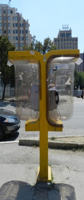

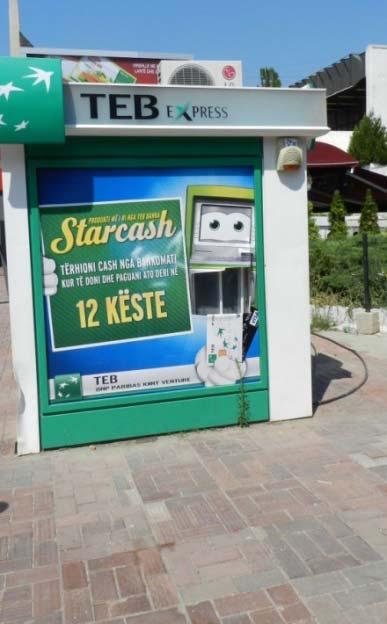

53 53 Phone booth ATM


54 54 Different greenhouses Outside oven

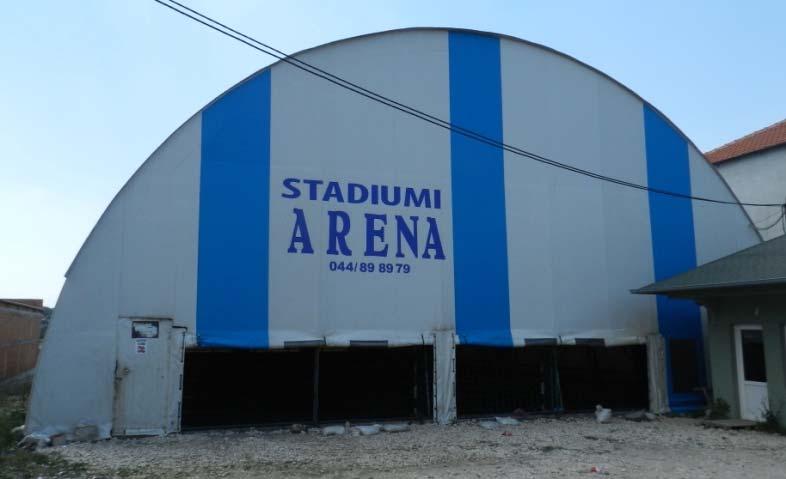

55 55 Barn Sport field

56 56 Garages build with no strong construction Carwash build of no strong construction


57 Kiosk/Booth 57


58 58 Veranda or covered resting Shelter or covered cages


59 Shelter at the entrance of the courtyard 59

 Other")
")
60 60 Other objects (power objects, post objects) Other objects (bus stations)
GOVERNMENT OF KOSOVA MINSTRY OF PUBLIC SERVICES KOSOVO CADASTRAL AGENCY PROGRESS OF THE CADASTRE IN KOSOVO
 KOSOVO CADASTRAL AGENCY FIG Commission 7 Annual Meeting 2004 Clermont-Ferrand, France September 8-14, 8 2004 PROGRESS OF THE CADASTRE IN KOSOVO Murat MEHA E-mail: mmeha@yahoo.com Data about Kosovo About
CADASTRAL MAPS AND GIS FOR SUSTAINABLE ECONOMIC DEVELOPMENT OF KOSOVA
 1 Title: CADASTRAL MAPS AND GIS FOR SUSTAINABLE ECONOMIC DEVELOPMENT OF KOSOVA Name and surname: E-mail: Organization: Conference Theme: Prof. Dr. sc. Murat MEHA mmeha@yahoo.com Kosovo Cadastral Agency
From 2D representation of the buildings into cadastral maps towards 3D GIS applications and BIM a case study for Prishtina
 From 2D representation of the buildings into cadastral maps towards 3D GIS applications and BIM a case study for Prishtina This is a Peer Reviewed Paper Fisnik LOSHI, Kosovo Keywords: 3D cadastre, property
Ownership Data in Cadastral Information System of Sofia (CIS Sofia) from the Available Cadastral Map
 from the Available Cadastral Map") Ownership Data in Cadastral Information System of Sofia (CIS Sofia) from the Available Cadastral Map Key words: ABSTRACT Lydmila LAZAROVA, Bulgaria CIS Sofia is created and maintained by GIS Sofia ltd,
Ownership Data in Cadastral Information System of Sofia (CIS Sofia) from the Available Cadastral Map Key words: ABSTRACT Lydmila LAZAROVA, Bulgaria CIS Sofia is created and maintained by GIS Sofia ltd,
Aspect of preliminary activities in the function of supporting NSDI
 Sonja DIMOVA, Republic of Macedonia Key words: e-governance, geospatial data, NSDI, INSPIRE, metadata SUMMARY The successful establishment of the NSDI in the true sense of the word cannot be performed
The Challenge to Implement International Cadastral Models Case Finland 1
 The Challenge to Implement International Cadastral Models Case Finland 1 Tarja MYLLYMÄKI and Tarja PYKÄLÄ, Finland Key words: cadastre, modelling, LADM, INSPIRE SUMMARY Efforts are currently made to develop
KCA ORGANIZATION GOVERNMENT OF KOSOVA MINSTRY OF PUBLIC SERVICES GOVERNMENT OF KOSOVA MINSTRY OF PUBLIC SERVICES
 Development of Cadastre and Land Management in Kosovo Prof. Dr. sc. Murat Meha, chief executive Hyzri Llabjani-Cadastral Expert * Hajzer Bublaku-Lawyer FIG Working Week 2004 in Athens, Greece, May 22-27,
CADASTRAL PROCEDURES AND WORKFLOW AT MCOS
 CADASTRAL PROCEDURES AND WORKFLOW AT MCOS Kosovo Cadastral Agency Page 2 Preface Land is economic wealth, and as such is recognized as one of the key mechanisms for the creation of wealth. As a rare resource
General Instructions For Surveys and Plans Outside the Provincial Survey System
 May 15, 2018 General Instructions For Surveys and Plans Outside the Provincial Survey System NOTE: This document is a Controller of Surveys Policy manual to be used as a general guideline for the Legal
Public Disclosure Copy
 Public Disclosure Authorized EUROPE AND CENTRAL ASIA Kosovo Social, Urban, Rural and Resilience Global Practice Global Practice IBRD/IDA Investment Project Financing FY 2010 Seq No: 19 ARCHIVED on 10-Jan-2018
PROJECT INFORMATION DOCUMENT (PID) CONCEPT STAGE Report No.: AB3229 Project Name. Land Registry and Cadastre Modernization Project Region
 CONCEPT STAGE Report No.: AB3229 Project Name. Land Registry and Cadastre Modernization Project Region") PROJECT INFORMATION DOCUMENT (PID) CONCEPT STAGE Report No.: AB3229 Project Name Land Registry and Cadastre Modernization Project Region EUROPE AND CENTRAL ASIA Sector Central government administration
PROJECT INFORMATION DOCUMENT (PID) CONCEPT STAGE Report No.: AB3229 Project Name Land Registry and Cadastre Modernization Project Region EUROPE AND CENTRAL ASIA Sector Central government administration
BULGARIAN CADASTRE A GUARANTEE FOR THE OWNERSHIP RIGHTS IN IMMOVABLE PROPERTIES
 4 TH INTERNATIONAL CONFERENCE RECENT PROBLEMS IN GEODESY AND RELATED FIELDS WITH INTERNATIONAL IMPORTANCE February 28 - March 2, 2007, Inter Expo Centre, Sofia, Bulgaria BULGARIAN CADASTRE A GUARANTEE
A Geocoded Cadastral Fabric as a Precondition for a Sustainable Land Management System
 A Geocoded Fabric as a Precondition for a Sustainable Land Management System Gottfried KONECNY, Germany; J.P. LAUZON, Canada; Abdul Salam MOHAMMED, India Key words: SDI,, Parcel Boundaries, GPS-GNSS, Land
Croatian SDI: a Tool for Accelerated Development of the Geo-Conscious Society
 STATE GEODETIC ADMINISTRATION Croatian SDI: a Tool for Accelerated Development of the Geo-Conscious Society Prof.Dr.Sc. Željko Bačić, Mr.Sc. Ljerka Rašić FIG Working Week 2009 - Surveyors Key Role in Accelerated
Cadastral Framework Standards
 Cadastral Framework Standards The goal of the Data Standards and Recommendations Committee is to provide recommendations and guidelines to Indiana GIS user communities to facilitate the collection, maintenance
Presented at the FIG Working Week 2016, May 2-6, 2016 in Christchurch, New Zealand
 Presented at the FIG Working Week 2016, May 2-6, 2016 in Christchurch, New Zealand The IMPULS Project Is a Project About Cooperation, Coordination, Transparency and Data Sharing A SDI project in the Western
Regional Cadastral Study Reforms in the Region
 UNECE WORKING PARTY ON LAND ADMINISTRATION Workshop on the Influence of Land Administration on People and Business Cavtat, Croatia 2-3 October 2008 Regional Cadastral Study Reforms in the Region Miodrag
Functional system for cadastral plans
 , Republic of Macedonia Key words: Cadastre, Digital plans, Data, System SUMMARY The analysis shows that the real estate market in Republic of Macedonia grows daily. With the expansion of this market increases
D DAVID PUBLISHING. Mass Valuation and the Implementation Necessity of GIS (Geographic Information System) in Albania
 in Albania") Journal of Civil Engineering and Architecture 9 (2015) 1506-1512 doi: 10.17265/1934-7359/2015.12.012 D DAVID PUBLISHING Mass Valuation and the Implementation Necessity of GIS (Geographic Elfrida Shehu
Journal of Civil Engineering and Architecture 9 (2015) 1506-1512 doi: 10.17265/1934-7359/2015.12.012 D DAVID PUBLISHING Mass Valuation and the Implementation Necessity of GIS (Geographic Elfrida Shehu
Topographic Signs Important Context of 3D Cadastre
 STATE GEODETIC ADMINISTRATION Gruška 20,10 000 Zagreb, Croatia Delft University of Technology Faculty of Architecture and the Built Environment Department OTB GIS Technology Section Topographic Signs Important
Quality Improvement to Cadastral Information in Sweden
 Gunnar BLIXT, Sweden Key words: digital cadastre, quality, cadastral index map, real property register. SUMMARY Lantmäteriet is a governmental agency which gives support for creating an efficient and sustainable
Standards of Practice for Surveying in the State of Alabama
 Standards of Practice for Surveying in the State of Alabama Effective January 1, 2017 RULE NO. 1.01 PURPOSE The purpose of these rules is to establish standards for the practice of surveying in the State
Section I General Information
 General Information Table of Contents A. Introduction... I-2 1. Purpose... I-2 2. Scope... I-2 3. Maintenance... I-3 4. Units... I-3 B. Public Relations... I-3 1. General Public... I-3 2. Property Owners...
Spatial Data Infrastructure in Sweden
 Spatial Data Infrastructure in Sweden Hans-Erik WIBERG, Sweden Key words: ABSTRACT Sweden was one of the first countries to address Data Infrastructure matters and have during several decades developed
Problems and Solution Proposals in Integration of Cadastral Data into Geographical Information System (GIS) in Turkey
 in Turkey") Problems and Solution Proposals in Integration of Cadastral Data into Geographical Information System (GIS) in Turkey Gülgün OZKAN, S. Savas DURDURAN, Ali ERDI and Bilal GIRGIN, Turkey Key words: Cadastre,
Problems and Solution Proposals in Integration of Cadastral Data into Geographical Information System (GIS) in Turkey Gülgün OZKAN, S. Savas DURDURAN, Ali ERDI and Bilal GIRGIN, Turkey Key words: Cadastre,
Land Cadastre Act. Chapter 1. Passed RT I 1994, 74, 1324 Entry into force (except 3 which entered into force on 1.01.
 Issuer: Riigikogu Type: act In force from: 01.01.2011 In force until: 31.12.2014 Translation published: 24.10.2014 Passed 12.10.1994 RT I 1994, 74, 1324 Entry into force 08.11.1994 (except 3 which entered
SYMPOSIUM LAND ADMINISTRATION IN POST CONFLICT AREAS Prill 2004 GJENEVA LAND ADMINISTRATION BEFORE AND AFTER THE WAR (1999) IN KOSOVO
 IN KOSOVO") SYMPOSIUM LAND ADMINISTRATION IN POST CONFLICT AREAS 29-30 Prill 2004 GJENEVA LAND ADMINISTRATION BEFORE AND AFTER THE WAR (1999) IN KOSOVO Prof. Dr. sc. Murat MEHA Chief Executive Officer Kosovo Cadastral
SYMPOSIUM LAND ADMINISTRATION IN POST CONFLICT AREAS 29-30 Prill 2004 GJENEVA LAND ADMINISTRATION BEFORE AND AFTER THE WAR (1999) IN KOSOVO Prof. Dr. sc. Murat MEHA Chief Executive Officer Kosovo Cadastral
Modern concepts of urban cadastre
 Modern concepts of urban cadastre CARMEN GRECEA Department of Land Measurements and Cadastre POLITEHNICA University of Timisoara 300006 Timisoara, P-ta Victoriei no. 2 ROMANIA carmen.grecea@ct.upt.ro http://www.upt.ro
New Developments in the Hellenic Cadastre
 New Developments in the Hellenic Cadastre Prof. M. Kavouras Vice-president Ktimatologio S.A. (Hellenic Cadastre) The Hellenic Cadastre Background The Hellenic National Cadastre Organizational and institutional
Challenge to Implement International Cadastral Models Case Finland
 FIG Articleof the Month April 20 Challenge to Implement International Cadastral Models Case Finland Tarja Myllymäki and Tarja Pykälä 200-04-5 The topics are In European level INSPIRE Experiences, similarities,
Republika e Kosovës Republika Kosovo - Republic of Kosovo Kuvendi - Skupština - Assembly
 Republika e Kosovës Republika Kosovo - Republic of Kosovo Kuvendi - Skupština - Assembly Law No. 04/L-144 ON ALLOCATION FOR USE AND EXCHANGE OF IMMOVABLE PROPERTY OF THE MUNICIPALITY Assembly of Republic
International funding projects in Republic Geodetic Authority
 International funding projects in Republic Geodetic Authority Serbia: Republic Geodetic Authority Workshop Exploring Funding Instruments for NMCA 7-8 November 2012 Republic Geodetic Authority Republic
GOVERNMENT OF KOSOVA MINSTRY OF PUBLIC SERVICES KOSOVO CADASTRAL AGENCY
 LAND CONSOLIDATION IN CREATION OF CADASTRAL MODEL AND ITS INFLUENSE IN ECONOMY DEVELOPMENT OF KOSOVA Prof. Dr. sc. Murat Meha Dip. eng. Qemail Kadiri E-mail: mmeha@yahoo.com WORKSHOP ORGANIZED BY FAO ON
Republic of Bulgaria
 Geodesy, Cartography and Cadastre Agency Republic of Bulgaria www.cadastre.bg 24. 01. 2018 г., гр. София The Cadastre Legislation in Bulgaria - historical reference 1908 г. The Cadastre Act The objective
The Digital Cadastral Database and the Role of the Private Licensed Surveyors in Denmark
 IRISH INSTITUTE OF SURVEYORS, DUBLIN INSTITUTE OF TECHNOLOGY, 23 NOVEMBER 2005 PUBLISHED IN IIS NEWS, WINTHER 2006. The Digital Cadastral Database and the Role of the Private Licensed Surveyors in Denmark
DEVELOPMENT OF A STUDY OF IMPLEMENTATION OF THE CADASTRE OF BUILDINGS IN THE REPUBLIC OF CROATIA
 REPUBLIC OF CROATIA Ministry of Construction and Physical Planning State Geodetic Administration Gruška 20, 10000 ZAGREB, CROATIA Phone: +385-1-6165-404 Fax: +385-1-6165-484 Terms of Reference DEVELOPMENT
GAUSSCAD A WEBGIS APPLICATION FOR COLLECTING CADASTRAL DATA
 M.M. Moise GaussCAD a WebGIS Application for Collecting Cadastral Data GAUSSCAD A WEBGIS APPLICATION FOR COLLECTING CADASTRAL DATA Mihai-Mircea MOISE, S.C. GAUSS S.R.L., mihai.moise@gauss.ro Abstract:
Parcel Boundaries in the Czech Republic
 Parcel Boundaries in the Czech Republic CZECH REPUBLIC Jiri Rydval, Libor Tomandl Czech Office for Surveying, Mapping and Cadastre inhabitants - 10.3 million territory 78,865 km 2 2 Contents: 1. A parcel
HOUSING AND PROPERTY MARKET IN LITHUANIA CONTENTS
 HOUSING AND PROPERTY MARKET IN LITHUANIA Kęstutis Sabaliauskas, Director General State Enterprise Centre of Registers, Lithuania Kestutis.Sabaliauskas@registrucentras.lt CONTENTS Legal environment Real
Securing Land Rights for Broadband Land Acquisition for Utilities in Sweden
 Securing Land Rights for Broadband Land Acquisition for Utilities in Sweden Marija JURIC and Kristin LAND, Sweden Key words: broadband, land acquisition, cadastral procedure, Sweden SUMMARY The European
IMPLEMENTATION OF FLEXICADASTRE IN ZAMBIA
 IMPLEMENTATION OF FLEXICADASTRE IN ZAMBIA Presented by: Simon M. Mwalimu Head of Mining Cadastre and Secretary of The Mining Advisory Committee Mining Cadastre Office-Zambia 16 th February 2009 Part A
ABSTRACT Land Administration System in Lithuania
 ABSTRACT Land Administration System in Lithuania 1. General introduction to the Lithuanian Land Administration System and State Enterprise Centre of Registers ( shortly SECR) Lithuania has established
201 KAR 18:150. Standards of practice.
 201 KAR 18:150. Standards of practice. RELATES TO: KRS 322.290(1)(a), (2)(f) STATUTORY AUTHORITY: KRS 322.290(2)(f) NECESSITY, FUNCTION, AND CONFORMITY: KRS 322.290(1)(a) authorizes the board to administer
Quality Improvement of the Real Estate Cadastre in Serbia
 , Serbia Key words: quality improvement, real estate information, quality assurance, Serbia SUMMARY The concept of cadastral modernization in the Republic of Serbia was defined in 1992, and it is being
Digitalisation of the Real Property Rights Towards Spatially enabled E-Government
 Digitalisation of the Real Property Rights Towards Spatially enabled E-Government Lise Schroeder, Bent Hulegaard Jensen, Esben Munk Soerensen & Line Hvingel Istanbul, Turkey 25 june 201 Overview Introduction
How a Cadaster Might Look Like in Finland in the Year 2035?
 How a Cadaster Might Look Like in Finland in the Year 2035? Mr. MARKKU Eino Olavi MARKKULA, Finland Key words; Cadastre, Coordinates, Digitised Process, Key Registers, Land Register Summary The Finnish
Strata Plan Fast Facts
 December 2015 ISSN: 2201-4292 Title: Strata Plan Fast Facts ISSN: 2201-4292 Land and Property Information www.lpi.nsw.gov.au Copyright Crown in right of New South Wales through Land and Property Information
Ⅱ-2. The Resurvey Project
 Presenter : JANG, Bong-Bae MLTM Ministry of land,transport and Maritime Affairs KIM, Soon-Tae KCSC Korea Cadastral Survey Corp., JANG, Bong-Bae Ⅰ. INTRODUCTION The Korean modern cadastral system was established
Design and Determine 3D Cadastral Systems: A Case Study of Turkey Hicret GURSOY SURMENELI* and Mehmet ALKAN* (Turkey)
") Design and Determine 3D Cadastral Systems: A Case Study of Turkey Hicret GURSOY SURMENELI* and Mehmet ALKAN* (Turkey) *Yildiz Technical University, Civil Engineering Faculty, Department of Geomatics CONTENTS
Design and Determine 3D Cadastral Systems: A Case Study of Turkey Hicret GURSOY SURMENELI* and Mehmet ALKAN* (Turkey) *Yildiz Technical University, Civil Engineering Faculty, Department of Geomatics CONTENTS
Land Administration in Jordan
 Land Administration in Jordan Problems and Challenges Eng. Director of Registration Services Department of Lands & Survey q General information q Historical Background q Properties Initiation q Problems
Development of Mobile Cadastral Surveying System for Korean Cadastral Resurvey Project
 Development of Mobile Cadastral Surveying System for Korean Cadastral Resurvey Project Joon-Sik, KIM, Sang-Gu, KANG, Yun-Soo, CHOI, Republic of Korea Key words: Mobile Cadastral Surveying System, RTK-GPS,
Cadastral Template 2003
 PCGIAP-Working Group 3 "Cadastre" FIG-Commission 7 "Cadastre and Land Management" Cadastral Template 2003 The establishment of a cadastral template is one of the objectives of Working Group 3 "Cadastre"
Alternatives for Economic Boundary Determination in the Establishment of a Cadastral System. Paper to the FIG Working Week 2012 Rome, May 9, 2012
 Alternatives for Economic Boundary Determination in the Establishment of a Cadastral System Paper to the FIG Working Week 2012 Rome, May 9, 2012 by Gottfried Konecny Emeritus Professor Leibniz University
Addressing Land Sector Opportunities with Geospatial Information in Nepal
 The 20th UNRCC-AP and the 4th UN-GGIM-AP 5-10 October 2015 Jeju Island, Republic of Korea Addressing Land Sector Opportunities with Geospatial Information in Nepal Krishna Raj BC Executive Director Land
Progress Report on Green Paper. Dr. Paddy Prendergast. on behalf of the. IIS Commission on Land Registration
 Progress Report on Green Paper By Dr. Paddy Prendergast on behalf of the IIS Commission on Land Registration Paddy Prendergast - Chair Brendan Sweeny - Hempenstall Surveys Paul Corrigan - P Corrigan Associates
ORDINANCE NO AN ORDINANCE ESTABLISHING A UNIFORM SYSTEM FOR STREET ADDRESSING IN EMERY COUNTY
 ORDINANCE NO. 21505 AN ORDINANCE ESTABLISHING A UNIFORM SYSTEM FOR STREET ADDRESSING IN EMERY COUNTY The County Commission of the County of Emery, State of Utah, being the Legislative Body of said county,
 Page 1 of 6 Office of the Professions Land Surveying Practice Guidelines - February 2000 The State Board for Engineering and Land Surveying issued the first draft of its proposed Land Surveying Practice
CADASTRAL WORKS in TURKEY AND GDLRC (TKGM)
") CADASTRAL WORKS in TURKEY AND GDLRC (TKGM) NOVEMBER 2011 SOME NUMBERS ABOUT TURKEY Area :783.600 Km 2 Population : 747 millions (2008) Number of land parcels : 555 millions Villages and quarters : 52.437
CADASTRAL WORKS in TURKEY AND GDLRC (TKGM) NOVEMBER 2011 SOME NUMBERS ABOUT TURKEY Area :783.600 Km 2 Population : 747 millions (2008) Number of land parcels : 555 millions Villages and quarters : 52.437
Participants of the Ministerial Meeting on Housing and Land Management on 8 October 2013 in Geneva
 Summary At its meeting on 2 April 2012, the Bureau of the Committee on Housing and Land Management of the United Nations Economic Commission for Europe agreed on the need for a Strategy for Sustainable
REFORM OF LAND CADASTRE IN LITHUANIA
 REFORM OF LAND CADASTRE IN LITHUANIA Romualdas KASPERAVICIUS, Lithuania Key words: ABSTRACT Main aim for every Government is to create legal, financial and organisational circumstances for real property.
Experience in Innovative Technologies Application to Change Urban Space for Sustainable Territory Development
 IOP Conference Series: Materials Science and Engineering PAPER OPEN ACCESS Experience in Innovative Technologies Application to Change Urban Space for Sustainable Territory Development To cite this article:
Reliability of the Italian cadastral system data quality and improvement prospects
 Reliability of the Italian cadastral system data quality and improvement prospects Eng. Franco MAGGIO (Central Director for Cadastral, Cartographic and Land Registration Services) Eng. Arturo ANGELINI
South African Council for Town and Regional Planners
 TARIFF OF FEES South African Council for Town and Regional Planners PLEASE NOTE : THE TARIFF OF FEES WAS APPROVED BY THE COUNCIL CHAPTER 10 : TARIFF OF FEES 10.1 INTRODUCTION 10.1.1 General This tariff
World Habitat Day was established in 1985 by the United Nations General Assembly through Resolution 40/202, and was first celebrated in 1986.
 Expression of Interest 29 th January 2019 GLOBAL OBSERVANCE OF THE ANNUAL WORLD HABITAT DAY 2019 1. Introduction UN-Habitat is the United Nations programme working towards a better urban future. Its mission
The Cadastral Modelling Future and The Land Surveyors Role
 The Cadastral Modelling Future and The Land Surveyors Role Ian Harper Geodata Australia ESRI Survey Summit July 2013 The Land Surveyors Future Role From Custodians of the Cadastre to Custodians of the
REGISTRATION OF PROPERTIES IN STRATA
 REGISTRATION OF PROPERTIES IN STRATA REPORT ON THE WORKING SESSIONS INTRODUCTION A cadastre is usually, and in most countries, a parcel-based, and up-to-date land information system containing records
Designing for transparency and participation in the Hellenic Cadastral Project
 Designing for transparency and participation in the Hellenic Cadastral Project Dr. Dimitris Rokos Director of Planning and Investments, Hellenic National Cadastre and Mapping Agency S.A. Table of Contents
MnDOT Contract No Exhibit B. Scope of Work. Scope of Work
 MnDOT Contract No. 1032993 Contract General Description The purpose of this contract is to provide the State with the survey accurate re-establishment of designated Public Land Survey section boundaries
DAWSON COUNTY MINOR PLAT REVIEW CHECKLIST $50.00 FEE PER PLAT REVIEW, $5.00 FEE FOR SCAN & CD FOR RECORDING
 DAWSON COUNTY MINOR PLAT REVIEW CHECKLIST $50.00 FEE PER PLAT REVIEW, $5.00 FEE FOR SCAN & CD FOR RECORDING NAME ON PLAT: CONTACT/PHONE #: NAMED STREET/ADDRESS: LAND LOT: DISTRICT: SECTION: ZONING: SETBACKS:
DECREE GENERAL PROVISIONS
 THE GOVERNMENT ------- SOCIALIST REPUBLIC OF VIET NAM Independence - Freedom Happiness --------------- No: 44/2014/ND-CP Hanoi, May 15, 2014 DECREE REGULATIONS ON LAND PRICES Pursuant to Law on Government
Functional concept and quality of cadastral services in Kosovo. Mr.sci.inxh. Murat Hoxha
 Functional concept and quality of cadastral services in Kosovo April 2018 Mr.sci.inxh. Murat Hoxha "It's not enough to work the best. You need to know what you're doing " Do It Right the First Time "The
INDIAN INSTITUTE OF TECHNOLOGY ROORKEE. Presentation on REAL TIME CADASTRAL SURVEYING SOLUTION WITH A SPECIAL IMPHESIS TO MODERN GPS TECHNOLOGY.
 INDIAN INSTITUTE OF TECHNOLOGY ROORKEE Presentation on REAL TIME CADASTRAL SURVEYING SOLUTION WITH A SPECIAL IMPHESIS TO MODERN GPS TECHNOLOGY By: Prof. Kamal Jain, Dept. of Civil Engg. IIT-Roorkee AIM
The Role of the Swedish Land Information System
 The Role of the Swedish Land Information System In the Business Society Tommy Österberg Swedesurvey 1 SWEDEN 9 million inhabitants 450 000 sq. km 21 Counties 291 Municipalities 4.6 million properties in
SECTOR PUBLIC CADASTRES AND REGISTERS MARKET PARTICIPANTS
 E-SERVICES TO CITIZENS, GOVERNMENT AND BUSINESSES. LITHUANIA EXPERIENCE Arvydas Bagdonavičius State Enterprise Centre of Registers Arvydas.Bagdonavicius@registrucentras.lt REGISTERS AND IS MANAGED BY THE
Preprint.
 http://www.diva-portal.org Preprint This is the submitted version of a paper presented at 10th EC GI & GIS Workshop, ESDI State of the Art, Warsaw, Poland, 23-25 June 2004. Citation for the original published
Ecuador and last year in Guangzhou, China emphasizing the sub-theme Innovative Governance, Open Cities.
 Expression of Interest 18th December 2018 GLOBAL OBSERVANCE OF THE ANNUAL WORLD CITIES DAY 2019 1. Introduction The United Nations has designated every 31 of October as World Cities Day (WCD). UN-Habitat
THINK BIG do little. Start an avalanche
 1 Recent activities on land consolidation in Serbia Stevan Marosan, Mladen Soskic University of Belgrade, Faculty of Civil Engineering Department for Geodesy and Geoinformatics Zoran Knezevic Ministry
FUTURE VISION ON KOREAN CADASTRAL SURVEYING
 FUTURE VISION ON KOREAN CADASTRAL SURVEYING Myounwoo LEE, Vice President, Korea Cadastral Survey Corporation, Korea 1. INTRODUCTION Cadastral surveying, which contributes to secure the ownership of the
Challenges for the multi purpose cadastre
 Jens RIECKEN, Markus SEIFERT, Germany Key words: Multi purpose cadastre, 3d-cadastre, land use, SDI, solar cadastre SUMMARY Over the past 30 years, with the progress of information technologies the development
The Register of the Domain of the State, Cadastre 2014 and LADM
 The Register of the Domain of the State, Cadastre 2014 and LADM Bruno Gilbert, Christian Lord, Daniel Roberge Foncier Québec 29 e réunion ISO/TC 211 Québec, 4 novembre 2009 Presentation plan Context Modernization
Building Integrated Land Information Systems and Development of NSDI
 Stig JÖNSSON, Sweden Key words: Land administration, land information systems, property formation, spatial data infrastructure, Inspire, institutional cooperation SUMMARY Lantmäteriet the Swedish agency
ONTARIO REGULATION to be made under the REGISTRY ACT Amending O. Reg. 43/96 (SURVEYS, PLANS AND DESCRIPTIONS OF LAND)
") Caution: This consultation draft is intended to facilitate dialogue concerning its contents. Should the decision be made to proceed with the proposal, the comments received during consultation will be
Caution: This consultation draft is intended to facilitate dialogue concerning its contents. Should the decision be made to proceed with the proposal, the comments received during consultation will be
Information Quality - A Critical Success Factor How to make it all right!
 Information Quality - A Critical Success Factor How to make it all right! Anders Svensson, Sweden Key words: Cadastre, information quality, property information, property boundaries SUMMARY Sweden has
Land Administration Infrastructures for Sustainable Development
 The Global Challenges Land Administration Infrastructures for Sustainable Development Prof. Stig Enemark Department of Development and Planning Aalborg, University, Denmark INTERNATIONAL CONFERENCE ON
Property Based Land Information Systems of Turkey
 Property Based Land Information Systems of Turkey Mehmet Fatih DİRİ, Bilgehan ÖZSOY, Ünsal ERGÜN, Turkey Key words: Cadaster, Land Registry, GIS, Property, TURKEY SUMMARY The property, addition to the
PROBLEMS IN REGISTRATION IN THE THIRD VERTICAL DIMENSION IN THE UNIFIED LAND REGISTRY IN HUNGARY, AND POSSIBLE SOLUTION
 3D Cadastres Technical and Legal Aspects II PROBLEMS IN REGISTRATION IN THE THIRD VERTICAL DIMENSION IN THE UNIFIED LAND REGISTRY IN HUNGARY, AND POSSIBLE SOLUTION ANDRÁS Osskó Budapest Land Office Hungary
The Boundary and the Effects of Cadastral Surveying in Cyprus
 The Boundary and the Effects of Cadastral Surveying in Cyprus Aristi Louca, Margarita Fani Surveyor Engineers, Cyprus Association of Rural and Surveying Engineers The History of Cyprus goes back 11000
Cadastre and Other Public Registers: Multipurpose Cadastre or Distributed Land Information System?
 Cadastre and Other Public Registers: Multipurpose Cadastre or Distributed Land Information System? Ivan PESL, Czech Republic Key words: Cadastre, Land Registry, Property, Taxes, Land Use, Territorial Planning,
PROJECT FINANCIAL STATEMENTS REAL ESTATE REGISTRATION PROJECT. Report on the Republika Srpska part of the. of the
 Report on the Republika Srpska part of the PROJECT FINANCIAL STATEMENTS of the REAL ESTATE REGISTRATION PROJECT of the Ministry of Finance and Treasury of Bosnia and Herzegovina financed by: - IDA Credit
Asset valuation. Advancing Methodology on Measuring Asset Ownership from a Gender Perspective
 Advancing Methodology on Measuring Asset Ownership from a Gender Perspective Asset valuation Workshop on the Production of Statistics on Asset Ownership from a Gender Perspective through Household Surveys
INTERNATIONAL JOURNAL OF GEOMATICS AND GEOSCIENCES Volume 2, No 2, 2011
 INTERNATIONAL JOURNAL OF GEOMATICS AND GEOSCIENCES Volume 2, No 2, 2011 Copyright 2010 All rights reserved Integrated Publishing services Case study ISSN 0976 4380 Property formation-change in land related
CREA DDF FAQ. Q: Will creating this facility lead to another investigation from the Competition Bureau?
 CREA DDF FAQ Note: New questions and answers added in November 2012 are shown in red. Q: What is the CREA DDF? A: The CREA DDF is a data distribution facility that CREA created to enable its members to
Urban-Rural Interrelationship for Sustainable Environment
 Urban-Rural Interrelationship for Sustainable Environment Marrakech 2-52 5 December 2003 Department of Lands and Survey - The Modernization Journey A Paper presented by Eng. Sameer Abbadi Surveying and
FIG/FAO International Seminar on State and Public Land Management
 FIG/FAO International Seminar on State and Public Land Management State Land Distribution for the Poor: State Land Identification, Mapping, Classification and Registration By Dr. Sareth Boramy Deputy General
FIG-WB Forum on Land Administration and reform in Sub-Sahara Africa
 FIG-WB Forum on Land Administration and reform in Sub-Sahara Africa Chris Mnyanga Ministry of Lands UNITED REPUBLIC OF TANZANIA] FIG WORKING WEEK, Abuja, NIGERIA 2013-6-10 MAY 2013 Country at Glance UNITED
Planning Act. Chapter 1 General provisions. Passed In force from: In force until: Translation published:
 Issuer: Riigikogu Type: act In force from: 01.07.2015 In force until: 31.08.2015 Translation published: 18.12.2015 1. Aim and scope of regulation of the Act Passed 28.01.2015 Chapter 1 General provisions
LIS a motivation for SDI initiative
 Eric Mwaikambo Ardhi University Dar es Salaam Tanzania Overview Status of LIS in Tanzania Relationship between SDI and LIS Spatial Standards LIS a motivation for SDI initiative Conclusion & Recommendations
THE LAND POOLING RULES OF THE KINGDOM OF BHUTAN 2009 ROYAL GOVERNMENT OF BHUTAN MINISTRY OF WORKS AND HUMAN SETTLEMENT
 THE LAND POOLING RULES OF THE KINGDOM OF BHUTAN 2009 ROYAL GOVERNMENT OF BHUTAN MINISTRY OF WORKS AND HUMAN SETTLEMENT July 2009 1 CONTENTS CHAPTER 1 PRELIMINARY... 3 Title, extent and commencement...
Cadastre and Land Registration in Europe
 Annex A: Questionnaire 2007 for Information Resource Cadastre and Land Registration in Europe Introduction This questionnaire is based on the EuroGeographics vision document 'Cadastre and Land Registration
Key Registers in Finland and some views of Cadastre 2035
 Presented at the FIG Working Week 2016, May 2-6, 2016 in Christchurch, New Zealand Key Registers in Finland and some views of Cadastre 2035 FIG Working Week, Christchurch New Zealand May, the 3rd, 2016