GOVERNMENT OF KOSOVA MINSTRY OF PUBLIC SERVICES KOSOVO CADASTRAL AGENCY PROGRESS OF THE CADASTRE IN KOSOVO
|
|
|
- Isaac Sanders
- 5 years ago
- Views:
Transcription
1 KOSOVO CADASTRAL AGENCY FIG Commission 7 Annual Meeting 2004 Clermont-Ferrand, France September 8-14, PROGRESS OF THE CADASTRE IN KOSOVO Murat MEHA mmeha@yahoo.com

2 Data about Kosovo About 2 mil. Inhabitants 10908km 2 30 Municipality 1301 Cadastral Zone Owner parcels Buildings
3 KOSOVO CADASTRAL AGENCY Changes and transition in Kosovo change of political system change of judicial system, change of economic system, privatisation of economy, privatisation proces of sotial enterprices and agricultural land. land administration
4 KOSOVO CADASTRAL AGENCY KOSOVO CADASTRAL AGENCY Chief executive Administration and Finance Directorate Cadastral Directorate GIS Directorate Legal Directorate Measurements Directorate Cartographic Directorate IT Directorate Municipality Cadastral Offices
5 Reconsolidation of cadastre Reconsolidation of the cadastre in Kosova has started after During the war in 1999 in Kosovo, the Serbian Government forces have stealing much more cadastral records and maps. Thanks for the support from Swiss, Sweden, Norwegian and Kosova government and their experts. Donations from the Governments Cadastral Unite Support to MCO s Measurement / GIS Legal Unite Tryning
6 KOSOVO CADASTRAL AGENCY Land Administration The project for LA till now are developed but also it will continue with following components: A Institutional Strengthening and Programme Management B Cadastre Maintenance and Immovable Property Rights Registration Development; C Kosovo Cadastre and Land Information System Development; KCLIS D Geoinformation /Spatial Data Infrastructure Development; E Education, Professional Development and Training Interministralcommittee for LA is established (3 meetings) which will advice Government how to implement land projects in Kosovo: Coordinate activities and developments Cooperation and Harmonisation activities between actors on LA Promote activities cross Ministry and Build trust through cooperation Present Land Policies priorities to Government at high level Involve public and private sector etc
7 KOSOVO CADASTRAL AGENCY Approved Laws Law on Mortgage No.2002/4 (UNMIK Rule 2002/21) Law on Establishment of Immovable Property Right Register No.2002/5 (UNMIK Rule No.2002/22) Law on fulfillment and change of Establishment of Immovable Property Right Register No.2003/13 (UNMIK Rule No.2003/27) Administrative Instruction No.2004/03 for Implementation of Law on Establishment of IPRR No.2002/5 and 2003/13 Law on Cadastre No.2003/25 (UNMIK Rule No.2004/4)
8 Laws in process Law on transfer Possesses of Private Property into Owners, Administrative Instruction on Implementation of Law on Cadastre No.2002/25 Administrative Instructions for the Licensing of Geodetic Companies and licensing Surveyors.
9 Projects Digital Immovable Property Right Register (IPRR) is in testing faze Vectorisation: cadastral maps are rasterised and vectorised Implementation of Digital Cadastre and orthophotos New KOSOVAREF01 based on EUREF I-stand II-ndorder geodetic network Pilot projects on area with Land Consolidation Topographical maps FIG book CADASTRE 2014 is translated and publichedfrom KCA in Albanian
10

11 Vectorazation 1. Topology, 2. Geometry, 3. Attributes.


12 Implementation of Digital Cadastre and orthophotos

13 New Geodetic network KOSOVAREF
14 KOSOVO CADASTRAL AGENCY Projects in process Aerial photography Project in Hade village Link textual and graphical database Registration of buildings and part of buildings
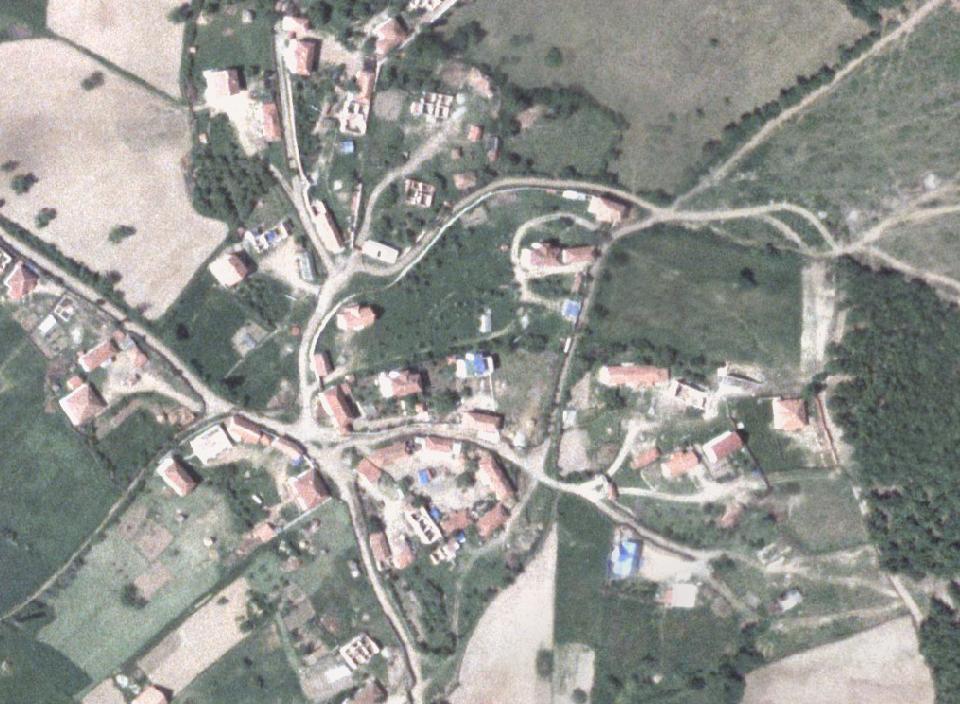
15 Aerial photography 2004

16 Model Hade village

17 Data from the model are in KCID program
18 Symposiums, Seminars, Workshops, Visits Active in Eurogeographic Active in CELKCenterBudapest Symposiums and Seminars on Land Administration with presentations, papers, contributes etc in different symposiums, seminars, workshops etc: Athens, Krakow, Edinburgh, Zagreb, Istanbul, Lisboan, Geneva, Miami Beach etc. Study tours and visits in region and Europe.
19 SUMMARY KOSOVO CADASTRAL AGENCY 1. Digital Cadastre is oriented to support economical development of Kosova offering exact data for the property and other relations to the IPRR. 2. Interministrial Coordination Committee for the land administration is established which will advice Government how to implement land projects in Kosovo. Involve public and private sector etc. 3. Laws and Unified register describe all rights and restrictions to owners or users for the private or public property. 4. Arial photography production have to create new possibility on linking textual and graphical parcels data. 5. The maintenance and advance of the cadastre is ongoing based on new standards. 6. Starting with topo maps.
SYMPOSIUM LAND ADMINISTRATION IN POST CONFLICT AREAS Prill 2004 GJENEVA LAND ADMINISTRATION BEFORE AND AFTER THE WAR (1999) IN KOSOVO
 IN KOSOVO") SYMPOSIUM LAND ADMINISTRATION IN POST CONFLICT AREAS 29-30 Prill 2004 GJENEVA LAND ADMINISTRATION BEFORE AND AFTER THE WAR (1999) IN KOSOVO Prof. Dr. sc. Murat MEHA Chief Executive Officer Kosovo Cadastral
SYMPOSIUM LAND ADMINISTRATION IN POST CONFLICT AREAS 29-30 Prill 2004 GJENEVA LAND ADMINISTRATION BEFORE AND AFTER THE WAR (1999) IN KOSOVO Prof. Dr. sc. Murat MEHA Chief Executive Officer Kosovo Cadastral
KCA ORGANIZATION GOVERNMENT OF KOSOVA MINSTRY OF PUBLIC SERVICES GOVERNMENT OF KOSOVA MINSTRY OF PUBLIC SERVICES
 Development of Cadastre and Land Management in Kosovo Prof. Dr. sc. Murat Meha, chief executive Hyzri Llabjani-Cadastral Expert * Hajzer Bublaku-Lawyer FIG Working Week 2004 in Athens, Greece, May 22-27,
CADASTRAL MAPS AND GIS FOR SUSTAINABLE ECONOMIC DEVELOPMENT OF KOSOVA
 1 Title: CADASTRAL MAPS AND GIS FOR SUSTAINABLE ECONOMIC DEVELOPMENT OF KOSOVA Name and surname: E-mail: Organization: Conference Theme: Prof. Dr. sc. Murat MEHA mmeha@yahoo.com Kosovo Cadastral Agency
GOVERNMENT OF KOSOVA MINSTRY OF PUBLIC SERVICES KOSOVO CADASTRAL AGENCY
 LAND CONSOLIDATION IN CREATION OF CADASTRAL MODEL AND ITS INFLUENSE IN ECONOMY DEVELOPMENT OF KOSOVA Prof. Dr. sc. Murat Meha Dip. eng. Qemail Kadiri E-mail: mmeha@yahoo.com WORKSHOP ORGANIZED BY FAO ON
Croatian SDI: a Tool for Accelerated Development of the Geo-Conscious Society
 STATE GEODETIC ADMINISTRATION Croatian SDI: a Tool for Accelerated Development of the Geo-Conscious Society Prof.Dr.Sc. Željko Bačić, Mr.Sc. Ljerka Rašić FIG Working Week 2009 - Surveyors Key Role in Accelerated
Implementing Norwegian funded projects with the State Geodetic Administration in Croatia
 Implementing Norwegian funded projects with the State Geodetic Administration in Croatia Fredrik Steiwer Managing Director Project Management and Mapping AS PMM? Project Management and Mapping AS (PMM)
Role of Republic Geodetic Authority in the Serbian geo-sector
 Role of Republic Geodetic Authority in the Serbian geo-sector Republic Geodetic Authority, Serbia www.rgz.gov.rs EuroGeographics General Assembly 2014 Moldova, Chisinau, 28 th 30 th September 2014 The
THE RECONSTRUCTION OF THE CADASTRE AND THE DEVELOPMENT OF A LAND INFORMATION SYSTEM IN KOSOVO
 THE RECONSTRUCTION OF THE CADASTRE AND THE DEVELOPMENT OF A LAND INFORMATION SYSTEM IN KOSOVO Tor VALSTAD, Norway/Kosovo Key words: Kosovo, Kosovo Cadastral Agency, KCA, cadastre, land information. ABSTRACT
International funding projects in Republic Geodetic Authority
 International funding projects in Republic Geodetic Authority Serbia: Republic Geodetic Authority Workshop Exploring Funding Instruments for NMCA 7-8 November 2012 Republic Geodetic Authority Republic
Republic of Bulgaria
 Geodesy, Cartography and Cadastre Agency Republic of Bulgaria www.cadastre.bg 24. 01. 2018 г., гр. София The Cadastre Legislation in Bulgaria - historical reference 1908 г. The Cadastre Act The objective
Presented at the FIG Working Week 2016, May 2-6, 2016 in Christchurch, New Zealand
 Presented at the FIG Working Week 2016, May 2-6, 2016 in Christchurch, New Zealand The IMPULS Project Is a Project About Cooperation, Coordination, Transparency and Data Sharing A SDI project in the Western
THINK BIG do little. Start an avalanche
 1 Recent activities on land consolidation in Serbia Stevan Marosan, Mladen Soskic University of Belgrade, Faculty of Civil Engineering Department for Geodesy and Geoinformatics Zoran Knezevic Ministry
CADASTRAL PROCEDURES AND WORKFLOW AT MCOS
 CADASTRAL PROCEDURES AND WORKFLOW AT MCOS Kosovo Cadastral Agency Page 2 Preface Land is economic wealth, and as such is recognized as one of the key mechanisms for the creation of wealth. As a rare resource
OFFICIAL GAZETTE OF THE REPUBLIC OF KOSOVA / PRISTINA: YEAR III / NO. 34 / 01 AUGUST 2008
 OFFICIAL GAZETTE OF THE REPUBLIC OF KOSOVA / PRISTINA: YEAR III / NO. 34 / 01 AUGUST 2008 LAW NO. 2002/5 ON THE ESTABLISHMENT OF THE IMMOVABLE PROPERTY RIGHTS REGISTER The Assembly of Kosovo, On the basis
e-land Administration in Hungary
 e-land Administration in Hungary Piroska Zalaba senior counsellor, project manager Ministry of Agriculture and Rural Development Department of Lands and Mapping FIG SEMINAR Innsbruck, 2-4 June 2004 Land
Quality Improvement of the Real Estate Cadastre in Serbia
 , Serbia Key words: quality improvement, real estate information, quality assurance, Serbia SUMMARY The concept of cadastral modernization in the Republic of Serbia was defined in 1992, and it is being
ABSTRACT Land Administration System in Lithuania
 ABSTRACT Land Administration System in Lithuania 1. General introduction to the Lithuanian Land Administration System and State Enterprise Centre of Registers ( shortly SECR) Lithuania has established
The Role of Geodesy in Modernization of Croatian Railways
 Igor POLJANAC, Rinaldo PAAR and Vlado CETL, Croatia Key words: railways, modernization, infrastructure, and geodesy. SUMMARY At the beginning of the 90-s in the last century the changes in the economic
Regional Cadastral Study Reforms in the Region
 UNECE WORKING PARTY ON LAND ADMINISTRATION Workshop on the Influence of Land Administration on People and Business Cavtat, Croatia 2-3 October 2008 Regional Cadastral Study Reforms in the Region Miodrag
CATALOGUE FOR MEASURING AND CREATING CADASTRAL UNITS
 1 CATALOGUE FOR MEASURING AND CREATING CADASTRAL UNITS Prishtinë, August 2013 2 EDITOR: PROF. DR. Murat MEHA Authors: Murat Meha, Qemajl Kadiri, Muzafer Çaka, Reshat Murati, Avni Ahmeti, Bashkim Shaqiri,
Spatial Data Infrastructure in Sweden
 Spatial Data Infrastructure in Sweden Hans-Erik WIBERG, Sweden Key words: ABSTRACT Sweden was one of the first countries to address Data Infrastructure matters and have during several decades developed
Country report, HUNGARY
 Country report, HUNGARY Gyula IVÁN Institute of Geodesy, Cartography & Remote Sensing (FÖMI) HUNGARY FIG Commission 7 Annual Meeting 2009 12-16 October, 2009, Kuala Lumpur, Malaysia Institute of Geodesy,
Country Report SWITZERLAND
 armasuisse Federal Office of Topography, swisstopo Country Report SWITZERLAND Dr. Daniel Steudler Swiss Annual Meeting 2013, FIG-Commission 7 22 October 2013, Yaoundé, Cameroon Basic Dimensions SWITZERLAND
Surveying in Austria. Congress Maanmittauspäivät Seinäjoki, 20 th March 2014
 Surveying in Austria Congress Maanmittauspäivät Seinäjoki, 20 th March 2014 Topics Facts, figures Organisational issues of surveying Role of the BEV Products, services The Cadastre Surveying Education
BULGARIAN CADASTRE A GUARANTEE FOR THE OWNERSHIP RIGHTS IN IMMOVABLE PROPERTIES
 4 TH INTERNATIONAL CONFERENCE RECENT PROBLEMS IN GEODESY AND RELATED FIELDS WITH INTERNATIONAL IMPORTANCE February 28 - March 2, 2007, Inter Expo Centre, Sofia, Bulgaria BULGARIAN CADASTRE A GUARANTEE
From 2D representation of the buildings into cadastral maps towards 3D GIS applications and BIM a case study for Prishtina
 From 2D representation of the buildings into cadastral maps towards 3D GIS applications and BIM a case study for Prishtina This is a Peer Reviewed Paper Fisnik LOSHI, Kosovo Keywords: 3D cadastre, property
Unified Land Administration for a Better Spatial Infrastructure
 Unified Land Administration for a Better Spatial Infrastructure Gyula IVÁN Institute of Geodesy, Cartography & Remote Sensing FÖMI (HUNGARY) Open Symposium 30th Korean Cadastral Seminar & FIG Commission
Annual Meeting 2006 SLOVENIA, BLED RASAS GOFMANAS JAUNIUS GRIGAS RIMANTAS RAMANAUSKAS KESTUTIS TRECIOKAS
 Annual Meeting 2006 SLOVENIA, BLED LAND ADMINISTRATION IN LITHUANIA RASAS GOFMANAS JAUNIUS GRIGAS RIMANTAS RAMANAUSKAS KESTUTIS TRECIOKAS ADMINISTRATIVE STRUCTURE OF LITHUANIA HISTORY OF LAND ADMINISTRATION
Improvement of Effectiveness Present Developments in Hungarian Land Administration
 Improvement of Effectiveness Present Developments in Hungarian Land Administration Gyula IVÁN and András OSSKÓ, Hungary Key words: Land Administration, Cadastre, Land Registry SUMMARY New Act on Surveying
Cadastre: definitions
 Introduction New vision towards a multipurpose cadastral system to support land management in Morocco Moha EL-AYACHI, El Hassane SEMLALI, Mohamed ETTARID, Driss TAHIRI, Institut Agronomique et Vétérinaire
DATR towards e-land Administration in Hungary
 DATR towards e-land Administration in Hungary Gyula IVÁN-Gábor SZABÓ-Zoltán WENINGER-Piroska Zalaba Institute of Geodesy, Cartography and Remote Sensing, Budapest, HUNGARY XXIV. FIG Congress Facing the
Land Administration In Public Private Partnerships
 Land Administration In Public Private Partnerships Workshop Customers - Co-operation - Services Vienna, 12-13 September 2002 Peter Creuzer Content Land Administration - Tasks History Spatial Data Infrastructure
Saulius Milevičius, Lithuanian Surveyors Association Head of the Internet Map Application Designing Group SE Centre of Registers
 LITHUANIAN EXPERIENCE IN CADASTRE Saulius Milevičius, Lithuanian Surveyors Association Head of the Internet Map Application Designing Group SE Centre of Registers Jolanta Česnauskienė, Jolanta Česnauskienė,
Use of data in Ukraine for sustainable economic growth. Oleksandr Maliuk State Service of Ukraine for Geodesy, Cartography and Cadastre
 Use of data in Ukraine for sustainable economic growth Oleksandr Maliuk State Service of Ukraine for Geodesy, Cartography and Cadastre Kehl, 2017 Content of the presentation Ukraine & StateGeoCadastre:
International Training Program (ITP) Coordinated Mentor Training Program
 Coordinated Mentor Training Program") Coordinated Mentor Training Program Presented at the FIG Congress 2018, May 6-11, 2018 in Istanbul, Turkey International Training Program (ITP) Paper no 9587: Peter Wasström, Head of International Services
Coordinated Mentor Training Program Presented at the FIG Congress 2018, May 6-11, 2018 in Istanbul, Turkey International Training Program (ITP) Paper no 9587: Peter Wasström, Head of International Services
Challenges for the multi purpose cadastre
 Jens RIECKEN, Markus SEIFERT, Germany Key words: Multi purpose cadastre, 3d-cadastre, land use, SDI, solar cadastre SUMMARY Over the past 30 years, with the progress of information technologies the development
Preprint.
 http://www.diva-portal.org Preprint This is the submitted version of a paper presented at 10th EC GI & GIS Workshop, ESDI State of the Art, Warsaw, Poland, 23-25 June 2004. Citation for the original published
PROJECT INFORMATION DOCUMENT (PID) CONCEPT STAGE Report No.: AB3229 Project Name. Land Registry and Cadastre Modernization Project Region
 CONCEPT STAGE Report No.: AB3229 Project Name. Land Registry and Cadastre Modernization Project Region") PROJECT INFORMATION DOCUMENT (PID) CONCEPT STAGE Report No.: AB3229 Project Name Land Registry and Cadastre Modernization Project Region EUROPE AND CENTRAL ASIA Sector Central government administration
PROJECT INFORMATION DOCUMENT (PID) CONCEPT STAGE Report No.: AB3229 Project Name Land Registry and Cadastre Modernization Project Region EUROPE AND CENTRAL ASIA Sector Central government administration
Cadastral survey - the best way of cadastre modernization Nikola VUČIĆ & Damir ŠANTEK, Croatia
 Presented at the FIG Congress 2018, May 6-11, 2018 in Istanbul, Turkey Cadastral survey - the best way of cadastre modernization Nikola VUČIĆ & Damir ŠANTEK, Croatia LAND ADMINISTRATION IN CROATIA Two
Presented at the FIG Congress 2018, May 6-11, 2018 in Istanbul, Turkey
 Presented at the FIG Congress 2018, May 6-11, 2018 in Istanbul, Turkey 5 Bibliometric Analysis of Articles Presented Under Commission 7: A Case of the 25th Fig Congress in Malaysia in 2014 Zeynel Abidin
Public Disclosure Copy
 Public Disclosure Authorized EUROPE AND CENTRAL ASIA Kosovo Social, Urban, Rural and Resilience Global Practice Global Practice IBRD/IDA Investment Project Financing FY 2010 Seq No: 19 ARCHIVED on 10-Jan-2018
The Digital Cadastral Database and the Role of the Private Licensed Surveyors in Denmark
 IRISH INSTITUTE OF SURVEYORS, DUBLIN INSTITUTE OF TECHNOLOGY, 23 NOVEMBER 2005 PUBLISHED IN IIS NEWS, WINTHER 2006. The Digital Cadastral Database and the Role of the Private Licensed Surveyors in Denmark
Advances in Modern Land Administration Cadastre 2014 in the Year 2006
 Advances in Modern Land Administration Cadastre 2014 in the Year 2006 Winfried HAWERK, Germany Key words: E-Land Administration, IT renewal strategies SUMMARY FIG Commission 7 Working Group 7.3 deals with
KHANALIBAYLI UNECE WPLA
 UNECE Working Party on Land Administration The role of the UNECE Working Party on Land Administration (WPLA) in the promotion and improvement of land administration and land management in the UNECE region
Test and Implementation of DATR System in Hungary
 Test and Implementation of DATR System in Hungary, Hungary Key words: unified land registry, cadastral map, Hungary SUMMARY During the last years there has been an important development in the Hungarian
The importance of changes in land surveyors education
 András OSSKÓ Key words: land administration, roles of land surveyors, extended education, lifelong learning SUMMARY It s a world wide experience, especially in developed countries that the interest in
Cadastre in Addis Ababa. Status and future development
 Status and future development Dr.-Ing. Paul Hartfiel Mülheim, 1. Oct. 2010-1 - Addis Ababa Capital of Ethiopia Area population 540 km² > 3,200,000 (rapidly growing) 2,300,000 in 1994 > 22% of all urban
Germany on the way to a 4D-Cadastre
 Germany on the way to a 4D-Cadastre Dr. Jens Riecken (DVW Vicepresident), Ulrich Gruber, Dr. Markus Seifert (DVW WG Geoinformation) TS 9.1 4D Cadastre, Land Domain Models & Concepts 1 Content About my
Land Administration Infrastructures for Sustainable Development
 The Global Challenges Land Administration Infrastructures for Sustainable Development Prof. Stig Enemark Department of Development and Planning Aalborg, University, Denmark INTERNATIONAL CONFERENCE ON
Experiences with land consolidation and land banking in Slovenia since 1991
 Experiences with land consolidation and land banking in Slovenia since 1991 Anka LISEC University of Ljubljana Faculty of Civil and Geodetic Engineering anka.lisec@fgg.uni-lj.si University of Ljubljana
Land Administration Developments in Rwanda
 Land Administration Developments in Rwanda Eugène RURANGWA Expert Group Meeting on secure land tenure new legal frameworks and tools UN-Gigiri, Nairobi, 10-12 November, 2004 Contents Somme figures about
FIG-WB Forum on Land Administration and reform in Sub-Sahara Africa
 FIG-WB Forum on Land Administration and reform in Sub-Sahara Africa Chris Mnyanga Ministry of Lands UNITED REPUBLIC OF TANZANIA] FIG WORKING WEEK, Abuja, NIGERIA 2013-6-10 MAY 2013 Country at Glance UNITED
ON THE TRANSFORMATION OF THE RIGHT OF USE TO SOCIALLY-OWNED IMMOVABLE PROPERTY
 REGULATION NO. 2003/13 UNMIK/REG/2003/13 9 May 2003 ON THE TRANSFORMATION OF THE RIGHT OF USE TO SOCIALLY-OWNED IMMOVABLE PROPERTY The Special Representative of the Secretary-General, Pursuant to the authority
LAND ADMINISTRATION IN LITHUANIA: CHALLENGES AND PERSPECTIVES
 UNECE WPLA Workshop Influence of Land Administration on People and Business, Cavtat, Croatia, October 2-3, 2008 LAND ADMINISTRATION IN LITHUANIA: CHALLENGES AND PERSPECTIVES Kestutis Sabaliauskas, Director
PROJECT INFORMATION DOCUMENT (PID) APPRAISAL STAGE Report No.: PIDA Project Name. Region Country Sector(s) Theme(s)
 APPRAISAL STAGE Report No.: PIDA Project Name. Region Country Sector(s) Theme(s)") Public Disclosure Authorized Public Disclosure Authorized Public Disclosure Authorized Public Disclosure Authorized Project Name Region Country Sector(s) Theme(s) Lending Instrument Project ID Borrower(s)
Public Disclosure Authorized Public Disclosure Authorized Public Disclosure Authorized Public Disclosure Authorized Project Name Region Country Sector(s) Theme(s) Lending Instrument Project ID Borrower(s)
PREPARATION FOR LAND CONSOLIDATION IN LITHUANIA. Vilma Daugaliene National Land Service under the Ministry of Agriculture
 PREPARATION FOR LAND CONSOLIDATION IN LITHUANIA Vilma Daugaliene National Land Service under the Ministry of Agriculture Symposium on Modern Land Consolidation Volvic (Clermont-Ferrand), France, September
Croatian NSDI - An example of AGISEE country web-page. Vlado Cetl and Miljenko Lapaine
 Croatian NSDI - An example of AGISEE country web-page Vlado Cetl and Miljenko Lapaine Introduction 2/18 Guidelines AGISSE Country Pages should provide an overview of the situation of SDIs in the countries
An Interdisciplinary 3D Cadastre Development Project in Practice
 An Interdisciplinary 3D Cadastre Development Project in Practice Joseph FORRAI and Gili KIRSCHNER, Israel Key words: Cadastre, 3DCad, R&D, Survey of Israel SUMMARY In September 2002, a two year long R&D
Land consolidation and rural development in Serbia
 1 Land consolidation and rural development in Serbia Stevan Marosan University of Belgrade, Faculty of Civil Engineering, Department for Geodesy and Geoinformatics Maja Trajkovic Ministry of Finance Vladan
New Developments in the Hellenic Cadastre
 New Developments in the Hellenic Cadastre Prof. M. Kavouras Vice-president Ktimatologio S.A. (Hellenic Cadastre) The Hellenic Cadastre Background The Hellenic National Cadastre Organizational and institutional
The Hellenic National Cadastre: An elemental institution for nurturing and promoting innovation in 3D geospatial data
 Hellenic National Cadastre: An elemental institution for nurturing and promoting innovation in 3D geospatial data Professor Byron Nakos President NATIONAL CADASTRE AND MAPPING AGENCY SA (NCMA SA) 288 Mesogion
Status and Perspectives of the Geodesy, Cartography and Cadastre Authority Availability of Geographic Information in Slovakia.
 Status and Perspectives of the Geodesy, Cartography and Cadastre Authority Availability of Geographic Information in Slovakia Hedviga Májovská Geodesy, Cartography and Cadastre Authority of the Slovak
Land Cadastre Act. Chapter 1. Passed RT I 1994, 74, 1324 Entry into force (except 3 which entered into force on 1.01.
 Issuer: Riigikogu Type: act In force from: 01.01.2011 In force until: 31.12.2014 Translation published: 24.10.2014 Passed 12.10.1994 RT I 1994, 74, 1324 Entry into force 08.11.1994 (except 3 which entered
UNECE Working Party on Land Administration. Report on the Activities Carried Out by the UNECE WPLA Since the Committee's 72nd Session
 UNECE Working Party on Land Administration Report on the Activities Carried Out by the UNECE WPLA Since the Committee's 72nd Session Damir Pahic, dipl.ing. UNECE WPLA Chair 73rd Session 25th September
The Multipurpose Hungarian Unified Land Registry System
 The Multipurpose Hungarian Unified Land Registry System András Osskó FIG Working Week Integrating Generation Stockholm, Sweden 14-19 June 2008 Republic of Hungary is located in Central Europe Neighbouring
LIS Development Project and Measures Proposed to Enhance Trust in the Land Administration System in Uganda
 Project for Design, Supply, Installation and Implementation of the Land Information System and Securing of Land Records (DeSILISoR) LIS Development Project and Measures Proposed to Enhance Trust in the
INTEGRATED LAND ADMINISTRATION SYSTEM PROJECT PREPARATION (IBRD Advance no. P459-HR) TERMS OF REFERENCE
 TERMS OF REFERENCE") INTEGRATED LAND ADMINISTRATION SYSTEM PROJECT PREPARATION (IBRD Advance no. P459-HR) TERMS OF REFERENCE SERVICE PROVISION FOR THE SUPPORT TO THE NATIONAL SPATIAL DATA INFRASTRUCTURE (NSDI) DEVELOPMENT
INTEGRATED LAND ADMINISTRATION SYSTEM PROJECT PREPARATION (IBRD Advance no. P459-HR) TERMS OF REFERENCE SERVICE PROVISION FOR THE SUPPORT TO THE NATIONAL SPATIAL DATA INFRASTRUCTURE (NSDI) DEVELOPMENT
Hungary is a landlocked, Central European country in the Carpathian Basin
 Brief Overview on Hungarian Land Administration MSc. György Domokos Hungarian Geodetic Surveying Liaison Group CLGE GA Hannover 12 13 October 2012 Hungary is a landlocked, Central European country in the
REFORM OF LAND CADASTRE IN LITHUANIA
 REFORM OF LAND CADASTRE IN LITHUANIA Romualdas KASPERAVICIUS, Lithuania Key words: ABSTRACT Main aim for every Government is to create legal, financial and organisational circumstances for real property.
The Use of Cadastral Information in Projects Financed by the EU: The Hellenic Cadastre
 The Use of Cadastral Information in Projects Financed by the EU: The Hellenic Cadastre Prof. D. Balodimos Vice-President of Ktimatologio S.A. (Hellenic Cadastre) Acknowledgements Dr. Panos Lolonis, Coordinator
Addressing Land Sector Opportunities with Geospatial Information in Nepal
 The 20th UNRCC-AP and the 4th UN-GGIM-AP 5-10 October 2015 Jeju Island, Republic of Korea Addressing Land Sector Opportunities with Geospatial Information in Nepal Krishna Raj BC Executive Director Land
GLOBAL GEOSPATIAL MANAGEMENT INFORMATION
 GLOBAL GEOSPATIAL MANAGEMENT INFORMATION SEOUL, KOREA 24 th to 26 th October 2011 COUNTRY REPORT - REPUBLIC OF BOTSWANA 1. INTRODUCTION 1.1. SOCIAL, ECONOMIC AND POLITICAL BACKGROUND Botswana attained
Mainstreaming of the National Land Consolidation Programme (MAINLAND)
") Mainstreaming of the National Land Consolidation Programme (MAINLAND) Vilma Daugaliene FAO Chief Technical Advisor 19 June 2018, Skopje 1 General information about the Project Duration: 1 March 2017 31
Mainstreaming of the National Land Consolidation Programme (MAINLAND) Vilma Daugaliene FAO Chief Technical Advisor 19 June 2018, Skopje 1 General information about the Project Duration: 1 March 2017 31
Rural Land Markets in Central and Western Europe
 András OSSKÓ, Hungary and Jan K. B. SONNENBERG, The Netherlands Key words: Central European Countries (CECs), Western European Countries (WECs), Rural Land Market, Ownership Structure. ABSTRACT After the
The Role of the Swedish Land Information System
 The Role of the Swedish Land Information System In the Business Society Tommy Österberg Swedesurvey 1 SWEDEN 9 million inhabitants 450 000 sq. km 21 Counties 291 Municipalities 4.6 million properties in
The Cadastral Survey and Land Registration System Development in Mongolia
 The Cadastral Survey and Land Registration System Development in Mongolia M. SAANDAR, Mongolia Key words: SUMMARY The new Land Law and Land Privatization Law in Mongolia will became effective in January,
Towards the Introduction of Workflow Management at the Netherlands Cadastre. WFM at NL Cadastre. Basic datamodel. Den Bosch G 7625
 Towards the Introduction of Workflow Management at the Netherlands Cadastre Berry van Osch Christiaan Lemmen Wednesday, May 26 2004 FIG Working Week Athens WFM at NL Cadastre Basic datamodel Nothing really
CADASTRAL WORKS in TURKEY AND GDLRC (TKGM)
") CADASTRAL WORKS in TURKEY AND GDLRC (TKGM) NOVEMBER 2011 SOME NUMBERS ABOUT TURKEY Area :783.600 Km 2 Population : 747 millions (2008) Number of land parcels : 555 millions Villages and quarters : 52.437
CADASTRAL WORKS in TURKEY AND GDLRC (TKGM) NOVEMBER 2011 SOME NUMBERS ABOUT TURKEY Area :783.600 Km 2 Population : 747 millions (2008) Number of land parcels : 555 millions Villages and quarters : 52.437
Value Chain Mapping. 3D Cadastre and Valuation The Added Value of 3D Geo-information Richard Witmer, Kadaster NL, 30 March 2017
 Value Chain Mapping 3D Cadastre and Valuation The Added Value of 3D Geo-information Richard Witmer, Kadaster NL, 30 March 2017 Agenda Purpose: why look at 3D cadastre and valuation? Approach: what we did.
AREC responsibilities, data and registries and the way of their distribution
 Data as a basis of the digital society PCC, 13-15 March 2018, Sofia AREC responsibilities, data and registries and the way of their distribution Vlatko Dimovski Agency for Real Estate Cadastre (AREC) the
10/2/2018. Fit for Purpose Continuum of rights -with GLTN UN Habitat Land Administration Domain Model Sharing of knowledge Network of Experts
 Thanks to FIG FIG Fit for Purpose Continuum of rights -with GLTN UN Habitat Land Administration Domain Model Sharing of knowledge Network of Experts 1 Norwegian support to projects abroad and the role
Standardization in the Cadastral Domain. Sub Working Group 1: Legal Aspects
 Standardization in the Cadastral Domain Sub Working Group 1: Legal Aspects Framework 10 participants 8 countries 2 sessions Updates from the different countries (mainly as to the legal aspects of cadastre)
The Role of National Mapping and Cadastre Agencies in Establishment of NSDI: Croatian Example
 The Role of National Mapping and Cadastre Agencies in Establishment of NSDI: Croatian Example Ljerka RAŠIĆ and Željko BAČIĆ, Croatia Key words: spatial data infrastructure, NSDI, NMCA, Inspire SUMMARY
From Measurement to Management
 From Measurement to Management The changing role of the land surveyors Prof. Stig Enemark Aalborg University, Denmark LAND MANAGEMENT AND HUMAN RIGHTS INTERNATIONAL SEMINAR, HØGSKOLEN I BERGEN, 8 9 SEPTEMBER
Geoinformation Technologies in Land Management and Beyond: Case of Georgia
 Geoinformation Technologies in Land Management and Beyond: Case of Georgia Joseph SALUKVADZE Professor, Department of Human Geography, Co-team Leader, Cadastre and Land Register Project, Co-financed by
The Challenge to Implement International Cadastral Models Case Finland 1
 The Challenge to Implement International Cadastral Models Case Finland 1 Tarja MYLLYMÄKI and Tarja PYKÄLÄ, Finland Key words: cadastre, modelling, LADM, INSPIRE SUMMARY Efforts are currently made to develop
Building Integrated Land Information Systems and Development of NSDI
 Stig JÖNSSON, Sweden Key words: Land administration, land information systems, property formation, spatial data infrastructure, Inspire, institutional cooperation SUMMARY Lantmäteriet the Swedish agency
The World Bank Modernization of Real Property Registration and Cadastre (P151746)
") Public Disclosure Authorized EUROPE AND CENTRAL ASIA Uzbekistan Social, Urban, Rural and Resilience Global Practice Global Practice IBRD/IDA Investment Project Financing FY 2016 Seq No: 5 ARCHIVED on 23-Apr-2018
Public Disclosure Authorized EUROPE AND CENTRAL ASIA Uzbekistan Social, Urban, Rural and Resilience Global Practice Global Practice IBRD/IDA Investment Project Financing FY 2016 Seq No: 5 ARCHIVED on 23-Apr-2018
Building a European Spatial Data Infrastructure: The Role of EuroGeographics
 Building a European Spatial Data Infrastructure: The Role of EuroGeographics Richard Kirwan President of EuroGeographics 1st Congress on Cadastre in the EU 1 Presentation overview EuroGeographics - the
A Complete, Free Solution for Cadastral Map Management
 A Complete, Free Solution for Cadastral Map Management Gyula IVÁN Institute of Geodesy, Cartography & Remote Sensing (FÖMI) HUNGARY FIG Commission 7, Annual Meeting 11-15 September 2008., Verona, ITALY
Land Administration System in Russian Federation
 Sergey VOLKOV, Russia Key words: land administration, market economy, land management, land resources. SUMMARY Principle source of economic and social development of Russian Federation in XXI century will
Topographic Signs Important Context of 3D Cadastre
 STATE GEODETIC ADMINISTRATION Gruška 20,10 000 Zagreb, Croatia Delft University of Technology Faculty of Architecture and the Built Environment Department OTB GIS Technology Section Topographic Signs Important
SECTOR PUBLIC CADASTRES AND REGISTERS MARKET PARTICIPANTS
 E-SERVICES TO CITIZENS, GOVERNMENT AND BUSINESSES. LITHUANIA EXPERIENCE Arvydas Bagdonavičius State Enterprise Centre of Registers Arvydas.Bagdonavicius@registrucentras.lt REGISTERS AND IS MANAGED BY THE
FROM SECURING TENURE TO ENSURING THE SUSTAINABLE USE OF LAND WITHIN A CONTEXT OF RESPONSIBLE GOVERNANCE OF LAND TENURE:
 FROM SECURING TENURE TO ENSURING THE SUSTAINABLE USE OF LAND WITHIN A CONTEXT OF RESPONSIBLE GOVERNANCE OF LAND TENURE: GOOD PRACTICES AND LESSONS LEARNT FROM TWO DECADES OF GIZ SUPPORTED LAND TENURE RELATED
The computerised land reallotment process in Turkey and the Netherlands in multi-purpose land consolidation projects
 The computerised land reallotment process in Turkey and the Netherlands in multi-purpose land consolidation projects FIG Conference, 15 April 2010, Sydney Louisa J. M. Jansen (Netherlands), Mustafa Karatas,
Incorporating Sustainable Development Objectives into ICT Enabled Land Administration Systems - Case Study Switzerland
 EXPERT GROUP MEETING ON INCORPORATING SUSTAINABLE DEVELOPMENT OBJECTIVES INTO ICT ENABLED LAND ADMINISTRATION SYSTEMS 9-11 November 2005, Centre for Spatial Data Infrastructures and Land Administration
GEOSPATIAL INFORMATION MANAGMENT IN CROATIA: REPORT 2012
 REPUBLIC OF CROATIA State Geodetic Administration GEOSPATIAL INFORMATION MANAGMENT IN CROATIA: REPORT 2012 Document submited by: Tomislav Ciceli 1 Abstract This report is dealing with current situation
Cadastre and Land Registration in Europe
 Annex A: Questionnaire 2007 for Information Resource Cadastre and Land Registration in Europe Introduction This questionnaire is based on the EuroGeographics vision document 'Cadastre and Land Registration
Using Geographical Information System for Implementing Resettlement Strategies in Mining Areas in Kosovo
 Using Geographical Information System for Implementing Resettlement Strategies in Mining Areas in Kosovo MURAT MEHA BLERIM REXHA ISMET SHALA BEDRI DRAGUSHA Faculty of Mines and Metallurgy Faculty of Electrical
Slovenian State Projects in the Field of Real Estate Registration
 Božena LIPEJ, Slovenia Key words: real estate, land cadastre, land register, modernization. ABSTRACT The making of adequate real estate policies requires well-organized real estate records which are one