BEFORE THE BOARD OF COUNTY COMMISSIONERS FOR MULTNOMAH COUNTY, OREGON ORDER NO
|
|
|
- Bartholomew Baker
- 6 years ago
- Views:
Transcription

 for the subject property. b. On August 17, 1999, the Multnomah County Board of Commissioners held a DeNovo Hearing regarding an appeal of the Planning Commission's decision denying.")
1 BEFORE THE BOARD OF COUNTY COMMISSIONERS FOR MULTNOMAH COUNTY, OREGON ORDER NO Upholding the decision of the Planning Commission denying ZC 1-98 & PR The Multnomah County Board of Commissioners Finds: a. On May 3, 1999, the Multnomah County Planning Commission denied the Zone Change, ZC 1-98, and the Plan Revision, PR 1-98, for the request for a change in zoning from Exclusive Farm Use (EFU) to Rural Residential (RR) for the subject property. b. On August 17, 1999, the Multnomah County Board of Commissioners held a DeNovo Hearing regarding an appeal of the Planning Commission's decision denying. The Multnomah County Board of Commissioners Orders: 1. The decision of the Planning Commission denying the Zone Change, ZC 1-98, and the Plan Revision, PR 1-98, is hereby upheld. 2. The findings and conclusions contained in the decision of the Multnomah County Planning Commission for ZC-98 and PR 1-98 (May 3, 1999) and the Staff Report dated April 26, 1999 are hereby affirmed and adopted by reference..approved this 19th day of August, ~...',,., BOARD OF COUNTY COMMISSIONERS FOR MULTOMAH COUNTY, OREGON REVIEWED: Thomas Sponsler, County Counsel For Multnomah County, Oregon ()di!~/);/ /fh- <, I/J!tl/J1ii l!ui/l, I Beverly, ( ORDER - Page 1 of 1

2


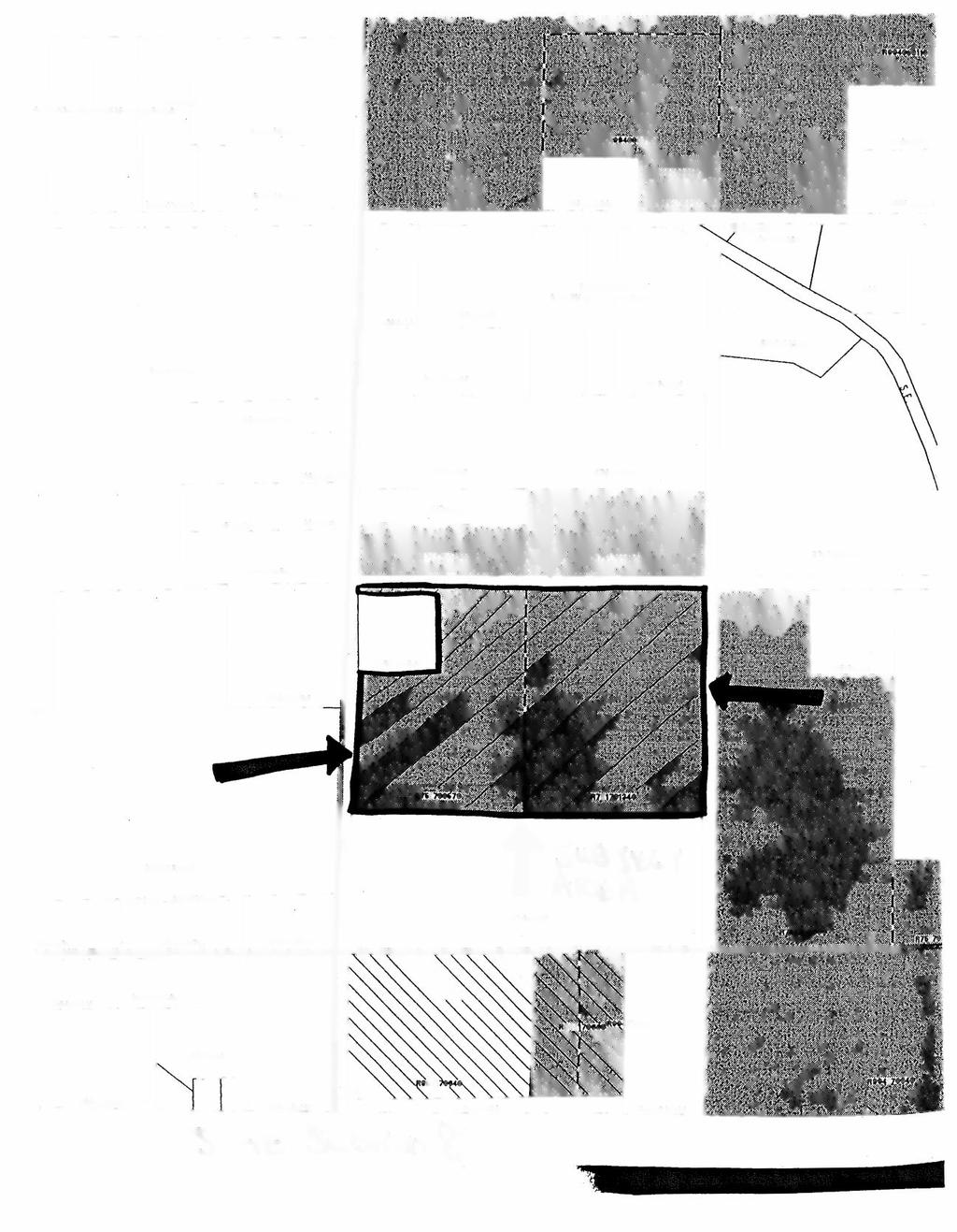
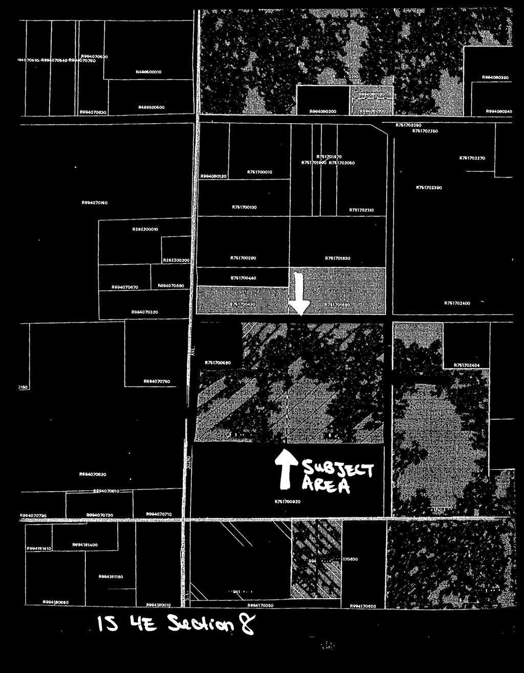
3 multncm~h ccunt"r' Department of Environmental Services Land Use Planning Division 1600 SE 190thAvenue Portland, OR Phone: (503) STAFF REPORT This notice concerns a public hearing scheduled to consider the land use case cited and described below. Case File: Scheduled Before: Multnomah County Planning Commissioners: Patrick Brothers, Laurie Craghead, Tim Crail, Chris Foster, John Ingle, Daniel Kearns, Dave Kunkel, John Rettig, and Nancy Wilson. Hearing Date, Time, & Place: Monday, May 3, 1999; at 6:30 PM, or soon thereafter SE Avenue, Columbia Room Portland, OR This Building ls Wheel-Chair Accessible. Multnomah County TDD Line - (503) WHAT: WHERE: Request for a Zone Change and Plan Revision to change the existing zoning of the subject parcels from Exclusive Farm Use (EFU) to Rural Residential (RR) SE 30211dAvenue. Township 1 South, Range 4 East, WM, Section 8, Tax Lots 5, 6, 11, 12, and the north half of Tax Lots 7 and 10. State ID Map: l S4E08CC 100and 300. Tax Account R#75l and R# See attached map. WHO: Applicant: Frank Walker Kings Valley Highway Philomath, OR Property Owner: Jack and Marilyn Stafford 4046 SE 302"dAvenue Troutdale, OR ZONING: Exclusive Farm Use (EFU). Decision Available: April 26, 1999

4 ll4q RHUOOOIO Rl R76170HOO RW418\400 R094J811SO
. The application does not carry the burden of meeting the applicable approval criteria.")

5 DECISION RECOMMENDED BY STAFF: Denial of the request for the Zone Change, ZC 1-98, and Plan Revision, PR 1-98, for the subject tract for the proposed change in zoning from Exclusive Farm Use (EFU) to Rural Residential (RR). The application does not carry the burden of meeting the applicable approval criteria. Staff recommends the denial based on the following: 1) The applicant has provided an inadequate analysis of adjacent uses occurring on adjacent tracts and of adjacent tracts (as in the land). Staffs analysis demonstrates the subject tract and adjoining tracts include High-Value Farmland. Most of the adjacent tracts are zoned EFU, in Farm Deferral tax accounts, and have average tract sizes exceeding 20 acres. Staff has provided a chart on page 17 of this report that summarizes this information. 2) It is the applicant's burden to demonstrate, in accordance with MCC Burden of Proof, that the subject tract, and not just the area being requested for the Zone Change and Plan Revision, cannot be practicably put to uses authorized under Goal 3. The list under Goal 3 (OAR Uses on Agricultural Lands) is a demanding and exhaustive list of uses for which the applicant must demonstate as impracticable uses for the subject tract. It is also the burden of the applicant to demonstrate that no land use conflicts will be created, the land use pattern will not be destabilized, and that public services will be available to those areas [MCC (A)(3)]. Further, the applicant attempts to show farm use is impracticable while stating that farm uses occur on the subject tract. The subject tract currently includes farm uses and the applicant has indicated that the site could accommodate other crops on the tract. The applicant also stated that nursery stock and livestock were prior uses on the tract. 3) The proposed zone change would result in land zoned for Rural Residential use. A primary use allowed in the RR zone is single-family residential development on 5-acre parcels. The area proposed for rezoning from EFU to RR includes lands with slopes in excess of 20%. The applicant narrative submitted April 6, 1999 via fax, describes "steep slopes" and a "Geologic Hazard Zone" for the subject tract. The applicant submitted a map entitled "Figure 4 Detailed Topographic Analysis" that shows areas of the subject tract with slope greater than 20%. Staff used soil maps, the Slope Hazard Map, and the Soil Survey of Multnomah County, OR as resources for slope determinations of the subject tract and adjacent tracts. Multnomah County's Comprehensive Plan Policy #14, Developmental Limitations, states that development shall be directed away from areas with slopes exceeding 20%. Staff has provided a response to Policy # 14 in this Staff Report. Staff states that if the subject tract contains geologically limiting factors such as a stream, a ravine, steep slopes, and heavy vegetation ("helps stabilize the steep slopes and should be retained" according to the applicant), then it is illogical to conclude the parcels would be better served by being zoned with a designation that allows a five acre minimum lot size and single-family residential development. It is also worthy to note that even if a portion of the tract were demonstrated to be unfarmable, retention of the land in open space is consistent with Goal 3, and clearly would have no impact on the ability to use the remainder of the parcel for uses allowed under Goal 3. 4) The applicant has argued that traffic in the area has resulted in conflicts with farm uses. Staff notes that the applicant argument actually substantiates Staffs reasons for denial. Staff states that additional residential development would exacerbate the traffic problems cited by the applicant and would necessitate additional access across High-Value Farmland. ZC 1-98 andpr 1-98 Decision Available: April 26,


6 Comprehensive Plan Policy #34, Trafficways, includes an analysis of traffic impacts and concerns. APPROVAL CRITERIA: The applicable approval criteria for this application include criteria of the Oregon Statewide Planning Goals, the Oregon Administrative Rules, the Oregon Revised Statutes, the Multnomah County Comprehensive Plan Policies, and the Multnomah County Code (MCC). The Board of County Commissioners must find that the proposal meets the approval criteria. The approval criteria include: OAR Chapter 660, Division 4, Interpretation of Goal 2 Exception Process; OAR ; OAR ; OAR ; OAR ; LCDC, Goal 3 Agricultural Land; ORS ; ORS ; ORS ; MCC ; MCC ; MCC ; Comprehensive Plan Policies 2, 3, 8, 9, 13, 14, 22, 34, 37, 38, and 40. The Code and Comprehensive Plan Policies noted here may be obtained by contacting the Land Use Planning Division at (503) The Staff Report, available seven (7) days before the public hearing before the Planning Commission, will contain the above noted OAR, ORS, Code and Comprehensive Plan Policies. BACKGROUND AND PROCESS: The subject tract consists of acres and two parcels identified by State ID as Tax Lot (TL) 100 (12.10 acres)(r#75170-l 340) and TL 300 (9.45 acres) (R#75l ), of Tl S R4E Section 8CC. Tax Lot I00 includes (as designated under the state ratio code) Tax Lots 11, 12, and the north half of 10 while Tax Lot 300 includes Tax Lots 5, 6 and the north half of 7. Both parcels are listed as Farm Deferral tax accounts. The applicant is requesting a Comprehensive Plan and Zone Change from Exclusive Farm Use (EFU) to Rural Residential (RR). The applicant provided a site map of the property, identified as "Figure 3 Topography" in the application materials, that shows a portion of the subject tract is proposed for the rezone from EFU to RR. The applicant, based on this map, does not propose to rezone the entire tract. The applicant representative, Frank Walker, acting on behalf of the property owners, Jack and Marilyn Stafford, submitted a final statement to the County on April 6, Mr. Walker stated, "This submittal is the final one we want to make prior to scheduling a public hearing. We have addressed the specific criteria in the January 25, 1999 letter from Phil Bourquin to my firm." Subsequent to receiving the faxed document and the original via mail service, Staff scheduled the meeting before the Planning Commission for May 3, Staff is obligated by MCC (A) and (B) to schedule a public hearing before the Planning Commission within 90 days of deeming the case complete. Section.8210 (B) states, in reference to the initiation action (submittal of application), "... which shall contain all information requested." With the applicant statement of final submittal of information pursuant to the Staff request for information, Staff concludes the scheduling of the public hearing before the Planning Commission should occur within 90 days of April 6, The Notice of Public Hearing was mailed April 21, The applicant's submitted narrative is quite lengthy. Staff did not include the applicant's narrative statement in its entirety in this Staff Report. Staff chose to include the narrative by reference and as an attachment (exhibit) to the Staff Report. An Exhibit list and the exhibits will Decision Available: April 26,


7 be available as a separate document to this Staff Report. attached to this report. Four exhibits, described below, are The Multnomah County Exclusive Farm Use Plan Designation and Zone is considered a resource zone under Statewide Planning Goal 3 - Agricultural Lands. A Comprehensive Plan and Zone Change from EFU to a non-resource zone (RR) requires and exception to Statewide Planning Goal 3. This Exceptions Process is laid out under Statewide Planning Goal 2 -Part II. Goal 2 - Part II outlines three instances when an exception to a goal may be authorized. Generally these exceptions are described as the l) Physically Developed, 2) Irrevocably Committed, or 3) Reasons exceptions. In this application, the applicant is pursuing an Irrevocably Committed exception. Exhibits: 1) Figure 3 Topography. 2) Figure 4 Detailed Topographic Analysis. 3) Figure 5 Geologic Hazard Zones. 4) Figure 6 Plot Plan. APPLICABLE CRITERIA AND FINDINGS: I. Compliance with LCDC Statewide Planning Goals: Staff: The Multnomah County Comprehensive Plan and implementing policies and ordinances have been found by LCDC to be in conformance with statewide land use planning goals and guidelines. Goals applicable to this proposal, with the exception of Goal 2 which is outlined here, are addressed under related policies from the Multnomah County Comprehensive Plan. [See Compliance with Comprehensive Plan Policies section]. The applicant is requesting an exception to Goal 3 -Agricultural land. LCDC Goal 2, Land Use Planning Staff: This goal requires the establishment of a land use planning process and policy framework which conforms to the applicable goals. OAR Chapter 660, Division 4 (Interpretation of Goal 2 Exception Process) explains three types of exceptions set forth in Goal 2: "developed" exception; " irrevocably committed" exception; and "reasons" exception. It appears applicant is requesting an "irrevocably committed" exception. The relevant sections are set forth below: Statewide Planning Goal 2 -Part II (b) provides, "A local government may adopt an exception to a goal when: (b) The land subject to the exception is irrevocably committed to uses not allowed by the applicable goal because adjacent uses and other relevantfactors make uses allowed by the applicable goal impracticable". The above citation is also found as ORS (1 ). The Statute implements the Statewide Planning Goal. The applicable Oregon Administrative Rules, Oregon Revised Statutes, and Multnomah County criteria that the Board of County Commissioners must find the proposal meets in order to satisfy the Irrevocably Committed exception stated in Goal 2 - Part II (c) are specified in the following findings and conclusions. Decision Available: April 26,


8 PART II - EXCEPTIONS: A local government may adopt an exception to a goal when: (a) The land subject to the exception is physically developed to the extent that it is no longer available for uses allowed by the applicable goal; Staff: The subject tract is not physically developed, at the current time, to the extent that is no longer available for the uses allowed by Goal 3 or OAR , Uses Authorized on Agricultural Lands. The applicant submitted a site plan entitled, "Figure 6, Plot Plan" that illustrates the existing structures as an old farmhouse, a dwelling, and a shop. The plan also shows the land uses of"timber" and "meadow" on the subject tract. The application does not meet the criterion. (b) The land subject to the exception is irrevocably committed to uses not allowed by the applicable goal because the existing adjacent uses and other relevant factors make uses allowed by the applicable impracticable; or Staff: The applicant addresses the definition of practical in the submitted narrative and refers to it several times in the narrative. The term used in the ORS and the Statewide Planning Rule is impracticable. The two words are distinctly different by definition. The American Heritage Dictionary states that impractical means "unwise to implement or maintain in practice." Webster's New Collegiate Dictionary states that impracticable is defined as, "not practicable; incapable of being performed or accomplished by the means employed or at command." The threshold for not doing a use on a site is much stronger under the definition of impracticable than under impractical. The applicant states that a burden of proof exists for the applicant to demonstrate that "every use under Goal 3 is impractical as a result of existing surrounding uses. This premise can be argued from two different perspectives: (1) Those uses that are non-resource-related and that would impact farm uses, and (2) those uses that are resource-related and that, by their nature and scope, would make farming on the subject property impractical." The applicant states "... it is impractical for the subject property to be farmed as a result of the existing surrounding uses. In other words, they are much larger in terms of their acreage requirements, they use sophisticated farming practices, and they have irrigation and drainage systems in place that enhance productivity. The subject property, by contrast, has a relatively small acreage available for nursery stock crops, lacks an economy of scale for justifying equipment purchases, and has no irrigation and drainage systems in place." Staffstates that not all of the uses listed in OAR , Uses Authorized on Agricultural Land, require the items cited by the applicant. The list is included below. The list is quite lengthy and the applicant does not show that each listed use is impracticable. Additionally, the ability of this tract of land or portions of this tract of land to be farmed by the current owner or leased for farming to adjoining tracts exists. A statement from adjoining owners that are not willing to lease, purchase, or utilize the land does not demonstrate the land is irrevocably committed. The conditions must be inherent in the land, not the people who occupy the land. Decision Available: April 26,
 The followingstandards are met: (1) Reasons justify why the state policy embodied in the applicable goals should not apply; (2) Areas which do not require a new exception cannot reasonably")
 The proposed uses are compatible")
9 The application does not meet the criterion. (c) The followingstandards are met: (1) Reasons justify why the state policy embodied in the applicable goals should not apply; (2) Areas which do not require a new exception cannot reasonably accommodate the use; (3) The long-term environmental, economic, social and energy consequences resulting from the use of the proposed site with measures designed to reduce adverse impacts are not significantly more adverse than would typically result from the same proposal being located in areas requiring a goal exception other than the proposed site; and (4) The proposed uses are compatible with other adjacent uses or will be so rendered through measures designed to reduce adverse impacts. Staff: The applicant does not address this criterion. The application does not meet the criterion. Compatible, as used in subparagraph (4) is not intended as an absolute term meaning no interference or adverse impacts of any type with adjacent uses. A local government approving or denying a proposed exception shall set forth findings of fact and a statement of reasons which demonstrate that the standards for an exception have or have not been met. Staff: The findings of fact and reasons that demonstrate the standards for an exception have not been met by the application are included herein this Staff Report for as made available on April 26, Each notice of a public hearing on a proposed exception shall specifically note that a goal exception is proposed and shall summarize the issues in an understandable manner. Staff: The Notice of Public Hearing for was mailed April 21, The notice contained a list of the applicable approval criteria, including the request for the goal exception. Upon review of a decision approving or denying an exception: (a) The commission shall be bound by any finding of fact for which there is substantial evidence in the record of the local government proceedings resulting in approval or denial of the exception; (b) The commission shall determine whether the local government's findings and reasons demonstrate that the standards for an exception have or have not been met; and (c) The commission shall adopt a clear statement of reasons which sets forth the basis for the determination that the standards for an exception have or have not been met. ZC 1-98 andpr 1-98 Decision Available: April 26,

 Does not comply with some or all goal requirements applicable to the subject properties or situations; and Staff: See subsection (c). (c) Complies with standards for an exception.")
10 Exception means a comprehensive plan provision, including an amendment to an acknowledged comprehensive plan, that; (a) Is applicable to specific properties or situations and does not establish a planning or zoning policy of general applicability; Staff: The applications submitted for the Zone Change, ZC 1-98,and Plan Revision, PR 1-98, are for a specific site identified as by the State ID system as 1S 4E Section 08 Tax Lots 100and 300. The request submitted by the applicant is to rezone a portion of the subject tract from EFU land to RR land. (b) Does not comply with some or all goal requirements applicable to the subject properties or situations; and Staff: See subsection (c). (c) Complies with standards for an exception. Staff: In the cases ZC 1-98and PR 1-98,the applicant requests an exception to Goal 3. Staff makes findings that the applicant does not comply with the standards for an exception. Those findings are contained within this document. The subject tract is not irrevocably committed. II. Findings: A. OAR : Planning and Zoning for Exception Areas (1) Purpose. This rule explains the requirements for adoption of plan and zone designations for exception areas. Exceptions to one goal or a portion of one goal do not relieve a jurisdiction from remaining goal requirements and do not authorize uses or activities other than those recognized or justified by the applicable exception. Physically developed and irrevocably committed exceptions under OAR and are intended to recognize and allow continuation of existing types of development in the exception area. Adoption of plan and zoning provisions which would allow changes in existing types of uses requires application of standards outlined in this rule. (2) "Physically Developed" and "Irrevocably Committed" Exceptions to goals other than Goals 11 and 14. Plan and zone designations shall limit uses to: (a) Uses which are the same as the existing types of land use on the exception site; Staff: The applicant states that the "uses that would be allowed in a Rural Residential Exception sufficiently similar to the existing types of land use in the Exception Area as to minimize potential adverse impacts." In addition, the applicant states, "The proposed use of the property for two additional rural residences can easily be made compatible with adjacent uses because of the inherent configuration of the land, topographic barriers, and thick vegetative screens." Staff fails to see how the inherent configuration of the land, the topographic barriers, and thick vegetative ZC 1-98andPR 1-98 DecisionAvailable:April26, StaffPlanner:TriciaR. Sears


11 cover would make the case stronger for the applicant request to establish a zoning that would provide an opportunity for two additional residences. If the land is not appropriate for farm use then how is it appropriate to excavate, fill, and remove vegetation to accommodate a driveway and a dwelling on the proposed new parcels of land? Additional dwellings would result in additional traffic, and the potential for greater complaints regarding accepted farm or forest practices such as spraying of crops, slash burning, and other accepted practices. The site characteristics would be altered by the change in zoning designation. Staff states the characteristics of the land, as outlined by the applicant in the application materials (narrative, site plans, photographs) and as researched by the Staff, support reasons to not change the zoning designation from EFU. In addition, on lands zoned RR it is unlikely that any farming would occur and hence this leaves the applicant's comparison of uses "which are the same as existing types" as lacking in support. The application does not meet the criterion. (b) Rural uses which meet the followingrequirements: (A) (B) (C) The rural uses are consistent with all other applicable Goal requirements; and The rural uses will not commit adjacent or nearby resource land to non-resource use as defined in OAR ; and The rural uses are compatible with adjacent or nearby resource use. Staff: The applicant argues that "the proposed rural uses will not commit adjacent or nearby resource lands to non-resource use". In very clear and simple terms, the rezoning of High-Value Farmland on the subject property from EFU to RR would result in resource land being developed with non-resource dwellings. In light of the fact that the applicant has stated that two additional parcels of land would be created and then a single-family residence would be constructed on each parcel ifthe zoning (RR) were to permit it, the zone change would indeed commit additional lands to a nonresource designation and hence use. The neighboring parcels or adjacent lands are primarily resource lands (EFU and CFU). The chart on page 17 illustrates the zoning and size of the adjacent tracts of land. The applicant states that "Any prospective use of these lots for Rural Residential can be made compatible with the resource uses to the east by leaving vegetation and maintaining large setbacks (200'). The applicant also states "Over 140 acres of rural uses are located north and east of the subject property, and these acreages are interspersed with resource uses. A high degree of compatibility exists between these uses because most of the houses are located in wooded areas which afford substantial screening. The houses also Decision Available: April 26,


12 tend to be located on steeper land rather than on level productive land." The applicant fails to indicate what 140-acre area he is referring to for the purposes of this evaluation. If the rural uses are interspersed with resource uses, how does that make it appropriate for the subject tract to be zoned RR? Within the narrative, the applicant states that two parcels would be created if the subject land were rezoned to RR. Thus, the potential for placing the land in agricultural uses would likely be abandoned for the purposes of single-family residential use on the newly created parcels. The application does not meet the criterion. (c) Changes to plan or zone designations are allowed consistently with subsections (a) or (b) of this section or where the uses or zones are identified and authorized by specific related policies contained in the acknowledged plan. Staff: Staff made the findings, as noted above, that the application was not consistent with subsections (a) and (b) of this section. (d) Uses not meeting the above requirements may be approved only under provisions for a reasons exception as outlined in OAR through Staff: OAR (2)(a) through (c) applies in this case. Since an "irrevocably committed" exception is requested, OAR must be addressed. B. OAR : Exception Requirements for land Physically Developed: Staff: Findings of compliance with the Land Physically Developed requirements of this section is required to satisfy the "committed" criteria under OAR (6)(f). (1) A local government may adopt an exception to a goal when the land subject to the exception is physically developed to the extent that is no longer available for uses allowed by the applicable goal. (2) Whether land has been physically developed with uses not allowed by an applicable Goal, will depend on the situation at the site of the exception. The exact nature and extent of the areas found to be physically developed shall be clearly set forth in the justification for the exception. The specific area(s) must be shown on a map or otherwise described and keyed to the appropriate findings of fact. The findings of fact shall identify the extent and location of the existing physical development on the land and can include information on structures, roads, sewer and water facilities, and utility facilities. Uses allowed by the applicable goal(s) to which an exception is being taken shall not be used to justify a physically developed exception. C. OAR : Exception Requirements for Land Irrevocably Committed to Other Uses: Decision Available: April 26,
 A \"committed exception\" is an exception taken in accordance with ORS 197.")
13 (1) A local Government may adopt an exception to a goal when the land subject to the exception is irrevocably committed to uses not allowed by the applicable goal because existing adjacent uses and other relevant factors make uses allowed by the applicable goal impracticable: (a) A "committed exception" is an exception taken in accordance with ORS (1)(b), Goal 2, Part II (b), and with the provisions of this rule. (b) For the purposes of this rule, an "exception area" is that area of land for which a "committed exception" is taken. (c) An "applicable goal", as used in this section, is a statewide planning goal or goals requirement that would apply to the exception area if an exception were not taken. Staff: In Sandgren v. Clackamas County, 29 Or LUBA 454 (1995), LUBA stated "to approve an irrevocably committed exception, the county must find that all uses allowed by the goals are impracticable, primarily as a result of uses established on adjacent parcels." (emphasis added). The courts have also stated that the "impracticability standard is a demanding one." Sandgren v. Clackamas County. In analyzing the types of uses allowed by the goal it cannot be assumed that noncommercial farm and forest uses are not allowed by the goal Friends of Oregon v. Yamhill, 27 Or LUBA 508 (1994). The applicant provides, "The impracticability standard is not confined to impacts that result from human occupancy of the land but also apply to the physical characteristic of adjacent lands such as those just referenced." The physical characteristics of the adjacent lands may limit the types of uses of uses that can be accomplished on the land. However, the zoning designation provides the parameters for allowed uses on the resource and non-resource lands. Staff provides a chart on page 17 that shows the relative size and the zoning of adjacent tracts. Again, the list of uses under OAR , Uses Authorized on Agricultural Lands, is lengthy. The applicant narrative includes the historical use of the subject tract for nursery stock and livestock uses. The applicant states that those uses are no longer "practicable at this location". The uses described by the applicant may no longer be practicable by the applicant's description, for the subject parcel. However, this does not preclude the use of the site for other agricultural uses listed under OAR The application does not meet the criterion. (2) Whether land is irrevocably committed depends on the relationship between the exception area and the lands adjacent to it. The findings for a committed exception therefore must address the following: (a) The characteristics of the exception area; Staff: The applicant provides a description of the subject tract and the proposed exception area located within the tract. The applicant request is to rezone the exception area from EFU to RR. The applicant describes a stream on the property, steep slopes, a small area still used for nursery stock, and the lack of ZC 1-98 andpr 1-98 Decision Available: April 26,

14 any large contiguous area as factors that characterize the exception area. Staff finds these characteristics do not preclude the ability of the site to be used for the uses listed by OAR The site is not irrevocably committed as defined bytbe OAR. The application does not meet the criterion. (b) The characteristics of adjacent lands; Staff: The applicant provides a description of the characteristics of adjacent lands. Staff provides a chart on page 17 that summarizes the zoning and size of adjacent tracts. The adjacent lands are not irrevocably committed. The application does not meet the criterion. (c) The relationship between the exception area and the lands adjacent to it; and Staff: The applicant has described the relationship between the exception area and the lands adjacent to it. The adjacent lands are primarily resource lands. As noted in subsection (b), Staff has included a chart on page 17 that provides a summary of characteristics of surrounding or adjacent tracts. The relationship of the exception area and the adjacent lands does not preclude the use of the lands for agricultural uses described in OAR The lands are not irrevocably committed. The application does not meet the criterion. (d) The other relevant factors set forth in OAR (6). Staff: Those factors are addressed within the respective subsections of OAR (6). (3) Whether uses or activities allowed by an applicable goal are impracticable as that term is used in ORS (1)(b),in Goal 2, Part II(b), and this rule shall be determined through consideration of factors set forth in this rule. Compliance with this rule shall constitute compliance with the requirements of Goal 2, Part II. It is the purpose of this rule to permit irrevocably committed exceptions where justified so as to provide flexibility in the application of broad resource-protection goal. It shall not be required that local government demonstrate that every use allowed by the applicable goal is "impossible". Staff: The applicant argues (page 4, applicant narrative) that, "the standard that applies to OAR is whether or not farm use can practicably be conducted on the subject property" and goes on to make arguments why some farm uses cannot be conducted at a commercial level. Goal 3 - USES provides that, "Counties may authorize farm uses and those non-farm uses defined by commission rule that will not have significant adverse effects on accepted farm or forest practices''. These "allowable" uses under the goal are found in OAR The test that must be met is an exhaustive one. According to Decision Available: April 26,


15 OAR (3), determining whether or not a "committed exception" may be authorized does not require a demonstration that every use allowed under OAR be "impossible" as a result of existing adjacent uses and other relevant factors. It does, however, require that "every use" be determined to be impracticable as a result of existing adjacent uses'. The subject parcels are considered High-Value Farmland based on the Soil Survey of Multnomah County, Oregon, Soil Conservation Service, USDA, August According to the Soil Survey, the subject parcels include the following soil types according to soil maps on file at Multnomah County: IOBCornelius silt loam, 3 to 8 percent; 34B Powell silt loam, 3 to 8 percent slope; 34C Powell silt loam, 8 to 15 percent slopes; 34D Powell silt loam, 15 to 30 percent slopes; and 57 Wollent silt loam. The soil types of l OB,34B, and 57 are High-Value Farmland Soils. OAR (8) defines High-Value Farmland. Uses allowed on Agricultural Lands designated as High-Value Farmland under OAR are as follows: OAR Uses Authorized on Agricultural Lands Farm use as defined in ORS ; Other buildings customarily provided in conjunction with farm use; Propagation or harvesting of a forest product; A facility for the primary processing of forest products; Creation of, restoration of, or enhancement of wetlands; The propagation, cultivation, maintenance and harvesting of aquatic species; Dwelling customarily provided in conjunction with farm use; A dwelling on property used for farm use located on the same lot or parcel as the dwelling of the farm operator; Accessory Farm Dwellings; One Single family dwelling on a lawfully created lot or parcel; One manufactured dwelling in conjunction with an existing dwelling as a temporary use; Single-family residential use not provided in conjunction with farm use; Seasonal farmworker housing as defined in ORS ; Residential home or facility as defined in ORS , in existing dwellings; Room and board arrangements for a maximum of five unrelated persons in existing residences; Alteration, restoration, or replacement of a lawfully established dwelling: Commercial activities in conjunction with farm use; Home occupations as provided in ORS ; A winery as described in ORS ; Farm stands; Operations for the exploration for and production of geothermal resources as defined by ORS and oil and gas as defined by ORS , including the 1 "to approve an irrevocably committed exception, the county must first find that all uses allowed by the goals are impracticable, primarily as a result of uses established on adjacent parcels"... "the impracticability standard is a demanding one" Sandgren v.clackamas County, 29 Or LUBA 454 (1995) "In analyzing the types of uses allowed by the applicable goal it cannot be assumed that noncommercial farm and forest uses are not allowed by the goal" Friends of Oregon v. Yamhill County, 27 Or LUBA 508 (1994) LUBA ZC l-98 and PR 1-98 Decision Available: April 26,


16 placement and operation of compressors, separators and other customary production equipment for an individual well adjacent to the wellhead; Operations for the exploration for minerals as defined by ORS ; Operations conducted for mining and processing of geothermal resources as defined by ORS and oil and gas as defined by ORS not otherwise permitted under this rule; Operations conducted for mining, crushing or stockpiling of aggregate or other mineral and other subsurface resources subject to ORS ; Processing as defined by ORS of aggregate into asphalt or portland cement; Processing of other mineral resources and other subsurface resources; Personal-use airports for airplanes and helicopter pads, including associated hangar, maintenance and service facilities; Construction of additional passing and travel lanes requiring the acquisition of right of way but not resulting in the creation of new land parcels; Reconstruction or modification of public roads and highways, not including the addition of travel lanes, where no removal or displacement of buildings would occur, or no new land parcels result; Temporary public road and highway detours that will be abandoned and restored to original condition or use at such time as no longer needed; Roads, highway and other transportation facilities, and improvements not otherwise allowed under this rule; Utility facilities necessary for public service, except commercial facilities for the purpose of generating power for public use by sale and transmission towers over 200 feet in height; Transmission towers over 200 feet in height; Commercial utility facilities for the purpose of generating power for public use by sale; Parks, playgrounds or community centers owned and operated by a governmental agency or a nonprofit community organization; Living history museum Staff: Additionally, the impracticable test must be applied to all "farm uses" allowed under ORS , below. ORS (2)(a) - "farm use" means the current employment of land for the primary purpose of obtaining a profit in money by raising, harvesting and selling crops or the feeding, breeding, management and sale of, or the produce of, livestock, poultry, fur-bearing animals or honeybees or for dairying and the sale of dairy products or any other agricultural or horticultural use or animal husbandry or any combination thereof, "Farm use" includes the preparation and storage of the products raised on such land for human use and animal use and disposal by marketing or otherwise, "Farm use" also includes the current employment ofland for the primary purpose of obtaining a profit in money by stabling or training equines including but not limited to providing riding lessons, training clinics and schooling shows. "farm use" also includes the propagation, cultivation, maintenance and harvesting of aquatic species. It does not include the use of land subject to the provisions of ORS chapter 321, except land used exclusively for growing cultured Christmas trees as defined in subsection (3) of this section or land described in ORS (l)(e) or (5). (ORS (2)(a). Decision Available: April 26,


17 The applicant has indicated the subject parcel is capable of producing farm products including 500 lbs. of cabbage per acre per year on seven acres, hay, and gazing. Staff finds that land capable of growing 3,500 lbs. of cabbage per year is capable of obtaining a profit and it is therefore practicable to conduct a "farm use". Further, and most vital, the applicant has substantially failed in his burden to do a complete analysis addressing and demonstrating that every use allowed under Goal 3 (OAR ) is impracticable as a result of existing surrounding uses. In addition, ORS (l)(b) allows a County to adopt an exception when "The land subject to the exception is irrevocably committed as described by the Department of Land Conservation and Development (LCDC) rule to uses not allowed by the applicable goal because existing adjacent uses and other relevant factors make uses allowed by the goal impracticable." As was stated by Staff under "Patt II- Exceptions" the application does not meet the Exceptions criterion. The application does not meet the criteria noted herein. (4) A conclusion that an exception area is irrevocably committed shall be supported by findings of fact which address all applicable factors of section (6) of this rule and by a statement of reasons explaining why the facts support the conclusion that uses allowed by the applicable goal are impracticable in the exception area, Staff: This criteria requires a statement of reasons why the facts support a conclusion that the uses allowed under Goal 3 are impracticable under a Rural Residential designation. Lacking adequate analysis on the part of the applicant regarding each and every use allowed under Goal 3, a conclusion that the exception area proposed is irrevocably committed cannot be made, nor could a statement as to the impracticability of Goal 3 uses occurring in a RR designation be made. The application does not meet the criterion. (5) A conclusion that an exception area is irrevocably committed shall be supported by finding of fact which address all applicable factors of section (6) of this rule and by a statement of reasons explaining why the facts support the conclusion that uses allowed by the applicable goal are impracticable in the exception area. Staff: Please see below for the Staff responses to subsection (6). (6) Findings of fact for a committed exception shall address the following factors: (a) Existing adjacent uses; Staff: As noted above in the Staff response to OAR (2)(b), the applicant provided a narrative describing the adjacent uses. The adjacent lands are not irrevocably committed and hence Staff made the finding that the application did not meet the criterion. The application does not meet the criterion. Decision Available: April 26,
; Staff: The applicant states that \"Existing domestic water service has no applicability for agricultural production and is strictly for domestic consumption.\" Staff disagrees with the applicant.")

18 (b) Existing public facilities and services (water and sewer lines, etc.); Staff: The applicant states that "Existing domestic water service has no applicability for agricultural production and is strictly for domestic consumption." Staff disagrees with the applicant. The existing capacity is important as future services would need to be available in the area. The applicant proposes to rezone the area to RR and then to create two additional parcels for the purposes of single-family residential use. These residences would need to have water and sewer capabilities. The applicant submitted a Certification of Water Service signed by the Lusted Water District. The comments on the form state, "future service" under the section titled, "The proposed use should be required to make the following water system improvements." The applicant does not state whether the "domestic water line" that is available to the site is " via a Lusted Water Cooperative line" could accommodate the two possible future single-family residences that may be established on RR land if the rezone were approved. The application does not meet the criterion. (c) Parcel size and ownership patterns of the exception area and adjacent lands: (A) Consideration of parcel size and ownership patterns under subsection (6)(c) of this rule shall include an analysis of how the existing development pattern came about and whether findings against the Goals were made at the time of partitioning or subdivision. Past land divisions made without application of the Goals do not in themselves demonstrate irrevocable commitment of the exception area. Only if development (e.g., physical improvements such as roads and underground facilities) on the resulting parcels or other factors make unsuitable their resource use or the resource use of nearby lands can the parcels be considered to be irrevocably committed. Resource and non-resource parcels created pursuant to the applicable goals shall not be used to justify a committed exception. For example, the presence of several parcels created for non-farm dwellings or an intensive commercial agricultural operation under the provisions of an exclusive farm use zone cannot be used to justify a committed exception for land adjoining those parcels; (B) Existing parcel sizes and contiguous ownership's shall be considered together in relation to the land's actual use. For example, several contiguous undeveloped parcels (including parcels separated only by a road or highway) under one ownership shall be considered as one farm or forest operation. The mere fact that small parcels exist does not in itself constitute irrevocable commitment. Small parcels in separate ownership's are more likely to be irrevocably committed if the parcels are developed, clustered in a large group or clustered around a road designed to serve these parcels. Small parcels in separate ownerships are not likely to be irrevocably committed if they stand alone amidst larger farm or forest operations, or are buffered from such operations. Decision Available: April 26,
 on the resulting parcels or other factors make unsuitable their resource use or the resource use of nearby lands can the parcels be")

19 Staff: The applicant refers to statements made earlier in the submitted narrative and chooses not to address this criterion specifically. The OAR states, "Only if development (e.g., physical improvements such as roads and underground facilities) on the resulting parcels or other factors make unsuitable their resource use or the resource use of nearby lands can the parcels be considered to be irrevocably committed." The OAR also states, "The mere fact that small parcels exist does not in itself constitute irrevocable commitment." In addition, the OAR states, "Small parcels in separate ownerships are not likely to be irrevocably committed if they stand alone amidst larger farm or forest operations, or are buffered from such operations." In accordance with the above statements and with reference to previous Staff comments, Sta.ffstates the application does not meet the application criterion in Sections (A) and (B). (d) Neighborhood and regional characteristics; Staff: When evaluating the lands actual use for the purposes of the exception, Staff considered the entire contiguous ownership as one. (e) Natural or man-made features or other impediments separating the exception area from adjacent resource land. Such features or impediments include but are not limited to roads, watercourses, utility lines, easements, or rights-of-way that effectivelyimpede practicable resource use of all or part of the exception area; (f) Physical development according to OAR ;and (g) Other relevant factors. Staff: The table below illustrates the characteristics of adjoining tracts. When considering adjoining tracts the subject tract must be considered one unit of land (not simply the proposed exception area). The table was created by Staff using on the most recent Multnomah County Assessment and Taxation records. Decision Available: April 26,


20 SID Zoning Tract Size Farm/Forest Development Deferral West IS 4E 07DD 100 MUA acres none Dwelling IS 4E 07DD 200 EFU acres 25.I2 acres Dwelling South IS 4E 08CC 200 EFU I4.00 acres acres Dwelling East IS 4E 08CD 400; IS EFU acres acres Dwelling 4E I7BA400 North ls 4E 08CB I200 EFU 2.90 acres none Dwelling IS 4E 08CB 1000 RR 5.00 acres None Vacant Subject Tract IS 4E 08CC I00, 300 EFU acres acres Dwellings The tracts identified in the above table as contiguous to the subject tract consist of acres. Of this acres, 5 acres are zoned Rural Residential, 4.80 acres are zoned MUA-20, and acres are zoned EFU. There are four adjoining tracts zoned EFU for an average tract size of acres (I acre/ 4 tracts) while the subject tract consists of acres. Farm or forest deferral is received on acres of the adjoining EFU tracts, indicating the presence of income from farm or forest production on the surrounding tracts. Only acres of all adjacent EFU tracts are not in Farm or Forest deferral. Further, when reviewing soils maps all adjoining tracts were identified as High Value Farmland with the only exception being the one parcel zoned Rural Residential. The applicant submits the following as "other relevant factors": geologic hazard zones, steep slopes, slope stabilizing vegetation, inaccessability to farmable areas, physical development, adverse soils related to hardpans, persistent soil disease, exception areas that are directly contiguous, and dangerous access to property from 30211d Avenue." (7) The evidence submitted to support any committed exception shall, at a minimum, include a current map, or aerial photograph, which shows the exception area and adjoining lands, and any other means needed to convey information about factors set forth in this rule. For example, a local government may use tables, charts, summaries or narratives to supplement the maps or photos. The applicable factors set forth in Section (6) of this rule shall be shown on the map or aerial photo. Decision Available: April 26,

 The requirement for a map or aerial photograph in section (7) of this rule only applies to the following committed exceptions: (a) Those adopted or amended as required by a Continuance Order")
21 Staff: The submitted maps inconsistently identify the proposed zone boundary being requested. The applicant provided a map entitled "Figure 3 Topography" that shows a portion of the subject tract labeled as the Rezone Area. An aerial photo was submitted with the Pre-Application materials (PA 4-96). (8) The requirement for a map or aerial photograph in section (7) of this rule only applies to the following committed exceptions: (a) Those adopted or amended as required by a Continuance Order dated after the effective date of section (7) of this rule; and (b) Those adopted or amended after the effective date of section (7) of this rule by a jurisdiction with an acknowledged comprehensive plan and land use regulations. Staff: Section (8)(b) applies in this case. D. GOAL 3 AGRICULTURAL LANDS To preserve and maintain agricultural lands. Agricultural lands shall be preserved and maintained for farm use, consistent with existing and future needs for agricultural products, forest and open space and with the state's agricultural land use policy expressed in ORS and Staff: The applicant seeks the proposed Exception "because the property owner recognizes the extreme limitations for agriculture on the majority of the site. Fully half the site is inherently unsuitable for agriculture because of exceedingly steep slopes." The applicant also states, "With the exception of six acres, the subject property is largely unusable for agricultural land, as opposed to simply being difficult to manage." Staff has made findings, already stated within this Staff Report, that the application does not meet the Exception criteria. The application materials submitted by the applicant do not demonstrate the existing tract (19.55 acres) and the adjacent tracts have met the irrevocably committed standard. The applicant reiterates that the subject tract still is used for agricultural activity (six acres noted above). The tract is a Farm Deferral tax account. The agricultural or resource lands should be preserved and maintained for farm use in accordance with Goal 3. USES Counties may authorize farm uses and those non-farm uses defined by commission rule that will not have significant adverse effects on accepted farm or forest practices. IMPLEMENTATl ON Zoning applied to agricultural land shall limit uses which can have significant adverse effects on agricultural and forest land, farm and forest uses or accepted farming or forest practices. Decision Available: April 26,


22 Counties shall establish minimum sizes for new lots or parcels in each agricultural land designation. The minimum parcel size established for farm uses in farmland zones shall be consistent with applicable statutes. If a county proposes a minimum lot or parcel size less than 80 acres or 160 acres for rangeland, the minimum shall be appropriate to maintain the existing commercial agricultural enterprise within the area and meet the requirements of ORS Counties authorized by ORS may designate agricultural land as marginal land and allow those uses and land divisions on the designated marginal land as allowed by law. LCDC shall review and approve plan designations and revisions to land use regulations in the manner provided by ORS Chapter 197. DEFINITIONS Agricultural Land - in western Oregon is land of predominantly Class I, II, III and IV soils and in eastern Oregon is land of predominantly Class I, II, III, IV, V and VI soils as identified in the Soil Capability Classification System of the United States Soil Conservation Service, and other lands which are suitable for farm use taking into consideration soil fertility, suitability for grazing, climatic conditions, existing and future availability of water for farm irrigation purposes, existing land use patterns, technological and energy inputs required, or accepted farming practices. Lands in other classes which are necessary to permit farm practices to be undertaken on adjacent or nearby lands, shall be included as agricultural in any event. More detailed soil data to define agricultural land may be utilized by local governments if such data permits achievement of this goal. Agricultural land does not include land within acknowledged urban growth boundaries or land within acknowledged exceptions to Goals 3 and 4. Farm Use - is as set forth in ORS Higlt-Value Farmlands - are areas of agricultural land defined by statute and Commission rule. Guidelines A. Planning 1. Urban growth should be separated from agricultural lands by buffer or transitional areas of open space. 2. Plans providing for the preservation and maintenance of farm land for farm use should consider as a major determinant the carrying capacity of the air, land and water resources of the planning area. The land conservation and development actions provided for by such plans should not exceed the carrying capacity of such resources. Staff: The applicant states that adequate carrying capacity of the available resources exists to accommodate the proposed use of the site. On the Service Provider forms submitted by the applicant, the applicant describes the proposed use as, "Retain farmable portion of property Decision Available: April 26,


23 for farming uses and to establish two additional dwelling sites on unfarmable portion of property." The applicant also states that the Rural Residential zoned properties act as a buffer or transitional area of open space. Staff's evaluation of the Service Provider forms submitted by the applicant (including one blank form), reveals the applicant has provided no determination of carrying capacity of the land. Several of the forms indicate the level of service would have to be determined. The application does not demonstrate the ability of the land, with a proposed designation of RR, to accommodate two additional single-family residences. What is the operating level of the site and how does it compare to the level that would be required to accommodate the proposed use? Staff recommends the subject tract remain zoned EFU as the application materials do not demonstrate the carrying capacity standard has been met. B. Implementation 1. Non-farm uses permitted within farm use zones under ORS (2)and (3) and (2)and (3) should be minimized to allow for maximum agricultural productivity. 2. Extension of services, such as sewer and water supplies into rural areas should be appropriate for the need of agriculture, farm use and non-farm uses established under ORS and Services that need to pass through agricultural lands should not be connected with any use that is not allowed under ORS , and should not be assessed as part of the farm unit and should not be limited in capacity to serve specific service areas and identified needs. 4. Forest and open space uses should be permitted on agricultural land that is being preserved for future agricultural growth. The interchange of such lands should not be subject to penalties. Staff: The implementation of Goal 3 requires that non-farm uses be kept to a minimum. The extension of services, as established in (A) above, requires the applicant to meet a carrying capacity standard. That standard has not been demonstrated. The applicant states the subject tract contains six acres used for agricultural purposes. The site also contains heavily wooded areas and meadow areas. Staff recommends the subject tract remain zoned EFU based on the evaluation of (B). E. Multnomah County Code: MCC Hearings (A) The Hearings Officer or a quorum of at least three members of the Planning Commission, as is appropriate, shall conduct a hearing on the application within 90 days of the initiation thereof, under MCC.8210(B), unless such time is extended with the written consent of the one initiating the action. [A111e11ded1982, Ord [ (B) Three members of the Planning Commission shall constitute a quorum in acting on applications under MCC.8115(B). (C) No action shall be heard unless a Staff Report is completed and available at the ZC 1-98andPR 1-98 DecisionAvailab1e:April26, StaffPlanner:TriciaR. Sears

 The burden of proof is upon the person initiating an action.")
24 office of the Planning Director at least seven days prior to the date fixed for hearing. A copy of the Report shall be mailed, upon completion, to the one initiating the action and to the Planning Commission or Hearings Officer, as appropriate. In addition, a copy shall be furnished to other persons who request the same upon payment of the fee provided for under MCC The Staff Report may be supplemented only at the hearing. /A111e11ded1998, Ord (D) The burden of proof is upon the person initiating an action. Unless otherwise provided in this Ordinance, that burden shall be to persuade that: (1) Granting the request is in the public interest; (2) There is a public need for the requested change and that need will be best served by changing the classification of the property in question as compared with other available property; Staff: The applicant argues that the "County's policy is to promote the use of EFU-zoned land for commercial agriculture" and the subject parcel has had no commercial agricultural use for "almost 20 years''. Multnomah County's policy as established under Comprehensive Plan Policy #9 and further evaluated below, "is to designate and maintain as exclusive (emphasis added) agricultural land". The focus of the County's policy is on agricultural uses, both commercial and noncommercial. Staff provides further comments under Policy #9 below. (3) The proposed action fully accords with the applicable elements of the Comprehensive Plan; and Staff: Staff finds the proposed action does not fully comply with the applicable elements of the Comprehensive Plan. Staff provides further comment under MCC Burden of Proof and the Comprehensive Plan Policies included below. (4) The factors listed in ORS have been considered. (E) Proof of change in a neighborhood or community or mistake in the planning or zoning for the property under consideration are additional relevant factors to be considered under subpart (D). above Burden of proof. * * * (A) The burden of proof is upon the person initiating a quasi-judicial plan revision. That burden shall be to persuade that the revision is: (1) Consistent with the procedures of ORS through and the standards of ORS if a goal exception is required, including any OAR's adopted pursuant to these statutes; Staff: Staff has provided findings within this Staff Report that the application does not meet the standard for granting an Exception. The application does not carry the burden of proof, including the burden of proof to demonstrate the subject tract is Decision Available: April 26,


25 irrevocably committed. (2) Evidence that the proposal conforms to the intent of relevant policies in the comprehensive plan or that the plan policies do not apply. In the case of a land use plan map amendment for a commercial, industrial, or public designation, evidence must also be presented that the plan does not provide adequate areas in appropriate locations for the proposed use; and Staff: Staff comments regarding the applicable Comprehensive Plan Policies are included below. The application does not provide evidence that all the Policy requirements have been met. (3) Evidence that the uses allowed by the proposed changes will (1) not destabilize the land use pattern in the vicinity, (2) not conflict with existing or planned uses on adjacent lands, and (3) that necessary public services are or will be available to serve allowed uses. Staff: The application does not demonstrate the subject tract and adjacent parcels are irrevocably committed. Land use patterns in the vicinity would be altered if two more residences were added; traffic problems already exist according to the applicant. Adjacent properties are used for farm purposes. Residential use on lands designated non-resource (if the subject tract were rezoned) may or may not conflict with existing agricultural uses. Properties adjacent to the subject tract, as Staff established earlier in the report, are primarily zoned MUA-20, EFU, and CFU. Only one adjacent property, a five-acre parcel to the north of the subject tract, is zoned RR. Refer to the chart on page 17 for additional information. (B) Proof that circumstances in the area affected by the proposed revision have changed since adoption of the plan, or that there was a mistake in the plan, are additional relevant factors which may be considered under subsection (A) of this section. [Ord (1.37) (1976); Ord (1990)} F. Comprehensive Plan Policies: POLICY 2 Off-Site Effects The County's policy is to apply conditions to its approval of land use actions where it is necessary to: A. Protect the public from the potentially deleterious effects of the proposed use; or Staff: The subject tract is acres (Tax Lot 100 is acres and Tax Lot 300 is 9.45 acres). The applicant states that the proposed use will not have any "deleterious effects on the public". If the subject tract was rezoned to RR, a zone with a five-acre minimum lot size, two additional parcels may be created out of the existing tract. At several points in the narrative the applicant describes traffic issues as a concern. Staff provides further comments regarding traffic concerns under Policy 34. B. Fulfill the need for public service demands created by the proposed use. Decision Available: April 26,


26 Staff: The application does not meet the carrying capacity standard, as discussed earlier in this report. Staff provides additional comments under Policy 37 Utilities. POLICY 3 Citizen Involvement The County's policy is to maintain a Committee for Citizen Involvement and an ongoing Citizen Involvement Program that is appropriate to the scale of the ongoing planning effort and that offers opportunities for citizens to be involved in all phases of the land planning process, and it will provide: A. Assistance through the distribution of information on planning; B. Coordination of public involvement; C. Structures for public involvement in the development of land use plans and policies; D. Opportunities for citizen involvement in regional, state and federal programs and the administrative decision making process; and E. A Community Group Participation Program. Staff: The applicant had a Pre-Application meeting with Multnomah County Land Use Planning Staff on November 13, 1997 (PA 4-96). The applications for the Zone Change, ZC 1-98, and the Plan Revision, PR 1-98, are subject to the requirements noted above. The application has followed the applicable processes. POLICY 8 Rural Residential Land It is the County's policy to designate certain limited areas for rural residential development. Such areas are established based upon the following: A. Significant parcelization when an average of five (5) acres or less has already occurred, the majority of which are separately owned and developed; Staff: The applicant states that "a high degree of parcelization of the area surrounding the property to the north and west" exists. Staff again refers to the chart on page 17 that shows the zoning and the size of the tracts adjacent to the subject tract proposed to be rezoned from EFU to RR. The chart shows the average size of the adjacent lands, held in the same ownership, is approximately 20 acres. B. The area is not a cohesive commercial farm or forest resource area; Staff: The parcels or tracts adjacent to the subject tract are primarily zoned EFU and CPU. These zoning designations are farm and forest resource areas. The high amount of agricultural activity in the area and the fact that a portion of the subject tract remains in farm use, supports the Staff recommendation that the subject tract remain zoned EFU. Decision Available: April 26,


27 C. The designated area is compatible with any adjacent farm or forest uses and would not cause any substantial conflict with these natural resource uses; Staff: The applicant provides a lengthy description of the natural resource characteristics of the land on the subject tract. The applicant argues that this supports the request for the rezone from EFU to RR. Staff provides comments under Policy #14 thataddresses these natural resource uses. The subject tract has several development limitations, as further described in Policy #14. Policy #14 directs development away from areas with developmental limitations. Staff finds the applicant has not carried the burden to show how residential development is effectively served rather than farm uses on a property, with the development limitations to the extent described by the applicant. These limitations support the conclusion that the subject tract should remain zoned EFU. D. The land resource is predominantly forest or forest-agricultural in nature (discounting the residences), rather than agricultural in character; Staff: The subject tract is a Farm Deferral account. The subject tract contains six acres; as described by the applicant, used for agricultural purposes. The land is not predominantly forest or forest-agricultural in nature. The applicant describes the adjacent parcels contain agricultural uses. E. There are no physical development limitations which would cause the areas to be hazardous for development; and Staff: The applicant has described, at length in the submitted narrative, the physical limitations and characteristics of the subject tract. Staff provides comments under Policy #14, Developmental Limitations, regarding the limitations of the subject tract. F. Limited, but adequate, services must be available for these areas, including those provided on-site (water and subsurface sewage disposal), as well as off-site (school, fire, police). Staff: Staff has addressed the services to the site under Policy #37 and #38. POLICY 9 Agricultural Land The County's policy is to designate and maintain as exclusive agricultural land, areas which are: A. Predominantly agricultural soil capability I, II, ill, and IV, as defined by U.S. Soil Conservation Service; B. Of parcel sizes suitable for commercial agriculture; C. In predominantly commercial agriculture use; and D. Not impacted by urban service; or E. Other areas, predominantly surrounded by commercial agriculture lands, which are necessary to permit farm practices to be undertaken on these adjacent lands. Decision Available: April 26,
 through (E) have been addressed repeatedly throughout this Staff Report.")
28 The County's policy is to restrict the use of these lands to exclusive agriculture and other uses, consistent with state law, recognizing that the intent is to preserve the best agricultural lands from inappropriate and incompatible development. Staff: The criteria of (A) through (E) have been addressed repeatedly throughout this Staff Report. The findings within this report show that the subject tract contains High-Value Farmland. The subject tract has land, approximately six acres as described by the applicant, used for agricultural purposes. As stated earlier, Staff finds the applicant has not carried the burden to show the lands are irrevocably committed. The applicant does not carry the burden of proof. Based on the submitted application materials, Staff makes the recommendation that the land remain zoned EFU. POLICY 13 Air, Water and Noise Quality Multnomah County, recognizing that the health, safety, welfare, and quality of life of its citizens may be adversely affected by air, water and noise pollution, supports efforts to improve air and water quality and to reduce noise levels. Therefore, it is Multnomah County's policy to: A. Cooperate with private citizens, businesses, utilities and public agencies to maintain and improve the quality of air and water, and to reduce noise pollution in Multnomah County. B. Support and participate in the implementation of state and regional plans and programs to reduce pollution levels. C. Maintain healthful air quality levels in the regional airshed, to maintain healthful ground and surface water resources, and to prevent or reduce excessive sound levels while balancing social and economic needs in Multnomah County. D. Discourage the development of noise-sensitive uses in areas of high noise impact. Staff: The applicant states that the air, water, and noise quality levels will be maintained and will be met as required if the proposed use to rezone the subject tract from EFU to RR is rezoned. It is likely the air, water, and noise quality standards would be met but an evaluation of the applicable standards would be necessary at the time of subsequent land use applications and building permit review. POLICY 14 Developmental Limitations The County's policy is to direct development and land form alterations away from areas with development limitations, except upon a showing that design and construction techniques can mitigate any public harm or associated public cost and mitigate any adverse effects to surrounding persons or properties. Development limitations areas are those which have any of the following characteristics: A. Slopes exceeding 20%; Decision Available: April 26,


29 B. Severe soil erosion potential; C. Land within the 100-year floodplain; D. A high seasonal water table within 0-24 inches of the surface for three or more weeks of the year; E. A fragipan less than 30 inches from the surface; F. Land subject to slumping, earth slides or movement. Staff: As described in the Staff response to OAR (3), the tract contains the following soil types: l OBCornelius silt loam, 3 to 8 percent slopes; 34B Powell silt loam, 3 to 8 percent slopes; 34C Powell silt loam, 8 to 15 percent slopes; 34D Powell silt loam, 15 to 30 percent slopes; and 57 Wollent silt loam according to the Soil Survey of Multnomah County, Oregon. The High-Value Farmland soil types include l OB,34B, and 57. Slopes exceed 20% based on the soil types identified on the soil maps on file at Multnomah County and as described by the Soil Survey. Runoff is slow and the hazard of erosion is slight for soil types lob,34b, and 57. Runoff is medium and the hazard of erosion is moderate for soil type 34C. For soil type 34D, runoff is medium and the hazard of erosion is high. The depth of the water table and the fragipan for the soil types of the tract are: Soil Type lob 34B 34C 34D 57 Water Table Depth in. from Dec. to April in. from Dec. to April in. from Dec. to April in. from Dec. to April 12 in. above to 12 in. below from Nov. to May Fragipan 60 in. or more 60 in. or more 60 in. or more 60 in. or more 60 in. or more Soil type 34D is subject to slumping in areas of cut and fill. The subject parcels (Tax Lots 100 and 300 on the State ID system) are not within the 100-year floodplain according to the Federal Insurance Rate Map (FIRM) community panel #4 l B. The appropriate Flood Boundary and Floodway Map, community panel #410 l B, was not on file with Multnomah County. The applications,, are not subject to the Code requirements for Flood Hazard. Staff has considered the above established site development limitations. Staff notes that the applicant's narrative included a substantial amount of description of the characteristics (steep slopes, ravines, etc) of the subject tract. The applicant argues the site can't be farmed and therefore the subject parcel should be rezoned from EFU to RR to allow for single-family residential development. The County's policy is to "direct development and land form alterations away from areas with developmental limitations." The applicant's proposal to increase development on a site and in an area that is limited by the very characteristics the applicant described, is an illogical conclusion. Decision Available: April 26,

30 POLICY 2 2 Energy Conservation The County's policy is to promote the conservation of energy and to use energy resources in a more efficient manner. In addition, it is the policy of Multnomah County to reduce dependency on non-renewable energy resources and to support greater utilization of renewable energy resources. The County shall require a finding, prior to the approval of legislative or quasi-judicial action, that the following factors have been considered: A. The development of energy-efficient land uses and practices; B. Increased density and intensity of development in urban areas, especially in proximity to transit corridors and employment, commercial and recreational centers; C. An energy-efficient transportation system linked with increased mass transit, pedestrian and bicycle facilities; D. Street layouts, lotting patterns and designs that utilize natural environmental and climatic conditions to advantage; E. Finally, the County will allow greater flexibility in the development and use of renewable energy resources. Staff: The proposed change of zoning of the subject tract may alter the future street layout of the area. The proposed zone change would possibly increase the density of the area and the intensity of development; through land partitioning and additional non-farm dwellings. Rezoning the subject tract from Exclusive Farm Use (EFU) to Rural Residential (RR) would provide an option to the property owners to divide the subject tract into smaller parcels, so long as the requirements of the RR zone were met. The RR zone requires a five-acre minimum lot size. The subject tract is currently acres in size. If the subject property (tract) were rezoned from EFU to RR, it may be possible to create two additional parcels of land. Transportation concerns are addressed under Comprehensive Plan Policy 34, Trafficways. POLICY 3 4 Trafficways The purpose of this policy is to direct the County to develop the existing trafficway system to maximize efficiency, and to consider the mobility of pedestrians by providing safe crossings. The County's policy is to develop a safe and efficient trafficway system using the existing road network, and by: A. Maintaining a trafficway classification system; B. Improving streets to the standards established by the classification system, where necessary and/or appropriate, to mitigate identified transportation problems; C. Placing priority on maintaining the existing trafficways; ZC 1-98 andpr 1-98 Decision Available: April 26,


31 D. Developing additional transportation facilities to meet community and regional transportation needs where capacity of the existing system has been maximized through transportation system management and demand management measures; E. Providing a safe and convenient pedestrian environment with road crossings and sidewalk network designed for pedestrian travel; F. Limiting the number of, and consolidating ingress and egress points, on arterials and major collectors to preserve traffic flow; G. Reducing reliance on the automobile and assuring that the planned transportation system supports patterns of travel and land use which will avoid or mitigate problems of air pollution, traffic congestion and community livability; H. Encouraging ride-share and flextime programs to help meet the projected increase in travel demand. The County will work with METRO and Tri-Met to develop ride-share programs, flextime and other transportation demand strategies to achieve the rideshare goal given in the Regional Transportation Plan; and I. Implementing the Street Standards Chapter and street standards codes and rules, including adherence to access control and intersection design guideline criteria, and establishing a procedure for allowing variances from that ordinance. Staff: The applicant argues that "A positive finding can be made that both efficiency and safety can be increased if this proposal is approved." However, the applicant provides narrative comments that conflict with that statement. The applicant describes the traffic in the area of the subject tract "has a limiting effect on the practicality of farming" and "The overall growth of the area (Gresham and Troutdale) and the resultant traffic increase on 302nd Avenue have made safe traveling for slow-moving farm implements necessary for nursing stock and berry operations much more difficult." Staff has already discussed the applicant's intent to construct single-family dwellings on each of the parcels that would be created as a result of the proposed zone change from EFU to RR. An increase in traffic would certainly result from the addition of single-family residences in the neighborhood. The increase level of traffic would be across High-Value Farmland. The level of traffic in the area of 302'1d Avenue is a concern pointed out several times in the applicant narrative, and Staff finds the arguments used by the applicant serve to support Staff's recommendation the land remain zoned EFU. The applicant also offers, "The area west of the property on 30211d A venue is zoned for non-resource use and has residences that can adversely effect farming practices and costs." The applicant does not provide supporting evidence for this statement. Staff does not agree with the applicant's argument. In conclusion, Staff finds the applicant's proposed would serve to exacerbate the traffic problems in the area of the subject tract. Excluding that portion of Multnomah County included in the Columbia River Gorge National Scenic Area, this policy, and the functional classification of trafficways map accompanying this policy, shall control over conflicting provisions of community plans or other preexisting plans in determining the functional classification of trafficways. Trafficways located within the Columbia River Gorge National Scenic Area are subject to, and superceded by, provisions of the Columbia River Gorge Scenic Area Management Plan. ZC 1-98 andpr 1-98 Decision Available: April 26,

 will approve a subsurface sewage disposal system; or D.")
32 POLICY 3 7 Utilities The County's policy is to require a finding prior to approval of a legislative or quasijudicial action that: Water and Disposal System A. The proposed use can be connected to a public sewer and water system, both of which have adequate capacity; or B. The proposed use can be connected to a public water system, and the Oregon Department of Environmental Quality (DEQ) will approve a subsurface sewage disposal system on the site; or C. There is an adequate private water system, and the Oregon Department of Environmental Quality (DEQ) will approve a subsurface sewage disposal system; or D. There is an adequate private water system and a public sewer with adequate capacity. Staff: The applicant has submitted the Certification of Water Service form. The form was completed by the Lusted Water District with the comment, "future service" under "The proposed use should be required to make the following water system improvements." The applicant has submitted a blank copy of the Certification of Private On-Site Sewage Disposal. Drainage E. There is adequate capacity in the storm water system to handle the run-off; or F. The water run-off can be handled on the site or adequate provisions can be made; and G. The run-off from the site will not adversely affect the water quality in adjacent streams, ponds, lakes, or alter the drainage on adjoining lands. Staff: The applicant states "culverts and check dams can be placed along ditches to delay stormwater run-off and channel water into specific areas for erosion control." Energy and Communications H. There is an adequate energy supply to handle the needs of the proposal and the development level projected by the plan; and I. Communications facilities are available. Furthermore, the County's policy is to continue cooperation with the Department of Environmental Quality for the development and implementation of a groundwater quality plan to meet the needs of the County. Staff: The applicant states, "this project should have a minimal effect on utilities... " but the applicant does not specifically address communication facilities or energy supplies. Decision Available: April 26,

33 POLICY 3 8 Facilities The County's policy is to require a finding prior to approval of a legislative or quasijudicial action that: School A. The appropriate school district has had an opportunity to review and comment on the proposal. Staff: The applicant has submitted the School District Review form, it was signed by the Gresham School District on 9/20/96. Fire Protection B. There is adequate water pressure and flowfor fire fighting purposes; and C. The appropriate fire district has had an opportunity to review and comment on the proposal. Staff: The applicant has submitted the Fire District Review, it was signed by the Gresham Fire and Emergency Service for Multnomah Rural Fire Protection District #10 and 9/22/96. Police Protection D. The proposal can receive adequate local policy protection in accordance with the standards of the jurisdiction providing police protection. Staff: The applicant has submitted the Police Services Review, it was signed by the Multnomah County Sheriffs office on 9/20/96. POLICY 40 Development Requirements The County's policy is to encourage a connected parks and recreation system and to provide for small private recreation areas by requiring a finding prior to approval of legislative or quasi-judicial action that: A. Pedestrian and bicycle path connections to parks, recreation areas and community facilities will be dedicated where appropriate and where designated in the Bicycle Corridor Capital Improvements Program and map. B. Landscaped areas with benches will be provided in commercial, industrial and multiplefamily developments where appropriate. C. Areas for bicycle parking facilitieswill be required in development proposals where appropriate. ZC I-98 and PR 1-98 Decision Available: April 26,


34 Staff: The subject tract, if rezoned from EFU to RR, would provide an opportunity to create two additional parcels. The residential use of the site would not require landscaped area, bicycle parking, and public recreation areas as described by this Policy. CONCLUSIONS: Staff: The applicant has not carried the burden necessary for granting a Zone Change and Plan Revision under the applicable approval criteria described herein. The proposal does not satisfy ZC and PR approval criteria as detailed in the findings section above. Staff recommends denial of the applications,, based on the applicant's submitted materials and Staff findings. A summary of the reasons for denial of the application is included on page 2 of this Staff Report. Notice to Mortgagee, Lien Holder, Vendor or Seller: ORS Chapter 215 requires that if you receive this notice it must be promptly forwarded to the purchaser. Decision Available: April 26,


35 FIGURE 3 TOPOGRAPHY., I _ EXHIBIT.-1 flbur<g-? Lu. l..ci'blij t~ei'bj
~.,....- ko?- 1,Lur '..''~ ' \. '\. (12.)./ (6) I 3f, \ \. \ f /fi\" 'f.,. \"\", I. \ ('~),,.,. \,. \ r... - \,o~~~~\" L.")
--. \.. 11.2s- ', \ '. ~,_..,. \.,_W~-,.-'. J. g ~- 111-300'...... r:-reld MEASUREMENTS: SUUNTO 360 CLINOMETER")
36 FIGURE 4 DETAILED TOPOGRAPHIC ANALYSIS t-.. _J I t ~~~ (: 7) '..._ I i!~' z,. ' ' s-i.9 " <r. : "-, ~~ t-.....r6..~o er.-. -~ t "','.'( )~.,....- ko?- 1,Lur '..''~ ' \. '\. (12.)./ (6) I 3f, \ \. \ f /fi" 'f.,. "", I. \ ('~),,.,. \,. \ r... - \,o~~~~" L.r ks) (;t:. > \ H"?, _ ',,_ \ '\ ~- QI)' \21 f. \ I '.; I -t > I.... I..... ~ ' ' IS"?(: \-..:,~. (.a:::~~-'. I I I..",...,,- ~)',.._..., "".. "'... '... \ --.)--. \ s- ', \ '. ~,_..,. \.,_W~-,.-'. J. g ~ ' r:-reld MEASUREMENTS: SUUNTO 360 CLINOMETER


37 FIGURE 5 GEOLOGIC HAZARD ZONES ti ( > ---..~- ; -... :: / ' ' : ;..;,,_.,,, ' \ \ SCALE ' EXHIBIT I Pl~~~?-{... l'"'it?ipr.i Jf~

 (11).., '... --.;.i. MEADOW (7) (10) D D D 401 UNIMPROVED R.o.")
38 I FIGURE 6 PLOT PLAN 0 CJ... -_, UNIMPROVED R.o.w. (5) XISTING AdCf.1SS 0....[jDWEL ING I I. I I. k k\. / /..._1 ' '... \. TIMBER '""-,....,..., I. ' ~ ~ - l ,...-~ ~~-:---~~~~~~~--1 ::x. PLO FARM HOUSE r:-i\1 p '~.... (12) ~".. ~ ' (6) (11).., ' ;.i. MEADOW (7) (10) D D D 401 UNIMPROVED R.o.w. 1 II a 2001
Lane Code CHAPTER 10 CONTENTS
 Lane Code CHAPTER 10 CONTENTS AGRICULTURAL LAND DISTRICT (A-2) 10.107-05 Purpose. 10.107-10 Uses. 10.107-12 Review Process. 10.107-20 Land Division Requirements. 10.107-30 Land s. 10.107-40 Setback Requirements.
The intent of the Exclusive Farm Use District is to preserve and maintain commercial agricultural land within the County.
 III 121 340 EXCLUSIVE FARM USE DISTRICT (EFU) 340 1 Intent and Purpose The intent of the Exclusive Farm Use District is to preserve and maintain commercial agricultural land within the County. The purpose
This EFU District is provided to meet the Oregon statutory and administrative rule requirements.
 ARTICLE III: LAND USE DISTRICTS III-121 340 EXCLUSIVE FARM USE DISTRICT (EFU) 340-1 Intent and Purpose The intent of the Exclusive Farm Use District is to preserve and maintain commercial agricultural
Multiple Use Forest District (MUF)
") This district is defined as Multiple Use Forest District with a minimum lot size of 20 acres. 11.15.2162 Purposes The purposes of the Multiple Use Forest District are to conserve and encourage the use
This district is defined as Multiple Use Forest District with a minimum lot size of 20 acres. 11.15.2162 Purposes The purposes of the Multiple Use Forest District are to conserve and encourage the use
ARTICLEIII: LAND USE DISTRICTS 344 AGRICULTURE AND FOREST DISTRICT (AF 20)
") ARTICLEIII: LAND USE DISTRICTS III 141 344 AGRICULTURE AND FOREST DISTRICT (AF 20) 344 1 Intent and Purpose The intent of the Exclusive Agriculture and Forest AF 20 District is to provide an exclusive
ARTICLEIII: LAND USE DISTRICTS III 141 344 AGRICULTURE AND FOREST DISTRICT (AF 20) 344 1 Intent and Purpose The intent of the Exclusive Agriculture and Forest AF 20 District is to provide an exclusive
Area Affected MCC.2202 through.2230 shall apply to those lands designed RR on the Multnomah County Zoning Map.
 Rural Residential 11.15.2202 Purposes The purposes of the Rural Residential District are to provide areas for residential use for those persons who desire rural living environments; to provide standards
MALHEUR COUNTY PLANNING & ZONING DEPARTMENT
 MALHEUR COUNTY PLANNING & ZONING DEPARTMENT 251 B Street West, Suite #12, Vale, Oregon 97918 (541) 473-5185 Fax (541) 473-5140 Conditional Use Permit Application Preparation and Submittal Submit 11 copies
Multiple Use Agriculture (MUA-20)
") Multiple Use Agriculture (MUA-20) 11.15.2122 Purposes The purposes of the Multiple Use Agriculture District are to conserve those agricultural lands not suited to full-time commercial farming for diversified
Multiple Use Agriculture (MUA-20) 11.15.2122 Purposes The purposes of the Multiple Use Agriculture District are to conserve those agricultural lands not suited to full-time commercial farming for diversified
Chapter 420 TIMBER-GRAZING ZONE (TG)
") Chapter 420 TIMBER-GRAZING ZONE (TG) 420.01 Purpose 420.02 Uses Permitted Through a Type I Procedure 420.03 Uses Permitted Through a Type II Procedure 420.04 Uses Permitted Through a Type III Procedure
Chapter 420 TIMBER-GRAZING ZONE (TG) 420.01 Purpose 420.02 Uses Permitted Through a Type I Procedure 420.03 Uses Permitted Through a Type II Procedure 420.04 Uses Permitted Through a Type III Procedure
Chapter 210 CONDITIONAL USES
 Chapter 210 CONDITIONAL USES 210.01 Purpose 210.02 Authorization 210.03 Process Type 210.04 Determination of Major or Minor Conditional Use Review 210.05 Approval Criteria 210.06 Conditions of Approval
Senate Bill 1533 Ordered by the Senate February 15 Including Senate Amendments dated February 15
 th OREGON LEGISLATIVE ASSEMBLY-- Regular Session A-Engrossed Senate Bill Ordered by the Senate February Including Senate Amendments dated February Printed pursuant to Senate Interim Rule. by order of the
77th OREGON LEGISLATIVE ASSEMBLY Regular Session. Enrolled. House Bill 2704 CHAPTER... AN ACT
 77th OREGON LEGISLATIVE ASSEMBLY--2013 Regular Session Sponsored by Representative SMITH Enrolled House Bill 2704 CHAPTER... AN ACT Relating to transmission lines; creating new provisions; and amending
Umatilla County Department of Land Use Planning
 Umatilla County Department of Land Use Planning 216 SE 4 th ST, Pendleton, OR 97801, (541) 278-6252 PROCESSING TYPE I & III APPLICATIONS Land Division, Type I - IV Supplemental Application & Information
PROPOSED AMENDMENTS TO HOUSE BILL 2730
 HB 0-1 (LC ) // (CDT/ps) Requested by Representative CLEM PROPOSED AMENDMENTS TO HOUSE BILL 0 1 1 In line of the printed bill, delete 1.0 and insert.. Delete lines through and insert: SECTION 1. ORS. is
SUPPLEMENTAL APPLICATION Lot of Record Dwelling (Agricultural Zoned Land) (January 2018) APPLICANT INFORMATION
 (January 2018) APPLICANT INFORMATION") CLACKAMAS COUNTY PLANNING AND ZONING DIVISION DEPARTMENT OF TRANSPORTATION AND DEVELOPMENT DEVELOPMENT SERVICES BUILDING 150 BEAVERCREEK ROAD OREGON CITY, OR 97045 503-742-4500 ZONINGINFO@CLACKAMAS.US
CLACKAMAS COUNTY PLANNING AND ZONING DIVISION DEPARTMENT OF TRANSPORTATION AND DEVELOPMENT DEVELOPMENT SERVICES BUILDING 150 BEAVERCREEK ROAD OREGON CITY, OR 97045 503-742-4500 ZONINGINFO@CLACKAMAS.US
Wasco County Land Use and Development Ordinance
 WC_Ordinance Wasco County Land Use and Development Ordinance Disclaimer: Every effort is made to keep the Wasco County online zoning ordinances accurate and up to date. However, Wasco County shall not
79th OREGON LEGISLATIVE ASSEMBLY Regular Session. Enrolled. House Bill 2730 CHAPTER... AN ACT
 79th OREGON LEGISLATIVE ASSEMBLY--2017 Regular Session Sponsored by Representatives CLEM, SMITH DB Enrolled House Bill 2730 CHAPTER... AN ACT Relating to agriculture; amending ORS 215.283. Be It Enacted
Chapter 410 EXCLUSIVE FARM USE ZONE (EFU)
") Chapter 410 EXCLUSIVE FARM USE ZONE (EFU) 410.01 Purpose 410.02 Uses Permitted Through a Type I Procedure 410.03 Uses Permitted Through a Type II Procedure 410.04 Uses Permitted Through a Type III Procedure
Chapter 410 EXCLUSIVE FARM USE ZONE (EFU) 410.01 Purpose 410.02 Uses Permitted Through a Type I Procedure 410.03 Uses Permitted Through a Type II Procedure 410.04 Uses Permitted Through a Type III Procedure
RURAL RESIDENTIAL FARMIFOREST 5 ACRES (RRFF-5) (6126/03)
 (6126/03)") CLACKAMAS COUNTY WNING AND DEVELOPMENT ORDINANCE 309 309.01 RURAL RESIDENTIAL FARMIFOREST 5 ACRES (RRFF-5) (6126/03) PURPOSE A. To provide areas for rural living where this type of development is compatible
CLACKAMAS COUNTY WNING AND DEVELOPMENT ORDINANCE 309 309.01 RURAL RESIDENTIAL FARMIFOREST 5 ACRES (RRFF-5) (6126/03) PURPOSE A. To provide areas for rural living where this type of development is compatible
77th OREGON LEGISLATIVE ASSEMBLY Regular Session. House Bill 3121 SUMMARY
 Sponsored by Representative RICHARDSON th OREGON LEGISLATIVE ASSEMBLY--0 Regular Session House Bill SUMMARY The following summary is not prepared by the sponsors of the measure and is not a part of the
Burlington Unincorporated Community Plan
 Burlington Unincorporated Community Plan June 30, 2010 Meeting Page 1 of 24 Table of Contents (Page numbers to be inserted) I. Background a. Location and Community Description b. Planning of Unincorporated
KLAMATH COUNTY PLANNING DEPARTMENT Government Center 305 Main St., Klamath Falls, Oregon Phone Option #4 Fax
 KLAMATH COUNTY PLANNING DEPARTMENT Government Center 305 Main St., Klamath Falls, Oregon 97601 Phone 541-883-5121 Option #4 Fax 541-885-3644 Land Partition Application Submittal Requirements (Please include
D R A F T. LC Regular Session 1/8/18 (CDT/ps)
") LC Regular Session // (CDT/ps) D R A F T SUMMARY Allows facility providing therapy or counseling that incorporates activities utilizing nonclinical setting to be established in area zoned for exclusive
LC Regular Session // (CDT/ps) D R A F T SUMMARY Allows facility providing therapy or counseling that incorporates activities utilizing nonclinical setting to be established in area zoned for exclusive
HOOD RIVER COUNTY EXCEPTIONS DOCUMENT. (Amended 12/17/84)
") HOOD RIVER COUNTY EXCEPTIONS DOCUMENT 1984 (Amended 12/17/84) COUNTY EXCEPTIONS DOCUMENT The Hood River County Comprehensive Land Use Plan is the basic instrument used for County land use planning. It
HOOD RIVER COUNTY EXCEPTIONS DOCUMENT 1984 (Amended 12/17/84) COUNTY EXCEPTIONS DOCUMENT The Hood River County Comprehensive Land Use Plan is the basic instrument used for County land use planning. It
LAND USE APPLICATION - ADMINISTRATIVE Property Line Adjustment Review (Ministerial No Notice)
") LAND MANAGEMENT DIVISION Date Received: LAND USE APPLICATION - ADMINISTRATIVE Property Line Adjustment Review (Ministerial No Notice) PUBLIC WORKS DEPARTMENT 3050 N. DELTA HWY, EUGENE OR 97408 Planning:
LAND MANAGEMENT DIVISION Date Received: LAND USE APPLICATION - ADMINISTRATIVE Property Line Adjustment Review (Ministerial No Notice) PUBLIC WORKS DEPARTMENT 3050 N. DELTA HWY, EUGENE OR 97408 Planning:
PENINSULA TOWNSHIP LAND DIVISION ORDINANCE TOWNSHIP OF PENINSULA COUNTY OF GRAND TRAVERSE, STATE OF MICHIGAN ORDINANCE NO OF 2012
 PENINSULA TOWNSHIP LAND DIVISION ORDINANCE TOWNSHIP OF PENINSULA COUNTY OF GRAND TRAVERSE, STATE OF MICHIGAN ORDINANCE NO OF 2012 AN ORDINANCE TO REGULATE THE DIVISION OF EXISTING PARCELS OF LAND PURSUANT
SUBDIVISION GUIDELINES (As Approved by the State Agricultural Land Preservation Board on July 10, 1996)
") SUBDIVISION GUIDELINES (As Approved by the State Agricultural Land Preservation Board on July 10, 1996) Section XI: CONSTRUCTION OF AN ADDITIONAL STRUCTURE AND SUBDIVISION A. Authority Authority for the
SUBDIVISION GUIDELINES (As Approved by the State Agricultural Land Preservation Board on July 10, 1996) Section XI: CONSTRUCTION OF AN ADDITIONAL STRUCTURE AND SUBDIVISION A. Authority Authority for the
Some Points Re Perpetuity - Code and Regulations
 College of William & Mary Law School William & Mary Law School Scholarship Repository William & Mary Annual Tax Conference Conferences, Events, and Lectures 2010 Some Points Re Perpetuity - Code and Regulations
Section 401 is adopted to implement the policies of the Comprehensive Plan for Agriculture areas.
 401 EXCLUSIVE FARM USE DISTRICT (EFU) 401.01 PURPOSE Section 401 is adopted to implement the policies of the Comprehensive Plan for Agriculture areas. 401.02 APPLICABILITY Section 401 applies to land in
CHAPTER URBAN TRANSITION - UT ZONE
 CHAPTER 16.13 URBAN TRANSITION - UT ZONE Section Title Page 16.13.000 Purpose 1 16.13.010 Uses 1 16.13.020 Conditional Uses 2 16.13.030 Conditional Use Criteria 3 16.13.040 Prohibited Uses 4 16.13.100
79th OREGON LEGISLATIVE ASSEMBLY Regular Session. House Bill 4100
 th OREGON LEGISLATIVE ASSEMBLY--0 Regular Session House Bill 00 Sponsored by Representative STARK, Senator LINTHICUM; Representatives POWER, SMITH DB, SPRENGER, WITT, Senator BAERTSCHIGER JR (Presession
79th OREGON LEGISLATIVE ASSEMBLY Regular Session. House Bill 4092
 th OREGON LEGISLATIVE ASSEMBLY--0 Regular Session House Bill 0 Sponsored by Representatives LEWIS, VIAL, Senator GIROD; Representatives BARRETO, BOONE, DOHERTY, ESQUIVEL, EVANS, HELFRICH, LIVELY, MCKEOWN,
NOTICE OF DECISION CONDITIONAL USE/ADMINSTRATIVE REVIEW CASE NO
 Attention Property Owner: A land use proposal has been submitted for property near where you live or near property you own elsewhere. State law requires that the county notify property owners within a
610 LAND DIVISIONS AND PROPERTY LINE ADJUSTMENTS OUTSIDE A UGB
 ARTICLE VI: LAND DIVISIONS AND PROPERTY LINE ADJUSTMENTS VI-21 610 LAND DIVISIONS AND PROPERTY LINE ADJUSTMENTS OUTSIDE A UGB 610-1 Property Line Adjustments (Property Line Relocation) A property line
Chapter 100 Planned Unit Development in Corvallis Urban Fringe
 100.100 Scope and Purpose. Chapter 100 Planned Unit Development in Corvallis Urban Fringe (1) All applications for land divisions in the Urban Residential (UR) and Flood Plain Agriculture (FPA) zones within
78th OREGON LEGISLATIVE ASSEMBLY Regular Session. Enrolled
 78th OREGON LEGISLATIVE ASSEMBLY--2015 Regular Session Enrolled House Bill 2457 Introduced printed pursuant to House Rule 12.00. Presession filed (at the request of Governor John A. Kitzhaber, M.D., for
Torch Lake Township Antrim County, Michigan
 Torch Lake Township Antrim County, Michigan Farmland and Open Space Development Rights Ordinance Ordinance No. 04-01 Effective September 3, 2004 AN ORDINANCE creating a farmland and open space protection
NOTICE OF ADOPTED CHANGE TO A COMPREHENSIVE PLAN OR LAND USE REGULATION
 NOTICE OF ADOPTED CHANGE TO A COMPREHENSIVE PLAN OR LAND USE REGULATION Date: Jurisdiction: Local file no.: DLCD file no.: September 01, 2015 Baker County PA-15-002 002-15 The Department of Land Conservation
Special Use Permit - Planned Unit Development Checklist. Property Address:
 Special Use Permit - Planned Unit Development Checklist Special Use Permit Number. Parcel Code/s #28-11- - - Property Address: Applicant: ARTICLE VIII Ordinance Reference - Section 8.1.2 Permit Procedures:
RENOTICE OF DECISION
 MULTNOMAH COUNTY LAND USE AND TRANSPORTATION PROGRAM 1600 SE 190 TH Avenue Portland, OR 97233 PH: 503-988-3043 FAX: 503-988-3389 http://www.co.multnomah.or.us/landuse RENOTICE OF DECISION This notice concerns
URBANIZATION ELEMENT. PREPARED BY CITY OF MEDFORD PLANNING DEPARTMENT 200 SOUTH IVY STREET MEDFORD, OREGON
 PREPARED BY CITY OF MEDFORD PLANNING DEPARTMENT 200 SOUTH IVY STREET MEDFORD, OREGON 97501 plnmed@ci.medford.or.us ROBERT O. SCOTT, AICP, PLANNING DIRECTOR COMPREHENSIVE PLANNING SECTION MARK GALLAGHER,
ARTICLE (SM) SURFACE MINING ZONE. 2. To allow the development and use of mineral and aggregate resources;
 SURFACE MINING ZONE. 2. To allow the development and use of mineral and aggregate resources;") ARTICLE 15.00 (SM) SURFACE MINING ZONE 15.01 PURPOSE The purposes of the Surface Mining Zone are: 1. To implement the policies of the Comprehensive Plan; 2. To allow the development and use of mineral
ARTICLE 15.00 (SM) SURFACE MINING ZONE 15.01 PURPOSE The purposes of the Surface Mining Zone are: 1. To implement the policies of the Comprehensive Plan; 2. To allow the development and use of mineral
For Office Use Only. Permit No. Fee: $ $ per proposed lot (AN ADDITIONAL 10% CODE COMPLIANCE FEE WILL BE CHARGED)
") For Office Use Only Permit No. Fee: $1600 + $560.00 per proposed lot (AN ADDITIONAL 10% CODE COMPLIANCE FEE WILL BE CHARGED) LAND PARTITION FOREST (Conditional Use) Crook County Planning Department 300
For Office Use Only Permit No. Fee: $1600 + $560.00 per proposed lot (AN ADDITIONAL 10% CODE COMPLIANCE FEE WILL BE CHARGED) LAND PARTITION FOREST (Conditional Use) Crook County Planning Department 300
CHAPTER 3 PRELIMINARY PLAT
 10-3-1 10-3-3 SECTION: CHAPTER 3 PRELIMINARY PLAT 10-3-1: Consultation 10-3-2: Filing 10-3-3: Requirements 10-3-4: Approval 10-3-5: Time Limitation 10-3-6: Grading Limitation 10-3-1: CONSULTATION: Each
Senate Bill 287 Ordered by the Senate March 8 Including Senate Amendments dated March 8
 0th OREGON LEGISLATIVE ASSEMBLY--0 Regular Session A-Engrossed Senate Bill Ordered by the Senate March Including Senate Amendments dated March Sponsored by Senators ROBLAN, OLSEN (Presession filed.) SUMMARY
CHAPTER 10 Planned Unit Development Zoning Districts
 CHAPTER 10 Planned Unit Development Zoning Districts Section 10.1 Intent and Purpose The Planned Unit Development (PUD) districts are intended to offer design flexibility for projects that further the
Board Session Agenda Review Form
 MARION COUNTY BOARD OF COMMISSIONERS Board Session Agenda Review Form Meeting date: December 21, 2016 Department: Public Works Agenda Planning Date: Dec. 15, 2016 Time required: None Audio/Visual aids
19.12 CLUSTER RESIDENTIAL DISTRICT
 Chapter 19.12 CLUSTER RESIDENTIAL DISTRICT (Adopted 12/22/2003; Ordinance #0061970). Amended 7/3/17, Ordinance #079100. Section 19.12.010 - Declaration of Intent. The Cluster Residential District provides
4. facilitate the construction of streets, utilities and public services in a more economical and efficient manner;
 PVPC MODEL BYLAW BY-RIGHT CLUSTER ZONING BYLAW Prepared by Pioneer Valley Planning Commission Revised: October 2001 1.00 Development 1.01 Development Allowed By Right Development in accordance with this
Oregon. Department of Land Conservation and Development
 Oregon Theodore R. Kulongoski, Governor NOTICE OF ADOPTED AMENDMENT November 22, 2006 TO: FROM: Subscribers to Notice of Adopted Plan or Land Use Regulation Amendments Mara Ulloa, Plan Amendment Program
March 26, Sutter County Planning Commission
 March 26, 2003 To: Re: Sutter County Planning Commission Agenda Item #12: Public hearing on Rezoning #03-04 to change the zoning classification of two parcels totaling 324+ acres from the AG (General Agricultural)
CHAPTER 6 - LAND USE ZONES
 CHAPTER 6 - LAND USE ZONES ARTICLE 60 - BASIC PROVISIONS 60.010 - PURPOSE The purpose of this Chapter is to establish land use Zones required to implement the goals and policies of the Grant County Comprehensive
FOREST DWELLING PERMIT APPLICATION. Other: APPLICANT: Name: Mailing address: Phone No.: Office Home. Name: Mailing Address: Phone No.
 FOREST DWELLING PERMIT APPLICATION TYPE: Lot of Record Template Large/Multi Tract Other: APPLICANT: Name: Mailing address: City State Zip Code Phone No.: Office Home Are you the property owner? owner's
PLANNING REPORT. Lot 5, SDR Lot 6 and 7 Concession 3 Township of Normanby Municipality of West Grey County of Grey
 PLANNING REPORT Dwelling Surplus to a Farm Operation Official Plan and Zoning By-law Amendment and Consent to Sever Lot 5, SDR Lot 6 and 7 Concession 3 Township of Normanby Municipality of West Grey County
PROPOSED FINDINGS OF FACT BENDER URBAN GROWTH BOUNDARY EXPANSION AND ANNEXATION REQUEST April 3, Background
 PROPOSED FINDINGS OF FACT BENDER URBAN GROWTH BOUNDARY EXPANSION AND ANNEXATION REQUEST April 3, 2016 Background The owners of TL300, 301, 302, 303, and 304, 3N1027BD - properties abutting the City Limits
8/17/16 PC Meeting 1
 1 GENERAL INFORMATION OWNER/APPLICANT: Thomas Corff & Terry Moberly (1943 13 th St.) 19328 Towercrest Dr. Oregon City, OR 97045 Michael & Jill Parker (1983 13 th St.) 1708 Oak St. Lake Oswego, OR 97034
ARTICLE III: LAND USE DISTRICTS AGRICULTURE AND FOREST DISTRICT (AF-10)
") ARTICLE III: LAND USE DISTRICTS III-153 346 AGRICULTURE AND FOREST DISTRICT (AF-10) 346-1 Intent and Purpose The AF-10 District is intended to retain an area s rural character and conserve the natural
ARTICLE III: LAND USE DISTRICTS III-153 346 AGRICULTURE AND FOREST DISTRICT (AF-10) 346-1 Intent and Purpose The AF-10 District is intended to retain an area s rural character and conserve the natural
Kent/MSU Extension Attn: Stacy Byers 775 Ball Ave NE Grand Rapids, MI Tel: (616)
") 2017 KENT COUNTY PURCHASE OF DEVELOPMENT RIGHTS (PDR) PROGRAM Kent/MSU Extension Attn: Stacy Byers 775 Ball Ave NE Grand Rapids, MI 49503 Email: stacy@sheridanland.com Tel: (616) 632-7878 FOR OFFICIAL
2017 KENT COUNTY PURCHASE OF DEVELOPMENT RIGHTS (PDR) PROGRAM Kent/MSU Extension Attn: Stacy Byers 775 Ball Ave NE Grand Rapids, MI 49503 Email: stacy@sheridanland.com Tel: (616) 632-7878 FOR OFFICIAL
CHAPTER TC (TIMBER CONSERVATION) ZONE
 ZONE") CHAPTER 17.138 TC (TIMBER CONSERVATION) ZONE Section Title Page 17.138.010 Purpose 1 17.138.020 Permitted Uses 1 17.138.030 Dwellings Permitted Subject to Standards 3 17.138.035 Uses Permitted Subject
CHAPTER 17.138 TC (TIMBER CONSERVATION) ZONE Section Title Page 17.138.010 Purpose 1 17.138.020 Permitted Uses 1 17.138.030 Dwellings Permitted Subject to Standards 3 17.138.035 Uses Permitted Subject
CHAPTER 50 LAND USE ZONES ARTICLE 50 BASIC PROVISIONS
 CHAPTER 50 LAND USE ZONES ARTICLE 50 BASIC PROVISIONS 50.010 - PURPOSE The purposes of this chapter are to establish land use zones required to implement the goals and policies of the Klamath County Comprehensive
Josephine County, Oregon
 Josephine County, Oregon PLANNING OFFICE 700 NW Dimmick Street, Suite C, Grants Pass OR 97526 (541) 474-5421 / Fax (541) 474-5422 E-mail: planning@co.josephine.or.us VARIANCE APPLICATION (General Development
CCC XXX Rural Neighborhood Conservation (NC)
") CCC 33.10.XXX Rural Neighborhood Conservation (NC) Purpose: Maintain low density rural residential areas and associated uses commonly found in rural areas consistent with the local character of the distinctive
CCC 33.10.XXX Rural Neighborhood Conservation (NC) Purpose: Maintain low density rural residential areas and associated uses commonly found in rural areas consistent with the local character of the distinctive
CLACKAMAS COUNTY ZONING AND DEVELOPMENT ORDINANCE
 406 406.01 TIMBER DISTRICT (TBR) (7/1/04) PURPOSE A. To conserve forest lands. B. To protect the state's forest economy by making possible economically efficient forest practices that assure the continuous
4. If any perennial surface water passes through or along the property lines of the acreage, a minimum of 200 feet or frontage should be required.
 b. Provide adequate acreage for appropriate productive use of rural residential land, such as small numbers of livestock, large gardens, etc. 3. Minimum of 200 feet of frontage on an improved county or
Rule 80. Preservation of Primary Agricultural Soils Revised and approved by the Land Use Panel during its public meeting on January 31, 2006.
 Rule 80. Preservation of Primary Agricultural Soils Revised and approved by the Land Use Panel during its public meeting on January 31, 2006. (A) Purpose. In accordance with 10 V.S.A. Sections 6025(b)
Planning Justification Report
 Planning Justification Report, Township of Puslinch FARHI HOLDINGS CORPORATION Updated January 27, 2017 Zelinka Priamo Ltd. Page i TABLE OF CONTENTS Page No. 1.0 1.1 1.2 1.3 2.0 2.1 2.2 2.3 2.4 2.5 3.0
CHAPTER 352 COUNTY LAND PRESERVATION AND USE COMMISSIONS
 CHAPTER 352 COUNTY LAND PRESERVATION AND USE COMMISSIONS Referred to in 6B.3, 15E.111, 159.6, 173.3, 455B.275 Chapter does not invalidate ordinances existing on July 1, 1982, or require adoption of zoning
Planned Unit Development (PUD). Sections:
. Sections:") Chapter 19.07. Planned Unit Development (PUD). Sections: 19.07.01. Purpose. 19.07.02. PUD Definition and Design Compatibility. 19.07.03. General PUD Standards. 19.07.04. Underlying Zones. 19.07.05. Permitted
Chapter 19.07. Planned Unit Development (PUD). Sections: 19.07.01. Purpose. 19.07.02. PUD Definition and Design Compatibility. 19.07.03. General PUD Standards. 19.07.04. Underlying Zones. 19.07.05. Permitted
Prepared By: 03/20/2013. feet EFU RR-5. Zoning. Taxlots. Subject UR-1. Information is deemed reliable but not guaranteed. RR-5
 Prepared By: 03/20/2013 Ü 0 260 feet EFU RR-5 Zoning Taxlots UR-1 Subject Terri Dr David Ln RR-5 Information is deemed reliable but not guaranteed. CHAPTER 5. ZONE DISTRICTS 5.1 GENERAL PROVISIONS... 1
SECTION 817 "AL" - LIMITED AGRICULTURAL DISTRICT
 SECTION 817 "AL" - LIMITED AGRICULTURAL DISTRICT The "AL" District is a limited agricultural district. It is intended to protect the general welfare of the agricultural community by limiting intensive
BEFORE THE LAND USE HEARINGS OFFICER OF CLACKAMAS COUNTY, OREGON
 BEFORE THE LAND USE HEARINGS OFFICER OF CLACKAMAS COUNTY, OREGON Regarding an Application for a Conditional Use ) Case File No. Permit to Establish a New Headquarters and ) Demonstration Center. ) (Soils
LAND USE APPLICATION
 Lincoln County Department of Planning & Development 210 SW 2nd Street, Newport, OR 97365 Phone (541) 265-4192 Fax (541) 265-6945 LAND USE APPLICATION TO BE COMPLETED BY STAFF Conditional Use Non-Conforming
STAFF REPORT. Permit Number: Porter. Kitsap County Board of Commissioners; Kitsap County Planning Commission
 STAFF REPORT Permit Number: 15 00461 Porter DATE: November 9, 2015 TO: FROM: Kitsap County Board of Commissioners; Kitsap County Planning Commission Katrina Knutson, AICP, Senior Planner, DCD and Jeff
Salem Township Zoning Ordinance Page 50-1 ARTICLE 50.0: PUD PLANNED UNIT DEVELOPMENT
 Salem Township Zoning Ordinance Page 50-1 ARTICLE 50.0 PLANNED UNIT DEVELOPMENT Section 50.01 Purpose The provisions of this Article provide enabling authority and standards for the submission, review,
Umatilla County Department of Land Use Planning
 Umatilla County Department of Land Use Planning 216 SE 4 th ST, Pendleton, OR 97801, (541) 278-6252 Property Line Adjustment, Type V Application & Information Packet PROCESSING THE APPLICATION The application
WASCO COUNTY PRELIMINARY SUBDIVISION APPLICATION
 WASCO COUNTY PRELIMINARY SUBDIVISION APPLICATION DETAILED SPECIFIC WRITTEN REQUEST File Number: SDV- Number of Proposed Lots & their Dimensions: PRELIMINARY SUBDIVISION PLAN REQUIREMENTS The approval of
IN THE OREGON TAX COURT MAGISTRATE DIVISION Property Tax ) DECISION
 DECISION") IN THE OREGON TAX COURT MAGISTRATE DIVISION Property Tax MARY JO AVERY, Plaintiff, v. CLACKAMAS COUNTY ASSESSOR, Defendant. TC-MD 130170C DECISION Plaintiff appealed the real market value (RMV of certain
IN THE OREGON TAX COURT MAGISTRATE DIVISION Property Tax MARY JO AVERY, Plaintiff, v. CLACKAMAS COUNTY ASSESSOR, Defendant. TC-MD 130170C DECISION Plaintiff appealed the real market value (RMV of certain
Napa County Planning Commission Board Agenda Letter
 Agenda Date: 9/20/2017 Agenda Placement: 8C Napa County Planning Commission Board Agenda Letter TO: FROM: Napa County Planning Commission Charlene Gallina for David Morrison - Director Planning, Building
CHAPTER 156: FARMLAND PRESERVATION. General Provisions. Qualifications and Certification of Farmland. Voluntary Agricultural Districts
 CHAPTER 156: FARMLAND PRESERVATION Section General Provisions 156.001 Definitions 156.002 Title 156.003 Authority 156.004 Purpose 156.005 Jurisdiction 156.020 Requirements 156.021 Certification Qualifications
Interpretation of Conservation Purpose INTERNAL REVENUE GUIDANCE AS TO WHAT CONSTITUES A CONSERVATION PURPOSE
 Interpretation of Conservation Purpose INTERNAL REVENUE GUIDANCE AS TO WHAT CONSTITUES A CONSERVATION PURPOSE 170(h)(4)(A) of Title 26, Internal Revenue Code, Subtitle A of the United States Code gives
FARM CLASSIFICATION IN BRITISH COLUMBIA
 FARM CLASSIFICATION IN BRITISH COLUMBIA ConTents Purpose 02 Application Procedures and Key Requirements 02 Other Resources: Application Forms and Fact Sheets 03 Excerpt from the Assessment Act: Section
ARTICLE 2.00 A-1 EXCLUSIVE FARM USE ZONE
 ARTICLE 2.00 A-1 EXCLUSIVE FARM USE ZONE 2.01 PURPOSE The purpose of the A-1 Zone is to protect and maintain agricultural lands for farm use, consistent with existing and future needs for agricultural
Appendix J Agricultural Land Preservation in Other States
 Appendix J Agricultural Land Preservation in Other States Appendix J Agricultural land preservation in other states Many states across the U.S. are working to protect agricultural land from development.
Residential Project Convenience Facilities
 Standards for Specific Land Uses 35.42.220 E. Findings. The review authority shall approve a Land Use Permit in compliance with Subsection 35.82.110.E (Findings required for approval) or a Conditional
ARTICLE 16 - MOBILE HOME PARKS, INDIVIDUAL SINGLE-WIDE MOBILE HOMES & DEPENDENT RELATIVE SINGLE-WIDE MOBILE HOMES
 ARTICLE 16 - MOBILE HOME PARKS, INDIVIDUAL SINGLE-WIDE MOBILE HOMES & DEPENDENT RELATIVE SINGLE-WIDE MOBILE HOMES Section 16.00 - Purpose & Intent The purpose of this ordinance shall be to prescribe procedures
ARTICLE 14 PLANNED UNIT DEVELOPMENT (PUD) DISTRICT
 DISTRICT") ARTICLE 14 PLANNED UNIT DEVELOPMENT (PUD) DISTRICT Section 14.01 Intent. It is the intent of this Article to allow the use of the planned unit development (PUD) process, as authorized by the Michigan Zoning
ARTICLE 14 PLANNED UNIT DEVELOPMENT (PUD) DISTRICT Section 14.01 Intent. It is the intent of this Article to allow the use of the planned unit development (PUD) process, as authorized by the Michigan Zoning
MINOR SUBDIVISION INFORMATION
 A. POINTS OF CONTACT: MINOR SUBDIVISION INFORMATION Surveyor: Address: Phone #: Fax # E-Mail Address: Representative (If different from applicant): Address: Phone #: Fax # E-Mail Address: B. GENERAL INFORMATION:
Chapter CLUSTER RESIDENTIAL DISTRICT (Adopted 12/22/2003; Ordinance # )
") Chapter 19.12 CLUSTER RESIDENTIAL DISTRICT (Adopted 12/22/2003; Ordinance #0061970) Section 19.12.010 - Declaration of Intent. The Cluster Residential District provides minimum standards for specified
Chapter 19.12 CLUSTER RESIDENTIAL DISTRICT (Adopted 12/22/2003; Ordinance #0061970) Section 19.12.010 - Declaration of Intent. The Cluster Residential District provides minimum standards for specified
ARTICLE III: LAND USE DISTRICTS 348 AGRICULTURE AND FOREST DISTRICT (AF 5)
") ARTICLE III: LAND USE DISTRICTS III 159 348 AGRICULTURE AND FOREST DISTRICT (AF 5) 348 1 Intent and Purpose The AF 5 District is intended to retain an area s rural character and conserve the natural resources
ARTICLE III: LAND USE DISTRICTS III 159 348 AGRICULTURE AND FOREST DISTRICT (AF 5) 348 1 Intent and Purpose The AF 5 District is intended to retain an area s rural character and conserve the natural resources
SUBDIVISION Application Information
 Application Information COMPLETE THE ATTACHED APPLICATION FORM by printing clearly or filling out all of the required fields electronically. The application must be signed by the registered owner(s) of
STAFF REPORT. Permit Number: Garland. Kitsap County Board of Commissioners; Kitsap County Planning Commission
 STAFF REPORT Permit Number: 15 00686 Garland DATE: February 25, 2016 TO: FROM: Kitsap County Board of Commissioners; Kitsap County Planning Commission Katrina Knutson, AICP, Senior Planner, DCD and Jeff
Kitsap County Department of Community Development
 Kitsap County Department of Community Development Staff Report and Recommendation Annual Comprehensive Plan Amendment Process for 2018 George s Corner LAMIRD Boundary Adjustment Report Date 7/16/2018 Hearing
TYPE II LAND USE APPLICATION Forest Dwelling: Template Dwelling
 LAND MANAGEMENT DIVISION Date Received: TYPE II LAND USE APPLICATION Forest Dwelling: Template Dwelling PUBLIC WORKS DEPARTMENT 3050 N. DELTA HWY, EUGENE OR 97404 Planning: 682-3577 For Office Use Only
SALEM MUNICIPAL AIRPORT MCNARY FIELD. Airport Lease Policy
 SALEM MUNICIPAL AIRPORT MCNARY FIELD Airport Lease Policy Adopted: May 22, 2013 Table of Contents 110-001-010 Introduction... 4 110-001-020 Effective Date... 5 110-001-030 Definitions... 5 110-001-040
NOTICE OF LAND USE DECISION BY THE COOS COUNTY PLANNING DIRECTOR
 NOTICE OF LAND USE DECISION BY THE COOS COUNTY PLANNING DIRECTOR Coos County Planning 225 N. Adams St. Coquille, OR 97423 http://www.co.coos.or.us/ Phone: 541-396-7770 Fax: 541-396-1022 Date of Notice:
THE COMPREHENSIVE PLAN FOR JOSEPHINE COUNTY (October 2005)
") THE COMPREHENSIVE PLAN FOR JOSEPHINE COUNTY (October 2005) GOALS AND POLICIES GOAL I: TO PRESERVE AND MAINTAIN AGRICULTURAL LANDS AND THE RURAL CHARACTER OF JOSEPHINE COUNTY OVERVIEW: The rate of population
THE COMPREHENSIVE PLAN FOR JOSEPHINE COUNTY (October 2005) GOALS AND POLICIES GOAL I: TO PRESERVE AND MAINTAIN AGRICULTURAL LANDS AND THE RURAL CHARACTER OF JOSEPHINE COUNTY OVERVIEW: The rate of population
SADC Guidance Document Farmland Preservation: Frequently Asked Questions
 SADC Guidance Document Farmland Preservation: Frequently Asked Questions Minimum Eligibility Criteria What Are the Minimum Criteria for State Farmland Preservation Funding? Land must be eligible for Farmland
Kitsap County Department of Community Development. Notice of Administrative Decision
 Kitsap County Department of Community Development Notice of Administrative Decision Date: March 27, 2018 To: Tammy Mabry, tammystattoostudio@gmail.com Interested Parties and Parties of Record RE: Permit
CHARLES CITY COUNTY SITE PLAN ORDINANCE. This Ordinance shall be known as the Charles City County Site Plan Ordinance.
 CHARLES CITY COUNTY SITE PLAN ORDINANCE Section 1. Title This Ordinance shall be known as the Charles City County Site Plan Ordinance. Section 2. Authority. This Ordinance is enacted pursuant to the authority
ARTICLE 7. SPECIFIC USE STANDARDS
 ARTICLE 7. SPECIFIC USE STANDARDS Section 7.1 Applicability The following standards apply to specified uses in all zoning districts in which such uses are allowed. Section 7.2 Accessory Apartments (A)