Wickenhall to Newhey Pipeline, Piethorne, Greater Manchester
|
|
|
- Brent Ball
- 6 years ago
- Views:
Transcription

1 Wickenhall to Newhey Pipeline, Piethorne, Greater Manchester Rapid Desk-Based Assessment and Watching Brief Oxford Archaeology North March 2008 United Utilities Issue No: /704 OAN Job No: L9530 NGR: SD to
2 Document Title: WICKENHALL TO NEWHEY PIPELINE, PIETHORNE, GREATER MANCHESTER Document Type: Rapid Desk-based Assessment and Watching Brief Client Name: United Utilities Issue Number: /704 OA Job Number: L9530 National Grid Reference: SD to Prepared by: Chris Healey Ged Callaghan Position: Project Officer Assistant Supervisor Date: March 2008 Checked by: Alison Plummer Signed. Position: Senior Project Manager Date: March 2008 Approved by: Alan Lupton Signed. Position: Operations Manager Date: March 2008 Oxford Archaeology North Oxford Archaeological Unit Ltd (2008) Storey Institute Janus House Meeting House Lane Osney Mead Lancaster Oxford LA1 1TF OX2 0EA t: (0044) t: (0044) f: (0044) f: (0044) w: e: Oxford Archaeological Unit Limited is a Registered Charity No: Disclaimer: This document has been prepared for the titled project or named part thereof and should not be relied upon or used for any other project without an independent check being carried out as to its suitability and prior written authority of Oxford Archaeology being obtained. Oxford Archaeology accepts no responsibility or liability for the consequences of this document being used for a purpose other than the purposes for which it was commissioned. Any person/party using or relying on the document for such other purposes agrees, and will by such use or reliance be taken to confirm their agreement to indemnify Oxford Archaeology for all loss or damage resulting therefrom. Oxford Archaeology accepts no responsibility or liability for this document to any party other than the person/party by whom it was commissioned.
3 1 CONTENTS SUMMARY... 2 ACKNOWLEDGEMENTS INTRODUCTION Circumstances of Project Location, Topography and Geology METHODOLOGY Project Design Desk-Based Assessment Watching Brief Archive HISTORICAL BACKGROUND Introduction Background Map Regression Analysis Previous Archaeological Work WATCHING BRIEF Introduction Results Finds DISCUSSION Introduction Significance and Recommendations BIBLIOGRAPHY Cartographic Sources Secondary Sources ILLUSTRATIONS Figures Plates...16 APPENDIX 1: PROJECT DESIGN...17 APPENDIX 2: CONTEXT LIST...18
4 2 SUMMARY United Utilities has proposed the construction of a new pipeline from Wickenhall to Newhey, Piethorne, Greater Manchester (SD to , Fig 1). As the scheme affects areas of archaeological potential, the County Archaeologist at Greater Manchester Archaeological Unit Sites and Monuments Record (GMAUSMR), recommended that a rapid desk-based assessment and permanent presence watching brief should be undertaken for previously undisturbed sections of the pipeline, and for areas where industrial remains are known to exist. The rapid desk-based research was undertaken by OA North in January A total of 13 sites were identified through inspection of the GMAUSMR and other primary sources. The sites consisted of three findspots, one earthwork site, four industrial sites, five hydrological management features and one chapel building. Of these, two were prehistoric in origin, six were demonstrably post-medieval and a further three were of unknown date. There was a great deal of disturbance of the landscape within the study area during the construction of the Oldham Loop railway, and municipal reservoirs and associated utility works, which were built in the nineteenth and twentieth centuries. These works may have resulted in the destruction of unknown archaeological deposits or features, which were not recorded. Two stone culverts were observed during the watching brief and it would appear that these relate to the nineteenth century hydrological management of the landscape. The bulk of the finds assemblage which was recovered during the project comprised kitchenwares and tablewares of the later nineteenth and twentieth centuries, although one fragment of Cistercian-type ware, of seventeenth century date, was present. There are no recommendations for any further work along the route of the pipeline.
5 3 ACKNOWLEDGEMENTS Oxford Archaeology North (OA North) would like to thank United Utilities for commissioning the project. Thanks are also due to the County Archaeologist and the staff at the Greater Manchester Archaeological Unit Sites and Monuments Record (GMAUSMR). The rapid desk-based research was undertaken by Chris Healey, Ged Callaghan undertook the watching brief and Mark Tidmarsh produced the drawings. Chris Healey and Ged Callaghan wrote the report, and Christine Howard-Davis assessed the finds. Alison Plummer managed the project, and also edited the report.
6 4 1. INTRODUCTION 1.1 CIRCUMSTANCES OF PROJECT United Utilities has proposed the construction of a new pipeline from Wickenhall to an existing manhole to the immediate south of Newhey, Greater Manchester (SD to , Fig 1). Following the acceptance of a Project Design (Appendix 1) devised to meet the Greater Manchester County Archaeologist s verbal brief, Oxford Archaeology North were commissioned by United Utilities to undertake the recommended work The rapid desk-based research comprised a search of both published and unpublished records held by the Sites and Monuments Record in Greater Manchester (GMAUSMR) and the archives and library held at OA North. This was followed by the watching brief programme. 1.2 LOCATION, TOPOGRAPHY AND GEOLOGY The study area is located to the south-east of the M62 motorway, between Wickenhall and Newhey (Fig 1). The area is located on the Manchester Pennine Fringe, which occupies the transitional zone between the open areas of Castleshaw Moor and Moss Moor and the densely populated urban conurbation of Manchester. The Fringe area has been carved partly from Millstone Grit and partly from the overlying Coal Measures. Glacial drift cover is extensive only on the lower ground (Countryside Commission 1998, 122-3). The land is predominantly used for agriculture, with stock rearing and rough grazing on improved grassland between urban areas. Field boundaries include dry gritstone walls and hedgerows. Woodland cover is sparse, and is concentrated in the river valleys (ibid).
7 5 2. METHODOLOGY 2.1 PROJECT DESIGN A project design (Appendix 1) was submitted by OA North in response to a verbal brief issued by the County Archaeologist at the Greater Manchester Archaeological Unit Sites and Monuments Record. The project design was adhered to in full, and the work was consistent with the relevant standards and procedures of the Institute of Field Archaeologists, and generally accepted best practice. 2.2 DESK-BASED ASSESSMENT The rapid desk-based assessment comprised a search of both published and unpublished records held by the Sites and Monuments Record (SMR) in Manchester, and the archives and library held at OA North. For this purpose, a study area comprising 0.5km either side of the proposed pipeline route (Fig 2) was examined. All known archaeological sites identified have been included in the Historical and Archaeological Background (Section 3.2 below) in order to assess the impact of the proposed development Sites and Monuments Record (GMAUSMR): the Sites and Monuments Record held in Manchester was consulted to establish the presence of sites of cultural heritage interest. Secondary sources for the area were limited, but grey literature and published sources were studied where available Oxford Archaeology North: OA North has an extensive archive of secondary sources relevant to the study area, as well as numerous unpublished client reports on work carried out both as OA North and in its former guise of Lancaster University Archaeological Unit (LUAU). These were consulted where necessary. 2.3 WATCHING BRIEF A programme of field observation recorded accurately the location, extent, and character of any surviving archaeological features and/or deposits within all topsoil stripping activities associated with the development works. This work comprised observation during the excavation for these works, the systematic examination of any subsoil horizons exposed during the course of the groundworks, and the accurate recording of all archaeological features and horizons, and any artefacts, identified during observation.
8 6 2.4 ARCHIVE A full professional archive has been compiled in accordance with the project design (Appendix 1), and in accordance with current IFA and English Heritage guidelines (English Heritage 1991). The paper and digital archive will be provided in the English Heritage Centre for Archaeology format and will be submitted to the Rochdale Local Studies Library. The Arts and Humanities Data Service (AHDS) online database Online Access index of Archaeological Investigations (OASIS) will be completed as part of the archiving phase of the project.
9 7 3. HISTORICAL BACKGROUND 3.1 INTRODUCTION The following section presents a summary of the historical and archaeological background of the general area. This is presented by historical period, and has been compiled in order to place the study area into a wider archaeological context. Period Date Range Palaeolithic 30,000 10,000 BC Mesolithic 10,000 3,500 BC Neolithic 3,500 2,200 BC Bronze Age 2, BC Iron Age 700 BC AD 43 Romano-British AD 43 AD 410 Early Medieval AD 410 AD 1066 Late Medieval AD 1066 AD 1540 Post-medieval AD 1540 c1750 Industrial Period cad Modern Post-1901 Table 1: Summary of British archaeological periods and date ranges 3.2 BACKGROUND Prehistoric Period: the earliest clear evidence for human activity in the area dates to the Mesolithic period, although this often takes the form of lithic scatters, particularly on parts of the Pennines (Hodgson and Brennand 2007, 4). Recovery of such Mesolithic scatters seems to show a particularly dense grouping between Saddleworth and Marsden (ibid), approximately 8km east of the study area, and it has been suggested that the area may have been particularly good for hunting (UMAU 1996, 7). Structural evidence for settlement is extremely rare by comparison (op cit, 2). More recently sites of this period have been found in lower-lying areas (Hodgson and Brennand 2007, 4), but there is nothing known from the study area. Sites belonging to the Neolithic period, which saw the introduction of farming and monumental structures, are also quite rare, although there are a number of burial and settlement sites known across the county (UMAU 1996, 25). Stray finds, however, continue to be the dominant type of evidence for this period. A find spot of Neolithic flints was recorded by the SMR within the study area at Cow Heys Haugh (SMR ; SD ) During the Bronze Age there is an increase in the number of presumed mortuary sites, particularly burial mounds or barrows. A number of settlement
10 8 sites appear to have been recently identified at Oversley Farm (Manchester Airport), Mellor and Tatton in Cheshire (Hodgson and Brennand 2007, 4). At Castleshaw, approximately 6km to the south-east of the study area, fragments of ceramic vessels were recovered from a pit feature (UMAU 1996, 8-9). Within the area of the Piethorne Brook, flint, jet and shale artefacts formed part of an assemblage obtained through excavation, alongside the remains of a rare stake-built structure, perhaps indicative of a nomadic or at least partially transhumant lifestyle. This was interpreted as being of Bronze Age date (op cit, 10). Stray finds of Bronze Age flint and a socketed bronze spearhead (SMR no ) have also been recovered from the area (UMAU 1996, 10). A small group of mounds in Piethorne Brook possibly represent Bronze Age cairns (UMAU 1996, 10), although this is currently unproven Subsequent to the Bronze Age archaeological evidence becomes increasingly scarce across the north of Britain. One of the defining site-types of the Iron Age is the hillfort, the closest example of which is Mellor (Crosby 1996, 20). Although no sites of conclusively Iron Age date are known within the study area, stone heads, thought perhaps to be Iron Age, have been recorded from the Rochdale area (Hodgson and Brennand 2007, 26). One of the stone heads was reportedly found within the study area, at Newhey (SMR ; SD ) Roman Period: the Roman fort at Castleshaw (Rigodunum?) was constructed in AD 78 or 79 along the road from Manchester to York, although it was abandoned by the end of the century (Philpott 2007, 4). Although the site at Castleshaw was reoccupied in the early years of the 2 nd century AD (approximately 105 AD), this time the Roman army only constructed a fortlet, and what may represent a civilian settlement has been partially excavated outside the gates (UMAU 1996, 20). Both fortlet and settlement seem to have been abandoned around the year 125 AD (ibid). The occurrence of Romanperiod remains in the area of Piethorne Brook is, however, considered highly unlikely (GMAU 1992, 3) Late Medieval Period: both documentary and archaeological evidence are silent from the early Roman period until the centuries following the Norman Conquest. Although medieval land ownership is problematic until the 13 th century, with numerous landowners holding ill-defined parcels of land (Redhead 2003, 76), the study area lay within the township of Butterworth, in the parish of Rochdale, and in the County of Lancashire. The Manor of Butterworth appears to have been held by the Eland family in the 12 th century, although it came into the possession of Sir John Byron in 1292 (UMAU 1996, 75). Ogden appears to be referred to in the c 1450 Byron Chartulary, as Akeden, Hakeden, Hokeden, and Okeden (ibid). The moors, probably comprising common land at this time, would not have been divided by archaeologically visible features such as ditch or wall boundaries (GMAU 1992, 4) Post-medieval Period: it is claimed that the bipartite arrangement of land depicted on an 1846 Tithe map of Butterworth, showing the township divided into freehold and lordship sides, represented an earlier medieval organisation (ibid). Land ownership appeared to have changed radically since the medieval period, although information regarding tenure is scarce (UMAU
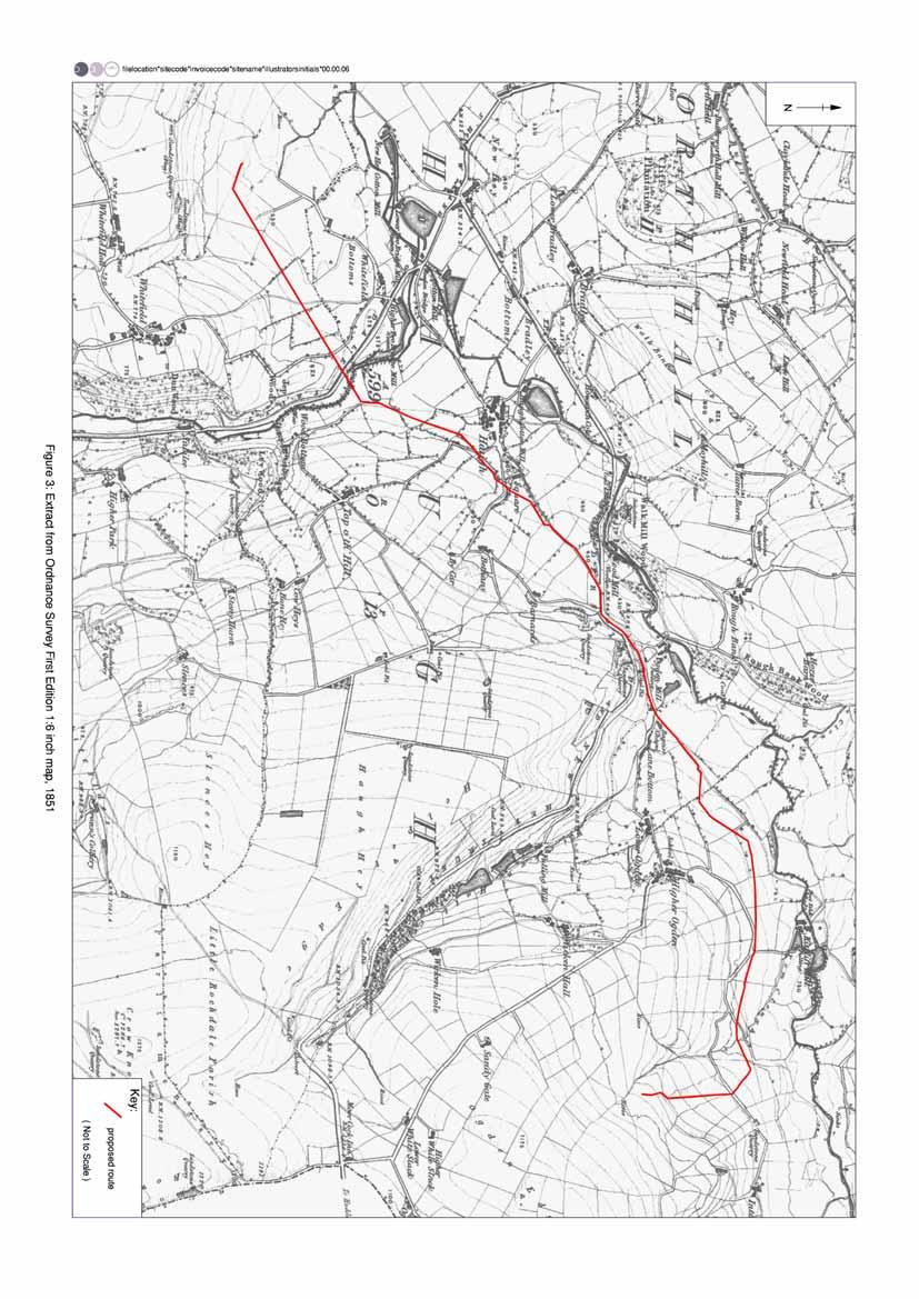
11 9 1996, 76). The financial problems which prompted the Byrons to begin to sell their Lancashire assets was accompanied by the purchase of tenements by yeoman farmers. In 1625 Byron s ownership of the Manor of Rochdale reverted to the Crown, and in 1626 came into the possession of Sir Robert Heath, whose survey of the manor provides much of the documentary detail for the early 17 th century (ibid) Many of the farms appear to have achieved freehold status by the 17 th century, although some had already become freehold by the mid 16 th century (UMAU 1996, 77). Much of the architectural fabric comprising these farms, which are mostly now ruined, appears to have been built during this period, although ceramic evidence from Tanning Holes, in the Piethorne Valley, suggests a late medieval origin for at least some of the sites (GMAU 1992, 35). It appears as though the early 17 th century saw a prosperous yeomanry constructing new farms, and enclosing unclaimed land with which to enrich freeholds lately purchased from the Byron estate (op cit, 36). Enclosure of the moorland by the use of hedges, ditches and stone walls is probably attested by some of the undated earthworks in the study area, and by the 1851 Ordnance Survey the study area was entirely enclosed, probably for a mixture of rough pasture and fodder-crops. The poor quality of this farmland forced most to seek a second income, which was provided by weaving (GMAU 1992, 36) across much of the Lancashire and West Yorkshire Pennines. Occupants of the farms in the Piethorne Valley also appear to have enjoyed turbary (peat-extraction) rights on the moors in the early 17 th century (Redhead 2003, 77) Industrial Period: the Ordnance Survey of 1851 shows a series of six mills along the Piethorne Valley and the river Beal (Fig 3; Section below), and earlier cartography indicates that water-power was certainly a feature of the region, if not necessarily the study area, by the late 18 th century. In the first half of the 19 th century six mill sites had been built in the vicinity of New Hey alone. Ogden Mill (SMR ; SD ), shown on the 1851 Ordnance Survey, may be the mill represented on Hennet s Map of 1830 (Section below; Plate 1). Spring Mill (SMR ; SD ) post-dates this particular edition of the Ordnance Survey mapping, although part of its fabric appears to date from the mid 19 th century. The ruined footprint of a complex 19 th - or early 20 th -century buildings to the north of Piethorne Brook (SMR ; SD ) may be associated with the Wood Mill woollen mill shown on the 1851 Ordnance Survey First Edition map (annotated on the 1890 Second Edition map as being used for fellmongering; Fig 4). Other hydrological features shown on the Ordnance Survey mapping include a weir (SMR ; SD ) on the Piethorne Brook Coal and stone extraction is also attested by 19 th century Ordnance Survey mapping, which shows coal-workings, mines and sandstone quarries near to the study area (Figs 3 and 4). Small-scale mining of these materials is archaeologically visible in the form of bell-pits (SMR ; SD ), a feature which appears to represent medieval and subsequent activity. Unidentified ruined buildings (SMR ; SD ) located immediately to the north of the Piethorne Brook may have been associated with sandstone quarry workings which are shown on the Ordnance Surveys of 1851 and 1890.
12 The water resource within the Piethorne Valley, in common which the majority of the rain-sodden Pennines, saw increasing exploitation in the second half of the 19 th century, as the Oldham Corporation Gas and Water Act of 1855 precipitated the construction of Norman Hill, Hanging Lees, Piethorne, and Kitcliffe Reservoirs between 1858 and 1866 (UMAU 1996, 84). These were followed by the Ogden reservoir (1872-8) and the Rooden reservoir ( ). It appears as though the Kitcliffe and Ogden reservoirs were constructed to provide a compensatory supply of water to some of the local mill owners (UMAU 1996, 84). A small reservoir (SMR ; SD ) below the major Ogden Reservoir is shown on the 1890 map, and this still supplies water to Greater Manchester. Late 19 th and 20 th century ancillary structures relating to hydrological management of the area survive in the forms of weirs, culverts and associated stonework (SMR ; SD and SMR ; SD ) The increasing exploitation of the area by medium-scale industry, such as the mills required a large working population, which in turn required accommodation. Terraced housing appears during the 19 th century, although the buildings at Thorn Bank (SMR ; SD ) may have been constructed for the benefit of a high-ranking water-board official. Rail and road links, which began to appear in the area during this period, stemmed from the increase in the necessary traffic of both people and industrial material, and the Baptist Chapel (SMR ; SD ) which was built in 1861 alongside the site of the Friend s Meeting House, itself erected in 1783, was probably intended to serve the growing population. 3.3 MAP REGRESSION ANALYSIS Yates Map of Lancashire 1786: this is the first useful cartographic representation of the study area, showing the nearby settlements of Ogden and Haugh (Plate 2), and the distinctive layout of forked road over forked watercourse. No other features of note are shown in the area with the exception of a water-wheel icon representing an unnamed water-powered mill to the north of New Hey. Given the scale of the map and the propensity of the cartographer to make mistakes it is not possible to confidently identify the location of this water-wheel icon Hennet s Map of Lancashire 1830: this map shows New Hey and the road linking it to the Milnrow/Shaw road (Plate 1). Piethorne Brook is shown as terminating in a large pool to the immediate south of New Hey, and a waterwheel icon is located in the approximate position of Ogden Mill Ordnance Survey Map, Lancashire 1 st edition 1851, 6 to 1 mile: the pool shown previously in Hennet s map is now clearly illustrated as a mill pond or reservoir, serving the Lower Two Bridge Mill (Fig 3). Six water-powered mills are shown drawing power from the Piethorne Brook. Three cotton mills in the immediate vicinity of New Hey draw water either from Piethorne Brook or the river Beal, both of which appear to have been subject to hydrological management in the form of weirs, reservoirs and races. Ogden Mill is clearly shown as two buildings, with ancillary structures also occupying the site.
13 Ordnance Survey Map, 1890, First Edition, 1:2500: the area is now dominated by the Oldham Loop railway and the Newhey station (Fig 4). The layouts of individual mills seem to show expansion in some cases and reduction in others. This reflects differing fortunes since the 1850s. Lower Two Bridges Mill (now annotated cotton ) had hardly changed in plan, whilst Higher Two Bridge Mill (no longer annotated) had become a building of intermediate size. The layout of New Hey Mills (woollen) is shown as having changed considerably, although it appears not to have changed in terms of overall size. New Hey Mill (cotton) is a comparative giant not shown on the earlier maps. The former Salt Pye Cotton Mill is now called Two Bridges Mill (woollen), and it appears to have grown somewhat. The settlement at New Hey has become somewhat of a sprawl either side of the railway, as the mills thirst for a labour force demanded an industrial village in the form of terraced housing. Ogden Mill is now annotated as a Dyeing and Finishing works, and has expanded to approximately double its former size. Spring Mill is shown as a similarly large complex. 3.4 PREVIOUS ARCHAEOLOGICAL WORK Excavations at Piethorne Brook conducted in the 1980s recorded a Bronze Age settlement, as well as lithic artefacts, stone adornments and Bronze Age ceramics (Poole 1986). Surveys have been carried out within the Piethorne Valley (GMAU 1992), and excavations have taken place at the site of Tanning Holes in the same valley, both in the late 1990s (UMAU 1996). The immediate study area has not benefited from any intrusive archaeological investigation.
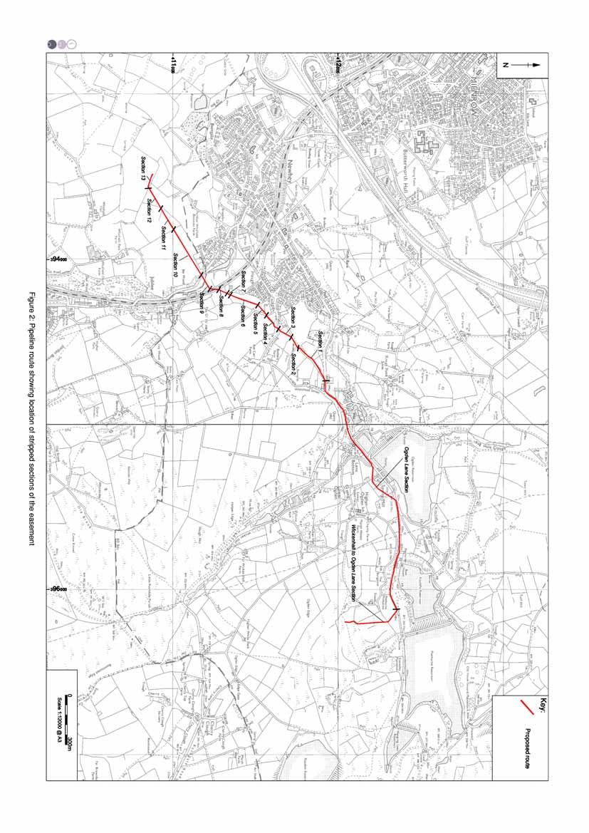
14 12 4. WATCHING BRIEF 4.1 INTRODUCTION A programme of permanent presence monitoring, in the form of a watching brief, was conducted from March to June 2007 in two phases. The first phase comprised the observation of 27 geological test pit and trench excavations around the Wickenhall Water Treatment Works (Fig 5), and the second phase comprised the observation of topsoil stripping activities within a 2km long pipeline easement, leading from Wickenhall to Newhey Water Treatment Works (Fig 2). The entire pipeline route was stripped of topsoil within the 3m wide easement. The easement was stripped in sections as shown on Figure 2. A 0.80m wide pipe-trench was excavated in the centre of this easement (Plate 3). Contexts recorded during the watching brief are presented in Appendix RESULTS Phase 1: Eighteen test pits (TP 1-18) were excavated on the high ground adjacent to Wickenhall Water Treatment Works (Fig 5), and contained layers of dark brown topsoil (101), measuring as much as 0.25m thick, over layers of mid greyish-brown subsoil (102), up to a maximum thickness of 0.60m. This subsoil layer contained <3% fragmentary building material including brick and tile fragments. To the north of the Wickenhall Water Treatment Works, adjacent to the access road, nine test trenches (TT 1-8) were excavated (Fig 5), with similar compositions to the 18 adjacent to the Wickenhall Water Treatment Works. A large modern rubbish pit had been filled with farm waste ( ) in TP 4. Natural geology occurred at depths varying between 0.30m and 1.50m A trackway surface (103) encountered in TP 1, adjacent to Wickenhall Water Treatment Works, appears to have been built in the early twentieth century from reused demolition material, and continues to form a functional farm track. No other archaeological features, structures or deposits were encountered Phase 2: the positions of the pipeline easement and the roadway trench are shown in Figure 2. Within the easement, dark brown topsoil layers (113, 118, 123, 128, 133, 138, 143, 148, 152 and 156) were recorded, above subsoil layers (114, 119, 124, 129, 130, 134, 139, 144, 149, 153 and 157) respectively. A single layer of very dark brown subsoil (158), was observed in Trench 15, between Wickenhall Water Treatment Works and Ogden Lane, although no artefacts or other dateable material was recovered from this layer. Natural geology occurred at depths of up to 1m below the existing ground surface On Ogden Lane, approximately 250m from the Piethorne Water Treatment Works, a stone culvert (161; Plate 4) was revealed occupying a north/south alignment beneath the modern road surface, conveying run-off water from the higher ground down towards the Kitcliffe Reservoir. A similar structure twelve metres away was situated above ground on the opposite side of the
15 13 road, and both probably represent parts of the monumental reservoir infrastructure constructed between 1858 and 1894 (Section ). No other features or deposits of any archaeological significance were encountered. 4.3 FINDS In all, 134 fragments were recovered during the investigation, from topsoil and subsoil contexts 119, 129, 130, 133, 134, 141, 144, and unstratified contexts. Their distribution is shown below (Table 1). Context Pottery Glass Clay tobacco pipe Other Totals Unstratified Topsoil Unstratified 1 1 Totals Table 1: Distribution of Principal Finds Types Pottery comprised the majority (88%) of the material recovered. It was in good condition, the fragments being reasonably large and unabraded, suggesting that the contexts from which it derived had not been repeatedly disturbed. Most of the finds date to the last quarter of the nineteenth or the earlier part of the twentieth century. The earliest material was derived from subsoil deposit 144, which produced a single small fragment of Cistercian-type ware, probably of seventeenth century date. Subsoil context 119 and topsoil deposit 133 both produced small fragments of slip-decorated vessel, a typically eighteenth century type. In addition, topsoil 119 produced a fragment of an earthenware lidded jar, probably engine-turned, this production method having been developed in the Staffordshire potteries during the later eighteenth century. It must be noted that these fragments are likely to be residual in both contexts. The bulk of the pottery comprised kitchenwares and tablewares of later nineteenth and twentieth centuries.
16 14 5. DISCUSSION 5.1 INTRODUCTION The rapid desk-based assessment identified 13 sites (Section 3.2) within 0.5km of the proposed pipeline corridor. Of these, all 13 were already recorded in the SMR. There are no recorded Scheduled Monuments and no other sites with Statutory Designations within the study area. The recorded sites within the study area chiefly relate to the industrial period (textile mills) and ancillary industrial buildings and features constructed to facilitate the management of the water resources which supplied these industries The watching brief recorded only limited evidence for human activity. Some areas of the pipeline were excavated across poorly-drained ground, and the culverts observed during the watching brief attest to the problems caused by weather in this extremely wet area of the Pennines. The recovery of artefacts proved to be sporadic and was mainly confined to areas adjacent to existing farmhouses. The pottery was also, in most cases, only found in the topsoil or subsoils, although a sherd was found amongst spoil from lower down (approximately 1.5m below the existing ground surface) in TP 10, close to Wickenhall Water Treatment Works. 5.2 SIGNIFICANCE AND RECOMMENDATIONS The small number of archaeological features noted during the course of the watching brief support the assertion that the area has been predominantly agricultural and pastoral in nature, and that the impact of human activity is limited to more recent history. Given the late date and the limited significance of the archaeological material recovered during the programme no further work is recommended.
17 15 6. BIBLIOGRAPHY 6.1 CARTOGRAPHIC SOURCES Hennet s Map of Lancashire 1830 Ordnance Survey 6 to 1 mile, First Edition, Lancashire sheet 89, surveyed , publ 1851 Ordnance Survey 6 to 1 mile, Second Edition, Lancashire sheet LXXXIX, surveyed , publ 1895 Yates Map of Lancashire SECONDARY SOURCES Crosby, A 1996 A History of Cheshire, Chichester Countryside Commission 1998, Countryside Character, Volume 2: North West, Cheltenham English Heritage 1991, Management of Archaeological Projects, 2 nd edn, London English Heritage 2006, Management of Research Projects in the Historic Environment (MoRPHE) GMAU 1992, Wicken Hall Water Treatment Works: An Archaeological Assessment, unpubl rep Hodgson, J, and Brennand, M 2007, The Prehistoric Period Resource Assessment Institute of Field Archaeologists, 1999 Standard and guidance for archaeological Desk-based Assessments Poole, S 1986, A Late Mesolithic and Early Bronze Age Site at Piethorn Brook, Milnrow, Greater Manchester Arch Jour 2, Philpott, R 2007, North-West Research Framework: Romano-British Resource Assessment Redhead, N 2003, The Castleshaw and Piethorne Valleys. The Industrial Exploitation of a Pennine Landscape, in Nevell M (ed), From Farmer to Factory Owner. Models, Methodology and Industrialisation, Council for British Archaeology North West, UMAU 1996, Castleshaw and Piethorne North West Water Landholding: Archaeological Survey, unpubl rep Walker, J (ed), 1989 Castleshaw. The Archaeology of a Roman fortlet, Greater Manchester Archaeological Unit
18 16 7. ILLUSTRATIONS 7.1 FIGURES Figure 1: Figure 2: Site Location Pipeline Route Showing Location of Stripped Sections of the Easement Figure 3: Extract from Ordnance Survey First Edition 1 mile to 6 inch map, 1851 Figure 4: Extract from Ordnance Survey First Edition 1 mile to 25 inch map, 1890 Figure 5: Detail of Test Pits in vicinity of Wickenhall Water Treatment Works 7.2 PLATES Plate 1: Extract of Yates Map of Lancashire, 1786 Plate 2: Extract of Hennet s Map of Lancashire, 1830 Plate 3: Plate 4: Topsoil stripping within the pipeline easement Culvert 161 on Ogden Lane, facing south

19
20
21

22
23


24 Plate 1: Extract of Yates Map of Lancashire, 1786 Plate 2: Extract of Hennet s Map of Lancashire, 1830


25 Plate 3: Topsoil stripping within the pipeline easement Plate 4: Culvert 161 on Ogden Lane, facing south
26 17 APPENDIX 1: PROJECT DESIGN
27 WICKENHALL TO NEWHEY WATER TREATMENT WORKS PIPELINE (PIETHORNE), GREATER MANCHESTER Archaeological Watching Brief Project Design Oxford Archaeology North January 2007 United Utilities OA North Tender No. t2926 NGR SD 9312
28 Wickenhall Water Treatment Works to Newhey, Greater Manchester: Project Design 2 1. INTRODUCTION 1.1 United Utilities (hereafter the client) have proposed the construction of a new pipeline from Wickenhall to Newhey, Greater Manchester. As the scheme affects areas of archaeological potential, dating from the Bronze Age through to the Industrial Period, the Assistant County Archaeologist at Greater Manchester Archaeological Unit Sites and Monuments Record (GMAUSMR) has recommended that a formal watching brief should be undertaken for previously undisturbed sections of the pipeline and areas where industrial remains are known to exist. 1.2 OA North has considerable experience of the assessment, evaluation and excavation of sites of all periods, having undertaken a great number of small and large-scale projects during the past 20 years. Watching briefs, evaluations and excavations have taken place within the planning process, to fulfil the requirements of clients and planning authorities, to very rigorous timetables. 1.3 OA North has the professional expertise and resources to undertake the project detailed below to a high level of quality and efficiency. OA North is an Institute of Field Archaeologists (IFA) registered organisation, registration number 17, and all its members of staff operate subject to the IFA Code of Conduct. 2 OBJECTIVES 2.1 The following programme has been designed to evaluate the archaeological resource of the proposed development area. The required stages to achieve this are as follows: 2.2 Rapid Desk-Based Assessment: a brief appraisal of the data held by the Sites and Monuments Record Office (SMR) will be undertaken; 2.3 Permanent Presence Watching Brief: this will be undertaken during all ground disturbances associated with previously undisturbed sections of the pipeline or where known remains of industrial archaeology are present; 2.4 Report and Archive: production of a report following the collation of data during Sections 2.2 and 2.3 above. 2.5 It should be noted that there is the possibility of follow-on excavation works in addition to the archaeological programme of work highlighted above. Such works will be subject to discussions with the Assistant County Archaeologist and would be a variation to this project design. It would be advisable for the client to set aside a contingency sum of approximately 25,000 to cover this eventuality. 3 METHOD STATEMENT 3.1 WATCHING BRIEF Rapid Desk-Based Assessment: an examination will be undertaken of SMR data made available to the project in order to place the findings of the watching brief into a local and regional context. For the use of United Utilities OA North: December 2006
29 Wickenhall Water Treatment Works to Newhey, Greater Manchester: Project Design Fieldwork: a programme of field observation will record accurately the location, extent, and character of any surviving archaeological features and/or deposits within all topsoil stripping activities associated with the development works. The watching brief will also be maintained for sections of the pipeline that are to be excavated without easement works ie within road surfaces. This work will comprise observation during the excavation for these works, the systematic examination of any subsoil horizons exposed during the course of the groundworks, and the accurate recording of all archaeological features and horizons, and any artefacts, identified during observation Putative archaeological features and/or deposits identified by the machining process, together with the immediate vicinity of any such features, will be cleaned by hand, using either hoes, shovel scraping, and/or trowels depending on the subsoil conditions, and where appropriate sections will be studied and drawn. Any such features will be sample excavated (ie selected pits and postholes will normally only be half-sectioned, linear features will be subject to no more than a 10% sample, and extensive layers will, where possible, be sampled by partial rather than complete removal) It is assumed that OA North will have the authority to stop the works for a sufficient time period to enable the recording of important deposits. It may also be necessary to call in additional archaeological support if a find of particular importance is identified or a high density of archaeology is discovered. This would only be called into effect in agreement with the Client and the County Archaeology Service and will require a variation to costing. In the event that significant archaeological features or deposits are identified the immediate area will be sealed off to avoid machine tracking and a meeting called between the Assistant County Archaeologist, United Utilities representative and the OA North project manager Written Record: during this phase of work, recording will comprise a full description and preliminary classification of features or materials revealed. All information identified in the course of the site works will be recorded stratigraphically utilising OA North pro-forma. Areas of excavation will be assigned trench numbers and context numbers will be applied to archaeological features Site Drawings: a large-scale plan (provided by the client) will be produced of the area of the groundworks showing the location and extent of the ground disturbance, appropriately labelled to correspond with the written record. Archaeological features will be recorded accurately (either on plan (1:20) and/or section (1:10), and as grid co-ordinates where appropriate) The site drawings will be manipulated in an industry standard CAD package (AutoCAD release 2000) for the production of final drawings A photographic record will be undertaken simultaneously. This will utilise a 35mm camera for the production of both colour slides and monochrome contact prints. A photographic scale will appear in all images captured. The photographic index will describe and locate each area/feature photographed Human Remains: any human remains uncovered will be left in situ, covered and protected. No further investigation will continue beyond that required to establish For the use of United Utilities OA North: December 2006
30 Wickenhall Water Treatment Works to Newhey, Greater Manchester: Project Design 4 the date and character of the burial. The GMAUSMR and the local Coroner will be informed immediately. If removal is essential the exhumation of any funerary remains will require the provision of a Department of Constitutional Affairs license, under section 25 of the Burial Act of An application will be made by OA North for the study area on discovery of any such remains and the removal will be carried out with due care and sensitivity under the environmental health regulations, and if appropriate, in compliance with the Disused Burial Grounds (Amendment) Act, Treatment of finds: no sampling of finds will take place during fieldwork. All finds will be exposed, lifted, cleaned, conserved, marked, bagged and boxed in accordance with the United Kingdom Institute for Conservation (UKIC) First Aid For Finds, 1998 (new edition) and the recipient museum's guidelines (Rochdale Museums Service) All identified finds and artefacts will be retained, although certain classes of building material can sometimes be discarded after recording if an appropriate sample is retained on advice from the recipient museum s archive curator Treasure: any gold and silver artefacts recovered during the course of the excavations will be removed to a safe place and reported to the local Coroner according to the procedures relating to the Treasure Act, Where removal cannot take place on the same working day as discovery, suitable security will be employed to protect the finds from theft Environmental Samples: samples will also be collected for technological, pedological and chronological analysis as appropriate. If necessary, access to conservation advice and facilities can be made available. OA North maintains close relationships with Ancient Monuments Laboratory staff at the Universities of Durham and York and, in addition, employs artefact and palaeozoological specialists with considerable expertise in the investigation, excavation and finds management of sites of all periods and types, who are readily available for consultation. 3.2 REPORT AND ARCHIVE Interim Statement: in the event that further work is recommended an interim statement will be issued. In this instance or in the event that the client specifically requests an interim statement it should be noted that all illustrations will be copies of field drawings and not finished CAD drawings Final Report: two copies of the final report will be submitted to the client and a further copy to the GMAUSMR. Both paper and digital copies will be provided on CD-ROM in pdf format. The report will present the following information: (i) Summary: a summary statement of the findings; (ii) Introduction: the background to the project including location details; (iii) (iv) (v) Methodology: an outline of the methodology of all elements of the programme of work; Historical Background: a brief historical background to the site; Results: an account of the past and present land use of the study area; For the use of United Utilities OA North: December 2006
31 Wickenhall Water Treatment Works to Newhey, Greater Manchester: Project Design 5 (vi) (vii) An account of archaeological features identified during the course of the watching brief: Discussion: a description of the significance of the study area in its local and regional context; Recommendations: the identification of areas where further development will impact upon the archaeological resource in addition to the impacts of the current development; (viii) Illustrations: maps, plans, sections and copies of the site photographic archive; (ix) Appendices: a copy of the brief and this project design; Provision will be made for a summary report to be submitted to a suitable regional or national archaeological journal within one year of completion of fieldwork, if relevant results are obtained Confidentiality: all internal reports to the client are designed as documents for the specific use of the Client, for the particular purpose as defined in the project brief and project design, and should be treated as such. They are not suitable for publication as academic documents or otherwise without amendment or revision Archive: the results of all archaeological work carried out will form the basis for a full archive to professional standards, in accordance with current English Heritage guidelines (Management of Archaeological Projects, 2nd edition, 1991). This archive, including a copy of the report, will be provided in the English Heritage Centre for Archaeology format. In this instance the archive will be submitted to the Rochdale Local Studies Library The Arts and Humanities Data Service (AHDS) online database Online Access to index of Archaeological Investigations (OASIS) will be completed as part of the archiving phase of the project. 4 PROJECT MONITORING 4.1 Monitoring of this project will be undertaken through the auspices of the GMAUSMR Assistant County Archaeologist, who will be informed of the start and end dates of the work. 5 WORK TIMETABLE 5.1 The rapid desk-based assessment is expected to take in the region of one day to complete. 5.2 The duration of the watching brief will be dependent upon the progress of the contractor. 5.3 The client report will be completed within eight weeks following completion of the fieldwork. 6 STAFFING For the use of United Utilities OA North: December 2006
32 Wickenhall Water Treatment Works to Newhey, Greater Manchester: Project Design The project will be under the direct management of Alison Plummer BSc (Hons) (OA North Senior Project Manager) to whom all correspondence should be addressed. 6.2 Present timetabling constraints preclude detailing at this stage exactly who will be undertaking the rapid desk-based assessment and watching brief, but both of these elements of the project are likely to be supervised by an OA North project supervisor experienced in these types of project. All OA North project officers and supervisors are experienced field archaeologists capable of carrying out projects of all sizes. 7 INSURANCE 7.1 OA North has a professional indemnity cover to a value of 2,000,000; proof of which can be supplied as required. For the use of United Utilities OA North: December 2006
33 18 APPENDIX 2: CONTEXT LIST Context Site Division Category Description 101 Wickenhall Test pit 13 Topsoil Dark-brown sandy silt <2% chalky, limestone fragments 102 Wickenhall Test pit 13 Subsoil Mid greyish-brown, clayey silt <3% ceramic building material 103 Wickenhall Brick rubble Orangey-red indurated brick fragments Test pit Wickenhall Test pit 13 Pipe-trench Backfill Greyish-brown, sandy clay <2% field stone fragments 105 Ogden Lane Road surface Tarmac 106 Ogden Lane Hardcore Greyish-brown Stone fragments in a sandy matrix 107 Ogden Lane Fill Light greyish brown clayey silt <3% sandstone chips (Fill of 109) 108 Ogden Lane Natural Mid brown sandy silt <4% stone fragments 109 Ogden Lane Cut Linear feature with U-shaped section, aligned NE/SW Culvert construction cut 110 Wickenhall Test Trench 4 Fill Mid green, soft clayey silt <2% small rounded stone fragments Modern dump material 111 Wickenhall Test Trench 4 Fill Dark brown, clayey silt Modern dump material 112 Wickenhall Test Trench 4 Fill Mid grey clayey silt Modern dump material 113 New Haugh Farm. Easement section 1 Topsoil Black clayey silt <3% small sub-rounded stones 114 New Haugh Farm. Subsoil Light grey sandy silt Easement section New Haugh Farm. Natural Light grey silty clay Easement section New Haugh Farm. Natural Light brown silty sand Easement section New Haugh Farm. Natural Orange yellow soft plastic clay Easement section New Haugh Farm. Topsoil Black sandy silt Easement section New Haugh Farm. Subsoil Light mid grey sandy silt Easement section New Haugh Farm. Natural Light brown sandy silt Easement section New Haugh Farm. Natural Mid-to-light brown silty sand Easement section New Haugh Farm. Natural Brown/orange soft, plastic clay Easement section New Haugh Farm. Easement section 3 Topsoil Black sandy silt <2% small rounded stones 124 New Haugh Farm. Easement section 3 Subsoil Light grey sandy silt <2% small sub-rounded stones 125 New Haugh Farm. Natural Light mid brown sandy silt Easement section New Haugh Farm. Natural Light mid brown, silty sand
34 19 Easement section New Haugh Farm. Easement section Bethany Lane T Easement section Bethany Lane Easement section Bethany Lane Easement section Bethany Lane Easement section Bethany Lane Easement section Haugh Spring Easement section Haugh Spring Easement section Haugh Spring Easement section Haugh Spring Easement section Haugh Spring Easement section Meadowside Farm Easement section Meadowside Farm Easement section Meadowside Farm Easement section Meadowside Farm Easement section Meadowside Farm Easement section Whitfield Park Farm. Easement section Whitfield Park Farm. Easement section Whitfield Park Farm. Easement section Whitfield Park Farm. Easement section Whitfield Park Farm. Easement section Whitfield Park Farm. Easement section Whitfield Park Farm. Easement section Whitfield Park Farm. Easement section Whitfield Park Farm. Easement section River Beal Sump. Easement section River Beal Sump. Easement section 14 Natural Topsoil Subsoil Subsoil Natural Natural Topsoil Subsoil Natural Natural Natural Topsoil Subsoil Subsoil Subsoil Natural Topsoil Subsoil Natural Natural Natural Topsoil Subsoil Natural Natural Topsoil Subsoil Yellow orange, soft clay Black sandy silt Light grey sandy silt.2% small stones Light mid brown sandy silt. Light mid brown soft sand Yellow-orange, plastic clay Black sandy silt <2% sub rounded stone inclusions Light grey sandy silt Light to mid brown sandy silt Mid brown silty sand Yellow orange, soft plastic clay Black sandy silt <2% small sub-rounded stone inclusions Mid light grey sandy silt.2% mix of subrounded and angular stones Light mid brown sandy silt 2% mix of subangular and rounded stone inclusions Mid brown silty sand Orangey brown soft, plastic clay Black sandy silt <4% small angular stones Light brown sandy silt <5% sub-angular stone inclusions Mid brown sandy silt Mid greyish brown sandy silt Greyish yellow firm plastic clay Black sandy silt <5% sub-angular stones Mid greyish brown sandy silt <2% sub-angular stones Light greyish brown sandy silt Greyish yellow firm plastic clay Black sandy silt <4% sub-angular stones Light greyish brown sandy silt <4% sub-rounded and sub-angular stones <,0.05m
35 River Beal Sump. Easement section River Beal Sump. Easement section Wickenhall to Ogden Lane. Easement section Wickenhall to Ogden Lane. Easement section Wickenhall to Ogden Lane. Easement section Wickenhall to Ogden Lane. Easement section Wickenhall to Ogden Lane. Easement section 15 Natural Natural Topsoil Subsoil Layer Deposit Natural Natural Orange brown sandy silt Greyish yellow firm plastic clay Black sandy silt <5% rounded stones Light brown sandy silt <4% sub angular stones Dark brownish black sandy silt Mid grey silty clay Greyish-yellow firm plastic clay
Archaeological monitoring and recording at Tollesbury Wick Marshes, Tollesbury, Essex September-October 2004
 Archaeological monitoring and recording at Tollesbury Wick Marshes, Tollesbury, Essex September-October 2004 report prepared by Howard Brooks on behalf of the Essex Wildlife Trust CAT project code: 04/9c
1. *Does the document clearly specify the aims, objectives and scope of the proposed programme of archaeological work?
 Notes and Guidance This document provides curatorial advisors, archaeological practitioners and other interested parties with additional information and guidance on the standards and expectations for archaeological
MANUSCRIPT MAPS IN DERBYSHIRE RECORD OFFICE
 MANUSCRIPT MAPS IN DERBYSHIRE RECORD OFFICE 1600-2000 Introduction Before the end of the reign of Queen Elizabeth I in 1603, maps of any kind were rare. In the four hundred years since then, maps of all
Cambridgeshire County Council Information Sheet on Lost Highways Research
 Cambridgeshire County Council Information Sheet on Lost Highways Research This information sheet is intended to assist parishes and individuals interested in investigating documentary evidence of historic
APPENDIX E Stage 2 Archaeological Assessment
 APPENDIX E Stage 2 Archaeological Assessment Stage 2 Archaeological Assessment of New Industrial Park, Part of Lots 14-17, Concession 2, Geographic Township of Elizabethtown County of Leeds and Grenville,
PLANNING & BUILDING REGULATIONS
 SCANDIA-HUS FACT SHEET NO. 10 PLANNING & BUILDING REGULATIONS DATE: 1 ST JANUARY 2018 ISSUE NO: 4 THE PLANNING SYSTEM Scandia-Hus will, as part of the service, handle all aspects of design, planning and
Residential Development Opportunity
 La Residential Development Opportunity For Sale by Informal Tender Indicative Redline Plan, CB6 2HT With outline planning permission for up to 46 residential units Unconditional offers invited by 12 noon
New Mexico Register / Volume XVI, Number 15 / August 15, 2005
 TITLE 4 CHAPTER 10 PART 14 PERMITS CULTURAL RESOURCES CULTURAL PROPERTIES AND HISTORIC PRESERVATION CULTURAL PROPERTIES ON PRIVATE LAND AND MECHANICAL EXCAVATION 4.10.14.1 ISSUING AGENCY: Cultural Properties
Appendix I Definitions of Inspections and Surveys of Buildings (CIC Explanatory Leaflet)
") Appendix I Definitions of Inspections and Surveys of Buildings (CIC Explanatory Leaflet) Introduction Professionals carry out many different types of inspections, each for a particular reason and each
Appendix I Definitions of Inspections and Surveys of Buildings (CIC Explanatory Leaflet) Introduction Professionals carry out many different types of inspections, each for a particular reason and each
NORTH SOMERSET COUNCIL HISTORIC ENVIRONMENT RECORDS. HER No. Type Period Description Grid Ref.
 NORTH SOMERSET COUNCIL HISTORIC ENVIRONMENT RECORDS HER No. Type Period Description Grid Ref. NHLE 1129841 Grade I Post-medieval Aston Court Mansion and Stables. ST 55709 71837 MNS705 NHLE 1000560 MNS704
Development of a temporary grass multisport pitch and associated works (in addition to the previously approved park - Phase A).
.") To the Lord Mayor and Report No. 163/2018 Members of Dublin City Council Report of the Chief Executive (a) Planning and Development Act 2000 (as amended) & Planning and Development Regulations 2001 (as
To the Lord Mayor and Report No. 163/2018 Members of Dublin City Council Report of the Chief Executive (a) Planning and Development Act 2000 (as amended) & Planning and Development Regulations 2001 (as
Volume Three Appendix 7. Scheme Plan and other subdivision requirements
 Volume Three Appendix 7 Appendix 7 Scheme Plan and other subdivision requirements Any application for subdivision consent must be accompanied by a Scheme Plan that contains the information set out in this
RYEDALE SITES LOCAL PLAN MATTER 4 PROPOSED HOUSING SITE OPTION REF. 116 LAND AT MIDDLETON ROAD, PICKERING BARRATT HOMES & DAVID WILSON HOMES
 RYEDALE SITES LOCAL PLAN MATTER 4 PROPOSED HOUSING SITE OPTION REF. 116 LAND AT MIDDLETON ROAD, PICKERING BARRATT HOMES & DAVID WILSON HOMES REPRESENTOR ID: 1064 INTRODUCTION 1.1 We write on behalf of
Valuation Report. Property Address. Prepared by. Surveyors Name Trafford Surveyors Ltd. On behalf of: Clients Name
 Valuation Report On Prepared by Surveyors Name Trafford Surveyors Ltd On behalf of: Clients Name CONTENTS Instruction...2 Basis of Valuation... 2 Executive Summary... 3 Location (Appendix 2 Location Plan)...
National Heritage List for England Online Application Form Guidance
 National Heritage List for England Online Application Form Guidance November 2015 These guidance notes are to accompany your application to add a heritage asset to the National Heritage List for England
Residential Development Opportunity
 La Residential Development Opportunity For Sale by Informal Tender Indicative Redline Plan With full planning permission for 5 residential units Unconditional offers invited by 12 noon Thursday 15 th March
CROSSRAIL INFORMATION PAPER C10 - LAND DISPOSAL POLICY
 CROSSRAIL INFORMATION PAPER C10 - LAND DISPOSAL POLICY This paper sets out the Crossrail land disposal policy as published in November 2005. It will be of particular relevance to owners of land subject
RYEDALE SITES LOCAL PLAN MATTER 3 PROPOSED HOUSING SITE OPTION REF. 116 LAND AT MIDDLETON ROAD, PICKERING BARRATT HOMES & DAVID WILSON HOMES
 RYEDALE SITES LOCAL PLAN MATTER 3 PROPOSED HOUSING SITE OPTION REF. 116 LAND AT MIDDLETON ROAD, PICKERING BARRATT HOMES & DAVID WILSON HOMES REPRESENTOR ID: 1064 INTRODUCTION 1.1 We write on behalf of
This decision is made under sections 130( 1 ) and 133 of the Environment Protection and Biodiversity Conservation Act 1999.
 and 133 of the Environment Protection and Biodiversity Conservation Act 1999.") Australian Government Department of the Environment and Energy Approval Mt Arthur Coal open cut modification, Muswellbrook, NSW, (EPBC 2014/7377). This decision is made under sections 130( 1 ) and 133
Australian Government Department of the Environment and Energy Approval Mt Arthur Coal open cut modification, Muswellbrook, NSW, (EPBC 2014/7377). This decision is made under sections 130( 1 ) and 133
Key findings from an investigation into low- and medium-value property sales. National Audit Office September 2017 DP
 from an investigation into low- and medium-value property sales National Audit Office September 207 DP 557-00 from an investigation into low- and medium-value property sales Contents 3 4 5 6 7 8 9 0 2
Friends Meeting House, Taunton
 Friends Meeting House, Taunton Bath Place, High Street, Taunton, Somerset, TA1 4EP National Grid Reference: ST 22568 24419 Statement of Significance The meeting house was built in 1816 to replace an earlier
Review of the Plaistow and Ifold Site Options and Assessment Report Issued by AECOM in August 2016.
 Review of the Plaistow and Ifold Site Options and Assessment Report Issued by AECOM in August 2016. Our ref: CHI/16/01 Prepared by Colin Smith Planning Ltd September 2016 1.0 INTRODUCTION 1.1 Colin Smith
Object entry. The SPECTRUM Standard
 Object entry Definition and scope This procedure is for the receipt of objects and associated information which enter your premises for whatever reason. It is the key to ensuring that all objects that
Aesthetic value This modern building is typical design for its date and has low aesthetic value.
 Friends Meeting House, Stoke-on-Trent 2 Miller Street, Newcastle-under-Lyme, ST5 1QJ National Grid Reference: SJ 85470 46308 Statement of Significance A modest building of 1978 that provides good facilities
Mineral Extraction Search Report
 Conclusion: HIGH RISK Date: 01/10/2015 Our Reference: TM.MS.10.01 Client/Reference: FKGRKW2LL.001 Terrafirma Mine Searches Ltd Pure Offices, Pastures Avenue, St Georges, BS22 7SB T: 01934 806515 E: info@terrafirmaminesearches.co.uk
FLOOD HAZARD AREA LAND USE MANAGEMENT
 FLOOD HAZARD AREA LAND USE MANAGEMENT Introduction Guidance For Selection of Qualified Professionals and Preparation of Flood Hazard Assessment Reports This document is intended to provide guidance for
FORM F1 TECHNICAL REPORT TABLE OF CONTENTS
 FORM 43-101F1 TECHNICAL REPORT TABLE OF CONTENTS TITLE CONTENTS OF THE TECHNICAL REPORT Item 1: Item 2 Item 3 Item 4 Item 5 Item 6 Item 7 Item 8 Item 9 Item 10 Item 11 Item 12 Item 13 Item 14 Item 15 Item
DEVELOPMENT OPPORTUNITY LAND EAST OF NEW ROAD MELBOURN, CAMBRIDGESHIRE, SG8 6BX
 DEVELOPMENT OPPORTUNITY LAND EAST OF NEW ROAD MELBOURN, CAMBRIDGESHIRE, SG8 6BX Illustrative Masterplan - Not to Scale An excellent opportunity to acquire a development site benefitting from outline planning
DEVELOPMENT OPPORTUNITY FOUNDATION HOUSE, ICKNIELD WAY, LETCHWORTH GARDEN CITY, SG6 1GD
 DEVELOPMENT OPPORTUNITY FOUNDATION HOUSE, ICKNIELD WAY, LETCHWORTH GARDEN CITY, SG6 1GD Site Plan - Not to scale An excellent opportunity to acquire a prime residential development opportunity within close
1 The Alleys, St Mary s Road, Hemel Hempstead, Hertfordshire, HP2 5ZB
 Quaker Meeting House, Hemel Hempstead 1 The Alleys, St Mary s Road, Hemel Hempstead, Hertfordshire, HP2 5ZB National Grid Reference: TL 05672 07875 Statement of Significance An early eighteenth-century
CHESHIRE WEST AND CHESTER COUNCIL
 Item No. 10 CHESHIRE WEST AND CHESTER COUNCIL Planning Committee 1 st April 2014 APPLICATION NUMBER: 13/05410/FUL DESCRIPTION OF DEVELOPMENT: Residential development of 17 affordable dwellings and associated
Your property and land surveys
 Your property and land surveys 2 Content Highways England 4 Introduction 5 Surveys and compensation 6 Typical compensation levels 6 Compensation for boreholes and trial pits 8 Rent for measuring apparatus
SPECIALIST, EXPERIENCED ADVICE THAT PUTS YOU IN CONTROL OF YOUR CONSTRUCTION PROJECT
 SPECIALIST, EXPERIENCED ADVICE THAT PUTS YOU IN CONTROL OF YOUR CONSTRUCTION PROJECT CLIENT ADVISERS Royal Institute of British Architects 66 Portland Place London W1B 1AD T 020 7580 5533 www.architecture.com
Guide to Preparing an Appraisal Report for a Continuing Disposal Schedule RECORDKEEPING GUIDE G11
 Guide to Preparing an Appraisal Report for a Continuing Disposal Schedule RECORDKEEPING GUIDE G11 MARCH 2008 MARCH 2008: Guide to Preparing an Appraisal Report for a Continuing Disposal Schedule Contents
NSW Travelling Stock Reserves Review Public consultation paper
 NSW Travelling Stock Reserves Review Public consultation paper A collaborative project between: Local Land Services Department of Industry Lands Contents Executive summary 2 1. About TSRs 3 What are TSR
SP Energy Networks Fee Scale
 SP Energy Networks Fee Scale Introduction SP Energy Networks (the Company), which is formed by the licensed and regulated companies known as SP Distribution Plc, SP Transmission Plc and SP Manweb Plc,
Plats and subdivisions; mapping requirements. (a) Size Requirements. All land plats presented to the register of deeds for recording in the
 Size Requirements. All land plats presented to the register of deeds for recording in the") 47-30. Plats and subdivisions; mapping requirements. (a) Size Requirements. All land plats presented to the register of deeds for recording in the registry of a county in North Carolina after September
47-30. Plats and subdivisions; mapping requirements. (a) Size Requirements. All land plats presented to the register of deeds for recording in the registry of a county in North Carolina after September
COUNTY GOVERNMENT OF LAMU Department of Land, Physical Planning, Infrastructure & Urban Development
 1 COUNTY GOVERNMENT OF LAMU Department of Land, Physical Planning, Infrastructure & Urban Development TERMS OF REFERENCE FOR OUTSOURCING OF CONSULTANCY SERVICES FOR SURVEY & REGULARIZATION OF KATSAIKAIKAIRU
VCH Parish History Template (revised 2017)
") plans of individual houses and outbuildings, detailing building materials and room use. Vernacular Architecture routinely publishes details of dendro dated buildings. Photographs and topographical drawings
plans of individual houses and outbuildings, detailing building materials and room use. Vernacular Architecture routinely publishes details of dendro dated buildings. Photographs and topographical drawings
Self-Builds Independent
 What you need to know Self-Builds Offering Independent Mortgage Advice Contact Us: Telephone: +44 (0) 1983 616666 Look us up: www.prospectmortgage.co.uk About 12,000 people build their own homes in the
RFQ INDEFINITE DELIVERIES CONTRACT - LAND SURVEYING SERVICES MAY
 RFQ-16-011 INDEFINITE DELIVERIES CONTRACT - LAND SURVEYING SERVICES MAY 19, 2016 I. GENERAL This IDC includes Professional Land Surveying Services for Ascension Parish School Board, to survey property
Application for Planning Permission. Town and Country Planning Act 1990
 Application for Planning Permission. Town and Country Planning Act 1990 Publication of applications on planning authority websites. Please note that the information provided on this application form and
Highways Highway Records
 Highways Highway Records Helen Baker, PROW and Records, Highways Introduction to the Highway Records The Highway Records team are tasked to respond to enquiries made of Essex County Council in respect
Griffith's [Tenement] Valuation of 1858/1859 for Co. Londonderry
![Griffith's [Tenement] Valuation of 1858/1859 for Co. Londonderry](/thumbs/80/80956206.jpg "Griffith's [Tenement] Valuation of 1858/1859 for Co. Londonderry") Griffith's [Tenement] Valuation of 1858/1859 for Co. Londonderry Given the absence of Census Enumerators' Returns for the nineteenth century, the Griffith's [Tenement] Valuation is a key source for identifying
Griffith's [Tenement] Valuation of 1858/1859 for Co. Londonderry Given the absence of Census Enumerators' Returns for the nineteenth century, the Griffith's [Tenement] Valuation is a key source for identifying
CARMACOUP FOREST Glespin, South Lanarkshire Hectares / Acres
 CARMACOUP FOREST Glespin, South Lanarkshire 310.50 Hectares / 767.24 Acres FREEHOLD FOR SALE AS A WHOLE John Clegg & Co Chartered Surveyors CARMACOUP FOREST Glespin 1 mile Irvine 35 miles Lockerbie 46
ATTACHMENT 2: CONSULTATION UPDATE NO. 3 PART 3 LANDOWNER ENGAGEMENT
 ATTACHMENT 2: CONSULTATION UPDATE NO. 3 PART 3 LANDOWNER ENGAGEMENT TABLE OF CONTENTS 1.0 INTRODUCTION... 1 Page 1.1 Purpose of Update... 1 1.2 Program Scope (May 1 to December 31, 2014)... 1 2.0 COMPONENTS
ARCHITECTS BRIEF (development year to RIBA stage 3 with option to progress to 7)
") 1. Luton Culture A lump sum quotation is sought for the Architectural Design to be undertaken as follows: Development Phase Works up to and including RIBA Stage 3 (including preparing planning application);
1. Luton Culture A lump sum quotation is sought for the Architectural Design to be undertaken as follows: Development Phase Works up to and including RIBA Stage 3 (including preparing planning application);
LAND OFF THETFORD ROAD WATTON, NORFOLK
 LAND OFF THETFORD ROAD WATTON, NORFOLK An exceptional opportunity to acquire a greenfield site benefitting from outline planning permission for the development of up to 180 dwellings. Approximately 7.4
Draft Neighbourhood Plan for the former Land Settlement Association Estate at Great Abington March 2017
 Draft Neighbourhood Plan for the former Land Settlement Association Estate at Great Abington March 2017 1 Neighbourhood Plan Contents 1 Why a Neighbourhood Plan for the former Abington Land Settlement
SCHEDULE 3 TO THE URBAN GROWTH ZONE. Shown on the planning scheme map as UGZ3 QUARRY HILLS PRECINCT STRUCTURE PLAN. 1.0 The Plan
 SCHEDULE 3 TO THE URBAN GROWTH ZONE 1.0 The Plan Shown on the planning scheme map as UGZ3 QUARRY HILLS PRECINCT STRUCTURE PLAN Map 1 to Schedule 3 to Clause 37.07 shows the Future Urban Structure for Quarry
Ingleborough and Scales Moor, North Yorkshire CL 134, 208, 272
 ANALYSIS OF REGISTERS OF COMMON LAND Ingleborough and Scales Moor, North Yorkshire CL 134, 208, 272 Christopher Rodgers 1 Introduction The Ingleton case study comprises two blocks of common land: Ingleborough
Rewlach Farm. Buxton Derbyshire SK17 0LQ
 Rewlach Farm Buxton Derbyshire SK17 0LQ Rewlach Farm Buxton Derbyshire SK17 0LQ Longnor: 2 miles, Buxton: 9 miles (All mileages are approximate) Five bedroom farmhouse Range of traditional farm buildings
Flinders Avenue, Lara Planning Scheme Amendment Combined Application for Rezoning and Multi-Lot Subdivision Reference : Decembe
 143-179 Flinders Avenue, Lara Planning Scheme Amendment Combined Application for Rezoning and Multi-Lot Subdivision Reference: 14134-03 TGM Group Geelong Melbourne Ballarat 1/27-31 Myers Street (PO Box
METHODOLOGY GUIDE VALUING LANDS IN TRANSITION IN ONTARIO. Valuation Date: January 1, 2016
 METHODOLOGY GUIDE VALUING LANDS IN TRANSITION IN ONTARIO Valuation Date: January 1, 2016 August 2017 August 22, 2017 The Municipal Property Assessment Corporation (MPAC) is responsible for accurately assessing
NEW USES FOR CLOSED CHURCHES Guidance from the Church of England for purchasers and lessees
 NEW USES FOR CLOSED CHURCHES Guidance from the Church of England for purchasers and lessees This leaflet guides you through the process of acquiring a Church of England church building closed for regular
Pre-purchase Building Inspection Agreement Page 1 of 10
 Pre-purchase Building Inspection Agreement Page 1 of 10 Complies with Australian Standard AS 4349.1-2007 Inspection of Buildings Part 1: Pre-Purchase inspections Strata and Company title property Inspection
NOVEMBER 2017 PHASE II: PRIVATE LAND OWNERSHIP BY RACE, GENDER AND NATIONALITY
 NOVEMBER 2017 PHASE II: PRIVATE LAND OWNERSHIP BY RACE, GENDER AND NATIONALITY South Africa belongs to all who live in it, united in our diversity. Constitution of the Republic of South Africa Act, 1996
Friends Meeting House, Acomb. The Green, Acomb, York, YO26 5LR. National Grid Reference: SE Statement of Significance
 Friends Meeting House, Acomb The Green, Acomb, York, YO26 5LR National Grid Reference: SE 57149 51293 Statement of Significance Acomb meeting house is a modest building, adapted in the beginning of the
Pre-Applica on Design Statement : Residen al Development, The Gas Works, 113 Bury Road, The ord, Norfolk 1
 13-188 Pre-Applica on Design Statement: Residen al Development, The Gas Works, 113 Bury Road, The ord, Norfolk Prepared by: Gary Johns Architects Date: October 2015 15-311 Pre-Applica on Design Statement
GENERAL ASSEMBLY OF NORTH CAROLINA SESSION 2017 H 1 HOUSE BILL 454* Short Title: Surveying and Plat Recording Changes. (Public)
") GENERAL ASSEMBLY OF NORTH CAROLINA SESSION H 1 HOUSE BILL * Short Title: Surveying and Plat Recording Changes. (Public) Sponsors: Referred to: Representative Arp. For a complete list of sponsors, refer
GENERAL ASSEMBLY OF NORTH CAROLINA SESSION H 1 HOUSE BILL * Short Title: Surveying and Plat Recording Changes. (Public) Sponsors: Referred to: Representative Arp. For a complete list of sponsors, refer
Furniture Design Brief
 Furniture Design Brief 1. INTRODUCTION Maitland Library will be 50 years old in May 2018. It is proposed to commemorate this significant milestone through commissioning the design and supply of signature
WHAT IS A MINERAL? By Jonathan Gaunt QC
 WHAT IS A MINERAL? By Jonathan Gaunt QC 1. The origin of Mineral Rights 1.1 The starting point is that a freehold owner is entitled to all the mines and minerals under his land down to an unlimited depth
LOT A. Range of modern and traditional farm buildings and acres of land Windsor Hill, Shepton Mallet FOR SALE BY AUCTION IN 8 LOTS
 LOT A Range of modern and traditional farm buildings and 148.95 acres of land Windsor Hill, Shepton Mallet FOR SALE BY AUCTION IN 8 LOTS An attractive range of modern and traditional farm buildings together
Research report Tenancy sustainment in Scotland
 Research report Tenancy sustainment in Scotland From the Shelter policy library October 2009 www.shelter.org.uk 2009 Shelter. All rights reserved. This document is only for your personal, non-commercial
Living in the Past: Preservation, interpretation, and engagement, and the 19th early 20th century home
 From the SelectedWorks of Kirsten Jarrett January 31, 2014 Living in the Past: Preservation, interpretation, and engagement, and the 19th early 20th century home Kirsten Jarrett Available at: https://works.bepress.com/kirsten_jarrett/8/
149(+/-) Acres. Prime Location Development Opportunity. Partially Completed. 260 Shepherd of the Hills Expressway Branson Mo
 Acres. Prime Location Development Opportunity. Partially Completed. 260 Shepherd of the Hills Expressway Branson Mo") Price Reduced!! 149(+/-) Acres Prime Location Development Opportunity Partially Completed 260 Shepherd of the Hills Expressway Branson Mo Attention Developers! Bank owned 149(+/-) acres in town! Partially
Price Reduced!! 149(+/-) Acres Prime Location Development Opportunity Partially Completed 260 Shepherd of the Hills Expressway Branson Mo Attention Developers! Bank owned 149(+/-) acres in town! Partially
DRAFT FOR PUBLIC HEARING (rev. March, 2016)
") Chapter 200. ZONING Article VI. Conservation/Cluster Subdivisions 200-45. Intent and Purpose These provisions are intended to: A. Guide the future growth and development of the community consistent with
Chapter 200. ZONING Article VI. Conservation/Cluster Subdivisions 200-45. Intent and Purpose These provisions are intended to: A. Guide the future growth and development of the community consistent with
DRAFT LOCAL VALIDATION CHECKLIST FOR ALL APPLICATIONS
 DRAFT LOCAL VALIDATION CHECKLIST FOR ALL APPLICATIONS For public consultation 9 February to 9 March 2015 February 2015 1 NATIONAL REQUIREMENTS Application Form Design & Access Statement (DAS) If major
Radon Report: England and Wales
 British Geological Survey, Wallingford Radon Report: England and Wales Advisory report on the requirement for radon protective measures in new buildings, conversions and extensions to existing buildings.
NFU Consultation Response
 Page 1 Title: Underground Drilling Access Date: 12th August 2014 Ref: UndergroundDrilling_NFU.doc Circulation: underground.access@decc.gsi.gov.uk Contact: Dr. Jonathan Scurlock, Chief Adviser, Renewable
National Trust for Historic Preservation Collections Management Policy INTRODUCTION
 National Trust for Historic Preservation Collections Management Policy INTRODUCTION The National Trust for Historic Preservation and its Collections. The National Trust for Historic Preservation in the
The Application Process
 The Application Process This document is intended as a guide and does not constitute a legal document. For further and more detailed information, please refer to the following Acts and Regulations: The
STANDARD MINERALS APPLICATION FORM. Application to Carry Out Mineral Working and Associated Development
 STANDARD MINERALS APPLICATION FORM Application to Carry Out Mineral Working and Associated Development TOWN AND COUNTRY PLANNING ACT 1990 County Planning, Minerals and Waste Cambridgeshire County Council
Residential Development Opportunity
 July 2018 La Residential Development Opportunity For Sale by Informal Tender Land off St Andrews Way, Langford, SG18 9QL With resolution to grant outline planning permission for up to 32 residential units
NEW USES FOR CLOSED CHURCH BUILDINGS Guidance from the Church Commissioners for purchasers and lessees
 This leaflet guides you through the process of acquiring a Church of England church building closed for regular public worship. We welcome proposals for new uses and are happy to discuss your queries.
Friends Meeting House, Middlesbrough. 131 Cambridge Road, Linthorpe, Middlesbrough, TS5 5HL. National Grid Reference: NZ
 Friends Meeting House, Middlesbrough 131 Cambridge Road, Linthorpe, Middlesbrough, TS5 5HL National Grid Reference: NZ 48046 17930 Statement of Significance The meeting house occupies a substantial Edwardian
AN ATTRACTIVE AND ACCESSIBLE ONE-DAY GROUSE MOOR. sand edge moor, wolsingham, county durham
 AN ATTRACTIVE AND ACCESSIBLE ONE-DAY GROUSE MOOR sand edge moor, wolsingham, county durham AN ATTRACTIVE AND ACCESSIBLE ONE-DAY GROUSE MOOR sand edge moor, wolsingham, county durham Total area approximately
Mass Appraisal of Income-Producing Properties
 Chapter 10 Mass Appraisal of Income-Producing Properties Whether valuing income-producing property or residential property, you can use similar information and methods for collecting and analyzing data
Grid Iron Terraced Housing
 Grid Iron Terraced Housing Summary of Dominant Character Figure 1: Terraced housing on Gladys Street, in the Clifton Park Terraces character area. 2005 SYAS The housing patterns of this zone are characterised
HS2 Phase Two - Land & Property - preparation of Hybrid Bill activities privacy notice
 HS2 Phase Two - Land & Property - preparation of Hybrid Bill activities privacy notice Your privacy There are rules about what personal information we can record, hold, use and share. You have rights over
DIVISION 2 - CONSTRUCTION PLAN AND MISCELLANEOUS REQUIREMENTS
 DIVISION 2 - CONSTRUCTION PLAN AND MISCELLANEOUS REQUIREMENTS 2.1 Required Plan Sheets 2.2 Drawing Requirements 2.3 Graphic Standards 2.4 Easements 2.5 Utility Locations 2.6 Private Facility Locations
CHAPTER 3 PRELIMINARY PLAT
 10-3-1 10-3-3 SECTION: CHAPTER 3 PRELIMINARY PLAT 10-3-1: Consultation 10-3-2: Filing 10-3-3: Requirements 10-3-4: Approval 10-3-5: Time Limitation 10-3-6: Grading Limitation 10-3-1: CONSULTATION: Each
Proposed Strategic Housing and Employment Land Availability Assessment (SHELAA) Methodology 2018
 Methodology 2018") Proposed Strategic Housing and Employment Land Availability Assessment (SHELAA) Methodology 2018 1.1 This section of the report sets out the methodology to be used in preparing the three South Worcestershire
Proposed Strategic Housing and Employment Land Availability Assessment (SHELAA) Methodology 2018 1.1 This section of the report sets out the methodology to be used in preparing the three South Worcestershire
Comprehensive Plan 2030
 Introduction Land use, both existing and future, is the central element of a Comprehensive Plan. Previous chapters have discussed: Projected population growth. The quality housing available in the Township
Trip Rate and Parking Databases in New Zealand and Australia
 Trip Rate and Parking Databases in New Zealand and Australia IAN CLARK Director Flow Transportation Specialists Ltd ian@flownz.com KEYWORDS: Trip rates, databases, New Zealand developments, common practices
South African Council for Town and Regional Planners
 TARIFF OF FEES South African Council for Town and Regional Planners PLEASE NOTE : THE TARIFF OF FEES WAS APPROVED BY THE COUNCIL CHAPTER 10 : TARIFF OF FEES 10.1 INTRODUCTION 10.1.1 General This tariff
Sloane Street, London SW1 9AX Fax:
 Reproduced from the Ordnance Survey mapping with the permission of the Controller of Her Majesty s Stationery Office Crown Copyright (ES763454) NOT TO SCALE 020 7598 4000 www.knightfrank.com 132 Sloane
Preliminary Subdivision Application (Major) (Four (4) lots or more)
 (Four (4) lots or more)") Gunnison City Offices www.gunnisoncity.org 38 West Center Gunnison, Utah 84634 (435) 528 7969 Date of Application: Preliminary Subdivision Application (Major) (Four (4) lots or more) APPLICANT INFORMATION
Gunnison City Offices www.gunnisoncity.org 38 West Center Gunnison, Utah 84634 (435) 528 7969 Date of Application: Preliminary Subdivision Application (Major) (Four (4) lots or more) APPLICANT INFORMATION
PUBLIC RIGHTS OF WAY. Guidance for Planners and Developers
 PUBLIC RIGHTS OF WAY Guidance for Planners and Developers 1. Introduction Public rights of way (PROW) are significant highway assets, highly valued by local people. They are a material consideration in
Manor Farm Hampnett, Gloucestershire
 Manor Farm Hampnett, Gloucestershire Manor Farm, Hampnett, Northleach, Gloucestershire, GL54 3NW An attractive commercial arable farm surrounding the village of Hampnett in the heart of the Cotswolds extending
LAND AT CARTMEL, GRANGE OVER SANDS, CUMBRIA
 LAND AT CARTMEL, GRANGE OVER SANDS, CUMBRIA Comprising 2.376 hectares (5.87 acres) of productive grassland in the Cartmel Valley together with a Stone Barn and 7 former stables with roadside access. FOR
Land at Sealooms Broad Lane, Heswall, Wirral, Merseyside. Lot 1
 Land at Sealooms Broad Lane, Heswall, Wirral, Merseyside Lot 1 Land at Sealooms Broad Lane, Heswall, Wirral, Merseyside CH60 9LE Approximate distances Heswall - 1 mile Neston - 4 miles West Kirby - 5.5
Application for Planning Permission. Town and Country Planning Act 1990
 Application for Planning Permission. Town and Country Planning Act 1990 Publication of applications on planning authority websites. Please note that the information provided on this application form and
Division 5 Residential Low Density Zone: Assessment Criteria and Assessment Tables
 Division 5 Residential Low Density Zone: Assessment Criteria and Assessment Tables 4.5.1 Residential Low Density Zone The provisions in this division relate to the Residential Low Density Zone as follows
APPLICATION PROCEDURE
 ANTRIM PLANNING BOARD P. O. Box 517 Antrim, New Hampshire 03440 Phone: 603-588-6785 FAX: 603-588-2969 APPLICATION FORM AND CHECKLIST FOR MINOR OR MAJOR SITE PLAN REVIEW File Date Received By APPLICATION
A Traditional Farmstead With Planning to redevelop the farm buildings If required Together with Pastureland The whole to be sold in 4 Lots
 Upon Instruction of Mr J Tomkinson A Traditional Farmstead With Planning to redevelop the farm buildings If required Together with Pastureland The whole to be sold in 4 Lots HILLSIDE FARM KNOWLE BANK ROAD
EXCELLENCE IN SURVEYING AWARD,
 EXECUTIVE SUMMARY Cottrell Cameron & Steen Surveys Pty Ltd is a private, survey company registered with the Surveyors Board of Queensland and an accredited surveyor with the Department of Natural Resources
Your guide to application for a vesting order based on title by adverse possession
 Your guide to application for a vesting order based on title by adverse possession The following is a general guide only to the procedures to follow when applying for ownership of a parcel of land by means
POLICY & PROCEDURE FOR THE TAKING IN CHARGE OF RESIDENTIAL DEVELOPMENTS
 POLICY & PROCEDURE FOR THE TAKING IN CHARGE OF RESIDENTIAL DEVELOPMENTS TABLE OF CONTENTS 1 POLICY OBJECTIVE...1 2 POLICY OVERVIEW... 2 2.1 Legislative framework... 2 2.2 Policy Statement... 2 2.3 Policy
FORMER FLAMINGO PARK. OAKHILL ROAD, SEAVIEW, IOW, Po34 5Ap
 FORMER FLAMINGO PARK OAKHILL ROAD, SEAVIEW, IOW, Po34 5Ap FORMER FLAMINGO PARK Oakhill Road, Seaview, Iow, PO34 5AP Freehold Offers Invited Rare freehold opportunity available for the first time in approximately