Highways Highway Records
|
|
|
- Lucinda Hutchinson
- 5 years ago
- Views:
Transcription

1 Highways Highway Records Helen Baker, PROW and Records, Highways
2 Introduction to the Highway Records The Highway Records team are tasked to respond to enquiries made of Essex County Council in respect of extent and status of highways within the County. The Highway Record is made up of thousands of hard copy maps and legal documents. Enquiries can come from any source, for example members of the public interested in the status of the road they live on, solicitors requiring information for conveyancing purposes, internal enquiries from maintenance staff. Currently, we are receiving approximately 80 enquiries a week and all of these are responded to in writing. We do experience seasonal fluctuations and we have had around 150 enquiries per week during the summer of Enquiries are dealt with in date order of receipt with priority being given to those that may involve a matter of public safety, for example.
3 What does this involve? - Upon receipt of an enquiry, we assess what information we will need to refer to in order to respond. -If the enquiry relates to a modern estate road, we would refer to the appropriate adoption documentation for that road. -There would be no documentation relating to historic roads and therefore we refer to historic maps to determine where the highway boundaries would be. This requires layering old maps and the current OS map base on a light frame, plus in some cases referring to deeds where ECC has acquired land for highway purposes. -The result is a composite plan, produced at scale and coloured to show the extent of highway. -In addition to the office based research, we are often required to mark the highway boundary on site or provide technical advice in respect of highway law. We are required to give evidence in court on behalf of Essex County Council.
4 Management of the Records The records consist of a set of maps, coloured using the County colours to show all publicly maintainable highways in Essex i.e. motorways, trunk roads, A roads, B roads, C roads, non classified roads, byways, bridleways and public footpaths, together with non-maintainable public highways where they are known. The records also consist of all documents received which update and amend the maps, for example stopping up orders, extinguishment and diversion of public rights of way, adoption notices and plans, Section 38 Agreements, Section 106 Agreements, Side Roads Orders, Compulsory Purchase Orders, Dedication Agreements. The records are supported by copies of all correspondence on highway record issues, which will include details of research carried out to establish the information provided to enquirer. The background system we currently use is called highnet. It consists of the centre line network of all publicly maintainable highways in the County, which have been digitised, which allows us to produce the road length statistics and the Section 36 List. It also consists of a database containing the grid reference, status, classification, speed limit, date of adoption, file references for each road.

5 The digitised record
6 Historic boundaries In order to establish a highway boundary today, it is necessary to look at historical map evidence to see where the original boundaries were set out ideally as near to the date of the first Highways Act which was 31 st August In practise it is usually only necessary to look at the 1920s County Series maps. There are occasions where this is not sufficient, however and we have to look at older editions of the Ordnance Survey, or even documents held at the Essex Records Office. Other documents include the Finance Act Map of 1910 which shows land that was subject to tax at that date, with public highway being excluded. If an area of land was shown not being subject to tax, the implication was that the Valuer treated it as highway.
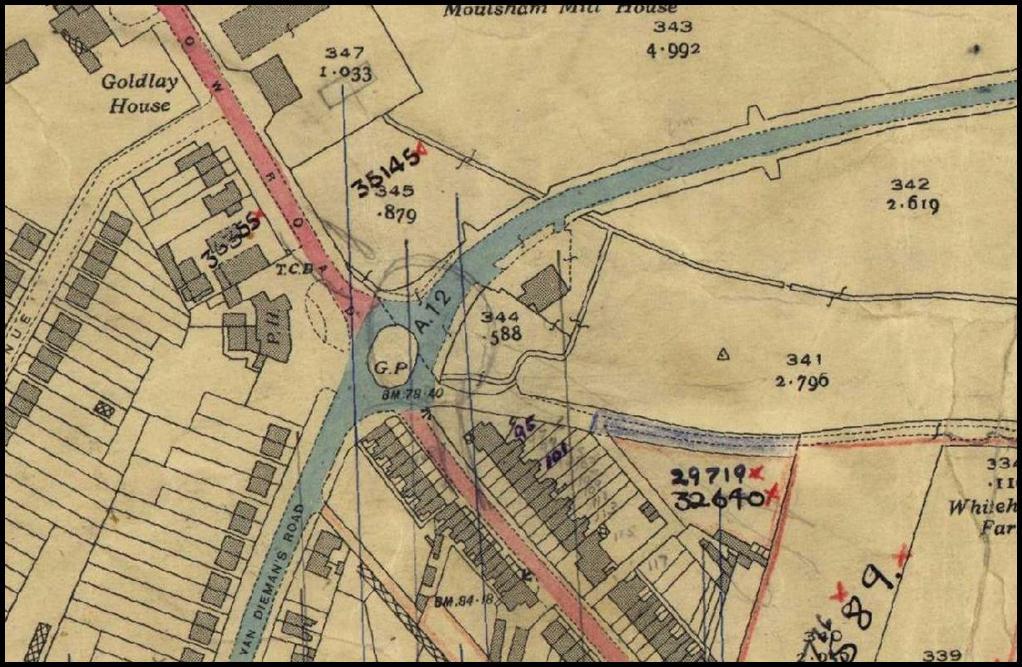
7 Overlaying map data

8 Composite of historic and modern OS
9 Marking the highway boundary on site We are often asked to interpret the map evidence on the ground and delimit highway boundaries on site, or assist the PROW officers in marking the routes of public footpaths etc. on site. We prepare plans at an appropriate scale in the office and use these as a basis for measuring on site. Fixed points such as buildings are used where possible, from which to take measurements, however in rural situations this is not always possible. The highway boundary or PROW is usually marked on the ground with wooden stakes or road marking paint and is often photographed to keep on record.
10 New Highways - Roads that did not exist in 1835 can be created at common law can be dedicated as highway by the owner of the subsoil and acceptance by the public or by statute. - Section 24 of the Highways Act 1980 gives the Highway Authority power to construct new highways, usually by means of a CPO (Compulsory Purchase Order). Once construction is completed, the road automatically becomes a highway. - Section 31 provides for the dedication of land as highway after a minimum period of 20 years unhindered use by the public. - Section 38 gives powers to the Highway Authority to adopt roads built by developers by agreement. - Section 205 enables the Highway Authority to pass a resolution for the making up of a road under the Private Streetworks Code. - Section 228 provides for the adoption of private streets by posting of notices.
11 New Highways cont Section 278 enable the Highway Authority to obtain financial contribution towards the cost of new highway works, new works within the existing highway limits or new lengths of road. Section 106 of the Town and Country Planning Act 1990 provides for the adoption of highways under a planning agreement.
12 Key Legal Points Once a highway, always a highway If it was a public highway on 1 st August 1835 or has been legally created since that date, it is a highway now. To stop being public highway, the rights of the public must be removed by legal order. Building a house or putting up a fence does not stop the highway being a highway. A highway is a way over which the public may lawfully pass and repass. It must be open to the public at large, the public use must be as of right, it must be for passage and the public right of passage must follow a defined route. Section 36 Highways Act 1980 says that a highway is a highway maintainable at the public expense if it existed prior to 31 August 1835 or it came into existence after that date. The Section 36 Register is a legal document maintained by ECC and published on the ECC website. It is updated monthly and re -issued in its entirety on 1 st April each year, as required by law.
13 Common misconceptions -It is very widely assumed that the Highway Authority is the owner of a highway. This is very rare and is usually only the case where land has been acquired for the construction of a bypass (for example) or land has been acquired to widen an existing highway. -If a party claims title to the subsoil of a piece of highway land, they cannot enclose it or build upon it. In law, highway rights are paramount over any claim to subsoil ownership. -Adverse possession does not apply to highway land, as in general the subsoil is not owned by the Highway Authority.
14 Ditches Ditches are usually not highway Unless the land was purchased for a scheme and highway was created. Ditches are there to prevent water drained from the surrounding land flooding the highway. The public s right to use the highway is the right to pass and repass. You cannot pass and repass a ditch without falling in so you can t establish highway rights.


15 Ditches Open Ditch Piped Ditch Infilled ditch The highway boundary is normally the roadside brow of a ditch, even where it has been infilled

16 Boundary Features Hedges Fences Walls Trees
17 Boundary Features -Hedges the boundary is usually the root of the hedge. Usually owned and maintained by the adjacent landowner. -Walls & Fences the position of a fence or wall is not proof of the extent of highway. Usually owned and maintained by the adjacent landowner. -Trees some trees are the responsibility of the highway authority. Most are not.
18 PROW research -Public rights of way are researched in exactly the same way as any other highways (i.e. roads). -We are often asked to research Definitive Map PROW to assist our colleagues in the PROW team. -Many PROW have historic widths, just like historic roads would and we use historic map evidence to determine the widths accordingly.
19 Example of the historic width of a Bridleway

20 Modern OS layered with historic map

21 Chapman and Andre 1777

22 Old Series Ordnance Survey Circa 1819
23 Further in- depth research Tithe Maps 1910 Finance Act Map Railway Records Sales particulars Inclosure awards Estate plans Historic photographs Aerial photography
24 The Future of the Highway Record We have recently acquired a huge volume of additional data from those districts who were former agents of ECC as Highway Authority. There is a long term project to integrate these records into the existing record and to have a fully catalogued database of all records held. The aim is to have a digital record which is available online for the public to view, however Essex is a large County and this is still some time away. The thousands of paper documents and legal agreements associated with the record would be scanned and held digitally in addition to the current hardcopies.
25 Questions
Cambridgeshire County Council Information Sheet on Lost Highways Research
 Cambridgeshire County Council Information Sheet on Lost Highways Research This information sheet is intended to assist parishes and individuals interested in investigating documentary evidence of historic
Development and. Public Rights of Way. Advice note for developers and development management officers
 Development and Public Rights of Way Advice note for developers and development management officers January 2010 Advice note for developers and development management officers Development and Public Rights
Your property and compulsory purchase
 Your property and compulsory purchase 2 Your property and Compulsory Purchase Content Highways England 4 Introduction 5 Compulsory purchase 6 Compensation for freeholders, leaseholders and tenants (compensatable
Local Highway Panels Members Guide. 13 Removing Highway Rights
 Local Highway Panels Members Guide 13 Removing Highway Rights 2 Local Highway Panels (LHP) Members Guide 2016/17 1. Introduction The definition of public highway is a way over which all members of the
PUBLIC RIGHTS OF WAY. Guidance for Planners and Developers
 PUBLIC RIGHTS OF WAY Guidance for Planners and Developers 1. Introduction Public rights of way (PROW) are significant highway assets, highly valued by local people. They are a material consideration in
An independent guide to property searches. Your guide to the facts
 An independent guide to property searches Your guide to the facts Contents What are property searches? 3 Examples of Register charges 4 Requisitioning a Search 5 CON29 search process 6 The different types
LAND EAST OF STILTON PETERBOROUGH
 LAND EAST OF STILTON PETERBOROUGH An opportunity to purchase two parcels of arable land, located close to the villages of Stilton and Yaxley and easy reach of the A1(M). In all 27.619 hectares (68.25 acres)
APPLICATION FOR A PUBLIC PATH DIVERSION ORDER FOR FOOTPATHS, BRIDLEWAYS & RESTRICTED BYWAYS HIGHWAYS ACT 1980 SECTION 119
 APPLICATION FOR A PUBLIC PATH DIVERSION ORDER FOR FOOTPATHS, BRIDLEWAYS & RESTRICTED BYWAYS HIGHWAYS ACT 1980 SECTION 119 TO: Essex Highways Definitive Map Service Seax House 2nd Floor Victoria Road South
LAND EAST OF STILTON PETERBOROUGH
 LAND EAST OF STILTON PETERBOROUGH An opportunity to purchase two adjoining parcels of arable land, located close to the village of Stilton and within easy reach of the A1(M). In all 30.174 hectares (74.56
Your property and compulsory purchase
 Your property and compulsory purchase Content Highways England 4 Introduction 5 Compulsory purchase 6 Compensation for freeholders, leaseholders and tenants (qualifying interests) 8 Compensation for people
LOT A. Range of modern and traditional farm buildings and acres of land Windsor Hill, Shepton Mallet FOR SALE BY AUCTION IN 8 LOTS
 LOT A Range of modern and traditional farm buildings and 148.95 acres of land Windsor Hill, Shepton Mallet FOR SALE BY AUCTION IN 8 LOTS An attractive range of modern and traditional farm buildings together
REGISTER OF LOCAL LAND CHARGES OFFICIAL CERTIFICATE OF SEARCH
 REGISTER OF LOCAL LAND CHARGES OFFICIAL CERTIFICATE OF SEARCH Search Reference: NLIS Reference: Solicitors Reference: Date: 1718_03381 CKB.JAG.EHLERS 07-Mar-2018 Applicant: Chennells 100804 Westcliff on
HS2 Phase Two - Land & Property - preparation of Hybrid Bill activities privacy notice
 HS2 Phase Two - Land & Property - preparation of Hybrid Bill activities privacy notice Your privacy There are rules about what personal information we can record, hold, use and share. You have rights over
REGISTER OF LOCAL LAND CHARGES OFFICIAL CERTIFICATE OF SEARCH
 REGISTER OF LOCAL LAND CHARGES OFFICIAL CERTIFICATE OF SEARCH Search Reference: NLIS Reference: Solicitors Reference: Date: 1718_02354 MDJ/GEN218 06-v-2017 Applicant: Lloyd Jones & Co DX 100802 WESTCLIFF
Quarter Section Township Range Meridian 4. Mailing Address Street and number City/town Province Postal code
 Property Access Approach Application (Page 1 of 3) Transportation and Agriculture Services Phone 780-417-7100 Fax 780-417-7109 Office: 370 Streambank Avenue, Sherwood Park, Alberta T8H 1N1 www.strathcona.ca
21.76ha (53.76 Acres) of Amenity and Grazing Land at Guardhouse, Threlkeld Keswick (Keswick 4 miles, Cockermouth 20 miles, Penrith 12 miles)
 of Amenity and Grazing Land at Guardhouse, Threlkeld Keswick (Keswick 4 miles, Cockermouth 20 miles, Penrith 12 miles)") Preliminary particulars of sale of: 21.76ha (53.76 Acres) of Amenity and Grazing Land at Guardhouse, Threlkeld Keswick (Keswick 4 miles, Cockermouth 20 miles, Penrith 12 miles) For sale by Public Auction
Preliminary particulars of sale of: 21.76ha (53.76 Acres) of Amenity and Grazing Land at Guardhouse, Threlkeld Keswick (Keswick 4 miles, Cockermouth 20 miles, Penrith 12 miles) For sale by Public Auction
Mike Gray Managing Director. Dedman Gray Land & Property Auctions have been the leading Essex Land & Property Auctioneers for over 30 years.
 Dedman Gray Land & Property Auctions have been the leading Essex Land & Property Auctioneers for over 30 years. Mike Gray Managing Director Our team of Auction consultants can offer our clients the best
LTN 82 COMPULSORY PURCHASE ORDERS
 JANUARY 2018 LTN 82 COMPULSORY PURCHASE ORDERS INTRODUCTION 1. The purpose of this Legal Topic Note is to explain the circumstances in which a parish council or, in Wales, a community council (local council)
Your property and compulsory purchase
 Safe roads, reliable journeys, informed travellers Your property and compulsory purchase An executive agency of the Department for Transport Your property and compulsory purchase 1. Introduction The Highways
BARN FOR CONVERSION TO DWELLING WITH 4.19 ACRES. Comprising THE WAGGON BARN STOCKLAND BRISTOL BRIDGWATER, SOMERSET. Price Guide 130, ,000
 Residential Sales & Lettings Chartered Surveyors Valuers & Auctioneers Commercial Sales & Lettings Drawing Planning Design Land Agents Antique & Fine Art Auctioneers For Sale Tamlyns Established 1878 BARN
BOUNDARIES & SQUATTER S RIGHTS
 BOUNDARIES & SQUATTER S RIGHTS Odd Results? The general boundary rule can have results that seem odd - for example the Land Registry s Practice Guides make it clear that they may regard you as owning land
Your property and blight
 Your property and blight Content Highways England 4 Introduction 5 Blight explained 6 When a blight notice can be submitted 8 Applicant eligibility 8 Reasonable efforts to sell the property 10 Requesting
HOBBS LOT FARM WISBECH ROAD MARCH CAMBRIDGESHIRE PE15 0BB
 WITH VACANT POSSESSION Issued by our March Office SAP/JW/1481 HOBBS LOT FARM WISBECH ROAD MARCH CAMBRIDGESHIRE PE15 0BB o O o - Particulars of A FENLAND FARM extending in total to 43.00 hectares (106.25
CLIENT GUIDE TO CONVEYANCING MATTERS
 CLIENT GUIDE TO CONVEYANCING MATTERS 1. INTRODUCTION This guide explains some of the terms used in conveyancing, the steps which are usually taken (and the reasons for them), and the factors which dictate
London Borough of Lambeth Room 205, Town Hall Brixton Hill, London SW2 1RW
 ,, REGISTER OF LOCAL LAND CHARGES - OFFICIAL CERTIFICATE OF SEARCH TM Search Group - For Invoicing 743360 Swindon 31 200 Delta Delta Business Park Wiltshire Swindon SN5 7XD Search Reference: 16/01327 Applicant
REPLIES TO STANDARD ENQUIRIES OF LOCAL AUTHORITY (2016 Edition)
") REPLIES TO STANDARD ENQUIRIES OF LOCAL AUTHORITY (2016 Edition) Applicant: Searchflow Limited 42, Kings Hill Avenue West Malling Kent ME19 4AJ Search Reference: 1819_00323 NLIS Reference: Solicitors Reference:
REPLIES TO STANDARD ENQUIRIES OF LOCAL AUTHORITY (2016 Edition) Applicant: Searchflow Limited 42, Kings Hill Avenue West Malling Kent ME19 4AJ Search Reference: 1819_00323 NLIS Reference: Solicitors Reference:
Guidance on Public Rights of Way Affected by Coastal and Estuarine Change or Management
 Guidance on Public Rights of Way Affected by Coastal and Estuarine Change or Management The purpose of this guidance: To ensure public rights of way issues are properly addressed in any coastal (including
WREXHAM COUNTY BOROUGH COUNCIL SEARCH FEE RECEIPT
 WREXHAM COUNTY BOROUGH COUNCIL SEARCH FEE RECEIPT RE: LAND CHARGES SEARCH LC/1617/01795 14 HAVARD WAY WREXHAM LL13 9LR This acknowledges receipt of payment for the sum of 85 received on 24/02/2017 being
PLEASE COMPLETE ALL SECTIONS USING BLOCK CAPITALS AND BLACK INK
 Application for adoption of new sewers Section 104 WIA t a~united ~ ~ Utilities ~~tng life f\ow smoothly This form should be used to offer proposed drainage systems for adoption by United Utilities under
FOR SALE (AS A WHOLE OR IN TWO LOTS)
") RURAL DEPARTMENT The Granary, Hyde Farm Marlow Road Pinkneys Green Berks Tel: 01628 777666 rural@pikesmithkemp.co.uk MAIDENHEAD 22 Queen Street, Berks SL6 1HZ Tel: 01628 621177 maidenhead@pikesmithkemp.co.uk
RURAL DEPARTMENT The Granary, Hyde Farm Marlow Road Pinkneys Green Berks Tel: 01628 777666 rural@pikesmithkemp.co.uk MAIDENHEAD 22 Queen Street, Berks SL6 1HZ Tel: 01628 621177 maidenhead@pikesmithkemp.co.uk
LAND AT GREAT CLERKES FARM LITTLE SAMPFORD, THAXTED, ESSEX
 LAND AT GREAT CLERKES FARM LITTLE SAMPFORD, THAXTED, ESSEX An opportunity to purchase a block of attractive arable land in a sought-after part of North Essex In all about 72.205 hectares (178.42 acres)
1. *Does the document clearly specify the aims, objectives and scope of the proposed programme of archaeological work?
 Notes and Guidance This document provides curatorial advisors, archaeological practitioners and other interested parties with additional information and guidance on the standards and expectations for archaeological
Highway Asset Records Schedule of Charges and Access to Information under the Environmental Information Regulations 2004
 Highway Asset Records 2017-18 Schedule of Charges and Access to Information under the Environmental Information Regulations 2004 Notes for customers 1. This Schedule of Charges details how customers can
LAND AT CARTMEL, GRANGE OVER SANDS, CUMBRIA
 LAND AT CARTMEL, GRANGE OVER SANDS, CUMBRIA Comprising 2.376 hectares (5.87 acres) of productive grassland in the Cartmel Valley together with a Stone Barn and 7 former stables with roadside access. FOR
State Highway Revocation: Policy and Guidance
 State Highway Revocation: Policy and Guidance Revocation and consultation 1. Where there are changes to the state highway network that create duplicate sections of State highway serving the same function
Groundsure HS2 and Crossrail
 Groundsure HS2 and Crossrail Address: Specimen Address Date: Report Date Groundsure Reference: HS2 & Crossrail Specimen Your Reference: HS2 & Crossrail Specimen Grid Reference:123456,123456 HS2*: The property
The System of Land Registration and Third Party Rights
 Chapter 2: The System of Land Registration and Third Party Rights Outline 2.1 Introduction 2.2 Registration under the Land Registration Acts 1925 1997 2.3 Registration under the Land Registration Act 2002
The Right to Acquire. Contents. Contents Making an informed decision Can you buy your home? How to buy your home 7. 4.
 The Right to Acquire Contents Contents 1 1. Making an informed decision 3 2. Can you buy your home? 7 3. How to buy your home 7 4. Discount 9 5. Repairs 10 6. Problems with the buying procedure 10 7. Who
To: Andrew Clark Your Ref: Our Ref: From: Louise Staples & Hannah Burden Date: 14 June 2010 Location: NFU HQ, Stoneleigh
 Page 1 To: Andrew Clark Your Ref: Our Ref: From: Louise Staples & Hannah Burden Date: 14 June 2010 Location: NFU HQ, Stoneleigh Compensation Procedure for Compulsory Purchase How is compensation assessed
MANUSCRIPT MAPS IN DERBYSHIRE RECORD OFFICE
 MANUSCRIPT MAPS IN DERBYSHIRE RECORD OFFICE 1600-2000 Introduction Before the end of the reign of Queen Elizabeth I in 1603, maps of any kind were rare. In the four hundred years since then, maps of all
SOUTH TIPPERARY COUNTY COUNCIL
 SOUTH TIPPERARY COUNTY COUNCIL POLICY FOR THE TAKING IN CHARGE OF RESIDENTIAL DEVELOPMENTS 1 POLICY POLICY This document outlines South Tipperary County Council s policy and procedure in relation to taking
Your property and land surveys
 Your property and land surveys 2 Content Highways England 4 Introduction 5 Surveys and compensation 6 Typical compensation levels 6 Compensation for boreholes and trial pits 8 Rent for measuring apparatus
You can complete and submit this form electronically via the Planning Portal by visiting
 holder Application for Planning Permission for works or extension to a dwelling and listed building consent. Town and Country Planning Act 1990 Planning (Listed Buildings and Conservation Areas) Act 1990
(UNECE) John Manthorpel
 John Manthorpel") Lanc Registration and Land Valuation in the United Kingdom and in the countries of the United Nations Economic Commission for Europe (UNECE) John Manthorpel Introduction This paper is in two parts and
Lanc Registration and Land Valuation in the United Kingdom and in the countries of the United Nations Economic Commission for Europe (UNECE) John Manthorpel Introduction This paper is in two parts and
Registration of Easements in the Property Registration Authority
 Registration of Easements in the Property Registration Authority Thursday, 11 April 2019 Marcus Kennedy, Senior Associate Mason Hayes & Curran Dublin Dublin London London New New York York San San Franscisco
Property Information Form
 Property Information Form Address of the property Full names of the seller Seller's solicitor Name of solicitors firm Address Email Reference number About this form Definitions This form is completed by
PATTERDALE FARM BLACKBIRD LANE BERKSHIRE SL6 3SX
 PATTERDALE FARM BLACKBIRD LANE BERKSHIRE SL6 3SX PATTERDALE FARM BLACKBIRD LANE, MAIDENHEAD, BERKSHIRE, SL6 3SX WINDSOR - 4.6 MILES MAIDENHEAD - 4.2 MILES MARLOW - 7.1 MILES HENLEY - 8.5 MILES READING
CON 29 GUIDANCE NOTES
 CON 29 GUIDANCE NOTES Introduction 1. These notes are issued by the Law Society in consultation with Land Data, the Local Land Charges Institute and the Local Government Association, to provide guidance
The smarter way to buy or sell property.
 The smarter way to buy or sell property www.smartestateagent.co.uk smart /sma:t/ adjective 1. astute, as in business; clever or bright Are you ready to get Smart? The internet is changing the way we do
THE CORPORATION OF THE TOWNSHIP OF NORTH FRONTENAC BY-LAW #123-13
 THE CORPORATION OF THE TOWNSHIP OF NORTH FRONTENAC BY-LAW #123-13 Being a By-law to Adopt an Assumption of Unmaintained Municipal Roads and Private Lanes Policy and Minimum Road Construction Standards
DEVELOPMENT OPPORTUNITY LAND EAST OF NEW ROAD MELBOURN, CAMBRIDGESHIRE, SG8 6BX
 DEVELOPMENT OPPORTUNITY LAND EAST OF NEW ROAD MELBOURN, CAMBRIDGESHIRE, SG8 6BX Illustrative Masterplan - Not to Scale An excellent opportunity to acquire a development site benefitting from outline planning
Waterford City and County Council Vacant Homes Action Plan 2017
 Waterford City and County Council Vacant Homes Action Plan 2017 1. Introduction The high demand for residential properties on the property market, slow rate of new build and deepening housing crisis across
Lodger and sub-letting policy
 Lodger and sub-letting policy Date: Author: 1 st July 2015 Sue Wilson for you for your community not for profit TWO RIVERS HOUSING Lodger and Sub-letting Policy 1.0 Introduction 1.1 Two Rivers Housing
HELP TO BUY - SHARED OWNERSHIP
 HELP TO BUY - SHARED OWNERSHIP A GUIDE FOR APPLICANTS 1 January 2017 CONTENTS Section 1 General Information Section 2 About Help to Buy Shared Ownership 1 What Is Help to Buy- Shared Ownership 2 How Does
POLICY & PROCEDURE FOR THE TAKING IN CHARGE OF RESIDENTIAL DEVELOPMENTS
 POLICY & PROCEDURE FOR THE TAKING IN CHARGE OF RESIDENTIAL DEVELOPMENTS TABLE OF CONTENTS 1 POLICY OBJECTIVE...1 2 POLICY OVERVIEW... 2 2.1 Legislative framework... 2 2.2 Policy Statement... 2 2.3 Policy
REGISTER OF LOCAL LAND CHARGES OFFICIAL CERTIFICATE OF SEARCH
 REGISTER OF LOCAL LAND CHARGES OFFICIAL CERTIFICATE OF SEARCH Search Reference: NLIS Reference: Solicitors Reference: Date: 1718_01775 KJR/3G112/28 07-Sep-2017 Applicant: Pulham & Co DX 42002 SAXMUNDHAM
AFFORDABLE HOME OWNERSHIP ALLOCATION POLICY
 AFFORDABLE HOME OWNERSHIP ALLOCATION POLICY INTRODUCTION This document sets out Grand Union Housing Group s (GUHG) Affordable Home Ownership Policy, with the main focus being on Shared Ownership. Shared
Highways Practice Note 029 Highways Act Section 72 Guidance March HPN Control Sheet
 Highways Practice Note 029 Highways Act 1980 - Section 72 Guidance March 2015 HPN Control Sheet HPN Control Sheet HPN prepared by: Shanthi Selvarajan Development Management Engineer Highways SMO3, Unit
Guide to Private Water Schemes
 Guide to Private Water Schemes This guide provides a summary of the background to private water schemes (syndicates), options for legal structures, types of schemes, and an overview about establishing
Loddington Coppice Farm Old, Northampton NN6 9RS
 Loddington Coppice Farm Old, Northampton NN6 9RS Loddington Coppice Farm Old, Northamptonshire NN6 9RS Kettering 6 miles, Market Harborough 9 miles, Northampton 14 miles, Junction 3 A14 4 miles (Distances
ARABLE LAND TO LET IN 2 LOTS. Available for Three Growing Seasons
 DRAFT On behalf of Heineken UK Limited (H.P. Bulmer) ARABLE LAND TO LET IN 2 LOTS Available for Three Growing Seasons Approximately 83.56 acres (33.82 hectares) of land situated at Woodhouse Farm, Wichenford,
Papers The Digital Economy Act : What surveyors need to know about changes to the law on telecommunications equipment
 Journal of Building Survey, Appraisal & Valuation Volume 6 Number 3 Papers The Digital Economy Act : What surveyors need to know about changes to the law on telecommunications equipment Michael Watson
FORNETY FARM WOOD By Newburgh, Aberdeenshire Hectares/ Acres
 FORNETY FARM WOOD By Newburgh, Aberdeenshire 66.36 Hectares/163.97 Acres John Clegg & Co CHARTERED SURVEYORS & FORESTRY AGENTS FORNETY FARM WOOD Newburgh 1 mile Ellon 4 miles Aberdeen 14 miles Edinburgh
Application for Consent Under the Planning Act, R.S.O c. P.13, as amended
 File No: Date of Receipt: Town Fee ($): Regional Fee ($): NPCA Fee ($): Other Fee ($): (Office Use Only) Department of Community & Development Services 1593 Four Mile Creek Road P.O. Box 100, Virgil, ON
FOR SALE FREEHOLD (MAY LET) WITH VACANT POSSESSION
 WITH VACANT POSSESSION") BY DIRECTION OF THE OWNER BLACKTHORN PROPERTIES LIMITED R26788 FOR SALE FREEHOLD (MAY LET) WITH VACANT POSSESSION WELL POSITIONED DETACHED FACTORY OR STORAGE PREMISES WITH GENEROUS PARKING AND AMENITY
BY DIRECTION OF THE OWNER BLACKTHORN PROPERTIES LIMITED R26788 FOR SALE FREEHOLD (MAY LET) WITH VACANT POSSESSION WELL POSITIONED DETACHED FACTORY OR STORAGE PREMISES WITH GENEROUS PARKING AND AMENITY
VALUATION REPORT IN RESPECT OF GATWICK PHASE TWO BONNETTS LANE IFIELD RH11 0HY
 VALUATION REPORT IN RESPECT OF GATWICK PHASE TWO BONNETTS LANE IFIELD RH11 0HY Prepared by: AJP Surveyors Ltd Piccadilly House 49 Piccadilly Manchester M1 2AP on 12 October 2015 Page 2 of 6 PREMISES TO
P R O P E R T Y S H A R I N G A G R E E M E N T
 P R O P E R T Y S H A R I N G A G R E E M E N T between «Investor» and «First_person» «and» «Second_person» Property at: «Street_address» Property Sharing Agreement Date: Parties 1. «Investor» ( us or
Boundary Disputes. Geomatics Client Guides. A clear impartial guide to... Check. They re Chartered.
 Check. They re Chartered. Geomatics Client Guides A clear impartial guide to... Boundary Disputes Property Registration Boundary Dispute Resolution Boundary Identification and Demarcation A clear, impartial
LAND OFF VILLAGE ROAD
 LAND OFF VILLAGE ROAD West Kirby Wirral CH48 3JN Offers invited FREEHOLD LAND OFF VILLAGE ROAD EXTENDS TO 0068 ACRES AND IS BEING OFFERED FOR THE FREEHOLD SALE AN IDEAL OPPORTUNITY TO ACQUIRE A PRIME SITE
Looking After Your Move
 Looking After Your Move Your Guide to Buying and Selling Your Home Tel: 0114 218 4000 E. info@tayloremmet.co.uk www.tayloremmet.co.uk Contents Your move.. 3 Important Dates.. 3 Up to Exchange of Contracts..
Adoption of a new sewer
 Adoption of a new sewer Application form You can go to our website thameswater.co.uk/buildover and apply online or complete this form and return to Thames Water, Developer Services, Clearwater Court, Vastern
Tenant s Scrutiny Panel and Designated Persons and Tenant s Complaints Panel
 Meeting: Social Care, Health and Housing Overview and Scrutiny Committee Date: 21 January 2013 Subject: Report of: Summary: Tenant s Scrutiny Panel and Designated Persons and Tenant s Complaints Panel
Specimen. Property Purchase Information. Sample. UK Land Registry Services. Contents:
 www.landsearch.net www.landsearch.net England and Wales Contents: Sample Property Purchase Information Title Register List of Pending Registrations (if there are any) Title Plan Deeds (page 5 of a Conveyance
PRE-CONTRACT QUESTIONNAIRE FOR PROPERTY SALE
 PRE-CONTRACT QUESTIONNAIRE FOR PROPERTY SALE FULL ADDRESS OF PROPERTY BEING SOLD (INCLUDING EIRCODE) Address line 1 Address line 2 Town / City County Eircode PROPERTY OWNER(S) MAIN CONTACT DETAILS Name
Woodground Farm, Stock Green, Redditch, Worcestershire, B96 6TA
 Woodground Farm, Stock Green, Redditch, Worcestershire, B96 6TA 01562 820880 WOODGROUND FARM STOCK GREEN, REDDITCH, WORCESTERSHIRE, B96 6TA Droitwich 7 miles Worcester 12 miles - Birmingham 24 miles (All
LONSDALE FARM, FRIZINGTON, CUMBRIA
 Preliminary particulars of sale of: LONSDALE FARM, FRIZINGTON, CUMBRIA An opportunity to acquire a 140 acre holding with quality agricultural land suitable for mowing and grazing, farm buildings, allotments
Arable Land at Gaddesden Lane, Near Redbourn, Hemel Hempstead
 Arable Land at Gaddesden Lane, Near Redbourn, Hemel Hempstead Arable Land at Gaddesden Lane, near Redbourn, Hertfordshire An opportunity to purchase approximately 27.86 acres of arable land with road frontage
Hickory Ridge Residence & Farm An residential, agricultural, and recreational investment opportunity.
 offered for sale Hickory Ridge Residence & Farm An residential, agricultural, and recreational investment opportunity. 2,620 (+/-) square foot dwelling situated on 65 (+/-) acres of farmland Hickory Ridge,
SOLD WOODS 4 SALE. Crackle Wood
 WOODS 4 SALE Phone: 01248 364 362 www.woods4sale.co.uk UK Woodland & Woods For Sale: Specialising in the Sales of Small Woodlands in England, Scotland and Wales for Recreation, Wildlife Conservation and
LIST 1 (Persons whose lands or interests would benefit by the proposed work, and who have joined in this application)
") APPLICATION FORM NO. APPLICATION FORM FOR LOCAL IMPROVEMENTS SCHEME (LIS) We the undersigned, each being the occupier of a property in the townland(s) referred to at (1) overleaf, hereby apply to Longford
APPLICATION FORM NO. APPLICATION FORM FOR LOCAL IMPROVEMENTS SCHEME (LIS) We the undersigned, each being the occupier of a property in the townland(s) referred to at (1) overleaf, hereby apply to Longford
DOWNFIELD STABLES WALTHAM ST LAWRENCE BERKSHIRE RG10 0HU
 DOWNFIELD STABLES WALTHAM ST LAWRENCE BERKSHIRE RG10 0HU Computer Generated Image DOWNFIELD STABLES DOWNFIELD ROAD, WALTHAM ST LAWRENCE, READING, BERKSHIRE, RG10 0HU MAIDENHEAD - 5.8 MILES WINDSOR - 9.5
LETTER TO COMPANY - DRAFT CITY OF LONDON LAW SOCIETY LAND LAW COMMITTEE CERTIFICATE OF TITLE (7 TH EDITION 2016 UPDATE)
") LETTER TO COMPANY - DRAFT CITY OF LONDON LAW SOCIETY LAND LAW COMMITTEE CERTIFICATE OF TITLE (7 TH EDITION 2016 UPDATE) This is the first of two letters which may be sent by the solicitors giving the Certificate
LETTER TO COMPANY - DRAFT CITY OF LONDON LAW SOCIETY LAND LAW COMMITTEE CERTIFICATE OF TITLE (7 TH EDITION 2016 UPDATE) This is the first of two letters which may be sent by the solicitors giving the Certificate
( RICS. A clear, impartial guide to. Boundary disputes. rics.org/consumerguides
 ( RICS A clear, impartial guide to Boundary disputes rics.org/consumerguides Contents Moving in...3 Living with your boundaries...4 Changes to your boundaries...4 Dealing with disputes...5 Free RICS guides...6
Empty Properties Enforcement Protocol
 Empty Properties Enforcement Protocol 1. Introduction 1.1 Ealing Council will take every step it can to assist owners of empty properties in bringing the accommodation back into use. The details of this
Parkland, The Lee, Great Missenden, Buckinghamshire
 Parkland, The Lee, Great Missenden, Buckinghamshire Parkland The Lee Great Missenden Buckinghamshire An opportunity to acquire two blocks of parkland lying in an elevated position within the Chilterns
Tozers guide to selling your home
 Call 01392 207020 enquiries@tozers.co.uk www.tozers.co.uk Tozers guide to selling your home Moving home can be a stressful experience so it pays to get the right advice. As one of the oldest and largest
The COMPLETE GUIDE To Privately Selling Or Renting Your Own Property
 The COMPLETE GUIDE To Privately Selling Or Renting Your Own Property Preparing Your Property for Sale or Rent By preparing your property correctly for your target market, you will be assured that you have
THE HERMITAGE WOODLANDS Dursley, Gloucestershire Hectares / Acres
 Suite 8, Rectory House Thame Road, Haddenham Buckinghamshire HP17 8DA Tel: 01844 291384 Email: woods@johnclegg.co.uk John Clegg & Co CHARTERED SURVEYORS & FORESTRY AGENTS THE HERMITAGE WOODLANDS Dursley,
Voluntary Right to Buy and Portability Policy
 Voluntary Right to Buy and Portability Policy 1. Policy statement Policy for customers who wish to purchase the home they rent from Bromford under the Voluntary Right to Buy scheme 2. Contents: Introduction
REPLIES TO DEVELOPMENT LAND ENQUIRIES. 1.1 When the sellers purchased the property they were told:-
 REPLIES TO DEVELOPMENT LAND ENQUIRIES Property: 76 Higher Drive, Purley, Surrey, CR8 2HG Date: 25 th August 2017 1. Boundaries 1.1 When the sellers purchased the property they were told:- Left Shared maintenance
If you re on the fence about buying your first investment, let us share advice on what to look for and what to avoid.
 FIRST INVESTMENT If you re on the fence about buying your first investment, let us share advice on what to look for and what to avoid. When you purchase an investment property in a resort under management
Please note that this is the only official copy we will issue. We will not issue a paper official copy.
 The electronic official copy of the register follows this message. Please note that this is the only official copy we will issue. We will not issue a paper official copy. Edition date 07.11.2017 This official
Application to purchase land or rights over land owned by Optivo
 Application to purchase land or rights over land owned by Optivo Name Address Contact telephone number Email address... Are you tenant / owner occupier. Location of land in question.. Purpose the land
APPLICATION FOR SUBDIVISION APPROVAL OF A SKETCH PLAN with checklist
 Prior to filing any application for SUBDIVISION approval, the applicant shall request in writing that the zoning administrator schedule a pre-submission conference. APPLICATION TO THE PLANNING BOARD TOWN
APPLICATION FOR CONSENT TO SEVER LAND UNDER SECTION 53 OF THE PLANNING ACT
 APPLICATION FOR CONSENT TO SEVER LAND UNDER SECTION 53 OF THE PLANNING ACT The Cochrane and Suburban Planning Board 23 5th Street Cochrane, Ontario P0L 1C0 Phone (705 272-4262 Fax (705 272-4507 APPLICATION
Title: ENCROACHMENT POLICY Number: 0132 Reference: Administrative Committee January 21, Adopted by City Council: February 2, 2009
 POLICY Title: ENCROACHMENT POLICY Number: 0132 Reference: Administrative Committee January 21, 2009 February 2, 2009 Supersedes: May 2, 2005 Prepared by: PLANNING, BUILDING AND DEVELOPMENT SERVICES STATEMENT
SANILAC COUNTY ROAD COMMISSION ROAD POLICIES. A. Drainage, Base and Grade Construction (NON BITUMINOUS)
") I. LOCAL ROADS SANILAC COUNTY ROAD COMMISSION A. Drainage, Base and Grade Construction (NON BITUMINOUS) 1. Cost Sharing: Sanilac County Road Commission Share 17% Township Share 83% 2. A Notice of Construction
I. LOCAL ROADS SANILAC COUNTY ROAD COMMISSION A. Drainage, Base and Grade Construction (NON BITUMINOUS) 1. Cost Sharing: Sanilac County Road Commission Share 17% Township Share 83% 2. A Notice of Construction
tenancy agreements What to look for in a tenancy agreement ueastudent.com/advice
 tenancy agreements What to look for in a tenancy agreement. 1 What do I have to sign to rent a house? When you sign up for a rented house, you will have to sign a tenancy agreement. A tenancy agreement
we apply for the necessary searches you make your mortgage application (if applicable)
") NOTES FOR BUYERS These notes contain important information about buying a property, and we ask you to read through them carefully. They form an integral part of our conveyancing service, and we hope that
NOTES FOR BUYERS These notes contain important information about buying a property, and we ask you to read through them carefully. They form an integral part of our conveyancing service, and we hope that
Promoter s Introduction to Land Compensation. Colin Smith FRICS
 Promoter s Introduction to Land Compensation Colin Smith FRICS Contents Land Acquisition Policy Statutory Compensation The Compensation Code Generalised Blight the HS2 discretionary property package 2