TO: Chair and Directors File No.: REZ 6005/SW ¼
|
|
|
- Reynard Oswin Stewart
- 5 years ago
- Views:
Transcription

1 TMc GM: Main Office: 155 George Street, Prince George, BC V2L 1P8 Telephone: (250) / Fax: (250) Toll Free: / REPORT FOR CONSIDERATION TO: Chair and Directors File No.: REZ 6005/SW ¼ FROM: Kenna Jonkman, MCIP, RPP, Planner III DATE: July 8, 2015 SUBJECT SUMMARY: PREVIOUS REPORTS: Item: Zoning Bylaw No. 2892, Amendment Bylaw No. 2949, 2015 Purpose: Consider First and Second Readings and Authorize a Public Hearing Location: Tete Jaune Electoral Area H Owner: Province of British Columbia Applicant: Regional District of Fraser-Fort George None ATTACHMENT(S): 1. Backgrounder 2. Availability and Sustainability of Crown Land Information received May 19, Engineering Report dated June 8, 2012 from Highland Timberworks Inc. 4. Bylaw No. 2949, 2015 RECOMMENDATION(S): ENTITLEMENT HOW VOTE COUNTED 1. THAT the report, availability and suitability of crown land information submitted on May 19, 2015 and engineering report dated June 8, 2012 from Highland Timberworks Inc. be received. All 1 Director/1 vote Majority 2. THAT Zoning Bylaw No. 2892, Amendment Bylaw No. 2949, 2015 be now introduced and read a first time. All 1 Director/1 vote Majority 3. THAT Bylaw No be given second reading. All 1 Director/1 vote 4. THAT a public hearing on Bylaw No be held with the chairing of the hearing All delegated to Director Alan, or her Alternate, or any other Director as a delegate of the 1 Director/1 vote Board. Majority Majority ISSUE(S): An application has been made to amend Zoning Bylaw No to allow a cemetery use on the subject parcel. The Board is being asked to consider: first reading of Zoning Bylaw No. 2892, Amendment Bylaw No. 2949, 2015 second reading of Zoning Bylaw No. 2892, Amendment Bylaw No. 2949, 2015 authorization of a public hearing for Zoning Bylaw No. 2892, Amendment Bylaw No. 2949, 2015 RELEVANT POLICIES: 1. Robson Valley-Canoe Upstream Official Community Plan Bylaw No. 1589: designates the subject area as Public Development/Institutional (PD/I)) PD/I designation supports the development of community related uses that are non-commercial in nature An OCP amendment is not required to allow the establishment of a cemetery use 2. Zoning Bylaw No. 2892: designates the subject area as Rural 5 (Ru5) Ru5 does not permit the establishment of a cemetery a Zoning Amendment is required to allow the establishment of the proposed cemetery use
2 Report to Regional Board Page 2 3. Local Government Act: details requirements for zoning bylaw amendments, including public hearings requires a notice of public hearing to be placed in two consecutive issues of a newspaper not less than 3 and not more than 10 days before the public hearing 4. Development Applications Procedures Bylaw No notice of a public hearing is to be sent to owners of land within 200 metres of the subject property notice of public hearing is to be sent to tenants of all parcels that are immediately adjacent to the subject property details requirements for a Notification of Application Sign, alternative form of notification or waiving of notification requirements prior to a public hearing delegates approval of notification requirements to the General Manager of Development Services SERVICE RELEVANCE: Regional District Land Use Services is a region wide service and fulfils the obligations of land use planning under Part 26 of the Local Government Act. FINANCIAL CONSIDERATION(S): N/A OTHER CONSIDERATION(S): N/A DECISION OPTIONS: 1. Approve recommendations. Bylaw No will proceed to public hearing Other Options: a. defeat Bylaw No at first reading if defeated, the bylaw may not be considered further cemetery use will not be permitted on the subject parcel b. approve only first reading of Bylaw No if it is considered that additional information is required bylaw may be amended after first reading at second reading, prior to a public hearing COMMENTS: The applicant has submitted an application to rezone a portion of the subject parcel to establish a cemetery use in the Tete Jaune community. Proposed Bylaw No would amend the zoning on the 1.36 ha area of the parcel from Rural 5 (Ru5) to Public Development 1 (P1). Should the zoning amendment be successful the applicant plans to proceed with subdividing the 1.36 ha portion of parcel from the remainder lot and purchasing it from the Crown. Community Services of the Regional District has been working with a Steering Committee and with the Ministry of Forests, Lands and Natural Resource Operations since 2005 to find a suitable piece of land for the proposed cemetery use. The area of land subject to this application was selected due to the reduced impact of the use on neighbouring parcel owners, lower development costs and the area having soils suitable for a cemetery use. In November 2012, the Regional District held a referendum in Tete Jaune and area property owners voted in favour of establishing a cemetery service within the Tete Jaune community. Currently the Regional District holds a Crown grant offer for the 1.36 hectare area proposed for the cemetery use. G:\SERVCTR\Board Reports\Agenda Reports for Finalizing\Planning Reports Only\KJ - Zoning BL 2892 Amend BL RDFFG - tete jaune.docx
3 Report to Regional Board Page 3 In 2014, the applicant applied to the Agricultural Land Commission to exclude the subject area from the Agricultural Land Reserve. The Commission approved the exclusion request in April, The Robson Valley-Canoe Upstream Official Community Plan identifies the subject parcel as an area where public/ institutional activities are supported. In addition, the Other Public Services policy within the OCP identifies that the Regional Board will continue to assist rural residents in assessing the feasibility of providing public services and utilities on a local service area basis in accordance with the Local Government Act. Should the proposed zoning bylaw amendment proceed to public hearing, the public will have the opportunity to comment on the proposal. Respectfully submitted, Kenna Jonkman, MCIP, RPP Planner III KJ:jw G:\SERVCTR\Board Reports\Agenda Reports for Finalizing\Planning Reports Only\KJ - Zoning BL 2892 Amend BL RDFFG - tete jaune.docx
 Legal Description: Part of the South West ¼ of District Lot 6005, within Cariboo District 9.6 ha (23.")

4 Report to Regional Board Page 4 BACKGROUNDER Owner: Province of British Columbia Applicant: Regional District of Fraser-Fort George License of Occupation # Location: Carr Road Tete Jaune (Area H ) Legal Description: Part of the South West ¼ of District Lot 6005, within Cariboo District 9.6 ha (23.8 acres) Existing and Surrounding Land Use: The subject parcel is undeveloped crown land. North - Private land East - Private land South - Private land West - Carr Road/ Private land G:\SERVCTR\Board Reports\Agenda Reports for Finalizing\Planning Reports Only\KJ - Zoning BL 2892 Amend BL RDFFG - tete jaune.docx

5 Report to Regional Board Page 5 Proposal: The applicant has applied to rezone a 1.36 ha (3.4 acres) portion of the 9.6 ha (23.8 acres) subject parcel to allow the establishment of a cemetery. The applicant would also like to subdivide the 1.36 ha portion from the parent parcel. Currently, the Regional District holds a License of Occupation for the property, issued by the Province of BC, for recreational purposes. In November 2012, the Regional District held a referendum in Tete Jaune and area property owners voted in favor of establishing a cemetery service on the subject parcel. Subsequently, the Regional District of Fraser-Fort George has received a Crown grant offer for a 1.36 ha portion of the 9.6 ha subject parcel to establish this use. The applicant has provided the following information to be considered with their application: Site photos Proposed development plan with layout map Availability and Suitability of Crown Land letter Engineering site assessment of the subject parcel Agricultural Land Reserve: Official Community Plan: In April 2015, the 1.36 ha portion of the subject parcel, proposed to be used for cemetery purposes, was excluded from the Agricultural Land Reserve. The subject parcel is designated Public Development/ Institutional (PD/I) by the Robson Valley-Canoe Upstream Official Community Plan (OCP). This designation identifies lands both privately owned and Crown Land suitable for a range of public, government and community related uses that are non-commercial in nature. A cemetery is considered a use supported by the Public Development/Institutional designation. There is also no prescribed minimum parcel area for the Public Development/ Institutional (PD/I) designation. An amendment to the OCP will not be required to establish the proposed cemetery use. In addition, the Other Public Services policy within the OCP identifies that the Regional Board will continue to assist rural residents in assessing the feasibility of providing public services and utilities on a local service area basis in accordance with the Local Government Act. G:\SERVCTR\Board Reports\Agenda Reports for Finalizing\Planning Reports Only\KJ - Zoning BL 2892 Amend BL RDFFG - tete jaune.docx
.")
6 Report to Regional Board Page 6 Zoning: Current Zoning: Pursuant to Zoning Bylaw No. 2892, the subject parcel is zoned Rural 5 (Ru5). The establishment of a cemetery is not permitted within this zone. An amendment to the Zoning Bylaw is be required to allow a cemetery use. Proposed Zoning: It is proposed to rezone the 1.36 ha portion of the parcel to Public Development 1 (P1). The permitted uses within this zone include: (a) Agriculture; (b) Cemetery; (c) Community Hall; (d) Community Recreation Area; (e) Government/Public Administration Facility; (f) Firehall; (g) Park-Provincial, Regional, Community; (h) Research Facility; (i) School; (j) Sanitary Landfill; (k) Utility; (l) General Permitted Uses [See s. 5.0]; and (m) Buildings and structures accessory to the permitted uses. Where a permitted use is established, the following secondary uses of land, buildings or structures are permitted: (a) Home Occupation [See s. 8.0]; (b) Residential-Single Family; (c) Secondary Suite; and (d) The sale of incidental refreshments, arts and crafts, produce and other goods. In addition, this zone would support the proposed subdivision as the minimum area of a lot to be created by subdivision is 0.8 ha. G:\SERVCTR\Board Reports\Agenda Reports for Finalizing\Planning Reports Only\KJ - Zoning BL 2892 Amend BL RDFFG - tete jaune.docx
.")
7 Report to Regional Board Page 7 Hazard Lands: In 1999, the Regional District commissioned a hazard study for the Robson Valley. Within this study it is identified that the area proposed to be used as a cemetery has a low frequency hazard of fluvial plain-meandering river channel (Fp-M). The low frequency means the hazard is estimated to occur at a frequency of one event in 10,000 years or longer. Access: The subject parcel is accessible from Carr Road. Fire Protection: Cemetery Licensing: Proposed Subdivision: Future Applications: Technical Agency Comments: The subject parcel is not within a fire protection area. Consumer Protection BC, a not-for-profit corporation established by the Province of BC is responsible for the enforcement of regulations related to funeral services, cemeteries and crematoria. The applicant is required to obtain all licenses required to operate the proposed cemetery use from Consumer Protection BC. The proposed subdivision would be done by the Ministry of Forests, Lands and Natural Resource Operations under the Land Title Act and would not be approved by the Ministry of Transportation and Infrastructure. The Ministry of Transportation and Infrastructure has raise concerns regarding access to lands beyond. The Ministry of Transportation and Infrastructure has requested a meeting between themselves, the applicant and the Ministry of Forests, Lands and Natural Resource Operations to discuss their comments prior to the start of the subdivision process. The applicant has been advised of this. If the zoning bylaw amendment is successful the applicants can proceed with the development of the cemetery through Consumer Protection BC and apply to the Crown to subdivide the subject parcel pursuant to the Land Title Act. Regional District Building Inspections: No concerns. Northern Health Authority: Northern Health is for this referral encompass public health and the possible contamination of drinking water sources. To prevent contamination to any possible drinking water sources (ground water and surface water) via leachate from the proposed use of this property, the water table level, 200 year flood plain, permeability of the soil, and setback distances should be taken into consideration. A hydrogeological study is recommended if there are neighbouring properties of concern or if there is pending development on the neighbouring properties. G:\SERVCTR\Board Reports\Agenda Reports for Finalizing\Planning Reports Only\KJ - Zoning BL 2892 Amend BL RDFFG - tete jaune.docx
8 Report to Regional Board Page 8 It is also recommended that an appropriate barrier to erected around the proposed cemetery to account for wild animal control. All operations related to this proposal must comply with the Drinking Water Protection Act and Regulations as well as the Public health Act and its associated regulations. Ministry of Transportation and Infrastructure: The Ministry of Transportation & Infrastructure (hereafter referred to as the Ministry) supports the above noted zoning amendment for part of the SW ¼ of District Lot 6005 to establish a cemetery but has the following comments or concerns: In order to satisfy access to lands beyond the Ministry requires that the subject remainder have a minimum of 20m of road dedication for access to Carr Road; The Ministry recommends that the orphaned piece of the remainder (to the southwest of proposed cemetery on the west side of Carr Rd.) be dedicated as road; Pursuant to Section 62 of the Transportation Act, the applicant would need to apply to the Ministry of Transportation and Infrastructure for an access permit; Carr Road must be dedicated at 33 feet either side of centre line. Ministry of Forests, Lands and natural Resource Operations Water Stewardship: We (Water Stewardship) have no comments to this proposal. Ministry of Forests, Lands and Natural Resource Operations Habitat Stewardship: Thank you for the opportunity to provide comment on this zoning amendment. Having reviewed the application I have no comments regarding the amendment and consider this referral closed. G:\SERVCTR\Board Reports\Agenda Reports for Finalizing\Planning Reports Only\KJ - Zoning BL 2892 Amend BL RDFFG - tete jaune.docx


9 Subject Parcel Photos
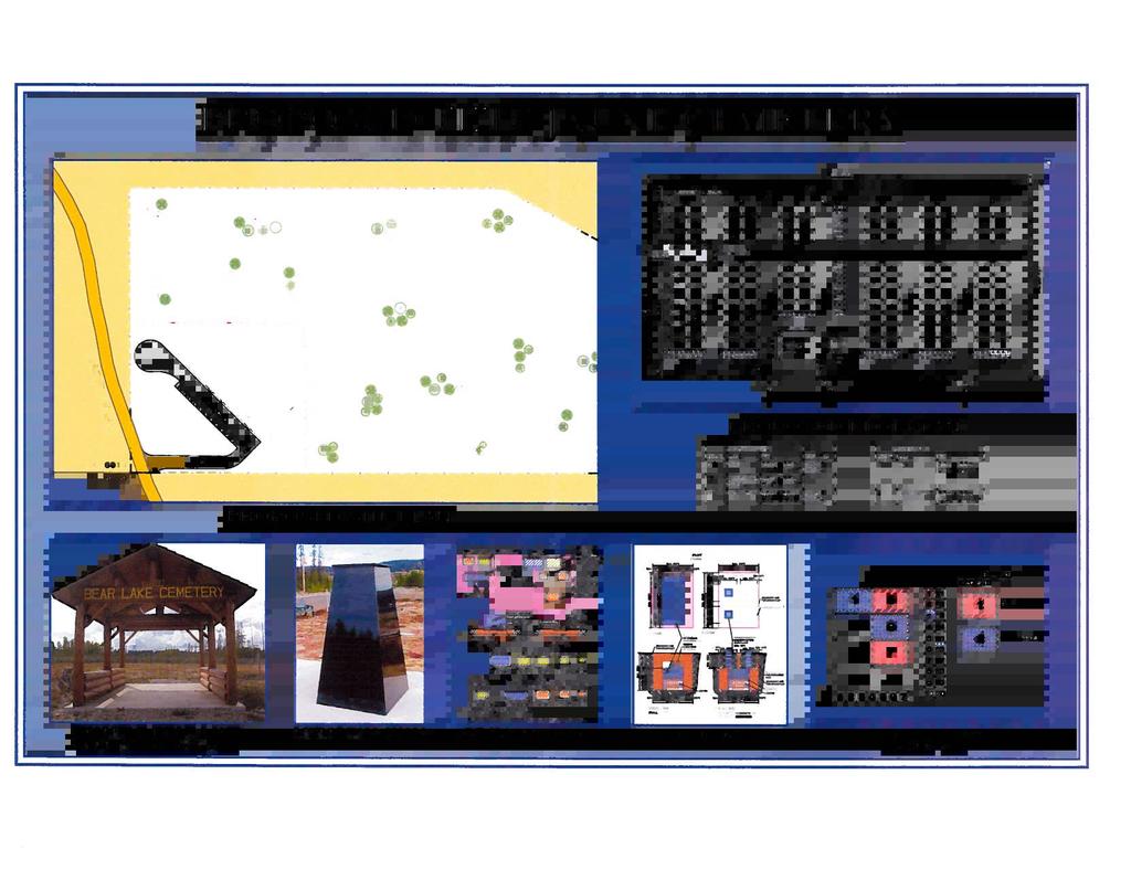


10
11 AVAILABILITY AND SUITABILITY OF CROWN LAND The Steering Committee and Regional District have worked together with the Ministry of Forests, Land and Natural Resource Operations to find a piece of land suitable for a cemetery that is easily accessible and centrally located. Originally, in 2005, the Steering Committee was interested in a piece of Crown land located to the east of Blackman Road adjacent to the Tete Jaune Community Club property. In 2008, during discussions with the Ministry of Forests regarding the Blackman Road property, a preferable piece of property in a quieter location, impacting fewer neighbours, requiring less development costs, and having more suitable soils was brought forward for consideration. This alternate property is the subject of this application and is legally described as the Southwest ¼ of District Lot 6005 and is located on Carr Road in Tete Jaune. Once the decision was made to pursue the Carr Road property, a feasibility study was completed, public meetings were held and a referendum took place, the results of which showed that the community is in favour of supporting the establishment and ongoing care and maintenance of a cemetery at this location through taxation. Understanding that the size and value of the property may have an effect on the success of a request for a sponsored crown grant, the conclusion was made to request that a 1.46 ha portion of the property be subdivided off for the cemetery and to keep the remaining portion for recreational purposes. To date, initial conversations with Ministry of Forests staff have indicated that the change in use of a 1.46 ha portion of this land from Recreation to Cemetery is plausible, leaving the remainder of the 6.84 ha property as status quo secured by a Licence of Occupation for Recreational use until Description of Parcel The land to the north and east rises in height, but there is an approximate 4 acre flat portion of the property at the base of the hill suitable for cemetery purposes. 3.6 acres would be set aside for the cemetery allowing a 32 foot buffer around the cemetery plots. The property is mainly cleared in the area of where the cemetery is to be constructed and is surrounded by a forest of pine and aspen trees. An engineering report completed in June 2012 identifies that the soils are suitable for cemetery use.

12 June 8, Tete Jaune Cemetery Steering Committee Engineering Report on Location of Proposed Community Cemetery On Carr Road, Rem SW ¼ DL 6005, Cariboo Land District Tete Jaune Cache, BC 1


13 Highland timberworks inc croydon ferry road Dunster, BC voj 1j0 PH June 8, 2012 Tete Jaune Cemetery Steering Committee P.O. Box 84, Valemount, BC V0E 2Z0 Att: Re: Ainslie Jackman, RPF Engineering site assessment of proposed community cemetery on Carr Road 1. Introduction The Tete Jaune Community has requested the writer to provide an engineering report with respect to establishing a cemetery at the SW corner of DL6005 (see accompanying map). The proposed cemetery measures 80m x 40m; 0.32 ha. in area, and is located approximately 3 km south of Highway 16, along Carr Road. 2. Field Review On October 6, 2011 A. McLean, P. Eng. conducted a field review of the site of the proposed community cemetery, accompanied by Ainslie Jackman, R.P.F., of the Tete Jaune Community Club, for the purpose of assessing the suitability of soils, slope stability, drainage and groundwater regime. The proposed cemetery is located on a gently sloping (3% to 5%) area 50m out from the base of hills which rise to the level of Highway 16; hazard of slope instability is very low. Flooding hazard from the Fraser River is also very low, as the site is estimated to be >10 metres above high water level of the river. A Pine and aspen forest overstory is underlain by a herb and shrub layer of club moss, kinnikinnick, wild rose; indicators of a dry, well drained site. Root wads of windthrown pine were examined, and found to consist of the glaciofluvial sediments known to predominate in the vicinity of Carr Road. Test pits dug for soil examinations and metre depth roadcuts observed showed well graded sand, gravel and cobbles. Three test pits were observed; TP1 dug at N , E encountered dry sandy soil on a falling slope of 5% to the southwest. TP2 dug at N , E along an old logging trail at the westerly end of the site (see Photo 1) found silty sand and gravel on a falling slope of 3% to the southwest. TP3 observed at N , E333310, found sand, gravel and cobbles on a level site at a 1 metre cut along a new access road running E-W, along the southerly end of the proposed cemetery area. Photo 1, taken upslope from TP2 location Photo 2, looking SW toward Carr Road 2
14 3. Site Selection Sites considered for cemeteries should meet the following criteria: 1) Accessible to the community 2) Correct zoning and community approval 3) Good surface drainage away from the grave sites 4) Water table >>than 10 from the surface 5) Low hazard of debris flow, avalanche or flooding 6) Adequate buffer between business establishments or residences As shown on the accompanying plan, the proposed area satisfies 1) and 6). As the initiative is undertaken by the community club and is sponsored by the local municipal government authority, it can be assumed to satisfy 2). The field review determined that the site meets criteria 3) and 5), and from well records it has been determined that the watertable is at 10 depth or greater, satisfying criteria 4). 4. Discussion and Recommendations Tete Jaune Cache had a cemetery, circa 1912, during the railway construction years. It is located near the old townsite, on private land adjacent to the Croydon Tete Jaune Forest Service Road. This pioneer cemetery is maintained by the landowner and the Valemount Historic Society, but is not registered as an active cemetery. As a community driven initiative, the cultural and societal aspects of the Tete Jaune Cemetery initiative have been assessed and found to be acceptable by the residents. 3
15 The proposed site for the new community cemetery appears quite suitable from the soils engineering and hydrological perspectives. It has favourable surface drainage, does not have a high water table, it is remote from steep slopes and from the Fraser River. The southwest corner of Rem SW ¼ of DL6005 is included in the Low Hazard for flooding mapping polygon, as shown in overview Land Hazard Assessment mapping done by Bruce Geotechnical for the Regional District of Fraser Fort George, see attached map at scale 1:5000. It is the opinion of the writer that the potential for problems concerning soil or water at the proposed location is low, and the location can be recommended as a safe and secure site for Tete Jaune Community Cemetery. 5. Closure This report, labeled 1049 and dated June 8, 2012, has been prepared exclusively for the Tete Jaune Cemetery Steering Committee and the Regional District of Fraser Fort George and its agents. Unauthorized photocopying or reproduction is prohibited. If there are any questions or if you require further assistance, please call the writer at , or to mclean@valemount.com Yours truly, Highland Timberworks Inc. Archie McLean, P. Eng. 4
16 STATEMENT OF LIMITATIONS The criteria and/or recommendations promulgated in this report were compiled on the basis of field reviews and prior information about the sites. It is possible that soil, moisture, slope or other conditions may be different from those described herein. It is recommended that, in the event that conditions different from those herein elucidated are found, Highland Timberworks Inc. be apprised of the new or different conditions so that it may review its criteria and/or recommendations in the context of the changed conditions and make amendments as necessary. The report may contain recommendations for additional research, investigation, site reviews, laboratory testing, mechanized geotechnical investigation, sample retrieval, engineering design, or other requirements, which if not prudently acted upon, relieve Highland Timberworks Inc. of all liability for consequent and/or subsequent problems that may have been avoided had the recommendations been appropriately heeded. 5

17 BYLAW NO A BYLAW TO AMEND REGIONAL DISTRICT OF FRASER-FORT GEORGE ZONING BYLAW NO. 2892, 2014 WHEREAS the Regional Board of the Regional District of Fraser-Fort George has, by bylaw, adopted Regional District of Fraser-Fort George Zoning Bylaw No. 2892; AND WHEREAS the Regional Board intends to amend aforesaid Bylaw No by passage of this bylaw, having due regard to the requirements of the Local Government Act; NOW THEREFORE the Board of Directors of the Regional District of Fraser-Fort George, in open meeting assembled, enacts as follows: 1. Regional District of Fraser-Fort George Zoning Bylaw No is hereby amended at Schedule B Map 215 by rezoning a portion of Part of the South West ¼ of District Lot 6005, within Cariboo District from Rural 5 (Ru5) to Public Development 1 (P1) as shown on Appendix A attached to and forming part of this bylaw. 2. This bylaw may be cited for all purposes as Zoning Bylaw No. 2892, Amendment Bylaw No. 2949, READ A FIRST TIME ON THE DAY OF, 2015 READ A SECOND TIME ON THE DAY OF, 2015 A PUBLIC HEARING IN RESPECT OF THIS BYLAW WAS HELD ON THE DAY OF, 2015 READ A THIRD TIME ON THE DAY OF, 2015 ADOPTED THIS DAY OF, 2015 Chair Corporate Officer
18 BYLAW NO. 2949, 2015 PAGE 2 APPENDIX A Certified as Appendix A to Bylaw No. 2949, 2015 Corporate Officer
B-1 a) PEACE RIVER REGIONAL DISTRICT DEVELOPMENT SERVICES ZONING AMENDMENT REPORT BYLAW NO. 2226, rd Reading and Adoption PROPOSAL
 PEACE RIVER REGIONAL DISTRICT DEVELOPMENT SERVICES ZONING AMENDMENT REPORT BYLAW NO. 2226, rd Reading and Adoption PROPOSAL") PEACE RIVER REGIONAL DISTRICT DEVELOPMENT SERVICES ZONING AMENDMENT REPORT BYLAW NO. 2226, 2016 3 rd Reading and Adoption OWNER: Rudy Willms DATE: August 3, 2016 AGENT: Tryon Land Surveying Ltd. AREA:
PEACE RIVER REGIONAL DISTRICT DEVELOPMENT SERVICES ZONING AMENDMENT REPORT BYLAW NO. 2226, 2016 3 rd Reading and Adoption OWNER: Rudy Willms DATE: August 3, 2016 AGENT: Tryon Land Surveying Ltd. AREA:
*DO NOT REMOVE * R (Redekop) Darbyshire Drive
 Darbyshire Drive") *DO NOT REMOVE * R16-022 (Redekop) 33770 Darbyshire Drive This Public Hearing Information Package has been compiled to provide information pertaining to the subject property. If you have questions regarding
*DO NOT REMOVE * R16-022 (Redekop) 33770 Darbyshire Drive This Public Hearing Information Package has been compiled to provide information pertaining to the subject property. If you have questions regarding
PUBLIC HEARING AGENDA
 REGIONAL DISTRICT OF NORTH OKANAGAN BOARD of DIRECTORS MEETING Wednesday, March 4, 05 4:00 pm PUBLIC HEARING AGENDA A. CALL PUBLIC HEARING TO ORDER B. INTRODUCTION OF BYLAW. Rezoning Bylaw 66, 04 [Boulter]
R-11. REPORT ON SUBDIVISION WITHIN THE AGRICULTURAL LANDRESERVE FILE NO. 212/2017 (Simpson) PEACE RIVER REGIONAL DISTRICT DEVELOPMENT SERVICES
 PEACE RIVER REGIONAL DISTRICT DEVELOPMENT SERVICES") PEACE RIVER REGIONAL DISTRICT DEVELOPMENT SERVICES REPORT ON SUBDIVISION WITHIN THE AGRICULTURAL LANDRESERVE FILE NO. 212/2017 (Simpson) OWNER: David A. Simpson DATE: October 19, 2017 AREA: Electoral Area
PEACE RIVER REGIONAL DISTRICT DEVELOPMENT SERVICES REPORT ON SUBDIVISION WITHIN THE AGRICULTURAL LANDRESERVE FILE NO. 212/2017 (Simpson) OWNER: David A. Simpson DATE: October 19, 2017 AREA: Electoral Area
REGIONAL DISTRICT OF NANAIMO BYLAW NO. 1469
 REGIONAL DISTRICT OF NANAIMO BYLAW NO. 1469 A BYLAW TO ESTABLISH FLOODPLAINS, CONSTRUCTION LEVELS IN FLOODPLAINS, AND SETBACKS FOR LANDFILL AND STRUCTURES IN FLOODPLAINS WHEREAS Section 910 of the Local
Provincial Agricultural Land Commission - Staff Report Application: 52667
 Provincial Agricultural Land Commission - Staff Report Application: 52667 Applicant: Agent: Local Government: Proposal: Victor Bugaychuk-Robson John Molodowich Fraser-Fort George EA Non-farm Use - To operate
Zoning Bylaw Amendment 1926 Vera Drive (Thomas) Lazo North (Electoral Area B) Lot C, Block 29, Comox District, Plan 32630, PID
 Lazo North (Electoral Area B) Lot C, Block 29, Comox District, Plan 32630, PID") Staff report DATE: March 27, 2018 TO: FROM: RE: Chair and Directors Electoral Areas Services Committee Russell Dyson Chief Administrative Officer Zoning Bylaw Amendment 1926 Vera Drive (Thomas) Lazo North
Staff report DATE: March 27, 2018 TO: FROM: RE: Chair and Directors Electoral Areas Services Committee Russell Dyson Chief Administrative Officer Zoning Bylaw Amendment 1926 Vera Drive (Thomas) Lazo North
MEMO RECOMMENDATION REFERRAL
 MEMO District of Highlands 1980 Millstream Road Victoria, BC V9B 6H1 Tel: 250-474-1773 Fax: 250-474-3677 LBeckett@highlands.ca TO: Christopher D. Coates, Chief Administrative Officer FILE: Referrals FROM:
FLOOD HAZARD AREA LAND USE MANAGEMENT
 FLOOD HAZARD AREA LAND USE MANAGEMENT Introduction Guidance For Selection of Qualified Professionals and Preparation of Flood Hazard Assessment Reports This document is intended to provide guidance for
REQUEST FOR DECISION Zoning Bylaw No. 670, 1999, Amendment Bylaw No
 REQUEST FOR DECISION Zoning Bylaw No. 670, 1999, Amendment Bylaw No. 1355 2014 Meeting dates: September 16, 2014 To: SLRD Board of Directors RECOMMENDATION: 1. THAT Bylaw 1355 2014, cited as Squamish Lillooet
ADMINISTRATIVE REPORT
 ADMINISTRATIVE REPORT TO: FROM: Board of Directors B. Newell, Chief Administrative Officer DATE: April 6, 2017 RE: OCP and Zoning Bylaw Amendment Electoral Area D Administrative Recommendations: RECOMMENDATION
DATE: October 22, 2008 FILE NO.: H
 REFERRAL Development Services Department Agricultural Land Commission Application DATE: October 22, 2008 FILE NO.: H-08-01133.000 FROM: RE: E. Riechert, Planner Referral from Regional District Okanagan-Similkameen
DATE: December 5, 2007 FILE NO.: C
 REFERRAL Development Services Department Agricultural Land Commission Application DATE: December 5, 2007 FILE NO.: C-07-05383.100 FROM: RE: C. Garrish, Planner Referral from Regional District Okanagan-Similkameen
STAFF REPORT. DATE: February 26, 2018 FILE: EASC. Chair and Directors, Electoral Areas Services Committee. Chief Administrative Officer
 STAFF REPORT DATE: February 26, 2018 TO: Chair and Directors, Electoral Areas Services Committee FILE: 0540-04 EASC FROM: RE: Dave Leitch Chief Administrative Officer BYLAWS NO. 305 & 306 CONSULTATION
PLANNING REPORT. Lot 5, SDR Lot 6 and 7 Concession 3 Township of Normanby Municipality of West Grey County of Grey
 PLANNING REPORT Dwelling Surplus to a Farm Operation Official Plan and Zoning By-law Amendment and Consent to Sever Lot 5, SDR Lot 6 and 7 Concession 3 Township of Normanby Municipality of West Grey County
REGIONAL DISTRICT OF CENTRAL OKANAGAN PUBLIC HEARING AGENDA
 REGIONAL DISTRICT OF CENTRAL OKANAGAN PUBLIC HEARING AGENDA Monday, February 27, 2017 7:00 p.m. Woodhaven Board Room 1450 K.L.O. Road, Kelowna, BC Pages 1. CALL TO ORDER This Special Meeting is being held
DATE: August 25, 2006 FILE NO.: E
 REFERRAL Development Services Department OCP & Zoning Bylaw Amendment Application DATE: August 25, 2006 FILE NO.: E-06-07171.000.015 FROM: RE: S. Theurer, Planning Services Manager Referral from Regional
Regional District of Central Kootenay Subdivision Bylaw No. 2159, 2011
 Regional District of Central Kootenay Subdivision Bylaw No. 2159, 2011 Adopted September 2011 Page 1 of 21 TABLE OF CONTENTS PART 1 - TITLE... 2 PART 2 - PURPOSE... 2 PART 3 - APPLICATION AND ADMINISTRATION...
ADMINISTRATIVE REPORT
 ADMINISTRATIVE REPORT TO: FROM: Board of Directors B. Newell, Chief Administrative Officer DATE: October 5, 2017 RE: Zoning Bylaw Amendment Electoral Area C Administrative Recommendation: THAT Bylaw No.
BOARD REPORT. FROM: Jennifer Sham Date: September 27, 2016 Planner SUBJECT: Salmon Valley Land Use Amendment (Ralston) Bylaw No.
 Bylaw No.") BOARD REPORT TO: Chair and Directors File No: BL 2557 FROM: Jennifer Sham Date: September 27, 2016 Planner SUBJECT: Salmon Valley Land Use Amendment (Ralston) Bylaw No. 2557 RECOMMENDATION #1: RECOMMENDATION
BOARD REPORT TO: Chair and Directors File No: BL 2557 FROM: Jennifer Sham Date: September 27, 2016 Planner SUBJECT: Salmon Valley Land Use Amendment (Ralston) Bylaw No. 2557 RECOMMENDATION #1: RECOMMENDATION
NO: R172 COUNCIL DATE: SEPTEMBER 9, Locational Guidelines for Private Liquor Stores (Licensee Retail Stores)
") CORPORATE REPORT NO: R172 COUNCIL DATE: SEPTEMBER 9, 2013 REGULAR COUNCIL TO: Mayor & Council DATE: September 9, 2013 FROM: General Manager, Planning and Development FILE: 0340-01 SUBJECT: Locational Guidelines
CORPORATE REPORT NO: R172 COUNCIL DATE: SEPTEMBER 9, 2013 REGULAR COUNCIL TO: Mayor & Council DATE: September 9, 2013 FROM: General Manager, Planning and Development FILE: 0340-01 SUBJECT: Locational Guidelines
STAFF REPORT. Recreation Commercial (RC) Recreation Commercial One (RC-1) Park Residential One (PR-1)
 Recreation Commercial One (RC-1) Park Residential One (PR-1)") STAFF REPORT DATE: May 1, 2018 TO: Chair and Directors Electoral Areas Services Committee FILE: 0540-04 EASC FROM: Dave Leitch Chief Administrative Officer RE: BYLAWS NO. 305 AND 306 - OCP AMENDMENT AND
STAFF REPORT DATE: May 1, 2018 TO: Chair and Directors Electoral Areas Services Committee FILE: 0540-04 EASC FROM: Dave Leitch Chief Administrative Officer RE: BYLAWS NO. 305 AND 306 - OCP AMENDMENT AND
Ministry of Forests, Lands and Natural Resources. Viktor Kisser of the CGF Church Dawson Creek
 PEACE RIVER REGIONAL DISTRICT PUBLIC HEARING AGENDA Proposed OCP/Zoning Amendment Bylaw Nos. 2184 & 2185, 2014 February 24, 2015 @ 7:00 p.m. Devereaux Elementary School, Arras, BC 1. CALL TO ORDER 2. CHAIRMAN
Subdivision - Application
 Planning and Development Services, 2001 Sherwood Drive, Sherwood Park, AB T8A 3W7 Phone 780-464-8080 Fax 780-464-8109 Email: Landuse&policyplanning@strathcona.ca (Page 1 of 5) This form is to be completed
Prepared for: Ontario Limited
 Application for Zoning By-law Amendment and Plan of Subdivision 1353 Scharfgate Drive Planning Rationale Report Prepared for: 1384341 Ontario Limited November 28, 2014 Planning Rationale Report Introduction
STAFF REPORT TO COUNCIL 1100 Patricia Blvd. I Prince George, BC, Canada V2L 3V9 I
 t CITYOF PRINCE GEORGE STAFF REPORT TO COUNCIL 1100 Patricia Blvd. I Prince George, BC, Canada V2L 3V9 I www.princegeorge.ca DATE: April 17, 2018 TO: NAME AND TITLE: SUBJECT: MAYOR AND COUNCIL IAN WELLS,
Lot 1 KAP Lot 1. Lot 1. Lot 4. ot 5
 Public Notice January 11, 2018 Subject Property: 237 Phoenix Avenue Lot 4, District Lot 5, Group 7 Similkameen Division Yale (Formerly Yale-Lytton) District, Plan 10974 Application: The applicant is proposing
ADMINISTRATIVE REPORT
 ADMINISTRATIVE REPORT TO: FROM: Board of Directors B. Newell, Chief Administrative Officer DATE: April 19, 2018 RE: Zoning Bylaw Amendment Electoral Area D-2 Administrative Recommendation: THAT Bylaw No.
These can be obtained at the City s Engineering Department or on the City s website (
 Subdivision Application Guide This handout provides information on the requirements and processes for a subdivision of land. It is intended for general guidance only. Applicants should also refer to: Official
Planning Justification Report
 Planning Justification Report, Township of Puslinch FARHI HOLDINGS CORPORATION Updated January 27, 2017 Zelinka Priamo Ltd. Page i TABLE OF CONTENTS Page No. 1.0 1.1 1.2 1.3 2.0 2.1 2.2 2.3 2.4 2.5 3.0
REPORT TO THE CHIEF ADMINISTRATIVE OFFICER FROM THE DEVELOPMENT AND ENGINEERING SERVICES DEPARTMENT
 January 26, 2016 REPORT TO THE CHIEF ADMINISTRATIVE OFFICER FROM THE DEVELOPMENT AND ENGINEERING SERVICES DEPARTMENT ON AGRICULTURAL LAND RESERVE EXCLUSION APPLICATION NO. ALR00040 3801 WESTSYDE ROAD OWNER/APPLICANT:
Consolidated as of May 14, 2012
 THE CORPORATION OF THE CITY OF WHITE ROCK BYLAW NO. 1869 A Bylaw to amend the provisions of City of White Rock Planning Procedures Bylaw, 2009, No. 1869. DISCLAIMER: THIS BYLAW IS CONSOLIDATED FOR CONVENIENCE
You are requested to comment on the attached LAND USE BYLAW AMENDMENT for potential effect on your agency s
 REGIONAL DISTRICT OF CENTRAL KOOTENAY BOX 590, 202 Lakeside Drive, NELSON, BC V1L 5R4 ph: 250 352 8165 fax: 250 352 9300 email: rdck@rdck.bc.ca REFERRAL FORM BYLAW AMENDMENT APPLICATION RDCK Planning File:
Rural Municipality of Kellross No Official Community Plan. Bylaw No
 Rural Municipality of Kellross No. 247 Official Community Plan Bylaw No. 2009-03 2 BYLAW NO. 2009-03 THE RURAL MUNICIPALITY OF KELLROSS NO. 247 LEROSS, SASKATCHEWAN A Bylaw of the Rural Municipality of
Staff Report. Planning and Development Services Planning Division
 This document can be made available in other accessible formats as soon as practicable and upon request Staff Report Planning and Development Services Planning Division Report To: Council Meeting Date:
A Guide to the Municipal Planning Process in Saskatchewan
 A Guide to the Municipal Planning Process in Saskatchewan A look at the municipal development permit and the subdivision approval process in Saskatchewan May 2008 Prepared By: Community Planning Branch
DEVELOPMENT PERMIT APPLICATION REQUIREMENTS
 DEVELOPMENT PERMIT APPLICATION REQUIREMENTS Where a parcel is designated within a development permit area (DPA) by an official community plan and a proposed development is not exempt from the DPA guidelines,
*DO NOT REMOVE * R Sharp McRae Avenue
 *DO NOT REMOVE * R16-003 - Sharp 32385 McRae Avenue This Public Hearing Information Package has been compiled to provide information pertaining to the subject property. If you have questions regarding
Temporary Use Permit Application Form
 Strategic & Community Development 6300 Hammond Bay Road Nanaimo, BC V9T 6N2 (250) 390-6510 (Nanaimo) (250) 954-3798 (District 69) 1-877-607-4111 (within BC) Fax:(250) 390-7511 planning@rdn.bc.ca Temporary
Lot 5. 8t 8. Lot 4. Lot 4. Lot 4. Lot 3 E Lot 4. Lot 3. Lot 3. Lot 3. Lot 1. Lot 1. Lot 5. Lot 5. Lot 5. Lot 4. Lot 4.
 Lot 2 Lot 1 Lot 12 Lot 11 Lot 3 Lot A Lot 10 Lot 4 Lot A Lot 5 Lot 7 Lot 8 Lot 8 Lot 6 Lot 7 Lot 9 Lot 6 Lot 1 Lot 2 Lot A Lot 5 Lot 10 Lot 9 Lot 6 Lot 5 Lot 8 8t 8 Lot 3 Lot 4 Lot 9 Lot 1 Lot 4 Lot 1
PUBLIC HEARING INFORMATION PACKAGE
 PUBLIC HEARING INFORMATION PACKAGE ADDRESS: APPLICANT: PLANNING FILE: 33093 7 th Avenue District of Mission LUC18-007 This Public Hearing Information Package has been compiled to provide information pertaining
Special Council meeting
 Special Council meeting Delegation on behalf of Klaus Fuerniss Enterprises Geotechnical Presentation Horizon Engineering Design Changes Responding to Geotechnical Investigations Omicron Staff reports Peer
PIN , Part 1, Plan SR-713 in Lot 2, Concession 5, Township of McKim (1096 Dublin Street, Sudbury)
") STAFF REPORT Applicant: Dalron Construction Limited Location: PIN 02124-0103, Part 1, Plan SR-713 in Lot 2, Concession 5, Township of McKim (1096 Dublin Street, Sudbury) Official Plan and Zoning By-law:
STAFF REPORT Applicant: Dalron Construction Limited Location: PIN 02124-0103, Part 1, Plan SR-713 in Lot 2, Concession 5, Township of McKim (1096 Dublin Street, Sudbury) Official Plan and Zoning By-law:
SOIL DEPOSIT BYLAW
 SOIL DEPOSIT BYLAW 5506-2015 THE FOLLOWING DOCUMENT HAS BEEN REPRODUCED FOR CONVENIENCE ONLY and is a consolidation of "District of Mission Soil Deposit with the following amending bylaws: Bylaw Number
PUBLIC HEARING INFORMATION PACKAGE
 PUBLIC HEARING INFORMATION PACKAGE ADDRESS: APPLICANT: PLANNING FILE(S): R16-034 33880, 33904 and 33930 Prentis Avenue J. Tiegen and G. Toor This Public Hearing Information Package has been compiled to
BOARD REPORT. Agricultural Land Commission recommending refusal, this 19th day of January, L// ^ fk- l^- Charles Hamilton, CAO
 CSRD BOARD REPORT 9.4 TO: FROM: Chair and Directors Christine LeFloch Development Services Assistant File No: LC2526E Date: December 15,2016 SUBJECT: RECOMMENDATION: Agricultural Land Commission (ALC)
REPORT ON EXCLUSION FROM THE AGRICULTURAL LAND RESERVE (ALR) FILE NO. 191/2015
 FILE NO. 191/2015") Peace River Regional District DEVELOPMENT SERVICES REPORT ON EXCLUSION FROM THE AGRICULTURAL LAND RESERVE (ALR) FILE NO. 191/2015 OWNER: Marguerite Gladysz DATE: September 1, 2015 AREA: Electoral Area
Peace River Regional District DEVELOPMENT SERVICES REPORT ON EXCLUSION FROM THE AGRICULTURAL LAND RESERVE (ALR) FILE NO. 191/2015 OWNER: Marguerite Gladysz DATE: September 1, 2015 AREA: Electoral Area
ZONING AMENDMENT Bylaw (Housekeeping)
") ZONING AMENDMENT Bylaw 2012-22 (Housekeeping) PUBLIC NOTICE IS HEREBY given that Council intends to adopt Zoning Amendment Bylaw 2012-22 to amend Zoning Bylaw 2011-23 as follows: 1. Section 10.6.1 (Permitted
ZONING AMENDMENT Bylaw 2012-22 (Housekeeping) PUBLIC NOTICE IS HEREBY given that Council intends to adopt Zoning Amendment Bylaw 2012-22 to amend Zoning Bylaw 2011-23 as follows: 1. Section 10.6.1 (Permitted
AGENDA FOR THE SPECIAL MEETING OF THE COUNCIL OF THE CITY OF NANAIMO (PUBLIC HEARING) SCHEDULED RECESS AT 9:00 P.M.
 SCHEDULED RECESS AT 9:00 P.M.") AGENDA FOR THE SPECIAL MEETING OF THE COUNCIL OF THE CITY OF NANAIMO (PUBLIC HEARING) Thursday, October 4, 2018, 7:00 P.M. SHAW AUDITORIUM, VANCOUVER ISLAND CONFERENCE CENTRE 80 COMMERCIAL STREET, NANAIMO,
AGENDA FOR THE SPECIAL MEETING OF THE COUNCIL OF THE CITY OF NANAIMO (PUBLIC HEARING) Thursday, October 4, 2018, 7:00 P.M. SHAW AUDITORIUM, VANCOUVER ISLAND CONFERENCE CENTRE 80 COMMERCIAL STREET, NANAIMO,
Date: April 15, 2016 Meeting Date: May 6, Park for Other Land to be used for Park Purposes Bylaw No. 1233, 2016 ;
 Section G 1.1 To: From: Regional Parks Committee Renato Jadrijev, Senior Property Negotiator, Financial Services Chris Plagnol, Director, Board and Information Services/Corporate Officer, Legal and Legislative
By-Law of The Corporation of the City of Oshawa
 By-Law 85-2006 of The Corporation of the City of Oshawa being a by-law to control the dumping of fill, removal of topsoil and alteration of grades. WHEREAS s. 142 of the Municipal Act, 2001, S.O. 2001,
The Corporation of the TOWN OF MILTON
 Report to: From: Chair & Members of the Administration & Planning Standing Committee W.F. Mann, Director of Planning and Development Date: March 21, 2011 Report No. PD-013-11 (Town File Z.08/10 - Radha
In the case of Lot 206, DL 587, SDYD, Plan 466, located at 3550 Valleyview Road, agri-tourism accommodation is a permitted use.
 Public Notice January 10, 2019 Subject Property: 3550 Valleyview Road Subject Property Lot 206, District Lot 587, Similkameen Division Yale District, Plan 466 Application: Rezone PL2018-8291 The applicant
PUBLIC HEARING INFORMATION PACKAGE
 PUBLIC HEARING INFORMATION PACKAGE ADDRESS: APPLICANT: 8522 Nottman Street Analytical Consulting PLANNING FILE(S): OCP17-002 R17-015 This Public Hearing Information Package has been compiled to provide
COUNTY OF HURON APPLICATION FOR CONSENT Under Section 53 of the Planning Act 8.3.1
 NOTE TO THE APPLICANT / AGENT / OWNER COUNTY OF HURON APPLICATION FOR CONSENT Under Section 53 of the Planning Act 8.3.1 This application is to be used if the County of Huron is the consent granting authority.
ii. That the driveway access from Desloges Road be controlled with a gate and access only be used for maintenance and emergency purposes; and,
 Presented To: Planning Committee Request for Decision Melissa Cotesta - Application for rezoning in order to permit a contractor s yard and warehouse, Pioneer Road, Sudbury Presented: Monday, Jun 27, 2016
City Of Attleboro Conservation Commission
 City Of Attleboro Conservation Commission GOVERNMENT CENTER, 77 PARK STREET ATTLEBORO, MASSACHUSETTS 02703 (508) 223 2222 FAX 222 3046 GENERAL INSTRUCTIONS AND CHECKLIST FOR COMPLETING STORMWATER MANAGEMENT
North Qu Appelle No. 187 Bylaw Basic Planning Statement - Table of Contents
 - Table of Contents Section1 Introduction 2 Section 2 - The Rural Municipality of North Qu Appelle No. 187 3 Section 3 Municipal Goals.... 3 Section 4 Agriculture and Natural Resources.. 4 Section 5 Residential
EXPLANATION OF PROCEDURE TO BE FOLLOWED PRESENTATION OF APPLICATION FOR ZONING BY-LAW AMENDMENT
 PORT COLBORNE CITY OF PORT COLBORNE SPECIAL COUNCIL MEETING AGENDA WEDNESDAY, AUGUST 21, 2013-6:30 P.M. Council Chambers, 3rd Floor, 66 Charlotte Street CALL MEETING TO ORDER Mayor Vance Badawey 1. CONFIRMATION
Schedule A to Bylaw No. 477, 2013 APPLICATION FEES 1. Official Community Plan Bylaw Amendment $ Zoning Bylaw Amendment $ Simultaneous Of
 Schedule A to Bylaw No. 477, 2013 APPLICATION FEES 1. Official Community Plan Bylaw Amendment $1000 2. Zoning Bylaw Amendment $1000 3. Simultaneous Official Community Plan and Zoning Bylaw Amendment $1500
TABLE OF CONTENTS 1. CITATION AREA OF APPLICATION PURPOSE DEFINITIONS GENERAL PROVISIONS Severability...
 FRASER VALLEY REGIONAL DISTRICT SUBDIVISION AND DEVELOPMENT SERVICING BYLAW No. 1319, 2015 TABLE OF CONTENTS 1. CITATION... 1 2. AREA OF APPLICATION... 1 3. PURPOSE... 1 4. DEFINITIONS... 2 5. GENERAL
PLANNING PROCEDURES AND FEES BYLAW
 PLANNING PROCEDURES AND FEES BYLAW The following is a consolidated copy of the planning procedures and fees bylaw and includes the following bylaws: Bylaw No. Bylaw Name Adopted Purpose 328 Comox Valley
Fraser River Escarpment Policy
 Fraser River Escarpment Policy Building Permit Requirements Page 1 of 2 This summary has been prepared by Inspections Services to assist property owners/builders in understanding the policies relating
PRELIMINARY PLAT CHECK LIST
 PRELIMINARY PLAT CHECK LIST Name of Proposed Subdivision: The following items must be included with the initial submittal of a Preliminary Plat: Application, filled out completely Project Narrative Pre-application
ADMINISTRATIVE REPORT
 ADMINISTRATIVE REPORT TO: FROM: Board of Directors B. Newell, Chief Administrative Officer DATE: October 18, 2018 RE: Official Community Plan (OCP) & Zoning Bylaw Amendments Electoral Area D Okanagan Falls
LAND USE PROCEDURES (LUP) BYLAW NO. 1235, 2007
 BYLAW NO. 1235, 2007") TOWN OF OSOYOOS LAND USE PROCEDURES (LUP) BYLAW NO. 1235, 2007 Adopted August 13, 2007 PART 1 PART 2 PART 3 PART 4 PART 5 PART 6 PART 7 PART 8 TABLE OF CONTENTS Index provided for ease of use and was not
TOWN OF OSOYOOS LAND USE PROCEDURES (LUP) BYLAW NO. 1235, 2007 Adopted August 13, 2007 PART 1 PART 2 PART 3 PART 4 PART 5 PART 6 PART 7 PART 8 TABLE OF CONTENTS Index provided for ease of use and was not
ADMINISTRATIVE REPORT
 ADMINISTRATIVE REPORT TO: FROM: Advisory Planning Commission B. Newell, Chief Administrative Officer DATE: February 14, 2017 RE: OCP & Zoning Bylaw Amendment Electoral Area D Purpose: To facilitate a residential
n (Weighted) LGA Part 26 (Unweighted)
 LGA Part 26 (Unweighted)") EADBL3 BOARD REPORT No: Date: TO: Chair and Directors FROM: Dan Passmore Senior Planner SUBJEGT: South Shuswap Zoning Amendment (Shuswap Lake Estates) Bylaw No. 701-75 RECOMMENDATION: THAT: File B,L701-75
EADBL3 BOARD REPORT No: Date: TO: Chair and Directors FROM: Dan Passmore Senior Planner SUBJEGT: South Shuswap Zoning Amendment (Shuswap Lake Estates) Bylaw No. 701-75 RECOMMENDATION: THAT: File B,L701-75
Our Focus: Your Future NATURE CONSERVANCY OF CANADA ACQUISITION OF PHILIPS PROPERTY
 Town of Fort Erie Community & Development Services Our Focus: Your Future Prepared for Council-in-Committee Report No. CDS-47-7 Agenda Date June 11, 27 File No. 1292 Subject NATURE CONSERVANCY OF CANADA
Preliminary Subdivision Application (Major) (Four (4) lots or more)
 (Four (4) lots or more)") Gunnison City Offices www.gunnisoncity.org 38 West Center Gunnison, Utah 84634 (435) 528 7969 Date of Application: Preliminary Subdivision Application (Major) (Four (4) lots or more) APPLICANT INFORMATION
Gunnison City Offices www.gunnisoncity.org 38 West Center Gunnison, Utah 84634 (435) 528 7969 Date of Application: Preliminary Subdivision Application (Major) (Four (4) lots or more) APPLICANT INFORMATION
CITY OF KELOWNA BYLAW NO
 SUMMARY: The Development Cost Charge Bylaw sets out the charges imposed for roads, water, sanitary sewer, drainage and public park when subdividing or constructing, altering or extending a building, pursuant
SMOKY LAKE COUNTY. Alberta Provincial Statutes. To provide a process to close a Government Road Allowance, or cancel a surveyed Road Plan.
 SMOKY LAKE COUNTY Title: Road Closure or Cancellation Policy No.: 16-03 Section: 03 Page No.: 1 of 11 E Legislation Reference: Alberta Provincial Statutes Purpose: To provide a process to close a Government
RESIDENTIAL AND RECREATIONAL
 Energy, Mines & Resources Land Management Branch 320-300 Main Street Whitehorse, Yukon Y1A 2B5 667-5215 Fax 667-3214 www.emr.gov.yk.ca RESIDENTIAL AND RECREATIONAL Lot Enlargement Policy OBJECTIVE To facilitate
COUNTY OF BRANT DEVELOPMENT SERVICES DEPARTMENT COMMITTEE OF ADJUSTMENT. Chair and Members of the Committee of Adjustment
 COUNTY OF BRANT DEVELOPMENT SERVICES DEPARTMENT COMMITTEE OF ADJUSTMENT TO: FROM: Chair and Members of the Committee of Adjustment Ruchika Angrish, Senior Planner DATE: January 23, 2014 REPORT: CA-14-06
Date Received: Application Complete? YES / NO
 OFFICE USE ONLY Section 22 (Official Plan Amendment) Section 34 (Zoning Amendment), Section 36 (Holding Zone Removal), Section 41 (Site Plan Approval) and Section 45 (Minor Variance) of the Planning Act
19.12 CLUSTER RESIDENTIAL DISTRICT
 Chapter 19.12 CLUSTER RESIDENTIAL DISTRICT (Adopted 12/22/2003; Ordinance #0061970). Amended 7/3/17, Ordinance #079100. Section 19.12.010 - Declaration of Intent. The Cluster Residential District provides
REGIONAL DISTRICT OF NORTH OKANAGAN SUBDIVISION SERVICING BYLAW NO. 2600, 2013
 REGIONAL DISTRICT OF NORTH OKANAGAN SUBDIVISION SERVICING BYLAW NO. 2600, 2013 Page 3 TABLE OF CONTENTS SECTION -100- SCOPE AND APPLICABILTY... 4 101 Title... 4 102 Application... 4 103 Compliance with
Rezoning. Rezone from RA to RF to create 3 residential lots and a remainder lot in Fraser Heights. Approval to Proceed
 City of Surrey PLANNING & DEVELOPMENT REPORT Rezoning Proposal: Rezone from RA to RF to create 3 residential lots and a remainder lot in Fraser Heights. Recommendation: Approval to Proceed Location: 16156-112
Qualified Professionals, Land Owners and Developers. FROM: Development Services. DATE: November 29, 2017
 TO: Qualified Professionals, Land Owners and Developers FROM: Development Services DATE: November 29, 2017 RE: Terms of reference for Natural Hazard and/or Risk Assessments The District of Squamish (District)
Conceptual Scheme SE W4
 December 2012 1. PURPOSE 1.1. The purpose of a Conceptual Scheme (CS) is as follows: a) To provide a framework for the subsequent subdivision and/or development of land within the Country Residential Policy
PUBLIC HEARING INFORMATION PACKAGE
 PUBLIC HEARING INFORMATION PACKAGE ADDRESS: APPLICANT: PLANNING FILE: R16-053 32973 10 th Avenue K. Docksteader This Public Hearing Information Package has been compiled to provide information pertaining
Application: Z Owner: D & S Schulz Enterprises Ltd. Address: 196 Cariboo Rd Applicant: Siegfried Schulz. RU6 - Two Dwelling Housing
 REPORT TO COUNCIL Date: October 3, 2016 RIM No. 1250-30 To: From: City Manager Community Planning Department (TY) Application: Z16-0018 Owner: D & S Schulz Enterprises Ltd Address: 196 Cariboo Rd Applicant:
SUBDIVISION AND DEVELOPMENT STANDARDS BYLAW. Date: Monday, April 27, Annacis Room. 4:30-4:45 pm
 L P SUBDIVISION AND DEVELOPMENT STANDARDS BYLAW Date: Monday, April 27, 2015 I. Location: Time: Annacis Room 4:30-4:45 pm Presentation: Steven Lan, Director of Engineering Background Materials: Memorandum
Kim Wingrove, Meaghen Reid, Kelsey Lang, Jordan Dolson
 MEMO KITCHENER WOODBRIDGE LONDON KINGSTON BARRIE To: From: Kim Wingrove, Meaghen Reid, Kelsey Lang, Jordan Dolson Bernie Hermsen / Emily Elliott Date: March 31, 2014 File: Subject: 9902IZ Zoning By-law
Inverness Area Planning Advisory Committee Inverness County Planning Advisory Committee Inverness County Council Planning Staff (EDPC)
") STAFF REPORT To: From: Inverness Area Planning Advisory Committee Inverness County Planning Advisory Committee Inverness County Council Planning Staff (EDPC) Date: January 18, 2018 Reference: Request for
STAFF REPORT To: From: Inverness Area Planning Advisory Committee Inverness County Planning Advisory Committee Inverness County Council Planning Staff (EDPC) Date: January 18, 2018 Reference: Request for
Preliminary Subdivision Application (Minor) (Three (3) lots or less)
 (Three (3) lots or less)") Gunnison City Offices www.gunnisoncity.org 38 West Center Gunnison, Utah 84634 (435) 528 7969 Date of Application: Preliminary Subdivision Application (Minor) (Three (3) lots or less) APPLICANT INFORMATION
Gunnison City Offices www.gunnisoncity.org 38 West Center Gunnison, Utah 84634 (435) 528 7969 Date of Application: Preliminary Subdivision Application (Minor) (Three (3) lots or less) APPLICANT INFORMATION
SUBDIVISION AND DEVELOPMENT APPLICATION FORM
 SUBDIVISION AND DEVELOPMENT APPLICATION FORM Bylaw No. 404, Subdivision and Development Standards Bylaw, 2014 APPLICATION FOR (check box): PRELIMINARY LAYOUT ASSESSMENT (PLA) PLA EXTENSION LOT LINE ADJUSTMENT
City of Chilliwack. Bylaw No. 4519
 City of Chilliwack Bylaw No. 4519 A bylaw to designate land as Floodplain and make provisions in relation to flood control, flood hazard management and development of land that is subject to flooding or
TO: CHAIR AND MEMBERS - PLANNING & ENVIRONMENT COMMITTEE
 TO: CHAIR AND MEMBERS - PLANNING & ENVIRONMENT COMMITTEE FROM: SUBJECT: JOHN M. FLEMING MANAGING DIRECTOR, PLANNING AND CITY PLANNER CITY OF LONDON CITY WIDE OFFICIAL PLAN AND ZONING BY-LAW AMENDMENTS
THAT the Regional Board support ALR subdivision application 047/2017 (Soloshy-Point),
,") PEACE RIVER REGIONAL DISTRICT DEVELOPMENT SERVICES REPORT ON SUBDIVISION WITHIN THE AGRICULTURAL LAND RESERVE FILE NO. 047/2017 OWNER: Thomas Soloshy & Lisa Point DATE: May 19, 2017 AREA: Electoral Area
PEACE RIVER REGIONAL DISTRICT DEVELOPMENT SERVICES REPORT ON SUBDIVISION WITHIN THE AGRICULTURAL LAND RESERVE FILE NO. 047/2017 OWNER: Thomas Soloshy & Lisa Point DATE: May 19, 2017 AREA: Electoral Area
Site Alteration By-law
 Site Alteration By-law C.P.-1363-381 Consolidated October 17, 2017 As Amended by: By-law No. Date Passed at Council C.P.-1363(a)-29 January 15, 2001 C.P.-1363(b)-53 February 5, 2001 C.P.-1363(c)-13 December
The Joe Rich Rural Land Use Bylaw
 The purpose of this review and update This process is a review and update of the (RLUB) future land use policies and current land use regulations to ensure that they reflect and respond to the needs of
Elk Valley Agricultural Land Reserve Review Project
 R E G I O N A L D I S T R I C T O F E A S T K O O T E N A Y Elk Valley Agricultural Land Reserve Review Project August 2009 ACKNOWLEDGEMENTS Special thanks to the following for their expertise and contributions
NOTICE OF PUBLIC HEARING RDCK Board Room, 202 Lakeside Drive, Nelson BC Thursday, January 31, 2019 at 6 pm
 NOTICE OF PUBLIC HEARING RDCK Board Room, 202 Lakeside Drive, Nelson BC Thursday, January 31, 2019 at 6 pm NOTICE is hereby given that a Public Hearing will be held at the RDCK Board Room at 202 Lakeside
Implementation Tools for Local Government
 Information Note #5: Implementation Tools for Local Government This Information Note is a guide only. It is not a substitute for the federal Fisheries Act, the provincial Riparian Areas Regulation, or
ADMINISTRATIVE REPORT
 ADMINISTRATIVE REPORT TO: FROM: Advisory Planning Commission B. Newell, Chief Administrative Officer DATE: March 8, 2016 TYPE: Official Community Plan & Zoning Bylaw Amendment Purpose: To allow for the
Exhibit No. 2 is a copy of the original site plan submitted by the applicant that was considered at the June 9, 2008 pu,blic meeting.
 Report To: From: Development Services Committee Commissioner, Development Services Department tem: DS-09-267 File: 2-06/2008 Subject: Revised Applications to Amend the Samac Secondary Plan and Zoning By-law
*DO NOT REMOVE * R Watt Street (New Country Homes Ltd. / Grohmueller)
") *DO NOT REMOVE * R16-007 9957 Watt Street (New Country Homes Ltd. / Grohmueller) This Public Hearing Information Package has been compiled to provide information pertaining to the subject property. If
*DO NOT REMOVE * R16-007 9957 Watt Street (New Country Homes Ltd. / Grohmueller) This Public Hearing Information Package has been compiled to provide information pertaining to the subject property. If
Planning Rationale in Support of an Application for Plan of Subdivision and Zoning By-Law Amendment
 Planning Rationale in Support of an Application for Plan of Subdivision and Zoning By-Law Amendment The Kilmorie Development 21 Withrow Avenue City of Ottawa Prepared by: Holzman Consultants Inc. Land
BYLAW NO The Council of the District of Sooke, in open meeting assembled, enacts as follows:
 DISTRICT OF SOOKE BYLAW NO. 490 A bylaw to establish procedures and fees for applications to amend the official community plan bylaw and the zoning bylaw and for the issuance of permits under Part 26 of