YourCounty. YourPlan.
|
|
|
- Marcus Pitts
- 5 years ago
- Views:
Transcription

1 YourCounty. YourPlan. MUNICIPAL DEVELOPMENT PLAN BYLAW NO. 09/12 SCHEDULE A Consolidated Version November 25, 2015 Note: All persons making use of the consolidation are reminded that it has no legislative sanction, that the amendments have been embodied for convenience of reference only, and that the original bylaw should be consulted for all purposes of interpreting and applying the bylaw.
2 Amended by the Following: Bylaw No. 02/14 (March 12, 2014) Bylaw No. 13/14 (October 22, 2014) Bylaw No. 08/15 (June 24, 2015) Bylaw No. 14/15 (November 25, 2015)
3 Table of Contents 1.0 Introduction The County Context New Directions Hierarchy of Plans Interpretation Growth Management Conceptual Strategy Agricultural Land Use Policies Goals Objectives Policies Residential Land Use Policies Goals Objectives Policies Economic Development Land Use Policies Goals Objectives Policies Recreational Development Policies Environmental Land Use Policies Goals Objectives Policies Growth Centres Goals Objectives Policies Special Policy Area: Highway 2/27 Area Structure Plan Area Structure Plan and Area Redevelopment Plan Policies Natural Resources Goals Objectives Policies Transportation, Servicing and Utilities Goals... 39
4 9.2 Objectives Policies Reserve Lands Goals Objectives Policies Development Phasing Goals Objectives Policies Intermunicipal Issues Goals Objectives Policies Plan Implementation and Monitoring Goals Objectives Policies Figures Figure 1 Site Location 3 Figure 2 Rural Neighbourhoods..4 Figure 3 Growth Management Conceptual Strategy..14 Figure 4 Environmentally Significant Areas 30 Figure 5 County Collector Network.. 40 Charts Chart 1 - Hierarchy of Plans 10 Appendices Appendix A Glossary Appendix B Growth Centre Mapping 64 Appendix C Urban Fringe Mapping..70
5 Page INTRODUCTION Agricultural preservation is paramount in Mountain View County (MVC). It is the backbone of the local economy, and the County will provide all necessary support to the industry when making land use decisions. MVC is changing, as are most rural municipalities in Alberta. While the main economic base of the County remains steadfastly rooted in agriculture, it is also developing in the fields of oil and gas, as well as various forms of commercial and residential growth. The agricultural base consists of over 1,800 farms and ranches known for grains, oilseed, dairy, exotic livestock, value-added agriculture, specialty crops, and tree and berry operations. Forestry is also an important industrial sector to the County. As the Provincial economy has grown, greater and greater demands have been placed on the forestry industry to respond to the increasing requirements for building materials for all types of construction. This industry provides employment for many County residents in falling, skidding, trucking, and in the lumber mills. Oil and gas operations have greatly expanded in the last couple of decades. MVC sits on significant oil and gas reserves. Every year, numerous wells are drilled and brought into production. This provides a wide range of employment opportunities, but also places pressures on services and roads. While the taxes generated by the oil and gas industry are significant, their impacts are also significant. MVC has recently experienced significant growth pressures. The County is bisected by the Highway 2 and 2A Corridors. This creates demand for businesses, which utilize this major transportation corridor (see Figure 1). A second growth area is tourism and recreational development based on the area s natural beauty. The Highway 2/2A Corridor also provides opportunities for a variety of developments and places MVC within commuting distance of major centres such as Red Deer and Calgary. Council wants to be proactive, not reactive. The aim is to ensure that viable agricultural land and environmentally significant areas are preserved and that all new development follows sustainable development guidelines, recognizes the impact on the environment, and benefits the community rather than putting pressures on the community. MVC wants to lead development and not be led by the development. This MDP provides clear rules and regulations that are visionary. The Plan addresses very sophisticated principles but is presented in an uncomplicated manner so developers and residents find it is easy to read, understand and interpret. Based on landowner input, Council has prepared a plan that will result in development that is sustainable, orderly, and appropriate for Mountain View County. 1.1 THE COUNTY CONTEXT MVC is situated in southern Alberta, stretching from the eastern slopes of the Rockies to the highly productive prairie lands. The County is bounded by Red Deer County to the north,
6 Page 2 Rocky View County to the south, Clearwater County to the northwest, Municipal District of Bighorn to the southwest, and Kneehill County to the east. The County is bisected by the Highway 2/2A Corridor. The urban municipalities located within the County are Carstairs, Cremona, Didsbury, Olds, and Sundre. Mountain View County consists of twenty diverse rural communities as shown in Figure 2.
7 Page 3
8 Page 4
9 Page NEW DIRECTIONS The new direction for the MDP is to provide guidance and clarity for the facilitation of good, sound sustainable development. Therefore, the new directions include: encouraging the conservation of agricultural land and the rural lifestyle; being open to innovation and new technology; concentrating and directing non-agricultural development to newly defined growth centres and Economic Growth Nodes; being sensitive to rural and agricultural views and vistas when allowing development; planning for higher densities in defined growth centres to ensure that new development is making efficient use of land taken out of agricultural production; working towards safe and effective fresh water and waste water systems; ensuring there is strong policy direction for the protection of environmentally significant areas; ultimately preparing Area Structure Plans (ASPs) for the defined growth centres and Economic Growth Nodes to provide more detailed planning direction; making sure that the MDP encourages and allows for a diversity of land uses, lifestyles and housing types to meet the needs of all Mountain View County residents; directing future residential, commercial, and industrial development at higher densities, to identified growth centres and the Economic Growth Nodes to take advantage of existing infrastructure, recognize historical patterns of growth and development and to minimize land taken out of agricultural production; working with adjacent municipalities and jurisdictions to conduct joint planning and infrastructure sharing for more effective and efficient use of resources; and developing and adopt plans for infrastructure as needed. 1.3 HIERARCHY OF PLANS The Municipal Government Act (MGA) delegates the responsibility for land use planning to municipalities (Part 17 Planning and Development). In the MGA, there is a hierarchy of plans laid out that guides the municipality and the developer to a logical process for the ultimate development and management of land. Municipal Development Plans The MDP is the paramount senior planning document for a municipality. It is mandatory that any municipality with a population over 3,500 adopt, by bylaw, a MDP.
10 Page 6 The Act states: 632(3) A municipal development plan (a) must address i. the future land use within the municipality, ii. the manner of and the proposals for future development in the municipality, iii. the coordination of land use, future growth patterns, and other infrastructure with adjacent municipalities if there is no intermunicipal development plan with respect to those matters in those municipalities, iv. the provision of the required transportation systems either generally or specifically within the municipality and in relation to adjacent municipalities, and v. the provision of municipal services and facilities either generally or specifically. (b) may address i. proposals for financing and programming of municipal infrastructure, ii. the co-ordination of municipal programs relating to the physical, social, and economic development of the municipality, iii. environmental matters within the municipality, iv. the financial resources of the municipality, v. the economic development of the municipality, and vi. any other matter relating to the physical, social or economic development of the municipality. (c) (d) (e) (f) may contain statements regarding the municipality s development constraints, including the results of any development studies and impact analysis, and goals, objectives, targets, planning policies and corporate strategies, must contain policies compatible with the subdivision and development regulations to provide guidance on the type and location of land uses adjacent to sour gas facilities, must contain policies respecting the provision of municipal, school or municipal and school reserves, including but not limited to the need for, amount of land and allocation of those reserves and the identification of school requirements in consultation with affected school authorities, and must contain policies respecting the protection of agricultural operations.
11 Page 7 Intermunicipal Development Plans The Act also allows municipalities to enter into the development of an Intermunicipal Development Plan (IDP) with neighbouring municipalities. This is a plan that is prepared, adopted, and administered jointly between municipalities which have shared interests. These plans generally consider lands within the urban fringe, including undeveloped lands on the internal edges of the urban centre. These plans may consider future land use and other matters relating to physical, social, and economic development of the area, but they must include a procedure to resolve any conflict between the municipalities along with a means to repeal or amend the plan. The preparation of Intermunicipal Development Plans is not mandatory but is considered good planning practice. Intermunicipal Development Plans are statutory plans, adopted by bylaw. Area Structure Plans/Area Redevelopment Plans Other tools for a municipality to provide a more detailed level of planning are Area Structure Plans (ASP) that are generally prepared for undeveloped land within the municipality. Alternately, Area Redevelopment Plans (ARP) are generally prepared for areas of a municipality that have previously developed and are looking to intensify or change the character of the development. These plans are also statutory plans adopted by bylaw by Council. These plans provide a framework for subsequent subdivision and development and may include an area of any size the Council feels appropriate. According to the Municipal Government Act, (Section 633(2)) an ASP (a) must describe i. the sequence of development proposed for the area, ii. the land uses proposed for the area, either generally or with respect to specific parts of the area, iii. the density of population proposed for the area either generally or with respect to specific parts of the area, and iv. the general location of major transportation routes and public utilities, and (b) may contain any other matters the Council considers necessary. An Area Structure Plan (or Area Redevelopment Plan) cannot alter the development rights granted to a property via the Municipal Development Plan. Area Structure Plans adopted by MVC shall conform to the Municipal Development Plan and describe the following: the area of MVC that is subject of the Area Structure Plan; the sequence of development proposed for the Area Structure Plan; the land use proposed for the Area Structure Plan area, either generally or with respect to certain parts of this area; the density of population proposed for
12 Page 8 the Area Structure Plan area either generally or with respect to specific parts of this area; the general location of major transportation routes and public or private utilities in the Area Structure Plan area; and any other information that MVC considers appropriate. In addition to the requirements highlighted above, Area Structure Plans may contain information deemed appropriate by MVC to guide future land use and development that may include all or some of the following: A description and/or evaluation of the plan area utilizing the following factors: natural resources; existing land use; ownership; existing development; topography; agricultural capability; soil; vegetation; environmental sensitivity and significance; geotechnical considerations; archaeological and historical considerations; existing utilities and transportation routes; and adjacent land uses; and A land use concept which includes a future land use scenario; a scenario for the accommodation and/or integration of existing development; reserve areas (municipal/environmental); main transportation routes; provision of utilities; anticipated improvements to existing infrastructure necessary to serve the future land use scenario; population densities and population projections; phasing of development; and constraints to development. In circumstances where landowners, developers or parties other than the County propose and/or prepare an Area Structure Plan or Area Redevelopment Plan, the County may require a due diligence study in the form of a market analysis/assessment to verify and provide justification for proposed land uses, densities and servicing. The preparation of Area Structure Plans and/or Area Redevelopment Plans must be approved by Council first, prior to landowners, developers or parties other than the County proceeding with them. Relationship of Plans The MDP, IDP(s), ASP(s) and ARP(s) are statutory plans; therefore the adoption process for each plan must include a public consultation process to allow any person who may be affected by the adoption of the plan to make suggestions and representations. The public, including school divisions, must be notified of the plan preparation process, and in the case of the MDP or an ASP that abuts another municipality, the adjacent municipality(ies) must be notified. The Municipal Government Act (Section 638) also states that all statutory plans adopted by a municipality must be consistent with each other. Concept Plans The Act also allows for the development of concept plans to obtain greater detail of the proposed development and its future impact on adjacent lands, as well as to demonstrate how this individual application complies with any applicable ASP and/or ARP and the MDP. Mountain View County has determined that concept plan preparation shall be tied to the
13 Page 9 scope and intensity of proposed development and shall include a public consultation process. Council, with recommendations from administration, shall give direction to applicants to prepare a concept plan. Concept plans may be a requirement to accompany redesignation and subdivision applications for developments that contain multiple phases and for developments that are within an Area Structure Plan and/or Area Redevelopment Plan. In certain circumstances, where an Area Structure Plan and/or Area Redevelopment Plan is not necessary given the scale of the proposed development, a concept plan may be required. Concept plans should not precede the preparation of Area Structure Plans and/or Area Redevelopment Plans within the identified growth centres and the Economic Growth Nodes. These plans shall document the existing situation of the plan area as well as relevant development considerations. These plans shall be developed to a minimum scale of the proposed development area, with larger applications including a minimum scale of the quarter section, and should require additional supportive information including but not limited to: servicing study, geotechnical assessment, traffic impact assessment, stormwater management plan, biophysical assessment and preliminary engineering plans and specifications.
14 Page 10 Chart 1 Hierarchy of Plans and Planning Process in Mountain View County Municipal Government Act Subdivision & Development Reg. Land Use Policies Municipal Development Plan Intermunicipal Development Plans (Optional) Area Structure Plans Area Redevelopment Plans Land Use Bylaws Concept Plans Redesignation Applications Subdivision Applications Development Permits Building Permits
15 Page INTERPRETATION In this MDP document, and particularly within the policy sections, three (3) key operative terms, Shall, Should, and May are used for consistency and clarity. The interpretation of these terms, are outlined as follows: Shall is a directive term that indicates that the actions outlined are mandatory, therefore must be complied with, without discretion. Should is a directive term that provides direction to strive to achieve the outlined action, but is not mandatory. When the policy is directed to the developer, the onus is on the applicant to justify why the desired action/result is not proposed and/or will not be achieved. May is a discretionary term, providing notification that the policy in question can be enforced if the County chooses to do so, and is usually dependent on the particular circumstances of the specific site and application. The MDP and its policies also reference unsubdivided quarter sections. The interpretation of this usually refers to +/-160 acres of land and is based on the original survey and legal description as per the Alberta Land Titles office. In addition to this traditional interpretation, the County may also consider quarter sections that include gore strips, lots created for and still used for public use (i.e., schools), railway lots, and/or utility lots as unsubdivided quarter sections. The effect of this interpretation will allow the County to consider subdivision applications that may otherwise not meet the policies outlined within this MDP. The County Collector Network is referenced throughout this document and shall be interpreted as the officially recognized road network for which long term plans for maintenance and/or upgrading exist and may or may not include asphalt paved, chip sealed and gravel roads. Bylaw No. 14/15
16 Page GROWTH MANAGEMENT CONCEPTUAL STRATEGY As Mountain View County grows, preserving the agricultural qualities and maintaining the rural lifestyle for residents is paramount. Based on public input through statistically valid surveys, administration s input and direction from Council, a growth management strategy has been developed in the form of a conceptual map. Figure 3 - The Growth Management Concept Strategy is a map of Mountain View County adapted from the Canada Land Inventory Class 1, 2 and 3 soils in combination with Environmentally Significant Areas (ESA) mapping. It is conceptual in nature and is to be used as a baseline to determine where certain types of development should and should not occur within the County. Development applications that may conform to the proposed type of development outlined for a particular area does not necessarily guarantee an approval. Conversely, development applications in areas of the County that do not conform to what is illustrated in the conceptual map does not necessarily mean refusal. Generally, development applications are subject to administration, Council, and public consultation on a case by case, site-specific basis. The Growth Management Conceptual Strategy is a starting point for which development applications will be reviewed and measured. Agricultural Preservation Area Agriculture continues to be the most important lifestyle and economic activity in Mountain View County. Agriculture is an industry that is becoming much broader and complex than the traditional family operated farm as seen in the past. New farm technologies and farming practices, coupled with the need to achieve economies of scale, have resulted in larger sized farms and intensive forms such as Confined Feeding Operations (CFO s). The intent for the Agricultural Preservation Area is to only allow for first parcel out residential development to ensure productive agricultural land in the County is preserved for agricultural purposes. The majority of this area will be subject to the applicable Agricultural Land Use Policies outlined in Section 3.0 of the MDP, as well as site specific analysis. Subdivision and development applications that deviate from this general policy approach within the Agricultural Preservation Area are strongly discouraged and shall require significant justification and supporting evidence. Potential Multi-Lot Residential Development Area The illustrated Potential Multi-Lot Residential Development, subject to consultation with local residents and Council and subject to the maximum number of dwelling units that are allowable in a quarter section, may be suitable for multiple lot residential development (2 to 3 lots) with the reminder of the balance of the quarter section as the fourth (4) title lot. Growth Centres Policies The County has identified six (6) growth centres as areas more suitable for future development including higher density residential, commercial and industrial uses. The growth centres include areas around the towns of Sundre, Olds, Didsbury, Carstairs, and Cremona as well as Water Valley. These areas require the preparation of Area Structure
17 Page 13 Plans prior to or in conjunction with major development applications at the discretion of the County. The growth centres are areas where more detailed studies are required (i.e. Area Structure Plans, concept plans) and do not necessarily imply the landowner(s) must develop. The boundaries of the growth centres are conceptual in nature and require further delineation with supporting studies as well as significant public consultation. The most applicable policy sections for the Growth Centres include the Residential Land Use Policies outlined in Section 4.0 and Growth Centre Policies outlined in Section 7.0. Inter-Municipal Development Plans (IDP) Mountain View County and our adjacent urban municipalities have adopted Inter-Municipal Development Plans (IDPs) that outline growth management strategies for areas surrounding the urban municipalities. All lands identified within these IDP s, including the IDP Fringe and IDP Referral Areas, shall be guided by the policies within these IDP s. Where any inconsistencies exist between the IDP and the MDP, the policies of the IDP shall prevail for the area contained within the IDP. Economic Growth Nodes Similar to the illustrated growth centres, the County recognizes the importance in growing its assessment base through taking advantage of future potential economic development opportunities for commercial and industrial growth in Economic Growth Nodes. It is anticipated that the Highway 2 corridor s importance will continue to increase and there may be opportunities for development to locate in Economic Growth Nodes given the benefits of access and exposure along the Highway 2 corridor. Developments within the Economic Growth Nodes will generally require an Area Structure Plan prior to or in conjunction with development applications and subdivision applications. The most applicable policy sections for this area within the conceptual map are the Growth Centre Policies outlined in Section 7.0 and the Economic Development Land Use Policies outlined in section 5.0. Concentrated Confined Feeding Operations Area Generally, the conceptual map illustrates where higher concentrations of Confined Feeding Operations are located within Mountain View County. These areas have been approximately calculated on concentrations of three (3) or more Confined Feeding Operations where their setback radii (800 metres) overlap. These areas are within the agricultural preservation lands and are not ideal for development, including first parcel out subdivision. The majority of this area falls within the applicable Agricultural Land Use Policies outlined in Section 3.0 of the MDP.
18 Page 14
19 Page AGRICULTURAL LAND USE POLICIES Approximately one-third of the County s population derives its livelihood from agriculture; some families have been farming and ranching in the County for generations. The conservation of farmland and ranchland is very important to the history and character of the County. As a starting point, the County has used the Canada Land Inventory Class 1, 2, and 3 soils in conjunction with Environmentally Significant Areas (ESA) mapping (illustrated in Figure 3 Growth Management Conceptual Strategy) as a baseline assessment to generally identify productive farmland that is worth preserving. Future development of agricultural lands shall only occur if it meets the guidelines and criteria set out in the MDP and any other applicable plan. Where first parcel out subdivision applications concern viable agricultural land in the County, the County s Agricultural Services Department shall be circulated for review and comment. 3.1 GOALS To conserve agricultural land and preserve the agricultural nature of the County To encourage all agricultural operations to employ beneficial management practices To ensure that agriculture remains an integral and viable component of the County s economy To encourage innovative, sustainable, and diversified agricultural activities. 3.2 OBJECTIVES To conserve agricultural land by encouraging the development of long-term preservation strategies for the County s agricultural/environmental land base To minimize the loss of agricultural land by limiting the amount of land removed from agricultural use. 3.3 POLICIES All lands in the County are deemed to be agricultural use unless otherwise designated for other uses MVC supports existing agricultural operations and supports the right to farm All new farm residences and other buildings shall be encouraged to locate within the quarter section to minimize the impact on agricultural operations Non-agricultural uses shall respect the existing agricultural operations, including their hours of operations, the odours and noises emanating from an agricultural operation and traffic movements.
20 Page The first parcel out of a previously unsubdivided quarter section is not permitted by right, but shall be generally supported by the County for the creation of one additional parcel, subject to redesignation and/or subdivision application and the provisions of the Land Use Bylaw and the MDP The maximum number of titles in the Agricultural Preservation Area should be two titles per quarter section The minimum parcel size for a newly proposed or existing agricultural parcel that is the subject of a redesignation and/or subdivision application, and not a fragmented parcel shall be ±40 acres (±16.19 ha). Parcel configuration should reflect the existing conditions and use of the land and shall require redesignation to the appropriate land use district and a concurrent subdivision application. Applications for subdivision of new agricultural parcels shall demonstrate the land being subdivided is being used for agricultural purposes to avoid future fragmentation. Agricultural parcel subdivisions that create more than two titles per quarter section may be considered within the Potential Multi-Lot Residential Development Area. Bylaw No. 14/ All new titles created in an agricultural district for non-agricultural use, shall require a redesignation to the appropriate land use district and a concurrent subdivision application Non-agricultural uses shall be directed to areas that minimize the impact on agricultural operations A farmstead separation, considered a non-agricultural use, may be subdivided from a previously unsubdivided quarter section, where the farmstead has been in existence for a minimum of 10 years or more at the time of application The maximum parcel size for farmstead separations should be 10 acres (4.05 hectares) with a minimum parcel size of 2 acres (0.8 ha). Larger lot sizes may be permitted when required for shelter belts, ancillary buildings, physical characteristics and land required to provide physical access Farmstead separation applications shall be considered a non-agricultural subdivision and therefore shall require redesignation to an appropriate land use district, and will be reviewed in accordance with the following criteria: (i) (ii) Demonstration that the Farmstead satisfies the definition of a Farmstead as contained in the Plan; The proposed parcel is a single parcel created from a previously unsubdivided quarter section;
21 Page 17 (iii) (iv) (v) (vi) The proposed parcel is limited in size to the original Farmstead as defined by physical characteristics, vegetation and shelter belts and such other land as required to provide physical access to the site; Access to the proposed parcel is available via direct access or easement or panhandle road to a developed public roadway acceptable to the Municipality; The balance of the quarter section is maintained as an agricultural land use; and Where two detached dwelling units exist on the proposed farmstead separation parcel, the County may consider redesignation and subdivision approval. At the Subdivision stage, the Approving Authority (Municipal Planning Commission or Administrative Subdivision and Development Approving Authority) may deem the additional dwelling legally nonconforming. Bylaw No. 14/ A Country Residential parcel may be permitted from an unsubdivided quarter subject to redesignation and subdivision in lieu of an agricultural parcel or farmstead separation. The parcel size should be 2 to 3 acres. Lot sizes greater than 3 acres (up to a maximum of 5 acres) may be considered where setbacks, topography and easements prevent the creation of a reasonable building envelope Secondary suites shall be developed in accordance with Mountain View County Land Use Bylaw as approved and amended by Council from time to time. Secondary Suites and home occupations that do not negatively impact adjoining uses shall be considered appropriate in the agricultural area Development of new Confined Feeding Operations (CFOs) shall not be supported within 1.6 km (1 mile) of any identified residential growth centre or urban centre, as illustrated on Figure 3. First parcel out subdivision within Concentrated CFO areas is strongly discouraged. A Concentrated CFO Area is generally defined as all those lands where all or a portion of a 800 metre setback from 3 confined feeding operations overlaps. Expansion of existing Confined Feeding Operations (CFOs) will be considered on a case by case basis Notwithstanding policy , the setback for new Confined Feeding Operations from a business park will not be required Applications for new or expanding Confined Feeding Operations shall meet all Provincial standards Notwithstanding other Policies in Section 3.3, a previously unsubdivided quarter section shall include those quarter sections with lots created for and still used for public use (i.e. schools), railway lots, oil and gas subdivision lots, and/or utility lots,
22 Page 18 thus future subdivision may be considered in accordance with the policies in Section 3.3. Bylaw No. 14/ Notwithstanding other Policies in Section 3.3, a fragmented parcel may be considered for subdivision. The subdivision of a fragmented parcel, as defined in Appendix A shall be evaluated in accordance with Mountain View County Policy 6008 (as amended by Council) and may be supported if all the following criteria are met to the satisfaction of the County: (i) A suitable building site exists; (ii) Legal and year round physical access is sufficient to meet the needs of the proposed use; (iii) The proposed use of the parcel does not negatively impact adjacent agricultural uses; (iv) The application demonstrates that the parcel can be serviced on site as per provincial regulations; and (v) The application should not result in more than three lots per quarter section, including first parcel out and farmstead separations. Bylaw No. 14/ Notwithstanding Policies and 3.3.7, minor boundary adjustments may be considered in accordance with Mountain View County Policy Notwithstanding Policies and 3.3.7, subdivisions for the expansion of existing Agricultural Parcels may be considered in accordance with Mountain View County Policy.
23 Page RESIDENTIAL LAND USE POLICIES The market demand for Country Residential lots in MVC has increased significantly in the past decade and is expected to remain strong into the future. The main concerns with residential development have traditionally been the provision of suitable servicing and the compatibility with surrounding existing uses, in particular agricultural operations. Land required or used for residential development takes the land out of agricultural production. The County needs clear guidelines to deal with the pressure for residential development and has prepared a conceptual map (Figure 3 Growth Management Conceptual Strategy), which illustrates where potential multi-lot residential development may occur. This will result in future Country Residential developments being more restricted in size and location, as well as being required to meet specific criteria. 4.1 GOALS To minimize land taken out of agricultural production To make rural residential development economically sustainable for the County To allow for affordable housing options. 4.2 OBJECTIVES To minimize conflicts with agricultural uses To ensure that affordable housing options exist, including secondary suites To encourage live-work opportunities that do not negatively impact adjacent uses To concentrate development away from good agricultural land and into identified growth centres, Economic Growth Node(s), and potential multi-lot residential development areas. 4.3 POLICIES Land Use Redesignation shall be required for new rural residential subdivision/development Land Use Redesignation and Subdivision applications shall be submitted simultaneously for consideration Low density residential subdivision/development clusters of up to three (3) titled lots, retaining the balance of the quarter as the fourth (4) title, may be supported if the following criteria are met: a. Low density residential subdivision should only be permitted if the landowner has held title to the quarter section for at least 5 years and the location of new lots should be directed to the least productive site on the quarter section.
24 Page 20 b. Low density residential subdivision (up to 3 lots with the balance of the quarter as the fourth lot) should generally occur within the areas identified as Potential Multi-lot Residential Development Areas within Figure 3 Growth Management Conceptual Strategy. c. The subdivision shall not result in more than four (4) titles in the quarter section. d. The maximum total area taken from a quarter section for residential subdivision shall not exceed 10 acres (4.04 ha), not including agricultural subdivisions. Larger areas may be considered where setbacks, topography and easements prevent the creation of reasonable building envelopes. Bylaw No. 14/15 e. The minimum lot size is 2 acres (0.81 ha). Parcel sizes should be 2-3 acres however, larger lots may be considered (up to a maximum of 5 acres) where setbacks, topography and easements prevent the creation of reasonable building envelopes. f. New undeveloped lots should be sited on the quarter section in a manner that allows for the most amount of agricultural land to be preserved. g. Lands in the Potential Multi-Lot Residential Development Area that are considered high quality forage lands shall not be subdivided for low density residential development. A site assessment will be done on the proposed area of subdivision looking at the permanent limitations to productivity on the property. The evaluation will include consultation with the Canadian Land Inventory (CLI), the farmland assessment records, historical and current on-site management practices to guide the evaluation of land which will not be based on short term limitations. h. The development should be located on the periphery of the quarter section to minimize access roads, to discourage panhandle roads, and to minimize the use of agricultural land for roads. i. Panhandle lots are not to be considered appropriate subdivision design except for a farmstead separation or where existing utilities, topographic or farming practices preclude other design solutions. j. Development of residential lots along coulees or other natural features may be considered, if other provisions of the MDP are satisfied. k. Residential development shall be designed in accordance with the County s access management policy. l. Consultation with adjacent landowners should precede any application to the County. Written confirmation from the neighbours and/or affected community should be provided to the County.
25 Page 21 m. The subdivision shall not result in more than the maximum allowable dwelling units per quarter section as set out in the Land Use Bylaw Multi-lot residential development (5 lots up to a maximum of 48 lots on a quarter section) shall be considered within the identified growth centres for land use redesignation and subdivision and may be supported if the following criteria are met: a. The proposed development is supported by an approved ASP. Generally, concept plans should not precede the preparation of Area Structure Plans and/or Area Redevelopment Plans within the identified growth centres. A concept plan may be considered as an alternative to an ASP and/or ARP, as determined by Council; b. The maximum lot size shall be determined by the ASP/ARP process. The minimum lot size shall be 2 acres (0.8 ha); c. The lots shall be sited to allow the balance of the quarter to remain as open space or in agricultural operation where appropriate; d. The development should be proposed adjacent to any existing development or approved subdivision on contiguous neighbouring quarter sections; e. The development should be proposed on the periphery of the quarter section to minimize access roads and to minimize the use of agricultural land for roads; f. Developers shall prove suitable water and sewer services for all new developments that shall meet or exceed the standards of both the County and Alberta Environment. Servicing solutions shall be determined as part of the ASP and/or ARP process, or as part of the concept plan, where appropriate; g. Dedication of future road right of ways and easements may be required at time of subdivision of the first phase of development. h. Consultation with adjacent landowners should precede any application to the County. Written confirmation from the neighbours should be provided to the County ASPs may provide more detailed guidance and direction for the growth and development of an area and may provide supplementary policies regarding development densities Proposals to prepare an ASP for development shall require permission and direction by Council prior to commencing the ASP process The municipal road to the County Collector Network from internal subdivision roads for residential development in growth centres may be paved or chip sealed, as determined by Council, and provided at the developer s expense. The extent of paving or chip seal required shall be in accordance with approved County Policy.
26 Page Internal subdivision roads for low density residential development accessing a gravel municipal road shall be gravelled at the developer s expense. Internal subdivision roads for low density residential development shall be paved or chip sealed, as determined by Council, when directly accessing a paved municipal road on the County Collector Network. The extent of paving required shall be in accordance with approved County Policy Internal subdivision roads for higher density residential development (5 lots or greater per quarter section) shall be paved or chip sealed as determined by Council and provided at the developer s expense Individual well and septic systems that meet municipal and provincial standards may be permitted for proposed residential developments Residential development shall not be permitted within a floodway of any watercourse Notwithstanding any other policy in this Plan, subdivision and development shall not be permitted if the site is unstable, subject to erosion, subject to flooding, or unsuited for permanent structures, unless compliant with the regulations set out in the Land Use Bylaw. Bylaw No. 08/ Notwithstanding Policy , development may occur on the sides of coulees if the developer demonstrates, through reports and/or analysis prepared and certified by a professional engineer, that stormwater management and slope stability are properly addressed. The developer may be required to further demonstrate suitability of the site through slope adaptive housing, access roads and/or driveways that are less than 10% slope Slopes of 10% or more shall require a geotechnical report prepared and stamped by a registered professional geotechnical engineer, demonstrating stability and suitability for development along with the standards for development Application for bareland condominium subdivision for the development of seasonal recreational facilities and/or amenities shall be considered and as such shall be required to meet all criteria for access, services, and all other county standards identified for residential development. Bareland condominium subdivision for the development of residential uses that allow year-round occupancy is strongly discouraged; however if approved, County standards shall apply MVC may support affordable housing options including secondary suites, attached housing, senior housing, and use of manufactured homes to allow people options for getting into the housing market The establishment of secondary suites may be considered within all residential and agricultural areas of MVC.
27 Page Secondary suites shall be built to code (the Alberta Building Code and Safety Codes Act) and follow all regulations set out in the Land Use Bylaw Home occupations that do not have any negative impact on the surrounding area are considered to be appropriate for rural residential areas A previously unsubdivided quarter section shall include quarter sections with lots created for and still used for public use (i.e. schools), railway lots, oil and gas subdivision lots, and/or utility lots, thus future subdivision in accordance with the policies in Section 4.3 may be considered. Bylaw No. 14/ Notwithstanding other policies in the MDP, subdivisions for titled lots fragmented by way of natural or man-made features, such as, but not limited to, rivers, railway lines and highways, may be considered by Council. The application should not result in more than five titles per quarter section, including first parcel out and farmstead separations, and shall not be permitted if the maximum number of dwelling units as set out in the LUB will be exceeded. Bylaw No. 14/ The County reserves the right to apply and create exclusionary areas where low density residential development is not desired Existing rural community centres may be considered appropriate locations for infill and small scale residential and local commercial developments. Consultation with the impacted community shall precede any application to the County.
28 Page ECONOMIC DEVELOPMENT LAND USE POLICIES It is important for any municipality, including MVC, to balance its tax base by taking advantage of economic development opportunities for commercial and industrial growth. The regional economy is growing at an unprecedented rate and while MVC straddles Highway 2/2A, a major transportation corridor, the commercial and industrial development pressures have been minimal to date. It is anticipated that as the corridor s importance continues to increase, and land prices in the Calgary/Airdrie and Red Deer areas increase at a relatively higher rate, MVC will become a prime location for commercial and industrial development. MVC strives to balance its tax base and provide a variety of opportunities and services to residents and businesses. Much of the demand for new businesses in commercial and industrial development is as a result of servicing the agricultural, oil and gas, or forestry sectors. In addition to serving the regional population, future growth may also occur to meet servicing requirements for tourism related opportunities, transportation hubs and the travelling public. To ensure economic development opportunities are not lost, the County must be prepared to consider applications for commercial and industrial development. Council recognizes that economic viability is a key component when evaluating development applications but understands the best use of the land must be considered in its evaluations. 5.1 GOALS To establish opportunities for economic development that will provide variety and diversity in location, servicing standards, and types of uses To ensure that all future commercial and industrial development is developed in a sustainable manner. 5.2 OBJECTIVES To encourage economic development to occur in identified growth centres and within Economic Growth Nodes to concentrate development and maximize economies of scale for servicing and infrastructure To ensure appropriate development standards are achieved, particularly within Economic Growth Nodes and within the growth centres to ensure high quality visual aesthetics of the County s gateways and well-travelled areas To encourage and allow appropriate forms of home occupations as a legitimate type of development within MVC. 5.3 POLICIES Economic development may take the form of business parks, highway/entranceway commercial or recreational/resort type development.
29 Page Development within Economic Growth Nodes shall be planned in a comprehensive manner and be concentrated at highway intersections, interchanges and service road locations. Notwithstanding Policy 5.3.4, piecemeal development along the highway and major county road corridors is generally discouraged as the intent is to locate commercial and industrial uses in well integrated nodes in close proximity to highway access points Land Use Redesignation and Subdivision applications (if required) shall be submitted simultaneously for consideration Isolated commercial or industrial applications, not located within a growth centre or an Economic Growth Node, may be considered and assessed on the individual merits of the application. Architectural design and landscape plans may be required. Locations adjacent to existing commercial and industrial developments are generally encouraged Where supported by an ASP, a concept plan may be required for all proposed Business Parks New business parks shall be located within a growth centre or within an Economic Growth Node In general, business parks shall consist of multiple lots with shared access, appropriate servicing and concentration of compatible uses in a planned and properly developed area for industrial and/or commercial uses All business parks shall: a. maintain high standards of visual appearance, b. provide integration with the surrounding area, c. mitigate negative impacts from such potential polluters including but not limited to noise, traffic, air emissions, runoff, and d. address interface issues with current and future adjacent developments. This includes landscaping and buffering All business parks shall be encouraged to utilize green development guidelines wherever possible, particularly for water conservation, collection and storage of supplemental fire suppressant water sources and individual pressurized sprinkler systems. This may include LEED building standards and other energy efficient design, where appropriate Business parks shall provide architectural, design and landscape plans to conform to the County s Design Guidelines. These plans may include, but are not limited to: a. a landscaping plan illustrating planting locations, buffering, fencing and other means to screen commercial and industrial uses from adjacent lands; b. the location, surface treatment, and landscaping of parking areas;
30 Page 26 c. the orientation of buildings (where there is a double frontage, the structure should provide two front facades); and d. a signage strategy illustrating the theme and/or consistent signing throughout Intensification of existing industrial business parks shall be encouraged as a first priority for adding new sites for commercial and industrial use. This intensification may require piped water and sewer and is subject to the provisions of the applicable ASP and Intermunicipal Development Plan Highway Commercial or Entranceway Commercial development shall be located outside of urban centres, on major roadways, and may provide a combination of services and uses for the travelling public and uses for the regional resident Highway Commercial and Entranceway Commercial shall be required to demonstrate design and aesthetic controls to ensure the appearance of the development complements the surrounding and neighbouring communities Municipal road access to all business parks or highway commercial/entranceway commercial sites shall be restricted. If located on a provincial highway, Alberta Transportation shall determine the access points and standards for development. If located on a county road the County shall determine the local road access points and the standards for development. If located on a Town road in conjunction with the County, the Town shall determine access points and standards for development Municipal Roads to the County Collector Network from internal subdivision roads should be paved or chip sealed as determined by Council, and provided at the developer s expense. The extent of paving required shall be in accordance with approved County Policy. The road standards shall be confirmed at the ASP/ARP and/or concept plan stage of the review process Internal subdivision roads shall be paved or chip sealed and provided at the developer s expense It is not mandatory for Commercial/Industrial uses to be serviced by piped communal or municipal water and sewer but appropriate servicing that meets the County s standards and Provincial standards is required MVC shall recognize and encourage home occupations throughout the County, as long as these home occupations do not have a negative impact on the surrounding area and are consistent with the uses outlined in the County s Land Use Bylaw An emergency response plan, emergency evacuation plan, and emergency access routes may be required by the County prior to approval of any development A traffic impact assessment may be required prior to approval of the development All studies shall be prepared at the cost of the developer.
31 Page All development applications shall provide for appropriate buffering and interface between current and /or future land uses. 5.4 RECREATIONAL DEVELOPMENT POLICIES Recreational development in Mountain View County is important in ensuring tourism related economic activities. Recreational development proposals continue to increase and residents are concerned about the potential impacts on the environment, infrastructure and the existing community. Prior to filing applications for recreational uses, proponents shall engage in significant community consultation to identify and address issues that may require resolution through the public review process. Council has recognized the need to identify specific recreational development policies to ensure the orderly and efficient development of its lands for this purpose Locations for commercial recreational development shall be guided by the natural features of the site and developers are encouraged to ensure that there is a natural feature or element in their development Commercial recreational development in the rural area may include, but is not limited to: campgrounds, resorts, and dude ranches with fixed roof accommodation, spas, golf courses and the ancillary clubhouses and other forms of recreational operations that are operated for commercial gain Commercial recreational development may include bare land condominium subdivisions for seasonal recreational vehicle sites Recreational development in the flood hazard areas or areas prone to flooding may be appropriate land uses when complying with regulations set out in the Land Use Bylaw Recreational development applications shall include consultation with the County s Economic Development Officer on a case by case basis Recreational development applications shall include community consultation with area landowners, residents, administration and Council The County shall maintain a recreational development strategy and/or mapping to identify areas that are appropriate for recreational development and associated uses, as well as to identify areas that are not suitable for recreational development and/or certain types of recreational uses Commercial recreational development applications shall satisfy appropriate servicing requirements relative to the type and form of the application proposed at the application stage and this may form part of the development agreement. Bylaw No. 08/15
32 Page ENVIRONMENTAL LAND USE POLICIES MVC provides a wide range of landscapes. Within this landscape there are many areas that are considered to be environmentally significant or environmentally hazardous. The County desires to protect these lands as well as to protect people and property from development on hazardous lands. 6.1 GOALS To identify hazard lands To identify and protect environmentally significant lands To develop an environmental stewardship program To facilitate the development of a land trust for the protection of environmentally significant lands. 6.2 OBJECTIVES To maintain environmentally significant assets for future generations. 6.3 POLICIES Lands known to be environmentally significant in MVC are shown in Figure 4; the exact boundaries of these lands shall be determined at time of subdivision and/or development by a qualified professional at the developer s expense. Depending upon the intensity of the development proposed, the County may support a landowner in the delineation of environmentally sensitive areas through utilization of aerial photography, global positioning systems and geographic information systems The County should require a detailed biophysical assessment of a site to determine if there are any environmentally significant areas not generally identified in Figure 4 that may require protection or enhancement Higher density residential developments (containing 5 or more lots) and business park developments should be required to complete a biophysical survey to verify locations and significance of environmentally significant lands Environmentally significant lands should be protected via the dedication of land as environmental reserve, or via the registration of an environmental reserve easement or restrictive covenant on the lands deemed to be environmentally significant subject to the provisions of the Municipal Government Act The County shall apply environmental protection measures and prescribe improvements upon the land as a condition of subdivision or development approval Bylaw No. 08/15
33 Page 29 in accordance with Mountain View County Policy 6009 as approved and amended by Council from time to time Areas known to be Hazard Lands within MVC are identified on Figure 4. Further studies should be required as part of any subdivision or development application to determine the exact location of the lands within a site. Bylaw No. 08/ Hazard lands representing river valleys shall require a dedication of a minimum 6 metres environmental reserve, environmental easement and/or restrictive covenant from the delineated top of bank at time of subdivision or development. The extent of this restriction shall be guided by approved Area Structure Plans, existing provincial standards with respect to development in proximity to hazard lands and/or a geotechnical assessment prepared by a qualified professional engineer in support of the subdivision and/or development. Bylaw No. 08/ Development on lands identified as hazard land shall comply with the regulations set out in the Land Use Bylaw. Bylaw No. 08/ No development shall take place in the floodway unless compliant with the regulations set out in the Land Use Bylaw. Development within the flood fringe may be permitted if compliant with the regulations set out in the Land Use Bylaw. Development within areas prone to flooding may be permitted if compliant with the regulations set out in the Land Use Bylaw Development within the flood fringe may be considered, if properly designed by a qualified professional engineer Wetlands shall be protected as environmental reserve, an environmental reserve easement or a restrictive covenant in accordance with Mountain View County Policy Enhancement of a wetland may be required at the time of a subdivision application The developer should be required to provide a geotechnical report, prepared and stamped by a registered professional geotechnical engineer, for slopes over 10%, to demonstrate stability and suitability for development. The engineering report shall outline the standards for development of the site. Bylaw No. 08/15
34 Page All future ASPs shall include detailed environmental studies identifying environmentally sensitive and hazard lands and wildlife corridors, and may include other requirements deemed necessary by staff and/or Council Redesignation, subdivision and development applications may require a Phase I Environmental Site Assessment prepared by a qualified professional The County recognizes that there are Provincial setback requirements from pipelines, wells, wastewater treatment facilities, active and reclaimed landfills as well as other facilities; these setbacks shall be implemented. The County recognizes that landfills and wastewater treatment facilities may need to be expanded in the future and this will be a consideration when adjacent lands are subdivided or developed. Bylaw No. 08/15

35 Page 31
36 Page GROWTH CENTRES With the objective of protecting most agricultural lands from the pressure to convert to other uses, the County has identified six (6) growth centres as the areas appropriate for future development (Appendix B). Lands not within a growth centre are considered to be identified for continued agricultural use. The designation of growth centres has been generous given the current demand for development; however, MVC believes that by designating these areas for long range future development, the ability for the County to plan for infrastructure upgrades is enhanced. In addition, the individual landowner s ability to plan for the future is increased. Identification as a growth centre does not imply that these lands will be developed within the lifespan of this plan, nor does it imply that the landowner must develop the land. This MDP requires long term planning and identifies the areas where development is logical, advantageous, and appropriate. The market, landowners and the County will decide when the time is right for the actual development of the land. In addition to the growth centres, Council has identified Economic Growth Nodes as an area within the County that is potentially suitable for more commercial, industrial and related developments. Development applications are subject to site analysis and development of lands within these areas is not guaranteed. 7.1 GOALS To identify areas for long term growth and development through the development of ASPs To identify growth centres in strategic locations in the County To allow for a variety of opportunities for residents and landowners. 7.2 OBJECTIVES To recognize the economic advantage of the Highway 2 Corridor To enhance the existing infrastructure and facilities in existing communities To recognize the future demand for second homes, commuter homes, home offices, and subsidiary occupations To recognize opportunities provided by economic development partnerships between the urban centres and the County. 7.3 POLICIES Future development of higher density residential (5 lots or greater per quarter section), highway commercial and industrial park, and/or higher intensity uses should be directed to the identified growth centres and Economic Growth Nodes
37 Page 33 supported by an Area Structure Plan(s)/Area Redevelopment Plan and/or a detailed concept plan(s), where deemed applicable by Council Development within growth centres and an Economic Growth Node may require piped communal or municipal treated water and sanitary sewer services, and asphalt internal roads with paved access to the County Collector Network. Developers may provide communal water and sewer services for all new developments exceeding four (4) titles per quarter section and shall meet or exceed the standards of both the County and Alberta Environment except where interim servicing standards have been approved. Inter-Municipal Development Plans prepared by the County and an adjacent urban centre may require that municipal water and wastewater infrastructure be provided to the same standards as lands within the urban centre. This Plan acknowledges that Inter-Municipal Development Plans should require that infrastructure in the IDP Plan area be planned and if built, shall be consistent with the standards of the urban centre Notwithstanding Policy 7.3.2, staged servicing solutions for water and sanitary services may be permitted at the County s discretion, provided that it meets County and Provincial regulations and is consistent with any applicable IDP Notwithstanding other policies in this Plan, major developments and subdivision proposed outside of the identified growth centres and an Economic Growth Node may be considered only if supported by an Area Structure Plan and/or Concept Plan approved in accordance with the direction and intent of this bylaw. The preparation of an Area Structure Plan or Concept Plan shall require permission and direction from Council All development applications shall provide for appropriate buffering and interface between current and /future land uses. 7.4 SPECIAL POLICY AREA: HIGHWAY 2/27 AREA STRUCTURE PLAN The Highway 2/27 Area Structure Plan area east of the Town of Olds is considered a Special Policy Area. There is an existing business park with potential future expansion at the Highway 2 interchange. Regional servicing for water and sewer has been approved and can potentially service this area in the future. It is the intent of this Special Policy Area that subdivision and development proceed in a phased and coordinated manner. It is the County s intent that development be allowed in a manner that is fiscally responsible, environmentally sound and preserves the area s valuable agricultural lands. Where municipal servicing is required, it will be installed by the Developer prior to registration of subdivision plans and development occurring. All lands will be redesignated to Direct Control District. Redesignation to Direct Control District will help ensure that Council s direction for this Special Policy Area is followed. The County will require that background studies and reports be updated for each phase of development.
38 Page Notwithstanding any other policy in this Plan, higher density development (with a maximum of 80 residential lots per quarter section) may be permitted with connection to municipal water and sanitary systems The minimum residential lot size pursuant to shall be 1 acre and the maximum lot size shall be 2 acres. The existing Highway 2/27 Area Structure Plan adopted by Bylaw 01/07 shall be revised and a concept plan shall be prepared, both to be adopted by Council prior to any further redesignation and subdivision approvals in the Special Policy Area for applications which will result in more parcels than a first parcel out/farmstead/fragmented parcel and remainder. The revised ASP shall address the phasing of development in the Plan area If municipal water and sanitary systems are not available for future development, the maximum number of residential lots shall be 48 per quarter section and the minimum lot size shall be two acres Concept Plans may be required to obtain greater detail of the proposed development and its future impact on adjacent lands. Bylaw No. 14/ All lands in the Special Policy Area will be redesignated to Direct Control District with the exception of the lands that are within the Inter-Municipal Development Plan (IDP) Urban Fringe, the Inter Municipal Development Plan (IDP) Referral Area, lands owned by Olds College and first parcel out/farmstead/fragmented parcel subdivisions. To ensure that subdivision and development is phased, the maximum area that may be redesignated in any one application is 160 acres. Seventy per cent (70%) of the lots in any residential phase must be developed prior to any new residential application being accepted within the Special Policy Area. Updated background studies and reports, including but not limited to Traffic Impact Analysis, Site Servicing, Grading and Drainage and Fiscal Impact Analysis shall accompany applications for new phases of development. Bylaw No. 14/ If municipal water and sanitary systems are extended to service the area, all costs shall be the responsibility of the Developer and/or lot owners. Municipal water and sanitary systems must be installed and be operational for each phase in advance of development. Interim servicing options will not be permitted An Area Structure Plan may further define the types of uses and the number and sizes of lots created throughout the Special Policy Area Prior to adoption of a revised ASP and the Concept Plan, an application for redesignation and subdivision may be considered for a residential first parcel out/farmstead/fragmented parcel subdivision, subject to Council redesignating the proposed parcel to the appropriate land use district. Bylaw No. 14/15
39 7.5 AREA STRUCTURE PLAN AND AREA REDEVELOPMENT PLAN POLICIES Municipal Development Plan Page Preparation of Area Structure Plans and/or Area Redevelopment Plans shall be in accordance with the requirements of the MGA as well as those requirements outlined in Section 1.3 of this MDP Existing Area Structure Plans and/or Area Redevelopment Plans may be reviewed to ensure conformity with the MDP Preparation of an Area Structure Plan and/or Area Redevelopment Plan shall require permission and direction from Council Preparation of an Area Structure Plan and/or Area Redevelopment Plan adjacent to an urban centre shall include consultation with the affected urban centre Where landowners, developers or parties other than MVC propose and/or prepare an Area Structure Plan and/or Area Redevelopment Plan, the County may require a due diligence study in the form of a market analysis/assessment to verify and provide justification for proposed land uses, densities and servicing The preparation of a Concept Plan should not precede the preparation of an Area Structure Plan and/or Area Redevelopment Plan Where supported by an Area Structure Plan and/or Area Redevelopment Plan, a Concept Plan may be required for all proposed Business Parks All future Area Structure Plans and/or Area Redevelopment Plans shall include detailed studies identifying environmentally sensitive and hazard lands and wildlife corridors, and may include other requirements deemed necessary by the County All future Area Structure Plans and/or Area Redevelopment Plans shall consider the impacts of natural resource extraction operations on adjacent lands If an application for higher density subdivision (5 lots or greater per quarter section) is in an area of the County not subject to an Area Structure Plan and/or Area Redevelopment Plan, the applicant may be required to wait until an Area Structure Plan and/or Area Redevelopment Plan is complete or request to prepare an Area Structure Plan and/or Area Redevelopment Plan, at the applicant s cost The applicant may be required to prepare a Concept Plan if an application for higher density subdivision (5 lots or greater per quarter section) or a Business Park is in an Area Structure Plan and/or Area Redevelopment Plan Area Structure Plans and/or Area Redevelopment Plans shall be prepared for the County s defined growth centres and Economic Growth Nodes Notwithstanding , minor development applications may be considered by the County prior to the preparation of an Area Structure Plan and/or Area Redevelopment Plan. Bylaw No. 08/15
40 Page Lot sizes and servicing strategy shall be determined by the Area Structure Plan and/or Area Redevelopment Plan process within the County s defined growth centres and Economic Growth Nodes The County may require Design Guidelines and/or Architectural Controls to be prepared at the applicant s cost and these may be included within Area Structure Plans and/or Area Redevelopment Plans.
41 Page NATURAL RESOURCES MVC has significant natural resources including, but not limited to, sand, gravel, oil, gas, and forests. The extraction and/or harvesting of these resources are generally controlled through provincial legislation. The transportation of these resources utilizes both county and provincial roads. It is important for the County to maintain communication with the resource companies and provincial legislative bodies to allow for the planned and managed extraction of the resources to ensure the social and environmental impacts are minimized and mitigated. 8.1 GOALS To allow for well-planned and managed extraction of the natural resources in MVC To recognize extraction of resources as an interim land use requiring appropriate and timely reclamation. 8.2 OBJECTIVES To facilitate the timely and economic extraction/harvesting of natural resources, with the minimum amount of impact on neighbouring lands and infrastructure To facilitate a high level of ongoing communication with all resource companies doing work in the County To ensure that industry shall be responsible for road construction and/or maintenance and any potential damage to County roads as a result of resource related activity To minimize and mitigate negative impacts on County residents and the environment. 8.3 POLICIES Extraction of natural resources, particularly sand and gravel deposits, prior to the subdivision and/or development of the lands for other uses shall be encouraged Applications for new or expansion of existing aggregate extraction/processing shall be subject to redesignation and the provisions of the Land Use Bylaw All applications for resource extraction shall be required to address potential impacts on adjacent land uses including but not be limited to dust and other airborne pollutants, noise, hours of operation, and traffic generation, and groundwater The County shall work with natural resource extraction industry to coordinate planning, growth and development in the County. Bylaw No. 13/14
42 Page Buffering and screening between the natural resource extraction industry and adjacent uses may be required when development permits are applied for The County shall require that natural resource extraction operators enter into a road use agreement, whether or not development approval from the County is required. A road use agreement with a neighbouring municipality may also be required All natural resource extraction operations shall adhere to all Provincial standards and a reclamation certificate from Alberta Environment may be required. All sites shall be reclaimed to the satisfaction of MVC and/or Alberta Environment Reclamation plans may include returning the land to a developable state rather than the original natural state if the lands are located in a growth centre Future ASPs shall consider the impacts of natural resource extraction operations on adjacent lands A proactive approach to public consultation in the form of a community notice, preparation of land use plans, and community education programs shall be required by the resource extraction industry in order to work within the County The County will implement all Provincial regulations detailing the type and location of land uses adjacent to sour gas facilities.
43 Page TRANSPORTATION, SERVICING AND UTILITIES Access and transportation is a critical element for any municipality but even more so for a rural municipality. MVC straddles Highways 2 and 2A and is criss-crossed with a number of provincial highways (see Figure 5). The County Operational Services, through a number of studies, has developed a road hierarchy and a series of road standards (County Collector Network) to which they are constructed and maintained are critical elements for industry and the quality of life enjoyed by county residents. It is the intent of this plan to protect transportation corridors, propose appropriate development and access management for these corridors and to ensure a long-range strategy for the construction and maintenance of the road system. In addition to roads, the County has recognized that the quality of life of residents and the potential for economic development is also dependent on the provision of safe and effective water and sanitary sewer systems, along with management of surface drainage runoff and stormwater. The services shall be provided to the standards identified by the County and/or Alberta Environment. 9.1 GOALS To prepare an implementation strategy for the construction of a long range road hierarchy To prepare and implement a long range water and sewer servicing strategy for the growth centres to be incorporated into all long range land use plans. 9.2 OBJECTIVES To improve the quality of life of the residents, visitors, and business owners in the County To work cooperatively with adjacent urban and rural municipalities and regional servicing commissions to provide service to MVC To ensure that development pays for future servicing. 9.3 POLICIES The County s long term road management strategy shall be referenced in all future development plans and applications MVC may require that municipal roads to the County Collector Network from internal residential subdivision roads be paved or chip sealed and provided at the developer s expense. The extent of paving required shall be in accordance with approved County Policy Internal residential subdivision roads, with the exception of development and/or subdivision under the provisions of Section 3.0 (Agricultural Land Use Policies),
44 Page 40 should be paved or chip sealed and provided at the developer s expense. The extent of paving required shall be in accordance with approved County Policy All new multi-lot development that requires access off a provincial highway shall develop the access to the standards of Alberta Transportation MVC shall continue to negotiate with Regional Servicing Commissions for membership and access to piped treated water MVC should continue to negotiate with urban municipalities for extension of services into the rural area, into the intermunicipal development plan areas and other adjacent rural developments as the County deems it necessary A stormwater management plan, prepared by a qualified professional engineer, may be required for all future subdivision and/or development in accordance with provincial regulations All new development may be required to provide grading plans and elevations to be registered on title through a restrictive covenant with the municipality prohibiting any development other than that which complies with the submitted grading plans and elevations, to ensure proper post-development drainage of the site Sanitary sewage shall be treated through a graduated method of systems to the satisfaction of MVC and depending on the density and the level of development, may include individual septic fields, communal septic fields, piped treated lagoons, or any other systems that pipe the waste to a regional treatment plant. Information supporting the proposed system will be submitted at time of redesignation and/or subdivision. Holding tanks are discouraged within residential developments The County may consider servicing solutions, including servicing via trucked in water and trucked out waste (from/to approved municipal facilities). These are not acceptable sewage solutions for residential development but are considered appropriate for recreational, commercial and industrial development Solid waste disposal plans shall be provided for each new development over four titles and for each growth centre Subject to the provisions of the Municipal Government Act, the County may require the owner of a parcel of land that is subject to a proposed subdivision to dedicate part of the parcel of land for the purposes of roads, public utilities, or both.
45 Page 41
46 Page RESERVE LANDS As a rural municipality, MVC may take municipal reserve (MR) lands where there is a community benefit and cash-in-lieu where it is more appropriate. MVC is supportive of natural areas and participation of community groups for maintenance and upkeep. Environmental reserves (ER) are a means of protecting significant lands from development and protecting people from building on hazardous lands. MVC is supportive of the dedication of agricultural farmlands or environmentally sensitive lands under alternative protection methods GOALS To adopt and implement a MVC Recreation and Cultural Master Plan To ensure the residents are serviced with adequate recreational lands and facilities To identify and designate environmentally sensitive and significant lands for protection OBJECTIVES To create Land Trusts To take MR lands in a balanced combination of land and/or cash-in-lieu To identify ER lands and develop a strategy for protection and maintenance of the land POLICIES All new subdivision shall demonstrate a municipal reserve dedication strategy, including how the MR will link to adjacent lands for linear parks and trails as well as providing central open spaces, to the satisfaction of the County The full 10% reserve allowable under the Municipal Government Act will be taken to ensure the recreational and operational needs of the community are met Notwithstanding Policy , municipal reserve will not be taken subject to Section 663 of the Municipal Government Act which states that the subdivision authority may not require the dedication of municipal reserve, school reserve, or the cash in lieu equivalent if: a) One lot is to be created from a quarter section of land; b) Land is to be subdivided into lots of 16.0 hectares or more and is to be used only for agricultural purposes;
47 Page 43 c) The land is to be subdivided is 0.8 hectares or less; or d) Reserve land, environmental reserve easement or money in place of it was provided in respect of the land that is subject of the purposed subdivision The County shall consult with Chinook s Edge School Division at time of subdivision to determine municipal school reserve needs for the future as well as the amount and allocation of reserves All paths and trails shall be constructed to MVC s standards All cash-in-lieu for municipal reserves shall be paid to the County to be held and used for the same purposes as municipal reserve land could be used Subject to Section 664 of the Municipal Government Act, environmental reserve may be taken by the County without compensation at the time of subdivision if it consists of: a. a swamp, gully, ravine, coulee or natural drainage course; b. land that is subject to flooding or is, in the opinion of the County, unstable; or c. a strip of land, not less than 6 metres in width, abutting the bed and shore of any lake, river, stream or other body of water for the purpose of: i. preventing pollution; or ii. providing public access to and beside the bed and shore As a condition of subdivision or development approval, the County may require the dedication of environmental reserves or the registration of an environmental reserve easement conservation easements, or restrictive covenants. These tools shall be utilized to advance the protection of environmentally significant areas and shall be filed by Caveat against the land as a condition of subdivision and development approval subject to the provisions of the Municipal Government Act The protection of environmentally significant lands within MVC shall be in accordance with Mountain View County Policy 6009 as approved and amended by Council from time to time The County shall investigate the creation of a land trust that will accept the donation of land for continued agricultural or open space use Dedication of lands to a land trust is encouraged for higher density rural residential development.
48 Page DEVELOPMENT PHASING The phasing of future development is important to understand and is difficult to predict. It is clear that not all of the growth centres identified in this Plan will develop in the first five years of this Plan or all at the same time. This is also true for the identified Economic Growth Nodes. The determination of the phasing will occur as a result of the direction of Council, market demand, the profitability of development, the servicing available and the infrastructure the developer is willing and able to install. MVC recognizes these factors in the determination of the phasing of development GOALS To facilitate the logical, economical, and orderly development of land in MVC OBJECTIVES To ensure that development proceeds in a logical and beneficial manner To set conditions and standards that all future development will be required to follow POLICIES If an application for higher density subdivision is in an area not subject to an ASP, the applicant may be required to either wait until an ASP is complete or request to prepare an ASP at the applicant s cost In the case of an application for low density rural residential development, the applicant shall be required to submit a redesignation and subdivision application concurrently. The applicant may be required to submit a concept plan, regardless of proposed phasing, that shows the utilization of allocated density on the quarter section and the provision of an internal subdivision road In the case of an application for a higher density rural residential development or business park where an ASP exists, the applicant shall be required to prepare a concept plan for Council consideration All concept plans shall conform to the MVC guidelines and information requirements.
49 Page INTERMUNICIPAL ISSUES There are five urban municipalities located within MVC: Carstairs, Cremona, Didsbury, Olds, and Sundre. It is very important that MVC works cooperatively with these five municipalities, as well as the adjacent rural municipalities, to plan for regional issues including transportation, servicing and recreation, as well as other issues such as fire, ambulance, education, and library services GOALS To work cooperatively with the urban municipalities within MVC To work cooperatively with adjacent rural municipalities OBJECTIVES To regularly review Intermunicipal Development Plans that will address issues of mutual concern between MVC and the five urban municipalities and be consistent with the memoranda of agreement negotiated between the County and the urban municipalities To facilitate discussions with urban and rural municipalities regarding regional servicing, economic considerations and other mutual interests To develop a referral process between municipalities POLICIES MVC shall monitor and update as necessary the Memorandum of Agreement (MOA) with each urban centre MVC shall monitor and update as necessary the Intermunicipal Development Plan with each urban centre Intermunicipal Development Plans shall include referral policies between municipalities Intermunicipal Development Plans should include agreements regarding extension of municipal services into the County s growth centres, where appropriate MVC should apply the development standards of the urban centre within the urban fringe area of the respective Intermunicipal Development Plan s urban fringe (See Appendix C) MVC shall coordinate parks and open spaces in the rural areas with any adjacent urban municipality s parks master plans The County should pursue agreements with adjacent rural municipalities with regard to areas of mutual interests, including transportation networks, watershed protection and planning, and regional growth nodes.
50 Page In order to coordinate land use, future growth patterns and infrastructure with adjacent rural municipalities the County will refer all draft statutory plans for review and comment where these affect lands near our municipal boundary. Significant redesignation, subdivision and development permit applications will also be circulated for comments.
51 Page PLAN IMPLEMENTATION AND MONITORING MVC has prepared a Municipal Development Plan with a vision. The potential life of this plan could be more than 40 years into the future. By anticipating growth and identifying all appropriate development locations, guided by standards and requirements of future developers, MVC provides a vision and proactive approach to facilitating good development. MVC will monitor the implementation of this Plan to ensure that the vision and goals are still reflected by the political, environmental, economic, and social environment of the future GOALS To establish an administrative review procedure for the MDP To ensure that the policies of this plan are relevant and followed in all future development related decisions OBJECTIVES To create an implementation and monitoring system for the MVC MDP To facilitate regular reviews of the MDP and redesignation, subdivision, and development in the County POLICIES The MDP policies herein shall be implemented through other statutory and nonstatutory plans and the Land Use Bylaw The policies of this MDP shall guide the amendments to the County s Land Use Bylaw Administration shall record comments, suggestions, and ideas for possible improvements to the MDP Administration shall maintain records of redesignation, subdivision, and development, and will prepare an annual report to Council. This report will monitor the effectiveness of the key Plan policies Administration shall conduct a brief annual review of the MDP, approvals, appeals, and interpretation issues The County shall conduct a review of the MDP within five years, including a public consultation process to test the validity of the document in the community Amendments to the MDP shall be in accordance with the provisions of the Municipal Government Act.
52 Page 48 APPENDIX A GLOSSARY Access A means of legally and physically entering or exiting a property to a developed municipal road acceptable to the Municipality. Adjacent Site Means a site that is contiguous to a site and includes land that would be contiguous if not for a public roadway, public utility lot, public utility right-of-way, river, stream or sidewalk. Adjoining Site Means a site that is contiguous to another site along a common property line. Affordable Housing Housing where individuals, couples, and families on modest and/or fixed incomes are not required to pay more than 30% of income on suitable and adequate housing. Aggregate Extraction/Processing Development for the removal, extraction, processing and transmission of the following for commercial purposes: sand, gravel, clay, peat, earth, shale, stone, marl, limestone, sandstone, marble, granite or other non-metallic ores. Agriculture The science, art, or occupation concerned with cultivating land, raising crops, and feeding, breeding, and raising livestock. Also known as the practice of farming. Bareland Condominium A condominium in which the units are defined in relation to the land rather than in relation to a structure. A Bareland condominium could be a duplex or a freestanding home with its own yard. A Bareland condominium shares all the other features of a conventional condominium except for the definition of the boundaries. Biophysical Assessment Multiple biophysical parameters evaluated at a single setting. Buffering An area within a property or site, generally adjacent to and parallel with the property line, either consisting of existing natural vegetation or created by the use of trees, shrubs and/or fences which is designed to limit views and sound from affecting the development tract adjacent to the property and vice versa. Bylaw No. 13/14
53 Page 49 Canada Land Inventory Classification Classification of land capability and use for regional resource and land-use planning through a comprehensive federal-provincial survey established under the Agricultural Rehabilitation and Development Act in Cash-in-Lieu In this MDP, the term refers to the contribution of money to the Municipal Reserve (MR) fund equivalent to the market value of the land required to meet the 10% Municipal Reserve dedication requirements under the Municipal Government Act; the acceptance of the contribution of cash-in-lieu of land dedication is at the discretion of council. Communal Services Private utilities and/or facilities serving more than one lot, and may include waste water and sanitary sewage. Commercial Recreational Recreational facilities that charges a fee for use or entry and has no relationship to the amount of profit earned. Commuter Home A property that is primarily residential in character, with its residents regularly commuting to another municipality to earn their livelihood. Concept Plan Interchangeable with the term outline plan which refers to a plan, may be adopted by resolution that relates to a proposed development and its relationship to existing and/or future development of adjacent lands. All concept plans may include the following information: 1) Existing Situation A baseline description of the following matters and an evaluation of the potential impacts on the proposed development: a) existing land use, ownership and development; b) topography, geotechnical, hydrological, hazard and/or environmental conditions that characterize the area; c) existing servicing arrangements, utilities, and transportation routes; d) any other matters the Municipality requires to be investigated. 2) Local Development Matters A description and evaluation of the following matters describing the proposed development within the plan area: a) the proposed uses of lands within the concept plan area; b) proposed parcel size and density for the concept plan area;
54 Page 50 c) the proposed internal road hierarchy and its impacts on the Provincial and Municipal road networks; d) Reserve dedication strategy and environmental protection measures; e) Proposed servicing arrangements; f) Any other matters the Municipality requires to be investigated. Based on the scope and intensity of development proposed, concept plans may require the provision of supportive reports and/or studies completed by a qualified professional including but not limited to: servicing study, geotechnical assessment, traffic impact assessment, stormwater management plan, biophysical assessment and preliminary engineering plans and specifications. Concept plans shall be prepared in accordance with approved County policy. Confined Feeding Operation An activity on land that is fenced/enclosed or within a building(s), where livestock are confined for the purpose of growing, sustaining, finishing, or breeding by means other than grazing; this does not include seasonal feeding and bedding sites. Conservation Design A density neutral design system that takes into account the natural landscape and ecology of a development site and facilitates development while maintaining the most valuable natural features and functions of the site. One objective of this design approach is protecting the essential physical, chemical, and biological characteristics of the environment against degradation. Conservation Easement Means a voluntary legal agreement defined in the Environmental Protection and Enhancement Act between a landowner and government or conservation agency. The easement agreement is intended to protect the natural values of the land by giving up all or some of the rights to develop the land. Contiguous The development of areas immediately adjacent to one another without intervening vacant land or undevelopable lands. Coulees A coulee (or coulée) is usually a deep steep-sided ravine often formed by erosion, commonly found in the northwestern United States and southwestern Canada. Most coulees were originally formed during the rapid melting of the glaciers at the end of the last Ice age. Some coulees are dry for most of the year; others may contain small streams. The loose rocks at the base of the wall form what are called scree slopes. These are formed when chunks of the canyon wall give way in a rockslide.
55 Page 51 Country Residential Lot Low density lots in rural areas for residential development; the lots generally serve people seeking sparsely settled places away from the influence of cities and towns. County Collector Network The County s officially recognized road network for which long term plans for maintenance and/or upgrading exists and may not include asphalt paved, chip sealed, and gravel roads. Density The number of dwelling units per acre or hectare (residential) or per quarter section; also the ratio of floor space or building area to the site (commercial). Developer Any person, including the landowner or a governmental agency, undertaking activities involving the division of a parcel into two or more parcels, the construction, reconstruction, conversion, structural alteration, relocation or enlargement of any building or other structure; or of any mining, excavation or landfill; and any change in the use of any building or other structure, or land, or extension of use of land. Development Standards This pertains to lot size, yard space, building form and bulk, off-street parking and loading facilities, fencing, screening, signs, and aesthetics. Direct Control District A district, defined in the Land Use Bylaw, for which detailed guidelines are established by council for control over the use and development of a specific site, pursuant to the provisions of the Municipal Government Act. Double Frontage A lot with direct access to a road right of way from both the front and rear lot line boundaries. Dude Ranch A tourist facility/resort offering hands-on ranch activities such as horseback riding and camping. Economic Development/Growth Nodes Small areas earmarked for concentrated economic development activities. Economies of Scale A decrease in cost as supply increases.
56 Page 52 Endeavour to Assist Agreements Generally refers to arrangements in which developers provide servicing to areas at their cost and recover a share of their expenses from future developments that require and/or utilize those services. Environmental Reserve A subdivision authority may require the owner of a parcel of land that is the subject of a proposed subdivision to provide part of that parcel as environmental reserve if it consists of a swamp, gully, ravine, coulee or natural drainage course; land that is subject to flooding or is, in the opinion of the subdivision authority, unstable; or a strip of land, not less than 6 m in width, abutting the bed and shore of any lake, river, stream or other body of water for the purpose of preventing pollution; or providing public access to and beside the bed and shore. Environmental Reserve Easement An easement registered pursuant to Section 664 of the Municipal Government Act intended for the protection and enhancement of the environment rather than dedicating land as environmental reserve. The land that is referred to in an environmental reserve easement remains in private ownership, but the easement serves to protect the natural environment. Environmentally Significant Lands Natural areas identified by either the Province or Mountain View County Policy 6009 as approved and amended by Council from time to time, which because of its features or characteristics, are significant to the County or Province from an environmental perspective, and which have the potential to remain viable. Environmental Stewardship Program The program is responsible for environmental quality and undertaken by all those whose actions affect the environment, reflected as both a value and a practice by individuals, companies, communities, and government organizations. Positive stewardship behaviour demonstrates acceptance of this responsibility through the continuous improvement of environmental performance to achieve measurable results and sustainable outcomes. Entranceway Commercial Commercial districts located near the boundary of the community along or, at the intersection of, major roadways thus providing high visibility to the traveling public and easy access to the site. Farmstead An established residential site that previously contained or currently contains a dwelling and other improvements used in connection with the raising or production of crops, livestock or poultry,
57 Page 53 situated on the same land used in connection with the farming operations. Fragmented parcels may have been removed from the quarter section prior to consideration for a farmstead separation. Bylaw No. 14/15 First Parcel Out A single lot/parcel created from a previously unsubdivided quarter section, and include quarter sections where fragmented parcels may have been removed prior to consideration for a first parcel out subdivision. Bylaw No. 14/15 Floodway The portion of the flood hazard area where flows are deepest, fastest and most destructive. The floodway typically includes the main channel of a stream and a portion of the adjacent overbank area. The floodway is required to convey the design flood. Bylaw No. 08/15 Flood, Design The current design standard in Alberta that is the one percent flood, defined as a flood whose magnitude has a one percent chance of being equaled or exceeding in any year. Although it can be referenced to as a 100-year flood, this does not mean that it will occur once every hundred years. Bylaw No. 08/15 Flood Fringe The portion of the flood hazard area outside of the floodway. Water in the flood fringe is generally shallower and flows more slowly than in the floodway. Bylaw No. 08/15 Flood Hazard Area The area of land bordering a water course or water body that would be affected by the 1 in 100 year design flood (a flood that has a 1 % chance of occurring every year) under encroachment conditions. The Flood Hazard Area includes the floodway and flood fringe and may include areas of overland flow. Bylaw No. 08/15

58 Page 54 Fragmented Parcel This is in reference to quarter sections that have had parcels physically separated due to permanent or man-made features such as roads, railway lines, water bodies, wetlands, environmentally sensitive areas, escarpments or other natural or man-made features that have resulted in the division of land other than through traditional subdivisions. Fragmented parcels may be approved in accordance with Mountain View County Policy 6008 as approved and amended by Council from time to time. Bylaw No. 14/15 Geotechnical Report A report, prepared by a professional geotechnical engineer that will determine the physical limitations of a site with recommendations to overcome any limitations. Gore Strips In this document it refers to the survey correction lines running east-west, and midway between base lines, on which the jogs are allowed to provide for convergence of meridians; they are also four townships apart. Sections in a fractional township are numbered the same as though the township was a full one, thus while the quarter sections within the gore strip are less than 160 acres in size, they will be treated the same as full quarter sections when determining the ability
59 Page 55 to subdivide. Within Mountain View County, the first correction line is between townships two and three; the second between townships six and seven; the third between townships ten and eleven, and so on northerly in regular order. Green Development Guidelines Guidelines advocating a development approach that integrates environmental responsiveness (benefiting the surrounding environment and/or reducing environmental impact on land, energy, waste, and natural resources), resource efficiency (using resources in the construction, development, and operations of buildings and/or communities in ways that are not wasteful), and sensitivity to existing culture and community (fostering community in design, construction, and operations). Growth Centres This refers to areas designated around previously identified growth nodes, economic development nodes, and/or existing urban areas where future development will be directed, including residential and business uses. Growth Nodes Small areas designated for compact future growth, which will be primarily residential development. Hazard Land Lands which may be prone to flooding, shoreline erosion or slope instability hazards or any hazard that may result in life loss or injury, property damage, social and economic disruption or
60 Page 56 environmental degradation and lands in proximity to water bodies and water courses with slopes greater than 10%. Higher Density Residential Multi-lot residential development consisting of 5 or more residential parcels. Highway Commercial Automobile-oriented commercial areas located along the highway corridors. Home Occupation A small business operated by a resident in accordance with the Land Use Bylaw. Home Office Operation of an office within a dwelling and/or its accessory building(s), or on a parcel on which a dwelling is located. Infrastructure The foundation and facilities that are needed to service communities (e.g., roads, utilities). Interface The place, situation, or way in which two things act together or affect each other; an area regarded as a common boundary between two or more sites or uses, or the point of interaction between adjacent lands. Internal Road In this MDP, the term refers to roadways developed to County standards within a comprehensive development providing legal and physical access to lots. Intensification In this MDP, the term refers to a process of adding new development elements to an area by building on vacant lots and/or or redeveloping existing buildings. Land Trust A non-profit organization that assists landowners who wish to conserve their properties from further development. Land trusts are usually organized as charitable corporations, not as trusts. Linear Park Open space areas that generally follow a stream corridor, ravine, street, or other elongated feature. They often contain various types of trail systems. These parks vary greatly in size and service standards. Bylaw No. 08/15
61 Page 57 Live-work Opportunities Operation of a business within a dwelling and/or its accessory building(s), or on a parcel on which a dwelling is located. Low Density Residential Subdivision Multi-lot residential development consisting of 2 to 3 residential parcels with the remaining balance of the quarter as the fourth titled lot. Major Development A large scale industrial, commercial or recreational facility that, in the opinion of the County, will create significant off-site impacts in terms of traffic generation, environmental impact, and similar effects. May Within policy statements, may is a discretionary term, providing notification that the policy in question can be enforced if the County chooses to do so, and is usually dependant on the particular circumstances of the specific site and application. Other policy terms are Shall and Should. Municipal Reserve A subdivision authority may require the owner of a parcel of land that is the subject of a proposed subdivision to provide part of that parcel for park or school purposes; at the discretion of the municipality. Municipal reserves may alternately be provided by cash-in-lieu or a combination of the two. When subdividing an area larger than two acres up to a 10% reserve dedication is required. Municipal Services Services and/or utilities owned and/or provided by the municipality to the public, the most common of which are water supply, sewage collection and disposal, refuse removal, municipal health services, municipal roads and stormwater drainage, street lighting, and municipal parks and recreation. These services have a direct and immediate effect on the quality of the lives of the people in that municipality. Poor services can also make it difficult to attract business or industry to an area and may limit job opportunities for residents.
62 Page 58 Natural Features The original undeveloped geographic features of a site that have evolved over time without direct influence from people. Notwithstanding Policy term used meaning in spite of ; generally identifies an exception to other policy statements. Open Space Areas of land not covered by structures, driveways, or parking lots. Open space may include common areas, parks, lakes, streams and ponds, etc. Overlay Plan A mechanism by which regulations tailored to areas can be superimposed (i.e., overlaid) on an existing land use district, thereby further refining the stipulations of the district. The purpose of the overlay mechanism is to specify operating or structural conditions to achieve consistency with the surrounding neighbourhood. Specifications may include building placement, height restrictions, open space and pedestrian use requirements, parking, and exterior design. Panhandle Lots A panhandle is a long, narrow portion of a lot whose principal function is to provide legal access to the lot. It generally touches the road. Panhandle Roads Panhandle road is a long, narrow portion of road whose principal function is to provide access to a lot. Public Consultation Public Consultation means the process of informing and/or consulting with the public in the planning and development process. In order to ascertain the opinions and concerns of surrounding landowners with regards to the proposed development concept, consultation with the public will need to be undertaken. In support of an application and at the discretion of the County, the consultation should follow an Open House format, shall be fully documented in writing and shall include the following information: (i) the names and contact information of all attendees; (ii) a synopsis of matters discussed; (iii) a summary of concerns raised; (iv) a formal response to all concerns raised. Please note that the time and place of the public meeting must be advertised in Mountain View Gazette for two consecutive weeks prior to the meeting and that written notification shall be given to Planning and Development Services Department. Further, a mail out must be prepared in support of the open house and shall be distributed by Mountain View County on the developer s behalf in support of the public consultation. This shall be at the developer s cost and the extent to which the public is consulted will be
63 Public Use Municipal Development Plan Page 59 determined upon characteristics and scale of the development application and the required process as set forth in the Municipal Government Act. This refers to lots or lands that will be used for institutional purposes and owned by the government or an institution. Examples of public uses include schools, hospitals, fire halls, recreational fields, trails, and natural area parks. Quarter Section A quarter section represents a division in the Alberta Township System, a land survey system. The system divides Alberta into a series of Townships, running south to north (from 49 to 60 latitude) and Range, running east to west (from the Alberta-Saskatchewan Border at 110 W longitude onwards). Each township is designated by their township and range numbers, and is also divided into 36 sections. Each section can be further divided into quarter sections, which are designated by their quadrant location (NW, NE, SW, and SE). A quarter section shall not be considered the consolidation of parcels of land that total +/- 160 acres. Also see unsubdivided quarter section. Ranchland Large areas on which large herds of animals, such as cattle, horse, or sheep are raised. Redesignation A change of land use designation, approved at a public hearing by County Council. Restrictive Covenant It is a binding agreement restricting the use of real property that is created in a conveyance or other instrument. Right to Farm A term usually applied to regulations that prohibit local governments from passing ordinances that prohibit the existence of an agricultural operation in an area. Right-To-Farm legislation exist in some municipalities to protect agricultural operations from nuisance suits (give immunity from nuisance suits) where claims of nuisance arise from neighbouring property owners or residents that are, or claim to be, injured by activities of those operations or conditions resulting from those activities. Road Development Standard A comprehensive compilation of standards to determine appropriate construction, upgrading and maintenance of roads to: cater for transport efficiencies; cater for road safety for all road users; value conservation characteristics associated with road reserves;
64 minimize construction and maintenance costs; and support Provincial and Regional transport routes. Road Hierarchy Categorization of roads by function and intended traffic management treatment. Road Use Agreement Municipal Development Plan Page 60 In this Plan, the term refers to an agreement to share the costs of road construction, maintenance and expansion between the County and other parties that create heavy traffic loads with a potential of causing damage to the roads. Rural Community Centre A small, rural unincorporated community that includes a limited number of land uses. These are typically single family dwellings and rural commercial uses, where infill, minor expansion and diversification of support serves may occur. Second Home A single-unit property owned by an individual but not occupied as their principal residence, and not subject to a timesharing ownership arrangement. Secondary Suite This self-contained suite includes bathroom and kitchen facilities and is usually developed as an additional dwelling unit incorporated, either within the principal residence or within a separate accessory building. It is smaller in square footage to the principal residence. Sometimes referred to as granny suites, garage suites, nanny suites or auxiliary suites. Secondary Suites may be approved in accordance with Mountain View County Policy 6007 as approved and amended by Council from time to time. Senior Housing Age-restricted housing communities for older adults. Some of these communities may be selfcontained for older adults who are able to care for themselves, while others may also provide assisted living with additional services such as meals, transportation, or social programs. Setbacks The distance a building must be from the front, side or rear property lines. Shall Within policy statements, shall is a directive term that indicates that the actions outlined are mandatory, therefore must be complied with without discretion. Other policy terms are May and Should.
65 Page 61 Should Within policy statements, should is a directive term, that provides direction to strive to achieve the outlined action, but is not mandatory. When used within a policy, the onus is on the applicant to justify why the desired action/result is not proposed and/or will not be achieved. Other policy terms are May and Shall. Smart Growth The process of using comprehensive planning to guide, design, develop, revitalize, and build communities that protects open space and farmland, keeps housing affordable and provides more transportation choices. Statutory Plan An Intermunicipal Development Plan, a Municipal Development Plan, an Area Structure Plan and an Area Redevelopment Plan adopted by bylaw. Subdivision The division of a parcel of land by an instrument that creates separate titles. Sustainable Sustainable activities utilize resources and build capacity in a way which ensures that the activity can be maintained over time. Also, activities do not deplete environmental resources faster than they can be regenerated, or threaten the viability of ecological systems. Sustainable Development A development path along which the maximization of human well-being for today's generations does not lead to declines in future well-being. Traffic Impact Assessment A study prepared by a professional transportation engineer that enables transportation authorities and developers to assess whether any road improvements are likely to be required as a result of new or modified developments, and, if so, the nature of those improvements. Transportation Corridor A large strip of land adjacent to the major provincial road network through the County under the direct control and/or influence of the Province of Alberta. Unsubdivided Quarter Sections The interpretation of unsubdivided quarter sections usually refers to +/-160 acres of land and is based on the original survey and legal description as per the Alberta Land Titles Office. In addition to this traditional interpretation, the County may also consider quarter sections that include gore strips, lots created for and still used for public use (i.e., schools), railway lots, and/or utility lots as
66 Page 62 unsubdivided quarter sections. The effect of this interpretation will allow the County to consider subdivision applications that may otherwise not meet the policies outlined within this MDP. Urban Fringe Urban fringe refers to the area of transition between a primarily urban area and the outlying suburban or rural areas. The urban fringe is sometimes referred to as, or constitutes urban sprawl depending on the density and type of development occurring. Wetlands Areas that are inundated or saturated by surface water or ground water at a frequency and duration sufficient to support vegetation that is adapted for life in saturated soil conditions. Wetlands are protected through a variety of federal and other regulations. Bylaw No. 14/15
67 Page 63
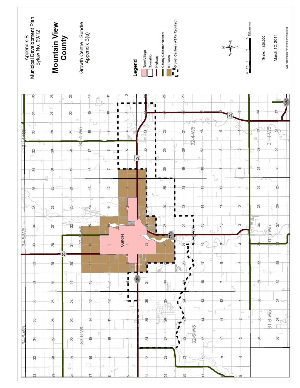
68 Page 64
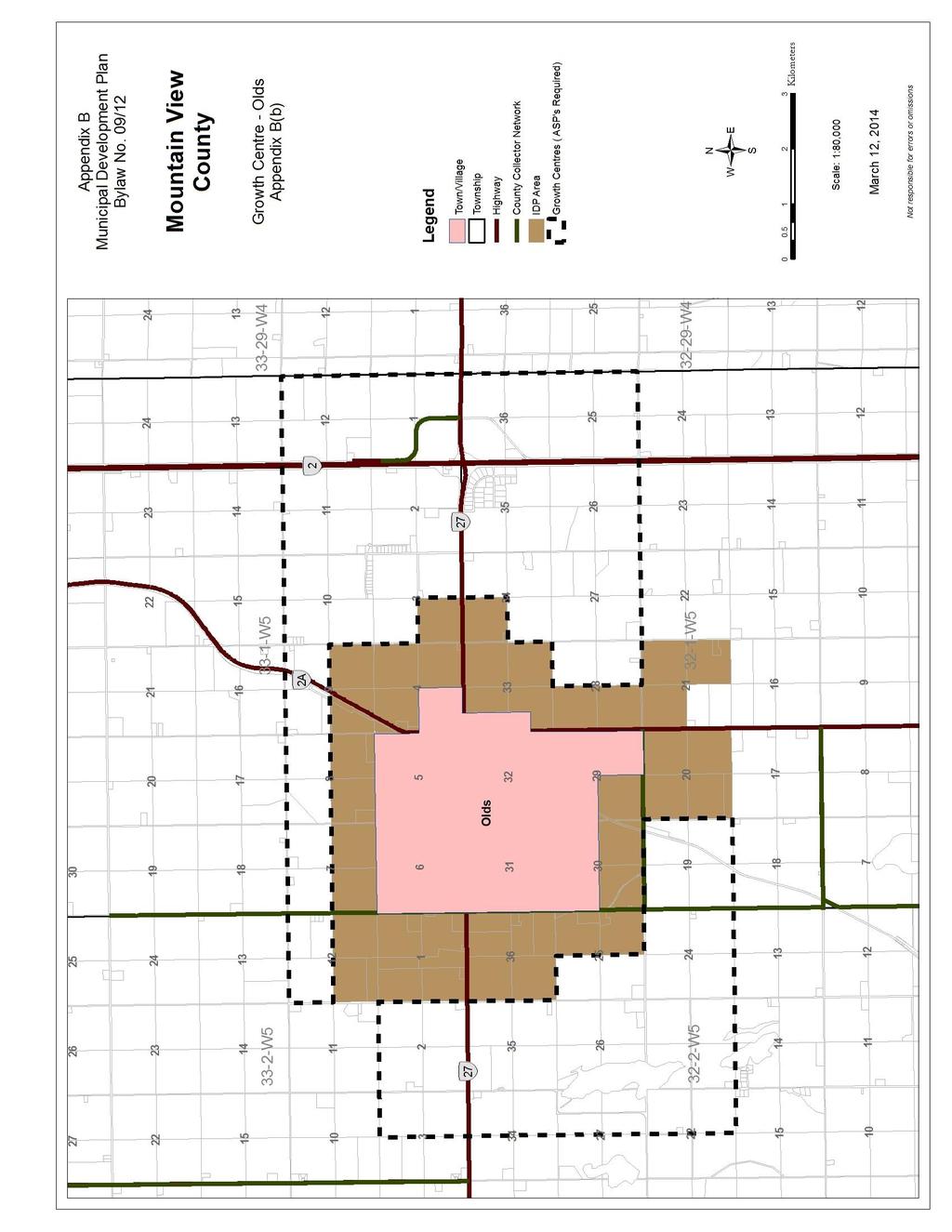
69 Page 65
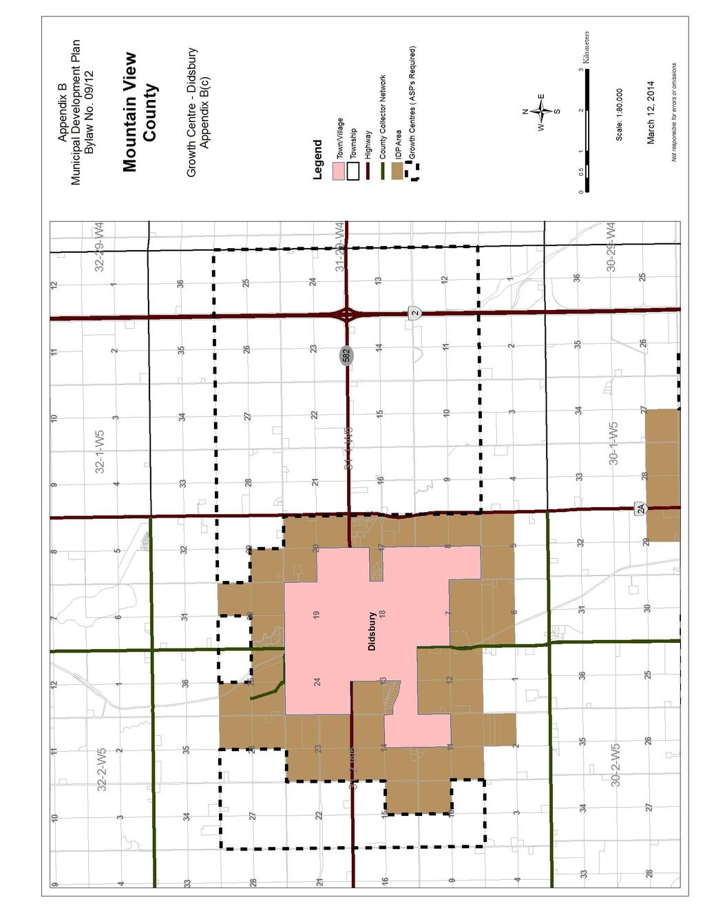
70 Page 66

71 Page 67
72 Page 68
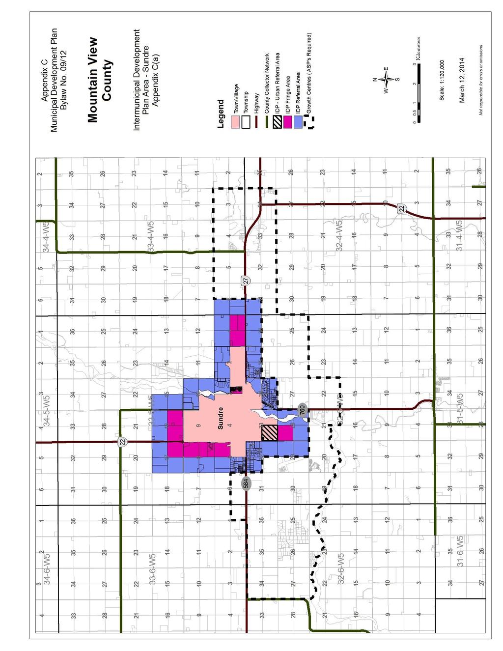
73 Page 69

74 Page 70

75 Page 71
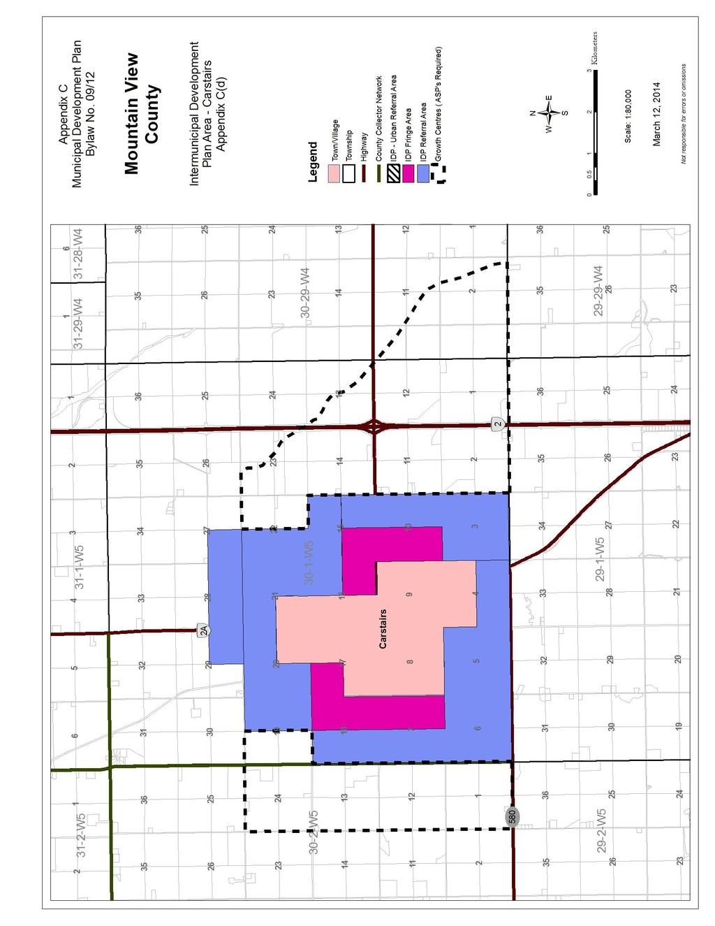
76 Page 72
RURAL GENERAL RG 1. PERMITTED USES DISCRETIONARY USES
 RURAL GENERAL RG PURPOSE: To protect the agricultural land base of the municipality while allowing nonagricultural developments which complement the area's economy. 1. PERMITTED USES DISCRETIONARY USES
Camrose County Municipal Development Plan Bylaw 1372
 Camrose County Municipal Development Plan Bylaw 1372 Prepared by: #200, 10576 113 Street, Edmonton, AB T5H 3H5 Tel: (780) 423-4123 Fax: (780) 426-0659 Contact: Shree Shinde, Project Manager Date: April
North Qu Appelle No. 187 Bylaw Basic Planning Statement - Table of Contents
 - Table of Contents Section1 Introduction 2 Section 2 - The Rural Municipality of North Qu Appelle No. 187 3 Section 3 Municipal Goals.... 3 Section 4 Agriculture and Natural Resources.. 4 Section 5 Residential
Bylaw No The Corman Park Saskatoon Planning District Official Community Plan Bylaw, 2010
 Bylaw No. 8844 The Corman Park Saskatoon Planning District Official Community Plan Bylaw, 2010 Codified to Bylaw No. 9446 May 23, 2017 BYLAW NO. 8844 The Corman Park Saskatoon Planning District Official
Corman Park - Saskatoon Planning District Official Community Plan
 1 Corman Park - Saskatoon Planning District Official Community Plan CONSOLIDATED: October, 2017 2 Table of Contents Bylaw Amendments... 3 Section 1: Foundations... 4 Section 2: Future Growth Sector Objectives
TOTTENHAM SECONDARY PLAN
 TOTTENHAM SECONDARY PLAN AMENDMENT NO. 11 TO THE OFFICIAL PLAN OF THE TOWN OF NEW TECUMSETH The following text and schedules to the Official Plan of the Town of New Tecumseth constitute Amendment No. 11
Bylaw No , being "Official Community Plan Bylaw, 2016" Schedule "A" DRAFT
 Bylaw No. 2600-2016, being "Official Community Plan Bylaw, 2016" Schedule "A" Urban Structure + Growth Plan Urban Structure Land use and growth management are among the most powerful policy tools at the
A Guide to the Municipal Planning Process in Saskatchewan
 A Guide to the Municipal Planning Process in Saskatchewan A look at the municipal development permit and the subdivision approval process in Saskatchewan May 2008 Prepared By: Community Planning Branch
MUNICIPAL DEVELOPMENT PLAN
 MUNICIPAL DEVELOPMENT PLAN Prepared by: The Council and Planning and Development Services Bylaw No. 1414-09 adopted August 12, 2009 Amending Bylaw - 1480-12 adopted June 12, 2013 Amending Bylaw 1529-14
Township of Tay Official Plan
 Township of Tay Official Plan Draft for Consultation (v.3) March 2016 Contents 1. INTRODUCTION... 1 1.1 Content, Title and Scope... 1 1.2 Basis and Purpose of this Plan... 1 1.3 Plan Structure... 2 2.
Strathcona County Municipal Policy Handbook. Last Review Date: May 21, 2013 Next Review Date: 05/2016
 SER-008-019 Strathcona County Municipal Policy Handbook Conceptual Schemes Date of Approval by Council: 09/28/04; 05/08/2007; 05/21/2013 Resolution No: 786/2004; 386/2007; 314/2013 Lead Role: Chief Commissioner
Prt. NE W5. Prepared for: Municipal District of Foothills #31. Prepared by:
 Prt. NE 22-22-3-W5 Prepared for: Municipal District of Foothills #31 Prepared by: Bowwood Land Services Inc. R.R. 1, Dewinton, Alberta T0L 0X0 Tel: 403-995-2225 Fax: 403-938-4787 " OFFICIAL COPY " ADOPTED
PLANNING REPORT. Lot 5, SDR Lot 6 and 7 Concession 3 Township of Normanby Municipality of West Grey County of Grey
 PLANNING REPORT Dwelling Surplus to a Farm Operation Official Plan and Zoning By-law Amendment and Consent to Sever Lot 5, SDR Lot 6 and 7 Concession 3 Township of Normanby Municipality of West Grey County
Wapiti Ridge Estates Area Structure Plan SE W5M. December Prepared For:
 SE 13-20-1 W5M December 2000 Prepared For: 393494 Alberta Limited, and The Municipal District of Foothills No. 31 Prepared By: Kristi Beunder Professional Planning Services Calgary, Alberta Ph: 201-3309
3.1. OBJECTIVES FOR RESIDENTIAL LAND USE DESIGNATIONS GENERAL OBJECTIVES FOR ALL RESIDENTIAL DESIGNATIONS
 3. RESIDENTIAL LAND USE DESIGNATIONS INTRODUCTION The Residential land use designations provide for housing and other land uses that are integral to, and supportive of, a residential environment. Housing
Financial Impact Statement There are no immediate financial impacts associated with the adoption of this report.
 STAFF REPORT Planning and Development Department Subject: Application by RYC Property to rezone a portion of lands on John Murray Dr. and Megan Lynn Dr. from R2 to R3 and to enter into a Development Agreement
Conceptual Scheme SE W4
 December 2012 1. PURPOSE 1.1. The purpose of a Conceptual Scheme (CS) is as follows: a) To provide a framework for the subsequent subdivision and/or development of land within the Country Residential Policy
Municipal Development Plan Bylaw County of Athabasca No. 12
 TABLE OF CONTENTS PART ONE - INTRODUCTION 1 1. PLAN PURPOSE 1 2. PLAN FORMAT 1 PART TWO - PLAN GOAL 2 1. PLAN GOAL 2 2. BASIS 2 PART THREE - PLAN OBJECTIVES 3 1.0 - AGRICULTURE 3 2.0 - COUNTRY RESIDENTIAL
Rural Municipality of Kellross No Official Community Plan. Bylaw No
 Rural Municipality of Kellross No. 247 Official Community Plan Bylaw No. 2009-03 2 BYLAW NO. 2009-03 THE RURAL MUNICIPALITY OF KELLROSS NO. 247 LEROSS, SASKATCHEWAN A Bylaw of the Rural Municipality of
Planning Justification Report
 Planning Justification Report, Township of Puslinch FARHI HOLDINGS CORPORATION Updated January 27, 2017 Zelinka Priamo Ltd. Page i TABLE OF CONTENTS Page No. 1.0 1.1 1.2 1.3 2.0 2.1 2.2 2.3 2.4 2.5 3.0
ALC Bylaw Reviews. A Guide for Local Governments
 2018 ALC Bylaw Reviews A Guide for Local Governments ALC Bylaw Reviews A Guide for Local Governments This version published on: August 14, 2018 Published by: Agricultural Land Commission #201-4940 Canada
STAFF REPORT PLN September 11, 2017
 Page: 1 TO: SUBJECT: GENERAL COMMITTEE APPLICATIONS FOR OFFICIAL PLAN AMENDMENT AND ZONING BY-LAW AMENDMENT 37 JOHNSON STREET WARD: WARD 1 PREPARED BY AND KEY CONTACT: SUBMITTED BY: GENERAL MANAGER APPROVAL:
City of Grande Prairie Development Services Department
 City of Grande Prairie Development Services Department COUNTRYSIDE SOUTH OUTLINE PLAN Prepared by: GPEC Consulting Ltd. #202, 10712-100th Street Grande Prairie, AB Council Resolution of August 20, 2001
8.5.1 R1, Single Detached Residential District
 8.5.1 R1, Single Detached Residential District The purpose of this district is to provide for residential development in the form of single detached dwellings. Dwelling, Single Detached Home Business,
SUPPLEMENTARY REQUIREMENTS SPECIFIED PENALTIES FOR OFFENCES RIPARIAN SETBACK MATRIX MODEL RURAL APPROACH STANDARDS POLICY COMMUNITY STANDARDS BYLAW
 APPENDICES APPENDIX A APPENDIX B APPENDIX C APPENDIX D APPENDIX E APPENDIX F APPENDIX G APPENDIX H APPENDIX I APPENDIX J APPENDIX K SUPPLEMENTARY REQUIREMENTS TELECOMMUNICATION TOWERS CONFINED FEEDING
MUNICIPAL DISTRICT OF WAINWRIGHT MUNICIPAL DEVELOPMENT PLAN. BYLAW NO As amended to May 15, 2007
 MUNICIPAL DISTRICT OF WAINWRIGHT MUNICIPAL DEVELOPMENT PLAN BYLAW NO. 1319 As amended to May 15, 2007 May 2007 Note: This document has been prepared for convenience only. The official Municipal Development
Land Use Planning Analysis. Phase 2 Drayton Valley Annexation Proposal
 Land Use Planning Analysis Phase 2 Drayton Valley Annexation Proposal Prepared for Town of Drayton Valley Prepared by Mackenzie Associates Consulting Group Limited March, 2011 TABLE OF CONTENTS 1.0 INTRODUCTION...
Rural Municipality of Estevan #5
 h Rural Municipality of Estevan #5 Official Community Plan Bylaw No. 4-2014 RM of Estevan No. 5 Official Community Plan A Way to the Future Bylaw No.4-2014 TABLE OF CONTENTS 1 Introduction... 4 1.1 AREA
ADMINISTRATION RECOMMENDATION(S) 2017 January 26. That Calgary Planning Commission recommends APPROVAL of the proposed Land Use Amendment.
 2017 January 26. That Calgary Planning Commission recommends APPROVAL of the proposed Land Use Amendment.") WEST OF NORTHMOUNT AND CHARLESWOOD Page 1 of 7 EXECUTIVE SUMMARY This land use amendment application seeks to redesignate a single residential parcel located in the community of Brentwood from Residential
WEST OF NORTHMOUNT AND CHARLESWOOD Page 1 of 7 EXECUTIVE SUMMARY This land use amendment application seeks to redesignate a single residential parcel located in the community of Brentwood from Residential
Rule 80. Preservation of Primary Agricultural Soils Revised and approved by the Land Use Panel during its public meeting on January 31, 2006.
 Rule 80. Preservation of Primary Agricultural Soils Revised and approved by the Land Use Panel during its public meeting on January 31, 2006. (A) Purpose. In accordance with 10 V.S.A. Sections 6025(b)
4.2 LAND USE INTRODUCTION
 4.2 LAND USE INTRODUCTION This section of the EIR addresses potential impacts from the Fresno County General Plan Update on land use in two general areas: land use compatibility and plan consistency. Under
Subdivision Information Package
 Subdivision Information Package County of Northern Lights January 2018 Title Page a Photo courtesy of: Shawn Elliot ISL Engineering and Land Services Ltd. is an award-winning full-service consulting firm
CYPRESS COUNTY MUNICIPAL DEVELOPMENT PLAN
 CYPRESS COUNTY MUNICIPAL DEVELOPMENT PLAN Bylaw 2015/26 Adopted July, 2015 Cypress County Municipal Development Plan Adopted July 2015 PREFACE This document is a statement of goals, objectives and policies
Highland Green Estates Neighbourhood Area Structure Plan
 Highland Green Estates Neighbourhood Area Structure Plan Original Outline Plan approved by Council: March 10, 1997 Outline Plan amended by Council: March 24, 1997 Converted to a Neighbourhood Area Structure
PIN , Part 1, Plan SR-713 in Lot 2, Concession 5, Township of McKim (1096 Dublin Street, Sudbury)
") STAFF REPORT Applicant: Dalron Construction Limited Location: PIN 02124-0103, Part 1, Plan SR-713 in Lot 2, Concession 5, Township of McKim (1096 Dublin Street, Sudbury) Official Plan and Zoning By-law:
STAFF REPORT Applicant: Dalron Construction Limited Location: PIN 02124-0103, Part 1, Plan SR-713 in Lot 2, Concession 5, Township of McKim (1096 Dublin Street, Sudbury) Official Plan and Zoning By-law:
CHAPTER Committee Substitute for Committee Substitute for Senate Bill No. 2188
 CHAPTER 2004-372 Committee Substitute for Committee Substitute for Senate Bill No. 2188 An act relating to land development; amending s. 197.502, F.S.; providing for the issuance of an escheatment tax
Planning Rationale in Support of an Application for Plan of Subdivision and Zoning By-Law Amendment
 Planning Rationale in Support of an Application for Plan of Subdivision and Zoning By-Law Amendment The Kilmorie Development 21 Withrow Avenue City of Ottawa Prepared by: Holzman Consultants Inc. Land
Belmead Neighbourhood Structure Plan
 Belmead Neighbourhood Structure Plan Office Consolidation November 2005 Prepared by: Planning and Policy Services Branch Planning and Development Department City of Edmonton Bylaw 6619 was adopted by Council
Chapter 100 Planned Unit Development in Corvallis Urban Fringe
 100.100 Scope and Purpose. Chapter 100 Planned Unit Development in Corvallis Urban Fringe (1) All applications for land divisions in the Urban Residential (UR) and Flood Plain Agriculture (FPA) zones within
POLICY AMENDMENT AND LAND USE AMENDMENT RICHMOND (WARD 8) RICHMOND ROAD SW AND 24 STREET SW BYLAWS 10P2018 AND 52D2018
 RICHMOND ROAD SW AND 24 STREET SW BYLAWS 10P2018 AND 52D2018") Page 1 of 12 EXECUTIVE SUMMARY This land use amendment proposes to redesignate two parcels of approximately 0.30 hectares ± (0.74 acres ±) located in the community of Richmond from DC Direct Control District
Page 1 of 12 EXECUTIVE SUMMARY This land use amendment proposes to redesignate two parcels of approximately 0.30 hectares ± (0.74 acres ±) located in the community of Richmond from DC Direct Control District
TOWNSHIP OF WILMOT OFFICIAL PLAN November 2006 Consolidation
 TOWNSHIP OF WILMOT OFFICIAL PLAN November 2006 Consolidation Township of Wilmot Development Services 60 Snyder s Road West Baden, ON N3A 1A1 p. 519.634.8444 f. 519.634.5044 www.wilmot.ca info@wilmot.ca
Planning Justification Report
 Planning Justification Report 101 Kozlov Street, Barrie, Ont. Destaron Property Management Ltd. November 2015 Revised February 2017 TABLE OF CONTENTS Page 1.0 INTRODUCTION... 1 2.0 DESCRIPTION OF SUBJECT
INTERMUNICIPAL DEVELOPMENT PLAN
 County of Lethbridge and City of Lethbridge INTERMUNICIPAL DEVELOPMENT PLAN County Bylaw No. 1254 City Bylaw No. 5242 SCHEDULE A August 2004 TABLE OF CONTENTS Page PART 1 INTRODUCTION 1.1 Background...
Torch Lake Township Antrim County, Michigan
 Torch Lake Township Antrim County, Michigan Farmland and Open Space Development Rights Ordinance Ordinance No. 04-01 Effective September 3, 2004 AN ORDINANCE creating a farmland and open space protection
1.0 Introduction. November 9, 2017
 November 9, 2017 Andrew Bone, Planner III Regional Planning Policy and Strategic Initiatives Halifax Regional Municipality 40 Alderney Drive Dartmouth, NS, B2Y 2N5 Subject: Application to amend the Bedford
Draft Model Access Management Overlay Ordinance
 Draft Model Access Management Overlay Ordinance This model was developed using the City of Hutchinson and the Trunk Highway 7 corridor. The basic provisions of this model may be adopted by any jurisdiction
MAKING THE MOST EFFECTIVE AND SUSTAINABLE USE OF LAND
 165 SOC146 To deliver places that are more sustainable, development will make the most effective and sustainable use of land, focusing on: Housing density Reusing previously developed land Bringing empty
PLANNING REPORT. Prepared for: John Spaleta 159 Delatre Street Woodstock Ontario N4S 6C2
 PLANNING REPORT County Official Plan Amendment and Zoning By-law Amendment to Permit a Seasonal Dwelling on an Existing Lot of Record with Access onto a Seasonally Maintained Road Parts of Lot 29, Concession
City of Brandon Brownfield Strategy
 City of Brandon Brownfield Strategy 2017 Executive Summary A brownfield is a property, the expansion, redevelopment, or reuse of which may be complicated by the presence or potential presence of a hazardous
Flinders Avenue, Lara Planning Scheme Amendment Combined Application for Rezoning and Multi-Lot Subdivision Reference : Decembe
 143-179 Flinders Avenue, Lara Planning Scheme Amendment Combined Application for Rezoning and Multi-Lot Subdivision Reference: 14134-03 TGM Group Geelong Melbourne Ballarat 1/27-31 Myers Street (PO Box
AMENDMENT NUMBER 38 TO THE OFFICIAL PLAN OF THE TOWNSHIP OF WEST LINCOLN (COMPLIANCE)
") AMENDMENT NUMBER 38 TO THE OFFICIAL PLAN OF THE TOWNSHIP OF WEST LINCOLN (COMPLIANCE) 2013 AMENDMENT NUMBER 38 TO THE OFFICIAL PLAN OF THE TOWNSHIP OF WEST LINCOLN PART 1 - THE PREAMBLE 1.1 TITLE This
AMENDMENT NUMBER 38 TO THE OFFICIAL PLAN OF THE TOWNSHIP OF WEST LINCOLN (COMPLIANCE) 2013 AMENDMENT NUMBER 38 TO THE OFFICIAL PLAN OF THE TOWNSHIP OF WEST LINCOLN PART 1 - THE PREAMBLE 1.1 TITLE This
THE CORPORATION OF THE TOWNSHIP OF KING THE CERTIFICATE PAGE FOR AMENDMENT NO. 89 TO THE OFFICIAL PLAN OF THE TOWNSHIP OF KING
 THE CORPORATION OF THE TOWNSHIP OF KING THE CERTIFICATE PAGE FOR AMENDMENT NO. 89 TO THE OFFICIAL PLAN OF THE TOWNSHIP OF KING (KING CITY COMMUNITY PLAN) The attached text and schedules constituting Amendment
RESIDENTIAL AND RECREATIONAL
 Energy, Mines & Resources Land Management Branch 320-300 Main Street Whitehorse, Yukon Y1A 2B5 667-5215 Fax 667-3214 www.emr.gov.yk.ca RESIDENTIAL AND RECREATIONAL Lot Enlargement Policy OBJECTIVE To facilitate
8Land Use. The Land Use Plan consists of the following elements:
 8Land Use 1. Introduction The Land Use Plan consists of the following elements: 1. Introduction 2. Existing Conditions 3. Opportunities for Redevelopment 4. Land Use Projections 5. Future Land Use Policies
York Neighbourhood Area Structure Plan
 York Neighbourhood Area Structure Plan Office Consolidation March 2006 Prepared by: Planning and Policy Services Branch Planning and Development Department City of Edmonton Bylaw 7064 was adopted by Council
For Vintages of Four Mile Creek Town of Niagara on the Lake, Ontario
 Planning Impact Analysis For Vintages of Four Mile Creek Town of Niagara on the Lake, Ontario Prepared by: Upper Canada Consultants 261 Martindale Road Unit #1 St. Catharines, Ontario L2W 1A1 Prepared
Land Use. Land Use Categories. Chart 5.1. Nepeuskun Existing Land Use Inventory. Overview
 Land Use State Comprehensive Planning Requirements for this Chapter A compilation of objectives, policies, goals, maps and programs to guide the future development and redevelopment of public and private
CASTLES OF CALEDON URBAN DESIGN REPORT
 CASTLES OF CALEDON URBAN DESIGN REPORT PROPOSED RESIDENTIAL DEVELOPMENT CALEDON, ONTARIO 10 JULY, 2015 TABLE CONTENTS: 1.0 DEVELOPMENT 4.0 CONCLUSION 1.1 Introduction 1.2 Castles of Caledon- Urban Design
ADMINISTRATION RECOMMENDATION(S) 2017 May 04. That Calgary Planning Commission recommends APPROVAL of the proposed Land Use Amendment.
 2017 May 04. That Calgary Planning Commission recommends APPROVAL of the proposed Land Use Amendment.") Page 1 of 14 EXECUTIVE SUMMARY This proposed Land Use Amendment seeks to redesignate the subject parcel from Residential Contextual One/Two Dwelling (R-C2) District to a DC Direct Control District to accommodate
Page 1 of 14 EXECUTIVE SUMMARY This proposed Land Use Amendment seeks to redesignate the subject parcel from Residential Contextual One/Two Dwelling (R-C2) District to a DC Direct Control District to accommodate
Residential Project Convenience Facilities
 Standards for Specific Land Uses 35.42.220 E. Findings. The review authority shall approve a Land Use Permit in compliance with Subsection 35.82.110.E (Findings required for approval) or a Conditional
DRAFT FOR PUBLIC HEARING (rev. March, 2016)
") Chapter 200. ZONING Article VI. Conservation/Cluster Subdivisions 200-45. Intent and Purpose These provisions are intended to: A. Guide the future growth and development of the community consistent with
Chapter 200. ZONING Article VI. Conservation/Cluster Subdivisions 200-45. Intent and Purpose These provisions are intended to: A. Guide the future growth and development of the community consistent with
STAFF REPORT. Financial Impact Statement There are no immediate financial impacts associated with the adoption of this report.
 STAFF REPORT Planning and Development Department Subject: Cottage Country Unsubstantial Amendment to Development Agreement To: CAO for Planning Advisory Committee, December 13, 2016 Date Prepared: December
ACCESSORY DWELLING UNITS
 ACCESSORY DWELLING UNITS LAND USE BYLAW C-4841-97 ACCESSORY DWELLING UNIT (ADU): means a subordinate dwelling unit attached to, created within or detached from the principal dwelling, single detached,
Town of Falmouth s Four Step Design Process for Subdivisions in the Resource Conservation Zoning Overlay District
 Town of Falmouth s Four Step Design Process for Subdivisions in the Resource Conservation Zoning Overlay District All subdivisions shall be designed in accordance with the following four-step process.
Explanatory Notes. for. The Planning and Development Act, 2007
 Explanatory Notes for The Planning and Development Act, 2007 Introduction The purpose of these notes is to explain the provisions of The Planning and Development Act, 2007 (the Act). The explanatory notes
Municipal Development Plan. The Village of Warburg
 Municipal Development Plan The Village of Warburg Table of Contents PART ONE: BACKGROUND AND PURPOSE 1 SECTION 1: BACKGROUND 1 SECTION 2: GOALS AND POLICIES 1 PART TWO: PHYSICAL ENVIRONMENT 2 SECTION 3:
SUBDIVISION APPLICATION
 PLANNING AND DEVELOPMENT SERVICES 38106 Rge Rd 275, Red Deer County, AB T4S-2L9 Phone: (403) 350-2170 Fax: (403) 346-9840 For Office Use Only File # Roll # Fee Submitted Date Deemed Complete Reference
Article XII. R-1 Agricultural-Low Density Residential District
 Article XII R-1 Agricultural-Low Density Residential District Section 1200. Declaration of Legislative Intent In expansion of the Declaration of Legislative Intent and Statement of Community Development
MIDWAY CITY Municipal Code
 MIDWAY CITY Municipal Code TITLE 9 ANNEXATION CHAPTER 9.01 PURPOSE CHAPTER 9.02 GENERAL REQUIREMENTS CHAPTER 9.03 PROPERTY OWNER INITIATION OF ANNEXATION CHAPTER 9.04 PROCEDURES FOR CONSIDERATION OF PETITION
DEVELOPMENT APPLICATION PRE-CONSULTATION FORM
 DEVELOPMENT APPLICATION PRE-CONSULTATION FORM Meeting Date: Property Owner: Site Address: Applicant & Address Site Area: APPLICATION TYPE (check applicable applications): Local Official Plan Amendment
Division 6 Residential Medium Density Zone: Assessment Criteria and Assessment Tables
 Division 6 Residential Medium Density Zone: Assessment Criteria and Assessment Tables 4.6.1 Residential Medium Density Zone The provisions in this division relate to the Residential Medium Density Zone
Draft Zoning Changes for the 2nd Planning Board Public Hearing, January 22, 2018.
 Draft Zoning Changes for the 2nd Planning Board Public Hearing, January 22, 2018. No changes were made at the 1st Public Hearing. Proposed wording for the 1 st Public Hearing in red, eliminated text in
SUBDIVISION AND DEVELOPMENT REGULATION
 Province of Alberta MUNICIPAL GOVERNMENT ACT SUBDIVISION AND DEVELOPMENT REGULATION Alberta Regulation 43/2002 With amendments up to and including Alberta Regulation 188/2017 Office Consolidation Published
Red Deer, Alberta acres ~ 468 units
 77.97 acres ~ 468 units FORMER CITY BOUNDARY LINE Red Deer, Alberta NEW CITY BOUNDARY LINE Project Details The subject Property is the fee simple interest in the South ½ of NE 12-38-27-W4M, in the City
Housing & Residential Intensification Study Discussion Paper Township of King
 Housing & Residential Intensification Study Discussion Paper Prepared by Planning Department January 2011 1.0 Background 1.1 Provincial Policies (Greenbelt and Growth Plan) Since 2001, the Province of
AGENDA 1. CALL TO ORDER :00 P.M.
 MUNICIPAL PLANNING COMMISSION REGULAR MEETING CITY HALL COUNCIL CHAMBERS SEPTEMBER 24, 2015 AGENDA 1. CALL TO ORDER ------------------------------------------------------------------------ 7:00 P.M. 2.
OFFICE CONSOLIDATION SECONDARY PLAN AREA 21 THE SOUTHGATE SECONDARY PLAN
 OFFICE CONSOLIDATION SECONDARY PLAN AREA 21 THE SOUTHGATE SECONDARY PLAN December 2012 EXPLANATORY NOTES (Secondary Plan Area 21) General (pertaining to all secondary plan office consolidations) i. Secondary
Telecommunications Development Permit Application Package
 Telecommunications Development Permit Application Package POLICY POL#308 Title: Policy Guidelines to Evaluate Commercial Communications Facilities Legal References: Radio Communication Act Municipal Government
Guide to Preliminary Plans
 Guide to Preliminary Plans Introduction The Douglas County is committed to providing open, transparent application processes to the public. This Guide is provided to assist anyone interested in the procedures
DRAFT FOR DISCUSSION PURPOSES ONLY. Port Credit Local Area Plan Built Form Guidelines and Standards DRAFT For Discussion Purposes
 Port Credit Local Area Plan Built Form Guidelines and Standards DRAFT For Discussion Purposes 1 Local Area Plan - Project Alignment Overview Directions Report, October 2008 (General Summary Of Selected
Division 5 Residential Low Density Zone: Assessment Criteria and Assessment Tables
 Division 5 Residential Low Density Zone: Assessment Criteria and Assessment Tables 4.5.1 Residential Low Density Zone The provisions in this division relate to the Residential Low Density Zone as follows
PLANNED UNIT DEVELOPMENT (PUD)
") SECTION 38.01. ARTICLE 38 PLANNED UNIT DEVELOPMENT (PUD) Purpose The purpose of this Article is to implement the provisions of the Michigan Zoning Enabling Act, Public Act 110 of 2006, as amended, authorizing
SECTION 38.01. ARTICLE 38 PLANNED UNIT DEVELOPMENT (PUD) Purpose The purpose of this Article is to implement the provisions of the Michigan Zoning Enabling Act, Public Act 110 of 2006, as amended, authorizing
LAND USE AMENDMENT SPRINGBANK HILL (WARD 6) ELMONT DRIVE SW AND 69 STREET SW BYLAW 114D2017
 ELMONT DRIVE SW AND 69 STREET SW BYLAW 114D2017") Page 1 of 8 EXECUTIVE SUMMARY This land use amendment application proposes to redesignate and subdivide 1.15 hectares of land located within the southwest community of East Springbank to accommodate 17
Page 1 of 8 EXECUTIVE SUMMARY This land use amendment application proposes to redesignate and subdivide 1.15 hectares of land located within the southwest community of East Springbank to accommodate 17
19 Implementation Monitoring Development Applications Finance
 19 Implementation The purpose of this chapter is to establish how the policies of Mississauga Official Plan are implemented and translated into programs. This Plan will be implemented by the powers conferred
General Development Plan Background Report on Agricultural Land Preservation
 General Development Plan 2008 Background Report on Agricultural Land Preservation February 2008 I. Introduction Anne Arundel County has been an agricultural community for over 350 years, beginning with
Village of Barons LAND USE BYLAW NO January Consolidated to Bylaw No. 710, October 2018
 Village of Barons LAND USE BYLAW NO. 677 January 2013 Consolidated to Bylaw No. 710, October 2018 Prepared by. January 2013 Village of Barons Land Use Bylaw No. 677 Amendments Bylaw No. Amendment Description
PLANNING REPORT Gordon Street City of Guelph. Prepared on behalf of Ontario Inc. March 17, Project No. 1507
 PLANNING REPORT 1131 Gordon Street City of Guelph Prepared on behalf of 1876698 Ontario Inc. March 17, 2016 Project No. 1507 423 Woolwich Street, Suite 201, Guelph, Ontario, N1H 3X3 Phone (519) 836-7526
19 Implementation Jurisdiction Monitoring Development Applications Finance
 19 Implementation The purpose of this chapter is to establish how the policies of Mississauga Official Plan are implemented and translated into programs. This Plan will be implemented by the powers conferred
LITTLE MOUNTAIN ADJACENT AREA REZONING POLICY
 LITTLE MOUNTAIN ADJACENT AREA REZONING POLICY JANUARY 2013 CONTENTS 1.0 INTENT & PRINCIPLES...1 2.0 APPLICATION...2 3.0 HOUSING TYPES, HEIGHT & DENSITY POLICIES...3 3.1 LOW TO MID-RISE APARTMENT POLICIES...4
ALBERTA BEACH REGIONAL INTER-MUNICIPAL DEVELOPMENT PLAN
 ALBERTA BEACH REGIONAL INTER-MUNICIPAL DEVELOPMENT PLAN AUGUST 1st, 2008 TABLE OF CONTENTS PART ONE: PREAMBLE...1 1.1) INTRODUCTION... 1 1.2) PLAN PARTNERS... 1 1.3) LOCATION & PLAN AREA... 2 1.4) RELEVANT
PLANNING AND ZONING DEPARTMENT
 Town of Minturn Development Review Process: Guide To Planned Unit Developments (Concept Plan) This guide describes the Planned Unit Development Process. This guide should be utilized in conjunction with
Planning & Development. Background. Subject Properties
 Planning & Development APPLICATION BRIEFING Prepared For: Planning Advisory Committee Submitted by: Jason Fox, Director of Planning & Development Date: Subject: Application by Meech Holdings Limited to
PLANNING PROCEDURES AND FEES BYLAW
 PLANNING PROCEDURES AND FEES BYLAW The following is a consolidated copy of the planning procedures and fees bylaw and includes the following bylaws: Bylaw No. Bylaw Name Adopted Purpose 328 Comox Valley
EXCERPTS FROM HALIFAX REGIONAL MUNICIPALITY CHARTER
 EXCERPTS FROM HALIFAX REGIONAL MUNICIPALITY CHARTER Municipal planning strategy 227 The Council may adopt a municipal planning strategy for all, or part, of the Municipality and there may be separate strategies
Inverness Area Planning Advisory Committee Inverness County Planning Advisory Committee Inverness County Council Planning Staff (EDPC)
") STAFF REPORT To: From: Inverness Area Planning Advisory Committee Inverness County Planning Advisory Committee Inverness County Council Planning Staff (EDPC) Date: January 18, 2018 Reference: Request for
STAFF REPORT To: From: Inverness Area Planning Advisory Committee Inverness County Planning Advisory Committee Inverness County Council Planning Staff (EDPC) Date: January 18, 2018 Reference: Request for
CITY OF FARMERSVILLE CITIZEN ADVISORY COMMITTEE AGENDA November 17, :30 P.M. 1, COUNCIL CHAMBERS, CITY HALL
 I. PRELIMINARY MATTERS CITY OF FARMERSVILLE CITIZEN ADVISORY COMMITTEE AGENDA November 17, 2014 6:30 P.M. 1, COUNCIL CHAMBERS, CITY HALL Call to Order, Roll Call, Prayer and Pledge of Allegiance Welcome
INDIAN RIVER COUNTY, FLORIDA. The Honorable Members of the Planning and Zoning Commission DEPARTMENT HEAD CONCURRENCE
 Public Hearing Legislative INDIAN RIVER COUNTY, FLORIDA M E M O R A N D U M TO: The Honorable Members of the Planning and Zoning Commission DEPARTMENT HEAD CONCURRENCE Robert M. Keating, AICP; Community
MUNICIPAL DEVELOPMENT PLAN BYLAW NO. 1723
 MUNICIPAL DEVELOPMENT PLAN BYLAW NO. 1723 SCHEDULE A Prepared by the January 2004 Consolidated to Bylaw No. 1856, September 2013 TABLE OF CONTENTS Page 1. INTRODUCTION... 1 1.1 Purpose of the Plan...
Chapter Plat Design (LMC)
") Chapter 18.14 Plat Design (LMC) Sections: 18.14.010 Lot width 18.14.020 Right-of-way requirements 18.14.030 Pipe stem lots 18.14.040 Division resulting in minimum lot sizes 18.14.050 Flood prone and bad
Chapter 18.14 Plat Design (LMC) Sections: 18.14.010 Lot width 18.14.020 Right-of-way requirements 18.14.030 Pipe stem lots 18.14.040 Division resulting in minimum lot sizes 18.14.050 Flood prone and bad
MUNICIPAL DISTRICT OF ROCKY VIEW NO. 44 ELBOW VALLEY WEST DIRECT CONTROL DISTRICT BYLAW C
 This document has been consolidated for convenience only. A current listing of any and all amendments can be obtained from the Municpal District Office Bylaw No. Date of Approval Amendment Type Bylaw C-6042-2005