M2 Mid Sugar Acquisition
|
|
|
- Edwina Ryan
- 5 years ago
- Views:
Transcription
1 Upper Columbia Regional Application 2017 M2 MidSugar Acquisition Methow Salmon Recovery Foundation (MSRF) PO Box 755, Twisp, WA Chris Johnson, (509) , PRISM # HWS # 02MMR Anticipated Request SRFB: $ 247,578 Anticipated Request Tributary Committee: $ 43,690 Anticipated Request for Proposal: $ 291,268 Anticipated Other Funding/Contributions/Matches: $ 0 (Name Source, if applicable) Anticipated TOTAL Project Budget: $ 291,268
2 Questions Answers Information Resource REGIONAL INFORMATION 1 What Upper Columbia subbasin is the project in? 2 What project category is your project? 3 What Assessment Unit is the project in? 4 What rank restoration and/or protection priority is the assessment unit the project is located in? 5 What is the primary species the project will target? 6 What secondary species will the project will target? 7 What regional PCSRF Metrics will be implemented with this project? 8 What Primary Ecological Concern does the Project Address? (not required for protection projects) 9 What other Ecological Concerns does the Project Address (not required for protection projects? 10 What is the rank priority of the primary ecological concern this project addresses in the assessment unit it occurs (not required for protection projects) Methow Protection Middle Methow River MMR AU protection Priority 1 Steelhead Spring Chinook, Bull Trout 17.3 acres of floodplain habitat protected from degradation or development 0.25 miles of streambank protected N/A Protection Project Acquisition will preserve the opportunity for future restoration that will address Primary Ecological Concern - #5 Peripheral and Transitional Habitats N/A Protection Project Future restoration actions would address EC# 1 Habitat Quantity, #4 Riparian Condition N/A Protection Project The future restoration project will address the primary ecological concern for the Middle Methow Peripheral and Transitional Habitats 11 Where is the project? Latitude: /Longitude: Wenatchee Entiat Methow Okanogan Restoration Design Only Restoration/Protection Protection Assessment Monitoring Click Here for Assessment Unit names Click Here for table of Assessment Unit ranks Steelhead Spring Chinook Bull trout Steelhead Spring Chinook Bull trout Other (please name) Click Here for regional PCSRF Metric definitions Click here for Ecological Concern definitions See above Click here for table of Ecological Concern ranks by assessment unit
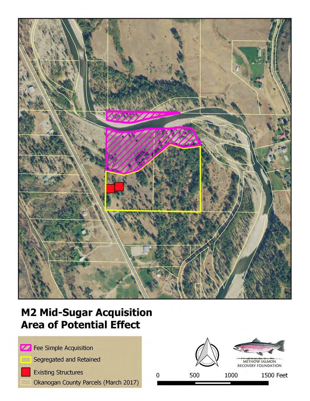
3 Regional Technical Team Summary Information Click here for complete RTT scoring criteria QUESTION 1 In one sentence, what is the purpose of your project? 2 Location of the Restoration Project 3 In one sentence, identify what you are going to do 4 5 How long will it take for the benefits of the project to be realized and how long are they estimated to persist? Benefits to Freshwater Survival or Capacity SUMMARY INFORMATION The purpose of the project is to preserve future restoration opportunities to improve floodplain function, preserve restoration options, and prevent subdivision and development supported by up and out Okanogan County allowances. Project site is located within the M2 restoration reach of the Methow River. The site includes floodplain adjacent to mainstem Methow and active side channel habitat near RM This reach of the Methow provides important spawning and rearing habitat for steelhead and important migration and rearing habitat for spring Chinook. The project will preserve options for future restoration along the Middle Methow River by acquiring fee simple title of a portion of two propertiesproperty that includes approximately 17.3 acres of riparian and floodplain habitat with approximately 1,300 ft. of mainstem and 550 ft. of side channel frontage. Benefits of protection will be realized immediately, while the potential restoration benefits could be realized shortly after acquisition, as this property is the key piece allowing for meaningful restoration of this river segment. These benefits will persist in perpetuity. Acquisition of the property will protect floodplain property and allow future restoration options that are currently being developed. Although the property is within a naturally unconstrained reach of the Methow River with the potential to allow off-channel and side channel habitat processes, levee construction along a large portion of the upstream edge of the property currently isolates the river from activating adjacent floodplain and wetland habitat areas. Acquiring this parcel would allow us the flexibility to evaluate a suite of actions that could be employed to address levee constraints, to restore lost habitat capacity, and prevent development that would permanently foreclose this opportunity. Protection Projects Only 1 Project Protection Type? Fee Simple acquisition with a Deed of Right granted to funders. 2 3 Placement of Protection Project spawning and rearing Placement of Protection Project habitat quality The Middle Methow River provides significant rearing areas for ESAlisted (endangered) Upper Columbia River (UCR) Spring Chinook salmon, spawning and rearing habitat for ESA-listed (threatened) UCR steelhead and Columbia River bull trout, and also supports Pacific lamprey, cutthroat trout, and coho salmon. A large portion of the property is within the mapped floodplain. Past actions (construction of highway 20, construction of the 1949 levee, construction of the 1972 levee) have limited impaired floodplain function, although functional riparian habitat remains along a number of
4 high flow channels. A The flood levee constructed in approximately 1972 currently limits forecloses habitat forming processes and isolates the river from meaningful connection with much of the floodplain. MSRF has already acquired the remainder of the ownership surrounding the levee in previous funding cycles. This Acquiring this propertysite is necessarykey to accomplishing any meaningful restoration of this reach of the Methow River. 4 Threat The property lies within a defined segment of the Methow River where restoration actions have been identified and prioritized through a reach assessment (Reclamation 2010). The current property owners have had the property surveyed and identified five buildable lots. The Owners reached out to MSRF and others in 2011 seeking to sell the portion of the property identified in this application. Due to prioritization of projects by others, MSRF was not able to pursue application at that time. In the event that this application is not successful, the owners have stated that they will complete a short subdivision and market the property for development. Recent building permit issuance by Okanogan County supports that this is a real risk. 5 Benefits to freshwater survival Development of multiple building sites and access roads through the floodplain would preclude the majority of restoration actions on the property and completely eliminate consideration of any actions designed to address the levee and restore channel processes within the reach. This would also eliminate opportunity to reconnect fish access to peripheral habitat and wetlands during critical high flow periods. 6 Conditions Affecting the Project The property is currently impacted by the location of a constructed flood levee that severely restricts channel movement and floodplain connection. Acquisition would allow study and development of restoration strategies to alter the flood protection and restore sensitive areas of the property. Acquisition prior to any additional development would also serve to preserve a wider range of future options for restoration. Acquisition at this time would retire all property rights within the most sensitive portion of theis property that would could limit restoration. Further evaluation of restoration actions and potential risks to other properties would be required prior to any future restoration.
5 Citizens Advisory Committee Ranking Criteria and Summary Information For complete CAC ranking criteria click here CRITERIA SUMMARY INFORMATION Criterion 1: Benefits to Fish and Certainty of Success (60 pts. as a weighted percentage based upon RTT score) Is the project consistent with Yes, protection is the highest priority for this reach. the Recovery Plan Implementation Strategy? Is the project/assessment based on proven scientific methods that will meet objectives? Are there any obstacles that could delay the implementation of this project or study (e.g. permitting, design)? Criterion 2: Project Longevity (30 points) Who has the responsibility to manage and maintain the project? What is the responsibility of current or future landowners? Has the sponsor successfully implemented projects in the past? Are the benefits associated with the project in perpetuity? *Will the project last only a few years? Is there a high risk of failure associated with this project? Criterion 3: Project Scope (15 points) Yes, channel migration modeling indicates that protection of this property should be prioritized to maintain/restore proper functioning conditions. The only potential obstacles to acquisition would be failure to secure project funding or failure to obtain an acceptable appraisal value (MSRF secured a professional appraisal value in 2011 that sellers have now indicated would be acceptable at this time). After nearly five years of discussion and coordination with others, the owners have indicated that they will divide and actively market the property if this effort is unsuccessful. MSRF will be responsible for all aspects of project management. MSRF will work closely with the funders to ensure that acquisition elements are completed within the approved timeline and would work collaboratively with others in the future to develop a preferred restoration strategy that is consistent with reach objectives. Yes, MSRF has completed more than 30 acquisitions through fee or easement. Acquisition of this property would result in perpetual protection. No. Acquisition is the surest means of protection in this case. MSRF has obtained a landowner agreement to pursue acquisition based on the appraised value obtained for the property in The landowner understands that the appraisal is now stale and will need to be updated to reflect current conditions. They have indicated that they are open to renegotiating based on the appraisal update andbut that they are not seeking a higher value. How much habitat is being protected or gained? Are threats imminent? Is the scale of the proposed action appropriate? Although MSRF has not independently Pending a formal survey to create the purchase parcelverified the acreage by a recent survey, MSRF is relying on GIS mapping that indicates that the area includes approximately 17.3 acres of riverine and floodplain habitat. Yes, the seller has completed an elevation survey and has initiated property improvements in anticipation of subdividing and selling buildable lots. Acquisition is proposed for the floodplain, riparian, and riverfront portions of the property. Development of building sites within these
6 areas would effectively foreclose any natural process restoration opportunities. The acquisition area does include several surveyed building sites based on elevation up and out within the area mapped as functional floodplain. The application excludes the adjacent upland areas that would not be required to facilitate future restoration. Actions by Okanogan County and the Corps of Engineers in previous high water events show that there is a risk of re-enforcement and expansion of the levee if other actions are not implemented to address their concerns (principally, protecting Hwy 20). Criterion 4: Community Support (25 points) *Has there been public outreach about this project to assess the level of community support? *Does the project build community support for salmon recovery efforts? *Is there any community outreach planned during and/or after implementation? Has the project sponsor secured landowner participation or acceptance? Will there be public access? MSRF has acquired five adjacent properties over the past six years with active public participation and without opposition. While this proposal is for acquisition only, outreach will be completed in advance of any formal development actions or applications for subsequent restoration funding. In the few weeks after this year s high water, MSRF has been approached by (and subsequently met with)three of the left bank property owners who have expressed support for this acquisition and future restoration actions designed to restore floodplain function they are suffering increased erosion attributed to the levee Yes, MSRF has secured a signed landowner agreement to submit this application. Yes MSRF secured the adjacent properties on both sides of the property and will extend access throughout. Will the project create benefits or raise concerns for particular groups or the community at large? What is the breadth and strength of the partnership supporting the project (technical support, financial, and in-kind contributions, labor)? Criterion 5: Economics (20 points) Acquisition of the property will increase public access to this reach of the Methow River. Subsequent development actions will be developed through a public engagement process to identify and help address any concerns for particular owners or groups or the community at large. MSRF has already made contact with each of the adjacent owners and has their support to make this purchase. Protection of sensitive properties within this reach is a high priority of the recovery community and has been identified as a priority in the Reach Assessments completed for the M2. MSRF has discussed the project through the local WAT process and has been encouraged by many of the participants to pursue the acquisition. Does the project represent an opportunity for economic benefit? Balancing environmental protection, landowner rights and tax base has been an ongoing conversation in Okanogan County since the initial listing of UCR salmon as endangered. The acquisition preserves the landowner opportunity to realize a reasonable economic return on their property and should not result in a significant loss in taxable value based on current assessed values. The property is not in agricultural use, so the change in ownership will not affect agricultural viability. Acquisition of the property will preserve economic opportunities for future restoration actions within this reach.
7 Will this project help the region move closer to delisting or reduce regulatory intervention? Is the project budget clearly defined and reasonable? How much benefit does the project create for the dollars invested? The confinement within this section of the Methow River, known to the restoration community as the Sugar Levee reach, significantly reduces opportunities to increase peripheral habitat necessary for recovery of ESA listed salmonids. Acquisition of this property will increase opportunities for future restoration actions designed to support delisting. Acquisition will also reduce the potential for future conflicts between development and restoration objectives. Securing the property will reduce the potential need for future protection efforts to maintain a home site in a dynamic segment of the Methow River. The acquisition budget is based on realistic costs and actual fees from similar recently completed acquisition projects and is informed by a previously completed professional appraisal. The cost of the project is based on an appraisal completed in Ultimate acquisition values are required to be consistent with federal appraisal standards, and the existing appraisal will need to be updated. The cost of the acquisition will be set by federal appraisal at the fair market value to prevent waste of limited restoration funds. The benefit of this acquisition is multiplied by the investment made to secure the adjacent properties (~$350K prior investment), in that this acquisition is the final piece needed to open the widest range of restoration opportunities in this reach. APPENDICES Appendix A. Response to comments (Final Proposal Only) Appendix B. GSRO Checklist (completed) a. Draft RCO Proposal Checklist b. Final RCO Proposal Checklist Appendix C. Cost Estimate spreadsheet (include in combined pdf as well as in PRISM)
8 Appendix C-3: Restoration, Acquisition, and Combination Project Proposal Appendix C-3: Restoration, Acquisition, and Combination Project Proposal Project Number Project Name M2 Mid-Sugar Acquisition Sponsor Methow Salmon Recovery Foundation (MSRF) List all related projects previously funded or reviewed by RCO: Project # or Name Status Status of Prior Phase Deliverables and Relationship to Current Proposal? In progress Adjacent property has been acquired; access in progress. Public access will serve current proposed acquisition Choose a status Choose a status If previous project was not funded, describe how the current proposal differs from the original. N/A 1. Project brief. This project seeks funding support to acquire the floodplain portion of a 40-acre property along the Methow River in the area known as the Sugar Levee reach. The reach name is due to a large levee that isolates the river from its historic floodplain along several adjoining properties. The acquisition property is located in the Middle Methow (M2) reach and includes approximately 1,300 ft. of mainstem river and 550 ft. of side channel in the mid-section of the levee. The ownership of the property includes the entire floodway of the river and extends across theboth banks of the Methow River channels. This acquisition will completes a multi-year effort to secure Page 1 Manual 18, Salmon Recovery Grants March 2017
9 Appendix C-3: Restoration, Acquisition, and Combination Project Proposal ownership/protection of the entire length of the Sugar Levee so that restoration actions are not limited to the current location. 2. Project location. The M2 Mid-Sugar Acquisition project is located in Okanogan County along the Methow River just north of the town of Twisp at approximately RM Problem statement. The target property is located in the Sugar Levee project area prioritized by MSRF for acquisition and restoration and builds on four properties previously acquired with regional funding support for protection and future restoration. This property is adjacent to the M2 Right Sugar property acquired with SRFB and Tributary funds awarded in The property owner has completed an elevation survey with the stated intention of subdividing and reselling up to four individual home-site parcels. If the owners pursue subdivision and resale based on the surveyed flood elevation, future development in low-lying areas would preclude either active or passive restoration of floodplain processes across a large segment of the surrounding reach. MSRF has secured a signed landowner agreement from the owners, who have demonstrated a strong desire to sell the property since first being contacted in This proposal would purchase the entire river frontage and floodplain portion of the property, retire development rights within this area and allow future restoration on this and adjacent properties, and increase certainties for restoration within the project area. The owner will retain the ability to develop two building sites in retained upland areas, where development would not constrain restoration. 4. List the fish resources present at the site and targeted by this project. Species Life History Present (egg, juvenile, adult) Current Population Trend (decline, stable, rising) Endangered Species Act Coverage (Y/N) Upper Columbia Egg, juvenile, adult Rising (NMFS 2016) Y River Steelhead Upper Columbia Juvenile, adult Stable (NMFS 2016) Y River Spring Chinook Columbia River Adult, sub-adult Declining/Stable (USFWS Y bull trout 2015) Pacific Lamprey Juvenile Declining N Summer Chinook Egg, juvenile, adult Stable N Coho Juvenile, adult Increasing N Others including: Cutthroat trout, dace, suckers, Egg, juvenile, adult Stable N Page 2 Manual 18, Salmon Recovery Grants March 2017
10 Appendix C-3: Restoration, Acquisition, and Combination Project Proposal sculpin, mountain whitefish 5. Describe the limiting factors, and limiting life stages (by fish species) that your project expects to address. The Methow River provides significant spawning and rearing areas for ESA-listed Upper Columbia River (UCR) Spring Chinook salmon (endangered), UCR steelhead (threatened), and Columbia River bull trout (threatened). The river also supports Pacific lamprey, cutthroat trout, and coho salmon. This project is in the Middle Methow M2 reach, where the RTT Biological Strategy identifies protection as a level 1 priority, and ranks it the second priority for protection in the Methow Watershed. The acquisition will protect more than 1300 feet of Methow River shoreline together with the inlet to a perennial side channel that provides good habitat today, and would allow development of future restoration actions to protect and restore the processes necessary to build and maintain habitat for tomorrow. The acquisition would also prevent further fragmentation of riverfront habitat by prevent subdivision and development that would complicate efforts to preserve functional habitat, likely degrade side channel conditions and compromise options for future habitat enhancement actions. Future restoration actions at this site could address four of the top five ecological concerns in the reach (#1 peripheral and transitional habitat, #2 instream habitat complexity, #3 bed and channel form, and #5 riparian condition). The primary goal of the acquisition is to allow restoration of habitat forming processes and prevent development that would preclude restoration. MSRF and Reclamation have prioritized restoration of the Sugar Levee properties as a primary effort for Under the Agreement, Reclamation will provide technical assistance to evaluate opportunities and risks within the levee reach and MSRF will complete public outreach and permitting as required to inform alternatives. The goal of the design effort will be to expand floodplain connection across the isolated historic area to restore peripheral habitat and reduce erosion impacts on adjacent left and right bank properties. This segment iis one of the most historically dynamic segments of the M2 reach. In response to flooding in 1948, and 1972, flood protection levees were built to protect homes, farms and roads throughout the area. While limited channel migration continues to maintain a network of side channels and gravel bars downstream of the levee, the river is held in check on the right bank along the length of the Sugar Levee by extensive bank armoring. Significant erosion has been occurring downstream of the levee on both the right and left bank of the river, which appears to be related to the constriction caused by the levee on both banks of the river. There are several restoration strategies being evaluated for this project area; development of four additional home sites Page 3 Manual 18, Salmon Recovery Grants March 2017
11 Appendix C-3: Restoration, Acquisition, and Combination Project Proposal identified on the property would preclude most actions designed to restore channel processes within the reach. 6. Project goals and objectives. A. What are the project s goals? Protect steelhead and spring Chinook habitat and preserve opportunities for restoration of habitat-forming processes by addressing flood protection constraints (levee and riprap), preventing site subdivision and development (additional home site construction would eliminate opportunities to setback or remove bank hardening and levee features) and initiate development of reach-based restoration across multiple protected channels on both right and left bank (this property is the key due to its central location). B. What are the project s objectives? Acquire fee simple title to 17 +/- acres of floodplain and riparian habitats along approximately 1,300 ft. of mainstem river and 550 ft. of side channel of the Middle Methow River in order to allow further restoration of the site. Protection is identified as a Level 1 action for this reach of the Methow River. C. What are the assumptions and constraints that could impact whether you achieve your objectives? The project assumes that MSRF and the current owner can reach mutual agreement on the value of the property to be acquired. MSRF previously secured a Yellow Book appraisal for the same property (2011), and the owner has stated that he would accept that value now. The prior determined value will have to be confirmed through an updated Yellow Book compliant reviewed appraisal process. 7. Project details. A. Provide a narrative description of the proposed project. The project proposes to acquire, through fee simple title, a 17 +/- acre portion of a larger 40 +/- acre riverfront property with multiple surveyed building sites. The area of the property proposed for acquisition is the last segment of the Sugar Levee area along the Methow River (RM 42.1). The acquisition will include the area riverward of the 1949 alignment, protecting approximately 1,300 ft. of mainstem river and 550 ft. of side channel along the Methow River. Protection is a Level 1 priority in this reach of the Methow. The acquisition will expand on four properties already acquired for protection and future restoration, and will place the ownership of the entire levee with MSRF. This proposal would purchase the property, retire development rights, allow future Page 4 Manual 18, Salmon Recovery Grants March 2017
12 Appendix C-3: Restoration, Acquisition, and Combination Project Proposal restoration on this and adjacent properties, and increase certainties for restoration within the project area. Acquisition value would be established by a reviewed Yellow book appraisal to update a prior appraisal completed in MSRF is concurrently seeking to secure either an easement or fee ownership in approximately 9.8 acres of a separate downstream property (Kedrowski) to expand restoration options. Acquiring the property would place ownership of the lower flow channel of the primary historic side-channel area cut off by the levee. Addition of the property is desired to expand the suite of restoration options but is not necessary to allow a levee setback action. B. Provide a scope of work and detailed list of project deliverables. MSRF proposes to acquire the subject property through fee simple title. Approximately 17.3 acres would be segregated from two existing parcels utilizing a public purposes segregation process. Purchase price would be determined through a reviewed appraisal process. Project concurrent with acquisition. Deliverables are outlined in the table below. All deliverables are the responsibility of MSRF. Item/Milestone Negotiate purchase and sale agreement with seller Order updated Appraisal/Review Outcome Reliable standards for performance of purchase Pending notification of award Target Date (Month/Year) February 2018 March 2018 Finalize Purchase Agreement based on appraisal completion Final agreement for purchase May 2018 Complete survey and public purposes segregation through Okanogan County Clear legal descriptions and segregation of property June/July 2018 Page 5 Manual 18, Salmon Recovery Grants March 2017
13 Appendix C-3: Restoration, Acquisition, and Combination Project Proposal Prepare draft deed of right for ECO and Committee Review Develop baseline survey and stewardship agreements Committee/SRFB Approval of the Conditions within the Proposed deed of right To address interim and longterm uses June/July 2018 July/August 2018 Acquisition Closing Recorded documents to the Committee Project Complete Final Report and invoices to Committee/SRFB Clear title subject to acceptance of title report and appraised values. Transfer of Development Rights completed Acquisition and protections in place Final approval and payment by the Committee/SRFB September/October 2018 November 2018 December 2019 December 2019 C. Explain how the sponsor determined cost estimates. Acquisition costs were determined based on prior appraisal completed in 2011 for the proposed acquisition, adjusted to reflect changes in the real estate market. The costs are in line with comparable protection acquisitions completed within the Methow Valley during the past 5 years. The final value of the fee purchase will be determined by a Yellow Book compliant reviewed appraisal update process. Actual costs for fees, escrow, and recording fees were estimated from quoted figures based on the estimated purchase price. These costs will need to be adjusted based on the value established by the reviewed appraisal. Professional fees for project management, implementation, and monitoring are based on our current rate schedule and estimated hours required to complete the project. Match figures are based on past proportions for comparable projects. D. Describe the design or acquisition alternatives considered to achieve the project s objectives. Negotiations with the landowner were initiated in 2010 concurrent with planning for the larger M2 Reach-based restoration project effort. Acquisition was delayed due to efforts Page 6 Manual 18, Salmon Recovery Grants March 2017
14 Appendix C-3: Restoration, Acquisition, and Combination Project Proposal to coordinate restoration efforts between multiple Project Sponsors working within the Methow Basin and changes in priorities set by sponsor focusing within this reach. Between 2010 and 2016, MSRF, and others, have evaluated a variety of restoration options ranging from conservation easements, permissive restoration, and fee simple acquisitions. This application has been prepared at the request of the landowners, who after five years delay, have determined to subdivide and develop the property for sale with building sites. MSRF elected to pursue acquisition at this time as the best option to ensure a level of certainty for restoration and long-term protection. E. How have lessons learned from completed projects or monitoring studies informed this project? MSRF has more than 15 years of experience with land acquisition and management in support of restoration projects and habitat protection.. F. Describe the long-term stewardship and maintenance obligations for the project or acquired land. Acquisition of the property by MSRF (Sponsor) would result in permanent protection with clear goals and stated objectives for future restoration actions secured by Deed of Right agreements with the funders. The Deed of Right will restrict any future residential development or clearing on the property. Deed of Right protections will be recorded as restrictions on the title of the property to ensure permanent protection and conservation of critical habitat function regardless of future ownership. MSRF will submit proposed deed of right language to funding entities for review to ensure adequate conditions are in place for the protection, conservation, and restoration of the habitat on the property to ensure that the purchase results in measurable benefits to salmon recovery. The property would be managed in conjunction with four adjacent MSRF owned properties and would include provisions for public access. MSRF maintains active partnerships with WA Department of Fish and Wildlife, US Fish and Wildlife Services, WA Department of Ecology, and the Confederated Tribes of the Colville Reservation for restoration and management of habitat projects proposed on protected properties. MSRF has previously coordinated with the Yakama Nation for key protection and restoration efforts in the Beaver Creek and Methow River Basins and continues to maintain several properties through long-term easement agreements. Additional partnerships are being explored with other agencies to ensure maximum public benefit is achieved on properties protected with public funding. Monitoring protocols will be developed for the restoration actions occurring on these properties. Following acquisition, MSRF anticipates working closely with the Regional Technical Team, and other appropriate review bodies, to evaluate proposed restoration alternatives developed for the site to ensure that future actions are compatible with long-term restoration strategies developed for this reach of the M2. Page 7 Manual 18, Salmon Recovery Grants March 2017
15 Appendix C-3: Restoration, Acquisition, and Combination Project Proposal 8. Explain why it is important to do this project now instead of later. The property lies within the Middle Methow (M2) restoration assessment area. This segment of the reach has been prioritized for a suite of protection and restoration actions. The current owners have secured an elevation survey of the property that identifies multiple potential building sites, and have indicated a strong desire to subdivide and sell the property as buildable riverfront if we are unsuccessful with this application. Development of any of the multiple building sites within the lower lying areas would require concurrent disturbance to construct access roads and utilities would preclude most actions designed to address channel confinement and restore channel processes within the reach. This proposal would purchase the floodplain portion of the property, retire development rights that conflict with future restoration on this and adjacent properties, and increase certainties for future restoration objectives within the project area. 9. If the project is a part of a larger overall project or strategy, describe the goal of the overall strategy, explain individual sequencing steps, and which of these steps is included in this application for funding. This acquisition property is located in the Middle Methow M2 Reach area prioritized for protection and restoration (Level 1 action). The immediate area is locally referred to as the Sugar Levee or Sugar Dike section. Past actions in this area include acquisition of four adjacent properties (MSRF) for protection and future restoration, acquisition of several conservation easements (Methow Conservancy), and construction of the 1890 s Side Channel groundwater project (Yakama Nation. 10. Describe the sponsors experience managing this type of project. MSRF is actively involved with land acquisition and management where such actions support future implementation and development of restoration projects in the Methow Basin. MSRF has engaged in property acquisition and management since our formation in 2002 and currently manages acres of owned land. Project experience has been focused on protection of in-stream, riparian and floodplain habitats, while balancing residential and agricultural land uses. Our restoration experience includes in-stream habitat complexity projects, floodplain reconnection projects, riparian restoration projects, irrigation efficiency, and passage improvement projects. A short list of similar acquisition/protection projects managed by MSRF is provided below: Twisp River Ponds Seven properties Chewuch River Floodplain 3 properties in the Lower Chewuch MVID West/Private Properties Twisp River 4 properties , 2015 Upper Beaver Creek Acquisition 138 acres 2011 Page 8 Manual 18, Salmon Recovery Grants March 2017
16 Appendix C-3: Restoration, Acquisition, and Combination Project Proposal Old School House Acquisition and resale 63 acres 2011 Whitefish Island Acquisition (Bird) 17 acres 2012 M2 Sugar Levee ~57 acres List all landowner names. Donald and Kathleen Pedersen N/A 12. List project partners and their role and contribution to the project. 13. Stakeholder outreach. N/A. No barriers to completion other than successful negotiation of value and access to funding. Supplemental Questions Acquisition Project Supplemental Questions Applies to both acquisition-only and combination projects. Answer the following supplemental questions (these are not included in the ten-page limit): A. Provide a detailed description of the property. The acquisition portion of the property is entirely within the mapped floodplain and active channel of the Methow River. Much of the area is isolated from flood channels by past levee construction and placed fill. Riparian condition behind the levee is heavily impacted with little canopy and native vegetation remaining. Riparian conditions along the side channel feature include several acres of relatively intact forested cottonwood riparian forest. The property also includes the inlet of an active side channel of the Methow River. About 700 feet of the rock levee is within the acquisition property. B. List type (fee title or conservation easement) and acreage of acquisitions proposed. Fee Title C. Does the sponsor hold an option or purchase and sale agreement for the property? Page 9 Manual 18, Salmon Recovery Grants March 2017
17 Appendix C-3: Restoration, Acquisition, and Combination Project Proposal No, however we do hold a landowner acknowledgement of willingness and verbal agreement to accept prior appraisal value as a fair purchase price. The Seller understands that the prior appraisal will need to be updated to verify accuracy of the previous appraised value. D. Describe adjacent land uses. Adjacent properties are used for rural residential, recreation, agriculture, and habitat conservation. The acquisition property is located between MSRF-owned parcels previously acquired with public funding and would complete a contiguous block of 57 acres owned by MSRF, assembled over the past 6 years. E. If uplands are included on the property, state their size and explain why they are essential for protecting salmonid habitat. The entire acquisition property is mapped as floodplain with areas of floodway. While elevation surveys do identify multiple building sites as up and out based on Okanogan County regulations, FEMA mapping shows no areas identified as uplands within the acquisition area. F. What percentage of the total project area is intact and fully functioning habitat? While the entire targeted acquisition property has the potential to function as riparian, floodplain, and open space, the presence of the Sugar Levee on the greatly limits habitat forming processes throughout the reach. Currently the 700 +/- foot side channel area and surrounding riparian forest are the only fully intact portions of the property (roughly 20% of the property by acreage). G. Is the site in need of restoration that is not part of this grant application? If yes, describe the restoration need and planned timeframe for implementation. Yes. As previously described, the site is part of the larger M2 Sugar Levee/Dike restoration area. There are currently several proposals for possible restoration opportunities at the site being considered by different project sponsors, all of which would benefit from this acquisition. The landowners have been in communication with multiple entities for more than 5 years seeking to negotiate a fair value for sale of portions of the property and have indicated a strong desire to sell a number of identified building sites located within the floodplain and riparian portions of the property in the near-term. They are not interested in allowing restoration actions under their ownership and have indicated that they will proceed with development if our effort is unsuccessful. Development of the property s building sites would likely preclude any large-scale effort to restore active floodplain processes in the project area. Page 10 Manual 18, Salmon Recovery Grants March 2017
18 Appendix C-3: Restoration, Acquisition, and Combination Project Proposal H. List structures (home, barn, outbuildings, fence, levees, bank armoring, or other infrastructure) on the property and any proposed modifications. If The landowners have improved one building site with electricity, phone, well, and septic system on the portion of the property they intend to retain. They have extended utilities to the undeveloped portion of the property in anticipation of future subdivision. The target acquisition portion of the property does not include any buildings or domestic structures. A rock-faced levee that begins on upstream property runs along the river on river right for about 700 ft. from the upstream property boundary. MSRF is currently developing funding support to evaluate future restoration activities that will build on this and adjacent prior acquisitions to improve peripheral and wetland habitats on the property and restore more natural channel processes. It is likely that developed alternatives would include modifications to the levee to improve river and floodplain processes. I. Describe the long-term stewardship and maintenance obligations for the acquired property. See above J. Describe the following: i. Zoning/land use The property is within the Methow Review District 5 (MRD 5) zoning. ii. Shoreline Master Plan designation The property is within the rural shoreline environment iii. Portion of site within 100-year floodplain The entire area proposed for acquisition is mapped by FEMA as being within the 100- year floodplain; however, the owners have an elevation survey that identifies multiple building sites that meet the up and out requirements for development under Okanogan County regulations. iv. Portion of site within designated floodway The majority of the site (70%) is mapped to be within the FEMA designated floodway, but has been isolated by the constructed levee. K. Explain why federal, state, and local regulations are insufficient to protect the property from degradation. Page 11 Manual 18, Salmon Recovery Grants March 2017
19 Appendix C-3: Restoration, Acquisition, and Combination Project Proposal While Okanogan County is in the process of updating its Comprehensive Plan as well as the Shoreline Master Plans, the most recent drafts indicate that zoning in this area is not likely to change significantly. While a number of regulations could theoretically provide some protection against clearing and filling within such low lying areas, existing County Shoreline and Critical Areas Regulations are not triggered unless other permits are required. Functionally, there are effectively no regulations that would prevent vegetation clearing, road building, or grazing on the floodplain. Under the up and out process, now that the owners have identified building sites by survey elevation, the county will issue development permits for residential construction. Once a residential structure is developed, current regulations allow the landowners to protect the property with riprap and other measures subject to obtaining a relatively simple shoreline exemption. Evidence of this policy is currently visible within the reach by the issuance of building and septic permits for a home to be built within 50 feet of the Methow River through a variance process, despite lack of conformity with setback and acreage requirements. L. For water rights and water savings projects: i. Describe the mechanism that the sponsor intends to use to conserve water (trust, etc.) and explain why this is the preferred approach. N/A; not a water rights or water savings project ii. Which steps in the water conservation process will be completed under this project proposal? N/A; not a water rights or water savings project iii. How much water, if any, will be saved because of this project? By what methods will the sponsor calculate the amount of water conserved? N/A; not a water rights or water savings project M. For acquisition projects intending to purchase multiple properties within an area, identify the target parcels and how the sponsor will prioritize the parcels. N/A Page 12 Manual 18, Salmon Recovery Grants March 2017
20 Appendix C-3: Restoration, Acquisition, and Combination Project Proposal Comments Use this section to respond to the comments received after the initial site visits, and then again after submitting the final application. Response to Site Visit Comments Please describe how the sponsor responded to the review panel s initial site visit comments. RCO recommends that the sponsor list each review panel comment and question and identify the response. The sponsor may use this space to respond directly to the comments. The SRP requested additional information about the status of additional floodplain properties that still need to be acquired to complete a levee setback in the future. MSRF is in negotiations with one downstream landowner (Kedrowski) to acquire approximately 9.8 acres of his property to expand restoration opportunities. The property is not required, but ownership would potentially expand restoration options. Three additional owners (Peter Vogt, Edward Baloun, and Chris Webb) own properties affected by the levee (increased erosion) and have indicated willingness to participate without acquisition requirements. The SRP requested clarification as to how retention of a building site on the nonpurchased portion would affect restoration. The Seller has developed one building site within the higher elevation area of the land that is above and behind the pre-1948 levee and has requested to retain 1 additional site in the same area behind the 1948 levee. In the event that a levee setback is selected as the preferred restoration action, both sites would be behind the proposed levee alignment and on areas identified as up and out of the floodplain. The acquisition and possible levee setback will not increase the risk of flooding on building sites landward of the pre 1948 bank line. The SRP asked where is bank erosion occurring and what are the landowner s plans to stop that? Four property owners (Peter Vogt, Edward Baloun, Chris Webb and the Community Covenant Church) own properties where bank erosion appears to have increased since construction of the 1973 levee. Each of the Owner s has expressed concern about additional property losses. The Webb, Baloun and Vogt properties have all had rock riprap placed on portions of their property since the levee was constructed. Vogt and Webb have indicated a desire to place additional riprap after this tears flows recede. The Covenant Church has lost between Page 13 Manual 18, Salmon Recovery Grants March 2017
21 Appendix C-3: Restoration, Acquisition, and Combination Project Proposal feet of shoreline over the past 5-6 years, and they would like assistance in slowing or halting property loss. How will the Project affect that erosion? Acquisition alone will not affect erosion on these properties. Once an engineering analysis is complete, we will have an increased ability to answer what a levee setback or other action could do in terms of reducing erosion with greater certainty. In advance of the engineering report, we can say, intuitively, that expanding the area of available floodplain should allow the river to dissipate energy on the floodplain rather than focusing that energy against downstream and opposite bank properties. And, while we believe this is correct, no action will be taken until analysis and public outreach have been completed. Response to Post-Application Comments Please describe how the sponsor responded to the review panel s post-application comments. RCO recommends that the sponsor list each of the review panel s comments and questions and identify the response. The sponsor may use this space to respond directly to the comments. Page 14 Manual 18, Salmon Recovery Grants March 2017
22 M2 MidSugar Acquisition Appendix A: Response to Comments Tributary Comments: For accounting purposes, please include the Tributary Committees match ($43,690) in the land purchase cost, not in the other line items MSRF Response: We have made the requested change in the budget spreadsheet. SRP Comment: The SRP requested additional information about the status of additional floodplain properties that still need to be acquired to complete a levee setback in the future. MSRF Response: MSRF is in negotiations with one downstream landowner (Kedrowski) to acquire approximately 9.8 acres of his property to expand restoration opportunities. The property is not required, but ownership would potentially expand restoration options. Three additional owners (Peter Vogt, Edward Baloun, and Chris Webb) own properties affected by the levee (increased erosion) and have indicated willingness to participate without acquisition requirements. SRP Comment: The SRP requested clarification as to how retention of a building site on the nonpurchased portion would affect restoration. MSRF Response: The Seller has developed one building site within the higher elevation area of the land that is above and behind the pre1948 levee and has requested to retain 1 additional site in the same area behind the 1948 levee. In the event that a levee setback is selected as the preferred restoration action, both sites would be behind the proposed levee alignment and on areas identified as up and out of the floodplain. The acquisition and possible levee setback will not increase the risk of flooding on building sites landward of the pre 1948 bank line. RTT/SRP questions/comments from presentation/notes: Comment: Where is bank erosion occurring and what are the landowner s plans to stop that? MSRF Response: Four property owners (Peter Vogt, Edward Baloun, Chris Webb and the Community Covenant Church) own properties where bank erosion appears to have increased since construction of the 1973 levee. Each of the Owner s has expressed concern about additional property losses. The Webb, Baloun and Vogt properties have all had rock rip rap placed on portions of their property since the levee was constructed. Vogt and Webb have indicated a desire to place additional rip rap
23 after this tears flows recede. The Covenant Church has lost between 1520 feet of shoreline over the past 56 years and would like assistance in slowing or halting property loss. Comment: How will the Project affect that erosion? MSRF Response: Acquisition alone will not affect erosion on these properties. Once an engineering analysis is complete, we will have an increased ability to answer what a levee setback or other action could do in terms of reducing erosion with greater certainty. In advance of the engineering report, we can say, intuitively, that expanding the area of available floodplain should allow the river to dissipate energy on the floodplain rather than focusing that energy against downstream and opposite bank properties. And, while we believe this is correct, no action will be taken until analysis and public outreach have been completed.
24 ACQUISTION Project Name M2 MidSugar Acquisition SRFB # Sponsor Methow Salmon Recovery Foundation See SRFB Manual 3 for additional information regarding allowable costs. This attachment is not required, but may be helpful in developing your PRISM costs. OVERALL PROJECT Budget must account for all costs to complete the project GRANT REQUEST Enter only the amount of the grant request Funding not reported in PRISM Source (Grant, Cash, Materials, Labor, Volunteers, etc) Amount Funding amount Match in PRISM Property Costs Item Qty Rate Land and improvements 1 $ 253, $ 253, $ 209,310 $ 43,690 $ STotal $ 253,000 $ 209,310 $ 43,690 $ Incidental Costs Item Qty Rate Boundary Line Adjustment 1 $ 2, $ 2,000 $ 2,000 $ $ Survey 1 $ 3, $ 3,000 $ 3,000 $ $ Cultural Resources 1 $ 5, $ 5,000 $ 5,000 $ $ Closing and Taxes 1 $ 3, $ 3,000 $ 3,000 $ $ Title Reports and Insurance 1 $ 1, $ 1,000 $ 1,000 $ $ Recording Fees 1 $ $ 500 $ 500 $ $ Survey and subdivision coordination 80 $ $ 4,944 $ 4,944 $ Stewardship Plan 16 $ $ 989 $ 989 $ $ Environmental Audit 1 $ $ 500 $ 500 $ $ STotal $ 20,933 $ 20, $ $ Administrative Costs Item Qty Rate Landowner communication 80 $ $ 4,944 $ 4,944 $ $ Acquisition management 90 $ $ 5,562 $ 5,562 $ $ Project admin 60 $ $ 2,781 $ 2,781 $ $ STotal $ 13,287 $ 13,287 $ $ Indirect Costs Description Approved Rate Total Project Base Indirect Costs % $ 19, $ 4,048 $ 4, $ $ Indirect Costs 0.000% STotal $ 4,048 $ 4,048 $ $ Administrative Budget Check GTOTAL $ 247,578 $ 43,690 $ A&E maximum allowed in PRISM $13, PRISM Project Total $ 291,268 A&E validation $ RCO Percentage Match Percentage $ MATCH The Grant Request and Match should equal the total project cost and Budget Check cell should be 0. Sponsors must account for all sources and types of match need to complete the project. Match Type (federal, state, local)
25 LCFRB Budget Detail Application # CUMULATIVE TOTALS This sheet contains automatic calculations Project Name M2 MidSugar Acquisition SRFB # Sponsor Methow Salmon Recovery Foundation OVERALL PROJECT GRANT REQUEST PRISM MATCH MATCH NOT IN PRISM Budget Cost Amount Amount Amount Check Sheet #1 Acquisition Property Costs $ 253,000 $ 209,310 $ 43,690 $ 0 Incidental Costs $ 20,933 $ 20,933 $ $ 0 Administrative Costs $ 13,287 $ 13,287 $ $ 0 Indirect Costs $ 4,048 $ 4,048 $ $ STotal $ 291,268 $ 247,578 $ 43,690 $ 0 Sheet #2 Design Design Costs $ $ $ $ Indirect Costs $ $ $ $ STotal $ $ $ $ 0 Sheet #3 Restoration Construction Costs $ $ $ $ 0 AA&E $ $ $ $ 0 Indirect Costs $ $ $ $ STotal $ $ $ $ 0 GTOTAL $ 291,268 $ 247,578 $ 43,690 $ 0 February 2013


26 Photo 1. Acquisition will allow modifications to this levee to reconnect active floodplain and restore river processes in the reach. Photo 2. The acquisition portion of the property includes this wetland area.
27
28
29

30
31
32
Project Pre-Application
 Pre Application Due Date: Tues, March 5 2013 Draft Application Due Date: Tues, April 30, 2013 Final Application Due Date: Thurs, July 11, 2013 Project Pre-Application (Please use the Up, Down, Left & Right
PROJECT SCORING GUIDANCE. Introduction: National Proiect Selection:
 FOREST LEGACY PROGRAM PROJECT SCORING GUIDANCE Introduction: This document provides guidance to the National Review Panel on how to score individual Forest Legacy Program (FLP) projects, including additional
CITY OF FORT COLLINS NATURAL AREAS AND CONSERVED LANDS EASEMENT POLICY
 CITY OF FORT COLLINS NATURAL AREAS AND CONSERVED LANDS EASEMENT POLICY Adopted January 3, 2012 PURPOSE: The purpose of the policy statement is to clarify the policies and procedures of the City of Fort
DRAFT FOR PUBLIC HEARING (rev. March, 2016)
") Chapter 200. ZONING Article VI. Conservation/Cluster Subdivisions 200-45. Intent and Purpose These provisions are intended to: A. Guide the future growth and development of the community consistent with
Chapter 200. ZONING Article VI. Conservation/Cluster Subdivisions 200-45. Intent and Purpose These provisions are intended to: A. Guide the future growth and development of the community consistent with
Introduction to INRMP Implementation Options
 El Dorado County Integrated Natural Resources Management Plan Introduction to INRMP Implementation Options 1 Our approach to the options evaluation is based on the INRMP components as they are currently
Background and Eligibility Information
 2013 Conservation Futures Application and Ratings Sheet 2016 Jefferson County Conservation Futures Program Property Acquisition and/or Operations and Maintenance Project Application Please complete the
Draft Continuing Authorities Program Section 1135 Detailed Project Report and Integrated Environmental Assessment
 Appendix G Real Estate Shorty s Island / Meander Reach Ecosystem Restoration Kootenai River, Idaho Draft Continuing Authorities Program Section 1135 Detailed Project Report and Integrated Environmental
UNOFFICIAL COPY OF HOUSE BILL 1272 A BILL ENTITLED
 UNOFFICIAL COPY OF HOUSE BILL 1272 M4 6lr0525 By: Delegates Smigiel, Kelley, Rosenberg, and Sossi Introduced and read first time: February 10, 2006 Assigned to: Environmental Matters 1 AN ACT concerning
Validation Checklist. Date submitted: How to use this check-list. Ecosystem Credit Accounting System. Version 1.1&2. Project Information
 Ecosystem Credit Accounting System Version 1.1&2 Last updated April 21, 2017 Validation Checklist Date submitted: Project Information Project Name Trading Area Name Trading Area Type (e.g., TMDL, TNC Ecoregion)
Background and Eligibility Information
 2017 Conservation Futures Application and Ratings Sheet 2017 Jefferson County Conservation Futures Program Property Acquisition and/or Operations and Maintenance Project Application Please complete the
Application Procedures for Easements or Rights of Way on City of Fort Collins Natural Areas and Conserved Lands March 2012
 Application Procedures for Easements or Rights of Way on City of Fort Collins Natural Areas and Conserved Lands March 2012 IMPORTANT NOTE: This document was created to accompany the City of Fort Collins
APPENDIX B. Fee Simple v. Conservation Easement Acquisitions NTCOG Water Quality Greenprint - Training Workshops
 APPENDIX B Fee Simple v. Conservation Easement Acquisitions NTCOG Water Quality Greenprint - Training Workshops Lake Arlington Watershed and Lewisville Lake East Watershed June 21, 2011 Presenter Talking
PROGRAM ADMINISTRATION MANUAL
 PROGRAM ADMINISTRATION MANUAL Created: 12/31/2014 Updated: 02/23/2018 Versions, Editions and Updates Date Name Changes 12/31/2014 Version 1.0 Initial document 01/15/2016 Version 2.0 Updated: Timeline,
Protecting Wild & Scenic River Values Through Land Conservation
 Protecting Wild & Scenic River Values Through Land Conservation RMS & NARRP Symposium Bridging Conservation and Recreation May 20, 2010 Portland, Oregon Phil Kincare Skagit Wild & Scenic River Mt. Baker-Snoqualmie
LIVING LANDS BIODIVERSITY GRANTS: INFORMATION AND APPLICATION. Due: January 16, 2009
 LIVING LANDS BIODIVERSITY GRANTS: INFORMATION AND APPLICATION Due: January 16, 2009 PURPOSE OF LIVING LANDS PROJECT Defenders of Wildlife s Living Lands project provides financial, technical and educational
OPEN SPACE & RECREATION PLAN
 OPEN SPACE & RECREATION PLAN HOPEWELL TOWNSHIP Cumberland County, New Jersey Prepared by: Hopewell Township Environmental Commission Final October 2011 (THIS PAGE INTENTIONALLY LEFT BLANK) PUBLIC MEETINGS
CHAPTER 6 CHESAPEAKE BAY PRESERVATION AREAS AND STREAM PROTECTION AREAS
 CHAPTER 6 CHESAPEAKE BAY PRESERVATION AREAS AND STREAM PROTECTION AREAS 6.1 INTRODUCTION Virginia s Chesapeake Bay Preservation Area (CBPA) Designation and Management Regulations (9VAC10-20 et seq.) require
If projects are received at the counter to be submitted without prior draft review, the project will be deferred to the next meeting.
 5400 Butternut Drive East Syracuse, NY13057-8509 Phone: 315.446.3910 x3 Fax: 315.449.0620 Edward M.Michalenko, PhD. Supervisor Planning & Zoning Samuel C. Gordon, MLA, Director Welcome to the Town of DeWitt
Land Conservation Agreements Project Guidance
 Land Conservation Agreements Project Guidance Stakeholder Informed OTHER OPTIONS Introduction Enhanced or permanent protection of corporate lands through land conservation agreements means that companies
Sample Baseline Documentation Report (BDR) Annotated Template for Environmentally Important Land
 Annotated Template for Environmentally Important Land") Sample Baseline Documentation Report (BDR) Annotated Template for Environmentally Important Land The baseline documentation report (BDR) provides a snap shot of the biophysical condition of a property
Sample Baseline Documentation Report (BDR) Annotated Template for Environmentally Important Land The baseline documentation report (BDR) provides a snap shot of the biophysical condition of a property
RECITALS. B. WHEREAS, Ranch, its successors and assigns, are referred to in the Easement as the Grantor ; and
 Basic Components of Management Plans Associated with Conservation Easement Acquisitions Where A Land Trust Or other third party Is the Grantee April 17, 2012 Key: Text in normal font, without highlight,
IRS FORM 8283 SUPPLEMENTAL STATEMENT DONATION OF CONSERVATION EASEMENT
 Name(s) shown on income tax return Identifying Number Robert T. Landowner 021-34-1234 Susan B. Landowner 083-23-5555 IRS FORM 8283 SUPPLEMENTAL STATEMENT DONATION OF CONSERVATION EASEMENT On November 12,
DEPARTMENT OF THE ARMY OFFICE OF THE CHIEF OF ENGINEERS WASHINGTON, D.C
 DEPARTMENT OF THE ARMY OFFICE OF THE CHIEF OF ENGINEERS WASHINGTON, D.C. 20314-1000 REPLY TO ATTENTION OF: CECW-PM (10-1-7a) THE SECRETARY OF THE ARMY 1. I submit for transmission to Congress my report
Tejon Ranch Conservation and Land Use Agreement Executive Summary
 Tejon Ranch Conservation and Land Use Agreement Executive Summary The Tejon Ranch Company (TRC) and Audubon California, the Endangered Habitats League, Natural Resources Defense Council, Planning and Conservation
Creek Rehabilitation Plan for Apple Valley Questions and Answers from the Pre-Bid Meeting and Site Visit 06/23/2016
 Questions and Answers from the Pre-Bid Meeting and Site Visit 06/23/2016 Q: What are the threatened and endangered species concerns in the area? A: This is potential habitat for Prebles Meadow Jumping
5. STRATEGIES AND RECOMMENDATIONS FOR FLOOD HAZARD REDUCTION
 5. STRATEGIES AND RECOMMENDATIONS FOR FLOOD HAZARD REDUCTION One of the first tasks of the Dungeness River Management Team after it was founded in 1988 was to serve as the advisory body for the 1990 Comprehensive
Transfer of Development Rights
 Ordinance Transfer of Development Rights King County s (WA) 2008 ordinance establishes a transfer of development rights program. The ordinance: Sets eligibility criteria for sending and receiving sites
Purpose: Regulations:
 Administrative Procedures for the Designation and Refinement Of Chesapeake Bay Preservation Area Boundaries Guidance on the Chesapeake Bay Preservation Area Designation and Management Regulations September,
Conservation Easement Stewardship
 Conservation Easements are effective tools to preserve significant natural, historical or cultural resources. Conservation Easement Stewardship Level of Service Standards March 2013 The mission of the
BY BOARD OF COUNTY COMMISSIONERS AN ACT TO BE ENTITLED
 BY BOARD OF COUNTY COMMISSIONERS ORDINANCE NO. AN ACT TO BE ENTITLED AN ORDINANCE AMENDING THE PASCO COUNTY LAND DEVELOPMENT CODE, ARTICLE 700, BY REPEALING EXISTING SECTION 702, ENVIRONMENTALLY SENSITIVE
Chapter 100 Planned Unit Development in Corvallis Urban Fringe
 100.100 Scope and Purpose. Chapter 100 Planned Unit Development in Corvallis Urban Fringe (1) All applications for land divisions in the Urban Residential (UR) and Flood Plain Agriculture (FPA) zones within
Central Pennsylvania Conservancy Project Selection Criteria Form
 Central Pennsylvania Conservancy Project Selection Criteria Form The following criteria guide the actions of the Central Pennsylvania Conservancy s Land Protection Committee and Board of Directors in selecting
Draft Zoning Changes for the 2nd Planning Board Public Hearing, January 22, 2018.
 Draft Zoning Changes for the 2nd Planning Board Public Hearing, January 22, 2018. No changes were made at the 1st Public Hearing. Proposed wording for the 1 st Public Hearing in red, eliminated text in
Georgia Conservation Tax Credit Program Frequently Asked Questions
 Georgia Conservation Tax Credit Program Frequently Asked Questions What are the minimum requirements for eligibility under the Georgia Conservation Tax Credit Program (GCTCP)? Individual and corporate
COASTAL CONSERVANCY. Staff Recommendation January 18, Carmel River Parkway Acquisitions. File No Project Manager: Trish Chapman
 COASTAL CONSERVANCY Staff Recommendation January 18, 2006 Carmel River Parkway Acquisitions File No. 06-104 Project Manager: Trish Chapman RECOMMENDED ACTION: Authorization to disburse up to $3,500,000
Kent Land Trust Strategic Reassessment Project Final Report
 Kent Land Trust Strategic Reassessment Project Final Report Prepared For: Connecticut Institute for Resilience and Climate Adaptation (CIRCA) Prepared by: Michael A. Benjamin, Land Steward, Kent Land Trust
FINAL PERFORMANCE REPORT. GRANT PROGRAM: Endangered Species Act Section 6 Recovery Land Acquisition
 FINAL PERFORMANCE REPORT STATE: Oklahoma GRANT NUMBER: F09AP00237 (E-72-RL-1) GRANT PROGRAM: Endangered Species Act Section 6 Recovery Land Acquisition GRANT TITLE: An Ecoregion Approach for Recovery and
Texas Land Trust Conference March 6, 2015
 Texas Land Trust Conference March 6, 2015 James D. Bradbury James D. Bradbury, PLLC Austin Fort Worth An Overview Unique area of law where the government can take private property Protected by the US Constitution
MITIGATION POLICY FOR DISTRICT-PROTECTED LANDS
 MITIGATION POLICY FOR DISTRICT-PROTECTED LANDS Approved by the District Board of Directors on July 18, 2017 The following Mitigation Policy is intended to inform the evaluation of environmental mitigation-related
TransNet Environmental Mitigation Program: Land Acquisition and Restoration Process and Criteria
 TransNet Environmental Mitigation Program: Land Acquisition and Restoration Process and Criteria On September 26, 2008, the San Diego Association of Governments Board of Directors (BOD) approved the attached
2015 WETLAND CONSERVATION ACT STATUTE CHANGES
 2015 WETLAND CONSERVATION ACT STATUTE CHANGES Summary of Key Statute Changes and Related Legislation with Explanations This summary includes excerpts from Laws of MN 2015, Chapter 4, Article 4. It includes
Federal Mandates and Willing Sellers: Real Estate Acquisition for the Missouri River Recovery Program
 Federal Mandates and Willing Sellers: Real Estate Acquisition for the Missouri River Recovery Program Brad Thompson, Chief, Civil Works Branch U.S. Corps of Engineers, Omaha District US Army Corps of Engineers
Using Easements to Conserve Biodiversity. Jeff Lerner Defenders of Wildlife
 Using Easements to Conserve Biodiversity Jeff Lerner Defenders of Wildlife jlerner@defenders.org Northeast LTA June 10, 2006 Defenders of Wildlife Mission: to protect native wild animals and plants in
Residential Project Convenience Facilities
 Standards for Specific Land Uses 35.42.220 E. Findings. The review authority shall approve a Land Use Permit in compliance with Subsection 35.82.110.E (Findings required for approval) or a Conditional
Staying Connected in the Northern Appalachians
 Staying Connected in the Northern Appalachians Potential Conservation Easement Provisions Designed to Explicitly Address Connectivity in the Northern Appalachians Updated and Revised May 2012 In this document,
Marin County Agricultural Land Conservation Program March 1, 2014
 Marin County Agricultural Land Conservation Program March 1, 2014 I. Purpose of this Document This document describes the Marin County Agricultural Land Conservation Program (County Program). The Marin
Napa County Planning Commission Board Agenda Letter
 Agenda Date: 9/20/2017 Agenda Placement: 8C Napa County Planning Commission Board Agenda Letter TO: FROM: Napa County Planning Commission Charlene Gallina for David Morrison - Director Planning, Building
Conservation Design Subdivisions
 Conservation Design Subdivisions An excerpt from the Rules and Regulations Governing Division of Land in Sheridan County, Wyoming, November 5, 2010 Sheridan County Public Works Department 224 S. Main Street
LLC & MLLC Property Bismark Meadows Bonner County, Idaho
 Vital Ground Property Management Plan LLC & MLLC Property Bismark Meadows Bonner County, Idaho December 10, 2009 (updated 2/12/13) Ryan Lutey The Vital Ground Foundation Building T-2, Fort Missoula Road
RURAL GENERAL RG 1. PERMITTED USES DISCRETIONARY USES
 RURAL GENERAL RG PURPOSE: To protect the agricultural land base of the municipality while allowing nonagricultural developments which complement the area's economy. 1. PERMITTED USES DISCRETIONARY USES
SECTION 6 SUBAREA PLAN IMPLEMENTATION POLICIES
 SECTION 6 SUBAREA PLAN IMPLEMENTATION POLICIES This section describes subarea plan implementation actions to be taken by the City of Escondido. These actions are specific to the city and are supplemental
IMPLEMENTING AGREEMENT. for the EAST CONTRA COSTA COUNTY HABITAT CONSERVATION PLAN/ NATURAL COMMUNITY CONSERVATION PLAN.
 IMPLEMENTING AGREEMENT for the EAST CONTRA COSTA COUNTY HABITAT CONSERVATION PLAN/ NATURAL COMMUNITY CONSERVATION PLAN by and between EAST CONTRA COSTA COUNTY HABITAT CONSERVANCY, COUNTY OF CONTRA COSTA,
Kitsap County Department of Community Development
 Kitsap County Department of Community Development Staff Report and Recommendation Annual Comprehensive Plan Amendment Process for 2018 George s Corner LAMIRD Boundary Adjustment Report Date 7/16/2018 Hearing
NANTUCKET ISLANDS LAND BANK AFFORDABLE HOUSING POLICY Adopted by the vote of the Land Bank Commission on November 10, 2015
 NANTUCKET ISLANDS LAND BANK AFFORDABLE HOUSING POLICY Adopted by the vote of the Land Bank Commission on November 10, 2015 In recent history, the island of Nantucket has experienced a shortage of affordable,
PAPRlamird5-Four Seasons
 PAPRlamird5-Four Seasons Lamird Report This report provides the written record of local circumstances that explains how the 4 Seasons LAMIRD ( this lamird ) fits within the rural element goals of the Growth
APPENDIX H REAL ESTATE REQUIREMENTS
 Malden River Ecosystem Restoration Detailed Project Report APPENDIX H REAL ESTATE REQUIREMENTS April 2007 Malden River Ecosystem Restoration Real Estate Report 1. PURPOSE: The Detailed Project Report
Land Use Application
 Land Use Application Check all permits you are applying for in the boxes provided. Submit this application form, the applicable materials listed in the corresponding permit application packet(s) and application
Environmental Credit Offsets: Not Just for Wetlands Transportation Engineers Association of Missouri
 Environmental Credit Offsets: Not Just for Wetlands Transportation Engineers Association of Missouri March 8, 2018 WHAT IS MITIGATION? Mitigation is the third step in an environmental sequence First step:
Preliminary Caledonia-Lewiston Levee Analysis Conducted by the Levee Working Group
 Preliminary Caledonia-Lewiston Levee Analysis Conducted by the Levee Working Group Analysis Content Overview History of the Levees Current Levee Management and Costs Flood Event Analysis Methodology Brief
Biodiversity Planning Policy and Guidelines for (LEP) Rezoning Proposals
 Rezoning Proposals") Council Policy Biodiversity Planning Policy and Guidelines for (LEP) Rezoning Proposals Table of Contents Table of Contents... 1 Policy... 2 Policy Objectives... 2 Policy Statement... 2 Guidelines... 2
Council Policy Biodiversity Planning Policy and Guidelines for (LEP) Rezoning Proposals Table of Contents Table of Contents... 1 Policy... 2 Policy Objectives... 2 Policy Statement... 2 Guidelines... 2
TRANSFER OF DEVELOPMENT RIGHTS
 STEPS IN ESTABLISHING A TDR PROGRAM Adopting TDR legislation is but one small piece of the effort required to put an effective TDR program in place. The success of a TDR program depends ultimately on the
General Development Plan Background Report on Agricultural Land Preservation
 General Development Plan 2008 Background Report on Agricultural Land Preservation February 2008 I. Introduction Anne Arundel County has been an agricultural community for over 350 years, beginning with
Background and Eligibility Information
 2016 Jefferson County Conservation Futures Program Property Acquisition and/or Operations and Maintenance Project Application Please complete the following application in its entirety. Be sure to answer
Land Use. Existing Land Use
 8 Land Use 8.1 Land Use Chapter Purpose and Contents This element includes a brief summary of existing land use conditions and trends followed by a series of goals, objectives, and recommendations to guide
LAKE OF THE WOODS COUNTY WETLAND CONSERVATION ORDINANCE OF 2002
 Ordinance # LAKE OF THE WOODS COUNTY WETLAND CONSERVATION ORDINANCE OF 2002 ARTICLE 1 TITLE AND PURPOSE Section 1.1. Title This Ordinance shall be known, cited and referred to as the Lake of the Woods
Land Preservation in the Highlands Region
 Land Preservation in the Highlands Region Prepared by the Highlands Water Protection and Planning Council - August 2010 The Highlands watersheds are the best in the State in respect to ease of collection,
FINDING OF NO SIGNIFICANT IMPACT TENNESSEE VALLEY AUTHORITY DISPOSAL FEE OWNERSHIP OF YELLOW CREEK INDUSTRIAL PARK PROPERTIES
 FINDING OF NO SIGNIFICANT IMPACT TENNESSEE VALLEY AUTHORITY DISPOSAL FEE OWNERSHIP OF YELLOW CREEK INDUSTRIAL PARK PROPERTIES In 1971, the Tennessee Valley Authority (TVA) partnered with the Mississippi
ANNUAL ELEMENT PROGRESS REPORT Housing Element Implementation (CCR Title )
") page 1 of 18 Table A Annual Building Activity Report Summary - New Construction Very Low-, Low-, and Mixed-Income Multifamily Projects 1 2 Project Identifier (may be APN No., project name or address) Unit
page 1 of 18 Table A Annual Building Activity Report Summary - New Construction Very Low-, Low-, and Mixed-Income Multifamily Projects 1 2 Project Identifier (may be APN No., project name or address) Unit
ARLINGTON COUNTY, VIRGINIA. County Board Agenda Item Meeting of June 17, 2017
 ARLINGTON COUNTY, VIRGINIA County Board Agenda Item Meeting of June 17, 2017 DATE: June 9, 2017 SUBJECT: Request to authorize advertisement of public hearings by the Planning Commission and County Board
OPEN SPACE PRESERVATION. Reflections on the Value of Acquiring Property for Preservation Purposes
 OPEN SPACE PRESERVATION Reflections on the Value of Acquiring Property for Preservation Purposes What is open space and what does it do? The Town Plan of Conservation and Development defines it as follows:
Summary of the Tejon Ranch Conservation and Land Use Agreement
 Summary of the Tejon Ranch Conservation and Land Use Agreement EXECUTIVE SUMMARY The Tejon Ranch Company (TRC) and Audubon California, the Endangered Habitats League, Natural Resources Defense Council,
CHAPTER 3 PRELIMINARY PLAT
 10-3-1 10-3-3 SECTION: CHAPTER 3 PRELIMINARY PLAT 10-3-1: Consultation 10-3-2: Filing 10-3-3: Requirements 10-3-4: Approval 10-3-5: Time Limitation 10-3-6: Grading Limitation 10-3-1: CONSULTATION: Each
Torch Lake Township Antrim County, Michigan
 Torch Lake Township Antrim County, Michigan Farmland and Open Space Development Rights Ordinance Ordinance No. 04-01 Effective September 3, 2004 AN ORDINANCE creating a farmland and open space protection
Chapter 5. Floodplain Management. 5.0 Introduction. 5.1 Floodplain Management and Regulation
 5.0 Introduction This chapter summarizes the Town s rules and regulations regarding floodplain management and development. The requirements presented in this chapter should be used by the design engineer
ARTICLE FIVE FINAL DRAFT
 ARTICLE FIVE 021218 FINAL DRAFT Sec. 503.6 Open Space Preservation Option Open Space Preservation Option Open Space Preservation developments may be approved in the AR, R-1, R-2 and R-3 zoning districts,
County of Sonoma Agenda Item Summary Report
 County of Sonoma Agenda Item Summary Report Agenda Item Number: 32 (This Section for use by Cler of the Board Only. Cler of the Board 575 Administration Drive Santa Rosa, CA 95403 To: The Sonoma County
ARTICLE XI - CONSERVATION SUBDIVISIONS
 ARTICLE XI - CONSERVATION SUBDIVISIONS Section 1101: Purpose and Intent. This Article is intended to provide for residential subdivisions that are designed based first and foremost on the preservation
Article Optional Method Requirements
 Article 59-6. Optional Method Requirements [DIV. 6.1. MPDU DEVELOPMENT IN RURAL RESIDENTIAL AND RESIDENTIAL ZONES Sec. 6.1.1. General Requirements... 6 2 Sec. 6.1.2. General Site and Building Type Mix...
Final Report: Conserving the Pugwash Estuary
 Final Report: Conserving the Pugwash Estuary Habitat Conservation Fund Grant to Nature Conservancy of Canada, Atlantic Region Report Prepared by: Craig Smith Nova Scotia Program Manager November 20 th,
Annutteliga Hammock Project Surplus and Consolidation Strategy
 Project Overview Annutteliga Hammock is a 31,250-acre partnership acquisition project of the Florida Forever program, of which 12,231 acres have been acquired to date. The intent of the project is to provide
APPENDIX D - REAL ESTATE
 APPENDIX D - REAL ESTATE 1. Purpose Real Estate Plan For Feasibility Study For Lake Lou Yaeger Section 206 Aquatic Ecosystem Restoration Continuing Authorities Project Feasibility Study This report is
Town of Falmouth s Four Step Design Process for Subdivisions in the Resource Conservation Zoning Overlay District
 Town of Falmouth s Four Step Design Process for Subdivisions in the Resource Conservation Zoning Overlay District All subdivisions shall be designed in accordance with the following four-step process.
WASCO COUNTY PRELIMINARY SUBDIVISION APPLICATION
 WASCO COUNTY PRELIMINARY SUBDIVISION APPLICATION DETAILED SPECIFIC WRITTEN REQUEST File Number: SDV- Number of Proposed Lots & their Dimensions: PRELIMINARY SUBDIVISION PLAN REQUIREMENTS The approval of
The Maryland Puritan Tiger Beetle Habitat Conservation Program
 The Maryland Puritan Tiger Beetle Habitat Conservation Program Maryland Department of Natural Resources Annapolis, MD 21401 October 2011 The Maryland Puritan Tiger Beetle Habitat Conservation Program October
Conservancy Mission. Leveraging GIS Technologies in Chesapeake Conservation and Restoration 10/17/2018
 Leveraging GIS Technologies in Chesapeake Conservation and Restoration Rachel Soobitsky Geospatial Project Manager Chesapeake Conservancy Conservation Innovation Center Kristin Kirkwood Executive Director
Facts on Metro Nashville s Development of a Hazard Mitigation Home Buyout Program in Response to the May 2010 Flood June 3, 2010
 Facts on Metro Nashville s Development of a Hazard Mitigation Home Buyout Program in Response to the May 2010 Flood June 3, 2010 Summary: The Metropolitan Government of Nashville is currently working to
Forest Service Role CHAPTER 2
 CHAPTER 2 Forest Service Role Implementation of the Management Plan charters a federal presence with an expanded focus beyond traditional Forest Service roles. In addition to administration of the National
Implementation Tools for Local Government
 Information Note #5: Implementation Tools for Local Government This Information Note is a guide only. It is not a substitute for the federal Fisheries Act, the provincial Riparian Areas Regulation, or
TERRA. Forest CORE Fund Project Application. Applicant Information Applicant Partner Organization Contact Person
 TERRA Forest CORE Fund Project Application Applicant Information Applicant Partner Organization Contact Person Phone Number Address Type of Applicant/ Partner Organization Title Email Address Federal State
Environment and Natural Resources Trust Fund Request for Proposals (RFP)
") Environment and Natural Resources Trust Fund 2012-2013 Request for Proposals (RFP) Project Title: Southeast Minnesota Sensitive Habitat Protection Program (SHPP) ENRTF ID: 067-D Topic Area: D. Land Acquisition
Environment and Natural Resources Trust Fund 2012-2013 Request for Proposals (RFP) Project Title: Southeast Minnesota Sensitive Habitat Protection Program (SHPP) ENRTF ID: 067-D Topic Area: D. Land Acquisition
SAFE HARBOR AGREEMENT FOR VOLUNTARY ENHANCEMENT/RESTORATION ACTIVITIES BENEFITING LAHONTAN CUTTHROAT TROUT ON PRIVATE LANDS WITHIN THE NORTHWEST DPS
 SAFE HARBOR AGREEMENT FOR VOLUNTARY ENHANCEMENT/RESTORATION ACTIVITIES BENEFITING LAHONTAN CUTTHROAT TROUT ON PRIVATE LANDS WITHIN THE NORTHWEST DPS 1 1. Introduction This Safe Harbor Agreement (Agreement)
Siskiyou Land Trust. Strategic Plan Update
 Siskiyou Land Trust Strategic Plan Update 2018-2023 Issued by the Board of Directors of Siskiyou Land Trust, May 2018 Our Mission: The Siskiyou Land Trust is dedicated to long-term stewardship of agricultural,
DESCRIPTION OF A LAND TRUST
 DESCRIPTION OF A LAND TRUST What is a land trust? Land trusts are non-profit organizations that work hand-in-hand with landowners to protect our valuable natural resources. Land trusts have become increasingly
APPLICATION FOR SUBDIVISION APPROVAL OF A SKETCH PLAN with checklist
 Prior to filing any application for SUBDIVISION approval, the applicant shall request in writing that the zoning administrator schedule a pre-submission conference. APPLICATION TO THE PLANNING BOARD TOWN
ORDINANCE NO WHEREAS, the Town of Jupiter ( Town ) has adopted a Comprehensive Plan
 has adopted a Comprehensive Plan") 0 0 ORDINANCE NO. -0 AN ORDINANCE OF THE TOWN COUNCIL OF THE TOWN OF JUPITER, FLORIDA, AMENDING CHAPTER OF THE TOWN CODE TO AMEND SECTION -, ENTITLED INTENT TO ADD PERMITTING LANDGUAGE; TO AMEND SECTION
0 0 ORDINANCE NO. -0 AN ORDINANCE OF THE TOWN COUNCIL OF THE TOWN OF JUPITER, FLORIDA, AMENDING CHAPTER OF THE TOWN CODE TO AMEND SECTION -, ENTITLED INTENT TO ADD PERMITTING LANDGUAGE; TO AMEND SECTION
Article 3 - Rural Districts
 rticle 3 - Rural Districts Div. 3.1. -40: griculture 40 (OI Only) 3-2 3.1.1. Intent... 3-2 3.1.2. Lot Dimensions... 3-2 3.1.3. uilding Placement... 3-3 3.1.4. uilding Height... 3-3 Div. 3.2. -20: griculture
FOR OFFICE USE ONLY Date Submitted Received By Fees Paid $ Receipt No. Received By Application No. Application Complete Final Action Date
 COMMERCIAL, INDUSTRIAL, & MANUFACTURING SITE PLAN (CIM) APPLICATION Mariposa County Planning Department 5100 Bullion Street, P.O. Box 2039 Mariposa, CA 95338 Telephone (209) 966-5151 FAX (209) 742-5024
Appendix G. Non-Federal Letters of Support and Draft Real Estate Plan
 Appendix G Non-Federal Letters of Support and Draft Real Estate Plan REAL ESTATE PLAN UPPER DELAWARE RIVER WATERSHED FEASABILITY STUDY LIVINGSTON MANOR, NEW YORK 1. GENERAL 2. REAL ESTATE REQUIREMENTS
SPECIFIC RESPONSES TO AREA COMMISSION OPPOSITION :
 SPECIFIC RESPONSES TO AREA COMMISSION OPPOSITION 3-14-19: Area Commission reasons for opposition in black APPLICANT S RESPONSE IN RED. The comprehensive planning and design of stream restoration efforts
Texas Parks and Wildlife Foundation Buffer Lands Program Program Description and Application
 Texas Parks and Wildlife Foundation Texas Parks and Wildlife Foundation s mission is to provide private support to Texas Parks and Wildlife Department to manage and conserve the natural and cultural resources