Partner Engineering & Science, Inc.
|
|
|
- Jack Richard
- 5 years ago
- Views:
Transcription

1 Partner Engineering & Science, Inc. Engineering, Environmental and Energy Consulting Commercial Real Estate Due Diligence Engineers who understand your business.

2 HUD Floodplain &Wetlands Regulations 24 CFR Part 55 Floodplain Management & Protection of Wetlands Implements Executive Order for Floodplain Management Implements Executive Order for Protection of Wetlands Lumberton, N.C. September 2018
3 MAP Guide Highlights Project must comply with Part 55 if any part of the site or integral offsite development (e.g. ingress, egress, parking) is located within floodplain Unless an exception applies, HUD will not approve projects in: Floodways, Coastal high hazard areas, or Floodplains if community does not participate in NFIP (see MAP 9.5.E.2) New construction/major improvements: HUD strongly discourages projects in the 100 year floodplain Refinances/minor improvements: HUD discourages projects where lowest floor, life support facilities, or egress/ingress are more than 12 below base flood elevation HUD will consider history or evidence of flooding even if site is not in a FEMA designated floodplain

4 Part 55 Requirements Projects located in a floodplain must be processed under ( The 8 Step Process ) unless an exception applies to the project type

5 Purpose of Part 55 Every Project Must Comply with Part 55 HUD s Doctrine of avoidance Avoid adverse impacts associated with the occupancy and modification of floodplains Avoid support of floodplain development whenever there are practicable alternatives Lumberton, N.C.
6 100 year floodplain ( 55.2(b)(9)) 100 Year Floodplain Aka, Special Flood Hazard Area (SFHA) Areas with a 1% chance of flooding each year if maps are functioning perfectly 26% chance over a 30 year mortgage FEMA designated as Zone A Current FEMA maps are backward looking Studies have predicted that actual risk will increase as current maps age
 FEMA designated as Zone B or Zone X (shaded) Minimum")
7 500 Year Floodplain 500 year floodplain ( 55.2(b)(4)) Areas with 0.2% annual chance of flooding (6% chance over a thirty year mortgage) FEMA designated as Zone B or Zone X (shaded) Minimum floodplain of concern for Critical Actions Shaded Zone X
(5)) The portion of the floodplain which is effective in carrying flow, where the flood hazard is generally the greatest, and where water depths and velocities are the highest.")
8 Floodway Floodway ( 55.2(b)(5)) The portion of the floodplain which is effective in carrying flow, where the flood hazard is generally the greatest, and where water depths and velocities are the highest. No HUD assistance may be approved for use in a floodway, except: Functionally dependent uses Housing is NEVER a functionally dependent use Floodplain function restoration activities Activities excepted under 55.12(c)
(1)) The area subject to high velocity waters, including hurricane wave wash and tsunamis FEMA designated as Zone V STOP Critical Actions and New Construction are not allowed Chapter 9 of the MAP")
9 Coastal High Hazard Area Coastal High Hazard Area ( 55.2(b)(1)) The area subject to high velocity waters, including hurricane wave wash and tsunamis FEMA designated as Zone V STOP Critical Actions and New Construction are not allowed Chapter 9 of the MAP Guide also prohibits projects involving rehab (9.5.E.2) Any activities must be designed for location in a Coastal High Hazard Area under 55.1(c)(3)
10 Critical Actions Critical Action ( 55.2(b)(3)) Any activity for which even a slight chance of flooding would be too great, because such flooding might result in loss of life, injury to persons, or damage to property Examples: - Utilities, roadways providing sole egress from floodprone areas - Hospitals, nursing homes, assisted living - All 232 and 242 projects - But Not housing for independent living for the elderly Critical actions shall not be approved in floodways or coastal high hazard areas Otherwise, 8 Step Process required in 500 and 100 year floodplains

11 Floodplain Preliminary FIRMS If a Preliminary flood map is available, it must be used as best available information unless it is less protective than the current FIRM map
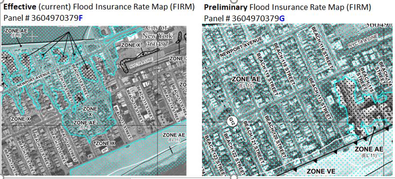

12 Floodplain Preliminary FIRMS


13 Floodplain Multi-Family 223f Town of Ocean Isle Beach, N.C. Revised FEMA FIRM 2018 FEMA FIRM, dated June 2, 2006
14 MAP Guide Highlights Project must comply with Part 55 if any part of the site or integral offsite development (e.g., ingress, egress, parking) is located within floodplain New construction/major improvements: HUD strongly discourages projects in 100 year floodplain Refinances/minor improvements: HUD discourages projects where lowest floor, life support facilities, or egress/ingress are more than 12 below base flood elevation 14
(7): Part 55 does not apply to a site in which an incidental portion is situated in an adjacent floodplain or wetland, but only if: Proposed activities do not occupy or modify the floodplain;")
15 Incidental Floodplain Exception 55.12(c)(7): Part 55 does not apply to a site in which an incidental portion is situated in an adjacent floodplain or wetland, but only if: Proposed activities do not occupy or modify the floodplain; Provisions are made for site drainage that would not have an adverse effect on any wetland; and A permanent covenant or comparable restriction is placed on the property s continued use to preserve the floodplain or wetland.
16 Incidental Portion of Floodplains Graphic shows site contains floodway Floodplain is incidental, if no access roads cross floodplain Project may proceed IF all conditions in 55.12(c)(7) are met
17 Incidental Portion of Floodplains Site contains a floodway and a 100 year floodplain Floodplain is NOT incidental Project cannot use the 8 Step Process and will be rejected
18 Incidental Portion of Floodplains Site contains 100 year floodplain Floodplain is incidental Project may proceed either: By meeting conditions in 55.12(c)(7), OR By completing 8 Step Process
19 Incidental Portion Improvements Multifamily Projects: HUD does not consider improvements to be incidental In other words, if any improvements (buildings, roads, parking lots, etc.) are located in the floodplain, the property does NOT qualify for the Incidental Portion Exception in 55.12(c)(7) and thus is subject to the requirements of Part 55 Proposed221(d)(4) Sub Rehab
(4) Sub Rehab Property")
, and existing improvements (parking) in")
20 Scenario: Incidental Portion Project NOT ALLOWED Proposed 221(d)(4) Sub Rehab Property Boundary Property boundary includes Floodplain (SFHA), and existing improvements (parking) in Floodway.


21 Floodplain Regulations 223f 5 Step does not include: Step 2 Step 3 Step 7
 activities that are not required to complete the full 8 Step Process, and may instead complete the Modified 5 Step Process Steps 2, 3, and 7 do not apply to these activities 55.")
22 Exceptions to Part 55 Broad Channel Queens, NY February (a) activities that are not required to complete the full 8 Step Process, and may instead complete the Modified 5 Step Process Steps 2, 3, and 7 do not apply to these activities 55.12(b) activities that are not required to complete the 8 Step Process 55.12(c) activities that are not required to comply with Part 55

23 WETLANDS
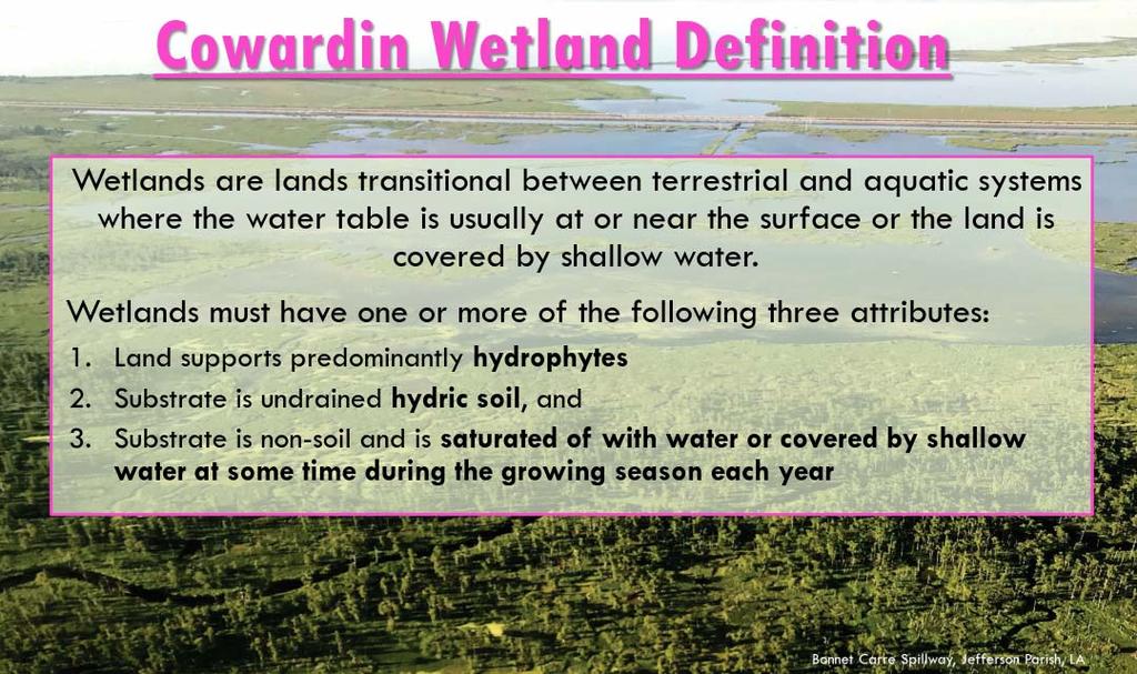
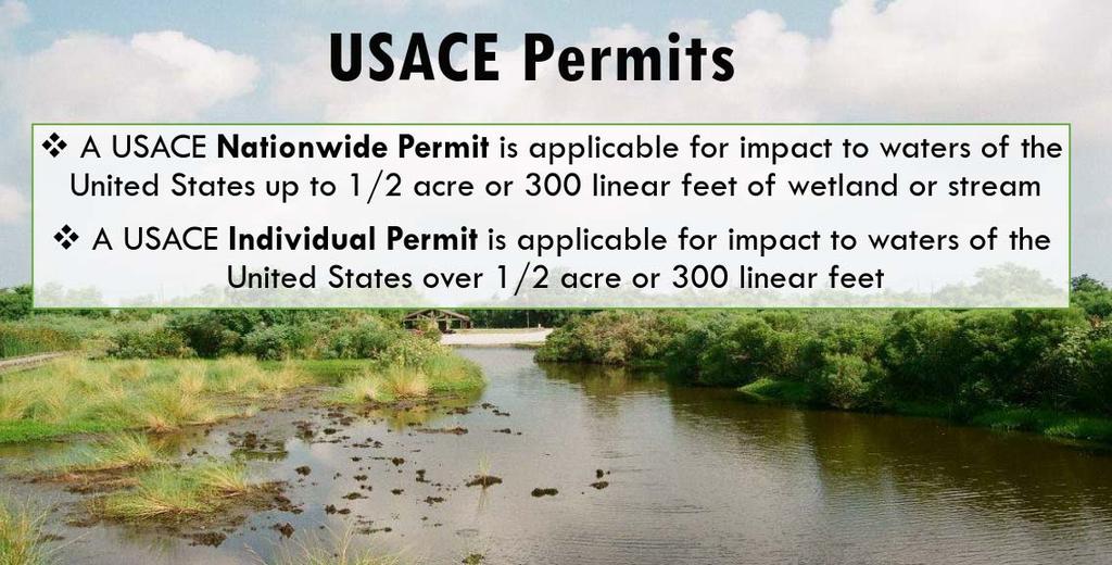
24 Wetland Laws Executive Order 11990, Protection of Wetlands, Promulgated at 24 CFR Part 55 avoid to the extent possible the long and short term adverse impacts associated with the destruction or modification of wetlands and to avoid direct or indirect support of new construction in wetlands wherever there is a practicable alternative... Section 404 of the Clean Water Act Dredging or filling wetlands ( Waters of the US ) requires a Section 404 permit from the Army Corps of Engineers

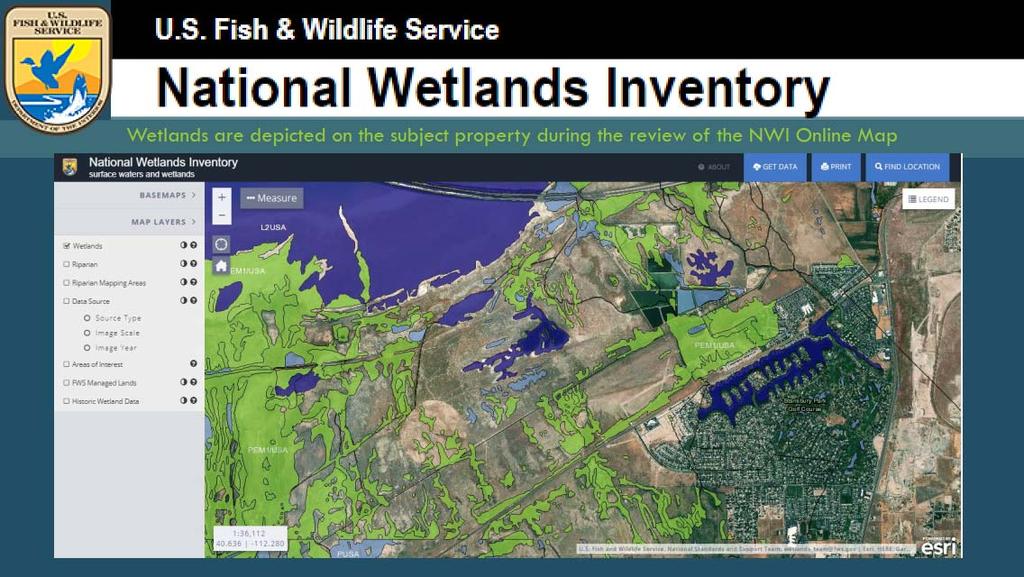
25 WETLANDS Screening tool: FWS National Wetlands Inventory For Delineation: Use this manual from January 1989 (not 1987 manual)
26 WETLANDS
27 WETLANDS

28 WETLANDS Suspect a wetland?
29 Wetlands New Construction? Yes New Construction in a wetland? No Project may proceed w/out an 8 step if: no construction or landscaping activities in the wetland appropriate provision made for site drainage that will not have an adverse effect on the wetland and a permanent covenant or comparable restriction placed on property to preserve the wetland

30 Wetlands New Construction? Yes New Construction in wetland? Yes Project may Proceed if: Avoid wetland, or HUD determines no practicable alternative via 8 step process * * Individual 404 permit can replace steps 1 5 of 8 step but only if no construction in floodplain
31 Wetland
32 Wetlands and the MAP Guide Extensive data must be provided to HUD. Early consultation required. Compensatory Mitigation recommended for unavoidable adverse impacts to more than one acre of wetland (24 CFR (e)(2)). permittee responsible mitigation, mitigation banking, in lieu fee mitigation, preservation easements/protective covenants, and any form of mitigation promoted by state or Federal agencies. Only in rare cases will rehab, purchase and refinancing be permitted to involve wetlands impacts.
33 Protection of Wetlands Wetlands impacts: AVOID THE WETLAND! If an impact cannot be avoided, HUD does an 8 step analysis to make that decision and to mitigate the impacts to both the floodplain and the wetlands. Must do full 8 steps; however for Individuallypermitted 404 sites, the first 5 steps can be eliminated (24 CFR 55.28)
 Executive Order 11990 and 24 CFR")
34 Wetland Multi-Family 221d4 New Construction Wetland Guidelines MAP (223f) Executive Order and 24 CFR 55.20
 and Floodway SITE CONDITIONS: 12 14 foot elevation drop from the edge of the forest buffer to the creek.")
35 Wetland Multi-Family 221d4 New Construction Wetland areas are located within an existing forested, conservation area. Wetland Area SFHA (Zone A12) and Floodway SITE CONDITIONS: foot elevation drop from the edge of the forest buffer to the creek. No planned improvements within wetland or SFHA/Floodway areas, Forested buffer will not be disturbed.

36 Wetland Multi-Family 221d4 New Construction Wetland Impacts can be Direct Disturbance in wetland Indirect Soil erosion and sedimentation during construction. Modification of wetland and watercourse hydrology and degradation of water quality of receiving waters. Loss of and impacts to, wildlife habitat and biodiversity. Potential indirect adverse impacts from storm water discharges can be mitigated through the use of integrated storm water management system
37 HUD Noise Standards HUD Exterior Noise Goal = 55 db or lower Indoor Outdoor Requirements Acceptable 45 db 65 db None. Normally Unacceptable > 45 db > 65 db 75 db Environmental Assessment and attenuation required for NC. Attenuation strongly encouraged for SR. Exterior amenity areas must be mitigated to 65dB for NC and encouraged for SR. EIS required if area is largely undeveloped or will encourage incompatible development. Unacceptable > 45 db > 75 db EIS Required. Attenuation required for NC with approval by the Assistant Secretary for CPD or Certifying Officer.
38 Acceptable Interior Noise If exterior noise less than 65 db, then through standard construction it can be assumed that interior noise does not exceed 45dB. If exterior noise is greater than 65dB, additional analysis required to ensure interior noise does not exceed 45 db. Greater than 65 db means 65.1 db or higher
39 Normally Unacceptable For noise within this range (above 65dB and 75dB) mitigation must demonstrate compliance (Noise Book Figures 17/19 or online Stracat), describe plans & specs, and be certified by project architect. Interior noise levels must be certified to be at or below 45 db. Exterior amenities must be documented and certified to be at or below 65dB. Environmental Impact Statement is required if project located in largely undeveloped area.
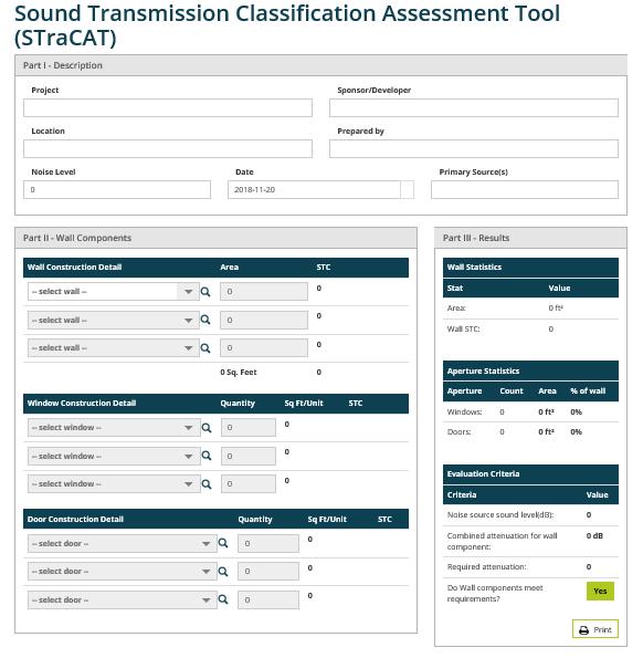
40 HUD Noise Calculator Because sound level is greater than 65 decibels, completion of the Sound Transmission Classification System (STraCAT) is warranted

41 Noise Analysis Traffic Data FHWA Vehicle Classifications
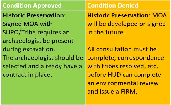
42 Noise Analysis Traffic Data Correlating HUD Definitions with FHWA Classifications HUD Noise Guidebook Autos [FHWA #1,2,3] Medium Trucks [FHWA #5] Heavy Trucks [FHWA #4, 6 13]] FHWA Vehicle Classes 1. Motorcycles 2. Passenger Cars 3. Pickups (Two Axle, Four Tire Single Unit Vehicles) 4. Buses (full length) 5. Two Axle, Six Tire, Single Unit Trucks 6. Three Axle, Single Unit Trucks 7. Four or More Axle, Single Unit Trucks 8. Four or Fewer Axle Single Trailer Trucks 9. Five Axle Single Trailer Trucks 10. Six or More Axle Single Trailer Trucks 11. Five or fewer Axle Multi Trailer Trucks 12. Six Axle Multi Trailer Trucks 13. Seven or More Axle Multi Trailer Trucks
43
44 Criteria to Increase Acceptable Range to 70 db 1. Environmental Impact Study (EIS) is not required and noise is the only environmental issue 2. Received concurrence of HUD Environmental Clearance Officer 3. Project meets other program goals 4. Project conforms with local goals 5. Project sponsor has set forth reasons why the noise cannot be attenuated 6. Other sites with DNL below 65dB are not available Refer to
45 If the Noise Level is Above 75 db New Construction: Noise above 75dB is unacceptable and results in rejected application Unless EIS is prepared and project meets noise standards EIS waiver is possible if criteria are met, including is no other unmitigated environmental concern A Waiver of the EIS is required to be submitted by the HUB to HQ Sub Rehab: No EIS waiver required but must meet MAP Guide 9.5.G for marketability noise mitigation HUD may reject project HUD strongly encourages conversion to a noisecompatible land use (51.101(a)(5)) Must demonstrate interiors are attenuated to 45dB and exterior amenities are attenuated to 65dB. Plan on a minimum 90 day review by HQ


46 Contamination Analysis
 interior testing Subsurface Investigation in 2010 No Information Is there a data gap?")
47 Contamination Analysis No Information under or in building Vapor can be addressed based on (1) soil/groundwater analytical results, (2) sub slab vapor testing or (3) interior testing Subsurface Investigation in 2010 No Information Is there a data gap? Subsurface Investigation in 2007 Is this a complete site characterization?


48 What to do about offsite contamination? Per Chapter 9 in the MAP Guide,

49 HUD Environmental Review Online System (HEROS)
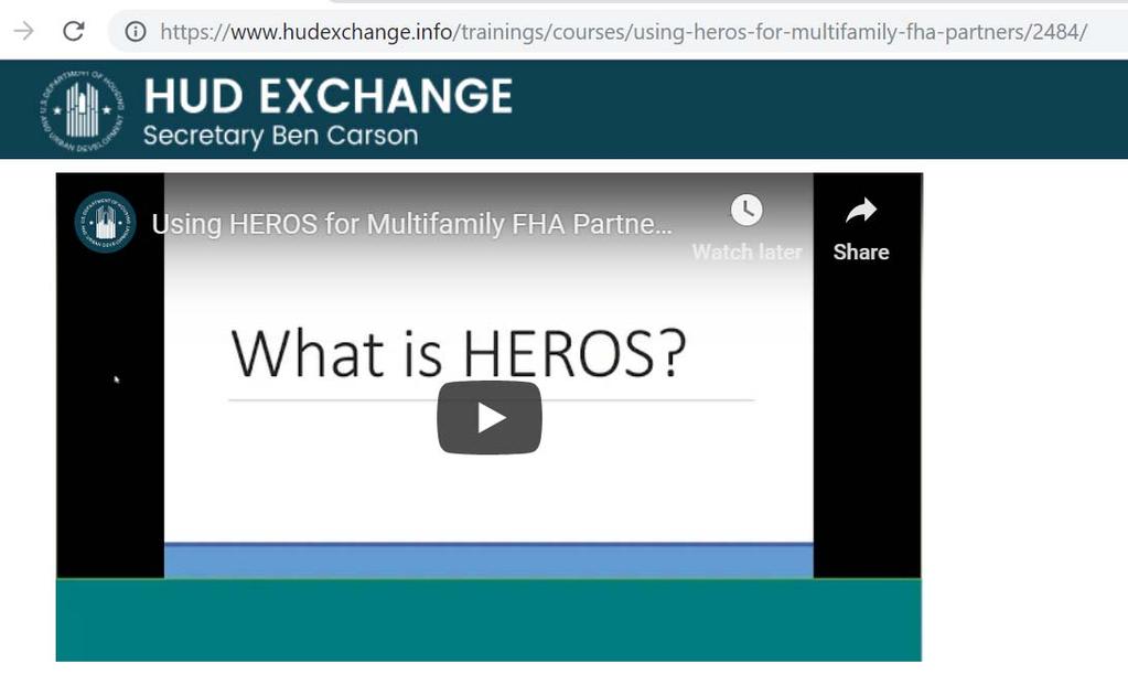
50
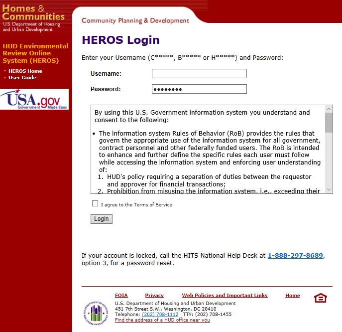
51 HEROS HEROS is replaces HUD s current paper based environmental review process (including the 4128) with a consistent, comprehensive online tool. HEROS walks users through the entire environmental review process from beginning to end, including compliance with related laws and authorities. It works for Part 50 and Part 58 environmental reviews in all HUD programs. Currently encouraged for MF and RAD partners soon will be required

52 HEROS Access Register for HEROS Partner Access: m/forms/d/e/1faipqlsdzd9kp XZKdVw1cRgqqc9g4Z0ZDXK7Dn vkfl10f4bzjmru1qq/viewform?usp=sf_link Partners will be notified by when they have access The will provide their login credentials It takes about two weeks after submitting a request to get access
53
54 HEROS Process PARTNER Assembles data and documents and inputs directly into HEROS HEROS screens are equivalent to Partner Worksheets HUD STAFF Reviews information directly in HEROS Follows up for any missing information Share with lenders outside of the HEROS system (Bug currently blocking lenders from reviewing inside the system) Completes all findings and determinations that must be made by HUD Get all required signatures in HEROS
55
56
, radon, lead and asbestos reports, and an environmental report that address NEPA factors and the laws & authorities")
57 Environmental Review Timing Lenders: Highlight environmental issues at Concept meeting and in detail in Lenders Narrative Narrative should include strategy and timing for resolution of environmental issues Pre app submissions must include the Phase 1, Phase 2 (if needed), radon, lead and asbestos reports, and an environmental report that address NEPA factors and the laws & authorities (preferably in HEROS) See Map 9.2.A.7 Pre apps or apps that are incomplete may be rejected. HUD staff: HUD staff will do as thorough a review as possible at the Preapp stage, pending workload. Goal is to identify as many issues as possible before inviting in a Firm.
58 Environmental Conditions on FIRM The environmental review must be complete and signed off in HEROS before HUD issues a FIRM. The environmental review and FIRM can contain certain conditions, but only for issues that have already been reviewed and approved. All consultation must be complete, correspondence resolved, etc., before HUD can issue a FIRM.
59 Special Conditions

60 Special Conditions (cont.)

61 Special Conditions (cont.)

62 SUBJECT: A proposed multifamily complex to be located in an urban downtown area, directly adjacent to (and under) a major federal highway. Due to the proximity of nearby archaeologic discoveries, the SHPO recommended a cultural resources survey, which later indicated the moderate to high probability of archaeologic resources. Therefore, an initial excavation to determine further risk was necessary for the project to move forward. The projected 10 year DNL for the subject property ranges from 78 to 83 db, which will require a regulatory waiver to conduct an Environmental Impact Statement (EIS) per 24 CFR Part and referenced in MAP 9.5.H.2.a. Phase 1 and 2 Environmental Site Assessments were conducted on the site which showed contaminants in the soil, but did not exceed the state s de minimis thresholds. Per Section 9.3 of the MAP Guide, a No Further Action letter from the state regulatory authority would be required, confirming the testing conducted and the level of contaminants present do not warrant that further remediation or monitoring be required. However, the state would only issue a No Further Interest letter that stated, Based on the limited information submitted, the Department does not intend to respond further to this matter. This letter is not intended and should not be construed to be a concurrence that the information provided is adequate to ascertain the condition of the property in question.


63 SUBJECT: A proposed multifamily site located across the street from a planned new industrial facility which will be handling large quantities of petroleum products, and within a few miles of several other large scale industrial facilities. The property is in the floodplain and subject to excessive noise. Additionally, there are market issues. HUD considers the environmental impacts of surrounding properties in terms of land use compatibility and overall risk, not merely compliance with specific laws and authorities.

64 SUBJECT: An existing multifamily property located ½ mile from the freeway, in a community that has experienced multiple extreme flood events in the past 3 4 years, and an increase in overall flooding due to increasing development and hardscaping of floodplains around the local rivers. The effective FEMA map for the site is over 25 years old and shows the site is partially in the 100 year floodplain. However, in checking the best data available through preliminary and advisory mapping on FEMA s RiskMAP6 website or local government s site shows that new data puts the property entirely within the regulatory floodway. HUD regulations at 24 CFR 55 require use of best available data including preliminary and advisory maps if those have a higher base flood elevation than the effective map, and prohibits HUDassisted actions in the floodplain.


65 SUBJECT: The property under consideration is currently occupied by a National Register listed (historic) building that is in disrepair. The local government agrees it is blight an should be demolished and redeveloped as housing. The current owner is willing to clear the property to prepare it for sale to the borrower, prior to submittal of pre app to HUD. Mike to discuss Under Section 110 of the National Historic Preservation Act, HUD cannot participate in a development where demolition was completed prior to HUD application in order to avoid Section 106 (Historic Preservation) review.


66 SUBJECT: A proposed market rate multifamily property to be located on a site which is almost entirely in a special flood hazard area. The project involved the modification of wetlands, floodplains, floodway, and a stream crossing the property. The project had to be rejected based on regulatory requirements. HUD s floodplain management and wetland protection regulations have an express prohibition against HUD assistance in a floodway (24 CFR Part 55.1(c) (1)). The exception to the floodway prohibition requires the LOMR to remove the entire site from the 100 year floodplain and floodway, with the requirement that the site contain no wetlands. The project did not qualify for the exception, because there were wetlands on the project site. Because there was disagreement on whether wetlands existed on the site, HUD staff performed a site visit and verified the wetlands on the property. Additionally, the MAP Guide provision at Chapter 9.5.E.2 prohibits development in a stream coursing through a proposed site if it is in the 100 year floodplain but not necessarily in a FEMA designated floodway. Essentially, the MAP Guide is treating the stream in the 100 year floodplain as if it were a floodway. Because the plan was to culvert the stream, this was considered development and not allowed by the MAP Guide. For these reasons the project could not meet HUD s regulatory requirements and was rejected.
67 Resources HEROS Partner Worksheets: record related federal laws and authorities partnerworksheets/ HEROS access: MAP Guide: G.pd 232 LEAN Guide: istration/healthcare_facilities/residential_caref HUD Environmental website: review/ Formal Training: Environmental Training for FHA Programs:
68


69
Using HEROS as an FHA Partner
 Using HEROS as an FHA Partner The purpose of this document is to provide instructions to consultants and lenders assisting with environmental reviews for Multifamily FHA-insured projects. Consultants will
Down Payment and Closing Cost Assistance. Neighborhood Housing Services of Bedford Stuyvesant 1012 Gates Avenue Brooklyn, NY 11221
 NEW YORK STATE HOUSING TRUST FUND HOME PROGRAM PROGRAMMATIC ENVIRONMENTAL REVIEW RECORD FOR LOCAL PROGRAM ADMINISTRATOR (LPA) PROGRAMS PROGRAM NAME: Down Payment and Closing Cost Assistance SHARS NUMBER:
Using HEROS as a RAD Partner
 Using HEROS as a RAD Partner The purpose of this document is to provide instructions to third party providers and Public Housing Authorities (PHAs) assisting HUD with Part 50 environmental reviews for
HEROS Kickoff for Partner Roll-Out
 HEROS Kickoff for Partner Roll-Out Partner Training FEBRUARY 1, 2018 Changes on Feb. 1, 2018 Consultants and PHAs working on Part 50 RAD environmental reviews are encouraged to start using HEROS on February
Chapter 5. Floodplain Management. 5.0 Introduction. 5.1 Douglas County Comprehensive Master Plan. 5.2 Floodplain Management and Regulation
 5.0 Introduction This chapter summarizes the County s rules and regulations regarding floodplain management and development. The requirements presented in this chapter should be used by the design engineer
Chapter 5. Floodplain Management. 5.0 Introduction. 5.1 Floodplain Management and Regulation
 5.0 Introduction This chapter summarizes the Town s rules and regulations regarding floodplain management and development. The requirements presented in this chapter should be used by the design engineer
Public Notice U.S. ARMY CORPS OF ENGINEERS, GALVESTON DISTRICT AND TEXAS COMMISSION ON ENVIRONMENTAL QUALITY
 Public Notice U.S. Army Corps Permit Application No: SWG-2016-00384 Of Engineers Date Issued: 27 December 2018 Galveston District Comments Due: 29 January 2019 U.S. ARMY CORPS OF ENGINEERS, GALVESTON DISTRICT
Floodplain Development Land Use Review
 PUBLIC WORKS - COMMUNITY DEVELOPMENT 333 Broadalbin Street SW, PO Box 490, Albany, Oregon 97321-0144 BUILDING 541-917-7553 PLANNING 541-917-7550 Floodplain Development Land Use Review Application Information
Requirements for Housing Trust Fund Environmental Provisions - HTF Combined with Other Funds September 20, 2016
 Requirements for Housing Trust Fund Environmental Provisions - HTF Combined with Other Funds September 20, 2016 Chantel Key: Sure. The poll is now open. The poll will be closing in about 15 seconds. The
CHAPTER 11: ENVIRONMENTAL REVIEW
 CHAPTER 11: ENVIRONMENTAL REVIEW CHAPTER PURPOSE & CONTENTS This chapter provides states with general information on environmental review. The chapter will provide an overview of the applicable regulations,
Tiered Environmental Review Format (2017)
") Tiered Environmental Review Format (2017) This tiered review format [per 24CFR 58.15] is designed to be used for activities that are categorically excluded [per 24CFR 58.35(a)] subject to the laws and
Tiered Environmental Review Format (2017) This tiered review format [per 24CFR 58.15] is designed to be used for activities that are categorically excluded [per 24CFR 58.35(a)] subject to the laws and
CHAPTER 15: ENVIRONMENTAL REVIEW
 CHAPTER 15: ENVIRONMENTAL REVIEW CHAPTER PURPOSE & CONTENTS This chapter provides grantees with general information on environmental review. The chapter will provide an overview of the applicable regulations,
CONDITIONAL USE PERMIT Application Packet
 CONDITIONAL USE PERMIT Application Packet Community Development Department 1020 East Pioneer Road, Draper, UT 84020 (801) 576-6539 Fax (801) 576-6526 Dear Applicant, This application packet has been developed
SUBDIVISION APPLICATION CHECKLIST SKETCH PLAN PRELIMINARY PLAT FINAL PLAT
 RECEIVED STAMP SUBDIVISION APPLICATION CHECKLIST SKETCH PLAN PRELIMINARY PLAT FINAL PLAT A checklist of background information and submission requirements for processing of a sketch plan, preliminary plat
Criteria for Appeals of Flood Insurance Rate Maps. November 30, 201 1
 Criteria for Appeals of Flood Insurance Rate Maps November 30, 201 1 This document outlines the criteria for appealing proposed changes in flood hazard information on Flood Insurance Rate Maps (FIRMS)
ENVIRONMENTAL REVIEW ENVIRONMENTAL COMPLIANCE PROCESS FOR HUD GRANTEES
 ENVIRONMENTAL REVIEW ENVIRONMENTAL COMPLIANCE PROCESS FOR HUD GRANTEES National Environmental Policy Act of 1969 Signed into law, January 1, 1970 Nixon named Man of the Year in 1972, environmental policy
Town of Lisbon, Maine SUBDIVISION REVIEW APPLICATION
 Date Received: Fee Paid (amount): Applicant: Town of Lisbon, Maine SUBDIVISION REVIEW APPLICATION Subdivision Name/Title: This application must be received at the Town Office by close of business on the
Land Use Application
 Land Use Application Check all permits you are applying for in the boxes provided. Submit this application form, the applicable materials listed in the corresponding permit application packet(s) and application
THE SUBDIVISION AND LAND DEVELOPMENT REVIEW PROCESS
 THE SUBDIVISION AND LAND DEVELOPMENT REVIEW PROCESS INTRODUCTION: Howard County Subdivision and Land Development Regulations are intended to promote the health, safety and general welfare of County residents.
DEPARTMENT OF THE ARMY OFFICE OF THE CHIEF OF ENGINEERS WASHINGTON, D.C
 DEPARTMENT OF THE ARMY OFFICE OF THE CHIEF OF ENGINEERS WASHINGTON, D.C. 20314-1000 REPLY TO ATTENTION OF: CECW-PM (10-1-7a) THE SECRETARY OF THE ARMY 1. I submit for transmission to Congress my report
Larimer County Planning Dept. Procedural Guide for 1041 PERMITS
 - Larimer County Planning Dept. Procedural Guide for 1041 PERMITS PLEASE NOTE: A PRE-APPLICATION CONFERENCE IS REQUIRED PRIOR TO SUBMITTING THIS APPLICATION. PURPOSE: State Statutes allow local governments
ARTICLE I. IN GENERAL
 Adopted by City Council on December 7, 2009 AN ORDINANCE TO AMEND AND REORDAIN CHAPTER 10 (WATER PROTECTION) OF THE CODE OF THE CITY OF CHARLOTTESVILLE, 1990, AS AMENDED, BY DELETING SECTIONS 10-51 AND
content chapter Section 6(f) Land and Water Conservation Fund Areas 23.1 Summary of Key Legislation, Regulations, and Guidance 23.
 Land and Water Conservation Fund Areas 23.1 Summary of Key Legislation, Regulations, and Guidance 23.") chapter 23 Section 6(f) Land and Water Conservation Fund Areas content 23.1 Summary of Key Legislation, Regulations, and Guidance 23.2 Agency Roles 23.3 General Methodology for Evaluation 23.4 Format and
chapter 23 Section 6(f) Land and Water Conservation Fund Areas content 23.1 Summary of Key Legislation, Regulations, and Guidance 23.2 Agency Roles 23.3 General Methodology for Evaluation 23.4 Format and
Guide to Preliminary Plans
 Guide to Preliminary Plans Introduction The Douglas County is committed to providing open, transparent application processes to the public. This Guide is provided to assist anyone interested in the procedures
MINNESOTA POLLUTION CONTROL AGENCY GENERAL PERMIT FOR DISPOSAL OF UNCOMTAMINATED CONCRETE
 MINNESOTA POLLUTION CONTROL AGENCY GENERAL PERMIT FOR DISPOSAL OF UNCOMTAMINATED CONCRETE ISSUANCE DATE: December 23, 2013 EXPIRATION DATE: December 23. 2018 This permit is a General Permit issued pursuant
2016 Fredericksburg Area Floodplain Management Workshop Tuesday, October 25, 2016
 2016 Fredericksburg Area Floodplain Management Workshop Tuesday, October 25, 2016 Charley Banks, CFM Department of Conservation And Recreation Division of Dam Safety & Floodplain Management Some Soapbox
Residential Major Subdivision Review Checklist
 Residential Major Subdivision Review Checklist Plan Submittal Requirements: 2 full sets of stamped plans Electric submittal - all plans contained in a single PDF 3 full sets if commercial kitchen or dining
Town of Bristol Rhode Island
 Town of Bristol Rhode Island Subdivision & Development Review Regulations Adopted by the Planning Board September 27, 1995 (March 2017) Formatted: Highlight Formatted: Font: 12 pt Table of Contents TABLE
Guide to Combined Preliminary and Final Plats
 Guide to Combined Preliminary and Final Plats Introduction The Douglas County is committed to providing open, transparent application processes to the public. This Guide is provided to assist anyone interested
Thurston County Planning Department BOARD OF COUNTY COMMISSIONERS PUBLIC HEARING DRAFT AMENDMENTS TO THE CRITICAL AREAS REGULATIONS. Chapter 24.
 Thurston County Planning Department BOARD OF COUNTY COMMISSIONERS PUBLIC HEARING DRAFT AMENDMENTS TO THE CRITICAL AREAS REGULATIONS Chapter 24.01 GENERAL PROVISIONS Chapter 24.01 6/4/2012 GENERAL PROVISIONS
Township of Collier 2418 Hilltop Road Presto, PA 15142
 Township of Collier 2418 Hilltop Road Presto, PA 15142 Fees: Major: 2 checks $600 + $50 per lot & $1700 Escrow) APPLICATION FOR SUBDIVISION major FINAL only Plans must be folded Rolled plans will not be
(Chapter Flood Damage Prevention)
") Chapter 13.10 Flood Damage Prevention Section: 13.10.010 Purpose and Policy 13.10.020 Definitions 13.10.030 Applicability and Areas of Special Flood Hazard 13.10.040 Administration 13.10.050 Provisions
Chapter 13.10 Flood Damage Prevention Section: 13.10.010 Purpose and Policy 13.10.020 Definitions 13.10.030 Applicability and Areas of Special Flood Hazard 13.10.040 Administration 13.10.050 Provisions
Josephine County, Oregon
 Josephine County, Oregon PLANNING OFFICE 700 NW Dimmick Street, Suite C, Grants Pass OR 97526 (541) 474-5421 / Fax (541) 474-5422 E-mail: planning@co.josephine.or.us HOME OCCUPATION APPLICATION PRE-APPLICATION
SEQRA (For Land Surveyors) Purpose of this Presentation
 Purpose of this Presentation") SEQRA (For Land Surveyors) Purpose of this Presentation Understand the basics and legal requirements of SEQRA Recognize the role that Land Surveyors play in the SEQRA Identify the problems posed by SEQRA
SEQRA (For Land Surveyors) Purpose of this Presentation Understand the basics and legal requirements of SEQRA Recognize the role that Land Surveyors play in the SEQRA Identify the problems posed by SEQRA
REZONING APPLICATION INSTRUCTIONS
 REZONING APPLICATION INSTRUCTIONS All required information, as stated on the Rezoning Application Checklist, must be included to qualify as a complete application. Upon receipt, staff will review the application
Chapter 100 Planned Unit Development in Corvallis Urban Fringe
 100.100 Scope and Purpose. Chapter 100 Planned Unit Development in Corvallis Urban Fringe (1) All applications for land divisions in the Urban Residential (UR) and Flood Plain Agriculture (FPA) zones within
BY BOARD OF COUNTY COMMISSIONERS AN ACT TO BE ENTITLED
 BY BOARD OF COUNTY COMMISSIONERS ORDINANCE NO. AN ACT TO BE ENTITLED AN ORDINANCE AMENDING THE PASCO COUNTY LAND DEVELOPMENT CODE, ARTICLE 700, BY REPEALING EXISTING SECTION 702, ENVIRONMENTALLY SENSITIVE
VI. SAFETY ELEMENT I. INTRODUCTION A. PURPOSE B. AUTHORITY. 1. Safety
 AB 162 and SB 1241 Amendment to the Safety Element New sections are underlined, deleted sections are shown as strikethrough and the denotes text remaining in place. VI. SAFETY ELEMENT I. INTRODUCTION A.
TENTATIVE MAP INFORMATION SHEET
 TENTATIVE MAP INFORMATION SHEET GENERAL INFORMATION This information sheet explains how your Tentative Map application will be processed, what fees you must pay, and what plans you must submit. If you
County of Kern HOME Program Housing Developer Pre-Application
 County of Kern HOME Program Housing Developer Pre-Application Instructions: Complete Items 1 through 4 below. On separate pages respond to Items 5 through 16 listed on the following pages. Respond as completely
5.0 Permit Applications
 5.0 Permit Applications A primary objective of the Toronto and Region Conservation Authority () is to prevent the loss of life and property due to flooding and erosion. Accordingly, administers a natural
February 29, To: Sarah Absher Senior Planner Tillamook County Department of Community Development
 February 29, 2016 To: Sarah Absher Senior Planner Tillamook County Department of Community Development From: Richard Hook Chair, Neskowin Citizen Advisory Committee Subject: Application 851-15-000265-PLNG:
Residential Minor Subdivision Review Checklist
 Residential Minor Subdivision Review Checklist Plan Submittal Requirements: 2 full sets of stamped plans Electric submittal - all plans contained in a single PDF 3 full sets if commercial kitchen or dining
Date of Review: 11/6/2015 Reviewer: RCQ/LMC STATE
 FINAL Florida Review Checklist: NFIP & FBC & Revised Model Ordinance (January 15, 2013d) Ordinance Citation: Model FPM regulations and 5 th Edition FBC : All Zones Date of Review: 11/6/2015 Reviewer: RCQ/LMC
LAND DEVELOPMENT AND SUBDIVISION ORDINANCE
 LAND DEVELOPMENT AND SUBDIVISION ORDINANCE (CHAPTER 18 OF THE MUNICIPAL CODE OF ORDINANCES) TO BE IMPLEMENTED BY: THE CITY OF FLORENCE July 2007 TABLE OF CONTENTS ARTICLE I: IN GENERAL... 1 1.1 Title...
NOTICE OF LAND USE DECISION BY THE COOS COUNTY PLANNING DIRECTOR
 NOTICE OF LAND USE DECISION BY THE COOS COUNTY PLANNING DIRECTOR Coos County Planning 225 N. Adams St. Coquille, OR 97423 http://www.co.coos.or.us/ Phone: 541-396-7770 Fax: 541-396-1022 This notice is
IRS FORM 8283 SUPPLEMENTAL STATEMENT DONATION OF CONSERVATION EASEMENT
 Name(s) shown on income tax return Identifying Number Robert T. Landowner 021-34-1234 Susan B. Landowner 083-23-5555 IRS FORM 8283 SUPPLEMENTAL STATEMENT DONATION OF CONSERVATION EASEMENT On November 12,
ARLINGTON COUNTY, VIRGINIA. County Board Agenda Item Meeting of June 17, 2017
 ARLINGTON COUNTY, VIRGINIA County Board Agenda Item Meeting of June 17, 2017 DATE: June 9, 2017 SUBJECT: Request to authorize advertisement of public hearings by the Planning Commission and County Board
Article III. Erosion and Sedimentation Control
 Article III. Erosion and Sedimentation Control Section 9.6 Erosion and Sedimentation Control Plan Requirements Section 9.6.1 Plan Submission A plan shall be prepared for all land-disturbing activities
MCPC MONONGALIA COUNTY PLANNING COMMISSION 243 High Street, Rm 110, Morgantown, WV Phone Fax
 GENERAL APPLICATION FOR DEVELOPMENT OF SIGNIFICANT IMPACT This application shall be used for all Level III reviews of developments of significant impact (DSI) that have a broader impact. Such impacts would
Creek Rehabilitation Plan for Apple Valley Questions and Answers from the Pre-Bid Meeting and Site Visit 06/23/2016
 Questions and Answers from the Pre-Bid Meeting and Site Visit 06/23/2016 Q: What are the threatened and endangered species concerns in the area? A: This is potential habitat for Prebles Meadow Jumping
SUBDIVISION APPLICATION
 SUBDIVISION APPLICATION Community Planning and Economic Development Development Services Division 250 South 4 th Street, Room 300 Minneapolis MN 55415-1316 612-673-3000 This application packet is used
BRISTOL CONSERVATION COMMISSION INLAND WETLANDS AGENCY FORM IW-1 (Application for a Wetlands Permit)
") APPLICATION NO. BRISTOL CONSERVATION COMMISSION INLAND WETLANDS AGENCY FORM IW-1 (Application for a Wetlands Permit) DATE FILED: APPROVED: DENIED: 1. APPLICANT: Name: Signature: Address: City: State: Zip
APPLICATION NO. BRISTOL CONSERVATION COMMISSION INLAND WETLANDS AGENCY FORM IW-1 (Application for a Wetlands Permit) DATE FILED: APPROVED: DENIED: 1. APPLICANT: Name: Signature: Address: City: State: Zip
MONTGOMERY COUNTY PLANNING DEPARTMENT
 MONTGOMERY COUNTY PLANNING DEPARTMENT THE MARYLAND-NATIONAL CAPITAL PARK AND PLANNING COMMISSION Forest Conservation Law Amendments - Modifications MCPB Item No. 7 Date: 5/24/2018 SUMMARY Mark Pfefferle,
BACKGROUND There are 23 flood control structures in the Upper Brushy Creek Water Control and Improvement District (District). See attached map.
. See attached map.") BACKGROUND There are 23 flood control structures in the Upper Brushy Creek Water Control and Improvement District (District). See attached map. The U.S Department of Agriculture - Natural Resources Conservation
BACKGROUND There are 23 flood control structures in the Upper Brushy Creek Water Control and Improvement District (District). See attached map. The U.S Department of Agriculture - Natural Resources Conservation
CITY OF FORT COLLINS NATURAL AREAS AND CONSERVED LANDS EASEMENT POLICY
 CITY OF FORT COLLINS NATURAL AREAS AND CONSERVED LANDS EASEMENT POLICY Adopted January 3, 2012 PURPOSE: The purpose of the policy statement is to clarify the policies and procedures of the City of Fort
Voluntary standard; accepted by USEPA to comply with AAI rule. 2. Regulatory/Developmental History
 This table summarizes some of the primary differences between the New Jersey Department of Environmental Protection (NJDEP) Preliminary Assessment Report (PAR), pursuant to the April 2013 NJDEP Site Remediation
DOUGLAS COUNTY SUBDIVISION RESOLUTION Article 4 Preliminary Plan 10/13/2015
 ARTICLE 4 PRELIMINARY PLAN 401 Intent An in-depth analysis of the proposed subdivision, including a review of the design considering the ability to obtain water and sanitation, identified geologic hazards,
Code of Federal Regulations
 Code of Federal Regulations Title 24 - Housing and Urban Development Volume: 1 Date: 2004-04-01 Original Date: 2004-04-01 Title: PART 50 - PROTECTION AND ENHANCEMENT OF ENVIRONMENTAL QUALITY Context: Title
SECTION 10: FLOOD HAZARD EVALUATION 10-1
 10) SECTION 10: FLOOD HAZARD EVALUATION A. General. Land subject to being flooded by a Flood of 100-Year Frequency as defined by Title 76, Chapter 5, MCA, or land subject to flooding pursuant to these
VOLUNTARY SALES ASSISTANCE PROGRAM CONSISTING OF TWO OPTIONS:
 VOLUNTARY SALES ASSISTANCE PROGRAM CONSISTING OF TWO OPTIONS: STANDARD SALES ASSISTANCE PROGRAM & CONVEYANCE AND RELEASE PROGRAM POLICIES AND PROCEDURES MANUAL Broward County Aviation Department Fort Lauderdale
Chapter 210 CONDITIONAL USES
 Chapter 210 CONDITIONAL USES 210.01 Purpose 210.02 Authorization 210.03 Process Type 210.04 Determination of Major or Minor Conditional Use Review 210.05 Approval Criteria 210.06 Conditions of Approval
FLOOD-RESISTANT CONSTRUCTION
 FLOOD-RESISTANT CONSTRUCTION The provisions contained in this appendix are not mandatory unless specifically referenced in the adopting ordinance. SECTION G101 ADMINISTRATION G101.1 Purpose. The purpose
ARTICLE 15 - PLANNED UNIT DEVELOPMENT
 Section 15.1 - Intent. ARTICLE 15 - PLANNED UNIT DEVELOPMENT A PUD, or Planned Unit Development, is not a District per se, but rather a set of standards that may be applied to a development type. The Planned
HEC Software and FEMA Submittals
 HEC Software and FEMA Submittals EWRI Workshop HEC Users Conference Larry Voice Risk Analysis FEMA Region VI April 12, 2010 Overview Flood Hazard Analysis Overview of Map Changes Accepted Model List Guidance
Schedule "A Fees (Planning Advisory Program)
") Approvals Fee Schedule (Effective January 1, 2018) Schedule "A Fees (Planning Advisory Program) - 2018 Planning Application Type Fee is for provision of comments to municipal approval authority on site
Approvals Fee Schedule (Effective January 1, 2018) Schedule "A Fees (Planning Advisory Program) - 2018 Planning Application Type Fee is for provision of comments to municipal approval authority on site
GOVERNMENT CODE SECTION GOVERNMENT CODE SECTION 65302
 GOVERNMENT CODE SECTION 65300 65300. Each planning agency shall prepare and the legislative body of each county and city shall adopt a comprehensive, long-term general plan for the physical development
State, County, or Municipal Agency or instrumentality thereof, applying for authorization
 Application for Project Authorization Under the New Jersey Register of Historic Places Act NJ Department of Environmental Protection Natural & Historic Resources Historic Preservation Office Date September
ARTICLE 6 PRELIMINARY PLAT
 ARTICLE 6 PRELIMINARY PLAT SECTION: 30-06-01: Preliminary Plat 30-06-02: Information Required for Preliminary Plat 30-06-03: Determination of Requirement for Environmental Review Documents 30-06-04: Additional
Guide to Minor Developments
 Guide to Minor Developments Introduction The Douglas County (DCD) is committed to providing open, transparent application processes to the public. This Guide is provided to assist anyone interested in
INTRODUCTION REQUEST FOR PROPOSALS SUMMARY
 PENNSYLVANIA HOUSING FINANCE AGENCY REQUEST FOR PROPOSALS 2018 Tax Exempt Qualified Residential Rental Facilities Seeking Private Activity Bond Allocations INTRODUCTION Private activity bonds to finance
DRAFT FOR PUBLIC HEARING (rev. March, 2016)
") Chapter 200. ZONING Article VI. Conservation/Cluster Subdivisions 200-45. Intent and Purpose These provisions are intended to: A. Guide the future growth and development of the community consistent with
Chapter 200. ZONING Article VI. Conservation/Cluster Subdivisions 200-45. Intent and Purpose These provisions are intended to: A. Guide the future growth and development of the community consistent with
Understanding the Conditional Use Process
 Understanding the Conditional Use Process The purpose of this document is to explain the process of applying for and obtaining a conditional use permit in the rural unincorporated towns of Dane County.
Conditional Use Permit case no. CU 14-06: Bristol Village Partners, LLC
 PLANNING AND ZONING COMMISSION STAFF REPORT August 7, 2014 Conditional Use Permit case no. CU 14-06: Bristol Village Partners, LLC CASE DESCRIPTION: LOCATION: LEGAL DESCRIPTION: EXISTING LAND USE: ZONING:
Corte Madera Marsh Restoration Project Update
 Corte Madera Marsh Restoration Project Update Building and Operating Committee Agenda Item No. 5 August 25, 2016 Photo credit: WRA Background of Site 1. 72 acre parcel carved out of larger property acquired
United States Post Office and Multi-Family Residential; and, Single- Family Residence with an Apartment
 Planning Commission File No.: AME2013 0009 January 9, 2014 Page 2 of 9 Existing Land Use: United States Post Office and Multi-Family Residential; and, Single- Family Residence with an Apartment Surrounding
SEWAGE FACILITIES PLANNING MODULE
 Code. COMMONWEALTH OF PENNSYLVANIA DEPARTMENT OF ENVIRONMENTAL PROTECTION BUREAU OF WATER STANDARDS AND FACILITY REGULATION SEWAGE FACILITIES PLANNING MODULE Component 3s. Small Flow Treatment Facilities
NYS Division of Housing and Community Renewal TECHNICAL SERVICES UNIT. Unified Funding Common Application Flaws
 NYS Division of Housing and Community Renewal TECHNICAL SERVICES UNIT Unified Funding Common Application Flaws October 2003 Underwriting Common Underwriting Application Flaws 1. Annual Reserve Contributions
SPECIAL PUBLIC NOTICE
 SPECIAL PUBLIC NOTICE U.S. ARMY CORPS OF ENGINEERS BUILDING STRONG LOS ANGELES DISTRICT APPLICATION FOR PERMIT Coachella Valley In-Lieu Fee Program Public Notice/Application No.: SPL-2013-00324-TOB Project:
ZONING & LAND USE APPLICATION
 City of Maple Plain 5050 Independence St P.O. Box 97 Maple Plain, MN 55359 Office: (763) 479-0515 Fax: (763) 479-0519 ZONING & LAND USE APPLICATION APPLICANT INFORMATION Applicant Name Company, if applicable
1. The owner of the property is Richmond Contract Manufacturing. 2. The property is located at 307 Front Street.
 RICHMOND PLANNING BOARD TUESDAY, FEBRUARY 24, 2015 TOWN OFFICE MEETING ROOM 6:00P.M. MINUTES 1.0 CALL TO ORDER Present: Russ Hughes, Jeff Severance, Larry Srock, Jessica Alexander and Tom Nugent. Others
SUBDIVISION, PLANNING APPROVAL, & REZONING STAFF REPORT Date: June 4, 2015
 SUBDIVISION, PLANNING APPROVAL, & REZONING STAFF REPORT Date: June 4, 2015 APPLICANT NAME SUBDIVISION NAME DEVELOPMENT NAME LOCATION Board of Water & Sewer Commissioners of the City of Mobile MAWSS MLK
Township of Little Egg Harbor Planning Board 665 Radio Road Little Egg Harbor, New Jersey Phone: ext. 221 Fax:
 BLOCK(S) LOT(S) Township of Little Egg Harbor Planning Board 665 Radio Road Little Egg Harbor, New Jersey 08087 Phone: 609-296-7241 ext. 221 Fax: 609-294-3040 Development Application Amended Development
Emergency Watershed Program Sandy Recovery Activities and Flood Plain Easement Program
 Emergency Watershed Program Sandy Recovery Activities and Flood Plain Easement Program Greg Westfall, Resource Conservationist USDA-Natural Resources Conservation Service (NRCS) Set up by Congress to respond
Public Hearing Published 8/21/2017 Public Hearing 9/21/2017 Approved 10/5/2017 RESOLUTION NO
 Public Hearing Published 8/21/2017 Public Hearing 9/21/2017 Approved 10/5/2017 RESOLUTION NO. 17-009 A RESOLUTION OF THE CITY OF FLOWERY BRANCH CITY COUNCIL APPROVING A CONDITIONAL USE PERMIT (CUP) TO
SECTION 4: PRELIMINARY PLAT
 SECTION 4: PRELIMINARY PLAT After the completion of the sketch plan process, if submitted, the owner or developer shall file with the City an application for preliminary plat. The preliminary plat stage
MUDDY CREEK TOWNSHIP PO BOX 239 PORTERSVILLE, PA SUBDIVISION AND LAND DEVELOPMENT APPLICATION
 MUDDY CREEK TOWNSHIP PO BOX 239 PORTERSVILLE, PA 16051 724-368-3438 SUBDIVISION AND LAND DEVELOPMENT APPLICATION NOTE TO ALL APPLICANTS: This checklist must be completed in its entirety If an item is not
Conditional Use Permit / Standard Subdivision Application
 Conditional Use Permit / Standard Subdivision Application Name of Proposed Subdivision: Total Area (Acres) Is Proposed Subdivision to be built in phases? Number of Lots If yes, how many phases? Applicant/Owner
TRANSFERABLE DEVELOPMENT RIGHTS PROCESS GUIDE
 TRANSFERABLE DEVELOPMENT RIGHTS PROCESS GUIDE Clear Creek County Planning Department P.O. Box 2000 Georgetown, Colorado 80444 (303) 679-2436 - phone (303) 569-1103 - fax 1 PURPOSE: A Transfer of Development
CITY OF CAMBRIDGE FLOODPLAIN MANAGEMENT CHAPTER 7 (GRADING, EROSION AND SEDIMENT CONTROL)
") CITY OF CAMBRIDGE FLOODPLAIN MANAGEMENT CHAPTER 7 (GRADING, EROSION AND SEDIMENT CONTROL) City of Cambridge, MD Floodplain Management Ordinance (Tidal): May, 2011 1 City of Cambridge, Maryland Floodplain
CITY OF CAMBRIDGE FLOODPLAIN MANAGEMENT CHAPTER 7 (GRADING, EROSION AND SEDIMENT CONTROL) City of Cambridge, MD Floodplain Management Ordinance (Tidal): May, 2011 1 City of Cambridge, Maryland Floodplain
Financial Impact Statement There are no immediate financial impacts associated with the adoption of this report.
 STAFF REPORT Planning and Development Department Subject: Application by RYC Property to rezone a portion of lands on John Murray Dr. and Megan Lynn Dr. from R2 to R3 and to enter into a Development Agreement
Bowie Marketplace Residential Detailed Site Plan Statement of Justification January 13, 2017 Revised February 2, 1017
 Bowie Marketplace Residential Detailed Site Plan Statement of Justification January 13, 2017 Revised February 2, 1017 Submitted on behalf of: BE Bowie LLC 5410 Edson Lane, Suite 220 Rockville, MD 20852
MULTI-FAMILY DWELLING UNIT SUBDIVISION ORDINANCE TOWN OF SIDNEY, MAINE
 MULTI-FAMILY DWELLING UNIT SUBDIVISION ORDINANCE TOWN OF SIDNEY, MAINE I. GENERAL A. Title B. Purpose C. Administration D. Scope II. DEFINITIONS A. Building Height B. Dwelling Unit C. Family D. Multi-Unit
FRESHWATER WETLANDS PROTECTION IN NEW JERSEY Tools for Municipal Action
 FRESHWATER WETLANDS PROTECTION IN NEW JERSEY Tools for Municipal Action The Freshwater Wetlands Protection Act INTENT OF FRESHWATER WETLANDS LAW The New Jersey legislature passed the Freshwater Wetlands
MTC ALABAMA SUBDIVISION
 # 2 SUB-000370-2017 MTC ALABAMA SUBDIVISION Engineering Comments: FINAL PLAT COMMENTS (should be addressed prior to submitting the FINAL PLAT for review and/or signature by the City Engineer): A. Provide
Purpose: Regulations:
 Administrative Procedures for the Designation and Refinement Of Chesapeake Bay Preservation Area Boundaries Guidance on the Chesapeake Bay Preservation Area Designation and Management Regulations September,
COMMERCIAL SITE DEVELOPMENT GUIDE FOR UNINCORPORATED ST. CHARLES COUNTY
 COMMERCIAL SITE DEVELOPMENT GUIDE FOR UNINCORPORATED ST. CHARLES COUNTY GENERAL INFORMATION: This brochure is to be used as a guide and is not intended to amend or supersede the corresponding County ordinances
Legal Description Part of the Western Half of the Eastern Half of the Northwest Quarter of Section 30, Le Ray Township
 Owner and Applicant s 20448 State Highway 83 Mankato, MN 56001 Request and Location Request for review and approval of a Conditional Use Permit to allow an Elder Care Residential Unit to be constructed
Subchapter 16 Subdivisions.
 Subchapter 16 Subdivisions. Sections: 35.16.1 Authority. 35.16.2 Purpose. 35.16.3 Jurisdiction. 35.16.4 Application. 35.16.5 Compliance and Enforcement. 35.16.6 Approval of Plat Required. 35.16.7 Lots,
PLANNING DEPARTMENT Application for a Type 2 Use through the Board of Adjustment & Appeals
 PLANNING DEPARTMENT Application for a Type 2 Use through the Board of Adjustment & Appeals Dear Applicant: Type 2 uses (formerly called Special Exceptions) are uses that may be approved if certain criteria