Property Location N Westervelt Company 100 ' 24 6' 614' 1"=200' GRAPHIC SCALE 13 9' 655' Parcel 9 15 ac VICINITY MAP NO SCALE Pa
|
|
|
- Damon Thomas
- 5 years ago
- Views:
Transcription


1
2
3
4
5


6 Property ocation Westervelt Company "=200 GRAPHIC CA Parcel 9 VICIITY MAP CA Parcel RTH - UTH - AT W - WT Parcel IT P DI R Ckd. By Rev. By ITI I QU C A CA CITY CA 24 6 IIT QU AC TY CI CITY 604 A C 1220 I Description I UIIT ITARY P 546 T UII Parcel ac R..W. I 22 PAVD RAD IT UI 289 CTR I 8 61 DI C A TB ACK 1020 C A Parcel 5 RY Y CIT IT CA CITY MI A IT 521 cale of 1"=200 Half street improvements along exton Bend Road. Capped sewer and cost estimate. ot configuration. Public street frontage. The number of lots on a private access easement The maximum road distance over the access easement from the public street to the most remote lot. Maximum distance = 2,000 feet. FMA Zone A/ Flood = 231 K A A C Date A TY CI WAIVR: TBACK Parcel 11 Rev. Parcel 3 12 ac 739 CA CITY MIT Parcel 2 Parcel B Drawn By: /18/ Parcel Parcel 8 16 ac Date: Parcel 10 RV Y XT BD RAD UBDIVII Parcel CA CITY MIT 621 AD U MATR PA o title search was performed for this survey. Property does not lie within a flood zone. All underground utilities are not shown on this drawing. Utilities shown must be field verified before any construction activity. 4. ots will served with onsite sewage systems. nsite sewage systems shall meet the 300 foot setback requirements from ake Tuscaloosa. 5. An additional five foot (5) width of R..W. will be granted to Tuscloosa County along exton Bend Road, adjacent to Westervelt property. 6. This property is located in the Tuscaloosa County and the City of Tuscaloosa Planning Jurisdiction, ot Zoned. 7. Township 20, Range 9W, ections 07 and ource of Title: Deedbook 2016, Page Total area of to be subdivided is ±168 acres 10. Total area under control of the developer is ±168 acres 11. wner/developer of property being subdivided: Westervelt Investment Realty, Inc P.. Box Tuscaloosa, A Plat created by: ance tripling, P & P P.. Box Tuscaloosa, A for o PRIA T: Parcel 6 D C I XT BD RAD TYPICA heet umber: T T CA Y CIT 1 G:\engineer\cad\ngineering\exton Bend ubdivision\dwg\exton Bend ubdivision Master Plan-PrePlat.dwg tamp: DIRCTI/CATI DCRIPTI Tuscaloosa County, Alabama Checked By: Drawing umber: 6 39 the


7 Property ocation Westervelt Company "=200 GRAPHIC CA Parcel 9 VICIITY MAP CA Parcel RTH - UTH - AT W - WT Parcel IT P DI R Ckd. By Rev. By ITI I QU C A CA CITY CA 24 6 IIT QU AC TY CI CITY 604 A C 1220 I Description I UIIT ITARY P 546 T UII Parcel ac R..W. I 22 PAVD RAD IT UI 289 CTR I 8 61 DI C A TB ACK 1020 C A Parcel 5 RY Y CIT IT CA CITY MI A IT 521 cale of 1"=200 Half street improvements along exton Bend Road. Capped sewer and cost estimate. ot configuration. Public street frontage. The number of lots on a private access easement The maximum road distance over the access easement from the public street to the most remote lot. Maximum distance = 2,000 feet. FMA Zone A/ Flood = 231 A C Date TY CI WAIVR: TBACK Parcel 11 K A Rev. Parcel 3 12 ac 739 CA CITY MIT Parcel 2 Parcel B Drawn By: /18/ Parcel Parcel 8 16 ac Date: Parcel 10 RV Y XT BD RAD UBDIVII Parcel CA CITY MIT 621 AD U MATR PA o title search was performed for this survey. Property does not lie within a flood zone. All underground utilities are not shown on this drawing. Utilities shown must be field verified before any construction activity. 4. ots will served with onsite sewage systems. nsite sewage systems shall meet the 300 foot setback requirements from ake Tuscaloosa. 5. An additional five foot (5) width of R..W. will be granted to Tuscloosa County along exton Bend Road, adjacent to Westervelt property. 6. This property is located in the Tuscaloosa County and the City of Tuscaloosa Planning Jurisdiction, ot Zoned. 7. Township 20, Range 9W, ections 07 and ource of Title: Deedbook 2016, Page Total area of to be subdivided is ±168 acres 10. Total area under control of the developer is ±168 acres 11. wner/developer of property being subdivided: Westervelt Investment Realty, Inc P.. Box Tuscaloosa, A Plat created by: ance tripling, P & P P.. Box Tuscaloosa, A for o PRIA T: Parcel 6 D C I XT BD RAD TYPICA heet umber: T T CA Y CIT 1 G:\engineer\cad\ngineering\exton Bend ubdivision\dwg\exton Bend ubdivision Master Plan-PrePlat.dwg tamp: DIRCTI/CATI DCRIPTI Tuscaloosa County, Alabama Checked By: Drawing umber: 6 39 the


8
MINOR SUBDIVISION PLAT CHECKLIST
 MINOR SUBDIVISION PLAT CHECKLIST Project Name: Tax ID #: Project Number: Date: _ Reviewed By: Telephone: NOTES: All lots on septic systems must comply with the Fulton County Health Department requirements
APPLICATION FOR PRELIMINARY PLAT RESIDENTAIL. FILING FEE: $ for the first 20 lots; $10.00 for each additional lot over 20
 COMMUNITY PLANNING & DEVELOPMENT TELEPHONE.* (816) 331-4331 FAX * (816) 331-6973 CITY HALL ANNEX 520 MAIN STREET BELTON, MISSOURI 64012 WEBSITE * www.belton.org APPLICATION FOR PRELIMINARY PLAT RESIDENTAIL
SHORT PLAT APPLICATION CHECKLIST City of White Salmon. Application completed with notarized signatures
 SHORT PLAT APPLICATION CHECKLIST City of White Salmon Application completed with notarized signatures Road Classification as assigned by City Public Works Director City Public Works Director Certification
STONE COUNTY PRELIMINARY PLAT CHECKLIST. Note: Applications need to be in the office by 2 p.m. on the cutoff day.
 STONE COUNTY PRELIMINARY PLAT CHECKLIST Note: Applications need to be in the office by 2 p.m. on the cutoff day. JOY WILSON, DIRECTOR Return form to: Planning & Zoning Administrator PO Box 301, Galena,
PRELMINARY PLAT CHECKLIST
 PRELMINARY PLAT CHECKLIST A. All preliminary plat submitted for approval shall be prepared by a Registered Professional Land Surveyor. B. Preliminary plats must be drawn to a scale of XXX with such accuracy
ARTICLE 8C SITE CONDOMINIUM DEVELOPMENT ORDINANCE
 ARTICLE 8C SITE CONDOMINIUM DEVELOPMENT ORDINANCE SECTION 8C.01 PURPOSE It is the purpose of this Ordinance to insure that plans for development within Oceola Township proposed under the provisions of
LAND DIVISION APPLICATION
 LAND DIVISION APPLICATION Return or mail to: Saginaw Charter Township Attn: Mr. Steve King 4980 Shattuck Road Saginaw MI 48603 OFFICE FILE NUMBER TAX ROLL # PERMIT FEE: $50.00 CREDIT CARD: CASH: CHECK
SUBDIVISION REGULATIONS
 SUBDIVISION REGULATIONS A Brief Summary Monroe County Madisonville Sweetwater Tellico Plains Vonore Monroe County, Tennessee Monroe County Planning Department 103 College Street South JP Kennedy Building
APPLICATION FOR LOT SPLIT
 APPLICATION FOR LOT SPLIT ELIGIBILITY Section 12.09.01 of the Land Development Code provides for review and approval of lot split, which shall include any of the following: 1. The division of a single
BOSSIER CITY PARISH METROPOLITAN PLANNING COMMISSION 620 Benton Rd. Bossier City, LA Phone: Fax: PRELIMINARY PLAT
 (OFFICE USE ONLY) Application Fee: Paid: Date: CASE # Project Information BOSSIER CITY PARISH METROPOLITAN PLANNING COMMISSION 620 Benton Rd. Bossier City, LA 71111 Phone: 318-741-8824 Fax: 318-741-8827
RESIDENTIAL DISTRICTS SINGLE FAMILY DWELLING DEVELOPMENT STANDARDS
 RESIDENTIAL DISTRICTS SINGLE FAMILY DWELLING DEVELOPMENT STANDARDS READ FIRST - NOTE TO DEVELOPERS & DISCLAIMER: Residential zoning districts require minimum yard distances from property lines for building
PRELIMINARY PLAT CHECK LIST
 PRELIMINARY PLAT CHECK LIST Name of Proposed Subdivision: The following items must be included with the initial submittal of a Preliminary Plat: Application, filled out completely Project Narrative Pre-application
HERON LANDING SUBDIVISION
 HERON LANDING SUBDIVISION Engineering Comments: Per FEMA guidelines, any development greater than 5 acres in size or subdivision 50 lots in size, requires a flood study. Width of drainage easement to be
DAWES SWITCHING STATION SUBDIVISION
 DAWES SWITCHING STATION SUBDIVISION Engineering Comments: Must comply with the Mobile County Flood Damage Prevention Ordinance. Development shall be designed to comply with the storm water detention and
Subdivision of existing two lots into three lots.
 PP-15-00189 Item No. 4-1 PC Staff Report 06/22/2015 PLANNING COMMISSION REPORT NON PUBLIC HEARING ITEM PUBLIC HEARING ON THE VARIANCE ONLY ITEM NO 4: PRELIMINARY PLAT FOR DEERFIELD WOODS SUBDIVISION NO.
SUBDIVISION PLAT CHECKLIST. The following information shall be include on the plat:
 SUBDIVISION PLAT CHECKLIST Subdivision Name: Land Surveyor: Owner/Developer: Date Submitted: The following information shall be include on the plat: The plat shall be drawn at a scale of one inch equals
DEVELOPMENT PLAN REVIEW CHECKLIST. To initiate the application, the applicant shall submit to the Administrative Officer:
 DEVELOPMENT PLAN REVIEW CHECKLIST To initiate the application, the applicant shall submit to the Administrative Officer: 1. Sixteen (16) copies of the Project Review Application Form, printed double-sided;
FINAL PLAT CHECKLIST
 FINAL PLAT CHECKLIST Project Name: Tax ID #: Project Number: Date: _ Reviewed By: Telephone: Please address all items marked with an "X" Please return redline comments with corrected plan, original mylar,
MAJOR RESIDENTIAL AND NONRESIDENTIAL SUBDIVISIONS
 Lawrence-Douglas County MAJOR RESIDENTIAL AND NONRESIDENTIAL SUBDIVISIONS Preliminary Plats The applicant shall schedule a Pre-Application meeting with Planning Staff at least seven (7) working days prior
PLANNED UNIT DEVELOPMENT CITY OF CHAMBLEE, GA
 Exhibit A Received 11/7/17 PLANNED UNIT DEVELOPMENT CITY OF CHAMBLEE, GA SHEET DESCRIPTION PAGE SITE DATA VICINITY MAP INDEX PAGE 1 EXISTING ZONING CC PUD PROJECT DESCRIPTION 2-3 PROPOSED ZONING CC PUD
PLANNED UNIT DEVELOPMENT & SUBDIVISION STAFF REPORT August 18, 2016
 PLANNED UNIT DEVELOPMENT & SUBDIVISION STAFF REPORT August 18, 2016 DEVELOPMENT NAME SUBDIVISION NAME Mullinax Ford Subdivision Mullinax Ford Subdivision LOCATION CITY COUNCIL DISTRICT District 6 Southeast
TERRY POIROUX FAMILY DIVISION SUBDIVISION
 TERRY POIROUX FAMILY DIVISION SUBDIVISION Engineering Comments: Must comply with the Mobile County Flood Damage Prevention Ordinance. Development shall be designed to comply with the storm water detention
STONE HEDGE SUBDIVISION, UNIT 1, RESUBDIVISION OF LOT 40 & WEST COMMON AREA
 # 5 SUB-000498-2018 STONE HEDGE SUBDIVISION, UNIT 1, RESUBDIVISION OF LOT 40 & WEST COMMON AREA Engineering Comments: Must comply with the Mobile County Flood Damage Prevention Ordinance. Development shall
ELMORE COUNTY LAND USE & BUILDING DEPARTMENT 520 E 2 nd South Mountain Home, ID (208) Preliminary Plat Application
 Preliminary Plat Application") ELMORE COUNTY LAND USE & BUILDING DEPARTMENT 520 E 2 nd South Mountain Home, ID 83647 (208) 587-2142 www.elmorecounty.org Preliminary Plat Application We are unable to accept facsimile copies. (Subdivisions
ELMORE COUNTY LAND USE & BUILDING DEPARTMENT 520 E 2 nd South Mountain Home, ID 83647 (208) 587-2142 www.elmorecounty.org Preliminary Plat Application We are unable to accept facsimile copies. (Subdivisions
DINKINS ESTATE FAMILY SUBDIVISION
 # 9 SUB2015-00122 DINKINS ESTATE FAMILY SUBDIVISION Engineering Comments: The following comments should be addressed prior to submitting the FINAL PLAT for acceptance and signature by the City Engineer:
A.3. ARTICLE 7 PLAN REQUIREMENTS FOR MINOR SUBDIVISION AND/OR LAND DEVELOPMENT
 700. 701.A.3. ARTICLE 7 PLAN REQUIREMENTS FOR MINOR SUBDIVISION AND/OR LAND DEVELOPMENT SECTION 700 PURPOSE The purpose of this Article is to set forth a streamlined set of Plan Requirements for minor
STATE OF MICHIGAN LAND DIVISION ORDINANCE NO.53
 STATE OF MICHIGAN COUNTY OF JACKSON LAND DIVISION ORDINANCE NO.53 Adopted: September 9,1997 Effective: October 20, 1997 An ordinance to regulate partitioning or division of parcels or tracts of land, enacted
PRELIMINARY PLAN CHECKLIST Major Land Development Projects. To initiate the application, the applicant shall submit to the Administrative Officer:
 PRELIMINARY PLAN CHECKLIST Major Land Development Projects To initiate the application, the applicant shall submit to the Administrative Officer: 1. The application review fee, as established by the South
MUDDY CREEK TOWNSHIP PO BOX 239 PORTERSVILLE, PA SUBDIVISION AND LAND DEVELOPMENT APPLICATION
 MUDDY CREEK TOWNSHIP PO BOX 239 PORTERSVILLE, PA 16051 724-368-3438 SUBDIVISION AND LAND DEVELOPMENT APPLICATION NOTE TO ALL APPLICANTS: This checklist must be completed in its entirety If an item is not
BOUNDARY LINE ADJUSTMENT APPLICATION
 OFFICE 518.747.5212 --------------FAX 518.747.2493 (Clerk s Office Use Only) BOUNDARY LINE ADJUSTMENT APPLICATION APPLICATION NO: DATE : FEE PAID: Requirements, Fees and Instructions (Please use dark blue
All roads developed to access four (4) or more parcels shall be constructed to Park County Road and Bridge Standards.
 or more parcels shall be constructed to Park County Road and Bridge Standards.") P a r k C o u n t y P l a n n i n g a n d Z o n i n g 1002 Sheridan Avenue Cody, WY 82414 Phone: 307-527-8540 35-40 ACRE SUBDIVISIONS www.parkcounty.us/planandzone.htm May 2011 This is only intended as
P a r k C o u n t y P l a n n i n g a n d Z o n i n g 1002 Sheridan Avenue Cody, WY 82414 Phone: 307-527-8540 35-40 ACRE SUBDIVISIONS www.parkcounty.us/planandzone.htm May 2011 This is only intended as
Walton County Planning and Development Services
 Walton County Planning and Development Services 31 Coastal Centre Boulevard, Suite 100 47 N 6 th Street Santa Rosa Beach, Florida 32459 DeFuniak Springs, Florida 32433 Phone 850-267-1955 Phone 850-892-8157
SECTION 6 - APPROVAL OF PLATS. Whenever any subdivision of land is proposed, and before any permit for the
 SECTION 6 - APPROVAL OF PLATS 6-1 APPROVAL REQUIRED BEFORE SALE Whenever any subdivision of land is proposed, and before any permit for the erection of a structure shall be granted, the subdivider or his
Preliminary Subdivision Application (Minor) (Three (3) lots or less)
 (Three (3) lots or less)") Gunnison City Offices www.gunnisoncity.org 38 West Center Gunnison, Utah 84634 (435) 528 7969 Date of Application: Preliminary Subdivision Application (Minor) (Three (3) lots or less) APPLICANT INFORMATION
Gunnison City Offices www.gunnisoncity.org 38 West Center Gunnison, Utah 84634 (435) 528 7969 Date of Application: Preliminary Subdivision Application (Minor) (Three (3) lots or less) APPLICANT INFORMATION
Review of Land Divisions in Open Space and Residential Zones 660
 Title 33, Planning and Zoning Chapter 33.660 5/24/18 Review of Land Divisions in Open Space and Residential Zones 33.660 Review of Land Divisions in Open Space and Residential Zones 660 Sections: General
ARTICLE 5 MINOR SUBDIVISION/LAND DEVELOPMENT
 ARTICLE 5 MINOR SUBDIVISION/LAND DEVELOPMENT SECTION 501 ONLY FINAL PLAN REQUIRED The classification of a proposed subdivision as a "Minor Subdivision" shall only require the submission, review and approval
Preliminary Subdivision Application (Major) (Four (4) lots or more)
 (Four (4) lots or more)") Gunnison City Offices www.gunnisoncity.org 38 West Center Gunnison, Utah 84634 (435) 528 7969 Date of Application: Preliminary Subdivision Application (Major) (Four (4) lots or more) APPLICANT INFORMATION
Gunnison City Offices www.gunnisoncity.org 38 West Center Gunnison, Utah 84634 (435) 528 7969 Date of Application: Preliminary Subdivision Application (Major) (Four (4) lots or more) APPLICANT INFORMATION
TO: Glynn County Islands Planning Commission. Eric Landon, Planner II. PP2754 Stones Throw Cottages. DATE: February 6, 2014
 COMMUNITY DEVELOPMENT DEPARTMENT Planning and Zoning Division 1725 Reynolds Street, Suite 200, Brunswick, GA 31520 Phone: 912-554-7428/Fax: 1-888-252-3726 TO: Glynn County Islands Planning Commission FROM:
JOHNNY S RV PARK SUBDIVISION
 # 11 SUB2016-00001 JOHNNY S RV PARK SUBDIVISION Engineering Comments: The following comments should be addressed prior to submitting the FINAL PLAT for acceptance and signature by the City Engineer: A.
CONCEPTUAL MASTER PLAN CHECKLIST Major Land Development Project
 CONCEPTUAL MASTER PLAN CHECKLIST Major Land Development Project To initiate the application, the applicant shall submit to the Administrative Officer: 1. The application review fee, as established by the
BOROUGH OF HELLERTOWN 685 Main St., Hellertown PA Phone: Fax:
 SUBDIVISION / LAND DEVELOPMENT REVIEW CHECKLIST Subdivision / Land Development Preliminary Plan Preliminary Plan Checklist A scaled plan not less that 1 = 100 feet (422.01) Proposed subdivision name or
BOUNDARY LINE ADJUSTMENT APPLICATION GUIDE
 BOUNDARY LINE ADJUSTMENT APPLICATION GUIDE SISKIYOU COUNTY PLANNING DIVISION 806 South Main Street, Yreka CA 96097 Phone: (530) 841-2100 / Fax: (530) 841-4076 WHAT IS A BOUNDARY LINE ADJUSTMENT? A Boundary
I I 1 I I C LE VI I I I I I 1 I I
 C LE V ARTCLE V M NOR R ES 0 E NT A L S U BD V S ON 60. Definition "Minor Residential Subdivision" shall mean a Subdivision of five (5) lots or less for residential purposes not involving any new streets
Town of Lisbon, Maine SUBDIVISION REVIEW APPLICATION
 Date Received: Fee Paid (amount): Applicant: Town of Lisbon, Maine SUBDIVISION REVIEW APPLICATION Subdivision Name/Title: This application must be received at the Town Office by close of business on the
A. Appropriate agency responsible for transportation review for the subject property.
 7.8.10 Procedure Any person desiring to create a minor subdivision shall submit to the Commission for approval an application on forms provided by the Division, and a record plat in conformance with the
PREPARED BY PLANNING DEPARTMENT ORANGE COUNTY NORTH CAROLINA
 PREPARED BY PLANNING DEPARTMENT ORANGE COUNTY NORTH CAROLINA Return to: DONNA PUCKETT 1555 NC 56 SUITE 2 CREEDMOOR, NC 27522 DECLARATION OF DEVELOPMENT RESTRICTIONS AND REQUIREMENTS RECORDED CONCURRENTLY
Use permitted by: Right Special Exemption
 CENTER TOWNSHIP 150 Henricks Road Butler, PA 16001-8472 Phone (724) 282-7805 Fax (724) 282-6550 Application Number: FEE COLLECTED: Application for: Preliminary Final Land Development Location: Map and
Certified Survey Review Instructions
 DEARBORN COUNTY PLAN COMMISSION County Administration Building, 165 Mary St., Lawrenceburg, IN 47025 Phone (812) 537-8821 Fax (812) 532-2029 Website: www.dearborncounty.org/planning Certified Survey Review
BAY FOREST PARK SUBDIVISION, RESUBDIVISION OF LOTS 6 & 7 AND BAY FOREST PARK SUBDIVISION LOT 10, OF THE RESUBDIVISON OF LOTS 9 & 10
 BAY FOREST PARK SUBDIVISION, RESUBDIVISION OF LOTS 6 & 7 AND BAY FOREST PARK SUBDIVISION LOT 10, OF THE RESUBDIVISON OF LOTS 9 & 10 Engineering Comments: Must comply with the Mobile County Flood Damage
Staff Report: Date: Applicant: Property Identification: Acreage of Request: Current Zoning of Requested Area: Requested Action: Attached:
 Staff Report: Completed by Jeff Palmer Director of Planning & Zoning Date: November 7, 2018, Updated November 20, 2018 Applicant: Greg Smith, Oberer Land Developer agent for Ronald Montgomery ET AL Property
MEMORANDUM. DATE: April 6, 2017 TO: Zoning Hearing Board Jackie and Jake Collas. FROM: John R. Weller, AICP, Zoning Officer
 MEMORANDUM DATE: April 6, 2017 TO: Zoning Hearing Board Jackie and Jake Collas FROM: John R. Weller, AICP, Zoning Officer SUBJECT: Zoning Hearing Board appeal of Jackie and Jake Collas Relief requested
Sketch Plan 2018 Bargersville Plan Commission Application Kit
 Sketch Plan 2018 Bargersville Plan Commission Application Kit For Commercial, Industrial, and Residential Developments At least 31 days prior to the intended filing of the Primary Plat or Development Plan
I. Requirements for All Applications. C D W
 108-16.1. Application checklists. Checklist for Required Submissions to the Planning Board or Zoning Board of Adjustment of Monroe Township All required submissions are to be made to the Administrative
New Lidl Supermarket Anchored Development Upper Providence,PA
 New Lidl Supermarket Anchored Development Upper Providence,PA Signalized intersection near Ridge Pk. & Townshipline Rd. For Lease 72,913 sf center with only 1,800 sf of space left! Location Signalized
WASHINGTON COUNTY DEVELOPMENT CODE CHAPTER TWO ZONING REGULATIONS PART 2 DENSITY AND LOT REQUIREMENTS. Table of Contents
 WASHINGTON COUNTY DEVELOPMENT CODE CHAPTER TWO ZONING REGULATIONS PART 2 DENSITY AND LOT REQUIREMENTS Table of Contents SECTION 1. DENSITY... 2 1.1 Density in Districts... 2 1.2 Determination of Density
Group Sewer Only** 80 Ft Frontage* 20,000 Sq. Ft. (.46 acre) Minimum** 120 Ft Frontage* 20,000 Sq. Ft. (.46acre) Minimum** 150 Ft Frontage*
 Minimum** 120 Ft Frontage* 20,000 Sq. Ft. (.46acre) Minimum** 150 Ft Frontage*") Residential Lots Minimum Chart The minimum lot size of any minor subdivision where there is no public sewers shall be as shown below or as required by township zoning and/or the Tuscarawas General Health
Residential Lots Minimum Chart The minimum lot size of any minor subdivision where there is no public sewers shall be as shown below or as required by township zoning and/or the Tuscarawas General Health
City of Yelm. Community Development Department BOUNDARY LINE ADJUSTMENT OR LARGE LOT SUBDIVISION
 City of Yelm Community Development Department BOUNDARY LINE ADJUSTMENT OR LARGE LOT SUBDIVISION Fee Date Received By File No. FEES: Boundary Line Adjustment $100.00 LARGE LOT SUBDIVISION $250.00, + $10.00/lot
PLANNED UNIT DEVELOPMENT, SIDEWALK WAIVER, & SUBDIVISION STAFF REPORT Date: November 6, 2008
 PLANNED UNIT DEVELOPMENT, SIDEWALK WAIVER, & SUBDIVISION STAFF REPORT Date: November 6, 2008 DEVELOPMENT NAME SUBDIVISION NAME LOCATION Frascati Shops, Inc. Frascati Subdivision 1120 Paper Mill Road CITY
MAGNOLIA SPRINGS SUBDIVISION, PHASE ONE
 MAGNOLIA SPRINGS SUBDIVISION, PHASE ONE Engineering Comments: Must comply with the Mobile County Flood Damage Prevention Ordinance. Development shall be designed to comply with the storm water detention
SUBDIVISION APPLICATION
 SUBDIVISION APPLICATION City of Horn Lake Planning Department 3101 Goodman Road, W Horn Lake, MS 38637 662-342-3559 Fax: 662-342-3485 Applications due the 1st working day of the month. Submit application
PARK PLACE SUBDIVISION
 PARK PLACE SUBDIVISION Engineering Comments: Must comply with the Mobile County Flood Damage Prevention Ordinance. The plat illustrates the proposed 53 lot, 12.6 + acres subdivision which is located on
LAND USE APPLICATION
 Lincoln County Department of Planning & Development 210 SW 2nd Street, Newport, OR 97365 Phone (541) 265-4192 Fax (541) 265-6945 LAND USE APPLICATION TO BE COMPLETED BY STAFF Conditional Use Non-Conforming
MINOR PLAT AMENDMENT APPLICATION CHECK APPLICABLE PERMIT ATTACHMENT:
 240 East Gammon Road Vineyard, Utah 84058 (801) 226-1929 MINOR PLAT AMMENDMENT APPLICATION Please Note: Attachment of request specific documents is required prior to processing your application. APPLICATION
SUBDIVISION & PLANNING APPROVAL STAFF REPORT Date: December 1, 2016
 SUBDIVISION & PLANNING APPROVAL STAFF REPORT Date: December 1, 2016 APPLICANT NAME SUBDIVISION NAME DEVELOPMENT NAME LOCATION Board of Water and Sewer Commissioners of the City of Mobile Halls Mill Road
204 Minor Subdivision & Large Lot Division
 204 Minor Subdivision & Large Lot Division 204.01 Purpose and Intent 204.05 General Procedures 204.10 Large Lot Division 204.02 Comprehensive Land Use 204.06 Submittal Requirements Plan Policies 204.07
APPLICATION FOR PRELIMINARY PLAT CERRO GORDO COUNTY, IOWA
 APPLICATION FOR PRELIMINARY PLAT CERRO GORDO COUNTY, IOWA Before subdividing any tract of land and previous to the filing of an Application for conditional approval of the Preliminary Plat, the subdivider
# 14 SUB CANAL SUBDIVISION
 CANAL SUBDIVISION Engineering Comments: Label each Lot showing the required minimum finished floor elevation (MFFE). It appears that Lots 2, 3 & 4 are located in the AE Flood Zone; add a note to the plat
Cover Letter with Narrative Statement
 Cover Letter with Narrative Statement March 31, 2017 rev July 27, 2017 RE: Rushton Pointe Residential Planned Unit Development Application for Public Hearing for RPUD Rezone PL2015 000 0306 Mr. Eric Johnson,
Administrative Action
 Administrative Action Preliminary Subdivision City of Raleigh Development Plans Review Center One Exchange Plaza Raleigh, NC 27602 (919) 516-2626 www.raleighnc.gov Case File / Name: General Location: CAC:
MINOR SUBDIVISION PLAT
 CHECKLIST HANCOCK COUNTY AREA PLAN COMMISSION A subdivider shall submit to the Plan Commission office an application and an accompanying plat for a minor subdivision. The plat shall be based on a boundary
610 LAND DIVISIONS AND PROPERTY LINE ADJUSTMENTS OUTSIDE A UGB
 ARTICLE VI: LAND DIVISIONS AND PROPERTY LINE ADJUSTMENTS VI-21 610 LAND DIVISIONS AND PROPERTY LINE ADJUSTMENTS OUTSIDE A UGB 610-1 Property Line Adjustments (Property Line Relocation) A property line
February 18, Conformity of the PUD to Standards Prescribed in the Zoning Ordinance
 General REPORT OF OFFICE OF URBAN DEVELOPMENT, PLANNING DIVISION STAFF TO THE TUSCALOOSA PLANNING AND ZONING COMMISSION ON THE TOWNHOMES OF WELLINGTON, A PLANNED UNIT DEVELOPMENT February 18, 2019 The
CITY OF PAPILLION PLANNING COMMISSION STAFF REPORT NOVEMBER 18, 2015 AGENDA BUCKY S CONVENIENCE STORES SPECIAL USE PERMIT SUP
 I. GENERAL INFORMATION A. APPLICANT: Jeffery Guyette 7315 Mercy Road Omaha, NE 68124 CITY OF PAPILLION PLANNING COMMISSION STAFF REPORT NOVEMBER 18, 2015 AGENDA BUCKY S CONVENIENCE STORES SPECIAL USE PERMIT
WASCO COUNTY PRELIMINARY SUBDIVISION APPLICATION
 WASCO COUNTY PRELIMINARY SUBDIVISION APPLICATION DETAILED SPECIFIC WRITTEN REQUEST File Number: SDV- Number of Proposed Lots & their Dimensions: PRELIMINARY SUBDIVISION PLAN REQUIREMENTS The approval of
APPLICATION FOR ZONING USE AND COMPLIANCE CERTIFICATE CENTER TOWNSHIP, BEAVER COUNTY, PA
 APPLICATION FOR ZONING USE AND COMPLIANCE CERTIFICATE CENTER TOWNSHIP, BEAVER COUNTY, PA *NOTE: As per the Pennsylvania State Planning Code, there is a 30 day appeal period, under which anyone can appeal
DEER RIVER COMMERCIAL PARK SUBDIVISION
 DEER RIVER COMMERCIAL PARK SUBDIVISION Engineering Comments: Must comply with the Mobile County Flood Damage Prevention Ordinance. Development shall be designed to comply with the storm water detention
ELIZA JORDAN CORNER SUBDIVISION
 ELIZA JORDAN CORNER SUBDIVISION Engineering Comments: Must comply with the Mobile County Flood Damage Prevention Ordinance. Development shall be designed to comply with the storm water detention and drainage
APPLICATION FOR MAJOR SUBDIVISION APPROVAL (FINAL PLAT)
") 209 S. Main Street Marysville, Ohio 43040 Phone: (937) 645-7350 Fax: (937) 645-7351 www.marysvilleohio.org APPLICATION FOR MAJOR SUBDIVISION APPROVAL (FINAL PLAT) *** IMPORTANT INFORMATION ~ Please read
209 S. Main Street Marysville, Ohio 43040 Phone: (937) 645-7350 Fax: (937) 645-7351 www.marysvilleohio.org APPLICATION FOR MAJOR SUBDIVISION APPROVAL (FINAL PLAT) *** IMPORTANT INFORMATION ~ Please read
City of Sanibel. Planning Department STAFF REPORT
 City of Sanibel Planning Department STAFF REPORT Planning Commission Meeting: July 23, 2013 Planning Commission Agenda Item: No 7b. Application Number: 13-7438DP Applicant Name: Attorney Beverly Grady
MASTER SUBDIVISION FINAL PLAT APPLICATION Town of Apex, North Carolina
 MASTER SUBDIVISION FINAL PLAT APPLICATION Town of Apex, North Carolina This document is a public record under the North Carolina Public Records Act and may be published to the Town s website or disclosed
APPLICATION FOR FINAL PLAT APPROVAL (Major Subdivision)
") APPLICATION FOR FINAL PLAT APPROVAL (Major Subdivision) CITY OF HOSCHTON, GA PLANNING AND DEVELOPMENT 79 City Square Hoschton, GA 30548 706-654-3034 Applicant Information: Name: Address: City, State, Zip:
APPLICATION FOR FINAL PLAT APPROVAL (Major Subdivision) CITY OF HOSCHTON, GA PLANNING AND DEVELOPMENT 79 City Square Hoschton, GA 30548 706-654-3034 Applicant Information: Name: Address: City, State, Zip:
MINOR SUBDIVISION FINAL PLAT APPLICATION Town of Apex, North Carolina
 MINOR SUBDIVISION FINAL PLAT APPLICATION Town of Apex, North Carolina This document is a public record under the North Carolina Public Records Act and may be published on the Town s website or disclosed
Gates County Planning and Zoning
 Gates County Planning and Zoning PO Box 411, 200 Court Street, Gatesville, NC 27938 phone: 252-357-2411 fax: 252-357-0073 Application for Technical Review Committee For Staff Use Only: Date: Application
Lake County Planning, Building and Development Department
 SUBMISSION CHECKLIST FOR SUBDIVISION FINAL PLAT Lake County Planning, Building and Development Department 500 W. Winchester Rd. Unit 101 Libertyville, Illinois 60048-1331 Telephone (847) 377-2600 E-mail:
UPPER MOUNT BETHEL TOWNSHIP, NORTHAMPTON COUNTY, PA MINOR SUBDIVISION FINAL PLAN CHECKLIST* YES** NO
 UPPER MOUNT BETHEL TOWNSHIP, NORTHAMPTON COUNTY, PA MINOR SUBDIVISION FINAL PLAN CHECKLIST* YES** NO GENERAL SUBMISSION ITEMS Does the submission include: 1. Seven (7) copies of completed Application Form?
COCHRAN FAMILY RIVERSIDE ESTATE SUBDIVISION
 # 19 SUB2012-00111 COCHRAN FAMILY RIVERSIDE ESTATE SUBDIVISION Engineering Comments: The following comments should be addressed prior to review, acceptance and signature by the City Engineer: 1. Label/show
SUBDIVISION APPLICATION: RECOMBINATION PLAT or EXEMPT PLAT
 SUBDIVISION APPLICATION: RECOMBINATION PLAT or EXEMPT PLAT Pursuant to Article 7, Section 155.706 of the Unified Development Code, an owner of land within the jurisdiction of the Town (or a duly authorized
NOT TO BE SUBMITTED WITH SKETCH DESIGN APPROVAL Subdivision Checklist: Major Subdivision Final Plat
 Must be received with review fee (equal to $200.00, plus $25.00 per lot) no later than 15 days prior to Planning Board meeting, which is normally the first Monday of the month (certain holidays may modify
SEQR short form are now located on the New York State Department of Environmental website:
 Dear Applicant: In order to speed up the entire process of appearing before the Planning Board, we ask that you observe one simple rule: Submit your plans and applications to the Planning Board Secretary
Guide to Combined Preliminary and Final Plats
 Guide to Combined Preliminary and Final Plats Introduction The Douglas County is committed to providing open, transparent application processes to the public. This Guide is provided to assist anyone interested
KRONER S MOBILE WEST COMMERCIAL BUSINESS PARK SUBDIVISION
 KRONER S MOBILE WEST COMMERCIAL BUSINESS PARK SUBDIVISION Engineering Comments: Must comply with the Mobile County Flood Damage Prevention Ordinance. Development shall be designed to comply with the storm
DAUPHIN CREEK ESTATES SUBDIVISION
 # 12 SUB-000076-2017 DAUPHIN CREEK ESTATES SUBDIVISION Engineering Comments: FINAL PLAT COMMENTS (should be addressed prior to submitting the FINAL PLAT for review and/or signature by the City Engineer):
Staff Report: Date: Applicant: Property Identification: Acreage of Request: Current Zoning of Requested Area: Requested Action: Attached:
 Staff Report: Completed by Jeff Palmer Director of Planning & Zoning Date: November 7, 2018 Applicant: Greg Smith, Oberer Land Developer agent for Ronald Montgomery ET AL Property Identification: Frontage
COUNTY OF LINCOLN, NORTH CAROLINA
 Page 1 COUNTY OF LINCOLN, NORTH CAROLINA 302 NORTH ACADEMY STREET, SUITE A, LINCOLNTON, NORTH CAROLINA 28092 BUILDING AND LAND DEVELOPMENT 704-736-8440 OFFICE 704-732-9010 FAX REQUIRED CERTIFICATES FOR
ARTICLE V PRELIMINARY PLAN SUBMISSION
 ARTICLE V PRELIMINARY PLAN SUBMISSION 501. Plan Requirements a. On or before the 25 th day of the month prior to a regularly scheduled meeting of the Planning Commission, the applicant shall submit two
DAWSON COUNTY MINOR PLAT REVIEW CHECKLIST $50.00 FEE PER PLAT REVIEW, $5.00 FEE FOR SCAN & CD FOR RECORDING
 DAWSON COUNTY MINOR PLAT REVIEW CHECKLIST $50.00 FEE PER PLAT REVIEW, $5.00 FEE FOR SCAN & CD FOR RECORDING NAME ON PLAT: CONTACT/PHONE #: NAMED STREET/ADDRESS: LAND LOT: DISTRICT: SECTION: ZONING: SETBACKS:
City of Prior Lake APPLICATION FOR PRELIMINARY PLAT
 City of Prior Lake APPLICATION FOR PRELIMINARY PLAT Requested Action Brief description of proposed project (Please describe the proposed amendment, project, or variance request. Attach additional sheets
Plans shall be drawn at a readable scale, signed, and sealed by a Florida Registered Engineer. The application package shall include:
 CHAPTER 400. SECTION 403. PERMIT TYPES AND APPLICATIONS SITE DEVELOPMENT 403.3. Preliminary Site Plans (PSP) A. Intent and Purpose PSPs are used to identify existing site conditions and demonstrate general
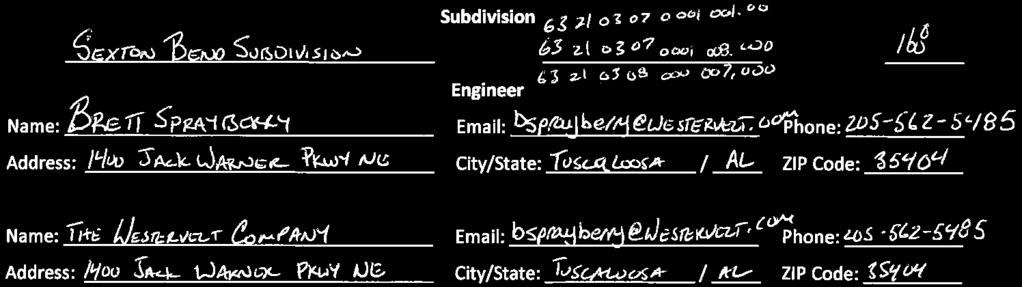
CITY OF SARALAND PRELIMINARY SUBDIVISION PLAT REVIEW
 PRELIMINARY SUBDIVISION PLAT REVIEW Application Number: Date Plat Submitted: Name of Subdivision: Name of Owner: Owner Address: (Street or P.O. Box) Telephone #: (City) (State) (Zip) E-mail: Name of Authorized
WESTMINSTER PARK SUBDIVISION
 WESTMINSTER PARK SUBDIVISION Engineering Comments: FINAL PLAT COMMENTS (should be addressed prior to submitting the FINAL PLAT for review and/or signature by the City Engineer): A. Provide all of the required