DLCD ACKNOWLEDGMENT or DEADLINE TO APPEAL: Wednesday, August 11, 2010
|
|
|
- Amberlynn George
- 5 years ago
- Views:
Transcription
1 Oregon Theodore R KjibngDski, Governor Department of Land Conservation and Development 635 Capitol Street, Suite 150 Salem, OR (503) Fax (503) www. lcd.state.or.us NOTICE OF ADOPTED AMENDMENT Mis. 7/27/2010 TO: FROM: Subscribers to Notice of Adopted Plan or Land Use Regulation Amendments Plan Amendment Program Specialist SUBJECT: City of Beaverton Plan Amendment DLCD File Number The Department of Land Conservation and Development (DLCD) received the attached notice of adoption. A Copy of the adopted plan amendment is available for review at the DLCD office in Salem and the local government office. Appeal Procedures* DLCD ACKNOWLEDGMENT or DEADLINE TO APPEAL: Wednesday, August 11, 2010 This amendment was submitted to DLCD for review prior to adoption pursuant to ORS (2)(b) only persons who participated in the local government proceedings leading to adoption of the amendment are eligible to appeal this decision to the Land Use Board of Appeals (LUBA). If you wish to appeal, you must file a notice of intent to appeal with the Land Use Board of Appeals (LUBA) no later than 21 days from the date the decision was mailed to you by the local government. If you have questions, check with the local government to determine the appeal deadline. Copies of the notice of intent to appeal must be served upon the local government and others who received written notice of the final decision from the local government. The notice of intent to appeal must be served and filed in the form and manner prescribed by LUBA, (OAR Chapter 661, Division 10). Please call LUBA at , if you have questions about appeal procedures. *NOTE: The Acknowledgment or Appeal Deadline is based upon the date the decision was mailed by local government. A decision may have been mailed to you on a different date than it was mailed to DLCD. As a result, your appeal deadline may be earlier than the above date specified. NO LUBA Notification to the jurisdiction of an appeal by the deadline, this Plan Amendment is acknowledged. Cc: Ken Reacher, City of Beaverton Gloria Gardiner, DLCD Urban Planning Specialist Anne Debbaut, DLCD Regional Representative Bill Holmstrom, DLCD Transportation Planner <paa> YA/ph

2 ! I In person Q DLCD Notice of Adoption electronic Q mailed DEPT OF JUL LAND CONSERVATION A N D DEVELOPMENT T h i s F o r m 2 must be mailed to D L C D within 5 - W o r k i n g D a y s after the Filial O r d i n a n c e is s i g n e d by the public Official Designated by the jurisdiction and all other requirements o f O R S and O A R For O flic e Use Only Jurisdiction: Beaverton Local file number: Date of Adoption: 7/19/2010 Date Mailed: 7/21/2010 Was a Notice of Proposed Amendment (Form 1) mailed to DLCD? Yes CPA / ZMA No Date: 4/02/2010 Comprehensive Plan Text Amendment [X] Comprehensive Plan Map Amendment Land Use Regulation Amendment E3 Zoning Map Amendment New Land Use Regulation O Other: Summarize the adopted amendment. Do not use technical terms. Do not write "See Attached". Apply City land use and zoning to TLID 1S109BB01500 and TLID 1S109BB01800 Does the Adoption differ from proposal? Yes, Please explain below: The initial proposal included three properties (Tax Lots 01400, 01500, and of Map 1S1W09BB). The property owner requested that the proposal be split into two segments. The first segment applied only to Lot 01400, which is the southernmost parcel. This second segment applies to Lots and Both lots received the Station Community Land Use designation and the Station Community High Density Residential zoning designation, which is slightly different from the designations shown in the original D L C D notice. Plan Map Changed from: Washington County Transit Oriented Zone Map Changed from: County TO:R18-24 and R-9 to: Station Community to: SC-HDR Location: NE corner of SW Murray Blvd. and SW Jenkins Rd. Specify Density: Previous: variable Acres Involved: New: variable Applicable statewide planning goals: H H D D D H D D H H H H H H D D D D a W a s an Exception Adopted? YES [X] NO Did DLCD receive a Notice of Proposed Amendment days prior to first evidentiary hearing? If no, do the statewide planning goals apply? If no, did Emergency Circumstances require immediate adoption? D L C D File No (18222) [16227] IE! Yes Yes Yes No No No
 526-2427 Address: PO Box 4755 Fax Number: 503-526-3720 City:")
3 DLCD file No. Please list all affected State or Federal Agencies, Local Governments or Special Districts: Local Contact: Ken Rcnchcr Phone: (503) Address: PO Box 4755 Fax Number: City: Beaverton Zip: Address: Extension: ADOPTION SUBMITTAL REQUIREMENTS This Form 2 must be received by DLCD 110 later than 5 days after the ordinance has been signed by the public official designated by the jurisdiction to sign the approved ordinance(s) per ORS and OAR Chapter 660. Division This Form 2 must be submitted by local jurisdictions only (not by applicant). 2. When submitting, please print this Form 2 on light green paper if available. 3. Send this Form 2 and One (1) Complete Paper Copy and One (1) Electronic Digital CD (documents and maps) of the Adopted Amendment to the address in number 6: 4. Electronic Submittals: Form 2 - Notice of Adoption will not be accepted via or any electronic or digital format at this time. 5. The Adopted Materials must include the final decision signed by the official designated by the jurisdiction. The Final Decision must include approved signed ordinance(s), finding(s), exhibit(s), and any map(s). 6. DLCD Notice of Adoption must be submitted in One (1) Complete Paper Copy and One (1) Electronic Digital CD via United States Postal Service, Common Carrier or Hand Carried to the DLCD Salein Office and stamped with the incoming date stamp, (for submittal instructions, also see # 5)] MAIL the PAPER COPY and CD of the Adopted Amendment to: ATTENTION: PLAN AMENDMENT SPECIALIST DEPARTMENT OF LAND CONSERVATION AND DEVELOPMENT 635 CAPITOL STREET NE, SUITE 150 SALEM, OREGON Submittal of this Notice of Adoption must include the signed ordinance(s), finding(s), exhibit(s) and any other supplementary infonnation (see ORS ). 8. Deadline to appeals to LUBA is calculated twenty-one (21) days from the receipt (postmark date) of adoption (see ORS to ). 9. In addition to sending the Fonn 2 - Notice of Adoption to DLCD, please notify persons who participated in the local hearing and requested notice of the final decision at the same time the adoption packet is mailed to DLCD (see ORS ). 10. Need More Copies? You can now access these forms online at You may also call the DLCD Office at (503) ; or Fax your request to: (503) U p d a t e d D e c e m b e r 22,
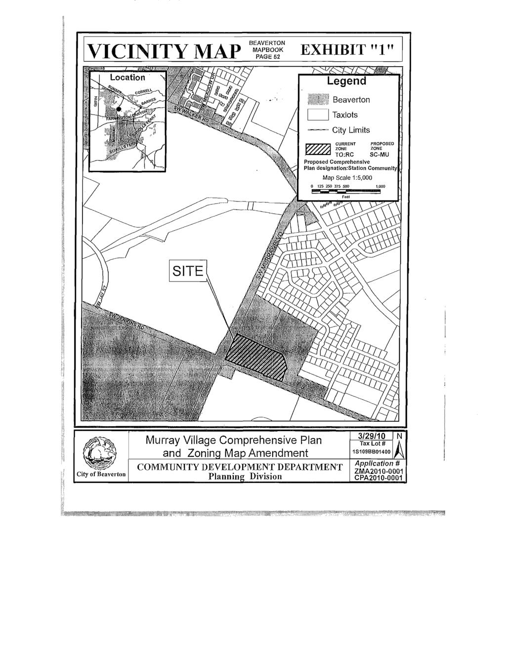
4 ORDINANCE NO AN ORDINANCE AMENDING ORDINANCE NO. 4187, FIGURE 111-1, THE COMPREHENSIVE PLAN LAND USE MAP AND ORDINANCE NO. 2050, THE ZONING MAP FOR PROPERTY GENERALLY LOCATED NORTHEAST OF THE INTERSECTION OF SW MURRAY BOULEVARD AMD SW JENKINS ROAD AND SPECIFICALLY IDENTIFIED AS LOT 1400 ON WASHINGTON COUNTY TAX ASSESSOR'S MAP 1S109-BB; CPA / ZMA WHEREAS, WHEREAS, WHEREAS, WHEREAS, WHEREAS, The Intent of the proposed amendments to the Comprehensive Plan Land Use Map and Zoning Map is to assign appropriate City land use designations to parcels that have been annexed into the City through a different process; and On May 19, 2010, the Planning Commission held a public hearing on the request to assign a Comprehensive Plan Land Use Map designation and Zoning Map designation to property that was annexed to the City in March, 2010; and No appeals were filed with the City; and The request is to designate this property Station Community (SC) on the City's Comprehensive Plan Land Use Map and to designate them Station Community - Multiple Use on the Zoning Map; and The Council incorporates by reference the Community Development Department staff report on CPA / ZMA by Associate Planner Kenneth Rencher, dated May 12, 2010; now, therefore, THE CITY OF BEAVERTON ORDAINS AS FOLLOWS: Section 1. Section 2. Ordinance No. 4187, the Comprehensive Plan Land Use Map, is amended to designate the subject property generally located on the northeast corner of the intersection of SW Murray Boulevard and SW Jenkins Road as Station Community (SC) on the Comprehensive Plan Land Use Map, as shown on Exhibit "1", in accordance with the Washington County - Beaverton Urban Planning Area Agreement (UPAA). The property is identified as Tax Lot 1400 on the Washington County Tax Assessor's Map 1S109-BB. Ordinance No. 2050, the Zoning Map, is amended to designate the zoning of the same property specified in Section 1 as Station Community - Multiple Use (SC- MU), as shown on Exhibit "1", in accordance with the UPAA. First reading this 7th day of June, Passed by the Council this 21st day of June, Approved by the Mayor this 22nd day of June, APPROVED: ORDINANCE NO Page 1 of 1 Agenda Bill No
5 VICINITY MAP BEAVERTON MAPBOOK PAGE 52 E f f l W "1" City of Beaverton Murray Village Comprehensive Plan and Zoning Map Amendment COMMUNITY DEVELOPMENT DEPARTMENT Planning Division 3/29/10 Tax Lot # 1S109BB01400 N A Application # ZMA CPA
6
7

8 Aerial Photo Exhibit 3 Murray Village CPA/ZMA
9 Zoning Current Development Site Size NAC Comprehensive Plan Surrounding Uses Existing Conditions Table Interim Washington County TO:RC Vacant with no development currently proposed (Site was formerly a mobile home park) Approximately 7.67 acres Five Oaks/Triple Creek NAC Land Use: Interim Washington County Transit Oriented Street Functional Classification Plan: SW Murray Blvd. and SW Jenkins Rd. are each classified as an Arterial. Street Improvement Master Plan: The Transportation System Plan Street Improvement Master Plan identifies SW Jenkins Rd. for future expansion to 5 lanes. (SW Murray Blvd. is already at 5 lanes.) Pedestrian & Bicycle Master Plan and Action Plans: The Pedestrian & Bicycle Master Plans identify existing and proposed pedestrian and bicycle facilities along both streets Zoning: North: Washington County R-5 (italics indicate outside City limits) South: Campus Industrial CI and Wash. Co. Industrial IND... Uses: North: Detached Housing South: TVF&R Fire Station and Maxim Integrated Products East: Interim Washington County TO:R18-24 West: Washington County TO.-EMP East: Vacant West: Nike TABLE OF CONTENTS Attachment A: CPA Murray Village CPA Attachment B: ZMA Murray Village ZMA PAGE CPA1-CPA14 ZMA1-ZMA3 EXHIBITS Exhibit 1. Vicinity Map (page 2 of report) Exhibit 2. Zoning Map Detail (page 3 of report) Exhibit 3. Aerial Photo (page 3 of report) Exhibit 4. Except from the Urban Planning Area Agreement (UPAA) Exhibit 5. Public Comments Received None Received SR-4
10 ANALYSIS AND FINDINGS FOR COMPREHENSIVE PLAN MAP AMENDMENT -QUASI-JUDICIAL See, ti on Approval Criteria: In order to approve a Comprehensive Plan Amendment application, the decision making authority shall make findings of fact based on evidence provided by the applicant demonstrating that all the following criteria are satisfied: A. The proposed amendment is consistent and compatible with relevant Statewide Planning Goals and related Oregon Administrative Rules; Of the nineteen Statewide Planning Goals, staff find Goals One, Two, Five, Six, Seven, Nine, Ten, Eleven, Twelve, and Thirteen are applicable to the proposed map amendment. Goal 1: To develop a citizen involvement program that insures the opportunity for citizens to be involved in all phases of the planning process. (Public Involvement) The proposed amendment is subject to the public notice requirements of the Comprehensive Plan Section as follows: Sections A and.b of the Comprehensive Plan prescribe the notice requirements to be provided for Quasi-Judicial Amendments. Notice must be mailed to the State Department of Land Conservation and Development (DLCD), Metro, Washington County, the Chair of any City-recognized Neighborhood Association Committee (NAC) or County-recognized Citizen Participation Organization whose boundaries include the property for which the change is contemplated, and the Chair of the Committee for Citizen Involvement (CCX) at least 45 days prior to the initial hearing. Between 20 and 40 days from the hearing, notice must be mailed to the subject property owners and surrounding property owners within 500 feet, posted in City Hall, posted in the City Library, posted on the City's Web site, and published in a local newspaper. In response to these requirements: 1. The required inter-agency DLCD notice was initially mailed to DLCD, Metro, and Washington County on April 2, 2010, which was at least 45 days prior to the first evidentiary hearing. Murray Village CPA/ZMA CPA-1
11 2. The required inter-agency DLCD notice was also mailed to the chair(s) of the Five Oaks/Triple Creek Neighborhood Association Committee (NAC) whose boundaries include the property for which the change is contemplated, and the Chair of the Committee for Citizen Involvement on April 2, 2010, at least 45 calendar days prior to the initial hearing; 3. Legal notice was published in the Beaverton Valley Times on April 14, Notice was mailed to properties owners included in the proposed change area, and to the owners of properties within 500 feet of the subject properties for which the change is proposed on April 8, Notice was posted in City Hall, in the City Library, and on the City's website on approximately April 8, There are no requirements to provide additional notice for this amendment beyond the notices described above. Therefore, staff find the notice requirements for this CPA have been met. At the hearing, the Planning Commission considers written comments and oral testimony before they make a decision. The procedures outlined in Comprehensive Plan Section allow for proper notice and public comment opportunities on the proposed Comprehensive Plan amendment as required by this Statewide Planning Goal. As noted above, these procedures have been followed. Goal 2: To establish a land use planning process and policy framework as a basis for all decisions and actions related to use of land and to assure an adequate factual base for such decisions and actions. (Land Use Planning) The City of Beaverton adopted its Comprehensive Plan which includes text and maps in a three-part report (Ordinance 1800) in The City adopted a new Comprehensive Plan (Ordinance 4187) in January of 2002 that was prepared pursuant to a periodic review work program approved by the State Department of Land Conservation and Development (DLCD). The proposed Plan, including a new Land Use Map, was the subject of numerous public hearings and considerable analysis before adoption. The adopted Plan and findings supporting adoption were deemed acknowledged pursuant to a series of Approval Orders from the Department of Land Conservation and Development, the last of which was issued on December 31, The subject property was annexed into the City in March, At that time, the parcel was not assigned City Comprehensive Plan Land Use Designations or City Zoning Designations. It has, on an interim basis, retained its County designations. In applying the Station Community Land Use Designation and the Station Community-Multiple Use (SC-MU) Zoning Designation, the City is following the correct process and procedures for selecting the most similar City equivalents to the Murray Village CPA/ZMA
12 County designations for situations that are not expressly provided for in the Urban Planning Area Agreement between the City of Beaverton and Washington County. Goal 5: To protect natural resources and conserve scenic and historic areas and open spaces. (Open Spaces, Scenic and Historic Areas, and Natural Resources) Goal 5 specifies that "[l]ocal governments shall adopt programs that will protect natural resources and conserve scenic, historic, and open space resources for present and future generations". The City of Beaverton depicts its significant natural resources related to Goal 5 on its Significant Tree Inventory Map, Local Wetland Inventory Map, and Habitat Benefit Area Map. These inventories are not altered by this proposed change in the Comprehensive Plan Land Use designation. Staff find that the proposal does not impact resources subject to the protection of Goal 5 compliance. Therefore, staff find that the amendment complies with Goal 5 of the Statewide Planning Goals. Goal 6: To maintain and improve the quality of the air, water, and land resources of the state. (Air, Water and Land Resources Quality) The applicable portion of Goal 6 specifies that "[p]lans which provide for the maintenance and improvement of air, land and water resources of the planning area should consider as a major determinant the carrying capacity of the air, land and water resources of the planning area. The land conservation and development actions provided for by such plans should not exceed the carrying capacity of sueh resources". Because the proposed City designations are substantially ident-igal to the existing County designations, no change in the carrying capacity of the planning area is expected. Staff find that the proposal does not impact resources subject to the protection ol' Goal 6 compliance. Therefore, staff find that the amendment complies with Goal G of the Statewide Planning Goals. Goal 7: To protect people and property from natural hazards. (Areas Subject to Natural Hazards) Goal 7 specifies that "[l]ocal governments shall adopt comprehensive plans... to reduce risk to people and property from natural hazards". No portion of the property is within the floodplain. This proposed change in land use designation will not alter the protections already in place to protect people and property from natural hazards. Staff find that the proposal does not alter the Goal 7 protections. Therefore, staff find that the amendment complies with Goal 7 of the Statewide Planning Goals. Murray Village CPA7ZMA CPA-3
13 Goal 9: To provide adequate opportunities throughout the state for a variety of economic activities vital to the health, welfare, and prosperity of Oregon's citizens. (Economic Development) Goal 9 specifies that comprehensive plans for urban areas shall "[l]imit uses on or near sites zoned for specific industrial and commercial uses to those which are compatible with proposed uses." Since the proposed mixed use land use and zoning designations are substantially similar to the existing designations, staff find that there will be no increase in incompatible uses as a result of this application. Therefore, staff find that this amendment complies with Goal 9 of the Statewide Planning Goals. Goal 10: To provide for housing needs of citizens of the state. (Housing) Goal 10 requires that local jurisdictions inventory the supply of buildable lands and develop plans "...in a manner that insures the provision of appropriate types and amounts of land within urban growth boundaries. Such land should be necessary and suitable for housing that meets the housing needs of households of all income levels". The subject property was annexed into the City in March, At that time, the parcel retained, on an interim basis, the County land use and zoning designations. In selecting City land use and zoning designations that closely approximate those of the County, the City is not significantly altering the supply of buildable land or potential housing units that can be constructed within the urban growth boundary. Staff find that the proposed amendment allows for a variety of housing types and densities commensurate with a variety of income levels as prescribed in Goal 10. This amendment complies with Goal 10 of the Statewide Goals. Goal 11: To plan and develop a timely, orderly and efficient arrangement of public facilities and senices to serve as a framework for urban and rural development. (Public Facilities and Services) The City of Beaverton is located within the Urban Growth Boundary (UGB) for the Portland metropolitan region. Metro is the regional governing body that determines the regional need for UGB expansions and in doing so, works with local governments to determine the highest and best use of lands within the UGB in order to reduce the need for UGB expansion into rural lands. The subject property is currently undeveloped. Availability of public facilities and services to serve the parcel will be addressed at the time it is proposed for development. When development for this parcel is proposed, site specific issues related to public facilities and services will be addressed in the development review process. Staff find that applying the City's Corridor Designation to the subject parcel satisfies the provisions expressed in Oregon's Goal 11. Murray Village CPA/ZMA CPA-4
14 Goal 12: To provide and encourage a safe, convenient and economic transportation system. (Transportation) Oregon Administrative Rules (OAR) through , referred to as the Transportation Planning Rule (TPR), provide guidance on compliance with Statewide Planning Goal 12. A Transportation System Plan (TSP), adopted pursuant to OAR Division 12, fulfills the requirements for public facilities planning required under Oregon Revised Statutes (ORS (2)(e)), Goal 11 and OAR Chapter 660, Division 12 as they relate to transportation facilities. Volume 4 of the Comprehensive Plan contains the City's adopted TSP, effective June 6, OAR requires local governments to review Comprehensive Plan and land use regulation amendments with regard to the effect of the amendment on existing or planned transportation facilities. This section is cited as follows: 1 I "A plan or land use regulation amendment significantly affects a transportation facility if it would: (a) Change the functional classification of an existing or planned transportation facility (exclusive of correction of map errors in an adopted plan); j (b) Change standards implementing a functional classification system; or i (c) As measured at the end of the planning period identified in the adopted : transportation system plan: (A) Allow land uses or levels of development that would result in types or levels of travel or access that are inconsistent with the functional classification of an existing or planned transportation facility; (B)Reduce the performance of an existing or planned transportation facility below the minimum acceptable performance standard identified in the TSP or comprehensive plan; or (C) Worsen the performance of an existing or'planned transportation facility that is otherwise projected to perform below the minimum I acceptable performance standard identified in the TSP or comprehensive plan." The City's Comprehensive Plan designations are descriptive tools assigned to individual parcels. These designations are in turn implemented through the specific zones. While the role of the plan designation is perceived as qualitative, zoning provisions apply specific criteria applicable to new development. As specified in CP Section 3.14 (the City's Comprehensive Plan and Zoning District Matrix), specific zones correlate with specific plan designations. However, zoning ultimately controls the use and residential density allowance for a development. This density in turn influences the scale of traffic generation that will affect local transportation facilities. The intent of the proposed amendment is to replace the interim County designations with the City designations that are most similar. The Station CPA-5
15 Community land use designation is most similar to the interim County Transit Oriented land use designation. Because the property's zoning and the developmentspecific conditions of approval are the principle instruments used to control the level of traffic generation derived from a development, and because no development is currently proposed on the property, traffic volumes will not be affected by the proposed amendment. The City Transportation System Plan (TSP) includes the forecast trip generation for traffic based on the County's existing plan designation. The proposal to change the Plan designation from Transit Oriented to Station Community is a minor change and will have negligible effects on the City's Transportation Plan. When future development is proposed, a traffic analysis will be required to analyze impacts of trip generation and assess the ability of the impacted street system to adequately accommodate the proposed development. Therefore, staff find that the proposed amendment will not significantly affect the local transpiration facilities as defined by OAR and cited above. Staff find that applying the City's Station Community Designation to the subject parcel satisfies the provisions expressed in Oregon's Goal 12 and OAR through (the Transportation Planning Rule). Goal 13: To conserve energy. (Energy Conservation) The proposal involves the conversion of the interim County Transit Oriented land use designation to the City Station Community land use designation. Because these two designations are substantially similar in the type and density of development that they allow, the City finds that there will be no significant change in the Goal 13 analysis that Washington County conducted as a part of the review prior to implementing the Cedar Hills-Cedar Mill Community Plan. The proposed land use designation continues to encourage high density, mixed use development that allows for energy-efficient means of transportation and energy conservation opportunities. Staff find that applying the City's Station Community Designation to the subject parcel satisfies the provisions expressed in Oregon's Goal 13. Remaining Goals Goal 3: Agricultural Goal 4: Forest Lands Lands These goals apply to rural unincorporated areas. The City of Beaverton is urban and incorporated, therefore, the goals are not applicable. Goal 8: Recreational Needs The proposal does not involve the siting of necessary recreational facilities which include destination resorts or opportunities to satisfy the recreational needs to visitors and the citizens of the state. Therefore, this goal is not applicable. Murray Village CPA7ZMA CPA-6
16 I f Goal 14: Urbanization The proposal does not include a request to establish or change the Urban Growth I Boundary. Therefore, this goal is not applicable. Goal 15: Willamette Greenway 1 This goal applies to lands along the Willamette River. The Willamette River is not { within, or adjacent to, the City of Beaverton, thus this goal is not applicable to the I proposal. I Goal 16: Estuarine Resources, Goal 17: Coastal Shorelands, Goal 18: Beaches And Dunes, Goal 19: Ocean Resources Apply to oceanic or coastal resources. The City of Beaverton is over 80 miles from coastal resources; therefore, these goals do not apply in the City of Beaverton. Summary Staff find that for the reasons identified above, the proposed Finding: amendment complies with Goals 1, 2, 5, 6, 7, 9, 10, 11, 12, and 13 and find that Goals 3, 4, 8, and are not applicable. Criterion A is met. B. The proposed amendment is consistent and compatible with the applicable Titles of the Metro Urban Growth Management Functional Plan and the Regional Transportation Plan; Facts and Findings: Title 1: Requirements of Housing and Employment Accommodation Section of the UGMFP requires that any Comprehensive Plan change must be consistent with the requirements of the Functional Plan. Section of the UGMFP states: "For each of the following 2040 Growth Concept design types, city and county comprehensive plans shall be amended to include the boundaries of each area, determined by the city or county consistent with the general locations shown on the 2040 Growth Concept Map..." While the 2040 Growth Concept Plan map designates the parcel included in this proposal as a combination of Station Community, Corridor, and Inner Neighborhoods residential design type, the existing Washington County designation is Transit Oriented, due to the proximity to the Beaverton Creek light rail station and the 62 and 67 Tri-Met bus routes, as shown in the Cedar Hills-Cedar Mill Community Plan. The 2040 Growth Concept Plan is intended to be a general framework for the entire region. The specific planning for the local area of the site was conducted by Washington County in As the more specific document, the Cedar Hills-Cedar Mill Community plan, which was Murray Village CPA/ZMA CPA-7
17 approved by Metro, is the governing document. Because the City Station Community and the County Transit Oriented land use designations are substantially similar, staff find that the proposal meets the requirement for compliance with Title 1 of the UGMFP. Title 2: Regional Parking Policy The City has an established minimum and maximum parking ratio related to zones A and B. The subject property is within Parking Zone A. Consequently, the Maximum Permitted Parking Spaces per Zone A applies to the subject property. Title 3: Water Quality and Flood Management Conservation In concert with other local governments in Washington County, the City partnered with Clean Water Services to enact legislation acknowledged to comply with Title 3. Title 4: Industrial and Other Employment Areas The City and Metro established long-term Industrial and Employment Areas on the Title 4 map. This area is not shown as Industrial Area on the Metro Title 4 Industrial and Employment Areas Map. Title 5: Neighbor Cities and Rural Reserves Title 5 concerns Neighbor Cities and Rural Reserves. The proposal is within the City of Beaverton; therefore, this Title does not apply. Title 6: Central City. Regional Centers, Town Centers and Station Communities The subject property is located at an intersection where all of the property on the other three corners is already part of an approved Station Community Both the southeast corner and the northwest corner of the intersection of SW Murray Blvd. and SW Jenkins Rd. are within the Beaverton Creek Station Community. Staff recommend that the subject parcel also be included within the Beaverton Creek Station Community boundaries. The proposed Station Community land use designation is compatible with the Title 6 requirements to enhance the region's Centers, which include the Station Communities. Title 7: Affordable Housing The intent of Title 7 is to enact a "fair share" housing strategy for each jurisdiction which includes a diverse range of housing types, specific goals for low- and moderate-income housing, housing densities consistent with the regional transportation system, and a balance of jobs and housing. The City adopted Comprehensive Plan Chapter Four to comply with this Metro Title. The sections of the Comprehensive Plan that are applicable to the Comprehensive Plan map amendment are addressed below to show consistency with Title 7. Comprehensive Plan Goal states "Maximize use of buildable residential land in the City." Action items applied to implement this goal have been implemented. Goal states "Provide an adequate variety of quality housing types to serve Beaverton's citizenry." The City is working in partnership with the Washington CPA-8
18 County Housing Authority to preserve the Housing Authority's portfolio of federally assisted housing at rent levels affordable to extremely and very low-income households. Comprehensive Goal states "Promote the retention of existing affordable housing stock in the City." The proposed zoning of the property (Station Community-Multiple Use) allows for a variety of housing types and could include various forms of affordable housing. Additionally, the City continues to support affordable housing programs through the Community Development Block Grant and HOME programs, the Citywide Housing Rehabilitation Loan Program, and partnership with local non-profit service providers. Goal states "Promote the production of new affordable housing units in the City." Participation in local non-profit efforts to develop affordable housing, providing an ombudsman to assist in the development review process, developing revolving loan funding, exploring land banking and employer sponsored affordable housing, supporting alternative funding for affordable housing, and continuing to explore tools and strategies to encourage affordable housing development are actions to implement Goal These goals and actions comply with Title 7. Title 8: Compliance Procedures Information about the proposal was sent to the Chief Operating Officer on April 2, 2010, more than 45 days prior to the first evidentiary hearing as required by Metro Code Section Title Performance Measures Title 9 directs Metro to measure the progress of the region in implementing the Urban Growth Management Functional Plan. This title is not relevant to the proposal. Title 10: Functional Plan Definitions Title 10 provides definitions for use in Metro's administration of the UGMFP and is, therefore, irrelevant to the compliance of this proposal to the UGMFP. Title 11: Planning for New Urban Areas Title 11 concerns planning for new urban areas. This proposal is within the Urban Growth Boundary and is within the corporate limits of the City of Beaverton. This Title does not apply to the amendment. Title 12: Protection of Residential Neighborhoods Protection of residential neighborhoods is a key to success of the 2040 Growth Concept. The property is within a mixed use Station Community area. By allowing for areas of high density, mixed use development, the City relieves some of the pressure on existing residential neighborhoods to increase density. Therefore, this proposal will have a beneficial effect on the residential neighborhoods. Murray Village CPA7ZMA CPA-9
19 Title 13: Coordination The City, as a member of the Tualatin Basin Coordinating Committee, complies with Title 13. Regional Transportation Plan (RTP) Section 6.4.4: Regional transportation system analysis is required for amendments to local plans or the addition of significant single occupancy vehicle capacity to regional facilities. "This section applies to city and county comprehensive plan amendments or to any local studies that would recommend or require an amendment to the Regional Transportation Plan to add significant single occupancy vehicle (SOV) capacity to the regional motor vehicle system, as defined by Figure This section does not apply to projects in local TSPs that are included in the 2000 RTP. For the purpose of this section, significant SOV capacity is defined as any increase in general vehicle capacity designed to serve 700 or more additional vehicle trips in one direction in one hour over a length of more than one mile. This section does not apply to plans that incorporate the policies and projects contained in the RTP." The City's Transportation System Plan (TSP) has been adopted for consistency with, and implementation of, the 2000 RTP. Therefore; the Regional Transportation Plan does not apply to the proposed zoning map amendment. Summary Finding: Staff find that for the reasons identified above, the proposed amendment complies with applicable Titles of the Metro Urban Growth Management Functional Plan and the Regional Transportation Plan. C. The proposed amendment is consistent and compatible with the Comprehensive Plan and other applicable local plans; Facts and Findings: All nine Comprehensive Plan chapters are addressed below. The Cedar Hills-Cedar Mill Community plan adopted by Washington County is also applicable to this proposal and is addressed following the Comprehensive Plan findings. Chapters 1 and 2, Procedures and. Public Involvement Elements, respectively The procedures for amending the Comprehensive Plan found within Chapter 1 have been complied with, including appropriate noticing. The Planning Commission will hold an initial hearing where public testimony and evidence will be entered into the record and used for the Planning Commission's deliberations. The Planning Commission will make a recommendation to City Council, who will follow appropriate procedures for adopting an ordinance implementing the Planning Murray Village CPA/ZMA CPA-10
20 Commission's recommendation and incorporating their findings, unless an appeal of the Planning Commission decision is filed, in which case the Council will conduct a hearing on the appeal. Staff find that the proposal is a quasi-judicial amendment. Staff find that the appropriate procedures in Chapter 1 and summarized in Chapter 2 of the Comprehensive Plan have been met. Thus, this proposal is in compliance with Chapters 1 and 2. Chapter 3 Land Use Element. Section 3.2 provides for the development of Station Communities with nodes of development centered around light rail or high capacity transit service and featuring a high quality pedestrian environment. The implementation of the Station Community land use designation is appropriate for this property and meets the requirements of this section. Section stipulates that the City shall apply appropriate City land use designations to annexed areas. Given the proximity to the Beaverton Creels light rail station and the adjacent areas already designated Station Community, Station Community is the appropriate land use designation for the subject property. Section 3.5 deals specifically with mixed use areas. The proposed land use designation is generally consistent with the 2040 Regional Growth Concept Plan and is appropriate for land within a mile of the light rail station. The subject property is generally within one half-mile of the station. The proposal is consistent with the Community Plan for the area that was adopted by Washington County prior to the annexation of this property. Staff find that for the reasons specified above, the policies found in Chapter 3 are met. Chapter 4 Housing Element. Discussion under Goal 10 assists in the understanding of the applicability of the Housing Element to this amendment. The City adopted a Housing Element into its Comprehensive Plan (Ordinance 4187) in January of 2002 pursuant to a periodic review work program approved by the State Department of Land Conservation and Development (DLCD). Part of that process involved development of a buildable lands inventory, a housing type needs analysis, and a housing density assessment. Based upon the findings of those studies, the City adopted policies to encourage a broad mix of housing types at density levels designed to maximize development potential. Policies that are particularly relevant to this proposal include the following: Section a) Allow development of a wide variety of housing types in the City. Murray Village CPA7ZMA CPA-11
21 Section a) Increase residential capacity in the City to substantially comply with requirements of Title 1 of the Metro Urban Growth Management Functional Plan. Staff addressed the relevance of these policies in the section of this report that addressed Goal 10 compliance. Pursuant to the reasoning contained in that section as it relates to the policies above, staff believes that the proposal fulfills these policies. Staff find that relevant policies found in Chapter 4 are met. Chapter 5 Public Facilities and Services Element. As noted in the Goal 11 discussion, the proposal does not physically affect the landscape, or affect service boundaries, or the City's public facility plans. The permitted uses on the subject property will be governed by the specific zoning applied to the property. The Station Community land use designation and the interim Transit Oriented land use designation are substantially similar, so the proposal would not affect the City's ability to implement the Public Facilities Plans, Capital Improvement Plan, Urban Planning Area Agreement (UPAA), Urban Service Area, Storm Water and Drainage System, Potable Water System, Sanitary Sewer System, Parks and Recreation, or Police and Fire and Emergency Medical Services plans already in place. Additionally, because the range of permitted residential densities allowed under the implementing zones of the two land use designations is very similar, school facilities should not be significantly affected by the proposal. Staff find that the relevant policies of Chapter 5 are met. Chapter 6 Transportation Element. Comprehensive Plan Section C is relevant to the proposed amendment. It states as follows: "Maintain levels of service consistent with Metro's Regional Transportation Plan and the Oregon Transportation Plan. Applications for Comprehensive Plan Amendments shall comply with the requirements of OAR and as appropriate include a transportation Impact Analysis that shows that the proposal will not degrade system performance below the acceptable two-hour peak demand-to-capacity ratio of " Findings addressing the amendment's compliance with OAR are provided under the section addressing Goal 12 compliance above. As pointed out in that section, the proposal seeks to replace the County designation of Transit Oriented with the City's Station Community designation. Staff find that the two plan designations are substantially similar and that, therefore, the traffic impacts from the potential range of development options will not change. Additional Murray Village CPA7ZMA CPA-12
22 analysis of the potential traffic impacts is provided by the findings for the Zoning Map Amendment (Attachment B of this staff report). It should also be noted that any future development proposed for the subject property will require that a traffic impact assessment be prepared by the applicant to demonstrate that traffic generation from the development will not adversely impact the transportation system. If such impacts were found to degrade the system beyond the 0.98 measure indicated above, then mitigation measures to alleviate the impact would be required. The analysis of traffic impact and identification of potential mitigation would be triggered by development of the property rather than by the amendment being proposed here. Staff find that for the reasons specified above, the proposal is consistent with the policies found in Chapter 6 of the City's Comprehensive Plan. Chapter 7 Natural, Cultural, Historic, Scenic, Energy and Groundwater Resources Element. Staff reviewed the provisions contained in the Chapter 7 of the City's Comprehensive Plan and concluded that because the proposal will not alter the protections in place for the Natural, Cultural, Historic, Scenic, Energy and Groundwater Resources present on the property, the proposed amendment does not affect the City's ability to implement the provisions in this chapter. Staff find that the proposed amendment does not affect the City's ability to implement this Chapter. Chapter 8 Environmental Quality and Safety Element. Staff reviewed the provisions contained in the Chapter 8 of the City's Comprehensive Plan and concluded that this proposed amendment does not affect the City's ability to comply with Sections 8.2 Water Quality, 8.3 Air Quality, 8.4 Noise, 8.5 Seismic Hazards, 8.6 Geologic Hazards, 8.7 Flood Hazards, or 8.8 Solid and Hazardous Wastes. Staff find that the proposed amendment does not affect the City's ability to implement this Chapter. Chapter 9 Economy Element. Staff reviewed the provisions contained in the Chapter 9 of the City's Comprehensive Plan and concluded that economic development, proposed industrial facilities, and employment centers would not be negatively affected by the proposed amendment. Staff find that the policies found in Chapter 9 do not apply to the proposed amendment. Murray Village CPA/ZMA CPA-13
23 Summary Finding: Staff find that the proposed Comprehensive Plan Amendment is generally consistent and compatible with the Comprehensive Plan. Thus, the requirements of Criterion 1.5.l.C are met. D. If the proposed amendment is to the Land Use Map, there is a demonstrated public need, which cannot be satisfied by other ; properties that now have the same designation as proposed by the amendment; The proposed amendment implements the City land use designation that most closely matches the interim Washington County land use designation. This change allows the City to implement a City zoning designation, which meets the demonstrated public need for orderly development by eliminating any potential confusion for developers or residents that may arise from having a mixture of City and County zoning regulations in effect. This is consistent with the approved procedure for handling land that is annexed into the City of Beaverton. Staff find that criterion 1.5. l.d is met for the proposed amendment. SUMMARY OF CPA FINDINGS: For the reasons identified above, staff find that the Comprehensive Plan Map Amendment satisfies the approval criteria for Comprehensive Plan Amendment approval pursuant to Section of the Comprehensive Plan, in addition to compliance with applicable State and Metro requirements. COMPREHENSIVE PLAN MAP AMENDMENT- QUASI JUDICIAL CONCLUSION Based on the facts and findings presented, staff concludes the proposal, CPA (Murray Village Comprehensive Plan Map Amendment) meets the criteria for approval. Recommendation Based on the facts and findings presented, staff recommend APPROVAL of CPA (Murray Village Comprehensive Plan Map Amendment) with no recommended conditions of approval Murray Village CPA7ZMA CPA-14
24 ATTACHMENT C ANALYSIS AND FINDINGS FOR ZONING MAP AMENDMENT - DISCRETIONARY ANNEXATION-RELATED APPROVAL Section Zoning Map Amendment; Purpose The purpose of a Zoning Map Amendment application is to provide for the consideration of legislative and quasi-judicial amendments to the zoning map. Legislative amendments to the zoning map are amendments of generally large size, diversity of ownership or of interest to a large geographic area. Quasi-judicial amendments to the zoning map are amendments that are generally small in size, single ownership or affect only a relatively small geographic area. Annexation related amendments to the zoning map are those amendments, whether legislative or quasi-judicial, which are associated with land being annexed into the City. It is recognized that such amendments may be necessary from time to time to reflect changing community conditions, needs, and desires. This Section is carried out by the approval criteria listed herein. Section C. Approval Criteria: In order to approve a Discretionary Annexation Related Zoning Map Amendment application, the decision making authority shall make findings of fact based on evidence provided by the applicant demonstrating that all the following criteria are satisfied: 1, The proposal satisfies the threshold requirements for a Discretionary Annexation Related Zoning Map Amendment application. Facts and Findings: Section A Threshold: An application for a Discretionary Annexation Related Zoning Map Amendment shall be required when the following threshold applies: "The change of zoning to a City zoning designation as a t^esult of annexation of land into the City and the Urban Planning Area Agreement (UPAA) does not specify a particular corresponding City zoning designation and discretion is required to determine the most similar City zoning designation." The City, as the applicant, is requesting a change in the zoning designation for a property that still has the interim Washington County zoning that has been in place since the property was annexed into the City. The property currently has the interim zoning designation of Transit Oriented Retail Commercial (TO:RC). The UPAA between the City of Beaverton and Washington County was signed prior to the creation of the mixed use, transit oriented zones. As a result, the UPAA does not specify a corresponding city zoning designation for the TO:RC zoning currently in place. Although no discretion was needed for the corresponding Comprehensive Plan Map Amendment, there are several City zoning designations that would Murray Village CPA/ZMA ZMA-1
25 ATTACHMENT C implement the Station Community land use designation and some discretion is required to identify the one that most closely matches the existing County zoning Therefore, staff find that the proposal meets the criterion for approval. 2. All City application fees related to the application under consideration by the decision making authority have been submitted. Facts and Findings: There is no fee associated with an Annexation Related Zoning Map Amendment application. Therefore, staff find that the proposal meets the criterion for approval. 3. The proposed zoning most closely approximates the density use provisions and development standards of the Washington County designation which applied to the subject property prior to annexation. Facts and Findings: Because the current zoning is a mixed use zone, the most similar City zoning designation would be one of the City's mixed use zones. According to the Beaverton Comprehensive Plan, the Station Community Land Use Designation should be generally applied to properties within one mile of light rail station platforms. The majority of the subject property is located within 'A mile from the Beaverton Creek Station light rail platform. There are five zoning districts that implement the Station Community Comprehensive Plan Designation: Station Area-Medium Density Residential (SA-MDR), Station Area-Mixed Use (SA-MU), Station Community-High Density Residential (SC-HDR), Station Community-Mixed Use (SC-MU), and Station Community-Employment (SC-E). The interim county zoning of TO:RC has no maximum number of units. The two Station Area zones have a maximum density of 30 units per acre. Of the three Station Community zones, SC-HDR and SC-MU allow new dwellings and do not set a maximum residential density. The SC-E zone does not allow new dwellings to be constructed. Therefore, only the SC-HDR and the SC-MU zones are possible choices for the conversion of the TO:RC zoning. Staff examined the range of uses allowed by the TO:RC zone and the SC-HDR and SC-MU zones and concluded that the SC-MU zone more closely matches the range of uses allowed in the TQ:RC zone. The SC-HDR zone only allows a portion of the commercial uses allowed under the interim zoning. Therefore staff find that the proposed City zoning designation of SC-MU is the best match for the existing zoning and adequately satisfies the criterion to closely approximate the County's zoning standards. Therefore, staff find that the proposal meets the criterion for approval. Murray Village CPA/ZMA ZMA-2
26 4. The proposed zoning designation is consistent with any guidance contained within the UPAA concerning the application of non-specified zoning district designations. Facts and Findings: By implementing a City zoning district that most closely matches the zoning designation established by the County prior to annexation, the proposed zoning designation is consistent with the guidance contained within the UPAA. Therefore, staff find that the proposal meets the criterion for approval. 5. Applications and documents related to the request, which will require further City approval, shall be submitted to the City in the proper sequence. Facts and Findings: The application for a Zoning Map Amendment is accompanied by an application to amend the Comprehensive Plan Map. The Development Code allows the two applications to be heard concurrently. Therefore this is the proper sequence. Therefore, staff find that the proposal meets the criterion for approval. SUMMARY OF ZMA FINDINGS: For the reasons identified above, staff find that the Zoning Map Amendment satisfies the approval criteria for Zoning Map Amendment approval pursuant to Section C of the Development Code, in addition to compliance with applicable State and Metro requirements. ZONING MAP AMENDMENT CONCLUSION Based on the facts and findings presented, staff concludes the proposal, ZMA (Murray Village ZMA) meets the criteria for approval. Recommendation Based on the facts and findings presented, staff recommends APPROVAL of ZMA (Murray Village ZMA). There are no recommended conditions of approval. Murray Village CPA/ZMA ZMA-3
27
28
Oregon Theodore R KjibngDski, Governor
 Oregon Theodore R KjibngDski, Governor Department of Land Conservation and Development 635 Capitol Street, Suite 150 Salem, OR 97301-2540 (503) 373-0050 Fax (503) 378-5518 www. lcd.state.or.us NOTICE OF
STAFF REPORT. Community Development Director PO Box 4755 Beaverton, OR 97076
 STAFF REPORT HEARING DATE: July 7, 2010 TO: Planning Commission STAFF: Jana Fox, Assistant Planner PROPOSAL: Southeast Beaverton Office Commercial Zoning Map Amendment (ZMA2010-0006) LOCATION: The subject
Department of Land Conservation and Development 635 Capitol Street, Suite 150 Salem, OR Theodore R. Kulongoski, Governor (503)
") Oregon Department of Land Conservation and Development 635 Capitol Street, Suite 150 Salem, OR 97301-2540 Theodore R. Kulongoski, Governor (503) 373-0050 AMENDED NOTICE OF ADOPTED AMENDMENT November 2,
Oregon Department of Land Conservation and Development 635 Capitol Street, Suite 150 Salem, OR 97301-2540 Theodore R. Kulongoski, Governor (503) 373-0050 AMENDED NOTICE OF ADOPTED AMENDMENT November 2,
NOTICE OF ADOPTED CHANGE TO A COMPREHENSIVE PLAN OR LAND USE REGULATION
 NOTICE OF ADOPTED CHANGE TO A COMPREHENSIVE PLAN OR LAND USE REGULATION Date: Jurisdiction: Local file no.: DLCD file no.: May 17, 2016 City of Lebanon 16-02-09 002-16 The Department of Land Conservation
AGENDA BILL. Beaverton City Council Beaverton, Oregon BUDGET IMPACT AMOUNT BUDGETED $0
 AGENDA BILL Beaverton City Council Beaverton, Oregon SUBJECT: An Ordinance Amending Ordinance No. 4187, Figure 111-1, the Comprehensive Plan Land Use Map to Apply the City's Neighborhood Residential-Standard
Oregon Theodore R. Kulongoski, Governor
 Oregon Theodore R. Kulongoski, Governor Department of Land Conservation and Development 635 Capitol Street NE, Suite 150 Salem, Oregon 97301-2524 Phone: (503) 373-0050 First Floor/Coastal Fax: (503) 378-6033
EXHIBIT B FINDINGS OF FACT BEND DEVELOPMENT CODE (BDC) UPDATE AMENDMENT PZ
 UPDATE AMENDMENT PZ") EXHIBIT B FINDINGS OF FACT BEND DEVELOPMENT CODE (BDC) UPDATE AMENDMENT PZ 18-0524 Procedural Findings Notice of the proposed amendments was provided to the Department of Land Conservation and Development
EXHIBIT B FINDINGS OF FACT BEND DEVELOPMENT CODE (BDC) UPDATE AMENDMENT PZ 18-0524 Procedural Findings Notice of the proposed amendments was provided to the Department of Land Conservation and Development
8/17/16 PC Meeting 1
 1 GENERAL INFORMATION OWNER/APPLICANT: Thomas Corff & Terry Moberly (1943 13 th St.) 19328 Towercrest Dr. Oregon City, OR 97045 Michael & Jill Parker (1983 13 th St.) 1708 Oak St. Lake Oswego, OR 97034
Department of Land Conservation and Development 635 Capitol Street NE, Suite 150 ^, ^.,. ^ Salem, Oregon
 Oregon Department of Land Conservation and Development 635 Capitol Street NE, Suite 150 ^, ^.,. ^ Salem, Oregon 97301-2524 Theodore R. Kulongoski, Governor 6 NOTICE OF ADOPTED AMENDMENT February 10, 2006
DLCD ACKNOWLEDGMENT or DEADLINE TO APPEAL: Wednesday, December 09, 2009
 Oregon Theodore R KjibngDski, Governor Department of Land Conservation and Development 635 Capitol Street, Suite 150 Salem, OR 97301-2540 (503) 373-0050 Fax (503) 378-5518 www. lc d. s tat e. or. us NOTICE
DLCD ACKNOWLEDGMENT or DEADLINE TO APPEAL: Tuesday, February 16, 2010
 Oregon Theodore R KjibngDski, Governor Department of Land Conservation and Development 635 Capitol Street, Suite 150 Salem, OR 97301-2540 (503) 373-0050 Fax (503) 378-5518 www. lcd.state.or.us NOTICE OF
Subject: Ordinance 1657, Annexation of 3.55 acres of land at 3015 and 3001 Parker Road.
 Agenda Report 2016-12-12-09 Date: December 8, 2016 To: From: Russ Axelrod, Mayor Members, West Linn City Council Jennifer Arnold, Planning Department Through: John Boyd, Interim Community Development Director
DLCD ACKNOWLEDGMENT or DEADLINE TO APPEAL: Thursday, March 18, 2010
 Oregon Department of Land Conservation and Development Theodore R KjibngDski, Governor 635 Capitol Street, Suite 150 Salem, O R 97301-2540 (503) 373-0050 Fax (503) 378-5518 w w w. lcd.state.or.us NOTICE
78th OREGON LEGISLATIVE ASSEMBLY Regular Session. House Bill 2510 SUMMARY
 th OREGON LEGISLATIVE ASSEMBLY--0 Regular Session Sponsored by Representative CLEM (Presession filed.) House Bill 0 SUMMARY The following summary is not prepared by the sponsors of the measure and is not
Darren Wyss, Associate Planner, Community Development Department
 Agenda Bill 2019-03-11-01 Date: February 25, 2019 Meeting Date: March 11, 2019 To: From: Through: Russ Axelrod, Mayor Members, West Linn City Council Darren Wyss, Associate Planner, Community Development
Planning the Oregon Way: Planning 101 for Planners and Permit Technicians. Southern Oregon Planners Network Meeting September 14, 2016
 Planning the Oregon Way: Planning 101 for Planners and Permit Technicians Southern Oregon Planners Network Meeting September 14, 2016 Planning the Oregon Way Presenters: Rob Hallyburton, DLCD Community
Lisa Anderson-Ogilvie, AICP, Interim Community Development Director. APPLICATION: Comprehensive Plan Change / Zone Change Case No.
 FOR MEETING OF: October 3, 2017 AGENDA ITEM NO.: 6.1 TO: FROM: STAFF: Planning Commission Lisa Anderson-Ogilvie, AICP, Interim Community Development Director Olivia Glantz, Planner II HEARING DATE: October
B. Subarea Provisions, including the Design Elements and Area of Special Concern and Potential Park/Open Space/Recreation Requirements;
 ARTICLE III: LAND USE DISTRICTS III-1 300 INTRODUCTION Article III of the Washington County Community Development Code consists of the primary and overlay districts which apply to the unincorporated areas
AGENDA BILL. Beaverton City Council Beaverton, Oregon BUDGET IMPACT AMOUNT BUDGETED $0
 AGENDA BILL SUBJECT: Beaverton City Council Beaverton, Oregon An Ordinance Annexing a Portion of Three Parcels Along NW 112 1 h Avenue to the City of Beaverton, Adding the Property to the Central Beaverton
Lisa Anderson-Ogilvie, AICP, Deputy Community Development Director and Planning Administrator
 FOR MEETING OF: June 19, 2018 AGENDA ITEM NO.: 6.2 TO: FROM: STAFF: Planning Commission Lisa Anderson-Ogilvie, AICP, Deputy Community Development Director and Planning Administrator Pamela Cole, Planner
DLCD ACKNOWLEDGMENT or DEADLINE TO APPEAL: Wednesday, June 15, 2011
 Department of Land Conservation and Development 635 Capitol Street, Suite 150 Salem, OR 9730 1-2540 (503) 373-0050 Fax (503) 378-5518 www. Icd.state.or.us NOTICE OF ADOPTED AMENDMENT 06/02/2011 TO: FROM:
NOTICE OF ADOPTED CHANGE TO A COMPREHENSIVE PLAN OR LAND USE REGULATION
 NOTICE OF ADOPTED CHANGE TO A COMPREHENSIVE PLAN OR LAND USE REGULATION Date: Jurisdiction: Local file no.: DLCD file no.: 08/26/2014 City of Salem CPC-ZC-14-01 001-14 The Department of Land Conservation
Oregon. Department of Land Conservation and Development
 Oregon Theodore R. Kulongoski, Governor NOTICE OF ADOPTED AMENDMENT November 22, 2006 TO: FROM: Subscribers to Notice of Adopted Plan or Land Use Regulation Amendments Mara Ulloa, Plan Amendment Program
AGENDA BILL. Beaverton City Council Beaverton, Oregon
 AGENDA BILL Beaverton City Council Beaverton, Oregon SUBJECT: An Appeal of Planning Commission FOR AGENDA OF: 02-07-12 BILL NO: 12029 Recommendation to Approve TA2011-0003, Station Community - Sunset Text
STAFF REPORT. For the Sept. 18, 2018 Board of Commissioners Hearing (The public hearing will begin no sooner than 10:00 a.m.)
") Sept. 10, 2018 To: From: Subject: Washington County Board of Commissioners Andy Back, Manager Planning and Development Services PROPOSED LAND USE ORDINANCE NO. 839 - An Ordinance Amending the Washington
Sept. 10, 2018 To: From: Subject: Washington County Board of Commissioners Andy Back, Manager Planning and Development Services PROPOSED LAND USE ORDINANCE NO. 839 - An Ordinance Amending the Washington
DLCD ACKNOWLEDGMENT or DEADLINE TO APPEAL: Thursday, October 20, 2011
 epartment of Land Conservation and evelopment Capitol Street, Suite 0 Salem, OR 0 1-0 (0) -000 Fax (0) - www. lc d. s tat e. or. us NOTICE OF AOPTE AMENMENT îbua /0/0 TO: FROM: Subscribers to Notice of
Rezone property from RR(T)D3, D1(T)D3, and RR(T)D15 to D3 and D15 along North Douglas Highway.
D3, D1(T)D3, and RR(T)D15 to D3 and D15 along North Douglas Highway.") DATE: TO: FROM: Planning Commission Chrissy McNally, Planner Community Development Department FILE NO.: AME2013 0016 PROPOSAL: Rezone property from RR(T)D3, D1(T)D3, and RR(T)D15 to D3 and D15 along North
DATE: TO: FROM: Planning Commission Chrissy McNally, Planner Community Development Department FILE NO.: AME2013 0016 PROPOSAL: Rezone property from RR(T)D3, D1(T)D3, and RR(T)D15 to D3 and D15 along North
URBANIZATION ELEMENT. PREPARED BY CITY OF MEDFORD PLANNING DEPARTMENT 200 SOUTH IVY STREET MEDFORD, OREGON
 PREPARED BY CITY OF MEDFORD PLANNING DEPARTMENT 200 SOUTH IVY STREET MEDFORD, OREGON 97501 plnmed@ci.medford.or.us ROBERT O. SCOTT, AICP, PLANNING DIRECTOR COMPREHENSIVE PLANNING SECTION MARK GALLAGHER,
DLCD ACKNOWLEDGMENT or DEADLINE TO APPEAL: Thursday, July 21, 2011
 Department of Land Conservation and Development 635 Capitol Street, Suite 150 Salem, OR 9730 1-2540 (503) 373-0050 Fax (503) 378-5518 www. lc d. s tat e. or. us NOTICE OF ADOPTED AMENDMENT ÄeA 07/11/2011
AGENDA BILL. Beaverton City Council Beaverton, Oregon BUDGET IMPACT AMOUNT BUDGETED $0
 AGENDA BILL Beaverton City Council Beaverton, Oregon SUBJECT: An Ordinance Amending Ordinance No. 2050, the Zoning Map, ZMA 2016-0001, TVF&R Station 65 Rezoning (Lindquist Development Company, Inc.) Zoning
PLANNING COMMISSION STAFF REPORT
 PLANNING COMMISSION STAFF REPORT West Capitol Hill Zoning Map Amendment Petition No. PLNPCM2011-00665 Located approximately at 548 W 300 North Street, 543 W 400 North Street, and 375 N 500 West Street
Planning Commission. Lisa Anderson-Ogilvie, AICP Interim Community Development Director. Christopher Green, AICP, Planner II
 FOR MEETING OF: July 18,2017 AGENDA ITEM NO.: 6.1 TO: FROM: STAFF: HEARING DATE: APPLICATION: LOCATION: SIZE: REQUEST: Planning Commission Lisa Anderson-Ogilvie, AICP Interim Community Development Director
AGENDA BILL. Beaverton City Council Beaverton, Oregon BUDGET IMPACT AMOUNT BUDGETED $0
 AGEDA BILL Beaverton City Council Beaverton, Oregon SUBJECT: An Ordinance Amending Ordinance o. 4187, Figure 111-1, the Comprehensive Plan Land Use Map and Ordinance o. 2050, the Zoning Map for Property
Burlington Unincorporated Community Plan
 Burlington Unincorporated Community Plan June 30, 2010 Meeting Page 1 of 24 Table of Contents (Page numbers to be inserted) I. Background a. Location and Community Description b. Planning of Unincorporated
CHAPTER Committee Substitute for Committee Substitute for Senate Bill No. 2188
 CHAPTER 2004-372 Committee Substitute for Committee Substitute for Senate Bill No. 2188 An act relating to land development; amending s. 197.502, F.S.; providing for the issuance of an escheatment tax
PLANNING STAFF REPORT AND RECOMMENDATION TO THE PLANNING COMMISSION
 NAME: Mark Hanna & David Tarlow / Washman LLC FILE NO: Z0375-18-CP, Z0376-18-ZAP REPORT AUTHOR: Martha Fritzie, Sr. Planner/ Planning & Zoning Division, DTD HEARING DATE: Planning Commission January 28,
SECTION 1 INTRODUCTION TO THE PANAMA CITY BEACH COMPREHENSIVE GROWTH DEVELOPMENT PLAN
 1. PURPOSE SECTION 1 INTRODUCTION TO THE PANAMA CITY BEACH COMPREHENSIVE GROWTH DEVELOPMENT PLAN The purpose of the City of Panama City Beach's Comprehensive Growth Development Plan is to establish goals,
REZONING GUIDE. Zone Map Amendment (Rezoning) - Application. Rezoning Application Page 1 of 3. Return completed form to
 - Application. Rezoning Application Page 1 of 3. Return completed form to") COMMUNITY PLANNING & DEVELOPMENT REZONING GUIDE Rezoning Application Page 1 of 3 Zone Map Amendment (Rezoning) - Application PROPERTY OWNER INFORMATION* PROPERTY OWNER(S) REPRESENTATIVE** CHECK IF POINT
COMMUNITY PLANNING & DEVELOPMENT REZONING GUIDE Rezoning Application Page 1 of 3 Zone Map Amendment (Rezoning) - Application PROPERTY OWNER INFORMATION* PROPERTY OWNER(S) REPRESENTATIVE** CHECK IF POINT
REZONING APPLICATION INSTRUCTIONS
 REZONING APPLICATION INSTRUCTIONS All required information, as stated on the Rezoning Application Checklist, must be included to qualify as a complete application. Upon receipt, staff will review the application
Department of Land Conservation and Development O r e g ^ x x 635 Capitol Street NE, Suite 150, w ^, v ^ Salem, Oregon
 Department of Land Conservation and Development O r e g ^ x x 635 Capitol Street NE, Suite 150, w ^, v ^ Salem, Oregon 0 97301-2524 Theodore R. Kuloneoski, Governor 6 NOTICE OF ADOPTED AMENDMENT July 3,
City of Astoria Comprehensive Plan URBAN GROWTH
 URBAN GROWTH CP.110 CP.110. Background Summary. Astoria has a population of 9,477 (2010 US Census). The total land area within the Urban Growth Boundary (UGB) is 3,474.2 acres with total land area of 4,450
Oregon Theodore R. Kulongoski, Governor
 Oregon Theodore R. Kulongoski, Governor NOTICE OF ADOPTED AMENDMENT Department of Land Conservation and Development 635 Capitol Street NE, Suite 150 Salem, Oregon 97301-2524 Phone: (503) 373-0050 First
/ Planning and Zoning Commission Staff Report Jay Walker- All Terra Consulting - RZ
 / Planning and Zoning Commission Staff Report Jay Walker- All Terra Consulting - Hearing Date: January 17, 2019 Development Services Department Applicant: Jay Walker All Terra Consulting Staff: Jennifer
Kitsap County Department of Community Development
 Kitsap County Department of Community Development Staff Report and Recommendation Annual Comprehensive Plan Amendment Process for 2018 George s Corner LAMIRD Boundary Adjustment Report Date 7/16/2018 Hearing
CLACKAMAS COUNTY BOARD OF COMMISSIONERS 2051 Kaen Road, Oregon City BCC Hearing Room - 4th Floor. LAND USE HEARING August 1, :30 AM
 CLACKAMAS COUNTY BOARD OF COMMISSIONERS 2051 Kaen Road, Oregon City BCC Hearing Room - 4th Floor LAND USE HEARING August 1, 2018 9:30 AM The item will not begin before time noted. Interested parties may
CITY OF PALM BEACH GARDENS CITY COUNCIL Agenda Cover Memorandum Meeting Date: November 1, 2018 Ordinance 24, 2018 / *Ordinance 25, 2018
 CITY OF PALM BEACH GARDENS CITY COUNCIL Agenda Cover Memorandum Meeting Date: November 1, 2018 Subject/Agenda Item: 11940 U.S. Highway One Small-Scale Comprehensive Plan Future Land Use Map Amendment and
Oregon Theodore R. Kulongoski, Governor
 Oregon Theodore R. Kulongoski, Governor NOTICE OF ADOPTED AMENDMENT Department of Land Conservation and Development 635 Capitol Street NE, Suite 150 Salem, Oregon 97301-2524 Phone: (503) 373-0050 First
MIDWAY CITY Municipal Code
 MIDWAY CITY Municipal Code TITLE 9 ANNEXATION CHAPTER 9.01 PURPOSE CHAPTER 9.02 GENERAL REQUIREMENTS CHAPTER 9.03 PROPERTY OWNER INITIATION OF ANNEXATION CHAPTER 9.04 PROCEDURES FOR CONSIDERATION OF PETITION
Planning Commission Agenda
 Development and Public Works Director, Anette Spickard, 541-726-3697 Current Development Manager: Greg Mott 541-726-3774 Management Specialist: Brenda Jones 541.726.3610 City Attorney s Office Mary Bridget
Community Development Department 333 Broadalbin Street SW, P.O. Box 490 Albany, OR 97321
 SUMMARY Community Development Department 333 Broadalbin Street SW, P.O. Box 490 Albany, OR 97321 STAFF REPORT Application for Tentative Partition Plat Review Planning File PA-06-17 Phone: 541-917-7550
Larimer County Planning Dept. Procedural Guide for 1041 PERMITS
 - Larimer County Planning Dept. Procedural Guide for 1041 PERMITS PLEASE NOTE: A PRE-APPLICATION CONFERENCE IS REQUIRED PRIOR TO SUBMITTING THIS APPLICATION. PURPOSE: State Statutes allow local governments
STAFF REPORT. Permit Number: Unlimited. Kitsap County Board of Commissioners; Kitsap County Planning Commission
 STAFF REPORT Permit Number: 15 00550 Unlimited DATE: March 2, 2016 TO: FROM: Kitsap County Board of Commissioners; Kitsap County Planning Commission Katrina Knutson, AICP, Senior Planner, DCD and Jeff
Hearing Date: April 17, 2014
 Community Development Department SUBJECT: ACTION ITEM: PUBLIC HEARING: PLANNING COMMISSION STAFF REPORT Comprehensive Plan CPA #13-01; Comprehensive Plan Amendment (CPA) _ X_ YES X NO _ Hearing Date: April
Kitsap County Department of Community Development
 Kitsap County Department of Community Development Staff Report and Recommendation Annual Comprehensive Plan Amendment Process for 2018 Public Facility Designations and Park Classifications Update Report
NOTICE OF ADOPTED CHANGE TO A COMPREHENSIVE PLAN OR LAND USE REGULATION
 NOTICE OF ADOPTED CHANGE TO A COMPREHENSIVE PLAN OR LAND USE REGULATION Date: Jurisdiction: Local file no.: DLCD file no.: 11/07/2014 Washington County ORDINANCE 787 008-14 The Department of Land Conservation
Town of Cary, North Carolina Rezoning Staff Report 14-REZ-31 Cary Park PDD Amendment (Waterford II) Town Council Meeting January 15, 2015
 Town Council Meeting January 15, 2015") Town of Cary, North Carolina Rezoning Staff Report 14-REZ-31 Cary Park PDD Amendment (Waterford II) Town Council Meeting January 15, 2015 REQUEST To amend the Town of Cary Official Zoning Map by amending
Town of Cary, North Carolina Rezoning Staff Report 14-REZ-31 Cary Park PDD Amendment (Waterford II) Town Council Meeting January 15, 2015 REQUEST To amend the Town of Cary Official Zoning Map by amending
Planning Department Oconee County, Georgia
 Planning Department Oconee County, Georgia STAFF REPORT REZONE CASE #: 6985 DATE: October 31, 2016 STAFF REPORT BY: Andrew C. Stern, Planner APPLICANT NAME: Williams & Associates, Land Planners PC PROPERTY
LAND USE PLANNING. General Discussion. Objectives
 GOAL 2: LAND USE PLANNING General Discussion To establish a land use planning process for the County as a basis for all decisions and actions related to use of land and to ensure an adequate factual base
CHAPTER 15: ENVIRONMENTAL REVIEW
 CHAPTER 15: ENVIRONMENTAL REVIEW CHAPTER PURPOSE & CONTENTS This chapter provides grantees with general information on environmental review. The chapter will provide an overview of the applicable regulations,
COMPREHENSIVE PLAN FUTURE LAND USE MAP AMENDMENT APPLICATION
 COUNTY STAFF DATA ONLY Date Received: Project No. CPA-20 - GADSDEN COUNTY DEPARTMENT OF PLANNING & COMMUNITY DEVELOPMENT 1-B East Jefferson Street, Post Office Box 1799, Quincy, FL 32353-1799 PLANNING
2030 General Plan. December 6, 7 pm
 2030 General Plan GPAC Meeting #9 GPAC Meeting #9 December 6, 7 pm City Council Input on Working Draft Land Use Map Council discussed GPAC & PC versions of the working draft land use map 11/28 Council
Marion County Board of County Commissioners
 Marion County Board of County Commissioners Date: 6/4/217 P&Z: 9/25/217 BCC Transmittal: 1/17/217 BCC Adopt: TBD Amendment No: 217-L6 Type of Application Large-Scale Comp Plan Amendment Request: Change
TOTTENHAM SECONDARY PLAN
 TOTTENHAM SECONDARY PLAN AMENDMENT NO. 11 TO THE OFFICIAL PLAN OF THE TOWN OF NEW TECUMSETH The following text and schedules to the Official Plan of the Town of New Tecumseth constitute Amendment No. 11
CITY OF MEDFORD COMPREHENSIVE PLAN BUILDABLE LAND INVENTORY
 CITY OF MEDFORD COMPREHENSIVE PLAN PREPARED BY CITY OF MEDFORD PLANNING DEPARTMENT 200 SOUTH IVY STREET MEDFORD, OREGON 97501 BIANCA PETROU, A.I.C.P., ACTING PLANNING DIRECTOR LONG RANGE PLANNING SECTION
STAFF REPORT. Permit Number: Lee. Kitsap County Board of Commissioners; Kitsap County Planning Commission
 STAFF REPORT Permit Number: 15 00689 Lee DATE: March 2, 2016 TO: FROM: Kitsap County Board of Commissioners; Kitsap County Planning Commission Katrina Knutson, AICP, Senior Planner, DCD and Jeff Arango,
4.2 LAND USE INTRODUCTION
 4.2 LAND USE INTRODUCTION This section of the EIR addresses potential impacts from the Fresno County General Plan Update on land use in two general areas: land use compatibility and plan consistency. Under
LISA ANDERSON-OGILVIE, AICP, DEPUTY COMMUNITY DEVELOPMENT DIRECTOR AND PLANNING ADMINISTRATOR
 FOR THE MEETING OF: December 20, 2017 CASE NO.: CU-ZC17-14 TO: FROM: HEARINGS OFFICER LISA ANDERSON-OGILVIE, AICP, DEPUTY COMMUNITY DEVELOPMENT DIRECTOR AND PLANNING ADMINISTRATOR SUBJECT: CONDITIONAL
ADUs and You! Common types of ADUs include mother-in-law suite, garage apartments and finished basements.
 ADUs and You! Accessory Dwelling Units Town of Lyons Accessory Dwelling Units (ADUs) are a form of housing that can be an important tool for diversifying and increasing the local housing stock. Lyons lost
8Land Use. The Land Use Plan consists of the following elements:
 8Land Use 1. Introduction The Land Use Plan consists of the following elements: 1. Introduction 2. Existing Conditions 3. Opportunities for Redevelopment 4. Land Use Projections 5. Future Land Use Policies
Land Use Planning and Agriculture in Oregon
 Everymember Material December 2013 Land Use Planning and Agriculture in Oregon Oregon has a long history of land use planning. The city of Portland established the first ordinance in 1918. The Oregon legislature
NOTICE OF PUBLIC HEARING. CITY OF ALBANY PLANNING COMMISSION Council Chambers, 333 Broadalbin Street SW Monday, March 20, :15 p.m.
 NOTICE OF PUBLIC HEARING CITY OF ALBANY PLANNING COMMISSION Council Chambers, 333 Broadalbin Street SW Monday, March 20, 2017 5:15 p.m. AGENDA 1. CALL TO ORDER 2. PLEDGE OF ALLEGIANCE 3. ROLL CALL 4. PUBLIC
MEMORANDUM! AGENDA ITEM #IV.C
 MEMORANDUM AGENDA ITEM #IV.C DATE: DECEMBER 07, 2018 TO: FROM: COUNCIL MEMBERS STAFF SUBJECT: LOCAL GOVERNMENT COMPREHENSIVE PLAN PROPOSED AND ADOPTED AMENDMENT CONSENT AGENDA Pursuant to the 1974 Interlocal
Town of Cary, North Carolina Rezoning Staff Report 12-REZ-27 Morris Branch Town Council Public Hearing January 24, 2013
 Town of Cary, North Carolina Rezoning Staff Report 12-REZ-27 Morris Branch Town Council Public Hearing January 24, 2013 REQUEST To amend the Town of Cary Official Zoning Map to rezone approximately 9.0
STAFF REPORT FOR ANNEXATION AND ZONING. CASE NAME: Taylor Annexation and Zoning PC DATE: August 7, 2013
 STAFF REPORT FOR ANNEATION AND ZONING ANNEATION CASE NO: A-13-001 ZONING CASE NO: RZ-13-002 REPORT DATE: July 30, 2013 CASE NAME: Taylor Annexation and Zoning PC DATE: August 7, 2013 ADDRESS OF PROPOSAL:
APPLICATION INFORMATION Site Information Parcel Number Street Address Applicant Information Name Street Address City State Zip
 Comprehensive Plan Amendment City of Puyallup Development Services 333 S. Meridian Puyallup, WA 98371 Phone: 253-864-4165 www.cityofpuyallup.org Submittal Checklist Application is signed and dated 5 Copies
DLCD ACKNOWLEDGMENT or DEADLINE TO APPEAL: Friday, January 28, 2011
 Department of Land Conservation and Development 635 Capitol Street, Suite 150 Salem, O R 9730 1-2540 (503) 373-0050 Fax (503) 378-5518 w w w. lc d. s tat e. or. us NOTICE OF ADOPTED AMENDMENT 01/13/2011
STAFF REPORT. Permit Number: Porter. Kitsap County Board of Commissioners; Kitsap County Planning Commission
 STAFF REPORT Permit Number: 15 00461 Porter DATE: November 9, 2015 TO: FROM: Kitsap County Board of Commissioners; Kitsap County Planning Commission Katrina Knutson, AICP, Senior Planner, DCD and Jeff
DLCD ACKNOWLEDGMENT or DEADLINE TO APPEAL: Tuesday, June 01, 2010
 Oregon Department of Land Conservation and Development Theodore R KjibngDski, Governor 635 Capitol Street, Suite 150 Salem, OR 97301-2540 (503) 373-0050 Fax (503) 378-5518 w w w. lc d. s tat e. or. us
STAFF REPORT. Permit Number: Laurier Enterprises, Inc. Kitsap County Board of Commissioners; Kitsap County Planning Commission
 STAFF REPORT Permit Number: 15 00740 Laurier Enterprises, Inc. DATE: December 18, 2015 TO: FROM: Kitsap County Board of Commissioners; Kitsap County Planning Commission Katrina Knutson, AICP, Senior Planner,
CITY OF NORTH LAS VEGAS MEMORANDUM
 CITY OF NORTH LAS VEGAS MEMORANDUM TO: FROM: SUBJECT: Planning Commission Community Development and Compliance Department # 28 ) AMP-03-15; Coleman Airpark II & III - Comprehensive Plan Amendment (Public
Oregon Theodore R KjibngDski, Governor
 Oregon Theodore R KjibngDski, Governor Department of Land Conservation and Development 635 Capitol Street, Suite 150 Salem, OR 97301-2540 (503) 373-0050 Fax (503) 378-5518 www. lc d. s tat e. or. us NOTICE
Initial Project Review
 Pierce County Department of Planning and Land Services, 2401 South 35th Street, Tacoma, WA (253) 798-7037 Initial Project Review Major Amendment to Preliminary Plat: Hawks Ridge Division 1 Application
WESTMINSTER PARK SUBDIVISION
 WESTMINSTER PARK SUBDIVISION Engineering Comments: FINAL PLAT COMMENTS (should be addressed prior to submitting the FINAL PLAT for review and/or signature by the City Engineer): A. Provide all of the required
NOTICE OF ADOPTED CHANGE TO A COMPREHENSIVE PLAN OR LAND USE REGULATION
 NOTICE OF ADOPTED CHANGE TO A COMPREHENSIVE PLAN OR LAND USE REGULATION Date: Jurisdiction: Local file no.: DLCD file no.: June 22, 2015 City of Sutherlin 2015-04-PA-ZC 002-15 The Department of Land Conservation
PLANNED UNIT DEVELOPMENT & SUBDIVISION STAFF REPORT Date: April 18, 2019
 PLANNED UNIT DEVELOPMENT & SUBDIVISION STAFF REPORT Date: April 18, 2019 DEVELOPMENT NAME SUBDIVISION NAME Springhill Village Subdivision Springhill Village Subdivision LOCATION 4350, 4354, 4356, 4358,
Concept Plan Project Narrative For 852 River Ranch Court
 Concept Plan Project Narrative For 852 River Ranch Court Date: January 5, 2016 Prepared by: Robert W. Jones II, P.E. Vortex Engineering, Inc. 2394 Patterson Rd., Ste 201 Grand Junction, CO 81505 970-245-9051
LETTER OF TRANSMITTAL
 LETTER OF TRANSMITTAL To: Clallam County Board of Commissioners From: Clallam County Planning Commission Date: November 18, 2009 Subject: Transmittal to BOCC: Findings and Conclusions regarding proposed
DLCD ACKNOWLEDGMENT or DEADLINE TO APPEAL: Monday, October 15, 2012
 NOTICE OF ADOPTED AMENDMENT 10/01/2012 TO: FROM: Subscribers to Notice of Adopted Plan or Land Use Regulation Amendments Plan Amendment Program Specialist SUBJECT: City of Salem Plan Amendment DLCD File
INDIAN RIVER COUNTY, FLORIDA. The Honorable Members of the Planning and Zoning Commission DEPARTMENT HEAD CONCURRENCE
 Public Hearing Legislative INDIAN RIVER COUNTY, FLORIDA M E M O R A N D U M TO: The Honorable Members of the Planning and Zoning Commission DEPARTMENT HEAD CONCURRENCE Robert M. Keating, AICP; Community
STAFF REPORT. Permit Number: Laurier Enterprises, Inc. Kitsap County Board of Commissioners; Kitsap County Planning Commission
 STAFF REPORT Permit Number: 15 00740 Laurier Enterprises, Inc. DATE: November 9, 2015 TO: FROM: Kitsap County Board of Commissioners; Kitsap County Planning Commission Katrina Knutson, AICP, Senior Planner,
City and County of Broomfield, Colorado
 City and County of Broomfield, Colorado CITY COUNCIL AGENDA MEMORANDUM To: From: Mayor and City Council George Di Ciero, City and County Manager Teri Malies, Principal Planner Terrance Ware, Planning Director
Land Use Planning Analysis. Phase 2 Drayton Valley Annexation Proposal
 Land Use Planning Analysis Phase 2 Drayton Valley Annexation Proposal Prepared for Town of Drayton Valley Prepared by Mackenzie Associates Consulting Group Limited March, 2011 TABLE OF CONTENTS 1.0 INTRODUCTION...
STAFF REPORT CITY OF LAKE OSWEGO PLANNING AND BUILDING SERVICES DEPARTMENT
 STAFF REPORT CITY OF LAKE OSWEGO PLANNING AND BUILDING SERVICES DEPARTMENT APPLICANT City of Lake Oswego LOCATION Citywide DATE OF REPORT November 17, 2016 FILE NO. LU 16-0035, Ordinance 2733 STAFF Paul
2013 APPLICATION FOR URBAN GROWTH AREA AMENDMENT TO PIERCE COUNTY COMPREHENSIVE PLAN
 2013 APPLICATION FOR URBAN GROWTH AREA AMENDMENT TO PIERCE COUNTY COMPREHENSIVE PLAN An Urban Growth Area Amendment (UGA) is a proposed change or revision to the designated Comprehensive Urban Growth Area
WESTMINSTER PARK PLACE SUBDIVISION
 WESTMINSTER PARK PLACE SUBDIVISION Engineering Comments: FINAL PLAT COMMENTS (should be addressed prior to submitting the FINAL PLAT for review and/or signature by the City Engineer): A. Provide all of
GENERAL DESCRIPTION STAFF RECOMMENDATION IMPLEMENTATION REQUIREMENTS
 Application No.: 891418 Applicant: AREA-WIDE MAP AMENDMENT Rezone two parcels from Moderate Density Single Family (MSF) to Neighborhood Center (NC) and Employment Center (EC). Charles Bitton GENERAL DESCRIPTION
THE CORPORATION OF THE TOWNSHIP OF KING THE CERTIFICATE PAGE FOR AMENDMENT NO. 89 TO THE OFFICIAL PLAN OF THE TOWNSHIP OF KING
 THE CORPORATION OF THE TOWNSHIP OF KING THE CERTIFICATE PAGE FOR AMENDMENT NO. 89 TO THE OFFICIAL PLAN OF THE TOWNSHIP OF KING (KING CITY COMMUNITY PLAN) The attached text and schedules constituting Amendment
Hood River Comprehensive Plan and Zoning Code Updates. March 19 th, 2018 Planning and Zoning Commission
 Hood River Comprehensive Plan and Zoning Code Updates March 19 th, 2018 Planning and Zoning Commission Hood River Comprehensive Plan and Zoning Code Updates Background Overview and Forecast of Legislative
APPLICATION FOR CONDITIONAL USE PERMIT
 Receipt No. Fee Date Date Permit Issued: Certificate of Compliance: Date DOOR COUNTY LAND USE SERVICES 421 Nebraska Street Door County Government Center Sturgeon Bay, Wisconsin 54235 (920) 746-2323 - FAX
NOTICE OF ADOPTED CHANGE TO A COMPREHENSIVE PLAN OR LAND USE REGULATION
 NOTCE OF ADOPTED CHANGE TO A COMPREHENSVE PLAN OR LAND USE REGULATON Date: Jurisdiction: Local file no.: DLCD file no.: April 17, 2015 City of Lebanon 15-01-03 001-15 The Department of Land Conservation