Claudia Stuart, Williamson Act Program Manager
|
|
|
- Dylan Atkinson
- 5 years ago
- Views:
Transcription
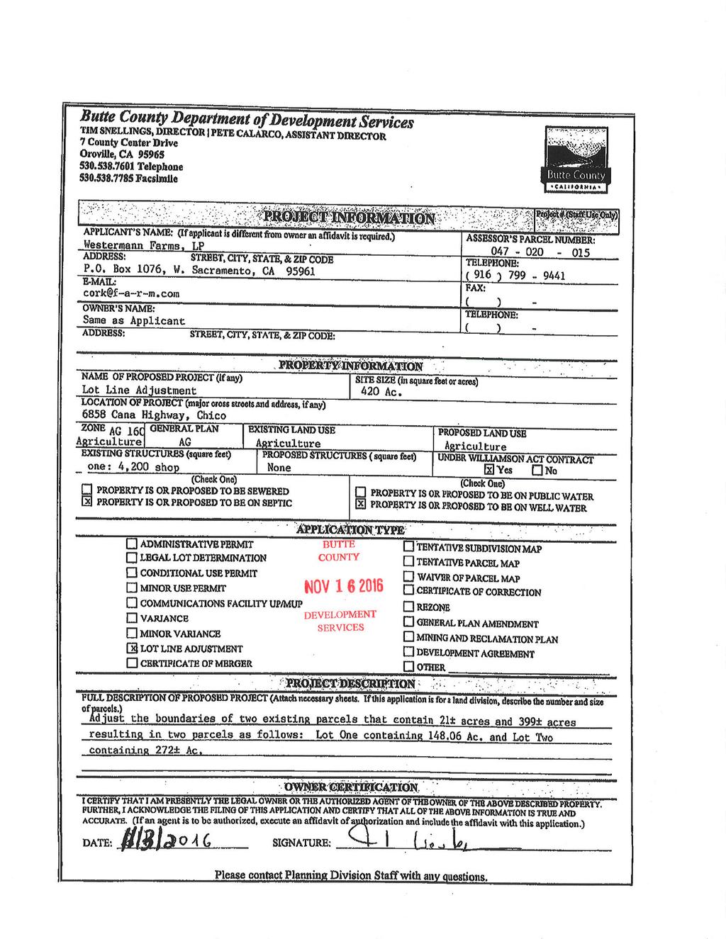
: 047-020-015 Location: General Plan: Zoning: Supervisorial District: Prime/NonPrime: North side of Cana Highway, approximately 8 miles NW of the City of Chico.")
1 Land Conservation (Williamson) Act Advisory Committee March 6, 2017 Prepared by: Claudia Stuart, Williamson Act Program Manager SUMMARY: Application Number(s): Applicant: LCA , LLA Westermann Farms, LP APN(s): Location: General Plan: Zoning: Supervisorial District: Prime/NonPrime: North side of Cana Highway, approximately 8 miles NW of the City of Chico. The NE boundary of the subject parcel is located adjacent to the Union Pacific Railroad. Agriculture (AG) AG-160 (Agriculture, 160-acre minimum parcel size) 2 (Wahl) Prime Farmland with areas of Farmland of Statewide Importance and Unique Farmland Action Requested: Make recommendations to the Board of Supervisors regarding a lot line adjustment on Williamson Act land and Williamson Act contract amendment RECOMMENDATION Staff recommends that the Williamson Act Advisory Committee recommend to the Board of Supervisors the following: 1) all required findings for consistency with the Williamson Act can be made; 2) the Williamson Act Advisory Committee recommends approval of the lot line adjustment and contract amendment to the Board of Supervisors, subject to: a) the property owner s recordation of a deed restriction limiting the separate sale or transfer of adjusted Lot 1 as long as it remains in the Williamson Act, and limiting residential development on adjusted Lot 1 while it remains in the Act; b) payment of any applicable fees. SUMMARY Westermann Farms, LP has applied for a Williamson Act compatibility review and contract amendment (Attachment A) in association with an application for a lot line adjustment to modify the boundaries between two lots (consisting of one APN) included in a Land Conservation (Williamson) Act contract (Application and Plat for LLA Attachment B). The lots affected by the proposed lot line adjustment are part of B.W. Farms General Partnership (1989) contract (Attachment C), which was based on orchards and field crops (almonds, prunes, wheat, beets, and beans). 1
2 BACKGROUND AND PROJECT DESCRIPTION Westermann Farms, LP owns approximately acres of Williamson Act land approximately 8 miles northwest of the City of Chico (Figures 1 Vicinity Map and 2 - Aerial). The property is currently in orchard use. It contains a central area of Prime Farmland as classified by the California Department of Conservation s Farmland Mapping and Monitoring Program; Farmland of Statewide Importance on its east and west peripheries; and Unique Farmland in the Pine Creek corridor, which is contiguous with the property s western boundary. The property is currently assigned one assessor s parcel number, but two underlying lots have been confirmed by the Department of Public Works as shown in the proposed plat (Attachment C). The property is in active orchard use. A 4,200 sf shop/storage building is located on the property. Two agricultural wells are currently located on the existing western lot (Lot 2). The current B.W. Farms 1989 Williamson Act contract is based on use of the property for orchards and field crops (almonds, prunes, wheat, beets, and beans). The subject property comprises the entire contract. Lot Line Adjustment (Westermann) Thomas Harris acting as agent for Westermann Farms LP has applied for a Williamson Act consistency review for a lot line adjustment on APN The County has confirmed the existence of two lots under the subject assessor s parcel. The applicant is proposing to adjust the internal property boundary between the underlying lots in order to facilitate the transfer of approximately acres from Lot 2 to Lot 1 for estate planning purposes. The existing lot boundary line, which runs north-south, would be replaced with an east-west boundary line running along the centerline of a field road near the center of the property, with resulting changes to acreages as follows: Existing Lot Sizes: Lot 1 (east lot) 21 acres Lot 2 (west lot) 399 acres Resultant Lot Sizes: Lot 1 (north lot) acres Lot 2 (south lot) 272 acres As a result of the lot line adjustment, one of the existing agricultural wells would be located on each of the adjusted lots. A 60-foot easement for access and utilities would be reserved along the eastern boundary of Lot 2. The applicable Williamson Act contract would be amended in order to reflect the adjusted lot boundaries. The property is currently in orchard use and would remain in orchard use after the adjustment. The lot line adjustment is processed as a non-hearing item that is reviewed by the Zoning Administrator. If the lot line adjustment is consistent with the requirements of Article 41 of the Butte County Zoning Code and Section of the Butte County Code, the Zoning Administrator approves the project conditioned upon a determination of consistency with the Williamson Act by the Board of Supervisors, per Rule 2.B.3 of the County s Policy, Procedures and Rules Declaration. 2


3 The Zoning Administrator approved LCA on February 16, 2017 subject to a determination by the Board of Supervisors that the project is consistent with the Williamson Act. Under Rule 7.C of the County s Williamson Act Policy, Procedures and Rules Declaration, the Williamson Act Advisory Committee must make a recommendation to the Board of Supervisors regarding the consistency of the lot line adjustment with the Williamson Act and Butte County s program. The Board of Supervisors makes the final determination regarding whether the lot line adjustment is consistent with the Act and may be recorded. Figure 1. Vicinity Map with Williamson Act Lands (green) Figure 2. Aerial 3
4 Contract Amendment LCA Consistent with Rule 5.B.6 of the County s program (New Contract Required Upon Granting of Entitlements), the property owners have applied for an amended Williamson Act contract to ensure that the new property boundaries are accurately reflected in the contract s property description. The Williamson Act Advisory Committee must recommend to the Board of Supervisors whether the amended contract would be consistent with the County s Williamson Act program. The Board of Supervisors determines whether to approve the amended contract (Attachment D Sample Contract Amendment). DISCUSSION OF REQUIRED FINDINGS Required Findings for the Lot Line Adjustment (LLA ) Government Code section (California Land Conservation Act Lot line adjustments) outlines requirements for processing a lot line adjustment for parcels under a Williamson Act contract. The statute allows the County and the property owner to mutually agree to rescind the contract and simultaneously enter into a new contract, provided that the Board of Supervisors makes seven findings. Section also allows the Board to apply additional conditions or restrictions to lot line adjustments. Staff recommends that the Williamson Act Advisory Committee recommend to the Board of Supervisors that the seven findings under Section can be made on the following basis: 1. The new contract or contracts would enforceably restrict the adjusted boundaries of the parcel for an initial term for at least as long as the unexpired term of the rescinded contract or contracts, but for not less than 10 years. The lot line adjustment is an adjustment of the internal boundary for the Westermann Farms property which is enrolled in the Williamson Act contract. The amended contract would enforceably restrict the entire property consistent with the term of all other Butte County Williamson Act contracts, meeting this finding. 2. There is no net decrease in the amount of the acreage restricted. In cases where two parcels involved in a lot line adjustment are both subject to contracts rescinded pursuant to this section, this finding will be satisfied if the aggregate acreage of the land restricted by the new contracts is at least as great as the aggregate acreage restricted by the rescinded contracts. The lot line adjustment would adjust an internal boundary on the property, and would not result in any change in the amount or the area of the acreage restricted, meeting this finding. 3. At least 90 percent of the land under the former contract or contracts remains under the new contract or contracts. All of the land under contract would remain under the lot line adjustment, meeting this finding. 4. After the lot line adjustment, the parcels of land subject to contract will be large enough to sustain their agricultural use, as defined in Section Section requires parcels enrolled in the Act to be at least 10 acres if prime farmland and 40 acres if nonprime farmland. Both adjusted parcels would include prime farmland, farmland of statewide importance, and unique farmland, and would therefore be subject to the larger 40-acre standard. After completion of the lot line adjustment, the adjusted parcels would be and 272 acres in size, meeting this minimum size requirement. 4
5 5. The lot line adjustment would not compromise the long-term agricultural productivity of the parcel or other agricultural lands subject to a contract or contracts. The lot line adjustment would modify an internal boundary of the property to coincide with an existing field road. The entire property is currently in orchard use and would remain in orchard use after the adjustment. Each adjusted lot would contain an agricultural well, assuring continuing access to water for crop irrigation. No change to the existing land use of orchard is proposed. The lot line adjustment therefore meets this finding. 6. The lot line adjustment is not likely to result in the removal of adjacent land from agricultural use. The lot line adjustment would move an internal boundary of the property. No changes are proposed to activities on the subject property; thus the lot line adjustment will not result in the removal of adjacent land from agricultural use, meeting this finding. 7. The lot line adjustment does not result in a greater number of developable parcels than existed prior to the adjustment, or an adjusted lot that is inconsistent with the general plan. The lot line adjustment will adjust the legal boundary between two lots. Both resultant lots will continue to be used for commercial agriculture, which is consistent with the General Plan designation of Agriculture. The subject property is zoned AG-160 (Agriculture 160-acre minimum parcel size). Adjusted Lot 2 will be 272 acres in size, meeting this requirement. Adjusted Lot 1 will be acres, which does not meet minimum parcel size requirements in the base AG-160 zone. However, Section A.3 (Exceptions for Minimum Parcel Size) of the County s Zoning Ordinance allows for this exception if: The lot line adjustment would improve health or safety conditions; or improve the design of the existing affected lots without altering the existing land uses thereon. The lot line adjustment will move Lot 1 closer to conformity with the minimum size requirement under zoning, while Lot 2 continues to meet minimum size requirements. Both adjusted lots will include an agricultural well to support agricultural operations. Because the lot line adjustment will not result in a greater number of developable parcels, and because it will move the property closer to conformance with its AG-160 zoning and have an improved design, it meets this finding. Rule 7.B of the County s program requires that the Board of Supervisors make five additional findings regarding land divisions of Williamson Act lands. Staff recommends that the Williamson Act Advisory Committee recommend to the Board of Supervisors that these findings can be made on the following basis: 1. The proposed division will not impair the use of the land for the production of food, fiber, livestock or wildlife habitat, as provided in the contract. The subject lots are currently used for orchard production, and will continue to be used for these purposes. While the property s two agricultural wells are currently both located on Lot 2, after the adjustment each parcel will contain a well. The lot line adjustment will therefore not impair the use of the land for food, meeting this finding. 2. Each parcel created by the division or lot line adjustment shall conform to minimum acreage under Table One of Rule 6. The property is currently in orchard use and will continue to be used for this purpose. Table One of Butte County s Williamson Act Procedures and Rules requires a minimum parcel size 5
6 of 20 acres for orchard production. The resultant lots would be and 272 acres, meeting this requirement. 3. The land division or lot line adjustment conforms to the Butte County General Plan, state laws and all other applicable County Codes and standards. The subject property is zoned AG-160 (Agriculture 160-acre minimum parcel size). Adjusted Lot 2 will be 272 acres in size, meeting this requirement. Adjusted Lot 1 will be acres, which does not meet minimum parcel size requirements in the base AG-160 zone. However, Section A.3 (Exceptions for Minimum Parcel Size) of the County s Zoning Ordinance allows for this non-conforming zoning exception if: The lot line adjustment would improve health or safety conditions; or improve the design of the existing affected lots without altering the existing land uses thereon. Lot 1 will be enlarged by the lot line adjustment. After adjustment, both lots will contain an agricultural well to support agricultural operations. The property will thus move closer to conformance with its AG-160 zoning and have an improved design. The lot line adjustment must also meet other applicable standards, including those under the Williamson Act program. The entire property is already enrolled in the Williamson Act. Staff therefore concludes that the property is not incoming into the Williamson Act, and does not have to meet base zoning in order to remain enrolled in the Williamson Act as required under Rule 5.A.5.a for incoming parcels which have not previously been enrolled in the Williamson Act: Rule 5.A.5.a Parcels must also meet or exceed minimum lot sizes established by the applicable base zoning district. Minimum parcel size applies to incoming Williamson Act contract parcels, parcels eligible for eligible for home building permit, and parcels eligible for sale or transfer. When possible, property owners may merge adjacent parcels to attain the minimum acreage required in Table ONE. When the minimum parcel acreage in TABLE ONE of this rule is greater than that set forth in the text of the property s original Williamson Act inclusion contract, the less restrictive (smaller) minimum parcel size shall apply. However, Lot 1 is substandard to the base zoning and is subject to the above limitations on home building permits, sale, or transfer. In order to limit the issuance of home building permits, or the separate sale or transfer of Lot 1 while it remains in the Williamson Act, staff recommends that a deed restriction be recorded prohibiting its separate sale or additional residential development for as long as it remains in the contract. With the application of this condition, the proposed lot line adjustment meets this finding. 4. The land division or lot line adjustment is not for the creation of residential development that does not directly support agricultural production on the contracted land. The proposed lot line adjustment will adjust the legal boundary between two existing lots, and will not create any additional opportunities for residential development, meeting this finding. Staff is also recommending that a deed restriction be recorded, limiting further sale of Lot 1 and further residential development on Lot 1 as long as it remains in the Williamson Act. 5. Any parcel merger (Government Code Article 1.5 Merger of Parcels) shall comply with Rule 5.A.5.c, and with Butte County Code Section
7 The proposed action is not a parcel merger; therefore, this requirement does not apply. ENVIRONMENTAL REVIEW Under Government Code section (CEQA Guidelines), the making or renewing of Williamson Act contracts exempt from review under the California Environmental Quality Act. RECOMMENDATION Based on the analysis above, staff recommends that the Williamson Act Advisory Committee recommend to the Board of Supervisors the following: 1) all required findings for consistency with the Williamson Act can be made; 2) the Williamson Act Advisory Committee recommends approval of the lot line adjustment and contract amendment to the Board of Supervisors, subject to: a) the property owner s recordation of a deed restriction limiting the separate sale or transfer of adjusted Lot 1 as long as it remains in the Williamson Act, and limiting residential development on adjusted Lot 1 while it remains in the Act; b) payment of any applicable fees. If you have questions or need further information before the meeting, please do not hesitate to contact me at cstuart@buttecounty.net or ATTACHMENTS A. Lot Line Adjustment Application and Plat (LLA ) B. Existing Williamson Act Contract (B.W. Farms General Partnership 1989) C. Application for Contract Amendment (LCA ) D. Sample Contract Amendment Template 7
8
9
10 o, "` U i r.' Recorded rr:. Official"., R enc o rd s #s: County of; Butte ' Candace J. Grubbs I Rec. Fee. ''` 0"0 k:. Tota14-r 00.,: Recorder v f'; 8: 02am 28- Feb- 90 : ': ^=' 4. JK - 7 LAND CONSERVATION AGREEMENT THIS AGREEMENT, made and entered into on the dates set forth below by and between B. W. FARMS GENERAL PARTNERSHIPF - hereinafter referred to as " Owner", and the County of Butte, a political subdivision of the State of California, hereinafter referred to as " County". WITNESSETH WHEREAS, Owner possesses certain real property hereinafter described located within County; and WHEREAS, said property is devoted to agricultural uses; and WHEREAS, said property is located within the AGRICULTURAL PRESERVE NO. heretofore established by County; and WHEREAS, both Owner and County' desire to limit the use of said property to agricultural, related and compatible uses in order to preserve a maximum amount of agricultural land, to conserve the State s economic resources, to maintain the agricultural economy, and assure a food supply for future residents, to discourage premature and unnecessary conversion of agricultural land to urban uses, recognizing that such land has public value as open space and constitutes an important physical, social, esthetic and economic asset to the County; and WHEREAS, the placement of said property in an agricultural preserve and the execution and approval of this Agreement is a determination that the highest and best use of said property during the term of this Agreement or any renewal thereof is for agricultural uses; NOW, THEREFORE, both Owner and County in consideration of the mutual promises, covenants and conditions herein contained and the substantial public benefits to be derived therefrom, do hereby agree as follows:
11 FY. FIRST: This Agreement is made and entered into pursuant to the California Land Conservation Act of 1965 as amended ( Chapter 7 of Part 1 of Division 1 of Title 5 of the Government Code of California commencing with Section 51200) including Article 3 of said Act entitled " Contracts". SECOND: During the term of this Agreement, or any renewal thereof, the said property shall not be used for any purpose other than agricultural uses for producing agricultural commodities for commercial purposes, uses related to such purposes and uses compatible for such purposes, which uses are set forth in Exhibit A" attaohed hereto and incorporated herein by reference. THIRD: The Board of Supervisors of County may from time to time and during the term of the Agreement or any extensions thereof, by resolution add to those compatible uses authorized in the resolution establishing the preserve within which the land is located; provided, however, said Board shall' not eliminate, without the written consent of Owner, a compatible use during the term of this Agreement or any renewals thereof. The provisions of this Agreement and any resolution supplementing the uses listed in Exhibit " A" is not intended to limit or superoede the planning and zoning powers of the County. FOURTH: In the event all or a part of the land subject to this Agreement is taken in an action in eminent domain or is acquired in lieu of eminent domain for a public improvement, this Agreement shall be null and void for the land or interest in the land actually taken but shall remain in full force and effect as to the remainder of the land or interest in the land not so taken or acquired. The date an action in eminent domain is filed shall be the date this Agreement is deemed null and void as to any land or interest in land subject to the Agreement which is taken by eminent domain. FIFTH: This Agreement shall be effective as of the day and year first above written and shall remain in effeot for a period of ten ( 10) years therefrom. This Agreement shall be automatically renewed on the first day of January of each year for a period of ten ( 10) years from the date of said renewal, unless notice of non renewal is given as provided in Section of the Government Code of California. 2.
12 9,,V1 % es.. :. a, SIXTH: The Owner understands that he is not entitled to any public funds by reason of the execution of this Agreement or any renewal thereof although the use thereof is limited as aforesaid. SEVENTH: This Agreement may only be cancelled if, upon petition by Owner, the Board of Supervisors of County, under the provision of Government Code Section 51282, finds: ( a) that cancellation is not consistent with the purposes of the Land Conservation Act of 1965; and ( b) that cancellation is in the public interest. " Upon cancellation, Owner shall pay to County a oancellation fee determined and certified by the Board of Supervisors of County in accordance with the provisions of Government Code Section Said cancellation fee may not be waived except as provided in Government Code Section and shall be a lien upon the property described herein until paid. EIGHTH: Owner agrees, during the term of this Agreement, to provide County, upon written request with information relative to the income and expenses derived from and incurred in connection with the use of the land subject to the Agreement for agriculture and related and compatible uses. NINTH: The Owner agrees that he, his successors and assigns shall not divide bysale or gift the property which is the subject of this Agreement into a parcel under separate ownership having less than 420 acres. TENTH: This Agreement shall run with the land described herein and shall be binding upon the heirs, successors and assigns of the Owner and County. ELEVENTH: In the event of forced sale of lands subject hereto for the settlement ofa tax lien, this Agreement is null and void as to such landactually sold for that purpose. No penalty as provided for in Paragraph seven ( 7) shall be charged for a cancellation under this paragraph. TWELFTH: This Agreement shall be cancelled without payments or public, hearing if it is replaced by any other enforceable restriction authorized by Article XXVIII of the California Constitution or whenever there is no operative legislation implementing said Article with respect to assessment practices. 3.
13 ao -A 8 0 I 5 A THIRTEENTH: The property of the Owner hereinabove referred to and to which the provisions of the Agreement apply is situated in the County of Butte, State of California and is particularly described as follows: 0111) 17A No SCIIEDULE C The land referred to herein is descrihed as follows: All that cotlain real properly sitnate in the County of California, dencrihed as follows! of Butte, Slate IWOTNN1NC, al- a concrete monnment on the Easterly line of the Mosrinejo at the Northwest corner of the Southwest Rancho, said monnment being quarter of the Sonthwest quarter of Section 0, Township 23 North, Range I West, and rnnning thence South Rq 56 ' East feel to a point_ on he Wefllerly right er way line of ( he California and Oregon ( now Southern Pacific) 11, 01road, said point being North 09' 56 ' West feet from a concrete n mintent at the Northeast corner of the Southwest quarter of the Senthwest quarter of Section S, running thence along the aforesaid Westerly right of way North ' West: feet to a point on the Southerly bank of Pine Creek said point being on the Northerly edge of ihe exisling farm access road ; said access road running along the top of the Levee along that side of Easterly Pine Creek; thence along the North erly and Westerly edge of said road also being the Southerly and Easterl hank of Pine Creek in ' a direction Southerly to.a point on the South line of Section 111, Township 23 North, Range 1 West ; thence along said South line North Pg" Sit ' East 050 feet, more or less, to the Southeast corner of said Section 1A ; thence along Emit line of said Section IR, North 0 nw East 52q4. 0 feel to the Southwest corner of Section 0 ; thence continuing along the West line of Section II, said Township and Range, North 00" 01 ' Past 1170 feet to the point of beginning
14 ego aaoi5 STATE OF CALIFORNIA COUNTY OF BUTTE SS On this eighthday of January, 1990, before me the undersigned, a Notary Public in and for said County, personally appeard RICHARD BOLEN, who proved to me on the basis of satisfactory evidence to be the person whose name is subscribed to the within instrument as the attorney- in- fact of BERT WESTERMANN, General Partner of WESTERMANN FARMS GENERAL PARTNERSHIP, a General Partnership, one of the partners of the partnership that executed the within instrument and acknowledged to me that he subscribed the name of BERT WESTERMANN, General Partner of WESTERMANN FARMS, GENERAL PARTNERSHIP, a General Partnership thereto as principal and his own name as Attorney- in- fact and further acknowledged to me that such partnership executed the same. WNI NBe II IBBBBUIuuuuBBBBuuuuueIBBIEBul OFFICIAL SEAL LAURIE HILTON NOTARY PUBLIC CALIFORNIA- 14AVYCOUNTY OF BUTTE Comm. Exp. April 15, 1991 LI 71oBeBBIBN7BIB9BBe6BBBBBBBe67eeeaeeBBBBUBBBBeeeo11BBEBn al STATE OF CALIFORNIA COUNTY OF BUITE SS On this eighth day of January, 1990, before me, the undersigned, a Notary Public in and for said County, personally appeared RICHARD A. BOLEN, personally known to me to be the person who executed the within instrument as one of the partners of the partnership that executed the within instrument, and acknowledged to me that such partnership executed the same. 451 r. ' I., Ire OFFICIAL SEAL LAURIE HILTON CALIFORNIA NOTARY PUBLIC COUNTY OF BUTTE Comm. Exp. April 15, 1991 ipb9ee7eelbeebu0eeeeuooehe9eeeouenoeuehbbbmmui o e
15 4.,.... < A;. 9' :.0.-I :5 6' IN WITNESS WHEREOF, The Owner and lounty have executed this Agreement the day and year above written. COUNTY OF BUTTE. CilarLitet lilt\sif-0,,,< A,.^..% thil9tikd of Supervisors 1 i ATTEST* 1 WILLIAM H.. c:,' RANDOLPH; tdharefikd ṙnif.;.itr-a-hve Officer and- treili-of' ffie Board 1, 11: T _ k_. la 1 4: Deputy Clerk I i S i, J OViNER( S). seze. e t, t.. 1,, 2 - / H- 6e-. 9' Dateof' 7-f-- 0 i eoution. ' Date otaxeoution '() i ,. 1i.'" a-&ela 44, X,4ū..- k_ 6.5i6)Aaz, A. Gled el-4-fre-ez7...- f.,,ifizia.re: ,..,.. e.!..-_el,... 4,,,, 4-_, ezy L CI ve-11( 4 Z',,----e.'i>2=-. ':- k 1 k t t k N 5. 1 i
16 c... s tta M 11 ii 0' 4 A ACKNOWLEDGMENT EXECUTED BY A PUBLIC CORPORATION AGENCY. OR POLITICAL SUBDIVISION ( Civil Code Section 1191) 4u C.4., c=t ot> cl STATE OF CALIFORNIA) SS. COUNTY OF BUTTE On this 27th day of February, 1990, before me personally appeared ted McLaughlin, personally known to me to be the person who executed this iinstrument as Chairman, Board of Supervisors of the Co jacknowledged to me executed *t. that the County nty of Butte and OFFICIALOACHL SEA CAROL R el... Vil 5wj* A1-. NOTARY PUBLIC - CALIFORNIA Carol Roach, Notary BUTTE COUNTY My comm. expires AUG 7, 1992 END OF DOCUMENT
17
18
19
20 LAND CONSERVATION AGREEMENT AMENDMENT This agreement is made and entered into by and between the [NAME] hereinafter referred to as "Owner" and the County of Butte, a political subdivision of the State of California, hereinafter referred to as "County". WITNESSETH WHEREAS, on the XXth of [MONTH], 19XX the then Owner [NAME] and County entered into a Land Conservation Agreement which agreement is recorded as Instrument No at Book XX, pages XXX-XXX of the Official Records of the County of Butte. WHEREAS, a lot line adjustment application, County reference Number LLAXX-XXXX, involving parcels subject to the above referenced agreement was approved for the Owner by the Department of Development Services on [DATE]. WHEREAS, lot line adjustment application LLAXX-XXXX was reviewed by the Butte County Land Conservation (Williamson) Act Advisory Committee on [DATE], and that Committee recommended that amendment of the agreement to document the reconfiguration of parcels resulting from LLAXX-XXXX would adequately serve the interests of the County s Williamson Act program. WHEREAS, lot line adjustment LLAXX-XXXX serves to make each of the resultant parcels conform to Butte County Butte County Williamson Act regulations for XX-acre minimum parcel size for grazing use. WHEREAS, Attached Exhibit A describes the land and parcels that is/are subject to the above referenced agreement, as reconfigured by LLAXX-XXXX.
21 WHEREAS, Owner and County now desire to amend the above referenced agreement to documenting the reconfiguration of parcels resulting from LLAXX-XXXX. NOW THEREFORE BE IT RESOLVED, Owner and County do hereby agree that the description of the land subject to the above referenced Land Conservation Agreement is amended as described in attached Exhibit A to documenting the reconfiguration of parcels resulting from LLAXX-XXXX, which agreement is recorded at Book XXXX, pages XXX-XXX of the Official Records of the County of Butte as provided above. IT IS FURTHER AGREED that this amendment shall be effective as of [MONTH, DAY], 20XX. IN WITNESS WHEREOF, the OWNER and COUNTY have executed this AGREEMENT the day and year above written. COUNTY OF BUTTE By BILL CONNELLY, Chair Butte County Board of Supervisors OWNERS(S)
22 Date of Execution Date of Execution
23 EXHIBIT "A" LEGAL DESCRIPTION The property of the OWNER hereinabove referred to and to which the provisions of the AGREEMENT AMENDMENT apply is situated in the County of Butte, State of California and is particularly described as follows: APN: XXX-XXX-XXX END DESCRIPTION
Butte County Department of Development Services
 Butte County Department of Development Services TIM SNELLINGS, DIRECTOR PETE CALARCO, ASSISTANT DIRECTOR 7 County Center Drive Oroville, CA 95965 (530) 538-7601 Telephone (530) 538-7785 Facsimile www.buttecounty.net/dds
CONTRACT SIGNATURES. Owners of record easements across your property need not sign if they are for road, flood control or public utility purposes.
 FARMLAND SECURITY ZONE SAN JOAQUIN COUNTY COMMUNITY DEVELOPMENT DEPARTMENT 1810 E. HAZELTON AVENUE, STOCKTON CA 95205 BUSINESS PHONE: (209) 468-3121 Business Hours: 8:00 a.m. to 5:00 p.m. (Monday through
The following information is furnished in response to your request regarding the Agricultural Preserve Program: CALIFORNIA LAND CONSERVATION PROGRAM
 KERN COUNTY AGRICULTURAL PROPERTY OWNER Re: Agricultural Preserve Program The following information is furnished in response to your request regarding the Agricultural Preserve Program: CALIFORNIA LAND
Voluntary Merger. Updated March 13, 2017
 Voluntary Merger Updated March 13, 2017 What is a Voluntary Merger? A Voluntary Merger is a process by which two or more parcels of land are merged into a single legal parcel. Pay special attention to
292 West Beamer Street Woodland, CA (530) FAX (530)
 FAX (530)") - County of Yolo PLANNING AND PUBLIC WORKS DEPARTMENT John Bencomo DIRECTOR 292 West Beamer Street Woodland, CA 95695-2598 (530) 666-8775 FAX (530) 666-8728 www.yolocounty.org PLANNING COMMISSION STAFF
- County of Yolo PLANNING AND PUBLIC WORKS DEPARTMENT John Bencomo DIRECTOR 292 West Beamer Street Woodland, CA 95695-2598 (530) 666-8775 FAX (530) 666-8728 www.yolocounty.org PLANNING COMMISSION STAFF
Claudia Stuart, Williamson Act Program Manager and Nick Hernandez, Planning Intern
 Land Conservation (Williamson) Act Advisory Committee STAFF REPORT September 15, 2014 Prepared by: Claudia Stuart, Williamson Act Program Manager and Nick Hernandez, Planning Intern Subject: Discussion:
ATTACHMENT B GRANT DEED. This deed is in satisfaction of the Eminent Domain Action Case No. GRANT DEED
 GRANT DEED RECORDING REQUESTED BY AND WHEN RECORDED MAIL TO: County of Orange County Executive Office CEO Real Estate 333 W. Santa Ana Blvd. Bldg. 10 Santa Ana, California 92701 AND MAIL TAX STATEMENTS
TOWN OF WOODSIDE. Report to Town Council Agenda Item 6 From: Susan George, Town Manager July 26, 2011
 TOWN OF WOODSIDE Report to Town Council Agenda Item 6 From: Susan George, Town Manager July 26, 2011 SUBJECT: RESOLUTION APPROVING A HOLD HARMLESS AND INDEMNIFICATION AGREEMENT FOR THE PROPERTY LOCATED
Monterey County Page 1
 Monterey County Board Report 168 West Alisal Street, 1st Floor Salinas, CA 93901 831.755.5066 Legistar File Number: RES 16-049 August 30, 2016 Introduced: Version: 8/19/2016 Current Status: Agenda Ready
COUNTY OF LOS ANGELES
 COUNTY OF LOS ANGELES DEPARTMENT OF PUBLIC WORKS 900 SOUTH FREMONT AVENUE ALHAMBRA, CALIFORNIA 91803-1331 Telephone: (626) 458-5100 JAMES A. NOYES, Director ADDRESS ALL CORRESPONDENCE TO: P.O. BOX 1460
Exhibit A: REAL ESTATE TRANSFER AGREEMENT
 Exhibit A: REAL ESTATE TRANSFER AGREEMENT This agreement is made between the City of Urbana, Illinois, a municipal corporation of the State of Illinois (the Seller ), and Homestead Corporation of Champaign-Urbana,
STAFF REPORT FOR REZONE #R JANUARY 15, 2015 PAGE PC-1 CVH INVESTMENTS LLC 455 E. GOBBI ST UKIAH, CA 95482
 STAFF REPORT FOR REZONE #R 4-2014 JANUARY 15, 2015 PAGE PC-1 OWNERS: JACK L. COX TTEE ET AL PO BOX 1389 UKIAH, CA 95482 CVH INVESTMENTS LLC 455 E. GOBBI ST UKIAH, CA 95482 APPLICANT: SUBJECT: PROPOSAL:
FILE OF THE CITY CLERK ADMINISTRATION ORDINANCE NO ADMINISTRATION BILL NO INTRODUCED NOVEMBER 24, 2009
 FILE OF THE CITY CLERK ADMINISTRATION ORDINANCE NO. 15-2009 ADMINISTRATION BILL NO. 15-2009 INTRODUCED NOVEMBER 24, 2009 ADOPTED BY COUNCIL DECEMBER 8, 2009 AN ORDINANCE PROVIDING FOR TAX EXEMPTION FOR
19.12 CLUSTER RESIDENTIAL DISTRICT
 Chapter 19.12 CLUSTER RESIDENTIAL DISTRICT (Adopted 12/22/2003; Ordinance #0061970). Amended 7/3/17, Ordinance #079100. Section 19.12.010 - Declaration of Intent. The Cluster Residential District provides
NON-EXCLUSIVE ROADWAY AND UTILITY EASEMENT DEED AND AGREEMENT
 RETURN TO: STOGSDILL LAW OFFICE, P.C. 505 West Main, Suite 313 Lewistown, Montana 59457 (406) 538-2623 NON-EXCLUSIVE ROADWAY AND UTILITY EASEMENT DEED AND AGREEMENT THIS EASEMENT DEED AND AGREEMENT is
JOEL ROJAS, COMMUNITY DE'WPfiENT DIRECTOR ACCEPTANCE OF A SEWER EASEMENT DEED TO PROVIDE ADDITIONAL EASEMENT AREA TO ALLOW
 CITY OF RANCHO PALOS VERDES COMMUNITY DEVELOPMENT DEPARTMENT MEMORANDUM TO: FROM: DATE: SUBJECT: HONORABLE MAYOR & CITY COUNCIL MEMBERS u - JOEL ROJAS, COMMUNITY DE'WPfiENT DIRECTOR JUNE 3, 2014 ACCEPTANCE
COUNTY OF MERCED RULES OF PROCEDURE TO IMPLEMENT THE CALIFORNIA LAND CONSERVATION ACT OF 1965
 COUNTY OF MERCED RULES OF PROCEDURE TO IMPLEMENT THE CALIFORNIA LAND CONSERVATION ACT OF 1965 Adopted by the Merced County Board of Supervisors July 25, 2000 (Resolution No. 2000 137) Revisions: September
FINAL CONDOMINIUM PLAT APPLICATION SUBMITTAL CHECKLIST
 FINAL CONDOMINIUM PLAT APPLICATION SUBMITTAL CHECKLIST Community Development Department 7501 E. Skoog Blvd. Prescott Valley AZ 86314 Phone (928) 759-3050 Fax (928)759-5511 email: comdev@pvaz.net Application
FIFTH AMENDMENT OF DECLARATION OF DEED RESTRICTIONS AND DEDICATIONS FOR PINEHURST ESTATES (A Clatsop County, Oregon Subdivision)
") After Recording Return To: W. Louis Larson 990 Astor Street Astoria, OR 97103 FIFTH AMENDMENT OF DECLARATION OF DEED RESTRICTIONS AND DEDICATIONS FOR PINEHURST ESTATES (A Clatsop County, Oregon Subdivision)
After Recording Return To: W. Louis Larson 990 Astor Street Astoria, OR 97103 FIFTH AMENDMENT OF DECLARATION OF DEED RESTRICTIONS AND DEDICATIONS FOR PINEHURST ESTATES (A Clatsop County, Oregon Subdivision)
COUNTY OF LOS ANGELES
 JAMES A. NOYES, Director COUNTY OF LOS ANGELES DEPARTMENT OF PUBLIC WORKS 900 SOUTH FREMONT AVENUE ALHAMBRA, CALIFORNIA 91803-1331 Telephone: (626) 458-5100 www.ladpw.org ADDRESS ALL CORRESPONDENCE TO:
GRANT OF AN OPEN SPACE EASEMENT; LANDS OF HENG AND PAREIGIS; LA RENA LANE; FILE # ZP-SD-GD.
 AGENDA ITEM #4.N TOWN OF LOS ALTOS HILLS Staff Report to the City Council September 21, 2017 SUBJECT: FROM: GRANT OF AN OPEN SPACE EASEMENT; LANDS OF HENG AND PAREIGIS; 25383 LA RENA LANE; FILE #258-16-ZP-SD-GD.
HONORABLE MAYOR AND MEMBERS OF THE CITY COUNCIL TITO HAES, ASSISTANT CITY MANAGER/PUBLIC WORKS DIRECTOR
 CONSENT ITEM D-16 TO: FROM: VIA: HONORABLE MAYOR AND MEMBERS OF THE CITY COUNCIL TITO HAES, ASSISTANT CITY MANAGER/PUBLIC WORKS DIRECTOR JAMES MAKSHANOFF, CITY MANAGER DATE: JUNE 16, 2014 SUBJECT: RESOLUTIONS
DO NOT WRITE, TYPE OR STAMP ANYTHING ABOVE THIS LINE OR IN THE MARGINS. PRIVATE LAKE AGREEMENT
 PRIVATE LAKE AGREEMENT This Agreement made and entered into the day of, 2 by ( Developer"). WITNESSETH: WHEREAS, Developer is the owner of a parcel of unimproved land ("the Tract") located within the corporate
Honorable Chairperson and Members of the Successor Agency to the Redevelopment Agency
 Office of Executive Officer CONSENT CALENDAR June 24, 2014 To: From: Honorable Chairperson and Members of the Successor Agency to the Redevelopment Agency Christine Daniel, Executive Officer Submitted
Williamson Act Participation & Open Space Subvention Act Survey 2014 Instructions for completing and submitting forms
 Williamson Act Participation & Open Space Subvention Act Survey 2014 Instructions for completing and submitting forms General Information It is important to note that Open Space Subvention funding has
COUNTY OF SANTA BARBARA
 COUNTY OF SANTA BARBARA Public Works Department Scott D. McGolpin - Director STANDARD STATEMENTS AND CERTIFICATES Prepared by the Office of the County Surveyor Aleksandar Jevremovic County Surveyor Effective
COUNCIL AGENDA MEMO ITEM NO. III - #1
 COUNCIL AGENDA MEMO ITEM NO. III - #1 FROM: Anton Jelinek, Director of Utilities MEETING: October 24, 2017 SUBJECT: PRESENTER: Permanent Utility and Right-of-Way Easement Anton Jelinek Discussion: At the
COUNTY OF LOS ANGELES
 COUNTY OF LOS ANGELES DEPARTMENT OF PUBLIC WORKS 900 SOUTH FREMONT AVENUE ALHAMBRA, CALIFORNIA 91803-1331 Telephone: (626) 458-5100 JAMES A. NOYES, Director www.ladpw.org ADDRESS ALL CORRESPONDENCE TO:
RECITALS. 3. On January 15, 2019 the Village Plan Commission considered recommended approval of the CSM and the Agreement.
 VILLAGE BOARD VILLAGE OF SHOREWOOD HILLS DANE COUNTY, WISCONSIN RESOLUTION NO. R-2019-1 A RESOLUTION APPROVING OF A CERTIFIED SURVEY MAP AND THE RELEASE OF CROSS EASEMENTS (DPPG, LLC) RECITALS 1. The Village
CONSENT ACTION BY THE BOARD OF DIRECTORS OF VENETO IN MIRAMAR CONDOMINIUM ASSOCIATION, INC.
 CONSENT ACTION BY THE BOARD OF DIRECTORS OF VENETO IN MIRAMAR CONDOMINIUM ASSOCIATION, INC. The undersigned, being all of the members of the Board of Directors of Veneto in Miramar Condominium Association,
SAMPLE DECLARATION OF VACATION OF EASEMENT/RIGHT OF WAY. of record in the Office of the Judge of Probate of Morgan County, Alabama in Plat
 SAMPLE DECLARATION OF VACATION OF EASEMENT/RIGHT OF WAY ) KNOW ALL MEN BY THESE PRESENTS, THAT: OWNER S NAME, owner of all of the property adjacent to that certain drainage, utilities, and telecommunications
First Home Club sm Declaration of Restrictive Covenant FOR USE WITH FHA LOANS ONLY
 7/2017 First Home Club sm Declaration of Restrictive Covenant FOR USE WITH FHA LOANS ONLY FHLBNY requires the following documents be executed at the closing of a FHC household when FHLB funds are used
PROPOSED FINAL AGREEMENT (Subject to final approval by Developer and City Council) AGREEMENT FOR OPTION TO PURCHASE REAL ESTATE
 AGREEMENT FOR OPTION TO PURCHASE REAL ESTATE") When recorded mail to: City Clerk City of Bullhead City 2355 Trane Road Bullhead City, Arizona 86442 PROPOSED FINAL AGREEMENT (Subject to final approval by Developer and City Council) AGREEMENT FOR OPTION
When recorded mail to: City Clerk City of Bullhead City 2355 Trane Road Bullhead City, Arizona 86442 PROPOSED FINAL AGREEMENT (Subject to final approval by Developer and City Council) AGREEMENT FOR OPTION
PLANNING DIRECTOR. Approved by the Planning Director on this day of, A.D. 20. day of, A.D. 20. Approved by the Fire Chief on this
 Located in a portion of the West Half of Section 19, Township 5 South, Range 1 East, Salt Lake Base and Meridian. SURVEYOR'S CERTIFICATE I, the undersigned surveyor, do hereby certify that I am a registered
BILL NO (Emergency Measure) ORDINANCE NO. 5072
 ORDINANCE NO. 5072") BILL NO. 5210 (Emergency Measure) ORDINANCE NO. 5072 AN ORDINANCE AUTHORIZING THE MAYOR TO EXECUTE WITH MICHELSON-HADLEY HEIGHTS DEVELOPMENT, LLC, A CONTRACT AND QUIT CLAIM DEED CONVEYING CERTAIN PROPERTIES
BILL NO. 5210 (Emergency Measure) ORDINANCE NO. 5072 AN ORDINANCE AUTHORIZING THE MAYOR TO EXECUTE WITH MICHELSON-HADLEY HEIGHTS DEVELOPMENT, LLC, A CONTRACT AND QUIT CLAIM DEED CONVEYING CERTAIN PROPERTIES
REVIEWED BY: Administrator Counsel Program Mgr.: Tiffany Schaufler Board Committee Engineer Other
 Minnehaha Creek Watershed District REQUEST FOR BOARD ACTION MEETING DATE: May 11, 2017 TITLE: Authorization to Grant a Temporary Easement to the City of Minnetrista RESOLUTION NUMBER: 17-034 PREPARED BY:
DOCUMENT VET SHEET for Karen McConnaughay Chairman, Kane County Board
 DOCUMENT VET SHEET for Karen McConnaughay Chairman, Kane County Board Name of Document: Temporary Construction Easement for Grading Purposes between Geneva School District and Counzy of Kane Submitted
IRREVOCABLE OFFER OF DEDICATION AND GRANT DEED (Well 15/Parcel L, McCormack Road, Liberty Island Road)
") RECORDING REQUESTED BY AND WHEN RECORDED MAIL TO, AND MAIL TAX STATEMENTS TO: City of Rio Vista Attn: City Manager 1 Main Street Rio Vista, CA 94571 (Above Space for Recorder s Use Only) THE UNDERSIGNED
RECORDING REQUESTED BY AND WHEN RECORDED MAIL TO, AND MAIL TAX STATEMENTS TO: City of Rio Vista Attn: City Manager 1 Main Street Rio Vista, CA 94571 (Above Space for Recorder s Use Only) THE UNDERSIGNED
NOW, THEREFORE, BE IT RESOLVED by the Albany City Council that it does hereby accept this easement.
 RESOLUTION NO. 5991 A RESOLUTION ACCEPTING THE FOLLOWING EASEMENT: Grantor Albany Industrial Properties, LLC Purpose A 40 -foot wide easement over a new deep trunk sewer main east of I -5 as part of the
*SB0046* S.B. 46 S.B AGRICULTURE SUSTAINABILITY ACT. LEGISLATIVE GENERAL COUNSEL 6 Approved for Filing: V. Ashby :38 AM 6
 LEGISLATIVE GENERAL COUNSEL 6 Approved for Filing: V. Ashby 6 6 01-27-12 10:38 AM 6 S.B. 46 1 AGRICULTURE SUSTAINABILITY ACT 2 2012 GENERAL SESSION 3 STATE OF UTAH 4 Chief Sponsor: Scott K. Jenkins 5 House
EASEMENT AGREEMENT (Distributor Performance Non-Exclusive)
") EASEMENT AGREEMENT (Distributor Performance Non-Exclusive) THIS EASEMENT AGREEMENT, effective the day of, 20, is made between WITNESSETH:, hereafter called Grantor, (whether grammatically singular or plural)
EASEMENT AGREEMENT (Distributor Performance Non-Exclusive) THIS EASEMENT AGREEMENT, effective the day of, 20, is made between WITNESSETH:, hereafter called Grantor, (whether grammatically singular or plural)
COUNCIL COMMUNICATION
 Meeting Date: June 27, 2017 COUNCIL COMMUNICATION Agenda Item: Agenda Location: Consent Calendar Work Plan # Legal Review: 1 st Reading 2 nd Reading Subject: A resolution approving the grant of a perpetual
6. LIST THE CAUSE DOCKETED NUMBER (E.G. ZONING CASE NUMBER, PLAT NUMBER...)
") GRANT OF RIGHT OF WAY CHECKLIST DOCUMENTS TO FOLLOW PLEASE MAKE SURE YOUR GRANT IS COMPLETED AS FOLLOWS: 1. NAME, COUNTY, AND THE STATE OF THE GRANTOR CLEARLY TYPED OR HAND WRITTEN. 2. A LEGAL DESCRIPTION
GRANT OF RIGHT OF WAY CHECKLIST DOCUMENTS TO FOLLOW PLEASE MAKE SURE YOUR GRANT IS COMPLETED AS FOLLOWS: 1. NAME, COUNTY, AND THE STATE OF THE GRANTOR CLEARLY TYPED OR HAND WRITTEN. 2. A LEGAL DESCRIPTION
Revised April 26, 2012 April 30, 2012
 BOARD OF EDUCATION OF HARFORD COUNTY A DECISION ON REFINANCING THE A.A. ROBERTY BUILDING CERTIFICATES OF PARTICIPATION AND THE HARFORD COUNTY PHASE I AND PHASE II ENERGY LEASES DATED 1//001 AND 1/1/00
DECLARATION OF ELEVATED PEDESTRIAN WALKWAY EASEMENT
 AFTER RECORDING MAIL TO: Drury Southwest Broadview, LLC 101 S. Farrar Drive Cape Girardeau, Missouri 63701 Attn: Herbert J. Wedemeier (Space left blank for recording purposes) DECLARATION OF ELEVATED PEDESTRIAN
STAFF REPORT TO THE (CITY COUNCIL, AGENCY, ETC.) The Mayor and Members of the City Council
 The Mayor and Members of the City Council") STAFF REPORT TO THE (CITY COUNCIL, AGENCY, ETC.) DATE: Regular Meeting of January 28, 2014 TO: SUBMITTED BY: SUBJECT: The Mayor and Members of the City Council Phil Batchelor, City Manager Eleventh Amendment
STAFF REPORT TO THE (CITY COUNCIL, AGENCY, ETC.) DATE: Regular Meeting of January 28, 2014 TO: SUBMITTED BY: SUBJECT: The Mayor and Members of the City Council Phil Batchelor, City Manager Eleventh Amendment
Recording Requested by and Return to: CITY OF HUNTINGTON BEACH Dept. of Planning 2000 Main St. Huntington Beach, Ca 92648
 Recording Requested by and Return to: CITY OF HUNTINGTON BEACH Dept. of Planning 2000 Main St. Huntington Beach, Ca 92648 (SPACE ABOVE THIS LINE FOR RECORDER'S USE) IRREVOCABLE RECIPROCAL EASEMENT FOR
RATE AND METHOD OF APPORTIONMENT FOR COMMUNITY FACILITIES DISTRICT NO. 4 - MAINTENANCE OF THE CITY OF MORENO VALLEY
 CFD No. 4 Maintenance Page 1 RATE AND METHOD OF APPORTIONMENT FOR COMMUNITY FACILITIES DISTRICT NO. 4 - MAINTENANCE OF THE CITY OF MORENO VALLEY A Special Tax as hereinafter defined shall be levied on
WILLIAMSON ACT CONTRACTS GUIDELINES
 NEVADA COUNTY COMMUNITY DEVELOPMENT AGENCY PLANNING DEPARTMENT ERIC ROOD ADMINISTRATION BUILDING 950 Maidu Avenue Nevada City, California 95959-8617 Phone: (530) 265-1222 FAX : (530) 265-9851 WILLIAMSON
TAFFREPORT. Steven A. Preston, FAICP, City Manager. Jennifer Davis, Community Development Director W trm-?f>
 Community Development Department TAFFREPORT Date: To: From: January 07, 2014 Steven A. Preston, FAICP, City Manager Jennifer Davis, Community Development Director W trm-?f> By: Daren Grilley, PE, City
DEED OF EASEMENT STATE OF NEW JERSEY AGRICULTURE RETENTION AND DEVELOPMENT PROGRAM. BETWEEN, whose address is and is referred to as the Grantor;
 Page 1 of 8 E3-E DEED OF EASEMENT STATE OF NEW JERSEY AGRICULTURE RETENTION AND DEVELOPMENT PROGRAM This Deed is made, 20. BETWEEN, whose address is and is referred to as the Grantor; AND, whose address
PIPELINE RIGHT-OF-WAY EASEMENT
 PIPELINE RIGHT-OF-WAY EASEMENT THIS RIGHT-OF-WAY EASEMENT made this day of March, 2014, by the City of Rochester Hills, a municipal corporation in the State of Michigan,, having an address at 1000 Rochester
Issues at the Rural-Urban Fringe: Hillsborough County Agriculture Stewardship Program 1
 FE701 Issues at the Rural-Urban Fringe: Hillsborough County Agriculture Stewardship Program 1 Rodney L. Clouser and Stephen Gran 2 This publication is part of a series titled Issues at the Rural-Urban
GROUND LEASE (PHASE II) by and between the COUNTY OF ORANGE. and the CAPITAL FACILITIES DEVELOPMENT CORPORATION. Dated as of [DATED DATE]
![GROUND LEASE (PHASE II) by and between the COUNTY OF ORANGE. and the CAPITAL FACILITIES DEVELOPMENT CORPORATION. Dated as of [DATED DATE]](/thumbs/95/123324850.jpg "GROUND LEASE (PHASE II) by and between the COUNTY OF ORANGE. and the CAPITAL FACILITIES DEVELOPMENT CORPORATION. Dated as of [DATED DATE]") RECORDING REQUESTED BY AND WHEN RECORDED MAIL TO: William W. Bothwell, Esq. ORRICK, HERRINGTON & SUTCLIFFE LLP 777 South Figueroa Street, Suite 3200 Los Angeles, California 90017 (Space above for Recorder
RECORDING REQUESTED BY AND WHEN RECORDED MAIL TO: William W. Bothwell, Esq. ORRICK, HERRINGTON & SUTCLIFFE LLP 777 South Figueroa Street, Suite 3200 Los Angeles, California 90017 (Space above for Recorder
BUTTE LOCAL AGENCY FORMATION COMMISSION (LAFCO) EXECUTIVE OFFICER S REPORT. LAFCo File City of Chico Extension of Services 716 Oak Lawn Avenue
 EXECUTIVE OFFICER S REPORT. LAFCo File City of Chico Extension of Services 716 Oak Lawn Avenue") Agenda Item 4.4 BUTTE LOCAL AGENCY FORMATION COMMISSION (LAFCO) EXECUTIVE OFFICER S REPORT TO: FROM: SUBJECT: Local Agency Formation Commission Stephen Betts, Deputy Executive Officer LAFCo File 15-21
Agenda Item 4.4 BUTTE LOCAL AGENCY FORMATION COMMISSION (LAFCO) EXECUTIVE OFFICER S REPORT TO: FROM: SUBJECT: Local Agency Formation Commission Stephen Betts, Deputy Executive Officer LAFCo File 15-21
APPLICATION FOR FARMSTEAD SPLIT
 APPLICATION FOR FARMSTEAD SPLIT Will County Land Use Department Development Review Division 58 E. Clinton St., Suite 500 Joliet, Illinois 60432 Telephone (815) 740-8140 Facsimile (815) 774-3386 Internet
AGREEMENT RECITALS: Draft 3/26/2015
 AGREEMENT This Agreement is entered into this day of April, 2015, by and between the SCHOOL BOARD OF BREVARD COUNTY, FLORIDA (the "School Board") and THE CITY OF MELBOURNE, a Florida municipal corporation
HOLDING TANK AGREEMENT
 MUNII\9602(4)\020328\1\11 03-19-07 WITH FINANCIAL SECURITY Prepared By: Return To: Parcel ID # Morgan, Hallgren, Crosswell & Kane, P.C. 700 N. Duke St. P. O. Box 4686 Lancaster, PA 17604-4686 (717)-299-5251
STAFF REPORT TO THE (CITY COUNCIL, AGENCY, ETC.) The Mayor and Members of the City Council
 The Mayor and Members of the City Council") STAFF REPORT TO THE (CITY COUNCIL, AGENCY, ETC.) DATE: Regular Meeting of January 28, 2014 TO: SUBMITTED BY: SUBJECT: The Mayor and Members of the City Council Phil Batchelor, City Manager Eleventh Amendment
STAFF REPORT TO THE (CITY COUNCIL, AGENCY, ETC.) DATE: Regular Meeting of January 28, 2014 TO: SUBMITTED BY: SUBJECT: The Mayor and Members of the City Council Phil Batchelor, City Manager Eleventh Amendment
BUTTE LOCAL AGENCY FORMATION COMMISSION (LAFCO) EXECUTIVE OFFICER S REPORT. LAFCo File City of Chico Extension of Services 624 Oak Lawn Avenue
 EXECUTIVE OFFICER S REPORT. LAFCo File City of Chico Extension of Services 624 Oak Lawn Avenue") Agenda Item 5.2 BUTTE LOCAL AGENCY FORMATION COMMISSION (LAFCO) EXECUTIVE OFFICER S REPORT TO: FROM: SUBJECT: Local Agency Formation Commission Stephen Betts, Deputy Executive Officer LAFCo File 18-12
Agenda Item 5.2 BUTTE LOCAL AGENCY FORMATION COMMISSION (LAFCO) EXECUTIVE OFFICER S REPORT TO: FROM: SUBJECT: Local Agency Formation Commission Stephen Betts, Deputy Executive Officer LAFCo File 18-12
TOWN OF LYONS, COLORADO ORDINANCE NO. 1017
 TOWN OF LYONS, COLORADO ORDINANCE NO. 1017 AN ORDINANCE OF THE BOARD OF TRUSTEES OF THE TOWN OF LYONS ANNEXING TO THE TOWN OF LYONS CERTAIN REAL PROPERTY OWNED BY THE TOWN OF LYONS WHEREAS, the Town of
NO PROTEST AGREEMENT AND COVENANT RUNNING WITH THE LAND. Parcel #(s): R: T: S: Q: Q: Project Name:
: R: T: S: Q: Q: Project Name:") RETURN TO: COVENANT RUNNING WITH THE LAND Parcel #(s): R: T: S: Q: Q: Project Name: THIS COVENANT RUNNING WITH THE LAND is made and entered into this day of, 20, by, between, and among, herein known as
RETURN TO: COVENANT RUNNING WITH THE LAND Parcel #(s): R: T: S: Q: Q: Project Name: THIS COVENANT RUNNING WITH THE LAND is made and entered into this day of, 20, by, between, and among, herein known as
MINUTES OF A REGULAR PLANNING COMMISSION MEETING HELD, TUESDAY, OCTOBER 11, :30 P.M. ROCKVILLE CITY HALL
 28 MINUTES OF A REGULAR PLANNING COMMISSION MEETING HELD, TUESDAY, OCTOBER 11, 2011 6:30 P.M. ROCKVILLE CITY HALL The meeting was called to order by Chair Toni Honer. Roll call was taken and the following
DEED AND DEDICATION FOR PUBLIC RIGHT OF WAY
 TO : BOARD OF DIRECTORS FROM : GARY PLATT, EXEC. DIRECTOR BUSINESS AND OPERATIONS SUBJECT : CITY OF STANWOOD CONSTRUCTION EASEMENT AND RIGHT-OF-WAY DEDICATION DATE : MARCH 17, 2009 TYPE : ACTION NEEDED
REPORT to the Mayor and Members of the City Council from the City Manager
 CITY OF PALMDALE REPORT to the Mayor and Members of the City Council from the City Manager DATE: SUBJECT: Approval of, an agreement between the City of Palmdale and merchant builders within Anaverde Phase
FILED: NEW YORK COUNTY CLERK 08/08/2012 INDEX NO /2011 NYSCEF DOC. NO. 34 RECEIVED NYSCEF: 08/08/2012
 FILED: NEW YORK COUNTY CLERK 08/08/2012 INDEX NO. 652061/2011 NYSCEF DOC. NO. 34 RECEIVED NYSCEF: 08/08/2012 NYC DEPARTMENT OF FINANCE OFFICE OF THE CITY REGISTER This page is part of the instrument. The
QUITCLAIM OF EASEMENT DEED R/WNo APN: &
 City of Los Angeles When recorded mail To: Los Angeles County Metropolitan Transportation Authority Attn: Roger Mohere, Chief Real Property Management & Development One Gateway Plaza Los Angeles, CA 90012
COUNTY OF SONOMA PERMIT AND RESOURCE MANAGEMENT DEPARTMENT 2550 Ventura Avenue, Santa Rosa, CA (707) FAX (707)
 FAX (707)") COUNTY OF SONOMA PERMIT AND RESOURCE MANAGEMENT DEPARTMENT 2550 Ventura Avenue, Santa Rosa, CA 95403 (707) 565-1900 FAX (707) 565-1103 DATE: TO: FROM: SUBJECT: December 15, 2009 at 2:05 p.m. Board of Supervisors
COUNTY OF SONOMA PERMIT AND RESOURCE MANAGEMENT DEPARTMENT 2550 Ventura Avenue, Santa Rosa, CA 95403 (707) 565-1900 FAX (707) 565-1103 DATE: TO: FROM: SUBJECT: December 15, 2009 at 2:05 p.m. Board of Supervisors
APPLICATION CHECKLIST
 DEPARTMENT OF PLANNING AND COMMUNITY DEVELOPMENT 1010 10TH Street, Suite 3400, Modesto, CA 95354 Phone: 209.525.6330 Fax: 209.525.5911 Form Available Online: http://www.stancounty.com/planning/applications.shtm
Open Space Taxation Act
 Open Space Taxation Act WASHINGTON STATE DEPARTMENT OF REVENUE JUNE 2007 The information and instructions in this brochure are to be used when applying for assessment on the basis of current use under
RESOLUTION NO. #
 ".. &co ny J MM RESOLUTION NO. #2-29 A JOINT RESOLUTION OF THE CITY OF NORTHFIEL AN THE TOWNSHIP OF GREENVALE TO THE OFFICE OF MINNESOTA PLANNING ESIGNATING AN UNINCORPORATE AREA AS IN NEE OF ORERLY ANNEXATION
SOUTH DAKOTA BOARD OF REGENTS. Budget and Finance ******************************************************************************
 SOUTH DAKOTA BOARD OF REGENTS Budget and Finance AGENDA ITEM: 6 K DATE: October 2-4, 2018 ****************************************************************************** SUBJECT USD Discovery District:
PARCEL MERGER APPLICATION
 CITY OF WILDOMAR Planning Department 23873 Clinton Keith Road, Suite #201 Wildomar, CA 92595 Tel. (951) 677-7751 Fax. (951) 698-1463 For office use only. Project Deposit Account Number PROJECT INFORMATION
TOWN OF FREEPORT Planning Department
 TOWN OF FREEPORT Planning Department June 10, 2010 TO: Dale Olmstead From: Donna Larson RE: Freeport Housing Trust Contract Zone On June 2, 2010 at 5PM a site walk was conducted for members of the Town
AMENDMENT TO QUITCLAIM DEED AND GRANT OF EASEMENT RECITALS
 RECORDED REQUESTED BY AND WHEN RECORDED MAIL TO: Clerk of the Board of Supervisors County of San Luis Obispo 1055 Monterey Street San Luis Obispo, CA 93408 APN 076-213-009 AND 076-215-012 SPACE ABOVE THIS
ADDENDUM TO PURCHASE AGREEMENT (WITH HOMEBUYER) NOTICE AND DISCLOSURE OF DEFERRED WATER AND SEWER CHARGES
 NOTICE AND DISCLOSURE OF DEFERRED WATER AND SEWER CHARGES") ADDENDUM TO PURCHASE AGREEMENT (WITH HOMEBUYER) NOTICE AND DISCLOSURE OF DEFERRED WATER AND SEWER CHARGES Pursuant to Section 14-117 of the Real Property Article of the Annotated Code of Maryland, and
ADDENDUM TO PURCHASE AGREEMENT (WITH HOMEBUYER) NOTICE AND DISCLOSURE OF DEFERRED WATER AND SEWER CHARGES Pursuant to Section 14-117 of the Real Property Article of the Annotated Code of Maryland, and
WASHINGTON STATE COUNTY AUDITOR/RECORDER'S INDEXING FORM
 AFTER RECORDING RETURN TO: The City of Gig Harbor Attn: City Clerk 3510 Grandview St. Gig Harbor, WA 98335 WASHINGTON STATE COUNTY AUDITOR/RECORDER'S INDEXING FORM Document Title(s) (or transactions contained
SITE LEASE. For all or a portion of the following Site:
 SITE LEASE For all or a portion of the following Site: Project Ohlone Community College District 43600 Mission Boulevard Fremont, CA 94539 APN: 513-0742-001 and 513-0742-002 and 513-0742-003 By and between
David L. Brown, Construction Services Manager
 Memorandum Date: 2/02/2013 Order Date: 2/27/2013 TO: DEPARTMENT: PRESENTED BY: AGENDA ITEM TITLE: Board of County s Public Works David L. Brown, Construction Services Manager In the Matter of Authorizing
Butte County Administrative Procedures and Uniform Rules for Implementing the California Land Conservation (Williamson) Act.
 Act.") Butte County Administrative Procedures and Uniform Rules for Implementing the California Land Conservation (Williamson) Act January 23, 2007 Policy, Procedures and Rules Declaration (Rule 5.A.5.d REV.
Butte County Administrative Procedures and Uniform Rules for Implementing the California Land Conservation (Williamson) Act January 23, 2007 Policy, Procedures and Rules Declaration (Rule 5.A.5.d REV.
SMOKY LAKE COUNTY. Alberta Provincial Statutes
 SMOKY LAKE COUNTY Title: Disposition of County Owned Property Policy No: 10-01 Section: 61 Code: P-R Page No.: 1 of 14 E Legislative Reference: Alberta Provincial Statutes Purpose: To outline the procedures
PERPETUAL DRAINAGE EASEMENT
 PERPETUAL DRAINAGE EASEMENT THIS GRANT OF PERPETUAL DRAINAGE EASEMENT is made this day of, 2016, between [name and address] ("Grantor"), and the City of Thornton, a Colorado municipal corporation, located
2014 Pine County Tax-Forfeit Land Auction Sale Terms and Conditions
 2014 Pine County Tax-Forfeit Land Auction Sale Terms and Conditions RESOLUTION BE IT HEREBY RESOLVED, that the parcels of land forfeited to the State for non-payment of taxes, appearing on the attached
Processing Procedures for Subdivisions of Land under a Williamson Act Contract
 PURPOSE Processing Procedures for Subdivisions of Land under a Williamson Act Contract The purpose of this policy is to provide guidance to project planners when reviewing certain subdivisions of land
LEASE. by and between COUNTY OF MONTEREY. and MONTEREY PUBLIC IMPROVEMENT CORPORATION. Dated as of, 2010 WHEN RECORDED RETURN TO:
 WHEN RECORDED RETURN TO: Orrick, Herrington & Sutcliffe LLP 777 S. Figueroa St., Suite 3200 Los Angeles, California 90017 Attn: Greg Harrington, Esq. THIS DOCUMENT IS RECORDED FOR THE BENEFIT OF THE COUNTY
CASH BOND AGREEMENT. WHEREAS, Developer desires to satisfy said requirement by submitting a cash bond.
 CASH BOND AGREEMENT This Cash Bond Agreement ("Agreement") is made as of, 201_, between the City of East Lansing, a Michigan municipal corporation, whose address is 410 Abbot Road, East Lansing, MI 48823
County of Santa Cruz
 Ou GOS87 County of Santa Cruz DEPARTMENT OF PUBLIC WORKS - REAL PROPERTY DIVISION THOMAS L. BOLICH DIRECTOR OF PUBLIC WORKS 701 OCEAN STREET, ROOM 410, SANTA CRUZ, CA 95060-4070 (831) 454-2331 FAX (831)
CHAPTER XIX ANNEXATION ARTICLE 1. ANNEXATION
 CHAPTER XIX ANNEXATION ARTICLE 1. ANNEXATION 19.0101 JABORSKY ADDITION: WHEREAS, The City of Belfield pursuant to Section 40-51.2-07 of the North Dakota Century Code has amended having passed a Resolution
Sketch & Legal Description of Mitigation Bank and Ingress/Egress Access Easements
 Appendix H: Sketch & Legal Description of Mitigation Bank and Ingress/Egress Access Easements Tippen Bay Wetland Mitigation Bank DeSoto County, Florida Prepared by: September, 2017 Original file
UNIFORM RULE 5. Administration of Williamson Act Contracts
 UNIFORM RULE 5 Administration of Williamson Act Contracts I. PROCEDURE TO ESTABLISH AN AGRICULTURAL PRESERVE AND WILLIAMSON ACT CONTRACT See Appendices 1 and 2 for the following forms: Application Form
LAND SPLIT APPLICATION AND SUBMITTAL REQUIREMENTS
 LAND SPLIT APPLICATION AND SUBMITTAL REQUIREMENTS PARCELS 2.5> ACRES OR SMALLER: THIS APPLICATION IS REQUIRED TO DIVIDE LAND INTO TWO OR THREE PARCELS. PARCELS LARGER THAN 2.5 ACRES: THIS APPLICATION IS
PROFESSIONAL ESCROW AGREEMENT
 PROFESSIONAL ESCROW AGREEMENT THIS AGREEMENT, dated this day of, 20, by and between TOWNSHIP, a Township of the Second Class, with its principal place of business being located at (hereinafter referred
Resolution No. The following resolution is now offered and read:
 Resolution No. RESOLUTION OF THE BOARD OF SUPERVISORS OF IMPERIAL COUNTY CALIFORNIA, GRANTING TENTATIVE APPROVAL OF CANCELLATION OF WILLIAMSON ACT LAND CONSERVATION CONTRACT ON LAND LOCATED AT 7096 ENGLISH
E' ONDIDO CITY COUNCIL. Agenda Item No.: 5 Date: February 3, TO: Honorable Mayor and Members of the City Council
 E' ONDIDO City of Choice 4000^ CITY COUNCIL For City Clerk's Use: APPROVED F-1 DENIED Reso No. File No. Ord No. TO: Honorable Mayor and Members of the City Council Agenda Item No.: 5 Date: February 3,
DECLARATION OF RESTRICTIVE COVENANTS
 STATE OF MARYLAND COUNTY OF DECLARATION OF RESTRICTIVE COVENANTS THIS DECLARATION OF RESTRICTIVE COVENANTS is made this day of, 20, by ( Declarant(s) ). RECITALS WHEREAS, Declarant(s) is/are the owner(s)
APPLICATION TO REGISTER NOTICE OF AN AGREEMENT THE LAND TITLES ACT SECTION 74
 26 th May 1981 Campeau - City of Kanata 40% Open Space Agreement APPLICATION TO REGISTER NOTICE OF AN AGREEMENT THE LAND TITLES ACT SECTION 74 TO: THE LAND REGISTRAR FOR THE LAND TITLES DIVISION OF OTTAWA-CARLETON
OWNER-INITIATED MERGER OF PARCELS APPLICATION
 REQUIREMENTS TO THE APPLICANT: OWNER-INITIATED MERGER OF PARCELS APPLICATION Please provide the following materials for your application. A complete application package will expedite your request for a
FIRST AMENDMENT TO THE CONSOLIDATING MASTER DEED MAPLE FOREST CONDOMINIUMS
 FIRST AMENDMENT TO THE CONSOLIDATING MASTER DEED MAPLE FOREST CONDOMINIUMS This First Amendment to Consolidating Master Deed ( Master Deed ) is made and executed on this day of, 2014, by MAPLE FOREST CONDOMINIUMS
Carol McGorray, President George Kennedy, Vice President Lori Malangone, Secretary David Bowen, Board Member Jeff Bronaugh, Board Member
 MARANA MUNICIPAL PROPERTY CORPORATION BOARD OF DIRECTORS MEETING NOTICE AND AGENDA 11555 W. Civic Center Drive, Marana, Arizona 85653 Executive Conference Room, 1st Floor MMC April 25, 2016 at 9:30 a.m.
APPENDIX G: SAMPLE CROSS-ACCESS AGREEMENTS
 APPENDIX G: SAMPLE CROSS-ACCESS AGREEMENTS THIS AGREEMENT is made and entered into on this (date) by (owner's name), a corporation authorized to transact business in the State of Ohio ("OWNER") and the