John Kaminski. Allison Lacey, Assistant City Attorney Thomas Gwosdz, City Attorney
|
|
|
- Randall Perry
- 5 years ago
- Views:
Transcription
1
2
3
4

5 P L A N N I N G C O M M I S S I O N MEETING MINUTES Date and Time: September 20, 2018, at 5:15pm MEMBERS PRESENT: B J Davis Michael Atkinson John Hyak James Johnson Gail Hoad Mary Ann Wyatt Brian Rokyta Jill Trevino MEMBERS ABSENT: Julia Welder STAFF PRESENT: Development Services: Julie Fulgham, Director of Development Services Rick Madrid, Assistant Director of Development Services Alina Phillips, Planning Manager Celeste Menchaca, Planner Lila Foster, Planning Technician City Manager s Office John Kaminski City Attorney's Office: Allison Lacey, Assistant City Attorney Thomas Gwosdz, City Attorney A: CALL TO ORDER Vice-Chair Wyatt called the September 20, 2018, regular meeting to order at 5:15pm. B: TRAINING FOR PLANNING COMMISSIONERS Thomas Gwodz, City Attorney, presented training to the Planning Commissioners on the following topics: 1. Open Meetings Act 2. Robert s Rule of Order 3. Standards for Adopting Plats 4. Variance Criteria C: ELECTION OF PLANNING COMMISSION OFFICERS Chair: Mr. Gwodz opened the floor to nominations for Chair. Commissioner John Hyak nominated Commissioner Mary Anne Wyatt for Chair. Commissioner James Johnson nominated Commissioner Jill Trevino for Chair. Page 1
6 Mr. Gwodz closed nominations and called for a vote on Chair. Commissioner Wyatt was elected Chair unanimously. Vice-Chair: Mr. Gwodz opened the floor to nominations for Vice-Chair. Commissioner James Johnson nominated Commissioner Jill Trevino. No other nomination were made for Vice-Chair. Mr. Gwodz closed nominations and called for a vote on Vice-Chair. Commissioner Trevino was elected Vice-Chair unanimously. Secretary: Mr. Gwodz opened the floor to nomination for Secretary. Commissioner Jill Trevino nominated Commissioner James Johnson for Secretary. No other nominations were made for Secretary. Mr. Gwodz closed nominations and called for a vote on Secretary. Commissioner Johnson was elected Secretary unanimously. Commissioner Julia Welder was absent for the vote on Planning Commission Officers. D: APPROVAL OF MEETING MINUTES July 19, 2018 Regular Meeting A motion to approve the July 19, 2018, minutes was made by Commissioner Johnson. Commissioner Trevino seconded the motion to accept the minutes. The motion passed unanimously. E: CITIZEN COMMUNICATION Chair Wyatt asked if any citizen wished to address the Commission on issues not specifically listed on the Agenda. No citizen approached the Commission. F: DEVELOPMENT REVIEWS/FORMAL ACTION 1. The Covey at Quail Creek: Preliminary Plat; twenty-one Single Family Residential (R1) Lots within Block 1, on a 6.59-acre tract of land out of the Manuel Zepeda Survey, Abstract 128, Victoria County, Texas, in the City s Extraterritorial Jurisdiction. Rodriguez Investment Group (Owner); CivilCorp, LLC (Agent). Final Plat Phase 1; eleven (11) Single Family Residential (R1) Lots within Block 1 on a 3.51-acre tract of land out of the Manuel Zepeda Survey, Abstract 128, Victoria Page 2
7 County, Texas, in the City s Extraterritorial Jurisdiction; Rodriguez Investment Group (Owner); CivilCorp, LLC (Agent). a. Staff Report The staff report and staff recommendation were presented by Celeste Menchaca, Planner to the Planning Commissioners. A 6.59 acre tract of land situated in the Manuel Zepeda Survey, Abstract No. 128, Victoria County, Texas, bounded by Turkey Lane, Dove Drive, and Warehouse Road, located North of the intersection of Business 59 and Zac Lentz Parkway in the City s Extraterritorial Jurisdiction, and being the same tract of land, described as 6.58 acres, conveyed from Frank Junior Hernandez to Rodriguez Investment Group, LP by deed dated March 6, 2018, as recorded in official records instrument No Victoria Preliminary Plat The Covey at Quail Creek is a proposed preliminary plat of 6.59 acres. The subject property is bounded by Turkey Lane, Dove Drive, and Warehouse Road, located north of the intersection of Business 59 and Zac Lentz Parkway in the City s Extraterritorial Jurisdiction. The property is undeveloped and is being platted into twenty-one (21) Single Family Residential Lots within Block 1. Development of The Covey at Quail Creek shall be completed in two (2) phases. Access to the subdivision will be provided via local streets Turkey Lane, Warehouse Road, and Dove Drive. Water service will be provided by Quail Creek Municipal Utility District (M.U.D.) by an existing 6 water line in Turkey Lane, existing 6 water line in Dove Drive, and a proposed 6 water line in Warehouse Road. Sanitary sewer service will be provided by an existing 10 sanitary sewer line in Dove Drive and a proposed 8 sanitary sewer line in Warehouse Road and Turkey Lane. Drainage is in accordance with the master drainage plan of the City of Victoria. Final Plat The Covey at Quail Creek Phase 1 is a proposed final plat of 3.51 acres. The subject property is bounded by Turkey Lane, Dove Drive, and Warehouse Road, located north of the intersection of Business 59 and Zac Lentz Parkway in the City s Extraterritorial Jurisdiction. The property is undeveloped and is being platted into eleven (11) Single Family Residential (R-1) lots within Block 1. Access to the subdivision will be provided via local streets Turkey Lane, Warehouse Road, and Dove Drive. Victoria County, Texas. Water service will be provided by Quail Creek Municipal Utility District (M.U.D.) by an existing 6 water line in Turkey Lane, existing 6 water line in Dove Drive, and a proposed 6 water line in Warehouse Road Sanitary sewer service will be provided by an existing 10 sanitary sewer line in Dove Drive and a proposed 8 sanitary sewer line in Warehouse Road and Turkey Lane. Drainage is in accordance with the master drainage plan of the City of Victoria. Page 3
8 G: OTHER BUSINESS The proposed Preliminary and Final plat are in compliance with the minimum requirements for Single Family Residential development contained within the Subdivision and Development Regulations. Staff recommends approval of the preliminary plat for The Covey at Quail Creek and final plat for The Covey at Quail Creek Phase 1, finding they meet all applicable ordinances and regulations. b. Public Hearing for Preliminary Plat Chair Wyatt opened the meeting for a public hearing on the Preliminary Plat. No owners, agents, or citizens approached the podium to address the Planning Commission. c. Preliminary Plat Deliberations and Action Chair Wyatt closed the public hearing and the Commissioners began their deliberations and acted on the Preliminary Plat. Commissioner Trevino made a motion to accept the Preliminary Plat. Commissioner Hoad seconded the motion to accept the Preliminary Plat. Chair Wyatt asked for vote. The Preliminary Plat was accepted and approved unanimously. Commissioner Welder was absent. d. Final Plat Deliberations and Action Commissioner Trevino made a motion to accept the Final Plat. Commissioner Hoad seconded the motion to accept the Final Plat. Chair Wyatt asked for vote. The Final Plat was accepted and approved unanimously. Commissioner Welder was absent. 1. Development Services Monthly Development Report present by Ms. Menchaca 2. October Planning Commission Meeting Reschedule to October 11, 2018, due to conflict with the Texas Chapter American Planning Association Conference. H: ITEMS FROM PLANNING COMMISSIONERS There were no items from the Planning Commissioners. I: ADJOURNMENT Commissioner Wyatt adjourned the meeting at 6:05pm. APPROVED: Page 4
9 Mary Anne Wyatt, Chair Victoria Planning Commission APPROVED: James Johnson, Secretary Victoria Planning Commission Page 5
10 P L A N N I N G C O M M I S S I O N MEETING MINUTES Date and Time: October 30, 2018, at 5:29pm MEMBERS PRESENT: B J Davis Michael Atkinson John Hyak James Johnson Gail Hoad Mary Ann Wyatt Brian Rokyta Jill Trevino Julia Welder Special Guest: Greg Spears STAFF PRESENT: Development Services: Julie Fulgham, Director of Development Services Rick Madrid, Assistant Director of Development Services Alina Phillips, Planning Manager John Johnston, Development Engineer Lila Foster, Planning Technician City Manager s Office Charmelle Garrett John Kaminski City Attorney's Office: Allison Lacey, Assistant City Attorney Thomas Gwosdz, City Attorney A: CALL TO ORDER Vice-Chair Wyatt called the September 20, 2018, regular meeting to order at 5:15pm. A special meeting of the Planning Commission jointly with the Victoria City Council was called to order by Chair of the Planning Commission, Mary Anne Wyatt at 5:29 p.m. Tuesday, October 30, 2018, in the Council Chambers, 107 W. Juan Linn, Victoria, Texas. WORK SESSION Joint Session with the Planning Commission to discuss the Unified Development Code. City Staff. City Manager Garrett stated in April 2016 the City adopted the 2035 Comprehensive Plan and under the chapter for land use development was the need to adopt a unified development code (UDC). She read a portion of the UDC stating the need for a more user-friendly development regulation and entitle it the unified land and site development ordinance. City Manager Garrett stated that according to the Comprehensive Plan, the UDC would achieve a better coordinated set of development related regulations, standards, and procedures. She commented that Council appointed a UDC committee a few years ago and the committee began looking at the issue, but had a few setbacks, including a change
11 CITY COUNCIL/PLANNING COMMISSION MINUTES October 30, 2018 in management of the Development Services Department. City Manager Garrett stated that UDC committee was behind were they wanted to be but were before the Council and Planning Commission to get direction on what enabling legislation the City will use to develop the UDC. She added that the topic will be on the November 20 th City Council meeting for a decision and the Planning Commission would further discuss the issue at the November 15 th Planning Commission meeting. City Manager Garrett stated that the ultimate decision will come from the Council but added that it was important for the Planning commission to ask questions and make suggestions. City Attorney Gwosdz stated that he was going to talk about the foundations of law that underlie the UDC. He commented that the Planning Commission and Council were being asked to consider if the City should adopt additional authority to allow for the enforcement of the development regulations that are currently on the books. City Attorney Gwosdz stated that the current City code was adopted in 1992 and sets forth where the authority to enforce City development regulations comes from, which was chapter 212 of the Local Government Code. He stated that because chapter 212 was chosen in the past as the chapter used to give the City the authority to regulate development, the City was limited to what chapter 212 of the Local Government Code allows. City Attorney Gwosdz explained that chapter 212 gives the City the authority to adopt rules governing plats and subdivisions of land, so the City was limited to subdivisions and plats of land. He further explained that there were two different types of plats listed in chapter 212, which include subdivision plats and development plats. City Attorney Gwosdz stated that subchapter B, governing development plats must be specifically adopted for development plats to apply within the City and the City has not adopted subchapter B. He also gave examples to illustrate how the subdivision and development plats work for enforcement. City Attorney Gwosdz also explained the City s use of site plans, which are not enforceable because site plans are not in chapter 212. He stated that when Development Services needs to enforce certain issues, they must rely on other enforcement authority, besides chapter 212 of the Local Government Code. City Attorney Gwosdz stated that if the City were to adopt subchapter B of chapter 212 to shore up the enforcement authority, development plat would be required to be prepared by a registered professional land surveyor which would be very costly to developers and would increase the amount of regulation. He stated that in response to the complexity of the City s plat-based system, Development Services had established a list of exceptions to ease the burden on citizens. City Attorney Gwosdz explained that replats are not enforced for each change in use and site plans do not require surveys. He added that the current process was more stream-lined than the State law would be if the City adopted subchapter B of chapter 212. City Attorney Gwosdz explained that the current City Code was valid and enforceable but could be subject to challenges in the court system because the code does not line up with State law. City Attorney Gwosdz also explained that chapter 211 of the Local Government Code gave cities the authority to allow for the enforcement of the development regulations. He commented that he liked the chapter 211 because it gave cities direct regulatory authority and was not tied to a plat. City Attorney Gwosdz stated that the City of Victoria had not adopted chapter 211, but he and Director Fulgham were asking the Council and Planning Commission to consider the adoption of chapter 211 as the foundation of law for regulations that have already been adopted. He commented that chapter 211 was titled Municipal Zoning Authority and the community had not adopted zoning. City Attorney Gwosdz asked Director Fulgham to explain what zoning was to facilitate the discussion on chapter 211.
12 CITY COUNCIL/PLANNING COMMISSION MINUTES October 30, 2018 Director Fulgham explained that there were two parts to zoning. She stated that the first part of zoning was mapping that divides cities into different polygons that are labels with different land uses, such as residential and commercial. Director Fulgham commented that a zoning map can be very rigid and limiting to development. She added that the staff was not proposing adopting a zoning map. Director Fulgham stated that the Development Services Department did want at look at the bulk regulations. She commented that bulk regulations had already been adopted under the subdivision ordinance and by subdivision authority. Director Fulgham stated that when a City was regulating land use the City can adopt bulk regulations by subdivision authority and by zoning authority. She commented that when the City has different bulk regulations for different land uses, then it was essentially a zoning function. Director Fulgham stated that in the planning world there was a shift away from zoning maps and more cities were only using the bulk regulations. She stated that the form-based zoning focuses on the form of the development, instead of the use of the development. Director Fulgham explained that bulk regulations were regulations that shape cities or developments, and gave examples of setbacks, parking requirements, minimum lot size, and lot width. She stated that bulk regulations are most effective when adopted under both the subdivision authority and the zoning authority. Director Fulgham explained the land use designations already adopted in the City code and stated that the uses can be located anywhere in the city so long as the form was met and the added that staff was not proposing any changes to the structure of land use designations. She gave examples of how the bulk regulations are applied to different land uses. Director Fulgham stated that when a brand-new development was being proposed, applying the ordinances to the new development were easy, but when applying the ordinances to infill or redevelopment, enforcing the ordinances can be difficult. She explained that if the City continues with only the authority listed in chapter 212, the changes in use will have to be tied to permits and development plats to continue to regulate the way the City currently regulates these types of changes. Director Fulgham stated that staff was asking for consideration to adopt chapter 211 for direct enforcement authority. She explained how the direct enforcement authority would allow the City to simplify the development process. Director Fulgham added that until a decision was made on how the City ordinances would get their regulating authority, a discussion of changes to the development ordinances could not happen. City Attorney Gwosdz added that the UDC could be drafted using either chapter 212 or chapter 211 as the derivative of authority, but the committee needed direction. After discussion between members of the Planning Commission, the Council, and staff, the members of the governing authorities were asked to read through chapters 212 and chapters 211 in preparation of making a decision. City Manager Garrett stated that the Planning Commission would meet about the issue on November 15 th and the Council would meet about the issue November 20 th. ADJOURNMENT There being no further business, the meeting was adjourned at 6:28 p.m. APPROVED: APPROVED: Mary Anne Wyatt, Chairperson Victoria Planning Commission James Johnson, Secretary Victoria Planning Commission
(5) Single Family residential detached, rural subdivision, Minimum interior side yard setback which requires the interior side yard setback to be 10 feet.")
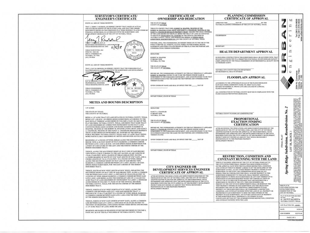
13 Agenda Item #: D-1 November 15, 2018 CASE: 1. Variance to Section 21-82(c)(5) Single Family residential detached, rural subdivision, Minimum interior side yard setback which requires the interior side yard setback to be 10 feet. Location: 97 Brook View Drive legally described as Spring Ridge Subdivision Lot 3, Block 1 Land Use: Applicant(s): Staff Contact: Single-Family Residential (R-1) Robert M. Shaffer Living Trust & Separate Property Trust (Owners), Urban Engineering (Agent) Alina Phillips, Planning Manager LOCATION MAP:
14 Agenda Item #: D-1 Pg. 2 BACKGROUND: The subject property is not located within the city limits of Victoria, Texas. The property lies within the City of Victoria s Extraterritorial Jurisdiction. Subdivisions created in the city s extraterritorial jurisdiction are subject to the city s Subdivision Ordinance, based on an inter-local agreement between the City of Victoria and Victoria County. The property is a 1.07 acre lot located at 97 Brook View Drive and was developed into a single-family residential lot within the Final Plat Spring Ridge Subdivision filed in During the subdivision process, subdivision blocks and lots, infrastructure, utilities, easements, and building setback lines are established. A plat was submitted to the City for review and approval. The plat was approved by the City; it was filed with the County Clerk s office for their records. The current building setback lines established for the subject property by the recorded plat are as followed: 50 front yard setback line, 5 interior yard setback lines and 20 Drain and Utility Easement in the back yard. The applicant is requesting a variance to the minimum interior side setback in order to replat this lot with a 2.5 interior side setback rather than the minimum 10 interior side setback currently required by the Subdivision Ordinance. The applicant is requesting this variance to satisfy their mortgage company s requirements since there is an existing garage structure encroaching in the currently platted interior side setback. When the garage structure was built on this property, the owner was not required to pull a building permit to construct it on their property because the City of Victoria does not have authority to issuing building permits for properties located outside of the city limits or enforce setbacks established by plats on property located outside of the incorporated limits of the City of Victoria. The variance would allow the owners to have a 2.5-foot interior building setback line only in the area of the existing garage. The variance, if approved, would allow the owners to have a 2.5-foot interior building setback line versus the 10-foot interior building setback line as required by the Subdivision Ordinance or a 5-foot interior setback line as established by the Spring Ridge Subdivision plat. STAFF RECOMMENDATION: Staff recommends the approval of the variance to waive Single Family residential detached, rural subdivision, minimum interior side yard setback which requires the interior side yard setback to be 10 feet in Section for granting variances: 1) The granting of the variance will not be detrimental to the public safety, health, or welfare, or be injurious to surrounding property; 2) The granting of the variance is not based on a hardship which is self-imposed; 3) The hardship is not based solely on the cost of complying with the regulation; 4) The granting of the variance will not have the effect of preventing the orderly development of other land in the area in accordance with the provisions of this chapter; and
15 Agenda Item #: D-1 Pg. 3 5) There are special or unique circumstances or conditions affecting the land involved such that the strict application of the provisions of this chapter would deprive the applicant of the reasonable use of the property. The subject property is not located within the city limits of Victoria, Texas. The property lies within the City of Victoria s Extraterritorial Jurisdiction. Subdivisions created in the city s extraterritorial jurisdiction are subject to the city s Subdivision Ordinance, based on an inter-local agreement between the City of Victoria and Victoria County. The City of Victoria does not have authority to issuing building permits for properties located out of the city limits or enforce setbacks established by plats on property located outside of the incorporated limits of the City of Victoria. Rural residential subdivision lots must be a minimum of one acre in size if there is an absence of public water and wastewater facilities. The subject property is 1.07 acres. The intent of setback lines is to provide a minimum amount of open space and prevent the conflagration of structures in an urbanized area. Staff believes the low density of the Spring Ridge Subdivision, in addition to the lack of regulatory authority concerning the construction of buildings located outside of the City limits, creates a unique condition and circumstance. For these reasons, staff would recommend the approval of this variance. Attachments: 1) Variance Application 2) Variance Request Letter 3) Deed 4) Letters of Support for the Variance 5) Final Plat
16
17
18
19
20
21
22
23
24 20' DRAIN & UTIL ESMT 5' BL 5' BL 1.17 ACRES LOT 5 LOT 4, BLOCK 1 BLOCK 1 MAP RECORDS SPRING RIDGE SUBDIVISION VOL. 8, PG. 196-C & D 50' BL 50' BL 50' BL LOT 4 BLOCK 2 HIGHW AY 87 W EARDEN Spring SITE LOCATION MAP Creek SUN VALLEY PARSON HAYNES RUSSELL SOLAR M ALLETTE HONEY BALL AIRPORT JESSICA BALL AIRPORT BRIGGS BAM BI PACO GLASCOW KELLY CRICK EDINBURGH BINGHAM LARKSPUR HIGHW AY 77 Tel (361) Fax (361) ACRES GLADYS E. REINECKE TO LARRY A. REINECKE VOL. 0177, PG. 519 OFFICIAL RECORDS FSR N45 35'18"W ' FSR VOL. 8 PG. 196-C & D MAP RECORDS 20' BL 5' BL 5' BL 5' BL N44 38'59"E ' 2.5' BL LOT 3R BLOCK ACRES 50' SEPTIC CONTROL EASEMENT VOL. 8, PG. 196 C & D MAP RECORDS 5' BL S44 38'59"W ' 5' BL 5' BL 1.01 ACRES LOT 2, BLOCK 1 MAP RECORDS SPRING RIDGE SUBDIVISION VOL. 8, PG. 196-C & D LOT 1 BLOCK 1 5' BL 50' BL 50' BL 10' DRAIN & UTIL ESMT VOL. 8, PG. 196-C & D MAP RECORDS FSR C1 BRO O K VIEW FSR 60.0' R.O.W. (EXISTING LO CAL STREET) FIELDNOTE POINT OF BEGINNING 10' DRAIN & UTIL ESMT VOL. 8, PG. 196-C & D MAP RECORDS 50' BL 50' BL LOT 3 BLOCK 2 MAP RECORDS SPRING RIDGE SUBDIVISION VOL. 8, PG. 196-C & D LOT 2 LOT 1 BLOCK 2 BLOCK 2 5' BL 5' BL 1. LAND USE : RURAL RESIDENTIAL (R7) 2. ADDRESS : 97 BROOK VIEW 3. BUILDING LINES : AS SHOWN 4. STREET CLASSIFICATION : CURVE C1 RADIUS ' GENERAL NOTES BROOK VIEW - EXISTING LOCAL STREET 5. STATISTICAL DATA : A) GROSS AREA ACRES B) GROSS LOTS - 1 LOT 6. FSR - FOUND 5/8" DIAMETER STEEL ROD 7. ABBREVIATIONS: AC - ACRES BL - BUILDING LINE R.O.W. - RIGHT-OF-WAY UE - UTILITY EASEMENT 8. THE CITY OF VICTORIA DOES NOT MAINTAIN DRAINAGE SYSTEMS OUTSIDE THE CITY LIMITS. THE CITY STRONGLY RECOMMENDS THAT ANY STRUCTURE OF SIGNIFICANT VALUE BE PLACED WITH A FINISHED FLOOR ELEVATION OF AT LEAST 24 INCHES ABOVE THE GRADE OF THE CENTERLINE OF THE ADJACENT STREET, OR 12 INCHES ABOVE THE HIGHEST ADJACENT GRADE, WHICHEVER ELEVATION IS MORE APPROPRIATE BASED ON THE TOPOGRAPHY OF THE PROPERTY. 9. NO BUILDING CONSTRUCTED IN THIS SUBDIVISION SHALL BE OCCUPIED UNTIL THAT BUILDING IS CONNECTED TO A FUNCTIONING SEPTIC SYSTEM APPROVED BY THE TEXAS COMMISSION ON ENVIRONMENTAL QUALITY OR THEIR AUTHORIZED AGENT. SEPTIC SYSTEMS SHALL BE LOCATED TO AVOID CONFLICTS WITH WATER WELL LOCATIONS. 10. DRAINAGE EASEMENTS ARE PRIVATE UNTIL ACCEPTED BY COUNTY OF VICTORIA COMMISSIONER'S COURT. CURVE DATA TANGENT 87.25' DELTA 04 47'03" ARC LENGTH ' CHORD BEARING AND LENGTH S 38 12'26" E ' FINAL PLAT Spring Ridge Subdivision, Resubdivision No. 2 LOT 3R, BLOCK 1 BEING A 1.07 ACRE TRACT OF LAND SITUATED IN VICTORIA COUNTY, TEXAS, BEING LOT 3, BLOCK 1 OF SPRING RIDGE SUBDIVISION 2004 N. Com merce ACCORDING TO THE M AP OR PLAT THEREOF AS RECORDED IN VOLUM E 8, PAGE 196 C&D OF THE PLAT RECORDS, VICTORIA COUNTY, TEXAS, AND BEING THAT SAM E TRACT OF LAND DESCRIBED BY CORRECTION INSTRUM ENT DATED JULY 9, 2018, CONVEYED FROM Victoria, Texas TREF# F-160 JASON JACKSON AND RANDI JACKSON TO ROBERT M. SHAFFER, TRUSTEE OF THE ROBERT M. SHAFFER LIVING TRUST AND NANCY A. CHANDLER, TRUSTEE OF THE NANCY A. CHANDLER SEPARATE PROPERTY TRUST AS RECORDED IN INSTRUM ENT NO OF THE OFFICIAL PUBLIC RECORDS, VICTORIA COUNTY TEXAS. THIS PLAT IS CONTAINED WITHIN THE EXTRATERRITORIAL JURISDICTION OF THE 75.0' R.O.W. PARSONS ROAD (SECONDARY ARTERIAL) CITY OF VICTORIA. PLAT IS FILED FOR RECORD IN VOL., PG. OF THE PLAT RECORDS OF VICTORIA COUNTY, TEXAS. COV PLAT FILE NO GRAPHIC SCALE IN FEET DATE JOB NUMBER 10/29/18 E PAGE 1 OF URBAN ENGINEERING
25
26
27
28
, Section 20-83 (Location")
, Section 21-96 (Queuing Spaces), and Section 21-101 (Landscaping).")

29 Agenda Item #: D- 2 November 15, 2018 CASE: 1. The applicant is requesting a variance to Section (Maximum Number of Driveways), Section (Location of Driveways), Section (Nonconforming Driveways), Section (Building Setback Lines), Section (Off-Street Parking Requirements, General), Section (Queuing Spaces), and Section (Landscaping). Location: Land Use: Applicant: Agent: Staff Contact: 7808 N. Navarro St. and legally described as Indian Trails Subdivision, Section One, Resubdivision No. 7, Lot 3C Commercial (C-1) McDonald s Corporation (Owners) Pape-Dawson Engineers Julie Fulgham, Director of Development Services LOCATION MAP:
30 Agenda Item #: D-2 Pg. 2 BACKGROUND: The subject property is located at 7808 North Navarro Street and is owned by McDonald s Corporation. The site is developed with an existing McDonald s Restaurant. The property owner is proposing to tear down the existing restaurant and rebuild a new restaurant, which is 885 square feet larger, on the existing site. The applicant is requesting a total of seven variances which includes variances to the following sections: Section (Maximum Number of Driveways), Section (Location of Driveways), Section (Nonconforming Driveways), Section (Building Setback Lines), Section (Off-Street Parking Requirements, General), Section (Queuing Spaces), and Section (Landscaping). The following sections of Chapter 20, Streets, Sidewalks, Curbs, and Gutters are the sections requested to be varied from: Section Maximum Number of Driveways (b) A commercial or multifamily land use on a street other than a freeway shall be permitted access only in accordance with the following: (1) A driveway onto a street from a land use with less than two hundred (200) feet of frontage on that street shall be permitted in accordance with special conditions established by the director in accordance with section Section Location of Driveways (d) Successive driveways located on the same property shall be located no closer together than one hundred (100) feet as measured between the adjacent driveway throats or the sum of the adjacent curb radii of the two (2) driveways plus a sixty-foot tangent length, whichever is greater, as shown in figure 20-83(d). Section Nonconforming Driveway (a) It is the intent of this section that nonconforming driveways be discontinued and that driveways be required to conform to the regulations prescribed herein with nonconforming status applying only under the appropriate circumstances. It is the further intent of this section that nonconforming driveways will eventually be eliminated through the natural course of application of this section and the need for repair and reconstruction or changes in use. Nonconforming status is intended to be a status to prevent a property owner from having to pay to bring a driveway into compliance with newer regulations after its original construction. Nonconforming status is not intended to guarantee a driveway will avoid alteration. (b) Any driveway access that does not conform to the provisions of this chapter but legally existed as a conforming driveway prior to May 1, 2010 may be permitted to continue as a nonconforming driveway until: (4) A driveway is reconstructed as defined by Section 20-80; or (5) Any development that is required by the City Code to be accompanied by a site plan. Additionally, the applicant is requesting variances to the following sections of Chapter 21, Subdivision and Development: Section Building Setback Lines Building setback lines, as specified in Article III, Division 1, Development Guidelines, shall be provided for every lot. Such lines shall be drawn on the preliminary and final plats. When public
31 Agenda Item #: D-2 Pg. 3 utility easements in excess of the setback requirements exist or are established on a lot, the building setback lines shall be adjusted to conform, at a minimum, to the easement dimensions. No building permit or building moving permit shall be issued for a building which will encroach any minimum building setback line. Except the owner of two (2) adjoining residential lots may obtain a building permit to construct a house or structure across the interior building setback lines of the recorded lots. Section Off-Street Parking Requirements (a) Off-street parking required. At the time that any building, use or structure is initiated, erected, enlarged or converted from one (1) land use to another land use which requires an increase in the number of parking spaces, off-street parking facilities shall be provided in accordance with these regulations for the use of occupants, employees, visitors and patrons. The provisions of this section shall not apply to properties located within the designated Downtown Business District, as described in Section of the City Code. (c) Amount of off-street parking spaces required: the required number of off-street parking spaces for any building, use or structure shall be determined by the list of land use classifications and corresponding parking standards contained in Table 3.1, of this section Table 3.1: Restaurant, fast food 1 space per 100 sq. ft. of gross floor area Section Queuing Spaces Uses which have drive-through window services shall provide queuing spaces. A fast-food restaurant with drive-through services shall provide a minimum of 5 queuing spaces. For other uses with drive-through services, the minimum number of queuing spaces required shall be determined by the Director of Development Services. Where such queuing spaces are provided, they shall conform to the following standards: (4) Queuing lanes shall not interfere with parking spaces, parking aisles, loading areas, internal circulation or driveways. Section Landscaping (d) Landscaped Area Required. A minimum of 10 percent of the total building site, as defined herein, shall be devoted to landscaping; except that the square footage of all portions of the building site covered by buildings footprints or areas designated as fenced and secured storage areas shall be subtracted from the building site area prior to making the 10 percent calculation. At least 70 percent of the required landscaped area shall be located within the street yard, as illustrated in Figure 3.6 of this section. For multiple-family developments, where it would be more desirable to disperse the landscaping throughout the site, the percentage of landscaping to be located in the street yard may be reduced by the Director of Development Services. INFRASTRUCTURE: Water: Sewer: Water service is being provided by an existing 16 line located in North Navarro Street. Sanitary sewer service is being provided by an existing 6 line located in a public utility easement adjacent to Navarro Street right-of-way.
32 Agenda Item #: D-2 Pg. 4 Streets: Drainage: North Navarro Street (Existing Primary Arterial Drainage is in accordance with the master drainage plan of the City of Victoria. STAFF RECOMMENDATION: Chapter 20, Article VI, Driveway Construction Variances: Chapter 20, Article VI, Driveway Construction sets forth variance procedures in Section Variances to driveway regulations differ from variances to the subdivision regulations in that the Planning Commission does not have a set of criteria to measure the variance requests against. The applicant must submit a request stating the circumstances showing that the literal enforcement of such provisions will result in an unnecessary and extraordinary hardship. The applicant s agent has submitted their request and it is attached. In this situation, the driveways have existed in this configuration since the site was developed with this building in There are two driveways on a site with only feet of frontage instead of the minimum 200 feet of frontage required for two driveways and which are separated by only approximately 60 feet instead of the minimum 100 feet of separation required by the ordinance. Driveway regulations are intended to reduce the number of potential conflicts between vehicles on a roadway and on an adjacent site and provide adequate ingress and egress to a property while maintaining adequate traffic flow on the adjacent roadway. Prior to the construction of the median in front of this property, there were a high rate of crashes on this segment of Navarro. However, after the introduction of the roadway median, a 36% reduction in collisions occurred between Loop 463 and Broadmoor on Navarro Street. A signalized intersection, to the south of the property, maintains and improves the safety of Victoria Mall s private drive and LaSalle Crossing, a local city street. Signalized intersections improve safety by managing high volumes of motorized traffic and controlling speed on a roadway. Therefore, staff concludes that the median and signalized driveway, located immediately south of this property, mitigates safety concerns of mulitple driveways without adequate spacing due to the inability to make left turns into or out of the driveways and the probability of reduced speeds on the roadway in front of this property because of the signal. However, reducing the number of driveways improves traffic flow (which is a large factor in roadway capacity) on an adjacent roadway. A recent example of a site redeveloped to be in compliance with this article is the Frost Bank site currently under construction south of this property. Chapter 21, Subdivision and Development Variances: Variances to Chapter 21, Subidivision and Development must meet the criteria established in Section Staff s analysis and recommendation of the requested variances to Chapter 20 is explained below. The criteria established in Section is as follows: 1) The granting of the variance will not be detrimental to the public safety, health, or welfare, or be injurious to surrounding property; 2) The granting of the variance is not based on a hardship which is self-imposed; 3) The hardship is not based solely on the cost of complying with the regulation;
33 Agenda Item #: D-2 Pg. 5 4) The granting of the variance will not have the effect of preventing the orderly development of other land in the area in accordance with the provisions of this chapter; and 5) There are special or unique circumstances or conditions affecting the land involved such that the strict application of the provisions of this chapter would deprive the applicant of the reasonable use of the property. The property owner has requested four variances to Chapter 21. The requested variances include a variance to the minimum 25-foot front building setback to allow the encroachment of a canopy 3 into the required front setback, a variance to the minimum number of required off-street parking spaces to allow only 32 parking spaces rather than the required 43 parking spaces, a variance to the regulation that queuing lanes shall not interfere with parking spaces, parking aisles, loading areas, internal circulation or driveways; and a variance to the landscaping requirements to allow only 39% of the 70% of landscaping required to be in the front street yard. While the ordinance does differentiate between a resturant (1 parking space per 3 seats is required) and a fast-food resturant (1 parking space per 100 square feet of gross floor area), staff recongizes that a fast food resturant is a convienence driven business and the functionality of the site is dependent on adequate queuing or parking spaces. The introduction of a second drive-thru order window on this property will reduce the length of the vehicular queue, enhancing functionality. Furthermore, the existence of a rear access point on this property to the Victoria Mall (authorized by a cross-access agreement) allows for even greater functionality and is a mitigating factor in any reduction in the number of off-street parking spaces or in designing parking spaces blocked by queuing space. Additionally, the applicant has requested a variance to allow for a 3-foot encroachment into the required 25- foot front setback to allow the construction of a canopy. The general requirements of setbacks allow for minor encroachments such as open eaves, cornices, windowsills, or canopies of up to 2 feet. The encroachment of a 3-foot overhang exceeds the minimum standards, when including the exceptions allowed by ordinance, by only 1-foot. This minimum encroachment has little to no effect on the orderly development of land and the intent of setbacks is still adhered to with the structural components of the building located outside of the minimum setbacks. Lastly, the applicants are requesting a variance to the landscaping requirement that 70% of the required landscaping be located in a street yard, which is defined in the landscaping section as the area of a building site between the street right-of-way line and the actual front wall line of the building. This street yard applies to all sides of a lot fronting a public right-of-way. In this circumstance, there is a unique condition in that the site is located along a private drive, which is signalized. The mall access drive is not a dedicated right-of-way, but functions like one. If the mall access drive were to be viewed as public right-of-way, then the landscaping abutting the side property line would be considered street yard frontage and the landscaping would be in compliance. It is preferable that the landscaping be spread between the street yard frontage on Navarro as well as the mall access drive to prevent corridors devoid of any vegetation. For these reasons listed above, staff recommends approving the variances to Chapter 21, as requested. Attachments: 1) Variance Application 2) Variance Request Letter with Supporting Documents
34 EXHIBIT 1
35 EXHIBIT 1
36 EXHIBIT 1
37 EXHIBIT 1
38 EXHIBIT 1
39 EXHIBIT 1
40 EXHIBIT 1
41 EXHIBIT 1
42 EXHBIT 2
43 EXHIBIT 2A

44 EXHIBIT 2B
45 EXHIBIT 3 THIS ILLUSTRATION IS FOR PLANNING PURPOSES ONLY AND SHOULD NOT BE CONSTRUED AS A FINAL ENGINEERING DOCUMENT. JOB NO DATE: 11/8/ RICHMOND AVE, SUITE 200 HOUSTON, TEXAS PHONE: FAX: TEXAS REGISTERED ENGINEERING FIRM F-470
 Agent Land Use Acreage Date 1603 Santa Rosa 1604 / 1606 E Juan Linn 1106 / 1108 E Juan Linn and 1103 Sand Rosa Oct-18 Jose E")
46 Minor Plat 1 J.E. Sanchez Subdivision NO 1 2 Valez Subdivision No. 1 Development Services Monthly Development Report Name Address Owner(s) Agent Land Use Acreage Date 1603 Santa Rosa 1604 / 1606 E Juan Linn 1106 / 1108 E Juan Linn and 1103 Sand Rosa Oct-18 Jose E Sanchez Milton Bluhm R Magdelena Velez Milton Bluhm R /1/ /1/ Gulf Coast Ind. Park Sec. 1 Resub Profit Esvardo Gonzales Milton Bluhm R /22/ Country Lane Townhomes Ph Zac Lentz Meill H Taylor Urban Engineering R Colony Creek Ph 1 Resub No Colony Creek Yinlang Inc. Robby Burdge Civil Corp 6 Tierra Linda Subd. No Airline Road Tierra Linda Inv. Civil Corp Major Plat 1 Site Plans 10/22/2018 P (park) /29/2018 C /29/2018 Name Address Owner(s) Agent Land Use Acreage Date Spring Ridge Subd. Resub No 2 ETJ 97 Brook View Robert Shaffer & Nancy Chandler Urban Engineering R /22/2018 Name Address Owner(s) Agent Land Use Acreage Date 1 Central Drug 3502 N Laurent Steve Branch Brad Tucker C /2/ Integrity Defensive Arts 1103 E Sabine Enrique Torres Jr. Milton Bluhm C /5/ McDONALD's Victoria Mall 7808 N Navarro McDonalds Corp Pape-Dawson C /5/ Kyrish Trucking Center 2605 Port Lavaca Hwy Kyrish Trucking - David Hassinger Krueger Cont. C /5/2018 Oct-18 City Council Action PC Recommendation Council Action 1 Land Use Codes: (R-1) Single Family Residential; (R-4) Multiple Family Residential; (P) Park; (C-1) General Commecial
47 Oct-18 City of Victoria Monthly Actvity Report Fisc. YTD - 1st month of year 10/1/2017* Description Total # Valuation (rounded) Total # Valuation (rounded) Total # Valuation (rounded) Residential Single Family 5 $ 833, $ 833, $ 385, RMH Placement 5 $ 156, $ 156, $ 53, Res Multi. Family 0 $ - 0 $ - 0 $ - Res Add/Repairs 81 $ 790, $ 790, ,388 $ 10,389, Comm. New Constr 2 $ 7,600, $ 7,600, Comm. Add/Repair 29 $ 2,712, $ 2,712, $ 5,207, Signs 7 $ 101, $ 101, $ 42, Other 52 $ 168, $ 168, $ - Plan Reviews $ - TOTAL: 184 $12,362, $12,362, $16,078, M.E.P. Permits Issued Oct-18 Fisc. YTD - 1st month of year 10/1/2017* Permits Total Permits Total Permits Total Electrical Permits 62 Electrical Permits 62 Electrical Permits 98 Mechanical Permits 46 Mechanical Permits 46 Mechanical Permits 29 Plumbing Permits 76 Plumbing Permits 76 Plumbing Permits 64 TOTAL: 184 TOTAL: 184 TOTAL: 191 Permit Fees Collected Oct-18 Fisc. YTD - 1st month of year 10/1/2017* Total Total Total Building $34, Building $34, Building $ 175, Electrical $6, Electrical $6, Electrical $ 5, Mechanical $5, Mechanical $5, Mechanical $ 2, Plumbing $5, Plumbing $5, Plumbing $ 5, License Fee $6, License Fee $6, License Fee $ 25, Plan Review Fees $4, Plan Review Fees $4, Plan Review Fees $ Misc. Fees $2, Misc. Fees $2, Misc. Fees $ 2, TOTAL: $66, TOTAL: $66, TOTAL: $216, * In response to hurricane Harvey; all emergency repair permit fees were waived from August 28 to- Sept. 1st Homeowner permits and Electrical permits were waived from Sept. 1 through Oct. 31, 2017
D E V E L O P M E N T S E R V I C E S. Thursday, June 21, :15 PM AGENDA. 1. May 17, 2018 Regular Meeting D: DEVELOPMENT REVIEWS/FORMAL ACTION
 D E V E L O P M E N T S E R V I C E S CITY OF VICTORIA PLANNING COMMISSION REGULAR MEETING E stabli sh e d 1 8 2 4 O u r m i ss i o n i s t o p rovide ci t y se r vi ce s that enhance t h e l i va b i
Thursday, September 15, :15 PM AGENDA. 1. August 18, 2016 Regular Meeting E: DEVELOPMENT REVIEWS/FORMAL ACTION
 D E V E L O P M E N T S E R V I C E S CITY OF VICTORIA PLANNING COMMISSION REGULAR MEETING E s t a b l i s h e d 1 8 2 4 O u r m i s s i o n i s t o p r o v i d e c i t y s e r v i c e s t h a t e n h
Allison Lacey, Assistant City Attorney. Mr. Spears called the June 21, 2018, Regular Meeting to order at 5:15pm.
 MEETING MINUTES Date and Time: June 21, 2018 at 5:15pm MEMBERS PRESENT: Greg Spears Michael Atkinson John Hyak Julia Welder Gail Hoad Mary Ann Wyatt Brian Rokyta Jill Trevino MEMBERS ABSENT: James Johnson
Thursday, February 18, :15 PM AGENDA. 1. January 21, 2016 Regular Meeting D: DEVELOPMENT REVIEWS/FORMAL ACTION
 D E V E L O P M E N T S E R V I C E S CITY OF VICTORIA PLANNING COMMISSION REGULAR MEETING E s t a b l i s h e d 1 8 2 4 O u r m i s s i o n i s t o p r o v i d e c i t y s e r v i c e s t h a t e n h
Lila Foster, Planning Technician. Motion to accept the minutes was made by Ms. Welder, seconded by Ms. Trevino, Motion passed unanimously
 P L A N N I N G C O M M I S S I O N MEETING MINUTES Date and Time: July 20, 2017 at 5:15pm MEMBERS PRESENT: Greg Spears Philip Johns Michael Atkinson John Hyak James Johnson Julia Welder Bruce Woods Jill
MEETING MINUTES. Julie Fulgham, Assistant Director. John Kaminski, Assistant City Manager. City Attorney's Office: Allison Marek, Asst.
 P L A N N I N G C O M M I S S I O N MEETING MINUTES Date and Time: February 18, 2016 at 5:15pm MEMBERS PRESENT: John Hyak, Chairperson Vic Caldwell Lucy Herrera Omar Rachid Greg Spears Julia Welder Bruce
M-43 CORRIDOR OVERLAY ZONE
 ARTICLE 26.00 M-43 CORRIDOR OVERLAY ZONE Section 26.01 Findings A primary function of the M-43 state highway is to move traffic through the Township and to points beyond. As the primary east-west arterial
ARTICLE 15 - PLANNED UNIT DEVELOPMENT
 Section 15.1 - Intent. ARTICLE 15 - PLANNED UNIT DEVELOPMENT A PUD, or Planned Unit Development, is not a District per se, but rather a set of standards that may be applied to a development type. The Planned
PLANNING COMMISSION REPORT REGULAR AGENDA
 PP-4-4-11 Item No. 9-1 PLANNING COMMISSION REPORT REGULAR AGENDA PC Staff Report 06/22/11 ITEM NO 9: PRELIMINARY PLAT; KASOLD WATER TOWER ADDITION; SE OF TAM O SHANTER & KASOLD DR (MKM) PP-4-4-11: Consider
Draft Model Access Management Overlay Ordinance
 Draft Model Access Management Overlay Ordinance This model was developed using the City of Hutchinson and the Trunk Highway 7 corridor. The basic provisions of this model may be adopted by any jurisdiction
610 LAND DIVISIONS AND PROPERTY LINE ADJUSTMENTS OUTSIDE A UGB
 ARTICLE VI: LAND DIVISIONS AND PROPERTY LINE ADJUSTMENTS VI-21 610 LAND DIVISIONS AND PROPERTY LINE ADJUSTMENTS OUTSIDE A UGB 610-1 Property Line Adjustments (Property Line Relocation) A property line
City of Shenandoah Development Package
 Upon completion return application to Development@shenandoahtx.us City of Shenandoah Development Package Documentation includes the following: Fee Schedule Platting Development Check List & Outline Development
MINOR SUBDIVISION PLAT CHECKLIST
 MINOR SUBDIVISION PLAT CHECKLIST Project Name: Tax ID #: Project Number: Date: _ Reviewed By: Telephone: NOTES: All lots on septic systems must comply with the Fulton County Health Department requirements
MINUTES PLANNING AND ZONING COMMISSION FEBRUARY 9, 2016 REGULAR MEETING
 MINUTES PLANNING AND ZONING COMMISSION FEBRUARY 9, 2016 REGULAR MEETING The Planning and Zoning Commission conducted its February 9, 2016, Regular Meeting in the Council Chambers of City Hall (1900 Billy
CHAPTER 2 GENERAL PROVISIONS
 CHAPTER 2 GENERAL PROVISIONS 200 ZONING DISTRICTS ESTABLISHED 201 SUPPLEMENTAL DISTRICTS ESTABLISHED 202 OFFICIAL ZONING MAP ESTABLISHED 203 DISTRICT BOUNDARY DESCRIPTION and INTERPRETATION 204 LIMITATION
ARTICLE 3 DEFINITIONS
 Sections: 3-1 Rules of Construction 3-2 Definitions ARTICLE 3 DEFINITIONS SECTION 3-1 RULES OF CONSTRUCTION 3-101. a. The language set forth in these regulations shall be interpreted in accordance with
I. Requirements for All Applications. C D W
 108-16.1. Application checklists. Checklist for Required Submissions to the Planning Board or Zoning Board of Adjustment of Monroe Township All required submissions are to be made to the Administrative
PUD Ordinance - Cascade Lakes Plat #10 of 1995
 PUD Ordinance - Cascade Lakes Plat #10 of 1995 CASCADE CHARTER TOWNSHIP Ordinance #10 of 1995 AN ORDINANCE TO AMEND THE CASCADE CHARTER TOWNSHIP ZONING ORDINANCE AND ZONING MAP TO ESTABLISH THE CASCADE
BEAR CREEK TOWNSHIP EMMET COUNTY, MICHIGAN. PRIVATE ROAD ORDINANCE Ordinance No. 11A-99. (to replace prior Private Road Ordinance No.
 BEAR CREEK TOWNSHIP EMMET COUNTY, MICHIGAN PRIVATE ROAD ORDINANCE Ordinance No. 11A-99 (to replace prior Private Road Ordinance No. 11-99) An Ordinance to protect the health, safety, and general welfare
DIVISION 2 - CONSTRUCTION PLAN AND MISCELLANEOUS REQUIREMENTS
 DIVISION 2 - CONSTRUCTION PLAN AND MISCELLANEOUS REQUIREMENTS 2.1 Required Plan Sheets 2.2 Drawing Requirements 2.3 Graphic Standards 2.4 Easements 2.5 Utility Locations 2.6 Private Facility Locations
-MENDOCINO COUNTY PLANNING AND BUILDING SERVICES- DIVISION OF LAND REGULATIONS TITLE 17
 ARTICLE VI -- GENERAL REGULATIONS AND PROVISIONS Sec. 17-50. Sec. 17-51 General Plan. Sec. 17-52 Lot and Block Design and Configuration. Sec. 17-53 Lot Access. Sec. 17-54 Private Roads. Sec. 17-55 Water
PLANNING AND ZONING COMMISSION AGENDA
 PLANNING AND ZONING COMMISSION AGENDA Regular Meeting Tuesday, March 10, 2015 7:00 p.m. City Hall - Council Chamber Daniel P. Moore Community Center Complex 1900 Billy G. Webb Drive Portland, Texas 1.
ORDINANCE NO. 41. PRIVATE ROAD ORDINANCE As Amended Through April 10, 2008
 ORDINANCE NO. 41 PRIVATE ROAD ORDINANCE As Amended Through April 10, 2008 An Ordinance to protect the health, safety, and general welfare of the inhabitants of Port Sheldon Township. The Township of Port
APPLICATION PROCEDURE
 ANTRIM PLANNING BOARD P. O. Box 517 Antrim, New Hampshire 03440 Phone: 603-588-6785 FAX: 603-588-2969 APPLICATION FORM AND CHECKLIST FOR MINOR OR MAJOR SITE PLAN REVIEW File Date Received By APPLICATION
CITY OF ALBERT LEA PLANNING COMMISSION ADVISORY BOARD
 CITY OF ALBERT LEA PLANNING COMMISSION ADVISORY BOARD 9/1/2015, 5:30 p.m. City Council Chambers AGENDA A. CALL TO ORDER AND ROLL CALL B. APPROVAL OF THE AGENDA C. APPROVAL OF MINUTES 1. PC Minutes from
E L M E R B O R O U G H L A N D U S E B O A R D APPLICATION COVER SHEET (to be completed for all applications and appeals)
") E L M E R B O R O U G H L A N D U S E B O A R D APPLICATION COVER SHEET (to be completed for all applications and appeals) 1. Name(s): 2. Address: 3. Telephone Number(s): 4. E-mail: 5. Owner Name(s) (if
E L M E R B O R O U G H L A N D U S E B O A R D APPLICATION COVER SHEET (to be completed for all applications and appeals) 1. Name(s): 2. Address: 3. Telephone Number(s): 4. E-mail: 5. Owner Name(s) (if
ORDINANCE NO. Be it ordained by the City Council of the City of Abilene, Texas:
 ORDINANCE NO. An ordinance repealing Chapter 23, Subpart B of the Code of the City of Abilene, Texas, entitled Mobile Homes and Vacation Travel Trailers; stating the authority; setting forth the scope
FRONT YARD MP 35 FT 35 FT 10 FT A 20 FT A 2 35 FT 30% NOT PERMITTED NOT PERMITTED
 RESIDENTIAL/AGRICULTURAL COMMERCIAL/INDUSTRIAL ZONING DISTRICT Charter Township of Fort Gratiot Code of Ordinances Chapter 38-Zoning, Article III-District Regulations DIVISION 12. SCHEDULE OF DISTRICT
ELK RAPIDS TOWNSHIP ANTRIM COUNTY, MICHIGAN ORDINANCE NO
 ELK RAPIDS TOWNSHIP ANTRIM COUNTY, MICHIGAN ORDINANCE NO. 3-2011 AN ORDINANCE TO REPLACE THE SUBDIVISION CONTROL ORDINANCE WITH A NEW SUBDIVISION DEVELOPMENT ORDINANCE, IN ACCORD WITH THE LAND DIVISION
b) Tangerine Corridor Overlay District 1) Tangerine Corridor District Regulations
 Tangerine Corridor Overlay District 1) Tangerine Corridor District Regulations") Attachment 1 Tangerine Road Corridor Overlay District Section 27.10.D.3.f.vi.b Initiation of Code Amendment September 2, 2014, Planning and Zoning Commission b) Tangerine Corridor Overlay District 1) Tangerine
Attachment 1 Tangerine Road Corridor Overlay District Section 27.10.D.3.f.vi.b Initiation of Code Amendment September 2, 2014, Planning and Zoning Commission b) Tangerine Corridor Overlay District 1) Tangerine
3. Section is entitled Accessory Buildings ; limited applicability/regulation.
 MEMORANDUM DATE: October 9, 2017 TO: FROM: RE: Chairperson Hetzel, PC Commissioners, and Interim Administrator Meyer Cynthia Smith Strack, Community Development Director 6.1 Discussion: Detached Accessory
ARTICLE SCHEDULE OF REGULATIONS
 ARTICLE 21.00 SCHEDULE OF REGULATIONS FOOTNOTES TO ARTICLE 21.00 SCHEDULE OF REGULATIONS a. If one or both public sanitary sewers and/or public water supply are not available minimum lot size shall be
ARTICLE 8C SITE CONDOMINIUM DEVELOPMENT ORDINANCE
 ARTICLE 8C SITE CONDOMINIUM DEVELOPMENT ORDINANCE SECTION 8C.01 PURPOSE It is the purpose of this Ordinance to insure that plans for development within Oceola Township proposed under the provisions of
Yankton County Planning Commission April 12, 2016
 The monthly meeting of the Yankton County Planning Commission was called to order by Zoning Administrator Patrick Garrity at 7:00 p.m. on. Members present at call to order: Gudahl, Sylliaasen, Kettering,
ARTICLE SINGLE FAMILY SITE CONDOMINIUM DEVELOPMENT STANDARDS
 ARTICLE 28.00 SINGLE FAMILY SITE CONDOMINIUM DEVELOPMENT STANDARDS Section 28.01 PURPOSE The purpose of this Article is to recognize that conventional single family developments, traditionally developed
Cover Letter with Narrative Statement
 Cover Letter with Narrative Statement March 31, 2017 rev July 27, 2017 RE: Rushton Pointe Residential Planned Unit Development Application for Public Hearing for RPUD Rezone PL2015 000 0306 Mr. Eric Johnson,
Subdivision of existing two lots into three lots.
 PP-15-00189 Item No. 4-1 PC Staff Report 06/22/2015 PLANNING COMMISSION REPORT NON PUBLIC HEARING ITEM PUBLIC HEARING ON THE VARIANCE ONLY ITEM NO 4: PRELIMINARY PLAT FOR DEERFIELD WOODS SUBDIVISION NO.
Staff Report: Date: Applicant: Property Identification: Acreage of Request: Current Zoning of Requested Area: Requested Action: Attached:
 Staff Report: Completed by Jeff Palmer Director of Planning & Zoning Date: November 7, 2018 Applicant: Greg Smith, Oberer Land Developer agent for Ronald Montgomery ET AL Property Identification: Frontage
Oakland County Michigan Register of Deeds Plat Engineering, GIS, & Remonumentation Dept. Ph: (248) Fax (248)
 Fax (248)") Oakland County Michigan Register of Deeds Plat Engineering, GIS, & Remonumentation Dept. Ph: (248)-858-1447 Fax (248)-858-7466 Requirements Needed for Final Plat Approval No. General Requirements. 1 Routing
Oakland County Michigan Register of Deeds Plat Engineering, GIS, & Remonumentation Dept. Ph: (248)-858-1447 Fax (248)-858-7466 Requirements Needed for Final Plat Approval No. General Requirements. 1 Routing
30% 10 FT 10 FT A 20 FT A 16 FT 35 FT 35 FT 10 FT A 20 FT A 2 35 FT PERMITTED PERMITTED NOT AN ACCESSORY STRUCTURE MAY NOT EXCEED THE.
 Charter Township of Fort Gratiot Code of Ordinances DIVISION 12. SCHEDULE OF DISTRICT REGULATIONS Section 38-441. Schedule of District Regulations ZONING DISTRICT MINIMUM FLOOR AREA OF STRUCTURE MINIMUM
ARTICLE VII. NONCONFORMITIES. Section 700. Purpose.
 ARTICLE VII. NONCONFORMITIES. Section 700. Purpose. The purpose of this chapter is to regulate and limit the development and continued existence of legal uses, structures, lots, and signs established either
Planning and Zoning Commission
 Village of Lemont Planning and Zoning Commission 418 Main Street Lemont, Illinois 60439 phone 630-257-1595 fax 630-257-1598 PLANNING & ZONING COMMISSION Regular Meeting Wednesday, January 18, 2012 6:30
ZONING BOARD OF ADJUSTMENTS (ZBOA) MEETING AGENDA
 MEETING AGENDA") ZONING BOARD OF ADJUSTMENTS (ZBOA) MEETING AGENDA Notice is hereby given of a Regular Meeting of the La Porte Zoning Board of Adjustments to be held on Thursday, April 27, 2017 at 6:00 p.m. at City Hall
ZONING BOARD OF ADJUSTMENTS (ZBOA) MEETING AGENDA Notice is hereby given of a Regular Meeting of the La Porte Zoning Board of Adjustments to be held on Thursday, April 27, 2017 at 6:00 p.m. at City Hall
BOARD OF ADJUSTMENT, PANEL A PUBLIC HEARING MINUTES DALLAS CITY HALL, COUNCIL CHAMBERS TUESDAY, APRIL 21, 2015
 BOARD OF ADJUSTMENT, PANEL A PUBLIC HEARING MINUTES DALLAS CITY HALL, COUNCIL CHAMBERS TUESDAY, APRIL 21, 2015 MEMBERS PRESENT AT BRIEFING: MEMBERS ABSENT FROM BRIEFING: Clint Nolen, Vice Chair, Larry
Village of Glenview Zoning Board of Appeals
 Village of Glenview Zoning Board of Appeals STAFF REPORT December 9, 2013 TO: Chairman and Zoning Board of Appeals Commissioners FROM: Community Development Department CASE #: Z2013-055 LOCATION: PROJECT
Conduct a hearing on the appeal, consider all evidence and testimony, and take one of the following actions:
 AGENDA ITEM #4.A TOWN OF LOS ALTOS HILLS Staff Report to the City Council SUBJECT: FROM: APPEAL OF PLANNING COMMISSION DENIAL OF A CONDITIONAL DEVELOPMENT PERMIT AND SITE DEVELOPMENT PERMIT FOR A NEW 3,511
DeWITT CHARTER TOWNSHIP 1401 W. HERBISON ROAD, DeWITT, MI PLANNING COMMISSION MINUTES MONDAY, MARCH 6, 2006
 DeWITT CHARTER TOWNSHIP 1401 W. HERBISON ROAD, DeWITT, MI PLANNING COMMISSION MINUTES MONDAY, MARCH 6, 2006 The regularly scheduled meeting of the DeWitt Charter Township Planning Commission was called
 City Council 1-15-08- Exhibit A Mansionization Code Amendments Recommended by Planning Commission 11-14-07 INCREASE OPEN SPACE AND SETBACKS Section 10.12.030 and A.12.030 Property Development Regulations:
Application for Sketch Plan Review
 Town of Standish 175 Northeast Road Standish, ME - 04084 Phone: (207)642-3461 Fax: (207) 642-5181 Application for Sketch Plan Review Applicant & Owner Information 1) Name of Applicant: Address: Phone:
Section 1: US 19 Overlay District
 Section 1: US 19 Overlay District Section 1.1 Intent and Purpose The purpose of the US Highway 19 Overlay District is to manage access to land development along US Highway 19 in a manner that preserves
Group Sewer Only** 80 Ft Frontage* 20,000 Sq. Ft. (.46 acre) Minimum** 120 Ft Frontage* 20,000 Sq. Ft. (.46acre) Minimum** 150 Ft Frontage*
 Minimum** 120 Ft Frontage* 20,000 Sq. Ft. (.46acre) Minimum** 150 Ft Frontage*") Residential Lots Minimum Chart The minimum lot size of any minor subdivision where there is no public sewers shall be as shown below or as required by township zoning and/or the Tuscarawas General Health
Residential Lots Minimum Chart The minimum lot size of any minor subdivision where there is no public sewers shall be as shown below or as required by township zoning and/or the Tuscarawas General Health
Spartanburg County Planning and Development Department
 Spartanburg County Planning and Development Department MINUTES Planning and Development Commission County Council Chambers, 4:30 p.m. June 6, 2017 Members Present: Members Absent: Staff Present: Whit Kennedy,
KASSON TOWNSHIP PRIVATE ACCESS ROAD ORDINANCE ORDINANCE NO (EFFECTIVE: MAY 12, 2007)
") KASSON TOWNSHIP PRIVATE ACCESS ROAD ORDINANCE ORDINANCE NO. 2007-01 (EFFECTIVE: MAY 12, 2007) An ordinance providing for the standards and specifications incident to the development of Private Motor Vehicle
KASSON TOWNSHIP PRIVATE ACCESS ROAD ORDINANCE ORDINANCE NO. 2007-01 (EFFECTIVE: MAY 12, 2007) An ordinance providing for the standards and specifications incident to the development of Private Motor Vehicle
ZONING AMENDMENT, PLANNED UNIT DEVELOPMENT & SUBDIVISION STAFF REPORT Date: August 8, 2013
 ZONING AMENDMENT, PLANNED UNIT DEVELOPMENT & SUBDIVISION STAFF REPORT Date: August 8, 2013 NAME SUBDIVISION NAME PV-Magnolia, LLC Twelve Trees Subdivision LOCATION 2860, 2862 and 2866 Pleasant Valley Road
CHAPTER 5. Subdivisions Regulations
 CHAPTER 5 Subdivisions Regulations 10-5-1 Introduction and Purpose 10-5-2 Definitions 10-5-3 General Provisions 10-5-4 Procedure for Submitting Subdivisions 10-5-5 Design Standards; Streets and Lots 10-5-6
Staff Report: Date: Applicant: Property Identification: Acreage of Request: Current Zoning of Requested Area: Requested Action: Attached:
 Staff Report: Completed by Jeff Palmer Director of Planning & Zoning Date: November 7, 2018, Updated November 20, 2018 Applicant: Greg Smith, Oberer Land Developer agent for Ronald Montgomery ET AL Property
SUBDIVISION DESIGN PRINCIPLES AND STANDARDS
 SECTION 15-200 SUBDIVISION DESIGN PRINCIPLES AND STANDARDS 15-201 STREET DESIGN PRINCIPLES 15-201.01 Streets shall generally conform to the collector and major street plan adopted by the Planning Commission
ARTICLE 24 PRIVATE ROAD, SHARED PRIVATE DRIVEWAY AND ACCESS EASEMENT STANDARDS
 ARTICLE 24 PRIVATE ROAD, SHARED PRIVATE DRIVEWAY AND ACCESS EASEMENT STANDARDS SECTION 24.00 INTENT AND PURPOSE The standards of this Article provide for the design, construction and maintenance of private
MINUTE ORDER. BONNER COUNTY PLANNING and ZONING COMMISSION PUBLIC HEARING MINUTES APRIL 7, 2016
 MINUTE ORDER BONNER COUNTY PLANNING and ZONING COMMISSION PUBLIC HEARING MINUTES APRIL 7, 2016 CALL TO ORDER: Acting Chair Hall called the Bonner County Planning and Zoning Commission hearing to order
ORDINANCE NO. O-5-10
 ORDINANCE NO. O-5-10 AN ORDINANCE OF THE TOWN COMMISSION OF THE TOWN OF PALM BEACH SHORES, FLORIDA, AMENDING THE TOWN CODE OF ORDINANCES AT APPENDIX A. ZONING. SECTION VI. DISTRICT B REGULATIONS BY AMENDING
The following regulations shall apply in the R-E District:
 "R-E" RESIDENTIAL ESTATE DISTRICT (8/06) The following regulations shall apply in the R-E District: 1. Uses Permitted: The following uses are permitted. A Zoning Certificate may be required as provided
1. Roll Call. 2. Minutes a. September 24, 2018 Special Joint Meeting with Clay County Planning Commission. 3. Adoption of the Agenda
 1. Roll Call City of Vermillion Planning Commission Agenda 5:30 p.m. Regular Meeting Tuesday, October 9, 2018 City Council Chambers 2 nd Floor City Hall 25 Center Street Vermillion, SD 57069 2. Minutes
THE COUNTY BOARD OF SUPERVISORS OF THE COUNTY OF DOUGLAS DOES ORDAIN AS FOLLOWS:
 8.1 SUBDIVISION CONTROL ORDINANCE THE COUNTY BOARD OF SUPERVISORS OF THE COUNTY OF DOUGLAS DOES ORDAIN AS FOLLOWS: SECTION I. GENERAL INTERPRETATION This ordinance shall not repeal, impair or modify private
Betty Jefferson, Vice Chairman Rick Keeler Bonney Ramsey Jim Phillips Rodney Bell
 A regular meeting of the Planning & Zoning Commission of the City of Waxahachie was held on Tuesday, at 7:00 p.m. in the Council Chamber at 401 S. Rogers, Waxahachie, Texas. Members Present: Members Absent:
13-2 SUBDIVISION PLANS AND PLATS REQUIRED EXCEPTIONS Subdivision Plats Required To be Recorded
 ARTICLE XIII SUBDIVISIONS 13-1 INTENT AND PURPOSE 13-1-1 Intent: It is the intent of the County Commission through the adoption of this Article to more fully avail itself of the power granted under 17-27-601
ARTICLE IV: DEVELOPMENT STANDARDS
 ARTICLE IV: DEVELOPMENT STANDARDS IV-53 409 PRIVATE STREETS A private street means any way that provides ingress to, or egress from, property by means of vehicles or other means, or that provides travel
Rick Keeler Bonney Ramsey Melissa Ballard Jim Phillips Rodney Bell
 A regular meeting of the Planning & Zoning Commission of the City of Waxahachie was held on Tuesday, at 7:00 p.m. in the Council Chamber at 401 S. Rogers, Waxahachie, Texas. Members Present: Member Absent:
Village of Glenview Zoning Board of Appeals
 Village of Glenview Zoning Board of Appeals STAFF REPORT August 20, 2012 TO: Chairman and Zoning Board of Appeals Commissioners FROM: Planning and Economic Development Department CASE #: Z2012-025 LOCATION:
CITY AND BOROUGH OF SITKA PLANNING AND COMMUNITY DEVELOPMENT DEPARTMENT VARIANCES
 CITY AND BOROUGH OF SITKA PLANNING AND COMMUNITY DEVELOPMENT DEPARTMENT VARIANCES VARIANCES WHAT? A variance is a waiver of development standards as outlined by municipal code. Variances may be sought
Community Development Department 333 Broadalbin Street SW, P.O. Box 490 Albany, OR 97321
 SUMMARY Community Development Department 333 Broadalbin Street SW, P.O. Box 490 Albany, OR 97321 STAFF REPORT Application for Tentative Partition Plat Review Planning File PA-06-17 Phone: 541-917-7550
ACTION FORM BRYAN CITY COUNCIL
 ACTION FORM BRYAN CITY COUNCIL DATE OF COUNCIL MEETING: July 8, 2014 DATE SUBMITTED: June 17, 2014 DEPARTMENT OF ORIGIN: Development Services SUBMITTED BY: Maggie Dalton MEETING TYPE: CLASSIFICATION: ORDINANCE:
REPORT TO PLANNING AND DESIGN COMMISSION City of Sacramento
 REPORT TO PLANNING AND DESIGN COMMISSION City of Sacramento 915 I Street, Sacramento, CA 95814-2671 www.cityofsacramento.org 9 PUBLIC HEARING December 10, 2015 To: Members of the Planning and Design Commission
PRELIMINARY PLATS. The following documents are provided as required by the City of Conroe for use in the above titled platting submittals:
 Public Works Engineering Division CITY OF CONROE PRELIMINARY PLATS The following documents are provided as required by the City of Conroe for use in the above titled platting submittals: Submittal Questionnaire
SECTION 7000 LAND DEVELOPMENT REQUIREMENTS
 SECTION 7000 LAND DEVELOPMENT REQUIREMENTS 7000 LAND DEVELOPMENT REQUIREMENTS... 1 7001 LEGISLATIVE AUTHORITY... 1 7001.1 LAND DEVELOPMENT... 1 7001.1.1 Title 40, Idaho Code... 1 7001.1.2 Idaho Code 40-1415
DAUPHIN CREEK ESTATES SUBDIVISION
 # 12 SUB-000076-2017 DAUPHIN CREEK ESTATES SUBDIVISION Engineering Comments: FINAL PLAT COMMENTS (should be addressed prior to submitting the FINAL PLAT for review and/or signature by the City Engineer):
CITY OF APALACHICOLA ORDINANCE
 CITY OF APALACHICOLA ORDINANCE 2017-05 AN ORDINANCE AMENDING ORDINANCE 91-7 WHICH ADOPTS THE CITY OF APALACHICOLA LAND DEVELOPMENT CODE REVISING SECTION II (DEFINITIONS) RELATING TO HISTORIC STRUCTURES,
A. Location. A MRD District may be permitted throughout the County provided it meets the standards established herein.
 752. Multi-Residential District (MRD) The Multi-Residential (MRD) District is intended to provide opportunities for rural, suburban and urban density mixed-residential developments consistent with the
STATE OF MICHIGAN COUNTY OF MARQUETTE, TOWNSHIP OF NEGAUNEE LAND DIVISION, SUBDIVISION AND CONDOMINIUM ORDINANCE
 STATE OF MICHIGAN COUNTY OF MARQUETTE, TOWNSHIP OF NEGAUNEE LAND DIVISION, SUBDIVISION AND CONDOMINIUM ORDINANCE Adopted: August 8 th, 2008 Effective: August 28 th, 2008 Sec.100. Title ARTICLE I GENERAL
ARTICLE SCHEDULE OF REGULATIONS
 ARTICLE 16.00 SCHEDULE OF REGULATIONS Section 16.01 Schedule of Regulations Yard Requirements 11 R-1 Single Family Single Family 12,000 sq. ft. 2 80 feet 25 6 8 40 2 ½ 35 1,200 20 R-2 Single Family Single
All items include discussion and possible action to approve, modify, deny, or continue unless marked otherwise.
 Storey County Planning Commission Meeting Agenda Thursday, October 6, 2016 6:00 p.m. Storey County Courthouse, District Courtroom 26 South B Street, Virginia City, Nevada Larry Prater Chairman Virgil Bucchianeri
ARTICLE 23 CONDOMINIUM STANDARDS
 ARTICLE 23 CONDOMINIUM STANDARDS Section 23.01 Intent. The intent of this Article is to provide regulatory standards for condominiums and site condominiums similar to those required for projects developed
CITY OF WINTER PARK Board of Adjustments. Regular Meeting October 17, 2017 City Hall, Commission Chambers
 CITY OF WINTER PARK Board of Adjustments Regular Meeting City Hall, Commission Chambers 5:00 p.m. MINUTES PRESENT Lucy Morse Chair, Aimee Hitchner, Michael Clary, Robert Trompke, Zachary Seybold, Director
Initial Subdivision Applications Shall Include the Following:
 Initial Subdivision Applications Shall Include the Following: 1) Subdivision Application Form: completely filled out (12 copies) 2) Plat: The Plat must adhere to the requirements set forth in the Town
RECOMMENDATION Following the public hearing, consider Zoning Case PD14-16, with a Development Plan.
 Staff Report Zoning Case PD14-16 (Helzer Tract) Planning and Zoning Meeting Date: 12-17-14 Document Being Considered: Ordinance RECOMMENDATION Following the public hearing, consider Zoning Case PD14-16,
Minutes from the June 3, 2013 Planning and Zoning Commission Meeting
 NOTICE OF A REGULAR MEETING BRENHAM PLANNING AND ZONING COMMISSION MONDAY, JULY 1, 2013 AT 5:15 P.M. SECOND FLOOR CITY HALL COUNCIL CHAMBERS 200 W. VULCAN BRENHAM, TEXAS 1. Call Meeting to Order CONSENT
201 General Provisions
 201 General Provisions 201.01 Title 201.09 Amendments 201.02 Purpose and Intent 201.10 Public Purpose 201.03 Authority 201.11 Variances and Appeals 201.04 Jurisdiction 201.12 Nonconformances 201.05 Enactment
FINAL PLAT. Community Development Department 8101 Ralston Road Arvada, Colorado 80002
 FINAL PLAT Community Development Department 8101 Ralston Road Arvada, Colorado 80002 September 2015 FINAL SUBDIVISION PLAT Final Subdivision Plat Review Applications for a Final Plat shall be submitted
Final Plats for Major Residential and Commercial Subdivisions Checklist
 Project Name: : This form is a checklist of Zoning Ordinance requirements for major residential and commercial subdivision plats to assist the applicant in their submittal. It is not intended to be a comprehensive
MINUTES. January 7, 2014
 MINUTES January 7, 2014 Vice Chairman Smith called the Planning Commission Meeting to order at 7 p.m. in the City Council Chamber. The following Commission members were in attendance: Michael Smith, Vice
LAND DEVELOPMENT AND SUBDIVISION ORDINANCE
 LAND DEVELOPMENT AND SUBDIVISION ORDINANCE (CHAPTER 18 OF THE MUNICIPAL CODE OF ORDINANCES) TO BE IMPLEMENTED BY: THE CITY OF FLORENCE July 2007 TABLE OF CONTENTS ARTICLE I: IN GENERAL... 1 1.1 Title...
PLANNED UNIT DEVELOPMENT (PUD) AREA PLAN/REZONING REVIEW PROCEDURE
 AREA PLAN/REZONING REVIEW PROCEDURE") PLANNED UNIT DEVELOPMENT (PUD) AREA PLAN/REZONING REVIEW PROCEDURE Professional inquiries will be made to our Township Planning Consultant, Township Engineer, and Township Attorney to get their opinions
PLANNED UNIT DEVELOPMENT (PUD) AREA PLAN/REZONING REVIEW PROCEDURE Professional inquiries will be made to our Township Planning Consultant, Township Engineer, and Township Attorney to get their opinions
The following information is for use by the Lincoln County Planning Board at their meeting/public hearing on February 3, 2014.
 LINCOLN COUNTY PLANNING & INSPECTIONS DEPARTMENT 302 NORTH ACADEMY STREET, SUITE A, LINCOLNTON, NORTH CAROLINA 28092 704-736-8440 OFFICE 704-736-8434 INSPECTION REQUEST LINE 704-732-9010 FAX To: Planning
FINAL SUBDIVISION AND LAND DEVELOPMENT PLAN CHECKLIST. Plan Name. Applicant's Name:
 TOWNSHIP OF UPPER ST. CLAIR FINAL SUBDIVISION AND LAND DEVELOPMENT PLAN CHECKLIST Date Filed Plan Name PLC Applicant's Name: Phone Filing Date for Final Application Final Plat 114.22. FINAL APPLICATION
FINAL PLAT APPLICATION
 FINAL PLAT APPLICATION (Page 1 of 3) LEGAL OWNER(s): NAME: STREET ADDRESS OWNER(s): CITY, STATE, ZIP CODE: PHONE NUMBER: BILLING ADDRESS: NAME OF ENGINEER/SURVEYOR: Engineer/Surveyor Address, Phone: PROPERTY
CITY OF WEST PALM BEACH ZONING BOARD OF APPEALS
 CITY OF WEST PALM BEACH ZONING BOARD OF APPEALS Meeting Date: November 2, 2017 Zoning Board of Appeals Case No. 3356 Dr. Alice Moore Apartments Variances Location Aerial I. REQUEST Site is outlined in
ZONING ORDINANCE: OPEN SPACE COMMUNITY. Hamburg Township, MI
 ZONING ORDINANCE: OPEN SPACE COMMUNITY Hamburg Township, MI ARTICLE 14.00 OPEN SPACE COMMUNITY (Adopted 1/16/92) Section 14.1. Intent It is the intent of this Article to offer an alternative to traditional
Preliminary Subdivision Application (Major) (Four (4) lots or more)
 (Four (4) lots or more)") Gunnison City Offices www.gunnisoncity.org 38 West Center Gunnison, Utah 84634 (435) 528 7969 Date of Application: Preliminary Subdivision Application (Major) (Four (4) lots or more) APPLICANT INFORMATION
Gunnison City Offices www.gunnisoncity.org 38 West Center Gunnison, Utah 84634 (435) 528 7969 Date of Application: Preliminary Subdivision Application (Major) (Four (4) lots or more) APPLICANT INFORMATION
FINAL DRAFT 12/1/16, Rev. to 7/18/17
 FINAL DRAFT 12/1/16, Rev. to 7/18/17 (As Adopted 8/8/17 Effective 9/1/17) SHELTON PLANNING AND ZONING COMMISSION Proposed Amendments to Zoning Regulations I. Amend Section 23 PERMITTED USES by inserting
Community Dev. Coord./Deputy City Recorder
 1 2 3 4 5 6 7 8 9 10 11 12 13 14 15 16 17 18 19 20 21 22 23 24 25 26 27 28 29 30 31 32 33 34 35 36 37 38 39 40 41 42 43 44 45 46 NORTH OGDEN PLANNING COMMISSION MEETING MINUTES December 18, 2013 The North
SECTION 16. "PUD" PLANNED UNIT DEVELOPMENT OVERLAY DISTRICT
 SECTION 6. "PUD" PLANNED UNIT DEVELOPMENT OVERLAY DISTRICT Subsection. Purpose. This district is established to achieve the coordinated integration of land parcels and large commercial and retail establishments