Report to the Montrose County Board of County Commissioners Prepared by the Montrose County Planning and Development Department #3
|
|
|
- Primrose Parsons
- 5 years ago
- Views:
Transcription
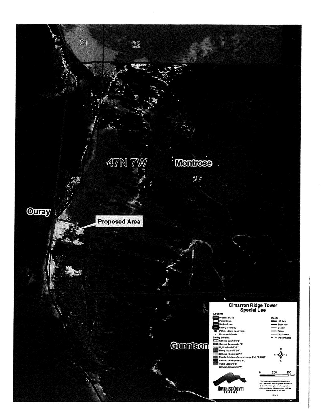
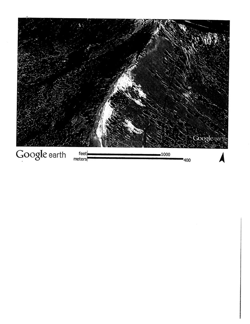
1 Report to the Montrose County Board of County Commissioners Prepared by the Montrose County Planning and Development Department #3 PREPARED BY: MEETING DATE: SUBJECT: APPLICANT: OWNER: LOCATION: PROPOSAL: ZONING: Steve White, Planning and Development Director January 22,2013 beginning at 9:00 a.m. Commissioners' Board Room 161 S. Townsend Ave. Montrose, Colorado Cimarron Ridge Tower Special Use [SU ] Skip Huston Chipeta Road Montrose, CO High Cimarron LLC 4730 South Downing St. Englewood, CO off of County Road 858 To build a tower site General Agricultural MONTROSE COUNTY MASTER PLAN REVIEW: Planning Area: Projected Land Use: Road Classification: South Valley Planning Area Agricultural CR Ouray County PROJECT DESCRIPTION: 1. This is an application for a Special Use Permit (SUP). The applicant is proposing to erect a cell tower on a 295' X 295' lease site with a parent parcel of 450 acres. The lease parcel is located approximately 700 feet from the western property boundary, and approximately 7.5 miles east of Highway The proposed site is located just west of the Ouray County line and just north of the Gunnison County line. The antenna will be located on the east side of the ridgeline of the Cimarron Mountains. The antenna will be used for wireless internet and cell phone services. The facility will consist of a lattice tower 120 feet in height with a 12'X40' equipment building.
2 ANALYSIS: 3. The Montrose County Master Plan designates the area of the proposed facility for "Agricultural/Rural Residential. These are defined as, "areas designated for development in agricultural, agribusiness, and higher density residential (including major subdivisions) uses; typical of the County's General Agricultural Zone District and General Residential Zone District. Generally, community water service is available. Radio towers are not specifically designated by the Master Plan for this area of the County; however, the Land Use Element does not deal directly with Special Uses. Therefore it is the Planning Department's position that a properly permitted radio tower in this area would be consistent with the Master Plan. 4. The Montrose County Zoning Resolution allows communication and telecommunication facilities and associated antenna support structures, not to exceed 150 feet in height. 5. The application was sent to the neighboring Counties (Ouray, Gunnison), and the surrounding property owners. No comments have been received from the neighboring counties or neighboring property owners. RECOMMENDATION: 6. The Planning Commission recommends approval of this Special Use Permit application based on the following findings of fact: a) The proposed Special Use Permit is not in conflict with the land use designation of the Montrose County Master Plan. b) The proposal meets the requirements of the County Zoning Resolution and the special use criteria. c) The facility will enhance the cell phone services for the citizens in the surrounding area. Approval is subject to the following Conditions: 1. The permit shall be applicable only to the specific use and specific property for which it was issued. 2. The development of the facility shall be in conformance all materials submitted as a part of the application with a height limitation of 120 feet. 3. The Special Use Permit shall run with the land. 4. An access permit from the controlling jurisdiction to the county road from the parent property will be required prior to operation of the facility. 5. Prior to operation of the facility the Land Use Department will inspect the site to verify compliance with all approved plans, acceptance by all appropriate County Departments and compliance with all conditions attached to the permit. 6. Approval of this request does not limit the Commissions power to terminate this permit, if a finding of non-compliance with the provisions of the permit, Zoning Resolution or other laws of the County or State. 2 1/22/2013 SU
3 7. The Special Use Permit is limited to the 295' X 295' area as shown in the application. 8. Montrose County shall be notified an provided with a detailed plan, prior to any additional facilities being added to the tower. 9. All generation equipment shall be low-profile, not exceeding 20' in height as measured from the ground pad. 10. The tower shall be painted or covered with a non-reflective material. 11. The Special Use Permit shall be subject to all State and Federal Regulations. SUGGESTED MOTION: 7. I move to approve the Cimarron Ridge Tower Special Use (SU ), per Resolution No , based on the findings of fact and subject to the conditions of approval listed in paragraph # 6 of this report. ATTACHMENTS: Vicinity Map Application 3 1/22/2013 SU
4 December 10,2012 To Whom It May Concern: We would like to be allowed to build a tower site on the High Cimarron, LLC property. Our site will be located approximately J4 mile south of Castle Rock along the Cimarron Ridge in Montrose County. The tower will be 120 feet tall and have a 12' x 40' communication building next to it. At this time the site will be solar, wind and backup generator powered. This site will solve the problems with cell service, Wi-Fi and radio communications near Colona, Log Hill, Ridgway and The Big Cimarron areas as well as Montrose. Skip Huston
5 _ MONTROSE COUNTY PLANNING & DEVELOPMENT 317 SOUTH 2 n d MONTROSE. CO APPLICATION FOR SPECIAL USE Q»mer(s} Name: Mailing Address: City/State/Zip: Phone Applicant (if different from owner, please attach original power of attorney) Warns: _ JMo lbshr\ Mailing Address: /'S^fti Q^LB ffl City/State/Zip: M&pf^^C^ ^ Pho^e:?*?/>-Xtf'97*6 Assessor's Parcel Number or attach Property record card: Physical address of property: Access off which County Road:. Legal description of property (for meies and bounds, please atfacfi copy from policy of tftla Property is zoned: PofebSe water source: no. Total Acreage of the property: ffi^?.3<g> rh^is^l Wastewater treatment source; By signing this application, you are certffyfng tftst the above InformaSon is true and correct to the best of yoyr Knowledge and belief. Cwner<s) Sfgnsto^^^^^M^CJt^^E^^^L. Date: Owri@r(s) Sigreatare: Applicant Signature: / Oats:, Date: Rev imoos!y!sda/masters/submiit(ti-$pecialtisa.dgs
6
7
8

9 6/4/2012
Pagosa Lakes Telecommunication Facility Development Plan Rezoning in the PUD zone, located at 1311 Lake Forest Cir.
 Archuleta County Development Services Planning Department 1122 HWY 84 P. O. Box 1507 Pagosa Springs, Colorado 81147 970-264-1390 Fax 970-264-3338 MEMORANDUM TO: Archuleta County Planning Commission FROM:
Otter Rd. & Woodgate Rd. Montrose, Colorado. Residential Development Information Packet
 Estates at Stone Ridge Otter Rd. & Woodgate Rd. Residential Development Information Packet John Renfrow * Joey Huskey Renfrow Realty Member of: Rocky Mountain Commercial Brokers www.rmcbrokers.com Information
Planning and Zoning Commission
 Planning and Zoning Commission Buell Consulting Conditional Use Permit Haugen Communication Tower Reason for Request: Install and maintain wireless facility, with 199 lattice type tower, prefabricated
West Main Spring Creek Rd River Development Montrose, Colorado 81401
 West Main Spring Creek Rd River Development Property Information Packet John Renfrow / Joey Huskey Renfrow Realty Page 1 Executive Summary 82+ ACRES OF DEVELOPMENT LAND WITH INCREDIBLE POTENTIAL Montrose,
MONTROSE COUNTY COMMERCE PARK
 MONTROSE COUNTY COMMERCE PARK South Highway 550 and Vernal Road 81403 Vernal Road Entrance South Hwy 550 Frontage Paved Streets with Utilities Commercial Development Information Packet John Renfrow * Joey
NEIGHBORHOOD MEETING
 NEIGHBORHOOD MEETING Community Development Department 8101 Ralston Road Arvada, Colorado 80002 NEIGHBORHOOD MEETINGS The City of Arvada promotes citizen participation in the development review process.
1340 Ogden Road Montrose, Colorado 81401
 1340 Ogden Road 81401 COMMERCIAL PROPERTY INFORMATION PACKET John Renfrow * Joey Huskey Renfrow Realty Member of: www.rmcbrokers.com Page 1 Executive Summary FUTURE COMMERCIAL DEVELOPMENT MLS# 578207 /
Board of Adjustment Variance Process Guide
 Board of Adjustment Variance Process Guide Clear Creek County Planning Department PO Box 2000 Georgetown, CO 80444 Phone: 303.679.2436 Fax: 303.569.1103 Board of Adjustment Variance Process Guide Overview
SUBDIVISION EXEMPTION (SUBX) SUBMITTAL CHECKLIST
 SUBMITTAL CHECKLIST") APPLICATION REQUIREMENTS: SUBDIVISION EXEMPTION (SUBX) SUBMITTAL CHECKLIST The applicant shall submit the Subdivision Exemption application fee and the required application materials as follows: One original
APPLICATION REQUIREMENTS: SUBDIVISION EXEMPTION (SUBX) SUBMITTAL CHECKLIST The applicant shall submit the Subdivision Exemption application fee and the required application materials as follows: One original
Planning Department 168 North Edwards Street Post Office Drawer L Independence, California 93526
 Planning Department 168 North Edwards Street Post Office Drawer L Independence, California 93526 Phone: (760) 878-0263 FAX: (760) 872-2712 E-Mail: inyoplanning@ inyocounty.us AGENDA ITEM NO.: 6 (Action
PLANNING AND ZONING COMMISSION Planned Unit Development (PUD), Type 2
, Type 2") PLANNING AND ZONING COMMISSION Planned Unit Development (PUD), Type 2 DOÑA ANA COUNTY COMMUNITY DEVELOPMENT DEPARTMENT Doña Ana County Government Center 845 North Motel Blvd Las Cruces, New Mexico 88007
PLANNING AND ZONING COMMISSION Planned Unit Development (PUD), Type 2 DOÑA ANA COUNTY COMMUNITY DEVELOPMENT DEPARTMENT Doña Ana County Government Center 845 North Motel Blvd Las Cruces, New Mexico 88007
TRANSFERABLE DEVELOPMENT RIGHTS PROCESS GUIDE
 TRANSFERABLE DEVELOPMENT RIGHTS PROCESS GUIDE Clear Creek County Planning Department P.O. Box 2000 Georgetown, Colorado 80444 (303) 679-2436 - phone (303) 569-1103 - fax 1 PURPOSE: A Transfer of Development
PLANNING COMMISSION REPORT
 PLANNING COMMISSION REPORT CASE: WINDSOR COURT GPA18-05 & ZON18-06 CASE #: GPA18-05 & ZON18-06 MEETING DATE: 12/06/2018 FROM: Thomas Ritz, Senior Planner, Planning, tritz@glendaleaz.com, 623-930-2588 SUBJECT
BOARD OF COUNTY COMMISSIONERS SARPY COUNTY, NEBRASKA
 2017-200 BOARD OF COUNTY COMMISSIONERS SARPY COUNTY, NEBRASKA RESOLUTION: SPECIAL USE PERMIT Robert Kyle Hibbitts Lot 12 Meadow Oaks Replat 1, (20407 Meadow Ridge Drive) Sarpy County, Nebraska WHEREAS,
GUNNISON COUNTY PLANNING COMMISSION PRELIMINARY AGENDA: Friday, July 7, 2017
 GUNNISON COUNTY PLANNING COMMISSION PRELIMINARY AGENDA: Friday, July 7, 2017 8:00 a.m. Call to order; determine quorum Planning Commission leave for site visit High Cimarron LLC 9:00 a.m. High Cimarron
Conditional Use Permit Basin Electric Squaw Gap Communication Tower
 Conditional Use Permit Basin Electric Squaw Gap Communication Tower Conditional Use Permit for the removal of two existing Application: communication towers and the construction of one, 290 tall selfsupporting,
PROCEEDINGS OF THE BOARD OF MONTROSE COUNTY COMMISSIONERS. DATE: September 8, 2015
 The Board of County Commissioners met in regular session held at the County Administrative Office Board Room at 9:00am. Those present: David White, Chairman; Glen Davis, Vice-Chairman; Ronald Henderson,
Planning and Zoning Staff Report Vallivue School District - PH
 Hearing Date: April 19, 2018 Planning and Zoning Staff Report - PH2018-16 Development Services Department Applicant: Nate Bondelid Owner: Staff: Dan Lister, Planner II (208) 455-5959 dlister@canyonco.org
MINOR BOUNDARY LINE ADJUSTMENT PROCESS GUIDE
 MINOR BOUNDARY LINE ADJUSTMENT PROCESS GUIDE Clear Creek County Planning Department P.O. Box 2000 Georgetown, Colorado 80444 (303) 679-2436 phone (303) 569-1103 fax 1 PURPOSE To establish criteria and
Planning and Zoning Staff Report Maverick Towers Van Wassenhove, PH
 Planning and Zoning Staff Report Maverick Towers Van Wassenhove, PH2018-17 Hearing Date: April 19, 2018 Development Services Department Applicant: Maverick Towers - Nadine Bostwick Owner: Paul Van Wassenhove
Location of Provisions in Ch. 160A and Ch. 153A in Proposed Ch. 160D
 Location of Provisions in Ch. 160A and Ch. 153A in Proposed Ch. 160D CHAPTER 160A ARTICLE 1 Definitions and Statutory Construction (most also retained in 160A/153A) CHAPTER 153A ARTICLE 1 PROPOSED CHAPTER
TEMPORARY USE PERMIT APPLICATION TEMPORARY TOWERS
 1. Project Name: TEMPORARY USE PERMIT APPLICATION TEMPORARY TOWERS 2. Applicant: Address: City: State: Zip Code: Telephone #: Facsimile #: email: 3. Owner: Address: City: State: Zip Code: Telephone #:
Planning Commission Hearing Date: 2/21/2017 Board of County Commissioners Hearing Date: 3/8/2017
 COMMISSIONERS: DARRYL GLENN (PRESIDENT) MARK WALLER (PRESIDENT PRO TEMPORE) STAN VANDERWERF LONGINOS GONZALEZ PEGGY LITTLETON PLANNING AND COMMUNITY DEVELOPMENT DEPARTMENT CRAIG DOSSEY, EXECUTIVE DIRECTOR
COMMUNICATION TOWERS ORDINANCE No. 31
 COMMUNICATION TOWERS ORDINANCE No. 31 ARTICLE 1: AUTHORITY AND JURISDICTION Authority Pursuant to the authority granted by 1967 SDCL 11-2 as amended; the following regulations are hereby adopted by the
Guide to Replats. Step 1. Step 2. Step 3. Step 4. Step 5. Step 6. Step 7. Step 8. Step 9. Step 10
 Guide to Replats Introduction Douglas County is committed to providing open, transparent application processes to the public. This Guide is provided to assist anyone interested in the procedures and expectations
City Recorder s Office
 City Recorder s Office PUBLIC NOTICE Notice is Hereby Given that the Tooele City Council & Tooele City Redevelopment Agency will meet in a Work Session, on Wednesday, September 19, 2018 at the hour of
ZONING VARIANCES ADMINISTRATIVE
 200 W. Oak Street, 3rd Floor Fort Collins, CO 80521 (970) 498-7683 / larimer.org/planning ZONING VARIANCES ADMINISTRATIVE The submittal requirements listed in this packet are intended to collect all of
ALBEMARLE COUNTY PLANNING STAFF REPORT SUMMARY
 ALBEMARLE COUNTY PLANNING STAFF REPORT SUMMARY Project Name: SDP2010-94 Hillsdale Farm/Cosner Property (AT&T CV427 Tier II) - Final Planning Commission Public Hearing: March 1, 2011 Owners: Kimco, LC Acreage:
STAFF REPORT FOR MAJOR SUBDIVISION
 STAFF REPORT FOR MAJOR SUBDIVISION FINAL PLAT CASE NO. FA-12-003 HEARING DATE: November 6, 2013 CASE NAME: Solterra Subdivision Filing No. 13 PROCEDURE: Planning Commission ADDRESS OF MAJOR SUBDIVISION
LARAMIE COUNTY PLANNING & DEVELOPMENT DEPARTMENT
 LARAMIE COUNTY PLANNING & DEVELOPMENT DEPARTMENT Planning Building MEMORANDUM TO: FROM: Laramie County Board of Commissioners Bryan Nicholas, Associate Planner DATE: October 2, 2018 TITLE: Review and action
2019 APPLICATION CHECKLIST: THE FOLLOWING ITEMS ARE REQUIRED IN ORDER TO ACCEPT AN APPLICATION: Date: Section: Block: Lot:
 Architectural & Community Appearance Board of Review (ACABOR) Town of Orangetown Building Department 20 Greenbush Road, Orangeburg, New York 10962 (845) 359-8410, ex 4331, www.orangetown.com 2019 APPLICATION
2017_10_MIKES_SWEETMAN_OE_PC.PDF
 1. OCTOBER PLANNING COMMISSION AGENDA Documents: OCTOBER 2017.PDF 1.I. MIKES/SWEETMAN OUTRIGHT EXEMPTIONS Documents: 2017_10_MIKES_SWEETMAN_OE_PC.PDF DEPARTMENT OF PLANNING AND ZONING 308 Byers Ave P.O.
ORDINANCE NO. NOW, THEREFORE, BE IT ORDAINED BY THE CITY COUNCIL OF THE CITY OF BRYAN, TEXAS:
 LOCATION MAPS: ORDINANCE NO. AN ORDINANCE OF THE CITY OF BRYAN, TEXAS, AMENDING CHAPTER 130, ZONING, OF THE CITY OF BRYAN CODE OF ORDINANCES, BY CHANGING THE ZONING CLASSIFICATION FROM AGRICULTURAL - OPEN
CERTIFICATE OF RECOMMENDATION
 DEPARTMENT OF PLANNING AND ZONING 308 Byers Ave P.O. Box 239 Hot Sulphur Springs Colorado 80451 970-725-3347 Ext 129 or Fax 970-725-3303 CERTIFICATE OF RECOMMENDATION TO: FROM: Grand County Board of Commissioners
SECTION 10 STANDARD PLATS
 SECTION 10 - STANDARD PLATS Subdivision 1: Purpose Standard Plats allow the subdivision of land into lots smaller than the minimum metes and bounds size in the zoning district, and control road development
Planning Department Filing Fee of $ up to 3 lots $75.00 per each additional lot (subject to change) payable to Archuleta County.
 payable to Archuleta County.") Archuleta County Development Services Building & Planning Departments 1122 Hwy 84 P. O. Box 1507 Pagosa Springs, Colorado 81147 970-264-1390 Fax 970-264-3338 Lot Consolidation Submittal Checklist for the
Archuleta County Development Services Building & Planning Departments 1122 Hwy 84 P. O. Box 1507 Pagosa Springs, Colorado 81147 970-264-1390 Fax 970-264-3338 Lot Consolidation Submittal Checklist for the
Neighborhood Meeting
 Neighborhood Meeting The City of Arvada promotes citizen participation in the development review process. Neighborhood meetings are required for annexations, rezoning, preliminary subdivision, planned
The Ranches Sketch Plan
 The Ranches Sketch Plan APPLICATION: RURAL LAND USE PROCESS (AKA CLUSTER DEVELOPMENT) HEARING DATES: Planning Commission: 12 July 2017 at 6:30 pm Board of County Commissioners: TBD APPLICANT: REQUEST:
The Elmore County Land Use & Building Department DOES NOT accept faxed applications or signatures.
 ELMORE COUNTY LAND USE & BUILDING DEPARTMENT 520 E 2 nd South Mountain Home, ID 83647 (208) 587-2142 www.elmorecounty.org Conditional Use Permit Application The Elmore County Land Use & Building Department
March 9, Planning Commission. Benjamin J. Ziskal, AICP, CEcD Planning Office
 COUNTY OF PRINCE WILLIAM 5 County Complex Court, Suite 210, Prince William, Virginia 22192-9201 PLANNING (703) 792-7615 FAX (703) 792-4401 www.pwcgov.org OFFICE Rebecca Horner, AICP, CZA Director of Planning
New Cingular Wireless Telecommunication Tower at County Road 48, Milner Conditional Use Permit
 New Cingular Wireless Telecommunication Tower at 39415 County Road 48, Milner ACTIVITY #: Conditional Use Permit PP2012-023 HEARING DATES: Planning Commission (PC): August 16, 2012 at 6:00pm PETITIONER:
1919 N Townsend Ave Montrose, Colorado 81401
 1919 N Townsend Ave 81401 VACANT INDUSTRIAL LAND INFORMATION John Renfrow * Jim Renfrow Renfrow Realty M b f Member of: Rocky Mountain Commercial Brokers www.rmcbrokers.com Page 1 Executive Summary 22
The Morton County Planning & Zoning Commission Agenda for January 25, 2018
 The Morton County Planning & Zoning Commission Agenda for January 25, 2018 Planning and Zoning meeting beginning at 5:30pm, located in the Morton County Commission room in the County Courthouse, 210 2
Nina Ruiz, Project Manager/Planner II Gilbert LaForce, Engineer II Craig Dossey, Executive Director Planning & Community Development
 COMMISSIONERS: DARRYL GLENN (PRESIDENT) MARK WALLER (PRESIDENT PRO TEMPORE) STAN VANDERWERF LONGINOS GONZALEZ PEGGY LITTLETON PLANNING AND COMMUNITY DEVELOPMENT DEPARTMENT CRAIG DOSSEY, EXECUTIVE DIRECTOR
MS MINOR SUBDIVISION TREVITHICK
 MS-02-015 341.12 MINOR SUBDIVISION TREVITHICK A request by Danny Trevithick for a one-lot Minor Subdivision on five acres. The property is zoned A-35 (Agricultural) District and is located ¼ mile south
CITY OF COLORADO SPRINGS 2006 ANNEXATION PLAN CHAPTER 4 ENCLAVES
 CITY OF COLORADO SPRINGS 2006 ANNEXATION PLAN CHAPTER 4 ENCLAVES As the City has expanded, enclaves, remnants of land that are surrounded by the City, have remained within the jurisdiction of El Paso County.
HOME OCCUPATION - I APPLICATION
 HOME OCCUPATION - I APPLICATION 1. Owner Name: Mailing Address: City: State: Zip Code: Telephone #: Facsimile #: 2. Applicant Name: Mailing Address: City: State: Zip Code: Telephone #: Facsimile #: Please
MAJOR BOUNDARY LINE ADJUSTMENT PROCESS GUIDE
 MAJOR BOUNDARY LINE ADJUSTMENT PROCESS GUIDE Clear Creek County Planning Department P.O. Box 2000 Georgetown, Colorado 80444 (303) 679-2436 - phone (303) 569-1103 - fax PURPOSE To establish criteria and
MONTEREY COUNTY PLANNING COMMISSION
 MONTEREY COUNTY PLANNING COMMISSION Meeting: June 11, 2003 @ 9:30 AM Agenda Item: D2 Project Description: Use Permit (Associated Tagline/Sprint #PLN000669) for the construction of a 50 Ft. monopole with
2. The AT&T WCF shall consist of a stealth design (faux saguaro cactus) with a maximum height of 30 feet above adjacent grade;
 with a maximum height of 30 feet above adjacent grade;") AGENDA ITEM # DATE: October 24, 2011 COAC NUMBER: 11-4698 CITY OF GOODYEAR CITY COUNCIL ACTION FORM SUBJECT: Special Use to allow the installation of a proposed AT&T Wireless Communication Facility to
AGENDA ITEM # DATE: October 24, 2011 COAC NUMBER: 11-4698 CITY OF GOODYEAR CITY COUNCIL ACTION FORM SUBJECT: Special Use to allow the installation of a proposed AT&T Wireless Communication Facility to
ZONING PERMIT MOBILE HOME (ZPMH) SUBMITTAL CHECKLIST
 SUBMITTAL CHECKLIST") ZONING PERMIT MOBILE HOME (ZPMH) SUBMITTAL CHECKLIST (A PRINCIPLE DWELLING UNIT, TEMPORARY USE DURING CONSTRUCTION OF RESIDENCE, TEMPORARY STORAGE (UNLESS OTHERWISE SPECIFIED), TEMPORARY ACCESSORY FARM
ZONING PERMIT MOBILE HOME (ZPMH) SUBMITTAL CHECKLIST (A PRINCIPLE DWELLING UNIT, TEMPORARY USE DURING CONSTRUCTION OF RESIDENCE, TEMPORARY STORAGE (UNLESS OTHERWISE SPECIFIED), TEMPORARY ACCESSORY FARM
-Section Contents- 201 Districts Overlay Districts Incorporation of Maps District Boundaries...
 SECTION 2 GENERAL REQUIREMENTS AND EXCEPTIONS -Section Contents- ZONING DISTRICTS 201 Districts... 2-2 202 Overlay Districts... 2-2 203 Incorporation of Maps... 2-3 204 District Boundaries... 2-3 LAND
ZONING CHANGE/SUP APPLICATION
 ZONING CHANGE/SUP APPLICATION Zoning Change Specific Use Permit Applicant Name: Company: Address: City, State, Zip Phone: Fax: Email: Owner (if different from applicant) Name: Company: Address: City, State,
1435 Hawk Pkwy Units C, D & E Montrose, Colorado 81401
 1435 Hawk Pkwy Units C, D & E 81401 COMMERCIAL INFORMATION SALE PACKET John Renfrow * Joey Huskey Renfrow Realty Member of: www.rmcbrokers.com Page 1 Executive Summary Outstanding Retail/Office Building
Attachment 4. Planning Commission Staff Report. June 26, 2017
 Planning Commission Staff Report June 26, 2017 Agenda #: Regular Agenda - 2 Title: Applicant: Request: Location: Existing Zoning: Proposed Use: Staff Planner: The Brands and The Brands West Eagle Crossing
This is a conditional use permit request to establish a commercial wind energy conversion system.
 Public Works 600 Scott Boulevard South Hutchinson, Kansas 67505 620-694-2976 Road & Bridge Planning & Zoning Noxious Weed Utilities Date: March 28, 2019 To: From: Reno County Planning Commission Russ Ewy,
Sig Zvejnieks, Karen Hall, Lori Litzen, Jim Coleman, Barbara Landers, Bill McCollam, and Nancy Trautman.
 MINUTES PENNINGTON COUNTY PLANNING COMMISSION December 8, 2014 @ 9:00 a.m. County Commissioners Meeting Room - Pennington County Administration Building MEMBERS PRESENT: STAFF PRESENT: Sig Zvejnieks, Karen
1201 N. San Juan Ave Montrose, Colorado 81401
 1201 N. San Juan Ave 81401 Commercial Property Information Packet John Renfrow * Joey Huskey Renfrow Realty Information deemed reliable, but not guaranteed and should be verified. Member of:: www.rmcbrokers.com
Apartments been convicted or received probation for a felony or sex crime? Date when filled out:
 M E M B E R Rental Application for Residents and Occupants Each co-resident and each occupant over 18 must submit a separate application. Spouses may submit a joint application. Date when filled out: ABOUT
BEFORE THE HEARINGS EXAMINER FOR THURSTON COUNTY
 BEFORE THE HEARINGS EXAMINER FOR THURSTON COUNTY In the Matter of the Application of ) NO. SUPT 020642 ) T-Mobile ) FINDINGS, CONCLUSIONS ) AND DECISION For Approval of a Special Use Permit ) ) SUMMARY
CITY OF MONTROSE PLANNING COMMISSION AGENDA City Council Chambers, 107 S Cascade Ave., Montrose, Colorado 5:00 p.m.
 CITY OF MONTROSE PLANNING COMMISSION AGENDA City Council Chambers, 107 S Cascade Ave., Montrose, Colorado 5:00 p.m., October 24, 2018 The 11:00 rule will be enforced. All public hearings scheduled and
REQUIREMENTS FOR RESIDENTIAL PLAN REVIEW New Constructions, additions and remodel
 Department of Development P. O. Box 628 (985) 898-2574 or (985) 646-4166 Fax: (985) 898-2785 or (985) 646-4174 permits@stpgov.org Revised 03/03/16 Completed Permit Application REQUIREMENTS FOR RESIDENTIAL
ARTICLE PERMISSIVE USES. A building or premises shall be permitted to be used for the following purposes in the A-1 Agricultural District:
 ARTICLE 3.00 A-1 AGRICULTURAL SECTIONS: 3.01 Intent 3.02 Permissive Uses 3.03 Permitted Special Uses 3.04 Conditional Uses 3.05 Accessory Uses 3.06 Parking Regulations 3.07 Sign Regulations 3.08 Density,
Staff Report. State Environmental Policy Act (SEPA): The proposal requires review under the State Environmental Policy Act.
: The proposal requires review under the State Environmental Policy Act.") Staff Report Major Amendment to Preliminary Plat / Planned Development District: Oakpointe at Sunrise PDD, Phase 1 (aka Emerald Ridge PDD) Application Number: 865995 Tax Parcel Number: 6026455560 South
Staff Report Major Amendment to Preliminary Plat / Planned Development District: Oakpointe at Sunrise PDD, Phase 1 (aka Emerald Ridge PDD) Application Number: 865995 Tax Parcel Number: 6026455560 South
A PUBLIC RIGHT-OF-WAY MANAGEMENT ORDINANCE BY THE CITY OF SOUTHLAKE, TEXAS; REGULATING THE PHYSICAL USE, OCCUPANCY AND MAINTENANCE
 ORDINANCE NO. 1178 A PUBLIC RIGHT-OF-WAY MANAGEMENT ORDINANCE BY THE CITY OF SOUTHLAKE, TEXAS; REGULATING THE PHYSICAL USE, OCCUPANCY AND MAINTENANCE OF CITY RIGHTS-OF-WAY BY WIRELESS NETWORK PROVIDERS;
ABILENE ZONING REGULATIONS TABLE OF CONTENTS
 ABILENE ZONING REGULATIONS TABLE OF CONTENTS ARTICLE SECTION TITLE PAGE 1 TITLE AND PURPOSE 1-1 Title. 1-1 1-2 Purpose and Intent.. 1-1 1-3 Consistency with Comprehensive Plan 1-2 1-4 Jurisdiction. 1-2
1.25 AC Residential Land
 FOR SALE $79,000 Property Details PARCEL ID 3414-501-1010-200-0 PRICE $79,000 A perfect spot for a new dream home! 1.25 AC lot is tucked away in a rural area of Port St. Lucie and just within 2 miles to
AGENDA ITEM SUMMARY BUSINESS OF THE CITY COUNCIL CITY OF GOLDEN, COLORADO. Quasi Judicial Matter
 AGENDA ITEM SUMMARY BUSINESS OF THE CITY COUNCIL CITY OF GOLDEN, COLORADO Quasi Judicial Matter MEETING DATE: July 10, 2014 REPORT DATE: June 30, 2014 CASE NO: PC 14-26 DEPT. OF ORIGIN: Community and Economic
1150 N. San Juan Ave Montrose, Colorado 81401
 1150 N. San Juan Ave 81401 Commercial Property Information Packet John Renfrow * Joey Huskey Renfrow Realty Information deemed reliable, but not guaranteed and should be verified. Member of:: www.rmcbrokers.com
Questions Commonly Asked by Prospective & New Homeowners Regarding Front Foot Benefit Charges (FFBC)
") If you have questions or need additional information, contact: Washington Suburban Sanitary Commission Property Assessments Section 14501 Sweitzer Lane, 11th floor Laurel, Maryland 20707 (301) 206-8032
If you have questions or need additional information, contact: Washington Suburban Sanitary Commission Property Assessments Section 14501 Sweitzer Lane, 11th floor Laurel, Maryland 20707 (301) 206-8032
Planning & Development Department AGRICULTURAL EXEMPTION SUBMITTAL FORMS INDEX
 AGRICULTURAL EXEMPTION SUBMITTAL FORMS INDEX APPLICANT S GUIDE 431 REGULATIONS THAT GOVERN THE USE OF LAND 433 LAND USE APPLICATION 401 CONTACT SUPPLEMENTAL 3043 REQUEST FOR REAL PROPERTY CLASSIFICATION
TELECOMMUNICATIONS TOWER AND VARIANCE STAFF REPORT
 TELECOMMUNICATIONS TOWER AND VARIANCE STAFF REPORT City County Planning Commission 1141 State Street Bowling Green, Kentucky 42101 (270) 842 1953 Summary: The applicants have filed an application for approval
Guide to Combined Preliminary and Final Plats
 Guide to Combined Preliminary and Final Plats Introduction The Douglas County is committed to providing open, transparent application processes to the public. This Guide is provided to assist anyone interested
PLANNING AND ZONING REVIEWS AT THE COUNTY LEVEL
 PLANNING AND ZONING REVIEWS AT THE COUNTY LEVEL Introductions Why do counties review planning and zoning matters? To bring pertinent inter-community and county-wide planning, zoning, site plan and subdivision
COUNTY OF EL DORADO DEVELOPMENT SERVICES PLANNING COMMISSION STAFF REPORT TENTATIVE MAP
 COUNTY OF EL DORADO DEVELOPMENT SERVICES PLANNING COMMISSION STAFF REPORT Agenda of: June 27, 2013 Item No.: 9.a Staff: Mel Pabalinas TENTATIVE MAP FILE NUMBER: APPLICANT: REQUEST: LOCATION: TM10-1501/West
Planning Commission Application Summary
 Planning Commission Application Summary Project Name: Creekside Estates Zone Change and Land Use Amendment Address: 571 West 11400 South Current Zoning: RA1 Hearing Date: July 14, 2016 Summary of Request
. D Design Review. Adjustment. Variance. Pre-Ap. Meeting: Alteration. Tax Assessor Parcel Number(s): _S_e_e_A_t_ta_c_h_e_d_L_is_t
: _S_e_e_A_t_ta_c_h_e_d_L_is_t") Check all permits you are applying for in the boxes provided. Submit this application form, the applicable materials listed in the corresponding permit application packet(s) and application fee payment.
Check all permits you are applying for in the boxes provided. Submit this application form, the applicable materials listed in the corresponding permit application packet(s) and application fee payment.
BILL SKINNER, SENIOR PLANNER SEPTEMBER 3, 2014
 ARAPAHOE BOARD OF COUNTY COMMISSIONERS PUBLIC HEARING DECEMBER 9, 2014 9:30 A.M. CASE # V13-004 PAULA DORA #12 RIGHT OF WAY VACATION BILL SKINNER, SENIOR PLANNER SEPTEMBER 3, 2014 VICINITY MAP The site
REPRESENTATIVE: NES, Inc. 619 North Cascade Avenue, Suite 200 Colorado Springs, CO 80903
 COMMISSIONERS: MARK WALLER (CHAIR) LONGINOS GONZALEZ, JR. (VICE-CHAIR) HOLLY WILLIAMS STAN VANDERWERF CAMI BREMER PLANNING AND COMMUNITY DEVELOPMENT DEPARTMENT CRAIG DOSSEY, EXECUTIVE DIRECTOR TO: FROM:
CHECKLIST FOR CUSTOMER Lawful Lot Determination
 CHECKLIST FOR CUSTOMER Lawful Lot Determination (LDO Section 10.2.1A) The following material must be submitted with a request for a lawful lot determination. Check off each item that you have included
PROJECTS IN THE RANCHO CALAVERAS/ LA CONTENTA AREA:
 PROJECTS IN THE RANCHO CALAVERAS/ LA CONTENTA AREA: Note: information subject to change; contact Planning Dept. or Supervisor Erickson for update/questions (information below was supplied by Calaveras
LOT CONSOLIDATION (for contiguous lots)
") www.larimer.org Planning Department 200 W. Oak Street 3 rd Floor Fort Collins, CO 8052 970-498-7683 LOT CONSOLIDATION (for contiguous lots) The purpose of the lot consolidation is to allow the consolidation
www.larimer.org Planning Department 200 W. Oak Street 3 rd Floor Fort Collins, CO 8052 970-498-7683 LOT CONSOLIDATION (for contiguous lots) The purpose of the lot consolidation is to allow the consolidation
COMPREHENSIVE PLAN FUTURE LAND USE MAP AMENDMENT APPLICATION
 COUNTY STAFF DATA ONLY Date Received: Project No. CPA-20 - GADSDEN COUNTY DEPARTMENT OF PLANNING & COMMUNITY DEVELOPMENT 1-B East Jefferson Street, Post Office Box 1799, Quincy, FL 32353-1799 PLANNING
LARAMIE COUNTY PLANNING & DEVELOPMENT DEPARTMENT
 LARAMIE COUNTY PLANNING & DEVELOPMENT DEPARTMENT Planning Building MEMORANDUM TO: FROM: Laramie County Planning Commission Marissa Pomerleau, Planning Technician DATE: March 28, 2019 TITLE: Review and
STAFF REPORT FOR MAJOR SUBDIVISION
 STAFF REPORT FOR MAJOR SUBDIVISION FINAL PLAT CASE NO. FA-14-001 HEARING DATE: January 6, 2016 CASE NAME: Solterra Subdivision Filing No. 16 PROCEDURE: Planning Commission ADDRESS OF MAJOR SUBDIVISION
Gabe Sevigney, Project Manager/Planner I Gilbert LaForce, Engineer II Craig Dossey, Executive Director Planning & Community Development
 COMMISSIONERS: DARRYL GLENN (PRESIDENT) MARK WALLER (PRESIDENT PRO TEMPORE) STAN VANDERWERF LONGINOS GONZALEZ PEGGY LITTLETON PLANNING AND COMMUNITY DEVELOPMENT DEPARTMENT CRAIG DOSSEY, EXECUTIVE DIRECTOR
MKP Development, LLC., represented by Adlai Pennington
 Applicant: Property Owner: Sector Plan: MKP Development, LLC., represented by Adlai Pennington MKP Development, LLC., represented by Adlai Pennington Southwest Council District: 2 Allowable Uses: Development
Short Subdivision
 Okanogan County OFFICE OF PLANNING AND DEVELOPMENT Planning GIS Natural Resources Outdoor Recreation 123-5 th Ave. N. Suite 130 - Okanogan, WA 98840 (509) 422-7160 FAX: (509) 422-7349 TTY/Voice Use 800-833-6388
MINERAL COUNTY PLANNING STAFF FINDINGS OF FACT Proposed Elk Run at St. Regis. February 12, 2017
 MINERAL COUNTY PLANNING STAFF FINDINGS OF FACT Proposed The proposed is a five-lot subdivision and is located approximately one mile east of St. Regis on Old Highway 10 East. The property is located in
In an effort to expedite the filing of your application, you are requested to follow the steps and procedures below:
 MADERA LAFCo APPLICATION CITY ANNEXATION PETITION In an effort to expedite the filing of your application, you are requested to follow the steps and procedures below: A. PreZoning Requirement LAFCo has
Temporary Placement of a Manufactured Home
 COMMUNITY DEVELOPMENT DEPARTMENT Planning Division P.O. Box 490 333 Broadalbin Street SW Albany, OR 97321 Phone 541-917-7550 Fax 541-791-0150 www.cityofalbany.net Temporary Placement of a Manufactured
APPLICATION FOR LOT SPLIT
 APPLICATION FOR LOT SPLIT ELIGIBILITY Section 12.09.01 of the Land Development Code provides for review and approval of lot split, which shall include any of the following: 1. The division of a single
CITY COUNCIL AGENDA MEMORANDUM
 City and County of Broomfield, Colorado CITY COUNCIL AGENDA MEMORANDUM To: Mayor and City Council From: Charles Ozaki, City and County Manager Prepared by: Anna Bertanzetti, Principal Planner David Shinneman,
STAFF REPORT FOR MAJOR SUBDIVISION
 STAFF REPORT FOR MAJOR SUBDIVISION FINAL PLAT CASE NO. FA-13-001 HEARING DATE: November 6, 2013 CASE NAME: Solterra Subdivision Filing No. 14 PROCEDURE: Planning Commission ADDRESS OF MAJOR SUBDIVISION
VISTA TERRACE LOT 8 RIDGWAY, COLORADO 1.14± ACRES $145,500
 VISTA TERRACE LOT 8 RIDGWAY, COLORADO 1.14± ACRES $145,500 This 1.14 acre lot is located in the hillside subdivision of Vista Terrace overlooking the beautiful Uncompahgre River Valley. This corner lot
610 North Townsend Avenue
 610 North Townsend Avenue Montrose, CO John Renfrow * Jim Renfrow Renfrow Realty Page 1 Executive Summary EXCELLENT VISIBILITY! 610 N. Townsend Ave. *MONTROSE, Colorado* MLS# Property Acres Bldg. Sq.Ft.
2019 APPLICATION CHECKLIST: THE FOLLOWING ITEMS ARE REQUIRED IN ORDER TO ACCEPT AN APPLICATION: Date: Section: Block: Lot:
 Zoning Board of Appeals Town of Orangetown Building Department 20 Greenbush Road, Orangeburg, New York 10962 (845) 359-8410, ex 4331, www.orangetown.com 2019 APPLICATION CHECKLIST: THE FOLLOWING ITEMS
ZONING BOARD OF APPEALS APPLICATION FORM
 ZONING BOARD OF APPEALS APPLICATION FORM REQUIREMENTS AND INSTRUCTIONS FOR OBTAINING A ZONING VARIANCE QUESTIONS REGARDING COMPLETION AND SUBMISSION OF THIS APPLICATION MAY BE DIRECTED TO THE PLANNING
John Renfrow * Joey Huskey Renfrow Realty
 1521 Ogden Road 81401 Commercial Property Information Packet John Renfrow * Joey Huskey Renfrow Realty Member of: www.rmcbrokers.com Page 1 Executive Summary COMMERCIAL LOT ON SOUTH TOWNSEND! 1521 Ogden
Douglas County Hearing Examiner
 Douglas County Hearing Examiner Andrew L. Kottkamp, Hearing Examiner I~ THE MATTER OF ) FINDINGS OF FACT, ) CONCLUSIONS OF LAW, ) DECISION AND ) CO~DITIONS OF APPROVAL THIS MATTER having come on for hearing