LARAMIE COUNTY PLANNING & DEVELOPMENT DEPARTMENT
|
|
|
- Austen Cole
- 5 years ago
- Views:
Transcription
 to NB (Neighborhood Business) for Tract 27, Foster Tracts, 2 nd Filing, Laramie County, WY.")
1 LARAMIE COUNTY PLANNING & DEVELOPMENT DEPARTMENT Planning Building MEMORANDUM TO: FROM: Laramie County Board of Commissioners Bryan Nicholas, Associate Planner DATE: October 2, 2018 TITLE: Review and action on a Zone Change from MU (Mixed Use) to NB (Neighborhood Business) for Tract 27, Foster Tracts, 2 nd Filing, Laramie County, WY. EXECUTIVE SUMMARY Kermit Craig & Gay Wilson of 2911 Foothills Road, Cheyenne, WY have submitted an application for Zone Change for Tract 27, Foster Tracts, 2 nd Filing, located on Haunted Road, southeast of Dell Range Boulevard and Whitney Road. The application has been submitted for the purpose of seeking a zone change from Mixed Use (MU) to Neighborhood Business (NB). BACKGROUND The subject property is currently vacant with a mixture of adjacent residential and commercial uses. On approximately 1.36 acres, the site has overhead electrical lines as well as underground utilities, along with an existing water well. There are no platted easements within the property that would hinder future development. Per the 2008 East Dell Range/ and Christensen Railroad Overpass Plan from Cheyenne Metropolitan Office (MPO), future expansion of the south half of the Dell Range R.O.W. will eventually impact this property. Pertinent Regulations Section (b) of the Laramie County Land Use Regulations governing the criteria for a zone map amendment. Section of the Laramie County Land Use Regulations governing the NB (Neighborhood Business) zone district Archer Pkwy Cheyenne, WY Phone (307) Fax (307) Page 1 of 3
2 DISCUSSION The Laramie County Comprehensive Plan designates this area as URI (Urban Rural Interface), in which a higher mixture of intensive land uses exist; such as high density residential, intensive commercial, employment centers, and industrial areas. Public infrastructure such as water and sewer may be in place, along with higher vehicular access and community services. PlanCheyenne contemplates the Mixed-Use Commercial Emphasis land use category for this property. Within the MU-C category, existing and future developments that align with activity centers are encouraged. Commercial activities and development is the primary focus, but can also include employment, public and residential uses. The primary use in this category is retail, light industrial, and live-work designed as an activity center. Current zoning for this property is MU (Mixed-Use), with areas in the district being a mixture of residential and commercial. The surrounding zone districts include Low, Medium and High Density Residential, Agricultural Residential, and Community Business. If approved the new zone district NB (Neighborhood Business) would encourage uses that provide goods and services to area residents. Due to the layout of the site, Haunted Road (East) and Dell Range (North) are both considered front property lines and thus the proposed zone change would affect the required setbacks for front and rear property lines only. The required setbacks for the MU Zone District are 25 feet from the front and rear property lines for principle structures. Within the NB Zone District, the required setbacks for principle structures are 25 feet from the front property line only, and five feet from the side and rear property lines. Thus any future development would only need be five feet from the West and South Property lines, due to the fact there are no side property lines on the site. Public notice was published and neighbor notice letters were sent by certified mail per Section Staff received a letter from an adjacent landowner opposing the zone change, a copy of which is attached. Section (b) of the Laramie County Land Use Regulations specifies that in order to recommend approval of this zone change, the Planning Commission must find at least one of the following: i. That the zoning district map amendments or regulations are consistent with plans and policies of Laramie County; or ii. That the original zoning classification given to the property was inappropriate or improper; or iii. That there have been changes of an economic, physical or social nature within the area involved which altered the basic character of such area, and that the amendment will not detrimentally affect the area involved Archer Pkwy Cheyenne, WY Phone (307) Fax (307) Page 2 of 3
3 Criteria i., is met by the conformance with the Laramie County Comprehensive Plan and PlanCheyenne with the proposed type of development. The Laramie County Planning Commission held a public hearing of this application on September 13, No public comment was received, and the Planning Commission voted (4-0) to recommend approval of the application to the Board with no conditions. RECOMMENDATION and FINDINGS Based on evidence provided, staff recommends the Board find that: a. This application meets the criteria for a zone map amendment pursuant to section (b) i. of the Laramie County Land Use Regulations b. The proposed change in zone district is in conformance with the requirements of section of the Laramie County Land Use Regulations. and that the Board approve the Zone Change from MU (Mixed-Use) to NB (Neighborhood Business) for Tract 27, Foster Tracts, 2 nd Filing, with no conditions. PROPOSED MOTION I move to approve the Zone Change from MU (Mixed-Use) to NB (Neighborhood Business) for Tract 27, Foster Tracts, 2 nd Filing, Laramie County, WY, and adopt the findings of facts a and b of the staff report. ATTACHMENTS Attachment 1: Location Map Attachment 2: Aerial Map Attachment 3: Comprehensive Map Attachment 4: PlanCheyenne Map Attachment 5: Current Zoning Map Attachment 6: Agency Review Comments Attachment 7: Adjacent Neighbor Opposition Letter Attachment 8: Applicant Response Letter to Opposition Attachment 9: Resolution Attachment 10: Resolution Exhibit A - Zone Change Map 3966 Archer Pkwy Cheyenne, WY Phone (307) Fax (307) Page 3 of 3
4 6807 FOXGLOVE DR 6909 FOXGLOVE DR FOXGLOVE DR Laramie County, Wyoming 7011 FOXGLOVE DR The CubbyHole LLC Zone Change PZ Location Map Legend 4501 WHITNEY RD 4409 WHITNEY RD WOODHOUSE DR HINESLEY RD WOODHOUSE DR 4350 WOODHOUSE DR HINESLEY RD WOODHOUSE DR 6528 WOODHOUSE DR 6616 HINESLEY RD US HAUNTED RD 6800 US SERVICE RD N US HAUNTED RD SADDLE RIDGE TRL Cheyenne/Laramie County GIS Cooperative Program Streets Classification Interstate Arterial Collector Local Platted, Not Built Private Rail Road Addresses Assessment Boundary Subject Property Printed on July 27, Feet This map is made possible through the Cheyenne and Laramie County Cooperative GIS Program (CLCCGIS). The data contained herein was collected for its use and is for display and planning purposes only. The CLCCGIS will not be held liable as to the validity, correctness, accuracy, completeness, and/or reliability of the data. The CLCCGIS furthermore assumes no liability associated with the use or misuse of this information.
5 Laramie County, Wyoming The CubbyHole LLC Zone Change PZ Aerial Map Legend Streets Classification Interstate Arterial Collector Local Platted, Not Built Private Rail Road Addresses Assessment Boundary HAUNTED RD Subject Property Printed on July 27, Cheyenne/Laramie County GIS Cooperative Program Feet This map is made possible through the Cheyenne and Laramie County Cooperative GIS Program (CLCCGIS). The data contained herein was collected for its use and is for display and planning purposes only. The CLCCGIS will not be held liable as to the validity, correctness, accuracy, completeness, and/or reliability of the data. The CLCCGIS furthermore assumes no liability associated with the use or misuse of this information.
6 HAUNTED RD Future Land Use Districts OTHER Urban-Rural Interface (URI) Rural Metro (RM) Rural Ag Interface (RAI) Ag & Range Land (AGR) FOXGLOVE DR Laramie County, Wyoming The CubbyHole LLC Zone Change PZ Comprehensive Plan Legend WOODHOUSE DR URI Streets Classification Interstate Arterial Collector Local Platted, Not Built Private Rail Road Assessment Boundary Subject Property Printed on July 27, 2018 WOODHOUSE DR SERVICE RD N SADDLE RIDGE TRL Feet This map is made possible through the Cheyenne and Laramie County Cooperative GIS Program (CLCCGIS). The data contained herein was collected for its use and is for display and planning purposes only. The CLCCGIS will not be held liable as to the validity, correctness, accuracy, completeness, and/or reliability of the data. The CLCCGIS furthermore assumes no liability associated with the use or misuse of this information.
7 PlanCheyenne (2014) NEW_FLUP Agriculture/Rural Rural Residential Urban Transition Residential BLAZING STAR RD Laramie County, Wyoming Urban Residential Mixed-use Residential MU-E Industrial Mixed-use Commercial UR Community Business Central Business District Public and Quasi-Public PUB-FED Open Space and Parks ROW GREENMEADOW DR WHITNEY RD WHITNEY RD WHITNEY RD UTR WOODHOUSE DR WOODHOUSE DR FOXGLOVE SERVICE RD N DR HAUNTED RD MU-C FOXGLOVE DR MU-R The CubbyHole LLC Zone Change PZ PlanCheyenne Map Legend Streets Classification Interstate Arterial Collector Local Platted, Not Built Private Rail Road Assessment Boundary Subject Property SADDLE RIDGE TRL Printed on July 27, 2018 WHITNEY RD SERVICE RD N PAINTED ROCK TRL CB COUNTRYSIDE AVE COUNTRYSIDE AVE SADDLE RIDGE TRL COUNTRYSIDE AVE GUNSMOKE RD Feet This map is made possible through the Cheyenne and Laramie County Cooperative GIS Program (CLCCGIS). The data contained herein was collected for its use and is for display and planning purposes only. The CLCCGIS will not be held liable as to the validity, correctness, accuracy, completeness, and/or reliability of the data. The CLCCGIS furthermore assumes no liability associated with the use or misuse of this information.
8 All Other Values Archer Special Use District (ASU) Agricultural (A-2) Agricultural and Rural Residental (A-1) Agricultural Residentail (AR) AR BLAZING STAR RD Laramie County, Wyoming Low Density Residential - Established (LR-1) Low Density Residential - Developing (LR-2) MR A-2 AR WHITNEY RD WHITNEY RD WHITNEY RD Medium Density Residential - Established (MR-1) Medium Density Residential - Developing (MR-2) High Density Residential - Established (HR-1) High Density Residentiial - Developing (HR-2) MU Mixed Use with Residential Emphasis (MUR) Mixed Use with Business Emphasis (MUB) Neighborhood Business Community Business (CB) Light Industrial (LI) Heavy Industrial (HI) Public (P) Planned Unit Development (PUD) Military (M) GREENMEADOW DR WOODHOUSE DR WOODHOUSE DR MU FOXGLOVE SERVICE RD N LR DR HAUNTED RD HR FOXGLOVE DR A-1 The CubbyHole LLC Zone Change PZ Current Zoning Map Legend Streets Classification Interstate Arterial Collector Local Platted, Not Built Private Rail Road Assessment Boundary Subject Property SADDLE RIDGE TRL Printed on July 27, 2018 CB WHITNEY RD SERVICE RD N PAINTED ROCK TRL MR COUNTRYSIDE AVE COUNTRYSIDE AVE SADDLE RIDGE TRL COUNTRYSIDE AVE GUNSMOKE RD Feet This map is made possible through the Cheyenne and Laramie County Cooperative GIS Program (CLCCGIS). The data contained herein was collected for its use and is for display and planning purposes only. The CLCCGIS will not be held liable as to the validity, correctness, accuracy, completeness, and/or reliability of the data. The CLCCGIS furthermore assumes no liability associated with the use or misuse of this information.
9 PZ THE CUBBYHOLE LLC ZONE CHANGE Cheyenne MPO: Nancy Olson COMMENTS ATTACHED 08/09/2018 The MPO does not have any comments on the proposed zone change. There does seem to be outstanding issues on the site plan, therefore we look forward to a second review when submitted. County Assessor: Clarice Blanton COMMENTS ATTACHED 08/13/ The description of Proposed Development on the Zone Change Application states The Car and R.V. Units will be for purchase as property. 2. What does this mean? Joint ownership in the building like a condo? Environmental Health Department: Roy Kroeger COMMENTS ATTACHED 08/13/2018 Laramie County Small Wastewater System Regulations This property is in the 201 Area Facilities Management Plan area but is not contiguous to corporate limits. A small wastewater system may be permitted so long as all setback requirements can be met. This property is very small for a wastewater system and it may not be possible to meet all setbacks. If a small wastewater system is permitted and installed it shall be abandoned for public sewer at such time that public sewer becomes available. Contact Environmental Health for more information on permitting the small wastewater system. Planners: Bryan Nicholas COMMENTS ATTACHED 08/20/ Any existing or proposed entrances or exits, and parking areas shall be shown on the Zone Change Map. 2. This property has two front property lines, with Haunted Road being the primary, and Dell Range Blvd being Non-Primary. 3. The setbacks for Neighborhood Business per Section (d)(i-v) are as follows: d. Setbacks i. All principal structures shall be set back twenty-five (25) feet from front property lines. ii. There shall be five (5) feet minimum side and rear setbacks between principal structures and the property line. iii. Outdoor display areas shall have a minimum setback of fifteen (15) feet from all property lines. iv. Outdoor storage areas shall have a minimum setback of twenty-five(25) feet from all property lines. v. Accessory structures shall conform to section of this regulation. 4. The total building and parking area shall not exceed 75 percent of the total property area. AGENCIES WITH NO COMMENTS: Cheyenne Urban Planning Office County Engineer County Public Works Department
10 Sheriff s Office AGENCIES WITH NO RESPONSE: Cheyenne Development Services County Real Estate Office County Treasurer Combined Communications Center Emergency Management Fire District No. 2 High West Energy CenturyLink Cheyenne Engineering Services
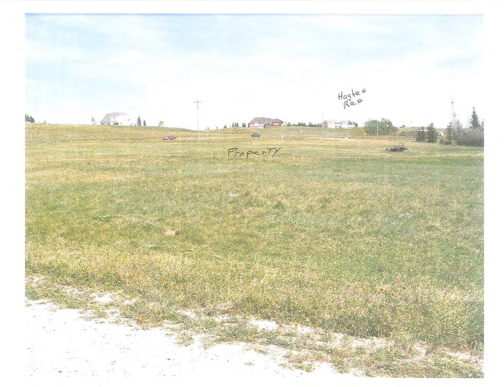
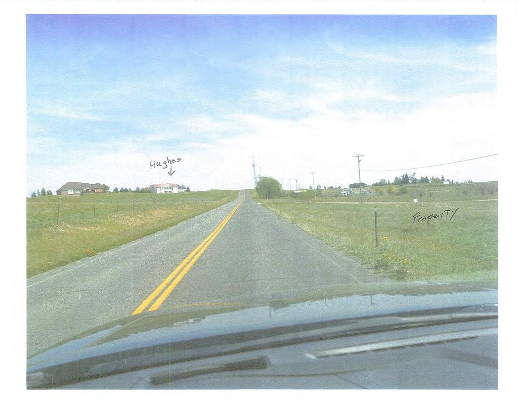
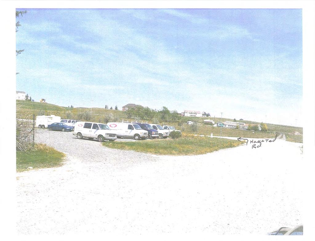
11 Bryan Nicholas From: Sent: To: Subject: Planning Monday, August 13, :25 AM Bryan Nicholas FW: PZ From: Vicki Million Hughes Sent: Friday, August 10, :28 PM To: Planning Subject: PZ To whom it may concern, I am opposed to changing the zoning for PZ on Haunted Road. I d also like to voice my concern that the sign was posted on the side street, rather than on Dell Range, the main road. It is very poorly marked unless your intention is NOT to inform the public of a proposed zone change. While I am not a proponent of the public challenging projects that are within their zone, I am opposed to further impacting the neighbors by allowing higher density, and reduced set-backs. This property will be visible to all of the homes to the north of the property in question, and any increase in density of the project will cause the greatest issues to those properties. Furthermore, why was I not informed via registered mail? A certain number of feet from a project may be adequate in the city, but in the county it s not just the property owners within a couple hundred feet who are adversely affected. My home looks right down on the property in question. By the way, I was unable to navigate you web-site in order to see the proposed layout of this project. You need a more intuitive system. Jim & Vicki Hughes 1
12
13
14
15
16
17
18
19
LARAMIE COUNTY PLANNING & DEVELOPMENT DEPARTMENT
 LARAMIE COUNTY PLANNING & DEVELOPMENT DEPARTMENT Planning Building MEMORANDUM TO: FROM: Laramie County Board of Commissioners Bryan Nicholas, Associate Planner DATE: May 15, 2018 TITLE: Review and action
LARAMIE COUNTY PLANNING & DEVELOPMENT DEPARTMENT
 LARAMIE COUNTY PLANNING & DEVELOPMENT DEPARTMENT Planning Building MEMORANDUM TO: FROM: Laramie County Planning Commission Bryan Nicholas, Associate Planner DATE: November 9, 2017 TITLE: Review and action
LARAMIE COUNTY PLANNING & DEVELOPMENT DEPARTMENT
 LARAMIE COUNTY PLANNING & DEVELOPMENT DEPARTMENT Planning Building MEMORANDUM TO: FROM: Laramie County Planning Commission Nancy Trimble, Associate Planner DATE: July 13, 2017 TITLE: Review and action
LARAMIE COUNTY PLANNING & DEVELOPMENT DEPARTMENT
 LARAMIE COUNTY PLANNING & DEVELOPMENT DEPARTMENT Planning Building MEMORANDUM TO: FROM: Laramie County Planning Commission Bryan Nicholas, Associate Planner DATE: February 14, 2019 TITLE: Review and action
LARAMIE COUNTY PLANNING & DEVELOPMENT DEPARTMENT
 LARAMIE COUNTY PLANNING & DEVELOPMENT DEPARTMENT Planning Building MEMORANDUM TO: FROM: Laramie County Board of Commissioners Nancy M. Trimble, Associate Planner DATE: December 5, 2017 TITLE: Review and
LARAMIE COUNTY PLANNING & DEVELOPMENT DEPARTMENT
 LARAMIE COUNTY PLANNING & DEVELOPMENT DEPARTMENT Planning Building MEMORANDUM TO: FROM: Laramie County Planning Commission Nancy M. Trimble, Associate Planner DATE: November 9, 2017 TITLE: Review and action
LARAMIE COUNTY PLANNING & DEVELOPMENT DEPARTMENT
 LARAMIE COUNTY PLANNING & DEVELOPMENT DEPARTMENT Planning Building MEMORANDUM TO: FROM: Laramie County Planning Commission Nancy M. Trimble, Associate Planner DATE: November 9, 2017 TITLE: Review and action
LARAMIE COUNTY PLANNING & DEVELOPMENT DEPARTMENT
 LARAMIE COUNTY ANNING & DEVELOPMENT DEPARTMENT Planning Building MEMORANDUM TO: FROM: Laramie County Board of Commissioners Seth Frentheway, Associate Planner DATE: June 19 th, 2018 TITLE: Review and action
LARAMIE COUNTY PLANNING & DEVELOPMENT DEPARTMENT
 LARAMIE COUNTY PLANNING & DEVELOPMENT DEPARTMENT Planning Building MEMORANDUM TO: FROM: Laramie County Board of Commissioners Brad Emmons, Planning Director DATE: May 15, 2018 TITLE: Review and action
LARAMIE COUNTY PLANNING & DEVELOPMENT DEPARTMENT
 LARAMIE COUNTY PLANNING & DEVELOPMENT DEPARTMENT Planning Building MEMORANDUM TO: FROM: Laramie County Planning Commission Marissa Pomerleau, Planning Technician DATE: March 28, 2019 TITLE: Review and
LARAMIE COUNTY PLANNING & DEVELOPMENT DEPARTMENT
 LARAMIE COUNTY PLANNING & DEPARTMENT Planning Building MEMORANDUM TO: FROM: Laramie County Planning Commission Nancy M. Trimble, Associate Planner DATE: December 14, 2017 TITLE: Review and action of a
LARAMIE COUNTY PLANNING & DEVELOPMENT DEPARTMENT
 LARAMIE COUNTY PLANNING & DEVELOPMENT DEPARTMENT Planning Building MEMORANDUM TO: FROM: Laramie County Planning Commission Seth Frentheway, Associate Planner DATE: August 23, 2018 TITLE: Review and recommendations
LARAMIE COUNTY PLANNING & DEVELOPMENT DEPARTMENT
 LARAMIE COUNTY PLANNING & DEVELOPMENT DEPARTMENT Planning Building MEMORANDUM TO: FROM: Laramie County Planning Commission Brad Emmons, Planning Director DATE: March 22, 2018 TITLE: Review and recommendations
LARAMIE COUNTY PLANNING & DEVELOPMENT DEPARTMENT
 LARAMIE COUNTY PLANNING & DEVELOPMENT DEPARTMENT Planning Building MEMORANDUM TO: FROM: Laramie County Planning Commission Bryan Nicholas, Associate Planner DATE: April 11, 2019 TITLE: Review and action
LARAMIE COUNTY PLANNING & DEVELOPMENT DEPARTMENT
 LARAMIE COUNTY PLANNING & DEVELOPMENT DEPARTMENT Planning Building MEMORANDUM TO: FROM: Laramie County Planning Commission Brett Walker, Planner DATE: January 25, 2018 TITLE: Review and action of a Subdivision
LARAMIE COUNTY PLANNING & DEVELOPMENT DEPARTMENT
 LARAMIE COUNTY PLANNING & DEVELOPMENT DEPARTMENT Planning Building MEMORANDUM TO: FROM: Laramie County Board of Commissioners Nancy Trimble, Associate Planner DATE: July 18, 2017 TITLE: Review and action
LARAMIE COUNTY PLANNING & DEVELOPMENT DEPARTMENT
 LARAMIE COUNTY PLANNING & DEVELOPMENT DEPARTMENT Planning Building MEMORANDUM TO: FROM: Laramie County Planning Commission Nancy M. Trimble, Associate Planner DATE: July 13, 2017 TITLE: Review and action
LARAMIE COUNTY PLANNING & DEVELOPMENT DEPARTMENT
 LARAMIE COUNTY PLANNING & DEVELOPMENT DEPARTMENT Planning Building MEMORANDUM TO: FROM: Laramie County Planning Commission Seth Frentheway, Associate Planner DATE: November 8, 2018 TITLE: Review and action
LARAMIE COUNTY PLANNING & DEVELOPMENT DEPARTMENT
 LARAMIE COUNTY PLANNING & DEVELOPMENT DEPARTMENT Planning Building MEMORANDUM TO: FROM: Laramie County Planning Commission Brett Walker, Planner DATE: January 25, 2018 TITLE: Review and action of a Variance
LARAMIE COUNTY PLANNING & DEVELOPMENT DEPARTMENT
 LARAMIE COUNTY PLANNING & DEVELOPMENT DEPARTMENT Planning Building MEMORANDUM TO: FROM: Laramie County Planning Commission Jean Vetter, Senior Planner DATE: January 26, 2017 TITLE: Review and action of
LARAMIE COUNTY PLANNING & DEVELOPMENT DEPARTMENT
 LARAMIE COUNTY PLANNING & DEVELOPMENT DEPARTMENT Planning Building MEMORANDUM TO: FROM: Laramie County Planning Commission Seth Frentheway, Associate Planner DATE: August 23, 2018 TITLE: Review and action
LARAMIE COUNTY PLANNING & DEVELOPMENT DEPARTMENT
 LARAMIE COUNTY PLANNING & DEVELOPMENT DEPARTMENT Planning Building MEMORANDUM TO: FROM: Laramie County Board of Commissioners Bryan Nicholas, Associate Planner DATE: October 16, 2018 TITLE: Review and
LARAMIE COUNTY PLANNING & DEVELOPMENT DEPARTMENT
 LARAMIE COUNTY PLANNING & DEVELOPMENT DEPARTMENT Planning Building MEMORANDUM TO: FROM: Laramie County Planning Commission Bryan Nicholas, Associate Planner DATE: September 27, 2018 TITLE: Review and action
ORDINANCE NO. BE IT ORDAINED BY THE GOVERNING BODY OF THE CITY OF CHEYENNE, WYOMING: That the City of Cheyenne hereby finds as follows:
 ORDINANCE NO. ENTITLED: AN ORDINANCE ANNEXING TO THE CITY OF CHEYENNE, WYOMING, A PARCEL OF LAND SITUATED IN THE NORTH 102 FEET OF TRACTS 323 AND 324, SUNNYSIDE ADDITION, 7TH FILING, LARAMIE COUNTY, WYOMING
STAFF REPORT - SUMMATION. Saddle Ridge, 7 th Filing. Preliminary Plat Process CASE NUMBER: UDC SUBDIVISION CODE: SDRA-P
 STAFF REPORT - SUMMATION Saddle Ridge, 7 th Filing Preliminary Plat Process CASE NUMBER: UDC-15-00351 SUBDIVISION CODE: SDRA-P PREPARED BY: MEETING DATES: Josh Tetzlaff July 6, 2015 Planning Commission
LARAMIE COUNTY PLANNING & DEVELOPMENT DEPARTMENT
 LARAMIE COUNTY PLANNING & DEVELOPMENT DEPARTMENT Planning Building MEMORANDUM TO: FROM: Laramie County Board of Commissioners Brett Walker, Planner DATE: April 3, 2018 TITLE: Review and action of a PUD
Whitney Ranch, 1 st Filing Annexation UDC P a g e 1
 STAFF REPORT - SUMMATION Whitney Ranch, 1 st Filing Annexation CASE NUMBER: UDC-17-00689 SUBDIVISION CODE: HIH 01 PREPARED BY: Eric Hammer PROPOSED CODE: WTRH 01 MEETING DATES: January 2, 2018 Planning
Marion County Board of County Commissioners
 Marion County Board of County Commissioners Date: 12/29/2015 P&Z: 12/28/2015 BCC: 1/12/2016 Item Number 160113Z Type of Application Rezoning Request From: A-1 (General Agriculture) To: PUD (Planned Unit
ORDINANCE NO. BE IT ORDAINED BY THE GOVERNING BODY OF THE CITY OF CHEYENNE, WYOMING:
 ORDINANCE NO. ENTITLED: AN ORDINANCE PURSUANT TO SECTION 2.2.1, ZONING MAP AMENDMENT, 2.2.2, PLANNED DEVELOPMENT REGULATING PLAN OR DEVELOPMENT MASTER PLAN, SECTION 5.1.2, ZONING DISTRICTS ESTABLISHED,
BE IT ORDAINED BY THE GOVERNING BODY OF THE CITY OF CHEYENNE, WYOMING: FIRST READING: SECOND READING: 3RD AND FINAL READING:
 ORDINANCE NO. ENTITLED: AN ORDINANCE PURSUANT TO SECTION 2.2.1 ZONING MAP AMENDMENTS, SECTION 5.1.2 ZONING DISTRICTS ESTABLISHED, AND SECTION 5.1.3 OFFICIAL ZONING MAP, OF THE UNIFIED DEVELOPMENT CODE,
Marion County Board of County Commissioners
 Marion County Board of County Commissioners Date: 4/26/26 P&Z: 4/25/26 BCC: 5/17/26 Item Number 160509Z Type of Application Request to rezone the property from the Rural Commercial (RC-1) District to the
PUBLIC NOTICE & AGENDA PLAN COMMISSION City Hall Forum State Street, Beloit, WI :00 PM Wednesday, November 07, 2018
 PUBLIC NOTICE & AGENDA PLAN COMMISSION City Hall Forum - 100 State Street, Beloit, WI 53511 7:00 PM Wednesday, November 07, 2018 1. CALL TO ORDER AND ROLL CALL 2. MINUTES 2.a. Consideration of the Minutes
CITY OF NORTH LAS VEGAS MEMORANDUM
 CITY OF NORTH LAS VEGAS MEMORANDUM TO: FROM: SUBJECT: Planning Commission Community Development and Compliance Department # 28 ) AMP-03-15; Coleman Airpark II & III - Comprehensive Plan Amendment (Public
Minutes of the Proceedings Laramie County Planning Commission Prepared by the Laramie County Planning & Development Office Laramie County Wyoming
 Minutes of the Proceedings Laramie County Planning Commission Prepared by the Laramie County Planning & Development Office Laramie County Wyoming Thursday, January 12, 2012 120112 00 The Laramie County
PLANNING AND ZONING COMMISSION VARIANCE
 PLANNING AND ZONING COMMISSION VARIANCE DOÑA ANA COUNTY COMMUNITY DEVELOPMENT DEPARTMENT Doña Ana County Government Center 845 N. Motel Blvd. Las Cruces, New Mexico 88007 Telephone: (575) 647-7350 MEETING
DRAFT Subject to Modifications
 TREASURE COAST REGIONAL PLANNING COUNCIL M E M O R A N D U M DRAFT Subject to Modifications To: Council Members AGENDA ITEM 5L From: Date: Subject: Staff September 17, 2010 Council Meeting Local Government
Planning Department Oconee County, Georgia
 Planning Department Oconee County, Georgia STAFF REPORT REZONE CASE #: 6985 DATE: October 31, 2016 STAFF REPORT BY: Andrew C. Stern, Planner APPLICANT NAME: Williams & Associates, Land Planners PC PROPERTY
REQUEST FOR PLANNING COMMISSION ACTION
 REQUEST FOR PLANNING COMMISSION ACTION DATE: 8/4/2010 ITEM NO: 5a Division Approval Item Description: Agenda Section PUBLIC HEARINGS Request by McAdam Majors for approval of a 1,008 sq ft. accessory structure
EXTRA-TERRITORIAL ZONING AUTHORITY
 EXTRA-TERRITORIAL ZONING AUTHORITY DOÑA ANA COUNTY COMMUNITY DEVELOPMENT DEPARTMENT Doña Ana County Government Complex 845 North Motel Boulevard Las Cruces, New Mexico 88007 Office: (575) 647-7237 MEETING
NYE COUNTY, NV PAHRUMP REGIONAL PLANNING COMMISSION REGULAR MEETING OCTOBER 12, 2016
 NYE COUNTY, NV PAHRUMP REGIONAL PLANNING COMMISSION REGULAR MEETING OCTOBER 12, 2016 Staff Report Agenda Item No. 10 CASE DESCRIPTION(S): For possible action ZC-2016-000009: Public hearing, discussion,
Minutes of the Proceedings Laramie County Planning Commission Prepared by the Laramie County Planning & Development Office Laramie County Wyoming
 Minutes of the Proceedings Laramie County Planning Commission Prepared by the Laramie County Planning & Development Office Laramie County Wyoming Thursday, April 10, 2014 140410 00 The Laramie County Planning
Marion County Board of County Commissioners
 Marion County Board of County Commissioners Date: 12/2/25 P&Z: 11/30/25 BCC: 12/16/25 Amendment No: (20)151209Z Type of Application Rezoning Request P-MH (Mobile Home Park) to B-2 (Community Business)
KNOXVILLE/KNOX COUNTY METROPOLITAN PLANNING COMMISSION PLAN AMENDMENT/REZONING REPORT
 KNOXVILLE/KNOX COUNTY METROPOLITAN PLANNING COMMISSION PLAN AMENDMENT/REZONING REPORT FILE #: 4-G-12-RZ 4-C-12-SP AGENDA ITEM #: 27 AGENDA DATE: 5/10/2012 POSTPONEMENT(S): 4/12/12 APPLICANT: OWNER(S):
COUNTY SUBDIVISION. Attachments: (1) Staff Analysis (2) Subdivision Maps (3) Related Documents including the Disclosure Statement
 Staff Analysis (2) Subdivision Maps (3) Related Documents including the Disclosure Statement") COUNTY SUBDIVISION DOÑA ANA COUNTY PLANNING AND ZONING COMMISSION Doña Ana County Government Center 845 N. Motel Blvd. Las Cruces, New Mexico 88007 Office: (575) 647-7250 MEETING DATE: August 25, 2011
COUNTY SUBDIVISION DOÑA ANA COUNTY PLANNING AND ZONING COMMISSION Doña Ana County Government Center 845 N. Motel Blvd. Las Cruces, New Mexico 88007 Office: (575) 647-7250 MEETING DATE: August 25, 2011
PLANNING AND ZONING COMMISSION VARIANCE
 PLANNING AND ZONING COMMISSION VARIANCE DOÑA ANA COUNTY COMMUNITY DEVELOPMENT DEPARTMENT Doña Ana County Government Center 845 N. Motel Blvd. Las Cruces, New Mexico 88007 Telephone: (575) 647-7350 MEETING
RECOMMENDATION REPORT
 SARPY COUNTY PLANNING & BUILDING DEPARTMENT RECOMMENDATION REPORT CHANGE OF ZONE (CZ 18-003) PRELIMINARY PLAT (PP 18-005) FINAL PLAT (FP 18-004) NIELSEN ADDITION APPLICANT: RODNEY AND MAUREEN NIELSEN PLANNING
RECOMMENDATION REPORT
 SARPY COUNTY PLANNING & BUILDING DEPARTMENT RECOMMENDATION REPORT CHANGE OF ZONE (CZ 18-005) PRELIMINARY PLAT (PP 18-007) FINAL PLAT (FP 18-008) SCHOLTING ESTATES APPLICANT: DIANE SCHOLTING PLANNING COMMISSION
SUBDIVISION REGULATIONS for Lawrence and the Unincorporated Areas of Douglas County, KS
 SUBDIVISION REGULATIONS for Lawrence and the Unincorporated Areas of Douglas County, KS December 19, 2006 Edition Amended: 09/11/07; 12/04/07; 03/25/08; 09/10/08 Amended: January 6, 2009 Article 8 Subdivision
PLANNING AND ZONING COMMISSION ZONE CHANGE
 PLANNING AND ZONING COMMISSION ZONE CHANGE DOÑA ANA COUNTY COMMUNITY DEVELOPMENT DEPARTMENT Doña Ana County Government Center 845 N. Motel Blvd. Las Cruces, New Mexico 88007 Telephone: (575) 647-7350 MEETING
Action Recommendation: Budget Impact:
 City of Fayetteville Staff Review Form 2018-0477 Legistar File ID 9/18/2018 City Council Meeting Date - Agenda Item Only N/A for Non-Agenda Item Garner Stoll Submitted By 8/28/2018 Submitted Date Action
Marion County Board of County Commissioners
 Marion County Board of County Commissioners Date: 6/4/217 P&Z: 9/25/217 BCC Transmittal: 1/17/217 BCC Adopt: TBD Amendment No: 217-L6 Type of Application Large-Scale Comp Plan Amendment Request: Change
Tuss and Lisa Taylor. Agriculture
 ZONE CHANGE STAFF REPORT CCPC City-County Planning Commission warrenpc.org (270) 842-1953 1141 State Street Bowling Green, KY 42101 DOCKET/CASE/APPLICATION NUMBER 2018-29-Z-CO PUBLIC HEARING DATE July
The Planning Commission. DATE: July 19, 2016
 TO: FROM: The Planning Commission MPC Staff DATE: SUBJECT: Petition of Chatham Savannah Authority for the Homeless Cindy Kelley, Agent Saffold Properties L.P. (John Saffold), Owner Aldermanic District:
Glades County Staff Report and Recommendation Unified Staff Report for Small Scale Plan Amendment and Rezoning
 Glades County Staff Report and Recommendation Unified Staff Report for Small Scale Plan Amendment and Rezoning CASE NUMBERS: COMP17-02 and RZ17-02 DATE of STAFF REPORT: May 1, 2017 CASE TYPE: Application
Marion County Board of County Commissioners
 Marion County Board of County Commissioners Date: 6/28/2017 P&Z: 6/26/2017 BCC: 7/18/2017 Item Number 170701Z Type of Application Rezoning Request B-2, Community Business to R-1, Single Family Residential
RP-2, RP-3, RP-4, AND RP-5 PLANNED RESIDENTIAL DISTRICTS
 6.10 - RP-2, RP-3, RP-4, AND RP-5 PLANNED RESIDENTIAL DISTRICTS 6.10.1 GENERAL DESCRIPTION: 6.10.1.1 The regulations established in this Section are intended to provide optional methods of land development
The following regulations shall apply in the R-E District:
 "R-E" RESIDENTIAL ESTATE DISTRICT (8/06) The following regulations shall apply in the R-E District: 1. Uses Permitted: The following uses are permitted. A Zoning Certificate may be required as provided
Applicant: ELVIO AND VICKI DE MENEGHI. 8 Quail Run Boulevard, Maple
 File: A213/13 Item # 34 Ward #1 Applicant: ELVIO AND VICKI DE MENEGHI Address: Agent: 8 Quail Run Boulevard, Maple JOHN TAGLIERI Comments/Conditions: Commenting Department Comment Condition of Approval
Marion County Board of County Commissioners
 Marion County Board of County Commissioners Date: 12/2/2015 P&Z: 11/30/2015 BCC: 12/16/2015 Item Number 151210SU Type of Application Special Use Permit Request To establish a Clay Electric Co-Operative
CAMINO REAL REGIONAL UTILITY AUTHORITY EXTRA-TERRITORIAL PLANNING & ZONING COMMISSION
 CAMINO REAL REGIONAL UTILITY AUTHORITY EXTRA-TERRITORIAL PLANNING & ZONING COMMISSION DOÑA ANA COUNTY COMMUNITY DEVELOPMENT DEPARTMENT Doña Ana County Government Center 845 N. Motel Blvd. Las Cruces, New
PLANNING COMMISSION REPORT Regular Agenda - Public Hearing Item
 Z-15-00469 Item No. 6A- 1 PLANNING COMMISSION REPORT Regular Agenda - Public Hearing Item PC Staff Report 11/16/15 ITEM NO. 6A GPI, RM12, & RS40 TO RM12; 14.756 ACRES; 5200 & 5300 CLINTON PKWY (SLD) Z-15-00469:
PLANNING COMMISSION PUBLIC HEARING STAFF REPORT ZRTD FAIRFAX MARBLE & GRANITE
 Date of Hearing: PLANNING COMMISSION PUBLIC HEARING STAFF REPORT SUBJECT: ELECTION DISTRICT: ZRTD-2016-0009 FAIRFAX MARBLE & GRANITE Broad Run CRITICAL ACTION DATE: September 27, 2017 STAFF CONTACTS: APPLICANT:
Marion County Planning & Zoning Commission
 Marion County Planning & Zoning Commission Date: 10/1/2013 P&Z: 10/28/2013 BCC: 11/19/2013 Item Number 131103SU Type of Application Special Use Permit Request Special Use Permit to allow package liquor
Conduct a hearing on the appeal, consider all evidence and testimony, and take one of the following actions:
 AGENDA ITEM #4.A TOWN OF LOS ALTOS HILLS Staff Report to the City Council SUBJECT: FROM: APPEAL OF PLANNING COMMISSION DENIAL OF A CONDITIONAL DEVELOPMENT PERMIT AND SITE DEVELOPMENT PERMIT FOR A NEW 3,511
Marion County Board of County Commissioners
 Marion County Board of County Commissioners Date: 10/4/26 P&Z: 9/26/26 BCC: 10/18/26 Item Number 161005SU Type of Application Special Use Permit Request Special Use Permit to allow a crematory as an accessory
PLANNING AND ZONING COMMISSION AGENDA MEMORANDUM
 PLANNING AND ZONING COMMISSION AGENDA MEMORANDUM City and County of Broomfield, Colorado To: Planning and Zoning Commission From: John Hilgers, Planning Director Prepared by: Michael Sutherland, Senior
CITY PLANNING COMMISSION AGENDA
 Page 60 CITY PLANNING COMMISSION AGENDA ITEM NO: C STAFF: MICHAEL SCHULTZ FILE NO: CPC UV 14-00023 QUASI-JUDICIAL PROJECT: APPLICANT: OWNER: 1534 & 1536 W. CHEYENNE ROAD JOHN DWORAK ESTATES OF ELAINE DWORAK
MUNICIPAL BUILDING 2101 O Neil Avenue Cheyenne, WY
 MUNICIPAL BUILDING 2101 O Neil Avenue Cheyenne, WY 82001 http://www.cheyennecity.org To view agenda backup items select the following link: http://cheyenne.granicus.com/generatedagendaviewer.php?view_id=5&event_id=687
Planning & Zoning Commission
 Planning & Zoning Commission Planning & Development Department August 14, 01 Zoning Map Amendment MAP-1-0001 (Bay View Section 4) Request Rezone approximately 1.19 acres from OS (Open Space) to RSF- (Residential
Marion County Planning & Zoning Commission
 Marion County Planning & Zoning Commission Date: /3/24 P&Z: 9/29/24 BCC: /21/24 Item Number 1409Z Type of Application Rezoning Request From: R-3, Multiple Family Residential To: B-4, Regional Business
In order to permit maximum applicability of the PUD District, PUD-1 and PUD-2 Districts are hereby created.
 ARTICLE III. PUD ned Unit Development Overlay District 205-128. Purpose. The PUD ned Unit Development Overlay District is intended to provide flexibility in the design of planned projects; to encourage
DEPARTMENT OF COMMUNITY DEVELOPMENT SERVICES. Planning Division. m e m o r a n d u m
 DEPARTMENT OF COMMUNITY DEVELOPMENT SERVICES Planning Division m e m o r a n d u m TO: FROM: The Urbana Zoning Board of Appeals Christopher Marx, AICP, Planner I DATE: December 15, 2017 SUBJECT: ZBA Case
SUBDIVISION DESIGN PRINCIPLES AND STANDARDS
 SECTION 15-200 SUBDIVISION DESIGN PRINCIPLES AND STANDARDS 15-201 STREET DESIGN PRINCIPLES 15-201.01 Streets shall generally conform to the collector and major street plan adopted by the Planning Commission
Midwest City, Oklahoma Zoning Ordinance
 2010 Midwest City, Oklahoma Zoning Ordinance 9/2/2010 Table of Contents Section 1. General Provisions... 5 1.1. Citation... 5 1.2. Authority... 5 1.3. Purpose... 5 1.4. Nature and Application... 5 1.5.
HENDRY COUNTY PLANNING & ZONING DEPARTMENT POST OFFICE BOX S. MAIN STREET LABELLE, FLORIDA (863) FAX: (863)
 FAX: (863)") HENDRY COUNTY PLANNING & ZONING DEPARTMENT POST OFFICE BOX 2340 640 S. MAIN STREET LABELLE, FLORIDA 33975 (863) 675-5240 FAX: (863) 674-4194 STAFF REPORT CPA19-0001 Comprehensive Plan Map Amendment Local
HENDRY COUNTY PLANNING & ZONING DEPARTMENT POST OFFICE BOX 2340 640 S. MAIN STREET LABELLE, FLORIDA 33975 (863) 675-5240 FAX: (863) 674-4194 STAFF REPORT CPA19-0001 Comprehensive Plan Map Amendment Local
Marion County Board of County Commissioners
 Marion County Board of County Commissioners Date: 10/29/25 P&Z: 10/26/25 BCC: 11/17/25 Item Number 151106SU Type of Application Special Use Permit Request Special Use Permit Modification to: 1. Add a secondary
Planning and Zoning Commission STAFF REPORT REQUEST. DSA : Zone Change from R-3 (Multi-Family Residential) to B-4 (Community Services).
 to B-4 (Community Services).") Planning and Zoning Commission STAFF REPORT AGENDA # TO: FROM: PLANNING AND ZONING COMMISSION Joseph Horn, City Planner MEETING DATES: August 4, 2016 SUBJECT: Gino Tarantini zone change requests REQUEST
Planning and Zoning Commission STAFF REPORT AGENDA # TO: FROM: PLANNING AND ZONING COMMISSION Joseph Horn, City Planner MEETING DATES: August 4, 2016 SUBJECT: Gino Tarantini zone change requests REQUEST
REPORT TO PLANNING & ZONING COMMISSION - CITY OF MARYLAND HEIGHTS
 APPLICATION NUMBER APPLICATION (PROJECT) NAME APPLICANT NAME PROPERTY OWNER NAME CUP16-0003 CENTRAL POWER SYSTEMS & SERVICES, INC. Central Power Systems & Services, Inc. 900 Liberty Drive, Liberty, MO
Staff Report: Date: Applicant: Property Identification: Acreage of Request: Current Zoning of Requested Area: Requested Action: Attached:
 Staff Report: Completed by Jeff Palmer Director of Planning & Zoning Date: November 7, 2018, Updated November 20, 2018 Applicant: Greg Smith, Oberer Land Developer agent for Ronald Montgomery ET AL Property
FUTURE LAND USE ELEMENT
 FUTURE LAND USE ELEMENT GOAL: 2.1 A distribution of land uses throughout unincorporated Manatee County which limit urban sprawl, providing a predictable and functional urban form, encouraging development
MS MINOR SUBDIVISION TREVITHICK
 MS-02-015 341.12 MINOR SUBDIVISION TREVITHICK A request by Danny Trevithick for a one-lot Minor Subdivision on five acres. The property is zoned A-35 (Agricultural) District and is located ¼ mile south
There was no further discussion. Secretary Warren presented the following resolution: RESOLUTION NO
 FENTON TOWNSHIP CIVIC COMMUNITY CENTER 12060 MANTAWAUKA DRIVE, FENTON, MICHIGAN Chairperson McGuirk called the meeting to order at 7:00 p.m. Present: Cypher, Marko, McGuirk, Mustola, Tucker, Warren, Westbrook
Guide to Preliminary Plans
 Guide to Preliminary Plans Introduction The Douglas County is committed to providing open, transparent application processes to the public. This Guide is provided to assist anyone interested in the procedures
City of Placerville Planning Commission AGENDA REPORT ITEM 6.1
 Placerville, a Unique Historical Past Forging into a Golden Future City of Placerville Planning Commission AGENDA REPORT ITEM 6.1 MEETING DATE: APPLICATION & NO.: 994 Thompson Way - Site Plan Review 2015-06
Introduction. Background DEPARTMENT OF COMMUNITY DEVELOPMENT SERVICES. Planning Division. m e m o r a n d u m TO: The Urbana Zoning Board of Appeals
 DEPARTMENT OF COMMUNITY DEVELOPMENT SERVICES Planning Division m e m o r a n d u m TO: FROM: The Urbana Zoning Board of Appeals Christopher Marx, AICP, Planner I DATE: March 16, 218 SUBJECT: ZBA Case ZBA-218-C-2:
Staff Report for Council Public Meeting
 Agenda Item 3.3 Staff Report for Council Public Meeting Date of Meeting: September 27, 2017 Report Number: SRPRS.17.134 Department: Division: Subject: Planning and Regulatory Services Development Planning
Board of County Commissioners Agenda Request
 Board of County Commissioners Agenda Request Date of Meeting: March 26, 2019 Date Submitted: March 19, 2019 To: From: Agenda Location: Subject: Honorable Chairman and Members of the Board Margaret Emblidge,
MINUTES JOINT MEETING LINCOLN COUNTY and SIOUX FALLS PLANNING COMMISSIONS 7:00 pm July 14, 2010
 MINUTES JOINT MEETING LINCOLN COUNTY and SIOUX FALLS PLANNING COMMISSIONS 7:00 pm July 14, 2010 Commissioners Room - Lincoln County Court House A joint meeting of Lincoln County and Sioux Falls Planning
SUBDIVISION REGULATIONS
 SUBDIVISION REGULATIONS for Lawrence and the Unincorporated Areas of Douglas County, KS Regulations Governing Land Divisions in the City of Lawrence and the Unincorporated Areas of Douglas County, Kansas
Subject: Ordinance 1657, Annexation of 3.55 acres of land at 3015 and 3001 Parker Road.
 Agenda Report 2016-12-12-09 Date: December 8, 2016 To: From: Russ Axelrod, Mayor Members, West Linn City Council Jennifer Arnold, Planning Department Through: John Boyd, Interim Community Development Director
MINUTES OF THE TOWN OF LADY LAKE REGULAR PLANNING AND ZONING BOARD MEETING LADY LAKE, FLORIDA. May 8, :30 p.m.
 MINUTES OF THE TOWN OF LADY LAKE REGULAR PLANNING AND ZONING BOARD MEETING LADY LAKE, FLORIDA May 8, 2017 5:30 p.m. The Planning and Zoning Board Meeting was held in the Town Hall Commission Chambers at
Town of Gorham Development Transfer Fee Program SECTION XVIII DEVELOPMENT TRANSFER OVERLAY DISTRICT
 Town of Gorham Development Transfer Fee Program SECTION XVIII DEVELOPMENT TRANSFER OVERLAY DISTRICT [Note: The Development Transfer Overlay District (a Development Transfer Fee program) is included as
THE REDEVELOPMENT PLAN
 PAGE 37 THE REDEVELOPMENT PLAN FUTURE LAND USE The Silver Terrace Redevelopment Area is currently designated as Redevelopment Area #4 on the City of Delray Beach Future Land Use Map (FLUM). This designation
AGENDA ITEM SUMMARY GLADES COUNTY BOARD OF COUNTY COMMISSIONERS
 AGENDA ITEM SUMMARY GLADES COUNTY BOARD OF COUNTY COMMISSIONERS SUBJECT: Case Number COMP17-02, RFYC, LLC This is a Legislative Hearing. DEPARTMENT REQUEST: The Community Development Department requests
SUBJECT: CUP ; Conditional Use Permit - Telegraph Road Vehicle Sales / Storage
 2 Board of Supervisors Robert Bob Thomas, Jr., Chairman Laura A. Sellers, Vice Chairman Meg Bohmke Jack R. Cavalier Wendy E. Maurer Paul V. Milde, III Gary F. Snellings August 24, 2016 Anthony J. Romanello,
ZONING ORDINANCE: OPEN SPACE COMMUNITY. Hamburg Township, MI
 ZONING ORDINANCE: OPEN SPACE COMMUNITY Hamburg Township, MI ARTICLE 14.00 OPEN SPACE COMMUNITY (Adopted 1/16/92) Section 14.1. Intent It is the intent of this Article to offer an alternative to traditional
EXTRA TERRITORIAL ZONING AUTHORITY CASE ANALYSIS
 DOÑA ANA COUNTY CASE # V09-007 COMMUNITY PLANNING AND ECONOMIC DEVELOPMENT DEPARTMENT Building Planning GIS 845 North Motel Boulevard Las Cruces, New Mexico 88007 (575) 647-7350 Fax: (575) 525-6131 Toll
ABILENE ZONING REGULATIONS TABLE OF CONTENTS
 ABILENE ZONING REGULATIONS TABLE OF CONTENTS ARTICLE SECTION TITLE PAGE 1 TITLE AND PURPOSE 1-1 Title. 1-1 1-2 Purpose and Intent.. 1-1 1-3 Consistency with Comprehensive Plan 1-2 1-4 Jurisdiction. 1-2
February 5, 2014 / Calendar No. 5
 CITY PLANNING COMMISSION February 5, 2014 / Calendar No. 5 C 120178 ZMQ IN THE MATTER OF an application submitted by Zirk Union Tpke, LLC pursuant to Sections 197-c and 200 of the New York City Charter
Multi-family dwellings (including assisted living facilities), Public buildings, facility or land; and,
, Public buildings, facility or land; and,") 607. General Residential District (GR) Intent. It is the intent of this section that the General Residential District be established for medium-to-high density residential purposes. These areas need to
607. General Residential District (GR) Intent. It is the intent of this section that the General Residential District be established for medium-to-high density residential purposes. These areas need to