111 W. Lyndale, Robinson, TX Phone (254) Fax (254)
|
|
|
- Posy Poole
- 5 years ago
- Views:
Transcription
1 Planning & Zoning Commission Meeting January 17, 2019
2 111 W. Lyndale, Robinson, TX Phone (254) Fax (254) PUBLIC NOTICE THE CITY OF ROBINSON PLANNING AND ZONING COMMISSION WILL MEET ON THURSDAY, JANUARY 17, 2019, AT 6:00 P.M. IN THE COUNCIL CHAMBERS AT ROBINSON CITY HALL, 111 W. LYNDALE DRIVE, ROBINSON, TEXAS TO CONSIDER AND ACT ON THE ITEMS ON THE FOLLOWING AGENDA. 1. Call to Order 2. Invocation 3. Roll Call 4. Approve Minutes: November 15, Citizen Comments 6. PUBLIC HEARING: Conduct a public hearing and consider a recommendation to the Robinson City Council regarding application of Bert Echterling requesting a zoning change from SF-1 Single Family Residential to PD Planned Development with base zoning of SF-2 Single Family Residential and 2-F Two-family Residential on portions of Tract 2 of the C. O Campo Survey, being approximately acres addressed at 710 E. Stegall Drive, and an amendment to the Future Land Use Plan within the Community Visions 2034 Comprehensive Plan. 7. PUBLIC HEARING: Conduct a public hearing and consider a recommendation to the Robinson City Council regarding application of Tracy Fine and Matt Rule with National Church Residences on behalf of James High requesting a zoning change from R/O Retail/Office and SF-1 Single Family Residential to MF-1 Multi-family Residential on a portion of a tract out of the C. O Campo Survey, being approximately acres approximately addressed at 510 N. Old Robinson Road, and an amendment to the Future Land Use Plan within the Community Visions 2034 Comprehensive Plan. 8. PUBLIC HEARING: Conduct a public hearing and consider a recommendation to the Robinson City Council regarding application of Keith Helpert on behalf of K4 Custom Homes, LLC requesting a zoning change from RE Rural Estate to SF-1 Single Family Planning & Zoning Commission Meeting Agenda January 17, 2019 Page 1 of 2
3 Residential on a portion of Tract 11 of the M. Martinez Survey, being approximately acres approximately addressed at 1104 S. Robinson Drive. 9. PUBLIC HEARING: Conduct a public hearing and consider a recommendation to the Robinson City Council regarding application of Keith Helpert on behalf of K4 Custom Homes, LLC requesting a zoning change from R/O Retail/Office and RE Rural Estate to C- 2 Commercial on Tracts 16, 18, 20, and a portion of Tract 11 of the M. Martinez Survey, being approximately 6.27 acres approximately addressed at 1010, 1060, 1104, and 1154 S. Robinson Drive, and an amendment to the Future Land Use Plan within the Community Visions 2034 Comprehensive Plan. 10. Discussion on changing Commission meeting dates. 11. Update on City Council actions. 12. Board member comments and/or questions: No discussion by or with Board members will be held on any matter not listed on an official agenda as required by law. 13. Adjourn. *The Governing Body reserves the right to go into Executive Session on any item listed on the Agenda in accordance with Chapter 551 of the Government Code. *Public Hearings will be held in accordance with procedures set forth in Resolution R , adopted by the City Council on June 13, Note: Persons with disabilities who plan to attend this meeting and who need auxiliary aids or services should contact Jana Lewellen, City Secretary at at least twenty-four (24) hours before this meeting so that appropriate arrangements can be made. POSTED: AT: BY: Planning & Zoning Commission Meeting Agenda January 17, 2019 Page 2 of 2
4 PLANNING AND ZONING COMMISSION AGENDA ITEM MEMORANDUM Date Submitted: 1/11/2019 Meeting Date: 1/17/2019 Items #1-3 CALL TO ORDER: INVOCATION: ROLL CALL: PRESENT ABSENT SCHERWITZ SANDERS DINGMAN THOMPSON STERNBERG
5 PLANNING AND ZONING COMMISSION AGENDA ITEM MEMORANDUM DEPT./DIVISION SUBMISSION & REVIEW: Justin French, Director of Planning and Development ITEM DESCRIPTION: Approve Minutes: September 20, Date Submitted: 1/11/2019 Meeting Date: 1/17/2019 Item #4 STAFF RECOMMENDATION: Approve minutes as presented in item description. ITEM SUMMARY: A copy of the minutes has been provided for review. FISCAL IMPACT: N/A ATTACHMENTS: October 23, 2018 Regular Meeting Minutes
6 PLANNING AND ZONING COMMISSION AGENDA ITEM MEMORANDUM DEPT./DIVISION SUBMISSION & REVIEW: Dexter Sternberg, Chair ITEM DESCRIPTION: Citizen Comments. Date Submitted: 1/11/2019 Meeting Date: 1/17/2019 Item #5 STAFF RECOMMENDATION: ITEM SUMMARY: This is an opportunity for citizens to address the Commission on matters which are not scheduled for consideration. In order to address the Commission, please complete a Speaker s Request Form and submit to the City Secretary prior to the start of the meeting. All comments must be directed to the Presiding Officer, rather than an individual Commission Member or city staff. Comments are limited to three minutes and must pertain to the subject matter listed on the Speaker s Request Form. The Commission may not comment publicly on issues raised, but may direct the City Manager or Planning Director to resolve or request the matter to be placed on a future agenda. Such public comments shall not include any deliberation as defined by Chapter 551 of the Government Code, as now or hereafter amended. FISCAL IMPACT: N/A ATTACHMENTS:
7 P&Z AGENDA ITEM MEMORANDUM DEPT./DIVISION SUBMISSION & REVIEW: Justin French, Director of Planning and Development Regular Agenda Item Date Submitted: 1/11/19 Meeting Date: 1/17/19 Agenda Item #6 ITEM DESCRIPTION: PUBLIC HEARING: Conduct a public hearing and consider a recommendation to the Robinson City Council regarding the application of Bert Echterling requesting a zoning change from SF-1 Single Family Residential to PD Planned Development with base zoning of SF-2 Single Family Residential and 2-F Two-family Residential on portions of Tract 2 of the C. O Campo Survey, being approximately acres addressed at 710 E. Stegall Drive, and an amendment to the Future Land Use Plan within the Community Visions 2034 Comprehensive Plan. STAFF RECOMMENDATION: The Future Land Use (FLU) Plan within the Community Visions 2034 Comprehensive Plan designates the subject site as Low Density Residential with a target density no greater than four dwelling units per acre. The propose development plan is for development at five dwelling units per acre, which is consistent with the land use designation of Medium Density Residential like that designated for the neighboring property to the west. The proposed rezoning is not consistent with the City s Comprehensive Plan; therefore, accompanying this request is a request to amend the FLU Plan by designating the planned duplex portion of the subject site as Medium Density Residential with a target density between five and nine dwelling units per acre. The Medium Density Residential land use category should be in urban areas of the City where public facilities and services such as schools, parks, and shopping are available. It should be located near collector thoroughfares to accommodate the higher density of population that may occur in the future. It may also be used as a zoned of transition from the more restrictive single family district to lesser restrictive or denser residential zoning districts, which is the case with this planned development. ITEM SUMMARY: The applicant requests this rezoning to develop 44 duplex residences on at least 9,500 square-foot lots with minimum lot widths of 100 feet and 32 single family residences on at least 8,000 square-foot lots with minimum lot widths of 80 feet. FISCAL IMPACT: None
8 EXISTING CONDITIONS: The property is presently undeveloped. The developer also owns the undeveloped property to the north and east, which is presently zoned SF-1 Single Family Residential. Here, the development intends to develop 59 single family residences on at least 12,000 square-foot lots with minimum lot widths of 100 feet and a density of dwelling units per acre. The only street frontage is to E. Stegall Drive, which is today two undivided lanes. The City s Transportation Plan calls for E. Stegall Drive to be four undivided lanes within 70 feet of right-of-way width at midblock. A six-inch water main exists along this stretch of E. Stegall Drive, and the developer is stubbing out for future connection to a water main to come with the development of the vacant property to the west that is located north of E. Shamrock Drive and zoned PH Patio Home. A six-inch sanitary sewer main of unknown depth exists along the site s frontage to E. Stegall Drive and adjacent to the subject site s west property line. Overhead franchise utilities are located across and along this stretch of E. Stegall Drive and into the subject site. The overhead franchise utilities into the subject site must be removed or re-located underground if they are to continue to be within the subject site. One street light is located at the bend in E. Stegall Road by the Robinson Cemetery and another is located at the other bend in E. Stegall Road that is east of Stovall Drive. To the west and south of E. Shamrock Drive is the Robinson Cemetery, and to the south across E. Stegall Drive is low density residential in the SF- 2 District. PROPERTY OWNER LETTERS: At the time of this report, staff has not received any returned notices on the requested MF-1 zoning from the surrounding property owners located within 200 feet of the subject site. ATTACHMENTS: Zoning Application Property Location Map Future Land Use Plan Current Zoning Map Photos of Subject & Surrounding Uses SF-2 District Standards 2-F District Standards Staff s Comments on Development Plan Applicant s Notification ISD Notification Surrounding Property Owner Notification Property Owners List Public Notice Draft Ordinance Applicant s Development Plan


9

10

11 Medium Density Residential

12 SF-1 SF-1 PH


13 Photos of Subject Site and Surrounding Uses Views looking north at subject site from E. Stegall Drive. Views looking north from E. Stegall Drive at residences adjacent to subject site. Views looking east from subject site at Robinson Cemetery and vacant land off E. Shamrock Drive.


14 Photos of Subject Site and Surrounding Uses On left, view looking northeast at City-owned property located northwest of subject site. On right, view looking at northern end of subject site with line of trees along Flat Creek in background. View looking south at residences across E. Stegall Drive from subject site.
15 Article 5 Permitted Uses ZONING ORDINANCE SF-2 - Single Family Residential District GENERAL PURPOSE & DESCRIPTION The SF-2, Single Family Residential District is intended to provide for development of single family detached dwelling units on lots of not less than eight thousand (8,000) square feet. PERMITTED USES Uses permitted in SF-2 District are outlined in Article 5, Permitted Uses. HEIGHT; AREA, YARD, AND LOT COVERAGE REQUIREMENTS The requirements regulating the minimum lot size, minimum yard sizes (front, side, and rear), maximum building height (stories and feet) and maximum percent of lot coverage by buildings, as pertains to this district, shall conform with the provisions provided in the Height and Area Regulations table for the SF-2 Zoning District. ADDITIONAL HEIGHT Max. Height Side Yard Interior Lot Street Side Rear Yard Front Yard Lot Size Lot Depth Lot Width Dwelling Area Building Coverage Impervious Coverage Height and Area Regulations SF-2 District Not to exceed 35 ft. 5 ft. min. one side & 15 ft. min. total both sides 15 ft. minimum 10 ft. minimum 25 ft. minimum 8,000 sq. ft. minimum 100 ft. minimum 80 ft. minimum 1,600 sq. ft. minimum 50% of lot area max. 60% of lot area max. Cooling towers, roof gables, chimneys and vent stacks may extend for an additional height not to exceed forty feet (40') above the average grade line of the building. Water stand pipes and tanks, church steeples, domes, and spires, school buildings, and institutional buildings may be erected to exceed two and a half (2-1/2) stories in height, provided that one (1) additional foot shall be added to the front yards for each foot that such structures exceed two and a half (2-1/2) stories. PARKING REGULATIONS A. Single Family Dwelling Unit - Two (2) enclosed spaces (garage) on the same lot as the main structure. B. See Section 11.4, Off-Street Parking and Loading Regulations. Page 65 CITY OF ROBINSON, TEXAS
16 Article 5 Permitted Uses ZONING ORDINANCE Max. Height Side Yard Interior Lot Street Side Rear Yard Front Yard Lot Size Per building Lot Depth Lot Width Dwelling Area One Bedroom Ea. Add. Bedroom Building Coverage Impervious Coverage 2F- Two Family Residential District (Duplex) GENERAL PURPOSE & DESCRIPTION The 2F, Two Family Residential District is intended to promote stable, quality multiple-occupancy residential development at slightly increased densities. This District may be used as a "buffer" or transition district between lower density residential areas and higher or non-residential areas, or major streets. PERMITTED USES Uses permitted in the 2F District are outlined in Article 5, Permitted Uses. HEIGHT; AREA; YARD; AND LOT COVERAGE REQUIREMENTS The requirements regulating the minimum lot size, minimum yard sizes (front, side, and rear), maximum building height (stories and feet), and maximum percent of lot coverage by buildings, as pertains to this district, shall conform with the provisions Height and Area Regulations 2F District Not to exceed 35 ft. 8 ft. minimum 15 ft. minimum 10 ft. minimum 25 ft. minimum 6,000 sq. ft. minimum 100 ft. minimum 60 ft. minimum 900 sq. ft. minimum 150 sq. ft. minimum 50% of lot area max. 70% of lot area max. yards for each foot that such structures exceed two and a half (2-1/2) stories. PARKING REGULATIONS provided in the Height and Area Regulations table for the 2F Zoning District. ADDITIONAL HEIGHT Cooling towers, roof gables, chimneys and vent stacks may extend for an additional height not to exceed forty feet (40') above the average grade line of the building. Water stand pipes and tanks, church steeples, domes, and spires, school buildings, and institutional buildings may be erected to exceed two and a half (2-1/2) stories in height, provided that one (1) additional foot shall be added to the front A. Residential Units - Two (2) spaces per dwelling unit on the same lot as the dwelling unit, with at least one of the parking spaces enclosed (garage) per unit. B. See Section 11.4, Off-Street Parking and Loading Regulations. SPECIAL DISTRICT REQUIREMENTS All utilities shall be provided to each separate unit of each duplex in a 2F District such that each unit is individually metered. Page 67 CITY OF ROBINSON, TEXAS

17 January 3, 2019 Echterling Builder s Inc. Attn: Bert Echterling, GMB 200 Hillside Drive Robinson, TX Ebitexas.gmail.com Dear Mr. Echterling: The City of Robinson has completed the review of your development plan submittal for Stegall Farms that was received on December 17, The following comments are provided in accordance with sections of the City's Code of Ordinances and adopted policies thereby. The development plan is scheduled for consideration by the Planning and Zoning Commission on January 17 th and the City Council on February 5 th. A revised development plan adequately addressing the following comments should be submitted prior to consideration of approval so the revised development plan may be attached to the ordinance amending zoning. 1. Provide a note on the Development Plan that indicates the purpose and intent of the Planned Development. For example, it could be to provide a mix of housing types with increased standards than that required in the base zoning. 2. On the Development Plan, label Blocks 1, 2, 3 & Informational comment - I first found several lots to have insufficient lot widths and lot depths, then I realized the printed scale on the plans is a little off. The zoning ordinance requires a scaled drawing of the development plan but it does not specifically indicate that lot dimensions shall be labeled on the development plan. If you have these labels to add to the development plan then it may be mutually beneficial and avoid issues during the platting of the property. 4. With the preliminary plat submittal, provide an exhibit showing 2-F Lots 51 & 52 meets the minimum lot depth of 100 feet, where lot depth is defined as The mean horizontal distance between the front and rear lot lines or otherwise provide an alternative definition for lot depth for this PD District such as, The longest distance between the front and rear lot lines. 5. With the preliminary plat submittal, provide an exhibit showing SF-2 Lots 47 & 48 meets the minimum lot depth of 100 feet, where lot depth is defined as The mean horizontal distance between the front and rear lot lines or otherwise provide an alternative definition for lot depth for this PD District such as, The longest distance between the front and rear lot lines. 6. Informational comment The SF-1 Lots 39 & 40 that are outside of this PD request may have insufficient lot depth using the zoning ordinance s definition of lot depth The mean horizontal distance between the front and rear lot lines. These lots may need to be tweaked on the preliminary plat. 7. On the Development Plan, clarify or remove the dashed line along the most eastern property line. 8. In the Bae Addition located along E. Stegall Addition and adjacent to SF-1 lots, clarify or remove the dashed lines. If they represent easements label appropriately.
18 9. Provide a note on the Development Plan that the existing Overhead Power line will be removed. 10. On the Preliminary Utility Plan, show the typical water main out from under the street. 11. On the Development Plan, show corner clips of right-of-way dedication adequate for the placement of street lights, visibility triangles, and ADA ramps within the right-of-way. 12. On the Development Plan, clarify the ROW that has been dedicated and the ROW that is to be dedicated. The existing note is misleading. 13. Provide a note on the Development Plan that indicates the detention ponds, if provided, must be maintained by the land owner(s) of lot(s) with the detention pond unless a Property Owners Association is formed that assesses adequate dues and takes this maintenance responsibility. 14. On the Development Plan, add a note prohibiting fences, structures, and other permanent improvements in the 100-year floodplain and within the WMARRS easement. 15. The Development Plan should show proposed easements. Provide the following easements on the Development Plan: a. On both sides of the common lot line of 2-F Lots 56 & 57 provide a 10 S.S.E. (Sanitary Sewer Easement). b. On both sides of the common lot line of 2-F Lots 50 & 51 provide a 10 W.L. & S.S.E. (Water Line & Sanitary Sewer Easement). c. On both sides of the common lot line of SF-1 Lots 21 & 22 provide a 10 W.L.E. & S.S.E. (Water Line & Sanitary Sewer Easement. d. On both sides of the common lot line of SF-1 Lots 28 & 29 provide a 10 S.S.E. (Sanitary Sewer Easement) from the front property lines to the WMARSS easement. e. Along the adjacency to each street including E. Stegall Drive, provide a 10 U.E. (Utility Easement) on each lot. f. Informational Comment Drainage easements at a width to be determined (TBD) with the preliminary engineering plans submitted with the preliminary plat. g. Informational Comment - Additional franchise utility easements may be required to be shown on the preliminary and final plats following franchise utility review. 16. Informational comment - Based on the construction phasing plan, with each phase of development (final platting and construction planning), off-site sanitary sewer easements and/or right-of-way must be dedicated to the City for the construction of necessary sanitary sewer lines to serve the phase of development. In addition, temporary flush valves shall be installed ends of water mains, temporary turnarounds may be required for fire department apparatus, and temporary drainage easements may be required. 17. Informational comment WMARS permit approval is required for the sanitary sewer tap into the WMARS Interceptor. 18. Informational comment - The most western sanitary sewer line traversing from E. Stegall Drive right-of-way to the WMARS Interceptor shall be oversized than that the development needs. The developer will need to enter into a Developer s Agreement with the City to be reimbursed by the City for the expense of oversizing this sanitary sewer line. The line size shall accommodate the February 2013 Wastewater Master Plan Project WW9: Hunters Cove Gravity Extension. Walker Partners staff to coordinate with design engineer to develop ultimate peak wet weather flows (of Moonlight lift station and future flows as a result of future development). 19. Informational comment In the developer s agreement and the construction plans, the existing wastewater line along East Stegall Drive between the eastern edge of Robinson Cemetery and the nearest street entrance to Stegall Farms (approximately 120 ) shall be abandoned once the new oversized gravity flow wastewater line is installed north of the existing pavement of East Stegall Drive and accepting gravity from the existing wastewater line to remain. 20. Informational comment With submittal of the preliminary plat, preliminary drainage plan including drainage area map and drainage calculations shall be provided. The
19 subdivision shall be done in such a manner that there will be no adverse impacts downstream of the development. Historically, this area within the Flat Creek watershed area has experienced problems during rainfall events. Due to this history, peak flow rates shown not be increased for the 2-year, 10-year, and 100-year storm frequencies. Developer should provide model analyses utilizing the updated Flat Creek stormwater model for no detention and with detention. Each analysis to show that there is no adverse impact, this option will be considered as acceptable. However, the developer is responsible to adequately demonstrate that the development provides no adverse impact on the upstream and downstream properties. 21. Informational comment With submittal of construction plans accompanying final plats, sidewalks and sidewalk details (including ramps and knuckles) shall be designed as part of paving and grading plans to avoid potential future ADA compliance issues and to provide homebuilders sidewalk design to follow. a copy of revised development plan to j.french@robinsontexas.org and provide written responses as to how each item was or was not addressed along with the reasons why with any re-submittals. Feel free to contact me if you have any questions. Sincerely, Justin French, AICP Director of Planning and Development City of Robinson 111 W. Lyndale Drive Robinson, TX j.french@robinsontexas.org Cc: 1519 Surveying & Engineers Attn: Madison Neal Rhoden, EIT 5054 Franklin Ave, Suite A Waco, TX Madison.rhoden@1519llc.com
20 NOTICE OF PUBLIC HEARING CASE: Z December 27, 2018 Bert Echterling 200 Hillside Drive Robinson, TX The City of Robinson has received your request for a zoning change from SF-1 Single Family Residential to PD Planned Development with base zoning of SF-2 Single Family Residential and 2-F Two-family Residential on portions of Tract 2 of the C. O Campo Survey, being approximately acres addressed at 710 E. Stegall Drive, and an amendment to the Future Land Use Plan within the Community Visions 2034 Comprehensive Plan. NOTICE OF HEARING BEFORE PLANNING AND ZONING COMMISSION Notice is hereby given that a public hearing will be held before the Planning and Zoning Commission of the City of Robinson on Thursday, the 17th day of January 2019, in the Council Chambers, 111 W. Lyndale Drive, at 6:00 p.m., regarding this requested zoning change. The Planning and Zoning Commission will forward a recommendation to the City Council. NOTICE OF HEARING BEFORE CITY COUNCIL Notice is hereby given that a public hearing will be held by the City Council of the City of Robinson on Tuesday, the 5th day of February 2019, in the Council Chambers, 111 W. Lyndale Drive, at 6:00 p.m., regarding this requested zoning change. For more information on the Comprehensive Plan, its land use classifications and its role in the Planning and Zoning process, you may contact the Department of Planning and Development at , or at 111 W. Lyndale Drive. Sincerely, Justin French, AICP Director of Planning and Development City of Robinson 111 W. Lyndale Drive Robinson, TX j.french@robinsontexas.org
21 NOTICE OF PUBLIC HEARING CASE: Z December 27, 2018 Dear Dr. Michael Hope: The City of Robinson has received the request made by Bert Echterling for a zoning change from SF-1 Single Family Residential to PD Planned Development with base zoning of SF-2 Single Family Residential and 2-F Twofamily Residential on portions of Tract 2 of the C. O Campo Survey, being approximately acres approximately addressed at 710 E. Stegall Drive, and an amendment to the Future Land Use Plan within the Community Visions 2034 Comprehensive Plan. The developer is proposing a total of 179 dwelling units on NOTICE OF HEARING BEFORE PLANNING AND ZONING COMMISSION Notice is hereby given that a public hearing will be held before the Planning and Zoning Commission of the City of Robinson on Thursday, the 17th day of January 2019, in the Council Chambers, 111 W. Lyndale Drive, at 6:00 p.m., regarding this requested zoning change. The Planning and Zoning Commission will forward a recommendation to the City Council. NOTICE OF HEARING BEFORE CITY COUNCIL Notice is hereby given that a public hearing will be held by the City Council of the City of Robinson on Tuesday, the 5th day of February 2019, in the Council Chambers, 111 W. Lyndale Drive, at 6:00 p.m., regarding this requested zoning change. This notice is provided in accordance with Section (c-1) of the Texas Local Government Code. This is notice of the public hearings, at which any interested persons will be given an opportunity to be heard. In hearing this matter, the Planning and Zoning Commission and City Council may approve the request as submitted, may approve an amended request, or may deny the request. For more information on the Comprehensive Plan, its land use classifications and its role in the Planning and Zoning process, you may contact the Department of Planning and Development at , or at 111 W. Lyndale Drive. Sincerely, Justin French, AICP Director of Planning and Development City of Robinson 111 W. Lyndale Drive Robinson, TX j.french@robinsontexas.org Please circle one and return to the City of Robinson with explanation. 1. In favor 2. Opposed 3. Neutral Name: Address: Explanation/Comments:
22 NOTICE OF PUBLIC HEARING CASE: Z December 27, 2018 Dear Sir or Madam: The City of Robinson has received the request made by Bert Echterling for a zoning change from SF-1 Single Family Residential to PD Planned Development with base zoning of SF-2 Single Family Residential and 2-F Twofamily Residential on portions of Tract 2 of the C. O Campo Survey, being approximately acres addressed at 710 E. Stegall Drive, and an amendment to the Future Land Use Plan within the Community Visions 2034 Comprehensive Plan. NOTICE OF HEARING BEFORE PLANNING AND ZONING COMMISSION Notice is hereby given that a public hearing will be held before the Planning and Zoning Commission of the City of Robinson on Thursday, the 17th day of January 2019, in the Council Chambers, 111 W. Lyndale Drive, at 6:00 p.m., regarding this requested zoning change. The Planning and Zoning Commission will forward a recommendation to the City Council. NOTICE OF HEARING BEFORE CITY COUNCIL Notice is hereby given that a public hearing will be held by the City Council of the City of Robinson on Tuesday, the 5th day of February 2019, in the Council Chambers, 111 W. Lyndale Drive, at 6:00 p.m., regarding this requested zoning change. According to City Tax Records, you are the owner of property which is located within two hundred (200) feet of the area of the requested zoning change. This is notice of the public hearings, at which any interested persons will be given an opportunity to be heard. In hearing this matter, the Planning and Zoning Commission and City Council may approve the request as submitted, may approve an amended request, or may deny the request. For more information on the Comprehensive Plan, its land use classifications and its role in the Planning and Zoning process, you may contact the Department of Planning and Development at , or at 111 W. Lyndale Drive. Sincerely, Justin French, AICP Director of Planning and Development City of Robinson 111 W. Lyndale Drive Robinson, TX j.french@robinsontexas.org Please circle one and return to the City of Robinson with explanation. 1. In favor 2. Opposed 3. Neutral Name: Address: Explanation/Comments:
23 Vacant City of Robinson 104 W. Lyndale Robinson TX Vacant City of Robinson 104 W. Lyndale Robinson TX Vacant Doye Baker 302 N Old Robinson Dr Robinson TX E. Stegall Dr. Robinson Cemetery Assoication 604 N Robinson Dr. Robinson TX E. Stegall Dr. Roy & Sharon Krumnow 623 E. Stegall Dr. Robinson TX E. Stegall Dr. Stehanie Vestal P.O. Box Robinson TX E. Stegall Dr. Randy & Deanna Solberg 701 E. Stegall Dr. Robinson TX E. Stegall Dr. August Goldman 713 E. Stegall Dr. Robinson TX E. Stegall Dr. Deborah Sonka 717 E. Stegall Dr. Robinson TX E. Stegall Dr. Arthur & Wanda Vestal 721 E. Stegall Dr. Robinson TX W. Lyndale Dr. Michael Hope 500 W Lyndale Robinson TX Applicants 710 E. Stegall Dr Echterling Builders 200 Hillside Dr Robinson TX
24 PUBLIC NOTICE The City of Robinson Planning and Zoning Commission will meet and conduct a Public Hearing on Thursday January 17, 2019, at 6:00 p.m. in the Council Chambers at City Hall, 111 W. Lyndale Drive, Robinson, Texas, to consider the following. Application of Bert Echterling requesting a zoning change from SF-1 Single Family Residential to PD Planned Development with base zoning of SF-2 Single Family Residential and 2-F Two-family Residential on portions of Tract 2 of the C. O Campo Survey, being approximately acres addressed at 710 E. Stegall Drive, and an amendment to the Future Land Use Plan within the Community Visions 2034 Comprehensive Plan. The Robinson City Council will conduct a Public Hearing and consider the recommendations of the Planning and Zoning Commission regarding the above matters on Tuesday February 5, 2019 at 6:00 p.m. at the same location. Jana Lewellen, City Secretary
25 ORDINANCE NO ORDINANCE OF THE CITY OF ROBINSON, TEXAS APPROVING A ZONING CHANGE FROM SF-1 TO PD PLANNED DEVELOPMENT DISTRICT ON A PORTION OF THE PROPERTY HAVING THE APPROXIMATE ADDRESS OF 710 E. STEGALL DRIVE IN ROBINSON, TEXAS, BEING APPROXIMATELY ACRES LOCALLY KNOWN AS A PORTION OF TRACT 2 OF THE C. O CAMPO SURVEY. WHEREAS, the owner of property having the approximate address of 710 E. Stegall Drive in Robinson, Texas, has requested that an 8.58-acre portion of the property be re-zoned from SF-1 to PD with the base zoning of SF-2; and WHEREAS, the owner of property having the address of 710 E. Stegall Drive in Robinson, Texas, has also requested that a acre portion of the property be rezoned from SF-1 to PD with the base zoning of 2-F; and WHEREAS, the proposed zoning change is compatible with the Comprehensive Master Land Use Plan for the City of Robinson; and WHEREAS, the Planning and Zoning Commission met on January 17, 2019, and recommended by a vote of. NOW THEREFORE, BE IT ORDAINED BY THE CITY COUNCIL OF THE CITY OF ROBINSON, TEXAS THAT: SECTION 1. The 8.58-acre portion of the property, as described by metes and bounds description in Exhibit A attached hereto, having the approximate address of 710 E. Stegall Drive in Robinson, Texas is hereby re-zoned from SF-1 to PD Planned Development District with the base zoning of SF-2. SECTION 2. The acre portion of the property, as described by metes and bounds description in Exhibit B attached hereto, having the approximate address of 710 E. Stegall
26 Drive in Robinson, Texas is hereby re-zoned from SF-1 to PD Planned Development District with the base zoning of 2-F. SECTION 3. The use of the property described above shall be subject to the restrictions, terms and conditions set forth in Exhibit C Performance/Design Standards and in the Exhibit D Development Plan attached hereto and shall further be subject to all the applicable regulations contained in the Zoning Ordinance and all other applicable and pertinent ordinances of the City of Robinson, Texas. Passed this 5 th day of February Jeremy Stivener, Mayor Pro Tem Attest: Jana Lewellen, City Secretary
27 Exhibit A SF-2 Tract Metes and Bounds Description BEING that acre tract of land located in the Carlos O'Campo Grant, Abstract No. 32, in the City of Robinson, McLennan County, Texas, being part of that called acre tract described in a deed to Echterling Builders, Inc. as recorded in McLennan County Clerk's Document (M.C.C.D.) of the Official Public Records of McLennan County, Texas (O.P.R.M.C.T.) (Parcel ID# ) and being further described as follows: BEGINNING at a point for corner; from which a 1/2-inch steel rod found for a common corner between said acre tract and Block 1, BAE Properties Addition to the City of Robinson, McLennan County, Texas, according to the plat or map thereof recorded in M.C.C.D of said O.P.R.M.C.T. bears South 78 degrees 51 minutes 16 seconds East, feet; THENCE over and across said acre tract the following courses and distances: South 72 degrees 28 minutes 20 seconds West, feet a point for corner; South 60 degrees 29 minutes 38 seconds West, feet to a point for corner; from which a 1/2- inch steel rod found for a common corner between said acre tract, a called acre tract described in a deed to Robinson Cemetery Association recorded in Volume 1546, Page 464 of the Deed Records, of McLennan County, Texas, and a called 12.3-acre tract of land described as Tract Two in a deed to Doye Baker recorded in Volume 1658, Page 310 of said D.R.M.C.T. bears South 60 degrees 25 minutes 36 seconds West, feet; North 16 degrees 34 minutes 06 seconds West, feet to a point for corner; North 32 degrees 31 minutes 40 seconds West, feet to a point for corner; North 07 degrees 32 minutes 34 seconds East, feet to a point for corner; North 32 degrees 31 minutes 40 seconds West, feet to a point for corner; from which a 3/8- inch steel rod found for a common corner between said acre tract, a called 10-acre tract of land described in a deed to the City of Robinson recorded in Volume 1361,
28 Page 15 of said D.R.M.C.T., and a acre tract of land described in a deed to the City of Robinson recorded in Volume 964, Page 208 of said D.R.M.C.T. bears South 81 degrees 15 minutes 33 seconds West, feet; North 57 degrees 28 minutes 20 seconds East, feet to a point for corner; North 84 degrees 19 minutes 13 seconds East, feet to a point for corner; from which a 5/8- inch steel rod found for a common corner between said acre tract, a called 6.72-acre tract of land described in a deed to Donald Ray Wright, Sr. recorded in M.C.C.D of said O.P.R.M.C.T., and a called 5.97-acre tract of land described in a deed to Michael Lee Crawford and wife, Laura Dolly Crawford recorded in Volume 1727, Page 207 of said D.R.M.C.T. bears North 45 degrees 26 minutes 51 seconds East, feet; South 32 degrees 31 minutes 40 seconds East, feet to a point for corner; South 17 degrees 31 minutes 40 seconds East, feet to the POINT OF BEGINNING and containing acres of land. Bearings, distances and acreages are grid, NAD83 State Plane Coordinate System, Texas Central Zone 4203.
29 Exhibit B 2-F Tract Metes and Bounds Description BEING that acre tract of land located in the Carlos O'Campo Grant, Abstract No. 32, in the City of Robinson, McLennan County, Texas, being part of that called acre tract described in a deed to Echterling Builders, Inc. as recorded in McLennan County Clerk's Document (M.C.C.D.) of the Official Public Records of McLennan County, Texas (O.P.R.M.C.T.) (Parcel ID# ) and being further described as follows: BEGINNING at a point for corner, said point being located in the common line between said acre tract, and a called acre tract of land described in a deed to Robinson Cemetery Association recorded in Volume 1546, Page 464 of the Deed Records of McLennan County, Texas; from which a 1/2-inch steel rod found for a common corner between said acre tract and acre tract bears South 32 degrees 20 minutes 49 seconds East, feet; THENCE North 32 degrees 20 minutes 49 seconds West, feet along the common line between said acre tract and acre tract to a 1/2-inch steel rod found for a common corner between said acre tract, acre tract, and a called 12.3-acre tract of land described as Tract Two in a deed to Doye Baker recorded in Volume 1658, Page 310 of said D.R.M.C.T.; THENCE along the common line between said acre tract, and 12.3-acre tract the following courses and distances: North 33 degrees 16 minutes 00 seconds West, feet to an axle found for corner; North 32 degrees 58 minutes 59 seconds West, feet to a 1/2-inch steel rod found with cap stamped VANNOY for a common corner between said acre tract, and a called 10-acre tract of land described in a deed to the City of Robinson Volume 1361, Page 15 of said D.R.M.C.T.;
30 THENCE North 33 degrees 03 minutes 15 seconds West, feet along the common line between said acre tract, and 10-acre tract to a point for corner; from which a 3/8-inch steel rod found for a common corner between said acre tract, and 10-acre tract bears North 33 degrees 03 minutes 15 seconds West, feet; THENCE over and across said acre tract the following courses and distances: North 57 degrees 28 minutes 20 seconds East, feet to a point for corner; South 32 degrees 31 minutes 40 seconds East, feet to a point for corner; South 07 degrees 32 minutes 34 seconds West, feet to a point for corner; South 32 degrees 31 minutes 40 seconds East, feet to a point for corner; South 16 degrees 42 minutes 14 seconds East, feet to a point for corner; South 60 degrees 29 minutes 38 seconds West, feet to a point for corner; South 22 degrees 52 minutes 15 seconds East, feet to a point for corner; South 32 degrees 31 minutes 40 seconds East, feet to a point for corner; South 30 degrees 43 minutes 10 seconds East, feet to a point for corner; South 59 degrees 42 minutes 17 seconds West, feet to the POINT OF BEGINNING and containing acres of land. Bearings, distances and acreages are grid, NAD83 State Plane Coordinate System, Texas Central Zone 4203.
31 Exhibit C Performance/Design Standards 1. This Planned Development District has the base zoning of SF-2 on the 8.58-acre tract described in Exhibit A and the base zoning of 2-F on the acre tract described in Exhibit B. 2. No lot or building site shall be used for any purpose except for single family residential or duplex residential purposes. 3. No building shall be erected, altered, placed or permitted to remain on any building site other than temporary construction trailers, temporary sales offices, model homes, single family or duplex dwellings together with any permitted garage or accessory building/structure. 4. In the SF-2 base zoning, the minimum air-conditioned area per dwelling, exclusive of garages, porches, and attics is 1,600 square feet. 5. In the 2-F base zoning, the minimum air-conditioned area per dwelling, exclusive of garages, porches, and attics is as follows: a. 1,200 square feet for a 2-bedroom dwelling; b. 1,400 square feet for a 3-bedroom dwelling; and c. 1,600 square feet for a 4-bedroom dwelling. 6. In the SF-2 base zoning, the minimum lot width is 80 feet. 7. In the 2-F base zoning, the minimum lot width is 100 feet. 8. Only new construction material, including masonry, shall be used in constructing any structures in the development plan. 9. All dwellings must be constructed using 100% masonry products of which 75% must be brick, stone, stucco, EFIS, or sustainable faux products mimicking brick or stone. Any siding used on the exterior walls must be cementitious fiberboard making up no more than 25% of the total wall area. This masonry requirement is measured on the total wall area of all sides. Gable or end walls are not to be factored into the exterior material calculations. Walls are to be measured from the wall base plate to the fascia board. Cementitious fiberboard siding may be used in any/all gables separated from the main wall by roof eyebrow or other such delineating feature. 10. Each and every residential structure shall have a garage to be constructed at the time of construction of the main residence and shall be constructed for not less than two (2) standard-sized automobiles. No garage shall ever the be changed, altered, enclosed or otherwise converted for any purpose other than for the housing of automobiles or other vehicles. In the 2-F base zoning, garages may not be enclosed or altered from original plans. 11. All roof materials of garages must be of the same nature as the materials used on the main residential dwelling and all garage walls must be constructed of the same material, or other similar material, as a material in exterior of the main residential dwelling. Any such additional building structures shall be only one story.
32 12. In the SF-2 base zoning, garages may be enclosed if a new garage is constructed to accommodate at least two standard-sized automobiles and located behind the front of the residence. The existing concrete driveway leading to the attached garage to be enclosed must be cut and modified to not connect to the house slab and to allow for a landscaping buffer not less than two feet (2 ) between the house slab and driveway. Window unit air-conditioners are not allowed anywhere in the residence, including an enclosed garage area. In no way shall the fact that a garage has been enclosed be visually detectable from the street. No exterior door or window may be added to the front elevation of the house. 13. In the SF-2 base zoning, all garage doors must have permanently installed deco hardware such as faux hinges and handle(s). 14. Carports are prohibited. 15. In the 2-F base zoning, accessory buildings are prohibited. 16. In the SF-2 base zoning, accessory buildings/structures must be of same material as main dwelling and constructed or placed on a concrete slab. Portable metal shades and metal buildings with sheet metal finishes are not allowed. 17. Streets are not to be used for parking by residents. All residents must park in the driveway and/or garage of their respective homes. Guest parking is allowed in the streets shall not exceed seventy-two (72) consecutive hours. 18. Each lot within the Planned Development shall have a sidewalk along each street frontage constructed by the homebuilder or the homebuilder s concrete contractor. Sidewalks must be constructed on a per lot basis as each home is finished. Sidewalks are to have a broom finish matching the driveway and be constructed to match throughout the Planned Development. Homeowner is responsible for maintenance and/or repair of sidewalk located on their respective property and shall maintain the grassy area between the sidewalk and the street. 19. A structure of temporary character, including but not limited to, mobile homes, manufactured homes, recreational vehicles, trailers, tents, shacks, garages, barns, basements or other accessory buildings, shall not be used on any lot at any time as a residence, either temporarily or permanently. In no event shall a mobile or manufactured home ever be permitted on any lot in the Planned Development. Recreational vehicles, boats, trailers, or other non-motorized vehicles or trailers may not park and/or be stored on any driveway or street within the Planned Development except for immediate use not exceeding twenty-four (24) hours. 20. Those portions of each improved lot that are visible from the street, primarily the front yard, shall be maintained with domestic grass and/or suitable ground cover, integrated with any natural trees and bushes that may be incorporated into the landscaping. Each homebuilder shall plant a minimum of one (1) hardwood tree at least 3 in diameter and at least 15 shrubs on the front yard of each lot. 21. A six-foot wood privacy fence must be constructed on a per lot basis as housing construction is completed. This fencing shall border the perimeter of the development except for the proposed lots that back up to Flat Creek and where a lot meets the 100-year floodplain. No fence, wall, or any other like structure shall be erected, added or placed on any lot nearer to any front lot line than the nearest front corner of the residential dwelling unless special exception is approved by the City of Robinson Zoning Board of Adjustment
33 in accordance with provisions and procedures in Section 2.4 of the City of Robinson Zoning Ordinance and Chapter 211 of the Texas Local Government Code. 22. Privacy fences may be reasonably stained to enhance natural appearance but are not to be painted; the good side of the fence (that is, the side that shows fence slats or pickets only) shall always face the public street closest to such fence when visibly from the public street, and privacy fences must be made from cedar with metal posts unless special exception is approved by the City of Robinson Zoning Board of Adjustment in accordance with provisions and procedures in Section 2.4 of the City of Robinson Zoning Ordinance and Chapter 211 of the Texas Local Government Code. Cyclone fences are allowed only if fully screened from public view (i.e. dog runs ). 23. If there is any conflict between Exhibit C Performance/Design Standards and Exhibit D Development Plan, the provisions in Exhibit C Performance/Design Standards shall control.
34 Exhibit D Development Plan (See Next Page)

35
36
37 P&Z AGENDA ITEM MEMORANDUM DEPT./DIVISION SUBMISSION & REVIEW: Justin French, Director of Planning and Development Regular Agenda Item Date Submitted: 1/11/19 Meeting Date: 1/17/19 Agenda Item #7 ITEM DESCRIPTION: PUBLIC HEARING: Conduct a public hearing and consider a recommendation to the Robinson City Council regarding the application of Tracy Fine and Matt Rule with National Church Residences on behalf of James High requesting a zoning change from R/O Retail/Office and SF-1 Single Family Residential to MF-1 Multi-family Residential on a portion of a tract out of the C. O Campo Survey, being approximately acres approximately addressed at 510 N. Old Robinson Road, and an amendment to the Future Land Use Plan within the Community Visions 2034 Comprehensive Plan. STAFF RECOMMENDATION: The Future Land Use (FLU) Plan within the Community Visions 2034 Comprehensive Plan designates the subject site as Low Density Residential with a target density no greater than four dwelling units per acre. The propose High Density Residential land use is not consistent with the City s Comprehensive Plan; therefore, accompanying this request is a request to amend the FLU Plan, making the subject site designated as High Density Residential with a target density greater than nine dwelling units per acre. This land use category tends to be located near, and reasonably accessible to, major arterials and collectors due to traffic they generate and capacity demands. It is also suitable near major employment centers, downtown urban core, and other high intensity areas. The applicant s intentions to provide an age-restricted community (senior housing) is in line with two specific goals in the City s Comprehensive plan to address the needs of senior citizens and encourage growth and provide safety and quality of life for all citizens. ITEM SUMMARY: The applicant requests this rezoning in order to develop an age-restricted community (senior housing). The request MF-1 Multi-family Residential District allows for a maximum density of fifteen (15) dwelling units per acre. The applicant s intentions are to develop 100 apartment homes for the elderly on the acre site for a target density of approximately six dwelling units per acre as shown in their conceptual site plan attached. FISCAL IMPACT: None
38 EXISTING CONDITIONS: The property is presently undeveloped and located immediately north of Flat Creek and property located in the AG Agriculture District. Multiple trees are located on the property and primarily along the south property line in the area of the 100-year floodplain. The only street frontage is to N. Old Robinson Road, which is today two undivided lanes. The City s Transportation Plan calls for N. Old Robinson Road to be four undivided lanes within 70 feet of right-of-way width at midblock. An eight-inch water main exists along this stretch of N. Old Robinson Road, and an eight-inch sanitary sewer main of unknown depth exists along the northern portion of the site s frontage to N. Old Robinson Road. Overhead franchise utilities are located along the subject site s N. Old Robinson Road frontage and one street light is located across N. Old Robinson Road from the subject site. To the north of the subject site is low density residential and vacant (developable) land in the SF-1 District. To the west is vacant (likely undevelopable) land in the AG District, and to the east across N. Old Robinson Road are duplexes along Deana Drive in the 2-F District, AAA RV Storage in the C-1 District, and the Bentwood Apartments in the MF-2 District. PROPERTY OWNER LETTERS: At the time of this report, staff has not received any returned notices on the requested MF-1 zoning from the surrounding property owners located within 200 feet of the subject site. ATTACHMENTS: Zoning Application Property Location Map Future Land Use Plan Current Zoning Map Photos of Subject & Surrounding Uses Applicant s Notification ISD Notification Surrounding Property Owner Notification Property Owners List Public Notice Draft Ordinance MF-1District Standards Applicant s Conceptual Site Plan
39

40

41 Low Density Residential
42


43 Photos of Subject Site and Surrounding Uses Google Earth view at subject site. Views looking east from N. Old Robinson Road at single family residential located north of subject site.


44 Photos of Subject Site and Surrounding Uses View east to self-storage facility across from subject site and view of Flat Creek south subject site. Views east from N. Old Robinson Road down Bentwood Drive and Deana Drive. Views looking north and south from intersection of N. Old Robinson Road and Bentwood Drive.
45 NOTICE OF PUBLIC HEARING CASE: Z December 27, 2018 Matt Rule National Church Residences Attn: Tracey Fine, Project Manager 2335 N. Bank Drive Columbus, OH The City of Robinson has received your request for a zoning change from R/O Retail/Office and SF-1 Single Family Residential to MF-1 Multi-family Residential on a portion of a tract out of the C. O Campo Survey, being approximately acres approximately addressed at 510 N. Old Robinson Road, and an amendment to the Future Land Use Plan within the Community Visions 2034 Comprehensive Plan. NOTICE OF HEARING BEFORE PLANNING AND ZONING COMMISSION Notice is hereby given that a public hearing will be held before the Planning and Zoning Commission of the City of Robinson on Thursday, the 17th day of January 2019, in the Council Chambers, 111 W. Lyndale Drive, at 6:00 p.m., regarding this requested zoning change and amendment. The Planning and Zoning Commission will forward a recommendation to the City Council. NOTICE OF HEARING BEFORE CITY COUNCIL Notice is hereby given that a public hearing will be held by the City Council of the City of Robinson on Tuesday, the 5th day of February 2019, in the Council Chambers, 111 W. Lyndale Drive, at 6:00 p.m., regarding this requested zoning change and amendment. For more information on the Comprehensive Plan, its land use classifications and its role in the Planning and Zoning process, you may contact the Department of Planning and Development at , or at 111 W. Lyndale Drive. Sincerely, Justin French, AICP Director of Planning and Development City of Robinson 111 W. Lyndale Drive Robinson, TX j.french@robinsontexas.org
46 NOTICE OF PUBLIC HEARING CASE: Z December 27, 2018 Dear Dr. Michael Hope: The City of Robinson has received the request made by Tracy Fine and Matt Rule with National Church Residences on behalf of James High for a zoning change from R/O Retail/Office and SF-1 Single Family Residential to MF-1 Multi-family Residential on a portion of a tract out of the C. O Campo Survey, being approximately acres approximately addressed at 510 N. Old Robinson Road, and an amendment to the Future Land Use Plan within the Community Visions 2034 Comprehensive Plan. The proposed development plan is for approximately one hundred (100) age-restricted senior housing units (33 two-bedroom units and 67 one-bedroom units). NOTICE OF HEARING BEFORE PLANNING AND ZONING COMMISSION Notice is hereby given that a public hearing will be held before the Planning and Zoning Commission of the City of Robinson on Thursday, the 17th day of January 2019, in the Council Chambers, 111 W. Lyndale Drive, at 6:00 p.m., regarding this requested zoning change and amendment. The Planning and Zoning Commission will forward a recommendation to the City Council. NOTICE OF HEARING BEFORE CITY COUNCIL Notice is hereby given that a public hearing will be held by the City Council of the City of Robinson on Tuesday, the 5th day of February 2019, in the Council Chambers, 111 W. Lyndale Drive, at 6:00 p.m., regarding this requested zoning change and amendment. This notice is provided in accordance with Section (c-1) of the Texas Local Government Code. This is notice of the public hearings, at which any interested persons will be given an opportunity to be heard. In hearing this matter, the Planning and Zoning Commission and City Council may approve the request as submitted, may approve an amended request, or may deny the request. For more information on the Comprehensive Plan, its land use classifications and its role in the Planning and Zoning process, you may contact the Department of Planning and Development at , or at 111 W. Lyndale Drive. Sincerely, Justin French, AICP Director of Planning and Development City of Robinson 111 W. Lyndale Drive Robinson, TX j.french@robinsontexas.org Please circle one and return to the City of Robinson with explanation. 1. In favor 2. Opposed 3. Neutral Name: Address: Explanation/Comments:
47 NOTICE OF PUBLIC HEARING CASE: Z December 27, 2018 Dear Sir or Madam: The City of Robinson has received the request made by Tracy Fine and Matt Rule with National Church Residences on behalf of James High for a zoning change from R/O Retail/Office and SF-1 Single Family Residential to MF-1 Multi-family Residential on a portion of a tract out of the C. O Campo Survey, being approximately acres approximately addressed at 510 N. Old Robinson Road, and an amendment to the Future Land Use Plan within the Community Visions 2034 Comprehensive Plan. NOTICE OF HEARING BEFORE PLANNING AND ZONING COMMISSION Notice is hereby given that a public hearing will be held before the Planning and Zoning Commission of the City of Robinson on Thursday, the 17th day of January 2019, in the Council Chambers, 111 W. Lyndale Drive, at 6:00 p.m., regarding this requested zoning change and amendment. The Planning and Zoning Commission will forward a recommendation to the City Council. NOTICE OF HEARING BEFORE CITY COUNCIL Notice is hereby given that a public hearing will be held by the City Council of the City of Robinson on Tuesday, the 5th day of February 2019, in the Council Chambers, 111 W. Lyndale Drive, at 6:00 p.m., regarding this requested zoning change and amendment. According to City Tax Records, you are the owner of property which is located within two hundred (200) feet of the area of the requested zoning change. This is notice of the public hearings, at which any interested persons will be given an opportunity to be heard. In hearing this matter, the Planning and Zoning Commission and City Council may approve the request as submitted, may approve an amended request, or may deny the request. For more information on the Comprehensive Plan, its land use classifications and its role in the Planning and Zoning process, you may contact the Department of Planning and Development at , or at 111 W. Lyndale Drive. Sincerely, Justin French, AICP Director of Planning and Development City of Robinson 111 W. Lyndale Drive Robinson, TX j.french@robinsontexas.org Please circle one and return to the City of Robinson with explanation. 1. In favor 2. Opposed 3. Neutral Name: Address: Explanation/Comments:
48 Address Owner Name Mailing Address City State Zip Code Property ID N. Old Robinson Rd Victricam Properties 74 Sugar Creek Pl Waco TX Vacant Maria Guerrero 209 N. Old Robinson Rd Robinson TX Deana Dr. Victricam Properties 74 Sugar Creek Pl Waco TX Deana Dr. Victricam Properties 74 Sugar Creek Pl Waco TX &137 Deana Dr. Paul & Linda Van Der Molen 1121 Heathrow Ln. Aurora IL & N. Old Robinson Rd Paco Blanco LTD 313 S. 13th Street Waco TX Bentwood Dr. Lometa Hudnall Cox Trust #2 100 E Ferguson Ste 700 Tyler TX Bentwood Dr. Edward & Barbara Kilduff 140 Allen Ln. Watsonville CA Bentwood Dr. Lometa Hudnall Cox Trust #2 100 E Ferguson Ste 700 Tyler TX Bentwood Dr. Edward & Barbara Kilduff 140 Allen Ln. Watsonville TX N. Old Robinson Rd Robinson ISD - Dr. Michael Hope 500 W. Lyndale Ave Robinson TX Greig Dr. Michelle Ann Reasoner Baker 199 Beach Trl. Belton TX Benson St. Richard Moll 1000 Beard Ave Robinson TX N. Old Robinson Rd Kimberly Rae Obenosky 300 N. Old Robinson Rd Robinson TX ISD Robinson ISD - Dr. Michael Hope 500 W. Lyndale Ave Robinson TX Applicants 510 N. Robinson Rd Matt Rule-Atten: Tracy Fine 2335 N. Bank Drive Columbus OH
49 PUBLIC NOTICE The City of Robinson Planning and Zoning Commission will meet and conduct a Public Hearing on Thursday January 17, 2019, at 6:00 p.m. in the Council Chambers at City Hall, 111 W. Lyndale Drive, Robinson, Texas, to consider the following. Application of Tracy Fine and Matt Rule with National Church Residences on behalf of James High requesting a zoning change from R/O Retail/Office and SF-1 Single Family Residential to MF-1 Multi-family Residential on a portion of a tract out of the C. O Campo Survey, being approximately acres approximately addressed at 510 N. Old Robinson Drive, and an amendment to the Future Land Use Plan within the Community Visions 2034 Comprehensive Plan. The Robinson City Council will conduct a Public Hearing and consider the recommendations of the Planning and Zoning Commission regarding the above matters on Tuesday February 5, 2019 at 6:00 p.m. at the same location. Jana Lewellen, City Secretary
50 ORDINANCE NO ORDINANCE OF THE CITY OF ROBINSON, TEXAS APPROVING A ZONING CHANGE FROM R/O and SF-1 TO MF-1 ON PROPERTY APPROXIMATELY ADDRESSED AT 510 N. OLD ROBINSON ROAD IN ROBINSON, TEXAS, BEING APPROXIMATELY ACRES LOCALLY KNOWN AS A PORTION OF A TRACT OUT OF THE C. O CAMPO SURVEY, AND APPROVING AN AMENDMENT TO THE FUTURE LAND USE PLAN WITHIN THE COMMUNITY VISIONS 2034 COMPREHENSIVE PLAN. WHEREAS, the owner of property having the approximate address of 510 N. Old Robinson Road in Robinson, Texas, has requested that the property be re-zoned from R/O Retail/Office and SF-1 Single Family Residential to MF-1; and WHEREAS, an amendment to the Community Visions 2034 Comprehensive Plan for the City of Robinson is proposed to change the property from Low Density Residential to High Density Residential, so the proposed zoning is compatible, and WHEREAS, the Planning and Zoning Commission met on January 17, 2019, and recommended by a vote of. NOW THEREFORE, BE IT ORDAINED BY THE CITY COUNCIL OF THE CITY OF ROBINSON, TEXAS THAT: SECTION 1. The acre property described by metes and bounds description in Exhibit A attached hereto, having the approximate address of 510 N. Old Robinson Road in Robinson, Texas is hereby redesignated from Low Density Residential to High Density Residential. SECTION 2. The acre property described by metes and bounds description in Exhibit A attached hereto, having the approximate address of 510 N. Old Robinson Road in
51 Robinson, Texas is hereby re-zoned from R/O Retail/Office and SF-1 Single Family Residential to MF-1. Passed this 5th day of February Bert Echterling, Mayor Attest: Jana Lewellen, City Secretary
52 Exhibit A Metes and Bounds Description BEING a acre tract of land situated in the Carlos O Campo Survey, Abstract No. 32, of McLennan County, Texas, and being a part of that certain acre tract of land conveyed by deed to James and Curtice High as recorded in Volume 1616, Page 383, of the Deed records of McLennan County, Texas, and being more particularly described by metes and bounds as follows; COMMENCING at a found cotton spindle located in the approximate center of North Old Robinson Road, with the center line of Flatt Creek, said spindle is also situated at the Northeasterly corner of that certain tract of land conveyed by deed to Michelle Baker, as recorded in Instrument No , of the Deed Records of McLennan County, Texas; THENCE N 31 05'34" W ALONG NORTH OLD ROBINSON ROAD, A DISTANCE OF 66.92, to a set P.K. Nail, located in North Old Robinson Road, for the POINT OF BEGINNING of this tract of land; THENCE S 67 14'21" W ALONG THE NORTH LINE OF SAID BAKER TRACT, AND THE SOUTH LINE OF THIS TRACT, PASSING A FOUND 1/2 IRON ROD AT AND CONTINUING IN ALL A DISTANCE OF ', TO A SET 1/2 IRON ROD WITH YELLOW FORT WORTH SURVEYING CAP, FOR A CORNER; THENCE N 39 01'19" W A DISTANCE OF ', TO A POINT, WHERE A WOOD CORNER POST BEARS N 57 00'51" E 0.27, FOR A CORNER; THENCE N 57 00'51" E PASSING A FOUND WOOD POST AT , AND CONTINUING IN ALL, TO A FOUND IRON ROD LOCATED IN THE APPROXIMATE CENTER LINE OF NORTH OLD ROBINSON ROAD IN ALL A DISTANCE OF ', FOR A CORNER; THENCE S 33 20'52" E ALONG NORTH OLD ROBINSON ROAD, A DISTANCE OF ', WHICH IS THE POINT OF BEGINNING, HAVING AN AREA OF ACRES OF LAND, WITH APPROXIMATELY 0.42 SITUATED WITHIN THE R.O.W. LINE OF NORTH OLD ROBINSON ROAD, LEAVING A NET AREA OF ACRES OF LAND.
53 Article 5 Permitted Uses ZONING ORDINANCE MF-1 - Multiple Family Residential District GENERAL PURPOSE & DESCRIPTION The MF-1, Multiple Family Residential District is an attached residential district intended to provide a residential density of fifteen (15) dwelling units per gross acre. The principal permitted land uses will include multiple family dwellings and garden apartments. Recreational, religious, health and educational uses normally located to service residential areas are also permitted in this District. This District should be located adjacent to a major street and serve as a buffer between retail/commercial development or heavy automobile traffic, and medium or low density residential development. PERMITTED USES Uses permitted in the MF-1 District are outlined in Article 5, Permitted Uses. HEIGHT; AREA; YARD; AND LOT COVERAGE REQUIREMENTS The requirements regulating the minimum lot size, minimum yard sizes (front, side, and rear), maximum building height (stories and feet), and maximum percent of lot coverage by buildings, as pertains to this district, shall conform with the provisions provided in the Height and Area Regulations table for the MF-1 Zoning District. ADDITIONAL HEIGHT Cooling towers, roof gables, chimneys and vent stacks may extend for an additional height not to exceed forty feet (40') above the average grade line of the building. Water stand pipes and tanks, church steeples, domes, and spires, school buildings, and institutional buildings may be erected to exceed two and a half (2-1/2) stories in height, provided that one (1) additional foot shall be added to the front yards for each foot that such structures exceed two and a half (2-1/2) stories. Height and Area Regulations MF-1 District Max. Height Not to exceed 35 ft. Side Yard Interior Lot 15 ft. minimum Street Side 25 ft. minimum (See Special District Req.) Rear Yard 10 ft. minimum (See Special District Req.) Front Yard 25 ft. minimum Lot Size Lot Depth Lot Width Dwelling Area One Bedroom Two Bedroom Ea. Add. Bedroom Maximum Density Building Coverage Impervious Coverage 6,000 sq. ft. minimum 120 ft. minimum 50 ft. minimum 575 sq ft. minimum 675 sq. ft. minimum 150 sq. ft. minimum 15 D.U./ gross acre 50% of lot area maximum 70% of lot area maximum Page 70 CITY OF ROBINSON, TEXAS
54 Article 5 Permitted Uses ZONING ORDINANCE PARKING REGULATIONS A. Two and one-half (2 1/2) spaces per unit. See Section 11.4, Off-Street Parking and Loading Requirements. STRUCTURE SEPARATION A. From main structure to main structure with openings for doors or windows on facing facades, twenty feet (20 ) B. From main structure to main structure without openings, ten feet (10 ). C. From main structure to accessory buildings or pools, ten feet (10 ). REFUSE FACILITIES A. Every dwelling unit shall be located within two hundred fifty feet (250') of a refuse facility, measured along the designated pedestrian and vehicular travel way. A refuse facility shall be a dumpster or other similar receptacle designed for receiving garbage in bulk or for more than one dwelling. B. All refuse facilities shall be screened from view on three (3) sides from persons standing at ground level on the site or immediately adjoining property, by a masonry wall (other than cementitious fiberboard) not less than six (6) feet, nor more than eight (8) feet in height or by an enclosure within a building. Refuse containers shall have solid latching gates and shall be provided and maintained in a manner to satisfy local public health and sanitary regulations. Each refuse facility shall be located so as to provide safe and convenient pickup by refuse collection agencies. Repair to damaged walls and gates shall be effected within 30 days of notification of such damage. SITE PLAN REQUIREMENT An application for change in zoning to the MF-1 Multi-family district shall be accompanied with a site plan that clearly illustrates the development concept of the land being rezoned. In addition, any property zoned MF that has not had a site plan approved at the time of zoning shall have a site plan approved by the City, upon recommendation of the Planning and Zoning Commission, prior to issuing any building permit for new construction. Page 71 CITY OF ROBINSON, TEXAS
55 Article 5 Permitted Uses ZONING ORDINANCE SPECIAL DISTRICT REQUIREMENTS A. Where a multiple family dwelling exceeding three (3) stories in height is erected, the side yard setback must be increased one (1) foot for each two (2) feet the structure exceeds three (3) stories but no side yard need exceed 50 feet as a result of this provision. B. Where multiple family dwellings exceed three (3) stories in height, a rear yard setback equal to one (1) foot for each two (2) feet in height is required, except that such rear yard setback need no exceed 50 feet as a result of this provision. Page 72 CITY OF ROBINSON, TEXAS

56 ZONING: MF-1 BUILDING HT: FRONT YARD: SIDE YARD: REAR YARD: 35' MAX. 25' 15' 10' SITE AREA: ACRES LEVEL 1 GROSS AREA 1BR 15, GROSS AREA 2BR 10, GROSS AREA AMENITY 5,940 1 OD WO NT DR. BE FORGE CRAFT ARCHITECTURE + DESIGN 608 West Monroe Street, Suite C Austin, Texas ,733 sq ft LEVEL 2 ZONING DENSITY: 15 UNITS/ACRE (Allowed number of dwelling units = 255. Proposed number of dwelling units = 100.) GROSS AREA 1BR 15, GROSS AREA 2BR 10, AN NA ST ,793 sq ft DE AI N ' BR 10, AR ITE.73 sf L S,981 TA : 727 TO A. OR LO 3 sf P F 89.1 TYA: 37,0 EA D OL GROSS AREA AD RO 23 N SO 16,330 BIN RO 1BR GROSS AREA N FL O O D LEVEL 3 PL N. 26,503 sq ft SPACES EA. BAY SPACES EA. BAY TREE ORCHARD PORTE COCHERE ADA PARKING PUBLIC ENTRY DUMPSTER TYP FLOOR. A: 37,089 sf 2BR 2BR 2BR A: 925 sf A: 925 sf A: 925 sf 1BR 1BR 1BR A: 710 sfa: 710 sfa: 710 sf 1BR 1BR 1BR 1BR 1BR 1BR A: 710 sfa: 710 sfa: 710 sfa: 710 sfa: 710 sfa: 710 sf 2BR 2BR 2BR 2BR A: 925 sf A: 925 sf A: 925 sf A: 925 sf 2BR 2BR A: 925 sf A: 925 sf 1BR 1BR 1BR 1BR 1BR 1BR A: 710 sfa: 710 sfa: 710 sfa: 710 sf A: 710 sfa: 710 sf 1BR 1BR 1BR 1BR 1BR 1BR 1BR A: 710 sfa: 710 sfa: 710 sfa: 710 sfa: 710 sfa: 710 sfa: 710 sf 2BR 2BR A: 924 sf A: 924 sf N. OLD ROBINSON ROAD 100 SPACES TOTAL 8 25' BLDG SETBACK /Volumes/PROJECTS/National Church Residences-Robinson/04 Current Model:Drawings/NC Residences.pln Ver Thursday, December 20, :06 PM N. OLD ROBINSON ROAD ROBINSON, TEXAS USA 20 SPACES EA. BAY 10 NATIONAL CHURCH RESIDENCES 84,029 sq ft AMENITY A: 5,940 sf THRU STREET GREEN SPACE DEANNA ST. COVERED PORCH TOTAL SITE AREA A: 727,982 sf ISSUE: CLIENT REVIEW 03 LAIN 10 P OD O L 0' F DATE: N 12/19/2018 PROJECT NUMBER: SHEET TITLE: SITE PLAN SD Forge Craft Architecture + Design
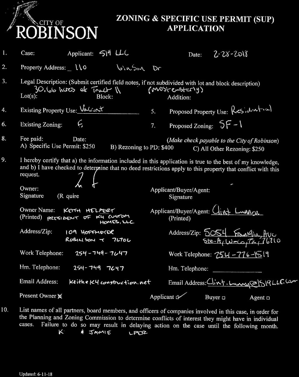
57 P&Z AGENDA ITEM MEMORANDUM DEPT./DIVISION SUBMISSION & REVIEW: Justin French, Director of Planning and Development Regular Agenda Item Date Submitted: 1/11/19 Meeting Date: 1/17/19 Agenda Item #8 ITEM DESCRIPTION: PUBLIC HEARING: Conduct a public hearing and consider a recommendation to the Robinson City Council regarding the application of Keith Helpert on behalf of K4 Custom Homes, LLC requesting a zoning change from RE Rural Estate to SF-1 Single Family Residential on a portion of Tract 11 of the M. Martinez Survey, being approximately acres approximately addressed at 1104 S. Robinson Drive. STAFF RECOMMENDATION: The Future Land Use (FLU) Plan within the Community Visions 2034 Comprehensive Plan designates the subject site as Low Density Residential with a target density no greater than four dwelling units per acre. The requested zoning and the developer s plan for 40 single family residences (1.3 dwelling units per acre) is consistent with the City s Comprehensive Plan. ITEM SUMMARY: The applicant requests this rezoning in order to develop 40 single family residences at 1.3 dwelling units per acre. The applicant also intends to develop his adjacent parcels along S. Robinson Drive (Hwy 77) for commercial uses. FISCAL IMPACT: N/A EXISTING CONDITIONS: The property is presently undeveloped and located south of the neighborhood duplexes recorded as Terrace Estates Addition and in the 2-F Two-family District. The site has access into Terrace Estates Addition from the southern end of Jennifer Drive, while also having future access to Robinson Drive via a proposed street. To the west is vacant (developable) land that the applicant also owns and proposes to rezone to C-2 Commercial with the next agenda item. Properties to the south include vacant (developable) land zoned R/O Retail Office and low density residential in the RE Rural Estate District and in the South Hall Addition which is zoned SF-1 Single Family Residential. Property to the east is also zoned RE Rural, it is vacant, and it has significant stormwater conveying through the property into and around the South Hall Addition.
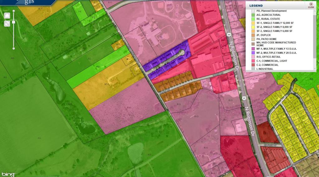
58 Adequate access to water and fire protection should be achievable with potential connection to 6- inch water mains along Robinson Drive, in Jennifer Drive right-of-way, and via off-site easement in the South Hall Addition. Sanitary sewer connections are similarly available; however, additional study is necessary to determine adequate sanitary sewer capacity. PROPERTY OWNER LETTERS: At the time of this report, staff has not received any returned notices on the requested SF-1 zoning from the surrounding property owners located within 200 feet of the subject site. ATTACHMENTS: Zoning Application Property Location Map Future Land Use Plan Current Zoning Map Photos of Subject & Surrounding Uses Applicant s Notification ISD Notification Surrounding Property Owner Notification Property Owners List Returned Notices Public Notice Draft Ordinance RE District Standards SF-1 District Standards Applicant s Rezoning Exhibit
59
60
61
62


63 Photos of Subject Site and Surrounding Uses View east at subject site from Cathy Drive. View north at subject site from Oakwood Terrace. Views east from Hwy 77 at neighboring residence facing Hwy 77 and proposed entrance to subject site.
64 NOTICE OF PUBLIC HEARING CASE: Z December 28, 2018 K4 Custom Homes, LLC Attn: Keith Helpert 109 Hoffmeyer Lane Robinson, TX The City of Robinson has received your request for a zoning change from RE Rural Estate to SF-1 Single Family Residential on a portion of Tract 11 of the M. Martinez Survey, being approximately acres approximately addressed at 1104 S. Robinson Drive. NOTICE OF HEARING BEFORE PLANNING AND ZONING COMMISSION Notice is hereby given that a public hearing will be held before the Planning and Zoning Commission of the City of Robinson on Thursday, the 17th day of January 2019, in the Council Chambers, 111 W. Lyndale Drive, at 6:00 p.m., regarding this requested zoning change. The Planning and Zoning Commission will forward a recommendation to the City Council. NOTICE OF HEARING BEFORE CITY COUNCIL Notice is hereby given that a public hearing will be held by the City Council of the City of Robinson on Tuesday, the 5th day of February 2019, in the Council Chambers, 111 W. Lyndale Drive, at 6:00 p.m., regarding this requested zoning change. For more information on the Comprehensive Plan, its land use classifications and its role in the Planning and Zoning process, you may contact the Department of Planning and Development at , or at 111 W. Lyndale Drive. Sincerely, Justin French, AICP Director of Planning and Development City of Robinson 111 W. Lyndale Drive Robinson, TX j.french@robinsontexas.org
65 NOTICE OF PUBLIC HEARING CASE: Z December 28, 2018 Dear Dr. Michael Hope: The City of Robinson has received the request made by Keith Helpert on behalf of K4 Custom Homes, LLC for a zoning change from RE Rural Estate to SF-1 Single Family Residential on a portion of Tract 11 of the M. Martinez Survey, being approximately acres approximately addressed at 1104 S. Robinson Drive. The developer proposes 41 single family residences. NOTICE OF HEARING BEFORE PLANNING AND ZONING COMMISSION Notice is hereby given that a public hearing will be held before the Planning and Zoning Commission of the City of Robinson on Thursday, the 17th day of January 2019, in the Council Chambers, 111 W. Lyndale Drive, at 6:00 p.m., regarding this requested zoning change. The Planning and Zoning Commission will forward a recommendation to the City Council. NOTICE OF HEARING BEFORE CITY COUNCIL Notice is hereby given that a public hearing will be held by the City Council of the City of Robinson on Tuesday, the 5th day of February 2019, in the Council Chambers, 111 W. Lyndale Drive, at 6:00 p.m., regarding this requested zoning change. This notice is provided in accordance with Section (c-1) of the Texas Local Government Code. This is notice of the public hearings, at which any interested persons will be given an opportunity to be heard. In hearing this matter, the Planning and Zoning Commission and City Council may approve the request as submitted, may approve an amended request, or may deny the request. For more information on the Comprehensive Plan, its land use classifications and its role in the Planning and Zoning process, you may contact the Department of Planning and Development at , or at 111 W. Lyndale Drive. Sincerely, Justin French, AICP Director of Planning and Development City of Robinson 111 W. Lyndale Drive Robinson, TX j.french@robinsontexas.org Please circle one and return to the City of Robinson with explanation. 1. In favor 2. Opposed 3. Neutral Name: Address: Explanation/Comments:
66 NOTICE OF PUBLIC HEARING CASE: Z December 28, 2018 Dear Sir or Madam: The City of Robinson has received the request made by Keith Helpert on behalf of K4 Custom Homes, LLC for a zoning change from RE Rural Estate to SF-1 Single Family Residential on a portion of Tract 11 of the M. Martinez Survey, being approximately acres approximately addressed at 1104 S. Robinson Drive. NOTICE OF HEARING BEFORE PLANNING AND ZONING COMMISSION Notice is hereby given that a public hearing will be held before the Planning and Zoning Commission of the City of Robinson on Thursday, the 17th day of January 2019, in the Council Chambers, 111 W. Lyndale Drive, at 6:00 p.m., regarding this requested zoning change. The Planning and Zoning Commission will forward a recommendation to the City Council. NOTICE OF HEARING BEFORE CITY COUNCIL Notice is hereby given that a public hearing will be held by the City Council of the City of Robinson on Tuesday, the 5th day of February 2019, in the Council Chambers, 111 W. Lyndale Drive, at 6:00 p.m., regarding this requested zoning change. According to City Tax Records, you are the owner of property which is located within two hundred (200) feet of the area of the requested zoning change. This is notice of the public hearings, at which any interested persons will be given an opportunity to be heard. In hearing this matter, the Planning and Zoning Commission and City Council may approve the request as submitted, may approve an amended request, or may deny the request. For more information on the Comprehensive Plan, its land use classifications and its role in the Planning and Zoning process, you may contact the Department of Planning and Development at , or at 111 W. Lyndale Drive. Sincerely, Justin French, AICP Director of Planning and Development City of Robinson 111 W. Lyndale Drive Robinson, TX j.french@robinsontexas.org Please circle one and return to the City of Robinson with explanation. 1. In favor 2. Opposed 3. Neutral Name: Address: Explanation/Comments:
67 Address Owner Name Mailing Address City State Zip Code Property ID 200 Kettler Dr Frink Attila IRA # Community Bank & Trust Trustee PO Box 2303 Waco TX Kettler Dr Mikki Roberts 510 Casa Del Rancho Rd Lorena TX Kettler Dr Frink Attila IRA # Community Bank & Trust Trustee P.O. Box 2303 Waco TX Kettler Dr Howard Tucker C/O Kelli Vann 400 Brint Ave. Waco TX Kettle Dr Judith Tucker C/O Kelli Vann 400 Brint Ave. Waco TX Kettler Dr Lane Price Creek Bend Dr. Woodway TX Kettler Dr Ben Burk Jr. 318 HCR 1414 Blum TX Kettler Dr Ben Burk Jr. 318 HCR 1414 Blum TX Kettler Dr Ben Burk Jr. 318 HCR 1414 Blum TX Kettler Dr Ben Burk Jr. 318 HCR 1414 Blum TX Kettler Dr Arlene Wegwerth 235 Kettler Dr. Robinson TX Jennifer Dr Tommie Lugwig 9402 Spring Ridge Cir. Waco TX Jennifer Dr Tommie Lugwig 9402 Spring Ridge Cir. Waco TX Jennifer Dr Tommie Lugwig 9402 Spring Ridge Cir. Waco TX Vacant John Fugate P.O. Box 400 Lorena TX Cline Rd-Vacant John & Dorie Fugate P.O. Box 400 Lorena TX Cline Rd Willis Osgood ETUX 1302 Wren Dr Robinson TX Vacant Elizabeth Osgood 1302 Wren Dr Robinson TX E. Moonlight Dr. Wesley Hughes ETUX 607 E. Moonlight Dr. Robinson TX Ivan Rd. Darwin Sowders 930 Ivan Rd. Waco TX Lux Drive Davide R. Broden ETUX 821 Lux Drive Robinson TX Brint Ln. Charles & Alma Cox 700 Brint Ln. Robinson TX Brint Ln. Charles Mott 620 Brint Ln. Robinson TX Brint Ln. Ricardo Lopez 619 Brint Ln. Robinson TX Brint Ln. Matthew James Lane 618 Brint Ln. Robinson TX Brint Ln. Mark Hopkins ETUX 614 Brint Ln. Robinson TX Brint Ln. Gail Walker Baird C/O Robert Baird & Charles Baird 610 Brint Ln. Robinson TX Brint Ln. Robert & Amber Arnold 606 Brint Ln. Robinson TX Brint Ln. Larry Mankey 602 Brint Ln. Robinson TX Brint Ln. Alfonso & Donna Sanchez 520 Brint Ln. Waco TX Brint Ln. Renee I. Randolph 304 Kayla Street Troy TX S. Robinson Dr. Sharon Thurmond 1104 S. Robinson Dr. Robinson TX S. Robinson Dr. Kirk Helpert ETUX 1110 S. Robinson Dr. Robinson TX S. Robinson Dr. Walter Dick Kettler 1108 S. Robinson Dr. Robinson TX Vacant Walter Dick Kettler Robinson TX Vacant Richard King 1106 S. Robinson Dr. Robinson TX S. Robinson Dr. Richard King 1106 S. Robinson Dr. Robinson TX S. Robinson Dr. David A. Franks ETUX 1206 S. Robinson Dr. Robinson TX Applicants 109 Hoffmeyer Ln. Keith Helpert 109 Hoffmeyer Ln. Robinson TX W. Lyndale Ave Dr. Michael Hope 500 W. Lyndale Ave. Robinson TX 76706

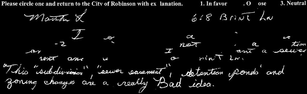

68
69 PUBLIC NOTICE The City of Robinson Planning and Zoning Commission will meet and conduct a Public Hearing on Thursday January 17, 2019, at 6:00 p.m. in the Council Chambers at City Hall, 111 W. Lyndale Drive, Robinson, Texas, to consider the following. Application of Keith Helpert on behalf of K4 Custom Homes, LLC requesting a zoning change from RE Rural Estate to SF-1 Single Family Residential on a portion of Tract 11 of the M. Martinez Survey, being approximately acres approximately addressed at 1104 S. Robinson Drive. The Robinson City Council will conduct a Public Hearing and consider the recommendations of the Planning and Zoning Commission regarding the above matters on Tuesday February 5, 2019 at 6:00 p.m. at the same location. Jana Lewellen, City Secretary
70 ORDINANCE NO ORDINANCE OF THE CITY OF ROBINSON, TEXAS APPROVING A ZONING CHANGE FROM RE TO SF-1 ON PROPERTY APPROXIMATELY ADDRESSED AT 1104 S. ROBINSON DRIVE IN ROBINSON, TEXAS, BEING APPROXIMATELY ACRES LOCALLY KNOWN AS A PORTION OF A TRACT 11 OF THE M. MARTINEZ SURVEY. WHEREAS, the owner of property having the approximate address of 1104 S. Robinson Drive in Robinson, Texas, has requested that the property be re-zoned from RE Rural Estate to SF-1 Single Family Residential; and WHEREAS, the proposed zoning change is, after heavy scrutiny, compatible with the Community Visions 2034 Comprehensive Plan for the City of Robinson and in keeping with adjacent land uses, and WHEREAS, the Planning and Zoning Commission met on January 17, 2019, and recommended by a vote of. NOW THEREFORE, BE IT ORDAINED BY THE CITY COUNCIL OF THE CITY OF ROBINSON, TEXAS THAT: SECTION 1. The acre property described by metes and bounds description in Exhibit A attached hereto, having the approximate address of 1104 S. Robinson Drive in Robinson, Texas is hereby re-zoned from RE Rural Estate to SF-1 Single Family Residential. Passed this 5th day of February Bert Echterling, Mayor Attest: Jana Lewellen, City Secretary
71 Exhibit A Metes and Bounds Description BEING acres of land in the City of Robinson, McLennan County, Texas out of the Marcelino Martinez Survey, Abstract No. 24, City of Robinson, McLennan County, Texas, being part of the remaining portion of that called acre tract of land described as Tract Two in a deed to K4 Custom Homes, LLC recorded in McLennan County Clerk's Document of the Official Public Records of McLennan County, Texas, being more particularly described as follows: BEGINNING at a 3/8-inch steel rod found for the North corner of said acre tract, and this described tract; THENCE South 32 degrees 01 minutes 04 seconds East, feet along the Northeast line of said acre tract, and this described tract to a point for the East corner of said acre tract, and this described tract; THENCE along the Southeast line of said acre tract, and this described tract the following courses and distances: South 46 degrees 25 minutes 32 seconds West, feet to a 5/8-inch steel rod found for corner; South 27 degrees 40 minutes 54 seconds East, feet to a point for corner; South 59 degrees 03 minutes 06 seconds West, at feet passing a ½-inch steel rod found for reference; thence continuing along the same course for a total distance of feet to a 5/8-inch steel rod found for corner; North 31 degrees 08 minutes 59 seconds West, feet to a 5/8-inch steel rod found for corner; South 67 degrees 29 minutes 59 seconds West, feet to a ½-inch steel rod found for corner; South 58 degrees 40 minutes 11 seconds West, feet to a ½-inch steel rod found for the South corner of said acre tract, and this described tract; North 15 degrees 37 minutes 32 seconds West, feet to a ½-inch steel rod found with cap stamped 1519 SURVEYING for corner; THENCE over and across said acre tract, and along the West line of this described tract the following courses and distances: North 20 degrees 10 minutes 41 seconds West, feet to a point for corner; THENCE with a curve turning to the right with an arc length of feet, with a radius of feet, with a chord bearing of South 70 degrees 13 minutes 27 seconds West, with a chord length of feet to a point for corner;
72 THENCE with a reverse curve turning to the left with an arc length of feet, with a radius of feet, with a chord bearing of South 65 degrees 05 minutes 34 seconds West, with a chord length of feet to a point for corner; North 08 degrees 41 minutes 38 seconds West, feet to a point for corner; North 21 degrees 18 minutes 22 seconds East, feet to a ½-inch steel rod found with cap stamped 1519 SURVEYING for an angle corner of said acre tract, and this described tract; THENCE along the Northwest line of said acre tract and this described tract the following courses and distances: North 59 degrees 30 minutes 25 seconds East, feet to a ½-inch steel rod found with cap stamped 1519 SURVEYING for corner; South 31 degrees 03 minutes 16 seconds East, feet to a 5/8-inch steel rod found for corner; North 58 degrees 47 minutes 01 seconds East a distance of feet to a 3/8-inch steel rod found for corner; North 57 degrees 10 minutes 11 seconds East, feet to the POINT OF BEGINNING and containing acres of land. Bearings, distances, and acreage are grid, NAD83 State Plane Coordinate System, Texas Central Zone 4203.

73 Article 5 Permitted Uses ZONING ORDINANCE Max. Height Side Yard RE Rural Estate District GENERAL PURPOSE & DESCRIPTION The RE Rural Estate District is designed to promote and encourage a large lot single family dwelling residential environment with limited agricultural uses.. PERMITTED USES Uses permitted in the RE Rural Estate District are outlined in Article 5, Permitted Uses. HEIGHT; AREA, YARD, AND LOT COVERAGE REQUIREMENTS The requirements regulating the minimum lot size, minimum yard sizes (front, side, and rear), maximum building height (stories and feet) and maximum percent of lot coverage by buildings, as pertains to this district, shall conform with the provisions Height and Area Regulations provided in the Height and Area Regulations table for the RE Zoning RE Rural Estate District District. Not to exceed 35 ft. Interior Lot Street Side Rear Yard Front Yard Lot Size Lot Depth Lot Width Dwelling Area Building Coverage Max. 15 ft. minimum 15 ft. minimum 20 ft. minimum 25 ft. minimum 1 acre 120 ft. minimum 100 ft. minimum 1,600 sq. ft. minimum 50% for rear half of lot ADDITIONAL HEIGHT Cooling towers, roof gables, chimneys and vent stacks may extend for an additional height not to exceed forty feet (40') above the average grade line of the building. Water stand pipes and tanks, church steeples, domes, and spires, school buildings, and institutional buildings may be erected to exceed two and a half (2-1/2) stories in height, provided that one (1) additional foot shall be added to the front yards for each foot that such structures exceed two and a half (2-1/2) stories. PARKING REGULATIONS C. Single Family Dwelling Unit - Two (2) enclosed spaces (garage) on the same lot as the main structure D. See Section 11.4, Off-Street Parking and Loading Regulations. Page 63 CITY OF ROBINSON, TEXAS
74 Article 5 Permitted Uses ZONING ORDINANCE Max. Height Side Yard Interior Lot Street Side Rear Yard Front Yard Lot Size Lot Depth SF-1 - Single Family Residential District GENERAL PURPOSE & DESCRIPTION The SF-1, Single Family Residential District will provide for development of single-family detached dwelling units on lots of not less than twelve thousand (12,000) square feet. Other uses, such as religious and educational facilities, and open spaces, may be provided to maintain a balanced, orderly, convenient and attractive residential area. PERMITTED USES Uses permitted in SF-1 District are outlined in Article 5, Permitted Uses. HEIGHT; AREA, YARD, AND LOT COVERAGE REQUIREMENTS The requirements regulating the minimum lot size, minimum yard sizes (front, side, and rear), maximum building height (stories and feet) and maximum percent of lot coverage by buildings, as pertains to this Height and Area Regulations SF-1 District Not to exceed 35 ft. 10 ft. min. one side & 15 ft. min. total both sides 15 ft. minimum 10 ft. minimum 25 ft. minimum 12,000 sq. ft. minimum 120 ft. minimum district, shall conform with the provisions provided in the Height and Area Regulations table for the SF-1 Zoning District. ADDITIONAL HEIGHT Lot Width 100 ft. minimum Cooling towers, roof gables, chimneys Dwelling Area 1,800 sq. ft. minimum and vent stacks may extend for an additional height not to exceed forty feet Building Coverage 50% of lot area max. (40') above the average grade line of the Impervious Coverage 60% of lot area max. building. Water stand pipes and tanks, church steeples, domes, and spires, school buildings, and institutional buildings may be erected to exceed two and a half (2-1/2) stories in height, provided that one (1) additional foot shall be added to the front yards for each foot that such structures exceed two and a half (2-1/2) stories. PARKING REGULATIONS A. Single Family Dwelling Unit - Two (2) enclosed spaces (garage) on the same lot as the main structure B. See Section 11.4, Off-Street Parking and Loading Regulations. Page 64 CITY OF ROBINSON, TEXAS
75
76 P&Z AGENDA ITEM MEMORANDUM DEPT./DIVISION SUBMISSION & REVIEW: Justin French, Director of Planning and Development Regular Agenda Item Date Submitted: 1/11/19 Meeting Date: 1/17/19 Agenda Item #9 ITEM DESCRIPTION: PUBLIC HEARING: Conduct a public hearing and consider a recommendation to the Robinson City Council regarding the application of Keith Helpert on behalf of K4 Custom Homes, LLC requesting a zoning change from R/O Retail/Office and RE Rural Estate to C-2 Commercial on Tracts 16, 18, 20, and a portion of Tract 11 of the M. Martinez Survey, being approximately 6.27 acres approximately addressed at 1010, 1060, 1104, and 1154 S. Robinson Drive, and an amendment to the Future Land Use Plan within the Community Visions 2034 Comprehensive Plan. STAFF RECOMMENDATION: The Future Land Use (FLU) Plan within the Community Visions 2034 Comprehensive Plan designates Tracts 18 and 20 as Commercial, while Tract 16 and the portion of Tract 11 are designated for Low Density Residential. The applicant s requested C-2 zoning is consistent with the Commercial land use category and not consistent with the Low- Density Residential category. Therefore, the requesting rezoning is accompanied by a request to amend the Future Land Use Plan in the Community Visions Comprehensive Plan. The proposed Commercial land use designation is supported by the plan in that it is located along Highway 77 and Medium Density Residential (Terrace Estates Addition). The Commercial land use category designates areas for low and mid-rise office development providing professional, financial, medical, corporate offices and major employment centers, and other office services to residents. It also designates areas for most retail, commercial, auto-related, and storage-related uses such as sales, restaurants, grocery stores, auto dealerships with complete servicing facilities, building material sales, light manufacturing, heavy machinery sales and small-scale office/warehouses. ITEM SUMMARY: The applicant requests this rezoning in order to develop parcels along S. Robinson Drive (Hwy 77) for potential C-2 commercial uses. FISCAL IMPACT: N/A EXISTING CONDITIONS: The property is presently undeveloped and located west and southwest of the neighborhood duplexes recorded as Terrace Estates Addition and in the 2-F
77 Two-family District. The sites have frontage to Robinson Drive (Hwy 77), Kettler Drive, Cathy Drive, Oakwood Terrance, and a proposed street to be constructed for the applicant s residential development discussed in the previous agenda item. Properties to the south include vacant (developable) land zoned R/O Retail Office and low density residential in the RE Rural Estate District. Property adjacent and to the north includes a nonconforming single family residence in the R/O District that faces and is addressed off S. Robinson Drive (Hwy 77). Adequate access to water and fire protection should be achievable with potential connection to 6- inch water mains along Robinson Drive. Sanitary sewer connections are similarly available; however, additional study is necessary to determine adequate sanitary sewer capacity. The applicant intends to manage the conveyance of stormwater with the use of detention ponds. PROPERTY OWNER LETTERS: At the time of this report, staff has not received any returned notices in support or opposition of the requested C-2 zoning from the surrounding property owners located within 200 feet of the subject site. However, one notice was returned that indicated the property owner was neutral to the requested rezoning. ATTACHMENTS: Zoning Application Property Location Map Future Land Use Plan Current Zoning Map Photos of Subject & Surrounding Uses Applicant s Notification Surrounding Property Owner Notification Property Owners List Notices Returned Public Notice Draft Ordinance Comparison of Allowed Uses R/O District Standards C-1 District Standards C-2 District Standards Applicant s Rezoning Exhibit

78
79
80
81


82 Photos of Subject Site and Surrounding Uses View east from Cathy Drive at adjacent property. View north from Kettler Drive at portion of subject site. View east at neighboring residence facing Hwy 77. View west across Highway 77 from subject site.
83 NOTICE OF PUBLIC HEARING CASE: Z December 28, 2018 K4 Custom Homes, LLC Attn: Keith Helpert 109 Hoffmeyer Lane Robinson, TX The City of Robinson has received your request for a zoning change from R/O Retail/Office and RE Rural Estate to C-2 Commercial on Tracts 16, 18, 20, and a portion of Tract 11 of the M. Martinez Survey, being approximately 6.27 acres approximately addressed at 1010, 1060, 1104, and 1154 S. Robinson Drive, and an amendment to the Future Land Use Plan within the Community Visions 2034 Comprehensive Plan. NOTICE OF HEARING BEFORE PLANNING AND ZONING COMMISSION Notice is hereby given that a public hearing will be held before the Planning and Zoning Commission of the City of Robinson on Thursday, the 17th day of January 2019, in the Council Chambers, 111 W. Lyndale Drive, at 6:00 p.m., regarding this requested zoning change and amendment. The Planning and Zoning Commission will forward a recommendation to the City Council. NOTICE OF HEARING BEFORE CITY COUNCIL Notice is hereby given that a public hearing will be held by the City Council of the City of Robinson on Tuesday, the 5th day of February 2019, in the Council Chambers, 111 W. Lyndale Drive, at 6:00 p.m., regarding this requested zoning change and amendment. For more information on the Comprehensive Plan, its land use classifications and its role in the Planning and Zoning process, you may contact the Department of Planning and Development at , or at 111 W. Lyndale Drive. Sincerely, Justin French, AICP Director of Planning and Development City of Robinson 111 W. Lyndale Drive Robinson, TX j.french@robinsontexas.org
84 NOTICE OF PUBLIC HEARING CASE: Z December 28, 2018 Dear Sir or Madam: The City of Robinson has received the request made by Keith Helpert on behalf of K4 Custom Homes, LLC for a zoning change from R/O Retail/Office and RE Rural Estate to C-2 Commercial on Tracts 16, 18, 20, and a portion of Tract 11 of the M. Martinez Survey, being approximately 6.27 acres approximately addressed at 1010, 1060, 1104, and 1154 S. Robinson Drive, and an amendment to the Future Land Use Plan within the Community Visions 2034 Comprehensive Plan. NOTICE OF HEARING BEFORE PLANNING AND ZONING COMMISSION Notice is hereby given that a public hearing will be held before the Planning and Zoning Commission of the City of Robinson on Thursday, the 17th day of January 2019, in the Council Chambers, 111 W. Lyndale Drive, at 6:00 p.m., regarding this requested zoning change and amendment. The Planning and Zoning Commission will forward a recommendation to the City Council. NOTICE OF HEARING BEFORE CITY COUNCIL Notice is hereby given that a public hearing will be held by the City Council of the City of Robinson on Tuesday, the 5th day of February 2019, in the Council Chambers, 111 W. Lyndale Drive, at 6:00 p.m., regarding this requested zoning change and amendment. According to City Tax Records, you are the owner of property which is located within two hundred (200) feet of the area of the requested zoning change. This is notice of the public hearings, at which any interested persons will be given an opportunity to be heard. In hearing this matter, the Planning and Zoning Commission and City Council may approve the request as submitted, may approve an amended request, or may deny the request. For more information on the Comprehensive Plan, its land use classifications and its role in the Planning and Zoning process, you may contact the Department of Planning and Development at , or at 111 W. Lyndale Drive. Sincerely, Justin French, AICP Director of Planning and Development City of Robinson 111 W. Lyndale Drive Robinson, TX j.french@robinsontexas.org Please circle one and return to the City of Robinson with explanation. 1. In favor 2. Opposed 3. Neutral Name: Address: Explanation/Comments:
85 Address Owner Name Mailing Address City State Zip Code Property ID 1109 S. Robinson Dr. Toby Gill 1109 S. R obinson Dr. Waco TX S. Robinson Dr. Edmond & Willie Cromer 1107 S. Robinson Dr. Waco TX S. Robinson Dr. William Thompson 1026 S. Old Robinson Rd. Robinson TX S. Robinson Dr. Mary Lathern 1103 S. Robinson Dr. Waco TX S. Robinson Dr. Garland Emmons Waco TX S. Robinson Dr. Garland Emmons 1009 S. Robinson Dr. Robinson TX Vacant Richard King 1106 S. Robinson Dr. Robinson TX S. Robinson Dr. Richard King 1106 S. Robinson Dr. Robinson TX S. Robinson Dr. David A. ETUX Franks 1206 S. Robinson Dr. Robinson TX Kettler Dr. #203 Mikki Roberts 510 Casa Del Rancho Rd Lorena TX Kettler Dr. #206 Frink Attila IRA # Community Bank & Trust Trustee P. O. Box 2303 Waco TX Kettler Dr. #202 Frink Attila IRA # Community Bank & Trust Trustee P. O. Box 2303 Waco TX Sams Dr. #203 Danny & Nelma Webb 1221 Harris Creek Rd. McGregor TX Sams Dr. #207 Danny & Nelma Webb 1221 Harris Creek Rd. McGregor TX Sams Dr. #202 Frink Family Trust 2500 Pebble Dr. Granbury TX Cathy Dr. #202 Jerome & Kathy Whipple 1405 Kempner Park Robinson TX Cathy Dr. #206 Jerome & Kathy Whipple 1405 Kempner Park Robinson TX S. Robinson Dr. George Stillwagon 479 Dal Paso Robinson TX S. Robinson Dr. Amanda Bright 1000 S. Robinson Dr. Robinson TX S. Robinson Dr. State of Texas Right of Way Waco Walter Dick Kettler Etux 1108 S. Robinson Dr. Robinson TX S. Robinson Dr. Lynda Cargill Broadway Et Vir 1100 S. Robinson Drive Robinson TX S. Robinson Dr. Kelly Paul Ewing 542 Jason Street Waco TX Cathy Dr. Reverchon Partners IV Ltd PO Box 1328 Hewitt TX Kettler Dr. Howard C. Tucker Etux %Kelli Vann 400 Brint Lane Waco TX Applicants 109 Hoffmeyer Ln Keith Helpert 109 Hoffmeyer Ln Robinson TX 76706


86
87 PUBLIC NOTICE The City of Robinson Planning and Zoning Commission will meet and conduct a Public Hearing on Thursday January 17, 2019, at 6:00 p.m. in the Council Chambers at City Hall, 111 W. Lyndale Drive, Robinson, Texas, to consider the following. Application of Keith Helpert on behalf of K4 Custom Homes, LLC requesting a zoning change from R/O Retail/Office and RE Rural Estate to C-2 Commercial on Tracts 16, 18, 20, and a portion of Tract 11 of the M. Martinez Survey, being approximately 6.27 acres approximately addressed at 1010, 1060, 1104, and 1154 S. Robinson Drive, and an amendment to the Future Land Use Plan within the Community Visions 2034 Comprehensive Plan. The Robinson City Council will conduct a Public Hearing and consider the recommendations of the Planning and Zoning Commission regarding the above matters on Tuesday February 5, 2019 at 6:00 p.m. at the same location. Jana Lewellen, City Secretary
88 ORDINANCE NO ORDINANCE OF THE CITY OF ROBINSON, TEXAS APPROVING A ZONING CHANGE FROM R/O and RE TO C-2 ON PROPERTY APPROXIMATELY ADDRESSED AT 1010, 1060, 1104, AND 1154 S. ROBINSON DRIVE IN ROBINSON, TEXAS, BEING APPROXIMATELY 6.27 ACRES LOCALLY KNOWN AS TRACTS 16, 18, 20, AND A PORTION OF TRACT 11 OF THE M. MARTINEZ SURVEY, AND APPROVING AN AMENDMENT TO THE FUTURE LAND USE PLAN WITHIN THE COMMUNITY VISIONS 2034 COMPREHENSIVE PLAN. WHEREAS, the owner of property having the approximate addresses of 1010, 1060, 1104, and 1154 S. Robinson Drive in Robinson, Texas, has requested that the property be re-zoned from R/O Retail/Office and RE Rural Estate to C-2 Commercial; and WHEREAS, an amendment to the Community Visions 2034 Comprehensive Plan for the City of Robinson is proposed to change the Future Land Use designation for the property from Low Density Residential to Commercial, so the proposed zoning is compatible, and WHEREAS, the Planning and Zoning Commission met on January 17, 2019, and recommended by a vote of. NOW THEREFORE, BE IT ORDAINED BY THE CITY COUNCIL OF THE CITY OF ROBINSON, TEXAS THAT: SECTION 1. The 6.27-acre property consisting of Tracts 16, 18, 20, and the portion of Tract 11 of the M. Martinez Survey described by metes and bounds description in Exhibit A attached hereto, having the approximate address of 1010, 1060, 1104, and 1154 S. Robinson Drive in Robinson, Texas is hereby redesignated from Low Density Residential and Commercial to entirely Commercial.
89 SECTION 2. The 6.27-acre property consisting of Tracts 16, 18, 20, and the portion of Tract 11 of the M. Martinez Survey described by metes and bounds description in Exhibit A attached hereto, having the approximate address of 1010, 1060, 1104, and 1154 S. Robinson Drive in Robinson, Texas is hereby re-zoned from R/O Retail/Office and RE Rural Estate to C-2 Commercial. Passed this 5th day of February Bert Echterling, Mayor Attest: Jana Lewellen, City Secretary
90 Exhibit A Metes and Bounds Description of Tract 11 Portion BEING acres of land in the City of Robinson, McLennan County, Texas out of the Marcelino Martinez Survey, Abstract No. 24, City of Robinson, McLennan County, Texas, being part of the remaining portion of that called acre tract of land described as Tract Two in a deed to K4 Custom Homes, LLC recorded in McLennan County Clerk's Document of the Official Public Records of McLennan County, Texas, being more particularly described as follows: BEGINNING at an aluminum TxDOT right-of-way monument found for the South corner of the remaining portion of said acre tract and this described tract, said point being located in the Northeast line of S. Robinson Drive; THENCE North 11 degrees 27 minutes 17 seconds West, feet along the common line between said acre tract and S. Robinson Drive to an aluminum TxDOT right-of-way monument found for the East corner of the remaining portion of said acre tract, and this described tract; THENCE along the Northwest line of said acre tract and this described tract the following courses and distances: North 67 degrees 05 minutes 45 seconds East, feet to a ¾-inch steel rod found for corner; North 11 degrees 21 minutes 40 seconds West, feet to a 5/8-inch steel rod found for corner; North 78 degrees 34 minutes 42 seconds East, feet to a point for corner; North 11 degrees 25 minutes 48 seconds West, feet to a 5/8-inch steel rod found for corner; North 78 degrees 25 minutes 26 seconds East, feet to a ½-inch steel rod found with cap stamped 1519 SURVEYING for corner; THENCE over and across said acre tract, and along Northeast line of this described tract the following courses and distances: South 21 degrees 18 minutes 22 seconds West, feet to a point for corner; South 08 degrees 41 minutes 38 seconds East, feet to a point for corner;
91 THENCE with a curve turning to the right with an arc length of feet, with a radius of feet, with a chord bearing of North 65 degrees 05 minutes 34 seconds E, with a chord length of feet to a point for corner; THENCE with a reverse curve turning to the left with an arc length of feet, with a radius of feet, with a chord bearing of North 70 degrees 13 minutes 27 seconds E, with a chord length of feet to a point for corner; South 20 degrees 10 minutes 41 seconds East, feet to a ½-inch steel rod found with cap stamped 1519 SURVEYING for corner; THENCE along the Southeast line of said acre tract, and this described tract the following courses and distances: South 59 degrees 18 minutes 14 seconds West, feet to a ½-inch steel rod found with cap stamped 1519 SURVEYING for corner; South 55 degrees 24 minutes 30 seconds West, feet to the POINT OF BEGINNING and containing acres of land. Bearings, distances, and acreage are gird, NAD83 State Plane Coordinate System, Texas Central Zone 4203.
92 Comparison of Allowed Uses Land Use R/O District C-1 District C-2 District P = Permitted Use, S = Specific Use Permit Required, X = Prohibited Use Residential Uses Assisted Living (including Independent Living) P X X Community Care Facility P P P Institutional and Public Uses Airport Landing Field, Public X X S Athletic Stadium or Field, Public P P P Cemetery S P P Church P P P Civic Center P P P Community Center P P P Day Care or Child Care Center P P P Fairgrounds X P P Halfway House X P P Library, Public P P P Mausoleum S P P Public or Municipally Owned Facility or Uses P P P Park or Playground, Public P P P Utilities, Public and Private P P P Educational Uses College or University X S P School, Private Boarding X S P School, Business or Trade S S P
93 Comparison of Allowed Uses Land Use R/O District C-1 District C-2 District School, Institutional, Rehabilitation Training S P P School, Parochial or Private P P P School, Public, Primary or Secondary P P P Automotive, Communication and Transportation Uses Airport Landing Field, Private X X S Auto Leasing or Rental X P P ATV Sales, New X X S ATV Sales and/or Service, Used X X S Auto Parts Sales, Enclosed X P P Auto Parking Lot X X P Auto Repair, Major X X S Auto Repair, Minor X S S Auto Sales, New X X P Auto Sales, Used X X S Auto Sales, Vintage X X P Auto Service Station X S S Auto, Boat, Trailer, RV and/or Truck Storage X X S Boat Sales, New X X P Boat Sales, Used and Repair X X S Fuel/Natural Resource Dispensing Station S S P Heliport S S S Helistop S S S Motorcycle Sales and Service, New X X P
94 Comparison of Allowed Uses Land Use R/O District C-1 District C-2 District Motorcycle Sales and Service, Used X X S Parking Lot, Truck X X S Recreation Vehicle Sales, New X X S Recreation Vehicle Sales and/or Service, Used X X S Terminal, Bus X X P Terminal, Railroad X X S Trailer Sales or Rental X X P Transportation Utility Structures and Facilities X X S Travel Trailer Sales, New X X S Travel Trailer Sales and/or Service, Used X X S Towing Company Office w/out Towed Vehicle Storage Yard X X P Truck and Bus Rental or Leasing X X S Truck Sales, Heavy X X S Office and Professional Uses Armed Services Recruitment Center P P P Bank, Savings & Loan/Credit Union P P P Office Center P P P Office, Professional, General P P P Studios, Professional P P P Retail, Services and Commercial Uses Animal Grooming S S P Animal Processing X X S Beauty, Barber or Other Personal Care Shop P P P
95 Comparison of Allowed Uses Land Use R/O District C-1 District C-2 District Bed and Breakfast, Hosted P P P Bed and Breakfast, Un-hosted (Commercial) P P P Bed and Breakfast, Un-hosted (Residential) P P P Brew-Pub S S S Building Materials and Hardware Sales, Enclosed P P P Building Materials and Hardware Sales, Outside Storage X S P Carwash, Self-Serve S S P Const. Equipment Rental and/or Sales X X S Carwash, Full-Serve S S P Const. Field Office P P P Consignment/Used Merchandise Store, Indoor X P P Consignment Store/Used Merchandise, Outdoor Activity X S P Convenience Store w/ Gas Pumps S S P Convenience Store w/out Gas Pumps P P P Dry Cleaning, Pick-up/Drop-off P P P Dry Cleaning, Small Shop X P P Feed Store X S P Fraternal Organization, Lodge or Civic Club P P P Hotel, Motel X S S Kennel, w/out Outside Pens X X S Key/Locksmith Shop X P P Kiosk P P P Laundromat, Self-Serve X P P
96 Comparison of Allowed Uses Land Use R/O District C-1 District C-2 District Massage Establishment S P P Mortuary or Funeral Parlor S S S Park and Ride S S P Nursery, Retail w/ Outside Storage X P P Paint Shop X S P Pawn Shop X S P Pet Shop X P P Produce Stand X S S Produce Sales (Inside) X S P Recycling Collection Center X X P Restaurant, Café or Cafeteria S P P Restaurant, Drive-In S P P Restaurants, Incidental to Main Use X P P Retail or Service Incidental P P P Retail Sales, General P P P Service and Repair Shops, General P P P Shopping Center P P P Small Engine & Appliance Repair X X P Tattoo Parlor/Body Piercing Studio X S S Tattoo Parlor, Cosmetic S P P Taxidermy Shop X S S Veterinarian Clinic, w/out Outside Pens P P P Veterinarian Clinic, w/ Outside Pens X S P
97 Comparison of Allowed Uses Land Use R/O District C-1 District C-2 District Wine Tasting Facility (Winery) S S S Health Club, Weight and Aerobic Center S P P Amusement and Entertainment Uses Amusement (Video) Arcade X X P Amusement Center, Commercial, Enclosed X X P Amusement Center, Commercial, Outdoors X X S Athletic Stadium or Field, Private X X S Club, Private w/ Alcoholic Beverage Sales S S S Dance Hall X S S Park and Recreation Facility, Private S S S Raceway, Motor X X S Recreation Center, Private X S P Stable, Private X X P Theater, Indoor X P P Theater, Outdoor X X S Medical Uses Clinic or Office, Medical P P P Equipment Sales, Medical Aid P P P Hospital S P P Hospital for Insane/Narcotic Related Illnesses S S P Medical Offices, Professional P P X Sanitarium X S P Laboratory, Medical S P P
98 Comparison of Allowed Uses Land Use R/O District C-1 District C-2 District Industrial and Commercial Uses Bakery and Confectionery Works, Commercial S P P Bottling Works X X S Brick/Stone Company, Sales, Enclosed X X S Building Materials and Lumber Storage Yard & Sales X S S Commercial Engraving X S S Commercial Plant, General S S S Compressor Station (Gas Pipelines) S S S Contractors Shop or Storage Yard X S S Dairy Products X X P Distribution Center X X P Industrial Manufacturing/Fabrication/ Assembly Enclosed, Light X X P Furniture Restoration X S P Industrial Manufacturing/Fabrication/Assembly Light, Outside Storage X X S Ice Company Sales-Wholesale X X P Landscaping Service X S P Machine Shop X X P Monuments & Headstones Sales X X P Moving Company X X P Overnight Delivery & Service Center X S P Paper & Chemical Supply X X P Petroleum Extraction (Oil & Gas Mining) S S S
99 Comparison of Allowed Uses Land Use R/O District C-1 District C-2 District Plumbing Shop & Related Services X S P Portable Building Sales X X P Private Utility Service Yard X X P Recycling Plant X X S Laboratories, Research and Scientific X X P Roofing & Siding Supply X X S Self Service or Mini-Warehouse X S P Shooting Range, Indoor X X S Warehouse/Showroom w/ Office X S P Warehouse, Wholesale, Outside Storage X X S Wholesale Sales, Enclosed X X P Wholesale Distribution Centers X X P
100 Article 5 Permitted Uses ZONING ORDINANCE R/O Retail/Office District GENERAL PURPOSE & DESCRIPTION The R/O Retail/Office District is established to create a District for office and professional uses and for limited retail uses intended for use by residents of nearby neighborhood areas to supply day-to-day needs and personal services. Neighborhood services should be located on a major street and generally utilize a site adjacent to one or more logical neighborhood service areas. The District can be used as a transition district between more intense uses and residential uses. Permitted uses should be compatible with adjacent residential areas. USES PERMITTED Uses permitted in the R/O District as outlined in Article 5, Permitted Use Table. HEIGHT; AREA, YARD, AND LOT COVERAGE REQUIREMENTS The requirements regulating the minimum lot size, minimum yard sizes (front, side, and rear) maximum building height (stories and feet), and maximum percent of lot coverage by buildings, as pertains to this district, shall conform with the provisions provided in the Height and Area Regulations table for the R/O Zoning District. Cooling towers, roof gables, chimneys, vent stacks, or mechanical equipment rooms may project, not to exceed twelve feet (12 ) beyond maximum building height. ADDITIONAL HEIGHT Additional height will be permitted in the R/O Retail/Office District for each additional foot that a structure sets back beyond the required front setback. For each one foot of additional setback the structure will be permitted one additional foot of height; but shall not exceed a total height of sixty (60) feet. Maximum Height Side Yard Interior Side Street Side Rear Yard Front Yard Lot Size Lot Depth Lot Width Building Coverage Height and Area Regulations R/O District 35 at front setback line. Additional height permitted according to Sec (See ) 5 ft. minimum 15 ft. minimum 10 feet minimum 25 feet minimum 6,000 sq. ft. minimum 100 feet minimum 60 ft. minimum 50% maximum Page 80 CITY OF ROBINSON, TEXAS
101 Article 5 Permitted Uses ZONING ORDINANCE REDUCED YARD If the front of the building is dedicated totally to landscaping, the front or side yard adjacent to the street may be reduced by ten (10) feet. OFF STREET PARKING AND LOADING REQUIREMENTS Off street parking and loading requirements shall be provided as required by Section 11.4, Off-Street Parking and Loading Regulations. LANDSCAPING REQUIREMENTS Landscaping requirements shall be provided as required by Article 7, Landscaping Requirements. SIGN REQUIREMENTS Sign requirements shall be provided as required by Article 12, Sign Requirements. OUTDOOR LIGHTING REQUIREMENTS Outdoor lighting requirements shall be provided as required by Article 10, Outdoor Lighting Requirements. OPEN STORAGE Open storage is prohibited. REFUSE FACILITIES All refuse facilities shall be screened from view on three (3) sides from persons standing at ground level on the site or immediately adjoining property, by a masonry wall (other than cementitious fiberboard) not less than six (6) feet, nor more than eight (8) feet in height or by an enclosure within a building. Refuse containers shall have solid latching gates and shall be provided and maintained in a manner to satisfy local public health and sanitary regulations. Each refuse facility shall be located so as to provide safe and convenient pickup by refuse collection agencies. Repair to damaged walls and gates shall be completed within thirty (30) days of notification of such damage. Page 81 CITY OF ROBINSON, TEXAS

102 Article 5 Permitted Uses ZONING ORDINANCE C-1 - Light Commercial District GENERAL PURPOSE & DESCRIPTION The C-1 - Light Commercial District is established to provide locations for various types of standard general retail trade, business and service use. The shopping areas developed within a C-1 - Light Commercial District should utilize a shopping center concept and be limited to two stories in height. The C-1 - Light Commercial District and shopping areas should be located generally at the intersection of major thoroughfares and convenient to their residential trade area, with signage compatible with surrounding land use. No open storage is permitted in the C-1 - Light Commercial District. PERMITTED USES Uses permitted in the C-1 District are outlined in Article 5, Permitted Uses. HEIGHT; AREA, YARD, AND LOT COVERAGE REQUIREMENTS The requirements regulating the minimum lot size, minimum yard sizes (front, side, and rear), maximum building height (stories and feet), and maximum percent of lot coverage by buildings, as pertains to this district, shall conform with the provisions provided in the Height and Area Regulations table for the C-1 Zoning District. Cooling towers, roof gables, chimneys, vent stacks, or mechanical equipment rooms may project, not to exceed twelve feet (12 ) beyond maximum building height. ADDITIONAL HEIGHT Additional height will be permitted in the C-1 Light Commercial District for each additional foot that a structure sets back beyond the required front setback. For each one foot of additional setback the structure will be permitted one additional foot of height; but shall not exceed a total height of sixty (60) feet. Maximum Height Side Yard Interior Side Street Side Rear Yard Front Yard Lot Size Lot Depth Lot Width Building Coverage Height and Area Regulations C-1 District 40 at front setback line. Additional height permitted according to Sec ft. minimum 15 ft. minimum 25 feet minimum 25 feet minimum 6,000 sq. ft. minimum 100 ft. minimum 60 ft. minimum 50% maximum Page 82 CITY OF ROBINSON, TEXAS
City of Robinson 111 W. Lyndale, Robinson, TX Phone (254) Fax (254)
 Fax (254)") ZONING BOARD OF ADJUSTMENT MEETING AUGUST 22, 2017 City of Robinson 111 W. Lyndale, Robinson, TX 76706-5619 Phone (254) 662-1415 Fax (254) 662-1035 THE ROBINSON ZONING BOARD OF ADJUSTMENT WILL MEET ON
ZONING BOARD OF ADJUSTMENT MEETING AUGUST 22, 2017 City of Robinson 111 W. Lyndale, Robinson, TX 76706-5619 Phone (254) 662-1415 Fax (254) 662-1035 THE ROBINSON ZONING BOARD OF ADJUSTMENT WILL MEET ON
Development Plan DP13-3 (Arlington Lofts) Planning and Zoning Meeting Date: Document Being Considered: Ordinance
 Planning and Zoning Meeting Date: Document Being Considered: Ordinance") Staff Report Development Plan DP13-3 (Arlington Lofts) Planning and Zoning Meeting Date: 6-19-13 Document Being Considered: Ordinance RECOMMENDATION Following the public hearing, consider Development Plan
Staff Report Development Plan DP13-3 (Arlington Lofts) Planning and Zoning Meeting Date: 6-19-13 Document Being Considered: Ordinance RECOMMENDATION Following the public hearing, consider Development Plan
ARTICLE 5.0 SCHEDULE OF REGULATIONS
 ARTICLE 5.0 SCHEDULE OF REGULATIONS Section 5.101 Table of Dimensional Standards by District. Dimensional Standards AG AG with sewer Districts Rural Residential Business Other SF SF with sewer R-1 R-1
INFORMATION & PROCEDURES FOR CHANGE OF ZONING REQUESTS AND CONDITIONAL USE PERMITS
 INFORMATION & PROCEDURES FOR CHANGE OF ZONING REQUESTS AND CONDITIONAL USE PERMITS The applicant is strongly encouraged to attend a pre-application meeting for the project prior to submittal of a zoning
DEVELOPMENT DEPARTMENT STAFF REPORT THE PARK AT 5 TH
 DEVELOPMENT DEPARTMENT STAFF REPORT ARB Meeting Date: July 3, 2018 Item #: _PZ2018-293_ THE PARK AT 5 TH Request: Site Address: Project Name: Parcel Number: Applicant: Proposed Development: Current Zoning:
MSC Ridgewood Subdivision
 Ay' MSC 2011 12523 CERTIFICATE OF RECORD STATE OF ARKANSAS cowl, I of WHITE CERTIFY THAT THIS INSTRUMENT WAS FILED FOR RECORD AN,D IS RECORDED AS STAMPED HEREON. DATE a - 3- I The. 1: mspry) BOOK Bill
PLANNED DEVELOPMENT DISTRICT A ACRE TRACT KNOWN AS GEAN ESTATES CITY OF KELLER, TARRANT COUNTY TEXAS
 PLANNED DEVELOPMENT DISTRICT A 123.359 ACRE TRACT KNOWN AS GEAN ESTATES CITY OF KELLER, TARRANT COUNTY TEXAS A. Exhibit A Development Regulations B. Exhibit B Legal Description C. Exhibit C Conceptual
CHAPTER 26 PLANNING AND ZONING ARTICLE VII. MOBILE HOMES AND RECREATIONAL VEHICLE (RV) PARKS. Recreational Vehicle (RV) Park Development Standards
 PARKS. Recreational Vehicle (RV) Park Development Standards") CHAPTER 26 PLANNING AND ZONING ARTICLE VII. MOBILE HOMES AND RECREATIONAL VEHICLE (RV) PARKS. Section 26-VII-1. Section 26-VII-2. Section 26-VII-3. Section 26-VII-4. Section 26-VII-5. Purpose Permitted
CHAPTER 26 PLANNING AND ZONING ARTICLE VII. MOBILE HOMES AND RECREATIONAL VEHICLE (RV) PARKS. Section 26-VII-1. Section 26-VII-2. Section 26-VII-3. Section 26-VII-4. Section 26-VII-5. Purpose Permitted
PLANNED DEVELOPMENT DISTRICT STANDARDS. Cadence Site
 PLANNED DEVELOPMENT DISTRICT STANDARDS Cadence Site A Planned Development District 1. Statement of General Facts, Conditions and Objectives Property Size: Approximately 57.51 Acres York County Tax Map
ACTION FORM BRYAN CITY COUNCIL
 ACTION FORM BRYAN CITY COUNCIL DATE OF COUNCIL MEETING: July 8, 2014 DATE SUBMITTED: June 17, 2014 DEPARTMENT OF ORIGIN: Development Services SUBMITTED BY: Maggie Dalton MEETING TYPE: CLASSIFICATION: ORDINANCE:
FINAL SUBDIVISION AND LAND DEVELOPMENT PLAN CHECKLIST. Plan Name. Applicant's Name:
 TOWNSHIP OF UPPER ST. CLAIR FINAL SUBDIVISION AND LAND DEVELOPMENT PLAN CHECKLIST Date Filed Plan Name PLC Applicant's Name: Phone Filing Date for Final Application Final Plat 114.22. FINAL APPLICATION
DEVELOPMENT STANDARDS FOR RESIDENTIAL PROJECTS RESIDENTIAL BUILDING TYPES: APPROPRIATE ZONES AND DENSITIES 2-1
 2 DEVELOPMENT STANDARDS FOR RESIDENTIAL PROJECTS RESIDENTIAL BUILDING TYPES: APPROPRIATE ZONES AND DENSITIES 2-1 This Chapter presents the development standards for residential projects. Section 2.1 discusses
City of Dade City, Florida Land Development Regulations ARTICLE 5: DENSITY, INTENSITY & DIMENSIONAL STANDARDS
 City of Dade City, Florida Land Development Regulations ARTICLE 5: DENSITY, INTENSITY & DIMENSIONAL STANDARDS ADOPTED AUGUST 12, 2014 ARTICLE 5: DENSITY, INTENSITY & DIMENSIONAL STANDARDS SECTION 5.1 DIMENSIONAL
NOTICE OF THE REGULAR MEETING OF THE PLANNING & ZONING COMMISSION Tuesday, August 4, 2015 REGULAR MEETING AGENDA 6:30 PM
 NOTICE OF THE REGULAR MEETING OF THE PLANNING & ZONING COMMISSION Tuesday, August 4, 2015 Notice is hereby given of the Regular Meeting of the Planning & Zoning Commission beginning at 6:30 p.m. Tuesday,
UPPER MOUNT BETHEL TOWNSHIP NORTHAMPTON COUNTY, PENNSYLVANIA
 UPPER MOUNT BETHEL TOWNSHIP NORTHAMPTON COUNTY, PENNSYLVANIA JOINDER DEED / LOT CONSOLIDATION TOWNSHIP REVIEW PROCESS When accepting proposed Joinder Deeds / Lot Consolidations, review the Joinder Deed
SUBDIVISION APPLICATION
 SUBDIVISION APPLICATION Preliminary Plat Minor Plat Final Plat Amended Plat Applicant Name: Owner (if different from applicant) Name: Company: Company: Address: Address: City, State, Zip City, State, Zip
Proposed Overland Park Kansas Ordinance RE-1 Residential Estates Community
 18.171 RE-1 Residential Estate Community 18.171.010 Statement of intent. The zoning of property as RE-1, (Residential Estates Community, 1 dwelling unit per Gross acre density), is intended to provide
Department of Planning & Development Services
 Department of Planning & Development Services S T A F F R E P O R T February 9, 2015 CASE NO: PROJECT: EXECUTIVE SUMMARY: ZA14-154 Plat Revision for Lots 25R-1A, 25R-1B and 25R-1C, Block 1, Woodland Heights
SECTION 10.7 R-PUD (RESIDENTIAL PLANNED UNIT DEVELOPMENT) ZONE
 ZONE") Article X Zones 10-20 SECTION 10.7 R-PUD (RESIDENTIAL PLANNED UNIT DEVELOPMENT) ZONE A. PURPOSE AND INTENT: The R-PUD Residential PUD Zone is intended to provide alternative, voluntary zoning procedures
Article X Zones 10-20 SECTION 10.7 R-PUD (RESIDENTIAL PLANNED UNIT DEVELOPMENT) ZONE A. PURPOSE AND INTENT: The R-PUD Residential PUD Zone is intended to provide alternative, voluntary zoning procedures
PUD 42 - Warner Ranch PUD - Amend. 2 Item No. 4B ZONING ZON
 PUD 42 - Warner Ranch PUD - Amend. 2 Item No. 4B ZONING ZON1210-001 CASE PLANNER: Steve Hopkins REQUEST: Approval of PUD 42 - Warner Ranch PUD - Amend. 2 ZONING AT TIME OF APPLICATION: PUD 42 CURRENT USE
THE CITY OF RAYMORE, MISSOURI Single-Family Residential Zoning Districts
 THE CITY OF RAYMORE, MISSOURI Single-Family Residential Zoning Districts REGULATIONS COMMON TO ALL DISTRICTS: Uses permitted in each district include detached single-family dwellings, manufactured homes
THE AREA PLAN COMMISSION OF ST. JOSEPH COUNTY, IN AGENDA
 THE AREA PLAN COMMISSION OF ST. JOSEPH COUNTY, IN AGENDA Tuesday, June 20, 2017 Fourth-Floor Council Chambers 3:30 p.m. County-City Building, South Bend, IN PUBLIC HEARINGS: 1. Rezonings: A. A combined
PLANNED DEVELOPMENT DISTRICT A ACRE TRACT KNOWN AS GEAN ESTATES CITY OF KELLER, TARRANT COUNTY TEXAS
 PLANNED DEVELOPMENT DISTRICT A 105.026 ACRE TRACT KNOWN AS GEAN ESTATES CITY OF KELLER, TARRANT COUNTY TEXAS A. Exhibit A Development Regulations B. Exhibit B Legal Description C. Exhibit C Conceptual
Chapter RESIDENTIAL ZONING DISTRICTS
 Chapter 18.16 RESIDENTIAL ZONING DISTRICTS Sections: 18.16.010 Purpose of Chapter 18.16.020 Purpose of Residential Zoning Districts 18.16.030 Regulations for Residential Zoning Districts 18.16.040 Residential
4.2 RESIDENTIAL ZONING DISTRICTS
 4.2 RESIDENTIAL ZONING DISTRICTS A. Purpose: To define regulations and standards for each residential zoning district in the City. The following sections identify uses, regulations, and performance standards
Shawnee Woods Subdivision
 Shawnee Woods Subdivision Declaration of Restrictions WHEREAS, D & P Inc. Lakeview Development LLC, Developer, having heretofore executed a plat of Shawnee Woods, which plat was recorded on the 11 th day
 Page 1 of 8 Laguna Beach Municipal Code Up Previous Next Main Collapse Search Print No Frames Title 25 ZONING Chapter 25.10 R-1 RESIDENTIAL LOW DENSITY ZONE 25.10.002 Intent and purpose. This zone is intended
May 12, Chapter RH HILLSIDE RESIDENTIAL ZONES REGULATIONS Sections:
 May 12, 2017 Chapter 17.13 RH HILLSIDE RESIDENTIAL ZONES REGULATIONS Sections: 17.13.010 Title, intent, and description. 17.13.020 Required design review process. 17.13.030 Permitted and conditionally
CITY OF TYLER CITY COUNCIL COMMUNICATION
 CITY OF TYLER CITY COUNCIL COMMUNICATION Agenda Number: Z-2 Date: January 23, 2019 Subject: PD18-035 FAIR NANCY WOOD (2801 AND 2835 SOUTH BROADWAY AVENUE) Request that the City Council consider approving
M E M O R A N D U M. Planning and Zoning Commission. Daniel Turner, Planner I
 M E M O R A N D U M Meeting Date: April 27, 2015 Item No. E-1 To: From: Planning and Zoning Commission Daniel Turner, Planner I Subject: Consider approval of a Final Plat for Gean Estates, Phase I, a proposed
CUMBERLAND RIDGE SUBDIVISION COVENANTS, RESTRICTIONS AND CONDITIONS PHASE VI. 2 nd Draft
 CUMBERLAND RIDGE SUBDIVISION COVENANTS, RESTRICTIONS AND CONDITIONS PHASE VI 2 nd Draft 7-11-14 All restrictions, covenants and conditions set forth in the Statement of Binding Elements recorded in Deed
RESTRICTIONS PLAT RESTRICTIONS
 RESTRICTIONS WHEREAS Hewitt-Boggs Co. hereinafter called Developer. Is the owner Of land in Stow, Summit County, Ohio which it intends to develop into a single family residential community. WHEREAS, Developer
Condominium Unit Requirements.
 ARTICLE 19 CONDOMINIUM REGULATIONS Section 19.01 Purpose. The purpose of this Article is to regulate projects that divide real property under a contractual arrangement known as a condominium. New and conversion
Town of Cary, North Carolina Rezoning Staff Report 13-REZ-13 An Zou Property Town Council Meeting November 21, 2013
 Town of Cary, North Carolina Rezoning Staff Report 13-REZ-13 An Zou Property Town Council Meeting November 21, 2013 REQUEST To amend the Town of Cary Official Zoning Map by rezoning 0.63 acres located
3. Section is entitled Accessory Buildings ; limited applicability/regulation.
 MEMORANDUM DATE: October 9, 2017 TO: FROM: RE: Chairperson Hetzel, PC Commissioners, and Interim Administrator Meyer Cynthia Smith Strack, Community Development Director 6.1 Discussion: Detached Accessory
WESTMINSTER PARK SUBDIVISION
 WESTMINSTER PARK SUBDIVISION Engineering Comments: FINAL PLAT COMMENTS (should be addressed prior to submitting the FINAL PLAT for review and/or signature by the City Engineer): A. Provide all of the required
ORDINANCE NO. Be it ordained by the City Council of the City of Abilene, Texas:
 ORDINANCE NO. An ordinance repealing Chapter 23, Subpart B of the Code of the City of Abilene, Texas, entitled Mobile Homes and Vacation Travel Trailers; stating the authority; setting forth the scope
Article 26 MOBILE/MANUFACTURED /MODULAR HOME AND RECREATIONAL VEHICLE REGULATIONS ADOPTED: FEBRUARY 19, 2008 CASE NUMBER: TA ORDINANCE NO.
 Article 26 MOBILE/MANUFACTURED /MODULAR HOME AND RECREATIONAL VEHICLE REGULATIONS ADOPTED: FEBRUARY 19, 2008 CASE NUMBER: TA0802 ORDINANCE NO. 7737 Unified Development Code Grand Prairie, Texas Planning
PLANNING AND ZONING COMMISSION FEBRUARY 20, :30 P.M. PLANNING AND ZONING MEMBERS PRESENT MEMBERS ABSENT: STAFF PRESENT:
 PLANNING AND ZONING COMMISSION FEBRUARY 20, 2018 5:30 P.M. PLANNING AND ZONING MEMBERS PRESENT Chair Lester Fettig Omar Crisp Paulino Castillo Lydia Alaniz Bryant Ward Jessica Walker Jeremy Langley MEMBERS
Marion County Board of County Commissioners
 Marion County Board of County Commissioners Date: 12/2/2015 P&Z: 11/30/2015 BCC: 12/16/2015 Item Number 151210SU Type of Application Special Use Permit Request To establish a Clay Electric Co-Operative
LINCOLN COUNTY PLANNING & INSPECTIONS DEPARTMENT
 LINCOLN COUNTY PLANNING & INSPECTIONS DEPARTMENT 302 NORTH ACADEMY STREET, SUITE A, LINCOLNTON, NORTH CAROLINA 28092 704-736-8440 OFFICE 704-736-8434 INSPECTION REQUEST LINE 704-732-9010 FAX To: Board
AAAA. Planning and Zoning Staff Report Lake Shore Land Holdings, LLC CU-PH Analysis
 AAAA Planning and Zoning Staff Report Lake Shore Land Holdings, LLC CU-PH2016-28 Hearing Date: April 21, 2016 Development Services Department Applicant: BRS Architects/Cindy Huebert Staff: Kyle McCormick,
ORDINANCE NO The Town Council of the Town of Yucca Valley does ordain as follows:
 ORDINANCE NO. 141 AN ORDINANCE OF THE TOWN COUNCIL OF THE TOWN OF YUCCA VALLEY, CALIFORNIA, AMENDING TITLE 8, DIVISION 12, CHAPTER 1 RELATING TO DEFINITIONS AND TITLE 8, DIVISION 8, CHAPTER 3, RELATING
CHAPTER 2 GENERAL PROVISIONS
 CHAPTER 2 GENERAL PROVISIONS 200 ZONING DISTRICTS ESTABLISHED 201 SUPPLEMENTAL DISTRICTS ESTABLISHED 202 OFFICIAL ZONING MAP ESTABLISHED 203 DISTRICT BOUNDARY DESCRIPTION and INTERPRETATION 204 LIMITATION
Planning Commission recommends APPROVAL of the amendment to Article 4, Article 7, and Article 14 as presented by Staff on 6/19/17.
 DATE: June 20, 2017 TO: FROM: SUBJECT: Mayor and City Council Planning Director Zoning Ordinance Amendment Article 4, Article 7, and Article 14 related to accessory uses, fences, walls, and administrative
DETAILED GRADING PLAN CHECKLIST (TEARDOWN/REDEVELOPMENT)
") GENERAL DETAILED GRADING PLAN CHECKLIST (TEARDOWN/REDEVELOPMENT) ADDRESS: PERMIT #: DATE: 1. Plan is signed and sealed by an Illinois registered professional engineer including date signed and license
GENERAL DETAILED GRADING PLAN CHECKLIST (TEARDOWN/REDEVELOPMENT) ADDRESS: PERMIT #: DATE: 1. Plan is signed and sealed by an Illinois registered professional engineer including date signed and license
FREQUENTLY USED PLANNING & ZONING TERMS
 City Of Mustang FREQUENTLY USED PLANNING & ZONING TERMS Abut: Having property lines, street lines, or zoning district lines in common. Accessory Structure: A structure of secondary importance or function
1. APPLICANT: The City of Overland Park is the applicant for this request.
 8. UNIFIED DEVELOPMENT ORDINANCE AMENDMENT - ZRR 2590 - Residential Neighborhood District 1. APPLICANT: The City of Overland Park is the applicant for this request. 2. REQUESTED ACTION: The applicant is
Staff Report: Date: Applicant: Property Identification: Acreage of Request: Current Zoning of Requested Area: Requested Action: Attached:
 Staff Report: Completed by Jeff Palmer Director of Planning & Zoning Date: November 7, 2018, Updated November 20, 2018 Applicant: Greg Smith, Oberer Land Developer agent for Ronald Montgomery ET AL Property
Residential Major Subdivision Review Checklist
 Residential Major Subdivision Review Checklist Plan Submittal Requirements: 2 full sets of stamped plans Electric submittal - all plans contained in a single PDF 3 full sets if commercial kitchen or dining
Town of Cary, North Carolina Rezoning Staff Report 14-REZ-24 Indian Wells Road Properties Town Council Meeting November 20, 2014
 Town of Cary, North Carolina Rezoning Staff Report 14-REZ-24 Indian Wells Road Properties Town Council Meeting November 20, 2014 REQUEST To amend the Town of Cary Official Zoning Map by revising a condition
ARTICLE 13 CONDOMINIUM REGULATIONS
 ARTICLE 13 CONDOMINIUM REGULATIONS Section 13.01 Purpose. The purpose of this Article is to regulate projects that divide real property under a contractual arrangement known as a condominium. New and conversion
Initial Subdivision Applications Shall Include the Following:
 Initial Subdivision Applications Shall Include the Following: 1) Subdivision Application Form: completely filled out (12 copies) 2) Plat: The Plat must adhere to the requirements set forth in the Town
M E M O R A N D U M. Meeting Date: October 23, Item No. F-1. Planning and Zoning Commission. Daniel Turner, Planner I
 M E M O R A N D U M Meeting Date: October 23, 2017 Item No. F-1 To: From: Subject: Planning and Zoning Commission Daniel Turner, Planner I PUBLIC HEARING: Consider a recommendation of a of Planned Development
SECTION 822 "R-1-A" AND "R-1-AH" - SINGLE FAMILY RESIDENTIAL DISTRICTS
 SECTION 822 "R-1-A" AND "R-1-AH" - SINGLE FAMILY RESIDENTIAL DISTRICTS The "R-1-A" and "R-1-AH" Districts are intended to provide for the development of single family residential homes at urban standards
ZONING CODE DISTRICT REGULATIONS
 CHAPTER 178 ZONING CODE DISTRICT REGULATIONS 178.01 A-1 Agricultural 178.08 C-2 General Commercial 178.02 R-1 Low Density Residential 178.09 C-3 Planned Commercial 178.03 R-2 Medium Density Residential
Exhibit "A" have applied for a re-zoning and re-classification of that property from OPEN RURAL (OR) to that of a PLANNED UNIT DEVELOPMENT (PUD); and
 to that of a PLANNED UNIT DEVELOPMENT (PUD); and") I NSTR # 200632845 OR BK 61439 PGS 0728-0750 RECORDED 06/24/2066 12:25:50 PR JOHN Q. CRAWFOKD CLERK OF CIRCUIT COURT NASSAU COUNTY, FLORIDA RECORDING FEES 1.37.80 ORDINANCE NO. 2006-65 AN ORDINANCE AMENDING
I NSTR # 200632845 OR BK 61439 PGS 0728-0750 RECORDED 06/24/2066 12:25:50 PR JOHN Q. CRAWFOKD CLERK OF CIRCUIT COURT NASSAU COUNTY, FLORIDA RECORDING FEES 1.37.80 ORDINANCE NO. 2006-65 AN ORDINANCE AMENDING
EXECUTIVE SUMMARY 04/06/2017
 AGENDA ITEM #22 EXECUTIVE SUMMARY 04/06/2017 COUNCIL AGENDA SUBJECT: Discuss and consider the Second Reading of an Ordinance regarding 16-OR-006a amending the Leander Code of Ordinances, Chapter 14, Zoning,
Section 7.01 Area Regulations
 SECTION 7: AREA, YARD AND FENCE REGULATIONS Section 7.01 Area Regulations Except as hereinafter provided, no building or structure or part thereof shall be erected, altered or converted for any use permitted
AN ORDINANCE OF THE CITY OF MINNEAPOLIS. By Palmisano
 AN ORDINANCE OF THE CITY OF MINNEAPOLIS By Palmisano Amending Title 20, Chapter 520 of the Minneapolis Code of Ordinances relating to Zoning Code: Introductory Provisions. The City Council of the City
RP-2, RP-3, RP-4, AND RP-5 PLANNED RESIDENTIAL DISTRICTS
 6.10 - RP-2, RP-3, RP-4, AND RP-5 PLANNED RESIDENTIAL DISTRICTS 6.10.1 GENERAL DESCRIPTION: 6.10.1.1 The regulations established in this Section are intended to provide optional methods of land development
SECTION 820 "R-R" - RURAL RESIDENTIAL DISTRICT
 SECTION 820 "R-R" - RURAL RESIDENTIAL DISTRICT The "R-R" District is intended to create or preserve rural or very large lot residential homesites where a limited range of agricultural activities may be
RESOLUTION NO. B. The proposed amendment would not be detrimental to the public interest, health, safety, convenience, or welfare of the City; and
 RESOLUTION NO. RESOLUTION OF THE PLANNING COMMISSION OF THE CITY OF SANTA ROSA RECOMMENDING TO CITY COUNCIL REZONING TO MODIFY THE EXISTING POLICY STATEMENT AND ADOPT THE BAY VILLAGE HOMES DEVELOPMENT
Preliminary Plat/Final Plat Application
 Melissa Municipal Center 3411 Barker Avenue Melissa, Texas 75454 Phone: (972) 838-2036 Applicant: Date: Address: Phone: Contact: Fax: E-mail: Propose Addition Name: Acres: Existing Zoning: Propose Zoning:
Town of Cary, North Carolina Rezoning Staff Report 12-REZ-27 Morris Branch Town Council Public Hearing January 24, 2013
 Town of Cary, North Carolina Rezoning Staff Report 12-REZ-27 Morris Branch Town Council Public Hearing January 24, 2013 REQUEST To amend the Town of Cary Official Zoning Map to rezone approximately 9.0
PUD Ordinance - Cascade Lakes Plat #10 of 1995
 PUD Ordinance - Cascade Lakes Plat #10 of 1995 CASCADE CHARTER TOWNSHIP Ordinance #10 of 1995 AN ORDINANCE TO AMEND THE CASCADE CHARTER TOWNSHIP ZONING ORDINANCE AND ZONING MAP TO ESTABLISH THE CASCADE
MAJOR SUBDIVISION PRELIMINARY PLAT CHECKLIST
 TOWNSHIP OF EGG HARBOR PLANNING BOARD/ZONING BOARD OF ADJUSTMENT 3515 BARGAINTOWN ROAD EGG HARBOR TOWNSHIP, NJ 08234 MAJOR SUBDIVISION PRELIMINARY PLAT CHECKLIST The following checklist is designed to
ARTICLE SCHEDULE OF REGULATIONS
 ARTICLE 21.00 SCHEDULE OF REGULATIONS FOOTNOTES TO ARTICLE 21.00 SCHEDULE OF REGULATIONS a. If one or both public sanitary sewers and/or public water supply are not available minimum lot size shall be
EXHIBIT D. Planned Unit Development Written Description April 13, 2016 Rouen Cove Phase II PUD
 1 EXHIBIT D Planned Unit Development Written Description April 13, 2016 Rouen Cove Phase II PUD Development # 8986.001 Developer: Curtis L. Hart Hart Resources LLC 8051 Tara Lane Jacksonville, Florida
ORDINANCE NO (As Amended)
") ORDINANCE NO. 01-2015 (As Amended) To Amend the Official Zoning Map of the City of Worthington, Ohio, to Change Zoning of Certain Land from the C-3 District (Institutions and Office), AR-4.5 District (Low
ORDINANCE NO. 01-2015 (As Amended) To Amend the Official Zoning Map of the City of Worthington, Ohio, to Change Zoning of Certain Land from the C-3 District (Institutions and Office), AR-4.5 District (Low
City of Fraser Residential Zoning District
 City of Fraser Residential Zoning District The one-family districts are established to provide principally for one-family dwellings at varying densities. The specific interest of these districts is to
MINOR PLAT. The following documents are provided as required by the City of Conroe for use in the above titled platting submittals:
 Public Works - Engineering Division CITY OF CONROE MINOR PLAT The following documents are provided as required by the City of Conroe for use in the above titled platting submittals: Submittal Questionnaire
APPLICATION PROCEDURE
 ANTRIM PLANNING BOARD P. O. Box 517 Antrim, New Hampshire 03440 Phone: 603-588-6785 FAX: 603-588-2969 APPLICATION FORM AND CHECKLIST FOR MINOR OR MAJOR SITE PLAN REVIEW File Date Received By APPLICATION
RE: 6. GILL/GREEN COMPREHENSIVE PLAN AMENDMENT, REZONING AND PRELIMINARY PLAT
 commission memo DATE: Thursday - August 9, 2018 TO: Marion Planning & Zoning Commission FROM: David N. Hockett, AICP Principal Planner RE: 6. GILL/GREEN COMPREHENSIVE PLAN AMENDMENT, REZONING AND PRELIMINARY
ARTICLE SCHEDULE OF REGULATIONS
 ARTICLE 16.00 SCHEDULE OF REGULATIONS Section 16.01 Schedule of Regulations Yard Requirements 11 R-1 Single Family Single Family 12,000 sq. ft. 2 80 feet 25 6 8 40 2 ½ 35 1,200 20 R-2 Single Family Single
CHAPTER 8. REVISION HISTORY
 CHAPTER 8. REVISION HISTORY CHAPTER 8. RESIDENTIAL DISTRICTS Ordinance # Plan Commission Town Council Approval Date Adoption Date Description 2002-14 09-24-02 11-14-02 Adoption of Chapter 8. 2010-20 09-27-10
Chapter Residential Mixed Density Zone
 Chapter 19.16 Residential Mixed Density Zone 19.16.010 Purpose and Intent 19.16.020 Permitted Uses 19.16.030 Accessory Permitted Uses 19.16.040 Secondary Permitted Uses 19.16.050 Conditional Uses 19.16.060
Multi-family dwellings (including assisted living facilities), Public buildings, facility or land; and,
, Public buildings, facility or land; and,") 607. General Residential District (GR) Intent. It is the intent of this section that the General Residential District be established for medium-to-high density residential purposes. These areas need to
607. General Residential District (GR) Intent. It is the intent of this section that the General Residential District be established for medium-to-high density residential purposes. These areas need to
CITY OF SARATOGA SPRINGS ZONING ORDINANCE
 Appendix C: 8. The Village At Saratoga Planned Unit Development (formerly 241.8) Chapter 241.8 AN ORDINANCE PROVIDING FOR THE ESTABLISHMENT OF A PLANNED UNIT DEVELOPMENT DISTRICT TO BE KNOWN AS "THE VILLAGE
DIVISION 7. R-6 AND R-6A RESIDENTIAL ZONES* The purpose of the R-6 residential zone is:
 Date of Draft: March 6, 2015 DIVISION 7. R-6 AND R-6A RESIDENTIAL ZONES* Sec. 14-135. Purpose. The purpose of the R-6 residential zone is: (a) To set aside areas on the peninsula for housing characterized
17.13 RH HILLSIDE RESIDENTIAL ZONES REGULATIONS SECTIONS:
 Effective April 14, 2011 Chapter 17.13 RH HILLSIDE RESIDENTIAL ZONES REGULATIONS SECTIONS: 17.13.010 Title, Intent, and Description 17.13.020 Required Design Review Process 17.13.030 Permitted and Conditionally
Chapter 21 MOBILE HOME PARK REGULATIONS.
 Chapter 21 MOBILE HOME PARK REGULATIONS. Sec. 21.1 SCOPE. For the preservation of the interests of various types of residential developments which should be permitted in every community and for the protection
ARTICLE 15. RULES, REGULATIONS AND DEFINITIONS
 ARTICLE 15. RULES, REGULATIONS AND DEFINITIONS Section 1. Interpretation and Construction: The following rules and regulations regarding interpretation and construction of the Ulysses-Grant County, Kansas,
Residential Minor Subdivision Review Checklist
 Residential Minor Subdivision Review Checklist Plan Submittal Requirements: 2 full sets of stamped plans Electric submittal - all plans contained in a single PDF 3 full sets if commercial kitchen or dining
BRIDGETON SUBDIVISION APPLICATION CHECKLIST
 APPLICATION NAME AND # CHECKLIST COMPLETED BY: DATE: Signature and printed name BRIDGETON SUBDIVISION APPLICATION CHECKLIST TO SUBDIVISION APPLICANTS: The attached checklist is to assist you in the submission
Charter Township of Plymouth Zoning Ordinance No. 99 Page 208 Article 21: Residential Unit Developments Amendments: ARTICLE XXI
 Charter Township of Plymouth Zoning Ordinance No. 99 Page 208 ARTICLE XXI RESIDENTIAL UNIT DEVELOPMENTS PURPOSE The purpose of the Residential Unit Development (RUD) is to permit two (2) optional methods
Exhibit A-1. Piney Creek Bend Planned Development
 Exhibit A-1 Piney Creek Bend Planned Development A. Purpose and Intent The Piney Creek Bend PD is composed of approximately 90.91 acres, as described in Exhibit D (Field Notes). The development of this
PRELIMINARY PLATS. The following documents are provided as required by the City of Conroe for use in the above titled platting submittals:
 Public Works Engineering Division CITY OF CONROE PRELIMINARY PLATS The following documents are provided as required by the City of Conroe for use in the above titled platting submittals: Submittal Questionnaire
DETAILED GRADING PLAN CHECKLIST (TEARDOWN/REDEVELOPMENT) Updated: 12/12/2017
 Updated: 12/12/2017") DETAILED GRADING PLAN CHECKLIST (TEARDOWN/REDEVELOPMENT) Updated: 12/12/2017 ADDRESS: PERMIT #: DATE: Sat. Not GENERAL 1. A disposition of comments should be included in all subsequent submittals. 2. Plan
DETAILED GRADING PLAN CHECKLIST (TEARDOWN/REDEVELOPMENT) Updated: 12/12/2017 ADDRESS: PERMIT #: DATE: Sat. Not GENERAL 1. A disposition of comments should be included in all subsequent submittals. 2. Plan
RESTRICTIONS FOR FOX CROFT SUBDIVISION
 RESTRICTIONS FOR FOX CROFT SUBDIVISION STATE OF LOUISIANA PARISH OF EAST BATON ROUGE BEFORE ME, the undersigned Notary Public, personal came and appeared: AK DEVELOPMENT, L.L.C., a limited liability company,
Staff Report: Date: Applicant: Property Identification: Acreage of Request: Current Zoning of Requested Area: Requested Action: Attached:
 Staff Report: Completed by Jeff Palmer Director of Planning & Zoning Date: November 7, 2018 Applicant: Greg Smith, Oberer Land Developer agent for Ronald Montgomery ET AL Property Identification: Frontage
Town of Cary, North Carolina Rezoning Staff Report 14-REZ-31 Cary Park PDD Amendment (Waterford II) Town Council Meeting January 15, 2015
 Town Council Meeting January 15, 2015") Town of Cary, North Carolina Rezoning Staff Report 14-REZ-31 Cary Park PDD Amendment (Waterford II) Town Council Meeting January 15, 2015 REQUEST To amend the Town of Cary Official Zoning Map by amending
Town of Cary, North Carolina Rezoning Staff Report 14-REZ-31 Cary Park PDD Amendment (Waterford II) Town Council Meeting January 15, 2015 REQUEST To amend the Town of Cary Official Zoning Map by amending
Introduction. Background DEPARTMENT OF COMMUNITY DEVELOPMENT SERVICES. Planning Division. m e m o r a n d u m TO: The Urbana Zoning Board of Appeals
 DEPARTMENT OF COMMUNITY DEVELOPMENT SERVICES Planning Division m e m o r a n d u m TO: FROM: The Urbana Zoning Board of Appeals Christopher Marx, AICP, Planner I DATE: March 16, 218 SUBJECT: ZBA Case ZBA-218-C-2:
DECLARATION OF RESTRICTIONS AND EASEMENTS OF OAKWOOD MEADOWS SUBDIVISION
 DECLARATION OF RESTRICTIONS AND EASEMENTS OF OAKWOOD MEADOWS SUBDIVISION WHEREAS, OAKWOOD MEADOWS, a subdivision of part of the Southwest quarter of Section 24, Town 1 North, Range 6 East, Green Oak Township,
City of Lynden Title 19 ZONING
 City of Lynden Title 19 ZONING Chapters Page Number 19.03 Comprehensive Plan 2 19.05 General Provisions 3 19.09 Maps and District Boundaries 4 19.11 Districts Established 5 19.13 Agricultural Zone 6 19.15
City of Grande Prairie Development Services Department
 City of Grande Prairie Development Services Department COUNTRYSIDE SOUTH OUTLINE PLAN Prepared by: GPEC Consulting Ltd. #202, 10712-100th Street Grande Prairie, AB Council Resolution of August 20, 2001
CHECKLIST FOR DEVELOPMENT REVIEW
 CHECKLIST FOR DEVELOPMENT REVIEW Petitions and related documents and plans for land development or other proposals regulated by Title 16 of the Municipal Code (Development Ordinance) and Title 17 of the
A favorable recommendation to the City Council is requested.
 To: Sycamore Plan Commission From: Brian Gregory, City Manager Date: November 9, 2017 Re: November 13, 2017 Plan Commission Meeting The Plan Commission has one action item and three workshop items. I.
the conditions contained in their respective Orders until January 1, 2025, at the discretion of the Director of Planning, Property and Development.
 Part 4: Use Regulations Temporary Uses and Structures Purpose the conditions contained in their respective Orders until January 1, 2025, at the discretion of the Director of Planning, Property and Development.
Request Conditional Rezoning (R-7.5 Residential to Conditional A-18 Apartment) Staff Recommendation Approval. Staff Planner Jimmy McNamara
 Staff Recommendation Approval. Staff Planner Jimmy McNamara") Applicants Property Owners Baker Villas, LLC; Ocean Rental Properties, LLC; James Edward Sollner; & Linda Susan Sollner Public Hearing November 8, 2017 City Council Election District Kempsville Agenda
Applicants Property Owners Baker Villas, LLC; Ocean Rental Properties, LLC; James Edward Sollner; & Linda Susan Sollner Public Hearing November 8, 2017 City Council Election District Kempsville Agenda