DOCKET/CASE/APPLICATION NUMBER PUBLIC HEARING DATE
|
|
|
- Cassandra Anthony
- 5 years ago
- Views:
Transcription
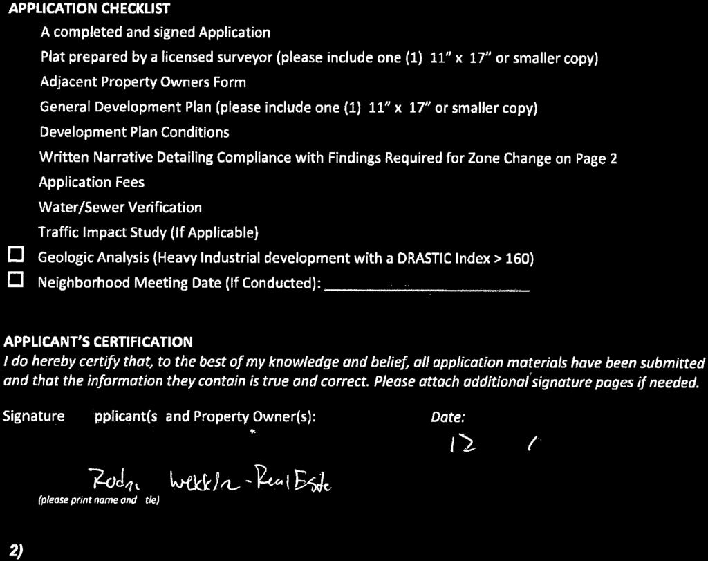
 842-1953 1141 State Street Bowling Green, KY 42101 DOCKET/CASE/APPLICATION NUMBER 2019-01-Z-BG PUBLIC HEARING DATE January 3, 2019 APPLICANTS/PROPERTY OWNERS Menard, Inc.")
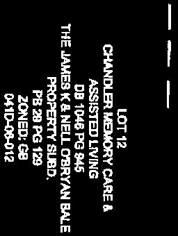
1 Z-BG Page 1 of 32 ZONE CHANGE STAFF REPORT CCPC City-County Planning Commission warrenpc.org (270) State Street Bowling Green, KY DOCKET/CASE/APPLICATION NUMBER Z-BG PUBLIC HEARING DATE January 3, 2019 APPLICANTS/PROPERTY OWNERS Menard, Inc. c/o Rodney Wekkin (applicants) & Bale of Kentucky Family Limited Partnership (property owners) BRIEF SUMMARY OF REQUEST: The applicants are proposing to rezone /- acres located on Campbell Lane from (Single Family Residential), (Multi-Family Residential), (General Business) and (Highway Business) to (Highway Business), in order to develop a variety of commercial uses, including a big-box retailer and multiple standalone commercial outlots. PROPERTY ADDRESS/LOCATION 0 Campbell Lane PRE-APP DATE October 2, 2018 PVA PARCEL NUMBER 041D-06 MAP SOURCE: CURRENT ZONING,, & CURRENT LAND USE Agriculture PROPOSED ZONING PROPOSED LAND USE Commercial FUTURE LAND USE Commercial FLUM AMENDMENT Yes No SIZE OF PROPERTY /- Acres PROPOSED DENSITY N/A OTHER INFORMATION Development Plan Conditions General Development Plan Neighborhood Meeting Traffic Impact Study (TIS) Environmental Assessment Public Comments PROPERTY HISTORY: R-1 (Single Family Residential) is the original COMPATIBILITY with COMPREHENSIVE PLAN: zoning for the property. Portions of the property were rezoned from The property is designated as R-1 to R-4 (Multi-Family Residential) in 1981, from R-1 to B-2 Commercial on the FLUM. The (General Business) in 1983 and from R-1 to R-4 and B-2 in proposed district is listed as a Another portion of the property was rezoned from B-2 to B-4 potentially compatible zone in the (Highway Business) in In 2001, the property was converted Commercial FLUM designation. The from R-1, R-4, B-2 and B-4 to (Single Family Residential), Planning Commission should (Multi-Family Residential), (General Business) and determine if the proposed development (Highway Business) through an amendment to the Zoning is compatible with the surrounding Ordinance. area. COMPATIBILITY with the SURROUNDING DEVELOPMENT: The property is located in the urbanized area of Bowling Green. A site characteristic review indicates that there are adequate facilities and infrastructure available to support the proposed development. There are mature tree lines along the portions of the property. Several sinkholes are also present on the property. Site design has been addressed in the General Development Plan and development plan conditions in conjunction with the requirements of the Zoning Ordinance. Staff has noted a few items for the Planning Commission to consider in the Site Design and Compatibility Review section. The commission should further evaluate these items in order to determine if the proposed development meets the criteria outlined in the Comprehensive Plan for compatibility. POINTS TO CONSIDER: The proposal is consistent with the FLUM and Commercial category. The proposed development complies with a majority of the site characteristics review criteria. The proposed General Development Plan complies with a majority of the review criteria for site design and compatibility, with exceptions noted regarding the following items:
2 Z-BG Page 2 of 32 Zone Change Staff Report Building Orientation: The majority (if not all) of the existing structures along Campbell Lane are designed with a front façade oriented toward Campbell lane. Staff suggested that the applicants consider a front-facing façade requirement for structures on lots fronting Campbell Lane, as well as for facades oriented toward streets internal to the development. The applicants committed that all lots with frontage along Campbell Lane face a public street, but did not require that such street be Campbell Lane. The applicants did not address building orientation for lots having frontage on streets internal to the development. Screening Requirements Adjacent to Eastland Park Subdivision: The original set of development plan conditions submitted by the applicants incorporated, along the common property line with Eastern Park Subdivision, an eight (8) foot high wood fence with masonry columns, with all externally exposed areas of the columns to be constructed entirely of brick, spaced sixty (60) to seventy (70) feet apart. This is the same requirement outlined in the development plan conditions for the adjacent development along Westpark Drive. The applicants substituted this requirement in their most recent set of development plan conditions with a 50' wide landscape buffer, to include a berm of 3-4' in height, which shall be planted using the buffer standards between incompatible land uses as described in the zoning ordinance. Lighting Adjacent to Eastland Park Subdivision: The original set of development plan conditions submitted by the applicants incorporated a requirement that all lighting at the rear of buildings along the boundary with Eastland Park subdivision be wall pack lighting only, focused inward and downward on the property. This requirement was omitted from the most recent set of development plan conditions submitted by the applicants. The zoning ordinance requires that lighting on any commercial property be directed downward and inward, designed to minimize light trespass onto adjacent properties and shall not exceed 0.5 foot candles at the property line, regardless of the lighting type that is utilized. Note: Please see attached pre-application information for FLUM category descriptions and other belowreferenced material. FUTURE LAND USE MAP and CATEGORY REVIEW FLUM Designation: Commercial (please see the attached map) Applicable Goals, Objectives and/or Actions Items Future Land Use: LU-1.1.1, LU-1.1.2, LU-1.1.3, LU-2, LU-2.1.4, LU-2.3.1, LU-2.5, LU Transportation: TR-2.1, TR-3 Community Facilities: N/A Parks and Recreation: PR-1.7 Natural and Cultural Resources: NCR-1.1, NCR-1.1.6, NCR-1.3, NCR Housing and Neighborhoods: HN-1, HN-1.2, HN-1.3 Economic Development: ED-1 The Commercial FLUM designation consists of a broad array of commercial development, including individual commercial (retail, service, hotel or office) businesses that may exist along a highway corridor or a business district, as well as larger planned shopping centers and office parks. Limited high density multi-family uses are allowed to be mixed into commercial areas. These uses should be limited to upper stories or blended in or scattered among commercial uses. No more than 25% of any contiguous area designated Commercial should contain a multi-family use. The proposal complies with LU and LU The Planning Commission should determine if the proposal is compatible with the area and therefore in compliance with LU City-County Planning Commission warrenpc.org (270) State Street Bowling Green, KY 42101
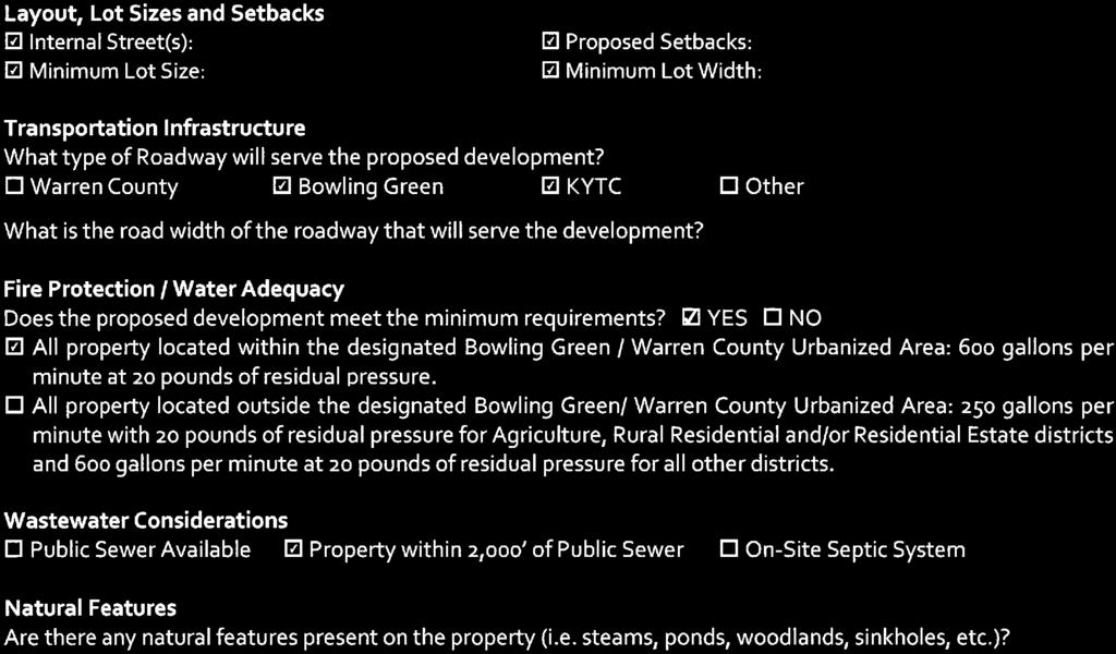
3 Z-BG Page 3 of 32 Zone Change Staff Report The proposal may comply with LU-2. The applicants are proposing that improvements on the property be constructed of at least 75% split-faced block, brick, masonry, wood, stone, glass, stucco or modern construction materials such as fiber cement board or metal panels. The development plan conditions for the adjacent commercial development on Westpark Drive incorporate similar materials, with an additional requirement that any split faced block for facades facing Eastland Park Subdivision be painted. The development plan conditions for the adjacent development also incorporate modern construction materials, but do not specifically call out metal panels as a permitted material. The Planning Commission should determine if the proposal incorporates high quality design standards tailored to protect the character of the community. The proposal generally complies with LU-2.14, PR-1.7 or NCR The applicants have agreed to maintain existing vegetation with a minimum of a 6 caliper along the common property line with Eastland Park Subdivision. They have also committed in development plan condition #3 that the property line adjacent to Eastland Park Subdivision will be developed with a 50 wide buffer, exclusive of drainage basins. The proposal complies with LU and TR-2.1. The applicants have committed in development plan conditions #5, 7 and 8 to a maximum of two access points to Campbell Lane, installation of a traffic signal at the main entrance to the development at such time the traffic volume warrants meet the traffic signal requirements as set for by KYTC, and that the property will be developed with an internal public street system that will connect to Highland Way. The applicants have also committed to prohibit vehicular connection with Eastland Street, as allowed by the subdivision regulations between incompatible uses. The Planning Commission should determine if the proposed development is compatible with the surrounding area, if the proposed layout of the development will protect nearby established neighborhoods, and if it complies with LU-2.5 and LU The proposal generally complies with TR-3. The development will incorporate sidewalks as required by the subdivision regulations and connect with existing pedestrian facilities along Campbell Lane. The proposal complies with NCR-1.1 or NCR-1.3, as the applicants have committed that any existing or found sinkholes within the proposed development will be identified and repaired prior to any development above said sinkhole. The proposal complies with NCR-2.4.1, as the development is proposed in an area where adequate infrastructure already exists, and would not result in added development pressure to the rural areas of Warren County. The proposal may comply with HN-1, HN-1.2 and HN-1.3. The Planning Commission should determine if the proposal is a compatible infill development that will maintain or improve existing character, development patterns and urban design and if it will strengthen the existing area. The Planning Commission should determine compliance with ED-1 and if the proposed development will result in additional business that will help to diversify the local economy. SITE CHARACTERISTICS REVIEW Layout, lot sizes and setbacks: The proposed layout of the site is depicted on the attached general development plan. The development will be served by internal streets. Buildings within the development will adhere to the (Highway Business) standards regarding setbacks, lot size and lot coverage, with an additional 80' building setback required from the common property line with Eastland Park Subdivision. City-County Planning Commission warrenpc.org (270) State Street Bowling Green, KY 42101
4 Z-BG Page 4 of 32 Zone Change Staff Report Transportation Infrastructure: The development has frontage on Campbell Lane (US 231), a State maintained urban principal arterial with right-of-way and pavement width that vary. Eastland Street, a City maintained urban local roadway with fifty (50) feet of right-of-way and thirty (30) feet of pavement width, stubs into the property, but will not connect with the proposed development. A connection is also proposed to the existing stub street on Highland Way through the portion of the development that is proposed to remain residential. Fire protection: This property is served by the Bowling Green Fire Department. Water adequacy: This property is served by Bowling Green Municipal Utilities (BGMU). Adequate water flow and pressure is available and will be provided to the property. Wastewater adequacy: This property will be served by sewer. Natural features: There are mature tree lines along the southern/eastern portions of the property. Several sinkholes are also present on the property. Prime farmland: The property is not classified as prime farmland. Soil suitability: N/A Flood plains and wetlands: There are no known floodplains or wetlands known on this property. Cultural or historical features: There are no known unique cultural or historical features on the site. This application complies with the majority of the items in the Site Characteristics Review. SITE DESIGN and COMPATIBILITY REVIEW Surrounding density: There is a mixture of residential uses/densities in the area ranging from low to moderate density. Surrounding land uses: Please see the attached existing land use map. The surrounding area is comprised of a mixture of commercial, single family residential, multi-family residential, public, publicinstitutional and agricultural uses. There are also several vacant tracts in the general vicinity. Eastland Park Subdivision is adjacent to the proposed development. The original set of development plan conditions submitted by the applicants incorporated a requirement that all lighting at the rear of buildings along the boundary with Eastland Park subdivision be wall pack lighting only, focused inward and downward on the property, but this requirement was omitted from the most recent set of development plan conditions that were submitted by the applicants. Surrounding architectural features: There is a mixture of one- and two-story buildings in the area comprised of a mixture of materials. The applicants have incorporated a maximum building height of 60 feet in their development plan conditions. The adjacent Gary Farms development contains several larger scale, big-box buildings. Signage in the adjacent commercial development on Westpark Drive limits freestanding signage to monument style only. For properties over 3 acres, the maximum height is 22. For properties less than 3 acres, the maximum height is 11, with a maximum sign face area of 70 SF. The nearby Gary Farms development incorporates these same restrictions, along with a requirement that the sign base be stacked stone. The applicants have included similar provisions for signage in development plan condition #6. City-County Planning Commission warrenpc.org (270) State Street Bowling Green, KY 42101
5 Z-BG Page 5 of 32 Zone Change Staff Report Building materials review: The majority of commercial structures in the area are comprised of brick, stone or other modern masonry materials. There are a few older commercial metal buildings in the area as well. The applicants have outlined permitted materials for the development in development plan condition #9, which include a requirement that improvements on the property be constructed of at least 75% split-faced block, brick, masonry, wood, stone, glass, stucco or modern construction materials such as fiber cement board or metal panels. The Planning Commission should determine if these materials are compatible with the surrounding area and if the proposed development will maintain or improve the existing character, development pattern and urban design along Campbell Lane. Building orientation: The majority (if not all) of the existing buildings along Campbell Lane have a front façade oriented toward Campbell Lane. Staff asked that the applicants consider incorporating a requirement that buildings on lots having frontage on Campbell Lane be constructed with a front façade oriented toward Campbell Lane. Staff also asked that the applicants consider a similar condition stating that buildings on lots with frontage on internal streets also be designed with a front façade oriented toward such street. The applicants committed in development plan condition #13 that all lots with frontage along Campbell Lane face a public street, but did not require that such street be Campbell Lane. The applicants did not address building orientation for lots having frontage on streets internal to the development. Landscaping and screening: Landscaping and screening will adhere to the regulations set forth in the Zoning Ordinance. The applicants have also included a commitment that the eastern property line adjacent to Eastland Park Subdivision will be developed with a 50 wide buffer to include a berm of 3-4 in height outside the drip line of the existing trees and planted using the buffer standards between noncompatible land uses as outlined in the zoning ordinance. The original set of development plan conditions submitted by the applicants incorporated, along the common property line with Eastern Park Subdivision, an eight (8) foot high wood fence with masonry columns, with all externally exposed areas of the columns to be constructed entirely of brick, spaced sixty (60) to seventy (70) feet apart. This requirement was substituted by the above-described buffer in the most recent set of development plan conditions submitted by the applicants. Proposed open space: The minimum amount of open space required by the zoning ordinance in the proposed zone is 10%. The applicants have committed in development plan condition #2 that each individual lot will contain a minimum of 15% green space. Connectivity: The proposed development will connect with Campbell Lane and Highland Way. Pedestrian, bicycle or transit facilities: The development will incorporate sidewalks as required by the subdivision regulations and connect with existing pedestrian facilities along Campbell Lane. AREA SPECIFIC POLICY REVIEW Applicable plan(s): development. TRAFFIC IMPACT STUDY There are no focal point plans or corridor studies applicable to the proposed Section of the Zoning Ordinance outlines the following: A. Any development requiring the submission of a Traffic Impact Study, as triggered by the thresholds identified by the Bowling Green Public Works Department (BGPW), Warren County Public Works Department (WCPW) or the Kentucky Transportation Cabinet (KYTC), shall analyze the effect of the proposed project on the surrounding roadways and intersections. Such effect shall be measured against the existing level of service standard and circulation patterns for the roadways affected by the proposed development s impact. City-County Planning Commission warrenpc.org (270) State Street Bowling Green, KY 42101
6 Z-BG Page 6 of 32 Zone Change Staff Report B. Exceptions to this requirement may be approved after consultation between the applicant and affected agencies (BGPW, WCPW and/or KYTC). When a project s traffic impact can be clearly anticipated without a study and all of the parties involved (transportation agency(ies) and applicant) are able to negotiate appropriate mitigation, a TIS may not be necessary. The applicant must provide documentation, in writing, from all affected agencies, exempting their particular development from the TIS requirement, along with a commitment in the form of a development plan condition(s), or conditions(s) in the instance of a CUP, agreeing to all improvement(s) required by such agency(ies). This documentation must be submitted as a part of an application (Zoning Map Amendment, Amendment to Development Plan Conditions, FLUM Amendment, Conditional Use Permit, Site Development Plan), in order for the application to be deemed complete. The applicants submitted a TIS, completed in November 2018, for the proposed development. The TIS was prepared by Qk4. Below are excerpts from the Conclusions and Recommendations section of the TIS. The purpose of this study is to determine the impacts to the existing roadway operations that will occur due to the development along Campbell Lane and to determine the intersection geometry for the Project Drive. The analysis shows that the intersection of Campbell Lane and Smallhouse Road will experience minor degradation during the Build conditions when compared to the No Build conditions. However, in the 10-year horizon, as the signals along Campbell are retimed, it is anticipated that this intersection could actually operate better in the Build condition than it currently operates. It is recommended that the Project Drive intersection at Campbell Lane be signalized due to the congested conditions in the PM peak hour. This intersection should be comprised of an eastbound left turn lane, a westbound right turn lane, and separate southbound turn lanes onto Campbell Lane. The following turn lane lengths are recommended from the queue analysis performed as part of this study. 1) Campbell Lane Eastbound Left 350 2) Campbell Lane Westbound Right 400 3) Project Drive Southbound Right 400 The applicants committed in development plan condition #7 that they will install a traffic signal at the main entrance to the development at such time the traffic volume warrants meet the traffic signal requirements as set for by KYTC and that final lane configuration will be coordinated with and approved by both KYTC and the Bowling Green Department of Public Works. GENERAL DEVELOPMENT PLAN / DEVELOPMENT PLAN CONDITIONS The applicants have submitted the following development plan conditions to help address compatibility with the surrounding area: 1) All previous Binding Elements relating to the property are null and void and shall be of no further force or effect with respect to the property. City-County Planning Commission warrenpc.org (270) State Street Bowling Green, KY 42101
7 Z-BG Page 7 of 32 Zone Change Staff Report 2) Each individual lot as they are created and developed will contain a minimum of 5% greenspace. 3) The eastern property line adjacent to Eastland Park Subdivision will be developed with a 50 wide buffer to include a berm of 3-4 in height outside the drip line of the existing trees and planted using the buffer standards between non-compatible land uses as outlined in the zoning ordinance. This buffer will be exclusive of any drainage basin. 4) Lighting for parking areas shall be designed and installed so that illumination does not exceed onehalf foot candles measured at the property line abutting property zoned for residential use or development. 5) The property will be developed with a maximum of 2 access points form Campbell Lane into the property. All access to Campbell Lane will be coordinated with and approved by the Kentucky Department of Transportation. 6) All signage on the property will be developed in compliance with the currently existing requirements for signage under the Warren County Joint Zoning Ordinance. Tracts which are 3 acres or greater in size may have a single monument style sign with a base of masonry construction, no taller than 22 feet 2 inches in height with no sign face larger than may be allowed by the Warren County Joint Zoning Ordinance. Signs on tracts smaller than 3 acres in size may have a single monument style sign with a base of masonry construction, no taller than 11 feet 2 inches in height and no larger than 70 square feet on each sign face. The property may be served with off-premises consolidated signage in compliance with the Warren County Joint Zoning Ordinance. 7) The developer shall install a traffic signal at the main entrance to the development at such time the traffic volume warrants meet the traffic signal requirements as set for by KYTC. Final lane configuration will be coordinated with and approved by both KYTC and the Bowling Green Department of Public Works. 8) The property will be developed with an internal public street system that will connect to Highland Way. Vehicular traffic will be prohibited to connect to Eastland Street. 9) Improvements on the property shall be constructed of at least 75% split-faced block, brick, masonry, wood, stone, glass, stucco or modern construction materials such as fiber cement board or metal panels. Plain face block shall not be allowed on front façade of a building facing a public right-of-way. 10) All buildings shall be set back from the Eastland Park Subdivision a minimum of ) The following uses shall be prohibited: Parking that is not accessory to a specific use; heavy vehicle and manufactured home sales; mobile home sales; self-service storage on outlots fronting Campbell Lane, used car sales except in conjunction with a new car dealership, off-premise advertising sign, bingo parlor or any establishment conducting games of chance or a pawn shop other than charitable gaming, provided that this restriction shall not prohibit the sale of lottery tickets incidental to a business; adult entertainment and any establishment selling or exhibiting pornographic materials. City-County Planning Commission warrenpc.org (270) State Street Bowling Green, KY 42101
8 Z-BG Page 8 of 32 Zone Change Staff Report 12) No building shall be taller than 60 feet. 13) All first tier lots along Campbell Lane shall face a public street. 14) All new public utilities shall be constructed underground. 15) All internal streets will be developed with uniform streetlights. 16) All healthy existing vegetation with a minimum of 6 caliper shall be preserved along the property line of the Eastland Park Subdivision. 17) Any existing or found sinkholes within the proposed development will be identified and repaired prior to any development above the said sinkhole. The proposed General Development Plan meets the majority of the review criteria for site design. Compatibility of the proposed development should be determined by the Planning Commission. The application will be subject to further review for compliance with Zoning Ordinance requirements at the building permit level portion of the review process, if approved. STAFF REVIEW SUMMARY The applicants are proposing to develop the property with a mixture of commercial uses. The proposed zoning district may be appropriate given the Commercial FLUM designation. The proposal complies with the majority of the criteria assessed in the review process, with exceptions noted regarding building orientation, screening requirements and lighting. The Planning Commission should determine if the proposal is compatible with the area and meets the goals and objectives of the Comprehensive Plan. City-County Planning Commission warrenpc.org (270) State Street Bowling Green, KY 42101
9 Z-BG Page 9 of 32 Zone Change Staff Report SUGGESTED MOTIONS I make the motion to APPROVE the proposed Zoning Map Amendment, together with and conditioned upon the General Development Plan, docket number Z-BG. Based upon the testimony and documents presented in this public hearing, the proposed Zoning Map Amendment is consistent with the adopted FOCUS 2030 Comprehensive Plan as demonstrated by its compliance with the objectives and action items presented in the staff report. (Compliance Summary Listed at Bottom of Page - Note Exceptions if Applicable) Therefore, the proposed Zoning Map Amendment is in agreement with the adopted Comprehensive Plan. Further, I request that this motion include the summary of evidence and testimony presented by the witnesses at this public hearing. I make the motion to DENY the proposed Zoning Map Amendment, docket number Z-BG. Based upon the testimony and documents presented in this public hearing, the proposed Zoning Map Amendment is not consistent with the adopted FOCUS 2030 Comprehensive Plan as demonstrated by its noncompliance with the objective and action items presented in the staff report. (Compliance Summary Listed at Bottom of Page - Note Exceptions if Applicable) Therefore, the proposed Zoning Map Amendment is not in agreement with the adopted Comprehensive Plan. Further, I request that this motion include the summary of evidence and testimony presented by the witnesses at this public hearing. COMPLIANCE SUMMARY Items In Compliance: Items Not In Compliance LU PR-1.7 LU-1.1.3* HN-1* LU LU-2* HN-1.2* LU-1.1.3* NCR-1.1 LU-2.5* HN-1.3* LU-2* NCR LU-2.5.2* LU NCR-1.3 ED-1* LU NCR LU-2.5* LU-2.5.2* HN-1* HN-1.2* TR-2.1 HN-1.3* TR-3 ED-1* *Denotes items in both the compliance and non-compliance columns. Planning Commission to determine compliance with these items. City-County Planning Commission warrenpc.org (270) State Street Bowling Green, KY 42101

10 Z-BG Page 10 of 32 M CI H OS T N ST BR O' I AN CT E PRIC AVE M CA PB EL LL AN E M ER RI C L KP CT AERIAL RKZD-R BG 100 0W A TP ES Feet
11 Z-BG Page 11 of 32 BE BE BE BE BE BE PUD BE WESTEN ST DESTINY LN OP-C BE BE OP-C BE OP-C BE CAMPBELL LANE MCINTOSH ST BE BE BE BE F BE BE BE BE RIDGESIDE AVE AG CB BE CHENOWETH CIRCLE F BE BE BE BE HI LI MHP BE P BE BE BE BE BE BE NB BE OP-C OP-R P BE BE LI BE BE LI BE PUD PUD BE PUD BE PUD PUD EXISTING ZONING BE BE PUD OP-R BE BE PUD PUD BE BE BE PUD BE RM-3 PUD RM-3 F WESTPARK DR PUD R-E RM-2 RM-3 PLEASANT WAY Feet EASTLAND ST WALTON AVE PUD BE PUD BE Z - BG RR RS-1B PUD BE PUD BE PUD RS-1C RS-1D
12 Z-BG Page 12 of 32 N ST E WE ST ET E KAR N ST RST VE NA AVE KAY L NY I ST DE H OS T N CI M U DH O WO E STR M CA EL PB LL E AN AR K ST P E W DR D IN W PL GE CRO SSRI D GE CARR IA GE H I LL D R IVE ST EL LIS E AV VE NA LTO WA THOMPSO N DR D RI VE EA ID ES DG RI EXISTING LAND USE Z - BG CHENOW E TH CIRCL E AGRICULTURAL PUBLIC-INSTITUTIONAL COMMERCIAL MULTI-FAMILY RESIDENTIAL INDUSTRIAL SINGLE-FAMILY RESIDENTIAL PUBLIC T VACANT SAN A E L P 600 Feet 300 Y WA
13 Z-BG Page 13 of 32 WESTEN ST Governmental MCINTOSH ST KAY AVE WOODHURST STREET DESTINY LN KAREN AVE Commercial Commercial Commercial Commercial CAMPBELL LANE Commercial WIND RIDGE AVE Commercial WESTPARK DR THOMPSON DR ELLIS PL WALTON AVE CARRIAGE HILL DRIVE CROSSRIDGE ST RIDGESIDE AVE Rural Village Agriculture CHENOWETH CIRCLE Rural Density Residential Low Density Residential Moderate Density Residential Commercial FUTURE LAND USE Z - BG High Density Residential Mixed Use / Residential Mixed Use / Commercial Commercial Lovers Lane Overlay Industrial PLEASANT WAY Institutional / Governmental Open Space, Parks & Recreation Cemetery Road Overlay


14 Z-BG Page 14 of 32


15 Z-BG Page 15 of 32


16 Z-BG Page 16 of 32

17 Z-BG Page 17 of 32


18 Z-BG Page 18 of 32


19 Z-BG Page 19 of 32


20 Z-BG Page 20 of 32


21 Z-BG Page 21 of 32

22 Z-BG Page 22 of 32


23 Z-BG Page 23 of 32


24 Z-BG Page 24 of 32


25 Z-BG Page 25 of 32

26 Z-BG Page 26 of 32


27 Z-BG Page 27 of 32

28 Z-BG Page 28 of 32


29 Z-BG Page 29 of 32

30 Z-BG Page 30 of 32
31 Z-BG Page 31 of 32 Rachel Hurt From: Rachel Hurt Sent: Friday, December 14, :19 AM To: 'rwekkin 'Jeff Arnold'; 'Brian Shirley' Cc: Ben Peterson Subject: Staff Comments: Proposed Zone Change - Campbell Lane Gentlemen, In reviewing your application for the proposed rezoning of the property located on Campbell Lane, staff has generated the following comments for your consideration: Development plan condition #2, relating to landscaping, can be deleted since it is already required. Development plan condition #3 states that the property will be developed with a minimum of 15% green space. Can you please clarify if this would be for the overall development, or is it the intent of this condition that each lot individually would contain 15% open space? Development plan condition #4 identifies a landscape buffer adjacent to Eastland Park. Would you also consider depicting this same buffer on your preliminary development plan? Can you please clarify if drainage areas will be permitted within this buffer area? Development plan condition #7 states that the property is limited to a maximum of two access points on Campbell Lane. Would you consider adding that these would be coordinated with and approved by the Kentucky Transportation Cabinet? Development plan condition #8 outlines requirements for a traffic signal at the main entrance. The traffic impact study (TIS) that was submitted with your application also outlines recommendations for turn lane requirements at the Project Drive intersection at Campbell Lane and stated that the intersection should be comprised of an eastbound left turn lane, a westbound right turn lane and separate southbound turn lanes onto Campbell Lane, with recommended lengths as follows: o Campbell Lane Eastbound Left 350 o Campbell Lane Westbound Right 400 o Project Drive Southbound Right 400 KYTC and BGPW officials have reviewed these recommendations and concur that these will be necessary to accommodate the proposed development. Would you consider also incorporating these into development plan condition #8? Development plan condition #9 identifies a connection with Highland Way. Would you also consider including a condition prohibiting vehicular access to Eastland Street? Development plan condition #10 outlines permitted building materials within the development. One term that is referenced is modern construction materials. Can you please clarify what this would include? Plain face block is also listed as an allowable material on all facades except in the instance of a front façade facing a public right of way. The overwhelming majority of recent commercial rezoning applications considered by the Planning Commission have prohibited plain face block as a permitted material altogether. The development plan conditions for the adjacent commercial development on Westpark Drive require at a minimum, painted split faced block for facades facing Eastland Park Subdivision. Would you consider prohibiting plain face block as a visible finished material? 1
32 Z-BG Page 32 of 32 Development plan condition #11 states that all buildings shall be set back a minimum of 80 feet from the northern boundary. Should this reference the eastern or northeastern boundary instead? Development plan condition #12 outlines prohibited uses for the development. Would you also consider incorporating mobile home sales, adult entertainment, self service storage, used car sales except in conjunction with a new car dealership, off premise advertising sign (billboard)? The Zoning Ordinance permits freestanding signage in the zone up to 30 in height, with a maximum sign face area of 150 SF. The adjacent commercial development on Westpark Drive limits freestanding signage to monument style only. For properties over 3 acres, the maximum height is 22. For properties less than 3 acres, the maximum height is 11, with a maximum sign face area of 70 SF. The nearby Gary Farms development incorporates these same restrictions, along with a requirement that the sign base be stacked stone. Would you consider incorporating similar restrictions for signage into your development plan conditions? LU of the FOCUS 2030 Comprehensive Plan evaluates compatibility of the proposed development with the surrounding area. The majority (if not all) of the existing buildings along Campbell Lane have a front façade oriented toward Campbell Lane. Would you consider incorporating an additional development plan condition requiring that all buildings on lots having frontage on Campbell Lane be constructed with a front façade oriented toward Campbell Lane? Would you consider a similar condition stating that buildings on lots with frontage on internal streets also be designed with a front façade oriented toward such street? Similar rezoning applications for commercial use have incorporated development plan conditions stating that all service utilities within the development will be located underground and that uniform streetlights will be installed within the development. The adjacent Gary Farms development has also incorporated underground utilities and uniform streetlights into their design. Would you also consider incorporating development plan conditions for an underground utility and uniform streetlight requirement? LU 2.1.4, PR 1.7 and NCR from the FOCUS 2030 Comprehensive Plan encourage preservation of the tree canopy and discourage removal of existing mature vegetation. Portions of the property along the southern and eastern property lines contain established, mature tree lines. Would you consider incorporating an additional development plan condition addressing preservation of the existing (or a portion of the existing) mature vegetation located on the property? NCR 1.1 and NCR 1.3 from the FOCUS 2030 Comprehensive Plan evaluate physical suitability of a particular development with existing natural features and the natural environment. Would you consider an additional development plan condition to address the existing sinkholes that are present on the site? The rezoning exhibit that was submitted with your application indicates the distance for a boundary line along Campbell Lane between the Chandler Memory Care and Kentucky Farm Bureau properties to be approximately The previously recorded plat also called out a boundary line containing approximately Is it possible that this was omitted by mistake? Can you please verify? Due to the upcoming holiday week, staff is requesting that any revisions you may have please be submitted no later than Thursday, December 20th at 10:00 AM. I am sorry for any inconvenience this may cause, but we want to ensure timely delivery of meeting materials to our Planning Commissioners. If this revision deadline is a concern, please let me know as soon as possible. Please let me know if you have any questions or concerns regarding the above comments. I am happy to assist however I can! Sincerely, Rachel Hurt Planner III 2
Tuss and Lisa Taylor. Agriculture
 ZONE CHANGE STAFF REPORT CCPC City-County Planning Commission warrenpc.org (270) 842-1953 1141 State Street Bowling Green, KY 42101 DOCKET/CASE/APPLICATION NUMBER 2018-29-Z-CO PUBLIC HEARING DATE July
Z-CO & 2018-V-11. July 5, 2018
 2018-30-Z-CO & 2018-V-11 Page 1 of 34 ZONE CHANGE AND VARIANCE STAFF REPORT CCPC City-County Planning Commission warrenpc.org (270) 842-1953 1141 State Street Bowling Green, KY 42101 DOCKET/CASE/APPLICATION
FUTURE LAND USE MAP AMENDMENT AND ZONE CHANGE STAFF REPORT
 2017-16-FLUM & 2017-81-Z-BG Page 1 of 13 FUTURE LAND USE MAP AMENDMENT AND ZONE CHANGE AFF REPORT Docket Numbers: 2017-16-FLUM and 2017-81-Z-BG Public Hearing Date: December 21, 2017 Pre-Application Conference:
FUTURE LAND USE MAP AMENDMENT AND ZONE CHANGE STAFF REPORT
 2017-14-LUM & 2017-79-Z-CO / WB Page 1 of 12 UTURE LAND USE MAP AMENDMENT AND ZONE CHANGE STA REPORT Docket Numbers: 2017-14-LUM and 2017-79-Z-CO/WB Public Hearing Date: November 16, 2017 Pre-Application
FLUM PUBLIC HEARING DATE
 2018-13-FLUM Page 1 of 30 FLUM AMENDMENT STAFF REPORT DOCKET/CASE/APPLICATION NUMBER CCPC City-County Planning Commission warrenpc.org (270) 842-1953 1141 State Street Bowling Green, KY 42101 2018-13-FLUM
Financial Impact Statement There are no immediate financial impacts associated with the adoption of this report.
 STAFF REPORT Planning and Development Department Subject: Application by RYC Property to rezone a portion of lands on John Murray Dr. and Megan Lynn Dr. from R2 to R3 and to enter into a Development Agreement
COMMUNITY DEVELOPMENT. Staff Report. Site Plan Review. SP June 19, 2018
 COMMUNITY DEVELOPMENT 333 Broadalbin Street SW, PO Box 490, Albany, Oregon 97321-0144 BUILDING 541-917-7553 PLANNING 541-917-7550 Staff Report Site Plan Review SP-18-18 June 19, 2018 Summary On May 1,
Planning Department Oconee County, Georgia
 Planning Department Oconee County, Georgia STAFF REPORT REZONE CASE #: 6985 DATE: October 31, 2016 STAFF REPORT BY: Andrew C. Stern, Planner APPLICANT NAME: Williams & Associates, Land Planners PC PROPERTY
RE: 6. GILL/GREEN COMPREHENSIVE PLAN AMENDMENT, REZONING AND PRELIMINARY PLAT
 commission memo DATE: Thursday - August 9, 2018 TO: Marion Planning & Zoning Commission FROM: David N. Hockett, AICP Principal Planner RE: 6. GILL/GREEN COMPREHENSIVE PLAN AMENDMENT, REZONING AND PRELIMINARY
610 LAND DIVISIONS AND PROPERTY LINE ADJUSTMENTS OUTSIDE A UGB
 ARTICLE VI: LAND DIVISIONS AND PROPERTY LINE ADJUSTMENTS VI-21 610 LAND DIVISIONS AND PROPERTY LINE ADJUSTMENTS OUTSIDE A UGB 610-1 Property Line Adjustments (Property Line Relocation) A property line
Cover Letter with Narrative Statement
 Cover Letter with Narrative Statement March 31, 2017 rev July 27, 2017 RE: Rushton Pointe Residential Planned Unit Development Application for Public Hearing for RPUD Rezone PL2015 000 0306 Mr. Eric Johnson,
UPPER MOUNT BETHEL TOWNSHIP NORTHAMPTON COUNTY, PENNSYLVANIA
 UPPER MOUNT BETHEL TOWNSHIP NORTHAMPTON COUNTY, PENNSYLVANIA JOINDER DEED / LOT CONSOLIDATION TOWNSHIP REVIEW PROCESS When accepting proposed Joinder Deeds / Lot Consolidations, review the Joinder Deed
TELECOMMUNICATIONS TOWER AND VARIANCE STAFF REPORT
 TELECOMMUNICATIONS TOWER AND VARIANCE STAFF REPORT City County Planning Commission 1141 State Street Bowling Green, Kentucky 42101 (270) 842 1953 Summary: The applicants have filed an application for approval
MINNETONKA PLANNING COMMISSION June 2, A conditional use permit for 2,328 square feet of accessory structures at 4915 Highland Road
 MINNETONKA PLANNING COMMISSION June 2, 2016 Brief Description A conditional use permit for 2,328 square feet of accessory structures at Recommendation Recommend the city council adopt the resolution approving
AAAA. Planning and Zoning Staff Report Lake Shore Land Holdings, LLC CU-PH Analysis
 AAAA Planning and Zoning Staff Report Lake Shore Land Holdings, LLC CU-PH2016-28 Hearing Date: April 21, 2016 Development Services Department Applicant: BRS Architects/Cindy Huebert Staff: Kyle McCormick,
City of Valdosta Land Development Regulations
 Chapter 206 Section 206-1 Base Zoning Districts Standards for Uses, Structures, and Property Development (B) (C) Principal Uses and Structures. Principal uses and structures permitted in each base zoning
Planned Unit Development (PUD). Sections:
. Sections:") Chapter 19.07. Planned Unit Development (PUD). Sections: 19.07.01. Purpose. 19.07.02. PUD Definition and Design Compatibility. 19.07.03. General PUD Standards. 19.07.04. Underlying Zones. 19.07.05. Permitted
Chapter 19.07. Planned Unit Development (PUD). Sections: 19.07.01. Purpose. 19.07.02. PUD Definition and Design Compatibility. 19.07.03. General PUD Standards. 19.07.04. Underlying Zones. 19.07.05. Permitted
REPORT OF THE PLANNING AND DEVELOPMENT DEPARTMENT FOR APPLICATION FOR REZONING ORDINANCE TO PLANNED UNIT DEVELOPMENT MAY 18, 2017
 BEL REPORT OF THE PLANNING AND DEVELOPMENT DEPARTMENT FOR APPLICATION FOR REZONING ORDINANCE 2016-805 TO PLANNED UNIT DEVELOPMENT MAY 18, 2017 The Planning and Development Department hereby forwards to
PLANNING COMMISSION REPORT Regular Agenda Public Hearing Item
 PC Staff Report 11/12/12 Item No. 2B- 1 PLANNING COMMISSION REPORT Regular Agenda Public Hearing Item ITEM NO. 2B: A TO GPI; 110 ACRES; E OF K-10 & N OF W 6 TH ST (MKM) : Consider a request to rezone approximately
LINCOLN COUNTY PLANNING & INSPECTIONS DEPARTMENT
 LINCOLN COUNTY PLANNING & INSPECTIONS DEPARTMENT 302 NORTH ACADEMY STREET, SUITE A, LINCOLNTON, NORTH CAROLINA 28092 704-736-8440 OFFICE 704-736-8434 INSPECTION REQUEST LINE 704-732-9010 FAX To: Board
Deerfield Township Community Development Department
 STAFF REVIEW Deerfield Township Community Development Department To: From: Hayfaa Wadih, AICP Lois McKnight, AICP Meeting Date: October 20, 2014 Continued from October 13, 2014 Re: Major PUD Modification
PLANNING COMMISSION REPORT Regular Agenda -Public Hearing Item
 PDP-13-00518 Item No. 3B- 1 PLANNING COMMISSION REPORT Regular Agenda -Public Hearing Item PC Staff Report 2/24/14 ITEM NO. 3B PRELIMINARY DEVELOPMENT PLAN FOR HERE @ KANSAS; 1101 INDIANA ST (SLD) PDP-13-00518:
PLANNED DEVELOPMENT DISTRICT STANDARDS. Cadence Site
 PLANNED DEVELOPMENT DISTRICT STANDARDS Cadence Site A Planned Development District 1. Statement of General Facts, Conditions and Objectives Property Size: Approximately 57.51 Acres York County Tax Map
City of Peachtree City. Annexation Review Process
 City of Peachtree City Annexation Review Process Page 1 Annexation Review Process Step One: Initial annexation information The following information is to be completed by the property owner and/ or their
LINCOLN COUNTY PLANNING & INSPECTIONS DEPARTMENT
 LINCOLN COUNTY PLANNING & INSPECTIONS DEPARTMENT 302 NORTH ACADEMY STREET, SUITE A, LINCOLNTON, NORTH CAROLINA 28092 704-736-8440 OFFICE 704-736-8434 INSPECTION REQUEST LINE 704-732-9010 FAX To: Board
Glades County Staff Report and Recommendation REZONING
 Glades County Staff Report and Recommendation REZONING CASE NUMBER: RZ15-01 DATE: October 2, 2015 CASE TYPE: Application for Rezoning REQUEST: J.J. Wiggins Memorial Trust is requesting a rezoning of 22.1±
NORMAN, OKLAHOMA OWNER: RCB BANK APPLICATION FOR 2025 PLAN CHANGE PLANNED UNIT DEVELOPMENT PRELIMINARY PLAT. 12 December 2011 Revised 5 January 2012
 THE VILLAGE AT OAKHURST ADDITION NORMAN, OKLAHOMA OWNER: RCB BANK APPLICATION FOR 2025 PLAN CHANGE PLANNED UNIT DEVELOPMENT PRELIMINARY PLAT 12 December 2011 Revised 5 January 2012 PREPARED BY: THE RIEGER
4.2 RESIDENTIAL ZONING DISTRICTS
 4.2 RESIDENTIAL ZONING DISTRICTS A. Purpose: To define regulations and standards for each residential zoning district in the City. The following sections identify uses, regulations, and performance standards
Glades County Staff Report and Recommendation Unified Staff Report for Small Scale Plan Amendment and Rezoning
 Glades County Staff Report and Recommendation Unified Staff Report for Small Scale Plan Amendment and Rezoning CASE NUMBERS: COMP17-02 and RZ17-02 DATE of STAFF REPORT: May 1, 2017 CASE TYPE: Application
PINE RIDGE COMMONS PUD AMEND ORDINANCE NUMBER 99-94
 PINE RIDGE COMMONS PUD AMEND ORDINANCE NUMBER 99-94 Title page of the Planned Unit Development Document, previously attached as Exhibit A to the PUD document of Ordinance Number 99-94, the Pine Ridge commons
Planning Department Oconee County, Georgia STAFF REPORT
 Planning Department Oconee County, Georgia STAFF REPORT REZONE CASE #: 7332 DATE: November 28, 2017 STAFF REPORT BY: Gabriel Quintas, Planner APPLICANT NAME: Smith Planning Group PROPERTY OWNER: John Hadden
Chapter CC COMMUNITY COMMERCIAL ZONES REGULATIONS
 Effective April 14, 2011 Chapter 17.35 CC COMMUNITY COMMERCIAL ZONES REGULATIONS SECTIONS: 17.35.010 Title, Intent, and Description 17.35.020 Required Design Review Process 17.35.030 Permitted and Conditionally
8Land Use. The Land Use Plan consists of the following elements:
 8Land Use 1. Introduction The Land Use Plan consists of the following elements: 1. Introduction 2. Existing Conditions 3. Opportunities for Redevelopment 4. Land Use Projections 5. Future Land Use Policies
ARTICLE 10 SPECIAL PURPOSE DISTRICTS
 ARTICLE 10 SPECIAL PURPOSE DISTRICTS Sec. 29.1000. SPECIAL PURPOSE DISTRICTS. (1) Purpose. Each Special Purpose District will appear on the City's Zoning Map as a Base Zone. The Special Purpose Districts
ADDRESS / DESCRIPTION: Northeast corner of Sandbridge Road and Atwoodtown Road ELECTION DISTRICT: PRINCESS ANNE
 10 & 11 March 14, 2012 Public Hearing APPLICANT: MARLYN DEVELOPMENT CORPORATION PROPERTY OWNER: CORAL DEVELOPMENT, LLC STAFF PLANNER: Faith Christie REQUEST: Modification of Conditional Change of Zoning
CITY OF SANTA ROSA COMMUNITY DEVELOPMENT DEPARTMENT STAFF REPORT FOR PLANNING COMMISSION SEPTEMBER 10, 2015 APPLICANT FILE NUMBER MJP
 ITEM NO. 9 CITY OF SANTA ROSA COMMUNITY DEVELOPMENT DEPARTMENT STAFF REPORT FOR PLANNING COMMISSION SEPTEMBER 10, 2015 PROJECT TITLE Yogurt Time Center ADDRESS/LOCATION 3093 Marlow Road ASSESSOR S PARCEL
Exhibit D. Tallow Ridge PUD. Written Description. Date: January 5, E. City Development Number:
 Exhibit D Tallow Ridge PUD Written Description Date: January 5, 2016 I. SUMMARY DESCRIPTION OF THE PROPERTY A. Current Land Use Designation: RR B. Current Zoning District: PUD C. Requested Zoning District:
Staff Report: Date: Applicant: Property Identification: Acreage of Request: Current Zoning of Requested Area: Requested Action: Attached:
 Staff Report: Completed by Jeff Palmer Director of Planning & Zoning Date: November 7, 2018, Updated November 20, 2018 Applicant: Greg Smith, Oberer Land Developer agent for Ronald Montgomery ET AL Property
Conditional Use Permit case no. CU 14-06: Bristol Village Partners, LLC
 PLANNING AND ZONING COMMISSION STAFF REPORT August 7, 2014 Conditional Use Permit case no. CU 14-06: Bristol Village Partners, LLC CASE DESCRIPTION: LOCATION: LEGAL DESCRIPTION: EXISTING LAND USE: ZONING:
DEVELOPMENT DEPARTMENT STAFF REPORT THE PARK AT 5 TH
 DEVELOPMENT DEPARTMENT STAFF REPORT ARB Meeting Date: July 3, 2018 Item #: _PZ2018-293_ THE PARK AT 5 TH Request: Site Address: Project Name: Parcel Number: Applicant: Proposed Development: Current Zoning:
PALM BEACH COUNTY PLANNING, ZONING AND BUILDING DEPARTMENT ZONING DIVISION
 PALM BEACH COUNTY PLANNING, ZONING AND BUILDING DEPARTMENT ZONING DIVISION Application No.: PDD/R-2015-00755 Application Name: Providence Living in Delray Beach Control No.: 2005-00506 Applicant: Providence
Planned Residence District (PR) To review a plan to construct 11 single family homes on approximately 4.01 acres.
 To review a plan to construct 11 single family homes on approximately 4.01 acres.") STAFF REPORT PLANNING & ZONING COMMISSION Village Green Municipal Building, Council Chambers 47 Hall Street Wednesday, March 13, 2019 7:00 P.M. 1. FINAL DEVELOPMENT PLAN REVIEW Applicant: Romanelli and
STAFF REPORT PLANNING & ZONING COMMISSION Village Green Municipal Building, Council Chambers 47 Hall Street Wednesday, March 13, 2019 7:00 P.M. 1. FINAL DEVELOPMENT PLAN REVIEW Applicant: Romanelli and
Article 7: Residential Land Use and Development Requirements
 Article 7: Residential Land Use and Section 701: Statement of Intent (A) (B) (C) The intent of Article 7 is to develop certain land use and development requirements for the residential uses within Cumru
Bethel Romanian Church - Rezone, RZ
 / Planning and Zoning Staff Report Bethel Romanian Church - Rezone, RZ2018-0023 Hearing Date: November 15, 2018 Development Services Department Owners: Bethel Romanian Church, Corp. Applicant: Viorel Botos
EXHIBIT D. Planned Unit Development Written Description April 13, 2016 Rouen Cove Phase II PUD
 1 EXHIBIT D Planned Unit Development Written Description April 13, 2016 Rouen Cove Phase II PUD Development # 8986.001 Developer: Curtis L. Hart Hart Resources LLC 8051 Tara Lane Jacksonville, Florida
PALM BEACH COUNTY PLANNING, ZONING AND BUILDING DEPARTMENT ZONING DIVISION
 PALM BEACH COUNTY PLANNING, ZONING AND BUILDING DEPARTMENT ZONING DIVISION Application No.: CA-2012-00688 Control No.: 2011-00552 Applicant: Garry Bernardo Owners: Garry Bernardo Agent: Frogner Consulting,
Development Plan DP13-3 (Arlington Lofts) Planning and Zoning Meeting Date: Document Being Considered: Ordinance
 Planning and Zoning Meeting Date: Document Being Considered: Ordinance") Staff Report Development Plan DP13-3 (Arlington Lofts) Planning and Zoning Meeting Date: 6-19-13 Document Being Considered: Ordinance RECOMMENDATION Following the public hearing, consider Development Plan
Staff Report Development Plan DP13-3 (Arlington Lofts) Planning and Zoning Meeting Date: 6-19-13 Document Being Considered: Ordinance RECOMMENDATION Following the public hearing, consider Development Plan
PLANNING COMMISSION REPORT Regular Agenda - Public Hearing Item
 Z-15-00469 Item No. 6A- 1 PLANNING COMMISSION REPORT Regular Agenda - Public Hearing Item PC Staff Report 11/16/15 ITEM NO. 6A GPI, RM12, & RS40 TO RM12; 14.756 ACRES; 5200 & 5300 CLINTON PKWY (SLD) Z-15-00469:
SPECIAL ZONING DISTRICTS
 SPECIAL ZONING DISTRICTS 5.01 5.99 RESERVED 5.100 PLANNED DEVELOPMENTS: Purpose: This district is intended to accommodate unified design of residential, commercial, office, professional services, retail
CONCEPTUAL MASTER PLAN CHECKLIST Major Land Development Project
 CONCEPTUAL MASTER PLAN CHECKLIST Major Land Development Project To initiate the application, the applicant shall submit to the Administrative Officer: 1. The application review fee, as established by the
Watertown City Council
 City of Watertown Watertown City Council 2/14/2017 Agenda Item: Riverpointe Subdivision 2 nd Replat Request for Action: Sketch Plan Department: Planning Request for Action Request: Paxmar, LLC (Applicant)
Chapter SPECIAL USE ZONING DISTRICTS
 Chapter 20.20 Sections: 20.20.010 Urban Transition (U-T) Zoning District 20.20.020 Planned Development (P-D) Zoning Districts 20.20.010 Urban Transition (U-T) Zoning District A. Purpose. The purpose of
31, Township 29 South, Range 25 East, Polk County, Florida, as depicted by the Land Use Plan attached
 ORDINANCE NO. 2013-04 AN ORDINANCE AMENDING THE ZONING MAP OF THE CITY OF BARTOW, FLORIDA, REZONING APPROXIMATELY 2. 2 ACRES OF LAND OWNED BY BALA3I OF POLK COUNTY, LLC AND LOCATED IN SECTION 31, TOWNSHIP
STAFF REPORT. Permit Number: Unlimited. Kitsap County Board of Commissioners; Kitsap County Planning Commission
 STAFF REPORT Permit Number: 15 00550 Unlimited DATE: March 2, 2016 TO: FROM: Kitsap County Board of Commissioners; Kitsap County Planning Commission Katrina Knutson, AICP, Senior Planner, DCD and Jeff
ARTICLE 14 PLANNED UNIT DEVELOPMENT (PUD) DISTRICT
 DISTRICT") ARTICLE 14 PLANNED UNIT DEVELOPMENT (PUD) DISTRICT Section 14.01 Intent. It is the intent of this Article to allow the use of the planned unit development (PUD) process, as authorized by the Michigan Zoning
ARTICLE 14 PLANNED UNIT DEVELOPMENT (PUD) DISTRICT Section 14.01 Intent. It is the intent of this Article to allow the use of the planned unit development (PUD) process, as authorized by the Michigan Zoning
Staff Report PLANNED DEVELOPMENT. Salt Lake City Planning Commission. From: Lauren Parisi, Associate Planner; Date: December 14, 2016
 Staff Report PLANNING DIVISION COMMUNITY & NEIGHBORHOODS To: Salt Lake City Planning Commission From: Lauren Parisi, Associate Planner; 801-535-7932 Date: December 14, 2016 Re: 1611 South 1600 East PLANNED
DOCKET/CASE/APPLICATION NUMBER PUBLIC HEARING DATE. November 1, 2018 APPLICANTS/PROPERTY OWNER
 2018-53-Z-CO Page 1 of 32 ZONE CHANGE STAFF REPORT CCPC City-County Planning Commission warrenpc.org (270) 842-1953 1141 State Street Bowling Green, KY 42101 DOCKET/CASE/APPLICATION NUMBER 2018-53-Z-CO
ARTICLE Encourage well planned, efficient development.
 ARTICLE 14.00 PD PLANNED SECTIONS: 14.01 Intent 14.02 Procedure 14.03 Initial Development Plan 14.04 Final Development Plan 14.05 Amendments 14.06 Planned Development Districts PD-1 Willow Run PD PD-2
Request Conditional Rezoning (AG-1 & AG-2 Agricultural to Conditional R-10 Residential & P- 1 Preservation District) Staff Recommendation Approval
 Staff Recommendation Approval") Applicant & Property Owner Public Hearing February 14, 2018 City Council Election District Princess Anne Agenda Item 7 Request Conditional Rezoning (AG-1 & AG-2 Agricultural to Conditional R-10 Residential
Applicant & Property Owner Public Hearing February 14, 2018 City Council Election District Princess Anne Agenda Item 7 Request Conditional Rezoning (AG-1 & AG-2 Agricultural to Conditional R-10 Residential
(a) Commercial uses on Laurel Avenue, abutting the TRO District to the
 Commercial uses on Laurel Avenue, abutting the TRO District to the") 32X Zoning Code 150.36 TRANSITIONAL RESIDENTIAL OVERLAY DISTRICT. (A) Intent and purpose. (1) It is the intent of the Transitional Residential Overlay District (hereinafter referred to as the "TRO District")
32X Zoning Code 150.36 TRANSITIONAL RESIDENTIAL OVERLAY DISTRICT. (A) Intent and purpose. (1) It is the intent of the Transitional Residential Overlay District (hereinafter referred to as the "TRO District")
Draft Model Access Management Overlay Ordinance
 Draft Model Access Management Overlay Ordinance This model was developed using the City of Hutchinson and the Trunk Highway 7 corridor. The basic provisions of this model may be adopted by any jurisdiction
COMMUNITY DEVELOPMENT DEPARTMENT 333 Broadalbin Street SW, P.O. Box 490 Albany, OR 97321
 COMMUNITY DEVELOPMENT DEPARTMENT 333 Broadalbin Street SW, P.O. Box 490 Albany, OR 97321 STAFF REPORT Application for Site Plan Review (SP-02-18) Residential Accessory Building Ph: 541-917-7550 Fax: 541-917-7598
RECOMMENDATION Following the public hearing, consider Zoning Case PD14-16, with a Development Plan.
 Staff Report Zoning Case PD14-16 (Helzer Tract) Planning and Zoning Meeting Date: 12-17-14 Document Being Considered: Ordinance RECOMMENDATION Following the public hearing, consider Zoning Case PD14-16,
The following regulations shall apply in the R-E District:
 "R-E" RESIDENTIAL ESTATE DISTRICT (8/06) The following regulations shall apply in the R-E District: 1. Uses Permitted: The following uses are permitted. A Zoning Certificate may be required as provided
ARTICLE VII. NONCONFORMITIES. Section 700. Purpose.
 ARTICLE VII. NONCONFORMITIES. Section 700. Purpose. The purpose of this chapter is to regulate and limit the development and continued existence of legal uses, structures, lots, and signs established either
Be linked by an internal circulation system (i.e., walkways, streets, etc.) to other structures within the IPUD;
 to other structures within the IPUD;") 2. HALIFAX ACTIVITY CENTER A. DESCRIPTIONS OF FUTURE LAND USE DESIGNATIONS Each of the future land use designations specified by Phase I of the Halifax Activity Center Plan, and the relationship of these
2. HALIFAX ACTIVITY CENTER A. DESCRIPTIONS OF FUTURE LAND USE DESIGNATIONS Each of the future land use designations specified by Phase I of the Halifax Activity Center Plan, and the relationship of these
PLANNING COMMISSION STAFF REPORT
 PLANNING COMMISSION STAFF REPORT REZONING CASE: RZ-15-002 REPORT DATE: January 26, 2016 CASE NAME: Thursday Lunch Club Rezoning PLANNING COMMISSION DATE: February 17, 2016 ADDRESS OF REZONING PROPOSAL:
CHAPTER 14 PLANNED UNIT DEVELOPMENTS
 9-14-1 9-14-1 CHAPTER 14 PLANNED UNIT DEVELOPMENTS SECTION: 9-14-1: Purpose 9-14-2: Governing Provisions 9-14-3: Minimum Area 9-14-4: Uses Permitted 9-14-5: Common Open Space 9-14-6: Utility Requirements
Excerpt from Town of West Greenwich, RI Zoning Ordinance Amended by Town Council September 12, 2007, and September 10, 2008
 ARTICLE IV SIGN REGULATIONS Section 1. Purpose and intent. The purpose of this Article is to: A. Improve pedestrian and traffic safety; B. Encourage the effective use of signs as a means of communication
March 26, Sutter County Planning Commission
 March 26, 2003 To: Re: Sutter County Planning Commission Agenda Item #12: Public hearing on Rezoning #03-04 to change the zoning classification of two parcels totaling 324+ acres from the AG (General Agricultural)
PLANNED UNIT DEVELOPMENT & SUBDIVISION STAFF REPORT Date: November 17, 2016
 PLANNED UNIT DEVELOPMENT & SUBDIVISION STAFF REPORT Date: November 17, 2016 DEVELOPMENT NAME SUBDIVISION NAME LOCATION Autonation Ford of Mobile Autonation Ford of Mobile Subdivision 901, 909, and 925
ARTICLE 5.0 SCHEDULE OF REGULATIONS
 ARTICLE 5.0 SCHEDULE OF REGULATIONS Section 5.101 Table of Dimensional Standards by District. Dimensional Standards AG AG with sewer Districts Rural Residential Business Other SF SF with sewer R-1 R-1
RECOMMENDATION REPORT
 SARPY COUNTY PLANNING & BUILDING DEPARTMENT RECOMMENDATION REPORT CHANGE OF ZONE (CZ 18-005) PRELIMINARY PLAT (PP 18-007) FINAL PLAT (FP 18-008) SCHOLTING ESTATES APPLICANT: DIANE SCHOLTING PLANNING COMMISSION
SECTION 10.7 R-PUD (RESIDENTIAL PLANNED UNIT DEVELOPMENT) ZONE
 ZONE") Article X Zones 10-20 SECTION 10.7 R-PUD (RESIDENTIAL PLANNED UNIT DEVELOPMENT) ZONE A. PURPOSE AND INTENT: The R-PUD Residential PUD Zone is intended to provide alternative, voluntary zoning procedures
Article X Zones 10-20 SECTION 10.7 R-PUD (RESIDENTIAL PLANNED UNIT DEVELOPMENT) ZONE A. PURPOSE AND INTENT: The R-PUD Residential PUD Zone is intended to provide alternative, voluntary zoning procedures
PLANNED UNIT DEVELOPMENT & SUBDIVISION STAFF REPORT Date: April 18, 2019
 PLANNED UNIT DEVELOPMENT & SUBDIVISION STAFF REPORT Date: April 18, 2019 DEVELOPMENT NAME SUBDIVISION NAME Springhill Village Subdivision Springhill Village Subdivision LOCATION 4350, 4354, 4356, 4358,
9. REZONING NO Vicinity of the northwest corner of 143 rd Street and Metcalf Avenue
 9. REZONING NO. 2002-15 Vicinity of the northwest corner of 143 rd Street and Metcalf Avenue 1. APPLICANT: Andrew Schlagel is the applicant for this request. 2. REQUESTED ACTION: The applicant is requesting
Land Use. Land Use Categories. Chart 5.1. Nepeuskun Existing Land Use Inventory. Overview
 Land Use State Comprehensive Planning Requirements for this Chapter A compilation of objectives, policies, goals, maps and programs to guide the future development and redevelopment of public and private
HC -- HIGHWAY COMMERCIAL DISTRICT
 SECTION 27 HC -- HIGHWAY COMMERCIAL DISTRICT 27.1 GENERAL PURPOSE AND DESCRIPTION: The HC, Highway Commercial, district is established to provide a relatively high intensity area which permits a mixture
REZONING APPLICATION INSTRUCTIONS
 REZONING APPLICATION INSTRUCTIONS All required information, as stated on the Rezoning Application Checklist, must be included to qualify as a complete application. Upon receipt, staff will review the application
ORDINANCE # NOW THEREFORE BE IT ORDAINED BY THE BOARD OF COUNTY COMMISSIONERS OF HERNANDO COUNTY, FLORIDA:
 ORDINANCE #2003-08 AN ORDINANCE AMENDING APPENDIX A, ZONING, ARTICLE IV, SECTION 3. COMMERCIAL DISTRICTS THROUGH MODIFICATION BY ESTABLISHING MAXIMUM DEVELOPMENT THRESHOLDS; BY AMENDING APPENDIX A, ZONING,
May 12, Chapter RH HILLSIDE RESIDENTIAL ZONES REGULATIONS Sections:
 May 12, 2017 Chapter 17.13 RH HILLSIDE RESIDENTIAL ZONES REGULATIONS Sections: 17.13.010 Title, intent, and description. 17.13.020 Required design review process. 17.13.030 Permitted and conditionally
PRELIMINARY PLAN CHECKLIST Major Land Development Projects. To initiate the application, the applicant shall submit to the Administrative Officer:
 PRELIMINARY PLAN CHECKLIST Major Land Development Projects To initiate the application, the applicant shall submit to the Administrative Officer: 1. The application review fee, as established by the South
MEMORANDUM. DATE: August 31, Honorable Mayor and City Councilmembers Patrick Klaers, City Administrator. Matthew Bachler, Associate Planner
 NEW BUSINESS 8B MEMORANDUM DATE: August 31, 2015 TO: FROM: Honorable Mayor and City Councilmembers Patrick Klaers, City Administrator Matthew Bachler, Associate Planner SUBJECT: Planning Case #15-016 Applicant:
ARTICLE B ZONING DISTRICTS
 ARTICLE B ZONING DISTRICTS Sec. 8-3021 Established. In order to protect the character of existing neighborhoods; to prevent excessive density of population in areas which are not adequately served with
REPORT OF THE PLANNING AND DEVELOPMENT DEPARTMENT FOR APPLICATION FOR REZONING ORDINANCE TO PLANNED UNIT DEVELOPMENT SEPTEMBER 22, 2016
 BEL REPORT OF THE PLANNING AND DEVELOPMENT DEPARTMENT FOR APPLICATION FOR REZONING ORDINANCE 2016-576 TO PLANNED UNIT DEVELOPMENT SEPTEMBER 22, 2016 The Planning and Development Department hereby forwards
Kitsap County Department of Community Development. Administrative Staff Report
 Kitsap County Department of Community Development Administrative Staff Report Report Date: Application Complete Date: March 15, 2018 Application Submittal Date: March 12, 2018 Project Name: Nikki Lee Salon
Department of Planning Services Division of Planning SARAH E. KEIFER, AICP Phone: 302/ Director of Planning Services FAX: 302/
 Kent County Department of Planning Services Division of Planning SARAH E. KEIFER, AICP Phone: 302/744-2471 Director of Planning Services FAX: 302/736-2128 KRISTOPHER S. CONNELLY, AICP Assistant Director
In order to permit maximum applicability of the PUD District, PUD-1 and PUD-2 Districts are hereby created.
 ARTICLE III. PUD ned Unit Development Overlay District 205-128. Purpose. The PUD ned Unit Development Overlay District is intended to provide flexibility in the design of planned projects; to encourage
PALM BEACH COUNTY PLANNING, ZONING AND BUILDING DEPARTMENT ZONING DIVISION ZONING COMMISSION VARIANCE STAFF REPORT 06/07/2012
 PALM BEACH COUNTY PLANNING, ZONING AND BUILDING DEPARTMENT ZONING DIVISION ZONING COMMISSION VARIANCE STAFF REPORT 06/07/2012 APPLICATION NO. CODE SECTION REQUIRED PROPOSED VARIANCE ZV-2009-03300 Variance
b) Tangerine Corridor Overlay District 1) Tangerine Corridor District Regulations
 Tangerine Corridor Overlay District 1) Tangerine Corridor District Regulations") Attachment 1 Tangerine Road Corridor Overlay District Section 27.10.D.3.f.vi.b Initiation of Code Amendment September 2, 2014, Planning and Zoning Commission b) Tangerine Corridor Overlay District 1) Tangerine
Attachment 1 Tangerine Road Corridor Overlay District Section 27.10.D.3.f.vi.b Initiation of Code Amendment September 2, 2014, Planning and Zoning Commission b) Tangerine Corridor Overlay District 1) Tangerine
BEFORE THE HEARING EXAMINER FOR THURSTON COUNTY
 COUNTY COMMISSIONERS Cathy Wolfe District One Diane Oberquell District Two Robert N. Macleod District Three HEARING EXAMINER BEFORE THE HEARING EXAMINER FOR THURSTON COUNTY In the Matter of the Application
3 NOVEMBER 9, 2011 Public Hearing APPLICANT:
 REQUEST: Conditional Change of Zoning (B-2 & I-1 to Conditional A-18) 3 NOVEMBER 9, 2011 Public Hearing APPLICANT: S.L. NUSBAUM REALTY COMPANY PROPERTY OWNER: USF PROPCO II, LLC STAFF PLANNER: Leslie Bonilla
AMENDED ZONING BY-LAW ARTICLE SENIOR LIVING COMMUNITY
 AMENDED ZONING BY-LAW ARTICLE 13.5 - SENIOR LIVING COMMUNITY ARTICLE : To see if the Town will vote to amend the Zoning Bylaw as follows: 2. By deleting existing Section 13.5, Senior Living Community,
Staff Report for Council Public Meeting
 Agenda Item 3.3 Staff Report for Council Public Meeting Date of Meeting: September 27, 2017 Report Number: SRPRS.17.134 Department: Division: Subject: Planning and Regulatory Services Development Planning
CITY OF DURHAM DURHAM COUNTY NORTH CAROLINA. Zoning Map Change Report. RR Existing Zoning. Rural Rural Density Residential Site Characteristics
 CITY OF DURHAM DURHAM COUNTY NORTH CAROLINA Zoning Map Change Report Meeting Date: February 26, 2007 Reference Name Arrowhead () Jurisdiction County Proposed Zoning RR Existing Zoning RS-20 Request Proposed
ARTICLE 20 SIGNS. SIGN, AREA: The entire area of all sign faces, cumulatively, including sign faces on which no copy is currently displayed.
 ARTICLE 20 SIGNS 7 TCC 1-20 (a) Purpose. The purpose of the article is to provide regulation and control of the location, size, content and placement of signs throughout the County in order to promote
Action Recommendation: Budget Impact:
 City of Fayetteville Staff Review Form 2018-0744 Legistar File ID 1/3/2019 City Council Meeting Date - Agenda Item Only N/A for Non-Agenda Item Garner Stoll 12/14/2018 CITY PLANNING (630) Submitted By
ARTICLE 12 PLANNED UNIT DEVELOPMENT DISTRICTS (PUDS) Sec Intent CHARTER TOWNSHIP OF BRIGHTON ZONING ORDINANCE
 Sec Intent CHARTER TOWNSHIP OF BRIGHTON ZONING ORDINANCE") ARTICLE 12 PLANNED UNIT DEVELOPMENT DISTRICTS (PUDS) Sec. 12-01 Intent 1 2 (a) The intent of this Article is to permit the coordinated development on larger sites, protect significant natural features
ARTICLE 12 PLANNED UNIT DEVELOPMENT DISTRICTS (PUDS) Sec. 12-01 Intent 1 2 (a) The intent of this Article is to permit the coordinated development on larger sites, protect significant natural features
Sterling Meadow Subdivision
 Sterling Meadow Subdivision Proposal: A pre-application conference was held on November 7, 2017, with the applicant and City staff to discuss the development. The applicant took staff s recommendations
City and County of Broomfield, Colorado
 City and County of Broomfield, Colorado CITY COUNCIL AGENDA MEMORANDUM To: From: Mayor and City Council George Di Ciero, City and County Manager Teri Malies, Principal Planner Terrance Ware, Planning Director