FLUM PUBLIC HEARING DATE
|
|
|
- Brice Henderson
- 5 years ago
- Views:
Transcription
 842-1953 1141 State Street Bowling Green, KY 42101 2018-13-FLUM BRIEF SUMMARY OF REQUEST: The applicants are proposing to amend the FLUM for 5.")
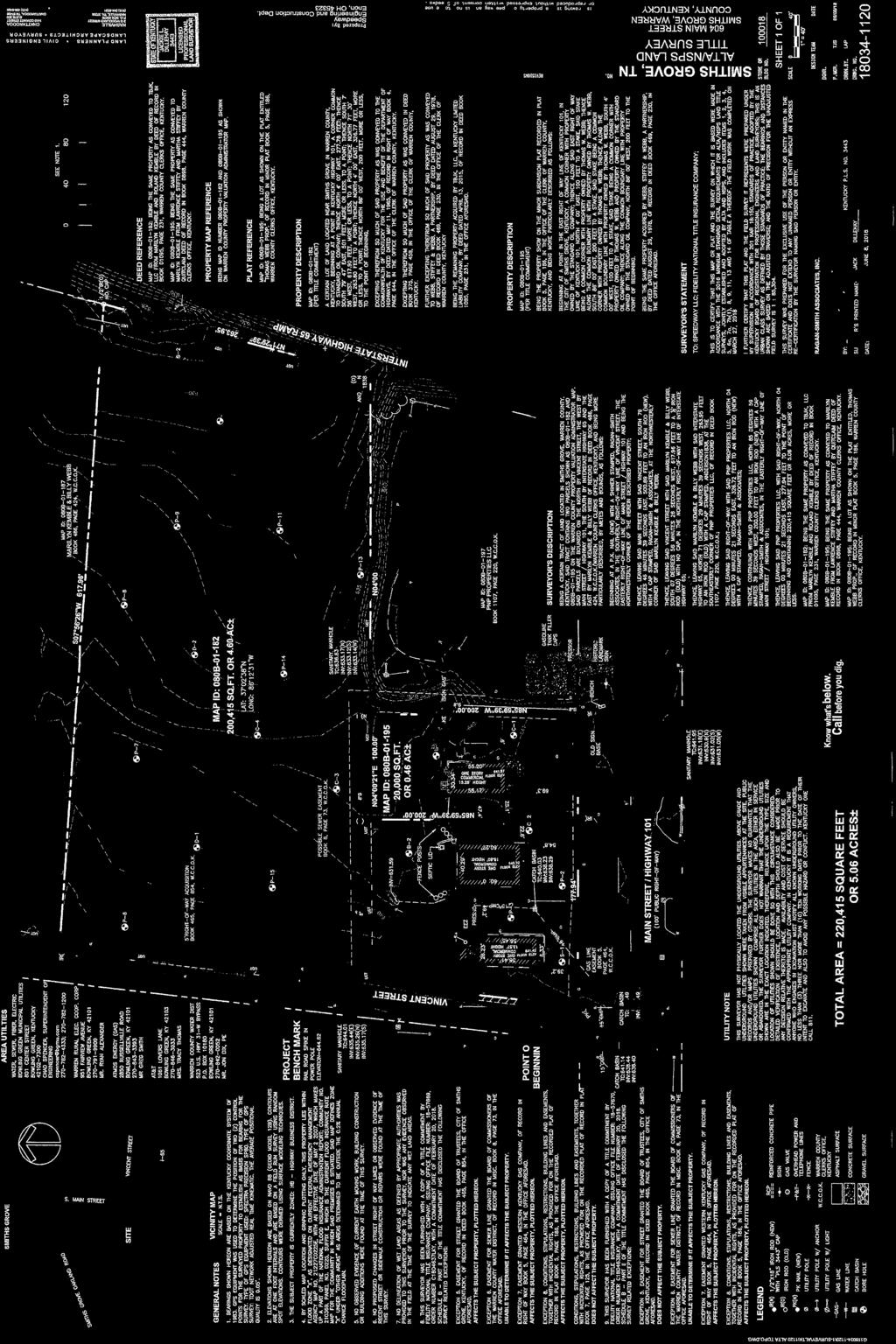
1 FLUM Page 1 of 30 FLUM AMENDMENT STAFF REPORT DOCKET/CASE/APPLICATION NUMBER CCPC City-County Planning Commission warrenpc.org (270) State Street Bowling Green, KY FLUM BRIEF SUMMARY OF REQUEST: The applicants are proposing to amend the FLUM for /- acres on properties at 604, 610 and 618 South Main Street in Smiths Grove from Highway Commercial to Light Industrial. If the FLUM amendment is successful, the applicants would later like to rezone the property to allow a convenience store and truck stop on the properties. PUBLIC HEARING DATE October 4, 2018 APPLICANTS/PROPERTY OWNERS McBride Dale Clarion c/o Robert Sweet Speedway, LLC c/o Mike Smead (applicants) TBJK LLC & Marilyn Kemble and Billy Webb (property owners) PROPERTY ADDRESSES/LOCATION 604, 610 & 618 South Main Street PRE-APP DATE March 8, 2018 PVA PARCEL NUMBERS 080B & 080B MAP SOURCE: CURRENT ZONING CURRENT LAND USE Commercial PROPOSED ZONING N/A PROPOSED LAND USE Commercial/ Industrial FUTURE LAND USE Highway Commercial FLUM AMENDMENT Yes No SIZE OF PROPERTY 5.06Acres PROPOSED DENSITY N/A OTHER INFORMATION Development Plan Conditions General Development Plan Neighborhood Meeting Traffic Impact Study (TIS) Environmental Assessment Public Comments PROPERTY HISTORY: The original zoning for the properties is agriculture. They were rezoned to commercial in 1976 and have been zoned some form of (Highway Business) since that time. COMPATIBILITY with COMPREHENSIVE PLAN: The properties are designated as Highway Commercial on the Smiths Grove FLUM. The applicants have requested to amend the FLUM to Light Industrial. The Planning Commission should determine if the proposed amendment is compatible with the surrounding area. COMPATIBILITY with the SURROUNDING DEVELOPMENT: The properties are located in the City of Smiths Grove. A site characteristic review indicates that there are generally adequate facilities and infrastructure available to support the proposed development. The properties contain a mature tree line along the southern property line. The Planning Commission should determine if the proposal is compatible with the surrounding area. POINTS TO CONSIDER: The Smiths Grove Focal Point Plan limits light industrial developments to areas currently designated as light industrial on the Smiths Grove FLUM. If this proposed FLUM amendment is approved, a rezoning and variance application would be the next step in the approval process. The Planning Commission should determine if the proposed development is compatible with the area.
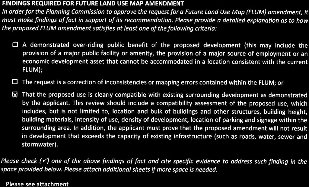
2 FLUM Page 2 of 30 FLUM Amendment Staff Report Note: Please see attached pre-application information for FLUM category descriptions and other belowreferenced material. FUTURE LAND USE MAP and CATEGORY REVIEW FLUM Designation: Highway Commercial, with a proposed FLUM amendment to Light Industrial (please see the attached Future Land Use Map). Applicable Goals, Objectives and/or Actions Items Future Land Use: LU Transportation: N/A Community Facilities: N/A Parks and Recreation: N/A Natural and Cultural Resources: N/A Housing and Neighborhoods: N/A Economic Development: N/A LU of the Comprehensive Plan states procedures for amending the FLUM. The Planning Commission s approval of a FLUM amendment should be based on at least one of the following criteria: o A demonstrated over-riding public benefit of the proposed development (this may include the provision of a majorly public facility or amenity, the provision of a major source of employment or an economic development asset that cannot be accommodated in a location consistent with the current FLUM). o The request is a correction of inconsistences or mapping errors contained within the FLUM. o The proposed use is clearly compatible with existing surrounding development as demonstrated by the applicant. This review should include a compatibly assessment of the proposed use, which includes, but is not limited to, location and bulk of building and other structures, building height, building materials, intensity of use, density of development, location of parking and signage within the surrounding area. In addition, the applicant must prove that the proposed amendment will not result in development that exceeds the capacity of existing infrastructure (such as roads, water, sewer and stormwater). The applicants have supplied a project summary to address the above criteria (please see attached). The summary statement addresses square footage, number of fuel pumps, transportation, building materials, landscaping and signage, among other items. SITE CHARACTERISTICS REVIEW Layout, lot sizes and setbacks: Please see the attached Preliminary Development Plan. Transportation Infrastructure: The properties have frontage on South Main Street (KY 101), a State maintained rural major collector with right-of-way and pavement width that vary. The properties also have frontage on Vincent Street, a City maintained urban local roadway with 50 feet of right-of-way and 18 feet of pavement width. The properties are adjacent to Ramp 38 on I-65, but have no direct access to I-65. Fire protection: This property is served by the Smiths Grove Volunteer Fire Department. Water adequacy: This property is served by Warren County Water District (WCWD) and has adequate water flow to meet the fire protection requirements. City-County Planning Commission warrenpc.org (270) State Street Bowling Green, KY 42101
3 FLUM Page 3 of 30 FLUM Amendment Staff Report Wastewater adequacy: Sewer is available to the property. Natural features: There is an existing tree line along the southern property line. Prime farmland: The properties are comprised of a soil type that is designated as prime farmland. There are existing businesses located along KY-101, with agricultural uses present in the rear portion of the development. Soil suitability: N/A Flood plains and wetlands: There are no known floodplains or wetlands known on this property. Cultural or historical features: There are no known unique cultural or historical features on the site. This application generally complies with the majority of the items in the Site Characteristics Review. AREA SPECIFIC POLICY REVIEW Applicable plan(s): These properties are located within the boundary of the Smiths Grove Focal Point Plan. If this application is approved, a future rezoning application would be evaluated on the items of the Smiths Grove Focal Point Plan at that time. Applicable policies from the Smiths Grove Focal Point Plan include items relating to the future land use map, infill development and size and scale and type of development. STAFF REVIEW SUMMARY The applicants are proposing to amend the FLUM from Highway Commercial to Light Industrial. If this application is successful, the applicants intend to submit a second application to rezone the properties for a convenience store, fuel sales and a truck stop. The Planning Commission should determine if the proposal is compatible with the area and if it meets the goals and objectives outlined in the Focus 2030 Comprehensive Plan. City-County Planning Commission warrenpc.org (270) State Street Bowling Green, KY 42101
4 FLUM Page 4 of 30 FLUM Amendment Staff Report SUGGESTED MOTIONS (FLUM Amendment) I make the motion to APPROVE the proposed Future Land Use Map Amendment, docket number FLUM. Based upon the testimony and documents presented in this public hearing, the proposed FLUM Amendment: Has met the directive to amend the FLUM as outlined in LU in the Comprehensive Plan. Further, I request that this motion include the summary of evidence and testimony presented by the witnesses at this public hearing. I make a motion to DENY the proposed Future Land Use Map Amendment docket number FLUM. Based upon the testimony and documents presented in this public hearing, the proposed FLUM Amendment: Has not met the directive to amend the FLUM as outlined in LU in the Comprehensive Plan. Further, I request that this motion include the summary of evidence and testimony presented by the witnesses at this public hearing. City-County Planning Commission warrenpc.org (270) State Street Bowling Green, KY 42101

5 FLUM Page 5 of 30 STREET SOUTH MAIN STREE T VINCEN T INTERSTATE 65 AERIAL FLUM Feet
6 FLUM Page 6 of 30 P GB BE BE LI BE LI BE BE LI BE LI BE SUNSET AVENUE BE GB BE GB BE GB BE BE LI BE MAIN ST BROWN STREET GB BE GB BE LAWSON ST BE BE BE BE BE BE BE VINCENT ST STANLEY RICE RD BE BE LI LI BE INTERSTATE 65 BE BE BE R-E SMITHS GROVE-SCOTTSVILLE RD EXISTING ZONING FLUM R-E CB HI NB OP-C PUD R-E RM-4 RR RS-1C RS-1D F GB LI MHP OP-R P RM-3 RS-1B R-E R-E Feet
7 FLUM Page 7 of 30 RUMSEY S T MAIN ST WITHERS POO N ST WEBB A VE LAWSON ST VINCEN T ST STANLE YR ICE RD SG RO VE -SC OT TS VI LLE RD INTERSTATE 65 SM ITH EXISTING LAND USE FLUM 400 RICULTURAL PUBLIC-INSTITUTIONAL COMMERCIAL MULTI-FAMILY RESIDENTIAL INDUSTRIAL SINGLE-FAMILY RESIDENTIAL PUBLIC VACANT Feet


8 FLUM Page 8 of 30

9 FLUM Page 9 of 30


10 FLUM Page 10 of 30


11 FLUM Page 11 of 30

12 FLUM Page 12 of 30

13 FLUM Page 13 of 30

14 FLUM Page 14 of 30

15 FLUM Page 15 of 30
16 Pre Application Conference Information Date: PROPERTY INFORMATION Attendees: Property Location: Property Owner(s): Current Zoning: Current Land Use: PVA Parcel #(s): CCPC City County Planning Commission warrenpc.org Contract Vendee(s): Proposed Zoning: Proposed Land Use: FLUM Page 16 of 30 APPLICATION TYPE ADDITIONAL DOCUMENTATION REQUIRED Zoning Map Amendment Traffic Impact Study FLUM Amendment to: Development Plan Conditions Development Plan/ Development Plan Conditions Amendment General Development Plan Conditional Use Permit Water / Sewer Verification Variance Geologic Analysis Other Other COMPREHENSIVE PLAN / FLUM COMPLIANCE REVIEW (FLUM and Category Descriptions are Attached) FLUM Designation Agriculture Rural Density Residential Low Density Residential Moderate Density Residential High Density Residential Mixed Use / Residential Mixed Use / Commercial Commercial Industrial Institutional / Governmental Open Space, Parks & Recreation Rural Village Special Focal Point Plan / FLUM Applicable Goals, Objectives and Action Items Future Land Use Natural and Cultural Resources LU LU LU LU NCR 1.1 NCR NCR 1.3 NCR 1.4 LU 2 LU 2.1 LU LU NCR 2.1 NCR 2.2 NCR 2.4 NCR LU LU LU LU NCR NCR 2.5 NCR LU 2.4 LU 2.5 LU LU LU 2.8 LU LU 2.9 LU 2.10 Housing and Neighborhoods HN 1 HN 1.2 HN 1.3 HN 2.1 Transportation HN 2.3 HN 3.2 HN 3.6 HN 4 TR 1.1 TR 2.1 TR 3 TR 4 HN 6 Community Facilities Economic Development CF 1.1 CF 1.4 CF 2.6 CF 5.3 ED 1 ED 1.8 ED 3 ED 4.5 CF 10.1 ED 9.1 ED 9.3 Parks and Recreation PR 1.7 PR 1.8 PR 3 PR 5.2 City County Planning Commission of Warren County 1141 State Street, Bowling Green, KY (270) Bowling Green Smiths Grove Oakland Warren County Plum Springs Woodburn
17 Pre Application Conference Information SITE CHARACTERISTICS REVIEW Layout, Lot Sizes and Setbacks Internal Street(s): Minimum Lot Size: Proposed Setbacks: Minimum Lot Width: CCPC City County Planning Commission warrenpc.org FLUM Page 17 of 30 Transportation Infrastructure What type of Roadway will serve the proposed development? Warren County Bowling Green KYTC Other What is the road width of the roadway that will serve the development? Fire Protection / Water Adequacy Does the proposed development meet the minimum requirements? YES NO All property located within the designated Bowling Green / Warren County Urbanized Area: 600 gallons per minute at 20 pounds of residual pressure. All property located outside the designated Bowling Green/ Warren County Urbanized Area: 250 gallons per minute with 20 pounds of residual pressure for Agriculture, Rural Residential and/or Residential Estate districts and 600 gallons per minute at 20 pounds of residual pressure for all other districts. Wastewater Considerations Public Sewer Available Property within 2,000 of Public Sewer On Site Septic System Natural Features Are there any natural features present on the property (i.e. steams, ponds, woodlands, sinkholes, etc.)? Soil Suitability How is the property classified in terms of soil suitability (See Figure 27, APP 63)? Not Limited Somewhat Limited Very Limited Prime Farmland How is the property classified in terms of farming suitability (See Figure 28, APP 64)? Prime Farmland Prime Farmland if Protected from Flooding Farmland of Statewide Importance Not Prime Farmland Unclassified Flood Plains and Wetlands Is the property (or a portion of the property) located within a flood plain or wetland? YES NO Cultural and Historical Features Are there any cultural/historical features located on the property (i.e. cemetery, historic structure, etc.)? City County Planning Commission of Warren County 1141 State Street, Bowling Green, KY (270) Bowling Green Smiths Grove Oakland Warren County Plum Springs Woodburn
18 Pre Application Conference Information SITE DESIGN AND COMPATIBILITY REVIEW Surrounding Density: Surrounding Land Uses: Surrounding Architectural Features: Building Materials: Building Orientation: Landscaping / Screening: Proposed Open Space: Connectivity: Pedestrian, Bicycle or Transit Facilities: CCPC City County Planning Commission warrenpc.org FLUM Page 18 of 30 AREA SPECIFIC POLICY REVIEW YES NO Is the property located within the boundary of any special Focal Point Plans, Overlay Districts, etc? Cemetery Road Overlay District Walnut Valley Focal Point Plan Lovers Lane Overlay District Cedar Ridge Focal Point Plan Scottsville Road Corridor Study Area Smiths Grove Focal Point Plan Woodburn Focal Point Plan Oakland Focal Point Plan STAFF NOTES City County Planning Commission of Warren County 1141 State Street, Bowling Green, KY (270) Bowling Green Smiths Grove Oakland Warren County Plum Springs Woodburn
19 Pre Application Conference Information CCPC City County Planning Commission warrenpc.org FLUM Page 19 of 30 FLUM AND CATEGORY DESCRIPTIONS Future Land Use Objective LU 1.1: Upon Plan adoption, utilize the Future Land Use Map (FLUM, Figure FLU 4) to guide decisionmaking regarding land uses and development proposals. Action LU 1.1.1: The Future Land Use Map (FLUM, Figure FLU 4) shall be used to determine the consistency which exists between future land use and development proposals. Action LU 1.1.2: The following land use categories are depicted on the FLUM and shall be used in conjunction with the map to determine the consistency of land use and development proposals: Agriculture () This land use designation applies to those rural areas relatively remote from the expanding rural suburban fringe, where agriculture uses are predominant with small and large scale farm operations. This classification can also include undeveloped areas used for open space and large tract single family residential property. While the presence of R E zoned land is acknowledged, and in some small areas, this zoning may even be prevalent, a new conservation development alternative to development under conventional or R E zoning, will become available to landowners. Conservation development is an approach to the design of residential subdivisions, which is highly suited to rural areas where the retention of open space, farmland, or uninterrupted vistas of the scenic, rural landscape is desired (See Page FLU 24 for a map of proposed Land Conservation Development Areas). Higher densities may be possible with a Conservation style development as permitted by the Zoning Ordinance. Rural Density Residential This land use designation applies to those rural areas relatively close to the suburban fringe. It also applies to areas where property fragmentation has occurred within unincorporated areas or near farming activities through provisions for exception lots in the zoning district or through re zoning and incremental subdivision of land as Residential Estate lots with gross densities ranging from zero (0) dwelling units per acre to one (1) dwelling units per acre. Higher densities may be possible with a Conservation style development as permitted by the Zoning Ordinance. Low Density Residential This land use designation comprises areas designated for single family detached development and attached singlefamily development including twin homes where each unit is platted on its own individual lot, with gross densities ranging from zero to four and a half (4.5) dwelling units per acre. Higher densities may be possible with a Conservation style development as permitted by the Zoning Ordinance. Moderate Density Residential This land use designation encourages areas developed for higher density single family detached and attached (RS 1C & RS 1D), as well as semi detached multi family development such as duplexes and townhouses, apartment buildings, condominiums and mobile home parks. Densities in this land use should range between three and a half (3.5) and thirteen (13) dwelling units per acre. High Density Residential This land use designation consists of areas occupied by multifamily housing, including higher density duplexes, townhomes, apartment buildings and condominiums. Densities exceeding eight (8) dwelling units per acre are encouraged in this Future Land Use category. High density single family may also be acceptable at five and a half (5.5) dwelling units per acre or greater. City County Planning Commission of Warren County 1141 State Street, Bowling Green, KY (270) Bowling Green Smiths Grove Oakland Warren County Plum Springs Woodburn
20 Pre Application Conference Information CCPC City County Planning Commission warrenpc.org FLUM Page 20 of 30 Commercial This land use designation consists of a broad array of commercial development, including individual commercial (retail, service, hotel or office) businesses that may exist along a highway corridor or a business district, as well as larger planned shopping centers and office parks. Limited high density multifamily uses are allowed to be mixed into commercial areas. These uses should be limited to upper stories or blended in or scattered among commercial uses. No more than 25% of any contiguous area designed Commercial should contain a multifamily uses. Compatibility will be assessed by applying policies in LU below in conjunction with a general development plan. Mixed Use The Future Land Use Map includes two categories of mixed land use. They refer to areas that combine complementary activities for example, retail, office or other commercial uses with residences, or industry with commerce. These can be existing developed areas, such as downtown Bowling Green, which retain a mixture of uses; or undeveloped or developing areas where the basic qualities of those existing mixed use areas (efficient use of land, higher development intensities, and pedestrian friendliness) are intended to be replicated. Bringing a diversity of uses together, in close proximity with one another, makes it possible to encourage the pedestrian orientation and to reduce vehicular trips and traffic congestion. The development pattern in mixed use areas may include different uses housed in different structures (sometimes on a single site), or different uses stacked one on top of another in a single structure. Generally, both of these development types are likely to be found in the mixed land use districts, which differ primarily in the relative amount of each land use that is encouraged in them. There are two sub categories of mixed use, based on the predominant character encouraged in each: Mixed Use/Residential This category applies to mixed use areas where, taken as a whole, the primary land use is residential in a variety of housing types and densities, balanced by complementary retail, office, institutional and civic uses. The distribution of land among these various activities shall be implemented through specific zoning, with standards addressing the form and character of development to ensure compatibility. This designation applies to the historic core of downtown Bowling Green or urbanized areas being redeveloped with the primary use as residential where complementary commercial and services are provided in a contiguous area. Here, development standards should be tailored to emphasize an urban character and a mix and intensity of development appropriate to this unique center of activity. When proposed as part of a mixed use development, Commercial uses should comprise of only twenty five percent (25%) of such development. Standalone Commercial developments should not exceed ten percent (10%) of any contiguous area designated Mixed Use Residential. No commercial footprint should exceed ten thousand (10,000) square feet. Compatibility will be assessed by applying policies in LU below in conjunction with a general development plan. Mixed Use/Commercial This category applies to strategic areas, mostly undeveloped today, that are located near designated industrial parks and accessible from major transportation corridors. These areas are envisioned as predominately large scale employment and business centers, albeit supplemented by compatible light industrial, retail, services, hotels and, where appropriate, higher density residential development (stand alone or in mixed use developments). The distribution of land among these various activities shall be addressed through specific zoning. However, primary activities in these areas may include low and medium rise office complexes, as well as environmentally friendly manufacturing and business centers. On large tracts, these uses should be encouraged to develop in a campus like setting, with quality architecture and generous, connected open space to maximize value, promote visual quality, and encourage pedestrian activity between employment areas and areas of supporting uses such as retail, restaurants, and residential. The primary focus of this category is commercial mixed uses with complementary residential comprising of up to 50% of the contiguous area. Compatibility will be assessed by applying policies in LU below in conjunction with a general development plan. City County Planning Commission of Warren County 1141 State Street, Bowling Green, KY (270) Bowling Green Smiths Grove Oakland Warren County Plum Springs Woodburn
21 Pre Application Conference Information CCPC City County Planning Commission warrenpc.org FLUM Page 21 of 30 Industrial This land use designation consists of areas developed or suitable for the uses permitted in the light (LI) and heavy (HI) industrial zoning categories. Because such areas require rail and truck access, future industrial development will continue to gravitate to the rail corridors and I 65 interchanges. Complementary service and commercial uses are allowed up to 25% of the total contiguous area. Compatibility will be assessed by applying policies in LU below in conjunction with a general development plan. Institutional / Government This land use designation consists of major public institutions, including the WKU campus and public schools, and governmental functions and operations such as the airport, government offices, and police and fire stations. Open Space, Park and Recreation This land use designation applies to all existing City and County owned public parks, golf courses, other recreational facilities, and permanently protected open spaces of countywide significance. Rural Village This land use designation is intended to provide for the continued vitality of the existing commercial and residential mixed use areas found in the smaller rural agricultural centers throughout Warren County. The rural village brings a sense of community and identification to the surrounding rural areas with an emphasis on providing essential goods and services to rural residents, but are not intended as employment designations for urban residents. Neighborhood scale commercial uses are encouraged as pockets of mixed use developments. Commercial uses should be limited in size and scale (less than 10,000 square feet) and only allow uses permitted in the zones outlined in the table below. When proposed as part of a mixed use development, commercial components should only comprise of no more than 10% of any such development. Standalone commercial development should not exceed more than 25% of any contiguous area designated Rural Village. Limited moderate density multifamily uses may be appropriate in some areas if limited in size and scale. Compatibility will be assessed by applying policies in LU below, in conjunction with a general development plan, and by applying specific polies found in Focal Point Plans, area plans, corridor studies, or any other plan created and approved by the Planning Commission. Future Land Use Category Residential Density Range Potentially Compatible Zoning Designations Agriculture 0-0.2**, RR*, RE* Rural Density Residential 0-1.0** RR, RE Low Density Residential 0-4.5** RR, RE,, RS-1B, PUD Moderate Density Residential , RS-1B, RS-1C, RS-1D,, RM-3, PUD, MHP High Density Residential 5.5 or greater RS-1D, RM-3, RM-4, GB, OP-R, CB, PUD, MHP Commercial 25% of development or RM-3, RM-4, GB,, OP-C, CB, PUD 10% of total contiguous area Mixed-Use / Residential 75% of development or 90% of total contiguous area, RS-1B, RS-1C, RS-1D,, RM-3, NB, GB, OP-R, CB, PUD Mixed-Use / Commercial 50% of contiguous area, RS-1B, RS-1C, RS-1D,, RM-3, RM-4, OP-C,, LI, PUD Industrial Not allowed OP-C,, LI, HI Institutional / Government Not allowed P Open Space, Parks and Recreation Not allowed P Rural Village * Allowed only with Agriculture FLUM exception lots as defined in LU ** Higher densities may be allowed in a Conservation Subdivision. 75% of development or 90% of total contiguous ar RR, RE,, RS-1B,, RM-3, NB, OP-R, GB, PUD City County Planning Commission of Warren County 1141 State Street, Bowling Green, KY (270) Bowling Green Smiths Grove Oakland Warren County Plum Springs Woodburn
22 Pre Application Conference Information CCPC City County Planning Commission warrenpc.org FLUM Page 22 of 30 Action LU 1.1.3: Requested re zonings (zone changes) shall be reviewed for consistency with the FLUM and the Development Review Provisions listed below. Development Review Provisions Map and General Policy Review The first step in determining compliance with the Comprehensive Plan is determining if the proposed use and zone are in agreement with the Future Land Use Map (LU 1.1.1) and Future Land Use categories listed in LU Additionally, applicable goals, objectives, and action items found in the Comprehensive Plan that may apply to the proposed use and zone should be identified as part of the community wide development compliance. Site Characteristics Review Unless specifically exempted by the zoning ordinance or by the Planning Commission, all zone change requests must be accompanied by a General Development Plan including any or all of the following: location and bulk of buildings and other structures, intensity of use, density of development, streets, ways, parking facilities, signs, drainage of surface water, access points, a plan for screening and buffering utilities, existing and manmade and natural conditions, and all other conditions requested by the Planning Commission and agreed to by the applicant. Each site shall identify the applicable site specific characteristics below and incorporate them on the general development plan, or in the application. The Planning Commission will consider how these items relate to relevant goals, objectives, and action items contained within the comprehensive plan as well as any other applicable codes, regulations or policies. o Proposed development layout, lot sizes, and setbacks (HN 1.2) o Transportation system adequacy or provisions for improvements (LU 2.3.1, TR 2.1) o Fire protection district, nearest station and hydrant locations (CF 1.1, CF 1.4, TR 3, TR 4) o Public water location, provider and certification of availability (CF 1.1, CF1.4) o Waste water location, provider and certification of availability (CF 1.1, CF 1.4) o Existing natural features (NCR 1.1, NCR 1.3) o Identification of prime farmland (Map FLU 2, NCR 2.4) o Soil suitability (Map 32) o Location of flood plains or wetlands (NCR 1.1) o Cultural and/or historical assets being removed or preserved (NCR 2.1, NCR 2.2) Site Design and Compatibility Review All proposals for new development must be assessed to determine their compatibility with the existing surrounding development. Compatibility may be shown because the proposed use is the same as the surrounding neighborhood, or it may be established by site design, buffering, control of access through the adjacent neighborhood, or other measures. Developments should address the following site design and compatibility considerations: o Surrounding density (HN 1.2) o Surrounding land uses (LU 2) o Surrounding building architecture including height, bulk, scale, massing, etc. (HN 1.2) o Proposed building materials (HN 1.2) o Building orientation in relation to the roadway (HN 1.2) o Proposed landscape buffering and/or screening (HN 1.2) o Proposed open space (LU 2.1.1, PR 2) o Connectivity to adjacent properties (LU 2.1.2) o Any pedestrian, bicycle or greenway facilities existing or proposed connections (LU 2.1.3, TR 3, TR 4, NCR 1.4, PR 3) City County Planning Commission of Warren County 1141 State Street, Bowling Green, KY (270) Bowling Green Smiths Grove Oakland Warren County Plum Springs Woodburn
23 Pre Application Conference Information CCPC City County Planning Commission warrenpc.org FLUM Page 23 of 30 Area Specific Policy Compliance In addition to the review items above, the Planning Commission will consider area specific policies created in focal point plans, area plans, corridor studies, and/or other similar plans created by the Planning Commission or other local and state government organizations. (LU 2.4, LU 2.8) Action LU 1.1.4: The following is a recommended protocol for the use of the Future Land Use Map and amending the FLUM. Purpose / Relationship to Zoning While the Zoning Map, and its associated zoning districts, defines specific uses and development types currently permitted for individual properties, the Future Land Use Map depicts more broadly the likely pattern of land uses that may exist in the future. Therefore, the FLUM does not directly determine the specific development that may be approved for a particular property. Applicants for zoning changes must demonstrate that the proposed use / development is consistent with the land use designation on the FLUM. However, consistency with the FLUM is only one of several considerations, and all other development criteria must be met for a rezoning approval, per the process laid out in the zoning ordinance and in KRS Because FLUM designations are considerably broader than provided in specific zoning districts, several different zoning districts may conform to the provisions of a single FLUM land use category. However, in cases where a proposed development type and associated zoning district is clearly inconsistent with the FLUM, and/or other provisions of the Comprehensive Plan, such rezoning approvals shall not be granted until and unless the FLUM is amended. Exceptions The following types of re zoning requests shall not require FLUM amendment prior to consideration for approval: o Emergency situations requiring immediate actions to protect public health, safety and welfare (e.g., providing temporary housing for those displaced by a natural disaster). o Corrections of zoning map errors o Single Family Residential rezoning requests for single family non conforming parcels that are less than 5 acres in size, and are compatible with existing residential land uses, and where only one new lot is being created from a parent tract that existed prior to July 1, o Rezoning requests of 10 acres or less, where a proposed development site lies within two or more future land use designations, if at least 50% of the property lies within a future land use designation which is consistent with the proposed zoning district. o Rezoning requests for property located within the Agriculture FLUM designation where the result will be the enlargement of an existing agricultural tract and the number of lots will remain the same as (or less than) what existed at the time the rezoning application was filed. The remaining lot must meet the requirements of the proposed zone and no lot resulting may be non conforming. Procedures for Amending the FLUM The Planning Commission s approval of a FLUM amendment request should be based on at least one of the following criteria: o A demonstrated over riding public benefit of the proposed development (this may include the provision of a major public facility or amenity, the provision of a major source of employment or an economic development asset that cannot be accommodated in a location consistent with the current FLUM). o The request is a correction of inconsistencies or mapping errors contained within the FLUM. o That the proposed use is clearly compatible with existing surrounding development as demonstrated by the applicant. This review should include a compatibility assessment of the proposed use, which includes, but is not limited to, location and bulk of buildings and other structures, building height, building materials, intensity of use, density of development, location of parking and signage within the surrounding area. In addition, the applicant must prove that the proposed amendment will not result in development that exceeds the capacity of existing infrastructure (such as roads, water, sewer and stormwater). City County Planning Commission of Warren County 1141 State Street, Bowling Green, KY (270) Bowling Green Smiths Grove Oakland Warren County Plum Springs Woodburn
24 Pre Application Conference Information CCPC City County Planning Commission warrenpc.org FLUM Page 24 of 30 Goal LU 2: Encourage compact, sustainable, high quality development which protects community character, provides balanced land uses and which is tailored to the variety of urban, suburban and rural sections of Warren County. Objective LU 2.1: Improve design standards and establish incentives for urban and suburban residential development. Action LU 2.1.1: Consider increasing or refining the standards for open space retention in new residential development, to ensure an adequate share of such space is usable and of scenic or ecological value. Action LU 2.1.2: Consider adoption of a roadway connectivity index applicable to new residential development or other developments with a significant residential component (40% or more). Action LU 2.1.3: Consider encouraging new developments to incorporate planned greenway links (as per the Greenbelt Master Plan) into their developments or, at a minimum, to provide connections to the greenway system whenever possible. Action LU 2.1.4: Consider adopting incentives to promote the preservation of existing trees on private property before, during, and after development, and standards that discourage clear cutting of trees. Action LU 2.3.1: Improve standards for access management (e.g., review spacing of driveways, consider requiring driveway sharing or parking lot connectivity, etc.) in order to reduce traffic friction and enhance safety. Action LU 2.3.4: Require that proposals for heavy industrial development in areas with a DRASTIC index of greater than 160 be accompanied by a detailed geologic analysis to determine the carrying capacity of the underlying soils with respect to the possibility of accidental spills of hazardous materials and storm water management. Objective LU 2.4: Establish a consistent sector/small area planning process to focus on areas of the County or the City that require special attention and a more detailed level of planning. Objective LU 2.5: Stabilize and protect Bowling Green s older neighborhoods. Action LU 2.5.2: Prepare guidelines to ensure the compatibility of infill development, particularly next to historic structures and sites. Action LU 2.5.3: Continue to identify and promote opportunities for revitalization and redevelopment. Objective LU 2.8: Continue to apply selected policies established in prior focal plans and overlay districts, in particular those pertaining to the smaller incorporated cities and corridors. Action LU 2.8.1: Continue to implement the adopted policy plans for Lovers Lane, Cemetery Road, Walnut Valley, the Cedar Ridge Neighborhood and the rural villages of Smiths Grove, Oakland and Woodburn. Any discrepancies between the 2030 Comprehensive Plan Future Land Use Map and the adopted policy plan maps shall follow that of the adopted policy plan (Volume 2 Appendix 3). Objective LU 2.9: Identify techniques to protect the County s small municipalities and rural settlements from development that is out of character. Objective LU 2.10: Identify and designate special character areas such as scenic roads and viewsheds for protection. City County Planning Commission of Warren County 1141 State Street, Bowling Green, KY (270) Bowling Green Smiths Grove Oakland Warren County Plum Springs Woodburn
25 Pre Application Conference Information CCPC City County Planning Commission warrenpc.org FLUM Page 25 of 30 Transportation Action TR 1.1: In reviewing development applications, identify the need to retain rights of way for roadways depicted in the long range plans of the MPO and the KYTC. Action TR 2.1: Continue to require that all private and public development is undertaken in a manner which promotes connectivity and minimizes traffic congestion on the existing road network, by implementing measures such as (but not limited to) the following: o Adjacent developments shall provide for internal circulation between them in accordance with the subdivision regulations. o At least one stub street should be constructed into each adjacent undeveloped property of 10 acres or more. The design of future alignment of street extensions onto adjacent tracts should benefit the surrounding community. Subsequent development of these adjacent tracts shall connect to the original stub street. o Access to existing collector and arterial roads shall be provided by newly constructed public streets spaced not closer than 600 feet on collectors and not closer than 1,320 feet on arterials. o All residential developments of 10 lots or more shall be served by an interior street system. o Development within the City limits of Bowling Green shall comply with the City s adopted Traffic Access Management Manual. Objective TR 3: Pedestrian and Bicycle Mobility: Promote pedestrian and bicycle mobility through an integrated network of sidewalks, paths and trails and through the encouragement of bicycle and pedestrian friendly streets and land use and development patterns. Objective TR 4: Transit System: Expand opportunities for transit alternatives to auto dependence for local, citywide, countywide and regional travel. Community Facilities Action CF 1.1: Proactively plan all public facilities to support desired land use patterns. Complete plans within timeframes sufficient to allow strategies for meeting future needs to be implemented before current planned capacities are exceeded. Action CF 1.4: Consider establishing a process for coordinated development review with utility providers, Planning Commission staff, parks department representatives, school district representatives, postal service representatives, fire and police representatives and other such relevant agencies, to expedite and more effectively coordinate development reviews. Action CF 2.6: On site sewage disposal systems may continue to be used provided that: o The Health Department must perform a site evaluation to determine the location, size and type of on site system to install. o The site evaluation must be performed and the on site disposal system located on the site before obtaining a building permit. o Every on site disposal system installation, regardless of lot size, must be approved by the Health Department. Action CF 5.3: Any new subdivision encompassing 5 lots or more shall be required to provide a minimum fire flow of 250 GPM. An exemption for subdivisions consisting of no more than 4 lots will continue to apply. Action CF 10.1: Promote technologies that reduce the impact of development and human activities on the environment, including sustainable development patterns, green building (e.g., encourage the use of green technologies in new construction, but also place an emphasis on adaptive reuse of existing buildings, and responsible deconstruction and reuse of building materials), alternative transportation, etc. City County Planning Commission of Warren County 1141 State Street, Bowling Green, KY (270) Bowling Green Smiths Grove Oakland Warren County Plum Springs Woodburn
26 Pre Application Conference Information CCPC City County Planning Commission warrenpc.org FLUM Page 26 of 30 Parks and Recreation Action PR 1.7: As necessary, review and enhance standards for new residential developments to ensure: o Connectivity of open spaces to the County s greenways system. o Protection of stream corridors and floodplains. o Protection and enhancement of tree canopy. Action PR 1.8: Adopt conservation/cluster subdivision design provisions to encourage the protection of open space, farmland, and rural character, making this approach an attractive alternative to conventional development in the zoning district. Objective PR 3: Continue to implement the Greenbelt System Master Plan and other programs that support bicycle and pedestrian recreation and mobility. Action PR 5.2: Provide and encourage appropriate levels of public access and amenities along the County s blueways, where feasible. Natural and Cultural Resources Objective NCR 1.1: Review and, as necessary, modify the land development regulations to ensure that land use and development decisions consider the physical suitability and natural resources of individual sites or areas anticipated for development. Action NCR 1.1.6: Consider amending the Zoning Ordinance and/or Subdivision Regulations to include standards and incentives for the protection of existing trees on infill and redevelopment sites before, during and after land development. The standards should take into account the health and maturity of existing trees to determine whether trees should remain in place, may be removed, or should be relocated (either on or off site) upon development. Objective NCR 1.3: Ensure that development is compatible with the natural environment, preserves unique landscapes and natural areas, conserves environmental resources and minimizes human impact on the natural environment. Objective NCR 1.4: Take advantage of local natural resources to create, protect, and enhance, and maintain recreational, educational, and cultural opportunities and activities, as long as such uses are compatible with those resources. Objective NCR 2.1: Gather, analyze and continuously update data about Warren County s unique cultural resources. Objective NCR 2.2: Support educational efforts to increase awareness of Warren County s cultural resources and to foster their preservation. Objective NCR 2.4: Implement strategies and tools to preserve and enhance Warren County s rural and agricultural heritage, including its agricultural landscapes and viewsheds, rural village centers, rural landmarks, and scenic rural corridors, etc. Action NCR 2.4.1: Use the Future Land Use Map, together with the policies in the Land Use, Transportation, and Community Facilities elements, in particular, to direct development first to areas where infrastructure already exists, in order to reduce the premature development pressure on the countryside. Action NCR 2.4.3: Adjust zoning and subdivision regulations to require development in rural village centers to be compatible in design and placement with existing surrounding structures, and to contribute to the historic character of the community. Objective NCR 2.5: Promote the economic viability and vitality of historic neighborhoods, historic districts, and rural landscapes, adjusting local government decision making processes, as necessary, to adequately consider cultural resources and historic preservation. Action NCR 2.5.3: Consider cultural historical resources in applicable development review. City County Planning Commission of Warren County 1141 State Street, Bowling Green, KY (270) Bowling Green Smiths Grove Oakland Warren County Plum Springs Woodburn

27 Pre Application Conference Information CCPC City County Planning Commission warrenpc.org FLUM Page 27 of 30 Housing and Neighborhoods Objective HN 1: Promote the development of infill sites with existing urban services and suitable redevelopment projects that maintain or improve existing character, development patterns and urban design. Action HN 1.2: Establish in the Zoning Ordinance clear compatibility criteria for new redevelopment and infill projects based on factors such as (but not limited to): building scale (massing, height), setbacks, parking location, landscaping and architectural character. Criteria may also include such items as requirements for compatible densities, street patterns, etc. (e.g., average density of new development should not exceed the density by more than 50 percent of the surrounding area, defined as that area located within a 1,000 foot radius). Action HN 1.3: Continue to identify and promote opportunities for infill and redevelopment, particularly projects which may strengthen existing neighborhoods and districts. Action HN 2.1: Promote the diversification of new housing stock by applying variable zoning densities and allowing a range of housing types in suitable locations, consistent with the Future Land Use Map. (e.g., mixed use centers, etc.). Action HN 2.3: Where housing is in severe disrepair to the point that rehabilitation is financially unfeasible, explore the possibility of acquiring and razing the structure to facilitate developing new housing for low and moderate income families. In cases of residential structures with historical significance, a higher threshold should apply for determining that rehabilitation is financially unfeasible. Action HN 3.2: Make revitalization of the Shake Rag neighborhood a priority, including housing rehabilitation activities, streetscape improvements, residential infill development, relocation of selected businesses, relocation of overhead utility lines, creation of a heritage walk from Fountain Square to the Barren Riverfront, development of minority owned businesses and identification of historic properties. Action HN 3.6: Revisit and, as necessary, adjust zoning in neighborhoods which are predominantly single family, but designated for multi family use. Characteristics of existing zoning designations that may need to be adjusted could include, but are not limited to: (a) failure to protect the primarily single family neighborhood from more intensive development; and/or (b) failure to promote new residential development that is sensitive in scale, form, and density to the established neighborhood character. Objective HN 4: Encourage an array of housing options in all parts of Warren County. Objective HN 6: Provide for the housing needs of the elderly, disabled and those in need of transitional housing. Economic Development Objective ED 1: Pursue actions to strengthen core industries, retain existing businesses and industries in the community and attract new businesses and industries, particularly those that will help to diversify the local economy. Action ED 1.8: Encourage the development and expansion of healthcare facilities and support facilities for those of retirement age. Objective ED 3: Support local small businesses, entrepreneurial endeavors and industries. Action ED 4.5: Allow and encourage agri tourism, farmers markets, local Co ops and community supported agriculture (CSAs), farmstands, accessory farm businesses, agricultural festivals, equestrian events and other activities that help to support a viable agriculture economy. Action ED 9.1: Support new cultural and entertainment venues, such as the development of a whitewater course on the Barren River, and completion of the Heritage Trail (a walking path from Fountain Square to the Riverfront), in Downtown Bowling Green, that complement current establishments such as the minor league baseball stadium, the Southern Kentucky Performing Arts Center and the Historic Railpark and Train Museum. Action ED 9.3: Consider the need for tourist support facilities (hotels, restaurants, etc.) when making land use and zoning decisions. City County Planning Commission of Warren County 1141 State Street, Bowling Green, KY (270) Bowling Green Smiths Grove Oakland Warren County Plum Springs Woodburn
28 FLUM Page 28 of 30 Warren County/Bowling Green Focus 2030 Comprehensive Plan Policies Regarding Development in Rural Village Focal Points ORV-Oakland Rural Village-General Policy Guidance ORV-1 New development should be planned to contribute to the maintenance and enhancement of the overall quality of life in the community. ORV-2 The rural village appearance of the primary entrance corridors into the City of Oakland should be preserved and maintained. ORV-3 To help prevent premature development of land at urban densities, the maintenance of agricultural land use on a permanent basis is encouraged. ORV-4 Development of any urban density residential or commercial development should be consistent in size and scale with the rural character of the landscape. ORV-5 Development of new recreation opportunities should be pursued and should offer linkage to the proposed Greenbelt system Master Plan of Warren County. ORV-6 New development must be consistent with any overlay district adopted for any portion of the Focal Point. ORV-7 New commercial development within the Oakland Focal Point should be of a neighborhood scale in size, character, and use. ORV-8 New industrial development within the Oakland Focal Point is not encouraged. SG-Smiths Grove Rural Village-General Policy Guidance SG-1 To ensure orderly development of vacant tracts and in-fill sites within the City of Smiths Grove, the Future Land Use Map should guide all zoning and development decisions. SG-2 Infill residential development should reflect the character of the neighborhood with regard to size, scale, setbacks, and architecture. SG-3 New single family residential development of greater than 10 units should be limited in density to no more than 4 units per acre. SG-4 All new residential development must have sidewalks, curb, and gutter. SG-5 New multi-family residential development shall be limited to two-family and townhouses only. SG-6 Highway commercial development should be limited to the area designated on the Smiths Grove Future Land Use Map. APP-76
Tuss and Lisa Taylor. Agriculture
 ZONE CHANGE STAFF REPORT CCPC City-County Planning Commission warrenpc.org (270) 842-1953 1141 State Street Bowling Green, KY 42101 DOCKET/CASE/APPLICATION NUMBER 2018-29-Z-CO PUBLIC HEARING DATE July
FUTURE LAND USE MAP AMENDMENT AND ZONE CHANGE STAFF REPORT
 2017-14-LUM & 2017-79-Z-CO / WB Page 1 of 12 UTURE LAND USE MAP AMENDMENT AND ZONE CHANGE STA REPORT Docket Numbers: 2017-14-LUM and 2017-79-Z-CO/WB Public Hearing Date: November 16, 2017 Pre-Application
Planning Department Oconee County, Georgia
 Planning Department Oconee County, Georgia STAFF REPORT REZONE CASE #: 6985 DATE: October 31, 2016 STAFF REPORT BY: Andrew C. Stern, Planner APPLICANT NAME: Williams & Associates, Land Planners PC PROPERTY
ARTICLE 3: Zone Districts
 ARTICLE 3: Zone Districts... 3-1 17.3.1: General...3-1 17.3.1.1: Purpose and Intent... 3-1 17.3.2: Districts and Maps...3-1 17.3.2.1: Applicability... 3-1 17.3.2.2: Creation of Districts... 3-1 17.3.2.3:
Appendix A: Guide to Zoning Categories Prince George's County, Maryland
 Appendix A: Guide to Zoning Categories Prince George's County, Maryland RESIDENTIAL ZONES 1 Updated November 2010 R-O-S: Reserved Open Space - Provides for permanent maintenance of certain areas of land
GOALS, OBJECTIVES, AND STRATEGIES
 GOALS, OBJECTIVES, AND STRATEGIES What follows is a series of goals, recommendations and actions that reflect the themes outlined in the Mineral Springs Vision Plan (incorporated into this document as
PLANNED UNIT DEVELOPMENT & SUBDIVISION STAFF REPORT Date: April 18, 2019
 PLANNED UNIT DEVELOPMENT & SUBDIVISION STAFF REPORT Date: April 18, 2019 DEVELOPMENT NAME SUBDIVISION NAME Springhill Village Subdivision Springhill Village Subdivision LOCATION 4350, 4354, 4356, 4358,
TOOELE COUNTY LAND USE ORDINANCE CHAPTER 31 Page 1
 CHAPTER 31 PLANNED COMMUNITY ZONE (P-C) Section 31-1 Definitions. 31-2 Purpose. 31-3 Land use districts. 31-4 P-C zone area minimum requirements. 31-5 Permitted uses. 31-6 Conditional uses. 31-7 Planning
ARTICLE B ZONING DISTRICTS
 ARTICLE B ZONING DISTRICTS Sec. 8-3021 Established. In order to protect the character of existing neighborhoods; to prevent excessive density of population in areas which are not adequately served with
Z-CO & 2018-V-11. July 5, 2018
 2018-30-Z-CO & 2018-V-11 Page 1 of 34 ZONE CHANGE AND VARIANCE STAFF REPORT CCPC City-County Planning Commission warrenpc.org (270) 842-1953 1141 State Street Bowling Green, KY 42101 DOCKET/CASE/APPLICATION
3.1. OBJECTIVES FOR RESIDENTIAL LAND USE DESIGNATIONS GENERAL OBJECTIVES FOR ALL RESIDENTIAL DESIGNATIONS
 3. RESIDENTIAL LAND USE DESIGNATIONS INTRODUCTION The Residential land use designations provide for housing and other land uses that are integral to, and supportive of, a residential environment. Housing
FUTURE LAND USE. City of St. Augustine Comprehensive Plan EAR-Based Amendments
 FUTURE LAND USE City of St. Augustine Comprehensive Plan EAR-Based Amendments Future Land Use Element FLU Goal To create an environment within the City and adjacent areas in which its residents have the
PROPOSED AMENDMENTS TO THE DERBY ZONING REGULATIONS AUGUST 12, 2008
 ARTICLE II Definitions and word usage 195-7. Definitions and word usage. Modify the following: HOUSING FOR THE ELDERLY OLDER PERSONS Housing in accordance with and as defined in the United States Fair
Future Land Use Categories & Nodes December 23, Future Land Use Categories
 Future Land Use Categories & Nodes December 23, 2015 A note regarding nodes: Descriptions for nodes are located in the general recommendations handout. Node locations are set in part by the Auburn Interactive
Bylaw No , being "Official Community Plan Bylaw, 2016" Schedule "A" DRAFT
 Bylaw No. 2600-2016, being "Official Community Plan Bylaw, 2016" Schedule "A" Urban Structure + Growth Plan Urban Structure Land use and growth management are among the most powerful policy tools at the
Chapter 100 Planned Unit Development in Corvallis Urban Fringe
 100.100 Scope and Purpose. Chapter 100 Planned Unit Development in Corvallis Urban Fringe (1) All applications for land divisions in the Urban Residential (UR) and Flood Plain Agriculture (FPA) zones within
DIVISION 1 PURPOSE OF DISTRICTS
 ARTICLE 2 ZONING DISTRICTS AND MAP DIVISION 1 PURPOSE OF DISTRICTS Section 2.101 Zoning Districts. For the purpose of this Ordinance, the City of Richmond is hereby divided into districts as follows: DISTRICT
Midwest City, Oklahoma Zoning Ordinance
 2010 Midwest City, Oklahoma Zoning Ordinance 9/2/2010 Table of Contents Section 1. General Provisions... 5 1.1. Citation... 5 1.2. Authority... 5 1.3. Purpose... 5 1.4. Nature and Application... 5 1.5.
CITY OF PORT ORCHARD
 CITY OF PORT ORCHARD ZONING DESIGNATIONS (Adapted from POMC Chapter 20.34 Zoning Districts, as adopted 6/13/2017) 20.34.110 Greenbelt zone (Gb). (1) Purpose. It is the purpose of the greenbelt zone to
Mohave County General Plan
 63 64 65 66 67 68 69 70 71 The Land Use Diagram is not the County's zoning map. 13 It is a guide to future land use patterns. Zoning and area plan designations may be more restrictive than the land use
4.2 RESIDENTIAL ZONING DISTRICTS
 4.2 RESIDENTIAL ZONING DISTRICTS A. Purpose: To define regulations and standards for each residential zoning district in the City. The following sections identify uses, regulations, and performance standards
ARTICLE 15 - PLANNED UNIT DEVELOPMENT
 Section 15.1 - Intent. ARTICLE 15 - PLANNED UNIT DEVELOPMENT A PUD, or Planned Unit Development, is not a District per se, but rather a set of standards that may be applied to a development type. The Planned
REPORT OF THE PLANNING AND DEVELOPMENT DEPARTMENT FOR APPLICATION FOR REZONING ORDINANCE TO PLANNED UNIT DEVELOPMENT APRIL 21, 2016
 BEL REPORT OF THE PLANNING AND DEVELOPMENT DEPARTMENT FOR APPLICATION FOR REZONING ORDINANCE TO PLANNED UNIT DEVELOPMENT APRIL 21, 2016 The Planning and Development Department hereby forwards to the Planning
ARTICLE FIVE FINAL DRAFT
 ARTICLE FIVE 021218 FINAL DRAFT Sec. 503.6 Open Space Preservation Option Open Space Preservation Option Open Space Preservation developments may be approved in the AR, R-1, R-2 and R-3 zoning districts,
ZONING AMENDMENT & SUBDIVISION STAFF REPORT Date: March 1, 2018
 #13 SUB-000406-2018 & ZON-000407-2018 ZONING AMENDMENT & SUBDIVISION STAFF REPORT Date: March 1, 2018 NAME SUBDIVISION NAME LOCATION Creekside @ Kooiman Dairy Creekside @ Kooiman Dairy Subdivision (South
TOTTENHAM SECONDARY PLAN
 TOTTENHAM SECONDARY PLAN AMENDMENT NO. 11 TO THE OFFICIAL PLAN OF THE TOWN OF NEW TECUMSETH The following text and schedules to the Official Plan of the Town of New Tecumseth constitute Amendment No. 11
Financial Impact Statement There are no immediate financial impacts associated with the adoption of this report.
 STAFF REPORT Planning and Development Department Subject: Application by RYC Property to rezone a portion of lands on John Murray Dr. and Megan Lynn Dr. from R2 to R3 and to enter into a Development Agreement
Comprehensive Plan /24/01
 IV The is a central component of the Comprehensive Plan. It is an extension of the general goals and policies of the community, as well as a reflection of previous development decisions and the physical
HOUSING ELEMENT GOALS, OBJECTIVES, & POLICIES
 HOUSING ELEMENT GOALS, OBJECTIVES, & POLICIES GOAL H-1: ENSURE THE PROVISION OF SAFE, AFFORDABLE, AND ADEQUATE HOUSING FOR ALL CURRENT AND FUTURE RESIDENTS OF WALTON COUNTY. Objective H-1.1: Develop a
PIN , Part 1, Plan SR-713 in Lot 2, Concession 5, Township of McKim (1096 Dublin Street, Sudbury)
") STAFF REPORT Applicant: Dalron Construction Limited Location: PIN 02124-0103, Part 1, Plan SR-713 in Lot 2, Concession 5, Township of McKim (1096 Dublin Street, Sudbury) Official Plan and Zoning By-law:
STAFF REPORT Applicant: Dalron Construction Limited Location: PIN 02124-0103, Part 1, Plan SR-713 in Lot 2, Concession 5, Township of McKim (1096 Dublin Street, Sudbury) Official Plan and Zoning By-law:
City of Valdosta Land Development Regulations
 Chapter 206 Section 206-1 Base Zoning Districts Standards for Uses, Structures, and Property Development (B) (C) Principal Uses and Structures. Principal uses and structures permitted in each base zoning
Primary Districts Established 4
 4.1 GENERAL PURPOSE SECTION 4 PRIMARY DISTRICTS ESTABLISHED The Town of Waxhaw, North Carolina is hereby divided into PRIMARY ZONING DISTRICTS as designated herein and as shown on the Official Zoning Map.
FUTURE LAND USE MAP AMENDMENT AND ZONE CHANGE STAFF REPORT
 2017-16-FLUM & 2017-81-Z-BG Page 1 of 13 FUTURE LAND USE MAP AMENDMENT AND ZONE CHANGE AFF REPORT Docket Numbers: 2017-16-FLUM and 2017-81-Z-BG Public Hearing Date: December 21, 2017 Pre-Application Conference:
ARTICLE 14 PLANNED UNIT DEVELOPMENT (PUD) DISTRICT
 DISTRICT") ARTICLE 14 PLANNED UNIT DEVELOPMENT (PUD) DISTRICT Section 14.01 Intent. It is the intent of this Article to allow the use of the planned unit development (PUD) process, as authorized by the Michigan Zoning
ARTICLE 14 PLANNED UNIT DEVELOPMENT (PUD) DISTRICT Section 14.01 Intent. It is the intent of this Article to allow the use of the planned unit development (PUD) process, as authorized by the Michigan Zoning
REPORT OF THE PLANNING AND DEVELOPMENT DEPARTMENT FOR APPLICATION FOR REZONING ORDINANCE TO PLANNED UNIT DEVELOPMENT MAY 18, 2017
 BEL REPORT OF THE PLANNING AND DEVELOPMENT DEPARTMENT FOR APPLICATION FOR REZONING ORDINANCE 2016-805 TO PLANNED UNIT DEVELOPMENT MAY 18, 2017 The Planning and Development Department hereby forwards to
8Land Use. The Land Use Plan consists of the following elements:
 8Land Use 1. Introduction The Land Use Plan consists of the following elements: 1. Introduction 2. Existing Conditions 3. Opportunities for Redevelopment 4. Land Use Projections 5. Future Land Use Policies
Appendix J - Planned Unit Development (PUD)
") Appendix J - Planned Unit Development (PUD) Intent and Purpose The purpose of the PUD is: 1. To provide development that is consistent with the Comprehensive Land Use Plan and promote the goals and objectives
Appendix J - Planned Unit Development (PUD) Intent and Purpose The purpose of the PUD is: 1. To provide development that is consistent with the Comprehensive Land Use Plan and promote the goals and objectives
Article Optional Method Requirements
 Article 59-6. Optional Method Requirements [DIV. 6.1. MPDU DEVELOPMENT IN RURAL RESIDENTIAL AND RESIDENTIAL ZONES Sec. 6.1.1. General Requirements... 6 2 Sec. 6.1.2. General Site and Building Type Mix...
Township of Tay Official Plan
 Township of Tay Official Plan Draft for Consultation (v.3) March 2016 Contents 1. INTRODUCTION... 1 1.1 Content, Title and Scope... 1 1.2 Basis and Purpose of this Plan... 1 1.3 Plan Structure... 2 2.
Glades County Staff Report and Recommendation Unified Staff Report for Small Scale Plan Amendment and Rezoning
 Glades County Staff Report and Recommendation Unified Staff Report for Small Scale Plan Amendment and Rezoning CASE NUMBERS: COMP17-02 and RZ17-02 DATE of STAFF REPORT: May 1, 2017 CASE TYPE: Application
Article 7: Residential Land Use and Development Requirements
 Article 7: Residential Land Use and Section 701: Statement of Intent (A) (B) (C) The intent of Article 7 is to develop certain land use and development requirements for the residential uses within Cumru
Staff Report for Council Public Meeting
 Agenda Item 3.3 Staff Report for Council Public Meeting Date of Meeting: September 27, 2017 Report Number: SRPRS.17.134 Department: Division: Subject: Planning and Regulatory Services Development Planning
AMENDMENT NUMBER 38 TO THE OFFICIAL PLAN OF THE TOWNSHIP OF WEST LINCOLN (COMPLIANCE)
") AMENDMENT NUMBER 38 TO THE OFFICIAL PLAN OF THE TOWNSHIP OF WEST LINCOLN (COMPLIANCE) 2013 AMENDMENT NUMBER 38 TO THE OFFICIAL PLAN OF THE TOWNSHIP OF WEST LINCOLN PART 1 - THE PREAMBLE 1.1 TITLE This
AMENDMENT NUMBER 38 TO THE OFFICIAL PLAN OF THE TOWNSHIP OF WEST LINCOLN (COMPLIANCE) 2013 AMENDMENT NUMBER 38 TO THE OFFICIAL PLAN OF THE TOWNSHIP OF WEST LINCOLN PART 1 - THE PREAMBLE 1.1 TITLE This
PINELLAS COUNTY COMPREHENSIVE PLAN
 PINELLAS COUNTY COMPREHENSIVE PLAN Future Land Use Map (FLUM) Category Descriptions and Rules Amended March 17, 2009 (Ordinance 09-17) Amended March 16, 2010 (Ordinance 10-18) Amended October 26, 2010
CHAPTER Committee Substitute for Committee Substitute for Senate Bill No. 2188
 CHAPTER 2004-372 Committee Substitute for Committee Substitute for Senate Bill No. 2188 An act relating to land development; amending s. 197.502, F.S.; providing for the issuance of an escheatment tax
Staff Report: Date: Applicant: Property Identification: Acreage of Request: Current Zoning of Requested Area: Requested Action: Attached:
 Staff Report: Completed by Jeff Palmer Director of Planning & Zoning Date: November 7, 2018, Updated November 20, 2018 Applicant: Greg Smith, Oberer Land Developer agent for Ronald Montgomery ET AL Property
SUBDIVISION, PLANNED UNIT DEVELOPMENT, ZONING AMENDMENT, & SIDEWALK WAIVER STAFF REPORT Date: July 19, 2018
 SUBDIVISION, PLANNED UNIT DEVELOPMENT, ZONING AMENDMENT, & SIDEWALK WAIVER STAFF REPORT Date: July 19, 2018 NAME SUBDIVISION NAME LOCATION West Mobile Properties, LLC U.S. Machine Subdivision 556, 566,
PLANNING COMMISSION REPORT Regular Agenda Public Hearing Item
 PC Staff Report 11/12/12 Item No. 2B- 1 PLANNING COMMISSION REPORT Regular Agenda Public Hearing Item ITEM NO. 2B: A TO GPI; 110 ACRES; E OF K-10 & N OF W 6 TH ST (MKM) : Consider a request to rezone approximately
PUBLIC DRAFT May 2017 Zoning Districts Use Regulations Definitions (partial)
") PUBLIC DRAFT May 2017 Zoning Districts Use Regulations Definitions (partial) Table of Contents Subchapter 1: General Provisions... 1 Subchapter 2: Administration & Procedures... 3 Subchapter 3: Zoning
PUBLIC DRAFT May 2017 Zoning Districts Use Regulations Definitions (partial) Table of Contents Subchapter 1: General Provisions... 1 Subchapter 2: Administration & Procedures... 3 Subchapter 3: Zoning
PLANNING COMMISSION REPORT Regular Agenda -Public Hearing Item
 PDP-13-00518 Item No. 3B- 1 PLANNING COMMISSION REPORT Regular Agenda -Public Hearing Item PC Staff Report 2/24/14 ITEM NO. 3B PRELIMINARY DEVELOPMENT PLAN FOR HERE @ KANSAS; 1101 INDIANA ST (SLD) PDP-13-00518:
DRAFT FOR PUBLIC HEARING (rev. March, 2016)
") Chapter 200. ZONING Article VI. Conservation/Cluster Subdivisions 200-45. Intent and Purpose These provisions are intended to: A. Guide the future growth and development of the community consistent with
Chapter 200. ZONING Article VI. Conservation/Cluster Subdivisions 200-45. Intent and Purpose These provisions are intended to: A. Guide the future growth and development of the community consistent with
LONG-RANGE LAND USE PLAN
 LONG-RANGE LAND USE PLAN INTENT Completion of the I-66/Route 29 interchange and future expansion of improved telecommunication networks will substantially improve the desirability of the Gainesville area
REPORT OF THE PLANNING AND DEVELOPMENT DEPARTMENT FOR APPLICATION FOR REZONING ORDINANCE TO PLANNED UNIT DEVELOPMENT SEPTEMBER 22, 2016
 BEL REPORT OF THE PLANNING AND DEVELOPMENT DEPARTMENT FOR APPLICATION FOR REZONING ORDINANCE 2016-576 TO PLANNED UNIT DEVELOPMENT SEPTEMBER 22, 2016 The Planning and Development Department hereby forwards
Be linked by an internal circulation system (i.e., walkways, streets, etc.) to other structures within the IPUD;
 to other structures within the IPUD;") 2. HALIFAX ACTIVITY CENTER A. DESCRIPTIONS OF FUTURE LAND USE DESIGNATIONS Each of the future land use designations specified by Phase I of the Halifax Activity Center Plan, and the relationship of these
2. HALIFAX ACTIVITY CENTER A. DESCRIPTIONS OF FUTURE LAND USE DESIGNATIONS Each of the future land use designations specified by Phase I of the Halifax Activity Center Plan, and the relationship of these
Place Type Descriptions Vision 2037 Comprehensive Plan
 Place Type Descriptions Vision 2037 Comprehensive Plan The Vision 2037 Comprehensive Plan establishes a range of place types for Oxford, ranging from low intensity (limited development) Rural and Natural
LAND USE AND ZONING OVERVIEW
 OVERVIEW OF PLANNING POLICIES LAND USE AND ZONING OVERVIEW The Minneapolis Plan for Sustainable Growth and Other Adopted Plans Community Planning and Economic Development Development Services Division
Salem HNA and EOA Advisory Committee Meeting #6
 Salem HNA and EOA Advisory Committee Meeting #6 Residential Land Policies Employment Land Policies Policy Discussions with the Committee Outcome of today s meeting Direction from this Committee on proposed
In order to permit maximum applicability of the PUD District, PUD-1 and PUD-2 Districts are hereby created.
 ARTICLE III. PUD ned Unit Development Overlay District 205-128. Purpose. The PUD ned Unit Development Overlay District is intended to provide flexibility in the design of planned projects; to encourage
REPORT OF THE PLANNING AND DEVELOPMENT DEPARTMENT FOR APPLICATION FOR REZONING ORDINANCE TO PLANNED UNIT DEVELOPMENT AUGUST 20, 2015
 BEL REPORT OF THE PLANNING AND DEVELOPMENT DEPARTMENT FOR APPLICATION FOR REZONING ORDINANCE TO PLANNED UNIT DEVELOPMENT AUGUST 20, 2015 The Planning and Development Department hereby forwards to the Planning
Rule 80. Preservation of Primary Agricultural Soils Revised and approved by the Land Use Panel during its public meeting on January 31, 2006.
 Rule 80. Preservation of Primary Agricultural Soils Revised and approved by the Land Use Panel during its public meeting on January 31, 2006. (A) Purpose. In accordance with 10 V.S.A. Sections 6025(b)
Marion County Board of County Commissioners
 Marion County Board of County Commissioners Date: 12/29/2015 P&Z: 12/28/2015 BCC: 1/12/2016 Item Number 160113Z Type of Application Rezoning Request From: A-1 (General Agriculture) To: PUD (Planned Unit
CITY OF PORTSMOUTH. CITY COUNCIL POLICY No HOUSING POLICY
 CITY OF PORTSMOUTH CITY COUNCIL POLICY No. 2016-03 HOUSING POLICY WHEREAS, the goals of the City of Portsmouth, as expressed in its 2025 Master Plan, include encouraging walkable mixed-use development,
Chapter Planned Residential Development Overlay
 Chapter 19.29 Planned Residential Development Overlay Sections 010 Purpose 020 Scope 030 Definitions 030 Minimum Size 040 Allowable Uses 050 Minimum Development Standards 060 Density Bonus 070 Open Space
APPENDIX D: DEFINITIONS
 D APPENDIX D: DEFINITIONS Terms used throughout the 2040 Comprehensive Plan should be interpreted using the definitions provided in this appendix. For interpretation of any term not defined, defer to the
PLANNING COMMISSION STAFF REPORT
 PLANNING COMMISSION STAFF REPORT REZONING CASE: RZ-15-002 REPORT DATE: January 26, 2016 CASE NAME: Thursday Lunch Club Rezoning PLANNING COMMISSION DATE: February 17, 2016 ADDRESS OF REZONING PROPOSAL:
Land Use. Existing Land Use
 8 Land Use 8.1 Land Use Chapter Purpose and Contents This element includes a brief summary of existing land use conditions and trends followed by a series of goals, objectives, and recommendations to guide
Indicates Council-recommended changes Introduced by: Mr. Tackett Date of introduction: June 14, 2016 SUBSTITUTE NO. 1 TO ORDINANCE NO.
 Indicates Council-recommended changes Introduced by: Mr. Tackett Date of introduction: June 14, 2016 SUBSTITUTE NO. 1 TO ORDINANCE NO. 16-067 TO AMEND NEW CASTLE COUNTY CODE CHAPTER 40 (ALSO KNOWN AS THE
STAFF REPORT. Permit Number: Porter. Kitsap County Board of Commissioners; Kitsap County Planning Commission
 STAFF REPORT Permit Number: 15 00461 Porter DATE: November 9, 2015 TO: FROM: Kitsap County Board of Commissioners; Kitsap County Planning Commission Katrina Knutson, AICP, Senior Planner, DCD and Jeff
Planning Department Oconee County, Georgia STAFF REPORT
 Planning Department Oconee County, Georgia STAFF REPORT REZONE CASE #: 7332 DATE: November 28, 2017 STAFF REPORT BY: Gabriel Quintas, Planner APPLICANT NAME: Smith Planning Group PROPERTY OWNER: John Hadden
THE AREA PLAN COMMISSION OF ST. JOSEPH COUNTY, IN AGENDA
 THE AREA PLAN COMMISSION OF ST. JOSEPH COUNTY, IN AGENDA Tuesday, June 20, 2017 Fourth-Floor Council Chambers 3:30 p.m. County-City Building, South Bend, IN PUBLIC HEARINGS: 1. Rezonings: A. A combined
Subdivision and Land Development Regulations. Jefferson County, West Virginia
 Subdivision and Land Development Regulations Jefferson County, West Virginia Adopted October 9, 2008 Amended September 29, 2016 Amendment Reference This document contains additions and amendments approved
A. Preserve natural resources as identified in the Comprehensive Plan.
 1370.08 Conservation Residential Overlay District. Subd. 1 Findings. The City finds that the lands and resources within the Conservation Residential Overlay District are a unique and valuable resource
Draft Model Access Management Overlay Ordinance
 Draft Model Access Management Overlay Ordinance This model was developed using the City of Hutchinson and the Trunk Highway 7 corridor. The basic provisions of this model may be adopted by any jurisdiction
RESIDENTIAL DISTRICTS
 RESIDENTIAL DISTRICTS RESIDENTIAL DISTRICTS The residential district standards have been revised to reflect on-the-ground development conditions, while continuing to respect the use patterns established
Planning & Development. Background. Subject Properties
 Planning & Development APPLICATION BRIEFING Prepared For: Planning Advisory Committee Submitted by: Jason Fox, Director of Planning & Development Date: Subject: Application by Meech Holdings Limited to
2030 General Plan. December 6, 7 pm
 2030 General Plan GPAC Meeting #9 GPAC Meeting #9 December 6, 7 pm City Council Input on Working Draft Land Use Map Council discussed GPAC & PC versions of the working draft land use map 11/28 Council
Pierce County Comprehensive Plan Review
 2015-2016 Pierce County Comprehensive Plan Review March 16, 2016 Introduction Planning and Management Policies Some of the policies governing both the planning and management of growth and change within
For Vintages of Four Mile Creek Town of Niagara on the Lake, Ontario
 Planning Impact Analysis For Vintages of Four Mile Creek Town of Niagara on the Lake, Ontario Prepared by: Upper Canada Consultants 261 Martindale Road Unit #1 St. Catharines, Ontario L2W 1A1 Prepared
610 LAND DIVISIONS AND PROPERTY LINE ADJUSTMENTS OUTSIDE A UGB
 ARTICLE VI: LAND DIVISIONS AND PROPERTY LINE ADJUSTMENTS VI-21 610 LAND DIVISIONS AND PROPERTY LINE ADJUSTMENTS OUTSIDE A UGB 610-1 Property Line Adjustments (Property Line Relocation) A property line
SUBJECT: Application for Planned Unit Development and Rezoning 1725 Winnetka Road
 TO: FROM: CHAIRMAN BILL VASELOPULOS AND MEMBERS OF THE PLAN & ZONING COMMISSION STEVE GUTIERREZ DIRECTOR OF COMMUNITY DEVELOPMENT MEETING DATE: September 5, 2017 SUBJECT: Application for Planned Unit Development
THE REDEVELOPMENT PLAN
 PAGE 37 THE REDEVELOPMENT PLAN FUTURE LAND USE The Silver Terrace Redevelopment Area is currently designated as Redevelopment Area #4 on the City of Delray Beach Future Land Use Map (FLUM). This designation
Planning Justification Report
 Planning Justification Report Kellogg s Lands City of London E&E McLaughlin Ltd. June 14, 2017 Zelinka Priamo Ltd. Page i TABLE OF CONTENTS Page No. 1.0 2.0 2.1 2.2 3.0 4.0 5.0 5.1 5.2 5.3 5.4 5.5 5.6
Town of Cary, North Carolina Rezoning Staff Report 12-REZ-27 Morris Branch Town Council Public Hearing January 24, 2013
 Town of Cary, North Carolina Rezoning Staff Report 12-REZ-27 Morris Branch Town Council Public Hearing January 24, 2013 REQUEST To amend the Town of Cary Official Zoning Map to rezone approximately 9.0
Cover Letter with Narrative Statement
 Cover Letter with Narrative Statement March 31, 2017 rev July 27, 2017 RE: Rushton Pointe Residential Planned Unit Development Application for Public Hearing for RPUD Rezone PL2015 000 0306 Mr. Eric Johnson,
Highland Green Estates Neighbourhood Area Structure Plan
 Highland Green Estates Neighbourhood Area Structure Plan Original Outline Plan approved by Council: March 10, 1997 Outline Plan amended by Council: March 24, 1997 Converted to a Neighbourhood Area Structure
O-I (Office-Institutional) and AG-1(Agricultural)
 and AG-1(Agricultural)") PROPERTY INFORMATION ADDRESS 3503 and 3505 Bethany Bend DISTRICT, LAND LOTS 2/1 973 and 974 OVERLAY DISTRICT State Route 9 PETITION NUMBERS EXISTING ZONING O-I (Office-Institutional) and AG-1(Agricultural)
PROPERTY INFORMATION ADDRESS 3503 and 3505 Bethany Bend DISTRICT, LAND LOTS 2/1 973 and 974 OVERLAY DISTRICT State Route 9 PETITION NUMBERS EXISTING ZONING O-I (Office-Institutional) and AG-1(Agricultural)
6. RESIDENTIAL ZONE REGULATIONS
 6. RESIDENTIAL ZONE REGULATIONS PART 6A PURPOSE OF CHAPTER (1) The purpose of this Chapter is to provide detailed regulations and requirements that are relevant only to residential zones and specific residential
PLANNING COMMISSION STAFF REPORT
 PLANNING COMMISSION STAFF REPORT REZONING CASE: RZ-16-001 REPORT DATE: March 8, 2016 CASE NAME: Trailbreak Partners Rezoning PLANNING COMMISSION DATE: March 16, 2016 ADDRESSES OF REZONING PROPOSAL: 5501
ARTICLE III District Regulations. A map entitled "Franklin Zoning Map" is hereby adopted as part of this chapter 1.
 ARTICLE III District Regulations ~ 305-8. Adoption of Zoning Map. A map entitled "Franklin Zoning Map" is hereby adopted as part of this chapter 1. ~ 305-9. Official Zoning Map; amendments. Regardless
Comprehensive Plan Amendment #PLN , Reserve at Cannon Branch (Coles Magisterial District)
") COUNTY OF PRINCE WILLIAM 5 County Complex Court, Prince William, Virginia 22192-9201 PLANNING (703) 792-7615 FAX (703) 792-4758 OFFICE Internet www.pwcgov.org Christopher M. Price, AICP Director of Planning
COUNTY OF PRINCE WILLIAM 5 County Complex Court, Prince William, Virginia 22192-9201 PLANNING (703) 792-7615 FAX (703) 792-4758 OFFICE Internet www.pwcgov.org Christopher M. Price, AICP Director of Planning
Town of Cary, North Carolina Rezoning Staff Report 14-REZ-31 Cary Park PDD Amendment (Waterford II) Town Council Meeting January 15, 2015
 Town Council Meeting January 15, 2015") Town of Cary, North Carolina Rezoning Staff Report 14-REZ-31 Cary Park PDD Amendment (Waterford II) Town Council Meeting January 15, 2015 REQUEST To amend the Town of Cary Official Zoning Map by amending
Town of Cary, North Carolina Rezoning Staff Report 14-REZ-31 Cary Park PDD Amendment (Waterford II) Town Council Meeting January 15, 2015 REQUEST To amend the Town of Cary Official Zoning Map by amending
SECTION 16. "PUD" PLANNED UNIT DEVELOPMENT OVERLAY DISTRICT
 SECTION 6. "PUD" PLANNED UNIT DEVELOPMENT OVERLAY DISTRICT Subsection. Purpose. This district is established to achieve the coordinated integration of land parcels and large commercial and retail establishments
City of Tacoma Zoning Reference Guide
 City of Tacoma Zoning Reference Guide Planning and Development Services 747 Market Street, Room 345 Tacoma, WA 98402 (253) 591-5577 This document should not be used as a substitute for codes and regulations.
ARTICLE Encourage well planned, efficient development.
 ARTICLE 14.00 PD PLANNED SECTIONS: 14.01 Intent 14.02 Procedure 14.03 Initial Development Plan 14.04 Final Development Plan 14.05 Amendments 14.06 Planned Development Districts PD-1 Willow Run PD PD-2
FINAL DRAFT 10/23/06 ARTICLE VI
 FINAL DRAFT 10/23/06 ARTICLE VI 185-41.1. Planned Residential Development A. Purpose and Intent. The purposes of the Planned Residential Development (PRD) bylaw are to maintain the rural character of Dover,
PLANNED UNIT DEVELOPMENT (PUD)
") SECTION 38.01. ARTICLE 38 PLANNED UNIT DEVELOPMENT (PUD) Purpose The purpose of this Article is to implement the provisions of the Michigan Zoning Enabling Act, Public Act 110 of 2006, as amended, authorizing
SECTION 38.01. ARTICLE 38 PLANNED UNIT DEVELOPMENT (PUD) Purpose The purpose of this Article is to implement the provisions of the Michigan Zoning Enabling Act, Public Act 110 of 2006, as amended, authorizing
Planned Unit Development (PUD). Sections:
. Sections:") Chapter 19.07. Planned Unit Development (PUD). Sections: 19.07.01. Purpose. 19.07.02. PUD Definition and Design Compatibility. 19.07.03. General PUD Standards. 19.07.04. Underlying Zones. 19.07.05. Permitted
Chapter 19.07. Planned Unit Development (PUD). Sections: 19.07.01. Purpose. 19.07.02. PUD Definition and Design Compatibility. 19.07.03. General PUD Standards. 19.07.04. Underlying Zones. 19.07.05. Permitted
ARTICLE 2 ZONING DISTRICTS AND MAPS
 ARTICLE 2 ZONING DISTRICTS AND MAPS SECTION 2.100 PURPOSE OF DISTRICTS Section 2.101. For the purpose of this Ordinance, Billings Township is hereby divided into districts as follows: DISTRICT NAME SYMBOL
Subdivision and Land Development Regulations. Jefferson County, West Virginia
 Subdivision and Land Development Regulations Jefferson County, West Virginia Adopted October 9, 2008 Amended April 16, 2015 Amendment Reference This document contains additions and amendments approved
THE WHEELER BUILDING SUBDIVISION
 THE WHEELER BUILDING SUBDIVISION Engineering Comments: FINAL PLAT COMMENTS (should be addressed prior to submitting the FINAL PLAT for review and/or signature by the City Engineer): A. Provide all of the