544 Rood Avenue Grand Junction, Co.
|
|
|
- Barbara Stone
- 5 years ago
- Views:
Transcription

1 PLANNING COMMISSION HEARING January 21, :00 P.M. 544 Rood Avenue Grand Junction, Co. 1
2 MCPC Rolling Calendar January 21, 2016 Mesa County Planning Commission Hearing - 6 PM Rood Ave - Hearing Room Project # Project Name Planner BoCC Status New MCPC CP Midlands Self Storage PUD Amendment Christie 2/9 OK February 11, 2016 Mesa County Planning Commission Workshop - 5:45 PM S. Spruce St. - Room 40A Project # Project Name Planner BoCC Status New MCPC CP Cumberlin Subdivision Concept Plan Jeff 2
3 Mesa County Planning Commission Public Meeting Joseph H. Moreng, Chair Rusty Price, Vice Chair Chip Page, Secretary Christi Flynn Phillip Jones David J. Hartmann George Skiff Ron Wriston (1 st Alternate) Bill Somerville (2 nd Alternate) Robert Erbisch (3 rd Alternate) Date: Thursday, January 21, 2016 Time: 6:00 p.m. Place: Mesa County Public Hearing Room, 544 Rood Avenue, 2 nd Floor, Grand Junction, Colorado. Please use the 6 th Street entrance. The following items will be presented at this public hearing of the Mesa County Planning Commission for their consideration. The Planning Commission will formulate a recommendation, which will be forwarded to the Mesa County Board of County Commissioners. If you have an interest in an item on the Agenda, the date and time of the County Commissioners hearing is listed after each agenda item. Your appearance at both hearings is important and encouraged. The purpose of a land use hearing is to have the facts of a case presented in a manner that will assist the decision-makers in making a fair, legal, and complete decision. The hearing is a factfinding forum by unbiased decision-makers, not a popularity contest. Unruly behavior, such as booing, hissing, cheering, applause, verbal outbursts, or other inappropriate behavior, detract from the hearing and will not be permitted. An 11:00 Rule will be enforced. This rule does not allow new agenda items to be heard after 11:00 p.m. NOTE: Copies of Staff Reports for Hearing Items are available on the back table within the hearing room. A. CALL TO ORDER B. PLEDGE OF ALLEGIANCE C. APPROVAL OF MINUTES D. AMENDMENTS TO THE AGENDA E. ANNOUNCEMENTS AND/OR PRESENTATIONS F. CONTINUED ITEMS: NONE END OF CONTINUED ITEMS G. WITHDRAWN ITEMS: NONE END OF WITHDRAWN ITEMS 3
4 H. CONSENT AGENDA ITEMS: Items placed on the Consent Agenda allow the Planning Commission to spend its time on the more complex items. These items are generally not perceived as controversial and can be approved by a single motion. The petitioners and staff are in agreement on all of the recommendations on these projects. The Planning Commission will pass these items to the Mesa County Commissioners, subject to staff and review agency comments. Anyone from the public or the Planning Commission may ask that an item be removed from the Consent Agenda for individual consideration at tonight s hearing. NOTICE: If an applicant agrees to have a project placed on the Consent Agenda for the Planning Commission, and it is approved on that Agenda, the project will be forwarded to the Mesa County Commissioner s Consent Agenda. If an applicant decides to remove the item from the Board s Consent Agenda, the project will be referred back to the Planning Commission and rescheduled for a new hearing date. NONE END OF CONSENT ITEMS I. HEARING ITEMS: PRESENTATION RULES: Due to the volume of items to be heard the follow restrictions may be applied to help expedite the hearing process: a) Where practical, presentations by staff and petitioners will be limited to 15 minutes or less. Petitioners are asked to not repeat presentation information that the staff has correctly presented. Please address the clarification to the staff's presentation, new information or new developments to the project, and the staff and agency review comments and recommendations. b) Responses in favor or in opposition to the proposal will be limited to approximately 3 minutes each. We prefer only new information to be presented. A single speaker may be selected on behalf of organized groups CP MIDLANDS SELF STORAGE PUD AMENDMENT Property Owner: Midlands Village Properties I, LLC Representative: Tom Logue Location: 435 and Road, Clifton, (D½ and 32 Roads) Zoning: RMF-8 Planner: Christie Barton, , christie.barton@mesacounty.us Request: Amend the Midlands Village PUD to include the Road property for a self-storage and office facility for use by Midlands Village residents and the public. The use includes 341 self storage units, a 290 square foot office, and temporary outdoor storage of recreation vehicles (RVs and boats). The units along the west, north and east property lines will be temperature controlled units with internal hallway access. The previous property owner (Banks) will have life use of the property. Development of the property will occur in three phases. Staff Recommendation: Approval with Conditions Board of County Commissioners Hearing Date:
5 END OF HEARING ITEMS J. PLANNING DIRECTOR UPDATES NONE END OF PLANNING DIRECTOR UPDATES K. ELECTION OF OFFICERS Chair Vice Chair Secretary END OF ELECTION OF OFFICERS L. ADJOURNMENT The Mesa County Public Hearing Room is accessible to the handicapped. With advance request, a sign language interpreter may be made available (call or TDD ). Mesa County Planning Division P.O. Box 20,000, 200 S. Spruce St. Grand Junction, CO 5
6 MESA COUNTY PLANNING COMMISSION DECEMBER 17, 2015 PUBLIC HEARING MINUTES Chairman Moreng called to order a scheduled hearing of the Mesa County Planning Commission at 6 PM. Chairman Moreng led the Pledge of Allegiance. The hearing was held in the Public Hearing Room, Mesa County Administration Building at 544 Rood Avenue, Grand Junction, Colorado. In attendance representing the Mesa County Planning Commission, were: Joe Moreng, Chip Page, Rusty Price, David Hartmann, George Skiff, Bill Somerville and Robert Erbisch. In attendance, representing the Mesa County Planning Division, were: Linda Dannenberger, Kaye Simonson, Jeff Hofman, and Christie Barton. Patrick Coleman, County Attorney was present. Kathy Kinsey was present to record the minutes. There were seven (7) citizens present throughout the hearing. Approval of Minutes Motion: Commissioner Page moved to approve the minutes as written. Second: Commissioner Somerville Motion Approved 4-0 Continued Items CP MIDLANDS SELF STORAGE PUD AMENDMENT Property Owner: Midlands Village Properties I, LLC Representative: Tom Logue Location: 435 and Road, Clifton, (D½ and 32 Roads) Zoning: RMF-8 Planner: Christie Barton, , christie.barton@mesacounty.us Request: Amend the Midlands Village PUD to include the Road property for a self-storage and office facility for use by Midlands Village residents and the public. The use includes 341 self-storage units, a 290 square foot office, and temporary outdoor storage of recreation vehicles (RVs and boats). The units along the west, north and east property lines will be temperature controlled units with internal hallway access. The previous property owner (Banks) will have life use of the property. Development of the property will occur in three phases. Staff Recommendation: Approval with Conditions Planning Commission Hearing Date Continued to: Board of County Commissioners Hearing Date Continued to: Motion: Commissioner Price Second: Commissioner Erbisch Motion Approved 7-0 Consent Items 6
7 Chairman Moreng explained the consent agenda and asked for a motion to approve or if anyone from the Planning Commission or public had any concerns or questions about any of the consent agenda Items RZ RIDDLE REZONE Property Owners: Neil and Donna Riddle Location: 2777 Purdy Mesa Road, Whitewater, (Purdy Mesa & Divide Rds) Zoning: AF35 Planner: Christie Barton, , christie.barton@mesacounty.us Request: To rezone a 32.9 acre parcel from the AF35 (Agricultural and Forestry) District to the AFT (Agricultural, Forestry, Transitional) District. Staff Recommendation: Approval Board of County Commissioners Hearing Date: CUP TWO HEART RANCH - MINOR ENTERTAINMENT EVENTS CONDITIONAL USE PERMIT Property Owner(s): Jason Fuller, Allison Fuller, Jeffrey Krebs, Linda Krebs Location: 140 Whiting Road, Whitewater, 81527(Kannah Creek Rd & Whiting Rd) Zoning: AFT Planner: Jeff Hofman, , jeff.hofman@mesacounty.us Request: Approve a Minor Entertainment Events Conditional Use Permit in the AFT zone district. This type of use is typically for weddings and receptions, family reunions and other private parties. The applicant is requesting a permit for 30 events per year with up to 215 guests. Staff Recommendation: Approval with Conditions Board of County Commissioners Hearing Date: Motion: Commissioner Somerville moved to approve the consent agenda. Second: Commissioner Page Motion Approval 7-0 Hearing Items CUP DRIVEN EXPERIENCES AMENDMENT TO CONDITIONAL USE PERMIT Property Owner(s): Western Sky Investments, LLC Representative(s): John Williams Location: Road, Gateway, (4.5 miles northwest of Hwy. 141 & 4.2 Road intersection) Zoning: AFT Planner: Jeff Hofman, , jeff.hofman@mesacounty.us Request: To amend the CUP to allow the existing driving course to expand on the property and allow limited-night time operations (no more than 10 nights per year). Staff Recommendation: Approval with Conditions Board of County Commissioners Hearing Date:
8 Staff Presentation Jeff Hofman entered into the record the project report, the PowerPoint presentation labeled as Exhibit A, the Representative s Exhibit B, and a letter from Colorado Parks and Wildlife labeled as Exhibit C. Mr. Hofman explained that this request is an amendment to the original CUP dating back to This request is to allow the existing off-road driving course to expand on the property, increase the signage that is allowed and to allow for night time operations for no more than 10 nights per year. Mr. Hofman showed a location map, a zoning map and an aerial photo pointing out the public lands and surrounding area, which is mostly BLM land. He also pointed out where the Utah state line is and 4.2 Road. Mr. Hofman showed a Future Land Use Map and stated that this area is RA35+ future land use. He stated that this track is restricted to the guests of the Gateway Canyon Resort. Mr. Hofman stated that in 2012 the permit limited the area to the west of a main drainage channel that cuts through the site, it was also limited to daylight hours and it limited the signage to 32 square feet. They wish to expand the track across the major drainage, allow up to 10 nights of use per year, and to increase the signage to 100 square feet. He continued to show a site plan showing the existing track and the expansion area. Several more photos were shown of the area, pointing out the support structure and he stated that there is a rail fence that divides the property from 4.2 Road. Mr. Hofman went on to explain the approval criteria in Section of the Code. He talked about the gate at the entrance to the property and stated that its placement on the property line has not caused any undesirable issues with traffic on the road. He went on to discuss the possibility of adverse impacts from the proposed expansion of use and talked about maintaining the natural environment, such as wildlife wintering habitat, weed management, the riparian area, and drainage and erosion. Mr. Hofman stated that Colorado Parks and Wildlife provided comments and they are recommending a winter closure from December 1st to April 1st to protect wildlife wintering habitat. This condition was also requested in the first review in He stated that the Board of County Commissioners struck that restriction in 2012 but it has been received again from Colorado Parks and Wildlife, as stated in the letter labeled Exhibit C. Parks and Wildlife has amended their comments to allow for a March 15th opening. Mr. Hofman went on to discuss the details in the Exhibit C letter, which includes migration of mule deer in the winter, a weed management program for the area, the riparian area, drainage, erosion and the silt traps. He went on to list and explain the conditions of approval. He also mentioned that the property owner to the south, Jack Treece, contacted Mesa County and that he requested some additional information but he didn t provide any additional comments. The Gateway Property Owners Association also contacted Mr. Hofman and they did not have any comments on this proposal. Applicant/Representative Presentation John Williams represents Andrew Hendricks, the applicant for this amendment to the conditional use permit. Mr. Williams informed everyone that Mr. Al Sison oversees things for Mr. Hendricks and he is in the audience tonight, if anyone has questions 8
9 about the property or any of Mr. Hendricks operations around Gateway Canyons. Mr. Williams entered paper copies of his PowerPoint into the record as Exhibit 1 and copies were given to the commissioners. Mr. Williams showed the PowerPoint presentation and explained some of the background of the project and showed some maps and photos of Gateway and the Driven Experience area, which is 313 acres. He stated that there is a 72-acre buffer zone between Mr. Treece s property and this property. Mr. Williams talked about the drivers involved in the course and explained that these people are professional drivers that want to teach the science and art of off-road driving and said the people in the Gateway community support off-road driving along with other outdoor activities in this area. He explained that the request for occasional night hours will not bother others because the only lights are the ones on the vehicles and there will be no external lights on the property. Mr. Williams showed a photo of the vehicle and explained that this expanded area has helped to attract Ford as one of their sponsors. He went to discuss the land and stated that John Hendricks owns all of this property except for the piece that Mr. Treece lives on and that it s also surrounded by BLM land. Further discussion took place regarding the drainage and erosion and Mr. Williams stated that in the original project conditions, it said they had to come back for additional approval if the expansion crossed the current drainage channel. He continued to explain that there was no disturbance of the historical drainage patterns and they are working with a civil engineer, Eric Slivon, and what he wants to do will help the erosion and drainage. They will have a monitoring program and will clean out sediment basins, put an overflow feature in, and then they can go in and clean these out so the water doesn t flow back on the track. He stated that there was talk that the Army Corps of Engineers may need to be involved but with further research, learned from their water engineers that this is a maintenance problem in an agricultural area rather than a diversion of a channel and the Army Corps does not have jurisdiction over the maintenance underneath the culverts and the plunge pool. They are also working on a plan to reduce the sediment and silt going into the Delores River. Further discussion took place about the opening date of March 15 th, which is a compromise between Driven Experiences and the Department of Wildlife. This approval will be put into the documentation and if there is a mild winter they may be able to open earlier. Mr. Williams then discussed the signage request to increase the size from 32 square feet to 100 square feet. He explained that they would like the larger signs to be inside the track area so they can give their sponsors like Go Pro and BF Goodrich recognition and to let the customers know who they are. Mr. Williams continued to discuss the conditions and Mr. Hofman stated that with a Site Plan application, in place they can address the review agency comments, the engineering comments, the concerns by the Parks and Wildlife and to put a weed 9
10 management process into place with the understanding that it will take a number of years to get the weeds under control with different methods to accomplish this. Further discussion took place about the track not being a spectator event but being a place where guests from the resort can go and others can partake if they reserve through the resort but it won t be open to the public. Linda Dannenberger explained that they don t have to pay a Transportation Impact Fee (TIF) if users are guests of the resort, rather than the facility being open to the public, but if that ever happens they will have to revisit this. Chair Moreng stated that people not staying at the resort could come in and participate but would then be considered as a resort day guest because everything involving the track has to be booked through the resort. Mr. Williams agreed with Chair Moreng and said they want participation to be regulated as it always has been. Commissioner Erbisch asked what types of weeds were on the property, their source and the obligations of the owners to control them. Mr. Hofman stated that according to the Colorado Parks and Wildlife they have identified some weeds that are on the States noxious weed list and there is a requirement to control these. He also mentioned that the Bureau of Land Management (BLM) requires weeds along the river be controlled. Mr. Williams stated that the Hendricks family supports the removal of the Tamarisk along the Delores River. Ms. Dannenberger stated that the State requires the weed control and it is not because of the development application per se. Mr. Williams stated that he has talked to Jeff Hofman and Daniel Larkin and discussed what needs to happen in regards to the drainage and overflow and Driven Experience agrees to take care of these issues and to continue working with the engineers. Chair Moreng suggested that they provide a rendering of what they propose the larger sign or signs to look like. Patrick Coleman, County Attorney, cautioned the commission to not get into any type of regulation of the content or the visual aspects of the sign because this is not something that they are allowed to do legally. He stated that they can regulate the size and the placement in terms of location on the property but they don t have the authority to regulate other details. It was stated that the commission does have authority over the height of the sign and Ms. Dannenberger stated that there is a maximum height in an AFT zone of 35 feet. Commissioner Somerville asked for clarification in regards to the drainage and sediment issues on the property. He asked if the drainage basin that they have is under sediment now and why they haven t taken care of this all along. Mr. Williams stated that they do maintain this but they are still learning as they go along and as storm events occur and affect the track and surrounding area, they are committed to take care of the issues. He explained that they have had conversations with engineers and this will be discussed and a monitoring system will be put into place. He also said that the roads are fairly hard packed now so they aren t affected as much when a storm occurs. He noted that a single storm event can result in silt filling the traps. 10
11 Further discussion took place about the signage. It was stated that the county doesn t regulate internal signs and this situation is different than most due to the size of the property. It was agreed upon that the additional signs would be internal and not visible from the road but they won t be place to attract people that are driving by. Ms. Dannenberger stated that there is a sign face square footage allowance so that could be divided into more than one sign and this totals the sign allowance. Commissioner Hartman inquired about the question raised by the Development Engineer about needing the Army Corps of Engineers to be involved. Mr. Hofman stated that it is his understanding that a third party consultant with credentials can make that determination because the Corps no longer does that. Mr. Coleman stated that regardless of whether or not the County makes the Corps of Engineer permit required or not required wouldn t change the requirement if the Corps of Engineers goes out and determines that a permit is required. Then the applicant would have to comply, whether it s a condition of their permit or not. Mr. Williams stated that his goal is to clarify things and have them spelled out better before the Board hearing in late January. Mr. Hofman updated condition # 10 to say; In order to preserve the remoteness of the natural character of the area, signage is limited to one sign, no more 32 square feet visible from the road and the additional 68 square foot allowance can be used internal to the site. Commissioner Somerville stated that he would like to see the drainage under control before they open and that the maintenance will be ongoing. Ms. Dannenberger stated that there are two or three enforcement points going forward, one is the Board hearing on January 26 th, the site plan submittal, and the third would be the site plan approval. She also stated that per the Code, all conditional use permits must have on-going maintenance of the site which is stated in Condition #8. Public Comments None Motion: Commissioner Price moved to recommend approval of CUP Driven Experiences Amendment to Conditional Use Permit with the agreed changes to the recommended conditions as described by Staff. Second: Commissioner PAGE Roll call vote taken: Commissioner Hartmann yes Commissioner Moreng yes Commissioner Price aye Commissioner Page yes Commissioner Skiff yes Commissioner Somerville yes Commissioner Erbisch - yes Motion Approved TXT DOMESTIC LIVESTOCK TEXT AMENDMENT 11
12 Planner: Kaye Simonson, , Request: To amend Section 5.3.4, Animals, to allow a limited number of chickens and rabbits on lots less than one-half acre, and to provide clarification regarding the keeping of domestic livestock. Staff Recommendation: Approval Board of County Commissioners Hearing Date: Staff Presentation Kaye Simonson entered into the record the Mesa County Land Development Code, the Mesa County Master Plan, the project file, and the PowerPoint presentation labeled as Exhibit A. She explained that the proposal for this text amendment is to amend Section Animals to allow a limited number of chickens and rabbits on lots that are less than one-half acre, and to provide clarification regarding the keeping of domestic livestock. Ms. Simonson stated that currently Section C provides standards for keeping domestic livestock on lots greater than a half-acre. However, on lots less than a half-acre, only household pets are permitted. She went on to explain that the City of Grand Junction and Fruita do permit a limited number of chickens and rabbits. This is a growing trend throughout the country and many jurisdictions have what are called Urban Chicken Ordinances in place. Ms. Simonson explained that in the last 2 years there have been about 20 Code Compliance complaints regarding chickens on the small lots in our urban zoning areas. These may occur in neighborhoods where one side of the street is in the city, which allows chickens but the other side in the County does not. She went on to show several photos that were taken by Code Compliance, showing a variety of coops, cages, and fencing. She explained that the proposal would allow up to 6 chickens or rabbits or a combination on lots that are less than a half-acre and there would be no other livestock or fowl permitted. No roosters would be allowed due to the noise issue. This amendment would not apply to duplex or multi-family properties because there may not be a fenced yard and these could be rental units. She went on to explain that this would be permitted for an accessory dwelling unit because one of the units has to be owner occupied and the owner can regulate this use. The animals would have to be confined by a fence, cage or pen and a 20-foot setback is required to the rear and side property lines; they would not be permitted in the front setback. These areas would be required to be kept clean and the food sources would need to be secured to keep unwanted animals and vermin out of the area. Ms. Simonson stated that Subsection B; Prohibited Animals, will also be amended in order to clarify the keeping of non-domestic or exotic animals and Subsection C.2 and 3 will have clarification regarding round pens and turnout areas, which are considered confined areas and are not pasture as defined in Chapter 12. She also mentioned that there is a an added reference to the Right to Farm and Ranch Policy, fencing would be required on lots that are less than 10 acres, and suitable area is defined for lots that are half-acre or larger. Ms. Simonson continued to explain the added verbiage regarding the requirements for lot sizes and what is needed in order to have horses. She also stated that Code Compliance requested that in the second paragraph of Subsection 12
13 C.1., the word new be deleted as this has caused misunderstanding when they are doing enforcement as to what is new and what is not new. Ms. Simonson went on to explain the criteria and the recommendation of approval for the amended text amendment. Comments Tony Piotrowski, the Mesa County Code Compliance Manager, explained that when they go out on calls, especially in the urban areas, they see that people have placed the animal pens by their back fences and the neighbors then complain about the smells and other issues. He stated that it has been a problem with families living in subdivisions where the children want to participate in 4-H projects but the way the Code is written now, it s not allowed. He explained that this change will provide more consistency in the Code and will match up better with the City of Grand Junction and Fruita s rules. Mr. Piotrowski also stated that some people are real rookies and don t know they have roosters and this can be a bit tricky. This amendment for the half-acre lots does not allow them. Commissioner Price inquired about sanitation requirements and if they are the same in Mesa County as Grand Junction and Fruita. Mr. Piotrowski stated that Fruita has their own ordinance and health standards that they regulate. Mesa County doesn t have the same thing but if need be we can call the Health Department and have them check on the property, but Code Compliance is hoping to be able to give the home owner direction and work with them. Commissioner Hartmann asked if they could change roosters to say crowing fowl. Discussion took place about roosters; if someone wants a rooster they have to have a half-acre lot or larger and there is no limit on how many they can have, aside from the animal unit limits. Planning Commission Discussion & Vote Commissioner Erbisch asked about the restriction and how would it be handled if someone came up with an animal not listed. Discussion took place about peacocks, pigs, goats, and geese and Ms. Simonson said if something comes up regarding these different types of animals they would have to be looked at based on the domestic livestock table, and stated that this amendment is only for chickens and rabbits on a lot that is under a half-acre and everything else on the smaller lots is prohibited unless it s a domestic household pet. Motion: Commissioner Page made a motion for approval with the amendment for Domestic Livestock Text Amendment. Second: Commissioner Price Roll call vote taken: Commissioner Hartmann yes Commissioner Moreng yes Commissioner Price aye 13
14 Commissioner Page yes Commissioner Skiff yes Commissioner Somerville yes Commissioner Erbisch - yes Motion Approved 7-0 Motion: Commissioner Erbisch moved that the meeting be adjourned. Second: Commissioner Skiff Motion Approved 7-0 Hearing adjourned at 7:35 PM Respectfully Submitted, Chip Page, Secretary 14
15 Index/ Location Map 15
16 INDEX MESA COUNTY PLANNING COMMISSION LAND USE HEARING JANUARY 21, 2016 HEARING ITEM(S): CP MIDLANDS SELF STORAGE PUD AMENDMENT Pg 10 16

17 ! 1 Miles 30 MCPC Hearing Items January 21, 2016 Location Map 4
18 PROJECT REVIEW 18
")

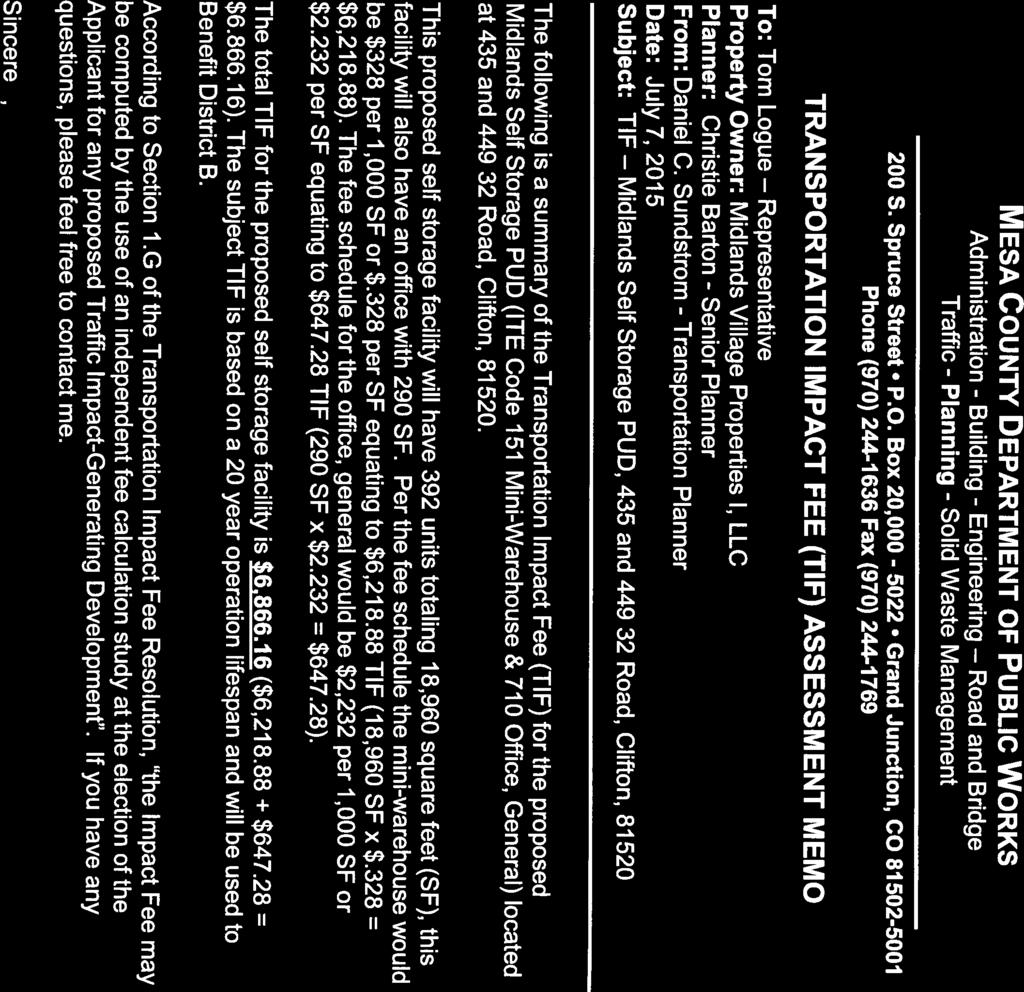
19 MESA COUNTY DEPARTMENT OF PUBLIC WORKS Administration - Building - Engineering Road and Bridge Traffic - Planning - Solid Waste Management 200 S. Spruce Street P.O. Box 20, Grand Junction, CO Phone (970) Fax (970) PROJECT REVIEW August 12, 2015 Amended December 7, 2015 I CP MIDLANDS VILLAGE SELF-STORAGE PUD AMENDMENT Property Owner: Midlands Village Properties I, LLC Representative: Tom Logue Location: 435 and Road, Clifton, (D½ and 32 Roads) Parcel #: & Zoning: RMF-8 Planner: Christie Barton, , christie.barton@mesacounty.us Request: Amend the Midlands Village PUD to include the Road property for a selfstorage and office facility for use by Midlands Village residents and the public. The use includes 341 self-storage units, a 290 square foot office, and temporary outdoor storage of recreation vehicles (RVs and boats). The units along the west, north and east property lines will be temperature controlled units with internal hallway access. The previous property owner (Banks) will have life use of the property. Development of the property will occur in three phases. Recommendation: Approval with conditions and adoption of the resolution Location & Zoning Map: Page 1 of 9 19
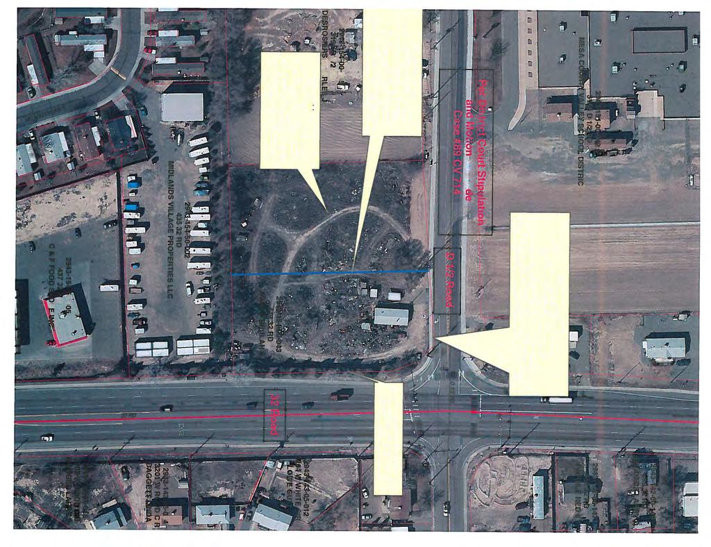
20 II. SURROUNDING LAND USES AND ZONING: Zoning within the 500-foot public notification area: C-1 (RSC Clifton) B-1 RMF-8 Grand Junction City Limits Land Uses within the 500-foot public notification area: Commercial Chatfield Elementary School Residential Agricultural State Highway 141 (also known as 32 Road) Applicable Area Plans Grand Junction Comprehensive Plan III. PROJECT HISTORY AND DESCRIPTION: Project History: C Rezone to PUD (9 units/acre) and ODP, The Shire Subdivision C BOCC reverted Plan but retained zone C The Shire Business Center C through C Midlands Village Mobile Home Park, convenience store, gas station and 6,700 square feet of commercial building space C98-00 Midlands Village Community Center C Expansion of the Midlands Village Community Center C Midlands Village F Midlands Village PUD Amendment to reflect as-built conditions on site Project Description: The Road property is part of the Midlands Village Planned Unit Development (PUD). The Road property (Banks property) has been purchased by Midlands Village Properties I, LLC reserving life estate use for Mrs. Banks. The Banks property has a 1990 Stipulation and Motion for Order (attached as part of the binder materials) to clean up the property. This application benefits the community as Midlands Village personnel have cleaned up the majority of the property and will install the required fencing and screening as part of this expansion. The project has a phasing plan for the eventual use of the remainder of the property. This project is to provide self-storage units for the Midlands Village residents and for the public. The project will include 341 mini-storage units and a 290 square foot office and restroom. Hours of operation will be normal business hours, closed Sundays and major holidays. A code controlled access gate will allow off-hours customer access to the storage units. A temporary outdoor storage use for boats and RVs will occur until full build-out of the project, and then the outdoor storage will be only for Midlands Village residents in the existing boat and RV storage Page 2 of 9 20
21 area. The use will be screened from D½ Road by fencing and landscaping. Existing vegetation and fencing effectively screens the property from 32 Road. The property is located within the Grand Junction Comprehensive Plan Area and within the Clifton Sanitation District. This property is not required to annex into the City of Grand Junction under the Persigo Agreement. The Future Land Use classifications for the property are Residential Medium (RM) and Mixed Use Opportunity Corridor along 32 Road. This use will have outdoor storage (boats and RVs) until the final build-out occurs. The Midlands Village PUD allows the outdoor storage of boats and RV s as an accessory use to their mobile home park. This is a temporary expansion of the outdoor storage use with storage units, fencing and landscaping along the roads providing the screening and buffering. Site Plan with phasing: IV. COMPLIANCE WITH MESA COUNTY CODE REQUIREMENTS: Section 3.7 Planned Unit Developments (PUD) Planned Unit Developments are approved and processed in the same manner as Major Subdivisions. The first step involves scheduling a General Meeting. A Planned Unit Development application will follow the General Meeting and Neighborhood Meeting processes described in Chapter 3.6, Major Subdivisions. A Neighborhood Meeting was held January 11, Notes from the meeting are included in the binder. F. Concept Plan and PUD Rezoning Approval Criteria Concept Plans and PUD Rezonings may be approved by the Board of County Commissioners only if they find that all of the following criteria have been met: Page 3 of 9 21
22 1. the proposed Concept Plan is consistent with the Mesa County Master Plan pursuant to C.R.S ; The Grand Junction Comprehensive Plan was adopted in 2010 with an addition to the Future Land Use classification along major roadways in the Plan area. The Mixed Use Opportunity Corridor allows neighborhood service and commercial uses with no outdoor storage at various locations along the identified roadways. This future land use classification anticipates service, retail and office commercial uses that service the immediate surrounding area with no outdoor storage at various locations along the identified corridors. While the implementing zones of Residential Office and Limited Business zoning districts don t allow storage units, the Midlands Village Planned Unit Development allowed the convenience store (retail commercial use) as part of the project. The proposed outdoor storage is temporary until full build out of the storage units. This expansion meets the intent of the service commercial use stated in Goal 3, Policy A & B in the Grand Junction Comprehensive Plan, which is an element of the Mesa County Master Plan. This plan is also consistent with the Pear Park Neighborhood Plan, which has goals of achieving high quality development and minimization of visual clutter along corridors. This criterion has been met. 2. the Concept Plan is necessary to address a unique situation or represents a substantial benefit to the County, compared to what could have been accomplished through strict application of otherwise applicable base zoning district standards, based on the Purposes set out in Section 1.5; Midlands Village is an existing Planned Unit Development that has commercial and residential uses with an integrated transportation system. The original project was approved under the 1995 Land Development Code, and PUDs were allowed with provision of a public benefit. The original plan showed a sidewalk on Shire Court, which connected Midlands Village to a sidewalk on D½ Road to a crossing to Chatfield Elementary School. This sidewalk was never built, and the pedestrian access from Midlands Village was blocked with landscaping. The applicant has agreed to build the sidewalk connecting Midlands Village and D½ Road along the east side of Shire Court. This is a community benefit to allow pedestrian access between a residential use and an elementary school. This expansion of the PUD zoning district also addresses a long-standing Code Compliance case. The property owners have cleaned up the Banks property, and have submitted plans showing fencing and an extension of the landscaping strip that will screen the property from D½ Road (32 Road is already screened with a berm, fence and vegetation). Once Mrs. Banks no longer lives on the property, the mobile home and personal items will be removed, and Phase 3 of the self-storage units will be completed. The expansion and amendment of the PUD cleans up the property and allows a new business that benefits the PUD. It would be difficult to accommodate this use with a standard zoning district as it is not supported by the implementing zoning districts for the Mixed Use Opportunity Corridor Future Land Use classification. It meets the intent to create large and small centers throughout the community that provides services and commercial areas as part of the future growth of the community. This criterion has been met. 3. the Concept Plan complies with the PUD regulations of Section 4.4.1; PUD, Planned Unit Development District Page 4 of 9 22
23 The PUD, Planned Unit Development District is intended to encourage innovative land planning and site design concepts that implement and are consistent with the Mesa County Master Plan. A. Developer's Statement of Intent Each Concept Plan application shall contain a statement by the applicant describing how the proposed development departs from the otherwise applicable standards of this Land Development Code, and how the proposed development, on balance, is an improvement over what would be required under otherwise applicable standards. Midlands Village is an existing Planned Unit Development (PUD) that incorporates residential and commercial in the same project. The PUD allowed an outdoor storage area for boats and RVs as an accessory use to the mobile home park. The self-storage business will be available for use by Midlands Village residents and the public. The temporary boat and RV storage will be removed at full build out of the self-storage unit project. A monument sign is proposed for D½ Road. The underlying zoning district is RMF-8 with Future Land Use classifications of Residential Medium and Mixed Use Opportunity Corridor. The departure from the Land Development Code standards is the implementing zoning districts for the Mixed Use Opportunity Corridor are Residential Office and Limited Business districts, neither of which allows self-storage units. The Planning Division believes this application meets the intent of the Master Plan for commercial uses to be created throughout the community to accommodate future growth. The proposed use provides a community and public benefit for a safer route to school, and also addresses a 1990 court order for clean-up of the Banks property. This requirement can be met. B. Review and Approval Procedures PUDs shall be reviewed and approved in accordance with the procedures of Section 3.7. This requirement has been met. C. Use Regulations The Board of County Commissioners shall determine the types of uses allowed within a PUD at the time of Concept Plan approval. Only uses that are consistent with the Mesa County Master Plan pursuant to C.R.S , may be allowed within a PUD, and should generally be limited to uses allowed in the underlying Zoning District. The Midlands Village PUD was adopted in 1996 and included the convenience store (retail commercial use) as part of the project. The management of Midlands Village has maintained the property in an exemplary manner. The Grand Junction Comprehensive Plan was adopted in 2010 with the addition of the Mixed Use Opportunity Corridors. These corridors are an overlay on the major roads in the urban area, and anticipate service and retail uses that serve the neighborhood at full service intersections. These intersections have all necessary infrastructure installed to support these uses. While the overlay covers these corridors, not all properties are able to support these uses. Additionally, service and retail uses are not always desired to be located mid-block, as this will reduce the flow of traffic on the arterial roads. This intersection is fully constructed with urban services, and can support the use. This expansion meets the intent of the service commercial use stated in Goal 3, Policies A & B in the Grand Junction Comprehensive Plan: Page 5 of 9 23
24 Goal 3: The Comprehensive Plan will create ordered and balanced growth and spread future growth throughout the community. Policy A: To create large and small centers throughout the community that provides services and commercial areas. Policy B: Create opportunities to reduce the amount of trips generated for shopping and commuting and decrease vehicle miles traveled thus increasing air quality. This requirement has been met. D. Development Intensity The total number of dwelling units and level of nonresidential development allowed within a PUD shall comply with the Mesa County Master Plan pursuant to C.R.S , and shall not exceed the level that can be adequately served by public facilities. To provide information on the capacity of streets and other facilities serving a PUD, the Planning Director may require the applicant to conduct a traffic impact study or other infrastructure capacity analysis to provide information on the development's expected impacts on existing and planned facilities. The proposed 341 self-storage units and accessory office use do not exceed the capacity of public services. A Traffic Impact Analysis has been completed for the use and no road improvements are required. No changes to the residential use are proposed. This requirement has been met. E. Other Standards Otherwise applicable standards of this Land Development Code may be modified by the Board of County Commissioners as part of the approval of a PUD, if consistent with the Mesa County Master Plan pursuant to C.R.S , and if the development is found to be an improvement over what would be required under otherwise applicable standards. Clean up of the Banks property has been the subject of a court order since Midlands Village, LLC has purchased the property with a life use for Mrs. Banks, and has completed a clean-up of three-quarters of the property. When Mrs. Banks no longer lives on the property, the final phase of the storage units will occur. Midlands Village, LLC will complete the fencing and landscaping that will address the court order and screen the storage units from D½ and 32 Roads. Master Plan Goals and Policies: Goal 3: The Comprehensive Plan will create ordered and balanced growth and spread future growth throughout the community. Policy A: To create large and small centers throughout the community that provides services and commercial areas. This development would be an expansion of an existing retail/service area at the intersection of D½ Road and 32 Road. This intersection is a full movement intersection with all infrastructure completed. Goal 7: New development adjacent to existing development (of a different density/unit type/land use type) should transition itself by incorporating appropriate buffering. Policy A: In making land use decisions, the City and County will balance the needs of the community. Goal 8: Create attractive public spaces and enhance the visual appeal of the community through quality development. Policy B: Design streets and walkways as attractive public spaces. Note: Construction of a sidewalk on Shire Court was not completed during the development of Midlands Village Filing 1. This connection to the Chatfield Elementary School is an important pedestrian connection between a residential use and the school. A pedestrian crossing on D½ Road Page 6 of 9 24
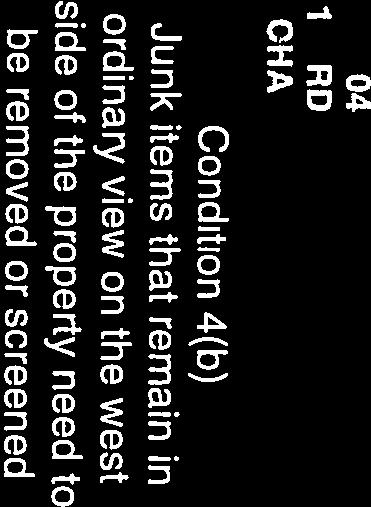
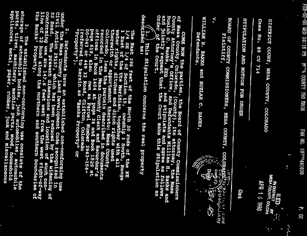
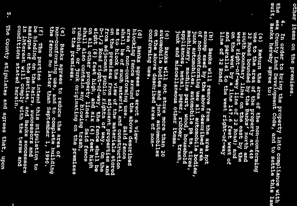
25 to Chatfield Elementary School is located within a half block of Shire Court. The applicant has agreed to construct the sidewalk as part of this project. This development is an improvement over the existing residential use with the court order for cleanup of the property. This criterion has been met. 4. the proposal is not significantly different from surrounding land uses in terms of density, intensity and impacts, and it mitigates any potential adverse impacts to maximum extent practical; Midlands Village has been established since Buffering and screening between adjacent uses mitigates the impacts. The proposal includes extension of the fencing and landscaping strip along D½ Road to mitigate the new use. A Traffic Analysis Letter has been submitted as part of the application packet, and states no additional improvements are required. A gate will be installed between Midlands Village and the new storage area as a barrier to cut-through traffic. A monument sign along D½ Road will be installed for the project. This criterion has been met. 5. facilities and services (including sewage and waste disposal, domestic water, irrigation water [where available], gas, electricity, police and fire protection, and roads and transportation, as applicable) shall be available upon completion of the project to serve the subject property, while maintaining adequate levels of service to existing development; and Urban facilities and services are available to the site. The property is served by Clifton Sanitation and a change of use is required for this service. The property is also served by Clifton Water, Grand Valley Irrigation Company, Grand Valley Drainage District, and Xcel Energy for electricity and natural gas. Clifton Fire District and Mesa Count Sheriff s Office provide emergency services. Right of way dedication on D½ Road is required to meet the Road Petition recorded at Reception # No impacts to existing levels of service to the neighborhood are expected with this application. This criterion can be met. 6. the same development could not be accomplished through the use of other techniques, such as rezoning to a non-pud district, variances, or administrative adjustments. This development has residential and commercial uses incorporated as part of the PUD. The same development could not be accomplished through the use of other techniques, such as a commercial zoning district, as this would not be in compliance with the Future Land Use map. This criterion has been met. Section 11.4 Violations and Enforcement Permits Approved with Conditions Instead of withholding or denying a permit or other authorization (as described in Section ), the County may grant such authorization subject to the condition that the violation be corrected. Since purchasing the Banks property, Midlands Village Properties I, LLC has removed junk and debris from the property. The narrative states they will install fencing (that was required in the court order) and extend similar landscaping to the existing landscaping along 32 Road. Approval of this application, with a condition of approval for the fencing and screening, accomplishes a clean-up of a long standing unsightly property. The Court Stipulation and Motion for Order is attached to this project review. This criterion can be met with conditions of approval. Page 7 of 9 25
26 Section General Approval Criteria The decision making body shall consider if the proposal: A. Complies with all applicable standards, provisions, and the purposes (Sec. 1.5) of the Land Development Code. This use is an expansion of the existing private storage use for the Midlands Village residents in conjunction with the Mixed Use Opportunity Corridor Future Land Use along 32 Road. It also incorporates self-storage units for the Midlands Village residents and for the public. It appears that the application can comply, with conditions of approval, with all applicable provisions of the Land Development Code. This criterion has been met. B. The project application is consistent with review agency comments. All review agency comments received are included in the hearing packet and project file. No objections have been received. This criterion can be met. C. The project application is consistent with applicable intergovernmental agreements (IGA) between the county and other entities. The City of Grand Junction has been notified of the application. The Colorado Department of Transportation (CDOT) was also notified of the application. Comments have not been received from either agency. This criterion has been met. V. REVIEW AGENCY COMMENTS: All review comments received are a part of the hearing packet and the file. VI. PUBLIC COMMENTS: No public comments have been received by the date of this review. VII. PROJECT RECOMMENDATION: The Planning Division recommends approval and adoption of the resolution of the Midlands Village Self-Storage PUD Amendment, with the following conditions: 1. All review agency comments not in conflict with the conditions of approval shall be resolved with the final plan. 2. A Site Development Plan shall be recorded for the project after a Final Plan review. 3. The applicant shall submit a Sign Permit application for the monument sign. 4. A Transportation Impact Fee (TIF) of $6, is required to be paid to the Planning Division prior to commercial site plan approval. 5. Outdoor lighting shall be full cut-off light fixtures in conformance with Section of the Land Development Code. 6. Right of Way dedication along D½ Road is required to match the Road Petition recorded in Road Book 2 at Page 153 File Number Fencing and landscaping for screening and buffering are to be installed along D½ Road in conformance with the Stipulation and Motion for Order of the Banks property by June 1, A sidewalk along the east side of Shire Drive shall be constructed from Lancaster Drive to D½ Road. Construction drawings shall be included in the Final Plan application, and a Development Improvement Agreement is required. The sidewalk shall be completed within one year of Final Plan approval. Page 8 of 9 26
27 The basis for this recommendation: The petition complies or can comply with conditions of approval with the criteria in PUD criteria in Section and Section 4.4.1, and the General Approval Criteria in Section of the Mesa County Land Development Code (2000, as amended). Section allows Mesa County to approve permits with conditions. Summary PUD Approval Criteria 3.7.1F Condition # 1. Consistent with Master Plan Has Been Met 2. Unique situation or substantial benefit Has Been Met 3. Compliance with PUD Regs in Can Be Met 7 & 8 4. Not significantly different from Has Been Met surrounding and nearby land uses, and mitigates impacts 5. Facilities and Services Can Be Met Could not be accomplished through use of techniques other than PUD Has Been Met General Approval Criteria A. Compliance with applicable standards and provisions in the Land Development Code Has been met B. Consistency with review agency comments Can be met 1, 4 C. Consistency with applicable IGAs Has been met Violations and Enforcement 11.4 Section Permits Approved with conditions Can be met 7 VIII. MCPC ACTION (1/21/16): IX. BOCC ACTION: (2/9/16): Page 9 of 9 27
28 28
29 29
30 30
31 31


32 32

33 33

34 34


35 35

36 36


37 37


38 38


39 39


40 40
41 41
42 HEARING NOTICE 42
43 500 ft buffer Parcels Urban Growth Area " Parcel/Notification Map Midlands Self Storage PUD Amend CP July 31, 2015 Notification Buffer AFT Legend Miles
44 PARCEL_NUM OWNER MAILING CITY ST ZIP AAMOLD CARROLL E 579 ELKHART LN GRAND JUNCTIOCO ABAD LORA RD CLIFTON CO AMBRIZ ANA M 3207 D 1/2 RD CLIFTON CO ATKINSON ALBERT RD UNIT 112 CLIFTON CO AVILA EDGAR 3210 WHITE CIR W CLIFTON CO BANK OF AMERICA NA 475 CROSSPOINT PARKWAYGETZVILLE NY BANKS BEULAH C LIFE EST RD CLIFTON CO BARNES BETTY LOU 496 CORONADO CT UNIT C CLIFTON CO BEASLEY BARBARA E RD UNIT 226 CLIFTON CO BERGAMO BILL RD UNIT 215 CLIFTON CO BILSON CHASE JEREMIAH RD UNIT 207 CLIFTON CO BIRD EILEEN ROSA RD UNIT 407 CLIFTON CO BLISS MILDRED E RD UNIT 401 CLIFTON CO BOGGS DON S AND BOGGS 408 LILAC LN GRAND JUNCTIOCO BRITTON JOYCE E RD UNIT 230 CLIFTON CO BRYAN WESLEY H 3203 DOWNEY CIR W CLIFTON CO BULLOCK MARY L /2 ROOD CT CLIFTON CO BURDETT ARTHUR C TRUST RD UNIT 231 CLIFTON CO C & F FOOD STORE INC 140 S 17TH ST GRAND JUNCTIOCO CAMPBELL RADINE RD UNIT 232 CLIFTON CO CASTANEDA-DELGADO ART RD TRLR 221 CLIFTON CO CHAIRO FRANK J JR RD UNIT 219 CLIFTON CO COGBURN THOMAS R RD UNIT 229 CLIFTON CO CONNOR DONALD L RD UNIT 218 CLIFTON CO CONWAY SANDY RD UNIT 217 CLIFTON CO COOPER RICHARD PO BOX 1017 EAGLE CO COSTOPOULOS RAY 3183 D 1/2 RD GRAND JUNCTIOCO CRANSTON LAND AND DEV 2447 RUBY MESA CT GRAND JUNCTIOCO CRITCHFIELD STANLEY RD UNIT 228 CLIFTON CO CRITELLI THOMAS JAMES RD UNIT 236 CLIFTON CO CRUZ RUBY RD UNIT 104 CLIFTON CO DAGGETT LINDA S 3201 W ROOD CIR CLIFTON CO DESROSIERS CHARLES J 2643 F 1/2 RD GRAND JUNCTIOCO DUNLOP SUSAN PATTEN RD UNIT 402 CLIFTON CO DUNN GINGER A RD UNIT 202 CLIFTON CO EGGERS RANDEN 3585 E 1/4 RD PALISADE CO FEDERAL NATIONAL MORTGINTERNATL PLAZA DDALLAS TX FERRIN ANN S RD UNIT 409 CLIFTON CO GALLEGOS GLORIA M 3187 D 1/2 RD GRAND JUNCTIOCO GARCIA VALENTINE G 3208 WHITE CIR W CLIFTON CO GASCON DOROTHY J RD UNIT 222 CLIFTON CO GIBSON STEVEN W PO BOX 1283 CLIFTON CO GRAY PENELOPE ANN RD UNIT 225 CLIFTON CO GREGORICH JUSTIN ABEL 2904 VICTORIA DR GRAND JUNCTIOCO GROVES CLARENCE W 3201 MAIN CIR W CLIFTON CO GURULE NED II RD CLIFTON CO
45 HACKNEY CLYDE L RD UNIT 410 CLIFTON CO HANLEY ALISHA JANE 633 NORTH PLACER CT GRAMD JUNCTICO HARGIS JUSTIN ALLEN RD UNIT 224 CLIFTON CO HARRY DELORES JACQUELINPO BOX 584 PALISADE CO HAWKINS GARY M RD UNIT 204 CLIFTON CO HENRY JACK D RD UNIT 211 CLIFTON CO HOLDEN PAUL E 3208 DOWNEY CIR W CLIFTON CO HOLLAND WILLIAM S SR 3202 W DOWNEY CIR CLIFTON CO HOMES OF MIDLANDS VILL PO BOX 239 MONTROSE CO HOPPE RALPH E 3207 W ROOD CIR CLIFTON CO HUNSBERGER MELVIN R 3207 W WHITE CIR CLIFTON CO HUNTER NANCY A RD UNIT 214 CLIFTON CO HURT RONALD E 2665 I RD GRAND JUNCTIOCO JEFLANI PROPERTIES LLC 3203 W WHITE CIR CLIFTON CO JOHNSON JUNE IRENE RD UNIT 212 CLIFTON CO JULIN JON JAMES RD UNIT 210 CLIFTON CO KELLEY BRENDA SUE 3622 STONEBROOK LN IDAHO FALLS ID KNUTSON JOHN PAUL RD UNIT 238 CLIFTON CO LAWRENCE W & JOY R BOY 3181 D 1/2 RD GRAND JUNCTIOCO LOWE GUY L 3204 WHITE CIR W CLIFTON CO MAGNABOSCO CHERYL C 3202 W WHITE CIR CLIFTON CO MAHER TIMOTHY T ROAD UNIT 223 CLIFTON CO MAJORS CHARLES W 3208 ROOD CIR W CLIFTON CO MARCUS RICHARD R RD UNIT 508 CLIFTON CO MAYER EWELL E 3205 D 1/2 RD CLIFTON CO MCGEE BILLY GENE 2876 C 1/2 RD GRAND JUNCTIOCO MCLAUGHLIN SUSAN M RD UNIT 416 CLIFTON CO MENDOZA MANUEL RD PALISADE CO MESA COUNTY VALLEY SCH2115 GRAND AVE GRAND JUNCTIOCO MIDLANDS VILLAGE PROPE PO BOX 239 MONTROSE CO MILLER RICHARD E JR /4 RD CLIFTON CO MILLER SHANA DEAN 326 W WHITE CIR CLIFTON CO MIZAK ELIZABETH RD UNIT 220 CLIFTON CO MONGER TOD R 3203 W ROOD CIR CLIFTON CO MORAVEC JAMES RD UNIT 216 CLIFTON CO PACKARD ERIK 3206 D 1/2 RD CLIFTON CO PADGETT KEVIN LEE 3214 E HALL CT CLIFTON CO PARTELLO JAMES M RD UNIT 502 CLIFTON CO PELLIZZARI JOSEPH RD UNIT 213 CLIFTON CO PEREZ FRANCISCO RD CLIFTON CO PICAZO RAQUEL RD UNIT 209 CLIFTON CO REEDER GARY R RD UNIT 403 CLIFTON CO ROSE OLIVE V RD UNIT 406 CLIFTON CO RUBIO FRANK D RD UNIT 208 CLIFTON CO SANCHEZ JOSE GUADALUPE3210 ROOD CIR W CLIFTON CO SANCHEZ RICHARD P /2 WHITE CIR W CLIFTON CO SANTISTEVAN RUBIO F 3206 ROOD CIR W CLIFTON CO
46 SAULNIER JENNIFER RD UNIT 206 CLIFTON CO SCHALNUS KATIE L PO BOX 195 YAMPA CO SELDERS LARRY D ROAD GRAND JUNCTIOCO SHEPPARD JASON /2 ROOD CIR W CLIFTON CO SHOEMAKER CAROLYN MA RD UNIT 418 CLIFTON CO SILL CANDACE DIANE RD UNIT 506 CLIFTON CO SINCLAIR PATRICIA L RD UNIT 203 CLIFTON CO STANLEY BYRON H 3185 D 1/2 RD GRAND JUNCTIOCO STOUT PEGGY JO RD UNIT 404 CLIFTON CO STRICKLAND JAMES T RD UNIT 405 CLIFTON CO STUDT PRISCILLA RD UNIT 412 CLIFTON CO SWOPE CLINT RD AUSTIN CO TELLEZ JULIO OLIVO 3201 D 1/2 RD CLIFTON CO TOPAZ DRIVE LLC 579 ELKHART LN GRAND JUNCTIOCO TRIPP DUSTIN WADE RD UNIT 413 CLIFTON CO VIERS CONNIE M RD UNIT 411 CLIFTON CO VINCENZETTI FRANCIS J RD UNIT 414 CLIFTON CO WILLIAMS PATRICIA M RD UNIT 205 CLIFTON CO WITHAM SHAWNTY K RD UNIT 234 CLIFTON CO WRIGHT GARL GENE ROAD UNIT 408 CLIFTON CO ZORTMAN MATTHEW D 3209 W WHITE CIR CLIFTON CO TOM LOGUE 537 FRUITWOOD DRIVE GRAND JUNCTIOCO
47 MCPC MINUTES 47
48 MESA COUNTY PLANNING COMMISSION August 20, 2015 PUBLIC HEARING MINUTES Chairman Moreng called to order a scheduled hearing of the Mesa County Planning Commission at 6 PM. Chairman Moreng led the Pledge of Allegiance. The hearing was held in the Public Hearing Room, Mesa County Administration Building at 544 Rood Avenue, Grand Junction, Colorado. In attendance representing the Mesa County Planning Commission, were: Joe Moreng, Phillip Jones, Rusty Price, David Hartmann, Ron Wriston, George Skiff, and Robert Erbisch. In attendance, representing the Mesa County Planning Division, were: Linda Dannenberger, and Christie Barton. Patrick Coleman, County Attorney was present. Kathy Kinsey was present to record the minutes. There were three (3) citizens present throughout the hearing. Approval of Minutes Motion: Commissioner Erbisch moved to approve the minutes as written. Second: Commissioner Price Motion Approved 5-0 *Chairman Moreng and Commissioner Erbisch were not present at the hearing; therefore their votes cannot be included. Chairman Moreng asked if there were any changes to the agenda. Linda Dannenberger brought to their attention that a comment was received via from a neighbor, Mr. Kroupa, in regards to the Hall Rezone project which is on the consent agenda. The comment was given to the planning commissioners and Ms. Dannenberger asked them to look it over and decide if the project should be removed from the consent agenda or not. Chairman Moreng stated that he felt Ms. Barton s response covered the neighbors issues and he doesn t feel it needs to be removed from the consent agenda. Patrick Coleman stated that this would be considered part of the hearing packet and believes the project can remain on the consent agenda. Chairman Moreng asked if any of the commissioners wanted to remove this from consent and they all agreed to leave it on consent. Mr. Kroupa was not present at the hearing. The comment was labeled as Exhibit 1. Announcements Ms. Dannenberger mentioned the Planning Commission, County Commissioner dinner being held on Wednesday, August 26 th at 6 PM located in Room 40 at MCCS. Any agenda requests need to be submitted to Chairman Moreng by Monday, August 24 th at the latest. Continued Items None 48
49 Hearing Item CP MIDLANDS SELF STORAGE PUD AMENDMENT Property Owner: Midlands Village Properties I, LLC Representative: Tom Logue Location: 435 and Road, Clifton, (D½ and 32 Roads) Zoning: RMF-8 Planner: Christie Barton, , Request: Amend the Midlands Village PUD to include the Road property for a self-storage and office facility for use by Midlands Village residents and the public. The use includes 392 self-storage units, a 290 square foot office, and outdoor storage of recreation vehicles (RVs and boats). The property owner (Banks) will have life use of the property. Development of the property will occur in three phases. Staff Recommendation: Approval with Conditions Board of County Commissioners Hearing Date: Staff Presentation Christie Barton entered into the record the Mesa County Master Plan, the Mesa County Land Development Code, the project review, the file # CP, the PowerPoint presentation labeled as Exhibit A and a letter that was received yesterday from the Desrosiers, is labeled as Exhibit 1. Ms. Barton explained the request for the property located at 435 and Road in Clifton. She stated that the previous owner of Road property, Mrs. Banks, has life use of the property. Ms. Barton explained that development of the property will occur in 3 phases. She then showed the location, zoning and aerial maps and pointed out the location of the Midlands Village PUD. Ms. Barton explained that there is an order in place to clean up the property and since Midlands Village has purchased it they have done substantial clean up and they will be installing fencing and landscaping. Ms. Barton explained that prior to the full build out there will be temporary outdoor boat and RV storage. She stated that the storage units and the 290 square foot office will be in an area that will have a code controlled gate for after-hours access to the storage units. She explained that the representative and owners will come up with a plan to have improved screening along the side of the property where the Desrosiers live. Ms. Barton went on to explain that this project is located in the Grand Junction Comprehensive Planning area and she showed a site plan with the 3 phases outlined and a rendering of what the storage units will look like. She continued on and showed photos from D ½ Road to the property and explained more about the location of things on the property in conjunction with Chatfield Elementary School. Ms. Barton explained the details regarding the PUD approval criteria in Section F., and in A. of the Land Development Code. She discussed the details about the applicant agreeing to build a sidewalk, explained that a Traffic Impact Analysis has been done and a sign is being proposed. She went on to read the conditions of approval. Questions 49
50 Commissioner Price asked if Ms. Barton had talked with Mr. Desrosiers. Ms. Barton said she has met with him and they discussed that he wants the area by him screened and buffered from his property and they discussed if he could develop his property in any way. Commissioner Erbisch asked about the hours of the self-serve and stated that he doesn t believe these hours would be practical or long enough for access to only be from 8 AM to 5 PM. Ms. Barton explained that the facility will be gate controlled so people can get in with a code after 5 PM and that the 8 to 5 applies to the office hours. Commissioner Erbisch also asked about the possibility of a drainage problem in this area. Ms. Barton stated that the applicant submitted a drainage plan and some changes would be made during the build-out and then the plan would be updated where necessary. Patrick Coleman, County Attorney, recommended that the condition which lists the hours of operation be amended to reflect that the administrative office hours are from 8 AM to 5 PM and that the users of the facility will be able to access through the gate with a code after 5 PM. Ms. Barton will change this to reflect that customers have access to the facility anytime (24/7). Further discussion took place about the property, the layout and the Banks property. Applicant/Representative Presentation Tom Logue spoke on behalf of the applicant. He stated that they will meet with the neighbor to the west and talk about the needs and how to solve the screening issue. Mr. Logue stated that he had met with the County s engineer on the site and discussed the drainage details. Questions Chairman Moreng asked if there were other facilities similar to this one. Mr. Logue said they only have the existing outdoor storage area and the facility is about maxed out right now so there is a need for additional storage due to the large population in that area. Commissioner Wriston asked how they determined the $ impact fee. Ms. Barton explained that there is a use formula that is used by the International Transportation Engineers book, they look for a similar use and compare them and they also use the traffic study that the applicant supplied. Commissioner Hartmann asked if the project will still be feasible if they lose some units to an expanded drainage facility. Mr. Logue stated that they will retain storm water in a basin and when there is a major storm event it will fill up and either evaporate or percolate into the water table in accordance with the manual. Public Comments None Planning Commission Discussion & Vote Chairman Moreng stated that he is in favor of this project and that it will clean up this area. Commissioner Hartmann asked if the county notifies the school district and if a specific person within the school sees the notice. Ms. Barton explained that there is not 50
51 a direct impact on the school with this project as it relates to additional children but at times the parents are more concerned than school district. Motion: Commissioner Price moved to approve project CUP Midlands Self Storage, Planned Unit Development Amendment with the conditions as amended. Second: Commissioner Wriston Motion: Approval with Conditions 7-0 Additional Announcements Ms. Dannenberger informed the commissioners that Bill Somerville contacted her and has requested a leave of absence but he didn t specify the amount of time he might be out. She said he will be present at the dinner next week but won t be able to attend the workshops or hearings for a while. Chairman Moreng said he thought this was more of a Board of County Commissioners decision and not theirs. Commissioner Price said it was in the bylaws that the Chair could make this determination. Chairman Moreng will contact Bill to discuss this and make a decision after that. Mr. Coleman said everyone needs to be aware that a commissioner has to be present at a specific amount of meetings in order to be allowed to vote on master plans. ADJOURNMENT Motion: Commissioner Hartmann moved that the meeting be adjourned. Motion Approved 7-0 Hearing adjourned at 6:50 PM Respectfully Submitted, Chip Page, Secretary 51
52 REVIEW AGENCY COMMENTS 52
53 53
54 54
55 PRO MIDLAND SELF STORAGE PUD CONCEPT PLAN Review Agency Comments Comments Due Date: User Otis Darnell Melinda Henderson Robin Carns Review Agency MC ROAD & BRIDGE B Date/Time Comment 7/6/2015 MCDOT has no problems at this time, 1:47:39 PM MC TREASURER 7/6/2015 As of July 6, 2015 property taxes are paid on parcel number :07:26 PM MMH MC ENGINEER OWTS MARK BARSLUND IRR DRAIN AUTH Cpt. Don Hendricks 7/7/2015 The property is served by municipal sewer, no other comments. 9:53:18 AM 7/7/2015 Any activity resulting in disturbance of one (1) acre or more will 11:24:08 AM require a 521 Drainage Authority permit MC SHERIFF 7/8/2015 What steps are being taken to deter theft and burglary? Lighting, 8:57:01 AM fencing, CCTV, security patrols, passkey gates? What's the security plan? Thank you. Daniel Sundstrom MC ADDRESSING 7/13/2015 Address Comment: 11:12:00 AM An address is available once this project is approved. BRIAN WOODS SAN CLIFTON 7/13/2015 From the project narrative, the property would be subject to a 6:06:09 PM change-of-use from residential to commercial. The applicant should contact the District for additional information regarding the proposed project. The District does not object to the proposed storage building concept. CHRIS ROWLAND FIRE CLIFTON 7/20/2015 No comments from Clifton Fire 10:49:48 AM DAVE REINERTSEN MC DEV ENGINEER WATER CLIFTON 7/22/2015 Clifton Water currently provides water service to the existing house 10:39:19 AM on this parcel with a 3/4" meter. The District has no concerns or other comments regarding this request. MC DEV ENGINEER 7/27/2015 4:35:19 PM Mesa County Development Engineering Comments: The following comments should be addressed prior to final concept plan approval: 1. The checklist found in Table 302 of the SWMM must be prepared and included in the report (SWMM 302.1). Items marked with an asterisk are not required in a Conceptual Drainage Report. If the Engineer believes that other items are not required, they can be marked n/a. It is helpful to provide a brief explanation for any items marked n/a. 2. The site is located within the Mesa County Stormwater Urbanized Area, and therefore improvements must address stormwater quality 55
56 per and Section 1600 of the SWMM. 3. Stormwater retention is proposed. Retention is not preferred by the County and is only allowed on a case-by case basis where there are severe limitations on downstream conveyance ( 403.8). Provide justification for allowing on-site retention for the project. The following comments may be addressed as part of final plan approval. 1. When retention is used, requires a 24-hour precipitation of 2.01 inches multiplied by a factor of Retention areas must drain within 48 hours of all storm events up to the 100-year storm event ( ). 3. Provide for emergency overflow of the retention pond per and analyze the overflow path for capacity and downstream impacts. 4. Provide measures to prevent sediment from entering and clogging the retention pond (pre-sedimentation facilities, frequent sediment removal, etc.). 5. Provide an operations and maintenance plan that includes monitoring, reporting, and maintenance requirements. 6. Openings in the concrete wall are proposed to allow for drainage from the paved areas of the site into the retention pond. In the final report please include an analysis of the flow through these openings and provide recommendations for scour protection in the retention pond. 7. Ensure that the grading done at the entrance on D ½ Road prevents runoff from leaving the road and draining on to the site and vice versa. 8. Make provisions for restricting access at the southern connection to the existing fenced storage area. No cut-through traffic will be allowed from Midlands Village to D ½ Road. 9. The site disturbance will be greater than 1.0 acre and the site is located within the Mesa County Stormwater Urbanized Area. A Stormwater Construction Permit will be required from both the Colorado Department of Public Health and Environment and the Drainage Authority. SYSTEM ACCOUNT - DO NOT DELETE Christie Barton 8/4/2015 Conceptual Drainage Report Ver 3 uploaded in response to review 6:23:59 AM comments. 11/10/2015 Revised Narrative and Concept Plan received The units 56
57 1:46:53 PM along the west, north and east boundaries will be temperature controlled units with internal hallways for access. Daniel Sundstrom MC ADDRESSING 11/13/2015 Transportation Planner 10:53:42 AM I have uploaded the Signed and Approved NOI for this project. NOI Midland Self Storage, signed & approved.pdf Per the Conditions of Approval; 1. Existing Residential Access to be removed and replaced with new curb and sidewalk once the current resident vacates the resident (phase 3 of this project). It is the responsibility of the applicant to obtain all necessary permits to do this work within MC right-of-way. No new or additional residents are allowed to use this existing driveway once vacated. 2. No cut through traffic will be allowed to drive through the Midlands Self Storage site to access Midlands Village private secondary access. 3. As per the Traffic Study the driveway will be located across from the existing bus storage site driveway approximately 271-feet from face of curb, west side of 32 Road, as indicated within the approved Design Exception Exhibit F - Preferred Location. 4. This NOI approves the locations of the connections to the public road system. This NOI is in no way to be construed as approving elements of the commercial site plan not related to the location and concept of the access point. The applicant must obtain approval from the Planning Division prior to construction. Plans shall include, at a minimum the following: a. Road Plans that include driveway improvements and removal of the existing residential driveway. b. Proposed driveway connection to existing D ½ Road c. Driveway detail of the proposed driveway Once approved the applicant can apply for a Road Access Notice to Proceed (NTP). MARK BARSLUND IRR DRAIN AUTH 11/16/2015 Any activity resulting in disturbance of one (1) acre or more will 12:51:58 PM require a 521 and CDPHE permit 57
58 Courtney Campbell MC CODE COMPLIANCE 11/24/2015 Mesa County Code Compliance Services does not indicate any open 10:35:54 AM or active case files pertaining to this property ( Rd). Our Department can release this property as compliant, due to the improvements by Midlands Village Corp meet the terms we had agreed upon in a discussion from September of If the Planner finds an apparent Code violation when they visit the property please let us know and we will investigate. 58


59 59
60 PUBLIC COMMENTS 60

61 61
62 300.01' Year 1 LOCATION MAP D 1/2 ROAD LAND USE SUMMARY AREA PERCENT USE (sf) OF TOTAL Buildings 45, Office Drives 28, Existing & Proposed Buffers 12, Stormwater Management 6, Inefficiencies 1, Total 94, PHASING PLAN Phase One (A) Office, Entrance and Storage Units Phase One (B) RV Storage on Gravel Surface and Stormwater Management Facility Year 2 Phase One (B) Storage Units Year 3-5 Phase Two and Phase Three LEGEND Property Boundary 2.18 ac. (See Improvement Survey) Existing Half Foot Contour xx Proposed Half Foot Contour Proposed 6 ft. Security Fence Existing 6 in. Irrigation Supply Existing Landscaped Berm 6,415 sf Proposed Landscaped Buffer 4,848 sf Direction of Surface Drainage Flow CONCEPT PLAN SITE 32 ROAD OF SHEET 1 1 SHEETS 51 Proposed Driveway D 1/2 ROAD 4650 Existing Driveway To Be Abandoned With Phase 3 East 1/4 Corner Section 15 T. 1 S., R. 1 E., Ute Mer ' L=82.23' HVAC 21 ft. 15 ft ft Phase 1 (A) 76 ft. 24 ft. HVAC ' 32 ROAD To U.S. 50 To I-70BL /9/ ft. Multi-Purpose Easement To Be Dedicated 1 1/2 in. Irrigation Supply P Connect Sump Box To Existing Structure Pump and Controls w/ Phase One Illuminated 4 ft. by 8 ft. Identification Sign Mounted on a 12 ft. Pole (Typ. 2 Places) 24 ft. Controlled Access Gate 26 ft ft. 30 ft. Phase 1 (B) Phase STORMWATER MANAGEMENT FACILITY (Retention Basins) 10' Drainage, Irrigation, and Utility Easement ' ft. 30 ft. OFFICE 4 9 ft. ea. 45 ft. x 195 ft. Self Storage F Building Existing Dwelling (Removed With Phase 3) 22 ft. 22 ft. 22 ft. UNIT COUNT BLDG. BLDG. BLDG. BLDG. BLDG. BLDG. % of SIZE TOTAL A B C D E F TOTAL 5 x x x x x x x TOTAL Concrete Surface Barrier Curb 45 ft. x 210 ft. Self Storage A Building HVAC Concrete V-Pan (typ. 4 Places 30 ft. x 160 ft. Self Storage B Building 30 ft. x 160 ft. Self Storage C Building 30 ft. x 160 ft. Self Storage D Building Phase 3 Phase 1 (B) Phase 2 60 ft. x 210 ft. Self Storage E Building Inlet Wall Block Out (typ. 3 Places) Gate ,520 sf Maintenance Building Existing Fenced Storage and Maintenance Area (Gravel Surface) Blanket Ingress/Egress Easement To Be Granted Lancaster Dr. 62 REVISIONS Date Description Date: November, 2015 Scale: 1 in. = 30 ft. Contour Interval: 0.5 ft. 30' 15' 0' 30' Prepared By: THOMAS A. LOGUE L a n d D e v e l o p m e n t C o n s u l t a n t 537 Fruitwood Drive, Grand Junction, Colorado Prepared For LEADERSHIP CIRCLE, LLC 1521 Oxbow Drive, Suite 210 Montrose, CO Planned Unit Development Amendment MIDLANDS SELF STORAGE Mesa County, Colorado
63 NEIGHBORHOOD MEETING INFORMATION 63

64 MIDLANDS SELF STORAGE NEIGHBORHOOD MEETING January 12, 2016 A neighborhood meeting to discuss the pending PUD Amendment and Site Plan application was held at 5:30 p.m. on January 11, 2016 at the Midlands Village Community Center. In addition to Christi Barton, Mesa County Planning Department staff planner, the project representative was in attendance. The meeting concluded at 6:00 p.m. given that there were no other individuals in attendance. Respectfully submitted, Tom Logue, Owners Representative xc: Matt Miles, Midlands Village, LLC. 64
65 APPLICANT INFORMATION 65
66 32 ROAD Project Narrative MIDLANDS SELF STORAGE PUD Concept Plan and Rezone Application May, 2015 Rev. November 9, 2015 SITE DESCRIPTION Address: LOCATION DATA Road Common Location: SW corner D ½ Road and 32 Road (SH 141) Area 2.16 acres Tax Parcel No Aliquot Section: NW ¼ Section 15, Township 1 South, Range 1 East, U.M. Latitude and Longitude: , LOCATION MAP To I-70BL 141 D 1/2 ROAD SITE To U.S
67 EXISTING and SURROUNDING LAND USE The site under concern is almost square in shape; approximately 316 feet in length east/west and 300 feet north/south. Ground cover on the site consists of untended fallow irrigated land. An existing single family dwelling and associated out buildings dominate the property. The surrounding land uses in the vicinity of the subject property are considered to be high intensity. Two primary land uses can be found in the vicinity of the subject property: limited Commercial/Business, mainly north of the site along 32 Road, and residential single family. Chatfield Elementary School is located north of the subject site adjacent to D ½ Road. A 2014 air photo depicting subject site in relationship to the surrounding area can be found on the following page: 67

68 EXISTING LAND USE MAP (2014 Air Photo) D 1/2 ROAD ROAD 141 INDEX 1 Property Boundary, 2.18 ac. 5 2 Dwelling 3 Existing Driveway 4 Landscaped Buffer 5 Existing Storage Area SURROUNDING LAND USE The surrounding land uses in the vicinity of the subject property are considered to range between high and moderate intensity. Land uses in the immediate vicinity of the subject property are depicted on the accompanying Surrounding Land Use Map that shows the configuration of various nearby properties in relationship to the subject site. 68

69 32 ROAD SURROUNDING LAND USE MAP Chatfield Elementary School D 1/2 ROAD SITE Indicates Non-Residential Land Use 141 D ROAD 69
70 LAND USE SUMMARY PERCENT AREA USE OF (sf) TOTAL Buildings 45, Office Drives 28, Existing & Proposed Buffers 12, Stormwater Management 6, Inefficiencies 1, Total 94,

71 LAND USE ZONING According to the Mesa County Land Use Zoning Map, the subject property is zoned: RMF-8. The zone designation is primarily intended to accommodate medium density single family, two- family and low density multi-family residential development. Other land use zones in the vicinity of the site include a PUD district for the existing 60.2 acre Midlands Village development and several non-residential zone designations. FUTURE LAND USE MAP SITE In 2010 the County adopted a Comprehensive Land Use Plan. A reproduction of the Future Land Use Map within the plan follows. Most of the land surrounding the property is designated as future Residential Medium, or Residential Medium/High. The plan indicates Mixed Use Opportunity Corridor along 32 Road. 71

72 FUTURE LAND USE MAP Mixed Use Opportunity Corridor SITE 72


73 DEVELOPMENT PROPOSAL The proposal calls for the ultimate development of 341 self storage units and a managing office that will be developed in a phased fashion using a PUD rezone designation. Approximately 12.8 percent of the site area is designated as landscaped buffers. 6,725 square feet of the property is devoted as an engineered stormwater management facility. LAND USE SUMMARY PERCENT AREA USE OF (sf) TOTAL Buildings 45, Office Drives 28, Existing & Proposed Buffers 12, Stormwater Management 6, Inefficiencies 1, Total 94, The architectural style of the proposed storage units is illustrated by the following photos: LANDSCAPING The proposal includes a provision for landscaped buffer strips along the properties frontage along the adjoining roadways. The frontage along 32 Road consists of an existing landscaped buffer that will be preserved. The landscaped area along D ½ Road will be installed to complement the existing buffer strip. 73

74 3 ft. Earthen Berm Existing Buffer along 32 Road. ACCESS On May 7, 2015, a conditional Notice of Intent to allow the construction of a new driveway from D ½ Road into the facility was issued by Mesa County. The proposed geometry for the access entrance on D 1/2 Road will be opposite of an existing private drive to a bus terminal. The proposed Concept Plan includes a connection with the existing Midlands Village RV storage area. This connection will allow the Midlands Village residents access without traversing 32 Road and D ½ Road to utilize the facility. A key element of the access plan calls for the removal of an existing driveway to D 1.2 Road approximately 100 feet west of 32 Road during the last development phase. According to a Traffic Study that was provide to Mesa County s Transportation Division, the future traffic movements into and out of the facility are considered to be low. DRAINAGE CONCEPTS Reviews of Flood Rate Insurance Maps indicate the site is not subject to flooding in the event of a 100 year storm. Conceptually, historic drainages patterns will not be altered within the development. All of the site area drainage will be carried on the ground towards a water quality treatment system that is incorporated into an engineered designed retention facility. Water within the retention area will evaporate and percolate into the ground. UTILITY SERVICE An existing eight inch domestic water main owned and operated by the Clifton Water District and a eight inch sanitary sewer main owned and operated by the Clifton Sanitation District are located within the D ½ Road right-of-way adjacent to the subject site. Dry utilities such as, natural gas, electric, and communication lines also lie within the D ½ Road right-of-way. All of these services have available capacity and can be extended into the site. Shares of irrigation water are delivered to an existing structure near the northeast property corner though a series of pipelines. Water for the landscaped areas will be provided by a pump and underground delivery system EMERGENCY SERVICES The property is located in Clifton Fire Protection District. The district provides fire and emergency response services from their facility located in Clifton about 2.0 miles away. Law Enforcement is provided by the Mesa County Sheriff s Department. The Sheriff is assisted by the Colorado State Patrol for I-70 traffic control and responding to and investigating automobile accidents that occur in the neighborhood. Other emergency services are also available from the Mesa County Emergency Management Department. 74
75 EVALUATION OF THE REQUEST A response to the Narrative Guidelines provided by the Mesa County Planning Department is utilized to evaluate the request. GUIDELINE 1. Specifically describe the uses that will be allowed/prohibited in this PUD. It may be helpful to use the Use Table in Chapter 5 of the Land Development Code. Also address use specific standards that will or will not apply to the proposed land uses. RESPONSE - The proposal calls for the ultimate establishment of 392 individual self storage units including a 290 square foot on-site office. The undertaking will be conducted in a phased fashion that allows for the interim parking of RV vehicles and marine craft as each phase is completed. Approximately seven percent of the site is set aside for a Stormwater Management Facility. GUIDELINE 2. State the total number and type of dwelling units and/or the level of non residential development proposed for this PUD, including square footage. RESPONSE: LAND USE SUMMARY PERCENT AREA USE OF (sf) TOTAL Buildings 45, Office Drives 28, Existing & Proposed Buffers 12, Stormwater Management 6, Inefficiencies 1, Total 94, GUIDELINE 3. Are phases proposed and how are they sequenced? RESPONSE: PHASING PLAN YEAR AREA PHASE ac. One (A) Office, Entrance and Storage Units One (B) RV Storage on Gravel Surface and Stormwater Management Facility ac. One (B) Storage Units ac. Phase Two and Phase Three GUIDELINE 4. Describe how the development departs from otherwise applicable standards of the Land Development Code and how the development is an improvement over what would be required under otherwise applicable standards. RESPONSE The proposed development does not depart from any known standards within the Land Development Code. The major improvement is ability to establish a site specific use by utilizing the PUD zone. In other words, no other use could occur on the property without an amendment to the PUD zone, which is subject to public review and comment. 75
76 GUIDELINE 5. Does the proposed development address unique situation or does it represent a substantial benefit to the County over what would be accomplished under otherwise applicable standards of the underlying zoning district? RESPONSE Other than the limited access requirements to D ½ Road, there are no other unique situations. The underlying zone does not allow self storage facilities. The primary benefit to the County is the establishment of a modern self storage facility for use by the area residents. A study was conducted of four Census Tract lying south of the 1-70 Business Loop, north of the Colorado River, between 29 Road and 33 ½ Road. Results indicate that there are approximately 21,223 people living in 8,163 households who would have the opportunity to use the facility. GUIDELINE 6. Describe why the same development could not be accomplished through the use of other techniques, such as rezoning to a non PUD district, variance or administrative adjustments. RESPONSE The same development could occur within a C-1 zone designation. This designation would create difficulties in meeting the goals and policies of the Mesa County Master Plan, discussed within Guideline 9. A comparison between the C-1 zone and the Proposed PUD zone follows: COMPARISON CHART MINIMUM PROPOSED C-1 ZONE STANDARD PD ZONE Lot Size 1 acre 2.16 acre Lot Width n.a 314 feet Street Frontage n.a. 598 feet Street Setback 14 feet 15 feet Side Setback 0 feet 5 feet Rear Setback 0 feet 44 feet Max. Lot Coverage 80% 48% Max. FAR Max Building Size 80,000 sq. ft. 46,100 sq. ft. GUIDELINE 7. Is the proposal significantly different than surrounding land uses in terms of density, intensity, and impacts? How does it mitigate any potential adverse impacts? RESPONSE No existing residential uses adjoin the proposed land use. Adverse impacts are minimal compared to a residential use. IMPACT COMPARISON SUMMARY TABLE MIDLANDS SELF STORAGE RESIDENTIAL LAND USE IMPACT CATEGORY Positive Negative Neutral Positive Negative Neutral Traffic Utility Service Emergency Services On-site Street Maintenance Schools Noise and Lighting Natural Environment Property and Use Taxes 76
77 GUIDELINE 8. Describe the facilities and services available to serve the subject property while maintaining adequate levels of service to existing development. This includes but is not limited to the following: sewage and waste disposal, domestic water, irrigation water [where available], gas, electricity, police and fire protection, roads, and transportation. RESPONSE All facilities and services are existing and can be extended to serve the subject property without creating any adverse impacts. GUIDELINE 9. Does the proposed PUD meet the goals and policies of the Mesa County Master Plan? State which goals and policies it meets. PUDs are required to be in compliance with the County s Master Plan. RESPONSE The 2010 adopted Mesa County Grand Junction Comprehensive Plan s Future Land Use Map indicates the subject property lies within two use categories: Residential-Medium: Includes a mix of residential development types with gross densities of 4 to 8 dwelling units per acre. Single family development will be integrated with of dwelling types. Some multi-family development may be permitted. Mixed Use Opportunity Corridor: This designation lies along 30 Road adjacent to the subject site and is intended to service retail and office commercial uses that serve the immediate surrounding area with no outdoor storage. The plan includes 12 goal and policy statements of which 4 are directly related to this request. GOAL 3: The Comprehensive Plan will create ordered and balanced growth and spread future growth throughout the community. POLICY A. To create large and small "centers" throughout the community that provides services and commercial areas. POLICY B. Create opportunities to reduce the amount of trips generated for shopping and commuting and decrease vehicle miles traveled thus increasing air quality. RESPONSE The proposed use is intended to provide storage for use by the surrounding residential and non-residential community. The request meets Policy A and B. GOAL 7: New development adjacent to existing development (of a different density/unit type/land use type) should transition itself by incorporating appropriate buffering. POLICY A. In making land use and development decisions, the City and County will balance the needs of the community. RESPONSE The request meets this goal a demonstrated in the response to GUIDELINE 5 above. GOAL 8: Create attractive public spaces and enhance the visual appeal of the community through quality development. POLICY E. Enhance and accentuate the City 'gateways' including interstate interchanges, and other major arterial streets leading into the City; RESPONSE The request maintains the existing landscape buffer along 32 Road and includes additional landscaping along D ½ Road. POLICY G. Use outdoor lighting that reduces glare and light spillage, without compromising safety; RESPONSE Most of the interior lighting will be wall mounted and directed downward. 77
78 Goal 12: Being a regional provider of goods and services the City and County will sustain, develop and enhance a healthy, diverse economy. POLICY B. The City and County will provide appropriate commercial and industrial development opportunities. RESPONSE In addition to the Comprehensive Plan, the County and the City of Grand Junction adopted a Pear Park Neighborhood Plan in The subject property lies with the plan boundary. One of the Goals within the plan states, Provide for adequate neighborhood commercial areas that will serve the Pear Park Neighborhood. The request meets that goal. 78

79 300.01' Year 1 LOCATION MAP D 1/2 ROAD LAND USE SUMMARY AREA PERCENT USE (sf) OF TOTAL Buildings 45, Office Drives 28, Existing & Proposed Buffers 12, Stormwater Management 6, Inefficiencies 1, Total 94, PHASING PLAN Phase One (A) Office, Entrance and Storage Units Phase One (B) RV Storage on Gravel Surface and Stormwater Management Facility Year 2 Phase One (B) Storage Units Year 3-5 Phase Two and Phase Three LEGEND Property Boundary 2.18 ac. (See Improvement Survey) Existing Half Foot Contour xx Proposed Half Foot Contour A Proposed 6 ft. Security Fence Existing 6 in. Irrigation Supply Existing Landscaped Berm 6,415 sf Proposed Landscaped Buffer 4,848 sf Direction of Surface Drainage Flow 25 ft. Pole Mounted Luminarie Full Cutoff Nighttime Friendly Criteria Wall Mounted Luminarie Meet Nighttime Friendly Criteria CONCEPT PLAN SITE 32 ROAD OF SHEET 1 1 SHEETS 51 Proposed Driveway D 1/2 ROAD 4650 Existing Driveway To Be Abandoned With Phase 3 East 1/4 Corner Section 15 T. 1 S., R. 1 E., Ute Mer. 21 ft. 15 ft ' HVAC L=82.23' ft Phase 1 (A) 76 ft. 24 ft. HVAC ' 32 ROAD To U.S. 50 To I-70BL /17/ ft. A 14 ft. Multi-Purpose Easement To Be Dedicated 1 1/2 in. Irrigation Supply P Connect Sump Box To Existing Structure Pump and Controls w/ Phase One Illuminated 4 ft. by 8 ft. Identification Sign Mounted on a 12 ft. Pole (Typ. 2 Places) Controlled Access Gate 26 ft ft. 30 ft. Phase 1 (B) Phase STORMWATER MANAGEMENT FACILITY (Retention Basins) 10' Drainage, Irrigation, and Utility Easement ' ft. 30 ft. OFFICE 4 9 ft. ea. 45 ft. x 195 ft. Self Storage F Building Existing Dwelling (Removed With Phase 3) 22 ft. 22 ft. 22 ft. UNIT COUNT BLDG. BLDG. BLDG. BLDG. BLDG. BLDG. % of SIZE TOTAL A B C D E F TOTAL 5 x x x x x x x TOTAL Concrete Surface Barrier Curb 45 ft. x 210 ft. Self Storage A Building HVAC Concrete V-Pan (typ. 4 Places 30 ft. x 160 ft. Self Storage B Building 30 ft. x 160 ft. Self Storage C Building 30 ft. x 160 ft. Self Storage D Building Phase 3 Phase 1 (B) Phase 2 60 ft. x 210 ft. Self Storage E Building Inlet Wall Block Out (typ. 3 Places) Gate ,520 sf Maintenance Building Existing Fenced Storage and Maintenance Area (Gravel Surface) Blanket Ingress/Egress Easement To Be Granted Lancaster Dr. 79 REVISIONS Date Description Date: November, 2015 Scale: 1 in. = 30 ft. Contour Interval: 0.5 ft. 30' 15' 0' 30' Prepared By: THOMAS A. LOGUE L a n d D e v e l o p m e n t C o n s u l t a n t 537 Fruitwood Drive, Grand Junction, Colorado Prepared For LEADERSHIP CIRCLE, LLC 1521 Oxbow Drive, Suite 210 Montrose, CO Planned Unit Development Amendment MIDLANDS SELF STORAGE Mesa County, Colorado
80 80

81 MIDLANDS SELF STORAGE Pole Mounted Light Detail 81

82 MIDLANDS SELF STORAGE Wall Mounted Light Detail 82
AGENDA TUESDAY FEBRUARY 9, 2016
 Board of MESA COUNTY COMMISSIONERS Colorado AGENDA TUESDAY FEBRUARY 9, 2016 Call Meeting to Order: LAND USE 544 Rood Avenue, Public Hearing Room 9:00 a.m. Deletions from Agenda: Additions to Agenda: Approval
MESA COUNTY PLANNING COMMISSION December 10, 2009 PUBLIC HEARING MINUTES
 MESA COUNTY PLANNING COMMISSION December 10, 2009 PUBLIC HEARING MINUTES Chairman Justman called to order a scheduled hearing of the Mesa County Planning Commission at 6:03p.m. Secretary Flynn led the
MESA COUNTY PLANNING COMMISSION OCTOBER 28, 2004, PUBLIC HEARING MINUTES
 MESA COUNTY PLANNING COMMISSION OCTOBER 28, 2004, PUBLIC HEARING MINUTES Chairman Bruce Kresin called a scheduled hearing of the Mesa County Planning Commission to order at 7:01 p.m. Chairman Kresin led
Concept Plan Project Narrative For 852 River Ranch Court
 Concept Plan Project Narrative For 852 River Ranch Court Date: January 5, 2016 Prepared by: Robert W. Jones II, P.E. Vortex Engineering, Inc. 2394 Patterson Rd., Ste 201 Grand Junction, CO 81505 970-245-9051
1. Roll Call. 2. Minutes a. September 24, 2018 Special Joint Meeting with Clay County Planning Commission. 3. Adoption of the Agenda
 1. Roll Call City of Vermillion Planning Commission Agenda 5:30 p.m. Regular Meeting Tuesday, October 9, 2018 City Council Chambers 2 nd Floor City Hall 25 Center Street Vermillion, SD 57069 2. Minutes
MINUTES JOINT MEETING LINCOLN COUNTY and SIOUX FALLS PLANNING COMMISSIONS 7:00 pm August 10, 2011
 MINUTES JOINT MEETING LINCOLN COUNTY and SIOUX FALLS PLANNING COMMISSIONS 7:00 pm August 10, 2011 Commissioners Room - Lincoln County Court House A joint meeting of the Lincoln County and Sioux Falls Planning
CITY OF RIFLE PLANNING COMMISSION SPECIAL MEETING
 CITY OF RIFLE PLANNING COMMISSION SPECIAL MEETING June 26, 2018 Rifle City Hall Council Chambers 6:00 PM Workshop General Updates Regular Meeting 7:00 PM Convene Regular Planning Commission Meeting 7:01
MESA COUNTY PLANNING COMMISSION February 28, 2008 PUBLIC HEARING MINUTES
 MESA COUNTY PLANNING COMMISSION February 28, 2008 PUBLIC HEARING MINUTES Vice Chairman Bonella called to order a scheduled hearing of the Mesa County Planning Commission at 7:00 p.m. Vice Chairman Bonella
MINUTES JOINT MEETING LINCOLN COUNTY and SIOUX FALLS PLANNING COMMISSIONS 7:00 pm July 14, 2010
 MINUTES JOINT MEETING LINCOLN COUNTY and SIOUX FALLS PLANNING COMMISSIONS 7:00 pm July 14, 2010 Commissioners Room - Lincoln County Court House A joint meeting of Lincoln County and Sioux Falls Planning
O-I (Office-Institutional) and AG-1(Agricultural)
 and AG-1(Agricultural)") PROPERTY INFORMATION ADDRESS 3503 and 3505 Bethany Bend DISTRICT, LAND LOTS 2/1 973 and 974 OVERLAY DISTRICT State Route 9 PETITION NUMBERS EXISTING ZONING O-I (Office-Institutional) and AG-1(Agricultural)
PROPERTY INFORMATION ADDRESS 3503 and 3505 Bethany Bend DISTRICT, LAND LOTS 2/1 973 and 974 OVERLAY DISTRICT State Route 9 PETITION NUMBERS EXISTING ZONING O-I (Office-Institutional) and AG-1(Agricultural)
CITY OF TAFT PLANNING COMMISSION REGULAR MEETING WEDNESDAY, JANUARY 20, 2016 CITY HALL COUNCIL CHAMBERS 209 E. KERN ST.
 CITY OF TAFT PLANNING COMMISSION REGULAR MEETING AGENDA WEDNESDAY, JANUARY 20, 2016 CITY HALL COUNCIL CHAMBERS 209 E. KERN ST., TAFT, CA 93268 AS A COURTESY TO ALL - PLEASE TURN OFF CELL PHONES Any writings
Tyrone Planning Commission Agenda May 24, :00 PM
 Tyrone Planning Commission Agenda May 24, 2018 7:00 PM Planning Commission I. Call to Order Jeff Duncan Chairman II. Approval of Agenda David Nebergall Vice-Chairman Carl Schouw Commissioner Dia Hunter
UPPER MOUNT BETHEL TOWNSHIP NORTHAMPTON COUNTY, PENNSYLVANIA
 UPPER MOUNT BETHEL TOWNSHIP NORTHAMPTON COUNTY, PENNSYLVANIA JOINDER DEED / LOT CONSOLIDATION TOWNSHIP REVIEW PROCESS When accepting proposed Joinder Deeds / Lot Consolidations, review the Joinder Deed
PENINSULA TOWNSHIP PLANNING COMMISSION MINUTES Center Road Traverse City, MI (Township Hall) February 27, :30 pm - amended time
 February 27, :30 pm - amended time") Meeting called to order at 5:30 pm by Couture. PENINSULA TOWNSHIP PLANNING COMMISSION MINUTES 13235 Center Road Traverse City, MI 49686 (Township Hall) February 27, 2017 5:30 pm - amended time Present:
Meeting called to order at 5:30 pm by Couture. PENINSULA TOWNSHIP PLANNING COMMISSION MINUTES 13235 Center Road Traverse City, MI 49686 (Township Hall) February 27, 2017 5:30 pm - amended time Present:
CITY OF MANHATTAN BEACH [DRAFT] PLANNING COMMISION MINUTES OF REGULAR MEETING JANUARY 28, 2015
![CITY OF MANHATTAN BEACH [DRAFT] PLANNING COMMISION MINUTES OF REGULAR MEETING JANUARY 28, 2015](/thumbs/94/121103169.jpg "CITY OF MANHATTAN BEACH [DRAFT] PLANNING COMMISION MINUTES OF REGULAR MEETING JANUARY 28, 2015") CITY OF MANHATTAN BEACH [DRAFT] PLANNING COMMISION MINUTES OF REGULAR MEETING JANUARY 28, 2015 A Regular Meeting of the Planning Commission of the City of Manhattan Beach, California, was held on the 28
CITY OF MANHATTAN BEACH [DRAFT] PLANNING COMMISION MINUTES OF REGULAR MEETING JANUARY 28, 2015 A Regular Meeting of the Planning Commission of the City of Manhattan Beach, California, was held on the 28
Community Dev. Coord./Deputy City Recorder
 1 2 3 4 5 6 7 8 9 10 11 12 13 14 15 16 17 18 19 20 21 22 23 24 25 26 27 28 29 30 31 32 33 34 35 36 37 38 39 40 41 42 43 44 45 46 NORTH OGDEN PLANNING COMMISSION MEETING MINUTES December 18, 2013 The North
Glades County Staff Report and Recommendation Unified Staff Report for Small Scale Plan Amendment and Rezoning
 Glades County Staff Report and Recommendation Unified Staff Report for Small Scale Plan Amendment and Rezoning CASE NUMBERS: COMP17-02 and RZ17-02 DATE of STAFF REPORT: May 1, 2017 CASE TYPE: Application
Request. Recommendation. Recommended Motion. Planning Division Department of Community and Economic Development
 PLANNING COMMISSION STAFF REPORT Legislative Item 900 South 900 East Rezone Zoning Map Amendment PLNPCM2010-00360 700 East 900 East, 700 South 900 South December 12, 2012 Applicant: City Council Luke Garrott
D R A F T Whitewater Township Planning Commission Minutes of 10/06/10 Regular Meeting
 D R A F T Whitewater Township Planning Commission Minutes of 10/06/10 Regular Meeting Call to Order Chairperson, Zakrajsek, called the meeting to order at 7:01 p.m. Roll Call Members Present: Lyons, Miller,
SECTION 5: ACCESSORY USES
 SECTION 5: ACCESSORY USES A. In Any District Subject to the restrictions of the Zoning Resolution, a use, equipment or item customarily incidental to an existing permitted use on a lot shall also be permitted
1. an RSF-R, RSF-1, RSF-2, RSF-4, RMF-5, or RMF-8 zoning district; or
 Chapter 9 INCENTIVES 9.1 General 9.1.1 Review and Approval Procedure Projects requesting bonuses under this chapter for land that has not been platted, or for land that is being voluntarily replatted,
Chapter 210 CONDITIONAL USES
 Chapter 210 CONDITIONAL USES 210.01 Purpose 210.02 Authorization 210.03 Process Type 210.04 Determination of Major or Minor Conditional Use Review 210.05 Approval Criteria 210.06 Conditions of Approval
ADA TOWNSHIP PLANNING COMMISSION MINUTES OF THE JUNE 15, 2017 MEETING
 ADA TOWNSHIP PLANNING COMMISSION MINUTES OF THE JUNE 15, 2017 MEETING A meeting of the was held on Thursday, June 15, 2017, 7:00 p.m. at the Ada Township Offices, 7330 Thornapple River Dr., Ada, MI. I.
THE AREA PLAN COMMISSION OF ST. JOSEPH COUNTY, IN AGENDA
 THE AREA PLAN COMMISSION OF ST. JOSEPH COUNTY, IN AGENDA Tuesday, June 20, 2017 Fourth-Floor Council Chambers 3:30 p.m. County-City Building, South Bend, IN PUBLIC HEARINGS: 1. Rezonings: A. A combined
AN ORDINANCE TO AMEND SECTION OF THE RAPID CITY MUNICIPAL CODE TO ALLOW FOR ADMINISTRATIVE DISSOLUTION OF PLANNED DEVELOPMENTS
 Ordinance No. 6231 AN ORDINANCE TO AMEND SECTION 17.50.050 OF THE RAPID CITY MUNICIPAL CODE TO ALLOW FOR ADMINISTRATIVE DISSOLUTION OF PLANNED DEVELOPMENTS WHEREAS, the City of Rapid City has adopted a
All items include discussion and possible action to approve, modify, deny, or continue unless marked otherwise.
 Storey County Planning Commission Meeting and Public Workshop Agenda Thursday April 18, 2019 6:00 p.m. Lockwood Senior/Community Center 800 Peri Ranch Road, Lockwood, NV Jim Hindle Chairman Jim Collins
New Cingular Wireless Telecommunication Tower at County Road 48, Milner Conditional Use Permit
 New Cingular Wireless Telecommunication Tower at 39415 County Road 48, Milner ACTIVITY #: Conditional Use Permit PP2012-023 HEARING DATES: Planning Commission (PC): August 16, 2012 at 6:00pm PETITIONER:
Request from Chad DeWaard for a Special Land Use Permit to Operate a Home-Based Business on property located at Cascade Road SE
 LOWELL CHARTER TOWNSHIP PLANNING COMMISSION REGULAR MEETING AND PUBLIC HEARINGS PRESENT: Blough, Batchelor, Simmonds, Clements, Edwards TOWNSHIP PLANNER: Tim Johnson CITIZENS IN ATTENDANCE: 13 The Regular
PLANNING AND DEVELOPMENT COMMISSION (PDC) SUMMARY MINUTES January 3, 2019
 SUMMARY MINUTES January 3, 2019") PLANNING AND DEVELOPMENT COMMISSION (PDC) SUMMARY MINUTES Members Present: Cheryl Phillips, 1 st Vice Chair; William Garvin, 2 nd Vice Chair; Joel Brender; James Brooks; Sondra Moylan; Donny Harrelson,
PLANNING AND DEVELOPMENT COMMISSION (PDC) SUMMARY MINUTES Members Present: Cheryl Phillips, 1 st Vice Chair; William Garvin, 2 nd Vice Chair; Joel Brender; James Brooks; Sondra Moylan; Donny Harrelson,
Town of Cary, North Carolina Rezoning Staff Report 14-REZ-31 Cary Park PDD Amendment (Waterford II) Town Council Meeting January 15, 2015
 Town Council Meeting January 15, 2015") Town of Cary, North Carolina Rezoning Staff Report 14-REZ-31 Cary Park PDD Amendment (Waterford II) Town Council Meeting January 15, 2015 REQUEST To amend the Town of Cary Official Zoning Map by amending
Town of Cary, North Carolina Rezoning Staff Report 14-REZ-31 Cary Park PDD Amendment (Waterford II) Town Council Meeting January 15, 2015 REQUEST To amend the Town of Cary Official Zoning Map by amending
NYE COUNTY, NV PAHRUMP REGIONAL PLANNING COMMISSION REGULAR MEETING DECEMBER 14, 2016
 NYE COUNTY, NV PAHRUMP REGIONAL PLANNING COMMISSION REGULAR MEETING DECEMBER 14, 2016 Staff Report Agenda Item No. 14 CASE DESCRIPTION(S): LOCATION: For possible action ZC-2016-000011: Public hearing,
GUNNISON COUNTY PLANNING COMMISSION PRELIMINARY AGENDA: Friday, July 7, 2017
 GUNNISON COUNTY PLANNING COMMISSION PRELIMINARY AGENDA: Friday, July 7, 2017 8:00 a.m. Call to order; determine quorum Planning Commission leave for site visit High Cimarron LLC 9:00 a.m. High Cimarron
Gateway Canyons and Hendricks Ranch Headquarters Second Amended PUD Concept Plan NARRATIVE
 Gateway Canyons and Hendricks Ranch Headquarters Second Amended PUD Concept Plan NARRATIVE 1. OVERVIEW OF PROJECT In October, 2005, the Board of Mesa County Commissioners approved a Planned Unit Development
AGENDA. PLANNING COMMISSION 2267 North 1500 West Clinton City, UT Phone: (801) Fax: (801) Web Site:
 Fax: (801) Web Site:") PLANNING COMMISSION 2267 North 1500 West Clinton City, UT 84015 Phone: (801) 614-0740 Fax: (801) 614-0752 Web Site: www.clintoncity.net Clinton City Planning Commission Chairman Jacob Briggs Vice Chairman
PLANNING COMMISSION 2267 North 1500 West Clinton City, UT 84015 Phone: (801) 614-0740 Fax: (801) 614-0752 Web Site: www.clintoncity.net Clinton City Planning Commission Chairman Jacob Briggs Vice Chairman
CHAPTER 7 PROVISIONS GOVERNING USE DISTRICTS
 CHAPTER 7 PROVISIONS GOVERNING USE DISTRICTS 11-701. R-1 Residential and Agricultural. It is the purpose and intent of this district to provide areas that are suitable for low density residential uses,
PLANNING COMMISSION Minutes
 MEETING DATE: Monday January 22, 2018 MEETING TIME: 6:00 PM MEETING LOCATION: City Council Chambers, 448 E. First Street, Suite 190, Salida, CO Present: Mandelkorn, Follet, Denning, Thomas, Farrell, Bomer,
Medical Marijuana Special Exception Use Information
 Medical Marijuana Special Exception Use Information The Special Exception Use information below is a modified version of the Unified Development Code. It clarifies the current section 5:104 Special Exceptions
Cover Letter with Narrative Statement
 Cover Letter with Narrative Statement March 31, 2017 rev July 27, 2017 RE: Rushton Pointe Residential Planned Unit Development Application for Public Hearing for RPUD Rezone PL2015 000 0306 Mr. Eric Johnson,
SPRINGETTSBURY TOWNSHIP ZONING HEARING BOARD AUGUST 6, 2015
 SPRINGETTSBURY TOWNSHIP ZONING HEARING BOARD AUGUST 6, 2015 MEMBERS IN ATTENDANCE: ALSO IN ATTENDANCE: NOT PRESENT: Dale Achenbach, Chairman Sande Cunningham David Seiler Trisha Lang, Director of Community
PLANNING COMMISSION Thursday, September 5, :00 p.m. Council Chambers, Administration Building 100 Ribaut Road, Beaufort, South Carolina
 PLANNING COMMISSION Thursday, September 5, 2013 6:00 p.m. Council Chambers, Administration Building 100 Ribaut Road, Beaufort, South Carolina In accordance with South Carolina Code of Laws, 1976, Section
PLANNING COMMISSION AGENDA REGULAR MEETING OF APRIL 14, 2004, 9:00 A.M M STREET, BOARD ROOM, THIRD FLOOR, MERCED, CALIFORNIA
 PLANNING AND COMMUNITY DEVELOPMENT DEPARTMENT William Nicholson Director 2222 M Street Merced, CA 95340 (209) 385-7654 (209) 726-1710 Fax www.co.merced.ca.us PLANNING COMMISSION AGENDA REGULAR MEETING
REGULAR MEETING OF LURAY PLANNING COMMISSION APRIL 13, 2016
 REGULAR MEETING OF LURAY PLANNING COMMISSION The Luray Planning Commission met on Wednesday, April 13, 2016 at 7:00 p.m. in regular session. The meeting was held in the Luray Town Council Chambers at 45
TOWN OF FARMINGTON ZONING BOARD OF APPEALS MEETING MINUTES. Approved MINUTES
 TOWN OF FARMINGTON ZONING BOARD OF APPEALS MEETING MINUTES Approved MINUTES The following minutes are a written summary of the main points that were made and the actions taken at the Town of Farmington
ADA TOWNSHIP PLANNING COMMISSION MINUTES OF THE MARCH 16, 2006 MEETING
 ADA TOWNSHIP PLANNING COMMISSION MINUTES OF THE MARCH 16, 2006 MEETING A regular meeting of the Ada Township Planning Commission was held on Thursday, March 16, 2006, at the Ada Township Offices, 7330
Kitsap County Department of Community Development. Staff Report and Administrative Decision
 Kitsap County Department of Community Development Report Date: Staff Report and Administrative Decision Application Complete Date: March 19, 2018 Application Submittal Date: March 19, 2018 To: Seth Hanson,
-Section Contents Intent Household Pets Poultry, Fowl, and Small Livestock (noncommercial)...
...") SECTION 24 ANIMALS -Section Contents- INTENT 2401 Intent... 24-2 HOUSEHOLD PETS 2402 Household Pets... 24-2 POULTRY, FOWL AND SMALL LIVESTOCK 2403 Poultry, Fowl, and Small Livestock (noncommercial)...
SECTION 24 ANIMALS -Section Contents- INTENT 2401 Intent... 24-2 HOUSEHOLD PETS 2402 Household Pets... 24-2 POULTRY, FOWL AND SMALL LIVESTOCK 2403 Poultry, Fowl, and Small Livestock (noncommercial)...
City and Borough of Sitka Planning and Zoning Commission Minutes of Meeting. November 17, 2009
 City and Borough of Sitka Planning and Zoning Commission Minutes of Meeting Present: Don Alexander (Chairman), Richard Parmelee (Member), William Stortz (Member), Karen Dhillon (Member), Wells Williams
THE CITY OF RAYMORE, MISSOURI Single-Family Residential Zoning Districts
 THE CITY OF RAYMORE, MISSOURI Single-Family Residential Zoning Districts REGULATIONS COMMON TO ALL DISTRICTS: Uses permitted in each district include detached single-family dwellings, manufactured homes
A Affordable Storage CUP Amendment, in Section 20, T35N R2W NMPM, at 4340B US Hwy 160W and 122 Meadows Dr.
 Archuleta County Development Services Planning Department 1122 HWY 84 P. O. Box 1507 Pagosa Springs, Colorado 81147 970-264-1390 Fax 970-264-3338 MEMORANDUM TO: Archuleta County Planning Commission FROM:
The Zoning Committee voted 4-2 to APPROVE this petition.
 Rezoning Petition 2016-T001 Zoning Committee Recommendation August 9, 2016 REQUEST SUMMARY OF PETITION PETITIONER AGENT/REPRESENTATIVE COMMUNITY MEETING STATEMENT OF CONSISTENCY Text amendment to Sections
Application CUP : Application CUP :
 MINUTES OF REGULAR MEETING ST. CHARLES COUNTY PLANNING & ZONING COMMISSION DATE: July 15, 2015 TIME: PLACE: 7:00 P.M. COUNTY EXECUTIVE BUILDING 300 N. THIRD ST. THIRD FLOOR COUNCIL CHAMBERS ST. CHARLES,
Chapter 100 Planned Unit Development in Corvallis Urban Fringe
 100.100 Scope and Purpose. Chapter 100 Planned Unit Development in Corvallis Urban Fringe (1) All applications for land divisions in the Urban Residential (UR) and Flood Plain Agriculture (FPA) zones within
Financial Impact Statement There are no immediate financial impacts associated with the adoption of this report.
 STAFF REPORT Planning and Development Department Subject: Application by RYC Property to rezone a portion of lands on John Murray Dr. and Megan Lynn Dr. from R2 to R3 and to enter into a Development Agreement
LIVONIA JOINT ZONING BOARD OF APPEALS MEETING MINUTES- May 4, 2015
 LIVONIA JOINT ZONING BOARD OF APPEALS MEETING MINUTES- May 4, 2015 Present: Chair P. Nilsson, M. Sharman, G. Cole, B. Weber, Rosemary Bergin Code Enforcement Officer A. Backus, Recording Secretary J. Brown
EDGERTON CITY HALL PLANNING COMMISSION MEETING REGULAR SESSION March 12, 2019
 EDGERTON CITY HALL PLANNING COMMISSION MEETING REGULAR SESSION The met in regular session with Chair John Daley calling the meeting to order at 7:00 p.m. All present participated in the Pledge of Allegiance.
PLAINFIELD CHARTER TOWNSHIP COMMUNITY DEVELOPMENT DEPARTMENT PLANNING, ZONING & BUILDING SERVICES MEMORANDUM
 PLAINFIELD CHARTER TOWNSHIP COMMUNITY DEVELOPMENT DEPARTMENT PLANNING, ZONING & BUILDING SERVICES 6161 BELMONT AVENUE N.E. BELMONT, MI 49306 PHONE 616-364-1190 FAX: 616-364-1170 www.plainfieldchartertwp.org
WOODS CROSS CITY PLANNING COMMISSION MEETING MARCH 27, 2018
 WOODS CROSS CITY PLANNING COMMISSION MEETING The minutes of the Woods Cross City Planning Commission meeting held March 27, 2018 at 6:30 P.M. in the Woods Cross City Hall located at 1555 South 800 West,
MINUTES OF THE REGULAR MEETING BOARD OF ZONING APPEALS. August 2, 2018
 A. Call to Order 7:00 p.m. MINUTES OF THE REGULAR MEETING BOARD OF ZONING APPEALS August 2, 2018 1. Roll Call - the following members were present: M. Coulter; L. Reibel; D. Falcoski; and C. Crane; and
DRAFT FOR DISCUSSION PURPOSES ONLY SEPTEMBER 29, 2017
 DRAFT FOR DISCUSSION PURPOSES ONLY SEPTEMBER 29, 2017 AN ORDINANCE AMENDING APPENDIX A OF THE CITY CODE, ENTITLED ZONING, ARTICLE 3, SECTION 3-403; ARTICLE 6, SECTIONS 6-2101 AND 6-2102; ARTICLE 10, SECTIONS
9. REZONING NO Vicinity of the northwest corner of 143 rd Street and Metcalf Avenue
 9. REZONING NO. 2002-15 Vicinity of the northwest corner of 143 rd Street and Metcalf Avenue 1. APPLICANT: Andrew Schlagel is the applicant for this request. 2. REQUESTED ACTION: The applicant is requesting
City of Ferndale CITY COUNCIL STAFF REPORT
 SUBJECT: Final Plat Approval DATE: January 19, 2016 FROM: Haylie Miller, Assistant Planner PRESENTATION BY: Haylie Miller City of Ferndale CITY COUNCIL STAFF REPORT MEETING DATE: January 19, 2016 AGENDA
1.94 acres. Gwinnett Prado, L.P. c/o Brogdon Consulting Duluth, GA Contact: Ted Sandler
 Land Use Petition RZ-15-006 Date of Staff Recommendation Preparation: April 21, 2015 Revised to Incorporate Planning Commission Recommendations: 5/6/15 PROJECT LOCATION: 10800 Block of State Bridge Road
CITY OF PINELLAS PARK, FLORIDA PLANNING AND ZONING COMMISSION MINUTES REGULAR MEETING June 1, 2017
 CITY OF PINELLAS PARK, FLORIDA PLANNING AND ZONING COMMISSION MINUTES REGULAR MEETING June 1, 2017 The meeting was called to order at 7:00 p.m. by Dennis Shelley, Chairperson. ROLL CALL PRESENT: ABSENT:
LINCOLN COUNTY PLANNING COMMISSION PO Box 329, Pioche, NV Phone , Fax
 LINCOLN COUNTY PLANNING COMMISSION PO Box 329, Pioche, NV 89043 Phone 775-962-5345, Fax 775-962-5347 Approved Minutes for January 14, 2008, 7:00 P.M. 1. Roll Call, Open Meeting Law: The Board met in regular
City of Apache Junction, Arizona Page 1
 Tuesday, March 11, 2014 City of Apache Junction, Arizona Agenda Planning and Zoning Commission Special Public Hearing and Work Session Meeting Theresa Nesser, Chair Christa Rizzi, Vice Chair Luciano Buzzin,
Section 1: US 19 Overlay District
 Section 1: US 19 Overlay District Section 1.1 Intent and Purpose The purpose of the US Highway 19 Overlay District is to manage access to land development along US Highway 19 in a manner that preserves
The Rootstown Township Zoning Commission met in a public hearing on Tuesday June 7, 2016, at 7 p.m. at Rootstown Town Hall.
 The Rootstown Township Zoning Commission met in a public hearing on Tuesday June 7, 2016, at 7 p.m. at Rootstown Town Hall. Present: Rob Swauger, Chair Absent: Steve Brown Theresa Summers, Vice Chair George
LEMOORE PLANNING COMMISSION Regular Meeting AGENDA Lemoore Council Chamber 429 C Street. May 14, :00 p.m.
 LEMOORE PLANNING COMMISSION Regular Meeting AGENDA Lemoore Council Chamber 429 C Street May 14, 2018 7:00 p.m. 1. Pledge of Allegiance 2. Call to Order and Roll Call 3. Public Comment This time is reserved
SKETCH PLAN REVIEW SPECIAL EXCEPTION, SPECIAL REVIEW,
 www.larimer.org Planning Department 200 W. Oak Street 3 rd Floor Fort Collins, CO 80521 970-498-7683 SKETCH PLAN REVIEW SKETCH PLAN REVIEW for Conservation Developments, Planned Land Divisions, Subdivisions,
A. CONSIDERATION OF THE UNAPPROVED MINUTES OF NOVEMBER 13, 2018
 I. CALL TO ORDER OFFICIAL AGENDA PLANNING & ZONING COMMISSION CITY OF STARKVILLE, MISSISSIPPI MEETING OF TUESDAY, DECEMBER 11, 2018 1ST FLOOR CITY HALL COURT ROOM 110 WEST MAIN STREET AT 5:30 PM II. III.
ROSEMEAD CITY COUNCIL STAFF REPORT
 ROSEMEAD CITY COUNCIL STAFF REPORT TO THE HONORABLE MAYOR AND CITY COUNCIL FROM JEFF ALLRED CITY MANAGER DATE JUNE 9 2015 6 SUBJECT MUNICIPAL CODE AMENDMENT 15 02 AMENDING CHAPTERS 17 04 AND 17 72 OF TITLE
PLANNING AND DEVELOPMENT COMMISSION (PDC) SUMMARY MINUTES September 6, 2018
 SUMMARY MINUTES September 6, 2018") PLANNING AND DEVELOPMENT COMMISSION (PDC) SUMMARY MINUTES Members Present: David Bramblett, Chair; Cheryl Phillips, 1 st Vice Chair; William Garvin, 2 nd Vice Chair; Joel Brender; and James Brooks Staff
PLANNING AND DEVELOPMENT COMMISSION (PDC) SUMMARY MINUTES Members Present: David Bramblett, Chair; Cheryl Phillips, 1 st Vice Chair; William Garvin, 2 nd Vice Chair; Joel Brender; and James Brooks Staff
TOWNSHIP OF WATERFORD 2131 AUBURN AVE., ATCO, NJ 08004
 TOWNSHIP OF WATERFORD 2131 AUBURN AVE., ATCO, NJ 08004 LAND USE BOARD MINUTES FOR MAY 1, 2017 The May 1, 2017Joint Land Use Board Meeting of the Township of Waterford, was called to Order at 7:00pm by
NOTICE OF MEETING. The City of Lake Elmo Planning Commission will conduct a meeting on Wednesday, November 14, 2012 at 7:00 p.m.
 3800 Laverne Avenue North Lake Elmo, MN 55042 (651) 777-5510 www.lakeelmo.org NOTICE OF MEETING The City of Lake Elmo Planning Commission will conduct a meeting on Wednesday, November 14, 2012 at 7:00
Glades County Staff Report and Recommendation REZONING
 Glades County Staff Report and Recommendation REZONING CASE NUMBER: RZ15-01 DATE: October 2, 2015 CASE TYPE: Application for Rezoning REQUEST: J.J. Wiggins Memorial Trust is requesting a rezoning of 22.1±
DEVELOPMENT DEPARTMENT STAFF REPORT THE PARK AT 5 TH
 DEVELOPMENT DEPARTMENT STAFF REPORT ARB Meeting Date: July 3, 2018 Item #: _PZ2018-293_ THE PARK AT 5 TH Request: Site Address: Project Name: Parcel Number: Applicant: Proposed Development: Current Zoning:
PLANNING AND ZONING DEPARTMENT
 Town of Minturn Development Review Process: Guide To Planned Unit Developments (Concept Plan) This guide describes the Planned Unit Development Process. This guide should be utilized in conjunction with
Community Development
 Land Use Petition RZ-16-002 Date of Staff Recommendation Preparation: April 15, 2016 (CEL) Date of Planning Commission Recommendation: May 3, 2016 PROJECT LOCATION: DISTRICT/SECTION/LANDLOT(S): ACREAGE
PUBLIC NOTICE & AGENDA PLAN COMMISSION City Hall Forum State Street, Beloit, WI :00 PM Wednesday, November 07, 2018
 PUBLIC NOTICE & AGENDA PLAN COMMISSION City Hall Forum - 100 State Street, Beloit, WI 53511 7:00 PM Wednesday, November 07, 2018 1. CALL TO ORDER AND ROLL CALL 2. MINUTES 2.a. Consideration of the Minutes
Introduction. Background DEPARTMENT OF COMMUNITY DEVELOPMENT SERVICES. Planning Division. m e m o r a n d u m TO: The Urbana Zoning Board of Appeals
 DEPARTMENT OF COMMUNITY DEVELOPMENT SERVICES Planning Division m e m o r a n d u m TO: FROM: The Urbana Zoning Board of Appeals Christopher Marx, AICP, Planner I DATE: March 16, 218 SUBJECT: ZBA Case ZBA-218-C-2:
APPLICATION PROCEDURE
 ANTRIM PLANNING BOARD P. O. Box 517 Antrim, New Hampshire 03440 Phone: 603-588-6785 FAX: 603-588-2969 APPLICATION FORM AND CHECKLIST FOR MINOR OR MAJOR SITE PLAN REVIEW File Date Received By APPLICATION
VILLAGE OF DOWNERS GROVE REPORT FOR THE VILLAGE COUNCIL MEETING OCTOBER 21, 2014 AGENDA
 ITEM ORD 00-05732 VILLAGE OF DOWNERS GROVE REPORT FOR THE VILLAGE COUNCIL MEETING OCTOBER 21, 2014 AGENDA SUBJECT: TYPE: SUBMITTED BY: Special Use for a Funeral Services Business at 1628 Ogden Avenue Resolution
TOWNSHIP OF WATERFORD 2131 AUBURN AVE., ATCO, NJ 08004
 TOWNSHIP OF WATERFORD 2131 AUBURN AVE., ATCO, NJ 08004 LAND USE BOARD MINUTES - April 17, 2017 The April 17, 2017 Joint Land Use Board meeting of the Township of Waterford, called to order at 7:04 pm by
Diamond Falls Subdivision PROPOSED YELLOWSTONE COUNTY BOARD OF PLANNING FINDINGS OF FACT
 Diamond Falls Subdivision PROPOSED YELLOWSTONE COUNTY BOARD OF PLANNING FINDINGS OF FACT The City/County Planning Staff has prepared the Findings of Fact for the Diamond Falls Subdivision. These findings
Boise City Planning & Zoning Commission Minutes November 3, 2014 Page 1
 Page 1 PUD14-00020 / 2 NORTH HOMES, LLC Location: 2818 W. Madison Avenue CONDITIONAL USE PERMIT FOR A FOUR UNIT PLANNED RESIDENTIAL DEVELOPMENT ON 0.28 ACRES LOCATED AT 2818 & 2836 W. MADISON AVENUE IN
AGENDA ITEM SUMMARY GLADES COUNTY BOARD OF COUNTY COMMISSIONERS
 AGENDA ITEM SUMMARY GLADES COUNTY BOARD OF COUNTY COMMISSIONERS SUBJECT: Case Number COMP17-01, Legend Moto LLC This is a Legislative Hearing. DEPARTMENT REQUEST: The Community Development Department requests
Staff Report: Date: Applicant: Property Identification: Acreage of Request: Current Zoning of Requested Area: Requested Action: Attached:
 Staff Report: Completed by Jeff Palmer Director of Planning & Zoning Date: November 7, 2018 Applicant: Greg Smith, Oberer Land Developer agent for Ronald Montgomery ET AL Property Identification: Frontage
General Information. Parcel Size: Acres
 MINUTES LINCOLN COUNTY PLANNING AND ZONING COMMISSION February 17, 2015 Ordinance Review Workshop 6:00 P.M. 7:00 P.M. Regular Meeting, Commissioners Meeting Room Lincoln County Courthouse ROLL CALL The
WAYZATA PLANNING COMMISSION MEETING MINUTES MAY 21, AGENDA ITEM 1. Call to Order and Roll Call
 PC00-0 0 0 0 WAYZATA PLANNING COMMISSION MEETING MINUTES MAY, 0 AGENDA ITEM. Call to Order and Roll Call Chair Buchanan called the meeting to order at :00 p.m. Present at roll call were Commissioners:
SITE PLAN REVIEW ADMINISTRATIVE REVIEW. Please Note: Once submitted to the County, all application materials become a matter of public record.
 200 W. Oak Street, 3rd Floor Fort Collins, CO 80521 (970) 498-7683 / larimer.org/planning SITE PLAN REVIEW ADMINISTRATIVE REVIEW The submittal requirements listed in this packet are intended to collect
ORDINANCE NO. 5 CASE NO. ORA THIRD SET OF OMNIBUS AMENDMENTS TO THE KOOTENAI COUNTY LAND USE AND DEVELOPMENT CODE
 ORDINANCE NO. 5 CASE NO. ORA18-0003 THIRD SET OF OMNIBUS AMENDMENTS TO THE KOOTENAI COUNTY LAND USE AND DEVELOPMENT CODE AN ORDINANCE OF KOOTENAI COUNTY, IDAHO, A POLITICAL SUBDIVISION OF THE STATE OF
The Ranches Sketch Plan
 The Ranches Sketch Plan APPLICATION: RURAL LAND USE PROCESS (AKA CLUSTER DEVELOPMENT) HEARING DATES: Planning Commission: 12 July 2017 at 6:30 pm Board of County Commissioners: TBD APPLICANT: REQUEST:
Steamboat Fireworks for Free Special Use Permit
 Steamboat Fireworks for Free Special Use Permit ACTIVITY #: PL-18-167 HEARING DATES: Planning Commission: 09/20/18 at 6:00pm Board of County Commissioners: 10/02/18 at 1:30pm PETITIONER: PETITION: LEGAL:
CHAPTER 50 LAND USE ZONES ARTICLE 50 BASIC PROVISIONS
 CHAPTER 50 LAND USE ZONES ARTICLE 50 BASIC PROVISIONS 50.010 - PURPOSE The purposes of this chapter are to establish land use zones required to implement the goals and policies of the Klamath County Comprehensive
2. MINUTES OF PREVIOUS MEETINGS a. Approval of October 15, 2014 Plan Commission Meeting Minutes*
 Meeting: Plan Commission Place: 1293 Washington Ave, Cedarburg Date/Time: January 21, 2015 / 7:00PM Web Page: www.town.cedarburg.wi.us Posted: January 16, 2015 Chairman Dave Valentine Town Administrator
MIDWAY CITY Municipal Code
 MIDWAY CITY Municipal Code TITLE 9 ANNEXATION CHAPTER 9.01 PURPOSE CHAPTER 9.02 GENERAL REQUIREMENTS CHAPTER 9.03 PROPERTY OWNER INITIATION OF ANNEXATION CHAPTER 9.04 PROCEDURES FOR CONSIDERATION OF PETITION
ARTICLE 14 PLANNED UNIT DEVELOPMENT (PUD) DISTRICT
 DISTRICT") ARTICLE 14 PLANNED UNIT DEVELOPMENT (PUD) DISTRICT Section 14.01 Intent. It is the intent of this Article to allow the use of the planned unit development (PUD) process, as authorized by the Michigan Zoning
ARTICLE 14 PLANNED UNIT DEVELOPMENT (PUD) DISTRICT Section 14.01 Intent. It is the intent of this Article to allow the use of the planned unit development (PUD) process, as authorized by the Michigan Zoning
ZONING AMENDMENT & SUBDIVISION STAFF REPORT Date: November 3, 2016
 ZONING AMENDMENT & SUBDIVISION STAFF REPORT Date: November 3, 2016 APPLICANT NAME SUBDIVISION NAME David Shumer 5955 Airport Subdivision CITY COUNCIL DISTRICT District 6 5955 Airport Boulevard, 754 Linlen
City of Brooklyn Park Planning Commission Staff Report
 City of Brooklyn Park Planning Commission Staff Report Agenda Item: 6D Meeting Date: August 9, 2017 Originating Agenda Section: Public Hearing Department: Community Development Resolution: X Ordinance:
MINOR BOUNDARY LINE ADJUSTMENT PROCESS GUIDE
 MINOR BOUNDARY LINE ADJUSTMENT PROCESS GUIDE Clear Creek County Planning Department P.O. Box 2000 Georgetown, Colorado 80444 (303) 679-2436 phone (303) 569-1103 fax 1 PURPOSE To establish criteria and