The Republic of Serbia. Corridor X Highway Project. Environmental & Social Impact Assessment. Executive Summary FINAL VERSION
|
|
|
- Anne Jordan
- 5 years ago
- Views:
Transcription
1 Public Disclosure Authorized Public Disclosure Authorized Public Disclosure Authorized Public Disclosure Authorized The Republic of Serbia Corridor X Highway Project Environmental & Social Impact Assessment Executive Summary FINAL VERSION June 3,
2
3 Introduction This Executive Summary presents a synopsis of the contents of two Corridor Level Environmental Impact Assessments, one for the E-75 Corridor and one for the E-80 Corridor, both prepared by an independent consultant for the Public Enterprise Putevi Srbije (PEPS), on behalf of the implementing Agency, Koridor 10 Društvo sa Ograničenom Odgovornošću (K10DOO). These section specific EIA were integrated into the two Corridor level EIA to provide a strategic overview, covering issues which are applicable to all sections and highlighting issues of particular concern in specific sections, as well as considering potential cumulative and trans-boundary impacts of the proposed program as a whole. Project Description The Government of the Republic of Serbia wants to develop and complete the core road infrastructure on Corridor X within the next 4 years. The objective is to facilitate sustainable economic development and ensure that the country capitalizes on its geographical position to continue its development as a key transit country on the Trans-European Network. The Government of the Republic of Serbia requested the assistance of the World Bank (WB) to lead the preparation and contribute to the financing of a program to develop the two southern sections of Corridor X, on the alignment of the E-75 and the E-80 respectively. The total cost of the Corridor X program is estimated at EUR 1.3 billion of which the World Bank will be contributing US$ 388 million equivalent, in a project together with the Government of Serbia. In addition, a number of donors have confirmed their commitment to provide parallel financing in the same manner: The European Bank for Reconstruction and Development (EBRD) has provisionally committed to lend EUR 150 million, and the European Investment Bank EIB) has provisionally committed to lend EUR 600 million, and Greece will grant EUR 100 million under its Hellenic Plan for the Economic Reconstruction of the Balkans (HiPERB) which will be allocated to one section of the E-75 between Donji Neradovac and Levosoje. Project Description The Project Development Objective is to increase transport efficiency and improve traffic safety on the three project sections of Corridor X, between Niš and Dimitrovgrad and Leskovac (Grabovnica) and Donji Neradovac respectively, and to improve road management and road safety in Serbia. The project proposes to achieve this objective through the following components: a) Component 1 - The M-1 road to FYR Macedonia (E-75) Corridor Xd. This component involves the construction of two sections of motorway totaling 31.9 km between Grabovnica and Gradelica, and between Vladicin Han and Donji Neradovac (Corridor Xd); b) Component 2 - The M 1-12 Road to Bulgaria (E-80) Niš - Dimitrovgrad - Corridor Xc. This component involves the construction of 8.67 km of motorway on a section of the corridor between Dimitrovgrad and the border with Bulgaria; 1
4 c) Component 3 - Road Safety: This component will support, inter alia, plans for: (i) road safety capacity building to support the establishment of a Lead Agency in the form of the National Road Safety Council (NRSC); (ii) creation of a road safety performance framework; (iii) developing and launching a national road safety strategy; and d) Component 4 - Implementation Assistance and Institutional Support: This component will include, inter alia, the following sub-components: (i) independent environmental and social supervision directly reporting to the client; (ii) project managerial support to CXLLC to assist in the implementation of the project; (iii) independent technical audit of the civil works; (iv) procurement assistance, and other necessary technical assistance, in the form of individual consultants to CXLLC; and (vi) technical assistance to support institutional strengthening in PEPS through the development of a Reform Action Plan. The project is part of a larger parallel financed investment program for the Corridor. This project will be implemented as part of a larger program for Corridor X Development, and parallel financing has been pledged by the EIB in the amount of EUR600 million for the E-75 and E-80, the EBRD in the amount of EUR150 million for the E-80. The provisional dates for EBRD and EIB Board submission are July and September 2009, respectively. The last 15.8 km of the E-75 between Levosoje and Donji Neradovac will be financed jointly by HiPERB and the Government of Serbia. European Union procurement guidelines will be used on this section. The use of harmonized procurement documentation and guidelines, financial management, reporting, and safeguard policies and procedures have been agreed between the IFIs. The Government asked the World Bank to act as lead IFI in the preparation of the entire program, and contribute in parallel to the IFI financed program. During project preparation, the Bank led the assessment of technical and economic viability, the review of the necessary social safeguards and the environmental impact assessments, and the review of the proposed design. Under implementation, the Bank will be formally responsible only for the supervision of those sections where it is contributing to the financing, but at the request of the Government, harmonized bidding documents, and World Bank Procurement Guidelines, will be followed by all the IFIs. In addition, the other IFIs have committed to harmonize financial management requirements, reporting requirements, and safeguard policies and procedures with those of the Bank for their respective parallel financed sections. Bank financing will also pay for the supervision consultants for works, environmental and social aspects, and other implementation assistance and institutional support for the entire IFI program.. Environmental conditions The construction of the proposed motorways on the two branches of Corridor X on the alignment of the designated E-80 and E-75 roads is one of the highest state priorities. Public Enterprise Putevi Srbije (PEPS), on behalf of Koridor 10 Društvo sa Ograničenom Odgovornošću (K10DOO), has prepared the environmental and safeguard documentation. As part of the preparation of preliminary engineering designs, detailed EIA were prepared for all seven sections of the proposed motorway on the E-75 alignment, and all five section of the proposed motorway on the E-80 alignment. The seven existing section EIAs were integrated by an independent consultant into a Corridor level EIA Report, for the section E-75, covering the proposed highway 2
5 route from Grabovnica to the border of FYR Macedonia, and the five were integrated, by the same independent consultant, into a Corridor level EIA report for the E-80, covering the proposed section between Prosek and the border with Bulgaria. The objective was to ensure that the two Corridor level EIA provided a strategic overview, covering issues which are applicable to all sections and highlighting issues of particular concern in specific sections, as well as considering potential cumulative and trans-boundary impacts of the proposed program as a whole. Each Corridor level EIA contains two volumes Volume 1 The Main Report and Volume 2 Appendices. The environmental conditions for the project are described in detail in sections 3 and 4 of the main reports, while additional detailed information is presented in the Appendices, including the requirements from the statutory environmental agencies. The project area for motorway on the E-80 alignment belongs to the southern part of Eastern Serbia, bordered by the line created by the hills and mountains Rozanj Rtanj Stara Planina, valley-like watershed between Nisava and Vlasina water basins and the border with Bulgaria (A situation map is provided in Annex A). The highway stretches in the direction northwest to southeast, from the city of Nis through Bela Palanka to Pirot to Dimitrovgrad. The project area is characterized mostly by continental and only in a small part by a moderately-continental climate, with low precipitation (mean annual ranging from 586 to 633 mm). Mean monthly temperature in January is below zero, whereas the warmest month is July, with temperatures ranging from 20 to 22 C. The proposed motorway on the alignment of the Е-80 comprises a wide range of ecosystems, which is caused by diversity of reliefs and variations in altitude. At the beginning of the project area, the terrain is mostly flat, approximately to the 58 km of the route, and it is situated in the valleys of the rivers Nišava, Crvena reka, Studena and Kunovačka reka, which themselves represent separate water ecosystems. Flattened terrain also occurs from the 80 km to the end of the section. The altitude (approximately 230 m) influences the flora and fauna as does the water environment. In the River Nišava catchment, large areas of natural flora were cleared to turn the fertile land in the valley and its tributaries into arable land. This also led to the disappearance of natural habitats for numerous animal species. Arable lands prevail, whereas vineyards and orchards alternate in smaller parcels. Within the farmed ecosystems, there is a differentiation between two basic types: cultures of grains and vegetables, and cultures of fruit and vineyards. Meadow communities in the region of alluvial plains represent natural ecosystems and are inhabited by species characteristic of areas with a high level of ground water. Considering that the meadows are mostly degraded by poor management (of previously well maintained mosaic of small scale mixed farming) and, the occurrence of various weed species is significant. Of all fauna representatives, only those adjusted to anthropogenically modified conditions are now found. Moving away from the river valley, from 58 km to 66 km and from 73 km to 80 km of the route, flat terrains drift to areas with higher inclinations, while the altitude increases from 200 m to 520 m, and are thus unsuitable for agriculture. It is typically dominated by forest, where the climax vegetation of Hungarian Oak and Turkey Oak gradually transcends into the community of 3
6 Sessile Oak and Hornbeam. From the 66 km point to 73 km of the route, the terrain transfers to the slopes of the mountain Suva planina where only natural vegetation is present, primarily in the form of beech forests, which transcend to beech-coniferous forests on colder exposures. Similar ecosystems can also be found in the area of the Dimitrovgrad bypass. The River Nišava has carved a composite valley with several depressions. However, the most prominent geological feature the river formed is the Sicevo gorge. The Nature Park Sicevacka Klisura is protected as an area of exceptional biological diversity and is home to a great number of endemic, relic and rare plant and animal species, and is a remarkable example of the occurrence and interaction of geological, geomorphological and hydrological phenomena, and a landscape of prominent features of natural beauty. The Gorge contains numerous caves, rock shelters and escarpments of Kusaca arranged in an arched, amphitheatrically sequence. Two monasteries and remains of several medieval fortifications are located in the gorge, as well as parts of a famous Roman road Via Militaris. The route of the proposed motorway does not follow the existing road through the Nature Park, but takes a southerly route outside the park, with a buffer zone in between, such that the left (northern) edge of the road zone lies very close to the southern border of the park. In addition to the Sićevac gorge, there is also the Jelašnica gorge in the vicinity of the study area, which is registered as a special natural reserve and through which the proposed motorway will run, largely following an existing road. Over 25 different soil types, subtypes and varieties have been identified within the project area incorporating a part of Nis valley, Bela Palanka and Pirot valleys, the River Nisava s alluvium and its tributaries. The recent alluvial deposits are heterogeneous group of soils formed as fresh deposits in the areas adjoining the rivers Nisava, Dolinska and Jerma. They take up large areas across which the newly designed motorway will pass, in particular in the section from Prosek to Dimitrovgrad. Morphologically, the area s relief covers highlands and flatlands. The mountain slopes of Suva Planina, Svrljiska Planina and Stara Planina belong to the highlands area, with sharp, rugged relief and great differences of mountain peaks and height. Alluvial areas belonging to valleys, terraces and alluvial deposits of Nisava, Dolinska and Jerma rivers present the flatland relief. The River Nišava cuts through the Sicevo Gorge. The river made several terraces during its formation, the highest of which is at 508 m. The width of the river valley of Nišava varies greatly, from several tens of meters to several kilometers. The Sicevo Gorge, which connects the Nis Hollow to the Bela Palanka Hollow, has specific hydrographic features. In this part, the River Nišava runs fast and wild, its river bed ranging from 15 to 25 m of width. A complex geological structure, various and highly active tectonic movement, including later erosion caused by numerous factors, have contributed not only to the morphological variety of the project area, but also to its hydro-geological complexity. The area is characterized by a diverse hydrographic network belonging to the Juzna Morava subbasin. A large number of tributaries to River Nišava are torrential in nature and form alluvial deposits at their confluences. Demographically and socially, the project area belongs to the category of highly underdeveloped regions of Serbia (Nisava and Pirot disctricts). The neglected economic development of the mountain area, which is also a border area, contributed to mass migration from villages to Nis (macroregional center), Pirot (regional center), Bela Palanka and Dimitrovgrad (municipal centers). The various plant communities in the area along the planned highway have developed 4
7 depending on the characteristics of the soil, relief and underground water levels. The vicinity of waterways causes an appearance of meadows, as well as smaller areas populated by willows and poplars. The areas that are more distant from the rivers are covered by oak forests. Apart from hydrophilic meadows and oak forests, which are typical for the entire Serbia, communities of lilac and dry oak occur, while forests of Sessile oak and hornbeam are common on higher altitudes and on hilly terrains. The natural environment is a limiting factor for agricultural production due to its relief and altitude, except for the narrow strip in the valley of the River Nišava. The agricultural production is focused on animal husbandry, some small orchards and vineyards. The project area for the proposed motorway on the E-75 alignment is located in the southern part of Serbia and encompasses the valleys of rivers Juzna Morava and Presevska Moravica (A situation map is provided in Annex B). The project area is characterized by moderatelycontinental climate. The main characteristics of this climate are mild summers and cold winters, significant precipitation (mean annual ranging from 601 to 911 mm) and clearly marked transitory periods with long autumns. The average annual temperature amplitude is C. The prospective E-75 highway is located in the valley of the Juzna Morava River and follows the river flow, transferring its position from the left to the right riverside. The route crosses through different morphological forms Leskovac basin, Vranje basin, Presevo basin and Grdelica gorge. Grdelica Gorge is one of the biggest gorges in Serbia - 30 km long and 550 m wide and connects Lescovac basin with Vranje basins. On both sides, river valleys are restricted within a hilly terrain. In the natural condition, the valleys were overgrown by hydrophilic (water-loving) plants, while surrounding hilly slopes were covered by Hungarian Oak and Turkey Oak, as well as their transitional forms. However, due to anthropogenic influences these ecosystems suffered a variety of changes. Remains of previous hygrophilous species are present in a valley of the Juzna Morava. These plant species are primarily represented by the narrow zone of white poplar forest. On higher locations, where soil aeration is better, and flooding frequency shorter, there are groups of ecological units of mono-dominant species of white poplar present in a mosaic pattern. At the level of bushes, besides red stem dogwood and Hungarian hawthorn, hawthorn and wild privet are present, which indicate significantly dryer weather conditions during the summer season. At the level of ground flora, besides hygrophytes, there are also mesophytes such as Galeopsis speciosa, Brachypodium silvatiicum and other. White poplar (Populus alba) is present even in the driest areas of terrain. The proposed motorway on the E-75 alignment, in one of its sections goes through the Grdelica Gorge, which is a refuge for tertiary flora, rare endangered herbal species and mixed relic vegetation and thus its preservation and protection are of considerable importance. Here, one can find species that have become very rare in Serbia.. One of these is the endemic Balkan plant Consolida uechtritziana, Soo, the habitat of which is in the Derven Gorge. This plant was included in The Red Data Book of Flora of Serbia I. Since this plant grows on ploughlands near roads, assumptions are that this plant could be found in Grdelica Gorge itself (on the highway section Caricina Dolina - Vladicin Han). Bird species in the Grdelica Gorge are numerous, including notably two birds of prey, the golden eagle Aquila chrysaetos and Peregrine Falcon Falco peregrinus. Besides these, other 5
8 characteristic species of rocky habitats in this area include: Eurasian Eagle Owl Bubo Bubo, Rock Partridge Alectoris graeca, The Rufous-tailed Rock Thrush Monticola saxatilis, The Black-eared Wheatear Oenanthe hispanica, Red Rumped Swallow Hirundo daurica. These two species are highly sensitive and require protection. As far as the Project is concerned, impacts will be minimized by undertaking ecological surveys and developing mitigation measures during the detailed design phase to ensure sensitive species are not negatively impacted and by undertaking appropriate landscaping to minimize habitat loss. The Grdelica canyon also represents the route some fauna use for their local migration from the south to the north. This route is the shortest way between the Vranjska and Leskovaska basins. Species which use this route include Balkan wall lizard, Podarcis tauricus, and Erhard's wall lizard Podarcis. The preservation of this part of the route is extremely important. The soil within the project area belongs to classes of fluvial and fluvio-glacial soils - azonal soil types whose formation has been caused by different periods of flooding, undisturbed pedogenetic processes and specific sub-soil material. The largest part of the project area belongs to a soil type called fluvisol or simply alluvial soil, where the ephemeral herbaceous vegetation and flooding shrubbery of grey willow (Salix cinerea) grow, as well as woods belonging to Salici Populetum type. The group of soils in the hilly and mountainous area also includes the acid brown soil that is home to different forest communities (beech, beech-fir tree, red fir and oak tree forests). The main hydrologic characteristic of the area is determined by the presence of Juzna Morava Valley and its articulated river meanders. The ground water regime directly relates to the regime of Juzna Morava, to which it is hydraulically connected. Geologically, the project area consists of metamorphic, magma and sediment rocks of different age. The metamorphic rocks occur as crystalline slate in various forms but always tectonically very damaged, broken and pleated. According to the maps of seismic regions, the project area belongs to complex terrains where quakes of 7, 8 and 9 о of Mercalli Intensity Scale are possible are possible. The proposed motorway cuts through several municipalities of Jablanica and Pcinj district the most important being Leskovac, Vladicin Han, Vranje, Bujanovac and Presevo. Population projections up to 2021 for these municipalities show that the project area would suffer a small decrease of total number of inhabitants (at average annual rate of 0.06%). According to the projections, increase of total number of inhabitants is expected in municipalities Leskovac and Vranje, while depopulation will continue in other municipalities. The study area is marked by the predominance of cultivated fields. Due to favourable conditions for agriculture, at locations where the land is close to water flows, the natural autochthonous ecosystems have been replaced by agrarian ecosystems. Arable land is dominant in the proposed motorway area, while orchards, meadows, bushy and sylvan ecosystems are infrequently present. Meadows and forests appear now and then along the newly projected highway. The lowest percent of the total area belongs to built up land. 6
9 Environmental impacts and mitigation: Section 5 of the main Corridor Level EIA reports deals with the environmental impacts and mitigation associated with the project. Preparation and design work to date has devoted much attention to routing of the motorway, particularly for new or offline sections, to avoid sensitive areas and minimize environmental impacts and social disruption. In the case of E-80 and E-75, those measures are developed in section 8 of the Main Reports, namely an Environmental Management Plan (EMP), which includes mitigation implementation and institutional responsibility and a monitoring plan. As detailed designs are not complete, aspects such as the design, layout and construction methods for tunnels and bridges, specific land which will need to be acquired, sites for construction camps, etc. are not yet known. The Corridor Level EIAs address issues and impacts and mitigation measures which can be identified at this stage of design. The detailed design will be undertaken by PEPS, on behalf of K10DOO, and will include additional site-specific assessments and investigations to refine the information on potential impacts and to prepare detailed site-specific EMPs for inclusion in the bidding documents. Each contractor will be contractually required to prepare an implementation plan based on the site-specific EMP, encompassing targeted operational Management Plans for transport, waste, pollution etc. Construction Phase Adverse air quality impacts will be managed during construction by good site management practices, including maintenance of machinery and spraying water to reduce fugitive dust nuisance. Potential noise disturbance will be managed in a pro-active manner, by selecting equipment that complies with health and safety standards for workers exposure and then by acting to mitigate any nuisance noise issues as they arise. Surface and groundwater will be protected during construction by adherence to the individual management plans, which will include plans for protection of soil and water pollution by safe storage of fuels and hazardous materials. The environment along the alignment of future E-75 and E-80 highways is not classified as sensitive or particularly valuable in terms of biodiversity and ecological significance, except in the vicinity of Sicevo Gorge and the Grdelica Gorge, as described above. The new alignment for the E-80 passes some 300 m away from the southern border of the Nature Park, and appropriate engineering measures have been designed to avoid possible negative impacts. It passes through the Jelašnica gorge which is a special nature reserve, but follows the existing regional road and is not expected to have a negative impact. The alignment of the E-75 highway passes through the Grdelica Gorge which is not a protected area but has ecological and biodiversity significance as a refuge for tertiary vegetation where significant populations of some endangered plant and animal species are known or likely to be found. Construction and operation of the highway in this area will avoid negative impacts on these populations through compliance with conditions set by the INP, and other measures to be specified in the site-specific EMP. In accordance with national law the road alignment has been selected to avoid negative impacts on known cultural heritage sites. However, in the vicinity of new highway, there are over 30 objects that belong to the category of cultural monuments. In accordance with the conditions set by the IPCM, resources will be provided under the project for further local investigations needed to determine which if any of these are vulnerable to direct or indirect impacts during the construction or operational stage of the highway. Related mitigation and monitoring measures will be included in the 7
10 respective site-specific EMPs as needed. As required by Serbian legislation (and OP 4.11), preventive protection measures will be applied to any chance finds discovered during construction works. Those measures include immediate stop of all works in progress around the new finds, adequate fencing to prevent unauthorized access and immediate notification of the Serbian Institute for Protection of Cultural Monuments. Soil pollution and degradation in project area is not considered as major problem during the construction phase and adequate protection measures have been proposed in EMP. Any required materials for fill will only be taken only from licensed borrow pits and quarries. As part of their implementation plans, contractors will identify the licensed borrow-pits they propose to use and, where appropriate, the measures they will use to close and re-cultivate these areas (as well as any dump and storage sites) after decommissioning. There are no potential large scale negative impacts on water quality, as the project include the engineering measures to prevent temporary pollution from the road construction (by dust, physical damage to river banks and accidental spills). During the construction period potential impacts on flora and fauna relate mainly to excessive destruction of trees and other vegetation at construction sites, disturbance of animals by noise and traffic and fuelwood collection and hunting of animals by workers at construction camps. Contractors will include measures to prevent these impacts in their implementation plans. No statutorily protected archaeological sites should be affected by the works, but several important features appear to be directly impacted and thus require investigation and management during construction. A watching brief will be maintained during construction by the consultant hired to supervise the environmental and social aspects of the project, and the necessary measures will be taken should late finds become an issue. Those measures include immediate stop of all works in progress around the new finds, adequate fencing to prevent unauthorized access and immediate notification of the Serbian Institute for Protection of Cultural Monuments. An allocation and financial allowance has been made in the EMPs for the provision of an archaeological watching brief during construction to facilitate on-site management of any late find issues and act as an interface with statutory agencies. Operation phase - The analysis of noise levels show that during the project operation the prescribed noise levels will be exceeded outside the highway corridor at certain places. For those areas the installation of approximately 47 kilometers of roadside noise-proof structures will be included in detailed design stage. Other noise abatement measures such as soundproofing of windows and doors and prohibiting residential buildings within a certain distance of the road may also be included in site-specific EMPs based on analyses to be carried out as part of the preparation of the detailed designs. A combination of open and closed drainage systems with retention ponds will reduce potential for pollution from road run-off during operation. The section of closed systems, incorporating grit and oil/water separators has been driven by the potential to affect nearby watercourses. The main potential impacts on fauna during operation of the motorway are: (i) a likely increase in fatalities due to both establishing roads in new areas and heavier and faster traffic on existing alignments, and (ii) possible restriction of movements such as seasonal migration of amphibians 8
11 to breeding ponds. In accordance with guidance from the INP, the former impact will be mitigated by fencing the entire alignment with decreasing mesh size at the bottom to protect smaller species, while the latter will be mitigated through the placement of many culverts and drainage pipes which will provide a mechanism to allow movements alongside and across the road. In addition, the design of bridges will follow INP guidance to ensure that the river banks remain accessible for animal movements. The investigations to be carried out as part of detailed design will provide the specific information on these aspects needed for the site-specific EMPs. Cumulative and indirect impacts - The routing and structures designed to date have sought to minimize overall social and environmental impacts. The difficult terrain for most of the route on E-75from Grabovnica to FYRM border has dictated the routing of infrastructure and associated communications. Due to this reason, the proposed motorway is located near the existing main railroad Nis Skopje, at the distance of m. This type of mutual position of the sections results in cumulative noise impacts.. From km to km the highway route passes near the stone quarry Momin Kamen. Emissions of gases and dust due to excavation and grinding of stone aggregate, together with emissions of pollutants from traffic realization into the air, represent cumulative impact that may be mitigated by appliance of stricter regulations in reference to work of the stone quarry. Construction of highway maintenance centres is stated for km (Grdelica interchange) and near Vranje interchange, on km There is a possibility that cumulative impacts of these facilities and the road exceed the permitted values of pollutant concentrations in the air as well as noise limits, which will be tested through EIAs prepared for these structures. On km there is a complex of structures of Tobacco Industry of Vranje. For the sections of the highway positioned near Vladicin Han and Vranje, no significant cumulative impacts are expected. Where existing infrastructure could contribute to a cumulative impact (e.g. noise, air pollution) it has been taken into account in the analysis and modeling of project impacts in the EIAs Future infrastructure development will be subject to physical planning and EIA which will also consider the potential for cumulative impacts. Induced development along the route of the highway per se is not anticipated, as new highway accesses to only existing facilities and connecting roads will be constructed as part of the Project. The alignment of the proposed motorway on both the E-75 and E-80 corridors passes predominantly through rural areas, which have seen out-migration in recent years. Whilst one of the purposes of the improved proposed motorway is to encourage economic development, it is not anticipated that large scale developments affecting neighboring countries or large inmigrations will occur simply due to the presence of an improved highway connection. No particular studies of this phenomenon have been undertaken as part of Corridor Level EIAs, but a recommendation herein is for the relevant planning authorities to take responsibility for this issue as part of land use and spatial planning, of which the Project is already a component of. Transboundary impacts The EIAs explored the potential for negative impacts beyond the borders of Serbia resulting from high intensity of impacts and the immediate vicinity of the impacts source in relation to borders of other countries. Results of the impact modeling (especially for noise and air quality) indicated that transfer of these impacts is limited to the highway corridor zone, which is typically within the boundaries of 500 m on either side of the highway. The majority of the road position is such that it is not located immediately close to the state borders. The terrain configuration of the area naturally avoids potential trans-border transfer 9
12 of impacts., as affected waterways flow from the border areas towards the interior of the country. The only impact that may result in degradation of environment conditions at a regional or global level is air pollution, i.e. emission of air pollutants causing greenhouse effect due to combustion of fuels of vehicles using the Project highway. Consultations: In respect to environmental safeguard issues, PEPS, on behalf of K10DOO, has already prepared 12 sub-section EIAs on preliminary/ feasibility designs that comply with Serbian legislation. The national disclosure process encompassed four rounds of public consultations for each sub-section (on TOR for environmental consultant, on scope of environmental assessment, on draft EIA and on draft final EIA) and were carried out in period from 2006 to Ten of the sub-section EIAs have been approved by the Serbian Ministry of Environment, whilst approval was outstanding on the last two at the time of the appraisal mission. In accordance with OP/BP 4.01 the Borrower engaged an independent consultant to prepare two Corridor Level EIAs (one for E-75 and one for E-80).. Besides consolidating the sub-section EIAs, the Corridor Level EIAs also take a strategic perspective, considering the cumulative, induced, indirect and transboundary impacts, which are expected to be minor. The two documents were disclosed in draft during the period from February 25, 2009 (when the documents were made publicly available on site and PEPS web site) to March 11 and 12, 2009 (when the public meetings were held in Bela Palanka (for E-80) and Vranje (for E-75). The draft EIAs were published by the World Bank Infoshop on April 10, 2009, and made publicly available in both Serbian and English in country on the PEPS website on the same date. The two Corridor Level EIA documents were then finalized and the final versions, acceptable to the Bank, were disclosed on PEPS web site on May 20, The Final Version of the Corridor Level EIAs was posted the World Bank Infoshop on May 28, During project implementation, local public consultations will be held on site-specific EMPs prior to their being finalized. Land acquisition and Resettlement: Resettlement Policy Framework (RPF) The RPF has been prepared in accordance with Serbian law, with additional provisions for full compliance with OP/BP 4.12 (particularly relating to entitlements for project-affected people who are using but do not own or rent the land to be acquired). As detailed engineering plans become available on a section by section basis, detailed section-specific Resettlement Action Plans (RAP) will be prepared on the basis of this RPF. These will be prepared by the legal department of Public Enterprise Putevi Srbije (PEPS), the Beneficiary of Expropriation, 1 the public enterprise legally in charge of expropriation for the WB financed project, and the entire IFI financed Corridor X program, on behalf of Koridor 10 Društvo sa Ograničenom Odgovornošću (K10DOO). PEPS are currently collecting detailed information on the section of the E-80, Dimitrovgrad Bypass, in conjunction with the preparation of the detailed design on this section. As soon as sufficient information is collected on this and each subsequent sub-section, 1 Benefit of Expropriation here is consistent to the definition under the Law on Expropriation: is the entity which is performing the expropriation on behalf of the implementing entity for a particular scheme or project. In the case of the Corridor X Highway project/program, the Beneficiary of Expropriation is the Public Enterprise Putevi Srbije (PEPS), on behalf of the implementing entity, K10DOO, or in future the latter directly on its own account. 10
13 the legal department within PEPS will prepare a RAP for this and each subsequent sub-section in accordance to this RPF and disclose it in the manner detailed in the RPF. Legal Basis for Resettlement Policy Framework. The following represent the legal basis for the RPF: The Republic of Serbia Expropriation Law (passed in 1995 and enacted on January 1, 1996, amended in March 2001, amended on March 19, 2009); Law on Fundamentals of Property Relations (1980, applicable from 1 st September 1980, amended 1990, and 1996); Administrative Code (Passed in 1996, amended June 26, 1997 Law of Planning and Construction (Passed on May 5, 2003, enacted on May 13, 2003); Law of Agricultural Land (Passed on July 19, 2006, enacted July 27, 2006); and The World Bank Policy on Involuntary Resettlement 2 (OP/BP 4.12). Land Acquisition & Resettlement Impacts in the Corridor X Program. Along the E-75 route, a section of 74.03km between Grabovnica to Levosoje, will be the subject to this RPF (reflecting the intention of the Government that this RPF will apply to the entire IFI parallel financed program). About half of the missing section is a new alignment, the other half is a widening of the existing road. The construction of the motorway requires approximately 566 hectares (ha) of land in total for the entire IFI and HiPERB financed program, out of which 452 ha is required for the section between Grabovnica and Levosoje, which encompasses the WB, and EIB financed sections. The expected amount of expropriation required on the World Bank financed sections on the E-75 is 50 hectares on the section between Grabovnica-Grdelica, and 130 hectares on the section between Vladicin Han- Donji Neradovac. Along the E-80 route, the new motorway will extend for a total distance of 83.4 km between Prosek and Dimitrovgrad, within the IFI financed program. The current estimates indicate that approximately a total of 1022 ha of land is affected along the entire corridor. The number of project affected households is not known at this stage. In general, the effect of the land acquisition/expropriation on project affected individuals and project affected households will vary according to the type of impact, and the type and amount of needed land, the location, etc. It is known that about 10 houses, 7 to 8 in the settlement of Jelasnica near Nis, and 2 or 3 in the settlement of Crvena Reka will require resettlement. In addition, at least one retailer of petrol and diesel will be affected.the expropriation on the first 5.9km from Prosek towards Crvena Reka was started in late 2008, and although the process has been reviewed by the World Bank, the expropriation on this short section will not be subject to the policies detailed in the RPF. The WB financed section is 8.67 km long around Dimitrovgrad, and the expected amount of land to be expropriated for this section is 50 hectares. Principles of land acquisition and resettlement. All compensation of project affected persons will be governed by the following general principles: 2 Available for download from the following link: ~isCURL:Y~menuPK: ~pagePK: ~piPK: ~theSitePK:502184,00.html 11
14 The relevant Republic of Serbia laws and OP/BP 4.12 will be followed. Where there is a conflict between the Republic of Serbia laws and WB policy, the provisions of this RPF and the relevant WB safeguard policy will apply; the property and inheritance rights of project affected persons will be respected; the public will be fully informed and processes will be transparent; Where it can be identified, comparable agricultural land, of the same type and quality, or appropriate value, in the same area or vicinity (as consistent with Article 15 of the Republic of Serbia Law on Expropriation) will be offered to the project affected persons with formal title, whose agricultural land is expropriated; The comparability of land is determined on the basis of an assessment of the available public land, by an accredited expert hired either by the Beneficiary of Expropriation, or the Ministry of Agriculture; In case of disagreement on the comparability of the land offered, or assessed fair value for immovable property, the project affected person can approach the independent grievance commission who can mediate and, if necessary, hire an accredited expert, at the expense of the Beneficiary of Expropriation to review and determine the comparability of the land offered, or the assessed fair value for immovable property; If the independent grievance commission determines that the offered agricultural land is not of comparable value, they can request the Beneficiary of Expropriation to pay the assessed fair value, as determined by the Taxation Administration; If after mediation, the project affected person, offered comparable agricultural land or assessed fair value for immovable property, disputes either the comparability or the assessment of fair value, they are free to enter the judicial process in a manner consistent with the current Law on Expropriation; Where comparable agricultural land cannot be identified, the project affected person with legal title is offered the assessed fair value for the land, as determined by the Tax Administration. If the project affected person wishes to challenge the assessment of fair value they can resort to the independent grievance commission initially, and subsequently to the judicial process; Where the project affected person without legal title is offered the assessed fair value for any investment made on public land in the cost of structures and installations 3 (under the Law on Fundamentals of Property Relations (1980, applicable from 1 st September 1980, 3 Replacement cost which is defined as the market price after taking into account the value of land, cost of structures & installations, crops, trees, wells, age of crops, vineyards, and the time needed to reproduce them, plus the cost of any registration and transfer taxes. In the case of a house, the compensation should be as such to enable the owner to replace the house with a similar house. This also includes the transaction cost. Speculation based on the construction of the road will not be a factor in valuation. In other words, the valuation is based on the fair market value before the announcement of the scheme. 12
15 amended 1990, and 1996) in terms of the investment made as determined by an accredited Expert to assess the value of the materials used, crops, woods, trees, fruit bearing trees, vineyards, the age of crops and the time needed to reproduce them; If the livelihood of the project affected persons without formal title depends on the public land that they are using, they will be assisted in their effort to improve their livelihoods and standard of living to restore them to pre-displacement levels; If project affected person, without legal title, is not satisfied with the decision, they can approach the independent grievance commission, who will mediate in the manner described earlier and, if necessary, hire an accredited expert, at the expense of the Beneficiary of Expropriation to review and determine the assessed fair value for immovable property; If the remaining parcel of land after expropriation of part of it is not economically viable, it will be expropriated, if the project affected person so desires; In cases where there are persons working on the affected land or businesses, as determined by the social assessment (socio-economic study), where the project affected person does not have formal title to the land (e.g. wage earners), then compensation should be provided to these project affected persons to ensure no loss, the extent as determined appropriate by the social assessment (socio-economic study); In cases where land is needed on a temporary basis, project affected persons who have formal title will be compensated to the assessed fair rental price for the period during which the land is used and the land will be returned in the same condition as before it was rented. In the case of agricultural land, the assessed fair rental price will be determined by an accredited expert paid by the Beneficiary of Expropriation in a manner consistent with the Republic of Serbia Law on Expropriation (Article 55); In exceptional cases, if resettlement is unavoidable in addition to the payment of fair market value for all land and immovable property, project affected persons will be provided assistance in relocation and other related expenses (i.e., cost of moving, transportation, administrative costs etc.); These rights do not extend to individuals who commence activities, either in the form of cultivation or the construction of any immovable objects, after the declaration of public interest, reflecting the introduced restriction on property transactions under current practice under the Republic of Serbia Law on Expropriation; 4 In general, expropriation will be undertaken in such a way that no project affected person, with or without formal title, will be worse off after expropriation; and 4 The declaration of public interest was made in the case of the E-75 in the Official Gazette of the Republic of Serbia Number 78 in 2008, and in the case of the E-80 in the Official Gazette of the Republic of Serbia Number 84 in This date and the implications have been publicized to all project affected people, and it is generally recognized as the point where the state registers its interest in affected land. 13
16 all activities and procedures will have to be formally documented. All project affected persons (private and public, individual and businesses) entitled to be compensated for land acquired, losses, structures or damages must be paid in full at the time of the acquisition of the land, or their grievance registered, before any works or construction activities are allowed to commence on the land plots in question. In the case of any disagreement over ownership and/or compensation amounts, the Beneficiary of Expropriation shall transfer the sum corresponding to the assessed fair value, as determined in each applicable case above, and which must also be satisfactory to the World Bank, to either the account of the relevant local authorities, or to a court account, or arrange a bank guarantee in the name of the project affected person with a commercial bank, while the case is pending, before starting any construction activities on the affected land plots. Project Affected Persons. Project affected persons are defined to include the following categories: Project affected persons, with formal title, who lose all or part of their land; Project affected persons, with formal title, who have immovable property on the land to be expropriated; Project affected persons with formal title over businesses that are affected by the loss of all or part of the land on which the businesses are located; Project affected persons with formal title over animal husbandries and agricultural processors that are affected by the loss of all or part of the land on which they are based; Project affected persons with formal title of tenancy on private or public land; Project affected persons with formal title over land, that will be needed during construction on a temporary basis; Project affected persons without formal title on affected land or businesses but their livelihoods are directly dependent on the affected land or businesses (e.g., those working on affected agricultural land or working in the affected businesses); and Project affected persons without formal title of ownership or use but who have established usage of public land by investing in immovable objects, crops, woods, trees, fruit bearing trees, vineyards, the age of crops, and the time needed to reproduce them. Land Acquisition and Resettlement Plans and Procedures. When a scheme is declared to be of public interest, a concrete expropriation proposal by the Beneficiary of Expropriation 5 is prepared and then submitted to the relevant municipality encompassing the project affected persons. A concrete expropriation proposal is prepared for each project affected person that contains the amount of land involved, the justification of the need for the specific expropriation, together with the confirmation that the scheme is included in the relevant regional and/or spatial plan. 5 Benefit of Expropriation here is consistent to the definition under the Law on Expropriation: is the entity which is performing the expropriation on behalf of the implementing entity for a particular scheme or project. In the case of the Corridor X Highway project/program, the Beneficiary of Expropriation is the Public Enterprise Putevi Srbije (PEPS), on behalf of the implementing entity, K10DOO, or in future the latter directly on its own account. 14
17 The Beneficiary of Expropriation (PEPS), through the municipalities involved, will collect information on the socio-economic condition of each project affected person at the time of the preparation of the section specific RAP. This will include information on employment status, income, sources of income, land holding, type and size of land, crops, other resources, number of children and dependents, for all project affected persons. This information will form the basis of the required social assessment (a socio-economic study) to the satisfaction of the Bank. These will form the basis of the RAPs. The concrete expropriation proposal also involves the Beneficiary of Expropriation arranging a bank guarantee with a Commercial Bank for the assessed fair value. This assessment is prepared by referring to the Cadastre Register, which provides details on the title holder, the immovable property, the type of land, and the area of the affected land. At this stage, the concrete expropriation proposal also obliges the Beneficiary of Expropriation to submit a request to the Cadastre Office, or other public register, to prevent any transaction (Article 32) on the land to be expropriated. The individual RAPs for a given section will also include; specific compensation rates; policy entitlements related to any additional impacts identified at the main design stage, if applicable; description of resettlement sites, if applicable; implementation schedule for resettlement activities; and detailed cost estimates. The RAPs should be in full compliance with this framework, its principles and procedures. Each individual RAP must be disclosed, and compensation paid or grievance registered, and a guarantee arranged, before commencing construction on any specific section. Expropriation and organizational arrangements and Consultation. The organizations and parties involved in the process of expropriation and resettlement are the Ministries of Finance, Agriculture, Taxation Administration, PEPS, the Beneficiary of Expropriation on behalf of K10DOO, and K10DOO, the implementing entity, municipalities, expert assessors, project affected persons, the independent grievance commission, and the court. When the scheme is declared to be of public interest, and approved by the Government, a concrete expropriation proposal is prepared by the Beneficiary of Expropriation, the legal department within the PEPS, on behalf of K10DOO, or in future K10DOO directly, and submitted to the local government s property department (LGPD), in the municipality where the scheme will be implemented. The LGPD is the body which administers the expropriation process at the local level, based on the administration law, the Law on Expropriation, and this RPF. The role of the municipality: The respective local LGPD, where properties are being expropriated, administers the expropriation process at the local level in conjunction with the Beneficiary of Expropriation. In the first step, the municipality reviews the RAP (expropriation proposal) for accuracy. Once the municipality has all the legal and technical documents and after review, it sends an invitation to all project affected persons inviting them to a meeting. If the project affected area (where land is being expropriated) is not spread out, the municipality calls for a public meeting. Otherwise it invites the project affected persons to come to the municipality one by one. During the meeting, the municipality informs the project affected persons about the project, presents them with all the information about the level of impact on their property with maps, their 15
18 entitlement based on this RPF (a copy of the entitlement matrix and the RPF will be given to the project affected persons in the first meeting), the steps which will be taken afterward, provides them with legal advice and informs them about their rights, including the role of the independent grievance commission. In this meeting, there is no discussion of the comparability of the agricultural land or the concept of fair value. It is only a consultative meeting, informing the project affected persons and providing them with their entitlements and rights. Once the information process is over, then the municipality and the project affected persons come to a decision on expropriation. However, if the project affected persons have a dispute about the decision of whether the actual expropriation should start or not (or if they feel that the law was not followed), the project affected person can register their concern with the Ministry of Finance, and the decision has to wait till the Ministry of Finance reviews the case, which takes between days. The review determines whether expropriation can continue or not. The latter only applies if there is a deficiency in the RAP. In the case of the former, the valuation process starts. In the case of the latter, the case automatically enters the judicial procedure, and access can be gained to the site. The Valuation Stage. At the valuation stage, the Beneficiary of Expropriation contacts the Taxation Administration for the assessment of fair value for all land. In the specific case of agricultural land, the Beneficiary of Expropriation contacts the Ministry of Agriculture, which provides an assessment of the availability of comparable agricultural land. In addition, the Beneficiary of Expropriation hires, at its own expense, through the relevant municipality, an accredited expert (s) to assess the value of the land, agricultural output, businesses, and all immovable property and structures. At the request of the project affected persons, they can be present during the valuation process. After the valuation, the Beneficiary of Expropriation presents the offer to the project affected person. If project affected person, with or without legal title, is not satisfied with the decision on valuation, they can approach the independent grievance commission, who will mediate in the manner described in paragraph 228. The grievance will be registered when first put to the independent grievance commission, and the monetary amount equivalent to the assessed fair value is entered into a municipal account, in their name, in a court account in their name, or under a bank guarantee with a commercial Bank arranged by the Beneficiary of Expropriation. At this point, the project affected person also agrees to transfer access to the land to the Beneficiary of Expropriation for the commencement of works. If the project affected person is unhappy with the guidance/decision of the independent grievance commission, they can apply to the court, following the standard procedures set forth by Serbian law. The ruling of the court also determines who pays the cost of litigation. The Transaction Stage. The expropriation of land and immovable property can take place through two processes: negotiated settlement or court settlement. a. Negotiated Settlement. If the project affected person, with legal title, agrees to a negotiated settlement, either in front of the LGPD or the independent grievance commission, then discussions between the municipality and project affected person 16
19 will take place to finalize the transaction. If an agreement is reached, the project affected person, with legal title, will be paid within 15 days after the agreement on the monetary compensation or the replacement of agricultural land or property. The expropriation should be registered in the land registry and cadastre office. b. Court Settlement. A court settlement will occur if the negotiated settlement process fails. Prior to requesting a court settlement, rights to due process and appeals will be explained fully by the relevant municipalities, the independent grievance commission, the Beneficiary of Expropriation, and the implementing entity to the owners/affected persons. The municipality wil hand over the case to the relevant court for valuation and registration, pursuant to the Serbian Law. Right of Appeal. After failure or refusal to agree on the assessed fair value decided by the first degree court, the owner/affected persons can appeal the decision stated in the judgment to the appeal, second degree, court. The ruling of the court determines who pays the cost of litigation. Monitoring. The Beneficiary of Expropriation PEPS, on behalf of the implementation entity (K10DOO), will monitor the implementation of the resettlement processes, both through internal, official institutional arrangements, as well as by an independent, external consultant, to be appointed by implementing entity. The external monitoring and evaluation consultant will be appointed prior to construction starting on any section. The WB also will monitor the implementation of RAPs prepared under the Project, for those sections financed in whole or in part from the World Bank loan, during the regular supervision missions. Cost Estimates and Budget. Only rough estimates of the land requirements for the two components are available at the time of the preparation of this RPF, and it is not possible to estimate the exact cost of land acquisition and resettlement. However, the Beneficiary of Expropriation, PEPS, through its legal department, will be preparing RAPs including detailed cost estimates for each section when the main design becomes available. Documentation Submitted to the World Bank for Review. Prior to obtaining final approval for each of the RAPs with respect to the relevant land plots, the Beneficiary of Expropriation, PEPS on behalf of the implementing entity (K10DOO) will submit the plan to the World Bank for review and approval, to confirm full compliance with the Bank s Operational Policy on Involuntary Resettlement (OP/BP4.12). Disclosure. This RPF in draft form was officially disclosed in both English and Serbian on the website of the Beneficiary of Expropriation on April 2, The final version was disclosed on May In addition, hard copies of the RPF, both in English and Serbian, were posted in the relevant organizations, as well as affected municipalities. The draft was also disclosed on the WB Infoshop on April 2, The final version was disclosed on May 28, As individual RAPs are prepared, they will be disclosed in the same manner. 17
20 18
21 Annex 1 Situation Map of the E-80 Motorway Alignment 19
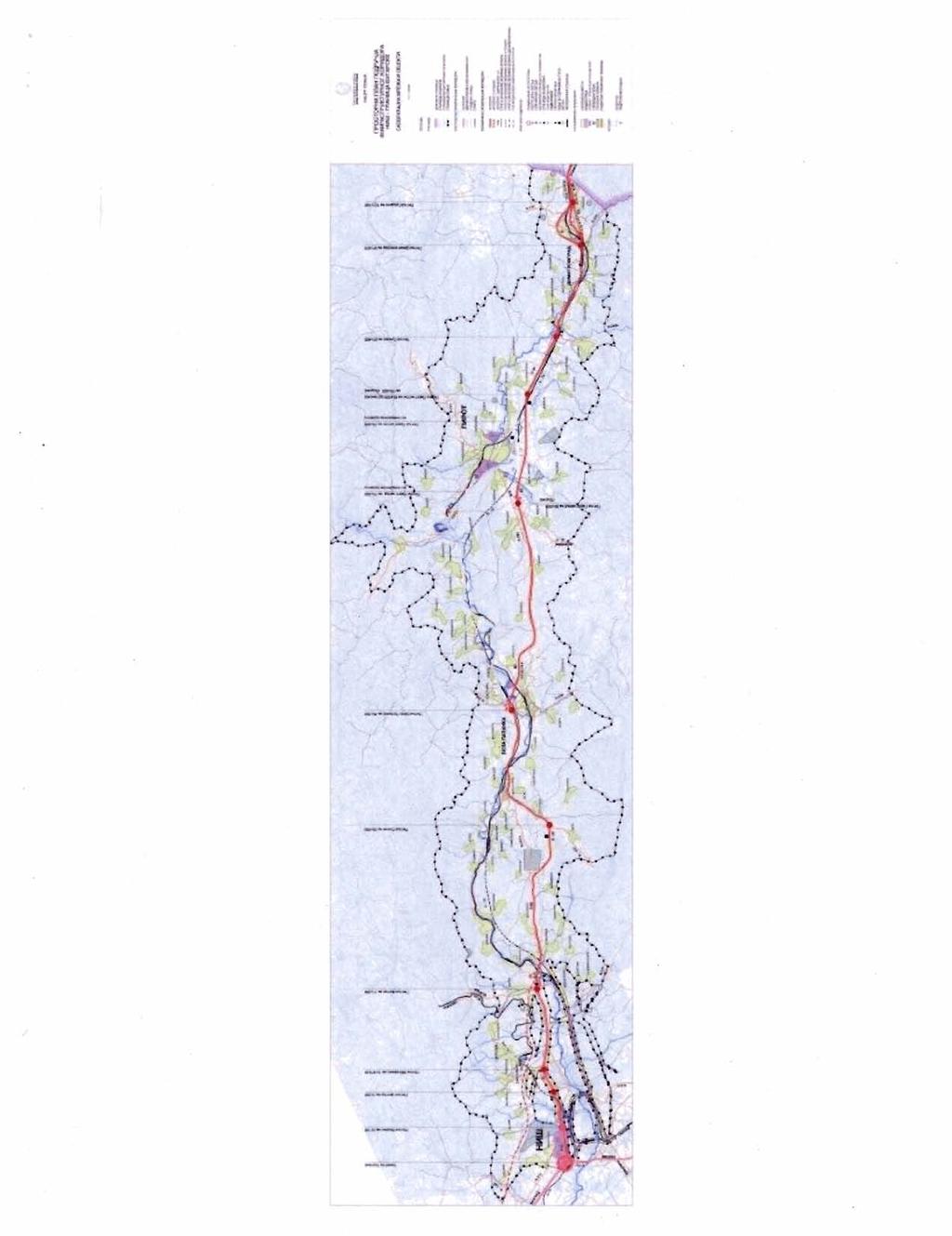
22
23 Annex 2 Situation Map of the E-75 Motorway Alignment 20

24
Serbia Corridor X Highway Project E-75 and E-80. Resettlement Policy Framework. Final Version June 4, 2009
 Public Disclosure Authorized Serbia Corridor X Highway Project E-75 and E-80 Resettlement Policy Framework RP789 rev Public Disclosure Authorized Public Disclosure Authorized Public Disclosure Authorized
RESETTLEMENT ACTION PLAN (For the E 80 Motorway Section - Dimitrovgrad Bypass)
") Public Disclosure Authorized Public Disclosure Authorized Public Disclosure Authorized Public Disclosure Authorized RP789 v2 SERBIA CORRIDOR X HIGHWAY PROJECT RESETTLEMENT ACTION PLAN (For the E 80 Motorway
Public Disclosure Authorized Public Disclosure Authorized Public Disclosure Authorized Public Disclosure Authorized RP789 v2 SERBIA CORRIDOR X HIGHWAY PROJECT RESETTLEMENT ACTION PLAN (For the E 80 Motorway
RESETTLEMENT ACTION PLAN
 Public Disclosure Authorized Public Disclosure Authorized Public Disclosure Authorized Public Disclosure Authorized SERBIA CORRIDOR X HIGHWAY PROJECT RESETTLEMENT ACTION PLAN (For the Corridor X Highway
RESETTLEMENT POLICY FRAMEWORK AND PROCEDURAL GUIDELINES GAUNGXI ROADS DEVELOPMENT II PROJECT
 Village Roads Component on the GAUNGXI ROADS DEVELOPMENT II PROJECT in THE PEOPLE S REPUBLIC OF CHINA (PRC) Guangxi Comnications Department Nanning, PRC This report was prepared by the Borrower and is
RESETTLEMENT POLICY FRAMEWORK
 Ministry of Agriculture and Environmental Protection Directorate for Water Management 11070 Belgrade, Blvd. Umetnosti 2a ELEKTROPRIVREDA SRBIJE FLOODS EMERGENCY AND RECOVERY PROJECT (FERP) RESETTLEMENT
Resettlement Policy Framework
 Republic of Turkey Second Renewable Energy and Energy Efficiency Project Resettlement Policy Framework Background 1. The Second Renewable Energy and Energy Efficiency Project will fund private sector investments
RESETTLEMENT ACTION PLAN
 Public Disclosure Authorized Public Disclosure Authorized Public Disclosure Authorized Public Disclosure Authorized RESETTLEMENT ACTION PLAN for the Corridor Highway project Component 1 - Corridor X, The
REPUBLIC OF MACEDONIA
 Public Disclosure Authorized Public Disclosure Authorized Public Disclosure Authorized Public Disclosure Authorized REPUBLIC OF MACEDONIA Municipal Services Improvement Project (MSIP) LAND ACQUISITION
CITY OF FORT COLLINS NATURAL AREAS AND CONSERVED LANDS EASEMENT POLICY
 CITY OF FORT COLLINS NATURAL AREAS AND CONSERVED LANDS EASEMENT POLICY Adopted January 3, 2012 PURPOSE: The purpose of the policy statement is to clarify the policies and procedures of the City of Fort
Koridori Srbije Corridor X Highway Project Land Acquisition and Resettlement Framework LARF
 Land Acquisition and Resettlement Framework LARF Issue 1 June 2018 PREPARED BY Contents List of Abbreviations 2 Glossary 3 1 Introduction 7 1.1 Principles and Objectives 12 2 Gaps Between RS Legislation
Resettlement Policy framework for the Albania s Improvement of the Management and Conditions of the Secondary and Local Roads Project
 Resettlement Policy framework for the Albania s Improvement of the Management and Conditions of the Secondary and Local Roads Project I. Introduction The overall length of the road network in Albania totals
Republic of Turkey Additional Financing to Second Renewable Energy and Energy Efficiency Project Resettlement Policy Framework For TSKB and TKB
 Public Disclosure Authorized Public Disclosure Authorized Public Disclosure Authorized Public Disclosure Authorized Republic of Turkey Additional Financing to Second Renewable Energy and Energy Efficiency
Current Law Legislation for Land Consolidation in Turkey
 Legal Frameworks for Land Consolidation in Turkey Fatma Tüz Zehra GÜLSEVER Geodesy and Photogrammetry Engineer FYR Macedonia 19-21 June 2018 In Turkey due to inheritence law, agriculture land plots get
RP1 85 November The Resettlement Policy Framework (RPF) Report on the GEF Hai Basin Project. (Final Version)
 Report on the GEF Hai Basin Project. (Final Version)") Public Disclosure Authorized Public Disclosure Authorized Public Disclosure Authorized Public Disclosure Authorized PIP annex 9 - C of GEF Hai Basin Integrated Water and Environment Management Project
Public Disclosure Authorized Public Disclosure Authorized Public Disclosure Authorized Public Disclosure Authorized PIP annex 9 - C of GEF Hai Basin Integrated Water and Environment Management Project
Summary of Land Acquisition, Resettlement and Rehabilitation Policy for Infrastructure Development Project 2015
 Summary of Land Acquisition, Resettlement and Rehabilitation Policy for Infrastructure Development Project 2015 Vision Contribute to overall development of the nation and its citizens by creating conducive
Western Balkans Investment Framework Infrastructure Project Facility Technical Assistance 4 (IPF 4)
") Western Balkans Investment Framework Infrastructure Project Facility Technical Assistance 4 (IPF 4) TA2012054 R0 WBF Preliminary Design and Feasibility Study with EIA for construction of Highway E-80 in
Western Balkans Investment Framework Infrastructure Project Facility Technical Assistance 4 (IPF 4) TA2012054 R0 WBF Preliminary Design and Feasibility Study with EIA for construction of Highway E-80 in
PROJECT INFORMATION DOCUMENT (PID) CONCEPT STAGE Report No.: AB3229 Project Name. Land Registry and Cadastre Modernization Project Region
 CONCEPT STAGE Report No.: AB3229 Project Name. Land Registry and Cadastre Modernization Project Region") PROJECT INFORMATION DOCUMENT (PID) CONCEPT STAGE Report No.: AB3229 Project Name Land Registry and Cadastre Modernization Project Region EUROPE AND CENTRAL ASIA Sector Central government administration
PROJECT INFORMATION DOCUMENT (PID) CONCEPT STAGE Report No.: AB3229 Project Name Land Registry and Cadastre Modernization Project Region EUROPE AND CENTRAL ASIA Sector Central government administration
Report No.: ISDSA15389
 Public Disclosure Authorized Public Disclosure Authorized Public Disclosure Authorized Public Disclosure Authorized 0 o Date ISDS Prepared/Updated: 12-ct-2015 INTEGRATED SAFEGUARDS DATA SHEET APPRAISAL
Minerals and Mining (Compensation And Resettlement) Regulations, 2012 (L.I. 2175)
 Regulations, 2012 (L.I. 2175)") Minerals and Mining (Compensation And Resettlement) Regulations, 2012 (L.I. 2175) ARRANGEMENT OF REGULATIONS Regulations 1. Claims for compensation 2. Assessment of compensation 3. Compensation principles
Minerals and Mining (Compensation And Resettlement) Regulations, 2012 (L.I. 2175) ARRANGEMENT OF REGULATIONS Regulations 1. Claims for compensation 2. Assessment of compensation 3. Compensation principles
IRS FORM 8283 SUPPLEMENTAL STATEMENT DONATION OF CONSERVATION EASEMENT
 Name(s) shown on income tax return Identifying Number Robert T. Landowner 021-34-1234 Susan B. Landowner 083-23-5555 IRS FORM 8283 SUPPLEMENTAL STATEMENT DONATION OF CONSERVATION EASEMENT On November 12,
MIDWAY CITY Municipal Code
 MIDWAY CITY Municipal Code TITLE 9 ANNEXATION CHAPTER 9.01 PURPOSE CHAPTER 9.02 GENERAL REQUIREMENTS CHAPTER 9.03 PROPERTY OWNER INITIATION OF ANNEXATION CHAPTER 9.04 PROCEDURES FOR CONSIDERATION OF PETITION
PROJECT INFORMATION DOCUMENT (PID) APPRAISAL STAGE Report No.: PIDA Project Name. Region Country Sector(s) Theme(s)
 APPRAISAL STAGE Report No.: PIDA Project Name. Region Country Sector(s) Theme(s)") Public Disclosure Authorized Public Disclosure Authorized Public Disclosure Authorized Public Disclosure Authorized Project Name Region Country Sector(s) Theme(s) Lending Instrument Project ID Borrower(s)
Public Disclosure Authorized Public Disclosure Authorized Public Disclosure Authorized Public Disclosure Authorized Project Name Region Country Sector(s) Theme(s) Lending Instrument Project ID Borrower(s)
Hurstpierpoint & Sayers Common Neighbourhood Plan. Habitats Regulations Assessment Screening Report. 4 th April 2014
 Hurstpierpoint & Sayers Common Neighbourhood Plan Habitats Regulations Assessment Screening Report 4 th April 2014 1.0 Introduction 1.1 This Habitats Regulations Assessment (HRA) screening report has been
SCHEDULE 3 TO THE URBAN GROWTH ZONE. Shown on the planning scheme map as UGZ3 QUARRY HILLS PRECINCT STRUCTURE PLAN. 1.0 The Plan
 SCHEDULE 3 TO THE URBAN GROWTH ZONE 1.0 The Plan Shown on the planning scheme map as UGZ3 QUARRY HILLS PRECINCT STRUCTURE PLAN Map 1 to Schedule 3 to Clause 37.07 shows the Future Urban Structure for Quarry
Biodiversity Planning Policy and Guidelines for (LEP) Rezoning Proposals
 Rezoning Proposals") Council Policy Biodiversity Planning Policy and Guidelines for (LEP) Rezoning Proposals Table of Contents Table of Contents... 1 Policy... 2 Policy Objectives... 2 Policy Statement... 2 Guidelines... 2
Council Policy Biodiversity Planning Policy and Guidelines for (LEP) Rezoning Proposals Table of Contents Table of Contents... 1 Policy... 2 Policy Objectives... 2 Policy Statement... 2 Guidelines... 2
Learning from land suitability analysis and Dutch spatial policy for sustainable land use in Japan
 Learning from land suitability analysis and Dutch spatial policy for sustainable land use in Japan Toru Nagayama 22 January 2009 GIS Research Group Seminar, University of Tsukuba Highlights from : Nagayama.,
Chapter 210 CONDITIONAL USES
 Chapter 210 CONDITIONAL USES 210.01 Purpose 210.02 Authorization 210.03 Process Type 210.04 Determination of Major or Minor Conditional Use Review 210.05 Approval Criteria 210.06 Conditions of Approval
Land Trust of Santa Cruz County. Strategic Plan. July 2012 to June This is a public version of a more detailed internal plan.
 Land Trust of Santa Cruz County Strategic Plan July 2012 to June 2015 This is a public version of a more detailed internal plan. Over the next three years the Land Trust will pursue four critical strategies.
INTEGRATED SAFEGUARDS DATASHEET APPRAISAL STAGE
 Public Disclosure Authorized Public Disclosure Authorized Public Disclosure Authorized Public Disclosure Authorized I. Basic Information Date prepared/updated: 03/03/2010 INTEGRATED SAFEGUARDS DATASHEET
Flinders Avenue, Lara Planning Scheme Amendment Combined Application for Rezoning and Multi-Lot Subdivision Reference : Decembe
 143-179 Flinders Avenue, Lara Planning Scheme Amendment Combined Application for Rezoning and Multi-Lot Subdivision Reference: 14134-03 TGM Group Geelong Melbourne Ballarat 1/27-31 Myers Street (PO Box
5. That the Owner shall agree that all development Blocks shown within the Draft Plan will be connected to full municipal services.
 Conditions Relating to Draft Plan of Subdivision Approval East Fonthill 26T 01014 (Draft Plan dated December 1, 2013, and revised August 28, 2014), the Town of Pelham 1. This approval applies to the Draft
LAW ON EXPROPRIATION (Official Gazette of the Republic of Montenegro, No 55/00, 12/02, 28/06)
") LAW ON EXPROPRIATION (Official Gazette of the Republic of Montenegro, No 55/00, 12/02, 28/06) I Basic Provisions Expropriation of Immovables Article 1 Expropriation shall mean dispossession or limitation
LAW ON EXPROPRIATION (Official Gazette of the Republic of Montenegro, No 55/00, 12/02, 28/06) I Basic Provisions Expropriation of Immovables Article 1 Expropriation shall mean dispossession or limitation
Community Occupancy Guidelines
 Community Occupancy Guidelines Auckland Council July 2012 Find out more: phone 09 301 0101 or visit www.aucklandcouncil.govt.nz Contents Introduction 4 Scope 5 In scope 5 Out of scope 5 Criteria 6 Eligibility
ADMINISTRATIVE GUIDANCE
 11 ADMINISTRATIVE GUIDANCE ON CONTAMINATED SITES Effective date: April 1, 2013 Version 1.1 May 2013 Expectations and Requirements for Contaminant Migration Introduction This guidance focusses on the ministry
4.2 LAND USE INTRODUCTION
 4.2 LAND USE INTRODUCTION This section of the EIR addresses potential impacts from the Fresno County General Plan Update on land use in two general areas: land use compatibility and plan consistency. Under
OUTLINE PLANNING PERMISSION
 Correspondence Address: G L Hearn Mr Phil Robinson 1 St James' Square Manchester M2 6DN Applicant: Telereal Trillium 140 London Wall London EC2Y 5DN OUTLINE PLANNING PERMISSION Town and Country Planning
NSW Travelling Stock Reserves Review Public consultation paper
 NSW Travelling Stock Reserves Review Public consultation paper A collaborative project between: Local Land Services Department of Industry Lands Contents Executive summary 2 1. About TSRs 3 What are TSR
Cibuk 1 Wind Farm Land Acquisition Plan Vetroelektrane Balkana d.o.o. October 2014
 Vetroelektrane Balkana d.o.o. October 2014 Table of contents Chapter Pages 1. Introduction 3 2. Project Land Acquisition 3 2.1. Land previously acquired 3 2.2. Land in the process of acquisition 4 3. Legal
South African Council for Town and Regional Planners
 TARIFF OF FEES South African Council for Town and Regional Planners PLEASE NOTE : THE TARIFF OF FEES WAS APPROVED BY THE COUNCIL CHAPTER 10 : TARIFF OF FEES 10.1 INTRODUCTION 10.1.1 General This tariff
Expropriation. Recommended Policy Wordings (full): Lao National Land Policy. Context. Policy. Standard of Public Purpose
: Lao National Land Policy. Context. Policy. Standard of Public Purpose") Expropriation Context Following from the goal of the National Land Policy, to promote and ensure a secure land tenure system that is transparent, effective, non-discriminative, equitable and just ; it
Expropriation Context Following from the goal of the National Land Policy, to promote and ensure a secure land tenure system that is transparent, effective, non-discriminative, equitable and just ; it
Napa County Planning Commission Board Agenda Letter
 Agenda Date: 9/20/2017 Agenda Placement: 8C Napa County Planning Commission Board Agenda Letter TO: FROM: Napa County Planning Commission Charlene Gallina for David Morrison - Director Planning, Building
RP607. Summary of Land Acquisition & Resettlement Policy Framework JAMAICA: JM Hurricane Dean ERL Project. A. Introduction. B. Means of Obtaining Land
 Public Disclosure Authorized Public Disclosure Authorized Public Disclosure Authorized Public Disclosure Authorized Summary of Land Acquisition Policy Framework JAMAICA: JM Hurricane Dean ERL Project RP607
Resettlement Compensation Framework Railway Corridor VIII - Eastern section
 Republic of Macedonia February 2012 Resettlement Compensation Framework Railway Corridor VIII - Eastern section Contract No: C21196/EBSF-2010-07-101 Macedonian Railways: Feasibility Study for Corridor
COMPLIANCE APPRAISAL: SUMMARY OF RESULTS
 October 22, 2015 Office of the Compliance Advisor Ombudsman (CAO) COMPLIANCE APPRAISAL: SUMMARY OF RESULTS IFC Investment in Lydian International Ltd. (Project #27657), Armenia Complaint 02 Lydian International
PLANNING REPORT. Prepared for: John Spaleta 159 Delatre Street Woodstock Ontario N4S 6C2
 PLANNING REPORT County Official Plan Amendment and Zoning By-law Amendment to Permit a Seasonal Dwelling on an Existing Lot of Record with Access onto a Seasonally Maintained Road Parts of Lot 29, Concession
Problems of land consolidation in the Republic of Moldova. Stefan Calancea Ministry of Agriculture and Food Industry
 1 Problems of land consolidation in the Republic of Moldova Stefan Calancea Ministry of Agriculture and Food Industry Oleg Horjan Land Re-parceling Component, Second Rural Investment and Secrecies Project
POLICY FRAMEWORK FOR COMPENSATION, RESETTLEMENT AND REHABILITATION OF PROJECT AFFECTED PERSONS. November 2000
 Public Disclosure Authorized Public Disclosure Authorized Public Disclosure Authorized Public Disclosure Authorized LAO PDR: AGRICULTURAL DEVELOPMENT PROGRAM RP-59 POLICY FRAMEWORK FOR COMPENSATION, RESETTLEMENT
Quality Improvement of the Real Estate Cadastre in Serbia
 , Serbia Key words: quality improvement, real estate information, quality assurance, Serbia SUMMARY The concept of cadastral modernization in the Republic of Serbia was defined in 1992, and it is being
TOWN OF WHITBY REPORT RECOMMENDATION REPORT
 TOWN OF WHITBY REPORT RECOMMENDATION REPORT REPORT TO: Planning and Development Committee REPORT NO: PL 4-08 DATE OF MEETING: January 21, 2008 FILE NO(S): MI-01-07 (SW- 2002-03) PREPARED BY: Planning Department
RECITALS. B. WHEREAS, Ranch, its successors and assigns, are referred to in the Easement as the Grantor ; and
 Basic Components of Management Plans Associated with Conservation Easement Acquisitions Where A Land Trust Or other third party Is the Grantee April 17, 2012 Key: Text in normal font, without highlight,
City of Grande Prairie Development Services Department
 City of Grande Prairie Development Services Department COUNTRYSIDE SOUTH OUTLINE PLAN Prepared by: GPEC Consulting Ltd. #202, 10712-100th Street Grande Prairie, AB Council Resolution of August 20, 2001
PROJECT SCORING GUIDANCE. Introduction: National Proiect Selection:
 FOREST LEGACY PROGRAM PROJECT SCORING GUIDANCE Introduction: This document provides guidance to the National Review Panel on how to score individual Forest Legacy Program (FLP) projects, including additional
Chapter 136. SOIL EROSION
 1 of 8 12/19/2011 4:17 PM Township of Andover, NJ Monday, December 19, 2011 Chapter 136. SOIL EROSION [HISTORY: Adopted by the Township Committee of the Township of Andover by Ord. No. 77-11 (Ch. XVII
RESETTLEMENT POLICY FRAMEWORK
 JSC SERBIAN RAILWAYS INFRASTRUCTURE CITY OF NIS RESETTLEMENT POLICY FRAMEWORK FOR EXPROPRIATION INTENDED FOR REHABILITATION AND MODERNIZATION OF THE RAILWAY LINE NIS-DIMITROVGRAD FINAL DOCUMENT Belgrade,
SUMMARY LAND ACQUISITION PLAN. Supplementary Appendix to the. Report and Recommendation of the President to the Board of Directors.
 SUMMARY LAND ACQUISITION PLAN Supplementary Appendix to the Report and Recommendation of the President to the Board of Directors on the RURAL ROADS SECTOR I PROJECT in INDIA Ministry of Rural Development
Land Use Planning Analysis. Phase 2 Drayton Valley Annexation Proposal
 Land Use Planning Analysis Phase 2 Drayton Valley Annexation Proposal Prepared for Town of Drayton Valley Prepared by Mackenzie Associates Consulting Group Limited March, 2011 TABLE OF CONTENTS 1.0 INTRODUCTION...
MAKING THE MOST EFFECTIVE AND SUSTAINABLE USE OF LAND
 165 SOC146 To deliver places that are more sustainable, development will make the most effective and sustainable use of land, focusing on: Housing density Reusing previously developed land Bringing empty
SOCIAL ASSESSMENT OF BANGALORE METRO RAIL PROJECT LINE R6
 SOCIAL ASSESSMENT OF BANGALORE METRO RAIL PROJECT LINE R6 1. Socio Economic Profile of the Project Area 1.1 General Profile Bangalore officially known as Bengaluru, is the capital of the Indian state of
Sample Baseline Documentation Report (BDR) Annotated Template for Environmentally Important Land
 Annotated Template for Environmentally Important Land") Sample Baseline Documentation Report (BDR) Annotated Template for Environmentally Important Land The baseline documentation report (BDR) provides a snap shot of the biophysical condition of a property
Sample Baseline Documentation Report (BDR) Annotated Template for Environmentally Important Land The baseline documentation report (BDR) provides a snap shot of the biophysical condition of a property
Article 12.5 Exemptions for Agricultural Housing, Affordable Housing, and Residential Infill Projects
 Title 14. California Code of Regulations Chapter 3. Guidelines for Implementation of the California Environmental Quality Act Article 12.5 Exemptions for Agricultural Housing, Affordable Housing, and Residential
THINK BIG do little. Start an avalanche
 1 Recent activities on land consolidation in Serbia Stevan Marosan, Mladen Soskic University of Belgrade, Faculty of Civil Engineering Department for Geodesy and Geoinformatics Zoran Knezevic Ministry
Scheme of Service. for. Housing Officers
 REPUBLIC OF KENYA Scheme of Service for Housing Officers APPROVED BY THE PUBLIC SERVICE COMMISSION AND ISSUED BY THE PERMANENT SECRETARY MINISTRY OF STATE FOR PUBLIC SERVICE OFFICE OF THE PRIME MINISTER
VI. SAFETY ELEMENT I. INTRODUCTION A. PURPOSE B. AUTHORITY. 1. Safety
 AB 162 and SB 1241 Amendment to the Safety Element New sections are underlined, deleted sections are shown as strikethrough and the denotes text remaining in place. VI. SAFETY ELEMENT I. INTRODUCTION A.
ROLE OF SOUTH AFRICAN GOVERNMENT IN SOCIAL HOUSING. Section 26 of the Constitution enshrines the right to housing as follows:
 1 ROLE OF SOUTH AFRICAN GOVERNMENT IN SOCIAL HOUSING Constitution Section 26 of the Constitution enshrines the right to housing as follows: Everyone has the right to have access to adequate housing The
Land Improvement Act
 Issuer: Riigikogu Type: act In force from: 01.09.2015 In force until: 31.12.2017 Translation published: 04.09.2015 Amended by the following acts Passed 22.01.2003 RT I 2003, 15, 84 Entry into force 01.07.2003,
Planning Act. Chapter 1 General provisions. Passed In force from: In force until: Translation published:
 Issuer: Riigikogu Type: act In force from: 01.07.2015 In force until: 31.08.2015 Translation published: 18.12.2015 1. Aim and scope of regulation of the Act Passed 28.01.2015 Chapter 1 General provisions
Implementing Agency Department of Housing, Ministry of Local Government, Urban Development, Housing and Environment
 Public Disclosure Authorized Public Disclosure Authorized Public Disclosure Authorized Public Disclosure Authorized PROJECT INFORMATION DOCUMENT (PID) IDENTIFICATION/CONCEPT STAGE Report No.: PIDC56649
OFFICIAL DOCUMENTS. Financing Agreement. Public Disclosure Authorized CREDIT NUMBER 6306-MD. Public Disclosure Authorized
 Public Disclosure Authorized Public Disclosure Authorized OFFICIAL DOCUMENTS Financing Agreement (Land Registration and Property Valuation Project) CREDIT NUMBER 6306-MD Public Disclosure Authorized between
Submittal of the Minutes from the March 9, 2011, April 5, 2011, and April 19, 2011 Cabinet Meetings.
 AGENDA BOARD OF TRUSTEES OF THE INTERNAL IMPROVEMENT TRUST FUND JUNE 16, 2011 Attachments to the items below can be viewed at the following link: http://www.dep.state.fl.us/secretary/cab/public_notices.htm
Barratt Metropolitan Limited Liability Partnership
 Barratt Metropolitan Limited Liability Partnership London Borough of Barnet (West Hendon Regeneration Area) Compulsory Purchase Order No 1 2014 Rebuttal Proof of Evidence Mr Matt Calladine 12 January 2015
Presentation to the Real Estate Institute of New Zealand 28 October 2016
 Presentation to the Real Estate Institute of New Zealand 28 October 2016 Disclaimer This presentation provides a high level overview of specific parts of the Proposed Auckland Unitary Plan Decisions Version
The Bill is called the Land Acquisition, Rehabilitation and Resettlement Act, 2011
 The Land Acquisition, Rehabilitation and Resettlement Bill, 2011 was introduced in Lok Sabha on September 7, 2011. On December 17, 2012, during the winter session of Parliament, the government circulated
DIRECTORATE DEEDS REGISTRATION SUB-SECTOR PROGRAMME. Title security of tenure to real property. Description
 DIRECTORATE DEEDS REGISTRATION SUB-SECTOR PROGRAMME Title security of tenure to real property Description Throughout the world and from early times, countries have endeavoured to have a system of land
Mandatory Requirement for Certification Bodies in Assessing Free, Prior and Informed Consent (FPIC) in New Planting Procedures
 in New Planting Procedures") Mandatory Requirement for Certification Bodies in Assessing Free, Prior and Informed Consent (FPIC) in New Planting Procedures February 2018 Document Name: Mandatory Requirement for Certification Bodies
Mandatory Requirement for Certification Bodies in Assessing Free, Prior and Informed Consent (FPIC) in New Planting Procedures February 2018 Document Name: Mandatory Requirement for Certification Bodies
In light of this objective, Global Witness is providing feedback on key sections of the 6 th draft of the national land policy:
 Summary Global Witness submission on the 6 th draft of Myanmar s draft national land policy June 2015 After a welcome extension to public participation on the 5 th draft of the national land policy, in
LAW ON ALLOCATION OF LAND TO MONGOLIAN CITIZENS FOR OWNERSHIP
 LAW ON ALLOCATION OF LAND TO MONGOLIAN CITIZENS FOR OWNERSHIP CHAPTER ONE. GENERAL PROVISIONS Article 1. Purpose of the Law 1.1. The purpose of this law is to govern allocation of land to citizens-families
Decree on State Land Lease or Concession
 Lao People s Democratic Republic Peace Independence Democracy Unity Prosperity ~~~~~~~~~~~~~ Prime Minister s Office No. 135/PM VCC, Date 25/05/2009 Decree on State Land Lease or Concession - Pursuant
GOVERNMENT CODE SECTION GOVERNMENT CODE SECTION 65302
 GOVERNMENT CODE SECTION 65300 65300. Each planning agency shall prepare and the legislative body of each county and city shall adopt a comprehensive, long-term general plan for the physical development
NORTH LEEDS MATTER 2. Response to Leeds Sites and Allocations DPD Examination Inspector s Questions. August 2017
 NORTH LEEDS MATTER 2 Response to Leeds Sites and Allocations DPD Examination Inspector s Questions August 2017 CLIENT: TAYLOR WIMPEY, ADEL REFERENCE NO: CONTENTS 1.0 INTRODUCTION 2.0 TEST OF SOUNDNESS
RESIDENTIAL AND RECREATIONAL
 Energy, Mines & Resources Land Management Branch 320-300 Main Street Whitehorse, Yukon Y1A 2B5 667-5215 Fax 667-3214 www.emr.gov.yk.ca RESIDENTIAL AND RECREATIONAL Lot Enlargement Policy OBJECTIVE To facilitate
CONDITIONAL USE PERMIT Application Packet
 CONDITIONAL USE PERMIT Application Packet Community Development Department 1020 East Pioneer Road, Draper, UT 84020 (801) 576-6539 Fax (801) 576-6526 Dear Applicant, This application packet has been developed
Conceptual Scheme SE W4
 December 2012 1. PURPOSE 1.1. The purpose of a Conceptual Scheme (CS) is as follows: a) To provide a framework for the subsequent subdivision and/or development of land within the Country Residential Policy
Chapter 100 Planned Unit Development in Corvallis Urban Fringe
 100.100 Scope and Purpose. Chapter 100 Planned Unit Development in Corvallis Urban Fringe (1) All applications for land divisions in the Urban Residential (UR) and Flood Plain Agriculture (FPA) zones within
SFG kv İzmir Substation Abbreviated Resettlement Action Plan (ARAP) Turkish Electricity Transmission Company. Public Disclosure Authorized
 Turkish Electricity Transmission Company. Public Disclosure Authorized") Public Disclosure Authorized Public Disclosure Authorized Public Disclosure Authorized Public Disclosure Authorized Turkish Electricity Transmission Company 380 kv İzmir Substation Abbreviated Resettlement
Public Disclosure Authorized Public Disclosure Authorized Public Disclosure Authorized Public Disclosure Authorized Turkish Electricity Transmission Company 380 kv İzmir Substation Abbreviated Resettlement
Paragraph 47 National Planning Policy Framework. rpsgroup.com/uk
 To boost significantly the supply of housing, local planning authorities should use their evidence base to ensure that their Local Plan meets the full, objectively assessed needs for market and affordable
MARK TWAIN LAKE MASTER PLAN CLARENCE CANNON DAM AND MARK TWAIN LAKE MONROE CITY, MISSOURI
 MARK TWAIN LAKE MASTER PLAN CLARENCE CANNON DAM AND MARK TWAIN LAKE MONROE CITY, MISSOURI CHAPTER 4 LAND ALLOCATION, LAND CLASSIFICATION, WATER SURFACE, AND EASEMENT LANDS This Master Plan is a land use
18 Sale and Other Disposition of Regional Lands Policy
 Clause 18 in Report No. 7 of Committee of the Whole was adopted, without amendment, by the Council of The Regional Municipality of York at its meeting held on April 19, 2018. 18 Sale and Other Disposition
Agricultural Lease Bid Process and Policy Updated September 21, 2017
 Agricultural Lease Bid Process and Policy Updated September 21, 2017 Introduction: Pitkin County Open Space & Trails (OST) was established by the voters of Pitkin County in 1990 with the following mission;
EN Official Journal of the European Union L 320/373
 29.11.2008 EN Official Journal of the European Union L 320/373 INTERNATIONAL FINANCIAL REPORTING STANDARD 3 Business combinations OBJECTIVE 1 The objective of this IFRS is to specify the financial reporting
City of Brandon Brownfield Strategy
 City of Brandon Brownfield Strategy 2017 Executive Summary A brownfield is a property, the expansion, redevelopment, or reuse of which may be complicated by the presence or potential presence of a hazardous
Division 5 Residential Low Density Zone: Assessment Criteria and Assessment Tables
 Division 5 Residential Low Density Zone: Assessment Criteria and Assessment Tables 4.5.1 Residential Low Density Zone The provisions in this division relate to the Residential Low Density Zone as follows
RESETTLEMENT POLICY FRAMEWORK (RPF)
") Public Disclosure Authorized Public Disclosure Authorized Public Disclosure Authorized Public Disclosure Authorized JANUARY 2013 Republic of Mozambique Mozambique Climate Resilience: Transforming Hydro-Meteorological
Public Disclosure Authorized Public Disclosure Authorized Public Disclosure Authorized Public Disclosure Authorized JANUARY 2013 Republic of Mozambique Mozambique Climate Resilience: Transforming Hydro-Meteorological
REPRESENTATIONS TO SHEPWAY DISTRICT COUNCIL (SDC) PLACES AND POLICIES LOCAL PLAN SUBMISSIONS DRAFT SDC/COZUMEL ESTATES LIMITED
 PLACES AND POLICIES LOCAL PLAN SUBMISSIONS DRAFT SDC/COZUMEL ESTATES LIMITED") REPRESENTATIONS TO SHEPWAY DISTRICT COUNCIL (SDC) PLACES AND POLICIES LOCAL PLAN SUBMISSIONS DRAFT SDC/COZUMEL ESTATES LIMITED OTTERPOOL PARK 19 MARCH 2018 Quod Limited Contents 1 Introduction 3 2 Site
REPRESENTATIONS TO SHEPWAY DISTRICT COUNCIL (SDC) PLACES AND POLICIES LOCAL PLAN SUBMISSIONS DRAFT SDC/COZUMEL ESTATES LIMITED OTTERPOOL PARK 19 MARCH 2018 Quod Limited Contents 1 Introduction 3 2 Site
PROJECT INFORMATION DOCUMENT (PID) RESTRUCTURING. PA Land Administration
 RESTRUCTURING. PA Land Administration") Project Name Region Sector Project ID Borrower(s) Implementing Agency PROJECT INFORMATION DOCUMENT (PID) RESTRUCTURING PA Land Administration LATIN AMERICA AND CARIBBEAN Natural Resources Management P050595
Project Name Region Sector Project ID Borrower(s) Implementing Agency PROJECT INFORMATION DOCUMENT (PID) RESTRUCTURING PA Land Administration LATIN AMERICA AND CARIBBEAN Natural Resources Management P050595
THE UNITED REPUBLIC OF TANZANIA PRESIDENT S OFFICE REGIONAL ADMINISTRATION AND LOCAL GOVERNMENT (PO-RALG) Tanzania Strategic Cities Project (TSCP)
 Tanzania Strategic Cities Project (TSCP)") THE UNITED REPUBLIC OF TANZANIA PRESIDENT S OFFICE REGIONAL ADMINISTRATION AND LOCAL GOVERNMENT (PO-RALG) Tanzania Strategic Cities Project (TSCP) Resettlement Action Plan Update Report for the ARUSHA
THE UNITED REPUBLIC OF TANZANIA PRESIDENT S OFFICE REGIONAL ADMINISTRATION AND LOCAL GOVERNMENT (PO-RALG) Tanzania Strategic Cities Project (TSCP) Resettlement Action Plan Update Report for the ARUSHA
Planning Rationale in Support of an Application for Plan of Subdivision and Zoning By-Law Amendment
 Planning Rationale in Support of an Application for Plan of Subdivision and Zoning By-Law Amendment The Kilmorie Development 21 Withrow Avenue City of Ottawa Prepared by: Holzman Consultants Inc. Land
Securing Land Rights for Broadband Land Acquisition for Utilities in Sweden
 Securing Land Rights for Broadband Land Acquisition for Utilities in Sweden Marija JURIC and Kristin LAND, Sweden Key words: broadband, land acquisition, cadastral procedure, Sweden SUMMARY The European
Establishment of a land market in Ukraine: current state and prospects
 Establishment of a land market in Ukraine: current state and prospects More than 25 years have passed since the adoption of the first resolution of the Verkhovna Rada On Land Reform. Despite such a long
Integrated Safeguards Data Sheet (Updated)
") Public Disclosure Authorized Public Disclosure Authorized Public Disclosure Authorized Public Disclosure Authorized Integrated Safeguards Data Sheet (Updated) Section I - Basic Information Date Prepared/Updated:
Public Disclosure Authorized Public Disclosure Authorized Public Disclosure Authorized Public Disclosure Authorized Integrated Safeguards Data Sheet (Updated) Section I - Basic Information Date Prepared/Updated:
Addressing Land Sector Opportunities with Geospatial Information in Nepal
 The 20th UNRCC-AP and the 4th UN-GGIM-AP 5-10 October 2015 Jeju Island, Republic of Korea Addressing Land Sector Opportunities with Geospatial Information in Nepal Krishna Raj BC Executive Director Land