ARLINGTON COUNTY, VIRGINIA. County Board Agenda Item Meeting of December 8, 2012
|
|
|
- Ambrose Fletcher
- 5 years ago
- Views:
Transcription
 blocks generally bounded by Lee Hwy., N.")
. Applicant: MI Lee Highway, LLC 2.")
1 ARLINGTON COUNTY, VIRGINIA County Board Agenda Item Meeting of December 8, 2012 DATE: November 29, 2012 SUBJECTS: 1. GP GENERAL LAND USE PLAN AMENDMENT to amend the GLUP designation for the two (2) blocks generally bounded by Lee Hwy., N. Veitch St., 21st St. N., and the VDOT right-of-way for I-66 from "Low-Medium" Residential (16-36 units/acre) to "Low" Office- Apartment-Hotel (up to 1.5 FAR office; up to 72 units/acre residential; up to 110 units/acre hotel). Applicant: MI Lee Highway, LLC 2. Z REZONING from "C-2" Service Commercial--Community Business Districts and "R-5" One-Family, Restricted Two-Family Dwelling Districts to "C-O-1.5" Commercial Office Building, Hotel and Apartment Districts for the property located at 2145 & 2147 Lee Hwy., 2001 & 2005 N. Uhle St., 2114, 2118, th St. N., vacated right of way of 2100 block of 20th St. N. (RPC# , -003 through -009, through -007, through -008). 3. SP #420 SITE PLAN consisting of up to 202 dwelling units, and 13,257 g.f.a. of retail; located at 2145 & 2147 Lee Hwy., 2001 & 2005 N. Uhle St., 2114, 2118, th St. N., vacated right of way of 2100 block of 20th St. N. (RPC# , -003 through -009, through - 007, through -008). County Manager: ##### County Attorney: ***** Staff: Peter Schulz, DCPHD, Planning Division Dolores Kinney, DES, Transportation Division Margaret Rhodes, DCPHD, Planning Division Sarah Pizzo, DCPHD, Housing Division PLA C., D., E.
2 By: Nan E. Walsh, Esq. Walsh, Colucci, Lubeley, Emrich & Walsh, PC 2100 Clarendon Blvd., 13 th Floor Arlington, Virginia C.M. RECOMMENDATIONS: 1. Adopt the attached resolution to approve an amendment to the General Land Use Plan from "Low-Medium" Residential (16-36 units/acre) to "Low" Office-Apartment- Hotel (up to 1.5 FAR office; up to 72 units/acre residential; up to 110 units/acre hotel) for the two (2) blocks generally bounded by Lee Hwy., N. Veitch St., 21st St. N. and the VDOT right-of-way for I Adopt the attached resolution to approve the rezoning request from C-2 and R-5 to C-O-1.5 for the property located at 2145 & 2147 Lee Hwy., 2001 & 2005 N. Uhle St., 2114, 2118, th St. N., vacated right of way of 2100 block of 20th St. N. (RPC# , -003 through -009, through -007, through -008). 3. Adopt the attached ordinance approving a site plan consisting of up to 202 dwelling units, and 13,257 g.f.a. of retail; located at 2145 & 2147 Lee Hwy., 2001 & 2005 N. Uhle St., 2114, 2118, th St. N., vacated right of way of 2100 block of 20th St. N. (RPC# , -003 through -009, through -007, through -008). ISSUES: The applicant requests an amendment to the General Land Use Plan (GLUP) from Low-Medium Residential to Low Office-Apartment-Hotel, a rezoning from C-2 and R- 5 to C-O-1.5, and a site plan for 202 dwelling units and approximately 13,257 square feet of retail use. Issues include concern about the proposed height of the East building, at 10 stories. SUMMARY: The applicant is requesting a General Land Use Plan (GLUP) amendment, rezoning, and associated site plan approval for the former Bergmann s Dry Cleaning plant site, as well as for a parcel across North Uhle Street with several rental single-family dwellings also owned by Bergmann s. The applicant proposes a GLUP change from Low-Medium Residential (16-36 units/acre) to Low Office-Apartment-Hotel. The applicant proposes rezoning the site from C-2 and R-5 to C-O-1.5. The applicant further proposes a site plan on two (2) separate blocks, separated by North Uhle Street. The proposed project consists of a 10-story building with 160 dwelling units east of North Uhle Street. West of North Uhle Street the applicant proposes a two-to-three story building consisting of 13,257 square feet of groundlevel retail, with one (1) floor of 15 apartments above, with 27 units of one and two- story stacked flats that will ring the parking garage, that is partially exposed above ground. The site was the subject of a 2011 Special GLUP Study which concluded that an amendment from Low-Medium Residential (16-36 dwelling units/acre) to Low Office-Apartment-Hotel (up to 1.5 FAR for office uses; up to 72 units/acre residential; and up to 110 units/acre hotel PLA
3 uses) is potentially appropriate, subject to an appropriate associated rezoning and site plan application, for various reasons, including the ability to create a mixed-use development with ground floor retail compatible with nearby development. This GLUP category, for a site of this size, separated as it is from other nearby sites by an interstate, a major arterial and North Veitch Street, could provide for potential placemaking and the development of a neighborhood-oriented center which would allow the residents of this area to access neighborhood-serving retail on foot or by bicycle. A GLUP designation of this nature would also be consistent with and in keeping with good planning principles that encourage smart growth and sustainable, walkable development close to Metrorail corridors. The County Board voted on September 17, 2011 to authorize such advertisement to be considered concurrently with a proposed rezoning and site plan application. With the proposal under consideration, the proposed GLUP amendment is appropriate for this site. The associated rezoning to C-O-1.5 is compatible with the densities permitted in the proposed Low Office-Apartment-Hotel designation. The proposed site plan is generally compatible with the guidance of the Special GLUP Study, and is consistent with the proposed GLUP category. Staff also supports the proposed height of the East Building at 10 stories (the maximum height permitted in the C-O-1.5 zoning district). While in general no more than eight (8) stories might be preferable (as further discussed in the report), staff can support 10 stories at this particular site due to the uniqueness of the location and because the applicant proposes to provide on-site affordable housing through the bonus density and height provisions of Section 36.H.7., and that the number of bonus dwelling units equals two (2) stories of additional height. Therefore staff recommends adoption of the attached resolution to amend the General Land Use Plan from Low-Medium Residential to Low Office-Apartment-Hotel; staff furthermore recommends adoption of the proposed rezoning from C-2 and R-5 to C-O-1.5 ; as well as approval of the attached ordinance approving a site plan for up to 202 dwelling units and up to 13,257 square feet of retail, subject to the conditions of the staff report. BACKGROUND: The applicant requests the following: A vacation of a dead-end segment of the 2100 block of 21 st Street North, totaling 3,870 square feet of county right-of-way (addressed in a separate report). A General Land Use Plan (GLUP) amendment for the total 1.86 acre site from Low- Medium Residential to Low Office-Apartment-Hotel. Rezoning of the entire site from C-2 and R-5 to C-O-1.5. Approval of a site plan for 202 total dwelling units and 13,257 square feet of retail with 242 parking spaces, in two parcels of land that are divided by North Uhle Street, a county street. The east parcel is proposed to have a 160-dwelling unit, 10-story apartment building. At the front (the Lee Highway frontage) of the west parcel a mixeduse building with one level of retail and one level of 15 apartments above it is proposed. The remainder of the west parcel consists of one (1) level of surface parking and two (2) levels of mostly-underground parking and two stories of apartments and stacked flats at ground level surrounding the upper level of parking. PLA
4 The majority of the site is currently developed with the former Bergmann s Dry Cleaning plant. The property has been a dry-cleaning plant since the 1950s. The dry cleaning operations have moved out of Arlington, and the building and site is used only for pick-up and drop-off of dry cleaning. The block to the east is currently developed with five (5) single-family detached dwellings that have long been rental housing and are currently vacant. The following provides additional information about the site and location: Site: The 1.86-acre site (81,143 square feet including the segment of 20 th Street North to be vacated) is located on two (2) blocks bounded on the north by 21 st Street North, I-66 rightof-way on the east, Lee Highway on the south, and North Veitch Street on the west. The site is divided by North Uhle Street, a County street that will remain a County street. The site has an approximately 20-foot change in topography from west to east: The highest point, at the corner of Lee Highway and North Veitch Street is about 210 feet above sea level (a.s.l.). The lowest point, the easternmost part of the east parcel is 186 feet a.s.l. The site is surrounded by the following land uses: To the north: To the east: To the south: To the west: Across 21st Street North is McCoy Park, a county park zoned R-5 and R-6. The property is designated Public on the General Land Use Plan (GLUP). I-66 right-of-way controlled by VDOT zoned S-3A and designated Public on the GLUP. In the right-of-way immediately adjacent to the site is the Custis Bicycle Trail. Lee Highway, the Inglewood Cooperative Apartments and townhouses zoned RA8-18, and a child care center zoned RA7-16 (SP#161) all designated on the GLUP Low-Medium Residential (16-36 units/acre). North Veitch Street, Potomac Place Townhouses zoned RA8-18, and single family houses zoned R-5, all designated on the GLUP as Low-Medium Residential (16-36 units/acre). PLA
.")
5 I-66 N. Veitch St. Zoning: West of Uhle Street, the property is zoned C-2 Service Commercial-Community Business Districts. East of Uhle Street, it is zoned R-5 One-Family, Restricted Two- Family Dwelling Districts. General Land Use Plan Designation: Low-Medium Residential (16-36 units/acre). The property was the subject of a special GLUP study in accordance with the County s adopted policy regarding GLUP amendment requests unanticipated by previous planning efforts ( Policy Regarding Consideration of General Land Use Plan Amendments Unanticipated by Previous Planning Efforts ). Neighborhood: The subject site is located in the North Highlands Civic Association area, and is across Lee Highway from the Lyon Village Civic Association area. Both neighborhoods had representation in the Special GLUP Study and the Site Plan Review Committee (SPRC) process. The Colonial Village Civic Association was invited to participate in the Special GLUP Study and SPRC, but did not send a representative. The Lyon Village Civic Association has sent a letter stating they cannot support the overall project due to the height of the residential building. Proposed Development: A General Land Use Plan (GLUP) Amendment, rezoning and site plan are proposed as follows: General Land Use Plan (GLUP) Amendment: The site was the subject of a 2011 GLUP Special Study, in accordance with the County s adopted policy regarding GLUP change requests in areas unanticipated by previous planning efforts. The Study concluded that an amendment from Low-Medium Residential (16-36 dwelling units/acre) to Low Office-Apartment-Hotel (up to PLA
6 1.5 FAR for office uses; up to 72 units/acre residential; and up to 110 units/acre hotel uses) could be appropriate. The County Board voted on September 17, 2011 to authorize such advertisement for a hearing to be held concurrent with consideration of the rezoning and site plan application. The applicant is requesting a GLUP amendment from Low-Medium Residential to Low Office-Apartment-Hotel, which would permit density and uses that are detailed in the table below. Development Potential: Existing GLUP Low-Medium Residential Site Area: 81,143(1.86 acres) DENSITY ALLOWED/TYPICAL USE MAXIMUM DEVELOPMENT POTENTIAL UNDER CORRESPONDING ZONING DISTRICTS units/acre RA8-18 : 66 dwelling units (apartments or townhouses) Proposed GLUP Low Office-Apartment-Hotel Site Area: 81,143(1.86 acres) Up to 1.5 FAR (office), up to 72 units/acre (residential), up to 110 units/acres (hotel) 115,909 s.f. g.f.a. commercial/office/institutional; or 134 apartment units; or 194 hotel units Rezoning: The western block of the site is currently zoned C-2 Service Commercial Community Business District, and the eastern block is zoned R-5 One-Family, Restricted Two-Family Dwelling Districts. The applicant is requesting a rezoning to C-O-1.5 Commercial Office Building, Hotel and Apartment Districts for the entirety of the site. The proposed C-O-1.5 zoning district is consistent with the proposed Low Office-Apartment- Hotel GLUP designation. The table below provides a comparison of by-right and site plan development potential for the existing and proposed zoning for the affected areas of the site. Site Area: C-2 By-Right 1 DENSITY ALLOWED/TYPICAL USE One-Family Dwellings: 6,000 s.f./lot; or Hotel: 600 s.f./unit; or Commercial: 1.5 FAR MAXIMUM DEVELOPMENT 9 One-Family Dwellings; 91 Hotel Units; 82,765 s.f. g.f.a. R-5 By-right One-Family Dwellings: 5,000 s.f./lot 4 one-family dwellings minimum 2 1 Using only the site area currently in each zoning district. 2 More than four one-family dwellings could be built depending on the number of legal lots created before PLA
7 C-2 Unified Commercial/Mixed Use Development (Use Permit) Mixed Use: 2.0 FAR; or Commercial only: 1.5 FAR 110,354 s.f. g.f.a. 82,765 s.f. g.f.a. C-O-1.5 By right 3 One-Family Dwellings: 6,000 s.f./lot; or 12 one-family dwellings C-O-1.5 Site Plan Office uses only at 0.60 FAR Mixed uses: commercial/office/institutional at max 1.5 FAR, Apartments at max 72 units/acre, Hotel at 110 units/acre. 46,363 s.f. g.f.a. 115,909 s.f. g.f.a. commercial/office/institutional; or 134 apartment units; or 194 hotel units Site Plan: The following table sets forth the preliminary statistical summary for the proposed development. Proposed Site Area 1.86 acres (81,143 s.f.) Density 4 Residential Density 202 units Base number of units 134 units LEED Gold Bonus (.40 g.f.a.) 35 units Affordable Housing Bonus 33 units Commercial (Office/Retail) 13,257 s.f. Retail GFA 5 13,257 s.f. C-O-1.5 Max. Permitted Commercial 1.5 FAR C-O-1.5 Max. Permitted Residential 72/units acre Height Building A (residential tower) Main Roof 107 ft Penthouse Height 11 ft Stories 10 C-O-1.5 Max. Permitted Height - 10 stories Residential Building B (retail/parking/townhouses) Main Roof 41 Penthouse Height N/A Stories 3 Average Site Elevation (east building) (west building) 3 C-O-1.5 calculations are over the entire site area. 4 See discussion of density below. 5 Applicant requests density exemption for all g.f.a. of retail. PLA
8 Parking 242 Residential Standard Spaces 168 Compact Spaces 26 Tandem Spaces N/A Parking Ratio.95 sp/1 unit Min. Residential Required Parking 1 sp/1 unit Ratio Min. Residential Required Parking 202 Spaces Retail Standard Spaces 42 Compact Spaces 5 Tandem Spaces N/A Parking Ratio 1/408 s.f. g.f.a. Min. Retail Required Parking Ratio 1/580 s.f. g.f.a. Min. Retail Required Parking Spaces 25 Other Handicap Spaces 4 Handicap Van Spaces 2 Loading spaces proposed 2 Loading spaces required 3 LEED Score Residential Gold LEED Score Commercial Gold Lot Coverage 76% Building B 88% (Retail/Parking/Townhouses) Building A (residential) 63% Density and uses The proposed redevelopment of the site includes a mix of uses including up to 202 apartment dwelling units and 13,257 square feet of retail space which will be occupied by a grocery store tenant. The number of dwelling units includes 35 bonus dwelling units from achieving LEED Gold certification at the maximum of.40 FAR and 33 units from the maximum affordable housing bonus of 25% (eight [8] of which will be committed affordable dwelling units). The applicant also wishes to reserve the option to convert one (1) dwelling unit located at the ground level at the corner of Lee Highway and Uhle Street to a small retail unit. The space would be a maximum of ~900 square feet. The applicant has requested an exemption from density for the proposed grocery store. The total square feet of the grocer will be 13,257 square feet. The justification of the proposed density exclusion is the County Board s Policy for Grocery Stores, adopted October 5, In that resolution, the County Board states that the County Board will seriously consider any reasonable suggestion for modification of County policies and regulations, (such as those 6 Includes 9 spaces proposed to be reserved exclusively for the retail from 9 a.m.-9 p.m, and not available for residential use in those times. The total number of residential parking spaces during business hours will be 193. PLA
9 pertaining to zoning, site plan, and parking standards) that would support the retention, expansion, or establishment of grocery stores. Full or partial density exclusions have been granted for grocery store projects in the past, for the Harris Teeter stores in Potomac Yards (50,000 square feet) and Shirlington (7,880 square feet). Staff believes that the grocery store exemption is appropriate in this case, as the provision of a community amenity such as a grocer is an important part of the placemaking nature of the project. In addition, the North Highlands Civic Association area, of which this site is a part, consists of over 3,000 residents at the last Census, but has no shopping area or grocer of its own. Therefore, the grocery store at this location is a benefit to the community. The applicant furthermore requests the ability to lease, or have the main grocer tenant sublease, a portion of the 13,257 retail g.f.a. to another tenant. However, the applicant is requesting a density exemption for that entire space, the potential lessee of that portion of space should be a use that is generally a part of, or complementary to a grocery store. Since the identified grocery store tenant (Mom s Organic Market) is smaller than a full-service grocer and does not offer the full services a modern supermarket does, staff therefore recommends in a condition that any additional use on the site be one that is complementary to the main grocery store use, such as a pharmacy, flower shop, café or deli, fish market, or similar uses in the judgment of the Zoning Administrator. Description of proposed project The proposed project will consist of two (2) parcels on the North side of the 2000 and 2100 blocks of Lee Highway. The two (2) parcels are divided by a one-block portion of North Uhle Street, an existing County street that connects Lee Highway and 21 st Street North. The east parcel will consist of a 107-foot tall building with 160 dwelling units. The building is defined by the Zoning Ordinance as 10 stories eight (8) units in the lowest level are defined as basement and the penthouse level is not considered a story as long as there are no dwelling units. The C-O-1.5 zoning district permits community amenities in the penthouse space. The east site will be surrounded by Virginia Department of Transportation (VDOT) right of way, and is set back from both Lee Highway (45 feet) and I-66 (75 feet at its closest point). There will be some on-site open space, including a small courtyard in the front where the building steps back from Uhle Street, and to the east of the tower (the rear of the property). The applicant will have a maintenance agreement (and site plan condition) with VDOT that this area will be landscaped and maintained by the applicant in perpetuity. This right of way is part of the Custis Trail, which the applicant proposes to realign for greater safety, and will add bicycle rider amenities such as a rest area with a water fountain. Although there will not be parking in this building, there will be a covered loading dock/trash removal space accessed from North Veitch Street. The building s facade presents a modern look that consists of much glass (operable and fixed windows) with concrete columns and slab edges, painted white. Units will have projecting unenclosed balconies. PLA
. Above the store would be 15 apartment units.")
10 Birds-eye view of Lee Highway The west parcel will consist of a mixed-use building fronting on Lee Highway with one (1) story of retail, the entirety to be occupied by a Mom s Organic Market grocery store (with the option, as mentioned above, of a complementary tenant in part of the space). Above the store would be 15 apartment units. As the site slopes significantly from west to east, one and one-half levels of parking become partially exposed above ground, although the parking will be hidden by façade materials that mimic the residential units above the store. The store will have two entrances, one (1) from the street at the corner of Lee Highway and North Veitch Street, the other from the top level of the parking garage. The residences will be accessed by a lobby from the top level of parking, with elevator access to the lower levels of the garage where the residents will park. Loading and trash removal for both commercial and residential portions will be accessed from the parking garage entrance. The parking garage will contain a total of 242 parking spaces. Much of the garage will be above ground, due to the sloping topography of the site, and the top level will be exposed. The top level of parking will be accessed from North Veitch Street. The top level of parking (49 spaces) is proposed to be reserved exclusively for the use of the grocer from 9 a.m. to 9 p.m. every day (see parking discussion below). Wrapping the garage the applicant proposes 27 stacked flats and apartments along Veitch, 21 st, and Uhle Streets. All have the appearance of townhouses, with doors to the street, but will also have access from their rear to the parking deck and a trash room. Both the residential and commercial buildings on the west block will have a traditional look, with brick and cast stone facades. The applicant proposes that one (1) of the residential units, the unit at the northwest corner of Uhle Street and Lee Highway, be able to be converted to a retail space. This space is approximately 900 square feet, and would be adapted with a storefront, but essentially look PLA
. LEED Scorecard The applicant is committing to LEED Gold status, with a total of 67 proposed points.")
11 similar to the townhouses. Because the project s average unit size is approximately 920 square feet, there is density available to allocate to commercial for this mix. View from North Veitch Street (where it transitions to 21 st St. N.). LEED Scorecard The applicant is committing to LEED Gold status, with a total of 67 proposed points. The applicant is committing that both the residential and commercial buildings will be certified Gold. The applicant is therefore requesting, consistent with the County s policy, bonus residential density of the maximum.40 FAR. Staff has recommended the.40 bonus residential density because the project will commit to the new energy efficiency and energy reporting criteria of the recently updated Green Building Density Incentive Policy. The applicant will be required to post a bond to ensure that the proposed LEED Gold certification is obtained. Affordable Housing The applicant is proposing a total of eleven units of on-site affordable housing comprised of the following three components: One (1) unit through the application of Section 36.H.6.a. for that part of the increase in density within the General Land Use Plan (GLUP) above 1.0 F.A.R Although the above ordinances permit the applicant to offer cash contribution in lieu of providing ADUs after approval of the site plan, at this time the applicant agrees to contribute the on-site ADU. Two (2) units as a contribution related to the GLUP amendment. Section 36.H.6.i states: Site plan applications that include an application to change the GLUP designation of the site may be subject to an affordable housing requirement in addition to the above PLA
12 ADU requirement. Such affordable housing requirements shall be addressed separately in the process of the County Board s consideration of the approval of the site plan. Eight (8) units of a total 33 requested bonus units for provision of on-site affordable housing per Section 36.H.7 (see discussion below under proposed modifications). Out of the total number of proposed on-site affordable dwelling units (including those units related to 36.H.6.a. (one unit) and 36 H.6.i. (two units) and the eight (8) units from the optional affordable housing bonus provisions under 36.H.7), five (5) of the proposed total ADUs will be one (1) bedroom, and six (6) will have two (2) bedrooms. Transportation The Master Transportation Plan (MTP) classifies Lee Highway as a Type-D Primarily Garden Apartments and Townhouse Neighborhoods Arterial. N. Veitch Street, N. Uhle Street, 21 st Street N. and 20 th Street N. are classified as Neighborhood Non-Arterial Streets. Twentieth Street N. is proposed to be vacated as part of this site plan and is discussed in the Streets Section of this report. The following chart describes the street typology as indicated in the MTP: Street Name Lee Highway N. Veitch Street N. Uhle Street 21 st Street N. Classification Travel Lanes Arterial 2 to 4 + Turning Bike Access Bike Lane Local Street 2 Bike/Shar ed Local Street 2 Bike/Shar ed Local Street 2 Bike/Shar ed Pedestrian Way (MTP) 6-8 ft. s/w 5-6 ft. Green Strip w/breaks 6-8 ft s/w 4-6 ft green strip 6-8 ft s/w 4-6 ft green strip 6-8 ft s/w 4-6 ft green strip Transportation Analysis: Trip Generation: A Traffic Impact Analysis (TIA) submitted by the applicant, prepared by Wells & Associates, dated September 2011 and updated September 25, 2012, assessed the impact of the development on the adjacent street network. The analysis estimates that currently vehicular traffic includes 1,781 am peak hour trips and 1,403 pm peak hour trips on Lee Highway; 203 am peak hour trips and 215 pm peak hour trips on N. Veitch Street, 177 AM peak hour trips and 163 PM peak hour trips on 21st Street, north of 20th Street and 10 am peak hour trips and 6 pm peak hour trips on N. Uhle Street. The proposed development is expected to generate 103 new am peak hour vehicle-trips, 279 new pm peak hour vehicle-trips and 2,008 new daily trips. Approximately 22 am peak hour trips and 96 pm peak hour trips would be retail trips from the surrounding network or intermediate stops on the way to another destination and not considered additional traffic. PLA
13 Levels of Service (LOS) describes the operation of intersections as A through F with A having minimal delays and F having the greatest delays and generally considered a failing intersection. Intersections operating with an LOS D or better are generally considered to be operating at an acceptable level of service. Nine (9) intersections were studied for the peak hour levels of service. The intersections include Lee Highway and N. Cleveland Street, Lee Highway and North Adams Street, Lee Highway and N. Veitch Street, Lee Highway and N. Uhle Street, Lee Highway and N. Scott Street, N. Veitch Street and 19 th Street N., N. Veitch Street and 20 th Street N., N. Veitch St. and 21 st Street N., N. Uhle Street and 21 st Street N. and existing on site driveways. They are all currently operating at overall acceptable levels. After development of 2145 Lee Highway, the intersections would continue to operate at overall acceptable levels of service. Streets: Regional access to the site is by the George Washington Memorial Parkway, I-66, and Lee Highway. The local streets abutting the site are described above in the MTP Chart. Lee Highway is an east-west roadway under the purview of the Virginia Department of Transportation (VDOT) through Arlington with three (3) westbound lanes and one (1) left turn lane at the signalized intersection with N. Veitch Street and three (3) eastbound lanes, one (1) left turn lane and one (1) right turn lane at the intersection of N. Veitch Street. Lee Highway in front of the site is approximately 95 feet wide from face of curb to face of curb. N. Veitch Street and N. Uhle Street provide north-south access between Lee Highway and 21 st Street N. N. Veitch Street varies in width from approximately 36 feet to 51 feet from face-of-curb to face-of-curb. Twenty-first Street N. and N. Uhle Street are approximately 27 and 30 feet in width respectively, from face-of-curb to face-of-curb, and the right-of-way for 20 th Street N. which is approximately 23 feet wide, dead-ends at the Custis Trail to the east and provides the east west connection from N. Uhle Street to the homes on the east. The pavement on the east end of 20th Street N. ends at a wooded area. On the east side of the wooded area is the Custis Trail. The project proposes to maintain the existing face-of-curb to face-of-curb widths on Lee Highway. N. Veitch Street would have a width of approximately 48 feet and include two 6-foot bicycle lanes with parking on both sides. N. Uhle Street would have a width of 34 feet and 21 st Street would have a width of approximately 36 feet from face-of-curb to face-of-curb. The plan proposes the vacation of 20 th Street N. east of N. Uhle Street, for construction of the new residential building. It is County policy to maintain the street grid network to maximize circulation. This segment of 20 th Street N. does not facilitate through traffic to the street grid network since it terminates at the VDOT right-of-way for I-66. Therefore, staff does not oppose the vacation of 20 th Street N. to accommodate the development of the high-rise multiple family building. The vacation is in exchange for compensation for the value of the street, and the vacation is discussed in a separate report for action concurrently with the site plan. Sidewalks and Pedestrian Circulation: The sidewalks around the site are currently 10 feet wide on Lee Highway, 8 feet wide on N. Veitch Street and 21 st Street N., 3 to 4 feet wide on 20 th Street N., and 7 to 8 feet wide on N. Uhle Street. On Lee Highway west of N. Uhle Street, the plan proposes a 17 foot wide sidewalk including a 5 foot wide landscape strip, and a minimum 15 foot wide sidewalk including a 5-foot wide landscape strip east of N. Uhle Street. The plan PLA
14 proposes minimum 15 foot 8 inch wide sidewalks on N. Veitch Street and 21 st Street N. including 5-foot by 12-foot tree pits. N. Uhle Street is proposed to have minimum 12-foot, 8- inch wide sidewalks with tree pits on both sides. Staff supports the proposed streetscape sections as they fall within the range recommended in the MTP. No other policy plans or guidelines address the streetscape for this site. Parking and Loading: On-site parking is currently provided by a surface parking lot on the west side of N. Uhle Street to serve the former cleaners. On-street parking is currently available on N. Veitch Street, N. Uhle Street, 20 th Street N. and N. 21 st Street and contains approximately 26 spaces. This site plan proposal would result in approximately 30 on-street parking spaces with the new development, which includes 13 spaces on N. Uhle Street, 10 spaces on 21st Street N. and 7 on N. Veitch Street. An above-ground and underground parking garage is proposed for the new development on the retail portion of the site west of N. Uhle Street. Access to the garage is proposed to be from N. Uhle Street and N. Veitch Street. The parking garage will accommodate 193 parking spaces for the residential units (0.95 space/unit) and 49 spaces for the retail space (1 space/270s.f.), for a total of 242 spaces. The developer proposes a relatively high parking ratio for the retail space, compared to the standard site plan minimum of 1 space/580 s.f., due to the high demand for parking at grocery stores, which is the proposed use for the retail space. Staff supports the proposed retail parking ratio. The retail parking spaces, which comprise the entire top level of the garage, would be reserved for retail use only from 9:00 am until 9:00 pm seven days per week. During other hours, residents may park in these spaces. In response to concerns regarding vehicles potentially queuing on N. Veitch Street while entering the top level of the garage, staff recommends management of the retail parking by mechanisms that do not require a gate arm or other barrier at the garage entrance The applicant agrees, and this provision is included in Condition # 90. Staff supports the proposed project size and resultant parking demand, including the proposed plan for residential parking, because the applicant agrees to all improvements necessary to mitigate the project impacts. It should be noted that the total number of parking spaces exceeds the minimum requirement for both the residential and retail uses. To mitigate the impact of reserving the nine (9) parking spaces discussed above, staff proposes not only the standard condition requiring a Parking Management Plan (#51), but the applicant agrees to a number of infrastructure improvements in order to enhance pedestrian circulation and transit use to reduce driving demand from the proposed project. These improvements include improving the bus stops at the perimeter of the site and the closest east and westbound bus stops on Lee Highway, constructing and widening, and landscaping, medians on Lee Highway to the east and west of N. Veitch Street, and contributing to future replacement of the existing span wire traffic signal at the Lee Highway and N. Veitch Street intersection. The widened medians will provide a pedestrian refuge in the middle of the 90+ foot wide Lee Highway to facilitate access the grocery store on the site, and to bus stops and metro stations to the north of Lee Highway, for the anticipated increased pedestrian traffic generated by this development. The applicant has agreed to design and construct the improvements on Lee Highway, as detailed in Condition #86 and to construct the 21 st St. N. bus stop improvements, detailed in Condition #87. The applicant has also agreed to a package of Transportation Demand Management (TDM) measures to encourage the use of PLA
15 transit, as summarized below. The applicant further agrees to unbundle parking and not to reserve parking spaces for individual residential tenants to optimize the efficiency of the residential garage. Furthermore, the applicant had a consultant do a parking study that predicted a usage of about.93 spaces per dwelling unit. In tandem with the transportation improvements the applicant has agreed to, this indicates that the residential parking reduction for 12 hours per day will have minimal impact on parking. The loading dock for the residential building is proposed to be incorporated into the high-rise building and accessed from N. Uhle Street. Loading for the retail building would be accessed from N. Veitch Street and located on the top level of the parking garage, in the retail building. Staff supports the locations of the residential and retail loading. Transportation Management Plan (TMP): Consistent with the County s adopted Transportation Demand Management (TDM) Policy; staff recommends that the applicant implement a TDM Plan to encourage reduced single occupancy vehicle (SOV) trips to and from the site. Staff recommends, and the applicant agrees, to implement the TDM strategies that are briefly summarized below and detailed in Condition #50: Designate a member of the building management team as Property Transportation Coordinator with responsibilities for completing and coordinating TDM Plan obligations. Provide transportation related information available to residents in each residential building. Provide SmarTrip cards to each initial residential multi-family occupant. Public Transit: The site is approximately one-third of a mile (1,975 feet) from the Courthouse Metro Station and is served by the ART Bus 61, Metro Bus 3A, 3B, 3Y and 15L. The plan proposes bus stop improvements to the east and westbound bus stops on Lee Highway and to relocate and improve the east and westbound bus stops on N. Veitch Street. Bicycle Access - Custis Trail: The intersection of the Custis Trail is proposed to be modified to improve sight distance and safety for the trail users. Currently, where the Custis trail intersects with the Lee Highway sidewalk, visibility for trail users is reduced due to the proximity of the trail to bridge railings and landscaping. The proposed trail realignment will pull the trail further west to a point where approaching visibility is better for trail users. The proposed site plan provides 73 residential bicycle spaces and 3 retail bicycle spaces. The developer also agrees to provide 10 additional Class I retail bike spaces for employees and 10 additional retail bike spaces for customers of the grocery store. The customer spaces shall be located on Veitch Street within 50 feet of the entrance to the grocery. Utilities: Water line improvements are proposed to be provided along 21 st Street N. and N. Uhle Street. A new sanitary sewer line is proposed to be provided along 21 st Street N. Aerial utilities will be undergrounded to comply with County policy for site plans. PLA
16 DISCUSSION: Adopted Plans and Policies: The proposed development is generally consistent with the proposed GLUP and is consistent with other adopted plans and policies governing the subject site as further detailed in the analysis below. General Land Use Plan: The GLUP is the primary policy guide for the future development of the County. Since its original adoption in 1961, the GLUP has been updated and periodically amended to more clearly reflect the intended use for a particular area. The GLUP may be amended either as part of a long term planning process or as a result of an individual request for a specific change. The subject site was designated Undetermined Uses in the 1961 General Land Use Plan, and remained that way until 1975 when the site was designated Low-Medium Residential, which at the time equated to units/acre. In 1987, the definition of Low- Medium Residential was changed to units/acre. Special GLUP Study: In 2008, the County Board adopted a Policy Statement Regarding Consideration of General Land Use Plan Amendments Unanticipated by Previous Planning Efforts. The Policy calls for a community review process in those instances where a requested land use change is inconsistent with an adopted plan or when the request is in an area without an adopted plan. The policy includes the following language: a proposed GLUP amendment for any site not identified in a County-Board adopted planning study as appropriate for such a GLUP amendment will not be considered until such a planning study or analysis has been completed and presented to the County Board. In this instance, there is no relevant adopted Sector Plan for this area. In the spring of 2011, the subject requested GLUP amendment was considered at three (3) meetings of the Long Range Planning Committee (LRPC) as part of a Special GLUP Study. During this process, staff presented its GLUP analysis and received input from the LRPC and representatives from the North Highlands Civic Association, where the site is located, and the Lyon Village Citizens Association, which is located nearby the site, who were invited to participate in the discussions. Representatives from the Colonial Village Civic Association were contacted and invited to participate in the LRPC process, but did not participate. The objective of the special study was to analyze the site in the context of the surrounding area and to obtain feedback from the LRPC on the appropriateness of the requested GLUP change and to evaluate whether other GLUP categories may also be appropriate. The scope of the study included the history of the GLUP and zoning designations for the subject site and surrounding area; an analysis of the existing GLUP and zoning designations for the subject site and surrounding area, including uses, density, heights, and the like; a summary of the recommendations of relevant plans and adopted policies; an analysis of the proposed GLUP amendment request and other GLUP categories such as Service Commercial, including uses, density, heights, and the like; three (3)-dimensional modeling of the existing conditions and what the proposed GLUP designation would theoretically allow; a grocery store analysis; and a preliminary transportation analysis. To summarize the feedback received through the process, there was general support from both commissioners and community representatives for providing for mixed-use development on this site with neighborhood-serving ground floor retail and some residential development. There PLA
17 appeared to be general support for an amendment to Low Office-Apartment-Hotel, though there were concerns about the associated heights. Concerns also were expressed on the part of both commissioners and community representatives about how this site could redevelop by-right as opposed to through the site plan process. The North Highlands Civic Association (NHCA) held a vote on the following question, which it posed on its own initiative to its members: "Would you support a future General Land Use Plan (GLUP) Amendment, as proposed by McCaffery Interests with respect to the Bergmann's property, with the understanding that the NHCA neighborhood's final decision regarding whether to support a GLUP Amendment would be subject to the NHCA community's support of an accompanying site plan/development plan that is consistent with the community's goals for the site and the neighborhood?" According to the North Highland s co-president, by a vote of 31 to 11, the North Highland Civic Association s position was to support the proposed GLUP amendment, with the understanding that a final decision on whether to support a GLUP amendment is subject to the community s support of an accompanying site plan/development plan that is consistent with the community s goals for the site and the neighborhood. There were also three (3) additional civic association members who notified the civic association presidents of their support of the proposed GLUP amendment, but because they could not attend either of the meetings, their positions were not included in the final vote count. With respect to the question of how the community would like to see the GLUP amended amongst the three (3) options proposed by the developer, or whether there was no preference, the co-president reported that the votes were evenly divided between them (no preference; both blocks designated as Low Office-Apartment-Hotel, the western block designated as Low Office-Apartment-Hotel and the eastern block designated as Medium Residential; both blocks designated as Medium Residential, with a striping on the western block as Low Office-Apartment-Hotel). The Lyon Village Citizens Association representative indicated that building height is a concern for that community, but that generally his association will defer to North Highlands on this matter. As a result of process refinements agreed to by the LRPC, staff s memorandum documenting the findings of the study was brought to the Planning Commission as an action item. At the June 27, 2011 Planning Commission meeting, after hearing staff s presentation and public testimony, the commissioners voted five (5) to one (1) in support of staff s recommendation that Low Office- Apartment-Hotel is a potentially appropriate designation for this site. In terms of additional guidance, one (1) commissioner indicated that he could support heights of up to eight (8) stories on this site; however the other commissioners did not provide specific feedback regarding what heights may be most appropriate for the site. The commissioners did indicate that building height, transitions and tapering are concerns that should be carefully addressed through the site plan review process. There was also some discussion of the question of precedent and whether or not this site is unique. One (1) commissioner advised staff to review the UC/MUD provisions to ensure that it is a viable tool. Other commissioners recommended that staff commence a corridor-wide study of Lee Highway. Staff concurred with the input of the Planning Commission and representatives of the affected civic associations regarding which GLUP categories could be appropriate. As a result of its extensive analysis, and informed by the input from the Planning Commission and the community, staff recommended that a GLUP amendment to a designation such as Low Office- PLA
18 Apartment-Hotel could be appropriate for several reasons. With the appropriate uses, heights, tapering and transitions, which can be addressed through the site plan process, Low Office- Apartment-Hotel and the associated C-O-1.5 zoning district could allow for the type of mixeduse project with ground floor retail and the possibility of residential uses that the community and some members of the LRPC recommended for this site. Such a combination of GLUP and zoning for a site of this size, separated as it is from other nearby sites by an interstate, a major arterial and North Veitch Street, could provide for potential placemaking and the development of a neighborhood-oriented center compatible with neighboring development which would allow the residents of this area to access neighborhood-serving retail on foot or by bicycle. Staff s economic development analysis concluded that some retail uses, which could include a grocery store or neighborhood-serving retail, could be viable in this location. A GLUP designation of this nature would also be consistent with and in keeping with good planning principles that encourage smart growth and sustainable, walkable development close to Metrorail corridors, as the site is only.4 miles from the Courthouse Metro station, and is the closest site on Lee Highway between Rosslyn and East Falls Church to a Metro station that is bordered on two sides by a major highway and a major arterial. Proposed Rezoning: The proposed site plan is inconsistent with the existing zoning designation of C-2 and R-5. Thus, the applicant proposes that the site be rezoned from C-2 and R-5 to C-O-1.5. A C-O-1.5 designation is compatible with the proposed GLUP category of Low Office-Apartment-Hotel. C-O-1.5 permits mixed-use development with densities of up to a 1.5 Floor Area Ratio (FAR) for retail and office, up to 72 units an acre for apartments, and up to 110 hotel units an acre. Such a rezoning is at the discretion of the County Board, within the standards of good zoning practice. A rezoning may be granted when a proposal is consistent with the County s comprehensive plan, and when it promotes plans for the area and the health, safety and welfare of the general community. The proposed rezoning is compatible with the results of the Special GLUP Study described, and the proposed GLUP category of Low Office- Apartment-Hotel recommended above. Proposed Site Plan: The proposed site plan is consistent with the recommendations of the Special GLUP Study for a mixed-use project that has a placemaking character that can be a center of neighborhood activity for a neighborhood that currently lacks significant retail and an identifiable center. Placemaking involves providing a vibrant space that meets the needs and desires of a community. Placemaking can take the form of providing for a mix of uses, a range of affordability, improved connectivity accommodating the full range of transportation options and gathering spaces. In this instance, the proposed project will provide for a broader mix of uses on a site occupied by a former dry cleaning plant and single-family houses. The proposed grocery store and potential ancillary retail space would provide a retail component lacking in this area that residents in the surrounding neighborhoods could easily access on foot or by bicycle. In addition, this project will provide several different housing typologies at a range of affordability levels. With regards to connectivity, the project will increase pedestrian, bicycle and vehicular connectivity by improving the adjacent roadway intersections, bus stops, sidewalks and interface with the Custis Trail. Lastly, with regards to a gathering space, this project will provide a meeting place in form of the café proposed as part of the grocery store and in the form of the proposed outdoor seating area (to be considered by a separate use permit) and the PLA
19 landscaped green space that will surround the residential building to the east, and the proposed water fountain for bike trail users will provide a useful landmark for cyclists and others. The biggest concern expressed by staff, the Long Range Planning Committee, Site Plan Review Committee and members of the community all throughout the planning process for this site was the proposed height of the East building. When the applicant initially approached the community with a concept development plan, the applicant proposed an East building of 14 stories in height, with no housing on the West block, and no on-site affordable housing. After the idea of a 14 story building was received negatively by the community, the applicant lowered the height of the proposed building to 10 stories. Through the Site Plan Review Committee process in 2012 the applicant responded to comments from staff and the SPRC by adding housing to the West block, and proposing 11 on-site affordable dwelling units. The proposed East block has remained at 10 stories, however. 10 Stories is the maximum permitted height for apartment buildings in the C-O-1.5 zoning district, by the terms of Section 23A, before bonuses are factored in. It is within the purview of the County Board to grant additional height based on the provision of on-site affordable housing. The County Board, through policy and Ordinances, has made a priority of obtaining committed affordable housing units, and incentivized that development by permitting additional height and density through an optional affordable housing bonus in Section 36.H.7 of the Zoning Ordinance. Section 36.H.7.a.2.(c). permits, by County Board approval of a site plan, up to six (6) additional stories above the height permitted in the Zoning Ordinance, as an incentive for the provision of on-site affordable housing. Unlike some Zoning Districts, C- O-1.5 does not have a cap on building heights including all bonuses. In theory, in combination with 36.H.7.a.2.(c), an apartment building in the C-O-1.5 district can be as tall as 16 stories. Staff believes that the proposed height of the East block is appropriate for the site for the following reasons: The general area of the proposed site plan, Lee Highway west of Rosslyn and east of Cherrydale, consists largely of medium density apartment and townhouse residential development, with a few pre-world War II frame single family houses dispersed throughout. The general area had been almost entirely rezoned for apartments (both RA and RA8-18 ) between the 1940s and 1960s. The tallest apartment building in the vicinity, Potomac Towers (located at 2001 N. Adams Street and zoned RA6-15 ), was constructed by-right in 1961, and is approximately 90 feet in height and has 10 stories 8. Similarly, the Circle Condominiums constructed in 1964 at 2030 N. Adams St., varies in height from eight (8) stories and 12 stories (due to the sloping grade). Most of the development surrounding the Bergmann s site is of older garden apartments of 7 It should be noted that the existing RA6-15 zoning in parts of this area does not conform to the area s GLUP designation of Low-Medium Residential density. 8 The apartment zoning districts were amended by the Board in the 1970s to reduce the by-right height and densities to their current standards. Currently, RA6-15 permits a maximum by-right height of six (6) stories or 60 feet, and RA8-18 permits a maximum by-right height of four (4) stories or 40 feet. Today, a Potomac Towers could not be built at its current height and density by right. PLA
20 generally no more than eight (8) stories, and townhouses of more recent construction (1980s- present) of no more than four stories or 40 feet. The Low-Medium (16-36 units/acre) General Land Use Plan designation for this neighborhood generally equates to R15-30T, RA14-26, and RA8-18 zoning (33 units/acre, on the high end of the permitted density). By approval of a special exception site plan, a building in an RA8-18 zoning district may be permitted to be up to eight (8) stories. Therefore, for the above reasons staff believes that, in general, the appropriate maximum height in the neighborhood would be no more than eight (8) stories. However, staff can support a building of 10 stories on this particular site, because it is unique within the area for the following reasons: The site for the proposed East building is the only location on Lee Highway within a halfmile radius from a Metro Station, outside of East Falls Church and Rosslyn, that is bordered on two sides by a major highway and a major arterial: I-66 and Lee Highway. The site for the proposed 10-story building is located on a full block, separated from other uses by the Interstate 66 right-of-way on the east and north (approximately 230 feet), the Lee Highway right-of-way to the South (150 feet in width including a 45-foot landscaped buffer area acquired as Lee Highway right-of-way but not used), and will be buffered on the west by the retail/mixed use block, transitioning down to the townhouses on the west. Furthermore, the grade at this site is lower than in the immediate vicinity. Most of the Lee Highway corridor is more than one-half-mile from the nearest Metro station. The applicant is proposing bonus dwelling units for the provision of on-site affordable housing, under the provisions of Section 36.H.7 of the Zoning Ordinance, where the applicant is permitted additional density of up to 25% of the base number of dwelling units, and up to six (6) stories of additional height. The applicant is requesting 33 bonus dwelling units, eight (8) of which will be on-site committed affordable dwelling units, 24% of the total number of bonus units, which is similar to recent site plans, and exceeds the County s adopted target of 20% of the bonus. 9 Each floor of the 10-story East building has 16 dwelling units. Staff believes the proposed East Building as an eight (8) story building with two (2) stories of bonus height, accommodating the 33 bonus units. Again, it is important to note that 10 stories is the maximum height for apartment buildings, exclusive of possible bonus height, in the C-O-1.5 Zoning district. The proposed site plan will also provide for placemaking, which was the primary rationale for consideration of an amendment to Low Office-Apartment-Hotel, the proposed GLUP amendment, rezoning and site plan combination is appropriate. Placemaking involves providing 9 Target 5C, Arlington s Goals and Targets for Affordable Housing, adopted by the County Board on March 11, 2011, states: In residential site plan projects, ensure developers comply with the Affordable Housing Ordinance to provide a cash contribution or affordable housing units. If the density bonus is used, target 20% with a stretch target of 50% of the total bonus units, bedrooms or gross floor area as affordable. PLA
21 a vibrant space that meets the needs and desires of a community. Placemaking can take the form of providing for a mix of uses, a range of affordability and improved connectivity accommodating the full range of transportation options, and gathering spaces. In this instance, the proposed project will provide for a broader mix of uses on a site occupied by a former dry cleaning plant and single-family houses. The proposed grocery store and potential ancillary retail space would provide a retail component lacking in this area that residents in the surrounding neighborhoods could easily access on foot or by bicycle. In addition, this project will provide several different housing typologies at a range of affordability levels. With regards to connectivity, the project will increase pedestrian, bicycle and vehicular connectivity by improving the adjacent roadway intersections, bus stops, sidewalks and interface with the Custis Trail. Lastly, with regards to a gathering space, this project will provide a meeting place in the form of the café proposed as part of the grocery store and proposed a outdoor cafe (to be considered by a separate use permit), the landscaped green space that will surround the residential building to the east and the proposed water fountain for bike trail users, which will provide a useful landmark for cyclists and others. In addition to allowing for additional density and a mix of uses on this site, which is appropriate from a planning perspective, the proposed GLUP designation is also appropriate as it will encourage revitalization at this visible location and allow for a mix of uses to sustain the revitalization efforts and the proposed retail in an area lacking in neighborhood-serving retail. The revitalization and redevelopment would be beneficial to the surrounding area. Changing the GLUP designation to Low Office-Apartment-Hotel may provide the additional density and uses needed to encourage the effective redevelopment of this site, to provide additional population to support retail in this area, activate the site and create a gateway to North Highlands. This site is located in a civic association area of 3,000 residents that would benefit from successful retail within walking or bicycling distance. Neighborhood serving retail is a vital resource in any area, particularly one such as this located approximately.43 miles from the Courthouse Metro Station. Furthermore, given its good roadway connectivity and its location along Lee Highway, a site like this can accommodate the customer and delivery traffic generated by mixed-use development with a retail component. With regards to the proposed form, as explored in the Special GLUP Study, the proposed GLUP and zoning combination is compatible with the surrounding land uses and the built context. The proposed site plan mitigates the impact of building height and mass by tapering down on the west side of the site towards the adjacent townhouses, respecting their scale and architecture. The County generally encourages mixed-use development, as it provides citizens with opportunities to live, work and play in their own neighborhood, thereby creating more vibrant communities and reducing vehicle trips. The proposed GLUP amendment, rezoning and site plan would be in keeping with this policy and would allow for the creation of a place for the North Highlands and surrounding communities. Modification of Use Regulations Parking modification: The applicant is proposing a modification from the site plan parking standard for residential buildings, which is one (1) parking space per dwelling unit. As discussed above, the parking garage will accommodate 193 parking spaces for the residential units (0.95 space/unit) and 49 spaces for the retail space (1 space/270s.f.), for a total of 242 spaces. The developer proposes a relatively high parking ratio for the retail space in site plans, compared to PLA
22 the standard site plan minimum of 1 space/580 s.f., due to the high demand for parking at grocery stores, which is the proposed use for the retail space. Staff supports the proposed retail parking ratio. The retail parking spaces, which comprise the entire top level of the garage, would be reserved for retail use only from 9:00 am until 9:00 pm seven days per week. Residents would be permitted to park in all spaces after 9 p.m. Staff supports the proposed project size and resultant parking demand, including the proposed plan for residential parking, because the applicant agrees to all improvements necessary to mitigate the project impacts, for a number of reasons. It should be noted that the total number of parking spaces exceeds the minimum requirement for both the residential and retail uses. To mitigate the impact of reserving the nine (9) parking spaces discussed above, the applicant agrees to not only the standard condition requiring a Parking Management Plan (#51), but also a number of infrastructure improvements in order to enhance pedestrian circulation and transit use to reduce driving demand from the proposed project. These improvements include improving the bus stops at the perimeter of the site and the closest east and westbound bus stops on Lee Highway, constructing, widening and landscaping new medians on Lee Highway to the east and west of N. Veitch Street, and contributing to future replacement of the existing traffic signal at the Lee Highway and N. Veitch Street intersection. The widened medians will provide a pedestrian refuge in the middle of the 90+ foot wide Lee Highway to facilitate access to the grocery store on the site, and to bus stops and Metro stations to the South of Lee Highway, for the anticipated increased in pedestrian traffic generated by this development. The applicant has agreed to design and construct the improvements on Lee Highway, as detailed in Condition #86 and to construct the 21 st St. N. bus stop improvements, detailed in Condition #87. The applicant has also agreed to a package of Transportation Demand Management (TDM) measures to encourage the use of transit, as summarized below. The applicant further agrees to unbundle parking and not to reserve parking spaces for individual residential tenants to optimize the efficiency of the residential garage. Furthermore, the applicant had a consultant do a parking study that predicted a usage of about.93 spaces per dwelling unit. In tandem with the transportation improvements the applicant has agreed to, this indicates that the residential parking reduction for 12 hours per day will have minimal impact on parking. Exemption for proposed grocery store from density: The applicant requests an exemption from density calculations for the proposed grocery store, justified by the Policy for Grocery Stores adopted by the County Board in The Policy states, in part that the County Board will, [To] seriously consider any reasonable suggestion for modification of County policies and regulations, (such as those pertaining to zoning, site plan, and parking standards) that would support the retention, expansion, or establishment of grocery stores. Staff supports the exemption for the following reasons: At the conclusion of the Special GLUP Study, staff recommended that a GLUP amendment to "Low" Office-Apartment-Hotel could be considered to provide for potential placemaking and the development of a neighborhood-oriented center. In order to facilitate this potential placemaking and the construction of a grocery store which residents of the area could access on foot or by bicycle, staff supports the exemption of density for the proposed grocery store. The grocery is a major component of this proposed site plan, and a small grocery store would be an important component of placemaking and creation PLA
23 of a neighborhood gathering place. Granting the exemption from density would lock in the applicant and any future owners of the property to provide the proposed grocer tenant. It also allows the applicant to use the density, instead, for residential purposes (approximately 16 additional dwelling units) to further enhance the West block with additional dwelling units, thereby improving the project s presence on an important corner of Lee Highway. It would also be the only grocer, or retailer of any significance, in the entire North Highlands Civic Association area and furthermore up to 1,000 square feet of the space may be converted to a limited number of uses complementary to a grocer. LEED Bonus: The applicant is requesting the maximum possible bonus of.40 FAR, consistent with County policy, of the base residential density for the achievement of LEED Gold certification. All portions of the site, including the commercial space, will be certified LEED Gold. Staff supports the maximum.40 FAR bonus because the applicant is committing the commercial portion of the project to LEED Gold certification, for which they will not get bonus density since it is proposed that the retail be exempted from density, and that the project will also commit to the new energy efficiency and energy reporting criteria of the recently updated Green Building Density Incentive Policy. The applicant will be required to post a bond to ensure that the proposed LEED Gold certification is obtained Affordable Housing Bonus: The applicant is requesting a bonus of 25% of the base permitted dwelling units for the provision of eight (8) units of affordable housing, per Section 36.H.7. 25% of the permitted base density of 72 dwelling units/acre equals approximately 33 total dwelling units. The County s target is to have a minimum of 20% of those bonus units be on-site affordable housing, with a stretch goal of 50% (Target 5C, adopted by the County Board March 12, 2011). One quarter of 33 is 8.25 or eight dwelling units. The applicant has offered eight (8) units out of this affordable housing bonus. Including the three (3) on-site affordable dwelling units the applicant proposes to provide related to section 36.H.6.a. and 36 H.6.i. of the Ordinance, there will be a total mix of six (6) two-bedroom units and five (5) one-bedroom units. It is a County Goal to obtain a greater number of two-bedroom (or more) units as part of on-site ADUs (Goal 7 of the County Board s adopted Goals and Targets). This project would also provide 11 new affordable units in Neighborhood Service Area E, in line with the County s Target 8A of locating 60% of the new committed affordable units in Neighborhood Services Areas D, E, and H. Furthermore, this would add on-site affordable housing north of Lee Highway, where there are very few site plan development opportunities. Community Amenities Associated with Proposed Site Plan The developer proposes the following community amenities with the subject site plan request: $75,000 contribution to Public Art Fund LEED Gold certification 11 units of on-site affordable housing $150,000- to improve McCoy Park PLA
24 To clean up (one time only) two (2) vacant County-owned parcels of land that are parts of returned right-of-way for I-66 but are not official parkland (RPC#s and ) across I-66. To upgrade Custis Trail, including redesigning/rebuilding a difficult intersection of two branches of the trail. To maintain unused VDOT right-of-way around the East Building in perpetuity. Utility undergrounding Wider sidewalks and street trees on eight (8) street frontages. Improved crosswalks around site, including the installation of nubs Transportation Demand Management Secure bicycle storage Cleanup of an environmentally contaminated site. Off-site transportation improvements including widened medians in Lee Highway and upgraded bus stop pads Community Process In addition to the Special GLUP Study process detailed above, the proposed site plan was the subject of five (5) SPRC meetings, held on February 13, April 19, May 10, June 18, and September 20, The SPRC had the general consensus that the building on the East block is too tall by at least two (2) stories, and that in this particular case it was not appropriate for the applicant to request an exemption for the density of the grocer, as the Policy for Grocery Stores was formulated in a time when grocery stores needed additional encouragement to locate in Arlington, and market trends in the last several years have shown that grocery retailers are willing to locate in Arlington largely without incentives. The SPRC also expressed the belief that the project read as two different projects, due to the differences in architecture and form between the two blocks. Housing Commission: The Housing Commission reviewed the proposed on-site affordable housing program as recommended by staff at its November 8, 2012 meeting and voted unanimously (12-0) in support of the program. Transportation Commission: The Transportation Commission (TC) reviewed the site plan proposal at its November 19, 2012 meeting and voted 6-0 to recommend approval of the GLUP amendment, MTP amendment rezoning, street vacation, and site plan, with the following additional recommendations: 1. Revisit use of the two parking spaces on N. Veitch Street adjacent to the grocery store, installation of left turn signals and dedicated left turn lane on N. Veitch Street at Lee Highway and no-left turn signage at the N. Veitch Street garage exit 12 months after completion of construction of the project. Staff Response: These items, including signalization, signage, and street configuration/striping, are among the types of evaluations done Countywide on an ongoing basis by County staff in response to individual requests, staff observation, or changes in circumstances and can take place at any time, on request, after completion and occupancy of PLA
25 the project. Signals and sign installations are based on warrants, which are thresholds for traffic levels and other data that warrant each type of control. 2. Include in the Transportation Commission letter to the County Board, a request for VDOT to evaluate on street parking and bike lanes in a one block section of westbound Lee Highway from N. Uhle Street to N. Veitch Street, and for staff to evaluate left turn signals on N. Veitch Street at the Lee Highway intersection. Staff Response: County staff has had preliminary conversations with VDOT on the subject of parking on Lee Highway and will consider pursuing this effort as staff resources permit Planning Commission: The Planning Commission considered the proposed GLUP amendment, MTP Amendment, rezoning, site plan, and vacation requests at their November 26, 2012 meeting. The Planning Commission voted to recommend to the County Board that it deny all items related to the Bergmann's site plan project, including the GLUP amendment, Master Transportation Plan amendment affecting 20th Street North, rezoning, vacation of a portion of 20th Street, and Site Plan #420. The County Manager recommendations before the Planning Commisson were as follows: adopt the resolution to approve an amendment to the GLUP from "Low Medium" Residential to "Low" Office-Apartment-Hotel, adopt the resolution for an amendment to the MTP Map to remove a section of 20th Street North, adopt the resolution to approve the rezoning from "C-2" and "R-5" to "C-O-1.5", determine that the proposed vacation of a portion of 20th Street North is substantially in accord with the adopted Comprehensive Plan, and adopt the ordinance approving Site Plan #420. Further, the Planning Commission voted to recommend to the County Board that it ask the County Manager to develop a plan to begin a comprehensive planning process for the Lee Highway Corridor between Rosslyn and East Falls Church. CONCLUSION: The proposed GLUP amendment to Low Office-Apartment-Hotel is appropriate as it would permit a mixed-use development, close to a Metro station and on major transit lines and along a well-used bike trail, that would provide for a neighborhood center and gathering place for a neighborhood that otherwise lacks one to which people could easily walk and bike. The associated rezoning to C-O-1.5 is compatible with the densities permitted in the Low Office-Apartment-Hotel designation. The proposed site plan is generally compatible with the guidance of the Special GLUP Study, and is compatible with the with the proposed GLUP category. Therefore, staff recommends adoption of the attached resolution to amend the General Land Use Plan from Low-Medium Residential to Low Office-Apartment-Hotel; staff furthermore recommends adoption of the proposed rezoning from C-2 and R-5 to C-O- 1.5 ; and staff furthermore recommends approval of the attached ordinance approving a site plan for up to 202 dwelling units and up to 13,257 square feet of retail. PLA
26 GENERAL LAND USE PLAN RESOLUTION WHEREAS, the County Board of Arlington County has been presented with a proposed amendment of the General Land Use Plan ( GLUP ), a part of the County s Comprehensive Plan, to: Amend the General Land Use Plan map to change the land use designation for the two (2) blocks generally bounded by Lee Highway, North Veitch Street, 21st Street North and the VDOT right-of-way for Interstate 66 from Low-Medium Residential (16-36 units/acre) to Low Office-Apartment-Hotel (up to 1.5 FAR office; up to 72 units/acre residential; up to 110 units/acre hotel). WHEREAS, the Applicant has requested a rezoning of the subject site that is inconsistent with the current designation of the property on the General Land Use Plan; and WHEREAS, the County staff has, pursuant to County policy, studied the property, and the County s policies and goals and has studied relevant Zoning and Planning purposes that apply to this Property; and WHEREAS, the proposed General Land Use Plan amendments would be consistent with the county s policies to preserve residential neighborhoods and would accomplish the harmonious development of the County or promote the health, safety, morals, order, convenience, prosperity and general welfare of the inhabitants as set forth in the General Land Use Plan booklet; and WHEREAS, the County Manager has recommended that the proposed amendment be adopted; and WHEREAS, the Planning Commission has recommended denial of the subject GLUP change at their meeting on November 26, 2012; and WHEREAS, the County Board of Arlington County has considered the foregoing recommendations and the purposes of the GLUP and the Comprehensive Plan as set forth in these documents, the Arlington County Zoning Ordinance, and the Code of Virginia; and WHEREAS, the County Board of Arlington County held a duly advertised public hearing on the proposed amendment to the GLUP on December 8, NOW, THEREFORE, be it resolved that, based on the aforementioned considerations, deliberations and all public comments, the County Board of Arlington County finds that the aforementioned proposed amendment to the GLUP should be, and hereby is, approved. PLA
27 REZONING RESOLUTION WHEREAS, MI Lee Highway, LLC has requested a rezoning FROM C-2 Service Commercial--Community Business Districts and "R-5" One-Family, Restricted Two-Family Dwelling Districts TO "C-O-1.5" Commercial Office Building, Hotel and Apartment Districts for property located at 2145 & 2147 Lee Hwy., 2001 & 2005 N. Uhle St., 2114, 2118, th St. N., vacated right of way of 2100 block of 20th St. N. (RPC# , -003 through -009, through -007, through -008) ( Property ); and WHEREAS, the County Board finds that the rezoning to "C-O-1.5" Commercial Office Building, Hotel and Apartment Districts will be consistent with the proposed General Land Use Plan Designation for the Property; and WHEREAS, the County Board finds that the rezoning to "C-O-1.5" Commercial Office Building, Hotel and Apartment Districts is required by public necessity, convenience, general welfare, and good zoning practice; and WHEREAS, the Planning Commission recommended denial of the rezoning to "C-O- 1.5" Commercial Office Building, Hotel and Apartment Districts at their meeting on November 26, 2012; and WHEREAS, the County Manager recommends approval of the rezoning to "C-O-1.5" Commercial Office Building, Hotel and Apartment Districts; and WHEREAS, the County Board of Arlington County held a duly advertised public hearing on the proposed rezoning on December 8, NOW THEREFORE, be it resolved, that the Property located at 2145 & 2147 Lee Hwy., 2001 & 2005 N. Uhle St., 2114, 2118, th St. N., vacated right of way of 2100 block of 20th St. N. (RPC# , -003 through -009, through -007, through -008) is hereby rezoned FROM C-2 Service Commercial--Community Business Districts and "R-5" One-Family, Restricted Two-Family Dwelling Districts TO "C-O-1.5" Commercial Office Building, Hotel and Apartment Districts, as shown on the attached map (Z ). PLA
28 SITE PLAN ORDINANCE WHEREAS, an application for a Site Plan dated September 19, 2011 for Site Plan #420, was filed with the Office of the Zoning Administrator: and WHEREAS, the Planning Commission held a duly advertised public hearing on that Site Plan on November 26, 2012 and recommended that the County Board deny it, and has provided a letter dated November 29, 2012; and WHEREAS, as indicated in Staff Report[s] prepared for the December 8, 2012 County Board meeting and through comments made at the public hearing before the County Board, the County Manager recommends that the County Board approve the Site Plan subject to numerous conditions as set forth in the Staff Report[s]; and WHEREAS, the County Board held a duly-advertised public hearing on that Site Plan on December8, 2012 and finds, based on thorough consideration of the public testimony and all materials presented to it and/or on file in the Office of the Zoning Administrator, that the improvements and/or development proposed by the Site Plan: Substantially complies with the character of master plans, officially approved neighborhood or area development plans, and with the uses permitted and use regulations of the district as set forth in the Zoning Ordinance and modified as follows: o Exempt a grocery store tenant from density calculations (13,257 square feet); o Additional density for the provision of affordable housing; and o Additional density for the achievement of LEED Gold certification o Modification from residential site plan parking ratio of one parking space per unit Functionally relates to other structures permitted in the district and will not be injurious or detrimental to the property or improvements in the neighborhood; and Is so designed and located that the public health, safety and welfare will be promoted and protected. NOW THEREFORE, BE IT ORDAINED that, as originally requested by an application dated September 19, 2011 for Site Plan #420, and as such application has been modified, revised, or amended to include the drawings, documents, conditions and other elements designated in Condition 1 below (which drawings, etc are hereafter collectively referred to as Revised Site Plan Application ), for a Site Plan for the Bergmann s development consisting of up to 13,257 square feet of retail space and up to a total of 202 dwelling units, for the parcels of real property known as RPC# , -003 through -009, through -007, through - 008, located at 2145 & 2147 Lee Hwy., 2001 & 2005 N. Uhle St., 2114, 2118, th St. N., PLA
29 vacated right of way of 2100 block of 20th St. N.; approval is granted and the parcels so described shall be used according to the Revised Site Plan Application, subject to the following conditions: Note: Where a particular County office is specified in these conditions, the specified office includes any functional successor to that office. Where the County Manager is specified in these conditions, County Manager includes the County Manager s designee. Whenever, under these conditions, anything is required to be done or approved by the County Manager, the language is understood to include the County Manager or his or her designee. The following Conditions of site plan approval (#1 through #14) are valid for the life of the site plan and must be met by the developer before issuance of the Land Disturbance and Demolition Permits. 1. Site Plan Term The developer (as used in these conditions, the term developer shall mean the owner, the applicant and all successors and assigns) agrees to comply with the standard conditions set forth below and as referenced in Administrative Regulation 4.1 and the revised plans dated November 29, 2012, 2012 and reviewed and approved by the County Board and made a part of the public record on December 8, 2012, including all renderings, drawings, and presentation boards presented during public hearings, together with any modifications proposed by the developer and accepted by the County Board or vice versa. This site plan approval expires three (3) years after the date of County Board approval if a building permit has not been issued for the first building to be constructed pursuant to the approved plan. Extension of this approval shall be at the sole discretion of the County Board. The owner agrees that this discretion shall include a review of this site plan and its conditions for their compliance with then current County policies for land use, zoning and special exception uses. Extension of the site plan is subject to, among other things, inclusion of amended or additional site plan conditions necessary to bring the plan into compliance with then current County policies and standards together with any modifications proposed by the owner and accepted by the County Board or vice versa. 2. Pre-Permit Meeting The developer agrees to request and attend a pre-permit meeting coordinated by County staff in a County office building prior to the issuance of any permits for the site plan. The meeting participants shall include the developer and its construction team, and relevant County staff. Relevant County staff will include the following personnel and division representatives: DCPHD Site Planner, Arlington County Police, Code Enforcement, Department of Environmental Services (DES) Transportation Planner, Department of Parks and Recreation (DPR) site plan liaison, Landscape Plan team, Arlington Economic Development (AED), green building staff contact, WalkArlington staff, Housing PLA
30 Division, and other departments as determined by the County Manager. The purpose of the pre-construction meeting is to discuss the requirements of the site plan conditions. 3. Tree Protection and Replacement a. The developer agrees to complete a tree survey, which shows existing conditions of the site and locates and identifies all trees which are three (3) inches in diameter or greater. The survey shall include any tree on adjacent sites whose dripline extends onto the subject site. b. The developer agrees to file and implement a tree protection plan which will designate any trees proposed to be saved by the developer. Trees designated to be saved on the tree protection plan, or those specified to be saved by the approved site plan and shown on any filing in connection with this case, will be protected. This plan shall include any tree on adjacent sites whose dripline extends onto the subject site. The tree protection plan shall be developed by a certified arborist or other horticultural professional with a demonstrated expertise in tree protection techniques on urban sites and shall be submitted and approved, and found by the County Manager to meet the requirements of this site plan, before the issuance of the Land Disturbance or Demolition Permit. c. Upon approval of the tree protection plan the developer agrees to submit to the Department of Parks and Recreation (DPR) a performance bond estimate for the trees to be saved. Upon approval of the performance bond estimate by the DPR, the developer agrees to submit to the DPR a performance bond, in the approved amount of the estimate, and the approved tree protection plan, which bond shall be executed by the developer in favor of the County before the issuance of the Final Building Permit. Prior to the release of the public improvement bond, the developer agrees to submit to the DPR as-built drawings showing the location of all saved trees. d. The Developer agrees that any tree proposed to be saved on the tree protection plan or other filing shall be saved. At a minimum, this plan shall include: (1) A site grading plan at two (2) foot intervals, including the location of all proposed improvements and utilities. (2) Detailed specifications for any tree walls or wells proposed. (3) A description of how and where building materials and equipment will be stored during construction to ensure that no compaction occurs within the critical root zone of the trees to be saved. (4) Identification of tree protection measures and delineation of placement of tree protection. PLA
31 (5) Any tree required to be saved pursuant to this condition, which dies (any tree which is 30% or more dead as determined by the County s Urban Forester shall be considered to have died) prior to, or within ten (10) years of, the issuance of the Master Certificate of Occupancy shall be removed and replaced by the developer at his expense with the number of major deciduous and evergreen trees consistent with the Tree Replacement Guidelines and which meet the minimum size and other requirements of Condition #15 below, provided, however, that replacement as specified in this subparagraph (3.d.5) does not relieve the developer of any violation resulting from the failure to save identified trees. (6) The location of all construction trailers shall be approved either by Administrative Change approval or be shown on the Tree Protection Plan, with the construction staging s location and travel routes shown on a map approved as part of that plan. All trailers proposed to be located in the public right-of-way shall require approval by DES and Zoning staff, and the site plan s Arlington County Police representative shall receive a copy of the aforementioned map. e. In addition to saving identified trees, the developer also agrees to replace all trees shown on the Tree Survey that are removed as a result of the new construction in accordance with the Arlington County Tree Replacement Guidelines. The developer agrees to submit tree replacement calculations and a tree replacement plan in accordance with the Arlington County Tree Replacement Guidelines. The tree replacement calculations shall be developed by a certified arborist or other horticultural professional with a demonstrated expertise in assessing the condition of trees. Any replacement trees shall conform to the standards and specifications set forth in Condition #15a below and any replacement trees that cannot be accommodated on site will be provided in a monetary amount to the Tree Canopy Fund coordinated with Arlington County s Department of Parks and Recreation. The developer agrees to submit and obtain approval of this plan by the County Manager as part of the final landscape plan. f. Per Condition #3.e above, the developer agrees to make a contribution to the County s Tree Canopy Fund of at least $2, per tree, or a greater amount specified by the County Board, for every tree that cannot be planted on site. The contribution shall be required when tree planting requirements cannot be met on the property. The payment shall be delivered to the Department of Parks and Recreation prior to the issuance of the Footing to Grade Permit, and evidence of compliance with this condition shall be provided to the Zoning Administrator in the form of a letter at the time of payment. 4. Photographic Record of Development The developer agrees to produce and submit to the Zoning Administrator a photographic record of development, starting with a record of the site as it appears before demolition is begun, including photographic records during construction, and ending with a PLA
32 photographic record of the development as it appears after completion of construction. These photographs shall comply with the following specifications: All photographic records can be either color or black and white. Submission of a photo contact sheet and 8" x 10" prints on photographic paper shall be the minimum acceptable standard. Color photographs on compact disc, print copies of the photographs, and the photo contact sheet must be date-stamped and submitted at the end of the project prior to the issuance of the Master Certificate of Occupancy. The photographic record shall include photos taken at the following points in construction, and photos shall be submitted as taken: a. Before Land Disturbance and Demolition of the site (shall be submitted before issuance of the Land Disturbance and Demolition Permits) Views of north, south, east and west facades, as location permits, of buildings to be demolished, as well as at least one photo of the site before any land disturbance including the existing physical relationship with adjacent buildings and streets. The photographic record shall also include all historic aspects of the facades of the building to be demolished, consistent with the requirements described in Condition #53 below. b. Site Clearance (shall be submitted before issuance of the Footing to Grade Permit) Views of cleared site facing north, south, east and west, as location permits, with adjacent buildings and streets included. c. Construction Phase (shall be submitted before issuance of the Shell and Core Certificate of Occupancy Permit) At a minimum, views of the site: during excavation, upon completion of the first floor above grade, at topping out, and during the exterior cladding phase. d. Site Completion (shall be submitted before issuance of the Master Certificate of Occupancy) North, south, east and west facades of completed building or buildings, as well as at least one view of completed project in context of adjacent buildings and streets. The photographic records for which no time is specified above, including the completed compact disc with the entire photographic history, shall be delivered to the Zoning Administrator, before the issuance of a Master Certificate of Occupancy for placement in the County archives. Utility Fund Contribution 5. In addition to funding and constructing the utility undergrounding work, the developer agrees to contribute in the amount specified in Site Plan conditions to the County utility fund before the issuance of the Final Building Permit or prorated consistent with an approved phasing plan for the development. The total utility fund contribution for this site is $93,140 ($50,000 x acres). These funds may, but need not, be used by the County for the purpose of providing the undergrounding of utilities along the properties PLA
33 which are not redeveloping in this undergrounding district. If the area of the site plan is subdivided, the contribution to be made by each owner shall be based proportionally on the amount of site area allocated to each subdivided parcel. The contribution, if not obligated by the County to pay for utility undergrounding projects within 10 years from the date of payment, will be refunded without any accrued interest to the development owners of record at the time of any refund. Plan for Temporary Circulation During Construction 6. The developer agrees to develop and implement (after approval) a plan for temporary pedestrian and vehicular circulation during construction. This plan shall identify temporary sidewalks, interim lighting, fencing around the site, construction vehicle routes, and any other feature necessary to ensure safe pedestrian and vehicular travel around the site during construction. Throughout construction, the developer agrees to ensure that safe pedestrian access is maintained along N. Veitch Street and Lee Highway by providing a minimum 5-foot wide clear sidewalk at all times adjacent to the site, subject to VDOT approval. Exceptions may be made only during an emergency as defined below, during actual demolition, and for such limited periods as are unavoidable for utility upgrades. The developer agrees to submit this plan to, and obtain approval of the plan from, the County Manager as meeting these standards, before the issuance of the Land Disturbance and Demolition Permits. The developer agrees to provide a copy of the approved plan to the appropriate civic associations. The County Manager may approve subsequent amendments to the plan, if consistent with this approval. The developer agrees, during the hours of construction, to provide flagmen to assist in the direction of traffic along or around a street any time that any driving lane of such a street is partially or fully blocked due to temporary construction activities. In addition, the developer agrees to notify the appropriate civic associations and all abutting property owners in writing (or, by mutual agreement, by ) at least seven calendar days in advance of any street closure, except in the case of an emergency, of more than one hour duration on any street. Emergency street closures may include, but not be limited to, those relating to rupture or potential rupture of a water or gas main, insecure building façade, or similar unforeseeable public danger. Emergency street closures shall not include closures for setting up or dismantling of a crane, exterior building construction, materials deliveries, or utilities work, or similar situations. During construction the Developer agrees to provide adequate temporary lighting for roadway users, including pedestrian walkways. A temporary lighting plan shall be submitted, approved and implemented prior to the issuance of the demolition and land disturbance permits. Lighting shall be turned on between dusk and dawn 7 days a week. Any high-intensity overhead lighting, such as lighting placed on construction cranes shall be used only during construction hours (except lower levels after hours for safety and security reasons), and shall be placed so as not to directly illuminate residential dwellings or be a nuisance to neighboring property owners. The approved temporary lighting plan shall be operated from prior to issuance of the Demolition and Land Disturbance permits until County standard lighting fixtures are in place and operational around the perimeter of the site. Street lighting shall be in accordance with the latest IES Roadway Lighting PLA
34 Design Guidelines, AASHTO Roadway Lighting Design Guide, VDOT Traffic Engineering design manuals, and Arlington County s Streetlight System Design Guidelines memorandum, and shall conform to minimum illuminance levels approved by the County. The developer agrees to maintain street surfaces adjacent to the site in a clean, smooth condition devoid of potholes at all times during the construction period. Whenever a significant portion of an adjacent road surface is disturbed for reasons relating to the construction, including utility work, the developer agrees to repair promptly the disturbed portion(s) of pavement with hot patching to return the road surface to a clean, smooth condition. The developer agrees to ensure that the road surface is promptly repaired regardless of whether the excavation work or other damage to the road surface was done by the developer, the developer s contractors, or private utility companies. The developer agrees to make reasonable efforts to schedule construction work so that digging in the street surfaces will not occur during the winter months. However, if the road surface is disturbed during the winter months, the developer may temporarily restore the road surface using cold patching and then hot patch the disturbed surface at the earliest opportunity when weather conditions permit. If cold patching is used, it shall be properly maintained and resurfaced as necessary to maintain a clean, smooth road condition. The term significant portion of a road is understood to include, but not be limited to, a cut in the road surface that exceeds 10 feet in length or 100 square feet in size. This condition is in addition to any other conditions in this site plan and any County requirements relating to reconstruction and repaving of streets at the completion of construction. Residential Relocation 7. The developer agrees to coordinate with the Arlington County Relocation Program Coordinator in order to provide each rental household living in either an apartment unit or a single-family dwelling which is displaced by the construction of this site plan, except those who sign initial leases for a unit in the project after the date of this site plan approval, with at least the following: a. A minimum of 120 days written notice to vacate. b. Relocation payments, in accordance with the Arlington County Tenant Relocation Guidelines adopted by the County Board and in effect on the County Board date identified in Condition #1,. c. Relocation services in accordance with the Arlington County Tenant Relocation Guidelines adopted by the County Board and in effect on the County Board date identified in Condition #1, If the developer decides to limit relocation benefits to persons who executed initial leases before adoption of the site plan, the developer agrees to notify, in writing, any tenant moving in after the date that the site plan is approved of his/her ineligibility for relocation payments and services. Any tenant who has not signed a waiver of rights to relocation assistance must receive the assistance. In cases where State law requires 120-day notice PLA
35 to vacate (displacement from multi-family buildings containing four or more units), notice cannot be waived, but the lead time for such notice may be reduced by mutual agreement in writing. Evidence of compliance with this condition shall be provided to the Zoning Administrator before the issuance of the Land Disturbance and Demolition Permits. Retail Relocation 8. The developer agrees to coordinate with the Department of Economic Development in order to provide the following relocation assistance to all retail tenants under lease as of the date of the approval of the proposed site plan: a. The developer agrees to keep all retail tenants informed of the redevelopment schedule by providing periodic updates with regard to material changes in the development program for the site, including the phasing of the project, anticipated schedules for eviction, construction and occupancy, and any anticipated material impacts on the tenants while they remain on the site, such as test borings, construction signs and fencing, asbestos removal, disruptions to customer parking and pedestrian paths, and the like. b. The developer will assist the County to make available to all retail tenants, either directly or through the developer, information on available commercial space in the County, business counseling services and appropriate business courses. c. The developer agrees to cooperate with the retail tenants by referring tenants who so request to private sources of professional assistance in regard to lease negotiation (i.e., understanding lease terms, trends and negotiation strategy), space planning and other related sources of help. d. Except for provisions in any lease to the contrary, the developer agrees to maintain the site, structures and systems in good repair and in a businesslike appearance until the last retail tenant vacates or until the notice to vacate expires, whichever comes first. e. The developer agrees to show compliance with the terms of this condition to the Zoning Administrator before the issuance of the Land Disturbance and Demolition Permits. Compliance with Federal, State and Local Laws 9. The developer agrees to comply with all federal, state and local laws and regulations not modified by the County Board's action on this plan and to obtain all necessary permits. In addition, the developer agrees to comply with all of the agreed-upon conditions approved by the County Board as a part of this site plan approval. The developer specifically agrees that the County has the authority to take such actions as may be necessary, to include the issuance of a stop work order for the entire project, when the developer is not in compliance with the agreed-upon conditions. Further, temporary PLA
36 Certificates of Occupancy will not be issued without approval by the Zoning Administrator. Post-County Board 4.1 Filing 10. The developer agrees to file four copies of a site plan and the tabular information form, and digital copies on compact disc in JPEG, PDF, and DXF formats, which complies with the final approval of the County Board and with Administrative Regulation 4.1, with the Zoning Administrator within 90 days of the County Board approval and before the issuance of the Land Disturbance and Demolition Permits. The developer agrees to include on the post-4.1 plans details regarding existing traffic signal system infrastructure, e.g., poles, meters, controller cabinets, and to indicate on the plans if any part of the system will be moved and to where it is proposed to be moved. The developer also agrees that no changes to the approved post-4.1 plans can take place in the field. All post-4.1 plan changes must be submitted for review and approval by either the Zoning Administrator or the County Board. Community Liaison and Activities During Construction 11. The developer agrees to comply with the following before issuance of the Land Disturbance and Demolition Permits and to remain in compliance with this condition until the Master Certificate of Occupancy is issued. a. The developer agrees to identify a person who will serve as liaison to the community throughout the duration of construction. This individual shall be on the construction site throughout the hours of construction, including weekends. The name and telephone number of this individual shall be provided in writing to residents, property managers and business owners whose property abuts the site, the North Highlands and Lyon Village Civic Association, and to the Zoning Administrator, and shall be posted at the entrance of the project. b. Before commencing any land disturbance of the site, the developer shall hold a community meeting with those whose property abuts the project to review the construction hauling route, location of construction worker parking, plan for temporary pedestrian and vehicular circulation, and hours and overall schedule for construction. The Zoning Administrator and the Arlington County Police representative must be notified once the community meeting dates/times are established. The developer agrees to provide documentation to the Zoning Administrator of the date, location and attendance of the meeting before a Land Disturbance and Demolition Permits is issued. The developer agrees to submit to the Zoning Administrator two (2) sets of plans or maps showing the construction hauling route, construction worker parking and temporary pedestrian and vehicular circulation (one set of which will be forwarded to the Police). Copies of plans or maps showing the construction hauling route, construction worker parking and temporary pedestrian and vehicular circulation shall be posted in the construction trailer and given to each subcontractor and construction vehicle PLA
37 operator before they commence work on the project. The location of all construction trailers shall be approved either by Administrative Change approval or to be shown on the Tree Protection Plan, with the construction staging s location and travel routes shown on a map approved as part of that plan. All trailers shall require approval by DES staff, and the site plan s Arlington County Police representative shall receive a copy of the aforementioned map. c. Throughout construction of the project, the developer agrees to advise abutting property owners in writing of the general timing of utility work in abutting streets or on-site that may affect their services or access to their property. d. At the end of each work day during construction of the project, the developer agrees to ensure that any streets used for hauling construction materials and entrance to the construction site are free of mud, dirt, trash, allaying dust, and debris and that all streets and sidewalks adjacent to the construction site are free of trash and debris. e. The developer agrees that construction activity, except for construction worker arrival to the construction site and indoor construction activity, will commence no earlier than 7:00 a.m. and end by 6:30 p.m. on weekdays and will commence no earlier than 10:00 a.m. and end by 6:30 p.m. on Saturdays, Sundays, and holidays. Holidays are defined as New Year s Day, Martin Luther King Day, Presidents Day, Memorial Day, Independence Day, Labor Day, Columbus Day, Veterans Day, Thanksgiving, and Christmas. Indoor construction activity defined as activity occurring entirely within a structure fully enclosed on all sides by installed exterior walls, windows, and/or doors shall end at midnight each day, and any such activity that occurs after 6:30 p.m. shall not annoy or disturb reasonable persons of normal sensitivities. The developer agrees to place a minimum of one sign per street front around the construction site, indicating the permissible hours of construction, to place one additional sign within the construction trailer containing the same information, to provide a written copy of the permissible hours of construction to all subcontractors, and to require its subcontractors to observe such hours. f. Storage of construction materials, equipment and vehicles shall occur on the site or an approved off-site location, or as approved by the County Manager. C & D Waste 12. The developer agrees to provide a plan for diverting from landfill disposal the demolition, construction, and land clearing debris generated by the project. The plan should outline recycling and/or reuse of waste generated during demolition and/or construction. The plan should outline specific waste streams and identify the means by which waste will be managed (reused, reprocessed on site, removed by licensed haulers for reuse/recycling, etc.). The developer agrees to obtain the County Manager s approval of this plan prior to the issuance of the Land Disturbance and Demolition permits, and to implement the plan throughout demolition and construction of the project. PLA
38 Green Building Fund Contribution 13. The developer agrees to make a contribution to the County s Green Building Fund of $ ($0.045 X square feet). The payment shall be made to the Department of Environmental Services prior to the issuance of the Land Disturbance and Demolition Permits, and compliance with this condition shall be provided to the Zoning Administrator in the form of a letter at the time of payment. If the project achieves formal certification as a LEED Green Building from the U.S. Green Building Council within one year of issuance of the Master Certificate of Occupancy, the Green Building fund contribution shall be refunded upon receipt of written request, and documentation of LEED certification, by the applicant. 14. Vacations and Encroachments Prior to the issuance by the County of any permit for development of the site plan, except for demolition permits solely for buildings and structures not owned by the County or located on property within which the County has an interest, the developer agrees to obtain approval of, and fulfill all required conditions of, all ordinances of vacation and/or ordinances of encroachment associated with and/or required to build the project, or any portion thereof, as depicted on the site plan referenced in Condition # 1 of this Ordinance and in accordance with final site engineering plans for the project approved by the County. The satisfaction of the requirements of this condition may be phased (i.e., all ordinances of vacation or ordinances of encroachment associated with each approved phase of development must be enacted or obtained before issuance, by the County, of any permit for any work relating to, or necessary for, such phase, except for demolition permits for buildings or structures, not owned by the County or located on property within which the County has a legal interest) provided that such phasing is approved by the County Manager as part of a phasing plan as set forth in Condition #68. Irrespective of any other conditions set forth herein, the developer agrees that no building, structure or utility of any type shall encroach upon, or interfere with, the use of any County property or the exercise by the County of any property right or interest, unless and until the developer, before any Excavation/Sheeting and Shoring Permit is issued, first has: a) obtained an ordinance of vacation or an ordinance of encroachment, enacted by the County Board, permitting such use, encroachment or interference; and, b) met all of the conditions of such ordinance(s). The following Conditions of site plan approval (#15 through #31) are valid for the life of the site plan and must be met by the developer before issuance of the Excavation/Sheeting and Shoring Permit. 15. Coordination of these plans: final site development, landscape and civil engineering The developer agrees to attach the County Board meeting minutes outlining the approved conditions and the conditions themselves to each set of Building Permit drawings that they submit to the County. The developer agrees to submit to the Zoning Administrator a detailed final landscape plan prior to issuance of the Excavation/Sheeting and Shoring Permit. The final landscape plan shall be submitted at a scale of 1 inch = 25 feet, in conjunction with the final civil engineering plan as required in Condition #18 below, as PLA
39 well as a vicinity map with major streets labeled. The final landscape plan shall be developed by, and display the professional seal of, a landscape architect certified to practice in the Commonwealth of Virginia. The developer further agrees that the final landscape plan and the final civil engineering plan shall verify, by means of survey, that there are no conflicts between the street trees and utilities. The developer shall obtain approval by the County Manager for both plans as meeting all requirements of the County Board's site plan approval and all applicable county laws and plans before the issuance of the Footing to Grade Permit or if no Footing to Grade permit is required, then the first above grade building permit. The plan shall be consistent with the conceptual landscape plan approved as a part of the site plan, and, at a minimum, shall conform to: the landscaping requirements in Conditions #16 and 21 below; the Arlington County Streetscape Standards if applicable; the Sector Plans if applicable; the County's landscaping, planting, and sidewalk and driveway construction specifications; and/or other applicable urban design standards approved by the County Board. In order to facilitate comparison with the final civil engineering plan, the landscape plan shall be at a scale of 1 inch = 25 feet; the County may require more detailed plans appropriate to landscape installation at a larger scale to also be submitted. The County may permit minor changes in building, street and driveway locations and other details of design as necessitated by more detailed planning and engineering studies if such changes are consistent with the provisions of the Zoning Ordinance governing administrative approval and with the intent of the site plan approval. The landscape plan shall include a Street Tree Plan which shall be reviewed by DPR and DCPHD, and shall be accompanied by the civil engineering plan. All hardscape features shown on the approved landscape plan shall be completed prior to the issuance of the first partial Certificate of Occupancy for tenant occupancy. All plant materials shown on the final landscape plan shall be installed before the issuance of the first Partial Certificate of Occupancy for occupancy any space above grade for the respective phase of construction. The Zoning Administrator may, for good cause shown and through the administrative change process, allow modifications to the timing of this condition based on the planting season, availability of plant materials, weather, or other construction-related issues, which may not permit installation of plant materials or construction of hardscape features by the required timing. Upon approval of the final landscape plan and prior to the issuance of the first partial Certificate of Occupancy for the respective phase of construction/tenant occupancy, the developer agrees to submit to the Department of Community Planning, Housing, and Development (DCPHD) a copy of the contract for construction and installation of all landscape materials. The final landscape plan shall include the following details: a. The location and dimensions of traffic signal poles and control cabinets, utility meters, utility vaults and boxes, transformers, mechanical equipment, fire hydrants, standpipes, storm water detention facilities, bus stops, the location of all existing and proposed utility lines and of all easements. The location of traffic control cabinets shall be shown on the final civil engineering plan and placed so they do not obstruct pedestrian travel or be visually obtrusive. Traffic control cabinets (existing or proposed) shall not be located in the pedestrian clear zone of the public sidewalk, PLA
40 including but not limited to access areas to ADA ramps, crosswalks, building entrances, and interior walkways. Transformers shall not be placed above grade in the setback area between the building and the street. The developer agrees to relocate existing traffic signal poles, traffic signal cabinets, and any other existing traffic-related items and equipment located on, or in the public right-of-way contiguous to, the development site as described below. The improvements shall conform to the DES Construction Standards and Specifications, and shall be shown on the final engineering plan. Installation of the improvements shall be completed prior to issuance of the first certificate of occupancy for the development. The developer agrees to install the following improvements: 1) None 2) 3) 4) b. Intake and exhaust garage ventilation grates may not be located within public sidewalks or streets, or within areas between the street curb and any building which is used as a walkway. The developer agrees to provide drawings showing how the garage will be ventilated as part of the post-county Board Administrative Regulation 4.1 drawings required in Condition #10 above. Ventilation grates shall be located and/or screened so as not to be visible from public rights-of-way. The developer shall obtain approval from the County Manager of the location and screening of all ventilation grates as part of the civil engineering plan and the final landscape plan before issuance of the Footing to Grade Permit, or if no Footing to Grade permit is required, then the first above grade building permit. c. The location, dimensions, materials, and pavement pattern, where applicable, for driveways and access drives, automobile drop-off areas, ADA ramps, driveway aprons, service drives, parking areas, interior walkways and roadways, plaza areas and sidewalks, as well as for address indicator signs. Interior walkways shall have a minimum width of four (4) feet. All plaza areas, access drives, automobile drop-off areas, interior walkways and roadways shall contain special treatments that coordinate in design, color and materials with the treatment of the public sidewalk. The materials and colors used are subject to approval by the County Manager according to adopted Sector Plans or other urban design standards approved by the County Board as a part of review and approval of the final landscape plan. d. The location and types of light fixtures for streets, parking, walkway and plaza areas, and associated utilities, as contained in the lighting plan required in Condition #53 below. PLA
41 e. Topography at two (2) foot intervals, and the finished first floor elevation of all structures, and top-of-slab elevation for any proposed underground structures. f. Landscaping for open space areas, plaza areas, courtyards, raised planters (including cross-sections of raised planters), surface parking areas, and service drives, including a listing of plant materials; details of planting, irrigation and drainage; and details of proposed furnishings for all areas, including but not limited to dimensions, size, style(s), materials(s), finish(s) and manufacturer(s) of seating, bollards, trash receptacles, bike racks, arbors, trellises, and water features, and other landscape elements or structures. Include public art information, if known. g. The location and planting details for street trees in accordance with Department of Environmental Services Standards and Specifications for planting in public rights-ofway and as shown on the civil engineering plan. h. The limits of demolition and construction. The developer agrees that once approved, the final landscape plan shall govern construction and/or installations of elements and features shown thereon, except as amendments may be specifically approved through an Administrative Change request. Landscape Standards 16. The developer agrees that all landscaping shall conform to Department of Environmental Services Standards and Specifications and to at least the following requirements: a. Plant materials and landscaping shall meet the then-current American Standard for Nursery Stock, and shall also meet the following standards: (1) Major deciduous trees (shade or canopy trees such as Oaks, Maples, London Plane Trees, Japanese Zelkovas, etc.) other than street trees a minimum caliper of 3 1/2 inches, except as indicated in Condition #21 below. (2) Evergreen trees (such as Scotch Pines, White Pines, Hemlocks, etc.) a minimum height of 7 to 8 feet. (3) Ornamental deciduous trees (such as Cherries, Dogwoods, Serviceberries, Hornbeams, etc.) a minimum caliper of 3 to 3 1/2 inches. Multi-stem trees shall not be less than 10 feet in height. (4) Shrubs a minimum spread of 18 to 24 inches. (5) Groundcover in 2 inch pots. b. The developer agrees to plant all street trees prior to issuance of the first Partial Certificate of Occupancy for occupancy of any space above grade for the PLA
42 respective phase of construction, unless otherwise approved by the Zoning Administrator, based on the planting season, the availability of street trees, and the weather. The developer also agrees to fulfill the Public Improvement Bond requirements (Condition #33). The developer agrees to notify the DPR Urban Forester at least 72 hours in advance of the scheduled planting of any street trees in the public right-of-way and to be available at the time of planting to meet with staff of DPR to inspect the plant material, the tree pit and the technique of planting. Soil used in the tree pit must meet the specifications for street tree planting available from the DPR Urban Forester. c. All new lawn areas shall be sodded; however, if judged appropriate by the County Manager, based on accepted landscaping standards and approved in writing, seeding may be substituted for sod. All sod and seed shall be state certified. d. Exposed earth not to be sodded or seeded shall be well-mulched or planted in ground cover. Areas to be mulched may not exceed the normal limits of a planting bed. e. Soil depth shall be a minimum of four (4) feet plus 12 inches minimum of drainage material or other drainage material commonly used in the industry as reviewed and approved by the County Manager on the landscape plan, for trees and tall shrubs and three (3) feet for other shrubs. This requirement shall also apply to those trees and tall shrubs in raised planters. Soil depth for raised planters shall be measured from the bottom of the planter to the top of the planter wall. The walls of raised planters shall be no higher than seat-wall height (2 1/2 feet, maximum) above the adjacent finished grade. f. Finished grades shall not exceed a slope of three to one or the grade that existed before the site work began. g. The developer agrees to maintain the site in a clean and well-maintained condition before the issuance of the Land Disturbance and Demolition Permits and agrees to secure and maintain the site throughout the construction and phasing process. Further, the developer agrees to submit a maintenance agreement which shall ensure that all plaza areas and other landscaped areas located on private property are kept in a clean and well-maintained condition for the life of the site plan and to follow the terms of that maintenance agreement approved for that purpose by the Zoning Administrator, as required in Section 32A of the Zoning Ordinance. Utility Company Contacts 17. The developer agrees to contact all utility companies, including the electric, telephone and cable television companies, and offer them access to the site at the time of utility installation to install their underground cables. In order to comply with this condition the developer agrees to submit to the Zoning Administrator copies of letters from the developer to the utility companies offering them access as stated above for each phase of the project. PLA
43 Civil engineering plan approval by DES 18. The developer agrees to submit a complete set of civil engineering plans for each applicable phase of the project consistent with the approved Phasing Plan for the development. Whether the set is complete will be determined by the County Manager, based on the Minimum Acceptance Criteria document dated April 30, 2012 or subsequent amended submission checklist, prior to the issuance of the Land Disturbance Permit for that phase. The plans shall be drawn at a horizontal scale of 1 inch = 25 feet and a vertical scale of 1 inch = 5 feet and be 24 inches by 36 inches in size. The developer agrees to meet the following requirements prior to issuance of the Excavation/Sheeting and Shoring Permit: 1. Obtain approval by the County Manager of a Maintenance of Traffic Plan for, at a minimum, the Excavation/Sheeting and Shoring phase of work; 2. Obtain approval by the County Manager of a tieback plan, or alternatively, submit a statement by the developer confirming that tiebacks will not be placed and will not extend into the public right of way during construction of the project; and 3. Obtain a minimum of one complete County staff review of the civil engineering plans that results in a finding by the County Manager that the limits of Excavation/Sheeting and Shoring shown on the plan will not interfere with, limit, damage, or pose a substantial risk of damage to, existing and proposed public infrastructure and adjacent public or private property. The developer also agrees to obtain all additional required approvals and permits prior to commencing excavation, sheeting, and shoring. The developer agrees to obtain approval of civil engineering plans that agree with the approved final landscape plan, and the sequence of construction, from the County Manager as being consistent with all site plan approval requirements and all County codes, standards and specifications, and policies, prior to issuance of the Footing to Grade permit, or for any phase consisting only of buildings on slab, prior to the issuance of the above grade building permit. Pavement, Curb and Gutter Along All Frontages 19. The developer agrees to show on the civil engineering plans pavement, curb and gutter along all frontages of this site in accordance with the then-current Arlington County Standard for concrete curb and gutter and the then-current standards for pavement and according to the following dimensions. The pavement, curb and gutter shall be constructed prior to issuance of the first partial Certificate of Occupancy for occupancy of the applicable phase of the project/tenant occupancy. The Zoning Administrator may, for good cause shown and through the administrative change process, allow modifications to the timing of this condition based on the season, weather, or other construction-related issues, which may not permit installation of these features by the required timing. PLA
44 a. The developer agrees to design and construct pavement, curb and gutter along all site frontages, as listed below, in locations as determined at the time of the review of the civil engineering plan. i. Subject to VDOT approval, the developer agrees to construct a new curb and gutter along the north side of Lee Highway, at approximately the same location as existing curb and gutter, including three (3) travel lanes and one (1) left turn lane, as shown on the civil engineering plan approved by the County Manager. The developer further agrees, subject to VDOT approval, to construct crosswalks and handicap ramps of materials as approved by the County, built per Arlington County Standards on the northeastern and northwestern corners of the intersection of Lee Highway with N. Veitch Street, and restripe the corresponding crosswalks across Lee Highway. ii. The developer agrees to construct a new curb and gutter along the east side of N. Veitch Street, with a pavement width of approximately 48 feet from face of curb to face of curb including parking lanes and travel lanes, as shown on the civil engineering plan approved by the County Manager. The developer further agrees to construct pedestrian nubs, crosswalks and handicap ramps of materials as approved by the County, built per Arlington County Standards on the east side and west side of N. Veitch Street at the corners of the intersections with Lee Highway and 20 th Street N.; with the exception that no nub shall be constructed on the west side of N. Veitch Street at Lee Highway. iii. The developer agrees to construct a new curb and gutter along the south side of 21st Street N., with a pavement width of approximately 34 feet from face of curb to face of curb including parking lanes and travel lanes, as shown on the civil engineering plan approved by the County Manager. The developer further agrees to construct pedestrian nubs, crosswalks and handicap ramps of materials approved by the County, built per Arlington County Standards on the north and south sides of 21 st Street N. at N. Veitch Street and at the east and west sides of N. Uhle Street. iv. The developer agrees to construct a new curb and gutter along the east and west sides of N. Uhle Street, with a pavement width of approximately 34 feet from face of curb to face of curb including parking lanes and travel lanes, as shown on the civil engineering plan approved by the County Manager. The developer further agrees to construct pedestrian nubs, and handicap ramps of materials approved by the County, built per Arlington County PLA
45 Standards on the east and west sides of N. Uhle Street at Lee Highway, at 21 st Street N. and mid-block from the main lobby entrance of the high-rise building on the east side to the entrance to the elevators on the west side. All improvements to curb, gutter, sidewalks and streets for pedestrian and/or vehicular access or circulation shall be in full compliance with applicable laws and regulations. The developer further agrees that all improvements to curb, gutter, sidewalks, crosswalks, and streets for pedestrian and/or vehicular access or circulation shall be as determined by the County Manager on the final Landscape Plan and on the final Civil Engineering Plan, in accordance with the Rosslyn-Ballston Corridor Streetscape Standards or other applicable urban design standards in effect at the time of final Civil Engineering Plan Approval; provided, however, that the provision of such improvements shall not increase the projected cost anticipated for such improvements as shown on the site plan drawings dated October 12, 2012 unless the County provides additional funding to offset such increased cost. 20. Survey Monuments The developer agrees to submit, before issuance of the Excavation/Sheeting and Shoring Permit, a survey of the site adherent to the following: Horizontal Datum - All Site Plans shall be referenced to the Virginia Coordinate System of 1983 (VCS 83). Two (2) adjacent corners or two points on every plan sheet shall be referenced to the VCS 83 with coordinate values shown in U.S. Survey feet. All plans shall be annotated as follows: The site shown hereon is referenced to the Virginia Coordinate System of 1983 as computed from a field run boundary and horizontal control survey. Vertical Datum - All Site Plans shall be referenced to the North American Vertical Datum of 1988 (NAVD 88). All plans shall be annotated as follows: The site shown hereon is referenced to the North American Vertical Datum of 1988 as computed from a field run vertical control survey. 21. Sidewalk Design and Improvements The developer agrees that the final sidewalk pattern/design and final selection of materials and colors to be used shall be as determined by the County Manager on the final landscape plan and civil engineering plan, in accordance with the Arlington County Streetscape Standards or other applicable urban design standards approved by the County Board and in effect at the time of the final landscape plan approval. The clear pedestrian zone of all public sidewalks shall also be indicated. The sidewalk clear zones along the street frontages of this development shall be consistent with the Arlington County Streetscape Standards and shall be placed on a properly-engineered base approved as such by the Department of Environmental Services. The developer agrees that the clear pedestrian zone sidewalk shall: PLA
46 a. Continue across all driveway aprons for loading and garage entrances along all frontages of the site plan, and there shall be no barriers to impede the flow of pedestrian traffic. b. Not be less than six feet wide at any point. c. Allow pinch-points only under the provisions of the Arlington County Streetscape Standards. d. Use plain, un-tinted concrete or, subject to approval, an integral tint that harmonizes with its setting. Non-standard materials or surface treatments may be used subject to approval and under the provisions of the Arlington County Streetscape Standards. e. Not contain joints or use patterns that create gaps of ¼-in depth or greater at spacings of less than 30. The developer further agrees to construct the sidewalk improvements detailed below prior to the issuance of the first partial Certificate of Occupancy for occupancy of the applicable phase of the project/tenant occupancy. The sidewalks shall contain street trees placed in either tree pits, tree grates or planting strips, consistent with the Standards for Planting and Preservation of Trees in Site Plan Projects, and as specified below. Placement, planting and root enhancement options shall be consistent with the Standards for Planting and Preservation of Trees in Site Plan Projects, and as specified below. Street trees shall not be placed within the vision obstruction area. All public walkways shall be constructed to County Standard. The developer, or any subsequent owner, also agrees to maintain and replace the street trees and sidewalks for the life of the site plan. The sidewalk sections and street tree species shall be as follows: Lee Highway west of N. Uhle Street subject to VDOT approval, a minimum 17-foot wide sidewalk measured from the back of curb maintaining a minimum 12-foot wide clear sidewalk, including a minimum 5-foot wide tree planting strip with minimum 3½ inch caliper Celtis occidentalis- Common Hackberry (or alternative species acceptable to the County Manager) street trees, placed 28 to 32 feet on center. Lee Highway east of N. Uhle Street subject to VDOT approval, a minimum 15-foot wide sidewalk measured from the back of curb maintaining a minimum 10-foot wide clear sidewalk, including a minimum 5-foot wide tree planting strip with minimum 3½ inch caliper Celtis occidentalis- Common Hackberry (or alternative species acceptable to the County Manager) street trees, placed 28 to 32 feet on. N. Veitch Street (up to 20 th Street N.) a minimum 15-foot, 8-inch wide sidewalk measured from the back of curb maintaining a minimum 10-foot wide clear sidewalk, including minimum 5-foot by 12-foot wide tree pits with minimum 3½ inch caliper Quercus bicolor-swamp White Oak (or alternative species acceptable to the County Manager) street trees, placed 28 to 32 feet on center and the tree pits located a minimum of eight (8) inches back from the curb. PLA
47 21 st Street N. a minimum 15-foot, 8-inch wide sidewalk measured from the back of curb maintaining a minimum 7-foot, 8-inch wide clear sidewalk, including minimum 5- foot by 12-foot wide tree pits with minimum 3½ inch caliper Quercus bicolor-swamp White Oak (or alternative species acceptable to the County Manager) street trees, placed 28 to 32 feet on center and the tree pits located a minimum of eight (8) inches back from the curb. N. Uhle Street On the east and west sides - a minimum 12-foot, 8-inch wide sidewalk measured from the back of curb maintain a minimum 6-foot clear sidewalk, including minimum 5-foot by 12-foot wide tree pits with minimum 3½ inch caliper Willow Oak (or alternative species acceptable to the County Manager) street trees, placed 28 to 32 feet on center and the tree pits located a minimum of eight (8) inches back from the curb. Subsurface Structure-free Zone for Utilities and Streetscape 22. The developer agrees that in order to accommodate the subsurface requirements of utilities and streetscape elements (including street trees), the final design of the project shall provide a structure-free zone under the public sidewalk along all street frontages. This zone shall be a minimum of five (5) feet deep and shall extend from the back of the street curb to the far edge of the public sidewalk. No subterranean structures (such as parking garages) shall intrude into this five foot deep zone. Within the zone, underground utilities and utility vaults shall not be located in a manner that interferes with the appropriate spacing and replacement of street trees, consistent with the approved final site and development and landscape plan. Utility lines shall not be located beneath street trees. The location of all existing and proposed utility lines shall be shown on both the final landscape plan and the final site engineering plan. Water Service Requirements 23. The developer agrees that the location of the water services will be determined at the time of the review of the final engineering plan, and shall be constructed in accordance with the standards defined in the Arlington County Department of Environmental Services Construction Standards and Specifications Manual. Existing Water Main or Fire Hydrant Service 24. The developer agrees that no existing water main or fire hydrant shall be taken out of service or made inaccessible without the prior approval of the Department of Environmental Services. This approval shall be obtained before the issuance of the Excavation/Sheeting and Shoring Permit. Replacement of Damaged Existing Curb, Gutter and Sidewalk 25. The developer agrees to remove and replace, according to the Arlington County Department of Environmental Services Construction Standards and Specifications Manual, any existing curb, gutter and sidewalk along the street frontages of this site which is in poor condition or damaged by the developer, prior to the issuance of the first Certificate of Occupancy. The Zoning Administrator may, for good cause shown and PLA
48 through the administrative change process, allow modifications to the timing of this condition based on the season, weather, or other construction-related issues, which may not permit installation of these features by the required timing. Street Lighting Requirements 26. The developer agrees to show on the civil engineering plans street lighting along all frontages of the site. The plans shall include the height and color of the street light poles. The developer agrees, at its cost, to purchase and install approved Arlington County street lighting along the frontages of the site prior to the issuance of the Shell and Core Certificate of Occupancy. In addition, the developer agrees to furnish and install all conduit and junction boxes necessary for the lighting system. All construction shall meet Arlington County standards. The developer agrees to purchase and install standard Arlington County street lights along all frontages of the site in accordance with the then current Arlington County Traffic Signal and Streetlighting Specifications. The developer agrees to remove all non-county Standard streetlights including mastarm mounted streetlights (typically cobrahead lights mounted at 25' to 35' above grade) from all site street frontages. Underground Existing Aerial Utilities 27. The developer agrees to remove and/or place underground all existing aerial utilities within or along the periphery of the entire site plan site as shown on the final site development and landscape plan and the civil engineering plan approved by the County Manager. Any utility improvements necessary to provide adequate utility services to this development or utility work necessary to provide a terminus to the underground facilities shall be paid for by the developer and shall not result in the installation of any additional utility poles, or aerial devices. All utility relocation shall be completed prior to the issuance of the Shell and Core Certificate of Occupancy. The developer agrees to construct/install four (4) 2-inch communication conduits (HDPE or equivalent County standard for communication conduits) and junction boxes along all site frontages, for the sole and exclusive use by Arlington County, unless the County Manager determines that less conduit is required at the time of Civil Engineering Plan approval. The conduit shall be designed and built as approved in the Civil Engineering Plan and consistent with the then current Arlington County Traffic Signal Specifications for the installation of communication conduit. The developer agrees to install the conduit prior to the issuance of the Shell and Core Certificate of Occupancy for the respective phases of construction. Off-street Parking for Construction Workers 28. The developer agrees to provide off-street parking for all construction workers without charge to the workers. In lieu of providing parking, the developer may provide a subsidy for the construction workers in order that they may use Metro, provide a van for van pooling, or use another established method of transportation to provide for construction PLA
49 workers to arrive at the site. Compliance with this condition shall be determined based on a plan which shall be submitted to the Zoning Administrator, and for which the developer has obtained the Zoning Administrator s approval, before the issuance of the Excavation/Sheeting, and Shoring Permit. This plan shall set forth the location of the parking to be provided at various stages of construction, how many spaces will be provided, how many construction workers will be assigned to the work site, and mechanisms which will be used to encourage the use of Metro, carpooling, vanpooling, and other similar efforts. The plan shall also provide for a location on the construction site at which information will be posted regarding Metro schedules and routes, bus schedules and routes, and carpooling and vanpooling information. If the plan is found to be either not implemented or violated during the course of construction, a correction notice will be forwarded to the developer. If the violation is not corrected within ten (10) days, a "stop work order" will be issued, and construction halted until the violation has been corrected. Address Indicator Signs 29. The developer agrees to install address indicator signs on the site which comply with Section of the Arlington County Code or successor provision in a location visible from the street and as shown on the final site development and landscape plan. Façade Treatment of Buildings 30. The developer agrees that the design of the facade treatment for the buildings and the materials to be used on the facades shall be as specified and shown on the submitted drawings identified in Condition #1 and as presented to the County Board and made a part of the public record on the County Board date identified in Condition #1, including all renderings, drawings, and presentation boards presented during public hearings. The developer agrees to submit three (3) copies of colored façade elevations at 24 x 36, which label the materials and colors for each elevation of the building, including interior elevations (e.g. elevations adjacent to interior courtyards, plazas and access drives), one (1) copy of black and white architectural elevations, and one (1) sample material board at no larger than 24 x 36, for review by the County Manager for consistency with this site plan approval prior to the issuance of the Footing to Grade Permit, or if no Footing to Grade permit is required, then the first above grade building permit. The submission shall be made to the Zoning Office. The developer further agrees to obtain the approval of the County Manager of the façade treatment as being consistent with the County Board approval before the issuance of the Final Building Permit. The developer agrees that all retail storefronts along public rights-of-way are required to have an overall minimum transparency of 50% as measured from floor to ceiling, except as detailed below. In addition, the portion of the retail storefronts on North Veitch Street and for a distance of 60 feet east from the intersection of Lee Highway and North Veitch Street that is located between three and eight feet from grade is required to be at least 80% transparent. The purpose of this condition is to allow pedestrians to view the activity within the retail establishment and to allow patrons and employees of the retail establishments to view the activity on the sidewalk and street. Transparency shall mean using glass or other transparent exterior material offering a view into an area of the PLA
50 retail establishment where human activity normally occurs and shall not be satisfied by views into areas blocked by display cases, the rear of shelving, interior walls, blinds, hallways, or the like. Provided that the exterior material is glass or other transparent material, a tenant may apply to the County Board for a site plan amendment to grant an exception to this condition for a specified duration. If, and at all times when, the retail space is leased by a grocery store tenant, that part of the Lee Highway façade of such retail space (beyond the 60 feet as detailed above) that is dedicated to retail tenant back-of-house operations and storage shall have display cases installed behind a transparent storefront pursuant to this condition in order to shield the storage and back-of house areas from public view. The display cases shall include artwork and/or merchandise for sale on the premises and the displays shall be rotated, at a minimum, on a quarterly basis. Recordation of Deeds of Public Easements and Deeds of Dedications 31. The developer agrees that, for each phase, as phase is defined in the phasing plan required in Condition #70, all required plats, deeds of conveyance, deeds of dedication, and deeds of easement associated with, and/or required by the civil engineering plans, for the construction of any public street, public infrastructure, public utility, public facility or public improvement (jointly Public Improvements ), shall be: a) submitted by the developer to the Department of Environmental Services for review and approval prior to the issuance of any Excavation/Sheeting and Shoring Permit for such phase; and b) approved by the County and recorded by the developer, among the land records of the Circuit Court of Arlington County, before the issuance of the first Certificate of Occupancy for the building(s) or any portion thereof for such phase. Real estate interests conveyed by the developer to the County for public street or public right-of-way purposes shall be conveyed in fee simple, free and clear of all liens and encumbrances. Real estate interests conveyed by the developer to the County for Public Improvements or public uses, including, but not limited to, sidewalk, street trees, other streetscape planting, water mains, storm sewers, sanitary sewers, and other public utilities and facilities, which other Public Improvements are not located, or to be located, in the public street or public rightof-way may be granted to the County by deed(s) of easement, provided, however, that in the deed(s) conveying such real estate interests to the County, all liens and encumbrances shall be subordinated to the easement rights of the County. The following conditions of site plan approval (#32 through #40) are valid for the life of the site plan and must be met by the developer before issuance of the Footing to Grade Structure Permit, or if no Footing to Grade permit is required for a particular phase, then the first above grade building permit. Plat of Excavated Area 32. The developer agrees to submit one (1) plat, drawn at the scale of 1 inch = 25 feet and 24 inches x 36 inches in size, of the excavated area showing spot elevations which confirm that the construction drawings are consistent with the average site elevation, and with the building s ground floor elevation(s) at the building s lowest level(s), as approved by the County Board and as indicated in the plans referenced in Conditions #1 and #10 above. PLA
51 Spot elevations shall be taken at spots determined at the time of the pre-construction meeting and shall at a minimum consist of two corners and spot elevations from 50 % of the total area to be excavated. The elevations shall be provided prior to the issuance of the footing to grade permit or if no Footing to Grade permit is required, then the first above grade building permit. Provided however, that when the Zoning Administrator determines that the excavated area will be greater than 20,000 square feet, the Zoning Administrator may reduce the area for which elevations must be provided before issuance of a footing to grade permit or if no Footing to Grade permit is required, then the first above-grade building permit. Additional elevations confirming the elevations of the remainder of the excavation shall be provided prior to issuance of any permit for above grade construction. Public Improvements Bond 33. Upon approval of the final site engineering plan the developer agrees to submit a performance bond estimate for the construction or installation of all facilities (to include street trees and all landscape materials) within the public rights-of-way or easements to the Department of Environmental Services for review and approval. Upon approval of the performance bond estimate by the Department of Environmental Services, the developer agrees to submit to the Department of Environmental Services a performance bond, in the approved amount of the estimate, and an agreement for the construction or installation of all these facilities (to include street trees and all landscape materials) within the public rights-of-way or easements, which shall be executed by the developer in favor of the County before the issuance of the Final Building Permit. Prior to the release of the public improvement bond, the developer agrees to submit asbuilt drawings showing the location and facilities for all underground utilities (water, sanitary sewer, and storm sewer) that will be maintained by Arlington County. Underground Electrical Transformers 34. The developer agrees to install all new electric transformers, and all associated appurtenances, in underground utility vaults that are screened from public view and that meet both Dominion Virginia Power and County design and construction standards and specifications. The developer agrees to install all other underground utility vaults in conformance with the County design and construction standards and specifications, and all applicable construction standards and specifications of the owner of the utilities. Such underground utility vaults ( Utility Vaults ) may be placed, in whole or in part, within the County right-of-way or public easement, only after the developer applies for, and there is enacted by the County Board, an encroachment ordinance, or other County Board approval, permitting use of the County right-of-way or public easement for such purpose. Upon enactment of the ordinance or approval, the developer agrees to comply with all the conditions of such ordinance and any other conditions prescribed in the site plan condition addressing vacations and encroachments, including, but not limited to, recordation of any deeds, plats, or ordinances, the payment of compensation and required fees. Any associated ventilation grates for such vaults shall not be permitted, located or constructed within any portion of the County right-of-way or public easement area for sidewalks or public streets, or within any areas that provide pedestrian access to any buildings, street, and public or private open spaces. The location and placement of the PLA
52 Utility Vaults shall not conflict with the physical operation or placement of other existing or proposed public or private utility facilities. The Utility Vaults shall have a minimum horizontal clearance of five (5) feet to conduits and manholes and a minimum horizontal clearance of ten (10) feet to public water mains and public sanitary sewers, unless a greater or lesser clearance is specifically shown on the site engineering plans and approved by the Department of Environmental Services. Notwithstanding the above, the transformers on the west parcel may be above ground as shown on plans dated October 12, 2012, and shall be screened, at a minimum, by landscaping. The developer shall obtain approval from the County Manager, or his designee, for the location of all Utility Vaults, ventilation grates, and associated appurtenances, as part of the review and approval of the final site engineering plans by the Department of Environmental Services. Interior Trash Collection and Recycling Areas 35. The developer agrees that interior space shall be provided and used for the collection, storage, compaction, and removal of trash, as well as appropriate facilities for the recycling of reusable materials as defined by the County. The collection, storage, compaction, and removal of trash shall not occur outside the interior loading space. This space may not conflict with the use of a loading berth. The developer agrees to obtain approval from the Zoning Administrator of drawings showing compliance with this condition before the issuance of the Footing to Grade Structure Permit or if no Footing to Grade permit is required, then the first above grade building permit. Interior Loading Spaces 36. The developer agrees that all loading spaces shall be in the interior of the building and shall also comply with the following requirements: minimum 12-foot clear width (including entrances), minimum 40 foot-length and 14-foot height clearance. Any loading dock to be used for trash removal in the western block shall have a minimum interior height clearance of 186 feet and any loading dock to be used for trash removal in the eastern block shall have a minimum interior height clearance of 18 feet. All loading docks shall contain roll-downclosable doors. Use of the loading docks for deliveries or trash pick-ups, excluding moving vans, shall be limited to the hours from 8:00 a.m. to 6:00 p.m., seven (7) days a week. The loading dock doors shall also be closed when the loading docks are in use, except when necessary for entry or exit of vehicles, venting of vehicle exhaust, or when required for similar operational or safety measures. Notwithstanding the conditions above, the developer agrees that the loading dock hours of operation for deliveries and trash pick-ups to a grocery store may occur during the hours of 6 a.m. 9 p.m., seven (7) days a week. The developer agrees that these extended hours will be permitted only as long as the grocery store continues to operate at that location. The developer further agrees to provide written notification to each prospective residential tenant of the residences on the West block of the loading dock hours of operation. In addition, the developer agrees to post the loading dock hours of operation in a publicly noticeable area in the residential building and to install permanent signs in the loading dock displaying the permitted hours of operation of the loading dock in accordance with the requirements of this Condition #37. The developer also agrees to provide the contact information for a loading dock liaison to the Zoning Administrator PLA
53 and the North Highlands Civic Association prior to issuance of the first Certificate of Occupancy for the grocery store in the West block. Parking Garage Van Access 37. The developer agrees that new parking garages shall be designed to allow access and use by vanpools. At least 2% of the total new parking supply shall be accessible to vans and shall be conveniently located on the level of the garage closest to street level. All other areas of the garage shall have a minimum clearance of 84 inches. Compliance with this condition shall be determined by review of the building plans by the Zoning Administrator before the issuance of the Footing to Grade Structure Permit, which review shall not relieve the developer from constructing in accordance with this condition. Parking Space Compliance with Zoning Ordinance 38. The developer agrees to ensure that all parking spaces comply with the requirements of Section 33 of the Zoning Ordinance or as otherwise modified by this site plan approval and shown on plans dated October 12, Unless otherwise approved by the County Board, the number of compact spaces may not exceed the Zoning Ordinance requirement. The developer shall submit drawings showing that these requirements are met, and shall obtain approval by the Zoning Administrator before the issuance of the Footing to Grade Structure Permit or if no Footing to Grade permit is required, then the first above grade building permit. Bicycle Storage Facilities 39. The developer agrees to provide, at no charge to the user, secure bicycle storage facilities in locations convenient to office, residential and retail areas on the following basis at a minimum: Office and Residential Bicycle Storage Facilities: One (1) employee bicycle parking space for every 7,500 square feet, or portion thereof, of office floor area and one (1) additional such visitor space for every 20,000 square feet, or portion thereof, of office floor area. One (1) resident bicycle parking space for every three (3) residential units, or portion thereof, of residential units and one (1) visitor space for every 50 residential units, or portion thereof, of residential units. Employee and resident bicycle parking facilities shall be highly visible to the intended users and protected from rain and snow within a structure shown on the site plan. The facilities shall not encroach on any area in the public right-of-way intended for use by pedestrians or any required fire egress. The facilities for office users and resident bicycle parking must meet the acceptable standards for Class I storage space as contained in the Arlington Bicycle Transportation Plan, dated April 1994 with Amendments through March 2003, and be highly visible from an elevator entrance, a full-time parking attendant, a full-time security guard or a visitor/customer entrance. Visitor parking must be located within 50 feet of the primary building entrance. Any bicycle parking racks used on the site must conform to the Arlington County Standard or be approved by the PLA
54 Bicycle and Pedestrian Program Manager. Drawings showing that these requirements have been met shall be approved by the Zoning Administrator before the issuance of the Footing to Grade Structure Permit or if no Footing to Grade permit is required, then the first above grade building permit. Residential condominium covenants shall not prohibit the storage of bicycles in individual condominium units. The Zoning Administrator may approve an administrative change to add a bike cage for resident bicycle parking if she finds that the number of bicycle parking spaces are not reduced and the conditions for visitor and retail parking are adhered to. In addition, the developer agrees that for every 50,000 square feet or fraction thereof of office Gross Floor Area (GFA), one (1) shower per gender shall be installed, up to a maximum of three (3) showers per gender. Also, a minimum of one (1) clothes storage locker per gender shall be installed for every required employee bicycle parking space. The lockers shall be installed adjacent to the showers in a safe and secured area and both showers and lockers shall be accessible to all tenants of the building. The location, layout and security of the showers and lockers shall be reviewed by the Arlington County Police Department before issuance of the Footing to Grade Structure Permit. The developer agrees that an exercise/health facility containing a maximum of 1,000 square feet shall not count as density (FAR) but shall count as GFA if this facility meets all of the following criteria: 1). The facility shall be located in the interior of the building and shall not add to the bulk or height of the project; 2). Showers and clothes lockers shall be provided as required above; 3). The lockers shall be installed adjacent to the showers in a safe and secured area within the exercise facility and both showers and lockers shall be accessible to all tenants of the project; 4). The exercise facility shall be open only to tenants of the project and shall not accept or solicit memberships from outside of the project. The exercise facility, including the showers and lockers, shall be open during normal working hours. Retail Bicycle Storage Facilities: Two (2) retail visitor/customer bicycle parking spaces for every 10,000 square feet, or portion thereof, of the first 50,000 square feet of retail floor area; one (1) additional retail visitor/customer space for every 12,500 square feet, or portion thereof, of additional retail floor area; and one (1) additional retail employee space for every 25,000 square feet, or portion thereof, of retail floor area. The retail visitor/customer bicycle spaces shall be installed at exterior locations that are convenient to the retail visitors/customers, and such locations shall be reviewed by the Department of Environmental Services. The developer agrees to obtain approval of the location, design and details of the retail visitor/customer bicycle spaces as part of the final site development and landscape plan. Facilities for retail visitors/customers must meet the County standards for bicycle racks, and be located close to retail visitor/customer entrances. The developer further agrees to provide 10 additional Class I retail bike spaces for employees and 10 additional retail bike spaces for customers of the grocery store. The customer spaces shall be located on Veitch Street within 50 feet of the entrance to the grocery. Emergency Vehicle Access/support on Parking and Plaza Areas PLA
55 40. The developer agrees to construct all plaza areas used for vehicular access and all surface parking areas to support the live load of any fire apparatus. Architecturally designed bollards or curbs shall be used on pedestrian plazas to separate the areas intended for emergency vehicle use from areas intended for pedestrian use. No above-grade structure shall be allowed to obstruct fire lanes. The requirements of this condition shall be incorporated in the drawings submitted for the Footing to Grade Structure Permit or if no Footing to Grade permit is required, then the first above grade building permit. The following conditions of site plan approval (#41 through #45) are valid for the life of the site plan and must be met by the developer before the issuance of the Final Building Permit. Wall Check Survey 41. The developer agrees to submit one (1) original and three (3) copies of a wall check survey to confirm its consistency with the plans approved by the County Board, as referenced in Conditions #1 and #10 above. The wall check survey shall show the location of the walls at the top level of the below-grade structure, and will be provided prior to the issuance of a permit for above-grade construction. The developer further agrees that, within thirty (30) days after approval of the wall check survey, or such other time as mutually agreed upon by the Zoning Administrator and the developer, to submit to the Zoning Administrator a wall check survey showing the location of the walls and the elevation of the slab, at grade. Screening of Mechanical Equipment 42. Mechanical equipment shall be screened so as not to be visible from public rights-of-way. Use of Penthouse 43. The use of any penthouse shall be limited to uses as permitted in Section 23A.D.of the Zoning Ordinance, mechanical equipment and equipment maintenance space or telecommunication transmitter and/or receiver equipment as required in Condition #58 below. Review by Crime Prevention Through Environmental Design (CPTED) Practitioner 44. The developer agrees to submit to the Operations Division of the Arlington County Police Department the approved post-4.1 drawings for review by the Crime Prevention Through Environmental Design (CPTED) practitioner in the Police Department for review of CPTED design elements. FAA Documentation 45. The developer agrees to obtain from the Federal Aviation Administration (FAA), before the issuance of the Excavation, Sheeting and Shoring permit, a written statement that the project is not a hazard to air navigation or that the project does not require notice to or approval by the FAA. PLA
56 The following conditions of site plan approval (#46 through #55) are valid for the life of the site plan and must be met by the developer before the issuance of the First Certificate of Occupancy. Water Main Improvements 46. The developer agrees to show on the civil engineering plans, and to construct, water main improvements in accordance with the standards defined in the Arlington County Department of Environmental Services Construction Standards and Specifications Manual and in accordance with the requirements set forth in this condition. The water main improvements shall be constructed prior to the issuance of the first Certificate of Occupancy for the respective phases of construction. The following improvements will be provided: a. Construct approximately 300 feet of 8 inch water main in 21st St N from the intersection of N. Veitch St near 20th St N. to N. Uhle St. b. Construct approximately 325 feet of 8 inch water main in N. Uhle St. from 21st St. N. to a connection to the 12 inch water main in Lee Highway. c. Abandon the existing 6-inch water main in 21st St. N. and N. Uhle St. to be replaced by the new 8-inch water main and transfer all appurtenances to the new 8-inch water main. d. New water meters for this development shall be installed from the new 8-inch water mains and shall be located in the County right-of-way behind the curb within the appropriate clear zones. e. Developer agrees to design a portion of new 12 inch water main and inline regulator valve to be constructed by others, near the intersection of N. Veitch St. and Lee Highway. The exact location shall be determined during final engineering design. Sanitary Sewer Main Improvements 47. The developer agrees to show on the final engineering plans, and to construct, sanitary sewer main improvements in accordance with the standards defined in the Arlington County Department of Environmental Services Construction Standards and Specifications Manual as well as the following improvements, prior to the issuance of the first Certificate of Occupancy for the respective phases of construction. Construct new 8-inch sanitary sewer within the street in 21st St. N. from existing Arlington County manhole 13499, following eastward to N. Uhle St. and continuing in N. Uhle St. to Lee Highway, with a connection to existing Arlington County manhole Existing 8" sanitary segments between Arlington County manholes , as well as segments shall either be abandoned or removed as determined during final engineering. PLA
57 The County will TV-Inspect the sanitary sewer lines serving the site and shall identify any improvements that are necessary to adequately service the development. The developer agrees to repair or replace any sections or appurtenances of the sanitary sewer serving the development that are found to be deficient or damaged by the developer, as identified by County staff and as shown on the final engineering plan approved by the County Manager. Storm Sewer Improvements 48. The developer agrees to show on the final engineering plans, and to construct, storm sewer improvements in accordance with the standards defined in the Arlington County Department of Environmental Services Construction Standards and Specifications Manual as well as the following as outlined below. The storm sewer improvements shall be constructed prior to the issuance of the first Certificate of Occupancy for the respective phases of construction. None Fire Hydrant and Fire Department Connection Requirements 49. The developer agrees to show on the final engineering plan, and to install, fire hydrants at intervals of not more than 300 feet, as well as fire department connections in order to provide adequate fire protection. The County shall specify the kind of service and locations at the time of the final site engineering plan approval based on applicable safety standards. The fire hydrants and fire department connections shall be installed prior to the issuance of the first Certificate of Occupancy. The developer agrees to provide calculations to demonstrate the needed fire flow as defined in the Arlington County Fire Prevention Code. This information shall be clearly shown on the cover sheet of each civil engineering plan set submitted. 50. Transportation Management Plan The developer agrees to develop and implement a Transportation Management Plan (TMP) in order to achieve the desired results of the Arlington County Transportation Demand Management (TDM) program. The developer agrees to obtain the approval of the County Manager or his designee for such plan, as being consistent with this site plan approval, including without limitation, this condition, before the issuance of the first Certificate of Occupancy for each respective building. All dollar denominated rates will be adjusted for inflation by the U.S. Department of Labor, Bureau of Labor Statistics Consumer Price Index (CPI) Inflation Calculator from the date of site plan approval. The Transportation Management Plan shall include a schedule and details of implementation and continued operation of the elements in the plan. The Transportation Management Plan shall include, but not be limited to, the following strategies: PLA
58 Participation and Funding a. Maintain an active, ongoing relationship with Arlington Transportation Partners (ATP). b. Designate a member of building management(s) as Property Transportation Coordinator (PTC) to be a primary point of contact with the County and undertake the responsibility for coordinating and completing all Transportation Management Plan (TMP) obligations. The developer and/or building management will provide, and keep current, the name and contact information of the PTC to Arlington County Commuter Services (ACCS) or successor. The Property Transportation Coordinator shall be appropriately trained, to the satisfaction of ACCS, to provide rideshare, transit, and other information provided by Arlington County intended to assist residents and employees of the buildings with transportation to and from the site c. In addition to supporting the ongoing activities of the Property Transportation Coordinator and other commitments of this TMP, the developer agrees to contribute to the Arlington County Commuter Services (ACCS), or successor, to sustain direct and indirect on-site and off-site services in support of TMP activities annual contributions of $ for commercial (office, retail, hotel) use and $ for residential use per year for thirty (30) years. Payment on this commitment will begin as a condition of issuance of the first Certificate of Occupancy for each respective building. Subsequent payments will be made annually. Physical Facilities and Improvements a. During construction, maintain or coordinate relocation of existing bus stops and car-share parking spaces around the site, as necessary. b. Bus stops and shelters within 50 feet of the property, on the project s side of the street, shall be maintained free of snow, ice, trash, and debris. After issuance of the Certificate of Occupancy for each building, a 6 foot wide path (or full width of sidewalk if sidewalk is less than 6-feet wide), clear of snow and ice, to the main entrance of the building shall be maintained to bus stops within 50 feet of the property on the project s side of the street, via the most direct route. c. Provide in each building, one (1) transportation information display, the content/design/location of which shall be approved by ACCS/ATP, to provide transportation-related information to employees, residents, guests, and visitors. d. Comply with requirements of Site Plan conditions to provide bicycle parking/storage facilities. The developer agrees to develop a plan of operation PLA
59 of the bicycle facilities which shall include details of implementation and continued operation of the bicycle facilities and related systems. e. Provide in the building lobby(s) a means to call a taxi. f. Maintain at least one on-site business center (including, at a minimum, access to copier, fax, personal computer, and internet services) in the residential building, which shall be made available to support residents of the building who choose to work from home. g. Comply with requirements of Site Plan conditions to provide construction worker parking. Parking Management Plan a. The developer shall prepare a parking management plan regarding locations for any of the following potential components: taxi passenger loading and unloading; accessible paratransit pick-up, drop-off, handicapped access and passenger waiting area; loading zones for short-term deliveries; bicycle parking; bus stops; car-share parking locations; and on-and off-street parking for employees, residents, guests, and visitors. Such plan shall include a schematic drawing depicting an area parking plan for all block faces abutting the site. Additionally, this plan will note restrictions as to times that various activities (such as deliveries and parking) are permitted in the respective spaces. b. Provide effective directional signage, subject to approval of a Comprehensive Sign Plan, to direct residents, visitors, and retail patrons to appropriate locations on the property. Such plan will include provisions for the specific items provided for in the Parking Management Plan. c. Provide reserved, signed, spaces for carpools and vanpools that are conveniently located with respect to the elevators serving the building containing the planned retail grocery or other commercial entities should there be no grocery tenant. d. Oversee program to provide carpools with a parking subsidy for commercial employees. Subsidies will be: (a) Two-person carpool subsidy shall equal one third the single-occupant vehicle monthly parking rate. (b) Three-person (or more carpool) subsidy shall equal two thirds the singleoccupant vehicle monthly parking rate. PLA
60 Promotions, Services, Policies a. Provide SmarTrip cards plus $65.00 Metro fare media per person, for free, one time, to each initial occupancy residential lessee or purchaser, distributed no later than the day of move in at initial lease up of the building. b. Provide SmarTrip cards plus $65.00 Metro fare media per person, for free, one time, to on-site property management and maintenance employees. Provide, administer, or cause the provision of a sustainable commute benefit program for on-site property management and maintenance employees. The program shall include, at a minimum, pre-tax employee contributions and/or tax-free transit or vanpool monthly contributions. c. Provide SmarTrip cards plus $65.00 Metro fare media per person, for free, one time, to initial occupancy on-site employees of the retail building, distributed no later than the first week of work at the building at initial lease up. d. As an alternative to (a) above, upon the request of the resident, provide a onetime membership fee subsidy in a car sharing plan per residential unit, not to exceed $65 per membership. This subsidy shall be paid in the form of a reimbursement on proof of membership in a car share service by lessees or purchasers. e. Provide website hotlinks to CommuterPage.com under a transportation information heading from the developer and property manager s websites regarding this development. f. Distribute a new-resident package, or similar, as specified by the County TDM planner; material provided by Arlington County which includes sitespecific ridesharing and transit-related information to each residential lessee or purchaser. Packages will be distributed to tenants and/or owners no later than the day of move-in on-site. g. Distribute a new-employee package, or similar, as specified by the County TDM planner; material provided by Arlington County which includes sitespecific ridesharing and transit-related information to each employee of the retail uses on-site. Packages will be distributed to employees no later than their first week of work on-site. h. Reference to the Courthouse Metro and local bus routes included in promotional materials and advertisements for the buildings. i. Cooperate with Arlington County to assist the County in implementing a transit-advertising program that will distribute information four times per year to employees, residents, guests, and visitors. PLA
61 j. Participate in regionally sponsored clean air, transit, and traffic mitigation promotions by posting notice of such promotions in locations within the building(s). Performance and Monitoring a. Upon approval of the TMP by the County, the developer agrees to implement all elements of the plan with assistance when appropriate by agencies of the County. b. The owner shall reimburse the County for (up to a maximum of $10,000 per study), and participate in, a transportation performance monitoring study at two years, five years, and each subsequent five years (at the County s option), after issuance of first Certificate of Occupancy. The County may conduct the study or ask the owner to conduct the study. The County will specify the timing and scope of the study. The study may include average vehicle occupancy, daily vehicle-trips to and from the site, and parking availability by time of day for the site and pedestrian traffic. The study may include a sevenday count of site-generated vehicle traffic and a voluntary mode-split survey. The building owner and/or operator will notify, assist, and encourage residents, tenant s employees, and building employees to participate in mode split surveys which may be of an on-line, or variety. A report will be produced as specified by the County. c. During the first year of start-up of the TMP and on an annual basis thereafter, the developer will submit an annual report, which may be of an on-line, or variety, to the County Manager, describing completely and correctly, the TDM related activities of the site, and continuous reports of changes in commercial tenants during each year. d. The Developer agrees to transfer the TDM plan and Site Plan documents to each building or property manager no later than their first day of work at the property. Residential Parking and Parking Management Plan 51. The intent of this condition is to ensure that at least one parking space is available in perpetuity for parking use by each residential unit in the project, unless otherwise modified by this site plan approval. Accordingly, the developer agrees to offer the use, for rental units, and the purchase or use for condominium units, of at least one parking space for each dwelling unit. The developer further agrees that renters of dwelling units, or purchasers of condominium units, shall not be required to also rent or purchase PLA
62 parking spaces. Parking spaces shall not be individually assigned to a particular residential tenant or dwelling unit. Further, for condominium units, the developer agrees to notify the Zoning Administrator at the time of the settlement of the last dwelling unit. If excess parking spaces are available at the time of settlement of the last dwelling unit, the number of excess parking spaces equaling the number of dwelling units which were sold without a parking space, shall first be offered exclusively for a period of twelve (12) months to the owners of those dwelling units which were sold without a parking space. Any other remaining spaces shall be offered to all dwelling unit owners or transferred to the condominium, cooperative or homeowners association. By the end of twenty four (24) months following the settlement of the last dwelling unit, the developer agrees to relinquish in writing to the condominium, cooperative or homeowners association any and all remaining interest in the parking spaces or garage and a copy shall be filed with the Zoning Administrator. The future purchase of any parking spaces shall be limited to the dwelling unit owners or condominium, cooperative or homeowners association of the building. For both rental and condominium buildings, the use of the parking spaces shall be limited to parking use by the residents of the building and guests, unless otherwise permitted by the Zoning Ordinance, and shall not be converted to storage or other use without approval of a site plan amendment. The developer agrees to submit to the Zoning Administrator a parking management plan which outlines how guest and visitor parking for the residential building, and parking for retail tenants' employees and customers for retail located in the residential buildings, will be provided, where the parking will be located and how guests and visitors, and retail employees and customers, will be directed to the parking spaces. The developer further agrees to make a minimum of 193 resident and residential visitor parking spaces, and 40 retail tenant parking spaces, available within the residential garage. The parking management plan shall be submitted to the Zoning Administrator, and reviewed and approved by the County Manager, prior to the issuance of the first Certificate of Occupancy for the first residential building. The developer agrees to implement the Parking Management Plan for the life of the site plan. Lighting Plan for Public Areas 52. The developer agrees to include a lighting plan for all internal and external public areas, including parking areas, as part of the final civil engineering plan and the final landscape plan. This lighting plan shall be subject to review by the County Manager, including street lighting as described in Condition #30 above. The developer shall include in the final civil engineering plan and in the final landscape plan certification that the lighting plan meets the then current standards of the Illumination Engineering Society of North America Standards. The developer agrees to obtain the approval of all lighting from the County Manager, and to install approved lighting, before the issuance of the First Certificate of Occupancy for occupancy of the applicable phase of the project. The applicant further agrees to submit and obtain the County Manager's approval of a PLA
63 Lighting Plan for the rooftop pool and deck prior to the issuance of the final certificate of occupancy. The County Manager will approve the Lighting plan if she finds that the plan incorporates dark sky lighting principles in accordance with the standards of the International Dark-Sky Association; specifies the hours of illumination, and includes a process and mechanism for adjusting the intensity of light after construction if necessary to ensure that the rooftop lighting has no adverse effect on the surrounding area or monumental views. Documentation of Historical Artifacts, Features and Buildings 53. The developer agrees to be responsible for documenting any historical artifact or historical natural feature uncovered during construction on the site. This documentation shall include written notation describing the artifact or natural feature, color photographs, and mapping of the location and/or depth of the site excavation at which the item was found. The developer agrees to submit a copy of this documentation to Arlington County before issuance of the First Certificate of Occupancy. In the event an historical artifact or natural feature is found on the site, and is to be disturbed or removed from the site during construction, the developer agrees to contact the Arlington County Historic Preservation Program, Neighborhood Services Division before removing or disturbing the artifact or natural feature. Arlington County shall be given the opportunity to accept donation of the artifact or natural feature before the item is offered to any other organization or individual. If historic buildings are located on the site, then photographic documentation shall be consistent with Historic American Building Survey (HABS) standards. Should the project be assessed as a possible archaeological site, the developer agrees to pursue, at a minimum, a level one and two archaeological study. The developer agrees to submit to the Arlington County Historic Preservation Program all written results of the level one and two archaeological study and all artifacts found on the site. Availability of Site Plan Conditions to Residential Condos, Cooperatives and Homeowners Associations 54. If the project includes a residential condominium or cooperative component, then the developer agrees that a copy of the conditions of this site plan approval shall be made available to all prospective purchasers with the condominium's, cooperative's or homeowners association's bylaws or agreements. Documentation that this condition has been satisfied shall be provided to the County Manager before the issuance of the First Certificate of Occupancy. If the project includes a residential rental component that is converted to a condominium or a cooperative, then the developer agrees that a copy of the conditions of this site plan approval shall be made available to all prospective purchasers with the condominium s, cooperative s, or homeowners association s bylaws or agreements prior to the issuance of the first Certificate of Occupancy following the conversion. PLA
64 The following condition of site plan approval (#55) is valid for the life of the site plan and must be met by the developer before the issuance of the Master Certificate of Occupancy. Building Height Certification 55. The developer agrees to submit, before the issuance of the Master Certificate of Occupancy, drawings certifying the building height as measured from the average site elevation to both the building roof and to the top of the penthouse roof. The following condition of site plan approval (#56) is valid for the life of the site plan and must be met by the developer within 90 days of receipt of the partial Certificate of Occupancy for full occupancy of the building. Obtain Master Certificate of Occupancy 56. The developer agrees to obtain a Master Certificate of Occupancy within 180 days of receipt of any partial Certificate of Occupancy for full occupancy of the building. Post Certificate of Occupancy: the following Conditions of site plan approval (#57 through #62) are valid for the life of the site plan. County Installation of Telecommunications Transmitter and/or Receiver Equipment 57. In order to maintain the effectiveness of the County's public safety systems, the developer/applicant hereby agrees to grant to the County in perpetuity the right to install telecommunications transmitter and/or receiver equipment and conducting wire in or on the penthouse or top floor, and antennae and traffic monitoring systems on the roof of the proposed buildings in a location and design that is acceptable to the County and the building owner based on a reasonable exercise of judgment by both upon request by the County. The developer agrees to provide, upon request by the County, access to electrical service separately metered, including auxiliary electrical power, and telephone radio control lines to the penthouse in the defined area. The developer is not required to pay for design and installation costs for such equipment. Any radio transmitter or receiver equipment and antenna to be installed or used by others must not interfere with the emergency communication system of the County. In addition, to enhance the reach of the County's public emergency communications system-of-systems, the developer/applicant agrees to grant to the County in perpetuity the right to install tie-ins from the County's outdoor emergency warning system to the interior building fire/emergency warning annuciator systems using either land lines or emergency relay transceivers in or on the penthouse or top floor, antennae systems and along with hazardous material detection sensors on the roof of the proposed buildings in a location and design that is acceptable to the County and the building owner based on a reasonable exercise of judgment by both upon request by the County. The developer agrees to provide, upon request by the County, access to electrical service separately metered, including auxiliary electrical power, and telephone radio control lines to the penthouse in the defined area. Any radio transmitter or receiver equipment and antenna to PLA
65 be installed or used by others must not interfere with the emergency communication system of the County. Structural Additions 58. The developer agrees that any structural addition or changes to the facades or materials shall be subject to the approval of the County Manager. If the County Manager, in consultation with the Zoning Administrator determines that any proposed improvements or changes to the facades or materials have a significant impact on the site plan, or otherwise meet Zoning Ordinance requirements for site plan amendments that go to the County Board, a site plan amendment shall be required. Snow Removal 59. The developer or owner agrees to remove snow from all interior streets and interior and exterior sidewalks, including accessibility ramps and gutter areas within crosswalks, within a reasonable time after snow has stopped falling but in no case later than snow removal provided for vehicular access to the site. Maintenance of Residential Common Areas 60. If the project includes a residential component, then the developer agrees that the maintenance of the common area, walkways, private drives and parking areas which are tied to condominium units shall be provided for by the condominium's, cooperative's or homeowners association's bylaws or agreements consistent with Section 2.D.6 of the Zoning Ordinance. Retention of Approved Parking Ratio over Subdivided Site 61. The developer agrees to provide parking for each building according to the approved parking ratio; when this parking is not located within the parcel designation of each building but located within the overall project, it shall continue to be committed to the entire project for purposes of administering the Zoning Ordinance. Retention of Approved Density over Subdivided Site 62. The density allocated for any new construction pursuant to the site plan on any subdivided parcel of the site shall be the same as the approved density for the entire site. No additional density shall be allowed on any individual parcel formed by subdivision of the site. The following unique site specific conditions (#63 through #90) are valid for the life of the site plan and must be met before the issuance of the permit specified in each Condition. 63. Retail Elements Prior to the issuance of the Final Building Permit the Developer agrees to meet the requirements of this condition. A. The Developer agrees to the following for Retail Space as shown on the plans referenced in Condition #1, within the site plan: PLA
66 1) If the project is located within the Rosslyn-Ballston Corridor, then the Developer will market a minimum of square feet of retail space located on the first floor of the building to uses as shown for that location in the approved Retail Action Plan for the Rosslyn-Ballston Corridor, dated May 2001, or other applicable retail policy documents in effect at the time of County Board approval, and consistent with the standards in this Condition #63. If the project is located outside of the Rosslyn-Ballston Corridor, then tthe Developer agrees to provide an approximately 13,257 square foot grocery store located on the first floor of the building, of which approximately 13,257 square feet has been excluded from the project s Floor Area Ratio because of the Policy For Grocery Stores, adopted by the County Board on October 5, Of the 13,257 square feet, the developer may lease up to a total of 1,000 square feet to one (1) or more separate tenant(s) for a deli, café, bakery, butcher shop, flower shop, fish market, pharmacy or uses of a similar character as services or products offered by a typical grocery store in the judgment of the Zoning Administrator. to uses consistent with the listings under Retail Categories as listed on pages 5-6 in the approved Retail Action Plan for the Rosslyn-Ballston Corridor, dated May 2001, or other applicable retail policy documents in effect at the time of County Board approval, and any other uses which the Zoning Administrator may determine are of the same general character (as same general character is described in Section 36.B. of the Zoning Ordinance), provided that they are consistent with the standards in this Condition #63. The Developer agrees to submit the marketing material and/or a letter detailing the marketing efforts written confirmation from a grocer for occupancy of 13,257 square feet of retail space and first floor plans consistent with the standards in this Condition #63 (and, if applicable, for the above mentioned small tenants), and obtain approval of such material or letter from the Zoning Administrator as having met the standards of this condition. 2) The Developer is encouraged to lease space designated for personal or business services in the Retail Action Plan to Entertainment and Main Street Retail businesses. The applicant further agrees that one (1) residential unit, being the unit on the west block located at the northwest corner of Lee Highway and Uhle street, may be converted to retail use in accordance with drawings dated October 12, Such retail use shall be limited to Entertainment and Main Street Uses, and Personal and Business Services as defined in the Retail Action Plan. 3) The retail space shall be designed and used in a manner consistent with the Sector Plan, adopted in. 4) For retail space greater than 3,000 square feet, the Developer agrees to retain a retail broker and meet with AED to discuss the strategy and marketing plans for the retail space. In the event that The Final Building Permit shall not be issued PLA
67 until documentation has been provided to the Zoning Administrator from AED that this meeting has occurred and a retail broker retained. 5) Standards for Retail Spaces: The retail spaces shall be designed and constructed to include interior and exterior improvements that are functional and attractive to prospective retailers and that animate the street frontage, including but not limited to the following: a. Approximately 17.5 foot floor to floor heights, as shown on the plans dated October 12, b. Access to the service corridor/areas as shown on the architectural plans dated October 12, c. Rough-in of utilities, i.e., sprinkler heads, plumbing, electrical wiring, and stubs for extensions. If the tenant(s) is unknown at the time of construction, the Developer may, in lieu of rough-in of utilities, include such work as part of the tenant improvement budget at the Developer s cost. d. Provision to connect to venting systems and grease traps required for any food preparation or restaurant use. e. Sufficient transparency of the building facade to achieve adequate street exposure, as set forth in Condition #30 above. The Developer agrees to notify all tenant(s) of this requirement. f. Parking as set forth in Condition #51 above. B. Changes to Retail Spaces: 1) Minor adjustments in the approved retail Gross Floor Area (GFA) or to details of the retail spaces as outlined in this Condition #63 may be approved by the Zoning Administrator if she finds that such changes are minor, as defined below, and are consistent with the original site plan approval. For the purposes of the preceding sentence, minor adjustments shall include only the following: (i) a minor adjustment in the location of the retail along the street frontage on the ground floor; or (ii) a minor adjustment in the GFA for the retail space, as long as the total approved retail GFA for the entire Site Plan does not change; or (iii) a minor adjustment in the elements of the retail space as described in this Condition #63. All other changes to the approved retail will require a Site Plan amendment. 2) Any change in the use of the retail space from a grocery store to another form of retail use, retail to office or other uses inconsistent with this Condition #63 shall require a Site Plan amendment. Public art site plan condition standard language for Public art fund contribution PLA
68 64. The developer agrees to make a contribution to the Public Art Fund in the amount of $75,000 to support County public art initiatives described in the Public Art Master Plan (adopted December 2004) and the goals of the Public Art Policy (adopted September 2000). Such funds shall be used to commission public art at _specific project name or opportunity designated by the County Manager OR shall be earmarked for use in the Courthouse metro (or other specified) area. Such contribution shall be made to the Public Art Fund prior to issuance of the first above grade building permit. If the contribution is made more than 12 months after site plan approval, the contribution amount will be adjusted based on the Consumer Price Index. After-hours Parking in Retail Garage 65. The developer agrees to make all retail parking in the garage available to the residential tenants for parking outside of grocery store operating hours (a minimum of 9:00 pm until 9:00 am seven days per week). public for parking after standard office hours (weekday evenings after 6:00 p.m., weekends, and all legal holidays) until 12:00 midnight or until the close of business of retail operations, whichever is later. The developer further agrees to make some parking spaces on the levels of the garage available for use exclusively by the retail tenants' employees and customers; at a minimum, the number of spaces to be so reserved shall be consistent with the requirements of the Zoning Ordinance for the retail uses that occupy the space, but need to leave sufficient spaces for other uses. The developer agrees to implement a validation program to allow free use of such spaces for retail customers and employees between 6:00 p.m. and 12:00 midnight or until the close of business of retail operations, whichever is later. Affordable Housing Contribution 66. The developer agrees that, prior to the issuance of the first Certificate of Occupancy for the project, the developer agrees to execute documents requested by the County to evidence agreement to all of the terms and conditions outlined in the developer s approved final Affordable Housing Plan as set forth in the following conditions: A. Affordable Rents: The developer agrees to provide 11 units, consisting of five onebedroom units, and six two-bedroom units in approximately 10,600_gross square feet. The apartments shall have rents affordable to households at or below 60% of Area Median Income (AMI). The developer agrees to lease the affordable units to households whose incomes do not exceed this affordability level. The developer agrees that the affordable rents shall not exceed the established affordability level provided by the Development office of the Housing Division, minus a utility allowance (if applicable) as per the Utility Allowance Schedule also provided by the Development office of the Housing Division. B. Rent Increases: The developer agrees that rent increases for tenants continuing in occupancy shall be based on AMI increases as provided each year by the Development office of the Housing Division, subject to a maximum cap of 5% per year for the first five (5) years for each tenant. Rents for households moving into vacated affordable units shall be set according to Paragraph (A) above. After an initial 5 year period for each tenant, annual rent adjustments shall not exceed the established PLA
69 affordability level for the rents minus a utility allowance as in Condition Paragraph (A) above. C. Compliance Period: The developer agrees that the site plan condition shall require units to remain affordable for a term of 30 years from the issuance of the last Certificate of Occupancy for the last floor that is able to be occupied for the building in which the units are located. D. Accessible Units: The developer agrees to maintain a minimum of one (1) onebedroom unit and one (1) two-bedroom unit of the affordable units as Type A under standards described in the American National Standards Institute Accessible and Usable Buildings and Facilities (ICC/ANSI A117.1) as adopted by the Virginia Uniform Statewide Building Code. The developer agrees to diligently market the accessible units to income-qualified households with persons with physical disabilities for a period of 60 days during the initial marketing and leasing period. If after 60 days the developer is unable to rent the unit(s) to households with persons with disabilities, then the developer agrees to provide the unit(s) to income-qualified households without disabilities. After the initial marketing and leasing period, when the units become available, the developer agrees to make best efforts to market and lease the units to income-qualified households with persons with disabilities but may market and lease these units to any income-qualified households, regardless of disability. The developer agrees to market these units to households in need of such units as part of the developer's Affirmative Marketing Plan, described below. E. Developer Affirmative Marketing Plan: The developer agrees to implement an Affirmative Marketing Plan in substantially that form as required by the Development office of the Housing Division. The developer agrees that the proposed marketing plan shall call for the initial advertising and marketing of all the Income-Restricted Units for a period of at least forty-five (45) days prior to the projected occupancy of the complex. 1) In addition, employees of the Owner, developer and/or property management company shall not submit applications for CAFs until the CAF units have been openly marketed for a minimum of four weeks. F. Condominium Conversion: If at any time prior to the end of the 30-year term for the affordable units the property is converted to a condominium, the affordable units shall continue to be operated as rental units subject to the terms and conditions of the site plan condition for the remainder of the compliance period. 67. Building Security Requirements a. The developer agrees to coordinate with County staff on the design of exterior building security measures in order to limit or mitigate any adverse impacts that these measures may have on the project's urban design (including street and retail base) and streetscape. All exterior building security measures shall be shown on, PLA
70 and approved as part of, the final site development and landscape plan or the approved façade treatment plan. The base of the buildings, as shown in the drawings dated October 12, 2012, and consistent with Condition #63 above, have been designed to accommodate retail uses and provide interest and activate the streetscape. Any change in the use and design of the base resulting from any proposal for exterior building measures shall require a site plan amendment. b. The developer agrees that it is the policy of the County to maintain the maximum number of on-street parking spaces around the perimeter of a site, and that it will not remove or reduce the number of on-street parking spaces around the perimeter of a site whether at the request of the developer or a tenant or otherwise. Accordingly, the developer agrees that it shall notify tenants of the aforesaid policy prior to execution of any lease with a tenant. Phasing Plan 68. The developer agrees to obtain approval of the County Manager of a phasing plan prior to the issuance of any building permits for the site plan, and to implement the approved plan. During the phasing of construction, the developer further agrees to appropriately maintain the site and any buildings located within it. This shall include, but not be limited to, maintaining landscaping, keeping the grass mowed, and removing litter and debris from the site. Until the buildings are demolished, the developer agrees to maintain access on the site for fire emergency vehicles. Improvements required by these site plan conditions shall be constructed in phases, consistent with the phasing plan for construction of the project. Any changes in the project phasing shall require a new phasing plan approved by the County Manager prior to the issuance of any permits. Enclosure of Balconies 69. The developer agrees that no balconies, other than those identified in the approved site plan, shall be enclosed. Enclosure of any additional balconies shall constitute additional gross floor area and shall require a site plan amendment. 70. LEED Credits and Sustainable Design Elements a) The developer agrees to include a LEED Accredited Professional (LEED-AP) as a member of the design and construction team. The team will incorporate sustainable design elements and innovative technologies into the project so that numerous project components will earn the developer points under the U.S. Green Building Council s LEED green building rating system. Specifically, the developer agrees to meet the requirements for all LEED Prerequisites and achieve at least the number of LEED credits necessary to achieve LEED certification at the Gold level for all buildings using the LEED NC version 2009 green building rating system, or a more recent version as approved by the County Manager. At least four (4) points from LEED EA credit 1, Optimize Energy Performance, shall be included in the certification of the project. PLA
71 b) Shell & Core 1. For residential units, the developer agrees that all of the following types of appliances, fixtures, and/or building components initially installed in the project shall have earned the U.S. EPA's ENERGY STAR label (or equivalent performance as approved by the County Manager): clothes washers, dishwashers, refrigerators, and ceiling fans. Residential units will comply with the EPA s Advanced Lighting Package (or equivalent performance as approved by the County Manager). The developer shall submit to the County Manager documentation sufficient to confirm that such components are ENERGY STAR qualified (or equivalent performance as approved by the County Manager ) prior to issuance of the Shell and Core Certificate of Occupancy. 2. For the commercial lighting in common areas of multifamily residential projects, (by way of illustration and not limitation, these areas include lobbies, corridors, stairwells, common rooms, fitness rooms, etc.), the developer shall reduce the need for lighting (through daylighting where possible) and shall specify the use of energy efficient fixtures, bulbs, light sensors, motion sensors, timers, and interior design, e.g., paint color, that maximize energy efficiency in lighting. The guidelines outlined by the US Green Building Council s LEED for Commercial Interiors (LEED-CI) credit entitled, Optimizing Energy Performance: Lighting Power shall be used toward the goal of maximizing energy efficiency in the lighting of common areas. c) Report Submittals - The developer further agrees to submit to the Department of Environmental Services (DES) (with notification of submission to the Zoning Office), reports prepared by the LEED-AP and documentation upon request to substantiate the report. Such reports will be submitted prior to the issuance of the following permits or certificates of occupancy for construction of the project and will summarize the efforts to date of the inclusion of the sustainable elements within the project: 1. Demolition, Clearing & Grading Permit 2. Excavation/Sheeting & Shoring Permit 3. Above-Grade Building Permit 4. Shell and Core Certificate of Occupancy 5. Partial Certificate of Occupancy for occupancy of the last floor of space 6. Master Certificate of Occupancy d) The developer agrees to provide certification by a LEED-AP within ninety (90) days after the issuance of the first certificate of occupancy for any part of the last floor of building. The certification shall state that all the prerequisites and the minimum number of LEED credits, as set forth above in the reporting mechanisms, have been incorporated into the respective building and that, in the professional s opinion, the project will qualify for at least a LEED Gold Certification as outlined in the LEED version 2009 rating system or a more recent version. At the request of staff, the developer agrees to accommodate site PLA
72 visits to verify LEED progress. The developer also agrees to submit all appropriate documentation to the USGBC (or their designee) for review and evaluation for LEED certification. e) Prior to the issuance of the partial certificate of occupancy for any space on the last floor of space for which a certificate of occupancy is issued, the developer agrees to provide to the County financial security (in the form of a bond or letter of credit or other form approved by the County Attorney) in the amount of $1,136,002 [($35 per s.f.) x (32,457.2 s.f. of LEED bonus density)] guaranteeing that, within twenty-four (24) months from the date of the issuance of the first certificate of occupancy for tenancy of any part of the last floor of the building, the developer will have received from the U.S. Green Building Council its LEED Gold certification. If the total number of LEED points earned during certification is less than the number of points required to achieve the agreed upon LEED certification level, the developer shall automatically forfeit a percentage of the financial security as follows: PLA Points missed Percentage of financial security forfeited % % % % If the certification of all buildings is not completed as one LEED project, then any point(s) missed that result in less than Gold level certification of any building within the twenty-four (24) month period (unless due to delay related solely to the USGBC) will cause the financial security to be forfeited as described above. The forfeited amount shall be paid to the County within 30 days of the date of notification from the USGBC. The developer agrees that the County may take any percentage of security forfeited and due to the County for any points missed as described above out of the financial security as deposited with the County. f) The owner agrees to provide a complete ENERGY STAR Portfolio Manager report (or equivalent as approved by the County Manager) as outlined in County guidelines titled Submission Requirements for Site Plans with Portfolio Manager Proffers for the entire project each year for a period of ten (10) years. The first report shall be due on or before January 31 of the year following issuance of the partial certificate of occupancy of the last floor of space. g) The developer agrees that the LEED points referenced in this condition refer to the LEED version 2009 rating system. If the developer requests to use an updated version of LEED, then any changes to the point valuations incorporated into future updates to the LEED Green Building Rating System must equal or exceed the requirements outlined in the version of LEED in use on the date of site plan acceptance.
73 h) The developer agrees to permit the County Manager or his designee to access the USGBC records for the project, and to provide the County Manager with such authorization as may be necessary to allow such access. Should there be a dispute between the County and the developer as to whether any sustainable element has properly been included in the development so as to qualify for the applicable number of LEED rating system points, the County and the developer will select a mutually agreeable thirdparty LEED-accredited individual, or other person with substantial experience in the LEED system as approved by the County Manager, and accept the determination of that individual as to whether the developer has qualified for those points. If the third-party person determines that the sustainable element has properly been included, the County will issue the permit. Such a determination shall in no way relieve the developer of the obligation to achieve the level of certification called for in this condition. Public Use and Access Easements 71. The developer agrees to grant permanent public use and access easements, in a form acceptable to the County Attorney and County Manager, to the County Board of Arlington County providing for public use and access to, entitled "." The final location of the easements may change with the preparation of the final building plans. The developer agrees to construct and landscape these areas, as shown on plans dated and made a part of the public record on. Final landscape design and installation shall be approved by the County Manager as part of the final site development and landscape plan. Construction and landscaping of these areas shall be completed prior to the granting of the easements. Granting of the public use and access easements shall be completed prior to the issuance of the first certificate of occupancy for the building. The easements shall be granted by deed, in form and substance acceptable to the County Manager, and shall be recorded among the land records of the Clerk of the Circuit Court of Arlington County. The developer shall be responsible for maintaining these areas. Refuse Delivery to County Disposal Facility 72. The developer agrees to deliver all refuse, as defined by the Arlington County Code, to an operating refuse disposal facility designated by the County Manager. Any facility designated by the County Manager will have competitive rates at or below other facilities in the region otherwise available to the developer. The developer agrees that if it intends to deliver its refuse from this project to a facility other than the disposal facility designated by the County Manager, then the developer will submit that decision in writing to the DES Solid Waste Bureau along with a comprehensive cost analysis justifying the developer s decision. The developer further agrees to stipulate in any future lease or property sale agreements and deeds that all tenants or property owners shall also comply with this requirement for the life of the site plan. Towing of Impermissibly Parked Vehicles 73. The developer agrees to have, as a part of its parking management plan, provisions relating to the towing of impermissibly parked vehicles. Such provisions shall include, but not be limited to: PLA
74 a. Requirements for signage at the developer s parking lot(s) shall be in conformance with requirements provided in Section 14.3 of the Arlington County Code;providing notice of all applicable parking restrictions enforced by towing, the location of the towing contractor(s) impoundment yard, and the name and telephone number of the developer s on-site representative responsible for towing-related complaints, as well as the telephone number of the Arlington County Office of Citizen and Consumer Affairs; b. Disclosure by the developer and its towing contractor(s), at the developer s parking lot(s), of all fees and charges for towing; and c. Evidence that the developer has a contract with the towing contractor that requires the towing contractor to clearly display all fees and charges for towing. Speed Bumps at Garage Exit Ramps 74. The developer agrees to install speed bumps adjacent to the top of garage exit ramps at locations where ramps abut the pedestrian sidewalk, in order to slow vehicular traffic prior to vehicles crossing the sidewalk. The locations of the speed bumps shall be shown on the site engineering and building plans approved by the County Manager. The garage doors shall be setback from the sidewalk a minimum distance of six (6) inches. Authorization for Police to Enter Residential Parking Areas 75. The developer agrees to develop procedures, subject to approval of the County Manager, whereby uniformed Arlington County Police will be authorized to enter the parking areas for purposes of enforcing compliance with County ordinances and state laws applicable to resident s motor vehicles. Public Safety Radio Communications 76. The developer agrees to install and maintain in operable condition, in a manner acceptable to the County Manager, an internal antenna/amplifier system that permits public safety radio communications to transmit in the MHz frequency and to receive in the MHz frequency from all areas within the building. The developer agrees to provide documentation in the approved electrical engineering drawings that adequate accommodations have been made in the building to meet this requirement. Historic Building Deconstruction 77. The developer agrees to develop and implement a plan, prior to the issuance of the Land Disturbance or Demolition permit, for the salvage and recycling of building elements and materials from the existing building(s) proposed to be demolished in the event the site contains a building that is identified and/or surveyed by Arlington County s Historic Preservation Program. The developer agrees to contact and permit the staff of the Historic Preservation Program to inspect the property and the existing building(s) to identify those historic building elements and materials to be salvaged. Provisions for such salvage shall be incorporated into the plan. The developer agrees to pay for a recycling contractor or PLA
75 other licensed contractor to have the identified building elements and materials that are marked for salvage to be removed from the building and the site. Power Door Openers 78. The developer agrees to install power door openers for the main pedestrian entrances to the residential building. In addition, at the secure interior doors, the developer agrees that call boxes, if used, shall be mounted and measured at a height that allows for hands-free remote capability. The entrances to the lobby of the residential elevators from the first level of the parking garage will have automatic door openers. These items shall be installed and functional prior to issuance of any certificate of occupancy for tenancy of the building. 79. The developer agrees that a major public entrance to the retail space at the corner of N. Veitch Street and Lee Highway will be maintained at that corner and open during all hours of business operations. 80. The developer agrees to make a contribution in the amount of $125,000, adjusted for inflation as provided below, to the County prior to the issuance of the Land Disturbance permit for either Parcel A or Parcel B of the site plan, whichever is first to occur. This contribution will be used for open space improvements at McCoy Park which may include, but not be limited to, improving park access, seating and picnic facilities, landscape improvements and other park facilities appropriate for a neighborhood park. Upon receipt of the contribution from the Developer, the County will coordinate a community planning process for McCoy Park to determine its design and park facilities. If the contribution is made on or after December 8, 2015, the developer agrees that the contribution amount will be increased for inflation by the same percentage as the percentage increase in the U.S. Department of Labor, Bureau of Labor Statistics Consumer Price Index (CPI) Inflation Calculator that occurs between the first day of the month following the expiration of the three-year term of the site plan approval and the first day of the month in which the payment is made. The developer further agrees to contribute $25,000 to the County prior to the issuance of the Land Disturbance permit for either Parcel A or Parcel B of the site plan, whichever is issued first, to be earmarked for additional projects in the North Highlands Civic Association area., The additional projects for which the money is used will be determined by DPR after consultation with the Civic Association. The developer further agrees to clean, on a one time basis, the property owned by the County (RPC#s and ) at the time that the developer is cleaning up the VDOT property surrounding the east block of the subject property. Such cleaning shall include but not be limited to, removal of invasive species, mowing, and litter and debris removal. 81. Multi-Space Parking Meters The developer agrees that, prior to issuance of the first certificate of occupancy for each phase, where parking meters are called for along the frontages adjacent to the site for that phase, it will install either parking meters or multi-space parking meters at the option of the County Manager. PLA
76 82. Canopies and Awnings The developer agrees that it shall not construct or permit to be constructed any structures within areas dedicated, or to be dedicated, as public sidewalk easements and public sidewalk and utilities easements pursuant to the conditions of this site plan, except that the developer may install canopies, awnings and/or other similar architectural details on or attached to the face of the building ( Canopies and Awnings ) within such easement areas to the extent such canopies, etc are shown on the revised plans dated October 12, 2012 and approved by the County Board on November 17, 2012, or as otherwise approved by the County Manager on the final civil engineering plan as referenced in Condition #18 and the façade plan referenced in Condition #30. Such Canopies and Awnings also shall, among other requirements, meet the following minimum standards: each Canopy or Awning shall (i) be suspended from the face of a building or structure; (ii) have no ground supports; (iii) maintain a clearance of at least ten feet above the public sidewalk to the lowest edge of the Canopy or Awning; (iv) extend no more than four feet into the adjoining public sidewalk easement or public sidewalk and utility easement; (v) contain no permanent fixtures such as, among other things, fans, heaters and sprinklers; (vi) extend from the face of the building to the outer edge of the Canopy or Awning in no place more than 5.5 feet; (vii) extend into the easement area no further than to a point that is five feet behind the back of the curb line; (viii) shall not be located in the clear space above any utility vault; and, (ix) if such Canopy or Awning incorporates a sign, the sign meets all of the applicable zoning ordinance provisions. In the event such Canopies and Awnings are approved by the County Manager as part of the final engineering plan and façade plan, the developer further agrees for itself, its successors in title and interest, and assigns, to indemnify and hold harmless the County Board of Arlington County, Virginia and County officials, officers, employees, and agents from all claims, negligence, damages, costs and expenses arising from the Canopies and Awnings. In the event of an emergency, the County may remove the Canopy or Awning and shall not be liable for any loss or damage to the Canopy, Awning or building that may result from such removal. In such event, the County shall not be responsible for replacing such Canopy or Awning. In the event of need for routine utility work in the area of a Canopy or Awning, or need for County infrastructure repairs in the regular course of business in the area of the Canopy or Awning, the County may, by written notice delivered to the developer, require the developer, at the developer s sole cost and expense, to remove the Canopy or Awning within fourteen (14) days of delivery of said notice. If the Canopy or Awning is not removed within fourteen (14) days of delivery of said notice, the County shall have the right, at the sole cost and expense of the developer to remove the Canopy or Awning and shall not be liable for any loss or damage to the Canopy, Awning or building that may result from such removal. In such event, the County shall not be responsible for replacing such Canopy or Awning. If the County Manager determines that any Canopy or Awning, whether or not approved, interferes with public access or the clear area of the sidewalk, or is otherwise inconsistent with, zoning ordinance requirements, or future development, the developer shall, at its PLA
77 sole cost and expense, remove the Canopy or Awning and fully restore any affected surface areas of the Canopy, building or easement. The developer agrees to complete removal of any Canopy or Awning upon notice of the need to do so. If the developer fails to remove the Canopy or Awning within the time specified, the developer agrees that the County may remove the Canopy or Awning, at the expense of the developer, and that the County shall not be liable for any loss or damage to the Canopy, Awning or building that may occur as a result of such removal. 83. The developer agrees to install and maintain the landscaping on the adjacent Virginia Department of Transportation right-of-way as shown on the plans dated October 12, 2012, subject to VDOT approval. Notwithstanding the timing outlined elsewhere in these conditions, the developer shall pursue off-site improvements to include modification to the Custis Trail, construction of water fountain, construction of a gazebo, and landscaping. All such off-site improvements shall be subject to necessary VDOT approvals. Should the necessary VDOT approvals not be granted prior to the issuance of the first certificate of occupancy for the residential building on the east block, the developer shall request from the County Manager an extension of one (1) year to complete such improvements. If the proposed improvements are denied by VDOT, the developer shall provide a contribution to the County in the amount of $100,000 and shall have no further obligation under this condition herein. Should the off-site improvements be approved by VDOT and installed, the developer agrees to maintain the improvements on the off-site property for the life of the site plan. The developer agrees that a Master Certificate of Occupancy will not be issued until the improvements under this condition have been completed or payment has been made to the County pursuant to the conditions above. 84. The developer agrees that all residents of all dwelling units on the East and West parcels shall be permitted access to the resident amenities in the East building. 85. The developer agrees that the number of total approved dwelling units may be reduced by no more than 5% of the total number of approved dwelling units, subject to the approval of the Zoning Administrator, provided there is no change in the approved total gross floor area. However, in no case shall the number of committed affordable dwelling units be reduced. Lee Highway Improvements a.) 86.Subject to approval of the Virginia Department of Transportation (VDOT), the developer agrees to the following improvements on Lee Highway: Design, construct, and landscape a new median on Lee Highway west of N. Veitch Street to the N. Vance Street intersection. b.) Design, widen and landscape the existing median on Lee Highway east of N. Veitch Street to transition to the existing widened median. c.) Restripe and narrow the westbound lanes of Lee Highway adjacent to the new and widened medians. d.) Landscaping for (a) and (b) above shall consist of ornamental trees, major deciduous trees and shrubbery or ground cover as shown on the Final Landscape Plan. PLA
78 The above improvements shall be shown in the civil engineering plans and the final landscape plan approved by the County Manager. The developer agrees to complete construction of the above improvements prior to the issuance of the first Certificate of Occupancy for tenant occupancy in the site plan. The developer further agrees to maintain the landscaping in the medians described in this condition for the life of the site plan. The Zoning Administrator may, through the Administrative change process, allow modifications of the timing of this condition, where the Zoning Administrator finds that 1) the developer is diligently pursuing the work; 2) the timing of this condition will not unnecessarily impede progress of the project; and 3) the developer has provided reasonable assurances that the work will be completed in accordance with the approved design. The developer agrees that all Lee Highway improvements shall be completed before the Master Certificate of Occupancy is issued for the site. 87. The developer agrees to relocate the existing westbound and eastbound bus stops on the north and south sides of Veitch Street at 20 th Road to the north and south sides of 21 st Street at N. Uhle Street as shown on the 4.1 plans dated October 12, The developer further agrees that the above relocated bus stops shall include bus nub extensions, new benches, and new trash receptacles as approved on the civil engineering plans and the final landscape plan. The developer agrees that construction of improvements agreed to in this condition shall be completed prior to the issuance of the first Certificate of Occupancy for tenant occupancy. 88. The developer agrees to design and upgrade existing west- and eastbound bus stops on Lee Highway with new benches and trash receptacles. The developer further agrees to install an Americans with Disability Act (ADA) landing pad for the westbound bus stop on Lee Highway. Such improvements shall be per County standards and shall be shown on the civil engineering plans and final landscape plan approved by the County Manager. The developer agrees to complete construction and installation of all improvements agreed to in this condition prior to the issuance of the first Certificate of Occupancy for tenant occupancy. Traffic Light Contribution 89. The developer agrees to contribute $75,000 toward the cost of future replacement of the existing traffic signal at the intersection of N. Veitch Street and Lee Highway. The contribution shall be paid in one installment prior to the issuance of the Shell and Core Certificate of Occupancy for the site plan. 90. The developer agrees, throughout the life of the site plan, to manage retail parking ingress to the parking garage by mechanisms that do not employ a gate arm or any other barrier to enter the retail level of the parking garage. The developer further agrees to provide access in a manner such that all queuing for retail parking occur on site and not within the public right of way or public sidewalk for the life of the site plan. PLA
79 PREVIOUS COUNTY BOARD ACTIONS: September 26, 1964 Denied a rezoning (Z ) from R- 5 to CM for 2124, 2126, 2130, 2134 and th Street North; and 1924 North Uhle Street. Denied a use permit (U ) for carpet and rug cleaning at 2147 Lee Hwy, (front half); 2124, 2126, 2130, 2134 and th Street North; and 1924 North Uhle Street (back half). February 7, 1967 March 17, 1980 November 16, 1996 November 8, 1997 November 18, 2000 April 22, 2006 October 14, 2006 Denied a rezoning (Z ) from R- 5 to C-2 for 2124, 2126, 2130, 2134 and th Street North; and 1924 North Uhle Street. Approved a rezoning (Z ) from R-5 to C-2 for 2124, 2126, 2130, 2134 and th Street North; and 1924 North Uhle Street. Approved a use permit (U ) for carpet and rug cleaning at 2147 Lee Hwy, with conditions and review in November Renewed a use permit (U ) for carpet and rug cleaning at 2147 Lee Hwy, with all previous conditions and review in November Renewed a use permit (U ) for carpet and rug cleaning at 2147 Lee Hwy, with all previous conditions and review in November Renewed a use permit (U ) for carpet and rug cleaning at 2147 Lee Hwy, with all previous conditions and review in October Renewed a use permit (U ) for carpet and rug cleaning at 2147 Lee Hwy, PLA
80 with all previous conditions and review in January January 27, 2007 November 17, 2012 Did not renew use permit (U ) for carpet and rug cleaning at 2147 Lee Hwy. Deferred a GLUP amendment, rezoning, and site plan to the November 26, 2012 Planning Commission and December 8, 2012 County Board meeting. PLA
81 N. T E N. Y!!!!!!!!!!! GP !!!!!!!!!!!!!!!! Indicates Public Ownership Low-Medium: up to U/A 0 I 300 Feet Public and Semi-Public!!!!!!!!!!!!!!!!! Public Notes: 5. This area was designated a "Coordinated Preservation and Development District" on 4/23/77. O ST!! 5 N. RH N. U HL E E N. W KE BL. D V Residential! N. S MY T H ST. ST. N. Land Use Category!. N. 20TH Legend! SC O S T. 20T H R D Recommendation: Approve General Land Use Plan Amendment Low: 1-10 U/A. RD. 2 1S T S T. N.. 19TH ST. S T. AYN N ON AR T T. N. N. VEITCH N. W ST. N. B HS T S T (RTE. 29) E..N R D. N. VA NC E S T. S T. T. LE E Y HW N. U HL S T. 21. N. W A YN N. A D AM S S H 20 T N S T. S T S N T. D ST. CT. N. R HOUS E 21ST 21 S T 66 N. TA FT From: "Low-Medium" Residential To: "Low" Office-Apartment-Hotel N. TR O Y. COURT W Map prepared by Arlington County CPHD This is not a legal document. Map 2011 Arlington County, VA Printed: August 2011
82 R-5 RA6-15 R-6 R-5 21ST ST N RAMP INTERSTATE 66 S-3A RAMP From: C-2 To: C-O TH ST N 1925 N UHLE ST TH ST N From: R-5 To: C-O C-2 LEE HWY N VANCE ST R15-30T N VEITCH ST 2147 LEE HWY N UHLE ST LEE HWY RA RA Z , 2147 Lee Hwy, 2001, 2005 N. Uhle St., 2114, 2118, th St. N., Vacated ROW RPC , thru -009, thru -007, thru -008 Scale: ICase Location(s) 1:1,200 Note: These maps are for property location assistance only. They may not represent the latest survey and other information. Department of Community Planning, Housing and Development Planning Division

83
84 LEED 2009 for New Construction and Major Renovation 1 Project Scorecard and Associated Tasks Project Name: Project Address: 2145 Lee Highway 2145 Lee Highway, Arlington, VA Yes? No SUSTAINABLE SITES 26 Y Prereq 1 Construction Activity Pollution Prevention Required 1 Credit 1 Site Selection 1 Goals Previously developed site 5 Credit 2 Development Density and Community Connectivity 5 Goals Established urban site with nearby amenitites and services 1 Credit 3 Brownfield Redevelopment 1 6 Credit 4.1 Alternative Transportation - Public Transportation Access 6 Goals Located within 1/2 mile of a rail system 1 Credit 4.2 Alternative Transportation - Bicycle Storage and Changing Rooms 1 Goals 3 Credit 4.3 Alternative Transportation - Low-Emitting and Fuel-Efficient Vehicles 3 Goals 2 Credit 4.4 Alternative Transportation - Parking Capacity 2 Goals 1 Credit 5.1 Site Development - Protect or Restore Habitat 1 1 Credit 5.2 Site Development - Maximize Open Space 1 1 Credit 6.1 Stormwater Design - Quantity Control 1 Goals 1 Credit 6.2 Stormwater Design - Quality Control 1 Goals Implement a Stormwater Basin that will remove 80% suspended solids 1 Credit 7.1 Heat Island Effect - Nonroof 1 Goals 1 Credit 7.2 Heat Island Effect - Roof 1 Goals Provide a white roof with Solar Reflectance Index of 71 or greater 1 Credit 8 Light Pollution Reduction 1 Yes? No WATER EFFICIENCY 10 Y Prereq 1 Water Use Reduction Required 4 Credit 1 Water Efficient Landscaping 2 to 4 Goals Reduce by 50% 2 4 No Potable Water Use or Irrigation 4 2 Credit 2 Innovative Wastewater Technologies Credit 3 Water Use Reduction 2 to 4 Goals 1. Provide bike storage for 15%, minimum, of residences based on Occupancy calcs 2. Provide Shower and Changing Rooms in each building for Full Time Employees (Leasing and Retail) 1. Dedicate 10 (5%) spaces for Fuel-Efficient vehicles 2. Provide signage "reserving" spaces Fuel-Efficient vehicles 1. Provide code minimum parking with no excess. 2. Dedicate 10 (5%) spaces for Vanpool or Car-share services such as Zip-car. 3. Sign Contract with Zip-Car or I-Go. Number of cars required is to be determined. Implement a Stormwater Management Plan that results in a 25% decrease in volume of run-off from the 2-year- 24hour design storm. Utilize a combination of Green Roof and storm detention system to reduce storm run-off. Provide covering for hardscape area (sidewalks, patios, driveways) with materials having a minimum Solar Reflectance Index of 29 such as light colored cement. For 4 credits, install an irrigation sytem supplied by harvested rainwater. Involves installation of an underground cistern. Reduce by 30% 2 1. Provide 1.5 gpm flow for lavatory, shower and kitchen faucets 2. Provide toilets with a maximum of 1.28 gal per flush (performance should have a MaP rating of 800 or greater) 3 Reduce by 35% 3 Reduce by 40% 4 4
85 Yes? No ENERGY & ATMOSPHERE 35 Y Prereq 1 Fundamental Commissioning of Building Energy Systems Required Y Prereq 2 Minimum Energy Performance Required Y Prereq 3 Fundamental Refrigerant Management Required 4 15 Credit 1 Optimize Energy Performance 1 to 19 Improve by 12% for New Buildings or 8% for Existing Building Renovations 1 Improve by 14% for New Buildings or 10% for Existing Building Renovations 2 1. Keep lighting to a CFL source wherever possible. 2. Use Hi-Performance values for glass- Lo-E, SHGC <.3, R value < Apply Heat Recovery strategies at the RTU's. 4. Change to Heat Pumps in lieu of Fan Coils for residential units. 5. All motors shall be Variable Frequency Drives 6. All spaces that are minimally occupied, Mail room, Amenity Room, Trash Rooms, etc, shall have occupancy sensors with override options. 7. Utilize a venting system with VFD's, controllers and sensors at Dryer, Bath & Toilet venting. Similar to Greenheck Goals "GreenVenting" systems or Enervex. 8. Install Demand Control Ventilation for the Leasing Offices, Lobbies and Amenity rooms. 9. Use Airside/Waterside economizers for packaged A/C units 10. High efficiency boilers- 95% or better 11. Static Pressure Reset for VAV boxes- reducing constant pressure during off hours 12. Programmable Thermostats for Leasing offices and Lobbies. 13. Upgrade all wall insulation to R-19 or better 14. Upgrade roof insulation to R-30 or better. 15. Limit lighting loads to below ASHRAE allowable LPD's. Use LED Lighting wherever possible. Improve by 16% for New Buildings or 12% for Existing Building Renovations 3 4 Improve by 18% for New Buildings or 14% for Existing Building Renovations 4 Improve by 20% for New Buildings or 16% for Existing Building Renovations 5 Improve by 22% for New Buildings or 18% for Existing Building Renovations 6 Improve by 24% for New Buildings or 20% for Existing Building Renovations 7 Improve by 26% for New Buildings or 22% for Existing Building Renovations 8 Improve by 28% for New Buildings or 24% for Existing Building Renovations 9 Improve by 30% for New Buildings or 26% for Existing Building Renovations 10 Improve by 32% for New Buildings or 28% for Existing Building Renovations 11 Improve by 34% for New Buildings or 30% for Existing Building Renovations 12 Improve by 36% for New Buildings or 32% for Existing Building Renovations 13 Improve by 38% for New Buildings or 34% for Existing Building Renovations 14 7 Credit 2 On-Site Renewable Energy 1 to 7 1% Renewable Energy 1 3% Renewable Energy 2 2 Credit 3 Enhanced Commissioning 2 2 Credit 4 Enhanced Refrigerant Management 2 Goals 3 Credit 5 Measurement and Verification 3 Goals Provide additional submeters to monitor utilities separately- water, gas, electric 2 Credit 6 Green Power 2 Yes? No Goals 1. Use Natural Refrigerants or HFC's with low Global Warming Potential (GWP) 2. Do not use Fire Extinguishers using CFC's, HCFC's or Halon system Purchase REC's equal to 50% of annual Electricity consumption for 2 years. 1EP point for 100% power usage MATERIALS & RESOURCES 14 Y Prereq 1 Storage and Collection of Recyclables Required 3 Credit 1.1 Building Reuse - Maintain Existing Walls, Floors and Roof 1 to 3 1 Credit 1.2 Building Reuse - Maintain Interior Nonstructural Elements 1 2 Credit 2 Construction Waste Management 1 to % Recycled or Salvaged % Recycled or Salvaged 2 Goals Develop a recycling plan that will facilitate 75% and more of the construction waste leaving the site 2 Credit 3 Materials Reuse 1 to 2 Reuse 5% 1 Reuse 10% 2 1 Credit 4 Recycled Content 1 to 2 Goals 1 10% of Content 1 Specify products with the largest amount of recycled content. Biggest focus will be on high budget items, not including labor, i.e. concrete, steel, finishes, cabinets, drop ceilings, drywall, etc. 20% of Content 2 2 Credit 5 Regional Materials 1 to 2 10% of Materials % of Materials 2 Goals 1. Favor products which are made in the region 1 Credit 6 Rapidly Renewable Materials 1 1 Credit 7 Certified Wood 1
86 Yes? No INDOOR ENVIRONMENTAL QUALITY 15 Y Prereq 1 Minimum Indoor Air Quality Performance Required Y Prereq 2 Environmental Tobacco Smoke (ETS) Control Required 1 Credit 1 Outdoor Air Delivery Monitoring 1 Goals 1 Credit 2 Increased Ventilation 1 1 Credit 3.1 Construction Indoor Air Quality Management Plan - During Construction 1 Goals Document an Indoor Air Quality Plan and implement during construction. Provide photos as evidence of each task. 1 Credit 3.2 Construction Indoor Air Quality Management Plan - Before Occupancy 1 Goals 1 Credit 4.1 Low-Emitting Materials - Adhesives and Sealants 1 Goals Use only adhesive or sealants with Low or No VOC content- meeting SCAQMD limits 1 Credit 4.2 Low-Emitting Materials - Paints and Coatings 1 Goals Use only paints and coatings with Low or No VOC content- meeting SCAQMD limits 1 Credit 4.3 Low-Emitting Materials - Flooring Systems 1 Goals Use only flooring Certified by Green Label Plus, FloorScore, GreenSeal standards 1 Credit 4.4 Low-Emitting Materials - Composite Wood and Agrifiber Products 1 Goals 1. All paneling and manufacturered laminated wood products can not have added urea formaldehyde. This would not include FFE- movable furniture. 1 Credit 5 Indoor Chemical and Pollutant Source Control 1 Goals 1 Credit 6.1 Controllability of Systems - Lighting 1 Goals Provide a light switch in every room for each occupant to control their own lighting. 1 Credit 6.2 Controllability of Systems - Thermal Comfort 1 Goals Provide a Thermostat in every room for each occupant to control their own temperature. 1 Credit 7.1 Thermal Comfort - Design 1 Goals 1 Credit 7.2 Thermal Comfort - Verification 1 1 Credit 8.1 Daylight and Views - Daylight 1 Goals Provide daylighting into 75% of regularly occupied spaces 1 Credit 8.2 Daylight and Views - Views 1 Yes? No Goals Monitor CO2 concentrations in densely populated areas or gyms and in apartments. Provide a direct outdoor airflow measurement device to measure outdoor air intake flow for all units. Measure Outdoor air intake flow per ASHRAE guidelines. 1. Flush-out entire building before occupancy which can take up to 3 months for a building this size OR 2. Test and sample air quality throughout building before occupancy 1. Provide 10 lineal feet of walk-off mat at main entrances- recessed or roll-up acceptable 2. Provide ventilation in area with high printer volume or stored toxic chemicals Design HVAC system to provide optimum temperature, humidity and air movement for building users based on ASHRAE standards. Provide daylighting into 90% of regularly occupied spaces INNOVATION IN DESIGN Credit 1 Innovation in Design 1 to 5 1 Innovation or Exemplary Performance- 95% Construction Waste Recycling 1 1 Innovation or Exemplary Performance- IEQ c8.1 Daylight and Views- Daylighting 95% 1 1 Innovation or Exemplary Performance- EA c8: Green Power -100% building electrical usage 1 Innovative Design: Living wall created by vines on trellis- may require more SF with irrigation 1 Innovative Design: 1 1 Credit 2 LEED Accredited Professional 1 Yes? No REGIONAL PRIORITY 4 Yes? No 4 Credit 1 Regional Priority 1 to 4 X Regionally Defined Credit Achieved- SS c5.1: Site Development - Protect or Restore Habitat 1 Regionally Defined Credit Achieved- WE c2: Innovative Wastewater Technologies 1 X Regionally Defined Credit Achieved- WE c3 (40%): Water Use Reduction 1 X Regionally Defined Credit Achieved- EA c1 (40%): Optimize Energy Performance 1 Regionally Defined Credit Achieved- EA c2 (1%): On-Site Renewable Energy 1 X Regionally Defined Credit Achieved- MR c1 (75%): Building Reuse PROJECT TOTALS (Certification Estimates) 110 Certified: points Silver: points Gold: points Platinum: 80+ points
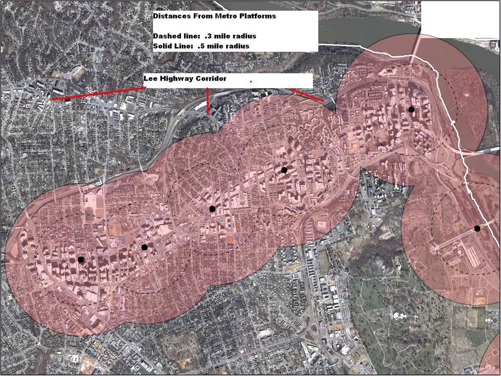
87
DEPARTMENT OF COMMUNITY PLANNING, HOUSING AND DEVELOPMENT Planning Division
 DEPARTMENT OF COMMUNITY PLANNING, HOUSING AND DEVELOPMENT Planning Division #1 Courthouse Plaza, 2100 Clarendon Boulevard, Suite 700 Arlington, VA 22201 TEL 703.228.3525 FAX 703.228.3543 www.arlingtonva.us
3804 Wilson Boulevard
 3804 Wilson Boulevard SPECIAL GENERAL LAND USE PLAN STUDY DEPARTMENT OF COMMUNITY PLANNING, HOUSING, & DEVELOPMENT Planning Division 3804 Wilson Boulevard Special GLUP Study a2 3804 Wilson Boulevard Special
3804 Wilson Boulevard (Staples Site) Special General Land Use Plan Study
 Special General Land Use Plan Study") 1 3804 Wilson Boulevard (Staples Site) Special General Land Use Plan Study Long Range Committee of the Planning Commission Meeting May 16, 2018 Department of Community Planning, Housing and Development
1 3804 Wilson Boulevard (Staples Site) Special General Land Use Plan Study Long Range Committee of the Planning Commission Meeting May 16, 2018 Department of Community Planning, Housing and Development
ARLINGTON COUNTY, VIRGINIA
 ARLINGTON COUNTY, VIRGINIA County Board Agenda Item Meeting of June 10, 2006 DATE: June 9, 2006 SUBJECTS: A. Z-2525-06-1 REZONING for Saul Centers, Inc., from C-3 General Commercial Districts to C-O Commercial
ARLINGTON COUNTY, VIRGINIA
 ARLINGTON COUNTY, VIRGINIA County Board Agenda Item Meeting of December 8, 2012 DATE: November 29, 2012 SUBJECT: PDSP #346 SITE PLAN AMENDMENT to convert approximately 1,458 square feet of GFA below-grade
ARLINGTON COUNTY, VIRGINIA
 ARLINGTON COUNTY, VIRGINIA County Board Agenda Item Meeting of June 16, 2012 DATE: June 7, 2012 SUBJECT: SP #397 SITE PLAN AMENDMENT to revise condition #31 to modify the retail transparency requirement
2401 Wilson Boulevard General Land Use Plan Amendment Study
 2401 Wilson Boulevard General Land Use Plan Amendment Study Long Range Planning Committee Meeting Presentation Compendium March 29, 2011 Department of Community Planning, Housing and Development GLUP Amendment
SITE PLAN REVIEW COMMITTEE MEETING AGENDA
 Page 1 SITE PLAN REVIEW COMMITTEE MEETING AGENDA DATE: Monday, July 10, 2017 TIME: 7:00 8:30 p.m. PLACE: 2100 Clarendon Boulevard Ground Floor Conference Rooms Cherry/Dogwood Arlington, VA 22202 SPRC STAFF
November 21, RECOMMENDATION: Deny the site plan request, and accept withdrawal of rezoning request.
 November 21, 2003 TO: FROM: APPLICANT: BY: The County Board of Arlington, Virginia Ron Carlee, County Manager Trammell Crow Residential Tim Sampson, Attorney/Agent Walsh, Colucci, Emrich, Lubeley & Terpak
SITE PLAN REVIEW COMMITTEE MEETING AGENDA Clarendon Boulevard Conference Rooms C & D Arlington, VA 22201
 SITE PLAN REVIEW COMMITTEE MEETING AGENDA DATE: Monday, October 2, 2017 TIME: 8:30 10:00 p.m. PLACE: 2100 Clarendon Boulevard Conference Rooms C & D Arlington, VA 22201 Item 2. 6711 Lee Highway (SP #3)
ARLINGTON COUNTY, VIRGINIA
 ARLINGTON COUNTY, VIRGINIA County Board Agenda Item Meeting of July 10, 2004 DATE: June 24, 2004 SUBJECT: A. GP-298-04-1 GENERAL LAND USE PLAN AMENDMENT from Semi- Public (Country Clubs and semi-public
SITE PLAN REVIEW COMMITTEE MEETING AGENDA Clarendon Boulevard Courthouse Plaza, Training Center (10 th Floor) Arlington, VA 22202
 Arlington, VA 22202") SITE PLAN REVIEW COMMITTEE MEETING AGENDA DATE: Wednesday, December 5, 2012 TIME: 8:30 10:00 p.m. PLACE: 2100 Clarendon Boulevard Courthouse Plaza, Training Center (10 th Floor) Arlington, VA 22202 SPRC
SITE PLAN REVIEW COMMITTEE MEETING AGENDA DATE: Wednesday, December 5, 2012 TIME: 8:30 10:00 p.m. PLACE: 2100 Clarendon Boulevard Courthouse Plaza, Training Center (10 th Floor) Arlington, VA 22202 SPRC
24. A., B., C. ARLINGTON COUNTY, VIRGINIA. County Board Agenda Item Meeting of February 23, DATE: February 19, 2019
 ARLINGTON COUNTY, VIRGINIA County Board Agenda Item Meeting of February 23, 2019 DATE: February 19, 2019 SUBJECTS: A. GP-343-17-1 GENERAL LAND USE PLAN AMENDMENT to change the land use designation for
ARLINGTON COUNTY, VIRGINIA. County Board Agenda Item Meeting of February 23, 2019
 ARLINGTON COUNTY, VIRGINIA County Board Agenda Item Meeting of February 23, 2019 DATE: February 5, 2019 SUBJECTS: A. GP-343-17-1 GENERAL LAND USE PLAN AMENDMENT to change the land use designation for a
SITE PLAN REVIEW COMMITTEE MEETING AGENDA Clarendon Boulevard Conference Rooms C & D Arlington, VA 22201
 SITE PLAN REVIEW COMMITTEE MEETING AGENDA DATE: Monday, July 24, 2017 TIME: 7:00 9:00 p.m. PLACE: 2100 Clarendon Boulevard Conference Rooms C & D Arlington, VA 22201 Item 1. 6711 Lee Highway (SP #3) (RPC#
Wesley Housing Development Corporation Trenton Street Residential
 Wesley Housing Development Corporation Trenton Street Residential 1 2 Site Location Multimodal Traffic Study Summary Existing Conditions (2017) 13 study intersections. -Scoped with Arlington County DES
SITE PLAN REVIEW COMMITTEE MEETING AGENDA. DATE: Monday, October 22, Clarendon Boulevard Courthouse Plaza, Room 311 Arlington, VA 22201
 SITE PLAN REVIEW COMMITTEE MEETING AGENDA DATE: Monday, October 22, 2012 TIME: 7:00 9:00 p.m. PLACE: 2100 Clarendon Boulevard Courthouse Plaza, Room 311 Arlington, VA 22201 SPRC STAFF COORDINATOR: Samia
SITE PLAN REVIEW COMMITTEE MEETING AGENDA Clarendon Boulevard Arlington, VA Conference Rooms 109/110 (C&D)
") SITE PLAN REVIEW COMMITTEE MEETING AGENDA DATE: Thursday, September 19, 2013 TIME: 7:00 10:00 p.m. PLACE: 2100 Clarendon Boulevard Arlington, VA 22201 Conference Rooms 109/110 (C&D) SPRC STAFF COORDINATOR:
SITE PLAN REVIEW COMMITTEE MEETING AGENDA DATE: Thursday, September 19, 2013 TIME: 7:00 10:00 p.m. PLACE: 2100 Clarendon Boulevard Arlington, VA 22201 Conference Rooms 109/110 (C&D) SPRC STAFF COORDINATOR:
SITE PLAN REVIEW COMMITTEE MEETING AGENDA. DATE: Thursday, April 25, :00 8:30 p.m. PLACE:
 SITE PLAN REVIEW COMMITTEE MEETING AGENDA DATE: Thursday, April 25, 2013 TIME: 7:00 8:30 p.m. PLACE: Courthouse Plaza 2100 Clarendon Boulevard Conference Rooms C&D Arlington, VA 22201 SPRC STAFF COORDINATOR:
ARLINGTON COUNTY, VIRGINIA
 ARLINGTON COUNTY, VIRGINIA County Board Agenda Item Meeting of September 18, 2004 DATE: August 19, 2004 SUBJECTS: A. GP-297-04-1 GENERAL LAND USE PLAN AMENDMENT from Service Commercial (Personal and business
S I T E P L A N R E V I E W C O M M I T T E E M E E T I N G A G E N D A
 S I T E P L A N R E V I E W C O M M I T T E E M E E T I N G A G E N D A DATE: Thursday, September 14, 2017 TIME: 6:00 6:45 p.m. (optional walking tour) 7:00 8:30 p.m. PLACE: 2801 Clarendon Boulevard Meeting
ARLINGTON COUNTY, VIRGINIA
 ARLINGTON COUNTY, VIRGINIA County Board Agenda Item Meeting December 9, 2006 DATE: November 20, 2006 SUBJECT: GP-302-05-2 Adoption of General Land Use Plan Amendments for the Clarendon Metro Station Area:
Ron Carlee, County Manager
 June 6, 2003 TO: FROM: APPLICANT: BY: SUBJECTS: The County Board of Arlington, Virginia The Holladay Corporation Nan Terpak, Attorney/Agent Walsh, Colucci, Lubeley, Emrich & Terpak 2200 Clarendon Blvd.,
Washington Boulevard + Kirkwood Road Special General Land Use Plan (GLUP) Study "Plus"
 Study Plus") Washington Boulevard + Kirkwood Road Special General Land Use Plan (GLUP) Study "Plus" Long Range Committee of the Planning Commission Meeting #4 May 18, 2017 Department of Community Planning, Housing
Washington Boulevard + Kirkwood Road Special General Land Use Plan (GLUP) Study "Plus" Long Range Committee of the Planning Commission Meeting #4 May 18, 2017 Department of Community Planning, Housing
ARLINGTON COUNTY, VIRGINIA
 ARLINGTON COUNTY, VIRGINIA County Board Agenda Item Meeting of February 20, 2016 DATE: February 17, 2016 SUBJECTS: A. Z-2587-16-1 REZONING from "R-6" One-Family Dwelling District to "CP-FBC" Columbia Pike
CONNECTING ARLINGTON S POLICY FRAMEWORK TO THE RESIDENTIAL PARKING WORKING GROUP
 CONNECTING ARLINGTON S POLICY FRAMEWORK TO THE RESIDENTIAL PARKING WORKING GROUP Contents Arlington County Development and Growth Goals... 1 Master Transportation Plan Policies Related to Multi Family
October 9, The County Board of Arlington, Virginia. Ron Carlee, County Manager
 October 9, 2003 TO: FROM: APPLICANT: BY: The County Board of Arlington, Virginia Ron Carlee, County Manager Douglas Schneiderman, Vice President Madison Homes, Inc. 6723 Whittier Avenue, Suite 104 McLean,
ARLINGTON COUNTY, VIRGINIA. County Board Agenda Item Meeting of May 14, 2011
 ARLINGTON COUNTY, VIRGINIA County Board Agenda Item Meeting of May 14, 2011 DATE: May 11, 2011 SUBJECT: SP #240 SITE PLAN AMENDMENT for a kiosk for the Department of Environmental Services located at the
ARLINGTON COUNTY, VIRGINIA
 ARLINGTON COUNTY, VIRGINIA County Board Agenda Item Meeting of September 19, 2015 DATE: September 15, 2015 SUBJECTS: A. SP# 297 PHASED DEVELOPMENT SITE PLAN AMENDMENT of the Pentagon Centre PDSP to permit
ARLINGTON COUNTY, VIRGINIA
 ARLINGTON COUNTY, VIRGINIA County Board Agenda Item Meeting of March 12, 2005 DATE: February 25, 2005 SUBJECTS: A. Z-2515-04-1 REZONING from C-2 Service Commercial Community Business Districts and RA8-18
S I T E P L A N R E V I E W C O M M I T T E E M E E T I N G A G E N D A
 S I T E P L A N R E V I E W C O M M I T T E E M E E T I N G A G E N D A DATE: Thursday, November 15, 2018 TIME: SPRC: 7:00 8:30 p.m. PLACE: Ellen M. Bozman Government Center 2100 Clarendon Boulevard Room
SITE PLAN REVIEW COMMITTEE MEETING AGENDA Clarendon Boulevard Courthouse Plaza, Rooms 109/110 Arlington, VA 22201
 SITE PLAN REVIEW COMMITTEE MEETING AGENDA DATE: Monday, January 6, 2014 TIME: 7:00 8:30 p.m. PLACE: 2100 Clarendon Boulevard Courthouse Plaza, Rooms 109/110 Arlington, VA 22201 SPRC STAFF COORDINATOR:
July 10, The County Board of Arlington, Virginia. Ron Carlee, County Manager. Keating Development Company
 July 10, 2003 TO: FROM: APPLICANT: BY: The County Board of Arlington, Virginia Ron Carlee, County Manager Keating Development Company Timothy S. Sampson, Attorney/Agent Walsh Colucci Lubeley Emrich & Terpak
ARLINGTON COUNTY, VIRGINIA
 ARLINGTON COUNTY, VIRGINIA County Board Agenda Item Meeting of April 21, 2007 DATE: April 13, 2007 SUBJECT: SP #346 PHASED DEVELOPMENT SITE PLAN AMENDMENT (PDSP) AND FINAL SITE PLANS for Potomac Yard:
Pentagon Centre (SP#297) PDSP & Phase I Site Plan Amendments SPRC #1
 PDSP & Phase I Site Plan Amendments SPRC #1") Pentagon Centre (SP#297) PDSP & Phase I Site Plan Amendments SPRC #1 CPHD February 23, 2015 Meeting Agenda Background on relevant planning context, guidance, and County policy Brief update on original
Pentagon Centre (SP#297) PDSP & Phase I Site Plan Amendments SPRC #1 CPHD February 23, 2015 Meeting Agenda Background on relevant planning context, guidance, and County policy Brief update on original
S I T E P L A N R E V I E W C O M M I T T E E M E E T I N G A G E N D A Clarendon Boulevard Courthouse Plaza, Rooms 109/111 Arlington, VA 22201
 S I T E P L A N R E V I E W C O M M I T T E E M E E T I N G A G E N D A DATE: Thursday, March 27, 2014 TIME: 7:00 8:25 pm PLACE: 2100 Clarendon Boulevard Courthouse Plaza, Rooms 109/111 Arlington, VA 22201
ARLINGTON COUNTY, VIRGINIA. County Board Agenda Item Meeting of September 19, 2015
 ARLINGTON COUNTY, VIRGINIA County Board Agenda Item Meeting of September 19, 2015 DATE: August 28, 2015 SUBJECT: Request to authorize advertisement of public hearings by the Planning Commission and the
ARLINGTON COUNTY, VIRGINIA
 ARLINGTON COUNTY, VIRGINIA County Board Agenda Item Meeting of March 27, 2004 DATE: March 19, 2004 SUBJECT: SP # 376 SITE PLAN AMENDMENT, to amend Condition #26 to permit the installation of new utility
ARLINGTON COUNTY, VIRGINIA. County Board Agenda Item Meeting of November 18, 2017
 ARLINGTON COUNTY, VIRGINIA County Board Agenda Item Meeting of November 18, 2017 DATE: November 9, 2017 SUBJECTS: A. Z-2597-17-1 REZONING from "C-O" Mixed Use District to "RA8-18" Multiple-Family Dwelling
S IT E PL A N R E V IE W C OM M IT T E E
 S IT E PL A N R E V IE W C OM M IT T E E M E E T I N G A G E N D A DATE: Thursday, January 4, 2018 TIME: 7:00 9:00 p.m. PLACE: Ellen Bozman Government Center/Courthouse Plaza 2100 Clarendon Boulevard Lobby
SITE PLAN REVIEW COMMITTEE MEETING AGENDA. DATE: Wednesday, February 28, Aurora Hills Community Center th Street S. Arlington, VA 22202
 Page 1 SITE PLAN REVIEW COMMITTEE MEETING AGENDA DATE: Wednesday, February 28, 2018 TIME: 7:00 9:00 p.m. PLACE: Aurora Hills Community Center 735 18 th Street S. Arlington, VA 22202 SPRC STAFF COORDINATOR:
28. ARLINGTON COUNTY, VIRGINIA. County Board Agenda Item Meeting of February 25, DATE: February 17, 2017
 ARLINGTON COUNTY, VIRGINIA County Board Agenda Item Meeting of February 25, 2017 DATE: February 17, 2017 SUBJECTS: Items associated with Queen's Court Residences: A. GP 335-16-1 GENERAL LAND USE PLAN AMENDMENT
ARLINGTON COUNTY, VIRGINIA
 ARLINGTON COUNTY, VIRGINIA County Board Agenda Item Meeting of November 14, 2015 DATE: November 13, 2015 SUBJECTS: Development A. SP #193 SITE PLAN AMENDMENT Ballston Air Rights Acquisition Company, LLC
SITE PLAN REVIEW COMMITTEE MEETING AGENDA Clarendon Boulevard Lobby Rooms C&D (Cherry & Dogwood) Arlington, VA
 Arlington, VA") SITE PLAN REVIEW COMMITTEE MEETING AGENDA DATE: Monday, January 8, 2018 TIME: 7:30 8:25 p.m. PLACE: 2100 Clarendon Boulevard Lobby Rooms C&D (Cherry & Dogwood) Arlington, VA 22201 SPRC STAFF COORDINATOR:
SITE PLAN REVIEW COMMITTEE MEETING AGENDA DATE: Monday, January 8, 2018 TIME: 7:30 8:25 p.m. PLACE: 2100 Clarendon Boulevard Lobby Rooms C&D (Cherry & Dogwood) Arlington, VA 22201 SPRC STAFF COORDINATOR:
ARLINGTON COUNTY, VIRGINIA
 ARLINGTON COUNTY, VIRGINIA County Board Agenda Item Meeting of November 15, 2005 DATE: November 4, 2005 SUBJECTS: A. Z-2519-05-1 REZONING: K. Hovnanian Homes of Virginia, Inc., from CM Limited Industrial
ARLINGTON COUNTY, VIRGINIA
 ARLINGTON COUNTY, VIRGINIA County Board Agenda Item Meeting of April 16, 2005 DATE: April 13, 2005 SUBJECT: A. SP #76 SITE PLAN AMENDMENT to reduce units in existing hotel from 238 to approximately 187,
Poverty Rates by Census Tracts
 The following document is a presentation that was delivered to the Housing Conservation District Advisory Group (HCDAG). The materials contained in this presentation (including several updates) were prepared
DEVELOPMENT STANDARDS FOR RESIDENTIAL PROJECTS RESIDENTIAL BUILDING TYPES: APPROPRIATE ZONES AND DENSITIES 2-1
 2 DEVELOPMENT STANDARDS FOR RESIDENTIAL PROJECTS RESIDENTIAL BUILDING TYPES: APPROPRIATE ZONES AND DENSITIES 2-1 This Chapter presents the development standards for residential projects. Section 2.1 discusses
S I T E P L A N R E V I E W C O M M I T T E E M E E T I N G A G E N D A
 S I T E P L A N R E V I E W C O M M I T T E E M E E T I N G A G E N D A DATE: Thursday, July 23, 2015 TIME: 7:00 10:00 p.m. PLACE: 2100 Clarendon Boulevard Courthouse Plaza, 1st Floor, Cherry and Dogwood
ARLINGTON COUNTY, VIRGINIA
 ARLINGTON COUNTY, VIRGINIA County Board Agenda Item Meeting of July 21, 2012 DATE: June 26, 2012 SUBJECT: SP #402 SITE PLAN AMENDMENT for a comprehensive sign plan amendment to add a projecting sign for
PLANNING COMMISSION MAY 3, 2018 PUBLIC HEARING
 PLANNING COMMISSION MAY 3, 2018 PUBLIC HEARING SUBJECT: REQUEST TO DEMOLISH TWO SINGLE-FAMILY DWELLINGS ON TWO ADJOINING LOTS AND CONSTRUCT TEN RESIDENTIAL CONDOMINIUM UNITS AT 947 GENESEE AVENUE AND 944
SITE PLAN REVIEW COMMITTEE MEETING AGENDA. DATE: Wednesday, April 4, 2018
 Page 1 SITE PLAN REVIEW COMMITTEE MEETING AGENDA DATE: Wednesday, April 4, 2018 TIME: 7:00 9:30 p.m. PLACE: Ellen Bozman Building Room 715, 7 th Floor 2100 Clarendon Boulevard Arlington, VA 22201 SPRC
ARLINGTON COUNTY, VIRGINIA
 ARLINGTON COUNTY, VIRGINIA County Board Agenda Item Meeting of September 17, 2005 DATE: September 15, 2005 SUBJECT: A. Z-2519-05-1 REZONING: K. Hovnanian Homes of Virginia, Inc., from CM Limited Industrial
ARLINGTON COUNTY, VIRGINIA
 ARLINGTON COUNTY, VIRGINIA County Board Agenda Item Meeting of July 19, 2008 DATE: July 16, 2008 SUBJECT: SP#297 SITE PLAN: PL Pentagon LLC c/o Kimco Realty Corporation, construct approx. 489,911 sq ft
ARLINGTON COUNTY, VIRGINIA
 ARLINGTON COUNTY, VIRGINIA County Board Agenda Item Meeting of July 13, 2013 DATE: July 5, 2013 SUBJECTS: A. Z-2565-13-1 REZONING from "" Service Commercial-Community Business Districts to "" Commercial
DRAFT Plan Incentives. Part A: Basic Discount
 DRAFT 2030 Plan Incentives July 26, 2006 Part A: Basic Discount In order for a development to be eligible for any 2030 Land Resource Management Plan Discounts it must be located in the Urban Corridor and
An implementation document is forthcoming. - A1-1 -
 OFF-STREET PARKING GUIDELINES FOR MULTI-FAMILY RESIDENTIAL PROJECTS APPROVED BY SPECIAL EXCEPTION IN THE ROSSLYN-BALLSTON AND JEFFERSON DAVIS METRO CORRIDORS 12/01/2017 This is a draft of the guidelines
ARLINGTON COUNTY, VIRGINIA
 ARLINGTON COUNTY, VIRGINIA County Board Agenda Item Meeting of December 10, 2005 DATE: December 9, 2005 SUBJECT: SP #392 SITE PLAN to develop approximately 153 dwelling units and approximately 17,162 square
SITE PLAN REVIEW COMMITTEE MEETING AGENDA. DATE: Wednesday, November 18, 2015
 Page 1 SITE PLAN REVIEW COMMITTEE MEETING AGENDA DATE: Wednesday, November 18, 2015 TIME: 7:00 9:00 p.m. PLACE: First Presbyterian Church of Arlington 601 North Vermont Street Arlington, VA 22203 SPRC
4 DEVELOPMENT STANDARDS FOR
 4 DEVELOPMENT STANDARDS FOR RESIDENTIAL MIXED-USE PROJECTS This chapter presents standards for residential mixed-use projects in the Ashland-Cherryland Business District and the Castro Valley Central Business
ARLINGTON COUNTY, VIRGINIA. County Board Agenda Item Meeting of May 14, 2016
 ARLINGTON COUNTY, VIRGINIA County Board Agenda Item Meeting of May 14, 2016 DATE: May 11, 2016 SUBJECTS: Applicant: AHC, Inc. A. Z-2589-16-1 REZONING from R-6 to RA-8-18 for an approximately 18,170 square
Nan E. Terpak, Attorney Walsh, Colucci, Stackhouse, Emrich & Lubeley 2100 Clarendon Boulevard, 13 th Floor Arlington, VA 22201
 January 31, 2002 TO: The County Board of Arlington, Virginia FROM: Ron Carlee, County Manager APPLICANT: McCaffrey Interests, Inc. BY: Nan E. Terpak, Attorney Walsh, Colucci, Stackhouse, Emrich & Lubeley
ARLINGTON COUNTY, VIRGINIA
 ARLINGTON COUNTY, VIRGINIA County Board Agenda Item Meeting March 17, 2007 DATE: March 8, 2007 SUBJECT: Request to Advertise Public Hearings on Amendments to Section 25B. C-O Rosslyn Commercial Office
ARLINGTON COUNTY, VIRGINIA
 ARLINGTON COUNTY, VIRGINIA County Board Agenda Item Meeting of June 12, 2004 DATE: June 3, 2004 SUBJECT: A. Z-2511-03-1 REZONING from R-5 One-Family, Restricted Two-Family Dwelling Districts, C-2 Service
ARLINGTON COUNTY, VIRGINIA. County Board Agenda Item Meeting of September 22, 2018
 ARLINGTON COUNTY, VIRGINIA County Board Agenda Item Meeting of September 22, 2018 DATE: September 13, 2018 SUBJECT: SP413-U-18-1 USE PERMIT ASSOCIATED WITH A SITE PLAN for food delivery service for Domino's
SITE PLAN REVIEW COMMITTEE MEETING AGENDA. DATE: Monday, December 16, 2013
 SITE PLAN REVIEW COMMITTEE MEETING AGENDA DATE: Monday, December 16, 2013 TIME: 7:00 10:00 p.m. PLACE: 2100 Clarendon Boulevard Courthouse Plaza, Rooms 109/111 Arlington, VA 22201 SPRC STAFF COORDINATOR:
S I T E P L A N R E V I E W C O M M I T T E E M E E T I N G A G E N D A Clarendon Boulevard Courthouse Plaza, Rooms 109/110 Arlington, VA 22201
 S I T E P L A N R E V I E W C O M M I T T E E M E E T I N G A G E N D A DATE: Thursday, May 22, 2014 TIME: 7:00 10:00 p.m. PLACE: 2100 Clarendon Boulevard Courthouse Plaza, Rooms 109/110 Arlington, VA
PLANNING COMMISSION REPORT Regular Agenda -Public Hearing Item
 PDP-13-00518 Item No. 3B- 1 PLANNING COMMISSION REPORT Regular Agenda -Public Hearing Item PC Staff Report 2/24/14 ITEM NO. 3B PRELIMINARY DEVELOPMENT PLAN FOR HERE @ KANSAS; 1101 INDIANA ST (SLD) PDP-13-00518:
ARLINGTON COUNTY, VIRGINIA
 ARLINGTON COUNTY, VIRGINIA County Board Agenda Item Meeting of November 15, 2005 DATE: November 22, 2005 SUBJECT: SP #331 SITE PLAN AMENDMENT to incorporate 4420 N. Fairfax Dr. into site plan, construct
ARLINGTON COUNTY, VIRGINIA
 ARLINGTON COUNTY, VIRGINIA County Board Agenda Item Meeting of March 13, 2004 DATE: March 10, 2004 SUBJECT: SP #256 SITE PLAN AMENDMENT to amend the comprehensive sign plan; premises known as 4250 Fairfax
SITE PLAN REVIEW COMMITTEE MEETING AGENDA. DATE: Monday, December 9, :00 10:00 p.m. PLACE:
 SITE PLAN REVIEW COMMITTEE MEETING AGENDA DATE: Monday, December 9, 2013 TIME: 7:00 10:00 p.m. PLACE: 2100 Clarendon Boulevard Courthouse Plaza, Room 109/110 Arlington, VA 22201 SPRC STAFF COORDINATOR:
TRANSIT-ORIENTED DEVELOPMENT PLAN EXISTING CONDITIONS REPORT LAWRENCE TO BRYN MAWR MODERNIZATION
 TRANSIT-ORIENTED DEVELOPMENT PLAN EXISTING CONDITIONS REPORT LAWRENCE TO BRYN MAWR MODERNIZATION March 2018- FINAL DRAFT SITE SPECIFIC DEVELOPMENT CONCEPTS SITE SPECIFIC DEVELOPMENT CONCEPTS This report
Planning Justification Report
 Planning Justification Report 101 Kozlov Street, Barrie, Ont. Destaron Property Management Ltd. November 2015 Revised February 2017 TABLE OF CONTENTS Page 1.0 INTRODUCTION... 1 2.0 DESCRIPTION OF SUBJECT
ARLINGTON COUNTY, VIRGINIA
 ARLINGTON COUNTY, VIRGINIA County Board Agenda Item Meeting of June 18, 2016 DATE: June 7, 2016 SUBJECT: Vacations Concerning a Project Known as 2400 Columbia Pike A. Vacation of a Portion of Columbia
ARLINGTON COUNTY, VIRGINIA
 ARLINGTON COUNTY, VIRGINIA County Board Agenda Item Meeting of February 23, 2013 DATE: February 8, 2013 SUBJECTS: A. Z-2563-12-1 REZONING from "CM" Limited Industrial Districts to "C-O-Crystal City" Commercial
ARLINGTON COUNTY, VIRGINIA
 ARLINGTON COUNTY, VIRGINIA County Board Agenda Item Meeting of June 17, 2008 DATE: June 6, 2008 SUBJECT: SP #293 SITE PLAN AMENDMENT, Teachers Insurance & Annuity Association, amend comprehensive sign
SITE PLAN REVIEW COMMITTEE MEETING AGENDA. DATE: Monday, January 29, 2018
 Page 1 SITE PLAN REVIEW COMMITTEE MEETING AGENDA DATE: Monday, January 29, 2018 TIME: 8:30 10:00 p.m. PLACE: 2100 Clarendon Boulevard, Rooms Cherry/Dogwood Arlington, VA 22201 SPRC STAFF COORDINATOR: Matt
ARLINGTON COUNTY, VIRGINIA
 ARLINGTON COUNTY, VIRGINIA County Board Agenda Item Meeting of May 5, 2007 DATE: April 27, 2007 SUBJECTS: A. GP 308-06-1 GENERAL LAND USE PLAN AMENDMENTS to: 1. Change land use designation from Public
Land Use, Transportation, and Infrastructure Committee of Denver City Council FROM: Scott Robinson, Senior City Planner DATE: December 6, 2018 RE:
 Community Planning and Development Planning Services 201 W. Colfax Ave., Dept. 205 Denver, CO 80202 p: 720.865.2915 f: 720.865.3052 www.denvergov.org/cpd TO: Land Use, Transportation, and Infrastructure
Town of Cary, North Carolina Rezoning Staff Report 14-REZ-31 Cary Park PDD Amendment (Waterford II) Town Council Meeting January 15, 2015
 Town Council Meeting January 15, 2015") Town of Cary, North Carolina Rezoning Staff Report 14-REZ-31 Cary Park PDD Amendment (Waterford II) Town Council Meeting January 15, 2015 REQUEST To amend the Town of Cary Official Zoning Map by amending
Town of Cary, North Carolina Rezoning Staff Report 14-REZ-31 Cary Park PDD Amendment (Waterford II) Town Council Meeting January 15, 2015 REQUEST To amend the Town of Cary Official Zoning Map by amending
Rosslyn Sector Plan Implementation GLUP, MTP & Zoning Amendments. Park and Recreation Commission June 28, 2016
 Rosslyn Sector Plan Implementation GLUP, MTP & Zoning Amendments Park and Recreation Commission June 28, 2016 Agenda Background GLUP Amendments MTP Amendments Zoning Ordinance Amendments to the C-O Rosslyn
SITE PLAN REVIEW COMMITTEE MEETING AGENDA. Navy League 2300 Wilson Boulevard, Large Conference Room Arlington, Virginia 22201
 Page 1 SITE PLAN REVIEW COMMITTEE MEETING AGENDA DATE: Monday, March 7, 2016 TIME: 7:00 9:00 p.m. PLACE: Navy League 2300 Wilson Boulevard, Large Conference Room Arlington, Virginia 22201 SPRC STAFF COORDINATOR:
SITE PLAN REVIEW COMMITTEE MEETING AGENDA. NRECA 4301 Wilson Boulevard Conference Rooms CC1 Arlington, VA 22203
 SITE PLAN REVIEW COMMITTEE MEETING AGENDA DATE: Monday, July 20, 2015 TIME: 7:00 10:00 p.m. PLACE: NRECA 4301 Wilson Boulevard Conference Rooms CC1 Arlington, VA 22203 SPRC STAFF COORDINATOR: Samia Byrd,
THE REDEVELOPMENT PLAN
 PAGE 37 THE REDEVELOPMENT PLAN FUTURE LAND USE The Silver Terrace Redevelopment Area is currently designated as Redevelopment Area #4 on the City of Delray Beach Future Land Use Map (FLUM). This designation
ARLINGTON COUNTY, VIRGINIA
 ARLINGTON COUNTY, VIRGINIA County Board Agenda Item Meeting of July 10, 2004 DATE: July 1, 2004 SUBJECTS: A. Consideration of consent concerning whether to include Hillside Park within the site plan area
Town of Cary, North Carolina Rezoning Staff Report 12-REZ-27 Morris Branch Town Council Public Hearing January 24, 2013
 Town of Cary, North Carolina Rezoning Staff Report 12-REZ-27 Morris Branch Town Council Public Hearing January 24, 2013 REQUEST To amend the Town of Cary Official Zoning Map to rezone approximately 9.0
PLANNED UNIT DEVELOPMENT & SUBDIVISION STAFF REPORT Date: April 18, 2019
 PLANNED UNIT DEVELOPMENT & SUBDIVISION STAFF REPORT Date: April 18, 2019 DEVELOPMENT NAME SUBDIVISION NAME Springhill Village Subdivision Springhill Village Subdivision LOCATION 4350, 4354, 4356, 4358,
S I T E P L A N R E V I E W C O M M I T T E E M E E T I N G A G E N D A
 S I T E P L A N R E V I E W C O M M I T T E E M E E T I N G A G E N D A DATE: Monday, September 21, 2015 TIME: 7:00 10:00 p.m. PLACE: 2100 Clarendon Boulevard Courthouse Plaza, 1st Floor, Cherry and Dogwood
ARLINGTON COUNTY, VIRGINIA. County Board Agenda Item Meeting of March 12, 2016
 ARLINGTON COUNTY, VIRGINIA County Board Agenda Item Meeting of March 12, 2016 DATE: March 3, 2016 SUBJECTS: A. Z-2588-16-1 REZONING () from C-O (Mixed Use District) and S-3A (Special District) to C-O Rosslyn
SITE PLAN REVIEW COMMITTEE MEETING AGENDA & STAFF REPORT
 SITE PLAN REVIEW COMMITTEE MEETING AGENDA & STAFF REPORT DATE: Thursday, April 21, 2016 TIME: 7:00 8:25 p.m. PLACE: Courthouse Plaza; Cherry/Dogwood Conference Rooms (109/110) SPRC STAFF COORDINATOR: Samia
S I T E P L AN R E VI E W C O M M I T T E E M EET I N G A G EN D A. Navy League 2300 Wilson Boulevard, Large Conference Room Arlington, Virginia 22201
 Page 1 S I T E P L AN R E VI E W C O M M I T T E E M EET I N G A G EN D A DATE: Monday, March 21, 2016 TIME: 7:00 9:00 p.m. PLACE: Navy League 2300 Wilson Boulevard, Large Conference Room Arlington, Virginia
4 LAND USE 4.1 OBJECTIVES
 4 LAND USE The Land Use Element of the Specific Plan establishes objectives, policies, and standards for the distribution, location and extent of land uses to be permitted in the Central Larkspur Specific
S I T E P L A N R E V I E W C O M M I T T E E M E E T I N G A G E N D A
 S I T E P L A N R E V I E W C O M M I T T E E M E E T I N G A G E N D A DATE: Monday July 27, 2015 TIME: 7:00 8:25 p.m. PLACE: 2100 Clarendon Boulevard Courthouse Plaza, 1st Floor, Cherry and Dogwood Rooms
DRAFT FOR DISCUSSION PURPOSES ONLY. Port Credit Local Area Plan Built Form Guidelines and Standards DRAFT For Discussion Purposes
 Port Credit Local Area Plan Built Form Guidelines and Standards DRAFT For Discussion Purposes 1 Local Area Plan - Project Alignment Overview Directions Report, October 2008 (General Summary Of Selected
SECTION 7000 LAND DEVELOPMENT REQUIREMENTS
 SECTION 7000 LAND DEVELOPMENT REQUIREMENTS 7000 LAND DEVELOPMENT REQUIREMENTS... 1 7001 LEGISLATIVE AUTHORITY... 1 7001.1 LAND DEVELOPMENT... 1 7001.1.1 Title 40, Idaho Code... 1 7001.1.2 Idaho Code 40-1415
ARLINGTON COUNTY, VIRGINIA. County Board Agenda Item Meeting of February 21, 2015
 ARLINGTON COUNTY, VIRGINIA County Board Agenda Item Meeting of February 21, 2015 DATE: February 17, 2015 SUBJECT: A. Consideration of adoption of an Amendment to the Arlington County Comprehensive Plan
SITE PLAN REVIEW COMMITTEE MEETING AGENDA Clarendon Boulevard Courthouse Plaza, Rooms 109/111 Arlington, VA 22201
 SITE PLAN REVIEW COMMITTEE MEETING AGENDA DATE: Monday, April 7, 2014 TIME: 7:00 8:25 p.m. PLACE: 2100 Clarendon Boulevard Courthouse Plaza, Rooms 109/111 Arlington, VA 22201 SPRC STAFF COORDINATOR: Samia
Rezoning Petition Pre-Hearing Staff Analysis April 15, 2019
 Rezoning Petition 2018-132 Pre-Hearing Staff Analysis April 15, 2019 REQUEST Current Zoning: R-3 (single family residential) Proposed Zoning: MUDD-O (mixed use development, optional) with five-year vested
66 Isabella Street Rezoning Application - Preliminary Report
 STAFF REPORT ACTION REQUIRED 66 Isabella Street Rezoning Application - Preliminary Report Date: November 15, 2010 To: From: Wards: Reference Number: Toronto and East York Community Council Director, Community
SITE PLAN REVIEW COMMITTEE MEETING AGENDA & STAFF REPORT. DATE: Monday, December 12, :00 8:30 p.m. PLACE:
 SITE PLAN REVIEW COMMITTEE MEETING AGENDA & STAFF REPORT DATE: Monday, December 12, 2016 TIME: 7:00 8:30 p.m. PLACE: 2100 Clarendon Boulevard Courthouse Plaza Room 109/110 (Cherry & Dogwood) Arlington,