ARLINGTON COUNTY, VIRGINIA
|
|
|
- Derick Junior Stafford
- 5 years ago
- Views:
Transcription
. Schools (Public). Parkways, major unpaved rights-of-way. Libraries and cultural facilities.")
1 ARLINGTON COUNTY, VIRGINIA County Board Agenda Item Meeting of May 5, 2007 DATE: April 27, 2007 SUBJECTS: A. GP GENERAL LAND USE PLAN AMENDMENTS to: 1. Change land use designation from Public [Parks (Local, regional, and federal). Schools (Public). Parkways, major unpaved rights-of-way. Libraries and cultural facilities.] to High Office-Apartment-Hotel (up to 3.8 FAR Office Density, up to 4.8 FAR Apartment Density, up to 3.8 FAR Hotel Density) for northern and southern portions of block generally bounded by N. Lynn St., Wilson Blvd., N. Moore St., and 19 th St. N. while keeping central portion of block Public ; 2. Remove General Location for Open Space symbol currently located on southern portions of aforementioned block; and 3. Remove stipple pattern on northern and central portions of aforementioned block as correction to indicate private ownership of those areas. County Manager: County Attorney: Staff: Lorrie Pearson, DCPHD, Planning Division Anthony Fusarelli, Jr., DCPHD, Planning Division Betts Abel, DCPHD, Housing Division Adam Denton, DES, Division of Transportation Ritch Viola, DES, Division of Transportation Linda Collier, DES, Real Estate Bureau B. AMENDMENT TO MASTER TRANSPORTATION PLAN PEDESTRIAN TRANSPORTATION PLAN to specify changes to Rosslyn Skywalk Network that delete Skywalk bridges across N. Moore St. and N. Lynn St., between Wilson Blvd. and 19 th St. N. C. ADOPTION OF RESOLUTION ON URBAN DESIGN PRINCIPLES FOR ROSSLYN CENTRAL PLACE. D. ORDINANCE TO AMEND, REENACT, AND RECODIFY Section 25B. C-O Rosslyn Commercial Office Building, Retail, Hotel and Multiple- Family Dwelling Districts of Arlington County Zoning Ordinance to: 1. Allow additional height (up to maximum of five hundred (500) feet above sea level) for properties within boundaries of Central Place block, which is
2 defined as blocks bounded by 19 th St. N., N. Lynn St., Wilson Blvd., and Fort Myer Dr.; or 2. Allow additional height (up to maximum of four hundred seventy (470) feet above sea level) for properties within boundaries of Central Place block, which is defined as blocks bounded by 19 th St. N., N. Lynn St., Wilson Blvd., and Fort Myer Dr. E. Z REZONING portion of site designated C-O Commercial Office Building, Hotel and Multiple-Family Dwelling Districts to C-O Rosslyn Commercial Office Building, Retail, Hotel and Multiple-Family Dwelling Districts within block bounded by Wilson Blvd., N. Moore St., 19 th St. N., and N. Lynn St., also known as Central Place parcels; 1730 N. Lynn St., 1801 and 1823 N. Moore St., 1213 Wilson Blvd., Lots 1, 2, 3, 4, 5 and Outlots A-3, A-4, A-5 of Block 10, Rosslyn (RPC # , -002, -003, - 005, -006, -008, -009, -010, -011, -012, -013). F. SP #335 SITE PLAN AMENDMENT: Central Place LLC, construct approx. 354 dwelling units, approx. 600,855 sq ft commercial/retail space, with modification of use regulations for density, storage, mechanical rooms, shafts, observation decks, coverage, parking, loading space and drive aisle requirements; 1213 Wilson Blvd., 1730, 1735 N. Lynn St., 1801 N. Lynn St., 1801, 1823 N. Moore St., Lots 1, 2, 3, 4, 5, and Outlots A-3, A-4 and A-5, Block 10, Rosslyn (RPC # , -002, -003, -004, -005, -006, -008, - 009, -010, 011, -012, -013; , -018) C. M. RECOMMENDATIONS: A. Adopt the attached resolution to approve the General Land Use Plan amendments to change the designation of the Property from Public to High Office-Apartment- Hotel, remove the General Location for Open Space symbol located in the southern portion of the Property, and to remove the stipple pattern on the northern and central portions of the Property as a correction to indicate private ownership of those areas; B. Amend the Master Transportation Plan - Pedestrian Transportation Plan, by specifying changes to the Rosslyn Skywalk Network that delete Skywalk bridges across N. Moore St. and N. Lynn St., between Wilson Blvd. and 19 th St. N.; C. Adopt the attached Resolution on Urban Design Principles for Rosslyn Central Place to set a policy on desired urban design characteristics for future development within Central Place; D. Adopt the attached ordinance to amend, reenact, and recodify Section 25.B. of the Arlington County Zoning Ordinance to allow additional height (up to a maximum of four hundred ninety (490) feet above sea level) and include other requirements such as rooftop sign limitations for properties within the boundaries of Central Place, - 2 -
3 defined as the blocks bordered by 19 th Street North, North Lynn Street, Wilson Boulevard, and Fort Myer Drive, in order to encourage orderly and efficient land use development; to facilitate the creation of convenient, attractive and harmonious communities; to encourage economic development activities that provide desirable employment and enlarge the tax base and for other reasons required by the public necessity, convenience and general welfare, and good zoning practice; E. Adopt the resolution to approve the rezoning request from C-O Commercial Office Building, Hotel and Apartment Districts to C-O Rosslyn Commercial Office Building, Hotel and Apartment Districts, for the properties located at 1730 N. Lynn St., 1801 and 1823 N. Moore St., 1213 Wilson Blvd., Lots 1, 2, 3, 4, 5 and Outlots A- 3, A-4, A-5 of Block 10, Rosslyn which are identified in the County Record as RPC # , -002, -003, -005, -006, -008, -009, -010, -011, -012, F. Approve the site plan amendment to SP #335 subject to the conditions of the staff report and subject to the enactment by the County Board of the ordinances of encroachment, ordinances of vacation, and approval of all conveyances, assignments or grants required by Condition #14 and Condition #90, by the dates or deadlines provided in Condition #14 and Condition #90. SUMMARY: The applicant proposes to amend an existing site plan (SP #335, commonly known as International Place, 1801 N. Lynn St.), to include the eastern block of Central Place, between N. Lynn and N. Moore Streets and between Wilson Boulevard and 19 th Street N., immediately across from the entrance to the Rosslyn Metrorail station. The applicant then proposes to construct a 31-story office building and a 30-story residential building on the block. The application requires a number of amendments, including to the General Land Use Plan (GLUP) for the location of the open space and land use designation, to the Zoning Ordinance to permit heights greater than 300 feet, and to the Master Transportation Plan to delete two pedestrian bridges. Also required is a rezoning of the portion of the property zoned C-O to C-O Rosslyn, as well as numerous vacations of easements and encroachments. The subject items were deferred at the April 21, 2007, County Board meeting to the May 5, 2007, County Board meeting to allow the applicant and staff additional time to resolve outstanding issues. The items had previously been deferred on December 9, 2006, and February 24, Since the County Board heard the items at the February 2007 meeting, the applicant has made a number of revisions to the plans based on negotiations with the County. Included among the revisions: 1) Along the plaza, the large overhang on the office building of the parking podium was removed by filling in the area with retail. The retail along the plaza within the residential building was pulled back in order to expand the plaza to the north
4 This revision eliminated the rooftop dining but provides a larger plaza area now 17,035 square feet. 2) The ADA/jump elevators were moved from the south side of the plaza to a more central and visible location within the plaza. The water wall was eliminated and the water feature tucked into the tree allée to provide a larger central area. 3) The observation deck was revised to eliminate the café area. As a result of a redesigned observation deck, changes were made to the office building s rooftop and floor plates. One of the observation deck elevators has been redesigned with translucent walls to provide views to the north and west. 4) The Community Benefits package was refined to include $5.4 million for affordable housing and $3.5 million for the Rosslyn Metro station elevators. These changes were presented to a community meeting on April 17, Both the Transportation and Planning Commissions recommended approval, adoption, or amendment of each of the subject items. Staff recommends amending the General Land Use Plan to provide for the kind of significant development on Central Place that is envisioned in the Rosslyn Station Area Plan Addendum, adopted by the County Board in Staff recommends a Zoning Ordinance Amendment to C-O Rosslyn that would permit additional height beyond 300 feet within both blocks of Central Place, bordered by Wilson Boulevard, N. Lynn Street, 19 th Street N., and Fort Myer Drive, to provide for an enhanced Rosslyn skyline as envisioned by the Rosslyn Working Group. Additional guidance on specific urban design criteria that should be met by C-O Rosslyn projects within Central Place is provided in a recommended resolution referenced by the Zoning Ordinance amendment. In addition, staff supports amending the Master Transportation Plan to remove two pedestrian bridges, supports the rezoning of the block from C-O to C-O Rosslyn, and supports the site plan amendment to incorporate the site into the existing Site Plan #335, subject to conditions. BACKGROUND: History: The Rosslyn Station Area Plan Addendum (Plan Addendum), adopted by the County Board in 1992, identifies Central Place as the hub of pedestrian, retail and social activity within Rosslyn and as the location of the area s principal public facilities. The 1992 Plan Addendum recommends the development of Central Place as a signature place and consolidated focal point that will bring activity to Rosslyn and provide for a memorable experience through a critical mass of retail and attractive public spaces. The Rosslyn Coordinated Redevelopment District (RCRD) was created in 1996 to encourage the physical and economic development of Rosslyn and maximize Rosslyn s potential to become a first class urban center exemplifying superior architecture and excellent design practice. Through the C-O Rosslyn Zoning District, the County Board may approve special exception site plan projects within the RCRD with additional - 4 -
5 density up to 10 FAR and building heights up to 300 feet. Projects may be approved with this additional density and height when they provide important community benefits and are consistent with the goals, objectives and design guidelines of the Rosslyn Station Area Plan Addendum, and other plans and policies adopted by the County Board. In September 2002, the County Board adopted the Resolution Regarding Building Heights (Attachment 1) for Rosslyn, which called for architecturally distinctive buildings with particular attention given to the design of the tops of the buildings and their impacts on the Rosslyn skyline. The resolution also concluded that Rosslyn s tallest buildings should be clustered around the Metro station entrance, and building heights should taper down towards the edges of the Rosslyn district. In 2002, the applicant, JBG, submitted a C-O Rosslyn residential site plan for a portion of the subject block. After consultation with County staff, the applicant was requested to resubmit a site plan for Central Place that better conforms to the concept of concentrating maximum heights near the Metro, tapering heights outward, and to the overall vision for Central Place. The 2002 JBG site plan did not consolidate the site and did not adequately address the issues of retail and open space opportunities. Through their 2002 resolution, the County Board affirmed it would consider additional height in Central Place, both in occupied space and architectural elements, in order to amplify the skyline presence and encourage an improved architectural quality. The attainment of other community amenities, such as public access to observation deck views, could also be anticipated in balance for permitting additional height. In October 2004, the County Manager established the Rosslyn Working Group (RWG) to study height and urban design issues on Central Place. At their last meeting in April 2005, the RWG generated recommendations for additional building height, the location of open space, and the refinement of urban design guidelines for Central Place. With regard to building heights, the group overwhelmingly voted to support additional building height only on the two Central Place blocks in Rosslyn. Additional height, up to 470 feet above sea level (a.s.l.) (varying on site elevation results in building heights of approximately 380 to 400 feet) is supported contingent upon agreed upon urban design guidelines and planning objectives for Central Place and a site plan that warrants additional density and height under C-O Rosslyn provisions. The RWG further determined that if the Federal Aviation Administration (FAA) determines additional height up to twenty (20) feet is not a hazard to air navigation that this additional height, beyond the 470 feet a.s.l., is generally acceptable. In any case where the FAA finds the additional 20 feet not to be a hazard, the maximum height supported by the RWG would equate to 490 feet above sea level. The RWG also concluded that the most appropriate location for open space on the Central Place plan was the southern portion of the block. The Urban Land Institute (ULI) participated in an advisory services panel over three days in June ULI s assignment was to explore opportunities for Rosslyn to create a mixed-use regional destination with retail and entertainment, to assist and coordinate with developers, and to create a better street life. In a concluding presentation, ULI provided their recommendations within the framework of market analysis, urban design, and implementation strategies. Related specifically - 5 -
6 to the Central Place concept, ULI recommended a mid-block location across from the Rosslyn Metro Station for the future public space, which should be integrally designed with development on Central Place. Site Plan Proposal: Since 2004, the applicant has presented a series of revised site plans for the subject site which placed the open space along Wilson Boulevard and linked the office and residential buildings together both below and above grade. The current design separates the buildings with a central plaza at grade with N. Moore Street and is described more fully below. The applicant, JBG, proposes to construct one residential and one office building on one of the Central Place blocks in Rosslyn. Each building would include retail space on the ground floor, and the office building would include an observation area at the top of the building. A plaza area is proposed between the buildings. Following is a brief summary of the request: Site plan for an office building and a residential building totaling 1,024,164 square feet; GLUP Amendment to revise the general location of open space and the High Office-Apartment-Hotel and Public designations within the block; Rezoning a portion of the site from C-O to C-O Rosslyn; and Master Transportation Plan Amendment to remove two pedestrian bridges. In conjunction with the requests by the applicant, a Zoning Ordinance Amendment is proposed to permit heights greater than 300 feet within Central Place, as envisioned by the Rosslyn Working Group. The proposed site plan would also require vacations of easements on park areas and of sidewalk, street, and dedications of utilities easements, as well as encroachments for both below-grade and above-grade portions of the building. The applicant has submitted applications requesting the vacations and encroachments, which are being reviewed by staff. Site Information: Site: The two-acre site is the eastern block of the two-block area known as Central Place, which is generally bounded by Wilson Boulevard to the south, 19 th Street North to the north, Fort Myer Drive to the west, and North Lynn Street to the east. This site is currently occupied by three privately owned parks with public access easements. Crandal Mackey, Annie s Park, and Metro Park contain approximately 26,950 square feet. The remainder of the site is occupied by McDonalds and Orleans House restaurants and two office buildings. The total gross floor area of the existing buildings on the block is approximately 119,000 square feet. Adjacent development includes: To the north: Across 19 th Street North is the Rosslyn Gateway East office building with retail, zoned C-O Commercial Office Building, Hotel and Multiple Family Dwelling District with a GLUP designation of High Office-Apartment-Hotel
7 To the east: To the west: Across North Lynn Street is International Place and the Smart Building, office buildings with ground floor retail, zoned C-O Rosslyn and a GLUP designation of High Office-Apartment-Hotel. Across North Moore Street lies the other half of the area known as Central Place, which currently includes the Rosslyn Metro station and Rosslyn Metro Center I, an office high-rise building with ground floor retail, zoned C-O Rosslyn and a GLUP designation of High Office-Apartment-Hotel. Also across North Moore Street is an existing office building with ground floor retail which is the proposed site of the 1812 North Moore Street project, also known as the Monday property, and a Virginia Electric and Power substation, both zoned C-O with a GLUP designation of High Office-Apartment-Hotel. To the south: Across Wilson Boulevard is the Key Building, an office building zoned C-O with a GLUP designation of High Office-Apartment-Hotel. Zoning: A majority of the site is zoned C-O. An 11,052 square foot parcel (Metro Park) owned by Clover is zoned C-O Rosslyn and was part of the first site plan approved under the C-O Rosslyn provisions (SP #94). The applicant has requested to rezone the C-O portion of the site to C-O Rosslyn. Land Use: The General Land Use Plan designation is a mixture of High Office-Apartment- Hotel and Public. The applicant has requested a GLUP amendment to change the general location of the open space and expand the area designated as High Office-Apartment-Hotel. Neighborhood: The site is within the North Rosslyn Civic Association and across Wilson Boulevard from the Radnor/Ft. Myer Heights Civic Association. Proposed General Land Use Plan (GLUP) Amendments (Attachment 2): The applicant proposes to amend the GLUP from Public to High Office-Apartment-Hotel for generally the northern half of the block bounded by North Lynn Street, Wilson Boulevard, North Moore Street, and 19 th Street North. The applicant is proposing to maintain the designation of the block s central portion as Public, to reflect the proposed plaza across from the Metro station entrance. In conjunction with this proposal, staff also recommends removal of both the General Location for Open Space symbol and the stipple pattern on the northern and central portions of the aforementioned block (as a correction to indicate private ownership of those areas). The northern half of the site is currently designated as Public [Parks (Local, regional, and federal). Schools (Public). Parkways, major unpaved rights-of-way. Libraries and cultural facilities.], while the site s southern half is designated as High Office-Apartment-Hotel (up to 3.8 FAR Office Density, up to 4.8 FAR Apartment Density, up to 3.8 FAR Hotel Density). These designations resulted from GLUP amendments in 1974 that deleted the original (1961) Apartments and Offices and Low Medium Residential designations of these properties. The following table summarizes the maximum development permitted under the existing and - 7 -
8 proposed GLUP designations. Although High Office-Apartment-Hotel designation densities typically range between 3.8 and 4.8 FAR, the site s location within the Rosslyn Coordinated Redevelopment District (RCRD) makes it eligible for C-O Rosslyn densities, up to 10.0 FAR EXISTING GLUP Public (appx. 43,272.5 s.f.) High Office-Apartment-Hotel (appx. 43,272.5 s.f.) PROPOSED GLUP Public (appx. 14,700 s.f.) High Office-Apartment-Hotel (appx. 71,845 s.f.) Density Allowed No limit Up to 3.8 FAR (office), up to 4.8 FAR (residential), up to 3.8 FAR (hotel); or 10.0 FAR (C-O Rosslyn all uses) No limit 3.8 FAR (office), up to 4.8 FAR (residential), up to 3.8 FAR (hotel); or 10.0 FAR (C-O Rosslyn all uses) Maximum Development No limit 164,435 s.f. (office) or 207,708 sq. ft (residential) or 164,435 s.f. (hotel); or 432,725 s.f. (C-O Rosslyn - all uses) No limit 273,011 s.f. (office) or 344,856 sq. ft (residential) or 273,011 s.f. (hotel); or 718,450 s.f. (C-O Rosslyn - all uses) As previously mentioned, the site is located within the RCRD on the General Land Use Plan (GLUP). The RCRD was established by the County Board on May 11, 1996, to encourage the physical and economic redevelopment of Rosslyn in maximizing its potential to become a competitive first class urban center that exemplifies superior architecture and excellence in urban design. The GLUP also contains a symbol designating a General Area for Open Space near the southern end of the Central Place site plan block. With this project, open space will be moved to the center of the block. Therefore, this symbol should be removed from this location. Currently, the areas on the GLUP comprising Metro Park, Annie s Park, and Crandal Mackey Park are stippled to indicate public ownership. In actuality, these areas contain public easements for park purposes, but the underlying fee interests are held in private ownership. To accurately reflect this condition, staff is proposing a GLUP amendment to remove the stipple pattern on the subject properties. Proposed Master Transportation Plan Amendments (Attachment 3): The site is presently accessible from the Rosslyn Skywalk, a system of pedestrian bridges providing grade-separated pedestrian access between the Metrorail Station and commercial and retail establishments in Rosslyn. Access to the Skywalk system is available at Rosslyn Metro Center to the west and provides connections to buildings to the east with elevated crossings over N. Moore Street and N. Lynn Street. The Master Transportation Plan was amended in 1998 to delete the Skywalk Bridge over 19 th Street with the site plan approval to redevelop the former Magazine Building (SP #335) located at the southeast corner of 19 th Street and N. Lynn Street and in 2000 to delete the Skywalk Bridge over N. Lynn Street, north of 19 th Street with the site plan approval of Waterview (SP #25)
9 The applicant has proposed to remove the Skywalk Bridge over N. Lynn Street, south of 19 th Street North and over N. Moore Street south of 19 th Street North. A corresponding amendment to the Master Transportation Plan to remove the pedestrian bridges has been requested by the applicant. Resolution on Urban Design Principles for Central Place (Attachment 4): As mentioned earlier in the report, the County Board adopted a Resolution Governing Building Heights in Rosslyn in While the 2002 resolution identified general guidelines for considering heights of future buildings in Rosslyn, its guidance on design parameters for buildings seeking additional height was limited. At this time, another resolution is being proposed that would build upon the efforts of the Rosslyn Working Group and the 2002 resolution, and provide additional guidance on urban design matters surrounding future development within Central Place. Proposed Zoning Ordinance Amendments (Attachment 5): The site plan applicant is requesting that all C-O portions of the proposed site be rezoned to C-O Rosslyn. The site is eligible for C-O Rosslyn given its location within the RCRD on the GLUP. However, the maximum permitted building height in C-O Rosslyn is currently 300 feet, contingent upon the provision of important community benefits identified in approved plans for the Rosslyn area. Since the proposed buildings exceed 300 feet in height, a Zoning Ordinance amendment to C-O Rosslyn that increases the maximum building height within the area defined as Central Place would be needed, to consider the proposed site plan application. Proposed Rezoning (Attachment 6): The applicant is also proposing to rezone the site from C- O Commercial Office Building, Hotel and Apartment Districts to C-O Rosslyn. Except for RPC # , which is currently zoned C-O Rosslyn, the majority of the site is now zoned C-O. The following table compares the by-right and special exception site plan development potential under the existing zoning designations. It also includes the development potential of the proposed C-O Rosslyn zoning for the entire site
10 EXISTING ZONING C-O (75,533 sf) C-O Rosslyn (11,062 sf) (Density has already been used by SP #94) PROPOSED ZONING C-O Rosslyn (86,595 sf) Uses/Density Allowed By-right: 0.6 office FAR; or 7 units/acre. By site plan: 3.8 office and hotel FAR; 4.8 residential FAR. By-right: 0.6 office FAR; or 7 units/acre. By site plan: Up to 10.0 FAR subject to appropriate community benefits. By-right: 0.6 office FAR; or 7 units/acre. By site plan: Up to 10.0 FAR subject to appropriate community benefits. Maximum Development By-right: 45,319 s.f. office; or 12 units. By site plan: 287,025 s.f. office or hotel; or 362,558 s.f. residential. By-right: 6,637 s.f. office; or 1 unit. By site plan: 110,620 s.f. office, hotel, or residential. By-right: 51,957 s.f. office; or 13 units. By site plan: 865,950 s.f. office, hotel, or residential. Proposed Amendment to Site Plan #335: Site Plan #335 was approved by the County Board in 1999 and combined two existing site plans, former SP #35, International Place, an existing 12- story office building at 1735 N. Lynn St., and former SP #31, 1801 N. Lynn St., which provided for the 24-story office building currently occupied by the U.S. State Department. Site Plan #335 increased the heights of the 1801 N. Lynn St. building and enhanced the streetscape along the east side of N. Lynn Street by adding retail spaces and eliminating blank walls. The site plan was last amended in 2002 to eliminate six (6) short-term parking spaces, the requirement for a public use of the 24 th floor, and the annual recurring costs of the Smart building package. The combination of the two former site plans and the rezoning of the 1735 N. Lynn St. site to C-O Rosslyn resulted in a total density less than the 10 FAR permitted under the site s zoning. The combined projects resulted in a density of 632,318 square feet, a 7.18 FAR Approximately 248,852 square feet of residual density (2.82 FAR) is proposed to be placed on the Central Place site. The table below summarizes the density used in SP #335: Site Area (SP #335) 88,119 s.f. (2.02 acres) 1801 N. Lynn St. 353,860 s.f N. Lynn St. 278,458 s.f. Total 632,318 s.f. (7.18 FAR) C-O Rosslyn Maximum Density 881,190 s.f. (10 FAR) C-O Rosslyn Potential Unused Residual 248,872 s.f. Density Site Area Used to Support Unused Residual 24,885 s.f. Density at International Place
11 Proposed Development: The table below sets forth the preliminary statistical summary for the proposed development: Proposal SITE AREA 1 86,595 s.f. SITE AREA available for density 2 71,975 s.f. AREA from International Place (SP #335) 24,885 s.f. TOTAL AREA for density calculation 96,860 s.f. Density Office G.F.A. 570,549 s.f. Residential G.F.A. 409,061 s.f. Residential Units 350 Retail GFA 44,554 s.f. Total GFA 1,024,164 s.f. (10.57 FAR) From Central Place block 775,312 s.f. From International Place/1801 N. Lynn St. (SP #335) 248,852 s.f. Proposed Density Exclusions Total Proposed Density Exclusions Office Building Observation deck and associated areas Mechanical Penthouse and MEP Shafts Below-grade storage (bikes and plaza equipment) Proposed Density Exclusions Residential Building Mechanical Penthouse and MEP Shafts Below-grade storage 56,154 s.f. 41,115 s.f. 16,965 s.f. 19,730 s.f. 4,420 s.f. 15,039 s.f. 10,479 s.f. 4,560 s.f. Commercial (office + retail) net G.F.A. 573,988 s.f. Residential net G.F.A. 394,022 s.f. Total net G.F.A. 968,010 s.f. Total net FAR 9.99 Total gross FAR (without exclusions) Total permitted FAR ( C-O Rosslyn ) 10.0 Building Height Average Site Elevation 82.4 feet 1 Includes several areas along N. Moore and N. Lynn Streets and Wilson Boulevard that are under easement for public street and utilities purposes and three areas under public easement for park purposes. 2 Excludes the 11,124 s.f. Metro parcel, the density from which has already been incorporated into Rosslyn Metro Center (SP #94) and 3,495 s.f. of Annie s Park, the density from which has already been incorporated into Park Place (SP #163)
12 Proposal Office Building Main Roof/Penthouse Elevation (a.s.l.) 470 feet Main Roof/Penthouse Height feet Number of stories 31 Residential Building Main Roof/Penthouse Elevation (a.s.l) feet Main Roof/Penthouse Height feet Number of stories 30 Permitted height ( C-O Rosslyn ) 300 feet Proposed Zoning Ordinance Amendment height above sea level (a.s.l) 470 feet a.s.l. above site elevation approx feet a.s.e. Parking Office Spaces Total 487 Office Spaces direct spaces 323 Office Parking Ratio direct spaces.85 space/1,000 s.f. Office Spaces mechanical (tandem) spaces 164 Office Parking Ratio mechanical spaces.85 space/1,000 s.f. Required Office Parking Ratio ( C-O Rosslyn ) 1 space/1,000 s.f. Required Office Parking Spaces ( C-O Rosslyn ) 571 Retail Spaces 45 Retail Parking Ratio 1.01 space/1000 s.f. Required Retail Parking Ratio ( C-O Rosslyn ) 1 space/1,000 s.f. Required Retail Parking Spaces ( C-O Rosslyn ) 45 Residential Spaces 289 Residential Parking Ratio.83 space/unit Required Residential Parking Ratio ( C-O Rosslyn ) 1 space/unit Required Residential Parking Spaces ( C-O Rosslyn ) 350 spaces Total Parking Spaces 821 Above grade parking spaces 397 Below grade parking spaces 424 Total Required Parking Spaces ( C-O Rosslyn ) 966 Total Bicycle Parking 232 Bicycle Parking Office Building 71
13 Proposal Bicycle Parking Residential Building 117 Bicycle Parking Visitor 34 Bicycle Parking Retail 10 Total Required Bicycle Parking 232 LEED Score both buildings to be certified by USGBC Office Building Core and Shell Residential Building 28 (Silver) 26 (Certified) Sidewalk Widths Minimum provided N. Lynn Street ft. total (12 ft. clear) N. Moore Street 14 ft. total (12 ft. clear) Wilson Boulevard ft. total (12 ft. clear) 19 th Street N ft. total (12 ft. clear) Corner of N. Moore St. and 19 th Street N. (from ADA ramp) approx ft. clear Density and Uses: The site plan proposes a 31-story building containing 570,549 square feet of office and 10,979 square feet of retail, and a 30-story residential building containing 350 units and 409,061 square feet and 33,575 square feet of retail. The office building would also contain an approximately 9,555 square-foot observation deck on the top floor and an approximately 1,578 square foot lobby at the base of the office building. The gross density of the entire block would be FAR, including 248,852 square feet of density from International Place across N. Lynn Street. The applicant has requested a modification of use regulations to exclude 56,154 square feet of area within the buildings, including mechanical rooms and shafts (30,954 s.f.), below-grade storage (8,980 s.f.), and the observation deck and associated areas (16,965 s.f.). If the modification of use regulations were approved, and these exclusions are not counted toward density, the net density would be 9.99 FAR If the modification of use regulations is not approved, the gross density would be FAR and would exceed that permitted under the Zoning Ordinance. Site and Design: The office building is proposed along Wilson Boulevard and the residential building is proposed along 19 th Street N. Each building would be served by both below-grade and above-grade parking. Proposed between the buildings, and directly across N. Moore Street from the Rosslyn Metro entrance, would be a plaza. Lining the plaza are proposed retail spaces as well as the lobby providing access to the observation deck. Plaza The plaza area consists of an approximately 115-foot by 140-foot area that could accommodate three future Metro elevators to replace the existing Metro elevator, stairs from N. Lynn Street, and two jump elevators from the below-grade parking levels to N. Lynn Street and the plaza level. The new Metro elevators, to be constructed by the County, would be located near N. Moore Street, closest to the Metro entrance and would access a new platform adjacent to the existing Rosslyn Metro station platform at the bottom of the station s escalatorway. This area
14 would contain fare vendors and gates, a kiosk, and toilets. Also included in the plaza design are a water feature, a tree allée, lighting, and moveable furniture. The applicant requests a limited amount (approximately 770 square feet) of outdoor seating be reserved for the retail spaces along the plaza. The size of the plaza, after subtracting the area dedicated to private seating, is approximately 16,263 square feet. The location of the plaza, between the office and residential buildings, is beneficial in that it is directly across from the Rosslyn Metro station. This placement, however, does not allow much natural light into the space. Staff has requested that the applicant examine methods to reflect more light into the plaza and has provided the applicant with examples of such methods. Although the plaza space has not yet been programmed, the applicant has agreed to work with staff, the Rosslyn Renaissance, and adjacent civic associations to produce a final design of the plaza that will be conducive to the types of programming desirable in Rosslyn. Possible future programming may include lunchtime concerts or a farmer s market. The process for refining the plaza design is outlined in Condition #86. Public access to the plaza would be provided in the form of an easement outlined in Condition #72. The subject block currently contains three individual parks totaling 26,950 square feet of useable area outside the public right-of-way. The table below compares the areas of the existing parks with the proposed plaza and proposed observation deck, described in the next section. Existing Parks Existing Park Areas (s.f.) Proposed Public Spaces Proposed Public Areas (s.f.) Annie s Park 10,286 s.f. Plaza 16,263 s.f. Metro Park 9,485 s.f. Observation Deck 9,555 s.f. Crandal Mackey Park 7,179 s.f. Observation 2,293 s.f. Lobby/Elevators TOTALS 26,950 s.f. 27,396 s.f. Observation Deck The proposed observation deck has been revised to occupy the space on the top floor. The current design on one level at the top of the office building, is approximately 9,555 square feet in area, and has an approximate 1,578 square foot lobby with an entrance from the plaza. The observation deck will accommodate up to 500 people. The current design provides continuous views along all sides of the building except in the corner where the elevators are located. One of the elevators, however, has been designed with glass walls so views to the west, north and plaza will be provided. Views from the deck itself would be provided though approximately 13- to 18- foot wide spaces around the perimeter of the deck with enlarged gathering areas at the corners. Two elevators would serve the observation deck, with one of those elevators having a glass side along the exterior of the building. Each elevator would hold 12 passengers and would require less than two minutes for a round trip, including loading and unloading
15 The applicant has offered to provide $500,000 toward programming, marketing, and an initial period of operating expenses for the observation deck. During that initial period, admission to the observation deck would be free of charge. As the applicant estimates an annual operating cost of approximately $1.5 million, only about one-third of the operating expenses for the first year would be covered by the $500,000 contribution. After that sum is spent, an admission fee would be charged for entry to pay for operating expenses. The applicant estimates that a future admission charge would be approximately $3.00 in order to be revenue-neutral. The applicant has agreed to offer two periods of free entry each month. Condition #83 would require development and implementation of a management plan for the observation deck and audits to verify operational expenses and admission charges, and Condition #72 addresses public access to the observation deck. Architecture The proposed building design is modern, using steel and glass and providing curved rooflines and step-backs as the building rises. Both buildings use varying types of glass tints to highlight the articulation. In the case of the residential building, the horizontal is emphasized through the use of bands of different glass tints as well as the introduction of horizontal bands of mesh. Inset glass balconies are proposed within the residential building. Each building proposes an abovegrade parking podium, treated with a translucent material that would allow light and movement to be seen from the outside. Kitchen and laundry venting for the residential building would be addressed through a continuous band of horizontal mesh at each floor, while venting for the parking podiums would generally occur at the vertical changes in plane. The above grade parking podium is screened by an opaque translucent material that complements the building s glass architecture. The proposed office building is 388 feet tall, as measured from the block s average site elevation, or 470 feet above sea level. The proposed residential building is proposed to be approximately 36 feet shorter, at 352 feet above the average site elevation, or 434 feet above sea level. Federal Aviation Administration (FAA) As a condition of site plan approval, proposed buildings within Rosslyn are required to provide documentation from the FAA that it has found that the proposed building is not a hazard to air navigation. On March 18, 2006, the FAA issued a Determination of No Hazard to Air Navigation to JBG for a previous version of the site plan which placed the open space along Wilson Boulevard. This determination found building heights of 390 feet above ground level and 469 feet above mean sea level not to be a hazard to air navigation. On May 6, 2006, the FAA issued a Determination of Notice of Presumed Hazard. The determination noted that any height above 333 feet above ground level would result in substantial adverse effect and would warrant a Determination of Hazard to Air Navigation. On November 24, 2006, the FAA issued a notice of presumed hazard to air navigation for the proposed office building. The determination noted that if the building were to be reduced in height to 365 feet above sea level, a reduction of 189 feet, a favorable determination on the building could be made. Further study would be
16 required to consider the building at the current height. As part of that further study, a public comment period was opened until February 24, The applicant reports that one comment, regarding lighting, was received during the comment period and that no additional determination has been made to date. The most recent information indicates that the FAA will likely determine that the proposed office building is not a hazard to air navigation at an elevation three (3) feet shorter than currently proposed. However, at the date of this report, an updated notice has not been provided by the FAA. Transportation: The development is located in the block bounded by 19 th Street N. to the north, N. Lynn Street to the east, Wilson Boulevard to the south and N. Moore Street to the west. Adjacent to the site, Lynn and Wilson Streets are classified by the Master Transportation Plan as Principal Arterial streets, Moore Street is classified as a Neighborhood Principal street, and 19 th Street is classified as a Minor Arterial Street. On-street parking is currently allowed along N. Lynn and N. Moore Streets. The Rosslyn Station area is well served by several transportation systems that provide access to the area from Northern Virginia, Maryland and the District of Columbia, including principal arterial streets and controlled access facilities, the Metrorail System, commuter bus operations and bike trails. Arterial and controlled access facilities serving Rosslyn include Lee Highway, the Wilson/Clarendon Boulevard one-way pair system, Arlington Boulevard, Interstate 66 (I-66), Route 110, and the George Washington Memorial Parkway. Access to Rosslyn from the District of Columbia is available from two Potomac River bridges: Key Bridge with direct access at Rosslyn Circle and Roosevelt Bridge via Arlington Boulevard and I-66. Trip Generation: A Traffic Impact Analysis (TIA) submitted by the applicant, prepared by Wells & Associates, dated December 12, 2006, assessed the impacts of the development on the adjacent street system. The proposed 350 residential units, 529,434 square feet of office, and 44,554 square feet of retail development is estimated to generate 402 AM and 410 PM peak hour vehicle trips upon project completion. The small increase in peak hour vehicle trips resulting from the proposed development will have a negligible effect on the local transportation system primarily due to its proximity to various methods of transit. Traffic volumes in the Rosslyn area have varied with no clear trend over the past several years. Regional long-range traffic forecasts show that traffic volumes are expected to increase in the future as further redevelopment occurs in the District of Columbia and the Rosslyn-Ballston Corridor. All day (non-directional) traffic volumes for several streets near the subject site are detailed below. Year N. Lynn north of 23,250 23,958 N/A 23,152 Wilson Blvd. N. Moore north of 19 th Street North 3,390 3,647 N/A 2,
17 Wilson Blvd east of 11,447 12,773 12,772 N/A Fort Myer Drive 19 th Street North east of Fort Myer Drive 9,303 8,867 N/A N/A Data source: Arlington County Department of Environmental Services N/A Not Available The majority of the intersections in the Rosslyn area operate at acceptable levels of service and are forecast to continue at the same Level of Service (LOS). Several intersections in Rosslyn currently provide unacceptable levels of service during the morning and evening peak hours for certain turning or through movements. Additional vehicle trips generated by the proposed development may worsen existing levels of service at critical intersections, such as Lee Highway and Fort Myer Drive and Lee Highway and Lynn Street. With the street system already full at critical locations during peak hours, and few practical choices for improving the street network to accommodate more traffic, the preferred strategy to accommodate a greater activity level is to manage traffic better, enhance the pedestrian environment and implement Transportation Demand Management (TDM) strategies to encourage non-auto travel. Parking: Access to the proposed below-grade parking garage is provided on N. Lynn Street within the residential building. On an interim basis, assuming the office building is constructed before the residential building, the applicant proposes to create access to the below level garage at the plaza located in the center of the block. Ultimately, when the northern residential building is complete, this ramp will be closed and all below-grade parking will enter on N. Lynn Street through the residential building. Access to the proposed above-grade garage for the office building will take place along N. Moore Street. The loading area for the office building is provided from N. Moore Street and N. Lynn Streets. The loading dock proposed for the office tower will provide a drive through design to limit backing into the space otherwise required along N. Lynn Street which currently operates as a one-way street. Access to the proposed above-grade garage for the residential building will take place along N. Moore Street. The loading area for the residential building is provided from N. Lynn Street. The applicant proposes to construct seven levels of parking (two levels below-grade, four levels above-grade at the residential building and five levels above-grade at the office building). Staff has requested the applicant examine whether a third level of parking below-grade can be provided to replace one level above-grade on the proposed residential building. This reallocation of parking would lessen the impact of traffic accessing the above-grade parking garages from N. Moore Street by directing some of that traffic to the below-grade parking garage entrance on N. Lynn Street. The applicant has begun that examination and has included an elevation in the plan set that shows a slightly shorter residential building with three levels of above grade parking. A total of 821 parking spaces are proposed to support the mixed use development, providing an office parking ratio of one space per 1,172 square feet of gross floor area, 0.83 spaces per
18 residential unit and 45 retail parking spaces at one space per 1000 square feet. The proposed parking ratios are inconsistent with the C-O Rosslyn zoning district, which would require 966 parking spaces. The applicant has requested a modification of use of the C-O Rosslyn parking requirements. The applicant is also proposing to implement a TDM to reduce the demand for vehicle parking and single occupant vehicle travel. Staff would support the modification of use regulations for parking within this project with the attached TDM Plan. Tour Bus Parking: The proposed project incorporates an observation deck that will accommodate approximately 500 people at any given time. A number of these visitors will arrive by various modes of transportation including tour bus. Tour buses currently operate throughout Arlington County visiting several attractions. There are numerous tour bus storage locations throughout Arlington County that allow tour buses to park while visitors are at an attraction. In the Rosslyn area there are three tour bus storage locations along Wilson Boulevard, N. Arlington Ridge Road, and Fort Myer Drive that can accommodate approximately 13 buses. These tour bus storage locations currently have a very high vacancy rate due to the closing of the Newseum. With this high vacancy rate, it is expected that the Rosslyn Central Place Observation Deck tour buses will be accommodated in the three (3) existing locations. Sidewalks: The existing streetscape sections are inconsistent with the adopted Arlington County Pedestrian Transportation Plan, which recommends a minimum 10-foot clear width sidewalk adjacent to high-density residential development. The existing sidewalks along N. Moore Street, 19 th Street N. and Wilson Boulevard are approximately 7-feet wide and along N. Lynn Street the existing sidewalk measures approximately 24-feet wide with a double row of tree pits in a staggered formation. The Rosslyn Station Addendum approved in 1992 predates the approval of C-O Rosslyn zoning that allows additional heights and density. The Rosslyn Station Addendum recommends a 16-foot wide sidewalk along Wilson Blvd., N., 19 th St. N. and N. Lynn St. Along N. Moore Street the Addendum recommends a 14-foot wide sidewalk. For comparison purposes, the Virginia Square Sector Plan, approved in 2002, recommends a sidewalk of 16 to 20 feet in width, incorporating 5-foot wide tree pits, 8-inch banding at the back of the curb, and café seating area maintaining a minimum 10-foot wide unobstructed, clear walkway along high-density arterial roads. The Clarendon Sector Plan, approved in 2006, recommended along high-density arterial roads a sidewalk width of 20-feet while maintaining a 14-foot clear walkway zone that may be reduced to 8-feet to accommodate café space. The applicant proposes to provide a 17-foot 8-inch wide sidewalk around the majority of the site, which would include minimum 12-foot clear sidewalk and 5-foot wide tree pits. The exception occurs at the corner of N. Moore Street and 19 th Street N., where the clear sidewalk measures approximately 10 feet from the back of the ADA ramp. Along a portion of N. Moore Street
19 where tree pits would conflict with underground utilities, the sidewalk would be a minimum of 14 feet wide, with proposed potted landscaping in areas. This arrangement would maintain a 12- foot clear sidewalk. No café seating is proposed on the periphery of the site and is located primarily within the proposed plaza. N. Moore Street currently is used as a multi-modal transit location with high levels of pedestrian activity. This proposed project is expected to significantly increase pedestrian activity around the entire site, particularly in front of the Metrorail station. The location of the Rosslyn Metro station and the plaza located directly across the street also provide alternative pedestrian linkages to transit and sufficient clear width walkways. Staff believes that the proposed sidewalk widths are sufficient for the proposed development. Streets: The applicant proposes to maintain the existing lane widths around the site and maintains the curb and gutter in the approximate current locations. Minor adjustments, as outlined below, are generally supported by staff. N. Moore Street currently exists and is planned to continue to operate as a two-way street and is constructed to approximately a 46-foot wide paved area with on street parking on the east side, bus operations on both sides, and one travel lane in each direction. The applicant proposes to narrow the street to an average width of 44-feet and to maintain a required 25-foot southbound lane for bus operations and an 11-foot wide northbound lane, and the applicant proposes to upgrade the existing mid-block crossing. N. Lynn Street currently exists and is planned to continue to operate as a one-way street and is constructed to various widths with an average of 63-foot wide paved area containing 4 lanes northbound approximately 10.5 to 11 feet in width, with on street parking on both sides. The applicant proposes to maintain approximately the existing curb alignment and stripe lanes to incorporate a 5-foot wide bike lane on the east side. 19 th Street N. currently exists and is planned to continue to operate as a two-way street and is constructed to approximately a 51-foot wide paved area with no on-street parking and two travel lanes. Two lanes, in the eastbound direction, are approximately 11 feet wide. There are two travel lanes in the westbound direction: one is 11 feet wide and one is 15.5 feet wide. Wilson Boulevard currently exists and is planned to continue to operate as a two-way street and is constructed to a 77-foot wide paved area with no on street parking and three travel lanes in each direction approximately 10 feet wide incorporating a raised planted median. The applicant has agreed to fund or to install a mid-block crossing per Arlington County standards on N. Lynn Street between Wilson Boulevard and 19 th Street N. with a pedestrian activated signal, the contribution from the developer for the signal is to be $100,000. The applicant also proposes a mid-block crosswalk across N. Moore Street, connecting the Metro station and the proposed plaza
20 Public Transit: The Rosslyn Station area is well served by public transportation, including Metrorail, Metrobus, Arlington Transit, Georgetown Metro Connector, regional commuter bus systems, and private and governmental shuttles. The subject site is located directly across the street from, and to the east of, the Rosslyn Metrorail Station which is served by the Orange and Blue Metrorail Lines. ART and Metrobus service is available on N. Moore Street adjacent to the Rosslyn Metrorail Station entrance and provides service regionally including Lee Highway, Pershing Drive, East Falls Church, Seven Corners, Tysons Corner, Fairfax, Dulles Airport, and the District of Columbia (Routes 38B, 5A, 5B, 15K, 15L, 3A, 3B, 3E, 4A, 4B, 4H, 4S, and ART 61 and 62.) Additional commuter bus service is available to the Rosslyn area from Prince William County and Loudoun County. WMATA (Washington Metro Area Transit Authority) currently operates a bus alley that provides a connection from N. Moore Street to N. Lynn Street at the southern portion of the block that the applicant is requesting to develop. The bus alley provides turning movements busses would not otherwise be able to make to N. Lynn Street via Wilson Boulevard. The applicant is in coordination with WMATA to provide a bus alley through the proposed office building that meets the requirements of WMATA. Rosslyn Station Central Place Elevator Project: WMATA conducted a study of the Rosslyn area to determine that three (3) elevators will be needed to support future demand on access and accessibility to the station. Arlington County, in conjunction with WMATA, desires to advance the completion of design and construction of the Rosslyn Station Central Place Entrance Project. The existing Metro elevator, adjacent to N. Moore Street, directly across from the Metro entrance, would be removed and converted into plaza area once the new elevators become operational. Specifically, the concept plan for the Central Place Entrance Project consists of the design and construction of the following component features: 1. Three (3) entrance elevators respectively located at the northwest corner of the central plaza between North Moore and North Lynn Streets halfway between Wilson Boulevard and 19 th Street North. 2. Underground entrance mezzanine and payment area. 3. New ancillary rooms supporting station operations including communications room, fire equipment; electrical room, and cleaner's room. 4. Underground mezzanine passageways. 5. Three (3) elevators from the surface street level to the underground mezzanine passageway, and related mechanical room. 6. Modifications to the existing mechanical areas and ventilation chases. 7. A new common mezzanine in the escalator tunnel along the north wall adjacent to the train room. Rosslyn Multimodal Transportation Plan Currently the Department of Environmental Services has issued a Request for Proposal to prepare a Rosslyn Multimodal Transportation Plan which would develop both the short-term and the long-range transportation network for the Rosslyn area to support redevelopment efforts and to focus on the variety of travel modes around the Rosslyn Metrorail station. The consultant
21 team will review and analyze travel demand and develop transportation options and improvements for pedestrians, bicyclists, vehicles, parking, transit routes, transit stops, and coordination of Metrobus and private shuttles with Metrorail. The redevelopment of Rosslyn may require changes to certain streets from one-way to two-way operation to accommodate pedestrians and vehicular movements. Additional cross connections may facilitate a more urban grid pattern of streets. The plan should also address the need to accommodate large volumes of commuter traffic at peak hours. The study should examine the current and future location and number of bus stops as well as street design, connectivity and operations. The study is expected to be completed by the end of Bicycle Access: The subject site has convenient access to the County s bike trail system. Onstreet bicycle lanes are signed adjacent to the site along Wilson Boulevard which provides connections and several County bicycle facilities that provide safe and convenient off-street facilities serving the Rosslyn Station area. The Custis Memorial (I-66) Trail and the Arlington Boulevard Trail provide connections to and from the west. The Mount Vernon Trail provides connections to the south along the George Washington Memorial Parkway and to the District of Columbia via the Potomac River bridges. Consistent with site plan development and the Arlington Bicycle Transportation Plan, the developer would also provide secure bicycle storage facilities for residents, visitors and guests to the site. Transportation Management Plan (TMP): Consistent with site plan development and the County s adopted TDM Policy, staff recommends that the developer implement a TDM Plan to encourage reduced single occupancy vehicle (SOV) trips to and from the site. Staff recommends, and the applicant agrees, to implement the TDM strategies that are briefly summarized below and referenced in Condition #51 of the site plan conditions: Provide a bus stop contribution of $50,000 for Moore Street bus stop improvements. Provide a contribution of $100,000 for a pedestrian activated light along Lynn Street. Provide 10 car share parking spaces within the proposed garage. Pay one time membership fee for car share for residents Maintain an on-site business center for residents who wish to telecommute. Distribute transit information, including a new resident package, to include site-specific transit-related information. Provide a parking management plan including include a schematic drawing depicting an area parking plan for all block faces abutting the site. Provide free SmarTrip cards for all new residents and employees. Designate a member of the building management team as Property Transportation Coordinator with responsibilities for completing and coordinating TDM Plan obligations. Conduct a transportation monitoring study of the site at two, five, and ten years. Contribute $23,000 per building for a combined contribution of $46,000 per year for 10 years to Arlington County Commuter Services. Utilities: Adequate water and sanitary sewer system capacity are available to serve the proposed development. The developer will construct new sanitary sewer connections serving the new
22 buildings to the existing sewer mains located in North Lynn Street. The new connections and sewer laterals will be determined during the final engineering plan review. Consistent with site plan development and the Underground Utility Policy, staff recommends that all utility services to the development be located underground and that the applicant contribute to the Underground Utility Fund. The contribution to the Underground Utility fund totals $99,400 and is based upon the site area necessary to support the proposed density. Density Removed from Site Through Previous Site Plans: In 1980, Site Plan #163 (commonly known as Park Place) was approved for construction of a building at 1659 N. Fort Myer Drive, 3,495 square feet of density from this block was used within the Park Place project. The proposed Central Place site plan has not included the 3,495 square feet in its site area used to calculate density. Furthermore, Condition #8 of Site Plan #163 required the developer to grant a public use easement for park purposes on the subject Central Place block per Condition #8. This condition has been fulfilled by the developer of Site Plan #163 and is therefore no longer a requirement of that site plan. Similarly, in 1998, Site Plan #94 (commonly known as Rosslyn Metro Center) was amended to permit construction of a second office building at 1700 N. Moore Street and used 11,124 square feet of site area from the subject Central Place block for density within the Rosslyn Metro Center project. The proposed Central Place site plan has not included the 11,124 square feet in its site area used to calculate density. Site Plan #94 also required an easement, discussed below. Assignment of Metropark Easement: Implementation of the site plan requires construction over the area within the Central Place block known as Metropark, which area is owned by Rosslyn Center Associates, L.P., the developer of Site Plan #94, located across N. Moore Street from the Central Place site. Condition #53 of Site Plan #94, as amended in 1998, requires Rosslyn Center Associates to convey an easement over Metropark that would permit development of the easement area in accordance with the Rosslyn Station Area Plan Addendum. Under the condition, Rosslyn Center Associates would be permitted to retain the density from the easement area to support the density of the office tower approved under Site Plan #94. In order for the applicant to build on the easement area, an easement would have to first be conveyed to the County and then assigned to the applicant. Rosslyn Center Associates provided a deed of easement to the County in 2004, but the deed was never accepted because of concerns over the form of the easement. In order for the applicant to develop the site plan, it will be necessary to either obtain revisions to the 2004 deed or to accept it as now drafted and then assign it to the applicant. Condition #93 addresses the acceptance of the Clover Easement and its assignment to the applicant. Modification of Use Regulations: The applicant has requested the following modifications of use regulations. Exclusions of Density: The applicant has requested that 39,189 square feet of mechanical rooms, shafts, and below-grade storage located in both the office and residential buildings be excluded
23 from the gross floor area. In addition, the applicant has requested 16,965 square feet which includes the observation deck and supporting areas (lobby, elevator shaft, stairs, storage, and mechanical rooms) also be excluded from the gross floor area of the project. The total exclusion requested is 56,154 square feet. The mechanical and below-grade exclusions requested are consistent with exclusions approved in other projects, and therefore are supported by staff. The exclusion for the observation deck is appropriate, as the space is a public amenity, it provides public access to the additional height allowed by the amendment to the C-O Rosslyn District, and retains the equivalent amount of publicly accessible spaces that exists on the site. Lower Parking Ratios: The applicant has proposed a residential parking ratio of.83 spaces per unit rather than the 1 space per unit required. For the office building, the applicant has requested a commercial parking ratio of.85 spaces per 1,000 square feet rather than the 1 space per 1,000 square feet required. Staff would support the modification of use regulations for lower parking ratios for this project with the attached TDM plan. Tandem Parking Spaces: The applicant proposes to include 164 tandem parking spaces, in the form of 82 mechanical stacking lifts, in the total parking requirement. As the garage will be managed, staff would support the use of tandem spaces in the form of mechanical lifts. Increase in the Compact Parking Ratio: The applicant proposes to increase the compact parking ratio to 21.5% rather than the permitted 15%. The majority of the compact spaces would be within the residential parking garage, and none of the retail parking spaces would be compact. The applicant has indicated that site constraints and the width of the block have resulted in the higher compact ratio. The office compact spaces are located in the above grade garage and are primarily located on the north and south faces of the garage. The compact spaces in these locations allow the garage to be as short as possible in the north-south direction. The residential compact spaces are located primarily in the east-west direction as the block narrows as you move north into the residential garage. The actual site width limitation for both the above grade and below grade residential garage requires that the compact spaces be constructed to allow for the required drive aisles and building systems. The site is approximately 110 feet wide at the narrow northern end, which does not allow the dimensions required for four standard parking spaces (18 feet each), two drive aisles (21 feet each) and two building walls (3 feet each) which total 120 feet in width. Revising the parking from standard to compact spaces reduces the overall width by 12 feet, which allows the garage to reasonably function, although the narrow site still prevents the garage from attaining typical efficiency standards for structured parking. The below grade garage is further constrained by the WMATA grates and the requirement for the electrical vault, while the above-grade garage is impacted by the public sidewalk easement around the site
24 The dimension of the garage within the residential building was further constrained in the northsouth direction as the building was pulled back to create a larger plaza area. Due to site constraints and the allocation of compact spaces primarily in the residential building, staff supports the modification for an increase in the compact parking ratio. Should a level of above-grade garage within the residential building be replaced by a level below grade as the applicant is considering, a lower compact parking space ratio is expected. Reduction in the Number of Loading Spaces: The applicant proposes four loading spaces rather than the seven required by the Zoning Ordinance. On a project of this size and with a mix of uses, the formula for calculating the number of required loading spaces would not be applicable. Staff supports this modification since delivery times for retail and office tenants are often staggered. The consolidation of the loading spaces also improves the street-level appearance of the project by accommodating more retail spaces and building access. Reduction in Drive Aisle Width to less than 23 feet: The applicant proposes 21-foot wide drive aisles within the parking garages rather than the 23 feet required. Staff supports the modification as shown in the plans. DISCUSSION: Plans, Ordinances and Policies: The General Land Use Plan (GLUP), Zoning Ordinance, 1992 Rosslyn Station Area Plan Addendum (Plan Addendum), Master Transportation Plan, and 2002 Resolution Governing Building Heights in Rosslyn guide development on this site. Other recent studies providing additional guidance on development in this area include the 2005 Rosslyn Working Group Status Report and 2005 Urban Land Institute Advisory Services Panel for Rosslyn. General Land Use Plan Amendments: The northern half of the site is currently designated Public on the GLUP, while the southern half of the site is designated as High Office- Apartment-Hotel. These designations were established through GLUP amendments enacted in Subsequent to these GLUP amendments, the County completed numerous studies and plans, and adopted other policies for the Rosslyn area that also apply to this site. While many of the recommendations in the Plan Addendum and other subsequent studies would need GLUP amendments in order to be implemented, no such amendments had been proposed for this area until now. The existing GLUP designations that pre-date the Plan Addendum would limit private development to the southernmost portion of the subject block, which would present significant challenges to attaining the vision for a critical mass of development. Similarly, limiting development to the southern extent of the block and precluding development with ground floor retail elsewhere on the block could hinder the transformation of N. Moore Street into a spine of pedestrian and retail activity. Based on the Plan Addendum s and subsequent studies overall goals and objectives for Central Place, GLUP amendments from Public to High Office- Apartment-Hotel in this location would be desirable and appropriate
25 The subject site plan also proposes a mid-block plaza across from the Rosslyn Metro Station as a location for open space. If this is ultimately the preferred location for an open plaza, then the GLUP should be amended to remove the General Location for Open Space symbol currently situated at the southern end of the subject block, but should maintain the Public designation in the middle of the block. In addition, the areas currently stippled on the subject property should no longer be stippled, to accurately convey the private ownership of these properties. Master Transportation Plan Amendments: The Rosslyn Skywalk network of pedestrian bridges was built in the late 1960 s through early 1980 s with the development projects that established Rosslyn. At the time, the system was designed as a means to provide a pedestrian circulation system separate from and above the vehicular traffic on the streets. In their more current vision, the County and Rosslyn Renaissance have been working to enhance the streetlevel pedestrian experience through building redevelopment/remodeling, as well as sidewalk and street improvements. In part, this vision has also led to the beginning of the dismantling of the Rosslyn Skywalk system, initiated several years ago with the approval of the 1801 N. Lynn Street and Waterview redevelopment projects. The two sections of the Skywalk network currently proposed for removal primarily function as a connector between the Rosslyn Metro Station and the buildings along the east side of North Lynn Street. The current use of these sections of the Skywalk network is limited due to building access restrictions and the grade separation between activity generators at street level and the Skywalk segments above. To address the removal of the aforementioned existing Skywalk segments, the proposed Rosslyn Central Place site plan includes planned improvements for the at-grade crossings of North Lynn Street and North Moore Street, including the installation of a signalized, mid-block crosswalk of North Lynn Street. Resolution on Urban Design Principles for Central Place: Following the 2002 Resolution Governing Building Heights in Rosslyn, the RWG was tasked with analyzing additional height and urban design issues in Central Place, the two-block area surrounding the Rosslyn Metro station. The proposed Resolution on Urban Design Principles for Central Place incorporates many of their ideas, as well as others, and is intended to provide further guidance on evaluating project designs within Central Place, especially when additional height is being considered. This new resolution is also referenced in the proposed Zoning Ordinance amendment, discussed in more detail below. The details of these guidelines are included in the resolution language depicted in Attachment 4. Zoning Ordinance Amendments: Given its location within the RCRD, the subject site is eligible for C-O Rosslyn, which permits building heights up to 300 feet and densities up to 10 FAR, contingent upon provision of important community benefits. However, in order to consider the proposed site plan with buildings that exceed 300 feet in height, a Zoning Ordinance amendment to C-O Rosslyn to increase the maximum building height within Central Place would be needed. Advertised Language
26 In November 2006, the County Board authorized advertisement of a proposed Zoning Ordinance amendment to C-O Rosslyn, that would allow additional height up to a maximum of five hundred (500) feet above sea level for properties within the two Central Place blocks bordered by Wilson Boulevard, N. Lynn Street, 19 th Street N., and Fort Myer Drive, contingent upon the proposal meeting specific development and urban design guidelines contained within the ordinance. The advertised language was discussed at meetings of the Zoning Committee of the Planning Commission on January 29, the Planning Commission on February 12, the Transportation Commission on February 15, and the County Board on February 26. During this public review process, areas of concern with the proposed language were identified and staff was directed to revisit the ordinance language for possible changes. To address these concerns, staff proposed an alternative approach for a Zoning Ordinance Amendment to the C-O Rosslyn district, which was discussed by the Zoning Committee on March 14 and authorized for advertisement at the County Board s March 20, 2007 recessed meeting. The proposed amendment achieves several objectives. It clarifies that while an enhanced Rosslyn skyline is a specific County goal for permitting heights greater than 300 feet within Central Place, other community amenities could also be included. The approach advertised in March 2007 includes urban design guidelines in a separate County Board Resolution on Urban Design Principles for Central Place (see Attachment 4), that is referenced in the ordinance. The proposed resolution includes criteria that pertain to all site plan projects within Central Place, and additional criteria for projects seeking approval for building height greater than 300 feet. While the language advertised in November 2006 proposed a maximum of 500 feet above sea level to give the County Board greater flexibility, comments received during public review supported the original Rosslyn Working Group recommendation for maximum heights up to 470 feet above sea level. The proposal advertised in March 2007 would also prohibit rooftop signs for projects in Central Place approved with additional density or height. One final concern raised in the review process of the advertised ordinance was the relationship between additional height and additional community benefit. Consistent with the County s policy on special exception site plan projects, it is anticipated that additional density and height for any project within C-O Rosslyn would be permitted only in exchange for important community benefits commensurate with the extent of additional density and height. Staff Recommendation: Staff recommends adoption of the approach advertised in March 2007, with modifications to permit maximum heights up to 490 feet above sea level, permit rooftop signs below 50 feet, and refine several of the design criteria in the proposed resolution on urban design guidelines. The proposed ordinance recommended for adoption adds a new provision for additional density and height in Section 25.E., to allow the County Board to grant additional height up to 490 feet above sea level within both blocks of Central Place between N. Lynn Street, 19 th Street N., Fort Myer Drive, and Wilson Boulevard. The amendment would permit site plan projects within Central Place to be approved when the County Board finds a project is generally consistent with a proposed Resolution on Urban Design Principles for Rosslyn Central Place. A summary of the
27 proposed ordinance amendment and resolution recommended for adoption and their implications for all projects within Central Place and those seeking additional height above 300 feet are presented below (see Attachments 4 and 5). Inclusion of Both Central Place Blocks Staff recommends a Zoning Ordinance amendment to C-O Rosslyn that would permit additional height beyond 300 feet within both blocks of Central Place, as defined above. This definition is consistent with the Central Place area defined by the RWG, and includes the two development blocks closest to the Rosslyn Metro station entrance. Resolution on Urban Design Principles for Rosslyn Central Place Established in 1996, the C-O Rosslyn district language identifies Central Place as a specific goal of this zoning classification, but does not explicitly treat areas within and outside of Central Place differently. The staff recommended Zoning Ordinance amendment provides additional guidance on specific urban design criteria that should be met by C-O Rosslyn projects within Central Place, by way of a referenced resolution. Additionally, the proposed resolution includes separate guidelines for projects seeking building height above 300 feet. The details of these guidelines are included in the resolution language depicted in Attachment 4. One of the resolution s criteria is that any additional building height should, to the extent feasible, preserve views from any approved or built public observation deck in Central Place. To date there are no public observation decks in Central Place. While Site Plan #94 (Rosslyn Center) included a condition for a greenhouse style rooftop terrace to be made available to community groups by reservation, the condition language does not suggest the space would function as a public observation deck. Additional Height and the Federal Aviation Administration Staff recommends a Zoning Ordinance amendment that would permit additional height within Central Place, up to a maximum of 490 feet above sea level. This maximum height of 490 feet a.s.l. is consistent with the absolute maximum building height recommended by the RWG within Central Place. Given Central Place s adjacency to the Rosslyn Metro station, the proposed amendment is consistent with both the County s policy of permitting the greatest building heights closest to the Metro stations and the Resolution Governing Building Heights in Rosslyn adopted by the County Board in Additionally, Arlington County has a standard condition of site plan approval requiring that projects that must be submitted to the FAA for review receive a no-hazard determination (or determination that the project does not require notice to or approval by the FAA) before issuance of a final building permit. Apart from the requirements and permitted height under C-O Rosslyn, no project can be legally constructed within C-O Rosslyn until it fulfills the requirements of this site plan condition
28 Rooftop Signs In their May 2005 Status Report, the RWG recommended that rooftop signs not be permitted on buildings within Central Place. According to the County s Sign Guidelines for Site Plan Buildings, any sign located above 35 feet is categorized as a rooftop sign, and may only be permitted through special exception approval of a comprehensive sign plan. Per this definition, signs located just above 35 feet for second floor retail tenants are technically considered rooftop signs, even though they may be physically located far from a building s roof. Given Central Place s location and the potential impacts of rooftop signs coupled with additional height on views from the George Washington Parkway and the D.C. Monumental Core, staff supports the RWG recommendation to restrict signs from rooftop locations. However, given the County s vision for maximizing retail opportunities within the first and second floors of buildings in Central Place, in the future there could be reason to support signs located above 35 feet for tenants of second floor retail space. To support both objectives, staff proposes a Zoning Ordinance amendment that would limit any sign approved by special exception to be located at a height less than 50 feet. This approach would achieve the dual objectives of prohibiting signs located near the tops of buildings in Central Place while providing a reasonable envelope for future applicants seeking to erect signs for second story retail tenants where the building design could warrant such signs to be located slightly above 35 feet. Rezoning: The applicant is also proposing to rezone the site from C-O Commercial Office Building, Hotel and Apartment Districts to C-O Rosslyn. The majority of the site is currently zoned C-O, which would permit a maximum density of 3.8 FAR for office or hotel, and 4.8 FAR for residential. The sole exception, RPC # is currently zoned C-O Rosslyn Commercial Office Building, Hotel and Apartment Districts, which offers the same densities as the C-O district, but also permits up to 10.0 FAR for all uses, subject to provision of important community benefits. The proposed zoning district is consistent with the proposed High Office-Apartment-Hotel GLUP designation and the site s location within the RCRD. The rezoning of the subject properties per the proposed site plan would also be generally consistent with the goals of the C-O Rosslyn zoning district, highlighted below. Goals of C-O Rosslyn Adopted in 1992, the Plan Addendum established the County s vision, goals, and objectives for Rosslyn. Subsequently, with the creation of the C-O Rosslyn zoning district in 1996, the maximum permitted density of up to 10.0 FAR was established in order to encourage renovation and redevelopment of properties to keep Rosslyn competitive in attracting first class business development. Additionally, the C-O Rosslyn zoning district was intended to be the primary implementation tool to achieve many of the goals and objectives identified in the Plan Addendum, such as: To create premier office space suitable for regional and national headquarters of major corporations, institutions and international firms; To provide hotels that expand and enhance hotel services for Rosslyn and Arlington County businesses, residents, and visitors;
29 To provide residential development that meets the housing goals and policies of Arlington County; To implement urban design, streetscape and open space plans and policies, including the Central Place, and Esplanade and other public facilities; To achieve the policy objectives for increasing retail commercial services in the center of Rosslyn; To achieve superior architecture and the best in urban design practice; and To implement the Rosslyn Station Area Plan Addendum, other elements of the Arlington County Comprehensive Plan, including the General Land Use Plan, Master Transportation Plan, Open Space Master Plan and other plans and policies established by the County Board for the area (See Attachment 5 - Section 25B. of the Zoning Ordinance). As proposed, the subject site plan includes elements that could achieve many of the goals identified above. The site plan proposes a new office building that would provide space suitable for headquarters of major businesses or institutions and a new residential building that meets the County s goals for introducing more housing into Rosslyn. The location and components of the proposed site plan, including a central open plaza, public observation deck, and an enhanced retail image, will lead to the implementation of various goals and objectives for Central Place. Further consistent with goals for C-O Rosslyn, the proposed site plan includes buildings that exemplify superior architecture and embody the best in urban design practice. Site Plan Amendment: The 1992 Rosslyn Station Area Plan Addendum included the concept of a Central Place as a binding element that unites Rosslyn s components into a cohesive whole. The subject site is situated on the eastern Central Place block, as defined by the Plan Addendum. The Plan Addendum identified the following criteria as some of the requirements for a successful design on this site: Provide a hub of pedestrian and retail activity within the Rosslyn Metro Station area, and establish Moore Street as the center of most activity; Consolidation of properties should occur on the block between Lynn and Moore Streets; Maintain a unique character to architecture and streetscape design, with all buildings having a common theme and an identifiable base, middle, and top, where the base element is no less than two stories in height on any façade; A new plaza should be at grade with Moore Street and also have direct access from Lynn Street; Introduction of hotel or residential uses into Central Place is a desirable component of any project in the area, and may be located in either a stand-alone building or incorporated into a mixed-use project; Residential buildings should maintain ground floor retail or restaurant frontage; Retail, restaurant and consumer services should occupy 100% of the net leasable area of all ground floors within the Central Place boundary;
30 At least 50% of this area should be occupied by traditional retail uses such as clothing, drug and book stores, shoe stores, newsstands, restaurants, toy or hobby shops, jewelry stores etc.; All building frontages, regardless of grade, should present a retail image at ground level, and entrances to and existence of upper level retail space should be clearly visible from adjacent streets and sidewalks; Sidewalks should be a minimum of 16 feet in width and should be an enhanced version of the sector plan standard using higher quality materials, paving patterns, etc.; The overall effect of the streetscape improvements should be to lend the central space a special identity and to act as a unifying element; and No new access points to loading or parking are to be created on Moore St. or Wilson Blvd., and those existing are to be reduced or eliminated as redevelopment occurs. The proposed site plan is generally consistent with the above criteria outlined in the Plan Addendum. The development of almost 1,000,000 square feet of combined office, residential, and retail space would generate a significant amount of pedestrian and other activity in the Central Place area. The applicant s consolidation of parcels on the entire block between Lynn and Moore Streets will enable a cohesive development on this critical block, consistent with the County s vision for this area. The two buildings modern steel and glass architectural designs will have identifiable bases, middles, and tops, step-backs, and curved rooflines, and will relate to each other through a unique and unified architectural character. The project s proposed 350 residential units will provide much desired residential uses for this area and bolster Rosslyn s residential character, while providing ground level retail and restaurant presence and an improved pedestrian environment. The proposed site plan also incorporates retail along ground level frontages in almost all first floor space not occupied by lobbies, loading areas, or parking garage entryways. The proposed sizes of these spaces suggest that most, if not all, of them would be marketable to traditional retail uses similar to those identified in the Plan Addendum. The glass and steel design of the buildings will allow for a clearly recognizable retail image at ground level, with upper story retail spaces also being clearly visible from public spaces. The proposal for 17-8 wide sidewalks around the majority of the site meets the 16 feet width specified in the Plan Addendum, and would include a variety of materials and patterns which will unify the site and highlight its unique location within Central Place. Where four curb cuts exist today along N. Moore Street, the site plan proposes consolidated curb cuts in two locations that provide access to the office building loading, WMATA bus pass-through, and above-grade parking for the office and residential building. The one existing curb cut along Wilson Boulevard is eliminated in the proposed site plan. As discussed above, the proposed site plan is consistent with many of the Plan Addendum s recommendations for Central Place. While several aspects of the proposed site plan are inconsistent with specific recommendations in the Plan Addendum, the site plan s proposed treatment of these elements are consistent with the intent of the Plan Addendum s concept for Central Place, as discussed below
31 The Plan Addendum recommends that a principal public space, equal or greater in area of that of Annie s Park and Metro Park combined, shall be incorporated into the Central Place at the (southern end of the block). In addition, the Plan Addendum recommends that Crandal Mackey Park should be maintained. In contrast, the proposed site plan proposes a mid-block open plaza between the two buildings, directly across from the Rosslyn Metro station. The proposed midblock location is consistent with the recommendations of the Urban Land Institute s Advisory Services Panel June 2005 study. Given its direct relationship to the Rosslyn Metro station and proposed retail frontage and observation deck lobby, a mid-block open plaza has great potential to become an accessible and active civic square that helps orient visitors arriving to Rosslyn by transit. While there are several possible open space locations on the site and corresponding implications, the principal objective is to attain a new plaza that is at grade with Moore Street and designed for year round activities. The proposed plaza achieves this goal. With regards to the open plaza, the Plan Addendum recommends that parking should be constructed under the southern plaza of the Central Place access to which should be from N. Lynn St with at grade retail development. While the proposed site plan locates the plaza midblock, it proposes two levels of parking below-grade, which will span under the open plaza. The proposed access to the below-grade parking is from N. Lynn Street, consistent with the Plan Addendum s recommendation. The Plan Addendum also recommends that another method for handling bus movements should be implemented with redevelopment. WMATA (Washington Metro Area Transit Authority) currently operates a bus alley that provides a connection from N. Moore Street to N. Lynn Street at the southern portion of the block that the applicant is requesting to develop. The applicant is in coordination with WMATA to provide a bus alley through the proposed building that meets the requirements of WMATA. It is anticipated that if in the future WMATA determines that the bus pass-through is no longer needed, this area may be converted to retail to enhance the ground floor retail presence in Central Place, consistent with the Plan Addendum s goals for Central Place. When the 1992 Plan Addendum was adopted, the Rosslyn skywalk system was considered a valuable complement to the primary sidewalk pedestrian network, that connected areas in Rosslyn that are separated by topography, street layout, or other impediments. Consistent with this former thinking, the Plan Addendum recommends that the three main skywalk axes should have dramatic termination points in Central Place. The current County and Rosslyn Renaissance vision includes the enhancement of the street-level pedestrian experience and incremental dismantling of the Rosslyn Skywalk system, where warranted, as redevelopment permits. The site plan s proposal to remove the skywalk segments connecting the site to adjacent areas is consistent with the current vision and recent actions on adjacent properties. The Plan Addendum also emphasizes the vision for Central Place as an area that has a strong retail character. The proposed site plan includes approximately 44,554 square feet of future retail space for the eastern block of Central Place. This proposal would yield an increase of retail
32 space above what currently exists today on site. As proposed, the retail space would be concentrated along public street frontages primarily at the ground level and designed with glass exterior walls that will enhance the area s overall retail image along public streetscapes. Additional Height above 300 Feet The proposed site plan amendment includes two buildings with heights greater than 300 feet. Given the proposed Zoning Ordinance amendment and the site s location within Central Place, the proposed buildings could be eligible for heights up to 490 feet above sea level (a.s.l.). The average elevation of the subject site is measured at 82.4 feet a.s.l. As proposed, the office building has a total building height of approximately feet and rooftop elevation of 470 feet a.s.l. In addition, the proposed residential building has a total building height of feet and a rooftop elevation of feet a.s.l. The elevations of both proposed buildings do not exceed 490 feet a.s.l., and thus would be permitted under the proposed Zoning Ordinance amendments to C-O Rosslyn, if the proposal meets the other requirements of the ordinance. Given the preceding discussion, the proposed site plan meets the parameters for site plan projects within Central Place outlined in the proposed ordinance amendment and resolution, in the following ways: The proposed mid-block plaza will enhance accessibility to and from the Rosslyn Metro Station; The proposed site plan includes almost of all of the net leasable ground floor area as retail space, and also includes some second floor retail space; As defined by the parking podiums, the tops of the base of both buildings maintain a constant height, such that their height on N. Lynn Street is one story greater than on N. Moore Street; and The proposed site plan s treatments of pertinent site and urban design elements meet the intent of the resolution s principals; In addition, the proposed site plan also meets the resolution s criteria for site plan projects seeking additional height up to 490 feet above sea level, in the following ways: The building design incorporates notable tapering in its form and massing and distinctly sculpted rooftops; The project includes a public observation deck, providing access to exceptional views, and central plaza open to the public; As proposed, the site plan will include one building capable of meeting LEED s Silver standard and another that will meet LEED s Certified standards; The proposed site plan is otherwise consistent with the principals in the 2002 County Board Resolution on Building Heights in Rosslyn, including architecturally distinctive buildings positively influencing the Rosslyn skyline, locating greatest building heights closest to the Metro station, and consideration of view corridors; and The project would not receive its final building permit until it receives notice confirmation from the FAA that the project is not a hazard to air navigation
33 Proposed Vacations and Encroachments: The Site Plan is conditioned upon the developer obtaining all required vacations, encroachments, assignments, conveyances and grants before first issuance of any building permit (exclusive of demolition permits which will be allowed for buildings or structures not owned by the County or located in property in which the County has a legal interest) for each phase of construction, as each phase is determined in a phasing plan approved by the County Manager. Implementation of each phase of construction of the site plan would require a number of vacations of easements, a number of encroachments and an assignment of County easement rights. Although the requests for vacations and encroachments are generally considered concurrently with the site plan request, the applicant has requested that the vacations and encroachments be considered at a later date due to the complexity of the site which includes a number of vacations, encroachments and an assignment of County easement interests and the length of time necessary to obtain an appraisal of the County s property interests. The applicant has submitted application materials and an independent real estate appraiser has been retained to conduct an appraisal. Conditions #14 and 90 outline the process for consideration of the vacation, encroachment, and assignment requests. The phasing plan approved by the County Manager, would set forth which encroachments, vacations, assignments, conveyances and grants are required with each phase. COMMUNITY BENEFIT: The C-O Rosslyn zoning district allows the County Board to approve development projects of up to 300 feet in height with Floor Area Ratios as high as The attainment of these densities and height is directly tied to the degree that a project demonstrates the achievement of significant public benefit as described in the goals, objectives and recommendations outlined in the Rosslyn Station Area Plan Addendum and meets other special exception criteria of the Zoning Ordinance. The value of the community benefit is based upon the additional density allowed in the C-O Rosslyn district. The redevelopment of the Central Place block provides the county with a number of community benefits that should be present in any C-O Rosslyn project: The consolidation and redevelopment of older, underutilized buildings and infrastructure. The consolidation requires demolition of structures with an otherwise continuing economic life. Redevelopment, the principal purpose of the C-O Rosslyn zoning district should in this project increase real estate tax revenue by over $3 million annually. Approximately 44,500 square feet of new retail space to activate Rosslyn streets. Public space, which in this project replaces three separate parcels, will have public access easements, with a public plaza strategically placed across from the Rosslyn Metro station entrance and an observation deck which provides a public access easement to views offered by the additional height under C-O Rosslyn. New infrastructure and more appropriate, pedestrian-oriented streetscape on the block. Premium architecture and building finishes. The additional community benefits specific to Central Place and outlined in Attachment 8 include:
34 Observation Deck: (Ground floor lobby, public stairs/elevator, observation deck and operations). The cost to construct the observation deck, lobby, and access is $13,951,900. The applicant will also provide a one-time payment of $500,000 for the operations and marketing of the observation deck. Total $13,951,900. (Condition #83) WMATA Metro Improvements: contribution to the WMATA Rosslyn station elevators, foundation for new WMATA elevators, a temporary bus-bay relocation and a new bus bay beneath the proposed office building provides $7,326,000 in community benefit. (Condition #91) Transportation-Streetscape Improvements: Lynn Street mid-block crossing, Art Bus Shelter, a TDM package and future space in the garage for 10 Flex Car parking spaces is valued at $860,000. (Condition #51) Public Plaza: Improvements and programming are valued at $6,749,760. (Condition #72) Public Art: valued at $750,000. (Condition #65) LEED Silver rating for the office building shell and core and a LEED certified rating for the residential building, with certification pursued for both buildings, valued at $1,620,000. (Condition #71) Affordable Housing: The Affordable Dwelling Units ordinance states: Site plan amendment applications that result in the demolition and rebuilding of a site plan project shall be subject to the requirements hereof at the time of redevelopment. The applicable requirements shall apply only to density that is replaced or rebuilt and any increased density. They shall not apply to rehabilitation or renovation of site plan projects. In addition, the ordinance further states in Section 36.H.6.i., Site plan applications that include an application to change the GLUP designation of the site may be subject to an affordable housing requirement in addition to the above ADU requirement. The ordinance also provides the County Board with the flexibility to approve the total or partial substitution of the ADUs required hereunder on sites where there are competing public priorities identified in County plans, studies, policies, or other documents that are addressed by the site plan application (Section 36.H.6.e.) The ordinance does not directly address new site plans that have existing density that will be retained. Staff and the County Attorney have set forth the following methodology for addressing such situations: Total site area includes square feet from all parcels in a given site plan. Gross floor area (GFA) includes density from all parcels. Remaining GFA includes all existing GFA that is to be retained. For Central Place, this methodology has been applied to the total site plan project. The requested GLUP change is consistent with County plans; therefore no additional amounts have been requested beyond the ordinance ADU requirements
35 For Central Place the site area includes that of the Central Place project (71,975 sq. ft.) as well as that of the International Place site plan area (88,119 sq. ft.) for a total of 160,095 sq. ft. The existing GFA is 632,318 sq. ft., which, divided by the site area results in FAR of Therefore, the existing approved density is 3.94 and all new density above that amount is charged for affordable housing purposes at a rate of $4 per sq. ft. for commercial use and $8 per sq. ft. for residential. The affordable housing contribution for the new commercial use is as follows: 573,988 sq. $4 = $2,295,952 The affordable housing attributable to the residential use is as follows: Contribution: 394,022 sq. $8 = $3,152,176 or Affordable dwelling units: On-site - 5%: 43 units depending on size Off-site nearby - 7.5% 64 units Off-site elsewhere 10%: 86 units If the residential contribution is a cash contribution rather than units, the total cash contribution will be $5,448,128. (Condition #97) The total Community Benefit package is valued at $37,205,788. COMMUNITY PROCESS: Rosslyn Working Group: The applicant began public discussions on a project at this location in October 2004, when first presenting to the newly-created Rosslyn Working Group (RWG). Eight RWG meetings considered whether additional height should be permitted on the Central Place blocks and for this type of project for Central Place. Site Plan Review Committee: The applicant also presented versions of this site plan at thirteen Site Plan Review Committee (SPRC) meetings beginning in December The most recent SPRC meetings addressed the current overall design of two separate buildings on September 25, October 19, November 9, 2006, and February 1, Transportation Commission: The Transportation Commission heard these items at its meeting on November 21, The commission had discussion about this project. Due to the number of outstanding questions and unresolved concerns, the Transportation Commission voted unanimously to recommend deferral of all subject items. In its recommendation, the Transportation Commission requested that staff and the applicant continue to work to resolve these concerns. The Transportation Commission heard these items at its February 15, 2007, meeting. The Commission voted to defer the Zoning Ordinance Amendment until further revisions and clarifications are made to the amendment language, as follows:
36 1) Clearly define and articulate what design guidelines would be 1) Optional and 2) Required for projects to be approved under C-O Rosslyn. 2) Clearly define and articulate what design guidelines would be 1) Optional and 2) Required for projects to be approved under C-O Rosslyn with additional height up to 470 feet above sea level. 3) Review and expand the required community benefits required for additional height, to include: pedestrian element improvements, transit element improvements, bicycle element improvements, window transparency, shared and fully unbundled parking, and TDM elements for the life of the site plan. The Transportation Commission voted unanimously to defer all other subject items to the next County Board meeting that can be advertised after the February County Board meeting, citing the need to complete the community benefits package, including resolution on Metro elevator funding. Although not a part of the motion, the Commission recommended revisions to a number of conditions. These items were heard by the Transportation Commission on April 19, General Land Use Plan Amendments: The Transportation Commission voted unanimously to recommend the County Board to approve the attached resolution to approve the General Land Use Plan amendments. Master Transportation Plan Amendment: The Transportation Commission voted unanimously to recommend the County Board to approve the Master Transportation Plan Amendment. Zoning Ordinance Amendment: The Transportation Commission voted to recommend the County Board to approve the Zoning Ordinance Amendment (including the referenced Resolution on Urban Design Principles for Central Place). Rezoning: The Transportation Commission voted to recommend the County Board to approve the rezoning. Site Plan Amendment: The Transportation Commission voted to recommend the County Board to approve the site plan amendment. As part of the main motion for the site plan amendment, the following conditions were recommended to be incorporated into the staff report: Add a crosswalk at the intersection of Wilson and North Moore Street. o Staff Response: Staff considers the existing condition appropriate as a crosswalk is located approximately 100-feet to the east at the signalized intersection of Wilson Blvd. and N. Lynn St. Due to the queuing of
37 eastbound traffic, adding an additional crosswalk at this unsignalized intersection may create pedestrian safety concerns. If the County deems a wider sidewalk is necessary along the north side of 19 th Street N. between N. Moore Street and N. Lynn Street the developer will modify the curb location post approval if requested by the County Manager, but at no cost to the developer. o Staff Response: Staff would consider future realignments of the curb on the north side of 19 th Street N. in conjunction with future development on the adjacent site. The contribution for Arlington County Commuter Services should be spread across 30 years, rather than the 10 years in the standard condition. o Staff Response: Staff and the applicant have reached a compromise solution to spread the contribution across 30 years for the office building, where the longer payout period is more feasible, and maintain the 10 year payments for the residential building. Condition #51 has been revised to reflect this compromise. Condition #6 should be modified to include adjacent blocks at the County Manager s discretion. o Staff Response: Staff and the applicant concur and has revised Condition #6 Noted that the sidewalk width should not be duplicated elsewhere in C-O- Rosslyn. Supported the County standards for the provision of bicycle lockers. o Staff Response: Staff and the applicant agree and Condition #43 has been revised. A 12-foot clear sidewalk should be maintained at the corner of N. Moore Street and 19 th Street N. o Staff Response: Staff has evaluated the limited area affected and has determined that since the area is only 9 linear feet, that the corner does not feature a door, and because the area is across from a handicapped ramp rather than an obstruction, pedestrians will be accommodated by the proposed sidewalk width at this location. Planning Commission: The Planning Commission heard these items at its November 29, 2006, meeting. After discussion, the Planning Commission voted, 9-0, to defer consideration of all subject items to the February 2007 County Board meeting and associated Planning Commission meeting. Although not specifically in the recommendation, the Planning Commission suggested that an additional SPRC meeting was merited. The Planning Commission heard the items at its February 12, 2007, meeting. The Commission voted 7-4 to defer consideration of all subject items to the March 2007, County Board meeting and associated Planning Commission meeting, with recommendations to:
38 1) Clarify Zoning Ordinance language in section 25B.E.3 as to whether some of the provisions are applicable to just this block or should apply to all of Rosslyn. 2) Split up the community benefits into the amount for the minimum C-O-Rosslyn portion of the project (10 FAR and 300 feet height) and the amount for the additional height over 300 feet. These items were heard by the Planning Commission on April 9, The Planning Commission voted unanimously to defer consideration of all subject items to the May 5, 2007, County Board meeting and associated Planning Commission meeting. These items were heard by the Planning Commission on April 23, The Planning Commission voted unanimously to recommend adoption of the General Land Use Plan Amendments, Zoning Ordinance Amendments, and Resolution on Urban Design Principles for Rosslyn Central Place as outlined in the staff report, voted unanimously to recommend amending the Master Transportation Plan, voted unanimously to recommend approval of the Rezoning, and voted unanimously to recommended approval of the Site Plan Amendment, with the following recommendations: Revisions to Condition #13 to update the building square footage and #71 to require LEED certification. o Staff Response: Staff concurs and has revised Condition #13 and is developing language for Condition #71. Revision to Condition #89 to require a lighting standard o Staff Response: Staff concurs and is working to determine the most appropriate standard to apply. Revision to Condition #94 to require an automatic eye door opener for the observation deck lobby. o Staff Response: Staff and the applicant concur and staff has revised the condition. Revision to Condition #84 to require audible and visual pedestrian alert systems and other measures at the bus pass-through exit. o Staff Response: Staff and the applicant concur and have revised the condition. Revise Condition #6 to consider electronic signs alerting motorists of street closures and circulation changes. o Staff Response: Staff and the applicant concur and staff has revised the condition to suggest their use when appropriate. Provide to the County Board a list of other Rosslyn sites that may undergo development and are similarly constrained in regard to site and shape. o Staff Response: Staff concurs and is compiling the information. CONCLUSION: The applicant has revised the project to respond to many of the comments expressed throughout the community process. The applicant has designed a project that generally meets the goals of the Rosslyn Addendum and is generally consistent with the proposed General Land Use Plan designation and zoning district for the subject site. Therefore, staff concludes that, based on the merits of the project, its consistency with the Plan and the Code, and
39 good planning practices, that the County Board should the adopt the resolutions to approve the General Land Use Plan Amendment, amend the Master Transportation Plan, adopt the Resolution on Urban Design Principles for Rosslyn Central Place, adopt the Zoning Ordinance Amendment to C-O Rosslyn, and approve the rezoning and site plan amendment, subject to the conditions of the staff report
40 CONDITIONS Note: Where a particular County office is specified in these conditions, the specified office includes any functional successor to that office. Where the County Manager is specified in these conditions, County Manager includes the County Manager s designee. Whenever, under these conditions, anything is required to be done or approved by the County Manager, the language is understood to include the County Manager or his or her designee. THE FOLLOWING CONDITIONS APPLY TO THE CENTRAL PLACE BLOCK (BOUNDED BY N. MOORE STREET, 19 TH STREET, N. LYNN STREET AND WILSON BOULEVARD) OF SITE PLAN #335, AS SHOWN ON THE PLANS DATED APRIL 13, CONDITIONS APPROVED ON AUGUST 14, 1999, AND AMENDED, WILL CONTINUE TO GOVERN THE BALANCE OF SITE PLAN #335 AND REMAIN UNCHANGED. The following Conditions of site plan approval (#1 through #14) are valid for the life of the site plan and must be met by the developer before issuance of the Clearing, Grading and Demolition Permit. 1. Site Plan Term The developer (as used in these conditions, the term developer shall mean the owner, the applicant and all successors and assigns) agrees to comply with the standard conditions set forth below and as referenced in Administrative Regulation 4.1 and the revised plans, dated April 13, 2007, and reviewed and approved by the County Board and made a part of the public record on May 5, 2007, including all renderings, drawings, and presentation boards presented during public hearings, together with any modifications proposed by the developer and accepted by the County Board or vice versa. The developer agrees that if it has not obtained enactment by the County Board of the ordinances of encroachment, and ordinances of vacation provided for in Condition #14 and Condition #90, fulfilled all conditions of those ordinances, and recorded deeds of vacation as appropriate, by May 5, 2010, then this site plan approval shall be null and void and of no further force and effect. The developer agrees that this site plan approval expires three (3) years after the date of County Board approval if a building permit has not been issued for the first building to be constructed pursuant to the approved plan. Extension of this approval shall be at the sole discretion of the County Board. The owner agrees that this discretion shall include a review of this site plan and its conditions for their compliance with then-current County policies for land use, zoning and special exception uses. Extension of the site plan is subject to, among other things, inclusion of amended or additional site plan conditions necessary to bring the plan into compliance with then-current County policies and standards
41 2. Pre-Construction Meeting The developer agrees to coordinate and conduct a pre-construction meeting in a County office building prior to the issuance of any permits for the site plan development.. The meeting participants shall include the developer and its construction team, and relevant County and WMATA staff. Relevant County staff will include the following personnel and division representatives: DCPHD Site Planner, Arlington County Police, Code Enforcement, Department of Environmental Services (DES) Transportation Planner, Department of Parks, Recreation and Community Resources (DPRCR) site plan liaison, Landscape Plan team, Arlington Economic Development (AED), green building staff contact, WalkArlington staff, Housing Division, and other departments as determined by the County Manager. The developer agrees to notify the above meeting participants of the meeting time and location at least two weeks in advance. The purpose of the preconstruction meeting is to discuss the requirements of the site plan conditions. 3. Tree Protection and Replacement a. The developer agrees to complete a tree survey, which shows existing conditions of the site and locates and identifies all trees which are four (4) inches in diameter or greater. The survey shall include any tree on an adjacent sits whose dripline extends onto the subject site. b. The developer agrees to file and implement a tree protection plan which will designate any trees proposed to be saved by the developer. Trees designated to be saved on the tree protection plan, or those specified to be saved by the approved site plan and shown on any filing in connection with this case, will be protected. This plan shall include any tree on an adjacent site whose dripline extends onto the subject site. The tree protection plan shall be developed by a certified arborist or other horticultural professional with a demonstrated expertise in tree protection techniques on urban sites. The developer agrees to submit to the County Manager, and obtain the County Manager s approval of the plan, as meeting the requirements of this site plan, before the issuance of the Clearing, Grading and Demolition Permit. c. Upon approval of the tree protection plan the developer agrees to submit to the Department of Parks, Recreation, and Cultural Resources (DPRCR) a performance bond estimate for the trees to be saved for the phase under development. Upon approval of the performance bond estimate by the DPRCR in an amount sufficient to guarantee implementation of the tree protection plan, the developer agrees to submit to the DPRCR a performance bond, in the approved amount of the estimate, and the approved tree protection plan, which bond shall be executed by the developer in favor of the County before the issuance of the Final Building Permit. Prior to the release of the public improvement bond, the developer agrees to submit to the DPRCR as-built drawings showing the current location of all saved trees
42 d. The developer agrees that any tree proposed to be saved on the tree protection plan or other filing shall be saved. At a minimum, this plan shall include: (1) A site grading plan at two (2) foot intervals, including the location of all proposed improvements and utilities. (2) Detailed specifications for any tree walls or wells proposed. (3) A description of how and where building materials and equipment will be stored during construction to ensure that no compaction occurs within the critical root zone of the trees to be saved. (4) Identification of tree protection measures and delineation of placement of tree protection. (5) Any tree required to be saved pursuant to this condition, which dies (any tree which is 30% or more dead as determined by the County s Urban Forester shall be considered to have died) prior to, or within ten (10) years of, the issuance of the Master Certificate of Occupancy shall be removed and replaced by the developer at his expense with the number of major deciduous and evergreen trees consistent with the Tree Replacement Guidelines and which meet the minimum size and other requirements of Condition #21 below, provided, however, that replacement as specified in this subparagraph (3.b.5) does not relieve the developer of any violation resulting from the failure to save identified trees. e. In addition to saving identified trees, the developer agrees to replace all trees shown on the Tree Survey that are removed as a result of the new construction in accordance with the Arlington County Tree Replacement Guidelines. The developer agrees to submit tree replacement calculations and a tree replacement plan in accordance with the Arlington County Tree Replacement Guidelines. The tree replacement calculations shall be developed by a certified arborist or other horticultural professional with a demonstrated expertise in assessing the condition of trees. Any replacement trees shall conform to the standards and specifications set forth in Condition #21a below and shall be installed on the project site or on County-owned land, determined by the County Manager. The developer agrees to submit and obtain approval of this plan by the County Manager as part of the final site development and landscape plan. 4. Photographic Record of Development The developer agrees to produce and submit to the Zoning Administrator a photographic record of development, starting with a record of the site as it appears before demolition is begun, including photographic records during construction, and ending with a
43 photographic record of the development as it appears after completion of construction. These photographs shall comply with the following specifications: All photographic records shall be taken using black and white film. Submission of a photo contact sheet and 8" x 10" prints on photographic paper shall be the minimum acceptable standard. Color photographs on compact disc must be submitted in addition to black and white photographs and the photo contact sheet at the end of the project prior to the issuance of the Master Certificate of Occupancy. The photographic record shall include photos taken at the following points in construction, and photos shall be submitted as taken: a. Before Clearing, Grading and Demolition of the site (shall be submitted before issuance of the Clearing, Grading and Demolition Permit) Views of north, south, east and west facades, as location permits, of buildings to be demolished, as well as at least one photo of the site before any clearing or grading including the existing physical relationship with adjacent buildings and streets. The photographic record shall also include all historic aspects of the facades of the building to be demolished, consistent with the requirements described in Condition #54 below. b. Site Clearance (shall be submitted before issuance of the Footing to Grade Permit) Views of cleared site facing north, south, east and west, as location permits, with adjacent buildings and streets included. c. Construction Phase (shall be submitted before issuance of the Shell and Core Certificate of Occupancy Permit) At a minimum, views of the site: during excavation, upon completion of the first floor above grade, at topping out, and during the exterior cladding phase. d. Site Completion (shall be submitted before issuance of the Master Certificate of Occupancy) North, south, east and west facades of completed building or buildings, as well as at least one view of completed project in context of adjacent buildings and streets for each phase of development: office building and residential building. The photographic records for which no time is specified above, including the completed compact disc with the entire photographic history, shall be delivered to the Zoning Administrator for placement in the County archives before the issuance of a Master Certificate of Occupancy for each phase of the development: office building and residential building. If the developer uses the "Fast Track" Permit Process, the Site Clearance and Construction Phase photographs shall be submitted before the issuance of the Footing to
44 Grade Structure Permit, or the first Building Permit, whichever comes first for the phase under development. The Construction Phase photographs, showing any construction to grade, shall be submitted before the Final Building Permit for the phase of construction to which the photos relate. The Construction Phase photographs showing all construction above grade and the Site Completion Photographs and completed compact disc showing the entire photographic history of the site shall be submitted before issuance of the Master Certificate of Occupancy for the phase to which the photos relate. Utility Fund Contribution 5. In addition to funding and constructing the utility undergrounding work, the developer agrees to contribute the amount specified in Site Plan conditions to the County utility fund before the issuance of the Building Permit or prorated consistent with an approved phasing plan for the development. The total utility fund contribution for this site is $99,400 ($50,000 x acres). This total payment shall be allocated between the two phases, with $53,400 ($50,000 x acres) contributed with Phase I, and $46,000 ($50,000 x 0.92 acres) contributed with Phase II. These funds may, but need not, be used by the County for the purpose of providing the undergrounding of utilities along the properties which are not redeveloping in this undergrounding district. If the area of the site plan is subdivided, the contribution to be made by each owner shall be based proportionally on the amount of site area included in each subdivided parcel. The contribution, if not obligated by the County to pay for utility undergrounding projects within 10 years from the date of payment, will be refunded without any accrued interest to the development owners of record at the time of any refund. Plan for Temporary Circulation During Construction 6. The developer agrees to develop and implement (after approval) a plan for temporary pedestrian and vehicular circulation, including all WMATA buses, during construction of each phase. This plan shall identify temporary sidewalks, interim lighting, fencing around the site, construction vehicle routes, temporary WMATA bus routes and interim bus passageway, if required, and any other feature, such as electronic street closure and detour signs, necessary to maintain an acceptable level of bus service and ensure safe pedestrian and vehicular travel around the site and adjacent blocks as determined necessary by the County Manager during construction. The plan shall minimize impact to transit services. Exceptions may be made only during an emergency as defined below, during actual demolition, and for such limited periods as are unavoidable for utility upgrades. The developer agrees to submit this plan to, and obtain approval of the plan from, the County Manager as meeting these standards, before the issuance of the Clearing, Grading and Demolition Permit for each phase. The developer agrees to provide a copy of the approved plan to the appropriate civic associations. The County Manager may approve subsequent amendments to the plan, if consistent with this approval. The developer agrees, during the hours of construction, to provide flagmen to assist in the direction of traffic along or around a street any time that any driving lane of such a
45 street is partially or fully blocked due to temporary construction activities. In addition, the developer agrees to notify Rosslyn Renaissance and Rosslyn BID operator and all abutting property owners in writing (or, by mutual agreement, by ) at least seven (7) calendar days in advance of any street closure of more that one hour duration on any street, except in the case of an emergency, and in addition, to notify WMATA at least fifteen (15) business days in advance of any street closure of more than 24 hours in duration, except in the case of an emergency. Emergency street closures include those relating to rupture or potential rupture of a water or gas main, insecure building façade, or similar unforeseeable public danger. Emergency street closures shall not include closures for setting up or dismantling of a crane, exterior building construction, materials deliveries, or utilities work, or similar situations. In the case of emergency closure, the developer agrees to notify the parties listed above as early as reasonably possible. Where county street lighting has been removed or disconnected due to construction and not yet replaced or reconnected, the developer agrees to maintain lighting around the perimeter of the site between the start of construction and completion of the project. The lighting shall be designed to illuminate the temporary pedestrian walkways and roads around the perimeter of the site. The developer may do this by means of overhead lights that meet the lighting standards for Arlington County streets (e.g. cobra head lights), or by stringing lamps of the kind used in used car lots or similar along sidewalks and streets along the perimeter of the site. If lighting is accomplished by the latter, such lighting shall be with 75 watt bulbs (or approximate equivalent) placed no more than 25 feet apart and 6 to 10 feet high. Lighting shall be turned on between dusk and dawn 7 days a week. Any high-intensity overhead lighting, such as lighting placed on construction cranes, shall be used only during construction hours as outlined in Condition #11. Lighting will be permitted within the lower levels of the building after hours for safety and security reasons, but shall be placed so as not to directly illuminate residential dwellings or be a nuisance to neighboring property owners. The developer agrees to maintain street surfaces adjacent to the site in a clean, smooth condition devoid of potholes at all times during the construction period. Whenever a significant portion of an adjacent road surface is disturbed for reasons relating to the construction, including utility work, the developer agrees to repair promptly the disturbed portion(s) of pavement with hot patching to return the road surface to a clean, smooth condition. The developer agrees to ensure that the road surface is promptly repaired regardless of whether the excavation work or other damage to the road surface was done by the developer, the developer s contractors, or private utility companies. The developer agrees to make reasonable efforts to schedule construction work so that digging in the street surfaces will not occur during the winter months. However, if the road surface is disturbed during the winter months, the developer may temporarily restore the road surface using cold patching and then hot patch the disturbed surface at the earliest opportunity when weather conditions permit. If cold patching is used, it shall be properly maintained and resurfaced as necessary to maintain a clean, smooth road condition. The term significant portion of a road is understood to include, but not be limited to, a cut in the road surface that exceeds 10 feet in length or 100 square feet in size. This condition
46 is in addition to any other conditions in this site plan and any County requirements relating to reconstruction and repaving of streets at the completion of construction. The developer agrees to provide electronic street closure and detour signs in necessary locations if requested by the County Manager. The developer agrees to construct a minimum five-foot-wide covered walkway along the site under construction in conformance with applicable building codes as shown on then to be approved Temporary Pedestrian and Vehicle Circulation Plan. The walkway is to be completed before the closure of any public sidewalk. The covered walkway may also include temporary project signs and graphics as described in Condition #50. Residential Relocation 7. Intentionally Omitted. The developer agrees to coordinate with the Arlington County Relocation Program Coordinator in order to provide each rental household living in either an apartment unit or a single-family dwelling which is displaced by the construction of this site plan, except those who sign initial leases for a unit in the project after the date of this site plan approval, with at least the following: a. A minimum of 120 days written notice to vacate. b. Relocation payments, in accordance with the Arlington County Tenant Relocation Guidelines adopted by the County Board and in effect on the County Board date identified in Condition #1,. c. Relocation services in accordance with the Arlington County Tenant Relocation Guidelines adopted by the County Board and in effect on the County Board date identified in Condition #1, If the developer decides to limit relocation benefits to persons who executed initial leases before adoption of the site plan, the developer agrees to notify, in writing, any tenant moving in after the date that the site plan is approved of his/her ineligibility for relocation payments and services. Any tenant who has not signed a waiver of rights to relocation assistance must receive the assistance. In cases where State law requires 120-day notice to vacate (displacement from multi-family buildings containing four or more units), notice cannot be waived, but the lead time for such notice may be reduced by mutual agreement in writing. Evidence of compliance with this condition shall be provided to the Zoning Administrator before the issuance of the Clearing, Grading and Demolition Permit
47 Retail Relocation 8. Intentionally Omitted. The developer agrees to coordinate with the Department of Economic Development in order to provide the following relocation assistance to all retail tenants under lease as of the date of the approval of the proposed site plan: a. The developer agrees to keep all retail tenants informed of the redevelopment schedule by providing periodic updates with regard to material changes in the development program for the site, including the phasing of the project, anticipated schedules for eviction, construction and occupancy, and any anticipated material impacts on the tenants while they remain on the site, such as test borings, construction signs and fencing, asbestos removal, disruptions to customer parking and pedestrian paths, and the like. b. The developer will assist the County to make available to all retail tenants, either directly or through the developer, information on available commercial space in the County, business counseling services and appropriate business courses. c. The developer agrees to cooperate with the retail tenants by referring tenants who so request to private sources of professional assistance in regard to lease negotiation (i.e., understanding lease terms, trends and negotiation strategy), space planning and other related sources of help. d. Except for provisions in any lease to the contrary, the developer agrees to maintain the site, structures and systems in good repair and in a businesslike appearance until the last retail tenant vacates or until the notice to vacate expires, whichever comes first. e. The developer agrees to show compliance with the terms of this condition to the Zoning Administrator before the issuance of the Clearing, Grading and Demolition Permit. Compliance with Federal, State and Local Laws 9. The developer agrees to comply with all federal, state and local laws and regulations not modified by the County Board's action on this plan and to obtain all necessary permits. In addition, the developer agrees to comply with all of the agreed-upon conditions as they apply to each phase of development approved by the County Board as a part of this site plan approval. The developer specifically agrees that the County has the authority to take such actions as may be necessary, to include the issuance of a stop work order for the entire project, when the developer is not in compliance with the agreed-upon conditions. Further, temporary Certificates of Occupancy will not be issued without approval by the Zoning Administrator
48 Post-County Board 4.1 Filing 10. The developer agrees to file three copies of a site plan and the tabular information form, and digital copies on compact disc in JPEG, PDF, and DXF formats, which complies with the final approval of the County Board and with Administrative Regulation 4.1, with the Zoning Administrator within 90 days of the County Board approval and before the issuance of the Clearing, Grading and Demolition Permit. The developer agrees to include on the post-4.1 plans details regarding existing traffic signal system infrastructure, e.g., poles, meters, controller cabinets, and to indicate on the plans if any part of the system will be moved and to where it is proposed to be moved. The developer agrees to convene and participate in a meeting with pertinent County staff to address requirements of the site plan approval. The developer also agrees that no changes to the approved post-4.1 plans can take place in the field. All post-4.1 plan changes must be approved by the lead DCPHD contact for the site plan. Community Liaison and Activities During Construction 11. The developer agrees to comply with the following before issuance of the Clearing, Grading and Demolition Permit and to remain in compliance with this condition until the Master Certificate of Occupancy is issued for each phase, if phases are not concurrent or overlapping. a. The developer agrees to identify a person who will serve as liaison to the community throughout the duration of construction. This individual shall be on the construction site throughout the hours of construction, including weekends. The name and telephone number of this individual shall be provided in writing to residents, property managers and business owners whose property abuts the site, Rosslyn Renaissance, and to the Zoning Administrator, and shall be posted at the entrance of the project. b. Before commencing any clearing or grading of the site, the developer shall hold a community meeting with those whose property abuts the project to review the construction hauling route, location of construction worker parking, plan for temporary pedestrian and vehicular circulation, and hours and overall schedule for construction. The Zoning Administrator and the Arlington County Police representative must be notified once the community meeting dates/times are established. The developer agrees to provide documentation to the Zoning Administrator of the date, location and attendance of the meeting before a Clearing, Grading and Demolition Permit is issued. The developer agrees to submit to the Zoning Administrator two (2) sets of plans or maps showing the construction hauling route, construction worker parking and temporary pedestrian and vehicular circulation (one set of which will be forwarded to the Police)
49 Copies of plans or maps showing the construction hauling route, construction worker parking and temporary pedestrian and vehicular circulation shall be posted in the construction trailer and given to each subcontractor and construction vehicle operator before they commence work on the project. The location of all construction trailers shall be approved either by Administrative Change approval or to be shown on the Tree Protection Plan, with the construction staging s location and travel routes shown on a map approved as part of that plan. All trailers shall require approval by DES staff, and the site plan s Arlington County Police representative shall receive a copy of the aforementioned map. c. Throughout construction of the project, the developer agrees to advise abutting property owners in writing of the general timing of utility work in abutting streets or on-site that may affect their services or access to their property. d. At the end of each work day during construction of the project, the developer agrees to ensure that any streets used for hauling construction materials and entrance to the construction site are free of mud, dirt, trash, allaying dust, and debris and that all streets and sidewalks adjacent to the construction site are free of trash and debris. e. The developer agrees that construction activity, except for construction worker arrival to the construction site and indoor construction activity, will commence no earlier than 7:00 a.m. and end by 6:30 p.m. on weekdays and will commence no earlier than 10:00 a.m. and end by 6:30 p.m. on Saturdays, Sundays, and holidays unless an alternate construction staging plan is reviewed by and approved by the County Manager after his determination of not having an undue adverse impact on the neighborhood. Holidays are defined as New Year s Day, Martin Luther King Day, Presidents Day, Memorial Day, Independence Day, Labor Day, Columbus Day, Veterans Day, Thanksgiving, and Christmas. Indoor construction activity defined as activity occurring entirely within a structure fully enclosed on all sides by installed exterior walls, windows, and/or doors shall end at midnight each day, and any such activity that occurs after 6:30 p.m. shall not annoy or disturb reasonable persons of normal sensitivities. The developer agrees to place a minimum of one sign per street front around the construction site, indicating the permissible hours of construction, to place one additional sign within the construction trailer containing the same information, to provide a written copy of the permissible hours of construction to all subcontractors, and to require its subcontractors to observe such hours. f. Storage of construction materials, equipment and vehicles shall occur on the site or an approved off-site location, or as approved by the County Manager
50 C & D Waste 12. The developer agrees to provide a plan for diverting from landfill disposal the demolition, construction, and land clearing debris generated by the project. The plan should outline recycling and/or reuse of waste generated during demolition and/or construction. The plan should outline specific waste streams and identify the means by which waste will be managed (reused, reprocessed on site, removed by licensed haulers for reuse/recycling, etc.). The plan must include letters from contracted haulers, reprocessors, and recyclers indicating that they are able to manage waste from the project. The developer agrees to obtain the County Manager s approval of this plan prior to the issuance of the Clearing, Grading, and Demolition permit, and to implement the plan throughout demolition and construction of the project. Compliance with this condition may contribute to achieving LEED credits MR 2.1 and 2.2 (Construction Waste Management.) In addition, the developer agrees to notify the County Manager at least thirty (30) days before demolition of each of the existing parks is to commence in order to permit the County to remove materials from those parks for reuse. Green Building Fund Contribution 13. The developer agrees to make a contribution to the County s Green Building Fund of $30,725 ($0.03 X 1,024,164 square feet). This total payment shall be allocated between the two phases, with $17,116 ($0.03 X 570,549 square feet) contributed with Phase I, and $12,272 ($0.03 X 409,061 square feet) contributed with Phase II. The payment shall be made to the Department of Environmental Services prior to the issuance of the Clearing, Grading, and Demolition Permit for each phase, and compliance with this condition shall be provided to the Zoning Administrator in the form of a letter at the time of payment. If the project achieves formal certification as a LEED Green Building from the U.S. Green Building Council within one year of issuance of the Master Certificate of Occupancy for each phase, the Green Building fund contribution shall be refunded upon receipt of written request, and documentation of LEED certification, by the applicantdeveloper. Vacations and Encroachments 14. Developer agrees that approval of this Ordinance by the County Board is conditioned upon: a) the developer obtaining enactment by the County Board of all ordinances of vacation and all ordinances of encroachment; and, b) approval by the County Board of the conveyance, assignment or granting to the developer of any necessary County property rights, interests, or permissions associated with and/or required for the developer to construct the project, referenced in Condition # 1 of this Ordinance, in accordance with final site engineering plans approved by the County by the time of deadlines provided in this condition, Condition # 90, and the approved ordinances of vacation and encroachment. Such ordinances of vacation, ordinances of encroachment, conveyances, assignments and grants shall include, but not be limited to, those specified in Condition # 90 herein. All enactments and approvals from the County Board described above, shall be obtained, by the developer, prior to the issuance of any permit issued by the County for development of the site plan, except that the developer may obtain demolition permits, but no other permits, solely for buildings and structures, not owned by the
51 County or located on property within which the County has a legal interest, prior to such enactments and approvals described above. The developer further agrees that no building, structure or utility of any type shall encroach upon, or interfere with, the use of any County property or the exercise by the County of any property right or interest, unless and until the developer first has obtained: a) an ordinance of vacation, ordinance of encroachment, or the conveyance, assignment or grant of County property rights, interests or permissions permitting such use or such building, structure or utility to encroach upon, or interfere with such County property right or interest; and, b) met all of the conditions of such ordinance(s), conveyances, assignments and grants. The satisfaction of the requirements of this condition may be phased (i.e., all ordinances of vacation, ordinances of encroachment, conveyances, assignments or grants associated with each approved phase of development must be enacted or obtained before issuance, by the County, of any permit for any work relating to, or necessary for, such phase, except for demolition permits for buildings or structures, not owned by the County or located on property within which the County has a legal interest) provided that: a) such phasing is approved by the County Manager as part of a phasing plan as set forth in Condition #69; and, b) for any encroachment, vacation, conveyance, assignment or grant for which the County requires an appraisal, if such encroachment, vacation, conveyance, assignment or grant is not approved by the County Board on or before May 5, 2008, then the developer agrees that a new appraisal shall be obtained by the County and paid for by the developer, or its successors or assigns. The following Conditions of site plan approval (#15 through #35) are valid for the life of the site plan and must be met by the developer before issuance of the Excavation/Sheeting and Shoring Permit. Coordination of these plans: final site development, landscape and site engineering 15. The developer agrees to attach the County Board meeting minutes outlining the approved conditions and the conditions themselves to each set of Building Permit drawings that the developer submits to the County. The developer agrees to submit to the Zoning Administrator and obtain approval from the County Manager of a detailed final site development plan and a landscape plan prior to issuance of the Excavation/Sheeting and Shoring Permit. The final site development plan and landscape plan shall be submitted at a scale of 1 inch = 25 feet, in conjunction with the final site engineering plan as required in Condition #21 below, as well as a vicinity map with major streets labeled. The landscape plan shall be developed by, and display the professional seal of, a landscape architect certified to practice in the Commonwealth of Virginia. The developer further agrees that the final site development plan, the landscape plan, and the site engineering plan shall verify, by means of survey, that there are no conflicts between the street trees and utilities. The developer shall obtain approval by the County Manager for both plans as meeting all requirements of the County Board's site plan approval and all applicable county laws and plans before the issuance of the Excavation/Sheeting and Shoring Permit. The plan shall be consistent with the conceptual landscape plan approved as a part of the site plan, and, at a minimum, shall conform to: the landscaping requirements
52 in Condition #21 below; the Rosslyn-Ballston Corridor Streetscape Standards if applicable; the Sector Plans if applicable; the County's landscaping, planting, and sidewalk and driveway construction specifications; and/or other applicable urban design standards approved by the County Board. In order to facilitate comparison with the final site engineering plan, the landscape plan shall be at a scale of 1 inch = 25 feet; the County may require more detailed plans appropriate to landscape installation at a larger scale to also be submitted. The County may permit minor changes in building, street and driveway locations and other details of design as necessitated by more detailed planning and engineering studies if such changes are consistent with the provisions of the Zoning Ordinance governing administrative approval and with the intent of the site plan approval. The landscape plan shall include a Street Tree Plan which shall be reviewed by DPRCR and DCPHD, and shall be accompanied by the site engineering plan. The installation of all plant materials shown on the final landscape plan shall take place before the issuance of the first Certificate of Occupancy for the respective phase of construction. The final site development and landscape plan for each phase shall include the following details, as applicable to the phase under development: a. The location and dimensions of traffic signal poles and control cabinets, utility meters, utility vaults and boxes, transformers, mechanical equipment, fire hydrants, standpipes, storm water detention facilities, the location of all existing and proposed utility lines and of all easements. The location of traffic control cabinets shall be shown on the final site engineering plan and placed so as not to obstruct pedestrian travel or be visually obtrusive. Traffic control cabinets shall not be located in the public sidewalk. Transformers shall not be placed above grade in the setback area between the building and the street. b. Intake and exhaust garage ventilation grates may not be located within public sidewalks or streets, or within areas between the street curb and any building which is used as a walkway. The developer agrees to provide drawings showing how the garage will be ventilated prior to submission of the post-county Board Administrative Regulation 4.1 drawings required in Condition #10 above. Ventilation grates shall be located and/or screened so as not to be visible from public rights-of-way. The developer shall obtain approval from the County Manager of the location and screening of all ventilation grates as part of the review of the final site engineering plan and the final site development and landscape plan before issuance of the Footing to Grade Permit. c. The location, dimensions, materials, and pavement pattern, where applicable, for driveways and access drives, automobile drop-off areas, driveway aprons, service drives, parking areas, interior walkways and roadways, plaza areas and sidewalks, as well as for address indicator signs. Brick or a concrete unit paver shall be used on the access drives, automobile drop-off areas, plaza areas, and interior walkways and roadways. Interior walkways shall have a minimum width of four (4) feet. All plaza areas shall contain special paver treatments that coordinate in
53 design, color and materials with the treatment of the public sidewalk. The materials and colors used are subject to approval by the County Manager according to adopted Sector Plans or other urban design standards approved by the County Board as a part of review and approval of the final site development and landscape plan. d. The location and types of light fixtures for streets, parking, walkway and plaza areas, and associated utilities, as contained in the lighting plan required in Condition #53 below. e. Topography at two (2) foot intervals, and the finished first floor elevation of all structures, and top-of-slab elevation for any proposed underground structures. f. Landscaping for open space areas, plaza areas, courtyards, raised planters (including cross-sections of raised planters), surface parking areas, and service drives, including a listing of plant materials; details of planting, irrigation and drainage; and details of proposed furnishings for all areas, including but not limited to dimensions, size, style(s), materials(s), finish(s) and manufacturer(s) of seating, bollards, trash receptacles, bike racks, arbors, trellises, and water features, and other landscape elements or structures, including public art. g. The location and planting details for street trees in accordance with Division of Transportation Standards and Specifications for planting in public rights-of-way and as shown on the approved final site engineering plan. h. The limits of demolition and construction. i. The developer further agrees that once approved, the final site development and landscape plan shall govern construction and/or installations of elements and features shown thereon, except as amendments may be specifically approved by the County Manager. j. As part of the final design of the plaza, the developer agrees to include provisions for enhanced ADA access, in the form of pathfinding, from the WMATA elevators to the plaza elevators. Landscape Standards 16. The developer agrees that all landscaping shall conform to Division of Transportation Standards and Specifications and to at least the following requirements: a. Plant materials and landscaping shall meet the then-current American Standard for Nursery Stock, and shall also meet the following standards:
54 (1) Major deciduous trees (shade or canopy trees such as Oaks, Maples, London Plane Trees, Japanese Zelkovas, etc.) other than street trees a minimum caliper of 4 to 4 1/2 inches, except as indicated in Condition #21 below. (2) Evergreen trees (such as Scotch Pines, White Pines, Hemlocks, etc.) a minimum height of 7 to 8 feet. (3) Ornamental deciduous trees (such as Cherries, Dogwoods, Serviceberries, Hornbeams, etc.) a minimum caliper of 3 to 3 1/2 inches. Multi-stem trees shall not be less than 10 feet in height. (4) Shrubs a minimum spread of 18 to 24 inches. (5) Groundcover in 2 inch pots. b. The developer agrees to coordinate with the DPRCR Urban Forester to determine an appropriate and acceptable season in which to conduct planting. Planting is to occur during a season so as to best ensure the viability of the plantings. In addition, the developer agrees to plant trees prior to issuance of the first Certificate of Occupancy Permit, weather permitting, as determined by the Urban Forester for each phase. c. All new lawn areas shall be sodded; however, if judged appropriate by the County Manager, based on accepted landscaping standards and approved in writing, seeding may be substituted for sod. All sod and seed shall be state certified. d. Exposed earth not to be sodded or seeded shall be well-mulched or planted in ground cover. Areas to be mulched may not exceed the normal limits of a planting bed. e. Soil depth shall be a minimum of four (4) feet plus 12 inches minimum of adequate drainage material (e.g. drainage board) for trees and tall shrubs and three (3) feet for other shrubs, except in locations where existing conditions prevent such depth. This requirement shall also apply to those trees and tall shrubs in raised planters. Soil depth for raised planters shall be measured from the bottom of the planter to the top of the planter wall. The walls of raised planters shall be no higher than seat-wall height (2 1/2 feet, maximum) above the adjacent finished grade. f. Finished grades shall not exceed a slope of three to one or the grade that existed before the site work began
55 g. The developer agrees to maintain the site in a clean and well-maintained condition before the issuance of the Clearing, Grading and Demolition Permit for each phase under development and agrees to secure and maintain the site throughout the construction and phasing process. Further, the developer agrees to submit a maintenance agreement, including the obligations of the developer, Rosslyn BID operator, and Arlington County, which shall ensure that all plaza areas and other landscaped areas located on private property are kept in a clean and wellmaintained condition for the life of the site plan and to follow the terms of that maintenance agreement approved for that purpose by the Zoning Administrator, as required in Section 32A of the Zoning Ordinance. h. The developer agrees to notify the DPRCR Urban Forester at least 72 hours in advance of the scheduled planting of any street trees in the public right-of-way and to be available at the time of planting to meet with staff of DPRCR to inspect the plant material, the tree pit and the technique of planting. Soil used in the tree pit must meet the specifications for street tree planting available from the DPRCR Urban Forester. Utility Company Contacts 17. The developer agrees to contact all utility companies, including the electric, telephone and cable television companies, and offer them access to the site at the time of utility installation to install their underground cables. In order to comply with this condition the developer agrees to submit to the Zoning Administrator copies of letters from the developer to the utility companies offering them access as stated above for each phase of the project. Final site engineering plan approval by DOT 18. The developer agrees to submit final site engineering plans to the Division of Transportation for each phase of the project. The plans shall include a receipt from the Zoning Office that the landscape plan has been accepted for the phase under development. Staff comments on the final engineering plans will not be provided to the developer without submission of the landscape plan to the Zoning Office. The plans shall be drawn at the scale of 1 inch = 25 feet and be 24 inches by 36 inches in size. The developer agrees to obtain approval by the County Manager of the final site engineering plans prior to issuance of the Excavation/Sheeting and Shoring permit. The final site engineering plans shall agree with the approved final site development and landscape plans and the sequence of construction, which shall be consistent with all site plan approval requirements and all County laws. The developer agrees that the plans shall include CPHD Site Planner review and signature blocks. Upon completion of the construction of a project, prior to the release of the bonds, the developer agrees to submit one (1) set of as-built mylar plans for sanitary, storm sewer and water main construction to the Division of Transportation for recording. Any doubt over whether pavement, curb and gutter must be constructed with a particular phase shall be determined by the County Attorney
56 Pavement, Curb and Gutter Along All Frontages 19. The developer agrees to show on the final engineering plans pavement, curb and gutter along all frontages of this site in accordance with the then-current Arlington County Standard for concrete curb and gutter and the then-current standards for pavement and according to the following dimensions. The pavement, curb and gutter shall be constructed prior to issuance of the first Certificate of Occupancy for occupancy of the applicable phase of the project. a. The developer agrees to construct new curb and gutter along N. Lynn Street, 19th Street N., and Wilson Boulevard in approximately their existing location, as shown on the final engineering plan approved by the County Manager or his designee. b. The developer agrees to construct new curb and gutter along N. Moore Street approximately in their existing location from Wilson Boulevard to approximately the southern corner of the residential building and new curb and gutter approximately 8 feet to the west of the existing location from the southern end of the residential building to 19 th Street N., as shown on the final engineering plan approved by the County Manager or his designee. c. The developer agrees to construct new curb and gutter along the west side of N. Moore Street at the intersection of 19th Street N. approximately 3 feet to the west of its existing location with a 30 foot curb radius. The developer also agrees to relocate two existing bus shelters, electrical, and signage currently in front of the Virginia Dominion Power substation. There shall be a minimum of 3 feet clear distance, or in accordance with ADA requirements, as measured from the back of curb to the front edge of shelter overhang. There shall be a minimum of 12 feet clear pedestrian zone between the existing stone wall (adjacent to Virginia Power substation) measured from the back edge of bus shelter bench. The southern curb of 19 th street shall be relocated approximately 4 feet to the north, for approximately 50 feet to the west, connecting back to the existing curbline as shown on the final engineering plan approved by the County Manager or his designee d. The developer agrees to construct a nub at the northwest corner of the intersection of Wilson Boulevard and N. Lynn Street, as shown on the final engineering plan approved by the County Manager, or his designee. e. The developer agrees to construct a nub at the northeast corner of the intersection of Wilson Boulevard and N. Moore Street, as shown on the final engineering plan approved by the County Manager, or his designee. f. The developer agrees to construct a nub at the southwest corner of the intersection of 19th Street N. and N. Lynn Street, as shown on the final engineering plan approved by the County Manager, or his designee
57 g. The developer agrees to construct nubs along the east and west sides of N. Lynn Street mid-block between the intersections of 19th Street N. and Wilson Boulevard, as shown on the final engineering plan approved by the County Manager, or his designee. h. The developer agrees to construct handicap ramps at all four corners of the project including mid-block crossing points along N. Lynn Street and N. Moore Street and across their respective streets off site and crosswalks of materials as approved by the County, built per Arlington County Standards, as shown on the final engineering plan approved by the County Manager. i. The developer agrees to construct a mid-block crossing on N. Moore Street at the location of the plaza across from the Rosslyn WMATA station of materials, such as stamped or scored concrete, thermoplasty, or other similar material, as approved by the County, built per Arlington County Standards, as shown on the final engineering plan approved by the County Manager. The developer agrees that all improvements to curb, gutter, sidewalks and streets for pedestrian and/or vehicular access or circulation shall be in full compliance with the Americans with Disabilities Act (ADA) except where it is not possible due to existing conditions and any regulations adopted thereunder, as well as any other applicable laws and regulations as determined by the County Manager. The developer further agrees that all improvements to curb, gutter, sidewalks, crosswalks, and streets for pedestrian and/or vehicular access or circulation shall be as determined by the County Manager on the final Site Development and Landscape Plan and on the final Site Engineering Plan, in accordance with the Rosslyn-Ballston Corridor Streetscape Standards or other applicable urban design standards in effect at the time of final Site Engineering Plan Approval for each phase of the project; provided, however, that the provision of such improvements shall not increase the projected cost anticipated for such improvements as shown on the site plan drawings dated April 13, 2007, unless the County provides additional funding to offset such increased cost. Survey Monuments 20. The developer agrees to submit a boundary survey of the site for each phase of the project, with an error of closure within the limit of one (1) in twenty thousand (20,000), related to the Virginia Coordinate System of 1983 (VCS 83). Two (2) adjacent corners or two points on every plan sheet shall be referenced to the VCS 83 with coordinate values shown in feet. If a conversion from meters to feet is necessary, the foot definition used for conversion is the U.S. Survey Foot of 1 ft = 1200/3937 E+00 meters. If the development is located more than one-half mile from an Arlington County Survey Control Network (ACSCN) monument, the developer agrees to utilize a Virginia Licensed Land Surveyor to establish a permanent second order accuracy (or higher) survey control monument. The surveyor shall comply with standards and specifications
58 contained in the current VDOT Survey Manual. The surveyor will be required to submit his or her computations to the Office of the County Surveyor for inclusion into the ACSCN. Plans referenced to the VCS 83 shall be annotated as follows: The site shown hereon is referenced to the Virginia Coordinate System of 1983 as computed from a field survey which ties this boundary to the Arlington County Survey Control Network. Sidewalk Design and Improvements 21. The developer agrees that the final sidewalk pattern/design and final selection of materials and colors to be used shall be as determined by the County Manager on the final site development and landscape plan and final engineering plan, in accordance with the Rosslyn-Ballston Streetscape Standards or other applicable urban design standards approved by the County Board and in effect at the time of the final landscape plan approval. The developer further agrees to construct the sidewalk improvements detailed below prior to the issuance of the first Certificate of Occupancy for occupancy of the applicable phase of the project. The developer agrees that sidewalk along the street frontages of this development shall be paved with brick or an interlocking concrete paver clear zones along the street frontages of this development shall be consistent with the County s R-B Corridor Streetscape Standards and made of a poured-in place "decorative" concrete design consistent with design specs: #02610, #02615 or approved alternate. Such sidewalk must comply with ADA standards of a vibration free surface texture and a limit of 1/4 inch or less rise not more than every 30 inches and shall be placed on a properly-engineered base approved as such by the Division of Transportation. The developer further agrees that the sidewalk treatments shall continue across all driveway aprons for loading and garage entrances along all frontages of the site plan, and there shall be no barriers to impede the flow of pedestrian traffic. The developer agrees that only emergency exit doors, not doors used for daily operations, shall be permitted to open out into the 12-foot clear sidewalk zone. The sidewalks shall contain street trees placed in either tree pits, tree grates or planting strips, consistent with the Standards for Planting and Preservation of Trees in Site Plan Projects, and as specified below. Placement, planting and root enhancement options shall be consistent with the Standards for Planting and Preservation of Trees in Site Plan Projects, and as specified below. Street trees shall not be placed within the vision obstruction area. All public walkways shall be constructed to County Standard. The developer agrees to maintain and replace the street trees and sidewalks for the life of the site plan. The developer agrees that the sidewalk sections and street tree species shall be as follows: Applicable throughout project: The developer agrees to pay for and install up to (2) multi space meters of style and location of the Central Place project as determined by the County Manager. North Moore Street - a minimum 15-foot wide sidewalk measured from the back of curb maintaining a 12-foot wide clear sidewalk from the intersection of Wilson Boulevard to the plaza. From the plaza to 19th Street N. a sidewalk that varies in width from 14-foot to 17-feet, 8 inches, measured from the back of curb maintaining a 12-foot
59 wide clear sidewalk, including 5 feet by 12 feet tree pits with tree grates, planted with 4 ½ inch caliper Willow Oak street trees, or an alternate species approved by the County Manager, placed 27 feet on center and a minimum of eight (8) inches back from the back of curb. North Lynn Street - a minimum of 15-foot, 10-inch wide sidewalk as measured from back of curb and maintaining a 12 foot wide clear sidewalk from Wilson Boulevard to a point approximately 100 feet North and a 17-foot, 8-inch wide sidewalk measured from the back of curb maintaining a 12-foot wide clear sidewalk for the remainder of N. Lynn Street, including 5 feet by 12 feet tree pits with tree grates, planted with 4 ½ inch caliper Willow Oak street trees, or an alternate species approved by the County Manager, placed 27 feet on center and a minimum of eight (8) inches back from the back of curb. At no additional expense to the developer beyond that shown in the landscape plan dated April 13, 2007, reviewed and approved by the County Board on May 5, 2007, the sidewalk design and pattern shall be coordinated with the Rosslyn Esplanade Project, provided the design and pattern details have been finalized prior to the application for the first building permit, not including permits for demolition or site clearing and/or grading. If approved by the County Manager, funds maybe drawn from the public art contribution from this development project to fund the art components of the streetscape as specified by the Rosslyn Esplanade project. 19th Street North a minimum 17-foot, 8-inch wide sidewalk measured from the back of curb maintaining a 12-foot wide clear sidewalk with the exception of nine linear feet at the corner of N. Moore St. where the sidewalk may be 10-feet clear to the back of the ADA ramp, including 5 feet by 12 feet tree pits with tree grates, planted with 4 ½ inch caliper Willow Oak street trees, or an alternate species approved by the County Manager, placed 27 feet on center and a minimum of eight (8) inches back from the back of curb. Wilson Boulevard - a minimum 17-foot, 8-inch wide sidewalk measured from the back of curb maintaining a 12-foot wide clear sidewalk, including 5 feet by 12 feet tree pits with tree grates, planted with 4 ½ inch caliper Willow Oak street trees, or an alternate species approved by the County Manager, placed 27 feet on center and a minimum of eight (8) inches back from the back of curb. Subsurface Structure-free Zone for Utilities and Streetscape 22. The developer agrees that in order to accommodate the subsurface requirements of utilities and streetscape elements (including street trees), the final design of the project shall provide a structure-free zone under the public sidewalk along all street frontages, as required in the Standards for Planting and Preservation of Trees in Site Plan Projects. This zone shall be a minimum of five (5) feet deep and shall extend from the back of the street curb to the far edge of the public sidewalk, except in locations where existing utilities or minor encroachments illustrated on the drawing entitled "Below Grade Clearance at Sidewalks," Sheet L.03, Administrative Regulation 4.1 drawings, dated
60 April 13, 2007, reviewed and approved by the County Board on May 5, No subterranean structures (such as parking garages) shall intrude into this five foot deep zone. Within the zone, underground utilities and utility vaults shall not be located in a manner that interferes with the appropriate spacing and replacement of street trees, consistent with the approved final site and development and landscape plan. New Uutility lines shall not be located beneath street trees. The location of all existing and proposed utility lines shall be shown on both the final landscape plan and the final site engineering plan. Water Service Requirements 23. The developer agrees that the location of the water services will be determined at the time of the review of the final engineering plan in accordance with the following standards: water meter installations shall be located behind and adjacent to the curb line in an area clear of driveways, a minimum of five (5) feet clear of other utilities and a minimum of 10 feet clear of structures; a clear space 15 feet wide by 20 feet long by 10 feet deep shall be provided for three (3) inch and four (4) inch meter installations, and 20 feet wide by 25 feet long by 10 feet deep for six (6) inch and larger meter installations; and the building walls shall be adjusted as necessary to provide these clearances, or as approved by the County Manager in order to accommodate existing structures or utilities. Sanitary Sewer and Water Main Requirements 24. The developer agrees that all sanitary sewers and water mains, including water services, shall have a minimum of ten (10) feet horizontal clearance from each other and five (5) feet clearance from all other utilities, and shall have a minimum of 10 feet horizontal clearance from buildings and other structures. Water mains 16 inch and larger, and mains placed more than 10 feet deep shall have a minimum of 15 feet horizontal clearance from buildings and other structures; and sanitary sewers 15 inches and larger, or sewers placed more than 10 feet deep shall have 15 feet minimum clearance from buildings and other structures. All water mains and sanitary sewers shall meet County Standard design criteria, or as approved by the County Manager in order to accommodate existing structures or utilities. The developer agrees that the minimum clear horizontal separation between each individual barrel of the storm sewer and proposed buildings or other permanent structures shall be as follows: 10 feet from the center line of storm sewer mains less than 27 inches in diameter and 10 feet or less in depth; 15 feet from the center line of storm sewer mains less than 27 inches in diameter and greater than 10 feet in depth; 15 feet plus half the diameter from the center line of storm sewer mains greater than 27 inches in diameter, at any depth. Existing Water Main or Fire Hydrant Service 25. The developer agrees that no existing water main or fire hydrant shall be taken out of service or made inaccessible without the prior approval of the Division of Transportation
61 This approval shall be obtained before the issuance of the Excavation/Sheeting and Shoring Permit. Water Main Improvements 26. The developer agrees to show, on the final engineering plans, water main improvements in accordance with the following. The water main improvements shall be constructed prior to the issuance of the Final Building Permit for the respective phases of construction. None required. Sanitary Sewer Main Improvements 27. The developer agrees to show, on the final engineering plans, and to construct sanitary sewer main improvements in accordance with the following. The sanitary sewer main improvements shall be constructed prior to the issuance of the Final Building Permit. The minimum clear horizontal separation between the existing 33 inch sanitary sewer pipe located in North Lynn Street and the nearest point of the proposed building shall be 15 feet. The County will TV-Inspect the sanitary sewer lines serving the site and shall identify any improvements that are necessary to adequately service the development. The developer agrees to repair or replace any sections or appurtenances of the sanitary sewer serving the development that are found to be deficient or damaged by the developer, as identified by County staff and as shown on the final engineering plan approved by the County Manager. Horizontal Standpipe or Fire Hydrant Requirements 28. The developer agrees to show, on the final engineering plan, horizontal standpipes or fire hydrants at intervals of not more than 300 feet in order to provide adequate fire protection. The County shall specify kind of service and locations at the time of the final site engineering plan approval based on applicable safety standards. The fire hydrants shall be installed prior to the issuance of the Final Building Permit, and horizontal standpipes shall be installed prior to the issuance of the first Certificate of Occupancy for each phase of the project. The developer agrees to provide calculations to demonstrate the needed fire flow as defined in the Arlington County Department of Environmental Services Construction Standards and Specifications Manual. This information shall be clearly shown on the cover sheet of each plan set submitted. Replacement of Damaged Existing Curb, Gutter and Sidewalk 29. The developer agrees to remove and replace, according to the Arlington County Department of Environmental Services Construction Standards and Specifications Manual, any existing curb, gutter and sidewalk along the street frontages of this site
62 which is in poor condition or damaged by the developer, prior to the issuance of the first Certificate of Occupancy for the phase under development. Street Lighting Requirements 30. Prior to the issuance of the Excavation/Sheeting and Shoring Permit, the developer agrees to show on the final engineering plans street lighting along all frontages of the site. The plans shall include the height and color of the street light poles. The developer agrees, at its cost, to purchase and install approved Arlington County street lighting along the frontages of the site prior to the issuance of the Shell and Core Certificate of Occupancy. In addition, the developer agrees to furnish and install all conduit and junction boxes necessary for the lighting system. All construction shall meet Arlington County standards. The developer agrees to purchase and install single-globe Virginia Power "Carlyle" standard street lights along 19 th Street N., and double-globe Virginia Power Carlyle standard street lights along N. Lynn Street and Wilson Boulevard, and BEGA street lights (or a suitable alternative approved by the County Manager) on the east side of N. Moore Street, or an alternate light fixture as accepted by the County Manager as optional standard street lights along all frontages of the site in accordance with adopted County Street Lighting Policy. The developer agrees that double banner brackets shall be installed on each streetlight. If the BEGA light fixtures (or suitable alternative) are accepted by the County Manager, the developer agrees to maintained them until such time as the BEGA light fixture becomes a standard Arlington County fixture, at which time the developer s maintenance obligation will cease. The number, height, and locations of lights installed shall be consistent with those shown on the final engineering plan. The developer agrees to remove all standard thoroughfare lights from the site, unless the County decides that one or more are required to provide adequate lighting for street safety purposes at intersections. The developer agrees to pay the cost of moving existing or installing additional standard thoroughfare lights if required above. Underground Existing Aerial Utilities 31. The developer agrees to remove or place underground all existing aerial utilities within or along the periphery of the entire site plan site as shown on the final site development and landscape plan and the final engineering plan approved by the County Manager. Any utility improvements necessary to provide adequate utility services to this development or utility work necessary to provide a terminus to the underground facilities shall be paid for by the developer and shall not result in the installation of any additional utility poles, or aerial devices. All utility relocation shall be completed prior to the issuance of the Shell and Core Certificate of Occupancy. Off-street Parking for Construction Workers 32. The developer agrees to provide off-street parking for all construction workers without charge to the workers. In lieu of providing parking, the developer may provide a subsidy for the construction workers in order that they may use Metro, provide a van for van
63 pooling, or use another established method of transportation to provide for construction workers to arrive at the site. Compliance with this condition shall be determined based on a plan which shall be submitted to the Zoning Administrator, and for which the developer has obtained the Zoning Administrator s approval, before the issuance of the Excavation/Sheeting, and Shoring Permit. This plan shall set forth the location of the parking to be provided at various stages of construction, how many spaces will be provided, how many construction workers will be assigned to the work site, and mechanisms which will be used to encourage the use of Metro, carpooling, vanpooling, and other similar efforts. The plan shall also provide for a location on the construction site at which information will be posted regarding Metro schedules and routes, bus schedules and routes, and carpooling and vanpooling information. If the plan is found to be either not implemented or violated during the course of construction, a correction notice will be forwarded to the developer. If the violation is not corrected within ten (10) days, the developer agrees that the County may issue a "stop work order, and construction halted until the violation has been corrected. Address Indicator Signs 33. The developer agrees to install address indicator signs on the site which comply with Section of the Arlington County Code or successor provision in a location visible from the street and as shown on the final site development and landscape plan. Façade Treatment of Buildings 34. The developer agrees that the design of the facade treatment for the buildings and the materials to be used on the facades shall be as specified and shown on the submitted drawings identified in Condition #1 and as presented to the County Board and made a part of the public record on the County Board date identified in Condition #1, including all renderings, drawings, and presentation boards presented during public hearings. The developer agrees to submit colored drawings and renderings that label the materials and colors for each elevation of the building, including interior elevations (e.g. elevations adjacent to interior courtyards, plazas and access drives), and material samples, for review by the County Manager for consistency with this site plan approval. The developer agrees to submit such drawings and renderings prior to the issuance of the Footing to Grade Permit. The developer further agrees to obtain the approval of the County Manager of the façade treatment as being consistent with the County Board approval before the issuance of the Final Building Permit for each phase. The developer agrees that all retail storefronts along public rights-of-way will have an overall minimum transparency of 50% as measured from floor to ceiling. In addition, the portion of the retail storefronts that is located between three and eight feet from grade is required to be at least 80% transparent. The purpose of this condition is to allow pedestrians to view the activity within the retail establishment and to allow patrons and employees of the retail establishments to view the activity on the sidewalk and street. Transparency shall mean using glass or other transparent exterior material offering a view into an area of the retail establishment where human activity normally occurs and
64 shall not be satisfied by views into areas blocked by display cases, the rear of shelving, interior walls, blinds, hallways, or the like. Provided that the exterior material is glass or other transparent material, a tenant may apply to the County Board for a site plan amendment to grant an exception to this condition for a specified duration. Recordation of Public Easements and Dedications 35. The developer agrees that, for each phase, as phase is defined in the phasing plan required in Condition # 69, all required plats, deeds of conveyance, deeds of dedication, and deeds of easement associated with, or required for, the construction of any public street, public infrastructure, public facility or public improvement (jointly Public Improvements ), shall be: a) submitted by the developer to the Department of Environmental Services for review and approval prior to the issuance of any Excavation/Sheeting and Shoring Permit; b) approved by the County; and, c) recorded by the developer, among the land records of the Clerk of the Circuit Court of Arlington County, all before the issuance of the first Certificate of Occupancy. Real estate interests conveyed by the developer to the County for public street or right-of-way purposes shall be conveyed in fee simple, free and clear of all liens and encumbrances. Real estate interests conveyed by the developer to the County for other Public Improvements, or public uses, including, but not limited to, sidewalk, street trees, other streetscape planting, water mains, storm sewers, sanitary sewers, and other public utilities and facilities, which other Public Improvements are not located, or to be located, within the public street or right-of-way, may be granted to the County by deed(s) of easement, provided, however, that in the deed conveying such real estate interests to the County, all liens and encumbrances shall be subordinated to the easement rights of the County. The following conditions of site plan approval (#36 through #44) are valid for the life of the site plan and must be met by the developer before issuance of the Footing to Grade Structure Permit. Plat of Excavated Area 36. The developer agrees to submit one (1) plat for each phase of the project, drawn at the scale of 1 inch = 25 feet and 24 inches x 36 inches in size, of the excavated area showing spot elevations which confirm that the construction drawings are consistent with the average site elevation, and with the building s ground floor elevation(s) at the building s lowest level(s), as approved by the County Board and as indicated in the plans referenced in Conditions #1 and #10 above. Public Improvements Bond 37. Upon approval of the final site engineering plan the developer agrees to submit a performance bond estimate for each phase of the project construction or installation of all facilities (to include street trees and all landscape materials) within the public rights-ofway or easements to the Division of Transportation for review and approval as associated with each phase of the project. Upon approval of the performance bond estimate by the Division of Transportation, the developer agrees to submit to the Division of
65 Transportation a performance bond, in the approved amount of the estimate, and an agreement for the construction or installation of all these facilities (to include street trees and all landscape materials) within the public rights-of-way or easements, which shall be executed by the developer in favor of the County before the issuance of the Final Building Permit. Prior to the release of the public improvement bond, the developer agrees to submit asbuilt drawings for each phase of the project showing the location and facilities for all underground utilities (water, sanitary sewer, and storm sewer) that will be maintained by Arlington County. Underground Electrical Transformers 38. The developer agrees that all new electrical transformers shall be placed underground in vaults which meet Virginia Power and Arlington County standards. These vaults may only be placed in the County right-of-way or public easement, behind the back of curb, after: (1) the developer applies for, and the County Board enacts any required encroachment ordinance or other permission or right for such purpose; (2) the developer complies with all conditions set forth in the encroachment ordinance; and, (3) the location of the vault is approved by the County Manager on the final site engineering plan as it is submitted for each phase. Ventilation grates may not be located within public sidewalks or streets, or within areas used as a walkway between the street curb and any building. The locations of the vaults shall be coordinated with other utility locations so as to have a minimum clearance of five (5) feet to conduits and manholes and a minimum clearance of ten (10) feet to water mains and sanitary sewers unless otherwise approved by the owner of that utility. For each phase, as phase is defined in the phasing plan required by Condition # 69, Tthe developer shall obtain approval from the County Manager on the location of all vault ventilation grates and utilities as part of the review of the final site engineering plan and the final site development and landscape plan before the issuance of the Footing to Grade Structure Permit for each phase. Interior Trash Collection and Recycling Areas 39. The developer agrees that interior space to be used for the collection, storage, compaction, and to provide the removal of trash, as well as to provide appropriate facilities for the recycling of reusable materials as defined by the County. The collection, storage, compaction, and removal of trash shall not occur outside the interior loading space. This space may not conflict with the use of a loading berth. The developer agrees to obtain approval from the Zoning Administrator of drawings showing compliance with this condition before the issuance of the Footing to Grade Structure Permit for each phase of the project. Interior Loading Spaces 40. The developer agrees that all loading spaces shall be in the interior of the building and shall also comply with the following requirements: minimum 12-foot clear width (including entrances), 30 foot-length and 14-foot height clearance. Any loading dock to be used for trash removal shall have a minimum interior height clearance of 18 feet. All
66 loading docks shall contain roll-down doors. In the residential building, Uuse of the loading dock for deliveries or trash pick-ups, excluding moving vans, shall be limited to the hours of 4:00 a.m. to 6:00 a.m. and 10:00 a.m. to 6:00 p.m. weekdays and 8:00 a.m. to 6:00 p.m. weekends. from 8:00 a.m. to 6:00 p.m. seven (7) days a week. In the commercial building, use of the loading dock for deliveries or trash pick-ups shall be limited to the hours of 4:00 a.m.to 6:00 p.m. weekdays and 8:00 a.m. to 6:00 p.m. weekends. If a tenant demonstrates the need for deliveries at other times, for example of baked goods or other perishable items, the hours may be administratively changed by the Zoning Administrator through an Administrative Change request. The loading dock door shall also be closed with the loading dock is in use, except when necessary for entry or exit of vehicles, venting of vehicle exhaust, or when required for similar operational or safety measures. Parking Garage Van Access 41. The developer agrees that new parking garages shall be designed to allow access and use by vans. At least 1% of the total new parking supply shall be accessible to vans, shall be conveniently located on the B-1 level of the below-grade garage building closest to street level, and shall have a minimum clearance of 98 inches. All other areas of the garage shall have a minimum clearance of 84 inches. Compliance with this condition shall be determined by review of the building plans by the Zoning Administrator before the issuance of the Footing to Grade Structure Permit, which review shall not relieve the developer from constructing in accordance with this condition. Parking Space Compliance with Zoning Ordinance 42. Unless otherwise approved by the County Board, Tthe developer agrees to ensure that all parking spaces and drive aisle widths comply with the requirements of Section 33 of the Zoning Ordinance. The mechanical lifts shown on the plans dated April 13, 2007, and approved by the County Board on May 5, 2007, will be counted as approved parking spaces in the below-grade garage, even if they do not allow the full dimensions of width and height otherwise required by the Zoning Ordinance. A minimum of 80 lifts, providing up to 160 spaces, will be provided on the B-2 level of the garage unless an additional B-3 garage level is constructed pursuant to Condition #82, in which case the lift spaces may also be located on the B-3 garage level. The developer agrees that the mechanical lifts will only be operated by a trained employee of a parking management company. The developer shall provide a minimum of 821 parking spaces. Unless otherwise approved by the County Board, the number of compact spaces may not exceed the Zoning Ordinance requirement. The developer shall submit drawings showing that these requirements are met, and shall obtain approval by the Zoning Administrator before the issuance of the Footing to Grade Structure Permit
67 Bicycle Storage Facilities 43. The developer agrees to provide, at no charge to the user, secure bicycle storage facilities in locations convenient to office, residential and retail areas on the following basis at a minimum: Office and Residential Bicycle Storage Facilities: One (1) employee bicycle parking space for every 7,500 square feet, or portion thereof, of office floor area and one (1) additional such visitor space for every 20,000 square feet, or portion thereof, of office floor area. One (1) resident bicycle parking space for every three (3) residential units, or portion thereof, of residential units and one (1) visitor space for every 50 residential units, or portion thereof, of residential units. Employee and resident bicycle parking facilities shall be highly visible to the intended users and protected from rain and snow within a structure shown on the site plan. The facilities shall not encroach on any area in the public right-of-way intended for use by pedestrians or any required fire egress. The facilities for office users and resident bicycle parking must meet the acceptable standards for Class I storage space as contained in the Arlington Bicycle Transportation Plan, dated April 1994 with Amendments through March 2003, and be highly visible from an elevator entrance, a full-time parking attendant, a full-time security guard or a visitor/customer entrance. Visitor parking must be located within 50 feet of the primary building entrance. Any bicycle parking racks used on the site must conform to the Arlington County Standard or be approved by the Bicycle and Pedestrian Program Manager. Drawings showing that these requirements have been met shall be approved by the Zoning Administrator before the issuance of the Footing to Grade Structure Permit. Residential condominium covenants shall not prohibit the storage of bicycles in individual condominium units. In addition, the developer agrees to install three (3) that for every 50,000 square feet or fraction thereof of office Gross Floor Area (GFA), one (1) shower per gender shall be installed, up to a maximum of three (3) showers per gender in the office building. Also, A minimum of one (1) clothes storage locker per gender shall be installed for every required employee bicycle parking space. The lockers shall be installed adjacent to the showers in a safe and secured area and both showers and lockers shall be accessible to all tenants of the building. The lockers will be a minimum size of 12 wide, 18 deep, 36 high, and shall be available for use at all times. The location, layout and security of the showers and lockers shall be reviewed by the Arlington County Police Department before issuance of the Footing to Grade Structure Permit. The developer agrees that an exercise/health facility containing a maximum of 1,000 square feet shall not count as density (FAR) but shall count as GFA if this facility meets all of the following criteria: 1). The facility shall be located in the interior of the building and shall not add to the bulk or height of the project; 2). Showers and clothes lockers shall be provided as required above; 3). The lockers shall be installed adjacent to the showers in a safe and secured
68 area within the exercise facility and both showers and lockers shall be accessible to all tenants of the project; 4). The exercise facility shall be open only to tenants of the project and shall not accept or solicit memberships from outside of the project. The exercise facility, including the showers and lockers, shall be open during normal working hours. Retail Bicycle Storage Facilities: Two (2) retail visitor/customer bicycle parking spaces for every 10,000 square feet, or portion thereof, of the first 50,000 square feet of retail floor area; one (1) additional retail visitor/customer space for every 12,500 square feet, or portion thereof, of additional retail floor area; and one (1) additional retail employee space for every 25,000 square feet, or portion thereof, of retail floor area. The retail visitor/customer bicycle spaces shall be installed at exterior locations that are convenient to the retail visitors/customers, and such locations shall be reviewed by the Division of Transportation. The developer agrees to obtain approval of the location, design and details of the retail visitor/customer bicycle spaces as part of the final site development and landscape plan. Facilities for retail visitors/customers must meet the County standards for bicycle racks, and be located close to retail visitor/customer entrances or the closest retail vehicle parking spaces. Emergency Vehicle Access/support on Parking and Plaza Areas 44. The developer agrees to construct all plaza areas to support the live load of EMT vehicles, not including fire apparatus. used for vehicular access and all surface parking areas to support the live load of any fire apparatus. Architecturally designed bollards or curbs shall be used on pedestrian plazas to separate the areas intended for emergency vehicle use from areas intended for pedestrian use. No above-grade structure shall be allowed to obstruct fire lanes. The requirements of this condition shall be incorporated in the drawings submitted for the Footing to Grade Structure Permit. The following conditions of site plan approval (#45 through #49) are valid for the life of the site plan and must be met by the developer before the issuance of the Final Building Permit. If the developer uses the "Fast Track" Permit Process, then the following conditions of site plan approval (#45 through #49) are valid for the life of the site plan and must be met by the developer before the issuance of the Structure Permit. Wall Check Survey 45. The developer agrees to submit one (1) original and three (3) copies of a wall check survey for each phase to confirm its consistency with the plans approved by the County Board, as referenced in Conditions #1 and #10 above. Screening of Mechanical Equipment 46. Mechanical equipment shall be screened so as not to be visible from public rights-of-way
69 Use of Penthouse 47. The use of any penthouse shall be limited to mechanical equipment and equipment maintenance space or telecommunication transmitter and/or receiver equipment as required in Condition #58 below, or as shown on the plans dated April 13, 2007, and approved by the County Board on May 5, Review by Crime Prevention Through Environmental Design (CPTED) Practitioner 48. The developer agrees to submit to the Zoning Administrator and the Operations Division of the Arlington County Police Department documentation that a Crime Prevention Through Environmental Design (CPTED) practitioner referred or approved by the Police Department has reviewed and accepted the site plan for meeting CPTED design requirements. FAA Documentation 49. The developer agrees to obtain from the Federal Aviation Administration (FAA), before the issuance of the final building permit, a written statement that the project is not a hazard to air navigation or that the project does not require notice to or approval by the FAA. If the FAA approves a height inconsistent with the building height shown on the plans dated April 13, 2007, and approved by the County Board on May 5, 2007, the developer agrees to submit to the County Manager revised elevations showing the height approved by the FAA. The following conditions of site plan approval (#50 through #55) are valid for the life of the site plan and must be met by the developer before the issuance of the First Certificate of Occupancy. The following conditions of site plan approval (#50 through #55) are valid for the life of the site plan and must be met by the developer before the issuance of the First Certificate of Occupancy. Comprehensive Sign Plan 50. The developer agrees to develop and submit a comprehensive sign plan and that all exterior signs (including identification and directional signage) shall be consistent with the guidelines contained in "Sign Guidelines for Site Plan Buildings and with Section 34 of the Zoning Ordinance for each phase of the project. The developer also agrees to coordinate the comprehensive sign plan with the Rosslyn BID Wayfinding system in place at the time of comprehensive sign plan submission. The Zoning Administrator shall determine whether the signs meet the standards of the guidelines and the Ordinance. No sign permits will be issued until a comprehensive sign plan is approved. The developer agrees to obtain approval from the Zoning Administrator of the comprehensive sign plan before any sign permits are issued and before the issuance of the first Certificate of Occupancy for each phase. A temporary construction sign plan for each phase may be approved prior to the comprehensive sign plan by the County Manager
70 The temporary construction sign plan may contain more than 100 square feet, as long as the signs include references to Rosslyn Renaissance, Rosslyn BID operator, and/or Arlington County Economic Development in addition to project information (including leasing, identification, directional, and construction information) and graphics. Consistent with Condition #6, the comprehensive sign plan for each phase may also include project specific signs and graphics to be shown on sidewalk enclosures or fencing. All proposed rooftop signs, defined as all signs that are 35 feet or more above the ground, shall require a site plan approval or amendment. No signs will be permitted over 50 feet above the ground. Transportation Management Plan 51. The developer agrees to develop and implement a transportation management plan as outlined in the attached letter from (applicant) dated to (staff), and the attachment thereto prior to the issuance of the first Certificate of Occupancy. Such plan shall include a schedule for and details of implementation and continued operation of the elements listed in the letter. The developer agrees to develop and implement a Transportation Management Plan (TMP) in order to achieve the desired results of the Arlington County Transportation Demand Management (TDM) program. The developer agrees to obtain the approval of the County Manager or his designee for such plan before the issuance of the first Certificate of Occupancy for the building. The Transportation Management Plan shall include a schedule and details of implementation and continued operation of the elements in the plan. The Transportation Management Plan shall include, but not be limited to, the following strategies: Annual assessments rates will be adjusted for inflation by the U.S. Department of Labor, Bureau of Labor Statistics Consumer Price Index (CPI) Inflation Calculator from the date of site plan approval. Residential Component. The following TMP strategies are for the residential component of the project: A. Maintain an active, on going relationship with Arlington Transportation Partners (ATP), or successor entity, at no cost to the developer, on behalf of the property management company. B. Designate a member(s) of building management as Property Transportation Coordinator (PTC) to be a primary point of contact with the county and undertake the responsibility for coordinating and completing all TMP obligations. The applicant and/or the building management will provide, and keep current, the name and contact information of the PTC to the Commuter Assistance Program. The Property Transportation Coordinator shall be
71 appropriately trained, to the satisfaction of ACCS (Arlington County Commuter Services), to provide rideshare, transit, and other information provided by Arlington County intended to assist with transportation to and from the site. C. Provide a Transportation Information Center Display purchased from or approved by ATP/ACCS, providing printed materials related to local transportation alternatives and maintain a stock of said materials at all times, in the residential building lobby. D. Provide SmarTrip cards at a maximum cost to the developer of $5.00 per card, plus $20.00 Metro fare media per person, for free to each initial occupancy residential lessee or condominium purchaser, distributed no later than the day of move in at the building. E. Provide SmarTrip cards, at a maximum cost to the developer of $5.00 per card, plus $ Metro fare media per person, for free to each initial occupancy on-site employee of the property management company and/or building operator. Provide or administer a sustainable commute benefit program for these employees (the program shall include, at a minimum, at the developer s option, pre-tax employee contributions and/or tax-free transit or vanpool monthly contributions. F. Provide SmarTrip cards, at a maximum cost to the developer of $5.00 per card, plus $ Metro fare media per person, for free to each initial occupancy on-site employee of each of the retail tenants. G. Distribute in a new-resident package, material provided by Arlington County that includes site-specific transit-related information and SmarTrip cards to each new resident. Packages will be distributed to each tenant / owner no later than the day of their move-in at the building. 1. Place a reference to the Rosslyn Metro Station in promotional materials and advertisements. 2. Distribute information provided by Arlington County regarding commute options and assistance services available. 3. Cooperate with Arlington County to assist the County in implementing a transit-advertising program that will distribute information four times per year to all residents, tenants, employees, and visitors. 4. Participate in Ozone Action Days and other regionally sponsored clean air, transit, and traffic mitigation promotions by posting notice of such
72 promotions in locations within the building acceptable to the developer. H. Maintain at least one on-site business center (including, at a minimum, access to copier, fax, pc, and internet services in a minimum 56 sq. ft. of space), which shall be made available to support residents of the building who choose to work from home. I. Provide website hotlinks to CommuterPage.comTM under a transportation information heading from the developer and property manager s websites regarding this development. J. Comply with requirements of Site Plan conditions to provide bicycle parking/storage facilities, a parking management plan, and construction worker parking. K. Provide for taxi passenger loading and unloading (and a means to call, such as an operator-provided hotline or access to a public telephone) at a location determined by Arlington County and as approved by the Site Plan. L. Car sharing parking spaces will be provided at curbside along the site if possible. The seven (7) existing car sharing places will be retained or relocated at curb side convenient to the Rosslyn Metro Station as determined by the County Manager or his designee at the developer s expense. Upon request of the County Manager or his designee, up to ten additional spaces shall be set aside in the below-grade garage at no cost, for car sharing services, if the demand exists as determined by the County Manager or his designee for the additional spaces, and with a six (6) month written notice given to the developer by Arlington County. Provision for these ten spaces shall be provided in the first phase to be built. In the interim condition and upon completion of both phases, the spaces shall be located convenient to the below-grade garage entrance, available to the members of the car sharing service twenty-four hours a day, seven days a week, without restrictions, (for security reasons the garage may be gated members of the car sharing service would have access to the spaces via a key pad combination to a passcode system, or other similar device). There shall be internal and external signage to direct people to the spaces. Until requested, the spaces may be used for residential or office use. Signs will be planned and included in the comprehensive sign plan, but not installed until the garage spaces are requested. The car sharing spaces shall be counted towards the parking requirements of the project. M. Provide a one time membership fee subsidy in a car sharing plan of thirty-five ($35) per residential unit. This subsidy shall be paid on proof of membership in a car share service by initial occupancy lessees and/ or condominium
73 purchasers. N. Designate an ADA accessible multi-purpose, loading, pick-up, drop-off and passenger waiting area in front of the main entrance to a residential building to be equipped with a short-term parking meter and curb cut ramp, for use by building tenants, visitors, and employees. The developer shall provide an ADA compliant accessible pathway to the area and sufficient space for loading and unloading of wheelchairs from vans. O. Provide effective directional signage subject to approval of a Comprehensive Sign Plan (parking, deliveries, taxi stand, Zipcar, Flexcar, etc.) to direct residents and visitors to appropriate locations on the property. P. In addition to supporting the ongoing activities of the Property Transportation Coordinator and other commitments of this TMP, the developer agrees to contribute to the Arlington County Commuter Services (ACCS) to sustain direct and indirect on-site and off-site services in support of TMP activities for the entire residential component of the project as follows: annual contributions of $23,000 per year for a period of ten (10) years. Payment on this commitment will begin as a condition of issuance of the first Certificate of Occupancy for the first finished dwelling unit in the completed building. Subsequent payments will be made each year on the anniversary of the issuance of the first certificate of occupancy. Q. Conduct a transportation performance monitoring study at two years, five years, and ten years after issuance of first Certificate of Occupancy and provide a report summarizing findings report findings to the County. All data collection for this study must occur on the same day and include average vehicle occupancy, daily vehicle-trips to and from the site, and parking availability by time of day for the site. Such report shall include an all-day count of site-generated vehicle and pedestrian traffic. A voluntary mode-split survey may be conducted on a different day. Commercial Component. The following TMP strategies are for the commercial component of the project, including all retail and office uses: A. Physical Facilities and Improvements. 1. Comply with requirements of Site Plan conditions to provide bicycle parking/storage facilities, van access to the garage, showers and lockers, and construction worker parking. Bicycle clothing lockers will be a minimum size of 12 wide, 18 deep, 36 high and shall be available for use on a 24 hour basis in office buildings for employees of office or retail
74 tenants, and building management who bicycle to the site. 2. During construction, maintain or coordinate relocation of existing bus stops, and car sharing locations as detailed in the residential component. B. Coordinated Parking Management 1. Comply with requirement of Site Plan conditions to develop a parking management plan that includes a description of employee, resident, visitor, and retail customer parking arrangements and charges; car sharing spaces, management of parking; and location of on-site parking meters and/or collection booths. 2. Provide reserved spaces for tenant employee carpoolers and vanpoolers that are conveniently located with respect to the elevators serving the building. 3. Establish monthly parking rates for single occupant vehicles (SOV) consistent with comparable office buildings located in the Arlington County development corridors. 4. Provide registered office and retail tenant vanpools with free parking. 5. Oversee program to provide office and retail tenant carpools (with three or more occupants) with a parking subsidy equal to one-half the singleoccupant vehicle monthly parking rate. 6. Depict, as part of the parking management plan, an area parking plan encompassing all block faces around the site. This plan will include a schematic drawing that designates proposed locations for a two-space taxi stands, an accessible paratransit pick-up/drop-off location, bus stops, loading zones for delivery vehicles, visitor bicycle rack locations, car sharing spaces, and on-street parking spaces. Additionally, this plan will note any restrictions as to times that various activities (such as deliveries and parking) are permitted in the respective spaces. 7. Restrictions on street loading will be included in the parking management plan. C. Program Participation and Funding 1. Maintain an active, on going relationship with Arlington Transportation Partners (ATP), or successor entity, at no cost to the developer, on behalf of the property management company
75 2. Designate a member(s) of building management as Property Transportation Coordinator to be a primary point of contact with the county and undertake the responsibility for coordinating and completing all TMP obligations. The applicant and /or building management will provide, and keep current, the name and contact information of the PTC to ACCS. The Property Transportation Coordinator shall be appropriately trained, to the satisfaction of ACCS, to provide rideshare, transit, and other information provided by Arlington County intended to assist with transportation to and from the site. 3. In addition to supporting the ongoing activities of the Property Transportation Coordinator and other commitments of this TMP, contribute $11,553 per year for thirty (30) years to the Arlington County Commuter Services (ACCS) to sustain direct and indirect on-site and offsite services in support of TMP activities. Payment on this commitment will begin as a condition of issuance of the first Certificate of Occupancy for the first tenant in the completed building. Subsequent payments will be made each year on the anniversary of the issuance of the first certificate of occupancy. 4. Promote the formation of Employer Transportation Benefit Programs with each tenant of the commercial building. 5. Provide SmarTrip cards, one time only, at a maximum cost to the developer of $5.00 per card, plus $60.00 Metro fare media per person, for free, to each tenants employees at initial occupancy. 6. Provide SmarTrip cards, at a maximum cost to the developer of $5.00 per card, plus $ Metro fare media per person, for free, to each on-site employee of the property management company at initial occupancy and/or building operator. Provide or administer a sustainable commute benefit program for these employees (the program shall include, at a minimum, at the developer s option, pre-tax employee contributions and/or tax-free transit or vanpool monthly contributions. 7. Provide SmarTrip cards, at a maximum cost to the developer of $5.00 per card, plus $ Metro fare media per person, for free to new on-site employees of each of the retail tenants at initial occupancy. D. Promotions, Services and Policies 1. Provide website hotlinks to CommuterPage.comTM under a transportation information heading from the developer and property manager s websites regarding this development
76 2. Provide a Transportation Information Center Display purchased from or approved by ATP/ACCS, providing printed materials related to local transportation alternatives and maintain a stock of said materials at all times, in the office building lobby. 3. Provide access to building or grounds at times acceptable to the developer to allow ATP and Metropolitan Washington Council of Governments (MWCOG) Commuter Connections to promote group riding among tenants of the building. 4. Encourage each of the building tenants to offer variable/flexible work hours to their employees in order to spread peak period transportation demands. 5. Appropriately train management personnel to provide rideshare, transit, and other information provided by Arlington County intended to assist with transportation to and from the site. Provide a means to call a taxi, such as an operator-provided hotline or access to a public telephone. 6. Encourage new tenants and employers to inform all new employees of the existence of the nearby Rosslyn Metro station, and encourage all employees to use Metrorail, Metrobus, Arlington Transit, or other services through the following means: a. Distribute in a new-employees package, materials provided by Arlington County including site-specific transit-related information and SmarTrip cards to all employees in the building. Packages will be distributed to each of the tenants employees no later than their first full day of work at the building. b. Provide information to tenant office and retail managers for their use as part of recruiting and employment materials regarding available commute options and assistance services. c. Distribute transit services information and promotional materials provided by Arlington County, four (4) times per year to persons employed at or visiting the site. Information regarding transit routes, schedules, fares, etc. shall be distributed to all tenant and owner employees and shall be displayed in common work areas. d. Participate in Ozone Action Days and other regionally sponsored clean air and traffic mitigation promotions by posting notice of such promotions in locations within the building acceptable to the
77 developer. E. Monitoring and Performance 1. Upon approval of the TMP by the County, the developer agrees to implement all elements of the plan with assistance when appropriate by agencies of the County. a. Conduct a transportation performance monitoring study at two years, five years, and ten years after issuance of first Certificate of Occupancy and provide a report summarizing findings report findings to the County. All data collection for this study must occur on the same day and include average vehicle occupancy, daily vehicle-trips to and from the site, and parking availability by time of day for the site. Such report shall include an all-day count of site-generated vehicle and pedestrian traffic. A voluntary mode-split survey may be conducted on a different day. 2. During the first year of start up of the TMP and on an annual basis thereafter, the Applicant will submit an annual letter to the County Manager describing the TDM related activities of the site. Residential Parking and Parking Management Plan 52. The intent of this condition is to ensure that at least one parking space is available in perpetuity for parking use by each residential unit in the project. Accordingly, the developer agrees to offer the use, for rental units, and the purchase or use for condominium units, of at least one parking space for each dwelling unit. Residential Building The developer agrees that the number of parking spaces designated for residential use shall remain dedicated to residential use, unless modified by the County Manager or his designee if such changes are consistent with the provisions of the Zoning Ordinance governing administrative approval and consistent with the intent of the site plan approval. Further, for condominium units, the developer agrees to notify the Zoning Administrator before the settlement on the last dwelling unit as to the number of parking spaces allocated to condominium use that remain available. If excess parking spaces allocated to the condominium units are available at the time of settlement of the last dwelling unit, the number of excess parking spaces equaling the number of dwelling units which were sold without a parking space, shall first be offered exclusively for a period of twelve (12) months to the owners of those dwelling units which were sold without a parking space. Any other remaining spaces shall be offered to all dwelling unit owners or transferred to the condominium, cooperative or homeowners association. By the end of twenty four (24) months following the settlement of the last dwelling unit, the developer agrees to relinquish in writing to the condominium, cooperative or homeowners association any
78 and all remaining interest in the parking spaces or garage and a copy shall be filed with the Zoning Administrator. The future purchase of any parking spaces shall be limited to the dwelling unit owners or condominium, cooperative or homeowners association of the building. For both rental and condominium buildings, the use of the parking spaces shall be limited to parking use by the residents of the building and their guests, unless otherwise permitted by the Zoning Ordinance, and shall not be converted to storage or other use without approval of a site plan amendment. The developer agrees to submit to the Zoning Administrator a parking management plan which outlines how tenant, guest, and visitor parking for the building will be provided, where the parking will be located, and how guests and visitors will be directed to the parking spaces. The developer further agrees to make a minimum of 45 retail tenant customer parking spaces, in total for both phases, which may be located under either building in the below- grade garage, 34 delivered in the residential phase, 11 delivered in the commercial phase. The parking management plan shall be submitted to the Zoning Administrator, and reviewed and approved by the County Manager, prior to the issuance of the first Certificate of Occupancy for the first residential building. Commercial Building The developer agrees that the number of parking spaces designated for commercial use shall remain dedicated to commercial use, unless modified by the County Manager if such changes are consistent with the provisions of the Zoning Ordinance governing administrative approval and consistent with the intent of the site plan approval. The use of the commercial parking spaces shall be limited to parking use by the tenants of the building, their guests and visitors, unless otherwise permitted by the Zoning Ordinance, and shall not be converted to storage or other use without approval of a site plan amendment. The developer agrees to submit to the Zoning Administrator a parking management plan which outlines how tenant, guest, and visitor parking will be provided, where the parking will be located, and how guests and visitors will be directed to the parking spaces. The developer further agrees to provide a maximum of 20% of the commercial parking as specific reserved parking spaces for tenants. The parking management plan shall be submitted to the Zoning Administrator, and reviewed and approved by the County Manager, prior to the issuance of the first Certificate of Occupancy for the commercial building. Lighting Plan for Public Areas 53. The developer agrees to include a lighting plan for all internal and external public areas, including parking areas, as part of the final site development and landscape plan. This lighting plan shall be subject to review by the County Manager, including street lighting
79 as described in Condition #30 above. The developer shall include in the site development and landscape plan certification that the lighting plan meets the minimum standards of the Zoning Ordinance, Section 2, Subsection H, and the Illumination Engineering Society of North America Standards. The developer agrees to obtain the approval of all lighting from the County Manager, and to install approved lighting, before the issuance of the First Certificate of Occupancy for occupancy of the applicable phase of the project. Documentation of Historical Artifacts, Features and Buildings 54. The developer agrees to be responsible for documenting any historical artifact or historical natural feature uncovered during construction on the site. This documentation shall include written notation describing the artifact or natural feature, color photographs, and mapping of the location and/or depth of the site excavation at which the item was found. The developer agrees to submit a copy of this documentation to Arlington County before issuance of the First Certificate of Occupancy. In the event an historical artifact or natural feature is found on the site, and is to be disturbed or removed from the site during construction, the developer agrees to contact the Arlington County Historic Preservation Program, Neighborhood Services Division before removing or disturbing the artifact or natural feature. Arlington County shall be given the opportunity to accept donation of the artifact or natural feature before the item is offered to any other organization or individual. If historic buildings are located on the site, then photographic documentation shall be consistent with Historic American Building Survey (HABS) standards. Should the project be assessed as a possible archaeological site, the developer agrees to pursue, at a minimum, a level one and two archaeological study. The developer agrees to submit to the Arlington County Historic Preservation Program all written results of the level one and two archaeological study and all artifacts found on the site. Availability of Site Plan Conditions to Residential Condos, Cooperatives and Homeowners Associations 55. If the project includes a residential condominium or cooperative component, then the developer agrees that a copy of the conditions of this site plan approval shall be made available to all prospective purchasers with the condominium's, cooperative's or homeowners association's bylaws or agreements. Documentation that this condition has been satisfied shall be provided to the County Manager before the issuance of the First Certificate of Occupancy. If the project includes a residential rental component that is converted to a condominium or a cooperative, then the developer agrees that a copy of the conditions of this site plan approval shall be made available to all prospective purchasers with the condominium s, cooperative s, or homeowners association s bylaws or agreements prior to the issuance of the first Certificate of Occupancy following the conversion
80 The following condition of site plan approval (#56) is valid for the life of the site plan and must be met by the developer before the issuance of the Master Certificate of Occupancy. Building Height Certification 56. The developer agrees to submit, before the issuance of the Master Certificate of Occupancy, drawings certifying the building height of the residential and office buildings as measured from the average site elevation to both the building roof and to the top of the penthouse roof at the completion of construction for the respective phase of the project. The following condition of site plan approval (#57) is valid for the life of the site plan and must be met by the developer within 90 days of after issuance of the partial Certificate of Occupancy for full occupancy of the building. Obtain Master Certificate of Occupancy 57. The developer agrees to obtain a Master Certificate of Occupancy within 90 days of issuance of any partial Certificate of Occupancy that allows full occupancy of the building in each phase of the project. Post Certificate of Occupancy: the following Conditions of site plan approval (#58 through #63) are valid for the life of the site plan. County Installation of Telecommunications Transmitter and/or Receiver Equipment 58. In order to maintain the effectiveness of the County's public safety systems, the developer/applicant hereby agrees to grant to the County in perpetuity the right to install telecommunications transmitter and/or receiver equipment and conducting wire in or on the penthouse or top floor, and antennae and traffic monitoring systems on the roof of the proposed buildings in a location and design that is acceptable to the County and the building owner based on a reasonable exercise of judgment by both upon request by the County. The developer agrees to provide, upon request by the County, access to electrical service separately metered, including auxiliary electrical power, and telephone radio control lines to the penthouse in the defined area. The developer is not required to pay for design and installation costs for such equipment. Any radio transmitter or receiver equipment and antenna to be installed or used by others must not interfere with the emergency communication system of the County. In addition, to enhance the reach of the County's public emergency communications system-of-systems, the developer/applicant agrees to grant to the County in perpetuity the right to install tie-ins from the County's outdoor emergency warning system to the Central Place interior building fire/emergency warning annuciator systems using either land lines or emergency relay transceivers in or on the penthouse or top floor, antennae systems and along with hazardous material detection sensors on the roof of the proposed buildings in a location and design that is acceptable to the County and the building owner
81 based on a reasonable exercise of judgment by both upon request by the County. The developer agrees to provide, upon request by the County, access to electrical service separately metered, including auxiliary electrical power, and telephone radio control lines to the penthouse in the defined area. Any radio transmitter or receiver equipment and antenna to be installed or used by others must not interfere with the emergency communication system of the County. Structural Additions 59. The developer agrees that any structural addition or changes to the facades or materials shall be subject to the approval of the County Manager. If the County Manager, in consultation with the Zoning Administrator determines that any proposed improvements or changes to the facades or materials have a significant impact on the site plan, or otherwise meet Zoning Ordinance requirements for site plan amendments that go to the County Board, a site plan amendment shall be required. Snow Removal 60. The developer or owner agrees to remove snow from all interior streets and interior and exterior sidewalks, including accessibility ramps and gutter areas within crosswalks, within a reasonable time after snow has stopped falling but in no case later than snow removal provided for vehicular access to the site. Maintenance of Residential Common Areas 61. If the project includes a residential component, then the developer agrees that the maintenance of the common area, walkways, private drives and parking areas which are tied to condominium units shall be provided for by the condominium's, cooperative's or homeowners association's bylaws or agreements consistent with Section 2.D.6 of the Zoning Ordinance. Retention of Approved Parking Ratio over Subdivided Site 62. The developer agrees to provide parking for each building according to the approved parking ratio; when this parking is not located within the parcel designation of each building but located within the overall project, it shall continue to be committed to the entire project for purposes of administering the Zoning Ordinance. Retention of Approved Density over Subdivided Site 63. The density allocated for any new construction pursuant to the site plan on any subdivided parcel of the site shall be the same as the approved density for the entire site. No additional density shall be allowed on any individual parcel formed by subdivision of the site. The following unique site specific conditions (#64 through #98) are valid for the life of the site plan and must be met before the issuance of the permit specified in each Condition
82 Retail Elements 64. The developer agrees to develop and implement a retail attraction and marketing plan for the approximately 44,554 square feet of retail space located on the first two floors of the office and residential buildings. The plan, which shall be submitted for the retail that is associated with each phase, shall identify the types of retail desired, the marketing strategy to attract the retail, and strategies to retain the retail, and slab-to-slab heights, consistent with sheets A1.03 and A1.04 of the plans dated April 13, The retail attraction and marketing plan shall be in accordance with the approved Retail Action Plan for the Rosslyn-Ballston Corridor, dated January The retail attraction and marketing plan shall be reviewed and approved by the Department of Economic Development before being submitted to the Zoning Administrator. The above-grade building permit shall not be issued until documentation has been provided to the Zoning Administrator assuring that the plan has been approved by the Department of Economic Development for each phase. Banks will only be permitted if they install an exterior ATM located on the building façade. Any change in the use of the retail space from retail to office or other non-retail use shall require a site plan amendment. The retail spaces shall be designed and constructed to include interior and exterior improvements necessary to ensure that they are functional and attractive to prospective retailers and that they animate the street frontage. These elements shall include, but are not limited to: approximately foot floor to floor slab-to-slab heights, as shown on sheets A1.03 and A1.04 of the plans dated April 13, 2007; access to the service corridor/areas as shown on the architectural plans dated April 13, 2007; direct street frontage or plaza frontage and access; rough-in of utilities, i.e., sprinkler heads, plumbing, electrical wiring, and stubs for extensions; provision for any venting systems required for any food preparation or restaurant use; and sufficient transparency of the building facade to achieve adequate street exposure. The developer agrees to require retailers to provide ADA access to the retail space proposed in the office and residential building space as generally depicted on the site plans dated April 13, Public art 65. The developer agrees to make a contribution to the Public Art Fund in the amount of $750,000 to support County public art initiatives described in the Public Art Master Plan (adopted December 2004) and the goals of the Public Art Policy (adopted September 2000). Such funds shall be used to commission public art within the Rosslyn metro area. Such contribution shall be made to the Public Art Fund prior to issuance of the first certificate of occupancy for Phase II, the residential building. If the contribution is made more than 36 months after site plan approval, the contribution amount will be adjusted based on the percentage change in the Consumer Price Index- Urban (CPI-U) between the date of site plan approval and the first day of the month in which the contribution is made
83 After-hours Parking in Office Garages 66. The developer agrees to make all parking, including the mechanical lift spaces and the associated required lift operators, in the below-grade garage of the commercial building available to the public for parking at market rates after standard office hours (weekday evenings after 6:00 p.m., weekends, and all legal holidays) until 12:00 midnight or until the close of business of retail operations or the close of business of the observation deck, whichever is later. The developer further agrees to make some parking spaces on the below-grade levels of the garage available for use exclusively by the retail tenants' employees and customers; at a minimum, the number of spaces to be so reserved shall be consistent with the requirements of the Zoning Ordinance for the retail uses that occupy the space, but need to leave sufficient spaces for other uses. The developer agrees to implement a validation program to allow free discounted use of such spaces for visitors to the observation deck, retail customers, and employees between 6:00 p.m. and 12:00 midnight or until the close of business of retail operations or the close of business of the observation deck, whichever is later. Outdoor Cafes 67. The developer agrees that outdoor cafes shall be permitted in the public right-of-way while maintaining a 12 clear sidewalk, or within public easements within the public plaza in accordance with the applicable provisions of the Zoning Ordinance, with a maximum seating area and all other applicable requirements as set forth in the Zoning Ordinance and as determined by the Zoning Administrator. The developer agrees that the maximum area permitted for private outdoor dining within the public plaza is 770 square feet as shown on plans dated April 13, Plans for all outdoor cafes shall be subject to prior administrative approval by the Zoning Administrator for consistency with County ordinances, regulations and policies. Any outdoor café shall be administratively reviewed one year following its approval to evaluate it after a season of operation. At that time, the Zoning Administrator may review the approval, impose conditions on the operation of the outdoor café, or revoke the prior approval. 68. Building Security Requirements The developer agrees to coordinate with County staff on the design of exterior building security measures in order to limit or mitigate any adverse impacts that these measures may have on the project's urban design (including street and retail base) and streetscape. All exterior building security measures shall be shown on, and approved as part of, the final site development and landscape plan and the approved façade treatment plan. The base of the buildings, as shown in the drawings dated April 13, 2007, and consistent with Condition #64 above, have been designed to accommodate retail uses and provide interest and activate the streetscape. Any change in the use and design of the base resulting from any proposal for exterior building measures shall require a site plan amendment
84 The developer agrees that it is the policy of the County to maintain the maximum number of on-street parking spaces around the perimeter of a site, and that it will not remove or reduce the number of on-street parking spaces around the perimeter of a site whether at the request of the developer or a tenant or otherwise for the on-street parking associated with each phase. Accordingly, the developer agrees that it shall notify tenants of the aforesaid policy prior to execution of any lease with a tenant. Phasing Plan 69. The developer agrees to obtain approval from the County Manager of a phasing plan to include location of all garage entrances as shown on the plans dated April 13, 2007, and reviewed and approved by the County Board and made a part of the public record on May 5, 2007, prior to the issuance of any building permits for the site plan, and to implement the approved plan. If the project is phased, the developer agrees that the interim garage door entrance to the below-grade garage on N. Lynn Street will be removed and converted to plaza and streetscape at the developer s cost before the issuance of the final Certificate of Occupancy for the second phase of the project. During the phasing of construction, the developer further agrees to appropriately maintain the site and any buildings located within it. This shall include, but not be limited to, maintaining landscaping, keeping the grass mowed, and removing litter and debris from the site. Until the buildings are demolished, the developer agrees to maintain access on the site for fire emergency vehicles. Improvements required by these site plan conditions shall be constructed in phases, consistent with the phasing plan for construction of the project. The Phase I plan shall include the construction of the office tower and the majority of the public plaza ( Plaza ), as designated on the drawing entitled Phase I Site Diagram, Sheet L.02 of Administrative Regulation 4.1, dated April 13, 2007 ( Phasing Plan Drawing ), and made a part hereof, including, but not limited to, the two ADA/jump elevators located in the Plaza, the underground storage for the Plaza and the temporary below-grade parking entrance. If the total square footage of the Plaza, included in Phase I, decreases more than 10% from the size indicated on the drawing entitled Phasing Plan Drawing, then a site plan amendment will be required to define the new public plaza size to be provided in Phase I. The developer agrees that the phasing plan, as approved by the County Manager, shall establish the ordinances of vacation, ordinances of encroachment, and assignments, conveyances and grants, required for and related to each phase, consistent with the terms of these site plan conditions, including, but not limited to Conditions #14, 35 and 90. Enclosure of Balconies 70. The developer agrees that no balconies, other than those identified in the approved site plan, shall be enclosed. Enclosure of any additional balconies shall constitute additional gross floor area and shall require a site plan amendment. LEED Credits and Sustainable Design Elements
85 71. The developer agrees to hire a LEED certified consultant as a member of the design and construction team. The consultant shall work with the team to incorporate sustainable design elements and innovative technologies into the project so that numerous building components may earn the developer points under the U.S. Green Building Council s system for LEED certification. Specifically, the developer agrees to include sustainable elements in design and construction that are sufficient to meet the requirements for seven (7) LEED Prerequisites and include at least 28 LEED Core and Shell credits for the office building (LEED-CS Silver), and 26 LEED for New Construction credits for the residential building (LEED-NC certified). The developer agrees to use commercially reasonable efforts to achieve additional LEED credits which would qualify the building for certified levels. The developer agrees to register the project with the USGBC as assurance that the project will seek LEED certification. The developer agrees to provide documentation of this registration to the County Manager or his designee prior to the issuance of the excavation, sheeting, and shoring permit. For residential development, the developer agrees that all of the following types of appliances, fixtures, and/or building components used in the project shall have earned the U.S. EPA s Energy Star label: clothes washers, dishwashers, refrigerators, ceiling fans, ventilation fans (including kitchen and bathroom fans), light fixtures (halls and common areas), and exit signs. To further enhance energy efficiency, the developer shall choose two of the types of components listed and all of those two types of components installed or used in the project shall be Energy Star qualified: programmable thermostats (in residential units); residential light fixtures; windows and doors; and HVAC systems. The developer shall submit to the County Manager a statement listing all Energy Star qualified components prior to issuance of the Core and Shell Certificate of Occupancy for each phase of the project. The developer further agrees to submit, to the Department of Environmental Services (DES) and to the Zoning Office, a report prepared by the LEED consultant and documentation upon request to substantiate the report. Such reports will be submitted prior to issuance of the following permits or certificates of occupancy for construction of each phase of the project and will summarize the efforts to date of the inclusion of the sustainable elements within the project: Demolition Permit Excavation, Sheeting and Shoring Permit Footing to Grade Permit First Above Grade Building Permit Final Building Permit Shell and Core Certificate of Occupancy Certificate of Occupancy for occupancy of the last floor of space Master Certificate of Occupancy
86 In addition, prior to issuance of the first Certificate of Occupancy after the Shell and Core Permit, the developer will have its LEED consultant submit a certification to the County Manager that the elements to earn the above specified numbers of points have been included in the buildings. Within ninety (90) days after the issuance of the first certification of occupancy for any part of the last floor of residential floors 1 through 24 of the residential building and the first certification of occupancy for any part of the last floor of office floors 1 through 23 of the office building, the applicant agrees to provide a certification by a LEEDaccredited professional. The certification shall state that all of the Green Elements, as set forth above in the reporting mechanisms and including all of the LEED Prerequisites, have been incorporated into the project and that, in the professional s opinion, the project will quality for a LEED Score of 28 points or higher for the office building and 26 points or higher for the residential building. The developer also agrees to submit all appropriate documentation to the USGBC for review and evaluation for LEED certification. Prior to the issuance of the first certificate of occupancy for office space in Phase I and residential space in Phase II, the developer agrees to provide to the County financial security (in the form of a bond or letter of credit or other form approved by the County Attorney) for each phase in the amount of $442,636 ($1 per square foot x 442,636 s.f..of residential and retail) for the residential building and $581,528 ($1 per square foot x 581,528 s.f. of office and retail) for the office building, guaranteeing that, within eighteen months from the date of the issuance of the first certificate of occupancy for any part of the last floor of residential floors 1 through 24 for the residential building and first certification of occupancy for any part of the last floor of office floors 1 through 23 for the office building, the developer will have received is LEED-NC Certified certification (26 or more credits) for the residential building and the LEED- CS Silver certification (28 or more credits) for the office building from the United States Green Building Council. Should the developer fail to obtain the USGBC s rating within the eighteen month period, unless due to delay related solely to the USGBC, the developer shall automatically forfeit the security, which shall be immediately paid to the County. The developer agrees to permit the County Manager or his designee to access the USGBC records for the project, and to provide the County Manager with such authorization as may be necessary to allow such access. Should there be a dispute between the County and the developer as to whether any sustainable element has properly been included in the development so as to qualify for the applicable number of LEED rating system points, the County and the developer will select a mutually agreeable thirdparty LEED-certified individual, or other person with substantial experience in the LEED system if approved by the County Manager, and accept the determination of that individual as to whether the developer has qualified for those points. If the third-party person determines that the sustainable element has properly been included, the County
87 will issue the permit. Such a determination shall in no way relieve the developer of the obligation to achieve the level of certification called for in this condition. Public Use and Access Easements 72. A. Plaza The developer agrees to grant a perpetual, permanent public use and public access easement to the County Board over, across, under and through a portion (hereinafter defined or designated) of RPC # for public use and access as described in this condition. The developer agrees that the County Board may reserve rights in the assignment to the developer, of the County s rights in RPC # (the area known as the Clover Easement ) for public use and access as described in this condition. The easement for the portion of RPC # and the reservation of rights in the entirety of RPC # collectively are hereinafter referred to in this condition as the Public Access Easement. The Public Access Easement shall be permit the County Board, its employees, designees, contractors and agents, and the public at-large, for the purpose of providing public use, including, but not limited to, pedestrian passage through, and public use of, the plaza, comprised of 17,035 square feet, more or less, and as more particularly designated on the Conceptual Landscape Plan, Sheet L.01, Administrative Regulation 4.1 drawings, dated April 13, 2007 ( Plaza ), reviewed and approved by the County Board on May 5, The Public Access Easement shall include the access and use, by the County Board and its employees, designees, contractors, and agents, and the public at-large, of the underground storage area located under the Plaza, comprised of 300 square feet, more or less, and as more particularly designated as Plaza Storage on the N. Lynn Street Ground Floor Plan, Sheet A1.03, Administrative Regulation 4.1 drawings, dated April 13, 2007, reviewed and approved by the County Board on May 5, The developer further agrees that: 1) The final location of the Public Access Easement shall be subject to review and approval by the County Manager, consistent with the approved final building plans, the approved final site development plans and the approved final landscape plans. 2) The developer, at its sole cost and expense, shall construct and landscape the required Plaza ( Plaza Improvements ) according to final building plans, the final site development plans, the final landscape plans, and the phasing plan required by Condition #69, as approved by the County Manager, and any third parties or governmental entities, as determined by the County Manager. 3) The cost to construct the Plaza shall be no less than $6,749,760.00, exclusive of garage construction and design service fees. Unless otherwise approved by the County Manager, the developer agrees that the $6,749, to be spent on the Plaza shall be allocated to the Plaza features and structures in general accordance with the schedule set forth on a document entitled Plaza Construction Budget and designated as Attachment 7 attached hereto and made a part hereof. At the completion of construction of the Plaza,
88 developer's contractor shall certify that costs associated with the plaza construction are consistent with the Plaza Construction Budget as shown in Attachment 7. If a building permit for the site plan that is the subject of these conditions is not issued within three (3) years of the date of approval of the site plan, then D.C. Metro area CPI-Urban escalation shall be applied to he $6,749,760.00, to determine the amount to construct the plaza. In the event the amount to construct the plaza is less than $6,749, or escalated amount, then the developer agrees to make payment of the difference to the County. 4) The developer agrees that the final design of the Plaza and construction of the Plaza Improvements shall not obstruct access by any emergency and police vehicles, including but not limited to, fire trucks, police cars, and ambulances, and that emergency and police vehicles shall be allowed access to the Plaza from N. Moore Street to the Plaza. 5) Construction and landscaping of the Plaza Improvements that are part of the Phase I of development, as designated on the drawing entitled Phase I Site Diagram, Sheet L.02, Administrative Regulation 4.1 drawings, dated April 13, 2007, and all facilities contained therein, as set forth on the approved plans, shall be completed and approved by the County Manager, and any third parties or governmental entities, as determined by the County Manager, prior to the recordation of the Public Access Easement. 6) The Public Access Easement, among other provisions as determined by the County Manager, shall: A) Provide that the County, its contractors and agents, and the public at-large, shall have full and free use of the Public Access Easement for the purposes named, and shall have all rights and privileges reasonably necessary to the exercise or the use of the Public Access Easement, including, but not limited to, the right to access to and from the Public Access Easement, and the right to use the adjoining land of the developer where necessary; provided, however, that the right to use the adjoining land shall be exercised only during periods of actual construction, maintenance, removal, repair, reconstruction, replacement and relocation, and further this right shall not be construed to allow the County to erect and building, structure or facility of a permanent nature on such adjoining land unless otherwise provided in such Public Access Easement. B) State that the developer shall be responsible, at its sole cost and expense, for the continued care and cleaning, maintenance, repair, replacement, installation and removal of the Plaza and any facilities located thereon, therein or there under (except for any facilities owned and operated by the Washington Metropolitan Area Transit Authority ( WMATA ), which facilities WMATA will maintain and repair), including, but not limited to, provision of snow and ice removal, care of any trees and landscaping contained therein, any water features, any benches or fixed seating, any moveable furniture, any concrete, bricks, masonry or stone work, underground storage area, any lighting, any banners or signage, any trash receptacles, any bicycle
89 racks, any staircases, steps, plaza elevators provided for ADA accessibility, or any other structural or decorative feature. C) Provide that developer shall, at all time during the term of the Plaza Access Easement, maintain comprehensive liability insurance for the Plaza, naming the County Board, its elected and appointed officials, officers, employees, agents and contractors, as additional insureds, in the initial coverage amount of not less than 1 million dollars per occurrence and not less than 2 million dollars, annual aggregate. The County Manager, in his sole discretion, can require an increase in the amount of comprehensive liability insurance, by prior written notice to the developer. D) Provide that the developer shall indemnify and hold harmless the County Board, its elected and appointed officials, officers, employees agents and contractors from all liability, personal injury, death, claims, damages, losses, costs and expenses, of whatsoever nature, concerning or arising out of the design, construction, installation, repair, maintenance, replacement, removal, care and cleaning and regulation or the Plaza or any feature, structure or facility therein by the developer and use thereof by the public at-large, the developer, and others. E) Provide that no motorized vehicles, other than emergency vehicles, and no bicycles, skateboards, scooters or similar non-motorized vehicles shall be operated on the Plaza. F) Provide that the Plaza shall be open for public access twenty-four hours a day, seven days a week. G) Provide that temporary vendors, selling items related to a public event on the Plaza, will be permitted to sell or peddle such items only in compliance with all applicable state and local laws, ordinances and regulations and only according to the terms of any permission granted for the vendor by the County Manager. Permanent vendors shall not be allowed to operate on the Plaza. H) Provide that, in addition to any other use set forth herein, the Plaza shall be available for public park purposes, public recreation, farmer s markets, concerts, performances, speeches, rallies, public gatherings, public dining and picnicking, display of public art consistent with the Public Art Policy, and any other public use ( Public Uses ), as long as such Public Uses are approved and permitted by the County Manager. I) Provide that the consumption of alcoholic beverages, consistent with applicable law, shall be permitted on the Plaza, at specified times and for specified events, subject to the obtaining of all required state and local permits, approvals and permissions, and further subject to approval thereof by the County Manager, in his sole discretion
90 J) Include the consent of any lender to the Public Access Easement and subordination of the lien of the mortgage or deed of trust to the Public Access Easement and include the consent of all parties and entities having any property interest, with priority, in such portions of RPC # and RPC # encumbered by the Public Access Easement. 9) The name for the Plaza shall be designated according to the Arlington County Policy for Naming and Renaming of County Facilities and Parks, adopted on July 10, 1999 or any naming policy in effect at the time the Plaza is initially named and thereafter renamed. 10) The Public Access Easement for the entire Plaza shall be recorded by the developer among the land records of the Clerk of the Circuit Court of Arlington County, Virginia prior to the issuance of the first certificate of occupancy, permitting tenant occupancy, of the project that is the subject of these conditions. 11) The Public Access Easement shall be, in substance, acceptable to the County Manager, and, in form, acceptable to the County Attorney. Thereafter, the Public Access Easement may be accepted by the County Manager on behalf of the County. B. Observation Deck The developer agrees to grant to the County Board, or otherwise cause to be granted to the County Board, a perpetual, permanent public use and public access easement, over, across, under and through horizontal and vertical portions of RPC # , RPC # and RPC# for public use and access as described in this condition. Such easement is hereinafter referred to in this condition as the Observation Deck and Access Easement. The Observation Deck and Access Easement shall permit the County Board, and its employees, designees and agents, and the public at-large to use the Observation Deck and Access Easement, for public use, including, but not limited to, pedestrian passage through, and public use of each of the following three areas: (i) the observation deck, the lounge area, the bathrooms, the storage area, the pantry area, and the elevator and stairway area (located on Floor 24 and jointly Observation Deck ), comprised of a total of 9,555 square feet more or less, and all as more particularly designated on the drawing entitled Floor Plans Office 24 and 23, Sheet A1.17, Administrative Regulation 4.1 drawings, dated April 13, 2007, reviewed and approved by the County Board on May 5, 2007; (ii) the Observation Deck lobby, two elevators, and stairway to the Observation Deck (located on ground floor and jointly, Observation Deck Lobby ), comprised of 1,578 square feet, more or less, and all as more particularly designated on the drawing entitled North Moore Street Ground Floor Plan, Sheet A.1.04, Administrative Regulation 4.1 drawings, dated April 13, 2007, reviewed and approved by the County Board on May 5, 2007; and (iii) the vertical stairwell and elevator shaft serving the Observation Deck (located from B-1 through Floor 24 and jointly Observation Deck Elevator Shaft ), comprised of a total of 5,832 square feet,
91 more or less, and all as more particularly designated on the Administrative Regulation 4.1 drawings, dated April 13, 2007, reviewed and approved by the County Board on May 5, The developer further agrees that: 1) The final location and dimensions of the Observation Deck and Access Easement shall be subject to review and approval by the County Manager, consistent with the approved final building plans, the final site development plans, and the final landscape plans. 2) The developer, at its sole cost and expense, shall construct the required Observation Deck, Observation Deck Lobby and Observation Deck Elevator Shaft according to final building plans, the final site development plans, and the final landscape plans, as approved by the County Manager. 3) Construction of Observation Deck, Observation Deck Lobby, Observation Deck Elevator Shaft, and all approved and required facilities, fixtures and furnishings contained therein, as set forth on the approved final building plans, and the final site development plans, shall be completed and shall be subject to approval by the County Manager, prior to the recordation of the Observation Deck and Access Easement. 4) The Observation Deck and Access Easement, among other provisions determined by the County Manager, shall: A) Provide that the County, its employees, designees and agents, and the public atlarge, shall have full and free use of the Observation Deck and Access Easement for all of the purposes stated in this condition, and shall have all rights and privileges reasonably necessary to the exercise or the use of the Observation Deck and Access Easement, including, but not limited to, the right to access to and from the Observation Deck and Access Easement. B) State that the developer shall be responsible, at its sole cost and expense, for the installation, maintenance, repair, replacement, removal, care and cleaning of Observation Deck, Observation Deck Lobby, Observation Deck Elevator Shaft, elevators serving the Observation Deck and stairways serving the Observation Deck and all facilities, fixtures or furnishings located thereon, therein or thereunder, including, but not limited to, all benches or fixed seating, all moveable furniture, all concrete, bricks, masonry or stone work, all lighting, all banners or signage, all trash receptacles, bathrooms, kitchen and pantry facilities, storage areas, all staircases, steps, and elevators serving the Observation Deck, and all other structural or decorative features
92 C) Provide that developer shall, at all time during the term of the Observation Deck and Access Easement, maintain comprehensive liability insurance for the Observation Deck, Observation Lobby and Observation Deck Elevator Shaft, naming the County Board, its elected and appointed officials, officers, employees, agents and contractors, as additional insureds, in the initial coverage amount of not less than 1 million dollars per occurrence and not less than 2 million dollars, annual aggregate. The County Manager, in his sole discretion, can require an increase in the amount of comprehensive liability insurance, by prior written notice to the developer. D) Provide that the developer shall indemnify and hold harmless the County Board, its elected and appointed officials, officers, employees, agents and contractors from all liability, personal injury, death, claims, damages, losses, costs and expenses, of whatsoever nature, concerning or arising out of the design, construction, installation, maintenance, repair, replacement, removal, care, cleaning and regulation of the Observation Deck, Observation Lobby or Observation Deck Elevator Shaft or any feature, structure or facility therein by the developer and use thereof by the public atlarge, the developer, and others. E) Provide that Observation Deck, Observation Lobby and Observation Deck Elevator Shaft shall be open for public access six days a week, including weekends, and for the hours as determined in the management and programming plan provided for in Condition #83 and approved, in writing, by the County Manager. F) Provide that only temporary vendors, selling items related to an event in Observation Deck or the Observation Lobby, or vendors selling Observation Deck related materials, will be permitted to sell or peddle such items in the Observation Deck and the Observation Lobby and such vendors will be permitted only in compliance with all applicable state and local laws, ordinances and regulations and according to the terms of any permission granted by the County Manager. G) Provide that the County and the developer may temporarily restrict access to the Observation Deck, Observation Lobby and Observation Deck Elevator Shaft in accordance with the management and programming plan provided for in Condition #83 and with the written consent of the County Manager. H) Provide that the consumption of alcoholic beverages, consistent with applicable law, shall be permitted in the Observation Deck, Observation Lobby and Observation Deck Elevator Shaft, at specified times and for specified events, subject to the obtaining of all required state and local permits, approvals and permissions, and further subject to approval thereof by the County Manager, in his sole discretion. I) Include the consent to the Observation Deck and Access Easement of any lender and subordination of the lien of the mortgage or deed of trust to the Observation Deck Access Easement and include the consent to the Observation Deck and Access
93 Easement of all parties and entities having any property interest, with priority, in such portions of RPC # , RPC # , RPC# and RPC # encumbered by the Observation Deck and Access Easement. 5) The Observation Deck and Access Easement shall be recorded by the developer among the land records of the Clerk of the Circuit Court of Arlington County, Virginia prior to the issuance of the first certificate of occupancy, permitting tenant occupancy, of any portion of the project that is the subject of these conditions. 6) The Observation Deck and Access Easement shall be, in substance, acceptable to the County Manager, and, in form, acceptable to the County Attorney. Thereafter, the Observation Deck and Easement may be accepted by the County Manager on behalf of the County. Refuse Delivery to County Disposal Facility 73. The developer agrees to deliver all refuse, as defined by the Arlington County Code, to an operating refuse disposal facility designated by the County Manager. The developer further agrees to stipulate in any future lease or property sale agreements and deeds that all tenants or property owners shall also comply with this requirement for the life of the site plan. Towing of Impermissibly Parked Vehicles 74. The developer agrees to have, as a part of its parking management plan, provisions relating to the towing of impermissibly parked vehicles. Such provisions shall include, but not be limited to: a. Requirements for signage at the developer s parking lot(s) providing notice of all applicable parking restrictions enforced by towing, the location of the towing contractor(s) impoundment yard, and the name and telephone number of the developer s on-site representative responsible for towing-related complaints, as well as the telephone number of the Arlington County Office of Citizen and Consumer Affairs; b. Disclosure by the developer and its towing contractor(s), at the developer s parking lot(s), of all fees and charges for towing; and c. Evidence that the developer has a contract with the towing contractor that requires the towing contractor to clearly display all fees and charges for towing. Speed Bumps at Garage Exit Ramps 75. The developer agrees to install speed bumps adjacent to the top of garage exit ramps at locations where ramps abut the pedestrian sidewalk, in order to slow vehicular traffic prior to vehicles crossing the sidewalk. The locations of the speed bumps shall be shown
94 on the site engineering and building plans approved by the County Manager. The garage doors shall be setback from the sidewalk a minimum distance of six (6) inches. Authorization for Police to Enter Residential Parking Areas 76. The developer agrees to develop procedures, subject to approval of the County Manager, whereby uniformed Arlington County Police will be authorized to enter the parking areas for purposes of enforcing compliance with County ordinances and state laws applicable to resident s motor vehicles. Public Safety Radio Communications 77. The developer agrees to install and maintain in operable condition, in a manner acceptable to the County Manager, an internal antenna/amplifier system that permits public safety radio communications to transmit in the MHz frequency and to receive in the MHz frequency from all areas within the building. The developer agrees to provide documentation in the approved electrical engineering drawings that adequate accommodations have been made in the building to meet this requirement. Transportation Improvements 78. The developer agrees to contribute $100,000 (adjusted for inflation by the U.S. Department of Labor, Bureau of Labor Statistics Consumer Price Index for Urban Consumers (CPI-U) Inflation Calculator if not contributed by May 5, 2010) to a pedestrian activated stoplight or install a pedestrian activated stoplight on N. Lynn Street mid-block between 19 th Street N. and Wilson Boulevard to meet all Arlington County guidelines and standards subject to approval of the County Manager or his designee prior to issuance of the first certificate of occupancy. 79. The developer agrees to contribute $50,000 (adjusted for inflation by the U.S. Department of Labor, Bureau of Labor Statistics Consumer Price Index for Urban Consumers (CPI-U) Inflation Calculator if not contributed by May 5, 2010) to bus stop and bus shelter improvements in the Rosslyn Station Area prior to issuance of the first certificate of occupancy. 80. The developer agrees to relocate any traffic signals, traffic signal cabinets, and any other existing related items as part of this development and curb alignment or relocation as part of this project to meet all Arlington County guidelines and standards subject to approval of the County Manager or his designee prior to issuance of the first certificate of occupancy. 81. The developer agrees to coordinate, provide, and maintain temporary WMATA bus relocation, including WMATA bus routing, temporary WMATA bus alley locations, temporary shelters and signs as required, and Metrorail elevator operations within the Rosslyn Station area with the County Manager and WMATA during the phase of
95 construction that impacts the bus pass-through. The developer agrees to construct the temporary WMATA bus turn-around of a size and location that is supported by Arlington County and WMATA in the phase that affects the bus pass-through. The developer also agrees to pay the County, at a rate consistent with the County policy in effect at the time of service interruption, for parking meters taken out of service to accommodate temporary bus relocations resulting from construction activities of this site plan. B-3 Garage Level on Residential Building 82. The developer agrees to conduct additional studies to evaluate below-grade soil conditions as they relate to below-grade structures for the residential building and any design impacts on the WMATA tunnel, to determine if an additional partial or full level of below grade parking can be constructed. If the developer's third party independent engineering consultant determines that a partial or full level of below-grade parking is structurally feasible to add, and with permission and approval from WMATA, the applicant shall design and construct such additional below-grade parking, and work to eliminate a level of above-grade parking within the residential building so long as the overall number of parking spaces is not decreased by more than 5 spaces from the approved plans. This change may be permitted by administrative change. As part of that administrative change, a reduction in the building height for the residential building up to the height of one level of above-grade parking, may also be considered. Observation Deck 83. The applicant agrees to make the Observation Deck generally available to the public six days a week, including weekends. The enclosed portion of the Observation Deck may have a restaurant/bar/coffee shop, subject to approval by the County Manager. The Observation Deck shall also include kitchenette-type facilities to include, at a minimum, a refrigerator, sink, food preparation area, and a microwave oven. The applicant has agreed to fund the first $500,000 (adjusted for inflation by the U.S. Department of Labor, Bureau of Labor Statistics Consumer Price Index for Urban Consumers (CPI-U) Inflation Calculator if not contributed by May 5, 2008) of operating expenses for the Observation Deck (Initial Operating period). After the Initial Operating Period, the applicant may impose an admission fee to cover operating costs. Operating costs will be defined by the County Manager to include all operating costs, which shall include but not be limited to security costs, utilities, personnel, space maintenance and repair, management fee, pro-rata share of real estate taxes, and any other applicable license and operating taxes, insurance, accounting and other professional costs, and other building operating costs, capital reserves, programming and marketing, all related to the observation deck and/or lobby. The applicant will operate and manage the Observation Deck in a commercially reasonable manner and may reserve the right to hire an outside vendor(s) to manage the Observation Deck. The applicant agrees that it will coordinate with the County Manager, Rosslyn Renaissance and Rosslyn BID operator, the Parks and Recreation Commission, and representatives from the Rosslyn North and Radnor-Fort Myer Heights civic associations
96 to develop a management and programming plan for the Observation Deck. The plan shall be reviewed and approved by the County Manager prior to the issuance of the final building permit, to include the availability and management of space, including hours of operation, an overall budget, fee structures for admission and space rental, educational and/or historical programming, uses permitted, and lobby operations. After consultation with the County Manager, Rosslyn Renaissance and Rosslyn BID operator, the operating budget and admission fee will be reviewed and adjusted as needed during the first year of operations, and annually thereafter. As part of the management and programming plan, the applicant agrees to include a requirement for biannual audits conducted by a third party accounting firm to be submitted and reviewed by the County Manager, the County Attorney, and the Rosslyn BID operator. The applicant may close the Observation Deck for general or specific threats/risks and capital repairs/maintenance. The applicant shall have the right to close the Observation Deck up to 20 afternoons/evenings per year (including every other 4 th of July) at no charge to applicant. At other times, all or portions of the Observation Deck may be closed for private functions, proceeds from which will be used to assist in the funding of annual operating expenses of the Observation Deck. The rules for outside use of the space will be consistent with the management and programming plan. The applicant agrees that the public will be permitted access to the observation deck during the operating hours listed in the management plan, except those times restricted above, for the life of the building. The applicant agrees that every other Saturday or Sunday, for a minimum period of 5 hours, the day and hours to be set forth in the management and programming plan, the Observation Deck will be open to the public without any charge. Pedestrian Safety Measures 84. Developer agrees to recess the above-grade garage control devices to allow approximately two vehicles to queue inside the garage structure, install convex mirrors at all garage, loading and bus entrances and exits. Developer agrees to create a safety zone (shy zone) at garage entrances as shown on plans. Additionally, developer will provide pedestrian refuge zones between vehicular openings, tactile warning strips, contrasting surface treatments as shown on the Plans, and audible and/or visual notifications to pedestrians at the bus pass-through, or as approved by the County Manager. Curbside Management Plan 85. The developer agrees that it shall coordinate with County staff to develop a curbside management plan for the site. The curbside management plan may include locations for metered spaces, a taxi stand, bus stops, two paratransit spaces, short-term parking, and car-sharing spaces. The plan shall be submitted for review and approval by the Zoning Administrator
97 Final Plaza Design 86. The developer agrees to work with the community to develop a final design for the plaza, based on the conceptual plaza design included in the Plans. Final plaza design shall be generally consistent with the plans dated April 13, 2007, and reviewed and approved by the County Board on May 5, 2007, in terms of the elevation above sea level and the general location of all proposed elevators, but shall establish details such as specific features design, materials, style and placement of furniture, and landscaping according to the schedule outlined below. Within one month of County Board approval of the site plan amendment (June 5, 2007), the applicant agrees to meet with Rosslyn Renaissance and the County Manager to discuss plaza programming and design expectations. The applicant further agrees to facilitate ongoing discussions with the County Manager, the Parks and Recreation Commission, and Rosslyn Renaissance and the Urban Design Committee of Rosslyn Renaissance, including representatives from the Rosslyn North and Radnor-Fort Myer Heights civic associations, during a design period of two (2) months after approval by the County Board (July 5, 2007). At this end of this design period, on or before August 31, 2007, the developer will submit the proposed final plaza design to the Urban Design Committee of Rosslyn Renaissance, the Parks and Recreation Commission, and the County Manager. County staff and Rosslyn Renaissance shall submit any comments or suggestions regarding the final plaza design to developer within two (2) months (October 31, 2007) from submission. Developer will respond promptly and incorporate into final plaza design the suggestions consistent with the intent of the 4.1 site plan approval. The developer agrees to submit the final plaza plan and for review and approval of the County Manager prior to issuance of the sheeting/shoring permits. The plaza will include a permanent storage area of approximately 300 square feet, over which an easement is required by Condition #72, for storage of movable furniture to be used on the Plaza. The Rosslyn BID operator or a successor organization will be given access to the storage area for set up and removal of the furniture. The development of the plaza will also include the initial purchase by the developer of 120 movable chairs and 10 movable tables for use on the plaza. Prior to recordation of the easement for the plaza required by Condition #72, the developer shall enter into a maintenance agreement for the plaza with Arlington County and other parties if requested and if deemed necessary by the County Manager. Bus Pass-Through 87. The developer agrees to construct, at its sole cost and expense, a pass-through through the office tower to accommodate buses for WMATA, and to grant an easement to WMATA and Arlington County and their successors and assigns, for its use, as shown on the final engineering plan and in consultation with WMATA, for the life of the building or until an alternative bus routing is agreed upon by WMATA and the County. Final design of the pass-through, including height, slope, dimensions, ventilation, and lighting shall be coordinated with WMATA and Arlington County. The design shall comply with WMATA criteria and local codes to permit operation of all current and planned bus types for geometry and fuel technology
98 If, in the future, WMATA, in its sole discretion, determines that a door would be permitted on the entrance and/or exit of the bus pass-through, the developer may submit an administrative change request to add the door(s) to the Zoning Administrator for review, but the pass-through shall be accessible 24 hours a day and seven days a week. The developer will request a letter from WMATA to confirm this permission from WMATA. If, in the future, WMATA and the County makes the determination that the bus passthrough is no longer needed, the developer may convert that area to retail, as shown on sheet L.01 of the Plans labeled "Future Potential Retail up to 2,430 sq. ft." This converted space shall not count as Gross Floor Area or FAR and shall not require additional parking or loading spaces. This additional retail space shall comply with the TDM measures outlined above and all other site plan conditions. The developer will request a letter from WMATA to confirm that the bus pass-through is no longer needed by WMATA. Coordination of Streetscape 88. Prior to filing its application for its initial building or demolition permit, the developer agrees upon request from the County Manager to coordinate with County staff, Rosslyn Renaissance, and adjacent property owners on streetscape items such as street trees, street furniture, lighting, etc. Any change in such streetscape items requested by Arlington County and agreed to by developer shall be approved by Administrative Change. 89. The developer agrees that the lighting design for the office and residential building tops shall conceal all views of direct lamp sources and will keep all light directed onto architectural surfaces within the confines of the building envelope. No direct light will leave the building envelope and be allowed into the night sky. The amount of lighting of public spaces in the upper floors and penthouse areas that is seen directly or indirectly (the illumination of interior surfaces perceived from a distance (for example from the Kennedy Center Roof Terrace) shall not exceed.9 times the luminance (measured in candelas/square meters with a meter using an acceptance angle of 1 degree) of the Monuments within the Federal Triangle as viewed and measured from the same location. The developer agrees to participate in the LIGHT UP ROSSLYN program. Lighting shall be consistent with the existing lighting standards utilized by all other buildings within Rosslyn. Lighting shall be installed on each building in two locations, subject to review and approval by the County Manager: 1) at the highest point possible and practicable; and 2) at a lower level for pedestrian viewing. 90. Notwithstanding any condition herein to the contrary, for each of the ordinances of vacation, ordinances of encroachment, conveyances, assignments or grants of County property rights, interests, or permissions required by Condition # 14, including, but not limited to, ordinances of vacation, ordinances of encroachment, conveyances,
99 assignments or grants of County property rights, interests or permissions pertaining to the following, or portions thereof: (A) Easement for Public Street and Utilities Purposes and Easement for Public Sidewalk recorded in Deed Book 1714, Page 259; (B) 5 Sanitary Sewer Easement recorded in Deed Book 753, Page 468; (C) Easement for Public Street and Utilities Purposes recorded in Deed Book 1616, Page 615 and Deed Book 1626, Page 382; (D) Easement for Public Street and Utilities Purposes and Walkway Easement recorded in Deed Book 2020, Page 1497; (E) Easement for Public Street and Utilities Purposes recorded in Deed Book 2191, Page 1577; (F) Easement for Public Street and Utilities Purposes and 10 Storm Sewer Easement recorded in Deed Book 2090, Page 5; (G) Easement for Public Street and Utilities Purposes recorded in Deed Book 1968, Page 749; (H) Easement for Public Street and Utilities Purposes recorded in Deed Book 1967, Page 1053; (I) Easement for Public Street and Utilities Purposes recorded in Deed Book 2224, Page 750; (J) Public Easement for Park Purposes recorded in Deed Book 2289, Page 1087; (K) Public Easement for Park Purposes recorded in Deed Book 2052, Page 180 and Deed Book 2089, Page 842; (L) Public Easement for Park Purposes recorded in Deed Book 2236, Page 935; (M) Encroachment of an electrical vault into County right-of-way along N. Moore Street, adjacent to RPC # , containing 143 sq. ft. and 2,526 cu. ft.;
100 (N) Encroachment of above grade parking into County right-of-way along N. Lynn Street, adjacent to RPC # , containing 88 sq. ft. and 4,180 cu. ft.; (O) Encroachment of below grade parking into County right-of-way along N. Lynn Street, adjacent to RPC # , containing 20 sq. ft. and 470 cu. ft., before issuance of any Clearing and Grading Permit(s), the developer agrees to comply with all other conditions, including but not limited to the payment of compensation, required by the respective ordinances of vacation, ordinances of encroachment, conveyances, assignments or grants of County property rights, interests, or permissions required by Condition # 14 herein. The developer further agrees that: (i) The compensation to be paid by the developer for any vacation, encroachment, conveyance, assignment or grant of County property rights, interests or permissions shall be determined by an independent appraisal by an independent, state certified, general real estate appraiser and shall not be reduced by, or treated as an offset to, any community benefits that are contributed by the developer by any condition of this Ordinance; (ii) Before consideration by the County of any ordinance of vacation, ordinance of encroachment, conveyance, assignment or grant of County property rights, interests or permissions, an appraisal of all vacations, encroachments, conveyances, assignments or grants of County property rights, interests or permissions, shall be prepared by an independent, state certified, general real estate appraiser; (iii) The developer shall pay for the cost of the appraisal by depositing with the County, payable to the Treasurer of Arlington County, Virginia, a check for such estimated cost as determined by the County Real Estate Bureau ( Appraisal Cost Estimate ) prior to the County retaining the appraiser. (iv) Any additional appraisal costs in excess of the Appraisal Cost Estimate shall be promptly paid, upon request, to the County by the developer. WMATA Elevators, Construction and Easements 91. Developer agrees that to negotiate in good faith and enter into an agreement that is satisfactory to the County (which may, at its own option, obtain WMATA s agreement) that will govern the developer s participation and cooperation with projects for WMATA facilities that will be undertaken by the County. Such agreement will contain, at a minimum:
101 The developer agrees that to the extent that areas of the property necessary for the WMATA facilities listed herein, are controlled, in whole or in part by, the developer, as of the date of approval of this site plan and in the future, the developer agrees to grant and convey all necessary temporary easements, permanent easements, license, or if applicable, agree to a reservation of rights in the assignment of the County s rights in RPC # to WMATA and Arlington County, its contractors, subcontractors, agents and assigns. For use by the public at-large, for the sum of One Dollar ($1.00), for new WMATA station facilities consisting of, but not limited to: three high-speed, high-capacity elevators, an emergency stairway, air shaft(s), underground station mezzanine and passageway connection with finishes, all appurtenant facilities and systems, including but not limited to electrical, communications, fare collection, and mechanical equipment, and any other facilities agreed to by WMATA, County and Developer (collectively called WMATA Facilities Easements ). WMATA Facilities Easements shall be upon, under, over and across portions of the Plaza, or other or other necessary areas that are part of the development that is the subject of these conditions, to construct, operate, maintain, repair, replace, remove, relocated within the boundaries of the easement, and access three passenger elevators, an emergency stairway, air shaft(s), underground station mezzanine, and passageway connection, and all appurtenant facilities, including electrical and mechanical equipment and any other facilities serving the Rosslyn Metrorail Station. Such WMATA Facilities Easements shall be granted to WMATA and Arlington County and have priority over all other liens and encumbrances on the property relating to the area of the easements. The WMATA Facilities Easements shall be subject to the Public Access Easement for the Plaza set forth in Condition # 72(a) hereto. The final location, width, dimensions and the rights associated with the WMATA Facilities Easements shall be incorporated into an instrument of conveyance, the substance and form of which shall be approved by WMATA and Arlington County prior to the issuance of the demolition permit. Developer agrees to coordinate the design and construction of the Central Place development with Arlington County and WMATA as not to preclude any new WMATA station facilities associated with the new Metrorail station elevator entrance. Developer agrees that the design and construction of the building, plaza, and underground garage will be done in such a way as to allow for construction of all WMATA facilities without interference from major building systems or imposition of building loads on WMATA facilities. Necessary accommodations shall be provided in the project (Phase I work) for all WMATA facilities, and Developer shall design and construct the project (Phase I work) to allow WMATA facilities to be independently constructed, but
102 integrally to/with the building structure. Separation of the projects is intended to allow the design and construction of each project to proceed independently if necessary. Developer is required to coordinate with WMATA on all design and construction matters including, among other things, project scheduling, site access, design review, and all other design and construction issues that will be detailed in a joint construction letter to be developed and agreed upon between the Developer, Arlington County and WMATA. The developer agrees to work with WMATA to locate available space under the plaza or above the underground mezzanine structure and/or as shown on the plans dated April 13, 2007, and reviewed and approved by the County Board on May 5, 2007,within the development building structure for WMATA service rooms above the underground mezzanine structure. Developer understands that the size and location of each WMATA facility within the building is subject to further change and refinements as the design of both the building and WMATA facilities progress (for example: the width of the emergency stairway may need to increase after analysis of emergency exiting capacity is completed and the results are in agreement with Arlington Fire Code Officials). Developer agrees to maintain service of the existing Metro elevator in its current location until which time the proposed Metro elevators are operational. It is expected that the existing WMATA elevator will need to be taken temporarily out-of-service during short periods for Developer s construction operations at which time WMATA shall implement bus bridge operations for the elderly and disabled who normally require elevator service to access transit at Rosslyn Station. Bus bridge operations will operate continuously during Metrorail revenue hours, seven days a week, until elevator service is restored. The cost of WMATA s bus bridge operations or any modifications to the WMATA elevator shall be borne by Developer The developer shall coordinate with Arlington County and WMATA during the construction of the new, planned Metro elevators to be located in the plaza and to grant to the County or WMATA, all necessary easements for the construction, public access, and maintenance of the WMATA facilities. The developer agrees to design and construct an isolated vertical shaft for the WMATA elevators through its lowest garage level or as shown on the plans dated April 13, 2007, and reviewed and approved by the County Board on May 5, 2007, which ever is greater. The developer agrees to design and construct a knock out panel in the plaza level slab, if construction of the elevator is not concurrent with phase I of the developer s project. The developer agrees to remove the existing Metro elevator within 180 days of the first day of operation of the new Metro elevators. The developer also agrees to convert the area of the original Metro elevator into plaza consistent with the final plaza design required by condition #86. The developer agrees to contribute $3.5 million to the County to be used for WMATA elevators in three equal payments. The first payment ($1,666,667) is due at the first
103 certificate of occupancy for Phase II of the project, the residential building. The second payment ($1,666,667) is due one year from the date of the first payment. The third and final payment (($1,666,666) is due two (2) years from the date of the first payment. Community Benefits 92. The Community Benefits shall be as set forth in a letter from the JBG Companies dated April 27, 2007, and as outlined in Attachment 8. The total community benefit package is $37,205, Clover Easement placeholder 94. In addition to the regulations and requirements established with ADA Federal law, the developer agrees to install an electric eye or a power door opener for the main residential entrances. In addition, at the secure interior door, the developer agrees that a call box, if used, shall be mounted and measured at the lowest given height under the ADA with hands-free remote capability. The entrance to the lobby of the residential elevators from the parking garage will have an automatic door opener and the entrance to the lobby of the observation deck from the plaza will have an electric eye door opener. 95. If an acceptable space for a polling place is identified within either building by the Arlington County Electoral Board, the developer agrees to provide that space for the life of the site plan or until such time as the Electoral Board notifies the developer and the County Manager in writing of its intention to permanently discontinue use of the building for a polling place. 96. Prior to the first building permit for the removal of the sky-walk bridges across N. Moore and N. Lynn Streets, the developer agrees to submit to the County Manager for review and approval, a plan depicting the affected areas across the receptive blocks, showing how the developer will reconstruct the buildings affected by the removal of sky-walk bridges, including depicting the proposed materials, in consultation with the adjacent property owner(s). Affordable Housing Contribution 97. The developer agrees to comply with Subsection 36.H.6.of the Zoning Ordinance, Affordable Dwelling Units for Increased Density Within General Land Use Plan. Prior to the issuance of the first Certificate of Occupancy for each building, the developer shall have submitted to and obtained from the County Manager confirmation or approval of the developer s finalized plan for meeting the requirements of the affordable housing ordinance, and shall have executed all necessary documents. Temporary Construction Easement for WMATA Elevators 98. Developer agrees that, before issuance of the first building permit for any building or structure to which the site plan applies, it will grant and convey, to the County, any permanent and/or temporary easements. necessary for the construction, location, public
104 use and public access, maintenance, repair, operation, replacement, relocation and removal of any improvements, structures, facilities, additions or renovations to the Rosslyn Metro Station, including, but not limited to three passenger elevators, an emergency stairway, airshaft, underground mezzanine, and all appurtenant facilities, including electrical and mechanical equipment. The developer further agrees that it will agree to a reservation, in the assignment of the County s rights in RPC # , for the benefit of the County, WMATA and the public at-large, of any such rights needed in RPC # Such permanent and/or temporary easements, or reservations, shall have priority over all other liens or encumbrances on the property relating to the area of the easements and shall be subject to the approval and acceptance of the County Manager, as to substance, and shall be subject to the approval of the County Attorney, as to form
105 PREVIOUS COUNTY BOARD ACTIONS: October 4, 1962 Approved a rezoning from C-2 to C-O. March 9, 1963 Approved a site plan (Z & SP #31) for a 10- story office building. November 6, 1976 August 5, 1978 Approved site plan amendment (Z ) to convert parking area to commercial and storage space and for four (4) signs, subject to conditions. Deferred site plan amendment (Z ) to permit outdoor dining, a sign and an entry vestibule for Eve s Restaurant to the September 23, 1978 County Board meeting. December 12, 1978 Approved site plan amendment (Z ) to permit outdoor dining a sign and an entry vestibule for Eve s Restaurant to the September 23, 1978 County Board meeting. November 27, 1979 Continued site plan amendment (Z ) to convert parking area to commercial and storage space and to permit four (4) signs, subject to conditions, and with no further review. June 20, 1981 Approved site plan amendment (Z ) to permit one (1) sign flat against the building. December 12, 1992 Approved site plan amendment (SP #31) for live entertainment for Tex Mex Grill former Lone Star Grill, to permit live entertainment 2 to 3 nights per week, including Fridays and Saturdays, from 6:00 p.m. 1:00 a.m
106 January 8, 1994 January 11, 1997 August 14, 1999 December 11, 1999 March 11, 2000 Continued site plan amendment (SP #31) for live entertainment subject to all previous conditions, amended condition #1 and a review in three (3) years. Continued a site plan amendment (SP #31) for live entertainment subject to all previous conditions and administrative review in five (5) years (January 2002). Reclassified from zoning district "C-O" Commercial Office Building, Hotel and Multiple-Family Dwelling District, to zoning district "C-O-Rosslyn" Commercial Office Building, Retail Hotel and Multiple-Family Dwelling District, pursuant to application Z on file in the Office of the Zoning Administrator and the zoning map is hereby amended to show these reclassifications, and two site plans (#31 and #335) were amended and combined into one new site plan (#335). Authorized On the "County Board's Own Motion", a January 29, 2000 County Board public hearing on Site Plan Approval SP #335 to permit approximately 75, 000 square feet of office density to be added to the 1801 North Lynn Street (also known as 1815 North Lynn Street, with tenant addresses of 1811 through 1819 North Lynn Street) building to upgrade the street front retail, to convert retail areas to office or storage, modification of use regulations for parking, to exempt storage areas from gross floor area calculations, and to permit a comprehensive sign plan, including roof top signs, on premises known as 1735 North Lynn Street and 1801 North Lynn Street (also known as 1815 North Lynn Street, with tenant addresses of 1811 through 1819 North Lynn Street). Approved a site plan amendment to permit Temps and Company to occupy space at their present location through September 30, 2000, for the parcel of real property known as 1735 North Lynn Street, approval is granted and the parcel so described shall be used according to the approval requested by the application. February 9, Deferred a site plan amendment (SP #335) to eliminate six short-term parking spaces, convert 1,500 square feet of retail to a conference facility, public use of rooftop conference facility subject to U.S. government security
107 requirements, and modification of storage user requirement at 1801 (1815) North Lynn Street to March 23, March 23, 2002 April 20, 2002 June 8, 2002 July 20, 2002 September 14, 2002 December 9, 2006 Deferred a site plan amendment (SP #335) to eliminate six short-term parking spaces, convert 1,500 square feet of retail to a conference facility, public use of rooftop conference facility subject to U.S. government security requirements, and modification of storage user requirement at 1801 (1815) North Lynn Street to April 20, Deferred a site plan amendment (SP #335) to eliminate six short-term parking spaces, convert 1,500 square feet of retail to a conference facility, public use of rooftop conference facility subject to U.S. government security requirements, and modification of storage user requirement at 1801 (1815) North Lynn Street to June 8, Deferred a site plan amendment (SP #335) to eliminate six short-term parking spaces, convert 1,500 square feet of retail to a conference facility, public use of rooftop conference facility subject to U.S. government security requirements, and modification of storage user requirement at 1801 (1815) North Lynn Street to July 20, Deferred a site plan amendment (SP #335) to eliminate six short-term parking spaces, convert 1,500 square feet of retail to a conference facility, public use of rooftop conference facility subject to U.S. government security requirements, and modification of storage user requirement at 1801 (1815) North Lynn Street to September 14, Approved a site plan amendment (SP #335) to eliminate six short-term parking spaces, convert 1,500 square feet of retail to a conference facility, public use of rooftop conference facility subject to U.S. government security requirements, and modification of storage user requirement at 1801 (1815) North Lynn Street. Deferred a site plan amendment (#335) to incorporate the properties within the boundaries of the Central Place block, which is defined as the block bounded by 19 th Street N., N. Lynn Street, Wilson Boulevard, and N. Moore Street into the site plan, and to construct approx. 354 dwelling units, approx. 600,855 sq ft commercial/retail space, with
108 modification of use regulations for density, storage, mechanical rooms, shafts, observation decks, coverage, parking, loading space and drive aisle requirements; 1213 Wilson Blvd., 1730, 1735 N. Lynn St., 1801 N. Lynn St., 1801, 1823 N. Moore St., Lots 1, 2, 3, 4, 5, and Outlots A- 3, A-4 and A-5, Block 10, Rosslyn (RPC # , - 002, -003, -004, -005, -006, -008, -009, -010, 011, -012, - 013; , -018) February 24, 2007 April 21, 2007 Deferred a site plan amendment (#335) to incorporate the properties within the boundaries of the Central Place block, which is defined as the block bounded by 19 th Street North, North Lynn Street, Wilson Boulevard, and North Moore Street into the site plan, and to construct approx. 350 dwelling units, approx. 600,855 sq ft commercial/retail space, with modification of use regulations for density, storage, mechanical rooms, shafts, observation decks, coverage, parking, loading space and drive aisle requirements; 1213 Wilson Blvd., 1730, 1735 N. Lynn St., 1801 N. Lynn St., 1801, 1823 N. Moore St., Lots 1, 2, 3, 4, 5, and Outlots A-3, A-4 and A-5, Block 10, Rosslyn (RPC # , -002, -003, -004, -005, -006, -008, -009, - 010, 011, -012, -013; , -018) Deferred a site plan amendment (#335) to incorporate the properties within the boundaries of the Central Place block, which is defined as the block bounded by 19 th Street North, North Lynn Street, Wilson Boulevard, and North Moore Street into the site plan, and to construct approx. 350 dwelling units, approx. 600,855 sq ft commercial/retail space, with modification of use regulations for density, storage, mechanical rooms, shafts, observation decks, coverage, parking, loading space and drive aisle requirements; 1213 Wilson Blvd., 1730, 1735 N. Lynn St., 1801 N. Lynn St., 1801, 1823 N. Moore St., Lots 1, 2, 3, 4, 5, and Outlots A-3, A-4 and A-5, Block 10, Rosslyn (RPC # , -002, -003, -004, -005, -006, -008, -009, - 010, 011, -012, -013; , -018)
109 GENERAL LAND USE PLAN RESOLUTION WHEREAS, the County Board of Arlington County ( County Board ) finds that the JBG Companies has requested that the General Land Use Plan be amended to change the designation for the northern and southern portions of the block generally bounded by North Lynn Street, Wilson Boulevard, North Moore Street, and 19 th Street North as shown on the attached map entitled GP ( Property ) from Public to High Office-Apartment-Hotel while keeping the central portion of the block Public, to remove the General Location for Open Space symbol currently located in the southern portion of the Property, and to remove the stipple pattern on the northern and central portions of the property as a correction to indicate private ownership of those areas; and WHEREAS, on April 23, 2007, the Planning Commission recommended that the proposed changes to the General Land Use Plan be approved; and WHEREAS, the County Manager has recommended that the proposed changes to the General Land Use Plan be approved as they are consistent with the Rosslyn Station Area Plan Addendum and the goals of the Rosslyn Coordinated Redevelopment District on the General Land Use Plan; and WHEREAS, the County Board has considered the foregoing recommendation and the purposes of the General Land Use Plan and the Comprehensive Plan as set forth in those documents, the Arlington County Zoning Ordinance and the Code of Virginia; and WHEREAS, the County Board finds that the proposed changes to the General Land Use Plan are consistent with the Rosslyn Station Area Plan Addendum and the goals of the Rosslyn Coordinated Redevelopment District on the General Land Use Plan; and WHEREAS, the County Board held a duly advertised public hearing on the proposed General Land Use Plan amendment on May 5, NOW, THEREFORE, be it resolved that, based on the aforementioned considerations, deliberations and all public comments, the County Board of Arlington County finds that the proposed General Land Use Plan amendments to change the designation of the Property from Public to High Office-Apartment-Hotel, remove the General Location for Open Space symbol currently located in the southern portion of the Property, and to remove the stipple pattern on the northern and central portions of the property as a correction to indicate private ownership of those areas should be, and hereby is, approved
110 REZONING RESOLUTION WHEREAS, the County Board of Arlington County ( County Board ) finds that the JBG Companies has requested a rezoning of properties located at 1730 N. Lynn St., 1801 and 1823 N. Moore St., 1213 Wilson Blvd., Lots 1, 2, 3, 4, 5 and Outlots A-3, A-4, A5 of Block 10, Rosslyn which are identified in the County Record as RPC # , -002, -003, -005, -006, -008, - 009, -010, -011, -012, -013 from C-O Commercial Office Building, Hotel and Apartment Districts to C-O Rosslyn Commercial Office Building, Hotel and Apartment Districts; and WHEREAS, on April 23, 2007, the Planning Commission recommended that a rezoning to C-O Rosslyn Commercial Office Building, Hotel and Apartment Districts be approved; and WHEREAS, the County Manager has recommended that a rezoning from C-O Commercial Office Building, Hotel and Apartment Districts to C-O Rosslyn Commercial Office Building, Hotel and Apartment Districts be approved as it is consistent with the General Land Use Plan and the Rosslyn Station Area Plan Addendum; and WHEREAS, the County Board finds that the proposed rezoning to C-O Rosslyn Commercial Office Building, Hotel and Apartment Districts is consistent with the General Land Use Plan and the Rosslyn Station Area Plan Addendum; and WHEREAS, the County Board finds that the proposed rezoning to C-O Rosslyn Commercial Office Building, Hotel and Apartment Districts is required by public necessity, convenience, general welfare, and good zoning practice; and WHEREAS, the County Board held a duly advertised public hearing on the proposed rezoning on May 5, NOW THEREFORE, be it resolved that, based on the aforementioned considerations, deliberations and all public comments, the County Board of Arlington does find that the proposed rezoning FROM C-O Commercial Office Building, Hotel and Apartment Districts TO C-O Rosslyn Commercial Office Building, Hotel and Apartment Districts, for the properties located at 1730 N. Lynn St., 1801 and 1823 N. Moore St., 1213 Wilson Blvd., Lots 1, 2, 3, 4, 5 and Outlots A-3, A-4, A5 of Block 10, Rosslyn which are identified in the County Record as RPC # , -002, -003, -005, -006, -008, -009, -010, -011, -012, -013, should be, and is thereby, approved
111 ATTACHMENT
112
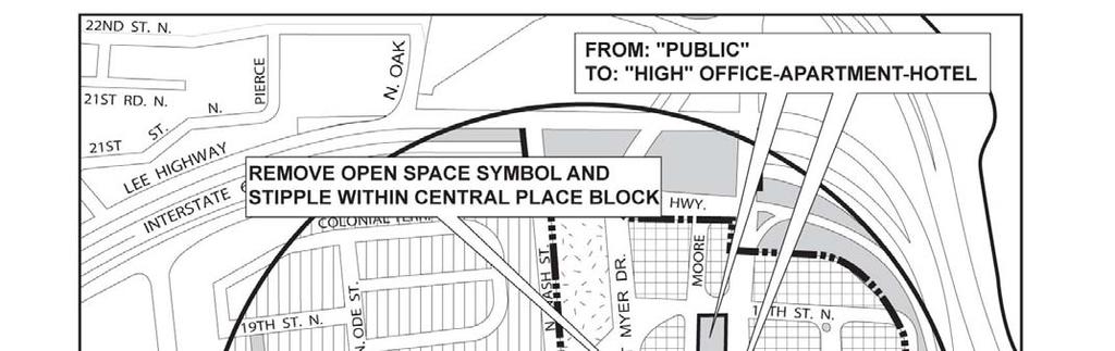


113 ATTACHMENT
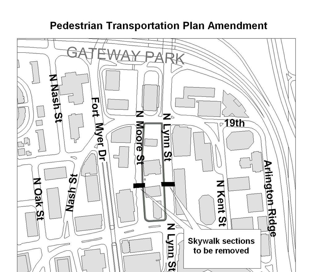
114 ATTACHMENT
115 ATTACHMENT 4 Resolution on Urban Design Principles for Rosslyn Central Place Adopted by the County Board May 5, 2007 WHEREAS the Rosslyn Coordinated Redevelopment District ( RCRD ) was adopted by the County Board in 1996 and designated on the County's General Land Use Plan; and WHEREAS sites within the RCRD have been rezoned to C-O Rosslyn" and on such rezoned sites special exception site plans, with building heights up to 300 feet, may be approved by the County Board; and WHEREAS the policies of the Arlington County General Land Use Plan and the Rosslyn Station Area Plan generally call for the greatest building heights to be focused closest to the Metro Station with building heights tapering down as locations are farther away from the station; and WHEREAS the Rosslyn Station Area Plan calls for the creation of a Central Place that is the hub of pedestrian and retail activity in Rosslyn with a unique character to its architecture and streetscape design; WHERAS the Arlington County Board passed a 2002 Resolution Governing Building Heights in Rosslyn that established general principles for considering height and design of future site plans within the RCRD; and WHEREAS the Rosslyn Working Group was established by the County Manager to further consider planning principles relating to building height, land use and urban design within Central Place (defined as the two blocks bounded by North Lynn Street, 19 th Street N., Fort Myer Drive, and Wilson Boulevard) and to make specific recommendations based on a thorough analysis of these principles; THEREFORE the Arlington County Board hereby resolves that the following major principles shall be used in considering future site plans within Central Place: Building, site, and streetscape designs should create clearly recognizable mid-block pedestrian connections and enhance overall connectivity to and from the Rosslyn Metro Station; Project design should maximize, to the extent possible, retail, restaurant, entertainment, and commercial uses within the first and second floors of the building; Despite existing variations in local topographic conditions, developments in Central Place should possess building base heights at generally uniform elevations;
116 Buildings should achieve the best feasible urban design with regard to such elements as: curbcuts, parking entrance consolidation, sidewalk clear width, retail activation, pedestrian-oriented units, and ground level façade transparency along public street frontages; and IN ADDITION, the Arlington County Board further resolves that the following major principles shall be used in considering additional building height above 300 feet for future site plans within Central Place: Buildings should include distinctive architectural features such as sculpted rooftop designs or significant tapering in its building form and massing; Projects should incorporate significant community amenities such as public access to views from building tops, public open space areas, or other important County goals for the Rosslyn area; Any additional building height should preserve, to the extent feasible, views from any public observation deck (approved or built) within Central Place; The design and construction of projects should incorporate best practices in energy conservation and excellence in sustainable architectural design; Projects should otherwise be consistent with the principles included in the September 2002 County Board Resolution Governing Building Heights in Rosslyn; Buildings should receive confirmation from the Federal Aviation Administration (F.A.A.) that the project is not a hazard to air navigation or that the project does not require notice to the F.A.A
117 ATTACHMENT 5 ORDINANCE TO AMEND SECTION 25B. C-O ROSSLYN COMMERCIAL OFFICE BUILDING, RETAIL, HOTEL, AND MULTIPLE-FAMILY DWELLING DISTRICTS OF THE ARLINGTON COUNTY ZONING ORDINANCE, TO AMEND, REENACT AND RECODIFY THE PROPOSED ZONING PROVISIONS; TO ALLOW ADDITIONAL HEIGHT (UP TO A MAXIMUM OF FOUR HUNDRED NINETY (490) FEET ABOVE SEA LEVEL) AND INCLUDE OTHER REQUIREMENTS SUCH AS ROOFTOP SIGN LIMITATIONS FOR PROPERTIES WITHIN THE BOUNDARIES OF CENTRAL PLACE, DEFINED AS THE BLOCKS BORDERED BY 19 TH STREET NORTH, NORTH LYNN STREET, WILSON BOULEVARD, AND FORT MYER DRIVE. BE IT ORDAINED THAT; Section 25.B. of the Zoning Ordinance be hereby amended, reenacted, and recodified, to allow additional height (up to a maximum of four hundred ninety (490) feet above sea level) and include other requirements such as rooftop sign limitations for properties within the boundaries of Central Place, defined as the blocks bordered by 19 th Street North, North Lynn Street, Wilson Boulevard, and Fort Myer Drive, in order to encourage orderly and efficient land use development; to facilitate the creation of convenient, attractive and harmonious communities; to encourage economic development activities that provide desirable employment and enlarge the tax base and for other reasons required by the public necessity, convenience and general welfare, and good zoning practice. * * * SECTION 25B. "C-O ROSSLYN" COMMERCIAL OFFICE BUILDING, RETAIL, HOTEL AND MULTIPLE-FAMILY DWELLING DISTRICTS The purpose of the "C-O Rosslyn" District classification is to encourage a mixed-use development of office, retail and service commercial, hotel and multiple-family dwelling uses within the Rosslyn Metro Station Area and the area designated as the "Rosslyn Coordinated Redevelopment District" on the General Land Use Plan. When a lot is located in the area designated "Rosslyn Coordinated Redevelopment District" on the General Land Use Plan, site plans may be approved by the county board. Determination as to the actual types and densities of uses to be allowed will be based on the characteristics of the site and its location, and on the extent to which the proposed site plan for development, redevelopment or rehabilitation of the site meets the standards of this section and accomplishes the policies and recommendations contained in the Rosslyn Station Area Plan Addendum and other plans and policies established for the area by the county board. The goals of this zoning classification are (1) to create premier office space suitable for regional and national headquarters of major corporations, institutions and international firms; (2) to provide hotels that expand and enhance hotel services for Rosslyn and Arlington County businesses, residents, and visitors; (3) to provide residential development that meets the housing goals and policies of Arlington County; (4) to implement urban design, streetscape and open space plans and policies, including the Central Place, the Esplanade and other public facilities; (5) to achieve the policy objectives for increasing retail commercial
118 services in the center of Rosslyn; and (6) to achieve superior architecture and the best in urban design practice. The following regulations shall apply in the "C-O Rosslyn" District:* *Note--For supplemental regulations, see Section A. Uses Permitted. All uses as permitted and regulated in "C-1-O" Districts, and special exception site plans as previously approved by the county board, subject to all conditions of approval and any future amendments which the county board may approve. (Ord. No , ) B. Site Plan Approval. Site plans are required to be approved as provided in Section 36, subsection H. (Ord. No , ) C. Special Exceptions. Site plans may be approved by the county board as specified herein: 1. The following uses may be approved when allowed by the General Land Use Plan: a. Office commercial uses. b. Multiple-family dwellings. c. Hotels. d. Retail and service commercial uses shall be provided and located as described in the Rosslyn Station Area Plan Addendum. Primary retail and service commercial uses shall generally be located at the street level and on the streets identified for such uses in the Rosslyn Station Area Plan Addendum. Secondary retail and service commercial uses shall generally be located on levels other than the street level and off the street frontages or in areas designated for secondary retail and service commercial uses in the Rosslyn Station Area Plan Addendum. 2. Density. a. The office, retail and service commercial gross floor area permitted on a given site shall be determined by multiplying the site area by 3.8. The hotel and multiple-family dwelling gross floor area permitted on a given site shall be determined by multiplying the site area by 4.8. b. No portion of the site shall be used more than one (1) time in computing the permitted density. All penthouse area in excess of that used for elevator, mechanical, or maintenance equipment shall be counted as gross floor area. (Ord. No , ) D. Height Limit. Thirty-five (35) feet, except that the following may be approved by site plan:
119 1. Office, retail and service commercial buildings: Up to a maximum height of one hundred fifty-three (153) feet, including penthouse and parapet walls, measured from the average elevation at the perimeter of the site. 2. Hotel and multiple-family dwelling buildings: Up to a maximum height of one hundred eighty (180) feet, including penthouse and parapet walls, measured from the average elevation at the perimeter of the site. (Ord. No , ) E. Provision for Additional Density and Height. 1. In considering the approval of a site plan the county board may permit additional density, above 3.8 floor area ratio (FAR) for office, retail and service commercial uses, above 4.8 FAR for hotels and multiple-family dwellings, and above the existing density on a site when it is already greater than 3.8 FAR for office, retail and service commercial uses, or above 4.8 FAR for hotels and multiple-family dwellings, up to maximum of 10.0 FAR and/or height up to a maximum of three hundred (300) feet. Increases in density and height may be approved when the county board finds that the development proposal offers important community benefits identified in approved plans for the area and meets the other special exception criteria of the zoning ordinance. In considering such modification, the county board may also consider characteristics of the site and the area as described in Section 36.H.5. of this ordinance and the plans and policies adopted for the area. Provisions of Section 36.H.7. for the approval of additional height and density shall not be applicable in the "C-O Rosslyn" district. In no case shall application of the modification of use provisions of Section 36.H.5. be applied to permit a density of more than 10.0 FAR or a height of more than three hundred (300) feet except as described below. 2. To enable the County to provide for adequate streets the county board may grant additional density (FAR) within the height limit up to an amount that would be permitted if any area dedicated from the site for street purposes were permitted to be counted in calculating density. 3. To enable the County to achieve an enhanced Rosslyn skyline and other community amenities the county board may grant additional height up to maximum of four hundred ninety (490) feet above sea level for projects within Central Place (defined as the area bounded by 19 th Street N., N. Lynn Street, Wilson Boulevard, and Fort Myer Drive). Site plan projects within Central Place may be approved when the county board finds a project is generally consistent with the May 5, 2007, county board Resolution on Urban Design Principles for Rosslyn Central Place, and additionally meets the standards of Section 36.H.3. of this ordinance. 4. Signs located above thirty five (35) feet may be approved through special exception by application of Section 34.A.3. of this ordinance. However, in no case shall any sign be permitted above a maximum height of fifty (50) feet on any building located within Central Place that is approved with additional density and height by application of either Section 25B.E.1 or Section 25B.E.3. of this ordinance
120 F. Parking Requirements. Parking shall be regulated as specified and regulated in Section 33, and as specified below, except that the county board may specify and modify parking regulations by Site Plan Approval: 1. Dwelling unit: One (1) off-street parking space shall be provided for each dwelling unit. 2. Transportation Demand Management plans shall be required to be approved as part of any site plan approval unless determined otherwise by the county board. Office, retail and service commercial parking may be approved within a range between the rate of one (1) off-street parking space for each five hundred thirty (530) square feet of office, retail and service commercial gross floor area and the rate of one (1) off-street parking space for each one thousand (1,000) square feet of office, retail and service commercial gross floor area depending on the adequacy of the Transportation Demand Management plan in addressing the need for parking. Short-term, convenient parking shall be provided for customers of commercial tenant retailers when the business premises are open to the public for business. 3. Hotel: Seven-tenths (0.7) off-street parking space for each guest room and dwelling unit. 4. The parking provided shall be located below grade or within the structure housing the use to which the parking is appurtenant, except as may be allowed in an approved site plan. 5. Off-street loading spaces for all permitted uses shall be provided as specified in Section 33. (Ord. No , ) G. Area Requirements. Each lot shall have a minimum average width of one hundred twenty-five (125) feet and a minimum area of thirty thousand (30,000) square feet. The county board may authorize application for rezoning to the "C-O Rosslyn" District where a lot or plot having less width or less area is part of a block surrounded by streets and/or buildings that generally comply with the provisions of this section. (Ord. No , ) H. Landscaping. Twenty (20) percent of total site area is required to be landscaped open space in accordance with the requirements of Section 32A, "Landscaping". The county board may modify landscaping requirements by site plan approval when the county board finds that the proposed site plan accomplishes the policies and recommendations contained in the Rosslyn Station Area Plan Addendum and other plans and policies established for the area by the county board. (Ord. No , )
121 I. Streetscape. Streetscapes, including curb, gutter, sidewalk, street light, street furniture, landscaping and other elements, shall be provided as contained in the Rosslyn Station Area Plan Addendum, and other plans and policies established for the area by the county board. (Ord. No , ) J. Additional Regulations. 1. For supplemental regulations, see Section Bulk, coverage and placement requirements are as regulated in Section 32, or as shown above, or as approved by the county board in a site plan approval. 3. Loading space must be provided as required in Section 33, or as approved by the county board in a site plan approval. 4. Signs are regulated by Section 34, or as approved by the county board in a site plan approval. (Ord. No , )

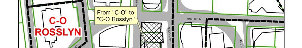


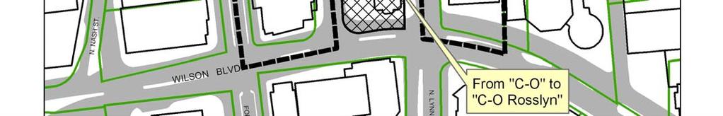


122 ATTACHMENT
ARLINGTON COUNTY, VIRGINIA
 ARLINGTON COUNTY, VIRGINIA County Board Agenda Item Meeting March 17, 2007 DATE: March 8, 2007 SUBJECT: Request to Advertise Public Hearings on Amendments to Section 25B. C-O Rosslyn Commercial Office
ARLINGTON COUNTY, VIRGINIA
 ARLINGTON COUNTY, VIRGINIA County Board Agenda Item Meeting of July 10, 2004 DATE: June 24, 2004 SUBJECT: A. GP-298-04-1 GENERAL LAND USE PLAN AMENDMENT from Semi- Public (Country Clubs and semi-public
Realizing Rosslyn: a new era of opportunity GOODY CLANCY WITH KITTELSON & ASSOCIATES RHODESIDE & HARWELL FARR ASSOCIATES W-ZHA
 Realizing Rosslyn: a new era of opportunity 1 AGENDA 2 Building Heights and Massing Subcommittee Approach and General Work Plan Confirm assumptions, goals, and performance criteria Determine 3 alternative
ARLINGTON COUNTY, VIRGINIA
 ARLINGTON COUNTY, VIRGINIA County Board Agenda Item Meeting of June 10, 2006 DATE: June 9, 2006 SUBJECTS: A. Z-2525-06-1 REZONING for Saul Centers, Inc., from C-3 General Commercial Districts to C-O Commercial
Ron Carlee, County Manager
 June 6, 2003 TO: FROM: APPLICANT: BY: SUBJECTS: The County Board of Arlington, Virginia The Holladay Corporation Nan Terpak, Attorney/Agent Walsh, Colucci, Lubeley, Emrich & Terpak 2200 Clarendon Blvd.,
DEPARTMENT OF COMMUNITY PLANNING, HOUSING AND DEVELOPMENT Planning Division
 DEPARTMENT OF COMMUNITY PLANNING, HOUSING AND DEVELOPMENT Planning Division #1 Courthouse Plaza, 2100 Clarendon Boulevard, Suite 700 Arlington, VA 22201 TEL 703.228.3525 FAX 703.228.3543 www.arlingtonva.us
ARLINGTON COUNTY, VIRGINIA
 ARLINGTON COUNTY, VIRGINIA County Board Agenda Item Meeting of July 19, 2014 DATE: July 8, 2014 SUBJECTS: A. ZOA-14-03 Zoning Ordinance amendments to: 1. Revise Map 34-1 (Sign Map) to update the placement
ARLINGTON COUNTY, VIRGINIA
 ARLINGTON COUNTY, VIRGINIA County Board Agenda Item Meeting December 9, 2006 DATE: November 20, 2006 SUBJECT: GP-302-05-2 Adoption of General Land Use Plan Amendments for the Clarendon Metro Station Area:
ARLINGTON COUNTY, VIRGINIA
 ARLINGTON COUNTY, VIRGINIA County Board Agenda Item Meeting of April 21, 2007 DATE: April 13, 2007 SUBJECT: SP #346 PHASED DEVELOPMENT SITE PLAN AMENDMENT (PDSP) AND FINAL SITE PLANS for Potomac Yard:
July 10, The County Board of Arlington, Virginia. Ron Carlee, County Manager. Keating Development Company
 July 10, 2003 TO: FROM: APPLICANT: BY: The County Board of Arlington, Virginia Ron Carlee, County Manager Keating Development Company Timothy S. Sampson, Attorney/Agent Walsh Colucci Lubeley Emrich & Terpak
ARLINGTON COUNTY, VIRGINIA. County Board Agenda Item Meeting of March 12, 2016
 ARLINGTON COUNTY, VIRGINIA County Board Agenda Item Meeting of March 12, 2016 DATE: March 3, 2016 SUBJECTS: A. Z-2588-16-1 REZONING () from C-O (Mixed Use District) and S-3A (Special District) to C-O Rosslyn
ARLINGTON COUNTY, VIRGINIA
 ARLINGTON COUNTY, VIRGINIA County Board Agenda Item Meeting of June 16, 2012 DATE: June 7, 2012 SUBJECT: SP #397 SITE PLAN AMENDMENT to revise condition #31 to modify the retail transparency requirement
3804 Wilson Boulevard (Staples Site) Special General Land Use Plan Study
 Special General Land Use Plan Study") 1 3804 Wilson Boulevard (Staples Site) Special General Land Use Plan Study Long Range Committee of the Planning Commission Meeting May 16, 2018 Department of Community Planning, Housing and Development
1 3804 Wilson Boulevard (Staples Site) Special General Land Use Plan Study Long Range Committee of the Planning Commission Meeting May 16, 2018 Department of Community Planning, Housing and Development
ARLINGTON COUNTY, VIRGINIA. County Board Agenda Item Meeting of September 19, 2015
 ARLINGTON COUNTY, VIRGINIA County Board Agenda Item Meeting of September 19, 2015 DATE: August 28, 2015 SUBJECT: Request to authorize advertisement of public hearings by the Planning Commission and the
ARLINGTON COUNTY, VIRGINIA
 ARLINGTON COUNTY, VIRGINIA County Board Agenda Item Meeting of December 8, 2012 DATE: November 29, 2012 SUBJECT: PDSP #346 SITE PLAN AMENDMENT to convert approximately 1,458 square feet of GFA below-grade
ARLINGTON COUNTY, VIRGINIA. County Board Agenda Item Meeting of May 14, 2011
 ARLINGTON COUNTY, VIRGINIA County Board Agenda Item Meeting of May 14, 2011 DATE: May 11, 2011 SUBJECT: SP #240 SITE PLAN AMENDMENT for a kiosk for the Department of Environmental Services located at the
ARLINGTON COUNTY, VIRGINIA
 ARLINGTON COUNTY, VIRGINIA County Board Agenda Item Meeting of December 10, 2005 DATE: December 9, 2005 SUBJECT: SP #392 SITE PLAN to develop approximately 153 dwelling units and approximately 17,162 square
SITE PLAN REVIEW COMMITTEE MEETING AGENDA. DATE: Monday, October 22, Clarendon Boulevard Courthouse Plaza, Room 311 Arlington, VA 22201
 SITE PLAN REVIEW COMMITTEE MEETING AGENDA DATE: Monday, October 22, 2012 TIME: 7:00 9:00 p.m. PLACE: 2100 Clarendon Boulevard Courthouse Plaza, Room 311 Arlington, VA 22201 SPRC STAFF COORDINATOR: Samia
3804 Wilson Boulevard
 3804 Wilson Boulevard SPECIAL GENERAL LAND USE PLAN STUDY DEPARTMENT OF COMMUNITY PLANNING, HOUSING, & DEVELOPMENT Planning Division 3804 Wilson Boulevard Special GLUP Study a2 3804 Wilson Boulevard Special
ARLINGTON COUNTY, VIRGINIA
 ARLINGTON COUNTY, VIRGINIA County Board Agenda Item Meeting of July 10, 2004 DATE: July 1, 2004 SUBJECTS: A. Consideration of consent concerning whether to include Hillside Park within the site plan area
SITE PLAN REVIEW COMMITTEE MEETING AGENDA
 Page 1 SITE PLAN REVIEW COMMITTEE MEETING AGENDA DATE: Monday, July 10, 2017 TIME: 7:00 8:30 p.m. PLACE: 2100 Clarendon Boulevard Ground Floor Conference Rooms Cherry/Dogwood Arlington, VA 22202 SPRC STAFF
ARLINGTON COUNTY, VIRGINIA
 ARLINGTON COUNTY, VIRGINIA County Board Agenda Item Meeting of November 15, 2005 DATE: November 22, 2005 SUBJECT: SP #331 SITE PLAN AMENDMENT to incorporate 4420 N. Fairfax Dr. into site plan, construct
ARLINGTON COUNTY, VIRGINIA
 ARLINGTON COUNTY, VIRGINIA County Board Agenda Item Meeting of July 19, 2008 DATE: July 16, 2008 SUBJECT: SP#297 SITE PLAN: PL Pentagon LLC c/o Kimco Realty Corporation, construct approx. 489,911 sq ft
SP #25 SITE PLAN AMENDMENT:
 May 8, 2002 TO: FROM: APPLICANT: BY: SUBJECT: The County Board of Arlington, Virginia Ron Carlee, County Manager JGB/TrizecHahn Waterview Venture LLC John G. Milliken, Attorney Venable 8010 Towers Crescent
November 21, RECOMMENDATION: Deny the site plan request, and accept withdrawal of rezoning request.
 November 21, 2003 TO: FROM: APPLICANT: BY: The County Board of Arlington, Virginia Ron Carlee, County Manager Trammell Crow Residential Tim Sampson, Attorney/Agent Walsh, Colucci, Emrich, Lubeley & Terpak
Wesley Housing Development Corporation Trenton Street Residential
 Wesley Housing Development Corporation Trenton Street Residential 1 2 Site Location Multimodal Traffic Study Summary Existing Conditions (2017) 13 study intersections. -Scoped with Arlington County DES
ARLINGTON COUNTY, VIRGINIA
 ARLINGTON COUNTY, VIRGINIA County Board Agenda Item Meeting of November 14, 2015 DATE: November 13, 2015 SUBJECTS: Development A. SP #193 SITE PLAN AMENDMENT Ballston Air Rights Acquisition Company, LLC
ARLINGTON COUNTY, VIRGINIA
 ARLINGTON COUNTY, VIRGINIA County Board Agenda Item Meeting of March 17, 2007 DATE: March 6, 2007 SUBJECT: SP#89 SITE PLAN AMENDMENT to permit one temporary banner sign of approximately 240 square feet;
SITE PLAN REVIEW COMMITTEE MEETING AGENDA Clarendon Boulevard Conference Rooms C & D Arlington, VA 22201
 SITE PLAN REVIEW COMMITTEE MEETING AGENDA DATE: Monday, October 2, 2017 TIME: 8:30 10:00 p.m. PLACE: 2100 Clarendon Boulevard Conference Rooms C & D Arlington, VA 22201 Item 2. 6711 Lee Highway (SP #3)
Washington Boulevard + Kirkwood Road Special General Land Use Plan (GLUP) Study "Plus"
 Study Plus") Washington Boulevard + Kirkwood Road Special General Land Use Plan (GLUP) Study "Plus" Long Range Committee of the Planning Commission Meeting #4 May 18, 2017 Department of Community Planning, Housing
Washington Boulevard + Kirkwood Road Special General Land Use Plan (GLUP) Study "Plus" Long Range Committee of the Planning Commission Meeting #4 May 18, 2017 Department of Community Planning, Housing
SITE PLAN REVIEW COMMITTEE MEETING AGENDA Clarendon Boulevard Courthouse Plaza, Training Center (10 th Floor) Arlington, VA 22202
 Arlington, VA 22202") SITE PLAN REVIEW COMMITTEE MEETING AGENDA DATE: Wednesday, December 5, 2012 TIME: 8:30 10:00 p.m. PLACE: 2100 Clarendon Boulevard Courthouse Plaza, Training Center (10 th Floor) Arlington, VA 22202 SPRC
SITE PLAN REVIEW COMMITTEE MEETING AGENDA DATE: Wednesday, December 5, 2012 TIME: 8:30 10:00 p.m. PLACE: 2100 Clarendon Boulevard Courthouse Plaza, Training Center (10 th Floor) Arlington, VA 22202 SPRC
An implementation document is forthcoming. - A1-1 -
 OFF-STREET PARKING GUIDELINES FOR MULTI-FAMILY RESIDENTIAL PROJECTS APPROVED BY SPECIAL EXCEPTION IN THE ROSSLYN-BALLSTON AND JEFFERSON DAVIS METRO CORRIDORS 12/01/2017 This is a draft of the guidelines
Rosslyn Plaza PDSP. County Board Public Hearing
 Rosslyn Plaza PDSP County Board Public Hearing Aaron Shriber, DCPHD, Planning Division March 12, 2016 Site Location 2 GLUP Designation 3 Zoning Designation 4 Rosslyn Sector Plan 5 Rosslyn Sector Plan Concept
ARLINGTON COUNTY, VIRGINIA
 ARLINGTON COUNTY, VIRGINIA County Board Agenda Item Meeting of February 23, 2013 DATE: February 8, 2013 SUBJECTS: A. Z-2563-12-1 REZONING from "CM" Limited Industrial Districts to "C-O-Crystal City" Commercial
ARLINGTON COUNTY, VIRGINIA
 ARLINGTON COUNTY, VIRGINIA County Board Agenda Item Meeting of January 21, 2006 DATE: January 5, 2006 SUBJECT: Action on Proposed Amendments to provide for the achievement of affordable housing objectives
ARLINGTON COUNTY, VIRGINIA. County Board Agenda Item Meeting of December 8, 2012
 ARLINGTON COUNTY, VIRGINIA County Board Agenda Item Meeting of December 8, 2012 DATE: November 29, 2012 SUBJECTS: 1. GP-322-11-1 GENERAL LAND USE PLAN AMENDMENT to amend the GLUP designation for the two
SITE PLAN REVIEW COMMITTEE MEETING AGENDA Clarendon Boulevard Courthouse Plaza, Rooms 109/111 Arlington, VA 22201
 SITE PLAN REVIEW COMMITTEE MEETING AGENDA DATE: Monday, April 7, 2014 TIME: 7:00 8:25 p.m. PLACE: 2100 Clarendon Boulevard Courthouse Plaza, Rooms 109/111 Arlington, VA 22201 SPRC STAFF COORDINATOR: Samia
S I T E P L A N R E V I E W C O M M I T T E E M E E T I N G A G E N D A
 S I T E P L A N R E V I E W C O M M I T T E E M E E T I N G A G E N D A DATE: Thursday, November 15, 2018 TIME: SPRC: 7:00 8:30 p.m. PLACE: Ellen M. Bozman Government Center 2100 Clarendon Boulevard Room
S I T E P L A N R E V I E W C O M M I T T E E M E E T I N G A G E N D A
 S I T E P L A N R E V I E W C O M M I T T E E M E E T I N G A G E N D A DATE: Thursday, September 14, 2017 TIME: 6:00 6:45 p.m. (optional walking tour) 7:00 8:30 p.m. PLACE: 2801 Clarendon Boulevard Meeting
W i l s o n B o u l e v a r d & K e y B o u l e v a r d
 14 0 1 W i l s o n B o u l e v a r d & 14 0 0 K e y B o u l e v a r d R o s s l y n, A r l i n g t o n C o u n t y, V i r g i n i a S i t e P l a n R e v i e w C o m m i t t e e M e e t i n g # 1 0 7.
October 9, The County Board of Arlington, Virginia. Ron Carlee, County Manager
 October 9, 2003 TO: FROM: APPLICANT: BY: The County Board of Arlington, Virginia Ron Carlee, County Manager Douglas Schneiderman, Vice President Madison Homes, Inc. 6723 Whittier Avenue, Suite 104 McLean,
DRAFT FOR DISCUSSION PURPOSES ONLY. Port Credit Local Area Plan Built Form Guidelines and Standards DRAFT For Discussion Purposes
 Port Credit Local Area Plan Built Form Guidelines and Standards DRAFT For Discussion Purposes 1 Local Area Plan - Project Alignment Overview Directions Report, October 2008 (General Summary Of Selected
Jasper 115 Street DC2 Urban Design Brief
 Jasper 115 Street DC2 Urban Design Brief Greenlong Construction Ltd. Stantec Consulting Ltd. 2017 Overview The proposed rezoning application supports the development of two mixed-use high-rise buildings
2401 Wilson Boulevard General Land Use Plan Amendment Study
 2401 Wilson Boulevard General Land Use Plan Amendment Study Long Range Planning Committee Meeting Presentation Compendium March 29, 2011 Department of Community Planning, Housing and Development GLUP Amendment
ARLINGTON COUNTY, VIRGINIA
 ARLINGTON COUNTY, VIRGINIA County Board Agenda Item Meeting of December 08, 2012 DATE: November 13, 2012 SUBJECT: Enactment of an Ordinance to Permit the Encroachment of a Structural Canopy within a Portion
Pentagon Centre (SP#297) PDSP & Phase I Site Plan Amendments SPRC #1
 PDSP & Phase I Site Plan Amendments SPRC #1") Pentagon Centre (SP#297) PDSP & Phase I Site Plan Amendments SPRC #1 CPHD February 23, 2015 Meeting Agenda Background on relevant planning context, guidance, and County policy Brief update on original
Pentagon Centre (SP#297) PDSP & Phase I Site Plan Amendments SPRC #1 CPHD February 23, 2015 Meeting Agenda Background on relevant planning context, guidance, and County policy Brief update on original
ARLINGTON COUNTY, VIRGINIA. County Board Agenda Item Meeting of September 22, 2018
 ARLINGTON COUNTY, VIRGINIA County Board Agenda Item Meeting of September 22, 2018 DATE: September 13, 2018 SUBJECT: SP413-U-18-1 USE PERMIT ASSOCIATED WITH A SITE PLAN for food delivery service for Domino's
ARLINGTON COUNTY, VIRGINIA
 ARLINGTON COUNTY, VIRGINIA County Board Agenda Item Meeting of July 16, 2016 DATE: July 5, 2016 SUBJECT: SP #64 SITE PLAN AMENDMENT to allow temporary extension of construction hours for ; located at 1000
ARLINGTON COUNTY, VIRGINIA
 ARLINGTON COUNTY, VIRGINIA County Board Agenda Item Meeting of November 5, 2016 DATE: October 25, 2016 SUBJECT: SP #11 SITE PLAN AMENDMENT for the conversion of 440 square feet of ground floor residential
24. A., B., C. ARLINGTON COUNTY, VIRGINIA. County Board Agenda Item Meeting of February 23, DATE: February 19, 2019
 ARLINGTON COUNTY, VIRGINIA County Board Agenda Item Meeting of February 23, 2019 DATE: February 19, 2019 SUBJECTS: A. GP-343-17-1 GENERAL LAND USE PLAN AMENDMENT to change the land use designation for
SITE PLAN REVIEW COMMITTEE MEETING AGENDA. DATE: Thursday, April 25, :00 8:30 p.m. PLACE:
 SITE PLAN REVIEW COMMITTEE MEETING AGENDA DATE: Thursday, April 25, 2013 TIME: 7:00 8:30 p.m. PLACE: Courthouse Plaza 2100 Clarendon Boulevard Conference Rooms C&D Arlington, VA 22201 SPRC STAFF COORDINATOR:
ARLINGTON COUNTY, VIRGINIA
 ARLINGTON COUNTY, VIRGINIA County Board Agenda Item Meeting of November 15, 2005 DATE: November 8, 2005 SUBJECTS: A. Adoption of Proposed Amendments to Section 20 (Appendix A) CP-FBC Columbia Pike - Form
CONNECTING ARLINGTON S POLICY FRAMEWORK TO THE RESIDENTIAL PARKING WORKING GROUP
 CONNECTING ARLINGTON S POLICY FRAMEWORK TO THE RESIDENTIAL PARKING WORKING GROUP Contents Arlington County Development and Growth Goals... 1 Master Transportation Plan Policies Related to Multi Family
SITE PLAN REVIEW COMMITTEE MEETING AGENDA Key Boulevard Arlington, VA 22201
 SITE PLAN REVIEW COMMITTEE MEETING AGENDA DATE: Monday, July 22, 2013 TIME: 7:00 10:00 p.m. PLACE: 1400 Key Boulevard Arlington, VA 22201 SPRC STAFF COORDINATOR: Samia Byrd, 703-228-3525 Item 1. 1401 Wilson
Rosslyn Sector Plan Implementation Zoning Ordinance Amendments. NAIOP Meeting April 13, 2016
 Rosslyn Sector Plan Implementation Zoning Ordinance Amendments NAIOP Meeting April 13, 2016 Agenda Background, Process & Schedule Preliminary Amendments to C-O Rosslyn Building Height & Step-backs Density
SITE PLAN REVIEW COMMITTEE MEETING AGENDA Clarendon Boulevard Conference Rooms C & D Arlington, VA 22201
 SITE PLAN REVIEW COMMITTEE MEETING AGENDA DATE: Monday, July 24, 2017 TIME: 7:00 9:00 p.m. PLACE: 2100 Clarendon Boulevard Conference Rooms C & D Arlington, VA 22201 Item 1. 6711 Lee Highway (SP #3) (RPC#
Nan E. Terpak, Attorney Walsh, Colucci, Stackhouse, Emrich & Lubeley 2100 Clarendon Boulevard, 13 th Floor Arlington, VA 22201
 January 31, 2002 TO: The County Board of Arlington, Virginia FROM: Ron Carlee, County Manager APPLICANT: McCaffrey Interests, Inc. BY: Nan E. Terpak, Attorney Walsh, Colucci, Stackhouse, Emrich & Lubeley
SITE PLAN REVIEW COMMITTEE MEETING AGENDA Clarendon Boulevard Arlington, VA Conference Rooms 109/110 (C&D)
") SITE PLAN REVIEW COMMITTEE MEETING AGENDA DATE: Thursday, September 19, 2013 TIME: 7:00 10:00 p.m. PLACE: 2100 Clarendon Boulevard Arlington, VA 22201 Conference Rooms 109/110 (C&D) SPRC STAFF COORDINATOR:
SITE PLAN REVIEW COMMITTEE MEETING AGENDA DATE: Thursday, September 19, 2013 TIME: 7:00 10:00 p.m. PLACE: 2100 Clarendon Boulevard Arlington, VA 22201 Conference Rooms 109/110 (C&D) SPRC STAFF COORDINATOR:
ARLINGTON COUNTY, VIRGINIA
 ARLINGTON COUNTY, VIRGINIA County Board Agenda Item Meeting of April 19, 2008 DATE: April 2, 2008 SUBJECT: ORDINANCE TO AMEND, REENACT, AND RECODIFY Section 20 CP- FBC, Columbia Pike Form Based Code Districts
S I T E P L A N R E V I E W C O M M I T T E E M E E T I N G A G E N D A
 S I T E P L A N R E V I E W C O M M I T T E E M E E T I N G A G E N D A DATE: Thursday, July 23, 2015 TIME: 7:00 10:00 p.m. PLACE: 2100 Clarendon Boulevard Courthouse Plaza, 1st Floor, Cherry and Dogwood
Smith Property Holdings Buchanan House, LLC. Nan Terpak, Agent/Attorney 2200 Clarendon Boulevard, 13th Floor Arlington, Virginia 22201
 January 28, 2003 TO: FROM: APPLICANT: BY: SUBJECTS: The County Board of Arlington, Virginia Ron Carlee, County Manager Smith Property Holdings Buchanan House, LLC Nan Terpak, Agent/Attorney 2200 Clarendon
ARLINGTON COUNTY, VIRGINIA
 ARLINGTON COUNTY, VIRGINIA County Board Agenda Item Meeting of March 13, 2004 DATE: March 10, 2004 SUBJECT: SP #256 SITE PLAN AMENDMENT to amend the comprehensive sign plan; premises known as 4250 Fairfax
ARLINGTON COUNTY, VIRGINIA
 ARLINGTON COUNTY, VIRGINIA County Board Agenda Item Meeting of January 23, 2016 DATE: January 20, 2016 SUBJECTS: A. SP #211 SITE PLAN AMENDMENT to permit a vehicle rental use and associated modification
SITE PLAN REVIEW COMMITTEE MEETING AGENDA. DATE: Monday, December 16, 2013
 SITE PLAN REVIEW COMMITTEE MEETING AGENDA DATE: Monday, December 16, 2013 TIME: 7:00 10:00 p.m. PLACE: 2100 Clarendon Boulevard Courthouse Plaza, Rooms 109/111 Arlington, VA 22201 SPRC STAFF COORDINATOR:
ARLINGTON COUNTY, VIRGINIA. County Board Agenda Item Meeting of February 23, 2019
 ARLINGTON COUNTY, VIRGINIA County Board Agenda Item Meeting of February 23, 2019 DATE: February 5, 2019 SUBJECTS: A. GP-343-17-1 GENERAL LAND USE PLAN AMENDMENT to change the land use designation for a
ARLINGTON COUNTY, VIRGINIA. County Board Agenda Item Meeting of June 14, 2014
 ARLINGTON COUNTY, VIRGINIA County Board Agenda Item Meeting of June 14, 2014 DATE: May 29, 2014 SUBJECT: Ordinance to Permit the Encroachments of: 1) A Portion of a Transformer Vault into an Existing Street
R o s s l y n, A r l i n g t o n C o u n t y, V i r g i n i a. S i t e P l a n R e v i e w C o m m i t t e e M e e t i n g # 2
 1 4 0 1 W i l s o n B o u l e v a r d & 1 4 0 0 K e y B o u l e v a r d R o s s l y n, A r l i n g t o n C o u n t y, V i r g i n i a S i t e P l a n R e v i e w C o m m i t t e e M e e t i n g # 2 0 9.
SP #447, 11 th & Vermont
 SP #447, 11 th & Vermont GLUP Amendment, Rezoning, and Site Plan Department of Community Planning, Housing, and Development County Board February 24, 2018 1 NORTH BLOCK (R15-30T) 11 th & Vermont (SP #447)
ARLINGTON COUNTY, VIRGINIA
 ARLINGTON COUNTY, VIRGINIA County Board Agenda Item Meeting of July 21, 2012 DATE: June 26, 2012 SUBJECT: SP #402 SITE PLAN AMENDMENT for a comprehensive sign plan amendment to add a projecting sign for
28. ARLINGTON COUNTY, VIRGINIA. County Board Agenda Item Meeting of February 25, DATE: February 17, 2017
 ARLINGTON COUNTY, VIRGINIA County Board Agenda Item Meeting of February 25, 2017 DATE: February 17, 2017 SUBJECTS: Items associated with Queen's Court Residences: A. GP 335-16-1 GENERAL LAND USE PLAN AMENDMENT
SITE PLAN REVIEW COMMITTEE MEETING AGENDA Clarendon Boulevard Courthouse Plaza, Rooms 109/110 Arlington, VA 22201
 SITE PLAN REVIEW COMMITTEE MEETING AGENDA DATE: Monday, January 6, 2014 TIME: 7:00 8:30 p.m. PLACE: 2100 Clarendon Boulevard Courthouse Plaza, Rooms 109/110 Arlington, VA 22201 SPRC STAFF COORDINATOR:
900 ALBERT STREET PLANNING RATIONALE ADDENDUM NO. 2
 900 ALBERT STREET PLANNING RATIONALE ADDENDUM NO. 2 March 26, 2018 Planning Rationale Addendum No. 2 Official Plan and Zoning By-law Amendment Prepared for: TIP Albert GP Inc. 485 Bank Street, Suite 200
Transit Oriented Communities Affordable Housing Incentive Program Guidelines (TOC Guidelines)
") Transit Oriented Communities Affordable Housing Incentive Program Guidelines (TOC Guidelines) Implementing Section 6 of Measure JJJ, approved by the voters in November 2016, and added to Los Angeles Municipal
Transit Oriented Communities Affordable Housing Incentive Program Guidelines (TOC Guidelines) Implementing Section 6 of Measure JJJ, approved by the voters in November 2016, and added to Los Angeles Municipal
ARLINGTON COUNTY, VIRGINIA
 ARLINGTON COUNTY, VIRGINIA County Board Agenda Item Meeting of November 14, 2006 DATE: November 2, 2006 SUBJECT: SP #106-6 SITE PLAN AMENDMENT to amend comprehensive sign plan; 2751 S. Stafford St. (Bear
ARLINGTON COUNTY, VIRGINIA
 ARLINGTON COUNTY, VIRGINIA County Board Agenda Item Meeting of June 12, 2004 DATE: June 3, 2004 SUBJECT: A. Z-2511-03-1 REZONING from R-5 One-Family, Restricted Two-Family Dwelling Districts, C-2 Service
The Miramar Santa Monica
 The Miramar Santa Monica Project Description The Santa Monica Miramar Hotel (the Miramar or the Hotel ) has been an institution in the City of Santa Monica since originally opening on the site in 1920.
Nan E. Terpak, Agent 2200 Clarendon Boulevard, 13th Floor Arlington, Virginia 22201
 July 10, 2002 TO: FROM: APPLICANT: BY: SUBJECT: The County Board of Arlington, Virginia Ron Carlee, County Manager McCaffrey Interests, Inc. Nan E. Terpak, Agent 2200 Clarendon Boulevard, 13th Floor Arlington,
Mitigation of the excess density and under-parking after the conversion.
 November 26, 2002 TO: FROM: APPLICANT: BY: SUBJECT: The County Board of Arlington, Virginia Ron Carlee, County Manager William H. Brakefield, Owner Scott F. Imirie, Agent 1000 Wilson Boulevard, Suite 800
ARLINGTON COUNTY, VIRGINIA. County Board Agenda Item Meeting of November 17, 2018
 ARLINGTON COUNTY, VIRGINIA County Board Agenda Item Meeting of November 17, 2018 DATE: November 7, 2018 SUBJECT: U-3501-17-4 USE PERMIT REVIEW for an Open-Air Market (Arlington Mill Farmer's Market); located
Montreal Road District Secondary Plan [Amendment #127, October 9, 2013]
![Montreal Road District Secondary Plan [Amendment #127, October 9, 2013]](/thumbs/72/66783104.jpg "Montreal Road District Secondary Plan [Amendment #127, October 9, 2013]") [Amendment #127, October 9, 2013] 1.0 General The following policies are applicable to the Montreal Road District as set out in Schedule 1. 1.1 District Objectives The objective of this Plan is to guide
[Amendment #127, October 9, 2013] 1.0 General The following policies are applicable to the Montreal Road District as set out in Schedule 1. 1.1 District Objectives The objective of this Plan is to guide
S IT E PL A N R E V IE W C OM M IT T E E
 S IT E PL A N R E V IE W C OM M IT T E E M E E T I N G A G E N D A DATE: Thursday, January 4, 2018 TIME: 7:00 9:00 p.m. PLACE: Ellen Bozman Government Center/Courthouse Plaza 2100 Clarendon Boulevard Lobby
ARLINGTON COUNTY, VIRGINIA
 ARLINGTON COUNTY, VIRGINIA County Board Agenda Item Meeting of April 16, 2005 DATE: April 13, 2005 SUBJECT: A. SP #76 SITE PLAN AMENDMENT to reduce units in existing hotel from 238 to approximately 187,
SITE PLAN REVIEW COMMITTEE MEETING AGENDA. DATE: Wednesday, February 28, Aurora Hills Community Center th Street S. Arlington, VA 22202
 Page 1 SITE PLAN REVIEW COMMITTEE MEETING AGENDA DATE: Wednesday, February 28, 2018 TIME: 7:00 9:00 p.m. PLACE: Aurora Hills Community Center 735 18 th Street S. Arlington, VA 22202 SPRC STAFF COORDINATOR:
ARLINGTON COUNTY, VIRGINIA
 ARLINGTON COUNTY, VIRGINIA County Board Agenda Item Meeting of September 19, 2015 DATE: September 15, 2015 SUBJECTS: A. SP# 297 PHASED DEVELOPMENT SITE PLAN AMENDMENT of the Pentagon Centre PDSP to permit
ARLINGTON COUNTY, VIRGINIA
 ARLINGTON COUNTY, VIRGINIA County Board Agenda Item Meeting of February 20, 2016 DATE: February 17, 2016 SUBJECTS: A. Z-2587-16-1 REZONING from "R-6" One-Family Dwelling District to "CP-FBC" Columbia Pike
ARLINGTON COUNTY, VIRGINIA
 ARLINGTON COUNTY, VIRGINIA County Board Agenda Item Meeting of July 19, 2014 DATE: July 11, 2014 SUBJECT: Adoption of final Urban Design Guidelines Applicant: VNO Pentagon Plaza, LLC By: John G. Milliken,
S I T E P L A N R E V I E W C O M M I T T E E M E E T I N G A G E N D A Clarendon Boulevard Courthouse Plaza, Rooms 109/111 Arlington, VA 22201
 S I T E P L A N R E V I E W C O M M I T T E E M E E T I N G A G E N D A DATE: Thursday, March 27, 2014 TIME: 7:00 8:25 pm PLACE: 2100 Clarendon Boulevard Courthouse Plaza, Rooms 109/111 Arlington, VA 22201
ARTICLE 887. PD 887. Valley View - Galleria Area Special Purpose District
 ARTICLE 887. PD 887. Valley View - Galleria Area Special Purpose District SEC. 51P-887.101. LEGISLATIVE HISTORY. PD 887 was established by Ordinance No. 29032, passed by the Dallas City Council on June
The Philadelphia Code. Table : Commercial and Commercial Mixed-Use Districts {For a printable PDF version, click HERE}
 1 of 19 2/17/2015 2:48 PM The Philadelphia Code 14-402. Commercial and Commercial Mixed-Use Districts. (1) General. (a) Districts. (.1) List. The City s Commercial and Commercial Mixed-Use zoning districts
20 Edward Street Zoning Amendment Application - Preliminary Report
 STAFF REPORT ACTION REQUIRED 20 Edward Street Zoning Amendment Application - Preliminary Report Date: January 20, 2015 To: From: Wards: Reference Number: Toronto and East York Community Council Director,
ARLINGTON COUNTY, VIRGINIA. County Board Agenda Item Meeting of July 14, 2018
 ARLINGTON COUNTY, VIRGINIA County Board Agenda Item Meeting of July 14, 2018 DATE: July 6, 2018 SUBJECT: Ordinance of Encroachment to Permit the Encroachment of a Canopy into an Easement for Public Street
Presentation Agenda Wilson - Mixed Use Building Presentation Agenda. 16 May 2016 SPRC 1. Pg 2
 4040 Wilson - Mixed Use Building SPRC 1 16 May 2016 Presentation Agenda 1. Project Overview 2. Land Use & Zoning 3. Site Design 4. Building Architecture 5. Transportation 6. Open Space 7. Community Benefits
Linear baguettes of. terra cotta and. floor-to-ceiling glass, bridge Courthouse s. historic brick. neighborhood with. modern architectural.
 2025 ClARENDON 2025 Clarendon is the pinnacle of the Clarendon/Courthouse skyline and gateway to the Nation s Capital. Identified by its large illuminated vertical fin at the corner of Wilson and Clarendon
ARLINGTON COUNTY, VIRGINIA. County Board Agenda Item Meeting of November 18, 2017
 ARLINGTON COUNTY, VIRGINIA County Board Agenda Item Meeting of November 18, 2017 DATE: November 9, 2017 SUBJECTS: A. Z-2597-17-1 REZONING from "C-O" Mixed Use District to "RA8-18" Multiple-Family Dwelling
Director, Community Planning, North York District NNY 23 OZ and NNY 23 RH
 STAFF REPORT ACTION REQUIRED 2 & 50 Sheppard Avenue East 4841 to 4881 Yonge Street and 2 to 6 Forest Laneway Official Plan Amendment, Zoning By-law Amendment and Rental Housing Demolition Applications
SITE PLAN REVIEW COMMITTEE MEETING AGENDA. DATE: Wednesday, April 4, 2018
 Page 1 SITE PLAN REVIEW COMMITTEE MEETING AGENDA DATE: Wednesday, April 4, 2018 TIME: 7:00 9:30 p.m. PLACE: Ellen Bozman Building Room 715, 7 th Floor 2100 Clarendon Boulevard Arlington, VA 22201 SPRC
S I T E P L A N R E V I E W C O M M I T T E E M E E T I N G A G E N D A Clarendon Boulevard Conference Room 311 Arlington, VA 22201
 S I T E P L A N R E V I E W C O M M I T T E E M E E T I N G A G E N D A DATE: Thursday, May 12, 2016 TIME: 7:00 8:25 p.m. PLACE: 2100 Clarendon Boulevard Conference Room 311 Arlington, VA 22201 SPRC STAFF
SITE PLAN REVIEW COMMITTEE MEETING AGENDA. NRECA 4301 Wilson Boulevard Conference Rooms CC1 Arlington, VA 22203
 SITE PLAN REVIEW COMMITTEE MEETING AGENDA DATE: Monday, July 20, 2015 TIME: 7:00 10:00 p.m. PLACE: NRECA 4301 Wilson Boulevard Conference Rooms CC1 Arlington, VA 22203 SPRC STAFF COORDINATOR: Samia Byrd,
STAFF REPORT. January 25, North York Community Council. Director, Community Planning, North District
 STAFF REPORT January 25, 2005 To: From: Subject: Purpose: North York Community Council Director, Community Planning, North District Refusal Report OPA & Rezoning Application 04 194214 NNY 33 OZ Applicant:
ARLINGTON COUNTY, VIRGINIA
 ARLINGTON COUNTY, VIRGINIA County Board Agenda Item Meeting of June 17, 2008 DATE: June 6, 2008 SUBJECT: SP #293 SITE PLAN AMENDMENT, Teachers Insurance & Annuity Association, amend comprehensive sign