Municipal Development Plan Bylaw County of Athabasca No. 12
|
|
|
- Ethan Norton
- 5 years ago
- Views:
Transcription
1 TABLE OF CONTENTS PART ONE - INTRODUCTION 1 1. PLAN PURPOSE 1 2. PLAN FORMAT 1 PART TWO - PLAN GOAL 2 1. PLAN GOAL 2 2. BASIS 2 PART THREE - PLAN OBJECTIVES AGRICULTURE COUNTRY RESIDENTIAL DEVELOPMENT SETTLEMENT EXPANSION INDUSTRIAL DEVELOPMENT COMMERCIAL DEVELOPMENT TRANSPORTATION, UTILITIES AND SOUR GAS RECREATION AND OPEN SPACE WILDLIFE HISTORIC RESOURCES 33 PART FOUR - ADMINISTRATION AUTHORITY OF THE PLAN LAND USE BYLAW AMENDMENT REVIEW MONITORING ADJACENT MUNICIPALITIES 37 PART FIVE - DEFINITIONS 38 MAPS MAP 1 GENERAL DEVELOPMENT PLAN 41 MAP 2 CRITICAL WILDLIFE AREAS 42 MAP 3 HERITAGE AREAS AND RIVER CORRIDOR 43 MAP 4 TRANSPORTATION PLAN 44 MAP 5 SOUR GAS AND LOGGING CONTROL AREAS 45 MAP 6 AREAS FROM WHICH CONFINED FEEDING OPERATIONS ARE TO BE RESTRICTED 46
2 PART ONE - INTRODUCTION 1. PLAN PURPOSE A Municipal Development Plan represents a set of long term goals and decisions which a municipal council has made addressing future land use change and development within its jurisdiction. The Council of the County of Athabasca has, for many years, had a Municipal Development Plan to serve as the policy guideline for planning and coordination of development and subdivision in the County, and considers it desirable to review and refresh the Municipal Development Plan. A Municipal Development Plan for the County will help avoid inconsistency in decision making, promote local goals and desires, maximize opportunities and minimize the unexpected. It will also assist Council in rationally addressing such ongoing issues as: loss of good farmland; conflicting farm and non-farm uses; design and location of multi-lot country residential development and lakeside development; hamlet growth and servicing options; the accommodation of industrial/commercial development, future transportation structure, and the acquisition and use of Reserve land for parks purposes. It is important to realize that a Municipal Development Plan is legally restricted in what it can and cannot address. There are a number of matters such as land ownership, land assessment and taxation, social services programs, and oil and natural gas development which have no place in the Plan. Any new land use or development proposal that does not comply with this Plan cannot be considered unless the Plan itself is amended to accommodate that proposal. It is also important to realize that the Municipal Development Plan is not retroactive in nature. Land uses in existence prior to adoption of the Plan which do not comply with this Plan, are permitted to continue. 2. PLAN FORMAT The goal, objectives and policies of this Plan are important as they set the standards of acceptable use, change and development. The Plan goal is established to identify a broad long term ideal which Council wishes to pursue in regards to future land use in the County. The objectives represent more specific aspects of the Plan goal, which in turn, can be achieved through the policy statements identifying specific actions, requirements and standards. Key words and phrases pertinent to the interpretation of policies contained in the Plan are listed and defined in the "Definitions" section of this Plan. For ease of reference, these Key words and phrases have been identified by the use of bold type face. 1
3 PART TWO - PLAN GOAL 1. PLAN GOAL To protect and develop the agricultural land base within the County of Athabasca while providing opportunity for industrial and economic diversification with well-planned growth, change and development within a context of protection and utilization of the natural resources and environment of the County. 2. BASIS The Plan goal is based upon an evaluation of various land use issues and concerns facing the County. This goal becomes the guiding principle and foundation of this Plan. A significant amount of land in the County is currently used for agricultural purposes and related rural lifestyles. The Council foresees the agricultural industry as being important to the long term social and economic welfare of the County. Council also foresees the agricultural industry changing over time, and wishes to provide for that change by having policies and processes that allow for well-planned growth, intensification, and development in the agricultural sector which utilizes suitable land but which limits impact on the natural and the social environment of the County. As well, it is deemed necessary that the Plan goal be directed towards promoting the diversification of business and industry in the County. In this manner, an environment will be provided which benefits both the agricultural industry and the community. It is recognized that there are sufficient areas of the County which can accommodate non-agricultural land uses without jeopardizing the agricultural land base. The Plan goal, therefore, encourages opportunities for well planned non-agricultural growth and development. This will promote a diversification of the County's economic base. 2
4 PART THREE - PLAN OBJECTIVES AGRICULTURE INTENT Agriculture is regarded as an important and critical land use activity in the County of Athabasca. The intent of this objective/policies section is to promote the long term viability of agriculture. As well, the intent of this section is to allow for well-planned growth, intensification, and development in the agricultural sector which utilizes suitable land but which limits impact on the natural and the social environment of the County. Those land uses not dependent upon productive soils are directed to other areas. OBJECTIVES - To minimize the loss of land with agricultural potential, and to discourage where possible, the loss of land with high agricultural capability to non-agricultural land uses. - To minimize the unnecessary fragmentation of agricultural land. - To allow for the intensification of agricultural operations in suitable locations. - To protect agricultural operations. - To minimize conflicts between agricultural operations and non-agricultural land uses. - To minimize the negative impact of operations on the quality of the natural environment. POLICIES 1.1 Higher capability agricultural land shall be considered as a quarter section having at least 20 ha (49.5 ac.) with a farmland assessment productivity rating of 30% better; or a quarter section with an averaged Canada Land Inventory agricultural capability rating of at least 100% Class 4 or better soil. 1.2 Lower capability agricultural land shall be considered as a quarter section having less than 20 ha (49.5 ac.) with a farmland assessment productivity rating of 30% or better; and an averaged Canada Land Inventory agriculture capability rating of less than 100% Class 4 soils. 1.3 Within each quarter section, there shall be permitted a maximum of four parcels, including subdivision as a result of fragmentation. Of these four parcels, no more than two parcels shall be for residential use and no more than two parcels shall be for agricultural use. The two residential parcels shall be created in accordance with Policies 3
5 2.1 and 2.2. The two agricultural parcels shall be created in accordance with Policy Additional subdivision for non-residential and/or non-agricultural uses may also be permitted in accordance with other policies of this Plan Notwithstanding anything in this Bylaw to the contrary, within the NNW W4 three (3) parcels may be allowed, two parcels shall be for residential use and parcel shall be for agriculture use. -Ref: Bylaw passed April 24, Notwithstanding anything in the Bylaw to the contrary, with the NW W4 five (5) parcels may be allowed. Three parcels shall be for residential use and two parcels shall be for agricultural use. - Ref: Bylaw passed November 27, Notwithstanding anything in this Bylaw to the contrary, within the NSW W4 three (3) parcels may be allowed, to parcels shall be for residential use and one parcel shall be for agriculture use. - Ref: Bylaw passed April 12, Notwithstanding anything in this By-law to the contrary, within the ESW W4 four (4) parcels may be allowed, three parcels shall be for residential use and one parcel shall be from agriculture use. - Ref: Bylaw passed October 18, 2005 Rescinded August 30, 2007by Bylaw Notwithstanding anything in this By-law to the contrary, within the NE W4 five (5) parcels may be allowed, three parcels shall be for residential use and two parcels shall be for agriculture use. - Ref: Bylaw passed June 7, Where agricultural land is taken for roads, rail lines, pipelines, transmission lines, etc., the County should endorse only those proposals which minimize the fragmentation of higher capability agricultural land. 1.5 Unless otherwise permitted in this Plan, higher capability agricultural land should be preserved for agricultural purposes; uses not dependent upon higher capability agricultural land should be directed to lower capability agricultural land. 1.6 The County shall not endorse any development for intensive agriculture purposes unless the application is accompanied by written comments from the Agricultural Services Board advising on the feasibility of the proposed use and suitability of the site. 1.7 The County shall encourage those interested in establishing a new confined feeding operation or expanding an existing operation to contact the local district agriculturist and the Natural Resources Conservation Board and its staff for advice on facility design, siting and waste management. 1.8 The County shall encourage the location of new confined feeding operations in those parts of the County which are suitable, both from a natural and from a social 4
6 environmental perspective. However, in addition to the minimum distance separation requirements provided through regulations adopted under the Agricultural Operation Practices Act, it shall be the County s policy that confined feeding operations requiring registration or approval and manure storage facilities requiring authorization under that Act shall not be allowed within the area shown as areas from which confined feeding operations are to be restricted on Map 6, which are close to Rural Centres, urban municipalities, certain lakes (including Baptiste Lake, Island Lake, Skeleton Lake and North Buck Lake), and the areas designated Country Residential in the County s Land Use Bylaw. Further, such areas surrounding the Rural Centres, the urban municipalities, the lakes, and the Country Residential Districts shall be considered an urban fringe when calculating the minimum distance separations in accordance with those regulations. Without limiting the generality of the foregoing, the Natural Resource Conservation Board shall not grant a variance to any of the requirements and regulations adopted under the Act, and all the requirements and regulations adopted under that Act shall be fully satisfied. As well, the County will encourage the Natural Resources Conservation Board to require that a Road Use Agreement be entered into with the County to address haul routes, maintenance and/or upgrading if necessary, dust control, and any other matters relative to the use of roads in the agricultural operation. 1.9 It shall also be the County s policy to encourage agricultural operators and any agencies that approve manure spreading to ensure that odours from the manure spreading do not seriously impact the use and enjoyment of residential property The County shall use the formulae in the Standards and Administration Regulation adopted pursuant to the Agricultural Operations Practices Act, and any successor or complementary documents issued by the Provincial government, in the review of any development or subdivision proposal near existing confined feeding operations The County shall encourage the operator of an confined feeding operation to comply with the Standards and Administration Regulations adopted pursuant to the Agricultural Operations Practices Act, and any successor or complementary documents issued by the Provincial government Development agreements shall be required as a condition of approval for subdivision of land within the County The Agricultural Use Area and Rural Use Area shall be established as designated on Map The Agricultural Use Area refers to those relatively large areas as defined on Map 1 which contain a predominance of higher capability agricultural land. These areas are characterized by a relatively high percentage of quarter sections which meet the definition requirements of higher capability agricultural land as established in this Plan. 5
7 1.15 The Rural Land Use Area refers to those relatively large areas as defined on Map 1 which contain a predominance of lower capability agricultural land. These areas are characterized by a relatively high percentage of quarter sections which meet the definitional requirements of lower capability agricultural land as established in this Plan The minimum agricultural parcel size in both the Agricultural Use Area and the Rural Use Area shall be 32 ha (79 ac.) except for: (a) (b) (c) (d) discretionary uses allowed in these areas for which smaller parcel sizes may be permitted; parcels fragmented by natural or manmade barriers; the remainder of a 32 ha (79 ac.) parcel where a lot subdivision has occurred; where the original quarter section is less that 64.7 ha (160 ac.), a minimum area not less than 28 ha (69 ac.). 6
8 2.0 - COUNTRY RESIDENTIAL DEVELOPMENT INTENT Country residential development is regarded as a desirable and appropriate residential lifestyle which should be encouraged in the County near some of the lakes in the County which have the capacity to accommodate residential development and in other selected areas where country residential development is suitable and will not interfere with the agricultural community. It is also recognized that certain locational and site requirements must be met to ensure residential development appropriate to the goal of this Plan. The intent of this objectives/policies section is to promote country residential development of a planned nature which does not have undesirable impacts on the agricultural economy and community, or the natural environment. OBJECTIVES - To direct country residential development to areas where it is most appropriate. - To minimize the municipal servicing costs to country residential development through the use of good planning principles. - To promote country residential development which is compatible with the capabilities and characteristics of the natural environment, especially the capacity of lakeshore areas to accommodate residential development and the resultant recreational use of the lakes, and compatible with surrounding land uses. - To maintain the existing residential environments around those lakes in the County which have experienced extensive residential development in the past, and to not allow residential development around those lakes which would reduce the quality of the residential environments or change the natural environments (including trophic status) of those lakes. - To allow country residential development at a rate which reflects demand for that lifestyle, and in such a manner that minimizes the amount of land used for this purpose. - To promote the design and development of country residential subdivisions in a way that reduces impacts on environmentally sensitive areas. - To maintain distinctions between urban and rural residential development. POLICIES 2.1 Minimum lot size for a Country residential parcel shall not be less than 0.4 ha (1 Acre) of land. The maximum lot size shall normally be 1.2 ha (3 Acres). However, the parcel size may exceed 1.2 ha (3 Acres), up to a usual maximum of approximately 10 acres if: It can be demonstrated that additional area is required to include shelter belts, farm buildings, or other facilities ancillary to a farmstead, or: The parcel is located in the Rural Use District, or; 7
9 The majority of the parcel is located on land that has not been developed, or; The larger size would take up land which is undevelopable for agricultural purposes due to topography or other physical aspects of the land, or; The majority of the parcel to be created is on land having a farmland assessment productivity rating less than 40%. - Ref: Bylaw passed April 24, Where a quarter section has been subdivided into two agricultural parcels, each having an area of approximately 32 ha (79 ac.), or where a quarter section of less than 64.7 ha (160 ac.) has been subdivided into two roughly equal parcels, each of 28 ha (69 ac.) or greater, then one country residential parcel is permitted to be subdivided out of each agricultural parcel. Where the quarter section has not been subdivided into two smaller agricultural parcels as described above, two country residential parcels may be subdivided out of each quarter section, provided that the location of the two parcels is such that if the quarter section is ever subdivided in the future into two roughly equal parcels, one residential parcel would be located in each of the two half quarter sections. 2.3 For the purposes of this Plan, an unsubdivided quarter section shall include those quarter sections where a separate title exists for a public utility or institutional use. 2.4 Development agreements shall be required as a condition of approval for country residential subdivision to avoid unreasonable obligations to the municipality as a result of such developments. Where subdivision is not involved, the municipality may enter into a development agreement prior to granting a development permit. 2.5 Appropriate setbacks shall be maintained between country residential subdivisions and adjacent incompatible land uses. In determining appropriate setbacks and/or buffering requirements, the County should give due consideration to such factors as the nature and intensity of existing and proposed land uses, and the topography and characteristics of the site. 2.6 Country residential subdivision and development proposed within 1 km (0.6 mi.) of a lake shall comply with the following criteria: (a) (b) (c) (d) the clearing of vegetation on each residential lot shall be minimized in order to maintain visual buffers from neighboring properties and the lake; residential development shall not be permitted within 30 m (98.5 ft.) of the lake shoreline; the developer shall provide public wells as required; the developer shall clear and post all walkways to improve pedestrian access to the lake, as required by, and to the satisfaction of, the County; 8
10 (e) (f) (g) upon obtaining the necessary permits an approvals from appropriate government agencies, the developer shall construct boat launching facilities as required and where appropriate to the satisfaction of the County and keep disturbance of the shoreline to a minimum to protect lake shore vegetation and aquatic life; the development shall, in the opinion of the County, be deemed to be compatible both with existing uses and the overall development capabilities of the lake environment; where adjacent to a lake, the registered owner shall provide part of the parcel as lakeside environmental reserve or environmental reserve easement. 2.7 Country residential subdivision and development shall not be permitted in hazardous areas. 2.8 Country residential subdivision and development in environmentally sensitive areas will be developed in such a manner as to protect the environmental sensitivity, and/or to mitigate as much as possible any negative impacts the development may have on the environmental sensitivity. MULTI-LOT COUNTRY RESIDENTIAL DEVELOPMENT 2.9 Multi-lot country residential subdivision and development shall not be permitted in the Agricultural Use Area Multi-lot country residential subdivision and development may be permitted within the Rural Use Area, and within the areas designated Country Residential on Map 1 of this Plan, as amended from time to time As a condition of development approval, the County shall require the developer to obtain all necessary permits and approvals with respect to sewage disposal Applications to amend the County's Municipal Development Plan and Land Use By-law to allow multi-lot country residential subdivision shall not be approved by the County unless potable water of sufficient quantity and quality is available to support both the existing and the proposed development Municipal approval shall generally be required prior to logging of private lands in or adjacent to a multi-lot country residential subdivision and within the areas indicated on Map 5 of this Plan To facilitate efficient land use and reduce servicing costs, lots within multi-lot country residential subdivisions should be clustered where possible. Similarly, multi-lot country residential subdivisions themselves should be clustered in close proximity to each other Multi-lot country residential subdivisions should be directed to areas which are extensively treed and/or have natural scenic landscape features, provided, however, that 9
11 the treed areas and/or natural scenic features will be preserved through the subdivision and development process Where site conditions permit, the alignment of internal roadways and the placement of lots in multi-lot country residential subdivisions should be designed in a manner which would maximize the utilization of passive solar energy conservation methods in future building construction and to minimize any detrimental impacts on adjacent water bodies Developers of multi-lot country residential subdivisions adjacent to lakes should be encouraged to construct community boat launching, docking and mooring facilities for the benefit of all residents, and to provide adequate opportunities for back lot owners and the public to access these facilities In order to encourage the full development of all lots within existing multi-lot country residential subdivisions, the County shall consider existing undeveloped lot availability when evaluating applications for future multi-lot country residential subdivision The following special policies shall apply in lands designated Country Residential adjacent to Baptiste, Island, Skeleton, North Buck, and Chump (Johnson) Lakes: (a) Baptiste Lake (i) (ii) Baptiste Lake is, at present, fairly heavily developed. Over 600 registered lots have been created to date at the Lake. In addition, there are 3 private campgrounds and 1 County-operated day use site and campground on the Lake. Baptiste Lake is a eutrophic lake. Further development may be allowed in the areas designated Country Residential adjacent to Baptiste Lake on the basis of the policies of this Plan. (iii) That a maximum of seven (7) parcels be allowed within Lake Lot W4 that is in the County of Athabasca. - Ref: Bylaw passed May 25, 2006 (b) Island Lake (i) (ii) A maximum of 48 residential lots may be allowed within the areas designated Country Residential within NW W4, SW W4, and SW W4 adjacent to Island Lake 16 in each of the 3 quarter sections. - Ref: Bylaw passed July 29, 2004 Due to development constraints, no development shall be permitted within 300 m ( ft.) of Island Lake in SW W4. Only foot access to the Lake shall be permitted on this quarter section. 10
12 (iii) A maximum of nine (9) residential lots may be developed within the portion of the NW W4 designated as Country Residential. - Ref: Bylaw passed July 29, 2004 & Bylaw passed July 11, 2006 Deleted by Bylaw passed May 13, 2008 (c) Skeleton Lake (i) (ii) (iii) (iv) Skeleton Lake is, at present, fairly heavily developed. No expansion of existing residential subdivisions within 400 m (¼ mile) of and fronting on Skeleton Lake shall be allowed. A maximum of 30 residential lots may be allowed within 400 m (¼ mile) of the Lake in the areas designated Country Residential in SW W4, NE W4, and NW W4-10 in each of these 3 areas. As well, a maximum of 12 residential lots may be allowed within 400 m (¼ mile of the Lake in the area designated Country Residential in NE W4. There is no maximum in the number of residential lots which may be allowed in the other areas designated Country Residential near the Lake. (d) North Buck and Chump (Johnson) Lakes (i) (ii) Due to environmental and situational factors, no further residential development shall be allowed in the north basin, south basin, north narrows or south narrows areas of North Buck Lake. These areas are considered to be currently overdeveloped on the basis of a standard of 4 ha (10 ac.) of surface water per dwelling (or recreational) unit. The total density of residential and recreational development surrounding Chump (Johnson) Lake and the main basin of North Buck Lake shall not exceed a density standard of 4 ha (10 ac.) of surface water per dwelling (or recreational) unit. For the purposes of this policy, a recreational vehicle space or a camping space in a campground or trailer park is the equivalent of one dwelling unit. From this policy, a total of 150 additional dwelling or recreational units may be allowed around the main basin of North Buck Lake. 50% of these shall be reserved for future public recreation area expansion In consultation with the Town of Athabasca, the County has developed an outline plan for the area surrounding the Town. Among other matters, the outline plan provides more detailed locational, subdivision, development and servicing policies respecting multi-lot country residential subdivision and development around the Town, including policies which vary the minimum lot sizes in different parts of the Country Residential areas near the Town based on environmental considerations and the potential for municipal water supply and sewage disposal services from the Town. The policies of that outline plan shall apply to the areas designated Country Residential near the Town of Athabasca. 11
13 MANUFACTURED HOME PARKS 2.21 In addition to the following policies, the development of manufactured home parks shall comply with Policies 2.4 to 2.18, both inclusive, of this Plan Manufactured home parks shall be encouraged to locate within easy access of employment opportunities, commercial and community facilities normally required for residential areas Manufactured home parks shall not be located in hazardous or environmentally sensitive areas. They shall be located in areas where soil and drainage conditions can ensure adequate communal water supply and adequate means of communal waste disposal, and where there is no danger of flooding or erosion The County shall only recommend the approval of manufactured home parks which have direct access to public traveled roads When evaluating a proposal for a manufactured home park, the County shall consider the demands which this development will place on community facilities and services The County should require a portion of the park be set aside as recreation space for the park residents. 12
14 3.0 - SETTLEMENT EXPANSION INTENT It is recognized that incorporated urban settlements and rural hamlet centres within the County serve different roles and functions. The urban municipalities provide a range of commercial, industrial, institutional and residential services whereas most of the rural hamlets provide a rural residential lifestyle augmented by the convenience of limited local services. While recognizing that growth of settlement areas is desirable, it is also evident that settlement expansion can negatively impact adjacent rural land uses. The intent of this objectives/policies section is to maintain the viability, function and role of existing settlements by coordinating future development and expansion in accordance with the spirit of the Plan goal. OBJECTIVES - To ensure where possible, that settlement areas have enough land within their respective boundaries to undertake comprehensive land use planning and development of servicing schemes. - To ensure that settlement growth and expansion occurs in an effective and orderly manner. - To encourage growth and expansion of existing settlement areas while discouraging the premature and unnecessary withdrawl of land currently in agricultural production. - To ensure that lands needed for future settlement expansion are not used prematurely or indiscriminately in a manner that would preclude or significantly increase costs for conversion to urban uses. POLICIES RURAL CENTRES 3.1 The function of a Rural Centre shall be one of providing residential opportunities augmented with local commercial development and community related services. 3.2 Atmore, Breynat, Caslan, Colinton, Donatville, Ellscott, Grassland, Meanook, Perryvale, Rochester and Wandering River shall be designated as Rural Centres. 3.3 The County shall not designate new Rural Centres until an assessment of the impacts of such a designation on the existing Rural Centres has been completed and reviewed by the County and any concerned Provincial agencies. 3.4 The Rural Centres of Atmore, Breynat, Caslan, Donatville, Ellscott, Meanook and Perryvale shall function without future sewage collection and/or waster distribution systems until such time as population, economic and environmental circumstances warrant it. 13
15 3.5 Future subdivision and development within Rural Centres which may jeopardize existing ground water supplies or quality or pose problems for sewage disposal shall not be permitted. 3.6 Within the Rural Centres of Colinton, Grassland, Rochester and Wandering River, subdivision and development shall be at a density which makes most efficient and economical use of the water and sewage servicing systems. 3.7 Once the sewage collection and water distribution systems within the Rural Centres of Colinton, Grassland, Rochester and Wandering River are being used to 65% of their servicing capacity, the County shall determine the feasibility of expanding communal services in these communities. Future subdivision and development within the communities should be planned and designed to permit redevelopment at a higher density should expansion of communal systems become feasible. 3.8 Subdivision and development within Rural Centres shall be contingent upon site-specific suitability and shall not jeopardize the quality of life in the community. 3.9 When 65% of the lands within the boundaries of a Rural Centre as established in the Land Use By-law have been developed for non-agricultural uses, the County shall review the boundaries designated for the Rural Centre. The County shall determine what boundary modifications are necessary and appropriate to ensure that the future growth of that community occurs in an economic and efficient manner Manufactured home park development may be permitted within the perimeter of a designated Rural Centre The County shall consider the preparation of community plans or conceptual plans as a means of facilitating detailed land use planning specific to the needs of individual Rural Centres. Any planning document prepared shall conform with the provisions of this Plan The County shall support efforts to achieve inter-municipal coordination of development and/or an annexation of lands adjacent to incorporated settlements The County should not support or endorse incorporated settlement expansion requests onto those County lands which are of higher agricultural capability where alternative lower capability lands are available as defined in this Plan. 14
16 4.0 - INDUSTRIAL DEVELOPMENT INTENT Industrial development in the County has, and will likely continue to occur, in association with the development of the natural resource base of the region. In order to achieve a diversification in the long term economic base of the County, the Plan encourages industrial development in appropriate locations. While recognizing that certain industries may have specific site requirements to meet special needs, the Plan promotes the clustering of compatible industrial uses. The intent of this objectives/policies section is to anticipate and plan for future growth, development and land use change within the industrial sector. OBJECTIVES - To minimize municipal costs associated with industrial development. - To minimize conflicts between industrial developments and existing or future land uses. - To encourage appropriate industrial development while maintaining high environment and servicing standards. - To ensure that land disturbed by resource extraction is returned to its original or better capability prior to disturbance. POLICIES GENERAL 4.1 The County shall encourage those industries providing products or services directly associated with the agricultural, oil and gas, or forestry resource base. 4.2 The County shall restrict to areas outside of existing Rural Centres, those non-labor intensive rural industries which normally require relatively large areas of land, but which have only a minimal requirement for on-site improvements, municipal services and public amenities. Light industrial and manufacturing uses may be permitted within a Rural Centre. 4.3 The County may permit industries which cannot reasonably be expected to coexist compatibly with elements of an urban environment. 4.4 Heavy and light industrial subdivision and development may only be permitted where designated on Map 1 of this Plan as General Industrial, as amended from time to time. Resource-serving, light industrial subdivision and development may also be permitted in areas designated Commercial/Industrial on Map 1 of this Plan. 15
17 4.5 Complementary and ancillary uses related to an industry, such as offices, product storage, or the residence of an owner or caretaker may be permitted in association with industrial development. 4.6 Industries not considered to have, in the opinion of the County, unique site requirements should be located in industrial parks. 4.7 Industrial uses should not be located such that they are likely to subject residents, hospitals, schools or other noise sensitive uses to high levels of noise The establishment of industrial parks shall be directed to areas suited to industrial development, considering such factors as soil, drainage, slope, availability of necessary services and capacity of existing transportation systems. 4.9 In order to accommodate and encourage a mix of industries within an industrial park, parcel sizes should be varied, but shall have a minimum parcel size of 0.4 ha (1 ac.) Industries that present a hazard to other industrial park users or demand unique site requirements should be permitted to locate independently at other acceptable locations in the County Any proposal for a new industrial development or expansion of an existing industrial development, should contain an identification of all costs associated with providing new services and upgrading existing services and facilities made necessary by that development. The apportionment of cost shall be negotiated by the County and appear in a development agreement before a development permit is issued All industries shall obtain approvals and permits required by provincial legislation and a development permit from the County Appropriate buffers shall be provided between industries and other existing and future incompatible land use. The expansion potential of the industry should be considered in determining the required buffer. RESOURCE EXTRACTION INDUSTRIES 4.14 The developer of a resource extraction industry or activity may be required at the time of application for a development permit, to demonstrate to the satisfaction of the County, that all necessary provincial permits and approvals pertinent to the development have been obtained A development permit for a resource extraction operation should only be issued when it has been shown that a development and reclamation plan has been prepared to the satisfaction of the County, and which adequately addresses such items as: (a) the sequence and extent of development; 16
18 (b) the proposed use of land after the development has been concluded; (c) (d) (e) (f) (g) whether the area contains higher capability agricultural land; any anticipated interference with surface or subsurface water; any anticipated impact on fish and wildlife habitat; the measures to be taken to mitigate any negative impacts identified in (d) and (e); whether the area contains potential historic resources Any development and reclamation plan submitted to the County should ensure that: (a) (b) (c) the land can be returned to its original or better agricultural productivity using similar inputs as before the development occurred; in the case of river and lake shoreland areas, the land can be reclaimed to its original or better (higher) recreation or wildlife use capability; in the case of potential negative impact on surface or subsurface water, or on fish and wildlife habitats, the mitigative measures proposed are likely to be successful All resource extraction industries, unless exempted by Provincial legislation, shall enter into a development agreement with the County Before a local development permit is issued, the County may require the proponent of a resource extraction development to post a performance bond or similar security for the purpose of ensuring reclamation is completed where no similar requirement is made by a provincial agency Resource extraction industries or activities shall be, where possible, located on lower capability agricultural lands Development permits for sand, gravel, clay or marl extraction operations exceeding 2 ha (5 ac.) in size shall not be issued until a reclamation plan is approved by the County. Implementation of the reclamation plan may be a requirement of the approval of such a development The County shall encourage the efficient use of gravel deposits within the County Land which is underlain by a commercial deposit of gravel should not be used for other purposes which would prevent subsequent extraction until the deposit has been removed and the land has been reclaimed. 17
19 WOOD PROCESSING AND FORESTRY 4.23 The use of woodlot management and selective harvesting techniques for logging of private land shall be encouraged. Care should be taken to prevent soil erosion, conserve topsoil, avoid deposition of material that may be harmful to fish habitat, and avoid creation of a fire hazard. Additionally, landowners will be encouraged to follow the Alberta Timber Harvest Planning and Operating Ground Rules and other relevant provincial guidelines in logging operations Forestry is a normal and expected practice in many parts of the County of Athabasca. In some parts, however, forestry may have adverse effects on neighbourhood amenities or materially interfere with or affect the use or enjoyment of neighbouring properties. Therefore, forestry activity in different parts of the County will be regulated in different ways. Specifically, municipal approval shall generally be required for logging within the Special Recreation Areas near certain lakes, and adjacent to multi-lot country residential areas, all of which are shown as Logging Control Areas on Map 5 of this Plan. In other areas, municipal approval shall not be required. 18
20 5.0 - COMMERCIAL DEVELOPMENT INTENT Commercial development within the County is located primarily in either the Rural Centres or adjacent to highway and secondary road systems. Some commercial developments, designed to serve a recreational purpose or recreational areas, are adjacent to lakes. The intent of this objectives/policies section is to promote commercial development which reflects accessibility, cost efficiency, convenience, safety, and land use compatibility. In this manner the servicing needs of both the traveling public and the local area residents may be met. OBJECTIVES - To minimize municipal costs associated with commercial development. - To minimize conflicts between commercial development and existing or future land uses. - To encourage appropriate commercial development while maintaining high environmental and servicing standards. POLICIES 5.1 Highway commercial uses, general commercial uses, and recreational commercial uses shall be the three forms of commercial use which may be permitted. 5.2 Highway commercial uses shall refer to those uses established adjacent to primary highways or secondary roads, in order to provide only the most common and regular service requirements of the highway traveling public. Such uses would include service stations, bulk oil sales, restaurants, motels and campsites (though commercial campsites will also be allowed in recreational areas). In certain situations light industrial, manufacturing and servicing uses associated with the agricultural, oil and gas, or forestry resource base, and institutional uses may be considered in highway commercial areas. It is the intent of this Plan that highway commercial uses and the uses associated with the resource base be clustered in locations specified on Map 1 of this Plan as Commercial/Industrial areas, as amended from time to time. 5.3 General commercial uses shall refer to those uses which service the resource and agricultural bases and Rural Centre population. Such uses would include retail and wholesale sales and services, restaurants, offices, financial and entertainment services. 5.4 General commercial uses shall only be permitted in Rural Centres and existing areas of general commercial use, unless it can be demonstrated that there is justifiable reason and need for such use in another location. 5.5 Recreational commercial uses shall refer to those uses which are associated with recreational use of the land, such as recreational vehicle trailer parks, campgrounds, and the like. 19
21 5.6 Recreational commercial uses shall be allowed where designated on Map 1 of this Plan. In addition, low scale and low intensity recreational commercial uses may be allowed in areas designated Special Recreation Use areas on Map 1 of this Plan if it can be demonstrated that there is justifiable reason and need for such use in the location. 5.7 The designation of land for new highway commercial or general commercial uses may be permitted on higher capability agricultural land. 5.8 Prior to approving any new commercial development adjacent to Multi-Lane, Major Two-Lane, or Minor-Two Lane Highways, the County shall consult with Alberta Transportation. 5.9 The County shall encourage those highway and general commercial uses which: (a) (b) (c) are not detrimental to existing development; do not require a standard of services which the municipality is unable or unwilling to provide; will not utilize higher capability agricultural land or jeopardize the quality of the natural environment Proposals for highway or general commercial development should be subject to a development agreement between the developer and the County to set out the party responsible for the construction and maintenance of municipal servicing facilities, access roads, etc. necessary for the development The County may, prior to approving any new developments for either highway or general commercial use, require the preparation and adoption of a conceptual or outline plan for the subject land which: (a) (b) (c) (d) (e) defines the boundaries of the proposal; defines standards of development which may include architecture, landscaping and sign control; outlines servicing requirements, methods and costs; includes ground water and soil permeability tests; and in the case of highway commercial development, ensures that the functional integrity of any adjacent road or highway is maintained through the use of service road systems and/or controlled access points Complementary and ancillary uses related to a commercial use, such as offices, product storage, or the residence of an owner or caretaker may be permitted in association with commercial development. 20
22 6.0 - TRANSPORTATION, UTILITIES AND SOUR GAS INTENT The development of transportation and utility systems and of sour gas can have a significant impact on land use change within the County. However, certain types of transportation, utility and sour gas development are beyond the direct control of the local municipality. The intent of this objectives/policies section is to provide polices which encourage compatible, economic and efficient service and utility related development. OBJECTIVES - To minimize any negative impacts associated with the development of linear transportation, communication, or utility facilities and services. - To ensure that necessary facilities, utilities, or services associated with land use and development are provided and in place when required. - To ensure that land use and development in the vicinity of existing or proposed transportation, communication, utility facilities/services, or sour gas facilities is regulated such that it does not interfere with their operation, upgrading or future expansion. - To ensure that municipal services and utilities are provided in an economical and efficient manner and are reflective of need, environmental constraints, land use considerations and existing infrastructures. POLICIES GENERAL 6.1 The County shall encourage the location of transportation and utility lines and facilities in a manner which: (a) (b) (c) (d) (e) minimizes the consumption of higher capability agricultural land; encourages the integration of transportation routes and utility lines within defined corridors; encourages rights-of-way to follow quarter section lines, property boundaries or existing easements; discourages the creation of fragmented parcels of land between rights-of-way; and minimizes the impacts on significant recreational, historical or wildlife resource areas. 21
23 6.2 Where proposed transportation and utility lines and facilities may adversely affect adjacent lands or land uses, the County shall recommend or require as a condition of development of the line or facility such buffering as deemed appropriate to minimize any negative impacts. 6.3 The County may require future subdivision or development proposals adjacent to transportation and utility lines and facilities to provide such buffering as deemed appropriate. 6.4 The County shall encourage new transportation and utility rights-of-way to avoid existing residential areas and areas designated for urban expansion. Where such lines must locate in close proximity to residential or urban areas, they should be designed to be compatible with future urban growth. 6.5 The County shall develop and implement a program of maintenance and improvement for the County road system designed to enhance traffic flow. 6.6 The County shall endeavor to cooperate with other municipalities in the planning and development of intermunicipal roadways. 6.7 New roads created by dedication or subdivision shall only be assumed by the municipality after they have been constructed to a standard which is acceptable to the County. 6.8 The County shall encourage those involved in the exploration and development of natural resources to construct access roads on road allowances wherever possible. 6.9 Direct access from private property onto either arterial or collector roads shall be discouraged and limited wherever possible. The County may establish and maintain access limitations on such roads All development adjacent to Multi-Lane, Major Two-Lane and Minor Two-Lane Highways will abide by Provincial Regulations respecting development and access Multi-Lane, Major Two-Lane and Minor Two-Lane Highways shall be as designated on Map 4 of this Plan. All other roads in the County, including any service roads adjacent to the three types of Highways, or local internal subdivision roads shall be considered Municipal Roads - either grid roads or internal roads. Service roads shall be considered to be local internal subdivision roads Where new roads will require crossing a permanent and naturally occuring water body, all appropriate Provincial government agencies will be consulted and all necessary approvals issued before construction begins The County has developed an outline plan for the area north of the Village of Boyle adjacent to Highway #63. Among other matters, the outline plan provides more detailed highway access policies for all development near the Highway. 22
24 6.14 The County shall endeavor to cooperate wherever appropriate with other municipalities and/or the provincial government with planning, development and operation of sanitary waste disposal facilities and sewage lagoons. SOUR GAS 6.15 The location of sour gas facilities within the County is identified on Map 5. Development in proximity to sour gas facilities will abide by any and all Provincial Regulations respecting such facilities. AIRPORTS 6.16 It is the intention of the County to regulate development around airports from the perspective of protecting development from the potential hazard of low flying aircraft. The Land Use Bylaw will regulate the heights of buildings around the Boyle, Athabasca, and Wandering River airports from that perspective. 23
25 7.0 - RECREATION AND OPEN SPACE INTENT The County of Athabasca is characterized by a relative abundance of resources which are ideally suited for a variety of outdoor recreation activities. In anticipation of increasing use pressures on these resources, it is the intent of this objectives/policies section to encourage diversified recreational development appropriate to the capabilities of these resources and the intent of the Plan goal, and to provide for the acquisition of Reserves pursuant to Provincial legislation. OBJECTIVES - To provide diversity in recreation opportunities. - To provide recreation development which is compatible with the capabilities and characteristics of the natural environment and surrounding land uses. - To ensure that higher capability agricultural land will not be lost to recreation development. - To provide for the comprehensive management of recreation opportunities on lake and river shoreline areas. - To ensure that high quality recreation resources are not jeopardized through premature or incompatible development. - To encourage quality development of outdoor recreation resources as a means of promoting tourism in the County. - To recognize that non-development and preservation of natural areas contribute significantly towards the promotion of tourism in the County. - To acquire land for park purposes during the subdivision process to meet some of the needs of future inhabitants of the County. POLICIES RECREATION AREA DESIGNATIONS 7.1 The Special Recreation Area, the Lakeside Recreation Area and the Athabasca River Corridor shall be established as designated on Maps 1 and The Special Recreation Area shall refer to those lands suited for specialized publicserving recreation uses, including those areas with the majority of land area owned by the Province, with the potential for public-serving recreational development, and with existing specialized public-serving development, as shown on Map 1. 24
26 7.3 Within the Special Recreation Area the predominant land uses shall be specialized public-serving recreation uses such as organized campgrounds, day use areas, picnic sites, lodges, hiking and ski trails, and other similar uses as developed by either private or public interests. Notwithstanding, wilderness uses shall be the only uses permitted on lands adjacent to Hope Lake, the north basin of Crooked Lake, and all of Cricket Lake and Round Lake. 7.4 The Lakeside Recreation Area shall refer to those lands adjacent to lakes with the capability to compatibly accommodate campground or recreational vehicle park recreational development, including those lands with existing public-serving recreation development, as shown on Map Municipal approval shall be required prior to logging of private lands in the areas shown on Map Within the Lakeside Recreation Area public-serving recreation development shall be the predominant land use. Non-agricultural development should be directed to lower capability agricultural land. 7.7 The Athabasca River Corridor shall refer to those lands with significant recreation, wildlife and economic resources located within the Athabasca River valley. This area generally includes: all lands adjacent to the Athabasca River, extending back to the major valley break corresponding with the 572 m ( ft.) contour interval; or, in areas where the major valley break is less defined, the maximum setback of this corridor from the River is generally 1.0 km (0.6 mi.); and, as defined on Map Within the Athabasca River Corridor, a compatible mix of public-serving recreation development, wildlife conservation, and agricultural activity shall be the predominant land use. The following conditions shall apply to future development within this Corridor: (a) (b) (c) (d) (e) Public-serving recreational development shall be encouraged; Land use and development should not jeopardize or preclude any future possibilities of developing a natural open space and recreation corridor system adjacent to the River; Structures which could be damaged by flooding or land uses that would significantly impede flood waters should locate outside the 1 in 100 year flood plain; Development proposals may be evaluated by the County using the Provincial government's Land Conservation Guidelines; Multi-lot country residential subdivision and development may be permitted in that portion of NE W4 lying south of the Athabasca River where a subdivision to allow for separation of title of the three residences located there in 25
27 1995 was approved, subject to considerations respecting access, environmental reserve, and servicing. (f) Other multi-lot country residential development may be permitted in the Athabasca River Corridor only in areas classified Country Residential in the County s Land Use Bylaw. GENERAL 7.9 All recreational development shall be designed to fit into the surrounding natural landscape, particularly in terms of siting, scale and visual impact Recreational development shall not exceed, in the opinion of the County, the physical and social carrying capacities of the site and adjacent areas to support such uses Developers shall be required to install, where necessary and appropriate, adequate onsite water systems and sewage disposal systems which have been approved by the authority having jurisdiction Spaces for day use, picnicking, camping and similar activities shall be suitably organized and clearly marked. Adequate lake access and parking facilities shall be provide where appropriate Developments shall be required to maintain an open space buffer of sufficient size and composition to act as noise and visual barrier from adjacent incompatible land uses The clearing of vegetation or alteration of land for development with 30 m (98.5 ft.) of a lake or river shoreline shall be minimized in order to maintain aesthetic and environmental buffers. A plan detailing the protection of existing treed areas and site topography shall be required with an application for subdivision or development The County shall encourage the development of additional public-serving recreation opportunities and facilities The County shall encourage the regional recreation board to review and update a comprehensive, long range recreation master plan which will address the recreational needs and desires of County residents, and which is compatible with the goal of this Plan The County shall, through regional and County recreation boards, continue an active program for the provision, upkeep and improvement of recreational areas and facilities to meet the recreational needs and desires of County residents The County shall support inter-municipal cooperation in the development of community serving facilities related to recreation, culture and entertainment. 26
28 LAKESIDE DEVELOPMENT 7.19 The County's overriding principle shall be that lakes are a public resource, and that lake shore development shall not be allowed to restrict the long-term use of the lakes by the public The following special policies shall apply in lands designated Lakeside Recreation Area adjacent to Baptiste, Island, Skeleton, North Buck, and Chump (Johnson) Lakes: (a) Baptiste Lake (i) Baptiste Lake is, at present, fairly heavily developed. New campgrounds and recreational vehicle trailer parks, and expansions of the existing campgrounds and recreational vehicle trailer parks adjacent to the Lake, must comply with current regulations for such development. (b) (i) (c) Island Lake New campgrounds and recreational vehicle trailer parks, and expansions of the existing campgrounds and recreational vehicle trailer parks adjacent to the Lake, must comply with current regulations for such development. Skeleton Lake (i) (ii) (iii) Other than small municipal park areas, there are two large commercial recreational facilities adjacent to Skeleton Lake. One is the Boy Scout Camp in NW W4, and the other is a recreational vehicle trailer park in NE W4. The recreational vehicle trailer park in NE W4 can grow to a maximum of 160 camping or trailer spaces. Any further growth can only occur if a comprehensive assessment of the capacity of the lake to accommodate the increase in recreational use that would result from any expansion shows that the Lake can accommodate that additional recreational use. No further development on the Boy Scout Camp site shall be allowed until a comprehensive assessment of the capacity of the lake to accommodate the increase in recreational use that would result from any expansion is undertaken which shows that the Lake can accommodate that additional recreational use. (d) North Buck and Chump (Johnson) Lakes 27
29 (i) (ii) (iii) Due to environmental and situational factors, no further recreational development shall be allowed in the north basin, south basin, north narrows or south narrows areas of North Buck Lake. These areas are considered to be currently overdeveloped on the basis of a standard of 4 ha (10 ac.) of surface water per dwelling (or recreational) unit. The total density of residential and recreational development surrounding Chump (Johnson) Lake and the main basin of North Buck Lake shall not exceed a density standard of 4 ha (10 ac.) of surface water per dwelling (or recreational) unit. For the purposes of this policy, a recreational vehicle space or a camping space in a campground or trailer park is the equivalent of one dwelling unit. From this policy, a total of 150 additional dwelling or recreational units may be allowed around the main basin of North Buck Lake. 50% of these shall be reserved for future public recreation area expansion. If warranted and appropriate, the campground at Chump (Johnson) Lake may be expanded to a maximum of 55 recreational units. This campsite shall serve as the focal point for facility-based recreation activity in the Chump (Johnson) Lake area. RESERVE PARCELS 7.21 Adequate public reserves shall be dedicated in multi-lot country residential subdivisions and in Rural Centres In subdivisions adjacent to lakes, Reserves shall include sufficient shorelands so as to provide adequate waterfowl and fish habitat, and lake access. Much of that Reserve shall be taken as Environmental Reserve. Some, which is not immediately adjacent to the lake, but which is to be used for park or playground area, for walkways or parking areas, may be taken as Municipal Reserve The County has and will continue to develop policies for the acquisition, use and administration of Reserve lands adjacent to lakes with the overall goal of the policies being the protection of the natural environment. Such lands will primarily be used to provide for protection of the natural environment and public access to the public resource - the water body. However, use of the Reserve lands by neighbouring landowners will also be a consideration and provided for within these policies Dedications of land for Municipal Reserve should be taken in Rural Centres and in multi-lot country residential areas during the subdivision process. In Rural Centres, the location of such lands will be determined through the use and development of concept plans or outline plans Municipal reserve dedications should be concentrated in a few large parcels on suitable sites, rather that scattered throughout the area of subdivision. 28
30 7.26 In order to provide for more suitable, larger areas for municipal recreation uses and facilities, the County should consolidate and acquire land in areas most suited for public use Reserves within a subdivision shall, where possible, be designed to connect with nearby public land or with reserves in adjacent subdivisions In subdivision situations where Reserves are due, but land is not a reasonable option for the County due to the proximity of other Reserve parcels or the small size of the Reserve which would be due, money in lieu of the Reserve may be taken by the County if so decided by the County's Subdivision Authority. In such cases, such funds shall be divided with School Authorities in accordance with agreements between the County and the School Authorities. The funds remaining to the County shall be used to acquire or develop other park land within the County The County, in cooperation with the County recreation board, shall pursue a program of documenting and evaluating all existing Reserve parcels with a view to consolidating and developing high quality municipal recreation facilities. This may be achieved in part through the disposition of existing Reserve parcels, trading land or by using the money taken in place of Reserves to purchase land. OPEN SPACE AREAS 7.30 Unless unique site requirements determine otherwise (e.g. ski slope development or peat extraction operations), development shall not be permitted: (a) (b) on unstable slopes or lands characterized by soil instability; on lands exhibiting evidence of poor drainage or flooding Unless unique site requirements determine otherwise, development proposals should conform with the Provincial government's Land Conservation Guidelines so far as they pertain to setback requirements from valley breaks, ravines and watercourses All development shall be designed to retain buffer strips adjacent to water bodies, ravines, watercourses and bog areas so as to prevent soil erosion and siltation of streams Development shall not be permitted in hazard land areas, or areas characterized by inherent physical characteristics which pose sever limitations to development. 29
31 8.0 - WILDLIFE INTENT The County of Athabasca is relatively rich in terms of wildlife resources. The physical characteristics of this area have created regionally significant habitat for waterfowl, shorebirds, moose and white-tailed deer. The Plan recognizes that human activity and development can place varying degrees of pressure on the viability of the County's wildlife resources. The intent of this objectives/policies section is to guide land use and development in a manner which protects and complements as much as possible, the critical wildlife habitat areas within the County. OBJECTIVES - To identify and protect from incompatible uses those critical wildlife habitat areas which are necessary to the maintenance of viable populations of certain species of fish and wildlife. - To ensure that land use, development and growth within the County will proceed in a manner which maintains and complements as much as possible the characteristics and qualities of the natural environment. - To promote wildlife management as a means of developing the recreation/tourism potential of the County. - To prevent, where possible, conflicts between wildlife and other land uses. POLICIES 8.1 Critical wildlife resources constitute those areas either designated as such in this Plan (Map 2), or as the County may determine on advice from Provincial government agencies. 8.2 Subdivision proposals within 1.0 km (0.6 mi.) of a designated waterfowl habitat or nesting area; or within a designated ungulate wintering rage; shall be referred by the County to appropriate Provincial government agencies for comment and review. At the discretion of the development Authority, development proposals shall also be subject to this referral process. 8.3 The County shall consult with the Alberta Environmental Protection prior to approving any non-agricultural development proposal which involve the draining of sloughs or wetland areas. 8.4 Subdivision or development may be permitted within or immediately adjacent to a critical wildlife resource area only when it can be proven to the satisfaction of the County that the proposed subdivision or development will not jeopardize or significantly damage those characteristics of the resource vital to the habitat and species maintenance. 30
32 8.5 Subdivision or development proposals within or near a designated critical wildlife resource shall ensure the disturbance of treed areas and alterations to the topography are minimized. The County shall require a plan detailing the protection of existing treed areas and site topography with any application for subdivision or development. 8.6 Alterations to the bed and shores of water bodies within the County shall not be undertaken without the necessary authorization and/or permits from the appropriate Provincial government agencies. 31
33 9.0 - HISTORIC RESOURCES INTENT The County of Athabasca is situated within one of the more complex archaeological areas in northeast Alberta, in which a significant number of historic sites and artifacts are believed to be located. More recent historical resources include the Athabasca Landing Trail and Athabasca River Corridor which represents one of the most regionally and perhaps provinciality significant historical resources located in the County. It is therefore, the intent of this objectives/policies section to promote the identification and conservation of the County's archaeological, cultural and historical heritage. OBJECTIVES - To avoid the unnecessary disturbance of all historic resources. - To utilize the historic resources in the County as a basis for promoting recreation and tourism. POLICIES 9.1 The County shall encourage and may support the efforts of public or private agencies in the acquisition, restoration, preservation, conservation or interpretation of historic resources in the County. 9.2 The County may consider designating valuable historic sites and buildings within the County as Municipal Historic Sites, where it considers such action to be in the public interest. 9.3 In consultation with the Provincial government, the County shall develop criteria for the purpose of determining and maintaining an inventory of buildings, structures of sites which have historical, cultural or architectural value in the County. 9.4 Any multi-lot subdivision proposal may be referred by the County to the Provincial government to determine if a Historical Resources Impact Assessment shall be required. Under the direction of Provincial government agencies, the developer shall be responsible for conducting studies and proposing any mitigative measures in areas where the proposal would destroy or alter an historic resource. TAWATINAW HERITAGE CORRIDOR 9.5 The Tawatinaw Heritage Corridor shall be established, as designated on Map 3, as comprising those areas which by virtue of their locational, agricultural, historical, recreational, natural or aesthetic qualities contribute to the heritage of the Athabasca Landing Trail and the Tawatinaw River Valley. This corridor includes that area of land adjacent to the Tawatinaw River and generally extending back to the major valley break, but also including the Athabasca Landing Trail. 32
34 9.6 Subdivision and development shall be co-ordinated and designed so as to minimize any conflicts with, or negative impacts on, the natural, cultural and historical features of the area. 9.7 Subdivision design and development shall ensure that disturbance of treed areas and alterations to site topography are minimized. The County shall require a plan detailing the protection of existing treed areas and site topography with any application for subdivision or development. 9.8 All subdivision proposals shall be referred by the County to Provincial government agencies for comment and review. At the discretion of the development authority, development proposals shall also be subject to this referral process. 9.9 The establishment of any future country residential development shall be on a gradual and controlled basis, so as to minimize any negative impact on area wildlife Any future country residential development should concentrate around existing developed areas so as to minimize additional loss of habitat areas Any development proposal on lands adjacent to the surveyed Athabasca Landing Trail may, at the discretion of the development authority, be referred to appropriate Provincial government agencies for comment The County shall encourage Provincial and other appropriate agencies to develop the cultural, historic, recreation and tourism potential associated with the Landing Trail Corridor. 33
35 PART FOUR - ADMINISTRATION 1. AUTHORITY OF THE PLAN 1.1 This Plan shall be adopted by County of Athabasca No. 12, as the County of Athabasca No. 12 Municipal Development Plan. 1.2 Subdivision and development of lands within the County of Athabasca shall be in accordance with the provisions of this Plan. The term "development" as used in the context of this Plan, shall only refer to that development as defined in the County's Land Use Bylaw which requires a development permit. 1.3 Council shall encourage the Provincial and Federal governments to have regard for the provisions of this Plan in the development and redevelopment of Crown lands, and in the formulation of Provincial and Federal policies and programs within the County of Athabasca. 2. LAND USE BYLAW 2.1 Where this Plan or any part thereof takes effect, the Land Use Bylaw in effect in the County of Athabasca thereby shall be amended to conform with this Plan. 2.2 No provisions of this Plan shall require the Land Use Bylaw to predesignate lands for hamlet and/or urban expansion, commercial, industrial, resource extraction, multi-lot country residential, manufactured home park, recreation, institutional or other similar uses. 3. AMENDMENT 3.1 Should changing conditions necessitate an amendment to the Plan, the amendment shall be adopted by bylaw. 3.2 In order to ensure that a proper evaluation is made of the impact of a proposed amendment on the goal, objectives and polices of the Plan; the following criteria shall apply to consideration of an amendment: (a) (b) a formal request for amendment shall be submitted to Council with the appropriate fee; the request shall be in the form of a written brief demonstrating the implications and relationship of the proposed amendment with respect to the goal, intent, objectives and policies of the Plan; 34
36 (c) (d) (e) during deliberation on the proposed amendment, Council may refer the request to such agencies as it considers necessary for comment; Council may request such information as it deems necessary to reach a decision on the proposed amendment; Council may proceed to amend the Plan. 4. REVIEW 4.1 The planning process is a dynamic process, subject to inevitable change. With this Plan being a major component in the County planning process, it is intended that this Plan will be subject to periodic review. Review of the Plan may be initiated in the following ways: (a) (b) (c) a complete or partial review due to economic, social, or technical developments or environmental considerations; a complete review upon the election of a new Council or at least once every three years; or a complete or partial review as a result of a Plan amendment request. 4.2 It is recognized as the intent of Council to continue ongoing discussions with the Town of Athabasca and the Village of Boyle respecting the development of outline plans providing further detailed policies respecting development in proximity to those urban municipalities. 5. MONITORING 5.1 Essential to the continued effectiveness, viability and relevance of the Plan is the mechanism of monitoring. Monitoring entails recording and appraising the significance of events, trends and decisions, in relation to the Plan. 5.2 This Plan is based on a set of assumptions, goals and objectives, many of which relate to the future. Over a period of time any one or more of these may change. It is the intent of this Plan to promote the development of formalized procedures and techniques to monitor the changes in the County's land use, development and growth patterns and environment. 5.3 This monitoring in combination with the review and amendment processes will form the key elements in ensuring the long term relevancy of the Plan to changing County aspirations and needs. 35
37 5.4 In order to monitor events, trends and decisions pertinent to this Plan, the County may establish a system of recording such information as: development applications and decisions; subdivision applications and decisions; location of approved subdivision applications and decisions; and, municipal servicing expenditures/tax revenues associated with subdivision and development. 6. ADJACENT MUNICIPALITIES 6.1 Proposals to amend this Plan, outline plans, the Land Use Bylaw, and other planning documents shall be circulated to adjacent municipalities for comment and input before being considered by Council. 6.2 Applications for subdivisions and for discretionary development permits shall be circulated to adjacent municipalities for comment and input before being considered by the appropriate approving authorities. 6.3 The County shall co-operate with adjacent municipalities in all planning activities. 6.4 In consultation with the Town of Athabasca and the Village of Boyle, the County has developed three outline plans - one for the area surrounding the Town, one for the area north of the Village, and the last for the whole area surrounding the Village. Among other matters, the outline plans provide more detailed locational, subdivision, development, access, and servicing policies respecting subdivision and development around the Town and the Village. The policies of that outline plan shall apply to the areas within the outline plans near the Town of Athabasca and the Village of Boyle. 6.5 The County is willing to participate with the Summer Villages and other agencies in the preparation and implementation of lake management studies where it is deemed appropriate. 36
38 PART FIVE - DEFINITIONS The following definitions have been compiled to assist the reader in the interpretation of this Plan. Where a definition has not been provided for in this Plan, the Municipal Government Act, 1994, as amended, and the County Land Use Bylaw shall be used, where appropriate, for interpretation purposes. "Agricultural Production" means extensive and intensive agricultural uses and activities involving the production of feed grains, cereal grains, forage crops, specialty crops, livestock and other animals on a commercial basis. It shall also mean the agricultural product storage, service facilities and farmsteads which relate to the individual farm unit. "Agricultural Services Board" means a committee of the Council of the County of Athabasca, augmented by the District Agriculturist and the County Agricultural Fieldman, who both serve in an advisory role to the Committee. The purpose of the committee is to discuss and review a wide range of matters relating to agricultural activity within the County. "Confined Feeding Operation" means a confined feeding operation as defined in the Agricultural Operation Practices Act. "Critical Wildlife Resources" means those areas identified largely by the Provincial government as being critical and vital to the maintenance of area wildlife. These areas could change over time as environmental and habitat changes occur. The updating and designation of critical wildlife areas will be an ongoing process. "Environmentally Sensitive Area" means any land or waterbody which exhibits an environmental condition which may be negatively impacted by development, such as a ground water recharge area, a wildlife refuge, or a fish breeding area. Forestry means the use of land for the purpose of management, development, logging and cultivation of timber resources, including associated reforestation and reclamation activities, but does not include wood processing or off-site, stand alone log reloading or transportation staging areas. "Hazardous Area" means any land which exhibits an environmental condition which may be hazardous to development such as susceptibility to flooding, erosion, subsidence, or inundation, or which exhibits a potentially hazardous environmental condition such as organic soil or steep slopes. "Historic Resource" means any work of nature of man, that is primarily of interest for its paleontological, prehistorical, historical, cultural, natural, scientific or aesthetic value including but not limited to, a paleontological, prehistoric, historical or natural site, structure or object, or as otherwise defined in the Alberta Historical Resources Act. "Industrial Park" is a development consisting of two or more lots designed and approved for industrial uses for which communal water and/or sewer service is not required. 37
39 "Intensive Agriculture" means a commercial agricultural operation other than intensive livestock operations which, due to the nature of the operation, require smaller tracts of land. Without restricting the generality of the foregoing, this shall include nurseries, greenhouses, kennels, and sod farms. "Lake" means a body of water, free from large quantities of aquatic vegetation, and characterized by relatively large open water (limnetic) and deep water (profundal) zones compared with the shore (littoral) zone; and, as defined by the Council of the County of Athabasca. "May" is an operative word meaning a choice is available, with no particular direction or guidance intended. "Manufactured Home Park" means a parcel of land under single ownership which has been planned and divided into rentable stalls for the long term parking and occupancy of manufactured or mobile homes; and has been improved for the long term accommodation of manufactured homes. "Multi-Lot Country Residential Subdivision" means more that one country residential lot within a quarter section or within an 32 ha (79 ac.) parcel. "Open Space" means land and water areas which are retained in an essentially undeveloped state and often serve one or more of the following uses: Conservation of land resources; ecological protection; recreation purposes; historic or scenic purposes; enhancement of community values and safety; maintenance of future land use options. "Public-Serving Recreation Uses" means organized campgrounds, day use areas, picnic sites, lodges, hiking and skiing trails and other similar uses as developed by either private or public interests. "Resource Extraction Industry" means an industry engaged in the extraction of natural resources such as clay, sand, gravel, coal and other minerals including petroleum and natural gas, and which may include the processing of these through primary treatment into a raw marketable form. "Shall" is an operative word which means the action is obligatory. "Should" is an operative word which means that, in order to achieve local goals and objective it is strongly advised that the action be taken, Exceptions shall be made only under extenuating circumstances. "Undeveloped Lot" means a lot which does not contain a residence, building or structure. "Unique Site Requirements" are a set of locational requirements which have been demonstrated to the County's satisfaction to be necessary in order for a commercial or industrial development to be carried out. "Waterbody" means a permanent and naturally occurring water feature. 38
40 "Wilderness Uses" are defined as including but not limited to hiking, cross country skiing, skidooing, all terrain vehicle activities (ATV), overnight camping in designated areas, nature observations and activities of like manner to those listed. Wood Processing Industry means that segment of the forest industry that manufactures lumber, fence posts, paper, plywood or other forest products. 39
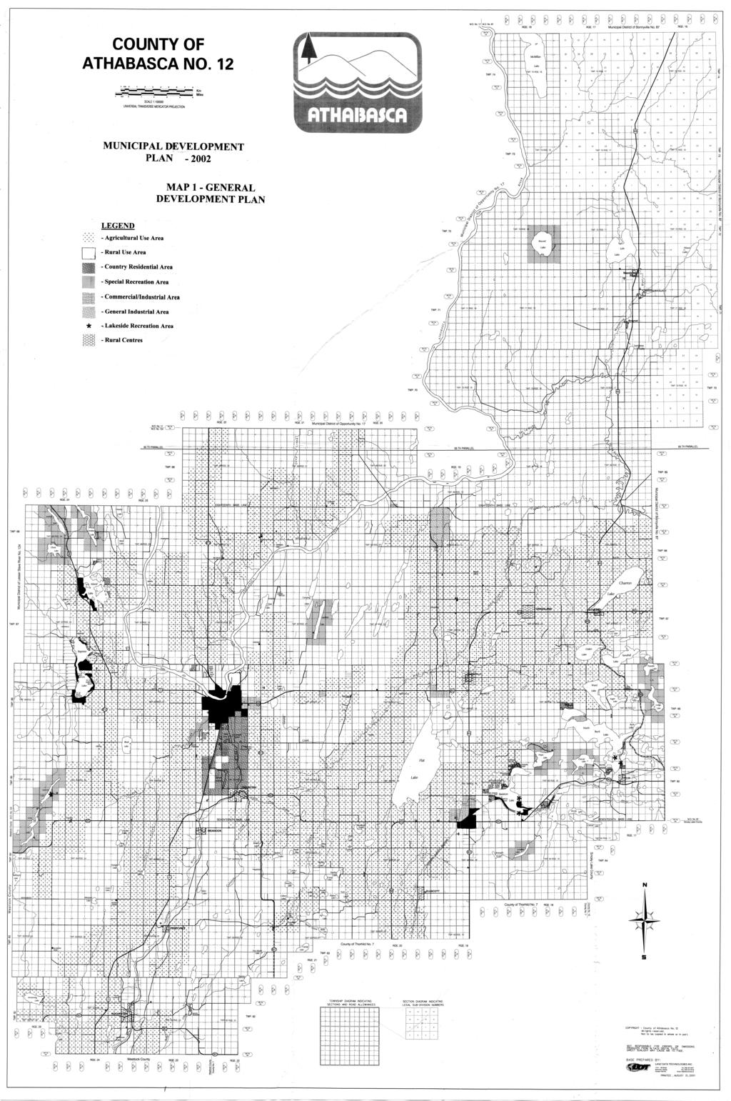
41
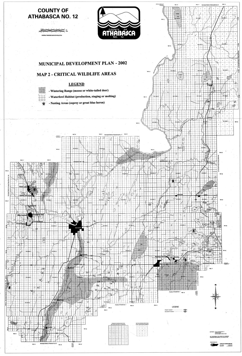
42
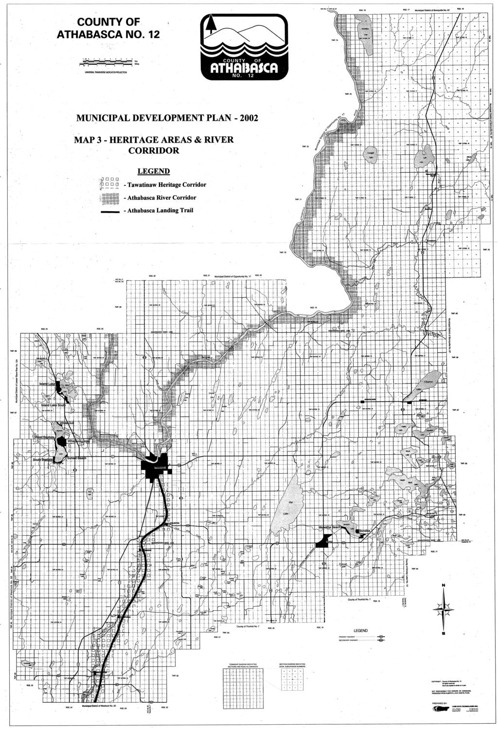
43
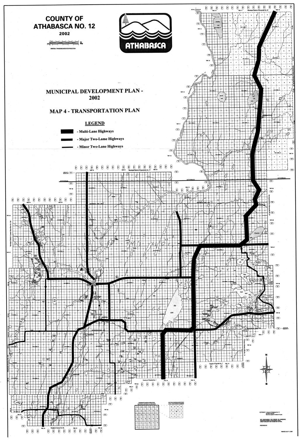
44
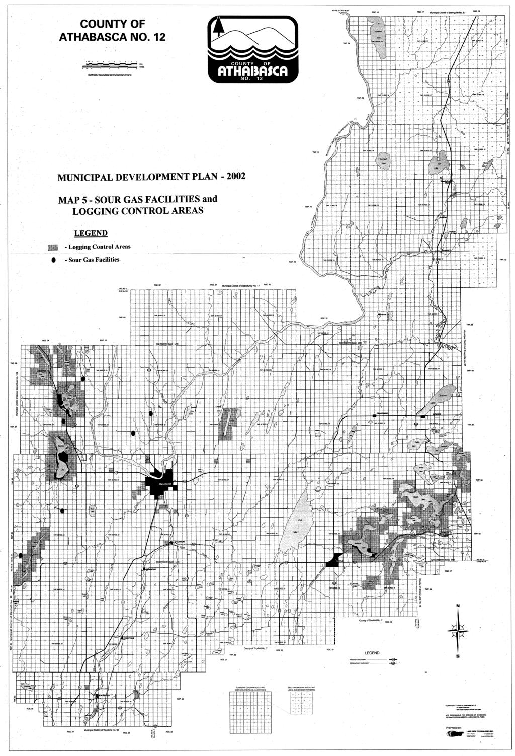
45
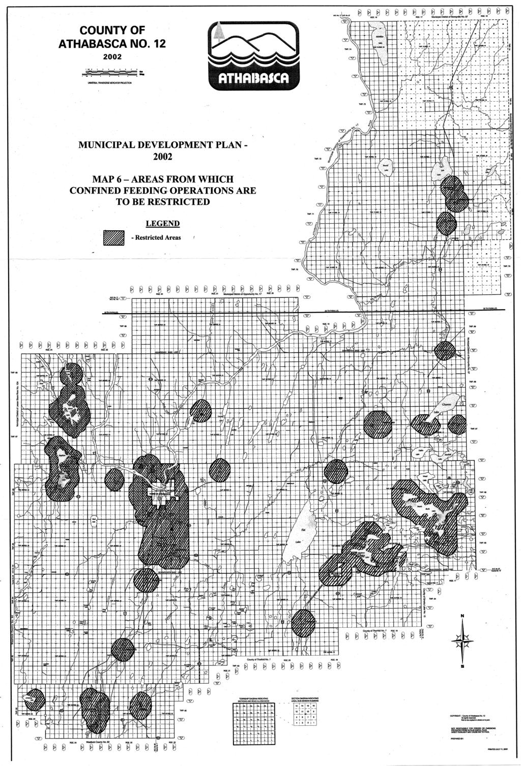
46
MUNICIPAL DISTRICT OF WAINWRIGHT MUNICIPAL DEVELOPMENT PLAN. BYLAW NO As amended to May 15, 2007
 MUNICIPAL DISTRICT OF WAINWRIGHT MUNICIPAL DEVELOPMENT PLAN BYLAW NO. 1319 As amended to May 15, 2007 May 2007 Note: This document has been prepared for convenience only. The official Municipal Development
Corman Park - Saskatoon Planning District Official Community Plan
 1 Corman Park - Saskatoon Planning District Official Community Plan CONSOLIDATED: October, 2017 2 Table of Contents Bylaw Amendments... 3 Section 1: Foundations... 4 Section 2: Future Growth Sector Objectives
RURAL GENERAL RG 1. PERMITTED USES DISCRETIONARY USES
 RURAL GENERAL RG PURPOSE: To protect the agricultural land base of the municipality while allowing nonagricultural developments which complement the area's economy. 1. PERMITTED USES DISCRETIONARY USES
Bylaw No The Corman Park Saskatoon Planning District Official Community Plan Bylaw, 2010
 Bylaw No. 8844 The Corman Park Saskatoon Planning District Official Community Plan Bylaw, 2010 Codified to Bylaw No. 9446 May 23, 2017 BYLAW NO. 8844 The Corman Park Saskatoon Planning District Official
North Qu Appelle No. 187 Bylaw Basic Planning Statement - Table of Contents
 - Table of Contents Section1 Introduction 2 Section 2 - The Rural Municipality of North Qu Appelle No. 187 3 Section 3 Municipal Goals.... 3 Section 4 Agriculture and Natural Resources.. 4 Section 5 Residential
Planning Justification Report
 Planning Justification Report, Township of Puslinch FARHI HOLDINGS CORPORATION Updated January 27, 2017 Zelinka Priamo Ltd. Page i TABLE OF CONTENTS Page No. 1.0 1.1 1.2 1.3 2.0 2.1 2.2 2.3 2.4 2.5 3.0
Rural Municipality of Kellross No Official Community Plan. Bylaw No
 Rural Municipality of Kellross No. 247 Official Community Plan Bylaw No. 2009-03 2 BYLAW NO. 2009-03 THE RURAL MUNICIPALITY OF KELLROSS NO. 247 LEROSS, SASKATCHEWAN A Bylaw of the Rural Municipality of
CCC XXX Rural Neighborhood Conservation (NC)
") CCC 33.10.XXX Rural Neighborhood Conservation (NC) Purpose: Maintain low density rural residential areas and associated uses commonly found in rural areas consistent with the local character of the distinctive
CCC 33.10.XXX Rural Neighborhood Conservation (NC) Purpose: Maintain low density rural residential areas and associated uses commonly found in rural areas consistent with the local character of the distinctive
MUNICIPAL DEVELOPMENT PLAN
 MUNICIPAL DEVELOPMENT PLAN Prepared by: The Council and Planning and Development Services Bylaw No. 1414-09 adopted August 12, 2009 Amending Bylaw - 1480-12 adopted June 12, 2013 Amending Bylaw 1529-14
Chapter 210 CONDITIONAL USES
 Chapter 210 CONDITIONAL USES 210.01 Purpose 210.02 Authorization 210.03 Process Type 210.04 Determination of Major or Minor Conditional Use Review 210.05 Approval Criteria 210.06 Conditions of Approval
RESIDENTIAL AND RECREATIONAL
 Energy, Mines & Resources Land Management Branch 320-300 Main Street Whitehorse, Yukon Y1A 2B5 667-5215 Fax 667-3214 www.emr.gov.yk.ca RESIDENTIAL AND RECREATIONAL Lot Enlargement Policy OBJECTIVE To facilitate
ARTICLE 7. SPECIFIC USE STANDARDS
 ARTICLE 7. SPECIFIC USE STANDARDS Section 7.1 Applicability The following standards apply to specified uses in all zoning districts in which such uses are allowed. Section 7.2 Accessory Apartments (A)
TOTTENHAM SECONDARY PLAN
 TOTTENHAM SECONDARY PLAN AMENDMENT NO. 11 TO THE OFFICIAL PLAN OF THE TOWN OF NEW TECUMSETH The following text and schedules to the Official Plan of the Town of New Tecumseth constitute Amendment No. 11
OFFICIAL COMMUNITY PLAN Rural Municipality of Willner No. 253
 OFFICIAL COMMUNITY PLAN Rural Municipality of Willner No. 253 Official Community Plan prepared by: Autumn Dawson MCIP, PPS S.A.R.M Planning Services Page 2 of 28 RURAL MUNICIPALITY OF WILLNER NO. 253 BYLAW
Division 5 Residential Low Density Zone: Assessment Criteria and Assessment Tables
 Division 5 Residential Low Density Zone: Assessment Criteria and Assessment Tables 4.5.1 Residential Low Density Zone The provisions in this division relate to the Residential Low Density Zone as follows
Rural Municipality of Estevan #5
 h Rural Municipality of Estevan #5 Official Community Plan Bylaw No. 4-2014 RM of Estevan No. 5 Official Community Plan A Way to the Future Bylaw No.4-2014 TABLE OF CONTENTS 1 Introduction... 4 1.1 AREA
Township of Tay Official Plan
 Township of Tay Official Plan Draft for Consultation (v.3) March 2016 Contents 1. INTRODUCTION... 1 1.1 Content, Title and Scope... 1 1.2 Basis and Purpose of this Plan... 1 1.3 Plan Structure... 2 2.
YourCounty. YourPlan.
 YourCounty. YourPlan. MUNICIPAL DEVELOPMENT PLAN BYLAW NO. 09/12 SCHEDULE A Consolidated Version November 25, 2015 Note: All persons making use of the consolidation are reminded that it has no legislative
a) Prime Agricultural Areas are designated Agricultural on the Land Use Schedules and may be used for a variety of agricultural activities.
 Prime Agricultural Areas are designated Agricultural on the Land Use Schedules and may be used for a variety of agricultural activities.") 4.0 LAND USE This Section contains the policies to guide land use development for all land within Central Elgin. The policies set out the range of permitted uses and land use policies to guide physical
4.0 LAND USE This Section contains the policies to guide land use development for all land within Central Elgin. The policies set out the range of permitted uses and land use policies to guide physical
1. Future Land Use FLU6.6.8 Land uses within the Rural Service Area portion of the Wekiva Study Area shall be limited to very low and low intensity
 1. Future Land Use FLU6.6.8 Land uses within the Rural Service Area portion of the Wekiva Study Area shall be limited to very low and low intensity uses to the greatest extent possible. Existing land uses
Section 2: Land Use Designations
 Section 2: Land Use Designations Introduction The purpose of a land use designation is to match the lands in a Plan Area to the goals, objectives and policies set out in the Official Community Plan. The
PLANNING REPORT. Lot 5, SDR Lot 6 and 7 Concession 3 Township of Normanby Municipality of West Grey County of Grey
 PLANNING REPORT Dwelling Surplus to a Farm Operation Official Plan and Zoning By-law Amendment and Consent to Sever Lot 5, SDR Lot 6 and 7 Concession 3 Township of Normanby Municipality of West Grey County
MARK TWAIN LAKE MASTER PLAN CLARENCE CANNON DAM AND MARK TWAIN LAKE MONROE CITY, MISSOURI
 MARK TWAIN LAKE MASTER PLAN CLARENCE CANNON DAM AND MARK TWAIN LAKE MONROE CITY, MISSOURI CHAPTER 4 LAND ALLOCATION, LAND CLASSIFICATION, WATER SURFACE, AND EASEMENT LANDS This Master Plan is a land use
SUMMER VILLAGE OF BIRCHCLIFF
 SUMMER VILLAGE OF BIRCHCLIFF BY-LAW 142-03 SCHEDULE A SUMMER VILLAGE OF BIRCHCLIFF CHURCH CAMP AREA STRUCTURE PLAN Prepared for Summer Village of Birchcliff On October 21, 2003 SCHEDULE A TABLE OF CONTENTS
3.1. OBJECTIVES FOR RESIDENTIAL LAND USE DESIGNATIONS GENERAL OBJECTIVES FOR ALL RESIDENTIAL DESIGNATIONS
 3. RESIDENTIAL LAND USE DESIGNATIONS INTRODUCTION The Residential land use designations provide for housing and other land uses that are integral to, and supportive of, a residential environment. Housing
PLANNING REPORT. Prepared for: John Spaleta 159 Delatre Street Woodstock Ontario N4S 6C2
 PLANNING REPORT County Official Plan Amendment and Zoning By-law Amendment to Permit a Seasonal Dwelling on an Existing Lot of Record with Access onto a Seasonally Maintained Road Parts of Lot 29, Concession
Conceptual Scheme SE W4
 December 2012 1. PURPOSE 1.1. The purpose of a Conceptual Scheme (CS) is as follows: a) To provide a framework for the subsequent subdivision and/or development of land within the Country Residential Policy
Chapter 100 Planned Unit Development in Corvallis Urban Fringe
 100.100 Scope and Purpose. Chapter 100 Planned Unit Development in Corvallis Urban Fringe (1) All applications for land divisions in the Urban Residential (UR) and Flood Plain Agriculture (FPA) zones within
ARTICLE FIVE FINAL DRAFT
 ARTICLE FIVE 021218 FINAL DRAFT Sec. 503.6 Open Space Preservation Option Open Space Preservation Option Open Space Preservation developments may be approved in the AR, R-1, R-2 and R-3 zoning districts,
CITY OF NORTH LAS VEGAS MEMORANDUM
 CITY OF NORTH LAS VEGAS MEMORANDUM TO: FROM: SUBJECT: Planning Commission Community Development and Compliance Department # 28 ) AMP-03-15; Coleman Airpark II & III - Comprehensive Plan Amendment (Public
Division 8 General Urban (T4) Zone: Assessment Criteria and Assessment Tables
 Zone: Assessment Criteria and Assessment Tables") Division 8 General Urban (T4) Zone: Assessment Criteria and Assessment Tables 15.8.1 General Urban (T4) Zone The provisions in this division relate to the General Urban (T4) Zone as follows overall outcomes
Division 8 General Urban (T4) Zone: Assessment Criteria and Assessment Tables 15.8.1 General Urban (T4) Zone The provisions in this division relate to the General Urban (T4) Zone as follows overall outcomes
Implementation TOWN OF LEON COMPREHENSIVE PLAN 9-1
 9 Implementation 9.1 Implementation Chapter Purpose and Contents This element includes a compilation of regulatory and non-regulatory measures to implement the objectives of this comprehensive plan. The
Planning Rationale in Support of an Application for Plan of Subdivision and Zoning By-Law Amendment
 Planning Rationale in Support of an Application for Plan of Subdivision and Zoning By-Law Amendment The Kilmorie Development 21 Withrow Avenue City of Ottawa Prepared by: Holzman Consultants Inc. Land
A Guide to the Municipal Planning Process in Saskatchewan
 A Guide to the Municipal Planning Process in Saskatchewan A look at the municipal development permit and the subdivision approval process in Saskatchewan May 2008 Prepared By: Community Planning Branch
City of Grande Prairie Development Services Department
 City of Grande Prairie Development Services Department COUNTRYSIDE SOUTH OUTLINE PLAN Prepared by: GPEC Consulting Ltd. #202, 10712-100th Street Grande Prairie, AB Council Resolution of August 20, 2001
4. If any perennial surface water passes through or along the property lines of the acreage, a minimum of 200 feet or frontage should be required.
 b. Provide adequate acreage for appropriate productive use of rural residential land, such as small numbers of livestock, large gardens, etc. 3. Minimum of 200 feet of frontage on an improved county or
OFFICIAL PLAN THE CORPORATION OF THE TOWNSHIP OF SEVERN
 OFFICIAL PLAN THE CORPORATION OF THE TOWNSHIP OF SEVERN CONSOLIDATION SEPTEMBER, 2010 TOWNSHIP OF SEVERN OFFICIAL PLAN OFFICE CONSOLIDATION SEPTEMBER, 2010 This is the Official Plan of the Corporation
Bylaw No , being "Official Community Plan Bylaw, 2016" Schedule "A" DRAFT
 Bylaw No. 2600-2016, being "Official Community Plan Bylaw, 2016" Schedule "A" Urban Structure + Growth Plan Urban Structure Land use and growth management are among the most powerful policy tools at the
Subdivision - Application
 Planning and Development Services, 2001 Sherwood Drive, Sherwood Park, AB T8A 3W7 Phone 780-464-8080 Fax 780-464-8109 Email: Landuse&policyplanning@strathcona.ca (Page 1 of 5) This form is to be completed
Division 4 Large Lot Residential Zone: Assessment Criteria and Assessment Tables
 Division 4 Large Lot Residential Zone: Assessment Criteria and Assessment Tables 4.4.1 Large Lot Residential Zone The provisions in this division relate to the Large Lot Residential Zone as follows overall
TOWNSHIP OF ADELAIDE METCALFE OFFICIAL PLAN. April 26, 2011 Consolidation
 TOWNSHIP OF ADELAIDE METCALFE OFFICIAL PLAN April 26, 2011 Consolidation Adopted by Township Council October 25, 2010 Approved with Modifications by the County of Middlesex April 26, 2011 This Document
Sample Interim Development Control Bylaw For a Rural Municipality
 Sample Interim Development Control Bylaw For a Rural Municipality Note: This document provides a sample of an Interim Development Control (IDC) Bylaw for use by a Rural Municipality. This sample may be
Draft Model Access Management Overlay Ordinance
 Draft Model Access Management Overlay Ordinance This model was developed using the City of Hutchinson and the Trunk Highway 7 corridor. The basic provisions of this model may be adopted by any jurisdiction
CITY OF FORT COLLINS NATURAL AREAS AND CONSERVED LANDS EASEMENT POLICY
 CITY OF FORT COLLINS NATURAL AREAS AND CONSERVED LANDS EASEMENT POLICY Adopted January 3, 2012 PURPOSE: The purpose of the policy statement is to clarify the policies and procedures of the City of Fort
8Land Use. The Land Use Plan consists of the following elements:
 8Land Use 1. Introduction The Land Use Plan consists of the following elements: 1. Introduction 2. Existing Conditions 3. Opportunities for Redevelopment 4. Land Use Projections 5. Future Land Use Policies
Draft Zoning Changes for the 2nd Planning Board Public Hearing, January 22, 2018.
 Draft Zoning Changes for the 2nd Planning Board Public Hearing, January 22, 2018. No changes were made at the 1st Public Hearing. Proposed wording for the 1 st Public Hearing in red, eliminated text in
2030 General Plan. December 6, 7 pm
 2030 General Plan GPAC Meeting #9 GPAC Meeting #9 December 6, 7 pm City Council Input on Working Draft Land Use Map Council discussed GPAC & PC versions of the working draft land use map 11/28 Council
Mohave County General Plan
 63 64 65 66 67 68 69 70 71 The Land Use Diagram is not the County's zoning map. 13 It is a guide to future land use patterns. Zoning and area plan designations may be more restrictive than the land use
P. H. Robinson Consulting Urban Planning, Consulting and Project Management
 PLANNING RATIONALE REPORT FOR SITE PLAN AND DRAFT PLAN OF CONDOMINIUM APPLICATIONS 73-75 HARVEY STREET CITY OF OTTAWA PREPARED BY: P H ROBINSON CONSULTING AUGUST 2012 1 This report has been prepared on
COMMUNITY PLAN PLANNING & URBAN DESIGN
 WHALE COVE COMMUNITY PLAN PLANNING & URBAN DESIGN WHALE COVE COMMUNITY PLAN Prepared for: Department of Community and Government Services Government of Nunavut Rankin Inlet, Nunavut Prepared by: FoTenn
Public Facilities and Finance Element
 This Element of the General Plan addresses the following public facilities issues: Water Service, including both potable (drinkable) and non-potable water delivery. Sewer Service, and Financing and construction
891941, , : COMPREHENSIVE PLAN AMENDMENT, COMMUNITY PLAN AMENDMENT, AND AREA-WIDE MAP AMENDMENT
 Application Nos. 891941, 891909, 891940: COMPREHENSIVE PLAN AMENDMENT, COMMUNITY PLAN AMENDMENT, AND AREA-WIDE MAP AMENDMENT Amendments to designate five parcels as Rural Industrial Center in the Alderton
New Cingular Wireless Telecommunication Tower at County Road 48, Milner Conditional Use Permit
 New Cingular Wireless Telecommunication Tower at 39415 County Road 48, Milner ACTIVITY #: Conditional Use Permit PP2012-023 HEARING DATES: Planning Commission (PC): August 16, 2012 at 6:00pm PETITIONER:
Letter of Intent May 2017 (Revised November 2017)
") THE BEACH AT WOODMOOR LETTER OF INTENT MAY 2017 (REVISED NOVEMBER 2017) OWNER/APPLICANT: CONSULTANT: Lake Woodmoor Holdings LLC N.E.S. Inc. 1755 Telstar Drive, Suite 211 619 North Cascade Avenue Colorado
THE BEACH AT WOODMOOR LETTER OF INTENT MAY 2017 (REVISED NOVEMBER 2017) OWNER/APPLICANT: CONSULTANT: Lake Woodmoor Holdings LLC N.E.S. Inc. 1755 Telstar Drive, Suite 211 619 North Cascade Avenue Colorado
SUBDIVISION AND DEVELOPMENT REGULATION
 Province of Alberta MUNICIPAL GOVERNMENT ACT SUBDIVISION AND DEVELOPMENT REGULATION Alberta Regulation 43/2002 With amendments up to and including Alberta Regulation 188/2017 Office Consolidation Published
CYPRESS COUNTY MUNICIPAL DEVELOPMENT PLAN
 CYPRESS COUNTY MUNICIPAL DEVELOPMENT PLAN Bylaw 2015/26 Adopted July, 2015 Cypress County Municipal Development Plan Adopted July 2015 PREFACE This document is a statement of goals, objectives and policies
Torch Lake Township Antrim County, Michigan
 Torch Lake Township Antrim County, Michigan Farmland and Open Space Development Rights Ordinance Ordinance No. 04-01 Effective September 3, 2004 AN ORDINANCE creating a farmland and open space protection
Town of Niagara-on-the-Lake Official Plan Review. Discussion Paper: Second Residential Units. Prepared for: The Town of Niagara-on-the-Lake
 Town of Niagara-on-the-Lake Official Plan Review Discussion Paper: Second Residential Units Prepared for: The Town of Niagara-on-the-Lake October 15, 2015 PLANSCAPE Inc. Building Community through Planning
BY-LAW NO OF THE COUNTY OF GRANDE PRAIRIE NO. 1
 BY-LAW NO. 2702 OF THE COUNTY OF GRANDE PRAIRIE NO. 1 A By-law of the County of Grande Prairie, in the Province of Alberta to impose and collect off-site levies for new or expanded roads required for or
ACCESSORY DWELLING UNITS
 ACCESSORY DWELLING UNITS LAND USE BYLAW C-4841-97 ACCESSORY DWELLING UNIT (ADU): means a subordinate dwelling unit attached to, created within or detached from the principal dwelling, single detached,
Chapter SPECIAL USE ZONING DISTRICTS
 Chapter 20.20 Sections: 20.20.010 Urban Transition (U-T) Zoning District 20.20.020 Planned Development (P-D) Zoning Districts 20.20.010 Urban Transition (U-T) Zoning District A. Purpose. The purpose of
ALC Bylaw Reviews. A Guide for Local Governments
 2018 ALC Bylaw Reviews A Guide for Local Governments ALC Bylaw Reviews A Guide for Local Governments This version published on: August 14, 2018 Published by: Agricultural Land Commission #201-4940 Canada
MUNICIPAL DISTRICT OF ROCKY VIEW NO. 44 ELBOW VALLEY WEST DIRECT CONTROL DISTRICT BYLAW C
 This document has been consolidated for convenience only. A current listing of any and all amendments can be obtained from the Municpal District Office Bylaw No. Date of Approval Amendment Type Bylaw C-6042-2005
Division 6 Residential Medium Density Zone: Assessment Criteria and Assessment Tables
 Division 6 Residential Medium Density Zone: Assessment Criteria and Assessment Tables 4.6.1 Residential Medium Density Zone The provisions in this division relate to the Residential Medium Density Zone
Camrose County Municipal Development Plan Bylaw 1372
 Camrose County Municipal Development Plan Bylaw 1372 Prepared by: #200, 10576 113 Street, Edmonton, AB T5H 3H5 Tel: (780) 423-4123 Fax: (780) 426-0659 Contact: Shree Shinde, Project Manager Date: April
Land Use. Existing Land Use
 8 Land Use 8.1 Land Use Chapter Purpose and Contents This element includes a brief summary of existing land use conditions and trends followed by a series of goals, objectives, and recommendations to guide
TOWNSHIP OF WILMOT OFFICIAL PLAN November 2006 Consolidation
 TOWNSHIP OF WILMOT OFFICIAL PLAN November 2006 Consolidation Township of Wilmot Development Services 60 Snyder s Road West Baden, ON N3A 1A1 p. 519.634.8444 f. 519.634.5044 www.wilmot.ca info@wilmot.ca
ARTICLE 2 ZONING DISTRICTS AND MAPS
 ARTICLE 2 ZONING DISTRICTS AND MAPS SECTION 2.100 PURPOSE OF DISTRICTS Section 2.101. For the purpose of this Ordinance, Billings Township is hereby divided into districts as follows: DISTRICT NAME SYMBOL
BYLAW NO THE RURAL MUNICIPALITY OF KELLROSS NO. 247 LEROSS, SASKATCHEWAN
 BYLAW NO. 2009-02 THE RURAL MUNICIPALITY OF KELLROSS NO. 247 LEROSS, SASKATCHEWAN A Bylaw of the Rural Municipality of Kellross No. 247 to adopt a Zoning Bylaw. Whereas the Council of the Rural Municipality
Division 16 Bundamba Racecourse Stables Area Zone: Assessment Criteria and Assessment Tables
 Division 16 Bundamba Racecourse Stables Area Zone: Assessment Criteria and Assessment Tables 4.16.1 Bundamba Racecourse Stables Area Zone The provisions in this division relate to the Bundamba Racecourse
STAFF REPORT. Permit Number: Porter. Kitsap County Board of Commissioners; Kitsap County Planning Commission
 STAFF REPORT Permit Number: 15 00461 Porter DATE: November 9, 2015 TO: FROM: Kitsap County Board of Commissioners; Kitsap County Planning Commission Katrina Knutson, AICP, Senior Planner, DCD and Jeff
ATTACHMENT A: FINDINGS
 ATTACHMENT A: FINDINGS 1.0 CEQA FINDINGS 1.1 ENVIRONMENTAL IMPACT REPORTS Findings pursuant to public resources code Section 21081 and the California Environmental Quality Act Guidelines Sections 15090
Land Use Planning Analysis. Phase 2 Drayton Valley Annexation Proposal
 Land Use Planning Analysis Phase 2 Drayton Valley Annexation Proposal Prepared for Town of Drayton Valley Prepared by Mackenzie Associates Consulting Group Limited March, 2011 TABLE OF CONTENTS 1.0 INTRODUCTION...
Chapter Four Growth in the Next 20 years
 Chapter Four Growth in the Next 20 years Although the city of Fargo has pushed to the limits planned for in the original growth plan, the city still has substantial amounts of land available for growth.
AMENDMENT NUMBER 38 TO THE OFFICIAL PLAN OF THE TOWNSHIP OF WEST LINCOLN (COMPLIANCE)
") AMENDMENT NUMBER 38 TO THE OFFICIAL PLAN OF THE TOWNSHIP OF WEST LINCOLN (COMPLIANCE) 2013 AMENDMENT NUMBER 38 TO THE OFFICIAL PLAN OF THE TOWNSHIP OF WEST LINCOLN PART 1 - THE PREAMBLE 1.1 TITLE This
AMENDMENT NUMBER 38 TO THE OFFICIAL PLAN OF THE TOWNSHIP OF WEST LINCOLN (COMPLIANCE) 2013 AMENDMENT NUMBER 38 TO THE OFFICIAL PLAN OF THE TOWNSHIP OF WEST LINCOLN PART 1 - THE PREAMBLE 1.1 TITLE This
Central Pennsylvania Conservancy Project Selection Criteria Form
 Central Pennsylvania Conservancy Project Selection Criteria Form The following criteria guide the actions of the Central Pennsylvania Conservancy s Land Protection Committee and Board of Directors in selecting
RURAL MUNICIPALITY OF McKILLOP NO. 220 OFFICIAL COMMUNITY PLAN BYLAW NO. 233/11
 RURAL MUNICIPALITY OF McKILLOP NO. 220 OFFICIAL COMMUNITY PLAN BYLAW NO. 233/11 0 TABLE OF CONTENTS PAGE 1 INTRODUCTION (Purpose and Effect)...2 2 DEVELOPMENT ISSUES...3 3 OCP PREMISE, GOAL and OBJECTIVES...6
This is a conditional use permit request to establish a commercial wind energy conversion system.
 Public Works 600 Scott Boulevard South Hutchinson, Kansas 67505 620-694-2976 Road & Bridge Planning & Zoning Noxious Weed Utilities Date: March 28, 2019 To: From: Reno County Planning Commission Russ Ewy,
19 Implementation Monitoring Development Applications Finance
 19 Implementation The purpose of this chapter is to establish how the policies of Mississauga Official Plan are implemented and translated into programs. This Plan will be implemented by the powers conferred
ALBERTA BEACH REGIONAL INTER-MUNICIPAL DEVELOPMENT PLAN
 ALBERTA BEACH REGIONAL INTER-MUNICIPAL DEVELOPMENT PLAN AUGUST 1st, 2008 TABLE OF CONTENTS PART ONE: PREAMBLE...1 1.1) INTRODUCTION... 1 1.2) PLAN PARTNERS... 1 1.3) LOCATION & PLAN AREA... 2 1.4) RELEVANT
Residential Project Convenience Facilities
 Standards for Specific Land Uses 35.42.220 E. Findings. The review authority shall approve a Land Use Permit in compliance with Subsection 35.82.110.E (Findings required for approval) or a Conditional
Understanding the Conditional Use Process
 Understanding the Conditional Use Process The purpose of this document is to explain the process of applying for and obtaining a conditional use permit in the rural unincorporated towns of Dane County.
Hawkesbury Local Environmental Plan 2012
 New South Wales Hawkesbury Environmental Plan 2012 under the Environmental Planning and Assessment Act 1979 I, the Minister for Planning and Infrastructure, pursuant to section 33A of the Environmental
A. Preserve natural resources as identified in the Comprehensive Plan.
 1370.08 Conservation Residential Overlay District. Subd. 1 Findings. The City finds that the lands and resources within the Conservation Residential Overlay District are a unique and valuable resource
19.12 CLUSTER RESIDENTIAL DISTRICT
 Chapter 19.12 CLUSTER RESIDENTIAL DISTRICT (Adopted 12/22/2003; Ordinance #0061970). Amended 7/3/17, Ordinance #079100. Section 19.12.010 - Declaration of Intent. The Cluster Residential District provides
19 Implementation Jurisdiction Monitoring Development Applications Finance
 19 Implementation The purpose of this chapter is to establish how the policies of Mississauga Official Plan are implemented and translated into programs. This Plan will be implemented by the powers conferred
Prt. NE W5. Prepared for: Municipal District of Foothills #31. Prepared by:
 Prt. NE 22-22-3-W5 Prepared for: Municipal District of Foothills #31 Prepared by: Bowwood Land Services Inc. R.R. 1, Dewinton, Alberta T0L 0X0 Tel: 403-995-2225 Fax: 403-938-4787 " OFFICIAL COPY " ADOPTED
CHAPTER Committee Substitute for Committee Substitute for Senate Bill No. 2188
 CHAPTER 2004-372 Committee Substitute for Committee Substitute for Senate Bill No. 2188 An act relating to land development; amending s. 197.502, F.S.; providing for the issuance of an escheatment tax
Special Use Permit - Planned Unit Development Checklist. Property Address:
 Special Use Permit - Planned Unit Development Checklist Special Use Permit Number. Parcel Code/s #28-11- - - Property Address: Applicant: ARTICLE VIII Ordinance Reference - Section 8.1.2 Permit Procedures:
GOVERNMENT CODE SECTION GOVERNMENT CODE SECTION 65302
 GOVERNMENT CODE SECTION 65300 65300. Each planning agency shall prepare and the legislative body of each county and city shall adopt a comprehensive, long-term general plan for the physical development
Planning Justification Report
 Planning Justification Report 101 Kozlov Street, Barrie, Ont. Destaron Property Management Ltd. November 2015 Revised February 2017 TABLE OF CONTENTS Page 1.0 INTRODUCTION... 1 2.0 DESCRIPTION OF SUBJECT
OFFICIAL COMMUNITY PLAN
 RURAL MUNICIPALITY O F R U DY NO. 284 OFFICIAL COMMUNITY PLAN S EPTEMBER 2014 RURAL MUNICIPALITY OF RUDY No. 284 OFFICIAL COMMUNITY PLAN Prepared for: THE R.M. OF RUDY NO. 284 Prepared by: CROSBY HANNA
STAFF REPORT. Financial Impact Statement There are no immediate financial impacts associated with the adoption of this report.
 STAFF REPORT Planning and Development Department Subject: Cottage Country Unsubstantial Amendment to Development Agreement To: CAO for Planning Advisory Committee, December 13, 2016 Date Prepared: December
PART SIXTEEN - SUBDIVISION AND DEVELOPMENT
 16.1 24 July 2010 PART SIXTEEN - SUBDIVISION AND DEVELOPMENT 1. INTRODUCTION Council has the statutory responsibility to control subdivision of land and the effects of land use throughout the District.
For Vintages of Four Mile Creek Town of Niagara on the Lake, Ontario
 Planning Impact Analysis For Vintages of Four Mile Creek Town of Niagara on the Lake, Ontario Prepared by: Upper Canada Consultants 261 Martindale Road Unit #1 St. Catharines, Ontario L2W 1A1 Prepared
Lane Code CHAPTER 10 CONTENTS
 Lane Code CHAPTER 10 CONTENTS AGRICULTURAL LAND DISTRICT (A-2) 10.107-05 Purpose. 10.107-10 Uses. 10.107-12 Review Process. 10.107-20 Land Division Requirements. 10.107-30 Land s. 10.107-40 Setback Requirements.
Appendix A: Guide to Zoning Categories Prince George's County, Maryland
 Appendix A: Guide to Zoning Categories Prince George's County, Maryland RESIDENTIAL ZONES 1 Updated November 2010 R-O-S: Reserved Open Space - Provides for permanent maintenance of certain areas of land
FINAL DRAFT 12/1/16, Rev. to 7/18/17
 FINAL DRAFT 12/1/16, Rev. to 7/18/17 (As Adopted 8/8/17 Effective 9/1/17) SHELTON PLANNING AND ZONING COMMISSION Proposed Amendments to Zoning Regulations I. Amend Section 23 PERMITTED USES by inserting
Wapiti Ridge Estates Area Structure Plan SE W5M. December Prepared For:
 SE 13-20-1 W5M December 2000 Prepared For: 393494 Alberta Limited, and The Municipal District of Foothills No. 31 Prepared By: Kristi Beunder Professional Planning Services Calgary, Alberta Ph: 201-3309
Article XII. R-1 Agricultural-Low Density Residential District
 Article XII R-1 Agricultural-Low Density Residential District Section 1200. Declaration of Legislative Intent In expansion of the Declaration of Legislative Intent and Statement of Community Development