GADSDEN COUNTY COMPREHENSIVE PLAN
|
|
|
- Sharyl Carson
- 5 years ago
- Views:
Transcription
1 GADSDEN COUNTY COMPREHENSIVE PLAN GADSDEN COUNTY BOARD OF COUNTY COMMISSIONERS Eric Hinson, District 1 Anthony O. Viegbesie, Phd., District 2 Gene Morgan, District 3 Brenda A. Holt, District 4 Sherrie Taylor, District 5 Robert Presnell, County Administrator David Weiss, County Attorney GADSDEN COUNTY PLANNING COMMISSION William Chukes, District 1 John Youmans, District 2 Gerald McSwain, District 2 Frank Rowan, District 3 Libby Henderson, District 3 Ed Dixon, District 4 Dr. Gail Bridges-Bright, District 4 Lori Bouie, District 5 Regina M. Davis, At-Large Roger Milton, School Board Representative 1B East Jefferson Street Post Office Box 1799 Quincy, Florida (850) TABLE OF CONTENTS
2 EXECUTIVE SUMMARY CITIZEN PARTICIPATION PLAN FUTURE LAND USE ELEMENT TRAFFIC CIRCULATION ELEMENT HOUSING ELEMENT INFRASTRUCTURE ELEMENT CONSERVATION ELEMENT RECREATION AND OPEN SPACE ELEMENT INTERGOVERNMENTAL COORDINATION ELEMENT CAPITAL IMPROVEMENTS ELEMENT CONCURRENCY MANAGEMENT SYSTEM iii iv FLU-1 TCE-1 HOU-1 INF-1 CON-1 REC-1 ICE-1 CIE-1 CMS-1 LIST OF MAPS Number EXHIBIT-1 EXISTING LAND-USE MAP EXHIBIT-2 FUTURE LAND-USE MAP EXHIBIT-3 EXISTING TRANSPORTATION MAP EXHIBIT-4 FUTURE TRANSPORTATION MAP EXHIBIT-4-a PROPOSED BY-PASS EXHIBIT-5 AIRPORTS AND RAIL LINES EXHIBIT-6 SCHOOLS EXHIBIT-7 CENTRAL WATER AND SEWER SYSTEMS EXHIBIT-8 DEVELOPED AREAS EXHIBIT-9 GENERAL SOIL ASSOCIATIONS EXHIBIT-10 SOIL LIMITATIONS ON DEVELOPMENT EXHIBIT-11 MAJOR WATERSHEDS EXHIBIT-12 FEMA FLOOD ZONES EXHIBIT-13 WETLANDS EXHIBIT-14 PROPOSED CONSERVATION LANDS EXHIBIT-15 HISTORICAL STRUCTURES AND SITES EXHIBIT-16 GEOLOGICAL FORMATIONS AND MINERAL RESOURCES EXHIBIT-17 RECREATIONAL SERVICE AREAS EXHIBIT-18 HAZARDOUS MATERIAL LOCATIONS
3 FUTURE LAND USE ELEMENT The purpose of the Future Land Use Element and accompanying Future Land Use Map is to designate the future general distribution, location, and extent of the use of land within the unincorporated areas of Gadsden County. GOAL 1A: PROVIDE A SYSTEM FOR ORDERLY GROWTH AND DEVELOPMENT Objective 1.1: Provide for certainty in growth and development through the adoption of the Future Land Use Map and Future Land Use categories. Policy 1.1.1: Gadsden County shall regulate the use of land through the adopted land use categories as follows. The Future Land Use Map (Exhibit 1) shall be used to determine the location and extent of development within Gadsden County. A. Historical 1) Purpose and Intent This category is intended to provide for preservation and protection of historically significant areas and structures within Gadsden County. 2) Designation Criteria Sites or districts that have been listed on the National Register of Historic Places, or have been deemed historically significant by ordinance by the Board of County Commissioners. 3) Density As determined to be historically existing. 4) Intensity As determined to be historically existing. 5) Impervious Surface Area What has been historically developed on the site or the average of the historic development within a quarter mile diameter of the site except the centralized utilities uses are exempted from impervious surface requirements? 6) Allowable Uses Centralized utilities; houses of worship; commercial; agricultural; educational facilities; residential. 7) Development Restrictions Anything that historically alters the site or structure, other than routine maintenance or what is necessary to eradicate a public hazard, is strictly prohibited. B. Conservation 1) Purpose and Intent This category is intended to provide areas for the conservation and protection of environmentally sensitive areas, land and water resources, and critical habitats. 2) Designation Criteria Lands which are being managed as a conservation resource, such as local, state, or federal lands. Environmentally sensitive resources including, but not limited to, steepheads along the Apalachicola River, wetlands, flood zones, and dedicated conservation easements. Page 1 of 16
4 3) Density No more than one dwelling unit per forty (40) acres. 4) Intensity Floor area ratio is ) Impervious Surface Area No more than 0.05 lot coverage. Impervious Surface is limited to that which supports passive activities such as the development of a boardwalk or nature observation point, except the centralized utilities uses are exempted from impervious surface requirements. Parking is limited to pervious surfaces with exceptions for what is required for conformity with the Americans with Disabilities Act. 6) Allowable Uses Those uses which are strictly passive in nature, such as walking trail, observation points, open space, and boardwalks. Centralized utilities and roadways are allowable uses only when necessary to connect existing or proposed developments located outside of the Conservation category; residential. 7) Development Restrictions A fifty (50) foot, undisturbed, vegetative buffer shall be required between any development and the FDEP jurisdictional wetland boundary; and a seventy-five (75) foot undisturbed, vegetative buffer shall be required between development and any streams, creeks, rivers, or waterbodies. C. Silviculture 1) Purpose and Intent The intent of this category is to provide areas for active Silvicultural and agricultural use. 2) Designation Criteria Lands which are dedicated to the ongoing production of timber. 3) Density No more than one dwelling unit per eighty (80) acres. 4) Impervious Surface Area - No more than 0.10 per parcel, except the centralized utilities uses are exempted from impervious surface requirements. 5) Allowable Uses Timber harvesting, timber production, timber production facilities; centralized utilities; work camps; residential. 6) Development Restrictions Operations shall be required to follow Best Management Practices for Silviculture (2008) of the Florida Department of Agriculture and Consumer Service, Florida Forest Service. D. Recreation 1) Purpose and Intent This category is intended to provide opportunities and sites for public and private recreation. 2) Designation Criteria Lands must be resource- or facility-oriented and used for permanent recreational space. 3) Density None allowed, except for facility management quarters. 4) Intensity The floor area ratio shall not exceed 0.20, except the centralized utilities and package plants are exempted from impervious surface requirements. 5) Impervious Surface Area No more than 0.40 lot coverage. Page 2 of 16
5 6) Allowable Uses Uses specifically intended for recreational purposes; centralized utilities. E. Public/Institutional 1) Purpose and Intent The intent of this category is to provide areas for civic and community uses. 2) Designation Criteria Uses or lands which are owned by a governmental entity for the purpose to provide services to the citizenry; houses of worship; institutions; public or privately owned medical care facilities. 3) Density Residential uses shall be limited to those incidental to the primary use such as a caretaker s quarters or a single parsonage. 4) Intensity The floor area ratio shall not exceed ) Impervious Surface Area No more than 0.75 lot coverage, except the centralized utilities uses are exempted from impervious surface requirements. 6) Allowable Uses Educational facilities; museums; galleries; houses of worship; institutions; other civic and governmental uses; residential as an accessory use; centralized utilities and package plants; cemeteries; public or non-commercial private recreational uses. 7) Development Restrictions Uses associated with incarceration shall be approved by the County Commission during a public hearing to ensure appropriate notification of adjacent property owners, and compatibility with surrounding uses. F. Agriculture-1 1) Purpose and Intent The intent of this category is to provide areas for agricultural activities. 2) Designation Criteria Agriculture uses and residences associated with such uses. 3) Density No more than one dwelling unit per five (5) acres 4) Impervious Surface Area No more than 0.10 lot coverage except the centralized utilities uses are exempted from impervious surface requirements. 5) Allowable Uses Agriculture related uses; Silviculture; residential; houses of worship; cemeteries; recreational activities; commercial activities associated with the primary agricultural use; home occupations; centralized utilities and package plants. 6) Development Restrictions - The Family Exception shall be allowed as long as the parent parcel can retain a minimum of three (3) acres, and the granted parcel has a minimum of three (3) acres, and the other requirements of the Land Development Code are met; minimum lot size for the non-residential uses that are also not used for centralized utilities described in this part shall be three (3) acres. Page 3 of 16
6 G. Agriculture-2 Development within the Agriculture-2 category shall be the same parameters as the Agriculture-1 land use category in F. above, except that: 1) Density - No more than one dwelling unit per ten (10) acres; and, 2) Solar power generation facilities are an allowable use on parcels ten (10) acres or greater in size. H. Agriculture-3 Development within the Agriculture-3 category shall be the same parameters as the Agriculture-1 category in F. above, except that: 1) Density - No more than one dwelling unit per twenty (20) acres; and, 2) Solar power generation facilities are an allowable use on parcels twenty (20) acres or greater in size. I. Rural Residential 1) Purpose and Intent The intent of this category is to provide areas for residential developments consisting of primarily single-family dwelling units on individual lots. 2) Designation Criteria Areas used primarily as single-family residential housing units. 3) Density No more than one dwelling unit per net acre where central water and sewer is not available; no more than one dwelling unit per net half acre where central water and sewer or a wastewater package plant system is available. Net acreage is determined by removing wetlands, perennial waterbodies, floodways, and existing easements which are not developable to calculate the net density. 4) Impervious Surface Area No more than 0.50 lot coverage, except the centralized utilities uses are exempted from impervious surface requirements. 5) Allowable Uses Residential single-family and multi-family; public and private schools grades K-12; centralized utilities and package plants; houses of worship; public or non-commercial private recreation; home occupations. 6) Development Restrictions Schools must be located on a collector or arterial roadway. Any amendment to a Rural Residential category must be contiguous to existing Rural Residential lands designated as such on the Future Land Use Map. J. Neighborhood Commercial 1) Purpose and Intent The intent of this category is to provide areas for limited commercial activities that serve to meet daily needs. Page 4 of 16
7 2) Designation Criteria Areas within the county that are located to serve vicinity residents with daily needs. 3) Density None 4) Intensity The floor area ratio shall not exceed ) Impervious Surface Area No more than.75 lot coverage, except the centralized utilities uses are exempted from impervious surface requirements. 6) Allowable Uses Convenience commercial uses; retail sales and services; child care facilities; restaurants; professional office and services; centralized utilities and package plants; private recreation; houses of worship. 7) Development Restrictions No outdoor storage of equipment is allowed; the sale of alcohol may be permitted only as an accessory use to a commercial retail use, or for consumption in a restaurant use; must be located along a collector or arterial roadway, as designated on the Functional Classification of Roadways Map in the Transportation Element; minimum lot size is one (1) acre with a maximum lot size of three (3) acres. Commercial uses are limited to under five thousand (5,000) square feet in size of heated and cooled space. K. Commercial 1) Purpose and Intent The intent of this category is to provide areas for general commercial activities. 2) Designation Criteria Areas along collector or arterial roadways, as designated on the Functional Classification of Roadways Map in the Transportation Element. 3) Density 0.00 except for mobile home parks which shall be limited to a maximum of five units per acre. 4) Intensity The floor area ratio shall not exceed ) Impervious Surface Area No more than 0.75 lot coverage, except the centralized utilities uses are exempted from impervious surface requirements. 6) Allowable Uses All uses allowable in the Neighborhood Commercial category; museums; galleries; other civic activities; lodging establishments; private clubs; entertainment; wholesale sales; shopping centers; office complexes; light manufacturing uses that are restricted to in-plant assembly; mobile home parks, recreational vehicle parks. 7) Development Restrictions The storage of outdoor equipment must be screened from the public right-of-way. Junk yards or construction and debris landfills are prohibited in this category. Mobile home parks shall be on a centralized water and waste water system to receive a density of greater than one dwelling unit per acre. L. Urban 1) Purpose and Intent The intent of this category is to provide areas for a mixture of uses, a diverse choice of housing types, and higher densities and Page 5 of 16
8 intensities in areas that have central water and sewer services available. The mixture of uses within the same development shall be encouraged. 2) Designation Criteria Areas adjacent or contiguous to city limits. 3) Density No more than five (5) dwelling units to the acre where central water and sewer services are available. No more than two (2) dwelling units to the acre where only central sanitary sewer service is available. Where neither central water nor sewer services are available, no more than one (1) dwelling unit to the acre. 4) Intensity The floor area ratio shall not exceed 1.5 for non-residential uses. 5) Impervious Surface Area No more than 0.75, except the centralized utilities uses are exempted from impervious surface requirements. 6) Allowable Uses All uses allowed within the Recreation, Public/Institutional, Rural Residential, Neighborhood Commercial and Commercial land use categories. 7) Development Restrictions Developments must be located on paved local, collector, or arterial roads as designated on the Functional Classification of Roadways Map in the Transportation Element. M. Light Industrial 1) Purpose and Intent The intent of this category is to provide areas for limited industrial activities. 2) Density None 3) Intensity The floor area ratio shall not exceed ) Impervious Surface Area No more than 0.80 lot coverage, except the centralized utilities uses are exempted from impervious surface requirements. 5) Allowable Uses Manufacturing; research and development; distribution; warehousing; rail-related activities; centralized utilities and package plants; construction industry; other similar uses. 6) Development Restrictions Industrial performance standards that pertain to noise, smoke, glare and other compatibility issues shall be set forth in the Land Development Code. N. Heavy Industrial 1) Purpose and Intent The intent of this category is to provide areas for industrial activities. 2) Density None. 3) Intensity The floor area ratio shall not exceed ) Impervious Surface Area No more than 0.90 lot coverage, except the centralized utilities uses are exempted from impervious surface requirements. 5) Allowable Uses All uses set forth in the Light Industrial category; uses associated with the open storage of materials and equipment; bulk storage and transfer stations; all uses deemed more intense in use than those associated with the Light Industrial category. Page 6 of 16
9 6) Development Restrictions The storage, distribution, or transfer of hazardous wastes are subject to permitting by the Florida Department of Environmental Protection Hazardous Waste regulations. O. Mining 1) Purpose and Intent The intent of this category is to provide areas for mining activities, to provide areas for mining activities in the future, and to preserve a valuable economic resource for Gadsden County. 2) Density None. 3) Allowable Uses Surface mining; borrow pits; rock quarries; other extraction activities; mining reclamation activities; associated office uses as an accessory to the primary use; agricultural and Silvicultural uses; centralized utilities. 4) Development Restrictions As pursuant to the Florida Department of Environmental Protection s Mining, Mitigation and Delineation permitting. Mining extraction activities shall be conducted in a manner which will mitigate adverse effects to water quality, fish, wildlife, and adjacent land uses. Mining activities shall not interrupt existing residential uses by creating inconsistent and conflicting land uses. Mining uses are not subject to County development order approval provided the mining operation has received approval by applicable federal and state agencies prior to operation and the operation is on land designated as Mining on the Future Land Use Map. In addition, any mining operation shall comply with any relevant policies located within the Conservation Element. Policy 1.1.2: Future Land Use category boundaries shall follow parcel boundary lines, as depicted on the Property Appraiser s parcel map(s). If a parcel boundary has been amended, and the Future Land Use category no longer follows the parcel boundary, the County s Geographic Information System (GIS) shall be utilized to determine boundaries of the Future Land Use category until such time as the boundary is amended to reflect the current Property Appraiser s parcel map(s). Policy 1.1.3: The County shall adopt an Urban Service Boundary or Boundaries to identify areas where urban development is appropriate due to the close proximity of urban services which include, but are not limited to, central water and sewer facilities, stormwater facilities, and a network (local, collector, and arterial roadways) of paved roads. Policy 1.1.4: The Urban Service Boundary or Boundaries shall not include lands designated as Agriculture, Silviculture, or Mining on the adopted Future Land Use Map. Policy 1.1.5: With the exception of the Rural Residential designation, as described in Policy 1.1.1(I)(3), all densities shall be calculated based on the gross acreage of a parcel. Page 7 of 16
10 Objective 1.2: The County shall implement regulations, programs, and processes that protect the character of the County and promote economic vitality. Policy 1.2.1: The County shall allow the provision of small scale retail and service establishments which are developed to serve the convenience needs of the rural population by supporting Neighborhood Commercial uses through the designation of such on the Future Land Use Map. Policy 1.2.2: To discourage urban sprawl and the expansion of the built environment away from urbanized areas and the provision of urban services, the County shall work with the municipalities to create places to live, work, shop and recreate in close proximity to existing municipal boundaries. Policy 1.2.3: If the residential density calculation relies upon the connection to a central water or sewer system or package plant, and the central water or sewer system or package plant is not online at the time of the development order submission, a development agreement shall be required as part of the process in order to grant the density. The system must be available and online within three (3) years of the completion of the development in order for the additional density to be granted. Policy 1.2.4: If the proposed development is located within one half mile of existing potable water or sanitary sewer infrastructure, the developer shall connect to the existing service provider for potable water or sanitary sewer services. Policy If the proposed development is located within one half mile of existing potable water or sanitary sewer infrastructure, and current capacity does not exist to provide for the projected demands of the development, dry lines shall be installed and provided to serve the projected capacities of the development when the service provider obtains the capacity to serve the development. Policy 1.2.6: The County shall review the appropriateness of site conditions or site modifications relative to soils and topography as part of its development review process. Policy 1.2.7: Specific and detailed standards for soil conservation and erosion control shall be included in the Land Development Code. Policy 1.2.8: Development shall be restricted from areas that have severe site limitations due to existing floodways. Policy 1.2.9: Developments shall only be approved by the County when the adopted levels of service standards meet or exceed the capacities adopted within this Plan. These standards shall include those for potable water, sanitary sewer, solid waste and recreational facilities and services. Policy : The County will coordinate with the School Board to assure that proposed public school facility sites are consistent with this Future Land Use Element. Page 8 of 16
11 Policy : County staff shall at least annually seek assistance from the U.S. Environmental Protection Agency and/or the Florida Department of Environmental Protection for direct funding assistance through the Brownfields Program. Policy : Gadsden County shall administer land development regulations for implementation of the Comprehensive Plan by: A. Regulating the subdivision of land. B. Regulating development to provide for compatibility measures of adjacent uses. C. Regulating signage. D. Ensuring safe and convenient on-site traffic flow and vehicle parking needs. Policy : Any applicant for a Future Land Use Map amendment shall at minimum supply the following information to the County when requesting such Map amendment: A. Location and amount (in percentage of total parcel) of on-site jurisdictional wetlands. B. Availability and capacities of existing and proposed potable water and sanitary sewer utilities. C. Proposed location of ingress and egress of development. D. Distance and location of nearest same land use category. E. Description of adjacent land use categories. F. In addition, for any land use category which supports residential development: 1) Existing and proposed school capacities (See Policy ). 2) Existing and proposed park space (See Policy 6.3.3). Policy : Overlay districts shall be encouraged to provide specific criteria regarding the development of a defined area and shall be incorporated into the Future Land Use Map. Policy : The County shall support the arts, recreational and tourism-based development along the Florida Arts Trail. Policy : As recognition that agriculture operations are a viable business in Gadsden County, existing agricultural uses and operations shall be protected from residential encroachment. Proposed residential development adjacent to lands Page 9 of 16
12 designated as Agriculture on the Future Land Use Map shall demonstrate compatible development plans to the agriculture use and/or operations prior to the issuance of a development order. Policy : In order to protect the functional vitality and productivity of wetland systems as natural resources, future development shall maintain buffers and setbacks between jurisdictional wetlands and such development, as implemented in the Land Development Code. Policy : The Planning Division shall explore the development and application of land development regulations specific to rural development within Gadsden County. Policy : No large scale land use amendment shall be approved which converts lands from any Agriculture land use category to the Rural Residential land use category unless a development agreement is recorded which requires the development to be served by central water and sewer utilities, or a wastewater package plant. GOAL 1B. PROTECT THE PROPERTY RIGHTS OF CITIZENS. Objective 1.3. Provide reasonable measures to protect the rights of property owners. Policy 1.3.1: Property owners rights of development shall be vested when a final development order is issued by the County and the development order has not expired, or development has commenced and is continuing in good faith prior to the adoption of this Plan. Policy 1.3.2: Property owners rights to conduct mining activities shall be vested so that the policies and regulations to be applied are those in effect at the time when the property owner received a permit from, or entered into an agreement with, a governmental regulatory agency authorized to issue the permit or enter into the agreement for so long as the permit or agreement is valid and effective and has not expired. Policy 1.3.3: Land uses which were lawful prior to the adoption of this Plan or a subsequent amendment, but which are no longer lawful as a result of the adoption of the Plan or a subsequent amendment, shall be considered non-conforming. Such uses shall be allowed to remain in a non-conforming condition, until: A. The use is discontinued or abandoned for a period as determined in the Land Development Regulations. B. The use is substantially changed, intensified, or expanded from the current use. A use shall be considered substantially changed, intensified, or expanded if it results in an increase in the number of trips generated as deemed so by a Page 10 of 16
13 comparative analysis utilizing the Institute of Traffic Engineers Trip Generation Manual, 9 th edition. Policy 1.3.4: Structures which were lawful prior to the adoption of this Plan or a subsequent amendment, but which are no longer lawful as a result of the adoption of the Plan or a subsequent amendment, shall be considered non-conforming structures. Other than those structures which are designated in an Historic Future Land Use category, such structures shall be allowed to remain in a non-conforming condition in perpetuity unless: A. The structure is damaged or destroyed to the extent of fifty (50) percent or more of the fair market value of the structure at the time of the damage or destruction. Structures rebuilt must follow the requirements of this Plan and the Land Development Code. B. Structures located within the Historical Future Land Use category may rebuild to the historic nature of the development. Policy 1.3.5: Parcels of record or recorded platted lots within a land use category that allows for residential development, that existed on or prior to November 26, 1991 shall be permitted one residential dwelling per parcel or recorded lot. Objective 1.4: Protect existing neighborhoods. Policy 1.4.1: New non-residential development which is proposed contiguous to lands designated Rural Residential on the Future Land Use Map shall be of a scale and intensity appropriate to the existing residential development. Policy 1.4.2: Neighborhood character shall be preserved and promoted by working toward maintaining compatibility of surrounding land uses. Policy 1.4.3: The County shall work with established neighborhood associations, as requested, to protect and enhance neighborhood character and livability. Policy 1.4.4: Platted lots as part of a recorded subdivision shall not be used for nonresidential purposes other than those uses associated with a home occupation. Policy 1.4.5: A compatibility analysis shall be submitted by the applicant for any proposed land use change contiguous to existing land designated Rural Residential on the Future Land Use Map. Compatibility shall mean a condition in which land uses or conditions can coexist in relative proximity to each other in a stable fashion over time such that no use or condition is unduly negatively impacted directly or indirectly by another use or condition. Page 11 of 16
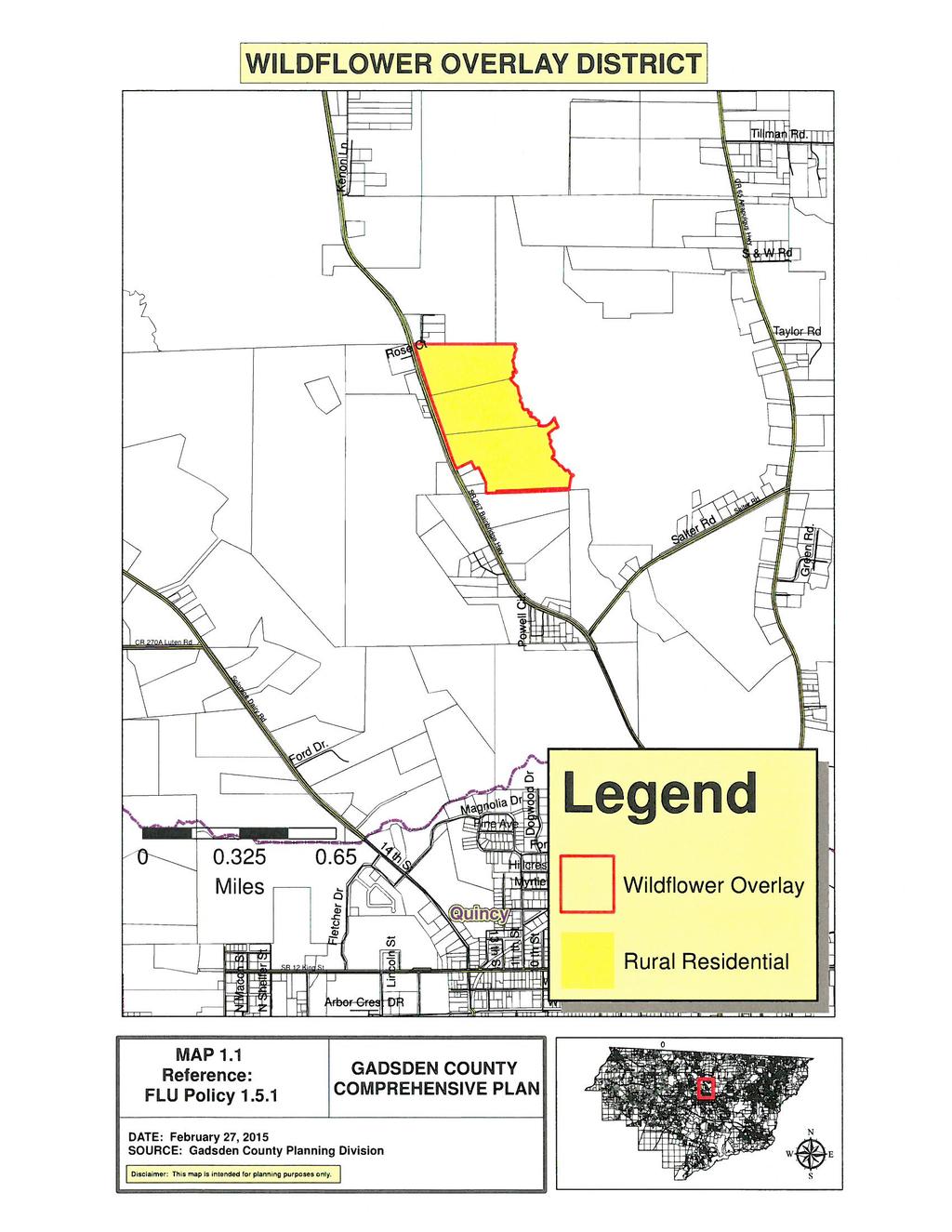
14 FUTURE LAND USE ELEMENT OVERLAY DISTRICTS SUB-ELEMENT GOAL: PROTECT UNIQUE CHARACTERISTICS PERTAINING TO PARTICULAR DEVELOPMENT IN GADSDEN COUNTY. Objective1.5: Establish site-specific policies for those lands subject to the Stipulated Settlement Agreement. Policy 1.5.1: Development of tax parcel ID numbers N-4W and N-4W (as of 2008), known as the Wildflower property and noted on Map 1.1 of this Comprehensive Plan shall be required to adhere to the following stipulations if developed as a major subdivision, or as more than one minor subdivision, as defined in the Gadsden County Land Development Code: A. The property shall be developed with a central potable water system, to be completely financed by the developer, due to the location of the properties between two central water systems, the importance of protecting environmental resources on and in close proximity to the property, and to provide for reliable potable water to the property. B. No less than ten (10) percent of the gross property shall be dedicated to the County for publicly accessible recreation and natural resource preservation purposes. C. All on-site septic systems shall be Advanced Wastewater Treatment Systems or Performance-based Systems. Upon central sewer being provided to the properties, each homeowner/lot owner shall be required to connect to such central sewer within 24 months of becoming available as defined in (2), Florida Statutes. D. Infrastructure improvements occurring on the Wildflower property shall be financed privately. A development agreement between the developer and the county shall be required which specifically describes the costs and development schedules. E. In order to assist in meeting affordable housing needs in the County, the developer has the option of either: Page 12 of 16
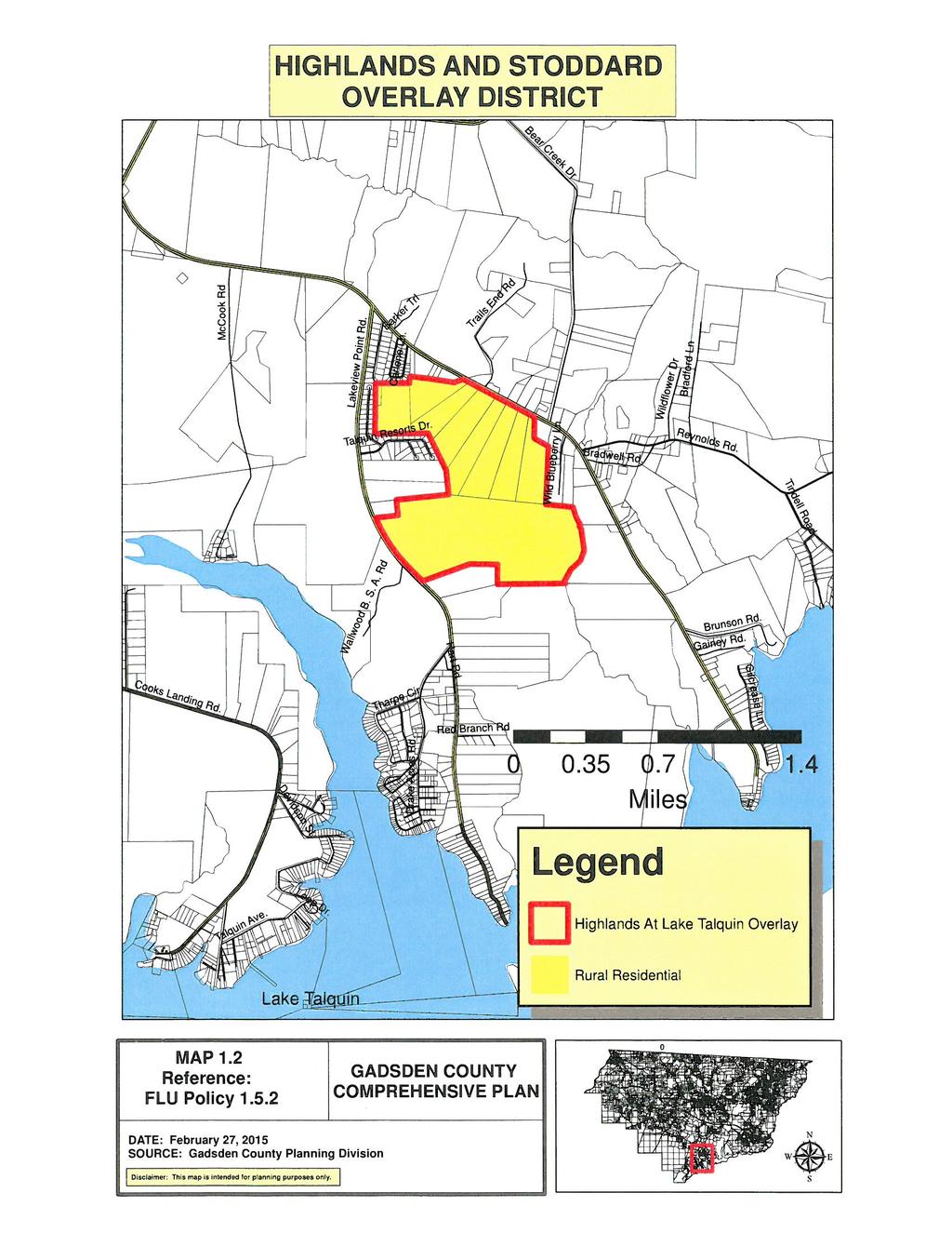
15 1) Provide a minimum of fifteen (15) percent of the units within the property at full build out to meet workforce affordable housing qualifying criteria as described in Section (1)(a), Florida Statutes; or 2) Provide a minimum of ten (10) percent of the unit within the property at full build out to meet affordable housing qualifying criteria as described in the Housing Element. These can be provided as any combination of moderate and/or low income units equaling ten (10) percent of total units. One-half of the affordable housing units under either option above shall be constructed by the time that one-half of all units within the property are developed. Policy 1.5.2: Development of tax parcel ID numbers N-4W and N-4W (less the southwesterly 47.7 acres and the southeasterly 46+/- acres (aka Highlands and Lake Talquin) and the southerly portion of tax parcel ID number N-4W (aka Stodard II property) and noted on Map 1.2 of this Comprehensive Plan shall be required to adhere to the following stipulations if developed as a major subdivision, or as more than one minor subdivision, as defined in the Gadsden County Land Development Code: A. Provide or construct a central wastewater treatment facility to serve the properties. Said facilities shall be constructed and operated by the developer or a licensed wastewater treatment facility operator, and shall be capable of expansion to serve other area properties or to be converted to a lift station to provide for effluent flow to a central wastewater treatment facility. The first phase may consist of a private facility to serve the properties and the second phase may include a plant expansion or conversion to serve as a regional lift station to serve the properties and additional properties. B. A development order shall require construction of a central wastewater treatment facility and as a condition of the development order the developer shall construct the wastewater treatment facility solely at developers cost. C. Should the Stodard property develop prior to the Highlands property, then on-site septic systems will be permitted and dry line sewers shall be provided on the Stodard property. D. Upon the completion of the Highlands wastewater treatment facility the owners of the Stodard dwelling units shall then be required to connect the dry lines and the individual homes to the Highlands wastewater system and abandon any permitted septic systems. Such connection shall be provided within one year of the completion of the wastewater treatment plant system. E. No less than ten (10) percent of the gross property shall be dedicated to the County for publicly accessibly recreation and natural resource preservation purposes. This requirement does not apply to the Stodard portion. Page 13 of 16
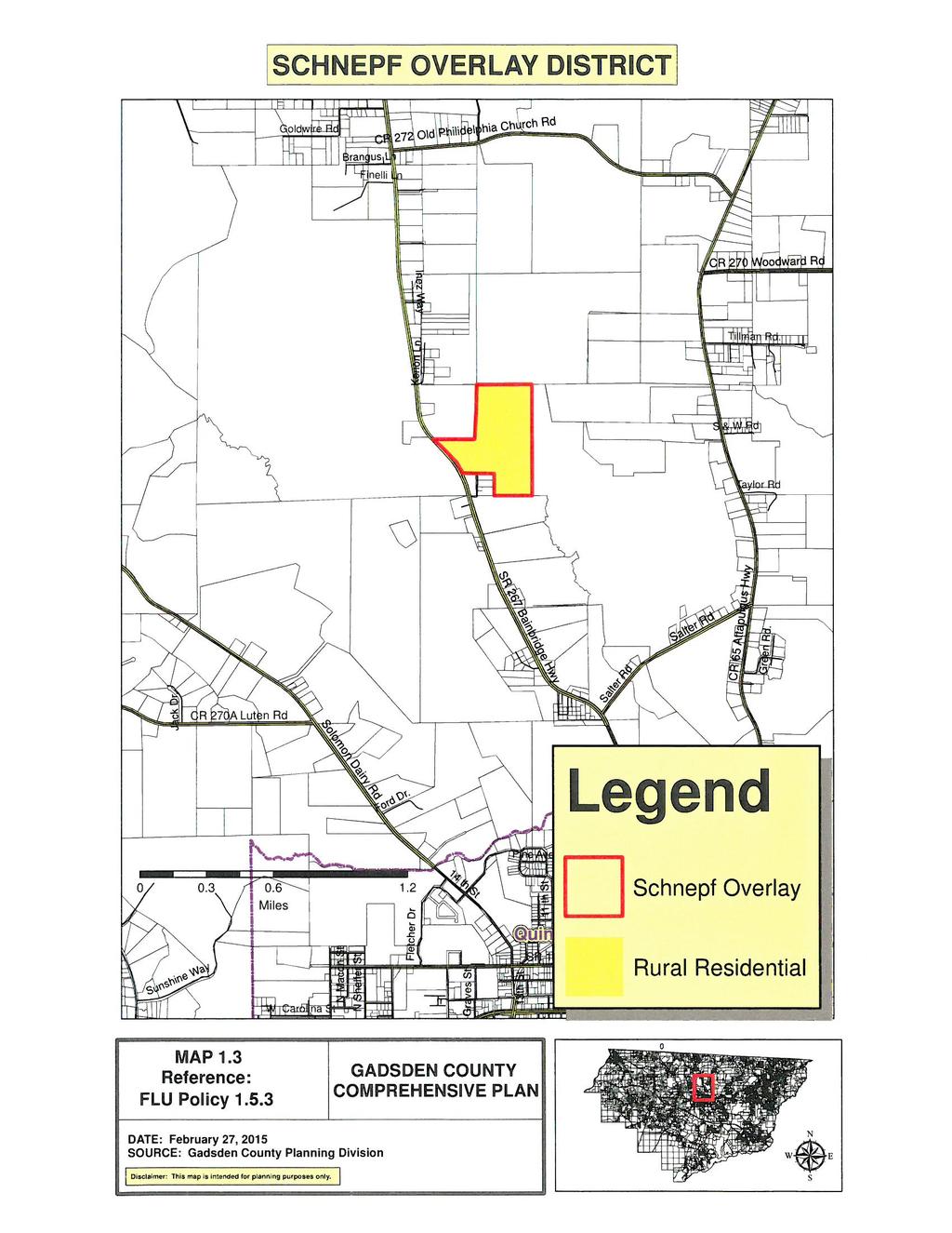
16 F. Infrastructure development improvements occurring on the Highlands at Lake Talquin property shall be financed privately and a development agreement between the developer and the County shall be required which specifically describes costs and development schedules. Policy 1.5.3: Development of tax parcel ID numbers N-4W and N-4W (aka Schnepf property) as noted on Map 1.3 of this Comprehensive Plan, shall be required to adhere to the following stipulations if developed as a major subdivision or more than one minor subdivision, as defined in the Gadsden County Land Development Code: A. The property shall be developed with a central potable water system to be completely financed by the developer, due to the location of the properties between two central water systems, the importance of protecting environmental resources on and in close proximity to the property, and to provide for reliable potable water to the property. B. No less than ten (10) percent of the gross property shall be dedicated to the County for publicly accessible recreation and natural resource preservation purposes. C. All on-site septic systems shall be Advanced Wastewater Treatment Systems or Performance-based Systems. Upon central sewer being provided to the properties each homeowner/lot owner shall be required to connect to such central sewer within twenty-four (24) months of coming available as described in (2)(a), Florida Statutes. D. Infrastructure development improvements occurring on these parcels shall be financed privately by the developer and a development agreement between the developer and the County shall be required which specifically describes costs and development schedules. E. In order to assist in meeting affordable housing needs in the County, the developer has the option of either: 1) Provide a minimum of either fifteen (15) percent of the units within the property at full build out to meet workforce affordable housing qualifying criteria as described in (1)(a); or 2) Provide a minimum of ten (10) percent of the unit within the property at full build out to meet affordable housing qualifying criteria as described in the Housing Element for moderate to low income. These can be provided as any combination of moderate and/or low income units equaling (10) percent of total units. Page 14 of 16
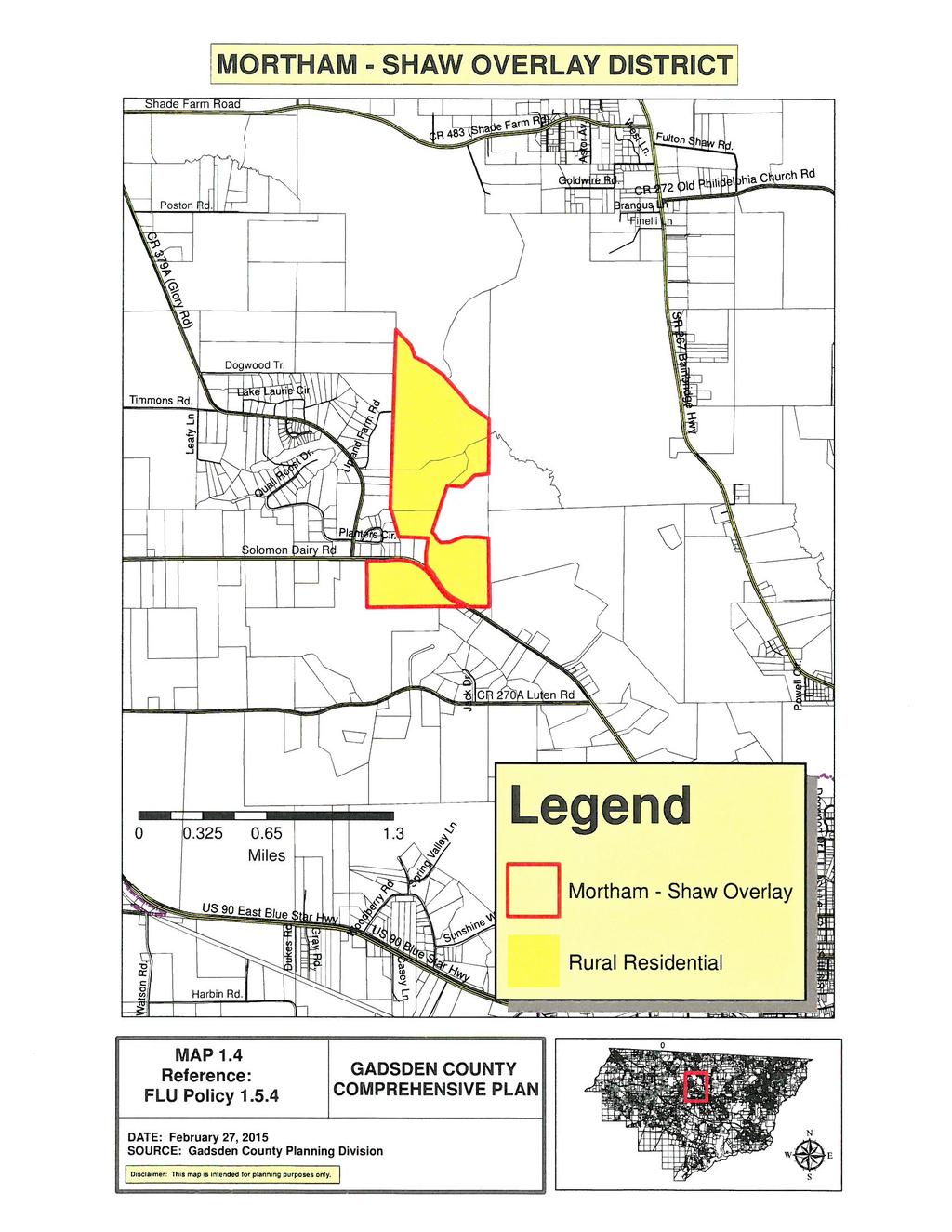
17 One-half of the affordable housing units under either option above shall be constructed by the time that one-half of all units within the property are developed. Policy 1.5.4: Development of tax parcel ID numbers N-4W , N-4W , N-4W and N-4W (aka Mortham-Shaw property) as noted in Map 1.4 of this Comprehensive Plan, shall be required to adhere to the following stipulations if developed as a major subdivision or more than one minor subdivision, as defined in the Gadsden County Land Development Code. A. The number of single-family lots (units) on these parcels shall be limited to a maximum of 160 on the /- acres, and the minimum lot size shall be two (2) acres to ensure compatibility with adjacent properties and to protect environmentally sensitive resources. B. The property shall be developed with a central potable water system, to be completely financed by the developer or property owner, due to the location of the properties between two central water systems, the importance of protecting environmental resources on or in close proximity to the property, and to provide for reliable potable water to the property. C. No less than ten (10) percent of the gross property shall be dedicated to the County for publicly accessible recreation and natural resource preservation purposes. D. All on-site septic systems shall be Advanced Wastewater Treatment Systems or Performance-based Systems. Upon central sewer being provided to the properties each homeowner/lot owner shall be required to connect to such central sewer within twenty-four (24) months of coming available as described in Section (2)(a), F.S. E. Infrastructure development improvements occurring on the Mortham-Shaw property shall be financed privately and a development agreement between the developer and the County shall be required which specifically describes costs and development schedules. F. In order to assist in meeting affordable housing needs in the County, the developer has the option of either: 1) Provide a minimum of either fifteen (15) percent of the units within the property at full build out to meet workforce affordable housing qualifying criteria as described in (1)(a); or 2) Provide a minimum of ten (10) percent of the unit within the property at full build out to meet affordable housing qualifying criteria as described in the Housing Element for moderate to low income. These can be provided as Page 15 of 16
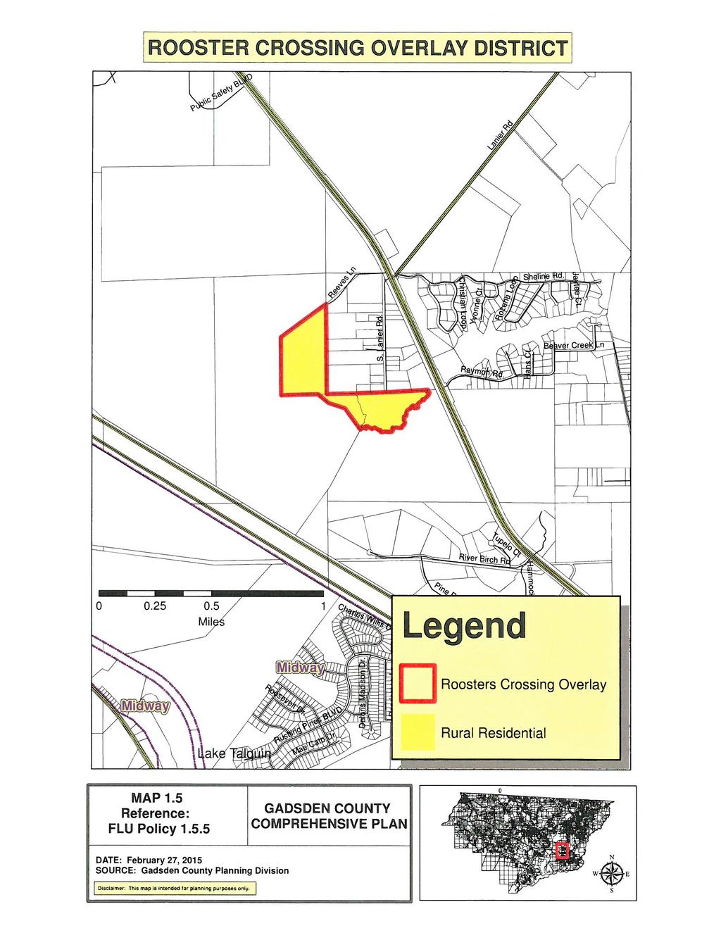
18 any combination of moderate and/or low income units equaling (10) percent of total units. One-half of the affordable housing units under either option above shall be constructed by the time that one-half of all units within the property are developed. Policy 1.5.5: Development of tax parcel ID numbers N-2W , N-2W and N-3W (aka Rooster s Crossing property) as noted on Map 1.5 of this Comprehensive Plan, shall be required to adhere to the following stipulations: A. The clustering of dwelling units shall be required in order to preserve open space beyond the minimum requirements of the County. B. The developer shall take measures to provide stormwater treatment and conveyance compliant with existing land development regulations for the existing South Lanier Road area from US 90 to the existing terminus of South Lanier Road. C. The developer shall work with the County towards the construction of a new collector roadway along the westerly and northerly portion of tax parcel ID number N-2W as proposed in Comprehensive Plan amendment CPA AD. D. All area designated as wetlands and flood plains shall be retained in open space. Page 16 of 16
19
20
21
22
23
Gadsden County Planning Commission Agenda Report
 Gadsden County Planning Commission Agenda Report Date of Meeting: June 16, 2016 To: From: Subject: Honorable Chairperson and Members of the Planning Commission Allara Mills Gutcher, AICP, Planning & Community
PUTNAM COUNTYCOMPREHENSIVE PLAN
 COMPREHENSIVE PLAN EXHIBIT AA COMPREHENSIVE PLAN A. Future Land Use Element Goals, Objectives, Policies This section proposed objectives and policies, which will assist Putnam County Commissioners and
FUTURE LAND USE. City of St. Augustine Comprehensive Plan EAR-Based Amendments
 FUTURE LAND USE City of St. Augustine Comprehensive Plan EAR-Based Amendments Future Land Use Element FLU Goal To create an environment within the City and adjacent areas in which its residents have the
CCC XXX Rural Neighborhood Conservation (NC)
") CCC 33.10.XXX Rural Neighborhood Conservation (NC) Purpose: Maintain low density rural residential areas and associated uses commonly found in rural areas consistent with the local character of the distinctive
CCC 33.10.XXX Rural Neighborhood Conservation (NC) Purpose: Maintain low density rural residential areas and associated uses commonly found in rural areas consistent with the local character of the distinctive
1. Future Land Use FLU6.6.8 Land uses within the Rural Service Area portion of the Wekiva Study Area shall be limited to very low and low intensity
 1. Future Land Use FLU6.6.8 Land uses within the Rural Service Area portion of the Wekiva Study Area shall be limited to very low and low intensity uses to the greatest extent possible. Existing land uses
COMPREHENSIVE PLAN FUTURE LAND USE MAP AMENDMENT APPLICATION
 COUNTY STAFF DATA ONLY Date Received: Project No. CPA-20 - GADSDEN COUNTY DEPARTMENT OF PLANNING & COMMUNITY DEVELOPMENT 1-B East Jefferson Street, Post Office Box 1799, Quincy, FL 32353-1799 PLANNING
Plans shall be drawn at a readable scale, signed, and sealed by a Florida Registered Engineer. The application package shall include:
 CHAPTER 400. SECTION 403. PERMIT TYPES AND APPLICATIONS SITE DEVELOPMENT 403.3. Preliminary Site Plans (PSP) A. Intent and Purpose PSPs are used to identify existing site conditions and demonstrate general
Marion County Board of County Commissioners
 Marion County Board of County Commissioners Date: 6/4/217 P&Z: 9/25/217 BCC Transmittal: 1/17/217 BCC Adopt: TBD Amendment No: 217-L6 Type of Application Large-Scale Comp Plan Amendment Request: Change
CHAPTER Committee Substitute for Committee Substitute for Senate Bill No. 2188
 CHAPTER 2004-372 Committee Substitute for Committee Substitute for Senate Bill No. 2188 An act relating to land development; amending s. 197.502, F.S.; providing for the issuance of an escheatment tax
FINAL DRAFT 12/1/16, Rev. to 7/18/17
 FINAL DRAFT 12/1/16, Rev. to 7/18/17 (As Adopted 8/8/17 Effective 9/1/17) SHELTON PLANNING AND ZONING COMMISSION Proposed Amendments to Zoning Regulations I. Amend Section 23 PERMITTED USES by inserting
Residential Project Convenience Facilities
 Standards for Specific Land Uses 35.42.220 E. Findings. The review authority shall approve a Land Use Permit in compliance with Subsection 35.82.110.E (Findings required for approval) or a Conditional
ARTICLE 7. SPECIFIC USE STANDARDS
 ARTICLE 7. SPECIFIC USE STANDARDS Section 7.1 Applicability The following standards apply to specified uses in all zoning districts in which such uses are allowed. Section 7.2 Accessory Apartments (A)
CHAPTER 3 REGULATIONS INSIDE THE COASTAL ZONE
 CHAPTER 3 REGULATIONS INSIDE THE COASTAL ZONE Organization. Chapter 3 contains the regulations which apply exclusively within the California Coastal Zone in Humboldt County and is organized as follows:
CHAPTER 5 DEVELOPMENT STANDARDS.
 SECTION 5000. GENERAL STANDARDS. CHAPTER 5 DEVELOPMENT STANDARDS. Subsection 5001. Establishment of Performance Standards. Gadsden County is committed to the protection of the general health, safety and
Planned Residential Development Zone
 SECTION 55 Planned Residential Development Zone 55.0 [Reserved] 55.1 General The Planned Residential Development (PRD) Zone is a class of zone in addition to and overlapping a portion or portions of the
ARTICLE V AGRICULTURAL PRESERVATION AND RURAL RESIDENTIAL DISTRICT
 ARTICLE V AP AGRICULTURAL PRESERVATION AND RURAL RESIDENTIAL DISTRICT Section 500. PURPOSE It is the purpose of the AP, Agricultural Preservation and Rural Residential District, to foster the preservation
Midwest City, Oklahoma Zoning Ordinance
 2010 Midwest City, Oklahoma Zoning Ordinance 9/2/2010 Table of Contents Section 1. General Provisions... 5 1.1. Citation... 5 1.2. Authority... 5 1.3. Purpose... 5 1.4. Nature and Application... 5 1.5.
Planned Residential Development ( PRD ) Application
 Application") FOR PLANNING USE ONLY Application # PRD Application Fee $ Receipt No. Filing Date Completeness Date Planned Residential Development ( PRD ) Application A. PROJECT INFORMATION 1. Project Name: 2. Address
FOR PLANNING USE ONLY Application # PRD Application Fee $ Receipt No. Filing Date Completeness Date Planned Residential Development ( PRD ) Application A. PROJECT INFORMATION 1. Project Name: 2. Address
Town of Truckee. Contents. Article I - Development Code Enactment and Applicability. Chapter Purpose and Effect of Development Code...
 Town of Truckee TITLE 18 - DEVELOPMENT CODE Article I - Development Code Enactment and Applicability Chapter 18.01 - Purpose and Effect of Development Code... I-3 18.01.010 - Title... I-3 18.01.020 - Purposes
Mohave County General Plan
 63 64 65 66 67 68 69 70 71 The Land Use Diagram is not the County's zoning map. 13 It is a guide to future land use patterns. Zoning and area plan designations may be more restrictive than the land use
Chapter 210 CONDITIONAL USES
 Chapter 210 CONDITIONAL USES 210.01 Purpose 210.02 Authorization 210.03 Process Type 210.04 Determination of Major or Minor Conditional Use Review 210.05 Approval Criteria 210.06 Conditions of Approval
CHAPTER 14 PLANNED UNIT DEVELOPMENTS
 9-14-1 9-14-1 CHAPTER 14 PLANNED UNIT DEVELOPMENTS SECTION: 9-14-1: Purpose 9-14-2: Governing Provisions 9-14-3: Minimum Area 9-14-4: Uses Permitted 9-14-5: Common Open Space 9-14-6: Utility Requirements
INTRODUCTION Future Land Use Element
 EXHIBIT A INTRODUCTION Future Land Use Element The purpose of the Future Land Use Element is to examine the existing land uses and to determine present and future land use needs such as the amount of land
GWINNETT COUNTY CSO CONSERVATION SUBDIVISION OVERLAY DISTRICT REQUIREMENTS
 GWINNETT COUNTY CSO CONSERVATION SUBDIVISION OVERLAY DISTRICT REQUIREMENTS Section 1316. CSO Conservation Subdivision Overlay District. 1. Purposes. The purposes of this overlay district are as follows:
BY BOARD OF COUNTY COMMISSIONERS AN ACT TO BE ENTITLED
 BY BOARD OF COUNTY COMMISSIONERS ORDINANCE NO. AN ACT TO BE ENTITLED AN ORDINANCE AMENDING THE PASCO COUNTY LAND DEVELOPMENT CODE, ARTICLE 700, BY REPEALING EXISTING SECTION 702, ENVIRONMENTALLY SENSITIVE
4. If any perennial surface water passes through or along the property lines of the acreage, a minimum of 200 feet or frontage should be required.
 b. Provide adequate acreage for appropriate productive use of rural residential land, such as small numbers of livestock, large gardens, etc. 3. Minimum of 200 feet of frontage on an improved county or
CITY OF HENDERSON TABLE OF CONTENTS. Section 101: Purpose... 1 Section 102: Authority... 1 GENERAL REGULATIONS APPLIED TO ALL DISTRICTS
 TABLE OF CONTENTS ARTICLE 100: PURPOSE AND AUTHORITY Section 101: Purpose... 1 Section 102: Authority... 1 ARTICLE 200: GENERAL REGULATIONS APPLIED TO ALL DISTRICTS Section 201: Jurisdiction and Zoning
A. ARTICLE 16 - STEEP SLOPE CONSERVATION DISTRICT
 1600. 1601.A. ARTICLE 16 - STEEP SLOPE CONSERVATION DISTRICT SECTION 1600 PURPOSE The purpose of this Article is to expand upon the Community Development Objectives associated with environmental protection
A. Maintenance. All legally established, nonconforming structures can be maintained (e.g., painting and repairs);
;") Chapter 24.50 NONCONFORMING USES, STRUCTURES AND LOTS Sections: 24.50.010 Nonconforming uses, structures, and lots Purpose. 24.50.020 Nonconforming uses, structures, and lots Alteration or expansion of
Chapter 24.50 NONCONFORMING USES, STRUCTURES AND LOTS Sections: 24.50.010 Nonconforming uses, structures, and lots Purpose. 24.50.020 Nonconforming uses, structures, and lots Alteration or expansion of
ARTICLE 9: VESTING DETERMINATION, NONCONFORMITIES AND VARIANCES. Article History 2 SECTION 9.01 PURPOSE 3
 ARTICLE 9 VESTING DETERMINATIONS, NONCONFORMITIES, AND VARIANCES Table of Contents Article History 2 SECTION 9.01 PURPOSE 3 SECTION 9.02 LOT OF RECORD AND VESTING DETERMINATIONS FOR NONCONFORMING DEVELOPMENTS
Article II - Zone Regulations
 Section 200 '200.1 ZONES AND BOUNDARIES Establishment of Zones: The Township of Penn is divided into zones enumerated below and shown on the map entitled "Zoning Map of Penn Township" which map is part
Multi-family dwellings (including assisted living facilities), Public buildings, facility or land; and,
, Public buildings, facility or land; and,") 607. General Residential District (GR) Intent. It is the intent of this section that the General Residential District be established for medium-to-high density residential purposes. These areas need to
607. General Residential District (GR) Intent. It is the intent of this section that the General Residential District be established for medium-to-high density residential purposes. These areas need to
ARTICLE 14 PLANNED UNIT DEVELOPMENT (PUD) DISTRICT
 DISTRICT") ARTICLE 14 PLANNED UNIT DEVELOPMENT (PUD) DISTRICT Section 14.01 Intent. It is the intent of this Article to allow the use of the planned unit development (PUD) process, as authorized by the Michigan Zoning
ARTICLE 14 PLANNED UNIT DEVELOPMENT (PUD) DISTRICT Section 14.01 Intent. It is the intent of this Article to allow the use of the planned unit development (PUD) process, as authorized by the Michigan Zoning
** If your lot does not meet the requirements above, please read Sec below
 Sec. 13-1-60 Zoning District Dimensional Requirements. For the Zoning Dept To Issue a Land Use Permit The Following Dimensions are Required. Minimum Side and Rear Yards s Lakes Classification Minimum Class
Special Use Permit - Planned Unit Development Checklist. Property Address:
 Special Use Permit - Planned Unit Development Checklist Special Use Permit Number. Parcel Code/s #28-11- - - Property Address: Applicant: ARTICLE VIII Ordinance Reference - Section 8.1.2 Permit Procedures:
ORDINANCE NOW THEREFORE, BE IT ENACTED BY THE CITY COMMISSION OF THE CITY OF WINTER GARDEN, FLORIDA, AS FOLLOWS:
 ORDINANCE 12-02 AN ORDINANCE OF THE CITY OF WINTER GARDEN, FLORIDA, AMENDING ARTICLE V OF CHAPTER 118 OF THE WINTER GARDEN CODE OF ORDINANCES ENTITLED PLANNED UNIT DEVELOPMENTS CREATING URBAN VILLAGE PLANNED
Charter Township of Plymouth Zoning Ordinance No. 99 Page 208 Article 21: Residential Unit Developments Amendments: ARTICLE XXI
 Charter Township of Plymouth Zoning Ordinance No. 99 Page 208 ARTICLE XXI RESIDENTIAL UNIT DEVELOPMENTS PURPOSE The purpose of the Residential Unit Development (RUD) is to permit two (2) optional methods
1 Chapter 4 FUTURE LAND USE ELEMENT Section 4.1. Background information. 4.1.A. Land use profile. Indiantown possesses a unique and valuable mix of ph
 1 Chapter 4 FUTURE LAND USE ELEMENT Section 4.1. Background information. 4.1.A. Land use profile. Indiantown possesses a unique and valuable mix of physical and man-made resources centered on the Okeechobee
This Chapter shall become effective upon adoption hereof by the Board of County Commissioners.
 CHAPTER 21.67 - WEST END INTERIM ZONING Sections: 21.67.010 APPLICABILITY 21.67.020 EFFECTIVE DATE 21.67.030 ZONING MAP 21.67.040 RELATIONSHIP TO BALANCE OF TITLE 21 21.67.050 ZONE CLASSIFICATIONS 21.67.060
Chapter 100 Planned Unit Development in Corvallis Urban Fringe
 100.100 Scope and Purpose. Chapter 100 Planned Unit Development in Corvallis Urban Fringe (1) All applications for land divisions in the Urban Residential (UR) and Flood Plain Agriculture (FPA) zones within
GC General Commercial District
 Section 712. GC General Commercial District 712.1 Intent of District. It is the intent of this section that the GC Zoning District be developed and reserved for general business purposes. The regulations
Chapter 2. Zoning Districts
 CHAPTER II. LAND USE ZONING DISTRICTS 2.00.00. GENERALLY In order to ensure that all development is consistent with the goals and objectives of the comprehensive plan, it is necessary and proper to establish
A. Location. A MRD District may be permitted throughout the County provided it meets the standards established herein.
 752. Multi-Residential District (MRD) The Multi-Residential (MRD) District is intended to provide opportunities for rural, suburban and urban density mixed-residential developments consistent with the
REPRESENTATIVE: Centerline Solutions Table Mountain Parkway Golden, CO 80403
 COMMISSIONERS: DARRYL GLENN (PRESIDENT) MARK WALLER (PRESIDENT PRO TEMPORE) STAN VANDERWERF LONGINOS GONZALEZ PEGGY LITTLETON PLANNING AND COMMUNITY DEVELOPMENT DEPARTMENT CRAIG DOSSEY, EXECUTIVE DIRECTOR
GENERAL PURPOSES OF ZONES
 9-7-1 9-7-2 CHAPTER 7 GENERAL PURPOSES OF ZONES SECTION: 9-7-1: Residential Agricultural Zone (RA) 9-7-2: Agricultural Residential Zone (AR) 9-7-3: Agricultural Prime Zone (AP) 9-7-4: Multiple Use Zone
Subchapter 5 Zoning Districts and Limitations
 Subchapter 5 Zoning Districts and Limitations 35.5.1 Rural Districts Sections: 35.5.1.1 Purpose. 35.5.1.2 Permitted Uses. 35.5.1.3 General Regulations. 35.5.1.1 Purpose. The purpose of a Rural District
ARTICLE VII. NONCONFORMITIES. Section 700. Purpose.
 ARTICLE VII. NONCONFORMITIES. Section 700. Purpose. The purpose of this chapter is to regulate and limit the development and continued existence of legal uses, structures, lots, and signs established either
PROPOSED AMENDMENTS TO THE DERBY ZONING REGULATIONS AUGUST 12, 2008
 ARTICLE II Definitions and word usage 195-7. Definitions and word usage. Modify the following: HOUSING FOR THE ELDERLY OLDER PERSONS Housing in accordance with and as defined in the United States Fair
DRAFT FOR PUBLIC HEARING (rev. March, 2016)
") Chapter 200. ZONING Article VI. Conservation/Cluster Subdivisions 200-45. Intent and Purpose These provisions are intended to: A. Guide the future growth and development of the community consistent with
Chapter 200. ZONING Article VI. Conservation/Cluster Subdivisions 200-45. Intent and Purpose These provisions are intended to: A. Guide the future growth and development of the community consistent with
619. Planned Development District (PD)
") 619. Planned Development District (PD) Intent. The purpose of the Planned Development District (sometimes hereinafter referred to as PD) is to provide opportunities to create more desirable environments
619. Planned Development District (PD) Intent. The purpose of the Planned Development District (sometimes hereinafter referred to as PD) is to provide opportunities to create more desirable environments
Article 7: Residential Land Use and Development Requirements
 Article 7: Residential Land Use and Section 701: Statement of Intent (A) (B) (C) The intent of Article 7 is to develop certain land use and development requirements for the residential uses within Cumru
Amendments to Chapter proposed by the Assembly Title 21 Committee
 Amendments to Chapter 21.04 proposed by the Assembly Title 21 Committee All page numbers refer to the S version. PZC recommended additions are underlined. PZC recommended deletions are in [BRACKETS AND
(b) The location of principal and accessory buildings on the lot and the relationship of each structure to the other.
 The location of principal and accessory buildings on the lot and the relationship of each structure to the other.") ARTICLE XIX SITE PLAN Sec. 20-1900 Site Plan Review Procedure - Intent The site plan review procedures are instituted to provide an opportunity for the Township Planning Commission to review the proposed
ARTICLE XIX SITE PLAN Sec. 20-1900 Site Plan Review Procedure - Intent The site plan review procedures are instituted to provide an opportunity for the Township Planning Commission to review the proposed
REPORT OF THE PLANNING AND DEVELOPMENT DEPARTMENT FOR APPLICATION FOR REZONING ORDINANCE TO PLANNED UNIT DEVELOPMENT SEPTEMBER 22, 2016
 BEL REPORT OF THE PLANNING AND DEVELOPMENT DEPARTMENT FOR APPLICATION FOR REZONING ORDINANCE 2016-576 TO PLANNED UNIT DEVELOPMENT SEPTEMBER 22, 2016 The Planning and Development Department hereby forwards
ARTICLE XXI GENERAL SITE DEVELOPMENT PLAN REQUIREMENTS
 1 2 3 4 5 6 7 8 9 10 11 12 13 14 15 16 17 18 19 20 21 22 23 24 25 ARTICLE XXI GENERAL SITE DEVELOPMENT PLAN REQUIREMENTS Section 21.1 Purpose and Intent... 2 Section 21.2 Administrative Site Plan Review
Cobb County Community Development Agency Zoning Division 1150 Powder Springs St. Marietta, Georgia 30064
 Cobb County Community Development Agency Zoning Division 1150 Powder Springs St. Marietta, Georgia 30064 Case # Z-63 Public Hearing Dates: PC: 11-06-18 BOC: 11-20-18 SITE BACKGROUND Applicant: Loyd Development
LAND USE ORDINANCE, TOWN OF RICHMOND, MAINE TABLE OF CONTENTS
 LAND USE ORDINANCE, TOWN OF RICHMOND, MAINE TABLE OF CONTENTS ARTICLE 1. GENERAL A. TITLE... 1 B. PURPOSES... 1 C. BASIC REQUIREMENTS... 1-2 D. ADMINISTRATION & ENFORCEMENT... 2-3 E. VALIDITY AND SEVERABILITY...
INDIAN RIVER COUNTY, FLORIDA. The Honorable Members of the Planning and Zoning Commission DEPARTMENT HEAD CONCURRENCE
 Public Hearing Legislative INDIAN RIVER COUNTY, FLORIDA M E M O R A N D U M TO: The Honorable Members of the Planning and Zoning Commission DEPARTMENT HEAD CONCURRENCE Robert M. Keating, AICP; Community
SECTION 1 INTRODUCTION TO THE PANAMA CITY BEACH COMPREHENSIVE GROWTH DEVELOPMENT PLAN
 1. PURPOSE SECTION 1 INTRODUCTION TO THE PANAMA CITY BEACH COMPREHENSIVE GROWTH DEVELOPMENT PLAN The purpose of the City of Panama City Beach's Comprehensive Growth Development Plan is to establish goals,
MEMORANDUM. Critical Areas Ordinance Density Requirements
 COUNTY COMMISSIONERS Creating Solutions for Our Future Cathy Wolfe District One Sandra Romero District Two Karen Valenzuela District Three PLANNING DEPARTMENT Scott Clark Director MEMORANDUM TO: FROM:
STAFF REPORT. Permit Number: Lee. Kitsap County Board of Commissioners; Kitsap County Planning Commission
 STAFF REPORT Permit Number: 15 00689 Lee DATE: March 2, 2016 TO: FROM: Kitsap County Board of Commissioners; Kitsap County Planning Commission Katrina Knutson, AICP, Senior Planner, DCD and Jeff Arango,
Class II, Type 11 Site Plan Conceptual/Preliminary Conceptual CITY: STATE: ZIP: TELEPHONE: ( ) 2. AUTHORIZED REPRESENTATIVE NAME: ADDRESS:
 2. AUTHORIZED REPRESENTATIVE NAME: ADDRESS:") GADSDEN COUNTY BUILDING & PLANNING & DEPARTMENT 1-B East Jefferson Street, Post Office Box 1799, Quincy, FL 32353-1799 Phone: (850) 875-8663 Fax: (850) 875-7280 E-mail: planning@gadsdencountyfl.gov Web
GADSDEN COUNTY BUILDING & PLANNING & DEPARTMENT 1-B East Jefferson Street, Post Office Box 1799, Quincy, FL 32353-1799 Phone: (850) 875-8663 Fax: (850) 875-7280 E-mail: planning@gadsdencountyfl.gov Web
CITY OF FORT COLLINS NATURAL AREAS AND CONSERVED LANDS EASEMENT POLICY
 CITY OF FORT COLLINS NATURAL AREAS AND CONSERVED LANDS EASEMENT POLICY Adopted January 3, 2012 PURPOSE: The purpose of the policy statement is to clarify the policies and procedures of the City of Fort
French, Bruce. The applicant is requesting a zone change from Suburban to Rural Service Center.
 BONNER COUNTY PLANNING DEPARTMENT PLANNING AND ZONING COMMISSION STAFF REPORT FOR FEBRUARY 2, 2017 Project Name: French, Bruce File Number,Type: ZC358-16, Zone Change Request: The applicant is requesting
MS MINOR SUBDIVISION TREVITHICK
 MS-02-015 341.12 MINOR SUBDIVISION TREVITHICK A request by Danny Trevithick for a one-lot Minor Subdivision on five acres. The property is zoned A-35 (Agricultural) District and is located ¼ mile south
Town of Windham Land Use Ordinance Sec. 400 Zoning Districts SECTION 400 ZONING DISTRICTS
 Town of Windham Land Use Ordinance Sec. 400 Zoning Districts Sections SECTION 400 ZONING DISTRICTS SECTION 400 ZONING DISTRICTS 4-1 401 Districts Enumerated 4-2 402 Location of districts; Zoning Map 4-2
Box Elder County Land Use Management & Development Code Article 3: Zoning Districts
 Chapter 3-6 Mobile Homes, Mobile Home Subdivisions, & Recreational Vehicle Parks Box Elder Zoning Ordinance as Adopted October 2007 Sections. 3-6-010. Purpose and Intent. 3-6-020. Conditional Use Permit
REPRESENTATIVE: Julie & Brad Nicodemus Black Squirrel Road Colorado Springs, CO 80809
 COMMISSIONERS: DARRYL GLENN (PRESIDENT) MARK WALLER (PRESIDENT PRO TEMPORE) STAN VANDERWERF LONGINOS GONZALEZ PEGGY LITTLETON PLANNING AND COMMUNITY DEVELOPMENT DEPARTMENT CRAIG DOSSEY, EXECUTIVE DIRECTOR
19.12 CLUSTER RESIDENTIAL DISTRICT
 Chapter 19.12 CLUSTER RESIDENTIAL DISTRICT (Adopted 12/22/2003; Ordinance #0061970). Amended 7/3/17, Ordinance #079100. Section 19.12.010 - Declaration of Intent. The Cluster Residential District provides
SUBDIVISION DEFINED, EXEMPTIONS FROM DEFINITION:
 12-611: SUBDIVISION DEFINED, EXEMPTIONS FROM DEFINITION: A. 1. Minor Land Division (MLD) shall mean any division of land into four (4) or fewer lots. 2. Minor Subdivision shall mean any division of land
Guide to Preliminary Plans
 Guide to Preliminary Plans Introduction The Douglas County is committed to providing open, transparent application processes to the public. This Guide is provided to assist anyone interested in the procedures
Conditional Use Permit case no. CU 14-06: Bristol Village Partners, LLC
 PLANNING AND ZONING COMMISSION STAFF REPORT August 7, 2014 Conditional Use Permit case no. CU 14-06: Bristol Village Partners, LLC CASE DESCRIPTION: LOCATION: LEGAL DESCRIPTION: EXISTING LAND USE: ZONING:
Planning Department Oconee County, Georgia
 Planning Department Oconee County, Georgia STAFF REPORT REZONE CASE #: 6985 DATE: October 31, 2016 STAFF REPORT BY: Andrew C. Stern, Planner APPLICANT NAME: Williams & Associates, Land Planners PC PROPERTY
TABLE OF CONTENTS. 1.1 Official Title Effective date Authority
 Chapter 1: GENERAL PROVISIONS TABLE OF CONTENTS 1.1 Official Title... 1-1 1.2 Effective date... 1-1 1.3 Authority... 1-1 1.3.1 General Authority... 1-1 1.3.2 References to North Carolina General Statutes...
Subdivision and Land Development Regulations. Jefferson County, West Virginia
 Subdivision and Land Development Regulations Jefferson County, West Virginia Adopted October 9, 2008 Amended September 29, 2016 Amendment Reference This document contains additions and amendments approved
Section 7.22: Multifamily Assisted Housing in AA-30 Residential Zone (MAHZ) [Note: an additional line will be added to the Table in Article 3, 3.1.
 [Note: an additional line will be added to the Table in Article 3, 3.1.") Section 7.22: Multifamily Assisted Housing in AA-30 Residential Zone (MAHZ) [Note: an additional line will be added to the Table in Article 3, 3.1.1A] 7.22.1 Purpose The purpose of this Special Regulation
Section 7.22: Multifamily Assisted Housing in AA-30 Residential Zone (MAHZ) [Note: an additional line will be added to the Table in Article 3, 3.1.1A] 7.22.1 Purpose The purpose of this Special Regulation
ALBEMARLE COUNTY CODE CHAPTER 18. ZONING SECTION 10. RURAL AREAS DISTRICT, RA
 CHAPTER 18. ZONING SECTION 10. RURAL AREAS DISTRICT, RA Sections: 10.1 Intent, where permitted. 10.2 Permitted uses. 10.2.1 By right. 10.2.2 By special use permit. 10.3 Application of regulations for development
ARTICLE PERMISSIVE USES. A building or premises shall be permitted to be used for the following purposes in the A-1 Agricultural District:
 ARTICLE 3.00 A-1 AGRICULTURAL SECTIONS: 3.01 Intent 3.02 Permissive Uses 3.03 Permitted Special Uses 3.04 Conditional Uses 3.05 Accessory Uses 3.06 Parking Regulations 3.07 Sign Regulations 3.08 Density,
ORDINANCE NUMBER 2015-
 1 1 1 1 1 1 1 1 0 0 1 ORDINANCE NUMBER 01- AN ORDINANCE OF ESCAMBIA COUNTY, FLORIDA, AMENDING PART III OF THE ESCAMBIA COUNTY CODE OF ORDINANCES, THE LAND DEVELOPMENT CODE OF ESCAMBIA COUNTY, FLORIDA;
CITY OF PORT ORCHARD
 CITY OF PORT ORCHARD ZONING DESIGNATIONS (Adapted from POMC Chapter 20.34 Zoning Districts, as adopted 6/13/2017) 20.34.110 Greenbelt zone (Gb). (1) Purpose. It is the purpose of the greenbelt zone to
CHAPTER 7 PROVISIONS GOVERNING USE DISTRICTS
 CHAPTER 7 PROVISIONS GOVERNING USE DISTRICTS 11-701. R-1 Residential and Agricultural. It is the purpose and intent of this district to provide areas that are suitable for low density residential uses,
Draft Zoning Changes for the 2nd Planning Board Public Hearing, January 22, 2018.
 Draft Zoning Changes for the 2nd Planning Board Public Hearing, January 22, 2018. No changes were made at the 1st Public Hearing. Proposed wording for the 1 st Public Hearing in red, eliminated text in
AMENDED ZONING BY-LAW ARTICLE SENIOR LIVING COMMUNITY
 AMENDED ZONING BY-LAW ARTICLE 13.5 - SENIOR LIVING COMMUNITY ARTICLE : To see if the Town will vote to amend the Zoning Bylaw as follows: 2. By deleting existing Section 13.5, Senior Living Community,
PLANNING COMMISSION REPORT Regular Agenda Public Hearing Item
 PC Staff Report 11/12/12 Item No. 2B- 1 PLANNING COMMISSION REPORT Regular Agenda Public Hearing Item ITEM NO. 2B: A TO GPI; 110 ACRES; E OF K-10 & N OF W 6 TH ST (MKM) : Consider a request to rezone approximately
Proposed Overland Park Kansas Ordinance RE-1 Residential Estates Community
 18.171 RE-1 Residential Estate Community 18.171.010 Statement of intent. The zoning of property as RE-1, (Residential Estates Community, 1 dwelling unit per Gross acre density), is intended to provide
Glades County Staff Report and Recommendation REZONING
 Glades County Staff Report and Recommendation REZONING CASE NUMBER: RZ15-01 DATE: October 2, 2015 CASE TYPE: Application for Rezoning REQUEST: J.J. Wiggins Memorial Trust is requesting a rezoning of 22.1±
TOOELE COUNTY LAND USE ORDINANCE CHAPTER 31 Page 1
 CHAPTER 31 PLANNED COMMUNITY ZONE (P-C) Section 31-1 Definitions. 31-2 Purpose. 31-3 Land use districts. 31-4 P-C zone area minimum requirements. 31-5 Permitted uses. 31-6 Conditional uses. 31-7 Planning
Planning Department Oconee County, Georgia STAFF REPORT
 Planning Department Oconee County, Georgia STAFF REPORT REZONE CASE #: 7332 DATE: November 28, 2017 STAFF REPORT BY: Gabriel Quintas, Planner APPLICANT NAME: Smith Planning Group PROPERTY OWNER: John Hadden
Larimer County Planning Dept. Procedural Guide for 1041 PERMITS
 - Larimer County Planning Dept. Procedural Guide for 1041 PERMITS PLEASE NOTE: A PRE-APPLICATION CONFERENCE IS REQUIRED PRIOR TO SUBMITTING THIS APPLICATION. PURPOSE: State Statutes allow local governments
DOUGLAS COUNTY SUBDIVISION RESOLUTION Article 4 Preliminary Plan 10/13/2015
 ARTICLE 4 PRELIMINARY PLAN 401 Intent An in-depth analysis of the proposed subdivision, including a review of the design considering the ability to obtain water and sanitation, identified geologic hazards,
CHAPTER 3 PRELIMINARY PLAT
 10-3-1 10-3-3 SECTION: CHAPTER 3 PRELIMINARY PLAT 10-3-1: Consultation 10-3-2: Filing 10-3-3: Requirements 10-3-4: Approval 10-3-5: Time Limitation 10-3-6: Grading Limitation 10-3-1: CONSULTATION: Each
Initial Subdivision Applications Shall Include the Following:
 Initial Subdivision Applications Shall Include the Following: 1) Subdivision Application Form: completely filled out (12 copies) 2) Plat: The Plat must adhere to the requirements set forth in the Town
ARTICLE B ZONING DISTRICTS
 ARTICLE B ZONING DISTRICTS Sec. 8-3021 Established. In order to protect the character of existing neighborhoods; to prevent excessive density of population in areas which are not adequately served with
A. No structure or land in the county shall hereafter be developed, used or occupied unless expressly authorized in a zoning district in this Code.
 Page 1 of 89 CHAPTER 2. ZONING DISTRICTS 2.00.00. GENERALLY In order to ensure that all development is consistent with the goals and objectives of the Comprehensive Plan, it is necessary and proper to
Article Optional Method Requirements
 Article 59-6. Optional Method Requirements [DIV. 6.1. MPDU DEVELOPMENT IN RURAL RESIDENTIAL AND RESIDENTIAL ZONES Sec. 6.1.1. General Requirements... 6 2 Sec. 6.1.2. General Site and Building Type Mix...
Marion County Board of County Commissioners
 Marion County Board of County Commissioners Date: 12/29/2015 P&Z: 12/28/2015 BCC: 1/12/2016 Item Number 160113Z Type of Application Rezoning Request From: A-1 (General Agriculture) To: PUD (Planned Unit
891941, , : COMPREHENSIVE PLAN AMENDMENT, COMMUNITY PLAN AMENDMENT, AND AREA-WIDE MAP AMENDMENT
 Application Nos. 891941, 891909, 891940: COMPREHENSIVE PLAN AMENDMENT, COMMUNITY PLAN AMENDMENT, AND AREA-WIDE MAP AMENDMENT Amendments to designate five parcels as Rural Industrial Center in the Alderton
Residential-1 District
 Residential-1 District City of Barnum, Minnesota Zoning District Information Sheet It is the purpose of the R-1 District to encourage the establishment and the preservation of residential neighborhoods
Open Space Model Ordinance
 Open Space Model Ordinance Section I. Background Open space development has numerous environmental and community benefits, including: 1) Reduces the impervious cover in a development. Impervious cover
Section Intent
 Section 246. 1. Intent 2. Authority a. It is the intent of these Transfer of Development Rights (TDR s) regulations to encourage the preservation of natural resources and facilitate orderly growth in the