29-35 TRAFALGAR STREET BURNLEY LANCASHIRE
|
|
|
- Griselda Jones
- 6 years ago
- Views:
Transcription

1 29-35 TRAFALGAR STREET BURNLEY LANCASHIRE Archaeological Building Investigation Oxford Archaeology North November 2014 Barnfield Construction Issue No: /1580 OA North Job No: L10802 NGR:

2
3 29-35 Trafalgar Street, Burnley: Archaeological Building Investigation 1 CONTENTS SUMMARY... 2 ACKNOWLEDGEMENTS INTRODUCTION Circumstances of the Project Location, Geology and Topography METHODOLOGY Methodology Archive BACKGROUND Introduction The Study Area RESULTS Introduction Trafalgar Street Varley Street And Derby Street Extensions CONCLUSION Conclusion BIBLIOGRAPHY ILLUSTRATIONS List of Figures... 36
4 29-35 Trafalgar Street, Burnley: Archaeological Building Investigation 2 SUMMARY Burnley Council in partnership with Barnfield Construction is currently engaged in a major programme of regeneration of the Weavers Triangle in Burnley. This has focused on returning historic industrial buildings, many of which are afforded statutory designation as listed buildings, back into viable long-term use. This is to be coupled with new development, which is intended to bring new investment to the area. One element of the new development is the proposed construction of a drivethrough fast-food restaurant on Trafalgar Street. The development proposals allow for the demolition of exiting properties at Trafalgar Street (centred on NGR ). These buildings are shown on historical mapping to have originally comprised a block of eleven cottages, with a row of four singledepth houses along Trafalgar Street, and seven properties to the rear arranged around a small central courtyard. The complex was enlarged by the addition of a further two properties at the northern end of the block, depicted as back-to-back houses. In order to secure archaeological interests, Burnley Council attached a condition to planning consent for the proposed development that allowed for an appropriate programme of archaeological building investigation to be carried out in advance of demolition. In October 2014, Barnfield Construction commissioned Oxford Archaeology North to carry out the required programme of archaeological building investigation This was commensurate with an English Heritage Level II-type survey, and has provided an appropriate record of the buildings to mitigate their ultimate loss. The survey was carried out in October The earliest cottages comprised three rows of single-fronted, two-storey one-upand-one-down cottages built around the courtyard, with a smaller blind-backed cottage within the courtyard accessed through a narrow passageway. Whilst such a layout was typical of the period in the industrial suburbs of the large industrialised towns, its construction on the outer fringes of Burnley at this date is very unusual. The apparent lack of standardisation within the plan form is also unusual. Two larger properties were quickly added to the northern end of the complex, with the second cottage deliberately creating a pair of two-up-and-twodown back-to-back cottages, representing a very rare survival of such structures, not only within the town, but within the wider region as a whole. Again their plan forms varied, with the latter structure having a layout more typical of early rural small houses. Although heavily remodelled by later twentieth century usage, the cottages retained many good examples, and relatively rare survivals of features typical of such structures, including steep winding staircases, in both timber and stone, a shelved cellar, and a small-paned sash window. The arrangement of the cottages themselves was possibly unique within the town.
5 29-35 Trafalgar Street, Burnley: Archaeological Building Investigation 3 ACKNOWLEDGEMENTS Oxford Archaeology North (OA North) would like to thank Gareth Smith and Matthew Guirdham of Barnfield Construction for commissioning and supporting the project. Thanks are also expressed to Erika Eden-Porter of Burnley Council for her support. The building investigation was carried out by Graham Mottershead, Chris Wild, and Lewis Stitt. The report was compiled by Graham Mottershead and Chris Wild, and the illustrations were produced by Graham Mottershead and Mark Tidmarsh. The report was edited by Ian Miller, who was also responsible for project management.
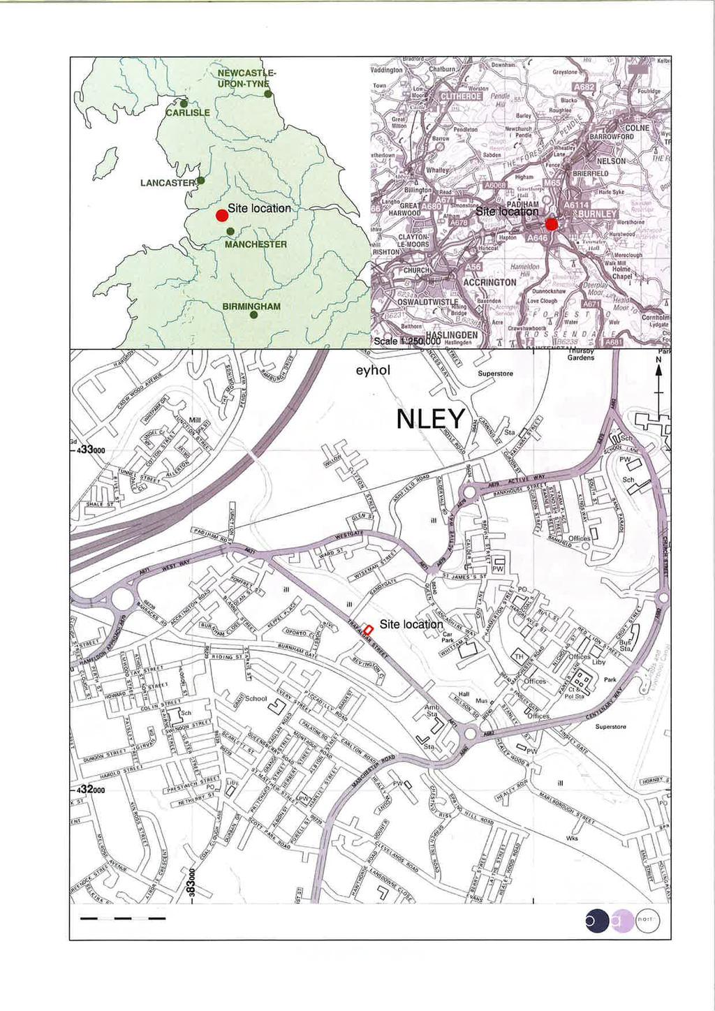
6 29-35 Trafalgar Street, Burnley: Archaeological Building Investigation 4 1. INTRODUCTION 1.1 CIRCUMSTANCES OF THE PROJECT Burnley Council in partnership with Barnfield Construction is currently engaged in a major programme of regeneration of the Weavers Triangle in Burnley. This has focused on returning historic industrial buildings, many of which are afforded statutory designation as listed buildings, back into viable long-term use. This is to be coupled with new development, which is intended to bring new investment to the area One element of the new development is the proposed construction of a drive-through fast-food restaurant on Trafalgar Street. The development proposals allow for the demolition of exiting properties at Trafalgar Street. These buildings are shown on historical mapping to have comprised a row of four single-depth houses along Trafalgar Street, with at least six properties to the rear arranged around a small central courtyard. The two properties forming the northern end of this block appear to have slightly larger than the others, and are depicted as back-toback houses In order to secure archaeological interests, Burnley Council attached a condition to planning consent for the proposed development that allowed for an appropriate programme of archaeological building investigation to be carried out in advance of demolition. In October 2014, Barnfield Construction commissioned Oxford Archaeology North to carry out the required programme of archaeological building investigation This was commensurate with an English Heritage Level II-type survey, and has provided an appropriate record of the buildings to mitigate their ultimate loss. The survey was carried out in October LOCATION, GEOLOGY AND TOPOGRAPHY The study area lies on the western fringe of Burnley town centre (centred on NGR ), on the southern side of the Leeds and Liverpool Canal, at a height of between 110m and 125m above Ordnance Datum (Fig 1). It is bounded by Trafalgar Street to the south-west, Varley Street to the south-east, and the Leeds and Liverpool Canal to the north (Plate 1). The site lies within a part of Burnley known as the Weavers Triangle, and forms the central part of the Canalside Conservation Area A focal feature of the local landscape is the Leeds and Liverpool Canal, which here forms the core section of its industrialised length through Burnley. Its route follows an elevated contour that encircles the town centre, and provided a focus for industrial development during the nineteenth century.

7 29-35 Trafalgar Street, Burnley: Archaeological Building Investigation The solid geology of the Burnley area comprises mostly sedimentary rocks of the Lower Westphalian coal measures. These are Carboniferous period deposits which date to between 290 and 345 million years ago, and include sandstone and Millstone grits. The overlying drift geology is essentially post-glacial deposits, predominantly boulder clay with some areas of sands or gravels (Countryside Commission 1998). The soils of the surrounding area, as mapped by the Ordnance Survey Soil Survey of England and Wales (1983), are predominantly of the Brickfield 3 series, which are cambic stagnogley soils, deriving from the underlying geology. Plate 1: Recent aerial view of the study area, prior to the demolition of the properties adjacent to Trafalgar Street
8 29-35 Trafalgar Street, Burnley: Archaeological Building Investigation 6 2. METHODOLOGY 2.1 METHODOLOGY The building investigation was carried out in October It aimed to provide an understanding of the historic fabric and key architectural features of the various buildings in the study area, and to provide an archive record of their component structures. It has provided a drawn, photographic and textual record of the buildings to English Heritage (2006) Level II standard. Records were made of all principal structural elements, both internal and external, as well as any features of historical or architectural significance. Particular attention was paid to the relationship between the earliest and latest parts of the building, especially those that would show their development and any alterations Photographic Survey: a photographic archive of the buildings was compiled, consisting of both general and detailed interior photographs, which were captured using digital formats Instrument Survey: accurate measured survey plans of the buildings were supplied at the start of the archaeological investigation, and were used as a basis for annotation to illustrate the phasing and development of the buildings. Detail captured by the annotation included features such as window and door openings, and changes in building material and phasing. Some additional survey was carried out using a reflectorless total-station survey, and the final drawings are presented through an industry standard CAD package (AutoCAD 2004) Interpretation and Analysis: a visual inspection of the buildings was undertaken, and a description maintained to English Heritage (2006) Level II standard. These records are essentially descriptive, and provide a systematic account of the origin, development and use of the former domestic properties. 2.2 ARCHIVE The results of all archaeological work carried out will form the basis for a full archive to professional standards, in accordance with current English Heritage guidelines (Management of Research Projects in the Historic Environment, 2006). The original record archive of project will be deposited with the Lancashire County Record Office The Arts and Humanities Data Service (AHDS) online database Online Access to index of Archaeological Investigations (OASIS) will be completed as part of the archiving phase of the project.
9 29-35 Trafalgar Street, Burnley: Archaeological Building Investigation 7 3. BACKGROUND 3.1 INTRODUCTION In order to place the study buildings in a local and regional context, the following section focuses on providing a summarised account of their development. This account is preceded by an overview of the development of the area By the sixteenth century Burnley was the market centre for its local area, and by 1650 it was regarded as a small market town at a national level (Farrer and Brownbill 1911, 442). The majority of the populace in the towns of the region at this time were engaged in the processing, manufacture, and distribution of textiles (Walton 1987), and Burnley was no exception. Many of the cloth workers were independent, operating a cottage-based industry, although the presence of clothiers, such as Richard Sagar of Coal Clough House in 1641, demonstrates that there were employers of weavers working in loomshops (Bennett 1948, 88) A survey of Lancashire in 1787 by Tunnicliffe lists several textile manufacturers in the Burnley area, who would probably have been engaged in the production of woollens (op cit, 168). By the end of the eighteenth century, however, cotton began to predominate, and several woollen mills were converted to cotton production. Expansion of the cotton industry led to a rapid growth of the town, with the population more than doubling between (Lowe 1985, 29). Central to this expansion was the application of steam power to textile production, which led to larger mills being built. The first steam-powered mill in Burnley is thought to have been Peel s Mill at the bottom of Sandygate, erected in 1790 (Bennett 1948, 174). By 1830 there were a total of 32 steam engines employed in the town s textile mills, demanding an increasingly larger workforce (Table 1). Year Population Difference % Increase Table 1: Population of Burnley,
10 29-35 Trafalgar Street, Burnley: Archaeological Building Investigation Another crucial factor in the expansion of the steam-based textile industry was the completion of the Leeds and Liverpool Canal which, by 1816, formed a trans-pennine route, and connected Burnley with the west coast port of Liverpool, and the east coast ports via the rivers Aire and Trent (Clarke 1994). The canal was opened in sections, and that which passed through Burnley was completed by This not only provided an arterial route for the import of raw materials and the export of finished goods, but also served the mill steam-power plants with a ready source of water for boiler feed and condensing purposes. This factor accounts for the dense concentration of mills flanking the canal as it passes through the present study area The application of power-looms was introduced to the region during the 1820s, although weaving sheds became a common feature of Burnley s townscape mostly after the 1850s (Ashmore 1982, 190). Nevertheless, the town developed to become the foremost weaving production centre, possibly in the world, just prior to World War I The 1960s saw great changes in Burnley with numerous buildings being demolished. It was estimated that ten acres of the town were under reconstruction by 1969, reducing Burnley s 300-odd chimney stacks to just a handful (Fort 1988). This was focused on the town centre, however, and the industrial townscape of the Weavers Triangle has survived remarkably intact The key characteristics of the canal, nineteenth-century textile mills and associated workers housing still dominate the townscapes of the region today, although the Weavers Triangle is undoubtedly the best surviving example in Lancashire (Lancashire County Council 2001), and probably one of the most important historic industrial areas in the country. The architectural heritage of the town is reflected in the large number of Industrial Period buildings that are listed, and the designation of sections of the canal corridor as a conservation area. The Canalside Conservation Area was designated in October 1988, and included part of the Weavers Triangle. Due to the threat of demolition of neighbouring buildings and the originally very tight boundary, the Conservation Area was extended in August 1990 and again in March 1993 to enclose the whole of the Weavers Triangle. A further extension in February 1997, to include other notable canalside buildings and engineering features, defines the current boundary. Covering an area of some 34 hectares the Canalside Conservation Area includes a fine collection of well-preserved canalside architecture and engineering features and is widely recognised as being one of the most important historic industrial areas in the North West. Nevertheless, some of the built heritage has been lost recently, frequently as a direct result of dereliction and decay. For instance, Woodfield Mill of , situated on the corner of Keppel Place and Trafalgar Street, was destroyed by a devastating fire in November 2008.
11 29-35 Trafalgar Street, Burnley: Archaeological Building Investigation THE STUDY AREA The study area retains a rectangular block of buildings that represent the remains of former dwellings that front onto Trafalgar Street and are bounded to the west and east by Derby Street and Varley Street respectively. The precise year in which these dwellings were build is uncertain, although they are absent from an undated plan though to have been produced in the early 1840s, but do appear on the Ordnance Survey first edition 6 : 1 mile plan that was surveyed in 1844 and published in This appears to show a U-shaped arrangement of buildings, fronting onto Trafalgar Street, with a small yard to the rear. The more detailed Ordnance Survey 1:1056 mile map of 1851, however, shows an additional two properties to have been added to the rear, enclosing the yard area (Plate 2). Plate 2: Extract from the Ordnance Survey 60 : 1 mile map of 1851, with arrow marking the site of Trafalgar Street

12 29-35 Trafalgar Street, Burnley: Archaeological Building Investigation RESULTS 4.1 INTRODUCTION The domestic buildings that formed the target of the building investigation are shown on historical mapping to have comprised a row of four single-depth houses along Trafalgar Street, with at least six properties to the rear arranged around a small central courtyard. The two properties forming the northern end of this block appear to have slightly larger than the others, and are depicted as back-to-backs TRAFALGAR STREET The basic extant plan represents a modification of that shown on the Ordnance Survey map of 1851 (Plate 2). The earliest phase appears to represent a U-shaped block of eight houses, fronting Trafalgar Street, Derby Street and what later became Varley Street. These are shown with a rear yard on the earlier 6": 1 mile edition of 1848, prior to the construction of two further dwellings on the northern side, enclosing the courtyard. The four properties fronting Trafalgar Street are narrower those on either side street, but have been remodelled into a single shop at ground-floor level (Plate 3). Plate 3: The front elevation of Trafalgar Street Above the shop frontage, they survive in their original form, being of dressed sandstone block construction, similar to the adjacent Habergham Eaves School, erected in 1840, and the nearby Slater s Terrace, built between 1845 and 1850 (OA North 2010).

.")
13 29-35 Trafalgar Street, Burnley: Archaeological Building Investigation Both the first and second floors had two pairs of diminishing windows with dressed single-piece sandstone surrounds and projecting sills (Plate 3). Those on the upper floor are placed at wall-head height, with the rooms within being open to the rafters of the hipped roof. Although much of the internal detail has been removed, original partitions survived within the roof space of all the properties, and comprised single-skin, hand-made brick walls, although all had been remodelled with later inserted doorways (Plate 4). Painted plaster, with a single red stripe below the wall head (Plate 5) appears to form relatively early decoration, but may be contemporary with the insertion of the doorways, overlying an earlier coat of Dolly Blue whitewash (Plate 5). Plate 4: Original partitions at second-floor level Plate 5: Painted plaster on original partitions

, clearly shown on the 1851 plan (Plate 2).")
14 29-35 Trafalgar Street, Burnley: Archaeological Building Investigation The position of the windows, and those in the return bays on both Derby Street and Varley Street (Plates 6 and 7), reveal much of the original layout of the cottages. The windows on the main façade are arranged in two pairs, placed centrally within each half of the frontage. This demonstrates that the cottages were erected as two mirrored pairs of single-fronted, cottages, with the doorways being placed at either end of the façade, and as an adjacent pair in the centre. The wider gap between the windows of 33 and 35 Trafalgar Street reflects the slightly larger size of the western property (Fig 4), clearly shown on the 1851 plan (Plate 2). Plate 6: The Varley Street elevation of Trafalgar Street Plate 7: The Derby Street elevation of the building

15 29-35 Trafalgar Street, Burnley: Archaeological Building Investigation This arrangement was not common until the mid-nineteenth century (Muthesius 1982, 87), and appears to have been undertaken to allow large central windows to be included in the side elevation, where a fireplace would have been placed in one of the structures had they been erected on the more traditional repeated plan form. The central placement of the windows in the end walls of the Trafalgar Street properties also shows them to have been of only a single room depth, forming blind-backed, one-up-and-one-down cottages, rather than having the side windows serving a small rear kitchen, as might be expected with a rectangular plan-form Mirroring the plan form generally allowed for fireplaces to be placed back-to-back on the party wall between each cottage, although a lack of flues in the extant internal walls within the roof space shows that this was not the case with the Trafalgar Street properties (Plate 4). Evidence for possible fireplace flues survived instead at the rear of these structures at first-floor level, in all but the larger western structure (Plates 8 and 9), suggesting that they were placed centrally in the inner cottages and in the inner corner of the outer cottages (Fig 5). Within the southern of the two properties fronting Derby Street, the rear of ground floor flue of 33 Trafalgar Street was observed, with a similar flue adjacent on its western side (Plate 10), presumably serving a fireplace placed against the south wall of the Derby Street cottage. Plate 8: Flue within 33 Trafalgar Street at first-floor level


16 29-35 Trafalgar Street, Burnley: Archaeological Building Investigation 14 Plate 9: Capped flues within 29 and 31 Trafalgar Street Plate 10: Flues in the south party wall on Derby Street No evidence for hearths was observed at either first- or second floorlevels, suggesting that these rooms were not heated, with the fireplaces at ground floor level being primarily for cooking, with the flue presumably being flanked by a range-type cooker, placed in the corner of the room Nothing survives of the original stairs on the Trafalgar Street frontage at ground floor level, although their position can be inferred from the external layout, surviving stairs within the Derby Street and Varley Street structures, and the probable fireplace placement. Whilst it was common by this time for the stairs of urban cottages to be placed within a small back room, often in a hallway leading directly from the front door (Brunskill 1982, 153), the placement of a window in the side-wall of the outer cottages precluded the stairs being placed there.

, with an extant timber stair in this position in the corresponding cottage")
17 29-35 Trafalgar Street, Burnley: Archaeological Building Investigation Given the probable placement of fireplaces or set pots in mirrored pairs on the back wall, as seen in the flues at first-floor level, it is highly likely that the stairs comprised steep, quarter-turn staircases placed against the rear wall, and accessed at the opposite end to the fireplace. An extant stone stair survives in this position in the southern of the two properties fronting Derby Street (Plate 11). A scar at first-floor level above denotes the position of a stair against the back wall to the second floor (Plate 12), with an extant timber stair in this position in the corresponding cottage fronting Varley Street (Fig; Plate 13). Plate 11: Stone stair in southern property on Derby Street Plate 12: Scar for further stair to second floor in southern property on Derby Street

18 29-35 Trafalgar Street, Burnley: Archaeological Building Investigation 16 Plate 13: Timber stair to second floor in southern property on Varley Street The cottages on the side streets formed a continuous build to form part of a continuous U-shaped block of cottages. These had facades mirroring each other, as on the Trafalgar Street frontage, with doorways placed on the opposing ends of the front walls. The properties were slightly wider and deeper, giving the possibility that these were in fact two-up-twodown cottages, with a small back room housing the fireplace and stairs, with the dividing wall being placed on the alignment of the party wall between the cottages on Trafalgar Street. Both of the northern cottages had narrow doorways into a rear courtyard (Fig 4; Plate 14), demonstrating that the fireplaces in the side cottages were not placed back-to-back on the rear wall against the party wall, and that the cottages may have had a repeated, rather than mirrored internal plan, despite the facades At the northern end of the Varley Street row the doorway of the cottage was placed slightly to the south, with a further door in a position matching those in the other cottages forming a corridor into a narrow courtyard (Fig 4; Plate 15). Quoin stones above this doorway suggest that the elevation mark the original return of the block of dwellings.

 affording access to the enclosed courtyard")
19 29-35 Trafalgar Street, Burnley: Archaeological Building Investigation 17 Plate 14: Extant and blocked doorway into courtyard Plate 15: Doorway (to the right) affording access to the enclosed courtyard to the rear
20 Trafalgar Street, Burnley: Archaeological Building Investigation The courtyard is shown on the Ordnance Survey plan of 1848 as bring bounded on its northern side by a wall, hence the need for an access passage from Varley Street (Plate 16). This is a somewhat unusual arrangement, as access could more simply have been formed into the courtyard by the provision of a door in the northern boundary wall. However, it appears that such straightforward access was prevented by either land ownership issues, or that the construction of the two cottages on the northern side of the courtyard, which were completed within a relatively short space of time, was already planned. Plate 16: Access passage from Varley Street to the enclosed courtyard The courtyard appears to have given access on its southern side into a narrow blind-backed cottage (Plate 2) into which there was latterly no external access at ground-floor level, because the door at it western end was blocked (Plate 14). This very small dwelling was remodelled subsequently to form ground-floor outshut extensions to the two central cottages fronting Trafalgar Street, with the rear elevation being entirely rebuilt in brick, bonded in black sooty mortar, and depicted on the Ordnance Survey edition of 1892 (Fig 3). At first-floor level it was knocked through into the cottages fronting Trafalgar Street, being converted into indoor privies. A scar for its shallow roof was visible at second-floor level either side (Plate 17). For the use of Barnfield Construction OA North: November 2014

21 29-35 Trafalgar Street, Burnley: Archaeological Building Investigation 19 Plate 17: Roof scar for cottage on south side of courtyard The courtyard also had narrow doorways into the rear of the two northern properties (Plate 14), the eastern one being blocked subsequently. The Ordnance Survey plan of 1851 appears to show an outshut extension on the rear of the northern of the cottages on Derby Street. There is no evidence for this, either within the cottage (which is heavily rendered), or on the exposed rubble wall face within the courtyard. It is probable that the structure represents a lean-to privy in the courtyard, serving all the original cottages, with an enclosed area to the north probably representing an ash pit. Access to this privy for the two southern cottages on Derby Street and Varley Street presumably involved using the external passage The Ordnance Survey plan of 1851 also appears to show a stair along the eastern side of the courtyard. These lead from north to south, and given the position of a doorway at ground-floor level in this position, this must have afforded access to the first floor of either this dwelling, or the blindbacked dwelling on the southern side of the yard. The upper floor of the blind-back is jettied over the yard, and its fabric reflect that of the other cottage frontages at this level, comprising dressed, coursed sandstone blocks with single-piece jambs and projecting lintels. Whilst there is no physical evidence for the remodelling of the window in the eastern part of the wall, which corresponds to the position of the landing depicted on the 1851 plan, it is very unlikely that such a small cottage would have had two windows into a single room at first-floor level. It is also probable that this wall was significantly remodelled, as the 1:500 OS edition of 1892 shows a much larger jettied projection (Fig 2), which corresponds to I- section beams placed within the extant yard. This combined evidence suggests that the stairs led to the upper floor of the blind-back, which was thus presumably divided into two single-room dwellings, the upper being slightly larger than that below. The 1892 plan also shows the outshut at the rear of the cottage on Derby Street in more detail, and as clearly a separate entity to the cottage, having been enlarged to form three privies.

22 29-35 Trafalgar Street, Burnley: Archaeological Building Investigation VARLEY STREET AND DERBY STREET EXTENSIONS Sometime between 1848 and 1851, two further structures were added to the north of the original housing block. These comprised further cottages, which, although larger than the earlier structures in plan, were of only two storeys, with the attics apparently only useable for storage, rather than providing a further storey as in the taller, earlier dwellings The eastern of these two cottages is of similar dressed stone to the row of buildings to the south, and butts the earlier structures, utilising the earlier wall to form its southern internal wall. Although it appears to have had a walled yard at the northern end of Varley Street, which appears to have formed part of the boundary wall of the Caledonia Boiler and Gasometer Works, the Varley Street façade matches that of the earlier structures, but with the windows to the two taller stories placed slightly higher, and with a string band below the eaves. This suggests that it formed the principal access into the structure, which also has a doorway in its northern gable wall (Plate 18). This may represent an insertion affording access into a courtyard created by the erection of further dwellings along Varley Street, and a large weaving shed, erected prior to 1892 as part of Caledonia Mill. Plate 18: Northern gable of the later extensions Internally, the window in the front elevation at ground-floor level was recessed within a bay (Plate 19), and a similar blind bay in the rear wall suggests that this cottage was built prior to that to the rear, and that a window originally placed in this position was blocked. An extant adjacent doorway up a slope into the western cottage may represent an original entrance if the cottages were of different date, but would have been blocked subsequently, being re-opened when the buildings were combined into a single property in the late twentieth century. The straight stone stairs were placed adjacent to the north wall, with only a short hallway from the door in the Varley Street façade (Plate 19), representing a slight variant of the typical single-fronted cottage plan, which had the stairs placed further from the front door, adjacent to the back room (Brunskill 1997, 115).
, further suggesting its insertion.")

23 29-35 Trafalgar Street, Burnley: Archaeological Building Investigation A keeping hole was incorporated into the wall below stairs (Plate 20), and no evidence was observed to suggest the presence of a cellar. The placement of the doorway adjacent to the stairs in a gable wall is uncommon (Fig 4; Plate 19), further suggesting its insertion. No evidence for internal partitions survive at ground-floor level, but an encased ceiling beam across the ground-floor level with the western edge of the stair wall (Plate 19) probably represents the position of a partition between the front, eastern room, and the smaller scullery, which appears to have been devoid of a fireplace, to the rear. Plate 19: Stairwell and window within recessed bay fronting Varley Street Plate 20: Keeping hole below stairs in Varley Street extension

, was keyed with stone into the cottages to south. The quoined return of the rear wall of the earlier cottages was also visible within the west side of the roof (Plate 22).")
24 29-35 Trafalgar Street, Burnley: Archaeological Building Investigation Original lath and plaster partitions survive on the upper floor, with a small landing affording access to a larger front room with a window overlooking Varley Street, and a smaller rear room with a smaller vertical window in the gable wall. A chimney breast survived only above floor level in the front room (Plate 21), constructed against the external wall of the earlier cottages to the south, and also visible as a brick stack within the roof space (Plate 22), was keyed with stone into the cottages to south. The quoined return of the rear wall of the earlier cottages was also visible within the west side of the roof (Plate 22). The attic was accessed through a 3' x 2'6" hatch above the stairs from the ground floor, with a doorway placed 34" above the floor of 8.5" wide boards (Plate 23). The ceiling is of lath and plaster, to band or pit-sawn joists, with three vertically-set purlins to each pitch of the replaced roof (Plate 22). Plate 21: Remains of chimney breast at first-floor level Plate 22: Roof space of extension to Varley Street properties

25 29-35 Trafalgar Street, Burnley: Archaeological Building Investigation 23 Plate 23: Access hatch to roof space of Varley Street extension The western of the two larger cottages had a front wall of rock-faced block construction, unlike the finer-tooled blockwork of the cottages to the east and south (Plate 7). Its internal plan also differed from that to the east, further suggesting a different phase of construction. It also retained greater evidence of its original plan form than the other structures within the block The front room, which appears to have originally comprised a living room / kitchen was accessed from the northern end of the Derby Street facade, with a centrally-placed vertical window providing the only source of light (Plate 24). A large central fireplace survived behind a late partition on the southern wall (Fig 4; Plate 24), whilst the east wall of the front room was of single-skin brick construction and had doorways at either end (Fig 4; Plate 25). That at the southern end of the wall afforded access into the stairwell, with a perpendicular sandstone stair affording access to the first floor (Fig 4; Plate 26). This differs from the cottage to the east, further suggesting a different date of construction, or different builder, and represents an alternative plan form for small urban cottages, typical nationally, but uncommon in the north of England, being replaced here by the rear stairs at a relatively early date (Muthesius 1982, 87, 123).


26 29-35 Trafalgar Street, Burnley: Archaeological Building Investigation 24 Plate 24: Front room of Derby Street extension Plate 25: Rear wall of front room of Derby Street extension

27 29-35 Trafalgar Street, Burnley: Archaeological Building Investigation 25 Plate 26: Straight stone stair in Derby Street extension The doorway at the northern end of the western stair wall gave access to a further short sandstone stair into a small, approximately 6 x 5' chamber, of probably 5' height, although the majority was obscured by rubble infill. The southern and western walls of this probably cold store / pantry retained 11" wide, 2" thick sandstone shelves, set 22" below ceiling height (Plates 27 and 28). The eastern stair wall above was carried on 4" thick flagstones, supported by a one brick square (9") pier with sandstone capping (Plate 28). Access to the cellar was blocked, possibly in the early/mid-twentieth century, with a timber floor inserted to carry the rear of a safe, which was placed in the front room (Plate 25).


28 29-35 Trafalgar Street, Burnley: Archaeological Building Investigation 26 Plate 27: Shelves within pantry cellar Plate 28: Brick pier with sandstone cappings supporting floor above cellar
.")
29 29-35 Trafalgar Street, Burnley: Archaeological Building Investigation The north wall originally housed a small square window opposite the entrance to the small cellar, but this was blocked following the erection of the Caledonia Mill weaving shed, which overlay the majority of the northern gable, with its wall scar still visible externally (Plate 18). A further window in the north wall afforded access into the narrower rear scullery/wash house, at the rear of the property, and which appears to have been devoid of a fireplace, but possibly had a copper boiler placed in one corner, with an internal brick flue that was removed subsequently. What appears to have been an original doorway was placed at the eastern end of the north wall, but was remodelled subsequently to form a further window (Plates 18 and 29). This appears to have originally provided access into the yard of the Caledonia Boiler and Gasometer Works, but following the construction of a further range of buildings to the north, prior to 1892, it afforded access into a courtyard, with the 1:500 map of that date appearing to show steps to the yard in the position of the doorway. The majority of the external wall of both properties in the position of this later courtyard was latterly obscured by a mid/latetwentieth century single-storey lean-to, which incorporated some sandstone rubble within its north wall, probably forming part of the external wall of the southern of two tunnel-backed (or back-extension ) cottages erected on the Varley Street frontage. Plate 29: Remodelled doorway at the eastern end of the north wall
, with a blocked fireplace in its southern wall (Plate 31) and several, possibly original 8 (0.21m) wide timber planks within the floor.")
.")
30 29-35 Trafalgar Street, Burnley: Archaeological Building Investigation The first-floor arrangement retained its original layout (Fig 5), with a small landing leading to a larger front room (Plate 30), with a blocked fireplace in its southern wall (Plate 31) and several, possibly original 8 (0.21m) wide timber planks within the floor. A hatch to the loft was placed above the stairwell (Plate 30), similar to that in the dwelling to the east, but contained a Phillips and Son safe, which was far more ornate than that on the ground floor below, having its handle cast in the shape of a hand (Plate 32). Plate 30: Front room of Derby Street extension, with attic hatch above stairs Plate 31: Blocked fireplace in south wall of Derby Street extension
, and appears to have formed a small bedroom chamber. Plate 33: original sash window in small rear room 4.")
.")
31 29-35 Trafalgar Street, Burnley: Archaeological Building Investigation 29 Plate 32: Decorative safe handle within attic hatch The smaller rear room at first floor level retained what appeared to be an original vertical 16-light timber sash window (Plate 33), and appears to have formed a small bedroom chamber. Plate 33: original sash window in small rear room The attic was accessible above the safe and had the reduced height brick and stone chimney stack for the fireplace below in-situ (Plate 34). The quoined return of the earlier cottages to the south was also visible, as in the structure to the east (Plate 35). A timber pegged stone roofing flag was also observed within the rubble within the roof space (Plate 36).


32 29-35 Trafalgar Street, Burnley: Archaeological Building Investigation 30 Plate 34: Chimney stack for fireplace in front room Plate 35: Quoined return of earlier Derby Street cottages

33 29-35 Trafalgar Street, Burnley: Archaeological Building Investigation 31 Plate 36: Timber-pegged roofing flagstone in Derby Street extension
34 29-35 Trafalgar Street, Burnley: Archaeological Building Investigation CONCLUSION 5.1 PHASE S The archaeological building investigation has provided an appropriate record of the complex properties fronting onto Trafalgar Street. These were originally separate dwellings, comprising eight two-storey cottages, with additional rooms in the attic, and a much smaller blind-backed twostorey cottage accessed from a courtyard placed behind the other buildings Although Trafalgar Street was merely a side street of the main thoroughfare of Sandygate at the time of their construction in the 1840s, the properties were arranged along its frontage, and along two streets either side, which became Derby and Varley Street. This probably reflects the rapid growth of Burnley during the middle years of the nineteenth century, and suggests a degree of town planning, and allocations of land plots on the fringes of the town by this date Unusually, and in direct contrast to the scene observed by Frederich Engles in Manchester at around the same period (Engels 1844), the four properties fronting what became the main street (Trafalgar Street) were smaller than those on the two side streets. All were single-fronted cottages, and appear to have had only a single room on each floor, although the slightly larger properties on Varley Street and Derby Street may have had timber of single-skin brick partitions to small rear rooms at ground floor level The main façade was mirrored along its centre-line, although with a slightly bigger property at the western end ruining the symmetry, and possibly suggesting its ground floor usage as a shop. Interior symmetry also appears to have been unusually lacking, particularly when considered with the uniformity of the nearby Slaters Terrace on Sandygate, built at around the same date. Staircases appear to have been of tight winding sandstone, quarter-turn variety at ground floor level, placed on the rear wall, adjacent to fireplaces on the Trafalgar Street frontage, but possibly placed on side walls on the side streets. Similar timber staircases led to the attics, with a rare survival of such a feature observed in the southern cottage on Varley Street The inclusion of a courtyard, accessed only through a narrow passage appears unusual when the lack of nearby structures at the time of construction is taken into account. This arrangement is much more akin to that observed within the industrial suburbs of Manchester and Salford at this time, where blind-backed and back-to-back cottages arranged around a dark, poorly lit and ventilated courtyard were the most common type of property built during this period. However, their construction on
35 29-35 Trafalgar Street, Burnley: Archaeological Building Investigation 33 the fringes of a town like Burnley in the early-victorian period appears most unusual. 5.2 PHASE 2 PRE Shortly after the erection of the original block of cottages, two further dwellings were added to the northern ends of Varley Street and Derby Street. That on Varley Street appears earlier, probably having a rear doorway into a yard on its western side, which was rapidly filled by a further structure within a very short space of time. Thus it appears that the earlier of the two structures was built as a single-fronted, two-up-andtwo-down through cottage, but was quickly turned into a back-to-back cottage with the addition of a similarly-sized structure to its rear, intentionally built as blind-backed Although similar in size, both differ in their internal layout. The earlier structure has its stairs against the side wall, immediately in front of the main entrance, and typical of the period, similar to the plan form of the nearby Slaters Terrace (OA North 2014). Whilst its fireplaces have been almost entirely removed, the retention of original sandstone and timber staircases, and a hatched entrance into a loft represent rare examples of such features The slightly later cottage ironically had what would be considered a more traditional plan form, with a central transverse stairwell between the kitchen and parlour. Furthermore, the building retained the only evidence for a cellar, in the form of a small pantry, again typical of small rural houses of the early/mid-nineteenth century. Its survival, and that of the staircases, timber partitions and an original sash window again represented fine and relatively examples of the period. 5.3 PHASE 3 LATE-NINETEENTH CENTURY ONWARDS The chronology of later alterations to the properties is difficult to establish with any certainty. By the last decade of the nineteenth century, the blind-backed cottage within the courtyard had been converted into outshuts for the two central dwellings on Trafalgar Street, reflecting an improvement in housing and sanitation conditions throughout the region at this time Later changes involved the conversion of all 11 dwellings into a single property, possibly containing accommodation as well as a shop and offices on the Trafalgar Street frontage. The attics were also knocked through, although this may have been a much earlier alteration, possibly to create multi-roomed flats within the attic, separate from those below, and with most of the internal stairs removed. Unfortunately, the final alterations to the property removed much of the original fabric, most especially at ground-floor level.
36 29-35 Trafalgar Street, Burnley: Archaeological Building Investigation 34 BIBLIOGRAPHY PRIMARY SOURCES Published Maps Fishwick s Plan of the Town of Burnley, 1827 Walsh s Plan of the Municipal Borough of Burnley, 1882 Ordnance Survey First Edition 6 :1 mile Sheets 64 (survey 1844, published 1848) Ordnance Survey First Edition 1:1056 (survey 1849, published 1851), Sheets 64:7, 64:8, 64:11 Ordnance Survey First Edition 1:1056 (1892), Sheets 64:7, 64:8, 64:11 Ordnance Survey First Edition 1:2500 (1893-4), Sheets 64:2, 64:6 Ordnance Survey 1:2500 (1912 edition) Ordnance Survey 1:2500 (1929 edition) Ordnance Survey 1:2500 (1960 edition) Ordnance Survey Soil Survey of England and Wales (1983) Trade Directories Barrett, P, & Co 1899 General and Commercial Directory of Burnley, Nelson, Colne and Padiham, Preston Barrett, P, & Co 1911 General and Commercial Directory of Burnley, Nelson, Colne and Padiham, Preston Mannex and Co, 1854 History, Topography and Directory of Mid-Lancashire, Preston Slater, I, 1879 Directory of Lancashire, Manchester Worrall, J, 1891 Cotton Spinners and Manufacturers Directory, Oldham Newspapers Blackburn Standard 17 December 1892 Burnley Advertiser 1875 Burnley Gazette 1874
37 29-35 Trafalgar Street, Burnley: Archaeological Building Investigation 35 SECONDARY SOURCES Ashmore, O, 1969 The Industrial Archaeology of Lancashire, Manchester Ashmore, O, 1982 The Industrial Archaeology of North-west England, Manchester Bennett, W, 1948 The History of Burnley , Burnley Bennett, W, 1951 The History of Burnley from 1850, Burnley Brunskill, RW, 1997 Houses and Cottages of Britain, London Clarke, M, 1994 The Leeds and Liverpool Canal, Preston Countryside Commission, 1998 Countryside Character Volume 2: North West, Cheltenham English Heritage, 1991 Management of Archaeological Projects, 2nd edn, Swindon English Heritage, 2006 Understanding Historic Buildings: A Guide to Good Practice, Swindon English Heritage, 2008 Conservation Principles Policies and Guidance, London Farrer, W, and Brownbill, J (eds), 1911 The Victoria History of the County of Lancaster, 6, London Fort, K, 1988 Burnley Since 1900: Ninety Years of Photographs, Manchester Giles, C, and Goodall, IH, 1992 Yorkshire Textile Mills , London Lowe, J, 1985 Burnley, Chichester Muthesius, S, 1982, The English Terraced House, London Nadin, J, 2008 Burnley Cotton Mills, Stroud OA North, 2004: Weaver s Triangle, Canalside Conservation Area Appraisal, Burnley; Desk Based Assessment, unpubl rep OA North, 2010 Lancashire Textile Mills: Rapid Assessment Survey, unpubl rep OA North, 2011: Co-op Headquarters, Miller St, Manchester; Archaeological Excavation, unpubl rep OA North, 2012: Sandygate Mill, Burnley; Historical Survey, unpubl rep OA North, 2013: Reeds Holme Mill, Burnley Rd, Rawtenstall, Lancashire; Archaeological Building Survey, unpubl rep Walton, JK 1987, Lancashire: a Social History, , Manchester
38 29-35 Trafalgar Street, Burnley: Archaeological Building Investigation 36 ILLUSTRATIONS LIST OF FIGURES Figure 1: Site location Figure 2: Study area superimposed on the Ordnance Survey 1:500 map of 1892 Figure 3: Figure 4: Figure 5: Figure 6: Figure 7: Block plan of the buildings in the study area Ground-floor plan of Trafalgar Street First-floor plan of Trafalgar Street Second-floor and attic plan of Trafalgar Street Elevations of Trafalgar Street

39
40
41
42
43

44
45
BUILDINGS IN TALBOT YARD, YORKERSGATE, MALTON. Case UID: RECOMMENDATION. Recommended Grade: II
 ADDRESS BUILDINGS IN TALBOT YARD, YORKERSGATE, MALTON Parish MALTON District RYEDALE County NORTH YORKSHIRE Case UID: 169678 Date First Listed: 27-OCT-2010 Formerly Listed As: RECOMMENDATION Outcome: Yes,
Residential Design Guide Appendices
 Residential Design Guide Appendices Appendix 1 Thorndon Appendix 2 Mt Victoria Appendix 3 Aro Valley Appendix 4 Southern Inner Residential Areas Appendix 5 Oriental Bay Appendix 6 Residential Coastal Edge
Historical Architectural Survey of a house in Chilswell Road, Oxford, OX1 4PJ
 Historical Architectural Survey of a house in Chilswell Road, Oxford, OX1 4PJ Figure 1: 20 Chilswell Road, East Elevation (Number 20 is to the right-hand side). Location The house (Figure 1) is situated
Appendix 2: Mt Victoria
 Appendix 2: Mt Victoria Contents 2.1 Significance of Mt Victoria to the City 2.2 Character Overview 2.3 Areas in Mt Victoria Moir Street Armour Avenue Porritt Avenue Scarborough Terrace Queen Street Elizabeth
Submitted to Fire Station 8 Working Group and Arlington County Public Library HOUSE AT 2211 NORTH CULPEPER STREET
 Submitted to Fire Station 8 Working Group and Arlington County Public Library HOUSE AT 2211 NORTH CULPEPER STREET Location: 2211 North Culpeper Street, Arlington, Virginia. Significance: The house at 2211
Section 2: SPRING LANE (Odd and even numbering)
") Buckinghamshire Archaeological Society HISTORIC BUILDINGS GROUP Great Horwood Village Survey : October 2011 Section 2: SPRING LANE (Odd and even numbering) GREAT HORWOOD : SPRING LANE : 2 The Old Farmhouse,
Buckinghamshire Archaeological Society HISTORIC BUILDINGS GROUP Great Horwood Village Survey : October 2011 Section 2: SPRING LANE (Odd and even numbering) GREAT HORWOOD : SPRING LANE : 2 The Old Farmhouse,
Friends Meeting House, Acomb. The Green, Acomb, York, YO26 5LR. National Grid Reference: SE Statement of Significance
 Friends Meeting House, Acomb The Green, Acomb, York, YO26 5LR National Grid Reference: SE 57149 51293 Statement of Significance Acomb meeting house is a modest building, adapted in the beginning of the
The Grotto House, Lower Basildon, Reading, West Berkshire
 The Grotto House, Lower Basildon, Reading, West Berkshire Building Recording For Dr James D Hull by Sean Wallis Thames Valley Archaeological Services Ltd Site Code GHB 09/79 September 2009 Summary Site
1 The Alleys, St Mary s Road, Hemel Hempstead, Hertfordshire, HP2 5ZB
 Quaker Meeting House, Hemel Hempstead 1 The Alleys, St Mary s Road, Hemel Hempstead, Hertfordshire, HP2 5ZB National Grid Reference: TL 05672 07875 Statement of Significance An early eighteenth-century
Property Name Haxton-Griffin Farm Location Athens vic., Greene County, New York NATIONAL REGISTER OF HISTORIC PLACES CONTINUATION SHEET
 Section Number 7 Page 1 7. Narrative Description Location & Setting The Haxton-Griffin Farm is located on the west side of the Hudson River, about one-half mile from the river and less than two miles southwest
APPLICANT CONSENTS TO PERSONAL INFORMATION BEING RELEASED Yes No. APPLICANT S SIGNATURE: 15 September 2015
 Department of Environment and Heritage Protection Application form Heritage Entry of a State Heritage Place in the Queensland Heritage Register Removal of a State Heritage Place from the Queensland Heritage
HISTORIC BUILDING RECORDING OF THE FORMER ST PHILIP HOWARD SCHOOL, AVENUE ROAD, HERNE BAY, KENT
 HISTORIC BUILDING RECORDING OF THE FORMER ST PHILIP HOWARD SCHOOL, 41-43 AVENUE ROAD, HERNE BAY, KENT 1 1.0 INTRODUCTION...PAGE 3 2.0 HISTORICAL/ARCHAEOLOGICAL BACKGROUND...PAGE 5 3.0 DESCRIPTION OF THE
REASONS FOR LISTING: 306 AND 308 LONSDALE ROAD. #306 Lonsdale #308 Lonsdale. 306 and 308 Lonsdale Road Apartments
 REASONS FOR LISTING: 306 AND 308 LONSDALE ROAD ATTACHMENT 2A #306 Lonsdale #308 Lonsdale 306 and 308 Lonsdale Road Apartments Description The properties at 306 and 308 Lonsdale Road are worthy of inclusion
Grid Iron Terraced Housing
 Grid Iron Terraced Housing Summary of Dominant Character Figure 1: Terraced housing on Gladys Street, in the Clifton Park Terraces character area. 2005 SYAS The housing patterns of this zone are characterised
Report of: DEVELOPMENT MANAGEMENT SECTION HEAD. 19 Cassiobury Park Avenue PARK
 PART A Report of: DEVELOPMENT MANAGEMENT SECTION HEAD Date of Committee: 26 th January 2012 Site address: 19 Cassiobury Park Avenue Reference Number : 11/01079/FULH Description of Development: Erection
SOUTH CAMBRIDGESHIRE DISTRICT COUNCIL. S/1744/05/F Thriplow House and Garage on land Adjacent 22 Middle Street for S Hurst
 SOUTH CAMBRIDGESHIRE DISTRICT COUNCIL REPORT TO: Development and Conservation Control Committee 2 nd November 2005 AUTHOR/S: Director of Development Services S/1744/05/F Thriplow House and Garage on land
Arlington Mill. Bibury Nr Cirencester
 Arlington Mill Bibury Nr Cirencester Arlington Mill An exciting Mill conversion in one of England s prettiest villages. Two Large Reception Rooms Downstairs Cloakroom Laundry/Boiler Room Cellar Kitchen/Breakfast
FORM A - AREA MASSACHUSETTS HISTORICAL COMMISSION MASSACHUSETTS ARCHIVES BUILDING 220 MORRISSEY BOULEVARD BOSTON, MASSACHUSETTS 02125
 FORM A - AREA MASSACHUSETTS HISTORICAL COMMISSION MASSACHUSETTS ARCHIVES BUILDING 220 MORRISSEY BOULEVARD BOSTON, MASSACHUSETTS 02125 Assessor s Sheets USGS Quad Area Letter Form Numbers in Area Town Northborough
Sandyford Farm, Near Belsay Northumberland NE20 0HG
 Sandyford Farm, Near Belsay Northumberland NE20 0HG TWO DEVELOPMENT SITES WITH LAND UNIT 1: THE FARMHOUSE 425,000 UNIT 2: SHEPHERDS COTTAGE 425,000 SITUATION AND DESCRIPTION Sandyford Farm near Belsay
RM-7, RM-7N and RM-7AN Districts Schedules
 1 Intent Districts Schedules The intent of this schedule is to encourage development of ground-oriented stacked townhouses or rowhouses, while continuing to permit lower intensity development. In RM-7AN,
Residence 3 Little Ryrie Street, Geelong
 Residence 3 Little Ryrie Street, Geelong Address 3 Little Ryrie Street, Geelong. Significance Local Construction Date/s 1873 Period & Building Type Victorian residence Designer Unknown Previous Grading
Stewkley s Historic Public Houses
 Stewkley s Historic Public Houses Buckinghamshire Archaeological Society BUCKINGHAMSHIRE HISTORIC PUBS SURVEY / March 2013 SURVEY: Stewkley Local History Group REPORT: Jill Scott Report number BAS/2013-03
MILL ROAD DEPOT, CAMBRIDGE Design and Access Statement December
 66 MILL ROAD DEPOT, CAMBRIDGE Design and Access Statement December 2017 67 HOOPER STREET EAGLE GREEN EAGLE FOUNDRY STREET C H I S H O L M T R A I L THE LIMES Headly Street is the first new street encountered
WELCOME TIMESCALES. Thank you for attending Anthology s final public exhibition on the emerging plans for Kennington Stage. ANTHOLOGY S COMMITMENTS
 WELCOME Thank you for attending Anthology s final public exhibition on the emerging plans for Kennington Stage. Since the second consultation in October 2018, which asked your views on the preferred approach,
Treribble House Three Ashes, Hereford
 Treribble House Three Ashes, Hereford Treribble House Three Ashes, Hereford This handsome and substantial grade II listed 18th Century Georgian house was built in 1721 by Admiral Tovey as well as a very
FARTOWN, PUDSEY LS28 8LP 89,999
 FARTOWN, PUDSEY LS28 8LP 89,999 BRIEFLY COMPRISING Entrance Hall. Living / Dining Room with Breakfast Kitchen Area. Cellar. 1st Floor Staircase and Landing. Double Bedroom. Bathroom. Loft. LOCATION Good
Wyman Historic District
 Wyman Historic District DISTRICT DESCRIPTION The Wyman Historic District is a large district that represents the many architectural styles in fashion between the late 1800s through 1955. With the establishment
The Horsham Town Local List
 The Horsham Town Local List Locally important historic buildings CONSULTATION DRAFT June 2010 1 Introduction What is a local list? Horsham District Council recognises that historic buildings form an important
RM-8 and RM-8N Districts Schedule
 Districts Schedule 1 Intent The intent of this schedule is to encourage development of ground-oriented stacked townhouses or rowhouses, including courtyard rowhouses, while continuing to permit lower intensity
Grosvenor House, Drury Lane, London, WC2. October 2003
 Grosvenor House, 141-143 Drury Lane, London, WC2 October 2003 The material contained in this document is private and confidential and for issue to and use by the client and the project team only. Acknowledgments
A GUIDE TO HOUSING ARCHITECTURE IN SOUTH CENTRAL WISCONSIN
 A GUIDE TO HOUSING ARCHITECTURE IN SOUTH CENTRAL WISCONSIN The purpose of this guide is to provide REALTORS with a common frame of reference in identifying housing architecture. In compiling the guide,
Evidential value The building has low evidential value, and the site is thought to have low archaeological potential.
 Friends Meeting House, Oswestry Oak Street, Oswestry, SY11 1LJ National Grid Reference: SJ 28855 29901 Statement of Significance This small meeting house was built in 1934 as an Anglican mission hall,
Section 7: HIGH STREET and The Cottage, Singleborough Lane (Sequential numbers south side, none north side)
") Buckinghamshire Archaeological Society HISTORIC BUILDINGS GROUP Great Horwood Village Survey : October 2011 Section 7: HIGH STREET and The Cottage, Singleborough Lane (Sequential numbers south side, none
Buckinghamshire Archaeological Society HISTORIC BUILDINGS GROUP Great Horwood Village Survey : October 2011 Section 7: HIGH STREET and The Cottage, Singleborough Lane (Sequential numbers south side, none
Rock Island County Courthouse History & Significance
 1 Rock Island County Courthouse History & Significance HISTORY: The Rock Island County Courthouse was built in 1896 in downtown Rock Island. Rock Island County was established in 1833 and Stephenson, as
12 CUMBERLAND STREET WOODBRIDGE SUFFOLK IP12 4AB
 12 CUMBERLAND STREET WOODBRIDGE SUFFOLK IP12 4AB OIEO 600,000 COUNTRY HOMES COTTAGES UNIQUE PROPERTIES CONVERSIONS PERIOD PROPERTIES LUXURY APARTMENTS Pictured (above left and right): The Tide Mill, Woodbridge
Vauxhall Sky Gardens Wandsworth Road London SW8
 Proposed development of Vauxhall Sky Gardens 143 161 Wandsworth Road London SW8 Affordable Housing Viability Submission Explanatory Notes January 2013 HEDC 230 Court Road London SE9 4TX 020 8265 3456 07711
Hastings CBD Heritage Inventory Project
 Hastings CBD Heritage Inventory Project SDJ COHEN MANUFACTURER S AGENT & IMPORTER LOCATION: Street and Number: 102 Warren Street North City / Town: Hastings Region: Hawke s Bay LEGAL DESCRIPTION: Legal
Current Development. Ownership. All houses are in private ownership. The Village Design and Housing
 Current Development As you will note from the Ifold Past display the settlement has grown in an ad hoc unplanned manner around a network of un-adopted access roads off the main Plaistow Rd. Residential
Canterbury City Council Military Road Canterbury Kent CT1 1YW. Title: CA//16/02739/FUL. Author: Planning and Regeneration.
 O Crown copyright and database rights 2017 Ordnance Survey 100019614 Title: CA//16/02739/FUL Author: Planning and Regeneration Scale 1:1,250 Map Dated: 22/02/2017 Canterbury City Council Military Road
Alterations to a Designated Heritage Property and Authority to Amend a Heritage Easement Agreement, 80 Bell Estate Road (Thornbeck-Bell House)
") STAFF REPORT ACTION REQUIRED Alterations to a Designated Heritage Property and Authority to Amend a Heritage Easement Agreement, 80 Bell Estate Road (Thornbeck-Bell House) Date: October 4, 2011 To: From:
STAFF REPORT ACTION REQUIRED Alterations to a Designated Heritage Property and Authority to Amend a Heritage Easement Agreement, 80 Bell Estate Road (Thornbeck-Bell House) Date: October 4, 2011 To: From:
Friends Meeting House, Taunton
 Friends Meeting House, Taunton Bath Place, High Street, Taunton, Somerset, TA1 4EP National Grid Reference: ST 22568 24419 Statement of Significance The meeting house was built in 1816 to replace an earlier
RT-11 and RT-11N Districts Schedules
 Districts Schedules 1 Intent The intent of this schedule is to allow a variety of housing options by encouraging development of multiple small houses and duplexes on larger lots and assembled sites, while
A SURVEY OF WAREHOUSES IN ULVERSTON, CUMBRIA
 A SURVEY OF WAREHOUSES IN ULVERSTON, CUMBRIA DW Elsworth and J Dawson 2005 1 Contents Contents 1 Summary 2 Acknowledgements 2 1. Introduction 3 1.1 Circumstances of the Project 3 2. Methodology 4 2.1 Introduction
Mill Cottage, Church Street, Wetheringsett
 Mill Cottage, Church Street, Wetheringsett An historically important 3 bedroom detached village cottage, Grade II Listed and found within the most delightful setting at the heart of the village. Numerous
FOR SALE BY PRIVATE TREATY
 Parva House, 335C Wakefield Road, Denby Dale, Huddersfield HD8 8RT Tel: 01484 866368 info@robertshaws.com www.robertshaws.com FOR SALE BY PRIVATE TREATY FALL HEAD FARMHOUSE FALL HEAD LANE SILKSTONE BARNSLEY
Toronto Preservation Board Toronto East York Community Council. Acting Director, Policy & Research, City Planning Division
 STAFF REPORT ACTION REQUIRED Alteration of a Heritage Property Designated under Part IV of the Ontario Heritage Act and Protected by a Heritage Easement Agreement 1046 Yonge Street Date: February 7, 2012
NEW HAMPSHIRE HISTORIC PROPERTY DOCUMENTATION BICKFORD RENTAL HOUSE NH STATE NO First Avenue, Berlin, Coos County, New Hampshire
 NEW HAMPSHIRE HISTORIC PROPERTY DOCUMENTATION BICKFORD RENTAL HOUSE NH STATE NO. 689 Location:, Berlin, Coos County, New Hampshire USGS Berlin Quadrangle UTM Coordinates: Z19 4926353N 326093E Present Owner:
As a purpose-built and little altered urban Victorian meeting house, the building has medium heritage significance.
 Friends Meeting House, Southampton 1A Ordnance Road, Southampton, Hampshire, SO15 2AZ National Grid Reference: SU 42111 12766 Statement of Significance As a purpose-built and little altered urban Victorian
Milford. Milford to the East of the River. Foundry Lane, Derby Road, nos. 2 and 3 c.1818 in present form - Listed Grade II
 Milford Milford to the East of the River The Strutts started purchasing land in Milford in March 1781 and immediately began to construct the first structure in what was to become a complex of cotton mills
Aesthetic value This modern building is typical design for its date and has low aesthetic value.
 Friends Meeting House, Stoke-on-Trent 2 Miller Street, Newcastle-under-Lyme, ST5 1QJ National Grid Reference: SJ 85470 46308 Statement of Significance A modest building of 1978 that provides good facilities
LING HILL FARM WHITBY, NORTH YORKSHIRE
 LING HILL FARM WHITBY, NORTH YORKSHIRE A FARMSTEAD INCLUDING A HOUSE, COTTAGE AND PART COMPLETED BARN CONVERSION PLUS PLANNING PERMISSION FOR BARNS TO BE CONVERTED TO PROVIDE 2 FURTHER HOLIDAY COTTAGES.
ASCOT HOUSE COLSTON BASSETT NOTTINGHAMSHIRE NG12 3FD. Land & Estate Agents Property Consultants
 ASCOT HOUSE COLSTON BASSETT NOTTINGHAMSHIRE NG12 3FD Land & Estate Agents Property Consultants The Country Property Specialists ASCOT HOUSE A stunning country home of appreciable character on the edge
THE OPPORTUNITY HAM MILL, LONDON ROAD, THRUPP, STROUD, GL5 2BB. Artists impression
 2 HECTARE / 4.94 ACRE RIVERSIDE DEVELOPMENT SITE WITH DETAILED PLANNING PERMISSION PROPOSALS FOR A HIGH QUALITY RESIDENTIAL-LED, MIXED-USE DEVELOPMENT LOCATED WITHIN 2.5 MILES OF STROUD TOWN CENTRE 100
BROCKTON HALL. Brockton, Eccleshall, Staffordshire.
 BROCKTON HALL Brockton, Eccleshall, Staffordshire. BROCKTON HALL Brockton, Eccleshall, Staffordshire, ST21 6LY Prospective purchasers are afforded the rare opportunity to acquire one of Staffordshire
Durant Ave., Berkeley
 Page 1 of 6 Attachment: 2121-2123 Durant Ave., Berkeley Proposed Project Analysis for New Construction Prepared for: Kahn Design Associates 1810 6 th Street Berkeley, CA. 94710 19 December 2014 Revised
A GUIDE TO HOUSING ARCHITECTURE IN SOUTH CENTRAL WISCONSIN
 A GUIDE TO HOUSING ARCHITECTURE IN SOUTH CENTRAL WISCONSIN The purpose of this guide is to provide REALTORS with a common frame of reference in identifying housing architecture. In compiling the guide,
South East CBD/ Paris End
 South East CBD/ Paris End Over the past 50 years, the eastern end of the CBD around Collins and Little Collins streets has lost many lanes and important heritage lanescapes due to large-scale office developments
06.09 Urban Structural Density (2017 Edition)
") 06.09 Urban Structural Density (2017 Edition) Overview Natural landscape and urban development - both have determined the urban structure of Berlin. The maps "Actual Use of Built-Up Areas", "Inventory
06.09 Urban Structural Density (2017 Edition) Overview Natural landscape and urban development - both have determined the urban structure of Berlin. The maps "Actual Use of Built-Up Areas", "Inventory
SURVEY OF PUBLIC HOUSES. Tingewick
 BUCKINGHAMSHIRE ARCHAEOLOGICAL SOCIETY HISTORIC BUILDINGS GROUP SURVEY OF PUBLIC HOUSES IN THE PARISH OF Tingewick BUCKINGHAMSHIRE A record of extant buildings that are currently or were formerly public
LEISURE COTTAGE, MOOR ROAD Cotherstone, Barnard Castle
 LEISURE COTTAGE, MOOR ROAD Cotherstone, Barnard Castle LEISURE COTTAGE, MOOR ROAD COTHERSTONE, BARNARD CASTLE, COUNTY DURHAM, DL12 9PJ PLACED IN A HIGHLY SOUGHT AFTER TEESDALE VILLAGE; LEISURE COTTAGE
CAIRNGORMS NATIONAL PARK AUTHORITY
 CAIRNGORMS NATIONAL PARK AUTHORITY Title: Prepared by: REPORT ON CALLED-IN PLANNING APPLICATION NEILSTEWART (PLANNER, DEVELOPMENT CONTROL) DEVELOPMENT PROPOSED: ERECTION OF NEW DWELLINGHOUSE, AT LAND BETWEEN
West End House West End Northleach GL54 3HG
 West End House West End Northleach GL54 3HG Step inside West End House West End House is a period Cotswold stone property situated just off the High Street on West End in Northleach, dating back at least
This location map is for information purposes only. The exact boundaries of the property are not shown.
 LOCATION MAP AND PHOTOGRAPH: 73 ST. GEORGE ST ATTACHMENT NO. 13A This location map is for information purposes only. The exact boundaries of the property are not shown. View of the principal (west) façade
Windshield Survey of McLoud, Pottawatomie County. September 12, 2007 By Jim Gabbert Architectural Historian OK/SHPO
 Windshield Survey of McLoud, Pottawatomie County September 12, 2007 By Jim Gabbert Architectural Historian OK/SHPO Purpose and Methodology The purpose of this windshield survey is to identify, based on
Weggs Farmhouse, Common Road, Dickleburgh
 Weggs Farmhouse, Common Road, Dickleburgh A Grade II Listed farmhouse of timber frame construction beneath a classic steeply pitched roof, providing four bedrooms, two reception rooms, office and kitchen
Design and Access Statement Volume III Part 6 of 9 Plot A1. May 2018 Allies and Morrison
 Design and Access Statement Volume III Part 6 of 9 Plot A1 May 2018 Allies and Morrison 6 OFFICE 135 CANADA WATER MASTERPLAN PLOT A1 Design and Access Statement May 2018 6.1 Introduction The office development
Memorandum. Overview. Background Information. To: Scott Albright, City of Santa Monica Date: 04/22/2013 Jan Ostashay, Principal OAC
 Memorandum P.O. Box 542 Long Beach, CA 562.500.9451 HISTORICS@AOL.COM To: Scott Albright, City of Santa Monica Date: 04/22/2013 From: Jan Ostashay, Principal OAC Re: PRELIMINARY HISTORICAL ASSESSMENT:
PREPARED FOR: ADI DEVELOPMENT GROUP INC.
 Acronym Urban Design and Planning/Mark Sterling Consulting Inc. 111 Clendenan Avenue, Toronto, Ontario M6P 2W7 URBAN DESIGN BRIEF PROPOSED DEVELOPMENT 4880 VALERA ROAD, CITY OF BURLINGTON PREPARED FOR:
Ancient Sites & Buildings. Bagenalstown Area
 Ancient Sites & Buildings. Bagenalstown Area Vol 2, Site 4 Dunleckney Rural Area Dunleckney. Dun Leicne The fort of the flags. The townland is situated to the north of the modern town of Muine Bheag, founded
DESIGN, ACCESS & PLANNING STATEMENT
 (MADRON STREET) LONDON SE1 5UB DESIGN, ACCESS & PLANNING STATEMENT The architectural response for the site has been designed with regard to the following: The New Southwark Plan The London Plan: Spatial
NOW, THEREFORE, THE COUNCIL OF THE CITY OF CALGARY ENACTS AS FOLLOWS:
 PUD2017-0081 ATTACHMENT 1 BYLAW NUMBER 13M2017 BEING A BYLAW OF THE CITY OF CALGARY TO DESIGNATE THE WHITE RESIDENCE AS A MUNICIPAL HISTORIC RESOURCE * * * * * * * * * * * * * * * * * * * * * * * * * *
29 Springfield Road, Ulverston, Cumbria, LA12 0EJ
 29 Springfield Road, Ulverston, Cumbria, LA12 0EJ Situated in one of the town s popular roads, this nicely proportioned family home offers excellent potential for somebody looking to move into this popular
CASTLES OF CALEDON URBAN DESIGN REPORT
 CASTLES OF CALEDON URBAN DESIGN REPORT PROPOSED RESIDENTIAL DEVELOPMENT CALEDON, ONTARIO 10 JULY, 2015 TABLE CONTENTS: 1.0 DEVELOPMENT 4.0 CONCLUSION 1.1 Introduction 1.2 Castles of Caledon- Urban Design
NEW HAMPSHIRE HISTORIC PROPERTY DOCUMENTATION DINARDO-DUPUIS HOUSE NH STATE NO Wight Street, Berlin, Coos County, New Hampshire
 NEW HAMPSHIRE HISTORIC PROPERTY DOCUMENTATION DINARDO-DUPUIS HOUSE NH STATE NO. 696 Location:, Berlin, Coos County, New Hampshire USGS Berlin Quadrangle UTM Coordinates: Z19 4926650N 325990E Present Owner:
RM-1 and RM-1N Districts Schedule
 Districts Schedule 1 Intent The intent of this Schedule is to encourage development of courtyard rowhouses on larger sites while continuing to permit lower intensity development on smaller sites. Siting
Church and Gloucester Properties Inclusion on Heritage Inventory
 STAFF REPORT ACTION REQUIRED Church and Gloucester Properties Inclusion on Heritage Inventory Date: April 17, 2009 To: From: Toronto Preservation Board Toronto and East York Community Council Director,
RT-3 District Schedule
 District Schedule 1 Intent The intent of this Schedule is to encourage the retention of neighbourhood and streetscape character, particularly through the retention, renovation and restoration of existing
Fig. 16 & 17 Left: Carved limestone detail. Right: Carved limestone and metal screen at main entrance on west elevation.
 Assessment and Feasibility Study Statement of Significance The historic Hall of Waters Building, located along the Fishing River in Downtown Excelsior Springs, Missouri, is a significant Art Deco building,
Criteria Evaluation: Landmark staff found that the structure application meets History Criteria 1a, and Architecture Criterion 2a and 2b.
 To: Landmark Preservation Commission From: Kara Hahn, Principal Planner, Community Planning & Development (CPD) Date: October 9, 2018 RE: Landmark Designation for the Henderson House, 2600 Milwaukee Street
CITY OF VANCOUVER ADMINISTRATIVE REPORT
 CITY OF VANCOUVER ADMINISTRATIVE REPORT Report Date: June 15, 2005 Author: Yardley McNeill Phone No.: 604.873.7582 RTS No.: 05159 CC File No.: 1401-84 Meeting Date: July 14, 2005 TO: FROM: SUBJECT: Vancouver
Demolition of Three Heritage Properties in the South Rosedale Heritage Conservation District - 5, 7, and 9 Dale Avenue
 REPORT FOR ACTION Demolition of Three Heritage Properties in the South Rosedale Heritage Conservation District - 5, 7, and 9 Dale Avenue Date: January 30, 2018 To: Toronto Preservation Board Toronto and
A By-law to amend Zoning and Development By-law No regarding Laneway Houses
 Zoning & Development By-law Amendments regarding Laneway Houses Draft for Public Hearing A By-law to amend Zoning and Development By-law No. 3575 regarding Laneway Houses 1. This By-law amends or adds
HOUSES IN DUMARESQ STREET & PITT STREET ST HELIER JERSEY
 HOUSES IN DUMARESQ STREET & PITT STREET ST HELIER JERSEY Chris Aubin, Paul Drury, Kirsty Rodwell for The Paul Drury Partnership January 2005 CONTENTS 1 The commission 3 2 The evolution of the buildings
RT-5 and RT-5N Districts Schedule
 Districts Schedule 1 Intent The intent of this District Schedule is to strongly encourage the retention and renovation of existing character houses by providing incentives such as increased floor area,
1. *Does the document clearly specify the aims, objectives and scope of the proposed programme of archaeological work?
 Notes and Guidance This document provides curatorial advisors, archaeological practitioners and other interested parties with additional information and guidance on the standards and expectations for archaeological
HOUSING TYPES AND CHARACTERISTICS
 HOUSING TYPES AND CHARACTERISTICS Market Study Housing Type Classification Single-Family Detached Townhouse Projected Dwelling Unit Demand 2010-2040 65.7 percent of total 9.1 percent of total Housing Variants
Re: TP , Flinders Street MELBOURNE, demolition and construction of 13 storey building.
 16 March 2017 City of Melbourne City Planning and Infrastructure, PO Box 1603 Melbourne Vic 3001 planning@melbourne.vic.gov.au Attn: Ben Nicholson Supported by the National Trust P.O. Box 24198, Melbourne
established 200 years MANCHESTER HOUSE Market Place, Chipping Norton
 established 200 years MANCHESTER HOUSE Market Place, Chipping Norton Manchester House 5 Market Place Chipping Norton Oxon OX7 5NA A SUBSTANTIAL LISTED PERIOD TOWN HOUSE WITH GREAT POTENTIAL INCORPORATING
Residential Development Opportunity Richmond Place, Boughton, Chester, Cheshire
 Residential Development Opportunity Richmond Place, Boughton, Chester, Cheshire Residential Development Opportunity Richmond Place, 125/127 Boughton, Chester, Cheshire CH3 5BH Approximate distances Chester
Garden Apartment, 15 Marlborough Buildings, Bath
 Garden Apartment, 15 Marlborough Buildings, Bath Garden Apartment 15 Marlborough Buildings, Bath, BA1 2LY A simply exquisite Grade II listed garden apartment providing approximately 3,000 sq. ft. of accommodation
ROOKERY COTTAGE, MIDDLETON TYAS Richmond, North Yorkshire
 ROOKERY COTTAGE, MIDDLETON TYAS Richmond, North Yorkshire ROOKERY COTTAGE MIDDLETON TYAS, RICHMOND, NORTH YORKSHIRE, DL10 6RE A HIDDEN GEM. AN ATTRACTIVE CHARACTER THREE/FOUR BEDROOMED DETACHED PERIOD
COUNTRY HOMES & COTTAGES
 AGENTS for FINE COUNTRY HOMES & COTTAGES Caring Lane Leeds Maidstone Kent ME17 1TJ M20 Junction 8 2 miles approx Bearsted Rail Station 2 miles approx Maidstone Centre 4.5 miles approx A fine example of
Kent Cottage guide price 815,000 Pound Green Buxted East Sussex TN22 4JR
 Kent Cottage guide price 815,000 Pound Green Buxted East Sussex TN22 4JR Step inside Kent Cottage A charming Victorian detached house, extended and modernised in recent years but retaining the character
LIBERTY HOUSE. Paul Keogh Architects. Paul Keogh Architects LIBERTY HOUSE HOMES
 150 151 Award: Highly Commended 2015 RIAI Irish Architecture Awards Client: Dublin City Council Liberty House takes its inspiration from the Georgian brick terraces Project Photography: Peter Cook Location:
Friends Meeting House, Middlesbrough. 131 Cambridge Road, Linthorpe, Middlesbrough, TS5 5HL. National Grid Reference: NZ
 Friends Meeting House, Middlesbrough 131 Cambridge Road, Linthorpe, Middlesbrough, TS5 5HL National Grid Reference: NZ 48046 17930 Statement of Significance The meeting house occupies a substantial Edwardian
Toronto Preservation Board Toronto East York Community Council. Acting Director, Urban Design, City Planning Division
 STAFF REPORT ACTION REQUIRED Demolition of a Designated Heritage Property within the Yorkville Hazelton Heritage Conservation District and Construction of a Replacement Structure - 129 Hazelton Avenue
Land at Sheldon Heath Road and Platt Brook Way, Sheldon, Birmingham, B26 2DS
 Committee Date: 06/02/2014 Application Number: 2013/08937/PA Accepted: 03/12/2013 Application Type: Full Planning Target Date: 04/03/2014 Ward: Sheldon Land at Sheldon Heath Road and Platt Brook Way, Sheldon,
H4. Residential Mixed Housing Suburban Zone
 H4. Residential Mixed Housing Suburban Zone H4.1. Zone description The Residential Mixed Housing Suburban Zone is the most widespread residential zone covering many established suburbs and some greenfields
The Pinnacle, Willenhall
 Development Case Study The Pinnacle Willenhall, West Midlands Background Originally constructed in 1967 using a large panel system, this 15 storey residential tower block is representative of high-rise
Hastings CBD Heritage Inventory Project
 Hastings CBD Heritage Inventory Project POPPELWELLS BUILDING OTHER NAMES: Fitzpatrick Building LOCATION: P. Huddleston, 2015 Street and Number or location: 117 125 Russell Street North City/ Town: Hastings