A SURVEY OF WAREHOUSES IN ULVERSTON, CUMBRIA
|
|
|
- Derick Fox
- 5 years ago
- Views:
Transcription


1 A SURVEY OF WAREHOUSES IN ULVERSTON, CUMBRIA DW Elsworth and J Dawson 2005
2 1 Contents Contents 1 Summary 2 Acknowledgements 2 1. Introduction Circumstances of the Project 3 2. Methodology Introduction Study Area Building Types Survey Background Interpretation Archive 6 3. Background Introduction Historical Background 7 4, Survey Results Introduction Gazetteer Results Introduction Summary and Analysis Recommendations 61 Bibliography 62 Primary Sources 62 Secondary Sources 62 Figures 64
3 2 Summary Ulverston has a rich architectural heritage, much of it dating from the 18 th and 19 th centuries and corresponding to a period of growth following the construction of the Ulverston Canal and the Furness Railway. This typifies the sort of development seen during the Industrial Revolution, and Ulverston was as much an industrial town as it was agricultural. Warehouses can therefore perhaps be considered as symbolic of growth resulting from the Industrial Revolution, and yet they are a much neglected building, often in poor condition and by their nature positioned away from the main street frontages where the more architecturally exciting buildings dominate. During March 2005 it was decided to undertake a rapid survey of all of the identifiable warehouses and warehouse-like buildings in Ulverston. The aim of the survey was to identify how many of this type of building exist, what condition they are in, what uses they are put to and their distribution within the town. A gazetteer of all of the sites was compiled and photographs were taken. A brief amount of analysis was carried out of the results and a short historical background prepared in order to put them into context. The results of the survey, although not interpreted in detail, demonstrate that in general warehouses and warehouse-like buildings are threatened by redevelopment and often not in good condition, although the majority are protected by their position within the Conservation Area. Most are used for business purposes although many are used for housing or are empty. Based on the results of the survey it is recommended that as many measures as possible be untaken to protect such buildings in future and that further recording be undertaken of selected good examples. Acknowledgements The survey was carried out by Daniel Elsworth and Jo Dawson, who also wrote the report. The authors would like to thank the staff of the Cumbria Record Office (Barrow-in-Furness) for their help with collating background sources.
4 3 1. Introduction 1.1 Circumstances of the Project During the last 12 months an increasing number of derelict or empty warehouses and warehouse-type buildings in Ulverston have been converted to, or have had planning applications for conversion into, housing. This inevitably destroys many of the original features of these buildings, which were not designed for domestic use, or alters them to such an extent that their original purpose becomes obscured. Many such conversions have already been undertaken and the stock of warehouses in good, original condition is continually decreasing Although not architecturally impressive when compared to many buildings in Ulverston, warehouses are of some historical importance as they played an major role in the trade and commerce of the town. Many are not Listed but a large number are within the Conservation Area and therefore have some protection from adverse development The recently completed Extensive Urban Survey (Cumbria County Council and English Heritage 2002) and draft Conservation Area Character Appraisal (CACA; South Lakeland District Council 2004) have begun to provide a more detailed understanding of the historic fabric of Ulverston. The information provided by these assessments has allowed this survey to be carried out rapidly and it is hoped that it will add an extra layer to the growing body of available information The survey was carried out in March The report was written in April 2005.
5 4 2. Methodology 2.1 Introduction This section is intended to define the way in which the survey was carried out, the area that was examined and how the information was gathered. It is intended that this will identify to the reader where the limitations of the survey are and where further work or improved survey might be necessary, as well as demonstrate that an appropriate strategy was employed throughout. 2.2 Study Area The entire town of Ulverston was examined, including areas both within and out with those covered by the Extensive Urban Survey (Cumbria County Council and English Heritage 2002) and CACA (South Lakeland District Council 2004). Outlying settlements such as Swarthmoor, Three Bridges, Sandhall, Ross Side and so forth were not included nor were any of the surrounding farms or isolated houses. Modern estates such as Croftlands were also not included, as they were considered unlikely to have any suitable examples. 2.3 Building Types It was not possible to find a detailed standard definition of a warehouse prior to the survey, although they are included in an early guide to recording industrial structures (AIA 1993), and are described by Dixon and Muthesius as for the storage rather than the manufacture of goods (1978, 124). Warehouses were therefore defined by a number of features, the most significant of which was high-level loading doorways. These are generally wider than a typical pedestrian doorway, but not as wide as a wagon doorway. In a typical example these are positioned one per floor, one above the other, with windows or pedestrian doorways flanking them rather than below them (see illustrated examples in Marshall and Davies-Shiel 1971, 104; Crossland 1971, 45; White 2000, 29; Brunskill 2002, 125). In some cases the remains of hoists or the canopies that covered them are present. The size of the building is not necessarily an identifying factor, and many are relatively small, sometimes only two storeys high (see illustrated example in Matthews 2003, 64). In some cases large buildings were included despite the absence of other typical features because they are specifically identified as warehouses on early maps (see Section 3.2.5; Plate 1) and it is assumed that they were used for the storage of heavy or bulky items such as slate or ore In many cases buildings have been included that are not warehouses as such but have warehouse-like features, in particular high-level loading doorways. Many of these, although not technically warehouses, were evidently used for storage and/or redistribution of goods and so have much the same function. A number of other examples were also recorded that combine the function of a warehouse (storage and redistribution) and another use, usually industrial in nature. Specific examples include mills, which almost invariably have a warehouse element, and other, more minor industrial buildings, where storage was an important consideration (see examples in Marshall and Davies-Shiel 1971, 18 and 97). Again, although not warehouses in the strictest sense these have been included within the survey.
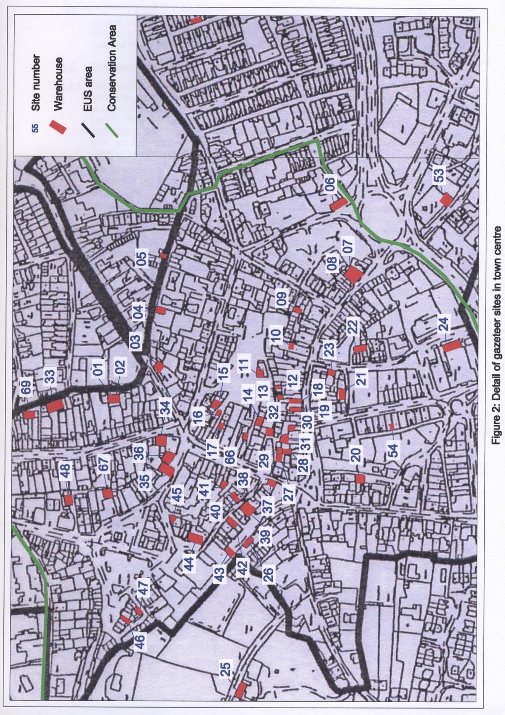
6 5 2.4 Survey The survey was carried out very rapidly. The entire town was systematically examined street by street and any warehouses that were identified were marked on a map (Figs 1 and 2). Photographs were taken wherever possible, and brief descriptions were written. In most cases, to save time in the field, notes and descriptions were compiled based on the photographs Apart from a written description of each building an assessment was also made of its current use (as far as this could be ascertained), the level of preservation of original warehouse features and its present condition The current use of the building was divided into six basic types: Business - including shops, pubs, and minor industries Domestic - either an individual house or several flats, including examples in the process of being converted Empty - the building is not used Recreation - used as a function room, hall or similar Storage - for both business and private purposes Unknown - it was not possible to ascertain what the building was used for Preservation was divided into four grades: 1 - all or most of the original warehouse features were present 2 - some or many of the original warehouse features were present 3 - a few of the original warehouse features were present 4 - very few or none of the original warehouse features were present Condition was similarly divided into four different terms: Good - the building was in use and well maintained Fair - the building was probably or partially in use and/or less well maintained Poor - the building was empty and/or in a bad state of repair, possibly with some minor structural problems Very poor - the building was derelict and/or suffering severe structural problems A record was also made of any statutory designations that protected it such as being within the Conservation Area or being Listed. Each building s character, as defined by the draft CACA (South Lakeland District Council 2004), was also noted. The results of the survey were collated into a simple gazetteer (Section 4), which included photographs of each building where these were available. 2.5 Background A limited background history was compiled to accompany the results of the survey and put them into context. This was compiled largely from secondary sources and early maps, and was not intended to examine the history of any of the individual buildings in detail nor provide a comprehensive examination of the subject.
7 6 2.6 Interpretation As the intention of the survey was simply to record warehouses, only a limited amount of interpretation was carried out. The results of the survey, combined with the information compiled for the background history, were subject to some interpretation, concentrating particularly on the current condition of the warehouses and the patterns of use, condition and distribution that could be identified. 2.7 Archive Copies of this report will be deposited with the Cumbria Sites and Monuments Record and the Conservation Officer for South Lakeland District Council. The paper and digital archive will be deposited at the Cumbria Record Office (Barrow-in-Furness) with a copy of the report.
8 7 3. Background 3.1 Introduction The historical background is primarily compiled from secondary sources and is intended to place the results of the survey into a local context. As the buildings are all post-medieval in date the background concentrates on this period, in particular examining events that are potentially of direct relevance to the construction and use of warehouses. 3.2 Historical Background Following the dissolution of Furness Abbey and Conishead Priory in the sixteenth century, Ulverston soon eclipsed Dalton as the principal market town in the area (Birkett 1949, 24). Ulverston began to grow increasingly wealthy during the seventeenth century as a result of trade in raw materials such as iron ore and slate, helped by the sound business practices of local Quakers (ibid). During the eighteenth century Ulverston s prosperity grew even greater, due in part to the number of ships visiting with goods on a regular basis and the variety of local industries that had developed (Rollinson 1966, 46-7). This was the town s golden age and Ulverston was famously described as the London of Furness by Father Thomas West (West 1802, 36) on account of its prosperity through trade (Robinson 1999). This was further enhanced by the expanding iron industry, which made use of landings at Ulverston (Marshall 1958, 85) At the end of the eighteenth century it was proposed that a canal be built to further increase the town s capacity for trade (Mckeever and Layfield 2004, 32), in a sense creating a large wharf, much closer to the town (Marshall and Davies-Shiel 1969, 184). In 1791 a meeting of interested parties was held and subscriptions to promote the scheme were raised (Mckeever and Layfield 2004, 33). In 1792 surveys of the proposed route, from Hammerside Hill at the coast to Weint End on the east edge of the town, were made and estimates of the expected total costs calculated (ibid). By the end of the year a bill was proposed to Parliament, which was passed in May 1793 (op cit, 34-5). Detailed specifications were then drawn up and the first sod was cut in August of the same year (op cit, 37-8). Despite problems during the construction the canal was completed in 1796 and opened that December (op cit, 42) Initially the canal was a success, although it was subject to the vagaries of the tide within only a few years and by 1805 ships were struggling to enter it (Close s additions in West 1805, 406). Schemes were put in place to try to resolve this and problems were always overcome but the Ulverston Canal was never particularly profitable (Marshall and Davies-Shiel 1969, 184); shareholders had to wait until 1836 for their first dividend (Mckeever and Layfield 2004, 45). Ironically, within 20 years of this the canal had been superseded by the construction of the Furness Railway (Marshall and Davies- Sheil 1969, 184). The railway had gradually been eroding the trade of Ulverston Canal for some time, by transporting goods to the growing port of Barrow-in-Furness and at the end of 1850 the Canal Company announced that it was to be dissolved (Mckeever and Layfield 2004, 48). Within three years a new railway bridge was being built across the canal, although the terms of the agreement meant that a new basin had to be constructed to

9 8 allow vessels to continue to use the canal, albeit in a limited fashion (op cit, 49) Warehouses: it is likely that the majority of warehouses in Ulverston relate to the period of prosperity that occurred during the late 18 th and early 19 th centuries, although it is not necessarily the case that they were built as a result of the construction of the canal. Indeed, the initial shareholders of the canal were mostly warehouse proprietors (Mckeever and Layfield 2004, 34), suggesting that a number of warehouses of some description already existed by the 1790s. Ulverston s prominence as a port was recognised early in the 18 th century when the customhouse for the area was moved there from Rampside after 1720 (Fell 1968, 323). Undoubtedly this prominence would have required a large number of warehouses Warehouses were certainly constructed to serve the canal, particularly at Canal Head (Plate 1). At least one warehouse is described by a contemporary witness as serving the canal at Canal Head (Close s additions in West 1805, 405), although it is likely that there were many more present in the town centre that no longer exist and that the term was used widely to describe any suitable place of storage and redistribution (Plate 2). Plate 1: Part of the Ordnance Survey map of 1852 showing warehouses around canal head

10 9 Plate 2: The former Hewitt s Chemist on the Market Place, described by its own signs as a Patent medicines, tea, oil, drug warehouse
: Adverse Description: Brick, English garden wall bond, two-storey,")
11 10 4. Survey Results 4.1 Introduction A gazetteer of all of the sites identified during the survey was produced and is presented below. 4.2 Gazetteer Site Number: 01 Address: Back Lane Current use: Unknown Preservation: 3 Condition: Fair Statutory designation: Within Conservation Area Architectural quality (defined by CACA): Adverse Description: Brick, English garden wall bond, two-storey, with high-level loading door on south side of east elevation. North side of east elevation has been extensively rebuilt in brick, possibly to accommodate a large doorway (presumably accessing garden to west) added on the ground floor, but has limestone quoins on north-east corner. Small mono-pitch outshut added to south end of ground floor of east elevation, below first-floor door. East external elevation Site Number: 02 Address: Back Lane Current use: Empty Preservation: 3 Condition: Fair Statutory designation: Within Conservation Area Architectural quality (defined by CACA): Adverse


: Positive Description: Rendered with quoins and string course, two storey, hipped roof.")
12 11 Description: Rendered but probably stone, two-storey. Two large ground floor doorways, one with sliding door, and ground floor window in east elevation. Window on south side of first floor of east elevation, and loading door in centre. Further window on north side of first floor, east elevation, was originally a second loading door, partially blocked with brick. Internally the roof is constructed with hand-finished timbers forming simple tie-beam trusses. There is a current planning application for conversion to two dwellings. East external elevation Site Number: 03 Address: Church Walk - Back Lane Current use: Storage Preservation: 2 Condition: Fair Statutory designation: Within Conservation Area Architectural quality (defined by CACA): Positive Description: Rendered with quoins and string course, two storey, hipped roof. Northwest (front) elevation has symmetrical first floor windows (boarded up) with semicircular overlights. Ground floor has wagon doorway and small window to left. Northeast elevation has small first floor loading doorway and windows on first and ground floor. North-east external elevation (left), north-west (front) external elevation (right)


13 12 Site Number: 04 Address: Back Lane Current use: Empty Preservation: 3 Condition: Poor Statutory designation: Within Conservation Area Architectural quality (defined by CACA): Adverse Description: Three-storeys, roughly coursed limestone and slate with quoins. The north-east (front) elevation has three central loading doorways, one per floor, which have been partially infilled with concrete blocks and bricks to form windows and doorways. A blocked original doorway is also present on the ground floor, to the north of the loading doors. The north-west and south-east gables have rebuilding in brick below the apex (possibly blocked apertures or alterations for flues). The northwest elevation has two modern inserted windows and two small fireplaces(?), which presumably belonged to a building attached to the north-west side, the remains of which may be present in the extant boundary wall. Currently has a planning application for conversion to a dwelling and addition of an attached garage. North-west external elevation (left) and north-east (front) external elevation (right) Site Number: 05 Address: Back Lane Current use: Storage Preservation: 2 Condition: Poor Statutory designation: Within Conservation Area Architectural quality (defined by CACA): Adverse Description: Two storey, rough courses of limestone and slate, with dressed quoins, and the occasional brick. May have been built onto an existing boundary wall at the south end. Ground floor doorway on west side of south elevation blocked with brick. Central first floor loading doorway with smaller aperture above (blocked with brick) presumably for hoist. Additional building added to east within last two years.


14 13 South external elevation Site Number: 06 Address: Brewery Street Current use: Unknown Preservation: 3 Condition: Poor Statutory designation: Within Conservation Area Architectural quality (defined by CACA): Adverse Description: Single storey, possibly reduced, presumably with loft. Built of stone rubble in random courses with upper section in brick. Three inserted windows and an inserted wagon doorway in south-west elevation, high-level loading doorway in northwest elevation within brick-built section. North-west external elevation (left) and south-west elevation (right)
 elevation has two large (inserted?) first floor windows either side of a central window, which may have originally been a loading door.")
15 14 Site Number: 07 Address: Market Street Current use: Empty Preservation: 4 Condition: Fair Statutory designation: Within Conservation Area Architectural quality (defined by CACA): Adverse Description: Two storey, rendered. South-west (front) elevation has two large (inserted?) first floor windows either side of a central window, which may have originally been a loading door. Ground floor has large shop window on south-east side and central (inserted?) wagon doorway, with pedestrian doorway to south-west. North-east (rear) elevation has two first floor windows, and a ground floor window and pedestrian doorway. Internally it has been much altered for use as a garage. The first floor has added partition walls forming rooms and the ground floor has inserted iron columns supporting the floor, making a large open space. It recently had a planning application for conversion to dwellings, although the current status of this is unknown. South-west (front) external elevation Site Number: 08 Address: Market Street Current use: Storage Preservation: 2 Condition: Poor Statutory designation: Within Conservation Area Architectural quality (defined by CACA): Neutral Description: Two storey, coursed limestone blocks. South-west (front) elevation has ground floor wagon doorway and first floor loading doorway with window to northwest. Modern awning attached over ground floor.


16 15 South-west (front) elevation Site Number: 09 Address: Little Union Street Current use: Unknown Preservation: 1 Condition: Poor Statutory designation: Within Conservation Area Architectural quality (defined by CACA): Neutral Description: Three storeys, first and second floors rendered, ground floor roughly coursed slate. Within a row of houses, but may form part of building to east. Loading doorways and doors survive in good condition on first and second floors of north elevation and timber gabled canopy originally covering hoist also intact. The building to the east recently had a planning application for conversion to housing. North external elevation
.")
17 16 Site Number: 10 Address: The Weint Current use: Business (shop) Preservation: 1 Condition: Good Statutory designation: Within Conservation Area Architectural quality (defined by CACA): Positive Description: Three storey, brick built, forming part of much larger Co-Op building dated 1881 (Turnbull and Southern 1995, 7). The warehouse section is tall and narrow with several apertures or a single tall aperture, the lower part of which is blocked. The gabled canopy covering the hoist is still in situ. East (front) external elevation Site Number: 11 Address: Buxton Place Current use: Unknown Preservation: 1 Condition: Poor Statutory designation: Within Conservation Area; Listed Architectural quality (defined by CACA): Listed Description: Large three storey building, rubble build with dressed limestone quoins and details. North (front) elevation has central loading doorways, one per floor, with gabled timber canopy over hoist above. Pair of flanking windows on first and second floors, and one on east side of ground floor. Wagon doorway on west side of ground floor and pedestrian doorway on east side, between loading doorway and window. Timber lintel over ground floor pedestrian doorway inscribed Rogers and Tyson.
: Not examined")

18 17 North (front) external elevation Site Number: 12 Address: Lower Brook Street - Buxton Place Current use: Domestic Preservation: 4 Condition: Fair Statutory designation: Within Conservation Area Architectural quality (defined by CACA): Not examined Description: Two storey with dormer gable containing hoist. Rendered but extensively rebuilt. Part of larger building including Site 13. North (front) elevation has central loading doorways on all floors with pairs of flanking windows. Currently being redeveloped for housing.
: Not examined Description: Three storey, rendered.")

19 18 North (front) external elevation Site Number: 13 Address: Lower Brook Street - Buxton Place Current use: Domestic Preservation: 3 Condition: Poor Statutory designation: Within Conservation Area Architectural quality (defined by CACA): Not examined Description: Three storey, rendered. The north (front) elevation forms an asymmetrical gable with blocked, off-centre loading doorways on all floors. The ground floor doorway is not blocked and the first floor doorway has been partially used as a window. It is about to be redeveloped for housing. North (front) external elevation

20 19 Site Number: 14 Address: Smith s Court Current use: Domestic Preservation: 4 Condition: Good Statutory designation: Within Conservation Area Architectural quality (defined by CACA): Neutral Description: Two storeys, rendered, with gabled canopy covering site of hoist. Extensively modernised or even entirely rebuilt, and may be a modern copy of a warehouse. Large loading doors on ground and first floor of north (front) elevation converted to windows, with smaller flanking windows. North (front) external elevation Site Number: 15 Address: Buxton Mews Current use: Domestic Preservation: 3 Condition: Good Statutory designation: Within Conservation Area Architectural quality (defined by CACA): Adverse Description: Rendered, two storeys with gabled dormers. Windows on first and attic floor of front (south) elevation and a pedestrian doorway in the ground floor and a garage doorway to the east. Probably not a warehouse, but the dormer windows and large windows on the first floor could be converted loading doorways. Currently for sale.
: Not examined Description: Small, two storey building,")

21 20 South (front) elevation Site Number: 16 Address: Buxton Mews Current use: Unknown Preservation: 3 Condition: Fair Statutory designation: Within Conservation Area Architectural quality (defined by CACA): Not examined Description: Small, two storey building, rendered. First floor loading doorways in the east (front) gable elevation with a larger wagon doorway below (possibly inserted). There are additional windows and pedestrian doorways in the north and south elevations. East (front) external elevation Site Number: 17 Address: Buxton Mews

22 21 Current use: Business (shop: Rushforth shoe repairs) Preservation: 2 Condition: Poor Statutory designation: Within Conservation Area Architectural quality (defined by CACA): Neutral Description: Small two storey building, effectively just a large monopitch outshut attached to the larger building to the east. It is built of random coursed slate rubble, with a thin coat of render, and has a small loading doorway at first floor level and a pedestrian doorway below. North (front) external elevation Site Number: 18 Address: Market Street Current use: Business (shop: Thorntons) Preservation: 3 Condition: Fair Statutory designation: Within Conservation Area Architectural quality (defined by CACA): Neutral Description: Two storeys with attic, rendered, decorated with engaged pilasters and a string course. The south (front) elevation has a blocked central aperture at attic level, which may be a loading doorway, although it is very small, and there are two wide and tall windows below this, which could also have been loading doorways. The ground floor is filled by a shop front.
: Adverse Description: Two storey with")
 elevation the attic has a dormer window, which may have housed a loading door although this seems unlikely.")
23 22 South (front) external elevation Site Number: 19 Address: Market Street Current use: Business (shop: Lyn Savage)/domestic Preservation: 3 Condition: Good Statutory designation: Within Conservation Area Architectural quality (defined by CACA): Adverse Description: Two storey with attic, rendered. In the south (front) elevation the attic has a dormer window, which may have housed a loading door although this seems unlikely. There is another window below this and a shop front on the ground floor. South (front) external elevation Site Number: 20 Address: Queen s Court


24 23 Current use: Unknown/storage Preservation: 1 Condition: Fair Statutory designation: Within Conservation Area Architectural quality (defined by CACA): Positive Description: Three storey, brick. There are central loading doorways on each floor in the front (east) elevation beneath a round arch and a blind dormer, with the remains of the hoist, flanked by a pair of windows. At ground floor the sill of the first floor loading doorway is supported by a timber beam with scrolled corbels and a pair of elaborate cast iron brackets. There is evidence for subsidence cracks below several of the windows on the south side. The end wall of a smaller building, including its extant chimney, are visible against the south elevation. It is currently for sale and formed the back of a shop (Fletcher and Robinson) on Queen Street. East (front) external elevation South external elevation (left) and detail of iron brackets (right)
: Neutral Description: Small, two storeys, brick, probably refronting stone.")
25 24 Site Number: 21 Address: Between Brogden Street and New Market Street Current use: Storage Preservation: 1 Condition: Fair Statutory designation: Within Conservation Area Architectural quality (defined by CACA): Neutral Description: Small, two storeys, brick, probably refronting stone. There is a loading doorway at first floor level and a small window in the south (front) elevation, with a large wagon doorway and pedestrian doorway on the ground floor. South (front) external elevation Site Number: 22 Address: Off Brogden Street Current use: Unknown Preservation: 2 Condition: Fair Statutory designation: Within Conservation Area Architectural quality (defined by CACA): Adverse Description: Two or three storeys, rendered, brick. The north (front) elevation forms an asymmetrical gable with off-centre loading doorways on all floors, the ground floor doorway having been made wider. Currently being redeveloped.


 elevation, flanked on both floors by windows.")
26 25 North (front) external elevation Site Number: 23 Address: Brogden Street Current use: Business (shop: Dodd s Florist) Preservation: 1 Condition: Good Statutory designation: Within Conservation Area; Listed Architectural quality (defined by CACA): Listed Description: Central part of much larger building made up of three two and three storey blocks. It is probably all brick, rendered and scored to give the appearance of ashlar blocks. The central section is two storeys, with a central loading doorway on the first floor above a pedestrian doorway in the east (front) elevation, flanked on both floors by windows. East (front) elevation (left) and detail of loading doorway (right) Site Number: 24 Address: Brogden Street
 end of the Coronation Hall shows signs of three phases of construction, one on top of the other.")

27 26 Current use: Recreation (Coronation Hall) Preservation: 1 Condition: Fair Statutory designation: Within Conservation Area Architectural quality (defined by CACA): Positive Description: The rear (east) end of the Coronation Hall shows signs of three phases of construction, one on top of the other. The lowest is built of mixed rubble with dressed sandstone quoins, the next has limestone quoins and the highest has rougher pecked sandstone quoins. This third phase seems to relate to the insertion of a row of windows on the ground floor of the east and north elevations and a high level loading doorway in the north elevation. These three phases may correspond to the building s use as a mansion (Littlecroft), mansion and then Hotel (Lightburn House/County Hotel - burnt down in 1911) and the Coronation Hall (Ashburner 1993, 22; Birkett 1949, 129). The doorway was presumably inserted to serve the stage end of the Coronation Hall. North external elevation (left) and rear (east) elevation Site Number: 25 Address: Stockbridge Lane Current use: Unknown Preservation: 1 Condition: Fair Statutory designation: Within Conservation Area Architectural quality (defined by CACA): Positive Description: Two storeys, rendered. The north (front) external elevation has a pair of loading doorways on the first floor, the sills of which rest on scrolled stone corbels, above windows. There is a further window on the first floor and looped ventilation slots. There are two chimneys.
: Neutral Description: Rendered, two-storey.")
28 27 North (front) external elevation Site Number: 26 Address: White Hart Yard Current use: Domestic Preservation: 3 Condition: Fair Statutory designation: Within Conservation Area Architectural quality (defined by CACA): Neutral Description: Rendered, two-storey. South-east external elevation forms a gable and has large apertures at ground and first floor levels within what are probably the former loading doorways. None Site Number: 27 Address: Lower Brook Street Current use: Empty Preservation: 3 Condition: Poor Statutory designation: Within Conservation Area Architectural quality (defined by CACA): Adverse Description: Three storey, mix of randomly coursed slate and brick with some evident rebuilding in brick for the addition of a chimney (since removed). The building appears to have been extended in height, probably from one storey, and possibly originally formed part of the building to the south. The north (front) elevation has three windows on the first and second floors, one on the ground floor adjacent to a partially blocked large pedestrian doorway. The west elevation has two partially blocked loading doorways on the south side of the first and second floors above a pedestrian doorway. Internally the roof structure consists of a single king-post truss and there is a fireplace in the north-west corner of the first floor. It was recently subject to a planning application for conversion to housing.
)")
: Positive Description: Not visited. Rendered, three storeys.")

29 28 North (front) and west external elevations (left) and king post truss (right) Corner fireplace on first floor Site Number: 28 Address: Lower Brook Street Current use: Business (shop: Unique Image (old Heritage Centre)) Preservation: 1 Condition: Fair Statutory designation: Within Conservation Area Architectural quality (defined by CACA): Positive Description: Not visited. Rendered, three storeys. Central loading doorways on all floors of west elevation with flanking pairs of windows on first and second floors and pedestrian doorway on north side of ground floor. Original hoist mechanism in situ and in working order as well as doors and iron grills over windows. None
: Listed Description: Two storeys, rendered.")

: Neutral Description: Two storey extension to rear (north) of shop facing onto Market Street,")
30 29 Site Number: 29 Address: Lower Brook Street Current use: Business (shop: Unique Image (old Heritage Centre)) Preservation: 2 Condition: Good Statutory designation: Within Conservation Area; Listed Architectural quality (defined by CACA): Listed Description: Two storeys, rendered. Large loading door on first floor of front (north) elevation above a large shop window and pedestrian doorway. To the west is another large window on the first floor above a large aperture forming a passage into the yard to the south. North (front) external elevation Site Number: 30 Address: Lower Brook Street (Brazier Fell s Yard) Current use: Business (shop: formerly WF Sport, now empty) Preservation: 3 Condition: Good Statutory designation: Within Conservation Area Architectural quality (defined by CACA): Neutral Description: Two storey extension to rear (north) of shop facing onto Market Street, rendered. There are several small windows on both floors, a first floor loading doorway in the east elevation and a pedestrian doorway in the north elevation. East external elevation (left) and north external elevation (right)
.")
31 30 Site Number: 31 Address: Brazier Fell s Yard Current use: Domestic Preservation: 2 Condition: Fair Statutory designation: Conservation Area; Listed Architectural quality (defined by CACA): Listed Description: Rear part of a larger shop fronting onto Market Street (the whole of which is Listed). It is rendered and three-storeys with a single large central aperture, original loading doors, blocked to form first and second floor windows and a ground floor doorway. The surrounds of the original aperture are finished with dressed limetone quoins as are the corners of the building. Front (north) external elevation Site Number: 32 Address: Bolton s Place Current use: Domestic/business (shop: Agate House) Preservation: 2 Condition: Good Statutory designation: Conservation Area Architectural quality (defined by CACA): Neutral Description: Three storeys, rendered. Row of central apertures, which have been made into windows on first and second floor and a large doorway on the ground floor. A beam projects from above the second floor window, and is presumably part of the original hoist. The warehouse forms part of a much larger building, which is partially used for housing and partially for a shop.


32 31 Front (west) external elevation Site Number: 33 Address: Back Lane Current use: Storage Preservation: 3 Condition: Poor Statutory designation: Conservation Area Architectural quality (defined by CACA): Neutral Description: Large barn-like building with small one-up one-down type accommodation attached to north end. Two and a half stories, rendered. East elevation has a large wagon doorway (probably not original), a pedestrian doorway and a first floor window, while the south gable has a first-floor loading doorway, ground floor pedestrian doorway (and similar doorway to the east blocked with brick) and a small aperture below the eaves. It may be on several levels internally and has the appearance of a bank-barn, perhaps altered for storage. South elevation (left) and east elevation (right)

33 32 Site Number: 34 Address: Soutergate Current use: Storage Preservation: 3 Condition: Poor Statutory designation: Conservation Area Architectural quality (defined by CACA): Adverse Description: Large, barn-like building, two-storeys, rendered. The east elevation has a large wagon-doorway (probably inserted) with a window above, to the south of which is a first floor loading doorway with a small window below. East (front) external elevation Site Number: 35 Address: Mill Street Current use: Business (pub) Preservation: 3 Condition: Good Statutory designation: Conservation Area; Listed Architectural quality (defined by CACA): Listed Description: Former Town Mill. Large three-storey building, stripped back to random courses of stone (slate). In the front (east) elevation there is a single loading doorway on the second floor, several large windows, two or three per floor, and a doorway on the ground floor with a modern gabled canopy. There are several further windows in the south elevation and a pedestrian doorway.
: Neutral Description: Three")
 elevation has four second floor windows, three on the first floor and one on the ground floor.")

34 33 Front (east) external elevation (left) and south external elevation (right) Site Number: 36 Address: Mill Street Current use: Empty Preservation: 1 Condition: Poor Statutory designation: Conservation Area Architectural quality (defined by CACA): Neutral Description: Three storeys, rendered and painted. The front (south) elevation has four second floor windows, three on the first floor and one on the ground floor. There are a pair of loading doorways on the east side, first and ground floor, and a pedestrian doorway in the centre of the ground floor. Between the ground floor doorways is a partially covered multi-light shop window with a moulded entablature. Front (south) external elevation Site Number: 37 Address: Upper Brook Street - King Street Current use: Business (shop: Nevinson s Carpet Shop) Preservation: 2 Condition: Good
 elevation has three windows per first and second floor and a large shop window on ground floor.")

35 34 Statutory designation: Conservation Area Architectural quality (defined by CACA): Positive Description: Three storey shop with loading doorways in north elevations, rendered and painted. Front (east) elevation has three windows per first and second floor and a large shop window on ground floor. North elevation has remaining second floor loading doorway and window below (probably originally a second loading doorway). On the ground floor there is a smaller shop window with a pedestrian doorway to the east of the apertures above. North external elevation (left) and front (east) and north external elevations (right) Site Number: 38 Address: Upper Brook Street Current use: Business (shop: Ralph Spours Estate Agents) Preservation: 3 Condition: Good Statutory designation: Conservation Area Architectural quality (defined by CACA): Neutral Description: Three storeys, rendered and painted. The first and second floors have two windows either side of wider central windows that were probably originally loading doorways. A timber gabled canopy, which probably originally housed/covered the hoist forms a small dormer at roof level.


36 35 North-east external elevation (front) Site Number: 39 Address: Upper Brook Street Current use: Business (shop: Home Style) Preservation: 2 Condition: Good Statutory designation: Conservation Area Architectural quality (defined by CACA): Neutral Description: Three storeys, rendered and painted. A similar arrangement to Sites 38 and 40, with a row of central apertures, one of which retains the original loading doors (first floor), flanked by pairs of windows. The second floor aperture has been converted into a window. North-east external elevation (front)


.")
37 36 Site Number: 40 Address: Upper Brook Street Current use: Business (shop: Russ the Barber) Preservation: 2 Condition: Good Statutory designation: Conservation Area Architectural quality (defined by CACA): Positive Description: Three storeys, rendered, similar arrangement to Sites 38 and 39. Flanking pair of windows on the first and second floors of the south-west elevation, with a central loading doorway remaining on the second floor and another, blocked beneath. At roof level a gabled timber canopy forms a dormer roof over the position of the original hoist (which is no longer evident). On the ground floor there is a decorative shop front with a moulded entablature, and engaged pilasters, flanked by pedestrian doorways. Front (south-west) external elevation
 running almost full height of north-west gable.")
38 37 Site Number: 41 Address: Leather Lane Current use: Domestic Preservation: 4 Condition: Poor Statutory designation: Conservation Area Architectural quality (defined by CACA): Not examined Description: Three storeys, random courses of stone, with central aperture (presumably originally loading doorways) running almost full height of north-west gable. This has been mostly blocked, leaving a small window at second floor level. Appears to be butted by building to south, which also partially covers the position of the original loading doors. North-west external elevation Site Number: 42 Address: Upper Brook Street Current use: Business (shop: Custom Cups and Corsets) Preservation: 3 Condition: Good Statutory designation: Conservation Area Architectural quality (defined by CACA): Neutral Description: Small, two-storey shop, rendered and painted. The front (north-east) elevation has a first floor possible loading doorway off centre, with ground floor pedestrian doorway and window below.
: Positive Description: Large, three storeys, rendered.")

39 38 Front (north-east) external elevation Site Number: 43 Address: Upper Brook Street Current use: Storage Preservation: 1 Condition: Fair Statutory designation: Conservation Area Architectural quality (defined by CACA): Positive Description: Large, three storeys, rendered. Front (north-east) gable has loading doorways on the first and second floors and a large, probably inserted, doorway on the ground floor. A beam forming part of the hoist remains in situ above the second floor loading doorway and there are windows on the first and second floor to the right of the loading doorways. Currently for sale. Front (north-east) external elevation Site Number: 44 Address: The Gill Current use: Business (shop: Gill Cycles) Preservation: 1 Condition: Good
 elevation, with a row of windows to the right.")

40 39 Statutory designation: Conservation Area Architectural quality (defined by CACA): Positive Description: Two storeys, rendered and painted. Large loading doorway on left side of front (west) elevation, with a row of windows to the right. There are two windows to the right of the ground floor and a modern doorway below the loading doorway, and a single window on the first and ground floors to the left of the doorways. The remains of an iron I-beam are present above the loading doorway, presumably forming part of the original hoist. Front (west) elevation Site Number: 45 Address: The Gill - Leather Lane Current use: Domestic Preservation: 2 Condition: Fair Statutory designation: Conservation Area Architectural quality (defined by CACA): Positive Description: Three storeys, rendered and scored to look like ashlar blocks, painted. Loading doorways, now infilled to form windows on the left side of the north elevation, with a larger (probably inserted) doorway below. A single smaller window is present on both the first and second floors to the right. Front (north) external elevation Site Number: 46 Address: The Gill Current use: Unknown Preservation: 2
 elevation has a large ground floor wagon doorway and three first floor windows (boarded over).")
 and front (north-east; right) external elevations Site Number: 47 Address: The Gill Current use: Unknown Preservation: 2 Condition: Poor Statutory designation: Conservation")
41 40 Condition: Poor Statutory designation: Conservation Area Architectural quality (defined by CACA): Neutral Description: Two storeys, rendered, within a row of houses. The front (north-east) elevation has a large ground floor wagon doorway and three first floor windows (boarded over). The rear (south-west) elevation has a first floor loading doorway above a ground floor pedestrian doorway. Rear (south-west; left) and front (north-east; right) external elevations Site Number: 47 Address: The Gill Current use: Unknown Preservation: 2 Condition: Poor Statutory designation: Conservation Area Architectural quality (defined by CACA): Neutral Description: Two storeys, roughly coursed stone and dressed quoins. The rear (south-west) elevation has a first floor loading doorway with a stone lintel above a ground floor wagon doorway. The south-east side has two connected doorways, one a wagon doorway, with brick arches, the smaller of which is blocked.

: Neutral Description: Two and a half")


42 41 Rear (south-west, left) and side (south-east; right) external elevation) Site Number: 48 Address: Bugle Horn Hill Current use: Recreation (Girl Guides room) Preservation: 3 Condition: Fair Statutory designation: Conservation Area Architectural quality (defined by CACA): Neutral Description: Two and a half storeys, coursed stone with dressed limestone quoins. A large aperture is present on the right side, which presumably originally housed loading doors on at least two levels, but is now blocked, apart from a pedestrian doorway on the ground floor. To the left are two windows on the first floor and a doorway on the ground floor.
: Adverse Description: Two or two and a half storeys, roughly coursed stone (north and south ends rendered) and some brick with dressed limestone quoins.")

43 42 Front (west) external elevation Site Number: 49 Address: Alley between Casson Street and Clarence Street/Casson Street Current use: Unknown Preservation: 3 Condition: Poor Statutory designation: None Architectural quality (defined by CACA): Adverse Description: Two or two and a half storeys, roughly coursed stone (north and south ends rendered) and some brick with dressed limestone quoins. The rear (west) elevation has two inserted windows on the ground floor and a pedestrian doorway. The first floor has the remains of a blocked aperture above one of the windows, possibly a blocked loading doorway, and a tall window above the ground floor doorway, possibly also a former loading doorway. A small monopitch outshut is attached to the north end and a garage to the south. Rear (west) external elevation Site Number: 50 Address: Swan Street Current use: Unknown Preservation: 2 Condition: Fair Statutory designation: None Architectural quality (defined by CACA): Not examined Description: Small, two-storey building, randomly coursed stone with dressed limestone quoins and a barge board. The front (east) gable has a first floor loading doorway with a stone lintel and quoins, while the south elevation has two ground floor windows, the west of which is evidently inserted.

")
44 43 Front (east) external elevation (left) and south external elevation (right)
: Adverse Description: Large former mill, three and a half")


45 44 Site Number: 51 Address: The Ellers Current use: Business (industrial) Preservation: 1 Condition: Fair Statutory designation: None Architectural quality (defined by CACA): Adverse Description: Large former mill, three and a half storeys, part rendered but randomly coursed stone structure. The east elevation has five windows per floor and a series of loading doorways at the south end, which have been re-used as a fire escape. A gabled hoist canopy remains in situ. The north elevation has a row of loading doors on all floors above the ground floor, and a pedestrian doorway on the ground floor. At the apex there is a gabled canopy over the remains of the hoist. The west elevation has six windows per floor while the south is largely obscured by attached buildings, but two windows are visible. East external elevation (left) and north external elevation (right) North and west external elevations (left) and south external elevation (right) Site Number: 52 Address: Neville Street
 elevation is a later alteration dated 1875, with various windows and a large ground floor wagon doorway and gabled dormers.")
![The east side has a painted advertisement on its north side stating: Dickinson and Son[s] Cornflours Provender Warehouse[s], and is double depth.](/docs-images/90/104478520/images/46-1.jpg "The west and south sides are rendered and much altered.")
46 45 Current use: Domestic Preservation: 4 Condition: Good Statutory designation: None Architectural quality (defined by CACA): Neutral Description: Extensively modernised, rendered over brick. The front (north) elevation is a later alteration dated 1875, with various windows and a large ground floor wagon doorway and gabled dormers. The east side has a painted advertisement on its north side stating: Dickinson and Son[s] Cornflours Provender Warehouse[s], and is double depth. The west and south sides are rendered and much altered. Detail of painted advertisement on east elevation (left) and front (north) external elevation (right) Site Number: 53 Address: Rachel s Court, Neville Street Current use: Domestic Preservation: 4 Condition: Good Statutory designation: None Architectural quality (defined by CACA): Adverse Description: Large former cotton mill, now flats. The rear (south-east) has warehouse-like elements including blocked former loading doorways at first floor level (now windows) and large wagon doorways on the ground floor.
: Positive Description: Rear of a shop on New Market Street.")
 elevation and the remains former loading doorways on the south side, which have been blocked and modern")
47 46 Rear (south-east) external elevation Site Number: 54 Address: Theatre Street car park/rear of New Market Street Current use: Business (shop) Preservation: 3 Condition: Good Statutory designation: Conservation Area Architectural quality (defined by CACA): Positive Description: Rear of a shop on New Market Street. Limestone and sandstone in regular courses of dressed blocks with sandstone quoins and details. Three storeys, forming a gable. There are a pair of windows on the first and second floors of the rear (west) elevation and the remains former loading doorways on the south side, which have been blocked and modern windows added. Rear (west) external elevation Site Number: 55 Address: Canal Head Current use: Business (shop) Preservation: 2


: Not examined Description: Two and a half storeys, rendered and painted.")
48 47 Condition: Fair Statutory designation: None Architectural quality (defined by CACA): Not examined Description: Large, two storeys, part rendered but roughly coursed stone. There are numerous windows in the east elevation on the first floor and three wagon doorways on the ground floor. The north elevation has a single window at first floor level, possibly inserted and possibly originally a loading doorway. The south end has evidently been altered, probably reduced in length as the stubs of walls and buttresses are visible. South external elevation (left) and east external elevation (right) Site Number: 56 Address: Canal Street Current use: Domestic Preservation: 4 Condition: Good Statutory designation: None Architectural quality (defined by CACA): Not examined Description: Two and a half storeys, rendered and painted. Front (south-east) elevation has a pair of dormer windows on the second floor, a pair of windows on the first floor and a window and doorway on the ground floor. The windows are arguably large enough to be former loading doorways, although this is not particularly convincing. Front (south-east) external elevation


49 48 Site Number: 57 Address: Canal Side Current use: Empty Preservation: 2 Condition: Poor Statutory designation: None Architectural quality (defined by CACA): Not examined Description: Three storeys, coursed limestone blocks with rusticated quoins. The front (north-west) elevation has a row of central loading doorways and a second floor row of windows with an iron lintel and the remains of a hoist above. On the first floor there is another high-level doorway. The north elevation has three tall windows with rounded heads, suggesting this was actually an engine house. It currently has a planning application for conversion to a house. North external elevation (left) and front (north-west) external elevation (right) Site Number: 58 Address: Canal Side Current use: Empty Preservation: 3 Condition: Poor Statutory designation: None Architectural quality (defined by CACA): Not examined Description: Brick built, two storeys. Gabled extension to north-west elevation obscures any detail but a high-level loading doorway is visible in the north elevation. Due to be demolished as part of a current building scheme.
: Not examined Description: Large two storey building, rendered and painted.")

: Not examined Description: Two storey extension to north-west corner of former Canal Tavern.")
50 49 Front (north-west) and north external elevations Site Number: 59 Address: Canal Head Current use: Domestic Preservation: 4 Condition: Fair Statutory designation: None Architectural quality (defined by CACA): Not examined Description: Large two storey building, rendered and painted. Numerous large windows, probably inserted in all elevations, except north, on first floor and wagon doorway in ground floor of south elevation. The ground level is higher on the west side allowing access to the first floor. South and east external elevations (left) and east external elevation (right) Site Number: 60 Address: Canal Head (former Canal Tavern) Current use: Domestic Preservation: 4 Condition: Fair Statutory designation: None Architectural quality (defined by CACA): Not examined Description: Two storey extension to north-west corner of former Canal Tavern. Rendered and painted, but dressed quoins visible. North end has a single small window at first floor level and a doorway on the ground floor, both probably inserted. The east and west elevations have a pair of ventilation slots below the eaves.
")
")
51 50 North external elevation (left) and east external elevation (right)

52 51 Site Number: 61 Address: Quebec Street Current use: Storage/business (industrial) Preservation: 3 Condition: Fair Statutory designation: None Architectural quality (defined by CACA): Not examined Description: Small, two-storey building. Randomly coursed stone, rendered on north-west side. Ground floor doorway in north-west elevation and blocked first floor aperture in south-west elevation, possibly former loading doorway. Front (north-west) and south-west external elevations Site Number: 62 Address: Quay Street Current use: Empty Preservation: 1 Condition: Good Statutory designation: None Architectural quality (defined by CACA): Not examined Description: Large three-storey building attached to the Welcome Inn, rendered and painted, with four windows on the first and second floors of the north-west elevation. There are three further windows on the ground floor and a pedestrian doorway. No evidence for loading doorways or other warehouse features but included on account of size and lack of obvious alternative function.
: Neutral Description: Small two-storey building, with garage doorway in west elevation.")

53 52 Front (north-west) external elevation Site Number: 63 Address: Chapel Street (Argyll House) Current use: Storage Preservation: 2 Condition: Fair Statutory designation: None Architectural quality (defined by CACA): Neutral Description: Small two-storey building, with garage doorway in west elevation. It is built of a mix of brick and stone and appears to have been built onto an existing boundary wall. The north elevation has a blocked gateway through the original wall and a first floor level loading doorway. A large amount of the original wall is built from re-used foundry waste including vitrified pieces of crucible and furnace lining brick. It is within the grounds of a building named Argyll House, which has a date stone marked 1886 JD. North and west external elevations (left) and north and east external elevations (right)
: Not examined Description: Large two storey building similar to Sites 55 and 59.")

 Preservation: 3 Condition: Poor Statutory designation: None")
54 53 Detail of re-used foundry waste in north elevation Site Number: 64 Address: Canal Head Current use: Business (shop) Preservation: 3 Condition: Fair Statutory designation: None Architectural quality (defined by CACA): Not examined Description: Large two storey building similar to Sites 55 and 59. Rendered, with a row of windows along the north-west elevation onto the road (probably inserted). There are large doorways and further windows in the south-east elevation and blocked first floor apertures in the north-east elevation. The north-west side is at a higher level, potentially allowing access from the road. North-west and north-east external elevations Site Number: 65 Address: Old Hall Lane Current use: Storage/business (industrial) Preservation: 3 Condition: Poor Statutory designation: None Architectural quality (defined by CACA): Not examined Description: Former Higher or Ure Mill. Two and a half storeys rendered but presumably stone. There are several inserted windows in the east elevation on the ground and first floor level. The south gable has a ground floor wagon doorway with a narrow loading doorway above and a first floor window, above which is a timber beam, possibly part of a former hoist. A re-used date stone, positioned at an angle, is
 elevation (left) and detail of date stone (right) Site Number: 66 Address: Smith s Court Current use: Unknown Preservation: 2 Condition: Fair Statutory")

55 54 visible possibly marked 179?, although the style of the text would suggest it is earlier. Front (south) elevation (left) and detail of date stone (right) Site Number: 66 Address: Smith s Court Current use: Unknown Preservation: 2 Condition: Fair Statutory designation: Conservation Area Architectural quality (defined by CACA): Adverse Description: Small two-storey building, rendered. The south elevation has a ground floor pedestrian doorway, a loading doorway above and a further small overlight above this (which may have been another full aperture, suggesting the building has been reduced in height). The west gable has a late chimney and a single first floor window.
: Not examined Description: Small, two storey")
 and the north elevation has")
56 55 South external elevation (left) and west external elevation (right) Site Number: 67 Address: Bugle Horn Hill Current use: Unknown Preservation: 3 Condition: Poor Statutory designation: Conservation Area Architectural quality (defined by CACA): Not examined Description: Small, two storey building, randomly coursed slate construction with dressed limestone quoins and alterations in brick. The west elevation has a possible single first floor loading doorway with a flat brick arch (possibly just a window) and the north elevation has alterations in brick suggesting the position of a chimney.
 in the west.")

57 56 North and west external elevations Site Number: 68 Address: Lund Road Current use: Unknown Preservation: 3 Condition: Poor Statutory designation: None Architectural quality (defined by CACA): Not examined Description: Small two-storey building, brick. There is a first floor loading doorway in the south elevation and another possible (blocked) in the west. A further large aperture at first floor in the south elevation has been reduced in size to form a window. South and west external elevations Site Number: 69 Address: Back Lane Current use: Domestic Preservation: 4 Condition: Good Statutory designation: Conservation Area Architectural quality (defined by CACA): Adverse Description: Recently converted to form a house and now rendered with modern windows. Recorded prior to conversion (Elsworth and Dawson 2005) as being two storeys, rendered but stone built. The front (east) elevation had two wagon doorways


 external elevation prior to redevelopment (left)")
 and the front (east)")
58 57 and a pedestrian doorway on the ground floor and three first floor apertures, two of which were probably loading doorways. It was originally used as a threshing barn but later became a slaughterhouse and may have been used as workshops, which may explain the addition of loading doorways. The front (east) external elevation prior to redevelopment (left) and the remains of animal stalls in the north end (right) The tie beam truss within the building (left) and the front (east) external elevation after redevelopment (right)
59 58 5. Results 5.1 Introduction It was not the intention of this survey to carry out a detailed analysis of the results, rather to record the current distribution condition and number of warehouses in Ulverston as a useful aid to future researchers, historians, archaeologists, planners, and conservation officers. Nevertheless, it is worthwhile at this stage presenting a brief interpretation as far as this is possible. 5.2 Summary and Analysis In order to facilitate this interpretation a summary table of the gazetteer was produced, and this is presented below (Table 1). Site Use Preservation Condition Designation CACA 01 Unknown 3 Fair Conservation Area Adverse 02 Empty 3 Fair Conservation Area Adverse 03 Storage 2 Fair Conservation Area Positive 04 Empty 3 Poor Conservation Area Adverse 05 Storage 2 Poor Conservation Area Adverse 06 Unknown 3 Poor Conservation Area Adverse 07 Empty 4 Fair Conservation Area Adverse 08 Storage 2 Poor Conservation Area Neutral 09 Unknown 1 Poor Conservation Area Neutral 10 Business (shop) 1 Good Conservation Area Positive 11 Unknown 1 Poor Conservation Area; Listed Listed 12 Domestic 4 Fair Conservation Area Not examined 13 Domestic 3 Poor Conservation Area Not examined 14 Domestic 4 Good Conservation Area Neutral 15 Domestic 3 Good Conservation Area Adverse 16 Unknown 3 Fair Conservation Area Not examined 17 Business (shop) 2 Poor Conservation Area Neutral 18 Business (shop) 3 Fair Conservation Area Neutral 19 Business (shop)/ 3 Good Conservation Area Adverse domestic 20 Unknown/storage 1 Fair Conservation Area Positive 21 Storage 1 Fair Conservation Area Neutral 22 Unknown 2 Fair Conservation Area Adverse 23 Business (shop) 1 Good Conservation Area; Listed Listed 24 Recreation (hall) 1 Fair Conservation Area Positive 25 Unknown 1 Fair Conservation Area Positive 26 Domestic 3 Fair Conservation Area Neutral 27 Empty 3 Poor Conservation Area Adverse 28 Business (shop) 1 Fair Conservation Area Positive 29 Business (shop) 2 Good Conservation Area; Listed Listed 30 Business (shop) 3 Good Conservation Area Neutral 31 Domestic 2 Fair Conservation Area; Listed Listed 32 Domestic/ 2 Good Conservation Area Neutral
60 59 Site Use Preservation Condition Designation CACA business (shop) 33 Storage 3 Poor Conservation Area Neutral 34 Storage 3 Poor Conservation Area Adverse 35 Business (pub) 3 Good Conservation Area; Listed Listed 36 Empty 1 Poor Conservation Area Neutral 37 Business (shop) 2 Good Conservation Area Positive 38 Business (shop) 3 Good Conservation Area Neutral 39 Business (shop) 2 Good Conservation Area Neutral 40 Business (shop) 2 Good Conservation Area Positive 41 Domestic 4 Poor Conservation Area Not examined 42 Business (shop) 3 Good Conservation Area Neutral 43 Storage 1 Fair Conservation Area Positive 44 Business (shop) 1 Good Conservation Area Positive 45 Domestic 2 Fair Conservation Area Positive 46 Unknown 2 Poor Conservation Area Neutral 47 Unknown 2 Poor Conservation Area Neutral 48 Recreation (Girl 3 Fair Conservation Area Neutral Guides room) 49 Unknown 3 Poor None Adverse 50 Unknown 2 Fair None Not examined 51 Business 1 Fair None Adverse (industrial) 52 Domestic 4 Good None Neutral 53 Domestic 4 Good None Adverse 54 Business (shop) 3 Good Conservation Area Positive 55 Business (shop) 2 Fair None Not examined 56 Domestic 4 Good None Not examined 57 Empty 2 Poor None Not examined 58 Empty 3 Poor None Not examined 59 Domestic 4 Fair None Not examined 60 Domestic 4 Fair None Not examined 61 Storage/ business (industrial) 3 Fair None Not examined 62 Empty 1 Good None Not examined 63 Storage 2 Fair None Neutral 64 Business (shop) 3 Fair None Not examined 65 Storage/ business (industrial) 3 Poor None Not examined 66 Unknown 2 Fair Conservation Area Adverse 67 Unknown 3 Poor Conservation Area Not examined 68 Unknown 3 Poor None Not examined 69 Domestic 4 Good Conservation Area Adverse Table 1: Summary of gazetteer of sites
61 Use: some warehouses appeared to have more than one use; hence the total number is more than the number of surveyed buildings. Business % (23 sites) Domestic % (16 sites) Empty % (8 sites) Recreation - 2.9% (2 sites) Storage % (11 sites) Unknown % (15 sites) Preservation: % (14 sites) % (19 sites) % (26 sites) % (10 sites) Condition: Good % (21 sites) Fair % (27 sites) Poor % (21 sites) Very poor - 0% (0 sites) Designation (other than Listed): Conservation area % (52 sites) None % (17 sites) CACA: Listed - 7.2% (5 sites) Positive % (12 sites) Neutral % (19 sites) Adverse % (16 sites) Not examined % (17 sites) Distribution: it is noticeable from the distribution that the majority of warehouses are situated within the town centre, typically on back streets or alleys (Figs 1 and 2). They would appear in general to be utilised in by shops or smaller businesses, suggesting that the majority were for small-scale goods for retail. A smaller concentration is present around Canal Head and, by contrast to those in the town centre, these are generally large in plan but only one or two storeys high. These were presumably therefore used in the trade of large bulk goods such as ore, slate and timber. In areas outside the town centre there are isolated warehouses in what are otherwise residential areas. These may represent the remains of former industries that were present in these areas, or were part of commercial activities away from the town centre Conclusions: the survey demonstrates that a typical warehouse is used for business purposes, has relatively few of its original features remaining and is in only a fair condition. It is likely to be within the Conservation Area, but is
62 61 probably only rated as neutral or adverse by the Conservation Area Character Appraisal, if it was examined at all. This would suggest that warehouses are particularly at threat from destruction or extensive and unsympathetic redevelopment, although they are generally protected by their position within the Conservation Area. It was observed that a number of these buildings have current planning applications for conversion (typically from storage to residential use; Sites 02, 03, 07, 09, 27 and 57) and it is considered likely that many of those that are currently empty will soon face a similar fate. 5.2 Recommendations Well-preserved warehouses in Ulverston are likely to become a rare building type within a relatively short period of time based on the evidence of this survey. They are particularly at threat from re-development and are rarely Listed. They undoubtedly played an important part in the commercial history of the town and form a significant element of its historic landscape. Ulverston was an important trading port, although not strictly on the coast, and warehouses are visual evidence of this fact The importance of warehouses to the historic fabric of towns has been suggested by Brunskill in his discussion of industrial buildings in general (2002, 125): There was a considerable range of industry active at the vernacular level in Cumbria during the 18 th and early to mid-19 th centuries. Nearly all the processes required buildings of some sort; and while many of these have fallen into ruin, many more will surely remain to be discovered, both overgrown and hidden in remote dales, and exposed but unrecognised in the towns. When better understood, they may be as much appreciated as works of vernacular architecture as their domestic or agricultural counterparts. Warehouses in Chester have also been described by Matthews (2003, 36) as a: common class of building that is often undervalued in the study of industrialisation These buildings are often found tucked away in the back streets, if they survive at all, and have often been converted into wine bars or apartments. They are another untapped resource in our understanding of work in the recent past. Census returns list warehouseman as a common occupation; how many worked in these small buildings rather than the large repositories? The same could undoubtedly be said for the situation in Ulverston It is therefore recommended that as many warehouses in Ulverston as possible are preserved in future. This could be achieved by conditions on planning applications requiring as many typical features as possible be maintained. This has already been achieved in some cases, and would presumably be required within the Conservation Area. A more detailed survey of some or all of these buildings in order to better understand them would also be useful, and this could also be achieved within the Conservation Area through PPG 15 (ODPM 2002, Section 4.2.5). This would be particularly beneficial in those cases where original features are likely to survive, such as where the building has remained empty and unaltered for a long time.
63 62 Bibliography Primary Sources Ordnance Survey, 1852 Lancashire Sheet 2, 60 : 1 Mile Secondary Sources Ashburner, D, 1993 A Story of the Growth of Ulverston, Ulverston Association for Industrial Archaeology (AIA), 1993 Index Record for Industrial Sites: Recording the Industrial Heritage, Leicester Birkett, HF, 1949 The Story of Ulverston, Kendal Brunskill, RW, 2002 Traditional Buildings of Cumbria, London Crossfield, JB, 1971 Looking at Whitehaven, Whitehaven Cumbria County Council and English Heritage, 2002 Extensive Urban Survey, Archaeological Assessment Report, Ulverston, unpubl rep Dixon, R, and Muthesius, S, 1978 Victorian Architecture, London Elsworth, DW, and Dawson, J, 2005 Barn on Back Lane, Ulverston: Archaeological Investigation, unpubl rep Fell, A, 1968 The Early Iron Industry of Furness and District, Cass Library of Industrial Classics, 21, 2 nd edn, London Marshall, JD, 1958 Furness and the Industrial Revolution, Barrow-in-Furness Marshall, JD, and Davies-Shiel, M, 1969 The Industrial Archaeology of the Lake Counties, Newton Abbot Marshall, JD, and Davies-Shiel, M, 1971 The Lake District at Work, Past and Present, Newton Abbot Matthews, KJ, 2003 An Archaeology of Work: The Example of 19 th and 20 th Century Chester, in M Nevell ed, From Farmer to Factory Owner: Models, Methodology & Industrialisation, Archaeology North West, 6:16, Mckeever, R, and Layfield, J, 2004 The Industrial Archaeology of South Ulverston, Ulverston Office of the Deputy Prime Minister (ODPM), 2002 Planning Policy Guidance 15: Planning and the Historic Environment Robinson, M, 1999 An Intercourse of Trade : Coastal Shipping in the North West, , Centre North-West Regional Studies Bulletin, n ser, 13, 30-7 Rollinson, W, 1966 Ulverston - A Furness Market Town During the Late 18 th and Early Nineteenth Centuries, in M Twyman, John Soulby, Printer, Ulverston, Reading, 7-14 South Lakeland District Council, 2004 Conservation Area Character Appraisal, draft report Turnbull, J, and Southern, J, 1995 More Than Just a Shop: A History of the Co-op in Lancashire, Preston West, T, 1802 A Guide to the Lakes of Cumberland, Westmorland and Lancashire, 8 th edn, Kendal
64 63 West, T, 1805 The Antiquities of Furness, 2 nd edn, with additions by W Close, Ulverston White, AJ, 2000 The Buildings of Georgian Lancaster, Lancaster

65
66
BUILDINGS IN TALBOT YARD, YORKERSGATE, MALTON. Case UID: RECOMMENDATION. Recommended Grade: II
 ADDRESS BUILDINGS IN TALBOT YARD, YORKERSGATE, MALTON Parish MALTON District RYEDALE County NORTH YORKSHIRE Case UID: 169678 Date First Listed: 27-OCT-2010 Formerly Listed As: RECOMMENDATION Outcome: Yes,
The Horsham Town Local List
 The Horsham Town Local List Locally important historic buildings CONSULTATION DRAFT June 2010 1 Introduction What is a local list? Horsham District Council recognises that historic buildings form an important
Section 7: HIGH STREET and The Cottage, Singleborough Lane (Sequential numbers south side, none north side)
") Buckinghamshire Archaeological Society HISTORIC BUILDINGS GROUP Great Horwood Village Survey : October 2011 Section 7: HIGH STREET and The Cottage, Singleborough Lane (Sequential numbers south side, none
Buckinghamshire Archaeological Society HISTORIC BUILDINGS GROUP Great Horwood Village Survey : October 2011 Section 7: HIGH STREET and The Cottage, Singleborough Lane (Sequential numbers south side, none
Stewkley s Historic Public Houses
 Stewkley s Historic Public Houses Buckinghamshire Archaeological Society BUCKINGHAMSHIRE HISTORIC PUBS SURVEY / March 2013 SURVEY: Stewkley Local History Group REPORT: Jill Scott Report number BAS/2013-03
Evidential value The building has low evidential value, and the site is thought to have low archaeological potential.
 Friends Meeting House, Oswestry Oak Street, Oswestry, SY11 1LJ National Grid Reference: SJ 28855 29901 Statement of Significance This small meeting house was built in 1934 as an Anglican mission hall,
REASONS FOR LISTING: 306 AND 308 LONSDALE ROAD. #306 Lonsdale #308 Lonsdale. 306 and 308 Lonsdale Road Apartments
 REASONS FOR LISTING: 306 AND 308 LONSDALE ROAD ATTACHMENT 2A #306 Lonsdale #308 Lonsdale 306 and 308 Lonsdale Road Apartments Description The properties at 306 and 308 Lonsdale Road are worthy of inclusion
1 The Alleys, St Mary s Road, Hemel Hempstead, Hertfordshire, HP2 5ZB
 Quaker Meeting House, Hemel Hempstead 1 The Alleys, St Mary s Road, Hemel Hempstead, Hertfordshire, HP2 5ZB National Grid Reference: TL 05672 07875 Statement of Significance An early eighteenth-century
SURVEY OF PUBLIC HOUSES. Tingewick
 BUCKINGHAMSHIRE ARCHAEOLOGICAL SOCIETY HISTORIC BUILDINGS GROUP SURVEY OF PUBLIC HOUSES IN THE PARISH OF Tingewick BUCKINGHAMSHIRE A record of extant buildings that are currently or were formerly public
Wyman Historic District
 Wyman Historic District DISTRICT DESCRIPTION The Wyman Historic District is a large district that represents the many architectural styles in fashion between the late 1800s through 1955. With the establishment
STATEMENT OF SIGNIFICANCE
 Site Name: MONTREAL STREET SCHOOL Date of Construction: 1905 Address: 861 4 Street SE (formally Montreal Street) Original Owners: Medicine Hat School Board Architect: George G. Kerr Contractors: R.A. Green
Church and Gloucester Properties Inclusion on Heritage Inventory
 STAFF REPORT ACTION REQUIRED Church and Gloucester Properties Inclusion on Heritage Inventory Date: April 17, 2009 To: From: Toronto Preservation Board Toronto and East York Community Council Director,
Friends Meeting House, Taunton
 Friends Meeting House, Taunton Bath Place, High Street, Taunton, Somerset, TA1 4EP National Grid Reference: ST 22568 24419 Statement of Significance The meeting house was built in 1816 to replace an earlier
EDMONTON STREET HOOVER & TOWN DUPLEX. Historical Buildings Committee
 368-370 EDMONTON STREET HOOVER & TOWN DUPLEX Historical Buildings Committee 20 March 1984 368-370 EDMONTON STREET HOOVER & TOWN DUPLEX If exuberance typifies the Queen Anne style of domestic architecture,
Section 2: SPRING LANE (Odd and even numbering)
") Buckinghamshire Archaeological Society HISTORIC BUILDINGS GROUP Great Horwood Village Survey : October 2011 Section 2: SPRING LANE (Odd and even numbering) GREAT HORWOOD : SPRING LANE : 2 The Old Farmhouse,
Buckinghamshire Archaeological Society HISTORIC BUILDINGS GROUP Great Horwood Village Survey : October 2011 Section 2: SPRING LANE (Odd and even numbering) GREAT HORWOOD : SPRING LANE : 2 The Old Farmhouse,
HALISSEE HALL 1475 N.W. 12 AVENUE
 HALISSEE HALL 1475 N.W. 12 AVENUE Designation Report City of Miami REPORT OF THE CITY OF MIAMI PLANNING DEPARTMENT TO THE HERITAGE CONSERVATION BOARD ON THE POTENTIAL DESIGNATION OF THE HALISSEE HAL L
Alterations to a Designated Heritage Property and Authority to Amend a Heritage Easement Agreement, 80 Bell Estate Road (Thornbeck-Bell House)
") STAFF REPORT ACTION REQUIRED Alterations to a Designated Heritage Property and Authority to Amend a Heritage Easement Agreement, 80 Bell Estate Road (Thornbeck-Bell House) Date: October 4, 2011 To: From:
STAFF REPORT ACTION REQUIRED Alterations to a Designated Heritage Property and Authority to Amend a Heritage Easement Agreement, 80 Bell Estate Road (Thornbeck-Bell House) Date: October 4, 2011 To: From:
Richardson s Bakery. Description of Historic Place. Heritage Value of Historic Place
 HISTORIC RESOURCES 2013 City of Medicine Hat Richardson s Bakery Date of Construction 1899 Address 720-4 (Montreal) Street SE Original Owner Henry McNeely Neighbourhood River Flats Legal 1491;24;11 Description
Evidential value The meeting house has been much altered and extended over time. It has low evidential value.
 Quaker Meeting House, New Milton 30 Whitefield Road, New Milton, Hampshire, BH25 6DF National Grid Reference: SZ 24213 95120 Statement of Significance The meeting house is a utilitarian building of c.1900
This location map is for information purposes only. The exact boundaries of the property are not shown.
 LOCATION MAP AND PHOTOGRAPH: 73 ST. GEORGE ST ATTACHMENT NO. 13A This location map is for information purposes only. The exact boundaries of the property are not shown. View of the principal (west) façade
RT-11 and RT-11N Districts Schedules
 Districts Schedules 1 Intent The intent of this schedule is to allow a variety of housing options by encouraging development of multiple small houses and duplexes on larger lots and assembled sites, while
DHR Resource Number: AVON STREET
 DHR Resource Number: 104-5082-0089 309 AVON STREET 309 Avon Street Parcel ID: 580127000 DHR Resource Number: 104-5082-0089 Primary Resource: Store, Spudnuts (contributing) Date: 1960 Commercial Style Site
HERITAGE PROPERTY RESEARCH AND EVALUATION REPORT
 ATTACHMENT NO. 12 HERITAGE PROPERTY RESEARCH AND EVALUATION REPORT WILLIAM CLARKE HOUSES 505-507 and 509-511 ADELAIDE STREET WEST, TORONTO Prepared by: Heritage Preservation Services City Planning Division
CITY OF TORONTO. BY-LAW No
 Authority: Toronto and East York Community Council Item 8.9, as adopted by City of Toronto Council on July 12, 13 and 14, 2011 Enacted by Council: April 11, 2012 CITY OF TORONTO BY-LAW No. 492-2012 To
Heritage Evaluation 51A, 53, 53A, 63, 65, 67 Mutual Street
 STAFF REPORT FOR INFORMATION Heritage Evaluation 51A, 53, 53A, 63, 65, 67 Mutual Street Date: May 11, 2016 To: From: Toronto Preservation Board Toronto East York Community Council Chief Planner and Executive
RM-7, RM-7N and RM-7AN Districts Schedules
 1 Intent Districts Schedules The intent of this schedule is to encourage development of ground-oriented stacked townhouses or rowhouses, while continuing to permit lower intensity development. In RM-7AN,
Milford. Milford to the East of the River. Foundry Lane, Derby Road, nos. 2 and 3 c.1818 in present form - Listed Grade II
 Milford Milford to the East of the River The Strutts started purchasing land in Milford in March 1781 and immediately began to construct the first structure in what was to become a complex of cotton mills
RM-8 and RM-8N Districts Schedule
 Districts Schedule 1 Intent The intent of this schedule is to encourage development of ground-oriented stacked townhouses or rowhouses, including courtyard rowhouses, while continuing to permit lower intensity
Friends Meeting House, Acomb. The Green, Acomb, York, YO26 5LR. National Grid Reference: SE Statement of Significance
 Friends Meeting House, Acomb The Green, Acomb, York, YO26 5LR National Grid Reference: SE 57149 51293 Statement of Significance Acomb meeting house is a modest building, adapted in the beginning of the
NOW, THEREFORE, THE COUNCIL OF THE CITY OF CALGARY ENACTS AS FOLLOWS:
 PUD2017-0081 ATTACHMENT 1 BYLAW NUMBER 13M2017 BEING A BYLAW OF THE CITY OF CALGARY TO DESIGNATE THE WHITE RESIDENCE AS A MUNICIPAL HISTORIC RESOURCE * * * * * * * * * * * * * * * * * * * * * * * * * *
VALUATION - of - XXXXXXXXXXXXXXXXXXX XXXXXXXXXX XXXXXXXXX XXXXXXXXXXXX - for - XXXXXXXXXXXXXXXXX
 VALUATION - of - XXXXX XXXXXXXXXX XXXXXXXXX XXXXXXXXXXXX - for - XXX 1.00 INSTRUCTIONS 1.10 Scope of Instructions In accordance with the attached letter of instruction and Conditions of Engagement dated
Eden Smith Survey: Forest Hill and Poplar Plains Neighbourhoods
 REASONS FOR LISTING ATTACHMENT NO. 3A 223 Balmoral Avenue: Frederick Jones House Description The property at 223 Balmoral Avenue is worthy of inclusion on the City of Toronto Inventory of Heritage Properties
Re: TP , Flinders Street MELBOURNE, demolition and construction of 13 storey building.
 16 March 2017 City of Melbourne City Planning and Infrastructure, PO Box 1603 Melbourne Vic 3001 planning@melbourne.vic.gov.au Attn: Ben Nicholson Supported by the National Trust P.O. Box 24198, Melbourne
Evidential value The building is a relatively recent building constructed on former farmland. It is of low evidential value.
 Friends Meeting House, Hartington Grove, Cambridge 91 93 Hartington Grove, Cambridge, Cambridgeshire, CB1 7UB National Grid Reference: TL 46675 56516 Statement of Significance The meeting house has low
Woodland Smythe Residence
 HISTORIC RESOURCES 2013 City of Medicine Hat Woodland Smythe Residence Date of Construction 1914 Address 234-1 (Esplanade) Street SE Original Owner Dr. George H. Woodland Architect McCoy & Levine Engineering
Treribble House Three Ashes, Hereford
 Treribble House Three Ashes, Hereford Treribble House Three Ashes, Hereford This handsome and substantial grade II listed 18th Century Georgian house was built in 1721 by Admiral Tovey as well as a very
Report of: DEVELOPMENT MANAGEMENT SECTION HEAD. 19 Cassiobury Park Avenue PARK
 PART A Report of: DEVELOPMENT MANAGEMENT SECTION HEAD Date of Committee: 26 th January 2012 Site address: 19 Cassiobury Park Avenue Reference Number : 11/01079/FULH Description of Development: Erection
136 MARKET AVENUE MARSHALL-WELLS HARDWARE WAREHOUSE HISTORICAL BUILDINGS COMMITTEE
 136 MARKET AVENUE MARSHALL-WELLS HARDWARE WAREHOUSE HISTORICAL BUILDINGS COMMITTEE January 8, 1987 136 MARKET AVENUE MARSHALL-WELLS HARDWARE WAREHOUSE The pre-eminence of Winnipeg as a regional metropolis
HOUSES IN DUMARESQ STREET & PITT STREET ST HELIER JERSEY
 HOUSES IN DUMARESQ STREET & PITT STREET ST HELIER JERSEY Chris Aubin, Paul Drury, Kirsty Rodwell for The Paul Drury Partnership January 2005 CONTENTS 1 The commission 3 2 The evolution of the buildings
FOR SALE BY PRIVATE TREATY
 Parva House, 335C Wakefield Road, Denby Dale, Huddersfield HD8 8RT Tel: 01484 866368 info@robertshaws.com www.robertshaws.com FOR SALE BY PRIVATE TREATY FALL HEAD FARMHOUSE FALL HEAD LANE SILKSTONE BARNSLEY
BRLYRLY. Cultural Heritage Commission Report. City. of Beverly. Hills Planning Division. Meeting Date: January 10, Subject:
 BRLYRLY City Hills Planning Division of Beverly 455 N. Rexford Drive Beverly Hills, CA 90210 TEL.(310)285-1141 FAX.(310)858-5966 Cultural Heritage Commission Report Meeting Date: Subject: 157 SOUTH CRESCENT
HISTORIC BUILDING RECORDING OF THE FORMER ST PHILIP HOWARD SCHOOL, AVENUE ROAD, HERNE BAY, KENT
 HISTORIC BUILDING RECORDING OF THE FORMER ST PHILIP HOWARD SCHOOL, 41-43 AVENUE ROAD, HERNE BAY, KENT 1 1.0 INTRODUCTION...PAGE 3 2.0 HISTORICAL/ARCHAEOLOGICAL BACKGROUND...PAGE 5 3.0 DESCRIPTION OF THE
RM-11 and RM-11N Districts Schedule
 Districts Schedule 1 Intent The intent of this Schedule is to permit medium density residential development primarily in the form of four-storey T -shaped apartments, and to foster compact, sustainable,
RT-8 District Schedule
 District Schedule 1 Intent The intent of this Schedule is to encourage the retention and renovation of existing buildings which maintain an architectural style and building form consistent with the historical
A. Land Use Relationships
 Chapter 9 Land Use Plan A. Land Use Relationships Development patterns in Colleyville have evolved from basic agricultural and residential land uses, predominate during the early stages of Colleyville
RT-3 District Schedule
 District Schedule 1 Intent The intent of this Schedule is to encourage the retention of neighbourhood and streetscape character, particularly through the retention, renovation and restoration of existing
RT-5 and RT-5N Districts Schedule
 Districts Schedule 1 Intent The intent of this District Schedule is to strongly encourage the retention and renovation of existing character houses by providing incentives such as increased floor area,
Location map, showing the Main Block (#1) and the links to the West (#2) and East (#3) Wings that are included in the Reasons for Designation.
 and the links to the West (#2) and East (#3) Wings that are included in the Reasons for Designation.") LOCATION MAP AND PHOTOGRAPHS: 101 COLLEGE STREET ATTACHMENT NO. 4A Location map, showing the Main Block (#1) and the links to the West (#2) and East (#3) Wings that are included in the Reasons for Designation.
LOCATION MAP AND PHOTOGRAPHS: 101 COLLEGE STREET ATTACHMENT NO. 4A Location map, showing the Main Block (#1) and the links to the West (#2) and East (#3) Wings that are included in the Reasons for Designation.
established 200 years MANCHESTER HOUSE Market Place, Chipping Norton
 established 200 years MANCHESTER HOUSE Market Place, Chipping Norton Manchester House 5 Market Place Chipping Norton Oxon OX7 5NA A SUBSTANTIAL LISTED PERIOD TOWN HOUSE WITH GREAT POTENTIAL INCORPORATING
Residential Design Guide Appendices
 Residential Design Guide Appendices Appendix 1 Thorndon Appendix 2 Mt Victoria Appendix 3 Aro Valley Appendix 4 Southern Inner Residential Areas Appendix 5 Oriental Bay Appendix 6 Residential Coastal Edge
Property Name Haxton-Griffin Farm Location Athens vic., Greene County, New York NATIONAL REGISTER OF HISTORIC PLACES CONTINUATION SHEET
 Section Number 7 Page 1 7. Narrative Description Location & Setting The Haxton-Griffin Farm is located on the west side of the Hudson River, about one-half mile from the river and less than two miles southwest
Ty Tan y Graig RHOSYGWALIA, NR BALA, GWYNEDD.
 Ty Tan y Graig RHOSYGWALIA, NR BALA, GWYNEDD www.jackson-stops.co.uk A restored stone farmhouse with letting cottage, barns and land occupying a peaceful rural location Accommodation in Brief Hall; Sitting
Aesthetic value This modern building is typical design for its date and has low aesthetic value.
 Friends Meeting House, Stoke-on-Trent 2 Miller Street, Newcastle-under-Lyme, ST5 1QJ National Grid Reference: SJ 85470 46308 Statement of Significance A modest building of 1978 that provides good facilities
RM-1 and RM-1N Districts Schedule
 Districts Schedule 1 Intent The intent of this Schedule is to encourage development of courtyard rowhouses on larger sites while continuing to permit lower intensity development on smaller sites. Siting
A GUIDE TO HOUSING ARCHITECTURE IN SOUTH CENTRAL WISCONSIN
 A GUIDE TO HOUSING ARCHITECTURE IN SOUTH CENTRAL WISCONSIN The purpose of this guide is to provide REALTORS with a common frame of reference in identifying housing architecture. In compiling the guide,
RT-7 District Schedule
 District Schedule 1 Intent The intent this Schedule is to encourage the retention and renovation of existing buildings which maintain an architectural style and building form consistent with the historical
LOCATION OF LISTED BUILDINGS
 39 4.0 THEBARTON CAMPUS 4.1 Description of Thebarton Campus The former Faulding Pharmaceuticals factory and laboratory site and its associated buildings are significant elements in the industrial and social
As a purpose-built and little altered urban Victorian meeting house, the building has medium heritage significance.
 Friends Meeting House, Southampton 1A Ordnance Road, Southampton, Hampshire, SO15 2AZ National Grid Reference: SU 42111 12766 Statement of Significance As a purpose-built and little altered urban Victorian
I 1-1. Staff Comment Form. Heritage Impact Assessment 7764 Churchville Road (Robert Hall House)
") I 1-1 Staff Comment Form Date: March 25, 2013 To: The Brampton Heritage Board Property: Applicant: Daniel Colucci and Larysa Kasij Brampton Heritage Board Date: April 16, 2013 Subject: Heritage Impact
I 1-1 Staff Comment Form Date: March 25, 2013 To: The Brampton Heritage Board Property: Applicant: Daniel Colucci and Larysa Kasij Brampton Heritage Board Date: April 16, 2013 Subject: Heritage Impact
A GUIDE TO HOUSING ARCHITECTURE IN SOUTH CENTRAL WISCONSIN
 A GUIDE TO HOUSING ARCHITECTURE IN SOUTH CENTRAL WISCONSIN The purpose of this guide is to provide REALTORS with a common frame of reference in identifying housing architecture. In compiling the guide,
Chairman and Members of the Planning and Development Committee. Thomas S. Mokrzycki, Commissioner of Planning and Building
 Exhibit 1 Port Credit DATE: TO: FROM: SUBJECT: Chairman and Members of the Planning and Development Committee Thomas S. Mokrzycki, Commissioner of Planning and Building Proposed Heritage Conservation District
The Cannery Marketplace Narrative. Purpose: Site Design Approach: Cannery Commerce District 10/18/2017
 The Cannery Marketplace Narrative Cannery Commerce District 10/18/2017 Purpose: A number of entitlements are being requested for the Cannery Marketplace inclusive of a Master Conditional Use Permit (Master
City of Loveland Community and Strategic Planning Civic Center 500 East 3 rd Street Loveland, Colorado Fax
 City of Loveland Community and Strategic Planning Civic Center 500 East 3 rd Street Loveland, Colorado 80537 970-962-2577 Fax 970-962-2900 Loveland City Council Staff Report From: Matt Robenalt, Community
Residence 3 Little Ryrie Street, Geelong
 Residence 3 Little Ryrie Street, Geelong Address 3 Little Ryrie Street, Geelong. Significance Local Construction Date/s 1873 Period & Building Type Victorian residence Designer Unknown Previous Grading
"DoubleClick Insert Picture" THREE GABLES HIGH STREET CHIPPING CAMPDEN
 "DoubleClick Insert Picture" THREE GABLES HIGH STREET CHIPPING CAMPDEN Tel: 01386 841622 Three Gables High Street Chipping Campden GL55 6AG Three Gables is one of the most distinctive of all High Street
GREVEL HOUSE CHIPPING CAMPDEN
 GREVEL HOUSE CHIPPING CAMPDEN Tel: 01386 841622 Grevel House High Street Chipping Campden GL55 6AG Grevel House, thought to be the home of the famous 14 th Century wool merchant William Grevel, who died
Kerr-Wallace Residence
 88 HISTORIC RESOURCES 2013 City of Medicine Hat Kerr-Wallace Residence Date of Construction 1912 Address 360-1 (Esplanade) Street Original Owner Harvey J. Kerr Architect Harvey J. Kerr Contractors Christopher
RM-10 and RM-10N Districts Schedule
 Districts Schedule 1 Intent The intent of this Schedule is to permit medium density residential development primarily in the form of 6-storey apartments, and to foster compact, sustainable, multi-family
Friends Meeting House, Middlesbrough. 131 Cambridge Road, Linthorpe, Middlesbrough, TS5 5HL. National Grid Reference: NZ
 Friends Meeting House, Middlesbrough 131 Cambridge Road, Linthorpe, Middlesbrough, TS5 5HL National Grid Reference: NZ 48046 17930 Statement of Significance The meeting house occupies a substantial Edwardian
Grosvenor House, Drury Lane, London, WC2. October 2003
 Grosvenor House, 141-143 Drury Lane, London, WC2 October 2003 The material contained in this document is private and confidential and for issue to and use by the client and the project team only. Acknowledgments
P. H. Robinson Consulting Urban Planning, Consulting and Project Management
 PLANNING RATIONALE REPORT FOR SITE PLAN AND DRAFT PLAN OF CONDOMINIUM APPLICATIONS 73-75 HARVEY STREET CITY OF OTTAWA PREPARED BY: P H ROBINSON CONSULTING AUGUST 2012 1 This report has been prepared on
Review of the Plaistow and Ifold Site Options and Assessment Report Issued by AECOM in August 2016.
 Review of the Plaistow and Ifold Site Options and Assessment Report Issued by AECOM in August 2016. Our ref: CHI/16/01 Prepared by Colin Smith Planning Ltd September 2016 1.0 INTRODUCTION 1.1 Colin Smith
The Central Park Neighborhood Chuck LaChiusa
 The Central Park Neighborhood 2012 Chuck LaChiusa BuffaloAH.com Frederick Law Olmsted 1868-1898 Olmsted & Vaux Park & Parkway System Calvert Vaux Louis J. Bennett 1833-1925 To Buffalo in 1866 from Fultonville,
Submitted to Fire Station 8 Working Group and Arlington County Public Library HOUSE AT 2211 NORTH CULPEPER STREET
 Submitted to Fire Station 8 Working Group and Arlington County Public Library HOUSE AT 2211 NORTH CULPEPER STREET Location: 2211 North Culpeper Street, Arlington, Virginia. Significance: The house at 2211
Hastings CBD Heritage Inventory Project HEARDS JEWELLERY CENTRE
 Hastings CBD Heritage Inventory Project HEARDS JEWELLERY CENTRE Photo: R. Murray, 2012 LOCATION: Street and Number: 112-114 Heretaunga Street West City / Town: Hastings Region: Hawke s Bay LEGAL DESCRIPTION:
5.0 Development Strategy 32
 5.0 Development Strategy 32 Objectives To ensure the long term future of the Bazaar Market building by giving it a higher order retail use, reflecting the development of retail on the Guy s site To ensure
FORM A - AREA MASSACHUSETTS HISTORICAL COMMISSION MASSACHUSETTS ARCHIVES BUILDING 220 MORRISSEY BOULEVARD BOSTON, MASSACHUSETTS 02125
 FORM A - AREA MASSACHUSETTS HISTORICAL COMMISSION MASSACHUSETTS ARCHIVES BUILDING 220 MORRISSEY BOULEVARD BOSTON, MASSACHUSETTS 02125 Assessor s Sheets USGS Quad Area Letter Form Numbers in Area Town Northborough
Quaker Meeting House, Central Edinburgh. 7 Victoria Terrace, Edinburgh, EH1 2JL. National Grid Reference: NT Statement of Significance
 Quaker Meeting House, Central Edinburgh 7 Victoria Terrace, Edinburgh, EH1 2JL National Grid Reference: NT 25557 73505 Statement of Significance Edinburgh Meeting House has high heritage significance as
Draft Neighbourhood Plan for the former Land Settlement Association Estate at Great Abington March 2017
 Draft Neighbourhood Plan for the former Land Settlement Association Estate at Great Abington March 2017 1 Neighbourhood Plan Contents 1 Why a Neighbourhood Plan for the former Abington Land Settlement
Current Development. Ownership. All houses are in private ownership. The Village Design and Housing
 Current Development As you will note from the Ifold Past display the settlement has grown in an ad hoc unplanned manner around a network of un-adopted access roads off the main Plaistow Rd. Residential
LOCATION MAP, PHOTOGRAPHS AND BACKGROUND: ATTACHMENT NO. 2A 650 QUEEN STREET EAST
 LOCATION MAP, PHOTOGRAPHS AND BACKGROUND: ATTACHMENT NO. 2A 650 QUEEN STREET EAST The arrow marks the location of 650 Queen Street East. This location map is for information purposes only and is oriented
DEVELOPMENT DEPARTMENT STAFF REPORT STAFF REPORT DRESDEN DRIVE TOWNHOMES DCI
 DEVELOPMENT DEPARTMENT STAFF REPORT Meeting Date: September 13, 2018 Item #: PZ2018-319 STAFF REPORT DRESDEN DRIVE TOWNHOMES DCI Request: Project Name: Development of Community Compact (DCI) and six concurrent
Proposals for the Redevelopment of the Magistrates Court & Police Station, Normandy Street / Orchard Lane, Alton
 THE SITE THE SITE The Site in Context WELCOME Welcome to our public exhibition in connection with our draft proposals ahead of a planning application being proposals for the redevelopment of the magistrates
Steve Mizokami Senior Planner, City of Santa Monica. From: Christine Lazzaretto, Principal; Heather Goers, Architectural Historian Date: April 3, 2018
 To: Steve Mizokami Senior Planner, City of Santa Monica 1 From: Christine Lazzaretto, Principal; Heather Goers, Architectural Historian Date: April 3, 2018 INTRODUCTION Per your request, Historic Resources
CITY OF TORONTO. BY-LAW No
 Authority: Toronto and East York Community Council Report 7, Clause 103, adopted as amended, by City of Toronto Council on September 28, 29 and 30, 2005 Enacted by Council: February 2, 2006 CITY OF TORONTO
29-35 TRAFALGAR STREET BURNLEY LANCASHIRE
 29-35 TRAFALGAR STREET BURNLEY LANCASHIRE Archaeological Building Investigation Oxford Archaeology North November 2014 Barnfield Construction Issue No: 2014-15/1580 OA North Job No: L10802 NGR: 383516
228/ 230 Central Avenue - Reasons for Designation
 228/ 230 Central Avenue Reasons for Designation The house at 228/230 Central Avenue is a twoandahalf storey, semidetached building incorporating two residences. It is situated on land that was previously
Archaeological monitoring and recording at Tollesbury Wick Marshes, Tollesbury, Essex September-October 2004
 Archaeological monitoring and recording at Tollesbury Wick Marshes, Tollesbury, Essex September-October 2004 report prepared by Howard Brooks on behalf of the Essex Wildlife Trust CAT project code: 04/9c
Memorandum. Historic Resources Inventory Survey Form 315 Palisades Avenue, 1983.
 Memorandum TO: Roxanne Tanemori, City of Santa Monica DATE: August 30, 2007 CC: FROM: Jon L. Wilson, M.Arch., Architectural Historian RE: Preliminary Historic Assessment: 315 Palisades Avenue (APN 4293-015-015)
City of Kingston Report to Municipal Heritage Committee Report Number MHC
 To: From: Resource Staff: Date of Meeting: November 24, 2014 Subject: City of Kingston Report to Municipal Heritage Committee Report Number MHC-14-073 Chair and Members of Municipal Heritage Committee
Appendix 2: Mt Victoria
 Appendix 2: Mt Victoria Contents 2.1 Significance of Mt Victoria to the City 2.2 Character Overview 2.3 Areas in Mt Victoria Moir Street Armour Avenue Porritt Avenue Scarborough Terrace Queen Street Elizabeth
CASTLES SPOTTER S GUIDE
 GCSE HISTORY HISTORY AROUND US During your visit to Rochester Castle today you will be investigating its remains to find out about : why it was built in this particular place how it was defended against
Ingleborough and Scales Moor, North Yorkshire CL 134, 208, 272
 ANALYSIS OF REGISTERS OF COMMON LAND Ingleborough and Scales Moor, North Yorkshire CL 134, 208, 272 Christopher Rodgers 1 Introduction The Ingleton case study comprises two blocks of common land: Ingleborough
Inclusion on the City of Toronto's Heritage Register - College Street Properties
 REPORT FOR ACTION Inclusion on the City of Toronto's Heritage Register - College Street Properties Date: March 12, 2018 To: Toronto Preservation Board Toronto and East York Community Council From: Acting
Memorandum. Overview. Background Information. To: Scott Albright, City of Santa Monica Date: 04/22/2013 Jan Ostashay, Principal OAC
 Memorandum P.O. Box 542 Long Beach, CA 562.500.9451 HISTORICS@AOL.COM To: Scott Albright, City of Santa Monica Date: 04/22/2013 From: Jan Ostashay, Principal OAC Re: PRELIMINARY HISTORICAL ASSESSMENT:
NEW HAMPSHIRE HISTORIC PROPERTY DOCUMENTATION DINARDO-DUPUIS HOUSE NH STATE NO Wight Street, Berlin, Coos County, New Hampshire
 NEW HAMPSHIRE HISTORIC PROPERTY DOCUMENTATION DINARDO-DUPUIS HOUSE NH STATE NO. 696 Location:, Berlin, Coos County, New Hampshire USGS Berlin Quadrangle UTM Coordinates: Z19 4926650N 325990E Present Owner:
Demolition of Three Heritage Properties in the South Rosedale Heritage Conservation District - 5, 7, and 9 Dale Avenue
 REPORT FOR ACTION Demolition of Three Heritage Properties in the South Rosedale Heritage Conservation District - 5, 7, and 9 Dale Avenue Date: January 30, 2018 To: Toronto Preservation Board Toronto and
Planning Rationale. 224 Cooper Street
 Submitted by: Robertson Martin Architects Tel 613.567.1361 Fax 613.567.9462 216 Pretoria Ave, Ottawa, Ontario, K1S 1X2 Planning Rationale 224 Cooper Street Planning Rationale Application to City of Ottawa
CHANGE IN VALUE ALTERATIONS MADE OCCUPANCY CHANGES
 INTRODUCTION This assignment is based on a residential house situated on 104 Rochester Road in Salt River, Cape Town. The house has an erf size of 238m 2 and floor size 350.82 m 2 with two storeys. The
Quaker Meeting House, Winchester. 16 Colebrook Street, Winchester, Hampshire, SO23 9LH. National Grid Reference: SU
 Quaker Meeting House, Winchester 16 Colebrook Street, Winchester, Hampshire, SO23 9LH National Grid Reference: SU 48489 29182 Statement of Significance The meeting house is a substantial town house of
Data Collection Sheet
 F1 House 9 Fitzroy Place Sandy Bay Habitation Feature Use: Habitation Archit. Style: Federation Walls: Face Brick Roof: Corrugated Iron Floors: 2 Integrity: Externally predominantly intact. The house is