Historic Inventory Report
|
|
|
- Ethelbert Sherman
- 6 years ago
- Views:
Transcription
1 Location Field Site No. 247 DAHP No. Historic Name: Park of the Pines Common Name: Park of the Pines Property Address: th Ave S, Kent, WA Comments: Tax No./Parcel No Plat/Block/Lot Block 4/Lot 7 Acreage 2.15 Supplemental Map(s) Township/Range/EW Section 1/4 Sec 1/4 1/4 Sec T22R04E 16 County King Quadrangle DES MOINES Coordinate Reference Easting: Northing: Projection: Washington State Plane South Datum: HARN (feet) Identification Survey Name: Sound Transit Federal Way Date Recorded: 07/20/2012 Field Recorder: Lori Durio Price Owner's Name: Duff, Ethel M. Owner Address: City: Kent TH AVENUE SOUTH State: Washington Zip: Classification: Building Resource Status: Survey/Inventory Comments: Within a District? No Contributing? National Register: Local District: National Register District/Thematic Nomination Name: Eligibility Status: Not Determined - SHPO Determination Date: 1/1/0001 Determination Comments: Wednesday, January 29, 2014 Page 1 of 7
2 Description Historic Use: Domestic - Single Family House Current Use: Domestic - Single Family House Plan: Square Stories: 1 Structural System: Balloon Frame Changes to Plan: Extensive Changes to Original Cladding: Extensive Changes to Other: Other (specify): Style: Modern - Minimal Traditional Foundation: Concrete - Block Cladding: Shingle Form/Type: Single Family - Side Gable Roof Type: Changes to Interior: Unknown Changes to Windows: Intact Gable - Side Gable Roof Material: Asphalt / Composition Narrative Study Unit Religion Date of Construction: 1947 Built Date 1949 Remodel Other Builder: Engineer: Architect: Property appears to meet criteria for the National Register of Historic Places:No Property is located in a potential historic district (National and/or local): No Property potentially contributes to a historic district (National and/or local): No Statement of Significance: This property is the primary residential portion of the Park of the Pines, a non-denominational Christian conference center founded in 1968 by the Reverend Haldane Duff and his wife Ethel. Park of the Pines covers three contiguous parcels and contains five primary buildings, including these two houses. Reverend Duff came from an influential religious family and in addition to founding the Park of the Pines, he served several area churches and hosted a radio program, World s Greatest Book Quiz. Reverend Duff is deceased but Ethel still resides on the property. Wednesday, January 29, 2014 Page 2 of 7
3 Haldane J. Duff ( ) was born in Minnesota, the youngest of five children, to parents who had emigrated from Ireland in In 1914 the family moved to Portland, Oregon. His father, Walter Duff, Sr., had served as an evangelical pastor in Ireland and continued his evangelistic ministry in Oregon for another 33 years. He was also the founder of the Irish Christian Workers Union in 1898, and the American Christian Workers Union in 1937 (Telling The Truth 2010). All four of Haldane Duff s siblings were born in Ireland, and they all became involved in Christian ministry. His only brother, Walter Duff, Jr., became a pastor and served at several churches in Oregon, and eventually helped found Village Missions, a mission to send pastors to rural areas, in He became its full time director in Village Missions continues to grow, and in 2011 it served 210 communities throughout the United States and Canada (Village Missions ). Haldane s sisters, Helen, Evangeline, and Olive, formed the Duff Sisters Gospel Trio and traveled the western United States, conducting evangelistic meetings in rural communities. In 1929, his sister Helen married a banker named Elwood Baugh and founded the Christian Business Women's Council of America in 1938, and Stonecroft Ministries 10 years later. Stonecroft Ministries remains a successful organization, with more than 25,000 volunteers conducting more than 8,000 outreach events in 2011, including a presence in 60 foreign countries (Stonecroft Ministries ). Evangeline and her husband, Archie McNeill, founded the Cannon Beach Christian Conference Center in Cannon Beach, Oregon, in Still active, the Cannon Beach Christian Conference Center is a non-denominational Christian retreat and conference center that employs 60 full-time, year-round staff and over 80 summer staff. It is recognized as one of the premier Christian retreat and conference centers on the West Coast (Cannon Beach Christian Conference Center ). Olive married Charles Huddleston who became a minister in the Methodist Church. Olive was a school teacher and served as Christian education director at several of her husband s churches. She was also a social worker for Child Protective Services in Tulare County, California (The Kaleah Commonwealth Online 2007). The Park of the Pines is a non-denominational summer church conference that operates from July to September. It is now run primarily by Ethel Duff (Haldane s widow), and has only one employee. In 2011, it listed income of $58,119 (Find the Company, 2012). In 2012, it reduced its services to 5 days a week for 5 weeks (Park of the Pines, ). By contrast to the religious organizations founded by three of his four siblings, the Park of the Pines is a very small operation. While three older Duff siblings were influential in establishing large religious organizations, Haldane Duff appears to have been less prominent, and the Park of the Pines is the smallest and by far the most modest of the Duff religious centers. Inquiries at the Federal Way Historical Society, Greater Kent Historical Society Museum, and Des Moines Historical Society did not provide any information on the Park of the Pines or Reverend Duff. Reverend Duff does not appear to qualify as an individually significant person in the context of the history of Kent or King County, or in the context of religious ministry and evangelism. No significant events are associated with the property. Therefore, these two houses do not appear to be associated with important persons or events and are not eligible for the NRHP under Criterion A or B. The houses are not architecturally distinctive and Building A has been subject to extensive alterations. They are vernacular structures with little or no design elements. Therefore, these two houses are not eligible for the NRHP under Criterion C. The buildings employed standard construction techniques; the material and construction methods do not convey important information that could contribute to understanding history or prehistory. The buildings are not eligible under Criterion D for information potential. Although all of the buildings on the property appear to be associated with the Park of the Pines conference center, they do not comprise an eligible historic district. They were not built to serve the conference center, but rather are a loose collection of residential and accessory buildings that pre-date the formation of the conference center. They are not united by any visible plan, do not appear to share any significant historic context, and are unremarkable architecturally. Therefore they are not eligible for the NRHP either individually or as a historic district. Wednesday, January 29, 2014 Page 3 of 7
4 Description of Physical Appearance: Major Bibliographic References: The property contains two small residential buildings on land designated by King County as Lot 7. The larger house (denoted as Building A by the King County Assessor) was originally built in 1947, then remodeled in It is a one-story, single-family residence in a Minimal Traditional style. It has 780 square feet and a nearly square footprint. It has a concrete block foundation, wood-frame construction, and a side-gabled roof of composition shingle with shallow boxed eaves. The exterior is clad in wood shake. There is a small front-gabled porch at the entry, supported on two simple wood posts. There are two chimneys, a smaller one on the rear slope of the roof and a larger exterior one on the north elevation. Windows are wood, with four horizontal panes. When originally built, the house was much smaller (280 square feet) and the entry was on the south elevation. The remodeling of moved the entry to the west elevation, in its current location, and wrapped new construction around the north and east sides of the building. The exterior was changed from shiplap wood siding to wood shake siding, the foundation was upgraded from split cedar to concrete block, and the large exterior chimney on the north elevation was added. The second residence on Lot 7 (Building B) is located southeast of Building A. Constructed in 1956, it is a one-story residence similar in style to Building A but smaller at 634 square feet. It has a poured concrete foundation, wood-frame construction, and a rectangular footprint with a small ell at the rear. The exterior is clad in wood shingles. The roof is a front gable of composition shingle with a shallow overhang. The entry is slightly recessed and shielded by a flat roof on wooden posts. Windows are wood, with a large front window of three horizontal panes. Other windows vary in configuration, but appear to have horizontal panes as well. Building B appears much as it did when originally built. Also on Lot 7 are three small accessory buildings, which appear to be garages or storage sheds. They are located to the east of Building A and date from 1949, 1950, and Ancestry.com. Haldane Duff in the 1940 Census. census/usa/oregon/haldane-duff_252mlk. Accessed January 2,. Cannon Beach Christian Conference Center.. Who We Are. Accessed January 2,. Find the Company.. Park of the Pines Church in Kent, WA. Accessed January 2,. King County Department of Assessments.. Accessed January. Park of the Pines.. Accessed January. Seattle Times Rev. Haldane J. Duff obituary. December 7, Stonecroft Ministries.. Our History. Accessed January 2,. Telling The Truth Christian Workers Union Walter Duff. March 9, Accessed January 18,. The Kaleah Commonwealth Online Obituary: Olive Huddleston Accessed January 18,. Village Missions.. The Founding of the Mission. Accessed January 2,. Wednesday, January 29, 2014 Page 4 of 7


5 Photos Building A and B from the public right-of-way, view looking northeast 2012 Park of the Pines sign 2012 Bldg A floorplan showing addition 2012 This is Bldg A in 1947, as originally built southwest corner 1947 Wednesday, January 29, 2014 Page 5 of 7


 elevation 1957")

6 This is Bldg A during renovation, 1948 southwest corner 1948 This is Bldg A shortly after renovation, with shed/garage visible to the rear. southwest corner 1949 Bldg A in 1957, similar in appearance to current view Front (west) elevation 1957 Bldg B shortly after construction northwest corner 1957 Wednesday, January 29, 2014 Page 6 of 7

7 Building A, southwest corner Building B, southwest corner Buildings A and B, south elevation Wednesday, January 29, 2014 Page 7 of 7
8 Location Field Site No. 247 DAHP No. Historic Name: Park of the Pines Common Name: Park of the Pines Property Address: th Ave S, Kent, WA Comments: Tax No./Parcel No Plat/Block/Lot Block 4/Lot 8 Acreage 2.30 Supplemental Map(s) Township/Range/EW Section 1/4 Sec 1/4 1/4 Sec T22R04E 16 County King Quadrangle DES MOINES Coordinate Reference Easting: Northing: Projection: Washington State Plane South Datum: HARN (feet) Identification Survey Name: Sound Transit Federal Way Date Recorded: 07/20/2012 Field Recorder: Lori Durio Price Owner's Name: World's Greatest Book Broadcasting Owner Address: th Avenue South City: Kent State: Washington Zip: Classification: Building Resource Status: Survey/Inventory Comments: Within a District? No Contributing? National Register: Local District: National Register District/Thematic Nomination Name: Eligibility Status: Not Determined - SHPO Determination Date: 1/1/0001 Determination Comments: Wednesday, January 29, 2014 Page 1 of 8
9 Description Historic Use: Domestic - Single Family House Current Use: Domestic - Single Family House Plan: Square Stories: 1 Structural System: Balloon Frame Changes to Plan: Slight Changes to Original Cladding: Moderate Changes to Other: Other (specify): Style: Modern - Minimal Traditional Foundation: Concrete - Block Cladding: Shingle Form/Type: Single Family - Side Gable Roof Type: Changes to Interior: Unknown Changes to Windows: Extensive Gable - Side Gable Roof Material: Asphalt / Composition Narrative Study Unit Religion Date of Construction: 1936 Built Date 1947 Remodel 1951 Remodel Other Builder: Engineer: Architect: Property appears to meet criteria for the National Register of Historic Places:No Property is located in a potential historic district (National and/or local): No Property potentially contributes to a historic district (National and/or local): No Statement of Significance: This property is part of the residential portion of the Park of the Pines, a non-denominational Christian conference center founded in 1968 by the Reverend Haldane Duff and his wife Ethel. Park of the Pines covers three contiguous parcels and contains five primary buildings, including these two houses. Reverend Duff came from an influential religious family and in addition to founding the Park of the Pines, he served several area churches and hosted a radio program, World s Greatest Book Quiz. Reverend Duff is deceased but Ethel still resides on the property. Wednesday, January 29, 2014 Page 2 of 8
10 Haldane J. Duff ( ) was born in Minnesota, the youngest of five children, to parents who had emigrated from Ireland in In 1914 the family moved to Portland, Oregon. His father, Walter Duff, Sr., had served as an evangelical pastor in Ireland and continued his evangelistic ministry in Oregon for another 33 years. He was also the founder of the Irish Christian Workers Union in 1898, and the American Christian Workers Union in 1937 (Telling The Truth 2010). All four of Haldane Duff s siblings were born in Ireland, and they all became involved in Christian ministry. His only brother, Walter Duff, Jr., became a pastor and served at several churches in Oregon, and eventually helped found Village Missions, a mission to send pastors to rural areas, in He became its full time director in Village Missions continues to grow, and in 2011 it served 210 communities throughout the United States and Canada (Village Missions ). Haldane s sisters, Helen, Evangeline, and Olive, formed the Duff Sisters Gospel Trio and traveled the western United States, conducting evangelistic meetings in rural communities. In 1929, his sister Helen married a banker named Elwood Baugh and founded the Christian Business Women's Council of America in 1938, and Stonecroft Ministries 10 years later. Stonecroft Ministries remains a successful organization, with more than 25,000 volunteers conducting more than 8,000 outreach events in 2011, including a presence in 60 foreign countries (Stonecroft Ministries ). Evangeline and her husband, Archie McNeill, founded the Cannon Beach Christian Conference Center in Cannon Beach, Oregon, in Still active, the Cannon Beach Christian Conference Center is a non-denominational Christian retreat and conference center that employs 60 full-time, year-round staff and over 80 summer staff. It is recognized as one of the premier Christian retreat and conference centers on the West Coast (Cannon Beach Christian Conference Center ). Olive married Charles Huddleston who became a minister in the Methodist Church. Olive was a school teacher and served as Christian education director at several of her husband s churches. She was also a social worker for Child Protective Services in Tulare County, California (The Kaleah Commonwealth Online 2007). The Park of the Pines is a non-denominational summer church conference that operates from July to September. It is now run primarily by Ethel Duff (Haldane s widow), and has only one employee. In 2011, it listed income of $58,119 (Find the Company, 2012). In 2012, it reduced its services to 5 days a week for 5 weeks (Park of the Pines, ). By contrast to the religious organizations founded by three of his four siblings, the Park of the Pines is a very small operation. While three older Duff siblings were influential in establishing large religious organizations, Haldane Duff appears to have been less prominent, and the Park of the Pines is the smallest and by far the most modest of the Duff religious centers. Inquiries at the Federal Way Historical Society, Greater Kent Historical Society Museum, and Des Moines Historical Society did not provide any information on the Park of the Pines or Reverend Duff. Reverend Duff does not appear to qualify as an individually significant person in the context of the history of Kent or King County, or in the context of religious ministry and evangelism. No significant events are associated with the property. Therefore, these two houses do not appear to be associated with important persons or events and are not eligible for the NRHP under Criterion A or B. The houses are not architecturally distinctive and both have been subject to extensive alterations. They are vernacular structures with little or no design elements. Therefore, these two houses are not eligible for the NRHP under Criterion C. The buildings employed standard construction techniques; the material and construction methods do not convey important information that could contribute to understanding history or prehistory. The buildings are not eligible under Criterion D for information potential. Although all of the buildings on the property appear to be associated with the Park of the Pines conference center, they do not comprise an eligible historic district. They were not built to serve the conference center, but rather are a loose collection of residential and accessory buildings that pre-date the formation of the conference center. They are not united by any visible plan, do not appear to share any significant historic context, and are unremarkable architecturally. Therefore they are not eligible for the NRHP either individually or as a historic district. Wednesday, January 29, 2014 Page 3 of 8
11 Description of Physical Appearance: Lot 8 contains the oldest buildings remaining on the Park of the Pinesproperty two 1930s cottages denoted as Building A and Building B. Building A sits closest to the road and was originally built in It was remodeled in 1947 and It is a one-story, wood-frame residence in the Minimal Traditional style with a square footprint encompassing 648 square feet. It has a side-gabled roof of composition shingle with open eaves. The foundation is concrete block, and the exterior is clad in wood shingles. There is a small chimney on the rear slope of the roof, near the ridgeline. The front façade is three bays wide with a center entry door shielded by a front-gabled roof on simple wooden knee brackets. The entry is accessed by concrete steps with a shallow landing and metal railings. On either side of the door is a wood, one-over -one window with a wood flower box. Side windows are also one-over-one. There is a small ell at the rear corner of the north elevation that is an added, enclosed porch. It has a side-gabled roof and single-light sliding sash windows. A historical photo shows that the house originally was clad in large wood shakes and had a tarpaper roof with no chimney. The front elevation openings were different, and had six-light casement windows that appear now to be on the side elevations of the garage. By 1947, photos show the house much as it looks today. To the north of Building A is a small wood-frame garage dating from It has a front-gabled roof of composition shingles and the exterior is clad in wood shingles to match the house. The front (west) elevation has a pair of simple wood doors; the side elevations each have two six-light wood casement windows. Building B on Lot 8 is located northeast of Building A and is set back from the road. This is the oldest building on the property, dating from 1931, and also the most altered. The entry is on the north elevation, so the house does not face the street. It has an irregular footprint and a front-gabled roof of composition shingle, with a small chimney on the rear roof slope. The house sits on a concrete block foundation and the exterior is clad in wood shingles. There is a single one-over-one wood window in the middle of the west elevation. The entry has a poured concrete porch and simple wood railings, and is shielded under a front-gabled roof supported on simple wood posts. There is a shed-roofed addition on the east elevation. The building was remodeled in 1941 and 1951, and appears to have had numerous additions. It was originally only 280 square feet and the foundation was described as mud sills. A photo from 1947 shows that the house did have an entry door on the west elevation, along with three windows. It appears this was changed and the current entry added in Wednesday, January 29, 2014 Page 4 of 8
12 Major Bibliographic References: Ancestry.com. Haldane Duff in the 1940 Census. census/usa/oregon/haldane-duff_252mlk. Accessed January 2,. Cannon Beach Christian Conference Center.. Who We Are. Accessed January 2,. Find the Company.. Park of the Pines Church in Kent, WA. Accessed January 2,. King County Department of Assessments.. Accessed January. Park of the Pines.. Accessed January. Seattle Times Rev. Haldane J. Duff obituary. December 7, Stonecroft Ministries.. Our History. Accessed January 2,. Telling The Truth Christian Workers Union Walter Duff. March 9, Accessed January 18,. The Kaleah Commonwealth Online Obituary: Olive Huddleston Accessed January 18,. Village Missions.. The Founding of the Mission. Accessed January 2,. Wednesday, January 29, 2014 Page 5 of 8

 facade, facing southeast Bldg A, 1947 photo showing")

")
13 Photos Bldg A - Bldg B can be seen in the rear, in the right side of the photo front facade and southeast corner 2012 Bldg A - undated historic photo taken shortly after construction. front (west) facade, facing southeast Bldg A, 1947 photo showing renovated appearance, similar to today. Bldg B can be seen in the rear at the right of the photo. Front facade, facing northeast 1947 Bldg B in 1951, showing renovated property similar to current appearance front (west) elevation 1951 Wednesday, January 29, 2014 Page 6 of 8


14 Bldg B West elevation 2012 Bldg A is to the far right, Bldg B is in the center, and the garage is to the far left. Lot 8 buildings, facing east 2012 Bldg B in 1947, showing previous west elevation with entry that faced the street. southwest corner 1947 Building A, northwest corner Wednesday, January 29, 2014 Page 7 of 8

15 East elevation, Building A, with garage on right Building B, northwest corner Building B, southeast corner Wednesday, January 29, 2014 Page 8 of 8
16 Location Field Site No DAHP No. Historic Name: Common Name: Terra Villa Apartments Property Address: 3012 S 240th St, Kent, WA Comments: Tax No./Parcel No Plat/Block/Lot Acreage.68 Supplemental Map(s) Township/Range/EW Section 1/4 Sec 1/4 1/4 Sec T22R04E 16 County King Quadrangle DES MOINES Coordinate Reference Easting: Northing: Projection: Washington State Plane South Datum: HARN (feet) Identification Survey Name: Sound Transit Federal Way Date Recorded: 11/15/ Field Recorder: MaryNell Nolan-Wheatley Owner's Name: C & A HUA LP Owner Address: PO BOX 1702 City: ISSAQUAH State: WA Zip: Classification: Building Resource Status: Survey/Inventory Comments: Within a District? No Contributing? No National Register: Local District: National Register District/Thematic Nomination Name: Eligibility Status: Not Determined - SHPO Determination Date: 1/1/0001 Determination Comments: Friday, July 11, 2014 Page 1 of 6
17 Description Historic Use: Domestic - Multiple Family House Current Use: Domestic - Multiple Family House Plan: Rectangle Stories: 2 Structural System: Platform Frame Changes to Plan: Intact Changes to Original Cladding: Slight Changes to Other: Other (specify): Style: Foundation: Cladding: Form/Type: Roof Type: Changes to Interior: Unknown Changes to Windows: Intact Roof Material: None Veneer - Brick Flat with Eaves Asphalt / Composition - Concrete - Block Built Up Concrete - Poured Veneer - Stucco Multi-Family - Multi-Story Apartment Block Narrative Study Unit Architecture/Landscape Architecture Date of Construction: 1966 Built Date Other Builder: Engineer: Architect: Property appears to meet criteria for the National Register of Historic Places:No Property is located in a potential historic district (National and/or local): No Property potentially contributes to a historic district (National and/or local): No Friday, July 11, 2014 Page 2 of 6
18 Statement of Significance: Construction of the original Highway 1 in the state of Washington commenced in By October 1923, 700 miles of a two-lane highway had been completed connecting Vancouver, British Columbia, to the Oregon-California border. Just after the highway was completed in 1924, however, plans were begun to reroute and improve the conditions of the highway. The project involved creating a new, wider, four-lane route further west that would connect Seattle and Tacoma, Washington, more directly (Kramak, 2010). The new roadway was completed in 1928 and acquired the title of Highway 1, while the original eastern route was renamed Highway 5 (Caster, 2007). The new Highway 1 became known as the Pacific Highway. Over the years, various parts of Highway 1 acquired alternative names, including the portion known as Pacific Highway S, which starts near Federal Way, Washington, and continues north, through Kent, Des Moines, and SeaTac, Washington (Kramak, 2010). In 1926, Pacific Highway (HWY 1) was included as a numbered U.S. Highway (US 99) (U.S. Route 99, ). The following decades witnessed the rapid growth of businesses along the highway and the formation of a new auto-oriented roadside culture characterized by a proliferation of motels, restaurants, and rest stops (Des Moines Historical Society, 2007). Increased automobile ownership changed people s perceptions about distance and allowed populations to sprawl around urban centers, increasing the number of residents in suburban towns and cities, including SeaTac, Des Moines, Kent, and Federal Way (Boyles, 2010). Kent started as an agricultural community before evolving into an industrial center. Early settlers in the area enjoyed prime farming due to rich deposits of alluvium in the valley that had made the soil especially fertile. Kent experienced a period of financial success in the second half of the nineteenth century, and on May 28, 1890, Kent incorporated as a city. Still primarily an agricultural community, Kent suffered from a lack of manual laborers after World War II (Stein, 2001). In 1962, the completion of the Howard A. Hanson Dam stopped flooding in the area, which attracted developers and manufacturing companies to relocate to Kent, accelerating the decline of farming. Three years later, Boeing established the Boeing Aerospace Center there. Over the next few decades, warehouses, industrial plants, and eventually technology firms came to dominate the local economy (Stein, 2001). This change in industry attracted new residents to Kent during the 1950s through the 1970s, and it was during these decades that much of the existing built environment was constructed. The property at 3012 South 240th Street in Kent, Washington, which is a residential apartment complex with three buildings constructed in 1966, is not eligible for listing in the NRHP. The property is not eligible for the NRHP under Criterion A, which applies to buildings that are associated with events that have made a significant contribution to the broad patterns of history, as no significant events are associated with this property. To be eligible for the NRHP under Criterion B, a property must be directly associated with a person considered significant within a historic context whose specific contribution to history has been both identified and documented. No such person who meets that definition is linked to these buildings. The property is not eligible for the NRHP under Criterion C as it is a typical mid-twentieth century residential apartment complex and does not embody the distinctive characteristics of a type, period, or method of construction; it is not the work of a master and does not possess high artistic value. The property is not eligible for the NRHP under Criterion D for information potential because the materials and construction methods of the buildings do not convey important information that could contribute to understanding history or prehistory. Therefore, the property is not eligible for listing in the NRHP because it does not meet any of the eligibility criteria. The buildings have undergone several minor alterations including the replacement of original doors. As a result, the property has lost some integrity of materials. The buildings retain integrity of design, workmanship, setting, location, feeling and association. Friday, July 11, 2014 Page 3 of 6
19 Description of Physical Appearance: Major Bibliographic References: 3012 South 240th Street is the Terra Villa Apartments which consists of three, two-story, rectangular plan, wood frame buildings constructed in The three buildings, which are primarily clad in painted concrete block, are positioned in a U shape (parallel north and south buildings with a perpendicular west building) with all apartment doors opening onto an interior courtyard. The apartment buildings contain a total of 22 units and are constructed on poured concrete foundations. Each building is defined by a flat built-up roof with deep front and rear eaves and exposed wood rafter tails. A narrow strip of wood wraps around each elevation along the lower exposed end of the rafter tails and parallel to the edge of the roof, creating the illusion of two eave edges. All of the visible windows, which appear to be original, are aluminum frame windows and all of the visible doors on the property are replacement, metal, paneled doors. The elevations of each building that face away from the interior courtyard are clad in wide vertical strips of alternating concrete block and cement stucco that run from the ground to the roof. Some concrete blocks have been painted to create a pattern of rectangles. Each vertical strip clad in stucco contains two, two-light horizontal sliding windows, one on the first floor and one on the second floor. With the exception of the side (south) elevation of the west building, which is clad in brick veneer, and the west elevation of the south building, which is clad in a diamond pattern concrete block, all other side elevations are clad in plain painted concrete block. The side (north and south) elevations of the west building, which is the largest and most prominent of the three buildings, extend further east than the rear (east) elevation, creating small protruding sections from the north and south ends of the back of the building. Attached flat overhangs continue over these extended side walls and shade exterior stairwells that are accessed from the building s interior courtyard. The two stairwells lead to the second floor balcony with a simple, open framework metal hand rail. The overhang, which covers the length of the balcony, is supported by thin wood posts. All of the windows on the interior elevations of each of the three buildings (facing the interior courtyard) are large, fixed, two-light windows, some of which are positioned above a pair of smaller awning windows. Extended flat roof overhangs project from the center of the interior elevations of the north and south buildings and cover an exterior metal staircase that leads to the second floor balconies. The property is surrounded by some grass and pavement for parking. Boyles, E The Suburb. Selected Cultural and Historical Geographies of the Greater Seattle Area. Available at: bellevue-and-redmond/the-suburb. Accessed March 18,. Caster, D Historical Society of Federal Way Timeline. Available at: Accessed March 15,. Des Moines Historical Society Time Line Page. Available at: Accessed March 13,. King County.. King County Department of Assessments. Available at: Accessed October 20,. Kramak, J.E., ed Establishing the Pacific Highway South. Selected Cultural and Historical Geographies of the Greater Seattle Area. Available at: Accessed March 14,. Stein, A.J Kent. HistoryLink: The Free Online Encyclopedia of Washington State History. Available at: Accessed March 18,. U.S. Route 99 The Pacific Highway.. Waymarking: A Groundspeak Website. Available at: Accessed March 19,. Friday, July 11, 2014 Page 4 of 6


20 Photos Southwest corner, west and south building in view Northwest corner East elevation, west building South elevaiton, south building Friday, July 11, 2014 Page 5 of 6

21 Southeast corner of property Friday, July 11, 2014 Page 6 of 6
22 Location Field Site No DAHP No. Historic Name: Common Name: th Ave S Property Address: th Ave S, Kent, WA Comments: Tax No./Parcel No Plat/Block/Lot Acreage.15 Supplemental Map(s) Township/Range/EW Section 1/4 Sec 1/4 1/4 Sec T22R04E 16 County King Quadrangle DES MOINES Coordinate Reference Easting: Northing: Projection: Washington State Plane South Datum: HARN (feet) Identification Survey Name: Sound Transit Federal Way Date Recorded: 11/15/ Field Recorder: MaryNell Nolan-Wheatley Owner's Name: FEDERAL NATIONAL MORTGAGE A Owner Address: PO BOX City: DALLAS State: TX Zip: Classification: Building Resource Status: Survey/Inventory Comments: Within a District? No Contributing? No National Register: Local District: National Register District/Thematic Nomination Name: Eligibility Status: Not Determined - SHPO Determination Date: 1/1/0001 Determination Comments: Friday, July 11, 2014 Page 1 of 5
23 Description Historic Use: Domestic - Single Family House Current Use: Domestic - Single Family House Plan: Rectangle Stories: 1 Structural System: Platform Frame Changes to Plan: Slight Changes to Original Cladding: Intact Changes to Other: Other (specify): Style: Foundation: Cladding: Form/Type: Roof Type: Changes to Interior: Unknown Changes to Windows: Intact Roof Material: Vernacular Wood - Clapboard Gable - Front Gable Asphalt / Composition - Shingle Concrete - Poured Single Family Narrative Study Unit Architecture/Landscape Architecture Date of Construction: 1955 Built Date Other Builder: Engineer: Architect: Property appears to meet criteria for the National Register of Historic Places:No Property is located in a potential historic district (National and/or local): No Property potentially contributes to a historic district (National and/or local): No Friday, July 11, 2014 Page 2 of 5
24 Statement of Significance: Construction of the original Highway 1 in the state of Washington commenced in By October 1923, 700 miles of a two-lane highway had been completed connecting Vancouver, British Columbia, to the Oregon-California border. Just after the highway was completed in 1924, however, plans were begun to reroute and improve the conditions of the highway. The project involved creating a new, wider, four-lane route further west that would connect Seattle and Tacoma, Washington, more directly (Kramak, 2010). The new roadway was completed in 1928 and acquired the title of Highway 1, while the original eastern route was renamed Highway 5 (Caster, 2007). The new Highway 1 became known as the Pacific Highway. Over the years, various parts of Highway 1 acquired alternative names, including the portion known as Pacific Highway S, which starts near Federal Way, Washington, and continues north, through Kent, Des Moines, and SeaTac, Washington (Kramak, 2010). In 1926, Pacific Highway (HWY 1) was included as a numbered U.S. Highway (US 99) (U.S. Route 99, ). The following decades witnessed the rapid growth of businesses along the highway and the formation of a new auto-oriented roadside culture characterized by a proliferation of motels, restaurants, and rest stops (Des Moines Historical Society, 2007). Increased automobile ownership changed people s perceptions about distance and allowed populations to sprawl around urban centers, increasing the number of residents in suburban towns and cities, including SeaTac, Des Moines, Kent, and Federal Way (Boyles, 2010). Kent started as an agricultural community before evolving into an industrial center. Early settlers in the area enjoyed prime farming due to rich deposits of alluvium in the valley that had made the soil especially fertile. Kent experienced a period of financial success in the second half of the nineteenth century, and on May 28, 1890, Kent incorporated as a city. Still primarily an agricultural community, Kent suffered from a lack of manual laborers after World War II (Stein, 2001). In 1962, the completion of the Howard A. Hanson Dam stopped flooding in the area, which attracted developers and manufacturing companies to relocate to Kent, accelerating the decline of farming. Three years later, Boeing established the Boeing Aerospace Center there. Over the next few decades, warehouses, industrial plants, and eventually technology firms came to dominate the local economy (Stein, 2001). This change in industry attracted new residents to Kent during the 1950s through the 1970s, and it was during these decades that much of the existing built environment was constructed. The property at th Avenue South in Kent, Washington, which is a residential building constructed in 1955, is not eligible for listing in the NRHP. The property is not eligible for the NRHP under Criterion A, which applies to buildings that are associated with events that have made a significant contribution to the broad patterns of history, as no significant events are associated with this property. To be eligible for the NRHP under Criterion B, a property must be directly associated with a person considered significant within a historic context whose specific contribution to history has been both identified and documented. No such person who meets that definition is linked to this building. The property is not eligible for the NRHP under Criterion C as it is a typical mid-twentieth century house and does not embody the distinctive characteristics of a type, period, or method of construction; it is not the work of a master and does not possess high artistic value. The property is not eligible for the NRHP under Criterion D for information potential because the materials and construction methods of the building do not convey important information that could contribute to understanding history or prehistory. Therefore, the property is not eligible for listing in the NRHP because it does not meet any of the eligibility criteria. The building has undergone several alterations including the replacement of the front door and the addition of a small front porch. As a result, the building has lost some integrity of materials and design. The building retains integrity of workmanship, setting, location, feeling and association. Friday, July 11, 2014 Page 3 of 5
25 Description of Physical Appearance: Major Bibliographic References: th Avenue South is a small, one-story, wood frame residence built in Constructed on a raised concrete foundation with a rectangular plan, the house is clad in horizontal wood siding and has a moderately pitched front gabled roof, covered in composite shingles, from which an interior slope brick chimney extends. A small, non-original wood porch with four steps and a small gabled overhang covered in composite shingles extends from the west end of the front (north) elevation. The overhang is supported by two thin wood posts and has an open framework wood railing. The front stairs lead to the replacement front door. East of the front door is a two-over-two light sash window in a wood frame that is centered under the front gable. The west elevation contains two window openings; the north window opening contains a row of three, two-over-two wood sash windows and the south opening contains a row of two windows in the same style. There are no windows or doors on the south elevation. The original louvered attic vent on the south elevation has been covered and replaced by a smaller, off-center vent. A composite shingle hipped roof detached garage addition is located on the northeast corner of the property, although it is barely visible from the public right-of-way. Aerial images indicate that a smaller shed addition has been attached to the east elevation of the detached garage addition. The property contains a small grassy area along the west and south elevations and a gravel driveway along the north elevation. Boyles, E The Suburb. Selected Cultural and Historical Geographies of the Greater Seattle Area. Available at: bellevue-and-redmond/the-suburb. Accessed March 18,. Caster, D Historical Society of Federal Way Timeline. Available at: Accessed March 15,. Des Moines Historical Society Time Line Page. Available at: Accessed March 13,. King County.. King County Department of Assessments. Available at: Accessed October 20,. Kramak, J.E., ed Establishing the Pacific Highway South. Selected Cultural and Historical Geographies of the Greater Seattle Area. Available at: Accessed March 14,. Stein, A.J Kent. HistoryLink: The Free Online Encyclopedia of Washington State History. Available at: Accessed March 18,. U.S. Route 99 The Pacific Highway.. Waymarking: A Groundspeak Website. Available at: Accessed March 19,. Friday, July 11, 2014 Page 4 of 5


26 Photos Northwest corner West elevation Southwest corner Friday, July 11, 2014 Page 5 of 5
27 Location Field Site No DAHP No. Historic Name: Common Name: Pacific Hwy S Property Address: Pacific Hwy S, Kent, WA Comments: Tax No./Parcel No Plat/Block/Lot Acreage.56 Supplemental Map(s) Township/Range/EW Section 1/4 Sec 1/4 1/4 Sec T22R04E 16 County King Quadrangle DES MOINES Coordinate Reference Easting: Northing: Projection: Washington State Plane South Datum: HARN (feet) Identification Survey Name: Sound Transit Federal Way Date Recorded: 11/13/ Field Recorder: MaryNell Nolan-Wheatley Owner's Name: KEY BANK OF WASHINGTON Owner Address: PO BOX City: DALLAS State: TX Zip: Classification: Building Resource Status: Survey/Inventory Comments: Within a District? No Contributing? No National Register: Local District: National Register District/Thematic Nomination Name: Eligibility Status: Not Determined - SHPO Determination Date: 1/1/0001 Determination Comments: Friday, July 11, 2014 Page 1 of 6
28 Description Historic Use: Commerce/Trade - Financial Institution Current Use: Vacant/Not in Use Plan: Irregular Stories: 1 Structural System: Platform Frame Changes to Plan: Intact Changes to Original Cladding: Intact Changes to Other: Other (specify): Style: Foundation: Cladding: Form/Type: Roof Type: Changes to Interior: Unknown Changes to Windows: Moderate Roof Material: Commercial Wood - Clapboard Flat with Eaves Asphalt / Composition - Concrete Built Up Concrete - Poured Commercial Narrative Study Unit Architecture/Landscape Architecture Date of Construction: 1955 Built Date Other Builder: Engineer: Architect: Property appears to meet criteria for the National Register of Historic Places:No Property is located in a potential historic district (National and/or local): No Property potentially contributes to a historic district (National and/or local): No Friday, July 11, 2014 Page 2 of 6
29 Statement of Significance: Construction of the original Highway 1 in the state of Washington commenced in By October 1923, 700 miles of a two-lane highway had been completed connecting Vancouver, British Columbia, to the Oregon-California border. Just after the highway was completed in 1924, however, plans were begun to reroute and improve the conditions of the highway. The project involved creating a new, wider, four-lane route further west that would connect Seattle and Tacoma, Washington, more directly (Kramak, 2010). The new roadway was completed in 1928 and acquired the title of Highway 1, while the original eastern route was renamed Highway 5 (Caster, 2007). The new Highway 1 became known as the Pacific Highway. Over the years, various parts of Highway 1 acquired alternative names, including the portion known as Pacific Highway S, which starts near Federal Way, Washington, and continues north, through Kent, Des Moines, and SeaTac, Washington (Kramak, 2010). In 1926, Pacific Highway (HWY 1) was included as a numbered U.S. Highway (US 99) (U.S. Route 99, ). The following decades witnessed the rapid growth of businesses along the highway and the formation of a new auto-oriented roadside culture characterized by a proliferation of motels, restaurants, and rest stops (Des Moines Historical Society, 2007). Increased automobile ownership changed people s perceptions about distance and allowed populations to sprawl around urban centers, increasing the number of residents in suburban towns and cities, including SeaTac, Des Moines, Kent, and Federal Way (Boyles, 2010). Kent started as an agricultural community before evolving into an industrial center. Early settlers in the area enjoyed prime farming due to rich deposits of alluvium in the valley that had made the soil especially fertile. Kent experienced a period of financial success in the second half of the nineteenth century, and on May 28, 1890, Kent incorporated as a city. Still primarily an agricultural community, Kent suffered from a lack of manual laborers after World War II (Stein, 2001). In 1962, the completion of the Howard A. Hanson Dam stopped flooding in the area, which attracted developers and manufacturing companies to relocate to Kent, accelerating the decline of farming. Three years later, Boeing established the Boeing Aerospace Center there. Over the next few decades, warehouses, industrial plants, and eventually technology firms came to dominate the local economy (Stein, 2001). This change in industry attracted new residents to Kent during the 1950s through the 1970s, and it was during these decades that much of the existing built environment was constructed. The property at Pacific Highway South in Kent, Washington, which is a large vacant bank building constructed in 1955, is not eligible for listing in the NRHP. The property is not eligible for the NRHP under Criterion A, which applies to buildings that are associated with events that have made a significant contribution to the broad patterns of history, as no significant events are associated with this property. To be eligible for the NRHP under Criterion B, a property must be directly associated with a person considered significant within a historic context whose specific contribution to history has been both identified and documented. No such person who meets that definition is linked to this building. The property is not eligible for the NRHP under Criterion C as it is a typical large, mid-twentieth century bank and does not embody the distinctive characteristics of a type, period, or method of construction; it is not the work of a master and does not possess high artistic value. The property is not eligible for the NRHP under Criterion D for information potential because the materials and construction methods of the building do not convey important information that could contribute to understanding history or prehistory. Therefore, the property is not eligible for listing in the NRHP because it does not meet any of the eligibility criteria. The building has undergone several alterations including the replacement of some original doors and windows. As a result, the building has lost some integrity of materials. The building retains integrity of design, workmanship, setting, location, feeling and association. Friday, July 11, 2014 Page 3 of 6
30 Description of Physical Appearance: Major Bibliographic References: Pacific Highway South is a large, one-story, wood frame former bank building with an irregular plan that is currently vacant. Built in 1955, the building is defined by a flat roof with a large wood awning that wraps around all of the building s elevations. The awning is composed of two parts: the lower, vertical section that is clad in composite wood and the upper section that is clad in composite shingles. The upper section is set at an angle to the vertical section and is meant to give the illusion of a hip roof. The awning and eaves are supported by exposed rafters. The building is primarily clad in horizontal wood siding placed above a concrete base that runs along the bottom of each exterior wall. A front gabled, hippedroof overhang extends from the center of the front (east) elevation and is supported by two large concrete pillars. Replacement metal and glass double doors with a fixed, single-light transom are located under this overhang. South of the main entry is a row of four, large, fixed, single-light replacement windows and north of the entry is a large rectangular window opening that is covered with plywood. Further north on the façade the elevation is recessed from the main entrance and contains several fixed, single-light windows. A large extended overhang protrudes from the north elevation and is supported halfway down its length and then again at its edge by two pairs of large, concrete pillars that are secured into small concrete islands. This overhang shades the former drive-through banking area. A pedestrian door opening on the north elevation has been boarded up. West of the pedestrian door is a one-over-one metal sash window with textured, translucent glass. Metal and glass double doors are located in the center of the west elevation and are surrounded by fixed, single-light windows. Further north on the same elevation is a large, fixed, single-light window followed by a row of six large, commercial style windows. Four of them are fixed, single-light, replacement windows while the other two are fixed, single-light windows, with two small, fixed, single-light windows above and below that are likely original to the property. The north end of the west elevation contains a replacement pedestrian metal door with a small rectangular window. There are no windows or doors on the south elevation. The property is surrounded by pavement formerly used for customer parking. Boyles, E The Suburb. Selected Cultural and Historical Geographies of the Greater Seattle Area. Available at: bellevue-and-redmond/the-suburb. Accessed March 18,. Caster, D Historical Society of Federal Way Timeline. Available at: Accessed March 15,. Des Moines Historical Society Time Line Page. Available at: Accessed March 13,. King County.. King County Department of Assessments. Available at: Accessed October 20,. Kramak, J.E., ed Establishing the Pacific Highway South. Selected Cultural and Historical Geographies of the Greater Seattle Area. Available at: Accessed March 14,. Stein, A.J Kent. HistoryLink: The Free Online Encyclopedia of Washington State History. Available at: Accessed March 18,. U.S. Route 99 The Pacific Highway.. Waymarking: A Groundspeak Website. Available at: Accessed March 19,. Friday, July 11, 2014 Page 4 of 6


31 Photos Southeast corner Northe elevation West elevation, large north overhang Northwest corner Friday, July 11, 2014 Page 5 of 6

32 Southwest corner Friday, July 11, 2014 Page 6 of 6
33 Location Field Site No DAHP No. Historic Name: Common Name: Dollar Tree Property Address: Pacific S, Kent, WA Comments: Tax No./Parcel No Plat/Block/Lot Acreage 2.27 Supplemental Map(s) Township/Range/EW Section 1/4 Sec 1/4 1/4 Sec T22R04E 16 County King Quadrangle DES MOINES Coordinate Reference Easting: Northing: Projection: Washington State Plane South Datum: HARN (feet) Identification Survey Name: Sound Transit Federal Way - Highline Water District Date Recorded: 10/21/2014 Field Recorder: MaryNell Nolan-Wheatley Owner's Name: MUSCATEL JOHN Owner Address: PO BOX 826 City: MERCER ISLAND State: WA Zip: Classification: Building Resource Status: Survey/Inventory Comments: Within a District? No Contributing? No National Register: Local District: National Register District/Thematic Nomination Name: Eligibility Status: Not Determined - SHPO Determination Date: 1/1/0001 Determination Comments: Tuesday, October 21, 2014 Page 1 of 5
34 Description Historic Use: Commerce/Trade - Department Store Current Use: Commerce/Trade - Department Store Plan: Rectangle Stories: 1 Structural System: Concrete - Block Changes to Plan: Moderate Changes to Original Cladding: Intact Changes to Other: Other (specify): Style: Foundation: Cladding: Form/Type: Roof Type: Changes to Interior: Unknown Changes to Windows: Slight Roof Material: Modern Concrete - Block Flat with Parapet Asphalt / Composition - Commercial Built Up Concrete - Poured Commercial - Strip Commercial Narrative Study Unit Architecture/Landscape Architecture Date of Construction: 1962 Built Date Other Builder: Engineer: Architect: Property appears to meet criteria for the National Register of Historic Places:No Property is located in a potential historic district (National and/or local): No Property potentially contributes to a historic district (National and/or local): No Statement of Significance: Construction of the original Highway 1 in the state of Washington commenced in By October 1923, 700 miles of a two-lane highway had been completed connecting Vancouver, British Columbia, to the Oregon-California border. Just after the highway was completed in 1924, however, plans were begun to reroute and improve the conditions of the highway. The project involved creating a new, wider, four-lane route further west that would connect Seattle and Tacoma, Washington, more directly (Kramak, 2010). The new roadway was completed in 1928 and acquired the title of Highway 1, while the original eastern route was renamed Highway 5 (Caster, 2007). The new Highway 1 became known as the Pacific Highway. Over the years, various parts of Highway 1 acquired alternative names, including the portion known as Pacific Highway S, which starts near Federal Way, Washington, and continues north, through Kent, Des Moines, and SeaTac, Washington (Kramak, 2010). Tuesday, October 21, 2014 Page 2 of 5
35 In 1926, Pacific Highway (HWY 1) was included as a numbered U.S. Highway (US 99) (U.S. Route 99, ). The following decades witnessed the rapid growth of businesses along the highway and the formation of a new auto-oriented roadside culture characterized by a proliferation of motels, restaurants, and rest stops (Des Moines Historical Society, 2007). Increased automobile ownership changed people s perceptions about distance and allowed populations to sprawl around urban centers, increasing the number of residents in suburban towns and cities, including SeaTac, Des Moines, Kent, and Federal Way (Boyles, 2010). Kent started as an agricultural community before evolving into an industrial center. Early settlers in the area enjoyed prime farming due to rich deposits of alluvium in the valley that had made the soil especially fertile. Kent experienced a period of financial success in the second half of the nineteenth century, and on May 28, 1890, Kent incorporated as a city. Still primarily an agricultural community, Kent suffered from a lack of manual laborers after World War II (Stein, 2001). In 1962, the completion of the Howard A. Hanson Dam stopped flooding in the area, which attracted developers and manufacturing companies to relocate to Kent, accelerating the decline of farming. Three years later, Boeing established the Boeing Aerospace Center there. Over the next few decades, warehouses, industrial plants, and eventually technology firms came to dominate the local economy (Stein, 2001). This change in industry attracted new residents to Kent during the 1950s through the 1970s, and it was during these decades that much of the existing built environment was constructed. The property at Pacific Highway South in Kent, Washington, which is a large retail building originally constructed in 1962, is not eligible for listing in the NRHP. The property, which is occupied by Dollar Tree, a U.S. Post Office, a small convenience store, and Eagle Fitness, is not eligible for the NRHP under Criterion A, which applies to buildings that are associated with events that have made a significant contribution to the broad patterns of history, as no significant events are associated with this property. To be eligible for the NRHP under Criterion B, a property must be directly associated with a person considered significant within a historic context whose specific contribution to history has been both identified and documented. No such person who meets that definition is linked to this building. The property is not eligible for the NRHP under Criterion C as it is a large, mid-twentieth century retail building that does not embody the distinctive characteristics of a type, period, or method of construction; it is not the work of a master and does not possess high artistic value. The barrel vaulted awning that runs along a section of the front (north) elevation is the primary distinguishing, mid-century modern feature of the otherwise unadorned building. The row of glass storefronts are the other defining characteristic of the building; however, materials including windows and doors have been replaced within these storefronts compromising the building s integrity. The eastern half of the building is a later addition that has altered the building s original design and floor plan. The building has also undergone two renovations in 2003 and 2005 according to the King County Assessor s website. Overall, the building is an unremarkable commercial building that contains a limited number of modest mid-century modern design elements. The property does not articulate a particular concept of design that expresses an aesthetic ideal. While the building may contain certain design features reminiscent of mid-century architectural styles (barrel vaulted awning and glass storefront), it does not express a design concept that distinguishes it as significant or distinct from other similar properties. The building does not possess high artistic values. The building is not an important example of building practices within its particular historic context and does not embody the distinctive characteristics of a type, period, or method of construction. Therefore, the commercial building is not eligible under Criterion C. The property is not eligible for the NRHP under Criterion D for information potential because the materials and construction methods of the building do not convey important information that could contribute to understanding history or prehistory. Therefore, the property is not eligible for listing in the NRHP because it does not meet any of the eligibility criteria. The building has undergone several alterations and a large addition. As a result, the building has lost some integrity of materials, design, and feeling. The building retains integrity of workmanship, setting, location, and association. Tuesday, October 21, 2014 Page 3 of 5
36 Description of Physical Appearance: Major Bibliographic References: Pacific Highway South is a large one-story, concrete block commercial retail building with an essentially rectangular plan set on a concrete slab foundation. Built in 1962 with a later addition on the east side that nearly doubles the size of the building, it has a flat roof and painted concrete block exterior walls. It is currently occupied by the Dollar Tree, U.S. Post Office, a small convenience store, and Eagle Fitness. Large green Dollar Tree signs have been attached to the exterior walls at the northwest corner of the building. The west end of the front (north) elevation, which is the original part of the building, is defined by a large, cantilevered awning composed of a series of parallel barrel vaults. The awning is covered in rolled roofing material and shades a concrete sidewalk. The front façade under the awning is composed of a row of seven arched, fixed transom windows above large, fixed, single-light windows placed above smaller, fixed single-light windows. As a result, nearly the entire exterior wall under the barrel vaulted awning is made up of glass. East of the wall of commercial windows, the elevation recesses, although it is still covered by the barrel vaulted overhang. Replacement metal and glass double doors, Dollar Tree s main doors, are located on the west wall of the recessed area and are surrounded by fixed, single-light windows. Large, fixed, single-light windows in the back of the recessed area (south wall) are the façade for a small convenience store. East of the convenience store, at the far east side of the recessed area, the barrel vaulted overhang ends and extends into a flat roof that has a lower height than the rest of the roof. This area and everything to the east was a later addition. A canvas quarter barrel convex awning runs along the west elevation of this section and shades metal and glass double doors surrounded by fixed, single-light windows. East of the double doors is a row of four large, fixed, singlelight windows. East of this center section the roof has a higher height. Another canvas, quarter barrel convex awning runs along the north elevation of this section and shades another set of metal and glass double doors surrounded by windows. The doors are flanked on either side by a row of large, fixed, singlelight windows. The other three elevations do not have any windows. A large, paved parking area is located on the north side of the property. Boyles, E The Suburb. Selected Cultural and Historical Geographies of the Greater Seattle Area. Available at: bellevue-and-redmond/the-suburb. Accessed March 18,. Caster, D Historical Society of Federal Way Timeline. Available at: Accessed March 15,. Des Moines Historical Society Time Line Page. Available at: Accessed March 13,. King County.. King County Department of Assessments. Available at: Accessed July Kramak, J.E., ed Establishing the Pacific Highway South. Selected Cultural and Historical Geographies of the Greater Seattle Area. Available at: Accessed March 14,. Stein, A.J Kent. HistoryLink: The Free Online Encyclopedia of Washington State History. Available at: Accessed March 18,. U.S. Route 99 The Pacific Highway.. Waymarking: A Groundspeak Website. Available at: Accessed March 19,. Tuesday, October 21, 2014 Page 4 of 5


37 Photos original section of building with awning Northwest corner Northeast corner, addition original section of building with barrel-vaulted awning North elevation, west side Southwest corner Tuesday, October 21, 2014 Page 5 of 5
38 Location Field Site No DAHP No. Historic Name: Common Name: Pacific Hwy S Property Address: Pacific Hwy S, Kent, WA Comments: Tax No./Parcel No Plat/Block/Lot Acreage.27 Supplemental Map(s) Township/Range/EW Section 1/4 Sec 1/4 1/4 Sec T22R04E 16 County King Quadrangle DES MOINES Coordinate Reference Easting: Northing: Projection: Washington State Plane South Datum: HARN (feet) Identification Survey Name: Sound Transit Federal Way Date Recorded: 11/13/ Field Recorder: MaryNell Nolan-Wheatley Owner's Name: PUETZ JERRY K Owner Address: 1033 S 262ND PL City: Des Moines State: WA Zip: Classification: Building Resource Status: Survey/Inventory Comments: Within a District? No Contributing? No National Register: Local District: National Register District/Thematic Nomination Name: Eligibility Status: Not Determined - SHPO Determination Date: 1/1/0001 Determination Comments: Friday, July 11, 2014 Page 1 of 6
39 Description Historic Use: Commerce/Trade - Business Current Use: Commerce/Trade - Business Plan: Rectangle Stories: 1.5 Structural System: Platform Frame Changes to Plan: Extensive Changes to Interior: Unknown Changes to Original Cladding: Extensive Changes to Windows: Extensive Changes to Other: Extensive Other (specify): Several window openings made smaller. Style: Cladding: Roof Type: Roof Material: Vernacular Veneer - Stucco Gable - Side Gable Asphalt / Composition - Veneer - Brick Flat with Parapet Shingle Concrete - Block Foundation: Form/Type: Concrete - Poured Commercial Narrative Study Unit Architecture/Landscape Architecture Date of Construction: 1935 Built Date 1952 Addition Other Builder: Engineer: Architect: Property appears to meet criteria for the National Register of Historic Places:No Property is located in a potential historic district (National and/or local): No Property potentially contributes to a historic district (National and/or local): No Friday, July 11, 2014 Page 2 of 6
40 Statement of Significance: Construction of the original Highway 1 in the state of Washington commenced in By October 1923, 700 miles of a two-lane highway had been completed connecting Vancouver, British Columbia, to the Oregon-California border. Just after the highway was completed in 1924, however, plans were begun to reroute and improve the conditions of the highway. The project involved creating a new, wider, four-lane route further west that would connect Seattle and Tacoma, Washington, more directly (Kramak, 2010). The new roadway was completed in 1928 and acquired the title of Highway 1, while the original eastern route was renamed Highway 5 (Caster, 2007). The new Highway 1 became known as the Pacific Highway. Over the years, various parts of Highway 1 acquired alternative names, including the portion known as Pacific Highway S, which starts near Federal Way, Washington, and continues north, through Kent, Des Moines, and SeaTac, Washington (Kramak, 2010). In 1926, Pacific Highway (HWY 1) was included as a numbered U.S. Highway (US 99) (U.S. Route 99, ). The following decades witnessed the rapid growth of businesses along the highway and the formation of a new auto-oriented roadside culture characterized by a proliferation of motels, restaurants, and rest stops (Des Moines Historical Society, 2007). Increased automobile ownership changed people s perceptions about distance and allowed populations to sprawl around urban centers, increasing the number of residents in suburban towns and cities, including SeaTac, Des Moines, Kent, and Federal Way (Boyles, 2010). Kent started as an agricultural community before evolving into an industrial center. Early settlers in the area enjoyed prime farming due to rich deposits of alluvium in the valley that had made the soil especially fertile. Kent experienced a period of financial success in the second half of the nineteenth century, and on May 28, 1890, Kent incorporated as a city. Still primarily an agricultural community, Kent suffered from a lack of manual laborers after World War II (Stein, 2001). In 1962, the completion of the Howard A. Hanson Dam stopped flooding in the area, which attracted developers and manufacturing companies to relocate to Kent, accelerating the decline of farming. Three years later, Boeing established the Boeing Aerospace Center there. Over the next few decades, warehouses, industrial plants, and eventually technology firms came to dominate the local economy (Stein, 2001). This change in industry attracted new residents to Kent during the 1950s through the 1970s, and it was during these decades that much of the existing built environment was constructed. The property at Pacific Highway South in Kent, Washington, which is a commercial building constructed in 1935 with several substantial additions, is not eligible for listing in the NRHP. The property, which is occupied by several businesses, is not eligible for the NRHP under Criterion A, which applies to buildings that are associated with events that have made a significant contribution to the broad patterns of history, as no significant events are associated with this property. To be eligible for the NRHP under Criterion B, a property must be directly associated with a person considered significant within a historic context whose specific contribution to history has been both identified and documented. No such person who meets that definition is linked to this building. The property is not eligible for the NRHP under Criterion C as it is a typical early to mid-twentieth century retail building with several large additions and does not embody the distinctive characteristics of a type, period, or method of construction; it is not the work of a master and does not possess high artistic value. The property is not eligible for the NRHP under Criterion D for information potential because the materials and construction methods of the building do not convey important information that could contribute to understanding history or prehistory. Therefore, the property is not eligible for listing in the NRHP because it does not meet any of the eligibility criteria. The building is heavily altered, including the replacement of original doors and windows and several large additions. As a result, the building has lost integrity of materials, design, and workmanship. The building retains integrity of setting, location, feeling and association. Friday, July 11, 2014 Page 3 of 6
41 Description of Physical Appearance: Pacific Highway South is composed of an original, one and a half-story, wood frame commercial building (1935) and two modern, commercial additions. The additions include a small, one-story rectangular plan addition (1952) occupied by a TV Repair shop and a larger, two-story, rectangular plan concrete block addition occupied by Agunta Grocery and OuMa Money Transfer and Travel Agency. Both additions are located to the south of the original building; the smaller addition (TV Repair) extends from the south elevation of the original building, and serves to connect the original building with the larger, two-story addition (Agunta Grocery and OuMa). The original, wood frame building, which has a rectangular plan, was constructed in 1935 and is currently clad in stucco exterior walls. Several businesses occupy the wood frame building including Family 1st Nutrition. The windows and doors are replacements and the sizes of many of the original window openings have been changed to accommodate contemporary designs. Constructed on a concrete slab foundation, the Family 1st Nutrition building has a steeply pitched side gabled roof covered in composite shingles. A disproportionately large gabled dormer window protrudes from the roof on the building s front (west) elevation and contains a replacement, two-light horizontal sliding window. Originally, it is likely that the dormer was significantly smaller and probably looked much like the small shed roof dormer that protrudes from the rear (east) elevation. A narrow, standing seam metal shed overhang shades the first floor s main façade. A nine-light replacement pedestrian door is positioned directly under the large dormer on the west elevation and is flanked by two, large, replacement, fixed, single-light windows. There are four, replacement, two-light horizontal sliding windows on the north elevation of the original, wood frame building (Family 1st Nutrition), two of which are on the ground floor and two of which are positioned under the wide, side gable end. Three of the four window openings on this elevation are smaller than they were originally. A wood porch with a flat roof has been added to the east elevation of the building, with wood stairs on the north side of the porch leading to a replacement, paneled door that contains a fanlight window. A large, shed roof addition connects to the back of the porch. The small, one-story, flat roof addition, which is occupied by a TV Repair shop, is also clad in stucco and extends from the original building s east elevation. The addition was constructed in The small building connects the original side-gabled building to the large south, concrete block addition. The west elevation of the TV Repair addition, which is flush with the original main façade, is also shaded by the narrow standing seam metal overhang and contains a nine-light pedestrian door adjacent to a large, fixed, single-light window. Attached to the south elevation of the TV Repair shop addition is a large, two-story concrete block building with a flat roof (Agunta Grocery and OuMa). Brick veneer covers the front (west) elevation and wraps around the corners of the building. The exterior walls of the north and south elevations are painted concrete block. A glazed pedestrian door is located in the center of the first floor of the west elevation and is flanked by two large, fixed, single-light windows. Another pedestrian door on the north side of the west elevation has been closed with concrete infill. Two, two-light horizontal sliding windows are located on the second floor of the front elevation. The south elevation and the second floor of the north elevation contain several windows, including two-light horizontal sliding windows and oneover-one metal sash windows. The entire property is surrounded by pavement. Friday, July 11, 2014 Page 4 of 6
42 Major Bibliographic References: Boyles, E The Suburb. Selected Cultural and Historical Geographies of the Greater Seattle Area. Available at: bellevue-and-redmond/the-suburb. Accessed March 18,. Caster, D Historical Society of Federal Way Timeline. Available at: Accessed March 15,. Des Moines Historical Society Time Line Page. Available at: Accessed March 13,. King County.. King County Department of Assessments. Available at: Accessed October 20,. Kramak, J.E., ed Establishing the Pacific Highway South. Selected Cultural and Historical Geographies of the Greater Seattle Area. Available at: Accessed March 14,. Stein, A.J Kent. HistoryLink: The Free Online Encyclopedia of Washington State History. Available at: Accessed March 18,. U.S. Route 99 The Pacific Highway.. Waymarking: A Groundspeak Website. Available at: Accessed March 19,. Friday, July 11, 2014 Page 5 of 6


43 Photos Northwest corner Southwest corner West elevation, north end West elevation, south end Friday, July 11, 2014 Page 6 of 6
44 Location Field Site No DAHP No. Historic Name: Common Name: Midway Motor Sports Auto Sales Property Address: Pacific S, Kent, WA Comments: Tax No./Parcel No Plat/Block/Lot Block 5/Lot 13 & 14 Acreage.70 Supplemental Map(s) Township/Range/EW Section 1/4 Sec 1/4 1/4 Sec T22R04E 16 County King Quadrangle DES MOINES Coordinate Reference Easting: Northing: Projection: Washington State Plane South Datum: HARN (feet) Identification Survey Name: Sound Transit Federal Way - Highline Water District Date Recorded: 10/21/2014 Field Recorder: MaryNell Nolan-Wheatley Owner's Name: MCLEAN PROPERTY INVESTMENTS LLC Owner Address: 3901 E BLAINE ST City: SEATTLE State: WA Zip: Classification: Building Resource Status: Survey/Inventory Comments: Within a District? No Contributing? No National Register: Local District: National Register District/Thematic Nomination Name: Eligibility Status: Not Determined - SHPO Determination Date: 1/1/0001 Determination Comments: Tuesday, October 21, 2014 Page 1 of 6
45 Description Historic Use: Commerce/Trade - Business Current Use: Commerce/Trade - Business Plan: Rectangle Stories: 1 Structural System: Concrete - Block Changes to Plan: Intact Changes to Original Cladding: Moderate Changes to Other: Other (specify): Style: Foundation: Cladding: Form/Type: Roof Type: Changes to Interior: Unknown Changes to Windows: Intact Roof Material: Commercial Veneer - Permastone Flat with Eaves Asphalt / Composition Concrete - Poured Wood - Boards Metal Gas Station Commercial Narrative Study Unit Architecture/Landscape Architecture Date of Construction: 1962 Built Date Other Builder: Engineer: Architect: Property appears to meet criteria for the National Register of Historic Places:No Property is located in a potential historic district (National and/or local): No Property potentially contributes to a historic district (National and/or local): No Statement of Significance: Construction of the original Highway 1 in the state of Washington commenced in By October 1923, 700 miles of a two-lane highway had been completed connecting Vancouver, British Columbia, to the Oregon-California border. Just after the highway was completed in 1924, however, plans were begun to reroute and improve the conditions of the highway. The project involved creating a new, wider, four-lane route further west that would connect Seattle and Tacoma, Washington, more directly (Kramak, 2010). The new roadway was completed in 1928 and acquired the title of Highway 1, while the original eastern route was renamed Highway 5 (Caster, 2007). The new Highway 1 became known as the Pacific Highway. Over the years, various parts of Highway 1 acquired alternative names, including the portion known as Pacific Highway S, which starts near Federal Way, Washington, and continues north, through Kent, Des Moines, and SeaTac, Washington (Kramak, 2010). Tuesday, October 21, 2014 Page 2 of 6
46 In 1926, Pacific Highway (HWY 1) was included as a numbered U.S. Highway (US 99) (U.S. Route 99, ). The following decades witnessed the rapid growth of businesses along the highway and the formation of a new auto-oriented roadside culture characterized by a proliferation of motels, restaurants, and rest stops (Des Moines Historical Society, 2007). Increased automobile ownership changed people s perceptions about distance and allowed populations to sprawl around urban centers, increasing the number of residents in suburban towns and cities, including SeaTac, Des Moines, Kent, and Federal Way (Boyles, 2010). Kent started as an agricultural community before evolving into an industrial center. Early settlers in the area enjoyed prime farming due to rich deposits of alluvium in the valley that had made the soil especially fertile. Kent experienced a period of financial success in the second half of the nineteenth century, and on May 28, 1890, Kent incorporated as a city. Still primarily an agricultural community, Kent suffered from a lack of manual laborers after World War II (Stein, 2001). In 1962, the completion of the Howard A. Hanson Dam stopped flooding in the area, which attracted developers and manufacturing companies to relocate to Kent, accelerating the decline of farming. Three years later, Boeing established the Boeing Aerospace Center there. Over the next few decades, warehouses, industrial plants, and eventually technology firms came to dominate the local economy (Stein, 2001). This change in industry attracted new residents to Kent during the 1950s through the 1970s, and it was during these decades that much of the existing built environment was constructed. Tuesday, October 21, 2014 Page 3 of 6
47 The property at Pacific Highway South in Kent, Washington, which was built as an automobile service station in 1962, is not eligible for listing in the NRHP. The property, which is occupied by Midway Motor Sports Auto Sales, is not eligible for the NRHP under Criterion A, which applies to buildings that are associated with events that have made a significant contribution to the broad patterns of history, as no significant events are associated with this property. To be eligible for the NRHP under Criterion B, a property must be directly associated with a person considered significant within a historic context whose specific contribution to history has been both identified and documented. No such person who meets that definition is linked to this building. In order to be eligible under Criterion C, a building must illustrate, through its distinctive characteristics, the pattern of features associated with a particular class of resources, the individuality or variation of features that occurs within the class, the evolution of that class, or the transition between classes of resources. While the building employs certain materials and design elements that were commonly used in the 1960s, the building is not a significant example of a midcentury modern gas station. The building s design and overall appearance is primarily defined by its function as an automobile service station. These utilitarian design elements, namely the large vehicle bays and the corner office-front with large, fixed, commercial windows, are the dominant features of the building. Other defining characteristics of the building include the permastone and metal cladding, the flat roof with wide banded parapet, and the prominent chimney. These features add visual interest to the building, but they do not distinguish the building as an important representative of a particular type, period, or method of construction. While some of the building s design elements and some of its materials are characteristic of mid-century modern buildings, it is not enough for a building to be a typical example of a 1960s service station in order to meet the NRHP criteria: it must also be an important example within its historic context. When considered within the context of Kent and Pacific Highway South, the building is not an important example of building practices in a particular time in history, but instead merely a utilitarian building that utilized elements of design and materials that were popular at the time. Dozens of other service stations constructed between 1940 and 1970 remain extant in the area and this building is not distinguished as significant in any way. When compared to other similar buildings, Midway Motor Sports Auto Sales does not express aesthetic ideals or design concepts as well as some other examples. In addition, some original siding and windows have been replaced, and the gas pumps and canopy have been removed, compromising the building s integrity. Therefore, the property is not eligible for the NRHP under Criterion C as it is a typical mid-twentieth century service station and does not embody the distinctive characteristics of a type, period, or method of construction; it is not the work of a master and does not possess high artistic value. The property is not eligible for the NRHP under Criterion D for information potential because the materials and construction methods of the building do not convey important information that could contribute to understanding history or prehistory. Therefore, the property is not eligible for listing in the NRHP because it does not meet any of the eligibility criteria. The building has been altered and has lost some integrity of materials, design, and association although it retains integrity of workmanship, setting, location, and feeling. Tuesday, October 21, 2014 Page 4 of 6
48 Description of Physical Appearance: Major Bibliographic References: Pacific Highway South is a one-story, concrete block automobile service station from 1962 with a rectangular plan. Constructed on a concrete slab foundation and currently occupied by Midway Motor Sports Auto Sales, the building is covered by two flat roofs with different heights and deep eaves. The office is located in the lower height section on the west half of the building while the vehicle maintenance area is located in the higher roof section on the east side. A striped red and white metal parapet wraps around the edge of the roof. The defining feature of the front (south) elevation is a large, inoperable, chimney clad in permastone veneer that extends from the southeast corner of the lower roof section. Although the chimney does not reach the ground, the permastone veneer extends down the exterior wall of the south elevation to the ground, giving the illusion of an exterior chimney. The chimney s central position on the facade creates a visual divide between the two roof heights. A metal and glass door is positioned under the chimney and serves as the business s main entrance. West of the front door are two, large, fixed, single-light windows. East of the front door, on the south elevation of the higher roof height section, are three large vehicle bays with retractable metal doors. The exterior walls between the vehicle bays are clad in permastone veneer to match the chimney, although some of the veneer has been replaced with plywood boards. The west elevation contains two pedestrian doors that originally accessed restrooms, around which the exterior wall is clad in permastone veneer. North of the two doors, the exterior wall is clad in enameled metal sheets punctuated by a large round exhaust fan. South of the doors the original glass storefront windows have been filled in with plywood boards and a small louvered window. The building is surrounded by pavement. A patch in the pavement shows where the gas pumps were located and two metal poles are all that remains of the canopy. Boyles, E The Suburb. Selected Cultural and Historical Geographies of the Greater Seattle Area. Available at: bellevue-and-redmond/the-suburb. Accessed March 18,. Caster, D Historical Society of Federal Way Timeline. Available at: Accessed March 15,. Des Moines Historical Society Time Line Page. Available at: Accessed March 13,. King County.. King County Department of Assessments. Available at: Accessed July Kramak, J.E., ed Establishing the Pacific Highway South. Selected Cultural and Historical Geographies of the Greater Seattle Area. Available at: Accessed March 14,. Stein, A.J Kent. HistoryLink: The Free Online Encyclopedia of Washington State History. Available at: Accessed March 18,. U.S. Route 99 The Pacific Highway.. Waymarking: A Groundspeak Website. Available at: Accessed March 19,. Tuesday, October 21, 2014 Page 5 of 6


49 Photos West corner Round exhaust fan visible at far left. Boarded over storefront windows visible at far right. Side (north) elevation Front elevation, view to the northeast 2014 Round exhaust fan visible at far left. Boarded over storefront windows visible at center of photo. View to the east Tuesday, October 21, 2014 Page 6 of 6
50 Location Field Site No DAHP No. Historic Name: Common Name: College Inn Apartments Property Address: Pacific Hwy S, Kent, WA Comments: Tax No./Parcel No Plat/Block/Lot Block 5/Portion of Lot 15 Acreage.76 Supplemental Map(s) Township/Range/EW Section 1/4 Sec 1/4 1/4 Sec T22R04E 16 County King Quadrangle DES MOINES Coordinate Reference Easting: Northing: Projection: Washington State Plane South Datum: HARN (feet) Identification Survey Name: Sound Transit Federal Way Date Recorded: 11/13/ Field Recorder: MaryNell Nolan-Wheatley Owner's Name: PELASCINI, DICK+CECILIA/PACI Owner Address: TH AVE NE STE B-100 City: Bellvue State: WA Zip: Classification: Building Resource Status: Survey/Inventory Comments: Within a District? No Contributing? No National Register: Local District: National Register District/Thematic Nomination Name: Eligibility Status: Not Determined - SHPO Determination Date: 1/1/0001 Determination Comments: Thursday, June 05, 2014 Page 1 of 5
51 Description Historic Use: Domestic - Hotel Current Use: Domestic - Multiple Family House Plan: Rectangle Stories: 1 Structural System: Concrete - Block Changes to Plan: Intact Changes to Original Cladding: Slight Changes to Other: Other (specify): Style: Foundation: Cladding: Form/Type: Roof Type: Changes to Interior: Unknown Changes to Windows: Slight Roof Material: Vernacular Concrete - Block Gable - Side Gable Asphalt / Composition - Veneer Shingle Concrete - Poured Glass - Glass Block Multi-Family Narrative Study Unit Architecture/Landscape Architecture Date of Construction: 1955 Built Date Other Builder: Engineer: Architect: Property appears to meet criteria for the National Register of Historic Places:No Property is located in a potential historic district (National and/or local): No Property potentially contributes to a historic district (National and/or local): No Thursday, June 05, 2014 Page 2 of 5
52 Statement of Significance: Construction of the original Highway 1 in the state of Washington commenced in By October 1923, 700 miles of a two-lane highway had been completed connecting Vancouver, British Columbia, to the Oregon-California border. Just after the highway was completed in 1924, however, plans were begun to reroute and improve the conditions of the highway. The project involved creating a new, wider, four-lane route further west that would connect Seattle and Tacoma, Washington, more directly (Kramak, 2010). The new roadway was completed in 1928 and acquired the title of Highway 1, while the original eastern route was renamed Highway 5 (Caster, 2007). The new Highway 1 became known as the Pacific Highway. Over the years, various parts of Highway 1 acquired alternative names, including the portion known as Pacific Highway S, which starts near Federal Way, Washington, and continues north, through Kent, Des Moines, and SeaTac, Washington (Kramak, 2010). In 1926, Pacific Highway (HWY 1) was included as a numbered U.S. Highway (US 99) (U.S. Route 99, ). The following decades witnessed the rapid growth of businesses along the highway and the formation of a new auto-oriented roadside culture characterized by a proliferation of motels, restaurants, and rest stops (Des Moines Historical Society, 2007). Increased automobile ownership changed people s perceptions about distance and allowed populations to sprawl around urban centers, increasing the number of residents in suburban towns and cities, including SeaTac, Des Moines, Kent, and Federal Way (Boyles, 2010). Kent started as an agricultural community before evolving into an industrial center. Early settlers in the area enjoyed prime farming due to rich deposits of alluvium in the valley that had made the soil especially fertile. Kent experienced a period of financial success in the second half of the nineteenth century, and on May 28, 1890, Kent incorporated as a city. Still primarily an agricultural community, Kent suffered from a lack of manual laborers after World War II (Stein, 2001). In 1962, the completion of the Howard A. Hanson Dam stopped flooding in the area, which attracted developers and manufacturing companies to relocate to Kent, accelerating the decline of farming. Three years later, Boeing established the Boeing Aerospace Center there. Over the next few decades, warehouses, industrial plants, and eventually technology firms came to dominate the local economy (Stein, 2001). This change in industry attracted new residents to Kent during the 1950s through the 1970s, and it was during these decades that much of the existing built environment was constructed. The property at Pacific Highway South in Kent, Washington, which is a residential apartment complex with three buildings constructed in 1955, is not eligible for listing in the NRHP. The property is not eligible for the NRHP under Criterion A, which applies to buildings that are associated with events that have made a significant contribution to the broad patterns of history, as no significant events are associated with this property. To be eligible for the NRHP under Criterion B, a property must be directly associated with a person considered significant within a historic context whose specific contribution to history has been both identified and documented. No such person who meets that definition is linked to these buildings. The property is not eligible for the NRHP under Criterion C as it is a typical, small midtwentieth century motel that has been converted into a residential apartment complex and does not embody the distinctive characteristics of a type, period, or method of construction; it is not the work of a master and does not possess high artistic value. The property is not eligible for the NRHP under Criterion D for information potential because the materials and construction methods of the buildings do not convey important information that could contribute to understanding history or prehistory. Therefore, the property is not eligible for listing in the NRHP because it does not meet any of the eligibility criteria. Overall, the buildings retain integrity of design, workmanship, setting, location, feeling and association. The replacement of some original siding, however, has resulted in the loss of some integrity of materials. Thursday, June 05, 2014 Page 3 of 5
53 Description of Physical Appearance: Major Bibliographic References: Pacific Highway South contains the College Inn Apartments, originally built as a motel, and consists of three, one-story, rectangular plan, concrete block buildings constructed in 1955, positioned in a U shape. The apartment complex contains 11 units and has painted concrete block exterior walls. The buildings, constructed on concrete slab foundations, are defined by moderately pitched, side gabled roofs covered in composite shingles with deep eaves. The gabled ends of the buildings are clad in non-original, horizontal composite siding. All of the buildings corners are rounded, creating smoothly curved edges around the window and door openings and giving the buildings a vaguely streamline moderne feel. The visible windows and doors on the property appear to be original as well as most of the exterior light fixtures. The smallest of the three buildings, which sits at the bottom of the U and is located on the east side of the property, has a protruding section on the front (west) elevation that contains an original front door with glass block sidelights. South of the front door is a large, fixed, single-light window with a concrete sill. Two original, tube shade light fixtures are secured to the exterior wall on either end of the front entrance. Two-light horizontal sliding windows with one large light and one smaller light are located on the west elevation to the north and south of the protruding entrance area. Covered by two side gabled roofs, the building s north roof has a higher peak and extends to cover a small protruding section in the rear of the building. The long buildings that run along the north and south edges of the property each contain five apartment units. The front (north) elevation of the south building contains five simple apartment doors and several windows that are identical to the two-light windows on the east building. Adjacent to each door is a small lantern light fixture, some of which have been replaced with contemporary designs. The front (south) elevation of the north building, which is currently being renovated (), is essentially a mirror image of the south building. The windows, however, on the north building are all eight-light casement windows. The difference in window styles indicates that the parallel buildings may not have been constructed at the same time, although they appear to date from the same general era. The interior space of the property, onto which all the apartment doors open, contains a paved parking area. Boyles, E The Suburb. Selected Cultural and Historical Geographies of the Greater Seattle Area. Available at: bellevue-and-redmond/the-suburb. Accessed March 18,. Caster, D Historical Society of Federal Way Timeline. Available at: Accessed March 15,. Des Moines Historical Society Time Line Page. Available at: Accessed March 13,. King County.. King County Department of Assessments. Available at: Accessed October 20,. Kramak, J.E., ed Establishing the Pacific Highway South. Selected Cultural and Historical Geographies of the Greater Seattle Area. Available at: Accessed March 14,. Stein, A.J Kent. HistoryLink: The Free Online Encyclopedia of Washington State History. Available at: Accessed March 18,. U.S. Route 99 The Pacific Highway.. Waymarking: A Groundspeak Website. Available at: Accessed March 19,. Thursday, June 05, 2014 Page 4 of 5


54 Photos View to the southeast West elevation Southwest corner, north building Northwest corner, south building Thursday, June 05, 2014 Page 5 of 5
55 Location Field Site No DAHP No. Historic Name: Common Name: Cocina Mexicana and South Sound Best Auto Property Address: Pacific Hwy S, Kent, WA Comments: Tax No./Parcel No Plat/Block/Lot Block 5/Lot 16, 17 Acreage.56 Supplemental Map(s) Township/Range/EW Section 1/4 Sec 1/4 1/4 Sec T22R04E 16 County King Quadrangle DES MOINES Coordinate Reference Easting: Northing: Projection: Washington State Plane South Datum: HARN (feet) Identification Survey Name: Sound Transit Federal Way Date Recorded: 11/13/ Field Recorder: MaryNell Nolan-Wheatley Owner's Name: GADINI, LOUIS A Owner Address: 2353 W HALLADAY ST City: Seattle State: WA Zip: Classification: Building Resource Status: Survey/Inventory Comments: Within a District? No Contributing? No National Register: Local District: National Register District/Thematic Nomination Name: Eligibility Status: Not Determined - SHPO Determination Date: 1/1/0001 Determination Comments: Thursday, June 05, 2014 Page 1 of 5
56 Description Historic Use: Commerce/Trade - Business Current Use: Commerce/Trade - Restaurant Plan: Rectangle Stories: 1 Structural System: Concrete - Block Changes to Plan: Intact Changes to Original Cladding: Moderate Changes to Other: Other (specify): Style: Foundation: Cladding: Form/Type: Roof Type: Changes to Interior: Unknown Changes to Windows: Extensive Roof Material: Vernacular Veneer Hip Asphalt / Composition - Veneer - Brick Shingle Concrete - Poured Concrete Commercial Narrative Study Unit Architecture/Landscape Architecture Date of Construction: 1946 Built Date Other Builder: Engineer: Architect: Property appears to meet criteria for the National Register of Historic Places:No Property is located in a potential historic district (National and/or local): No Property potentially contributes to a historic district (National and/or local): No Thursday, June 05, 2014 Page 2 of 5
57 Statement of Significance: Construction of the original Highway 1 in the state of Washington commenced in By October 1923, 700 miles of a two-lane highway had been completed connecting Vancouver, British Columbia, to the Oregon-California border. Just after the highway was completed in 1924, however, plans were begun to reroute and improve the conditions of the highway. The project involved creating a new, wider, four-lane route further west that would connect Seattle and Tacoma, Washington, more directly (Kramak, 2010). The new roadway was completed in 1928 and acquired the title of Highway 1, while the original eastern route was renamed Highway 5 (Caster, 2007). The new Highway 1 became known as the Pacific Highway. Over the years, various parts of Highway 1 acquired alternative names, including the portion known as Pacific Highway S, which starts near Federal Way, Washington, and continues north, through Kent, Des Moines, and SeaTac, Washington (Kramak, 2010). In 1926, Pacific Highway (HWY 1) was included as a numbered U.S. Highway (US 99) (U.S. Route 99, ). The following decades witnessed the rapid growth of businesses along the highway and the formation of a new auto-oriented roadside culture characterized by a proliferation of motels, restaurants, and rest stops (Des Moines Historical Society, 2007). Increased automobile ownership changed people s perceptions about distance and allowed populations to sprawl around urban centers, increasing the number of residents in suburban towns and cities, including SeaTac, Des Moines, Kent, and Federal Way (Boyles, 2010). Kent started as an agricultural community before evolving into an industrial center. Early settlers in the area enjoyed prime farming due to rich deposits of alluvium in the valley that had made the soil especially fertile. Kent experienced a period of financial success in the second half of the nineteenth century, and on May 28, 1890, Kent incorporated as a city. Still primarily an agricultural community, Kent suffered from a lack of manual laborers after World War II (Stein, 2001). In 1962, the completion of the Howard A. Hanson Dam stopped flooding in the area, which attracted developers and manufacturing companies to relocate to Kent, accelerating the decline of farming. Three years later, Boeing established the Boeing Aerospace Center there. Over the next few decades, warehouses, industrial plants, and eventually technology firms came to dominate the local economy (Stein, 2001). This change in industry attracted new residents to Kent during the 1950s through the 1970s, and it was during these decades that much of the existing built environment was constructed. The property at Pacific Highway South in Kent, Washington, which contains a commercial building constructed in 1946 and a new construction mobile building, is not eligible for listing in the NRHP. The property is not eligible for the NRHP under Criterion A, which applies to buildings that are associated with events that have made a significant contribution to the broad patterns of history, as no significant events are associated with this property. To be eligible for the NRHP under Criterion B, a property must be directly associated with a person considered significant within a historic context whose specific contribution to history has been both identified and documented. No such person who meets that definition is linked to this building. The property is not eligible for the NRHP under Criterion C as it is a typical mid-twentieth century commercial building and does not embody the distinctive characteristics of a type, period, or method of construction; it is not the work of a master and does not possess high artistic value. The property is not eligible for the NRHP under Criterion D for information potential because the materials and construction methods of the building do not convey important information that could contribute to understanding history or prehistory. Therefore, the property is not eligible for listing in the NRHP because it does not meet any of the eligibility criteria. In addition, the building is heavily altered, including the replacement of original doors, windows, and siding. As a result, the property has lost integrity of materials. The building retains integrity of design, workmanship, setting, location, feeling and association. Thursday, June 05, 2014 Page 3 of 5
58 Description of Physical Appearance: Pacific Highway South is a one-story, concrete block building with a rectangular plan, built in A pre-fab mobile office building from 1989 that operates as a car dealership is also included on the property. Constructed on a concrete slab foundation and currently occupied by Cocina Mexicana restaurant, the main building appears to have been recently renovated and is defined by a hipped roof with slightly flared eaves covered in composite shingles. Two small, interior brick chimneys protrude from the north and south sides of the roof. The eaves of the roof create deep overhangs that shade the front (west) and side (north and south) elevations. The overhang is supported along the front façade by four, simple wood columns. The building is primarily clad in non-original horizontal composite siding, with some brick veneer and concrete block. A metal and glass pedestrian door is located in the center of the main façade and is surrounded by brick veneer. A large, replacement, two-light horizontal sliding window is located on either side of the front door, each of which has decorative, non-operable shutters. The exterior wall under the front windows is also clad in brick veneer. The lower section of the exterior walls of the north and south elevations are concrete block, placed below two, fixed, single-light replacement windows with decorative, non-operable shutters. A replacement metal pedestrian door is located east of the two windows on the south elevation. The north elevation contains a small window opening with an air conditioning unit. The exterior walls of two small wings in the rear of the building extend to the edge of the eave from the east ends of the north and south elevations. The west elevation of the north wing contains a small, fixed, octagonal window. The restaurant is surrounded by paved parking areas and has some landscaping in the front. Major Bibliographic References: Boyles, E The Suburb. Selected Cultural and Historical Geographies of the Greater Seattle Area. Available at: bellevue-and-redmond/the-suburb. Accessed March 18,. Caster, D Historical Society of Federal Way Timeline. Available at: Accessed March 15,. Des Moines Historical Society Time Line Page. Available at: Accessed March 13,. King County.. King County Department of Assessments. Available at: Accessed October 20,. Kramak, J.E., ed Establishing the Pacific Highway South. Selected Cultural and Historical Geographies of the Greater Seattle Area. Available at: Accessed March 14,. Stein, A.J Kent. HistoryLink: The Free Online Encyclopedia of Washington State History. Available at: Accessed March 18,. U.S. Route 99 The Pacific Highway.. Waymarking: A Groundspeak Website. Available at: Accessed March 19,. Thursday, June 05, 2014 Page 4 of 5


59 Photos West (front) elevation, restaurant Northwest corner, restaurant Southwest corner, restaurant Northwest corner, mobile office Thursday, June 05, 2014 Page 5 of 5
60 Location Field Site No DAHP No. Historic Name: Common Name: KMB Garage Property Address: th Ave S, Kent, WA Comments: Tax No./Parcel No Plat/Block/Lot Plat Block 5 / Lot Acreage.99 Supplemental Map(s) Township/Range/EW Section 1/4 Sec 1/4 1/4 Sec T22R04E 16 County King Quadrangle DES MOINES Coordinate Reference Easting: Northing: Projection: Washington State Plane South Datum: HARN (feet) Identification Survey Name: Sound Transit Federal Way Date Recorded: 05/05/2014 Field Recorder: MaryNell Nolan-Wheatley Owner's Name: C & C ASSOCIATES NW L L C Owner Address: TH AVE NE City: Tacoma State: WA Zip: Classification: Building Resource Status: Survey/Inventory Comments: Within a District? No Contributing? No National Register: Local District: National Register District/Thematic Nomination Name: Eligibility Status: Not Determined - SHPO Determination Date: 1/1/0001 Determination Comments: Friday, July 25, 2014 Page 1 of 5
61 Description Historic Use: Domestic - Single Family House Current Use: Commerce/Trade - Business Plan: Rectangle Stories: 1 Structural System: Platform Frame Changes to Plan: Intact Changes to Original Cladding: Intact Changes to Other: Moderate Changes to Interior: Unknown Changes to Windows: Extensive Other (specify): Original interior garage may have been enclosed and converted to interior space. Style: Foundation: Cladding: Form/Type: Roof Type: Roof Material: Ranch Veneer - Permastone Gable - Side Gable Asphalt / Composition - Wood - Vertical Shingle Concrete - Block Commercial Narrative Study Unit Architecture/Landscape Architecture Date of Construction: 1961 Built Date 1971 Built Date Other Builder: Engineer: Architect: Property appears to meet criteria for the National Register of Historic Places:No Property is located in a potential historic district (National and/or local): No Property potentially contributes to a historic district (National and/or local): No Friday, July 25, 2014 Page 2 of 5
62 Statement of Significance: Construction of the original Highway 1 in the state of Washington commenced in By October 1923, 700 miles of a two-lane highway had been completed connecting Vancouver, British Columbia, to the Oregon-California border. Just after the highway was completed in 1924, however, plans were begun to reroute and improve the conditions of the highway. The project involved creating a new, wider, four-lane route further west that would connect Seattle and Tacoma, Washington, more directly (Kramak, 2010). The new roadway was completed in 1928 and acquired the title of Highway 1, while the original eastern route was renamed Highway 5 (Caster, 2007). The new Highway 1 became known as the Pacific Highway. Over the years, various parts of Highway 1 acquired alternative names, including the portion known as Pacific Highway S, which starts near Federal Way, Washington, and continues north, through Kent, Des Moines, and SeaTac, Washington (Kramak, 2010). In 1926, Pacific Highway (HWY 1) was included as a numbered U.S. Highway (US 99) (U.S. Route 99, ). The following decades witnessed the rapid growth of businesses along the highway and the formation of a new auto-oriented roadside culture characterized by a proliferation of motels, restaurants, and rest stops (Des Moines Historical Society, 2007). Increased automobile ownership changed people s perceptions about distance and allowed populations to sprawl around urban centers, increasing the number of residents in suburban towns and cities, including SeaTac, Des Moines, Kent, and Federal Way (Boyles, 2010). Kent started as an agricultural community before evolving into an industrial center. Early settlers in the area enjoyed prime farming due to rich deposits of alluvium in the valley that had made the soil especially fertile. Kent experienced a period of financial success in the second half of the nineteenth century, and on May 28, 1890, Kent incorporated as a city. Still primarily an agricultural community, Kent suffered from a lack of manual laborers after World War II (Stein, 2001). In 1962, the completion of the Howard A. Hanson Dam stopped flooding in the area, which attracted developers and manufacturing companies to relocate to Kent, accelerating the decline of farming. Three years later, Boeing established the Boeing Aerospace Center there. Over the next few decades, warehouses, industrial plants, and eventually technology firms came to dominate the local economy (Stein, 2001). This change in industry attracted new residents to Kent during the 1950s through the 1970s, and it was during these decades that much of the existing built environment was constructed. The property at th Avenue South in Kent, Washington, which is a commercial property with two buildings constructed in 1961 and 1971 respectively, is not eligible for listing in the NRHP. The property is not eligible for the NRHP under Criterion A, which applies to buildings that are associated with events that have made a significant contribution to the broad patterns of history, as no significant events are associated with this property. To be eligible for the NRHP under Criterion B, a property must be directly associated with a person considered significant within a historic context whose specific contribution to history has been both identified and documented. No such person who meets that definition is linked to these buildings. The property is not eligible for the NRHP under Criterion C as it is a typical commercial garage building from the 1960s and 1970s and does not embody the distinctive characteristics of a type, period, or method of construction; it is not the work of a master and does not possess high artistic value. The property is not eligible for the NRHP under Criterion D for information potential because the materials and construction methods of the building do not convey important information that could contribute to understanding history or prehistory. Therefore, the property is not eligible for listing in the NRHP because it does not meet any of the eligibility criteria. The building has had several alterations, including the replacement of original windows and the enclosure of an interior garage. Additionally, it is likely that the 1961 building, which is now adjacent to a large garage and surrounded by a gravel parking lot, was originally a residence. As a result, the property has lost integrity of materials, feeling, association and setting. The property retains integrity of design, workmanship, and location. Friday, July 25, 2014 Page 3 of 5
63 Description of Physical Appearance: Major Bibliographic References: th Avenue South contains two buildings: a one-story, wood frame, office building constructed in 1961 and a one-story, prefabricated steel, shop building constructed in The commercial property is currently occupied by the KMB Garage for automobile service. The 1,520-square foot, rectangular plan office building has a side gabled roof with moderately deep eaves, covered in composite shingles. It is likely that the building, which has elements of the ranch style, was originally used as a residence. A narrow, interior slope brick chimney protrudes from the center of the west side of the roof. The building, which sits on a concrete block foundation, has exterior walls clad in permastone, with the exception of the gabled ends that are clad in vertical wood siding. A recessed entrance area is located on the north end of the front (east) elevation. An interior garage may have originally been located under the north end of the primary side gabled roof, although it is unknown when the garage was enclosed or when the building changed to a commercial use. The front door may have been originally accessible through the garage. Currently, no front door is visible from the public-right-of way, although it is likely that the main pedestrian entrance is located in the recessed entryway. All of the visible windows are replacements. Three window openings are located on the building s front elevation including (from north to south): a large, fixed, single light window with an adjacent, narrow, fixed, single-light window that contains a small awning window; a smaller, two-light horizontal sliding window, and a large, fixed, single-light window. The north elevation contains a small, louvered attic vent and a two-light horizontal sliding window. The rectangular plan, 4,400-square foot garage is located northwest of the 1961 building and has a corrugated metal, side gabled roof with deep eave overhangs and a higher roof height than the adjacent office building. Four metal chimney pipes protrude from the roof s ridgeline. The building appears to primarily be clad in vertical metal siding. The north elevation, which appears to only contain a large, louvered attic vent and is barely visible from the public right-of-way, may be clad in vertical wood siding. Constructed on a concrete slab foundation, the building s front elevation contains five, large vehicle bays with retractable metal doors. The four garage doors on the south end of the façade contain three, fixed, single-light windows. Four, replacement metal pedestrian doors that contain narrow, rectangular, fixed, single-light windows, are also located on the front elevation, in the space between the vehicle bays. Both buildings on the property are set back from 30th Avenue South and are surrounded by gravel and some pavement. Most of the parcel grounds are used for parking and vehicle storage. A chain link fence surrounds the property s perimeter. Boyles, E The Suburb. Selected Cultural and Historical Geographies of the Greater Seattle Area. Available at: bellevue-and-redmond/the-suburb. Accessed March 18,. Caster, D Historical Society of Federal Way Timeline. Available at: Accessed March 15,. Des Moines Historical Society Time Line Page. Available at: Accessed March 13,. King County.. King County Department of Assessments. Available at: Accessed October 20,. Kramak, J.E., ed Establishing the Pacific Highway South. Selected Cultural and Historical Geographies of the Greater Seattle Area. Available at: Accessed March 14,. Stein, A.J Kent. HistoryLink: The Free Online Encyclopedia of Washington State History. Available at: Accessed March 18,. U.S. Route 99 The Pacific Highway.. Waymarking: A Groundspeak Website. Available at: Accessed March 19,. Friday, July 25, 2014 Page 4 of 5


64 Photos East elevation, 1961 office building Northeast corner, 1961 building Northeast corner, 1971 building East elevation, 1971 building 2014 Friday, July 25, 2014 Page 5 of 5
65 Location Field Site No DAHP No. Historic Name: Common Name: Kim's Nails & the Barber Shop Property Address: Pacific Hwy S, Kent, WA Comments: Tax No./Parcel No Plat/Block/Lot Block 5/Lot 18 Acreage.33 Supplemental Map(s) Township/Range/EW Section 1/4 Sec 1/4 1/4 Sec T22R04E 16 County King Quadrangle DES MOINES Coordinate Reference Easting: Northing: Projection: Washington State Plane South Datum: HARN (feet) Identification Survey Name: Sound Transit Federal Way Date Recorded: 11/13/ Field Recorder: MaryNell Nolan-Wheatley Owner's Name: LIM, HAU KIM Owner Address: PACIFIC HWY S #101 City: KENT State: WA Zip: Classification: Building Resource Status: Survey/Inventory Comments: Within a District? No Contributing? No National Register: Local District: National Register District/Thematic Nomination Name: Eligibility Status: Not Determined - SHPO Determination Date: 1/1/0001 Determination Comments: Thursday, June 05, 2014 Page 1 of 5
66 Description Historic Use: Commerce/Trade - Business Current Use: Commerce/Trade - Business Plan: Irregular Stories: 1 Structural System: Mixed Changes to Plan: Extensive Changes to Interior: Unknown Changes to Original Cladding: Extensive Changes to Windows: Extensive Changes to Other: Unknown Other (specify): Style: Cladding: Roof Type: Roof Material: Commercial Shingle Flat with Parapet Asphalt / Composition Veneer Wood - Vertical Concrete - Block Wood Foundation: Form/Type: Concrete - Poured Commercial Narrative Study Unit Architecture/Landscape Architecture Date of Construction: 1947 Built Date Other Builder: Engineer: Architect: Property appears to meet criteria for the National Register of Historic Places:No Property is located in a potential historic district (National and/or local): No Property potentially contributes to a historic district (National and/or local): No Thursday, June 05, 2014 Page 2 of 5
67 Statement of Significance: Construction of the original Highway 1 in the state of Washington commenced in By October 1923, 700 miles of a two-lane highway had been completed connecting Vancouver, British Columbia, to the Oregon-California border. Just after the highway was completed in 1924, however, plans were begun to reroute and improve the conditions of the highway. The project involved creating a new, wider, four-lane route further west that would connect Seattle and Tacoma, Washington, more directly (Kramak, 2010). The new roadway was completed in 1928 and acquired the title of Highway 1, while the original eastern route was renamed Highway 5 (Caster, 2007). The new Highway 1 became known as the Pacific Highway. Over the years, various parts of Highway 1 acquired alternative names, including the portion known as Pacific Highway S, which starts near Federal Way, Washington, and continues north, through Kent, Des Moines, and SeaTac, Washington (Kramak, 2010). In 1926, Pacific Highway (HWY 1) was included as a numbered U.S. Highway (US 99) (U.S. Route 99, ). The following decades witnessed the rapid growth of businesses along the highway and the formation of a new auto-oriented roadside culture characterized by a proliferation of motels, restaurants, and rest stops (Des Moines Historical Society, 2007). Increased automobile ownership changed people s perceptions about distance and allowed populations to sprawl around urban centers, increasing the number of residents in suburban towns and cities, including SeaTac, Des Moines, Kent, and Federal Way (Boyles, 2010). Kent started as an agricultural community before evolving into an industrial center. Early settlers in the area enjoyed prime farming due to rich deposits of alluvium in the valley that had made the soil especially fertile. Kent experienced a period of financial success in the second half of the nineteenth century, and on May 28, 1890, Kent incorporated as a city. Still primarily an agricultural community, Kent suffered from a lack of manual laborers after World War II (Stein, 2001). In 1962, the completion of the Howard A. Hanson Dam stopped flooding in the area, which attracted developers and manufacturing companies to relocate to Kent, accelerating the decline of farming. Three years later, Boeing established the Boeing Aerospace Center there. Over the next few decades, warehouses, industrial plants, and eventually technology firms came to dominate the local economy (Stein, 2001). This change in industry attracted new residents to Kent during the 1950s through the 1970s, and it was during these decades that much of the existing built environment was constructed. The property at Pacific Highway South in Kent, Washington, which is a commercial building constructed in 1947, is not eligible for listing in the NRHP. The property is not eligible for the NRHP under Criterion A, which applies to buildings that are associated with events that have made a significant contribution to the broad patterns of history, as no significant events are associated with this property. To be eligible for the NRHP under Criterion B, a property must be directly associated with a person considered significant within a historic context whose specific contribution to history has been both identified and documented. No such person who meets that definition is linked to this building. The property is not eligible for the NRHP under Criterion C as it is a typical mid-twentieth century retail building and does not embody the distinctive characteristics of a type, period, or method of construction; it is not the work of a master and does not possess high artistic value. The property is not eligible for the NRHP under Criterion D for information potential because the materials and construction methods of the building do not convey important information that could contribute to understanding history or prehistory. Therefore, the property is not eligible for listing in the NRHP because it does not meet any of the eligibility criteria. In addition, the building is heavily altered, including the replacement of most original siding and all original doors and windows. Several large additions have greatly expanded the footprint of the building. As a result, the property has lost integrity of materials, design, workmanship and feeling. The building retains integrity of setting and location. Thursday, June 05, 2014 Page 3 of 5
68 Description of Physical Appearance: Major Bibliographic References: Pacific Highway South is a one-story, commercial building with an irregular plan, built in Originally, the building was much smaller but several large additions on the north, south, and east elevations have greatly expanded the building s footprint. Constructed on a concrete slab foundation, the building has a flat roof with a rectangular front parapet and is currently occupied by Kim s Nails and the Barber Shop. A large, standing seam metal awning runs along the length of the front (west) elevation. A sign for Kim s Nails has been attached in the center of the awning. Just north of the center of the west elevation are replacement metal and glass double doors. The exterior walls surrounding the doors are clad in wood shake siding that may mark the building s original facade. The rest of the elevation is clad in non-original vertical composite siding. On either side of the double doors are rows of three, large, fixed, single-light commercial style windows. Another set of metal and glass double doors are located at the north end of the elevation and are accessed by two concrete steps. These double doors are flanked by large, fixed, single-light replacement windows. A single metal and glass replacement pedestrian door is located on the south end of the front façade and is surrounded by fixed, single-light windows. There is a row of five, fixed, single-light windows north of the single door and a sign for the Barber Shop affixed to the exterior wall to the south. The north elevation is clad in vertical wood siding and the south elevation has painted concrete block exterior walls with a section of wood siding that has been attached to the center of the wall. The south section, which is concrete block construction and occupied by the Barber Shop, and the north section, are likely later additions to the original wood frame building, now positioned in the center of the building. Aerial images of the property show that there are also several additions in the rear of the property. The property includes a paved front parking area and flower beds set behind a series of low brick walls that line the front façade. Boyles, E The Suburb. Selected Cultural and Historical Geographies of the Greater Seattle Area. Available at: bellevue-and-redmond/the-suburb. Accessed March 18,. Caster, D Historical Society of Federal Way Timeline. Available at: Accessed March 15,. Des Moines Historical Society Time Line Page. Available at: Accessed March 13,. King County.. King County Department of Assessments. Available at: Accessed October 20,. Kramak, J.E., ed Establishing the Pacific Highway South. Selected Cultural and Historical Geographies of the Greater Seattle Area. Available at: Accessed March 14,. Stein, A.J Kent. HistoryLink: The Free Online Encyclopedia of Washington State History. Available at: Accessed March 18,. U.S. Route 99 The Pacific Highway.. Waymarking: A Groundspeak Website. Available at: Accessed March 19,. Thursday, June 05, 2014 Page 4 of 5


69 Photos Southwest corner Northwest corner West elevation, north end West elevation, south end Thursday, June 05, 2014 Page 5 of 5
70 Location Field Site No DAHP No. Historic Name: Common Name: JJ's Bar and Grill Property Address: Pacific Hwy S, Kent, WA Comments: Tax No./Parcel No Plat/Block/Lot Block 5/Lots 20, 21 Acreage.60 Supplemental Map(s) Township/Range/EW Section 1/4 Sec 1/4 1/4 Sec T22R04E 16 County King Quadrangle DES MOINES Coordinate Reference Easting: Northing: Projection: Washington State Plane South Datum: HARN (feet) Identification Survey Name: Sound Transit Federal Way Date Recorded: 11/12/ Field Recorder: MaryNell Nolan-Wheatley Owner's Name: KIM, YOUNG RANG Owner Address: PACIFIC HWY S City: Kent State: WA Zip: Classification: Building Resource Status: Survey/Inventory Comments: Within a District? No Contributing? No National Register: Local District: National Register District/Thematic Nomination Name: Eligibility Status: Not Determined - SHPO Determination Date: 1/1/0001 Determination Comments: Thursday, June 05, 2014 Page 1 of 6
71 Description Historic Use: Commerce/Trade - Restaurant Current Use: Commerce/Trade - Restaurant Plan: L-Shape Stories: 1 Structural System: Platform Frame Changes to Plan: Extensive Changes to Original Cladding: Moderate Changes to Other: Other (specify): Style: Vernacular Arts & Crafts - Rustic / National Park Foundation: Concrete - Poured Cladding: Log - Decorative Half / Novelty Wood - Vertical Veneer Form/Type: Commercial Roof Type: Changes to Interior: Unknown Changes to Windows: Moderate Roof Material: Shed Asphalt / Composition - Gable - Side Gable Shingle Narrative Study Unit Community Planning/Development Architecture/Landscape Architecture Date of Construction: 1932 Built Date 1966 Addition Other Builder: Engineer: Architect: Property appears to meet criteria for the National Register of Historic Places:No Property is located in a potential historic district (National and/or local): No Property potentially contributes to a historic district (National and/or local): No Statement of Significance: Construction of the original Highway 1 in the state of Washington commenced in By October 1923, 700 miles of a two-lane highway had been completed connecting Vancouver, British Columbia, to the Oregon-California border. Just after the highway was completed in 1924, however, plans were begun to reroute and improve the conditions of the highway. The project involved creating a new, wider, four-lane route further west that would connect Seattle and Tacoma, Washington, more directly (Kramak, 2010). The new roadway was completed in 1928 and acquired the title of Highway 1, while the original eastern route was renamed Highway 5 (Caster, 2007). The new Highway 1 became known as the Pacific Highway. Over the years, various parts of Highway 1 acquired alternative names, including the portion known as Pacific Highway S, which starts near Federal Way, Washington, and continues north, through Kent, Des Moines, and SeaTac, Washington (Kramak, 2010). Thursday, June 05, 2014 Page 2 of 6
72 In 1926, Pacific Highway (HWY 1) was included as a numbered U.S. Highway (US 99) (U.S. Route 99, ). The following decades witnessed the rapid growth of businesses along the highway and the formation of a new auto-oriented roadside culture characterized by a proliferation of motels, restaurants, and rest stops (Des Moines Historical Society, 2007). Increased automobile ownership changed people s perceptions about distance and allowed populations to sprawl around urban centers, increasing the number of residents in suburban towns and cities, including SeaTac, Des Moines, Kent, and Federal Way (Boyles, 2010). Kent started as an agricultural community before evolving into an industrial center. Early settlers in the area enjoyed prime farming due to rich deposits of alluvium in the valley that had made the soil especially fertile. Kent experienced a period of financial success in the second half of the nineteenth century, and on May 28, 1890, Kent incorporated as a city. Still primarily an agricultural community, Kent suffered from a lack of manual laborers after World War II (Stein, 2001). In 1962, the completion of the Howard A. Hanson Dam stopped flooding in the area, which attracted developers and manufacturing companies to relocate to Kent, accelerating the decline of farming. Three years later, Boeing established the Boeing Aerospace Center there. Over the next few decades, warehouses, industrial plants, and eventually technology firms came to dominate the local economy (Stein, 2001). This change in industry attracted new residents to Kent during the 1950s through the 1970s, and it was during these decades that much of the existing built environment was constructed. JJ s Bar and Grill at Pacific Highway South in Kent, Washington, dates from 1932 and has several additions. One large addition originally served as a single family residence but now operates as a smoke shop called Total Vape. While the building has served as a roadside restaurant for many decades, the property is not eligible for the NRHP under Criterion A, which applies to buildings that are associated with events that have made a significant contribution to the broad patterns of history, as no significant events are associated with this property. To be eligible for the NRHP under Criterion B, a property must be directly associated with a person considered significant within a historic context whose specific contribution to history has been both identified and documented. No such person who meets that definition is linked to this building. The property is not eligible for the NRHP under Criterion C as it is an unexceptional example of a mid-twentieth century roadside restaurant and does not embody the distinctive characteristics of a type, period, or method of construction; it is not the work of a master and does not possess high artistic value. The property is not eligible for the NRHP under Criterion D for information potential because the materials and construction methods of the building do not convey important information that could contribute to understanding history or prehistory. Therefore, the property is not eligible for listing in the NRHP because it does not meet any of the eligibility criteria. In addition, the building is heavily altered including the replacement of some original doors, windows, and siding. The residential addition has been converted into a retail shop and several other smaller additions have been attached to the rear and side elevations. As a result, the property has lost integrity of materials, design, and workmanship. The building retains integrity of setting, location, feeling and association. Thursday, June 05, 2014 Page 3 of 6
73 Description of Physical Appearance: Major Bibliographic References: JJ s Bar and Grill at Pacific Highway South is a one-story, wood frame restaurant with an irregular plan, built in A side gabled addition on the north elevation dates to c.1966 and originally functioned as a single family residence but has been converted into retail space currently occupied by a smoke shop called Total Vape. Constructed on a concrete slab foundation, JJ s Bar and Grill sits under two side gabled roofs covered in composite shingles. The roof that covers the south end of the building has a higher roof height and a steeper pitch than the roof on the north end, creating multiple roof planes and indicating a likely addition. The building is primarily clad in original sawn log siding, although the cladding on the south elevation has been replaced by non-original vertical wood siding. The front (west) elevation has an attached, flat, full width overhang that is supported by simple wood pillars and an open framework railing. A small, square room, likely an addition, protrudes from the center of the front façade, covered by the main overhang, and serves as the entrance area with simple wood doors on the north and south elevations. The west elevation of this small room contains a horizontally oriented, rectangular, fixed window with small diamond-shaped lights in a wood frame. South of the main entrance are five pairs of vertically oriented, rectangular, fixed, windows with small diamond-shaped lights in a wood frame and north of the main entrance are two pairs in the same style. The majority of the windows are original, but four pairs have one original window and one replacement, single-light window. One pair has been covered in plastic presumably to protect the original glass. The north elevation is defined by a large, exterior gable end stone chimney. West of the chimney is a small, fixed, single-light window and a pair of paneled wood doors that are likely original. The c.1966 side gabled addition on the north elevation has a lower roof height and is clad in vertical wood siding. The front (west) elevation of the addition contains a small protruding entrance on the south end with an attached shed roof and a paneled door. North of the entrance are two large, fixed, single-light replacement windows. A small, 45-square foot shed addition that is used as a drive-through espresso stand has been added to the south elevation of JJ s Bar and Grill. Clad in vertical composite siding, the stand contains a paneled door on the south elevation and a contemporary two-light horizontal sliding window. The west elevation of the stand also contains a twolight horizontal sliding window. East of the espresso stand is a concrete ramp with a wood railing and a pedestrian door. The center of the rear (east) elevation is covered by a small front gable roof that extends from the back of the primary side gabled roof. Several small shed additions have been added under the center gable on the east elevation. The building is surrounded by paved parking areas. Boyles, E The Suburb. Selected Cultural and Historical Geographies of the Greater Seattle Area. Available at: bellevue-and-redmond/the-suburb. Accessed March 18,. Caster, D Historical Society of Federal Way Timeline. Available at: Accessed March 15,. Des Moines Historical Society Time Line Page. Available at: Accessed March 13,. King County.. King County Department of Assessments. Available at: Accessed October 20,. Kramak, J.E., ed Establishing the Pacific Highway South. Selected Cultural and Historical Geographies of the Greater Seattle Area. Available at: Accessed March 14,. Stein, A.J Kent. HistoryLink: The Free Online Encyclopedia of Washington State History. Available at: Accessed March 18,. U.S. Route 99 The Pacific Highway.. Waymarking: A Groundspeak Website. Available at: Accessed March 19,. Thursday, June 05, 2014 Page 4 of 6


74 Photos Southwest corner Former residence, now VAPE, visible at far left. Original building in center. Northwest corner Original part of building on left. West elevation Original part of building, showing stone chimney. North elevation Thursday, June 05, 2014 Page 5 of 6

75 Original section of building. West elevation, detail Thursday, June 05, 2014 Page 6 of 6
76 Location Field Site No DAHP No. Historic Name: Briarwood Apartments Common Name: Briarwood Apartments Property Address: th Ave S, Kent, WA Comments: Tax No./Parcel No Plat/Block/Lot Acreage.51 Supplemental Map(s) Township/Range/EW Section 1/4 Sec 1/4 1/4 Sec T22R04E 16 County King Quadrangle DES MOINES Coordinate Reference Easting: Northing: Projection: Washington State Plane South Datum: HARN (feet) Identification Survey Name: Sound Transit Federal Way Date Recorded: 11/15/ Field Recorder: MaryNell Nolan-Wheatley Owner's Name: HEMMINGER GARETH H+PAMELA J Owner Address: PO BOX 594 City: ENUMCLAW State: WA Zip: Classification: Building Resource Status: Survey/Inventory Comments: Within a District? No Contributing? No National Register: Local District: National Register District/Thematic Nomination Name: Eligibility Status: Not Determined - SHPO Determination Date: 1/1/0001 Determination Comments: Friday, July 11, 2014 Page 1 of 5
77 Description Historic Use: Domestic - Multiple Family House Current Use: Domestic - Multiple Family House Plan: Rectangle Stories: 2 Structural System: Platform Frame Changes to Plan: Slight Changes to Original Cladding: Intact Changes to Other: Other (specify): Style: Foundation: Cladding: Form/Type: Roof Type: Changes to Interior: Unknown Changes to Windows: Extensive Roof Material: None Concrete - Block Flat with Eaves Asphalt / Composition - Wood - Vertical Built Up Concrete - Poured Multi-Family - Multi-Story Apartment Block Narrative Study Unit Architecture/Landscape Architecture Date of Construction: 1962 Built Date Other Builder: Engineer: Architect: Property appears to meet criteria for the National Register of Historic Places:No Property is located in a potential historic district (National and/or local): No Property potentially contributes to a historic district (National and/or local): No Friday, July 11, 2014 Page 2 of 5
78 Statement of Significance: Construction of the original Highway 1 in the state of Washington commenced in By October 1923, 700 miles of a two-lane highway had been completed connecting Vancouver, British Columbia, to the Oregon-California border. Just after the highway was completed in 1924, however, plans were begun to reroute and improve the conditions of the highway. The project involved creating a new, wider, four-lane route further west that would connect Seattle and Tacoma, Washington, more directly (Kramak, 2010). The new roadway was completed in 1928 and acquired the title of Highway 1, while the original eastern route was renamed Highway 5 (Caster, 2007). The new Highway 1 became known as the Pacific Highway. Over the years, various parts of Highway 1 acquired alternative names, including the portion known as Pacific Highway S, which starts near Federal Way, Washington, and continues north, through Kent, Des Moines, and SeaTac, Washington (Kramak, 2010). In 1926, Pacific Highway (HWY 1) was included as a numbered U.S. Highway (US 99) (U.S. Route 99, ). The following decades witnessed the rapid growth of businesses along the highway and the formation of a new auto-oriented roadside culture characterized by a proliferation of motels, restaurants, and rest stops (Des Moines Historical Society, 2007). Increased automobile ownership changed people s perceptions about distance and allowed populations to sprawl around urban centers, increasing the number of residents in suburban towns and cities, including SeaTac, Des Moines, Kent, and Federal Way (Boyles, 2010). Kent started as an agricultural community before evolving into an industrial center. Early settlers in the area enjoyed prime farming due to rich deposits of alluvium in the valley that had made the soil especially fertile. Kent experienced a period of financial success in the second half of the nineteenth century, and on May 28, 1890, Kent incorporated as a city. Still primarily an agricultural community, Kent suffered from a lack of manual laborers after World War II (Stein, 2001). In 1962, the completion of the Howard A. Hanson Dam stopped flooding in the area, which attracted developers and manufacturing companies to relocate to Kent, accelerating the decline of farming. Three years later, Boeing established the Boeing Aerospace Center there. Over the next few decades, warehouses, industrial plants, and eventually technology firms came to dominate the local economy (Stein, 2001). This change in industry attracted new residents to Kent during the 1950s through the 1970s, and it was during these decades that much of the existing built environment was constructed. The property at th Avenue South in Kent, Washington, which is a residential apartment building constructed in 1962, is not eligible for listing in the NRHP. The property is not eligible for the NRHP under Criterion A, which applies to buildings that are associated with events that have made a significant contribution to the broad patterns of history, as no significant events are associated with this property. To be eligible for the NRHP under Criterion B, a property must be directly associated with a person considered significant within a historic context whose specific contribution to history has been both identified and documented. No such person who meets that definition is linked to this building. The property is not eligible for the NRHP under Criterion C as it is a typical mid-twentieth century residential apartment and does not embody the distinctive characteristics of a type, period, or method of construction; it is not the work of a master and does not possess high artistic value. The property is not eligible for the NRHP under Criterion D for information potential because the materials and construction methods of the building do not convey important information that could contribute to understanding history or prehistory. Therefore, the property is not eligible for listing in the NRHP because it does not meet any of the eligibility criteria. The apartment building has all replacement doors and windows and a small shed addition on the west elevation. As a result, the building has lost some integrity of materials. The building retains integrity of design, workmanship, setting, location, feeling and association. Friday, July 11, 2014 Page 3 of 5
79 Description of Physical Appearance: Major Bibliographic References: The Briarwood Apartments building at th Avenue South is a two-story, 16-unit wood frame apartment building constructed in Constructed on a poured concrete foundation with a rectangular plan, the front (east) elevation is clad in concrete block siding and the side (north and south) elevations are clad in vertical wood siding. The building is defined by a flat built-up roof with exposed rafter tails and an integrated overhang that shades the front elevation. Two exterior concrete stairs access the second floor balcony from the north and south ends of the front elevation. A thin metal railing extends the length of the second floor balcony, which is supported by thin metal posts that extend down to the ground and up to the edge of the overhang. Each apartment unit is accessed through a non-original metal paneled exterior door on the front elevation. There are three pairs of doors bookended by two individual doors on each floor of the east elevation, totaling 16 doors for 16 units. Each door has an original small adjacent tube shade light fixture. Between each pair of doors are two large replacement three-light horizontal sliding windows with a fixed center light. There are a total of 16 of these types of windows on the front elevation. The south elevation has no doors or windows. A small attached shed addition extends from the south end of the rear (west) elevation and is clad in vertical wood siding. Another small detached shed is located behind the building but is not visible from the public right-of-way. The property contains a front lawn and a parking area on the east side, west of the main road. Between the road and the parking area is a small landscaped area surrounded by a concrete block wall that contains the property s sign and the mailboxes. Boyles, E The Suburb. Selected Cultural and Historical Geographies of the Greater Seattle Area. Available at: bellevue-and-redmond/the-suburb. Accessed March 18,. Caster, D Historical Society of Federal Way Timeline. Available at: Accessed March 15,. Des Moines Historical Society Time Line Page. Available at: Accessed March 13,. King County.. King County Department of Assessments. Available at: Accessed October 20,. Kramak, J.E., ed Establishing the Pacific Highway South. Selected Cultural and Historical Geographies of the Greater Seattle Area. Available at: Accessed March 14,. Stein, A.J Kent. HistoryLink: The Free Online Encyclopedia of Washington State History. Available at: Accessed March 18,. U.S. Route 99 The Pacific Highway.. Waymarking: A Groundspeak Website. Available at: Accessed March 19,. Friday, July 11, 2014 Page 4 of 5


80 Photos Southeast corner Northeast corner East elevation, detail Southeast corner, detail Friday, July 11, 2014 Page 5 of 5
81 Location Field Site No DAHP No. Historic Name: Tip Top Mobile Home Park Common Name: Tip Top Mobile Home Park Property Address: 2912 S 240th St, Kent, WA Comments: Tax No./Parcel No Plat/Block/Lot Acreage 1.53 Supplemental Map(s) Township/Range/EW Section 1/4 Sec 1/4 1/4 Sec T22R04E 16 County King Quadrangle DES MOINES Coordinate Reference Easting: Northing: Projection: Washington State Plane South Datum: HARN (feet) Identification Survey Name: Sound Transit Federal Way Date Recorded: 11/15/ Field Recorder: MaryNell Nolan-Wheatley Owner's Name: 1999 TUFORTY LP ATTN: R F KAPELA Owner Address: ND AVE NE City: BELLEVUE State: WA Zip: Classification: Building Resource Status: Survey/Inventory Comments: Within a District? No Contributing? No National Register: Local District: National Register District/Thematic Nomination Name: Eligibility Status: Not Determined - SHPO Determination Date: 1/1/0001 Determination Comments: Friday, July 11, 2014 Page 1 of 7
82 Description Historic Use: Domestic - Single Family House Current Use: Other Plan: Rectangle Stories: 1 Structural System: Platform Frame Changes to Plan: Intact Changes to Original Cladding: Intact Changes to Other: Other (specify): Style: Vernacular Ranch - World War II Era Cottage Arts & Crafts - Craftsman Foundation: Concrete - Poured Cladding: Wood - Clapboard Veneer - Brick Form/Type: Single Family - Side Gable Single Family - Bungalow Roof Type: Changes to Interior: Unknown Changes to Windows: Extensive Roof Material: Gable - Side Gable Asphalt / Composition - Gable - Front Gable Shingle Narrative Study Unit Architecture/Landscape Architecture Date of Construction: 1960 Built Date 1931 Built Date 1940 Built Date Other Builder: Engineer: Architect: Property appears to meet criteria for the National Register of Historic Places:No Property is located in a potential historic district (National and/or local): No Property potentially contributes to a historic district (National and/or local): No Statement of Significance: Construction of the original Highway 1 in the state of Washington commenced in By October 1923, 700 miles of a two-lane highway had been completed connecting Vancouver, British Columbia, to the Oregon-California border. Just after the highway was completed in 1924, however, plans were begun to reroute and improve the conditions of the highway. The project involved creating a new, wider, four-lane route further west that would connect Seattle and Tacoma, Washington, more directly (Kramak, 2010). The new roadway was completed in 1928 and acquired the title of Highway 1, while the original eastern route was renamed Highway 5 (Caster, 2007). The new Highway 1 became known as the Pacific Highway. Over the years, various parts of Highway 1 acquired alternative names, including the portion known as Pacific Highway S, which starts near Federal Way, Washington, and continues north, through Kent, Des Moines, and SeaTac, Washington (Kramak, 2010). Friday, July 11, 2014 Page 2 of 7
83 In 1926, Pacific Highway (HWY 1) was included as a numbered U.S. Highway (US 99) (U.S. Route 99, ). The following decades witnessed the rapid growth of businesses along the highway and the formation of a new auto-oriented roadside culture characterized by a proliferation of motels, restaurants, and rest stops (Des Moines Historical Society, 2007). Increased automobile ownership changed people s perceptions about distance and allowed populations to sprawl around urban centers, increasing the number of residents in suburban towns and cities, including SeaTac, Des Moines, Kent, and Federal Way (Boyles, 2010). Kent started as an agricultural community before evolving into an industrial center. Early settlers in the area enjoyed prime farming due to rich deposits of alluvium in the valley that had made the soil especially fertile. Kent experienced a period of financial success in the second half of the nineteenth century, and on May 28, 1890, Kent incorporated as a city. Still primarily an agricultural community, Kent suffered from a lack of manual laborers after World War II (Stein, 2001). In 1962, the completion of the Howard A. Hanson Dam stopped flooding in the area, which attracted developers and manufacturing companies to relocate to Kent, accelerating the decline of farming. Three years later, Boeing established the Boeing Aerospace Center there. Over the next few decades, warehouses, industrial plants, and eventually technology firms came to dominate the local economy (Stein, 2001). This change in industry attracted new residents to Kent during the 1950s through the 1970s, and it was during these decades that much of the existing built environment was constructed. The property at 2912 South 240th Street in Kent, Washington, which is the Tip Top Mobile Home Park and contains a residence built in 1931, five cabins from circa 1940, a restroom/laundry building from 1960, and collection of trailers with unknown construction dates, is not eligible for listing in the NRHP. The property is not eligible for the NRHP under Criterion A, which applies to buildings that are associated with events that have made a significant contribution to the broad patterns of history, as no significant events are associated with this property. To be eligible for the NRHP under Criterion B, a property must be directly associated with a person considered significant within a historic context whose specific contribution to history has been both identified and documented. No such person who meets that definition is linked to these buildings. The property is not eligible for the NRHP under Criterion C as it is a collection of typical early to mid-twentieth century residential buildings and trailers and does not embody the distinctive characteristics of a type, period, or method of construction; it is not the work of a master and does not possess high artistic value. While the 1931 residence is an example of a Craftsman style bungalow and retains elements of that style, it has had some loss of integrity, including severe alteration of the setting. The building does not retain enough integrity to convey its architectural significance and therefore, the residence is not eligible under Criterion C. The property is not eligible for the NRHP under Criterion D for information potential because the materials and construction methods of the buildings do not convey important information that could contribute to understanding history or prehistory. Therefore, the property is not eligible for listing in the NRHP because it does not meet any of the eligibility criteria. In addition to the loss of integrity of the setting, the 1931 bungalow and the circa 1940 cabins on the property have all had original doors and windows replaced. As a result, the property has also lost integrity of materials. The buildings retain integrity of design, workmanship, location, feeling and association. Friday, July 11, 2014 Page 3 of 7
84 Description of Physical Appearance: 2912 South 240th Street is the Tip Top Mobile Home Park, which consists of a 1931 residence, five circa 1940 cabins, a 1960 restroom/laundry building and a collection of mobile homes. The 1931 residence is a one-story, wood framem, Craftsman style bungalow with a rectangular plan and concrete slab foundation that currently sits on the grounds of a mobile home and RV park. The bungalow has a low-pitched, frontgabled roof covered in composite siding with a wide, unenclosed eave overhang and exposed rafter tails. The exterior walls are clad in horizontal wood clapboard. An exterior eave wall brick chimney projects on the east elevation. The front (south) elevation has a deep porch on a slightly raised concrete slab that wraps around the southwest corner of the building and is covered by an extended front gable clad in wood clapboard. A decorative triangular knee brace and exposed roof beams are located under the front gabled end. The defining visual element of the facade is the four large, battered columns clad in wood clapboard that sit on short, square piers clad in brick. The porch does not have a railing. The west side of the porch is covered by a separate side gable that crosses the porch s front gable and is lower height than the primary front gable. The main entry on the front (south) elevation is a replacement paneled door with a small fanlight and is protected by a metal and glass storm door. East of the front door is a large, replacement, fixed, single-light picture window in a wood frame with a wood sill. The east elevation contains two rectangular replacement windows. A small dropped hip roof section projects from the rear (north) elevation and contains several replacement windows. A pedestrian door reached by two concrete steps on the projection s west elevation serves as a back door to the house. The house is surrounded by gravel and pavement. A small, rectangular-plan building with a front gabled roof is located northeast of the residence. The building, which was built on a concrete slab foundation in 1960, served as a restroom and laundry for the mobile home park. Clad in horizontal wood clapboard, the two visible windows on the east elevation have been covered by wood lattice. The south end of the east elevation is recessed and contains a pedestrian door, which is covered by the primary roof. A decorative bracket is located under the south gable. On the north edge of the property is a row of five nearly identical circa 1940 wood frame cabins that are constructed on poured concrete foundations. All of the cabins are clad in horizontal wood siding and have moderately-pitched side gabled roofs covered in composite shingles. Small attached shed roof overhangs supported by wood knee braces project from the center of the front (south) elevations and shade the front doors which are flanked by window openings. Many of the original windows appear to have been replaced with fixed, single-light windows or two-light horizontal sliding windows, all with decorative nonoperable shutters. The cabin on the far west side of the property has a small gabled section that projects from the rear (north) elevation and crosses the primary side gable. A paved driveway makes a loop through the park and circumnavigates the mobile homes that are parked in two rows on the east side of the property. Friday, July 11, 2014 Page 4 of 7
85 Major Bibliographic References: Boyles, E The Suburb. Selected Cultural and Historical Geographies of the Greater Seattle Area. Available at: bellevue-and-redmond/the-suburb. Accessed March 18,. Caster, D Historical Society of Federal Way Timeline. Available at: Accessed March 15,. Des Moines Historical Society Time Line Page. Available at: Accessed March 13,. King County.. King County Department of Assessments. Available at: Accessed October 20,. Kramak, J.E., ed Establishing the Pacific Highway South. Selected Cultural and Historical Geographies of the Greater Seattle Area. Available at: Accessed March 14,. Stein, A.J Kent. HistoryLink: The Free Online Encyclopedia of Washington State History. Available at: Accessed March 18,. U.S. Route 99 The Pacific Highway.. Waymarking: A Groundspeak Website. Available at: Accessed March 19,. Friday, July 11, 2014 Page 5 of 7


86 Photos Southeast corner, 1931 bungalow South elevation, 1931 bungalow East elevation, 1960 restroom/laundry View to the northwest, 5 cabins through the fence Friday, July 11, 2014 Page 6 of 7

87 West elevation, west cabin Friday, July 11, 2014 Page 7 of 7
88 Location Field Site No DAHP No. Historic Name: Common Name: TL Sea Diving Property Address: Pacific Hwy S, Des Moines, WA Comments: Tax No./Parcel No Plat/Block/Lot Block 6/Lot 12 Acreage 1.07 Supplemental Map(s) Township/Range/EW Section 1/4 Sec 1/4 1/4 Sec T22R04E 16 County King Quadrangle DES MOINES Coordinate Reference Easting: Northing: Projection: Washington State Plane South Datum: HARN (feet) Identification Survey Name: Sound Transit Federal Way Date Recorded: 11/12/ Field Recorder: MaryNell Nolan-Wheatley Owner's Name: EMERALD PLACE TWO LLC Owner Address: 1018 W JAMES ST City: Kent State: WA Zip: Classification: Building Resource Status: Survey/Inventory Comments: Within a District? No Contributing? No National Register: Local District: National Register District/Thematic Nomination Name: Eligibility Status: Not Determined - SHPO Determination Date: 1/1/0001 Determination Comments: Thursday, June 05, 2014 Page 1 of 5
89 Description Historic Use: Commerce/Trade - Business Current Use: Agriculture/Subsistence - Storage Plan: Rectangle Stories: 1 Structural System: Platform Frame Changes to Plan: Intact Changes to Original Cladding: Intact Changes to Other: Other (specify): Style: Foundation: Cladding: Form/Type: Roof Type: Changes to Interior: Unknown Changes to Windows: Extensive Roof Material: Commercial Wood - Clapboard Flat with Parapet Asphalt / Composition Concrete - Poured Commercial Narrative Study Unit Architecture/Landscape Architecture Date of Construction: 1930 Built Date Other Builder: Engineer: Architect: Property appears to meet criteria for the National Register of Historic Places:No Property is located in a potential historic district (National and/or local): No Property potentially contributes to a historic district (National and/or local): No Thursday, June 05, 2014 Page 2 of 5
90 Statement of Significance: Construction of the original Highway 1 in the state of Washington commenced in By October 1923, 700 miles of a two-lane highway had been completed connecting Vancouver, British Columbia, to the Oregon-California border. Just after the highway was completed in 1924, however, plans were begun to reroute and improve the conditions of the highway. The project involved creating a new, wider, four-lane route further west that would connect Seattle and Tacoma, Washington, more directly (Kramak, 2010). The new roadway was completed in 1928 and acquired the title of Highway 1, while the original eastern route was renamed Highway 5 (Caster, 2007). The new Highway 1 became known as the Pacific Highway. Over the years, various parts of Highway 1 acquired alternative names, including the portion known as Pacific Highway S, which starts near Federal Way, Washington, and continues north, through Kent, Des Moines, and SeaTac, Washington (Kramak, 2010). In 1926, Pacific Highway (HWY 1) was included as a numbered U.S. Highway (US 99) (U.S. Route 99, ). The following decades witnessed the rapid growth of businesses along the highway and the formation of a new auto-oriented roadside culture characterized by a proliferation of motels, restaurants, and rest stops (Des Moines Historical Society, 2007). Increased automobile ownership changed people s perceptions about distance and allowed populations to sprawl around urban centers, increasing the number of residents in suburban towns and cities, including SeaTac, Des Moines, Kent, and Federal Way (Boyles, 2010). The city of Des Moines is located approximately halfway between Seattle and Tacoma, on the eastern side of Puget Sound (Des Moines Historical Society, 2007). The town started as a logging community and as a real estate venture of F. A. Blasher, who moved from Des Moines, Iowa, to King County in 1888 (Des Moines Historical Society, 2007; Lange, 1998). After World War I, Des Moines popularity rose when the town expanded its dock and ferry service, attracting increased numbers of summer vacationers. The population grew quickly after World War II and Des Moines was incorporated as a city in 1959 (Des Moines Historical Society, 2007). While some buildings in Des Moines date to the 1920s and 1930s, many commercial and residential buildings were constructed during a period of suburban development in the 1950s and 1960s. On January 31, 1967, Interstate 5 (I-5), which passed through Des Moines on the route from Everett to Tacoma, Washington, was completed and established another transportation route, in addition to Pacific Highway S (SR 99), for commuters in the area (Des Moines Historical Society, 2007). The property at Pacific Highway South in Des Moines, Washington, which has a commercial building constructed in 1930 and a warehouse from 1980, is not eligible for listing in the NRHP. The property is not eligible for the NRHP under Criterion A, which applies to buildings that are associated with events that have made a significant contribution to the broad patterns of history, as no significant events are associated with this property. To be eligible for the NRHP under Criterion B, a property must be directly associated with a person considered significant within a historic context whose specific contribution to history has been both identified and documented. No such person who meets that definition is linked to these buildings. The property is not eligible for the NRHP under Criterion C as it is a typical early to mid-twentieth century commercial retail building with accessory buildings and does not embody the distinctive characteristics of a type, period, or method of construction; it is not the work of a master and does not possess high artistic value. The property is not eligible for the NRHP under Criterion D for information potential because the materials and construction methods of the buildings do not convey important information that could contribute to understanding history or prehistory. Therefore, the property is not eligible for listing in the NRHP because it does not meet any of the eligibility criteria. In addition, the main building has been altered several times, including the replacement of original doors and windows and the addition of a large metal awning. As a result, the property has lost integrity of materials, design, and feeling. Little remains visible of the orignal 1930 building. The building retains integrity of workmanship, setting, location, and association. Thursday, June 05, 2014 Page 3 of 5
91 Description of Physical Appearance: Major Bibliographic References: Pacific Highway South is a one-story, wood frame, commercial building with a rectangular plan that was built in 1930 and is currently occupied by the TL Sea Diving retail shop. Behind the main building are two accessory buildings, including a one-story, wood frame garage from 1980 and a new construction mobile building. Built on a concrete slab foundation, the main building is defined by a flat roof with a shallow parapet, wrapped with a large, corrugated metal awning on the primary elevations. A vinyl banner with the business name hangs off of the awning, which is additionally decorated with metal cutouts of fish and other aquatic life. The exterior walls of the building are clad in horizontal wood siding. North of the center of the front (east) elevation is a replacement paneled pedestrian door that is utilized as the main entrance. South of the front door are three, large, replacement, fixed, single-light commercial style windows. North of the front door are two more fixed, single-light replacement windows that wrap around the building s northeast corner. On the far west side of the north elevation, an original window opening has been covered by a piece of painted plywood. A replacement, two-light horizontal sliding window on the south elevation is smaller than the original window opening. As a result, a piece of wood has been inserted above the existing window as in-fill. The window is covered with metal security mesh. A small, extended shed overhang covers an attached shed on the rear (west) elevation of the building. Behind TL Sea Diving is a rectangular plan, flat roof garage from West of the garage there is a new construction mobile building. The site is surrounded my pavement. Boyles, E The Suburb. Selected Cultural and Historical Geographies of the Greater Seattle Area. Available at: bellevue-and-redmond/the-suburb. Accessed March 18,. Caster, D Historical Society of Federal Way Timeline. Available at: Accessed March 15,. Des Moines Historical Society Time Line Page. Available at: Accessed March 13,. Lange, G Des Moines Beginnings: Des Moines Post Office opens on August 6, HistoryLink: The Free Online Encyclopedia of Washington State History. Available at: Accessed March 15,. King County.. King County Department of Assessments. Available at: Accessed October 20,. Kramak, J.E., ed Establishing the Pacific Highway South. Selected Cultural and Historical Geographies of the Greater Seattle Area. Available at: Accessed March 14,. U.S. Route 99 The Pacific Highway.. Waymarking: A Groundspeak Website. Available at: Accessed March 19,. Thursday, June 05, 2014 Page 4 of 5


92 Photos East (front) elevation Garage and mobile building are visible at right. Northeast corner North elevation, accessory buildings visible Southeast corner Thursday, June 05, 2014 Page 5 of 5
93 Location Field Site No DAHP No. Historic Name: Common Name: Pacific Hwy S Property Address: Pacific Hwy S, Des Moines, WA Comments: Tax No./Parcel No Plat/Block/Lot Block 6/Lot 13 Acreage.20 Supplemental Map(s) Township/Range/EW Section 1/4 Sec 1/4 1/4 Sec T22R04E 16 County King Quadrangle DES MOINES Coordinate Reference Easting: Northing: Projection: Washington State Plane South Datum: HARN (feet) Identification Survey Name: Sound Transit Federal Way Date Recorded: 11/12/ Field Recorder: MaryNell Nolan-Wheatley Owner's Name: SIMPSON-RITCHEY INVESTMENT Owner Address: 1031 NE 188TH ST City: SHORELINE State: WA Zip: Classification: Building Resource Status: Survey/Inventory Comments: Within a District? No Contributing? No National Register: Local District: National Register District/Thematic Nomination Name: Eligibility Status: Not Determined - SHPO Determination Date: 1/1/0001 Determination Comments: Thursday, June 05, 2014 Page 1 of 5
94 Description Historic Use: Commerce/Trade - Business Current Use: Vacant/Not in Use Plan: Rectangle Stories: 1 Structural System: Platform Frame Changes to Plan: Moderate Changes to Original Cladding: Intact Changes to Other: Other (specify): Style: Foundation: Cladding: Form/Type: Roof Type: Changes to Interior: Unknown Changes to Windows: Extensive Roof Material: Commercial Veneer - Brick Flat with Parapet Asphalt / Composition Concrete - Poured Concrete - Block Commercial Narrative Study Unit Architecture/Landscape Architecture Date of Construction: 1947 Built Date Other Builder: Engineer: Architect: Property appears to meet criteria for the National Register of Historic Places:No Property is located in a potential historic district (National and/or local): No Property potentially contributes to a historic district (National and/or local): No Thursday, June 05, 2014 Page 2 of 5
95 Statement of Significance: Construction of the original Highway 1 in the state of Washington commenced in By October 1923, 700 miles of a two-lane highway had been completed connecting Vancouver, British Columbia, to the Oregon-California border. Just after the highway was completed in 1924, however, plans were begun to reroute and improve the conditions of the highway. The project involved creating a new, wider, four-lane route further west that would connect Seattle and Tacoma, Washington, more directly (Kramak, 2010). The new roadway was completed in 1928 and acquired the title of Highway 1, while the original eastern route was renamed Highway 5 (Caster, 2007). The new Highway 1 became known as the Pacific Highway. Over the years, various parts of Highway 1 acquired alternative names, including the portion known as Pacific Highway S, which starts near Federal Way, Washington, and continues north, through Kent, Des Moines, and SeaTac, Washington (Kramak, 2010). In 1926, Pacific Highway (HWY 1) was included as a numbered U.S. Highway (US 99) (U.S. Route 99, ). The following decades witnessed the rapid growth of businesses along the highway and the formation of a new auto-oriented roadside culture characterized by a proliferation of motels, restaurants, and rest stops (Des Moines Historical Society, 2007). Increased automobile ownership changed people s perceptions about distance and allowed populations to sprawl around urban centers, increasing the number of residents in suburban towns and cities, including SeaTac, Des Moines, Kent, and Federal Way (Boyles, 2010). The city of Des Moines is located approximately halfway between Seattle and Tacoma, on the eastern side of Puget Sound (Des Moines Historical Society, 2007). The town started as a logging community and as a real estate venture of F. A. Blasher, who moved from Des Moines, Iowa, to King County in 1888 (Des Moines Historical Society, 2007; Lange, 1998). After World War I, Des Moines popularity rose when the town expanded its dock and ferry service, attracting increased numbers of summer vacationers. The population grew quickly after World War II and Des Moines was incorporated as a city in 1959 (Des Moines Historical Society, 2007). While some buildings in Des Moines date to the 1920s and 1930s, many commercial and residential buildings were constructed during a period of suburban development in the 1950s and 1960s. On January 31, 1967, Interstate 5 (I-5), which passed through Des Moines on the route from Everett to Tacoma, Washington, was completed and established another transportation route, in addition to Pacific Highway S (SR 99), for commuters in the area (Des Moines Historical Society, 2007). The property at Pacific Highway South in Des Moines, Washington, which is a vacant commercial building constructed in 1947, is not eligible for listing in the NRHP. The property is not eligible for the NRHP under Criterion A, which applies to buildings that are associated with events that have made a significant contribution to the broad patterns of history, as no significant events are associated with this property. To be eligible for the NRHP under Criterion B, a property must be directly associated with a person considered significant within a historic context whose specific contribution to history has been both identified and documented. No such person who meets that definition is linked to this building. The property is not eligible for the NRHP under Criterion C as it is an unexceptional example of a midtwentieth century commercial retail building and does not embody the distinctive characteristics of a type, period, or method of construction; it is not the work of a master and does not possess high artistic value. The property is not eligible for the NRHP under Criterion D for information potential because the materials and construction methods of the building do not convey important information that could contribute to understanding history or prehistory. Therefore, the property is not eligible for listing in the NRHP because it does not meet any of the eligibility criteria. In addition, the building has been altered several times, including the replacement of original doors and windows and a large rear addition. As a result, the property has lost some integrity of materials and design. The building retains integrity of workmanship, setting, location, feeling and association. Thursday, June 05, 2014 Page 3 of 5
96 Description of Physical Appearance: Major Bibliographic References: Pacific Highway South is a vacant one-story, wood frame, commercial building with a rectangular plan that was built in Constructed on a concrete foundation, the building has a flat roof behind a simple parapet, to which a full width, quarter barrel, canvas convex awning has been attached on the front façade (east elevation). On the side (north and south) elevations, the parapet gradually stair steps downward towards the rear (west) of the building. The exterior walls of the building are clad in painted brick veneer. Metal and glass double doors are located on the south end of the main façade and are topped by a fixed, single-light transom window. North of the front doors are three large, square, fixed, single-light replacement windows with mirrored glass. The north elevation contains one small square window opening that has been boarded up and covered with a security grate. A full width concrete block addition has been attached to the rear of the building and contains a retractable metal door on the north elevation. The exterior walls of the addition are painted concrete block. A horizontal band of concrete that runs across the north and south elevations approximately three-quarters of the way up the exterior walls may be an indication that originally the building had a lower roof height. The property contains a paved parking area along the east elevation and a paved driveway along the north elevation. Boyles, E The Suburb. Selected Cultural and Historical Geographies of the Greater Seattle Area. Available at: bellevue-and-redmond/the-suburb. Accessed March 18,. Caster, D Historical Society of Federal Way Timeline. Available at: Accessed March 15,. Des Moines Historical Society Time Line Page. Available at: Accessed March 13,. Lange, G Des Moines Beginnings: Des Moines Post Office opens on August 6, HistoryLink: The Free Online Encyclopedia of Washington State History. Available at: Accessed March 15,. King County.. King County Department of Assessments. Available at: Accessed October 20,. Kramak, J.E., ed Establishing the Pacific Highway South. Selected Cultural and Historical Geographies of the Greater Seattle Area. Available at: Accessed March 14,. U.S. Route 99 The Pacific Highway.. Waymarking: A Groundspeak Website. Available at: Accessed March 19,. Thursday, June 05, 2014 Page 4 of 5
")


97 Photos East (front) elevation Northeast corner Southeast corner Thursday, June 05, 2014 Page 5 of 5
98 Location Field Site No DAHP No. Historic Name: Common Name: Pacific Hwy S Property Address: Pacific Hwy S, Des Moines, WA Comments: Tax No./Parcel No Plat/Block/Lot Block 6/Portions 17 & 18 Acreage.91 Supplemental Map(s) Township/Range/EW Section 1/4 Sec 1/4 1/4 Sec T22R04E 16 County King Quadrangle DES MOINES Coordinate Reference Easting: Northing: Projection: Washington State Plane South Datum: HARN (feet) Identification Survey Name: Sound Transit Federal Way Date Recorded: 11/12/ Field Recorder: MaryNell Nolan-Wheatley Owner's Name: WILLIAM WILBUR FINANCIAL Owner Address: 3320 BURCH MOUNTAIN RD City: WENATCHEE State: WA Zip: Classification: Building Resource Status: Survey/Inventory Comments: Within a District? No Contributing? No National Register: Local District: National Register District/Thematic Nomination Name: Eligibility Status: Not Determined - SHPO Determination Date: 1/1/0001 Determination Comments: Thursday, June 05, 2014 Page 1 of 6
99 Description Historic Use: Commerce/Trade - Business Current Use: Vacant/Not in Use Plan: Rectangle Stories: 1 Structural System: Concrete - Block Changes to Plan: Moderate Changes to Original Cladding: Intact Changes to Other: Other (specify): Style: Foundation: Cladding: Form/Type: Roof Type: Changes to Interior: Unknown Changes to Windows: Moderate Roof Material: Other - Utilitarian Concrete - Block Flat with Parapet Asphalt / Composition Concrete - Poured Utilitarian Narrative Study Unit Architecture/Landscape Architecture Date of Construction: 1949 Built Date 1950 Built Date 1970 Built Date Other Builder: Engineer: Architect: Property appears to meet criteria for the National Register of Historic Places:No Property is located in a potential historic district (National and/or local): No Property potentially contributes to a historic district (National and/or local): No Thursday, June 05, 2014 Page 2 of 6
100 Statement of Significance: Construction of the original Highway 1 in the state of Washington commenced in By October 1923, 700 miles of a two-lane highway had been completed connecting Vancouver, British Columbia, to the Oregon-California border. Just after the highway was completed in 1924, however, plans were begun to reroute and improve the conditions of the highway. The project involved creating a new, wider, four-lane route further west that would connect Seattle and Tacoma, Washington, more directly (Kramak, 2010). The new roadway was completed in 1928 and acquired the title of Highway 1, while the original eastern route was renamed Highway 5 (Caster, 2007). The new Highway 1 became known as the Pacific Highway. Over the years, various parts of Highway 1 acquired alternative names, including the portion known as Pacific Highway S, which starts near Federal Way, Washington, and continues north, through Kent, Des Moines, and SeaTac, Washington (Kramak, 2010). In 1926, Pacific Highway (HWY 1) was included as a numbered U.S. Highway (US 99) (U.S. Route 99, ). The following decades witnessed the rapid growth of businesses along the highway and the formation of a new auto-oriented roadside culture characterized by a proliferation of motels, restaurants, and rest stops (Des Moines Historical Society, 2007). Increased automobile ownership changed people s perceptions about distance and allowed populations to sprawl around urban centers, increasing the number of residents in suburban towns and cities, including SeaTac, Des Moines, Kent, and Federal Way (Boyles, 2010). The city of Des Moines is located approximately halfway between Seattle and Tacoma, on the eastern side of Puget Sound (Des Moines Historical Society, 2007). The town started as a logging community and as a real estate venture of F. A. Blasher, who moved from Des Moines, Iowa, to King County in 1888 (Des Moines Historical Society, 2007; Lange, 1998). After World War I, Des Moines popularity rose when the town expanded its dock and ferry service, attracting increased numbers of summer vacationers. The population grew quickly after World War II and Des Moines was incorporated as a city in 1959 (Des Moines Historical Society, 2007). While some buildings in Des Moines date to the 1920s and 1930s, many commercial and residential buildings were constructed during a period of suburban development in the 1950s and 1960s. On January 31, 1967, Interstate 5 (I-5), which passed through Des Moines on the route from Everett to Tacoma, Washington, was completed and established another transportation route, in addition to Pacific Highway S (SR 99), for commuters in the area (Des Moines Historical Society, 2007). The property at Pacific Highway South in Des Moines, Washington, which contains a vacant commercial building constructed in 1949, a single family residence from 1950, and a garage from 1970, is not eligible for listing in the NRHP. The property is not eligible for the NRHP under Criterion A, which applies to buildings that are associated with events that have made a significant contribution to the broad patterns of history, as no significant events are associated with this property. To be eligible for the NRHP under Criterion B, a property must be directly associated with a person considered significant within a historic context whose specific contribution to history has been both identified and documented. No such person who meets that definition is linked to these buildings. The property is not eligible for the NRHP under Criterion C as it contains a typical mid-twentieth century utilitarian commercial building, a common -styled garage, and an unexceptional residential building, and does not embody the distinctive characteristics of a type, period, or method of construction; it is not the work of a master and does not possess high artistic value. The property is not eligible for the NRHP under Criterion D for information potential because the materials and construction methods of the buildings do not convey important information that could contribute to understanding history or prehistory. Therefore, the property is not eligible for listing in the NRHP because it does not meet any of the eligibility criteria. In addition, the commercial building has undergone several alterations including the replacement of original doors and windows and two large additions on the rear elevation. The house also appears to have had a large addition, and its setting has been altered. As a result, the property has lost integrity of materials, design, and setting. The building retains integrity of workmanship, location, feeling and association. Thursday, June 05, 2014 Page 3 of 6
101 Description of Physical Appearance: Major Bibliographic References: Pacific Highway South contains a vacant one-story, concrete block, commercial building with a rectangular plan that was built in Constructed on a concrete slab foundation, the building is defined by a flat roof with a low parapet and painted concrete exterior walls. Two large concrete block additions have been attached to the rear (west) elevation of the original building. The first addition, which is now the center section of the building, has a slightly higher roof height than the front and rear sections. As a result of these variations in roof height, the parapet on the side (north and south) elevations is stairstepped. A metal pedestrian door with a fixed, single-light window and wood door surround is located in the center of the front (east) elevation. A very narrow metal shed overhang provides minimal shade over the main door, which is accessed from the front parking lot by a concrete ramp. South of the front door are two rectangular window openings with wide wood casings, one of which contains a fixed, single-light replacement window and the other of which has been replaced by an opaque board. North of the front door is a two-light window with a large fixed light and a smaller horizontal sliding light. The sliding window, which is likely original to the building, is surrounded by a wide wood casing and is covered by a metal security grate. The south elevation contains two large vehicle bays with retractable metal doors. Between the two large vehicle doors are a metal pedestrian door and a six-light window that is likely original to the property. The west end of the south elevation contains a smaller retractable metal door flanked on either side by metal pedestrian doors. There are no windows or doors on the north elevation. The building is surrounded by pavement. Aerial images and the King County Assessor's website indicate that there is a 1950 single family residence and a 1970 garage in the rear of the property. These buildings are not visible from the public right-of-way. According to aerial images and the King County Assessor's website, the residence is a single story, wood framed building with an L-shaped footprint. It is clad in halfround log siding. The front (south) elevation has a pair of multi-light windows and a pedestrian door. There is a central ridge chimney in the side gabled roof of asphalt shingle. There are rear additions, including a substantial one with a gable roof, as well as smaller ones with shed roofs. The garage is wood framed with a front gable roof of asphalt shingle. The front (south) elevation contains a large, paneled overhead garage door, and the building is clad in vertical T1-11 wood siding. Boyles, E The Suburb. Selected Cultural and Historical Geographies of the Greater Seattle Area. Available at: bellevue-and-redmond/the-suburb. Accessed March 18,. Caster, D Historical Society of Federal Way Timeline. Available at: Accessed March 15,. Des Moines Historical Society Time Line Page. Available at: Accessed March 13,. Lange, G Des Moines Beginnings: Des Moines Post Office opens on August 6, HistoryLink: The Free Online Encyclopedia of Washington State History. Available at: Accessed March 15,. King County.. King County Department of Assessments. Available at: Accessed October 20,. Kramak, J.E., ed Establishing the Pacific Highway South. Selected Cultural and Historical Geographies of the Greater Seattle Area. Available at: Accessed March 14,. U.S. Route 99 The Pacific Highway.. Waymarking: A Groundspeak Website. Available at: Accessed March 19,. Thursday, June 05, 2014 Page 4 of 6


 elevation of")
102 Photos East elevation Northeast corner, commercial building Southeast corner, commercial building Date of photo unknown. Courtesy of King County Assessor's website. south (front) elevation of house 2014 Thursday, June 05, 2014 Page 5 of 6
 elevation of garage 2014 Thursday, June 05, 2014 Page 6")
103 Date of photo unknown. Courtesy of King County Assessor's website. South (front) elevation of garage 2014 Thursday, June 05, 2014 Page 6 of 6
104 Location Field Site No DAHP No. Historic Name: Common Name: KB Kitchen & Bath Property Address: Pacific Hwy S, Des Moines, WA Comments: Tax No./Parcel No Plat/Block/Lot Block 6/Lot 19 Acreage.81 Supplemental Map(s) Township/Range/EW Section 1/4 Sec 1/4 1/4 Sec T22R04E 16 County King Quadrangle DES MOINES Coordinate Reference Easting: Northing: Projection: Washington State Plane South Datum: HARN (feet) Identification Survey Name: Sound Transit Federal Way Date Recorded: 11/12/ Field Recorder: MaryNell Nolan-Wheatley Owner's Name: WILLIAM WILBUR FINANCIAL Owner Address: 3320 BURCH MOUNTAIN RD City: WENATCHEE State: WA Zip: Classification: Building Resource Status: Survey/Inventory Comments: Within a District? No Contributing? No National Register: Local District: National Register District/Thematic Nomination Name: Eligibility Status: Not Determined - SHPO Determination Date: 1/1/0001 Determination Comments: Thursday, June 05, 2014 Page 1 of 5
105 Description Historic Use: Commerce/Trade - Business Current Use: Commerce/Trade - Business Plan: Rectangle Stories: 1 Structural System: Concrete - Block Changes to Plan: Slight Changes to Original Cladding: Intact Changes to Other: Moderate Other (specify): Several window openings have been boarded up. Style: Commercial Foundation: Concrete - Poured Cladding: Concrete - Block Form/Type: Commercial Roof Type: Shed Hip Changes to Interior: Unknown Changes to Windows: Extensive Roof Material: Asphalt / Composition - Shingle Asphalt / Composition - Rolled Narrative Study Unit Architecture/Landscape Architecture Date of Construction: 1947 Built Date Other Builder: Engineer: Architect: Property appears to meet criteria for the National Register of Historic Places:No Property is located in a potential historic district (National and/or local): No Property potentially contributes to a historic district (National and/or local): No Statement of Significance: Construction of the original Highway 1 in the state of Washington commenced in By October 1923, 700 miles of a two-lane highway had been completed connecting Vancouver, British Columbia, to the Oregon-California border. Just after the highway was completed in 1924, however, plans were begun to reroute and improve the conditions of the highway. The project involved creating a new, wider, four-lane route further west that would connect Seattle and Tacoma, Washington, more directly (Kramak, 2010). The new roadway was completed in 1928 and acquired the title of Highway 1, while the original eastern route was renamed Highway 5 (Caster, 2007). The new Highway 1 became known as the Pacific Highway. Over the years, various parts of Highway 1 acquired alternative names, including the portion known as Pacific Highway S, which starts near Federal Way, Washington, and continues north, through Kent, Des Moines, and SeaTac, Washington (Kramak, 2010). Thursday, June 05, 2014 Page 2 of 5
106 In 1926, Pacific Highway (HWY 1) was included as a numbered U.S. Highway (US 99) (U.S. Route 99, ). The following decades witnessed the rapid growth of businesses along the highway and the formation of a new auto-oriented roadside culture characterized by a proliferation of motels, restaurants, and rest stops (Des Moines Historical Society, 2007). Increased automobile ownership changed people s perceptions about distance and allowed populations to sprawl around urban centers, increasing the number of residents in suburban towns and cities, including SeaTac, Des Moines, Kent, and Federal Way (Boyles, 2010). The city of Des Moines is located approximately halfway between Seattle and Tacoma, on the eastern side of Puget Sound (Des Moines Historical Society, 2007). The town started as a logging community and as a real estate venture of F. A. Blasher, who moved from Des Moines, Iowa, to King County in 1888 (Des Moines Historical Society, 2007; Lange, 1998). After World War I, Des Moines popularity rose when the town expanded its dock and ferry service, attracting increased numbers of summer vacationers. The population grew quickly after World War II and Des Moines was incorporated as a city in 1959 (Des Moines Historical Society, 2007). While some buildings in Des Moines date to the 1920s and 1930s, many commercial and residential buildings were constructed during a period of suburban development in the 1950s and 1960s. On January 31, 1967, Interstate 5 (I-5), which passed through Des Moines on the route from Everett to Tacoma, Washington, was completed and established another transportation route, in addition to Pacific Highway S (SR 99), for commuters in the area (Des Moines Historical Society, 2007). The property at Pacific Highway South in Des Moines, Washington, which is a commercial building constructed in 1947, is not eligible for listing in the NRHP. The property, which is occupied by the KB Kitchen and Bath store, is not eligible for the NRHP under Criterion A, which applies to buildings that are associated with events that have made a significant contribution to the broad patterns of history, as no significant events are associated with this property. To be eligible for the NRHP under Criterion B, a property must be directly associated with a person considered significant within a historic context whose specific contribution to history has been both identified and documented. No such person who meets that definition is linked to this building. The property is not eligible for the NRHP under Criterion C as it is an unremarkable mid-twentieth century commercial building and does not embody the distinctive characteristics of a type, period, or method of construction; it is not the work of a master and does not possess high artistic value. The property is not eligible for the NRHP under Criterion D for information potential because the materials and construction methods of the building do not convey important information that could contribute to understanding history or prehistory. Therefore, the property is not eligible for listing in the NRHP because it does not meet any of the eligibility criteria. In addition, the building has undergone several alterations including the replacement of original doors and windows, and several small shed additions on the rear elevation. As a result, the property has lost some integrity of materials and design. The building retains integrity of workmanship, setting, location, feeling and association. Thursday, June 05, 2014 Page 3 of 5
107 Description of Physical Appearance: Major Bibliographic References: Pacific Highway South is a one-story, concrete block commercial building built in 1947 with a rectangular plan. Constructed on a poured concrete foundation and currently occupied by the KB Kitchen and Bath store, the building has a hipped roof that is covered in composite shingles and some rolled roofing material. The exterior walls are all painted concrete block. The main façade (east elevation) is defined by an attached, full width, flat roof overhang that is supported by eight, simple wood posts. A tall, rectangular parapet clad in plywood boards wraps around the edges of the overhang. In the center of the front façade, the parapet is taller and is topped by a decorative triangular pediment. Long vinyl banners that run along the wood parapet advertise the store s services. In the center of the main façade, under the overhang, is a single pedestrian door that serves as the store s main entrance. There are six large, square, fixed, single-light windows that are evenly spaced along the entire facade on either side of the front door. The south elevation contains a one-over-one wood sash window that is missing the bottom sash and is original to the property, a fixed, single-light replacement window, and a vehicle bay with a retractable metal door. On the far west end of the south elevation, two smaller window openings have been boarded up with plywood. The east end of the north elevation contains a fixed, single-light window. On the west end of the same elevation, the original one-over-one wood sash window has been replaced by opaque vertical panels, although the concrete sill is still visible. Several shed roof additions on the west elevation and a rear accessory building are visible in aerial views of the building, although they are not visible from the public right-of-way. The building is surrounded by paved parking areas. Boyles, E The Suburb. Selected Cultural and Historical Geographies of the Greater Seattle Area. Available at: bellevue-and-redmond/the-suburb. Accessed March 18,. Caster, D Historical Society of Federal Way Timeline. Available at: Accessed March 15,. Des Moines Historical Society Time Line Page. Available at: Accessed March 13,. Lange, G Des Moines Beginnings: Des Moines Post Office opens on August 6, HistoryLink: The Free Online Encyclopedia of Washington State History. Available at: Accessed March 15,. King County.. King County Department of Assessments. Available at: Accessed October 20,. Kramak, J.E., ed Establishing the Pacific Highway South. Selected Cultural and Historical Geographies of the Greater Seattle Area. Available at: Accessed March 14,. U.S. Route 99 The Pacific Highway.. Waymarking: A Groundspeak Website. Available at: Accessed March 19,. Thursday, June 05, 2014 Page 4 of 5
")


108 Photos East (front) elevation Northeast corner Southeast corner Thursday, June 05, 2014 Page 5 of 5
109 Location Field Site No DAHP No. Historic Name: Common Name: Tool Town Property Address: Pacific Hwy S, Des Moines, WA Comments: Tax No./Parcel No Plat/Block/Lot Block 6/Lot 22 Acreage.70 Supplemental Map(s) Township/Range/EW Section 1/4 Sec 1/4 1/4 Sec T22R04E 16 County King Quadrangle DES MOINES Coordinate Reference Easting: Northing: Projection: Washington State Plane South Datum: HARN (feet) Identification Survey Name: Sound Transit Federal Way Date Recorded: 11/12/ Field Recorder: MaryNell Nolan-Wheatley Owner's Name: EWING, BRADFORD A Owner Address: PO BOX 1105 City: KENT State: WA Zip: Classification: Building Resource Status: Survey/Inventory Comments: Within a District? No Contributing? No National Register: Local District: National Register District/Thematic Nomination Name: Eligibility Status: Not Determined - SHPO Determination Date: 1/1/0001 Determination Comments: Thursday, June 05, 2014 Page 1 of 6
110 Description Historic Use: Commerce/Trade - Business Current Use: Commerce/Trade - Business Plan: Rectangle Stories: 1 Structural System: Concrete - Block Changes to Plan: Intact Changes to Original Cladding: Intact Changes to Other: Moderate Other (specify): Entry doors have been replaced Style: Foundation: Cladding: Form/Type: Roof Type: Changes to Interior: Unknown Changes to Windows: Intact Roof Material: Commercial Veneer - Permastone Flat with Parapet Asphalt / Composition Concrete - Poured Concrete - Block Glass - Glass Block Commercial Narrative Study Unit Architecture/Landscape Architecture Date of Construction: 1954 Built Date 1949 Built Date Other Builder: Engineer: Architect: Property appears to meet criteria for the National Register of Historic Places:No Property is located in a potential historic district (National and/or local): No Property potentially contributes to a historic district (National and/or local): No Statement of Significance: Construction of the original Highway 1 in the state of Washington commenced in By October 1923, 700 miles of a two-lane highway had been completed connecting Vancouver, British Columbia, to the Oregon-California border. Just after the highway was completed in 1924, however, plans were begun to reroute and improve the conditions of the highway. The project involved creating a new, wider, four-lane route further west that would connect Seattle and Tacoma, Washington, more directly (Kramak, 2010). The new roadway was completed in 1928 and acquired the title of Highway 1, while the original eastern route was renamed Highway 5 (Caster, 2007). The new Highway 1 became known as the Pacific Highway. Over the years, various parts of Highway 1 acquired alternative names, including the portion known as Pacific Highway S, which starts near Federal Way, Washington, and continues north, through Kent, Des Moines, and SeaTac, Washington (Kramak, 2010). Thursday, June 05, 2014 Page 2 of 6
111 In 1926, Pacific Highway (HWY 1) was included as a numbered U.S. Highway (US 99) (U.S. Route 99, ). The following decades witnessed the rapid growth of businesses along the highway and the formation of a new auto-oriented roadside culture characterized by a proliferation of motels, restaurants, and rest stops (Des Moines Historical Society, 2007). Increased automobile ownership changed people s perceptions about distance and allowed populations to sprawl around urban centers, increasing the number of residents in suburban towns and cities, including SeaTac, Des Moines, Kent, and Federal Way (Boyles, 2010). The city of Des Moines is located approximately halfway between Seattle and Tacoma, on the eastern side of Puget Sound (Des Moines Historical Society, 2007). The town started as a logging community and as a real estate venture of F. A. Blasher, who moved from Des Moines, Iowa, to King County in 1888 (Des Moines Historical Society, 2007; Lange, 1998). After World War I, Des Moines popularity rose when the town expanded its dock and ferry service, attracting increased numbers of summer vacationers. The population grew quickly after World War II and Des Moines was incorporated as a city in 1959 (Des Moines Historical Society, 2007). While some buildings in Des Moines date to the 1920s and 1930s, many commercial and residential buildings were constructed during a period of suburban development in the 1950s and 1960s. On January 31, 1967, Interstate 5 (I-5), which passed through Des Moines on the route from Everett to Tacoma, Washington, was completed and established another transportation route, in addition to Pacific Highway S (SR 99), for commuters in the area (Des Moines Historical Society, 2007). The property at Pacific Highway South in Des Moines, Washington, contains a commercial building constructed in 1954, occupied by Tool Town, and a house and separate garage from The property is not eligible for listing in the NRHP. The property is not eligible for the NRHP under Criterion A, which applies to buildings that are associated with events that have made a significant contribution to the broad patterns of history, as no significant events are associated with this property. To be eligible for the NRHP under Criterion B, a property must be directly associated with a person considered significant within a historic context whose specific contribution to history has been both identified and documented. No such person who meets that definition is linked to these buildings. The property is not eligible for the NRHP under Criterion C as it is a typical mid-twentieth century commercial building and an unremarkable residence and garage. It does not embody the distinctive characteristics of a type, period, or method of construction; it is not the work of a master and does not possess high artistic value. The property is not eligible for the NRHP under Criterion D for information potential because the materials and construction methods of the buildings do not convey important information that could contribute to understanding history or prehistory. Therefore, the property is not eligible for listing in the NRHP because it does not meet any of the eligibility criteria. The buildings have all had some alterations - the commercial building has replacement entry doors and a non-original metal awning over the parapet; the house has replacement windows; and the garage has a large addition. The property retains integrity of workmanship, setting, location, feeling and association. Thursday, June 05, 2014 Page 3 of 6
112 Description of Physical Appearance: Major Bibliographic References: Pacific Highway South contains a one-story, concrete block commercial building with a rectangular plan that was built in Constructed on a concrete slab foundation and currently occupied by Tool Town, the building is defined by a flat roof and a vertical corrugated metal awning over the parapet that wraps around the primary elevations. A large plastic sign with the store s name is attached to the awning on the front (east) elevation. Modern metal and glass double doors are located in the middle of the main façade and are topped by a fixed transom window. A row of three large, fixed, single-light commercial style windows are positioned on either side of the main entrance. The front façade windows appear to be original. The space between the doors and the rows of windows are clad in colorful permastone siding and the bulkheads below the windows are composed of glass block. The exterior walls of the north and south elevations are painted concrete block. The north elevation contains (moving from east to west) a small, square, fixed, single-light window, a metal pedestrian door, and a vehicle bay with a retractable metal door. The south elevation contains a small square window that is identical to the small window on the north elevation. Paved parking areas are located on the north and east sides of the property. Aerial images and the King County Assessor's website indicate that there is a residence from and a garage from 1949 in the rear of the property, although due to heavy vegetation they are not visible from the public right-of-way. According to photos on the Assessor's website, the house has an L-shaped footprint and a hipped roof of asphalt shingle with deep eaves. It appears to be masonry construction with concrete window sills. All the windows are replacements and are flanked by non-operable shutters. No other decorative elements are visible. The garage is rectangular in plan with a front gable roof of asphalt shingle that extends into a shed roof to cover a side addition. The garage is frame construction, clad in wood weatherboards. The front elevation features a large garage door that appears to be composed of two sets of five folding wooden panels, with each panel having one window at the top. All the windows appear to be painted or boarded over except for one. Boyles, E The Suburb. Selected Cultural and Historical Geographies of the Greater Seattle Area. Available at: bellevue-and-redmond/the-suburb. Accessed March 18,. Caster, D Historical Society of Federal Way Timeline. Available at: Accessed March 15,. Des Moines Historical Society Time Line Page. Available at: Accessed March 13,. Lange, G Des Moines Beginnings: Des Moines Post Office opens on August 6, HistoryLink: The Free Online Encyclopedia of Washington State History. Available at: Accessed March 15,. King County.. King County Department of Assessments. Available at: Accessed October 20,. Kramak, J.E., ed Establishing the Pacific Highway South. Selected Cultural and Historical Geographies of the Greater Seattle Area. Available at: Accessed March 14,. U.S. Route 99 The Pacific Highway.. Waymarking: A Groundspeak Website. Available at: Accessed March 19,. Thursday, June 05, 2014 Page 4 of 6


113 Photos East (front) elevation, commercial building Northeast corner, commercial building Southeast corner, commercial building Date of photo unknown. Courtesy of King County Assessor's website. Front (south) elevation of house 2014 Thursday, June 05, 2014 Page 5 of 6

114 Date of photo unknown. Courtesy of King County Assessor's website. North elevation of garage 2014 Thursday, June 05, 2014 Page 6 of 6
115 Location Field Site No DAHP No. Historic Name: Common Name: Midway Cleaners Property Address: Pacific Hwy S, Kent, WA Comments: Tax No./Parcel No Plat/Block/Lot Block 6/Lot 23 Acreage.66 Supplemental Map(s) Township/Range/EW Section 1/4 Sec 1/4 1/4 Sec T22R04E 16 County King Quadrangle DES MOINES Coordinate Reference Easting: Northing: Projection: Washington State Plane South Datum: HARN (feet) Identification Survey Name: Sound Transit Federal Way Date Recorded: 11/12/ Field Recorder: MaryNell Nolan-Wheatley Owner's Name: PARK, MICHAEL Y+JIN SHIK Owner Address: PACIFIC HWY S City: Kent State: WA Zip: Classification: Building Resource Status: Survey/Inventory Comments: Within a District? No Contributing? No National Register: Local District: National Register District/Thematic Nomination Name: Eligibility Status: Not Determined - SHPO Determination Date: 1/1/0001 Determination Comments: Thursday, June 05, 2014 Page 1 of 5
116 Description Historic Use: Commerce/Trade - Business Current Use: Commerce/Trade - Business Plan: Rectangle Stories: 1 Structural System: Platform Frame Changes to Plan: Moderate Changes to Original Cladding: Moderate Changes to Other: Moderate Other (specify): Building has changed use. Style: Commercial Foundation: Concrete - Poured Cladding: Veneer - Brick Veneer Wood - Boards Wood - Vertical Form/Type: Gas Station - House with Canopy Commercial Roof Type: Changes to Interior: Unknown Changes to Windows: Moderate Roof Material: Shed Asphalt / Composition - Sawtooth / Folded Plate Shingle Gable - Side Gable Narrative Study Unit Architecture/Landscape Architecture Date of Construction: 1946 Built Date Other Builder: Engineer: Architect: Property appears to meet criteria for the National Register of Historic Places:No Property is located in a potential historic district (National and/or local): No Property potentially contributes to a historic district (National and/or local): No Thursday, June 05, 2014 Page 2 of 5
117 Statement of Significance: Construction of the original Highway 1 in the state of Washington commenced in By October 1923, 700 miles of a two-lane highway had been completed connecting Vancouver, British Columbia, to the Oregon-California border. Just after the highway was completed in 1924, however, plans were begun to reroute and improve the conditions of the highway. The project involved creating a new, wider, four-lane route further west that would connect Seattle and Tacoma, Washington, more directly (Kramak, 2010). The new roadway was completed in 1928 and acquired the title of Highway 1, while the original eastern route was renamed Highway 5 (Caster, 2007). The new Highway 1 became known as the Pacific Highway. Over the years, various parts of Highway 1 acquired alternative names, including the portion known as Pacific Highway S, which starts near Federal Way, Washington, and continues north, through Kent, Des Moines, and SeaTac, Washington (Kramak, 2010). In 1926, Pacific Highway (HWY 1) was included as a numbered U.S. Highway (US 99) (U.S. Route 99, ). The following decades witnessed the rapid growth of businesses along the highway and the formation of a new auto-oriented roadside culture characterized by a proliferation of motels, restaurants, and rest stops (Des Moines Historical Society, 2007). Increased automobile ownership changed people s perceptions about distance and allowed populations to sprawl around urban centers, increasing the number of residents in suburban towns and cities, including SeaTac, Des Moines, Kent, and Federal Way (Boyles, 2010). Kent started as an agricultural community before evolving into an industrial center. Early settlers in the area enjoyed prime farming due to rich deposits of alluvium in the valley that had made the soil especially fertile. Kent experienced a period of financial success in the second half of the nineteenth century, and on May 28, 1890, Kent incorporated as a city. Still primarily an agricultural community, Kent suffered from a lack of manual laborers after World War II (Stein, 2001). In 1962, the completion of the Howard A. Hanson Dam stopped flooding in the area, which attracted developers and manufacturing companies to relocate to Kent, accelerating the decline of farming. Three years later, Boeing established the Boeing Aerospace Center there. Over the next few decades, warehouses, industrial plants, and eventually technology firms came to dominate the local economy (Stein, 2001). This change in industry attracted new residents to Kent during the 1950s through the 1970s, and it was during these decades that much of the existing built environment was constructed. The property at Pacific Highway South in Kent, Washington, which is a commercial building constructed in 1946, is not eligible for listing in the NRHP. The property, which is occupied by Midway Cleaners, is not eligible for the NRHP under Criterion A, which applies to buildings that are associated with events that have made a significant contribution to the broad patterns of history, as no significant events are associated with this property. To be eligible for the NRHP under Criterion B, a property must be directly associated with a person considered significant within a historic context whose specific contribution to history has been both identified and documented. No such person who meets that definition is linked to this building. The property may be eligible for the NRHP under Criterion C as a midtwentieth century automobile gas/service station. The property is not eligible for the NRHP under Criterion D for information potential because the materials and construction methods of the building do not convey important information that could contribute to understanding history or prehistory. However, although the building represents an example of a specific mid-century gas station design, it has undergone several alterations and two additions on the south elevation. As a result, the property has lost integrity of materials, design, feeling and association, and is not eligible for listing in the NRHP due to a lack of integrity. The building retains integrity of workmanship, setting, and location. Thursday, June 05, 2014 Page 3 of 5
118 Description of Physical Appearance: Major Bibliographic References: Pacific Highway South is a one-story, wood frame commercial building built in 1946 with a rectangular plan. Constructed on a poured concrete foundation and currently occupied by Midway Cleaners, the building is defined by a its distinctive roof composed of a side gable over the building and a large, attached overhang on the front (east) elevation that slants steeply upwards, giving it a partial sawtooth appearance. The overhang is supported by three simple metal posts that are secured into a small concrete island. The two outside metal posts are positioned at an angle so that the bases of the posts are closer together than the tops of the posts. The large overhang and building form indicates that the building was likely originally used as an auto service station. The roof is covered in a variety of composite shingles. The lower half of the front elevation is clad in brick veneer and the top half is clad in a combination of wood boards and vertical wood siding. Metal and glass double doors are located near the middle of the main façade, at the south end of the original part of the building, and are reached by three concrete steps. North of the front door, a small room protrudes from the elevation clad in two types of vertical wood siding and contains a plywood pedestrian door on the east elevation and a fixed, replacement, single-light window on both the north and south elevations. This small room appears to be an addition that was perhaps added as a cashier window for the service station. North of the small room is a row of five, square, fixed, single-light windows directly above the brick veneer. The north elevation is defined by an exterior gable wall brick chimney. The exterior wall of the north elevation is clad in vertical composite siding placed above brick veneer. East of the chimney is a metal, three-light horizontal sliding window with a fixed center light and west of the chimney is a large, fixed, single-light window. South of the front doors begins the additions, and there is a large sign with red letters placed over corrugated metal that reads Midway Cleaners. A second, side gabled addition with a lower roof height has been attached to the south of the first addition. This addition is clad in vertical composite siding and contains a glazed pedestrian door, a single-light awning window placed above a fixed, single-light rectangular window, and a large pair of fixed, single-light windows. The south elevation of the addition is shielded by a row of large bushes. An extended shed roof addition has been added to the west elevation of the south addition. The area in front of the building is a paved parking lot. Aerial images indicate that there are two small accessory sheds in the rear of the property. Boyles, E The Suburb. Selected Cultural and Historical Geographies of the Greater Seattle Area. Available at: bellevue-and-redmond/the-suburb. Accessed March 18,. Caster, D Historical Society of Federal Way Timeline. Available at: Accessed March 15,. Des Moines Historical Society Time Line Page. Available at: Accessed March 13,. King County.. King County Department of Assessments. Available at: Accessed October 20,. Kramak, J.E., ed Establishing the Pacific Highway South. Selected Cultural and Historical Geographies of the Greater Seattle Area. Available at: Accessed March 14,. Stein, A.J Kent. HistoryLink: The Free Online Encyclopedia of Washington State History. Available at: Accessed March 18,. U.S. Route 99 The Pacific Highway.. Waymarking: A Groundspeak Website. Available at: Accessed March 19,. Thursday, June 05, 2014 Page 4 of 5


119 Photos Showing exaggerated canopy and post supports. East (front) elevation Two additions visible on left. Southeast corner Northeast corner Thursday, June 05, 2014 Page 5 of 5
120 Location Field Site No DAHP No. Historic Name: Common Name: Tea Garden and Midway Insurance Center Property Address: Pacific Hwy S, Kent, WA Comments: Tax No./Parcel No Plat/Block/Lot Block 6/Lot 24 Acreage.12 Supplemental Map(s) Township/Range/EW Section 1/4 Sec 1/4 1/4 Sec T22R04E 16 County King Quadrangle DES MOINES Coordinate Reference Easting: Northing: Projection: Washington State Plane South Datum: HARN (feet) Identification Survey Name: Sound Transit Federal Way Date Recorded: 11/12/ Field Recorder: MaryNell Nolan-Wheatley Owner's Name: DUCAY, MAGNOLIA Owner Address: PACIFIC HWY S City: Kent State: WA Zip: Classification: Building Resource Status: Survey/Inventory Comments: Within a District? No Contributing? No National Register: Local District: National Register District/Thematic Nomination Name: Eligibility Status: Not Determined - SHPO Determination Date: 1/1/0001 Determination Comments: Thursday, June 05, 2014 Page 1 of 5
121 Description Historic Use: Commerce/Trade - Business Current Use: Commerce/Trade - Business Plan: Rectangle Stories: 1 Structural System: Platform Frame Changes to Plan: Slight Changes to Original Cladding: Extensive Changes to Other: Other (specify): Style: Foundation: Cladding: Form/Type: Roof Type: Changes to Interior: Unknown Changes to Windows: Slight Roof Material: None Wood - Boards Flat with Eaves Asphalt / Composition - Metal - Corrugated Built Up Concrete - Poured Wood - Plywood Commercial Narrative Study Unit Architecture/Landscape Architecture Date of Construction: 1960 Built Date Other Builder: Engineer: Architect: Property appears to meet criteria for the National Register of Historic Places:No Property is located in a potential historic district (National and/or local): No Property potentially contributes to a historic district (National and/or local): No Thursday, June 05, 2014 Page 2 of 5
122 Statement of Significance: Construction of the original Highway 1 in the state of Washington commenced in By October 1923, 700 miles of a two-lane highway had been completed connecting Vancouver, British Columbia, to the Oregon-California border. Just after the highway was completed in 1924, however, plans were begun to reroute and improve the conditions of the highway. The project involved creating a new, wider, four-lane route further west that would connect Seattle and Tacoma, Washington, more directly (Kramak, 2010). The new roadway was completed in 1928 and acquired the title of Highway 1, while the original eastern route was renamed Highway 5 (Caster, 2007). The new Highway 1 became known as the Pacific Highway. Over the years, various parts of Highway 1 acquired alternative names, including the portion known as Pacific Highway S, which starts near Federal Way, Washington, and continues north, through Kent, Des Moines, and SeaTac, Washington (Kramak, 2010). In 1926, Pacific Highway (HWY 1) was included as a numbered U.S. Highway (US 99) (U.S. Route 99, ). The following decades witnessed the rapid growth of businesses along the highway and the formation of a new auto-oriented roadside culture characterized by a proliferation of motels, restaurants, and rest stops (Des Moines Historical Society, 2007). Increased automobile ownership changed people s perceptions about distance and allowed populations to sprawl around urban centers, increasing the number of residents in suburban towns and cities, including SeaTac, Des Moines, Kent, and Federal Way (Boyles, 2010). Kent started as an agricultural community before evolving into an industrial center. Early settlers in the area enjoyed prime farming due to rich deposits of alluvium in the valley that had made the soil especially fertile. Kent experienced a period of financial success in the second half of the nineteenth century, and on May 28, 1890, Kent incorporated as a city. Still primarily an agricultural community, Kent suffered from a lack of manual laborers after World War II (Stein, 2001). In 1962, the completion of the Howard A. Hanson Dam stopped flooding in the area, which attracted developers and manufacturing companies to relocate to Kent, accelerating the decline of farming. Three years later, Boeing established the Boeing Aerospace Center there. Over the next few decades, warehouses, industrial plants, and eventually technology firms came to dominate the local economy (Stein, 2001). This change in industry attracted new residents to Kent during the 1950s through the 1970s, and it was during these decades that much of the existing built environment was constructed. The property at Pacific Highway South in Kent, Washington, which is a commercial building constructed in 1960, is not eligible for listing in the NRHP. The property, which is occupied by the Tea Garden Café and Midway Insurance Center, is not eligible for the NRHP under Criterion A, which applies to buildings that are associated with events that have made a significant contribution to the broad patterns of history, as no significant events are associated with this property. To be eligible for the NRHP under Criterion B, a property must be directly associated with a person considered significant within a historic context whose specific contribution to history has been both identified and documented. No such person who meets that definition is linked to this building. The property is not eligible for the NRHP under Criterion C as it is a typical mid- to late-twentieth century commercial building and does not embody the distinctive characteristics of a type, period, or method of construction; it is not the work of a master and does not possess high artistic value. The property is not eligible for the NRHP under Criterion D for information potential because the materials and construction methods of the building do not convey important information that could contribute to understanding history or prehistory. Therefore, the property is not eligible for listing in the NRHP because it does not meet any of the eligibility criteria. In addition, the building has been altered, including the replacement of original doors and a small addition on the northwest corner. As a result, the property has lost some integrity of materials and design. The building retains integrity of workmanship, setting, location, feeling and association. Thursday, June 05, 2014 Page 3 of 5
123 Description of Physical Appearance: Major Bibliographic References: Pacific Highway South is a one-story, wood frame commercial building with a rectangular plan, built in Constructed on a raised concrete slab foundation that is partially skirted in plywood and currently occupied by the Tea Garden Café and Midway Insurance Center, the building is defined by a flat, built-up roof and two canvas, quarter barrel, convex awnings that wrap around the building s east and north elevations. The awnings are supported by a row of simple metal posts that are secured onto a slightly raised wood deck that runs the length of the front (east) façade. Two wood steps and a wood ramp on the north end lead to the deck area. Two replacement metal doors are located on the main façade, which is clad in wood boards. Between the two doors is a row of four, fixed, single-light windows. The north and south ends of the façade each contain a pair of fixed, single-light windows. The north elevation of the original building has a two-light horizontal sliding window with an AC unit replacing one of the lights. A rectangular addition with a flat roof protrudes from the northwest corner of the building. The addition and the north elevation of the original building are both clad in corrugated metal siding. The east elevation of the addition contains a simple pedestrian door and the north elevation contains a replacement, two-light window. A small wood porch is attached to the addition in front of the pedestrian door, and is shaded by a small, integrated flat roof overhang. There are paved parking areas on the north and east sides of the building. Boyles, E The Suburb. Selected Cultural and Historical Geographies of the Greater Seattle Area. Available at: bellevue-and-redmond/the-suburb. Accessed March 18,. Caster, D Historical Society of Federal Way Timeline. Available at: Accessed March 15,. Des Moines Historical Society Time Line Page. Available at: Accessed March 13,. King County.. King County Department of Assessments. Available at: Accessed October 20,. Kramak, J.E., ed Establishing the Pacific Highway South. Selected Cultural and Historical Geographies of the Greater Seattle Area. Available at: Accessed March 14,. Stein, A.J Kent. HistoryLink: The Free Online Encyclopedia of Washington State History. Available at: Accessed March 18,. U.S. Route 99 The Pacific Highway.. Waymarking: A Groundspeak Website. Available at: Accessed March 19,. Thursday, June 05, 2014 Page 4 of 5
")

124 Photos Northeast corner East (front) elevation Thursday, June 05, 2014 Page 5 of 5
125 Location Field Site No DAHP No. Historic Name: Common Name: Birchtree Apartments Property Address: Pacific Hwy S, Kent, WA Comments: Tax No./Parcel No Plat/Block/Lot Block 6/Lot 24 Acreage.50 Supplemental Map(s) Township/Range/EW Section 1/4 Sec 1/4 1/4 Sec T22R04E 16 County King Quadrangle DES MOINES Coordinate Reference Easting: Northing: Projection: Washington State Plane South Datum: HARN (feet) Identification Survey Name: Sound Transit Federal Way Date Recorded: 11/12/ Field Recorder: MaryNell Nolan-Wheatley Owner's Name: BIRCHTREE WPIG LLC Owner Address: 1120 EAST TERRACE ST #100 City: Seattle State: WA Zip: Classification: Building Resource Status: Survey/Inventory Comments: Within a District? No Contributing? No National Register: Local District: National Register District/Thematic Nomination Name: Eligibility Status: Not Determined - SHPO Determination Date: 1/1/0001 Determination Comments: Thursday, June 05, 2014 Page 1 of 5
126 Description Historic Use: Domestic - Multiple Family House Current Use: Domestic - Multiple Family House Plan: L-Shape Stories: 2 Structural System: Platform Frame Changes to Plan: Intact Changes to Original Cladding: Slight Changes to Other: Other (specify): Style: Foundation: Cladding: Form/Type: Roof Type: Changes to Interior: Unknown Changes to Windows: Moderate Roof Material: None Veneer - Stucco Flat with Eaves Asphalt / Composition - Veneer Built Up Concrete - Poured Multi-Family - Multi-Story Apartment Block Narrative Study Unit Architecture/Landscape Architecture Date of Construction: 1966 Built Date Other Builder: Engineer: Architect: Property appears to meet criteria for the National Register of Historic Places:No Property is located in a potential historic district (National and/or local): No Property potentially contributes to a historic district (National and/or local): No Thursday, June 05, 2014 Page 2 of 5
127 Statement of Significance: Construction of the original Highway 1 in the state of Washington commenced in By October 1923, 700 miles of a two-lane highway had been completed connecting Vancouver, British Columbia, to the Oregon-California border. Just after the highway was completed in 1924, however, plans were begun to reroute and improve the conditions of the highway. The project involved creating a new, wider, four-lane route further west that would connect Seattle and Tacoma, Washington, more directly (Kramak, 2010). The new roadway was completed in 1928 and acquired the title of Highway 1, while the original eastern route was renamed Highway 5 (Caster, 2007). The new Highway 1 became known as the Pacific Highway. Over the years, various parts of Highway 1 acquired alternative names, including the portion known as Pacific Highway S, which starts near Federal Way, Washington, and continues north, through Kent, Des Moines, and SeaTac, Washington (Kramak, 2010). In 1926, Pacific Highway (HWY 1) was included as a numbered U.S. Highway (US 99) (U.S. Route 99, ). The following decades witnessed the rapid growth of businesses along the highway and the formation of a new auto-oriented roadside culture characterized by a proliferation of motels, restaurants, and rest stops (Des Moines Historical Society, 2007). Increased automobile ownership changed people s perceptions about distance and allowed populations to sprawl around urban centers, increasing the number of residents in suburban towns and cities, including SeaTac, Des Moines, Kent, and Federal Way (Boyles, 2010). Kent started as an agricultural community before evolving into an industrial center. Early settlers in the area enjoyed prime farming due to rich deposits of alluvium in the valley that had made the soil especially fertile. Kent experienced a period of financial success in the second half of the nineteenth century, and on May 28, 1890, Kent incorporated as a city. Still primarily an agricultural community, Kent suffered from a lack of manual laborers after World War II (Stein, 2001). In 1962, the completion of the Howard A. Hanson Dam stopped flooding in the area, which attracted developers and manufacturing companies to relocate to Kent, accelerating the decline of farming. Three years later, Boeing established the Boeing Aerospace Center there. Over the next few decades, warehouses, industrial plants, and eventually technology firms came to dominate the local economy (Stein, 2001). This change in industry attracted new residents to Kent during the 1950s through the 1970s, and it was during these decades that much of the existing built environment was constructed. The property at Pacific Highway South in Kent, Washington, which is a residential apartment building constructed in 1966, is not eligible for listing in the NRHP. The property is not eligible for the NRHP under Criterion A, which applies to buildings that are associated with events that have made a significant contribution to the broad patterns of history, as no significant events are associated with this property. To be eligible for the NRHP under Criterion B, a property must be directly associated with a person considered significant within a historic context whose specific contribution to history has been both identified and documented. No such person who meets that definition is linked to this building. The property is not eligible for the NRHP under Criterion C as it is an unexceptional example of a typical midtwentieth century residential apartment building and does not embody the distinctive characteristics of a type, period, or method of construction; it is not the work of a master and does not possess high artistic value. The property is not eligible for the NRHP under Criterion D for information potential because the materials and construction methods of the buildings do not convey important information that could contribute to understanding history or prehistory. Therefore, the property is not eligible for listing in the NRHP because it does not meet any of the eligibility criteria. In addition, the building has been altered by the replacement of some original windows and siding. As a result, the property has lost some integrity of materials. The building retains integrity of design, workmanship, setting, location, feeling and association. Thursday, June 05, 2014 Page 3 of 5
128 Description of Physical Appearance: Major Bibliographic References: Pacific Highway South contains the Birchtree Apartments which has an L-shaped plan and was constructed in The two-story, wood frame building with 30 units, which is primarily clad in pebbled stucco, sits on a poured concrete foundation and has a flat built-up roof with projecting eaves. Due to the fact that the apartment building is constructed on sloping ground, only the second floor of the east elevation (the bottom of the L) is visible from the street. As such, the building appears to be one story. The ground floor is accessed from the rear of the property, in the inset of the L. The east elevation contains four, three-light sliding windows with a fixed center light, one of which is a replacement and two, two-light horizontal sliding windows, one of which is also a replacement. The windows are narrow and horizontally oriented, positioned just under the eaves of the building. The north elevation of this section is clad in non-original vertical composite siding and contains one, fixed, single-light replacement window. The south elevation contains all three-light and two-light horizontal sliding windows, identical to those on the east elevation. Several of the south elevation windows are contemporary replacements. Photos from the King County Assessor s website indicate that the apartment units are accessed from the inside elevations of the L. Covered exterior wood stairwells lead to a long second floor balcony that runs along the length of the interior elevations. All of the apartments are accessed through exterior doors, most of which appear to be flanked by larger, horizontal sliding windows. Paved parking areas are located in the front and rear areas of the building. Boyles, E The Suburb. Selected Cultural and Historical Geographies of the Greater Seattle Area. Available at: bellevue-and-redmond/the-suburb. Accessed March 18,. Caster, D Historical Society of Federal Way Timeline. Available at: Accessed March 15,. Des Moines Historical Society Time Line Page. Available at: Accessed March 13,. King County.. King County Department of Assessments. Available at: Accessed October 20,. Kramak, J.E., ed Establishing the Pacific Highway South. Selected Cultural and Historical Geographies of the Greater Seattle Area. Available at: Accessed March 14,. Stein, A.J Kent. HistoryLink: The Free Online Encyclopedia of Washington State History. Available at: Accessed March 18,. U.S. Route 99 The Pacific Highway.. Waymarking: A Groundspeak Website. Available at: Accessed March 19,. Thursday, June 05, 2014 Page 4 of 5


129 Photos East elevation Northeast corner South elevation Thursday, June 05, 2014 Page 5 of 5
130 Location Field Site No DAHP No. Historic Name: Common Name: Hair Essentials Property Address: 1443 S 308th St, Federal Way, WA Comments: Tax No./Parcel No Plat/Block/Lot Block 7 Acreage.18 Supplemental Map(s) Township/Range/EW Section 1/4 Sec 1/4 1/4 Sec T21R04E 08 County King Quadrangle POVERTY BAY Coordinate Reference Easting: Northing: Projection: Washington State Plane South Datum: HARN (feet) Identification Survey Name: Sound Transit Federal Way Date Recorded: 01/02/2014 Field Recorder: MaryNell Nolan-Wheatley Owner's Name: PAEK HUI OK Owner Address: 1443 S 308TH City: FEDERAL WAY State: WA Zip: Classification: Building Resource Status: Survey/Inventory Comments: Within a District? No Contributing? No National Register: Local District: National Register District/Thematic Nomination Name: Eligibility Status: Not Determined - SHPO Determination Date: 1/1/0001 Determination Comments: Friday, July 25, 2014 Page 1 of 5
131 Description Historic Use: Commerce/Trade - Business Current Use: Commerce/Trade - Business Plan: Rectangle Stories: 1 Structural System: Concrete - Block Changes to Plan: Slight Changes to Original Cladding: Intact Changes to Other: Other (specify): Style: Foundation: Cladding: Form/Type: Roof Type: Changes to Interior: Unknown Changes to Windows: Extensive Roof Material: Commercial Concrete - Block Gable - Side Gable Asphalt / Composition - Shingle Concrete - Poured Commercial Narrative Study Unit Architecture/Landscape Architecture Date of Construction: 1954 Built Date Other Builder: Engineer: Architect: Property appears to meet criteria for the National Register of Historic Places:No Property is located in a potential historic district (National and/or local): No Property potentially contributes to a historic district (National and/or local): No Friday, July 25, 2014 Page 2 of 5
132 Statement of Significance: Construction of the original Highway 1 in the state of Washington commenced in By October 1923, 700 miles of a two-lane highway had been completed connecting Vancouver, British Columbia, to the Oregon-California border. Just after the highway was completed in 1924, however, plans were begun to reroute and improve the conditions of the highway. The project involved creating a new, wider, four-lane route further west that would connect Seattle and Tacoma, Washington, more directly (Kramak, 2010). The new roadway was completed in 1928 and acquired the title of Highway 1, while the original eastern route was renamed Highway 5 (Caster, 2007). The new Highway 1 became known as the Pacific Highway. Over the years, various parts of Highway 1 acquired alternative names, including the portion known as Pacific Highway S, which starts near Federal Way, Washington, and continues north, through Kent, Des Moines, and SeaTac, Washington (Kramak, 2010). In 1926, Pacific Highway (HWY 1) was included as a numbered U.S. Highway (US 99) (U.S. Route 99, ). The following decades witnessed the rapid growth of businesses along the highway and the formation of a new auto-oriented roadside culture characterized by a proliferation of motels, restaurants, and rest stops (Des Moines Historical Society, 2007). Increased automobile ownership changed people s perceptions about distance and allowed populations to sprawl around urban centers, increasing the number of residents in suburban towns and cities, including SeaTac, Des Moines, Kent, and Federal Way (Boyles, 2010). Federal Way was originally settled as a rural logging community in the late 1800s. In 1928, when the Pacific Highway (HWY 1/US 99) between Tacoma and Seattle opened, it linked Federal Way to the larger neighboring communities, spurring economic and residential development. The name Federal Way came from an eponymous school built in 1929 on Pacific Highway S (Caster, 2007). During the 1950s, Federal Way witnessed substantial growth, transforming from a small lumber town into a metropolitan area. Auto -oriented businesses emerged and thrived along the Pacific Highway. Community growth was bolstered by Boeing and Weyerhaeuser industries in the 1960s. In 1968, Weyerhaeuser purchased 430 acres of land for its corporate headquarters, which opened in April 1971 (Caster, 2007). Federal Way was incorporated as a city in The property at 1443 South 308th Street in Federal Way, Washington, which is a commercial property constructed in 1954, is not eligible for listing in the NRHP. The property is not eligible for the NRHP under Criterion A, which applies to buildings that are associated with events that have made a significant contribution to the broad patterns of history, as no significant events are associated with this property. To be eligible for the NRHP under Criterion B, a property must be directly associated with a person considered significant within a historic context whose specific contribution to history has been both identified and documented. No such person who meets that definition is linked to this building. The property is not eligible for the NRHP under Criterion C as it is a typical mid-twentieth century commercial building and does not embody the distinctive characteristics of a type, period, or method of construction; it is not the work of a master and does not possess high artistic value. The property is not eligible for the NRHP under Criterion D for information potential because the materials and construction methods of the building do not convey important information that could contribute to understanding history or prehistory. Therefore, the property is not eligible for listing in the NRHP because it does not meet any of the eligibility criteria. In addition the building is altered, including the replacement of original doors and windows. As a result, the building has lost integrity of materials. The building retains integrity of design, workmanship, setting, location, feeling and association. Friday, July 25, 2014 Page 3 of 5
133 Description of Physical Appearance: Major Bibliographic References: 1443 South 308th Street contains a small, one-story, concrete block, commercial building that was constructed in 1954 and is currently occupied by Hair Essentials. Constructed on a concrete slab foundation, the rectangular plan building has painted concrete block exterior walls. The building is defined by a moderately steep, side gabled roof with shallow boxed eaves covered in composite shingles. The gabled ends have a very shallow rake and are clad in vertical wood siding with a small louvered attic vent. A metal and glass replacement pedestrian door is located on the east end of the front (north) elevation at the top of a slight concrete ramp and positioned adjacent to a large, plastic sign for the business. The center of the front facades projects out from the rest of the elevation and contains a large, three-light horizontal sliding replacement window with a fixed center light. A one-over-one metal sash replacement window is located on the west end of the main façade. A large fixed, single-light replacement window is located in the center of the east elevation while a pedestrian door is located in the center of the west elevation. All of the visible windows have protruding concrete sills. Aerial images indicate that a small covered porch extends from the rear (south) elevation. The property surrounding the building is mostly paved and used for parking. Boyles, E The Suburb. Selected Cultural and Historical Geographies of the Greater Seattle Area. Available at: bellevue-and-redmond/the-suburb. Accessed March 18,. Caster, D Historical Society of Federal Way Timeline. Available at: Accessed March 15,. Des Moines Historical Society Time Line Page. Available at: Accessed March 13,. King County.. King County Department of Assessments. Available at: Accessed October 20,. Kramak, J.E., ed Establishing the Pacific Highway South. Selected Cultural and Historical Geographies of the Greater Seattle Area. Available at: Accessed March 14,. U.S. Route 99 The Pacific Highway.. Waymarking: A Groundspeak Website. Available at: Accessed March 19,. Friday, July 25, 2014 Page 4 of 5


134 Photos Northeast corner North elevation Northwest corner Friday, July 25, 2014 Page 5 of 5
135 Location Field Site No DAHP No. Historic Name: Common Name: Lake Village Apartments Property Address: 1453 S 308th St, Federal Way, WA Comments: Tax No./Parcel No Plat/Block/Lot Lot 8-9 Acreage.36 Supplemental Map(s) Township/Range/EW Section 1/4 Sec 1/4 1/4 Sec T21R04E 08 County King Quadrangle POVERTY BAY Coordinate Reference Easting: Northing: Projection: Washington State Plane South Datum: HARN (feet) Identification Survey Name: Sound Transit Federal Way Date Recorded: 01/02/2014 Field Recorder: MaryNell Nolan-Wheatley Owner's Name: LUO XINMIN Owner Address: PO BOX 671 City: MERCER ISLAND State: WA Zip: Classification: Building Resource Status: Survey/Inventory Comments: Within a District? No Contributing? No National Register: Local District: National Register District/Thematic Nomination Name: Eligibility Status: Not Determined - SHPO Determination Date: 1/1/0001 Determination Comments: Friday, July 25, 2014 Page 1 of 7
136 Description Historic Use: Domestic - Multiple Family House Current Use: Domestic - Multiple Family House Plan: Irregular Stories: 2 Structural System: Platform Frame Changes to Plan: Intact Changes to Interior: Unknown Changes to Original Cladding: Moderate Changes to Windows: Extensive Changes to Other: Other (specify): Style: Cladding: Roof Type: Roof Material: Vernacular Wood - Vertical Flat with Parapet Asphalt / Composition - Flat with Eaves Built Up Foundation: Form/Type: Concrete - Poured Multi-Family Narrative Study Unit Architecture/Landscape Architecture Date of Construction: 1957 Built Date Other Builder: Engineer: Architect: Property appears to meet criteria for the National Register of Historic Places:No Property is located in a potential historic district (National and/or local): No Property potentially contributes to a historic district (National and/or local): No Friday, July 25, 2014 Page 2 of 7
137 Statement of Significance: Construction of the original Highway 1 in the state of Washington commenced in By October 1923, 700 miles of a two-lane highway had been completed connecting Vancouver, British Columbia, to the Oregon-California border. Just after the highway was completed in 1924, however, plans were begun to reroute and improve the conditions of the highway. The project involved creating a new, wider, four-lane route further west that would connect Seattle and Tacoma, Washington, more directly (Kramak, 2010). The new roadway was completed in 1928 and acquired the title of Highway 1, while the original eastern route was renamed Highway 5 (Caster, 2007). The new Highway 1 became known as the Pacific Highway. Over the years, various parts of Highway 1 acquired alternative names, including the portion known as Pacific Highway S, which starts near Federal Way, Washington, and continues north, through Kent, Des Moines, and SeaTac, Washington (Kramak, 2010). In 1926, Pacific Highway (HWY 1) was included as a numbered U.S. Highway (US 99) (U.S. Route 99, ). The following decades witnessed the rapid growth of businesses along the highway and the formation of a new auto-oriented roadside culture characterized by a proliferation of motels, restaurants, and rest stops (Des Moines Historical Society, 2007). Increased automobile ownership changed people s perceptions about distance and allowed populations to sprawl around urban centers, increasing the number of residents in suburban towns and cities, including SeaTac, Des Moines, Kent, and Federal Way (Boyles, 2010). Federal Way was originally settled as a rural logging community in the late 1800s. In 1928, when the Pacific Highway (HWY 1/US 99) between Tacoma and Seattle opened, it linked Federal Way to the larger neighboring communities, spurring economic and residential development. The name Federal Way came from an eponymous school built in 1929 on Pacific Highway S (Caster, 2007). During the 1950s, Federal Way witnessed substantial growth, transforming from a small lumber town into a metropolitan area. Auto -oriented businesses emerged and thrived along the Pacific Highway. Community growth was bolstered by Boeing and Weyerhaeuser industries in the 1960s. In 1968, Weyerhaeuser purchased 430 acres of land for its corporate headquarters, which opened in April 1971 (Caster, 2007). Federal Way was incorporated as a city in The property at 1453 South 308th Street in Federal Way, Washington, which contains a two-building, 14- unit apartment complex constructed in 1957, is not eligible for listing in the NRHP. The property is not eligible for the NRHP under Criterion A, which applies to buildings that are associated with events that have made a significant contribution to the broad patterns of history, as no significant events are associated with this property. To be eligible for the NRHP under Criterion B, a property must be directly associated with a person considered significant within a historic context whose specific contribution to history has been both identified and documented. No such person who meets that definition is linked to these buildings. The property is not eligible for the NRHP under Criterion C as it is a typical mid-twentieth century apartment complex and does not embody the distinctive characteristics of a type, period, or method of construction; it is not the work of a master and does not possess high artistic value. The property is not eligible for the NRHP under Criterion D for information potential because the materials and construction methods of the buildings do not convey important information that could contribute to understanding history or prehistory. Therefore, the property is not eligible for listing in the NRHP because it does not meet any of the eligibility criteria. In addition the buildings have been altered, including the replacement of original doors and windows. As a result, the buildings have lost integrity of materials. The buildings retain integrity of design, workmanship, setting, location, feeling and association. Friday, July 25, 2014 Page 3 of 7
138 Description of Physical Appearance: 1453 South 308th Street contains a mid-sized apartment complex constructed in 1957 with two, two-story buildings and 14 units called the Lake Village Apartments. The apartment building is composed of a rectangular plan, wood frame building with an adjacent, essentially U-shaped wood frame building that wraps around its southwest and southeast corners. Both buildings are clad in vertical wood siding and have a flat, built-up roof, although the U-shaped building has moderately deep eave overhangs with exposed wood rafters while the rectangular building has a low parapet. Additionally, the wood cladding on the U-shaped building is slightly wider than that on the rectangular building. All of the windows and doors on the building are contemporary replacements and the pattern of windows is nearly identical on the first and second floors of the building. Two, paneled pedestrian doors are located on the east (front) elevation of the rectangular plan building. Each door is flanked by frosted sidelights. The front elevation is slightly recessed and the side walls extend on either side to meet the edge of the eave overhang, creating a box frame around the east elevation. On either side of these two entrances is a large, fixed, single-light window placed over a narrow, three-light horizontal sliding window. The second floor of the front façade contains two, two-light horizontal sliding windows and two, three-light horizontal sliding windows. There are two, fixed, single-light windows place above smaller, two-light horizontal sliding windows in the center of the rectangular plan building s side (north) elevation. Directly above these windows, there are two, large, two-light horizontal sliding windows on the second floor. The rear (west) elevation of the rectangular plan building is barely visible from the public right-of-way but appears to be identical to the front elevation, with the exception of a small, corrugated metal shed roof overhang supported by wood brackets that shades the two pedestrian doors. The south elevation of the rectangular plan building faces the inside of the U-shaped building and is not visible from the public right-of-way. A metal pedestrian door is located on the ground floor of the east elevation of the U-shaped building, below letters that are affixed to the exterior wall and spell Lake Village Apartments. There are a row of windows, the pattern of which is identical on the first and second floors that line the south elevation; from the west to east, the windows include six, two-light horizontal sliding windows of various sizes followed by two, one-over-one metal sash windows. A large, exterior concrete block chimney is located on the south end of the west elevation. North of the chimney, still on the west elevation, the first and second floors both contain three, two-light horizontal sliding windows (two medium, one small) and one, small, one-over-one metal sash window. The north elevation of the west end of the U contains a threelight horizontal sliding window on the first and second floors while the north elevation of the east end of the U contains a two-light horizontal sliding window next to a three-light horizontal sliding window on both floors. A full width, wood balcony, with an open framework wood handrail appears to run along the second floor on the interior elevation of the U-shaped building. This balcony is accessed by two flights of wood stairs that are located at the top of the U shape, on the interior elevation. A wood fence runs across most of the north elevation and the buildings are surrounded by a paved parking area. Friday, July 25, 2014 Page 4 of 7
139 Major Bibliographic References: Boyles, E The Suburb. Selected Cultural and Historical Geographies of the Greater Seattle Area. Available at: bellevue-and-redmond/the-suburb. Accessed March 18,. Caster, D Historical Society of Federal Way Timeline. Available at: Accessed March 15,. Des Moines Historical Society Time Line Page. Available at: Accessed March 13,. King County.. King County Department of Assessments. Available at: Accessed October 20,. Kramak, J.E., ed Establishing the Pacific Highway South. Selected Cultural and Historical Geographies of the Greater Seattle Area. Available at: Accessed March 14,. U.S. Route 99 The Pacific Highway.. Waymarking: A Groundspeak Website. Available at: Accessed March 19,. Friday, July 25, 2014 Page 5 of 7


140 Photos Northeast corner North elevation Northwest corner Southeast corner Friday, July 25, 2014 Page 6 of 7

141 South elevation Friday, July 25, 2014 Page 7 of 7
142 Location Field Site No DAHP No. Historic Name: Common Name: ReMax & Zaran Sayre Property Management Property Address: Pacific Hwy S, Federal Way, WA Comments: Tax No./Parcel No Plat/Block/Lot Acreage.27 Supplemental Map(s) Township/Range/EW Section 1/4 Sec 1/4 1/4 Sec T21R04E 09 County King Quadrangle POVERTY BAY Coordinate Reference Easting: Northing: Projection: Washington State Plane South Datum: HARN (feet) Identification Survey Name: Sound Transit Federal Way Date Recorded: 12/18/ Field Recorder: MaryNell Nolan-Wheatley Owner's Name: SPA FAMILY LIMITED PARTNERS Owner Address: PACIFIC HWY S City: FEDERAL WAY State: WA Zip: Classification: Building Resource Status: Survey/Inventory Comments: Within a District? No Contributing? No National Register: Local District: National Register District/Thematic Nomination Name: Eligibility Status: Not Determined - SHPO Determination Date: 1/1/0001 Determination Comments: Friday, July 25, 2014 Page 1 of 5
143 Description Historic Use: Commerce/Trade - Business Current Use: Commerce/Trade - Business Plan: T-Shape Stories: 1 Structural System: Platform Frame Changes to Plan: Moderate Changes to Original Cladding: Intact Changes to Other: Other (specify): Style: Foundation: Cladding: Form/Type: Roof Type: Changes to Interior: Unknown Changes to Windows: Slight Roof Material: Commercial Wood - Clapboard Flat with Eaves Asphalt / Composition - Built Up Concrete - Poured Commercial Narrative Study Unit Architecture/Landscape Architecture Date of Construction: 1962 Built Date Other Builder: Engineer: Architect: Property appears to meet criteria for the National Register of Historic Places:No Property is located in a potential historic district (National and/or local): No Property potentially contributes to a historic district (National and/or local): No Friday, July 25, 2014 Page 2 of 5
144 Statement of Significance: Construction of the original Highway 1 in the state of Washington commenced in By October 1923, 700 miles of a two-lane highway had been completed connecting Vancouver, British Columbia, to the Oregon-California border. Just after the highway was completed in 1924, however, plans were begun to reroute and improve the conditions of the highway. The project involved creating a new, wider, four-lane route further west that would connect Seattle and Tacoma, Washington, more directly (Kramak, 2010). The new roadway was completed in 1928 and acquired the title of Highway 1, while the original eastern route was renamed Highway 5 (Caster, 2007). The new Highway 1 became known as the Pacific Highway. Over the years, various parts of Highway 1 acquired alternative names, including the portion known as Pacific Highway S, which starts near Federal Way, Washington, and continues north, through Kent, Des Moines, and SeaTac, Washington (Kramak, 2010). In 1926, Pacific Highway (HWY 1) was included as a numbered U.S. Highway (US 99) (U.S. Route 99, ). The following decades witnessed the rapid growth of businesses along the highway and the formation of a new auto-oriented roadside culture characterized by a proliferation of motels, restaurants, and rest stops (Des Moines Historical Society, 2007). Increased automobile ownership changed people s perceptions about distance and allowed populations to sprawl around urban centers, increasing the number of residents in suburban towns and cities, including SeaTac, Des Moines, Kent, and Federal Way (Boyles, 2010). Federal Way was originally settled as a rural logging community in the late 1800s. In 1928, when the Pacific Highway (HWY 1/US 99) between Tacoma and Seattle opened, it linked Federal Way to the larger neighboring communities, spurring economic and residential development. The name Federal Way came from an eponymous school built in 1929 on Pacific Highway S (Caster, 2007). During the 1950s, Federal Way witnessed substantial growth, transforming from a small lumber town into a metropolitan area. Auto -oriented businesses emerged and thrived along the Pacific Highway. Community growth was bolstered by Boeing and Weyerhaeuser industries in the 1960s. In 1968, Weyerhaeuser purchased 430 acres of land for its corporate headquarters, which opened in April 1971 (Caster, 2007). Federal Way was incorporated as a city in The property at Pacific Highway South in Federal Way, Washington, which is a commercial property constructed in 1962, is not eligible for listing in the NRHP. The property is not eligible for the NRHP under Criterion A, which applies to buildings that are associated with events that have made a significant contribution to the broad patterns of history, as no significant events are associated with this property. To be eligible for the NRHP under Criterion B, a property must be directly associated with a person considered significant within a historic context whose specific contribution to history has been both identified and documented. No such person who meets that definition is linked to this building. The property is not eligible for the NRHP under Criterion C as it is a typical mid-twentieth century commercial office building and does not embody the distinctive characteristics of a type, period, or method of construction; it is not the work of a master and does not possess high artistic value. The property is not eligible for the NRHP under Criterion D for information potential because the materials and construction methods of the building do not convey important information that could contribute to understanding history or prehistory. Therefore, the property is not eligible for listing in the NRHP because it does not meet any of the eligibility criteria. In addition the building is altered, including the replacement of original doors and a large rear, two-story addition. As a result, the building has lost integrity of materials and design. The building retains integrity of workmanship, setting, location, feeling and association. Friday, July 25, 2014 Page 3 of 5
145 Description of Physical Appearance: Major Bibliographic References: Pacific Highway South contains a one-story, wood frame, commercial office building that was constructed in 1965 and is currently occupied by several offices including ReMax reality and Zaran Sayre Property Management. A two story addition extends from the rear (east) elevation and creates an essentially T-shaped floor plan. Constructed on a raised concrete slab foundation, the building is primarily clad in horizontal wood siding and has a flat, built-up roof with moderately deep eaves. A small vertical parapet awning clad in vertical wood siding, to which the ReMax sign is affixed, wraps around the building s primary elevations. A raised porch with lower exterior walls clad in horizontal wood siding projects from the front (west) elevation and supports the front eave overhang with simple wood posts. Three concrete steps lead onto the front porch and allow access to the main metal and glass pedestrian door which is situated in the center of the front façade. On either side of the front door is a large, fixed, single-light rectangular picture window. The south elevation contains three, two-light horizontal sliding windows that are likely original to the property. On the east end of the south elevation is a metal pedestrian door accessed by a short, straight flight of stairs with a closed framework handrail clad in horizontal wood siding. There are also three, two-light horizontal sliding windows on the north elevation, along with one fixed, single-light window. The north and south ends of the west elevation of the two-story east addition extend beyond the north and south elevations of the original building, creating the T shape. Each side contains a contemporary style paneled door on the ground floor, placed below a large, fixed, single-light window on the second floor. The north and south elevations of the addition each contain one, large, fixed, single-light rectangular window on the west end of the second floor. The rear (east) elevation contains three, two-light horizontal sliding windows on the first floor, and two, two-light horizontal sliding windows on the second floor positioned on either side of pair of small, narrow, one-over-one replacement sash windows. A large security light also extends from the second floor of the addition s east elevation. Projecting from the roof of the original building where it meets the addition is a small structure with an angled skylight. The building is surrounded by pavement used for parking. Boyles, E The Suburb. Selected Cultural and Historical Geographies of the Greater Seattle Area. Available at: bellevue-and-redmond/the-suburb. Accessed March 18,. Caster, D Historical Society of Federal Way Timeline. Available at: Accessed March 15,. Des Moines Historical Society Time Line Page. Available at: Accessed March 13,. King County.. King County Department of Assessments. Available at: Accessed October 20,. Kramak, J.E., ed Establishing the Pacific Highway South. Selected Cultural and Historical Geographies of the Greater Seattle Area. Available at: Accessed March 14,. U.S. Route 99 The Pacific Highway.. Waymarking: A Groundspeak Website. Available at: Accessed March 19,. Friday, July 25, 2014 Page 4 of 5


146 Photos Southwest corner Northwest corner West elevation Northeast corner Friday, July 25, 2014 Page 5 of 5
147 Location Field Site No DAHP No. Historic Name: Common Name: 1700 S 305th Pl Property Address: 1700 S 305th Pl, Federal Way, WA Comments: Tax No./Parcel No Plat/Block/Lot Lot 13 Acreage.25 Supplemental Map(s) Township/Range/EW Section 1/4 Sec 1/4 1/4 Sec T21R04E 09 County King Quadrangle POVERTY BAY Coordinate Reference Easting: Northing: Projection: Washington State Plane South Datum: HARN (feet) Identification Survey Name: Sound Transit Federal Way Date Recorded: 12/18/ Field Recorder: MaryNell Nolan-Wheatley Owner's Name: LEE SEUNG T+HEE JUNG Owner Address: 221 SW 331ST PL City: FEDERAL WAY State: WA Zip: Classification: Building Resource Status: Survey/Inventory Comments: Within a District? No Contributing? No National Register: Local District: National Register District/Thematic Nomination Name: Eligibility Status: Not Determined - SHPO Determination Date: 1/1/0001 Determination Comments: Friday, July 25, 2014 Page 1 of 5
148 Description Historic Use: Commerce/Trade - Business Current Use: Health Care - Clinic Plan: L-Shape Stories: 1 Structural System: Platform Frame Changes to Plan: Intact Changes to Interior: Unknown Changes to Original Cladding: Moderate Changes to Windows: Extensive Changes to Other: Slight Other (specify): Some original window openings have been enclosed. Style: Cladding: Roof Type: Roof Material: Ranch Veneer - Brick Gable - Cross Gable Asphalt / Composition - Commercial Wood - Clapboard Shingle Wood - Board-and-Batten Foundation: Form/Type: Concrete - Poured Commercial Narrative Study Unit Architecture/Landscape Architecture Date of Construction: 1968 Built Date Other Builder: Engineer: Architect: Property appears to meet criteria for the National Register of Historic Places:No Property is located in a potential historic district (National and/or local): No Property potentially contributes to a historic district (National and/or local): No Friday, July 25, 2014 Page 2 of 5
149 Statement of Significance: Construction of the original Highway 1 in the state of Washington commenced in By October 1923, 700 miles of a two-lane highway had been completed connecting Vancouver, British Columbia, to the Oregon-California border. Just after the highway was completed in 1924, however, plans were begun to reroute and improve the conditions of the highway. The project involved creating a new, wider, four-lane route further west that would connect Seattle and Tacoma, Washington, more directly (Kramak, 2010). The new roadway was completed in 1928 and acquired the title of Highway 1, while the original eastern route was renamed Highway 5 (Caster, 2007). The new Highway 1 became known as the Pacific Highway. Over the years, various parts of Highway 1 acquired alternative names, including the portion known as Pacific Highway S, which starts near Federal Way, Washington, and continues north, through Kent, Des Moines, and SeaTac, Washington (Kramak, 2010). In 1926, Pacific Highway (HWY 1) was included as a numbered U.S. Highway (US 99) (U.S. Route 99, ). The following decades witnessed the rapid growth of businesses along the highway and the formation of a new auto-oriented roadside culture characterized by a proliferation of motels, restaurants, and rest stops (Des Moines Historical Society, 2007). Increased automobile ownership changed people s perceptions about distance and allowed populations to sprawl around urban centers, increasing the number of residents in suburban towns and cities, including SeaTac, Des Moines, Kent, and Federal Way (Boyles, 2010). Federal Way was originally settled as a rural logging community in the late 1800s. In 1928, when the Pacific Highway (HWY 1/US 99) between Tacoma and Seattle opened, it linked Federal Way to the larger neighboring communities, spurring economic and residential development. The name Federal Way came from an eponymous school built in 1929 on Pacific Highway S (Caster, 2007). During the 1950s, Federal Way witnessed substantial growth, transforming from a small lumber town into a metropolitan area. Auto -oriented businesses emerged and thrived along the Pacific Highway. Community growth was bolstered by Boeing and Weyerhaeuser industries in the 1960s. In 1968, Weyerhaeuser purchased 430 acres of land for its corporate headquarters, which opened in April 1971 (Caster, 2007). Federal Way was incorporated as a city in The property at 1700 South 305th Place in Federal Way, Washington, which is a commercial property constructed in 1968, is not eligible for listing in the NRHP. The property is not eligible for the NRHP under Criterion A, which applies to buildings that are associated with events that have made a significant contribution to the broad patterns of history, as no significant events are associated with this property. To be eligible for the NRHP under Criterion B, a property must be directly associated with a person considered significant within a historic context whose specific contribution to history has been both identified and documented. No such person who meets that definition is linked to this building. The property is not eligible for the NRHP under Criterion C as it is a typical mid-twentieth century commercial office and does not embody the distinctive characteristics of a type, period, or method of construction; it is not the work of a master and does not possess high artistic value. The property is not eligible for the NRHP under Criterion D for information potential because the materials and construction methods of the building do not convey important information that could contribute to understanding history or prehistory. Therefore, the property is not eligible for listing in the NRHP because it does not meet any of the eligibility criteria. In addition the building is altered, including the replacement of original doors and windows. As a result, the building has lost integrity of materials. The building retains integrity of design, workmanship, setting, location, feeling and association. Friday, July 25, 2014 Page 3 of 5
150 Description of Physical Appearance: Major Bibliographic References: 1700 South 305th Place contains a one-story, wood frame, commercial building with a small apartment that was constructed in 1968 and is currently occupied by several offices including the Animal Hospital and Lucy s Alterations. Constructed on a concrete slab foundation, the lower half of the building s exterior walls are clad in brick veneer while the upper half is clad in horizontal wood siding. All of the visible windows appear to be contemporary replacements. A cross gabled roof clad in composite shingles covers the L-shaped building. A paved parking lot is located in the inset of the L. A replacement pedestrian door with decorative leaded glass is situated on the south elevation of the east wing of the L, which contains the Animal Hospital. East of the door, still on the south elevation, are two, small, two-light horizontal sliding windows. West of the door and on the far east end of the south elevation are two large, fixed, single-light windows. Each window is flanked by two rectangular panels clad in non-original vertical wood siding. These panels were likely originally occupied by glass sliding windows. Some of the brick veneer on the south elevation has been replaced. Another pedestrian door is located on the east elevation of the south wing (also facing the main parking area), which contains the alterations shop. The replacement door is protected by a metal and glass storm door. A two-light horizontal sliding window is located south of the door and two large, fixed, single-light windows flanked by rectangular panels clad in vertical wood siding are located north of the door. The south elevation of the south wing has a large sign that reads Animal Hospital, but contains no doors or windows. The west elevation of the south wing contains three large, two-light horizontal sliding windows. The rear (north) elevation of the building is clad in unpainted wood board and batten. The elevation contains a two-light horizontal sliding window and two window openings that have been covered with board and batten. The property contains a grassy area on the west side. Boyles, E The Suburb. Selected Cultural and Historical Geographies of the Greater Seattle Area. Available at: bellevue-and-redmond/the-suburb. Accessed March 18,. Caster, D Historical Society of Federal Way Timeline. Available at: Accessed March 15,. Des Moines Historical Society Time Line Page. Available at: Accessed March 13,. King County.. King County Department of Assessments. Available at: Accessed October 20,. Kramak, J.E., ed Establishing the Pacific Highway South. Selected Cultural and Historical Geographies of the Greater Seattle Area. Available at: Accessed March 14,. U.S. Route 99 The Pacific Highway.. Waymarking: A Groundspeak Website. Available at: Accessed March 19,. Friday, July 25, 2014 Page 4 of 5


151 Photos View to the northwest Southwest corner South elevation Friday, July 25, 2014 Page 5 of 5
152 Location Field Site No DAHP No. Historic Name: Common Name: 3118 S 219th St Property Address: 3118 S 219th St, Des Moines, WA Comments: Tax No./Parcel No Plat/Block/Lot Acreage Supplemental Map(s) Township/Range/EW Section 1/4 Sec 1/4 1/4 Sec County Quadrangle Coordinate Reference Easting: Northing: Projection: Washington State Plane South Datum: HARN (feet) Identification Survey Name: Sound Transit Federal Way Date Recorded: 10/31/ Field Recorder: MaryNell Nolan-Wheatley Owner's Name: CHICK, RON Owner Address: PO BOX 1337 City: EATONVILLE State: WA Zip: Classification: Building Resource Status: Survey/Inventory Comments: Within a District? No Contributing? No National Register: Local District: National Register District/Thematic Nomination Name: Eligibility Status: Not Determined - SHPO Determination Date: 1/1/0001 Determination Comments: Thursday, April 17, 2014 Page 1 of 5
153 Description Historic Use: Domestic - Single Family House Current Use: Domestic - Single Family House Plan: Rectangle Stories: 1.5 Structural System: Platform Frame Changes to Plan: Extensive Changes to Original Cladding: Extensive Changes to Other: Extensive Other (specify): second floor added, roofline changed. Style: Foundation: Cladding: Form/Type: Roof Type: Changes to Interior: Unknown Changes to Windows: Extensive Roof Material: Vernacular Wood - T 1-11 Gable Asphalt / Composition - Veneer - Vinyl Siding Shingle Concrete - Poured Single Family Narrative Study Unit Architecture/Landscape Architecture Date of Construction: 1950 Built Date Other Builder: Engineer: Architect: Property appears to meet criteria for the National Register of Historic Places:No Property is located in a potential historic district (National and/or local): No Property potentially contributes to a historic district (National and/or local): No Thursday, April 17, 2014 Page 2 of 5
154 Statement of Significance: Construction of the original Highway 1 in the state of Washington commenced in By October 1923, 700 miles of a two-lane highway had been completed connecting Vancouver, British Columbia, to the Oregon-California border. Just after the highway was completed in 1924, however, plans were begun to reroute and improve the conditions of the highway. The project involved creating a new, wider, four-lane route further west that would connect Seattle and Tacoma, Washington, more directly (Kramak, 2010). The new roadway was completed in 1928 and acquired the title of Highway 1, while the original eastern route was renamed Highway 5 (Caster, 2007). The new Highway 1 became known as the Pacific Highway. Over the years, various parts of Highway 1 acquired alternative names, including the portion known as Pacific Highway S, which starts near Federal Way, Washington, and continues north, through Kent, Des Moines, and SeaTac, Washington (Kramak, 2010). In 1926, Pacific Highway (HWY 1) was included as a numbered U.S. Highway (US 99) (U.S. Route 99, ). The following decades witnessed the rapid growth of businesses along the highway and the formation of a new auto-oriented roadside culture characterized by a proliferation of motels, restaurants, and rest stops (Des Moines Historical Society, 2007). Increased automobile ownership changed people s perceptions about distance and allowed populations to sprawl around urban centers, increasing the number of residents in suburban towns and cities, including SeaTac, Des Moines, Kent, and Federal Way (Boyles, 2010). The city of Des Moines is located approximately halfway between Seattle and Tacoma, on the eastern side of Puget Sound (Des Moines Historical Society, 2007). The town started as a logging community and as a real estate venture of F. A. Blasher, who moved from Des Moines, Iowa, to King County in 1888 (Des Moines Historical Society, 2007; Lange, 1998). After World War I, Des Moines popularity rose when the town expanded its dock and ferry service, attracting increased numbers of summer vacationers. The population grew quickly after World War II and Des Moines was incorporated as a city in 1959 (Des Moines Historical Society, 2007). While some buildings in Des Moines date to the 1920s and 1930s, many commercial and residential buildings were constructed during a period of suburban development in the 1950s and 1960s. On January 31, 1967, Interstate 5 (I-5), which passed through Des Moines on the route from Everett to Tacoma, Washington, was completed and established another transportation route, in addition to Pacific Highway S (SR 99), for commuters in the area (Des Moines Historical Society, 2007). The property at 3118 South 219th Street in Des Moines, Washington, which is a residential building constructed in 1950, is not eligible for listing in the NRHP. The property is not eligible for the NRHP under Criterion A, which applies to buildings that are associated with events that have made a significant contribution to the broad patterns of history, as no significant events are associated with this property. To be eligible for the NRHP under Criterion B, a property must be directly associated with a person considered significant within a historic context whose specific contribution to history has been both identified and documented. No such person who meets that definition is linked to this building. The property is not eligible for the NRHP under Criterion C as it is a simple residential building and does not embody the distinctive characteristics of a type, period, or method of construction; it is not the work of a master and does not possess high artistic value. The property is not eligible for the NRHP under Criterion D for information potential because the materials and construction methods of the building do not convey important information that could contribute to understanding history or prehistory. Therefore, the property is not eligible for listing in the NRHP because it does not meet any of the eligibility criteria. The building has been extensively altered several times, including the addition of a second story and the replacement of all original siding, doors, and windows. As a result, the property has lost integrity of materials, design, workmanship, and feeling. The building retains integrity of setting, location, and association. Thursday, April 17, 2014 Page 3 of 5
155 Description of Physical Appearance: Major Bibliographic References: 3118 South 219th Street is a one and a half-story residential building built in 1950 with a rectangular plan. The wood framed house sits on a concrete slab foundation and all of the visible windows and doors are contemporary replacements. It is likely that the house was originally one story and that the second floor and asymmetrical roofline are not original. The front (south) elevation is defined by an asymmetrical front gable roof covered in composite shingles. The roof creates a deep eave overhang that shades the front elevation. The other dominant feature of the façade is a wood slat balcony that extends the width of the upper floor and is supported by wood pillars that are set into a concrete porch below. The balcony is accessed by two large, contemporary horizontal sliding glass doors. The upper half of the exterior walls of the house are clad in vertical T 1-11 siding, while the front gable end and the bottom half of the exterior walls are clad in vertical vinyl siding. The ground floor of the south elevation contains a large, three-light horizontal sliding window with a fixed center sash. East of the window is a plain replacement front door. Both the window and the front door are shaded by the balcony above. Walls have been added between the wood balcony supports on the southeast corner of the porch, creating a partially enclosed entrance area directly in front of the front door. The west elevation contains two, replacement horizontal sliding windows and one pedestrian door. A small shed roofed addition is visible on the north elevation. The house is located on a private lane and is surrounded mainly by gravel for parking and some grass. Boyles, E The Suburb. Selected Cultural and Historical Geographies of the Greater Seattle Area. Available at: bellevue-and-redmond/the-suburb. Accessed March 18,. Caster, D Historical Society of Federal Way Timeline. Available at: Accessed March 15,. Des Moines Historical Society Time Line Page. Available at: Accessed March 13,. Lange, G Des Moines Beginnings: Des Moines Post Office opens on August 6, HistoryLink: The Free Online Encyclopedia of Washington State History. Available at: Accessed March 15,. King County.. King County Department of Assessments. Available at: Accessed October 20,. Kramak, J.E., ed Establishing the Pacific Highway South. Selected Cultural and Historical Geographies of the Greater Seattle Area. Available at: Accessed March 14,. U.S. Route 99 The Pacific Highway.. Waymarking: A Groundspeak Website. Available at: Accessed March 19,. Thursday, April 17, 2014 Page 4 of 5

156 Photos Southwest corner Thursday, April 17, 2014 Page 5 of 5
157 Location Field Site No DAHP No. Historic Name: Common Name: st Ave S Property Address: st Ave S, Des Moines, WA Comments: Tax No./Parcel No Plat/Block/Lot Acreage Supplemental Map(s) Township/Range/EW Section 1/4 Sec 1/4 1/4 Sec T22R04E 09 County King Quadrangle DES MOINES Coordinate Reference Easting: Northing: Projection: Washington State Plane South Datum: HARN (feet) Identification Survey Name: Sound Transit Federal Way Date Recorded: 10/31/ Field Recorder: MaryNell Nolan-Wheatley Owner's Name: LY, MAI K Owner Address: ST AVE S City: Des Moines State: Washington Zip: Classification: Building Resource Status: Survey/Inventory Comments: Within a District? No Contributing? No National Register: Local District: National Register District/Thematic Nomination Name: Eligibility Status: Not Determined - SHPO Determination Date: 1/1/0001 Determination Comments: Thursday, April 17, 2014 Page 1 of 5
158 Description Historic Use: Domestic - Single Family House Current Use: Domestic - Single Family House Plan: Irregular Stories: 1 Structural System: Platform Frame Changes to Plan: Extensive Changes to Original Cladding: Intact Changes to Other: Moderate Changes to Interior: Unknown Changes to Windows: Extensive Other (specify): The single family residence was remodeled into 2 units with a 2 hr firewall separation in c Style: Ranch Foundation: Concrete - Poured Cladding: Shingle - Concrete/Asbestos Wood - Vertical Form/Type: Single Family - Side Gable Roof Type: Roof Material: Shed Asphalt / Composition - Gable - Side Gable Shingle Gable - Front Gable Narrative Study Unit Architecture/Landscape Architecture Date of Construction: 1958 Built Date 1980 Addition 2005 Remodel Other Builder: Engineer: Architect: Property appears to meet criteria for the National Register of Historic Places:No Property is located in a potential historic district (National and/or local): No Property potentially contributes to a historic district (National and/or local): No Thursday, April 17, 2014 Page 2 of 5
159 Statement of Significance: Construction of the original Highway 1 in the state of Washington commenced in By October 1923, 700 miles of a two-lane highway had been completed connecting Vancouver, British Columbia, to the Oregon-California border. Just after the highway was completed in 1924, however, plans were begun to reroute and improve the conditions of the highway. The project involved creating a new, wider, four-lane route further west that would connect Seattle and Tacoma, Washington, more directly (Kramak, 2010). The new roadway was completed in 1928 and acquired the title of Highway 1, while the original eastern route was renamed Highway 5 (Caster, 2007). The new Highway 1 became known as the Pacific Highway. Over the years, various parts of Highway 1 acquired alternative names, including the portion known as Pacific Highway S, which starts near Federal Way, Washington, and continues north, through Kent, Des Moines, and SeaTac, Washington (Kramak, 2010). In 1926, Pacific Highway (HWY 1) was included as a numbered U.S. Highway (US 99) (U.S. Route 99, ). The following decades witnessed the rapid growth of businesses along the highway and the formation of a new auto-oriented roadside culture characterized by a proliferation of motels, restaurants, and rest stops (Des Moines Historical Society, 2007). Increased automobile ownership changed people s perceptions about distance and allowed populations to sprawl around urban centers, increasing the number of residents in suburban towns and cities, including SeaTac, Des Moines, Kent, and Federal Way (Boyles, 2010). The city of Des Moines is located approximately halfway between Seattle and Tacoma, on the eastern side of Puget Sound (Des Moines Historical Society, 2007). The town started as a logging community and as a real estate venture of F. A. Blasher, who moved from Des Moines, Iowa, to King County in 1888 (Des Moines Historical Society, 2007; Lange, 1998). After World War I, Des Moines popularity rose when the town expanded its dock and ferry service, attracting increased numbers of summer vacationers. The population grew quickly after World War II and Des Moines was incorporated as a city in 1959 (Des Moines Historical Society, 2007). While some buildings in Des Moines date to the 1920s and 1930s, many commercial and residential buildings were constructed during a period of suburban development in the 1950s and 1960s. On January 31, 1967, Interstate 5 (I-5), which passed through Des Moines on the route from Everett to Tacoma, Washington, was completed and established another transportation route, in addition to Pacific Highway S (SR 99), for commuters in the area (Des Moines Historical Society, 2007). The property at st Avenue South in Des Moines, Washington, which is a residential building constructed in 1958, is not eligible for listing in the NRHP. The property is not eligible for the NRHP under Criterion A, which applies to buildings that are associated with events that have made a significant contribution to the broad patterns of history, as no significant events are associated with this property. To be eligible for the NRHP under Criterion B, a property must be directly associated with a person considered significant within a historic context whose specific contribution to history has been both identified and documented. No such person who meets that definition is linked to this building. The property is not eligible for the NRHP under Criterion C as it is an unremarkable example of a typical Ranch style house and does not embody the distinctive characteristics of a type, period, or method of construction; it is not the work of a master and does not possess high artistic value. The property is not eligible for the NRHP under Criterion D for information potential because the materials and construction methods of the building do not convey important information that could contribute to understanding history or prehistory. Therefore, the property is not eligible for listing in the NRHP because it does not meet any of the eligibility criteria. The building has been altered several times, including the replacement of all original doors and windows. A carport was added in 1980 and a large addition was added to the east elevation circa 2005 as part of a remodeling project that changed the house from a single family residence into two units. As a result, the property has lost integrity of materials and design. The building retains integrity of workmanship, setting, location, feeling and association. Thursday, April 17, 2014 Page 3 of 5
160 Description of Physical Appearance: Major Bibliographic References: st Avenue South is a one-story residential building built in Originally it had a rectangular plan, but subsequent additions have resulted in the current irregular plan. The upper half of the exterior walls of the wood frame house are clad in vertical wood siding, while the bottom half of the exterior walls and the gable ends are clad in asbestos shingles. The house sits on a concrete slab foundation. Composite shingles cover the roof, which is a side gable over the original part of the house and a front gable on the rear addition. There is one interior slope brick chimney and one exterior gable end concrete block chimney. All of the doors and windows that are visible from the public right-of-way are contemporary replacements. The wood paneled front door is located on the west elevation. North of the front door is a large, three-light horizontal sliding window with a fixed center sash. To the south of the front door are two, two-light horizontal sliding windows. A carport and storage area with a flat roof was constructed in 1980 and extends west from the north elevation of the house, shading much of the gravel driveway. The carport is supported by wood posts. The south elevation of the main house contains one small, two-light horizontal sliding window and an attic vent. A large, rectangular plan addition with a deep eave overhang that was constructed circa 2005 extends from the southeast corner of the house. The addition was part of an extensive remodeling project that added a second living unit to the house. The west elevation of the addition contains a two-light horizontal sliding window while the south elevation contains two, two-light horizontal sliding windows on either side of a pedestrian door. The front of the property contains a gravel U-shaped driveway. The back yard is not visible from the public right-of-way due to a high wood fence. Boyles, E The Suburb. Selected Cultural and Historical Geographies of the Greater Seattle Area. Available at: bellevue-and-redmond/the-suburb. Accessed March 18,. Caster, D Historical Society of Federal Way Timeline. Available at: Accessed March 15,. Des Moines Historical Society Time Line Page. Available at: Accessed March 13,. Lange, G Des Moines Beginnings: Des Moines Post Office opens on August 6, HistoryLink: The Free Online Encyclopedia of Washington State History. Available at: Accessed March 15,. King County.. King County Department of Assessments. Available at: Accessed October 20,. Kramak, J.E., ed Establishing the Pacific Highway South. Selected Cultural and Historical Geographies of the Greater Seattle Area. Available at: Accessed March 14,. U.S. Route 99 The Pacific Highway.. Waymarking: A Groundspeak Website. Available at: Accessed March 19,. Thursday, April 17, 2014 Page 4 of 5


161 Photos West (front) elevation West elevation, view to southeast Southwest corner 2005 addition is visible on right, original house at left South west corner Thursday, April 17, 2014 Page 5 of 5
162 Location Field Site No DAHP No. Historic Name: Common Name: st Ave S Property Address: st Ave S, Des Moines, WA Comments: Tax No./Parcel No Plat/Block/Lot Acreage Supplemental Map(s) Township/Range/EW Section 1/4 Sec 1/4 1/4 Sec T22R04E 09 County King Quadrangle DES MOINES Coordinate Reference Easting: Northing: Projection: Washington State Plane South Datum: HARN (feet) Identification Survey Name: Sound Transit Federal Way Date Recorded: 10/31/ Field Recorder: MaryNell Nolan-Wheatley Owner's Name: BRANDT, CARL Owner Address: TH SW City: BURIEN State: Washington Zip: Classification: Building Resource Status: Survey/Inventory Comments: Within a District? No Contributing? No National Register: Local District: National Register District/Thematic Nomination Name: Eligibility Status: Not Determined - SHPO Determination Date: 1/1/0001 Determination Comments: Thursday, April 17, 2014 Page 1 of 5
163 Description Historic Use: Domestic - Single Family House Current Use: Domestic - Single Family House Plan: Rectangle Stories: 1 Structural System: Platform Frame Changes to Plan: Moderate Changes to Original Cladding: Intact Changes to Other: Other (specify): Style: Ranch Foundation: Concrete - Poured Cladding: Shingle - Concrete/Asbestos Wood - Vertical Form/Type: Single Family Roof Type: Changes to Interior: Unknown Changes to Windows: Extensive Roof Material: Shed Asphalt / Composition - Hip Shingle Narrative Study Unit Architecture/Landscape Architecture Date of Construction: 1954 Built Date 1980 Addition Other Builder: Engineer: Architect: Property appears to meet criteria for the National Register of Historic Places:No Property is located in a potential historic district (National and/or local): No Property potentially contributes to a historic district (National and/or local): No Statement of Significance: Construction of the original Highway 1 in the state of Washington commenced in By October 1923, 700 miles of a two-lane highway had been completed connecting Vancouver, British Columbia, to the Oregon-California border. Just after the highway was completed in 1924, however, plans were begun to reroute and improve the conditions of the highway. The project involved creating a new, wider, four-lane route further west that would connect Seattle and Tacoma, Washington, more directly (Kramak, 2010). The new roadway was completed in 1928 and acquired the title of Highway 1, while the original eastern route was renamed Highway 5 (Caster, 2007). The new Highway 1 became known as the Pacific Highway. Over the years, various parts of Highway 1 acquired alternative names, including the portion known as Pacific Highway S, which starts near Federal Way, Washington, and continues north, through Kent, Des Moines, and SeaTac, Washington (Kramak, 2010). Thursday, April 17, 2014 Page 2 of 5
164 Description of Physical Appearance: In 1926, Pacific Highway (HWY 1) was included as a numbered U.S. Highway (US 99) (U.S. Route 99, ). The following decades witnessed the rapid growth of businesses along the highway and the formation of a new auto-oriented roadside culture characterized by a proliferation of motels, restaurants, and rest stops (Des Moines Historical Society, 2007). Increased automobile ownership changed people s perceptions about distance and allowed populations to sprawl around urban centers, increasing the number of residents in suburban towns and cities, including SeaTac, Des Moines, Kent, and Federal Way (Boyles, 2010). The city of Des Moines is located approximately halfway between Seattle and Tacoma, on the eastern side of Puget Sound (Des Moines Historical Society, 2007). The town started as a logging community and as a real estate venture of F. A. Blasher, who moved from Des Moines, Iowa, to King County in 1888 (Des Moines Historical Society, 2007; Lange, 1998). After World War I, Des Moines popularity rose when the town expanded its dock and ferry service, attracting increased numbers of summer vacationers. The population grew quickly after World War II and Des Moines was incorporated as a city in 1959 (Des Moines Historical Society, 2007). While some buildings in Des Moines date to the 1920s and 1930s, many commercial and residential buildings were constructed during a period of suburban development in the 1950s and 1960s. On January 31, 1967, Interstate 5 (I-5), which passed through Des Moines on the route from Everett to Tacoma, Washington, was completed and established another transportation route, in addition to Pacific Highway S (SR 99), for commuters in the area (Des Moines Historical Society, 2007). The property at st Avenue South in Des Moines, Washington, which is a residential building constructed in 1954, is not eligible for listing in the NRHP. The property is not eligible for the NRHP under Criterion A, which applies to buildings that are associated with events that have made a significant contribution to the broad patterns of history, as no significant events are associated with this property. To be eligible for the NRHP under Criterion B, a property must be directly associated with a person considered significant within a historic context whose specific contribution to history has been both identified and documented. No such person who meets that definition is linked to this building. The property is not eligible for the NRHP under Criterion C as it is an undistinguished example of a typical midtwentieth century residential building and does not embody the distinctive characteristics of a type, period, or method of construction; it is not the work of a master and does not possess high artistic value. The property is not eligible for the NRHP under Criterion D for information potential because the materials and construction methods of the building do not convey important information that could contribute to understanding history or prehistory. Therefore, the property is not eligible for listing in the NRHP because it does not meet any of the eligibility criteria. The building has undergone several alterations, including the replacement of most original doors and windows, a carport addition, and a large addition on the east elevation. As a result, the property has lost integrity of design. The building retains integrity of mateials, workmanship, setting, location, feeling and association st Avenue South is a one-story residential building built in 1954 with a rectangular plan. The upper half of the wood frame house s exterior walls is clad in vertical wood siding and lower half is clad in asbestos shingle siding. The house sits on a concrete slab foundation. Composite shingles cover the hip roof. All of the doors and windows that are visible from the public right-of-way are contemporary replacements. Originally, the house had more of a square plan. At some point prior to 1990 a large addition was added to the east elevation. Another later addition is the shed roofed carport attached to the north elevation. The shed roof is supported by four wood posts. The front door to the house is located on the north elevation under the carport and is accessed by three wood steps that lead to a small wood porch. The east elevation contains three replacement, two-light horizontal sliding windows two to the east of the front door and one to the west. The north end of the west elevation contains a large, threelight horizontal sliding window with a fixed middle sash. On the south end of the same elevation is a small replacement, two-light horizontal sliding window. Grass, some gravel, and a high wood and chain link fence surrounds the property. Thursday, April 17, 2014 Page 3 of 5
165 Major Bibliographic References: Boyles, E The Suburb. Selected Cultural and Historical Geographies of the Greater Seattle Area. Available at: bellevue-and-redmond/the-suburb. Accessed March 18,. Caster, D Historical Society of Federal Way Timeline. Available at: Accessed March 15,. Des Moines Historical Society Time Line Page. Available at: Accessed March 13,. Lange, G Des Moines Beginnings: Des Moines Post Office opens on August 6, HistoryLink: The Free Online Encyclopedia of Washington State History. Available at: Accessed March 15,. King County.. King County Department of Assessments. Available at: Accessed October 20,. Kramak, J.E., ed Establishing the Pacific Highway South. Selected Cultural and Historical Geographies of the Greater Seattle Area. Available at: Accessed March 14,. U.S. Route 99 The Pacific Highway.. Waymarking: A Groundspeak Website. Available at: Accessed March 19,. Thursday, April 17, 2014 Page 4 of 5
 elevation")

166 Photos view to southeast West (front) elevation Northwest corner Thursday, April 17, 2014 Page 5 of 5
167 Location Field Site No DAHP No. Historic Name: Common Name: st Ave S Property Address: st Ave S, Des Moines, WA Comments: Tax No./Parcel No Plat/Block/Lot Acreage Supplemental Map(s) Township/Range/EW Section 1/4 Sec 1/4 1/4 Sec T22R04E 09 County King Quadrangle DES MOINES Coordinate Reference Easting: Northing: Projection: Washington State Plane South Datum: HARN (feet) Identification Survey Name: Sound Transit Federal Way Date Recorded: 10/31/ Field Recorder: MaryNell Nolan-Wheatley Owner's Name: WINSTON, DANIEL+CHERYL Owner Address: INTERNATIONAL BLVD #162 City: SeaTac State: Washington Zip: Classification: Building Resource Status: Survey/Inventory Comments: Within a District? No Contributing? No National Register: Local District: National Register District/Thematic Nomination Name: Eligibility Status: Not Determined - SHPO Determination Date: 1/1/0001 Determination Comments: Thursday, April 17, 2014 Page 1 of 5
168 Description Historic Use: Domestic - Single Family House Current Use: Domestic - Single Family House Plan: Rectangle Stories: 1 Structural System: Platform Frame Changes to Plan: Intact Changes to Original Cladding: Intact Changes to Other: Other (specify): Style: Foundation: Cladding: Form/Type: Roof Type: Changes to Interior: Unknown Changes to Windows: Extensive Roof Material: Vernacular Shingle - Gable - Side Gable Asphalt / Composition - Concrete/Asbestos Shingle Concrete - Poured Single Family Narrative Study Unit Architecture/Landscape Architecture Date of Construction: 1940 Built Date Other Builder: Engineer: Architect: Property appears to meet criteria for the National Register of Historic Places:No Property is located in a potential historic district (National and/or local): No Property potentially contributes to a historic district (National and/or local): No Thursday, April 17, 2014 Page 2 of 5
169 Statement of Significance: Construction of the original Highway 1 in the state of Washington commenced in By October 1923, 700 miles of a two-lane highway had been completed connecting Vancouver, British Columbia, to the Oregon-California border. Just after the highway was completed in 1924, however, plans were begun to reroute and improve the conditions of the highway. The project involved creating a new, wider, four-lane route further west that would connect Seattle and Tacoma, Washington, more directly (Kramak, 2010). The new roadway was completed in 1928 and acquired the title of Highway 1, while the original eastern route was renamed Highway 5 (Caster, 2007). The new Highway 1 became known as the Pacific Highway. Over the years, various parts of Highway 1 acquired alternative names, including the portion known as Pacific Highway S, which starts near Federal Way, Washington, and continues north, through Kent, Des Moines, and SeaTac, Washington (Kramak, 2010). In 1926, Pacific Highway (HWY 1) was included as a numbered U.S. Highway (US 99) (U.S. Route 99, ). The following decades witnessed the rapid growth of businesses along the highway and the formation of a new auto-oriented roadside culture characterized by a proliferation of motels, restaurants, and rest stops (Des Moines Historical Society, 2007). Increased automobile ownership changed people s perceptions about distance and allowed populations to sprawl around urban centers, increasing the number of residents in suburban towns and cities, including SeaTac, Des Moines, Kent, and Federal Way (Boyles, 2010). The city of Des Moines is located approximately halfway between Seattle and Tacoma, on the eastern side of Puget Sound (Des Moines Historical Society, 2007). The town started as a logging community and as a real estate venture of F. A. Blasher, who moved from Des Moines, Iowa, to King County in 1888 (Des Moines Historical Society, 2007; Lange, 1998). After World War I, Des Moines popularity rose when the town expanded its dock and ferry service, attracting increased numbers of summer vacationers. The population grew quickly after World War II and Des Moines was incorporated as a city in 1959 (Des Moines Historical Society, 2007). While some buildings in Des Moines date to the 1920s and 1930s, many commercial and residential buildings were constructed during a period of suburban development in the 1950s and 1960s. On January 31, 1967, Interstate 5 (I-5), which passed through Des Moines on the route from Everett to Tacoma, Washington, was completed and established another transportation route, in addition to Pacific Highway S (SR 99), for commuters in the area (Des Moines Historical Society, 2007). The property at st Avenue South in Des Moines, Washington, which is a residential building constructed in 1940, is not eligible for listing in the NRHP. The property is not eligible for the NRHP under Criterion A, which applies to buildings that are associated with events that have made a significant contribution to the broad patterns of history, as no significant events are associated with this property. To be eligible for the NRHP under Criterion B, a property must be directly associated with a person considered significant within a historic context whose specific contribution to history has been both identified and documented. No such person who meets that definition is linked to this building. The property is not eligible for the NRHP under Criterion C as it is a typical example of a early to mid-twentieth century vernacular residential building and does not embody the distinctive characteristics of a type, period, or method of construction; it is not the work of a master and does not possess high artistic value. The property is not eligible for the NRHP under Criterion D for information potential because the materials and construction methods of the building do not convey important information that could contribute to understanding history or prehistory. Therefore, the property is not eligible for listing in the NRHP because it does not meet any of the eligibility criteria. All of the original doors and windows have been replaced. As a result, the property has lost some integrity of design. The building retains integrity of materials, workmanship, setting, location, feeling and association. Thursday, April 17, 2014 Page 3 of 5
170 Description of Physical Appearance: Major Bibliographic References: st Avenue South is a small, one-story residential building built in 1940 with a rectangular plan. The wood frame house is clad in an asbestos shingle siding and sits on a raised concrete slab foundation. Composite shingles cover the side gable roof. An interior slope concrete block chimney protrudes from the rear slope of the roof. All of the doors and windows that are visible from the public right-of-way are contemporary replacements. The front (west) elevation is defined by a small porch with an attached shed roofed overhang covered in composite shingles located in the center of the facade. Five wooden steps on the south side of the front porch lead to the replacement front door. The stairs have a wooden railing that wraps around the porch. Originally, the front door was accessed by stairs on the north side of the porch. North of the front door is a large, two-light horizontal sliding window. South of the porch is a one-overone metal sash window. Two more metal, one-over one sash windows are located on the south elevation, along with a small louvered attic vent. The north elevation also contains a louvered attic vent, along with a two-light horizontal sliding window and a sash window identical to those on the south elevation. The property is surrounded by grass. A tall wooden fence extends on either side of the house s front elevation. Boyles, E The Suburb. Selected Cultural and Historical Geographies of the Greater Seattle Area. Available at: bellevue-and-redmond/the-suburb. Accessed March 18,. Caster, D Historical Society of Federal Way Timeline. Available at: Accessed March 15,. Des Moines Historical Society Time Line Page. Available at: Accessed March 13,. Lange, G Des Moines Beginnings: Des Moines Post Office opens on August 6, HistoryLink: The Free Online Encyclopedia of Washington State History. Available at: Accessed March 15,. King County.. King County Department of Assessments. Available at: Accessed October 20,. Kramak, J.E., ed Establishing the Pacific Highway South. Selected Cultural and Historical Geographies of the Greater Seattle Area. Available at: Accessed March 14,. U.S. Route 99 The Pacific Highway.. Waymarking: A Groundspeak Website. Available at: Accessed March 19,. Thursday, April 17, 2014 Page 4 of 5
")


171 Photos West (front) elevation Northwest corner Southwest corner Thursday, April 17, 2014 Page 5 of 5
172 Location Field Site No DAHP No. Historic Name: Common Name: st Ave S Property Address: st Ave S, Des Moines, WA Comments: Tax No./Parcel No Plat/Block/Lot Acreage.18 Supplemental Map(s) Township/Range/EW Section 1/4 Sec 1/4 1/4 Sec T22R04E 09 County King Quadrangle DES MOINES Coordinate Reference Easting: Northing: Projection: Washington State Plane South Datum: HARN (feet) Identification Survey Name: Sound Transit Federal Way Date Recorded: 10/31/ Field Recorder: MaryNell Nolan-Wheatley Owner's Name: LONG, HONG YING Owner Address: ST AVE S City: Des Moines State: Washington Zip: Classification: Building Resource Status: Survey/Inventory Comments: Within a District? No Contributing? No National Register: Local District: National Register District/Thematic Nomination Name: Eligibility Status: Not Determined - SHPO Determination Date: 1/1/0001 Determination Comments: Thursday, April 17, 2014 Page 1 of 5
173 Description Historic Use: Domestic - Single Family House Current Use: Domestic - Single Family House Plan: L-Shape Stories: 1 Structural System: Platform Frame Changes to Plan: Moderate Changes to Original Cladding: Intact Changes to Other: Other (specify): Style: Modern - Minimal Traditional Foundation: Concrete - Poured Cladding: Wood - Clapboard Wood - T 1-11 Form/Type: Single Family Roof Type: Changes to Interior: Unknown Changes to Windows: Extensive Roof Material: Gable - Side Gable Asphalt / Composition - Gable - Front Gable Shingle Narrative Study Unit Architecture/Landscape Architecture Date of Construction: 1966 Built Date Other Builder: Engineer: Architect: Property appears to meet criteria for the National Register of Historic Places:No Property is located in a potential historic district (National and/or local): No Property potentially contributes to a historic district (National and/or local): No Thursday, April 17, 2014 Page 2 of 5
174 Statement of Significance: Construction of the original Highway 1 in the state of Washington commenced in By October 1923, 700 miles of a two-lane highway had been completed connecting Vancouver, British Columbia, to the Oregon-California border. Just after the highway was completed in 1924, however, plans were begun to reroute and improve the conditions of the highway. The project involved creating a new, wider, four-lane route further west that would connect Seattle and Tacoma, Washington, more directly (Kramak, 2010). The new roadway was completed in 1928 and acquired the title of Highway 1, while the original eastern route was renamed Highway 5 (Caster, 2007). The new Highway 1 became known as the Pacific Highway. Over the years, various parts of Highway 1 acquired alternative names, including the portion known as Pacific Highway S, which starts near Federal Way, Washington, and continues north, through Kent, Des Moines, and SeaTac, Washington (Kramak, 2010). In 1926, Pacific Highway (HWY 1) was included as a numbered U.S. Highway (US 99) (U.S. Route 99, ). The following decades witnessed the rapid growth of businesses along the highway and the formation of a new auto-oriented roadside culture characterized by a proliferation of motels, restaurants, and rest stops (Des Moines Historical Society, 2007). Increased automobile ownership changed people s perceptions about distance and allowed populations to sprawl around urban centers, increasing the number of residents in suburban towns and cities, including SeaTac, Des Moines, Kent, and Federal Way (Boyles, 2010). The city of Des Moines is located approximately halfway between Seattle and Tacoma, on the eastern side of Puget Sound (Des Moines Historical Society, 2007). The town started as a logging community and as a real estate venture of F. A. Blasher, who moved from Des Moines, Iowa, to King County in 1888 (Des Moines Historical Society, 2007; Lange, 1998). After World War I, Des Moines popularity rose when the town expanded its dock and ferry service, attracting increased numbers of summer vacationers. The population grew quickly after World War II and Des Moines was incorporated as a city in 1959 (Des Moines Historical Society, 2007). While some buildings in Des Moines date to the 1920s and 1930s, many commercial and residential buildings were constructed during a period of suburban development in the 1950s and 1960s. On January 31, 1967, Interstate 5 (I-5), which passed through Des Moines on the route from Everett to Tacoma, Washington, was completed and established another transportation route, in addition to Pacific Highway S (SR 99), for commuters in the area (Des Moines Historical Society, 2007). The property at st Avenue South in Des Moines, Washington, which is a residential building constructed in 1966, is not eligible for listing in the NRHP. The property is not eligible for the NRHP under Criterion A, which applies to buildings that are associated with events that have made a significant contribution to the broad patterns of history, as no significant events are associated with this property. To be eligible for the NRHP under Criterion B, a property must be directly associated with a person considered significant within a historic context whose specific contribution to history has been both identified and documented. No such person who meets that definition is linked to this building. The property is not eligible for the NRHP under Criterion C as it is a typical example of a 1960s minimal traditional style residential building and does not embody distinctive characteristics; it is not the work of a master and does not possess high artistic value. The property is not eligible for the NRHP under Criterion D for information potential because the materials and construction methods of the building do not convey important information that could contribute to understanding history or prehistory. Therefore, the property is not eligible for listing in the NRHP because it does not meet any of the eligibility criteria. The building has undergone alterations, including the enclosure of the carport and the replacement of original doors and windows. As a result, the property has lost some integrity of design and materials. The building retains integrity of workmanship, setting, location, feeling, and association. Thursday, April 17, 2014 Page 3 of 5
175 Description of Physical Appearance: Major Bibliographic References: st Avenue South is a one-story residential building from 1966 with an L-shaped plan. The wood frame house is clad in wood clapboards and sits on a concrete slab foundation. A composite shingle covers the roof, which is a front gable over the main part of the house and a side gable over the north end where the carport was. Originally the carport formed the bottom of the "L," extending from the east end of the north elevation. The roof of the carport was supported by a full wall on the west elevation and by two posts on the north elevation. A single car could access the carport from the east elevation. The front door was located underneath the roof of the carport, on the east end of the north elevation of the main section of the house. To the west of the front door, also covered by the carport was an exterior chimney breast. At some point, the carport was partially enclosed and converted into interior living space. The front door remains in the same location and is accessed through a small recessed porch that is what remains of the original carport. The east elevation of the main house contains a replacement two-light horizontal sliding window and one replacement three-light horizontal sliding window with a fixed middle sash. Between the two window bays is a flat wood panel that creates a horizontal emphasis. The south elevation contains three replacement windows including two horizontal sliding windows, and one, oneover-one sash window. A replacement glazed door is located on the east side of the south elevation. The north elevation of the original carport is clad in vertical T 1-11 siding and contains one replacement, twolight horizontal sliding window. The property includes a front and back yard and a paved driveway. Boyles, E The Suburb. Selected Cultural and Historical Geographies of the Greater Seattle Area. Available at: bellevue-and-redmond/the-suburb. Accessed March 18,. Caster, D Historical Society of Federal Way Timeline. Available at: Accessed March 15,. Des Moines Historical Society Time Line Page. Available at: Accessed March 13,. Lange, G Des Moines Beginnings: Des Moines Post Office opens on August 6, HistoryLink: The Free Online Encyclopedia of Washington State History. Available at: Accessed March 15,. King County.. King County Department of Assessments. Available at: Accessed October 20,. Kramak, J.E., ed Establishing the Pacific Highway South. Selected Cultural and Historical Geographies of the Greater Seattle Area. Available at: Accessed March 14,. U.S. Route 99 The Pacific Highway.. Waymarking: A Groundspeak Website. Available at: Accessed March 19,. Thursday, April 17, 2014 Page 4 of 5

")


176 Photos enclosed carport is at right. East (front) elevation Northeast corner Southeast corner South elevation Thursday, April 17, 2014 Page 5 of 5
177 Location Field Site No DAHP No. Historic Name: Common Name: st Ave S Property Address: st Ave S, Des Moines, WA Comments: Tax No./Parcel No Plat/Block/Lot Acreage.26 Supplemental Map(s) Township/Range/EW Section 1/4 Sec 1/4 1/4 Sec T22R04E 09 County King Quadrangle DES MOINES Coordinate Reference Easting: Northing: Projection: Washington State Plane South Datum: HARN (feet) Identification Survey Name: Sound Transit Federal Way Date Recorded: 10/31/ Field Recorder: MaryNell Nolan-Wheatley Owner's Name: EIDSON, DALE E Owner Address: ST AVE S City: Des Moines State: Washington Zip: Classification: Building Resource Status: Survey/Inventory Comments: Within a District? No Contributing? No National Register: Local District: National Register District/Thematic Nomination Name: Eligibility Status: Not Determined - SHPO Determination Date: 1/1/0001 Determination Comments: Thursday, April 17, 2014 Page 1 of 5
178 Description Historic Use: Domestic - Single Family House Current Use: Vacant/Not in Use Plan: Irregular Stories: 1 Structural System: Platform Frame Changes to Plan: Moderate Changes to Interior: Unknown Changes to Original Cladding: Intact Changes to Windows: Extensive Changes to Other: Moderate Other (specify): Garage addition (1964) converted into interior living space. Style: Cladding: Roof Type: Roof Material: Ranch Wood - Clapboard Gable - Side Gable Asphalt / Composition - Gable - Front Gable Shingle Foundation: Form/Type: Concrete - Poured Single Family Narrative Study Unit Architecture/Landscape Architecture Date of Construction: 1959 Built Date 1964 Addition Other Builder: Engineer: Architect: Property appears to meet criteria for the National Register of Historic Places:No Property is located in a potential historic district (National and/or local): No Property potentially contributes to a historic district (National and/or local): No Thursday, April 17, 2014 Page 2 of 5
179 Statement of Significance: Construction of the original Highway 1 in the state of Washington commenced in By October 1923, 700 miles of a two-lane highway had been completed connecting Vancouver, British Columbia, to the Oregon-California border. Just after the highway was completed in 1924, however, plans were begun to reroute and improve the conditions of the highway. The project involved creating a new, wider, four-lane route further west that would connect Seattle and Tacoma, Washington, more directly (Kramak, 2010). The new roadway was completed in 1928 and acquired the title of Highway 1, while the original eastern route was renamed Highway 5 (Caster, 2007). The new Highway 1 became known as the Pacific Highway. Over the years, various parts of Highway 1 acquired alternative names, including the portion known as Pacific Highway S, which starts near Federal Way, Washington, and continues north, through Kent, Des Moines, and SeaTac, Washington (Kramak, 2010). In 1926, Pacific Highway (HWY 1) was included as a numbered U.S. Highway (US 99) (U.S. Route 99, ). The following decades witnessed the rapid growth of businesses along the highway and the formation of a new auto-oriented roadside culture characterized by a proliferation of motels, restaurants, and rest stops (Des Moines Historical Society, 2007). Increased automobile ownership changed people s perceptions about distance and allowed populations to sprawl around urban centers, increasing the number of residents in suburban towns and cities, including SeaTac, Des Moines, Kent, and Federal Way (Boyles, 2010). The city of Des Moines is located approximately halfway between Seattle and Tacoma, on the eastern side of Puget Sound (Des Moines Historical Society, 2007). The town started as a logging community and as a real estate venture of F. A. Blasher, who moved from Des Moines, Iowa, to King County in 1888 (Des Moines Historical Society, 2007; Lange, 1998). After World War I, Des Moines popularity rose when the town expanded its dock and ferry service, attracting increased numbers of summer vacationers. The population grew quickly after World War II and Des Moines was incorporated as a city in 1959 (Des Moines Historical Society, 2007). While some buildings in Des Moines date to the 1920s and 1930s, many commercial and residential buildings were constructed during a period of suburban development in the 1950s and 1960s. On January 31, 1967, Interstate 5 (I-5), which passed through Des Moines on the route from Everett to Tacoma, Washington, was completed and established another transportation route, in addition to Pacific Highway S (SR 99), for commuters in the area (Des Moines Historical Society, 2007). The property at st Avenue South in Des Moines, Washington, which is a residential building constructed in 1959, is not eligible for listing in the NRHP. The property is not eligible for the NRHP under Criterion A, which applies to buildings that are associated with events that have made a significant contribution to the broad patterns of history, as no significant events are associated with this property. To be eligible for the NRHP under Criterion B, a property must be directly associated with a person considered significant within a historic context whose specific contribution to history has been both identified and documented. No such person who meets that definition is linked to this building. The property is not eligible for the NRHP under Criterion C as it is a typical example of a mid-twentieth century residential building and does not embody the distinctive characteristics of a type, period, or method of construction; it is not the work of a master and does not possess high artistic value. The property is not eligible for the NRHP under Criterion D for information potential because the materials and construction methods of the building do not convey important information that could contribute to understanding history or prehistory. Therefore, the property is not eligible for listing in the NRHP because it does not meet any of the eligibility criteria. The building has undergone several alterations, including the replacement of all original doors and windows and a large addition on the north elevation. As a result, the property has lost integrity of design and materials. The building retains integrity of workmanship, setting, location, feeling and association. Thursday, April 17, 2014 Page 3 of 5
180 Description of Physical Appearance: Major Bibliographic References: st Avenue South is a one-story residential building built in 1959 with an irregular plan and is currently vacant. The wood frame house is clad in wood clapboards and sits on a concrete slab foundation. Composite shingles cover the roof, which is a side gable over the main part of the house with a front gable over a small section that extends to the front. All of the doors and windows that are visible from the public right-of-way are contemporary replacements. The wood paneled front door is located on the narrow south elevation of the extended section. On the east elevation of this section is a window opening with a fixed, 16-light window flanked by two, 8-light horizontal sliding windows. On the south end of the east elevation are two window openings, each with two nine-light horizontal sliding windows. The north elevation contains an exterior brick chimney. The King County Assessor s website indicates that circa 1964 a large two car attached garage was added to the house s north elevation (just west of the chimney), and it is covered by a separate and lower height side gabled roof. The garage was at some point converted to interior living space, although due to the overgrown vegetation surrounding the house, the addition is no longer visible from the public right-of-way. There are no windows on the building s south elevation. The property includes a front yard and a dirt driveway. Boyles, E The Suburb. Selected Cultural and Historical Geographies of the Greater Seattle Area. Available at: bellevue-and-redmond/the-suburb. Accessed March 18,. Caster, D Historical Society of Federal Way Timeline. Available at: Accessed March 15,. Des Moines Historical Society Time Line Page. Available at: Accessed March 13,. Lange, G Des Moines Beginnings: Des Moines Post Office opens on August 6, HistoryLink: The Free Online Encyclopedia of Washington State History. Available at: Accessed March 15,. King County.. King County Department of Assessments. Available at: Accessed October 20,. Kramak, J.E., ed Establishing the Pacific Highway South. Selected Cultural and Historical Geographies of the Greater Seattle Area. Available at: Accessed March 14,. U.S. Route 99 The Pacific Highway.. Waymarking: A Groundspeak Website. Available at: Accessed March 19,. Thursday, April 17, 2014 Page 4 of 5
")


181 Photos East (front) elevation East elevation Southeast corner Thursday, April 17, 2014 Page 5 of 5
182 Location Field Site No DAHP No. Historic Name: Common Name: st Ave S Property Address: st Ave S, Des Moines, WA Comments: Tax No./Parcel No Plat/Block/Lot Acreage Supplemental Map(s) Township/Range/EW Section 1/4 Sec 1/4 1/4 Sec T22R04E 09 County King Quadrangle DES MOINES Coordinate Reference Easting: Northing: Projection: Washington State Plane South Datum: HARN (feet) Identification Survey Name: Sound Transit Federal Way Date Recorded: 10/31/ Field Recorder: MaryNell Nolan-Wheatley Owner's Name: WEAVER, SCOTT R+WADILL, LOWEL Owner Address: ST AVE S City: Des Moines State: Washington Zip: Classification: Building Resource Status: Survey/Inventory Comments: Within a District? No Contributing? No National Register: Local District: National Register District/Thematic Nomination Name: Eligibility Status: Not Determined - SHPO Determination Date: 1/1/0001 Determination Comments: Thursday, April 17, 2014 Page 1 of 5
183 Description Historic Use: Domestic - Single Family House Current Use: Domestic - Single Family House Plan: Rectangle Stories: 1 Structural System: Platform Frame Changes to Plan: Intact Changes to Original Cladding: Extensive Changes to Other: Other (specify): Style: Modern - Minimal Traditional Foundation: Concrete - Poured Cladding: Veneer - Vinyl Siding Form/Type: Single Family - Gable Front and Wing Roof Type: Changes to Interior: Unknown Changes to Windows: Extensive Roof Material: Gable - Side Gable Asphalt / Composition - Gable - Front Gable Shingle Narrative Study Unit Architecture/Landscape Architecture Date of Construction: 1938 Built Date Other Builder: Engineer: Architect: Property appears to meet criteria for the National Register of Historic Places:No Property is located in a potential historic district (National and/or local): No Property potentially contributes to a historic district (National and/or local): No Thursday, April 17, 2014 Page 2 of 5
184 Statement of Significance: Construction of the original Highway 1 in the state of Washington commenced in By October 1923, 700 miles of a two-lane highway had been completed connecting Vancouver, British Columbia, to the Oregon-California border. Just after the highway was completed in 1924, however, plans were begun to reroute and improve the conditions of the highway. The project involved creating a new, wider, four-lane route further west that would connect Seattle and Tacoma, Washington, more directly (Kramak, 2010). The new roadway was completed in 1928 and acquired the title of Highway 1, while the original eastern route was renamed Highway 5 (Caster, 2007). The new Highway 1 became known as the Pacific Highway. Over the years, various parts of Highway 1 acquired alternative names, including the portion known as Pacific Highway S, which starts near Federal Way, Washington, and continues north, through Kent, Des Moines, and SeaTac, Washington (Kramak, 2010). In 1926, Pacific Highway (HWY 1) was included as a numbered U.S. Highway (US 99) (U.S. Route 99, ). The following decades witnessed the rapid growth of businesses along the highway and the formation of a new auto-oriented roadside culture characterized by a proliferation of motels, restaurants, and rest stops (Des Moines Historical Society, 2007). Increased automobile ownership changed people s perceptions about distance and allowed populations to sprawl around urban centers, increasing the number of residents in suburban towns and cities, including SeaTac, Des Moines, Kent, and Federal Way (Boyles, 2010). The city of Des Moines is located approximately halfway between Seattle and Tacoma, on the eastern side of Puget Sound (Des Moines Historical Society, 2007). The town started as a logging community and as a real estate venture of F. A. Blasher, who moved from Des Moines, Iowa, to King County in 1888 (Des Moines Historical Society, 2007; Lange, 1998). After World War I, Des Moines popularity rose when the town expanded its dock and ferry service, attracting increased numbers of summer vacationers. The population grew quickly after World War II and Des Moines was incorporated as a city in 1959 (Des Moines Historical Society, 2007). While some buildings in Des Moines date to the 1920s and 1930s, many commercial and residential buildings were constructed during a period of suburban development in the 1950s and 1960s. On January 31, 1967, Interstate 5 (I-5), which passed through Des Moines on the route from Everett to Tacoma, Washington, was completed and established another transportation route, in addition to Pacific Highway S (SR 99), for commuters in the area (Des Moines Historical Society, 2007). The property at st Avenue South in Des Moines, Washington, which is a residential building constructed in 1938, is not eligible for listing in the NRHP. The property is not eligible for the NRHP under Criterion A, which applies to buildings that are associated with events that have made a significant contribution to the broad patterns of history, as no significant events are associated with this property. To be eligible for the NRHP under Criterion B, a property must be directly associated with a person considered significant within a historic context whose specific contribution to history has been both identified and documented. No such person who meets that definition is linked to this building. The property is not eligible for the NRHP under Criterion C as it is a typical example of Minimal Traditional style residential building and does not embody the distinctive characteristics of a type, period, or method of construction; it is not the work of a master and does not possess high artistic value. The property is not eligible for the NRHP under Criterion D for information potential because the materials and construction methods of the building do not convey important information that could contribute to understanding history or prehistory. Therefore, the property is not eligible for listing in the NRHP because it does not meet any of the eligibility criteria. The building has been altered, including the replacement of all original siding, doors, and windows. As a result, the property has lost integrity of materials, design, and workmanship. The building retains integrity of setting, location, feeling and association. Thursday, April 17, 2014 Page 3 of 5
185 Description of Physical Appearance: Major Bibliographic References: st Avenue South is a one-story residential building built in 1938 with a rectangular plan. The wood frame house is clad in replacement horizontal composite siding and sits on a slightly raised concrete foundation. The roof has a front gable with a side gable wing and is covered with composite shingles. There are two interior slope brick chimneys. All of the doors and windows that are visible from the public right-of-way are contemporary replacements. The front entrance is located on the north side of the east elevation. The front door is accessed by five wide metal stairs with wood hand railings on either side that lead to a porch. The porch is shaded by an attached, gabled overhang supported by simple triangular brackets that are not original to the house. The overhang is covered by a composite shingle roof and clad in horizontal siding, which matches the siding on the rest of the house. The wood paneled front door is protected by a metal and glass storm door and flanked by fixed, replacement eight-light sidelights. There are three window openings on the east elevation which all contain two, 12-light horizontal sliding windows. Two of these window openings are south of the front door and one is located north of the front door. The north elevation contains two, small, one-over-one replacement sash windows, one two-light horizontal sliding window, and one fixed, 20-light window. The south elevation of the house contains one horizontal sliding window identical to those on the east elevation and one six-over-six-light sash window. There is a shed building clad in vertical composite siding with a composite shingle gambrel roof in the rear (west) of the property. The property includes a front yard surrounded by a high wood fence, a paved driveway, and a concrete path leading to the front door. Boyles, E The Suburb. Selected Cultural and Historical Geographies of the Greater Seattle Area. Available at: bellevue-and-redmond/the-suburb. Accessed March 18,. Caster, D Historical Society of Federal Way Timeline. Available at: Accessed March 15,. Des Moines Historical Society Time Line Page. Available at: Accessed March 13,. Lange, G Des Moines Beginnings: Des Moines Post Office opens on August 6, HistoryLink: The Free Online Encyclopedia of Washington State History. Available at: Accessed March 15,. King County.. King County Department of Assessments. Available at: Accessed October 20,. Kramak, J.E., ed Establishing the Pacific Highway South. Selected Cultural and Historical Geographies of the Greater Seattle Area. Available at: Accessed March 14,. U.S. Route 99 The Pacific Highway.. Waymarking: A Groundspeak Website. Available at: Accessed March 19,. Thursday, April 17, 2014 Page 4 of 5
")


186 Photos East (front) elevation Northeast corner Southeast corner Thursday, April 17, 2014 Page 5 of 5
187 Location Field Site No DAHP No. Historic Name: Common Name: Buena Vida Apartments Property Address: th Ave S, Des Moines, WA Comments: Tax No./Parcel No th Ave S Des Moines Plat/Block/Lot Block 13, Lot Acreage.59 Supplemental Map(s) Township/Range/EW Section 1/4 Sec 1/4 1/4 Sec T22R04E 09 County King Quadrangle DES MOINES Coordinate Reference Easting: Northing: Projection: Washington State Plane South Datum: HARN (feet) Identification Survey Name: Sound Transit Federal Way (2) Date Recorded: 07/29/2014 Field Recorder: MaryNell Nolan-Wheatley Owner's Name: KLB STRATGEGIES R E INVEST Owner Address: PO BOX 4826 City: Federal Way State: WA Zip: Classification: Building Resource Status: Survey/Inventory Comments: Within a District? No Contributing? No National Register: Local District: National Register District/Thematic Nomination Name: Eligibility Status: Not Determined - SHPO Determination Date: 1/1/0001 Determination Comments: Thursday, July 31, 2014 Page 1 of 5
188 Description Historic Use: Domestic - Multiple Family House Current Use: Domestic - Multiple Family House Plan: L-Shape Stories: 3 Structural System: Platform Frame Changes to Plan: Intact Changes to Original Cladding: Moderate Changes to Other: Other (specify): Style: Foundation: Cladding: Form/Type: Roof Type: Changes to Interior: Unknown Changes to Windows: Moderate Roof Material: None Veneer - Stucco Flat with Parapet Asphalt / Composition - Veneer - Vinyl Siding Built Up Concrete - Poured Multi-Family - Multi-Story Apartment Block Narrative Study Unit Architecture/Landscape Architecture Date of Construction: 1968 Built Date Other Builder: Engineer: Architect: Property appears to meet criteria for the National Register of Historic Places:No Property is located in a potential historic district (National and/or local): No Property potentially contributes to a historic district (National and/or local): No Thursday, July 31, 2014 Page 2 of 5
189 Statement of Significance: Construction of the original Highway 1 in the state of Washington commenced in By October 1923, 700 miles of a two-lane highway had been completed connecting Vancouver, British Columbia, to the Oregon-California border. Just after the highway was completed in 1924, however, plans were begun to reroute and improve the conditions of the highway. The project involved creating a new, wider, four-lane route further west that would connect Seattle and Tacoma, Washington, more directly (Kramak, 2010). The new roadway was completed in 1928 and acquired the title of Highway 1, while the original eastern route was renamed Highway 5 (Caster, 2007). The new Highway 1 became known as the Pacific Highway. Over the years, various parts of Highway 1 acquired alternative names, including the portion known as Pacific Highway S, which starts near Federal Way, Washington, and continues north, through Kent, Des Moines, and SeaTac, Washington (Kramak, 2010). In 1926, Pacific Highway (HWY 1) was included as a numbered U.S. Highway (US 99) (U.S. Route 99, ). The following decades witnessed the rapid growth of businesses along the highway and the formation of a new auto-oriented roadside culture characterized by a proliferation of motels, restaurants, and rest stops (Des Moines Historical Society, 2007). Increased automobile ownership changed people s perceptions about distance and allowed populations to sprawl around urban centers, increasing the number of residents in suburban towns and cities, including SeaTac, Des Moines, Kent, and Federal Way (Boyles, 2010). The city of Des Moines is located approximately halfway between Seattle and Tacoma, on the eastern side of Puget Sound (Des Moines Historical Society, 2007). The town started as a logging community and as a real estate venture of F. A. Blasher, who moved from Des Moines, Iowa, to King County in 1888 (Des Moines Historical Society, 2007; Lange, 1998). After World War I, Des Moines popularity rose when the town expanded its dock and ferry service, attracting increased numbers of summer vacationers. The population grew quickly after World War II and Des Moines was incorporated as a city in 1959 (Des Moines Historical Society, 2007). While some buildings in Des Moines date to the 1920s and 1930s, many commercial and residential buildings were constructed during a period of suburban development in the 1950s and 1960s. On January 31, 1967, Interstate 5 (I-5), which passed through Des Moines on the route from Everett to Tacoma, Washington, was completed and established another transportation route, in addition to Pacific Highway S (SR 99), for commuters in the area (Des Moines Historical Society, 2007). The property at th Avenue South in Des Moines, Washington, which is a residential apartment complex constructed in 1968, is not eligible for listing in the NRHP. The property is not eligible for the NRHP under Criterion A, which applies to buildings that are associated with events that have made a significant contribution to the broad patterns of history, as no significant events are associated with this property. To be eligible for the NRHP under Criterion B, a property must be directly associated with a person considered significant within a historic context whose specific contribution to history has been both identified and documented. No such person who meets that definition is linked to these buildings. The property is not eligible for the NRHP under Criterion C as it is a typical, small mid-twentieth century residential apartment complex and does not embody the distinctive characteristics of a type, period, or method of construction; it is not the work of a master and does not possess high artistic value. The property is not eligible for the NRHP under Criterion D for information potential because the materials and construction methods of the buildings do not convey important information that could contribute to understanding history or prehistory. Therefore, the property is not eligible for listing in the NRHP because it does not meet any of the eligibility criteria. In addition the two buildings have been altered, including the replacement of original windows and some siding. As a result, the property has lost some integrity of materials. The building retains integrity of design, workmanship, setting, location, feeling and association. Thursday, July 31, 2014 Page 3 of 5
190 Description of Physical Appearance: Major Bibliographic References: th Avenue South contains the Buena Vida Apartments, which is composed of two perpendicular buildings with essentially L-shaped floor plans, constructed in The three-story wood frame buildings, which sit on poured concrete foundations and contain a total of 24 apartment units, are primarily clad in pebbled stucco panels with vertical strips of the exterior walls clad in non-original horizontal vinyl siding. Constructed on slightly sloping ground, the first floor apartments in some instances are below ground level. From the side (east) side of the property, with a view to the west, the two buildings appear to be two stories. The apartment buildings are covered by flat, built-up roofs with low parapets. Shallow awnings clad in vertical wood siding wrap around the parapets on all elevations. The apartment windows are two-light horizontal sliders, many of which are contemporary replacements. Each of the buildings elevations is defined by a row of vertical bays that alternate between pebbled stucco and horizontal vinyl siding. The windows are contained within the strips of vinyl siding, which creates a repeating pattern along each exterior wall. Each building contains 2-3 open-air stairwells that are covered by the primary roof. Open framework railings border the stairwell landings on each floor. The south elevation of one of the buildings (facing South 218th Street) and the west elevation of the second building (facing 28th Avenue South) contain balconies on the second and third floors that have open framework wood railings. The balconies are accessed from the apartments by sliding glass doors. A large paved parking lot is located on the north side of the property. Boyles, E The Suburb. Selected Cultural and Historical Geographies of the Greater Seattle Area. Available at: bellevue-and-redmond/the-suburb. Accessed March 18,. Caster, D Historical Society of Federal Way Timeline. Available at: Accessed March 15,. Des Moines Historical Society Time Line Page. Available at: Accessed March 13,. Lange, G Des Moines Beginnings: Des Moines Post Office opens on August 6, HistoryLink: The Free Online Encyclopedia of Washington State History. Available at: Accessed March 15,. King County.. King County Department of Assessments. Available at: Accessed October 20,. Kramak, J.E., ed Establishing the Pacific Highway South. Selected Cultural and Historical Geographies of the Greater Seattle Area. Available at: Accessed March 14,. U.S. Route 99 The Pacific Highway.. Waymarking: A Groundspeak Website. Available at: Accessed March 19,. Thursday, July 31, 2014 Page 4 of 5


191 Photos Northeast corner of the property West elevation, west building South elevation, south building Southeast corner, south building Thursday, July 31, 2014 Page 5 of 5
192 Location Field Site No DAHP No. Historic Name: Common Name: 2211 S 260th St Property Address: 2211 S 260th St, Des Moines, WA Comments: Tax No./Parcel No Plat/Block/Lot Acreage.87 Supplemental Map(s) Township/Range/EW Section 1/4 Sec 1/4 1/4 Sec T22R04E 28 County King Quadrangle POVERTY BAY Coordinate Reference Easting: Northing: Projection: Washington State Plane South Datum: HARN (feet) Identification Survey Name: Sound Transit Federal Way Date Recorded: 11/21/ Field Recorder: MaryNell Nolan-Wheatley Owner's Name: CHUMAKI ANDREY Owner Address: 2211 S 260TH ST City: DES MOINES State: WA Zip: Classification: Building Resource Status: Survey/Inventory Comments: Within a District? No Contributing? No National Register: Local District: National Register District/Thematic Nomination Name: Eligibility Status: Not Determined - SHPO Determination Date: 1/1/0001 Determination Comments: Friday, July 11, 2014 Page 1 of 5
193 Description Historic Use: Domestic - Single Family House Current Use: Domestic - Single Family House Plan: Rectangle Stories: 1 Structural System: Platform Frame Changes to Plan: Slight Changes to Original Cladding: Extensive Changes to Other: Moderate Other (specify): Original flat roof replaced with steeply-pitched front gable. Style: Modern - Minimal Traditional Foundation: Concrete - Poured Cladding: Veneer - Brick Veneer Form/Type: Single Family Roof Type: Changes to Interior: Unknown Changes to Windows: Extensive Roof Material: Gable - Front Gable Asphalt / Composition - Shingle Narrative Study Unit Architecture/Landscape Architecture Date of Construction: 1956 Built Date 1973 Remodel Other Builder: Engineer: Architect: Property appears to meet criteria for the National Register of Historic Places:No Property is located in a potential historic district (National and/or local): No Property potentially contributes to a historic district (National and/or local): No Friday, July 11, 2014 Page 2 of 5
194 Statement of Significance: Construction of the original Highway 1 in the state of Washington commenced in By October 1923, 700 miles of a two-lane highway had been completed connecting Vancouver, British Columbia, to the Oregon-California border. Just after the highway was completed in 1924, however, plans were begun to reroute and improve the conditions of the highway. The project involved creating a new, wider, four-lane route further west that would connect Seattle and Tacoma, Washington, more directly (Kramak, 2010). The new roadway was completed in 1928 and acquired the title of Highway 1, while the original eastern route was renamed Highway 5 (Caster, 2007). The new Highway 1 became known as the Pacific Highway. Over the years, various parts of Highway 1 acquired alternative names, including the portion known as Pacific Highway S, which starts near Federal Way, Washington, and continues north, through Kent, Des Moines, and SeaTac, Washington (Kramak, 2010). In 1926, Pacific Highway (HWY 1) was included as a numbered U.S. Highway (US 99) (U.S. Route 99, ). The following decades witnessed the rapid growth of businesses along the highway and the formation of a new auto-oriented roadside culture characterized by a proliferation of motels, restaurants, and rest stops (Des Moines Historical Society, 2007). Increased automobile ownership changed people s perceptions about distance and allowed populations to sprawl around urban centers, increasing the number of residents in suburban towns and cities, including SeaTac, Des Moines, Kent, and Federal Way (Boyles, 2010). The city of Des Moines is located approximately halfway between Seattle and Tacoma, on the eastern side of Puget Sound (Des Moines Historical Society, 2007). The town started as a logging community and as a real estate venture of F. A. Blasher, who moved from Des Moines, Iowa, to King County in 1888 (Des Moines Historical Society, 2007; Lange, 1998). After World War I, Des Moines popularity rose when the town expanded its dock and ferry service, attracting increased numbers of summer vacationers. The population grew quickly after World War II and Des Moines was incorporated as a city in 1959 (Des Moines Historical Society, 2007). While some buildings in Des Moines date to the 1920s and 1930s, many commercial and residential buildings were constructed during a period of suburban development in the 1950s and 1960s. On January 31, 1967, Interstate 5 (I-5), which passed through Des Moines on the route from Everett to Tacoma, Washington, was completed and established another transportation route, in addition to Pacific Highway S (SR 99), for commuters in the area (Des Moines Historical Society, 2007). The property at 2211 South 260th Street in Des Moines, Washington, which contains a residential building constructed in 1956, is not eligible for listing in the NRHP. The property is not eligible for the NRHP under Criterion A, which applies to buildings that are associated with events that have made a significant contribution to the broad patterns of history, as no significant events are associated with this property. To be eligible for the NRHP under Criterion B, a property must be directly associated with a person considered significant within a historic context whose specific contribution to history has been both identified and documented. No such person who meets that definition is linked to this building. The property is not eligible for the NRHP under Criterion C as it is a typical mid-twentieth century house and does not embody the distinctive characteristics of a type, period, or method of construction; it is not the work of a master and does not possess high artistic value. The property is not eligible for the NRHP under Criterion D for information potential because the materials and construction methods of the building do not convey important information that could contribute to understanding history or prehistory. Therefore, the property is not eligible for listing in the NRHP because it does not meet any of the eligibility criteria. In addition, the residence is heavily altered including the replacement of the original roof, windows, and doors. As a result, the building has lost integrity of materials and design. The building retains integrity of workmanship, setting, location, feeling and association. Friday, July 11, 2014 Page 3 of 5
195 Description of Physical Appearance: Major Bibliographic References: 2211 South 260th Street is a one-story wood frame, minimal tradition style, residential building constructed in Built on a concrete slab foundation, the house has a rectangular plan and a nonoriginal steeply-pitched front gabled roof with shallow boxed eaves covered in composite shingles. The original flat roof was replaced by the extant pitched roof before An interior slope brick chimney protrudes from the west side of the roof. The lower third of the exterior walls of the house are clad in painted brick veneer, while the upper two-thirds are clad in non-original horizontal composite siding. The gable ends are also clad in horizontal composite siding. A paneled replacement front door with a fixed, single-light window is located in the center of the front (north) elevation and is protected by a metal and glass storm door. A small concrete step leads up to the main entry. On either side of the front door is a large fixed, single-light replacement window. Another replacement pedestrian door is located in the center of the side (east) elevation. Replacement two-light horizontal sliding windows are located on either side of the east elevation door. A large, flat roof, wood garden trellis extends from the east elevation and shades a carefully manicured garden surrounded by a white picket fence. A short gravel driveway is located on the north side of the property. Boyles, E The Suburb. Selected Cultural and Historical Geographies of the Greater Seattle Area. Available at: bellevue-and-redmond/the-suburb. Accessed March 18,. Caster, D Historical Society of Federal Way Timeline. Available at: Accessed March 15,. Des Moines Historical Society Time Line Page. Available at: Accessed March 13,. Lange, G Des Moines Beginnings: Des Moines Post Office opens on August 6, HistoryLink: The Free Online Encyclopedia of Washington State History. Available at: Accessed March 15,. King County.. King County Department of Assessments. Available at: Accessed October 20,. Kramak, J.E., ed Establishing the Pacific Highway South. Selected Cultural and Historical Geographies of the Greater Seattle Area. Available at: Accessed March 14,. U.S. Route 99 The Pacific Highway.. Waymarking: A Groundspeak Website. Available at: Accessed March 19,. Friday, July 11, 2014 Page 4 of 5


196 Photos Northeast corner North elevation East elevation Friday, July 11, 2014 Page 5 of 5
197 Location Field Site No DAHP No. Historic Name: Common Name: Pacific Rod & Custom Property Address: Pacific Hwy S, Kent, WA Comments: Tax No./Parcel No Plat/Block/Lot Acreage 2.46 Supplemental Map(s) Township/Range/EW Section 1/4 Sec 1/4 1/4 Sec T22R04E 28 County King Quadrangle POVERTY BAY Coordinate Reference Easting: Northing: Projection: Washington State Plane South Datum: HARN (feet) Identification Survey Name: Sound Transit Federal Way Date Recorded: 11/25/ Field Recorder: MaryNell Nolan-Wheatley Owner's Name: PROKOP GERALD & JOANNE Owner Address: PACIFIC HWY S City: KENT State: WA Zip: Classification: Building Resource Status: Survey/Inventory Comments: Within a District? No Contributing? No National Register: Local District: National Register District/Thematic Nomination Name: Eligibility Status: Not Determined - SHPO Determination Date: 1/1/0001 Determination Comments: Friday, July 11, 2014 Page 1 of 5
198 Description Historic Use: Commerce/Trade - Business Current Use: Commerce/Trade - Business Plan: Rectangle Stories: 1 Structural System: Concrete - Block Changes to Plan: Extensive Changes to Original Cladding: Intact Changes to Other: Other (specify): Style: Other - Utilitarian Other - Industrial Foundation: Concrete - Poured Cladding: Metal - Corrugated Form/Type: Utilitarian Industrial Roof Type: Changes to Interior: Unknown Changes to Windows: Slight Gable - Front Gable Flat with Parapet Roof Material: Metal - Corrugated Asphalt / Composition - Built Up Narrative Study Unit Architecture/Landscape Architecture Date of Construction: 1952 Built Date 1987 Addition Other Builder: Engineer: Architect: Property appears to meet criteria for the National Register of Historic Places:No Property is located in a potential historic district (National and/or local): No Property potentially contributes to a historic district (National and/or local): No Friday, July 11, 2014 Page 2 of 5
199 Statement of Significance: Construction of the original Highway 1 in the state of Washington commenced in By October 1923, 700 miles of a two-lane highway had been completed connecting Vancouver, British Columbia, to the Oregon-California border. Just after the highway was completed in 1924, however, plans were begun to reroute and improve the conditions of the highway. The project involved creating a new, wider, four-lane route further west that would connect Seattle and Tacoma, Washington, more directly (Kramak, 2010). The new roadway was completed in 1928 and acquired the title of Highway 1, while the original eastern route was renamed Highway 5 (Caster, 2007). The new Highway 1 became known as the Pacific Highway. Over the years, various parts of Highway 1 acquired alternative names, including the portion known as Pacific Highway S, which starts near Federal Way, Washington, and continues north, through Kent, Des Moines, and SeaTac, Washington (Kramak, 2010). In 1926, Pacific Highway (HWY 1) was included as a numbered U.S. Highway (US 99) (U.S. Route 99, ). The following decades witnessed the rapid growth of businesses along the highway and the formation of a new auto-oriented roadside culture characterized by a proliferation of motels, restaurants, and rest stops (Des Moines Historical Society, 2007). Increased automobile ownership changed people s perceptions about distance and allowed populations to sprawl around urban centers, increasing the number of residents in suburban towns and cities, including SeaTac, Des Moines, Kent, and Federal Way (Boyles, 2010). Kent started as an agricultural community before evolving into an industrial center. Early settlers in the area enjoyed prime farming due to rich deposits of alluvium in the valley that had made the soil especially fertile. Kent experienced a period of financial success in the second half of the nineteenth century, and on May 28, 1890, Kent incorporated as a city. Still primarily an agricultural community, Kent suffered from a lack of manual laborers after World War II (Stein, 2001). In 1962, the completion of the Howard A. Hanson Dam stopped flooding in the area, which attracted developers and manufacturing companies to relocate to Kent, accelerating the decline of farming. Three years later, Boeing established the Boeing Aerospace Center there. Over the next few decades, warehouses, industrial plants, and eventually technology firms came to dominate the local economy (Stein, 2001). This change in industry attracted new residents to Kent during the 1950s through the 1970s, and it was during these decades that much of the existing built environment was constructed. The property at Pacific Highway South in Kent, Washington, which is a commercial building constructed in 1952, is not eligible for listing in the NRHP. The property is not eligible for the NRHP under Criterion A, which applies to buildings that are associated with events that have made a significant contribution to the broad patterns of history, as no significant events are associated with this property. To be eligible for the NRHP under Criterion B, a property must be directly associated with a person considered significant within a historic context whose specific contribution to history has been both identified and documented. No such person who meets that definition is linked to this building. The property is not eligible for the NRHP under Criterion C as it is a typical mid-twentieth century utilitarian commercial building and does not embody the distinctive characteristics of a type, period, or method of construction; it is not the work of a master and does not possess high artistic value. The property is not eligible for the NRHP under Criterion D for information potential because the materials and construction methods of the building do not convey important information that could contribute to understanding history or prehistory. Therefore, the property is not eligible for listing in the NRHP because it does not meet any of the eligibility criteria. In addition the building is heavily altered, including a large prefabricated steel addition constructed in 1987 and the replacement of some original materials. As a result, the building has lost integrity of materials and design. The building retains integrity of workmanship, setting, location, feeling and association. Friday, July 11, 2014 Page 3 of 5
200 Description of Physical Appearance: Major Bibliographic References: Pacific Highway South is a one-story, concrete block commercial auto shop building constructed in 1952 with a large prefabricated steel rear addition that was constructed in It is currently occupied by Pacific Rod and Custom. The essentially rectangular plan building is constructed on a concrete slab foundation and the original and new construction sections are clad in corrugated metal siding. The original (west) section of the building has a flat built-up roof that is obscured by stepped parapets that rise above the roofline on the front (west) and side (north and south) elevations. Most of the windows appear to be original. A traditional sloped corrugated metal awning is affixed to the front (west) elevation and shades a plain metal door with a small brass letter slot. Flanking the metal door are three-light windows with horizontal muntins. The south end of the front elevation contains a large six-light window. The south elevation contains another large six-light window and a smaller window with a single-light awning window placed above a fixed, single-light window. East of the two windows, on the south elevation, is a large vehicle bay that has been covered by a plywood board, followed by two more awning windows placed above fixed, single-light windows. This section of the south elevation, including the covered vehicle bay and the two adjacent windows, is shaded by a large metal canopy with a higher roof height than the original building and supported by four simple metal posts. The north elevation of the original building contains four three-light windows with horizontal muntins and one two-light window that appears to have been partially replaced. The 4,000 square foot prefabricated steel 1987 service garage addition projects from the east elevation of the original building and has a front gabled corrugated metal roof. The peak of the gabled roof is substantially higher than the adjacent flat roof of the 1952 front building. A metal pedestrian door covered by a traditional sloped corrugated metal awning is positioned in the middle of the addition s south elevation. Just east of the metal door is a two-light horizontal sliding window followed by three very large vehicle bays with retractable metal doors. The east end of the elevation contains another metal pedestrian door with an adjacent two-light horizontal sliding window. West of the central door are two large vehicle bays with retractable metal doors separate by a small twolight horizontal sliding window. The far west end of the elevation contains a third metal pedestrian door. A small shed addition has been attached to the north elevation of the service building, which otherwise has no defining features. Aerial images indicate that a full width addition with a lower height roof extends from the east elevation of the 1987 service building. The building is surrounded by pavement used for parking. Boyles, E The Suburb. Selected Cultural and Historical Geographies of the Greater Seattle Area. Available at: bellevue-and-redmond/the-suburb. Accessed March 18,. Caster, D Historical Society of Federal Way Timeline. Available at: Accessed March 15,. Des Moines Historical Society Time Line Page. Available at: Accessed March 13,. King County.. King County Department of Assessments. Available at: Accessed October 20,. Kramak, J.E., ed Establishing the Pacific Highway South. Selected Cultural and Historical Geographies of the Greater Seattle Area. Available at: Accessed March 14,. Stein, A.J Kent. HistoryLink: The Free Online Encyclopedia of Washington State History. Available at: Accessed March 18,. U.S. Route 99 The Pacific Highway.. Waymarking: A Groundspeak Website. Available at: Accessed March 19,. Friday, July 11, 2014 Page 4 of 5


201 Photos Northwest corner Southwest corner West elevation Friday, July 11, 2014 Page 5 of 5
202 Location Field Site No DAHP No. Historic Name: Common Name: Ranger Tugs Boat and Trailer Sales Property Address: Pacific Hwy S, Kent, WA Comments: Tax No./Parcel No Plat/Block/Lot Acreage 2.54 Supplemental Map(s) Township/Range/EW Section 1/4 Sec 1/4 1/4 Sec T22R04E 28 County King Quadrangle POVERTY BAY Coordinate Reference Easting: Northing: Projection: Washington State Plane South Datum: HARN (feet) Identification Survey Name: Sound Transit Federal Way Date Recorded: 11/21/ Field Recorder: MaryNell Nolan-Wheatley Owner's Name: LIVINGSTON DAVID T Owner Address: TH AVE SW City: SEATTLE State: WA Zip: Classification: Building Resource Status: Survey/Inventory Comments: Within a District? No Contributing? No National Register: Local District: National Register District/Thematic Nomination Name: Eligibility Status: Not Determined - SHPO Determination Date: 1/1/0001 Determination Comments: Friday, July 11, 2014 Page 1 of 5
203 Description Historic Use: Commerce/Trade - Business Current Use: Commerce/Trade - Business Plan: Rectangle Stories: 1 Structural System: Steel Changes to Plan: Slight Changes to Interior: Unknown Changes to Original Cladding: Intact Changes to Windows: Moderate Changes to Other: Other (specify): Style: Cladding: Roof Type: Roof Material: Other - Industrial Metal - Corrugated Flat with Parapet Metal - Corrugated Modern - Quonset Hut Concrete - Block Barrel Vault Foundation: Form/Type: Concrete - Poured Utilitarian Industrial Narrative Study Unit Architecture/Landscape Architecture Date of Construction: 1947 Built Date 1965 Built Date Other Builder: Engineer: Architect: Property appears to meet criteria for the National Register of Historic Places:No Property is located in a potential historic district (National and/or local): No Property potentially contributes to a historic district (National and/or local): No Friday, July 11, 2014 Page 2 of 5
204 Statement of Significance: Construction of the original Highway 1 in the state of Washington commenced in By October 1923, 700 miles of a two-lane highway had been completed connecting Vancouver, British Columbia, to the Oregon-California border. Just after the highway was completed in 1924, however, plans were begun to reroute and improve the conditions of the highway. The project involved creating a new, wider, four-lane route further west that would connect Seattle and Tacoma, Washington, more directly (Kramak, 2010). The new roadway was completed in 1928 and acquired the title of Highway 1, while the original eastern route was renamed Highway 5 (Caster, 2007). The new Highway 1 became known as the Pacific Highway. Over the years, various parts of Highway 1 acquired alternative names, including the portion known as Pacific Highway S, which starts near Federal Way, Washington, and continues north, through Kent, Des Moines, and SeaTac, Washington (Kramak, 2010). In 1926, Pacific Highway (HWY 1) was included as a numbered U.S. Highway (US 99) (U.S. Route 99, ). The following decades witnessed the rapid growth of businesses along the highway and the formation of a new auto-oriented roadside culture characterized by a proliferation of motels, restaurants, and rest stops (Des Moines Historical Society, 2007). Increased automobile ownership changed people s perceptions about distance and allowed populations to sprawl around urban centers, increasing the number of residents in suburban towns and cities, including SeaTac, Des Moines, Kent, and Federal Way (Boyles, 2010). Kent started as an agricultural community before evolving into an industrial center. Early settlers in the area enjoyed prime farming due to rich deposits of alluvium in the valley that had made the soil especially fertile. Kent experienced a period of financial success in the second half of the nineteenth century, and on May 28, 1890, Kent incorporated as a city. Still primarily an agricultural community, Kent suffered from a lack of manual laborers after World War II (Stein, 2001). In 1962, the completion of the Howard A. Hanson Dam stopped flooding in the area, which attracted developers and manufacturing companies to relocate to Kent, accelerating the decline of farming. Three years later, Boeing established the Boeing Aerospace Center there. Over the next few decades, warehouses, industrial plants, and eventually technology firms came to dominate the local economy (Stein, 2001). This change in industry attracted new residents to Kent during the 1950s through the 1970s, and it was during these decades that much of the existing built environment was constructed. The property at Pacific Highway South in Kent, Washington, which contains a 1947 Quonset hut and a 1965 light industrial building, is not eligible for listing in the NRHP. The property is not eligible for the NRHP under Criterion A, which applies to buildings that are associated with events that have made a significant contribution to the broad patterns of history, as no significant events are associated with this property. To be eligible for the NRHP under Criterion B, a property must be directly associated with a person considered significant within a historic context whose specific contribution to history has been both identified and documented. No such person who meets that definition is linked to these buildings. The property is not eligible for the NRHP under Criterion C as it is a typical mid-twentieth century commercial and light industrial facility and does not embody the distinctive characteristics of a type, period, or method of construction; it is not the work of a master and does not possess high artistic value. The property is not eligible for the NRHP under Criterion D for information potential because the materials and construction methods of the buildings do not convey important information that could contribute to understanding history or prehistory. Therefore, the property is not eligible for listing in the NRHP because it does not meet any of the eligibility criteria. In addition, the buildings have undergone several alterations, including the replacement of some original doors and windows and several additions. As a result, the buildings have lost integrity of materials and some integrity of design. The buildings retain integrity of workmanship, setting, location, feeling and association. Friday, July 11, 2014 Page 3 of 5
205 Description of Physical Appearance: Major Bibliographic References: Pacific Highway South contains a 1947 Quonset hut and a 1965 light industrial building, both of which are currently occupied by Ranger Tugs Boat and Trailer Sales. The prefabricated steel Quonset hut is clad in corrugated metal siding. An attached flat roof wood overhang supported by solid concrete block pillars extends from the front (west) elevation. Metal doors with fixed, single-light windows are located in the middle of the front elevation and are flanked by concrete supports. On either side of the concrete supports is a row of three large fixed, single-light windows that slant away from the front elevation. A rectangular louvered attic vent is located just under the highest point of the arched roof. Two, small corrugated metal shed dormers project from the south elevation and each contain a replacement twolight horizontal sliding window. Beneath the dormers is another two-light horizontal sliding replacement window. A larger, corrugated metal shed dormer projects form the north elevation and contains a threelight horizontal sliding replacement window. The large, concrete block, rectangular plan light industrial building is located behind the Quonset hut on the east side of the property. The building sits on a concrete slab foundation and has a flat built up roof and painted concrete block exterior walls. The building is not clearly visible from the public right-of-way but appears to contain a replacement paneled pedestrian door and several vehicle bays with retractable metal doors on the west elevation. The south end of the building has a higher roof height and appears to be a later addition. A new construction, shed roof, service building is located on the northeast side of the property, although it is not visible from the public right-of-way. Several small trailers with flat roofs and clad in corrugated metal siding are also located on the property. Most of the windows on the trailers appear to be horizontal sliding windows. The buildings are surrounded by gravel and a large parking lot is located in the southwest corner of the property. Boyles, E The Suburb. Selected Cultural and Historical Geographies of the Greater Seattle Area. Available at: bellevue-and-redmond/the-suburb. Accessed March 18,. Caster, D Historical Society of Federal Way Timeline. Available at: Accessed March 15,. Des Moines Historical Society Time Line Page. Available at: Accessed March 13,. King County.. King County Department of Assessments. Available at: Accessed October 20,. Kramak, J.E., ed Establishing the Pacific Highway South. Selected Cultural and Historical Geographies of the Greater Seattle Area. Available at: Accessed March 14,. Stein, A.J Kent. HistoryLink: The Free Online Encyclopedia of Washington State History. Available at: Accessed March 18,. U.S. Route 99 The Pacific Highway.. Waymarking: A Groundspeak Website. Available at: Accessed March 19,. Friday, July 11, 2014 Page 4 of 5


206 Photos Southwest corner West elevation North elevation, 1947 Quonset hut Southwest corner, 1965 light industrial building Friday, July 11, 2014 Page 5 of 5
207 Location Field Site No DAHP No. Historic Name: Common Name: 3015 S 259th Ct Property Address: 3015 S 259th Ct, Kent, WA Comments: Tax No./Parcel No Plat/Block/Lot Acreage.27 Supplemental Map(s) Township/Range/EW Section 1/4 Sec 1/4 1/4 Sec T22R04E 28 County King Quadrangle POVERTY BAY Coordinate Reference Easting: Northing: Projection: Washington State Plane South Datum: HARN (feet) Identification Survey Name: Sound Transit Federal Way Date Recorded: 02/10/2014 Field Recorder: MaryNell Nolan-Wheatley Owner's Name: HORN JOHNNIE M Owner Address: 3015 S 259TH CT City: Kent State: WA Zip: Classification: Building Resource Status: Survey/Inventory Comments: Within a District? No Contributing? No National Register: Local District: National Register District/Thematic Nomination Name: Eligibility Status: Not Determined - SHPO Determination Date: 1/1/0001 Determination Comments: Friday, July 25, 2014 Page 1 of 5
208 Description Historic Use: Domestic - Single Family House Current Use: Domestic - Single Family House Plan: Rectangle Stories: 1 Structural System: Platform Frame Changes to Plan: Slight Changes to Original Cladding: Intact Changes to Other: Other (specify): Style: Foundation: Cladding: Form/Type: Roof Type: Changes to Interior: Unknown Changes to Windows: Extensive Roof Material: Ranch Wood Gable - Gable-on-Hip Asphalt / Composition - Wood - Vertical Shingle Concrete - Poured Single Family Narrative Study Unit Architecture/Landscape Architecture Date of Construction: 1958 Built Date Other Builder: Engineer: Architect: Property appears to meet criteria for the National Register of Historic Places:No Property is located in a potential historic district (National and/or local): No Property potentially contributes to a historic district (National and/or local): No Friday, July 25, 2014 Page 2 of 5
209 Statement of Significance: Construction of the original Highway 1 in the state of Washington commenced in By October 1923, 700 miles of a two-lane highway had been completed connecting Vancouver, British Columbia, to the Oregon-California border. Just after the highway was completed in 1924, however, plans were begun to reroute and improve the conditions of the highway. The project involved creating a new, wider, four-lane route further west that would connect Seattle and Tacoma, Washington, more directly (Kramak, 2010). The new roadway was completed in 1928 and acquired the title of Highway 1, while the original eastern route was renamed Highway 5 (Caster, 2007). The new Highway 1 became known as the Pacific Highway. Over the years, various parts of Highway 1 acquired alternative names, including the portion known as Pacific Highway S, which starts near Federal Way, Washington, and continues north, through Kent, Des Moines, and SeaTac, Washington (Kramak, 2010). In 1926, Pacific Highway (HWY 1) was included as a numbered U.S. Highway (US 99) (U.S. Route 99, ). The following decades witnessed the rapid growth of businesses along the highway and the formation of a new auto-oriented roadside culture characterized by a proliferation of motels, restaurants, and rest stops (Des Moines Historical Society, 2007). Increased automobile ownership changed people s perceptions about distance and allowed populations to sprawl around urban centers, increasing the number of residents in suburban towns and cities, including SeaTac, Des Moines, Kent, and Federal Way (Boyles, 2010). Kent started as an agricultural community before evolving into an industrial center. Early settlers in the area enjoyed prime farming due to rich deposits of alluvium in the valley that had made the soil especially fertile. Kent experienced a period of financial success in the second half of the nineteenth century, and on May 28, 1890, Kent incorporated as a city. Still primarily an agricultural community, Kent suffered from a lack of manual laborers after World War II (Stein, 2001). In 1962, the completion of the Howard A. Hanson Dam stopped flooding in the area, which attracted developers and manufacturing companies to relocate to Kent, accelerating the decline of farming. Three years later, Boeing established the Boeing Aerospace Center there. Over the next few decades, warehouses, industrial plants, and eventually technology firms came to dominate the local economy (Stein, 2001). This change in industry attracted new residents to Kent during the 1950s through the 1970s, and it was during these decades that much of the existing built environment was constructed. The property at 3015 South 259th Court in Kent, Washington, which is a residential property built in 1958, is not eligible for listing in the NRHP. The property is not eligible for the NRHP under Criterion A, which applies to buildings that are associated with events that have made a significant contribution to the broad patterns of history, as no significant events are associated with this property. To be eligible for the NRHP under Criterion B, a property must be directly associated with a person considered significant within a historic context whose specific contribution to history has been both identified and documented. No such person who meets that definition is linked to this building. The property is not eligible for the NRHP under Criterion C as it is a typical residential building from the mid-twentieth century and does not embody the distinctive characteristics of a type, period, or method of construction; it is not the work of a master and does not possess high artistic value. The property is not eligible for the NRHP under Criterion D for information potential because the materials and construction methods of the building do not convey important information that could contribute to understanding history or prehistory. Therefore, the property is not eligible for listing in the NRHP because it does not meet any of the eligibility criteria. In addition the building has been altered several times including the replacement of original windows and doors. As a result, the property has lost integrity of materials. The building retains integrity of design, workmanship, location, setting, feeling and association. Friday, July 25, 2014 Page 3 of 5
210 Description of Physical Appearance: Major Bibliographic References: 3015 South 259th Court is a one-story ranch style residential property with a rectangular floor plan constructed in The property is constructed on a slope and contains a basement that is not visible from the front (north) elevation, but is accessible from the rear (south) elevation. The upper third of the exterior walls are clad in vertical wood siding while the bottom two-thirds of the exterior walls are clad in horizontal wood siding. A composite shingle covers the gable-on-hip roof, which is characterized by very small gabled ends and a moderately deep boxed eave. All of the visible windows are contemporary replacements in dark metal frames. A paneled replacement front door is located just east of center on the front façade and is accessed by a small concrete step. A large, fixed, single-light replacement window flanked by two adjacent, narrow horizontal sliding components is located east of the front door. Two, smaller, two-light horizontal sliding windows are located west of the front door. An interior garage, which is covered by the primary roof, is located in the west end of the house. The west end of the front façade contains the vehicle bay with a retractable wood door. A two-light horizontal sliding window is located in the center of the west elevation, just under the boxed eave. Two, two-light horizontal sliding windows are located on the ground level of the east elevation. The basement level on the east elevation contains a fixed, single-light window and a two-light horizontal sliding window. A flight of wood stairs appear to lead to a rear porch addition, although the porch is not visible from the public right-of-way. The property includes a paved driveway that leads to the garage and a grassy front and back yard. Boyles, E The Suburb. Selected Cultural and Historical Geographies of the Greater Seattle Area. Available at: bellevue-and-redmond/the-suburb. Accessed March 18,. Caster, D Historical Society of Federal Way Timeline. Available at: Accessed March 15,. Des Moines Historical Society Time Line Page. Available at: Accessed March 13,. King County.. King County Department of Assessments. Available at: Accessed October 20,. Kramak, J.E., ed Establishing the Pacific Highway South. Selected Cultural and Historical Geographies of the Greater Seattle Area. Available at: Accessed March 14,. Stein, A.J Kent. HistoryLink: The Free Online Encyclopedia of Washington State History. Available at: Accessed March 18,. U.S. Route 99 The Pacific Highway.. Waymarking: A Groundspeak Website. Available at: Accessed March 19,. Friday, July 25, 2014 Page 4 of 5


211 Photos Northeast corner North elevation Northwest corner Friday, July 25, 2014 Page 5 of 5
212 Location Field Site No DAHP No. Historic Name: Common Name: Budget Batteries & Lupita's Tires and Wheels Property Address: Pacific Hwy S, Kent, WA Comments: Tax No./Parcel No Plat/Block/Lot Acreage.59 Supplemental Map(s) Township/Range/EW Section 1/4 Sec 1/4 1/4 Sec T22R04E 28 County King Quadrangle POVERTY BAY Coordinate Reference Easting: Northing: Projection: Washington State Plane South Datum: HARN (feet) Identification Survey Name: Sound Transit Federal Way Date Recorded: 11/25/ Field Recorder: MaryNell Nolan-Wheatley Owner's Name: MONZELOWSKY ROGER C Owner Address: W PIMA ST City: GOODYEAR State: AZ Zip: Classification: Building Resource Status: Survey/Inventory Comments: Within a District? No Contributing? No National Register: Local District: National Register District/Thematic Nomination Name: Eligibility Status: Not Determined - SHPO Determination Date: 1/1/0001 Determination Comments: Friday, July 11, 2014 Page 1 of 5
213 Description Historic Use: Commerce/Trade - Business Current Use: Commerce/Trade - Business Plan: Rectangle Stories: 1 Structural System: Concrete - Block Changes to Plan: Moderate Changes to Original Cladding: Slight Changes to Other: Moderate Other (specify): Some windows have been boarded up. Style: Foundation: Cladding: Form/Type: Roof Type: Changes to Interior: Unknown Changes to Windows: Extensive Roof Material: Commercial Metal Flat with Eaves Asphalt / Composition - Veneer - Stucco Built Up Concrete - Poured Commercial Narrative Study Unit Architecture/Landscape Architecture Date of Construction: 1961 Built Date Other Builder: Engineer: Architect: Property appears to meet criteria for the National Register of Historic Places:No Property is located in a potential historic district (National and/or local): No Property potentially contributes to a historic district (National and/or local): No Friday, July 11, 2014 Page 2 of 5
214 Statement of Significance: Construction of the original Highway 1 in the state of Washington commenced in By October 1923, 700 miles of a two-lane highway had been completed connecting Vancouver, British Columbia, to the Oregon-California border. Just after the highway was completed in 1924, however, plans were begun to reroute and improve the conditions of the highway. The project involved creating a new, wider, four-lane route further west that would connect Seattle and Tacoma, Washington, more directly (Kramak, 2010). The new roadway was completed in 1928 and acquired the title of Highway 1, while the original eastern route was renamed Highway 5 (Caster, 2007). The new Highway 1 became known as the Pacific Highway. Over the years, various parts of Highway 1 acquired alternative names, including the portion known as Pacific Highway S, which starts near Federal Way, Washington, and continues north, through Kent, Des Moines, and SeaTac, Washington (Kramak, 2010). In 1926, Pacific Highway (HWY 1) was included as a numbered U.S. Highway (US 99) (U.S. Route 99, ). The following decades witnessed the rapid growth of businesses along the highway and the formation of a new auto-oriented roadside culture characterized by a proliferation of motels, restaurants, and rest stops (Des Moines Historical Society, 2007). Increased automobile ownership changed people s perceptions about distance and allowed populations to sprawl around urban centers, increasing the number of residents in suburban towns and cities, including SeaTac, Des Moines, Kent, and Federal Way (Boyles, 2010). Kent started as an agricultural community before evolving into an industrial center. Early settlers in the area enjoyed prime farming due to rich deposits of alluvium in the valley that had made the soil especially fertile. Kent experienced a period of financial success in the second half of the nineteenth century, and on May 28, 1890, Kent incorporated as a city. Still primarily an agricultural community, Kent suffered from a lack of manual laborers after World War II (Stein, 2001). In 1962, the completion of the Howard A. Hanson Dam stopped flooding in the area, which attracted developers and manufacturing companies to relocate to Kent, accelerating the decline of farming. Three years later, Boeing established the Boeing Aerospace Center there. Over the next few decades, warehouses, industrial plants, and eventually technology firms came to dominate the local economy (Stein, 2001). This change in industry attracted new residents to Kent during the 1950s through the 1970s, and it was during these decades that much of the existing built environment was constructed. The property at Pacific Highway South in Kent, Washington, which is a commercial building constructed in 1961, is not eligible for listing in the NRHP. The property is not eligible for the NRHP under Criterion A, which applies to buildings that are associated with events that have made a significant contribution to the broad patterns of history, as no significant events are associated with this property. To be eligible for the NRHP under Criterion B, a property must be directly associated with a person considered significant within a historic context whose specific contribution to history has been both identified and documented. No such person who meets that definition is linked to this building. The property is not eligible for the NRHP under Criterion C as it is a typical mid-twentieth century commercial building and does not embody the distinctive characteristics of a type, period, or method of construction; it is not the work of a master and does not possess high artistic value. The property is not eligible for the NRHP under Criterion D for information potential because the materials and construction methods of the building do not convey important information that could contribute to understanding history or prehistory. Therefore, the property is not eligible for listing in the NRHP because it does not meet any of the eligibility criteria. In addition the building has undergone several alterations, including the replacement of original doors and windows and a large north addition. As a result, the building has lost integrity of materials and design. The building retains integrity of workmanship, setting, location, feeling and association. Friday, July 11, 2014 Page 3 of 5
215 Description of Physical Appearance: Major Bibliographic References: Pacific Highway South is a one-story, concrete block commercial auto service building constructed in The rectangular plan building is composed of two sections: the original south section that is occupied by Lupita s Tires and Wheels and the north section that is occupied by Budget Batteries and was likely an addition. Constructed on a poured concrete foundation, both sections of the building are covered by the same built-up flat roof with moderate eaves. While both sections have exposed wood rafters, the north section s rafters are more prominent. The exterior walls of the south section of the building are clad in metal plates painted green. A metal and glass replacement door is located on the south end of the west elevation and is surrounded by fixed, single-light replacement windows; there are two large windows to the south and one to the north. North of the glass door is a metal pedestrian door and five window openings that have been covered with metal cladding. The south elevation contains two large fixed, single -light replacement windows. The east elevation of the south section contains two large vehicle bays with retractable metal doors. South of the vehicle bays are two metal pedestrian doors. Above the doors is a row of four narrow rectangular window openings with replacement plexiglass. The north addition is clad in stucco. A metal and glass pedestrian door is located on the north end of the west elevation with a fixed, single-light transom. North of the door are two large fixed, single-light windows. South of the glass door, still on the west elevation, are two vehicle bays with retractable metal doors. Short concrete ramps lead up to the vehicle bays. There are no openings on the north elevation or on the north end of the east elevation. A shed roof corrugated metal overhang has been added to the north elevation and is supported by four simple metal posts. Advertisements for the two business s services cover most of the exposed exterior walls and the area around the building is entirely paved. Boyles, E The Suburb. Selected Cultural and Historical Geographies of the Greater Seattle Area. Available at: bellevue-and-redmond/the-suburb. Accessed March 18,. Caster, D Historical Society of Federal Way Timeline. Available at: Accessed March 15,. Des Moines Historical Society Time Line Page. Available at: Accessed March 13,. King County.. King County Department of Assessments. Available at: Accessed October 20,. Kramak, J.E., ed Establishing the Pacific Highway South. Selected Cultural and Historical Geographies of the Greater Seattle Area. Available at: Accessed March 14,. Stein, A.J Kent. HistoryLink: The Free Online Encyclopedia of Washington State History. Available at: Accessed March 18,. U.S. Route 99 The Pacific Highway.. Waymarking: A Groundspeak Website. Available at: Accessed March 19,. Friday, July 11, 2014 Page 4 of 5


216 Photos Southwest corner Northwest corner East elevation Friday, July 11, 2014 Page 5 of 5
217 Location Field Site No DAHP No. Historic Name: Common Name: Shell Gas Station Property Address: Pacific Hwy S, Kent, WA Comments: Tax No./Parcel No Plat/Block/Lot Acreage.68 Supplemental Map(s) Township/Range/EW Section 1/4 Sec 1/4 1/4 Sec T22R04E 28 County King Quadrangle POVERTY BAY Coordinate Reference Easting: Northing: Projection: Washington State Plane South Datum: HARN (feet) Identification Survey Name: Sound Transit Federal Way Date Recorded: 11/21/ Field Recorder: MaryNell Nolan-Wheatley Owner's Name: KIM CHANG SUNG Owner Address: TH AVE NE City: SEATTLE State: WA Zip: Classification: Building Resource Status: Survey/Inventory Comments: Within a District? No Contributing? No National Register: Local District: National Register District/Thematic Nomination Name: Eligibility Status: Not Determined - SHPO Determination Date: 1/1/0001 Determination Comments: Friday, July 11, 2014 Page 1 of 5
218 Description Historic Use: Commerce/Trade - Business Current Use: Commerce/Trade - Business Plan: Irregular Stories: 1 Structural System: Platform Frame Changes to Plan: Extensive Changes to Original Cladding: Moderate Changes to Other: Other (specify): Style: Foundation: Cladding: Form/Type: Roof Type: Changes to Interior: Unknown Changes to Windows: Extensive Roof Material: Commercial Veneer - Brick Flat with Parapet Asphalt / Composition - Wood - T 1-11 Built Up Concrete - Poured Veneer Veneer - Stucco Gas Station - Convenience Store w/canopy Narrative Study Unit Architecture/Landscape Architecture Date of Construction: 1960 Built Date 2005 Addition Other Builder: Engineer: Architect: Property appears to meet criteria for the National Register of Historic Places:No Property is located in a potential historic district (National and/or local): No Property potentially contributes to a historic district (National and/or local): No Friday, July 11, 2014 Page 2 of 5
219 Statement of Significance: Construction of the original Highway 1 in the state of Washington commenced in By October 1923, 700 miles of a two-lane highway had been completed connecting Vancouver, British Columbia, to the Oregon-California border. Just after the highway was completed in 1924, however, plans were begun to reroute and improve the conditions of the highway. The project involved creating a new, wider, four-lane route further west that would connect Seattle and Tacoma, Washington, more directly (Kramak, 2010). The new roadway was completed in 1928 and acquired the title of Highway 1, while the original eastern route was renamed Highway 5 (Caster, 2007). The new Highway 1 became known as the Pacific Highway. Over the years, various parts of Highway 1 acquired alternative names, including the portion known as Pacific Highway S, which starts near Federal Way, Washington, and continues north, through Kent, Des Moines, and SeaTac, Washington (Kramak, 2010). In 1926, Pacific Highway (HWY 1) was included as a numbered U.S. Highway (US 99) (U.S. Route 99, ). The following decades witnessed the rapid growth of businesses along the highway and the formation of a new auto-oriented roadside culture characterized by a proliferation of motels, restaurants, and rest stops (Des Moines Historical Society, 2007). Increased automobile ownership changed people s perceptions about distance and allowed populations to sprawl around urban centers, increasing the number of residents in suburban towns and cities, including SeaTac, Des Moines, Kent, and Federal Way (Boyles, 2010). Kent started as an agricultural community before evolving into an industrial center. Early settlers in the area enjoyed prime farming due to rich deposits of alluvium in the valley that had made the soil especially fertile. Kent experienced a period of financial success in the second half of the nineteenth century, and on May 28, 1890, Kent incorporated as a city. Still primarily an agricultural community, Kent suffered from a lack of manual laborers after World War II (Stein, 2001). In 1962, the completion of the Howard A. Hanson Dam stopped flooding in the area, which attracted developers and manufacturing companies to relocate to Kent, accelerating the decline of farming. Three years later, Boeing established the Boeing Aerospace Center there. Over the next few decades, warehouses, industrial plants, and eventually technology firms came to dominate the local economy (Stein, 2001). This change in industry attracted new residents to Kent during the 1950s through the 1970s, and it was during these decades that much of the existing built environment was constructed. The property at Pacific Highway South in Kent, Washington, which is a commercial building constructed in 1960, is not eligible for listing in the NRHP. The property is not eligible for the NRHP under Criterion A, which applies to buildings that are associated with events that have made a significant contribution to the broad patterns of history, as no significant events are associated with this property. To be eligible for the NRHP under Criterion B, a property must be directly associated with a person considered significant within a historic context whose specific contribution to history has been both identified and documented. No such person who meets that definition is linked to this building. The property is not eligible for the NRHP under Criterion C as it is a typical commercial building and does not embody the distinctive characteristics of a type, period, or method of construction; it is not the work of a master and does not possess high artistic value. The property is not eligible for the NRHP under Criterion D for information potential because the materials and construction methods of the building do not convey important information that could contribute to understanding history or prehistory. Therefore, the property is not eligible for listing in the NRHP because it does not meet any of the eligibility criteria. In addition the building is heavily altered including the replacement of original windows and doors and a large south elevation addition. As a result, the building has lost integrity of materials and design. The building retains integrity of workmanship, setting, location, feeling and association. Friday, July 11, 2014 Page 3 of 5
220 Description of Physical Appearance: Major Bibliographic References: Pacific Highway South is an irregularly shaped, wood frame, commercial building erected in Currently, the building serves as a Shell gas station and Food Mart, with several other small restaurants and businesses contained in a large, 3,435 square foot south addition that was constructed in All of the doors and windows on the building are contemporary replacements. The original 1,290 square foot north section is clad in vertical composite siding, some vertical T 1-11 siding, and some brick veneer. With a rectangular plan and a flat built up roof, the original building is currently occupied by the Shell Food Mart and sits on a poured concrete foundation. An awning clad in horizontal composite siding wraps around the primary elevations. A small, secondary awning has been attached to the lower half of the first awning, and contains a yellow and red sign that reads FOOD MART. Metal and glass double doors are located in the middle of the front (west) elevation of the original building and are surrounded by fixed, single-light windows. There are four fixed, single-light windows to the south of the main doors and two to the north. Advertisements, an ice machine, and newspaper dispensers cover much of the front elevation. The north elevation contains a metal pedestrian door with a fixed, single-light transom. West of the transom are two other smaller, but otherwise identical fixed, single-light windows. A flat roof overhang made of wood and metal extends from the east elevation, but is blocked from the public right-of-way by a tall wood fence. Attached to the south elevation is an essentially L-shaped addition with a flat built-up roof and corrugated metal awning that wraps around the primary elevations. The boxed awning creates an overhang over the front (west) elevation and is supported by a series of simple square concrete posts. A slightly raised sidewalk runs along the elevation under the overhang. The addition s front façade (the interior elevations of the L shape), which is clad in stucco, contains three distinct storefronts, each of which is defined by double metal and glass doors surrounded by fixed, single-light windows. The south section of the west elevation of the addition projects out. The west elevation of the projection contains a row of five large fixed, single-light windows. Four gas pump island are covered by a large Shell canopy on the west side of the property. The site is completely paved with a small landscaped area along the street sidewalk. Boyles, E The Suburb. Selected Cultural and Historical Geographies of the Greater Seattle Area. Available at: bellevue-and-redmond/the-suburb. Accessed March 18,. Caster, D Historical Society of Federal Way Timeline. Available at: Accessed March 15,. Des Moines Historical Society Time Line Page. Available at: Accessed March 13,. King County.. King County Department of Assessments. Available at: Accessed October 20,. Kramak, J.E., ed Establishing the Pacific Highway South. Selected Cultural and Historical Geographies of the Greater Seattle Area. Available at: Accessed March 14,. Stein, A.J Kent. HistoryLink: The Free Online Encyclopedia of Washington State History. Available at: Accessed March 18,. U.S. Route 99 The Pacific Highway.. Waymarking: A Groundspeak Website. Available at: Accessed March 19,. Friday, July 11, 2014 Page 4 of 5


221 Photos West elevation Northwest corner West elevation, south c addition Friday, July 11, 2014 Page 5 of 5
222 Location Field Site No DAHP No. Historic Name: Common Name: 3014 S 259th Ct Property Address: 3014 S 259th Ct, Kent, WA Comments: Tax No./Parcel No Plat/Block/Lot Acreage.45 Supplemental Map(s) Township/Range/EW Section 1/4 Sec 1/4 1/4 Sec T22R04E 28 County King Quadrangle POVERTY BAY Coordinate Reference Easting: Northing: Projection: Washington State Plane South Datum: HARN (feet) Identification Survey Name: Sound Transit Federal Way Date Recorded: 02/10/2014 Field Recorder: MaryNell Nolan-Wheatley Owner's Name: STILL TIM & TERESA Owner Address: ND AVE S City: Kent State: WA Zip: Classification: Building Resource Status: Survey/Inventory Comments: Within a District? No Contributing? No National Register: Local District: National Register District/Thematic Nomination Name: Eligibility Status: Not Determined - SHPO Determination Date: 1/1/0001 Determination Comments: Friday, July 25, 2014 Page 1 of 5
223 Description Historic Use: Domestic - Single Family House Current Use: Domestic - Single Family House Plan: Irregular Stories: 1 Structural System: Platform Frame Changes to Plan: Moderate Changes to Original Cladding: Intact Changes to Other: Other (specify): Style: Foundation: Cladding: Form/Type: Roof Type: Changes to Interior: Unknown Changes to Windows: Moderate Roof Material: Vernacular Wood Gable - Cross Gable Asphalt / Composition - Rolled Concrete - Poured Single Family Narrative Study Unit Architecture/Landscape Architecture Date of Construction: 1946 Built Date 1960 Addition Other Builder: Engineer: Architect: Property appears to meet criteria for the National Register of Historic Places:No Property is located in a potential historic district (National and/or local): No Property potentially contributes to a historic district (National and/or local): No Friday, July 25, 2014 Page 2 of 5
224 Statement of Significance: Construction of the original Highway 1 in the state of Washington commenced in By October 1923, 700 miles of a two-lane highway had been completed connecting Vancouver, British Columbia, to the Oregon-California border. Just after the highway was completed in 1924, however, plans were begun to reroute and improve the conditions of the highway. The project involved creating a new, wider, four-lane route further west that would connect Seattle and Tacoma, Washington, more directly (Kramak, 2010). The new roadway was completed in 1928 and acquired the title of Highway 1, while the original eastern route was renamed Highway 5 (Caster, 2007). The new Highway 1 became known as the Pacific Highway. Over the years, various parts of Highway 1 acquired alternative names, including the portion known as Pacific Highway S, which starts near Federal Way, Washington, and continues north, through Kent, Des Moines, and SeaTac, Washington (Kramak, 2010). In 1926, Pacific Highway (HWY 1) was included as a numbered U.S. Highway (US 99) (U.S. Route 99, ). The following decades witnessed the rapid growth of businesses along the highway and the formation of a new auto-oriented roadside culture characterized by a proliferation of motels, restaurants, and rest stops (Des Moines Historical Society, 2007). Increased automobile ownership changed people s perceptions about distance and allowed populations to sprawl around urban centers, increasing the number of residents in suburban towns and cities, including SeaTac, Des Moines, Kent, and Federal Way (Boyles, 2010). Kent started as an agricultural community before evolving into an industrial center. Early settlers in the area enjoyed prime farming due to rich deposits of alluvium in the valley that had made the soil especially fertile. Kent experienced a period of financial success in the second half of the nineteenth century, and on May 28, 1890, Kent incorporated as a city. Still primarily an agricultural community, Kent suffered from a lack of manual laborers after World War II (Stein, 2001). In 1962, the completion of the Howard A. Hanson Dam stopped flooding in the area, which attracted developers and manufacturing companies to relocate to Kent, accelerating the decline of farming. Three years later, Boeing established the Boeing Aerospace Center there. Over the next few decades, warehouses, industrial plants, and eventually technology firms came to dominate the local economy (Stein, 2001). This change in industry attracted new residents to Kent during the 1950s through the 1970s, and it was during these decades that much of the existing built environment was constructed. The property at 3014 South 259th Court in Kent, Washington, which is a residential property built in 1946, is not eligible for listing in the NRHP. The property is not eligible for the NRHP under Criterion A, which applies to buildings that are associated with events that have made a significant contribution to the broad patterns of history, as no significant events are associated with this property. To be eligible for the NRHP under Criterion B, a property must be directly associated with a person considered significant within a historic context whose specific contribution to history has been both identified and documented. No such person who meets that definition is linked to this building. The property is not eligible for the NRHP under Criterion C as it is a typical residential building from the mid-twentieth century and does not embody the distinctive characteristics of a type, period, or method of construction; it is not the work of a master and does not possess high artistic value. The property is not eligible for the NRHP under Criterion D for information potential because the materials and construction methods of the building do not convey important information that could contribute to understanding history or prehistory. Therefore, the property is not eligible for listing in the NRHP because it does not meet any of the eligibility criteria. In addition the building is altered including the replacement of most of the original windows and doors and several additions. As a result, the property has lost integrity of materials and design. The building retains integrity of workmanship, location, setting, feeling and association. Friday, July 25, 2014 Page 3 of 5
225 Description of Physical Appearance: Major Bibliographic References: 3014 South 259th Court is a one-story, wood frame, residential property with an irregular floor plan. Constructed in 1946 on a raised concrete foundation, the building has a cross gabled roof with a shallow, open eave and rake covered in rolled roofing material. The property is set back from the main road and surrounded by a fence and substantial vegetation. As a result, most of the house is not visible from the public right-of-way. The house is clad in horizontal wood siding. Most of the visible windows are contemporary replacements. A paneled replacement front door that contains a small fanlight is located on the south end of the west elevation and is covered by a small, attached shed roof overhang. The overhang shades a small, raised concrete porch that is accessed by a few steps and a paved pathway. The southwest corner of the overhang is supported by a plain wood post. The center of the south elevation of the main section of the house contains a large, fixed, single-light replacement window. Two rectangular plan sections project from the west and east elevations of the building s main section. The west section extends from the west elevation, just north of the front door. Covered in a front gable roof that crosses the primary side gable, the south elevation of the west section of the house contains a large, two-light, horizontal sliding replacement window. An integrated, open gable, metal frame addition supported by several simple metal posts extends from the west elevation of the west section. The south elevation of the metal frame addition is clad in an opaque vinyl material. A front gable roof also covers the section that projects from the east elevation of the main house. The south elevation of the east projection contains a three-light window with horizontal muntins that may be original to the property. A long gravel driveway runs from the main road, along the west side of the property, and terminates in front of a large, detached garage. The primary section of the garage, which was likely originally used as a shed building, is a rectangular plan building that appears to be covered by a composite shingle, side gabled roof. The accessory building contains a pedestrian door and several small windows on its front (south) elevation. A large, nearly square addition, which was added circa 1960, extends from the west elevation of the original section, and is covered by a large hipped roof. Two large vehicle bays with retractable metal doors are located on the front (south) elevation of the garage addition. Most of the property surrounding the house and garage is covered with grass. KENT REFERENCES Boyles, E The Suburb. Selected Cultural and Historical Geographies of the Greater Seattle Area. Available at: bellevue-and-redmond/the-suburb. Accessed March 18,. Caster, D Historical Society of Federal Way Timeline. Available at: Accessed March 15,. Des Moines Historical Society Time Line Page. Available at: Accessed March 13,. King County.. King County Department of Assessments. Available at: Accessed October 20,. Kramak, J.E., ed Establishing the Pacific Highway South. Selected Cultural and Historical Geographies of the Greater Seattle Area. Available at: Accessed March 14,. Stein, A.J Kent. HistoryLink: The Free Online Encyclopedia of Washington State History. Available at: Accessed March 18,. U.S. Route 99 The Pacific Highway.. Waymarking: A Groundspeak Website. Available at: Accessed March 19,. Friday, July 25, 2014 Page 4 of 5


226 Photos Photo courtesy of King County Assessor's website. Southwest corner South elevation South elevation, detached garage Friday, July 25, 2014 Page 5 of 5
227 Location Field Site No DAHP No. Historic Name: Common Name: th St Property Address: th Ave S, Kent, WA Comments: Tax No./Parcel No Plat/Block/Lot Acreage.34 Supplemental Map(s) Township/Range/EW Section 1/4 Sec 1/4 1/4 Sec T22R04E 28 County King Quadrangle POVERTY BAY Coordinate Reference Easting: Northing: Projection: Washington State Plane South Datum: HARN (feet) Identification Survey Name: Sound Transit Federal Way Date Recorded: 02/10/2014 Field Recorder: MaryNell Nolan-Wheatley Owner's Name: WITTER LYLE G Owner Address: TH AVE S City: Kent State: WA Zip: Classification: Building Resource Status: Survey/Inventory Comments: Within a District? No Contributing? No National Register: Local District: National Register District/Thematic Nomination Name: Eligibility Status: Not Determined - SHPO Determination Date: 1/1/0001 Determination Comments: Friday, July 25, 2014 Page 1 of 5
228 Description Historic Use: Domestic - Single Family House Current Use: Domestic - Single Family House Plan: L-Shape Stories: 1 Structural System: Platform Frame Changes to Plan: Intact Changes to Original Cladding: Extensive Changes to Other: Other (specify): Style: Foundation: Cladding: Form/Type: Roof Type: Changes to Interior: Unknown Changes to Windows: Intact Roof Material: Ranch Veneer Gable - Cross Gable Asphalt / Composition - Wood - Boards Rolled Concrete - Poured Single Family - Cross Gable Narrative Study Unit Architecture/Landscape Architecture Date of Construction: 1967 Built Date Other Builder: Engineer: Architect: Property appears to meet criteria for the National Register of Historic Places:No Property is located in a potential historic district (National and/or local): No Property potentially contributes to a historic district (National and/or local): No Friday, July 25, 2014 Page 2 of 5
229 Statement of Significance: Construction of the original Highway 1 in the state of Washington commenced in By October 1923, 700 miles of a two-lane highway had been completed connecting Vancouver, British Columbia, to the Oregon-California border. Just after the highway was completed in 1924, however, plans were begun to reroute and improve the conditions of the highway. The project involved creating a new, wider, four-lane route further west that would connect Seattle and Tacoma, Washington, more directly (Kramak, 2010). The new roadway was completed in 1928 and acquired the title of Highway 1, while the original eastern route was renamed Highway 5 (Caster, 2007). The new Highway 1 became known as the Pacific Highway. Over the years, various parts of Highway 1 acquired alternative names, including the portion known as Pacific Highway S, which starts near Federal Way, Washington, and continues north, through Kent, Des Moines, and SeaTac, Washington (Kramak, 2010). In 1926, Pacific Highway (HWY 1) was included as a numbered U.S. Highway (US 99) (U.S. Route 99, ). The following decades witnessed the rapid growth of businesses along the highway and the formation of a new auto-oriented roadside culture characterized by a proliferation of motels, restaurants, and rest stops (Des Moines Historical Society, 2007). Increased automobile ownership changed people s perceptions about distance and allowed populations to sprawl around urban centers, increasing the number of residents in suburban towns and cities, including SeaTac, Des Moines, Kent, and Federal Way (Boyles, 2010). Kent started as an agricultural community before evolving into an industrial center. Early settlers in the area enjoyed prime farming due to rich deposits of alluvium in the valley that had made the soil especially fertile. Kent experienced a period of financial success in the second half of the nineteenth century, and on May 28, 1890, Kent incorporated as a city. Still primarily an agricultural community, Kent suffered from a lack of manual laborers after World War II (Stein, 2001). In 1962, the completion of the Howard A. Hanson Dam stopped flooding in the area, which attracted developers and manufacturing companies to relocate to Kent, accelerating the decline of farming. Three years later, Boeing established the Boeing Aerospace Center there. Over the next few decades, warehouses, industrial plants, and eventually technology firms came to dominate the local economy (Stein, 2001). This change in industry attracted new residents to Kent during the 1950s through the 1970s, and it was during these decades that much of the existing built environment was constructed. The property at th Avenue South in Kent, Washington, which is a residential property built in 1967, is not eligible for listing in the NRHP. The property is not eligible for the NRHP under Criterion A, which applies to buildings that are associated with events that have made a significant contribution to the broad patterns of history, as no significant events are associated with this property. To be eligible for the NRHP under Criterion B, a property must be directly associated with a person considered significant within a historic context whose specific contribution to history has been both identified and documented. No such person who meets that definition is linked to this building. The property is not eligible for the NRHP under Criterion C as it is a typical residential building from the mid-twentieth century and does not embody the distinctive characteristics of a type, period, or method of construction; it is not the work of a master and does not possess high artistic value. The property is not eligible for the NRHP under Criterion D for information potential because the materials and construction methods of the building do not convey important information that could contribute to understanding history or prehistory. Therefore, the property is not eligible for listing in the NRHP because it does not meet any of the eligibility criteria. In addition the building has been altered including the replacement of original siding. As a result, the property has lost integrity of materials. The building retains integrity of design, workmanship, location, setting, feeling and association. Friday, July 25, 2014 Page 3 of 5
230 Description of Physical Appearance: Major Bibliographic References: th Avenue South is a one-story ranch style residential property with an essentially L-shaped floor plan constructed in The house has a crossed gabled roof covered in rolled roofing material with moderately deep open eaves and an interior slope brick chimney. Primarily clad in wide, flush, vertical composite siding, the rectangular spaces below the windows on the front (west) elevation, are clad in narrow, horizontal composite siding. Other sections of the house, including the south elevation, are clad in wood boards. None of the siding appears original. Heavy vegetation in front of the house obscures much of the main façade. The front door is located south of center on the front elevatoin. North of the front door are three, two-light horizontal sliding windows in thin metal frames. The south end of the front elevation projects out from the rest of the elevation, creating the bottom of the L shape, and is covered by a front gabled roof that crosses the primary side gabled roof. The projection contains a two-car garage. The northwest corner of the front gable creates a small overhang over the front door. Two vehicle bays with retractable wood doors are located on the front of the garage and can be illuminated by a large security light that is attached to the exterior wall just below the peak of the front gable. There are no visible windows or doors on the north or south elevations. The property includes a paved driveway that slopes up towards the house from 28th Avenue South. Boyles, E The Suburb. Selected Cultural and Historical Geographies of the Greater Seattle Area. Available at: bellevue-and-redmond/the-suburb. Accessed March 18,. Caster, D Historical Society of Federal Way Timeline. Available at: Accessed March 15,. Des Moines Historical Society Time Line Page. Available at: Accessed March 13,. King County.. King County Department of Assessments. Available at: Accessed October 20,. Kramak, J.E., ed Establishing the Pacific Highway South. Selected Cultural and Historical Geographies of the Greater Seattle Area. Available at: Accessed March 14,. Stein, A.J Kent. HistoryLink: The Free Online Encyclopedia of Washington State History. Available at: Accessed March 18,. U.S. Route 99 The Pacific Highway.. Waymarking: A Groundspeak Website. Available at: Accessed March 19,. Friday, July 25, 2014 Page 4 of 5


231 Photos Northwest corner Southwest corner West elevation Friday, July 25, 2014 Page 5 of 5
232 Location Field Site No DAHP No. Historic Name: Common Name: th Ave S Property Address: th Ave S, Kent, WA Comments: Tax No./Parcel No Plat/Block/Lot Acreage.30 Supplemental Map(s) Township/Range/EW Section 1/4 Sec 1/4 1/4 Sec T22R04E 28 County King Quadrangle POVERTY BAY Coordinate Reference Easting: Northing: Projection: Washington State Plane South Datum: HARN (feet) Identification Survey Name: Sound Transit Federal Way Date Recorded: 02/12/2014 Field Recorder: MaryNell Nolan-Wheatley Owner's Name: MAESTAS JOHN K Owner Address: TH AVE S City: Kent State: WA Zip: Classification: Building Resource Status: Survey/Inventory Comments: Within a District? No Contributing? No National Register: Local District: National Register District/Thematic Nomination Name: Eligibility Status: Not Determined - SHPO Determination Date: 1/1/0001 Determination Comments: Friday, July 25, 2014 Page 1 of 5
233 Description Historic Use: Domestic - Single Family House Current Use: Domestic - Single Family House Plan: Rectangle Stories: 1 Structural System: Platform Frame Changes to Plan: Slight Changes to Original Cladding: Intact Changes to Other: Other (specify): Style: Foundation: Cladding: Form/Type: Roof Type: Changes to Interior: Unknown Changes to Windows: Intact Roof Material: Modern - Contemporary Veneer Gable - Front Gable Asphalt / Composition - Rolled Concrete - Poured Single Family Narrative Study Unit Architecture/Landscape Architecture Date of Construction: 1967 Built Date 2000 Addition Other Builder: Engineer: Architect: Property appears to meet criteria for the National Register of Historic Places:No Property is located in a potential historic district (National and/or local): No Property potentially contributes to a historic district (National and/or local): No Friday, July 25, 2014 Page 2 of 5
234 Statement of Significance: Construction of the original Highway 1 in the state of Washington commenced in By October 1923, 700 miles of a two-lane highway had been completed connecting Vancouver, British Columbia, to the Oregon-California border. Just after the highway was completed in 1924, however, plans were begun to reroute and improve the conditions of the highway. The project involved creating a new, wider, four-lane route further west that would connect Seattle and Tacoma, Washington, more directly (Kramak, 2010). The new roadway was completed in 1928 and acquired the title of Highway 1, while the original eastern route was renamed Highway 5 (Caster, 2007). The new Highway 1 became known as the Pacific Highway. Over the years, various parts of Highway 1 acquired alternative names, including the portion known as Pacific Highway S, which starts near Federal Way, Washington, and continues north, through Kent, Des Moines, and SeaTac, Washington (Kramak, 2010). In 1926, Pacific Highway (HWY 1) was included as a numbered U.S. Highway (US 99) (U.S. Route 99, ). The following decades witnessed the rapid growth of businesses along the highway and the formation of a new auto-oriented roadside culture characterized by a proliferation of motels, restaurants, and rest stops (Des Moines Historical Society, 2007). Increased automobile ownership changed people s perceptions about distance and allowed populations to sprawl around urban centers, increasing the number of residents in suburban towns and cities, including SeaTac, Des Moines, Kent, and Federal Way (Boyles, 2010). Kent started as an agricultural community before evolving into an industrial center. Early settlers in the area enjoyed prime farming due to rich deposits of alluvium in the valley that had made the soil especially fertile. Kent experienced a period of financial success in the second half of the nineteenth century, and on May 28, 1890, Kent incorporated as a city. Still primarily an agricultural community, Kent suffered from a lack of manual laborers after World War II (Stein, 2001). In 1962, the completion of the Howard A. Hanson Dam stopped flooding in the area, which attracted developers and manufacturing companies to relocate to Kent, accelerating the decline of farming. Three years later, Boeing established the Boeing Aerospace Center there. Over the next few decades, warehouses, industrial plants, and eventually technology firms came to dominate the local economy (Stein, 2001). This change in industry attracted new residents to Kent during the 1950s through the 1970s, and it was during these decades that much of the existing built environment was constructed. The property at th Avenue South in Kent, Washington, which is a residential property built in 1967, is not eligible for listing in the NRHP. The property is not eligible for the NRHP under Criterion A, which applies to buildings that are associated with events that have made a significant contribution to the broad patterns of history, as no significant events are associated with this property. To be eligible for the NRHP under Criterion B, a property must be directly associated with a person considered significant within a historic context whose specific contribution to history has been both identified and documented. No such person who meets that definition is linked to this building. The property is not eligible for the NRHP under Criterion C as it is a typical residential building from the mid-twentieth century and does not embody the distinctive characteristics of a type, period, or method of construction; it is not the work of a master and does not possess high artistic value. The property is not eligible for the NRHP under Criterion D for information potential because the materials and construction methods of the building do not convey important information that could contribute to understanding history or prehistory. Therefore, the property is not eligible for listing in the NRHP because it does not meet any of the eligibility criteria. In addition the building has been altered including the replacement of the front door and a carport addition. As a result, the property has lost some integrity of materials and design. The building retains integrity of workmanship, location, setting, feeling and association. Friday, July 25, 2014 Page 3 of 5
235 Description of Physical Appearance: Major Bibliographic References: th Avenue South is a one-story, contemporary style, wood frame, residential property with a rectangular floor plan constructed in The house, which sits on a concrete slab foundation, has a center front gabled roof covered in rolled roofing material with moderately deep open eaves, exposed wood rafters, and an interior slope brick chimney. Primarily clad in flush, vertical composite siding, the house is defined by an open front gable that extends into a deep overhang, shading the front entrance and ground level porch. The south edge of the front gable is supported by two simple wood posts; one post supports the central gable peak and the second post supports the southwest corner of the overhang. A replacement front door is located north of center on the front (west) elevation. A large, two-light horizontal sliding window with a thin metal frame is located south of the front door. Narrow, vertical wood strips extend from the outer edges and the center of the sliding window, extending the full height of the front elevation and emphasizing a sense of verticality from the ground to the peak of the open front gable. A long, horizontal window opening is located on the south end of the front facade. The opening contains two, two-light horizontal sliding windows separated by a rectangular wood panel painted bright blue. The open front gable s overhang abruptly ends above the central panel in the window opening. A shallow eave continues to the south end of the front façade. The north end of the house contains an interior two-car garage that is covered by the primary roof. Both vehicle bays with retractable doors are decorated with two X shapes that are composed of narrow wood strips. The north and south elevations do not contain any fenestration. An extended, secondary shed roof projects from the south elevation and covers a carport addition constructed circa The south edge of the carport is supported by two simple wood posts. Another shed addition may extend from the rear (east) elevation, but it is not clearly visible from the public right-of-way. The property includes a front yard that is flanked on the north side by a paved driveway and on the south side by a gravel driveway. The two driveways lead to the two-car garage and carport respectively. Boyles, E The Suburb. Selected Cultural and Historical Geographies of the Greater Seattle Area. Available at: bellevue-and-redmond/the-suburb. Accessed March 18,. Caster, D Historical Society of Federal Way Timeline. Available at: Accessed March 15,. Des Moines Historical Society Time Line Page. Available at: Accessed March 13,. King County.. King County Department of Assessments. Available at: Accessed October 20,. Kramak, J.E., ed Establishing the Pacific Highway South. Selected Cultural and Historical Geographies of the Greater Seattle Area. Available at: Accessed March 14,. Stein, A.J Kent. HistoryLink: The Free Online Encyclopedia of Washington State History. Available at: Accessed March 18,. U.S. Route 99 The Pacific Highway.. Waymarking: A Groundspeak Website. Available at: Accessed March 19,. Friday, July 25, 2014 Page 4 of 5


236 Photos Northwest corner Southwest corner West elevation North elevation Friday, July 25, 2014 Page 5 of 5
237 Location Field Site No DAHP No. Historic Name: Common Name: th Ave S Property Address: th Ave S, Kent, WA Comments: Tax No./Parcel No Plat/Block/Lot Acreage.30 Supplemental Map(s) Township/Range/EW Section 1/4 Sec 1/4 1/4 Sec T22R04E 28 County King Quadrangle POVERTY BAY Coordinate Reference Easting: Northing: Projection: Washington State Plane South Datum: HARN (feet) Identification Survey Name: Sound Transit Federal Way Date Recorded: 02/12/2014 Field Recorder: MaryNell Nolan-Wheatley Owner's Name: AQUINO ROLANDO S+MYRNA C+RO Owner Address: TH AVE S City: Kent State: WA Zip: Classification: Building Resource Status: Survey/Inventory Comments: Within a District? No Contributing? No National Register: Local District: National Register District/Thematic Nomination Name: Eligibility Status: Not Determined - SHPO Determination Date: 1/1/0001 Determination Comments: Friday, July 25, 2014 Page 1 of 5
238 Description Historic Use: Domestic - Single Family House Current Use: Domestic - Single Family House Plan: L-Shape Stories: 1 Structural System: Platform Frame Changes to Plan: Intact Changes to Original Cladding: Intact Changes to Other: Other (specify): Style: Foundation: Cladding: Form/Type: Roof Type: Changes to Interior: Unknown Changes to Windows: Extensive Roof Material: Ranch Veneer Gable - Side Gable Asphalt / Composition - Rolled Concrete - Poured Single Family Narrative Study Unit Architecture/Landscape Architecture Date of Construction: 1967 Built Date Other Builder: Engineer: Architect: Property appears to meet criteria for the National Register of Historic Places:No Property is located in a potential historic district (National and/or local): No Property potentially contributes to a historic district (National and/or local): No Friday, July 25, 2014 Page 2 of 5
239 Statement of Significance: Construction of the original Highway 1 in the state of Washington commenced in By October 1923, 700 miles of a two-lane highway had been completed connecting Vancouver, British Columbia, to the Oregon-California border. Just after the highway was completed in 1924, however, plans were begun to reroute and improve the conditions of the highway. The project involved creating a new, wider, four-lane route further west that would connect Seattle and Tacoma, Washington, more directly (Kramak, 2010). The new roadway was completed in 1928 and acquired the title of Highway 1, while the original eastern route was renamed Highway 5 (Caster, 2007). The new Highway 1 became known as the Pacific Highway. Over the years, various parts of Highway 1 acquired alternative names, including the portion known as Pacific Highway S, which starts near Federal Way, Washington, and continues north, through Kent, Des Moines, and SeaTac, Washington (Kramak, 2010). In 1926, Pacific Highway (HWY 1) was included as a numbered U.S. Highway (US 99) (U.S. Route 99, ). The following decades witnessed the rapid growth of businesses along the highway and the formation of a new auto-oriented roadside culture characterized by a proliferation of motels, restaurants, and rest stops (Des Moines Historical Society, 2007). Increased automobile ownership changed people s perceptions about distance and allowed populations to sprawl around urban centers, increasing the number of residents in suburban towns and cities, including SeaTac, Des Moines, Kent, and Federal Way (Boyles, 2010). Kent started as an agricultural community before evolving into an industrial center. Early settlers in the area enjoyed prime farming due to rich deposits of alluvium in the valley that had made the soil especially fertile. Kent experienced a period of financial success in the second half of the nineteenth century, and on May 28, 1890, Kent incorporated as a city. Still primarily an agricultural community, Kent suffered from a lack of manual laborers after World War II (Stein, 2001). In 1962, the completion of the Howard A. Hanson Dam stopped flooding in the area, which attracted developers and manufacturing companies to relocate to Kent, accelerating the decline of farming. Three years later, Boeing established the Boeing Aerospace Center there. Over the next few decades, warehouses, industrial plants, and eventually technology firms came to dominate the local economy (Stein, 2001). This change in industry attracted new residents to Kent during the 1950s through the 1970s, and it was during these decades that much of the existing built environment was constructed. The property at th Avenue South in Kent, Washington, which is a residential property built in 1967, is not eligible for listing in the NRHP. The property is not eligible for the NRHP under Criterion A, which applies to buildings that are associated with events that have made a significant contribution to the broad patterns of history, as no significant events are associated with this property. To be eligible for the NRHP under Criterion B, a property must be directly associated with a person considered significant within a historic context whose specific contribution to history has been both identified and documented. No such person who meets that definition is linked to this building. The property is not eligible for the NRHP under Criterion C as it is a typical residential building from the mid-twentieth century and does not embody the distinctive characteristics of a type, period, or method of construction; it is not the work of a master and does not possess high artistic value. The property is not eligible for the NRHP under Criterion D for information potential because the materials and construction methods of the building do not convey important information that could contribute to understanding history or prehistory. Therefore, the property is not eligible for listing in the NRHP because it does not meet any of the eligibility criteria. In addition the building has been altered including the replacement of original windows and doors. As a result, the property has lost some integrity of materials. The building retains integrity of design, workmanship, location, setting, feeling and association. Friday, July 25, 2014 Page 3 of 5
240 Description of Physical Appearance: Major Bibliographic References: th Avenue South is a one-story, wood frame, ranch style residential property with an essentially L-shaped floor plan constructed in The house, which sits on a concrete slab foundation, has a side gabled roof covered in rolled roofing material with moderately deep open eaves and an interior slope brick chimney. Primarily clad in flush, vertical composite siding, all of the visible doors and windows appear to be contemporary replacements. The front door is located just south of center on the front (west) elevation. North of the front door is a large, fixed, single-light window flanked by two, narrow horizontal sliding lights. Further north on the front elevation is a long, horizontal window opening that contains two, two-light horizontal windows separated by a wood panel. The south end of the front elevation projects out from the rest of the elevation, creating the bottom of the L shape, and is covered by a side gabled roof that is slightly higher than the primary side gabled roof. The projection contains a two-car garage. The northwest corner of the higher side gable roof that covers the garage creates a small overhang that shades the front door and is supported by a simple wood post. Two vehicle bays with retractable metal doors are located on the front of the garage. There are no windows or doors on the north or south elevations. The property includes a paved driveway that leads to the garage from 28th Avenue South, a sloping front yard, and a fenced off back yard. Boyles, E The Suburb. Selected Cultural and Historical Geographies of the Greater Seattle Area. Available at: bellevue-and-redmond/the-suburb. Accessed March 18,. Caster, D Historical Society of Federal Way Timeline. Available at: Accessed March 15,. Des Moines Historical Society Time Line Page. Available at: Accessed March 13,. King County.. King County Department of Assessments. Available at: Accessed October 20,. Kramak, J.E., ed Establishing the Pacific Highway South. Selected Cultural and Historical Geographies of the Greater Seattle Area. Available at: Accessed March 14,. Stein, A.J Kent. HistoryLink: The Free Online Encyclopedia of Washington State History. Available at: Accessed March 18,. U.S. Route 99 The Pacific Highway.. Waymarking: A Groundspeak Website. Available at: Accessed March 19,. Friday, July 25, 2014 Page 4 of 5


241 Photos North elevation Southwest corner West elevation Friday, July 25, 2014 Page 5 of 5
242 Location Field Site No DAHP No. Historic Name: Common Name: th Ave S Property Address: th Ave S, Kent, WA Comments: Tax No./Parcel No Plat/Block/Lot Acreage.28 Supplemental Map(s) Township/Range/EW Section 1/4 Sec 1/4 1/4 Sec T22R04E 28 County King Quadrangle POVERTY BAY Coordinate Reference Easting: Northing: Projection: Washington State Plane South Datum: HARN (feet) Identification Survey Name: Sound Transit Federal Way Date Recorded: 02/12/2014 Field Recorder: MaryNell Nolan-Wheatley Owner's Name: BEATTY JERRY M JR Owner Address: TH AVE S City: Kent State: WA Zip: Classification: Building Resource Status: Survey/Inventory Comments: Within a District? No Contributing? No National Register: Local District: National Register District/Thematic Nomination Name: Eligibility Status: Not Determined - SHPO Determination Date: 1/1/0001 Determination Comments: Friday, July 25, 2014 Page 1 of 5
243 Description Historic Use: Domestic - Single Family House Current Use: Domestic - Single Family House Plan: L-Shape Stories: 1 Structural System: Platform Frame Changes to Plan: Intact Changes to Original Cladding: Extensive Changes to Other: Other (specify): Style: Foundation: Cladding: Form/Type: Roof Type: Changes to Interior: Unknown Changes to Windows: Extensive Roof Material: Ranch Wood Gable - Gable-on-Hip Asphalt / Composition - Shingle Concrete - Poured Single Family Narrative Study Unit Architecture/Landscape Architecture Date of Construction: 1967 Built Date Other Builder: Engineer: Architect: Property appears to meet criteria for the National Register of Historic Places:No Property is located in a potential historic district (National and/or local): No Property potentially contributes to a historic district (National and/or local): No Friday, July 25, 2014 Page 2 of 5
244 Statement of Significance: Construction of the original Highway 1 in the state of Washington commenced in By October 1923, 700 miles of a two-lane highway had been completed connecting Vancouver, British Columbia, to the Oregon-California border. Just after the highway was completed in 1924, however, plans were begun to reroute and improve the conditions of the highway. The project involved creating a new, wider, four-lane route further west that would connect Seattle and Tacoma, Washington, more directly (Kramak, 2010). The new roadway was completed in 1928 and acquired the title of Highway 1, while the original eastern route was renamed Highway 5 (Caster, 2007). The new Highway 1 became known as the Pacific Highway. Over the years, various parts of Highway 1 acquired alternative names, including the portion known as Pacific Highway S, which starts near Federal Way, Washington, and continues north, through Kent, Des Moines, and SeaTac, Washington (Kramak, 2010). In 1926, Pacific Highway (HWY 1) was included as a numbered U.S. Highway (US 99) (U.S. Route 99, ). The following decades witnessed the rapid growth of businesses along the highway and the formation of a new auto-oriented roadside culture characterized by a proliferation of motels, restaurants, and rest stops (Des Moines Historical Society, 2007). Increased automobile ownership changed people s perceptions about distance and allowed populations to sprawl around urban centers, increasing the number of residents in suburban towns and cities, including SeaTac, Des Moines, Kent, and Federal Way (Boyles, 2010). Kent started as an agricultural community before evolving into an industrial center. Early settlers in the area enjoyed prime farming due to rich deposits of alluvium in the valley that had made the soil especially fertile. Kent experienced a period of financial success in the second half of the nineteenth century, and on May 28, 1890, Kent incorporated as a city. Still primarily an agricultural community, Kent suffered from a lack of manual laborers after World War II (Stein, 2001). In 1962, the completion of the Howard A. Hanson Dam stopped flooding in the area, which attracted developers and manufacturing companies to relocate to Kent, accelerating the decline of farming. Three years later, Boeing established the Boeing Aerospace Center there. Over the next few decades, warehouses, industrial plants, and eventually technology firms came to dominate the local economy (Stein, 2001). This change in industry attracted new residents to Kent during the 1950s through the 1970s, and it was during these decades that much of the existing built environment was constructed. The property at th Avenue South in Kent, Washington, which is a residential property built in 1967, is not eligible for listing in the NRHP. The property is not eligible for the NRHP under Criterion A, which applies to buildings that are associated with events that have made a significant contribution to the broad patterns of history, as no significant events are associated with this property. To be eligible for the NRHP under Criterion B, a property must be directly associated with a person considered significant within a historic context whose specific contribution to history has been both identified and documented. No such person who meets that definition is linked to this building. The property is not eligible for the NRHP under Criterion C as it is a typical residential building from the mid-twentieth century and does not embody the distinctive characteristics of a type, period, or method of construction; it is not the work of a master and does not possess high artistic value. The property is not eligible for the NRHP under Criterion D for information potential because the materials and construction methods of the building do not convey important information that could contribute to understanding history or prehistory. Therefore, the property is not eligible for listing in the NRHP because it does not meet any of the eligibility criteria. In addition the building has been altered including the replacement of original windows and siding. As a result, the property has lost some integrity of materials. The building retains integrity of design, workmanship, location, setting, feeling and association. Friday, July 25, 2014 Page 3 of 5
245 Description of Physical Appearance: Major Bibliographic References: th Avenue South is a one-story, wood frame, ranch style residential property with an essentially L-shaped floor plan constructed in The house, which sits on a concrete slab foundation, has a gableon-hip roof covered in composite shingles with moderately deep boxed eaves and an interior slope brick chimney. Clad in non-original horizontal wood siding, all of the visible windows appear to be contemporary replacements. The front door is located just north of center on the front (west) elevation. South of the front door is a large, three-light horizontal sliding window. Further south on the front façade are two, two-light horizontal sliding windows. The north end of the front elevation projects out from the rest of the elevation, creating the bottom of the L shape, and is covered by a second gable-on-hip roof that is slightly higher than the primary roof. The projection contains a two-car garage with two retractable metal doors on the north end of the front elevation. The southwest corner of the garage s roof creates a small overhang that shades the front door and is supported by a simple wood post. There are no windows or doors on the north or south elevations. The property includes a paved driveway that leads to the garage from 28th Avenue South, a sloping front yard outlined by a concrete block wall, and a fenced off backyard. Boyles, E The Suburb. Selected Cultural and Historical Geographies of the Greater Seattle Area. Available at: bellevue-and-redmond/the-suburb. Accessed March 18,. Caster, D Historical Society of Federal Way Timeline. Available at: Accessed March 15,. Des Moines Historical Society Time Line Page. Available at: Accessed March 13,. King County.. King County Department of Assessments. Available at: Accessed October 20,. Kramak, J.E., ed Establishing the Pacific Highway South. Selected Cultural and Historical Geographies of the Greater Seattle Area. Available at: Accessed March 14,. Stein, A.J Kent. HistoryLink: The Free Online Encyclopedia of Washington State History. Available at: Accessed March 18,. U.S. Route 99 The Pacific Highway.. Waymarking: A Groundspeak Website. Available at: Accessed March 19,. Friday, July 25, 2014 Page 4 of 5


246 Photos Northwest corner Southwest corner West elevation Friday, July 25, 2014 Page 5 of 5
247 Location Field Site No DAHP No. Historic Name: Common Name: th Ave S Property Address: th Ave S, Kent, WA Comments: Tax No./Parcel No Plat/Block/Lot Acreage Supplemental Map(s) Township/Range/EW Section 1/4 Sec 1/4 1/4 Sec T22R04E 28 County King Quadrangle POVERTY BAY Coordinate Reference Easting: Northing: Projection: Washington State Plane South Datum: HARN (feet) Identification Survey Name: Sound Transit Federal Way (2) Date Recorded: 03/11/2014 Field Recorder: MaryNell Nolan-Wheatley Owner's Name: KING COUNTY-ROADS Owner Address: ADM-ES TH AVE City: Seattle State: WA Zip: Classification: Building Resource Status: Survey/Inventory Comments: Within a District? No Contributing? No National Register: Local District: National Register District/Thematic Nomination Name: Eligibility Status: Not Determined - SHPO Determination Date: 1/1/0001 Determination Comments: Thursday, July 24, 2014 Page 1 of 5
248 Description Historic Use: Commerce/Trade - Business Current Use: Commerce/Trade - Business Plan: Rectangle Stories: 1 Structural System: Platform Frame Changes to Plan: Extensive Changes to Original Cladding: Intact Changes to Other: Other (specify): Style: Foundation: Cladding: Form/Type: Roof Type: Changes to Interior: Unknown Changes to Windows: Intact Roof Material: Other - Utilitarian Wood Flat with Eaves Unknown Concrete - Poured Utilitarian Narrative Study Unit Architecture/Landscape Architecture Date of Construction: 1970 Built Date 2004 Addition 1995 Built Date 2001 Built Date 2002 Built Date Other Builder: Engineer: Architect: Property appears to meet criteria for the National Register of Historic Places:No Property is located in a potential historic district (National and/or local): No Property potentially contributes to a historic district (National and/or local): No Thursday, July 24, 2014 Page 2 of 5
249 Statement of Significance: Construction of the original Highway 1 in the state of Washington commenced in By October 1923, 700 miles of a two-lane highway had been completed connecting Vancouver, British Columbia, to the Oregon-California border. Just after the highway was completed in 1924, however, plans were begun to reroute and improve the conditions of the highway. The project involved creating a new, wider, four-lane route further west that would connect Seattle and Tacoma, Washington, more directly (Kramak, 2010). The new roadway was completed in 1928 and acquired the title of Highway 1, while the original eastern route was renamed Highway 5 (Caster, 2007). The new Highway 1 became known as the Pacific Highway. Over the years, various parts of Highway 1 acquired alternative names, including the portion known as Pacific Highway S, which starts near Federal Way, Washington, and continues north, through Kent, Des Moines, and SeaTac, Washington (Kramak, 2010). In 1926, Pacific Highway (HWY 1) was included as a numbered U.S. Highway (US 99) (U.S. Route 99, ). The following decades witnessed the rapid growth of businesses along the highway and the formation of a new auto-oriented roadside culture characterized by a proliferation of motels, restaurants, and rest stops (Des Moines Historical Society, 2007). Increased automobile ownership changed people s perceptions about distance and allowed populations to sprawl around urban centers, increasing the number of residents in suburban towns and cities, including SeaTac, Des Moines, Kent, and Federal Way (Boyles, 2010). Kent started as an agricultural community before evolving into an industrial center. Early settlers in the area enjoyed prime farming due to rich deposits of alluvium in the valley that had made the soil especially fertile. Kent experienced a period of financial success in the second half of the nineteenth century, and on May 28, 1890, Kent incorporated as a city. Still primarily an agricultural community, Kent suffered from a lack of manual laborers after World War II (Stein, 2001). In 1962, the completion of the Howard A. Hanson Dam stopped flooding in the area, which attracted developers and manufacturing companies to relocate to Kent, accelerating the decline of farming. Three years later, Boeing established the Boeing Aerospace Center there. Over the next few decades, warehouses, industrial plants, and eventually technology firms came to dominate the local economy (Stein, 2001). This change in industry attracted new residents to Kent during the 1950s through the 1970s, and it was during these decades that much of the existing built environment was constructed. The property at th Avenue South in Kent, Washington, which is a commercial property with several buildings constructed in 1970, 1995, 2001, 2002, and 2004 respectively, is not eligible for listing in the NRHP. The property is not eligible for the NRHP under Criterion A, which applies to buildings that are associated with events that have made a significant contribution to the broad patterns of history, as no significant events are associated with this property. To be eligible for the NRHP under Criterion B, a property must be directly associated with a person considered significant within a historic context whose specific contribution to history has been both identified and documented. No such person who meets that definition is linked to these buildings. The property is not eligible for the NRHP under Criterion C as it is a typical commercial property from the mid- to late-twentieth century and does not embody the distinctive characteristics of a type, period, or method of construction; it is not the work of a master and does not possess high artistic value. The property is not eligible for the NRHP under Criterion D for information potential because the materials and construction methods of the buildings do not convey important information that could contribute to understanding history or prehistory. Therefore, the property is not eligible for listing in the NRHP because it does not meet any of the eligibility criteria. In addition the original 1970 is barely recognizable due to large additions and the construction of several other accessory structures on the lot. As a result, the property has lost integrity of design, feeling, workmanship, and setting. The building retains integrity of materials, location, and association. Thursday, July 24, 2014 Page 3 of 5
250 Description of Physical Appearance: Major Bibliographic References: th Avenue South contains a one-story, rectangular plan, wood frame, service building that was constructed in A large, 4,000-square foot truck garage was added to the east elevation of the 1970 building at an unknown date. Between 1995 and 2002, several other carports and equipment shelters were constructed on other parts of the property. A one-and-a-half-story, wood frame, rectangular plan building was added to the 1970 building s west elevation circa The structures are all located on a large, acre property that is mostly paved. Most of the structures are not visible from the publicright-of-way. The small 1970 service building, which is clad in horizontal wood siding, has a flat roof and sits on a concrete slab foundation. A plain metal front door is located in the center of the front (north) elevation. A small, two-light horizontal sliding window is located on the west side of the door and a protruding air conditioning unit is located on the east side. The east elevation contains a side pedestrian entrance. A large, steel frame, flat roof truck carport extends from the east elevation of the service building. The carport contains four large, truck bays. A circa 2004, rectangular plan, wood frame addition extends from the west elevation of the 1970 service building. All of the windows are fixed and contain single-lights. The one-and-a-half-story building constructed on a concrete slab foundation is clad in painted fiberboards and has a side gabled roof covered in composite shingles. Double metal doors that contain fixed, single-light windows are located on the north end of the west elevation. South of the main entrance there is a large, square, ground floor window opening. A row of four windows are located on the west elevation s second floor, under the gable peak. A wood frame deck, raised on stilts, wraps around the southwest corner of the building. Three, large, square windows are located on the north elevation s ground floor. East of the service building is an 810-square foot carport constructed in 1995, a 2,500- square foot carport constructed in 2001, and an equipment shelter constructed in None of these accessory buildings have any defining features. Boyles, E The Suburb. Selected Cultural and Historical Geographies of the Greater Seattle Area. Available at: bellevue-and-redmond/the-suburb. Accessed March 18,. Caster, D Historical Society of Federal Way Timeline. Available at: Accessed March 15,. Des Moines Historical Society Time Line Page. Available at: Accessed March 13,. King County.. King County Department of Assessments. Available at: Accessed October 20,. Kramak, J.E., ed Establishing the Pacific Highway South. Selected Cultural and Historical Geographies of the Greater Seattle Area. Available at: Accessed March 14,. Stein, A.J Kent. HistoryLink: The Free Online Encyclopedia of Washington State History. Available at: Accessed March 18,. U.S. Route 99 The Pacific Highway.. Waymarking: A Groundspeak Website. Available at: Accessed March 19,. Thursday, July 24, 2014 Page 4 of 5


251 Photos North elevation 2014 Northeast corner 2014 Northwest corner 2014 Thursday, July 24, 2014 Page 5 of 5
252 Location Field Site No DAHP No. Historic Name: Common Name: Pioneer Builders Supply Co., Inc. Property Address: 2427 S 260th St, Kent, WA Comments: Tax No./Parcel No Plat/Block/Lot Acreage 1.38 Supplemental Map(s) Township/Range/EW Section 1/4 Sec 1/4 1/4 Sec T22R04E 28 County King Quadrangle POVERTY BAY Coordinate Reference Easting: Northing: Projection: Washington State Plane South Datum: HARN (feet) Identification Survey Name: Sound Transit Federal Way (2) Date Recorded: 07/29/2014 Field Recorder: MaryNell Nolan-Wheatley Owner's Name: BURKE GREGORY D Owner Address: 4723 SLAYDEN RD NE City: TACOMA State: WA Zip: Classification: Building Resource Status: Survey/Inventory Comments: Within a District? No Contributing? No National Register: Local District: National Register District/Thematic Nomination Name: Eligibility Status: Not Determined - SHPO Determination Date: 1/1/0001 Determination Comments: Thursday, July 31, 2014 Page 1 of 5
253 Description Historic Use: Commerce/Trade - Business Current Use: Commerce/Trade - Business Plan: L-Shape Stories: 1 Structural System: Platform Frame Changes to Plan: Slight Changes to Original Cladding: Intact Changes to Other: Other (specify): Style: Foundation: Cladding: Form/Type: Roof Type: Changes to Interior: Unknown Changes to Windows: Unknown Roof Material: Other - Utilitarian Wood - Vertical Flat with Parapet Asphalt / Composition - Built Up Concrete - Poured Utilitarian Narrative Study Unit Architecture/Landscape Architecture Date of Construction: 1958 Built Date 1978 Addition Other Builder: Engineer: Architect: Property appears to meet criteria for the National Register of Historic Places:No Property is located in a potential historic district (National and/or local): No Property potentially contributes to a historic district (National and/or local): No Thursday, July 31, 2014 Page 2 of 5
254 Statement of Significance: Construction of the original Highway 1 in the state of Washington commenced in By October 1923, 700 miles of a two-lane highway had been completed connecting Vancouver, British Columbia, to the Oregon-California border. Just after the highway was completed in 1924, however, plans were begun to reroute and improve the conditions of the highway. The project involved creating a new, wider, four-lane route further west that would connect Seattle and Tacoma, Washington, more directly (Kramak, 2010). The new roadway was completed in 1928 and acquired the title of Highway 1, while the original eastern route was renamed Highway 5 (Caster, 2007). The new Highway 1 became known as the Pacific Highway. Over the years, various parts of Highway 1 acquired alternative names, including the portion known as Pacific Highway S, which starts near Federal Way, Washington, and continues north, through Kent, Des Moines, and SeaTac, Washington (Kramak, 2010). In 1926, Pacific Highway (HWY 1) was included as a numbered U.S. Highway (US 99) (U.S. Route 99, ). The following decades witnessed the rapid growth of businesses along the highway and the formation of a new auto-oriented roadside culture characterized by a proliferation of motels, restaurants, and rest stops (Des Moines Historical Society, 2007). Increased automobile ownership changed people s perceptions about distance and allowed populations to sprawl around urban centers, increasing the number of residents in suburban towns and cities, including SeaTac, Des Moines, Kent, and Federal Way (Boyles, 2010). Kent started as an agricultural community before evolving into an industrial center. Early settlers in the area enjoyed prime farming due to rich deposits of alluvium in the valley that had made the soil especially fertile. Kent experienced a period of financial success in the second half of the nineteenth century, and on May 28, 1890, Kent incorporated as a city. Still primarily an agricultural community, Kent suffered from a lack of manual laborers after World War II (Stein, 2001). In 1962, the completion of the Howard A. Hanson Dam stopped flooding in the area, which attracted developers and manufacturing companies to relocate to Kent, accelerating the decline of farming. Three years later, Boeing established the Boeing Aerospace Center there. Over the next few decades, warehouses, industrial plants, and eventually technology firms came to dominate the local economy (Stein, 2001). This change in industry attracted new residents to Kent during the 1950s through the 1970s, and it was during these decades that much of the existing built environment was constructed. The property at 2427 South 260th Street in Kent, Washington, which is a commercial property that contains two buildings constructed in 1958 and 1978 respectively, is not eligible for listing in the NRHP. The property is not eligible for the NRHP under Criterion A, which applies to buildings that are associated with events that have made a significant contribution to the broad patterns of history, as no significant events are associated with this property. To be eligible for the NRHP under Criterion B, a property must be directly associated with a person considered significant within a historic context whose specific contribution to history has been both identified and documented. No such person who meets that definition is linked to these buildings. The property is not eligible for the NRHP under Criterion C as it is a typical utilitarian and commercial property and does not embody the distinctive characteristics of a type, period, or method of construction; it is not the work of a master and does not possess high artistic value. The property is not eligible for the NRHP under Criterion D for information potential because the materials and construction methods of the buildings do not convey important information that could contribute to understanding history or prehistory. Therefore, the property is not eligible for listing in the NRHP because it does not meet any of the eligibility criteria. In addition the property is altered including the replacement of some original materials and a small shed addition on the 1958 building. As a result, the property has lost integrity of materials. The buildings retain integrity of design, workmanship, setting, location, feeling and association. Thursday, July 31, 2014 Page 3 of 5
255 Description of Physical Appearance: Major Bibliographic References: 2427 South 260th Street contains two commercial buildings: a one-story, wood frame, 2,394-square foot storage warehouse constructed in 1958 and a one-story, prefabricated steel, 6,288-square foot storage warehouse that includes an office area constructed in The property is currently occupied by Pioneer Builders Supply Co., Inc. Both buildings are unadorned utilitarian structures constructed on concrete slab foundations. The 1958 building has an essentially L-shaped plan and is clad in vertical wood siding. A narrow awning, also clad in vertical wood siding, wraps around the edge of the building s flat, built up roof. The north end of the east elevation projects out creating the building s L shape and a plain pedestrian door is located on the south end of the east elevation. A small shed addition has been constructed on the buildings south elevation. Several security lights are attached to the building s awning, though no other details are visible from the public right-of-way. The 1978 building, which is located northeast of the 1958 building, is a rectangular plan structure with a low pitched corrugated metal side gabled roof. The building, which is clad in corrugated metal, contains a 5,664-square foot storage warehouse and a 336-square foot office space. A large, vehicle bay with a retractable door is located just north of center on the front (west) elevation and accesses the storage area. Adjacent to the vehicle bay is a plain metal pedestrian door. The office, which appears to be two stories, is located in the north end of the building and is accessed by double metal and glass doors that are surrounded by fixed, single-light windows on the north end of the west elevation. A flat overhang shades the entrance area. Above the entrance are two, two-light horizontal sliding windows. A two-light horizontal sliding window is located on the second floor of the north elevation. A large vehicle bay with a retractable metal door is also located in the center of the east elevation. The property is mostly paved and is surrounded by a chain-link fence with barbed wire. Boyles, E The Suburb. Selected Cultural and Historical Geographies of the Greater Seattle Area. Available at: bellevue-and-redmond/the-suburb. Accessed March 18,. Caster, D Historical Society of Federal Way Timeline. Available at: Accessed March 15,. Des Moines Historical Society Time Line Page. Available at: Accessed March 13,. King County.. King County Department of Assessments. Available at: Accessed October 20,. Kramak, J.E., ed Establishing the Pacific Highway South. Selected Cultural and Historical Geographies of the Greater Seattle Area. Available at: Accessed March 14,. Stein, A.J Kent. HistoryLink: The Free Online Encyclopedia of Washington State History. Available at: Accessed March 18,. U.S. Route 99 The Pacific Highway.. Waymarking: A Groundspeak Website. Available at: Accessed March 19,. Thursday, July 31, 2014 Page 4 of 5


256 Photos North side of property, looking towards 1958 building 2014 Northwest corner of 1978 building North elevation, 1978 building Thursday, July 31, 2014 Page 5 of 5
257 Location Field Site No DAHP No. Historic Name: Common Name: Pacific Hwy S Property Address: Pacific Hwy S, Federal Way, WA Comments: Tax No./Parcel No Plat/Block/Lot Block 2/ Lot 2-3 Acreage.89 Supplemental Map(s) Township/Range/EW Section 1/4 Sec 1/4 1/4 Sec T21R04E 04 County King Quadrangle POVERTY BAY Coordinate Reference Easting: Northing: Projection: Washington State Plane South Datum: HARN (feet) Identification Survey Name: Sound Transit Federal Way Date Recorded: 12/13/ Field Recorder: MaryNell Nolan-Wheatley Owner's Name: DICH LYNN Owner Address: NE 1ST PL City: BELLEVUE State: WA Zip: Classification: Building Resource Status: Survey/Inventory Comments: Within a District? No Contributing? No National Register: Local District: National Register District/Thematic Nomination Name: Eligibility Status: Not Determined - SHPO Determination Date: 1/1/0001 Determination Comments: Friday, July 25, 2014 Page 1 of 5
258 Description Historic Use: Commerce/Trade - Business Current Use: Commerce/Trade - Business Plan: Irregular Stories: 1 Structural System: Concrete - Block Changes to Plan: Extensive Changes to Original Cladding: Extensive Changes to Other: Other (specify): Style: Foundation: Cladding: Form/Type: Roof Type: Changes to Interior: Unknown Changes to Windows: Extensive Roof Material: Commercial Veneer - Stucco Flat with Parapet Asphalt / Composition - Built Up Concrete - Poured Commercial - Strip Commercial Narrative Study Unit Architecture/Landscape Architecture Date of Construction: 1961 Built Date Other Builder: Engineer: Architect: Property appears to meet criteria for the National Register of Historic Places:No Property is located in a potential historic district (National and/or local): No Property potentially contributes to a historic district (National and/or local): No Friday, July 25, 2014 Page 2 of 5
259 Statement of Significance: Construction of the original Highway 1 in the state of Washington commenced in By October 1923, 700 miles of a two-lane highway had been completed connecting Vancouver, British Columbia, to the Oregon-California border. Just after the highway was completed in 1924, however, plans were begun to reroute and improve the conditions of the highway. The project involved creating a new, wider, four-lane route further west that would connect Seattle and Tacoma, Washington, more directly (Kramak, 2010). The new roadway was completed in 1928 and acquired the title of Highway 1, while the original eastern route was renamed Highway 5 (Caster, 2007). The new Highway 1 became known as the Pacific Highway. Over the years, various parts of Highway 1 acquired alternative names, including the portion known as Pacific Highway S, which starts near Federal Way, Washington, and continues north, through Kent, Des Moines, and SeaTac, Washington (Kramak, 2010). In 1926, Pacific Highway (HWY 1) was included as a numbered U.S. Highway (US 99) (U.S. Route 99, ). The following decades witnessed the rapid growth of businesses along the highway and the formation of a new auto-oriented roadside culture characterized by a proliferation of motels, restaurants, and rest stops (Des Moines Historical Society, 2007). Increased automobile ownership changed people s perceptions about distance and allowed populations to sprawl around urban centers, increasing the number of residents in suburban towns and cities, including SeaTac, Des Moines, Kent, and Federal Way (Boyles, 2010). Federal Way was originally settled as a rural logging community in the late 1800s. In 1928, when the Pacific Highway (HWY 1/US 99) between Tacoma and Seattle opened, it linked Federal Way to the larger neighboring communities, spurring economic and residential development. The name Federal Way came from an eponymous school built in 1929 on Pacific Highway S (Caster, 2007). During the 1950s, Federal Way witnessed substantial growth, transforming from a small lumber town into a metropolitan area. Auto -oriented businesses emerged and thrived along the Pacific Highway. Community growth was bolstered by Boeing and Weyerhaeuser industries in the 1960s. In 1968, Weyerhaeuser purchased 430 acres of land for its corporate headquarters, which opened in April 1971 (Caster, 2007). Federal Way was incorporated as a city in The property at Pacific Highway South in Federal Way, Washington, which is a commercial property constructed in 1961, is not eligible for listing in the NRHP. The property is not eligible for the NRHP under Criterion A, which applies to buildings that are associated with events that have made a significant contribution to the broad patterns of history, as no significant events are associated with this property. To be eligible for the NRHP under Criterion B, a property must be directly associated with a person considered significant within a historic context whose specific contribution to history has been both identified and documented. No such person who meets that definition is linked to this building. The property is not eligible for the NRHP under Criterion C as it is a typical mid-twentieth century commercial building and does not embody the distinctive characteristics of a type, period, or method of construction; it is not the work of a master and does not possess high artistic value. The property is not eligible for the NRHP under Criterion D for information potential because the materials and construction methods of the building do not convey important information that could contribute to understanding history or prehistory. Therefore, the property is not eligible for listing in the NRHP because it does not meet any of the eligibility criteria. In addition the building is heavily altered, including a massive rear addition and the replacement of original doors and windows. As a result, the building has lost integrity of materials, design, and workmanship. The building retains integrity of setting, location, feeling and association. Friday, July 25, 2014 Page 3 of 5
260 Description of Physical Appearance: Major Bibliographic References: Pacific Highway South contains a one-story concrete block commercial building that was constructed in 1961 and is currently occupied by six retail businesses. Constructed on a concrete slab foundation, the irregular plan building is clad in stucco and has a flat, built-up roof with a short, rectangular parapet. The building consists of a small, rectangular plan building with a much large rectangular plan building attached to the rear (east) elevation. The larger section has a higher roof height and is likely a later addition. A tall vertical concrete awning wraps around the building s primary elevations and provides some shade for the front (west) elevation. Signs for each of the businesses have been attached to the concrete awning. All of the windows, which are large, fixed, single-light commercial windows, appear to be contemporary replacements. The west façade of the smaller, original section of the building that now projects from the addition s west elevation contains two identical, mirror image storefronts. Each storefront contains double metal and glass doors surrounded by fixed, single-light windows. Two large commercial windows are positioned between the two entrances. On the north and south sides of the entrances, rows of seven large commercial windows wrap around the northwest and southwest corners of the building. The north end of the additions front (west) façade contains double metal and glass doors surrounded by fixed, single-light windows. Four more entrances with double metal and glass doors surrounded by fixed, single-light windows are located south of the original building, on the addition s west elevation. The south end of the front elevation also contains a vehicle bay with a retractable metal door and a single metal pedestrian door. There are no windows on the north or south elevation. A large paved parking lot is located in front of the building. Boyles, E The Suburb. Selected Cultural and Historical Geographies of the Greater Seattle Area. Available at: bellevue-and-redmond/the-suburb. Accessed March 18,. Caster, D Historical Society of Federal Way Timeline. Available at: Accessed March 15,. Des Moines Historical Society Time Line Page. Available at: Accessed March 13,. King County.. King County Department of Assessments. Available at: Accessed October 20,. Kramak, J.E., ed Establishing the Pacific Highway South. Selected Cultural and Historical Geographies of the Greater Seattle Area. Available at: Accessed March 14,. U.S. Route 99 The Pacific Highway.. Waymarking: A Groundspeak Website. Available at: Accessed March 19,. Friday, July 25, 2014 Page 4 of 5


261 Photos West elevation, view to the northeast View to the southeast Southwest corner, original building Friday, July 25, 2014 Page 5 of 5
262 Location Field Site No DAHP No. Historic Name: Common Name: Pacific Hwy S Property Address: Pacific Hwy S, Federal Way, WA Comments: Tax No./Parcel No Plat/Block/Lot Block 2/ Lot 4 Acreage.20 Supplemental Map(s) Township/Range/EW Section 1/4 Sec 1/4 1/4 Sec T21R04E 04 County King Quadrangle POVERTY BAY Coordinate Reference Easting: Northing: Projection: Washington State Plane South Datum: HARN (feet) Identification Survey Name: Sound Transit Federal Way Date Recorded: 12/18/ Field Recorder: MaryNell Nolan-Wheatley Owner's Name: BWW REAL ESTATE LLC Owner Address: PACIFIC HWY S City: FEDERAL WAY State: WA Zip: Classification: Building Resource Status: Survey/Inventory Comments: Within a District? No Contributing? No National Register: Local District: National Register District/Thematic Nomination Name: Eligibility Status: Not Determined - SHPO Determination Date: 1/1/0001 Determination Comments: Friday, July 25, 2014 Page 1 of 5
263 Description Historic Use: Commerce/Trade - Business Current Use: Vacant/Not in Use Plan: Rectangle Stories: 1 Structural System: Platform Frame Changes to Plan: Extensive Changes to Original Cladding: Intact Changes to Other: Other (specify): Style: Foundation: Cladding: Form/Type: Roof Type: Changes to Interior: Unknown Changes to Windows: Extensive Roof Material: Commercial Wood - Vertical Flat with Parapet Asphalt / Composition - Built Up Concrete - Poured Commercial Narrative Study Unit Architecture/Landscape Architecture Date of Construction: 1928 Built Date Other Builder: Engineer: Architect: Property appears to meet criteria for the National Register of Historic Places:No Property is located in a potential historic district (National and/or local): No Property potentially contributes to a historic district (National and/or local): No Friday, July 25, 2014 Page 2 of 5
264 Statement of Significance: Construction of the original Highway 1 in the state of Washington commenced in By October 1923, 700 miles of a two-lane highway had been completed connecting Vancouver, British Columbia, to the Oregon-California border. Just after the highway was completed in 1924, however, plans were begun to reroute and improve the conditions of the highway. The project involved creating a new, wider, four-lane route further west that would connect Seattle and Tacoma, Washington, more directly (Kramak, 2010). The new roadway was completed in 1928 and acquired the title of Highway 1, while the original eastern route was renamed Highway 5 (Caster, 2007). The new Highway 1 became known as the Pacific Highway. Over the years, various parts of Highway 1 acquired alternative names, including the portion known as Pacific Highway S, which starts near Federal Way, Washington, and continues north, through Kent, Des Moines, and SeaTac, Washington (Kramak, 2010). In 1926, Pacific Highway (HWY 1) was included as a numbered U.S. Highway (US 99) (U.S. Route 99, ). The following decades witnessed the rapid growth of businesses along the highway and the formation of a new auto-oriented roadside culture characterized by a proliferation of motels, restaurants, and rest stops (Des Moines Historical Society, 2007). Increased automobile ownership changed people s perceptions about distance and allowed populations to sprawl around urban centers, increasing the number of residents in suburban towns and cities, including SeaTac, Des Moines, Kent, and Federal Way (Boyles, 2010). Federal Way was originally settled as a rural logging community in the late 1800s. In 1928, when the Pacific Highway (HWY 1/US 99) between Tacoma and Seattle opened, it linked Federal Way to the larger neighboring communities, spurring economic and residential development. The name Federal Way came from an eponymous school built in 1929 on Pacific Highway S (Caster, 2007). During the 1950s, Federal Way witnessed substantial growth, transforming from a small lumber town into a metropolitan area. Auto -oriented businesses emerged and thrived along the Pacific Highway. Community growth was bolstered by Boeing and Weyerhaeuser industries in the 1960s. In 1968, Weyerhaeuser purchased 430 acres of land for its corporate headquarters, which opened in April 1971 (Caster, 2007). Federal Way was incorporated as a city in The property at Pacific Highway South in Federal Way, Washington, which is a commercial property constructed in 1928, is not eligible for listing in the NRHP. The property is not eligible for the NRHP under Criterion A, which applies to buildings that are associated with events that have made a significant contribution to the broad patterns of history, as no significant events are associated with this property. To be eligible for the NRHP under Criterion B, a property must be directly associated with a person considered significant within a historic context whose specific contribution to history has been both identified and documented. No such person who meets that definition is linked to this building. The property is not eligible for the NRHP under Criterion C as it is a typical early to mid-twentieth century commercial building and does not embody the distinctive characteristics of a type, period, or method of construction; it is not the work of a master and does not possess high artistic value. The property is not eligible for the NRHP under Criterion D for information potential because the materials and construction methods of the building do not convey important information that could contribute to understanding history or prehistory. Therefore, the property is not eligible for listing in the NRHP because it does not meet any of the eligibility criteria. In addition the building is heavily altered, including a large north addition and the replacement of original doors and windows. As a result, the building has lost integrity of materials. The building retains integrity of design, workmanship, setting, location, feeling and association. Friday, July 25, 2014 Page 3 of 5
265 Description of Physical Appearance: Major Bibliographic References: Pacific Highway South contains a one-story, wood frame, commercial building that was constructed in 1928 and is currently vacant. Constructed on a concrete slab foundation, the rectangular plan building is clad in vertical wood siding and has a flat, built-up roof with a short, rectangular parapet. A vertical awning clad in corrugated metal extends along the building s front (west) elevation. All of the visible windows and doors are contemporary replacements. Canted bays project from the north and south ends of the front façade, marking two distinct store front entrances located on either end. Although the north and south ends of the building look nearly identical, it appears that the north end was a later addition that nearly doubled the size of the original building. The west elevation of the south bay, which is the original section of the building, contains a row of three, fixed, single-light windows, flanked on the north and south elevations of the bay by large, fixed, single-light windows. North of the south bay are double metal and glass doors and a small, two-light horizontal sliding window. The north bay contains double metal and glass doors with a fixed, single-light transom window flanked on either side by a large, fixed, single-light commercial window. A narrow, fixed, single-light window is located on the south elevation of the bay. South of the north bay, still on the west elevation, are three, fixed, single-light windows. A paneled door flanked by large, two-light horizontal sliding windows is located on the south elevation. There are no windows or doors on the north elevation. The property around the building is mostly pavement and gravel, with some patchy grass. Boyles, E The Suburb. Selected Cultural and Historical Geographies of the Greater Seattle Area. Available at: bellevue-and-redmond/the-suburb. Accessed March 18,. Caster, D Historical Society of Federal Way Timeline. Available at: Accessed March 15,. Des Moines Historical Society Time Line Page. Available at: Accessed March 13,. King County.. King County Department of Assessments. Available at: Accessed October 20,. Kramak, J.E., ed Establishing the Pacific Highway South. Selected Cultural and Historical Geographies of the Greater Seattle Area. Available at: Accessed March 14,. U.S. Route 99 The Pacific Highway.. Waymarking: A Groundspeak Website. Available at: Accessed March 19,. Friday, July 25, 2014 Page 4 of 5


266 Photos Northwest corner Southwest corner West elevation, view to the northeast West elevation, view to the southeast Friday, July 25, 2014 Page 5 of 5
267 Location Field Site No DAHP No. Historic Name: Common Name: th Ave S Property Address: th Ave S, Federal Way, WA Comments: Tax No./Parcel No Plat/Block/Lot Block 2/ Lot 7 Acreage.39 Supplemental Map(s) Township/Range/EW Section 1/4 Sec 1/4 1/4 Sec T21R04E 04 County King Quadrangle POVERTY BAY Coordinate Reference Easting: Northing: Projection: Washington State Plane South Datum: HARN (feet) Identification Survey Name: Sound Transit Federal Way Date Recorded: 12/13/ Field Recorder: MaryNell Nolan-Wheatley Owner's Name: LITTLE JOHN R Owner Address: TH AVE S City: FEDERAL WAY State: WA Zip: Classification: Building Resource Status: Survey/Inventory Comments: Within a District? No Contributing? No National Register: Local District: National Register District/Thematic Nomination Name: Eligibility Status: Not Determined - SHPO Determination Date: 1/1/0001 Determination Comments: Thursday, July 24, 2014 Page 1 of 5
268 Description Historic Use: Domestic - Single Family House Current Use: Commerce/Trade - Business Plan: L-Shape Stories: 2 Structural System: Mixed Changes to Plan: Extensive Changes to Original Cladding: Intact Changes to Other: Other (specify): Style: Ranch Foundation: Concrete - Poured Cladding: Concrete - Block Veneer - Vinyl Siding Veneer Form/Type: Single Family Roof Type: Changes to Interior: Unknown Changes to Windows: Extensive Gable - Front Gable Flat with Eaves Roof Material: Asphalt / Composition - Shingle Asphalt / Composition - Built Up Narrative Study Unit Architecture/Landscape Architecture Date of Construction: 1952 Built Date Other Builder: Engineer: Architect: Property appears to meet criteria for the National Register of Historic Places:No Property is located in a potential historic district (National and/or local): No Property potentially contributes to a historic district (National and/or local): No Thursday, July 24, 2014 Page 2 of 5
269 Statement of Significance: Construction of the original Highway 1 in the state of Washington commenced in By October 1923, 700 miles of a two-lane highway had been completed connecting Vancouver, British Columbia, to the Oregon-California border. Just after the highway was completed in 1924, however, plans were begun to reroute and improve the conditions of the highway. The project involved creating a new, wider, four-lane route further west that would connect Seattle and Tacoma, Washington, more directly (Kramak, 2010). The new roadway was completed in 1928 and acquired the title of Highway 1, while the original eastern route was renamed Highway 5 (Caster, 2007). The new Highway 1 became known as the Pacific Highway. Over the years, various parts of Highway 1 acquired alternative names, including the portion known as Pacific Highway S, which starts near Federal Way, Washington, and continues north, through Kent, Des Moines, and SeaTac, Washington (Kramak, 2010). In 1926, Pacific Highway (HWY 1) was included as a numbered U.S. Highway (US 99) (U.S. Route 99, ). The following decades witnessed the rapid growth of businesses along the highway and the formation of a new auto-oriented roadside culture characterized by a proliferation of motels, restaurants, and rest stops (Des Moines Historical Society, 2007). Increased automobile ownership changed people s perceptions about distance and allowed populations to sprawl around urban centers, increasing the number of residents in suburban towns and cities, including SeaTac, Des Moines, Kent, and Federal Way (Boyles, 2010). Federal Way was originally settled as a rural logging community in the late 1800s. In 1928, when the Pacific Highway (HWY 1/US 99) between Tacoma and Seattle opened, it linked Federal Way to the larger neighboring communities, spurring economic and residential development. The name Federal Way came from an eponymous school built in 1929 on Pacific Highway S (Caster, 2007). During the 1950s, Federal Way witnessed substantial growth, transforming from a small lumber town into a metropolitan area. Auto -oriented businesses emerged and thrived along the Pacific Highway. Community growth was bolstered by Boeing and Weyerhaeuser industries in the 1960s. In 1968, Weyerhaeuser purchased 430 acres of land for its corporate headquarters, which opened in April 1971 (Caster, 2007). Federal Way was incorporated as a city in The property at th Avenue South in Federal Way, Washington, which is a residential property built in 1952 and currently used as a single family house and a car service garage, is not eligible for listing in the NRHP. The property is not eligible for the NRHP under Criterion A, which applies to buildings that are associated with events that have made a significant contribution to the broad patterns of history, as no significant events are associated with this property. To be eligible for the NRHP under Criterion B, a property must be directly associated with a person considered significant within a historic context whose specific contribution to history has been both identified and documented. No such person who meets that definition is linked to this building. The property is not eligible for the NRHP under Criterion C as it is a typical residential building from the mid-twentieth century and does not embody the distinctive characteristics of a type, period, or method of construction; it is not the work of a master and does not possess high artistic value. The property is not eligible for the NRHP under Criterion D for information potential because the materials and construction methods of the building do not convey important information that could contribute to understanding history or prehistory. Therefore, the property is not eligible for listing in the NRHP because it does not meet any of the eligibility criteria. In addition the building has undergone extensive alterations including a large, two-story rear addition and the replacement of original doors and windows. As a result, the property has lost integrity of materials and design. The building retains integrity of workmanship, location, setting, feeling and association. Thursday, July 24, 2014 Page 3 of 5
270 Description of Physical Appearance: Major Bibliographic References: th Avenue South is a two-story, residential property with an L-shaped plan that is currently used as a single family residence and an auto service garage. Constructed in 1952 on a concrete slab foundation, the building is composed of an original, one-story, concrete block ranch style building and a two-story, new construction addition attached to the rear (west) elevation. The original section of the house has painted concrete block exterior walls and a flat built-up roof with deep eave overhangs. The addition is clad in horizontal composite siding and has a front gabled roof covered in composite shingles. All of the visible doors and windows are contemporary replacements and most window and door openings are surrounded by a thick, wood frame. A plain front door that is protected by a security grate is located on the north end of the front (east) façade, adjacent to a small, fixed, single-light window. A concrete block support pillar protrudes from the east elevation just south of the front door. A large, twolight horizontal sliding window and a smaller two-light horizontal sliding window are located on the main façade, south of the support beam. A double interior wood frame garage addition extends from the south elevation of the original building and contains two vehicle bays with retractable metal doors on its east elevation. Clad in a vinyl siding, this section of the building is used as a commercial service garage and is accessed by a wide gravel driveway that wraps around the south end of the building to the rear elevation. The north elevation of the original building contains a two-light horizontal sliding window and a narrow, fixed, single-light window. The two story addition projects from the north end of the west elevation and has a large, exterior eave wall concrete block chimney that protrudes from the south elevation. The east and south elevations of the addition both contain a two-light horizontal sliding window on the second floor. A wood balcony with a wood open framework handrail wraps around the northwest corner of the addition. A two-light horizontal sliding window is visible under the balcony, on the north elevation of the addition. The property contains a large front yard surrounded by a chain link fence. A small, accessory shed building with a front gabled roof is located on the south of the property. Boyles, E The Suburb. Selected Cultural and Historical Geographies of the Greater Seattle Area. Available at: bellevue-and-redmond/the-suburb. Accessed March 18,. Caster, D Historical Society of Federal Way Timeline. Available at: Accessed March 15,. Des Moines Historical Society Time Line Page. Available at: Accessed March 13,. King County.. King County Department of Assessments. Available at: Accessed October 20,. Kramak, J.E., ed Establishing the Pacific Highway South. Selected Cultural and Historical Geographies of the Greater Seattle Area. Available at: Accessed March 14,. U.S. Route 99 The Pacific Highway.. Waymarking: A Groundspeak Website. Available at: Accessed March 19,. Thursday, July 24, 2014 Page 4 of 5


271 Photos Southeast corner Northeast corner East elevation Thursday, July 24, 2014 Page 5 of 5
272 Location Field Site No DAHP No. Historic Name: Common Name: 1560 S 284th St Property Address: 1560 S 284th St, Federal Way, WA Comments: Tax No./Parcel No Plat/Block/Lot Acreage.44 Supplemental Map(s) Township/Range/EW Section 1/4 Sec 1/4 1/4 Sec T22R04E 32 County King Quadrangle POVERTY BAY Coordinate Reference Easting: Northing: Projection: Washington State Plane South Datum: HARN (feet) Identification Survey Name: Sound Transit Federal Way (2) Date Recorded: 08/01/2014 Field Recorder: MaryNell Nolan-Wheatley Owner's Name: WILSON PAULINE R Owner Address: 1560 S 284TH ST City: Federal Way State: WA Zip: Classification: Building Resource Status: Survey/Inventory Comments: Within a District? No Contributing? No National Register: Local District: National Register District/Thematic Nomination Name: Eligibility Status: Not Determined - SHPO Determination Date: 1/1/0001 Determination Comments: Friday, August 01, 2014 Page 1 of 5
273 Description Historic Use: Domestic - Single Family House Current Use: Domestic - Single Family House Plan: T-Shape Stories: 1 Structural System: Platform Frame Changes to Plan: Moderate Changes to Original Cladding: Intact Changes to Other: Other (specify): Style: Modern - Minimal Traditional Foundation: Concrete - Block Cladding: Shingle - Concrete/Asbestos Wood - Vertical Form/Type: Single Family Roof Type: Changes to Interior: Unknown Changes to Windows: Extensive Roof Material: Gable - Cross Gable Asphalt / Composition - Shingle Narrative Study Unit Architecture/Landscape Architecture Date of Construction: 1952 Built Date Other Builder: Engineer: Architect: Property appears to meet criteria for the National Register of Historic Places:No Property is located in a potential historic district (National and/or local): No Property potentially contributes to a historic district (National and/or local): No Friday, August 01, 2014 Page 2 of 5
274 Statement of Significance: Construction of the original Highway 1 in the state of Washington commenced in By October 1923, 700 miles of a two-lane highway had been completed connecting Vancouver, British Columbia, to the Oregon-California border. Just after the highway was completed in 1924, however, plans were begun to reroute and improve the conditions of the highway. The project involved creating a new, wider, four-lane route further west that would connect Seattle and Tacoma, Washington, more directly (Kramak, 2010). The new roadway was completed in 1928 and acquired the title of Highway 1, while the original eastern route was renamed Highway 5 (Caster, 2007). The new Highway 1 became known as the Pacific Highway. Over the years, various parts of Highway 1 acquired alternative names, including the portion known as Pacific Highway S, which starts near Federal Way, Washington, and continues north, through Kent, Des Moines, and SeaTac, Washington (Kramak, 2010). In 1926, Pacific Highway (HWY 1) was included as a numbered U.S. Highway (US 99) (U.S. Route 99, ). The following decades witnessed the rapid growth of businesses along the highway and the formation of a new auto-oriented roadside culture characterized by a proliferation of motels, restaurants, and rest stops (Des Moines Historical Society, 2007). Increased automobile ownership changed people s perceptions about distance and allowed populations to sprawl around urban centers, increasing the number of residents in suburban towns and cities, including SeaTac, Des Moines, Kent, and Federal Way (Boyles, 2010). Federal Way was originally settled as a rural logging community in the late 1800s. In 1928, when the Pacific Highway (HWY 1/US 99) between Tacoma and Seattle opened, it linked Federal Way to the larger neighboring communities, spurring economic and residential development. The name "Federal Way" came from an eponymous school built in 1929 on Pacific Highway S (Caster, 2007). During the 1950s, Federal Way witnessed substantial growth, transforming from a small lumber town into a metropolitan area. Auto-oriented businesses emerged and thrived along the Pacific Highway. Community growth was bolstered by Boeing and Weyerhaeuser industries in the 1960s. In 1968, Weyerhaeuser purchased 430 acres of land for its corporate headquarters, which opened in April 1971 (Caster, 2007). Federal Way was incorporated as a city in The property at 1560 South 284th Street in Federal Way, Washington, which is a residential property built in 1952, is not eligible for listing in the NRHP. The property is not eligible for the NRHP under Criterion A, which applies to buildings that are associated with events that have made a significant contribution to the broad patterns of history, as no significant events are associated with this property. To be eligible for the NRHP under Criterion B, a property must be directly associated with a person considered significant within a historic context whose specific contribution to history has been both identified and documented. No such person who meets that definition is linked to this building. The property is not eligible for the NRHP under Criterion C as it is a typical residential building from the mid-twentieth century and does not embody the distinctive characteristics of a type, period, or method of construction; it is not the work of a master and does not possess high artistic value. The property is not eligible for the NRHP under Criterion D for information potential because the materials and construction methods of the building do not convey important information that could contribute to understanding history or prehistory. Therefore, the property is not eligible for listing in the NRHP because it does not meet any of the eligibility criteria. In addition the property is altered including the replacement of original windows and a rear addition. As a result, the property has lost integrity of materials and some integrity of design. The building retains integrity of feeling, setting, workmanship, location and association. Friday, August 01, 2014 Page 3 of 5
275 Description of Physical Appearance: Major Bibliographic References: 1560 South 284th Street is a one-story, wood frame, minimal traditional residential property with an essentially T-shaped plan constructed in The building, which sits on a concrete block foundation, has a cross gable roof with shallow open eaves covered in composite shingles. Due to the change in grade of the land, the 860-square foot basement level is entirely above ground on the west elevation, but is entirely below ground on the east elevation. As a result, the residence appears to be two full stories from the southwest corner. The visible windows are multi-light replacement windows and the exterior walls are clad in vertical wood siding placed above asbestos shingles. The front door is located in the center of the front (south) elevation under the primary front gable. A long flight of concrete steps with an open framework metal handrail lead from the paved driveway, up the sloping property, to a concrete porch and main entrance, which are shaded by a front gabled overhang supported by two simple wood posts. A nine -by-nine light, horizontal sliding replacement window is located east of the front door. A nine-light storm door protects the plain wood front door. This entrance area is entirely clad in asbestos shingles. A 15-by- 15 light horizontal sliding replacement window is located west of the front porch. An identical window is also located on the south end of the west elevation, along with a fixed, single-light casement window. A one-story, side gabled section of the house projects from the center of the east elevation and creates the essentially T-shaped floor plan. The south elevation of the projection contains a pedestrian door and a two-light horizontal sliding window. An 18-light, pedestrian replacement door is located on the west end of the south elevation s basement level. A row of two, two-light horizontal sliding windows, a pedestrian door, and a large, multi-light window are located on the west elevation s basement level. A flat overhang supported by two simple posts shades the side entrance. A front gabled addition appears to extend from the rear (north) elevation, although it is not very visible from the public right-of-way. The property includes a paved driveway, backyard, and front garden that is supported by a stone wall. Boyles, E The Suburb. Selected Cultural and Historical Geographies of the Greater Seattle Area. Available at: bellevue-and-redmond/the-suburb. Accessed March 18,. Caster, D Historical Society of Federal Way Timeline. Available at: Accessed March 15,. Des Moines Historical Society Time Line Page. Available at: Accessed March 13,. King County.. King County Department of Assessments. Available at: Accessed July Kramak, J.E., ed Establishing the Pacific Highway South. Selected Cultural and Historical Geographies of the Greater Seattle Area. Available at: Accessed March 14,. U.S. Route 99 The Pacific Highway.. Waymarking: A Groundspeak Website. Available at: Accessed March 19,. Friday, August 01, 2014 Page 4 of 5


276 Photos Southwest corner. Southwest corner, closer. South elevation. West elevation. Friday, August 01, 2014 Page 5 of 5
277 Location Field Site No DAHP No. Historic Name: Common Name: La Madera Apartments Property Address: Pacific Hwy S, Federal Way, WA Comments: Tax No./Parcel No Plat/Block/Lot Acreage Supplemental Map(s) Township/Range/EW Section 1/4 Sec 1/4 1/4 Sec T22R04E 33 County King Quadrangle POVERTY BAY Coordinate Reference Easting: Northing: Projection: Washington State Plane South Datum: HARN (feet) Identification Survey Name: Sound Transit Federal Way Date Recorded: 12/02/ Field Recorder: MaryNell Nolan-Wheatley Owner's Name: INSITE LA MADERA LLC Owner Address: 221 WELLS AVE STE 100 City: RENTON State: WA Zip: Classification: Building Resource Status: Survey/Inventory Comments: Within a District? No Contributing? No National Register: Local District: National Register District/Thematic Nomination Name: Eligibility Status: Not Determined - SHPO Determination Date: 1/1/0001 Determination Comments: Monday, July 21, 2014 Page 1 of 7
278 Description Historic Use: Domestic - Institutional Housing Current Use: Domestic - Institutional Housing Plan: Rectangle Stories: 2 Structural System: Platform Frame Changes to Plan: Intact Changes to Original Cladding: Extensive Changes to Other: Other (specify): Style: Foundation: Cladding: Form/Type: Roof Type: Changes to Interior: Unknown Changes to Windows: Extensive Roof Material: Vernacular Veneer Flat with Eaves Asphalt / Composition - Wood - Clapboard Built Up Concrete - Block Multi-Family Narrative Study Unit Architecture/Landscape Architecture Date of Construction: 1946 Built Date Other Builder: Engineer: Architect: Property appears to meet criteria for the National Register of Historic Places:No Property is located in a potential historic district (National and/or local): No Property potentially contributes to a historic district (National and/or local): No Monday, July 21, 2014 Page 2 of 7
279 Statement of Significance: Construction of the original Highway 1 in the state of Washington commenced in By October 1923, 700 miles of a two-lane highway had been completed connecting Vancouver, British Columbia, to the Oregon-California border. Just after the highway was completed in 1924, however, plans were begun to reroute and improve the conditions of the highway. The project involved creating a new, wider, four-lane route further west that would connect Seattle and Tacoma, Washington, more directly (Kramak, 2010). The new roadway was completed in 1928 and acquired the title of Highway 1, while the original eastern route was renamed Highway 5 (Caster, 2007). The new Highway 1 became known as the Pacific Highway. Over the years, various parts of Highway 1 acquired alternative names, including the portion known as Pacific Highway S, which starts near Federal Way, Washington, and continues north, through Kent, Des Moines, and SeaTac, Washington (Kramak, 2010). In 1926, Pacific Highway (HWY 1) was included as a numbered U.S. Highway (US 99) (U.S. Route 99, ). The following decades witnessed the rapid growth of businesses along the highway and the formation of a new auto-oriented roadside culture characterized by a proliferation of motels, restaurants, and rest stops (Des Moines Historical Society, 2007). Increased automobile ownership changed people s perceptions about distance and allowed populations to sprawl around urban centers, increasing the number of residents in suburban towns and cities, including SeaTac, Des Moines, Kent, and Federal Way (Boyles, 2010). Federal Way was originally settled as a rural logging community in the late 1800s. In 1928, when the Pacific Highway (HWY 1/US 99) between Tacoma and Seattle opened, it linked Federal Way to the larger neighboring communities, spurring economic and residential development. The name Federal Way came from an eponymous school built in 1929 on Pacific Highway S (Caster, 2007). During the 1950s, Federal Way witnessed substantial growth, transforming from a small lumber town into a metropolitan area. Auto -oriented businesses emerged and thrived along the Pacific Highway. Community growth was bolstered by Boeing and Weyerhaeuser industries in the 1960s. In 1968, Weyerhaeuser purchased 430 acres of land for its corporate headquarters, which opened in April 1971 (Caster, 2007). Federal Way was incorporated as a city in The property at Pacific Highway South in Federal Way, Washington, which contains a large, 9- building, 81-unit apartment complex constructed in 1946, is not eligible for listing in the NRHP. The property is not eligible for the NRHP under Criterion A, which applies to buildings that are associated with events that have made a significant contribution to the broad patterns of history, as no significant events are associated with this property. To be eligible for the NRHP under Criterion B, a property must be directly associated with a person considered significant within a historic context whose specific contribution to history has been both identified and documented. No such person who meets that definition is linked to these buildings. The property is not eligible for the NRHP under Criterion C as it is a typical early to mid-twentieth century apartment complex and does not embody the distinctive characteristics of a type, period, or method of construction; it is not the work of a master and does not possess high artistic value. The property is not eligible for the NRHP under Criterion D for information potential because the materials and construction methods of the buildings do not convey important information that could contribute to understanding history or prehistory. Therefore, the property is not eligible for listing in the NRHP because it does not meet any of the eligibility criteria. In addition the property is heavily altered, including several newer buildings and the replacement of original doors, windows, and siding. As a result, the buildings have lost integrity of materials. The buildings retain integrity of design, workmanship, setting, location, feeling and association. Monday, July 21, 2014 Page 3 of 7
280 Description of Physical Appearance: Pacific Highway South is a large, housing apartment complex with nine buildings containing 81 units called the La Madera Apartments. The property consists of four long rectangular buildings and one large L-shaped building constructed in 1946 along with four nearly identical, newer construction, rectangular plan buildings with steeply pitched gabled roofs. All of the buildings are wood frame construction. Two nearly identical parallel 1946 buildings clad in replacement horizontal wood siding are located in the northeast corner. Constructed on concrete block foundations, these two-story buildings are defined by flat, built-up roofs that extend into deep eave overhangs with awnings clad in asbestos shingles that wrap around each elevation. Covered by the eave, the front (south) elevation of each of the 1946 buildings contain full width, replacement balconies with open framework wood railings and simple wooden support posts that run the length of the first and second floors. The eave overhangs project slightly further on the east and west ends of the front elevations, covering exterior flights of wood ladder stairs that lead to the second floor balconies. Each floor contains five replacement pedestrian doors separated by large replacement three-light or two-light horizontal sliding windows. The rear (north) elevation and the side (west and east) elevations contain mostly two-light horizontal sliding replacement windows and a few one-over-one replacement sash windows. A few small shed additions project from the rear and side elevations. South of the parallel buildings, still on the east side of the property is a large L- shaped building and two rectangular plan buildings constructed on concrete block foundations with all replacement two-light or three-light horizontal sliding windows. Clad in non-original horizontal composite siding, these three buildings have nearly identically designs to that of the pair of parallel buildings, with wood balconies stretching the length of the main elevations and flat roofs with awnings clad in asbestos shingles. Although they look largely the same, they appear to have newer cladding materials on the exterior walls and awning. The west ends of the two southern most buildings are covered in flat roofs with a slightly lower height, due to a change in the grade of the ground. Two, adjacent but overlapping gabled roof overhangs project from the west elevation of western most building; the south gable covers an enclosed porch area and the north gable covers an open porch accessed by a small flight of stairs. The lower walls of the porch are clad in stone veneer. West of the 1946 buildings are four, one-and-a-half-story, nearly identical, rectangular plan buildings clad in horizontal composite siding that are likely newer construction. The roofs, which are covered in composite shingles, are defined by their steep pitch, skylights, shallow eaves, and short rake. Constructed on a poured concrete foundation, the buildings appear to have lookout basements. The buildings are positioned in a square formation, with the two southern buildings facing north and the two northern buildings facing south. An off-centered, plain front door is located on the front elevation of each building and is reached by a small flight of stairs and raised porch with an open framework wood handrail. The front doors are flanked by three, two-light horizontal sliding windows on one side, and one window of the same design on the either side. Two, two-light horizontal sliding windows are located on the second floor of the front elevations. The side elevations of each of the four buildings contain two to four two-light horizontal sliding windows. The King County Assessor s website indicates that the property was remodeled in The property is surrounded by paved parking areas and some grass. Monday, July 21, 2014 Page 4 of 7
281 Major Bibliographic References: Boyles, E The Suburb. Selected Cultural and Historical Geographies of the Greater Seattle Area. Available at: bellevue-and-redmond/the-suburb. Accessed March 18,. Caster, D Historical Society of Federal Way Timeline. Available at: Accessed March 15,. Des Moines Historical Society Time Line Page. Available at: Accessed March 13,. King County.. King County Department of Assessments. Available at: Accessed October 20,. Kramak, J.E., ed Establishing the Pacific Highway South. Selected Cultural and Historical Geographies of the Greater Seattle Area. Available at: Accessed March 14,. U.S. Route 99 The Pacific Highway.. Waymarking: A Groundspeak Website. Available at: Accessed March 19,. Monday, July 21, 2014 Page 5 of 7

")


282 Photos View Northwest, 1946 buildings View Southwest, 1946 buildings (north side of property) East elevation, L-shaped 1946 building Overall property, view to the northeast Monday, July 21, 2014 Page 6 of 7


283 Northwest corners, new construction buildings Southwest corner, new construction buildings Monday, July 21, 2014 Page 7 of 7
284 Location Field Site No DAHP No. Historic Name: Common Name: Pacific Hwy S Property Address: Pacific Hwy S, Federal Way, WA Comments: Tax No./Parcel No Plat/Block/Lot Acreage 1.50 Supplemental Map(s) Township/Range/EW Section 1/4 Sec 1/4 1/4 Sec T22R04E 33 County King Quadrangle POVERTY BAY Coordinate Reference Easting: Northing: Projection: Washington State Plane South Datum: HARN (feet) Identification Survey Name: Sound Transit Federal Way Date Recorded: 11/25/ Field Recorder: MaryNell Nolan-Wheatley Owner's Name: CHAMBERLAIN PROPERTIES Owner Address: 200 W MERCER ST #506 City: SEATTLE State: WA Zip: Classification: Building Resource Status: Survey/Inventory Comments: Within a District? No Contributing? No National Register: Local District: National Register District/Thematic Nomination Name: Eligibility Status: Not Determined - SHPO Determination Date: 1/1/0001 Determination Comments: Friday, July 11, 2014 Page 1 of 8
285 Description Historic Use: Domestic - Single Family House Current Use: Commerce/Trade - Business Plan: Irregular Stories: 2 Structural System: Platform Frame Changes to Plan: Extensive Changes to Original Cladding: Extensive Changes to Other: Extensive Changes to Interior: Unknown Changes to Windows: Extensive Other (specify): Building has been completely renovated with a second floor addition. Style: Foundation: Cladding: Form/Type: Roof Type: Roof Material: Vernacular Wood Gable - Cross Gable Asphalt / Composition - Wood - Board-and-Batten Shingle Concrete - Poured Commercial Narrative Study Unit Architecture/Landscape Architecture Date of Construction: 1926 Built Date 1976 Built Date Other Builder: Engineer: Architect: Property appears to meet criteria for the National Register of Historic Places:No Property is located in a potential historic district (National and/or local): No Property potentially contributes to a historic district (National and/or local): No Friday, July 11, 2014 Page 2 of 8
286 Statement of Significance: Description of Physical Appearance: Construction of the original Highway 1 in the state of Washington commenced in By October 1923, 700 miles of a two-lane highway had been completed connecting Vancouver, British Columbia, to the Oregon-California border. Just after the highway was completed in 1924, however, plans were begun to reroute and improve the conditions of the highway. The project involved creating a new, wider, four-lane route further west that would connect Seattle and Tacoma, Washington, more directly (Kramak, 2010). The new roadway was completed in 1928 and acquired the title of Highway 1, while the original eastern route was renamed Highway 5 (Caster, 2007). The new Highway 1 became known as the Pacific Highway. Over the years, various parts of Highway 1 acquired alternative names, including the portion known as Pacific Highway S, which starts near Federal Way, Washington, and continues north, through Kent, Des Moines, and SeaTac, Washington (Kramak, 2010). In 1926, Pacific Highway (HWY 1) was included as a numbered U.S. Highway (US 99) (U.S. Route 99, ). The following decades witnessed the rapid growth of businesses along the highway and the formation of a new auto-oriented roadside culture characterized by a proliferation of motels, restaurants, and rest stops (Des Moines Historical Society, 2007). Increased automobile ownership changed people s perceptions about distance and allowed populations to sprawl around urban centers, increasing the number of residents in suburban towns and cities, including SeaTac, Des Moines, Kent, and Federal Way (Boyles, 2010). Federal Way was originally settled as a rural logging community in the late 1800s. In 1928, when the Pacific Highway (HWY 1/US 99) between Tacoma and Seattle opened, it linked Federal Way to the larger neighboring communities, spurring economic and residential development. The name Federal Way came from an eponymous school built in 1929 on Pacific Highway S (Caster, 2007). During the 1950s, Federal Way witnessed substantial growth, transforming from a small lumber town into a metropolitan area. Auto -oriented businesses emerged and thrived along the Pacific Highway. Community growth was bolstered by Boeing and Weyerhaeuser industries in the 1960s. In 1968, Weyerhaeuser purchased 430 acres of land for its corporate headquarters, which opened in April 1971 (Caster, 2007). Federal Way was incorporated as a city in The property at Pacific Highway South in Federal Way, Washington, which contains a commercial office space constructed in 1926 and two commercial strip buildings constructed in 1976, is not eligible for listing in the NRHP. The property is not eligible for the NRHP under Criterion A, which applies to buildings that are associated with events that have made a significant contribution to the broad patterns of history, as no significant events are associated with this property. To be eligible for the NRHP under Criterion B, a property must be directly associated with a person considered significant within a historic context whose specific contribution to history has been both identified and documented. No such person who meets that definition is linked to these buildings. The property is not eligible for the NRHP under Criterion C as it is a typical twentieth century commercial retail strip and does not embody the distinctive characteristics of a type, period, or method of construction; it is not the work of a master and does not possess high artistic value. The property is not eligible for the NRHP under Criterion D for information potential because the materials and construction methods of the buildings do not convey important information that could contribute to understanding history or prehistory. Therefore, the property is not eligible for listing in the NRHP because it does not meet any of the eligibility criteria. In addition the buildings are heavily altered, including additions and the replacement of some original windows, doors, and siding. As a result, the buildings have lost integrity of materials and design. The building retains integrity of workmanship, setting, location, feeling and association. Friday, July 11, 2014 Page 3 of 8
287 27203 Pacific Highway South contains several commercial retail buildings. On the northeast side of the property is a heavily altered two-story, wood frame building that was built in 1926 and is currently occupied by State Farm Insurance. On the west and south sides of the property are two large commercial strip buildings that were constructed in 1976 and contain restaurants, bars, and a convenience store. A small accessory building is located on the far south end of the property and is occupied by the West Coast Motor Sales, LLC. The 1926 building, which originally functioned as a single-family residence, has an irregular plan and sits on a poured concrete foundation with a lookout unfinished basement level. Clad primarily in horizontal wood siding, the building has been heavily altered since its original construction, including the replacement of the original roof, doors, windows, openings, and siding. It is likely that originally the building was a small, rectangular plan, one-story house with a moderately pitched side gabled roof. Over the years, a second story and multiple additions have been constructed. Currently, the building is defined by a steeply pitched cross gabled roof covered in composite shingles from which an interior slope brick chimney protrudes. The front (east) elevation contains a plain, pressed wood pedestrian door flanked by fixed, single-light windows. A six-by-six-light horizontal sliding window is located on the far north end of the front façade. A large composite shingle gabled dormer projects from the second floor of the east elevation and contains another six-by-six light horizontal sliding window. A concrete sidewalk runs along the front elevation. A paneled pedestrian door covered by a traditional slanted canvas awning is located near the middle of the north elevation and is flanked by six-by-six light horizontal sliding windows. The second floor on the north elevation contains two small four-over-four sash windows and a large six-by-six light horizontal sliding window. Large red letters spelling State Farm have been attached to the north elevation s exterior wall between the first and second floors. A two-story addition covered by a front gable that crosses the primary side gable projects from the rear (west) elevation and is clad in a combination of board and batten siding on the second floor and horizontal wood siding on the ground floor. The west elevation of the west projection s ground floor contains an eight-light window while the second floor contains five, four-light windows that wrap around the addition s northwest and southwest corners. A one-story shed roof porch extends from the north elevation of the west projection, nestled in the northwest corner of the building. The porch is partially enclosed and contains double glass doors accessed by six concrete steps with metal pipe handrails. The north elevation of the enclosed section of the porch contains a six-by-six horizontal sliding window. There are two sash windows and two horizontal sliding windows on the ground floor of the south elevation and two sash windows on the second floor. All the windows on the south elevation are similar contemporary styles to those on the rest of the building. Friday, July 11, 2014 Page 4 of 8
288 A long, one-story, rectangular plan concrete block, commercial strip building built in 1976 is located on the west side of the property and is occupied by a variety of retail stores, cafes, and bars. Although the building is clad primarily in stucco, the north end of the building, which contains a bar, is clad in vertical composite siding placed over brick veneer. The building is defined by a flat, built-up roof with several corrugated metal awnings that wrap around the primary elevations. The center section of the building does not have an awning and has a contemporary second floor addition with a slight second story overhang. All of the windows are fixed, single-light windows in metal frames. The main façade of Castaway Spirits on the north end of the building contains a recessed entrance with a metal pedestrian door. South of the door are four large windows and north of the door is a large window opening that has been covered with signage for the bar. South of the bar is Redondo Cleaners. The east elevation of the cleaners contains double metal and glass doors with a narrow transom. Directly adjacent to the south side of the doors are two windows. Further south on the front elevation is a row of three more fixed, singlelight windows. South of the cleaners is the two-story section of the building which contains the Redondo Laundromat. The ground floor of the east elevation contains double metal and glass doors, a single glass pedestrian door, and two fixed, single-light windows. The second floor addition protrudes slightly and contains a row of 16 fixed, single-light windows. The windows continue around the top edge of the building, allowing light to enter the building from the edge of the roof. The south end of the building is clad in textured concrete block and contains at least seven businesses. The east elevation of each individual storefront is defined by a metal and glass door with fixed, single-light transoms positioned next to a row of three large, fixed-single-light windows. Four, fixed, single-light windows are located on the south elevation. A large paved parking lot is located in front of the building. Perpendicular to the west building, on the south end of the property, is a smaller one-story, rectangular plan, concrete block building that contains the Corner Mart convenience store. The 1976 building has a flat built-up roof with a corrugated metal awning that wraps around the primary elevations. The building is clad in textured concrete and has all fixed, single-light windows. Double metal and glass doors with a narrow fixed, single-light transom are located in the center of the front (north) elevation and are flanked by three large windows to the east and one large window to the west. A row of three fixed, single-light windows, one of which is covered by a plywood board, is located on the west end of the front façade. Advertisements cover much of the front elevation. The rear (south) elevation has painted concrete block exterior walls. South of the convenient store is a small, rectangular plan building with a corrugated metal side gabled roof that operates as a small used car business. The building is clad in composite board and batten. Sliding glass doors are located in the center of the front (east) elevation and are flanked by contemporary 15-light windows. Another pedestrian door and a two-light horizontal sliding window are located on the north elevation and a two-light horizontal sliding window is centered on the north elevation. Wood ladder stairs with an open framework wood handrails lead up to both pedestrian doors. The property in front of the small building is paved and filled with parked cars. Friday, July 11, 2014 Page 5 of 8
289 Major Bibliographic References: Boyles, E The Suburb. Selected Cultural and Historical Geographies of the Greater Seattle Area. Available at: bellevue-and-redmond/the-suburb. Accessed March 18,. Caster, D Historical Society of Federal Way Timeline. Available at: Accessed March 15,. Des Moines Historical Society Time Line Page. Available at: Accessed March 13,. King County.. King County Department of Assessments. Available at: Accessed October 20,. Kramak, J.E., ed Establishing the Pacific Highway South. Selected Cultural and Historical Geographies of the Greater Seattle Area. Available at: Accessed March 14,. U.S. Route 99 The Pacific Highway.. Waymarking: A Groundspeak Website. Available at: Accessed March 19,. Friday, July 11, 2014 Page 6 of 8


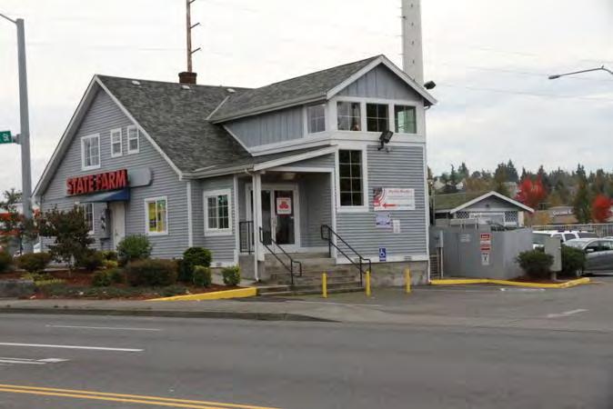
290 Photos Southeast corner, 1926 building Northeast corner, 1926 building Northwest corner, 1926 building Northeast corner, west 1976 building Friday, July 11, 2014 Page 7 of 8


291 East elevation, west 1976 building North elevation, 1976 convenient store East elevation, south accessory building Friday, July 11, 2014 Page 8 of 8
292 Location Field Site No DAHP No. Historic Name: Common Name: Pacific Hwy S Property Address: Pacific Hwy S, Federal Way, WA Comments: Tax No./Parcel No Plat/Block/Lot Acreage.27 Supplemental Map(s) Township/Range/EW Section 1/4 Sec 1/4 1/4 Sec T22R04E 33 County King Quadrangle POVERTY BAY Coordinate Reference Easting: Northing: Projection: Washington State Plane South Datum: HARN (feet) Identification Survey Name: Sound Transit Federal Way Date Recorded: 12/02/ Field Recorder: MaryNell Nolan-Wheatley Owner's Name: KIM ROBERT C+CANDACE Y Owner Address: TH PL SE City: AUBURN State: WA Zip: Classification: Building Resource Status: Survey/Inventory Comments: Within a District? No Contributing? No National Register: Local District: National Register District/Thematic Nomination Name: Eligibility Status: Not Determined - SHPO Determination Date: 1/1/0001 Determination Comments: Monday, July 21, 2014 Page 1 of 5
293 Description Historic Use: Commerce/Trade - Business Current Use: Commerce/Trade - Business Plan: Rectangle Stories: 1 Structural System: Platform Frame Changes to Plan: Slight Changes to Original Cladding: Moderate Changes to Other: Other (specify): Style: Foundation: Cladding: Form/Type: Roof Type: Changes to Interior: Unknown Changes to Windows: Moderate Roof Material: Commercial Wood - Vertical Flat with Eaves Asphalt / Composition - Metal - Corrugated Built Up Concrete - Block Commercial Narrative Study Unit Architecture/Landscape Architecture Date of Construction: 1966 Built Date Other Builder: Engineer: Architect: Property appears to meet criteria for the National Register of Historic Places:No Property is located in a potential historic district (National and/or local): No Property potentially contributes to a historic district (National and/or local): No Monday, July 21, 2014 Page 2 of 5
294 Statement of Significance: Construction of the original Highway 1 in the state of Washington commenced in By October 1923, 700 miles of a two-lane highway had been completed connecting Vancouver, British Columbia, to the Oregon-California border. Just after the highway was completed in 1924, however, plans were begun to reroute and improve the conditions of the highway. The project involved creating a new, wider, four-lane route further west that would connect Seattle and Tacoma, Washington, more directly (Kramak, 2010). The new roadway was completed in 1928 and acquired the title of Highway 1, while the original eastern route was renamed Highway 5 (Caster, 2007). The new Highway 1 became known as the Pacific Highway. Over the years, various parts of Highway 1 acquired alternative names, including the portion known as Pacific Highway S, which starts near Federal Way, Washington, and continues north, through Kent, Des Moines, and SeaTac, Washington (Kramak, 2010). In 1926, Pacific Highway (HWY 1) was included as a numbered U.S. Highway (US 99) (U.S. Route 99, ). The following decades witnessed the rapid growth of businesses along the highway and the formation of a new auto-oriented roadside culture characterized by a proliferation of motels, restaurants, and rest stops (Des Moines Historical Society, 2007). Increased automobile ownership changed people s perceptions about distance and allowed populations to sprawl around urban centers, increasing the number of residents in suburban towns and cities, including SeaTac, Des Moines, Kent, and Federal Way (Boyles, 2010). Federal Way was originally settled as a rural logging community in the late 1800s. In 1928, when the Pacific Highway (HWY 1/US 99) between Tacoma and Seattle opened, it linked Federal Way to the larger neighboring communities, spurring economic and residential development. The name Federal Way came from an eponymous school built in 1929 on Pacific Highway S (Caster, 2007). During the 1950s, Federal Way witnessed substantial growth, transforming from a small lumber town into a metropolitan area. Auto -oriented businesses emerged and thrived along the Pacific Highway. Community growth was bolstered by Boeing and Weyerhaeuser industries in the 1960s. In 1968, Weyerhaeuser purchased 430 acres of land for its corporate headquarters, which opened in April 1971 (Caster, 2007). Federal Way was incorporated as a city in The property at Pacific Highway South in Federal Way, Washington, which contains a commercial retail building and a detached residential building constructed in 1966, is not eligible for listing in the NRHP. The property is not eligible for the NRHP under Criterion A, which applies to buildings that are associated with events that have made a significant contribution to the broad patterns of history, as no significant events are associated with this property. To be eligible for the NRHP under Criterion B, a property must be directly associated with a person considered significant within a historic context whose specific contribution to history has been both identified and documented. No such person who meets that definition is linked to these buildings. The property is not eligible for the NRHP under Criterion C as it is a typical mid-twentieth century retail building with a residential accessory building and does not embody the distinctive characteristics of a type, period, or method of construction; it is not the work of a master and does not possess high artistic value. The property is not eligible for the NRHP under Criterion D for information potential because the materials and construction methods of the buildings do not convey important information that could contribute to understanding history or prehistory. Therefore, the property is not eligible for listing in the NRHP because it does not meet any of the eligibility criteria. In addition the buildings are heavily altered, including small additions and the replacement of some original windows, doors, and siding. As a result, the buildings have lost integrity of materials and some integrity of design. The buildings retain integrity of workmanship, setting, location, feeling and association. Monday, July 21, 2014 Page 3 of 5
295 Description of Physical Appearance: Pacific Highway South is a small one-story, wood frame barber shop with a single-family residential accessory building in the rear of the property, constructed in The residential structure is barely visible from the public right-of-way. The rectangular plan, 432 square foot retail building sits on a raised concrete block foundation and has a flat built-up roof. An awning clad in wood shake wraps around the building s front and side elevations. Many of the wood shingles have fallen off of the awning and have been replaced with large plywood boards, which may have been used for signage. The exterior walls of the barber shop are clad in vertical wood siding and all of the windows are fixed, single-lights. Two replacement pedestrian doors with fixed-light windows are located on the front (east) elevation. A row of three, large rectangular commercial windows are located between the two doors. North of the north door is a row of six, large rectangular commercial windows that wrap around the northeast corner of the building. The last window on the north elevation contains a transom with a plywood board replacing the original glass. The lower half of the north elevation s exterior wall is partially clad in non-original corrugated metal siding. A row of four windows wrap around the southeast corner of the building, starting just south of the south pedestrian door. The last window in the row on the south elevation also contains a transom. The window and the transom have been replaced by large plywood boards. The bottom of the window contains an air conditioning unit. A shed roof addition extends from the rear (west) elevation. The barber shop is surrounded by pavement. Behind the barber shop, on the west side of the property which has a lower grade, is a one-story, singlefamily wood frame residence. The irregular plan building has a cross gabled roof covered in composite shingles. Clad in a combination of horizontal wood and sawn log siding, the residence sits on a poured concrete foundation and is hidden from view from the street. All of the visible windows are replacement fixed, single-light windows placed over a single-light awning window. A replacement paneled pedestrian door that may serve as the main entrance, is located on the east elevation and is shaded by the primary side gabled roof. The edges of the eave are supported by simple wood posts and a window is located just north of the main door. The south elevation also contains one window. A front gabled section that crosses the primary side gable and contains a window on its south elevation shaded by a small attached awning, extends from the center of the rear (west) elevation. A wood deck addition constructed on wood stilts extends from the west elevation and has an open framework wood hand railing. The residence is primarily surrounded by grass. Major Bibliographic References: Boyles, E The Suburb. Selected Cultural and Historical Geographies of the Greater Seattle Area. Available at: bellevue-and-redmond/the-suburb. Accessed March 18,. Caster, D Historical Society of Federal Way Timeline. Available at: Accessed March 15,. Des Moines Historical Society Time Line Page. Available at: Accessed March 13,. King County.. King County Department of Assessments. Available at: Accessed October 20,. Kramak, J.E., ed Establishing the Pacific Highway South. Selected Cultural and Historical Geographies of the Greater Seattle Area. Available at: Accessed March 14,. U.S. Route 99 The Pacific Highway.. Waymarking: A Groundspeak Website. Available at: Accessed March 19,. Monday, July 21, 2014 Page 4 of 5


296 Photos Southeast corner Northeast corner South elevation, residential accessory building Monday, July 21, 2014 Page 5 of 5
297 Location Field Site No DAHP No. Historic Name: Common Name: th Ave S Property Address: th Ave S, Federal Way, WA Comments: Tax No./Parcel No Plat/Block/Lot Acreage.25 Supplemental Map(s) Township/Range/EW Section 1/4 Sec 1/4 1/4 Sec T22R04E 33 County King Quadrangle POVERTY BAY Coordinate Reference Easting: Northing: Projection: Washington State Plane South Datum: HARN (feet) Identification Survey Name: Sound Transit Federal Way Date Recorded: 02/12/2014 Field Recorder: MaryNell Nolan-Wheatley Owner's Name: JOHNSON CHRISTOPHER L+KRIST Owner Address: TH AVE S City: Federal Way State: WA Zip: Classification: Building Resource Status: Survey/Inventory Comments: Within a District? No Contributing? No National Register: Local District: National Register District/Thematic Nomination Name: Eligibility Status: Not Determined - SHPO Determination Date: 1/1/0001 Determination Comments: Friday, July 25, 2014 Page 1 of 5
298 Description Historic Use: Domestic - Single Family House Current Use: Domestic - Single Family House Plan: L-Shape Stories: 1 Structural System: Platform Frame Changes to Plan: Intact Changes to Interior: Unknown Changes to Original Cladding: Extensive Changes to Windows: Extensive Changes to Other: Other (specify): Style: Cladding: Roof Type: Roof Material: Ranch Veneer Hip Asphalt / Composition - Wood - Boards Gable - Front Gable Shingle Foundation: Form/Type: Concrete - Poured Single Family Narrative Study Unit Architecture/Landscape Architecture Date of Construction: 1965 Built Date Other Builder: Engineer: Architect: Property appears to meet criteria for the National Register of Historic Places:No Property is located in a potential historic district (National and/or local): No Property potentially contributes to a historic district (National and/or local): No Friday, July 25, 2014 Page 2 of 5
299 Statement of Significance: Construction of the original Highway 1 in the state of Washington commenced in By October 1923, 700 miles of a two-lane highway had been completed connecting Vancouver, British Columbia, to the Oregon-California border. Just after the highway was completed in 1924, however, plans were begun to reroute and improve the conditions of the highway. The project involved creating a new, wider, four-lane route further west that would connect Seattle and Tacoma, Washington, more directly (Kramak, 2010). The new roadway was completed in 1928 and acquired the title of Highway 1, while the original eastern route was renamed Highway 5 (Caster, 2007). The new Highway 1 became known as the Pacific Highway. Over the years, various parts of Highway 1 acquired alternative names, including the portion known as Pacific Highway S, which starts near Federal Way, Washington, and continues north, through Kent, Des Moines, and SeaTac, Washington (Kramak, 2010). In 1926, Pacific Highway (HWY 1) was included as a numbered U.S. Highway (US 99) (U.S. Route 99, ). The following decades witnessed the rapid growth of businesses along the highway and the formation of a new auto-oriented roadside culture characterized by a proliferation of motels, restaurants, and rest stops (Des Moines Historical Society, 2007). Increased automobile ownership changed people s perceptions about distance and allowed populations to sprawl around urban centers, increasing the number of residents in suburban towns and cities, including SeaTac, Des Moines, Kent, and Federal Way (Boyles, 2010). Federal Way was originally settled as a rural logging community in the late 1800s. In 1928, when the Pacific Highway (HWY 1/US 99) between Tacoma and Seattle opened, it linked Federal Way to the larger neighboring communities, spurring economic and residential development. The name Federal Way came from an eponymous school built in 1929 on Pacific Highway S (Caster, 2007). During the 1950s, Federal Way witnessed substantial growth, transforming from a small lumber town into a metropolitan area. Auto -oriented businesses emerged and thrived along the Pacific Highway. Community growth was bolstered by Boeing and Weyerhaeuser industries in the 1960s. In 1968, Weyerhaeuser purchased 430 acres of land for its corporate headquarters, which opened in April 1971 (Caster, 2007). Federal Way was incorporated as a city in The property at th Avenue South in Federal Way, Washington, which is a residential property built in 1965, is not eligible for listing in the NRHP. The property is not eligible for the NRHP under Criterion A, which applies to buildings that are associated with events that have made a significant contribution to the broad patterns of history, as no significant events are associated with this property. To be eligible for the NRHP under Criterion B, a property must be directly associated with a person considered significant within a historic context whose specific contribution to history has been both identified and documented. No such person who meets that definition is linked to this building. The property is not eligible for the NRHP under Criterion C as it is a typical residential building from the midtwentieth century and does not embody the distinctive characteristics of a type, period, or method of construction; it is not the work of a master and does not possess high artistic value. The property is not eligible for the NRHP under Criterion D for information potential because the materials and construction methods of the building do not convey important information that could contribute to understanding history or prehistory. Therefore, the property is not eligible for listing in the NRHP because it does not meet any of the eligibility criteria. In addition the building has been altered including the replacement of original windows, doors, and siding. As a result, the property has lost integrity of materials. The building retains integrity of design, workmanship, location, setting, feeling and association. Friday, July 25, 2014 Page 3 of 5
300 Description of Physical Appearance: Major Bibliographic References: th Avenue South is a one-story, wood frame, ranch style residential property with an essentially L-shaped floor plan constructed in The house, which sits on a concrete slab foundation, has a hipped roof covered in composite shingles with moderately deep open eaves and an interior slope brick chimney. Clad in non-original horizontal composite siding, all of the windows are contemporary replacements. The main entrance is located in the center of the front (west) elevation and projects out from the rest of the elevation. Covered by an attached hipped roof, the projecting entrance contains a replacement, paneled front door and an adjacent, narrow, vertically oriented, fixed, single-light window. Two small concrete steps lead to the front door. A 12-over-one light sash window, flanked on either side by a six-over-one light sash window, are located north of the main entrance on the front façade. Two small, narrow, horizontally oriented awning windows are located just below the eave, south of the projecting entrance area, while a row of three, six-over-one light sash windows is located on the south end of the front elevation. The south elevation is clad in plain wood boards and contains one narrow, vertically oriented window opening. A long, rectangular plan, attached garage projects from the north end of the front façade and is covered by a front gabled roof that crosses the primary hipped roof. A wide vehicle bay with chamfered corners and a retractable metal door is situated on the west elevation of the garage. A fixed, single-light window with frosted glass is located on the garage s north elevation. The property includes a paved driveway and a grassy front lawn. A tall wood fence surrounds the rear of the property. Boyles, E The Suburb. Selected Cultural and Historical Geographies of the Greater Seattle Area. Available at: bellevue-and-redmond/the-suburb. Accessed March 18,. Caster, D Historical Society of Federal Way Timeline. Available at: Accessed March 15,. Des Moines Historical Society Time Line Page. Available at: Accessed March 13,. King County.. King County Department of Assessments. Available at: Accessed October 20,. Kramak, J.E., ed Establishing the Pacific Highway South. Selected Cultural and Historical Geographies of the Greater Seattle Area. Available at: Accessed March 14,. U.S. Route 99 The Pacific Highway.. Waymarking: A Groundspeak Website. Available at: Accessed March 19,. Friday, July 25, 2014 Page 4 of 5


301 Photos West elevation Southwest corner North elevation Friday, July 25, 2014 Page 5 of 5
302 Location Field Site No DAHP No. Historic Name: Common Name: J n B Furniture Property Address: Pacific S, Federal Way, WA Comments: Tax No./Parcel No Plat/Block/Lot Acreage.17 Supplemental Map(s) Township/Range/EW Section 1/4 Sec 1/4 1/4 Sec T22R04E 33 County King Quadrangle POVERTY BAY Coordinate Reference Easting: Northing: Projection: Washington State Plane South Datum: HARN (feet) Identification Survey Name: Sound Transit Federal Way - Highline Water District Date Recorded: 10/21/2014 Field Recorder: MaryNell Nolan-Wheatley Owner's Name: LYNCH AARON A Owner Address: City: DES MOINES PACIFIC HWY S #394 State: WA Zip: Classification: Building Resource Status: Survey/Inventory Comments: Within a District? No Contributing? No National Register: Local District: National Register District/Thematic Nomination Name: Eligibility Status: Not Determined - SHPO Determination Date: 1/1/0001 Determination Comments: Tuesday, October 21, 2014 Page 1 of 5
303 Description Historic Use: Commerce/Trade - Business Current Use: Commerce/Trade - Business Plan: Rectangle Stories: 1 Structural System: Concrete - Block Changes to Plan: Slight Changes to Original Cladding: Slight Changes to Other: Other (specify): Style: Foundation: Cladding: Form/Type: Roof Type: Changes to Interior: Unknown Changes to Windows: Moderate Roof Material: Modern Concrete - Block Flat with Parapet Asphalt / Composition - Commercial Veneer - Stucco Built Up Concrete - Poured Shingle - Concrete/Asbestos Commercial Narrative Study Unit Architecture/Landscape Architecture Date of Construction: 1948 Built Date Other Builder: Engineer: Architect: Property appears to meet criteria for the National Register of Historic Places:No Property is located in a potential historic district (National and/or local): No Property potentially contributes to a historic district (National and/or local): No Statement of Significance: Construction of the original Highway 1 in the state of Washington commenced in By October 1923, 700 miles of a two-lane highway had been completed connecting Vancouver, British Columbia, to the Oregon-California border. Just after the highway was completed in 1924, however, plans were begun to reroute and improve the conditions of the highway. The project involved creating a new, wider, four-lane route further west that would connect Seattle and Tacoma, Washington, more directly (Kramak, 2010). The new roadway was completed in 1928 and acquired the title of Highway 1, while the original eastern route was renamed Highway 5 (Caster, 2007). The new Highway 1 became known as the Pacific Highway. Over the years, various parts of Highway 1 acquired alternative names, including the portion known as Pacific Highway S, which starts near Federal Way, Washington, and continues north, through Kent, Des Moines, and SeaTac, Washington (Kramak, 2010). Tuesday, October 21, 2014 Page 2 of 5
304 In 1926, Pacific Highway (HWY 1) was included as a numbered U.S. Highway (US 99) (U.S. Route 99, ). The following decades witnessed the rapid growth of businesses along the highway and the formation of a new auto-oriented roadside culture characterized by a proliferation of motels, restaurants, and rest stops (Des Moines Historical Society, 2007). Increased automobile ownership changed people s perceptions about distance and allowed populations to sprawl around urban centers, increasing the number of residents in suburban towns and cities, including SeaTac, Des Moines, Kent, and Federal Way (Boyles, 2010). Federal Way was originally settled as a rural logging community in the late 1800s. In 1928, when the Pacific Highway (HWY 1/US 99) between Tacoma and Seattle opened, it linked Federal Way to the larger neighboring communities, spurring economic and residential development. The name Federal Way came from an eponymous school built in 1929 on Pacific Highway S (Caster, 2007). During the 1950s, Federal Way witnessed substantial growth, transforming from a small lumber town into a metropolitan area. Auto -oriented businesses emerged and thrived along the Pacific Highway. Community growth was bolstered by Boeing and Weyerhaeuser industries in the 1960s. In 1968, Weyerhaeuser purchased 430 acres of land for its corporate headquarters, which opened in April 1971 (Caster, 2007). Federal Way was incorporated as a city in The property at Pacific Highway South in Federal Way, Washington, which contains a commercial retail building constructed in 1948, is not eligible for listing in the NRHP. The property is not eligible for the NRHP under Criterion A, which applies to buildings that are associated with events that have made a significant contribution to the broad patterns of history, as no significant events are associated with this property. To be eligible for the NRHP under Criterion B, a property must be directly associated with a person considered significant within a historic context whose specific contribution to history has been both identified and documented. No such person who meets that definition is linked to this building. While the building contains elements of the mid-century modern style, namely an asymmetrical entrance door located within an angled storefront, the building as a whole does not embody the distinctive characteristics of a type, period, or method of construction; it is not the work of a master and does not possess high artistic value. The building is a commonly employed commercial design with minimal design features executed using common materials. While aspects of the building s appearance form an aesthetic connection with a particular era of architecture, the building does not express aesthetic ideals or design concepts as well as other mid-century modern commercial buildings and it does not fully articulate a particular concept of design. Some distinctive mid-century modern features, such as the original commercial sign, have been lost as a result of alterations. Additionally, original windows and doors on the side (north and south) and rear (west) elevations have been replaced. According to photographs from the King County Assessor s website, the large aluminum signage shaft on the south elevation was stripped of its original cladding in 2003, exposing an interior metal frame. Due to these alterations, the original design and function of this aluminum shaft have been lost. Other photos from the King County Assessor s website indicate that the rear elevation has been heavily altered including the replacement of original windows, doors, and siding on the ground floor and the addition of a wood deck area, as it was changed to accommodate a residential space. These alterations have compromised the building s integrity of design, materials and workmanship. Within the historic context of Pacific Highway South and Federal Way, this commercial property is not an important example of building practices of a particular time in history, nor is it a significant example of a particular design evolution or transition of construction types. The building is an undistinguished commercial property that has a modest association with mid-century modern design influences. The building s design has not achieved any significance within its historic context. Therefore, the building is not eligible under Criterion C. The property is not eligible for the NRHP under Criterion D for information potential because the materials and construction methods of the building do not convey important information that could contribute to understanding history or prehistory. Therefore, the property is not eligible for listing in the NRHP because it does not meet any of the eligibility criteria. Due to the replacement of original windows and doors and the original sign structure cladding, the building has lost integrity of materials, design, and workmanship. The building retains integrity of setting, location, feeling and association. Tuesday, October 21, 2014 Page 3 of 5
305 Description of Physical Appearance: Major Bibliographic References: Pacific Highway South is a one-story, concrete block commercial retail building constructed in The rectangular plan building with a poured concrete foundation sits on steeply sloping ground. As a result of the change in grade, the building contains a basement level that is accessible from the rear (west) and side (north) elevations but is not visible from the front (east) elevation. Primarily clad in stucco, the retail store, which is occupied by J n B Furniture, has a flat built up roof with a short rectangular parapet that wraps around the building s four elevations. The front elevation is defined by an attached flat overhang that shades a row of five large, slanted and fixed, single-light commercial style windows placed below fixed, single-light transoms. The top of the slanted store front tilts away from the building, and the north end of the façade angles towards the building s interior. Large security lights are fastened underneath the overhang to light a large front concrete patio area and a sign for the store is affixed to the east elevation above the overhang. Double wood doors, each with five lights and topped by a pair of fixed, single-light transoms are located on the north end of the front elevation and are shaded by a lower, attached overhang. The center light on each door contains a mosaic design created with pieces of colored glass. A large exterior rectangular structure clad in corrugated metal is attached to the east end of the south elevation and extends high above the roofline. It was most likely a structure to hold signage. West of this structure on the south elevation are two small, two-light horizontal sliding windows and one small window that contains an air conditioning unit. Vines climb up the west end of the south elevation. The north elevation is defined by two brick exterior chimneys that divide the exterior wall into three sections. The elevation contains two small, two-light horizontal windows. A replacement pedestrian door is located on the basement level, just east of the center of the north elevation. A small, attached, gabled overhang shades the side door and is supported by two simple, wood posts with small lanterns. The pedestrian door can be reached by a straight flight of concrete stairs that lead down along the side elevation from the Pacific Highway South sidewalk in front of the building. West of the side door, the exterior wall of the basement level is clad in asbestos shingle and contains one fixed, three-light window with horizontal wood muntins that is original to the building. The north end of the basement level has painted concrete block exterior walls and contains a fixed, single-light window. All of the windows on the rear elevation are replacements. A large wood deck addition extends from the basement level on the back of the building and is accessed by a pair of sliding glazed doors. The building is surrounded by pavement used for parking. Boyles, E The Suburb. Selected Cultural and Historical Geographies of the Greater Seattle Area. Available at: bellevue-and-redmond/the-suburb. Accessed March 18,. Caster, D Historical Society of Federal Way Timeline. Available at: Accessed March 15,. Des Moines Historical Society Time Line Page. Available at: Accessed March 13,. King County.. King County Department of Assessments. Available at: Accessed July Kramak, J.E., ed Establishing the Pacific Highway South. Selected Cultural and Historical Geographies of the Greater Seattle Area. Available at: Accessed March 14,. U.S. Route 99 The Pacific Highway.. Waymarking: A Groundspeak Website. Available at: Accessed March 19,. Tuesday, October 21, 2014 Page 4 of 5


 elevation")

306 Photos Northeast corner East elevation Photo courtesy of the King County Assessor's website. Rear (west) elevation 2004 Southeast corner, aluminum sign shaft Tuesday, October 21, 2014 Page 5 of 5
307 Location Field Site No DAHP No. Historic Name: Common Name: Blue Ridge Apartments Property Address: Pacific Hwy S, Federal Way, WA Comments: Tax No./Parcel No Plat/Block/Lot Acreage 1.83 Supplemental Map(s) Township/Range/EW Section 1/4 Sec 1/4 1/4 Sec T22R04E 33 County King Quadrangle POVERTY BAY Coordinate Reference Easting: Northing: Projection: Washington State Plane South Datum: HARN (feet) Identification Survey Name: Sound Transit Federal Way Date Recorded: 12/02/ Field Recorder: MaryNell Nolan-Wheatley Owner's Name: DOMAN JACQUELINE LAURA Owner Address: PACIFIC HWY S City: DES MOINES State: WA Zip: Classification: Building Resource Status: Survey/Inventory Comments: Within a District? No Contributing? No National Register: Local District: National Register District/Thematic Nomination Name: Eligibility Status: Not Determined - SHPO Determination Date: 1/1/0001 Determination Comments: Monday, July 21, 2014 Page 1 of 5
308 Description Historic Use: Domestic - Multiple Family House Current Use: Domestic - Multiple Family House Plan: Rectangle Stories: 2 Structural System: Platform Frame Changes to Plan: Intact Changes to Original Cladding: Intact Changes to Other: Other (specify): Style: Vernacular Foundation: Concrete - Poured Cladding: Veneer - Stucco Form/Type: Multi-Family - U Court Roof Type: Changes to Interior: Unknown Changes to Windows: Slight Gable - Side Gable Flat with Eaves Roof Material: Asphalt / Composition - Shingle Asphalt / Composition - Built Up Narrative Study Unit Architecture/Landscape Architecture Date of Construction: 1964 Built Date Other Builder: Engineer: Architect: Property appears to meet criteria for the National Register of Historic Places:No Property is located in a potential historic district (National and/or local): No Property potentially contributes to a historic district (National and/or local): No Monday, July 21, 2014 Page 2 of 5
309 Statement of Significance: Construction of the original Highway 1 in the state of Washington commenced in By October 1923, 700 miles of a two-lane highway had been completed connecting Vancouver, British Columbia, to the Oregon-California border. Just after the highway was completed in 1924, however, plans were begun to reroute and improve the conditions of the highway. The project involved creating a new, wider, four-lane route further west that would connect Seattle and Tacoma, Washington, more directly (Kramak, 2010). The new roadway was completed in 1928 and acquired the title of Highway 1, while the original eastern route was renamed Highway 5 (Caster, 2007). The new Highway 1 became known as the Pacific Highway. Over the years, various parts of Highway 1 acquired alternative names, including the portion known as Pacific Highway S, which starts near Federal Way, Washington, and continues north, through Kent, Des Moines, and SeaTac, Washington (Kramak, 2010). In 1926, Pacific Highway (HWY 1) was included as a numbered U.S. Highway (US 99) (U.S. Route 99, ). The following decades witnessed the rapid growth of businesses along the highway and the formation of a new auto-oriented roadside culture characterized by a proliferation of motels, restaurants, and rest stops (Des Moines Historical Society, 2007). Increased automobile ownership changed people s perceptions about distance and allowed populations to sprawl around urban centers, increasing the number of residents in suburban towns and cities, including SeaTac, Des Moines, Kent, and Federal Way (Boyles, 2010). Federal Way was originally settled as a rural logging community in the late 1800s. In 1928, when the Pacific Highway (HWY 1/US 99) between Tacoma and Seattle opened, it linked Federal Way to the larger neighboring communities, spurring economic and residential development. The name Federal Way came from an eponymous school built in 1929 on Pacific Highway S (Caster, 2007). During the 1950s, Federal Way witnessed substantial growth, transforming from a small lumber town into a metropolitan area. Auto -oriented businesses emerged and thrived along the Pacific Highway. Community growth was bolstered by Boeing and Weyerhaeuser industries in the 1960s. In 1968, Weyerhaeuser purchased 430 acres of land for its corporate headquarters, which opened in April 1971 (Caster, 2007). Federal Way was incorporated as a city in The property at Pacific Highway South in Federal Way, Washington, which contains a two-story, three-building, 26-unit apartment complex constructed in 1964, is not eligible for listing in the NRHP. The property is not eligible for the NRHP under Criterion A, which applies to buildings that are associated with events that have made a significant contribution to the broad patterns of history, as no significant events are associated with this property. To be eligible for the NRHP under Criterion B, a property must be directly associated with a person considered significant within a historic context whose specific contribution to history has been both identified and documented. No such person who meets that definition is linked to these buildings. The property is not eligible for the NRHP under Criterion C as it is a typical mid-twentieth century apartment complex and does not embody the distinctive characteristics of a type, period, or method of construction; it is not the work of a master and does not possess high artistic value. The property is not eligible for the NRHP under Criterion D for information potential because the materials and construction methods of the buildings do not convey important information that could contribute to understanding history or prehistory. Therefore, the property is not eligible for listing in the NRHP because it does not meet any of the eligibility criteria. In addition the property has undergone several alterations including the replacement of some original doors and windows. As a result, the buildings have lost some integrity of materials and design. The buildings retain integrity of workmanship, setting, location, feeling and association. Monday, July 21, 2014 Page 3 of 5
310 Description of Physical Appearance: Major Bibliographic References: Pacific Highway South contains three rectangular plan buildings that compose the Blue Ridge Apartment complex. The buildings are arranged in a U-shape with a large grassy courtyard in the center. The north and east buildings, which have side gabled roofs covered in composite shingles, are two stories, while the south building, which as a flat, built-up roof with deep eaves is one-story. The west end of the north building, however, becomes one-story to match the south building. The south and north buildings, which face each other, have identical, mirror image floor plans; projecting one-story sections on the west ends of the long, essentially rectangular plan buildings extend towards each other and provide further privacy for the interior courtyard. Constructed on poured concrete foundations, the wood frame apartment buildings are clad in stucco. The east building, which is positioned parallel to 18th Avenue South, is built on sloping ground. As a result, the three recessed entrance areas on the east elevation access split-level, wood ladder stairwells that lead up to the second floor and down to the ground floor. Wide strips of the exterior wall adjacent to the recessed stairwell access points on the east elevation are clad in permastone veneer. Each floor on the east elevation contains eight narrow, three-light horizontal sliding windows in thin aluminum frames that are positioned just under the ceiling height. The first floor apartment windows are just above ground level on this elevation and overlook a paved parking lot. The north building contains mostly three-light horizontal sliding windows on the north and west elevations. The south elevation, which overlooks the courtyard, has a second floor balcony and mostly large, fixed, single-light windows that are not very visible from the public right-of-way. The west end of the north building, which drops down to one-story, has a flat built-up roof with deep eave overhangs. A replacement paneled apartment door is visible on the west elevation of the north building s projection. Several three-light horizontal sliding windows are also visible on the west end of the north building. The projection on the west end of the south building, which appears to be utilized as a main office, contains at least five fixed, single-light windows and an original wood door with a fixed-single light window. All of the other visible windows on the south building are narrow, three-light horizontal sliding windows with thin aluminum frames. Boyles, E The Suburb. Selected Cultural and Historical Geographies of the Greater Seattle Area. Available at: bellevue-and-redmond/the-suburb. Accessed March 18,. Caster, D Historical Society of Federal Way Timeline. Available at: Accessed March 15,. Des Moines Historical Society Time Line Page. Available at: Accessed March 13,. King County.. King County Department of Assessments. Available at: Accessed October 20,. Kramak, J.E., ed Establishing the Pacific Highway South. Selected Cultural and Historical Geographies of the Greater Seattle Area. Available at: Accessed March 14,. U.S. Route 99 The Pacific Highway.. Waymarking: A Groundspeak Website. Available at: Accessed March 19,. Monday, July 21, 2014 Page 4 of 5


311 Photos Southeast corner, east building East elevation, east building, detail Southwest corner, north building Northwest corner, south building Monday, July 21, 2014 Page 5 of 5
312 Location Field Site No DAHP No. Historic Name: Common Name: Pacific Hwy S Property Address: Pacific Hwy S, Federal Way, WA Comments: Tax No./Parcel No Plat/Block/Lot Acreage.49 Supplemental Map(s) Township/Range/EW Section 1/4 Sec 1/4 1/4 Sec T22R04E 33 County King Quadrangle POVERTY BAY Coordinate Reference Easting: Northing: Projection: Washington State Plane South Datum: HARN (feet) Identification Survey Name: Sound Transit Federal Way Date Recorded: 12/02/ Field Recorder: MaryNell Nolan-Wheatley Owner's Name: SABOTKA CAROL+CHET H+CHET A Owner Address: RD AVE SW City: FEDERAL WAY State: WA Zip: Classification: Building Resource Status: Survey/Inventory Comments: Within a District? No Contributing? No National Register: Local District: National Register District/Thematic Nomination Name: Eligibility Status: Not Determined - SHPO Determination Date: 1/1/0001 Determination Comments: Monday, July 21, 2014 Page 1 of 5
313 Description Historic Use: Commerce/Trade - Business Current Use: Commerce/Trade - Business Plan: Rectangle Stories: 1 Structural System: Platform Frame Changes to Plan: Slight Changes to Original Cladding: Intact Changes to Other: Other (specify): Style: Foundation: Cladding: Form/Type: Roof Type: Changes to Interior: Unknown Changes to Windows: Extensive Roof Material: Commercial Veneer - Permastone Flat with Parapet Asphalt / Composition - Wood - Vertical Built Up Concrete - Poured Veneer Commercial Narrative Study Unit Architecture/Landscape Architecture Date of Construction: 1946 Built Date Other Builder: Engineer: Architect: Property appears to meet criteria for the National Register of Historic Places:No Property is located in a potential historic district (National and/or local): No Property potentially contributes to a historic district (National and/or local): No Monday, July 21, 2014 Page 2 of 5
314 Statement of Significance: Construction of the original Highway 1 in the state of Washington commenced in By October 1923, 700 miles of a two-lane highway had been completed connecting Vancouver, British Columbia, to the Oregon-California border. Just after the highway was completed in 1924, however, plans were begun to reroute and improve the conditions of the highway. The project involved creating a new, wider, four-lane route further west that would connect Seattle and Tacoma, Washington, more directly (Kramak, 2010). The new roadway was completed in 1928 and acquired the title of Highway 1, while the original eastern route was renamed Highway 5 (Caster, 2007). The new Highway 1 became known as the Pacific Highway. Over the years, various parts of Highway 1 acquired alternative names, including the portion known as Pacific Highway S, which starts near Federal Way, Washington, and continues north, through Kent, Des Moines, and SeaTac, Washington (Kramak, 2010). In 1926, Pacific Highway (HWY 1) was included as a numbered U.S. Highway (US 99) (U.S. Route 99, ). The following decades witnessed the rapid growth of businesses along the highway and the formation of a new auto-oriented roadside culture characterized by a proliferation of motels, restaurants, and rest stops (Des Moines Historical Society, 2007). Increased automobile ownership changed people s perceptions about distance and allowed populations to sprawl around urban centers, increasing the number of residents in suburban towns and cities, including SeaTac, Des Moines, Kent, and Federal Way (Boyles, 2010). Federal Way was originally settled as a rural logging community in the late 1800s. In 1928, when the Pacific Highway (HWY 1/US 99) between Tacoma and Seattle opened, it linked Federal Way to the larger neighboring communities, spurring economic and residential development. The name Federal Way came from an eponymous school built in 1929 on Pacific Highway S (Caster, 2007). During the 1950s, Federal Way witnessed substantial growth, transforming from a small lumber town into a metropolitan area. Auto -oriented businesses emerged and thrived along the Pacific Highway. Community growth was bolstered by Boeing and Weyerhaeuser industries in the 1960s. In 1968, Weyerhaeuser purchased 430 acres of land for its corporate headquarters, which opened in April 1971 (Caster, 2007). Federal Way was incorporated as a city in The property at Pacific Highway South in Federal Way, Washington, which contains a commercial building constructed in 1946, is not eligible for listing in the NRHP. The property is not eligible for the NRHP under Criterion A, which applies to buildings that are associated with events that have made a significant contribution to the broad patterns of history, as no significant events are associated with this property. To be eligible for the NRHP under Criterion B, a property must be directly associated with a person considered significant within a historic context whose specific contribution to history has been both identified and documented. No such person who meets that definition is linked to this building. The property is not eligible for the NRHP under Criterion C as it is a typical mid-twentieth century retail building and does not embody the distinctive characteristics of a type, period, or method of construction; it is not the work of a master and does not possess high artistic value. The property is not eligible for the NRHP under Criterion D for information potential because the materials and construction methods of the building do not convey important information that could contribute to understanding history or prehistory. Therefore, the property is not eligible for listing in the NRHP because it does not meet any of the eligibility criteria. In addition the building has undergone several alterations, including a small addition and the replacement of original windows and doors. As a result, the building has lost integrity of materials and some integrity of design. The building retains integrity of workmanship, setting, location, feeling and association. Monday, July 21, 2014 Page 3 of 5
315 Description of Physical Appearance: Major Bibliographic References: Pacific Highway South is a one-story, wood frame commercial building constructed in The rectangular plan building sits on a poured concrete foundation. Due to the change in grade of the land, the finished basement is not visible from the front (east) elevation, but is accessible through the rear (west) elevation. The flat, built-up roof is obscured by a tall, rectangular parapet that wraps around the building s primary elevations. A traditional slanted awning clad in corrugated metal runs along the length of the front façade, beneath the parapet. The front façade is divided into two identical halves by a strip of exterior wall that is clad in a light colored permastone reaching from the ground to just below the awning. Each half contains a row of four fixed, single-light, square, replacement windows flanked on either side by a replacement metal and glass pedestrian door. Permastone veneer covers the exterior walls under the rows of windows and wraps around the northeast and southeast corners of the building. The parapet and the space between the awning and the windows are clad in vertical wood and composite siding. The north, south, and west elevations are clad in vertical wood siding. The north elevation contains three window openings all of which have been covered either by plywood boards or by wood lattice. The south elevation is defined by an exterior brick chimney and a metal and glass replacement pedestrian door. The far west end of the south elevation contains a square window opening that has been replaced by a plywood board. An attached flat roof canopy extends from above the pedestrian door and connects to a small flat roof shed addition clad in vertical wood siding. The small connecting canopy shades the top of a flight of concrete steps that lead down to the rear of the property and allow access to the basement level. The rear elevation contains two basement level entrances with double metal and glass doors covered by attached gabled roof overhangs covered in composite shingles and supported by simple wood posts. The glass in most of the window openings on the back of the building appears to have been replaced with plywood boards, although the elevation is not clearly visible from the public right-of-way. The building is surrounded by pavement and some grass. Boyles, E The Suburb. Selected Cultural and Historical Geographies of the Greater Seattle Area. Available at: bellevue-and-redmond/the-suburb. Accessed March 18,. Caster, D Historical Society of Federal Way Timeline. Available at: Accessed March 15,. Des Moines Historical Society Time Line Page. Available at: Accessed March 13,. King County.. King County Department of Assessments. Available at: Accessed October 20,. Kramak, J.E., ed Establishing the Pacific Highway South. Selected Cultural and Historical Geographies of the Greater Seattle Area. Available at: Accessed March 14,. U.S. Route 99 The Pacific Highway.. Waymarking: A Groundspeak Website. Available at: Accessed March 19,. Monday, July 21, 2014 Page 4 of 5


316 Photos Southeast corner Northeast corner Southwest corner Monday, July 21, 2014 Page 5 of 5
317 Location Field Site No DAHP No. Historic Name: Common Name: 2920 S 284th St Property Address: 2920 S 284th St, Federal Way, WA Comments: Tax No./Parcel No Plat/Block/Lot Acreage 3.84 Supplemental Map(s) Township/Range/EW Section 1/4 Sec 1/4 1/4 Sec T22R04E 33 County King Quadrangle POVERTY BAY Coordinate Reference Easting: Northing: Projection: Washington State Plane South Datum: HARN (feet) Identification Survey Name: Sound Transit Federal Way Date Recorded: 02/12/2014 Field Recorder: MaryNell Nolan-Wheatley Owner's Name: SEARS TRACY CAROLYN+MICHAEL Owner Address: PO BOX 517 City: AUBURN State: WA Zip: Classification: Building Resource Status: Survey/Inventory Comments: Within a District? No Contributing? No National Register: Local District: National Register District/Thematic Nomination Name: Eligibility Status: Not Determined - SHPO Determination Date: 1/1/0001 Determination Comments: Friday, July 25, 2014 Page 1 of 5
318 Description Historic Use: Domestic - Single Family House Current Use: Domestic - Single Family House Plan: Irregular Stories: 1 Structural System: Platform Frame Changes to Plan: Extensive Changes to Original Cladding: Extensive Changes to Other: Extensive Changes to Interior: Unknown Changes to Windows: Extensive Other (specify): Original entrance is no longer visible due to the numerous alterations and additions. Style: Foundation: Cladding: Form/Type: Roof Type: Roof Material: Ranch Veneer - Brick Gable Clay Tile Concrete - Poured Wood Wood - Vertical Single Family Narrative Study Unit Architecture/Landscape Architecture Date of Construction: 1945 Built Date 1956 Addition 1959 Addition Other Builder: Engineer: Architect: Property appears to meet criteria for the National Register of Historic Places:No Property is located in a potential historic district (National and/or local): No Property potentially contributes to a historic district (National and/or local): No Friday, July 25, 2014 Page 2 of 5
319 Statement of Significance: Construction of the original Highway 1 in the state of Washington commenced in By October 1923, 700 miles of a two-lane highway had been completed connecting Vancouver, British Columbia, to the Oregon-California border. Just after the highway was completed in 1924, however, plans were begun to reroute and improve the conditions of the highway. The project involved creating a new, wider, four-lane route further west that would connect Seattle and Tacoma, Washington, more directly (Kramak, 2010). The new roadway was completed in 1928 and acquired the title of Highway 1, while the original eastern route was renamed Highway 5 (Caster, 2007). The new Highway 1 became known as the Pacific Highway. Over the years, various parts of Highway 1 acquired alternative names, including the portion known as Pacific Highway S, which starts near Federal Way, Washington, and continues north, through Kent, Des Moines, and SeaTac, Washington (Kramak, 2010). In 1926, Pacific Highway (HWY 1) was included as a numbered U.S. Highway (US 99) (U.S. Route 99, ). The following decades witnessed the rapid growth of businesses along the highway and the formation of a new auto-oriented roadside culture characterized by a proliferation of motels, restaurants, and rest stops (Des Moines Historical Society, 2007). Increased automobile ownership changed people s perceptions about distance and allowed populations to sprawl around urban centers, increasing the number of residents in suburban towns and cities, including SeaTac, Des Moines, Kent, and Federal Way (Boyles, 2010). Federal Way was originally settled as a rural logging community in the late 1800s. In 1928, when the Pacific Highway (HWY 1/US 99) between Tacoma and Seattle opened, it linked Federal Way to the larger neighboring communities, spurring economic and residential development. The name Federal Way came from an eponymous school built in 1929 on Pacific Highway S (Caster, 2007). During the 1950s, Federal Way witnessed substantial growth, transforming from a small lumber town into a metropolitan area. Auto -oriented businesses emerged and thrived along the Pacific Highway. Community growth was bolstered by Boeing and Weyerhaeuser industries in the 1960s. In 1968, Weyerhaeuser purchased 430 acres of land for its corporate headquarters, which opened in April 1971 (Caster, 2007). Federal Way was incorporated as a city in The property at 2920 South 284th Street in Federal Way, Washington, which is a residential property built in 1945, is not eligible for listing in the NRHP. The property is not eligible for the NRHP under Criterion A, which applies to buildings that are associated with events that have made a significant contribution to the broad patterns of history, as no significant events are associated with this property. To be eligible for the NRHP under Criterion B, a property must be directly associated with a person considered significant within a historic context whose specific contribution to history has been both identified and documented. No such person who meets that definition is linked to this building. The property is not eligible for the NRHP under Criterion C as it is a typical residential building from the early to mid-twentieth century and does not embody the distinctive characteristics of a type, period, or method of construction; it is not the work of a master and does not possess high artistic value. The property is not eligible for the NRHP under Criterion D for information potential because the materials and construction methods of the building do not convey important information that could contribute to understanding history or prehistory. Therefore, the property is not eligible for listing in the NRHP because it does not meet any of the eligibility criteria. In addition the building is heavily altered, including the replacement of original windows, doors, siding and multiple large additions that have completely changed the building s floor plan. As a result, the property has lost integrity of materials, design, workmanship, feeling, and association. The building retains integrity of location and setting. Friday, July 25, 2014 Page 3 of 5
320 Description of Physical Appearance: Major Bibliographic References: 2920 South 284th Street is a one-story, wood frame, residential property with an irregular floor plan constructed in Originally, the property was a small, rectangular plan building clad in horizontal wood siding with a side gabled roof. A number of alterations occurred before 1946, including a small, gabled roof, addition to the east elevation, another gabled roof addition to the west elevation, and a front gabled addition to the rear (north) elevation. By 1959, the horizontal wood siding had been replaced with brick veneer and another large south addition had been constructed with a large exterior gable wall chimney. Also during this time a swimming pool was installed. At a later, unknown date, another addition was added to the west wing of the house. The original main entrance was covered as a result of the numerous additions. The house is set off of the main road and is completely surrounded by heavy vegetation. As a result, a clear view of the house s main elevations is not possible from the public right-ofway. Currently, the house appears to be clad in a combination of brick veneer, vertical wood siding, and horizontal wood siding on the gable ends. The pitched roofs are covered with red barrel tiles and several non-original skylights are visible. All of the visible windows are two-light horizontal sliding replacements. Aerial images indicate that the pool remains extant, although the property appears possibly vacant. A small accessory building is located on the north side of the property but is not at all visible from the public right-of-way. Boyles, E The Suburb. Selected Cultural and Historical Geographies of the Greater Seattle Area. Available at: bellevue-and-redmond/the-suburb. Accessed March 18,. Caster, D Historical Society of Federal Way Timeline. Available at: Accessed March 15,. Des Moines Historical Society Time Line Page. Available at: Accessed March 13,. King County.. King County Department of Assessments. Available at: Accessed October 20,. Kramak, J.E., ed Establishing the Pacific Highway South. Selected Cultural and Historical Geographies of the Greater Seattle Area. Available at: Accessed March 14,. U.S. Route 99 The Pacific Highway.. Waymarking: A Groundspeak Website. Available at: Accessed March 19,. Friday, July 25, 2014 Page 4 of 5


321 Photos Photo courtesy of the King County Assessor's website. Southeast corner Photo courtesy of the King County Assessor's Website. South elevation View to the northeast of chimney and roof. Friday, July 25, 2014 Page 5 of 5
322 Location Field Site No DAHP No. Historic Name: Common Name: Skyway Inn Hotel Property Address: International Blvd, SeaTac, WA Comments: Tax No./Parcel No Plat/Block/Lot Acreage Supplemental Map(s) Township/Range/EW Section 1/4 Sec 1/4 1/4 Sec T22R04E 04 County King Quadrangle DES MOINES Coordinate Reference Easting: Northing: Projection: Washington State Plane South Datum: HARN (feet) Identification Survey Name: Sound Transit Federal Way Date Recorded: 10/22/ Field Recorder: MaryNell Nolan-Wheatley Owner's Name: Skyway LLC Owner Address: International Blvd. City: SeaTac State: Washington Zip: Classification: Building Resource Status: Survey/Inventory Comments: Within a District? No Contributing? No National Register: Local District: National Register District/Thematic Nomination Name: Eligibility Status: Not Determined - SHPO Determination Date: 1/1/0001 Determination Comments: Thursday, April 17, 2014 Page 1 of 7
323 Description Historic Use: Domestic - Hotel Current Use: Domestic - Hotel Plan: Irregular Stories: 1-3 Structural System: Concrete - Block Changes to Plan: Extensive Changes to Original Cladding: Intact Changes to Other: Other (specify): Style: Foundation: Cladding: Form/Type: Roof Type: Changes to Interior: Unknown Changes to Windows: Extensive Roof Material: Roadside Veneer - Stucco Flat with Eaves Asphalt / Composition - Commercial - Highway Veneer - Vinyl Siding Built Up Strip Concrete - Poured Hotel/Motel - Motor Inn Narrative Study Unit Architecture/Landscape Architecture Date of Construction: 1948 Built Date 1981 Addition Other Builder: Engineer: Architect: Property appears to meet criteria for the National Register of Historic Places:No Property is located in a potential historic district (National and/or local): No Property potentially contributes to a historic district (National and/or local): No Thursday, April 17, 2014 Page 2 of 7
324 Statement of Significance: Construction of the original Highway 1 in the state of Washington commenced in By October 1923, 700 miles of a two-lane highway had been completed connecting Vancouver, British Columbia, to the Oregon-California border. Just after the highway was completed in 1924, however, plans were begun to reroute and improve the conditions of the highway. The project involved creating a new, wider, four-lane route further west that would connect Seattle and Tacoma, Washington, more directly (Kramak, 2010). The new roadway was completed in 1928 and acquired the title of Highway 1, while the original eastern route was renamed Highway 5 (Caster, 2007). The new Highway 1 became known as the Pacific Highway. Over the years, various parts of Highway 1 acquired alternative names, including the portion known as Pacific Highway S, which starts near Federal Way, Washington, and continues north, through Kent, Des Moines, and SeaTac, Washington (Kramak, 2010). In 1926, Pacific Highway (HWY 1) was included as a numbered U.S. Highway (US 99) (U.S. Route 99, ). The following decades witnessed the rapid growth of businesses along the highway and the formation of a new auto-oriented roadside culture characterized by a proliferation of motels, restaurants, and rest stops (Des Moines Historical Society, 2007). Increased automobile ownership changed people s perceptions about distance and allowed populations to sprawl around urban centers, increasing the number of residents in suburban towns and cities, including SeaTac, Des Moines, Kent, and Federal Way (Boyles, 2010). The City of SeaTac, which was incorporated in 1990, is named for the airport, which is now surrounded by the city. Before the airport was constructed in the 1940s, however, the rural area was commonly referred to by locals as Angle Lake, an allusion to the body of water in the Highline region next to where the airport now stands (City of SeaTac, ; Highline Historical Society, ). Early development in the area started after the 1883 construction of Northern Pacific s transcontinental railroad to Puget Sound, which brought an influx of settlers and farmers. During the 1930s and 1940s, a wave of new businesses opened along the new Pacific Highway, which passed Angle Lake, to serve the needs of those traveling by automobile (Dorpat and Crowley, 2004). Construction on the Seattle-Tacoma International Airport (Sea-Tac Airport) started in January The new airport and the adjacent Interstate 5 freeway that was completed in the 1960s changed many aspects of the community. Much of the existing housing stock in SeaTac dates to the period of planning and construction for the airport, from the 1930s-1950s. The property at International Boulevard in SeaTac, Washington, which is the Skyway Inn Hotel built in 1948, is not eligible for listing in the NRHP. The building is not eligible for the NRHP under Criterion A, which applies to properties that are associated with events that have made a significant contribution to the broad patterns of history, as no significant events are associated with this property. To be eligible for the NRHP under Criterion B, a property must be directly associated with a person considered significant within a historic context whose specific contribution to history has been both identified and documented. No such person who meets that definition is linked to this property. The property is not eligible for the NRHP under Criterion C as it is a typical roadside motel from the 1940s and does not embody the distinctive characteristics of a type, period, or method of construction; it is not the work of a master and does not possess high artistic value. The property is not eligible for the NRHP under Criterion D for information potential because the materials and construction methods of the building do not convey important information that could contribute to understanding history or prehistory. Therefore, the property is not eligible for listing in the NRHP because it does not meet any of the eligibility criteria. The main building has undergone several alterations and additions and has lost integrity of design and materials. The property retains integrity of location, setting, workmanship, feeling and association. Thursday, April 17, 2014 Page 3 of 7
325 Description of Physical Appearance: The Skyway Inn Hotel, which was constructed in 1948, is composed of two buildings: the original onestory building on the north side of the property and a new construction, three-story, L-shaped building on the south side of the property. Both buildings are concrete block construction clad with textured stucco and built on concrete slab foundations. The original building has had numerous additions on the west elevation and is irregularly shaped with various roof heights. The dominant feature of the building is a flat roof, a red corrugated metal awning that wraps around the primary elevations, and the textured stucco walls. The main building is in fact composed of two buildings, separated by a driveway, but connected by the red metal awning. The central section of the building, with the highest roof height, is the main lobby, which can be accessed on the east elevation by a pedestrian door. The metal awning in front of the main entrance is significantly taller over this section, and is supported by two columns clad in textured stucco. The lobby section connects to a large square section of motel rooms that extends south. The west half of this south section is an addition, with a different awning and painted concrete block exterior walls. The metal awning north of the lobby extends over a driveway leading to a rear parking lot, and connects to the north wing of rooms. The north wing is essentially rectangular in plan, with its longer elevations on the north and south sides. The west half of the north wing is also an addition. The east elevation of the south section of the main building has five paneled replacement doors that allow access to the motel rooms and six rectangular, replacement, horizontal sliding windows. The metal awning along the elevation is supported by columns identical to those in front of the entrance door. Each column has a bare bulb sconce. The divide between the original building and the west addition to the south section is visible on the south elevation, as the exterior wall is textured stucco to the east, and painted concrete block to the west. Here, a red composite shingle parapet runs along the edge of the flat roof, as a new extension of the original metal awning. The center of the exterior wall is clad in red, vertical composite siding and contains a paneled pedestrian door. According to an aerial view map of the property, the door likely leads to a central courtyard. All of the windows on the east elevation of the north wing of rooms are fixed, replacement, single light windows. The sidewalk on the east elevation of the main building is tiled in red ceramic tiles that are likely original to the property. On the south side of the property is a concrete block, 3-story building with an L-shaped plan built in 1981 that is designed to match the colors and materials of the original building. The interior elevations of the L, which face the motel s parking lot, have arcaded balconies. Each room is accessed by an exterior, pedestrian metal door. All of the windows on the building are modern three-over-six light windows with aluminum frames that are paired. The north elevation and the east elevation contain exterior stairwells that are sheltered by the roof. The building is clad in textured stucco. A composite shingle awning, meant to look like red clay tiles, wraps around the primary elevations. Thursday, April 17, 2014 Page 4 of 7
326 Major Bibliographic References: Boyles, E The Suburb. Selected Cultural and Historical Geographies of the Greater Seattle Area. Available at: bellevue-and-redmond/the-suburb. Accessed March 18,. Caster, D Historical Society of Federal Way Timeline. Available at: Accessed March 15,. City of SeaTac.. History. Available at: Accessed March 14,. Des Moines Historical Society Time Line Page. Available at: Accessed March 13,. Dorpat, P., and W. Crowley SeaTac. HistoryLink: The Free Online Encyclopedia of Washington State History. Available at: Accessed March 19,. Highline Historical Society.. Oral Histories. Available at: Accessed April 3,. Kramak, J.E., ed Establishing the Pacific Highway South. Selected Cultural and Historical Geographies of the Greater Seattle Area. Available at: Accessed March 14,. U.S. Route 99 The Pacific Highway.. Waymarking: A Groundspeak Website. Available at: Accessed March 19,. Thursday, April 17, 2014 Page 5 of 7


327 Photos Northeast corner East elevation East elevation, main entrance and covered driveway Close up of east elevation Thursday, April 17, 2014 Page 6 of 7


328 East elevation of L-shaped new construction building Southeast corner, main building, with west adddition Thursday, April 17, 2014 Page 7 of 7
329 Location Field Site No DAHP No. Historic Name: Common Name: The Firs Mobile Home Park Property Address: Pacific Hwy S, SeaTac, WA Comments: Tax No./Parcel No Plat/Block/Lot Acreage Supplemental Map(s) Township/Range/EW Section 1/4 Sec 1/4 1/4 Sec T22R04E 04 County King Quadrangle DES MOINES Coordinate Reference Easting: Northing: Projection: Washington State Plane South Datum: HARN (feet) Identification Survey Name: Sound Transit Federal Way Date Recorded: 10/22/ Field Recorder: MaryNell Nolan-Wheatley Owner's Name: Fife Motel Inc Owner Address: 706 S Marine Hills Way City: Federal Way State: Washington Zip: Classification: Building Resource Status: Survey/Inventory Comments: Within a District? No Contributing? No National Register: Local District: National Register District/Thematic Nomination Name: Eligibility Status: Not Determined - SHPO Determination Date: 1/1/0001 Determination Comments: Thursday, April 17, 2014 Page 1 of 6
330 Description Historic Use: Other Current Use: Other Plan: Irregular Stories: 1 Structural System: Mixed Changes to Plan: Extensive Changes to Original Cladding: Extensive Changes to Other: Other (specify): Style: Vernacular None Foundation: Concrete - Poured Cladding: Shingle Veneer - Vinyl Siding Metal - Corrugated Wood - Vertical Form/Type: Other Roof Type: Shed Gable Changes to Interior: Unknown Changes to Windows: Extensive Flat with Eaves Roof Material: Metal Asphalt / Composition - Shingle Asphalt / Composition - Rolled Narrative Study Unit Architecture/Landscape Architecture Date of Construction: 1968 Built Date Other Builder: Engineer: Architect: Property appears to meet criteria for the National Register of Historic Places:No Property is located in a potential historic district (National and/or local): No Property potentially contributes to a historic district (National and/or local): No Thursday, April 17, 2014 Page 2 of 6
331 Statement of Significance: Construction of the original Highway 1 in the state of Washington commenced in By October 1923, 700 miles of a two-lane highway had been completed connecting Vancouver, British Columbia, to the Oregon-California border. Just after the highway was completed in 1924, however, plans were begun to reroute and improve the conditions of the highway. The project involved creating a new, wider, four-lane route further west that would connect Seattle and Tacoma, Washington, more directly (Kramak, 2010). The new roadway was completed in 1928 and acquired the title of Highway 1, while the original eastern route was renamed Highway 5 (Caster, 2007). The new Highway 1 became known as the Pacific Highway. Over the years, various parts of Highway 1 acquired alternative names, including the portion known as Pacific Highway S, which starts near Federal Way, Washington, and continues north, through Kent, Des Moines, and SeaTac, Washington (Kramak, 2010). In 1926, Pacific Highway (HWY 1) was included as a numbered U.S. Highway (US 99) (U.S. Route 99, ). The following decades witnessed the rapid growth of businesses along the highway and the formation of a new auto-oriented roadside culture characterized by a proliferation of motels, restaurants, and rest stops (Des Moines Historical Society, 2007). Increased automobile ownership changed people s perceptions about distance and allowed populations to sprawl around urban centers, increasing the number of residents in suburban towns and cities, including SeaTac, Des Moines, Kent, and Federal Way (Boyles, 2010). The City of SeaTac, which was incorporated in 1990, is named for the airport, which is now surrounded by the city. Before the airport was constructed in the 1940s, however, the rural area was commonly referred to by locals as Angle Lake, an allusion to the body of water in the Highline region next to where the airport now stands (City of SeaTac, ; Highline Historical Society, ). Early development in the area started after the 1883 construction of Northern Pacific s transcontinental railroad to Puget Sound, which brought an influx of settlers and farmers. During the 1930s and 1940s, a wave of new businesses opened along the new Pacific Highway, which passed Angle Lake, to serve the needs of those traveling by automobile (Dorpat and Crowley, 2004). Construction on the Seattle-Tacoma International Airport (Sea-Tac Airport) started in January The new airport and the adjacent Interstate 5 freeway that was completed in the 1960s changed many aspects of the community. Much of the existing housing stock in SeaTac dates to the period of planning and construction for the airport, from the 1930s-1950s. The property at Pacific Highway South in SeaTac, Washington, which is a mobile home park built in 1968, is not eligible for listing in the NRHP. The property is not eligible for the NRHP under Criterion A, which applies to buildings that are associated with events that have made a significant contribution to the broad patterns of history, as no significant events are associated with this property. To be eligible for the NRHP under Criterion B, a property must be directly associated with a person considered significant within a historic context whose specific contribution to history has been both identified and documented. No such person who meets that definition is linked to this property. The property is not eligible for the NRHP under Criterion C as it is a typical mobile home park from the 1960s and does not embody the distinctive characteristics of a type, period, or method of construction; it is not the work of a master and does not possess high artistic value. The property is not eligible for the NRHP under Criterion D for information potential because the materials and construction methods of the collection of buildings do not convey important information that could contribute to understanding history or prehistory. Therefore, the property is not eligible for listing in the NRHP because it does not meet any of the eligibility criteria. Most of the mobile homes that are visible from the public right of way have undergone several alterations and additions and have lost integrity of design and materials. The buildings on the property appear to retain integrity of location, setting, workmanship, feeling and association. Thursday, April 17, 2014 Page 3 of 6
332 Description of Physical Appearance: Major Bibliographic References: The property at Pacific Highway South is occupied by The Firs Mobile Home Park, which was originally constructed in The large L-shaped parcel contains a collection of mainly rectangular plan mobile homes, many of which have undergone additions and alterations. Only a few of the buildings are visible from the public right of way. Most of the mobile homes appear to be clad in metal siding with either flat roofs or shallow side gabled roofs. A residential property near to the southwest corner of the parcel is a wood frame building with a front gable roof, constructed on a concrete slab. The house is clad in straight edge shingles and a large attic vent is positioned under the front gable. A large rectangular, fixed, single light replacement window is positioned in the center of the west (front) elevation. To the north of the window is a paneled door with a gabled overhang. To the south of the central windows is a rectangular, replacement one-over-one sash window. A shed roof addition, clad in vertical composite siding is attached to the north elevation. The west elevation of the addition has a single metal pedestrian door with a shed roof overhang. The northwest corner of the property has a rectangular plan mobile home placed on a concrete foundation. The building has a long, shed roofed overhang, with composite shingles that runs the length of the west elevation and is supported by thin wood pillars with knee brackets. The building is clad in corrugated metal and has all replacement windows. To the south of this mobile home, is another residential building built on a slope, clad in straight edge shingles, with a side gabled, composite shingle roof. The north (front) elevation has a gabled overhang over the entrance, supported by carved wood pillars. To the west of the entrance is a four light replacement window and to the east is a single-light, awning window. The west elevation, which is part of an addition, has one replacement, horizontal sliding windows and a concrete stair that leads to a side pedestrian door. There are several other additions on the south elevation, with another pedestrian door with a gabled overhang that leads to the basement level. On the southeast corner of the building, a two story addition protrudes from the back of the house with a flat roof and connects to a one story addition with a composite shingle, shed roof. Boyles, E The Suburb. Selected Cultural and Historical Geographies of the Greater Seattle Area. Available at: bellevue-and-redmond/the-suburb. Accessed March 18,. Caster, D Historical Society of Federal Way Timeline. Available at: Accessed March 15,. City of SeaTac.. History. Available at: Accessed March 14,. Des Moines Historical Society Time Line Page. Available at: Accessed March 13,. Dorpat, P., and W. Crowley SeaTac. HistoryLink: The Free Online Encyclopedia of Washington State History. Available at: Accessed March 19,. Highline Historical Society.. Oral Histories. Available at: Accessed April 3,. Kramak, J.E., ed Establishing the Pacific Highway South. Selected Cultural and Historical Geographies of the Greater Seattle Area. Available at: Accessed March 14,. U.S. Route 99 The Pacific Highway.. Waymarking: A Groundspeak Website. Available at: Accessed March 19,. Thursday, April 17, 2014 Page 4 of 6


333 Photos Mobile home with long west elevation overhang. View to the northeast Mobile home with long west elevation overhang. Southeast corner Metal clad mobile homes. West elevation West elevation Thursday, April 17, 2014 Page 5 of 6


334 View to southeast Southwest corner, south additions Thursday, April 17, 2014 Page 6 of 6
335 Location Field Site No DAHP No. Historic Name: Common Name: Payless Cars Property Address: Pacific Hwy S, SeaTac, WA Comments: Tax No./Parcel No Plat/Block/Lot Acreage Supplemental Map(s) Township/Range/EW Section 1/4 Sec 1/4 1/4 Sec T22R04E 04 County King Quadrangle DES MOINES Coordinate Reference Easting: Northing: Projection: Washington State Plane South Datum: HARN (feet) Identification Survey Name: Sound Transit Federal Way Date Recorded: 10/22/ Field Recorder: MaryNell Nolan-Wheatley Owner's Name: Pas LLC Owner Address: 371 NE Gilman Blvd. #360 City: Issaquah State: Washington Zip: Classification: Building Resource Status: Survey/Inventory Comments: Within a District? No Contributing? No National Register: Local District: National Register District/Thematic Nomination Name: Eligibility Status: Not Determined - SHPO Determination Date: 1/1/0001 Determination Comments: Thursday, April 17, 2014 Page 1 of 5
336 Description Historic Use: Commerce/Trade - Business Current Use: Commerce/Trade - Business Plan: Rectangle Stories: 1 Structural System: Concrete - Block Changes to Plan: Extensive Changes to Original Cladding: Slight Changes to Other: Other (specify): Style: Foundation: Cladding: Form/Type: Roof Type: Changes to Interior: Unknown Changes to Windows: Extensive Roof Material: Other - Industrial Veneer - Brick Flat with Eaves Asphalt / Composition Concrete - Poured Concrete - Block Wood - Vertical Industrial Narrative Study Unit Architecture/Landscape Architecture Date of Construction: 1956 Built Date Other Builder: Engineer: Architect: Property appears to meet criteria for the National Register of Historic Places:No Property is located in a potential historic district (National and/or local): No Property potentially contributes to a historic district (National and/or local): No Thursday, April 17, 2014 Page 2 of 5
337 Statement of Significance: Construction of the original Highway 1 in the state of Washington commenced in By October 1923, 700 miles of a two-lane highway had been completed connecting Vancouver, British Columbia, to the Oregon-California border. Just after the highway was completed in 1924, however, plans were begun to reroute and improve the conditions of the highway. The project involved creating a new, wider, four-lane route further west that would connect Seattle and Tacoma, Washington, more directly (Kramak, 2010). The new roadway was completed in 1928 and acquired the title of Highway 1, while the original eastern route was renamed Highway 5 (Caster, 2007). The new Highway 1 became known as the Pacific Highway. Over the years, various parts of Highway 1 acquired alternative names, including the portion known as Pacific Highway S, which starts near Federal Way, Washington, and continues north, through Kent, Des Moines, and SeaTac, Washington (Kramak, 2010). In 1926, Pacific Highway (HWY 1) was included as a numbered U.S. Highway (US 99) (U.S. Route 99, ). The following decades witnessed the rapid growth of businesses along the highway and the formation of a new auto-oriented roadside culture characterized by a proliferation of motels, restaurants, and rest stops (Des Moines Historical Society, 2007). Increased automobile ownership changed people s perceptions about distance and allowed populations to sprawl around urban centers, increasing the number of residents in suburban towns and cities, including SeaTac, Des Moines, Kent, and Federal Way (Boyles, 2010). The City of SeaTac, which was incorporated in 1990, is named for the airport, which is now surrounded by the city. Before the airport was constructed in the 1940s, however, the rural area was commonly referred to by locals as Angle Lake, an allusion to the body of water in the Highline region next to where the airport now stands (City of SeaTac, ; Highline Historical Society, ). Early development in the area started after the 1883 construction of Northern Pacific s transcontinental railroad to Puget Sound, which brought an influx of settlers and farmers. During the 1930s and 1940s, a wave of new businesses opened along the new Pacific Highway, which passed Angle Lake, to serve the needs of those traveling by automobile (Dorpat and Crowley, 2004). Construction on the Seattle-Tacoma International Airport (Sea-Tac Airport) started in January The new airport and the adjacent Interstate 5 freeway that was completed in the 1960s changed many aspects of the community. Much of the existing housing stock in SeaTac dates to the period of planning and construction for the airport, from the 1930s-1950s. The property at Pacific Highway South in SeaTac, Washington, which is a light industrial facility built in 1956, is not eligible for listing in the NRHP. The property is not eligible for the NRHP under Criterion A, which applies to buildings that are associated with events that have made a significant contribution to the broad patterns of history, as no significant events are associated with this property. To be eligible for the NRHP under Criterion B, a property must be directly associated with a person considered significant within a historic context whose specific contribution to history has been both identified and documented. No such person who meets that definition is linked to this property. The property is not eligible for the NRHP under Criterion C as it is a typical light industrial building from the mid-twentieth century and does not embody the distinctive characteristics of a type, period, or method of construction; it is not the work of a master and does not possess high artistic value. The property is not eligible for the NRHP under Criterion D for information potential because the materials and construction methods of the building does not convey important information that could contribute to understanding history or prehistory. Therefore, the property is not eligible for listing in the NRHP because it does not meet any of the eligibility criteria. The building, which is occupied by Payless Cars, has undergone several alterations and additions and has lost some integrity of design and materials. The building retains integrity of location, setting, workmanship, feeling and association. Thursday, April 17, 2014 Page 3 of 5
338 Description of Physical Appearance: Major Bibliographic References: The property at Pacific Highway South contains a one-story light industrial facility that was constructed in 1956, and is currently occupied by Payless Car. Built on a concrete slab foundation with a long rectangular plan, the concrete block building has a flat roof with an integrated overhang with exposed wood rafter tails that shades the west (front) elevation. The west elevation is mainly defined by large windows and a series of metal retractable doors. Originally, the building was likely a significantly smaller rectangular plan building, that has undergone several large additions to the south and east elevations. The original building is visible on the north end of the current building. Its west elevation is defined by a commercial façade with five large bays of fixed replacement windows. The fourth bay from the north contains a pair of glazed doors with a fixed transom and north sidelight. The two north bays contain rows of three floor-to-ceiling windows. The third bay from the north contains a large single light, and the bay furthest south contains two large floor-to-ceiling windows. A sign for Payless Car is secured to the edge of the overhang in front of this main entrance. Opaque panels run the length of this section of the building, under the overhang and above the large row of windows. To the south of the windows, the walls are clad in vertical wood siding. A large metal, retractable door and a metal pedestrian door to the south of the commercial façade mark part of a newer addition. At this point, the opaque panels under the overhang are replaced by large fixed, single light replacement windows. To the south of the doors, the cladding changes to brick veneer, designating another south addition. There are three more retractable metal doors on the south end of the west elevation. The north and south elevations are clad in brick veneer. The north elevation has one fixed, two-light replacement window. The south elevation has no windows. The east elevation has exposed concrete block walls and a large overhang on the north end that nearly doubles the depth of the building. The east elevation has two large metal retractable doors and several metal pedestrian doors. Most of the windows are replacement one-over-one sash windows. The entire property is surrounded by a chain link fence and a large paved parking lot that is used for airport parking. Boyles, E The Suburb. Selected Cultural and Historical Geographies of the Greater Seattle Area. Available at: bellevue-and-redmond/the-suburb. Accessed March 18,. Caster, D Historical Society of Federal Way Timeline. Available at: Accessed March 15,. City of SeaTac.. History. Available at: Accessed March 14,. Des Moines Historical Society Time Line Page. Available at: Accessed March 13,. Dorpat, P., and W. Crowley SeaTac. HistoryLink: The Free Online Encyclopedia of Washington State History. Available at: Accessed March 19,. Highline Historical Society.. Oral Histories. Available at: Accessed April 3,. King County.. King County Department of Assessments. Available at: Accessed October 20,. Kramak, J.E., ed Establishing the Pacific Highway South. Selected Cultural and Historical Geographies of the Greater Seattle Area. Available at: Accessed March 14,. U.S. Route 99 The Pacific Highway.. Waymarking: A Groundspeak Website. Available at: Accessed March 19,. Thursday, April 17, 2014 Page 4 of 5


339 Photos West elevation, north end Southwest corner West elevation, closer East elevation Thursday, April 17, 2014 Page 5 of 5
340 Location Field Site No DAHP No. Historic Name: Common Name: Apker's Classic Car Sales Property Address: Pacific Hwy S, Kent, WA Comments: Tax No./Parcel No Plat/Block/Lot Acreage.41 Supplemental Map(s) Township/Range/EW Section 1/4 Sec 1/4 1/4 Sec T22R04E 21 County King Quadrangle DES MOINES Coordinate Reference Easting: Northing: Projection: Washington State Plane South Datum: HARN (feet) Identification Survey Name: Sound Transit Federal Way Date Recorded: 11/21/ Field Recorder: MaryNell Nolan-Wheatley Owner's Name: CROOK TOM Owner Address: ND AVE S City: AUBURN State: WA Zip: Classification: Building Resource Status: Survey/Inventory Comments: Within a District? No Contributing? No National Register: Local District: National Register District/Thematic Nomination Name: Eligibility Status: Not Determined - SHPO Determination Date: 1/1/0001 Determination Comments: Friday, July 11, 2014 Page 1 of 5
341 Description Historic Use: Commerce/Trade - Warehouse Current Use: Commerce/Trade - Warehouse Plan: Rectangle Stories: 1 Structural System: Steel Changes to Plan: Slight Changes to Interior: Unknown Changes to Original Cladding: Intact Changes to Windows: Intact Changes to Other: Other (specify): Style: Cladding: Roof Type: Roof Material: Other - Utilitarian Metal - Corrugated Shed Metal - Corrugated Gable - Side Gable Foundation: Form/Type: Concrete - Poured Utilitarian Narrative Study Unit Architecture/Landscape Architecture Date of Construction: 1968 Built Date Other Builder: Engineer: Architect: Property appears to meet criteria for the National Register of Historic Places:No Property is located in a potential historic district (National and/or local): No Property potentially contributes to a historic district (National and/or local): No Friday, July 11, 2014 Page 2 of 5
342 Statement of Significance: Construction of the original Highway 1 in the state of Washington commenced in By October 1923, 700 miles of a two-lane highway had been completed connecting Vancouver, British Columbia, to the Oregon-California border. Just after the highway was completed in 1924, however, plans were begun to reroute and improve the conditions of the highway. The project involved creating a new, wider, four-lane route further west that would connect Seattle and Tacoma, Washington, more directly (Kramak, 2010). The new roadway was completed in 1928 and acquired the title of Highway 1, while the original eastern route was renamed Highway 5 (Caster, 2007). The new Highway 1 became known as the Pacific Highway. Over the years, various parts of Highway 1 acquired alternative names, including the portion known as Pacific Highway S, which starts near Federal Way, Washington, and continues north, through Kent, Des Moines, and SeaTac, Washington (Kramak, 2010). In 1926, Pacific Highway (HWY 1) was included as a numbered U.S. Highway (US 99) (U.S. Route 99, ). The following decades witnessed the rapid growth of businesses along the highway and the formation of a new auto-oriented roadside culture characterized by a proliferation of motels, restaurants, and rest stops (Des Moines Historical Society, 2007). Increased automobile ownership changed people s perceptions about distance and allowed populations to sprawl around urban centers, increasing the number of residents in suburban towns and cities, including SeaTac, Des Moines, Kent, and Federal Way (Boyles, 2010). Kent started as an agricultural community before evolving into an industrial center. Early settlers in the area enjoyed prime farming due to rich deposits of alluvium in the valley that had made the soil especially fertile. Kent experienced a period of financial success in the second half of the nineteenth century, and on May 28, 1890, Kent incorporated as a city. Still primarily an agricultural community, Kent suffered from a lack of manual laborers after World War II (Stein, 2001). In 1962, the completion of the Howard A. Hanson Dam stopped flooding in the area, which attracted developers and manufacturing companies to relocate to Kent, accelerating the decline of farming. Three years later, Boeing established the Boeing Aerospace Center there. Over the next few decades, warehouses, industrial plants, and eventually technology firms came to dominate the local economy (Stein, 2001). This change in industry attracted new residents to Kent during the 1950s through the 1970s, and it was during these decades that much of the existing built environment was constructed. The property at Pacific Highway South in Kent, Washington, which was constructed in 1968 and is occupied by Apker s Classics Car Sales, is not eligible for listing in the NRHP. The property is not eligible for the NRHP under Criterion A, which applies to buildings that are associated with events that have made a significant contribution to the broad patterns of history, as no significant events are associated with this property. To be eligible for the NRHP under Criterion B, a property must be directly associated with a person considered significant within a historic context whose specific contribution to history has been both identified and documented. No such person who meets that definition is linked to this building. The property is not eligible for the NRHP under Criterion C as it is a typical mid-twentieth century light industrial warehouse and does not embody the distinctive characteristics of a type, period, or method of construction; it is not the work of a master and does not possess high artistic value. The property is not eligible for the NRHP under Criterion D for information potential because the materials and construction methods of the building do not convey important information that could contribute to understanding history or prehistory. Therefore, the property is not eligible for listing in the NRHP because it does not meet any of the eligibility criteria. In addition, the building has a shed addition on the east elevation. As a result, the building has lost some integrity of design. The building retains integrity of materials, workmanship, setting, location, feeling and association. Friday, July 11, 2014 Page 3 of 5
343 Description of Physical Appearance: Major Bibliographic References: Pacific Highway South is a one-story, 8,400-square foot prefabricated steel commercial warehouse constructed in 1968 and currently occupied by Apker s Classics Car Sales. Constructed on a poured concrete foundation, the building has a rectangular plan and a corrugated metal low-pitch side gabled roof. The exterior walls of the building are clad in corrugated metal and the front (north) elevation is defined by two very large vehicle bays with retractable metal doors. West of the vehicle bays is a metal pedestrian door. A canvas convex awning wraps around the northwest corner of the warehouse, halfway up the building s height, and shades the main entrance. Another pedestrian door is located on the east end of the north elevation and is covered by a smaller, canvas, convex awning. Just under the west gable peak are two, two-light horizontal sliding windows. There are no windows or doors on the south elevation. A nearly full width shed addition that is half the height of the warehouse is attached to the east elevation. The property includes some grass and landscaping along the west elevation and a large paved area on the north and east elevations. Boyles, E The Suburb. Selected Cultural and Historical Geographies of the Greater Seattle Area. Available at: bellevue-and-redmond/the-suburb. Accessed March 18,. Caster, D Historical Society of Federal Way Timeline. Available at: Accessed March 15,. Des Moines Historical Society Time Line Page. Available at: Accessed March 13,. King County.. King County Department of Assessments. Available at: Accessed October 20,. Kramak, J.E., ed Establishing the Pacific Highway South. Selected Cultural and Historical Geographies of the Greater Seattle Area. Available at: Accessed March 14,. Stein, A.J Kent. HistoryLink: The Free Online Encyclopedia of Washington State History. Available at: Accessed March 18,. U.S. Route 99 The Pacific Highway.. Waymarking: A Groundspeak Website. Available at: Accessed March 19,. Friday, July 11, 2014 Page 4 of 5


344 Photos Northwest corner Southwest corner West elevation Friday, July 11, 2014 Page 5 of 5
345 Location Field Site No DAHP No. Historic Name: Common Name: State Farm Insurance & All Sight Vision Care Property Address: Pacific Hwy S, Kent, WA Comments: Tax No./Parcel No Plat/Block/Lot Acreage.23 Supplemental Map(s) Township/Range/EW Section 1/4 Sec 1/4 1/4 Sec T22R04E 21 County King Quadrangle DES MOINES Coordinate Reference Easting: Northing: Projection: Washington State Plane South Datum: HARN (feet) Identification Survey Name: Sound Transit Federal Way Date Recorded: 11/21/ Field Recorder: MaryNell Nolan-Wheatley Owner's Name: POWELL BRUCE V Owner Address: PACIFIC HWY S City: KENT State: WA Zip: Classification: Building Resource Status: Survey/Inventory Comments: Within a District? No Contributing? No National Register: Local District: National Register District/Thematic Nomination Name: Eligibility Status: Not Determined - SHPO Determination Date: 1/1/0001 Determination Comments: Friday, July 11, 2014 Page 1 of 5
346 Description Historic Use: Commerce/Trade - Professional Current Use: Commerce/Trade - Professional Plan: L-Shape Stories: 1 Structural System: Platform Frame Changes to Plan: Intact Changes to Original Cladding: Intact Changes to Other: Other (specify): Style: Foundation: Cladding: Form/Type: Roof Type: Changes to Interior: Unknown Changes to Windows: Moderate Roof Material: Commercial Veneer - Brick Flat with Parapet Asphalt / Composition - Wood - Clapboard Built Up Concrete - Poured Commercial Narrative Study Unit Architecture/Landscape Architecture Date of Construction: 1965 Built Date Other Builder: Engineer: Architect: Property appears to meet criteria for the National Register of Historic Places:No Property is located in a potential historic district (National and/or local): No Property potentially contributes to a historic district (National and/or local): No Friday, July 11, 2014 Page 2 of 5
347 Statement of Significance: Construction of the original Highway 1 in the state of Washington commenced in By October 1923, 700 miles of a two-lane highway had been completed connecting Vancouver, British Columbia, to the Oregon-California border. Just after the highway was completed in 1924, however, plans were begun to reroute and improve the conditions of the highway. The project involved creating a new, wider, four-lane route further west that would connect Seattle and Tacoma, Washington, more directly (Kramak, 2010). The new roadway was completed in 1928 and acquired the title of Highway 1, while the original eastern route was renamed Highway 5 (Caster, 2007). The new Highway 1 became known as the Pacific Highway. Over the years, various parts of Highway 1 acquired alternative names, including the portion known as Pacific Highway S, which starts near Federal Way, Washington, and continues north, through Kent, Des Moines, and SeaTac, Washington (Kramak, 2010). In 1926, Pacific Highway (HWY 1) was included as a numbered U.S. Highway (US 99) (U.S. Route 99, ). The following decades witnessed the rapid growth of businesses along the highway and the formation of a new auto-oriented roadside culture characterized by a proliferation of motels, restaurants, and rest stops (Des Moines Historical Society, 2007). Increased automobile ownership changed people s perceptions about distance and allowed populations to sprawl around urban centers, increasing the number of residents in suburban towns and cities, including SeaTac, Des Moines, Kent, and Federal Way (Boyles, 2010). Kent started as an agricultural community before evolving into an industrial center. Early settlers in the area enjoyed prime farming due to rich deposits of alluvium in the valley that had made the soil especially fertile. Kent experienced a period of financial success in the second half of the nineteenth century, and on May 28, 1890, Kent incorporated as a city. Still primarily an agricultural community, Kent suffered from a lack of manual laborers after World War II (Stein, 2001). In 1962, the completion of the Howard A. Hanson Dam stopped flooding in the area, which attracted developers and manufacturing companies to relocate to Kent, accelerating the decline of farming. Three years later, Boeing established the Boeing Aerospace Center there. Over the next few decades, warehouses, industrial plants, and eventually technology firms came to dominate the local economy (Stein, 2001). This change in industry attracted new residents to Kent during the 1950s through the 1970s, and it was during these decades that much of the existing built environment was constructed. The property at Pacific Highway South in Kent, Washington, which was constructed in 1965 and contains State Farm Insurance and All Sight Vision Care, is not eligible for listing in the NRHP. The property is not eligible for the NRHP under Criterion A, which applies to buildings that are associated with events that have made a significant contribution to the broad patterns of history, as no significant events are associated with this property. To be eligible for the NRHP under Criterion B, a property must be directly associated with a person considered significant within a historic context whose specific contribution to history has been both identified and documented. No such person who meets that definition is linked to this building. The property is not eligible for the NRHP under Criterion C as it is a typical mid-twentieth century commercial office building and does not embody the distinctive characteristics of a type, period, or method of construction; it is not the work of a master and does not possess high artistic value. The property is not eligible for the NRHP under Criterion D for information potential because the materials and construction methods of the building do not convey important information that could contribute to understanding history or prehistory. Therefore, the property is not eligible for listing in the NRHP because it does not meet any of the eligibility criteria. In addition, the building has undergone several alterations including the replacement of some original windows and doors. As a result, the building has lost integrity of materials. The building retains integrity of design, workmanship, setting, location, feeling and association. Friday, July 11, 2014 Page 3 of 5
348 Description of Physical Appearance: Major Bibliographic References: Pacific Highway South is a one-story, wood frame commercial office building constructed in 1965 and currently occupied by State Farm Insurance and All Sight Vision Care. Constructed on a poured concrete foundation, the building has an essentially L-shaped plan and a flat built-up roof. A corrugated metal awning wraps around the front and side elevations, which are all clad in brick veneer. From each of the building s corners, a non-load bearing wall extends away from the building at an angle and bisects the 90 degree angles of the awning corners. Two, metal and tinted glass replacement pedestrian doors are located on the front (west) elevation and lead to the two businesses located in the building. A row of narrow, horizontally oriented, fixed, single-light windows run along the top of the exterior wall. There are four such windows north of the north door, four between the two doors, and two south of the south door. A raised concrete sidewalk runs along the west elevation. Identical windows to those on the main facade also run along the top edge of the north elevation exterior wall. There are no windows or doors on the south elevation. The rear (east) elevation of the building is clad in horizontal wood siding and contains several replacement windows and doors. A large rectangular section of the building projects from the north end of the east elevation. This section has its own corrugated metal awning, which is slightly taller than the primary awning and connects to the main awning along the west elevation. For this reason, a section of the awning along the front of the building is taller where the rear projection meets the main building. A metal pedestrian door is located on the south end of the east elevation and is flanked by three -light horizontal sliding windows with fixed center lights. The east elevation of the rear projection contains a pedestrian door flanked by fixed, single-light windows. The building is surrounded by pavement used for parking. Boyles, E The Suburb. Selected Cultural and Historical Geographies of the Greater Seattle Area. Available at: bellevue-and-redmond/the-suburb. Accessed March 18,. Caster, D Historical Society of Federal Way Timeline. Available at: Accessed March 15,. Des Moines Historical Society Time Line Page. Available at: Accessed March 13,. King County.. King County Department of Assessments. Available at: Accessed October 20,. Kramak, J.E., ed Establishing the Pacific Highway South. Selected Cultural and Historical Geographies of the Greater Seattle Area. Available at: Accessed March 14,. Stein, A.J Kent. HistoryLink: The Free Online Encyclopedia of Washington State History. Available at: Accessed March 18,. U.S. Route 99 The Pacific Highway.. Waymarking: A Groundspeak Website. Available at: Accessed March 19,. Friday, July 11, 2014 Page 4 of 5


349 Photos Southwest corner West elevation Northwest corner Southeast corner Friday, July 11, 2014 Page 5 of 5
350 Location Field Site No DAHP No. Historic Name: Common Name: Pawn Depot Property Address: Pacific Hwy S, Kent, WA Comments: Tax No./Parcel No Plat/Block/Lot Acreage.38 Supplemental Map(s) Township/Range/EW Section 1/4 Sec 1/4 1/4 Sec T22R04E 21 County King Quadrangle DES MOINES Coordinate Reference Easting: Northing: Projection: Washington State Plane South Datum: HARN (feet) Identification Survey Name: Sound Transit Federal Way Date Recorded: 11/19/ Field Recorder: MaryNell Nolan-Wheatley Owner's Name: FLOM JOHANAN/FD INCORPORATE Owner Address: PACIFIC HWY S #203 City: KENT State: WA Zip: Classification: Building Resource Status: Survey/Inventory Comments: Within a District? No Contributing? National Register: Local District: National Register District/Thematic Nomination Name: Eligibility Status: Not Determined - SHPO Determination Date: 1/1/0001 Determination Comments: Friday, July 11, 2014 Page 1 of 5
351 Description Historic Use: Commerce/Trade - Business Current Use: Commerce/Trade - Business Plan: Rectangle Stories: 1 Structural System: Concrete - Block Changes to Plan: Intact Changes to Original Cladding: Intact Changes to Other: Moderate Changes to Interior: Unknown Changes to Windows: Moderate Other (specify): Front elevation vehicle may bays may have been replaced by pedestrian doors and fixed windows. Style: Foundation: Cladding: Form/Type: Roof Type: Roof Material: Commercial Wood - Clapboard Flat with Eaves Asphalt / Composition - Concrete - Block Built Up Concrete - Poured Commercial Narrative Study Unit Architecture/Landscape Architecture Date of Construction: 1962 Built Date Other Builder: Engineer: Architect: Property appears to meet criteria for the National Register of Historic Places:No Property is located in a potential historic district (National and/or local): No Property potentially contributes to a historic district (National and/or local): No Friday, July 11, 2014 Page 2 of 5
352 Statement of Significance: Construction of the original Highway 1 in the state of Washington commenced in By October 1923, 700 miles of a two-lane highway had been completed connecting Vancouver, British Columbia, to the Oregon-California border. Just after the highway was completed in 1924, however, plans were begun to reroute and improve the conditions of the highway. The project involved creating a new, wider, four-lane route further west that would connect Seattle and Tacoma, Washington, more directly (Kramak, 2010). The new roadway was completed in 1928 and acquired the title of Highway 1, while the original eastern route was renamed Highway 5 (Caster, 2007). The new Highway 1 became known as the Pacific Highway. Over the years, various parts of Highway 1 acquired alternative names, including the portion known as Pacific Highway S, which starts near Federal Way, Washington, and continues north, through Kent, Des Moines, and SeaTac, Washington (Kramak, 2010). In 1926, Pacific Highway (HWY 1) was included as a numbered U.S. Highway (US 99) (U.S. Route 99, ). The following decades witnessed the rapid growth of businesses along the highway and the formation of a new auto-oriented roadside culture characterized by a proliferation of motels, restaurants, and rest stops (Des Moines Historical Society, 2007). Increased automobile ownership changed people s perceptions about distance and allowed populations to sprawl around urban centers, increasing the number of residents in suburban towns and cities, including SeaTac, Des Moines, Kent, and Federal Way (Boyles, 2010). Kent started as an agricultural community before evolving into an industrial center. Early settlers in the area enjoyed prime farming due to rich deposits of alluvium in the valley that had made the soil especially fertile. Kent experienced a period of financial success in the second half of the nineteenth century, and on May 28, 1890, Kent incorporated as a city. Still primarily an agricultural community, Kent suffered from a lack of manual laborers after World War II (Stein, 2001). In 1962, the completion of the Howard A. Hanson Dam stopped flooding in the area, which attracted developers and manufacturing companies to relocate to Kent, accelerating the decline of farming. Three years later, Boeing established the Boeing Aerospace Center there. Over the next few decades, warehouses, industrial plants, and eventually technology firms came to dominate the local economy (Stein, 2001). This change in industry attracted new residents to Kent during the 1950s through the 1970s, and it was during these decades that much of the existing built environment was constructed. The property at Pacific Highway South in Kent, Washington, which is a commercial building constructed in 1962, is not eligible for listing in the NRHP. The property is not eligible for the NRHP under Criterion A, which applies to buildings that are associated with events that have made a significant contribution to the broad patterns of history, as no significant events are associated with this property. To be eligible for the NRHP under Criterion B, a property must be directly associated with a person considered significant within a historic context whose specific contribution to history has been both identified and documented. No such person who meets that definition is linked to this building. The property is not eligible for the NRHP under Criterion C as it is a typical mid-twentieth century retail building and does not embody the distinctive characteristics of a type, period, or method of construction; it is not the work of a master and does not possess high artistic value. The property is not eligible for the NRHP under Criterion D for information potential because the materials and construction methods of the building do not convey important information that could contribute to understanding history or prehistory. Therefore, the property is not eligible for listing in the NRHP because it does not meet any of the eligibility criteria. In addition, the building has been altered, including the replacement of original doors and windows. As a result, the building has lost integrity of materials but retains integrity of design, workmanship, setting, location, feeling and association. Friday, July 11, 2014 Page 3 of 5
353 Description of Physical Appearance: Major Bibliographic References: Pacific Highway South is a one-story, concrete block commercial building constructed in The rectangular plan building sits on a poured concrete foundation and is defined by a low-pitched shed roof covered in rolled roofing material with a deep eave overhang and exposed roof rafters over the front (east) elevation. Security lights have been fixed to the edge of the eave. The building is constructed on land that changes grade from front to back, so the building appears one story from the front but contains a basement level that is accessible from the rear (west) elevation. The front elevation is clad in horizontal wood siding and has a canvas quarter barrel awning that is attached to the center section of the façade and reads Pawn Depot the name of the business that occupies the building. Six large rectangular bays define the front elevation. Each bay contains a glazed pedestrian door with a fixed, single-light transom window adjacent to two columns of four fixed, single-light windows in metal frames. It is likely that these bays originally contained large retractable vehicle doors. The exterior walls of the north and south elevations are painted concrete block. A small vertical awning of wood slats run along the length of both elevations. The basement level of the rear elevation contains six vehicle bays with retractable metal doors while the second floor contains a variety of replacement fixed, single-light windows and two-light horizontal sliding windows. The front and rear of the property contain paved parking areas. Boyles, E The Suburb. Selected Cultural and Historical Geographies of the Greater Seattle Area. Available at: bellevue-and-redmond/the-suburb. Accessed March 18,. Caster, D Historical Society of Federal Way Timeline. Available at: Accessed March 15,. Des Moines Historical Society Time Line Page. Available at: Accessed March 13,. King County.. King County Department of Assessments. Available at: Accessed October 20,. Kramak, J.E., ed Establishing the Pacific Highway South. Selected Cultural and Historical Geographies of the Greater Seattle Area. Available at: Accessed March 14,. Stein, A.J Kent. HistoryLink: The Free Online Encyclopedia of Washington State History. Available at: Accessed March 18,. U.S. Route 99 The Pacific Highway.. Waymarking: A Groundspeak Website. Available at: Accessed March 19,. Friday, July 11, 2014 Page 4 of 5


354 Photos Southeast corner Northeast corner Friday, July 11, 2014 Page 5 of 5
Historic Inventory Report
 Location Field Site No. 1909-8 DAHP No. Historic Name: Common Name: 23450 27th Ave S Property Address: 23450 27th Ave S, Des Moines, WA 98198 Comments: Tax No./Parcel No. 1953400425 Plat/Block/Lot Block
Historic Inventory Report
 Location Field Site No. 4599-18 DAHP No. Historic Name: Common Name: 21138 31st Ave S Property Address: 21138 31st Ave S, SeaTac, WA 98198 Comments: Tax No./Parcel No. 5083100050 Plat/Block/Lot Acreage
Historic Inventory Report
 Location Field Site No. 0980 DAHP No. Historic Name: King County Water District 75 water tank Common Name: Highline Water District - 1959 water tank Property Address: 21420 31st Ave S, SeaTac, WA 98198
Historic Property Report
 Location Address: 1224 E ROCKWOOD PINES RD, SPOKANE, WA 99203 Tax No/Parcel No: 35294.0243 Plat/Block/Lot: ROCKWOOD PINES 2ND L15 Geographic Areas: Spokane County, SPOKANE NW Quadrangle, T25R43E29 Information
IMPORTANT NOTICE. Architectural Inventory Form COLORADO CULTURAL RESOURCE SURVEY I. IDENTIFICATION North Grand Avenue 5PE.
 IMPORTANT NOTICE OAHP1403 Rev. 9/98 COLORADO CULTURAL RESOURCE SURVEY Architectural Inventory Form Page 1 This survey form represents an UNOFFICIAL COPY and is provided for informational purposes only.
NEW HAMPSHIRE HISTORIC PROPERTY DOCUMENTATION DINARDO-DUPUIS HOUSE NH STATE NO Wight Street, Berlin, Coos County, New Hampshire
 NEW HAMPSHIRE HISTORIC PROPERTY DOCUMENTATION DINARDO-DUPUIS HOUSE NH STATE NO. 696 Location:, Berlin, Coos County, New Hampshire USGS Berlin Quadrangle UTM Coordinates: Z19 4926650N 325990E Present Owner:
Architectural Inventory Form
 310 N Spruce St 5SM1775 Official Eligibility Determination OAHP1403 (OAHP use only) COLORADO CULTURAL RESOURCE SURVEY Rev. 9/98 Date Initials Determined Eligible National Register Determined Not Eligible
DHR Resource Number: AVON STREET
 DHR Resource Number: 104-5082-0089 309 AVON STREET 309 Avon Street Parcel ID: 580127000 DHR Resource Number: 104-5082-0089 Primary Resource: Store, Spudnuts (contributing) Date: 1960 Commercial Style Site
IMPORTANT NOTICE. Architectural Inventory Form COLORADO CULTURAL RESOURCE SURVEY I. IDENTIFICATION North Grand Avenue 5PE.
 IMPORTANT NOTICE OAHP1403 Rev. 9/98 COLORADO CULTURAL RESOURCE SURVEY Architectural Inventory Form Page 1 This survey form represents an UNOFFICIAL COPY and is provided for informational purposes only.
Historic Property Report
 Location Address: Geographic Areas: Information Number of stories: 1326 E Club Ct, Spokane, WA, 99203, USA Spokane Certified Local Government, Spokane County, T25R43E32, SPOKANE SW Quadrangle N/A Construction
IMPORTANT NOTICE. Architectural Inventory Form COLORADO CULTURAL RESOURCE SURVEY I. IDENTIFICATION. 519 West 19th Street 5PE.6460
 IMPORTANT NOTICE OAHP1403 Rev. 9/98 COLORADO CULTURAL RESOURCE SURVEY Architectural Inventory Form Page 1 This survey form represents an UNOFFICIAL COPY and is provided for informational purposes only.
Architectural Inventory Form
 OAHP1403 Rev. 9/98 COLORADO CULTURAL RESOURCE SURVEY Architectural Inventory Form Official eligibility determination (OAHP use only) Date Initials Determined Eligible- NR Determined Not Eligible- NR Determined
Architectural Inventory Form
 OAHP1403 Rev. 9/98 COLORADO CULTURAL RESOURCE SURVEY Architectural Inventory Form Official eligibility determination (OAHP use only) Date Initials Determined Eligible- NR Determined Not Eligible- NR Determined
Architectural Inventory Form
 COLORADO CULTURAL RESOURCE SURVEY Page 1 Official Eligibility Determination (OAHP use only) Date Initials Determined Eligible-National Register Determined Not Eligible - National Register Determined Eligible
Architectural Inventory Form
 OAHP1403 Rev. 9/98 COLORADO CULTURAL RESOURCE SURVEY Architectural Inventory Form Official eligibility determination (OAHP use only) Date Initials Determined Eligible- NR Determined Not Eligible- NR Determined
Memorandum. Overview. Background Information. To: Scott Albright, City of Santa Monica Date: 04/22/2013 Jan Ostashay, Principal OAC
 Memorandum P.O. Box 542 Long Beach, CA 562.500.9451 HISTORICS@AOL.COM To: Scott Albright, City of Santa Monica Date: 04/22/2013 From: Jan Ostashay, Principal OAC Re: PRELIMINARY HISTORICAL ASSESSMENT:
Submitted to Fire Station 8 Working Group and Arlington County Public Library HOUSE AT 2211 NORTH CULPEPER STREET
 Submitted to Fire Station 8 Working Group and Arlington County Public Library HOUSE AT 2211 NORTH CULPEPER STREET Location: 2211 North Culpeper Street, Arlington, Virginia. Significance: The house at 2211
STAFF DESIGN REVIEW RESIDENTIAL BUILDING APPLICATION SUPPLEMENT
 STAFF DESIGN REVIEW RESIDENTIAL BUILDING APPLICATION SUPPLEMENT OFFICIAL USE ONLY Case #: Received By: Master File #: Project Planner: Date: Related Cases: Single Family, including Townhomes (ln-fill housing
Architectural Inventory Form
 COLORADO CULTURAL RESOURCE SURVEY Page 1 Official Eligibility Determination (OAHP use only) Date Initials Determined Eligible-National Register Determined Not Eligible - National Register Determined Eligible
Architectural Inventory Form
 COLORADO CULTURAL RESOURCE SURVEY Page 1 Official Eligibility Determination (OAHP use only) Date Initials Determined Eligible-National Register Determined Not Eligible - National Register Determined Eligible
NEW HAMPSHIRE HISTORIC PROPERTY DOCUMENTATION LESSARD HOUSE NH STATE NO Second Avenue, Berlin, Coos County, New Hampshire
 NEW HAMPSHIRE HISTORIC PROPERTY DOCUMENTATION LESSARD HOUSE NH STATE NO. 695 Location:, Berlin, Coos County, New Hampshire USGS Berlin Quadrangle UTM Coordinates: Z19 4926222N 326139E Present Owner: Present
City of Loveland Community and Strategic Planning Civic Center 500 East 3 rd Street Loveland, Colorado Fax
 City of Loveland Community and Strategic Planning Civic Center 500 East 3 rd Street Loveland, Colorado 80537 970-962-2577 Fax 970-962-2900 Loveland City Council Staff Report From: Matt Robenalt, Community
Historic Inventory Report
 Location Field Site No. DAHP No. Historic Name: N/A Common Name: Chang Property Address: 2755 Towne, Sequim, WA 98382 Comments: Tax No./Parcel No. 04313660590100000 Plat/Block/Lot JEVNE SHORT PLAT V4 P32
Maryland Historical Trust Inventory No. PG: 81B-003 Maryland Inventory of Historic Properties Form
 Maryland Historical Trust Inventory No. PG: 81B-003 Maryland Inventory of 1. Name of Property (indicate preferred name) historic other 2. Location Thrift Schoolhouse street and number 11110 Thrift Road
Architectural Inventory Form
 COLORADO CULTURAL RESOURCE SURVEY Page 1 Official Eligibility Determination (OAHP use only) Date Initials Determined Eligible-National Register Determined Not Eligible - National Register Determined Eligible
Infill & Other Residential Design Review
 Infill & Other Residential Design Review December 2018 Infill and Other Residential Design Review applies to projects that are located within the Infill Regulations District, on properties immediately
List of Landmarks. Below are the properties currently designated as Cary Historic Landmarks:
 Historic Landmarks Overview The Town of Cary designates Cary Historic Landmarks as a way to preserve buildings that are historically, architecturally, or culturally significant to Cary. The Town Council
Steve Mizokami Senior Planner, City of Santa Monica. From: Christine Lazzaretto, Principal; Heather Goers, Architectural Historian Date: April 3, 2018
 To: Steve Mizokami Senior Planner, City of Santa Monica 1 From: Christine Lazzaretto, Principal; Heather Goers, Architectural Historian Date: April 3, 2018 INTRODUCTION Per your request, Historic Resources
The City of Titusville Historic Preservation Board Local Historic Resource Nomination Form
 The City of Titusville Historic Preservation Board Local Historic Resource Nomination Form 1. Location Street Address Original Street Name (if any) City Titusville State Florida Zip Code Streets that form
The City of Titusville
 The City of Titusville Historic Preservation Board Local Historic Resource Nomination Form 1. Location Street Address Original Street Name (if any) City Titusville State Florida Zip Code Streets that form
HISTORIC RESOURCE SURVEY FORM University of Oregon Cultural Resources Survey Eugene, Lane County, Oregon Summer 2006
 HISTORIC RESOURCE SURVEY FORM University of Oregon Cultural Resources Survey Eugene, Lane County, Oregon Summer 2006 RESOURCE IDENTIFICATION Current building name: Esslinger (Arthur A.) Hall Historic building
VIRGINIA BEACH HISTORICAL REGISTER PROGRAM INFORMATION AND NOMINATION/APPLICATION FORM INSTRUCTIONS
 VIRGINIA BEACH HISTORICAL REGISTER PROGRAM INFORMATION AND NOMINATION/APPLICATION FORM INSTRUCTIONS Program Information: The Virginia Beach Historical Register was established by the Virginia Beach City
1718 Jefferson Park Avenue (DHR # )
") JEFFERSON PARK AVENUE 1718 Jefferson Park Avenue (DHR # 104-5092-0068) STREET ADDRESS: 1718 Jefferson Park Avenue MAP & PARCEL: 11-56 PRESENT ZONING: R-UHD ORIGINAL OWNER: P. D. Glison ORIGINAL USE: PRESENT
JEFFERSON PARK AVENUE 1718 Jefferson Park Avenue (DHR # 104-5092-0068) STREET ADDRESS: 1718 Jefferson Park Avenue MAP & PARCEL: 11-56 PRESENT ZONING: R-UHD ORIGINAL OWNER: P. D. Glison ORIGINAL USE: PRESENT
Historic Property Report
 Historic Property Report Property ID: 181962 Backlund, Fred W and Mary, House Location Address: 1521 E PINECREST RD, SPOKANE, WA 99203 Tax No/Parcel No: 35283.2410 Plat/Block/Lot: ROCKWOOD VIEW L12 B2
NEW HAMPSHIRE HISTORIC PROPERTY DOCUMENTATION BICKFORD RENTAL HOUSE NH STATE NO First Avenue, Berlin, Coos County, New Hampshire
 NEW HAMPSHIRE HISTORIC PROPERTY DOCUMENTATION BICKFORD RENTAL HOUSE NH STATE NO. 689 Location:, Berlin, Coos County, New Hampshire USGS Berlin Quadrangle UTM Coordinates: Z19 4926353N 326093E Present Owner:
Memorandum. 233 Wilshire Boulevard, Suite 130, Santa Monica, CA INTERNET TEL FAX
 TO: Scott Albright, City of Santa Monica DATE: April 29, 2010 CC: FROM: PCR Services RE: PRELIMINARY HISTORIC ASSESSMENT: 2501 2ND TH STREET, APN As requested by City s staff, PCR Services Corporation
1. Name of Property. historic name Coonradt, Ernest E. and Ruth G., House. other names/site number. 2. Location
 Site Inventory Form State Inventory No. 09-00875 New Supplemental State Historical Society of Iowa Part of a district with known boundaries (enter inventory no.) 09-00962 (November 2005) Relationship:
The City of Titusville Historic Preservation Board Local Historic Resource Nomination Form
 The City of Titusville Historic Preservation Board Local Historic Resource Nomination Form 1. Location Street Address City Titusville State Florida Zip Code 2. Property Owner Owner Name Address (if different
HISTORIC RESOURCE SURVEY FORM University of Oregon Cultural Resources Survey Eugene, Lane County, Oregon Summer 2006
 HISTORIC RESOURCE SURVEY FORM University of Oregon Cultural Resources Survey Eugene, Lane County, Oregon Summer 2006 RESOURCE IDENTIFICATION Current building name: Condon Hall Historic building name: Science
Architectural Inventory Form
 COLORADO CULTURAL RESOURCE SURVEY Page 1 Official Eligibility Determination (OAHP use only) Date Initials Determined Eligible-National Register Determined Not Eligible - National Register Determined Eligible
CALIFORNIA. cfr. i l fi ERIC GARCETTI MAYOR
 DEPARTMENT OF CITY PLANNING 200 N. Spring Street, Room 272 LOS ANGELES, CA 90012-4801 CULTURAL HERITAGE COMMISSION RICHARD BARRON PRESIDENT GAILKENNARD VICE PRESIDENT PILAR BUELNA DIANE KANNER BARRY MILOFSKY
Architectural Inventory Form
 OAHP1403 Rev. 9/98 COLORADO CULTURAL RESOURCE SURVEY Architectural Inventory Form Official eligibility determination (OAHP use only) Date Initials Determined Eligible- NR Determined Not Eligible- NR Determined
IMPORTANT NOTICE. Architectural Inventory Form COLORADO CULTURAL RESOURCE SURVEY I. IDENTIFICATION Court Street 5PE.6598
 IMPORTANT NOTICE OAHP1403 Rev. 9/98 COLORADO CULTURAL RESOURCE SURVEY Architectural Inventory Form Page 1 This survey form represents an UNOFFICIAL COPY and is provided for informational purposes only.
Current Functions (Enter categories from instructions) 02D01: Commerce / financial / savings and loan 11D03: doctor office chiropractic
 02D01: Commerce / financial / savings and loan 11D03: doctor office chiropractic") Site Inventory Form State Inventory No. 92-00550 New Supplemental State Historical Society of Iowa Part of a district with known boundaries (enter inventory no.) 92-00349 (November 2005) Relationship:
Site Inventory Form State Inventory No. 92-00550 New Supplemental State Historical Society of Iowa Part of a district with known boundaries (enter inventory no.) 92-00349 (November 2005) Relationship:
5^3 CAM MAY United States Department of the Interior National Park Service
 NPS Fonn 10-900 (Oct 1990) United States Department of the Interior National Park Service NATIONALREGISTER OFHISTORIC PLACES REGISTRATIONFORM PECtlVEO 2290 MAY - 6 1997 OMB No. 10024-0018 5^3 1. NAME OF
Wyman Historic District
 Wyman Historic District DISTRICT DESCRIPTION The Wyman Historic District is a large district that represents the many architectural styles in fashion between the late 1800s through 1955. With the establishment
M E M O R A N D U M PLANNING AND COMMUNITY DEVELOPMENT DEPARTMENT CITY OF SANTA MONICA PLANNING DIVISION
 M E M O R A N D U M 10-A PLANNING AND COMMUNITY DEVELOPMENT DEPARTMENT CITY OF SANTA MONICA PLANNING DIVISION DATE: May 14, 2018 TO: FROM: SUBJECT: The Honorable Landmarks Commission Planning Staff 1314
IMPORTANT NOTICE. Architectural Inventory Form COLORADO CULTURAL RESOURCE SURVEY I. IDENTIFICATION North Main Street 5PE.
 IMPORTANT NOTICE OAHP1403 Rev. 9/98 COLORADO CULTURAL RESOURCE SURVEY Architectural Inventory Form Page 1 This survey form represents an UNOFFICIAL COPY and is provided for informational purposes only.
2.2.2 The Land Use Setting
 2-6 Planning Area pearance varies dramatically from season to season. The absence of significant topographic or man-made features within the District contributes to a very open visual character that allows
IMPORTANT NOTICE. Architectural Inventory Form COLORADO CULTURAL RESOURCE SURVEY I. IDENTIFICATION. 210 West 20th Street 5PE.6616
 IMPORTANT NOTICE OAHP1403 Rev. 9/98 COLORADO CULTURAL RESOURCE SURVEY Architectural Inventory Form Page 1 This survey form represents an UNOFFICIAL COPY and is provided for informational purposes only.
Plymouth 163. Place (neighborhood or village)
") USGS Quad Area(s) Form Number Plymouth 163 Town Place (neighborhood or village) Address 2 Cross Street Historic Name Uses: Present residence Original residence Date of Construction c.1850 Source maps Style/Form
USGS Quad Area(s) Form Number Plymouth 163 Town Place (neighborhood or village) Address 2 Cross Street Historic Name Uses: Present residence Original residence Date of Construction c.1850 Source maps Style/Form
Loveland Historic Preservation Commission Staff Report
 COMMUNITY & STRATEGIC PLANNING Civic Center 500 East Third Street Loveland, Colorado 80537 (970) 962-2577 FAX (970) 962-2945 TDD (970) 962-2620 www.cityofloveland.org Loveland Historic Preservation Commission
Current Functions (Enter categories from instructions) Materials (Enter categories from instructions)
 Materials (Enter categories from instructions)") Site Inventory Form State Inventory No. 29-00089 New Supplemental State Historical Society of Iowa Part of a district with known boundaries (enter inventory no.) 29-03522 (November 2005) Relationship:
Site Inventory Form State Inventory No. 29-00089 New Supplemental State Historical Society of Iowa Part of a district with known boundaries (enter inventory no.) 29-03522 (November 2005) Relationship:
IMPORTANT NOTICE. Architectural Inventory Form COLORADO CULTURAL RESOURCE SURVEY I. IDENTIFICATION North Grand Avenue 5PE.
 IMPORTANT NOTICE OAHP1403 Rev. 9/98 COLORADO CULTURAL RESOURCE SURVEY Architectural Inventory Form Page 1 This survey form represents an UNOFFICIAL COPY and is provided for informational purposes only.
IMPORTANT NOTICE. Architectural Inventory Form COLORADO CULTURAL RESOURCE SURVEY I. IDENTIFICATION Court Street 5PE.6603
 IMPORTANT NOTICE OAHP1403 Rev. 9/98 COLORADO CULTURAL RESOURCE SURVEY Architectural Inventory Form Page 1 This survey form represents an UNOFFICIAL COPY and is provided for informational purposes only.
HISTORIC RESOURCE SURVEY FORM University of Oregon Cultural Resources Survey Eugene, Lane County, Oregon Summer 2006
 HISTORIC RESOURCE SURVEY FORM University of Oregon Cultural Resources Survey Eugene, Lane County, Oregon Summer 2006 RESOURCE IDENTIFICATION Current building name: Cascade Annex West Wing Historic building
Historic Property Report
 Location Address: Geographic Areas: Information Number of stories: 2020 E 18th Ave, Spokane, WA Spokane County, T25R43E28 N/A Construction Dates: Construction Type Year Circa Built Date 1956 Historic Use:
FORM A - AREA MASSACHUSETTS HISTORICAL COMMISSION MASSACHUSETTS ARCHIVES BUILDING 220 MORRISSEY BOULEVARD BOSTON, MASSACHUSETTS 02125
 FORM A - AREA MASSACHUSETTS HISTORICAL COMMISSION MASSACHUSETTS ARCHIVES BUILDING 220 MORRISSEY BOULEVARD BOSTON, MASSACHUSETTS 02125 Assessor s Sheets USGS Quad Area Letter Form Numbers in Area Town Northborough
Architectural Inventory Form
 COLORADO CULTURAL RESOURCE SURVEY Page 1 Official Eligibility Determination (OAHP use only) Date Initials Determined Eligible-National Register Determined Not Eligible - National Register Determined Eligible
IMPORTANT NOTICE. Architectural Inventory Form COLORADO CULTURAL RESOURCE SURVEY I. IDENTIFICATION Court Street 5PE.6601
 IMPORTANT NOTICE OAHP1403 Rev. 9/98 COLORADO CULTURAL RESOURCE SURVEY Architectural Inventory Form Page 1 This survey form represents an UNOFFICIAL COPY and is provided for informational purposes only.
Architectural Inventory Form
 COLORADO CULTURAL RESOURCE SURVEY Page 1 Official eligibility determination (OAHP use only) Date Initials Determined Eligible- NR Determined Not Eligible- NR Determined Eligible- SR Determined Not Eligible-
Architectural Inventory Form
 COLORADO CULTURAL RESOURCE SURVEY Page 1 Official Eligibility Determination (OAHP use only) Date Initials Determined Eligible-National Register Determined Not Eligible - National Register Determined Eligible
I 1-1. Staff Comment Form. Heritage Impact Assessment 7764 Churchville Road (Robert Hall House)
") I 1-1 Staff Comment Form Date: March 25, 2013 To: The Brampton Heritage Board Property: Applicant: Daniel Colucci and Larysa Kasij Brampton Heritage Board Date: April 16, 2013 Subject: Heritage Impact
I 1-1 Staff Comment Form Date: March 25, 2013 To: The Brampton Heritage Board Property: Applicant: Daniel Colucci and Larysa Kasij Brampton Heritage Board Date: April 16, 2013 Subject: Heritage Impact
STAFF REPORT NEW BEDFORD HISTORICAL COMMISSION MEETING July 10, 2017
 PATRICK J. SULLIVAN DIRECTOR City of New Bedford Department of Planning, Housing & Community Development 608 Pleasant St, New Bedford, Massachusetts 02740 Telephone: (508) 979.1500 Facsimile: (508) 979.1575
Site Inventory Form State Inventory No New Supplemental
 Site Inventory Form State Inventory No. 70-00940 New Supplemental State Historical Society of Iowa Part of a district with known boundaries (enter inventory no.) (December 1, 1999) Relationship: Contributing
Current Functions (Enter categories from instructions) Materials (Enter categories from instructions)
 Materials (Enter categories from instructions)") Site Inventory Form State Inventory No. 92-00584 New Supplemental State Historical Society of Iowa Part of a district with known boundaries (enter inventory no.) 92-00349 (November 2005) Relationship:
Site Inventory Form State Inventory No. 92-00584 New Supplemental State Historical Society of Iowa Part of a district with known boundaries (enter inventory no.) 92-00349 (November 2005) Relationship:
Memorandum. Historic Resources Inventory Survey Form 315 Palisades Avenue, 1983.
 Memorandum TO: Roxanne Tanemori, City of Santa Monica DATE: August 30, 2007 CC: FROM: Jon L. Wilson, M.Arch., Architectural Historian RE: Preliminary Historic Assessment: 315 Palisades Avenue (APN 4293-015-015)
Los Angeles Department of City Planning RECOMMENDATION REPORT
 Los Angeles Department of City Planning RECOMMENDATION REPORT CULTURAL HERITAGE COMMISSION HEARING DATE: June 16, 2011 TIME: 10:00 AM PLACE: City Hall, Room 1010 200 N. Spring Street Los Angeles, CA 90012
1 WAY STREET. Private Residence
 1 WAY STREET VG BALDWIN STREET Late 19th C. (cal 1898) 21/2 storey brick gable roofed residential building with a projecting central bay with 1/1 windows in each of the three faces on the first two storeys
HISTORIC RESOURCES INVENTORY - BUILDING AND STRUCTURES. One Constitution Plaza, 2nd Floor, Hartford CT 06103
 HISTORIC RESOURCES INVENTORY - BUILDING AND STRUCTURES Please send completed form to: Stacey Vairo, National Register and State Register Coordinator, Connecticut Commission State Historic on Culture Preservation
Planning & Community Development Department DESIGNATION OF THE HOUSE AT 545 WESTGATE STREET AS A LANDMARK
 port December 11, 2017 TO: FROM: SUBJECT: Honorable Mayor and City Council Planning & Community Development Department DESIGNATION OF THE HOUSE AT 545 WESTGATE STREET AS A LANDMARK RECOMMENDATION: Staff
Los Angeles Department of City Planning RECOMMENDATION REPORT
 Los Angeles Department of City Planning RECOMMENDATION REPORT CULTURAL HERITAGE COMMISSION HEARING DATE: October 2, 2014 TIME: 10:00 AM PLACE: City Hall, Room 1010 200 N. Spring Street Los Angeles, CA
Durant Ave., Berkeley
 Page 1 of 6 Attachment: 2121-2123 Durant Ave., Berkeley Proposed Project Analysis for New Construction Prepared for: Kahn Design Associates 1810 6 th Street Berkeley, CA. 94710 19 December 2014 Revised
Windshield Survey of McLoud, Pottawatomie County. September 12, 2007 By Jim Gabbert Architectural Historian OK/SHPO
 Windshield Survey of McLoud, Pottawatomie County September 12, 2007 By Jim Gabbert Architectural Historian OK/SHPO Purpose and Methodology The purpose of this windshield survey is to identify, based on
Richardson s Bakery. Description of Historic Place. Heritage Value of Historic Place
 HISTORIC RESOURCES 2013 City of Medicine Hat Richardson s Bakery Date of Construction 1899 Address 720-4 (Montreal) Street SE Original Owner Henry McNeely Neighbourhood River Flats Legal 1491;24;11 Description
HOUSING TYPES AND CHARACTERISTICS
 HOUSING TYPES AND CHARACTERISTICS Market Study Housing Type Classification Single-Family Detached Townhouse Projected Dwelling Unit Demand 2010-2040 65.7 percent of total 9.1 percent of total Housing Variants
Criteria Evaluation: Landmark staff found that the structure application meets History Criteria 1a, and Architecture Criterion 2a and 2b.
 To: Landmark Preservation Commission From: Kara Hahn, Principal Planner, Community Planning & Development (CPD) Date: October 9, 2018 RE: Landmark Designation for the Henderson House, 2600 Milwaukee Street
HISTORIC PRESERVATION COMMISSION MEETING CITY OF DAVENPORT, IOWA TUESDAY, NOVEMBER 13, 2018; 6:00 PM
 HISTORIC PRESERVATION COMMISSION MEETING CITY OF DAVENPORT, IOWA TUESDAY, NOVEMBER 13, 2018; 6:00 PM CITY COUNCIL CHAMBERS 226 WEST 4TH STREET DAVENPORT, IOWA 52801 WORK SESSION I. Call to Order II. Secretary's
Architectural Inventory Form
 COLORADO CULTURAL RESOURCE SURVEY Page 1 Official Eligibility Determination (OAHP use only) Date Initials Determined Eligible-National Register Determined Not Eligible - National Register Determined Eligible
NOW, THEREFORE, THE COUNCIL OF THE CITY OF CALGARY ENACTS AS FOLLOWS:
 PUD2017-0081 ATTACHMENT 1 BYLAW NUMBER 13M2017 BEING A BYLAW OF THE CITY OF CALGARY TO DESIGNATE THE WHITE RESIDENCE AS A MUNICIPAL HISTORIC RESOURCE * * * * * * * * * * * * * * * * * * * * * * * * * *
Los Angeles Department of City Planning RECOMMENDATION REPORT
 Los Angeles Department of City Planning RECOMMENDATION REPORT CULTURAL HERITAGE COMMISSION HEARING DATE: April 1, 2010 TIME: 10:00 AM PLACE: City Hall, Room 1010 200 N. Spring Street Los Angeles, CA 90012
NEW HAMPSHIRE HISTORIC PROPERTY DOCUMENTATION BRASSARD TWO-FAMILY HOUSE NH STATE NO Second Avenue, Berlin, Coos County, New Hampshire
 NEW HAMPSHIRE HISTORIC PROPERTY DOCUMENTATION BRASSARD TWO-FAMILY HOUSE NH STATE NO. 691 Location:, Berlin, Coos County, New Hampshire USGS Berlin Quadrangle UTM Coordinates: Z19 4926438N 326077E Present
119 Maywood Lane (DHR # )
") MAYWOOD LANE 119 Maywood Lane (DHR # 104-5092-0058) STREET ADDRESS: 119 Maywood Lane MAP & PARCEL: 11-63 PRESENT ZONING: R-2U ORIGINAL OWNER: B. R. Bibb ORIGINAL USE: PRESENT USE: PRESENT OWNER: Maywood
MAYWOOD LANE 119 Maywood Lane (DHR # 104-5092-0058) STREET ADDRESS: 119 Maywood Lane MAP & PARCEL: 11-63 PRESENT ZONING: R-2U ORIGINAL OWNER: B. R. Bibb ORIGINAL USE: PRESENT USE: PRESENT OWNER: Maywood
State of California The Resources Agency DEPARTMENT OF PARKS AND RECREATION PRIMARY RECORD
 State of California The Resources Agency DEPARTMENT OF PARKS AND RECREATION PRIMARY RECORD Primary # HRI # Trinomial NRHP Status Code Other Listings Review Code Reviewer Date Page _1_ of _3_ *Resource
Architectural Inventory Form
 COLORADO CULTURAL RESOURCE SURVEY Page 1 Official Eligibility Determination (OAHP use only) Date Initials Determined Eligible-National Register Determined Not Eligible - National Register Determined Eligible
2501 2nd Street Santa Monica, California City Landmark Assessment and Evaluation Report
 2501 2nd Street Evaluation Report Assessor s Parcel Map Sanborn Maps Photographs Prepared for: City of Santa Monica Planning Division July 27, 2010 2501 2nd Street Environmental Setting Improvements on
Woodland Smythe Residence
 HISTORIC RESOURCES 2013 City of Medicine Hat Woodland Smythe Residence Date of Construction 1914 Address 234-1 (Esplanade) Street SE Original Owner Dr. George H. Woodland Architect McCoy & Levine Engineering
Los Angeles Department of City Planning RECOMMENDATION REPORT
 Los Angeles Department of City Planning RECOMMENDATION REPORT CULTURAL HERITAGE COMMISSION DATE: September 4, 2008 TIME: 10:00 AM PLACE: City Hall, Room 1010 200 N. Spring Street Los Angeles, CA 90012
SEE INSTRUCTIONS IN HOW TO COMPLETE NATIONAL REGISTER FORMS TYPE ALL ENTRIES -- COMPLETE APPLICABLE SECTIONS X VICINITY OF CODE 22 STATUS
 Form No. 10-300 (Rev. 10-74) UNITED S DEPARTMENT OF THE INTERIOR NATIONAL PARK SERVICE NATIONAL REGISTER OF HISTORIC PLACES INVENTORY «NOMINATION FORM 1NAME HISTORIC AND/OR COMMON SEE INSTRUCTIONS IN HOW
Architectural Inventory Form
 COLORADO CULTURAL RESOURCE SURVEY Page 1 Official Eligibility Determination (OAHP use only) Date Initials Determined Eligible-National Register Determined Not Eligible - National Register Determined Eligible
H I S T O R I C P R E S E RVAT I O N B OA R D
 Agenda Item Summary H I S T O R I C P R E S E RVAT I O N B OA R D S E P T E M B E R 7, 2 0 1 6 Case Number HPB2016-00146 A G E N DA ITEM 2 3206 GR E E N S AVENUE Applicant Carl Dann III, owner Property
Residential Design Guide Appendices
 Residential Design Guide Appendices Appendix 1 Thorndon Appendix 2 Mt Victoria Appendix 3 Aro Valley Appendix 4 Southern Inner Residential Areas Appendix 5 Oriental Bay Appendix 6 Residential Coastal Edge
Historic Name: Common Name: Assessor address Historic address Parcel No. Plat/Block/Lot: Acreage:
 Historic Name: Mayfair Tavern Common Name: Mayfair Café and Cocktail Lounge Assessor address: 407 W. 2 nd Avenue, Spokane, WA 99201 Historic address: 202 and 202-1/2 South Washington Street Parcel No.
Article 3. SUBURBAN (S-) NEIGHBORHOOD CONTEXT
 NEIGHBORHOOD CONTEXT") Article 3. SUBURBAN (S-) NEIGHBORHOOD CONTEXT this page left intentionally blank Contents ARTICLE 3. SUBURBAN (S-) NEIGHBORHOOD CONTEXT DIVISION 3.1 NEIGHBORHOOD CONTEXT DESCRIPTION...3.1-1 Section 3.1.1
Article 3. SUBURBAN (S-) NEIGHBORHOOD CONTEXT this page left intentionally blank Contents ARTICLE 3. SUBURBAN (S-) NEIGHBORHOOD CONTEXT DIVISION 3.1 NEIGHBORHOOD CONTEXT DESCRIPTION...3.1-1 Section 3.1.1
Rezoning Petition Pre-Hearing Staff Analysis April 17, 2017
 Rezoning Petition 2017-041 Pre-Hearing Staff Analysis April 17, 2017 REQUEST Current Zoning: R-5 (single family residential), R-22MF (multifamily residential), and I-1 (light industrial) Proposed Zoning:
Los Angeles Department of City Planning RECOMMENDATION REPORT
 Los Angeles Department of City Planning RECOMMENDATION REPORT CULTURAL HERITAGE COMMISSION DATE: February 21, 2008 TIME: 10:00 AM PLACE: City Hall, Room 1010 200 N. Spring Street Los Angeles, CA 90012
PLANNING COMMISSION STAFF REPORT
 106 William Avenue PC Meeting: 8/26/14 Agenda Item: 3 PLANNING COMMISSION STAFF REPORT DATE: August 26, 2014 RE: DR/FAR 14-26, Geoffrey Butler, Applicant; House Properties 77 LLP, Property Owner; 106 William
DEVELOPMENT DEPARTMENT STAFF REPORT STAFF REPORT DRESDEN DRIVE TOWNHOMES DCI
 DEVELOPMENT DEPARTMENT STAFF REPORT Meeting Date: September 13, 2018 Item #: PZ2018-319 STAFF REPORT DRESDEN DRIVE TOWNHOMES DCI Request: Project Name: Development of Community Compact (DCI) and six concurrent
other names/site number Downtown Survey Map # J-135
 Site Inventory Form State Inventory No. 29-01109 New Supplemental State Historical Society of Iowa Part of a district with known boundaries (enter inventory no.) 29-03685, 29-00001 (November 2005) Relationship:
Oregon Historic Site Form
 Oregon Historic Site Form LOCATION AND PROPERTY NAME 7900 Duke St Portland, Multnomah County address: 7900 SE Duke St Portland vcnty Multnomah County apprx. addrs historic name: current/ other names: Woodmere