Historic Inventory Report
|
|
|
- Roger Matthews
- 5 years ago
- Views:
Transcription
1 Location Field Site No DAHP No. Historic Name: Common Name: th Ave S Property Address: th Ave S, Des Moines, WA Comments: Tax No./Parcel No Plat/Block/Lot Block 7, Lot 10 Acreage 0.19 Supplemental Map(s) Township/Range/EW Section 1/4 Sec 1/4 1/4 Sec T22R04E 16 County King Quadrangle DES MOINES Coordinate Reference Easting: Northing: Projection: Washington State Plane South Datum: HARN (feet) Identification Survey Name: Sound Transit Federal Way (2) Date Recorded: 07/29/2014 Field Recorder: MaryNell Nolan-Wheatley Owner's Name: VILLAGRAN NANCY L Owner Address: 1555 GRANT ST City: PORT TOWNSEND State: WA Zip: Classification: Building Resource Status: Survey/Inventory Comments: Within a District? No Contributing? No National Register: Local District: National Register District/Thematic Nomination Name: Eligibility Status: Not Determined - SHPO Determination Date: 1/1/0001 Determination Comments: Thursday, July 31, 2014 Page 1 of 5
2 Description Historic Use: Domestic - Single Family House Current Use: Domestic - Single Family House Plan: L-Shape Stories: 1 Structural System: Platform Frame Changes to Plan: Slight Changes to Original Cladding: Intact Changes to Other: Other (specify): Style: Foundation: Cladding: Form/Type: Roof Type: Changes to Interior: Unknown Changes to Windows: Extensive Roof Material: Ranch Shingle - Hip - Cross Hipped Asphalt / Composition - Concrete/Asbestos Rolled Concrete - Poured Veneer - Brick Single Family Narrative Study Unit Architecture/Landscape Architecture Date of Construction: 1957 Built Date Other Builder: Engineer: Architect: Property appears to meet criteria for the National Register of Historic Places:No Property is located in a potential historic district (National and/or local): No Property potentially contributes to a historic district (National and/or local): No Thursday, July 31, 2014 Page 2 of 5
3 Statement of Significance: Construction of the original Highway 1 in the state of Washington commenced in By October 1923, 700 miles of a two-lane highway had been completed connecting Vancouver, British Columbia, to the Oregon-California border. Just after the highway was completed in 1924, however, plans were begun to reroute and improve the conditions of the highway. The project involved creating a new, wider, four-lane route further west that would connect Seattle and Tacoma, Washington, more directly (Kramak, 2010). The new roadway was completed in 1928 and acquired the title of Highway 1, while the original eastern route was renamed Highway 5 (Caster, 2007). The new Highway 1 became known as the Pacific Highway. Over the years, various parts of Highway 1 acquired alternative names, including the portion known as Pacific Highway S, which starts near Federal Way, Washington, and continues north, through Kent, Des Moines, and SeaTac, Washington (Kramak, 2010). In 1926, Pacific Highway (HWY 1) was included as a numbered U.S. Highway (US 99) (U.S. Route 99, ). The following decades witnessed the rapid growth of businesses along the highway and the formation of a new auto-oriented roadside culture characterized by a proliferation of motels, restaurants, and rest stops (Des Moines Historical Society, 2007). Increased automobile ownership changed people s perceptions about distance and allowed populations to sprawl around urban centers, increasing the number of residents in suburban towns and cities, including SeaTac, Des Moines, Kent, and Federal Way (Boyles, 2010). The city of Des Moines is located approximately halfway between Seattle and Tacoma, on the eastern side of Puget Sound (Des Moines Historical Society, 2007). The town started as a logging community and as a real estate venture of F. A. Blasher, who moved from Des Moines, Iowa, to King County in 1888 (Des Moines Historical Society, 2007; Lange, 1998). After World War I, Des Moines popularity rose when the town expanded its dock and ferry service, attracting increased numbers of summer vacationers. The population grew quickly after World War II and Des Moines was incorporated as a city in 1959 (Des Moines Historical Society, 2007). While some buildings in Des Moines date to the 1920s and 1930s, many commercial and residential buildings were constructed during a period of suburban development in the 1950s and 1960s. On January 31, 1967, Interstate 5 (I-5), which passed through Des Moines on the route from Everett to Tacoma, Washington, was completed and established another transportation route, in addition to Pacific Highway S (SR 99), for commuters in the area (Des Moines Historical Society, 2007). The property at South 27th Avenue in Des Moines, Washington, which is a residential property built in 1957, is not eligible for listing in the NRHP. The property is not eligible for the NRHP under Criterion A, which applies to buildings that are associated with events that have made a significant contribution to the broad patterns of history, as no significant events are associated with this property. To be eligible for the NRHP under Criterion B, a property must be directly associated with a person considered significant within a historic context whose specific contribution to history has been both identified and documented. No such person who meets that definition is linked to this building. The property is not eligible for the NRHP under Criterion C as it is a typical residential building from the midtwentieth century and does not embody the distinctive characteristics of a type, period, or method of construction; it is not the work of a master and does not possess high artistic value. The property is not eligible for the NRHP under Criterion D for information potential because the materials and construction methods of the building do not convey important information that could contribute to understanding history or prehistory. Therefore, the property is not eligible for listing in the NRHP because it does not meet any of the eligibility criteria. In addition the property is altered including the replacement of original windows and a rear deck addition. As a result, the property has lost integrity of materials and some integrity of design. The building retains integrity of workmanship, feeling, setting, location, and association. Thursday, July 31, 2014 Page 3 of 5
4 Description of Physical Appearance: Major Bibliographic References: South 27th Avenue is a one-story, wood frame, ranch style, residential property with an essentially L-shaped plan constructed in The building, which sits on a concrete slab foundation, has a cross hipped roof with deep open eaves covered in rolled roofing material. An interior slope brick chimney protrudes from the north end of the roof. The exterior walls of the residence are primarily clad in asbestos shingles. On the front (west) façade, however, the lower third of the exterior wall is clad in brick veneer. The windows appear to be replacements. A plain wood front door that is protected by a metal and glass storm door is located just south of center on the front elevation. A small, concrete porch accessed by a concrete step leads to the main entrance. Two, two-light horizontal sliding replacement windows are located south of the main entrance. North of the main entrance there is a large window opening (equal height to the front door) that appears to contain a row of three large, fixed, lights over three smaller, fixed lights. The north end of the façade protrudes out and contains a double garage that is covered by a front gabled roof. The front gable crosses the primary side gabled roof. The garage is entirely clad in asbestos shingles and contains a large, retractable door on the west elevation. Aerial images indicate that a large, open deck has been constructed on the north end of the east elevation. The property contains a paved driveway and a front and backyard. Boyles, E The Suburb. Selected Cultural and Historical Geographies of the Greater Seattle Area. Available at: bellevue-and-redmond/the-suburb. Accessed March 18,. Caster, D Historical Society of Federal Way Timeline. Available at: Accessed March 15,. Des Moines Historical Society Time Line Page. Available at: Accessed March 13,. Lange, G Des Moines Beginnings: Des Moines Post Office opens on August 6, HistoryLink: The Free Online Encyclopedia of Washington State History. Available at: Accessed March 15,. King County.. King County Department of Assessments. Available at: Accessed October 20,. Kramak, J.E., ed Establishing the Pacific Highway South. Selected Cultural and Historical Geographies of the Greater Seattle Area. Available at: Accessed March 14,. U.S. Route 99 The Pacific Highway.. Waymarking: A Groundspeak Website. Available at: Accessed March 19,. Thursday, July 31, 2014 Page 4 of 5


5 Photos West elevation Northwest corner Southwest corner Thursday, July 31, 2014 Page 5 of 5
6 Location Field Site No DAHP No. Historic Name: Common Name: Contour Countertops Property Address: Pacific Hwy S, Kent, WA Comments: Tax No./Parcel No Plat/Block/Lot Acreage 3.48 Supplemental Map(s) Township/Range/EW Section 1/4 Sec 1/4 1/4 Sec T22R04E 21 County King Quadrangle DES MOINES Coordinate Reference Easting: Northing: Projection: Washington State Plane South Datum: HARN (feet) Identification Survey Name: Sound Transit Federal Way Date Recorded: 11/21/ Field Recorder: MaryNell Nolan-Wheatley Owner's Name: CONTOUR DEVELOPMENT LLC Owner Address: 3151 TAHOMA PL W City: UNIVERSITY PLACE State: WA Zip: Classification: Building Resource Status: Survey/Inventory Comments: Within a District? No Contributing? No National Register: Local District: National Register District/Thematic Nomination Name: Eligibility Status: Not Determined - SHPO Determination Date: 1/1/0001 Determination Comments: Friday, July 11, 2014 Page 1 of 5
7 Description Historic Use: Commerce/Trade - Warehouse Current Use: Commerce/Trade - Warehouse Plan: Rectangle Stories: 1 Structural System: Steel Changes to Plan: Extensive Changes to Interior: Unknown Changes to Original Cladding: Intact Changes to Windows: Intact Changes to Other: Other (specify): Style: Cladding: Roof Type: Roof Material: Other - Utilitarian Metal - Corrugated Gable - Front Gable Metal - Corrugated Other - Industrial Foundation: Form/Type: Concrete - Poured Utilitarian Industrial Narrative Study Unit Architecture/Landscape Architecture Date of Construction: 1968 Built Date 1974 Addition 1981 Addition 2002 Addition Other Builder: Engineer: Architect: Property appears to meet criteria for the National Register of Historic Places:No Property is located in a potential historic district (National and/or local): No Property potentially contributes to a historic district (National and/or local): No Friday, July 11, 2014 Page 2 of 5
8 Statement of Significance: Construction of the original Highway 1 in the state of Washington commenced in By October 1923, 700 miles of a two-lane highway had been completed connecting Vancouver, British Columbia, to the Oregon-California border. Just after the highway was completed in 1924, however, plans were begun to reroute and improve the conditions of the highway. The project involved creating a new, wider, four-lane route further west that would connect Seattle and Tacoma, Washington, more directly (Kramak, 2010). The new roadway was completed in 1928 and acquired the title of Highway 1, while the original eastern route was renamed Highway 5 (Caster, 2007). The new Highway 1 became known as the Pacific Highway. Over the years, various parts of Highway 1 acquired alternative names, including the portion known as Pacific Highway S, which starts near Federal Way, Washington, and continues north, through Kent, Des Moines, and SeaTac, Washington (Kramak, 2010). In 1926, Pacific Highway (HWY 1) was included as a numbered U.S. Highway (US 99) (U.S. Route 99, ). The following decades witnessed the rapid growth of businesses along the highway and the formation of a new auto-oriented roadside culture characterized by a proliferation of motels, restaurants, and rest stops (Des Moines Historical Society, 2007). Increased automobile ownership changed people s perceptions about distance and allowed populations to sprawl around urban centers, increasing the number of residents in suburban towns and cities, including SeaTac, Des Moines, Kent, and Federal Way (Boyles, 2010). Kent started as an agricultural community before evolving into an industrial center. Early settlers in the area enjoyed prime farming due to rich deposits of alluvium in the valley that had made the soil especially fertile. Kent experienced a period of financial success in the second half of the nineteenth century, and on May 28, 1890, Kent incorporated as a city. Still primarily an agricultural community, Kent suffered from a lack of manual laborers after World War II (Stein, 2001). In 1962, the completion of the Howard A. Hanson Dam stopped flooding in the area, which attracted developers and manufacturing companies to relocate to Kent, accelerating the decline of farming. Three years later, Boeing established the Boeing Aerospace Center there. Over the next few decades, warehouses, industrial plants, and eventually technology firms came to dominate the local economy (Stein, 2001). This change in industry attracted new residents to Kent during the 1950s through the 1970s, and it was during these decades that much of the existing built environment was constructed. The property at Pacific Highway South in Kent, Washington, which was constructed in 1968 and is occupied by Contour Countertops, is not eligible for listing in the NRHP. The property is not eligible for the NRHP under Criterion A, which applies to buildings that are associated with events that have made a significant contribution to the broad patterns of history, as no significant events are associated with this property. To be eligible for the NRHP under Criterion B, a property must be directly associated with a person considered significant within a historic context whose specific contribution to history has been both identified and documented. No such person who meets that definition is linked to this building. The property is not eligible for the NRHP under Criterion C as it is a typical mid-twentieth century light industrial warehouse and does not embody the distinctive characteristics of a type, period, or method of construction; it is not the work of a master and does not possess high artistic value. The property is not eligible for the NRHP under Criterion D for information potential because the materials and construction methods of the building do not convey important information that could contribute to understanding history or prehistory. Therefore, the property is not eligible for listing in the NRHP because it does not meet any of the eligibility criteria. In addition, the building has undergone several massive rear additions and the replacement of some original material. As a result, the building has lost some integrity of design and materials. The building retains integrity of workmanship, setting, location, feeling and association. Friday, July 11, 2014 Page 3 of 5
9 Description of Physical Appearance: Major Bibliographic References: Pacific Highway South is a massive one-story, 54,210-square foot prefabricated steel, light industrial warehouse currently occupied by Contour Countertops. The original section of the building (west end), which is the only section of the warehouse actually visible from the public right-of-way, was constructed in Several very large additions were constructed in 1974, 1981, and 2002, resulting in the current square footage. Constructed on a poured concrete foundation, the building has an essentially rectangular plan and a corrugated metal low-pitch front gabled roof. The exterior walls of the building, which are double height, are also clad in corrugated metal. A metal and glass replacement pedestrian door is located just north of the center of the front (west) elevation. Three, two-light horizontal sliding windows are located south of the main door. Further south are two metal pedestrian doors, one of which contains a fixed, single-light window. North of the door (moving south to north) is a two-light horizontal sliding window, a metal pedestrian door with a fixed single-light window, and two larger two-light horizontal sliding windows. A canvas, quarter barrel convex awning runs along the west elevation, just above the front door and the surrounding windows. A three-light horizontal sliding window is positioned above the awning, just below the peak of the gable. A small shed roof garage addition projects from the south end of the west elevation and contains two large vehicle bays with retractable metal doors on top of a raised concrete loading dock. The 1974 full width addition extends from the east elevation of the original building, and the 1981 full width addition extends from the east elevation of the 1974 addition. Several small shed roof additions with large retractable metal doors on raised concrete loading docks are located along the south elevation and may have been part of the 2002 additions. The building is set back from the main road, down a long paved driveway. For this reason, the rear and side additions are not visible from the public right-of-way. Boyles, E The Suburb. Selected Cultural and Historical Geographies of the Greater Seattle Area. Available at: bellevue-and-redmond/the-suburb. Accessed March 18,. Caster, D Historical Society of Federal Way Timeline. Available at: Accessed March 15,. Des Moines Historical Society Time Line Page. Available at: Accessed March 13,. King County.. King County Department of Assessments. Available at: Accessed October 20,. Kramak, J.E., ed Establishing the Pacific Highway South. Selected Cultural and Historical Geographies of the Greater Seattle Area. Available at: Accessed March 14,. Stein, A.J Kent. HistoryLink: The Free Online Encyclopedia of Washington State History. Available at: Accessed March 18,. U.S. Route 99 The Pacific Highway.. Waymarking: A Groundspeak Website. Available at: Accessed March 19,. Friday, July 11, 2014 Page 4 of 5

10 Photos West elevation Friday, July 11, 2014 Page 5 of 5
11 Location Field Site No DAHP No. Historic Name: Common Name: Pacific Hwy S Property Address: Pacific Hwy S, Kent, WA Comments: Tax No./Parcel No Plat/Block/Lot Acreage.77 Supplemental Map(s) Township/Range/EW Section 1/4 Sec 1/4 1/4 Sec T22R04E 21 County King Quadrangle DES MOINES Coordinate Reference Easting: Northing: Projection: Washington State Plane South Datum: HARN (feet) Identification Survey Name: Sound Transit Federal Way Date Recorded: 11/19/ Field Recorder: MaryNell Nolan-Wheatley Owner's Name: PUREWAL GURDEV S Owner Address: ND AVE SE City: Kent State: WA Zip: Classification: Building Resource Status: Survey/Inventory Comments: Within a District? No Contributing? No National Register: Local District: National Register District/Thematic Nomination Name: Eligibility Status: Not Determined - SHPO Determination Date: 1/1/0001 Determination Comments: Friday, July 11, 2014 Page 1 of 5
12 Description Historic Use: Commerce/Trade - Business Current Use: Commerce/Trade - Business Plan: Irregular Stories: 1 Structural System: Concrete - Block Changes to Plan: Extensive Changes to Interior: Unknown Changes to Original Cladding: Slight Changes to Windows: Extensive Changes to Other: Other (specify): Style: Cladding: Roof Type: Roof Material: Commercial Veneer - Permastone Shed Asphalt / Composition - Veneer Flat with Parapet Built Up Wood - Vertical Foundation: Form/Type: Concrete - Poured Utilitarian Commercial Narrative Study Unit Architecture/Landscape Architecture Date of Construction: 1957 Built Date Other Builder: Engineer: Architect: Property appears to meet criteria for the National Register of Historic Places:No Property is located in a potential historic district (National and/or local): No Property potentially contributes to a historic district (National and/or local): No Friday, July 11, 2014 Page 2 of 5
13 Statement of Significance: Construction of the original Highway 1 in the state of Washington commenced in By October 1923, 700 miles of a two-lane highway had been completed connecting Vancouver, British Columbia, to the Oregon-California border. Just after the highway was completed in 1924, however, plans were begun to reroute and improve the conditions of the highway. The project involved creating a new, wider, four-lane route further west that would connect Seattle and Tacoma, Washington, more directly (Kramak, 2010). The new roadway was completed in 1928 and acquired the title of Highway 1, while the original eastern route was renamed Highway 5 (Caster, 2007). The new Highway 1 became known as the Pacific Highway. Over the years, various parts of Highway 1 acquired alternative names, including the portion known as Pacific Highway S, which starts near Federal Way, Washington, and continues north, through Kent, Des Moines, and SeaTac, Washington (Kramak, 2010). In 1926, Pacific Highway (HWY 1) was included as a numbered U.S. Highway (US 99) (U.S. Route 99, ). The following decades witnessed the rapid growth of businesses along the highway and the formation of a new auto-oriented roadside culture characterized by a proliferation of motels, restaurants, and rest stops (Des Moines Historical Society, 2007). Increased automobile ownership changed people s perceptions about distance and allowed populations to sprawl around urban centers, increasing the number of residents in suburban towns and cities, including SeaTac, Des Moines, Kent, and Federal Way (Boyles, 2010). Kent started as an agricultural community before evolving into an industrial center. Early settlers in the area enjoyed prime farming due to rich deposits of alluvium in the valley that had made the soil especially fertile. Kent experienced a period of financial success in the second half of the nineteenth century, and on May 28, 1890, Kent incorporated as a city. Still primarily an agricultural community, Kent suffered from a lack of manual laborers after World War II (Stein, 2001). In 1962, the completion of the Howard A. Hanson Dam stopped flooding in the area, which attracted developers and manufacturing companies to relocate to Kent, accelerating the decline of farming. Three years later, Boeing established the Boeing Aerospace Center there. Over the next few decades, warehouses, industrial plants, and eventually technology firms came to dominate the local economy (Stein, 2001). This change in industry attracted new residents to Kent during the 1950s through the 1970s, and it was during these decades that much of the existing built environment was constructed. The property at Pacific Highway South in Kent, Washington, which was constructed in 1957 and contains the US Towing Office and an auto body shop, is not eligible for listing in the NRHP. The property is not eligible for the NRHP under Criterion A, which applies to buildings that are associated with events that have made a significant contribution to the broad patterns of history, as no significant events are associated with this property. To be eligible for the NRHP under Criterion B, a property must be directly associated with a person considered significant within a historic context whose specific contribution to history has been both identified and documented. No such person who meets that definition is linked to this building. The property is not eligible for the NRHP under Criterion C as it is a typical mid-twentieth century commercial building and does not embody the distinctive characteristics of a type, period, or method of construction; it is not the work of a master and does not possess high artistic value. The property is not eligible for the NRHP under Criterion D for information potential because the materials and construction methods of the building do not convey important information that could contribute to understanding history or prehistory. Therefore, the property is not eligible for listing in the NRHP because it does not meet any of the eligibility criteria. In addition, the building has undergone several alterations including the replacement of original windows and several rear additions. As a result, the building has lost integrity of materials and design. The building retains integrity of workmanship, setting, location, feeling and association. Friday, July 11, 2014 Page 3 of 5
14 Description of Physical Appearance: Major Bibliographic References: Pacific Highway South is a one-story, concrete block commercial building constructed in 1957 and currently occupied by the US Towing Office and an auto body shop. Constructed on a poured concrete foundation, the building has an irregular plan and a flat built-up roof. An awning clad in horizontal wood siding wraps around the front and side elevations. A large rectangular, narrow stone interior chimney protrudes from the north end of the roof. The south end of the front (west) elevation is clad in a heavy, dark, permastone siding. North of the permastone is a row of four large, replacement, fixed, single-light windows placed above concrete block veneer. The west elevation north of the row of windows is slightly recessed. Within the recessed area, which is clad in vertical wood siding, the main door is located on the south wall. The south elevation of the building is also clad in vertical wood siding. The north elevation is clad in a mix of permastone, non-original narrow concrete block veneer, and vertical wood siding. The west end of the elevation contains a fixed, single-light replacement window. A large flat roof rectangular plan, concrete block addition projects from the east elevation of the building. Several shed roof additions clad in vertical wood siding with large vehicle bays have been attached to the north elevation of the large rear addition. The rear section of the property, which is paved and used to store cars, is fenced off and not visible from the public right-of-way. In 2010, a small existing wood frame accessory building was moved to the northwest side of the property in the front parking lot, and converted into a drive-through espresso stand. The espresso stand, which sits on a raised concrete foundation, has a gabled roof and all replacement two-light horizontal sliding windows. A replacement pedestrian door accessed by a wood ramp is located on the south elevation. Boyles, E The Suburb. Selected Cultural and Historical Geographies of the Greater Seattle Area. Available at: bellevue-and-redmond/the-suburb. Accessed March 18,. Caster, D Historical Society of Federal Way Timeline. Available at: Accessed March 15,. Des Moines Historical Society Time Line Page. Available at: Accessed March 13,. King County.. King County Department of Assessments. Available at: Accessed October 20,. Kramak, J.E., ed Establishing the Pacific Highway South. Selected Cultural and Historical Geographies of the Greater Seattle Area. Available at: Accessed March 14,. Stein, A.J Kent. HistoryLink: The Free Online Encyclopedia of Washington State History. Available at: Accessed March 18,. U.S. Route 99 The Pacific Highway.. Waymarking: A Groundspeak Website. Available at: Accessed March 19,. Friday, July 11, 2014 Page 4 of 5


15 Photos The espresso stand is visible on the far left side of the photo. Southwest corner of property Northwest corner Southwest corner West elevation Friday, July 11, 2014 Page 5 of 5
16 Location Field Site No DAHP No. Historic Name: Common Name: Widing Transportation Property Address: Pacific Hwy S, Kent, WA Comments: Tax No./Parcel No Plat/Block/Lot Acreage 9.44 Supplemental Map(s) Township/Range/EW Section 1/4 Sec 1/4 1/4 Sec T22R04E 21 County King Quadrangle DES MOINES Coordinate Reference Easting: Northing: Projection: Washington State Plane South Datum: HARN (feet) Identification Survey Name: Sound Transit Federal Way Date Recorded: 02/21/2014 Field Recorder: MaryNell Nolan-Wheatley Owner's Name: CITY PACIFIC LAND CO LLC Owner Address: PO BOX 699 City: FAIRVIEW State: OR Zip: Classification: Building Resource Status: Survey/Inventory Comments: Within a District? No Contributing? No National Register: Local District: National Register District/Thematic Nomination Name: Eligibility Status: Not Determined - SHPO Determination Date: 1/1/0001 Determination Comments: Friday, July 25, 2014 Page 1 of 5
17 Description Historic Use: Commerce/Trade - Business Current Use: Commerce/Trade - Business Plan: Rectangle Stories: 1 Structural System: Steel Changes to Plan: Intact Changes to Original Cladding: Intact Changes to Other: Other (specify): Style: Foundation: Cladding: Form/Type: Roof Type: Changes to Interior: Unknown Changes to Windows: Extensive Roof Material: Other - Utilitarian Veneer Gable - Side Gable Asphalt / Composition - Shingle Concrete - Poured Utilitarian Narrative Study Unit Architecture/Landscape Architecture Date of Construction: 1951 Built Date 1969 Addition Other Builder: Engineer: Architect: Property appears to meet criteria for the National Register of Historic Places:No Property is located in a potential historic district (National and/or local): No Property potentially contributes to a historic district (National and/or local): No Friday, July 25, 2014 Page 2 of 5
18 Statement of Significance: Construction of the original Highway 1 in the state of Washington commenced in By October 1923, 700 miles of a two-lane highway had been completed connecting Vancouver, British Columbia, to the Oregon-California border. Just after the highway was completed in 1924, however, plans were begun to reroute and improve the conditions of the highway. The project involved creating a new, wider, four-lane route further west that would connect Seattle and Tacoma, Washington, more directly (Kramak, 2010). The new roadway was completed in 1928 and acquired the title of Highway 1, while the original eastern route was renamed Highway 5 (Caster, 2007). The new Highway 1 became known as the Pacific Highway. Over the years, various parts of Highway 1 acquired alternative names, including the portion known as Pacific Highway S, which starts near Federal Way, Washington, and continues north, through Kent, Des Moines, and SeaTac, Washington (Kramak, 2010). In 1926, Pacific Highway (HWY 1) was included as a numbered U.S. Highway (US 99) (U.S. Route 99, ). The following decades witnessed the rapid growth of businesses along the highway and the formation of a new auto-oriented roadside culture characterized by a proliferation of motels, restaurants, and rest stops (Des Moines Historical Society, 2007). Increased automobile ownership changed people s perceptions about distance and allowed populations to sprawl around urban centers, increasing the number of residents in suburban towns and cities, including SeaTac, Des Moines, Kent, and Federal Way (Boyles, 2010). Kent started as an agricultural community before evolving into an industrial center. Early settlers in the area enjoyed prime farming due to rich deposits of alluvium in the valley that had made the soil especially fertile. Kent experienced a period of financial success in the second half of the nineteenth century, and on May 28, 1890, Kent incorporated as a city. Still primarily an agricultural community, Kent suffered from a lack of manual laborers after World War II (Stein, 2001). In 1962, the completion of the Howard A. Hanson Dam stopped flooding in the area, which attracted developers and manufacturing companies to relocate to Kent, accelerating the decline of farming. Three years later, Boeing established the Boeing Aerospace Center there. Over the next few decades, warehouses, industrial plants, and eventually technology firms came to dominate the local economy (Stein, 2001). This change in industry attracted new residents to Kent during the 1950s through the 1970s, and it was during these decades that much of the existing built environment was constructed. The property at Pacific Highway South in Kent, Washington, which contains a small office trailer constructed in 1951 and a service garage truck wash building constructed in 1969, is not eligible for listing in the NRHP. The property is not eligible for the NRHP under Criterion A, which applies to buildings that are associated with events that have made a significant contribution to the broad patterns of history, as no significant events are associated with this property. To be eligible for the NRHP under Criterion B, a property must be directly associated with a person considered significant within a historic context whose specific contribution to history has been both identified and documented. No such person who meets that definition is linked to these buildings. The property is not eligible for the NRHP under Criterion C as it contains typical mid-twentieth century vehicle service buildings and does not embody the distinctive characteristics of a type, period, or method of construction; it is not the work of a master and does not possess high artistic value. The property is not eligible for the NRHP under Criterion D for information potential because the materials and construction methods of the buildings do not convey important information that could contribute to understanding history or prehistory. Therefore, the property is not eligible for listing in the NRHP because it does not meet any of the eligibility criteria. Both buildings have been altered, including the replacement of original windows on the office trailer and a small addition on the truck wash. As a result, the property has lost integrity of materials and design. The buildings retain integrity of workmanship, location, setting, feeling, and association. Friday, July 25, 2014 Page 3 of 5
19 Description of Physical Appearance: Major Bibliographic References: Pacific Highway South is a 9.44-acre parcel that contains a very large parking lot, a small office building constructed in 1951, and a service garage truck wash constructed in The remainder of the parcel is filled with parked tractors and trucks. Both buildings are occupied by the company Widing Transportation. The 1951 office building is a one-story, prefabricated steel, rectangular plan building with a side gabled roof covered in composite shingles. The roof has a moderately deep open eave and rake. Constructed on a raised concrete foundation, the building and the foundation are clad in vertical composite siding. All of the windows are replacement, fixed, single-light rectangular windows of the same size. A metal pedestrian door is located just west of center on the front (north) elevation. Three windows are located west of the main door, and four windows are located east. Another metal pedestrian door is located on the far east side of the front elevation. There are no windows or doors on the west elevation. The 1969 prefabricated steel garage building sits on a concrete slab foundation and has an essentially rectangular plan. Located on the north side of the parcel, the utilitarian building is clad in corrugated metal and has a low-pitch, front gabled corrugated metal roof with a flush eave and rake. The garage is barely visible from the public right-of-way, as it is located some distance from Pacific Highway South. Two large vehicle bays with retractable metal doors are located on the west elevation. Another vehicle bay with a retractable metal door is located on the east elevation. A small, metal, rectangular plan shed is attached to the west end of the garage s north elevation and contains a metal pedestrian door on its west elevation. The entire property is paved, with the exception of a small landscaped area near the entrance, and surrounded by a chain link fence. Boyles, E The Suburb. Selected Cultural and Historical Geographies of the Greater Seattle Area. Available at: bellevue-and-redmond/the-suburb. Accessed March 18,. Caster, D Historical Society of Federal Way Timeline. Available at: Accessed March 15,. Des Moines Historical Society Time Line Page. Available at: Accessed March 13,. King County.. King County Department of Assessments. Available at: Accessed October 20,. Kramak, J.E., ed Establishing the Pacific Highway South. Selected Cultural and Historical Geographies of the Greater Seattle Area. Available at: Accessed March 14,. Stein, A.J Kent. HistoryLink: The Free Online Encyclopedia of Washington State History. Available at: Accessed March 18,. U.S. Route 99 The Pacific Highway.. Waymarking: A Groundspeak Website. Available at: Accessed March 19,. Friday, July 25, 2014 Page 4 of 5


20 Photos Northwest corner, 1951 office West elevation North elevation Southwest corner, 1969 building Friday, July 25, 2014 Page 5 of 5
21 Location Field Site No DAHP No. Historic Name: Common Name: Sunset Motel Property Address: Pacific Hwy S, Kent, WA Comments: Tax No./Parcel No Plat/Block/Lot Acreage 1.24 Supplemental Map(s) Township/Range/EW Section 1/4 Sec 1/4 1/4 Sec T22R04E 21 County King Quadrangle DES MOINES Coordinate Reference Easting: Northing: Projection: Washington State Plane South Datum: HARN (feet) Identification Survey Name: Sound Transit Federal Way Date Recorded: 11/19/ Field Recorder: MaryNell Nolan-Wheatley Owner's Name: SANGHA SATVINDER S Owner Address: PACIFIC HWY S City: KENT State: WA Zip: Classification: Building Resource Status: Survey/Inventory Comments: Within a District? No Contributing? No National Register: Local District: National Register District/Thematic Nomination Name: Eligibility Status: Not Determined - SHPO Determination Date: 1/1/0001 Determination Comments: Friday, July 11, 2014 Page 1 of 7
22 Description Historic Use: Domestic - Hotel Current Use: Domestic - Hotel Plan: Rectangle Stories: 1 Structural System: Platform Frame Changes to Plan: Intact Changes to Interior: Unknown Changes to Original Cladding: Moderate Changes to Windows: Extensive Changes to Other: Other (specify): Style: Cladding: Roof Type: Roof Material: None Veneer - Brick Shed Asphalt / Composition - Wood - Vertical Gable - Side Gable Shingle Veneer Foundation: Form/Type: Concrete - Poured Hotel/Motel - Motel Narrative Study Unit Architecture/Landscape Architecture Date of Construction: 1950 Built Date 1952 Built Date 1989 Built Date Other Builder: Engineer: Architect: Property appears to meet criteria for the National Register of Historic Places:No Property is located in a potential historic district (National and/or local): No Property potentially contributes to a historic district (National and/or local): No Friday, July 11, 2014 Page 2 of 7
23 Statement of Significance: Construction of the original Highway 1 in the state of Washington commenced in By October 1923, 700 miles of a two-lane highway had been completed connecting Vancouver, British Columbia, to the Oregon-California border. Just after the highway was completed in 1924, however, plans were begun to reroute and improve the conditions of the highway. The project involved creating a new, wider, four-lane route further west that would connect Seattle and Tacoma, Washington, more directly (Kramak, 2010). The new roadway was completed in 1928 and acquired the title of Highway 1, while the original eastern route was renamed Highway 5 (Caster, 2007). The new Highway 1 became known as the Pacific Highway. Over the years, various parts of Highway 1 acquired alternative names, including the portion known as Pacific Highway S, which starts near Federal Way, Washington, and continues north, through Kent, Des Moines, and SeaTac, Washington (Kramak, 2010). In 1926, Pacific Highway (HWY 1) was included as a numbered U.S. Highway (US 99) (U.S. Route 99, ). The following decades witnessed the rapid growth of businesses along the highway and the formation of a new auto-oriented roadside culture characterized by a proliferation of motels, restaurants, and rest stops (Des Moines Historical Society, 2007). Increased automobile ownership changed people s perceptions about distance and allowed populations to sprawl around urban centers, increasing the number of residents in suburban towns and cities, including SeaTac, Des Moines, Kent, and Federal Way (Boyles, 2010). Kent started as an agricultural community before evolving into an industrial center. Early settlers in the area enjoyed prime farming due to rich deposits of alluvium in the valley that had made the soil especially fertile. Kent experienced a period of financial success in the second half of the nineteenth century, and on May 28, 1890, Kent incorporated as a city. Still primarily an agricultural community, Kent suffered from a lack of manual laborers after World War II (Stein, 2001). In 1962, the completion of the Howard A. Hanson Dam stopped flooding in the area, which attracted developers and manufacturing companies to relocate to Kent, accelerating the decline of farming. Three years later, Boeing established the Boeing Aerospace Center there. Over the next few decades, warehouses, industrial plants, and eventually technology firms came to dominate the local economy (Stein, 2001). This change in industry attracted new residents to Kent during the 1950s through the 1970s, and it was during these decades that much of the existing built environment was constructed. The property at Pacific Highway South in Kent, Washington, which is the Sunset Motel composed of four buildings constructed in 1950, 1952, and 1989, is not eligible for listing in the NRHP. The property is not eligible for the NRHP under Criterion A, which applies to buildings that are associated with events that have made a significant contribution to the broad patterns of history, as no significant events are associated with this property. To be eligible for the NRHP under Criterion B, a property must be directly associated with a person considered significant within a historic context whose specific contribution to history has been both identified and documented. No such person who meets that definition is linked to these buildings. The property is not eligible for the NRHP under Criterion C as it is a mid-twentieth century motel that has been added to over the decades and does not embody the distinctive characteristics of a type, period, or method of construction; it is not the work of a master and does not possess high artistic value. The property is not eligible for the NRHP under Criterion D for information potential because the materials and construction methods of the building do not convey important information that could contribute to understanding history or prehistory. Therefore, the property is not eligible for listing in the NRHP because it does not meet any of the eligibility criteria. In addition, the property is heavily altered with the replacement of original doors and windows and the construction of two large additions in A roof was replaced in as part of fire damage repairs. As a result, the motel has lost integrity of materials and design. The building retains integrity of workmanship, setting, location, feeling and association. Friday, July 11, 2014 Page 3 of 7
24 Description of Physical Appearance: Pacific Highway South is occupied by the Sunset Motel and consists of four buildings that form a U shape around a large paved parking lot. The original long rectangular plan building was constructed in Two years later, a similar building was constructed parallel to the original building, running along the north side of the property. In 1989, two more buildings were constructed on the east side of the property. All of the wood frame buildings have rectangular plans and are constructed on poured concrete foundations. The two parallel buildings (1950 and 1952) are both constructed on sloping ground. For this reason they each have several adjacent side gabled roofs covered in composite shingles, the heights of which stair step down towards the west side of the property. The gabled roofs have deep open eaves with hanging bulbous light fixtures that cover and illuminate the rows of motel room doors that line the front elevation of each building. The original 1950 building has two, long side gabled roofs. A large vertical corrugated metal awning wraps around the northwest corner of the building, in which the motel s main office is contained. The lower half of the exterior wall of the front (north) elevation is clad in brick veneer while the top half is clad in vertical wood siding. The exterior walls of the office, however, are clad in wider vertical wood siding. Exterior replacement metal paneled doors on the north elevation lead to each motel room. Between each door is a large replacement two-light horizontal sliding window with a metal frame. The north elevation of the office section contains two replacement glass doors surrounded by large, fixed, single-light windows. Between the two doors is a fixed, single-light window with a small ledge used as an exterior check-in window for motel guests. The west elevation of the 1950 building contains two replacement two-light horizontal sliding windows covered by metal security grates. Across the parking lot and parallel to the 1950 building is the 1952 building. The two buildings are very similar, although the 1952 building is covered by three side gabled roofs and is almost entirely clad in vertical wood siding. All of the windows on the front (south) elevation are large contemporary replacement, twolight horizontal sliding windows and all of the doors are replacement paneled metal doors, identical to those on the 1950 building. AC units have been inserted into the exterior walls beneath most of the windows. A convex canvas awning wraps around the southwest corner of the building and advertises for the Hawaiian Sun B.B.Q.2 restaurant that is located in the west end of the building. The restaurant is clad in a mix of non-original horizontal and vertical composite siding. The south elevation of the restaurant contains a replacement metal and glass door flanked by three replacement windows on either side. Five of the six windows are fixed, single-light windows while the sixth is a one-over-one metal sash window. A solid concrete ramp with an open framework metal-pipe hand rail leads up to the south elevation door. The west elevation of the restaurant contains a row of six fixed, single-light replacement windows. A smaller, one-story building with a side gabled roof and rectangular plan that was built in 1989 is located directly east of the 1952 building. This building appears very similar to the 1952 building and is barely visible from the public right-of-way. At the far east end of the property, positioned perpendicular to the 1950 and 1952 buildings, is a two-story wood frame building clad in vertical composite siding and constructed in The building is defined by a steeply pitched shed roof with a tall, vertical awning clad in composite barrel tiles that runs along the front (west) elevation. An exterior wood staircase with an open framework wood railing leads to a second floor balcony that runs the length of the west elevation. Each floor on the west elevation contains three pairs of exterior motel room doors with individual doors on either end. Between each pair of doors are two large, two-light horizontal sliding windows. The two 1989 buildings sit on land that is at higher grade than the land on which the two earlier buildings were constructed. Friday, July 11, 2014 Page 4 of 7
25 Major Bibliographic References: Boyles, E The Suburb. Selected Cultural and Historical Geographies of the Greater Seattle Area. Available at: bellevue-and-redmond/the-suburb. Accessed March 18,. Caster, D Historical Society of Federal Way Timeline. Available at: Accessed March 15,. Des Moines Historical Society Time Line Page. Available at: Accessed March 13,. King County.. King County Department of Assessments. Available at: Accessed October 20,. Kramak, J.E., ed Establishing the Pacific Highway South. Selected Cultural and Historical Geographies of the Greater Seattle Area. Available at: Accessed March 14,. Stein, A.J Kent. HistoryLink: The Free Online Encyclopedia of Washington State History. Available at: Accessed March 18,. U.S. Route 99 The Pacific Highway.. Waymarking: A Groundspeak Website. Available at: Accessed March 19,. Friday, July 11, 2014 Page 5 of 7


26 Photos View southeast, north elevation, 1950 building View southeast View to the northeast South west corner, 1952 building Friday, July 11, 2014 Page 6 of 7

27 West elevation, 1989 building Friday, July 11, 2014 Page 7 of 7
28 Location Field Site No DAHP No. Historic Name: Common Name: nd Ave S Property Address: nd Ave S, Des Moines, WA Comments: Tax No./Parcel No Plat/Block/Lot Acreage 1.50 Supplemental Map(s) Township/Range/EW Section 1/4 Sec 1/4 1/4 Sec T22R04E 21 County King Quadrangle POVERTY BAY Coordinate Reference Easting: Northing: Projection: Washington State Plane South Datum: HARN (feet) Identification Survey Name: Sound Transit Federal Way Date Recorded: 11/21/ Field Recorder: MaryNell Nolan-Wheatley Owner's Name: MARTIN EUGENE N Owner Address: ND AVE S City: DES MOINES State: WA Zip: Classification: Building Resource Status: Survey/Inventory Comments: Within a District? No Contributing? No National Register: Local District: National Register District/Thematic Nomination Name: Eligibility Status: Not Determined - SHPO Determination Date: 1/1/0001 Determination Comments: Friday, July 11, 2014 Page 1 of 5
29 Description Historic Use: Domestic - Single Family House Current Use: Domestic - Single Family House Plan: L-Shape Stories: 1 Structural System: Platform Frame Changes to Plan: Extensive Changes to Original Cladding: Extensive Changes to Other: Extensive Changes to Interior: Unknown Changes to Windows: Extensive Other (specify): Original carport replaced with front gabled interior living space. Original front gable roof over front door removed. Window sizes have also been adjusted to accomodate contemporary window designs. Style: Modern - Minimal Traditional Foundation: Concrete - Poured Cladding: Veneer Form/Type: Single Family Roof Type: Roof Material: Gable - Cross Gable Asphalt / Composition - Shingle Narrative Study Unit Architecture/Landscape Architecture Date of Construction: 1952 Built Date 1967 Addition 1961 Addition Other Builder: Engineer: Architect: Property appears to meet criteria for the National Register of Historic Places:No Property is located in a potential historic district (National and/or local): No Property potentially contributes to a historic district (National and/or local): No Friday, July 11, 2014 Page 2 of 5
30 Statement of Significance: Construction of the original Highway 1 in the state of Washington commenced in By October 1923, 700 miles of a two-lane highway had been completed connecting Vancouver, British Columbia, to the Oregon-California border. Just after the highway was completed in 1924, however, plans were begun to reroute and improve the conditions of the highway. The project involved creating a new, wider, four-lane route further west that would connect Seattle and Tacoma, Washington, more directly (Kramak, 2010). The new roadway was completed in 1928 and acquired the title of Highway 1, while the original eastern route was renamed Highway 5 (Caster, 2007). The new Highway 1 became known as the Pacific Highway. Over the years, various parts of Highway 1 acquired alternative names, including the portion known as Pacific Highway S, which starts near Federal Way, Washington, and continues north, through Kent, Des Moines, and SeaTac, Washington (Kramak, 2010). In 1926, Pacific Highway (HWY 1) was included as a numbered U.S. Highway (US 99) (U.S. Route 99, ). The following decades witnessed the rapid growth of businesses along the highway and the formation of a new auto-oriented roadside culture characterized by a proliferation of motels, restaurants, and rest stops (Des Moines Historical Society, 2007). Increased automobile ownership changed people s perceptions about distance and allowed populations to sprawl around urban centers, increasing the number of residents in suburban towns and cities, including SeaTac, Des Moines, Kent, and Federal Way (Boyles, 2010). The city of Des Moines is located approximately halfway between Seattle and Tacoma, on the eastern side of Puget Sound (Des Moines Historical Society, 2007). The town started as a logging community and as a real estate venture of F. A. Blasher, who moved from Des Moines, Iowa, to King County in 1888 (Des Moines Historical Society, 2007; Lange, 1998). After World War I, Des Moines popularity rose when the town expanded its dock and ferry service, attracting increased numbers of summer vacationers. The population grew quickly after World War II and Des Moines was incorporated as a city in 1959 (Des Moines Historical Society, 2007). While some buildings in Des Moines date to the 1920s and 1930s, many commercial and residential buildings were constructed during a period of suburban development in the 1950s and 1960s. On January 31, 1967, Interstate 5 (I-5), which passed through Des Moines on the route from Everett to Tacoma, Washington, was completed and established another transportation route, in addition to Pacific Highway S (SR 99), for commuters in the area (Des Moines Historical Society, 2007). The property at nd Avenue South in Des Moines, Washington, which contains a residential building and detached garage that were constructed in 1952 and 1961 respectively, is not eligible for listing in the NRHP. The property is not eligible for the NRHP under Criterion A, which applies to buildings that are associated with events that have made a significant contribution to the broad patterns of history, as no significant events are associated with this property. To be eligible for the NRHP under Criterion B, a property must be directly associated with a person considered significant within a historic context whose specific contribution to history has been both identified and documented. No such person who meets that definition is linked to these buildings. The property is not eligible for the NRHP under Criterion C as it is a typical mid-twentieth century house and detached garage and does not embody the distinctive characteristics of a type, period, or method of construction; it is not the work of a master and does not possess high artistic value. The property is not eligible for the NRHP under Criterion D for information potential because the materials and construction methods of the buildings do not convey important information that could contribute to understanding history or prehistory. Therefore, the property is not eligible for listing in the NRHP because it does not meet any of the eligibility criteria. In addition, the residence and garage are heavily altered including several additions and the replacement of original roofing, doors, windows, and siding. As a result, the buildings have lost integrity of materials, design, and workmanship. The buildings retain integrity of setting, location, feeling and association. Friday, July 11, 2014 Page 3 of 5
31 Description of Physical Appearance: Major Bibliographic References: nd Avenue South is a one-story, wood frame, ranch style, residential building constructed in Built on a concrete slab foundation, the house has an L-shaped plan and is clad in non-original horizontal composite siding. A moderately pitched cross gable roof with shallow eaves tops the building and is covered in composite shingles. A replacement pressed wood paneled door protected by a metal and glass storm door is located in the center of the front (west) elevation. Two short flights of concrete steps lead to the front door due to the fact that the house is built on a small rise. A large, fixed, singlelight replacement picture window is located north of the main entry on the front elevation. South of the main entry is a pair of one-over-one sash windows that are also likely replacements. The north end of the west elevation is covered by a front gable roof with a flush rake that crosses the primary side gabled roof. This front gabled section of the house is an addition. Originally, a flat roof carport was attached to the north elevation of the rectangular plan house and a front gable roof was positioned over the front door, crossing the primary side gabled roof. In 1967, the front gable was removed from over the front door and a long front gabled addition was added to the north elevation, creating the bottom of the L-shaped floor plan that currently exists. Under the extant front gable, the original narrow horizontally oriented two-light sliding window has been replaced with a larger two-light horizontal sliding window. In 1961, a detached garage with a side gabled roof covered in composite shingles was constructed on the southeast side of the property. The front (west) elevation of the garage contains a vehicle bay with a retractable metal door. Clad in horizontal composite siding, the garage has a carport and shed addition on its south elevation. The house and detached garage are surrounded by large bushes and tall trees and a sloping front lawn is located on the west side of the property. A gravel driveway crosses the front lawn and leads to the garage and carport. A large trailer is located directly in front of the north end of the west elevation. Boyles, E The Suburb. Selected Cultural and Historical Geographies of the Greater Seattle Area. Available at: bellevue-and-redmond/the-suburb. Accessed March 18,. Caster, D Historical Society of Federal Way Timeline. Available at: Accessed March 15,. Des Moines Historical Society Time Line Page. Available at: Accessed March 13,. Lange, G Des Moines Beginnings: Des Moines Post Office opens on August 6, HistoryLink: The Free Online Encyclopedia of Washington State History. Available at: Accessed March 15,. King County.. King County Department of Assessments. Available at: Accessed October 20,. Kramak, J.E., ed Establishing the Pacific Highway South. Selected Cultural and Historical Geographies of the Greater Seattle Area. Available at: Accessed March 14,. U.S. Route 99 The Pacific Highway.. Waymarking: A Groundspeak Website. Available at: Accessed March 19,. Friday, July 11, 2014 Page 4 of 5


32 Photos Southwest corner West elevation Northwest corner, detached 1961 garage Friday, July 11, 2014 Page 5 of 5
33 Location Field Site No DAHP No. Historic Name: Common Name: Midway Mobile Mansions Property Address: Pacific Hwy S, Kent, WA Comments: Tax No./Parcel No Plat/Block/Lot Acreage 4.56 Supplemental Map(s) Township/Range/EW Section 1/4 Sec 1/4 1/4 Sec T22R04E 21 County King Quadrangle DES MOINES Coordinate Reference Easting: Northing: Projection: Washington State Plane South Datum: HARN (feet) Identification Survey Name: Sound Transit Federal Way Date Recorded: 11/21/ Field Recorder: MaryNell Nolan-Wheatley Owner's Name: 1997 MIDWAY GROUP L P Owner Address: ND AVE NE #266 City: KIRKLAND State: WA Zip: Classification: Building Resource Status: Survey/Inventory Comments: Within a District? No Contributing? No National Register: Local District: National Register District/Thematic Nomination Name: Eligibility Status: Not Determined - SHPO Determination Date: 1/1/0001 Determination Comments: Friday, July 11, 2014 Page 1 of 5
34 Description Historic Use: Domestic - Secondary Structure Current Use: Domestic - Secondary Structure Plan: Rectangle Stories: 1 Structural System: Concrete - Block Changes to Plan: Moderate Changes to Original Cladding: Intact Changes to Other: Other (specify): Style: Foundation: Cladding: Form/Type: Roof Type: Changes to Interior: Unknown Changes to Windows: Moderate Roof Material: Vernacular Veneer - Brick Flat with Parapet Asphalt / Composition - Wood - Vertical Built Up Concrete - Poured Concrete - Block Utilitarian Narrative Study Unit Architecture/Landscape Architecture Date of Construction: 1949 Built Date 1955 Built Date Other Builder: Engineer: Architect: Property appears to meet criteria for the National Register of Historic Places:No Property is located in a potential historic district (National and/or local): No Property potentially contributes to a historic district (National and/or local): No Statement of Significance: Construction of the original Highway 1 in the state of Washington commenced in By October 1923, 700 miles of a two-lane highway had been completed connecting Vancouver, British Columbia, to the Oregon-California border. Just after the highway was completed in 1924, however, plans were begun to reroute and improve the conditions of the highway. The project involved creating a new, wider, four-lane route further west that would connect Seattle and Tacoma, Washington, more directly (Kramak, 2010). The new roadway was completed in 1928 and acquired the title of Highway 1, while the original eastern route was renamed Highway 5 (Caster, 2007). The new Highway 1 became known as the Pacific Highway. Over the years, various parts of Highway 1 acquired alternative names, including the portion known as Pacific Highway S, which starts near Federal Way, Washington, and continues north, through Kent, Des Moines, and SeaTac, Washington (Kramak, 2010). Friday, July 11, 2014 Page 2 of 5
35 In 1926, Pacific Highway (HWY 1) was included as a numbered U.S. Highway (US 99) (U.S. Route 99, ). The following decades witnessed the rapid growth of businesses along the highway and the formation of a new auto-oriented roadside culture characterized by a proliferation of motels, restaurants, and rest stops (Des Moines Historical Society, 2007). Increased automobile ownership changed people s perceptions about distance and allowed populations to sprawl around urban centers, increasing the number of residents in suburban towns and cities, including SeaTac, Des Moines, Kent, and Federal Way (Boyles, 2010). Kent started as an agricultural community before evolving into an industrial center. Early settlers in the area enjoyed prime farming due to rich deposits of alluvium in the valley that had made the soil especially fertile. Kent experienced a period of financial success in the second half of the nineteenth century, and on May 28, 1890, Kent incorporated as a city. Still primarily an agricultural community, Kent suffered from a lack of manual laborers after World War II (Stein, 2001). In 1962, the completion of the Howard A. Hanson Dam stopped flooding in the area, which attracted developers and manufacturing companies to relocate to Kent, accelerating the decline of farming. Three years later, Boeing established the Boeing Aerospace Center there. Over the next few decades, warehouses, industrial plants, and eventually technology firms came to dominate the local economy (Stein, 2001). This change in industry attracted new residents to Kent during the 1950s through the 1970s, and it was during these decades that much of the existing built environment was constructed. The property at Pacific Highway South in Kent, Washington, which contains the Midway Mobile Mansions park with a 1949 equipment shop, two 1955 residences, and a collection of mobile homes dating between 1963 and 1998, is not eligible for listing in the NRHP. The property is not eligible for the NRHP under Criterion A, which applies to buildings that are associated with events that have made a significant contribution to the broad patterns of history, as no significant events are associated with this property. To be eligible for the NRHP under Criterion B, a property must be directly associated with a person considered significant within a historic context whose specific contribution to history has been both identified and documented. No such person who meets that definition is linked to these buildings. The property is not eligible for the NRHP under Criterion C as it is a typical group of mid-twentieth century residential buildings with a collection of mobile homes and does not embody the distinctive characteristics of a type, period, or method of construction; it is not the work of a master and does not possess high artistic value. The property is not eligible for the NRHP under Criterion D for information potential because the materials and construction methods of the buildings do not convey important information that could contribute to understanding history or prehistory. Therefore, the property is not eligible for listing in the NRHP because it does not meet any of the eligibility criteria. Due to the establishment of the mobile home park, the original 1949 and 1955 buildings have lost integrity of setting. In addition, the buildings have been altered, including the replacement of original doors and windows. As a result, the property has also lost integrity of materials. The buildings retain integrity of design, workmanship, location, feeling and association. Friday, July 11, 2014 Page 3 of 5
36 Description of Physical Appearance: Major Bibliographic References: Pacific Highway South is the Midway Mobile Mansions trailer park. Located in the front (west) section of the property is a 1949 equipment shop and two 1955 residences. The other buildings on the property are mobile homes that date from between 1963 and The small, one-story, rectangular plan concrete block equipment shop built in 1949 is located in the southwest corner of the property. Constructed on a concrete slab foundation, the 640-square foot building has a flat roof and an attached concrete block interior garage addition on the west elevation. A small composite shingle awning wraps around the primary elevations of the original section of the building, stopping at the edge of the garage addition. The lower half of the exterior wall of the front (north) elevation of the original section of the building is clad in brick veneer while the top half is painted concrete block. A metal pedestrian door is located in the middle of the main façade and is flanked by a large window opening on either side: a twolight horizontal sliding window is located to the east, while the window opening to the west is covered with wood lattice. The front (north) elevation of the garage is clad in vertical wood siding and contains a vehicle bay with a retractable metal door. The west elevation of the garage is mostly painted concrete block with some wide vertical wood siding along the top of the exterior wall. A 15-light glass block window is located in the middle of the west elevation. Across the main driveway from the equipment shop, on the north side of the property, are two identical wood frame residential buildings constructed in The rectangular plan buildings have poured concrete foundations and gable-on-hip roofs covered in composite shingles with deep eaves. Triangular louvered vents are positioned in the gable ends. Clad in brick veneer with rounded edges on the corners of the building and around the doors and windows, each residence appears to contain two apartments. Two, replacement two-light horizontal sliding windows are located in the center of the front (south) elevations. On either side of the windows is a replacement metal pedestrian door. The east and west ends of the main façade contain fixed, single-light replacement windows. Concrete sills are located below each of the windows and a small brick wall outlines flower beds along the front elevation. The west elevations each contain two 15-light glass block windows. The rear (north) elevations contain two, two-light horizontal sliding replacement windows and two, nine-light glass block windows. Several new construction shed accessory buildings are located near each of the residences. A large collection of rectangular plan, flat roof, mobile homes are located on the east side of the property, although they are not visible from the public right-of-way. Boyles, E The Suburb. Selected Cultural and Historical Geographies of the Greater Seattle Area. Available at: bellevue-and-redmond/the-suburb. Accessed March 18,. Caster, D Historical Society of Federal Way Timeline. Available at: Accessed March 15,. Des Moines Historical Society Time Line Page. Available at: Accessed March 13,. King County.. King County Department of Assessments. Available at: Accessed October 20,. Kramak, J.E., ed Establishing the Pacific Highway South. Selected Cultural and Historical Geographies of the Greater Seattle Area. Available at: Accessed March 14,. Stein, A.J Kent. HistoryLink: The Free Online Encyclopedia of Washington State History. Available at: Accessed March 18,. U.S. Route 99 The Pacific Highway.. Waymarking: A Groundspeak Website. Available at: Accessed March 19,. Friday, July 11, 2014 Page 4 of 5


37 Photos Northwest corner, 1949 equipment shop Southwest corner, 1955 residences Northwest corner, 1955 residence View east Friday, July 11, 2014 Page 5 of 5
38 Location Field Site No DAHP No. Historic Name: Common Name: JC Marble Expo Property Address: Pacific Hwy S, Des Moines, WA Comments: Tax No./Parcel No Plat/Block/Lot Acreage 5.0 Supplemental Map(s) Township/Range/EW Section 1/4 Sec 1/4 1/4 Sec T22R04E 21 County King Quadrangle POVERTY BAY Coordinate Reference Easting: Northing: Projection: Washington State Plane South Datum: HARN (feet) Identification Survey Name: Sound Transit Federal Way Date Recorded: 11/21/ Field Recorder: MaryNell Nolan-Wheatley Owner's Name: JC MARBLE EXPO LLC Owner Address: RD AVE SE City: MERCER ISLAND State: WA Zip: Classification: Building Resource Status: Survey/Inventory Comments: Within a District? No Contributing? No National Register: Local District: National Register District/Thematic Nomination Name: Eligibility Status: Not Determined - SHPO Determination Date: 1/1/0001 Determination Comments: Friday, July 11, 2014 Page 1 of 5
39 Description Historic Use: Commerce/Trade - Business Current Use: Commerce/Trade - Business Plan: Rectangle Stories: 1 Structural System: Steel Changes to Plan: Intact Changes to Interior: Unknown Changes to Original Cladding: Intact Changes to Windows: Intact Changes to Other: Other (specify): Style: Cladding: Roof Type: Roof Material: Commercial Glass Gable - Front Gable Unknown Concrete - Block Metal - Corrugated Other Foundation: Form/Type: Concrete - Poured Commercial Narrative Study Unit Architecture/Landscape Architecture Date of Construction: 1968 Built Date Other Builder: Engineer: Architect: Property appears to meet criteria for the National Register of Historic Places:No Property is located in a potential historic district (National and/or local): No Property potentially contributes to a historic district (National and/or local): No Friday, July 11, 2014 Page 2 of 5
40 Statement of Significance: Construction of the original Highway 1 in the state of Washington commenced in By October 1923, 700 miles of a two-lane highway had been completed connecting Vancouver, British Columbia, to the Oregon-California border. Just after the highway was completed in 1924, however, plans were begun to reroute and improve the conditions of the highway. The project involved creating a new, wider, four-lane route further west that would connect Seattle and Tacoma, Washington, more directly (Kramak, 2010). The new roadway was completed in 1928 and acquired the title of Highway 1, while the original eastern route was renamed Highway 5 (Caster, 2007). The new Highway 1 became known as the Pacific Highway. Over the years, various parts of Highway 1 acquired alternative names, including the portion known as Pacific Highway S, which starts near Federal Way, Washington, and continues north, through Kent, Des Moines, and SeaTac, Washington (Kramak, 2010). In 1926, Pacific Highway (HWY 1) was included as a numbered U.S. Highway (US 99) (U.S. Route 99, ). The following decades witnessed the rapid growth of businesses along the highway and the formation of a new auto-oriented roadside culture characterized by a proliferation of motels, restaurants, and rest stops (Des Moines Historical Society, 2007). Increased automobile ownership changed people s perceptions about distance and allowed populations to sprawl around urban centers, increasing the number of residents in suburban towns and cities, including SeaTac, Des Moines, Kent, and Federal Way (Boyles, 2010). The city of Des Moines is located approximately halfway between Seattle and Tacoma, on the eastern side of Puget Sound (Des Moines Historical Society, 2007). The town started as a logging community and as a real estate venture of F. A. Blasher, who moved from Des Moines, Iowa, to King County in 1888 (Des Moines Historical Society, 2007; Lange, 1998). After World War I, Des Moines popularity rose when the town expanded its dock and ferry service, attracting increased numbers of summer vacationers. The population grew quickly after World War II and Des Moines was incorporated as a city in 1959 (Des Moines Historical Society, 2007). While some buildings in Des Moines date to the 1920s and 1930s, many commercial and residential buildings were constructed during a period of suburban development in the 1950s and 1960s. On January 31, 1967, Interstate 5 (I-5), which passed through Des Moines on the route from Everett to Tacoma, Washington, was completed and established another transportation route, in addition to Pacific Highway S (SR 99), for commuters in the area (Des Moines Historical Society, 2007). The property at Pacific Highway South in Des Moines, Washington, which was constructed in 1968 and is occupied by JC Marble Expo, is not eligible for listing in the NRHP. The property is not eligible for the NRHP under Criterion A, which applies to buildings that are associated with events that have made a significant contribution to the broad patterns of history, as no significant events are associated with this property. To be eligible for the NRHP under Criterion B, a property must be directly associated with a person considered significant within a historic context whose specific contribution to history has been both identified and documented. No such person who meets that definition is linked to this building. The property is not eligible for the NRHP under Criterion C as it is a typical mid-twentieth century commercial building and does not embody the distinctive characteristics of a type, period, or method of construction; it is not the work of a master and does not possess high artistic value. The property is not eligible for the NRHP under Criterion D for information potential because the materials and construction methods of the building do not convey important information that could contribute to understanding history or prehistory. Therefore, the property is not eligible for listing in the NRHP because it does not meet any of the eligibility criteria. The building remains largely intact and as a result retains integrity of materials, design, workmanship, setting, location, feeling and association. Friday, July 11, 2014 Page 3 of 5
41 Description of Physical Appearance: Major Bibliographic References: Pacific Highway South is a double height, one-story 8,000-square foot prefabricated steel and concrete block commercial building currently occupied by JC Marble Expo. Constructed on a poured concrete foundation, the building has a rectangular plan and a very low-pitched front gable roof with flush eaves and a deep rake overhang over the front (east) elevation. The front elevation is defined by five large vertical sections of windows that run from the ground to the roof. Each section contains fixed, single-light windows in a metal framing system. Narrow, horizontally oriented, rectangular opaque panel inserts in the metal framing system run along the top of the elevation, just below the rake. Between each window section the load bearing walls are painted concrete block. Double metal and glass doors are located within the center section of windows, under the shallow peak of the front gable, and serve as the store s main entrance. Two large banners with the store s name and an advertisement for cabinets have been attached to the east elevation over the main entrance. A concrete sidewalk runs along the façade. There are no windows or doors on the side (north and south) elevations. The east ends of each side elevation have a metal framework identical to that on the front elevation. Instead of glass, each opening contains an opaque fiberglass insert. The exterior walls of the west ends of the side elevations are clad in corrugated metal siding placed above painted concrete block. The property is surrounded by pavement. Boyles, E The Suburb. Selected Cultural and Historical Geographies of the Greater Seattle Area. Available at: bellevue-and-redmond/the-suburb. Accessed March 18,. Caster, D Historical Society of Federal Way Timeline. Available at: Accessed March 15,. Des Moines Historical Society Time Line Page. Available at: Accessed March 13,. Lange, G Des Moines Beginnings: Des Moines Post Office opens on August 6, HistoryLink: The Free Online Encyclopedia of Washington State History. Available at: Accessed March 15,. King County.. King County Department of Assessments. Available at: Accessed October 20,. Kramak, J.E., ed Establishing the Pacific Highway South. Selected Cultural and Historical Geographies of the Greater Seattle Area. Available at: Accessed March 14,. U.S. Route 99 The Pacific Highway.. Waymarking: A Groundspeak Website. Available at: Accessed March 19,. Friday, July 11, 2014 Page 4 of 5


42 Photos Northeast corner Southeast corner East elevation Friday, July 11, 2014 Page 5 of 5
43 Location Field Site No DAHP No. Historic Name: Common Name: Pacific Fleet Sales Property Address: Pacific Hwy S, Kent, WA Comments: Tax No./Parcel No Plat/Block/Lot Acreage.71 Supplemental Map(s) Township/Range/EW Section 1/4 Sec 1/4 1/4 Sec T22R04E 21 County King Quadrangle DES MOINES Coordinate Reference Easting: Northing: Projection: Washington State Plane South Datum: HARN (feet) Identification Survey Name: Sound Transit Federal Way Date Recorded: 11/21/ Field Recorder: MaryNell Nolan-Wheatley Owner's Name: FORD MARK Owner Address: PACIFIC HWY S City: KENT State: WA Zip: Classification: Building Resource Status: Survey/Inventory Comments: Within a District? No Contributing? No National Register: Local District: National Register District/Thematic Nomination Name: Eligibility Status: Not Determined - SHPO Determination Date: 1/1/0001 Determination Comments: Friday, July 11, 2014 Page 1 of 5
44 Description Historic Use: Commerce/Trade - Business Current Use: Commerce/Trade - Business Plan: Rectangle Stories: 1 Structural System: Concrete - Block Changes to Plan: Intact Changes to Original Cladding: Intact Changes to Other: Other (specify): Style: Foundation: Cladding: Form/Type: Roof Type: Changes to Interior: Unknown Changes to Windows: Moderate Roof Material: Commercial Wood - Vertical Flat with Eaves Asphalt / Composition - Concrete - Block Built Up Concrete - Poured Commercial - One-Part Block Narrative Study Unit Architecture/Landscape Architecture Date of Construction: 1955 Built Date Other Builder: Engineer: Architect: Property appears to meet criteria for the National Register of Historic Places:No Property is located in a potential historic district (National and/or local): No Property potentially contributes to a historic district (National and/or local): No Friday, July 11, 2014 Page 2 of 5
45 Statement of Significance: Construction of the original Highway 1 in the state of Washington commenced in By October 1923, 700 miles of a two-lane highway had been completed connecting Vancouver, British Columbia, to the Oregon-California border. Just after the highway was completed in 1924, however, plans were begun to reroute and improve the conditions of the highway. The project involved creating a new, wider, four-lane route further west that would connect Seattle and Tacoma, Washington, more directly (Kramak, 2010). The new roadway was completed in 1928 and acquired the title of Highway 1, while the original eastern route was renamed Highway 5 (Caster, 2007). The new Highway 1 became known as the Pacific Highway. Over the years, various parts of Highway 1 acquired alternative names, including the portion known as Pacific Highway S, which starts near Federal Way, Washington, and continues north, through Kent, Des Moines, and SeaTac, Washington (Kramak, 2010). In 1926, Pacific Highway (HWY 1) was included as a numbered U.S. Highway (US 99) (U.S. Route 99, ). The following decades witnessed the rapid growth of businesses along the highway and the formation of a new auto-oriented roadside culture characterized by a proliferation of motels, restaurants, and rest stops (Des Moines Historical Society, 2007). Increased automobile ownership changed people s perceptions about distance and allowed populations to sprawl around urban centers, increasing the number of residents in suburban towns and cities, including SeaTac, Des Moines, Kent, and Federal Way (Boyles, 2010). Kent started as an agricultural community before evolving into an industrial center. Early settlers in the area enjoyed prime farming due to rich deposits of alluvium in the valley that had made the soil especially fertile. Kent experienced a period of financial success in the second half of the nineteenth century, and on May 28, 1890, Kent incorporated as a city. Still primarily an agricultural community, Kent suffered from a lack of manual laborers after World War II (Stein, 2001). In 1962, the completion of the Howard A. Hanson Dam stopped flooding in the area, which attracted developers and manufacturing companies to relocate to Kent, accelerating the decline of farming. Three years later, Boeing established the Boeing Aerospace Center there. Over the next few decades, warehouses, industrial plants, and eventually technology firms came to dominate the local economy (Stein, 2001). This change in industry attracted new residents to Kent during the 1950s through the 1970s, and it was during these decades that much of the existing built environment was constructed. The property at Pacific Highway South in Kent, Washington, which contains two buildings constructed in 1955 and occupied by Pacific Fleet Sales, is not eligible for listing in the NRHP. The property is not eligible for the NRHP under Criterion A, which applies to buildings that are associated with events that have made a significant contribution to the broad patterns of history, as no significant events are associated with this property. To be eligible for the NRHP under Criterion B, a property must be directly associated with a person considered significant within a historic context whose specific contribution to history has been both identified and documented. No such person who meets that definition is linked to these buildings. The property is not eligible for the NRHP under Criterion C as it is a typical mid-twentieth century utilitarian commercial facility and does not embody the distinctive characteristics of a type, period, or method of construction; it is not the work of a master and does not possess high artistic value. The property is not eligible for the NRHP under Criterion D for information potential because the materials and construction methods of the buildings do not convey important information that could contribute to understanding history or prehistory. Therefore, the property is not eligible for listing in the NRHP because it does not meet any of the eligibility criteria. In addition, the buildings have been altered several times, including the replacement of original doors and windows and several small additions. As a result, the buildings have lost integrity of design and materials. The buildings retain integrity of workmanship, setting, location, feeling and association. Friday, July 11, 2014 Page 3 of 5
46 Description of Physical Appearance: Pacific Highway South contains two buildings that were constructed in 1955 and are now occupied by Pacific Fleet Sales. The north building, which functions as an office, has a rectangular plan and a concrete slab foundation. Defined by a flat roof with deep eaves and exposed wood rafter tails, the front (south) elevation of the small concrete block building is clad in vertical wood siding that wraps around the southeast and southwest corners. Double metal and glass replacement doors are located in the middle of the front elevation. Five fixed, single-light replacement windows followed by one two-light horizontal sliding window are located west of the main entry and wrap around the building s southwest corner. A concrete block pillar protrudes from the south elevation just east of the main doors, followed by a fixed, single-light replacement window. The exterior walls of the rear of the building are painted concrete block and three concrete block pillars protrude from the rear (north) elevation. A replacement two-light horizontal sliding window is located in the center of the rear elevation. Southeast of the office is a prefabricated steel service repair garage with a moderately-pitched side gabled corrugated metal roof. Constructed on a concrete slab foundation, the rectangular plan building is clad in corrugated metal. An extended secondary shed roof overhang projects from the north end of the front (west) elevation and is supported by several simple metal posts. South of the overhang, still on the west elevation, are two large vehicle bays with retractable metal doors. A dropped side gable metal overhang extends from the south elevation and rests on steel supports. A short, vertical composite siding clad awning hangs down from the eaves of the gable overhang. Adjacent to the south end of the overhang is a shorter, gabled roof pavilion. Aerial images indicate that several other small shed additions have been added on the east and north sides of the building, although and high wood fence blocks visibility of the building s surroundings from the public right-of-way. The area west of the service building is paved and filled with parked cars. Major Bibliographic References: Boyles, E The Suburb. Selected Cultural and Historical Geographies of the Greater Seattle Area. Available at: bellevue-and-redmond/the-suburb. Accessed March 18,. Caster, D Historical Society of Federal Way Timeline. Available at: Accessed March 15,. Des Moines Historical Society Time Line Page. Available at: Accessed March 13,. King County.. King County Department of Assessments. Available at: Accessed October 20,. Kramak, J.E., ed Establishing the Pacific Highway South. Selected Cultural and Historical Geographies of the Greater Seattle Area. Available at: Accessed March 14,. Stein, A.J Kent. HistoryLink: The Free Online Encyclopedia of Washington State History. Available at: Accessed March 18,. U.S. Route 99 The Pacific Highway.. Waymarking: A Groundspeak Website. Available at: Accessed March 19,. Friday, July 11, 2014 Page 4 of 5


47 Photos Southwest corner Northwest corner East elevation, service building East elevation, south additions, service building Friday, July 11, 2014 Page 5 of 5
48 Location Field Site No DAHP No. Historic Name: Common Name: Les Schwab Tires Property Address: Pacific Hwy S, Kent, WA Comments: Tax No./Parcel No Plat/Block/Lot Acreage 1.89 Supplemental Map(s) Township/Range/EW Section 1/4 Sec 1/4 1/4 Sec T22R04E 21 County King Quadrangle DES MOINES Coordinate Reference Easting: Northing: Projection: Washington State Plane South Datum: HARN (feet) Identification Survey Name: Sound Transit Federal Way Date Recorded: 11/19/ Field Recorder: MaryNell Nolan-Wheatley Owner's Name: LES SCHWAB TIRES OF WA #329 Owner Address: PO BOX 5350 City: BEND State: OR Zip: Classification: Building Resource Status: Survey/Inventory Comments: Within a District? No Contributing? No National Register: Local District: National Register District/Thematic Nomination Name: Eligibility Status: Not Determined - SHPO Determination Date: 1/1/0001 Determination Comments: Friday, July 11, 2014 Page 1 of 5
49 Description Historic Use: Commerce/Trade - Business Current Use: Commerce/Trade - Business Plan: L-Shape Stories: 2 Structural System: Steel Changes to Plan: Moderate Changes to Original Cladding: Intact Changes to Other: Other (specify): Style: Other - Utilitarian Other - Industrial Foundation: Concrete - Poured Cladding: Metal - Corrugated Form/Type: Utilitarian Industrial Roof Type: Changes to Interior: Unknown Changes to Windows: Moderate Gable - Side Gable Flat with Parapet Roof Material: Metal - Corrugated Asphalt / Composition - Built Up Narrative Study Unit Architecture/Landscape Architecture Date of Construction: 1966 Built Date 2010 Remodel 2004 Built Date Other Builder: Engineer: Architect: Property appears to meet criteria for the National Register of Historic Places:No Property is located in a potential historic district (National and/or local): No Property potentially contributes to a historic district (National and/or local): No Friday, July 11, 2014 Page 2 of 5
50 Statement of Significance: Construction of the original Highway 1 in the state of Washington commenced in By October 1923, 700 miles of a two-lane highway had been completed connecting Vancouver, British Columbia, to the Oregon-California border. Just after the highway was completed in 1924, however, plans were begun to reroute and improve the conditions of the highway. The project involved creating a new, wider, four-lane route further west that would connect Seattle and Tacoma, Washington, more directly (Kramak, 2010). The new roadway was completed in 1928 and acquired the title of Highway 1, while the original eastern route was renamed Highway 5 (Caster, 2007). The new Highway 1 became known as the Pacific Highway. Over the years, various parts of Highway 1 acquired alternative names, including the portion known as Pacific Highway S, which starts near Federal Way, Washington, and continues north, through Kent, Des Moines, and SeaTac, Washington (Kramak, 2010). In 1926, Pacific Highway (HWY 1) was included as a numbered U.S. Highway (US 99) (U.S. Route 99, ). The following decades witnessed the rapid growth of businesses along the highway and the formation of a new auto-oriented roadside culture characterized by a proliferation of motels, restaurants, and rest stops (Des Moines Historical Society, 2007). Increased automobile ownership changed people s perceptions about distance and allowed populations to sprawl around urban centers, increasing the number of residents in suburban towns and cities, including SeaTac, Des Moines, Kent, and Federal Way (Boyles, 2010). Kent started as an agricultural community before evolving into an industrial center. Early settlers in the area enjoyed prime farming due to rich deposits of alluvium in the valley that had made the soil especially fertile. Kent experienced a period of financial success in the second half of the nineteenth century, and on May 28, 1890, Kent incorporated as a city. Still primarily an agricultural community, Kent suffered from a lack of manual laborers after World War II (Stein, 2001). In 1962, the completion of the Howard A. Hanson Dam stopped flooding in the area, which attracted developers and manufacturing companies to relocate to Kent, accelerating the decline of farming. Three years later, Boeing established the Boeing Aerospace Center there. Over the next few decades, warehouses, industrial plants, and eventually technology firms came to dominate the local economy (Stein, 2001). This change in industry attracted new residents to Kent during the 1950s through the 1970s, and it was during these decades that much of the existing built environment was constructed. The property at Pacific Highway South in Kent, Washington, which is a commercial tire shop constructed in 1966 with a large detached tire warehouse constructed in 2004, is not eligible for listing in the NRHP. The property is not eligible for the NRHP under Criterion A, which applies to buildings that are associated with events that have made a significant contribution to the broad patterns of history, as no significant events are associated with this property. To be eligible for the NRHP under Criterion B, a property must be directly associated with a person considered significant within a historic context whose specific contribution to history has been both identified and documented. No such person who meets that definition is linked to this building. The property is not eligible for the NRHP under Criterion C as it is a typical mid-twentieth century light industrial building and does not embody the distinctive characteristics of a type, period, or method of construction; it is not the work of a master and does not possess high artistic value. The property is not eligible for the NRHP under Criterion D for information potential because the materials and construction methods of the building do not convey important information that could contribute to understanding history or prehistory. Therefore, the property is not eligible for listing in the NRHP because it does not meet any of the eligibility criteria. In addition, the building has undergone several alterations including the replacement of some original doors and windows and two large rear additions. As a result, the building has lost integrity of materials and design. The building retains integrity of workmanship, setting, location, feeling and association. Friday, July 11, 2014 Page 3 of 5
51 Description of Physical Appearance: Major Bibliographic References: Pacific Highway South is a two-story, prefabricated steel commercial building constructed in 1966 and currently occupied by Les Schwab Tires. In addition to two large attached additions on the rear of the building, the property also includes a new construction tire warehouse completed in The commercial building has an L-shaped plan, sits on a concrete slab foundation, and is clad in corrugated metal siding. A side gabled, corrugated metal roof covers the original, rectangular section of the building. Replacement double metal and glass doors are located south of the center of the front (east) elevation. A standard slanted corrugated metal awning shades the double doors. North of the main doors is an attached metal shed roof awning that projects from above the ceiling height of the first floor. Four large vehicle stalls separated by large metal columns that compose the service area of the building, are located under the awning. A row of replacement fixed, single-light windows are located inside the vehicle service area, against the rear (west) wall. The interior walls of the service area are clad in corrugated metal. South of the front doors are two, two-light horizontal sliding windows with three horizontal security bars placed on the interior side of the window. Located on the south end of the second floor on the front elevation are two, two-light horizontal sliding windows. A small shed extends from the east side of the north elevation. A recessed entrance on the west side of the shed leads into the main building. The ground floor of the south elevation contains two fixed, single-light replacement windows and one two-light horizontal sliding window. These windows also contain interior horizontal security bars. The second floor of the south elevation contains four large two-light horizontal sliding windows, one small two-light horizontal sliding window and one fixed, single-light replacement window. A large one-story corrugated metal addition with a flat built-up roof projects from the south end of the rear (west) elevation. North of that addition, a two-story corrugated metal addition with a gable roof projects from the original building s west elevation. This gabled roof addition was constructed in 2010 as part of a remodeling effort that rearranged the restroom and storage facilities. Southwest of the main building is a large prefabricated steel tire warehouse that was constructed in The 5,000-square foot warehouse, which is clad in corrugated metal siding and has a low-pitch front gabled corrugated metal roof, has a vehicle bay with a retractable metal door on the south elevation. West of the retractable door are two metal pedestrian doors. Another vehicle bay with a retractable metal door and another pedestrian door are located on the north end of the west elevation. The original building and the detached warehouse are surrounded by pavement. Boyles, E The Suburb. Selected Cultural and Historical Geographies of the Greater Seattle Area. Available at: bellevue-and-redmond/the-suburb. Accessed March 18,. Caster, D Historical Society of Federal Way Timeline. Available at: Accessed March 15,. Des Moines Historical Society Time Line Page. Available at: Accessed March 13,. King County.. King County Department of Assessments. Available at: Accessed October 20,. Kramak, J.E., ed Establishing the Pacific Highway South. Selected Cultural and Historical Geographies of the Greater Seattle Area. Available at: Accessed March 14,. Stein, A.J Kent. HistoryLink: The Free Online Encyclopedia of Washington State History. Available at: Accessed March 18,. U.S. Route 99 The Pacific Highway.. Waymarking: A Groundspeak Website. Available at: Accessed March 19,. Friday, July 11, 2014 Page 4 of 5

52 Photos Southeast corner Northeast corner Southeast corner, accessory tire warehouse, 2004 Friday, July 11, 2014 Page 5 of 5
53 Location Field Site No DAHP No. Historic Name: Common Name: Pacific Highway S Property Address: Pacific Hwy S, Des Moines, WA Comments: Tax No./Parcel No Plat/Block/Lot Acreage Supplemental Map(s) Township/Range/EW Section 1/4 Sec 1/4 1/4 Sec T22R04E 09 County King Quadrangle DES MOINES Coordinate Reference Easting: Northing: Projection: Washington State Plane South Datum: HARN (feet) Identification Survey Name: Sound Transit Federal Way Date Recorded: 10/30/ Field Recorder: MaryNell Nolan-Wheatley Owner's Name: CITADEL OF SEATTLE Owner Address: PO BOX City: SEATTLE State: Washington Zip: Classification: Building Resource Status: Survey/Inventory Comments: Within a District? No Contributing? No National Register: Local District: National Register District/Thematic Nomination Name: Eligibility Status: Not Determined - SHPO Determination Date: 1/1/0001 Determination Comments: Thursday, April 17, 2014 Page 1 of 5
54 Description Historic Use: Commerce/Trade - Business Current Use: Commerce/Trade - Business Plan: L-Shape Stories: 1 Structural System: Platform Frame Changes to Plan: Extensive Changes to Original Cladding: Intact Changes to Other: Other (specify): Style: Commercial - Highway Strip Foundation: Concrete - Poured Cladding: Veneer - Vinyl Siding Veneer - Permastone Form/Type: Commercial - Strip Commercial Roof Type: Changes to Interior: Unknown Changes to Windows: Extensive Roof Material: Shed Asphalt / Composition - Flat with Eaves Built Up Narrative Study Unit Architecture/Landscape Architecture Date of Construction: 1948 Built Date Other Builder: Engineer: Architect: Property appears to meet criteria for the National Register of Historic Places:No Property is located in a potential historic district (National and/or local): No Property potentially contributes to a historic district (National and/or local): No Thursday, April 17, 2014 Page 2 of 5
55 Statement of Significance: Construction of the original Highway 1 in the state of Washington commenced in By October 1923, 700 miles of a two-lane highway had been completed connecting Vancouver, British Columbia, to the Oregon-California border. Just after the highway was completed in 1924, however, plans were begun to reroute and improve the conditions of the highway. The project involved creating a new, wider, four-lane route further west that would connect Seattle and Tacoma, Washington, more directly (Kramak, 2010). The new roadway was completed in 1928 and acquired the title of Highway 1, while the original eastern route was renamed Highway 5 (Caster, 2007). The new Highway 1 became known as the Pacific Highway. Over the years, various parts of Highway 1 acquired alternative names, including the portion known as Pacific Highway S, which starts near Federal Way, Washington, and continues north, through Kent, Des Moines, and SeaTac, Washington (Kramak, 2010). In 1926, Pacific Highway (HWY 1) was included as a numbered U.S. Highway (US 99) (U.S. Route 99, ). The following decades witnessed the rapid growth of businesses along the highway and the formation of a new auto-oriented roadside culture characterized by a proliferation of motels, restaurants, and rest stops (Des Moines Historical Society, 2007). Increased automobile ownership changed people s perceptions about distance and allowed populations to sprawl around urban centers, increasing the number of residents in suburban towns and cities, including SeaTac, Des Moines, Kent, and Federal Way (Boyles, 2010). The city of Des Moines is located approximately halfway between Seattle and Tacoma, on the eastern side of Puget Sound (Des Moines Historical Society, 2007). The town started as a logging community and as a real estate venture of F. A. Blasher, who moved from Des Moines, Iowa, to King County in 1888 (Des Moines Historical Society, 2007; Lange, 1998). After World War I, Des Moines popularity rose when the town expanded its dock and ferry service, attracting increased numbers of summer vacationers. The population grew quickly after World War II and Des Moines was incorporated as a city in 1959 (Des Moines Historical Society, 2007). While some buildings in Des Moines date to the 1920s and 1930s, many commercial and residential buildings were constructed during a period of suburban development in the 1950s and 1960s. On January 31, 1967, Interstate 5 (I-5), which passed through Des Moines on the route from Everett to Tacoma, Washington, was completed and established another transportation route, in addition to Pacific Highway S (SR 99), for commuters in the area (Des Moines Historical Society, 2007). The property at Pacific Highway South in Des Moines, Washington, which is a commercial building constructed in 1948, is not eligible for listing in the NRHP. The property is not eligible for the NRHP under Criterion A, which applies to buildings that are associated with events that have made a significant contribution to the broad patterns of history, as no significant events are associated with this property. To be eligible for the NRHP under Criterion B, a property must be directly associated with a person considered significant within a historic context whose specific contribution to history has been both identified and documented. No such person who meets that definition is linked to this building. The property is not eligible for the NRHP under Criterion C as it is a typical commercial strip building and does not embody the distinctive characteristics of a type, period, or method of construction; it is not the work of a master and does not possess high artistic value. The property is not eligible for the NRHP under Criterion D for information potential because the materials and construction methods of the building do not convey important information that could contribute to understanding history or prehistory. Therefore, the property is not eligible for listing in the NRHP because it does not meet any of the eligibility criteria. Additionally, the building has undergone several alterations, including the replacement of most original doors and windows and several additions. As a result, the property has lost integrity of design and materials. The building retains integrity of workmanship, setting, location, feeling and association. Thursday, April 17, 2014 Page 3 of 5
56 Description of Physical Appearance: Major Bibliographic References: Pacific Highway South is a one-story commercial building constructed in 1948 with an L-shaped footprint. The building contains multiple storefronts on the east elevation. The wood frame building has undergone several additions, including a large rectangular addition on the north elevation, and several smaller additions on the rear (west) elevation. The building is constructed on a poured concrete foundation and has a flat roof eaves and an attached convex, corrugated metal awning that extends along the front (east) elevation. The metal frame for the awning continues around the northeast corner of the building, but the metal cladding is missing on the north elevation section. The awning is not original to the building. The original building includes the rectangular plan, wood frame section partially clad in permastone veneer in the southeast corner of the current building. The east elevation of the building contains all replacement, fixed, one- or two-light windows and replacement metal and glass pedestrian doors. The original section of the façade, with the permastone veneer, has one pedestrian door and six large, fixed, single-light rectangular windows. The east elevation of the north addition is clad horizontal composite siding and contains two pairs of pedestrian doors and two, fixed, two-light windows. Because the building is constructed on ground that slopes down towards the west, the rear of the building contains a basement level. The north, south, and west elevations are all clad in wide, horizontal composite siding. There are no windows on the north elevation and four, two-light, horizontal sliding windows on the south elevation. A small, shed-roofed addition extends from the southwest corner of the building and is supported by wood pillars. This addition does not have exterior walls on the west elevation, and appears to be used as an outdoor storage space. North of the shed-roofed addition is the rear (west) section of the north addition, which contains an above-ground basement level due to the change in grade. The west elevation of the basement level contains a retractable vehicle door and four, twelve-light windows. The raised ground floor level contains two, three-light horizontal sliding windows and two, two-light horizontal sliding windows. There is a paved parking area on the east side of the property and grass on the west side. The property also includes an accessory shed building in the rear of the property. Boyles, E The Suburb. Selected Cultural and Historical Geographies of the Greater Seattle Area. Available at: bellevue-and-redmond/the-suburb. Accessed March 18,. Caster, D Historical Society of Federal Way Timeline. Available at: Accessed March 15,. Des Moines Historical Society Time Line Page. Available at: Accessed March 13,. Lange, G Des Moines Beginnings: Des Moines Post Office opens on August 6, HistoryLink: The Free Online Encyclopedia of Washington State History. Available at: Accessed March 15,. King County.. King County Department of Assessments. Available at: Accessed October 20,. Kramak, J.E., ed Establishing the Pacific Highway South. Selected Cultural and Historical Geographies of the Greater Seattle Area. Available at: Accessed March 14,. U.S. Route 99 The Pacific Highway.. Waymarking: A Groundspeak Website. Available at: Accessed March 19,. Thursday, April 17, 2014 Page 4 of 5


57 Photos Showing original section of building. Southeast corner Original section of building is on left; addition is on right. East elevation, view to the northwest Southwest corner Northeast corner Thursday, April 17, 2014 Page 5 of 5
58 Location Field Site No DAHP No. Historic Name: Common Name: Emerald Thai Cuisine Property Address: Pacific Hwy S, Des Moines, WA Comments: Tax No./Parcel No Plat/Block/Lot Acreage Supplemental Map(s) Township/Range/EW Section 1/4 Sec 1/4 1/4 Sec T22R04E 09 County King Quadrangle DES MOINES Coordinate Reference Easting: Northing: Projection: Washington State Plane South Datum: HARN (feet) Identification Survey Name: Sound Transit Federal Way Date Recorded: 10/30/ Field Recorder: MaryNell Nolan-Wheatley Owner's Name: HALL, PAUL W & MARILYN R Owner Address: 828 S 260TH ST City: Des Moines State: Washington Zip: Classification: Building Resource Status: Survey/Inventory Comments: Within a District? No Contributing? No National Register: Local District: National Register District/Thematic Nomination Name: Eligibility Status: Not Determined - SHPO Determination Date: 1/1/0001 Determination Comments: Thursday, April 17, 2014 Page 1 of 5
59 Description Historic Use: Domestic - Single Family House Current Use: Commerce/Trade - Restaurant Plan: Rectangle Stories: 1 Structural System: Platform Frame Changes to Plan: Extensive Changes to Original Cladding: Extensive Changes to Other: Other (specify): Style: Vernacular Foundation: Concrete - Poured Cladding: Veneer - Vinyl Siding Log - Decorative Half / Novelty Wood - T 1-11 Form/Type: Other Roof Type: Changes to Interior: Unknown Changes to Windows: Moderate Gable - Front Gable Flat with Eaves Roof Material: Asphalt / Composition - Shingle Asphalt / Composition - Built Up Narrative Study Unit Architecture/Landscape Architecture Date of Construction: 1948 Built Date Other Builder: Engineer: Architect: Property appears to meet criteria for the National Register of Historic Places:No Property is located in a potential historic district (National and/or local): No Property potentially contributes to a historic district (National and/or local): No Statement of Significance: Construction of the original Highway 1 in the state of Washington commenced in By October 1923, 700 miles of a two-lane highway had been completed connecting Vancouver, British Columbia, to the Oregon-California border. Just after the highway was completed in 1924, however, plans were begun to reroute and improve the conditions of the highway. The project involved creating a new, wider, four-lane route further west that would connect Seattle and Tacoma, Washington, more directly (Kramak, 2010). The new roadway was completed in 1928 and acquired the title of Highway 1, while the original eastern route was renamed Highway 5 (Caster, 2007). The new Highway 1 became known as the Pacific Highway. Over the years, various parts of Highway 1 acquired alternative names, including the portion known as Pacific Highway S, which starts near Federal Way, Washington, and continues north, through Kent, Des Moines, and SeaTac, Washington (Kramak, 2010). Thursday, April 17, 2014 Page 2 of 5
60 In 1926, Pacific Highway (HWY 1) was included as a numbered U.S. Highway (US 99) (U.S. Route 99, ). The following decades witnessed the rapid growth of businesses along the highway and the formation of a new auto-oriented roadside culture characterized by a proliferation of motels, restaurants, and rest stops (Des Moines Historical Society, 2007). Increased automobile ownership changed people s perceptions about distance and allowed populations to sprawl around urban centers, increasing the number of residents in suburban towns and cities, including SeaTac, Des Moines, Kent, and Federal Way (Boyles, 2010). The city of Des Moines is located approximately halfway between Seattle and Tacoma, on the eastern side of Puget Sound (Des Moines Historical Society, 2007). The town started as a logging community and as a real estate venture of F. A. Blasher, who moved from Des Moines, Iowa, to King County in 1888 (Des Moines Historical Society, 2007; Lange, 1998). After World War I, Des Moines popularity rose when the town expanded its dock and ferry service, attracting increased numbers of summer vacationers. The population grew quickly after World War II and Des Moines was incorporated as a city in 1959 (Des Moines Historical Society, 2007). While some buildings in Des Moines date to the 1920s and 1930s, many commercial and residential buildings were constructed during a period of suburban development in the 1950s and 1960s. On January 31, 1967, Interstate 5 (I-5), which passed through Des Moines on the route from Everett to Tacoma, Washington, was completed and established another transportation route, in addition to Pacific Highway S (SR 99), for commuters in the area (Des Moines Historical Society, 2007). The property at Pacific Highway South in Des Moines, Washington, which was constructed in 1948 and is currently occupied by the Emerald Thai Cuisine restaurant, is not eligible for listing in the NRHP. The property is not eligible for the NRHP under Criterion A, which applies to buildings that are associated with events that have made a significant contribution to the broad patterns of history, as no significant events are associated with this property. To be eligible for the NRHP under Criterion B, a property must be directly associated with a person considered significant within a historic context whose specific contribution to history has been both identified and documented. No such person who meets that definition is linked to this building. The property is not eligible for the NRHP under Criterion C as it is a typical mid-century commercial building and does not embody the distinctive characteristics of a type, period, or method of construction; it is not the work of a master and does not possess high artistic value. The property is not eligible for the NRHP under Criterion D for information potential because the materials and construction methods of the building do not convey important information that could contribute to understanding history or prehistory. Therefore, the property is not eligible for listing in the NRHP because it does not meet any of the eligibility criteria. Additionally, the building has undergone several alterations, including the replacement of all original doors and windows, and two rear additions. As a result, the property has lost integrity of design. The building retains integrity of materials, workmanship, setting, location, feeling, and association. Thursday, April 17, 2014 Page 3 of 5
61 Description of Physical Appearance: Major Bibliographic References: Pacific Highway South is a one-story, wood-framed, commercial building built in 1948 with a rectangular plan that is currently occupied by the Emerald Thai Cuisine restaurant. The original section of the building is likely the gable-roofed middle section, which was likely residential. The property is comprised of a small front building with a flat roof, the gable roof original house that extends from the east elevation of the addition, and a small gable roofed rear addition. The front building is defined by a flat roof with wide eaves and sawn log siding that has been painted. All of the windows are fixed, with three-, six-or nine-lights. The north end of the west elevation extends out from the rest of the front facade. The west elevation of this section contains one window with six lights that may be original, and the south elevation of the same section contains the outline of a pedestrian door that has been boarded up with plywood. This was likely the original front entrance. The recessed area to the south of this section is shaded by an overhang that is part of the flat roof. The overhang is supported by three wood posts. A replacement metal door, which serves as the restaurant s main entrance, opens onto this porch area from the west elevation. South of the main door are two large, nine-light replacement windows. There is another nine-light replacement window on the south elevation. These larger window openings are likely not original to the building or have been significantly enlarged. The north elevation contains a fixed, three -light window with horizontal wood muntins that may be original to the property. The original front gabled house extends from the rear (east) elevation of the log-clad building. It is clad in vertical composite siding and has a composite shingle roof. The gable end of the front (west) gable, which rises above the flat roof of the front building, is clad in vertical T1-11 siding. The north elevation contains one metal pedestrian door and four contemporary windows: one fixed, single-light window; two, two-light horizontal sliding windows; and one, three-light horizontal sliding window. A small gable roofed addition extends from the south elevation of the original house and is clad in vertical composite siding. The small addition contains one large, fixed, single-light window with horizontal sliding lights on either side. The building is surrounded by a paved parking lot and some landscaping. Boyles, E The Suburb. Selected Cultural and Historical Geographies of the Greater Seattle Area. Available at: bellevue-and-redmond/the-suburb. Accessed March 18,. Caster, D Historical Society of Federal Way Timeline. Available at: Accessed March 15,. Des Moines Historical Society Time Line Page. Available at: Accessed March 13,. Lange, G Des Moines Beginnings: Des Moines Post Office opens on August 6, HistoryLink: The Free Online Encyclopedia of Washington State History. Available at: Accessed March 15,. King County.. King County Department of Assessments. Available at: Accessed October 20,. Kramak, J.E., ed Establishing the Pacific Highway South. Selected Cultural and Historical Geographies of the Greater Seattle Area. Available at: Accessed March 14,. U.S. Route 99 The Pacific Highway.. Waymarking: A Groundspeak Website. Available at: Accessed March 19,. Thursday, April 17, 2014 Page 4 of 5


62 Photos Log-clad addition to the right, original house in the middle Northwest corner Log-clad addition on the left, original gable-roofed house on the right. Southwest corner West (front) elevation North elevation Thursday, April 17, 2014 Page 5 of 5
63 Location Field Site No DAHP No. Historic Name: Common Name: The Legend Motel Property Address: Pacific Hwy S, Des Moines, WA Comments: Tax No./Parcel No Plat/Block/Lot Acreage Supplemental Map(s) Township/Range/EW Section 1/4 Sec 1/4 1/4 Sec T22R04E 09 County King Quadrangle DES MOINES Coordinate Reference Easting: Northing: Projection: Washington State Plane South Datum: HARN (feet) Identification Survey Name: Sound Transit Federal Way Date Recorded: 10/31/ Field Recorder: MaryNell Nolan-Wheatley Owner's Name: TARLOK, CHAND Owner Address: PACIFIC HWY S City: Des Moines State: Washington Zip: Classification: Building Resource Status: Survey/Inventory Comments: Within a District? No Contributing? No National Register: Local District: National Register District/Thematic Nomination Name: Eligibility Status: Not Determined - SHPO Determination Date: 1/1/0001 Determination Comments: Thursday, April 17, 2014 Page 1 of 5
64 Description Historic Use: Domestic - Hotel Current Use: Domestic - Hotel Plan: U-Shape Stories: 1 Structural System: Platform Frame Changes to Plan: Intact Changes to Original Cladding: Slight Changes to Other: Other (specify): Style: None Foundation: Concrete - Poured Cladding: Veneer - Stucco Veneer - Vinyl Siding Form/Type: Hotel/Motel - Motel Roof Type: Hip Gable Changes to Interior: Unknown Changes to Windows: Moderate Roof Material: Clay Tile Asphalt / Composition - Shingle Narrative Study Unit Architecture/Landscape Architecture Date of Construction: 1959 Built Date Other Builder: Engineer: Architect: Property appears to meet criteria for the National Register of Historic Places:No Property is located in a potential historic district (National and/or local): No Property potentially contributes to a historic district (National and/or local): No Thursday, April 17, 2014 Page 2 of 5
65 Statement of Significance: Construction of the original Highway 1 in the state of Washington commenced in By October 1923, 700 miles of a two-lane highway had been completed connecting Vancouver, British Columbia, to the Oregon-California border. Just after the highway was completed in 1924, however, plans were begun to reroute and improve the conditions of the highway. The project involved creating a new, wider, four-lane route further west that would connect Seattle and Tacoma, Washington, more directly (Kramak, 2010). The new roadway was completed in 1928 and acquired the title of Highway 1, while the original eastern route was renamed Highway 5 (Caster, 2007). The new Highway 1 became known as the Pacific Highway. Over the years, various parts of Highway 1 acquired alternative names, including the portion known as Pacific Highway S, which starts near Federal Way, Washington, and continues north, through Kent, Des Moines, and SeaTac, Washington (Kramak, 2010). In 1926, Pacific Highway (HWY 1) was included as a numbered U.S. Highway (US 99) (U.S. Route 99, ). The following decades witnessed the rapid growth of businesses along the highway and the formation of a new auto-oriented roadside culture characterized by a proliferation of motels, restaurants, and rest stops (Des Moines Historical Society, 2007). Increased automobile ownership changed people s perceptions about distance and allowed populations to sprawl around urban centers, increasing the number of residents in suburban towns and cities, including SeaTac, Des Moines, Kent, and Federal Way (Boyles, 2010). The city of Des Moines is located approximately halfway between Seattle and Tacoma, on the eastern side of Puget Sound (Des Moines Historical Society, 2007). The town started as a logging community and as a real estate venture of F. A. Blasher, who moved from Des Moines, Iowa, to King County in 1888 (Des Moines Historical Society, 2007; Lange, 1998). After World War I, Des Moines popularity rose when the town expanded its dock and ferry service, attracting increased numbers of summer vacationers. The population grew quickly after World War II and Des Moines was incorporated as a city in 1959 (Des Moines Historical Society, 2007). While some buildings in Des Moines date to the 1920s and 1930s, many commercial and residential buildings were constructed during a period of suburban development in the 1950s and 1960s. On January 31, 1967, Interstate 5 (I-5), which passed through Des Moines on the route from Everett to Tacoma, Washington, was completed and established another transportation route, in addition to Pacific Highway S (SR 99), for commuters in the area (Des Moines Historical Society, 2007). The property at Pacific Highway South in Des Moines, Washington, which was constructed in 1959 and is currently occupied by the Legend Motel, is not eligible for listing in the NRHP. The property is not eligible for the NRHP under Criterion A, which applies to buildings that are associated with events that have made a significant contribution to the broad patterns of history, as no significant events are associated with this property. To be eligible for the NRHP under Criterion B, a property must be directly associated with a person considered significant within a historic context whose specific contribution to history has been both identified and documented. No such person who meets that definition is linked to this building. The property is not eligible for the NRHP under Criterion C as it is an unremarkable example of a typical roadside motel from the mid-twentieth century and does not embody the distinctive characteristics of its type as well as other examples do; it is not the work of a master and does not possess high artistic value. The property is not eligible for the NRHP under Criterion D for information potential because the materials and construction methods of the building do not convey important information that could contribute to understanding history or prehistory. Therefore, the property is not eligible for listing in the NRHP because it does not meet any of the eligibility criteria. Additionally, the building has undergone some alterations, including the replacement of some original doors and windows. As a result, the property has lost some integrity of materials. The building retains integrity of design, workmanship, setting, location, feeling and association. Thursday, April 17, 2014 Page 3 of 5
66 Description of Physical Appearance: Major Bibliographic References: Pacific Highway South is occupied by the Legend Motel and was constructed in The onestory, wood frame building, constructed on a poured concrete foundation, has an essentially U-shaped plan composed of three rectangular plan buildings with the bottom of the U on the east side of the property. Most of the motel s rooms are accessed by exterior doors that line the interior elevations of the U and face a large, paved parking lot. In the center of the parking lot is a concrete island filled with mulch and several large boulders surrounding signage for the motel. All of the doors for the 30 motel rooms appear to be modern, metal replacements that are currently painted red. The building is clad in pebbled stucco. Since the building is constructed on land that changes grade, the north and south wings are covered with three consecutive gabled roofs. The roof heights get lower moving from east to west, creating a stair-stepped effect, and are hipped in the rear corners and at the end of the one small extension on the northeast end. The roof is covered with a composite shingle meant to look like clay tiles. The edges of each gable are lined in barrel vaulted clay tiles and the gable ends are clad in vertical composite siding. The roof has deep eaves that shade the motel s primary elevations. Many of the windows on the interior elevations of the U appear to be original to the property and include several types of window styles: large window openings that contain one rectangular, fixed, single light, flanked by a single-light horizontal sliding sash and a shorter, rectangular, fixed, single-light placed above a small awning window; large, two-light windows with one fixed light and one horizontal sliding light; and several smaller one-over-one metal sash windows. In some cases, the small awning windows have been replaced by air conditioning units. All of the windows have aluminum frames. The motel s main office is contained in the west end of the north wing of the motel and is defined by large, replacement, fixed, single light windows that wrap around the southwest corner of the wing. This section of the building contains one and a half stories. Two, two-light, horizontal sliding windows are located just below the peak of the gable on the west elevation, above the main office. The office is accessible through two pedestrian doors located on the south and west elevations of the north wing. Boyles, E The Suburb. Selected Cultural and Historical Geographies of the Greater Seattle Area. Available at: bellevue-and-redmond/the-suburb. Accessed March 18,. Caster, D Historical Society of Federal Way Timeline. Available at: Accessed March 15,. Des Moines Historical Society Time Line Page. Available at: Accessed March 13,. Lange, G Des Moines Beginnings: Des Moines Post Office opens on August 6, HistoryLink: The Free Online Encyclopedia of Washington State History. Available at: Accessed March 15,. King County.. King County Department of Assessments. Available at: Accessed October 20,. Kramak, J.E., ed Establishing the Pacific Highway South. Selected Cultural and Historical Geographies of the Greater Seattle Area. Available at: Accessed March 14,. U.S. Route 99 The Pacific Highway.. Waymarking: A Groundspeak Website. Available at: Accessed March 19,. Thursday, April 17, 2014 Page 4 of 5


67 Photos West elevation View to the northeast View to the southeast West elevation, closer Thursday, April 17, 2014 Page 5 of 5
68 Location Field Site No DAHP No. Historic Name: Common Name: 2628 S 222nd St Property Address: 2628 S 222nd St, Des Moines, WA Comments: Tax No./Parcel No Plat/Block/Lot Acreage Supplemental Map(s) Township/Range/EW Section 1/4 Sec 1/4 1/4 Sec T22R04E 09 County King Quadrangle DES MOINES Coordinate Reference Easting: Northing: Projection: Washington State Plane South Datum: HARN (feet) Identification Survey Name: Sound Transit Federal Way Date Recorded: 10/30/ Field Recorder: MaryNell Nolan-Wheatley Owner's Name: BENZEL, LARRY Owner Address: 2028 W MEEKER ST APT 2B City: KENT State: Washington Zip: Classification: Building Resource Status: Survey/Inventory Comments: Within a District? No Contributing? No National Register: Local District: National Register District/Thematic Nomination Name: Eligibility Status: Not Determined - SHPO Determination Date: 1/1/0001 Determination Comments: Thursday, April 17, 2014 Page 1 of 5
69 Description Historic Use: Domestic - Single Family House Current Use: Domestic - Single Family House Plan: Square Stories: 1 Structural System: Platform Frame Changes to Plan: Slight Changes to Original Cladding: Intact Changes to Other: Other (specify): Style: Foundation: Cladding: Form/Type: Roof Type: Changes to Interior: Unknown Changes to Windows: Intact Roof Material: Vernacular Veneer - Stucco Hip Asphalt / Composition - Shingle Concrete - Poured Single Family Narrative Study Unit Architecture/Landscape Architecture Date of Construction: 1966 Built Date Other Builder: Engineer: Architect: Property appears to meet criteria for the National Register of Historic Places:No Property is located in a potential historic district (National and/or local): No Property potentially contributes to a historic district (National and/or local): No Thursday, April 17, 2014 Page 2 of 5
70 Statement of Significance: Construction of the original Highway 1 in the state of Washington commenced in By October 1923, 700 miles of a two-lane highway had been completed connecting Vancouver, British Columbia, to the Oregon-California border. Just after the highway was completed in 1924, however, plans were begun to reroute and improve the conditions of the highway. The project involved creating a new, wider, four-lane route further west that would connect Seattle and Tacoma, Washington, more directly (Kramak, 2010). The new roadway was completed in 1928 and acquired the title of Highway 1, while the original eastern route was renamed Highway 5 (Caster, 2007). The new Highway 1 became known as the Pacific Highway. Over the years, various parts of Highway 1 acquired alternative names, including the portion known as Pacific Highway S, which starts near Federal Way, Washington, and continues north, through Kent, Des Moines, and SeaTac, Washington (Kramak, 2010). In 1926, Pacific Highway (HWY 1) was included as a numbered U.S. Highway (US 99) (U.S. Route 99, ). The following decades witnessed the rapid growth of businesses along the highway and the formation of a new auto-oriented roadside culture characterized by a proliferation of motels, restaurants, and rest stops (Des Moines Historical Society, 2007). Increased automobile ownership changed people s perceptions about distance and allowed populations to sprawl around urban centers, increasing the number of residents in suburban towns and cities, including SeaTac, Des Moines, Kent, and Federal Way (Boyles, 2010). The city of Des Moines is located approximately halfway between Seattle and Tacoma, on the eastern side of Puget Sound (Des Moines Historical Society, 2007). The town started as a logging community and as a real estate venture of F. A. Blasher, who moved from Des Moines, Iowa, to King County in 1888 (Des Moines Historical Society, 2007; Lange, 1998). After World War I, Des Moines popularity rose when the town expanded its dock and ferry service, attracting increased numbers of summer vacationers. The population grew quickly after World War II and Des Moines was incorporated as a city in 1959 (Des Moines Historical Society, 2007). While some buildings in Des Moines date to the 1920s and 1930s, many commercial and residential buildings were constructed during a period of suburban development in the 1950s and 1960s. On January 31, 1967, Interstate 5 (I-5), which passed through Des Moines on the route from Everett to Tacoma, Washington, was completed and established another transportation route, in addition to Pacific Highway S (SR 99), for commuters in the area (Des Moines Historical Society, 2007). The property at 2628 South 222nd Street in Des Moines, Washington, which is a residential building constructed in 1966, is not eligible for listing in the NRHP. The property is not eligible for the NRHP under Criterion A, which applies to buildings that are associated with events that have made a significant contribution to the broad patterns of history, as no significant events are associated with this property. To be eligible for the NRHP under Criterion B, a property must be directly associated with a person considered significant within a historic context whose specific contribution to history has been both identified and documented. No such person who meets that definition is linked to this building. The property is not eligible for the NRHP under Criterion C as it is a typical vernacular residence and does not embody the distinctive characteristics of a type, period, or method of construction; it is not the work of a master and does not possess high artistic value. The property is not eligible for the NRHP under Criterion D for information potential because the materials and construction methods of the building do not convey important information that could contribute to understanding history or prehistory. Therefore, the property is not eligible for listing in the NRHP because it does not meet any of the eligibility criteria. Additionally, the building has had a small addition on the west elevation. As a result, the property has lost some integrity of design. The building retains integrity of workmanship, materials, setting, location, feeling, and association. Thursday, April 17, 2014 Page 3 of 5
71 Description of Physical Appearance: Major Bibliographic References: 2628 South 222nd Street is a one-story residential building built in 1966 with a square plan. The wood frame house is clad in stucco and sits on a poured concrete foundation. Built on land that changes grade, the house has an unfinished basement that is accessible through the rear (north) elevation. A composite shingle covers the hip roof, from which an interior slope brick chimney protrudes. Four concrete steps on the south elevation lead to a small concrete stoop and the original location of the front door, although the door appears to no longer be used. The original front door is shaded by a small, attached wood, shed overhang. A small, shed roofed addition on the west elevation serves as the new entrance, which is also accessed by four concrete steps on the south elevation of the addition. An arched opening leads to a small vestibule area and allows access to a door on the west elevation of the original house. All of the windows on the original section of the house appear to be original, one-over-one wood sash windows or fixed three-light windows with horizontal wood muntins. On the south elevation, there are three windows: two, three-light windows with horizontal wood muntins on either end of the elevation and a smaller, sash window to the west of the original front door. The east elevation also contains two, threelight windows with horizontal wood muntins. The north elevation contains two wood sash windows. The west elevation of the addition contains three contemporary style windows; the two on the north side are two-light horizontal sliding windows, and the one on the south side is a fixed, single-light window. North of the small addition, on the west elevation of the original building, is another original wood sash window. The area around the house includes grass, gravel, and some landscaping. A gravel driveway provides parking on the west side of the property. Boyles, E The Suburb. Selected Cultural and Historical Geographies of the Greater Seattle Area. Available at: bellevue-and-redmond/the-suburb. Accessed March 18,. Caster, D Historical Society of Federal Way Timeline. Available at: Accessed March 15,. Des Moines Historical Society Time Line Page. Available at: Accessed March 13,. Lange, G Des Moines Beginnings: Des Moines Post Office opens on August 6, HistoryLink: The Free Online Encyclopedia of Washington State History. Available at: Accessed March 15,. King County.. King County Department of Assessments. Available at: Accessed October 20,. Kramak, J.E., ed Establishing the Pacific Highway South. Selected Cultural and Historical Geographies of the Greater Seattle Area. Available at: Accessed March 14,. U.S. Route 99 The Pacific Highway.. Waymarking: A Groundspeak Website. Available at: Accessed March 19,. Thursday, April 17, 2014 Page 4 of 5


72 Photos Southeast corner Southwest corner Northeast corner South elevation Thursday, April 17, 2014 Page 5 of 5
73 Location Field Site No DAHP No. Historic Name: Common Name: Pacific Highway S Property Address: Pacific Hwy S, Des Moines, WA Comments: Tax No./Parcel No Plat/Block/Lot Acreage Supplemental Map(s) Township/Range/EW Section 1/4 Sec 1/4 1/4 Sec T22R04E 09 County King Quadrangle DES MOINES Coordinate Reference Easting: Northing: Projection: Washington State Plane South Datum: HARN (feet) Identification Survey Name: Sound Transit Federal Way Date Recorded: 10/30/ Field Recorder: MaryNell Nolan-Wheatley Owner's Name: DES MOINES AFFORDABLE HOUSING Owner Address: ST AVE #50 City: SEATTLE State: Washington Zip: Classification: Building Resource Status: Survey/Inventory Comments: Within a District? No Contributing? No National Register: Local District: National Register District/Thematic Nomination Name: Eligibility Status: Not Determined - SHPO Determination Date: 1/1/0001 Determination Comments: Thursday, April 17, 2014 Page 1 of 5
74 Description Historic Use: Domestic - Single Family House Current Use: Vacant/Not in Use Plan: L-Shape Stories: 1 Structural System: Platform Frame Changes to Plan: Extensive Changes to Original Cladding: Extensive Changes to Other: Other (specify): Style: Foundation: Cladding: Form/Type: Roof Type: Changes to Interior: Unknown Changes to Windows: Extensive Roof Material: None Veneer - Brick Hip - Cross Hipped Asphalt / Composition - Concrete - Block Shingle Concrete - Block Shingle - Concrete/Asbestos Wood - Vertical Commercial - Strip Commercial Narrative Study Unit Architecture/Landscape Architecture Date of Construction: 1938 Built Date 1960 Remodel Other Builder: Engineer: Architect: Property appears to meet criteria for the National Register of Historic Places:No Property is located in a potential historic district (National and/or local): No Property potentially contributes to a historic district (National and/or local): No Thursday, April 17, 2014 Page 2 of 5
75 Statement of Significance: Construction of the original Highway 1 in the state of Washington commenced in By October 1923, 700 miles of a two-lane highway had been completed connecting Vancouver, British Columbia, to the Oregon-California border. Just after the highway was completed in 1924, however, plans were begun to reroute and improve the conditions of the highway. The project involved creating a new, wider, four-lane route further west that would connect Seattle and Tacoma, Washington, more directly (Kramak, 2010). The new roadway was completed in 1928 and acquired the title of Highway 1, while the original eastern route was renamed Highway 5 (Caster, 2007). The new Highway 1 became known as the Pacific Highway. Over the years, various parts of Highway 1 acquired alternative names, including the portion known as Pacific Highway S, which starts near Federal Way, Washington, and continues north, through Kent, Des Moines, and SeaTac, Washington (Kramak, 2010). In 1926, Pacific Highway (HWY 1) was included as a numbered U.S. Highway (US 99) (U.S. Route 99, ). The following decades witnessed the rapid growth of businesses along the highway and the formation of a new auto-oriented roadside culture characterized by a proliferation of motels, restaurants, and rest stops (Des Moines Historical Society, 2007). Increased automobile ownership changed people s perceptions about distance and allowed populations to sprawl around urban centers, increasing the number of residents in suburban towns and cities, including SeaTac, Des Moines, Kent, and Federal Way (Boyles, 2010). The city of Des Moines is located approximately halfway between Seattle and Tacoma, on the eastern side of Puget Sound (Des Moines Historical Society, 2007). The town started as a logging community and as a real estate venture of F. A. Blasher, who moved from Des Moines, Iowa, to King County in 1888 (Des Moines Historical Society, 2007; Lange, 1998). After World War I, Des Moines popularity rose when the town expanded its dock and ferry service, attracting increased numbers of summer vacationers. The population grew quickly after World War II and Des Moines was incorporated as a city in 1959 (Des Moines Historical Society, 2007). While some buildings in Des Moines date to the 1920s and 1930s, many commercial and residential buildings were constructed during a period of suburban development in the 1950s and 1960s. On January 31, 1967, Interstate 5 (I-5), which passed through Des Moines on the route from Everett to Tacoma, Washington, was completed and established another transportation route, in addition to Pacific Highway S (SR 99), for commuters in the area (Des Moines Historical Society, 2007). The property at Pacific Highway South in Des Moines, Washington, which is a vacant commercial building constructed in 1938, is not eligible for listing in the NRHP. The property is not eligible for the NRHP under Criterion A, which applies to buildings that are associated with events that have made a significant contribution to the broad patterns of history, as no significant events are associated with this property. To be eligible for the NRHP under Criterion B, a property must be directly associated with a person considered significant within a historic context whose specific contribution to history has been both identified and documented. No such person who meets that definition is linked to this building. The property is not eligible for the NRHP under Criterion C as it is a typical commercial building and does not embody the distinctive characteristics of a type, period, or method of construction; it is not the work of a master and does not possess high artistic value. The property is not eligible for the NRHP under Criterion D for information potential because the materials and construction methods of the building do not convey important information that could contribute to understanding history or prehistory. Therefore, the property is not eligible for listing in the NRHP because it does not meet any of the eligibility criteria. Additionally, the building has undergone extensive alterations, including a large addition on the west elevation, the replacement of all original doors and windows, and changes in cladding. As a result, the property has lost integrity of design, materials, feeling, workmanship, and association. The building retains integrity of setting and location. Thursday, April 17, 2014 Page 3 of 5
76 Description of Physical Appearance: Major Bibliographic References: Pacific Highway South is currently a vacant, one-story commercial property with a rear apartment unit and an essentially L-shaped plan. Constructed in 1938, it was originally a wood frame residential building with a rectangular plan. It has had extensive alterations and is clad in a variety of siding materials including brick veneer, asbestos shingle, and vertical wood siding, and has a concrete block foundation. An addition on the south end of the west elevation (creating an L shape) is concrete block, with painted concrete block exterior walls. Composite shingle covers the cross hipped roof, from which an interior slope brick chimney protrudes. All of the windows and doors are modern replacements. The building is constructed on a slope, creating a basement level that is accessible from the rear (west) elevation, but is not visible from the front (east) elevation. The east elevation is clad in brick veneer and contains two replacement metal and glass pedestrian doors bordered by fixed, single-light sidelight windows on the north. Between each of the doors are large window openings that each contain a row of three, fixed, single-light windows in black metal frames. The south end of the east elevation protrudes slightly and is covered by a hip roof that crosses the primary hip roof. The east elevation of the protruding section of the east elevation has a metal pedestrian door, flanked by a row of three, fixed, single-light windows on either side, that wrap around this section s corners. There are no windows on the north elevation of the original building. The above-ground basement level is visible on the west elevation, which contains all replacement two-light, horizontal sliding windows with small wood window sills. The raised ground floor level on the west elevation (above the basement level) has a balcony with a railing clad in vertical wood siding. The exterior wall of the raised ground floor level on this elevation is clad in asbestos shingle siding. The basement level has a painted concrete block exterior wall. The concrete block addition extends from the south end of the west elevation and contains a basement and ground floor level. The ground floor level can be accessed by an exterior wood staircase. There are two pedestrian doors on the west elevation that lead to the basement level. The south elevation of the building contains two distinct sections: the original building on the east side clad in brick veneer, and the concrete addition on the west side that has painted concrete block exterior walls. There are two large, replacement, horizontal sliding windows, two smallm replacement, horizontal sliding windows, and one, small, rectangular, fixed, singlelight window on this elevation. A sidewalk runs along the building s east elevation, and a paved parking lot is located in the west side of the property. Boyles, E The Suburb. Selected Cultural and Historical Geographies of the Greater Seattle Area. Available at: bellevue-and-redmond/the-suburb. Accessed March 18,. Caster, D Historical Society of Federal Way Timeline. Available at: Accessed March 15,. Des Moines Historical Society Time Line Page. Available at: Accessed March 13,. Lange, G Des Moines Beginnings: Des Moines Post Office opens on August 6, HistoryLink: The Free Online Encyclopedia of Washington State History. Available at: Accessed March 15,. King County.. King County Department of Assessments. Available at: Accessed October 20,. Kramak, J.E., ed Establishing the Pacific Highway South. Selected Cultural and Historical Geographies of the Greater Seattle Area. Available at: Accessed March 14,. U.S. Route 99 The Pacific Highway.. Waymarking: A Groundspeak Website. Available at: Accessed March 19,. Thursday, April 17, 2014 Page 4 of 5


77 Photos Southeast corner Northeast corner Northwest corner East elevation Thursday, April 17, 2014 Page 5 of 5
78 Location Field Site No DAHP No. Historic Name: Common Name: th Ave S - Southwest Auto Repair Property Address: 22011, 22017, th St S, Des Moines, WA Comments: Tax No./Parcel No Plat/Block/Lot Acreage Supplemental Map(s) Township/Range/EW Section 1/4 Sec 1/4 1/4 Sec T22R04E 09 County King Quadrangle DES MOINES Coordinate Reference Easting: Northing: Projection: Washington State Plane South Datum: HARN (feet) Identification Survey Name: Sound Transit Federal Way Date Recorded: 10/31/ Field Recorder: MaryNell Nolan-Wheatley Owner's Name: PHS 220TH I LLC Owner Address: 1110 STEVENSON AVE # 206 City: ENUMCLAW State: WA Zip: Classification: Building Resource Status: Survey/Inventory Comments: Within a District? No Contributing? No National Register: Local District: National Register District/Thematic Nomination Name: Eligibility Status: Not Determined - SHPO Determination Date: 1/1/0001 Determination Comments: Thursday, April 17, 2014 Page 1 of 6
79 Description Historic Use: Domestic - Single Family House Current Use: Domestic - Multiple Family House Plan: Rectangle Stories: 1 Structural System: Platform Frame Changes to Plan: Moderate Changes to Original Cladding: Intact Changes to Other: Moderate Other (specify): Original doors replaced with glass sliding doors. Style: Other - Industrial Arts & Crafts - Craftsman Foundation: Concrete - Poured Cladding: Veneer - Brick Wood - T 1-11 Wood - Clapboard Concrete - Block Form/Type: Single Family - Bungalow Industrial Roof Type: Gable Changes to Interior: Unknown Changes to Windows: Extensive Flat with Parapet Flat with Eaves Roof Material: Asphalt / Composition - Shingle Asphalt / Composition - Built Up Narrative Study Unit Architecture/Landscape Architecture Date of Construction: 1928 Built Date 1954 Built Date 1967 Built Date Other Builder: Engineer: Architect: Property appears to meet criteria for the National Register of Historic Places:No Property is located in a potential historic district (National and/or local): No Property potentially contributes to a historic district (National and/or local): No Thursday, April 17, 2014 Page 2 of 6
80 Statement of Significance: Construction of the original Highway 1 in the state of Washington commenced in By October 1923, 700 miles of a two-lane highway had been completed connecting Vancouver, British Columbia, to the Oregon-California border. Just after the highway was completed in 1924, however, plans were begun to reroute and improve the conditions of the highway. The project involved creating a new, wider, four-lane route further west that would connect Seattle and Tacoma, Washington, more directly (Kramak, 2010). The new roadway was completed in 1928 and acquired the title of Highway 1, while the original eastern route was renamed Highway 5 (Caster, 2007). The new Highway 1 became known as the Pacific Highway. Over the years, various parts of Highway 1 acquired alternative names, including the portion known as Pacific Highway S, which starts near Federal Way, Washington, and continues north, through Kent, Des Moines, and SeaTac, Washington (Kramak, 2010). In 1926, Pacific Highway (HWY 1) was included as a numbered U.S. Highway (US 99) (U.S. Route 99, ). The following decades witnessed the rapid growth of businesses along the highway and the formation of a new auto-oriented roadside culture characterized by a proliferation of motels, restaurants, and rest stops (Des Moines Historical Society, 2007). Increased automobile ownership changed people s perceptions about distance and allowed populations to sprawl around urban centers, increasing the number of residents in suburban towns and cities, including SeaTac, Des Moines, Kent, and Federal Way (Boyles, 2010). The city of Des Moines is located approximately halfway between Seattle and Tacoma, on the eastern side of Puget Sound (Des Moines Historical Society, 2007). The town started as a logging community and as a real estate venture of F. A. Blasher, who moved from Des Moines, Iowa, to King County in 1888 (Des Moines Historical Society, 2007; Lange, 1998). After World War I, Des Moines popularity rose when the town expanded its dock and ferry service, attracting increased numbers of summer vacationers. The population grew quickly after World War II and Des Moines was incorporated as a city in 1959 (Des Moines Historical Society, 2007). While some buildings in Des Moines date to the 1920s and 1930s, many commercial and residential buildings were constructed during a period of suburban development in the 1950s and 1960s. On January 31, 1967, Interstate 5 (I-5), which passed through Des Moines on the route from Everett to Tacoma, Washington, was completed and established another transportation route, in addition to Pacific Highway S (SR 99), for commuters in the area (Des Moines Historical Society, 2007). The property at th Avenue South in Des Moines, Washington, contains three buildings: a Craftsman style residence from 1928, an auto garage from 1954, and a small garage/accessory building from c No buildings on the property are eligible for listing in the NRHP. The property is not eligible for the NRHP under Criterion A, which applies to buildings that are associated with events that have made a significant contribution to the broad patterns of history, as no significant events are associated with this property. To be eligible for the NRHP under Criterion B, a property must be directly associated with a person considered significant within a historic context whose specific contribution to history has been both identified and documented. No such person who meets that definition is linked to this property. The property is not eligible for the NRHP under Criterion C as it contains typical buildings from the early to mid -twentieth century and that do not embody the distinctive characteristics of a type, period, or method of construction; they are not the work of a master and do not possess high artistic value. The property is not eligible for the NRHP under Criterion D for information potential because the materials and construction methods of the buildings do not convey important information that could contribute to understanding history or prehistory. Therefore, the property is not eligible for listing in the NRHP because it does not meet any of the eligibility criteria. The residential building has undergone several alterations including the changing original door and window openings and the enclosure of both porches. The auto garage facility has all replacement doors and windows. As a result, the property has lost some integrity of design, materials, and workmanship. The property retains integrity of setting, location, feeling, and association. Thursday, April 17, 2014 Page 3 of 6
81 Description of Physical Appearance: th Avenue South contains three buildings: a one-story residential duplex with a look-out basement in the center of the property; a small garage/accessory building on the south side of the property; and a one-story auto garage facility (Southwest Auto Repair) on the north side of the property. The two main buildings have rectangular plans while the accessory building is irregular. All are constructed on poured concrete foundations. The residential building has a front gable roof covered in a composite shingle with two interior ridge chimneys. The roof has deep eaves supported by wood knee braces. The building is clad in wood clapboards and contains a mix of original wood windows, replacement windows, and replacement, fixed, single-light windows. The front porch extends from the east elevation and is covered in a front gable roof that is lower in height than the main house. The porch has been enclosed and converted to living space. The east elevation of the porch enclosure contains two window openings. Originally, the window openings were identical and each contained a pair of two, oneover-one wood sash windows. The south window opening, however, has been completely changed and now contains a smaller, two-light, horizontal sliding window. The north window opening remains in its original location, but now contains two replacement sash windows. The north elevation of the porch enclosure contains a replacement pedestrian door accessed by several steps with no railing. On the west elevation of the house is a small porch with eaves supported by columns partially clad in brick veneer. This back porch is barely visible from the public right-of-way. The south elevation of the house contains one pedestrian door opening that currently contains replacement, horizontal sliding glass doors accessed by five concrete steps with a wood railing. To the west of the glass doors are two large, window openings that each contain a row of three replacement one-over-one sash windows. One large, two-light horizontal sliding look-out window and one window of the same style but much smaller are visible on the basement level of the south elevation. To the north of the east porch enclosure, on the east elevation of the main section of the house, is a small wood sash window with the original three-light upper sash and a replacement one-light lower sash. A small attic vent is located in the east gable end. The north elevation contains a replacement metal door on the east end. The elevation also contains three replacement oneover-one sash windows and two small, fixed, single-light windows. Several look-out windows are also visible on the basement level. The house is surrounded by grass, gravel, and some trees and bushes. North of the house is a one-story, light industrial, concrete block building with a flat roof with a simple parapet. The building is occupied by Southwest Auto Repair and is partially clad in horizontal T1-11 siding. All of the windows and doors appear to be replacements. The front (east) elevation contains two large retractable metal doors. The north elevation contains one fixed, single-light window and one two-light, horizontal sliding window. The south elevation contains one two-light horizontal window and one singlelight window covered in metal security bars. There is a pedestrian door on the south elevation that is also covered in a metal security door. Southwest Auto Repair is surrounded by pavement and some grass. A smaller garage/accessory building with a shed roof is located in the rear (west) of the property. It originally contained a retractable garage door and a pedestrian door on the east elevation, but the garage door has been replaced with two two-light sliding windows. There are two two-light sliding windows on the south elevation, and one on the north elevation. A deck has also been added to the west elevation, and the building appears to now be a vacant office. Thursday, April 17, 2014 Page 4 of 6
82 Major Bibliographic References: Boyles, E The Suburb. Selected Cultural and Historical Geographies of the Greater Seattle Area. Available at: bellevue-and-redmond/the-suburb. Accessed March 18,. Caster, D Historical Society of Federal Way Timeline. Available at: Accessed March 15,. Des Moines Historical Society Time Line Page. Available at: Accessed March 13,. Lange, G Des Moines Beginnings: Des Moines Post Office opens on August 6, HistoryLink: The Free Online Encyclopedia of Washington State History. Available at: Accessed March 15,. King County.. King County Department of Assessments. Available at: Accessed October 20,. Kramak, J.E., ed Establishing the Pacific Highway South. Selected Cultural and Historical Geographies of the Greater Seattle Area. Available at: Accessed March 14,. U.S. Route 99 The Pacific Highway.. Waymarking: A Groundspeak Website. Available at: Accessed March 19,. Thursday, April 17, 2014 Page 5 of 6


83 Photos Auto garage at right, house at left Northeast corner Front porch enclosure at right Southeast corner, residential building Front porch enclosure at left Northeast corner, residential building Southeast corner, light industrial building Thursday, April 17, 2014 Page 6 of 6
84 Location Field Site No DAHP No. Historic Name: Common Name: Des Moines Veterinary Hospital Property Address: Pacific Hwy S, Des Moines, WA Comments: Tax No./Parcel No Plat/Block/Lot Acreage Supplemental Map(s) Township/Range/EW Section 1/4 Sec 1/4 1/4 Sec T22R04E 09 County King Quadrangle DES MOINES Coordinate Reference Easting: Northing: Projection: Washington State Plane South Datum: HARN (feet) Identification Survey Name: Sound Transit Federal Way Date Recorded: 10/30/ Field Recorder: MaryNell Nolan-Wheatley Owner's Name: CONGER, MARY E Owner Address: PACIFIC HWY S City: DES MOINES State: Washington Zip: Classification: Building Resource Status: Survey/Inventory Comments: Within a District? No Contributing? No National Register: Local District: National Register District/Thematic Nomination Name: Eligibility Status: Not Determined - SHPO Determination Date: 1/1/0001 Determination Comments: Thursday, April 17, 2014 Page 1 of 5
85 Description Historic Use: Unknown Current Use: Health Care - Hospital Plan: Irregular Stories: 1 Structural System: Platform Frame Changes to Plan: Extensive Changes to Original Cladding: Extensive Changes to Other: Other (specify): Style: Foundation: Cladding: Form/Type: Roof Type: Changes to Interior: Unknown Changes to Windows: Extensive Roof Material: Vernacular Veneer - Brick Gable - Cross Gable Asphalt / Composition - Veneer - Vinyl Siding Shingle Concrete - Poured Other Narrative Study Unit Architecture/Landscape Architecture Date of Construction: 1964 Built Date 2012 Remodel Other Builder: Engineer: Architect: Property appears to meet criteria for the National Register of Historic Places:No Property is located in a potential historic district (National and/or local): No Property potentially contributes to a historic district (National and/or local): No Thursday, April 17, 2014 Page 2 of 5
86 Statement of Significance: Construction of the original Highway 1 in the state of Washington commenced in By October 1923, 700 miles of a two-lane highway had been completed connecting Vancouver, British Columbia, to the Oregon-California border. Just after the highway was completed in 1924, however, plans were begun to reroute and improve the conditions of the highway. The project involved creating a new, wider, four-lane route further west that would connect Seattle and Tacoma, Washington, more directly (Kramak, 2010). The new roadway was completed in 1928 and acquired the title of Highway 1, while the original eastern route was renamed Highway 5 (Caster, 2007). The new Highway 1 became known as the Pacific Highway. Over the years, various parts of Highway 1 acquired alternative names, including the portion known as Pacific Highway S, which starts near Federal Way, Washington, and continues north, through Kent, Des Moines, and SeaTac, Washington (Kramak, 2010). In 1926, Pacific Highway (HWY 1) was included as a numbered U.S. Highway (US 99) (U.S. Route 99, ). The following decades witnessed the rapid growth of businesses along the highway and the formation of a new auto-oriented roadside culture characterized by a proliferation of motels, restaurants, and rest stops (Des Moines Historical Society, 2007). Increased automobile ownership changed people s perceptions about distance and allowed populations to sprawl around urban centers, increasing the number of residents in suburban towns and cities, including SeaTac, Des Moines, Kent, and Federal Way (Boyles, 2010). The city of Des Moines is located approximately halfway between Seattle and Tacoma, on the eastern side of Puget Sound (Des Moines Historical Society, 2007). The town started as a logging community and as a real estate venture of F. A. Blasher, who moved from Des Moines, Iowa, to King County in 1888 (Des Moines Historical Society, 2007; Lange, 1998). After World War I, Des Moines popularity rose when the town expanded its dock and ferry service, attracting increased numbers of summer vacationers. The population grew quickly after World War II and Des Moines was incorporated as a city in 1959 (Des Moines Historical Society, 2007). While some buildings in Des Moines date to the 1920s and 1930s, many commercial and residential buildings were constructed during a period of suburban development in the 1950s and 1960s. On January 31, 1967, Interstate 5 (I-5), which passed through Des Moines on the route from Everett to Tacoma, Washington, was completed and established another transportation route, in addition to Pacific Highway S (SR 99), for commuters in the area (Des Moines Historical Society, 2007). The property at Pacific Highway South in Des Moines, Washington, which was built in 1964 and is a commercial building occupied by Des Moines Veterinary Hospital, is not eligible for listing in the NRHP. The property is not eligible for the NRHP under Criterion A, which applies to buildings that are associated with events that have made a significant contribution to the broad patterns of history, as no significant events are associated with this property. To be eligible for the NRHP under Criterion B, a property must be directly associated with a person considered significant within a historic context whose specific contribution to history has been both identified and documented. No such person who meets that definition is linked to this building. The property is not eligible for the NRHP under Criterion C as it is a typical commercial facility and does not embody the distinctive characteristics of a type, period, or method of construction; it is not the work of a master and does not possess high artistic value. The property is not eligible for the NRHP under Criterion D for information potential because the materials and construction methods of the building do not convey important information that could contribute to understanding history or prehistory. Therefore, the property is not eligible for listing in the NRHP because it does not meet any of the eligibility criteria. Additionally, the building has undergone a recent and extensive renovation, including the replacement of all original openings, siding, and roof structure, and a complete re-design. As a result, the property has lost integrity of design, materials, workmanship, feeling, and association. The building retains integrity of setting and location. Thursday, April 17, 2014 Page 3 of 5
87 Description of Physical Appearance: Major Bibliographic References: Pacific Highway South is a one-story commercial building that was constructed in 1964 and is currently occupied by the Des Moines Veterinary Hospital. The property was extensively renovated in 2012, including exterior modifications, a new roof structure, and interior remodeling. Built on a poured concrete foundation, the wood frame building with an irregular plan is constructed on sloping ground, creating a basement level in the rear of the building that is not visible from the front (east) elevation. The building has a cross gable roof covered in composite shingles. All of the windows and doors on the building are modern replacements; the front and side (south) elevation contain all fixed, single-light windows, and the rear (west) elevation contains three fixed, single-light windows and three, three-light horizontal sliding windows with the middle light fixed. The north end of the east elevation contains the main entrance, which is covered by a front gable that crosses the building s primary side gable roof. The entrance façade protrudes slightly from the rest of the elevation and contains a row of three large, rectangular windows flanked on each side by a metal and glass pedestrian door with a single fixed, sidelight. The protruding entrance area, including the gable end, is clad in horizontal composite siding, though the rest of the east elevation is clad in brick veneer. On the south end of the east elevation is a metal pedestrian door. The south elevation is clad in horizontal composite siding under the side gable and contains a row of windows that are obscured by several trees that are planted directly in front of the elevation. A one story, new construction garage is located on the southwest corner of the property, on a lower grade than the front of the building. The garage has a flat roof and is clad in horizontal composite siding. The south elevation has a retractable vehicle door. The west elevation of the main building extends at the same height as the front of the building, despite the change in grade of the land. As a result of this slope, the back of the building is supported by wood pillars and creates an overhang that shades a covered parking area. This rear section of the building is clad in horizontal composite siding. The property is surrounded by some landscaping and paved areas for customer parking. Boyles, E The Suburb. Selected Cultural and Historical Geographies of the Greater Seattle Area. Available at: bellevue-and-redmond/the-suburb. Accessed March 18,. Caster, D Historical Society of Federal Way Timeline. Available at: Accessed March 15,. Des Moines Historical Society Time Line Page. Available at: Accessed March 13,. Lange, G Des Moines Beginnings: Des Moines Post Office opens on August 6, HistoryLink: The Free Online Encyclopedia of Washington State History. Available at: Accessed March 15,. King County.. King County Department of Assessments. Available at: Accessed October 20,. Kramak, J.E., ed Establishing the Pacific Highway South. Selected Cultural and Historical Geographies of the Greater Seattle Area. Available at: Accessed March 14,. U.S. Route 99 The Pacific Highway.. Waymarking: A Groundspeak Website. Available at: Accessed March 19,. Thursday, April 17, 2014 Page 4 of 5


88 Photos Southeast corner East elevation Southwest corner, garage Thursday, April 17, 2014 Page 5 of 5
89 Location Field Site No DAHP No. Historic Name: Common Name: 2602 S 220th St Property Address: 2602 S 220th St, Des Moines, WA Comments: Tax No./Parcel No Plat/Block/Lot Lot 13 Acreage 0.32 Supplemental Map(s) Township/Range/EW Section 1/4 Sec 1/4 1/4 Sec T22R04E 09 County King Quadrangle DES MOINES Coordinate Reference Easting: Northing: Projection: Washington State Plane South Datum: HARN (feet) Identification Survey Name: Sound Transit Federal Way (2) Date Recorded: 07/29/2014 Field Recorder: MaryNell Nolan-Wheatley Owner's Name: HENDERSON STUART Owner Address: SE 416TH ST City: ENUMCLAW State: WA Zip: Classification: Building Resource Status: Survey/Inventory Comments: Within a District? No Contributing? No National Register: Local District: National Register District/Thematic Nomination Name: Eligibility Status: Not Determined - SHPO Determination Date: 1/1/0001 Determination Comments: Thursday, July 31, 2014 Page 1 of 5
90 Description Historic Use: Domestic - Single Family House Current Use: Domestic - Single Family House Plan: Rectangle Stories: 1 Structural System: Platform Frame Changes to Plan: Moderate Changes to Original Cladding: Moderate Changes to Other: Other (specify): Style: Modern - Contemporary Foundation: Concrete - Poured Cladding: Shingle - Concrete/Asbestos Veneer - Stucco Form/Type: Single Family Roof Type: Changes to Interior: Unknown Changes to Windows: Extensive Roof Material: Shed Asphalt / Composition - Flat with Eaves Built Up Narrative Study Unit Architecture/Landscape Architecture Date of Construction: 1947 Built Date 1954 Addition Other Builder: Engineer: Architect: Property appears to meet criteria for the National Register of Historic Places:No Property is located in a potential historic district (National and/or local): No Property potentially contributes to a historic district (National and/or local): No Statement of Significance: Construction of the original Highway 1 in the state of Washington commenced in By October 1923, 700 miles of a two-lane highway had been completed connecting Vancouver, British Columbia, to the Oregon-California border. Just after the highway was completed in 1924, however, plans were begun to reroute and improve the conditions of the highway. The project involved creating a new, wider, four-lane route further west that would connect Seattle and Tacoma, Washington, more directly (Kramak, 2010). The new roadway was completed in 1928 and acquired the title of Highway 1, while the original eastern route was renamed Highway 5 (Caster, 2007). The new Highway 1 became known as the Pacific Highway. Over the years, various parts of Highway 1 acquired alternative names, including the portion known as Pacific Highway S, which starts near Federal Way, Washington, and continues north, through Kent, Des Moines, and SeaTac, Washington (Kramak, 2010). Thursday, July 31, 2014 Page 2 of 5
91 In 1926, Pacific Highway (HWY 1) was included as a numbered U.S. Highway (US 99) (U.S. Route 99, ). The following decades witnessed the rapid growth of businesses along the highway and the formation of a new auto-oriented roadside culture characterized by a proliferation of motels, restaurants, and rest stops (Des Moines Historical Society, 2007). Increased automobile ownership changed people s perceptions about distance and allowed populations to sprawl around urban centers, increasing the number of residents in suburban towns and cities, including SeaTac, Des Moines, Kent, and Federal Way (Boyles, 2010). The city of Des Moines is located approximately halfway between Seattle and Tacoma, on the eastern side of Puget Sound (Des Moines Historical Society, 2007). The town started as a logging community and as a real estate venture of F. A. Blasher, who moved from Des Moines, Iowa, to King County in 1888 (Des Moines Historical Society, 2007; Lange, 1998). After World War I, Des Moines popularity rose when the town expanded its dock and ferry service, attracting increased numbers of summer vacationers. The population grew quickly after World War II and Des Moines was incorporated as a city in 1959 (Des Moines Historical Society, 2007). While some buildings in Des Moines date to the 1920s and 1930s, many commercial and residential buildings were constructed during a period of suburban development in the 1950s and 1960s. On January 31, 1967, Interstate 5 (I-5), which passed through Des Moines on the route from Everett to Tacoma, Washington, was completed and established another transportation route, in addition to Pacific Highway S (SR 99), for commuters in the area (Des Moines Historical Society, 2007). The property at 2602 South 220th Street in Des Moines, Washington, which is a residential property built in 1947, is not eligible for listing in the NRHP. The property is not eligible for the NRHP under Criterion A, which applies to buildings that are associated with events that have made a significant contribution to the broad patterns of history, as no significant events are associated with this property. To be eligible for the NRHP under Criterion B, a property must be directly associated with a person considered significant within a historic context whose specific contribution to history has been both identified and documented. No such person who meets that definition is linked to this building. The property is not eligible for the NRHP under Criterion C as it is a typical residential building from the mid-twentieth century and does not embody the distinctive characteristics of a type, period, or method of construction; it is not the work of a master and does not possess high artistic value. The property is not eligible for the NRHP under Criterion D for information potential because the materials and construction methods of the building do not convey important information that could contribute to understanding history or prehistory. Therefore, the property is not eligible for listing in the NRHP because it does not meet any of the eligibility criteria. In addition the property is altered including the replacement of original windows, doors, and siding, the relocation of the original front entrance, and several additions. As a result, the property has lost integrity of materials, design, and workmanship. The area surrounding the property has also become substantially developed since the residence was built in 1947, compromising the building s integrity of setting and feeling. The building retains integrity of location and association. Thursday, July 31, 2014 Page 3 of 5
92 Description of Physical Appearance: Major Bibliographic References: 2602 South 220th Street is a one-story, wood frame, contemporary style, residential property with an essentially rectangular plan constructed in The building, which sits on a concrete slab foundation, is partially covered by a built up flat roof and partially covered by a built up shed roof with a deep open eave overhang. The original building was a small, rectangular plan structure with a flat roof and exterior walls clad in stucco. The main entrance was located on the west elevation. Circa 1954, a shed-roofed addition was constructed on the south elevation. The addition, the exterior walls of which are clad in asbestos shingles, is not as wide as the original building; however, the addition s shed roof is the same width as the original building, creating a deep eave overhang over the east elevation of the addition. The overhang is supported by a narrow wood post. The front door was relocated under the overhang, on the addition s east elevation. As such, the main entrance (a plain wood pedestrian door protected by a metal screen door) and a concrete porch is currently located under the deep, extended overhang in the southeast corner of the residence. A large, brick, exterior eave wall chimney protrudes on the south end of the west elevation and was part of the circa 1954 addition. The original chimney is still visible projecting from the original section of the roof. The building s visible windows are contemporary replacements. The south elevation contains two, two-light horizontal sliding windows while the east elevation contains a two-light sliding window and two, one-over-one metal sash windows. On the south elevation of the original building, currently located under the overhang of the south addition, is a large, two-light horizontal sliding window. Aerial images indicate that another addition was constructed on the north elevation. This addition is not visible from the public right-of-way. The property is bordered by a white picket fence and includes a gravel driveway and side yard. The driveway runs along the west side of the house and leads to a large paved parking area. Boyles, E The Suburb. Selected Cultural and Historical Geographies of the Greater Seattle Area. Available at: bellevue-and-redmond/the-suburb. Accessed March 18,. Caster, D Historical Society of Federal Way Timeline. Available at: Accessed March 15,. Des Moines Historical Society Time Line Page. Available at: Accessed March 13,. Lange, G Des Moines Beginnings: Des Moines Post Office opens on August 6, HistoryLink: The Free Online Encyclopedia of Washington State History. Available at: Accessed March 15,. King County.. King County Department of Assessments. Available at: Accessed October 20,. Kramak, J.E., ed Establishing the Pacific Highway South. Selected Cultural and Historical Geographies of the Greater Seattle Area. Available at: Accessed March 14,. U.S. Route 99 The Pacific Highway.. Waymarking: A Groundspeak Website. Available at: Accessed March 19,. Thursday, July 31, 2014 Page 4 of 5


93 Photos South elevation Southeast corner Southwest corner Thursday, July 31, 2014 Page 5 of 5
94 Location Field Site No DAHP No. Historic Name: Common Name: Pete's Welding Property Address: Pacific Hwy S, Des Moines, WA Comments: Tax No./Parcel No Plat/Block/Lot Acreage 1.78 Supplemental Map(s) Township/Range/EW Section 1/4 Sec 1/4 1/4 Sec T22R04E 09 County King Quadrangle DES MOINES Coordinate Reference Easting: Northing: Projection: Washington State Plane South Datum: HARN (feet) Identification Survey Name: Sound Transit Federal Way Date Recorded: 10/30/ Field Recorder: MaryNell Nolan-Wheatley Owner's Name: PETE'S TOWING Owner Address: PACIFIC HWY S City: Des Moines State: Washington Zip: Classification: Building Resource Status: Survey/Inventory Comments: Within a District? No Contributing? No National Register: Local District: National Register District/Thematic Nomination Name: Eligibility Status: Not Determined - SHPO Determination Date: 1/1/0001 Determination Comments: Thursday, April 17, 2014 Page 1 of 6
95 Description Historic Use: Commerce/Trade - Business Current Use: Commerce/Trade - Business Plan: Rectangle Stories: 1 Structural System: Concrete - Block Changes to Plan: Moderate Changes to Interior: Changes to Original Cladding: Intact Changes to Windows: Moderate Changes to Other: Other (specify): Style: Cladding: Roof Type: Roof Material: Other - Utilitarian Concrete - Block Flat with Parapet Asphalt / Composition - Other - Industrial Built Up Foundation: Form/Type: Concrete - Poured Utilitarian Industrial Narrative Study Unit Architecture/Landscape Architecture Date of Construction: 1955 Built Date 1968 Addition 1979 Addition Other Builder: Engineer: Architect: Property appears to meet criteria for the National Register of Historic Places:No Property is located in a potential historic district (National and/or local): No Property potentially contributes to a historic district (National and/or local): No Thursday, April 17, 2014 Page 2 of 6
96 Statement of Significance: Construction of the original Highway 1 in the state of Washington commenced in By October 1923, 700 miles of a two-lane highway had been completed connecting Vancouver, British Columbia, to the Oregon-California border. Just after the highway was completed in 1924, however, plans were begun to reroute and improve the conditions of the highway. The project involved creating a new, wider, four-lane route further west that would connect Seattle and Tacoma, Washington, more directly (Kramak, 2010). The new roadway was completed in 1928 and acquired the title of Highway 1, while the original eastern route was renamed Highway 5 (Caster, 2007). The new Highway 1 became known as the Pacific Highway. Over the years, various parts of Highway 1 acquired alternative names, including the portion known as Pacific Highway S, which starts near Federal Way, Washington, and continues north, through Kent, Des Moines, and SeaTac, Washington (Kramak, 2010). In 1926, Pacific Highway (HWY 1) was included as a numbered U.S. Highway (US 99) (U.S. Route 99, ). The following decades witnessed the rapid growth of businesses along the highway and the formation of a new auto-oriented roadside culture characterized by a proliferation of motels, restaurants, and rest stops (Des Moines Historical Society, 2007). Increased automobile ownership changed people s perceptions about distance and allowed populations to sprawl around urban centers, increasing the number of residents in suburban towns and cities, including SeaTac, Des Moines, Kent, and Federal Way (Boyles, 2010). The city of Des Moines is located approximately halfway between Seattle and Tacoma, on the eastern side of Puget Sound (Des Moines Historical Society, 2007). The town started as a logging community and as a real estate venture of F. A. Blasher, who moved from Des Moines, Iowa, to King County in 1888 (Des Moines Historical Society, 2007; Lange, 1998). After World War I, Des Moines popularity rose when the town expanded its dock and ferry service, attracting increased numbers of summer vacationers. The population grew quickly after World War II and Des Moines was incorporated as a city in 1959 (Des Moines Historical Society, 2007). While some buildings in Des Moines date to the 1920s and 1930s, many commercial and residential buildings were constructed during a period of suburban development in the 1950s and 1960s. On January 31, 1967, Interstate 5 (I-5), which passed through Des Moines on the route from Everett to Tacoma, Washington, was completed and established another transportation route, in addition to Pacific Highway S (SR 99), for commuters in the area (Des Moines Historical Society, 2007). The property at Pacific Highway South in Des Moines, Washington, which was built in 1955 and is a light industrial facility occupied by Pete s Welding, is not eligible for listing in the NRHP. The property is not eligible for the NRHP under Criterion A, which applies to buildings that are associated with events that have made a significant contribution to the broad patterns of history, as no significant events are associated with this property. To be eligible for the NRHP under Criterion B, a property must be directly associated with a person considered significant within a historic context whose specific contribution to history has been both identified and documented. No such person who meets that definition is linked to this building. The property is not eligible for the NRHP under Criterion C as it is a typical light industrial facility and does not embody the distinctive characteristics of a type, period, or method of construction; it is not the work of a master and does not possess high artistic value. The property is not eligible for the NRHP under Criterion D for information potential because the materials and construction methods of the building do not convey important information that could contribute to understanding history or prehistory. Therefore, the property is not eligible for listing in the NRHP because it does not meet any of the eligibility criteria. Additionally, the building has undergone several alterations, including a large addition on the south elevation. As a result, the property has lost integrity of design and materials. The building retains integrity setting, workmanship, location, feeling and association. Thursday, April 17, 2014 Page 3 of 6
97 Description of Physical Appearance: Major Bibliographic References: Pacific Highway South is a one-story light industrial facility that was constructed in 1955 and is currently occupied by Pete s Welding. The property includes a concrete block, rectangular plan auto service building with a flat roof, and a large metal garage building with a gable roof built in 1979 on the south side of the property. The property is built on a small slope, with the main service building on higher ground, closer to Pacific Highway South. Built on a poured concrete foundation, the main building has a flat, built-up roof. The building is composed of the original 1955 building on the north end, and a 1968 concrete block addition on the south end. The front entrance and office area protrudes slightly from the center point of the front (east) elevation and contains a replacement metal and glass pedestrian door surrounded by fixed, single-light windows that wrap around the northeast and southeast corners of the entrance area. The east elevation of the north section contains (moving from south to north) a replacement, two-light horizontal sliding window, a metal pedestrian door with a small window, and two large retractable metal and glass doors for vehicle access. The north elevation contains three window openings, each of which contains a two-light window, with one larger, fixed light and one smaller, horizontal sliding light. On the south side of the main entrance is the 1968 concrete block addition with a higher roof height. The east elevation of the addition contains four, large retractable metal and glass doors with 18 lights each. The bottom three lights on each retractable door are opaque fiberglass. A large overhang extends from the south elevation of the addition, shading two horizontal sliding windows. The overhang is supported by four posts. All of the exterior walls of the building are painted concrete block. The property surrounding the buildings is all paved. Boyles, E The Suburb. Selected Cultural and Historical Geographies of the Greater Seattle Area. Available at: bellevue-and-redmond/the-suburb. Accessed March 18,. Caster, D Historical Society of Federal Way Timeline. Available at: Accessed March 15,. Des Moines Historical Society Time Line Page. Available at: Accessed March 13,. Lange, G Des Moines Beginnings: Des Moines Post Office opens on August 6, HistoryLink: The Free Online Encyclopedia of Washington State History. Available at: Accessed March 15,. King County.. King County Department of Assessments. Available at: Accessed October 20,. Kramak, J.E., ed Establishing the Pacific Highway South. Selected Cultural and Historical Geographies of the Greater Seattle Area. Available at: Accessed March 14,. U.S. Route 99 The Pacific Highway.. Waymarking: A Groundspeak Website. Available at: Accessed March 19,. Thursday, April 17, 2014 Page 4 of 6


98 Photos Southeast corner 1968 addition original 1955 building Northeast corner Southeast corner 1979 garage addition is at left View to northwest Thursday, April 17, 2014 Page 5 of 6


99 1968 addition is at left, original 1955 building on right. East elevation large garage accessory building Northeast corner Thursday, April 17, 2014 Page 6 of 6
100 Location Field Site No DAHP No. Historic Name: Common Name: Bartell Drugs Property Address: Pacific Hwy S, Des Moines, WA Comments: Tax No./Parcel No Plat/Block/Lot Acreage Supplemental Map(s) Township/Range/EW Section 1/4 Sec 1/4 1/4 Sec T22R04E 09 County King Quadrangle DES MOINES Coordinate Reference Easting: Northing: Projection: Washington State Plane South Datum: HARN (feet) Identification Survey Name: Sound Transit Federal Way Date Recorded: 10/30/ Field Recorder: MaryNell Nolan-Wheatley Owner's Name: LURIA PACIFIC NORTH WEST LLC Owner Address: 1188 BISHOP ST #1203 City: HONOLULU State: HI Zip: Classification: Building Resource Status: Survey/Inventory Comments: Within a District? No Contributing? No National Register: Local District: National Register District/Thematic Nomination Name: Eligibility Status: Not Determined - SHPO Determination Date: 1/1/0001 Determination Comments: Thursday, April 17, 2014 Page 1 of 5
101 Description Historic Use: Commerce/Trade - Department Store Current Use: Commerce/Trade - Department Store Plan: Rectangle Stories: 1 Structural System: Concrete - Block Changes to Plan: Moderate Changes to Original Cladding: Slight Changes to Other: Other (specify): Style: Commercial - Highway Strip Foundation: Concrete - Poured Cladding: Veneer - Permastone Concrete - Block Wood - Plywood Form/Type: Commercial - Strip Commercial Roof Type: Changes to Interior: Unknown Changes to Windows: Extensive Roof Material: Gable - Front Gable Asphalt / Composition - Flat with Parapet Built Up Narrative Study Unit Architecture/Landscape Architecture Date of Construction: 1957 Built Date Other Builder: Engineer: Architect: Property appears to meet criteria for the National Register of Historic Places:No Property is located in a potential historic district (National and/or local): No Property potentially contributes to a historic district (National and/or local): No Thursday, April 17, 2014 Page 2 of 5
102 Statement of Significance: Construction of the original Highway 1 in the state of Washington commenced in By October 1923, 700 miles of a two-lane highway had been completed connecting Vancouver, British Columbia, to the Oregon-California border. Just after the highway was completed in 1924, however, plans were begun to reroute and improve the conditions of the highway. The project involved creating a new, wider, four-lane route further west that would connect Seattle and Tacoma, Washington, more directly (Kramak, 2010). The new roadway was completed in 1928 and acquired the title of Highway 1, while the original eastern route was renamed Highway 5 (Caster, 2007). The new Highway 1 became known as the Pacific Highway. Over the years, various parts of Highway 1 acquired alternative names, including the portion known as Pacific Highway S, which starts near Federal Way, Washington, and continues north, through Kent, Des Moines, and SeaTac, Washington (Kramak, 2010). In 1926, Pacific Highway (HWY 1) was included as a numbered U.S. Highway (US 99) (U.S. Route 99, ). The following decades witnessed the rapid growth of businesses along the highway and the formation of a new auto-oriented roadside culture characterized by a proliferation of motels, restaurants, and rest stops (Des Moines Historical Society, 2007). Increased automobile ownership changed people s perceptions about distance and allowed populations to sprawl around urban centers, increasing the number of residents in suburban towns and cities, including SeaTac, Des Moines, Kent, and Federal Way (Boyles, 2010). The city of Des Moines is located approximately halfway between Seattle and Tacoma, on the eastern side of Puget Sound (Des Moines Historical Society, 2007). The town started as a logging community and as a real estate venture of F. A. Blasher, who moved from Des Moines, Iowa, to King County in 1888 (Des Moines Historical Society, 2007; Lange, 1998). After World War I, Des Moines popularity rose when the town expanded its dock and ferry service, attracting increased numbers of summer vacationers. The population grew quickly after World War II and Des Moines was incorporated as a city in 1959 (Des Moines Historical Society, 2007). While some buildings in Des Moines date to the 1920s and 1930s, many commercial and residential buildings were constructed during a period of suburban development in the 1950s and 1960s. On January 31, 1967, Interstate 5 (I-5), which passed through Des Moines on the route from Everett to Tacoma, Washington, was completed and established another transportation route, in addition to Pacific Highway S (SR 99), for commuters in the area (Des Moines Historical Society, 2007). The property at Pacific Highway South in Des Moines, Washington, which was built in 1957 and is occupied by Bartell Drugs and Blumenthal Uniforms and Equipment, is not eligible for listing in the NRHP. The property is not eligible for the NRHP under Criterion A, which applies to buildings that are associated with events that have made a significant contribution to the broad patterns of history, as no significant events are associated with this property. To be eligible for the NRHP under Criterion B, a property must be directly associated with a person considered significant within a historic context whose specific contribution to history has been both identified and documented. No such person who meets that definition is linked to this building. The property is not eligible for the NRHP under Criterion C as it is a typical large retail store and does not embody the distinctive characteristics of a type, period, or method of construction; it is not the work of a master and does not possess high artistic value. The property is not eligible for the NRHP under Criterion D for information potential because the materials and construction methods of the building do not convey important information that could contribute to understanding history or prehistory. Therefore, the property is not eligible for listing in the NRHP because it does not meet any of the eligibility criteria. Additionally, the building has undergone several alterations and additions and has no original doors or windows. As a result, the property has lost integrity of design and materials. The building retains integrity of setting, workmanship, location, feeling, and association. Thursday, April 17, 2014 Page 3 of 5
103 Description of Physical Appearance: Major Bibliographic References: Pacific Highway South is a large, one-story retail facility currently occupied Bartell Drugs and Blumenthal Uniforms and Equipment. Constructed in 1957 and built on a concrete slab foundation with a rectangular plan, the building s main elevations are clad in a permastone veneer. The building appears to have been built in two stages. The northern section has a shallow front gable roof and the southern section has a flat roof. A boxed parapet surrounds most of the roof. The front (east) elevation has two main commercial fronts that align with the different roof structures: Bartell Drugs on the north and Blumenthal Uniforms and Equipment on the south. The Bartell section of the façade (which consumes the majority of the elevation) consists of four automated glass doors surrounded by fixed, single-light commercial-style windows. Vertical black panels have been attached to the parapet to create a decorative overhang, marking the location of the main entrance. North of the entrance are five, large, replacement, fixed, single-light windows placed above opaque composite panels. The Blumenthal section of the elevation consists of a metal and glass replacement door surrounded by large, fixed, single-light windows placed above opaque composite panels. Both businesses have large signs attached the awning. The north elevation of the addition has painted concrete block exterior walls and one metal pedestrian door that is accessible by a small flight of wooden stairs. West of the pedestrian door on the north elevation is a loading dock with a retractable metal door. The exterior walls of the south elevation are painted concrete block and there are no windows or doors. The building is surrounded by a large, paved parking lot. Boyles, E The Suburb. Selected Cultural and Historical Geographies of the Greater Seattle Area. Available at: bellevue-and-redmond/the-suburb. Accessed March 18,. Caster, D Historical Society of Federal Way Timeline. Available at: Accessed March 15,. Des Moines Historical Society Time Line Page. Available at: Accessed March 13,. Lange, G Des Moines Beginnings: Des Moines Post Office opens on August 6, HistoryLink: The Free Online Encyclopedia of Washington State History. Available at: Accessed March 15,. King County.. King County Department of Assessments. Available at: Accessed October 20,. Kramak, J.E., ed Establishing the Pacific Highway South. Selected Cultural and Historical Geographies of the Greater Seattle Area. Available at: Accessed March 14,. U.S. Route 99 The Pacific Highway.. Waymarking: A Groundspeak Website. Available at: Accessed March 19,. Thursday, April 17, 2014 Page 4 of 5


104 Photos Northeast corner Southeast corner East elevation North elevation, west end Thursday, April 17, 2014 Page 5 of 5
105 Location Field Site No DAHP No. Historic Name: Common Name: Adult Airport Video Property Address: Pacific Hwy S, Des Moines, WA Comments: Tax No./Parcel No Plat/Block/Lot Acreage Supplemental Map(s) Township/Range/EW Section 1/4 Sec 1/4 1/4 Sec T22R04E 09 County King Quadrangle DES MOINES Coordinate Reference Easting: Northing: Projection: Washington State Plane South Datum: HARN (feet) Identification Survey Name: Sound Transit Federal Way Date Recorded: 10/30/ Field Recorder: MaryNell Nolan-Wheatley Owner's Name: LITTLEJOHN, JOYCE L Owner Address: INTERNATIONAL BLVD #162 City: SEATTLE State: WA Zip: Classification: Building Resource Status: Survey/Inventory Comments: Within a District? No Contributing? No National Register: Local District: National Register District/Thematic Nomination Name: Eligibility Status: Not Determined - SHPO Determination Date: 1/1/0001 Determination Comments: Thursday, April 17, 2014 Page 1 of 5
106 Description Historic Use: Commerce/Trade - Business Current Use: Commerce/Trade - Business Plan: Rectangle Stories: 1 Structural System: Concrete - Block Changes to Plan: Intact Changes to Original Cladding: Intact Changes to Other: Other (specify): Style: Commercial - Highway Strip Foundation: Concrete - Poured Cladding: Concrete - Block Form/Type: Commercial - Strip Commercial Roof Type: Changes to Interior: Unknown Changes to Windows: Extensive Roof Material: Flat with Parapet Asphalt / Composition - Built Up Narrative Study Unit Architecture/Landscape Architecture Date of Construction: 1958 Built Date Other Builder: Engineer: Architect: Property appears to meet criteria for the National Register of Historic Places:No Property is located in a potential historic district (National and/or local): No Property potentially contributes to a historic district (National and/or local): No Thursday, April 17, 2014 Page 2 of 5
107 Statement of Significance: Construction of the original Highway 1 in the state of Washington commenced in By October 1923, 700 miles of a two-lane highway had been completed connecting Vancouver, British Columbia, to the Oregon-California border. Just after the highway was completed in 1924, however, plans were begun to reroute and improve the conditions of the highway. The project involved creating a new, wider, four-lane route further west that would connect Seattle and Tacoma, Washington, more directly (Kramak, 2010). The new roadway was completed in 1928 and acquired the title of Highway 1, while the original eastern route was renamed Highway 5 (Caster, 2007). The new Highway 1 became known as the Pacific Highway. Over the years, various parts of Highway 1 acquired alternative names, including the portion known as Pacific Highway S, which starts near Federal Way, Washington, and continues north, through Kent, Des Moines, and SeaTac, Washington (Kramak, 2010). In 1926, Pacific Highway (HWY 1) was included as a numbered U.S. Highway (US 99) (U.S. Route 99, ). The following decades witnessed the rapid growth of businesses along the highway and the formation of a new auto-oriented roadside culture characterized by a proliferation of motels, restaurants, and rest stops (Des Moines Historical Society, 2007). Increased automobile ownership changed people s perceptions about distance and allowed populations to sprawl around urban centers, increasing the number of residents in suburban towns and cities, including SeaTac, Des Moines, Kent, and Federal Way (Boyles, 2010). The city of Des Moines is located approximately halfway between Seattle and Tacoma, on the eastern side of Puget Sound (Des Moines Historical Society, 2007). The town started as a logging community and as a real estate venture of F. A. Blasher, who moved from Des Moines, Iowa, to King County in 1888 (Des Moines Historical Society, 2007; Lange, 1998). After World War I, Des Moines popularity rose when the town expanded its dock and ferry service, attracting increased numbers of summer vacationers. The population grew quickly after World War II and Des Moines was incorporated as a city in 1959 (Des Moines Historical Society, 2007). While some buildings in Des Moines date to the 1920s and 1930s, many commercial and residential buildings were constructed during a period of suburban development in the 1950s and 1960s. On January 31, 1967, Interstate 5 (I-5), which passed through Des Moines on the route from Everett to Tacoma, Washington, was completed and established another transportation route, in addition to Pacific Highway S (SR 99), for commuters in the area (Des Moines Historical Society, 2007). The property at Pacific Highway South in Des Moines, Washington, which was built in 1958 and is occupied by Adult Airport Video, is not eligible for listing in the NRHP. The property is not eligible for the NRHP under Criterion A, which applies to buildings that are associated with events that have made a significant contribution to the broad patterns of history, as no significant events are associated with this property. To be eligible for the NRHP under Criterion B, a property must be directly associated with a person considered significant within a historic context whose specific contribution to history has been both identified and documented. No such person who meets that definition is linked to this building. The property is not eligible for the NRHP under Criterion C as it is a typical strip commercial facility and does not embody the distinctive characteristics of a type, period, or method of construction; it is not the work of a master and does not possess high artistic value. The property is not eligible for the NRHP under Criterion D for information potential because the materials and construction methods of the building do not convey important information that could contribute to understanding history or prehistory. Therefore, the property is not eligible for listing in the NRHP because it does not meet any of the eligibility criteria. Additionally, the building retains no original doors or windows. As a result, the property has lost some integrity of design and materials. The building retains integrity setting, workmanship, location, feeling and association. Thursday, April 17, 2014 Page 3 of 5
108 Description of Physical Appearance: Major Bibliographic References: Pacific Highway South is a one-story retail facility that was constructed in 1958 and is currently occupied by the Adult Airport Video store. Built on a poured concrete foundation, the concrete block building with a rectangular plan is constructed on sloping ground, creating a basement level in the rear of the building that is not visible from the front (east) elevation. The building has a flat, built-up roof with a low parapet. A flat metal roof on metal supports that are set into the concrete sidewalk has been added across the front facade. A long, domed canvas awning is attached to the edge of the metal roof and runs across the front (east) elevation and wraps around the northeast corner. A row of ten, large, replacement, fixed, single-light windows defines the east elevation. Advertisements and an opaque, mirrored adhesive material cover the windows to obscure visibility into the store. The main entrance to the store is located on the building s northeast chamfered corner and is composed of a pair of metal and glass doors surrounded by fixed, single-light windows. All of the windows have been covered with a mirrored material. There are two window openings that have been enclosed and a pedestrian door on the north elevation. The south elevation contains one pedestrian door accessible by a small flight of stairs. A garage/storage building built in 1985 is located at the rear of the property. Boyles, E The Suburb. Selected Cultural and Historical Geographies of the Greater Seattle Area. Available at: bellevue-and-redmond/the-suburb. Accessed March 18,. Caster, D Historical Society of Federal Way Timeline. Available at: Accessed March 15,. Des Moines Historical Society Time Line Page. Available at: Accessed March 13,. Lange, G Des Moines Beginnings: Des Moines Post Office opens on August 6, HistoryLink: The Free Online Encyclopedia of Washington State History. Available at: Accessed March 15,. King County.. King County Department of Assessments. Available at: Accessed October 20,. Kramak, J.E., ed Establishing the Pacific Highway South. Selected Cultural and Historical Geographies of the Greater Seattle Area. Available at: Accessed March 14,. U.S. Route 99 The Pacific Highway.. Waymarking: A Groundspeak Website. Available at: Accessed March 19,. Thursday, April 17, 2014 Page 4 of 5
")


109 Photos East (front) elevation Northeast corner Southeast corner Thursday, April 17, 2014 Page 5 of 5
110 Location Field Site No DAHP No. Historic Name: Common Name: Spa Warehouse Property Address: Pacific Hwy S, Des Moines, WA Comments: Tax No./Parcel No Plat/Block/Lot Acreage Supplemental Map(s) Township/Range/EW Section 1/4 Sec 1/4 1/4 Sec T22R04E 09 County King Quadrangle DES MOINES Coordinate Reference Easting: Northing: Projection: Washington State Plane South Datum: HARN (feet) Identification Survey Name: Sound Transit Federal Way Date Recorded: 10/30/ Field Recorder: MaryNell Nolan-Wheatley Owner's Name: LAD GROUP LLC Owner Address: PO BOX 548 City: RAINIER State: WA Zip: Classification: Building Resource Status: Survey/Inventory Comments: Within a District? No Contributing? No National Register: Local District: National Register District/Thematic Nomination Name: Eligibility Status: Not Determined - SHPO Determination Date: 1/1/0001 Determination Comments: Thursday, April 17, 2014 Page 1 of 5
111 Description Historic Use: Commerce/Trade - Business Current Use: Commerce/Trade - Business Plan: Rectangle Stories: 1 Structural System: Concrete - Block Changes to Plan: Intact Changes to Original Cladding: Slight Changes to Other: Other (specify): Style: Commercial - Highway Strip Foundation: Concrete - Poured Cladding: Veneer - Permastone Concrete - Block Metal - Corrugated Form/Type: Commercial - Strip Commercial Roof Type: Changes to Interior: Unknown Changes to Windows: Extensive Roof Material: Mansard Asphalt / Composition - Built Up Narrative Study Unit Architecture/Landscape Architecture Date of Construction: 1960 Built Date Other Builder: Engineer: Architect: Property appears to meet criteria for the National Register of Historic Places:No Property is located in a potential historic district (National and/or local): No Property potentially contributes to a historic district (National and/or local): No Thursday, April 17, 2014 Page 2 of 5
112 Statement of Significance: Construction of the original Highway 1 in the state of Washington commenced in By October 1923, 700 miles of a two-lane highway had been completed connecting Vancouver, British Columbia, to the Oregon-California border. Just after the highway was completed in 1924, however, plans were begun to reroute and improve the conditions of the highway. The project involved creating a new, wider, four-lane route further west that would connect Seattle and Tacoma, Washington, more directly (Kramak, 2010). The new roadway was completed in 1928 and acquired the title of Highway 1, while the original eastern route was renamed Highway 5 (Caster, 2007). The new Highway 1 became known as the Pacific Highway. Over the years, various parts of Highway 1 acquired alternative names, including the portion known as Pacific Highway S, which starts near Federal Way, Washington, and continues north, through Kent, Des Moines, and SeaTac, Washington (Kramak, 2010). In 1926, Pacific Highway (HWY 1) was included as a numbered U.S. Highway (US 99) (U.S. Route 99, ). The following decades witnessed the rapid growth of businesses along the highway and the formation of a new auto-oriented roadside culture characterized by a proliferation of motels, restaurants, and rest stops (Des Moines Historical Society, 2007). Increased automobile ownership changed people s perceptions about distance and allowed populations to sprawl around urban centers, increasing the number of residents in suburban towns and cities, including SeaTac, Des Moines, Kent, and Federal Way (Boyles, 2010). The city of Des Moines is located approximately halfway between Seattle and Tacoma, on the eastern side of Puget Sound (Des Moines Historical Society, 2007). The town started as a logging community and as a real estate venture of F. A. Blasher, who moved from Des Moines, Iowa, to King County in 1888 (Des Moines Historical Society, 2007; Lange, 1998). After World War I, Des Moines popularity rose when the town expanded its dock and ferry service, attracting increased numbers of summer vacationers. The population grew quickly after World War II and Des Moines was incorporated as a city in 1959 (Des Moines Historical Society, 2007). While some buildings in Des Moines date to the 1920s and 1930s, many commercial and residential buildings were constructed during a period of suburban development in the 1950s and 1960s. On January 31, 1967, Interstate 5 (I-5), which passed through Des Moines on the route from Everett to Tacoma, Washington, was completed and established another transportation route, in addition to Pacific Highway S (SR 99), for commuters in the area (Des Moines Historical Society, 2007). The property at Pacific Highway South in Des Moines, Washington, which was built in 1960 and is occupied by the Spa Warehouse, is not eligible for listing in the NRHP. The property is not eligible for the NRHP under Criterion A, which applies to buildings that are associated with events that have made a significant contribution to the broad patterns of history, as no significant events are associated with this property. To be eligible for the NRHP under Criterion B, a property must be directly associated with a person considered significant within a historic context whose specific contribution to history has been both identified and documented. No such person who meets that definition is linked to this building. The property is not eligible for the NRHP under Criterion C as it is a typical twentieth-century retail store and does not embody the distinctive characteristics of a type, period, or method of construction; it is not the work of a master and does not possess high artistic value. The property is not eligible for the NRHP under Criterion D for information potential because the materials and construction methods of the building do not convey important information that could contribute to understanding history or prehistory. Therefore, the property is not eligible for listing in the NRHP because it does not meet any of the eligibility criteria. Additionally, the building retains no original doors or windows. As a result, the property has lost some integrity of design and materials. The building retains integrity setting, workmanship, location, feeling and association. Thursday, April 17, 2014 Page 3 of 5
113 Description of Physical Appearance: Major Bibliographic References: Pacific Highway South is a one-story retail facility that was constructed in 1960 and is currently occupied by the Spa Warehouse store. Built on a poured concrete foundation, the concrete block building with a rectangular plan is constructed on sloping ground, creating a basement level in the rear of the building that is not visible from the front (east) elevation. The building has a modern mansard roof with a flat top surrounded by a standing seam metal skirt that creates a deep overhang, which is extended on the front elevation. Here the roof overhang is supported by wood posts that are set into short pillars clad in permastone veneer. The store s signage is attached to the mansard on the front and side (north) elevations. The east elevation is composed almost entirely by two pairs of glass and metal doors surrounded by replacement fixed, single-light windows. The narrow area between the foundation and the windows is clad in permastone veneer. The windows and the permastone veneer wrap around the northeast corner of the building, but do not extend the length of the north elevation. As such, the exterior wall of the north elevation is primarily painted concrete block. A large warehouse built in 1987 is in the rear (west) of the property. The main commercial building and the warehouse are surrounded by gravel, pavement, and some grass. Boyles, E The Suburb. Selected Cultural and Historical Geographies of the Greater Seattle Area. Available at: bellevue-and-redmond/the-suburb. Accessed March 18,. Caster, D Historical Society of Federal Way Timeline. Available at: Accessed March 15,. Des Moines Historical Society Time Line Page. Available at: Accessed March 13,. Lange, G Des Moines Beginnings: Des Moines Post Office opens on August 6, HistoryLink: The Free Online Encyclopedia of Washington State History. Available at: Accessed March 15,. King County.. King County Department of Assessments. Available at: Accessed October 20,. Kramak, J.E., ed Establishing the Pacific Highway South. Selected Cultural and Historical Geographies of the Greater Seattle Area. Available at: Accessed March 14,. U.S. Route 99 The Pacific Highway.. Waymarking: A Groundspeak Website. Available at: Accessed March 19,. Thursday, April 17, 2014 Page 4 of 5


114 Photos East (front) elevation Northeast corner Southeast corner large accessory building/warehouse in rear of property. View to the southwest Thursday, April 17, 2014 Page 5 of 5
115 Location Field Site No DAHP No. Historic Name: Common Name: Winston 99 Auto Repair and Service Property Address: Pacific Hwy S, Des Moines, WA Comments: Tax No./Parcel No Plat/Block/Lot Acreage Supplemental Map(s) Township/Range/EW Section 1/4 Sec 1/4 1/4 Sec T22R04E 09 County King Quadrangle DES MOINES Coordinate Reference Easting: Northing: Projection: Washington State Plane South Datum: HARN (feet) Identification Survey Name: Sound Transit Federal Way Date Recorded: 10/30/ Field Recorder: MaryNell Nolan-Wheatley Owner's Name: SUH, DAI-SUK Owner Address: 610 S 288TH LN City: Federal Way State: Washington Zip: Classification: Building Resource Status: Survey/Inventory Comments: Within a District? No Contributing? No National Register: Local District: National Register District/Thematic Nomination Name: Eligibility Status: Not Determined - SHPO Determination Date: 1/1/0001 Determination Comments: Thursday, April 17, 2014 Page 1 of 5
116 Description Historic Use: Commerce/Trade - Business Current Use: Commerce/Trade - Business Plan: L-Shape Stories: 1 Structural System: Platform Frame Changes to Plan: Intact Changes to Original Cladding: Slight Changes to Other: Other (specify): Style: Foundation: Cladding: Form/Type: Roof Type: Changes to Interior: Unknown Changes to Windows: Extensive Roof Material: Roadside Veneer - Permastone Flat with Eaves Asphalt / Composition - Concrete - Block Built Up Concrete - Poured Commercial Narrative Study Unit Architecture/Landscape Architecture Date of Construction: 1963 Built Date Other Builder: Engineer: Architect: Property appears to meet criteria for the National Register of Historic Places:No Property is located in a potential historic district (National and/or local): No Property potentially contributes to a historic district (National and/or local): No Thursday, April 17, 2014 Page 2 of 5
117 Statement of Significance: Construction of the original Highway 1 in the state of Washington commenced in By October 1923, 700 miles of a two-lane highway had been completed connecting Vancouver, British Columbia, to the Oregon-California border. Just after the highway was completed in 1924, however, plans were begun to reroute and improve the conditions of the highway. The project involved creating a new, wider, four-lane route further west that would connect Seattle and Tacoma, Washington, more directly (Kramak, 2010). The new roadway was completed in 1928 and acquired the title of Highway 1, while the original eastern route was renamed Highway 5 (Caster, 2007). The new Highway 1 became known as the Pacific Highway. Over the years, various parts of Highway 1 acquired alternative names, including the portion known as Pacific Highway S, which starts near Federal Way, Washington, and continues north, through Kent, Des Moines, and SeaTac, Washington (Kramak, 2010). In 1926, Pacific Highway (HWY 1) was included as a numbered U.S. Highway (US 99) (U.S. Route 99, ). The following decades witnessed the rapid growth of businesses along the highway and the formation of a new auto-oriented roadside culture characterized by a proliferation of motels, restaurants, and rest stops (Des Moines Historical Society, 2007). Increased automobile ownership changed people s perceptions about distance and allowed populations to sprawl around urban centers, increasing the number of residents in suburban towns and cities, including SeaTac, Des Moines, Kent, and Federal Way (Boyles, 2010). The city of Des Moines is located approximately halfway between Seattle and Tacoma, on the eastern side of Puget Sound (Des Moines Historical Society, 2007). The town started as a logging community and as a real estate venture of F. A. Blasher, who moved from Des Moines, Iowa, to King County in 1888 (Des Moines Historical Society, 2007; Lange, 1998). After World War I, Des Moines popularity rose when the town expanded its dock and ferry service, attracting increased numbers of summer vacationers. The population grew quickly after World War II and Des Moines was incorporated as a city in 1959 (Des Moines Historical Society, 2007). While some buildings in Des Moines date to the 1920s and 1930s, many commercial and residential buildings were constructed during a period of suburban development in the 1950s and 1960s. On January 31, 1967, Interstate 5 (I-5), which passed through Des Moines on the route from Everett to Tacoma, Washington, was completed and established another transportation route, in addition to Pacific Highway S (SR 99), for commuters in the area (Des Moines Historical Society, 2007). The property at Pacific Highway South in Des Moines, Washington, which was built in 1963 and is occupied by Winston 99 Auto Repair and Service, is not eligible for listing in the NRHP. The property is not eligible for the NRHP under Criterion A, which applies to buildings that are associated with events that have made a significant contribution to the broad patterns of history, as no significant events are associated with this property. To be eligible for the NRHP under Criterion B, a property must be directly associated with a person considered significant within a historic context whose specific contribution to history has been both identified and documented. No such person who meets that definition is linked to this building. The property is not eligible for the NRHP under Criterion C as it is an undistinguished example of a typical mid-century auto service station that lacks the distinctive characteristics that other examples of this type exhibit; it is not the work of a master and does not possess high artistic value. The property is not eligible for the NRHP under Criterion D for information potential because the materials and construction methods of the building do not convey important information that could contribute to understanding history or prehistory. Therefore, the property is not eligible for listing in the NRHP because it does not meet any of the eligibility criteria. Additionally, the building has undergone several alterations; it has no original doors or windows and the service station equipment has been removed. As a result, the property has lost integrity of materials and association. The building retains integrity of design, setting, workmanship, location, and feeling. Thursday, April 17, 2014 Page 3 of 5
118 Description of Physical Appearance: Major Bibliographic References: Pacific Highway South, which is occupied by Winston 99 Auto Repair and Service, is a one-story commercial garage and car service building constructed in Built on a concrete slab foundation with an L-shaped plan, the wood frame building is defined by a flat roof with extended eaves and a long, integrated overhang that extends from the south end of the west (front) elevation. The overhang, which is supported by two concrete pillars that sit on a small concrete island that originally held the fuel pumps, is angled slightly upward and cantilevers out beyond the support pillars. The building s primary elevations (south, west, and part of the north) are clad in a large, faux-stone veneer. The west (front) elevation of the building contains large, replacement, fixed, single-light windows. Under the overhang, on the south end of the west elevation, is a glass and metal pedestrian door with a transom window, followed by a row of five large vertical, fixed windows. A row of opaque fiberglass panels runs across the top of the door and windows, and another row runs along the bottom of the windows. The north end of the west elevation contains another metal and glass pedestrian door topped by a transom and surrounded by fixed, singlelight windows that wrap around the northwest corner of the building. The northwest corner of the building is shaded by a convex vinyl awning that wraps around the corner of the building, under the eave overhang, with the garage name printed in bright colors. The south elevation contains two multi-light, metal and glass retractable doors. The door on the west has a row of opaque panels along the bottom. The door on the east has at least two rows of lights that are boarded over. Opaque panels run across the top of the door openings, similar to that on the west elevation. The property is surrounded by blacktop pavement. Boyles, E The Suburb. Selected Cultural and Historical Geographies of the Greater Seattle Area. Available at: bellevue-and-redmond/the-suburb. Accessed March 18,. Caster, D Historical Society of Federal Way Timeline. Available at: Accessed March 15,. Des Moines Historical Society Time Line Page. Available at: Accessed March 13,. Lange, G Des Moines Beginnings: Des Moines Post Office opens on August 6, HistoryLink: The Free Online Encyclopedia of Washington State History. Available at: Accessed March 15,. King County.. King County Department of Assessments. Available at: Accessed October 20,. Kramak, J.E., ed Establishing the Pacific Highway South. Selected Cultural and Historical Geographies of the Greater Seattle Area. Available at: Accessed March 14,. U.S. Route 99 The Pacific Highway.. Waymarking: A Groundspeak Website. Available at: Accessed March 19,. Thursday, April 17, 2014 Page 4 of 5


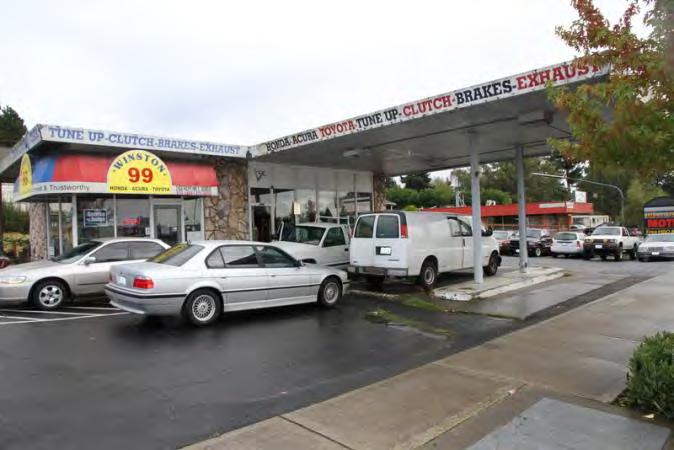
119 Photos view to southeast West elevation North elevation Northwest corner Southwest corner Thursday, April 17, 2014 Page 5 of 5
120 Location Field Site No DAHP No. Historic Name: Common Name: Los Pinitos Property Address: Pacific Hwy S, Des Moines, WA Comments: Tax No./Parcel No Plat/Block/Lot Acreage Supplemental Map(s) Township/Range/EW Section 1/4 Sec 1/4 1/4 Sec T22R04E 09 County King Quadrangle DES MOINES Coordinate Reference Easting: Northing: Projection: Washington State Plane South Datum: HARN (feet) Identification Survey Name: Sound Transit Federal Way Date Recorded: 10/30/ Field Recorder: MaryNell Nolan-Wheatley Owner's Name: THAI'S PROPERTIES INC Owner Address: TH AVE S City: SEATTLE State: Washington Zip: Classification: Building Resource Status: Survey/Inventory Comments: Within a District? No Contributing? No National Register: Local District: National Register District/Thematic Nomination Name: Eligibility Status: Not Determined - SHPO Determination Date: 1/1/0001 Determination Comments: Thursday, April 17, 2014 Page 1 of 5
121 Description Historic Use: Commerce/Trade - Business Current Use: Commerce/Trade - Restaurant Plan: L-Shape Stories: 1 Structural System: Concrete - Block Changes to Plan: Moderate Changes to Interior: Unknown Changes to Original Cladding: Intact Changes to Windows: Extensive Changes to Other: Moderate Other (specify): Plywood skirt added to bottom of extended eaves Style: Cladding: Roof Type: Roof Material: None Wood - T 1-11 Flat with Eaves Asphalt / Composition - Veneer - Brick Built Up Veneer - Permastone Concrete - Block Foundation: Form/Type: Concrete - Poured Commercial Narrative Study Unit Architecture/Landscape Architecture Date of Construction: 1963 Built Date Other Builder: Engineer: Architect: Property appears to meet criteria for the National Register of Historic Places:No Property is located in a potential historic district (National and/or local): No Property potentially contributes to a historic district (National and/or local): No Thursday, April 17, 2014 Page 2 of 5
122 Statement of Significance: Construction of the original Highway 1 in the state of Washington commenced in By October 1923, 700 miles of a two-lane highway had been completed connecting Vancouver, British Columbia, to the Oregon-California border. Just after the highway was completed in 1924, however, plans were begun to reroute and improve the conditions of the highway. The project involved creating a new, wider, four-lane route further west that would connect Seattle and Tacoma, Washington, more directly (Kramak, 2010). The new roadway was completed in 1928 and acquired the title of Highway 1, while the original eastern route was renamed Highway 5 (Caster, 2007). The new Highway 1 became known as the Pacific Highway. Over the years, various parts of Highway 1 acquired alternative names, including the portion known as Pacific Highway S, which starts near Federal Way, Washington, and continues north, through Kent, Des Moines, and SeaTac, Washington (Kramak, 2010). In 1926, Pacific Highway (HWY 1) was included as a numbered U.S. Highway (US 99) (U.S. Route 99, ). The following decades witnessed the rapid growth of businesses along the highway and the formation of a new auto-oriented roadside culture characterized by a proliferation of motels, restaurants, and rest stops (Des Moines Historical Society, 2007). Increased automobile ownership changed people s perceptions about distance and allowed populations to sprawl around urban centers, increasing the number of residents in suburban towns and cities, including SeaTac, Des Moines, Kent, and Federal Way (Boyles, 2010). The city of Des Moines is located approximately halfway between Seattle and Tacoma, on the eastern side of Puget Sound (Des Moines Historical Society, 2007). The town started as a logging community and as a real estate venture of F. A. Blasher, who moved from Des Moines, Iowa, to King County in 1888 (Des Moines Historical Society, 2007; Lange, 1998). After World War I, Des Moines popularity rose when the town expanded its dock and ferry service, attracting increased numbers of summer vacationers. The population grew quickly after World War II and Des Moines was incorporated as a city in 1959 (Des Moines Historical Society, 2007). While some buildings in Des Moines date to the 1920s and 1930s, many commercial and residential buildings were constructed during a period of suburban development in the 1950s and 1960s. On January 31, 1967, Interstate 5 (I-5), which passed through Des Moines on the route from Everett to Tacoma, Washington, was completed and established another transportation route, in addition to Pacific Highway S (SR 99), for commuters in the area (Des Moines Historical Society, 2007). The property at Pacific Highway South in Des Moines, Washington, which was built in 1963 and is occupied by several commercial businesses including Los Pinitos Mexican Restaurant, is not eligible for listing in the NRHP. The property is not eligible for the NRHP under Criterion A, which applies to buildings that are associated with events that have made a significant contribution to the broad patterns of history, as no significant events are associated with this property. To be eligible for the NRHP under Criterion B, a property must be directly associated with a person considered significant within a historic context whose specific contribution to history has been both identified and documented. No such person who meets that definition is linked to this building. The property is not eligible for the NRHP under Criterion C as it is a typical mid-century, roadside commercial property and does not embody the distinctive characteristics of a type, period, or method of construction; it is not the work of a master and does not possess high artistic value. The property is not eligible for the NRHP under Criterion D for information potential because the materials and construction methods of the building do not convey important information that could contribute to understanding history or prehistory. Therefore, the property is not eligible for listing in the NRHP because it does not meet any of the eligibility criteria. Additionally, the building has undergone several alterations; it has no original doors or windows, it has likely had an addition, and a plywood skirt has been added to the bottom of the eaves. As a result, the property has lost integrity of materials. The building retains integrity of design, setting, workmanship, location, feeling and association. Thursday, April 17, 2014 Page 3 of 5
123 Description of Physical Appearance: Major Bibliographic References: Pacific Highway South, which has several commercial spaces (one of which is occupied by Los Pinitos Mexican Restaurant), is a one-story commercial building constructed in Built on a poured concrete foundation with an L-shaped plan, the concrete block building is defined by a flat roof with extended eaves that are supported by a series of curved concrete supports that run vertically up the exterior walls of the front (west) elevation and under the eaves, forming a right angle where the eave meets the roof. The concrete supports are currently painted a bright orange and are positioned after every third bay of windows or doors. Plywood skirting clad in vertical T 1-11 has been added along the bottom edge of the eaves. The building is constructed into sloped land, making the roof in the rear (east) side of the property appear to be nearly at ground level. The west elevation contains rows of large replacement, fixed, single-light windows set above faux-stone veneer. The longer section of the L-shaped plan contains four commercial spaces, three of which are currently vacant. The façade of each commercial space contains a metal and glass pedestrian door flanked by two large, fixed, single-light windows placed above a short wall clad in faux-stone veneer. Each commercial space is divided from the neighboring space by one of the curved concrete supports. The north end of the west elevation protrudes from the rest of the building and creates the bottom part of the L shape. This section was likely an addition. The west elevation of this section contains six windows set above faux-stone veneer exterior walls, with a concrete support on both ends and another in the middle (bisecting the six windows into two sets of three). The south elevation of this section contains one metal and glass pedestrian door surrounded by fixed, single-light windows. The north elevation of this addition contains a metal and glass pedestrian door with two fixed, single-light windows to the east, and one fixed, single-light window to the west. Brick veneer is used on the exterior wall under the large windows on this elevation, instead of faux-stone. The east end of the north elevation has painted concrete exterior walls. Boyles, E The Suburb. Selected Cultural and Historical Geographies of the Greater Seattle Area. Available at: bellevue-and-redmond/the-suburb. Accessed March 18,. Caster, D Historical Society of Federal Way Timeline. Available at: Accessed March 15,. Des Moines Historical Society Time Line Page. Available at: Accessed March 13,. Lange, G Des Moines Beginnings: Des Moines Post Office opens on August 6, HistoryLink: The Free Online Encyclopedia of Washington State History. Available at: Accessed March 15,. King County.. King County Department of Assessments. Available at: Accessed October 20,. Kramak, J.E., ed Establishing the Pacific Highway South. Selected Cultural and Historical Geographies of the Greater Seattle Area. Available at: Accessed March 14,. U.S. Route 99 The Pacific Highway.. Waymarking: A Groundspeak Website. Available at: Accessed March 19,. Thursday, April 17, 2014 Page 4 of 5


124 Photos Addition is at left West elevation View of addition Northwest corner Thursday, April 17, 2014 Page 5 of 5
125 Location Field Site No DAHP No. Historic Name: Common Name: West View Motel Property Address: 2717 S 216th St, Des Moines, WA Comments: Tax No./Parcel No Plat/Block/Lot Acreage Supplemental Map(s) Township/Range/EW Section 1/4 Sec 1/4 1/4 Sec T22R04E 09 County King Quadrangle DES MOINES Coordinate Reference Easting: Northing: Projection: Washington State Plane South Datum: HARN (feet) Identification Survey Name: Sound Transit Federal Way Date Recorded: 10/30/ Field Recorder: MaryNell Nolan-Wheatley Owner's Name: H & R WESTVIEW LLC Owner Address: 2945 S 296TH PL City: FEDERAL WAY State: Washington Zip: Classification: Building Resource Status: Survey/Inventory Comments: Within a District? No Contributing? No National Register: Local District: National Register District/Thematic Nomination Name: Eligibility Status: Not Determined - SHPO Determination Date: 1/1/0001 Determination Comments: Thursday, April 17, 2014 Page 1 of 7
126 Description Historic Use: Domestic - Hotel Current Use: Domestic - Hotel Plan: L-Shape Stories: 2 Structural System: Concrete - Block Changes to Plan: Extensive Changes to Original Cladding: Slight Changes to Other: Other (specify): Style: None Foundation: Concrete - Poured Cladding: Concrete Veneer - Permastone Veneer - Vinyl Siding Concrete - Block Veneer - Brick Form/Type: Hotel/Motel - Motel Roof Type: Gable Changes to Interior: Unknown Changes to Windows: Extensive Flat with Eaves Roof Material: Concrete - Tile Asphalt / Composition - Built Up Narrative Study Unit Architecture/Landscape Architecture Date of Construction: 1953 Built Date 1959 Addition 1962 Addition Other Builder: Engineer: Architect: Property appears to meet criteria for the National Register of Historic Places:No Property is located in a potential historic district (National and/or local): No Property potentially contributes to a historic district (National and/or local): No Thursday, April 17, 2014 Page 2 of 7
127 Statement of Significance: Construction of the original Highway 1 in the state of Washington commenced in By October 1923, 700 miles of a two-lane highway had been completed connecting Vancouver, British Columbia, to the Oregon-California border. Just after the highway was completed in 1924, however, plans were begun to reroute and improve the conditions of the highway. The project involved creating a new, wider, four-lane route further west that would connect Seattle and Tacoma, Washington, more directly (Kramak, 2010). The new roadway was completed in 1928 and acquired the title of Highway 1, while the original eastern route was renamed Highway 5 (Caster, 2007). The new Highway 1 became known as the Pacific Highway. Over the years, various parts of Highway 1 acquired alternative names, including the portion known as Pacific Highway S, which starts near Federal Way, Washington, and continues north, through Kent, Des Moines, and SeaTac, Washington (Kramak, 2010). In 1926, Pacific Highway (HWY 1) was included as a numbered U.S. Highway (US 99) (U.S. Route 99, ). The following decades witnessed the rapid growth of businesses along the highway and the formation of a new auto-oriented roadside culture characterized by a proliferation of motels, restaurants, and rest stops (Des Moines Historical Society, 2007). Increased automobile ownership changed people s perceptions about distance and allowed populations to sprawl around urban centers, increasing the number of residents in suburban towns and cities, including SeaTac, Des Moines, Kent, and Federal Way (Boyles, 2010). The city of Des Moines is located approximately halfway between Seattle and Tacoma, on the eastern side of Puget Sound (Des Moines Historical Society, 2007). The town started as a logging community and as a real estate venture of F. A. Blasher, who moved from Des Moines, Iowa, to King County in 1888 (Des Moines Historical Society, 2007; Lange, 1998). After World War I, Des Moines popularity rose when the town expanded its dock and ferry service, attracting increased numbers of summer vacationers. The population grew quickly after World War II and Des Moines was incorporated as a city in 1959 (Des Moines Historical Society, 2007). While some buildings in Des Moines date to the 1920s and 1930s, many commercial and residential buildings were constructed during a period of suburban development in the 1950s and 1960s. On January 31, 1967, Interstate 5 (I-5), which passed through Des Moines on the route from Everett to Tacoma, Washington, was completed and established another transportation route, in addition to Pacific Highway S (SR 99), for commuters in the area (Des Moines Historical Society, 2007). The property at 2717 South 216th Street in Des Moines, Washington, which was originally built in 1953 and is occupied by West View Motel, is not eligible for listing in the NRHP. The property is not eligible for the NRHP under Criterion A, which applies to buildings that are associated with events that have made a significant contribution to the broad patterns of history, as no significant events are associated with this property. To be eligible for the NRHP under Criterion B, a property must be directly associated with a person considered significant within a historic context whose specific contribution to history has been both identified and documented. No such person who meets that definition is linked to this building. The property is not eligible for the NRHP under Criterion C as it is an undistinguished example of a typical midcentury, roadside motel and lacks the distinctive characteristics of other examples of its type and period; it is not the work of a master and does not possess high artistic value. The property is not eligible for the NRHP under Criterion D for information potential because the materials and construction methods of the building do not convey important information that could contribute to understanding history or prehistory. Therefore, the property is not eligible for listing in the NRHP because it does not meet any of the eligibility criteria. Additionally, the building has undergone several large additions and alterations and retains no original doors or windows. As a result, the property has lost integrity of design and materials. The building retains integrity of setting, workmanship, location, feeling, and association. Thursday, April 17, 2014 Page 3 of 7
128 Description of Physical Appearance: 2717 South 216th Street is occupied by West View Motel and was originally constructed in The concrete block building, constructed on a poured concrete foundation, has an essentially L-shaped plan, composed of a two-story, rectangular plan building that serves as the front of the motel, set at a right angle to two buildings that compose a much longer wing of motel rooms that run along the east side of the property. The two perpendicular wings meet at the northeast corner of the property. Most of the motel s rooms are accessed by exterior doors that line the interior elevations of the south wing of the L, and face a large, paved parking lot. All of the doors and windows on the property appear to be modern replacements. The two-story north wing, which serves as the motel s main entry, was built as an addition in It has a flat, built-up roof with a deep eave overhang that shades a long balcony running across the second story of the front (north) elevation. The balcony is supported by metal pillars that are secured into the ground below. The first and second story exterior walls are clad in vertical composite siding above faux-stone veneer siding. On the ground floor level of the north wing there are three paneled motel room doors and three replacement horizontal sliding windows. To the west of the rooms is a glass and metal pedestrian door that serves as the motel s main entrance. To the west of the main entrance is a horizontal sliding window identical to the others on the same elevation. The ground floor level does not extend beyond this window. The second floor, however, is nearly twice as long as the ground floor. As such, the west end of the second floor serves as a covering for a driveway that passes by the main office and leads to the rear parking lot. This cantilevered section of the second floor is supported by metal pillars set into concrete bases. The second story contains six, paneled motel room doors and six, two-light, horizontal sliding windows. A simple metal railing runs along the second story balcony, which can be accessed by exterior metal stairs. The vertical composite siding and faux-stone veneer continues around the northwest corner of the ground floor and along the width of the west elevation. The west elevation of the ground floor contains two, large, replacement, fixed, single-light windows that overlook the driveway. The west elevation of the second floor is entirely clad in faux-stone veneer, serving as the backdrop to the West View Motel sign. A one-story concrete block addition with a flat roof is attached to the south elevation of the north wing. The exterior walls of this addition are painted concrete block. The east elevation of the north wing is decorated with geometric shapes carved into a concrete exterior wall. The south wing of the motel, which extends south from the northeast corner of the north wing, is composed of a two buildings, one built in 1959 and one the original built in The 1959 addition is a two-story concrete block building with a gable roof on the north end. It is attached to the 1953 building, a one-story concrete block building with a gable roof on the south end. Both buildings have roofs clad in composite barrel tiles. All of the motel rooms in the north wing are accessed by exterior doors along the west elevation and all of the windows on the west and east elevations are modern, horizontal sliding windows that match those on the north elevation of the main building. The two-story section has a balcony with a metal railing that runs the length of the floor and can be accessed by exterior metal stairs. The exterior walls of the south wing are painted concrete block. The gable ends are clad in vertical composite siding. A small, flat roof, one-story addition is on the east elevation of the south wing. Thursday, April 17, 2014 Page 4 of 7
129 Major Bibliographic References: Boyles, E The Suburb. Selected Cultural and Historical Geographies of the Greater Seattle Area. Available at: bellevue-and-redmond/the-suburb. Accessed March 18,. Caster, D Historical Society of Federal Way Timeline. Available at: Accessed March 15,. Des Moines Historical Society Time Line Page. Available at: Accessed March 13,. Lange, G Des Moines Beginnings: Des Moines Post Office opens on August 6, HistoryLink: The Free Online Encyclopedia of Washington State History. Available at: Accessed March 15,. King County.. King County Department of Assessments. Available at: Accessed October 20,. Kramak, J.E., ed Establishing the Pacific Highway South. Selected Cultural and Historical Geographies of the Greater Seattle Area. Available at: Accessed March 14,. U.S. Route 99 The Pacific Highway.. Waymarking: A Groundspeak Website. Available at: Accessed March 19,. Thursday, April 17, 2014 Page 5 of 7


 wing Northwest")

130 Photos North (1962) wing. Entrance to building and drive-thru to rear parking lot. Original part of building is at center in the background. North elevation North (1962) wing Northwest corner 1962 building at right, 1959 building with gable roof at left. Northeast corner 1962 building at left, 1959 building visible at right. West elevation Thursday, April 17, 2014 Page 6 of 7

131 Original 1953 building at right, 1959 building in center, 1962 building at far left. View to the northeast Thursday, April 17, 2014 Page 7 of 7
132 Location Field Site No DAHP No. Historic Name: Common Name: 3018 S 221st St Property Address: 3018 S 221st St, Des Moines, WA Comments: Tax No./Parcel No Plat/Block/Lot Acreage.51 Supplemental Map(s) Township/Range/EW Section 1/4 Sec 1/4 1/4 Sec T22R04E 09 County King Quadrangle DES MOINES Coordinate Reference Easting: Northing: Projection: Washington State Plane South Datum: HARN (feet) Identification Survey Name: Sound Transit Federal Way Date Recorded: 11/05/ Field Recorder: MaryNell Nolan-Wheatley Owner's Name: JOHNSON W R Owner Address: TH PL NE City: KIRKLAND State: WA Zip: Classification: Building Resource Status: Survey/Inventory Comments: Within a District? No Contributing? No National Register: Local District: National Register District/Thematic Nomination Name: Eligibility Status: Not Determined - SHPO Determination Date: 1/1/0001 Determination Comments: Tuesday, June 10, 2014 Page 1 of 5
133 Description Historic Use: Domestic - Single Family House Current Use: Domestic - Single Family House Plan: Irregular Stories: 1 Structural System: Platform Frame Changes to Plan: Moderate Changes to Original Cladding: Extensive Changes to Other: Other (specify): Style: Foundation: Cladding: Form/Type: Roof Type: Changes to Interior: Unknown Changes to Windows: Moderate Roof Material: Vernacular Veneer - Vinyl Siding Gable - Side Gable Asphalt / Composition - Shingle Concrete - Poured Single Family - Side Gable Narrative Study Unit Architecture/Landscape Architecture Date of Construction: 1953 Built Date Other Builder: Engineer: Architect: Property appears to meet criteria for the National Register of Historic Places:No Property is located in a potential historic district (National and/or local): No Property potentially contributes to a historic district (National and/or local): No Tuesday, June 10, 2014 Page 2 of 5
134 Statement of Significance: Construction of the original Highway 1 in the state of Washington commenced in By October 1923, 700 miles of a two-lane highway had been completed connecting Vancouver, British Columbia, to the Oregon-California border. Just after the highway was completed in 1924, however, plans were begun to reroute and improve the conditions of the highway. The project involved creating a new, wider, four-lane route further west that would connect Seattle and Tacoma, Washington, more directly (Kramak, 2010). The new roadway was completed in 1928 and acquired the title of Highway 1, while the original eastern route was renamed Highway 5 (Caster, 2007). The new Highway 1 became known as the Pacific Highway. Over the years, various parts of Highway 1 acquired alternative names, including the portion known as Pacific Highway S, which starts near Federal Way, Washington, and continues north, through Kent, Des Moines, and SeaTac, Washington (Kramak, 2010). In 1926, Pacific Highway (HWY 1) was included as a numbered U.S. Highway (US 99) (U.S. Route 99, ). The following decades witnessed the rapid growth of businesses along the highway and the formation of a new auto-oriented roadside culture characterized by a proliferation of motels, restaurants, and rest stops (Des Moines Historical Society, 2007). Increased automobile ownership changed people s perceptions about distance and allowed populations to sprawl around urban centers, increasing the number of residents in suburban towns and cities, including SeaTac, Des Moines, Kent, and Federal Way (Boyles, 2010). The city of Des Moines is located approximately halfway between Seattle and Tacoma, on the eastern side of Puget Sound (Des Moines Historical Society, 2007). The town started as a logging community and as a real estate venture of F. A. Blasher, who moved from Des Moines, Iowa, to King County in 1888 (Des Moines Historical Society, 2007; Lange, 1998). After World War I, Des Moines popularity rose when the town expanded its dock and ferry service, attracting increased numbers of summer vacationers. The population grew quickly after World War II and Des Moines was incorporated as a city in 1959 (Des Moines Historical Society, 2007). While some buildings in Des Moines date to the 1920s and 1930s, many commercial and residential buildings were constructed during a period of suburban development in the 1950s and 1960s. On January 31, 1967, Interstate 5 (I-5), which passed through Des Moines on the route from Everett to Tacoma, Washington, was completed and established another transportation route, in addition to Pacific Highway S (SR 99), for commuters in the area (Des Moines Historical Society, 2007). The property at 3018 South 221st Street in Des Moines, Washington, which is a single family residential building constructed in 1953, is not eligible for listing in the NRHP. The property is not eligible for the NRHP under Criterion A, which applies to buildings that are associated with events that have made a significant contribution to the broad patterns of history, as no significant events are associated with this property. To be eligible for the NRHP under Criterion B, a property must be directly associated with a person considered significant within a historic context whose specific contribution to history has been both identified and documented. No such person who meets that definition is linked to this building. The property is not eligible for the NRHP under Criterion C as it is a typical mid-twentieth century residential building and does not embody the distinctive characteristics of a type, period, or method of construction; it is not the work of a master and does not possess high artistic value. The property is not eligible for the NRHP under Criterion D for information potential because the materials and construction methods of the buildings do not convey important information that could contribute to understanding history or prehistory. Therefore, the property is not eligible for listing in the NRHP because it does not meet any of the eligibility criteria. The building has been altered several times, including the replacement of all original siding and doors and a large addition on the west elevation. As a result, the property has lost integrity of materials, design, and workmanship. The building retains integrity of setting, location, feeling and association. Tuesday, June 10, 2014 Page 3 of 5
135 Description of Physical Appearance: Major Bibliographic References: 3018 South 221st Street is a one-story residential building, built in It is a rectangular plan house that is original to the property with a large, shed roofed addition on the west elevation. As a result of the addition, the house currently has an irregular floor plan. Many of the visible windows and doors are contemporary replacements. The building is clad in horizontal composite siding and sits on a concrete slab foundation. A composite shingle roof covers the side gable roof with deep eave overhangs on the original section of the house and also covers the shed roof on the addition. The front (south) elevation contains a replacement front door that sits adjacent to a large fixed, three-light window with vertical muntins that may be original to the house. A small concrete platform with a metal railing creates a porch on the south elevation. The west elevation of the main house contains a two-light window with one fixed light and one casement light. This window may also be original to the property, although a new wood frame has been added on the exterior. Directly north of this window is a narrow exterior concrete block chimney. North of the chimney is a large, shed-roofed addition with a rectangular plan. The south elevation of the addition contains a two-light, horizontal sliding window. The west elevation of the addition contains a replacement three-light horizontal sliding window, a one-over-one sash window, and a fixed, 18-light window. The house is surrounded by grass, vegetation, and gravel. Boyles, E The Suburb. Selected Cultural and Historical Geographies of the Greater Seattle Area. Available at: bellevue-and-redmond/the-suburb. Accessed March 18,. Caster, D Historical Society of Federal Way Timeline. Available at: Accessed March 15,. Des Moines Historical Society Time Line Page. Available at: Accessed March 13,. Lange, G Des Moines Beginnings: Des Moines Post Office opens on August 6, HistoryLink: The Free Online Encyclopedia of Washington State History. Available at: Accessed March 15,. King County.. King County Department of Assessments. Available at: Accessed October 20,. Kramak, J.E., ed Establishing the Pacific Highway South. Selected Cultural and Historical Geographies of the Greater Seattle Area. Available at: Accessed March 14,. U.S. Route 99 The Pacific Highway.. Waymarking: A Groundspeak Website. Available at: Accessed March 19,. Tuesday, June 10, 2014 Page 4 of 5


136 Photos West elevation Northwest corner Southwest corner Tuesday, June 10, 2014 Page 5 of 5
137 Location Field Site No DAHP No. Historic Name: Common Name: 3027 S 220th St Property Address: 3027 S 220th St, Des Moines, WA Comments: Tax No./Parcel No Plat/Block/Lot Acreage Supplemental Map(s) Township/Range/EW Section 1/4 Sec 1/4 1/4 Sec T22R04E 09 County King Quadrangle DES MOINES Coordinate Reference Easting: Northing: Projection: Washington State Plane South Datum: HARN (feet) Identification Survey Name: Sound Transit Federal Way Date Recorded: 10/31/ Field Recorder: MaryNell Nolan-Wheatley Owner's Name: INGERSOLL LLC Owner Address: SE 51ST ST City: BELLEVUE State: Washington Zip: Classification: Building Resource Status: Survey/Inventory Comments: Within a District? No Contributing? No National Register: Local District: National Register District/Thematic Nomination Name: Eligibility Status: Not Determined - SHPO Determination Date: 1/1/0001 Determination Comments: Tuesday, June 10, 2014 Page 1 of 5
138 Description Historic Use: Domestic - Single Family House Current Use: Domestic - Single Family House Plan: Rectangle Stories: 1 Structural System: Platform Frame Changes to Plan: Slight Changes to Original Cladding: Extensive Changes to Other: Moderate Other (specify): Carport enclosed to form an interior garage. Style: Foundation: Cladding: Form/Type: Roof Type: Changes to Interior: Unknown Changes to Windows: Extensive Roof Material: Ranch Veneer - Vinyl Siding Gable - Side Gable Asphalt / Composition - Rolled Concrete - Poured Single Family - Side Gable Narrative Study Unit Architecture/Landscape Architecture Date of Construction: 1962 Built Date Other Builder: Engineer: Architect: Property appears to meet criteria for the National Register of Historic Places:No Property is located in a potential historic district (National and/or local): No Property potentially contributes to a historic district (National and/or local): No Tuesday, June 10, 2014 Page 2 of 5
139 Statement of Significance: Construction of the original Highway 1 in the state of Washington commenced in By October 1923, 700 miles of a two-lane highway had been completed connecting Vancouver, British Columbia, to the Oregon-California border. Just after the highway was completed in 1924, however, plans were begun to reroute and improve the conditions of the highway. The project involved creating a new, wider, four-lane route further west that would connect Seattle and Tacoma, Washington, more directly (Kramak, 2010). The new roadway was completed in 1928 and acquired the title of Highway 1, while the original eastern route was renamed Highway 5 (Caster, 2007). The new Highway 1 became known as the Pacific Highway. Over the years, various parts of Highway 1 acquired alternative names, including the portion known as Pacific Highway S, which starts near Federal Way, Washington, and continues north, through Kent, Des Moines, and SeaTac, Washington (Kramak, 2010). In 1926, Pacific Highway (HWY 1) was included as a numbered U.S. Highway (US 99) (U.S. Route 99, ). The following decades witnessed the rapid growth of businesses along the highway and the formation of a new auto-oriented roadside culture characterized by a proliferation of motels, restaurants, and rest stops (Des Moines Historical Society, 2007). Increased automobile ownership changed people s perceptions about distance and allowed populations to sprawl around urban centers, increasing the number of residents in suburban towns and cities, including SeaTac, Des Moines, Kent, and Federal Way (Boyles, 2010). The city of Des Moines is located approximately halfway between Seattle and Tacoma, on the eastern side of Puget Sound (Des Moines Historical Society, 2007). The town started as a logging community and as a real estate venture of F. A. Blasher, who moved from Des Moines, Iowa, to King County in 1888 (Des Moines Historical Society, 2007; Lange, 1998). After World War I, Des Moines popularity rose when the town expanded its dock and ferry service, attracting increased numbers of summer vacationers. The population grew quickly after World War II and Des Moines was incorporated as a city in 1959 (Des Moines Historical Society, 2007). While some buildings in Des Moines date to the 1920s and 1930s, many commercial and residential buildings were constructed during a period of suburban development in the 1950s and 1960s. On January 31, 1967, Interstate 5 (I-5), which passed through Des Moines on the route from Everett to Tacoma, Washington, was completed and established another transportation route, in addition to Pacific Highway S (SR 99), for commuters in the area (Des Moines Historical Society, 2007). The property at 3027 South 220th Street in Des Moines, Washington, which is a residential building constructed in 1962, is not eligible for listing in the NRHP. The property is not eligible for the NRHP under Criterion A, which applies to buildings that are associated with events that have made a significant contribution to the broad patterns of history, as no significant events are associated with this property. To be eligible for the NRHP under Criterion B, a property must be directly associated with a person considered significant within a historic context whose specific contribution to history has been both identified and documented. No such person who meets that definition is linked to this building. The property is not eligible for the NRHP under Criterion C as it is a typical mid-twentieth century residential building and does not embody the distinctive characteristics of a type, period, or method of construction; it is not the work of a master and does not possess high artistic value. The property is not eligible for the NRHP under Criterion D for information potential because the materials and construction methods of the buildings do not convey important information that could contribute to understanding history or prehistory. Therefore, the property is not eligible for listing in the NRHP because it does not meet any of the eligibility criteria. The building has been altered several times, including the replacement of original doors and windows and the enclosure of a carport on the west elevation. As a result, the property has lost integrity of materials and design. The building retains integrity of workmanship, setting, location, feeling and association. Tuesday, June 10, 2014 Page 3 of 5
140 Description of Physical Appearance: Major Bibliographic References: 3027 South 220th Street is a one-story residential ranch style building with a rectangular plan that was built in The house sits on a concrete slab foundation and all of the visible windows and doors are contemporary replacements. The upper half of the exterior walls of the wood frame house are clad in vertical composite siding and the lower half of the exterior walls are clad in horizontal composite siding. A composite rolled roofing material covers the side gabled roof, which is defined by a deep eave overhang and exposed rafter tails. The west end of the house, which currently contains an interior garage with a retractable metal door on the north elevation, was originally a carport that was covered by the primary roof and supported on the west end by three wood pillars. At some point, the carport was enclosed and clad in vertical composite siding. To the east of the garage is the main living space. The replacement plywood front door is located on the north elevation under an integrated shed roofed overhang covered in rolled roofing material. The overhang shades a small concrete porch and is supported by two wood pillars. Between the front door and the retractable garage door is a large replacement window with a fixed, single-light window placed over a smaller fixed, single-light flanked by two single-light awning windows. East of the front door are two, two-light horizontal sliding windows. Another integrated shed roofed overhang extends from the rear (south) elevation. The property has a paved driveway and a large back yard that is surrounded by a high chain link and wood fence. Boyles, E The Suburb. Selected Cultural and Historical Geographies of the Greater Seattle Area. Available at: bellevue-and-redmond/the-suburb. Accessed March 18,. Caster, D Historical Society of Federal Way Timeline. Available at: Accessed March 15,. Des Moines Historical Society Time Line Page. Available at: Accessed March 13,. Lange, G Des Moines Beginnings: Des Moines Post Office opens on August 6, HistoryLink: The Free Online Encyclopedia of Washington State History. Available at: Accessed March 15,. King County.. King County Department of Assessments. Available at: Accessed October 20,. Kramak, J.E., ed Establishing the Pacific Highway South. Selected Cultural and Historical Geographies of the Greater Seattle Area. Available at: Accessed March 14,. U.S. Route 99 The Pacific Highway.. Waymarking: A Groundspeak Website. Available at: Accessed March 19,. Tuesday, June 10, 2014 Page 4 of 5


141 Photos North elevation Northwest corner Southwest corner Tuesday, June 10, 2014 Page 5 of 5
142 Location Field Site No DAHP No. Historic Name: Common Name: 2812 S 226th St Property Address: 2812 S 226th St, Des Moines, WA Comments: Tax No./Parcel No Plat/Block/Lot Plat Block 1 / Lot 3 Acreage.13 Supplemental Map(s) Township/Range/EW Section 1/4 Sec 1/4 1/4 Sec T22R04E 16 County King Quadrangle DES MOINES Coordinate Reference Easting: Northing: Projection: Washington State Plane South Datum: HARN (feet) Identification Survey Name: Sound Transit Federal Way (2) Date Recorded: 03/11/2014 Field Recorder: MaryNell Nolan-Wheatley Owner's Name: BEALL ERIC A Owner Address: PO BOX 440 City: SEAHURST State: WA Zip: Classification: Building Resource Status: Survey/Inventory Comments: Within a District? No Contributing? No National Register: Local District: National Register District/Thematic Nomination Name: Eligibility Status: Not Determined - SHPO Determination Date: 1/1/0001 Determination Comments: Thursday, July 24, 2014 Page 1 of 5
143 Description Historic Use: Domestic - Single Family House Current Use: Domestic - Single Family House Plan: L-Shape Stories: 1.5 Structural System: Platform Frame Changes to Plan: Slight Changes to Original Cladding: Intact Changes to Other: Moderate Other (specify): Original roof has been replaced with corrugated metal. Style: Foundation: Cladding: Form/Type: Roof Type: Changes to Interior: Unknown Changes to Windows: Moderate Roof Material: Vernacular Veneer - Brick Gable - Cross Gable Metal - Corrugated Concrete - Block Wood Single Family Narrative Study Unit Architecture/Landscape Architecture Date of Construction: 1943 Built Date Other Builder: Engineer: Architect: Property appears to meet criteria for the National Register of Historic Places:No Property is located in a potential historic district (National and/or local): No Property potentially contributes to a historic district (National and/or local): No Thursday, July 24, 2014 Page 2 of 5
144 Statement of Significance: Construction of the original Highway 1 in the state of Washington commenced in By October 1923, 700 miles of a two-lane highway had been completed connecting Vancouver, British Columbia, to the Oregon-California border. Just after the highway was completed in 1924, however, plans were begun to reroute and improve the conditions of the highway. The project involved creating a new, wider, four-lane route further west that would connect Seattle and Tacoma, Washington, more directly (Kramak, 2010). The new roadway was completed in 1928 and acquired the title of Highway 1, while the original eastern route was renamed Highway 5 (Caster, 2007). The new Highway 1 became known as the Pacific Highway. Over the years, various parts of Highway 1 acquired alternative names, including the portion known as Pacific Highway S, which starts near Federal Way, Washington, and continues north, through Kent, Des Moines, and SeaTac, Washington (Kramak, 2010). In 1926, Pacific Highway (HWY 1) was included as a numbered U.S. Highway (US 99) (U.S. Route 99, ). The following decades witnessed the rapid growth of businesses along the highway and the formation of a new auto-oriented roadside culture characterized by a proliferation of motels, restaurants, and rest stops (Des Moines Historical Society, 2007). Increased automobile ownership changed people s perceptions about distance and allowed populations to sprawl around urban centers, increasing the number of residents in suburban towns and cities, including SeaTac, Des Moines, Kent, and Federal Way (Boyles, 2010). The city of Des Moines is located approximately halfway between Seattle and Tacoma, on the eastern side of Puget Sound (Des Moines Historical Society, 2007). The town started as a logging community and as a real estate venture of F. A. Blasher, who moved from Des Moines, Iowa, to King County in 1888 (Des Moines Historical Society, 2007; Lange, 1998). After World War I, Des Moines popularity rose when the town expanded its dock and ferry service, attracting increased numbers of summer vacationers. The population grew quickly after World War II and Des Moines was incorporated as a city in 1959 (Des Moines Historical Society, 2007). While some buildings in Des Moines date to the 1920s and 1930s, many commercial and residential buildings were constructed during a period of suburban development in the 1950s and 1960s. On January 31, 1967, Interstate 5 (I-5), which passed through Des Moines on the route from Everett to Tacoma, Washington, was completed and established another transportation route, in addition to Pacific Highway S (SR 99), for commuters in the area (Des Moines Historical Society, 2007). The property at 2812 South 226th Street in Des Moines, Washington, which is a residential property built in 1943, is not eligible for listing in the NRHP. The property is not eligible for the NRHP under Criterion A, which applies to buildings that are associated with events that have made a significant contribution to the broad patterns of history, as no significant events are associated with this property. To be eligible for the NRHP under Criterion B, a property must be directly associated with a person considered significant within a historic context whose specific contribution to history has been both identified and documented. No such person who meets that definition is linked to this building. The property is not eligible for the NRHP under Criterion C as it is a typical residential building from the early to mid-twentieth century and does not embody the distinctive characteristics of a type, period, or method of construction; it is not the work of a master and does not possess high artistic value. The property is not eligible for the NRHP under Criterion D for information potential because the materials and construction methods of the building do not convey important information that could contribute to understanding history or prehistory. Therefore, the property is not eligible for listing in the NRHP because it does not meet any of the eligibility criteria. In addition the building is altered including the replacement of the original roof and some original windows and a carport addition. As a result, the property has lost integrity of materials and design. The building retains integrity of feeling, workmanship, setting, location, and association. Thursday, July 24, 2014 Page 3 of 5
145 Description of Physical Appearance: Major Bibliographic References: 2812 South 226th Street is a one-and-a-half-story, wood frame, vernacular style, single-family residential property with an L-shaped plan constructed in The building, which sits on a concrete block foundation and has a look out basement, is topped by a corrugated metal, cross gabled roof with shallow boxed eaves. The exterior walls of the residence are clad in brick veneer. The front entrance, which is shaded by an attached front gabled overhang, is located in the center of the front (east) elevation. Originally, this overhang was supported by simple posts. Currently, the side walls on the north and south sides of the overhang have been enclosed to form a small vestibule area. A three-light window with horizontal muntins is located to the north of the entrance area and a large, two-light horizontal sliding replacement window is located to the south. Above the entrance is a three-light horizontal sliding replacement window. This front façade is covered by the primary front gabled roof. A small, two-light horizontal sliding window is located on the south elevation. A large, rectangular plan section of the house extends from the west end of the south elevation and is covered by a side gabled roof that crosses the primary front gabled roof. A narrow interior slope brick chimney protrudes from side gabled roof and a large exterior gable wall brick chimney is located on the south elevation. The roof s eave extends to form a covered porch area along the east elevation of the projection. A pedestrian door and a window opening are located underneath the eave overhang, the southeast corner of which is supported by a simple brick column. The west elevation s ground floor contains a two-light horizontal sliding replacement window and a fixed, single-light window flanked on either side by three-light windows with horizontal muntins. A small, two-light horizontal sliding window is located under the gable peak on the west elevation. Several look out basement windows, most of which appear to be two-light horizontal sliding replacements, are located in the foundation level of the west elevation. A gabled roof dormer, which is clad in horizontal wood siding, protrudes from the north side of the roof and contains a small window opening, the style of which is not visible from the public right-of-way. According to the King County Assessor s website, a 440- square foot, two-car carport was constructed circa The carport, however, is not visible from the public right-of-way. Boyles, E The Suburb. Selected Cultural and Historical Geographies of the Greater Seattle Area. Available at: bellevue-and-redmond/the-suburb. Accessed March 18,. Caster, D Historical Society of Federal Way Timeline. Available at: Accessed March 15,. Des Moines Historical Society Time Line Page. Available at: Accessed March 13,. Lange, G Des Moines Beginnings: Des Moines Post Office opens on August 6, HistoryLink: The Free Online Encyclopedia of Washington State History. Available at: Accessed March 15,. King County.. King County Department of Assessments. Available at: Accessed October 20,. Kramak, J.E., ed Establishing the Pacific Highway South. Selected Cultural and Historical Geographies of the Greater Seattle Area. Available at: Accessed March 14,. U.S. Route 99 The Pacific Highway.. Waymarking: A Groundspeak Website. Available at: Accessed March 19,. Thursday, July 24, 2014 Page 4 of 5


146 Photos Northwest corner 2014 West elevation 2014 Thursday, July 24, 2014 Page 5 of 5
147 Location Field Site No DAHP No. Historic Name: Common Name: Pacific Hwy S Property Address: Pacific Hwy S, Des Moines, WA Comments: Tax No./Parcel No Plat/Block/Lot Plat Block 1 /Lot Portion 10 Acreage.69 Supplemental Map(s) Township/Range/EW Section 1/4 Sec 1/4 1/4 Sec T22R04E 16 County King Quadrangle DES MOINES Coordinate Reference Easting: Northing: Projection: Washington State Plane South Datum: HARN (feet) Identification Survey Name: Sound Transit Federal Way (2) Date Recorded: 03/11/2014 Field Recorder: MaryNell Nolan-Wheatley Owner's Name: PACIFIC LLC Owner Address: TH AVE NE City: Kirkland State: WA Zip: Classification: Building Resource Status: Survey/Inventory Comments: Within a District? No Contributing? No National Register: Local District: National Register District/Thematic Nomination Name: Eligibility Status: Not Determined - SHPO Determination Date: 1/1/0001 Determination Comments: Thursday, July 24, 2014 Page 1 of 6
148 Description Historic Use: Domestic - Multiple Family House Current Use: Domestic - Multiple Family House Plan: Rectangle Stories: 1 Structural System: Platform Frame Changes to Plan: Intact Changes to Original Cladding: Intact Changes to Other: Other (specify): Style: Foundation: Cladding: Form/Type: Roof Type: Changes to Interior: Unknown Changes to Windows: Moderate Roof Material: Ranch Wood Hip Asphalt / Composition - Shingle Concrete - Poured Multi-Family - Duplex Narrative Study Unit Architecture/Landscape Architecture Date of Construction: 1950 Built Date 1998 Built Date Other Builder: Engineer: Architect: Property appears to meet criteria for the National Register of Historic Places:No Property is located in a potential historic district (National and/or local): No Property potentially contributes to a historic district (National and/or local): No Thursday, July 24, 2014 Page 2 of 6
149 Statement of Significance: Construction of the original Highway 1 in the state of Washington commenced in By October 1923, 700 miles of a two-lane highway had been completed connecting Vancouver, British Columbia, to the Oregon-California border. Just after the highway was completed in 1924, however, plans were begun to reroute and improve the conditions of the highway. The project involved creating a new, wider, four-lane route further west that would connect Seattle and Tacoma, Washington, more directly (Kramak, 2010). The new roadway was completed in 1928 and acquired the title of Highway 1, while the original eastern route was renamed Highway 5 (Caster, 2007). The new Highway 1 became known as the Pacific Highway. Over the years, various parts of Highway 1 acquired alternative names, including the portion known as Pacific Highway S, which starts near Federal Way, Washington, and continues north, through Kent, Des Moines, and SeaTac, Washington (Kramak, 2010). In 1926, Pacific Highway (HWY 1) was included as a numbered U.S. Highway (US 99) (U.S. Route 99, ). The following decades witnessed the rapid growth of businesses along the highway and the formation of a new auto-oriented roadside culture characterized by a proliferation of motels, restaurants, and rest stops (Des Moines Historical Society, 2007). Increased automobile ownership changed people s perceptions about distance and allowed populations to sprawl around urban centers, increasing the number of residents in suburban towns and cities, including SeaTac, Des Moines, Kent, and Federal Way (Boyles, 2010). The city of Des Moines is located approximately halfway between Seattle and Tacoma, on the eastern side of Puget Sound (Des Moines Historical Society, 2007). The town started as a logging community and as a real estate venture of F. A. Blasher, who moved from Des Moines, Iowa, to King County in 1888 (Des Moines Historical Society, 2007; Lange, 1998). After World War I, Des Moines popularity rose when the town expanded its dock and ferry service, attracting increased numbers of summer vacationers. The population grew quickly after World War II and Des Moines was incorporated as a city in 1959 (Des Moines Historical Society, 2007). While some buildings in Des Moines date to the 1920s and 1930s, many commercial and residential buildings were constructed during a period of suburban development in the 1950s and 1960s. On January 31, 1967, Interstate 5 (I-5), which passed through Des Moines on the route from Everett to Tacoma, Washington, was completed and established another transportation route, in addition to Pacific Highway S (SR 99), for commuters in the area (Des Moines Historical Society, 2007). The property at Pacific Highway South in Des Moines, Washington, which is a mixed use parcel that contains a residential duplex and a single-family residence built in 1950 along with a commercial office building constructed in 1998, is not eligible for listing in the NRHP. The property is not eligible for the NRHP under Criterion A, which applies to buildings that are associated with events that have made a significant contribution to the broad patterns of history, as no significant events are associated with this property. To be eligible for the NRHP under Criterion B, a property must be directly associated with a person considered significant within a historic context whose specific contribution to history has been both identified and documented. No such person who meets that definition is linked to these buildings. The property is not eligible for the NRHP under Criterion C as it contains typical residential buildings from the mid-twentieth century and does not embody the distinctive characteristics of a type, period, or method of construction; it is not the work of a master and does not possess high artistic value. The property is not eligible for the NRHP under Criterion D for information potential because the materials and construction methods of the buildings do not convey important information that could contribute to understanding history or prehistory. Therefore, the property is not eligible for listing in the NRHP because it does not meet any of the eligibility criteria. In addition the 1950 buildings are altered including the replacement of some of the original windows and siding and several additions. As a result, the property has lost integrity of materials, design, and setting. The building retains integrity of feeling, workmanship, location, and association. Thursday, July 24, 2014 Page 3 of 6
150 Description of Physical Appearance: Pacific Highway South contains three buildings: two, one-story, wood frame, residential buildings constructed in 1950 and a two-story, reinforced concrete, office building constructed in The two 1950s residential buildings are located in the rear (west) side of the property and are both constructed on concrete slab foundations. The larger residence, located in the furthest position on the lot s west side, is a ranch style duplex topped by a hipped roof with deep boxed eaves covered in composite shingles. With exterior walls clad in horizontal wood siding, the duplex has a rectangular plan and contains nearly all replacement, one-over-one sash windows. Most of the windows are positioned in pairs. The building s two primary entrances, marked by plain doors with metal and glass storm doors, are located on the far north and south ends of the front (east) elevation. Each entrance is recessed behind a small concrete porch and covered by the northeast and southeast corners of the roof, the edges of which are supported by simple wood posts. The exterior wall that overlooks the concrete porch areas and is perpendicular to the main doors contains a single, one-over-one sash window. Between the two entrances, the east elevation contains two pairs of sash windows flanked on either side by pairs of smaller windows in the same style. The north elevation contains a sash window that is centered between two, adjacent, fixed, single-light windows. Southeast of the duplex is a single-family residence that was also constructed in The essentially L- shaped building has a gabled roof covered in composite shingles. The upper half of the building s exterior walls are primarily clad in wood board and batten while the lower half are primarily clad in horizontal wood siding. A large section of the siding on the dwelling s north elevation, including the gable end, has been replaced by what appears to be fiberboards. The north elevation also contains a small, two-light horizontal sliding replacement window and a small, metal, louvered attic vent. A rectangular plan shed roof addition projects from the south end of the west elevation and is clad in fiberboards. The west elevation of the shed contains a small, rectangular window opening. The building s main entrance is not visible from the public right-of-way. On the east side of the property, on higher grade land, is a two-story, rectangular plan, reinforced concrete office building that overlooks Pacific Highway. The building has a flat roof and all fixed, singlelight windows. The exterior walls of the first floor are clad in square, concrete tiles, while the second floor is clad in smooth stucco. Double metal and glass doors surrounded by fixed, single-light windows are located in the center of the front (east) elevation. A row of three, large, fixed, single-light commercial windows are located north and south of the main entrance on the front façade. Above the entrance is a bay window that contains two fixed, single-light windows with a smaller, fixed single-light window above and below each. A row of three, fixed, single-light windows are located north and south of the bay window. All three buildings on the parcel are surrounded by a large paved parking lot. Thursday, July 24, 2014 Page 4 of 6
151 Major Bibliographic References: Boyles, E The Suburb. Selected Cultural and Historical Geographies of the Greater Seattle Area. Available at: bellevue-and-redmond/the-suburb. Accessed March 18,. Caster, D Historical Society of Federal Way Timeline. Available at: Accessed March 15,. Des Moines Historical Society Time Line Page. Available at: Accessed March 13,. Lange, G Des Moines Beginnings: Des Moines Post Office opens on August 6, HistoryLink: The Free Online Encyclopedia of Washington State History. Available at: Accessed March 15,. King County.. King County Department of Assessments. Available at: Accessed October 20,. Kramak, J.E., ed Establishing the Pacific Highway South. Selected Cultural and Historical Geographies of the Greater Seattle Area. Available at: Accessed March 14,. U.S. Route 99 The Pacific Highway.. Waymarking: A Groundspeak Website. Available at: Accessed March 19,. Thursday, July 24, 2014 Page 5 of 6


152 Photos Northeast corner, 1950 duplex 2014 North elevation, 1950 duplex 2014 Northest corner, 1950 single family residence 2014 East elevation, 1998 office building 2014 Thursday, July 24, 2014 Page 6 of 6
153 Location Field Site No DAHP No. Historic Name: Common Name: Pacific Hwy S Property Address: Pacific Hwy S, Des Moines, WA Comments: Tax No./Parcel No Plat/Block/Lot Block 1/portion of lot 11 Acreage 0.71 Supplemental Map(s) Township/Range/EW Section 1/4 Sec 1/4 1/4 Sec T22R04E 16 County King Quadrangle DES MOINES Coordinate Reference Easting: Northing: Projection: Washington State Plane South Datum: HARN (feet) Identification Survey Name: Sound Transit Federal Way Date Recorded: 11/08/ Field Recorder: MaryNell Nolan-Wheatley Owner's Name: MORRIS, KEVIN Owner Address: PACIFIC HWY S City: Des Moines State: WA Zip: Classification: Building Resource Status: Survey/Inventory Comments: Within a District? No Contributing? No National Register: Local District: National Register District/Thematic Nomination Name: Eligibility Status: Not Determined - SHPO Determination Date: 1/1/0001 Determination Comments: Thursday, June 05, 2014 Page 1 of 5
154 Description Historic Use: Commerce/Trade - Warehouse Current Use: Commerce/Trade - Warehouse Plan: Rectangle Stories: 1 Structural System: Steel Changes to Plan: Intact Changes to Interior: Unknown Changes to Original Cladding: Moderate Changes to Windows: Intact Changes to Other: Other (specify): Style: Cladding: Roof Type: Roof Material: Other - Utilitarian Metal - Corrugated Gable - Side Gable Metal - Corrugated Other - Industrial Foundation: Form/Type: Concrete - Poured Utilitarian Industrial Narrative Study Unit Architecture/Landscape Architecture Date of Construction: 1966 Built Date Other Builder: Engineer: Architect: Property appears to meet criteria for the National Register of Historic Places:No Property is located in a potential historic district (National and/or local): No Property potentially contributes to a historic district (National and/or local): No Thursday, June 05, 2014 Page 2 of 5
155 Statement of Significance: Construction of the original Highway 1 in the state of Washington commenced in By October 1923, 700 miles of a two-lane highway had been completed connecting Vancouver, British Columbia, to the Oregon-California border. Just after the highway was completed in 1924, however, plans were begun to reroute and improve the conditions of the highway. The project involved creating a new, wider, four-lane route further west that would connect Seattle and Tacoma, Washington, more directly (Kramak, 2010). The new roadway was completed in 1928 and acquired the title of Highway 1, while the original eastern route was renamed Highway 5 (Caster, 2007). The new Highway 1 became known as the Pacific Highway. Over the years, various parts of Highway 1 acquired alternative names, including the portion known as Pacific Highway S, which starts near Federal Way, Washington, and continues north, through Kent, Des Moines, and SeaTac, Washington (Kramak, 2010). In 1926, Pacific Highway (HWY 1) was included as a numbered U.S. Highway (US 99) (U.S. Route 99, ). The following decades witnessed the rapid growth of businesses along the highway and the formation of a new auto-oriented roadside culture characterized by a proliferation of motels, restaurants, and rest stops (Des Moines Historical Society, 2007). Increased automobile ownership changed people s perceptions about distance and allowed populations to sprawl around urban centers, increasing the number of residents in suburban towns and cities, including SeaTac, Des Moines, Kent, and Federal Way (Boyles, 2010). The city of Des Moines is located approximately halfway between Seattle and Tacoma, on the eastern side of Puget Sound (Des Moines Historical Society, 2007). The town started as a logging community and as a real estate venture of F. A. Blasher, who moved from Des Moines, Iowa, to King County in 1888 (Des Moines Historical Society, 2007; Lange, 1998). After World War I, Des Moines popularity rose when the town expanded its dock and ferry service, attracting increased numbers of summer vacationers. The population grew quickly after World War II and Des Moines was incorporated as a city in 1959 (Des Moines Historical Society, 2007). While some buildings in Des Moines date to the 1920s and 1930s, many commercial and residential buildings were constructed during a period of suburban development in the 1950s and 1960s. On January 31, 1967, Interstate 5 (I-5), which passed through Des Moines on the route from Everett to Tacoma, Washington, was completed and established another transportation route, in addition to Pacific Highway S (SR 99), for commuters in the area (Des Moines Historical Society, 2007). The property at Pacific Highway South in Des Moines, Washington, which is a light industrial warehouse building constructed in 1966, is not eligible for listing in the NRHP. The property is not eligible for the NRHP under Criterion A, which applies to buildings that are associated with events that have made a significant contribution to the broad patterns of history, as no significant events are associated with this property. To be eligible for the NRHP under Criterion B, a property must be directly associated with a person considered significant within a historic context whose specific contribution to history has been both identified and documented. No such person who meets that definition is linked to this building. The property is not eligible for the NRHP under Criterion C as it is a typical utilitarian warehouse and does not embody the distinctive characteristics of a type, period, or method of construction; it is not the work of a master and does not possess high artistic value. The property is not eligible for the NRHP under Criterion D for information potential because the materials and construction methods of the building do not convey important information that could contribute to understanding history or prehistory. Therefore, the property is not eligible for listing in the NRHP because it does not meet any of the eligibility criteria. The building appears to have retained its original windows and doors, although the metal siding seems to have been more recently replaced. As a result, the property has lost some integrity of materials. The building retains integrity of design, workmanship, setting, location, feeling and association. Thursday, June 05, 2014 Page 3 of 5
156 Description of Physical Appearance: Major Bibliographic References: Pacific Highway South is a one-story, prefabricated steel warehouse with a rectangular plan that was built in The building sits on a concrete slab foundation and is clad in replacement corrugated metal. Corrugated metal also covers the side gable roof, from which two large metal chimney flues protrude. The east (front) elevation is defined by two, very large, vehicle bays with retractable metal doors on the north and south ends of the elevation. There is a pair of metal pedestrian doors in the center of the east elevation, with small, two-light aluminum horizontal sliding windows on either side. Between the north window and the north vehicle bay is another metal pedestrian door. Two security lights have been attached to the east elevation. There are no openings on the north or south elevations. The property is surrounded by pavement and a chain link fence. Boyles, E The Suburb. Selected Cultural and Historical Geographies of the Greater Seattle Area. Available at: bellevue-and-redmond/the-suburb. Accessed March 18,. Caster, D Historical Society of Federal Way Timeline. Available at: Accessed March 15,. Des Moines Historical Society Time Line Page. Available at: Accessed March 13,. Lange, G Des Moines Beginnings: Des Moines Post Office opens on August 6, HistoryLink: The Free Online Encyclopedia of Washington State History. Available at: Accessed March 15,. King County.. King County Department of Assessments. Available at: Accessed October 20,. Kramak, J.E., ed Establishing the Pacific Highway South. Selected Cultural and Historical Geographies of the Greater Seattle Area. Available at: Accessed March 14,. U.S. Route 99 The Pacific Highway.. Waymarking: A Groundspeak Website. Available at: Accessed March 19,. Thursday, June 05, 2014 Page 4 of 5

157 Photos Southeast corner Thursday, June 05, 2014 Page 5 of 5
158 Location Field Site No DAHP No. Historic Name: Common Name: SAV-ON Insurance Agency Property Address: Pacific Hwy S, Des Moines, WA Comments: Tax No./Parcel No Plat/Block/Lot Block 1/portion Lot 12 Acreage 0.41 Supplemental Map(s) Township/Range/EW Section 1/4 Sec 1/4 1/4 Sec T22R04E 16 County King Quadrangle DES MOINES Coordinate Reference Easting: Northing: Projection: Washington State Plane South Datum: HARN (feet) Identification Survey Name: Sound Transit Federal Way Date Recorded: 11/08/ Field Recorder: MaryNell Nolan-Wheatley Owner's Name: DEVITTE, DONALD A+JEANNE Owner Address: PACIFIC HWY S City: Des Moines State: WA Zip: Classification: Building Resource Status: Survey/Inventory Comments: Within a District? No Contributing? No National Register: Local District: National Register District/Thematic Nomination Name: Eligibility Status: Not Determined - SHPO Determination Date: 1/1/0001 Determination Comments: Thursday, June 05, 2014 Page 1 of 7
159 Description Historic Use: Commerce/Trade - Business Current Use: Commerce/Trade - Business Plan: L-Shape Stories: 1 Structural System: Concrete - Block Changes to Plan: Intact Changes to Original Cladding: Extensive Changes to Other: Other (specify): Style: Commercial - Highway Strip Foundation: Concrete - Poured Cladding: Veneer - Vinyl Siding Concrete - Block Wood - T 1-11 Form/Type: Multi-Family Commercial - Strip Commercial Roof Type: Mansard Changes to Interior: Unknown Changes to Windows: Moderate Gable - Side Gable Roof Material: Metal Asphalt / Composition - Shingle Asphalt / Composition - Built Up Narrative Study Unit Architecture/Landscape Architecture Date of Construction: 1966 Built Date Other Builder: Engineer: Architect: Property appears to meet criteria for the National Register of Historic Places:No Property is located in a potential historic district (National and/or local): No Property potentially contributes to a historic district (National and/or local): No Thursday, June 05, 2014 Page 2 of 7
160 Statement of Significance: Construction of the original Highway 1 in the state of Washington commenced in By October 1923, 700 miles of a two-lane highway had been completed connecting Vancouver, British Columbia, to the Oregon-California border. Just after the highway was completed in 1924, however, plans were begun to reroute and improve the conditions of the highway. The project involved creating a new, wider, four-lane route further west that would connect Seattle and Tacoma, Washington, more directly (Kramak, 2010). The new roadway was completed in 1928 and acquired the title of Highway 1, while the original eastern route was renamed Highway 5 (Caster, 2007). The new Highway 1 became known as the Pacific Highway. Over the years, various parts of Highway 1 acquired alternative names, including the portion known as Pacific Highway S, which starts near Federal Way, Washington, and continues north, through Kent, Des Moines, and SeaTac, Washington (Kramak, 2010). In 1926, Pacific Highway (HWY 1) was included as a numbered U.S. Highway (US 99) (U.S. Route 99, ). The following decades witnessed the rapid growth of businesses along the highway and the formation of a new auto-oriented roadside culture characterized by a proliferation of motels, restaurants, and rest stops (Des Moines Historical Society, 2007). Increased automobile ownership changed people s perceptions about distance and allowed populations to sprawl around urban centers, increasing the number of residents in suburban towns and cities, including SeaTac, Des Moines, Kent, and Federal Way (Boyles, 2010). The city of Des Moines is located approximately halfway between Seattle and Tacoma, on the eastern side of Puget Sound (Des Moines Historical Society, 2007). The town started as a logging community and as a real estate venture of F. A. Blasher, who moved from Des Moines, Iowa, to King County in 1888 (Des Moines Historical Society, 2007; Lange, 1998). After World War I, Des Moines popularity rose when the town expanded its dock and ferry service, attracting increased numbers of summer vacationers. The population grew quickly after World War II and Des Moines was incorporated as a city in 1959 (Des Moines Historical Society, 2007). While some buildings in Des Moines date to the 1920s and 1930s, many commercial and residential buildings were constructed during a period of suburban development in the 1950s and 1960s. On January 31, 1967, Interstate 5 (I-5), which passed through Des Moines on the route from Everett to Tacoma, Washington, was completed and established another transportation route, in addition to Pacific Highway S (SR 99), for commuters in the area (Des Moines Historical Society, 2007). The property at Pacific Highway South in Des Moines, Washington, which contains two commercial buildings constructed in 1966, is not eligible for listing in the NRHP. The property is not eligible for the NRHP under Criterion A, which applies to buildings that are associated with events that have made a significant contribution to the broad patterns of history, as no significant events are associated with this property. To be eligible for the NRHP under Criterion B, a property must be directly associated with a person considered significant within a historic context whose specific contribution to history has been both identified and documented. No such person who meets that definition is linked to these buildings. The property is not eligible for the NRHP under Criterion C as they are typical mid-twentieth century commercial buildings and do not embody the distinctive characteristics of a type, period, or method of construction; they are not the work of a master and do not possess high artistic value. The property is not eligible for the NRHP under Criterion D for information potential because the materials and construction methods of the buildings do not convey important information that could contribute to understanding history or prehistory. Therefore, the property is not eligible for listing in the NRHP because it does not meet any of the eligibility criteria. The buildings have been altered several times, including the replacement of original doors, windows, and siding. As a result, the property has lost integrity of materials. The buildings retain integrity of design, workmanship, setting, location, feeling and association. Thursday, June 05, 2014 Page 3 of 7
161 Description of Physical Appearance: Pacific Highway South contains two commercial buildings occupied by several businesses and some apartments, including SAV-ON Insurance Agency, which is most prominently advertised. Built in 1966, the property contains two concrete block buildings: a one-story L-shaped building which is located closer to Pacific Highway South and a two-story rectangular plan building in the rear. The L-shaped building, which is occupied by SAV-ON Insurance Agency, is clad in non-original horizontal vinyl siding and has a shallow mansard roof clad in metal. Built on a poured concrete foundation on land that changes grade, the building contains a basement level in the rear of the property that is not visible from the front of the building. The building s front elevations, which are the east and north elevations on the inset of the L, contain all replacement paneled doors three on the north elevation and four on the east. The front, north elevation contains four replacement fixed, single-light windows while the inset s other front (east) elevation contains four, fixed, single-light windows placed under pairs of awning windows. Large letters that spell the name of the insurance agency run along the north elevation of the awning. Plastic letters that spell INSURANCE have been secured to the painted concrete exterior wall on the building s south elevation. The interior elevations of the L overlook a paved parking area that connects to a paved driveway, which slopes down along the building s north elevation and leads to a rear parking area. The raised basement level on the back (west) elevation contains (moving from north to south) three replacement pedestrian doors, one metal retractable door, and two, two-light aluminum horizontal sliding windows. Between the windows and the retractable door is a large recessed area that is used for covered parking. Above the basement level are seven, metal, two-light horizontal sliding windows. Set on a poured concrete foundation behind the main building is a two-story rectangular plan accessory building. Due to the steep change in grade of the land, the second floor of this building is on the same grade as the raised basement level of the main building. The side gable roof of the second building has such a low pitch that it appears almost flat and is covered in built-up roofing material. An extended shed roof covered in corrugated metal creates a deep overhang over the building s front (north) elevation and shades a large wood balcony that wraps around the building s second floor. The overhang is supported by thin wood posts that rest on an open framework railing. Wood stairs access the north end of the balcony from the parking area behind the main building. The ground floor of the accessory building has painted concrete block exterior walls and is defined by three large vehicle bays with nine-light retractable doors. East of the vehicle doors is a metal replacement pedestrian door and a two-light, aluminum horizontal sliding window. The second floor of the north elevation contains two replacement pedestrian doors protected by metal and glass storm doors and four large replacement, two-light horizontal sliding windows. The north and south elevation of the second floor both contain a two-light horizontal sliding window and a fixed, single-light window below two small awning windows. The exterior walls of the second floor are clad in horizontal vinyl siding that matches the cladding on the main building. The property is surrounded by pavement. Thursday, June 05, 2014 Page 4 of 7
162 Major Bibliographic References: Boyles, E The Suburb. Selected Cultural and Historical Geographies of the Greater Seattle Area. Available at: bellevue-and-redmond/the-suburb. Accessed March 18,. Caster, D Historical Society of Federal Way Timeline. Available at: Accessed March 15,. Des Moines Historical Society Time Line Page. Available at: Accessed March 13,. Lange, G Des Moines Beginnings: Des Moines Post Office opens on August 6, HistoryLink: The Free Online Encyclopedia of Washington State History. Available at: Accessed March 15,. King County.. King County Department of Assessments. Available at: Accessed October 20,. Kramak, J.E., ed Establishing the Pacific Highway South. Selected Cultural and Historical Geographies of the Greater Seattle Area. Available at: Accessed March 14,. U.S. Route 99 The Pacific Highway.. Waymarking: A Groundspeak Website. Available at: Accessed March 19,. Thursday, June 05, 2014 Page 5 of 7


163 Photos Main building Northeast corner Main building Southeast corner Main building Northwest corner and rear elevation Main building at left, secondary building at right Northwest corner Thursday, June 05, 2014 Page 6 of 7

164 Secondary (rear) building North elevation Thursday, June 05, 2014 Page 7 of 7
165 Location Field Site No DAHP No. Historic Name: Common Name: Pacific Hwy S Property Address: Pacific Hwy S, Des Moines, WA Comments: Tax No./Parcel No Plat/Block/Lot Block 1/Lot 13 & 14 Acreage 1.76 Supplemental Map(s) Township/Range/EW Section 1/4 Sec 1/4 1/4 Sec T22R04E 16 County King Quadrangle DES MOINES Coordinate Reference Easting: Northing: Projection: Washington State Plane South Datum: HARN (feet) Identification Survey Name: Sound Transit Federal Way Date Recorded: 11/08/ Field Recorder: MaryNell Nolan-Wheatley Owner's Name: CENTRAL PACIFIC BANK Owner Address: W BERNARDO ST, STE #360 City: San Diego State: CA Zip: Classification: Building Resource Status: Survey/Inventory Comments: Within a District? No Contributing? No National Register: Local District: National Register District/Thematic Nomination Name: Eligibility Status: Not Determined - SHPO Determination Date: 1/1/0001 Determination Comments: Thursday, June 05, 2014 Page 1 of 7
166 Description Historic Use: Domestic - Single Family House Current Use: Domestic - Single Family House Plan: Irregular Stories: 1 Structural System: Platform Frame Changes to Plan: Slight Changes to Original Cladding: Slight Changes to Other: Other (specify): Style: Vernacular Commercial Foundation: Concrete - Poured Cladding: Wood - Vertical Shingle - Concrete/Asbestos Wood - Clapboard Concrete Form/Type: Single Family Commercial Roof Type: Changes to Interior: Unknown Changes to Windows: Slight Gable - Side Gable Flat with Parapet Flat with Eaves Roof Material: Asphalt / Composition - Shingle Asphalt / Composition - Built Up Narrative Study Unit Architecture/Landscape Architecture Date of Construction: 1959 Built Date 1949 Built Date 1950 Built Date 1954 Built Date Other Builder: Engineer: Architect: Property appears to meet criteria for the National Register of Historic Places:No Property is located in a potential historic district (National and/or local): No Property potentially contributes to a historic district (National and/or local): No Statement of Significance: Thursday, June 05, 2014 Page 2 of 7
167 Description of Physical Appearance: Construction of the original Highway 1 in the state of Washington commenced in By October 1923, 700 miles of a two-lane highway had been completed connecting Vancouver, British Columbia, to the Oregon-California border. Just after the highway was completed in 1924, however, plans were begun to reroute and improve the conditions of the highway. The project involved creating a new, wider, four-lane route further west that would connect Seattle and Tacoma, Washington, more directly (Kramak, 2010). The new roadway was completed in 1928 and acquired the title of Highway 1, while the original eastern route was renamed Highway 5 (Caster, 2007). The new Highway 1 became known as the Pacific Highway. Over the years, various parts of Highway 1 acquired alternative names, including the portion known as Pacific Highway S, which starts near Federal Way, Washington, and continues north, through Kent, Des Moines, and SeaTac, Washington (Kramak, 2010). In 1926, Pacific Highway (HWY 1) was included as a numbered U.S. Highway (US 99) (U.S. Route 99, ). The following decades witnessed the rapid growth of businesses along the highway and the formation of a new auto-oriented roadside culture characterized by a proliferation of motels, restaurants, and rest stops (Des Moines Historical Society, 2007). Increased automobile ownership changed people s perceptions about distance and allowed populations to sprawl around urban centers, increasing the number of residents in suburban towns and cities, including SeaTac, Des Moines, Kent, and Federal Way (Boyles, 2010). The city of Des Moines is located approximately halfway between Seattle and Tacoma, on the eastern side of Puget Sound (Des Moines Historical Society, 2007). The town started as a logging community and as a real estate venture of F. A. Blasher, who moved from Des Moines, Iowa, to King County in 1888 (Des Moines Historical Society, 2007; Lange, 1998). After World War I, Des Moines popularity rose when the town expanded its dock and ferry service, attracting increased numbers of summer vacationers. The population grew quickly after World War II and Des Moines was incorporated as a city in 1959 (Des Moines Historical Society, 2007). While some buildings in Des Moines date to the 1920s and 1930s, many commercial and residential buildings were constructed during a period of suburban development in the 1950s and 1960s. On January 31, 1967, Interstate 5 (I-5), which passed through Des Moines on the route from Everett to Tacoma, Washington, was completed and established another transportation route, in addition to Pacific Highway S (SR 99), for commuters in the area (Des Moines Historical Society, 2007). The property at Pacific Highway South in Des Moines, Washington, which contains a commercial building constructed in 1954 and 1959 and two residential buildings constructed in 1949 and 1950, is not eligible for listing in the NRHP. The property is not eligible for the NRHP under Criterion A, which applies to buildings that are associated with events that have made a significant contribution to the broad patterns of history, as no significant events are associated with this property. To be eligible for the NRHP under Criterion B, a property must be directly associated with a person considered significant within a historic context whose specific contribution to history has been both identified and documented. No such person who meets that definition is linked to these buildings. The property is not eligible for the NRHP under Criterion C as they are unexceptional examples of typical mid-twentieth century commercial and residential buildings and do not embody the distinctive characteristics of a type, period, or method of construction; they are not the work of a master and do not possess high artistic value. The property is not eligible for the NRHP under Criterion D for information potential because the materials and construction methods of the buildings do not convey important information that could contribute to understanding history or prehistory. Therefore, the property is not eligible for listing in the NRHP because it does not meet any of the eligibility criteria. The commercial buildings, which were originally an automobile dealership, have been neglected over the years and several windows and doors have been covered or replaced with plywood boards. Nothing remains of the car lot. The houses have also had alterations. As a result, the property has lost some integrity of materials, feeling, and association. The buildings retain integrity of design, setting, and location. Thursday, June 05, 2014 Page 3 of 7
168 22837 Pacific Highway South is a large property that contains a wood frame commercial building constructed in 1954, a concrete commercial building from 1959, two wood frame residential buildings constructed in 1949 and 1950, and several accessory buildings and trailers. The small, wood frame, commercial building is located near to the entrance to the property, adjacent to the sidewalk along Pacific Highway South. A long driveway leads west, down a small hill to the two residential properties and several accessory buildings. The masonry commercial building is just behind the frame commercial building, near the foot of the hill. According to the King County Assessor s website, the property was formerly utilized as an auto showroom and lot. The small wood frame commercial building at the front of the property, which has a rectangular plan and a flat roof, is built on sharply sloped land that allows for a large raised basement level that is accessible from the rear (west) elevation but is not visible from the street level. The raised basement level extends further south than the main section of the building, joining the one-story masonry building which has several vehicle bays. The north, east, and south elevations of the frame building are primarily clad in asbestos shingles, as is the parapet that runs along the edge of the roof on the principle elevations. The building is in very poor condition and most of the doors and windows have either been covered or replaced by plywood boards. The front (east) elevation contains a pedestrian door opening and a large window opening, both of which are covered by plywood boards. The north elevation contains one large window opening and one smaller window opening which are also both covered by plywood. On the north elevation the street level contains a large window opening that has been covered by an opaque panel and a smaller, metal, fixed window, placed over a single-light awning window. Two narrow wooden boards have been nailed over the smaller window opening. The masonry commercial building is unadorned concrete. The west elevation contains a boarded up pedestrian door, a two-light window, and two large vehicle bays with retractable metal doors. West of the commercial buildings are two, one-story residences. The wood frame house furthest to the west was constructed with an irregular plan on a concrete slab foundation in Clad in horizontal wood siding, the house is topped by a gabled roof covered in composite shingles. The recessed entrance, which is surrounded by a simple, carved wood door surround, is located on the north end of the east elevation and is accessed by four concrete steps. South of the front door is a replacement, fixed, singlelight window. The south end of the façade, which contains a one-over-one metal sash window, is covered by a front gabled roof that intersects the principle side gable. A smaller front gabled addition wraps around the southeast corner of the building, creating multiple level eaves on the east elevation. The building s side elevations are not visible from the public right-of-way. Southeast of this dwelling is a rectangular plan, wood frame house constructed in Constructed on a concrete slab foundation, the house has a side gabled roof covered with composite shingles from which an interior slope brick chimney protrudes. The eaves of the roof are nearly flush with the building s elevations. The front (east) elevation of the house is clad in asbestos shingles and the side elevations (north and south) are clad in horizontal wood siding. All of the rectangular windows have decorative non-operable shutters. Four concrete steps with an open framework hand railing lead up to a small concrete porch in the center of the east elevation. A nine-light front door, which is likely original to the property, and the front porch are shaded by a shed roof overhang supported by thin metal scroll brackets. The overhang is clad in horizontal wood siding. North of the front entrance is a fixed, single-light placed beneath a single-light awning window. South of the entrance is a fixed, single-light placed above a single-light awning window. Between the front door and the south window is a small, fixed, octagonal shaped window. The south elevation contains two windows that are identical to the window on the north side of the front façade. Southwest of this residence is an accessory garage building with a side gabled roof that is covered in corrugated metal and composite shingles. The exterior walls of the garage are clad in vertical wood and vertical composite siding. Two large vehicle bays with two styles of retractable metal doors are located on the east elevation. An extended shed roof has been attached to the west elevation. Several other trailers are located in the northwest corner of the property, although they are not visible from the public right-of-way. Thursday, June 05, 2014 Page 4 of 7
169 Major Bibliographic References: Boyles, E The Suburb. Selected Cultural and Historical Geographies of the Greater Seattle Area. Available at: bellevue-and-redmond/the-suburb. Accessed March 18,. Caster, D Historical Society of Federal Way Timeline. Available at: Accessed March 15,. Des Moines Historical Society Time Line Page. Available at: Accessed March 13,. Lange, G Des Moines Beginnings: Des Moines Post Office opens on August 6, HistoryLink: The Free Online Encyclopedia of Washington State History. Available at: Accessed March 15,. King County.. King County Department of Assessments. Available at: Accessed October 20,. Kramak, J.E., ed Establishing the Pacific Highway South. Selected Cultural and Historical Geographies of the Greater Seattle Area. Available at: Accessed March 14,. U.S. Route 99 The Pacific Highway.. Waymarking: A Groundspeak Website. Available at: Accessed March 19,. Thursday, June 05, 2014 Page 5 of 7


170 Photos Wood-framed commercial building on the right, residential buildings at the center and left. View to the west, overall property Wood-framed commercial building Southeast corner Wood-frame commercial building Northeast corner West (rear) elevation, commercial buildings Thursday, June 05, 2014 Page 6 of 7


171 1950 residence visible at far left. East elevation, 1949 residence East elevation, 1950 residence Southeast corner, 1950 residence Thursday, June 05, 2014 Page 7 of 7
172 Location Field Site No DAHP No. Historic Name: Common Name: Midway Casino Restaurant Property Address: Pacific Hwy S, Des Moines, WA Comments: Tax No./Parcel No Plat/Block/Lot Block 1/Lot 16 & 17 Acreage.69 Supplemental Map(s) Township/Range/EW Section 1/4 Sec 1/4 1/4 Sec T22R04E 16 County King Quadrangle DES MOINES Coordinate Reference Easting: Northing: Projection: Washington State Plane South Datum: HARN (feet) Identification Survey Name: Sound Transit Federal Way Date Recorded: 11/08/ Field Recorder: MaryNell Nolan-Wheatley Owner's Name: SIM, KUNSOP Owner Address: SE 40TH PL City: Bellevue State: WA Zip: Classification: Building Resource Status: Survey/Inventory Comments: Within a District? No Contributing? No National Register: Local District: National Register District/Thematic Nomination Name: Eligibility Status: Not Determined - SHPO Determination Date: 1/1/0001 Determination Comments: Thursday, June 05, 2014 Page 1 of 7
173 Description Historic Use: Commerce/Trade - Business Current Use: Vacant/Not in Use Plan: Rectangle Stories: 1 Structural System: Platform Frame Changes to Plan: Slight Changes to Original Cladding: Slight Changes to Other: Moderate Other (specify): Style: Vernacular Foundation: Concrete - Poured Cladding: Wood - Vertical Veneer - Brick Veneer - Stucco Shingle - Concrete/Asbestos Form/Type: Single Family Commercial Roof Type: Hip Gable Changes to Interior: Unknown Changes to Windows: Moderate Flat with Parapet Flat with Eaves Roof Material: Asphalt / Composition - Shingle Asphalt / Composition - Built Up Narrative Study Unit Architecture/Landscape Architecture Date of Construction: 1955 Built Date 1948 Built Date Other Builder: Engineer: Architect: Property appears to meet criteria for the National Register of Historic Places:No Property is located in a potential historic district (National and/or local): No Property potentially contributes to a historic district (National and/or local): No Thursday, June 05, 2014 Page 2 of 7
174 Statement of Significance: Construction of the original Highway 1 in the state of Washington commenced in By October 1923, 700 miles of a two-lane highway had been completed connecting Vancouver, British Columbia, to the Oregon-California border. Just after the highway was completed in 1924, however, plans were begun to reroute and improve the conditions of the highway. The project involved creating a new, wider, four-lane route further west that would connect Seattle and Tacoma, Washington, more directly (Kramak, 2010). The new roadway was completed in 1928 and acquired the title of Highway 1, while the original eastern route was renamed Highway 5 (Caster, 2007). The new Highway 1 became known as the Pacific Highway. Over the years, various parts of Highway 1 acquired alternative names, including the portion known as Pacific Highway S, which starts near Federal Way, Washington, and continues north, through Kent, Des Moines, and SeaTac, Washington (Kramak, 2010). In 1926, Pacific Highway (HWY 1) was included as a numbered U.S. Highway (US 99) (U.S. Route 99, ). The following decades witnessed the rapid growth of businesses along the highway and the formation of a new auto-oriented roadside culture characterized by a proliferation of motels, restaurants, and rest stops (Des Moines Historical Society, 2007). Increased automobile ownership changed people s perceptions about distance and allowed populations to sprawl around urban centers, increasing the number of residents in suburban towns and cities, including SeaTac, Des Moines, Kent, and Federal Way (Boyles, 2010). The city of Des Moines is located approximately halfway between Seattle and Tacoma, on the eastern side of Puget Sound (Des Moines Historical Society, 2007). The town started as a logging community and as a real estate venture of F. A. Blasher, who moved from Des Moines, Iowa, to King County in 1888 (Des Moines Historical Society, 2007; Lange, 1998). After World War I, Des Moines popularity rose when the town expanded its dock and ferry service, attracting increased numbers of summer vacationers. The population grew quickly after World War II and Des Moines was incorporated as a city in 1959 (Des Moines Historical Society, 2007). While some buildings in Des Moines date to the 1920s and 1930s, many commercial and residential buildings were constructed during a period of suburban development in the 1950s and 1960s. On January 31, 1967, Interstate 5 (I-5), which passed through Des Moines on the route from Everett to Tacoma, Washington, was completed and established another transportation route, in addition to Pacific Highway S (SR 99), for commuters in the area (Des Moines Historical Society, 2007). The property at Pacific Highway South in Des Moines, Washington, which contains a commercial building from 1955 formerly occupied by Midway Casino Restaurant and a residential building constructed in 1948, is not eligible for listing in the NRHP. The property is not eligible for the NRHP under Criterion A, which applies to buildings that are associated with events that have made a significant contribution to the broad patterns of history, as no significant events are associated with this property. To be eligible for the NRHP under Criterion B, a property must be directly associated with a person considered significant within a historic context whose specific contribution to history has been both identified and documented. No such person who meets that definition is linked to these buildings. The property is not eligible for the NRHP under Criterion C as they are unexceptional examples of typical mid-twentieth century commercial and residential buildings and do not embody the distinctive characteristics of a type, period, or method of construction; they are not the work of a master and do not possess high artistic value. The property is not eligible for the NRHP under Criterion D for information potential because the materials and construction methods of the buildings do not convey important information that could contribute to understanding history or prehistory. Therefore, the property is not eligible for listing in the NRHP because it does not meet any of the eligibility criteria. The buildings have been altered, including the replacement or enclosure of original doors and windows. As a result, the property has lost integrity of materials and design. The buildings retain integrity of workmanship, setting, location, feeling and association. Thursday, June 05, 2014 Page 3 of 7
175 Description of Physical Appearance: Pacific Highway South contains the former Midway Casino restaurant, built in 1955, and a small residential property, built in The wood frame, one-story casino building, which was constructed on a concrete slab foundation and is currently vacant, is defined by a flat roof and a rectangular plan. Clad primarily in painted brick veneer, the casino s main entrance is located on the east end of the north elevation and contains a pair of double replacement paneled doors with small, semicircular lights. Above the main entrance is a plexi-glass awning clad in vertical strips of wood that wraps around the northeast corner of the building and is supported by two, plain, wood posts. A large, plastic sign that reads Midway Casino Restaurant, Lounge & Poker has been secured to the north elevation of the awning. West of the main entrance a few narrow wood strips have been attached vertically and horizontally to the exterior wall of the north elevation forming several large squares that may have originally framed windows. The openings have been enclosed and covered with textured stucco. A large exterior chimney is located in the center of the north elevation, extends through the eave overhang, and is topped by a metal flue. The west end of the north elevation is clad in vertical wood siding. A small flat roof addition protrudes from the north elevation and likely contains the building s utility equipment. The casino s east elevation is composed of six vertical sections of wall clad in brick veneer. Each section of brick extends above the edge of the roof to form a parapet, which, when placed in a row, creates a castellated effect. Two exposed rafter tails emerge from the edge of the roof between each brick veneer section. The tall, narrow, rectangular spaces framed by wood that extend down to the ground between the parapets may have originally contained fixed windows, although they have been covered by textured stucco. A sign for the restaurant has been placed above the rafter tails on the east elevation and another on the south elevation, covering a sign that was formerly painted on the brick veneer. The west elevation is clad solely in brick veneer and contains a pedestrian door and a window opening that has been covered by an opaque material. Northwest of the commercial building is a small, one-story wood frame residential building with an irregular plan that is clad in asbestos shingles. Constructed on a concrete slab, the house has a hipped primary roof that is covered in composite shingles. A large, front gable overhang addition that serves as a covered parking area protrudes from the east side of the front (south) elevation and is supported by two simple wood posts. A plain pedestrian door is located on the south elevation under the overhang. West of the front entrance is a pair of large, fixed, single-light windows. The east elevation of the main section of the house contains a small, two-light horizontal sliding window. Another rectangular section of the house wraps around the northeast corner and is covered by its own hipped roof. The south elevation of this section contains a pedestrian door with nine lights and a two-light, horizontal sliding window. A large, paved parking lot fills the space between the residence and the commercial building. Thursday, June 05, 2014 Page 4 of 7
176 Major Bibliographic References: Boyles, E The Suburb. Selected Cultural and Historical Geographies of the Greater Seattle Area. Available at: bellevue-and-redmond/the-suburb. Accessed March 18,. Caster, D Historical Society of Federal Way Timeline. Available at: Accessed March 15,. Des Moines Historical Society Time Line Page. Available at: Accessed March 13,. Lange, G Des Moines Beginnings: Des Moines Post Office opens on August 6, HistoryLink: The Free Online Encyclopedia of Washington State History. Available at: Accessed March 15,. King County.. King County Department of Assessments. Available at: Accessed October 20,. Kramak, J.E., ed Establishing the Pacific Highway South. Selected Cultural and Historical Geographies of the Greater Seattle Area. Available at: Accessed March 14,. U.S. Route 99 The Pacific Highway.. Waymarking: A Groundspeak Website. Available at: Accessed March 19,. Thursday, June 05, 2014 Page 5 of 7


177 Photos Northeast corner, commercial building Showing main entrance of commercial building North elevation Southeast corner, commercial building West elevation, commercial building Thursday, June 05, 2014 Page 6 of 7


178 Southeast corner, residence South elevation, residence Thursday, June 05, 2014 Page 7 of 7
179 Location Field Site No DAHP No. Historic Name: Common Name: Pacific Hwy S Property Address: Pacific Hwy S, Des Moines, WA Comments: Tax No./Parcel No Plat/Block/Lot Block 1/Lot 16 & 17 Acreage 1.31 Supplemental Map(s) Township/Range/EW Section 1/4 Sec 1/4 1/4 Sec T22R04E 16 County King Quadrangle DES MOINES Coordinate Reference Easting: Northing: Projection: Washington State Plane South Datum: HARN (feet) Identification Survey Name: Sound Transit Federal Way Date Recorded: 11/08/ Field Recorder: MaryNell Nolan-Wheatley Owner's Name: SIM, KUMSOP CHONGOK Owner Address: SE 40TH PL City: Bellevue State: WA Zip: Classification: Building Resource Status: Survey/Inventory Comments: Within a District? No Contributing? No National Register: Local District: National Register District/Thematic Nomination Name: Eligibility Status: Not Determined - SHPO Determination Date: 1/1/0001 Determination Comments: Thursday, June 05, 2014 Page 1 of 5
180 Description Historic Use: Domestic - Single Family House Current Use: Domestic - Single Family House Plan: Rectangle Stories: 1 Structural System: Platform Frame Changes to Plan: Unknown Changes to Original Cladding: Unknown Changes to Other: Other (specify): Style: Vernacular Foundation: Concrete - Block Concrete - Poured Cladding: Concrete - Block Wood - Clapboard Form/Type: Utilitarian Single Family Roof Type: Changes to Interior: Unknown Changes to Windows: Unknown Gable - Front Gable Flat with Eaves Roof Material: Asphalt / Composition - Shingle Asphalt / Composition - Built Up Narrative Study Unit Architecture/Landscape Architecture Date of Construction: 1962 Built Date 1946 Built Date Other Builder: Engineer: Architect: Property appears to meet criteria for the National Register of Historic Places:No Property is located in a potential historic district (National and/or local): No Property potentially contributes to a historic district (National and/or local): No Thursday, June 05, 2014 Page 2 of 5
181 Statement of Significance: Construction of the original Highway 1 in the state of Washington commenced in By October 1923, 700 miles of a two-lane highway had been completed connecting Vancouver, British Columbia, to the Oregon-California border. Just after the highway was completed in 1924, however, plans were begun to reroute and improve the conditions of the highway. The project involved creating a new, wider, four-lane route further west that would connect Seattle and Tacoma, Washington, more directly (Kramak, 2010). The new roadway was completed in 1928 and acquired the title of Highway 1, while the original eastern route was renamed Highway 5 (Caster, 2007). The new Highway 1 became known as the Pacific Highway. Over the years, various parts of Highway 1 acquired alternative names, including the portion known as Pacific Highway S, which starts near Federal Way, Washington, and continues north, through Kent, Des Moines, and SeaTac, Washington (Kramak, 2010). In 1926, Pacific Highway (HWY 1) was included as a numbered U.S. Highway (US 99) (U.S. Route 99, ). The following decades witnessed the rapid growth of businesses along the highway and the formation of a new auto-oriented roadside culture characterized by a proliferation of motels, restaurants, and rest stops (Des Moines Historical Society, 2007). Increased automobile ownership changed people s perceptions about distance and allowed populations to sprawl around urban centers, increasing the number of residents in suburban towns and cities, including SeaTac, Des Moines, Kent, and Federal Way (Boyles, 2010). The city of Des Moines is located approximately halfway between Seattle and Tacoma, on the eastern side of Puget Sound (Des Moines Historical Society, 2007). The town started as a logging community and as a real estate venture of F. A. Blasher, who moved from Des Moines, Iowa, to King County in 1888 (Des Moines Historical Society, 2007; Lange, 1998). After World War I, Des Moines popularity rose when the town expanded its dock and ferry service, attracting increased numbers of summer vacationers. The population grew quickly after World War II and Des Moines was incorporated as a city in 1959 (Des Moines Historical Society, 2007). While some buildings in Des Moines date to the 1920s and 1930s, many commercial and residential buildings were constructed during a period of suburban development in the 1950s and 1960s. On January 31, 1967, Interstate 5 (I-5), which passed through Des Moines on the route from Everett to Tacoma, Washington, was completed and established another transportation route, in addition to Pacific Highway S (SR 99), for commuters in the area (Des Moines Historical Society, 2007). The property at Pacific Highway South in Des Moines, Washington is a mobile home park from 1962, including an equipment shed/accessory building, and a small residence from The property is not eligible for listing in the NRHP. The property is not eligible under Criterion A, which applies to buildings that are associated with events that have made a significant contribution to the broad patterns of history, as no significant events are associated with this property. To be eligible for the NRHP under Criterion B, a property must be directly associated with a person considered significant within a historic context whose specific contribution to history has been both identified and documented. No such person who meets that definition is linked to this property. The property is not eligible for the NRHP under Criterion C as it is a simple collection of mobile homes with an unadorned accessory building and an unexceptional 1940s residence. It does not embody the distinctive characteristics of a type, period, or method of construction; it is not the work of a master and does not possess high artistic value. The property is not eligible for the NRHP under Criterion D for information potential because the materials and construction methods of the collection of buildings do not convey important information that could contribute to understanding history or prehistory. Therefore, the property is not eligible for listing in the NRHP because it does not meet any of the eligibility criteria. The shed is not visible from the public rightof-way, and the house is only marginally visible. Most of the mobile homes that are visible from the public right-of-way have undergone alterations and small additions and have lost some integrity of design and materials. The property appears to retain integrity of location, setting, workmanship, feeling and association. Thursday, June 05, 2014 Page 3 of 5
182 Description of Physical Appearance: Major Bibliographic References: The property at Pacific Highway South is occupied by a mobile home park. The parcel contains a collection of one-story, rectangular plan mobile homes that are one unit deep, many of which have undergone small additions and alterations. The mobile homes are lined up on either side of a long paved driveway and each is surrounded by grass. It also has a small concrete block accessory building from 1962 and a single family residence from The accessory building, noted as an equipment building on the King County Assessor's website, is located along the southern edge of the property. It is square in plan and has a flat roof with eaves. The openings appear to be mostly boarded over. The residence is located in the northeast corner of the property. According to aerial photos and those from the King County Assessor's website, it has a rectangular footprint and a front gabled roof of asphalt shingle with deep eaves. It is clad in wood clapboards and has a front porch with wood picket railings under the main roof. Boyles, E The Suburb. Selected Cultural and Historical Geographies of the Greater Seattle Area. Available at: bellevue-and-redmond/the-suburb. Accessed March 18,. Caster, D Historical Society of Federal Way Timeline. Available at: Accessed March 15,. Des Moines Historical Society Time Line Page. Available at: Accessed March 13,. Lange, G Des Moines Beginnings: Des Moines Post Office opens on August 6, HistoryLink: The Free Online Encyclopedia of Washington State History. Available at: Accessed March 15,. King County.. King County Department of Assessments. Available at: Accessed October 20,. Kramak, J.E., ed Establishing the Pacific Highway South. Selected Cultural and Historical Geographies of the Greater Seattle Area. Available at: Accessed March 14,. U.S. Route 99 The Pacific Highway.. Waymarking: A Groundspeak Website. Available at: Accessed March 19,. Thursday, June 05, 2014 Page 4 of 5


183 Photos View to the west View to the northwest Date of photo unknown. Courtesy of King County Assessor's Office. southwest corner of house 2014 Date of photo unknown. Courtesy of King County Assessor's Office. southwest corner of shed/equipment building 2014 Thursday, June 05, 2014 Page 5 of 5
184 Location Field Site No DAHP No. Historic Name: Common Name: 7-Eleven Property Address: 2904 Kent Des Moines Rd, Des Moines, WA Comments: Tax No./Parcel No Plat/Block/Lot Plat Block 1 / Lot Acreage.35 Supplemental Map(s) Township/Range/EW Section 1/4 Sec 1/4 1/4 Sec T22R04E 16 County King Quadrangle DES MOINES Coordinate Reference Easting: Northing: Projection: Washington State Plane South Datum: HARN (feet) Identification Survey Name: Sound Transit Federal Way (2) Date Recorded: 03/11/2014 Field Recorder: MaryNell Nolan-Wheatley Owner's Name: THE SOUTHLAND CORPORATION Owner Address: PO BOX 711 City: Dallas State: TX Zip: Classification: Building Resource Status: Survey/Inventory Comments: Within a District? No Contributing? No National Register: Local District: National Register District/Thematic Nomination Name: Eligibility Status: Not Determined - SHPO Determination Date: 1/1/0001 Determination Comments: Thursday, July 24, 2014 Page 1 of 5
185 Description Historic Use: Commerce/Trade - Business Current Use: Commerce/Trade - Business Plan: Rectangle Stories: 1 Structural System: Concrete - Block Changes to Plan: Intact Changes to Original Cladding: Intact Changes to Other: Other (specify): Style: Foundation: Cladding: Form/Type: Roof Type: Changes to Interior: Unknown Changes to Windows: Intact Roof Material: Commercial Veneer - Brick Flat with Parapet Asphalt / Composition - Built Up Concrete - Poured Commercial Narrative Study Unit Architecture/Landscape Architecture Date of Construction: 1969 Built Date Other Builder: Engineer: Architect: Property appears to meet criteria for the National Register of Historic Places:No Property is located in a potential historic district (National and/or local): No Property potentially contributes to a historic district (National and/or local): No Thursday, July 24, 2014 Page 2 of 5
186 Statement of Significance: Construction of the original Highway 1 in the state of Washington commenced in By October 1923, 700 miles of a two-lane highway had been completed connecting Vancouver, British Columbia, to the Oregon-California border. Just after the highway was completed in 1924, however, plans were begun to reroute and improve the conditions of the highway. The project involved creating a new, wider, four-lane route further west that would connect Seattle and Tacoma, Washington, more directly (Kramak, 2010). The new roadway was completed in 1928 and acquired the title of Highway 1, while the original eastern route was renamed Highway 5 (Caster, 2007). The new Highway 1 became known as the Pacific Highway. Over the years, various parts of Highway 1 acquired alternative names, including the portion known as Pacific Highway S, which starts near Federal Way, Washington, and continues north, through Kent, Des Moines, and SeaTac, Washington (Kramak, 2010). In 1926, Pacific Highway (HWY 1) was included as a numbered U.S. Highway (US 99) (U.S. Route 99, ). The following decades witnessed the rapid growth of businesses along the highway and the formation of a new auto-oriented roadside culture characterized by a proliferation of motels, restaurants, and rest stops (Des Moines Historical Society, 2007). Increased automobile ownership changed people s perceptions about distance and allowed populations to sprawl around urban centers, increasing the number of residents in suburban towns and cities, including SeaTac, Des Moines, Kent, and Federal Way (Boyles, 2010). The city of Des Moines is located approximately halfway between Seattle and Tacoma, on the eastern side of Puget Sound (Des Moines Historical Society, 2007). The town started as a logging community and as a real estate venture of F. A. Blasher, who moved from Des Moines, Iowa, to King County in 1888 (Des Moines Historical Society, 2007; Lange, 1998). After World War I, Des Moines popularity rose when the town expanded its dock and ferry service, attracting increased numbers of summer vacationers. The population grew quickly after World War II and Des Moines was incorporated as a city in 1959 (Des Moines Historical Society, 2007). While some buildings in Des Moines date to the 1920s and 1930s, many commercial and residential buildings were constructed during a period of suburban development in the 1950s and 1960s. On January 31, 1967, Interstate 5 (I-5), which passed through Des Moines on the route from Everett to Tacoma, Washington, was completed and established another transportation route, in addition to Pacific Highway S (SR 99), for commuters in the area (Des Moines Historical Society, 2007). The property at 2904 Kent Des Moines Road in Des Moines, Washington, which contains a commercial building constructed in 1969, is not eligible for listing in the NRHP. The property is not eligible for the NRHP under Criterion A, which applies to buildings that are associated with events that have made a significant contribution to the broad patterns of history, as no significant events are associated with this property. To be eligible for the NRHP under Criterion B, a property must be directly associated with a person considered significant within a historic context whose specific contribution to history has been both identified and documented. No such person who meets that definition is linked to this building. The property is not eligible for the NRHP under Criterion C as it is a typical commercial buildings from the midtwentieth century and does not embody the distinctive characteristics of a type, period, or method of construction; it is not the work of a master and does not possess high artistic value. The property is not eligible for the NRHP under Criterion D for information potential because the materials and construction methods of the building do not convey important information that could contribute to understanding history or prehistory. Therefore, the property is not eligible for listing in the NRHP because it does not meet any of the eligibility criteria. In addition the building has been slightly altered including the addition of a large 7-Eleven store awning on the front elevation. As a result, the property has lost some integrity of design. The building retains integrity of materials, feeling, workmanship, setting, location, and association. Thursday, July 24, 2014 Page 3 of 5
187 Description of Physical Appearance: Major Bibliographic References: 2904 Kent Des Moines Road contains a one-story, concrete block, commercial, convenience store, constructed in 1969 and currently occupied by a 7-Eleven. The rectangular plan building, which sits on a concrete slab foundation, has a flat, built-up roof with a low parapet. The exterior walls are clad in brick veneer painted white. The front (south) elevation is defined by a large, rectangular awning that rises above the primary roof height. The awning is clad in diagonal wood siding and has a large plastic orange, green, and red covering with 7-Eleven s logo. Fluorescent lights are positioned above the plastic signage. Double metal and glass doors are located in the center of the main façade. A row of four, large, commercial windows that are the same height has the main doors flank the entrance on either side creating a glass wall effect. Advertisements are secured to the south elevation above the windows. There are no windows or doors on the west elevation. The remainder of the property is paved and used for customer parking. Boyles, E The Suburb. Selected Cultural and Historical Geographies of the Greater Seattle Area. Available at: bellevue-and-redmond/the-suburb. Accessed March 18,. Caster, D Historical Society of Federal Way Timeline. Available at: Accessed March 15,. Des Moines Historical Society Time Line Page. Available at: Accessed March 13,. Lange, G Des Moines Beginnings: Des Moines Post Office opens on August 6, HistoryLink: The Free Online Encyclopedia of Washington State History. Available at: Accessed March 15,. King County.. King County Department of Assessments. Available at: Accessed October 20,. Kramak, J.E., ed Establishing the Pacific Highway South. Selected Cultural and Historical Geographies of the Greater Seattle Area. Available at: Accessed March 14,. U.S. Route 99 The Pacific Highway.. Waymarking: A Groundspeak Website. Available at: Accessed March 19,. Thursday, July 24, 2014 Page 4 of 5


188 Photos South elevation 2014 Southwest corner 2014 West elevation 2014 Thursday, July 24, 2014 Page 5 of 5
189 Location Field Site No DAHP No. Historic Name: Common Name: The Edgecliff Apartments Property Address: th Ave S, Des Moines, WA Comments: Tax No./Parcel No Plat/Block/Lot Acreage Supplemental Map(s) Township/Range/EW Section 1/4 Sec 1/4 1/4 Sec T22R04E 16 County King Quadrangle DES MOINES Coordinate Reference Easting: Northing: Projection: Washington State Plane South Datum: HARN (feet) Identification Survey Name: Sound Transit Federal Way Date Recorded: 11/05/ Field Recorder: MaryNell Nolan-Wheatley Owner's Name: EDGECLIFF APTS Owner Address: MARINE VIEW DR S City: DES MOINES State: WA Zip: Classification: Building Resource Status: Survey/Inventory Comments: Within a District? No Contributing? No National Register: Local District: National Register District/Thematic Nomination Name: Eligibility Status: Not Determined - SHPO Determination Date: 1/1/0001 Determination Comments: Tuesday, June 10, 2014 Page 1 of 5
190 Description Historic Use: Domestic - Institutional Housing Current Use: Domestic - Institutional Housing Plan: Rectangle Stories: 3 Structural System: Platform Frame Changes to Plan: Intact Changes to Original Cladding: Intact Changes to Other: Moderate Other (specify): Front stairs recently replaced. Style: Foundation: Cladding: Form/Type: Roof Type: Changes to Interior: Unknown Changes to Windows: Intact Roof Material: None Veneer - Stucco Flat with Parapet Asphalt / Composition - Veneer - Brick Built Up Concrete - Poured Multi-Family - Multi-Story Apartment Block Narrative Study Unit Architecture/Landscape Architecture Date of Construction: 1964 Built Date Other Builder: Engineer: Architect: Property appears to meet criteria for the National Register of Historic Places:No Property is located in a potential historic district (National and/or local): No Property potentially contributes to a historic district (National and/or local): No Tuesday, June 10, 2014 Page 2 of 5
191 Statement of Significance: Construction of the original Highway 1 in the state of Washington commenced in By October 1923, 700 miles of a two-lane highway had been completed connecting Vancouver, British Columbia, to the Oregon-California border. Just after the highway was completed in 1924, however, plans were begun to reroute and improve the conditions of the highway. The project involved creating a new, wider, four-lane route further west that would connect Seattle and Tacoma, Washington, more directly (Kramak, 2010). The new roadway was completed in 1928 and acquired the title of Highway 1, while the original eastern route was renamed Highway 5 (Caster, 2007). The new Highway 1 became known as the Pacific Highway. Over the years, various parts of Highway 1 acquired alternative names, including the portion known as Pacific Highway S, which starts near Federal Way, Washington, and continues north, through Kent, Des Moines, and SeaTac, Washington (Kramak, 2010). In 1926, Pacific Highway (HWY 1) was included as a numbered U.S. Highway (US 99) (U.S. Route 99, ). The following decades witnessed the rapid growth of businesses along the highway and the formation of a new auto-oriented roadside culture characterized by a proliferation of motels, restaurants, and rest stops (Des Moines Historical Society, 2007). Increased automobile ownership changed people s perceptions about distance and allowed populations to sprawl around urban centers, increasing the number of residents in suburban towns and cities, including SeaTac, Des Moines, Kent, and Federal Way (Boyles, 2010). The city of Des Moines is located approximately halfway between Seattle and Tacoma, on the eastern side of Puget Sound (Des Moines Historical Society, 2007). The town started as a logging community and as a real estate venture of F. A. Blasher, who moved from Des Moines, Iowa, to King County in 1888 (Des Moines Historical Society, 2007; Lange, 1998). After World War I, Des Moines popularity rose when the town expanded its dock and ferry service, attracting increased numbers of summer vacationers. The population grew quickly after World War II and Des Moines was incorporated as a city in 1959 (Des Moines Historical Society, 2007). While some buildings in Des Moines date to the 1920s and 1930s, many commercial and residential buildings were constructed during a period of suburban development in the 1950s and 1960s. On January 31, 1967, Interstate 5 (I-5), which passed through Des Moines on the route from Everett to Tacoma, Washington, was completed and established another transportation route, in addition to Pacific Highway S (SR 99), for commuters in the area (Des Moines Historical Society, 2007). The property at th Avenue South in Des Moines, Washington, which is a residential apartment building constructed in 1964, is not eligible for listing in the NRHP. The property is not eligible for the NRHP under Criterion A, which applies to buildings that are associated with events that have made a significant contribution to the broad patterns of history, as no significant events are associated with this property. To be eligible for the NRHP under Criterion B, a property must be directly associated with a person considered significant within a historic context whose specific contribution to history has been both identified and documented. No such person who meets that definition is linked to this building. The property is not eligible for the NRHP under Criterion C as it is a typical mid-twentieth century residential apartment building and does not embody the distinctive characteristics of a type, period, or method of construction; it is not the work of a master and does not possess high artistic value. The property is not eligible for the NRHP under Criterion D for information potential because the materials and construction methods of the buildings do not convey important information that could contribute to understanding history or prehistory. Therefore, the property is not eligible for listing in the NRHP because it does not meet any of the eligibility criteria. The building has been altered several times, including a new exterior staircase on the east elevation. As a result, the property has lost integrity of materials and design. The building retains integrity of workmanship, setting, location, feeling and association. Tuesday, June 10, 2014 Page 3 of 5
192 Description of Physical Appearance: Major Bibliographic References: The building at th Avenue South is the Edgecliff Apartments, which has a rectangular plan and was constructed in The three-story, wood frame building, which is primarily clad in pebbled stucco, sits on a poured concrete foundation and has a flat roof. An integrated flat roof overhang extends from the center of the roof on the front (east) elevation and shades two newly replaced exterior wood staircases that allow access to 12 exterior apartment doors. Due to the fact that the apartment building is built on a hill, the parking lot on the east side of the building is at a higher grade than the parking lot on the west side. As a result of the change in grade of the land, one staircase originates at the higher paved parking lot in front of the building s east elevation, while the other staircase originates on the side of the building, on lower land that is the same grade as the first floor apartments. Both sets of stairs lead to long balconies that run along the second and third floors of the east elevation. The windows on the east elevation are narrow rectangular openings that are oriented horizontally and placed just underneath the ceiling height of each floor. All of the windows are metal framed horizontal sliders, with either two lights or three lights. The center lights on the three-light windows appear to be fixed. The north and south elevations have two types of veneer: pebbled stucco flanked on either side by wide strips of brick veneer. The brick veneer sections rise slightly above the roofline and create short parapets. The brick veneer also extends beyond the exterior walls of the west elevation, creating exterior side walls for covered balconies on the rear of the building. There are two columns of concrete balconies that extend from the back of the building, all of which have flat roofs, brick side walls, and metal railings. The property surrounding the apartment building is mostly paved with some landscaping. Boyles, E The Suburb. Selected Cultural and Historical Geographies of the Greater Seattle Area. Available at: bellevue-and-redmond/the-suburb. Accessed March 18,. Caster, D Historical Society of Federal Way Timeline. Available at: Accessed March 15,. Des Moines Historical Society Time Line Page. Available at: Accessed March 13,. Lange, G Des Moines Beginnings: Des Moines Post Office opens on August 6, HistoryLink: The Free Online Encyclopedia of Washington State History. Available at: Accessed March 15,. King County.. King County Department of Assessments. Available at: Accessed October 20,. Kramak, J.E., ed Establishing the Pacific Highway South. Selected Cultural and Historical Geographies of the Greater Seattle Area. Available at: Accessed March 14,. U.S. Route 99 The Pacific Highway.. Waymarking: A Groundspeak Website. Available at: Accessed March 19,. Tuesday, June 10, 2014 Page 4 of 5


193 Photos East elevation Northeast corner Northwest corner Southeast corner Tuesday, June 10, 2014 Page 5 of 5
194 Location Field Site No DAHP No. Historic Name: Common Name: Villette Apartments Property Address: th Ave S, Des Moines, WA Comments: Tax No./Parcel No Plat/Block/Lot Plat Block 2 / Lot 3 Acreage.38 Supplemental Map(s) Township/Range/EW Section 1/4 Sec 1/4 1/4 Sec T22R04E 16 County King Quadrangle DES MOINES Coordinate Reference Easting: Northing: Projection: Washington State Plane South Datum: HARN (feet) Identification Survey Name: Sound Transit Federal Way (2) Date Recorded: 03/17/2014 Field Recorder: MaryNell Nolan-Wheatley Owner's Name: BUCKLIN IAN Owner Address: BOX City: SEATTLE State: WA Zip: Classification: Building Resource Status: Survey/Inventory Comments: Within a District? No Contributing? No National Register: Local District: National Register District/Thematic Nomination Name: Eligibility Status: Not Determined - SHPO Determination Date: 1/1/0001 Determination Comments: Thursday, July 24, 2014 Page 1 of 5
195 Description Historic Use: Domestic - Multiple Family House Current Use: Domestic - Multiple Family House Plan: Rectangle Stories: 3 Structural System: Platform Frame Changes to Plan: Intact Changes to Original Cladding: Intact Changes to Other: Other (specify): Style: Foundation: Cladding: Form/Type: Roof Type: Changes to Interior: Unknown Changes to Windows: Slight Roof Material: None Veneer - Brick Flat with Eaves Asphalt / Composition - Veneer - Stucco Built Up Concrete - Poured Multi-Family Narrative Study Unit Architecture/Landscape Architecture Date of Construction: 1961 Built Date 2008 Remodel Other Builder: Engineer: Architect: Property appears to meet criteria for the National Register of Historic Places:No Property is located in a potential historic district (National and/or local): No Property potentially contributes to a historic district (National and/or local): No Thursday, July 24, 2014 Page 2 of 5
196 Statement of Significance: Construction of the original Highway 1 in the state of Washington commenced in By October 1923, 700 miles of a two-lane highway had been completed connecting Vancouver, British Columbia, to the Oregon-California border. Just after the highway was completed in 1924, however, plans were begun to reroute and improve the conditions of the highway. The project involved creating a new, wider, four-lane route further west that would connect Seattle and Tacoma, Washington, more directly (Kramak, 2010). The new roadway was completed in 1928 and acquired the title of Highway 1, while the original eastern route was renamed Highway 5 (Caster, 2007). The new Highway 1 became known as the Pacific Highway. Over the years, various parts of Highway 1 acquired alternative names, including the portion known as Pacific Highway S, which starts near Federal Way, Washington, and continues north, through Kent, Des Moines, and SeaTac, Washington (Kramak, 2010). In 1926, Pacific Highway (HWY 1) was included as a numbered U.S. Highway (US 99) (U.S. Route 99, ). The following decades witnessed the rapid growth of businesses along the highway and the formation of a new auto-oriented roadside culture characterized by a proliferation of motels, restaurants, and rest stops (Des Moines Historical Society, 2007). Increased automobile ownership changed people s perceptions about distance and allowed populations to sprawl around urban centers, increasing the number of residents in suburban towns and cities, including SeaTac, Des Moines, Kent, and Federal Way (Boyles, 2010). The city of Des Moines is located approximately halfway between Seattle and Tacoma, on the eastern side of Puget Sound (Des Moines Historical Society, 2007). The town started as a logging community and as a real estate venture of F. A. Blasher, who moved from Des Moines, Iowa, to King County in 1888 (Des Moines Historical Society, 2007; Lange, 1998). After World War I, Des Moines popularity rose when the town expanded its dock and ferry service, attracting increased numbers of summer vacationers. The population grew quickly after World War II and Des Moines was incorporated as a city in 1959 (Des Moines Historical Society, 2007). While some buildings in Des Moines date to the 1920s and 1930s, many commercial and residential buildings were constructed during a period of suburban development in the 1950s and 1960s. On January 31, 1967, Interstate 5 (I-5), which passed through Des Moines on the route from Everett to Tacoma, Washington, was completed and established another transportation route, in addition to Pacific Highway S (SR 99), for commuters in the area (Des Moines Historical Society, 2007). The property at th Avenue South in Des Moines, Washington, which is a residential apartment building constructed in 1961, is not eligible for listing in the NRHP. The property is not eligible for the NRHP under Criterion A, which applies to buildings that are associated with events that have made a significant contribution to the broad patterns of history, as no significant events are associated with this property. To be eligible for the NRHP under Criterion B, a property must be directly associated with a person considered significant within a historic context whose specific contribution to history has been both identified and documented. No such person who meets that definition is linked to this building. The property is not eligible for the NRHP under Criterion C as it is a typical mid-twentieth century residential apartment building and does not embody the distinctive characteristics of a type, period, or method of construction; it is not the work of a master and does not possess high artistic value. The property is not eligible for the NRHP under Criterion D for information potential because the materials and construction methods of the buildings do not convey important information that could contribute to understanding history or prehistory. Therefore, the property is not eligible for listing in the NRHP because it does not meet any of the eligibility criteria. In addition the building has been altered including the replacement of original doors and several windows. As a result, the property has lost integrity of materials. The building retains integrity of design, workmanship, setting, location, feeling and association. Thursday, July 24, 2014 Page 3 of 5
197 Description of Physical Appearance: Major Bibliographic References: th Avenue South contains the Villette Apartments, which is a rectangular plan building constructed in The three-story, 12-unit, wood frame building, which is clad in alternating, wide, vertical strips of brick veneer and smooth stucco, sits on a poured concrete foundation. A flat, built-up roof with flush eaves covers the building. All of the visible windows are two-light horizontal sliding windows, most of which are original although several appear to have replacement parts. The visible pedestrian doors are all replacements. The front (east) elevation is defined by two, three-story, metal frame balconies that extend from the north and south ends of the façade and are covered by extended flat roof overhangs. A metal, open tread, exterior staircase connects each floor and a long narrow balcony on the third floor connects the north and south staircases and balconies. The north balconies are four bays wide, while the south balconies are three bays wide. The pattern of doors and windows on each floor of the façade is identical and includes a series of plain metal pedestrian doors, double glass sliding doors, and two-light horizontal windows. Two, plain metal pedestrian doors and double glass sliding doors open onto the south balconies while two plain metal pedestrian doors and two sets of double sliding glass doors open onto the north balconies. Two windows are located on the façade between each balcony and one window is located north of the north balconies, and south of the south balconies. According to the King County Assessor s website, the Villette Apartments were remodeled circa 2008 and an existing storage/laundry room was converted into a one bedroom apartment. A large paved parking lot, which is at a higher grade level than the apartment building, is located on the east side of the building. Boyles, E The Suburb. Selected Cultural and Historical Geographies of the Greater Seattle Area. Available at: bellevue-and-redmond/the-suburb. Accessed March 18,. Caster, D Historical Society of Federal Way Timeline. Available at: Accessed March 15,. Des Moines Historical Society Time Line Page. Available at: Accessed March 13,. Lange, G Des Moines Beginnings: Des Moines Post Office opens on August 6, HistoryLink: The Free Online Encyclopedia of Washington State History. Available at: Accessed March 15,. King County.. King County Department of Assessments. Available at: Accessed October 20,. Kramak, J.E., ed Establishing the Pacific Highway South. Selected Cultural and Historical Geographies of the Greater Seattle Area. Available at: Accessed March 14,. U.S. Route 99 The Pacific Highway.. Waymarking: A Groundspeak Website. Available at: Accessed March 19,. Thursday, July 24, 2014 Page 4 of 5


198 Photos East elevation 2014 Northeast corner 2014 Southeast corner 2014 Thursday, July 24, 2014 Page 5 of 5
199 Location Field Site No DAHP No. Historic Name: Common Name: Winlo Apartments Property Address: th Ave S, Des Moines, WA Comments: Tax No./Parcel No Plat/Block/Lot Plat Block 2 / Lot 4 Acreage.38 Supplemental Map(s) Township/Range/EW Section 1/4 Sec 1/4 1/4 Sec T22R04E 16 County King Quadrangle DES MOINES Coordinate Reference Easting: Northing: Projection: Washington State Plane South Datum: HARN (feet) Identification Survey Name: Sound Transit Federal Way (2) Date Recorded: 03/17/2014 Field Recorder: MaryNell Nolan-Wheatley Owner's Name: RICE MILTON B+JOANNE M Owner Address: 534 SW 316TH ST City: FEDERAL WAY State: WA Zip: Classification: Building Resource Status: Survey/Inventory Comments: Within a District? No Contributing? No National Register: Local District: National Register District/Thematic Nomination Name: Eligibility Status: Not Determined - SHPO Determination Date: 1/1/0001 Determination Comments: Thursday, July 24, 2014 Page 1 of 5
200 Description Historic Use: Domestic - Multiple Family House Current Use: Domestic - Multiple Family House Plan: U-Shape Stories: 3 Structural System: Platform Frame Changes to Plan: Intact Changes to Original Cladding: Intact Changes to Other: Other (specify): Style: None Foundation: Concrete - Poured Cladding: Wood - Vertical Form/Type: Multi-Family - U Court Roof Type: Changes to Interior: Unknown Changes to Windows: Intact Flat with Eaves Roof Material: Asphalt / Composition - Rolled Asphalt / Composition - Built Up Narrative Study Unit Architecture/Landscape Architecture Date of Construction: 1959 Built Date Other Builder: Engineer: Architect: Property appears to meet criteria for the National Register of Historic Places:No Property is located in a potential historic district (National and/or local): No Property potentially contributes to a historic district (National and/or local): No Thursday, July 24, 2014 Page 2 of 5
201 Statement of Significance: Construction of the original Highway 1 in the state of Washington commenced in By October 1923, 700 miles of a two-lane highway had been completed connecting Vancouver, British Columbia, to the Oregon-California border. Just after the highway was completed in 1924, however, plans were begun to reroute and improve the conditions of the highway. The project involved creating a new, wider, four-lane route further west that would connect Seattle and Tacoma, Washington, more directly (Kramak, 2010). The new roadway was completed in 1928 and acquired the title of Highway 1, while the original eastern route was renamed Highway 5 (Caster, 2007). The new Highway 1 became known as the Pacific Highway. Over the years, various parts of Highway 1 acquired alternative names, including the portion known as Pacific Highway S, which starts near Federal Way, Washington, and continues north, through Kent, Des Moines, and SeaTac, Washington (Kramak, 2010). In 1926, Pacific Highway (HWY 1) was included as a numbered U.S. Highway (US 99) (U.S. Route 99, ). The following decades witnessed the rapid growth of businesses along the highway and the formation of a new auto-oriented roadside culture characterized by a proliferation of motels, restaurants, and rest stops (Des Moines Historical Society, 2007). Increased automobile ownership changed people s perceptions about distance and allowed populations to sprawl around urban centers, increasing the number of residents in suburban towns and cities, including SeaTac, Des Moines, Kent, and Federal Way (Boyles, 2010). The city of Des Moines is located approximately halfway between Seattle and Tacoma, on the eastern side of Puget Sound (Des Moines Historical Society, 2007). The town started as a logging community and as a real estate venture of F. A. Blasher, who moved from Des Moines, Iowa, to King County in 1888 (Des Moines Historical Society, 2007; Lange, 1998). After World War I, Des Moines popularity rose when the town expanded its dock and ferry service, attracting increased numbers of summer vacationers. The population grew quickly after World War II and Des Moines was incorporated as a city in 1959 (Des Moines Historical Society, 2007). While some buildings in Des Moines date to the 1920s and 1930s, many commercial and residential buildings were constructed during a period of suburban development in the 1950s and 1960s. On January 31, 1967, Interstate 5 (I-5), which passed through Des Moines on the route from Everett to Tacoma, Washington, was completed and established another transportation route, in addition to Pacific Highway S (SR 99), for commuters in the area (Des Moines Historical Society, 2007). The property at th Avenue South in Des Moines, Washington, which is a residential apartment building constructed in 1959, is not eligible for listing in the NRHP. The property is not eligible for the NRHP under Criterion A, which applies to buildings that are associated with events that have made a significant contribution to the broad patterns of history, as no significant events are associated with this property. To be eligible for the NRHP under Criterion B, a property must be directly associated with a person considered significant within a historic context whose specific contribution to history has been both identified and documented. No such person who meets that definition is linked to this building. The property is not eligible for the NRHP under Criterion C as it is a typical mid-twentieth century residential apartment building and does not embody the distinctive characteristics of a type, period, or method of construction; it is not the work of a master and does not possess high artistic value. The property is not eligible for the NRHP under Criterion D for information potential because the materials and construction methods of the buildings do not convey important information that could contribute to understanding history or prehistory. Therefore, the property is not eligible for listing in the NRHP because it does not meet any of the eligibility criteria. In addition the building has been altered including the replacement of original doors. As a result, the property has lost some integrity of materials. The building retains integrity of design, workmanship, setting, location, feeling and association. Thursday, July 24, 2014 Page 3 of 5
202 Description of Physical Appearance: Major Bibliographic References: th Avenue South contains the Winlo Apartments, which is an essentially U-shaped building constructed in The three-story, 9-unit, wood frame building, which is clad in vertical wood siding, sits on a poured concrete foundation. The building is composed of a two story, U-shaped building with a flat, built-up roof and a smaller, one-story, rectangular plan, partial third story that sits on top of the west side of the building (the bottom of the U shape) and has a flat roof covered in rolled roofing material. The roof over the primary two story section of the building and the roof over the partial third story have deep eaves that shade the entrances to each apartment. An open tread, wood staircase with several intermediary landings is located in the center of the front (east) elevation and leads from the interior area of the U shaped building to the full width balconies that run along the façades on the second and third floors. Due to a change in grade of the land, the first floor of the building is lower than the parking lot where the staircase originates. For this reason, a small flight of stairs next to the primary staircase leads down to the first floor level. All of the windows are horizontal sliding windows and all of the visible doors are paneled replacements. The front elevations of the first and second floors are identical and each contains two pedestrian entrances separated by two, three-light horizontal sliding windows. The north and south ends of the elevation on each floor contain two, small, two-light horizontal sliding windows. The far north and south ends of the façade project outward (forming the top of the U shape). The inward facing elevations of each of these projecting wings, which overlook the central paved parking lot, contain a single pedestrian door. The third floor s front elevation contains two pedestrian entrances that are placed between three, small, two-light horizontal sliding windows. A long balcony, which is supported by the roof covering the second floor of the building, runs along the third floor s façade and wraps around the southeast corner. The exterior wall of the balcony is clad in asbestos shingles and small flower pots are attached to the metal handrail above. Double glass sliding doors are located on the south elevation of the third floor section and is shaded by an extended flat roof overhang that is supported by two, simple wood posts. On the ground, a low concrete wall separates the front of the property form the adjacent 30th Avenue South. Boyles, E The Suburb. Selected Cultural and Historical Geographies of the Greater Seattle Area. Available at: bellevue-and-redmond/the-suburb. Accessed March 18,. Caster, D Historical Society of Federal Way Timeline. Available at: Accessed March 15,. Des Moines Historical Society Time Line Page. Available at: Accessed March 13,. Lange, G Des Moines Beginnings: Des Moines Post Office opens on August 6, HistoryLink: The Free Online Encyclopedia of Washington State History. Available at: Accessed March 15,. King County.. King County Department of Assessments. Available at: Accessed October 20,. Kramak, J.E., ed Establishing the Pacific Highway South. Selected Cultural and Historical Geographies of the Greater Seattle Area. Available at: Accessed March 14,. U.S. Route 99 The Pacific Highway.. Waymarking: A Groundspeak Website. Available at: Accessed March 19,. Thursday, July 24, 2014 Page 4 of 5


203 Photos East elevation 2014 Northeast corner 2014 Southeast corner 2014 Thursday, July 24, 2014 Page 5 of 5
204 Location Field Site No DAHP No. Historic Name: Common Name: th Ave S Property Address: th Ave S, Des Moines, WA Comments: Tax No./Parcel No Plat/Block/Lot Plat Block 2 / Lot 5 Acreage.21 Supplemental Map(s) Township/Range/EW Section 1/4 Sec 1/4 1/4 Sec T22R04E 16 County King Quadrangle DES MOINES Coordinate Reference Easting: Northing: Projection: Washington State Plane South Datum: HARN (feet) Identification Survey Name: Sound Transit Federal Way (2) Date Recorded: 03/17/2014 Field Recorder: MaryNell Nolan-Wheatley Owner's Name: LARSON JEFFREY C Owner Address: ND ST E City: PUYALLUP State: WA Zip: Classification: Building Resource Status: Survey/Inventory Comments: Within a District? No Contributing? No National Register: Local District: National Register District/Thematic Nomination Name: Eligibility Status: Not Determined - SHPO Determination Date: 1/1/0001 Determination Comments: Thursday, July 24, 2014 Page 1 of 5
205 Description Historic Use: Domestic - Single Family House Current Use: Domestic - Single Family House Plan: Rectangle Stories: 1.5 Structural System: Platform Frame Changes to Plan: Intact Changes to Interior: Unknown Changes to Original Cladding: Intact Changes to Windows: Extensive Changes to Other: Other (specify): Style: Cladding: Roof Type: Roof Material: Ranch Veneer - Brick Gable - Side Gable Asphalt / Composition - Wood Flat with Eaves Shingle Foundation: Form/Type: Concrete - Poured Single Family Narrative Study Unit Architecture/Landscape Architecture Date of Construction: 1958 Built Date 1961 Addition Other Builder: Engineer: Architect: Property appears to meet criteria for the National Register of Historic Places:No Property is located in a potential historic district (National and/or local): No Property potentially contributes to a historic district (National and/or local): No Thursday, July 24, 2014 Page 2 of 5
206 Statement of Significance: Construction of the original Highway 1 in the state of Washington commenced in By October 1923, 700 miles of a two-lane highway had been completed connecting Vancouver, British Columbia, to the Oregon-California border. Just after the highway was completed in 1924, however, plans were begun to reroute and improve the conditions of the highway. The project involved creating a new, wider, four-lane route further west that would connect Seattle and Tacoma, Washington, more directly (Kramak, 2010). The new roadway was completed in 1928 and acquired the title of Highway 1, while the original eastern route was renamed Highway 5 (Caster, 2007). The new Highway 1 became known as the Pacific Highway. Over the years, various parts of Highway 1 acquired alternative names, including the portion known as Pacific Highway S, which starts near Federal Way, Washington, and continues north, through Kent, Des Moines, and SeaTac, Washington (Kramak, 2010). In 1926, Pacific Highway (HWY 1) was included as a numbered U.S. Highway (US 99) (U.S. Route 99, ). The following decades witnessed the rapid growth of businesses along the highway and the formation of a new auto-oriented roadside culture characterized by a proliferation of motels, restaurants, and rest stops (Des Moines Historical Society, 2007). Increased automobile ownership changed people s perceptions about distance and allowed populations to sprawl around urban centers, increasing the number of residents in suburban towns and cities, including SeaTac, Des Moines, Kent, and Federal Way (Boyles, 2010). The city of Des Moines is located approximately halfway between Seattle and Tacoma, on the eastern side of Puget Sound (Des Moines Historical Society, 2007). The town started as a logging community and as a real estate venture of F. A. Blasher, who moved from Des Moines, Iowa, to King County in 1888 (Des Moines Historical Society, 2007; Lange, 1998). After World War I, Des Moines popularity rose when the town expanded its dock and ferry service, attracting increased numbers of summer vacationers. The population grew quickly after World War II and Des Moines was incorporated as a city in 1959 (Des Moines Historical Society, 2007). While some buildings in Des Moines date to the 1920s and 1930s, many commercial and residential buildings were constructed during a period of suburban development in the 1950s and 1960s. On January 31, 1967, Interstate 5 (I-5), which passed through Des Moines on the route from Everett to Tacoma, Washington, was completed and established another transportation route, in addition to Pacific Highway S (SR 99), for commuters in the area (Des Moines Historical Society, 2007). The property at th Avenue South in Des Moines, Washington, which is a residential property built in 1958, is not eligible for listing in the NRHP. The property is not eligible for the NRHP under Criterion A, which applies to buildings that are associated with events that have made a significant contribution to the broad patterns of history, as no significant events are associated with this property. To be eligible for the NRHP under Criterion B, a property must be directly associated with a person considered significant within a historic context whose specific contribution to history has been both identified and documented. No such person who meets that definition is linked to this building. The property is not eligible for the NRHP under Criterion C as it is a typical residential building from the midtwentieth century and does not embody the distinctive characteristics of a type, period, or method of construction; it is not the work of a master and does not possess high artistic value. The property is not eligible for the NRHP under Criterion D for information potential because the materials and construction methods of the building do not convey important information that could contribute to understanding history or prehistory. Therefore, the property is not eligible for listing in the NRHP because it does not meet any of the eligibility criteria. In addition the building is altered including the replacement of original windows and a second floor addition to the attached garage. As a result, the property has lost integrity of materials and design. The building retains integrity of workmanship, feeling, setting, location, and association. Thursday, July 24, 2014 Page 3 of 5
207 Description of Physical Appearance: Major Bibliographic References: th Avenue South is a one-and-a-half-story, wood frame, ranch style, residential building with a rectangular plan constructed in The building, which sits on a concrete slab foundation, is topped by a side gabled roof with deep open eaves covered in composite shingles. An internal slope brick chimney protrudes from the west side of the roof and the gable ends are clad in horizontal wood siding. All of the visible windows are contemporary replacements and the residence s exterior walls are primarily clad in brick veneer. The front door, which is protected by a replacement metal screen door, is located west of center on the front (south) elevation. East of the front door on the main façade there are three, two-light horizontal sliding windows. The two sliding windows directly adjacent to the front door are very small. The east end of the building contains an attached garage. Originally, the garage was covered by the primary side gabled roof. Circa 1961, a second floor addition with a flat roof was added to the garage and the west elevation of the second floor was clad in horizontal wood siding that remains extant. The front elevation of the garage s first floor contains a vehicle bay with a retractable metal door and an adjacent pedestrian door opening that is possibly missing a door. A two-light horizontal sliding window and a small, one-over-one sash window are located on the front elevation of the second floor. The residence is set back from the main road and is difficult to see from the public right-of-way. A large, gravel area in front of the house is used for parking. Architectural drawings on the King County Assessor s website indicate that a deck wraps around the northeast corner of the building. Boyles, E The Suburb. Selected Cultural and Historical Geographies of the Greater Seattle Area. Available at: bellevue-and-redmond/the-suburb. Accessed March 18,. Caster, D Historical Society of Federal Way Timeline. Available at: Accessed March 15,. Des Moines Historical Society Time Line Page. Available at: Accessed March 13,. Lange, G Des Moines Beginnings: Des Moines Post Office opens on August 6, HistoryLink: The Free Online Encyclopedia of Washington State History. Available at: Accessed March 15,. King County.. King County Department of Assessments. Available at: Accessed October 20,. Kramak, J.E., ed Establishing the Pacific Highway South. Selected Cultural and Historical Geographies of the Greater Seattle Area. Available at: Accessed March 14,. U.S. Route 99 The Pacific Highway.. Waymarking: A Groundspeak Website. Available at: Accessed March 19,. Thursday, July 24, 2014 Page 4 of 5


208 Photos Southeast corner 2014 South elevation 2014 South elevation 2014 Thursday, July 24, 2014 Page 5 of 5
209 Location Field Site No DAHP No. Historic Name: Common Name: Salon Belleza Latina & State Farm Insurance Property Address: Pacific Hwy S, Des Moines, WA Comments: Tax No./Parcel No Plat/Block/Lot Block 2/Lot 5 & 6 Acreage 0.36 Supplemental Map(s) Township/Range/EW Section 1/4 Sec 1/4 1/4 Sec T22R04E 16 County King Quadrangle DES MOINES Coordinate Reference Easting: Northing: Projection: Washington State Plane South Datum: HARN (feet) Identification Survey Name: Sound Transit Federal Way Date Recorded: 11/08/ Field Recorder: MaryNell Nolan-Wheatley Owner's Name: HOUSER, GARY R+CHRISTI A Owner Address: PACIFIC HWY S City: DES MOINES State: WA Zip: Classification: Building Resource Status: Survey/Inventory Comments: Within a District? No Contributing? No National Register: Local District: National Register District/Thematic Nomination Name: Eligibility Status: Not Determined - SHPO Determination Date: 1/1/0001 Determination Comments: Thursday, June 05, 2014 Page 1 of 5
210 Description Historic Use: Domestic - Single Family House Current Use: Commerce/Trade - Professional Plan: Irregular Stories: 1 Structural System: Platform Frame Changes to Plan: Extensive Changes to Original Cladding: Extensive Changes to Other: Other (specify): Style: Foundation: Cladding: Form/Type: Roof Type: Changes to Interior: Unknown Changes to Windows: Extensive Roof Material: Vernacular Veneer - Vinyl Siding Gable Asphalt / Composition - Veneer Shingle Concrete - Poured Wood - T 1-11 Commercial Narrative Study Unit Architecture/Landscape Architecture Date of Construction: 1955 Built Date 1977 Remodel 1977 Addition Other Builder: Engineer: Architect: Property appears to meet criteria for the National Register of Historic Places:No Property is located in a potential historic district (National and/or local): No Property potentially contributes to a historic district (National and/or local): No Thursday, June 05, 2014 Page 2 of 5
211 Statement of Significance: Construction of the original Highway 1 in the state of Washington commenced in By October 1923, 700 miles of a two-lane highway had been completed connecting Vancouver, British Columbia, to the Oregon-California border. Just after the highway was completed in 1924, however, plans were begun to reroute and improve the conditions of the highway. The project involved creating a new, wider, four-lane route further west that would connect Seattle and Tacoma, Washington, more directly (Kramak, 2010). The new roadway was completed in 1928 and acquired the title of Highway 1, while the original eastern route was renamed Highway 5 (Caster, 2007). The new Highway 1 became known as the Pacific Highway. Over the years, various parts of Highway 1 acquired alternative names, including the portion known as Pacific Highway S, which starts near Federal Way, Washington, and continues north, through Kent, Des Moines, and SeaTac, Washington (Kramak, 2010). In 1926, Pacific Highway (HWY 1) was included as a numbered U.S. Highway (US 99) (U.S. Route 99, ). The following decades witnessed the rapid growth of businesses along the highway and the formation of a new auto-oriented roadside culture characterized by a proliferation of motels, restaurants, and rest stops (Des Moines Historical Society, 2007). Increased automobile ownership changed people s perceptions about distance and allowed populations to sprawl around urban centers, increasing the number of residents in suburban towns and cities, including SeaTac, Des Moines, Kent, and Federal Way (Boyles, 2010). The city of Des Moines is located approximately halfway between Seattle and Tacoma, on the eastern side of Puget Sound (Des Moines Historical Society, 2007). The town started as a logging community and as a real estate venture of F. A. Blasher, who moved from Des Moines, Iowa, to King County in 1888 (Des Moines Historical Society, 2007; Lange, 1998). After World War I, Des Moines popularity rose when the town expanded its dock and ferry service, attracting increased numbers of summer vacationers. The population grew quickly after World War II and Des Moines was incorporated as a city in 1959 (Des Moines Historical Society, 2007). While some buildings in Des Moines date to the 1920s and 1930s, many commercial and residential buildings were constructed during a period of suburban development in the 1950s and 1960s. On January 31, 1967, Interstate 5 (I-5), which passed through Des Moines on the route from Everett to Tacoma, Washington, was completed and established another transportation route, in addition to Pacific Highway S (SR 99), for commuters in the area (Des Moines Historical Society, 2007). The property at Pacific Highway South in Des Moines, Washington, which is a former residential building built in 1955 now used as office space, is not eligible for listing in the NRHP. The property is not eligible for the NRHP under Criterion A, which applies to buildings that are associated with events that have made a significant contribution to the broad patterns of history, as no significant events are associated with this property. To be eligible for the NRHP under Criterion B, a property must be directly associated with a person considered significant within a historic context whose specific contribution to history has been both identified and documented. No such person who meets that definition is linked to this property. The property is not eligible for the NRHP under Criterion C as it was a typical residence from the mid-twentieth century before converted to commercial use and does not embody the distinctive characteristics of a type, period, or method of construction; it is not the work of a master and does not possess high artistic value. The property is not eligible for the NRHP under Criterion D for information potential because the materials and construction methods of the building do not convey important information that could contribute to understanding history or prehistory. Therefore, the property is not eligible for listing in the NRHP because it does not meet any of the eligibility criteria. The building, which is occupied by Salon Belleza Latina and State Farm Insurance, has undergone several alterations and large additions, including the replacement of all original doors and windows, and has lost integrity of design, materials, workmanship, feeling, and association. The building retains integrity of location and setting. Thursday, June 05, 2014 Page 3 of 5
212 Description of Physical Appearance: Major Bibliographic References: The property at Pacific Highway South contains a one-story commercial office space that was constructed as a house in 1955, and is currently occupied by Salon Belleza Latina and State Farm Insurance. Built on a concrete slab foundation with an irregular plan, the wood frame building has a steeply pitched gabled roof covered in composite shingles from which an interior slope chimney protrudes. The building is clad in horizontal vinyl siding, with the exception of the side gable ends which are clad in vertical composite siding. A small section of the building protrudes from the west (front) elevation and is covered by a front gabled roof that crosses the principle side gable. The west elevation of this protrusion has two, replacement, fixed, single-light windows that wrap around the exterior corners to the north and south elevations. South of the front gable section is a small porch area with an open framework railing shaded by the boxed eave overhang of the primary roof. The porch, which is not original to the building, is accessed by three wood steps that lead to the front, replacement, nine-light door that is flanked by two, fixed, single-light rectangular windows. South of the porch, the elevation protrudes slightly and contains a fixed, single-light window. On the south end of the west elevation is another fixed, single-light window. An addition extends from the north elevation of the building and is topped by a lower height side gabled roof. A partial porch has been added to the west elevation of this north addition, which contains another pair of replacement, glazed doors shaded by a boxed eave. The south elevation of the building contains two, two-light horizontal sliding windows and a louvered attic vent. Extending from the south end of the east elevation is a new construction attached garage with a gabled roof. The garage contains a large vehicle opening on the south elevation. An extended shed roof is attached to the east elevation of the garage. Aerial images indicate that another long, gabled roof addition extends from the north end of the east elevation, although it is barely visible from the public right-of-way. The north elevation is clad in vertical composite siding and contains one, three-light window and one single-light window. Behind the building, on the east side of the property, a long, rectangular plan warehouse building with a gabled roof has been constructed. The accessory building is clad in vertical T 1-11 siding and contains a metal retractable door and a large metal pedestrian door on its west elevation. Another smaller shed building appears to be located in the northeast corner of the property. The buildings are surrounded by a paved parking lot. Boyles, E The Suburb. Selected Cultural and Historical Geographies of the Greater Seattle Area. Available at: bellevue-and-redmond/the-suburb. Accessed March 18,. Caster, D Historical Society of Federal Way Timeline. Available at: Accessed March 15,. Des Moines Historical Society Time Line Page. Available at: Accessed March 13,. Lange, G Des Moines Beginnings: Des Moines Post Office opens on August 6, HistoryLink: The Free Online Encyclopedia of Washington State History. Available at: Accessed March 15,. King County.. King County Department of Assessments. Available at: Accessed October 20,. Kramak, J.E., ed Establishing the Pacific Highway South. Selected Cultural and Historical Geographies of the Greater Seattle Area. Available at: Accessed March 14,. U.S. Route 99 The Pacific Highway.. Waymarking: A Groundspeak Website. Available at: Accessed March 19,. Thursday, June 05, 2014 Page 4 of 5


213 Photos West elevation Southwest corner Northwest corner North elevation Thursday, June 05, 2014 Page 5 of 5
214 Location Field Site No DAHP No. Historic Name: Common Name: th Ave S Property Address: th Ave S, Des Moines, WA Comments: Tax No./Parcel No Plat/Block/Lot Plat Block 2 / Lot 5 Acreage.17 Supplemental Map(s) Township/Range/EW Section 1/4 Sec 1/4 1/4 Sec T22R04E 16 County King Quadrangle DES MOINES Coordinate Reference Easting: Northing: Projection: Washington State Plane South Datum: HARN (feet) Identification Survey Name: Sound Transit Federal Way (2) Date Recorded: 03/17/2014 Field Recorder: MaryNell Nolan-Wheatley Owner's Name: ISIORDIA CESAR Z Owner Address: TH AVE S City: Des Moines State: WA Zip: Classification: Building Resource Status: Survey/Inventory Comments: Within a District? No Contributing? No National Register: Local District: National Register District/Thematic Nomination Name: Eligibility Status: Not Determined - SHPO Determination Date: 1/1/0001 Determination Comments: Thursday, July 24, 2014 Page 1 of 5
215 Description Historic Use: Domestic - Single Family House Current Use: Domestic - Single Family House Plan: Rectangle Stories: 1 Structural System: Platform Frame Changes to Plan: Moderate Changes to Original Cladding: Moderate Changes to Other: Moderate Changes to Interior: Unknown Changes to Windows: Extensive Other (specify): Carport addition was converted into interior living space at an unknown date. Style: Foundation: Cladding: Form/Type: Roof Type: Roof Material: Ranch Wood - Board-and-Batten Hip Asphalt / Composition - Veneer Rolled Concrete - Poured Single Family Narrative Study Unit Architecture/Landscape Architecture Date of Construction: 1953 Built Date 2001 Remodel Other Builder: Engineer: Architect: Property appears to meet criteria for the National Register of Historic Places:No Property is located in a potential historic district (National and/or local): No Property potentially contributes to a historic district (National and/or local): No Thursday, July 24, 2014 Page 2 of 5
216 Statement of Significance: Construction of the original Highway 1 in the state of Washington commenced in By October 1923, 700 miles of a two-lane highway had been completed connecting Vancouver, British Columbia, to the Oregon-California border. Just after the highway was completed in 1924, however, plans were begun to reroute and improve the conditions of the highway. The project involved creating a new, wider, four-lane route further west that would connect Seattle and Tacoma, Washington, more directly (Kramak, 2010). The new roadway was completed in 1928 and acquired the title of Highway 1, while the original eastern route was renamed Highway 5 (Caster, 2007). The new Highway 1 became known as the Pacific Highway. Over the years, various parts of Highway 1 acquired alternative names, including the portion known as Pacific Highway S, which starts near Federal Way, Washington, and continues north, through Kent, Des Moines, and SeaTac, Washington (Kramak, 2010). In 1926, Pacific Highway (HWY 1) was included as a numbered U.S. Highway (US 99) (U.S. Route 99, ). The following decades witnessed the rapid growth of businesses along the highway and the formation of a new auto-oriented roadside culture characterized by a proliferation of motels, restaurants, and rest stops (Des Moines Historical Society, 2007). Increased automobile ownership changed people s perceptions about distance and allowed populations to sprawl around urban centers, increasing the number of residents in suburban towns and cities, including SeaTac, Des Moines, Kent, and Federal Way (Boyles, 2010). The city of Des Moines is located approximately halfway between Seattle and Tacoma, on the eastern side of Puget Sound (Des Moines Historical Society, 2007). The town started as a logging community and as a real estate venture of F. A. Blasher, who moved from Des Moines, Iowa, to King County in 1888 (Des Moines Historical Society, 2007; Lange, 1998). After World War I, Des Moines popularity rose when the town expanded its dock and ferry service, attracting increased numbers of summer vacationers. The population grew quickly after World War II and Des Moines was incorporated as a city in 1959 (Des Moines Historical Society, 2007). While some buildings in Des Moines date to the 1920s and 1930s, many commercial and residential buildings were constructed during a period of suburban development in the 1950s and 1960s. On January 31, 1967, Interstate 5 (I-5), which passed through Des Moines on the route from Everett to Tacoma, Washington, was completed and established another transportation route, in addition to Pacific Highway S (SR 99), for commuters in the area (Des Moines Historical Society, 2007). The property at th Avenue South in Des Moines, Washington, which is a residential property built in 1953, is not eligible for listing in the NRHP. The property is not eligible for the NRHP under Criterion A, which applies to buildings that are associated with events that have made a significant contribution to the broad patterns of history, as no significant events are associated with this property. To be eligible for the NRHP under Criterion B, a property must be directly associated with a person considered significant within a historic context whose specific contribution to history has been both identified and documented. No such person who meets that definition is linked to this building. The property is not eligible for the NRHP under Criterion C as it is a typical residential building from the midtwentieth century and does not embody the distinctive characteristics of a type, period, or method of construction; it is not the work of a master and does not possess high artistic value. The property is not eligible for the NRHP under Criterion D for information potential because the materials and construction methods of the building do not convey important information that could contribute to understanding history or prehistory. Therefore, the property is not eligible for listing in the NRHP because it does not meet any of the eligibility criteria. In addition the building is altered including the replacement of the original doors, windows, roof, and siding and a side addition. As a result, the property has lost integrity of materials, design, and workmanship. The building retains integrity of feeling, setting, location, and association. Thursday, July 24, 2014 Page 3 of 5
217 Description of Physical Appearance: Major Bibliographic References: th Avenue South is a one-story, wood frame, ranch style, residential building with a rectangular plan constructed in The building, which sits on a concrete slab foundation, is topped by a hipped roof with deep boxed eaves covered in rolled roofing material. An external eave wall brick chimney bisects the west elevation. According to the King County Assessor s website, the property was remodeled circa All of the visible windows are contemporary replacements. The upper half of the residence s exterior walls are clad in non-original wood board and batten while the lower half are clad in horizontal composite siding. A plain front door is located in the center of the front (south) elevation. A small oneover-one sash window is located east of the front door and a large, fixed, single-light window is located to the west. A non-original pedestrian door is located on the east end of the façade. A flat roof addition, which originally served as a carport, extends from the east elevation and is also clad in board and batten siding placed above horizontal composite siding. At an unknown date, the walls of the carport were enclosed and the area was converted into interior living space. A pedestrian door is located on the rear (north) elevation of the addition. Several window openings that appear to be one-over-one sash windows are also located on the rear elevation. An overhang extends from the north elevation of the addition and shades part of the gravel driveway that passes along the rear of the building. The property is set back off the main road and is surrounded by tall trees. Boyles, E The Suburb. Selected Cultural and Historical Geographies of the Greater Seattle Area. Available at: bellevue-and-redmond/the-suburb. Accessed March 18,. Caster, D Historical Society of Federal Way Timeline. Available at: Accessed March 15,. Des Moines Historical Society Time Line Page. Available at: Accessed March 13,. Lange, G Des Moines Beginnings: Des Moines Post Office opens on August 6, HistoryLink: The Free Online Encyclopedia of Washington State History. Available at: Accessed March 15,. King County.. King County Department of Assessments. Available at: Accessed October 20,. Kramak, J.E., ed Establishing the Pacific Highway South. Selected Cultural and Historical Geographies of the Greater Seattle Area. Available at: Accessed March 14,. U.S. Route 99 The Pacific Highway.. Waymarking: A Groundspeak Website. Available at: Accessed March 19,. Thursday, July 24, 2014 Page 4 of 5


218 Photos Photos courtesy of the King County Assessor's website. South elevation 2014 Northeast corner 2014 Thursday, July 24, 2014 Page 5 of 5
219 Location Field Site No DAHP No. Historic Name: Common Name: Pacific Hwy S Property Address: Pacific Hwy S, Des Moines, WA Comments: Tax No./Parcel No Plat/Block/Lot Block 2/Lot 6 & 7 Acreage.35 Supplemental Map(s) Township/Range/EW Section 1/4 Sec 1/4 1/4 Sec T22R04E 16 County King Quadrangle DES MOINES Coordinate Reference Easting: Northing: Projection: Washington State Plane South Datum: HARN (feet) Identification Survey Name: Sound Transit Federal Way Date Recorded: 11/08/ Field Recorder: MaryNell Nolan-Wheatley Owner's Name: AL-YASIRI, ALI A Owner Address: PACIFIC HWY S City: DES MOINES State: WA Zip: Classification: Building Resource Status: Survey/Inventory Comments: Within a District? No Contributing? No National Register: Local District: National Register District/Thematic Nomination Name: Eligibility Status: Not Determined - SHPO Determination Date: 1/1/0001 Determination Comments: Thursday, June 05, 2014 Page 1 of 5
220 Description Historic Use: Commerce/Trade - Business Current Use: Commerce/Trade - Business Plan: Rectangle Stories: 1.5 Structural System: Platform Frame Changes to Plan: Extensive Changes to Interior: Unknown Changes to Original Cladding: Slight Changes to Windows: Extensive Changes to Other: Slight Other (specify): Front door opening made smaller. Style: Cladding: Roof Type: Roof Material: Vernacular Wood Gable - Side Gable Asphalt / Composition - Veneer - Brick Shingle Wood - Vertical Metal - Corrugated Other Foundation: Form/Type: Concrete - Poured Commercial Narrative Study Unit Architecture/Landscape Architecture Date of Construction: 1956 Built Date Other Builder: Engineer: Architect: Property appears to meet criteria for the National Register of Historic Places:No Property is located in a potential historic district (National and/or local): No Property potentially contributes to a historic district (National and/or local): No Thursday, June 05, 2014 Page 2 of 5
221 Statement of Significance: Construction of the original Highway 1 in the state of Washington commenced in By October 1923, 700 miles of a two-lane highway had been completed connecting Vancouver, British Columbia, to the Oregon-California border. Just after the highway was completed in 1924, however, plans were begun to reroute and improve the conditions of the highway. The project involved creating a new, wider, four-lane route further west that would connect Seattle and Tacoma, Washington, more directly (Kramak, 2010). The new roadway was completed in 1928 and acquired the title of Highway 1, while the original eastern route was renamed Highway 5 (Caster, 2007). The new Highway 1 became known as the Pacific Highway. Over the years, various parts of Highway 1 acquired alternative names, including the portion known as Pacific Highway S, which starts near Federal Way, Washington, and continues north, through Kent, Des Moines, and SeaTac, Washington (Kramak, 2010). In 1926, Pacific Highway (HWY 1) was included as a numbered U.S. Highway (US 99) (U.S. Route 99, ). The following decades witnessed the rapid growth of businesses along the highway and the formation of a new auto-oriented roadside culture characterized by a proliferation of motels, restaurants, and rest stops (Des Moines Historical Society, 2007). Increased automobile ownership changed people s perceptions about distance and allowed populations to sprawl around urban centers, increasing the number of residents in suburban towns and cities, including SeaTac, Des Moines, Kent, and Federal Way (Boyles, 2010). The city of Des Moines is located approximately halfway between Seattle and Tacoma, on the eastern side of Puget Sound (Des Moines Historical Society, 2007). The town started as a logging community and as a real estate venture of F. A. Blasher, who moved from Des Moines, Iowa, to King County in 1888 (Des Moines Historical Society, 2007; Lange, 1998). After World War I, Des Moines popularity rose when the town expanded its dock and ferry service, attracting increased numbers of summer vacationers. The population grew quickly after World War II and Des Moines was incorporated as a city in 1959 (Des Moines Historical Society, 2007). While some buildings in Des Moines date to the 1920s and 1930s, many commercial and residential buildings were constructed during a period of suburban development in the 1950s and 1960s. On January 31, 1967, Interstate 5 (I-5), which passed through Des Moines on the route from Everett to Tacoma, Washington, was completed and established another transportation route, in addition to Pacific Highway S (SR 99), for commuters in the area (Des Moines Historical Society, 2007). The property at Pacific Highway South in Des Moines, Washington, which is a commercial retail building built in 1956, is not eligible for listing in the NRHP. The property is not eligible for the NRHP under Criterion A, which applies to buildings that are associated with events that have made a significant contribution to the broad patterns of history, as no significant events are associated with this property. To be eligible for the NRHP under Criterion B, a property must be directly associated with a person considered significant within a historic context whose specific contribution to history has been both identified and documented. No such person who meets that definition is linked to this property. The property is not eligible for the NRHP under Criterion C as it is a typical commercial retail space from the mid-twentieth century and does not embody the distinctive characteristics of a type, period, or method of construction; it is not the work of a master and does not possess high artistic value. The property is not eligible for the NRHP under Criterion D for information potential because the materials and construction methods of the building do not convey important information that could contribute to understanding history or prehistory. Therefore, the property is not eligible for listing in the NRHP because it does not meet any of the eligibility criteria. The building has undergone several alterations and large rear additions, including the replacement of some original doors and windows. It is likely that the roofline and second floor are not original. It has lost integrity of design and materials. The building retains integrity of location, setting, workmanship, feeling, and association. Thursday, June 05, 2014 Page 3 of 5
222 Description of Physical Appearance: Major Bibliographic References: The property at Pacific Highway South contains a one and a half-story commercial retail space that was constructed in 1956, and is currently occupied by the Barber Shop and the Smoke Shop. Built on a concrete slab foundation with a rectangular plan, the wood frame building has a steeply pitched side gable roof covered in composite shingles. The building is clad primarily in horizontal wood siding, with some brick veneer. The main entrance, which is located in the center of the west elevation, is slightly recessed and contains a glazed replacement front door that is shaded by the boxed eave overhang of the primary roof. The façade around the front entrance is clad in brick veneer, except for a small vertical strip of horizontal siding just south of the front door, indicating that the original door was significantly wider, requiring in-fill when it was replaced. This door currently serves as the entrance to the smoke shop. Brick veneer cladding covers the lower half of the exterior walls of the rest of the west elevation and wraps around the northwest and southwest corners of the building, partially cladding the north and south elevations. Above the brick veneer, on the north and south ends of the west elevation, are two rows of three, fixed, single-light windows. The south row of windows, which are the front façade for the Barber Shop, are interrupted by a replacement, nine-light pedestrian door. A concrete ramp with a metal railing leads to the Barber Shop door. Four shed roof dormer windows protrude on the west elevation. Each contains two, six-light replacement sliding windows. The dormers are clad in vertical wood siding. The west end of the north elevation contains a three-light, horizontal sliding window with a fixed center light. A smaller shed roof structure had been attached to the south elevation and is clad in corrugated metal, horizontal wood siding, and some wood lattice. The addition contains a recessed pedestrian entrance accessed by a small concrete step. The gablel end on the north and south elevations have sliding windows, with two, eight-light windows flanking a fixed, 16-light window. The ground floor of the south elevation also contains (moving from west to east) a fixed, single-light window, double, replacement glazed doors, and a tall, rectangular, fixed, single-light window. Two gable roof additions extend from the north and south ends of the east elevation. A large, shed roof addition has been constructed between the two extensions, creating a full width, one-story addition on the east elevation. The north elevation of the east addition contains a two-light, horizontal sliding window. The south elevation of the same addition contains three, two-light, horizontal sliding windows of various sizes. The southeast corner of the property contains an accessory storage building with a gabled roof; the area in front of the main building is a large paved parking lot. Boyles, E The Suburb. Selected Cultural and Historical Geographies of the Greater Seattle Area. Available at: bellevue-and-redmond/the-suburb. Accessed March 18,. Caster, D Historical Society of Federal Way Timeline. Available at: Accessed March 15,. Des Moines Historical Society Time Line Page. Available at: Accessed March 13,. Lange, G Des Moines Beginnings: Des Moines Post Office opens on August 6, HistoryLink: The Free Online Encyclopedia of Washington State History. Available at: Accessed March 15,. King County.. King County Department of Assessments. Available at: Accessed October 20,. Kramak, J.E., ed Establishing the Pacific Highway South. Selected Cultural and Historical Geographies of the Greater Seattle Area. Available at: Accessed March 14,. U.S. Route 99 The Pacific Highway.. Waymarking: A Groundspeak Website. Available at: Accessed March 19,. Thursday, June 05, 2014 Page 4 of 5


223 Photos West elevation Northwest corner Southwest corner Thursday, June 05, 2014 Page 5 of 5
224 Location Field Site No DAHP No. Historic Name: Common Name: th Ave S Property Address: th Ave S, Des Moines, WA Comments: Tax No./Parcel No Plat/Block/Lot Acreage Supplemental Map(s) Township/Range/EW Section 1/4 Sec 1/4 1/4 Sec T22R04E 16 County King Quadrangle DES MOINES Coordinate Reference Easting: Northing: Projection: Washington State Plane South Datum: HARN (feet) Identification Survey Name: Sound Transit Federal Way Date Recorded: 11/05/ Field Recorder: MaryNell Nolan-Wheatley Owner's Name: STRANG WILLIAM C Owner Address: TH S City: Des Moines State: WA Zip: Classification: Building Resource Status: Survey/Inventory Comments: Within a District? No Contributing? No National Register: Local District: National Register District/Thematic Nomination Name: Eligibility Status: Not Determined - SHPO Determination Date: 1/1/0001 Determination Comments: Tuesday, June 10, 2014 Page 1 of 5
225 Description Historic Use: Domestic - Single Family House Current Use: Domestic - Single Family House Plan: L-Shape Stories: 1 Structural System: Platform Frame Changes to Plan: Moderate Changes to Original Cladding: Intact Changes to Other: Extensive Changes to Interior: Unknown Changes to Windows: Extensive Other (specify): Original roof replaced with a contemporary style. Front gabled roof added to attached garage. Style: Foundation: Cladding: Form/Type: Roof Type: Roof Material: Ranch Veneer - Brick Gable - Cross Gable Asphalt / Composition - Wood - Vertical Shingle Concrete - Poured Wood - Clapboard Single Family Narrative Study Unit Architecture/Landscape Architecture Date of Construction: 1957 Built Date Other Builder: Engineer: Architect: Property appears to meet criteria for the National Register of Historic Places:No Property is located in a potential historic district (National and/or local): No Property potentially contributes to a historic district (National and/or local): No Tuesday, June 10, 2014 Page 2 of 5
226 Statement of Significance: Construction of the original Highway 1 in the state of Washington commenced in By October 1923, 700 miles of a two-lane highway had been completed connecting Vancouver, British Columbia, to the Oregon-California border. Just after the highway was completed in 1924, however, plans were begun to reroute and improve the conditions of the highway. The project involved creating a new, wider, four-lane route further west that would connect Seattle and Tacoma, Washington, more directly (Kramak, 2010). The new roadway was completed in 1928 and acquired the title of Highway 1, while the original eastern route was renamed Highway 5 (Caster, 2007). The new Highway 1 became known as the Pacific Highway. Over the years, various parts of Highway 1 acquired alternative names, including the portion known as Pacific Highway S, which starts near Federal Way, Washington, and continues north, through Kent, Des Moines, and SeaTac, Washington (Kramak, 2010). In 1926, Pacific Highway (HWY 1) was included as a numbered U.S. Highway (US 99) (U.S. Route 99, ). The following decades witnessed the rapid growth of businesses along the highway and the formation of a new auto-oriented roadside culture characterized by a proliferation of motels, restaurants, and rest stops (Des Moines Historical Society, 2007). Increased automobile ownership changed people s perceptions about distance and allowed populations to sprawl around urban centers, increasing the number of residents in suburban towns and cities, including SeaTac, Des Moines, Kent, and Federal Way (Boyles, 2010). The city of Des Moines is located approximately halfway between Seattle and Tacoma, on the eastern side of Puget Sound (Des Moines Historical Society, 2007). The town started as a logging community and as a real estate venture of F. A. Blasher, who moved from Des Moines, Iowa, to King County in 1888 (Des Moines Historical Society, 2007; Lange, 1998). After World War I, Des Moines popularity rose when the town expanded its dock and ferry service, attracting increased numbers of summer vacationers. The population grew quickly after World War II and Des Moines was incorporated as a city in 1959 (Des Moines Historical Society, 2007). While some buildings in Des Moines date to the 1920s and 1930s, many commercial and residential buildings were constructed during a period of suburban development in the 1950s and 1960s. On January 31, 1967, Interstate 5 (I-5), which passed through Des Moines on the route from Everett to Tacoma, Washington, was completed and established another transportation route, in addition to Pacific Highway S (SR 99), for commuters in the area (Des Moines Historical Society, 2007). The property at th Avenue South in Des Moines, Washington, which is a residential building constructed in 1957, is not eligible for listing in the NRHP. The property is not eligible for the NRHP under Criterion A, which applies to buildings that are associated with events that have made a significant contribution to the broad patterns of history, as no significant events are associated with this property. To be eligible for the NRHP under Criterion B, a property must be directly associated with a person considered significant within a historic context whose specific contribution to history has been both identified and documented. No such person who meets that definition is linked to this building. The property is not eligible for the NRHP under Criterion C as it is a typical mid-twentieth century residential building and does not embody the distinctive characteristics of a type, period, or method of construction; it is not the work of a master and does not possess high artistic value. The property is not eligible for the NRHP under Criterion D for information potential because the materials and construction methods of the buildings do not convey important information that could contribute to understanding history or prehistory. Therefore, the property is not eligible for listing in the NRHP because it does not meet any of the eligibility criteria. The building has been heavily altered, including two large deck additions and the replacement of the original doors, windows, and roof. As a result, the property has lost integrity of materials, design, and workmanship. The building retains integrity of setting, location, feeling and association. Tuesday, June 10, 2014 Page 3 of 5
227 Description of Physical Appearance: Major Bibliographic References: th Avenue South is a one-story, residential building with an essentially L-shaped plan that was built in The house sits on a poured concrete foundation and most of the visible windows and doors are contemporary replacements. The upper-half of the exterior walls of the wood frame house are clad in vertical wood siding while the lower-half of the north and south elevation exterior walls are clad in wide wood clapboards and the lower half of the front (east) elevation is clad in brick veneer. On the façade, a concrete stringcourse separates the brick veneer from the vertical wood siding above. Composite shingle roof material covers the steeply pitched cross gabled roof. The house is built on sloping ground, and has a basement level that is not visible from the front (east) elevation. The primary living space has a rectangular plan and is covered by an asymmetrical, side-gabled roof with the longer side creating a deep eave overhang that shades the east elevation. The south end of the east elevation, which contains the front replacement door and two replacement two-light horizontal sliding windows, is slightly recessed from the north end of the elevation. For this reason, the roof extends further on the north end of the elevation to cover the protruding section of the elevation that also contains two, replacement, two-light horizontal sliding windows. Protruding even further from the far north end of the east elevation is an attached garage with a front gabled roof that is perpendicular to the primary side gabled roof. The east elevation of the garage has a large replacement retractable metal door. The house s original roof was a very low pitch side gabled roof with shallow eaves that also covered the garage. When the roof was replaced, a new front gabled roof was added to the garage, both of which drastically altered the appearance of the house. The north elevation contains one small replacement casement window and the south elevation contains two small, replacement two-light horizontal sliding windows. Two large, raised decks have been added to the west elevation. The front of the property includes grass, landscaping, and a paved driveway in front of the garage. Boyles, E The Suburb. Selected Cultural and Historical Geographies of the Greater Seattle Area. Available at: bellevue-and-redmond/the-suburb. Accessed March 18,. Caster, D Historical Society of Federal Way Timeline. Available at: Accessed March 15,. Des Moines Historical Society Time Line Page. Available at: Accessed March 13,. Lange, G Des Moines Beginnings: Des Moines Post Office opens on August 6, HistoryLink: The Free Online Encyclopedia of Washington State History. Available at: Accessed March 15,. King County.. King County Department of Assessments. Available at: Accessed October 20,. Kramak, J.E., ed Establishing the Pacific Highway South. Selected Cultural and Historical Geographies of the Greater Seattle Area. Available at: Accessed March 14,. U.S. Route 99 The Pacific Highway.. Waymarking: A Groundspeak Website. Available at: Accessed March 19,. Tuesday, June 10, 2014 Page 4 of 5


228 Photos East elevation Northeast corner Southeast corner Tuesday, June 10, 2014 Page 5 of 5
229 Location Field Site No DAHP No. Historic Name: Common Name: Valiant Arms Apartments Property Address: th Ave S, Des Moines, WA Comments: Tax No./Parcel No Plat/Block/Lot Acreage Supplemental Map(s) Township/Range/EW Section 1/4 Sec 1/4 1/4 Sec T22R04E 16 County King Quadrangle DES MOINES Coordinate Reference Easting: Northing: Projection: Washington State Plane South Datum: HARN (feet) Identification Survey Name: Sound Transit Federal Way Date Recorded: 11/05/ Field Recorder: MaryNell Nolan-Wheatley Owner's Name: QED DEVELOPMENTS L L C Owner Address: PO BOX City: Seattle State: WA Zip: Classification: Building Resource Status: Survey/Inventory Comments: Within a District? No Contributing? No National Register: Local District: National Register District/Thematic Nomination Name: Eligibility Status: Not Determined - SHPO Determination Date: 1/1/0001 Determination Comments: Tuesday, June 10, 2014 Page 1 of 5
230 Description Historic Use: Domestic - Institutional Housing Current Use: Domestic - Institutional Housing Plan: Rectangle Stories: 3 Structural System: Platform Frame Changes to Plan: Intact Changes to Original Cladding: Slight Changes to Other: Other (specify): Style: Foundation: Cladding: Form/Type: Roof Type: Changes to Interior: Unknown Changes to Windows: Extensive Roof Material: None Veneer - Stucco Gable - Front Gable Asphalt / Composition - Veneer - Vinyl Siding Built Up Concrete - Poured Multi-Family - Multi-Story Apartment Block Narrative Study Unit Architecture/Landscape Architecture Date of Construction: 1964 Built Date Other Builder: Engineer: Architect: Property appears to meet criteria for the National Register of Historic Places:No Property is located in a potential historic district (National and/or local): No Property potentially contributes to a historic district (National and/or local): No Tuesday, June 10, 2014 Page 2 of 5
231 Statement of Significance: Construction of the original Highway 1 in the state of Washington commenced in By October 1923, 700 miles of a two-lane highway had been completed connecting Vancouver, British Columbia, to the Oregon-California border. Just after the highway was completed in 1924, however, plans were begun to reroute and improve the conditions of the highway. The project involved creating a new, wider, four-lane route further west that would connect Seattle and Tacoma, Washington, more directly (Kramak, 2010). The new roadway was completed in 1928 and acquired the title of Highway 1, while the original eastern route was renamed Highway 5 (Caster, 2007). The new Highway 1 became known as the Pacific Highway. Over the years, various parts of Highway 1 acquired alternative names, including the portion known as Pacific Highway S, which starts near Federal Way, Washington, and continues north, through Kent, Des Moines, and SeaTac, Washington (Kramak, 2010). In 1926, Pacific Highway (HWY 1) was included as a numbered U.S. Highway (US 99) (U.S. Route 99, ). The following decades witnessed the rapid growth of businesses along the highway and the formation of a new auto-oriented roadside culture characterized by a proliferation of motels, restaurants, and rest stops (Des Moines Historical Society, 2007). Increased automobile ownership changed people s perceptions about distance and allowed populations to sprawl around urban centers, increasing the number of residents in suburban towns and cities, including SeaTac, Des Moines, Kent, and Federal Way (Boyles, 2010). The city of Des Moines is located approximately halfway between Seattle and Tacoma, on the eastern side of Puget Sound (Des Moines Historical Society, 2007). The town started as a logging community and as a real estate venture of F. A. Blasher, who moved from Des Moines, Iowa, to King County in 1888 (Des Moines Historical Society, 2007; Lange, 1998). After World War I, Des Moines popularity rose when the town expanded its dock and ferry service, attracting increased numbers of summer vacationers. The population grew quickly after World War II and Des Moines was incorporated as a city in 1959 (Des Moines Historical Society, 2007). While some buildings in Des Moines date to the 1920s and 1930s, many commercial and residential buildings were constructed during a period of suburban development in the 1950s and 1960s. On January 31, 1967, Interstate 5 (I-5), which passed through Des Moines on the route from Everett to Tacoma, Washington, was completed and established another transportation route, in addition to Pacific Highway S (SR 99), for commuters in the area (Des Moines Historical Society, 2007). The property at th Avenue South in Des Moines, Washington, which is a residential apartment building constructed in 1964, is not eligible for listing in the NRHP. The property is not eligible for the NRHP under Criterion A, which applies to buildings that are associated with events that have made a significant contribution to the broad patterns of history, as no significant events are associated with this property. To be eligible for the NRHP under Criterion B, a property must be directly associated with a person considered significant within a historic context whose specific contribution to history has been both identified and documented. No such person who meets that definition is linked to this building. The property is not eligible for the NRHP under Criterion C as it is a typical mid-twentieth century residential apartment building and does not embody the distinctive characteristics of a type, period, or method of construction; it is not the work of a master and does not possess high artistic value. The property is not eligible for the NRHP under Criterion D for information potential because the materials and construction methods of the buildings do not convey important information that could contribute to understanding history or prehistory. Therefore, the property is not eligible for listing in the NRHP because it does not meet any of the eligibility criteria. The building has been altered several times, including the replacement of the original windows and doors. As a result, the property has lost integrity of materials. The building retains integrity of design, workmanship, setting, location, feeling and association. Tuesday, June 10, 2014 Page 3 of 5
232 Description of Physical Appearance: Major Bibliographic References: The building at th Avenue South is the Valiant Arms Apartments, which has a rectangular plan and was constructed in The three-story, wood frame building with 12 units, which is primarily clad in pebbled stucco, sits on a poured concrete foundation and has a very low pitch, built-up, front gabled roof. The doors and windows are modern replacements. Due to the fact that the apartment building was constructed on a hill, the replacement, glazed main entry door on the east elevation leads to the second floor of the building. Replacement sidelight windows, composed of five vertically situated lights, frame the front door, which is positioned in the center of the east elevation directly under the peak of the gable. This center section of the elevation, surrounding the front entrance, is clad in horizontal composite siding. An attached, flat overhang protrudes from the elevation and shades the front door. Above the overhang is a window with two, nine-light horizontal sliders. A wooden sign with the apartment building s name hangs directly above this window and partially covers a large, replacement, metal, louvered attic vent. North of the entrance area, on the third floor, is another window opening with a replacement fixed, 12-light window flanked by two, six-light, slider windows. The north and south elevations contain a number of small balconies with wood slat railings that are shaded by deep eave overhangs from the roof and accessed by glazed pedestrian doors. The north and south elevations also contain several replacement, fixed, single-light windows flanked by two horizontal sliders. There is a small paved parking area along the east elevation of the building. Boyles, E The Suburb. Selected Cultural and Historical Geographies of the Greater Seattle Area. Available at: bellevue-and-redmond/the-suburb. Accessed March 18,. Caster, D Historical Society of Federal Way Timeline. Available at: Accessed March 15,. Des Moines Historical Society Time Line Page. Available at: Accessed March 13,. Lange, G Des Moines Beginnings: Des Moines Post Office opens on August 6, HistoryLink: The Free Online Encyclopedia of Washington State History. Available at: Accessed March 15,. King County.. King County Department of Assessments. Available at: Accessed October 20,. Kramak, J.E., ed Establishing the Pacific Highway South. Selected Cultural and Historical Geographies of the Greater Seattle Area. Available at: Accessed March 14,. U.S. Route 99 The Pacific Highway.. Waymarking: A Groundspeak Website. Available at: Accessed March 19,. Tuesday, June 10, 2014 Page 4 of 5


233 Photos East elevation Northeast corner Southeast corner Tuesday, June 10, 2014 Page 5 of 5
234 Location Field Site No DAHP No. Historic Name: Common Name: Pacific Hwy S Property Address: Pacific Hwy S, Des Moines, WA Comments: Tax No./Parcel No Plat/Block/Lot Block 2/Portion of Lot 10 Acreage 0.44 Supplemental Map(s) Township/Range/EW Section 1/4 Sec 1/4 1/4 Sec T22R04E 16 County King Quadrangle DES MOINES Coordinate Reference Easting: Northing: Projection: Washington State Plane South Datum: HARN (feet) Identification Survey Name: Sound Transit Federal Way Date Recorded: 11/08/ Field Recorder: MaryNell Nolan-Wheatley Owner's Name: OLSON, LEONARD A Owner Address: TH AVE S City: DES MOINES State: WA Zip: Classification: Building Resource Status: Survey/Inventory Comments: Within a District? No Contributing? No National Register: Local District: National Register District/Thematic Nomination Name: Eligibility Status: Not Determined - SHPO Determination Date: 1/1/0001 Determination Comments: Thursday, June 05, 2014 Page 1 of 5
235 Description Historic Use: Commerce/Trade - Business Current Use: Vacant/Not in Use Plan: Rectangle Stories: 1 Structural System: Concrete - Block Changes to Plan: Intact Changes to Original Cladding: Intact Changes to Other: Slight Other (specify): Windows are all covered or replaced with plywood boards. Style: Foundation: Cladding: Form/Type: Roof Type: Changes to Interior: Unknown Changes to Windows: Unknown Roof Material: Commercial Concrete - Block Flat with Parapet Asphalt / Composition - Built Up Concrete - Poured Commercial - Enframed Window Wall Narrative Study Unit Architecture/Landscape Architecture Date of Construction: 1952 Built Date Other Builder: Engineer: Architect: Property appears to meet criteria for the National Register of Historic Places:No Property is located in a potential historic district (National and/or local): No Property potentially contributes to a historic district (National and/or local): No Thursday, June 05, 2014 Page 2 of 5
236 Statement of Significance: Construction of the original Highway 1 in the state of Washington commenced in By October 1923, 700 miles of a two-lane highway had been completed connecting Vancouver, British Columbia, to the Oregon-California border. Just after the highway was completed in 1924, however, plans were begun to reroute and improve the conditions of the highway. The project involved creating a new, wider, four-lane route further west that would connect Seattle and Tacoma, Washington, more directly (Kramak, 2010). The new roadway was completed in 1928 and acquired the title of Highway 1, while the original eastern route was renamed Highway 5 (Caster, 2007). The new Highway 1 became known as the Pacific Highway. Over the years, various parts of Highway 1 acquired alternative names, including the portion known as Pacific Highway S, which starts near Federal Way, Washington, and continues north, through Kent, Des Moines, and SeaTac, Washington (Kramak, 2010). In 1926, Pacific Highway (HWY 1) was included as a numbered U.S. Highway (US 99) (U.S. Route 99, ). The following decades witnessed the rapid growth of businesses along the highway and the formation of a new auto-oriented roadside culture characterized by a proliferation of motels, restaurants, and rest stops (Des Moines Historical Society, 2007). Increased automobile ownership changed people s perceptions about distance and allowed populations to sprawl around urban centers, increasing the number of residents in suburban towns and cities, including SeaTac, Des Moines, Kent, and Federal Way (Boyles, 2010). The city of Des Moines is located approximately halfway between Seattle and Tacoma, on the eastern side of Puget Sound (Des Moines Historical Society, 2007). The town started as a logging community and as a real estate venture of F. A. Blasher, who moved from Des Moines, Iowa, to King County in 1888 (Des Moines Historical Society, 2007; Lange, 1998). After World War I, Des Moines popularity rose when the town expanded its dock and ferry service, attracting increased numbers of summer vacationers. The population grew quickly after World War II and Des Moines was incorporated as a city in 1959 (Des Moines Historical Society, 2007). While some buildings in Des Moines date to the 1920s and 1930s, many commercial and residential buildings were constructed during a period of suburban development in the 1950s and 1960s. On January 31, 1967, Interstate 5 (I-5), which passed through Des Moines on the route from Everett to Tacoma, Washington, was completed and established another transportation route, in addition to Pacific Highway S (SR 99), for commuters in the area (Des Moines Historical Society, 2007). The property at Pacific Highway South in Des Moines, Washington, which is a commercial building constructed in 1952 that is currently vacant, is not eligible for listing in the NRHP. The property is not eligible for the NRHP under Criterion A, which applies to buildings that are associated with events that have made a significant contribution to the broad patterns of history, as no significant events are associated with this property. To be eligible for the NRHP under Criterion B, a property must be directly associated with a person considered significant within a historic context whose specific contribution to history has been both identified and documented. No such person who meets that definition is linked to this building. The property is not eligible for the NRHP under Criterion C as it is an unexceptional example of a typical mid-twentieth century commercial building and does not embody the distinctive characteristics of a type, period, or method of construction; it is not the work of a master and does not possess high artistic value. The property is not eligible for the NRHP under Criterion D for information potential because the materials and construction methods of the building do not convey important information that could contribute to understanding history or prehistory. Therefore, the property is not eligible for listing in the NRHP because it does not meet any of the eligibility criteria. All of the building s windows have been covered or replaced with plywood boards. As a result, the property has lost some integrity of materials and design. The building retains integrity of workmanship, setting, location, feeling and association. Thursday, June 05, 2014 Page 3 of 5
237 Description of Physical Appearance: Major Bibliographic References: Pacific Highway South is a vacant one-story, concrete block, commercial building with a rectangular plan that was built in The building sits on a concrete slab foundation and all of the visible windows and doors are currently replaced or covered with plywood boards. The exterior walls are all painted concrete block. A flat roof with a metal parapet and a deep overhang with exposed rafters are the defining characteristics of the building. The parapet, clad in mirrors (most of which are badly damaged), is attached to the edge of the overhang and wraps around the primary elevations. The west (front) elevation contains three sections that are divided by concrete block pillars that protrude from the elevation. The north section contains a large window opening, the center section contains a pedestrian door with two large window openings on either side, and the south section contains a large window opening and another pedestrian door on the far south side of the elevation. On the north and south elevations, protruding concrete block pillars visually bisect the exterior walls, which otherwise contain no windows. Besides several overgrown trees and bushes that line the west elevation, the property mainly consists of a large paved area that surrounds the building s primary elevations. Boyles, E The Suburb. Selected Cultural and Historical Geographies of the Greater Seattle Area. Available at: bellevue-and-redmond/the-suburb. Accessed March 18,. Caster, D Historical Society of Federal Way Timeline. Available at: Accessed March 15,. Des Moines Historical Society Time Line Page. Available at: Accessed March 13,. Lange, G Des Moines Beginnings: Des Moines Post Office opens on August 6, HistoryLink: The Free Online Encyclopedia of Washington State History. Available at: Accessed March 15,. King County.. King County Department of Assessments. Available at: Accessed October 20,. Kramak, J.E., ed Establishing the Pacific Highway South. Selected Cultural and Historical Geographies of the Greater Seattle Area. Available at: Accessed March 14,. U.S. Route 99 The Pacific Highway.. Waymarking: A Groundspeak Website. Available at: Accessed March 19,. Thursday, June 05, 2014 Page 4 of 5


238 Photos West elevation Southwest corner Northwest corner Thursday, June 05, 2014 Page 5 of 5
239 Location Field Site No DAHP No. Historic Name: Common Name: Canopy World Inc. Property Address: Pacific Hwy S, Des Moines, WA Comments: Tax No./Parcel No Plat/Block/Lot Plat Block 2 / Lot 15,16,17 Acreage.60 Supplemental Map(s) Township/Range/EW Section 1/4 Sec 1/4 1/4 Sec T22R04E 16 County King Quadrangle DES MOINES Coordinate Reference Easting: Northing: Projection: Washington State Plane South Datum: HARN (feet) Identification Survey Name: Sound Transit Federal Way (2) Date Recorded: 03/11/2014 Field Recorder: MaryNell Nolan-Wheatley Owner's Name: CANOPY WORLD INC Owner Address: 5000 AUTO CENTER WAY City: BREMERTON State: WA Zip: Classification: Building Resource Status: Survey/Inventory Comments: Within a District? No Contributing? No National Register: Local District: National Register District/Thematic Nomination Name: Eligibility Status: Not Determined - SHPO Determination Date: 1/1/0001 Determination Comments: Thursday, July 24, 2014 Page 1 of 5
240 Description Historic Use: Commerce/Trade - Business Current Use: Commerce/Trade - Business Plan: Irregular Stories: 1 Structural System: Concrete - Block Changes to Plan: Moderate Changes to Interior: Unknown Changes to Original Cladding: Slight Changes to Windows: Slight Changes to Other: Other (specify): Style: Cladding: Roof Type: Roof Material: Other - Utilitarian Wood - Vertical Gable Asphalt / Composition - Concrete - Block Flat with Eaves Rolled Foundation: Form/Type: Concrete - Poured Utilitarian Narrative Study Unit Architecture/Landscape Architecture Date of Construction: 1966 Built Date 1979 Addition Other Builder: Engineer: Architect: Property appears to meet criteria for the National Register of Historic Places:No Property is located in a potential historic district (National and/or local): No Property potentially contributes to a historic district (National and/or local): No Thursday, July 24, 2014 Page 2 of 5
241 Statement of Significance: Construction of the original Highway 1 in the state of Washington commenced in By October 1923, 700 miles of a two-lane highway had been completed connecting Vancouver, British Columbia, to the Oregon-California border. Just after the highway was completed in 1924, however, plans were begun to reroute and improve the conditions of the highway. The project involved creating a new, wider, four-lane route further west that would connect Seattle and Tacoma, Washington, more directly (Kramak, 2010). The new roadway was completed in 1928 and acquired the title of Highway 1, while the original eastern route was renamed Highway 5 (Caster, 2007). The new Highway 1 became known as the Pacific Highway. Over the years, various parts of Highway 1 acquired alternative names, including the portion known as Pacific Highway S, which starts near Federal Way, Washington, and continues north, through Kent, Des Moines, and SeaTac, Washington (Kramak, 2010). In 1926, Pacific Highway (HWY 1) was included as a numbered U.S. Highway (US 99) (U.S. Route 99, ). The following decades witnessed the rapid growth of businesses along the highway and the formation of a new auto-oriented roadside culture characterized by a proliferation of motels, restaurants, and rest stops (Des Moines Historical Society, 2007). Increased automobile ownership changed people s perceptions about distance and allowed populations to sprawl around urban centers, increasing the number of residents in suburban towns and cities, including SeaTac, Des Moines, Kent, and Federal Way (Boyles, 2010). The city of Des Moines is located approximately halfway between Seattle and Tacoma, on the eastern side of Puget Sound (Des Moines Historical Society, 2007). The town started as a logging community and as a real estate venture of F. A. Blasher, who moved from Des Moines, Iowa, to King County in 1888 (Des Moines Historical Society, 2007; Lange, 1998). After World War I, Des Moines popularity rose when the town expanded its dock and ferry service, attracting increased numbers of summer vacationers. The population grew quickly after World War II and Des Moines was incorporated as a city in 1959 (Des Moines Historical Society, 2007). While some buildings in Des Moines date to the 1920s and 1930s, many commercial and residential buildings were constructed during a period of suburban development in the 1950s and 1960s. On January 31, 1967, Interstate 5 (I-5), which passed through Des Moines on the route from Everett to Tacoma, Washington, was completed and established another transportation route, in addition to Pacific Highway S (SR 99), for commuters in the area (Des Moines Historical Society, 2007). The property at Pacific Highway South in Des Moines, Washington, which is a commercial property with two buildings constructed in 1966 and 1979 respectively, is not eligible for listing in the NRHP. The property is not eligible for the NRHP under Criterion A, which applies to buildings that are associated with events that have made a significant contribution to the broad patterns of history, as no significant events are associated with this property. To be eligible for the NRHP under Criterion B, a property must be directly associated with a person considered significant within a historic context whose specific contribution to history has been both identified and documented. No such person who meets that definition is linked to these buildings. The property is not eligible for the NRHP under Criterion C as it is a typical commercial property from the mid- to late-twentieth century and does not embody the distinctive characteristics of a type, period, or method of construction; it is not the work of a master and does not possess high artistic value. The property is not eligible for the NRHP under Criterion D for information potential because the materials and construction methods of the building do not convey important information that could contribute to understanding history or prehistory. Therefore, the property is not eligible for listing in the NRHP because it does not meet any of the eligibility criteria. In addition the 1966 building has been altered including the replacement of the roof and a large rear addition. As a result, the property has lost integrity of materials and design. The building retains integrity of feeling, workmanship, setting, location, and association. Thursday, July 24, 2014 Page 3 of 5
242 Description of Physical Appearance: Major Bibliographic References: Pacific Highway South contains two commercial buildings associated with Canopy World, Inc. Truck Accessories: a one-story, concrete block service garage building with an irregular plan constructed in 1966 and a one-story, wood frame office building with a rectangular plan constructed in The two buildings, both of which are clad in vertical wood siding, are located adjacent to one another in the center of a large paved parking lot. The 1966 building, which sits on a concrete slab foundation, has a flat roof with a pitched middle section covered in rolled roofing material. A large vehicle bay is located on the south end of the front (west) elevation. North of the vehicle bay is a plain metal pedestrian door. A large sign for the company has been attached to the exterior wall above the pedestrian door. There is no fenestration on the north or south elevations. Some of the vertical wood siding on the north and south elevation s exterior walls has been removed, exposing painted concrete block. A large, rectangular plan shed addition projects from the rear (east) elevation and is also clad in vertical wood siding. Two, fixed, single-light windows are located on the addition s east elevation and a plain metal pedestrian door is located on the north elevation. The 1979 wood frame office building is located just north of the service garage and sits on a raised concrete foundation. The rectangular plan building has a very low-pitched side gabled roof covered in rolled roofing material with corrugated metal gable ends. Most of the visible windows are two-light horizontal sliding windows. A straight flight of five wood stairs with an open framework wood handrail leads to double glass sliding doors on the front (west) elevation. Two-light horizontal sliding windows are located north and south of the main entrance on the façade. A large, twolight horizontal sliding window is located on the south elevation and there are no windows on the north elevation. The rear (east) elevation of the office building contains a metal pedestrian door, two, two-light horizontal sliding windows, and a small, one-over-one sash window. The remainder of the property is paved and used for parking. Boyles, E The Suburb. Selected Cultural and Historical Geographies of the Greater Seattle Area. Available at: bellevue-and-redmond/the-suburb. Accessed March 18,. Caster, D Historical Society of Federal Way Timeline. Available at: Accessed March 15,. Des Moines Historical Society Time Line Page. Available at: Accessed March 13,. Lange, G Des Moines Beginnings: Des Moines Post Office opens on August 6, HistoryLink: The Free Online Encyclopedia of Washington State History. Available at: Accessed March 15,. King County.. King County Department of Assessments. Available at: Accessed October 20,. Kramak, J.E., ed Establishing the Pacific Highway South. Selected Cultural and Historical Geographies of the Greater Seattle Area. Available at: Accessed March 14,. U.S. Route 99 The Pacific Highway.. Waymarking: A Groundspeak Website. Available at: Accessed March 19,. Thursday, July 24, 2014 Page 4 of 5


243 Photos Southwest corner, 1966 building in front, 1979 building in rear 2014 Northeast corner, 1966 building in rear, 1979 building in front 2014 North elevation, 1979 building 2014 Northwest corner, 1979 building in front, 1966 building in rear 2014 Thursday, July 24, 2014 Page 5 of 5
244 Location Field Site No DAHP No. Historic Name: Common Name: MD Clothing and Barber Shop Property Address: Pacific Hwy S, Des Moines, WA Comments: Tax No./Parcel No Plat/Block/Lot Block 2, Portion Lot 18 Acreage.22 Supplemental Map(s) Township/Range/EW Section 1/4 Sec 1/4 1/4 Sec T22R04E 16 County King Quadrangle DES MOINES Coordinate Reference Easting: Northing: Projection: Washington State Plane South Datum: HARN (feet) Identification Survey Name: Sound Transit Federal Way Date Recorded: 11/11/ Field Recorder: MaryNell Nolan-Wheatley Owner's Name: GIBSON, JOHN A Owner Address: 123 GERMAINE DR City: CHEHALIS State: WA Zip: Classification: Building Resource Status: Survey/Inventory Comments: Within a District? No Contributing? No National Register: Local District: National Register District/Thematic Nomination Name: Eligibility Status: Not Determined - SHPO Determination Date: 1/1/0001 Determination Comments: Thursday, June 05, 2014 Page 1 of 5
245 Description Historic Use: Commerce/Trade - Business Current Use: Commerce/Trade - Business Plan: Rectangle Stories: 1 Structural System: Concrete - Block Changes to Plan: Intact Changes to Original Cladding: Intact Changes to Other: Moderate Changes to Interior: Unknown Changes to Windows: Moderate Other (specify): South elevation window enclosed and clad in vertical wood siding. Style: Foundation: Cladding: Form/Type: Roof Type: Roof Material: Commercial Concrete - Block Flat with Parapet Asphalt / Composition Concrete - Poured Commercial - Enframed Window Wall Narrative Study Unit Architecture/Landscape Architecture Date of Construction: 1950 Built Date Other Builder: Engineer: Architect: Property appears to meet criteria for the National Register of Historic Places:No Property is located in a potential historic district (National and/or local): No Property potentially contributes to a historic district (National and/or local): No Thursday, June 05, 2014 Page 2 of 5
246 Statement of Significance: Construction of the original Highway 1 in the state of Washington commenced in By October 1923, 700 miles of a two-lane highway had been completed connecting Vancouver, British Columbia, to the Oregon-California border. Just after the highway was completed in 1924, however, plans were begun to reroute and improve the conditions of the highway. The project involved creating a new, wider, four-lane route further west that would connect Seattle and Tacoma, Washington, more directly (Kramak, 2010). The new roadway was completed in 1928 and acquired the title of Highway 1, while the original eastern route was renamed Highway 5 (Caster, 2007). The new Highway 1 became known as the Pacific Highway. Over the years, various parts of Highway 1 acquired alternative names, including the portion known as Pacific Highway S, which starts near Federal Way, Washington, and continues north, through Kent, Des Moines, and SeaTac, Washington (Kramak, 2010). In 1926, Pacific Highway (HWY 1) was included as a numbered U.S. Highway (US 99) (U.S. Route 99, ). The following decades witnessed the rapid growth of businesses along the highway and the formation of a new auto-oriented roadside culture characterized by a proliferation of motels, restaurants, and rest stops (Des Moines Historical Society, 2007). Increased automobile ownership changed people s perceptions about distance and allowed populations to sprawl around urban centers, increasing the number of residents in suburban towns and cities, including SeaTac, Des Moines, Kent, and Federal Way (Boyles, 2010). The city of Des Moines is located approximately halfway between Seattle and Tacoma, on the eastern side of Puget Sound (Des Moines Historical Society, 2007). The town started as a logging community and as a real estate venture of F. A. Blasher, who moved from Des Moines, Iowa, to King County in 1888 (Des Moines Historical Society, 2007; Lange, 1998). After World War I, Des Moines popularity rose when the town expanded its dock and ferry service, attracting increased numbers of summer vacationers. The population grew quickly after World War II and Des Moines was incorporated as a city in 1959 (Des Moines Historical Society, 2007). While some buildings in Des Moines date to the 1920s and 1930s, many commercial and residential buildings were constructed during a period of suburban development in the 1950s and 1960s. On January 31, 1967, Interstate 5 (I-5), which passed through Des Moines on the route from Everett to Tacoma, Washington, was completed and established another transportation route, in addition to Pacific Highway S (SR 99), for commuters in the area (Des Moines Historical Society, 2007). The property at Pacific Highway South in Des Moines, Washington, which is a commercial building constructed in 1950, is not eligible for listing in the NRHP. The property is not eligible for the NRHP under Criterion A, which applies to buildings that are associated with events that have made a significant contribution to the broad patterns of history, as no significant events are associated with this property. To be eligible for the NRHP under Criterion B, a property must be directly associated with a person considered significant within a historic context whose specific contribution to history has been both identified and documented. No such person who meets that definition is linked to this building. The property is not eligible for the NRHP under Criterion C as it is a typical mid-twentieth century commercial building and does not embody the distinctive characteristics of a type, period, or method of construction; it is not the work of a master and does not possess high artistic value. The property is not eligible for the NRHP under Criterion D for information potential because the materials and construction methods of the building do not convey important information that could contribute to understanding history or prehistory. Therefore, the property is not eligible for listing in the NRHP because it does not meet any of the eligibility criteria. The building s two main doors have been replaced and a window on the south elevation has been filled in with vertical wood siding. As a result, the property has lost some integrity of materials. The building retains integrity of design, workmanship, setting, location, feeling and association. Thursday, June 05, 2014 Page 3 of 5
247 Description of Physical Appearance: Major Bibliographic References: Pacific Highway South is a one-story, concrete block, commercial building with a rectangular plan that was built in The building, which is currently occupied by MD Clothing and Allstar Barbers, sits on a concrete slab foundation and the exterior walls are painted concrete block. The exterior of the building is defined by a flat roof with a standing seam, metal awning and parapet that extend along the length of the front (west) elevation. Under the awning, positioned in the center of the west elevation, are two replacement glazed pedestrian doors that are separated by a concrete block post. On either side of the front doors is a row of four large, slanted and fixed, single-light commercial style windows in aluminum frames; the tops of the windows tilt away from the front façade. There are no windows on the north or south elevations. An outline of an original window opening and concrete window sill that has been filled in and clad in vertical wood siding is visible on the south elevation. The building is surrounded by paved parking areas. Boyles, E The Suburb. Selected Cultural and Historical Geographies of the Greater Seattle Area. Available at: bellevue-and-redmond/the-suburb. Accessed March 18,. Caster, D Historical Society of Federal Way Timeline. Available at: Accessed March 15,. Des Moines Historical Society Time Line Page. Available at: Accessed March 13,. Lange, G Des Moines Beginnings: Des Moines Post Office opens on August 6, HistoryLink: The Free Online Encyclopedia of Washington State History. Available at: Accessed March 15,. King County.. King County Department of Assessments. Available at: Accessed October 20,. Kramak, J.E., ed Establishing the Pacific Highway South. Selected Cultural and Historical Geographies of the Greater Seattle Area. Available at: Accessed March 14,. U.S. Route 99 The Pacific Highway.. Waymarking: A Groundspeak Website. Available at: Accessed March 19,. Thursday, June 05, 2014 Page 4 of 5


248 Photos West elevation Northwest corner Southwest corner Thursday, June 05, 2014 Page 5 of 5
249 Location Field Site No DAHP No. Historic Name: Common Name: th Ave S Property Address: th Ave S, Des Moines, WA Comments: Tax No./Parcel No Plat/Block/Lot Acreage Supplemental Map(s) Township/Range/EW Section 1/4 Sec 1/4 1/4 Sec T22R04E 16 County King Quadrangle DES MOINES Coordinate Reference Easting: Northing: Projection: Washington State Plane South Datum: HARN (feet) Identification Survey Name: Sound Transit Federal Way Date Recorded: 11/06/ Field Recorder: MaryNell Nolan-Wheatley Owner's Name: SLEEMAN JEAN S Owner Address: PO BOX 3445 City: Kent State: WA Zip: Classification: Building Resource Status: Survey/Inventory Comments: Within a District? No Contributing? No National Register: Local District: National Register District/Thematic Nomination Name: Eligibility Status: Not Determined - SHPO Determination Date: 1/1/0001 Determination Comments: Tuesday, June 10, 2014 Page 1 of 5
250 Description Historic Use: Domestic - Single Family House Current Use: Commerce/Trade - Business Plan: Irregular Stories: 1 Structural System: Platform Frame Changes to Plan: Extensive Changes to Original Cladding: Intact Changes to Other: Other (specify): Style: Vernacular Foundation: Concrete - Poured Cladding: Wood Veneer - Plastic Metal - Corrugated Form/Type: Utilitarian Other Roof Type: Shed Changes to Interior: Unknown Changes to Windows: Extensive Gable - Cross Gable Flat with Eaves Roof Material: Asphalt / Composition - Shingle Asphalt / Composition - Built Up Narrative Study Unit Architecture/Landscape Architecture Date of Construction: 1940 Built Date Other Builder: Engineer: Architect: Property appears to meet criteria for the National Register of Historic Places:No Property is located in a potential historic district (National and/or local): No Property potentially contributes to a historic district (National and/or local): No Statement of Significance: Construction of the original Highway 1 in the state of Washington commenced in By October 1923, 700 miles of a two-lane highway had been completed connecting Vancouver, British Columbia, to the Oregon-California border. Just after the highway was completed in 1924, however, plans were begun to reroute and improve the conditions of the highway. The project involved creating a new, wider, four-lane route further west that would connect Seattle and Tacoma, Washington, more directly (Kramak, 2010). The new roadway was completed in 1928 and acquired the title of Highway 1, while the original eastern route was renamed Highway 5 (Caster, 2007). The new Highway 1 became known as the Pacific Highway. Over the years, various parts of Highway 1 acquired alternative names, including the portion known as Pacific Highway S, which starts near Federal Way, Washington, and continues north, through Kent, Des Moines, and SeaTac, Washington (Kramak, 2010). Tuesday, June 10, 2014 Page 2 of 5
251 In 1926, Pacific Highway (HWY 1) was included as a numbered U.S. Highway (US 99) (U.S. Route 99, ). The following decades witnessed the rapid growth of businesses along the highway and the formation of a new auto-oriented roadside culture characterized by a proliferation of motels, restaurants, and rest stops (Des Moines Historical Society, 2007). Increased automobile ownership changed people s perceptions about distance and allowed populations to sprawl around urban centers, increasing the number of residents in suburban towns and cities, including SeaTac, Des Moines, Kent, and Federal Way (Boyles, 2010). The city of Des Moines is located approximately halfway between Seattle and Tacoma, on the eastern side of Puget Sound (Des Moines Historical Society, 2007). The town started as a logging community and as a real estate venture of F. A. Blasher, who moved from Des Moines, Iowa, to King County in 1888 (Des Moines Historical Society, 2007; Lange, 1998). After World War I, Des Moines popularity rose when the town expanded its dock and ferry service, attracting increased numbers of summer vacationers. The population grew quickly after World War II and Des Moines was incorporated as a city in 1959 (Des Moines Historical Society, 2007). While some buildings in Des Moines date to the 1920s and 1930s, many commercial and residential buildings were constructed during a period of suburban development in the 1950s and 1960s. On January 31, 1967, Interstate 5 (I-5), which passed through Des Moines on the route from Everett to Tacoma, Washington, was completed and established another transportation route, in addition to Pacific Highway S (SR 99), for commuters in the area (Des Moines Historical Society, 2007). The property at th Avenue South in Des Moines, Washington, which is a residential building constructed in 1940 with a commercial garage shop addition, is not eligible for listing in the NRHP. The property is not eligible for the NRHP under Criterion A, which applies to buildings that are associated with events that have made a significant contribution to the broad patterns of history, as no significant events are associated with this property. To be eligible for the NRHP under Criterion B, a property must be directly associated with a person considered significant within a historic context whose specific contribution to history has been both identified and documented. No such person who meets that definition is linked to this building. The property is not eligible for the NRHP under Criterion C as it is a typical early to mid-twentieth century mixed used building and does not embody the distinctive characteristics of a type, period, or method of construction; it is not the work of a master and does not possess high artistic value. The property is not eligible for the NRHP under Criterion D for information potential because the materials and construction methods of the buildings do not convey important information that could contribute to understanding history or prehistory. Therefore, the property is not eligible for listing in the NRHP because it does not meet any of the eligibility criteria. The building has been altered several times, including the replacement of all the visible windows, a new roof, and several additions. A large garage and a large carport have been added to the east and south elevations respectively. As a result, the property has lost integrity of materials, workmanship, and design. The building retains integrity of setting, location, feeling and association. Tuesday, June 10, 2014 Page 3 of 5
252 Description of Physical Appearance: Major Bibliographic References: th Avenue South is a one-story building with an irregular floor plan that was built in 1940 on a piece of slightly raised land. Attached to the south and east elevations are a carport and a garage shop building. Although the property is currenlty zoned commercial, the building was likely a residence originally. Constructed on a concrete slab foundation, the wood frame building has a cross gabled roof clad in replacement composite shingles. Only one window is visible from the public right-of-way and that is a replacement, one-over-one sash window on the east elevation. The building is clad in horizontal wood siding. The main entry appears to be on the west elevation which is not visible from the street. According to aerial images of the property, the front entrance is covered by a front gabled roof that crosses the principle side gabled roof. A rectangular gabled section protrudes from the east elevation. Two parallel rectangular plan sections extend from underneath the side gable on the south elevation. The section that extends from the west side of the south elevation has a gabled roof with a double pitch on the east side. Adjacent to this section, is another gabled roof addition with a much lower roof height. Both of these south elevation extensions appear to be additions. Attached to the end of the lower gabled roof addition on the south elevation is a new construction carport with a flat built-up roof supported by several simple wood posts. The carport is accessed by a paved driveway that slopes up towards the vehicle entrance on the east elevation. The south and west elevations of the carport are clad in opaque corrugated plastic. Constructed on a lower grade and attached to the east elevation of the main building is a flat built-up roof, commercial garage defined by three vehicle bays with retractable doors. The garage is clad in horizontal wood siding that matches the cladding on the main building. A small shed roofed storage building clad in corrugated metal and constructed on a concrete block foundation is attached to the southeast corner of the garage building. The property around the building is mostly paved with some gravel and surrounded by a chain link fence. Boyles, E The Suburb. Selected Cultural and Historical Geographies of the Greater Seattle Area. Available at: bellevue-and-redmond/the-suburb. Accessed March 18,. Caster, D Historical Society of Federal Way Timeline. Available at: Accessed March 15,. Des Moines Historical Society Time Line Page. Available at: Accessed March 13,. Lange, G Des Moines Beginnings: Des Moines Post Office opens on August 6, HistoryLink: The Free Online Encyclopedia of Washington State History. Available at: Accessed March 15,. King County.. King County Department of Assessments. Available at: Accessed October 20,. Kramak, J.E., ed Establishing the Pacific Highway South. Selected Cultural and Historical Geographies of the Greater Seattle Area. Available at: Accessed March 14,. U.S. Route 99 The Pacific Highway.. Waymarking: A Groundspeak Website. Available at: Accessed March 19,. Tuesday, June 10, 2014 Page 4 of 5


253 Photos East elevation Northeast corner Southeast corner Tuesday, June 10, 2014 Page 5 of 5
254 Location Field Site No DAHP No. Historic Name: Common Name: Pacific Ridge Apartments Property Address: th Ave S, Des Moines, WA Comments: Tax No./Parcel No Plat/Block/Lot Acreage Supplemental Map(s) Township/Range/EW Section 1/4 Sec 1/4 1/4 Sec T22R04E 16 County King Quadrangle DES MOINES Coordinate Reference Easting: Northing: Projection: Washington State Plane South Datum: HARN (feet) Identification Survey Name: Sound Transit Federal Way Date Recorded: 11/06/ Field Recorder: MaryNell Nolan-Wheatley Owner's Name: RASMUSSEN HANS M Owner Address: TH AVE S #109 City: DES MOINES State: WA Zip: Classification: Building Resource Status: Survey/Inventory Comments: Within a District? No Contributing? No National Register: Local District: National Register District/Thematic Nomination Name: Eligibility Status: Not Determined - SHPO Determination Date: 1/1/0001 Determination Comments: Tuesday, June 10, 2014 Page 1 of 6
255 Description Historic Use: Domestic - Institutional Housing Current Use: Domestic - Institutional Housing Plan: Rectangle Stories: 1 Structural System: Concrete - Block Changes to Plan: Intact Changes to Original Cladding: Intact Changes to Other: Other (specify): Style: Foundation: Cladding: Form/Type: Roof Type: Changes to Interior: Unknown Changes to Windows: Extensive Roof Material: None Veneer - Brick Gable - Side Gable Asphalt / Composition - Concrete - Block Built Up Concrete - Poured Multi-Family Narrative Study Unit Architecture/Landscape Architecture Date of Construction: 1958 Built Date Other Builder: Engineer: Architect: Property appears to meet criteria for the National Register of Historic Places:No Property is located in a potential historic district (National and/or local): No Property potentially contributes to a historic district (National and/or local): No Tuesday, June 10, 2014 Page 2 of 6
256 Statement of Significance: Construction of the original Highway 1 in the state of Washington commenced in By October 1923, 700 miles of a two-lane highway had been completed connecting Vancouver, British Columbia, to the Oregon-California border. Just after the highway was completed in 1924, however, plans were begun to reroute and improve the conditions of the highway. The project involved creating a new, wider, four-lane route further west that would connect Seattle and Tacoma, Washington, more directly (Kramak, 2010). The new roadway was completed in 1928 and acquired the title of Highway 1, while the original eastern route was renamed Highway 5 (Caster, 2007). The new Highway 1 became known as the Pacific Highway. Over the years, various parts of Highway 1 acquired alternative names, including the portion known as Pacific Highway S, which starts near Federal Way, Washington, and continues north, through Kent, Des Moines, and SeaTac, Washington (Kramak, 2010). In 1926, Pacific Highway (HWY 1) was included as a numbered U.S. Highway (US 99) (U.S. Route 99, ). The following decades witnessed the rapid growth of businesses along the highway and the formation of a new auto-oriented roadside culture characterized by a proliferation of motels, restaurants, and rest stops (Des Moines Historical Society, 2007). Increased automobile ownership changed people s perceptions about distance and allowed populations to sprawl around urban centers, increasing the number of residents in suburban towns and cities, including SeaTac, Des Moines, Kent, and Federal Way (Boyles, 2010). The city of Des Moines is located approximately halfway between Seattle and Tacoma, on the eastern side of Puget Sound (Des Moines Historical Society, 2007). The town started as a logging community and as a real estate venture of F. A. Blasher, who moved from Des Moines, Iowa, to King County in 1888 (Des Moines Historical Society, 2007; Lange, 1998). After World War I, Des Moines popularity rose when the town expanded its dock and ferry service, attracting increased numbers of summer vacationers. The population grew quickly after World War II and Des Moines was incorporated as a city in 1959 (Des Moines Historical Society, 2007). While some buildings in Des Moines date to the 1920s and 1930s, many commercial and residential buildings were constructed during a period of suburban development in the 1950s and 1960s. On January 31, 1967, Interstate 5 (I-5), which passed through Des Moines on the route from Everett to Tacoma, Washington, was completed and established another transportation route, in addition to Pacific Highway S (SR 99), for commuters in the area (Des Moines Historical Society, 2007). The property at th Avenue South in Des Moines, Washington, which is a residential apartment building constructed in 1958, is not eligible for listing in the NRHP. The property is not eligible for the NRHP under Criterion A, which applies to buildings that are associated with events that have made a significant contribution to the broad patterns of history, as no significant events are associated with this property. To be eligible for the NRHP under Criterion B, a property must be directly associated with a person considered significant within a historic context whose specific contribution to history has been both identified and documented. No such person who meets that definition is linked to this building. The property is not eligible for the NRHP under Criterion C as it is a typical mid-twentieth century residential apartment building and does not embody the distinctive characteristics of a type, period, or method of construction; it is not the work of a master and does not possess high artistic value. The property is not eligible for the NRHP under Criterion D for information potential because the materials and construction methods of the building do not convey important information that could contribute to understanding history or prehistory. Therefore, the property is not eligible for listing in the NRHP because it does not meet any of the eligibility criteria. The building has been altered several times, including the replacement of many original windows. As a result, the property has lost some integrity of materials. The building retains integrity of design, workmanship, setting, location, feeling and association. Tuesday, June 10, 2014 Page 3 of 6
257 Description of Physical Appearance: Major Bibliographic References: The Pacific Ridge Apartments building, at th Avenue South, has a rectangular plan and was constructed in The one-story, masonry building with nine units, which is primarily clad in brick veneer, sits on a poured concrete foundation and has a very low pitch, built-up, side gabled roof with deep eave overhangs. Most of the windows are modern replacements. The apartment units are accessed through exterior doors that are paired along the long south elevation. Between the pairs of doors are two styles of metal framed windows: narrow, two-light horizontal sliding windows placed directly below where the eave meets the exterior wall and large, fixed, single-light windows with a narrow adjacent sliding light. The door to the main office is located on the east end of the south elevation. Around the corner from the office door, on the south end of the east elevation is a large fixed window with a sliding light identical to those on the south elevation. The east elevation is defined by a large exterior gable wall chimney that punctures the rake and protrudes from the roof. North of the chimney on the same elevation is a small, two-light horizontal sliding window. A louvered attic vent is positioned directly below the peak of the east gable. The gable end is clad in angled composite siding that runs parallel to the angle of the roof. Parking stalls and some landscaping line the south and east elevations. A narrow alley runs along the north elevation between the exterior wall and an adjacent chain link fence. The alley provides rear access to the apartment units. The windows on the rear (north) elevation appear to be the same as those on the south elevation. Southwest of the main apartment building is another concrete block building with a square plan and a very low pitch side gabled roof with deep eaves. The building appears to be newer construction. The exterior walls of the accessory building are painted concrete block and the gabled ends are clad in vertical composite siding. The east elevation of the building has a small dropped, shed roofed overhang covered in composite shingles and supported by wood brackets. The north elevation has four windows and two pedestrian doors that are barely visible from the public right-of-way. The area to the east of the accessory building is a large paved parking lot. Boyles, E The Suburb. Selected Cultural and Historical Geographies of the Greater Seattle Area. Available at: bellevue-and-redmond/the-suburb. Accessed March 18,. Caster, D Historical Society of Federal Way Timeline. Available at: Accessed March 15,. Des Moines Historical Society Time Line Page. Available at: Accessed March 13,. Lange, G Des Moines Beginnings: Des Moines Post Office opens on August 6, HistoryLink: The Free Online Encyclopedia of Washington State History. Available at: Accessed March 15,. King County.. King County Department of Assessments. Available at: Accessed October 20,. Kramak, J.E., ed Establishing the Pacific Highway South. Selected Cultural and Historical Geographies of the Greater Seattle Area. Available at: Accessed March 14,. U.S. Route 99 The Pacific Highway.. Waymarking: A Groundspeak Website. Available at: Accessed March 19,. Tuesday, June 10, 2014 Page 4 of 6


258 Photos Southeast corner, whole property Southeast corner, main building East elevation Northeast corner Tuesday, June 10, 2014 Page 5 of 6

259 Northeast corner, accessory building Tuesday, June 10, 2014 Page 6 of 6
260 Location Field Site No DAHP No. Historic Name: Common Name: Secrets Adult Entertainment Property Address: Pacific Hwy S, Des Moines, WA Comments: Tax No./Parcel No Plat/Block/Lot Block 2/Portion Lot 20 Acreage.29 Supplemental Map(s) Township/Range/EW Section 1/4 Sec 1/4 1/4 Sec T22R04E 16 County King Quadrangle DES MOINES Coordinate Reference Easting: Northing: Projection: Washington State Plane South Datum: HARN (feet) Identification Survey Name: Sound Transit Federal Way Date Recorded: 11/12/ Field Recorder: MaryNell Nolan-Wheatley Owner's Name: PAK, KEON Y+HANNAH H Owner Address: NE 3RD PL City: BELLEVUE State: WA Zip: Classification: Building Resource Status: Survey/Inventory Comments: Within a District? No Contributing? No National Register: Local District: National Register District/Thematic Nomination Name: Eligibility Status: Not Determined - SHPO Determination Date: 1/1/0001 Determination Comments: Thursday, June 05, 2014 Page 1 of 5
261 Description Historic Use: Commerce/Trade - Business Current Use: Commerce/Trade - Business Plan: Rectangle Stories: 1 Structural System: Mixed Changes to Plan: Moderate Changes to Interior: Unknown Changes to Original Cladding: Intact Changes to Windows: Extensive Changes to Other: Slight Other (specify): All of the replacement windows have been treated to appear opaque. Style: Cladding: Roof Type: Roof Material: None Veneer - Stucco Flat with Parapet Metal - Standing Seam Concrete - Block Flat with Eaves Asphalt / Composition Foundation: Form/Type: Concrete - Poured Commercial Narrative Study Unit Architecture/Landscape Architecture Date of Construction: 1934 Built Date 1985 Remodel Other Builder: Engineer: Architect: Property appears to meet criteria for the National Register of Historic Places:No Property is located in a potential historic district (National and/or local): No Property potentially contributes to a historic district (National and/or local): No Thursday, June 05, 2014 Page 2 of 5
262 Statement of Significance: Construction of the original Highway 1 in the state of Washington commenced in By October 1923, 700 miles of a two-lane highway had been completed connecting Vancouver, British Columbia, to the Oregon-California border. Just after the highway was completed in 1924, however, plans were begun to reroute and improve the conditions of the highway. The project involved creating a new, wider, four-lane route further west that would connect Seattle and Tacoma, Washington, more directly (Kramak, 2010). The new roadway was completed in 1928 and acquired the title of Highway 1, while the original eastern route was renamed Highway 5 (Caster, 2007). The new Highway 1 became known as the Pacific Highway. Over the years, various parts of Highway 1 acquired alternative names, including the portion known as Pacific Highway S, which starts near Federal Way, Washington, and continues north, through Kent, Des Moines, and SeaTac, Washington (Kramak, 2010). In 1926, Pacific Highway (HWY 1) was included as a numbered U.S. Highway (US 99) (U.S. Route 99, ). The following decades witnessed the rapid growth of businesses along the highway and the formation of a new auto-oriented roadside culture characterized by a proliferation of motels, restaurants, and rest stops (Des Moines Historical Society, 2007). Increased automobile ownership changed people s perceptions about distance and allowed populations to sprawl around urban centers, increasing the number of residents in suburban towns and cities, including SeaTac, Des Moines, Kent, and Federal Way (Boyles, 2010). The city of Des Moines is located approximately halfway between Seattle and Tacoma, on the eastern side of Puget Sound (Des Moines Historical Society, 2007). The town started as a logging community and as a real estate venture of F. A. Blasher, who moved from Des Moines, Iowa, to King County in 1888 (Des Moines Historical Society, 2007; Lange, 1998). After World War I, Des Moines popularity rose when the town expanded its dock and ferry service, attracting increased numbers of summer vacationers. The population grew quickly after World War II and Des Moines was incorporated as a city in 1959 (Des Moines Historical Society, 2007). While some buildings in Des Moines date to the 1920s and 1930s, many commercial and residential buildings were constructed during a period of suburban development in the 1950s and 1960s. On January 31, 1967, Interstate 5 (I-5), which passed through Des Moines on the route from Everett to Tacoma, Washington, was completed and established another transportation route, in addition to Pacific Highway S (SR 99), for commuters in the area (Des Moines Historical Society, 2007). The property at Pacific Highway South in Des Moines, Washington, which is a commercial building constructed in 1934, is not eligible for listing in the NRHP. The property is not eligible for the NRHP under Criterion A, which applies to buildings that are associated with events that have made a significant contribution to the broad patterns of history, as no significant events are associated with this property. To be eligible for the NRHP under Criterion B, a property must be directly associated with a person considered significant within a historic context whose specific contribution to history has been both identified and documented. No such person who meets that definition is linked to this building. The property is not eligible for the NRHP under Criterion C as it is a typical commercial retail building and does not embody the distinctive characteristics of a type, period, or method of construction; it is not the work of a master and does not possess high artistic value. The property is not eligible for the NRHP under Criterion D for information potential because the materials and construction methods of the building do not convey important information that could contribute to understanding history or prehistory. Therefore, the property is not eligible for listing in the NRHP because it does not meet any of the eligibility criteria. In addition, the building has been heavily altered, including the replacement of all original doors and windows and a change in the roof structure. Nothing remains visible from the original 1934 building. As a result, the property has lost integrity of materials, design, feeling, and workmanship. The building retains integrity of setting, location, and association. Thursday, June 05, 2014 Page 3 of 5
263 Description of Physical Appearance: Major Bibliographic References: Pacific Highway South is a one-story commercial building with a rectangular plan, built in The building, which is currently occupied by Secrets Adult Entertainment, sits on a concrete slab foundation and the exterior walls are clad in stucco. While the original section of the building closest to the main road is wood frame, a large, full width, concrete block addition has been attached to the rear (east) elevation. The seam where the concrete block addition joins the wood frame original building is visible on the south elevation. The exterior walls of the addition are painted concrete block. The roof is flat with eaves that extend out at an angle, forming hipped structures at the corners and gabled structures in the center. These eaves terminate behind a metal parapet with an attached awning clad in blue standing seam metal that wraps around the building s four elevations. The roof structure is likely not original to the building. All of the windows on the building have been treated in order to make them opaque. The front (west) elevation contains three large window bays, each of which contains a large, fixed, single-light window placed over a slightly smaller, fixed, single-light window. Interrupting the row of windows is a metal and glass pedestrian front door which has been covered on the inside with an opaque material. North of the windows on the west elevation is another metal pedestrian door that is probably used as a service entrance. The north elevation contains a pair of metal pedestrian doors. There are no windows or doors on the south elevation. The building is surrounded by concrete ramps with metal hand railings that lead to the front and side doors. There are paved parking lots on the north and south sides of the building. Boyles, E The Suburb. Selected Cultural and Historical Geographies of the Greater Seattle Area. Available at: bellevue-and-redmond/the-suburb. Accessed March 18,. Caster, D Historical Society of Federal Way Timeline. Available at: Accessed March 15,. Des Moines Historical Society Time Line Page. Available at: Accessed March 13,. Lange, G Des Moines Beginnings: Des Moines Post Office opens on August 6, HistoryLink: The Free Online Encyclopedia of Washington State History. Available at: Accessed March 15,. King County.. King County Department of Assessments. Available at: Accessed October 20,. Kramak, J.E., ed Establishing the Pacific Highway South. Selected Cultural and Historical Geographies of the Greater Seattle Area. Available at: Accessed March 14,. U.S. Route 99 The Pacific Highway.. Waymarking: A Groundspeak Website. Available at: Accessed March 19,. Thursday, June 05, 2014 Page 4 of 5


264 Photos Northwest corner Southwest corner Thursday, June 05, 2014 Page 5 of 5
265 Location Field Site No DAHP No. Historic Name: Common Name: A 30th Ave S Property Address: A 30th Ave S, Des Moines, WA Comments: Tax No./Parcel No Plat/Block/Lot Block 2/Lot 28 and portion of 29 Acreage 0.37 Supplemental Map(s) Township/Range/EW Section 1/4 Sec 1/4 1/4 Sec T22R04E 16 County King Quadrangle DES MOINES Coordinate Reference Easting: Northing: Projection: Washington State Plane South Datum: HARN (feet) Identification Survey Name: Sound Transit Federal Way Date Recorded: 11/08/ Field Recorder: MaryNell Nolan-Wheatley Owner's Name: MACKINNON DESIGN & DEVELOPMENT Owner Address: PO BOX City: Tacoma State: WA Zip: Classification: Building Resource Status: Survey/Inventory Comments: Within a District? No Contributing? No National Register: Local District: National Register District/Thematic Nomination Name: Eligibility Status: Not Determined - SHPO Determination Date: 1/1/0001 Determination Comments: Thursday, June 05, 2014 Page 1 of 5
266 Description Historic Use: Domestic - Single Family House Current Use: Domestic - Single Family House Plan: Irregular Stories: 1 Structural System: Platform Frame Changes to Plan: Extensive Changes to Interior: Unknown Changes to Original Cladding: Slight Changes to Windows: Extensive Changes to Other: Moderate Other (specify): New facade with tall parapet placed on east elevation of 1939 garage building. Style: Cladding: Roof Type: Roof Material: Vernacular Wood - Clapboard Shed Asphalt / Composition - Other - Utilitarian Veneer Hip Shingle Metal - Corrugated Flat with Parapet Foundation: Form/Type: Concrete - Poured Utilitarian Single Family Narrative Study Unit Architecture/Landscape Architecture Date of Construction: 1939 Built Date 1940 Addition 1950 Addition 1958 Remodel Other Builder: Engineer: Architect: Property appears to meet criteria for the National Register of Historic Places:No Property is located in a potential historic district (National and/or local): No Property potentially contributes to a historic district (National and/or local): No Thursday, June 05, 2014 Page 2 of 5
267 Statement of Significance: Construction of the original Highway 1 in the state of Washington commenced in By October 1923, 700 miles of a two-lane highway had been completed connecting Vancouver, British Columbia, to the Oregon-California border. Just after the highway was completed in 1924, however, plans were begun to reroute and improve the conditions of the highway. The project involved creating a new, wider, four-lane route further west that would connect Seattle and Tacoma, Washington, more directly (Kramak, 2010). The new roadway was completed in 1928 and acquired the title of Highway 1, while the original eastern route was renamed Highway 5 (Caster, 2007). The new Highway 1 became known as the Pacific Highway. Over the years, various parts of Highway 1 acquired alternative names, including the portion known as Pacific Highway S, which starts near Federal Way, Washington, and continues north, through Kent, Des Moines, and SeaTac, Washington (Kramak, 2010). In 1926, Pacific Highway (HWY 1) was included as a numbered U.S. Highway (US 99) (U.S. Route 99, ). The following decades witnessed the rapid growth of businesses along the highway and the formation of a new auto-oriented roadside culture characterized by a proliferation of motels, restaurants, and rest stops (Des Moines Historical Society, 2007). Increased automobile ownership changed people s perceptions about distance and allowed populations to sprawl around urban centers, increasing the number of residents in suburban towns and cities, including SeaTac, Des Moines, Kent, and Federal Way (Boyles, 2010). The city of Des Moines is located approximately halfway between Seattle and Tacoma, on the eastern side of Puget Sound (Des Moines Historical Society, 2007). The town started as a logging community and as a real estate venture of F. A. Blasher, who moved from Des Moines, Iowa, to King County in 1888 (Des Moines Historical Society, 2007; Lange, 1998). After World War I, Des Moines popularity rose when the town expanded its dock and ferry service, attracting increased numbers of summer vacationers. The population grew quickly after World War II and Des Moines was incorporated as a city in 1959 (Des Moines Historical Society, 2007). While some buildings in Des Moines date to the 1920s and 1930s, many commercial and residential buildings were constructed during a period of suburban development in the 1950s and 1960s. On January 31, 1967, Interstate 5 (I-5), which passed through Des Moines on the route from Everett to Tacoma, Washington, was completed and established another transportation route, in addition to Pacific Highway S (SR 99), for commuters in the area (Des Moines Historical Society, 2007). The property at th Avenue South in Des Moines, Washington, which consists of a residential building constructed in 1939 and several accessory garage buildings constructed in the 1940s and 1950s, is not eligible for listing in the NRHP. The property is not eligible for the NRHP under Criterion A, which applies to buildings that are associated with events that have made a significant contribution to the broad patterns of history, as no significant events are associated with this property. To be eligible for the NRHP under Criterion B, a property must be directly associated with a person considered significant within a historic context whose specific contribution to history has been both identified and documented. No such person who meets that definition is linked to these buildings. The property is not eligible for the NRHP under Criterion C as they are typical early to mid-twentieth century residential and accessory garage buildings and do not embody the distinctive characteristics of a type, period, or method of construction; they are not the work of a master and do not possess high artistic value. The property is not eligible for the NRHP under Criterion D for information potential because the materials and construction methods of the buildings do not convey important information that could contribute to understanding history or prehistory. Therefore, the property is not eligible for listing in the NRHP because it does not meet any of the eligibility criteria. Each building on the property has been altered several times, including roof replacement and replacement of some original siding and all original windows. Several small shed-roofed additions have been attached to the main residence and the accessory buildings altering their floor plans significantly. As a result, the property has lost integrity of materials, workmanship, and design. The building retains integrity of setting, location, feeling, and association. Thursday, June 05, 2014 Page 3 of 5
268 Description of Physical Appearance: Major Bibliographic References: th Avenue South contains a one-story residential building with an irregular plan that was built in 1939 and several accessory garage buildings that were constructed in the 1940s and 1950s. Constructed on a raised concrete foundation, the wood frame residence has a hipped roof clad in composite shingles, from which a central, interior slope, brick chimney protrudes. The house is not visible from the public right-of-way, but according to photos on the King County Assessor s website, it is clad in horizontal wood siding and all of the windows are contemporary replacements. The front façade, which appears to be located on the west elevation, contains an integrated shed roofed overhang that shades a small porch area accessed by a set of side steps. The porch is partially enclosed in sheets of corrugated metal. South of the front porch is a replacement, two-light horizontal sliding window with a small metal awning. A small addition protrudes from the south elevation and is covered in its own hipped roof. The west elevation of the protruding section contains a replacement three-light horizontal sliding window. Another shed roof overhang extends from the north elevation, although heavy vegetation and a tall wood fence shield the elevation from view. Southeast of the residence is a large, flat roofed carport that has undergone numerous additions and alterations since its construction in Clad in horizontal composite siding, the original carport had a simple rectangular floor plan and a large opening for vehicular entry. By 1958, a new façade with a tall parapet had been added to the east elevation along with at least two shed roofed additions on the south elevation. A pedestrian door shaded by a gabled overhang was positioned on the east elevation next to a large three-light window with horizontal muntins. At a later date, the gabled overhang was replaced by a flat metal overhang that remains extant today. The west elevation window was replaced with a three-light, horizontal sliding window with a fixed center light and a small, third shed unit addition was added to the south elevation. In 1950, another detached garage was constructed on the northeast side of the property and clad in horizontal composite siding. This building also had a flat roof and contained a large east elevation opening for vehicular entry. Eventually, a small addition was added to the north elevation and one large shed roof covered in composite shingles was placed over both the 1950 garage and its north addition. The addition to the garage and the gable end is currently clad in vertical composite siding. A new construction two car carport has been built between the 1930 garage and the 1950 garage, with vehicular access on the east elevation. A parapet clad in horizontal composite siding runs along the edge of the roof of the new carport and the exterior walls are clad in corrugated metal. The property is surrounded by trees, pavement, and a series of wooden fences. Boyles, E The Suburb. Selected Cultural and Historical Geographies of the Greater Seattle Area. Available at: bellevue-and-redmond/the-suburb. Accessed March 18,. Caster, D Historical Society of Federal Way Timeline. Available at: Accessed March 15,. Des Moines Historical Society Time Line Page. Available at: Accessed March 13,. Lange, G Des Moines Beginnings: Des Moines Post Office opens on August 6, HistoryLink: The Free Online Encyclopedia of Washington State History. Available at: Accessed March 15,. King County.. King County Department of Assessments. Available at: Accessed October 20,. Kramak, J.E., ed Establishing the Pacific Highway South. Selected Cultural and Historical Geographies of the Greater Seattle Area. Available at: Accessed March 14,. U.S. Route 99 The Pacific Highway.. Waymarking: A Groundspeak Website. Available at: Accessed March 19,. Thursday, June 05, 2014 Page 4 of 5


269 Photos West elevation, main residence Southeast corner of garage East elevation Northeast corner of garage Thursday, June 05, 2014 Page 5 of 5
270 Location Field Site No DAHP No. Historic Name: Common Name: th Ave S Property Address: th Ave S, Des Moines, WA Comments: Tax No./Parcel No Plat/Block/Lot Block 2/Lot 30 Acreage.21 Supplemental Map(s) Township/Range/EW Section 1/4 Sec 1/4 1/4 Sec T22R04E 16 County King Quadrangle DES MOINES Coordinate Reference Easting: Northing: Projection: Washington State Plane South Datum: HARN (feet) Identification Survey Name: Sound Transit Federal Way Date Recorded: 11/08/ Field Recorder: MaryNell Nolan-Wheatley Owner's Name: BOWMAN, THOMAS & HONG Owner Address: TH AVE S City: Des Moines State: WA Zip: Classification: Building Resource Status: Survey/Inventory Comments: Within a District? No Contributing? No National Register: Local District: National Register District/Thematic Nomination Name: Eligibility Status: Not Determined - SHPO Determination Date: 1/1/0001 Determination Comments: Thursday, June 05, 2014 Page 1 of 5
271 Description Historic Use: Domestic - Single Family House Current Use: Domestic - Single Family House Plan: Rectangle Stories: 1 Structural System: Platform Frame Changes to Plan: Moderate Changes to Original Cladding: Intact Changes to Other: Moderate Other (specify): Garage addition later converted into interior living space. Style: Foundation: Cladding: Form/Type: Roof Type: Changes to Interior: Unknown Changes to Windows: Extensive Roof Material: Ranch Wood Gable - Side Gable Asphalt / Composition - Rolled Concrete - Poured Single Family - Side Gable Narrative Study Unit Architecture/Landscape Architecture Date of Construction: 1959 Built Date 1962 Addition 2005 Remodel Other Builder: Engineer: Architect: Property appears to meet criteria for the National Register of Historic Places:No Property is located in a potential historic district (National and/or local): No Property potentially contributes to a historic district (National and/or local): No Statement of Significance: Construction of the original Highway 1 in the state of Washington commenced in By October 1923, 700 miles of a two-lane highway had been completed connecting Vancouver, British Columbia, to the Oregon-California border. Just after the highway was completed in 1924, however, plans were begun to reroute and improve the conditions of the highway. The project involved creating a new, wider, four-lane route further west that would connect Seattle and Tacoma, Washington, more directly (Kramak, 2010). The new roadway was completed in 1928 and acquired the title of Highway 1, while the original eastern route was renamed Highway 5 (Caster, 2007). The new Highway 1 became known as the Pacific Highway. Over the years, various parts of Highway 1 acquired alternative names, including the portion known as Pacific Highway S, which starts near Federal Way, Washington, and continues north, through Kent, Des Moines, and SeaTac, Washington (Kramak, 2010). Thursday, June 05, 2014 Page 2 of 5
272 In 1926, Pacific Highway (HWY 1) was included as a numbered U.S. Highway (US 99) (U.S. Route 99, ). The following decades witnessed the rapid growth of businesses along the highway and the formation of a new auto-oriented roadside culture characterized by a proliferation of motels, restaurants, and rest stops (Des Moines Historical Society, 2007). Increased automobile ownership changed people s perceptions about distance and allowed populations to sprawl around urban centers, increasing the number of residents in suburban towns and cities, including SeaTac, Des Moines, Kent, and Federal Way (Boyles, 2010). The city of Des Moines is located approximately halfway between Seattle and Tacoma, on the eastern side of Puget Sound (Des Moines Historical Society, 2007). The town started as a logging community and as a real estate venture of F. A. Blasher, who moved from Des Moines, Iowa, to King County in 1888 (Des Moines Historical Society, 2007; Lange, 1998). After World War I, Des Moines popularity rose when the town expanded its dock and ferry service, attracting increased numbers of summer vacationers. The population grew quickly after World War II and Des Moines was incorporated as a city in 1959 (Des Moines Historical Society, 2007). While some buildings in Des Moines date to the 1920s and 1930s, many commercial and residential buildings were constructed during a period of suburban development in the 1950s and 1960s. On January 31, 1967, Interstate 5 (I-5), which passed through Des Moines on the route from Everett to Tacoma, Washington, was completed and established another transportation route, in addition to Pacific Highway S (SR 99), for commuters in the area (Des Moines Historical Society, 2007). The property at th Avenue South in Des Moines, Washington, which is a residential building constructed in 1959, is not eligible for listing in the NRHP. The property is not eligible for the NRHP under Criterion A, which applies to buildings that are associated with events that have made a significant contribution to the broad patterns of history, as no significant events are associated with this property. To be eligible for the NRHP under Criterion B, a property must be directly associated with a person considered significant within a historic context whose specific contribution to history has been both identified and documented. No such person who meets that definition is linked to this building. The property is not eligible for the NRHP under Criterion C as it is an unexceptional example of a typical midtwentieth century residential building and does not embody the distinctive characteristics of a type, period, or method of construction; it is not the work of a master and does not possess high artistic value. The property is not eligible for the NRHP under Criterion D for information potential because the materials and construction methods of the building do not convey important information that could contribute to understanding history or prehistory. Therefore, the property is not eligible for listing in the NRHP because it does not meet any of the eligibility criteria. The building has been altered several times, including the replacement of all original doors and windows and an addition. The attached garage addition was later converted into interior living space. As a result, the property has lost integrity of materials and design. The building retains integrity of workmanship, setting, location, feeling and association. Thursday, June 05, 2014 Page 3 of 5
273 Description of Physical Appearance: Major Bibliographic References: th Avenue South is a one-story ranch style residential building with a rectangular plan that was built in The house sits on a concrete slab foundation and all of the visible windows and doors are contemporary replacements. The house is clad in horizontal wood siding. A rolled roofing material covers the side gabled roof from which an interior slope brick chimney protrudes. The house is composed of three distinct sections: the side gabled main living area, a side gabled south elevation addition with a lower roof height, and a detached shed addition directly adjacent to the house s south elevation. The replacement front paneled wood door, which is protected by a glass and metal storm door, is located in the center of the east elevation of the main living area. North of the front door is a replacement threelight horizontal sliding window with a fixed center light. South of the front door is a replacement two-light horizontal sliding window. The south addition with a side gabled, lower height roof, was originally constructed as a garage, but has since been converted into interior living space. The east elevation of this section contains a paneled wood door protected by a storm door, and a replacement, two-light horizontal sliding window. There is a single pedestrian door and storm door identical to those on the front elevation located on the north elevation. In 2005, a tall, detached, gabled roof shed clad in vertical wood siding with a corrugated metal roof was constructed just south of the main house. There are no visible openings on the shed building. The house is set on land that is a higher grade than the main road. For this reason, the dirt driveway slopes up towards the house. The property also contains a small front yard area. Boyles, E The Suburb. Selected Cultural and Historical Geographies of the Greater Seattle Area. Available at: bellevue-and-redmond/the-suburb. Accessed March 18,. Caster, D Historical Society of Federal Way Timeline. Available at: Accessed March 15,. Des Moines Historical Society Time Line Page. Available at: Accessed March 13,. Lange, G Des Moines Beginnings: Des Moines Post Office opens on August 6, HistoryLink: The Free Online Encyclopedia of Washington State History. Available at: Accessed March 15,. King County.. King County Department of Assessments. Available at: Accessed October 20,. Kramak, J.E., ed Establishing the Pacific Highway South. Selected Cultural and Historical Geographies of the Greater Seattle Area. Available at: Accessed March 14,. U.S. Route 99 The Pacific Highway.. Waymarking: A Groundspeak Website. Available at: Accessed March 19,. Thursday, June 05, 2014 Page 4 of 5


274 Photos East elevation Showing converted garage addition. East elevation, south end Thursday, June 05, 2014 Page 5 of 5
275 Location Field Site No DAHP No. Historic Name: Common Name: 3043 S 224th St Property Address: 3043 S 224th St, Des Moines, WA Comments: Tax No./Parcel No Plat/Block/Lot Acreage Supplemental Map(s) Township/Range/EW Section 1/4 Sec 1/4 1/4 Sec T22R04E 16 County King Quadrangle DES MOINES Coordinate Reference Easting: Northing: Projection: Washington State Plane South Datum: HARN (feet) Identification Survey Name: Sound Transit Federal Way Date Recorded: 11/05/ Field Recorder: MaryNell Nolan-Wheatley Owner's Name: FRYREAR HAZEL L Owner Address: 3043 S 224th St City: Des Moines State: WA Zip: Classification: Building Resource Status: Survey/Inventory Comments: Within a District? No Contributing? No National Register: Local District: National Register District/Thematic Nomination Name: Eligibility Status: Not Determined - SHPO Determination Date: 1/1/0001 Determination Comments: Tuesday, June 10, 2014 Page 1 of 5
276 Description Historic Use: Domestic - Single Family House Current Use: Domestic - Single Family House Plan: Rectangle Stories: 1 Structural System: Platform Frame Changes to Plan: Moderate Changes to Original Cladding: Slight Changes to Other: Moderate Changes to Interior: Moderate Changes to Windows: Extensive Other (specify): Original carport was enclosed and converted into interior living space. Style: Foundation: Cladding: Form/Type: Roof Type: Roof Material: Vernacular Shingle - Hip Asphalt / Composition - Concrete/Asbestos Shingle Concrete - Poured Wood - Clapboard Single Family Narrative Study Unit Architecture/Landscape Architecture Date of Construction: 1955 Built Date 1965 Addition 2005 Addition Other Builder: Engineer: Architect: Property appears to meet criteria for the National Register of Historic Places:No Property is located in a potential historic district (National and/or local): No Property potentially contributes to a historic district (National and/or local): No Tuesday, June 10, 2014 Page 2 of 5
277 Statement of Significance: Construction of the original Highway 1 in the state of Washington commenced in By October 1923, 700 miles of a two-lane highway had been completed connecting Vancouver, British Columbia, to the Oregon-California border. Just after the highway was completed in 1924, however, plans were begun to reroute and improve the conditions of the highway. The project involved creating a new, wider, four-lane route further west that would connect Seattle and Tacoma, Washington, more directly (Kramak, 2010). The new roadway was completed in 1928 and acquired the title of Highway 1, while the original eastern route was renamed Highway 5 (Caster, 2007). The new Highway 1 became known as the Pacific Highway. Over the years, various parts of Highway 1 acquired alternative names, including the portion known as Pacific Highway S, which starts near Federal Way, Washington, and continues north, through Kent, Des Moines, and SeaTac, Washington (Kramak, 2010). In 1926, Pacific Highway (HWY 1) was included as a numbered U.S. Highway (US 99) (U.S. Route 99, ). The following decades witnessed the rapid growth of businesses along the highway and the formation of a new auto-oriented roadside culture characterized by a proliferation of motels, restaurants, and rest stops (Des Moines Historical Society, 2007). Increased automobile ownership changed people s perceptions about distance and allowed populations to sprawl around urban centers, increasing the number of residents in suburban towns and cities, including SeaTac, Des Moines, Kent, and Federal Way (Boyles, 2010). The city of Des Moines is located approximately halfway between Seattle and Tacoma, on the eastern side of Puget Sound (Des Moines Historical Society, 2007). The town started as a logging community and as a real estate venture of F. A. Blasher, who moved from Des Moines, Iowa, to King County in 1888 (Des Moines Historical Society, 2007; Lange, 1998). After World War I, Des Moines popularity rose when the town expanded its dock and ferry service, attracting increased numbers of summer vacationers. The population grew quickly after World War II and Des Moines was incorporated as a city in 1959 (Des Moines Historical Society, 2007). While some buildings in Des Moines date to the 1920s and 1930s, many commercial and residential buildings were constructed during a period of suburban development in the 1950s and 1960s. On January 31, 1967, Interstate 5 (I-5), which passed through Des Moines on the route from Everett to Tacoma, Washington, was completed and established another transportation route, in addition to Pacific Highway S (SR 99), for commuters in the area (Des Moines Historical Society, 2007). The property at 3043 South 224th Street in Des Moines, Washington, which is a residential building constructed in 1955, is not eligible for listing in the NRHP. The property is not eligible for the NRHP under Criterion A, which applies to buildings that are associated with events that have made a significant contribution to the broad patterns of history, as no significant events are associated with this property. To be eligible for the NRHP under Criterion B, a property must be directly associated with a person considered significant within a historic context whose specific contribution to history has been both identified and documented. No such person who meets that definition is linked to this building. The property is not eligible for the NRHP under Criterion C as it is a typical mid-twentieth century residential building and does not embody the distinctive characteristics of a type, period, or method of construction; it is not the work of a master and does not possess high artistic value. The property is not eligible for the NRHP under Criterion D for information potential because the materials and construction methods of the buildings do not convey important information that could contribute to understanding history or prehistory. Therefore, the property is not eligible for listing in the NRHP because it does not meet any of the eligibility criteria. The building has been altered several times, including the replacement of all original doors and windows, the enclosure of a carport on the east end of the house, and a large detached garage addition. As a result, the property has lost integrity of materials and design. The building retains integrity of workmanship, setting, location, feeling and association. Tuesday, June 10, 2014 Page 3 of 5
278 Description of Physical Appearance: Major Bibliographic References: 3043 South 224th Street is a one-story residential building with a rectangular plan that was built in The house sits on a slightly raised concrete foundation and all of the visible windows and doors are contemporary replacements. The upper-half of the exterior walls of the wood frame house are clad in horizontal wood siding and the lower-half of the exterior walls are clad in asbestos shingle siding. The hipped roof is of composite shingles. The front (north) elevation contains a replacement front door reached by several concrete steps and a small concrete stoop with a metal railing. The porch is shaded by an attached, shed roofed overhang covered in composite shingles and supported by one pillar underneath the overhang s northwest corner. West of the front door are two replacement, two-light, horizontal sliding windows. East of the main entry are two large replacement windows with fixed, single-lights placed over two smaller awning windows. There are no windows on the east or west elevations. Originally, the house had a carport that was covered by the east end of the primary roof. The corners of the roof were supported by two plain pillars. At some point, the carport was enclosed and converted into an interior living space. In 1965, an 840 square foot detached garage addition with a composite shingle, hipped roof was constructed on the southwest corner of the property. The garage is clad in horizontal wood siding and asbestos shingle siding to match the main house and has retractable and pedestrian doors on the north elevation. A carport with a flat roof was attached to the southwest corner of the main house in 2005 and shades the area in front of the rear garage. Boyles, E The Suburb. Selected Cultural and Historical Geographies of the Greater Seattle Area. Available at: bellevue-and-redmond/the-suburb. Accessed March 18,. Caster, D Historical Society of Federal Way Timeline. Available at: Accessed March 15,. Des Moines Historical Society Time Line Page. Available at: Accessed March 13,. Lange, G Des Moines Beginnings: Des Moines Post Office opens on August 6, HistoryLink: The Free Online Encyclopedia of Washington State History. Available at: Accessed March 15,. King County.. King County Department of Assessments. Available at: Accessed October 20,. Kramak, J.E., ed Establishing the Pacific Highway South. Selected Cultural and Historical Geographies of the Greater Seattle Area. Available at: Accessed March 14,. U.S. Route 99 The Pacific Highway.. Waymarking: A Groundspeak Website. Available at: Accessed March 19,. Tuesday, June 10, 2014 Page 4 of 5


279 Photos North elevation Northwest corner Northeast corner Tuesday, June 10, 2014 Page 5 of 5
280 Location Field Site No DAHP No. Historic Name: Common Name: 3033 S 224th St Property Address: 3033 S 224th St, Des Moines, WA Comments: Tax No./Parcel No Plat/Block/Lot Acreage.17 Supplemental Map(s) Township/Range/EW Section 1/4 Sec 1/4 1/4 Sec T22R04E 16 County King Quadrangle DES MOINES Coordinate Reference Easting: Northing: Projection: Washington State Plane South Datum: HARN (feet) Identification Survey Name: Sound Transit Federal Way Date Recorded: 11/05/ Field Recorder: MaryNell Nolan-Wheatley Owner's Name: RIVERA DANIEL+SARIKA H Owner Address: 3033 S 224TH ST City: Des Moines State: WA Zip: Classification: Building Resource Status: Survey/Inventory Comments: Within a District? No Contributing? No National Register: Local District: National Register District/Thematic Nomination Name: Eligibility Status: Not Determined - SHPO Determination Date: 1/1/0001 Determination Comments: Tuesday, June 10, 2014 Page 1 of 5
281 Description Historic Use: Domestic - Single Family House Current Use: Domestic - Single Family House Plan: Rectangle Stories: 1 Structural System: Platform Frame Changes to Plan: Moderate Changes to Original Cladding: Moderate Changes to Other: Moderate Other (specify): Carport enclosed to form interior garage. Style: Foundation: Cladding: Form/Type: Roof Type: Changes to Interior: Unknown Changes to Windows: Extensive Roof Material: Vernacular Wood - T 1-11 Gable - Gable-on-Hip Asphalt / Composition - Veneer - Vinyl Siding Shingle Concrete - Poured Single Family Narrative Study Unit Architecture/Landscape Architecture Date of Construction: 1951 Built Date 1970 Remodel Other Builder: Engineer: Architect: Property appears to meet criteria for the National Register of Historic Places:No Property is located in a potential historic district (National and/or local): No Property potentially contributes to a historic district (National and/or local): No Tuesday, June 10, 2014 Page 2 of 5
282 Statement of Significance: Construction of the original Highway 1 in the state of Washington commenced in By October 1923, 700 miles of a two-lane highway had been completed connecting Vancouver, British Columbia, to the Oregon-California border. Just after the highway was completed in 1924, however, plans were begun to reroute and improve the conditions of the highway. The project involved creating a new, wider, four-lane route further west that would connect Seattle and Tacoma, Washington, more directly (Kramak, 2010). The new roadway was completed in 1928 and acquired the title of Highway 1, while the original eastern route was renamed Highway 5 (Caster, 2007). The new Highway 1 became known as the Pacific Highway. Over the years, various parts of Highway 1 acquired alternative names, including the portion known as Pacific Highway S, which starts near Federal Way, Washington, and continues north, through Kent, Des Moines, and SeaTac, Washington (Kramak, 2010). In 1926, Pacific Highway (HWY 1) was included as a numbered U.S. Highway (US 99) (U.S. Route 99, ). The following decades witnessed the rapid growth of businesses along the highway and the formation of a new auto-oriented roadside culture characterized by a proliferation of motels, restaurants, and rest stops (Des Moines Historical Society, 2007). Increased automobile ownership changed people s perceptions about distance and allowed populations to sprawl around urban centers, increasing the number of residents in suburban towns and cities, including SeaTac, Des Moines, Kent, and Federal Way (Boyles, 2010). The city of Des Moines is located approximately halfway between Seattle and Tacoma, on the eastern side of Puget Sound (Des Moines Historical Society, 2007). The town started as a logging community and as a real estate venture of F. A. Blasher, who moved from Des Moines, Iowa, to King County in 1888 (Des Moines Historical Society, 2007; Lange, 1998). After World War I, Des Moines popularity rose when the town expanded its dock and ferry service, attracting increased numbers of summer vacationers. The population grew quickly after World War II and Des Moines was incorporated as a city in 1959 (Des Moines Historical Society, 2007). While some buildings in Des Moines date to the 1920s and 1930s, many commercial and residential buildings were constructed during a period of suburban development in the 1950s and 1960s. On January 31, 1967, Interstate 5 (I-5), which passed through Des Moines on the route from Everett to Tacoma, Washington, was completed and established another transportation route, in addition to Pacific Highway S (SR 99), for commuters in the area (Des Moines Historical Society, 2007). The property at 3033 South 224th Street in Des Moines, Washington, which is a residential building constructed in 1951, is not eligible for listing in the NRHP. The property is not eligible for the NRHP under Criterion A, which applies to buildings that are associated with events that have made a significant contribution to the broad patterns of history, as no significant events are associated with this property. To be eligible for the NRHP under Criterion B, a property must be directly associated with a person considered significant within a historic context whose specific contribution to history has been both identified and documented. No such person who meets that definition is linked to this building. The property is not eligible for the NRHP under Criterion C as it is a typical mid-twentieth century residential building and does not embody the distinctive characteristics of a type, period, or method of construction; it is not the work of a master and does not possess high artistic value. The property is not eligible for the NRHP under Criterion D for information potential because the materials and construction methods of the buildings do not convey important information that could contribute to understanding history or prehistory. Therefore, the property is not eligible for listing in the NRHP because it does not meet any of the eligibility criteria. The building has been altered several times, including the replacement of all original doors and windows, the enclosure of a carport on the east end of the house, and a large addition on the south elevation. As a result, the property has lost integrity of materials and design. The building retains integrity of workmanship, setting, location, feeling and association. Tuesday, June 10, 2014 Page 3 of 5
283 Description of Physical Appearance: Major Bibliographic References: The house at 3033 South 224th Street is a one-story residential building with an irregular plan that was built in The house sits on a concrete slab foundation and all of the visible windows and doors are contemporary replacements. The upper-half of the exterior walls of the wood frame house is clad in vertical T 1-11 siding and the lower-half of the exterior walls is clad in wide horizontal composite siding. The house has a composite shingle, gable on hip roof and small attic vents are located where the hip meets the gable. The front (north) elevation contains a replacement plywood front door reached by two concrete steps and a small concrete stoop. A replacement, two-light horizontal sliding window and a retractable garage door are located to the east of the main entry. West of the main entry is a large, fixed, single-light replacement window. The east and west elevations of the house each contains one, replacement, two-light horizontal sliding window. Originally, the house had a carport that was covered by the east end of the primary roof. The edge of the roof was supported by three plain pillars. Before 1970, the carport was enclosed and converted into an interior garage with a retractable door on the north elevation, which remains today. A large gable-roof addition extends south from the south elevation of the main living section of the house and appears to form an overhang that shades a patio area. A small shed roofed addition has also been added to the south elevation of the garage. The property includes a front yard and a paved driveway. Boyles, E The Suburb. Selected Cultural and Historical Geographies of the Greater Seattle Area. Available at: bellevue-and-redmond/the-suburb. Accessed March 18,. Caster, D Historical Society of Federal Way Timeline. Available at: Accessed March 15,. Des Moines Historical Society Time Line Page. Available at: Accessed March 13,. Lange, G Des Moines Beginnings: Des Moines Post Office opens on August 6, HistoryLink: The Free Online Encyclopedia of Washington State History. Available at: Accessed March 15,. King County.. King County Department of Assessments. Available at: Accessed October 20,. Kramak, J.E., ed Establishing the Pacific Highway South. Selected Cultural and Historical Geographies of the Greater Seattle Area. Available at: Accessed March 14,. U.S. Route 99 The Pacific Highway.. Waymarking: A Groundspeak Website. Available at: Accessed March 19,. Tuesday, June 10, 2014 Page 4 of 5


284 Photos North elevation Northeast corner Northwest corner Northwest corner, large rear addition visible Tuesday, June 10, 2014 Page 5 of 5
285 Location Field Site No DAHP No. Historic Name: Common Name: 3021 S 224th St Property Address: 3021 S 224th St, Des Moines, WA Comments: Tax No./Parcel No Plat/Block/Lot Block 3, Por 1 Acreage 0.17 Supplemental Map(s) Township/Range/EW Section 1/4 Sec 1/4 1/4 Sec T22R04E 16 County King Quadrangle DES MOINES Coordinate Reference Easting: Northing: Projection: Washington State Plane South Datum: HARN (feet) Identification Survey Name: Sound Transit Federal Way (2) Date Recorded: 07/29/2014 Field Recorder: MaryNell Nolan-Wheatley Owner's Name: BARKLEY GREGORY P & BOBBI Owner Address: 3021 S 224TH ST City: Des Moines State: WA Zip: Classification: Building Resource Status: Survey/Inventory Comments: Within a District? No Contributing? No National Register: Local District: National Register District/Thematic Nomination Name: Eligibility Status: Not Determined - SHPO Determination Date: 1/1/0001 Determination Comments: Thursday, July 31, 2014 Page 1 of 5
286 Description Historic Use: Domestic - Single Family House Current Use: Domestic - Single Family House Plan: Irregular Stories: 1 Structural System: Platform Frame Changes to Plan: Extensive Changes to Original Cladding: Extensive Changes to Other: Other (specify): Style: Foundation: Cladding: Form/Type: Roof Type: Changes to Interior: Unknown Changes to Windows: Extensive Roof Material: Ranch Wood - Board-and-Batten Hip - Cross Hipped Asphalt / Composition - Veneer - Brick Rolled Concrete - Poured Single Family Narrative Study Unit Architecture/Landscape Architecture Date of Construction: 1946 Built Date 1954 Addition 2001 Remodel 1995 Addition Other Builder: Engineer: Architect: Property appears to meet criteria for the National Register of Historic Places:No Property is located in a potential historic district (National and/or local): No Property potentially contributes to a historic district (National and/or local): No Thursday, July 31, 2014 Page 2 of 5
287 Statement of Significance: Construction of the original Highway 1 in the state of Washington commenced in By October 1923, 700 miles of a two-lane highway had been completed connecting Vancouver, British Columbia, to the Oregon-California border. Just after the highway was completed in 1924, however, plans were begun to reroute and improve the conditions of the highway. The project involved creating a new, wider, four-lane route further west that would connect Seattle and Tacoma, Washington, more directly (Kramak, 2010). The new roadway was completed in 1928 and acquired the title of Highway 1, while the original eastern route was renamed Highway 5 (Caster, 2007). The new Highway 1 became known as the Pacific Highway. Over the years, various parts of Highway 1 acquired alternative names, including the portion known as Pacific Highway S, which starts near Federal Way, Washington, and continues north, through Kent, Des Moines, and SeaTac, Washington (Kramak, 2010). In 1926, Pacific Highway (HWY 1) was included as a numbered U.S. Highway (US 99) (U.S. Route 99, ). The following decades witnessed the rapid growth of businesses along the highway and the formation of a new auto-oriented roadside culture characterized by a proliferation of motels, restaurants, and rest stops (Des Moines Historical Society, 2007). Increased automobile ownership changed people s perceptions about distance and allowed populations to sprawl around urban centers, increasing the number of residents in suburban towns and cities, including SeaTac, Des Moines, Kent, and Federal Way (Boyles, 2010). The city of Des Moines is located approximately halfway between Seattle and Tacoma, on the eastern side of Puget Sound (Des Moines Historical Society, 2007). The town started as a logging community and as a real estate venture of F. A. Blasher, who moved from Des Moines, Iowa, to King County in 1888 (Des Moines Historical Society, 2007; Lange, 1998). After World War I, Des Moines popularity rose when the town expanded its dock and ferry service, attracting increased numbers of summer vacationers. The population grew quickly after World War II and Des Moines was incorporated as a city in 1959 (Des Moines Historical Society, 2007). While some buildings in Des Moines date to the 1920s and 1930s, many commercial and residential buildings were constructed during a period of suburban development in the 1950s and 1960s. On January 31, 1967, Interstate 5 (I-5), which passed through Des Moines on the route from Everett to Tacoma, Washington, was completed and established another transportation route, in addition to Pacific Highway S (SR 99), for commuters in the area (Des Moines Historical Society, 2007). The property at 3021 South 224th Street in Des Moines, Washington, which is a residential property built in 1946, is not eligible for listing in the NRHP. The property is not eligible for the NRHP under Criterion A, which applies to buildings that are associated with events that have made a significant contribution to the broad patterns of history, as no significant events are associated with this property. To be eligible for the NRHP under Criterion B, a property must be directly associated with a person considered significant within a historic context whose specific contribution to history has been both identified and documented. No such person who meets that definition is linked to this building. The property is not eligible for the NRHP under Criterion C as it is a typical residential building from the early- to mid-twentieth century and does not embody the distinctive characteristics of a type, period, or method of construction; it is not the work of a master and does not possess high artistic value. The property is not eligible for the NRHP under Criterion D for information potential because the materials and construction methods of the building do not convey important information that could contribute to understanding history or prehistory. Therefore, the property is not eligible for listing in the NRHP because it does not meet any of the eligibility criteria. In addition the property is heavily altered including the replacement of original windows, doors, roof, and siding, and several additions. As a result, the property has lost integrity of materials, design, and workmanship. The area surrounding the property has also become substantially developed since the residence was built in 1947, compromising the building s integrity of setting and feeling. The building retains integrity of location and association. Thursday, July 31, 2014 Page 3 of 5
288 Description of Physical Appearance: Major Bibliographic References: 3021 South 224th Street is a one-story, wood frame, ranch style, residential property with an irregular plan constructed in The building, which sits on a concrete slab foundation, has a cross hipped roof with deep boxed eaves covered in rolled roofing material. The building has been substantially altered since its original construction in 1947, at which time the house was a small, rectangular plan, minimal traditional house with a hipped roof and a centered entrance on the west elevation. Circa 1954, an addition was constructed on the north elevation that nearly doubled the area of the house. The addition was covered by another hipped roof. At the same time, the roof, windows, front door, and siding were replaced. A large, external eave wall chimney was also constructed on the south elevation. In 1995, a large, 648-square foot, L-shaped detached garage was constructed in the northwest corner of the property. The property was remodeled again circa It is likely that it was during this renovation that a large, full-width addition was constructed on the building s rear (east) elevation, forming the residence s irregular plan. Currently, the upper half of the building s exterior walls are clad in board and batten siding while the lower half are clad in brick veneer. Though very few of the windows are visible from the public right-of-way, most appear to be contemporary two-light horizontal sliding replacements with decorative, non-operable shutters. The detached garage, which also has a cross hipped roof, is clad in the same materials as the main house and is accessed via a long paved driveway. The property is surrounded by a tall wood fence and is heavily landscaped. Boyles, E The Suburb. Selected Cultural and Historical Geographies of the Greater Seattle Area. Available at: bellevue-and-redmond/the-suburb. Accessed March 18,. Caster, D Historical Society of Federal Way Timeline. Available at: Accessed March 15,. Des Moines Historical Society Time Line Page. Available at: Accessed March 13,. Lange, G Des Moines Beginnings: Des Moines Post Office opens on August 6, HistoryLink: The Free Online Encyclopedia of Washington State History. Available at: Accessed March 15,. King County.. King County Department of Assessments. Available at: Accessed October 20,. Kramak, J.E., ed Establishing the Pacific Highway South. Selected Cultural and Historical Geographies of the Greater Seattle Area. Available at: Accessed March 14,. U.S. Route 99 The Pacific Highway.. Waymarking: A Groundspeak Website. Available at: Accessed March 19,. Thursday, July 31, 2014 Page 4 of 5


289 Photos North elevation Northeast corner Thursday, July 31, 2014 Page 5 of 5
290 Location Field Site No DAHP No. Historic Name: Common Name: 3049 S 224th St Property Address: 3049 S 224th St, Des Moines, WA Comments: Tax No./Parcel No Plat/Block/Lot Acreage.17 Supplemental Map(s) Township/Range/EW Section 1/4 Sec 1/4 1/4 Sec T22R04E 16 County King Quadrangle DES MOINES Coordinate Reference Easting: Northing: Projection: Washington State Plane South Datum: HARN (feet) Identification Survey Name: Sound Transit Federal Way Date Recorded: 11/05/ Field Recorder: MaryNell Nolan-Wheatley Owner's Name: GALL TAMEY Owner Address: 3049 S 224TH ST City: Des Moines State: WA Zip: Classification: Building Resource Status: Survey/Inventory Comments: Within a District? No Contributing? No National Register: Local District: National Register District/Thematic Nomination Name: Eligibility Status: Not Determined - SHPO Determination Date: 1/1/0001 Determination Comments: Tuesday, June 10, 2014 Page 1 of 5
291 Description Historic Use: Domestic - Single Family House Current Use: Domestic - Single Family House Plan: Rectangle Stories: 1 Structural System: Platform Frame Changes to Plan: Intact Changes to Original Cladding: Moderate Changes to Other: Other (specify): Style: Foundation: Cladding: Form/Type: Roof Type: Changes to Interior: Unknown Changes to Windows: Extensive Roof Material: Ranch Wood - Hardiplank Gable - Side Gable Asphalt / Composition - Shingle Concrete - Poured Single Family - Side Gable Narrative Study Unit Architecture/Landscape Architecture Date of Construction: 1953 Built Date Other Builder: Engineer: Architect: Property appears to meet criteria for the National Register of Historic Places:No Property is located in a potential historic district (National and/or local): No Property potentially contributes to a historic district (National and/or local): No Tuesday, June 10, 2014 Page 2 of 5
292 Statement of Significance: Construction of the original Highway 1 in the state of Washington commenced in By October 1923, 700 miles of a two-lane highway had been completed connecting Vancouver, British Columbia, to the Oregon-California border. Just after the highway was completed in 1924, however, plans were begun to reroute and improve the conditions of the highway. The project involved creating a new, wider, four-lane route further west that would connect Seattle and Tacoma, Washington, more directly (Kramak, 2010). The new roadway was completed in 1928 and acquired the title of Highway 1, while the original eastern route was renamed Highway 5 (Caster, 2007). The new Highway 1 became known as the Pacific Highway. Over the years, various parts of Highway 1 acquired alternative names, including the portion known as Pacific Highway S, which starts near Federal Way, Washington, and continues north, through Kent, Des Moines, and SeaTac, Washington (Kramak, 2010). In 1926, Pacific Highway (HWY 1) was included as a numbered U.S. Highway (US 99) (U.S. Route 99, ). The following decades witnessed the rapid growth of businesses along the highway and the formation of a new auto-oriented roadside culture characterized by a proliferation of motels, restaurants, and rest stops (Des Moines Historical Society, 2007). Increased automobile ownership changed people s perceptions about distance and allowed populations to sprawl around urban centers, increasing the number of residents in suburban towns and cities, including SeaTac, Des Moines, Kent, and Federal Way (Boyles, 2010). The city of Des Moines is located approximately halfway between Seattle and Tacoma, on the eastern side of Puget Sound (Des Moines Historical Society, 2007). The town started as a logging community and as a real estate venture of F. A. Blasher, who moved from Des Moines, Iowa, to King County in 1888 (Des Moines Historical Society, 2007; Lange, 1998). After World War I, Des Moines popularity rose when the town expanded its dock and ferry service, attracting increased numbers of summer vacationers. The population grew quickly after World War II and Des Moines was incorporated as a city in 1959 (Des Moines Historical Society, 2007). While some buildings in Des Moines date to the 1920s and 1930s, many commercial and residential buildings were constructed during a period of suburban development in the 1950s and 1960s. On January 31, 1967, Interstate 5 (I-5), which passed through Des Moines on the route from Everett to Tacoma, Washington, was completed and established another transportation route, in addition to Pacific Highway S (SR 99), for commuters in the area (Des Moines Historical Society, 2007). The property at 3049 South 224th Street in Des Moines, Washington, which is a residential building constructed in 1953, is not eligible for listing in the NRHP. The property is not eligible for the NRHP under Criterion A, which applies to buildings that are associated with events that have made a significant contribution to the broad patterns of history, as no significant events are associated with this property. To be eligible for the NRHP under Criterion B, a property must be directly associated with a person considered significant within a historic context whose specific contribution to history has been both identified and documented. No such person who meets that definition is linked to this building. The property is not eligible for the NRHP under Criterion C as it is a typical mid-twentieth century residential building and does not embody the distinctive characteristics of a type, period, or method of construction; it is not the work of a master and does not possess high artistic value. The property is not eligible for the NRHP under Criterion D for information potential because the materials and construction methods of the buildings do not convey important information that could contribute to understanding history or prehistory. Therefore, the property is not eligible for listing in the NRHP because it does not meet any of the eligibility criteria. The building has been altered several times, including the replacement of original siding, doors and windows. As a result, the property has lost integrity of materials. The building retains integrity of design, workmanship, setting, location, feeling and association. Tuesday, June 10, 2014 Page 3 of 5
293 Description of Physical Appearance: Major Bibliographic References: 3049 South 224th Street is a one-story, residential, ranch style building with a rectangular plan that was built in The house sits on a concrete slab foundation and most of the visible windows and doors are contemporary replacements. The upper-half of the exterior walls of the wood frame house are clad in very wide vertical composite siding (north elevation) or narrower vertical composite siding (east and west elevations) and the lower-half of the exterior walls are clad in horizontal composite siding. A composite shingle masterial covers the side gabled roof, from which an interior slope brick chimney protrudes. In the center of the north elevation is a replacement plywood front door accessed by two concrete steps. West of the main entry are two, replacement, two-light horizontal sliding windows. East of the front door is a large, fixed, single-light window placed under three, small, single-light windows, two of which are horizontal sliders. Further east on the north elevation is a garage door opening with two, replacement paneled wood doors. There are no windows on the west elevation and one, one-over-one sash window on the east elevation that may be original. The triangular spaces under the gabled ends of the roof are clad in wood shingles and contain small, circular, louvered wood attic vents. The property includes a front and back yard, some landscaping, and a paved driveway. There are several small accessory garden buildings behind the house. Boyles, E The Suburb. Selected Cultural and Historical Geographies of the Greater Seattle Area. Available at: bellevue-and-redmond/the-suburb. Accessed March 18,. Caster, D Historical Society of Federal Way Timeline. Available at: Accessed March 15,. Des Moines Historical Society Time Line Page. Available at: Accessed March 13,. Lange, G Des Moines Beginnings: Des Moines Post Office opens on August 6, HistoryLink: The Free Online Encyclopedia of Washington State History. Available at: Accessed March 15,. King County.. King County Department of Assessments. Available at: Accessed October 20,. Kramak, J.E., ed Establishing the Pacific Highway South. Selected Cultural and Historical Geographies of the Greater Seattle Area. Available at: Accessed March 14,. U.S. Route 99 The Pacific Highway.. Waymarking: A Groundspeak Website. Available at: Accessed March 19,. Tuesday, June 10, 2014 Page 4 of 5


294 Photos North elevation Northwest corner Northeast corner Tuesday, June 10, 2014 Page 5 of 5
295 Location Field Site No DAHP No. Historic Name: Common Name: 3027 S 224th St Property Address: 3027 S 224th St, Des Moines, WA Comments: Tax No./Parcel No Plat/Block/Lot Block 3, Lot 1 Acreage 0.17 Supplemental Map(s) Township/Range/EW Section 1/4 Sec 1/4 1/4 Sec T22R04E 16 County King Quadrangle DES MOINES Coordinate Reference Easting: Northing: Projection: Washington State Plane South Datum: HARN (feet) Identification Survey Name: Sound Transit Federal Way (2) Date Recorded: 07/29/2014 Field Recorder: MaryNell Nolan-Wheatley Owner's Name: TANNERS Owner Address: 3040 S 224TH ST City: Des Moines State: WA Zip: Classification: Building Resource Status: Survey/Inventory Comments: Within a District? No Contributing? No National Register: Local District: National Register District/Thematic Nomination Name: Eligibility Status: Not Determined - SHPO Determination Date: 1/1/0001 Determination Comments: Thursday, July 31, 2014 Page 1 of 5
296 Description Historic Use: Domestic - Single Family House Current Use: Domestic - Single Family House Plan: L-Shape Stories: 1.5 Structural System: Platform Frame Changes to Plan: Intact Changes to Original Cladding: Intact Changes to Other: Moderate Changes to Interior: Unknown Changes to Windows: Extensive Other (specify): Original attached garage was converted into interior living space. Style: Modern - Minimal Traditional Foundation: Concrete - Poured Cladding: Wood - Vertical Shingle - Concrete/Asbestos Form/Type: Single Family Roof Type: Roof Material: Gable - Cross Gable Asphalt / Composition - Rolled Narrative Study Unit Architecture/Landscape Architecture Date of Construction: 1956 Built Date 2003 Remodel Other Builder: Engineer: Architect: Property appears to meet criteria for the National Register of Historic Places:No Property is located in a potential historic district (National and/or local): No Property potentially contributes to a historic district (National and/or local): No Statement of Significance: Construction of the original Highway 1 in the state of Washington commenced in By October 1923, 700 miles of a two-lane highway had been completed connecting Vancouver, British Columbia, to the Oregon-California border. Just after the highway was completed in 1924, however, plans were begun to reroute and improve the conditions of the highway. The project involved creating a new, wider, four-lane route further west that would connect Seattle and Tacoma, Washington, more directly (Kramak, 2010). The new roadway was completed in 1928 and acquired the title of Highway 1, while the original eastern route was renamed Highway 5 (Caster, 2007). The new Highway 1 became known as the Pacific Highway. Over the years, various parts of Highway 1 acquired alternative names, including the portion known as Pacific Highway S, which starts near Federal Way, Washington, and continues north, through Kent, Des Moines, and SeaTac, Washington (Kramak, 2010). Thursday, July 31, 2014 Page 2 of 5
297 In 1926, Pacific Highway (HWY 1) was included as a numbered U.S. Highway (US 99) (U.S. Route 99, ). The following decades witnessed the rapid growth of businesses along the highway and the formation of a new auto-oriented roadside culture characterized by a proliferation of motels, restaurants, and rest stops (Des Moines Historical Society, 2007). Increased automobile ownership changed people s perceptions about distance and allowed populations to sprawl around urban centers, increasing the number of residents in suburban towns and cities, including SeaTac, Des Moines, Kent, and Federal Way (Boyles, 2010). The city of Des Moines is located approximately halfway between Seattle and Tacoma, on the eastern side of Puget Sound (Des Moines Historical Society, 2007). The town started as a logging community and as a real estate venture of F. A. Blasher, who moved from Des Moines, Iowa, to King County in 1888 (Des Moines Historical Society, 2007; Lange, 1998). After World War I, Des Moines popularity rose when the town expanded its dock and ferry service, attracting increased numbers of summer vacationers. The population grew quickly after World War II and Des Moines was incorporated as a city in 1959 (Des Moines Historical Society, 2007). While some buildings in Des Moines date to the 1920s and 1930s, many commercial and residential buildings were constructed during a period of suburban development in the 1950s and 1960s. On January 31, 1967, Interstate 5 (I-5), which passed through Des Moines on the route from Everett to Tacoma, Washington, was completed and established another transportation route, in addition to Pacific Highway S (SR 99), for commuters in the area (Des Moines Historical Society, 2007). The property at 3027 South 224th Street in Des Moines, Washington, which is a residential property built in 1956, is not eligible for listing in the NRHP. The property is not eligible for the NRHP under Criterion A, which applies to buildings that are associated with events that have made a significant contribution to the broad patterns of history, as no significant events are associated with this property. To be eligible for the NRHP under Criterion B, a property must be directly associated with a person considered significant within a historic context whose specific contribution to history has been both identified and documented. No such person who meets that definition is linked to this building. The property is not eligible for the NRHP under Criterion C as it is a typical residential building from the mid-twentieth century and does not embody the distinctive characteristics of a type, period, or method of construction; it is not the work of a master and does not possess high artistic value. The property is not eligible for the NRHP under Criterion D for information potential because the materials and construction methods of the building do not convey important information that could contribute to understanding history or prehistory. Therefore, the property is not eligible for listing in the NRHP because it does not meet any of the eligibility criteria. In addition the property is altered including the replacement of original windows and doors and the conversion of an original attached garage into interior living space. As a result, the property has lost integrity of materials and design. The building retains integrity of workmanship, feeling, setting, location and association. Thursday, July 31, 2014 Page 3 of 5
298 Description of Physical Appearance: Major Bibliographic References: 3027 South 224th Street is a one-and-a-half-story, wood frame, minimal traditional, residential property with an essentially L-shaped plan constructed in The building, which sits on a concrete slab foundation, has a moderately pitched, cross gable roof with shallow boxed eaves covered in rolled roofing material. An interior ridge brick chimney protrudes from the west end of the roof. The lower half of the exterior walls are clad in asbestos shingles while the upper half of the exterior walls are clad in vertical channel boards. The windows are horizontal sliding replacements that were installed circa A replacement paneled front door, which contains a fanlight and is protected by a metal and glass storm door, is located east of center on the front (north) elevation. The exterior wall surrounding the entrance is clad in vertical channel boards. A large, three-light horizontal sliding window is located west of the main entrance. The front door, adjacent sliding window, and a small concrete, ground-level porch are covered by the eave overhang of the primary side gabled roof the edge of which is supported by a thin metal post with some decorative scrollwork. A raised, knee-height brick flowerbed divides the porch from the front yard. The west end of the façade projects out, but is also covered by the primary side gabled roof. Originally, the west end of the house contained an attached garage. Circa 2003, the garage door was removed on the north elevation and replaced by a small, two-light horizontal sliding window. The east end of the front elevation projects out from the rest of the façade and is covered by a front gable roof that crosses the primary side gable. The north elevation of the front gabled section contains a two-light horizontal sliding window. The west elevation contains a replacement pedestrian door protected by a metal and glass storm door and an adjacent two-light horizontal sliding window. Above the side door, just beneath the peak of the side gable, is a two-light horizontal sliding attic window. A small storage shed has been attached to the west elevation. A centered two-light horizontal sliding window is located on the east elevation. The property includes a paved driveway and a front and backyard. Boyles, E The Suburb. Selected Cultural and Historical Geographies of the Greater Seattle Area. Available at: bellevue-and-redmond/the-suburb. Accessed March 18,. Caster, D Historical Society of Federal Way Timeline. Available at: Accessed March 15,. Des Moines Historical Society Time Line Page. Available at: Accessed March 13,. Lange, G Des Moines Beginnings: Des Moines Post Office opens on August 6, HistoryLink: The Free Online Encyclopedia of Washington State History. Available at: Accessed March 15,. King County.. King County Department of Assessments. Available at: Accessed October 20,. Kramak, J.E., ed Establishing the Pacific Highway South. Selected Cultural and Historical Geographies of the Greater Seattle Area. Available at: Accessed March 14,. U.S. Route 99 The Pacific Highway.. Waymarking: A Groundspeak Website. Available at: Accessed March 19,. Thursday, July 31, 2014 Page 4 of 5


299 Photos North elevation Northeast corner Northwest corner Thursday, July 31, 2014 Page 5 of 5
300 Location Field Site No DAHP No. Historic Name: Common Name: th Ave S Property Address: th Ave S, Des Moines, WA Comments: Tax No./Parcel No Plat/Block/Lot Acreage Supplemental Map(s) Township/Range/EW Section 1/4 Sec 1/4 1/4 Sec T22R04E 16 County King Quadrangle DES MOINES Coordinate Reference Easting: Northing: Projection: Washington State Plane South Datum: HARN (feet) Identification Survey Name: Sound Transit Federal Way Date Recorded: 11/05/ Field Recorder: MaryNell Nolan-Wheatley Owner's Name: REED JAN+ROGER Owner Address: TH AVE E City: LAKE TAPPS State: WA Zip: Classification: Building Resource Status: Survey/Inventory Comments: Within a District? No Contributing? No National Register: Local District: National Register District/Thematic Nomination Name: Eligibility Status: Not Determined - SHPO Determination Date: 1/1/0001 Determination Comments: Tuesday, June 10, 2014 Page 1 of 8
301 Description Historic Use: Domestic - Single Family House Current Use: Domestic - Single Family House Plan: Rectangle Stories: 1 Structural System: Platform Frame Changes to Plan: Slight Changes to Interior: Unknown Changes to Original Cladding: Moderate Changes to Windows: Extensive Changes to Other: Other (specify): Style: Cladding: Roof Type: Roof Material: Vernacular Veneer Gable - Side Gable Asphalt / Composition - Wood Shingle Wood - Clapboard Wood - T 1-11 Wood - Vertical Concrete - Block Foundation: Form/Type: Concrete - Block Single Family - Side Gable Narrative Study Unit Architecture/Landscape Architecture Date of Construction: 1938 Built Date Other Builder: Engineer: Architect: Property appears to meet criteria for the National Register of Historic Places:No Property is located in a potential historic district (National and/or local): No Property potentially contributes to a historic district (National and/or local): No Tuesday, June 10, 2014 Page 2 of 8
302 Statement of Significance: Construction of the original Highway 1 in the state of Washington commenced in By October 1923, 700 miles of a two-lane highway had been completed connecting Vancouver, British Columbia, to the Oregon-California border. Just after the highway was completed in 1924, however, plans were begun to reroute and improve the conditions of the highway. The project involved creating a new, wider, four-lane route further west that would connect Seattle and Tacoma, Washington, more directly (Kramak, 2010). The new roadway was completed in 1928 and acquired the title of Highway 1, while the original eastern route was renamed Highway 5 (Caster, 2007). The new Highway 1 became known as the Pacific Highway. Over the years, various parts of Highway 1 acquired alternative names, including the portion known as Pacific Highway S, which starts near Federal Way, Washington, and continues north, through Kent, Des Moines, and SeaTac, Washington (Kramak, 2010). In 1926, Pacific Highway (HWY 1) was included as a numbered U.S. Highway (US 99) (U.S. Route 99, ). The following decades witnessed the rapid growth of businesses along the highway and the formation of a new auto-oriented roadside culture characterized by a proliferation of motels, restaurants, and rest stops (Des Moines Historical Society, 2007). Increased automobile ownership changed people s perceptions about distance and allowed populations to sprawl around urban centers, increasing the number of residents in suburban towns and cities, including SeaTac, Des Moines, Kent, and Federal Way (Boyles, 2010). The city of Des Moines is located approximately halfway between Seattle and Tacoma, on the eastern side of Puget Sound (Des Moines Historical Society, 2007). The town started as a logging community and as a real estate venture of F. A. Blasher, who moved from Des Moines, Iowa, to King County in 1888 (Des Moines Historical Society, 2007; Lange, 1998). After World War I, Des Moines popularity rose when the town expanded its dock and ferry service, attracting increased numbers of summer vacationers. The population grew quickly after World War II and Des Moines was incorporated as a city in 1959 (Des Moines Historical Society, 2007). While some buildings in Des Moines date to the 1920s and 1930s, many commercial and residential buildings were constructed during a period of suburban development in the 1950s and 1960s. On January 31, 1967, Interstate 5 (I-5), which passed through Des Moines on the route from Everett to Tacoma, Washington, was completed and established another transportation route, in addition to Pacific Highway S (SR 99), for commuters in the area (Des Moines Historical Society, 2007). The properties at South 224th Street and th Avenue South in Des Moines, Washington, which are a collection of single family residential buildings, are not eligible for listing in the NRHP. The properties are not eligible for the NRHP under Criterion A, which applies to buildings that are associated with events that have made a significant contribution to the broad patterns of history, as no significant events are associated with these properties. To be eligible for the NRHP under Criterion B, a property must be directly associated with a person considered significant within a historic context whose specific contribution to history has been both identified and documented. No such person who meets that definition is linked to these buildings. The properties are not eligible for the NRHP under Criterion C as they are typical early to mid-twentieth century residential buildings and do not embody the distinctive characteristics of a type, period, or method of construction; they are not the work of a master and do not possess high artistic value. The properties are not eligible for the NRHP under Criterion D for information potential because the materials and construction methods of the buildings do not convey important information that could contribute to understanding history or prehistory. Therefore, the properties are not eligible for listing in the NRHP because they do not meet any of the eligibility criteria. The buildings have been altered several times, including the replacement of original siding, doors and windows. As a result, the properties have lost integrity of materials. The buildings retain integrity of design, workmanship, setting, location, feeling and association. Tuesday, June 10, 2014 Page 3 of 8
303 Description of Physical Appearance: Parcel contains a row of eight residential buildings that were constructed in The seven buildings with the addresses South 224th Street are small nearly identical cabins, with concrete block foundations and rectangular plans set in a row behind th Avenue South, which is a larger, rectangular plan house. The seven wood frame cabins in the rear of the property all have low pitch, side gabled roofs with shallow eave overhangs, covered in composite shingles. All of the visible windows have been replaced by contemporary, two-light horizontal sliding windows and all of the front doors have also been replaced by modern designs. The front elevation of the seven cabins is the north elevation, which contains the front door, accessed by a small concrete step and flanked on either side by either one or two windows. The seven cabins contain one small window on the south end of the east elevations and no windows on the west elevations. The houses at 3025 and 3055 South 224th Street are slightly longer, which allows for an extra window on the west side of the front door, for a total of three windows on the facade. The remaining five houses only have two windows on the front elevation (one on each side of the front door) South 224th Street is clad in asbestos shingle siding that is likely original to the property. The house has vertical T 1-11 siding placed under the peak of the side gables. The upper half of the exterior walls of 3049 South 224th Street are clad in vertical composite siding, while the bottom half are clad in asbestos shingle siding. The houses at 3035 and 3041 South 224th Street are both clad in vertical wood siding. A concrete block accessory shed building with a side gabled roof covered in composite siding has been constructed in the front (north) yard of 3035 South 224th Street. The shed building has a pedestrian door on the north elevation, a small sash window on the east elevation, and a two-light horizontal sliding window on the west elevation. The exterior walls of the shed are painted concrete block. 3045, 3029, and 3025 South 224th Street are clad in two types of siding: the upper halves of the exterior walls are clad in vertical composite siding, while the bottom halves are clad in wood clapboard. Each property contains a small front yard and a short driveway. At the intersection of South 224th Street and 30th Avenue South ( oth Avenue South) is a larger, one and a half-story house with a steeply pitched, side gabled roof covered in composite shingles. The house, which is clad in horizontal wood siding, appears to have all replacement windows and doors. The front (west) elevation is defined by a covered porch with a shed roofed overhang supported by two round columns. South of the main entry is a large, fixed, single-light window. To the north of the front door is what appears to be a sash window, although heavy vegetation obscures the view from the public right-ofway. Above the porch is a shed roofed dormer. A front gable addition extends from the east (rear) elevation of the house and contains a pedestrian door accessed by a small set of wood stairs. There are three, two-light, horizontal sliding windows on the east elevation. A large, detached, new-construction, two-car garage with a shed roof has been constructed behind the house, on the east side of the property. The house is surrounded by a wood and chain link fence. Tuesday, June 10, 2014 Page 4 of 8
304 Major Bibliographic References: Boyles, E The Suburb. Selected Cultural and Historical Geographies of the Greater Seattle Area. Available at: bellevue-and-redmond/the-suburb. Accessed March 18,. Caster, D Historical Society of Federal Way Timeline. Available at: Accessed March 15,. Des Moines Historical Society Time Line Page. Available at: Accessed March 13,. Lange, G Des Moines Beginnings: Des Moines Post Office opens on August 6, HistoryLink: The Free Online Encyclopedia of Washington State History. Available at: Accessed March 15,. King County.. King County Department of Assessments. Available at: Accessed October 20,. Kramak, J.E., ed Establishing the Pacific Highway South. Selected Cultural and Historical Geographies of the Greater Seattle Area. Available at: Accessed March 14,. U.S. Route 99 The Pacific Highway.. Waymarking: A Groundspeak Website. Available at: Accessed March 19,. Tuesday, June 10, 2014 Page 5 of 8


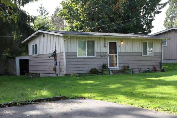
305 Photos 3055 S 224th Street, northwest corner 3049 S 224th St, northeast corner 3045 S 224th St, northeast corner 3041 S 224th St, northeast corner Tuesday, June 10, 2014 Page 6 of 8


306 3035 S 224th St, northeast corner 3035 S 224th St, northwest corner of concrete block bldg 3029 S 224th St, north elevation 3025 S 224th St, northeast corner Tuesday, June 10, 2014 Page 7 of 8

307 th Ave S, west elevation th Ave S, southwest corner Ave S, north elevation of garage Tuesday, June 10, 2014 Page 8 of 8
308 Location Field Site No DAHP No. Historic Name: Common Name: 3025 S 225th St Property Address: 3025 S 225th St, Des Moines, WA Comments: Tax No./Parcel No Plat/Block/Lot Acreage Supplemental Map(s) Township/Range/EW Section 1/4 Sec 1/4 1/4 Sec T22R04E 16 County King Quadrangle DES MOINES Coordinate Reference Easting: Northing: Projection: Washington State Plane South Datum: HARN (feet) Identification Survey Name: Sound Transit Federal Way Date Recorded: 11/05/ Field Recorder: MaryNell Nolan-Wheatley Owner's Name: SILVA HORACNO CARMONA Owner Address: 3025 S 225TH ST City: Des Moines State: WA Zip: Classification: Building Resource Status: Survey/Inventory Comments: Within a District? No Contributing? No National Register: Local District: National Register District/Thematic Nomination Name: Eligibility Status: Not Determined - SHPO Determination Date: 1/1/0001 Determination Comments: Tuesday, June 10, 2014 Page 1 of 5
309 Description Historic Use: Domestic - Single Family House Current Use: Domestic - Single Family House Plan: Rectangle Stories: 1 Structural System: Platform Frame Changes to Plan: Extensive Changes to Original Cladding: Extensive Changes to Other: Extensive Changes to Interior: Extensive Changes to Windows: Extensive Other (specify): Front entry moved. Carport enclosed and converted into an attached garage. Garage was later converted into interior living space. Style: Foundation: Cladding: Form/Type: Roof Type: Roof Material: Vernacular Veneer Gable Asphalt / Composition - Shingle Concrete - Poured Single Family Narrative Study Unit Architecture/Landscape Architecture Date of Construction: 1943 Built Date 1961 Addition Other Builder: Engineer: Architect: Property appears to meet criteria for the National Register of Historic Places:No Property is located in a potential historic district (National and/or local): No Property potentially contributes to a historic district (National and/or local): No Statement of Significance: Construction of the original Highway 1 in the state of Washington commenced in By October 1923, 700 miles of a two-lane highway had been completed connecting Vancouver, British Columbia, to the Oregon-California border. Just after the highway was completed in 1924, however, plans were begun to reroute and improve the conditions of the highway. The project involved creating a new, wider, four-lane route further west that would connect Seattle and Tacoma, Washington, more directly (Kramak, 2010). The new roadway was completed in 1928 and acquired the title of Highway 1, while the original eastern route was renamed Highway 5 (Caster, 2007). The new Highway 1 became known as the Pacific Highway. Over the years, various parts of Highway 1 acquired alternative names, including the portion known as Pacific Highway S, which starts near Federal Way, Washington, and continues north, through Kent, Des Moines, and SeaTac, Washington (Kramak, 2010). Tuesday, June 10, 2014 Page 2 of 5
310 In 1926, Pacific Highway (HWY 1) was included as a numbered U.S. Highway (US 99) (U.S. Route 99, ). The following decades witnessed the rapid growth of businesses along the highway and the formation of a new auto-oriented roadside culture characterized by a proliferation of motels, restaurants, and rest stops (Des Moines Historical Society, 2007). Increased automobile ownership changed people s perceptions about distance and allowed populations to sprawl around urban centers, increasing the number of residents in suburban towns and cities, including SeaTac, Des Moines, Kent, and Federal Way (Boyles, 2010). The city of Des Moines is located approximately halfway between Seattle and Tacoma, on the eastern side of Puget Sound (Des Moines Historical Society, 2007). The town started as a logging community and as a real estate venture of F. A. Blasher, who moved from Des Moines, Iowa, to King County in 1888 (Des Moines Historical Society, 2007; Lange, 1998). After World War I, Des Moines popularity rose when the town expanded its dock and ferry service, attracting increased numbers of summer vacationers. The population grew quickly after World War II and Des Moines was incorporated as a city in 1959 (Des Moines Historical Society, 2007). While some buildings in Des Moines date to the 1920s and 1930s, many commercial and residential buildings were constructed during a period of suburban development in the 1950s and 1960s. On January 31, 1967, Interstate 5 (I-5), which passed through Des Moines on the route from Everett to Tacoma, Washington, was completed and established another transportation route, in addition to Pacific Highway S (SR 99), for commuters in the area (Des Moines Historical Society, 2007). The property at 3025 South 225th Street in Des Moines, Washington, which is a residential building constructed in 1943, is not eligible for listing in the NRHP. The property is not eligible for the NRHP under Criterion A, which applies to buildings that are associated with events that have made a significant contribution to the broad patterns of history, as no significant events are associated with this property. To be eligible for the NRHP under Criterion B, a property must be directly associated with a person considered significant within a historic context whose specific contribution to history has been both identified and documented. No such person who meets that definition is linked to this building. The property is not eligible for the NRHP under Criterion C as it is a typical early to mid-twentieth century residential building and does not embody the distinctive characteristics of a type, period, or method of construction; it is not the work of a master and does not possess high artistic value. The property is not eligible for the NRHP under Criterion D for information potential because the materials and construction methods of the buildings do not convey important information that could contribute to understanding history or prehistory. Therefore, the property is not eligible for listing in the NRHP because it does not meet any of the eligibility criteria. The building has been altered several times, including several large additions, the replacement of original siding, doors and windows, and the conversion of a carport first into a garage, and later into interior living space. As a result, the property has lost integrity of materials, design, and workmanship. The building retains integrity of setting, location, feeling and association. Tuesday, June 10, 2014 Page 3 of 5
311 Description of Physical Appearance: Major Bibliographic References: 3025 South 225th Street is a one-story, residential, vernacular style building that was built in The visible windows and doors are contemporary replacements and the wood frame house is clad in vertical composite siding. The house, which sits on a concrete slab foundation, has an essentially rectangular plan with three distinct sections that are each covered in a composite shingle gable roof. The northwest section of the house is the original section and has a more steeply pitched gabled roof than the other sections. Another rectangular section extends from the southeast corner of the original section of the house and contains a recessed porch area under the north end of its gabled roof. The porch is accessed by three wood steps and has a metal railing. South of the main entrance is a pair of sliding glass doors. North of the entrance, on the west elevation of the original building, are two replacement two-light horizontal sliding windows. Another addition that extends from the east elevation of the original section of the house is currently under construction. The east addition is covered by a gabled roof that is perpendicular to the original building and the south addition. This addition is barely visible from the public right-of-way. Originally, the house had a simple rectangular plan with a small gabled protrusion on the south elevation. The main entrance to the house was originally located on the west elevation. Attached to the south elevation of the small gabled protrusion was a flat roofed carport supported by simple pillars. After 1961, the carport was enclosed to form an interior garage and a gable roof was added that extended south from the south elevation of the main house. A retractable metal door was positioned on the south end of the garage s west elevation. At this time, the porch was constructed under the north end of the new gabled roof, in the space between the main house and the garage. The main entry was relocated to its current location on the porch. More recently, the retractable garage door has been replaced by the sliding glass doors. The house is located off of the main road and is reached by a long gravel driveway. Heavy vegetation surrounds the building. Boyles, E The Suburb. Selected Cultural and Historical Geographies of the Greater Seattle Area. Available at: bellevue-and-redmond/the-suburb. Accessed March 18,. Caster, D Historical Society of Federal Way Timeline. Available at: Accessed March 15,. Des Moines Historical Society Time Line Page. Available at: Accessed March 13,. Lange, G Des Moines Beginnings: Des Moines Post Office opens on August 6, HistoryLink: The Free Online Encyclopedia of Washington State History. Available at: Accessed March 15,. King County.. King County Department of Assessments. Available at: Accessed October 20,. Kramak, J.E., ed Establishing the Pacific Highway South. Selected Cultural and Historical Geographies of the Greater Seattle Area. Available at: Accessed March 14,. U.S. Route 99 The Pacific Highway.. Waymarking: A Groundspeak Website. Available at: Accessed March 19,. Tuesday, June 10, 2014 Page 4 of 5


312 Photos West elevation South elevation through the trees, rear addition Tuesday, June 10, 2014 Page 5 of 5
313 Location Field Site No DAHP No. Historic Name: Common Name: th Ave S Property Address: th Ave S, Des Moines, WA Comments: Tax No./Parcel No Plat/Block/Lot Acreage Supplemental Map(s) Township/Range/EW Section 1/4 Sec 1/4 1/4 Sec T22R04E 16 County King Quadrangle DES MOINES Coordinate Reference Easting: Northing: Projection: Washington State Plane South Datum: HARN (feet) Identification Survey Name: Sound Transit Federal Way Date Recorded: 11/06/ Field Recorder: MaryNell Nolan-Wheatley Owner's Name: PARKER MARC Owner Address: TH AVE S City: Des Moines State: WA Zip: Classification: Building Resource Status: Survey/Inventory Comments: Within a District? No Contributing? No National Register: Local District: National Register District/Thematic Nomination Name: Eligibility Status: Not Determined - SHPO Determination Date: 1/1/0001 Determination Comments: Tuesday, June 10, 2014 Page 1 of 5
314 Description Historic Use: Domestic - Single Family House Current Use: Domestic - Single Family House Plan: Rectangle Stories: 1 Structural System: Platform Frame Changes to Plan: Intact Changes to Original Cladding: Extensive Changes to Other: Other (specify): Style: Foundation: Cladding: Form/Type: Roof Type: Changes to Interior: Unknown Changes to Windows: Extensive Roof Material: Vernacular Wood - Vertical Gable - Side Gable Asphalt / Composition - Shingle Concrete - Poured Single Family - Side Gable Narrative Study Unit Architecture/Landscape Architecture Date of Construction: 1948 Built Date 1950 Addition Other Builder: Engineer: Architect: Property appears to meet criteria for the National Register of Historic Places:No Property is located in a potential historic district (National and/or local): No Property potentially contributes to a historic district (National and/or local): No Tuesday, June 10, 2014 Page 2 of 5
315 Statement of Significance: Construction of the original Highway 1 in the state of Washington commenced in By October 1923, 700 miles of a two-lane highway had been completed connecting Vancouver, British Columbia, to the Oregon-California border. Just after the highway was completed in 1924, however, plans were begun to reroute and improve the conditions of the highway. The project involved creating a new, wider, four-lane route further west that would connect Seattle and Tacoma, Washington, more directly (Kramak, 2010). The new roadway was completed in 1928 and acquired the title of Highway 1, while the original eastern route was renamed Highway 5 (Caster, 2007). The new Highway 1 became known as the Pacific Highway. Over the years, various parts of Highway 1 acquired alternative names, including the portion known as Pacific Highway S, which starts near Federal Way, Washington, and continues north, through Kent, Des Moines, and SeaTac, Washington (Kramak, 2010). In 1926, Pacific Highway (HWY 1) was included as a numbered U.S. Highway (US 99) (U.S. Route 99, ). The following decades witnessed the rapid growth of businesses along the highway and the formation of a new auto-oriented roadside culture characterized by a proliferation of motels, restaurants, and rest stops (Des Moines Historical Society, 2007). Increased automobile ownership changed people s perceptions about distance and allowed populations to sprawl around urban centers, increasing the number of residents in suburban towns and cities, including SeaTac, Des Moines, Kent, and Federal Way (Boyles, 2010). The city of Des Moines is located approximately halfway between Seattle and Tacoma, on the eastern side of Puget Sound (Des Moines Historical Society, 2007). The town started as a logging community and as a real estate venture of F. A. Blasher, who moved from Des Moines, Iowa, to King County in 1888 (Des Moines Historical Society, 2007; Lange, 1998). After World War I, Des Moines popularity rose when the town expanded its dock and ferry service, attracting increased numbers of summer vacationers. The population grew quickly after World War II and Des Moines was incorporated as a city in 1959 (Des Moines Historical Society, 2007). While some buildings in Des Moines date to the 1920s and 1930s, many commercial and residential buildings were constructed during a period of suburban development in the 1950s and 1960s. On January 31, 1967, Interstate 5 (I-5), which passed through Des Moines on the route from Everett to Tacoma, Washington, was completed and established another transportation route, in addition to Pacific Highway S (SR 99), for commuters in the area (Des Moines Historical Society, 2007). The property at th Avenue South in Des Moines, Washington, which is a residential building constructed in 1948, is not eligible for listing in the NRHP. The property is not eligible for the NRHP under Criterion A, which applies to buildings that are associated with events that have made a significant contribution to the broad patterns of history, as no significant events are associated with this property. To be eligible for the NRHP under Criterion B, a property must be directly associated with a person considered significant within a historic context whose specific contribution to history has been both identified and documented. No such person who meets that definition is linked to this building. The property is not eligible for the NRHP under Criterion C as it is a typical early to mid-twentieth century residential building and does not embody the distinctive characteristics of a type, period, or method of construction; it is not the work of a master and does not possess high artistic value. The property is not eligible for the NRHP under Criterion D for information potential because the materials and construction methods of the buildings do not convey important information that could contribute to understanding history or prehistory. Therefore, the property is not eligible for listing in the NRHP because it does not meet any of the eligibility criteria. The building has been altered several times, including the replacement of all original windows, doors, and siding. Additionally, contemporary treatments around several of the primary windows have drastically changed the appearance of the house. As a result, the property has lost integrity of materials, workmanship, and design. The building retains integrity of setting, location, feeling and association. Tuesday, June 10, 2014 Page 3 of 5
316 Description of Physical Appearance: Major Bibliographic References: The building at th Avenue South is a one-story residential building with a rectangular floor plan that was built in Constructed on a raised concrete slab foundation, the wood frame building is one and a half units deep and has a side gabled roof with a double pitch in the back which is clad in composite shingles. The windows are replacement, two-light, horizontal sliding windows. The house is clad in nonoriginal vertical wood siding and the foundation is clad in plywood. A small porch extends from the north end of the front (west) elevation and is covered by a front gable overhang clad in vertical wood siding and supported by two wood pillars. The porch and replacement paneled front door are reached by four wood steps. South of the front entrance are two windows. Each of the windows has been framed by thick aluminum strips that run across the top of the window and extend down on either side of the frame to ground level. The space under the windows and between the aluminum strips has been clad with two narrow columns of unpainted horizontal wood siding. The exterior window treatments are modern additions to the house. The north elevation contains a small louvered attic vent and three windows, two of which on the west side have modern exterior window treatments identical to those on the façade. The south elevation contains two windows and an attic vent. The double pitched roof over the rear (east) elevation extends into a shed overhang supported on narrow posts. A detached garage with a gabled roof, which was constructed in 1950, is located behind the house. The garage is also clad in non-original vertical wood siding and the west elevation contains a replacement pedestrian door, one replacement fixed, single-light window, and one wood frame window with several lights that may be original. Boyles, E The Suburb. Selected Cultural and Historical Geographies of the Greater Seattle Area. Available at: bellevue-and-redmond/the-suburb. Accessed March 18,. Caster, D Historical Society of Federal Way Timeline. Available at: Accessed March 15,. Des Moines Historical Society Time Line Page. Available at: Accessed March 13,. Lange, G Des Moines Beginnings: Des Moines Post Office opens on August 6, HistoryLink: The Free Online Encyclopedia of Washington State History. Available at: Accessed March 15,. King County.. King County Department of Assessments. Available at: Accessed October 20,. Kramak, J.E., ed Establishing the Pacific Highway South. Selected Cultural and Historical Geographies of the Greater Seattle Area. Available at: Accessed March 14,. U.S. Route 99 The Pacific Highway.. Waymarking: A Groundspeak Website. Available at: Accessed March 19,. Tuesday, June 10, 2014 Page 4 of 5


317 Photos West elevation Southwest corner Northwest corner Tuesday, June 10, 2014 Page 5 of 5
318 Location Field Site No DAHP No. Historic Name: Common Name: th Ave S Property Address: th Ave S, Des Moines, WA Comments: Tax No./Parcel No Plat/Block/Lot Acreage Supplemental Map(s) Township/Range/EW Section 1/4 Sec 1/4 1/4 Sec T22R04E 16 County King Quadrangle DES MOINES Coordinate Reference Easting: Northing: Projection: Washington State Plane South Datum: HARN (feet) Identification Survey Name: Sound Transit Federal Way Date Recorded: 11/06/ Field Recorder: MaryNell Nolan-Wheatley Owner's Name: GIANG LAN-XUAN Owner Address: th Ave S City: Des Moines State: WA Zip: Classification: Building Resource Status: Survey/Inventory Comments: Within a District? No Contributing? No National Register: Local District: National Register District/Thematic Nomination Name: Eligibility Status: Not Determined - SHPO Determination Date: 1/1/0001 Determination Comments: Tuesday, June 10, 2014 Page 1 of 5
319 Description Historic Use: Domestic - Single Family House Current Use: Domestic - Single Family House Plan: Irregular Stories: 1 Structural System: Platform Frame Changes to Plan: Moderate Changes to Original Cladding: Intact Changes to Other: Other (specify): Style: Foundation: Cladding: Form/Type: Roof Type: Changes to Interior: Unknown Changes to Windows: Extensive Roof Material: Ranch Veneer - Brick Hip - Cross Hipped Asphalt / Composition - Shingle Concrete - Poured Single Family Narrative Study Unit Architecture/Landscape Architecture Date of Construction: 1955 Built Date Other Builder: Engineer: Architect: Property appears to meet criteria for the National Register of Historic Places:No Property is located in a potential historic district (National and/or local): No Property potentially contributes to a historic district (National and/or local): No Tuesday, June 10, 2014 Page 2 of 5
320 Statement of Significance: Construction of the original Highway 1 in the state of Washington commenced in By October 1923, 700 miles of a two-lane highway had been completed connecting Vancouver, British Columbia, to the Oregon-California border. Just after the highway was completed in 1924, however, plans were begun to reroute and improve the conditions of the highway. The project involved creating a new, wider, four-lane route further west that would connect Seattle and Tacoma, Washington, more directly (Kramak, 2010). The new roadway was completed in 1928 and acquired the title of Highway 1, while the original eastern route was renamed Highway 5 (Caster, 2007). The new Highway 1 became known as the Pacific Highway. Over the years, various parts of Highway 1 acquired alternative names, including the portion known as Pacific Highway S, which starts near Federal Way, Washington, and continues north, through Kent, Des Moines, and SeaTac, Washington (Kramak, 2010). In 1926, Pacific Highway (HWY 1) was included as a numbered U.S. Highway (US 99) (U.S. Route 99, ). The following decades witnessed the rapid growth of businesses along the highway and the formation of a new auto-oriented roadside culture characterized by a proliferation of motels, restaurants, and rest stops (Des Moines Historical Society, 2007). Increased automobile ownership changed people s perceptions about distance and allowed populations to sprawl around urban centers, increasing the number of residents in suburban towns and cities, including SeaTac, Des Moines, Kent, and Federal Way (Boyles, 2010). The city of Des Moines is located approximately halfway between Seattle and Tacoma, on the eastern side of Puget Sound (Des Moines Historical Society, 2007). The town started as a logging community and as a real estate venture of F. A. Blasher, who moved from Des Moines, Iowa, to King County in 1888 (Des Moines Historical Society, 2007; Lange, 1998). After World War I, Des Moines popularity rose when the town expanded its dock and ferry service, attracting increased numbers of summer vacationers. The population grew quickly after World War II and Des Moines was incorporated as a city in 1959 (Des Moines Historical Society, 2007). While some buildings in Des Moines date to the 1920s and 1930s, many commercial and residential buildings were constructed during a period of suburban development in the 1950s and 1960s. On January 31, 1967, Interstate 5 (I-5), which passed through Des Moines on the route from Everett to Tacoma, Washington, was completed and established another transportation route, in addition to Pacific Highway S (SR 99), for commuters in the area (Des Moines Historical Society, 2007). The property at th Avenue South in Des Moines, Washington, which is a residential building constructed in 1955, is not eligible for listing in the NRHP. The property is not eligible for the NRHP under Criterion A, which applies to buildings that are associated with events that have made a significant contribution to the broad patterns of history, as no significant events are associated with this property. To be eligible for the NRHP under Criterion B, a property must be directly associated with a person considered significant within a historic context whose specific contribution to history has been both identified and documented. No such person who meets that definition is linked to this building. The property is not eligible for the NRHP under Criterion C as it is a typical mid-twentieth century residential building and does not embody the distinctive characteristics of a type, period, or method of construction; it is not the work of a master and does not possess high artistic value. The property is not eligible for the NRHP under Criterion D for information potential because the materials and construction methods of the buildings do not convey important information that could contribute to understanding history or prehistory. Therefore, the property is not eligible for listing in the NRHP because it does not meet any of the eligibility criteria. The building has been altered several times, including the replacement of most original windows and doors and a large east elevation addition. As a result, the property has lost integrity of materials and design. The building retains integrity of workmanship, setting, location, feeling and association. Tuesday, June 10, 2014 Page 3 of 5
321 Description of Physical Appearance: Major Bibliographic References: th Avenue South is a one-story, residential, ranch style building with an irregular plan that was built in The house sits on a concrete slab foundation and most of the visible windows and doors are contemporary replacements. The wood frame house is clad in brick veneer and composite shingles cover the cross hipped roof, from which an interior, slope, concrete block chimney protrudes. The front (west) elevation is defined by three levels of façade. The first level of façade, which falls under the boxed eave of the primary roof, contains a replacement front door and a large, fixed, single-light picture window that wraps around the southwest corner of the house, which may be original. Protruding from the north side of this first portion of the façade, but still under the primary hipped roof, is another level of façade which contains a replacement, two-light, horizontal sliding window. The third level of façade protrudes from the north end of the west elevation and is topped by a hipped roof that crosses the primary roof. The west elevation of this larger protrusion also contains one, two-light, horizontal sliding window. Aerial images of the property indicate that a long addition extends from the northeast corner of the building. A flowerbed enclosed in a small brick wall with large bushes runs along the west elevation. The property includes a slightly raised front yard with bricks defining its perimeter, a gravel driveway, and a back yard enclosed by a tall wood fence. The pyramidal roof of a large accessory building in the rear of the property is barely visible from the public right-of-way. Boyles, E The Suburb. Selected Cultural and Historical Geographies of the Greater Seattle Area. Available at: bellevue-and-redmond/the-suburb. Accessed March 18,. Caster, D Historical Society of Federal Way Timeline. Available at: Accessed March 15,. Des Moines Historical Society Time Line Page. Available at: Accessed March 13,. Lange, G Des Moines Beginnings: Des Moines Post Office opens on August 6, HistoryLink: The Free Online Encyclopedia of Washington State History. Available at: Accessed March 15,. King County.. King County Department of Assessments. Available at: Accessed October 20,. Kramak, J.E., ed Establishing the Pacific Highway South. Selected Cultural and Historical Geographies of the Greater Seattle Area. Available at: Accessed March 14,. U.S. Route 99 The Pacific Highway.. Waymarking: A Groundspeak Website. Available at: Accessed March 19,. Tuesday, June 10, 2014 Page 4 of 5


322 Photos Southwest corner West elevation Southwest corner Tuesday, June 10, 2014 Page 5 of 5
323 Location Field Site No DAHP No. Historic Name: Common Name: th Ave S Property Address: th Ave S, Des Moines, WA Comments: Tax No./Parcel No Plat/Block/Lot Acreage Supplemental Map(s) Township/Range/EW Section 1/4 Sec 1/4 1/4 Sec T22R04E 16 County King Quadrangle DES MOINES Coordinate Reference Easting: Northing: Projection: Washington State Plane South Datum: HARN (feet) Identification Survey Name: Sound Transit Federal Way Date Recorded: 11/05/ Field Recorder: MaryNell Nolan-Wheatley Owner's Name: LI JIN MING Owner Address: TH AVE S City: Des Moines State: WA Zip: Classification: Building Resource Status: Survey/Inventory Comments: Within a District? No Contributing? No National Register: Local District: National Register District/Thematic Nomination Name: Eligibility Status: Not Determined - SHPO Determination Date: 1/1/0001 Determination Comments: Tuesday, June 10, 2014 Page 1 of 5
324 Description Historic Use: Domestic - Single Family House Current Use: Domestic - Single Family House Plan: Rectangle Stories: 1 Structural System: Platform Frame Changes to Plan: Slight Changes to Original Cladding: Intact Changes to Other: Other (specify): Style: Vernacular Ranch Foundation: Concrete - Poured Cladding: Wood Wood - Clapboard Veneer Form/Type: Single Family Roof Type: Shed Changes to Interior: Unknown Changes to Windows: Extensive Gable - Side Gable Gable - Cross Gable Roof Material: Asphalt / Composition - Shingle Asphalt / Composition - Rolled Narrative Study Unit Architecture/Landscape Architecture Date of Construction: 1946 Built Date 1955 Built Date Other Builder: Engineer: Architect: Property appears to meet criteria for the National Register of Historic Places:No Property is located in a potential historic district (National and/or local): No Property potentially contributes to a historic district (National and/or local): No Tuesday, June 10, 2014 Page 2 of 5
325 Statement of Significance: Construction of the original Highway 1 in the state of Washington commenced in By October 1923, 700 miles of a two-lane highway had been completed connecting Vancouver, British Columbia, to the Oregon-California border. Just after the highway was completed in 1924, however, plans were begun to reroute and improve the conditions of the highway. The project involved creating a new, wider, four-lane route further west that would connect Seattle and Tacoma, Washington, more directly (Kramak, 2010). The new roadway was completed in 1928 and acquired the title of Highway 1, while the original eastern route was renamed Highway 5 (Caster, 2007). The new Highway 1 became known as the Pacific Highway. Over the years, various parts of Highway 1 acquired alternative names, including the portion known as Pacific Highway S, which starts near Federal Way, Washington, and continues north, through Kent, Des Moines, and SeaTac, Washington (Kramak, 2010). In 1926, Pacific Highway (HWY 1) was included as a numbered U.S. Highway (US 99) (U.S. Route 99, ). The following decades witnessed the rapid growth of businesses along the highway and the formation of a new auto-oriented roadside culture characterized by a proliferation of motels, restaurants, and rest stops (Des Moines Historical Society, 2007). Increased automobile ownership changed people s perceptions about distance and allowed populations to sprawl around urban centers, increasing the number of residents in suburban towns and cities, including SeaTac, Des Moines, Kent, and Federal Way (Boyles, 2010). The city of Des Moines is located approximately halfway between Seattle and Tacoma, on the eastern side of Puget Sound (Des Moines Historical Society, 2007). The town started as a logging community and as a real estate venture of F. A. Blasher, who moved from Des Moines, Iowa, to King County in 1888 (Des Moines Historical Society, 2007; Lange, 1998). After World War I, Des Moines popularity rose when the town expanded its dock and ferry service, attracting increased numbers of summer vacationers. The population grew quickly after World War II and Des Moines was incorporated as a city in 1959 (Des Moines Historical Society, 2007). While some buildings in Des Moines date to the 1920s and 1930s, many commercial and residential buildings were constructed during a period of suburban development in the 1950s and 1960s. On January 31, 1967, Interstate 5 (I-5), which passed through Des Moines on the route from Everett to Tacoma, Washington, was completed and established another transportation route, in addition to Pacific Highway S (SR 99), for commuters in the area (Des Moines Historical Society, 2007). The property at th Avenue South in Des Moines, Washington, which contains two residential buildings one constructed in 1946 and one constructed in the mid-1950s is not eligible for listing in the NRHP. The property is not eligible for the NRHP under Criterion A, which applies to buildings that are associated with events that have made a significant contribution to the broad patterns of history, as no significant events are associated with this property. To be eligible for the NRHP under Criterion B, a property must be directly associated with a person considered significant within a historic context whose specific contribution to history has been both identified and documented. No such person who meets that definition is linked to these buildings. The property is not eligible for the NRHP under Criterion C as they are typical early to mid-twentieth century residential buildings and do not embody the distinctive characteristics of a type, period, or method of construction; they are not the work of a master and do not possess high artistic value. The property is not eligible for the NRHP under Criterion D for information potential because the materials and construction methods of the buildings do not convey important information that could contribute to understanding history or prehistory. Therefore, the property is not eligible for listing in the NRHP because it does not meet any of the eligibility criteria. Both buildings have been altered several times, including the replacement of original doors and windows. As a result, the property has lost integrity of materials and design. The buildings retain integrity of workmanship, setting, location, feeling and association. Tuesday, June 10, 2014 Page 3 of 5
326 Description of Physical Appearance: th Avenue South contains two, one-story residential buildings with rectangular floor plans constructed on concrete foundations. The building in the rear (east side) of the property, which is not visible from the public right-of-way, was constructed in Located in the front of the property, and the only building visible from the street, is a one-story, residential, ranch style building with a rectangular plan that was built in the mid-1950s. According to photos on the King County Assessor s website, the 1946, wood frame building in the back of the property has a side gabled roof covered in composite shingles and is one and half units deep. The windows on the west and south elevations are replacement, one-over-one sash windows and the building is clad in horizontal wood siding. The raised concrete foundation is clad in vertical composite siding. A small porch extends from the front (west) elevation and is covered by a front gabled overhang supported by two wood pillars. The front entrance is flanked on each side by a window. The south elevation contains two replacement sash windows and a small louvered attic vent. Two small additions protrude from the rear (east) elevation of the building. The first has a lower height front gabled roof that runs perpendicularly to the primary roof and contains one small sash window on the south elevation. Attached to the east elevation of this addition is a smaller, shed roof addition that contains a replacement door flanked by two, three-light windows with horizontal wood muntins on its east elevation that are likely original to the property. The ranch style house on the front side of the property has a rectangular plan and a cross gabled roof covered in rolled roofing material. The upper half of the exterior walls of the wood frame house are clad in vertical composite siding and the lower half of the walls are clad in wood clapboard. A replacement, wood paneled front door and a large, replacement, fixed, single-light window placed over two, narrow horizontal sliders, are positioned on the south end of the front (west) elevation under a front gable that crosses the house s primary side gable. A small wood porch with a wood hand railing has been added to the front elevation in front of the main door. North of the front door are two, two-light, horizontal sliding windows. On the north end of the west elevation is an interior garage with a metal retractable door on the west elevation. There are no windows on the north elevation of the house. A large, exterior brick chimney defines the south elevation. A small window covered by a metal security grate is located just east of the chimney. The property includes a gravel driveway and a front yard area that is surrounded by a wood fence. Major Bibliographic References: Boyles, E The Suburb. Selected Cultural and Historical Geographies of the Greater Seattle Area. Available at: bellevue-and-redmond/the-suburb. Accessed March 18,. Caster, D Historical Society of Federal Way Timeline. Available at: Accessed March 15,. Des Moines Historical Society Time Line Page. Available at: Accessed March 13,. Lange, G Des Moines Beginnings: Des Moines Post Office opens on August 6, HistoryLink: The Free Online Encyclopedia of Washington State History. Available at: Accessed March 15,. King County.. King County Department of Assessments. Available at: Accessed October 20,. Kramak, J.E., ed Establishing the Pacific Highway South. Selected Cultural and Historical Geographies of the Greater Seattle Area. Available at: Accessed March 14,. U.S. Route 99 The Pacific Highway.. Waymarking: A Groundspeak Website. Available at: Accessed March 19,. Tuesday, June 10, 2014 Page 4 of 5


327 Photos West elevation, ranch Northwest corner, ranch Southwest corner Tuesday, June 10, 2014 Page 5 of 5
328 Location Field Site No DAHP No. Historic Name: Common Name: th Ave S Property Address: th Ave S, Des Moines, WA Comments: Tax No./Parcel No Plat/Block/Lot Plat Block 3 / Lot 5 Acreage.41 Supplemental Map(s) Township/Range/EW Section 1/4 Sec 1/4 1/4 Sec T22R04E 16 County King Quadrangle DES MOINES Coordinate Reference Easting: Northing: Projection: Washington State Plane South Datum: HARN (feet) Identification Survey Name: Sound Transit Federal Way (2) Date Recorded: 03/17/2014 Field Recorder: MaryNell Nolan-Wheatley Owner's Name: JORSTAD KENNETH T+DELORIS Owner Address: TH AVE S City: Des Moines State: WA Zip: Classification: Building Resource Status: Survey/Inventory Comments: Within a District? No Contributing? No National Register: Local District: National Register District/Thematic Nomination Name: Eligibility Status: Not Determined - SHPO Determination Date: 1/1/0001 Determination Comments: Thursday, July 24, 2014 Page 1 of 5
329 Description Historic Use: Domestic - Single Family House Current Use: Domestic - Single Family House Plan: Irregular Stories: 1 Structural System: Platform Frame Changes to Plan: Moderate Changes to Original Cladding: Extensive Changes to Other: Moderate Other (specify): The size of visible windows has been altered. Style: Foundation: Cladding: Form/Type: Roof Type: Changes to Interior: Unknown Changes to Windows: Extensive Roof Material: Ranch Veneer Gable - Cross Gable Asphalt / Composition - Rolled Concrete - Poured Single Family Narrative Study Unit Architecture/Landscape Architecture Date of Construction: 1954 Built Date 2005 Addition Other Builder: Engineer: Architect: Property appears to meet criteria for the National Register of Historic Places:No Property is located in a potential historic district (National and/or local): No Property potentially contributes to a historic district (National and/or local): No Thursday, July 24, 2014 Page 2 of 5
330 Statement of Significance: Construction of the original Highway 1 in the state of Washington commenced in By October 1923, 700 miles of a two-lane highway had been completed connecting Vancouver, British Columbia, to the Oregon-California border. Just after the highway was completed in 1924, however, plans were begun to reroute and improve the conditions of the highway. The project involved creating a new, wider, four-lane route further west that would connect Seattle and Tacoma, Washington, more directly (Kramak, 2010). The new roadway was completed in 1928 and acquired the title of Highway 1, while the original eastern route was renamed Highway 5 (Caster, 2007). The new Highway 1 became known as the Pacific Highway. Over the years, various parts of Highway 1 acquired alternative names, including the portion known as Pacific Highway S, which starts near Federal Way, Washington, and continues north, through Kent, Des Moines, and SeaTac, Washington (Kramak, 2010). In 1926, Pacific Highway (HWY 1) was included as a numbered U.S. Highway (US 99) (U.S. Route 99, ). The following decades witnessed the rapid growth of businesses along the highway and the formation of a new auto-oriented roadside culture characterized by a proliferation of motels, restaurants, and rest stops (Des Moines Historical Society, 2007). Increased automobile ownership changed people s perceptions about distance and allowed populations to sprawl around urban centers, increasing the number of residents in suburban towns and cities, including SeaTac, Des Moines, Kent, and Federal Way (Boyles, 2010). The city of Des Moines is located approximately halfway between Seattle and Tacoma, on the eastern side of Puget Sound (Des Moines Historical Society, 2007). The town started as a logging community and as a real estate venture of F. A. Blasher, who moved from Des Moines, Iowa, to King County in 1888 (Des Moines Historical Society, 2007; Lange, 1998). After World War I, Des Moines popularity rose when the town expanded its dock and ferry service, attracting increased numbers of summer vacationers. The population grew quickly after World War II and Des Moines was incorporated as a city in 1959 (Des Moines Historical Society, 2007). While some buildings in Des Moines date to the 1920s and 1930s, many commercial and residential buildings were constructed during a period of suburban development in the 1950s and 1960s. On January 31, 1967, Interstate 5 (I-5), which passed through Des Moines on the route from Everett to Tacoma, Washington, was completed and established another transportation route, in addition to Pacific Highway S (SR 99), for commuters in the area (Des Moines Historical Society, 2007). The property at th Avenue South in Des Moines, Washington, which is a residential property built in 1954, is not eligible for listing in the NRHP. The property is not eligible for the NRHP under Criterion A, which applies to buildings that are associated with events that have made a significant contribution to the broad patterns of history, as no significant events are associated with this property. To be eligible for the NRHP under Criterion B, a property must be directly associated with a person considered significant within a historic context whose specific contribution to history has been both identified and documented. No such person who meets that definition is linked to this building. The property is not eligible for the NRHP under Criterion C as it is a typical residential building from the midtwentieth century and does not embody the distinctive characteristics of a type, period, or method of construction; it is not the work of a master and does not possess high artistic value. The property is not eligible for the NRHP under Criterion D for information potential because the materials and construction methods of the building do not convey important information that could contribute to understanding history or prehistory. Therefore, the property is not eligible for listing in the NRHP because it does not meet any of the eligibility criteria. In addition the building is altered including changes to the size and style of window openings, the replacement of original doors and siding, and several additions. As a result, the property has lost integrity of materials, design, and workmanship. The building retains integrity of feeling, setting, location, and association. Thursday, July 24, 2014 Page 3 of 5
331 Description of Physical Appearance: Major Bibliographic References: th Avenue South is a one-story, wood frame, ranch style, residential building with an irregular plan constructed in The building, which sits on a concrete slab foundation, is topped by a cross gabled roof with deep open eaves covered in rolled roofing material. An internal slope brick chimney protrudes from the center of the roof. All of the visible windows are contemporary replacements and the residence s exterior walls are clad non-original horizontal composite siding. The size of most of the visible windows have also been altered. A replacement front door, which is protected by a metal and glass storm door, is located in the center of the front (west) elevation. A flat roof overhang extends from the eaves of the primary side gabled roof to cover the small porch in front of the main entrance. The overhang is supported by two simple wood posts and an open framework wood railing wraps around the perimeter of the concrete porch. North of the main entrance there is a large, two-light horizontal sliding window flanked on either side by a single-light, rectangular window. A large, three-light horizontal sliding window is located south of the front door on the façade. A rectangular plan addition that was constructed at an unknown date projects from the south end of the rear (east) elevation and is covered by a front gabled roof that crosses the primary side gabled roof. Four, identical, two-light horizontal sliding windows are located on the south elevation. A pedestrian door with a metal and glass storm door is located in the center of the north elevation and is shaded by a large, non-original overhang with a front gabled roof covered in rolled roofing material. The front of the overhang is supported by two, rectangular, wood columns that rest on large rectangular posts clad in horizontal composite siding. East of the side entrance on the north elevation is a two-light horizontal sliding window. A detached, 720-square foot, two-car garage was constructed on the northwest corner of the property at the end of a gravel driveway circa The garage is clad in vertical vinyl siding and has a front gabled roof with gable ends clad in horizontal composite siding. Two vehicle bays with retractable metal doors are located on the garage s front (west) elevation. The residence is mostly surrounded by grass and includes a large front yard. Boyles, E The Suburb. Selected Cultural and Historical Geographies of the Greater Seattle Area. Available at: bellevue-and-redmond/the-suburb. Accessed March 18,. Caster, D Historical Society of Federal Way Timeline. Available at: Accessed March 15,. Des Moines Historical Society Time Line Page. Available at: Accessed March 13,. Lange, G Des Moines Beginnings: Des Moines Post Office opens on August 6, HistoryLink: The Free Online Encyclopedia of Washington State History. Available at: Accessed March 15,. King County.. King County Department of Assessments. Available at: Accessed October 20,. Kramak, J.E., ed Establishing the Pacific Highway South. Selected Cultural and Historical Geographies of the Greater Seattle Area. Available at: Accessed March 14,. U.S. Route 99 The Pacific Highway.. Waymarking: A Groundspeak Website. Available at: Accessed March 19,. Thursday, July 24, 2014 Page 4 of 5


332 Photos Southwest corner 2014 East elevation 2014 Northwest corner 2014 East elevation, c garage 2014 Thursday, July 24, 2014 Page 5 of 5
333 Location Field Site No DAHP No. Historic Name: Common Name: th Ave S Property Address: th Ave S, Des Moines, WA Comments: Tax No./Parcel No Plat/Block/Lot Acreage Supplemental Map(s) Township/Range/EW Section 1/4 Sec 1/4 1/4 Sec T22R04E 16 County King Quadrangle DES MOINES Coordinate Reference Easting: Northing: Projection: Washington State Plane South Datum: HARN (feet) Identification Survey Name: Sound Transit Federal Way Date Recorded: 11/06/ Field Recorder: MaryNell Nolan-Wheatley Owner's Name: HAWKINS DONALD F+SANDRA A Owner Address: TH AVE SE City: KENT State: WA Zip: Classification: Building Resource Status: Survey/Inventory Comments: Within a District? No Contributing? No National Register: Local District: National Register District/Thematic Nomination Name: Eligibility Status: Not Determined - SHPO Determination Date: 1/1/0001 Determination Comments: Tuesday, June 10, 2014 Page 1 of 5
334 Description Historic Use: Domestic - Single Family House Current Use: Domestic - Single Family House Plan: Rectangle Stories: 1 Structural System: Platform Frame Changes to Plan: Moderate Changes to Original Cladding: Extensive Changes to Other: Extensive Changes to Interior: Unknown Changes to Windows: Extensive Other (specify): The original roof of the second building was replaced with a modern second floor addition. Style: Vernacular Foundation: Concrete - Poured Cladding: Wood - Clapboard Wood - Vertical Veneer Form/Type: Single Family - Side Gable Single Family Roof Type: Gable - Side Gable Butterfly Roof Material: Asphalt / Composition - Shingle Asphalt / Composition - Rolled Narrative Study Unit Architecture/Landscape Architecture Date of Construction: 1960 Built Date Other Builder: Engineer: Architect: Property appears to meet criteria for the National Register of Historic Places:No Property is located in a potential historic district (National and/or local): No Property potentially contributes to a historic district (National and/or local): No Tuesday, June 10, 2014 Page 2 of 5
335 Statement of Significance: Construction of the original Highway 1 in the state of Washington commenced in By October 1923, 700 miles of a two-lane highway had been completed connecting Vancouver, British Columbia, to the Oregon-California border. Just after the highway was completed in 1924, however, plans were begun to reroute and improve the conditions of the highway. The project involved creating a new, wider, four-lane route further west that would connect Seattle and Tacoma, Washington, more directly (Kramak, 2010). The new roadway was completed in 1928 and acquired the title of Highway 1, while the original eastern route was renamed Highway 5 (Caster, 2007). The new Highway 1 became known as the Pacific Highway. Over the years, various parts of Highway 1 acquired alternative names, including the portion known as Pacific Highway S, which starts near Federal Way, Washington, and continues north, through Kent, Des Moines, and SeaTac, Washington (Kramak, 2010). In 1926, Pacific Highway (HWY 1) was included as a numbered U.S. Highway (US 99) (U.S. Route 99, ). The following decades witnessed the rapid growth of businesses along the highway and the formation of a new auto-oriented roadside culture characterized by a proliferation of motels, restaurants, and rest stops (Des Moines Historical Society, 2007). Increased automobile ownership changed people s perceptions about distance and allowed populations to sprawl around urban centers, increasing the number of residents in suburban towns and cities, including SeaTac, Des Moines, Kent, and Federal Way (Boyles, 2010). The city of Des Moines is located approximately halfway between Seattle and Tacoma, on the eastern side of Puget Sound (Des Moines Historical Society, 2007). The town started as a logging community and as a real estate venture of F. A. Blasher, who moved from Des Moines, Iowa, to King County in 1888 (Des Moines Historical Society, 2007; Lange, 1998). After World War I, Des Moines popularity rose when the town expanded its dock and ferry service, attracting increased numbers of summer vacationers. The population grew quickly after World War II and Des Moines was incorporated as a city in 1959 (Des Moines Historical Society, 2007). While some buildings in Des Moines date to the 1920s and 1930s, many commercial and residential buildings were constructed during a period of suburban development in the 1950s and 1960s. On January 31, 1967, Interstate 5 (I-5), which passed through Des Moines on the route from Everett to Tacoma, Washington, was completed and established another transportation route, in addition to Pacific Highway S (SR 99), for commuters in the area (Des Moines Historical Society, 2007). The property at th Avenue South in Des Moines, Washington, which contains two residential buildings constructed in 1960, is not eligible for listing in the NRHP. The property is not eligible for the NRHP under Criterion A, which applies to buildings that are associated with events that have made a significant contribution to the broad patterns of history, as no significant events are associated with this property. To be eligible for the NRHP under Criterion B, a property must be directly associated with a person considered significant within a historic context whose specific contribution to history has been both identified and documented. No such person who meets that definition is linked to these buildings. The property is not eligible for the NRHP under Criterion C as they are typical mid-twentieth century residential buildings and do not embody the distinctive characteristics of a type, period, or method of construction; they are not the work of a master and do not possess high artistic value. The property is not eligible for the NRHP under Criterion D for information potential because the materials and construction methods of the buildings do not convey important information that could contribute to understanding history or prehistory. Therefore, the property is not eligible for listing in the NRHP because it does not meet any of the eligibility criteria. Both buildings have been heavily altered, including the replacement of original doors, windows, and siding. The building in the rear of the property has a large second floor addition. As a result, the property has lost integrity of materials, design and workmanship. The buildings retain integrity of setting, location, feeling and association. Tuesday, June 10, 2014 Page 3 of 5
336 Description of Physical Appearance: Major Bibliographic References: The building at th Avenue South contains two, residential structures with rectangular floor plans constructed on concrete foundations in The building closest to the main road (on the west side of the property) is a one-story dwelling with a side gabled roof covered in composite shingles. Two exposed rafter tails are visible under the north and south gables. The wood frame house is clad in non-original horizontal composite siding and has replacement doors and windows. The replacement front door is positioned just south of the center of the front (west) elevation. A wood deck painted blue has been added to the west elevation in front of the main entrance. North of the main entrance are two identical window openings, with a fixed, single-light window flanked by horizontal sliders. South of the front door are a row of three large, replacement, fixed, single-light windows. The windows on the front of the house are placed high on the façade, just under the point where the eave overhang meets the exterior wall. The south elevation contains two, fixed, single-light windows. There are no windows on the north elevation. Northeast of the front property is a two-story, wood frame, residential building with a butterfly roof covered in rolled roofing material. Originally, the house was a one-story cottage with a side gabled roof and exposed rafter tails, similar to the adjacent house. At some point, the gabled roof was removed and a modern second floor was added. The square footage of the second floor addition is slightly larger than the original building, creating shallow overhangs where the top of the ground floor meets the second floor. Currently, the ground floor is clad in vertical wood siding and the second floor is clad in horizontal wood clapboard. The house is difficult to see from the public right-of-way due to heavy vegetation, but most of the visible windows appear to be contemporary replacements. A replacement plywood pedestrian door is visible on the ground floor of the west elevation. A large balcony extends from the second floor of the west elevation and is supported by wood pillars. Overlooking the balcony on the west elevation is a row of three large, fixed, single-light windows topped by a row of three narrow, horizontally oriented, fixed, single-light windows. South of the deck, positioned just under the eave overhang are four, small square, fixed, single-light windows. The north and south elevations contain several, replacement, horizontal sliding windows. Under the angle of the inverted gabled on the south and north elevations are fixed, single-light, irregularly shaped quadrilateral windows. The two houses on the property are surrounded by gravel and some grass. Boyles, E The Suburb. Selected Cultural and Historical Geographies of the Greater Seattle Area. Available at: bellevue-and-redmond/the-suburb. Accessed March 18,. Caster, D Historical Society of Federal Way Timeline. Available at: Accessed March 15,. Des Moines Historical Society Time Line Page. Available at: Accessed March 13,. Lange, G Des Moines Beginnings: Des Moines Post Office opens on August 6, HistoryLink: The Free Online Encyclopedia of Washington State History. Available at: Accessed March 15,. King County.. King County Department of Assessments. Available at: Accessed October 20,. Kramak, J.E., ed Establishing the Pacific Highway South. Selected Cultural and Historical Geographies of the Greater Seattle Area. Available at: Accessed March 14,. U.S. Route 99 The Pacific Highway.. Waymarking: A Groundspeak Website. Available at: Accessed March 19,. Tuesday, June 10, 2014 Page 4 of 5


337 Photos Southwest corner Northwest corner, both houses visible Northwest corner Tuesday, June 10, 2014 Page 5 of 5
338 Location Field Site No DAHP No. Historic Name: Common Name: 3030 S 227th St Property Address: 3030 S 227th St, Des Moines, WA Comments: Tax No./Parcel No Plat/Block/Lot Acreage Supplemental Map(s) Township/Range/EW Section 1/4 Sec 1/4 1/4 Sec T22R04E 16 County King Quadrangle DES MOINES Coordinate Reference Easting: Northing: Projection: Washington State Plane South Datum: HARN (feet) Identification Survey Name: Sound Transit Federal Way Date Recorded: 11/06/ Field Recorder: MaryNell Nolan-Wheatley Owner's Name: JORSTAD KENNETH T Owner Address: 3030 S 227TH City: Des Moines State: WA Zip: Classification: Building Resource Status: Survey/Inventory Comments: Within a District? No Contributing? No National Register: Local District: National Register District/Thematic Nomination Name: Eligibility Status: Not Determined - SHPO Determination Date: 1/1/0001 Determination Comments: Tuesday, June 10, 2014 Page 1 of 5
339 Description Historic Use: Domestic - Single Family House Current Use: Domestic - Single Family House Plan: Rectangle Stories: 2 Structural System: Platform Frame Changes to Plan: Slight Changes to Original Cladding: Intact Changes to Other: Other (specify): Style: Foundation: Cladding: Form/Type: Roof Type: Changes to Interior: Unknown Changes to Windows: Extensive Roof Material: Vernacular Wood - Clapboard Gable - Side Gable Asphalt / Composition - Shingle Concrete - Poured Single Family - Side Gable Narrative Study Unit Architecture/Landscape Architecture Date of Construction: 1963 Built Date Other Builder: Engineer: Architect: Property appears to meet criteria for the National Register of Historic Places:No Property is located in a potential historic district (National and/or local): No Property potentially contributes to a historic district (National and/or local): No Tuesday, June 10, 2014 Page 2 of 5
340 Statement of Significance: Construction of the original Highway 1 in the state of Washington commenced in By October 1923, 700 miles of a two-lane highway had been completed connecting Vancouver, British Columbia, to the Oregon-California border. Just after the highway was completed in 1924, however, plans were begun to reroute and improve the conditions of the highway. The project involved creating a new, wider, four-lane route further west that would connect Seattle and Tacoma, Washington, more directly (Kramak, 2010). The new roadway was completed in 1928 and acquired the title of Highway 1, while the original eastern route was renamed Highway 5 (Caster, 2007). The new Highway 1 became known as the Pacific Highway. Over the years, various parts of Highway 1 acquired alternative names, including the portion known as Pacific Highway S, which starts near Federal Way, Washington, and continues north, through Kent, Des Moines, and SeaTac, Washington (Kramak, 2010). In 1926, Pacific Highway (HWY 1) was included as a numbered U.S. Highway (US 99) (U.S. Route 99, ). The following decades witnessed the rapid growth of businesses along the highway and the formation of a new auto-oriented roadside culture characterized by a proliferation of motels, restaurants, and rest stops (Des Moines Historical Society, 2007). Increased automobile ownership changed people s perceptions about distance and allowed populations to sprawl around urban centers, increasing the number of residents in suburban towns and cities, including SeaTac, Des Moines, Kent, and Federal Way (Boyles, 2010). The city of Des Moines is located approximately halfway between Seattle and Tacoma, on the eastern side of Puget Sound (Des Moines Historical Society, 2007). The town started as a logging community and as a real estate venture of F. A. Blasher, who moved from Des Moines, Iowa, to King County in 1888 (Des Moines Historical Society, 2007; Lange, 1998). After World War I, Des Moines popularity rose when the town expanded its dock and ferry service, attracting increased numbers of summer vacationers. The population grew quickly after World War II and Des Moines was incorporated as a city in 1959 (Des Moines Historical Society, 2007). While some buildings in Des Moines date to the 1920s and 1930s, many commercial and residential buildings were constructed during a period of suburban development in the 1950s and 1960s. On January 31, 1967, Interstate 5 (I-5), which passed through Des Moines on the route from Everett to Tacoma, Washington, was completed and established another transportation route, in addition to Pacific Highway S (SR 99), for commuters in the area (Des Moines Historical Society, 2007). The property at 3030 South 227th Street in Des Moines, Washington, which is a residential building constructed in 1963, is not eligible for listing in the NRHP. The property is not eligible for the NRHP under Criterion A, which applies to buildings that are associated with events that have made a significant contribution to the broad patterns of history, as no significant events are associated with this property. To be eligible for the NRHP under Criterion B, a property must be directly associated with a person considered significant within a historic context whose specific contribution to history has been both identified and documented. No such person who meets that definition is linked to this building. The property is not eligible for the NRHP under Criterion C as it is a typical mid-twentieth century residential building and does not embody the distinctive characteristics of a type, period, or method of construction; it is not the work of a master and does not possess high artistic value. The property is not eligible for the NRHP under Criterion D for information potential because the materials and construction methods of the buildings do not convey important information that could contribute to understanding history or prehistory. Therefore, the property is not eligible for listing in the NRHP because it does not meet any of the eligibility criteria. The building has been altered several times, including the replacement of all original windows and doors. Additionally, a large carport has been added to the south elevation. As a result, the property has lost integrity of materials, and design. The building retains integrity of workmanship, setting, location, feeling and association. Tuesday, June 10, 2014 Page 3 of 5
341 Description of Physical Appearance: Major Bibliographic References: The structure at 3030 South 227th Street is a two-story residential building with a rectangular plan that was built in The house sits on a concrete slab foundation and the visible windows and doors are contemporary replacements. The wood frame house is clad in wood clapboard and a composite shingle covers the side gabled roof, from which an interior ridge brick chimney protrudes. The roof extends over the front (west) elevation and creates a deep eave overhang that is supported by five simple, tall wood posts. The replacement paneled front door with a glazed semicircle is protected by a screen door and located just north of center on the west elevation. North of the main entry, on the first floor is a large, two-light, horizontal sliding window. South of the main entry are two very narrow, horizontally orientated, two-light sliding windows. On the second floor of the west elevation are four windows: one small, two-light horizontal sliding window directly above the front door; two larger, two-light horizontal sliding windows on the north and south ends of the elevation; and a fixed, single-light window flanked by two single-light horizontal sliders. A large, attached, flat roof, single carport extends from the south elevation. The roof of the carport serves as a second floor, exterior balcony with a wood railing that wraps around the edges of the flat roof. An exterior wood staircase on the south side of the carport allows access to the balcony from the driveway. In front of the house is a raised front lawn that is surrounded by a low concrete block wall. Concrete steps bisect the knee-height wall and lead to the front porch. The house is set off the main road and is accessed by a long gravel driveway. Boyles, E The Suburb. Selected Cultural and Historical Geographies of the Greater Seattle Area. Available at: bellevue-and-redmond/the-suburb. Accessed March 18,. Caster, D Historical Society of Federal Way Timeline. Available at: Accessed March 15,. Des Moines Historical Society Time Line Page. Available at: Accessed March 13,. Lange, G Des Moines Beginnings: Des Moines Post Office opens on August 6, HistoryLink: The Free Online Encyclopedia of Washington State History. Available at: Accessed March 15,. King County.. King County Department of Assessments. Available at: Accessed October 20,. Kramak, J.E., ed Establishing the Pacific Highway South. Selected Cultural and Historical Geographies of the Greater Seattle Area. Available at: Accessed March 14,. U.S. Route 99 The Pacific Highway.. Waymarking: A Groundspeak Website. Available at: Accessed March 19,. Tuesday, June 10, 2014 Page 4 of 5


342 Photos West elevation Partial west elevation down the driveway Tuesday, June 10, 2014 Page 5 of 5
343 Location Field Site No DAHP No. Historic Name: Common Name: 3027 S 231st St Property Address: 3027 S 231st St, Des Moines, WA Comments: Tax No./Parcel No Plat/Block/Lot Acreage Supplemental Map(s) Township/Range/EW Section 1/4 Sec 1/4 1/4 Sec T22R04E 16 County King Quadrangle DES MOINES Coordinate Reference Easting: Northing: Projection: Washington State Plane South Datum: HARN (feet) Identification Survey Name: Sound Transit Federal Way Date Recorded: 11/06/ Field Recorder: MaryNell Nolan-Wheatley Owner's Name: PALERMO SILVIO & ROSARIA Owner Address: 4410 S 176TH ST City: SEATAC State: WA Zip: Classification: Building Resource Status: Survey/Inventory Comments: Within a District? No Contributing? No National Register: Local District: National Register District/Thematic Nomination Name: Eligibility Status: Not Determined - SHPO Determination Date: 1/1/0001 Determination Comments: Tuesday, June 10, 2014 Page 1 of 5
344 Description Historic Use: Domestic - Single Family House Current Use: Domestic - Single Family House Plan: Rectangle Stories: 1 Structural System: Platform Frame Changes to Plan: Moderate Changes to Original Cladding: Slight Changes to Other: Other (specify): Style: Ranch Foundation: Concrete - Poured Cladding: Veneer Shingle - Concrete/Asbestos Form/Type: Single Family - Side Gable Roof Type: Changes to Interior: Unknown Changes to Windows: Extensive Roof Material: Shed Asphalt / Composition - Gable - Side Gable Shingle Flat with Eaves Narrative Study Unit Architecture/Landscape Architecture Date of Construction: 1958 Built Date Other Builder: Engineer: Architect: Property appears to meet criteria for the National Register of Historic Places:No Property is located in a potential historic district (National and/or local): No Property potentially contributes to a historic district (National and/or local): No Tuesday, June 10, 2014 Page 2 of 5
345 Statement of Significance: Construction of the original Highway 1 in the state of Washington commenced in By October 1923, 700 miles of a two-lane highway had been completed connecting Vancouver, British Columbia, to the Oregon-California border. Just after the highway was completed in 1924, however, plans were begun to reroute and improve the conditions of the highway. The project involved creating a new, wider, four-lane route further west that would connect Seattle and Tacoma, Washington, more directly (Kramak, 2010). The new roadway was completed in 1928 and acquired the title of Highway 1, while the original eastern route was renamed Highway 5 (Caster, 2007). The new Highway 1 became known as the Pacific Highway. Over the years, various parts of Highway 1 acquired alternative names, including the portion known as Pacific Highway S, which starts near Federal Way, Washington, and continues north, through Kent, Des Moines, and SeaTac, Washington (Kramak, 2010). In 1926, Pacific Highway (HWY 1) was included as a numbered U.S. Highway (US 99) (U.S. Route 99, ). The following decades witnessed the rapid growth of businesses along the highway and the formation of a new auto-oriented roadside culture characterized by a proliferation of motels, restaurants, and rest stops (Des Moines Historical Society, 2007). Increased automobile ownership changed people s perceptions about distance and allowed populations to sprawl around urban centers, increasing the number of residents in suburban towns and cities, including SeaTac, Des Moines, Kent, and Federal Way (Boyles, 2010). The city of Des Moines is located approximately halfway between Seattle and Tacoma, on the eastern side of Puget Sound (Des Moines Historical Society, 2007). The town started as a logging community and as a real estate venture of F. A. Blasher, who moved from Des Moines, Iowa, to King County in 1888 (Des Moines Historical Society, 2007; Lange, 1998). After World War I, Des Moines popularity rose when the town expanded its dock and ferry service, attracting increased numbers of summer vacationers. The population grew quickly after World War II and Des Moines was incorporated as a city in 1959 (Des Moines Historical Society, 2007). While some buildings in Des Moines date to the 1920s and 1930s, many commercial and residential buildings were constructed during a period of suburban development in the 1950s and 1960s. On January 31, 1967, Interstate 5 (I-5), which passed through Des Moines on the route from Everett to Tacoma, Washington, was completed and established another transportation route, in addition to Pacific Highway S (SR 99), for commuters in the area (Des Moines Historical Society, 2007). The property at 3027 South 231st Street in Des Moines, Washington, which is a residential building constructed in 1958, is not eligible for listing in the NRHP. The property is not eligible for the NRHP under Criterion A, which applies to buildings that are associated with events that have made a significant contribution to the broad patterns of history, as no significant events are associated with this property. To be eligible for the NRHP under Criterion B, a property must be directly associated with a person considered significant within a historic context whose specific contribution to history has been both identified and documented. No such person who meets that definition is linked to this building. The property is not eligible for the NRHP under Criterion C as it is a typical mid-twentieth century residential building and does not embody the distinctive characteristics of a type, period, or method of construction; it is not the work of a master and does not possess high artistic value. The property is not eligible for the NRHP under Criterion D for information potential because the materials and construction methods of the buildings do not convey important information that could contribute to understanding history or prehistory. Therefore, the property is not eligible for listing in the NRHP because it does not meet any of the eligibility criteria. The building has been altered several times, including the replacement of all original windows and doors and the addition of a flat roofed east elevation garage. As a result, the property has lost integrity of materials and design. The building retains integrity of workmanship, setting, location, feeling and association. Tuesday, June 10, 2014 Page 3 of 5
346 Description of Physical Appearance: Major Bibliographic References: 3027 South 231st Street is a one-story residential ranch style building with a rectangular plan that was built in The house sits on a concrete slab foundation and the visible windows and doors are contemporary replacements. The upper halves of the exterior walls of the wood frame house are clad in vertical composite siding and the lower halves of the walls are clad in asbestos shingles. A composite shingle covers the side gabled roof. An extended shed roofed overhang clad in composite shingles is attached to the west end of the front (north) elevation and is supported by three simple wood posts, shading the front replacement plywood door and creating a partial porch. The other defining feature of the north elevation is a large, exterior eave wall chimney that passes through the eave overhang and extends from the roof. Between the front door and the chimney is a pair of replacement one-over-one sash windows with highly reflective glass. On the east end of the north elevation is a replacement, twolight horizontal sliding window. Attached to the east elevation is an adjacent shed room unit clad in vertical composite siding and asbestos shingles that originally served as an attached garage. The original vehicle opening on the north elevation has been replaced with a two-light horizontal sliding window. A flat roofed attached garage with a retractable door on the north elevation has been added to the east elevation of the shed room. The property includes a short paved driveway and a small front yard surrounded by a chain link fence. Boyles, E The Suburb. Selected Cultural and Historical Geographies of the Greater Seattle Area. Available at: bellevue-and-redmond/the-suburb. Accessed March 18,. Caster, D Historical Society of Federal Way Timeline. Available at: Accessed March 15,. Des Moines Historical Society Time Line Page. Available at: Accessed March 13,. Lange, G Des Moines Beginnings: Des Moines Post Office opens on August 6, HistoryLink: The Free Online Encyclopedia of Washington State History. Available at: Accessed March 15,. King County.. King County Department of Assessments. Available at: Accessed October 20,. Kramak, J.E., ed Establishing the Pacific Highway South. Selected Cultural and Historical Geographies of the Greater Seattle Area. Available at: Accessed March 14,. U.S. Route 99 The Pacific Highway.. Waymarking: A Groundspeak Website. Available at: Accessed March 19,. Tuesday, June 10, 2014 Page 4 of 5


347 Photos North elevation North elevation Northwest corner Tuesday, June 10, 2014 Page 5 of 5
348 Location Field Site No DAHP No. Historic Name: Common Name: 3026 S 231st St Property Address: 3026 S 231st St, Des Moines, WA Comments: Tax No./Parcel No Plat/Block/Lot Acreage Supplemental Map(s) Township/Range/EW Section 1/4 Sec 1/4 1/4 Sec T22R04E 16 County King Quadrangle DES MOINES Coordinate Reference Easting: Northing: Projection: Washington State Plane South Datum: HARN (feet) Identification Survey Name: Sound Transit Federal Way Date Recorded: 11/06/ Field Recorder: MaryNell Nolan-Wheatley Owner's Name: PALERMO SILVIO & ROSARIA Owner Address: 4410 S 176TH ST City: SEATAC State: WA Zip: Classification: Building Resource Status: Survey/Inventory Comments: Within a District? No Contributing? No National Register: Local District: National Register District/Thematic Nomination Name: Eligibility Status: Not Determined - SHPO Determination Date: 1/1/0001 Determination Comments: Tuesday, June 10, 2014 Page 1 of 5
349 Description Historic Use: Domestic - Single Family House Current Use: Domestic - Single Family House Plan: Rectangle Stories: 1 Structural System: Platform Frame Changes to Plan: Intact Changes to Original Cladding: Slight Changes to Other: Moderate Changes to Interior: Unknown Changes to Windows: Extensive Other (specify): The size of some window openings have been changed to accomodate modern window replacements. Style: Foundation: Cladding: Form/Type: Roof Type: Roof Material: Vernacular Veneer - Vinyl Siding Gable - Cross Gable Asphalt / Composition - Wood - T 1-11 Shingle Concrete - Poured Wood Single Family Narrative Study Unit Architecture/Landscape Architecture Date of Construction: 1950 Built Date Other Builder: Engineer: Architect: Property appears to meet criteria for the National Register of Historic Places:No Property is located in a potential historic district (National and/or local): No Property potentially contributes to a historic district (National and/or local): No Tuesday, June 10, 2014 Page 2 of 5
350 Statement of Significance: Construction of the original Highway 1 in the state of Washington commenced in By October 1923, 700 miles of a two-lane highway had been completed connecting Vancouver, British Columbia, to the Oregon-California border. Just after the highway was completed in 1924, however, plans were begun to reroute and improve the conditions of the highway. The project involved creating a new, wider, four-lane route further west that would connect Seattle and Tacoma, Washington, more directly (Kramak, 2010). The new roadway was completed in 1928 and acquired the title of Highway 1, while the original eastern route was renamed Highway 5 (Caster, 2007). The new Highway 1 became known as the Pacific Highway. Over the years, various parts of Highway 1 acquired alternative names, including the portion known as Pacific Highway S, which starts near Federal Way, Washington, and continues north, through Kent, Des Moines, and SeaTac, Washington (Kramak, 2010). In 1926, Pacific Highway (HWY 1) was included as a numbered U.S. Highway (US 99) (U.S. Route 99, ). The following decades witnessed the rapid growth of businesses along the highway and the formation of a new auto-oriented roadside culture characterized by a proliferation of motels, restaurants, and rest stops (Des Moines Historical Society, 2007). Increased automobile ownership changed people s perceptions about distance and allowed populations to sprawl around urban centers, increasing the number of residents in suburban towns and cities, including SeaTac, Des Moines, Kent, and Federal Way (Boyles, 2010). The city of Des Moines is located approximately halfway between Seattle and Tacoma, on the eastern side of Puget Sound (Des Moines Historical Society, 2007). The town started as a logging community and as a real estate venture of F. A. Blasher, who moved from Des Moines, Iowa, to King County in 1888 (Des Moines Historical Society, 2007; Lange, 1998). After World War I, Des Moines popularity rose when the town expanded its dock and ferry service, attracting increased numbers of summer vacationers. The population grew quickly after World War II and Des Moines was incorporated as a city in 1959 (Des Moines Historical Society, 2007). While some buildings in Des Moines date to the 1920s and 1930s, many commercial and residential buildings were constructed during a period of suburban development in the 1950s and 1960s. On January 31, 1967, Interstate 5 (I-5), which passed through Des Moines on the route from Everett to Tacoma, Washington, was completed and established another transportation route, in addition to Pacific Highway S (SR 99), for commuters in the area (Des Moines Historical Society, 2007). The property at 3026 South 231st Street in Des Moines, Washington, which is a residential building and a detached garage constructed in 1950, is not eligible for listing in the NRHP. The property is not eligible for the NRHP under Criterion A, which applies to buildings that are associated with events that have made a significant contribution to the broad patterns of history, as no significant events are associated with this property. To be eligible for the NRHP under Criterion B, a property must be directly associated with a person considered significant within a historic context whose specific contribution to history has been both identified and documented. No such person who meets that definition is linked to this building. The property is not eligible for the NRHP under Criterion C as it is a typical mid-twentieth century residential building and does not embody the distinctive characteristics of a type, period, or method of construction; it is not the work of a master and does not possess high artistic value. The property is not eligible for the NRHP under Criterion D for information potential because the materials and construction methods of the buildings do not convey important information that could contribute to understanding history or prehistory. Therefore, the property is not eligible for listing in the NRHP because it does not meet any of the eligibility criteria. The building has been altered several times, including the replacement of all original windows and doors and some siding. Additionally, the sizes of several window openings on the front facade have been changed to accommodate replacement windows. As a result, the property has lost integrity of materials, and design. The building retains integrity of workmanship, setting, location, feeling and association. Tuesday, June 10, 2014 Page 3 of 5
351 Description of Physical Appearance: Major Bibliographic References: 3026 South 231st Street is a one-story residential building with an essentially rectangular plan that was built in Constructed on a raised concrete slab foundation, the wood frame building has a cross gabled roof clad in composite shingles. The windows are contemporary replacements. The house is clad in horizontal wood siding, the foundation is clad in vertical T 1-11, and the gable ends are clad in vertical vinyl siding. A small entrance wing extends from just west of the center of the front (south) elevation and is covered by a front gable that crosses the primary side gabled roof. The south elevation of the entrance wing contains a replacement glass and metal storm door, reached by six concrete steps with a metal hand railing. The outer storm door accesses a small vestibule area that contains the main front door. West of the front door is a replacement, two-light horizontal sliding window. An identical window is located on the west elevation of the entrance wing. Two very tall trees are planted on either side of the front steps. West of the front entrance wing is a replacement one-over-one sash window. East of the entrance is a pair of one-over-one sash windows. On the east end of the south elevation is a two-light horizontal sliding window. Originally, a larger window opening was located in this position. Currently, the outline of the first window opening is still visible, although it has been filled in by replacement horizontal wood siding. A small raised porch protrudes from the east elevation and is covered by a gabled overhang supported by two simple posts. The west elevation contains one pair of sash windows and one single sash window that are identical to those on the front elevation. Southeast of the house is a detached garage with a front gable roof covered in composite shingles. The garage is original to the property. The front (west) elevation of the garage is clad in vertical vinyl siding and contains a retractable metal door and a small fixed, replacement, single-light window. The property includes a small side yard. Boyles, E The Suburb. Selected Cultural and Historical Geographies of the Greater Seattle Area. Available at: bellevue-and-redmond/the-suburb. Accessed March 18,. Caster, D Historical Society of Federal Way Timeline. Available at: Accessed March 15,. Des Moines Historical Society Time Line Page. Available at: Accessed March 13,. Lange, G Des Moines Beginnings: Des Moines Post Office opens on August 6, HistoryLink: The Free Online Encyclopedia of Washington State History. Available at: Accessed March 15,. King County.. King County Department of Assessments. Available at: Accessed October 20,. Kramak, J.E., ed Establishing the Pacific Highway South. Selected Cultural and Historical Geographies of the Greater Seattle Area. Available at: Accessed March 14,. U.S. Route 99 The Pacific Highway.. Waymarking: A Groundspeak Website. Available at: Accessed March 19,. Tuesday, June 10, 2014 Page 4 of 5


352 Photos South elevation Southwest corner South elevation, east porch Tuesday, June 10, 2014 Page 5 of 5
353 Location Field Site No DAHP No. Historic Name: Common Name: th Ave S Property Address: th Ave S, Des Moines, WA Comments: Tax No./Parcel No Plat/Block/Lot Acreage Supplemental Map(s) Township/Range/EW Section 1/4 Sec 1/4 1/4 Sec T22R04E 16 County King Quadrangle DES MOINES Coordinate Reference Easting: Northing: Projection: Washington State Plane South Datum: HARN (feet) Identification Survey Name: Sound Transit Federal Way Date Recorded: 11/06/ Field Recorder: MaryNell Nolan-Wheatley Owner's Name: POND ROBERT A Owner Address: TH AVE S City: DES MOINES State: WA Zip: Classification: Building Resource Status: Survey/Inventory Comments: Within a District? No Contributing? No National Register: Local District: National Register District/Thematic Nomination Name: Eligibility Status: Not Determined - SHPO Determination Date: 1/1/0001 Determination Comments: Tuesday, June 10, 2014 Page 1 of 5
354 Description Historic Use: Domestic - Single Family House Current Use: Domestic - Single Family House Plan: Rectangle Stories: 1 Structural System: Platform Frame Changes to Plan: Slight Changes to Original Cladding: Moderate Changes to Other: Extensive Changes to Interior: Unknown Changes to Windows: Extensive Other (specify): Carport enclosed and converted into interior living space. Main entry relocated. Style: Foundation: Cladding: Form/Type: Roof Type: Roof Material: Ranch Veneer - Brick Gable - Side Gable Asphalt / Composition - Veneer Shingle Concrete - Poured Single Family - Side Gable Narrative Study Unit Architecture/Landscape Architecture Date of Construction: 1956 Built Date 1968 Addition Other Builder: Engineer: Architect: Property appears to meet criteria for the National Register of Historic Places:No Property is located in a potential historic district (National and/or local): No Property potentially contributes to a historic district (National and/or local): No Tuesday, June 10, 2014 Page 2 of 5
355 Statement of Significance: Construction of the original Highway 1 in the state of Washington commenced in By October 1923, 700 miles of a two-lane highway had been completed connecting Vancouver, British Columbia, to the Oregon-California border. Just after the highway was completed in 1924, however, plans were begun to reroute and improve the conditions of the highway. The project involved creating a new, wider, four-lane route further west that would connect Seattle and Tacoma, Washington, more directly (Kramak, 2010). The new roadway was completed in 1928 and acquired the title of Highway 1, while the original eastern route was renamed Highway 5 (Caster, 2007). The new Highway 1 became known as the Pacific Highway. Over the years, various parts of Highway 1 acquired alternative names, including the portion known as Pacific Highway S, which starts near Federal Way, Washington, and continues north, through Kent, Des Moines, and SeaTac, Washington (Kramak, 2010). In 1926, Pacific Highway (HWY 1) was included as a numbered U.S. Highway (US 99) (U.S. Route 99, ). The following decades witnessed the rapid growth of businesses along the highway and the formation of a new auto-oriented roadside culture characterized by a proliferation of motels, restaurants, and rest stops (Des Moines Historical Society, 2007). Increased automobile ownership changed people s perceptions about distance and allowed populations to sprawl around urban centers, increasing the number of residents in suburban towns and cities, including SeaTac, Des Moines, Kent, and Federal Way (Boyles, 2010). The city of Des Moines is located approximately halfway between Seattle and Tacoma, on the eastern side of Puget Sound (Des Moines Historical Society, 2007). The town started as a logging community and as a real estate venture of F. A. Blasher, who moved from Des Moines, Iowa, to King County in 1888 (Des Moines Historical Society, 2007; Lange, 1998). After World War I, Des Moines popularity rose when the town expanded its dock and ferry service, attracting increased numbers of summer vacationers. The population grew quickly after World War II and Des Moines was incorporated as a city in 1959 (Des Moines Historical Society, 2007). While some buildings in Des Moines date to the 1920s and 1930s, many commercial and residential buildings were constructed during a period of suburban development in the 1950s and 1960s. On January 31, 1967, Interstate 5 (I-5), which passed through Des Moines on the route from Everett to Tacoma, Washington, was completed and established another transportation route, in addition to Pacific Highway S (SR 99), for commuters in the area (Des Moines Historical Society, 2007). The property at th Avenue South in Des Moines, Washington, which is a residential building constructed in 1956, is not eligible for listing in the NRHP. The property is not eligible for the NRHP under Criterion A, which applies to buildings that are associated with events that have made a significant contribution to the broad patterns of history, as no significant events are associated with this property. To be eligible for the NRHP under Criterion B, a property must be directly associated with a person considered significant within a historic context whose specific contribution to history has been both identified and documented. No such person who meets that definition is linked to this building. The property is not eligible for the NRHP under Criterion C as it is a typical mid-twentieth century residential building and does not embody the distinctive characteristics of a type, period, or method of construction; it is not the work of a master and does not possess high artistic value. The property is not eligible for the NRHP under Criterion D for information potential because the materials and construction methods of the building do not convey important information that could contribute to understanding history or prehistory. Therefore, the property is not eligible for listing in the NRHP because it does not meet any of the eligibility criteria. The building has been altered several times, including the replacement of all original doors and windows, the enclosure of a carport on the south end of the house, and a large detached garage addition. As a result, the property has lost integrity of materials and design. The building retains integrity of workmanship, setting, location, feeling and association. Tuesday, June 10, 2014 Page 3 of 5
356 Description of Physical Appearance: Major Bibliographic References: th Avenue South is a one-story, ranch style, residential building with a rectangular plan that was built in The house sits on a concrete slab foundation and the visible windows and doors are contemporary replacements. The house is primarily clad in non-original vertical composite siding, with most of the lower half of the front (west) elevation clad in the original brick veneer. A composite shingle covers the side gabled roof from which an interior slope concrete block chimney protrudes. The replacement front door, protected by a 12-light storm door, is located south of the center of the west elevation. The brick veneer begins north of the front door and is placed below three replacement windows: a fixed, 18-light window under a row of three small rectangular windows, two of which are horizontal sliders; and two, two-light horizontal sliders. Originally, the house had a carport that was covered by the south end of the primary roof. The southwest corner of the roof was supported by one plain pillar. The main entry was located on the south elevation of the main living space and was accessed through the carport. At some point, the carport was enclosed and converted to interior living space. The main entry was relocated to the west elevation and an 18-light window under three smaller horizontally oriented windows identical to the window on the north side of the current entry was installed on the south end of the façade. In 1968, a 790-square foot detached garage addition was constructed on the property. The garage is not visible from the public right-of-way. The areas in front and on the side of the house are paved and used for parking. Boyles, E The Suburb. Selected Cultural and Historical Geographies of the Greater Seattle Area. Available at: bellevue-and-redmond/the-suburb. Accessed March 18,. Caster, D Historical Society of Federal Way Timeline. Available at: Accessed March 15,. Des Moines Historical Society Time Line Page. Available at: Accessed March 13,. Lange, G Des Moines Beginnings: Des Moines Post Office opens on August 6, HistoryLink: The Free Online Encyclopedia of Washington State History. Available at: Accessed March 15,. King County.. King County Department of Assessments. Available at: Accessed October 20,. Kramak, J.E., ed Establishing the Pacific Highway South. Selected Cultural and Historical Geographies of the Greater Seattle Area. Available at: Accessed March 14,. U.S. Route 99 The Pacific Highway.. Waymarking: A Groundspeak Website. Available at: Accessed March 19,. Tuesday, June 10, 2014 Page 4 of 5


357 Photos West elevation Northwest corner Southwest corner Tuesday, June 10, 2014 Page 5 of 5
358 Location Field Site No DAHP No. Historic Name: Common Name: th Ave S Property Address: th Ave S, Des Moines, WA Comments: Tax No./Parcel No Plat/Block/Lot Acreage Supplemental Map(s) Township/Range/EW Section 1/4 Sec 1/4 1/4 Sec T22R04E 16 County King Quadrangle DES MOINES Coordinate Reference Easting: Northing: Projection: Washington State Plane South Datum: HARN (feet) Identification Survey Name: Sound Transit Federal Way Date Recorded: 11/06/ Field Recorder: MaryNell Nolan-Wheatley Owner's Name: POND ROBERT A Owner Address: TH AVE S City: DES MOINES State: WA Zip: Classification: Building Resource Status: Survey/Inventory Comments: Within a District? No Contributing? No National Register: Local District: National Register District/Thematic Nomination Name: Eligibility Status: Not Determined - SHPO Determination Date: 1/1/0001 Determination Comments: Tuesday, June 10, 2014 Page 1 of 5
359 Description Historic Use: Domestic - Single Family House Current Use: Domestic - Single Family House Plan: L-Shape Stories: 1 Structural System: Platform Frame Changes to Plan: Moderate Changes to Original Cladding: Slight Changes to Other: Other (specify): Style: Foundation: Cladding: Form/Type: Roof Type: Changes to Interior: Unknown Changes to Windows: Extensive Roof Material: Ranch Veneer - Brick Gable - Side Gable Asphalt / Composition - Wood Shingle Concrete - Poured Wood - T 1-11 Single Family - Side Gable Narrative Study Unit Architecture/Landscape Architecture Date of Construction: 1956 Built Date Other Builder: Engineer: Architect: Property appears to meet criteria for the National Register of Historic Places:No Property is located in a potential historic district (National and/or local): No Property potentially contributes to a historic district (National and/or local): No Tuesday, June 10, 2014 Page 2 of 5
360 Statement of Significance: Construction of the original Highway 1 in the state of Washington commenced in By October 1923, 700 miles of a two-lane highway had been completed connecting Vancouver, British Columbia, to the Oregon-California border. Just after the highway was completed in 1924, however, plans were begun to reroute and improve the conditions of the highway. The project involved creating a new, wider, four-lane route further west that would connect Seattle and Tacoma, Washington, more directly (Kramak, 2010). The new roadway was completed in 1928 and acquired the title of Highway 1, while the original eastern route was renamed Highway 5 (Caster, 2007). The new Highway 1 became known as the Pacific Highway. Over the years, various parts of Highway 1 acquired alternative names, including the portion known as Pacific Highway S, which starts near Federal Way, Washington, and continues north, through Kent, Des Moines, and SeaTac, Washington (Kramak, 2010). In 1926, Pacific Highway (HWY 1) was included as a numbered U.S. Highway (US 99) (U.S. Route 99, ). The following decades witnessed the rapid growth of businesses along the highway and the formation of a new auto-oriented roadside culture characterized by a proliferation of motels, restaurants, and rest stops (Des Moines Historical Society, 2007). Increased automobile ownership changed people s perceptions about distance and allowed populations to sprawl around urban centers, increasing the number of residents in suburban towns and cities, including SeaTac, Des Moines, Kent, and Federal Way (Boyles, 2010). The city of Des Moines is located approximately halfway between Seattle and Tacoma, on the eastern side of Puget Sound (Des Moines Historical Society, 2007). The town started as a logging community and as a real estate venture of F. A. Blasher, who moved from Des Moines, Iowa, to King County in 1888 (Des Moines Historical Society, 2007; Lange, 1998). After World War I, Des Moines popularity rose when the town expanded its dock and ferry service, attracting increased numbers of summer vacationers. The population grew quickly after World War II and Des Moines was incorporated as a city in 1959 (Des Moines Historical Society, 2007). While some buildings in Des Moines date to the 1920s and 1930s, many commercial and residential buildings were constructed during a period of suburban development in the 1950s and 1960s. On January 31, 1967, Interstate 5 (I-5), which passed through Des Moines on the route from Everett to Tacoma, Washington, was completed and established another transportation route, in addition to Pacific Highway S (SR 99), for commuters in the area (Des Moines Historical Society, 2007). The property at th Avenue South in Des Moines, Washington, which is a residential building constructed in 1956, is not eligible for listing in the NRHP. The property is not eligible for the NRHP under Criterion A, which applies to buildings that are associated with events that have made a significant contribution to the broad patterns of history, as no significant events are associated with this property. To be eligible for the NRHP under Criterion B, a property must be directly associated with a person considered significant within a historic context whose specific contribution to history has been both identified and documented. No such person who meets that definition is linked to this building. The property is not eligible for the NRHP under Criterion C as it is a typical mid-twentieth century residential building and does not embody the distinctive characteristics of a type, period, or method of construction; it is not the work of a master and does not possess high artistic value. The property is not eligible for the NRHP under Criterion D for information potential because the materials and construction methods of the building do not convey important information that could contribute to understanding history or prehistory. Therefore, the property is not eligible for listing in the NRHP because it does not meet any of the eligibility criteria. The building has been altered several times, including the replacement of the original doors, windows, and roof, and an east elevation addition. As a result, the property has lost integrity of materials and design. The building retains integrity of workmanship, setting, location, feeling and association. Tuesday, June 10, 2014 Page 3 of 5
361 Description of Physical Appearance: Major Bibliographic References: th Avenue South is a one-story, ranch style, residential building with an L-shaped plan that was built in The house sits on a concrete slab foundation and the visible windows and doors are contemporary replacements. The house is primarily clad in horizontal wood siding, with the lower half of the front (west) elevation clad in brick veneer painted white. A composite shingle roof covers the steeply pitched side gabled, non-original roof from which an interior slope brick chimney protrudes. The original roof had a much lower pitch. Currently, the large gable ends are clad in vertical T 1-11 siding. A carport is located under the south end of the primary roof. The south end of the roof is supported by seven wood posts, clad in corrugated plastic. The front door, which is protected by a modern storm door, is accessed under the carport, on the south elevation of the main living space. East of the front door on the south elevation is a replacement, two-light horizontal sliding window. On the west elevation, placed just above the brick veneer, are three replacement windows, including two, two-light horizontal sliding windows and one, fixed, single-light picture window. A dropped, front gabled roof addition extends from the south end of the east elevation (on the rear of the carport) and is barely visible from the public right-of-way due to a high wood fence that surrounds the property. The addition, which forms the bottom of the L shape, is clad in vertical composite siding. The property includes a small front and back yard and a paved driveway that leads into the carport. Boyles, E The Suburb. Selected Cultural and Historical Geographies of the Greater Seattle Area. Available at: bellevue-and-redmond/the-suburb. Accessed March 18,. Caster, D Historical Society of Federal Way Timeline. Available at: Accessed March 15,. Des Moines Historical Society Time Line Page. Available at: Accessed March 13,. Lange, G Des Moines Beginnings: Des Moines Post Office opens on August 6, HistoryLink: The Free Online Encyclopedia of Washington State History. Available at: Accessed March 15,. King County.. King County Department of Assessments. Available at: Accessed October 20,. Kramak, J.E., ed Establishing the Pacific Highway South. Selected Cultural and Historical Geographies of the Greater Seattle Area. Available at: Accessed March 14,. U.S. Route 99 The Pacific Highway.. Waymarking: A Groundspeak Website. Available at: Accessed March 19,. Tuesday, June 10, 2014 Page 4 of 5


362 Photos West elevation Northwest corner Southwest corner Southwest corner Tuesday, June 10, 2014 Page 5 of 5
363 Location Field Site No DAHP No. Historic Name: Common Name: th Ave S Property Address: th Ave S, Des Moines, WA Comments: Tax No./Parcel No Plat/Block/Lot Acreage.32 Supplemental Map(s) Township/Range/EW Section 1/4 Sec 1/4 1/4 Sec T22R04E 16 County King Quadrangle DES MOINES Coordinate Reference Easting: Northing: Projection: Washington State Plane South Datum: HARN (feet) Identification Survey Name: Sound Transit Federal Way Date Recorded: 11/06/ Field Recorder: MaryNell Nolan-Wheatley Owner's Name: SINGH GURPREET Owner Address: TH AVE S City: Des Moines State: WA Zip: Classification: Building Resource Status: Survey/Inventory Comments: Within a District? No Contributing? No National Register: Local District: National Register District/Thematic Nomination Name: Eligibility Status: Not Determined - SHPO Determination Date: 1/1/0001 Determination Comments: Tuesday, June 10, 2014 Page 1 of 5
364 Description Historic Use: Domestic - Single Family House Current Use: Domestic - Single Family House Plan: Square Stories: 1 Structural System: Platform Frame Changes to Plan: Intact Changes to Original Cladding: Extensive Changes to Other: Other (specify): Style: Foundation: Cladding: Form/Type: Roof Type: Changes to Interior: Unknown Changes to Windows: Extensive Roof Material: Vernacular Veneer - Vinyl Siding Shed Asphalt / Composition - Built Up Concrete - Poured Single Family Narrative Study Unit Architecture/Landscape Architecture Date of Construction: 1950 Built Date Other Builder: Engineer: Architect: Property appears to meet criteria for the National Register of Historic Places:No Property is located in a potential historic district (National and/or local): No Property potentially contributes to a historic district (National and/or local): No Tuesday, June 10, 2014 Page 2 of 5
365 Statement of Significance: Construction of the original Highway 1 in the state of Washington commenced in By October 1923, 700 miles of a two-lane highway had been completed connecting Vancouver, British Columbia, to the Oregon-California border. Just after the highway was completed in 1924, however, plans were begun to reroute and improve the conditions of the highway. The project involved creating a new, wider, four-lane route further west that would connect Seattle and Tacoma, Washington, more directly (Kramak, 2010). The new roadway was completed in 1928 and acquired the title of Highway 1, while the original eastern route was renamed Highway 5 (Caster, 2007). The new Highway 1 became known as the Pacific Highway. Over the years, various parts of Highway 1 acquired alternative names, including the portion known as Pacific Highway S, which starts near Federal Way, Washington, and continues north, through Kent, Des Moines, and SeaTac, Washington (Kramak, 2010). In 1926, Pacific Highway (HWY 1) was included as a numbered U.S. Highway (US 99) (U.S. Route 99, ). The following decades witnessed the rapid growth of businesses along the highway and the formation of a new auto-oriented roadside culture characterized by a proliferation of motels, restaurants, and rest stops (Des Moines Historical Society, 2007). Increased automobile ownership changed people s perceptions about distance and allowed populations to sprawl around urban centers, increasing the number of residents in suburban towns and cities, including SeaTac, Des Moines, Kent, and Federal Way (Boyles, 2010). The city of Des Moines is located approximately halfway between Seattle and Tacoma, on the eastern side of Puget Sound (Des Moines Historical Society, 2007). The town started as a logging community and as a real estate venture of F. A. Blasher, who moved from Des Moines, Iowa, to King County in 1888 (Des Moines Historical Society, 2007; Lange, 1998). After World War I, Des Moines popularity rose when the town expanded its dock and ferry service, attracting increased numbers of summer vacationers. The population grew quickly after World War II and Des Moines was incorporated as a city in 1959 (Des Moines Historical Society, 2007). While some buildings in Des Moines date to the 1920s and 1930s, many commercial and residential buildings were constructed during a period of suburban development in the 1950s and 1960s. On January 31, 1967, Interstate 5 (I-5), which passed through Des Moines on the route from Everett to Tacoma, Washington, was completed and established another transportation route, in addition to Pacific Highway S (SR 99), for commuters in the area (Des Moines Historical Society, 2007). The property at th Avenue South in Des Moines, Washington, which is a residential building constructed in 1950, is not eligible for listing in the NRHP. The property is not eligible for the NRHP under Criterion A, which applies to buildings that are associated with events that have made a significant contribution to the broad patterns of history, as no significant events are associated with this property. To be eligible for the NRHP under Criterion B, a property must be directly associated with a person considered significant within a historic context whose specific contribution to history has been both identified and documented. No such person who meets that definition is linked to this building. The property is not eligible for the NRHP under Criterion C as it is typical mid-twentieth century residential building and does not embody the distinctive characteristics of a type, period, or method of construction; it is not the work of a master and does not possess high artistic value. The property is not eligible for the NRHP under Criterion D for information potential because the materials and construction methods of the building do not convey important information that could contribute to understanding history or prehistory. Therefore, the property is not eligible for listing in the NRHP because it does not meet any of the eligibility criteria. The building has been altered several times, including the replacement of all the original siding, windows, and doors. As a result, the property has lost integrity of materials and workmanship. The building retains integrity of design, setting, location, feeling and association. Tuesday, June 10, 2014 Page 3 of 5
366 Description of Physical Appearance: Major Bibliographic References: th Avenue South is a one-story residential building with a square plan that was built in Constructed on a poured concrete foundation, the wood frame building has a built-up shed roof with a deep eave overhang and exposed rafters. The visible windows and doors are replacements. The building is clad in non-original horizontal vinyl siding. Built on land that changes grade, the house has a look-out basement that is accessible from the rear of the building but is not visible from the front (west) elevation. The replacement front door, protected by metal and glass storm door, is located in the center of the west elevation. Three concrete steps with a metal hand railing lead to the front entrance. South of the front door is a large, fixed light with a smaller horizontal sliding window. North of the front door is a two-light horizontal sliding window. The south elevation contains two, horizontal sliding windows, one of which is larger than the other. The north elevation is obscured by shrubbery. A large front lawn slopes down towards 30th Avenue South and is adjacent to a paved driveway that leads to the rear of the house. Boyles, E The Suburb. Selected Cultural and Historical Geographies of the Greater Seattle Area. Available at: bellevue-and-redmond/the-suburb. Accessed March 18,. Caster, D Historical Society of Federal Way Timeline. Available at: Accessed March 15,. Des Moines Historical Society Time Line Page. Available at: Accessed March 13,. Lange, G Des Moines Beginnings: Des Moines Post Office opens on August 6, HistoryLink: The Free Online Encyclopedia of Washington State History. Available at: Accessed March 15,. King County.. King County Department of Assessments. Available at: Accessed October 20,. Kramak, J.E., ed Establishing the Pacific Highway South. Selected Cultural and Historical Geographies of the Greater Seattle Area. Available at: Accessed March 14,. U.S. Route 99 The Pacific Highway.. Waymarking: A Groundspeak Website. Available at: Accessed March 19,. Tuesday, June 10, 2014 Page 4 of 5


367 Photos West elevation Northwest corner Tuesday, June 10, 2014 Page 5 of 5
368 Location Field Site No DAHP No. Historic Name: Common Name: th Ave S Property Address: th Ave S, Des Moines, WA Comments: Tax No./Parcel No Plat/Block/Lot Acreage.46 Supplemental Map(s) Township/Range/EW Section 1/4 Sec 1/4 1/4 Sec T22R04E 16 County King Quadrangle DES MOINES Coordinate Reference Easting: Northing: Projection: Washington State Plane South Datum: HARN (feet) Identification Survey Name: Sound Transit Federal Way Date Recorded: 11/06/ Field Recorder: MaryNell Nolan-Wheatley Owner's Name: KWAK ROBERT K Owner Address: TH AVE S City: DES MOINES State: WA Zip: Classification: Building Resource Status: Survey/Inventory Comments: Within a District? No Contributing? No National Register: Local District: National Register District/Thematic Nomination Name: Eligibility Status: Not Determined - SHPO Determination Date: 1/1/0001 Determination Comments: Tuesday, June 10, 2014 Page 1 of 5
369 Description Historic Use: Domestic - Single Family House Current Use: Domestic - Single Family House Plan: Rectangle Stories: 1 Structural System: Platform Frame Changes to Plan: Moderate Changes to Original Cladding: Extensive Changes to Other: Other (specify): Style: Vernacular Foundation: Concrete - Poured Cladding: Shingle - Concrete/Asbestos Metal - Corrugated Veneer - Vinyl Siding Veneer Form/Type: Single Family Roof Type: Changes to Interior: Unknown Changes to Windows: Extensive Roof Material: Shed Asphalt / Composition - Gable Shingle Narrative Study Unit Architecture/Landscape Architecture Date of Construction: 1946 Built Date Other Builder: Engineer: Architect: Property appears to meet criteria for the National Register of Historic Places:No Property is located in a potential historic district (National and/or local): No Property potentially contributes to a historic district (National and/or local): No Tuesday, June 10, 2014 Page 2 of 5
370 Statement of Significance: Construction of the original Highway 1 in the state of Washington commenced in By October 1923, 700 miles of a two-lane highway had been completed connecting Vancouver, British Columbia, to the Oregon-California border. Just after the highway was completed in 1924, however, plans were begun to reroute and improve the conditions of the highway. The project involved creating a new, wider, four-lane route further west that would connect Seattle and Tacoma, Washington, more directly (Kramak, 2010). The new roadway was completed in 1928 and acquired the title of Highway 1, while the original eastern route was renamed Highway 5 (Caster, 2007). The new Highway 1 became known as the Pacific Highway. Over the years, various parts of Highway 1 acquired alternative names, including the portion known as Pacific Highway S, which starts near Federal Way, Washington, and continues north, through Kent, Des Moines, and SeaTac, Washington (Kramak, 2010). In 1926, Pacific Highway (HWY 1) was included as a numbered U.S. Highway (US 99) (U.S. Route 99, ). The following decades witnessed the rapid growth of businesses along the highway and the formation of a new auto-oriented roadside culture characterized by a proliferation of motels, restaurants, and rest stops (Des Moines Historical Society, 2007). Increased automobile ownership changed people s perceptions about distance and allowed populations to sprawl around urban centers, increasing the number of residents in suburban towns and cities, including SeaTac, Des Moines, Kent, and Federal Way (Boyles, 2010). The city of Des Moines is located approximately halfway between Seattle and Tacoma, on the eastern side of Puget Sound (Des Moines Historical Society, 2007). The town started as a logging community and as a real estate venture of F. A. Blasher, who moved from Des Moines, Iowa, to King County in 1888 (Des Moines Historical Society, 2007; Lange, 1998). After World War I, Des Moines popularity rose when the town expanded its dock and ferry service, attracting increased numbers of summer vacationers. The population grew quickly after World War II and Des Moines was incorporated as a city in 1959 (Des Moines Historical Society, 2007). While some buildings in Des Moines date to the 1920s and 1930s, many commercial and residential buildings were constructed during a period of suburban development in the 1950s and 1960s. On January 31, 1967, Interstate 5 (I-5), which passed through Des Moines on the route from Everett to Tacoma, Washington, was completed and established another transportation route, in addition to Pacific Highway S (SR 99), for commuters in the area (Des Moines Historical Society, 2007). The property at th Avenue South in Des Moines, Washington, which is a residential building and an accessory outbuilding constructed in 1946, is not eligible for listing in the NRHP. The property is not eligible for the NRHP under Criterion A, which applies to buildings that are associated with events that have made a significant contribution to the broad patterns of history, as no significant events are associated with this property. To be eligible for the NRHP under Criterion B, a property must be directly associated with a person considered significant within a historic context whose specific contribution to history has been both identified and documented. No such person who meets that definition is linked to these buildings. The property is not eligible for the NRHP under Criterion C as they are typical early to mid -twentieth century residential buildings and do not embody the distinctive characteristics of a type, period, or method of construction; they are not the work of a master and do not possess high artistic value. The property is not eligible for the NRHP under Criterion D for information potential because the materials and construction methods of the buildings do not convey important information that could contribute to understanding history or prehistory. Therefore, the property is not eligible for listing in the NRHP because it does not meet any of the eligibility criteria. The building has been altered several times, including the replacement of all the original siding and windows. Several small shed roofed additions have been attached to the main building and the accessory building altering their floor plans. As a result, the property has lost integrity of materials, workmanship, and design. The building retains integrity of setting, location, feeling and association. Tuesday, June 10, 2014 Page 3 of 5
371 Description of Physical Appearance: Major Bibliographic References: th Avenue South is a one-story residential building with a rectangular plan that was built in Constructed on a concrete slab foundation, the wood frame building has a front gabled roof clad in replacement composite shingles, from which an interior slope brick chimney protrudes. The visible windows are replacement, two-light, horizontal sliding windows. There are two such windows on the north elevation and two on the south elevation. The building is clad in non-original asbestos shingles. Small, dropped, shed roofed additions have been attached to the west, north, and east elevations. All of the roofs of the additions are covered in composite shingles. The full width addition on the front (west) elevation is clad in corrugated metal and contains a pedestrian door opening with a temporary plywood door that appears to serve as the main entrance. The door opening is shaded by a small shed roofed overhang. One replacement window is visible on the south elevation of the front addition. A very small shed with a pedestrian opening clad in vertical vinyl siding extends from the east side of the north elevation and appears to be used as storage space. Another full width shed roofed addition has been attached to the rear (east) elevation, although it is barely visible from the public right-of-way. The south elevation of the rear addition contains one window identical to the other replacements. Northeast of the main building is an accessory building that also appears to be currently used as a residence and has undergone several additions. The building, which is clad in vertical composite siding and some vinyl siding, has a side gabled roof covered in composite shingles with an extended secondary shed roof overhang addition on the north elevation. The front overhang is supported by four wood posts with knee braces that rest on an open framework porch railing. Aerial images indicate that two more, shed roofed additions have been attached to the accessory building s east elevation. The property is surrounded by grass, gravel, and several other detached shed buildings, most of which are hidden by a high wood fence. Boyles, E The Suburb. Selected Cultural and Historical Geographies of the Greater Seattle Area. Available at: bellevue-and-redmond/the-suburb. Accessed March 18,. Caster, D Historical Society of Federal Way Timeline. Available at: Accessed March 15,. Des Moines Historical Society Time Line Page. Available at: Accessed March 13,. Lange, G Des Moines Beginnings: Des Moines Post Office opens on August 6, HistoryLink: The Free Online Encyclopedia of Washington State History. Available at: Accessed March 15,. King County.. King County Department of Assessments. Available at: Accessed October 20,. Kramak, J.E., ed Establishing the Pacific Highway South. Selected Cultural and Historical Geographies of the Greater Seattle Area. Available at: Accessed March 14,. U.S. Route 99 The Pacific Highway.. Waymarking: A Groundspeak Website. Available at: Accessed March 19,. Tuesday, June 10, 2014 Page 4 of 5


372 Photos Northwest corner View to the northeast Tuesday, June 10, 2014 Page 5 of 5
373 Location Field Site No DAHP No. Historic Name: Common Name: King's Arms Motel Property Address: TH S, DES MOINES, WA Comments: Tax No./Parcel No Plat/Block/Lot FEDERAL HIGHWAY ADDLESS PSH #1 Acreage Supplemental Map(s) Township/Range/EW Section 1/4 Sec 1/4 1/4 Sec T22R04E 16 SE County King Quadrangle DES MOINES Coordinate Reference Easting: Northing: Projection: Washington State Plane South Datum: HARN (feet) Identification Survey Name: Sound Transit Federal Way - Highline Water District Date Recorded: 10/21/2014 Field Recorder: MaryNell Nolan-Wheatley Owner's Name: NIJJER ENTERPRISES LLC Owner Address: TH AVE S City: DES MOINES State: WA Zip: Classification: Building Resource Status: Survey/Inventory Comments: Within a District? No Contributing? No National Register: Local District: National Register District/Thematic Nomination Name: Eligibility Status: Not Determined - SHPO Determination Date: 1/1/0001 Determination Comments: Tuesday, October 21, 2014 Page 1 of 6
374 Description Historic Use: Domestic - Hotel Current Use: Domestic - Hotel Plan: Rectangle Stories: 3 Structural System: Platform Frame Changes to Plan: Intact Changes to Original Cladding: Intact Changes to Other: Other (specify): Style: Foundation: Cladding: Form/Type: Roof Type: Changes to Interior: Unknown Changes to Windows: Slight Roof Material: Modern Veneer Gable - Parallel Gables Asphalt / Composition - Veneer - Stucco Rolled Concrete - Poured Wood Hotel/Motel - Motel Narrative Study Unit Architecture/Landscape Architecture Date of Construction: 1963 Built Date Other Builder: Engineer: Architect: Property appears to meet criteria for the National Register of Historic Places:No Property is located in a potential historic district (National and/or local): No Property potentially contributes to a historic district (National and/or local): No Statement of Significance: Construction of the original Highway 1 in the state of Washington commenced in By October 1923, 700 miles of a two-lane highway had been completed connecting Vancouver, British Columbia, to the Oregon-California border. Just after the highway was completed in 1924, however, plans were begun to reroute and improve the conditions of the highway. The project involved creating a new, wider, four-lane route further west that would connect Seattle and Tacoma, Washington, more directly (Kramak, 2010). The new roadway was completed in 1928 and acquired the title of Highway 1, while the original eastern route was renamed Highway 5 (Caster, 2007). The new Highway 1 became known as the Pacific Highway. Over the years, various parts of Highway 1 acquired alternative names, including the portion known as Pacific Highway S, which starts near Federal Way, Washington, and continues north, through Kent, Des Moines, and SeaTac, Washington (Kramak, 2010). Tuesday, October 21, 2014 Page 2 of 6
375 In 1926, Pacific Highway (HWY 1) was included as a numbered U.S. Highway (US 99) (U.S. Route 99, ). The following decades witnessed the rapid growth of businesses along the highway and the formation of a new auto-oriented roadside culture characterized by a proliferation of motels, restaurants, and rest stops (Des Moines Historical Society, 2007). Increased automobile ownership changed people s perceptions about distance and allowed populations to sprawl around urban centers, increasing the number of residents in suburban towns and cities, including SeaTac, Des Moines, Kent, and Federal Way (Boyles, 2010). The city of Des Moines is located approximately halfway between Seattle and Tacoma, on the eastern side of Puget Sound (Des Moines Historical Society, 2007). The town started as a logging community and as a real estate venture of F. A. Blasher, who moved from Des Moines, Iowa, to King County in 1888 (Des Moines Historical Society, 2007; Lange, 1998). After World War I, Des Moines popularity rose when the town expanded its dock and ferry service, attracting increased numbers of summer vacationers. The population grew quickly after World War II and Des Moines was incorporated as a city in 1959 (Des Moines Historical Society, 2007). While some buildings in Des Moines date to the 1920s and 1930s, many commercial and residential buildings were constructed during a period of suburban development in the 1950s and 1960s. On January 31, 1967, Interstate 5 (I-5), which passed through Des Moines on the route from Everett to Tacoma, Washington, was completed and established another transportation route, in addition to Pacific Highway S (SR 99), for commuters in the area (Des Moines Historical Society, 2007). Tuesday, October 21, 2014 Page 3 of 6
376 The property at th Avenue South in Des Moines, Washington, which was constructed in 1963 and is currently occupied by the King s Arms Motel, is not eligible for listing in the NRHP. The property is not eligible for the NRHP under Criterion A, which applies to buildings that are associated with events that have made a significant contribution to the broad patterns of history, as no significant events are associated with this property. To be eligible for the NRHP under Criterion B, a property must be directly associated with a person considered significant within a historic context whose specific contribution to history has been both identified and documented. No such person who meets that definition is linked to this building. While the King s Arms Motel is an example of a mid-century modern roadside motel, it is not a significant example. In order to be eligible under Criterion C, a building must illustrate, through distinctive characteristics, the pattern of features associated with a particular class of resources, the individuality or variation of features that occurs within the class, the evolution of that class, or the transition between classes of resources. The King s Arms Motel, however, does not possess sufficient distinctive characteristics to be considered an important representative of a particular type, period or method of construction. While certain materials on the buildings are representative of mid-century buildings, including stucco and vertical siding, the use of these materials is common among buildings constructed during the era and their use alone does not make the property significant. Currently, the character defining features of the property are the swimming pool, the front gabled zig-zag roof, and the large expanses of glass. Other defining design features of the building were conceived from a need to create a convenient and accessible rest stop for guests arriving by car, including the multiple entrance facades, exterior hallways, and off-street parking. From the public right-of-way, exterior hallways are only visible on the west elevation of the east building, although it is also likely that exterior hallways are located on the east elevation of the west building. While these design elements and some of the building s materials are characteristic of mid-century modern buildings, it is not enough for a building to be a typical example of a 1960s roadside motel in order to meet the NRHP criteria: it must also be an important example within its historic context. The building s design features, even when combined, do not distinguish the building as expressing the ideals or design concepts of mid-century modern roadside motels as well as other similar properties. The property s prominent features create an aesthetic that is associated with a particular era, but the property is not an aesthetic ideal. The motel is not a noteworthy or significant example of mid-century modern design when considered within its particular historic context and when compared to other motels constructed during the same period. Therefore, the property is not eligible for the NRHP under Criterion C as it does not embody the distinctive characteristics of a type, period, or method of construction; it is not the work of a master and does not possess high artistic value. The property is not eligible for the NRHP under Criterion D for information potential because the materials and construction methods of the building do not convey important information that could contribute to understanding history or prehistory. Therefore, the property is not eligible for listing in the NRHP because it does not meet any of the eligibility criteria. Additionally, the building has undergone several alterations, including the replacement of many original doors and windows. As a result, the property has lost integrity of materials. The building retains integrity of design, workmanship, setting, location, feeling and association. Tuesday, October 21, 2014 Page 4 of 6
377 Description of Physical Appearance: Major Bibliographic References: th Avenue South is occupied by The King s Arms Motel and was constructed in The property is composed of two parallel, wood frame buildings with rectangular plans, set on top of high grade land. The north end of the front (west) building is three stories and the south end is two stories. The two ends of the building are connected by a swimming pool area that is only visible in aerial images. The east building is two stories. The west elevations, which are the long facades that face the main parking lot along 30th Avenue S for both buildings, are clad in vertical composite siding and the ends of the building (north and south elevations) are clad in pebbled stucco with thin vertical strips of wood painted blue. Constructed on poured concrete foundations, each building is covered in a series of parallel gables that form deep eave overhangs over the west elevations, giving it a zig-zag appearance. Each motel unit is positioned under a gable peak. On the front building, the façade of each motel room unit contains a pair of sliding doors with fixed sidelights positioned adjacent to a large, fixed, single-light window. The glass doors open onto individual balconies that are laterally attached along each floor, but are separated by wall partitions. The second and third floor balconies have horizontal wood railings. Pedestrian doors access the ground level motel rooms. The motel s main office is located on the ground floor just north of the swimming pool and is shaded by a blue, convex, canvas awning with the motel s name printed in white. On the west (rear) elevation of the east building the motel rooms are accessed by pedestrian doors on the ground and second floor levels. The full width second floor balcony does not have partitions dividing each motel room balcony from the neighboring room. Rather, the balcony is utilized as an exterior hallway. Each pedestrian door is flanked by an aluminum, two-light horizontal sliding window and an aluminum three-light, horizontal sliding window with a fixed center light. These windows are very narrow and horizontally oriented under the eave overhang. The motel is surrounded by a large paved parking lot. Boyles, E The Suburb. Selected Cultural and Historical Geographies of the Greater Seattle Area. Available at: bellevue-and-redmond/the-suburb. Accessed March 18,. Caster, D Historical Society of Federal Way Timeline. Available at: Accessed March 15,. Des Moines Historical Society Time Line Page. Available at: Accessed March 13,. Lange, G Des Moines Beginnings: Des Moines Post Office opens on August 6, HistoryLink: The Free Online Encyclopedia of Washington State History. Available at: Accessed March 15,. King County.. King County Department of Assessments. Available at: Accessed July Kramak, J.E., ed Establishing the Pacific Highway South. Selected Cultural and Historical Geographies of the Greater Seattle Area. Available at: Accessed March 14,. U.S. Route 99 The Pacific Highway.. Waymarking: A Groundspeak Website. Available at: Accessed March 19,. Tuesday, October 21, 2014 Page 5 of 6


378 Photos View to the southeast of overall property West elevation, west building Southwest corner of west building, view northeast View northeast, signage Tuesday, October 21, 2014 Page 6 of 6
379 Location Field Site No DAHP No. Historic Name: Common Name: A to B Auto Sales Property Address: th Ave S, Kent, WA Comments: Tax No./Parcel No Plat/Block/Lot Acreage.27 Supplemental Map(s) Township/Range/EW Section 1/4 Sec 1/4 1/4 Sec T22R04E 16 County King Quadrangle DES MOINES Coordinate Reference Easting: Northing: Projection: Washington State Plane South Datum: HARN (feet) Identification Survey Name: Sound Transit Federal Way Date Recorded: 11/13/ Field Recorder: MaryNell Nolan-Wheatley Owner's Name: GREENWOOD NORTH INC Owner Address: 9500 ROOSEVELT WAY NE #100 City: Seattle State: WA Zip: Classification: Building Resource Status: Survey/Inventory Comments: Within a District? No Contributing? No National Register: Local District: National Register District/Thematic Nomination Name: Eligibility Status: Not Determined - SHPO Determination Date: 1/1/0001 Determination Comments: Friday, July 11, 2014 Page 1 of 5
380 Description Historic Use: Commerce/Trade - Business Current Use: Commerce/Trade - Business Plan: Rectangle Stories: 1 Structural System: Platform Frame Changes to Plan: Intact Changes to Original Cladding: Slight Changes to Other: Moderate Changes to Interior: Unknown Changes to Windows: Slight Other (specify): Window openings on the entrance appear to have been altered. Style: Foundation: Cladding: Form/Type: Roof Type: Roof Material: Commercial Veneer - Stucco Flat with Eaves Asphalt / Composition - Veneer - Permastone Built Up Concrete - Poured Concrete - Block Commercial Narrative Study Unit Architecture/Landscape Architecture Date of Construction: 1950 Built Date Other Builder: Engineer: Architect: Property appears to meet criteria for the National Register of Historic Places:No Property is located in a potential historic district (National and/or local): No Property potentially contributes to a historic district (National and/or local): No Friday, July 11, 2014 Page 2 of 5
381 Statement of Significance: Construction of the original Highway 1 in the state of Washington commenced in By October 1923, 700 miles of a two-lane highway had been completed connecting Vancouver, British Columbia, to the Oregon-California border. Just after the highway was completed in 1924, however, plans were begun to reroute and improve the conditions of the highway. The project involved creating a new, wider, four-lane route further west that would connect Seattle and Tacoma, Washington, more directly (Kramak, 2010). The new roadway was completed in 1928 and acquired the title of Highway 1, while the original eastern route was renamed Highway 5 (Caster, 2007). The new Highway 1 became known as the Pacific Highway. Over the years, various parts of Highway 1 acquired alternative names, including the portion known as Pacific Highway S, which starts near Federal Way, Washington, and continues north, through Kent, Des Moines, and SeaTac, Washington (Kramak, 2010). In 1926, Pacific Highway (HWY 1) was included as a numbered U.S. Highway (US 99) (U.S. Route 99, ). The following decades witnessed the rapid growth of businesses along the highway and the formation of a new auto-oriented roadside culture characterized by a proliferation of motels, restaurants, and rest stops (Des Moines Historical Society, 2007). Increased automobile ownership changed people s perceptions about distance and allowed populations to sprawl around urban centers, increasing the number of residents in suburban towns and cities, including SeaTac, Des Moines, Kent, and Federal Way (Boyles, 2010). Kent started as an agricultural community before evolving into an industrial center. Early settlers in the area enjoyed prime farming due to rich deposits of alluvium in the valley that had made the soil especially fertile. Kent experienced a period of financial success in the second half of the nineteenth century, and on May 28, 1890, Kent incorporated as a city. Still primarily an agricultural community, Kent suffered from a lack of manual laborers after World War II (Stein, 2001). In 1962, the completion of the Howard A. Hanson Dam stopped flooding in the area, which attracted developers and manufacturing companies to relocate to Kent, accelerating the decline of farming. Three years later, Boeing established the Boeing Aerospace Center there. Over the next few decades, warehouses, industrial plants, and eventually technology firms came to dominate the local economy (Stein, 2001). This change in industry attracted new residents to Kent during the 1950s through the 1970s, and it was during these decades that much of the existing built environment was constructed. The property at th Avenue South in Kent, Washington, which is a commercial auto service building constructed in 1950, is not eligible for listing in the NRHP. The property, which is occupied by A to B Auto Sales, is not eligible for the NRHP under Criterion A, which applies to buildings that are associated with events that have made a significant contribution to the broad patterns of history, as no significant events are associated with this property. To be eligible for the NRHP under Criterion B, a property must be directly associated with a person considered significant within a historic context whose specific contribution to history has been both identified and documented. No such person who meets that definition is linked to this building. The property is not eligible for the NRHP under Criterion C as it is a typical mid-twentieth century auto service building and does not embody the distinctive characteristics of a type, period, or method of construction; it is not the work of a master and does not possess high artistic value. The property is not eligible for the NRHP under Criterion D for information potential because the materials and construction methods of the building do not convey important information that could contribute to understanding history or prehistory. Therefore, the property is not eligible for listing in the NRHP because it does not meet any of the eligibility criteria. In addition, the building has been altered several times and has lost some integrity of materials, although it retains integrity of design, workmanship, setting, location, feeling and association. Friday, July 11, 2014 Page 3 of 5
382 Description of Physical Appearance: Major Bibliographic References: th Avenue South is a one-story, wood frame commercial auto service building with an essentially rectangular plan that was built in Constructed on a concrete slab foundation and currently occupied by A to B Auto Sales, the building is covered by two flat roofs with deep eaves of different heights. The service building s office is located in the lower height section on the south side of the building while the vehicle maintenance area is located in the higher roof section on the north side. A small entrance area protrudes from the middle of the front (west) elevation and has exterior walls clad in stucco with permastone veneer below. The south elevation of the protrusion contains the main pedestrian entry and a large, fixed, single-light replacement window. The west elevation contains a two-light rectangular window. The section to the south of the entrance area has painted concrete block exterior walls. The edges of the window openings on this section are all smoothly curved, unlike those on the entrance protrusion, which have likely been altered. An original four-light awning window flanked by two-light fixed windows is located on the west elevation, south of the main entrance. The south elevation contains three original window bays, each of which contains a one-over-one light awning window flanked by fixed, one-over-one light windows. The west elevation of the north section contains two large vehicle bays with retractable metal doors. The building is surrounded by pavement. Boyles, E The Suburb. Selected Cultural and Historical Geographies of the Greater Seattle Area. Available at: bellevue-and-redmond/the-suburb. Accessed March 18,. Caster, D Historical Society of Federal Way Timeline. Available at: Accessed March 15,. Des Moines Historical Society Time Line Page. Available at: Accessed March 13,. King County.. King County Department of Assessments. Available at: Accessed October 20,. Kramak, J.E., ed Establishing the Pacific Highway South. Selected Cultural and Historical Geographies of the Greater Seattle Area. Available at: Accessed March 14,. Stein, A.J Kent. HistoryLink: The Free Online Encyclopedia of Washington State History. Available at: Accessed March 18,. U.S. Route 99 The Pacific Highway.. Waymarking: A Groundspeak Website. Available at: Accessed March 19,. Friday, July 11, 2014 Page 4 of 5


383 Photos Southwest corner West elevation Southwest corner, detail Friday, July 11, 2014 Page 5 of 5
384 Location Field Site No DAHP No. Historic Name: Common Name: th Ave S Property Address: th Ave S, Kent, WA Comments: Tax No./Parcel No Plat/Block/Lot Acreage.58 Supplemental Map(s) Township/Range/EW Section 1/4 Sec 1/4 1/4 Sec T22R04E 16 County King Quadrangle DES MOINES Coordinate Reference Easting: Northing: Projection: Washington State Plane South Datum: HARN (feet) Identification Survey Name: Sound Transit Federal Way Date Recorded: 11/13/ Field Recorder: MaryNell Nolan-Wheatley Owner's Name: GENERAL TRANSIMISSION Owner Address: TH AVE S City: Kent State: WA Zip: Classification: Building Resource Status: Survey/Inventory Comments: Within a District? No Contributing? No National Register: Local District: National Register District/Thematic Nomination Name: Eligibility Status: Not Determined - SHPO Determination Date: 1/1/0001 Determination Comments: Friday, July 11, 2014 Page 1 of 5
385 Description Historic Use: Commerce/Trade - Warehouse Current Use: Commerce/Trade - Warehouse Plan: Rectangle Stories: 1 Structural System: Platform Frame Changes to Plan: Intact Changes to Interior: Unknown Changes to Original Cladding: Intact Changes to Windows: Extensive Changes to Other: Other (specify): Style: Cladding: Roof Type: Roof Material: Other - Utilitarian Metal - Corrugated Flat with Parapet Asphalt / Composition - Other - Industrial Built Up Foundation: Form/Type: Concrete - Poured Utilitarian Industrial Narrative Study Unit Architecture/Landscape Architecture Date of Construction: 1965 Built Date Other Builder: Engineer: Architect: Property appears to meet criteria for the National Register of Historic Places:No Property is located in a potential historic district (National and/or local): No Property potentially contributes to a historic district (National and/or local): No Friday, July 11, 2014 Page 2 of 5
386 Statement of Significance: Construction of the original Highway 1 in the state of Washington commenced in By October 1923, 700 miles of a two-lane highway had been completed connecting Vancouver, British Columbia, to the Oregon-California border. Just after the highway was completed in 1924, however, plans were begun to reroute and improve the conditions of the highway. The project involved creating a new, wider, four-lane route further west that would connect Seattle and Tacoma, Washington, more directly (Kramak, 2010). The new roadway was completed in 1928 and acquired the title of Highway 1, while the original eastern route was renamed Highway 5 (Caster, 2007). The new Highway 1 became known as the Pacific Highway. Over the years, various parts of Highway 1 acquired alternative names, including the portion known as Pacific Highway S, which starts near Federal Way, Washington, and continues north, through Kent, Des Moines, and SeaTac, Washington (Kramak, 2010). In 1926, Pacific Highway (HWY 1) was included as a numbered U.S. Highway (US 99) (U.S. Route 99, ). The following decades witnessed the rapid growth of businesses along the highway and the formation of a new auto-oriented roadside culture characterized by a proliferation of motels, restaurants, and rest stops (Des Moines Historical Society, 2007). Increased automobile ownership changed people s perceptions about distance and allowed populations to sprawl around urban centers, increasing the number of residents in suburban towns and cities, including SeaTac, Des Moines, Kent, and Federal Way (Boyles, 2010). Kent started as an agricultural community before evolving into an industrial center. Early settlers in the area enjoyed prime farming due to rich deposits of alluvium in the valley that had made the soil especially fertile. Kent experienced a period of financial success in the second half of the nineteenth century, and on May 28, 1890, Kent incorporated as a city. Still primarily an agricultural community, Kent suffered from a lack of manual laborers after World War II (Stein, 2001). In 1962, the completion of the Howard A. Hanson Dam stopped flooding in the area, which attracted developers and manufacturing companies to relocate to Kent, accelerating the decline of farming. Three years later, Boeing established the Boeing Aerospace Center there. Over the next few decades, warehouses, industrial plants, and eventually technology firms came to dominate the local economy (Stein, 2001). This change in industry attracted new residents to Kent during the 1950s through the 1970s, and it was during these decades that much of the existing built environment was constructed. The property at th Avenue South in Kent, Washington, which is a commercial transmission shop constructed in 1965, is not eligible for listing in the NRHP. The property is not eligible for the NRHP under Criterion A, which applies to buildings that are associated with events that have made a significant contribution to the broad patterns of history, as no significant events are associated with this property. To be eligible for the NRHP under Criterion B, a property must be directly associated with a person considered significant within a historic context whose specific contribution to history has been both identified and documented. No such person who meets that definition is linked to this building. The property is not eligible for the NRHP under Criterion C as it is a typical mid-twentieth century warehouse for auto repairs and does not embody the distinctive characteristics of a type, period, or method of construction; it is not the work of a master and does not possess high artistic value. The property is not eligible for the NRHP under Criterion D for information potential because the materials and construction methods of the building do not convey important information that could contribute to understanding history or prehistory. Therefore, the property is not eligible for listing in the NRHP because it does not meet any of the eligibility criteria. In addition, the building has been altered, including the replacement of original windows. As a result, the property has lost some integrity of materials. The building retains integrity of design, workmanship, setting, location, feeling and association. Friday, July 11, 2014 Page 3 of 5
387 Description of Physical Appearance: Major Bibliographic References: th Avenue South is a large, one-story, wood frame, commercial warehouse with a rectangular plan that was built in Constructed on a concrete slab foundation, the building has a flat, built-up roof that is obscured by a parapet that is stair stepped on the front (west) and rear (east) elevations. The building is clad in corrugated metal and the facade is defined by two large vehicle bays with retractable metal doors that are located north of the center of the elevation. Between the two vehicle bays is a metal pedestrian door with a narrow, fixed, single-light window. The south end of the west elevation contains another metal pedestrian door with a fixed, single-light window and a replacement two-light horizontal sliding window. There are no windows or doors on the south elevation. The warehouse, which is currently used as a transmission shop, is located off of the main road at the end of a long paved and gravel driveway. As a result, only the west elevation is visible from the public right-of-way. Boyles, E The Suburb. Selected Cultural and Historical Geographies of the Greater Seattle Area. Available at: bellevue-and-redmond/the-suburb. Accessed March 18,. Caster, D Historical Society of Federal Way Timeline. Available at: Accessed March 15,. Des Moines Historical Society Time Line Page. Available at: Accessed March 13,. King County.. King County Department of Assessments. Available at: Accessed October 20,. Kramak, J.E., ed Establishing the Pacific Highway South. Selected Cultural and Historical Geographies of the Greater Seattle Area. Available at: Accessed March 14,. Stein, A.J Kent. HistoryLink: The Free Online Encyclopedia of Washington State History. Available at: Accessed March 18,. U.S. Route 99 The Pacific Highway.. Waymarking: A Groundspeak Website. Available at: Accessed March 19,. Friday, July 11, 2014 Page 4 of 5

388 Photos West elevation Friday, July 11, 2014 Page 5 of 5
389 Location Field Site No DAHP No. Historic Name: Common Name: th Ave S Property Address: th Ave S, Kent, WA Comments: Tax No./Parcel No Plat/Block/Lot Plat Block 4 / Lot 6 Acreage.65 Supplemental Map(s) Township/Range/EW Section 1/4 Sec 1/4 1/4 Sec T22R04E 16 County King Quadrangle DES MOINES Coordinate Reference Easting: Northing: Projection: Washington State Plane South Datum: HARN (feet) Identification Survey Name: Sound Transit Federal Way Date Recorded: 02/21/2014 Field Recorder: MaryNell Nolan-Wheatley Owner's Name: SMITH LLOYD C & LORAINE T Owner Address: TH AVE S City: Des Moines State: WA Zip: Classification: Building Resource Status: Survey/Inventory Comments: Within a District? No Contributing? No National Register: Local District: National Register District/Thematic Nomination Name: Eligibility Status: Not Determined - SHPO Determination Date: 1/1/0001 Determination Comments: Friday, July 25, 2014 Page 1 of 5
390 Description Historic Use: Commerce/Trade - Warehouse Current Use: Commerce/Trade - Warehouse Plan: Rectangle Stories: 1 Structural System: Steel Changes to Plan: Intact Changes to Interior: Unknown Changes to Original Cladding: Intact Changes to Windows: Intact Changes to Other: Other (specify): Style: Cladding: Roof Type: Roof Material: Other - Utilitarian Metal - Corrugated Gable - Side Gable Metal - Corrugated Other - Industrial Foundation: Form/Type: Concrete - Poured Utilitarian Industrial Narrative Study Unit Architecture/Landscape Architecture Date of Construction: 1968 Built Date Other Builder: Engineer: Architect: Property appears to meet criteria for the National Register of Historic Places:No Property is located in a potential historic district (National and/or local): No Property potentially contributes to a historic district (National and/or local): No Friday, July 25, 2014 Page 2 of 5
391 Statement of Significance: Construction of the original Highway 1 in the state of Washington commenced in By October 1923, 700 miles of a two-lane highway had been completed connecting Vancouver, British Columbia, to the Oregon-California border. Just after the highway was completed in 1924, however, plans were begun to reroute and improve the conditions of the highway. The project involved creating a new, wider, four-lane route further west that would connect Seattle and Tacoma, Washington, more directly (Kramak, 2010). The new roadway was completed in 1928 and acquired the title of Highway 1, while the original eastern route was renamed Highway 5 (Caster, 2007). The new Highway 1 became known as the Pacific Highway. Over the years, various parts of Highway 1 acquired alternative names, including the portion known as Pacific Highway S, which starts near Federal Way, Washington, and continues north, through Kent, Des Moines, and SeaTac, Washington (Kramak, 2010). In 1926, Pacific Highway (HWY 1) was included as a numbered U.S. Highway (US 99) (U.S. Route 99, ). The following decades witnessed the rapid growth of businesses along the highway and the formation of a new auto-oriented roadside culture characterized by a proliferation of motels, restaurants, and rest stops (Des Moines Historical Society, 2007). Increased automobile ownership changed people s perceptions about distance and allowed populations to sprawl around urban centers, increasing the number of residents in suburban towns and cities, including SeaTac, Des Moines, Kent, and Federal Way (Boyles, 2010). Kent started as an agricultural community before evolving into an industrial center. Early settlers in the area enjoyed prime farming due to rich deposits of alluvium in the valley that had made the soil especially fertile. Kent experienced a period of financial success in the second half of the nineteenth century, and on May 28, 1890, Kent incorporated as a city. Still primarily an agricultural community, Kent suffered from a lack of manual laborers after World War II (Stein, 2001). In 1962, the completion of the Howard A. Hanson Dam stopped flooding in the area, which attracted developers and manufacturing companies to relocate to Kent, accelerating the decline of farming. Three years later, Boeing established the Boeing Aerospace Center there. Over the next few decades, warehouses, industrial plants, and eventually technology firms came to dominate the local economy (Stein, 2001). This change in industry attracted new residents to Kent during the 1950s through the 1970s, and it was during these decades that much of the existing built environment was constructed. The property at th Avenue South in Kent, Washington, which contains a light industrial, commercial service building constructed in 1968, is not eligible for listing in the NRHP. The property is not eligible for the NRHP under Criterion A, which applies to buildings that are associated with events that have made a significant contribution to the broad patterns of history, as no significant events are associated with this property. To be eligible for the NRHP under Criterion B, a property must be directly associated with a person considered significant within a historic context whose specific contribution to history has been both identified and documented. No such person who meets that definition is linked to this building. The property is not eligible for the NRHP under Criterion C as it is a typical mid-twentieth century light industrial building and does not embody the distinctive characteristics of a type, period, or method of construction; it is not the work of a master and does not possess high artistic value. The property is not eligible for the NRHP under Criterion D for information potential because the materials and construction methods of the building do not convey important information that could contribute to understanding history or prehistory. Therefore, the property is not eligible for listing in the NRHP because it does not meet any of the eligibility criteria. The property appears largely intact. As a result, the building retains integrity of materials, design, workmanship, location, setting, feeling, and association. Friday, July 25, 2014 Page 3 of 5
392 Description of Physical Appearance: Major Bibliographic References: th Avenue South is a one-story, prefabricated steel, light industrial commercial service building constructed in The 12,300-square foot, rectangular plan building, constructed on a concrete slab foundation, is clad corrugated metal. A low-pitch, side gabled, corrugated metal roof tops the facility. A deep eave overhang shades the front (south) elevation. Five large vehicle bays with retractable metal doors used for loading and unloading trucks are located on the front elevation. Each retractable metal door contains a centered row of three, horizontally oriented, fixed, single-light windows. Between the vehicle bays are four pedestrian door entrances, each of which is positioned next to two, two-light horizontal sliding windows. There is no visible fenestration on the rear (north) or west elevations. Four large security lights are secured onto the rear elevation. The building is located at the end of a paved, private drive. The south side of the property is paved and used for vehicle parking. Boyles, E The Suburb. Selected Cultural and Historical Geographies of the Greater Seattle Area. Available at: bellevue-and-redmond/the-suburb. Accessed March 18,. Caster, D Historical Society of Federal Way Timeline. Available at: Accessed March 15,. Des Moines Historical Society Time Line Page. Available at: Accessed March 13,. King County.. King County Department of Assessments. Available at: Accessed October 20,. Kramak, J.E., ed Establishing the Pacific Highway South. Selected Cultural and Historical Geographies of the Greater Seattle Area. Available at: Accessed March 14,. Stein, A.J Kent. HistoryLink: The Free Online Encyclopedia of Washington State History. Available at: Accessed March 18,. U.S. Route 99 The Pacific Highway.. Waymarking: A Groundspeak Website. Available at: Accessed March 19,. Friday, July 25, 2014 Page 4 of 5


393 Photos Northwest corner Southwest corner Southwest corner, closer Photo courtesy of the King County Assessor's website. South elevation, view to the northeast Friday, July 25, 2014 Page 5 of 5
394 Location Field Site No DAHP No. Historic Name: Common Name: Life Safer Property Address: th S, Kent, WA Comments: Tax No./Parcel No Plat/Block/Lot Acreage.21 Supplemental Map(s) Township/Range/EW Section 1/4 Sec 1/4 1/4 Sec T22R04E 16 County King Quadrangle DES MOINES Coordinate Reference Easting: Northing: Projection: Washington State Plane South Datum: HARN (feet) Identification Survey Name: Sound Transit Federal Way - Highline Water District Date Recorded: 10/21/2014 Field Recorder: MaryNell Nolan-Wheatley Owner's Name: BREKKE LYLE L & JOAN E Owner Address: SE 31ST ST City: BELLEVUE State: WA Zip: Classification: Building Resource Status: Survey/Inventory Comments: Within a District? No Contributing? No National Register: Local District: National Register District/Thematic Nomination Name: Eligibility Status: Not Determined - SHPO Determination Date: 1/1/0001 Determination Comments: Tuesday, October 21, 2014 Page 1 of 6
395 Description Historic Use: Commerce/Trade - Business Current Use: Commerce/Trade - Business Plan: Rectangle Stories: 1 Structural System: Platform Frame Changes to Plan: Intact Changes to Interior: Unknown Changes to Original Cladding: Slight Changes to Windows: Slight Changes to Other: Slight Other (specify): Transom window above main entrance replaced with a wooden board. Style: Cladding: Roof Type: Roof Material: Commercial Veneer - Brick Shed Asphalt / Composition Metal - Corrugated Flat with Eaves Wood Wood - Board-and-Batten Foundation: Form/Type: Concrete - Poured Utilitarian Commercial Narrative Study Unit Architecture/Landscape Architecture Date of Construction: 1962 Built Date Other Builder: Engineer: Architect: Property appears to meet criteria for the National Register of Historic Places:No Property is located in a potential historic district (National and/or local): No Property potentially contributes to a historic district (National and/or local): No Statement of Significance: Construction of the original Highway 1 in the state of Washington commenced in By October 1923, 700 miles of a two-lane highway had been completed connecting Vancouver, British Columbia, to the Oregon-California border. Just after the highway was completed in 1924, however, plans were begun to reroute and improve the conditions of the highway. The project involved creating a new, wider, four-lane route further west that would connect Seattle and Tacoma, Washington, more directly (Kramak, 2010). The new roadway was completed in 1928 and acquired the title of Highway 1, while the original eastern route was renamed Highway 5 (Caster, 2007). The new Highway 1 became known as the Pacific Highway. Over the years, various parts of Highway 1 acquired alternative names, including the portion known as Pacific Highway S, which starts near Federal Way, Washington, and continues north, through Kent, Des Moines, and SeaTac, Washington (Kramak, 2010). Tuesday, October 21, 2014 Page 2 of 6
396 In 1926, Pacific Highway (HWY 1) was included as a numbered U.S. Highway (US 99) (U.S. Route 99, ). The following decades witnessed the rapid growth of businesses along the highway and the formation of a new auto-oriented roadside culture characterized by a proliferation of motels, restaurants, and rest stops (Des Moines Historical Society, 2007). Increased automobile ownership changed people s perceptions about distance and allowed populations to sprawl around urban centers, increasing the number of residents in suburban towns and cities, including SeaTac, Des Moines, Kent, and Federal Way (Boyles, 2010). Kent started as an agricultural community before evolving into an industrial center. Early settlers in the area enjoyed prime farming due to rich deposits of alluvium in the valley that had made the soil especially fertile. Kent experienced a period of financial success in the second half of the nineteenth century, and on May 28, 1890, Kent incorporated as a city. Still primarily an agricultural community, Kent suffered from a lack of manual laborers after World War II (Stein, 2001). In 1962, the completion of the Howard A. Hanson Dam stopped flooding in the area, which attracted developers and manufacturing companies to relocate to Kent, accelerating the decline of farming. Three years later, Boeing established the Boeing Aerospace Center there. Over the next few decades, warehouses, industrial plants, and eventually technology firms came to dominate the local economy (Stein, 2001). This change in industry attracted new residents to Kent during the 1950s through the 1970s, and it was during these decades that much of the existing built environment was constructed. Tuesday, October 21, 2014 Page 3 of 6
397 The property at th Avenue South in Kent, Washington, which is occupied by an auto repair company called Life Safer and was constructed in 1962, is not eligible for listing in the NRHP. The property is not eligible for the NRHP under Criterion A, which applies to buildings that are associated with events that have made a significant contribution to the broad patterns of history, as no significant events are associated with this property. To be eligible for the NRHP under Criterion B, a property must be directly associated with a person considered significant within a historic context whose specific contribution to history has been both identified and documented. No such person who meets that definition is linked to this building. In order to be eligible under Criterion C, a building must illustrate, through its distinctive characteristics, the pattern of features associated with a particular class of resources, the individuality or variation of features that occurs within the class, the evolution of that class, or the transition between classes of resources. While the building employs certain materials and design elements that were commonly used in the 1960s, the building does not contain enough distinctive characteristics to be considered a true or significant representative of a particular type, period, or method of construction. Overall, the property is an unremarkable auto repair shop with a small office. The character defining features of the property include the flat roof with deep eave overhangs, the shed roof carport, and the alternating use of brick veneer and wood siding to clad the building. However, flat roofs, carports, and the use of these cladding materials were common during the 1960s (and remain so) and do not establish the property as a significant example of a type or method of construction. The design is primarily utilitarian to allow an auto service business to function and the materials are not employed in a distinctive or significant way. When considered within the context of Kent and the development of Pacific Highway South, the building is not an important example of building practices in a particular time in history, but instead merely a utilitarian building that utilized design elements and materials that were popular at the time. When compared to other similar buildings from the 1960s, the Life Safer building does not express aesthetic ideals or design concepts as well as other properties. Some original windows and garage doors have been replaced, compromising the building s integrity. Therefore, the property is not eligible for the NRHP under Criterion C as it is a typical mid-twentieth century auto repair building and does not embody the distinctive characteristics of a type, period, or method of construction; it is not the work of a master and does not possess high artistic value. The property is not eligible for the NRHP under Criterion D for information potential because the materials and construction methods of the building do not convey important information that could contribute to understanding history or prehistory. Therefore, the property is not eligible for listing in the NRHP because it does not meet any of the eligibility criteria. In addition, the building has been altered, including the replacement of some original windows and garage doors, and the addition of metal siding on the south elevation over what was likely a glass storefront. As a result, the property has lost integrity of materials and design. The building retains integrity of workmanship, setting, location, feeling and association. Tuesday, October 21, 2014 Page 4 of 6
398 Description of Physical Appearance: Major Bibliographic References: th Avenue South is a one-story, wood frame building occupied by an auto repair business called Life Safer. Constructed in 1962, the building has a rectangular plan and is constructed on a concrete slab foundation. The building is defined by a flat roof with deep eaves and exposed wood rafter tails. A glass pedestrian door is located on the front (west) elevation and serves as the company s main entrance. Above the door, the glass from the transom window has been replaced with a piece of wood. North of the front door is a large vehicle bay with a retractable metal door that has two rows of windows, one of which has been painted over. The exterior wall of the west elevation around the retractable door is clad in corrugated metal siding. The exterior wall to the south of the front door is divided vertically into five sections which alternate between brick veneer siding and horizontal wood siding. Running along the very top edge of the exterior walls, just under the beginning of the eave, is a row of five windows one window above each section of siding. The two outside windows are three-light, horizontal sliding windows with a fixed center light. The window in the middle of the row is a two-light horizontal sliding window. A large extended shed roof projects from the west end of the south elevation and is supported by three simple metal posts on either side. The south elevation under the overhang is clad in non-original corrugated metal siding which likely replaced a glass storefront that would have been under the overhang. The south elevation now has one pedestrian metal door and a wall-mounted air-conditioning unit. East of the overhang are two large vehicle bays with replacement retractable metal doors. The north elevation is clad in non-original corrugated metal and contains three, two-light horizontal sliding replacement windows. The ground surrounding the building on the west and south sides is paved and used for parking. Boyles, E The Suburb. Selected Cultural and Historical Geographies of the Greater Seattle Area. Available at: bellevue-and-redmond/the-suburb. Accessed March 18,. Caster, D Historical Society of Federal Way Timeline. Available at: Accessed March 15,. Des Moines Historical Society Time Line Page. Available at: Accessed March 13,. King County.. King County Department of Assessments. Available at: Accessed July Kramak, J.E., ed Establishing the Pacific Highway South. Selected Cultural and Historical Geographies of the Greater Seattle Area. Available at: Accessed March 14,. Stein, A.J Kent. HistoryLink: The Free Online Encyclopedia of Washington State History. Available at: Accessed March 18,. U.S. Route 99 The Pacific Highway.. Waymarking: A Groundspeak Website. Available at: Accessed March 19,. Tuesday, October 21, 2014 Page 5 of 6


399 Photos West elevation Northwest corner Southwest corner Tuesday, October 21, 2014 Page 6 of 6
400 Location Field Site No DAHP No. Historic Name: Common Name: Murray's Collision Center Property Address: th Ave S, Kent, WA Comments: Tax No./Parcel No Plat/Block/Lot Acreage.68 Supplemental Map(s) Township/Range/EW Section 1/4 Sec 1/4 1/4 Sec T22R04E 16 County King Quadrangle DES MOINES Coordinate Reference Easting: Northing: Projection: Washington State Plane South Datum: HARN (feet) Identification Survey Name: Sound Transit Federal Way Date Recorded: 11/13/ Field Recorder: MaryNell Nolan-Wheatley Owner's Name: MURRAY MR+MRS Owner Address: TH AVE S City: KENT State: WA Zip: Classification: Building Resource Status: Survey/Inventory Comments: Within a District? No Contributing? No National Register: Local District: National Register District/Thematic Nomination Name: Eligibility Status: Not Determined - SHPO Determination Date: 1/1/0001 Determination Comments: Friday, July 11, 2014 Page 1 of 5
401 Description Historic Use: Commerce/Trade - Business Current Use: Commerce/Trade - Business Plan: Rectangle Stories: 1 Structural System: Platform Frame Changes to Plan: Extensive Changes to Original Cladding: Intact Changes to Other: Other (specify): Style: Other - Utilitarian Modern - Minimal Traditional Foundation: Concrete - Poured Cladding: Shingle - Concrete/Asbestos Wood - Vertical Metal - Corrugated Form/Type: Utilitarian Roof Type: Changes to Interior: Unknown Changes to Windows: Extensive Gable - Side Gable Gable - Cross Gable Flat with Parapet Roof Material: Asphalt / Composition - Shingle Asphalt / Composition - Built Up Narrative Study Unit Architecture/Landscape Architecture Date of Construction: 1964 Built Date 2000 Addition Other Builder: Engineer: Architect: Property appears to meet criteria for the National Register of Historic Places:No Property is located in a potential historic district (National and/or local): No Property potentially contributes to a historic district (National and/or local): No Friday, July 11, 2014 Page 2 of 5
402 Statement of Significance: Construction of the original Highway 1 in the state of Washington commenced in By October 1923, 700 miles of a two-lane highway had been completed connecting Vancouver, British Columbia, to the Oregon-California border. Just after the highway was completed in 1924, however, plans were begun to reroute and improve the conditions of the highway. The project involved creating a new, wider, four-lane route further west that would connect Seattle and Tacoma, Washington, more directly (Kramak, 2010). The new roadway was completed in 1928 and acquired the title of Highway 1, while the original eastern route was renamed Highway 5 (Caster, 2007). The new Highway 1 became known as the Pacific Highway. Over the years, various parts of Highway 1 acquired alternative names, including the portion known as Pacific Highway S, which starts near Federal Way, Washington, and continues north, through Kent, Des Moines, and SeaTac, Washington (Kramak, 2010). In 1926, Pacific Highway (HWY 1) was included as a numbered U.S. Highway (US 99) (U.S. Route 99, ). The following decades witnessed the rapid growth of businesses along the highway and the formation of a new auto-oriented roadside culture characterized by a proliferation of motels, restaurants, and rest stops (Des Moines Historical Society, 2007). Increased automobile ownership changed people s perceptions about distance and allowed populations to sprawl around urban centers, increasing the number of residents in suburban towns and cities, including SeaTac, Des Moines, Kent, and Federal Way (Boyles, 2010). Kent started as an agricultural community before evolving into an industrial center. Early settlers in the area enjoyed prime farming due to rich deposits of alluvium in the valley that had made the soil especially fertile. Kent experienced a period of financial success in the second half of the nineteenth century, and on May 28, 1890, Kent incorporated as a city. Still primarily an agricultural community, Kent suffered from a lack of manual laborers after World War II (Stein, 2001). In 1962, the completion of the Howard A. Hanson Dam stopped flooding in the area, which attracted developers and manufacturing companies to relocate to Kent, accelerating the decline of farming. Three years later, Boeing established the Boeing Aerospace Center there. Over the next few decades, warehouses, industrial plants, and eventually technology firms came to dominate the local economy (Stein, 2001). This change in industry attracted new residents to Kent during the 1950s through the 1970s, and it was during these decades that much of the existing built environment was constructed. The property at th Avenue South in Kent, Washington, which is occupied by Murray s Collision Center and was constructed in 1962, is not eligible for listing in the NRHP. The property, which contains a front office building and large rear service building, is not eligible for the NRHP under Criterion A, which applies to buildings that are associated with events that have made a significant contribution to the broad patterns of history, as no significant events are associated with this property. To be eligible for the NRHP under Criterion B, a property must be directly associated with a person considered significant within a historic context whose specific contribution to history has been both identified and documented. No such person who meets that definition is linked to these buildings. The property is not eligible for the NRHP under Criterion C as it is a typical mid-twentieth century service garage and office building and does not embody the distinctive characteristics of a type, period, or method of construction; it is not the work of a master and does not possess high artistic value. The property is not eligible for the NRHP under Criterion D for information potential because the materials and construction methods of the buildings do not convey important information that could contribute to understanding history or prehistory. Therefore, the property is not eligible for listing in the NRHP because it does not meet any of the eligibility criteria. In addition, both buildings are altered, including the replacement of original windows and doors and a 3,150 -square foot addition that was attached to the garage in As a result, the property has lost integrity of materials and design. The buildings retain integrity of workmanship, setting, location, feeling and association. Friday, July 11, 2014 Page 3 of 5
403 Description of Physical Appearance: Major Bibliographic References: th Avenue South, occupied by Murray s Collision Center, contains two buildings: a one-story, wood frame office building and a large, one-story service garage in the rear of the property. Constructed in 1964, the front office building sits on a raised concrete foundation and is clad in asbestos shingle siding. Defined by an irregular plan and a steeply pitched cross gabled roof with shallow boxed eaves, the building has a canvas, quarter barrel convex awning that wraps around the primary elevations. A replacement metal and glass pedestrian door is located under a front gable on the south end of the front (west) elevation that intersects with the building s primary side gabled roof. The entrance is slightly recessed under a gabled door surround. A small wood porch is positioned in front of the main door and is accessed by several wood steps or by a wooden side ramp that wraps around the building's northwest corner, both of which have open framework wood hand rails. South of the main entry, still under the front gable on the west elevation, is a pair of replacement, fixed, single-light windows in a wood frame. On the north side of the front elevation is a replacement, fixed, single-light window. The north elevation contains four, replacement, one-over-one metal sash windows and the south elevation contains one. A small hipped roof unit with no visible windows or doors projects from the center of the south elevation. Aerial images indicate that a gabled section of the building extends from the rear (east) addition and crosses the primary roof. A flat roof, single car garage addition clad in vertical wood siding has been attached to the east elevation of the rear gabled section. A large retractable metal door is located on the north elevation of the garage addition. A large, warehouse service building clad in corrugated metal siding and surrounded by a high wood fence is located east of the front office building. The service building is composed of two sections: the original, wood frame, 4,800-square foot building and a 3,150-square foot prefabricated steel addition on the west elevation, constructed in Constructed on a poured concrete foundation, the front (north) elevation of the original building contains three large vehicle bays with retractable metal doors and one metal pedestrian door. The original building has a flat roof with a small parapet. The large addition on the west elevation has a low pitch side gabled roof that is higher than the adjacent flat roof of the original building. There are two large vehicle bays with retractable doors on the north elevation and one vehicle bay with a retractable door on the west elevation. The service building is surrounded by a tall wood fence and is mostly hidden from view from the public right-of-way. The front office building has some landscaping in front and several parking spots on the north and west elevations. Boyles, E The Suburb. Selected Cultural and Historical Geographies of the Greater Seattle Area. Available at: bellevue-and-redmond/the-suburb. Accessed March 18,. Caster, D Historical Society of Federal Way Timeline. Available at: Accessed March 15,. Des Moines Historical Society Time Line Page. Available at: Accessed March 13,. King County.. King County Department of Assessments. Available at: Accessed October 20,. Kramak, J.E., ed Establishing the Pacific Highway South. Selected Cultural and Historical Geographies of the Greater Seattle Area. Available at: Accessed March 14,. Stein, A.J Kent. HistoryLink: The Free Online Encyclopedia of Washington State History. Available at: Accessed March 18,. U.S. Route 99 The Pacific Highway.. Waymarking: A Groundspeak Website. Available at: Accessed March 19,. Friday, July 11, 2014 Page 4 of 5


404 Photos Northwest corner Southwest corner West elevation, rear warehouse Friday, July 11, 2014 Page 5 of 5
Historic Inventory Report
 Location Field Site No. 4599-18 DAHP No. Historic Name: Common Name: 21138 31st Ave S Property Address: 21138 31st Ave S, SeaTac, WA 98198 Comments: Tax No./Parcel No. 5083100050 Plat/Block/Lot Acreage
Historic Inventory Report
 Location Field Site No. 247 DAHP No. Historic Name: Park of the Pines Common Name: Park of the Pines Property Address: 23458 30th Ave S, Kent, WA 98032 Comments: Tax No./Parcel No. 2500600420 Plat/Block/Lot
Historic Inventory Report
 Location Field Site No. 0980 DAHP No. Historic Name: King County Water District 75 water tank Common Name: Highline Water District - 1959 water tank Property Address: 21420 31st Ave S, SeaTac, WA 98198
Historic Property Report
 Location Address: 1224 E ROCKWOOD PINES RD, SPOKANE, WA 99203 Tax No/Parcel No: 35294.0243 Plat/Block/Lot: ROCKWOOD PINES 2ND L15 Geographic Areas: Spokane County, SPOKANE NW Quadrangle, T25R43E29 Information
Historic Property Report
 Location Address: Geographic Areas: Information Number of stories: 1326 E Club Ct, Spokane, WA, 99203, USA Spokane Certified Local Government, Spokane County, T25R43E32, SPOKANE SW Quadrangle N/A Construction
DHR Resource Number: AVON STREET
 DHR Resource Number: 104-5082-0089 309 AVON STREET 309 Avon Street Parcel ID: 580127000 DHR Resource Number: 104-5082-0089 Primary Resource: Store, Spudnuts (contributing) Date: 1960 Commercial Style Site
Architectural Inventory Form
 310 N Spruce St 5SM1775 Official Eligibility Determination OAHP1403 (OAHP use only) COLORADO CULTURAL RESOURCE SURVEY Rev. 9/98 Date Initials Determined Eligible National Register Determined Not Eligible
NEW HAMPSHIRE HISTORIC PROPERTY DOCUMENTATION LESSARD HOUSE NH STATE NO Second Avenue, Berlin, Coos County, New Hampshire
 NEW HAMPSHIRE HISTORIC PROPERTY DOCUMENTATION LESSARD HOUSE NH STATE NO. 695 Location:, Berlin, Coos County, New Hampshire USGS Berlin Quadrangle UTM Coordinates: Z19 4926222N 326139E Present Owner: Present
M E M O R A N D U M PLANNING AND COMMUNITY DEVELOPMENT DEPARTMENT CITY OF SANTA MONICA PLANNING DIVISION
 M E M O R A N D U M 10-A PLANNING AND COMMUNITY DEVELOPMENT DEPARTMENT CITY OF SANTA MONICA PLANNING DIVISION DATE: May 14, 2018 TO: FROM: SUBJECT: The Honorable Landmarks Commission Planning Staff 1314
Historic Inventory Report
 Location Field Site No. DAHP No. Historic Name: N/A Common Name: Chang Property Address: 2755 Towne, Sequim, WA 98382 Comments: Tax No./Parcel No. 04313660590100000 Plat/Block/Lot JEVNE SHORT PLAT V4 P32
Architectural Inventory Form
 OAHP1403 Rev. 9/98 COLORADO CULTURAL RESOURCE SURVEY Architectural Inventory Form Official eligibility determination (OAHP use only) Date Initials Determined Eligible- NR Determined Not Eligible- NR Determined
IMPORTANT NOTICE. Architectural Inventory Form COLORADO CULTURAL RESOURCE SURVEY I. IDENTIFICATION North Grand Avenue 5PE.
 IMPORTANT NOTICE OAHP1403 Rev. 9/98 COLORADO CULTURAL RESOURCE SURVEY Architectural Inventory Form Page 1 This survey form represents an UNOFFICIAL COPY and is provided for informational purposes only.
Architectural Inventory Form
 OAHP1403 Rev. 9/98 COLORADO CULTURAL RESOURCE SURVEY Architectural Inventory Form Official eligibility determination (OAHP use only) Date Initials Determined Eligible- NR Determined Not Eligible- NR Determined
The City of Titusville
 The City of Titusville Historic Preservation Board Local Historic Resource Nomination Form 1. Location Street Address Original Street Name (if any) City Titusville State Florida Zip Code Streets that form
The City of Titusville Historic Preservation Board Local Historic Resource Nomination Form
 The City of Titusville Historic Preservation Board Local Historic Resource Nomination Form 1. Location Street Address Original Street Name (if any) City Titusville State Florida Zip Code Streets that form
The City of Titusville Historic Preservation Board Local Historic Resource Nomination Form
 The City of Titusville Historic Preservation Board Local Historic Resource Nomination Form 1. Location Street Address City Titusville State Florida Zip Code 2. Property Owner Owner Name Address (if different
CALIFORNIA. cfr. i l fi ERIC GARCETTI MAYOR
 DEPARTMENT OF CITY PLANNING 200 N. Spring Street, Room 272 LOS ANGELES, CA 90012-4801 CULTURAL HERITAGE COMMISSION RICHARD BARRON PRESIDENT GAILKENNARD VICE PRESIDENT PILAR BUELNA DIANE KANNER BARRY MILOFSKY
Loveland Historic Preservation Commission Staff Report
 COMMUNITY & STRATEGIC PLANNING Civic Center 500 East Third Street Loveland, Colorado 80537 (970) 962-2577 FAX (970) 962-2945 TDD (970) 962-2620 www.cityofloveland.org Loveland Historic Preservation Commission
Submitted to Fire Station 8 Working Group and Arlington County Public Library HOUSE AT 2211 NORTH CULPEPER STREET
 Submitted to Fire Station 8 Working Group and Arlington County Public Library HOUSE AT 2211 NORTH CULPEPER STREET Location: 2211 North Culpeper Street, Arlington, Virginia. Significance: The house at 2211
Architectural Inventory Form
 COLORADO CULTURAL RESOURCE SURVEY Page 1 Official Eligibility Determination (OAHP use only) Date Initials Determined Eligible-National Register Determined Not Eligible - National Register Determined Eligible
HISTORIC RESOURCE SURVEY FORM University of Oregon Cultural Resources Survey Eugene, Lane County, Oregon Summer 2006
 HISTORIC RESOURCE SURVEY FORM University of Oregon Cultural Resources Survey Eugene, Lane County, Oregon Summer 2006 RESOURCE IDENTIFICATION Current building name: Condon Hall Historic building name: Science
Current Functions (Enter categories from instructions) Materials (Enter categories from instructions)
 Materials (Enter categories from instructions)") Site Inventory Form State Inventory No. 29-00089 New Supplemental State Historical Society of Iowa Part of a district with known boundaries (enter inventory no.) 29-03522 (November 2005) Relationship:
Site Inventory Form State Inventory No. 29-00089 New Supplemental State Historical Society of Iowa Part of a district with known boundaries (enter inventory no.) 29-03522 (November 2005) Relationship:
Architectural Inventory Form
 OAHP1403 Rev. 9/98 COLORADO CULTURAL RESOURCE SURVEY Architectural Inventory Form Official eligibility determination (OAHP use only) Date Initials Determined Eligible- NR Determined Not Eligible- NR Determined
Los Angeles Department of City Planning RECOMMENDATION REPORT
 Los Angeles Department of City Planning RECOMMENDATION REPORT CULTURAL HERITAGE COMMISSION HEARING DATE: October 2, 2014 TIME: 10:00 AM PLACE: City Hall, Room 1010 200 N. Spring Street Los Angeles, CA
Los Angeles Department of City Planning RECOMMENDATION REPORT
 Los Angeles Department of City Planning RECOMMENDATION REPORT CULTURAL HERITAGE COMMISSION DATE: February 21, 2008 TIME: 10:00 AM PLACE: City Hall, Room 1010 200 N. Spring Street Los Angeles, CA 90012
Current Functions (Enter categories from instructions) 02D01: Commerce / financial / savings and loan 11D03: doctor office chiropractic
 02D01: Commerce / financial / savings and loan 11D03: doctor office chiropractic") Site Inventory Form State Inventory No. 92-00550 New Supplemental State Historical Society of Iowa Part of a district with known boundaries (enter inventory no.) 92-00349 (November 2005) Relationship:
Site Inventory Form State Inventory No. 92-00550 New Supplemental State Historical Society of Iowa Part of a district with known boundaries (enter inventory no.) 92-00349 (November 2005) Relationship:
City of Loveland Community and Strategic Planning Civic Center 500 East 3 rd Street Loveland, Colorado Fax
 City of Loveland Community and Strategic Planning Civic Center 500 East 3 rd Street Loveland, Colorado 80537 970-962-2577 Fax 970-962-2900 Loveland City Council Staff Report From: Matt Robenalt, Community
1. Name of Property. historic name Coonradt, Ernest E. and Ruth G., House. other names/site number. 2. Location
 Site Inventory Form State Inventory No. 09-00875 New Supplemental State Historical Society of Iowa Part of a district with known boundaries (enter inventory no.) 09-00962 (November 2005) Relationship:
NEW HAMPSHIRE HISTORIC PROPERTY DOCUMENTATION DINARDO-DUPUIS HOUSE NH STATE NO Wight Street, Berlin, Coos County, New Hampshire
 NEW HAMPSHIRE HISTORIC PROPERTY DOCUMENTATION DINARDO-DUPUIS HOUSE NH STATE NO. 696 Location:, Berlin, Coos County, New Hampshire USGS Berlin Quadrangle UTM Coordinates: Z19 4926650N 325990E Present Owner:
Historic Property Report
 Location Address: Geographic Areas: Information Number of stories: 2020 E 18th Ave, Spokane, WA Spokane County, T25R43E28 N/A Construction Dates: Construction Type Year Circa Built Date 1956 Historic Use:
The following standards are not applicable to manufactured homes that are subject to Section
 ARTICLE IV: DEVELOPMENT STANDARDS IV 259 430 75 Manufactured Dwelling (General Standards) 430 75.1 Minimum Standards for All Manufactured Dwellings The following standards are not applicable to manufactured
Architectural Inventory Form
 COLORADO CULTURAL RESOURCE SURVEY Page 1 Official Eligibility Determination (OAHP use only) Date Initials Determined Eligible-National Register Determined Not Eligible - National Register Determined Eligible
IMPORTANT NOTICE. Architectural Inventory Form COLORADO CULTURAL RESOURCE SURVEY I. IDENTIFICATION. 519 West 19th Street 5PE.6460
 IMPORTANT NOTICE OAHP1403 Rev. 9/98 COLORADO CULTURAL RESOURCE SURVEY Architectural Inventory Form Page 1 This survey form represents an UNOFFICIAL COPY and is provided for informational purposes only.
Architectural Inventory Form
 COLORADO CULTURAL RESOURCE SURVEY Page 1 Official Eligibility Determination (OAHP use only) Date Initials Determined Eligible-National Register Determined Not Eligible - National Register Determined Eligible
HISTORIC RESOURCE SURVEY FORM University of Oregon Cultural Resources Survey Eugene, Lane County, Oregon Summer 2006
 HISTORIC RESOURCE SURVEY FORM University of Oregon Cultural Resources Survey Eugene, Lane County, Oregon Summer 2006 RESOURCE IDENTIFICATION Current building name: Cascade Annex West Wing Historic building
Plymouth 163. Place (neighborhood or village)
") USGS Quad Area(s) Form Number Plymouth 163 Town Place (neighborhood or village) Address 2 Cross Street Historic Name Uses: Present residence Original residence Date of Construction c.1850 Source maps Style/Form
USGS Quad Area(s) Form Number Plymouth 163 Town Place (neighborhood or village) Address 2 Cross Street Historic Name Uses: Present residence Original residence Date of Construction c.1850 Source maps Style/Form
Architectural Inventory Form
 COLORADO CULTURAL RESOURCE SURVEY Page 1 Official Eligibility Determination (OAHP use only) Date Initials Determined Eligible-National Register Determined Not Eligible - National Register Determined Eligible
5^3 CAM MAY United States Department of the Interior National Park Service
 NPS Fonn 10-900 (Oct 1990) United States Department of the Interior National Park Service NATIONALREGISTER OFHISTORIC PLACES REGISTRATIONFORM PECtlVEO 2290 MAY - 6 1997 OMB No. 10024-0018 5^3 1. NAME OF
Maryland Historical Trust Inventory No. PG: 81B-003 Maryland Inventory of Historic Properties Form
 Maryland Historical Trust Inventory No. PG: 81B-003 Maryland Inventory of 1. Name of Property (indicate preferred name) historic other 2. Location Thrift Schoolhouse street and number 11110 Thrift Road
Architectural Inventory Form
 COLORADO CULTURAL RESOURCE SURVEY Page 1 Official eligibility determination (OAHP use only) Date Initials Determined Eligible- NR Determined Not Eligible- NR Determined Eligible- SR Determined Not Eligible-
Historic Property Report
 Historic Property Report Property ID: 181962 Backlund, Fred W and Mary, House Location Address: 1521 E PINECREST RD, SPOKANE, WA 99203 Tax No/Parcel No: 35283.2410 Plat/Block/Lot: ROCKWOOD VIEW L12 B2
STAFF DESIGN REVIEW RESIDENTIAL BUILDING APPLICATION SUPPLEMENT
 STAFF DESIGN REVIEW RESIDENTIAL BUILDING APPLICATION SUPPLEMENT OFFICIAL USE ONLY Case #: Received By: Master File #: Project Planner: Date: Related Cases: Single Family, including Townhomes (ln-fill housing
Wyman Historic District
 Wyman Historic District DISTRICT DESCRIPTION The Wyman Historic District is a large district that represents the many architectural styles in fashion between the late 1800s through 1955. With the establishment
Infill & Other Residential Design Review
 Infill & Other Residential Design Review December 2018 Infill and Other Residential Design Review applies to projects that are located within the Infill Regulations District, on properties immediately
IMPORTANT NOTICE. Architectural Inventory Form COLORADO CULTURAL RESOURCE SURVEY I. IDENTIFICATION North Main Street 5PE.
 IMPORTANT NOTICE OAHP1403 Rev. 9/98 COLORADO CULTURAL RESOURCE SURVEY Architectural Inventory Form Page 1 This survey form represents an UNOFFICIAL COPY and is provided for informational purposes only.
Richardson s Bakery. Description of Historic Place. Heritage Value of Historic Place
 HISTORIC RESOURCES 2013 City of Medicine Hat Richardson s Bakery Date of Construction 1899 Address 720-4 (Montreal) Street SE Original Owner Henry McNeely Neighbourhood River Flats Legal 1491;24;11 Description
State of California The Resources Agency DEPARTMENT OF PARKS AND RECREATION PRIMARY RECORD
 State of California The Resources Agency DEPARTMENT OF PARKS AND RECREATION PRIMARY RECORD Primary # HRI # Trinomial NRHP Status Code Other Listings Review Code Reviewer Date Page _1_ of _3_ *Resource
Architectural Narrative Columbia & Hawthorn responds to its unique location as a gateway to Little Italy and the Bay in several ways. 1. The visual ch
 Architectural Narrative Columbia & Hawthorn responds to its unique location as a gateway to Little Italy and the Bay in several ways. 1. The visual character of the building is intended to symbolically
Site Inventory Form State Inventory No New Supplemental
 Site Inventory Form State Inventory No. 70-00940 New Supplemental State Historical Society of Iowa Part of a district with known boundaries (enter inventory no.) (December 1, 1999) Relationship: Contributing
I 1-1. Staff Comment Form. Heritage Impact Assessment 7764 Churchville Road (Robert Hall House)
") I 1-1 Staff Comment Form Date: March 25, 2013 To: The Brampton Heritage Board Property: Applicant: Daniel Colucci and Larysa Kasij Brampton Heritage Board Date: April 16, 2013 Subject: Heritage Impact
I 1-1 Staff Comment Form Date: March 25, 2013 To: The Brampton Heritage Board Property: Applicant: Daniel Colucci and Larysa Kasij Brampton Heritage Board Date: April 16, 2013 Subject: Heritage Impact
IMPORTANT NOTICE. Architectural Inventory Form COLORADO CULTURAL RESOURCE SURVEY I. IDENTIFICATION Court Street 5PE.6603
 IMPORTANT NOTICE OAHP1403 Rev. 9/98 COLORADO CULTURAL RESOURCE SURVEY Architectural Inventory Form Page 1 This survey form represents an UNOFFICIAL COPY and is provided for informational purposes only.
VIRGINIA BEACH HISTORICAL REGISTER PROGRAM INFORMATION AND NOMINATION/APPLICATION FORM INSTRUCTIONS
 VIRGINIA BEACH HISTORICAL REGISTER PROGRAM INFORMATION AND NOMINATION/APPLICATION FORM INSTRUCTIONS Program Information: The Virginia Beach Historical Register was established by the Virginia Beach City
published by title and summary as permitted by Section 508 of the Charter. The approved "Summary
 Introduced by: ORDINANCE NO. AN ORDINANCE OF THE CITY OF PASADENA AMENDING TITLE 17 (THE ZONING CODE) TO CHANGE THE DEVELOPMENT STANDARDS OF THE MULTIFAMILY RESIDENTIAL DISTRICTS (RM-16,32 AND 48; CITY
Historic Name: Common Name: Assessor address Historic address Parcel No. Plat/Block/Lot: Acreage:
 Historic Name: Mayfair Tavern Common Name: Mayfair Café and Cocktail Lounge Assessor address: 407 W. 2 nd Avenue, Spokane, WA 99201 Historic address: 202 and 202-1/2 South Washington Street Parcel No.
Property Name Haxton-Griffin Farm Location Athens vic., Greene County, New York NATIONAL REGISTER OF HISTORIC PLACES CONTINUATION SHEET
 Section Number 7 Page 1 7. Narrative Description Location & Setting The Haxton-Griffin Farm is located on the west side of the Hudson River, about one-half mile from the river and less than two miles southwest
1 WAY STREET. Private Residence
 1 WAY STREET VG BALDWIN STREET Late 19th C. (cal 1898) 21/2 storey brick gable roofed residential building with a projecting central bay with 1/1 windows in each of the three faces on the first two storeys
LOOP HOUSE. elevated tube for working and a wrapping tube for living.
 58 56 54 52 8 5 50 6 5 48 54 46 52 50 48 46 44 4 4 42 42 40 40 8 46 2 28 0 8 6 26 4 24 22 22 24 26 28 0 2 4 6 8 4 6 40 8 42 40 N HELICOPTER VIEW FROM SOUTHWEST PROJECT LOOP HOUSE TYPE NEW CONSTRUCTION
MEMORANDUM REGARDING: DATE September 13, 2016 PROJECT NO Mill Creek Residential Trust 411 Borel Avenue, Suite #405 San Mateo, CA 94402
 MEMORANDUM DATE September 13, 2016 PROJECT NO. 16137 TO Dave Fiore PROJECT 2190 Shattuck Avenue OF Mill Creek Residential Trust 411 Borel Avenue, Suite #405 San Mateo, CA 94402 FROM Katherine Wallace,
Prime Development Land
 SALE PRICE $17,000,000 ($7.84± psf) FEATURES Approximately 49.8 Acres of Industrial and Commercial Land for Sale Including a 45,200± SF Fully Leased Manufacturing Building 3 Zoning Classifications: Heavy
HISTORIC RESOURCE SURVEY FORM University of Oregon Cultural Resources Survey Eugene, Lane County, Oregon Summer 2006
 HISTORIC RESOURCE SURVEY FORM University of Oregon Cultural Resources Survey Eugene, Lane County, Oregon Summer 2006 RESOURCE IDENTIFICATION Current building name: Esslinger (Arthur A.) Hall Historic building
Initial Project Review
 Pierce County Department of Planning and Land Services, 2401 South 35th Street, Tacoma, WA (253) 798-7037 Initial Project Review Major Amendment to Preliminary Plat: Hawks Ridge Division 1 Application
CITY OF MERCED SMALL LOT SINGLE-FAMILY HOME DESIGN GUIDELINES
 CITY OF MERCED SMALL LOT SINGLE-FAMILY HOME DESIGN GUIDELINES Development Services Department Planning and Permitting Adopted August 15, 2005 SMALL LOT SINGLE FAMILY HOME GUIDELINES A. Purpose and Applicability.
STAFF REPORT NEW BEDFORD HISTORICAL COMMISSION MEETING July 10, 2017
 PATRICK J. SULLIVAN DIRECTOR City of New Bedford Department of Planning, Housing & Community Development 608 Pleasant St, New Bedford, Massachusetts 02740 Telephone: (508) 979.1500 Facsimile: (508) 979.1575
Architectural Inventory Form
 COLORADO CULTURAL RESOURCE SURVEY Page 1 Official Eligibility Determination (OAHP use only) Date Initials Determined Eligible-National Register Determined Not Eligible - National Register Determined Eligible
Architectural Inventory Form
 OAHP1403 Rev. 9/98 COLORADO CULTURAL RESOURCE SURVEY Architectural Inventory Form Official eligibility determination (OAHP use only) Date Initials Determined Eligible- NR Determined Not Eligible- NR Determined
IMPORTANT NOTICE. Architectural Inventory Form COLORADO CULTURAL RESOURCE SURVEY I. IDENTIFICATION. 210 West 20th Street 5PE.6616
 IMPORTANT NOTICE OAHP1403 Rev. 9/98 COLORADO CULTURAL RESOURCE SURVEY Architectural Inventory Form Page 1 This survey form represents an UNOFFICIAL COPY and is provided for informational purposes only.
3.1 Existing Built Form
 3.1 Existing Built Form There is a wide variety of built form in the study area, generally comprising 2 and 3 storey buildings. This stretch of Queen Street East is somewhat atypical of Toronto's main
Prime Development Land
 SALE PRICE $17,000,000 ($7.84± psf) FEATURES Approximately 49.8 Acres of Industrial and Commercial Land for Sale Including a 45,200± SF Fully Leased Manufacturing Building 3 Zoning Classifications: Heavy
Current Functions (Enter categories from instructions) Materials (Enter categories from instructions)
 Materials (Enter categories from instructions)") Site Inventory Form State Inventory No. 92-00584 New Supplemental State Historical Society of Iowa Part of a district with known boundaries (enter inventory no.) 92-00349 (November 2005) Relationship:
Site Inventory Form State Inventory No. 92-00584 New Supplemental State Historical Society of Iowa Part of a district with known boundaries (enter inventory no.) 92-00349 (November 2005) Relationship:
HISTORIC RESOURCES INVENTORY - BUILDING AND STRUCTURES. Please send completed form to: National Register and State Register Coordinator,
 HISTORIC RESOURCES INVENTORY - BUILDING AND STRUCTURES Please send completed form to: National Register and State Register Coordinator, Connecticut Commission State Historic on Culture Preservation & Tourism,
FOR SALE 605 Industry Ave DISTRIBUTION WAREHOUSE FACILITY Asking $395,000
 FOR SALE 605 Industry Ave DISTRIBUTION WAREHOUSE FACILITY Asking $395,000 For Additional Information and To View the Property Please Contact Sandy Hoff - Office Phone 218-722-5556 shoff@fisalter.com AREA
1 Total Total. Current Functions (Enter categories from instructions) Materials (Enter categories from instructions)
 Materials (Enter categories from instructions)") Site Inventory Form State Inventory No. 29-03663 New Supplemental State Historical Society of Iowa Part of a district with known boundaries (enter inventory no.) (November 2005) Relationship: Contributing
Site Inventory Form State Inventory No. 29-03663 New Supplemental State Historical Society of Iowa Part of a district with known boundaries (enter inventory no.) (November 2005) Relationship: Contributing
DEVELOPMENT STANDARDS FOR RESIDENTIAL PROJECTS RESIDENTIAL BUILDING TYPES: APPROPRIATE ZONES AND DENSITIES 2-1
 2 DEVELOPMENT STANDARDS FOR RESIDENTIAL PROJECTS RESIDENTIAL BUILDING TYPES: APPROPRIATE ZONES AND DENSITIES 2-1 This Chapter presents the development standards for residential projects. Section 2.1 discusses
San Francisco Planning Department South Mission Historic Resources Survey Historic District Description
 O Donnell Fowler Homes West side of York Street between 25 th and 26 th Streets. Boundaries: West side of York Street between 25 th and 26 th Streets Period of Significance: 1889 Eligibility: California
Sickels Laundry and Dry Cleaning
 Site Inventory Form State Inventory No. 29-03677 New Supplemental State Historical Society of Iowa Part of a district with known boundaries (enter inventory no.) 29-03685 (November 2005) Relationship:
NEW HAMPSHIRE HISTORIC PROPERTY DOCUMENTATION BICKFORD RENTAL HOUSE NH STATE NO First Avenue, Berlin, Coos County, New Hampshire
 NEW HAMPSHIRE HISTORIC PROPERTY DOCUMENTATION BICKFORD RENTAL HOUSE NH STATE NO. 689 Location:, Berlin, Coos County, New Hampshire USGS Berlin Quadrangle UTM Coordinates: Z19 4926353N 326093E Present Owner:
Rezoning Petition Pre-Hearing Staff Analysis April 17, 2017
 Rezoning Petition 2017-041 Pre-Hearing Staff Analysis April 17, 2017 REQUEST Current Zoning: R-5 (single family residential), R-22MF (multifamily residential), and I-1 (light industrial) Proposed Zoning:
ARTICLE ZONING DISTRICTS AND OFFICIAL MAP SEC SUPPLEMENTAL AREA, YARD AND HEIGHT RESTRICTIONS.
 SEC. 27-310. SUPPLEMENTAL AREA, YARD AND HEIGHT RESTRICTIONS. The following requirements provide exceptions or qualify and supplement the specific district regulations set forth in this part. Planned developments
Steve Mizokami Senior Planner, City of Santa Monica. From: Christine Lazzaretto, Principal; Heather Goers, Architectural Historian Date: April 3, 2018
 To: Steve Mizokami Senior Planner, City of Santa Monica 1 From: Christine Lazzaretto, Principal; Heather Goers, Architectural Historian Date: April 3, 2018 INTRODUCTION Per your request, Historic Resources
RM-7, RM-7N and RM-7AN Districts Schedules
 1 Intent Districts Schedules The intent of this schedule is to encourage development of ground-oriented stacked townhouses or rowhouses, while continuing to permit lower intensity development. In RM-7AN,
Durant Ave., Berkeley
 Page 1 of 6 Attachment: 2121-2123 Durant Ave., Berkeley Proposed Project Analysis for New Construction Prepared for: Kahn Design Associates 1810 6 th Street Berkeley, CA. 94710 19 December 2014 Revised
HISTORIC RESOURCES REPORT
 APPENDIX B: HISTORIC RESOURCES REPORT Olympic and Bundy Historic Resource Report Prepared by Christopher A. Joseph & Associates 11849 W. Olympic Boulevard, Suite 101 Los Angeles, CA 90064 December 2006
Los Angeles Department of City Planning RECOMMENDATION REPORT
 Los Angeles Department of City Planning RECOMMENDATION REPORT CULTURAL HERITAGE COMMISSION HEARING DATE: April 1, 2010 TIME: 10:00 AM PLACE: City Hall, Room 1010 200 N. Spring Street Los Angeles, CA 90012
Memorandum. 233 Wilshire Boulevard, Suite 130, Santa Monica, CA INTERNET TEL FAX
 TO: Scott Albright, City of Santa Monica DATE: April 29, 2010 CC: FROM: PCR Services RE: PRELIMINARY HISTORIC ASSESSMENT: 2501 2ND TH STREET, APN As requested by City s staff, PCR Services Corporation
other names/site number Downtown Survey Map # J-135
 Site Inventory Form State Inventory No. 29-01109 New Supplemental State Historical Society of Iowa Part of a district with known boundaries (enter inventory no.) 29-03685, 29-00001 (November 2005) Relationship:
Chapter 17-2 Residential Districts
 Chapter 17-2 Residential Districts 17-2-0100 District Descriptions...2-1 17-2-0200 Allowed Uses...2-2 17-2-0300 Bulk and Density Standards...2-5 17-2-0400 Character Standards...2-18 17-2-0500 Townhouse
List of Landmarks. Below are the properties currently designated as Cary Historic Landmarks:
 Historic Landmarks Overview The Town of Cary designates Cary Historic Landmarks as a way to preserve buildings that are historically, architecturally, or culturally significant to Cary. The Town Council
Nathan s Hill Millrace Center Stage Grover s Forge
 SOUTH VILLAGE As the residential areas at the center of the Village increased in density, development of the area southward toward route 355 also accelerated. The Hamlet apartments (now Cider Mill) had
Index Calculating Total Living Area...2 Factors that affect your square footage:...3 Elements of the Property Sketch...4 Style Definitions...
 Index Calculating Total Living Area...2 Factors that affect your square footage:...3 Elements of the Property Sketch...4 Style Definitions...6 Ranch:... 6 Raised Ranch:... 7 Split Level:... 8 Cape Cod:...
BRLYRLY. Cultural Heritage Commission Report. City. of Beverly. Hills Planning Division. Meeting Date: January 10, Subject:
 BRLYRLY City Hills Planning Division of Beverly 455 N. Rexford Drive Beverly Hills, CA 90210 TEL.(310)285-1141 FAX.(310)858-5966 Cultural Heritage Commission Report Meeting Date: Subject: 157 SOUTH CRESCENT
NOW, THEREFORE, THE COUNCIL OF THE CITY OF CALGARY ENACTS AS FOLLOWS:
 PUD2017-0081 ATTACHMENT 1 BYLAW NUMBER 13M2017 BEING A BYLAW OF THE CITY OF CALGARY TO DESIGNATE THE WHITE RESIDENCE AS A MUNICIPAL HISTORIC RESOURCE * * * * * * * * * * * * * * * * * * * * * * * * * *
Hathaway Building th Ave S Seattle, WA Bruce Kahn, CCIM, CPM
 EXCELLENT South Seattle Location - Across the street from the Furniture Mart - Tenant to vacate April 2014 Super re-development opportunity - easily convert to 40,000 SF Office with Ample Free Parking-
FOR SALE OR LEASE. Manufacturing / Distribution Facility 85,262± Square Feet (Divisible) Acres
 Acres") FOR SALE OR LEASE Manufacturing / Distribution Facility 85,262± Square Feet (Divisible) 15.65 Acres 330 Southwell Boulevard Tifton, Tift County, Georgia 31794 SALES PRICE: $4,000,000 LEASE RATE: $2.00/PSF,
FOR SALE OR LEASE Manufacturing / Distribution Facility 85,262± Square Feet (Divisible) 15.65 Acres 330 Southwell Boulevard Tifton, Tift County, Georgia 31794 SALES PRICE: $4,000,000 LEASE RATE: $2.00/PSF,
The Cannery Marketplace Narrative. Purpose: Site Design Approach: Cannery Commerce District 10/18/2017
 The Cannery Marketplace Narrative Cannery Commerce District 10/18/2017 Purpose: A number of entitlements are being requested for the Cannery Marketplace inclusive of a Master Conditional Use Permit (Master
2.0 Section 4(f) Properties
 Properties") 2.0 Section 4(f) Properties A Cultural Resource Assessment Survey (CRAS) and a CRAS Addendum were completed for the Wekiva Parkway PD&E Study in accordance with the provisions of the National Historic
2.0 Section 4(f) Properties A Cultural Resource Assessment Survey (CRAS) and a CRAS Addendum were completed for the Wekiva Parkway PD&E Study in accordance with the provisions of the National Historic
Whereas, the Forests have invited recreation residence and organizational camp/club permit holders to comment on this Programmatic Agreement; and
 Programmatic Agreement Among The National Forests of Washington State The Washington State Historic Preservation Office and The Advisory Council on Historic Preservation Regarding Recreation Residence,
COMMUNITY DEVELOPMENT. Staff Report. Site Plan Review. SP June 19, 2018
 COMMUNITY DEVELOPMENT 333 Broadalbin Street SW, PO Box 490, Albany, Oregon 97321-0144 BUILDING 541-917-7553 PLANNING 541-917-7550 Staff Report Site Plan Review SP-18-18 June 19, 2018 Summary On May 1,
Site Inventory Form State Inventory No New Supplemental
 Site Inventory Form State Inventory No. 70-00938 New Supplemental State Historical Society of Iowa Part of a district with known boundaries (enter inventory no.) (December 1, 1999) Relationship: Contributing
Composition of traditional residential corridors.
 Page 1 of 7 St. Petersburg, Florida, Code of Ordinances >> PART II - ST. PETERSBURG CITY CODE >> Chapter 16 - LAND DEVELOPMENT REGULATIONS >> SECTION 16.20.060. CORRIDOR RESIDENTIAL TRADITIONAL DISTRICTS