PLANNING BOARD MEETING CITY OF ST. PETE BEACH
|
|
|
- Jason Stanley
- 6 years ago
- Views:
Transcription

1 PLANNING BOARD MEETING CITY O ST. PETE BEACH 155 Corey Avenue St. Pete Beach, L Tuesday, 10/18/2016 4:00 p.m. Call to Order Pledge of Allegiance Roll Call 1. Changes to the Agenda Agenda items to be added, moved or deleted will be addressed at this time. Items added will be assigned agenda item numbers and items that are moved will retain the same item numbers. A notation will be made that those items will be taken out of order. 2. Audience Comments Comments shall be limited to three minutes per person to issues not on the agenda. 3. Agenda Items a. Minutes for Acceptance: September 20 th, 2016 b. Ordinance : Review and recommendation to City Commission for proposed amendments to Division 20 of the City of St. Pete Beach Land Development Code regarding development standards in Pass-a-Grille.
2 c. Conditional Use Applicant requests conditional use approval for the construction of an off-premise parking structure at 6390 Gulf Boulevard pursuant to section 35.3(d)(4) of the Land Development Code. 4. Other items 5. Adjournment APPEAL If a person decides to appeal any decision made at this meeting, he or she will need a record of the proceeding and, for such purpose, may need to ensure that a verbatim record of the meeting is made, which record includes the testimony and evidence upon which the appeal is to be based (.S ). The City does not furnish verbatim transcripts; interested parties should make the necessary arrangements for verbatim transcripts. AMERICANS WITH DISABILITIES ACT In Accordance with the Americans with Disabilities Act and.s , persons with disabilities needing special accommodations to participate in this meeting should contact City Hall at (727) no later than four days prior to the meeting for assistance. The public is cordially invited to attend. All agenda material is available for review at City Hall.
3 PLANNING BOARD MINUTES SEPTEMBER 20, :00 P.M. CALL TO ORDER PLEDGE O ALLEGIANCE ROLL CALL PRESENT: Tiffany Secka, Chairwoman Michael Lehman, Vice Chairman Linda Chaney, Member Martin Lott, Member Jack Ohlhaber, Member ALSO PRESENT: Andrew Dickman, City Attorney Jennifer Bryla, Community Development Director Bruce Cooper, Building Code Administrator Chelsey Welden, Planner II Mary Jo Murphy, Deputy City Clerk 1. Changes to the Agenda Ms. Bryla announced the following topics to the board in regard to the Pass-A-Grille orm-based Code: A public hearing will be held during the Historic Preservation Board meeting on October 6, 2016 at 3:30 p.m. A community meeting will be held at the Don Vista on October 13, 2016 at 6:00 p.m. 2. Audience Comments Brooke Anderson, st Avenue, stated there were no agendas available for the public. Ms. Bryla informed Ms. Anderson that the agendas were in the kiosk. City Attorney Dickman stated the meeting was properly noticed in City Hall and in the Library. Ms. Bryla added that there had been two advertisements.
4 Planning Board September 20, 2016 Page 2 of 6 Chairwoman Secka asked for additional audience comments. Chairwoman Secka closed audience comments. Hearing none, 3. Agenda Items a. Minutes for Acceptance: August 16, 2016 Ms. Bryla stated there was a misrepresentation for Ordinance , the parking ordinance, and confirmed with the board that it should read as follows: 41 st Avenue from Belle Vista Drive east to the end of the street. Chairwoman Secka clarified that the Ordinance is , not Member Ohlhaber made a motion to approve the clarification as written. The motion was seconded by Member Lott. Chairwoman Secka called for the vote. The clarification was unanimously approved by a roll call vote (5 yeses 0 nos). Member Lott made a motion to approve the August 16, 2016 meeting minutes as amended. The motion was seconded by Member Ohlhaber and unanimously approved by a roll call vote (5 yeses 0 nos). b. Ordinance Ms. Bryla reviewed Ordinance with the Planning Board. Bruce Cooper, Building Official, spoke in regard to Ordinance Chairwoman Secka asked for public comments. Harry Metz, 504 Pass-A-Grille Way, spoke in regard to property owners, tenants, leases and violations. Chairwoman Secka asked for any additional audience comments. Chairwoman Secka closed audience comments. Hearing none, Chairwoman Secka asked for board deliberation. The board thanked staff for their efforts. Member Ohlhaber made a motion to approve Ordinance with the stipulation that a 30-day notice, stating Ordinance will be going into effect, be given to all affected and clarify the penalties and requirements. The motion was seconded by Member Chaney and unanimously approved by a roll call vote (5 yeses 0 nos).
5 Planning Board September 20, 2016 Page 3 of 6 c. Comprehensive Plan Amendment Ms. Bryla reviewed Comprehensive Plan Amendment with the Planning Board. Chairwoman Secka asked for the applicant to come forward. Attorney Ed Armstrong, 600 Cleveland Street, Suite 800, Clearwater, lorida, Attorney with Hill Ward Henderson and representing the owners of the Plaza Beach Resort, asked the board to recommend approval to the City Commission. Cyndi Tarrapani, lorida Design Consultants, 3030 Starkey Blvd., New Port Richey, lorida, representing the applicant, gave an explanation of the request to the Planning Board members. Ms. Tarrapani reviewed the following documents and presented them to Mary Jo Murphy, Deputy City Clerk: a one-page letter to Ms. Bryla from Rodney Chatman, dated August 5, 2016, in regard to RE: Proposed Amendment to the St. Pete Beach Community Redevelopment Plan and four documents entitled Palm Crest Beach Motel, Long Key Beach Resort Motel, Bon-Aire Resort Motel, and the Under Tow Beach Bar, in regard to supporting the changes Robert Czyszczon requested to the Boutique Hotel/Condo Plan Category and Zoning District. There was discussion between the board and Ms. Bryla. Chairwoman Secka asked for public comment. Timothy Weber, attorney representing Bill Jacobs, Ronald Struthers, and DMC, LLC, spoke in regard to the following topics: amending the Comprehensive Plan, floor area ratio, density, sewer system, and suggested the applicant return to the board with data and analysis to amend the Comprehensive Plan. Bill Pyle, 6600 Sunset Way, spoke in regard to the following items: Allure project, process objections, substantive objections, Comprehensive Plan, density study, and removal of a rear yard setback to the beach. Chairwoman Secka asked for additional audience comments. Jim Anderson, st Avenue, spoke in regard to the following topics: remedial action agreement, I&I study, stormwater facilities analysis, concurrency management system, capital improvement schedule, and the Comprehensive Plan. Mr. Anderson reviewed the following documents and presented them to the Deputy City Clerk: Overflow Report, Monthly lows Y13-15, Agreement for Wholesale Wastewater Service, and Exhibit B Remedial Action. Member Ohlhaber requested that the board be given copies of the documents Mr. Anderson reviewed during the 9/20/16 Planning Board meeting. John Michael, Bay Waters Inn, Bay Street, spoke on the following topics: the Comprehensive Plan, infrastructure, hotels, neighbors, and consideration for the future.
6 Planning Board September 20, 2016 Page 4 of 6 Chairwoman Secka asked for additional audience comments. Mr. Robert Czyszczon, 4506 Gulf Boulevard, St. Pete Beach, lorida 33706, applicant, spoke in regard to the following topics: hotels, resort destinations, floor area ratio, and the desire to build a hotel. Attorney Ed Armstrong, 600 Cleveland Street, Suite 800, Clearwater, lorida, spoke in regard to the following topics: recognizing points of tourism to the economic base, amending the Comprehensive Plan and asked the board to ratify their vote from the last meeting. Chairwoman Secka asked for additional audience comments. Timothy Weber, attorney representing Bill Jacobs, Ronald Struthers, and DMC, LLC, spoke in regard to the following topics: floor area ratio and the staff report. Chairwoman Secka asked for additional public comments. Hearing none, Chairwoman Secka closed audience comments. Chairwoman Secka asked for board deliberation, and there was discussion among the board members. Member Lott made a motion to recommend approval of the Comprehensive Plan Amendment 02-16, an amendment to the uture Land Use Element amending the Boutique Hotel District of the City of St. Pete Beach Comprehensive Plan with the one change of the loor Area Ratios, AR, to 1.4 and the parapet language transparency. The motion was seconded by Member Ohlhaber and approved by a roll call vote (4 yeses Member Lott, Vice Chairman Lehman, Member Ohlhaber, Chairwoman Secka; 1 no Member Chaney). d. Conditional Use Chairwoman Secka asked the Deputy City Clerk to swear in any person that would be speaking during the quasi-judicial hearing. Deputy City Clerk Murphy complied. Chairwoman Secka asked for any ex parte communication that needed to be disclosed from any board member. Member Lott stated he needed to recuse himself. Member Lott declared a voting conflict and submitted the form entitled orm 8B Memorandum of Voting Conflict for County, Municipal, and other Local Public Officers to the Deputy City Clerk. Ms. Bryla reviewed Conditional Use with the Planning Board. Attorney Ed Armstrong, 600 Cleveland Street, Suite 800, Clearwater, lorida, representing the TradeWinds, spoke in regard to the Condition Use Case and introduced Mr. Tim Bogott with the TradeWinds.
7 Planning Board September 20, 2016 Page 5 of 6 Tim Bogott, St. Pete Beach, CEO of the TradeWinds, spoke in regard to the following topics: new development, tax base, transient occupancy, tourism, sewer system problems, improving drainage, improving amenities and facilities for guests, and asked for a recommendation for approval to the City Commission. Timothy Weber, attorney representing James Anderson, spoke in regard to the following topics: conditional use approval process, utility infrastructure, Comprehensive Plan, studies, data and analysis. Bill Pyle, 6600 Sunset Way, spoke in regard to the following topics: sewer study, I&I study, density study, and the conditional use approval. Jim Anderson, st Avenue, spoke in regard to the following topics: capacity study, consent order, sea levels and sewers. Chairwoman Secka asked for further audience comments. Hearing none, Chairwoman Secka asked for the attorneys rebuttals. Attorney Ed Armstrong, 600 Cleveland Street, Suite 800, Clearwater, lorida, Attorney with Hill Ward Henderson, spoke in regard to the following topics: criteria for review of conditional uses, concurrency ordinance, sewer systems, and conditions for the approval. Chairwoman Secka closed audience comments and opened board deliberation. Al Carrier, Deuel & Associates, Civil Engineers and Land Surveyors, and Phillip Graham, Phil Graham Landscape Architecture, introduced themselves and were sworn in by the Deputy City Clerk. Al Carrier, Deuel & Associates, spoke in regard to the following topics: stormwater, ponds, city criteria, roof drains, vault system, water quality treatment, and conceptual plans. Attorney Ed Armstrong, 600 Cleveland Street, Suite 800, Clearwater, lorida, Attorney with Hill Ward Henderson, spoke in regard to the following topics: sites, separate ownerships, affiliated entities, and a unity of title. Tim Bogott, St. Pete Beach, CEO of the TradeWinds, spoke in regard to the following topics: bank agreements, easement agreements, unified site agreement and sound barriers. Attorney Ed Armstrong, 600 Cleveland Street, Suite 800, Clearwater, lorida, Attorney with Hill Ward Henderson, spoke in regard to the conditional use application. Al Carrier, Deuel & Associates, spoke in regard to the footprint of the building and the vault system. Vice Chairman Lehman made a motion to approve Conditional Use , 5750 Gulf Boulevard, for a temporary lodging use with building height
8 Planning Board September 20, 2016 Page 6 of 6 greater than 50 feet in density above 30 units per acre pursuant to Section 35.3(b)(1), Section 35.3(d)(2) & Section 39.6(p) of the Land Development Code. The motion was seconded by Member Chaney and approved by a roll call vote (3 yeses Vice Chairman Lehman, Member Ohlhaber, Chairwoman Secka; 1 no - Member Chaney; 1 member abstained from voting Member Lott). 4. Other Items In regard to the Pass-A-Grille orm-based Code, Ms. Bryla stated she would send the Planning Board members the revised draft on riday, September 23, Adjournment There being no further business to come before the Board, the meeting was adjourned at 5:15 p.m. Attest: Rebecca C. Haynes, City Clerk Tiffany Secka, Chairwoman Minutes approved on:
9 DIVISION 20 - PAG PASS- A- GRILLE OVERLAY DISTRICT... 2 Sec Purpose and intent Sec Permitted principal uses and structures Sec Permitted accessory uses and structures Sec Allowable conditional use Sec Prohibited uses and structures Sec Density, Intensity and Assembly of Parcels Sec Maximum floor area ratio Sec Maximum impervious surface ratio Sec Reduced setbacks for contributing structures granted a certificate of appropriateness Sec Minimum building type requirements Sec Subdivision of Lots... 4 Sec Permitted building types... 4 Sec Vacant parcels... 4 Sec Building type glossary... 5 Sec Minimum off- street parking requirements Sec Alleways Sec Landscaping Standards Sec Screening of Elevated Buildings Sec General Building Design (non- residential) Division 20- PAG Overlay Draft 3 09/23/2016 Page 1
10 1 2 3 DIVISION 20 - PAG PASS-A-GRILLE ZONING OVERLAY DISTRICT Sec Purpose and intent. The City recognizes that the Pass-a-Grille Area was developed prior to the the development of suburban zoning regulations. The (PAG) Pass-a-Grille Zoning Overlay District is intended to allow for structures that are considered "contributing" to the National Register Historic District to be considered conforming regarding base flood elevations and uses of property within the Pass-a-Grille area situated south of 32nd Avenue, in order to ensure that structures and uses will be compatible with the character of existing development, including the area within the designated Pass-a-Grille Historic District. Also, to recognize that the existing parcel size s, uses and overall character of the PAG shall be permitted to continue as viable uses while allowing for updates to existing structures, additions and new development that is consistent with the existing mass and scale within the District. Sec Permitted principal uses and structures. Subject to the provisions or restrictions contained in this section and elsewhere in this Code, permitted uses and structures in the PAG Pass-a-Grille Zoning Overlay District are as follows: (a) All uses permitted in the underlying Comprehensive Zoning District; andplan s Land Use Element as identified in the Land Use Map; and (b) Transient occupancy in single-family or multi-family dwellings, so long as any such transient occupancy of less than 30 days does not occur more than three times in any 12-month period on any parcel. (c) Uses that are in existence, upon date of adoption, shall be permitted as limited uses within an existing structure. Additions, improvements and renovations will be permitted, if the building meets the standards set forth in this Division of the Code. Sec Permitted accessory uses and structures. (a) Uses and structures, as regulated in sections 6.12 and 6.13, which are customarily accessory and clearly incidental and subordinate to permitted or permissible uses and structures, and are not of a nature prohibited under section (b) Home occupations, subject to the conditions set forth in section 6.5 of this Code. (c) Residential docks, including tie poles, in conformance with the provisions of section 6.23 and other applicable codes and ordinances of the city, county or state. (d) Temporary structures under the provisions of section Sec Allowable conditional use. Subject to the provisions or restrictions contained in this section and elsewhere in this Code, allowable conditional uses in the PAG Pass-a-Grille ZoningOverlay District are as follows: (a) All permitted special exception uses permitted in the underlying zoning district. (b) All other uses. As determined necessary under the conditional use approval procedures. Division 20- PAG Overlay Draft 3 09/23/2016 Page 2
11 Sec Prohibited uses and structures. All uses and structures not of a nature specifically or provisionally permitted herein or within the underlying land use map are hereby prohibited in the PAG Pass-a-Grille OverlayZoning District. Any use which the City Commission, upon appeal, and after investigating similar uses elsewhere, shall determine to be potentially noxious, dangerous or offensive to residents of the district or to those who pass by on public roadways, by reason of odor, smoke, noise, glare, fumes, gas, fire, explosion or emission of particulate matter or likely for other reasons to be incompatible with the character of the district, is hereby prohibited in the PAG Pass-a-Grille Zoning District. Sec Density, Intensity and Assembly of Parcels. (a) The maximum residential density permitted in the PAG Pass-a-Grille ZoningOverlay District shall not exceed the number of units per acre permitted by the underlying land use map for undeveloped parcels of land; or (b) The existing residential density of an existing residential structure shall be permitted to rebuild on the existing parcel of land, with the same density as the existing structure(s) has, if the building was constructed prior to XX (insert adoption date) and can meet the lot requirements, by building type, in Sec. xx20.12 of the code. (c) The existing Hotel/Motel units shall be permitted to rebuild on the existing parcel of land, with the same number of units that already exist as a rental/leasable room within the existing built hotel if the building was constructed prior to (insert adoption date) and can meet the lot requirements of a Boutique Hotel Building Type as provided in Sec of the code. (c)(d) No more than two lots of record may be combined to accommodate additions to existing structures or new construction of a single family residential home.. Sec Maximum floor area ratio. Maximum floor area ratio (AR) for non-residential uses: Underlying district requirements. Sec Maximum impervious surface ratio. Maximum impervious surface ratio (ISR) for residential and transient accommodation uses: Maximum impervious surface ratio (ISR) for non-residential uses: Underlying zoning district requirements or existing building footprint. Sec Reduced setbacks for contributing structures granted a certificate of appropriateness. Proposed additions to contributing structures may be eligible for a reduction in setback requirements if the proposed plans have been reviewed, approved, and issued a certificate of appropriateness by the Historic Preservation Board pursuant to Section 28. The purpose of this regulation is to ensure the design is compatible with neighboring structures. Compatible design means architectural design and construction that will fit harmoniously into the district based on scale, materials, and quality of construction with adjacent buildings and structures. Design review shall be based on the requirements set forth in the Zoning underlying zoning district and the PAG overlay herein and for consistency with the Secretary of Interior's Standards for Rehabilitation. If the Historic Preservation Board finds that an addition is consistent with the Secretary of the Interior's Division 20- PAG Overlay Draft 3 09/23/2016 Page 3
12 Standards and that the addition would not preclude the structure's continued designation as a contributing structure, and approves a certificate of appropriateness for the plans, then the applicant can request a variance waivers to any and all of the setbacks, provided the setbacks are consistent within the same block of the proposed addition by providing the historical setback data for the street block (both faces) the parcel is on and the historical setbacks along that particular street that will be evaluated by the Historic Board.. The addition must still meet impervious surface, floor area, height, landscaping, and buffering standards in the code. The reductions in setbacks do not abrogate the responsibility of the designer or homeowner to incorporate these requirements into the plan. Sec Minimum building type requirements. Lots of record within the Pass-a-Grille ZoningOverlay shall be deemed conforming despite the width and size regulations in the building types, so long as the lots are not further subdivided, and the condition existed prior to the adoption of the Division. No more than two lots of record may be combined to accommodate additions to existing structures or new construction. Sec Subdivision of Lots Lots within the Pass-a-Grille ZoningOverlay shall not be subdivided to a size smaller than the platted lot of record and/or building lot types in this Division. Existing structures that are listed as contributing structures in the most recent Historic Resources Survey or that are locally designated historic structures are exempt from the setbacks imposed by the underlying zoning district; however, additions and accessory structures shall comply with the standards in Section xx20.12, by building type. All other structures shall also comply with the setbacks and required yards imposed by the building types in this Division, Sec Sec Permitted building types Building types are permitted by the following criteria: (a) Existing Parcel Size, and (b) Existing Density, Units and Rooms An applicant must provide a survey of the parcel to verify the actual parcel size (lot width/lot depth) or use the City s parcel data information. If the applicant believes the lot width and depth are different that the City s records, the applicant will be required to have a survey of the lot for verification. Sec Vacant parcels The following procedures shall be followed (a) or parcels of land within a residential land use district: Any parcel of land that is vacant, at the time of adoption, shall only be permitted any residential building type that is consistent with the underlying uses permitted in the land use plan and must meet the lot width and lot depth as identified, by building type, to determine the appropriate standards to apply to that parcel. (b) Parcels of land within non-residential land use districts: Any parcel of land that is vacant, at the time of adoption of the Pass-a-Grille Zoning District, shall be permitted any of the non-residential building types that are consistent with the existing lot width/depth of the parcel of land. Assembly or parcel splits shall only be permitted through the Planning and Zoning Commission, to determine the compatibility and respect for the existing character of the PAG Overlay district. Division 20- PAG Overlay Draft 3 09/23/2016 Page 4
13 Sec Building type glossary The following categories are included in the table provided for each building type. Each standard is labeled by a letter (A, example) which directly relates to the table provided on each building type. The categories are described as follows: (a) Lot requirements: Provisions for minimum and maximums; lot depth, lot size and the permitted lot coverage; (b) Building envelope: Provisions for the minimum and maximum setbacks permitted by front, side, and rear yards. There is a minimum and maximum setback for each lot type. The maximum and minimum frontage refers to the proportion of the lot width along which the primary building façade must be within the minimum and maximum front setback. (c) Accessory structure envelope: provides the setbacks and maximum building footprints permitted for accessory structures. (d) Building height: Provisions for permitted heights in feet (ft). The maximum height for first floor residential development shall be fourteen (14) feet and twenty (20) feet for non-residential. The maximum height for second story and higher shall not exceed fourteen (14) feet. Each building lot typology provides the range of height appropriate for the building type. No new or substantially improved building within the PAG Pass-a-Grille ZoningOverlay District and having the underlying zoning designation of THD, RU-2 Residential, RLM-2 Residential, or RM Residential shall be constructed not to exceed 28 feet in height to the midpoint of a sloped roof or top of the parapet of a flat or low sloped roof, and measured from the base flood elevation determined under the most restrictive applicable standard for the building site, further provided that the overall roof height shall not exceed 32 feet. Base lood Elevation requirements are outlined in Sec of the City s Code of Ordinances. Building facade requirements: A - Base lood Elevation (BE) refer to Sec B - inished Grade (G) MIN Determined by the BE & G C - Height of loors (liveable) 8 14 D - Total Height (Measurement from the BE) MAX Residential* * Commercial (non-residential) -- Refer to Underlying Zoning District HEIGHT C D *Not to exceed 28 feet in height to the midpoint of a sloped roof or top of the parapet of a flat or low sloped roof, and measured from the base flood elevation determined under the most restrictive applicable standard for the building site, further provided that the overall roof height shall not exceed 32 feet. C B A Division 20- PAG Overlay Draft 3 09/23/2016 Page 5

14 (e) Parking provisions: The amount of parking shall be determined by Section xx of the Land Development Code. Parking provisions provide zones where parking is permitted. The parking zone refers to any uncovered parking area located on the parcel. Driveways are permitted in any zone provided the frontage requirements have been met as required by building type. The diagram illustrates a Primary and Secondary street. Primary streets are streets that are addressed to the parcel of land. Secondary streets may or may not have access to the parcel. Zones are defined and illustrated by the lot area between the principal building frontage and: 1) Zone 1: the right-of-way of any primary street. 2) Zone 2: any common interior lot line. 3) Zone 3: any rear lot line. 4) Zone 4: the right-of-way of any secondary street. (f) Private frontages, refers to the area that is attached or integrated into the primary building. The building types provide the appropriate private frontages for that building type. If there are multiple frontages provided in the table, the applicant may choose what private frontage to provide per building. A minimum of one frontage will be required when listed on the chart, by Building Type. The private frontage area may count towards the calculation of the frontage build out requirement under the Building Envelope category. Division 20- PAG Overlay Draft 3 09/23/2016 Page 6
15 HL HOUSE-LARGE LOT REQUIREMENTS AND BUILDING ENVELOPE A building lot located and designed to accommodate a detached building with large side, rear and front yards. E G A LOT REQUIREMENTS MIN MAX A - Lot Width (ft) B - Lot Depth (ft) C - Lot Size (sf) 6, H H D - Lot Coverage (%) BUILDING ENVELOPE MIN MAX E - Street Setback (ft) Side Setback (ft) nd Story* B G - Rear Setback (ft) ACCESSORY STRUCTURE ENVELOPE Garage Adjacent to Alley 5 -- H - rontage Buildout (%) ACC STR ENVELOPE MIN MAX I - Street Setback (ft) J - Side Setback (ft) K - Rear Setback (ft) L - Building ootprint (sf) BUILDING HEIGHT N - Accessory Structure(s) (ft) ' as defined in Sec N - Accessory Structure(s) (ft) -- 28' PARKING PROVISIONS Location Zone 1,2,3, and 4 BUILDING HEIGHT M I I J N G K PRIVATE RONTAGES (P) Select a minimum of (1) P listed P, S, CY * Porch or balcony that is not enclosed may be located within the 2nd Story setback. PARKING LOCATION Zone 4 Zone 1 Principal Building ootprint Zone 2 Zone 3 Division 20- PAG Overlay Draft 3 09/23/2016 Page 7
16 HM HOUSE-MEDIUM LOT REQUIREMENTS AND BUILDING ENVELOPE A building lot located and designed to accommodate a detached building with small side yards and a large front yard. E G A LOT REQUIREMENTS MIN MAX A - Lot Width (ft) B - Lot Depth (ft) H H C - Lot Size (sf) 4, D - Lot Coverage (%) BUILDING ENVELOPE MIN MAX E - Street Setback (ft) Side Setback (ft) nd Story* G - Rear Setback (ft) Garage Adjacent to Alley 5 -- H - rontage Buildout (%) ACC STR ENVELOPE MIN MAX I - Street Setback (ft) 30 J - Side Setback (ft) K - Rear Setback (ft) L - Building ootprint (sf) BUILDING HEIGHT MIN MAX M - Principal Building (ft) as defined in Sec N - Accessory Structure(s) (ft) PARKING PROVISIONS Location Zone 2,3, and 4 ACCESSORY STRUCTURE ENVELOPE BUILDING HEIGHT M B I I J N G K PRIVATE RONTAGES (P) Select a minimum of (1) P listed P, S, CY PARKING LOCATION * Porch or balcony that is not enclosed may be located within the 2nd Story setback. Zone 4 * Zone 1 Principal Building ootprint Zone 2 Zone 3 Division 20- PAG Overlay Draft 3 09/23/2016 Page 8
17 HS HOUSE-SMALL LOT REQUIREMENTS AND BUILDING ENVELOPE A building lot located and designed to accommodate a small detached building with small side and front yards. A maximum of one dwelling unit is permitted. LOT REQUIREMENTS MIN MAX E G A A - Lot Width (ft) B - Lot Depth (ft) C - Lot Size (sf) 1,600 4,800 H H D - Lot Coverage (%) BUILDING ENVELOPE MIN MAX E - Street Setback (ft) Side Setback (ft) nd Story* 6 -- B G - Rear Setback (ft) ACCESSORY STRUCTURE ENVELOPE Garage Adjacent to Alley 5 -- H - rontage Buildout (%) ACC STR ENVELOPE MIN MAX I - Street Setback (ft) 30 J - Side Setback (ft) K - Rear Setback (ft) L - Building ootprint (sf) BUILDING HEIGHT MIN MAX M - Principal Building (ft) ' as defined in Sec N - Accessory Structure(s) (ft) -- 28' BUILDING HEIGHT I I J G K PARKING PROVISIONS Location Zone 2,3,4 M N PRIVATE RONTAGES (P) Select a minimum of (1) P listed * Porch or balcony that is not enclosed may be located within the 2nd Story setback. P, S, CY PARKING LOCATION Zone 4 Zone 1 Principal Building ootprint Zone 2 Zone 3 Division 20- PAG Overlay Draft 3 09/23/2016 Page 9
18 AH APARTMENT HOUSE LOT REQUIREMENTS AND BUILDING ENVELOPE A building lot located and designed to accommodate a detached building which resembles a large house but which contains multiple dwellings above and beside each other. A maximum of 4 units are permitted in this building lot. units are permitted. (The units have to be existing prior to redevelopment as stated in Sec Density). LOT REQUIREMENTS MIN MAX A - Lot Width (ft) B - Lot Depth (ft) C - Lot Size (sf) 3, D - Lot Coverage (%) BUILDING ENVELOPE MIN MAX E - Street Setback (ft) Side Setback (ft) nd Story* G - Rear Setback (ft) Garage Adjacent to Alley 5 -- H - rontage Buildout (%) ACC STR ENVELOPE MIN MAX I - Street Setback (ft) 30 J - Side Setback (ft) K - Rear Setback (ft) L - Building ootprint (sf) BUILDING HEIGHT MIN MAX M - Principal Building (st) ' as defined in Sec ACCESSORY STRUCTURE ENVELOPE BUILDING HEIGHT I M B H H E I J N G G K A N - Accessory Structure(s) (ft) -- 2 PARKING LOCATION PARKING PROVISIONS Location Zone 2, 3 and 4 PRIVATE RONTAGES (P) * Zone 4 Select a minimum of (1) P listed P, S, CY * Porch or balcony that is not enclosed may be located within the 2nd Story setback. * Zone 1 Principal Building ootprint Zone 2 Zone 3 Division 20- PAG Overlay Draft 3 09/23/2016 Page 10
19 AS APARTMENT BUILDING-SMALL LOT REQUIREMENTS AND BUILDING ENVELOPE A building lot located and designed to accommodate multiple dwellings above or beside each other in a building that occupies most of its building lot width and is placed close to the sidewalk. A maximum of 11 dwelling units are permitted. (The units have to be existing prior to redevelopment as stated in Sec Density). LOT REQUIREMENTS MIN MAX A - Lot Width (ft) B - Lot Depth (ft) C - Lot Size (sf) 6,000 10,800 D - Lot Coverage (%) BUILDING ENVELOPE MIN MAX E - Street Setback (ft) Side Setback (ft) nd Story* 14 G - Rear Setback (ft) Garage Adjacent to Alley 5 -- H - rontage Buildout (%) ACC STR ENVELOPE MIN MAX I - Street Setback (ft) 30 J - Side Setback (ft) K - Rear Setback (ft) L - Building ootprint (sf) BUILDING HEIGHT MIN MAX M - Principal Building (ft) as defined in Sec N - Accessory Structure(s) (ft) PARKING PROVISIONS ACCESSORY STRUCTURE ENVELOPE BUILDING HEIGHT I M B H H E I J N G G K A Location Zone 2 and 3 PRIVATE RONTAGES (P) Select a minimum of (1) P P,, S, CY PARKING LOCATION * Porch or balcony that is not enclosed may be located within the 2nd Story setback. * Zone 4 * Zone 1 Principal Building ootprint Zone 2 Zone 3 Division 20- PAG Overlay Draft 3 09/23/2016 Page 11
20 AM APARTMENT BUILDING- MEDIUM LOT REQUIREMENTS AND BUILDING ENVELOPE A building lot located and designed to accommodate multiple dwellings above or beside each other in a building that occupies most of its building lot width and is placed close to the sidewalk. A maximum of 24 dwelling units are permitted. LOT REQUIREMENTS MIN MAX H G A A - Lot Width (ft) B - Lot Depth (ft) C - Lot Size (sf) 10,800 24,000 D - Lot Coverage (%) BUILDING ENVELOPE MIN MAX E - Street Setback (ft) Side Setback (ft) nd Story 15 G - Rear Setback (ft) Garage Adjacent to Alley 5 -- H - rontage Buildout (%) ACC STR ENVELOPE MIN MAX I - Street Setback (ft) 30 J - Side Setback (ft) K - Rear Setback (ft) L - Building ootprint (sf) BUILDING HEIGHT MIN MAX M - Principal Building (ft) as defined in Sec H ACCESSORY STRUCTURE ENVELOPE BUILDING HEIGHT M B I I J N G K N - Accessory Structure(s) (ft) PARKING LOCATION PARKING PROVISIONS Location Zone 2 and 3 PRIVATE RONTAGES (P) Zone 4 Select a minimum of (1) P listed CY, P,, S * Porch or balcony that is not enclosed may be located within the 2nd Story setback. Zone 1 Principal Building ootprint Zone 2 Zone 3 Division 20- PAG Overlay Draft 3 09/23/2016 Page 12
21 CA COURTYARD APARTMENT LOT REQUIREMENTS AND BUILDING ENVELOPE A building lot located and designed to accommodate multiple dwellings arranged around and fronting on a central garden or courtyard that may be partially or wholly open to a street and/or alleyway. LOT REQUIREMENTS MIN MAX A - Lot Width (ft) H H E (min) G A B - Lot Depth (ft) C - Lot Size (sf) 4,000 24,000 D - Lot Coverage (%) BUILDING ENVELOPE MIN MAX E - Street Setback (ft) Side Setback (ft) nd Story* 10 G - Rear Setback (ft) Garage Adjacent to Alley 5 -- H - rontage Buildout (%) ACC STR ENVELOPE MIN MAX I - Street Setback (ft) 30 J - Side Setback (ft) K - Rear Setback (ft) L - Building ootprint (sf) BUILDING HEIGHT MIN MAX M - Principal Building (ft) ' as defined in Sec N - Accessory Structure(s) (ft) -- 28' PARKING PROVISIONS ACCESSORY STRUCTURE ENVELOPE BUILDING HEIGHT I M B I J N G K Location Zone 2 and 3 PRIVATE RONTAGES (P) PARKING LOCATION Select a minimum of (1) P listed * Porch or balcony that is not enclosed may be located within the 2nd Story setback. Zone 4 Zone 1 Principal Building ootprint Zone 2 Zone 3 Division 20- PAG Overlay Draft 3 09/23/2016 Page 13
22 CS COMMERCIAL/ MIXED-USE - SMALL LOT REQUIREMENTS AND BUILDING ENVELOPE A building lot located and designed to accommodate a multi story building with commercial, office and/or multiple dwellings in any story that is designed for smaller lot sizes. LOT REQUIREMENTS MIN MAX H G A A - Lot Width (ft) B - Lot Depth (ft) C - Lot Size (sf) 1,600 7,200 D - Lot Coverage (%) BUILDING ENVELOPE MIN MAX E - Street Setback (ft) Side Setback (ft) nd Story G - Rear Setback (ft) n/a Alley 5 -- H - rontage Buildout (%) ACC STR ENVELOPE MIN MAX I - Street Setback (ft) 30 J - Side Setback (ft) K - Rear Setback (ft) L - Building ootprint (sf) BUILDING HEIGHT MIN MAX M - Principal Building (st) -- underlying zoning district N - Accessory Structure(s) (ft) ACCESSORY STRUCTURE ENVELOPE BUILDING HEIGHT M B H I N I J G K PARKING PROVISIONS Location Zone 2 and 3 PRIVATE RONTAGES (P) Select a minimum of (1) P listed C PARKING LOCATION Zone 4 Zone 1 Principal Building ootprint Zone 2 Zone 3 Division 20- PAG Overlay Draft 3 09/23/2016 Page 14
23 CM COMMERCIAL/ MIXED-USE - MEDIUM LOT REQUIREMENTS AND BUILDING ENVELOPE A building lot located and designed to accommodate a multi story building with commercial, office and/or multiple dwellings in any story that is designed for average lot sizes. LOT REQUIREMENTS MIN MAX A - Lot Width (ft) H G A B - Lot Depth (ft) C - Lot Size (sf) -- 52,500 D - Lot Coverage (%) BUILDING ENVELOPE MIN MAX E - Street Setback (ft) Side Setback (ft) nd Story G - Rear Setback (ft) n/a Alley 5 -- H - rontage Buildout (%) ACC STR ENVELOPE MIN MAX I - Street Setback (ft) 30 J - Side Setback (ft) K - Rear Setback (ft) L - Building ootprint (sf) BUILDING HEIGHT MIN MAX M - Principal Building (st) -- underlying zoning district N - Accessory Structure(s) (ft) H ACCESSORY STRUCTURE ENVELOPE BUILDING HEIGHT M B I I J N G K PARKING PROVISIONS Location Zone 2 and 3 PRIVATE RONTAGES (P) PARKING LOCATION Select a minimum of (1) P listed C Zone 4 Zone 1 Principal Building ootprint Zone 2 Zone 3 Division 20- PAG Overlay Draft 3 09/23/2016 Page 15
24 BHS BOUTIQUE HOTEL LOT REQUIREMENTS AND BUILDING ENVELOPE A building lot located and designed to accommodate a lodging, up to 34 rooms. The number of rooms will be confirmed by existing operating hotel rooms. (The units have to be existing prior to redevelopment as stated in Sec Density). E G A LOT REQUIREMENTS MIN MAX A - Lot Width (ft) B - Lot Depth (ft) H C - Lot Size (sf) -- 13,125 D - Lot Coverage (%) BUILDING ENVELOPE MIN MAX E - Street Setback (ft) Side Setback (ft) nd Story ACCESSORY STRUCTURE ENVELOPE G - Rear Setback (ft) Garage Adjacent to Alley 5 -- H - rontage Buildout (%) ACC STR ENVELOPE MIN MAX I - Street Setback (ft) J - Side Setback (ft) K - Rear Setback (ft) L - Building ootprint (sf) BUILDING HEIGHT MIN MAX M - Principal Building (ft) ' as defined in Sec N - Accessory Structure(s) (ft) -- 28' BUILDING HEIGHT H I B I J G K PARKING PROVISIONS Location Zone 2,3, and 4 M N PRIVATE RONTAGES (P) PARKING LOCATION Select a minimum of (1) P listed C, P,, CY,S Zone 4 * Zone 1 Principal Building ootprint Zone 2 Zone 3 Division 20- PAG Overlay Draft 3 09/23/2016 Page 16
25 SS SINGLE STORY COMMERCIAL BUILDING-SMALL LOT REQUIREMENTS AND BUILDING ENVELOPE A building lot located and designed to accomodate single use office and retail. G A LOT REQUIREMENTS MIN MAX A - Lot Width (ft) B - Lot Depth (ft) H C - Lot Size (sf) 4,000 6,000 D - Lot Coverage (%) BUILDING ENVELOPE MIN MAX E - Street Setback (ft) Side Setback (ft) nd Story n/a G - Rear Setback (ft) Alley 5 -- H - rontage Buildout (%) ACC STR ENVELOPE MIN MAX I - Street Setback (ft) 30 J - Side Setback (ft) K - Rear Setback (ft) L - Building ootprint (sf) BUILDING HEIGHT MIN MAX M - Principal Building (ft) -- underlying zoning district N - Accessory Structure(s) (ft) PARKING PROVISIONS Location Zone 2,3, and 4 H ACCESSORY STRUCTURE ENVELOPE BUILDING HEIGHT M B I I J N G K PRIVATE RONTAGES (P) Select a minimum of (1) P listed C, G, A PARKING LOCATION Zone 4 * Zone 1 Principal Building ootprint Zone 2 Zone 3 Division 20- PAG Overlay Draft 3 09/23/2016 Page 17
26 SM SINGLE STORY COMMERCIAL BUILDING-MEDIUM LOT REQUIREMENTS AND BUILDING ENVELOPE A building lot located and designed to accomodate single use office and retail. G A LOT REQUIREMENTS MIN MAX A - Lot Width (ft) B - Lot Depth (ft) H C - Lot Size (sf) -- 52,500 D - Lot Coverage (%) BUILDING ENVELOPE MIN MAX E - Street Setback (ft) Side Setback (ft) nd Story n/a G - Rear Setback (ft) Alley 5 -- H - rontage Buildout (%) ACC STR ENVELOPE MIN MAX I - Street Setback (ft) 30 J - Side Setback (ft) K - Rear Setback (ft) L - Building ootprint (sf) BUILDING HEIGHT MIN MAX M - Principal Building (st) -- underlying zoning district N - Accessory Structure(s) (ft) PARKING PROVISIONS Location Zone 2 and 3 H ACCESSORY STRUCTURE ENVELOPE BUILDING HEIGHT M B I I J N G K PRIVATE RONTAGES (P) Select a minimum of (1) P listed C PARKING LOCATION Zone 4 * Zone 1 Principal Building ootprint Zone 2 Zone 3 Division 20- PAG Overlay Draft 3 09/23/2016 Page 18
27 IN CIVIC INSTITUTION BUILDING LOT REQUIREMENTS AND BUILDING ENVELOPE A building lot located and designed to accommodate a building containing public or civic uses such as community services, day care, education, government, places of worship, or social services. This typology is only for permitted and exiting Institutional Buildings. LOT REQUIREMENTS MIN MAX H E G A A - Lot Width (ft) B - Lot Depth (ft) C - Lot Size (sf) D - Lot Coverage (%) BUILDING ENVELOPE MIN MAX B E - Street Setback (ft) ACCESSORY STRUCTURE ENVELOPE - Side Setback (ft) nd Story G - Rear Setback (ft) Alley 5 -- H - rontage Buildout (%) ACC STR ENVELOPE MIN MAX I - Street Setback (ft) 30 J - Side Setback (ft) K - Rear Setback (ft) L - Building ootprint (sf) BUILDING HEIGHT MIN MAX M - Principal Building (ft) N - Accessory Structure(s) (ft) -- 28' PARKING PROVISIONS BUILDING HEIGHT M H I I J N G K Location Zone 2,3, and 4 PRIVATE RONTAGES (P) Select a minimum of (1) P listed no requirement PARKING LOCATION Zone 4 * Zone 1 Principal Building ootprint Zone 2 Zone 3 Division 20- PAG Overlay Draft 3 09/23/2016 Page 19
28 P PORCH The façade is set back from the front lot line per applicable street setback requirements. The façade includes an attached front porch structure. A wide variety of porch designs are possible. RONTAGE ZONE (Z) MIN MAX Porch structure requirements: A - Width (clear) (ft) B - Depth (clear) (ft) 5 -- C - Height (clear) (ft) 7 -- INTERACE ZONE (IZ) Landscape with path (3 wide min) from sidewalk to structure RONTAGE ZONE AND INTERACE ZONE DIMENSIONS Primary Building Primary Building Private frontage zone B C A ROW (Public frontage zone) Division 20- PAG Overlay Draft 3 09/23/2016 Page 20
29 S STOOP The façade is set back from the front lot line per applicable street setback requirements. The façade includes an attached entry stoop (an elevated landing with stairs) that is placed at or near the front lot line. The ground floor is elevated to provide privacy. The stoop may include a roof, however it is not required. RONTAGE ZONE (Z) MIN MAX Stoop structure requirements: A - Width (clear) (ft) 5 10 B - Depth (clear) (ft) 3 8 C- Height (stoop) (in) D - Height (clear) (ft) 7 -- INTERACE ZONE (IZ) Landscape with path (3 wide min) from sidewalk to structure RONTAGE ZONE DIMENSIONS Primary Building Primary Building D C Private frontage zone B A ROW (Public frontage zone) Division 20- PAG Overlay Draft 3 09/23/2016 Page 21
30 ORECOURT The façade is set back from the front lot line per applicable street setback requirements. A portion of the façade is recessed to form an uncovered court. The court is suitable for outdoor dining, gardens, vehicle drop-offs, formal entries etc. A fence or wall may be used to define the private space of the court. The court may be elevated behind a retaining wall at or near the front lot line with entry steps to the court. The forecourt area may not have a permanent roof structure. Cafe s, seating area s may provide shade, umbrella s or any temporary shelter(s) that provide shade. RONTAGE ZONE AND INTERACE ZONE DIMENSIONS RONTAGE ZONE (Z) MIN MAX Courtyard requirements: A - Width (clear) (ft) B - Depth (clear) (ft) INTERACE ZONE (IZ) Landscape with path (6 wide min) from sidewalk to structure OTHER REQUIREMENTS None Primary Building Primary Building B Z IZ ROW A Division 20- PAG Overlay Draft 3 09/23/2016 Page 22
31 CY COMMON YARD The façade is set back from the front lot line per applicable street setback requirements. The common yard may include a two to four foot in height decorative fence that shall be constructed of wood, shell, or concrete material. The frontyard is required to have a minimum of 1 canopy tree, shrubs, and ground cover. RONTAGE ZONE (Z) MIN MAX Stoop structure requirements: A - Landscape grass and or ground cover B - Shrubs, ground cover 10 (3 gallon) -- C - Tree (canopy tree) 1 -- D- ence Height (feet) 2 4 RONTAGE ZONE DIMENSIONS Primary Building Primary Building Private frontage zone B A C D ROW (Public frontage zone) Street (ROW) Division 20- PAG Overlay Draft 3 09/23/2016 Page 23
32 C COMMERCIAL The façade is set back from the front lot line per applicable street setback requirements, typically at or near the front lot line with the entrance at sidewalk grade. The façade may include an awning, shed roof, or gallery (a lightweight colonnade with no habitable building space above it) that covers the sidewalk and may extend into the right-of-way. The facade has a substantial amount of glazing at the sidewalk level. Recessed entrances are acceptable. RONTAGE ZONE (Z) MIN MAX Building facade requirements: A - Distance between openings (ft) B - Door recess (ft) -- 5 C - Ground floor transparency (%) D - Height to bottom of window (ft) INTERACE ZONE (IZ) Extended sidewalk from right-of-way edge to structure OPTIONAL ELEMENTS MIN MAX AWNING or GALLERY E - Setback from curb (ft) Depth (clear) (ft) *(Gallery min 8 ) 4 10 G - Height (clear) (ft) 8 -- RONTAGE ZONE AND INTERACE ZONE DIMENSIONS Primary Building G Z IZ ROW OTHER REQUIREMENTS None Primary Building A B E D Division 20- PAG Overlay Draft 3 09/23/2016 Page 24
33 H BUILDING HEIGHT Pass-a-grille is located in a flood zone and has special requirements that shall be met in Sec of the City s Code of Ordinances for Base lood Elevations. The graphic below provides overall guidance on the design of floors, the measuring of the finished floor. MIN MAX Building facade requirements: A - Base lood Elevation (BE) refer to Sec B - inished Grade Determined by the BE 1 C - Height of loors D - Total Height Residential* (primary and accessory buildings) Commercial (non-residential) -- Refer to Underlying Zoning District HEIGHT C C B A D Division 20- PAG Overlay Draft 3 09/23/2016 Page 25
 Residential: Shall be in accordance with the requirements of division Division 23 of the Land Development Code, Off Street Parking and Loading.")
 The PAG Overlay district provides has existing alleyways that shall be maintained as an alleyway. (b) Under no circumstance shall an existing alley be reduced in the width and length.")
34 Sec Minimum off-street parking requirements. (a) Residential: Shall be in accordance with the requirements of division Division 23 of the Land Development Code, Off Street Parking and Loading. (b) Nonresidential: may reduce the number of spaces, if on- street parking is available, then an applicant can count any on- street parking within 500 feet of the parcel. Sec Alleways (a) The PAG Overlay district provides has existing alleyways that shall be maintained as an alleyway. (b) Under no circumstance shall an existing alley be reduced in the width and length. (c) Parking is permitted adjacent to an Alleyway or where the City has identified, through signage, that vehicles may park within the alleyway. Under no circumstance shall a parked vehicle, but may not impede the vehicular movement. (d) Alleyways shall not be permanently closed or vacated. Sec Landscaping Standards (a) Streetscape Standards. When the City requires improvements to the Public rontage Zone which includes: urnishing zones, pedestrian zones and a shy zone, the following standards shall apply. 1) urnishing Zone that is a minimum of six feet in depth and may include street lights, benches and canopy trees. A furnishing zone shall include one of the following: Tree Grate Standards. One canopy tree per 30 feet in lineal building shall be provided the entire length of the parcel the building is fronting. 2) Planter Beds. A minimum width of 6 feet with a maximum length of 25 feet that contains 1 canopy tree per bed and 100 percent ground cover. 3) Pedestrian Zone, 8-10 feet of unobstructed sidewalk 4) Shy zone, comprised of 12 inches to 2 feet that includes the area from the edge of the building to the edge of the pedestrian zone Public rontage Zone Public rontage Zone 37 (b) Landscape Buffers shall not be required between any uses within the PAG ZoningOverlay. Division 20- PAG Overlay Draft 3 09/23/2016 Page 26
35 (c) ront Buffers for all Residential building types, excluding the Apartment Building, shall provide the following: 1) ront fence or landscape buffer shall be provided and include the following: i. An opaque hedge, height not to exceed 3 feet when fully matured and/or: ii. 24 to 48 knee wall and/or fence. Permitted materials are: wood, shell or concrete material that is consistent with the overall architecture and design of the primary residence A Primary Building B Sec Screening of Elevated Buildings. A building required by Section of the City s Code of Ordinances, to be elevated more than three feet above grade shall mask the fact that it is elevated through the use of appropriate architectural screening so that the building, when viewed from public rights-of-way, appears to have been constructed at, or near, natural grade as follows: (a) Architectural screening shall be permitted when: 1) Creates a visual continuity that is integrated with the overall design and architecture of the home using doors, garage doors, entryways, staircase and/or archways. 2) No more than 20% of the area being screened can be transparent. (b) Landscape screening shall be installed: Street (ROW) Primary Building C RONTAGE ZONE (Z) MIN MAX Stoop structure requirements: A - Landscape D Private ROW (Public frontage zone) frontage zone grass and or ground cover B - Shrubs, ground cover 10 (3 gallon) -- C - Tree (canopy tree) 1 -- D- ence Height (feet) 2 4 1) A minimum 3-foot-wide landscape area 2) One understory tree per 20 lineal feet (or portion thereof) of the elevated building length/width viewed from public rights-of way. 3) The landscape area shallwill be planted with shrubs, ornamental grasses and groundcovers to provide 100% coverage of the landscape area within one growing season. The landscape design shall (unless spatially impractical) provide layering of plant materials that includes larger background shrubs and low foreground groundcovers. All plant material should be lorida riendly plantings. 4) Permanent mulch materials, such as organic mulches, stones, and recycled inorganic Division 20- PAG Overlay Draft 3 09/23/2016 Page 27
36 groundcover materials are not permitted in lieu of vegetation, unless they are provided as accent or focal points that enhance the landscape design. Sec Elevation Considerations Where Base lood Elevation (BE) is less than four (4) feet above grade, buildings shall not be elevated more than one (1) foot above BE. Where BE is more than four (4) feet and less than seven (7) feet above grade, buildings may be elevated to nine (9) feet above grade, provided the area is screened as required in Sec and does not exceed the maximum height requirements, by building types in Sec Sec 20.21Sec General Building Design (non-residential) In addition to the required private frontages and the standards provided in each frontage, the following standards shall be applied to non-residential building types only. (a) Public entrance. Buildings that are open to the public shall have an entrance for pedestrians from the street to the building interior. This entrance shall be designed to be a distinctive and prominent element of the architectural design, and shall be open to the public during business hours. Buildings shall incorporate lighting and changes in mass, surface or finish which places an emphasis to the entrance. (b) Building orientation. The primary building entrances shall be visible and directly accessible from a street or park space that has a sidewalk or pedestrian path. Building massing such as tower elements shall be used to call-out the location of building entries. (c) Storefront character. Buildings shall express a storefront character. This guideline is met by providing all of the following features along the building frontage as applicable. 1) Regularly spaced and similar-shaped windows with window hoods or trim (all building stories). 2) Large display windows on the ground floor. All street-facing, park-facing and plaza-facing structures shall have windows covering a minimum of 40% and a maximum 80% of the ground floor of each storefront s linear frontage. Blank walls shall not occupy over 50% of a street-facing frontage and shall not exceed 20 linear feet without being interrupted by a window or entry. Mirrored glass, obscured glass and glass block cannot be used in meeting this requirement. Display windows may be used to meet this requirement if the first floor has not been design as a flood proof first floor. (d) Building açade. Buildings shall provide a foundation or base, typically from ground to bottom of the lower windowsills, with changes in volume or material. A clear visual division shall be maintained between the ground level floor and upper floors with either a cornice line or awning from 12 to 16 above grade, whichever applies to the proposed development. No more than 20 feet of horizontal distance of wall shall be provided without architectural relief for building walls and frontage walls facing the street. All buildings excluding single family detached homes shall utilize at least three of the following design features to provide visual relief along all elevations of the building: 1) Divisions or change in materials (materials should be drawn from a common palette) 2) Window bays 3) Separate entrances and entry treatments, porticoes extending at least five (5) feet. 4) Variation in roof lines Division 20- PAG Overlay Draft 3 09/23/2016 Page 28
37 ) Balconies: 6 maximum may project into the front or side street setbacks 6) Dormers 7) Canopies, extending at least five (5) feet 8) Gables 9) Overhang extending at least five (5) feet 10) Recessed entries (at least three [3] feet from the primary façade) 11) Protruding entries (at least three [3] from the primary façade) 12) Covered porch entries 13) Cupolas Division 20- PAG Overlay Draft 3 09/23/2016 Page 29

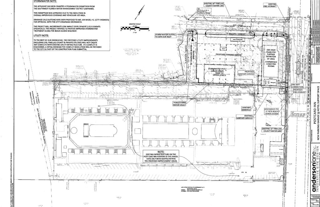
38 10/18/16 St. Pete Beach Planning Board 155 Corey Avenue St. Pete Beach, L Conditional Use Case #: (Off-Premise Parking Structure for Transient Lodging) Agent/Owner S. Elise Batsel/ CRP 6300 Gulf LLC Location 6390 Gulf Blvd. Commission District District 2 Staff Representative Jennifer Bryla, Community 13Development T 13Tindings indings are further explored in the Justification and technical review portion of the Staff Report. Staff has determined, pursuant to Sec. 4.4 (Conditional Use Approval Criteria) the following: 1. The proposed application is consistent with lorida Statutes. 2. The proposed ITEM SUMMARY: The applicant is requesting conditional use approval for an off-premise parking structure with meeting space pursuant to Section 35.3(d) of the Land Development Code. The proposed will serve the existing Postcard Inn temporary lodging facility, also owned by the applicant. Located north of the hotel, the subject property contains a dirt lot that is currently used as overflow parking for the hotel and a now vacated commercial strip shopping center. The proposed development will contain 5,027 square feet of conference and meeting room space and a multi-story parking structure with 346 spaces. The applicants request is consistent with the criteria in the Land Development Code. Existing Use: Commercial (strip center) Proposed Use: Structured parking and hotel meeting space Adjacent Uses: North: South: East: West: Infrastructure, Commercial (strip center) Recreation (tennis courts for Silver Sands Condominiums) Transient Lodging (Postcard Inn) Infrastructure (Gulf Blvd.) Residential ( Silver Sands Condominiums)
39 application is consistent with the Comprehensive Plan. 3. The proposed application is compatible with the character of the existing area. 4. The proposed application will not have a negative impact on off-street parking or transportation. 5. The proposed application will not negatively affect public health, safety, or welfare. Staff Recommendation 13TApproval with outlined conditions. PUBLIC NOTICE: Notice of public hearing has been advertised and notice has been provided as required by State Statutes including mailings within 500 feet of the subject property, posting of the property, and newspaper advertisement. As of the date of this report, no written comments have been received. Oral and written comments may be presented at the public hearing. COMPREHENSIVE PLAN/LAND DEVELOPMENT CODE: The subject property has a future land use designation of LR (Large Resort District) in the City of St. Pete Beach Comprehensive Plan. It is located in the Gulf Boulevard Community Redevelopment District (CRD), which encourages the redevelopment of hotels and their secondary uses that are permitted in the LR District. The subject property is also zoned LR (Large Resort District) in the City of St. Pete Beach Land Development Code (LDC) which allows off-premise parking structures as secondary uses with conditional use approval. The proposed development adjoins an existing residential property located outside the LR District, so a 30-foot wide landscape buffer is required. It is also subject to the design standards outlined in Division 39 of the Land Development Code which contains design standards for developments within the Community Redevelopment District. JUSTIICATION / TECHNICAL REVIEW: City Staff has reviewed the standards for review in section 4.4 and has determined the following: Standards applicable to all conditional uses. When considering an application for approval of a conditional use, the city commission review shall consider the following standards: (1) Whether the conditional use is consistent with the goals, objectives, and policies of the Comprehensive Plan, any adopted special area plan and these regulations; The application is consistent as it increases pedestrian safety, parking, and aesthetics while supporting the city s tourism economy. Specically 5.1.2, and Objective 2.4. The proposed addition of the approximately 5000 square feet of conference and meeting space and approximately 350 parking space facility is consistent by mixing the existing temporary lodging uses with accessory and support uses. The project also creates a positive aesthetic impact along Gulf Boulevard with the redevelopment (2) Whether the proposed use will be compatible with the character of the existing area, including existing structures and structures under 2
40 construction, existing public facilities and public facilities under construction, and residential, commercial and/or service facilities available within the existing area. More specifically: a. Whether the overall appearance and function of the area will be significantly affected. Consideration shall be given to the existence of other uses in the area, based on the number, size, and location of the uses and the intensity and scale of the proposed and existing uses in the area; The height of the adjacent residential facility (seaward of the proposed new structure) is significantly higher in height than the Proposed Project. The Proposed Project is not incompatible with regards to intensity or scale. The new garage height is proposed for 37-6 the neighboring multi-family development height is Additionally the applicant is incorporating a 30 landscaped buffer along the edge of the project that is directly adjacent to the multi-family development. The Proposed Project is compatible with adjacent properties as additional landscape buffering is being added to three sides of the proposed structure and provide a public access for residents of the surrounding area. b. Whether the application will preserve any city, state or federally designated historic, scenic, archaeological, or cultural resources; The applicant will preserve any such resources should any exist. The City s only listed properties on the National Registry of Historic Places are located south of 32 nd Avenue. c. Whether the application will be compatible with adjacent development, if any, based on characteristics such as size, building style and scale; or whether such incompatibilities are mitigated through such means as screening, landscaping, setbacks, and other design features; The Proposed Project is development criteria is consistent with the Land Development Code parameters and therefore consistent with adjacent properties. The height of the adjacent residential facility (seaward of the proposed new structure) is significantly higher in height than the Proposed Project. The proposed development is compatible with adjacent development, which includes commercial, temporary lodging, and multifamily residential. Where the property abuts residential, it includes the required landscape buffer. d. Whether the application will have significant adverse impacts on the livability and usability of nearby land due to noise, dust, fumes, smoke, glare from lights, late-night operations, odors, vehicular traffic, truck and other delivery trips, the amount, location, and nature of any outside activities, potential for increased litter, or privacy and safety issues. The application will not have adverse impacts 3
41 on the livability of surrounding properties. The applicant proposes to use low level lighting and has shown that their will be a reduction in light intrusion into the adjacent properties while providing necessary light for safety and security. The project is incorporating a landscaped pedestrian access way to the sand beach which will allow enhanced buffering to adjacent properties and act as an additional noise barrier and also provide access for residents from surrounding neighborhoods. The applicant is proposing designated motorcycle parking on the ground level of the garage to reduce the noise potential and has located the trash facility inside the garage to remove impacts along 64 th st. (3) Whether the transportation system is capable of adequately supporting the proposed use in addition to the existing uses in the area. Evaluation factors include street capacity and level of service, access to arterials, transit availability, on-street parking impacts, if any, site access requirements, neighborhood impacts, and pedestrian safety; The application will not have an adverse impact on the transportation systems. The data and analysis indicates that the transportation impacts as a result of the Proposed Project will be consistent with the City Level of Service standards. Pedestrian safety will be improved and adequate measures to control ingress and egress to the facility are being taken. (4) Whether the minimum off-street parking area required and the amount of space needed for the loading and unloading of trucks, if applicable, will be provided and will function properly and safely; The application provides for adequate parking and loading facilities. The circulation plan for the project provides improvements to the City s adjacent pedestrian circulation system with the addition of a sidewalk along 64the street. (5) Whether generally, the public health, safety and welfare will be preserved, and any reasonable conditions necessary for such preservation have been made; or the reasons stated above, the application will not affect the health, safety and welfare of the community in a negative manner. (6) Whether the applicant has demonstrated the financial and technical capacity to complete any improvements and mitigation necessitated by the development as proposed and has made adequate legal provision to guarantee the provision such improvements and mitigation; The applicant has demonstrated the ability to complete the project in a timely manner. The applicant manages $183 bullion of assets across 126 funds. (7) Whether the proposed use complies with all additional standards imposed on it by the particular provision of these regulations authorizing such use and by all other applicable requirements of the regulations of the 4
42 City of St. Pete Beach. The proposed use complies with all other provisions of the code. In addition, criteria for review of conditional uses within the Community Redevelopment District shall meet the following pursuant to Sec of the Land Development Code: The following criteria are to be used to evaluate the extent that the proposed project can demonstrate that no unreasonable or disproportionately negative impacts are imposed upon adjacent or nearby properties: 1. Utility infrastructure, including sanitary sewer, reclaimed water, potable water, electric and natural gas services, and data transmission and telecommunication services Pursuant to Resolution , the proposed development has therefore satisfied the requirements for sewer/wastewater concurrency and has a negative net impact on the City s sewer system. 2. Transportation infrastructure, including ingress and egress from public right-of-way, traffic control devices and signalization, internal vehicle circulation of the site, design and function of parking areas, loading and unloading areas, pedestrian transit infrastructure and amenities, and public sidewalks and roadways. The proposed application was reviewed by a transportation engineer on behalf of the city during the technical review process and recommendations have been made accordingly to mitigate for any adverse impacts the project may pose, including but not limited to the ingress/egress movements of patrons and service personal. 3. Hydrological features and stormwater management infrastructure The Applicant is proposing to include components within the project for consistency with the Comprehensive Plan criteria, specifically accommodating a 24 hour 25 year storm event. 4. Aesthetic and architectural features of the development, including site layout, physical dimensions of structures such as height and massing, design and appearance of building facades, exterior building materials, advertising and directional signage and the provision and maintenance of Gulf and Bay view and vistas. The applicant has provided illustrative renderings of the proposed structure that serves to enhance the aesthetic of the St. Pete Beach community. 5. Site landscaping, open space provision and impervious surface limitations. The proposed project meets or exceeds the criteria expressed in the City guiding documents. 6. Operational and functional requirements of facilities, including hours 5
43 of operation, provision of required services or amenities, lighting requirements, noise abatement requirements, residency limitations and facilities maintenance. The proposed project meets or exceeds the criteria expressed in the City guiding documents. 7. ire suppression and facility security. The proposed project meets or exceeds the criteria expressed in the City guiding documents. The garage and the meeting space has incorporated sprinkler equipment and structural separation for the buildings. The applicant also has full time private security personnel on site. 8. Emergency management and hurricane evacuation provisions. The proposed project meets or exceeds the criteria expressed in the City guiding documents. 9. or temporary lodging uses taller than 50 feet in height or a density greater than 30 units per acre, the following additional issues shall be considered. a. The amount of separation provided between the proposed temporary lodging use and any existing buildings on adjoining properties and resulting impact on sunlight and views. The applicant has provided illustrative renderings of the proposed structures that serve to enhance the aesthetic of the St. Pete Beach community. The Proposed Structure has a smaller height than surrounding structures. b. The proximity of any adjacent residential building to the lorida Coastal Construction Control Line and the degree to which the proposed temporary lodging use and /or any accessory use or structure maintains an open view of the waterfront from neighboring properties. The project is not proposing any residential development. The project is proposing additional pedestrian access and will not affect existing viewsheds westward to the Gulf of Mexico. The Technical Review Committee reviewed the application on March 16 th, May 18 th, and June 15 th, 2016 and has the following departmental comments: 10. Recreation: None. 11. Building: None. 12. ire: None. 13. Public Services: See conditions below. 14. Code Enforcement: None. 15. Planning & Zoning: See conditions below. STA RECOMMENDATION: Upon review of the City s guiding documents, Staff recommends approval 6
44 with the following conditions: a. The plans referenced herein shall be those reviewed and approved by the TRC, which are attached to this staff report as Exhibit A and dated September 30, b. The applicant shall provide a public access easement on the sandy beach eastward of the Mean High Water Line pursuant to Policy 5 of the Large Resort District section in the Comprehensive Plan. The easement shall be a minimum of 20 feet wide and shall run the full length of the site as described in the legal description of the application, generally from the northernmost property line to the southernmost property line of 6300 Gulf Blvd. Its contents shall be reviewed and approved by the City Attorney prior to any development order issuance. c. Both access points to the garage on 64 th Avenue shall be restricted by a controlled-access arm at all times. The westernmost point shall allow exit-only from the garage onto 64 th Avenue shall at no point in time allow ingress into the garage. The easternmost entrance into the garage on 64 th Avenue shall only be used by service vehicles and shall be restricted by a controlled-access arm. d. A sidewalk a minimum of 6 feet wide shall be placed on the south side of 64 th Avenue, running the entire length of the subject property as described in the legal description of the application, generally from the easternmost property line to the westernmost property line of 6390 Gulf Blvd. and shall connect to the sidewalk on Gulf Blvd. e. A 10 foot wide sidewalk shall be constructed along Gulf Blvd. pursuant to Sec of the Land Development Code along the subject property as described in the legal description of the application, generally from the northernmost property line to the southernmost property line of 6390 Gulf Blvd. and shall connect to the existing DOT sidewalk and to future sidewalk widenings, which shall be required in accordance with future phases of development at 6300 Gulf Blvd. The method of conveyance shall be as outlined by the Department of Transportation. The sidewalk in front of 6300 Gulf Blvd. shall be widened to 10 feet during future phases of development. f. Any easement granted by the applicant to the City for portions of the required 10-foot sidewalk located on the applicant s private property shall be reviewed and approved by the City Attorney prior to any development order being issued. g. The private beach access walkway depicted on the site plan along the southernmost property line of 6390 Gulf Blvd. shall 7
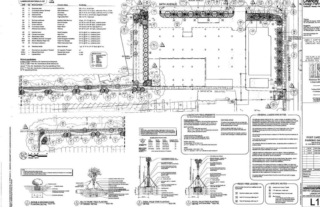
45 connect the sidewalk on Gulf Blvd. to the sandy beach and shall be open for public use. Landscaping or another form of protection approved by TRC shall be installed along the entire length of the public beach access walkway adjacent to vehicular use areas in order to protect pedestrians, and Low Impact Development techniques shall be used. h. The proposed development shall be landscaped in accordance with Division 39 (Community Redevelopment District General Standards) & Division 22 (Landscaping and Tree Protection) of the Land Development Code. Those plant materials with an asterisk as identified in Section 22.4 of Division 22, shall be utilized rather than strongly encouraged. i. Design standards in Sec. 39.3(b)(d)&(e) Sec (b)(1)&(3), and 39.7(c)&(e) which are strongly suggested/encouraged in Division 39 (Community Redevelopment District General Standards) shall be required and incorporated into the official site plan. j. One on-site directional sign shall be required near the main entrance of the Postcard Inn indicating that the entrance to the garage is accessed from Gulf Blvd. and one on-site directional sign indicating that the driveway along the north property line of 6300 Gulf Blvd. is has no outlet and is for hotel guests only. Any other proposed signage shall be consistent with Division 26 of the Land Development Code and be reviewed by the TRC during the Site Plan review process. k. The applicant shall be responsible for the cost of removing the three parking meters on 64 th Ave which will be displaced by the proposed plans. If any additional parking meters will need to be temporary displaced during construction, the applicant shall be responsible for the cost of their temporary removal and replacement. l. The proposed infrastructure satisfies the previously-specified criteria for stormwater concurrency with the City of St. Pete Beach. Should any modifications to the proposed site which would result in a change to the impervious surface ratio be implemented, additional stormwater runoff storage volume must be provided in accordance with Goal 2 of the Infrastructure Element of the City of St. Pete Beach adopted Comprehensive Plan, which would identify the entire predevelopment site used for calculation as being the natural unimproved state with a runoff coefficient of 0.3 (unless the slope of the natural unimproved state was known). m. Based on the projected wastewater contributions provided, the 8
46 proposed redevelopment will see no net increase in sewer/wastewater flows contributed to the City of St. Pete Beach collection system. Pursuant to Resolution , the proposed development has therefore satisfied the requirements for sewer/wastewater concurrency. 9
47
48
49
50

51
52
53
54
55
56
BOARD OF ADJUSTMENT MEETING CITY OF ST. PETE BEACH
 BOARD OF ADJUSTMENT MEETING CITY OF ST. PETE BEACH 155 Corey Avenue St. Pete Beach, Florida Wednesday, 11/15/2017 2:00 p.m. Call to Order Pledge of Allegiance Roll Call 1. Changes to the Agenda Agenda
Unless the City is going to enforce this, including the collection of taxes, it should be removed from the Code
 DIVISION 20 - PAG PASS-A-GRILLE ZONING DISTRICT Page Line Comment Response/Resolution Sec 20.01 Purpose and intent. 2 2 5 The proposed PAG Overlay is intended to prevent the construction of more residential
Composition of traditional residential corridors.
 Page 1 of 7 St. Petersburg, Florida, Code of Ordinances >> PART II - ST. PETERSBURG CITY CODE >> Chapter 16 - LAND DEVELOPMENT REGULATIONS >> SECTION 16.20.060. CORRIDOR RESIDENTIAL TRADITIONAL DISTRICTS
Table of Contents ARTICLE 5A CHARACTER-BASED ZONING 1
 Table of Contents ARTICLE 5A CHARACTER-BASED ZONING 1 SECTION 10.5A10 GENERAL... 1 10.5A11 Purpose and Intent... 1 10.5A12 Applicability... 1 10.5A13 Compliance with Regulating Plan... 1 10.5A14 Relationship
Table of Contents ARTICLE 5A CHARACTER-BASED ZONING 1
 Table of Contents ARTICLE 5A CHARACTER-BASED ZONING 1 SECTION 10.5A10 GENERAL... 1 10.5A11 Purpose and Intent... 1 10.5A12 Applicability... 1 10.5A13 Compliance with Regulating Plan... 1 10.5A14 Relationship
Coding For Places People Love Main Street Corridor District
 Coding For Places People Love Main Street Corridor District 1) Scope a) District boundaries are assigned according to the District Boundary Map. b) The Primary Retail Corridor is assigned according to
ARTICLE V - DIVISION 10 RM-10 RESIDENTIAL MULTIFAMILY DISTRICT
 Development Services ARTICLE V - DIVISION 10 RM-10 RESIDENTIAL MULTIFAMILY DISTRICT Sec. 29-421. Purpose and Intent. (a) The RM-10 Residential Multifamily District is intended for areas affected by the
BOARD OF ADJUSTMENT MEETING CITY OF ST. PETE BEACH
 BOARD OF ADJUSTMENT MEETING CITY OF ST. PETE BEACH 155 Corey Avenue St. Pete Beach, Florida Wednesday, 1/27/2016 2:00 p.m. Call to Order Pledge of Allegiance Roll Call 1. Changes to the Agenda Agenda items
COMMERCIAL ZONING DISTRICTS (Amended 11/13/14) Part I. C-1 Restricted Commercial District
 Part I. C-1 Restricted Commercial District") ARTICLE XI. COMMERCIAL ZONING DISTRICTS (Amended 11/13/14) Part I. C-1 Restricted Commercial District Section 152: Purpose This district is designed to accommodate commercial uses which act as a transition
ARTICLE XI. COMMERCIAL ZONING DISTRICTS (Amended 11/13/14) Part I. C-1 Restricted Commercial District Section 152: Purpose This district is designed to accommodate commercial uses which act as a transition
ARTICLE VII. NONCONFORMITIES. Section 700. Purpose.
 ARTICLE VII. NONCONFORMITIES. Section 700. Purpose. The purpose of this chapter is to regulate and limit the development and continued existence of legal uses, structures, lots, and signs established either
BOARD OF ADJUSTMENT MEETING CITY OF ST. PETE BEACH
 BOARD OF ADJUSTMENT MEETING CITY OF ST. PETE BEACH 155 Corey Avenue St. Pete Beach, Florida Wednesday, 7/26/2017 2:00 p.m. Call to Order Pledge of Allegiance Roll Call 1. Changes to the Agenda Agenda items
PLANNED DEVELOPMENT DISTRICT STANDARDS. Cadence Site
 PLANNED DEVELOPMENT DISTRICT STANDARDS Cadence Site A Planned Development District 1. Statement of General Facts, Conditions and Objectives Property Size: Approximately 57.51 Acres York County Tax Map
DAVIDSON PLANNING ORDINANCE AMENDMENTS AFTER SEPTEMBER 2009 SECTION 9
 AMENDMENT ADOPTED 6/12/2012 Section 9.1.3.3.1 Wall Murals Entire Section Added: 9.1.3.3.1 Wall Murals DAVIDSON PLANNING ORDINANCE AMENDMENTS AFTER SEPTEMBER 2009 SECTION 9 Exterior wall murals are only
May 12, Chapter RH HILLSIDE RESIDENTIAL ZONES REGULATIONS Sections:
 May 12, 2017 Chapter 17.13 RH HILLSIDE RESIDENTIAL ZONES REGULATIONS Sections: 17.13.010 Title, intent, and description. 17.13.020 Required design review process. 17.13.030 Permitted and conditionally
DEVELOPMENT DEPARTMENT STAFF REPORT THE PARK AT 5 TH
 DEVELOPMENT DEPARTMENT STAFF REPORT ARB Meeting Date: July 3, 2018 Item #: _PZ2018-293_ THE PARK AT 5 TH Request: Site Address: Project Name: Parcel Number: Applicant: Proposed Development: Current Zoning:
17.13 RH HILLSIDE RESIDENTIAL ZONES REGULATIONS SECTIONS:
 Effective April 14, 2011 Chapter 17.13 RH HILLSIDE RESIDENTIAL ZONES REGULATIONS SECTIONS: 17.13.010 Title, Intent, and Description 17.13.020 Required Design Review Process 17.13.030 Permitted and Conditionally
Chapter DOWNTOWN ZONING DISTRICTS
 Chapter 20.14 Sections: 20.14.010 Purpose of the Downtown Zoning Districts 20.14.020 Land Use Regulations for Downtown Zoning Districts 20.14.030 Development Standards for Downtown Zoning Districts 20.14.010
Chapter CC COMMUNITY COMMERCIAL ZONES REGULATIONS
 Effective April 14, 2011 Chapter 17.35 CC COMMUNITY COMMERCIAL ZONES REGULATIONS SECTIONS: 17.35.010 Title, Intent, and Description 17.35.020 Required Design Review Process 17.35.030 Permitted and Conditionally
UPPER MOUNT BETHEL TOWNSHIP NORTHAMPTON COUNTY, PENNSYLVANIA
 UPPER MOUNT BETHEL TOWNSHIP NORTHAMPTON COUNTY, PENNSYLVANIA JOINDER DEED / LOT CONSOLIDATION TOWNSHIP REVIEW PROCESS When accepting proposed Joinder Deeds / Lot Consolidations, review the Joinder Deed
DEVELOPMENT STANDARDS FOR RESIDENTIAL PROJECTS RESIDENTIAL BUILDING TYPES: APPROPRIATE ZONES AND DENSITIES 2-1
 2 DEVELOPMENT STANDARDS FOR RESIDENTIAL PROJECTS RESIDENTIAL BUILDING TYPES: APPROPRIATE ZONES AND DENSITIES 2-1 This Chapter presents the development standards for residential projects. Section 2.1 discusses
ARTICLE 4: SCHEDULE OF DISTRICT, USE AND SETBACK REGULATIONS
 Page 1 of 48 City of Hollywood Zoning and Land Development Regulations 4.6.I Beach Community Redevelopment Districts. 1. Purpose. To establish development standards for the Beach Community Redevelopment
FOR SALE > MULTIFAMILY/COMMERCIAL REDEVELOPMENT OPPORTUNITY
 FOR SALE > MULTIFAMILY/COMMERCIAL REDEVELOPMENT OPPORTUNITY 2220 W. Cary Street RICHMOND, VA 23220 CURRENT PROPERTY ILLUSTRATION CONCEPTUAL ONLY (NOT PROPOSED) Property Information Zoning: R-63, Multifamily
BOROUGH OF HOPATCONG ORDINANCE No
 BOROUGH OF HOPATCONG ORDINANCE No. 10-2014 AN ORDINANCE OF THE BOROUGH OF HOPATCONG, SUSSEX COUNTY, NEW JERSEY TO ADOPT A FORM BASED CODE AS AN OVERLAY DISTRICT AFFECTING PORTIONS OF THE B-1 AND R-1 ZONING
2. The modification is consistent with the objectives of this chapter.
 DRAFT February 11, 2009 BMC 20.28 Infill Housing 20.28.010 Purpose. This chapter establishes special development regulations for a series of housing forms that are different than the traditional detached
TOWN OF NEW SHOREHAM ZONING BOARD OF REVIEW APPLICATION PROCEDURE
 TOWN OF NEW SHOREHAM ZONING BOARD OF REVIEW APPLICATION PROCEDURE 1. Please answer all questions on the application and please print clearly. If a question is not applicable, mark the space with a N/A.
ARTICLE 909. PD 909. PD 909 was established by Ordinance No , passed by the Dallas City Council on April 23, (Ord.
 ARTICLE 909. PD 909. SEC. 51P-909.101. LEGISLATIVE HISTORY. PD 909 was established by Ordinance No. 29330, passed by the Dallas City Council on April 23, 2014. (Ord. SEC. 51P-909.102. PROPERTY LOCATION
CITY OF BELLE GLADE. 110 Dr. Martin Luther King Jr. Blvd., West Belle Glade, FL Telephone (561) Fax (561)
 Fax (561)") CITY OF BELLE GLADE 110 Dr. Martin Luther King Jr. Blvd., West Belle Glade, FL 33430 Telephone (561)992-1630 Fax (561)993-1811 www.bellegladegov.com SITE PLAN APPROVAL APPLICATION Please refer to the appropriate
CITY OF BELLE GLADE 110 Dr. Martin Luther King Jr. Blvd., West Belle Glade, FL 33430 Telephone (561)992-1630 Fax (561)993-1811 www.bellegladegov.com SITE PLAN APPROVAL APPLICATION Please refer to the appropriate
ARTICLE 5. R-6 Residential- Duplex, Single Family Detached and Townhouse District
 ARTICLE 5 R-6 Residential- Duplex, Single Family Detached and Townhouse District 5.1. Conformity Subject to Article 11 of this Ordinance (Non-conforming Situations), no person may use, occupy, or sell
Part 4.0 DEVELOPMENT REGULATIONS
 M A I N S T R E E T N O R T H Part 4.0 DEVELOPMENT REGULATIONS 4.1 Districts 4.2 Permitted and Prohibited Uses, Standards and Standard Specific Criteria and Other General Provisions 4.3 DPS REGULATIONS
CHAPTER 29 ARTICLE 8. 20,000 sf 30,000 sf 100,000 sf (with approval by Special Use Permit according to Sec
 CHAPTER 29 ARTICLE 8 (3) Zone Development Standards. The zone development standards for the NC Zone are set forth in Table 29.81(3) below: Table 29.81(3) Neighborhood Commercial (NC) Zone Development Standards
8.14 Single Detached with Granny Flat or Coach House Edgemere
 8.14 Single Detached with Granny Flat or Coach House Edgemere [Bylaw 8922, Nov 19/12] (RE1) 8.14.1 Purpose The zone applies to the Edgemere (RE1) neighbourhood and provides for single detached housing
CITY OF BELLEVIEW PLANNING & ZONING BOARD AGENDA
 CITY OF BELLEVIEW PLANNING & ZONING BOARD AGENDA BELLEVIEW CITY HALL COMMISSION ROOM 5:30 PM IF A PERSON SHOULD DESIRE TO APPEAL ANY DECISION MADE BY THE BOARD, A VERBATIM RECORD OF THE PROCEEDINGS WHICH
City of Coral Gables Planning and Zoning Staff Report
 City of Coral Gables Planning and Zoning Staff Report Applicant: Application: Public Hearing: Date & Time: Location: City of Coral Gables Giralda Restaurant Row Overlay Zoning Code Text Amendment Planning
Chapter CN NEIGHBORHOOD CENTER COMMERCIAL ZONES REGULATIONS
 Chapter 17.33 - CN NEIGHBORHOOD CENTER COMMERCIAL ZONES REGULATIONS Sections: 17.33.010 - Title, intent, and description. 17.33.020 - Required design review process. 17.33.030 - Permitted and conditionally
Residential RM Medium Density Residential. Residential Zones: Minimum Setback: Average of front setbacks on the adjacent lots.
 ARTICLE 3. SETBACKS, COURTS AND OPEN SPACE 9-4.301 Setbacks. (a) Minimum Setbacks. The minimum setbacks of buildings from lot lines shall be as prescribed in Table 9-4-301(a). Table 9-4.301(a): Minimum
THE CITY COUNCIL OF NORTH ROYALTON, OHIO
 THE CITY COUNCIL OF NORTH ROYALTON, OHIO ORDINANCE NO. 16-113 INTRODUCED BY: Nickell, Kasaris, Antoskiewicz AN ORDINANCE AMENDING THE CODIFIED ORDINANCES OF THE CITY OF NORTH ROYALTON, PART 12 PLANNING
Article 2. Rules of Interpretation
 Article 2. Rules of Interpretation Article 2. Rules of Interpretation Sec. 2.1. Building Types 2.1.1. Building Type Descriptions... 2-2 Sec. 2.2. Rules Applicable to all Districts 2.2.1. Site... 2-5 2.2.2.
CITY OF ROHNERT PARK CITY COUNCIL AGENDA REPORT
 Mission Statement We Care for Our Residents by Working Together to Build a Better Community for Today and Tomorrow. CITY OF ROHNERT PARK CITY COUNCIL AGENDA REPORT ITEM NO. 12 Meeting Date: February 14,
Chapter 17-2 Residential Districts
 Chapter 17-2 Residential Districts 17-2-0100 District Descriptions...2-1 17-2-0200 Allowed Uses...2-2 17-2-0300 Bulk and Density Standards...2-5 17-2-0400 Character Standards...2-18 17-2-0500 Townhouse
ACCESSORY DWELLING UNITS IN THE SOUTHEAST SECTOR
 February 19, 2019 Staff Report to the Municipal Planning Board LDC2018-10020 Item #11 S U M M A R Y Applicant The City of Orlando ACCESSORY DWELLING UNITS IN THE SOUTHEAST SECTOR Applicant s Request Update
Article Optional Method Requirements
 Article 59-6. Optional Method Requirements [DIV. 6.1. MPDU DEVELOPMENT IN RURAL RESIDENTIAL AND RESIDENTIAL ZONES Sec. 6.1.1. General Requirements... 6 2 Sec. 6.1.2. General Site and Building Type Mix...
(a) Commercial uses on Laurel Avenue, abutting the TRO District to the
 Commercial uses on Laurel Avenue, abutting the TRO District to the") 32X Zoning Code 150.36 TRANSITIONAL RESIDENTIAL OVERLAY DISTRICT. (A) Intent and purpose. (1) It is the intent of the Transitional Residential Overlay District (hereinafter referred to as the "TRO District")
32X Zoning Code 150.36 TRANSITIONAL RESIDENTIAL OVERLAY DISTRICT. (A) Intent and purpose. (1) It is the intent of the Transitional Residential Overlay District (hereinafter referred to as the "TRO District")
Anacortes, WA. 718 commercial ave. FOR lease. 2,320 +/- sf retail space in a 10,820 +/- sf building. Located in historic downtown Anacortes
 718 commercial ave Anacortes, WA FOR lease 2,320 +/- sf retail space in a 10,820 +/- sf building Located in historic downtown Anacortes Frontage on Commercial Ave alongside four other retail spaces Zoned
Staff Report: Date: Applicant: Property Identification: Acreage of Request: Current Zoning of Requested Area: Requested Action: Attached:
 Staff Report: Completed by Jeff Palmer Director of Planning & Zoning Date: November 7, 2018, Updated November 20, 2018 Applicant: Greg Smith, Oberer Land Developer agent for Ronald Montgomery ET AL Property
LOT AREA AND FRONTAGE
 LOT AREA AND FRONTAGE Lot Area & Frontage for the R2.1 Zone Lot Area & Frontage for the R2.4 Zone Minimum Lot Minimum Lot Zone Area Width R2.1 700 sq m 18 m R2.4 600 sq m 16 m Lot Area means the total
City of Hollywood Zoning and Land Development Regulations. Day Care Facilities. Plant Nursery & Garden Center. School,** public or private.
 Print City of Hollywood Zoning and Land Development Regulations 4.3 Commercial Districts. A. C-1 Low Intensity Commercial District. 1. Purpose and uses: District Purposes Exception Accessory Prohibited
Decatur, Georgia Unified Development Ordinance. Effective February 1, 2015
 Decatur, Georgia Unified Development Ordinance Decatur Unified Development Ordinance Article 1. General Provisions... 1-1 Sec. 1.1. Legal Status Provisions....1-2 Sec. 1.2. Zoning Districts...1-4 Sec.
Sedro woolley, WA 720 MURDOCK ST. FOR sale. 14,500 +/- sf office building with 8,500 +/- sf unfinished basement space on 0.
 720 MURDOCK ST Sedro woolley, WA FOR sale 14,500 +/- sf office building with 8,500 +/- sf unfinished basement space on 0.27 +/- AC Former City Hall built in 1930 Located in the Downtown Sedro Woolley core
City of Coral Gables Planning and Zoning Staff Report
 City of Coral Gables Planning and Zoning Staff Report Applicant: Application: Public Hearing: Date & Time: Location: City of Coral Gables Zoning Code Text Amendment Giralda Plaza Overlay District Planning
PLANNING AND DEVELOPMENT DEPARTMENT STAFF REPORT STAFF REPORT PREMIER AUTO SERVICES, INC. VARIANCES
 PLANNING AND DEVELOPMENT DEPARTMENT STAFF REPORT Meeting Date: February 14, 2019 Item #: PZ2019-402 STAFF REPORT PREMIER AUTO SERVICES, INC. VARIANCES Project Name: Premier Auto Services, Inc. Applicant:
the conditions contained in their respective Orders until January 1, 2025, at the discretion of the Director of Planning, Property and Development.
 Part 4: Use Regulations Temporary Uses and Structures Purpose the conditions contained in their respective Orders until January 1, 2025, at the discretion of the Director of Planning, Property and Development.
DEVELOPMENT DEPARTMENT STAFF REPORT DRESDEN HEIGHTS PHASE II DCI
 DEVELOPMENT DEPARTMENT Meeting Date: January 10, 2019 Item #: PZ2019-393 Project Name: Applicant and Owner: Proposed Development: Requests: STAFF REPORT DRESDEN HEIGHTS PHASE II DCI Dresden Heights Phase
City of Colleyville City Council Agenda Briefing
 City of Colleyville City Council Agenda Briefing City Hall 100 Main Street Colleyville, Texas 76034 www.colleyville.com Agenda Number 5a Agenda Date 01/06/2015 Number Ordinance O-14-1942 Type Ordinance
PLANNING COMMISSION REPORT Regular Agenda -Public Hearing Item
 PDP-13-00518 Item No. 3B- 1 PLANNING COMMISSION REPORT Regular Agenda -Public Hearing Item PC Staff Report 2/24/14 ITEM NO. 3B PRELIMINARY DEVELOPMENT PLAN FOR HERE @ KANSAS; 1101 INDIANA ST (SLD) PDP-13-00518:
ARTICLE 15. RULES, REGULATIONS AND DEFINITIONS
 ARTICLE 15. RULES, REGULATIONS AND DEFINITIONS Section 1. Interpretation and Construction: The following rules and regulations regarding interpretation and construction of the Ulysses-Grant County, Kansas,
Staff Report PLANNED DEVELOPMENT. Salt Lake City Planning Commission. From: Lauren Parisi, Associate Planner; Date: December 14, 2016
 Staff Report PLANNING DIVISION COMMUNITY & NEIGHBORHOODS To: Salt Lake City Planning Commission From: Lauren Parisi, Associate Planner; 801-535-7932 Date: December 14, 2016 Re: 1611 South 1600 East PLANNED
New Zoning Ordinance Program
 City of Goleta New Zoning Ordinance Program Module 3: Regulations Applying to Multiple Districts General Site Regulations Landscaping Parking and Loading June 09, 2014 New Zoning Ordinance Program By:
ORDINANCE NO The Town Council of the Town of Yucca Valley does ordain as follows:
 ORDINANCE NO. 141 AN ORDINANCE OF THE TOWN COUNCIL OF THE TOWN OF YUCCA VALLEY, CALIFORNIA, AMENDING TITLE 8, DIVISION 12, CHAPTER 1 RELATING TO DEFINITIONS AND TITLE 8, DIVISION 8, CHAPTER 3, RELATING
TOWN OF CAREFREE NOTICE OF PUBLIC MEETING of the PLANNING and ZONING COMMISSION
 TOWN OF CAREFREE NOTICE OF PUBLIC MEETING of the PLANNING and ZONING COMMISSION WHEN: MONDAY, OCTOBER 10, 2016 WHERE: FCF HOLLAND COMMUNITY CENTER, QUAIL ROOM 34250 N. 60 TH STREET, BUILDING B, SCOTTSDALE,
PLANNING BOARD MEETING CITY OF ST. PETE BEACH
 PLANNING BOARD MEETING CITY OF ST. PETE BEACH 155 Corey Avenue St. Pete Beach, FL 33706 June 27, 2017 4:00 Call to Order Pledge of Allegiance Roll Call 1. Changes to the Agenda Agenda items to be added,
TABLE OF CONTENTS. Chapters and Sections
 TABLE OF CONTENTS Chapters and Sections Chapter 9.02 Permits and Approvals [Addition]... 1 9.02.090 Administrative variances.... 1 Chapter [New]... 1 9.07.091 Purpose and Intent... 1 9.07.092 Applicability...
RM-8 and RM-8N Districts Schedule
 Districts Schedule 1 Intent The intent of this schedule is to encourage development of ground-oriented stacked townhouses or rowhouses, including courtyard rowhouses, while continuing to permit lower intensity
THE AREA PLAN COMMISSION OF ST. JOSEPH COUNTY, IN AGENDA
 THE AREA PLAN COMMISSION OF ST. JOSEPH COUNTY, IN AGENDA Tuesday, January 17, 2017 Fourth-Floor Council Chambers 3:30 p.m. County-City Building, South Bend, IN EXECUTIVE SESSION: A. Election of Officers
Chair to close public hearing. Review Deadline: 60 Days: 8/18/ Days: 10/17/2017
 Planning Commission Meeting Date: July 19, 2017 Agenda Item 3A 3A The Elmwood Major Amendment to Section 36-268-PUD 8 Case No.: Location: Applicant: Owner: Recommended Action: 17-21-PUD 5605 West 36 th
NORMAN, OKLAHOMA OWNER: RCB BANK APPLICATION FOR 2025 PLAN CHANGE PLANNED UNIT DEVELOPMENT PRELIMINARY PLAT. 12 December 2011 Revised 5 January 2012
 THE VILLAGE AT OAKHURST ADDITION NORMAN, OKLAHOMA OWNER: RCB BANK APPLICATION FOR 2025 PLAN CHANGE PLANNED UNIT DEVELOPMENT PRELIMINARY PLAT 12 December 2011 Revised 5 January 2012 PREPARED BY: THE RIEGER
FREQUENTLY USED PLANNING & ZONING TERMS
 City Of Mustang FREQUENTLY USED PLANNING & ZONING TERMS Abut: Having property lines, street lines, or zoning district lines in common. Accessory Structure: A structure of secondary importance or function
Can They Build That Here? Tanglewood Neighborhood Association by the Planning and Development Department
 Can They Build That Here? Tanglewood Neighborhood Association by the Planning and Development Department April 16, 2012 Tanglewood Neighborhood Association Includes several platted subdivisions: Tanglewood
DIVISION 7. R-6 AND R-6A RESIDENTIAL ZONES* The purpose of the R-6 residential zone is:
 Date of Draft: March 6, 2015 DIVISION 7. R-6 AND R-6A RESIDENTIAL ZONES* Sec. 14-135. Purpose. The purpose of the R-6 residential zone is: (a) To set aside areas on the peninsula for housing characterized
4 DEVELOPMENT STANDARDS FOR
 4 DEVELOPMENT STANDARDS FOR RESIDENTIAL MIXED-USE PROJECTS This chapter presents standards for residential mixed-use projects in the Ashland-Cherryland Business District and the Castro Valley Central Business
Zoning Regulations of the Town of Redding Connecticut
 Zoning Regulations of the Town of Redding Connecticut Statutory zoning authority was adopted for the Town of Redding, and a Zoning Commission established as provided by law, at a Town Meeting held May
ATLANTA ZONING ORDINANCE UPDATE
 CITY OF ATLANTA ZONING ORDINANCE QUICK FIXES In 2015 the City of Atlanta selected a team of consultants to conduct a comprehensive assessment of the City s Zoning Ordinance, including a review of the ability
THE CORPORATION OF THE DISTRICT OF PEACHLAND BYLAW NUMBER 2065, A Bylaw to Amend Zoning Bylaw Number 1375, 1996
 THE CORPORATION OF THE DISTRICT OF PEACHLAND BYLAW NUMBER 2065, 2013 A Bylaw to Amend Zoning Bylaw Number 1375, 1996 WHEREAS the Council of the Corporation of the District of Peachland has adopted Zoning
City of Fraser Residential Zoning District
 City of Fraser Residential Zoning District The one-family districts are established to provide principally for one-family dwellings at varying densities. The specific interest of these districts is to
SECTION 7. RESIDENTIAL DISTRICTS
 SECTION 7. RESIDENTIAL DISTRICTS 7.1 RESIDENTIAL DISTRICTS PURPOSE 7.2 PERMITTED AND SPECIAL USES 7.3 YARD AND BULK REGULATIONS 7.4 GENERAL STANDARDS OF APPLICABILITY 7.5 FLOOR AREA RATIO MEASUREMENT AND
DEVELOPMENT DEPARTMENT STAFF REPORT STAFF REPORT DRESDEN DRIVE TOWNHOMES DCI
 DEVELOPMENT DEPARTMENT STAFF REPORT Meeting Date: September 13, 2018 Item #: PZ2018-319 STAFF REPORT DRESDEN DRIVE TOWNHOMES DCI Request: Project Name: Development of Community Compact (DCI) and six concurrent
MIXED USE DEVELOPMENT AGREEMENT
 MIXED USE DEVELOPMENT AGREEMENT THIS MIXED USE DEVELOPMENT AGREEMENT (hereinafter "Agreement") made and entered into this day of, 2007, pursuant to Section 205-30 of the Zoning Ordinances of the City of
PART 3 RESIDENTIAL ZONING DISTRICTS. Designation of Residential Zoning Districts and Purpose Statements.
 PART 3 S Section 301. Designation of and Purpose Statements. See Table 3-1 herein this Section for the designations and purpose statements of the respective Residential Zoning Districts which are shown
ARLINGTON COUNTY, VIRGINIA
 ARLINGTON COUNTY, VIRGINIA County Board Agenda Item Meeting of June 16, 2012 DATE: June 7, 2012 SUBJECT: SP #397 SITE PLAN AMENDMENT to revise condition #31 to modify the retail transparency requirement
Article 7: Residential Land Use and Development Requirements
 Article 7: Residential Land Use and Section 701: Statement of Intent (A) (B) (C) The intent of Article 7 is to develop certain land use and development requirements for the residential uses within Cumru
Article IV. Terminology
 Article IV. Terminology 212-22 Purpose. Add or amend the following definitions: BUILDING HEIGHT The vertical distance measured from the average elevation of the proposed finished grade at the front of
PERMITTED USES: Within the MX-1 Mixed Use Neighborhood District the following uses are permitted:
 6.25 MX-1 - MIXED USE NEIGHBORHOOD 6.25.1 INTENT: The purpose of the MX-1 Mixed Use Neighborhood District is to accommodate the development of a wide-range of residential and compatible non-residential
City of Cape May Planning Board Meeting Minutes Tuesday September 10, 2013
 City of Cape May Planning Board Meeting Minutes Tuesday September 10, 2013 Opening: The meeting of the City of Cape May Planning Board was called to order by Chairman William Bezaire, at 7:00 PM. In compliance
a. To insure compatible relationships between land use activities;
 PART B SECTION VIII INSTITUTIONAL DISTRICTS Article 1 Planned Institutional District 1. Purpose and Intent: It is the purpose and intent of this district to permit and encourage the orderly, cooperative
City of Fayetteville, Arkansas Page 1 of 3
 City of Fayetteville, Arkansas 113 West Mountain Street Fayetteville, AR 72701 (479) 575-8323 Legislation Text File #: 2018-0144, Version: 1 ADM 18-6094 (AMEND UDC 164.19/ACCESSORY DWELLING UNITS): AN
ARTICLE 5. COMMERCIAL AND OFFICE DISTRICTS 5.1 PURPOSE STATEMENTS 5.2 USES 5.3 DIMENSIONAL STANDARDS 5.4 DESIGN STANDARDS 5.5 DK DISTRICT STANDARDS 5
 ARTICLE 5. COMMERCIAL AND OFFICE DISTRICTS 5.1 PURPOSE STATEMENTS 5.2 USES 5.3 DIMENSIONAL STANDARDS 5.4 DESIGN STANDARDS 5.5 DK DISTRICT STANDARDS 5.6 CU DISTRICT STANDARDS 5.7 SW DISTRICT STANDARDS THE
RM-7, RM-7N and RM-7AN Districts Schedules
 1 Intent Districts Schedules The intent of this schedule is to encourage development of ground-oriented stacked townhouses or rowhouses, while continuing to permit lower intensity development. In RM-7AN,
AN ORDINANCE OF THE CITY OF MINNEAPOLIS. By Palmisano
 AN ORDINANCE OF THE CITY OF MINNEAPOLIS By Palmisano Amending Title 20, Chapter 520 of the Minneapolis Code of Ordinances relating to Zoning Code: Introductory Provisions. The City Council of the City
PLANNING AND ZONING BOARD Council Chambers 3048 S. Atlantic Avenue Daytona Beach Shores, Florida Monday, January 11, :30 a.m.
 PLANNING AND ZONING BOARD Council Chambers 3048 S. Atlantic Avenue Daytona Beach Shores, Florida Monday, January 11, 2016 8:30 a.m. AGENDA CALL TO ORDER AUDIENCE REMARKS: Time for citizens and members
Min. Lot Frontage (Ft.) 1. Min. Front Yard (Ft.) Min. Rear Yard (Ft.) R , R , R ,
 1. Min. Front Yard (Ft.) Min. Rear Yard (Ft.) R , R , R ,") SECTION 11 - DIMENSIONAL REQUIREMENTS A. The following standards shall be required for single family dwellings and associated accessory uses and structures within Residence s, except as expressly permitted
SECTION 11 - DIMENSIONAL REQUIREMENTS A. The following standards shall be required for single family dwellings and associated accessory uses and structures within Residence s, except as expressly permitted
PUD 42 - Warner Ranch PUD - Amend. 2 Item No. 4B ZONING ZON
 PUD 42 - Warner Ranch PUD - Amend. 2 Item No. 4B ZONING ZON1210-001 CASE PLANNER: Steve Hopkins REQUEST: Approval of PUD 42 - Warner Ranch PUD - Amend. 2 ZONING AT TIME OF APPLICATION: PUD 42 CURRENT USE
Z O N I N G R E G U L A T I O N S. City of New London, Connecticut
 Z O N I N G R E G U L A T I O N S City of New London, Connecticut Amended To July 10, 2018 R-1 and R-1A Article IV. Residential District Regulations Section 400 R-1 and R-lA - Single Family Low Density
ncd zoning overlay regulations
 ncd zoning overlay regulations Special Design Standards to apply to development in the Glen Lennox Area Neighborhood Conservation District-8C The following Design Standards shall apply to all development
Article 19: Southeastern San Diego Planned District ( Southeastern San Diego Planned District added by O N.S.)
") Article 19: Southeastern San Diego Planned District ( Southeastern San Diego Planned District added 3-27-2007 by O-19599 N.S.) Division 3: Zoning ( Zoning added 3-27-2007 by O-19599 N.S.) 1519.0301 Residential
Article 19: Southeastern San Diego Planned District ( Southeastern San Diego Planned District added 3-27-2007 by O-19599 N.S.) Division 3: Zoning ( Zoning added 3-27-2007 by O-19599 N.S.) 1519.0301 Residential
ORDINANCE NO. The Board of Supervisors of the County of Ventura, State of California, ordains as follows: Section 1
 ORDINANCE NO. AN ORDINANCE OF THE VENTURA COUNTY BOARD OF SUPERVISORS AMENDING DIVISION 8, CHAPTER 1, ARTICLE 2, 5, 7, 8, 9, 11, 13 AND 19 OF THE VENTURA COUNTY ORDINANCE CODE, NON-COASTAL ZONING ORDINANCE
Figure 5-1, Land Use Plan, establishes the boundaries of each land use districts in the Boronda Community
 APPENDIX A DEVELOPMENT STANDARDS This Appendix provides development standards and regulations for the majority of the land use districts within the Community of Boronda. This section describes the allowed
PALM BEACH COUNTY PLANNING, ZONING AND BUILDING DEPARTMENT ZONING DIVISION ZONING COMMISSION VARIANCE STAFF REPORT 07/05/2012
 PALM BEACH COUNTY PLANNING, ZONING AND BUILDING DEPARTMENT ZONING DIVISION ZONING COMMISSION VARIANCE STAFF REPORT 07/05/2012 APPLICATION NO. CODE SECTION REQUIRED PROPOSED VARIANCE ZV-2012-00690 3.D.1.A
TO: Mayor & Council DATE: July 19, FROM: General Manager, Planning & Development FILE:
 CORPORATE REPORT NO: L002 COUNCIL DATE: July 24, 2017 REGULAR COUNCIL LAND USE TO: Mayor & Council DATE: July 19, 2017 FROM: General Manager, Planning & Development FILE: 5480 01 SUBJECT: Proposed Amendments
CITY OF MERCED SMALL LOT SINGLE-FAMILY HOME DESIGN GUIDELINES
 CITY OF MERCED SMALL LOT SINGLE-FAMILY HOME DESIGN GUIDELINES Development Services Department Planning and Permitting Adopted August 15, 2005 SMALL LOT SINGLE FAMILY HOME GUIDELINES A. Purpose and Applicability.
Application for Site Plan Agreement
 Township of Asphodel-Norwood Building and Planning Department 2357 County Road 45 Norwood, ON K0L 2V0 Application for Site Plan Agreement The undersigned hereby applies to the Council of the Township of
TO: Glynn County Islands Planning Commission. Eric Landon, Planner II. PP2754 Stones Throw Cottages. DATE: February 6, 2014
 COMMUNITY DEVELOPMENT DEPARTMENT Planning and Zoning Division 1725 Reynolds Street, Suite 200, Brunswick, GA 31520 Phone: 912-554-7428/Fax: 1-888-252-3726 TO: Glynn County Islands Planning Commission FROM: