TABLE OF CONTENTS. Chapters and Sections
|
|
|
- Harold Preston
- 5 years ago
- Views:
Transcription
1 TABLE OF CONTENTS Chapters and Sections Chapter 9.02 Permits and Approvals [Addition] Administrative variances Chapter [New] Purpose and Intent Applicability Purposes of Mixed-Use Overlay Districts Permitted Uses in Mixed-Use Overlay Districts Mixed-Use Overlay District Site Development Standards Building Frontage Type Standards Open Space Standards Publicly-Accessible Open Space Open Space Standards Private/Common Open Space Lot Area Requirements and Lot Consolidation Incentives Chapter 9.09 Specific Use Development Standards [New] Live-Work Development Mixed-Use Development Outdoor Dining Chapter 9.11 Parking, Pedestrian, and Loading Requirements [New/Revised] General Regulations Off-Street Parking Requirements Off-Street Bicycle Parking Requirements Chapter 9.15 Definitions [New] Definitions i
2 List of Tables Table : Mixed-Use Overlay District Development Standards List of Figures Figure Examples of Development in Mixed-Use Institutional Anchor (MUI) Overlay District Figure Examples of Development in Mixed-Use Community (MUC) Overlay District Figure Examples of Development in Mixed-Use Neighborhood (MUN) Overlay District Figure Block Standards Figure Build-to-Zone Standards Figure Setback Standards Figure Building Frontage Length Figure Building Standards and Building Frontage Types Figure Parking Standards Figure Live-Work/Office Frontage Standards Figure Residential Frontage Standards Figure Storefront Standards Figure Publicly Accessible Open Space (Forecourt, Front, L-Shaped, Paseo/Central Courtyard) Figure Build-to-Zone Figure Floor Area Ratio ii
3 Chapter 9.02 Permits and Approvals [Addition] Sections: Administrative Variances Administrative variances. C. Limitations on Administrative Variances. Only the following variances may be granted by the community development director and subject to the following limitations: 5. Decrease in building frontage requirements. In any mixed-use overlay district, the community development director may authorize up to a ten (10) percent decrease in the distance threshold established to specify the required percentage of a building frontage to be built to the Build-To-Zone, as indicated in Table (Mixed-Use Overlay District Development Standards) (i.e., the distance threshold from street intersections for the purposes of calculating building frontage length may be reduced from 300 feet to 270 feet). The community development director is not authorized to reduce the percentage of the building frontage that is required to be built to the Build-To-Zone. Chapter [New] Sections: Purpose and Intent Applicability Purposes of Mixed-Use Overlay District Permitted Uses in Mixed-Use Overlay Districts Mixed-Use Site Development Standards Building Frontage Type Standards Open Space Standards Publicly-Accessible Open Space Open Space Standards Private/Common Open Space Lot Area Requirements and Lot Consolidation Incentives Purpose and Intent A. Purpose. The purpose of this Chapter to provide regulations that implement the goals and policies of the General Plan, the Alessandro Boulevard Corridor Vision Plan (accepted by the Moreno Valley City Council on June 30, 2010), and other similar long-range planning documents aimed at encouraging mixed-use development within the City. Planning Draft: February
4 B. Intent. The Mixed-Use Overlay Districts are intended to: 1. Stimulate economic development and reinvestment through regulations based upon recognized urban design principles that allow property owners to respond with flexibility to market forces; 2. Create specific development nodes at street intersections with a pedestrian-oriented mix of uses with convenient access between area neighborhoods, housing, employment centers, and retail services; 3. Accommodate intensities and patterns of development that can support multiple modes of transportation including public transit, bicycles, and walking; 4. Facilitate well-designed new mixed-use development projects that combine residential and nonresidential uses (e.g., office, retail, business services, personal services, public spaces and uses, other community amenities, etc.) to promote a better balance of jobs and housing; 5. Ensure compatibility with adjacent existing single-family neighborhoods and harmonious integration with existing commercial areas; 6. Encourage the development of unique district character through a streetscape that provides attractive features (e.g., landscaping, street furniture, niche or linear parks, public places, courtyards, public transportation shelters; etc.) designed to integrate the public realm (e.g., streets, sidewalks, etc.) with adjacent development on private property; and 7. Provide additional property rights while preserving existing property rights. This intent is achieved by providing additional development rights in compliance with this Chapter, which property owners may exercise under certain conditions, while retaining all development rights conferred by the underlying district to property owners in the mixed-use overlay districts. Incentives and advantages include allowing a greater range and mix of uses; more permissive dimensional specifications (e.g., greater floor area ratio, lot coverage ratio, and height; reduced setbacks; etc.); exemption from certain design review requirements; and fee reductions or waivers Applicability This Section describes the applicability of mixed-use overlay district standards to a property when the property is located within two districts a base district (e.g., Commercial (C), Office (O), Business Park/Light Industrial (BP), etc.) and a mixed-use overlay district. A. Relationship between overlay district standards and base district standards. For property within a mixed-use overlay district, the regulations in this Chapter allow mixed-use development as an alternative to the type of development allowed under the base (underlying) district standards. B. Base district standards. 1. The provisions in this Chapter shall apply to all properties within their respective mixed-use overlay districts, but the provisions do not supersede the underlying base district provisions until a property is developed in compliance with the provisions of this Chapter. 2
5 2. New projects may be developed in compliance with the existing underlying base district, provided that all standards and requirements of the underlying base district are met. 3. Regulations, development standards, and requirements in the underlying base district shall continue to apply to those projects that are currently developed according to the existing standards. 4. For legal non-conforming uses (i.e., uses that do not comply with the provisions of the base district or this Chapter), the provisions in Section (Legal Nonconforming Uses, Improvements, and Parcels) shall apply. C. Option to apply mixed-use overlay district standards. 1. The owner or developer of any property within any mixed-use overlay district may choose to develop in compliance with the standards and procedures in this Chapter that apply to the particular mixed-use overlay district in which the property is located. 2. In order to exercise the option to develop under the provisions in this Chapter, approval of a development review application shall be required in compliance with Chapter (Development Review Process). In granting the approval, the review authority shall find that: a. The proposed development is in compliance with the provisions in this Chapter; and b. Approval of the project will not reduce the amount of land available in mixed-use overlay zone areas to a point where the City's affordable housing needs under the Regional Housing Needs Assessment (RHNA) cannot be met. D. Other applicable regulations. Other applicable regulations can be found in Section (Live- Work Development) and Section (Mixed-Use Development). E. Applicable regulations after completion of development. Once a property is developed in compliance with the provisions in this Chapter, the provisions of this Chapter completely supersede the provisions of the underlying base district. Whenever the requirements of the overlay district impose a more or less restrictive standard than the provisions of the underlying base district, the requirements of the overlay district shall govern. F. Use of photographs. Photographs and illustrations are included in this Chapter for illustrative purposes only. Specific development standards in this Chapter are the controlling language for purposes of development regulation. 3
6 This space intentionally left blank. 4
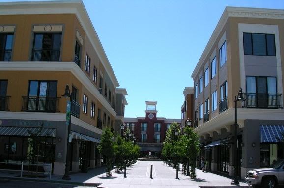
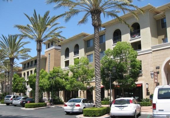
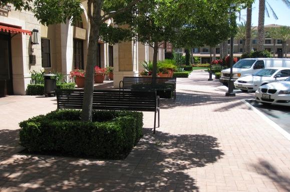
7 Purposes of Mixed-Use Overlay Districts This Section describes the purpose and intent of each mixed-use overlay district. A. Mixed-Use Institutional Anchor (MUI) Overlay District. The Mixed-Use Institutional Anchor (MUI) Overlay District applies to areas around prominent anchor instituti0ns, such as civic centers, medical centers, and educational campuses. The intent is to build upon the role of the institutions by providing opportunities for urban, high-intensity development that serves the needs of visitors, employees, and residents affiliated with the anchor institution and the surrounding region. Development is allowed up to five stories in height with building frontages near or at the sidewalk, wide sidewalks, and parking under or behind buildings. Vertical mixed-use development (ground-floor retail with offices or housing above) is required at important street intersections. Horizontally-integrated or vertically-integrated mixed-use development, with no requirement for ground-floor retail, is allowed in other locations. The overlay district name may be expanded to include the name of the type of anchor institution (e.g., MUI Medical Center ). See Figure (Examples of Development in Mixed-Use Institutional Anchor (MUI) Overlay District). B. Mixed-Use Community (MUC) Overlay District. The Mixed-Use Community (MUC) Overlay District applies to areas along major arterials and arterials. The intent is to provide opportunities for the development of pedestrian-oriented blocks with medium-intense development that serves the needs of residents, visitors, and employees from the surrounding community. Development is allowed up to four stories in height with building frontages near or at the sidewalk, wide sidewalks, and parking under or behind buildings. Vertical mixed-use development (ground-floor retail with offices or housing above) is required at important street intersections. Horizontallyintegrated or vertically-integrated mixed-use development, with no requirement for ground-floor retail, is allowed in other locations. The overlay district name may be expanded to include the community name (e.g., MUC East Alessandro ). See Figure (Examples of Development in Mixed-Use Community (MUC) Overlay District). C. Mixed-Use Neighborhood (MUN) Overlay District. The Mixed-Use Neighborhood (MUN) Overlay District applies to areas along arterials and minor arterials. The intent is to provide an area for lowrise mixed-use development that serves the needs of residents, visitors, and employees from the surrounding immediate neighborhood. Development is allowed up to three stories in height with building frontages near or at the sidewalk, wide sidewalks, and parking under or behind buildings. Vertical mixed-use development (ground-floor retail with offices or housing above) is required at important street intersections. Horizontally-integrated or vertically-integrated mixed-use development, with no requirement for ground-floor retail, is allowed in other locations. The overlay district name may be expanded to include the neighborhood name (e.g., MUN Lasselle Crossing ). See Figure (Examples of Development in Mixed-Use Neighborhood (MUN) Overlay District). 5


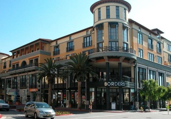
8 Figure Examples of Development in Mixed-Use Institutional Anchor (MUI) Overlay District Alessandro Boulevard Street 6


9 Figure Examples of Development in Mixed-Use Community (MUC) Overlay District Alessandro Boulevard Street 7


 and townhomes")
10 Figure Examples of Development in Mixed-Use Neighborhood (MUN) Overlay District Mixed-Use Building with surface parking to rear and side Mixed-Use Building with podium parking Townhomes with rear loaded garages Apartments (with surface parking to the rear) and townhomes with rear loaded garages Street Alessandro Boulevard 8
11 Permitted Uses in Mixed-Use Overlay Districts For the mixed-use overlay districts, unless otherwise expressly provided in this Title, permitted uses are limited to those described in the Permitted Uses Table in Section (Permitted Uses) of this Title. Any use not listed in Table as a permitted use, conditional use, or accessory use shall be prohibited. 9
12 Mixed-Use Overlay District Site Development Standards This Section provides standards that govern development on properties located in the Mixed-Use Overlay Districts. See Table (Mixed-Use Overlay District Development Standards) and related illustrations. For the purpose of this Zoning Code, mixed-use projects shall comply with nonresidential standards when no mixed-use standards exist. Table : Mixed-Use Overlay District Development Standards Development Features MUI MUC MUN Maximum density for residential uses expressed as dwelling units per net acre. Density Standards See (Development Density) Residential Uses 40 du/ac 30 du/ac 30 du/ac Intensity Standards Maximum floor area ratio (FAR) for nonresidential uses. Nonresidential Uses (1) 1.0 (less than 50% residential) 1.25 (greater than 50% residential) Maximum dimensions required for each newly created block as measured from Block Standards edge of right-of-way line. See Block in (Definitions). See Figure Block Length (A) 600 ft (max) 500 ft (max) 500 ft (max) Block Perimeter (B) 1,800 ft 1,600 ft 1,500 ft Notes: (1) Podium and underground parking is not counted toward floor area ratio (FAR). Includes residential FAR. Table continued on next page Planning Draft: February
13 Table : Mixed-Use Overlay District Development Standards (continued) Development Features MUI MUC MUN Building Placement Standards The area between the minimum and maximum setbacks within which the principal Build-to-Zone building s front façade (building façade line) is to be located. See Build-to-Zone in (Definitions). See Figure Front (C) Along Alessandro Blvd 0-15 ft 0-10 ft 0-10 ft Front (D) All other Streets 0-15 ft 0-10 ft 0-10 ft Street Side Setback (E) 0-15 ft 0-10 ft 0-10 ft Setback Minimum and maximum required setbacks. See (Accessory Structures) for allowed projections into setbacks. See Figure Front Setback (F) Along Alessandro Blvd 0 ft (min); 15 ft (max) 0 ft (min); 10 ft (max) 0 ft (min); 10 ft (max) Front Setback (G) All other Streets 0 ft (min); 15 ft (max) 0 ft (min); 10 ft (max) 0 ft (min); 10 ft (max) Street Side Setback (H) 0 ft (min); 15 ft (max) 0 ft (min); 10 ft (max) 0 ft (min); 10 ft (max) Interior Side Setback (2) (I) 5 ft (min); No max 5 ft (min); No max 5 ft (min); No max Rear Setback (2) (J) 10 ft (min); No max 10 ft (min); No max 10 ft (min); No max Building Frontage Length % of building built to BTZ. See Build-to-Zone in (Definitions). See Figure Within 300 ft of street intersections (K) 65% 65% 65% Over 300 ft from street intersections (L) 50% 50% 50% Building Standards See Underground Levels and Mezzanines/Lofts in (Definitions). See Figure Number of Stories (3) (M) 5 max 4 max 3 max Maximum Height (3) (N) 60 ft 55 ft 45 ft Underground Levels (O) Allowed Allowed Allowed Mezzanines/Lofts (4) (P) Allowed Allowed Allowed Building Frontage Types Along Alessandro Boulevard within 300 ft of Intersections (Q) Elsewhere (R) See (Frontage Type Standards). Live-Work Office Storefront Live-Work Office Residential Storefront Live-Work Office Residential Storefront Live-Work Office Residential Storefront Live-Work Office Residential Storefront Live-Work Office Residential Storefront Notes: (2) Wherever a lot abuts a lot in any single-family residential district, a minimum setback equal to the building height, but not less than 10 feet shall be required. (3) Wherever a lot abuts a lot in any single-family residential district, a 15-foot upper story stepback is required for those portions of buildings that are above 30 feet from finished grade. (4) Mezzanines and lofts shall not be counted as a floor if less than 1/3 of the unit s floor area. Table continued on next page Planning Draft: February
14 Table : Mixed-Use Overlay District Development Standards (continued) Development Features MUI MUC MUN Site Planning Standards Parking Standards See 9.11 (Parking Standards) and Figure Surface Parking (S) Garage / Tuck-Under Parking (T) Underground / Podium Parking (U) Above-Ground Parking Structure (5) (V) Open Space Standards Publicly Accessible Open Space (nonresidential) Private Open Space (multi-family residential) 20 ft min setback from front lot line; 15 ft min setback from side lot line Prohibited along front lot lines Allowed beneath building footprint Allowed if screened from views from public right-of-way and adjacent single-family residential districts 20 ft min setback from front lot line; 15 ft min setback from side lot line Prohibited along front lot lines Allowed beneath building footprint Allowed if screened from views from public right-of-way and adjacent single-family residential districts 20 ft min setback from front lot line; 15 ft min setback from side lot line Prohibited along front lot lines Allowed beneath building footprint Allowed if screened from views from public right-of-way and adjacent single-family residential districts See (Open Space Standards Publicly Accessible Open Space). 15% of net lot area 10% of net lot area 10% of net lot area See (Open Space Standards Private/Common Open Space). 1 st floor 150 sq ft per unit 150 sq ft per unit 150 sq ft per unit Upper floors 100 sq ft per unit 100 sq ft per unit 100 sq ft per unit Common Open Space (multi-family residential) 300 sq ft per unit 300 sq ft per unit 300 sq ft per unit Notes: (5) Minimum interior depth of building liner space that wraps above-ground parking structures facing Alessandro Boulevard shall be 30 feet from the building façade line, as defined in Section (Definitions). Planning Draft: February
15 Figure : Block Standards B Street Street A Street A Street Figure : Build-to-Zone Standards Alessandro Boulevard C E D D Side Street Planning Draft: February
16 Figure : Setback Standards Front or Street Side Lot Line Min. Setback Line F G H Min. Setback Line Max. Setback Line I Interior Side or Rear Lot Line J Street Interior Side or Rear Lot Line Min. Setback Line Evergreen trees to screen views from building (where upper floor windows are present) at maturity of tree I J Single-Family Home Planning Draft: February
17 Figure : Building Frontage Length Lot Depth Alessandro Boulevard Lot Depth Front Lot Line K % of Lot Width % of Lot Depth Lot Width Lot Width % of Lot Width K Street-Side Lot Line L Front Lot Line Side Street Figure : Building Standards and Building Frontage Types M M Q S R T M N P M M P R O Planning Draft: February


18 Figure : Parking Standards Front/Street Side Lot Line S Min. setback line for surface parking Front/Street Side Lot Line T Street Street Surface Parking T Garage / Tuck-Under Parking V Building liner space wraps parking structure along street frontages Mixed - Use Mixed - Use Mixed - Use Mixed - Use Street Street U Podium/Underground Parking V Above-Ground Parking Structure Planning Draft: February
19 Building Frontage Type Standards This Section provides frontage type standards for buildings in the mixed-use overlay districts. Table specifies allowable building frontage types for each mixed-use overlay district. A. Types of building frontages. 1. Live-Work/Office Fronts: A frontage that reinforces both residential and work activities that can occur in the building. The elevation of the ground floor is located at or near the grade of sidewalk to provide direct public access to the building. Entrances and windows are provided on the front of the facade to provide eyes on the street and direct sidewalk access to commercial and office uses. The front setback (if provided) may be improved with landscaping or as an extension of the public sidewalk to create a more pedestrian-friendly environment. See also Section (Live-Work Development). 2. Residential Fronts: A frontage that reinforces the residential character and use of the building. The elevation of the ground floor is elevated above the grade of the lot to provide privacy for residences by preventing direct views into the home from the sidewalk. Entrances and windows are provided on the front of the facade to provide eyes on the street and direct sidewalk access to the building. Stoops are allowed to project into the front setback to enhance entrances. The front setback is primarily improved with landscaping. 3. Storefronts: A frontage that reinforces the commercial character and use of the ground floor of the building. The elevation of the ground floor is located at or near the grade of sidewalk to provide direct public access into the building. Large storefronts display windows are provided on the front of the facade to encourage visual access to merchandise displays and to encourage window shopping. Awnings or marquees are provided over storefront windows and entrances. The front setback (if provided) is primarily improved as an extension of the public sidewalk to create a more pedestrian friendly environment. Planning Draft: February
20 B. Live-Work/Office Frontage Standards (1) Figure A B C D E F G H Elevation of Ground Floor Minimum Ground Floor Interior Height Ground Floor Unit Entrances Upper Floor Unit Entrances Recessed Entrances Ground Floor Windows Upper Floor Windows Awnings and Marquees Projecting Elements (Balconies, Roof Overhangs, Shade Structures, and Bay Windows) Sidewalk and Setback Treatment The ground floor elevation shall be located near the elevation of the sidewalk to minimize the need for external steps and external ADA ramps at public entrances. 12 feet minimum (floor-to-floor height) (Commercial Ready) All ground floor tenant spaces that have street frontage shall have entrances on a facade fronting a street. All other ground floor uses may have a common lobby entrance along the front facade or private entrances along other facades. Entrances to upper floor units may be provided through a common lobby entrance and/or by a common entrance along a facade fronting a street. Entrances may be recessed into the facade. At least 40% of the surface area of the ground floor facade (2) shall be occupied by windows (3). At least 25% of the surface area of each upper floor façade(2) shall be occupied by windows (3). Awnings or marquees may be provided over storefront windows and entrances. Awning and marquees may project up to 6 feet from the facade and extend over the sidewalk provided that at least 8 feet of vertical clearance is provided. Projecting Elements on upper floors may project three feet from the facade and project into the setback. The public sidewalk shall be improved with street trees with an average spacing of 30 on-center and pedestrian-scaled street lights (no taller than 14 feet). If the front facade is setback from the public sidewalk, the setback shall be landscaped and/or improved as an extension of the public sidewalk. Notes: (1) See Section (Live-Work Development). (2) As measured by multiplying the width of the facade by the floor-to-floor height. Opening in the facade (such as entrances to parking facilities or covered outdoor hallways/entrances) shall be subtracted from the surface area calculation. (3) All parts of the window (e.g. head, jamb, frame, sash, sill, muntin bars, and panes) that are visible on the elevation drawing shall be included as window in the calculation. Portions of the window that are not visible on the elevation drawing (such as a window that is blocked by a solid balcony wall) shall not be included in the calculation). Planning Draft: February


21 Figure : Live-Work/Office Frontage Standards G H C F A B Covered exterior hallway (area subtracted from surface area of 2 nd Floor) Width of 3 rd Floor Facade D E Floor-to-Floor Height Floor-to-Floor Height Floor-to-Floor Height Width of Ground Floor and 2 nd Floor Facade Parking entrance (area subtracted from surface area of 2 nd Floor) Examples of Live-Work Frontages Planning Draft: February
22 C. Residential Frontage Standards Figure A B Elevation of Ground Floor The ground floor elevation shall be located within 6 feet of the ground surface of the adjacent sidewalk or walkway. Minimum Ground Floor Ceiling Height 10 feet minimum (floor-to-floor height) C D E F G Ground Floor Unit Entrances Upper Floor Unit Entrances Recessed Entrances Ground and Upper Floor Windows Stoops and Front Porches Projecting Elements (Balconies, Roof Overhangs, Shade Structures, and Bay Windows) Sidewalk and Setback Treatment Entrances to ground floor units that have street frontage may be provided through a common lobby entrance and/or by private entrances from the adjacent sidewalk. Entrances to upper floor units may be provided through a common lobby entrance and/or by a common entrance along a facade fronting a street. Entrances may be recessed into the facade. At least 25% of the surface area of the ground and upper floor façade (1) shall be occupied by windows (2). Stoops and front porches may be provided in front of building and unit entrances. Stoops and front porches may project up to 5 feet from the facade and project into the setback. Projecting Elements on upper floors may project 3 feet from the facade and project into the setback. The public sidewalk shall be improved with street trees with an average spacing of 30 feet on-center and pedestrian-scaled street lights (no taller than 14 feet). If the front facade is setback from the public sidewalk, the setback shall be landscaped (excluding stoops/front porches and paved paths to building entrances). Notes: (1) As measured by multiplying the width of the facade by the floor-to-floor height. Opening in the facade (such as entrances to parking facilities or covered outdoor hallways/entrances) shall be subtracted from the surface area calculation. (2) All parts of the window (e.g. head, jamb, frame, sash, sill, muntin bars, and panes) that are visible on the elevation drawing shall be included as window in the calculation. Portions of the window that are not visible on the elevation drawing (such as a window that is blocked by a solid balcony wall) shall not be included in the calculation). Planning Draft: February

 Width of 3 rd Floor")

")
23 Figure : Residential Frontage Standards F G E C A B Covered exterior hallway (area subtracted from surface area of 2 nd Floor) Width of 3 rd Floor Facade D Floor-to-Floor Height Floor-to-Floor Height Floor-to-Floor Height Width of Ground Floor and 2 nd Floor Facade Parking entrance (area subtracted from surface area of 2 nd Floor) Examples of Residential Frontages Planning Draft: February
24 D. Storefront Standards Figure A Elevation of Ground Floor The ground floor elevation shall be located near the elevation of the sidewalk to minimize the need for external steps and external ADA ramps at public entrances. B Minimum Ground Floor Ceiling Height 15 feet minimum (floor-to-floor height) (Commercial Ready) C D E F G H Storefront Entrances Lobby Entrances Recessed Entrances Ground Floor Windows Upper Floor Windows Awnings and Marquees Projecting Elements (Balconies, Shade Structures, and Bay Windows) Sidewalk and Setback Treatment All ground floor tenant spaces that have street frontage shall have storefront entrances on the facade fronting a street. Lobby entrances to upper floor uses shall be located on a facade fronting a street. Storefront and lobby entrances may be recessed into the facade. At least 50% of the surface area of the ground floor façade (1) shall be occupied by windows (2). At least 25% of the surface area of each upper floor facade 1 shall be occupied by windows 2. Awnings or marquees are required over storefront windows and entrances. Awning and marquees may project up to 6 feet from the facade and extend over the sidewalk provided that at least 8 feet of vertical clearance is provided. Projecting Elements on upper floors may project 3 feet from the facade and project into the setback. The public sidewalk shall be improved with street trees with an average spacing of 30 feet on-center and pedestrian-scaled street lights (no taller than 14 feet). If the front facade is setback from the public sidewalk, the setback shall be improved as an extension of the public sidewalk. Notes: (1) As measured by multiplying the width of the facade by the floor-to-floor height. Opening in the facade (such as entrances to parking facilities or covered outdoor hallways/entrances) shall be subtracted from the surface area calculation. (2) All parts of the window (e.g. head, jamb, frame, sash, sill, muntin bars, and panes) that are visible on the elevation drawing shall be included as window in the calculation. Portions of the window that are not visible on the elevation drawing (such as a window that is blocked by a solid balcony wall) shall not be included in the calculation). Planning Draft: February


25 Figure : Storefront Standards G H F A B Covered exterior hallway (area subtracted from surface area of 2 nd Floor) Width of 3 rd Floor Facade Floor-to-Floor Height Floor-to-Floor Height D E Floor-to-Floor Height Width of Ground Floor and 2 nd Floor Facade Parking entrance (area subtracted from surface area of 2 nd Floor) Examples of Storefronts Planning Draft: February
26 Open Space Standards Publicly-Accessible Open Space This Section provides standards for publicly accessible open space areas in order to ensure a high level of pedestrian connectivity and activity between the public realm and the private realm, as defined in Chapter 9.15 (Definitions). A. Minimum size. All new nonresidential development shall provide publicly accessible open spaces as a percentage of the total development site area as indicated in Table (Mixed-Use Site Development Standards). B. Eligible areas. Publicly accessible open space areas shall not include parking, driveway, or rear setback areas, but may include front and side setback areas provided that they are integrated into the overall design of the project. C. Ground-level installation. Plazas, courtyards, or other similar publicly accessible open space areas shall be installed at ground level and shall be incorporated into the design of the development. D. Visibility and accessibility. Public open space areas shall be visible and accessible from the public rights-of-way to engage the interest of pedestrians and encourage public use. E. Landscaping and hardscapes. Landscaping shall comply with Chapter 9.17 (Landscape and Water Efficiency Requirements). In addition, a combination of landscape and hardscape materials shall be used in the design of these areas and shall include the following components: 1. Hardscape paving may include brick, stone, interlocking concrete pavers, textured concrete, and/or impressed patterned concrete. Hardscape elements may include, but are not limited to, seating areas, potted plant materials, water features, and public art installations. 2. The balance of the open space areas shall be landscaped with turf, shrubs, or groundcover, and trees. All plant materials shall be in proportion to the height and mass of the building and shall be permanently maintained. F. Minimum height to width ratios. In order to achieve sunlight and air circulation in required publicly accessible open space areas, the following minimum height to width ratios shall be provided: 1. Enclosed Open Space (i.e., open space that is enclosed on four sides, such as a courtyard): 2 to 1 ratio. The required open space shall have a width of at least one-half the height of the adjacent building façade (measured perpendicularly from the façade). This requirement shall apply to all sides of the required open space. 2. Open Space that is open on one or more sides: 3 to 1 ratio. The required open space shall have a width of at least one-third the height of the adjacent building facade (measured perpendicularly from the façade). This requirement shall apply to all sides of the required open space. Planning Draft: February
27 G. Design configuration. 1. In the Mixed-Use Institutional Anchor (MUI) Overlay District, sharing of the required publiclyaccessible open space ( quasi-public space ) for nonresidential uses and the required common open space for residential uses, indicated in Table (Mixed-Use Overlay District Site Development Standards), may be allowed by the applicable review authority when it is clear that the open space will provide direct benefit to residents of the project and the public in general subject to the following limitations: a. Up to 30 percent of the required open space for residential uses in a horizontal mixed use project may be provided as quasi-public open space within the nonresidential component of the project; or b. Up to 50 percent of the required open space for residential uses in a vertical mixed use project may be provided as quasi-public open space within the nonresidential component of the project. c. The minimum dimension (length and width) of shared common open space areas shall be 20 feet. These areas shall be located at grade and shall be accessible for use by the general public. d. Quasi-public open space areas shall not include outdoor dining areas or other outdoor activity areas for exclusive use by an individual business. e. Quasi-public open space areas are areas located on private property and accessible to the general public. These areas shall include pedestrian oriented amenities, including enhanced seating, lighting, paving, landscaping, public art, water features, and other similar features deemed appropriate by the Community Development Director. 2. Publicly accessible open space areas shall be located and configured as any one of the following: a. Forecourt: The publicly accessible open space area is located along a recessed center section of the front façade of the building as illustrated in Figure (Publicly Accessible Open Space Forecourt). b. Front: The publicly accessible open space area is located along the street facing frontage of the building as illustrated in Figure (Publicly Accessible Open Space Front). c. L Shaped: The publicly accessible open space area is located along the front and side of the lot as illustrated in Figure (Publicly Accessible Open Space L Shaped). d. Paseo or Central Courtyard: The publicly accessible open space area is located on the side of the building or along a center pedestrian paseo or courtyard as illustrated in Figure (Publicly Accessible Open Space Paseo or Central Courtyard). Planning Draft: February
28 Figure Publicly Accessible Open Space Forecourt Figure Publicly Accessible Open Space Front Planning Draft: February
29 Figure Publicly Accessible Open Space L Shaped Figure Publicly Accessible Open Space Paseo or Central Courtyard Planning Draft: February
30 Open Space Standards Private/Common Open Space This Section provides standards for private and/or common open space for residential uses. Private and/or common open space shall be provided in addition to the required publicly accessible open space in Section (Open Space Standards Publicly-Accessible Open Space). A. Required amount of open space. 1. Minimum required open space. Private open space and common open space shall be provided in the amounts indicated in Table (Mixed-Use Site Development Standards). 2. Residential developments. Private open space and common open space shall be provided on a per unit basis for residential projects and shall be a combination of the total required space divided between private areas (e.g., balconies, patios, etc.) and common areas (e.g., courtyards, playgrounds, recreation facilities, multi-purpose rooms, etc.) designed for the common use of residents as specified below. 3. Nonresidential or mixed-use developments. Private open space and common open space shall be provided as a percentage of the total lot area for nonresidential projects and may be used to provide site amenities such as rooftop decks, courtyards, or similar features. Mixed use developments shall combine the residential standards and the nonresidential standard to satisfy this provision. C. Exclusive use. Private and common open space areas shall be located and designed for the exclusive use of the residents or tenants of the property and their guests and shall not be publicly accessible, except in the Civic Center Mixed-Use (CVMU) Overlay District and the Medical Center Mixed-Use (MDMU) Overlay District where sharing of the required publicly accessible open space ( quasi-public space ) for nonresidential uses and the required common open space for residential uses may be allowed in compliance with Subsection G. (Open Space Standards Publicly Accessible Open Space Design configuration). D. Types of open space. A combination of private and common open space shall be provided to satisfy the following requirements: 1. Common open space amenities shall include, but are limited to, one or more of the following amenities: courtyards, plazas, tennis courts, swimming pools, spas, permanently equipped gym/exercise rooms, or other permanent amenity. Rooftop decks and terraces may be used to satisfy this requirement, however, these areas shall be easily accessible to all residents within the building, and face the public rights-of-way where possible. 2. Private open space areas may include balconies, patios, terraces, or rooftop decks. These areas shall be integrated into the overall architectural design of the building. Architectural elements (e.g., railings, trellises, short walls, roof-top enclosures, etc.) shall be consistent with the architectural style of the structure to which they are attached. E. Materials and design. Open space areas shall be constructed of permanent materials and be permanently integrated into the design of the building. Planning Draft: February
31 F. Building height to open space width ratios. In order to achieve sunlight and air circulation in outdoor common open space areas, the following building height to open space width ratios are required: 1. Enclosed Open Space (i.e., open space that is enclosed on four sides, such as a courtyard): 1 to 1 ratio. The required open space shall have a width of at least one-half the height of the adjacent building façade (measured perpendicularly from the façade). This requirement shall apply to all sides of the required open space. 2. Open Space that is open on one or more sides: 2 to 1 ratio. The required open space shall have a width of at least one-third the height of the adjacent building facade (measured perpendicularly from the façade). This requirement shall apply to all sides of the required open space Lot Area Requirements and Lot Consolidation Incentives A. Lot area requirements. In addition to the lot area requirements provided in Table (Mixed-Use Site Development Standards), the size and shape of each newly created lot shall be adequate to allow the full development of the allowed uses in a manner consistent with the following: 1. Adequate provision shall be made to promote safe and orderly access and circulation of pedestrian and vehicular traffic within the site and from public streets and adjacent developments; 2. Adequate provision shall be made for buildings to be sited to allow for functional use of space between structures and to provide areas for parking, access, and landscaping; 3. Adequate provision shall be made to ensure the compatibility of the site development with surrounding development in regard to size, scale, building and site design, and limitation of overshadowing effects; and 4. The proposed development shall not limit or adversely affect the growth and development potential of adjacent properties or the general area in which the proposed development will be located. B. Lot consolidation incentives. 1. Allowable incentives for lot consolidation. In order to encourage the assembly of smaller existing lots into larger lots that can be more efficiently developed into a mixed-use project, the following incentives are offered: a. Reduction in required parking for a mixed-use project when approved in compliance with Section (Adjustments to Off-Street Parking requirements). b. Increase in maximum floor area ratio (FAR), up to a maximum of 10 percent. c. Reduction in common and/or private open space requirements, up to a maximum of 10 percent. Planning Draft: February
32 2. Eligibility for incentives. a. Consolidation of existing small lots into a development project site of one acre or greater up to two acres shall be eligible for any two of the allowable incentives identified above. b. Consolidation of existing small lots into a development project site of two acres or greater shall be eligible for any four of the allowable incentives identified above. Planning Draft: February
33 This space intentionally left blank. Planning Draft: February
34 Moreno Valley Zoning Code Chapter 9.09 Specific Use Development Standards [New] Sections: Live-Work Development Mixed-Use Development Outdoor Dining Live-Work Development This Section provides operational and compatibility standards for the development of live/work units. These standards are in addition to the standards for live-work development provided in Chapter (Mixed-Use Overlay Districts). A. Allowed Uses. 1. The nonresidential component of a live/work unit shall only be a nonresidential use allowed within a mixed-use overlay district, except that certain uses are determined to be not appropriate within a residential environment and are therefore prohibited as provided in subsection B, below. 2. The residential component of a live/work unit shall only be a residential use allowed within a mixed-use overlay district. B. Prohibited Uses. A live/work unit shall not be used for any of the following activities or similar activities as determined by the Community Development Director: 1. Adult-oriented businesses; 2. Animal care or boarding; 3. Classroom instruction (e.g., art/music lessons, tutoring, and similar uses) involving five or more students at any one time; 4. Commercial food preparation activities; 5. Industrial uses; 6. Vehicle maintenance or repair (e.g., body or mechanical work, including boats and recreational vehicles), vehicle detailing and painting, upholstery, etc.; 7. Storage of flammable liquids or hazardous materials beyond that normally associated with a residential use; Planning Draft: February
35 Moreno Valley Zoning Code Mixed-Use Projects 8. Medical and dental offices, clinics, and laboratories (not including chiropractors or counselors/psychotherapists); 9. Activities or uses that are not compatible with residential activities or that would clearly conflict with other live/work activities or the character of the surrounding neighborhood as determined by the Community Development Director; and 10. Activities or uses that would adversely affect the health or safety of live/work unit residents, because of dust, glare, heat, noise, noxious gases, odor, smoke, traffic, vibration, or other impacts, or that would be hazardous because of materials, processes, products, or wastes. C. Site Planning and Design Standards. 1. Each live/work unit fronting a public right-of-way shall have a pedestrian-oriented frontage that allows views into the interior of the nonresidential areas of the unit. 2. Each live/work unit shall have a clearly identified, separate access from other live/work units within the structure or development. Access to individual units shall be from common access areas, parking lots, or walkways. Access to each unit shall be clearly identified to provide for emergency services. 3. The living space within the live/work unit shall be contiguous with the working space, with direct access between the two areas. D. Operational standards. 1. No portion of a live/work unit shall be separately sold or rented. 2. The owner or developer of a structure containing live/work units shall provide written notice to all occupants, tenants, and users that the surrounding area may be subject to higher impacts associated with nonresidential uses (e.g., noise) than exist in more predominantly residential areas. Performance standards for live/work units shall be those applicable to nonresidential uses allowed in the zoning district in which the live/work units are located. 3. All activities related to the "work" component of a live/work unit shall be conducted within a completely enclosed building. 4. Up to two additional persons who do not reside in the live/work unit may work in the unit. 5. Client and customer visits to live/work units are allowed. 6. Parking for each live/work unit shall be provided in compliance with Chapter 9.11 (Parking, Pedestrian, and Loading Requirements). 7. A live/work unit shall not be converted to either entirely residential use or entirely nonresidential use. 8. A live/work use may display a window or building-mounted sign up to a maximum of five percent of the building frontage area used for commercial purposes. Signs shall not be illuminated, including neon signs. Planning Draft: February
36 Moreno Valley Zoning Code Mixed-Use Development This Section provides operational and compatibility standards for mixed-use development. These standards are in addition to the standards provided in Chapter (Mixed-Use Overlay Districts). A. Operational standards. 1. Hours of operation. Outdoor nonresidential uses in mixed-use projects shall be prohibited from operating between the hours of 10:00 p.m. and 7:00 a.m. These hours may be modified through approval of a Conditional Use Permit in compliance with Section (Conditional Use Permits). 2. Joint tenants and owners association. a. A joint tenants and owners association shall be formed to ensure the well-being of each tenant and owner in a mixed-use project. b. The association bylaws, including voting rights, shall be subject to review by the City Attorney and approval by the Director. The association's bylaws shall include the following: (1) Assignment of parking spaces per each use. (2) Identification of maintenance responsibilities for landscaping, parking facilities, and recycling and refuse storage facilities. (3) Noise notification procedures. (4) Relationship between uses regarding association representation. (5) Voting procedures. (6) Procedures for solving problems that may arise between the different types of uses or residents. 3. Loading and unloading activities. Where applicable, the covenants, conditions, and restrictions of a mixed-use project shall indicate the times when the loading and unloading of goods may occur on the street, provided that in no event shall loading or unloading take place after 10:00 p.m. or before 7:00 a.m. on any day of the week. 4. Noise notification. a. Residents, whether owners or tenants, of a mixed-use development project shall be notified in writing before taking up residence that they will be living in an urban type of environment and that the noise levels may be higher than a typical residential area. b. The covenants, conditions, and restrictions of a mixed-use project shall require that the residents acknowledge their receipt of the written noise notification. Their signatures shall confirm receipt and understanding of this information. Planning Draft: February
37 Moreno Valley Zoning Code Mixed-Use Development B. Fences and walls. In addition to the regulations in Section (Fences and Walls), fences and walls shall be subject to the following regulations: 1. Separation wall required. A masonry separation wall shall be constructed on all property lines adjacent to any single-family residential district. Pedestrian access points are encouraged and may be allowed subject to approval of the Community Development Director. The separation wall shall be six feet in height, as measured from the highest elevation of land contiguous to the wall, except in a required front setback area and in a required exterior side setback area for a corner, reverse corner or key lot, where the wall shall be limited to 36 inches in height. 2. Other fences and walls. Fences and walls are allowed in any yard area subject to the following height regulations: a. Front yard area. In the front yard area, the height shall be limited to 36 inches. b. Street side yard. In street side yard areas, the height shall be limited to 36 inches. c. All other areas. In all other areas, the height shall be limited to six feet, as measured from the side of the fence or wall with the highest grade. 3. Location. All perimeter fences and walls shall be constructed on the property line unless a different location is permitted by the Community Development Director. No parallel wall or fence shall be constructed less than five feet from an existing wall or fence, unless approved by the Community Development Director. 4. Materials. a. Chain link fencing shall not be erected between a primary or accessory structure and a public or private street, except that chain link fencing may be used for security purposes for public utility structures and for temporary fencing needs (construction sites, special events, vacant lots, etc.). b. Barbed wire and concertina wire are prohibited, except at public utility structures. C. Landscaping. Landscaping shall comply with Chapter 9.17 (Landscape and Water-Efficiency Requirements). D. Screening and buffering standards. Mechanical and air-conditioning equipment shall be screened and buffered in compliance with Section (Mechanical and Electrical equipment). E. Signs. Signs shall comply with Chapter 9.12 (Sign Regulations). In addition, in a mixed-use overlay district where both residential and nonresidential uses are allowed, the signage rights and responsibilities applicable to a particular use shall be determined as follows: residential uses shall be treated as if they were located in the residential area where that type of use would be allowed as a matter of right, and nonresidential uses shall be treated as if they were located in a district where that particular use would be allowed, either as a matter of right or subject to a discretionary process. Planning Draft: February
38 Moreno Valley Zoning Code Mixed-Use Development I. Trash and recycling enclosures. 1. Recycling and refuse storage facilities shall be located as far away as possible from residential units and shall be completely screened from view from adjacent residential portions of the project or another adjacent residential uses in compliance with Section (Screening Requirements). 2. The location and design of recycling and refuse storage facilities shall mitigate nuisances from odors when residential uses might be impacted. 3. The location and design of recycling and refuse storage facilities shall be integrated into and be compatible with the architectural design and details of the overall project. J. Sound mitigation. Residential dwelling units shall be designed to be sound attenuated against present and future project noise. New projects or new nonresidential uses in existing projects shall provide an acoustical analysis report, by an acoustical engineer, describing the acoustical design features of the structure required to satisfy the exterior and interior noise standards. K. Design criteria. 1. A mixed-use development project shall be designed and constructed to: a. Be pedestrian in its focus by: i. Providing direct pedestrian linkages to adjacent public sidewalks. ii. Creating enhanced pedestrian connections throughout the project between residential and nonresidential uses and parking areas. iii. Providing enhanced pedestrian amenities throughout the project, including seating, pedestrian area lighting, special paving, public art, water features, common open space, directories, and similar items to create a pleasant pedestrian experience. iv. Incorporating architectural design elements and materials that relate to a pedestrian scale. b. Locate uses in proximity to one another without large intervening parking lots so that it is convenient for people to walk between the various uses and park their vehicles only once. c. Create a pedestrian scale and character of development along the street by providing significant wall articulation and varying roof heights, incorporating pedestrian scale elements (e.g., doors, windows, lighting, landscaping), and locating storefronts and common open space areas (e.g., plaza, courtyard, outdoor dining) near the public sidewalk to contribute to an active street environment. d. Provide a transition to adjacent residential uses in compliance with the standards provided in Table (Mixed-Use Overlay District Development Standards). 2. Consistent use of architectural details and materials. Architectural style and use of quality materials shall be compatible and consistent throughout an entire mixed-use project. Planning Draft: February
39 Moreno Valley Zoning Code Mixed-Use Development However, differences in architectural details and materials may occur to differentiate between the residential and nonresidential portions of the project. The overall project design and site layout shall be one that promotes a strong pedestrian environment and active street frontage. This can be accomplished by incorporating features into the project as outlined in Paragraph 3, below. 3. Features. a. Street level features. Variations in the front building plane shall be incorporated through the use of varying building setbacks, variations in wall planes, and the inclusion of pedestrian amenities (e.g., plaza, courtyard, outdoor dining, landscaping). Long expanses of blank walls shall be prohibited. b. Pedestrian-oriented features. At least 75 percent of the building frontage facing a public street, primary pedestrian way, or parking lot shall be devoted to pedestrian-oriented features (e.g., storefronts, pedestrian entrances to nonresidential uses; transparent display windows; landscaping). c. Upper level features. Upper floor balconies, bays, and windows shall be provided whenever opportunities exist for these types of features. d. Entrances. When nonresidential and residential uses are located in a vertical mixed use structure, separate pedestrian entrances shall be provided for each use. The entrances for nonresidential uses shall be designed to be visually distinct from the entrances for residential uses. Entrances to individual residential units in a vertical mixed use project shall not be allowed along a street frontage. Instead shared entrances to residential units located above the ground floor shall be from lobbies that serve multiple units. e. Neighborhood interface. The design of new infill development shall be sensitive to the scale and design characteristics of established structures in abutting residential neighborhoods, with the objective of achieving a harmonious transition between the new development and existing neighborhood. Consideration shall be given to factors including, but not limited to, orientation of architectural features, building articulation, and exterior building treatments. f. Lighting. Lighting shall be incorporated along sidewalks or other pedestrian walkways, plazas, paseos, courtyards, and other common open areas to enhance the pedestrian environment and increase public safety. Lighting for nonresidential uses shall be designed, located, and shielded to ensure that they do not adversely impact the residential uses, but shall provide sufficient illumination for access and security purposes consistent with the provisions of Section (Lighting). g. Security. Projects shall be designed to minimize security risks to residents and to minimize the opportunities for vandalism and theft. This may be accomplished by: i. Maximizing visibility to common open space areas, internal walkways, and public sidewalks. Use opportunities for natural surveillance to increase visibility. ii. Using walkways, low fences, lighting, signage, and landscaping to clearly guide people and vehicles to and from the proper entrances. Planning Draft: February
40 Moreno Valley Zoning Code Mixed-Use Development iii. Eliminating areas of concealment, hiding places, and dead spaces. iv. Using lighting to improve the visibility of common areas while enhancing the pedestrian environment. Lighting should not be overly bright and should provide a uniform level of light over the subject area to eliminate dark spaces. Planning Draft: February
41 Moreno Valley Zoning Code Mixed-Use Development This page intentionally left blank. Planning Draft: February
42 Moreno Valley Zoning Code Outdoor Dining This Section provides standards for outdoor dining areas. A. Public property. Outdoor dining on public property shall require approval of an encroachment permit by the Public Works Director and compliance with the standards of the Public Works Department. B. Private property. Outdoor dining on private property shall comply with the following standards: 1. Coordinated design scheme. The design and appearance of proposed improvements or furniture (e.g., tables, chairs, benches, umbrellas, planters, menu boards, etc.) to be placed in an outdoor dining area shall present a coordinated theme and shall be compatible with the appearance and design of the primary structure, as determined by the Director. 2. Hours of operation. Hours of operation for outdoor dining areas shall coincide with those of the associated indoor restaurant. 3. Property maintenance. The operator shall maintain the outdoor dining area(s) in a neat, clean, and orderly condition at all times. This shall include all tables, benches, chairs, displays, or other related furniture. An adequate number of trash receptacles shall be provided to serve the outdoor dining area. 4. Outdoor bar prohibited. A bar designed and/or operated to sell or dispense any alcoholic beverages shall not be allowed in the outside dining area. 5. Location. Outdoor dining areas may be allowed to locate in required setback areas but shall not encroach into required parking areas. They may be allowed to encroach into a public right-of-way with an approved Encroachment Permit issued by the City Engineer. 6. Noise. Amplified sound (e.g., music, television, etc.) shall not be audible beyond the lot line. C. Review criteria. When reviewing an application to allow outdoor dining, the review authority shall consider the relation of outdoor dining areas to sensitive noise receptors (e.g., hospitals, schools, and residential uses). Mitigation measures shall be applied to eliminate potential impacts related to glare, light, loitering, and noise. Planning Draft: February
43 Moreno Valley Zoning Code Mixed-Use Development This page intentionally left blank. Planning Draft: February
44 Moreno Valley Zoning Code 9.11 Parking, Pedestrian, and Loading Requirements Chapter 9.11 Parking, Pedestrian, and Loading Requirements [New/Revised] General Regulations H. Rear Parking. Parking in the rear of buildings and service area shall be limited to five percent of the total required off-street parking, except in the mixed-use overlay districts identified in Chapter (Mixed-Use Overlay Districts) Off-Street Parking Requirements Table A-12: Off-Street Parking Requirements Use Requirement Covered Parking Notes Residential Uses Live-Work Units (residential component) 2/unit 2 covered/unit Guest parking is required for all units at 0.25 spaces/unit. Guest parking is NOT included in the minimum required parking standard and can be shared with the business aspect of the "Live-Work" parking standard. Residential Component of Mixed-Use Project See Multiple-Family requirements in Table A-12 See Multiple-Family requirements in Table A-12 Guest parking is required for all units at 0.25 spaces/unit. Guest parking is included in the minimum required parking standard and may be shared with the non-residential component. Alternate parking requirements may be permitted subject to approval of a parking study pursuant to Section (A) of this chapter. Planning Draft: February
45 Moreno Valley Zoning Code 9.11 Parking, Pedestrian, and Loading Requirements Table B-12: Off-Street Parking Requirements Commercial Uses Minimum Requirement Notes Eating and Drinking Establishments Eating and drinking establishments within shopping centers of 25,000 square feet of building area or greater. 1/100 sq. ft. of gross floor area up to 6,000 sq. ft. 1/75 sq. ft. of gross floor area over 6,000 sq. ft. 1/225 sq. ft. of gross floor area up to 15% of the shopping center gross building square footage. A minimum of 10 spaces required for stand-alone use. No additional parking required if outdoor dining area comprises no more than 15 percent of the interior gross floor area of the primary food service use; If outdoor dining area is over 15%, 1 space for every 60 sq ft or 1 space for every 3 seats, whichever is greater. Eating and drinking establishments within shopping centers of 25,000 square feet of building area or greater. Planning Draft: February
46 Moreno Valley Zoning Code 9.11 Parking, Pedestrian, and Loading Requirements Off-Street Bicycle Parking Requirements A. Type of Facilities. 1. Class 1 Facilities. Class 1 bicycle facilities required pursuant to the provisions of this chapter are intended for long-term parking, and shall be protected against theft of the entire bicycle and of its components and accessories. 2. Class 2 Facilities. Class 2 facilities are intended for short-term parking, and shall include a stationary object to which the owner or operator can lock the frame and both wheels with a user-provided lock. The facility shall be designed so as to protect the lock from physical assault. 3. Class 3 Facilities. Class 3 facilities are also intended for short-term parking, and shall include a stationary object to which the user can lock the frame and both wheels with a user-provided six-foot cable (or chain) and lock. B. Number of Parking Spaces Required. 1. Bicycle parking spaces shall be provided in all commercial, office and industrial districts equal to five percent of the required automobile parking spaces, with a minimum of two bicycle parking stalls required for any one use. 2. Single-family residences are exempt from this section. 3. Multiple-family residences shall comply with the following: a. General, multiple-family-dwelling (e.g., apartments, condominiums, townhouses, etc.) - One Class 1 per 3 units and one Class 2 per 15 units; b. Primarily for students & low-income families, multiple-family-dwelling - One Class 1 per 2 units and one Class 2 per 15 units; and c. Primarily for residents 62 and older, multiple-family-dwelling - One Class 1 per 30 units and one Class II per 30 units. C. Class Requirements. All required bicycle parking spaces shall include a Class 2 or 3 facility, except elementary and junior high schools, which shall include an enclosed Class 1 facility. D. General Requirements. 1. All bicycle spaces shall be located as close as possible to the entrance(s) of the use that they are intended to serve, but situated as not to obstruct primary pedestrian circulation. If this is not possible, signs should be posted to direct bicyclists to the bike parking. 2. All bicycle facilities shall be located in highly visible areas to minimize theft and vandalism. 3. All bicycle parking and storage areas shall be surfaced so as to keep the area in a dust-free condition. Pervious pavement is recommended. Planning Draft: February
47 Moreno Valley Zoning Code 9.11 Parking, Pedestrian, and Loading Requirements 4. A minimum aisle width of five feet shall be provided between and adjacent to rows of bicycle racks or spaces for access and pedestrian pathways. 5. Bicycle parking areas shall be separated from automobile parking areas by a physical barrier of sufficient identification and distance to protect parked bicycles from damage by cars. 6. Signage should be posted to direct bicyclists to the locations of bicycle racks that may not be readily apparent. Similarly, signs indicating the location of bicycle parking should be posted wherever a NO BICYCLE PARKING sign is posted. Planning Draft: February
48 Moreno Valley Zoning Code 9.11 Parking, Pedestrian, and Loading Requirements This page intentionally left blank. Planning Draft: February
![Moreno Valley Zoning Code 9.15.030 Definitions Chapter 9.15 Definitions [New] 9.15.030 Definitions The following terms shall be added to Chapter 9.15 (Definitions). Block.](/docs-images/87/95709613/images/49-0.jpg "The aggregate of lots, pedestrian passages, and rear alleys, circumscribed on all sides by streets. Block Length. The linear dimension of a block along one of its street frontages. Block Perimeter.")
 is to be located. See Figure 9.15.030-1 (Build-to-Zone). Figure 9.15.030-1 Build-To-Zone Building Façade Line.")
49 Moreno Valley Zoning Code Definitions Chapter 9.15 Definitions [New] Definitions The following terms shall be added to Chapter 9.15 (Definitions). Block. The aggregate of lots, pedestrian passages, and rear alleys, circumscribed on all sides by streets. Block Length. The linear dimension of a block along one of its street frontages. Block Perimeter. The aggregate dimension of a block along all of its street frontages. Build-to-Zone. The area between the minimum and maximum setbacks within which the principal building s front façade (building façade line) is to be located. See Figure (Build-to-Zone). Figure Build-To-Zone Building Façade Line. The vertical plane along a lot where the building s front façade is actually located. See Figure (Build-to-Zone). Commercial-Ready Space. Ground floor interior space constructed with a minimum height as established in Section (Building Frontage Type Standards) that may be used for either residential or nonresidential uses. The intent of Commercial-Ready space is to provide flexibility so that a space can be converted between residential and nonresidential uses in response to market demand. Planning Draft: February
(Ord. No. 2834, 6(Exh. A), ) Chapter MIXED/MULTIUSE ZONE Purpose Uses permitted. Page 1.
, ) Chapter MIXED/MULTIUSE ZONE Purpose Uses permitted. Page 1.") Chapter 17.45 - MIXED/MULTIUSE ZONE Sections: 17.45.010 - Purpose. A. The purpose of this chapter to provide regulations that implement the goals and policies of the general plan and other similar long-range
Chapter 17.45 - MIXED/MULTIUSE ZONE Sections: 17.45.010 - Purpose. A. The purpose of this chapter to provide regulations that implement the goals and policies of the general plan and other similar long-range
Composition of traditional residential corridors.
 Page 1 of 7 St. Petersburg, Florida, Code of Ordinances >> PART II - ST. PETERSBURG CITY CODE >> Chapter 16 - LAND DEVELOPMENT REGULATIONS >> SECTION 16.20.060. CORRIDOR RESIDENTIAL TRADITIONAL DISTRICTS
DEVELOPMENT STANDARDS FOR RESIDENTIAL PROJECTS RESIDENTIAL BUILDING TYPES: APPROPRIATE ZONES AND DENSITIES 2-1
 2 DEVELOPMENT STANDARDS FOR RESIDENTIAL PROJECTS RESIDENTIAL BUILDING TYPES: APPROPRIATE ZONES AND DENSITIES 2-1 This Chapter presents the development standards for residential projects. Section 2.1 discusses
Coding For Places People Love Main Street Corridor District
 Coding For Places People Love Main Street Corridor District 1) Scope a) District boundaries are assigned according to the District Boundary Map. b) The Primary Retail Corridor is assigned according to
Article 3. SUBURBAN (S-) NEIGHBORHOOD CONTEXT
 NEIGHBORHOOD CONTEXT") Article 3. SUBURBAN (S-) NEIGHBORHOOD CONTEXT this page left intentionally blank Contents ARTICLE 3. SUBURBAN (S-) NEIGHBORHOOD CONTEXT DIVISION 3.1 NEIGHBORHOOD CONTEXT DESCRIPTION...3.1-1 Section 3.1.1
Article 3. SUBURBAN (S-) NEIGHBORHOOD CONTEXT this page left intentionally blank Contents ARTICLE 3. SUBURBAN (S-) NEIGHBORHOOD CONTEXT DIVISION 3.1 NEIGHBORHOOD CONTEXT DESCRIPTION...3.1-1 Section 3.1.1
ARTICLE 5. COMMERCIAL AND OFFICE DISTRICTS 5.1 PURPOSE STATEMENTS 5.2 USES 5.3 DIMENSIONAL STANDARDS 5.4 DESIGN STANDARDS 5.5 DK DISTRICT STANDARDS 5
 ARTICLE 5. COMMERCIAL AND OFFICE DISTRICTS 5.1 PURPOSE STATEMENTS 5.2 USES 5.3 DIMENSIONAL STANDARDS 5.4 DESIGN STANDARDS 5.5 DK DISTRICT STANDARDS 5.6 CU DISTRICT STANDARDS 5.7 SW DISTRICT STANDARDS THE
Figure 5-1, Land Use Plan, establishes the boundaries of each land use districts in the Boronda Community
 APPENDIX A DEVELOPMENT STANDARDS This Appendix provides development standards and regulations for the majority of the land use districts within the Community of Boronda. This section describes the allowed
Table of Contents ARTICLE 5A CHARACTER-BASED ZONING 1
 Table of Contents ARTICLE 5A CHARACTER-BASED ZONING 1 SECTION 10.5A10 GENERAL... 1 10.5A11 Purpose and Intent... 1 10.5A12 Applicability... 1 10.5A13 Compliance with Regulating Plan... 1 10.5A14 Relationship
Table of Contents ARTICLE 5A CHARACTER-BASED ZONING 1
 Table of Contents ARTICLE 5A CHARACTER-BASED ZONING 1 SECTION 10.5A10 GENERAL... 1 10.5A11 Purpose and Intent... 1 10.5A12 Applicability... 1 10.5A13 Compliance with Regulating Plan... 1 10.5A14 Relationship
DAVIDSON PLANNING ORDINANCE AMENDMENTS AFTER SEPTEMBER 2009 SECTION 9
 AMENDMENT ADOPTED 6/12/2012 Section 9.1.3.3.1 Wall Murals Entire Section Added: 9.1.3.3.1 Wall Murals DAVIDSON PLANNING ORDINANCE AMENDMENTS AFTER SEPTEMBER 2009 SECTION 9 Exterior wall murals are only
4 DEVELOPMENT STANDARDS FOR
 4 DEVELOPMENT STANDARDS FOR RESIDENTIAL MIXED-USE PROJECTS This chapter presents standards for residential mixed-use projects in the Ashland-Cherryland Business District and the Castro Valley Central Business
PERMITTED USES: Within the MX-1 Mixed Use Neighborhood District the following uses are permitted:
 6.25 MX-1 - MIXED USE NEIGHBORHOOD 6.25.1 INTENT: The purpose of the MX-1 Mixed Use Neighborhood District is to accommodate the development of a wide-range of residential and compatible non-residential
Chapter DOWNTOWN ZONING DISTRICTS
 Chapter 20.14 Sections: 20.14.010 Purpose of the Downtown Zoning Districts 20.14.020 Land Use Regulations for Downtown Zoning Districts 20.14.030 Development Standards for Downtown Zoning Districts 20.14.010
Appendix1,Page1. Urban Design Guidelines. Back to Back and Stacked Townhouses. DRAFT September 2017
 Appendix1,Page1 Urban Design Guidelines DRAFT September 2017 Back to Back and Stacked Townhouses Appendix1,Page2 Table of Contents 1 Introduction 1 1.1 Purpose 1 1.2 Urban Design Objectives 1 1.3 Building
Part 4.0 DEVELOPMENT REGULATIONS
 M A I N S T R E E T N O R T H Part 4.0 DEVELOPMENT REGULATIONS 4.1 Districts 4.2 Permitted and Prohibited Uses, Standards and Standard Specific Criteria and Other General Provisions 4.3 DPS REGULATIONS
New Zoning Ordinance Program
 City of Goleta New Zoning Ordinance Program Module 3: Regulations Applying to Multiple Districts General Site Regulations Landscaping Parking and Loading June 09, 2014 New Zoning Ordinance Program By:
SUBCHAPTER MIXED USE ZONES
 SUBCHATER 153.070 MIXED USE ZONES Section Contents: 153.070.010 Intent and urpose 153.070.020 Use Regulations 153.070.030 Development Standards 153.070.040 Additional Development Standards for Mixed Use
8.5.1 R1, Single Detached Residential District
 8.5.1 R1, Single Detached Residential District The purpose of this district is to provide for residential development in the form of single detached dwellings. Dwelling, Single Detached Home Business,
Chapter 17-2 Residential Districts
 Chapter 17-2 Residential Districts 17-2-0100 District Descriptions...2-1 17-2-0200 Allowed Uses...2-2 17-2-0300 Bulk and Density Standards...2-5 17-2-0400 Character Standards...2-18 17-2-0500 Townhouse
COMMERCIAL ZONING DISTRICTS (Amended 11/13/14) Part I. C-1 Restricted Commercial District
 Part I. C-1 Restricted Commercial District") ARTICLE XI. COMMERCIAL ZONING DISTRICTS (Amended 11/13/14) Part I. C-1 Restricted Commercial District Section 152: Purpose This district is designed to accommodate commercial uses which act as a transition
ARTICLE XI. COMMERCIAL ZONING DISTRICTS (Amended 11/13/14) Part I. C-1 Restricted Commercial District Section 152: Purpose This district is designed to accommodate commercial uses which act as a transition
Urban Design Brief (Richmond) Corp. 1631, 1635, 1639, 1643 and 1649 Richmond Street City of London
 Corp. 1631, 1635, 1639, 1643 and 1649 Richmond Street City of London") Urban Design Brief 1635 (Richmond) Corp. 1631, 1635, 1639, 1643 and 1649 Richmond Street City of London Site Plan Control Application Holding Provision Application April 1, 2015 Prepared for: Rise Real
Urban Design Brief 1635 (Richmond) Corp. 1631, 1635, 1639, 1643 and 1649 Richmond Street City of London Site Plan Control Application Holding Provision Application April 1, 2015 Prepared for: Rise Real
THE CITY OF RAYMORE, MISSOURI Single-Family Residential Zoning Districts
 THE CITY OF RAYMORE, MISSOURI Single-Family Residential Zoning Districts REGULATIONS COMMON TO ALL DISTRICTS: Uses permitted in each district include detached single-family dwellings, manufactured homes
THE CITY COUNCIL OF NORTH ROYALTON, OHIO
 THE CITY COUNCIL OF NORTH ROYALTON, OHIO ORDINANCE NO. 16-113 INTRODUCED BY: Nickell, Kasaris, Antoskiewicz AN ORDINANCE AMENDING THE CODIFIED ORDINANCES OF THE CITY OF NORTH ROYALTON, PART 12 PLANNING
2.35 BVT G Bow Valley Trail General Commercial District [ ]
![2.35 BVT G Bow Valley Trail General Commercial District [ ]](/thumbs/94/119006025.jpg "2.35 BVT G Bow Valley Trail General Commercial District [ ]") 2.35 BVT G Bow Valley Trail General Commercial District [2014 07] 2.35.1 Purpose This district is intended to form the core of Canmore s visitor accommodation outside the resorts and provide a variety
2.35 BVT G Bow Valley Trail General Commercial District [2014 07] 2.35.1 Purpose This district is intended to form the core of Canmore s visitor accommodation outside the resorts and provide a variety
Article 19: Southeastern San Diego Planned District ( Southeastern San Diego Planned District added by O N.S.)
") Article 19: Southeastern San Diego Planned District ( Southeastern San Diego Planned District added 3-27-2007 by O-19599 N.S.) Division 3: Zoning ( Zoning added 3-27-2007 by O-19599 N.S.) 1519.0301 Residential
Article 19: Southeastern San Diego Planned District ( Southeastern San Diego Planned District added 3-27-2007 by O-19599 N.S.) Division 3: Zoning ( Zoning added 3-27-2007 by O-19599 N.S.) 1519.0301 Residential
FOR SALE > MULTIFAMILY/COMMERCIAL REDEVELOPMENT OPPORTUNITY
 FOR SALE > MULTIFAMILY/COMMERCIAL REDEVELOPMENT OPPORTUNITY 2220 W. Cary Street RICHMOND, VA 23220 CURRENT PROPERTY ILLUSTRATION CONCEPTUAL ONLY (NOT PROPOSED) Property Information Zoning: R-63, Multifamily
DRAFT -- PROPOSED EXPANSION AND REVISIONS TO DIVISION 24. SPECIAL DISTRICT--COLLEGE AND UNIVERSITY NEIGHBORHOODS DISTRICT
 DRAFT -- PROPOSED EXPANSION AND REVISIONS TO DIVISION 24. SPECIAL DISTRICT--COLLEGE AND UNIVERSITY NEIGHBORHOODS DISTRICT Sec. 28-831. Purpose. The college and university neighborhoods district purposes
UPPER MOUNT BETHEL TOWNSHIP NORTHAMPTON COUNTY, PENNSYLVANIA
 UPPER MOUNT BETHEL TOWNSHIP NORTHAMPTON COUNTY, PENNSYLVANIA JOINDER DEED / LOT CONSOLIDATION TOWNSHIP REVIEW PROCESS When accepting proposed Joinder Deeds / Lot Consolidations, review the Joinder Deed
Article 2. Rules of Interpretation
 Article 2. Rules of Interpretation Article 2. Rules of Interpretation Sec. 2.1. Building Types 2.1.1. Building Type Descriptions... 2-2 Sec. 2.2. Rules Applicable to all Districts 2.2.1. Site... 2-5 2.2.2.
BOROUGH OF HOPATCONG ORDINANCE No
 BOROUGH OF HOPATCONG ORDINANCE No. 10-2014 AN ORDINANCE OF THE BOROUGH OF HOPATCONG, SUSSEX COUNTY, NEW JERSEY TO ADOPT A FORM BASED CODE AS AN OVERLAY DISTRICT AFFECTING PORTIONS OF THE B-1 AND R-1 ZONING
BYLAW NO. 15/026 A BYLAW OF THE REGIONAL MUNICIPALITY OF WOOD BUFFALO TO AMEND THE LAND USE BYLAW NO. 99/059
 Attachment 2 BYLAW NO. 15/026 A BYLAW OF THE REGIONAL MUNICIPALITY OF WOOD BUFFALO TO AMEND THE LAND USE BYLAW NO. 99/059 WHEREAS Section 639 of the Municipal Government Act requires every municipality
CHAPTER MFR 22 Multi-Family Residential
 CHAPTER 19.28 MFR 22 Multi-Family Residential Sections: 19.28.010 PURPOSE 19.28.020 PERMITTED USES 19.28.030 USES SUBJECT TO A CONDITIONAL USE PERMIT 19.28.040 PERMITTED ACCESSORY USES 19.28.050 PROHIBITED
Multi-unit residential uses code
 9.3.11 Multi-unit residential uses code 9.3.11.1 Application (1) This code applies to assessable development identified as requiring assessment against the Multi-unit residential uses code by the tables
ORDINANCE NO The Town Council of the Town of Yucca Valley does ordain as follows:
 ORDINANCE NO. 141 AN ORDINANCE OF THE TOWN COUNCIL OF THE TOWN OF YUCCA VALLEY, CALIFORNIA, AMENDING TITLE 8, DIVISION 12, CHAPTER 1 RELATING TO DEFINITIONS AND TITLE 8, DIVISION 8, CHAPTER 3, RELATING
Residential RM Medium Density Residential. Residential Zones: Minimum Setback: Average of front setbacks on the adjacent lots.
 ARTICLE 3. SETBACKS, COURTS AND OPEN SPACE 9-4.301 Setbacks. (a) Minimum Setbacks. The minimum setbacks of buildings from lot lines shall be as prescribed in Table 9-4-301(a). Table 9-4.301(a): Minimum
City of North Richland Hills Transit Oriented Development Code
 Section 118-561. Purpose and Intent: City of North Richland Hills Transit Oriented Development Code The purpose of the Transit Oriented Development (TOD) Code is to support the development of the community
City of Valdosta Land Development Regulations
 Chapter 206 Section 206-1 Base Zoning Districts Standards for Uses, Structures, and Property Development (B) (C) Principal Uses and Structures. Principal uses and structures permitted in each base zoning
Plan Dutch Village Road
 Plan Dutch Village Road Objective: The lands around Dutch Village Road are a minor commercial area that services the larger Fairview community. Maintaining the vibrancy of the area by planning for redevelopment
DEVELOPMENT DEPARTMENT STAFF REPORT THE PARK AT 5 TH
 DEVELOPMENT DEPARTMENT STAFF REPORT ARB Meeting Date: July 3, 2018 Item #: _PZ2018-293_ THE PARK AT 5 TH Request: Site Address: Project Name: Parcel Number: Applicant: Proposed Development: Current Zoning:
Goal 1 - Retain and enhance Cherry Creek North s unique physical character.
 Introduction This document summarizes the proposed new zoning for the area of roughly bordered by University Boulevard, Steele Street, 3rd Avenue, and 1st Avenue. It provides a high-level review of the
Chapter CC COMMUNITY COMMERCIAL ZONES REGULATIONS
 Effective April 14, 2011 Chapter 17.35 CC COMMUNITY COMMERCIAL ZONES REGULATIONS SECTIONS: 17.35.010 Title, Intent, and Description 17.35.020 Required Design Review Process 17.35.030 Permitted and Conditionally
SECTION 7. RESIDENTIAL DISTRICTS
 SECTION 7. RESIDENTIAL DISTRICTS 7.1 RESIDENTIAL DISTRICTS PURPOSE 7.2 PERMITTED AND SPECIAL USES 7.3 YARD AND BULK REGULATIONS 7.4 GENERAL STANDARDS OF APPLICABILITY 7.5 FLOOR AREA RATIO MEASUREMENT AND
THE CORPORATION OF THE DISTRICT OF PEACHLAND BYLAW NUMBER 2065, A Bylaw to Amend Zoning Bylaw Number 1375, 1996
 THE CORPORATION OF THE DISTRICT OF PEACHLAND BYLAW NUMBER 2065, 2013 A Bylaw to Amend Zoning Bylaw Number 1375, 1996 WHEREAS the Council of the Corporation of the District of Peachland has adopted Zoning
ARTICLE 10 SPECIAL PURPOSE DISTRICTS
 ARTICLE 10 SPECIAL PURPOSE DISTRICTS Sec. 29.1000. SPECIAL PURPOSE DISTRICTS. (1) Purpose. Each Special Purpose District will appear on the City's Zoning Map as a Base Zone. The Special Purpose Districts
3.1 Existing Built Form
 3.1 Existing Built Form There is a wide variety of built form in the study area, generally comprising 2 and 3 storey buildings. This stretch of Queen Street East is somewhat atypical of Toronto's main
3 3 MIXED-USE DISTRICTS
 .1 INTENT MIXED-USE DISTRICTS.1 INTENT For the purposes of this ordinance, the standards and provisions for mixed-use districts are designed to create walkable, mixed-use environments whereas the rural,
SECTION 3.1 ZONING DISTRICTS ESTABLISHED
 ARTICLE 3. ZONING DISTRICTS SECTION 3.1 ZONING DISTRICTS ESTABLISHED The City of Cedar Hill, Texas is hereby divided into the following zoning districts. The use, height and area regulations as set out
Article 6. GENERAL URBAN (G-) NEIGHBORHOOD CONTEXT
 NEIGHBORHOOD CONTEXT") Article 6. GENERAL URBAN (G-) NEIGHBORHOOD CONTEXT this page left intentionally blank Contents ARTICLE 6. GENERAL URBAN (G-) NEIGHBORHOOD CONTEXT DIVISION 6.1 NEIGHBORHOOD CONTEXT DESCRIPTION...6.1-1 Section
Article 6. GENERAL URBAN (G-) NEIGHBORHOOD CONTEXT this page left intentionally blank Contents ARTICLE 6. GENERAL URBAN (G-) NEIGHBORHOOD CONTEXT DIVISION 6.1 NEIGHBORHOOD CONTEXT DESCRIPTION...6.1-1 Section
CHAPTER 8. REVISION HISTORY
 CHAPTER 8. REVISION HISTORY CHAPTER 8. RESIDENTIAL DISTRICTS Ordinance # Plan Commission Town Council Approval Date Adoption Date Description 2002-14 09-24-02 11-14-02 Adoption of Chapter 8. 2010-20 09-27-10
Community Advisory Committee (CAC) Meeting #7 West Anaheim Youth Center May 26, 2016
 Meeting #7 West Anaheim Youth Center May 26, 2016") Community Advisory Committee (CAC) Meeting #7 West Anaheim Youth Center May 26, 2016 1 Project Team City: David Belmer Planning and Building Director Jonathan Borrego, AICP Planning Services Manager Gustavo
Community Advisory Committee (CAC) Meeting #7 West Anaheim Youth Center May 26, 2016 1 Project Team City: David Belmer Planning and Building Director Jonathan Borrego, AICP Planning Services Manager Gustavo
Chapter URBAN VILLAGE ZONING DISTRICTS
 Chapter 20.16 Sections: 20.16.010 Purpose of the Urban Village Zoning Districts 20.16.020 Land Use Regulations for the Urban Village Zoning Districts 20.16.030 Development Standards & Guidelines for the
Division 3: Zoning ( Zoning added by O N.S.; effective )
") Article 12: Mid-City Communities Planned District ( Mid-City Communities Planned District added 3-27-2007 by O-19598 N.S.; effective 4-26-2007.) Division 3: Zoning ( Zoning added 3-27-2007 by O-19598 N.S.;
Article 12: Mid-City Communities Planned District ( Mid-City Communities Planned District added 3-27-2007 by O-19598 N.S.; effective 4-26-2007.) Division 3: Zoning ( Zoning added 3-27-2007 by O-19598 N.S.;
BYLAW NUMBER 159D2016
 CPC2016-164 ATTACHMENT 1 BEING A BYLAW OF THE CITY OF CALGARY TO AMEND THE LAND USE BYLAW 1P2007 (LAND USE ) * * * * * * * * * * * * * * * * * * * * * * * * * * * * * * * * WHEREAS it is desirable to amend
Zoning Regulations of the Town of Redding Connecticut
 Zoning Regulations of the Town of Redding Connecticut Statutory zoning authority was adopted for the Town of Redding, and a Zoning Commission established as provided by law, at a Town Meeting held May
ARTICLE 5.0 SCHEDULE OF REGULATIONS
 ARTICLE 5.0 SCHEDULE OF REGULATIONS Section 5.101 Table of Dimensional Standards by District. Dimensional Standards AG AG with sewer Districts Rural Residential Business Other SF SF with sewer R-1 R-1
City of North Richland Hills Transit Oriented Development Code
 City of North Richland Hills Transit Oriented Development Code Section 118-561. Purpose and Intent: The purpose of the Transit Oriented Development (TOD) Code is to support the development of the community
Anacortes, WA. 718 commercial ave. FOR lease. 2,320 +/- sf retail space in a 10,820 +/- sf building. Located in historic downtown Anacortes
 718 commercial ave Anacortes, WA FOR lease 2,320 +/- sf retail space in a 10,820 +/- sf building Located in historic downtown Anacortes Frontage on Commercial Ave alongside four other retail spaces Zoned
LITTLE MOUNTAIN ADJACENT AREA REZONING POLICY
 LITTLE MOUNTAIN ADJACENT AREA REZONING POLICY JANUARY 2013 CONTENTS 1.0 INTENT & PRINCIPLES...1 2.0 APPLICATION...2 3.0 HOUSING TYPES, HEIGHT & DENSITY POLICIES...3 3.1 LOW TO MID-RISE APARTMENT POLICIES...4
Architectural Narrative Columbia & Hawthorn responds to its unique location as a gateway to Little Italy and the Bay in several ways. 1. The visual ch
 Architectural Narrative Columbia & Hawthorn responds to its unique location as a gateway to Little Italy and the Bay in several ways. 1. The visual character of the building is intended to symbolically
Chapter CN NEIGHBORHOOD CENTER COMMERCIAL ZONES REGULATIONS
 Chapter 17.33 - CN NEIGHBORHOOD CENTER COMMERCIAL ZONES REGULATIONS Sections: 17.33.010 - Title, intent, and description. 17.33.020 - Required design review process. 17.33.030 - Permitted and conditionally
City of Reno October 30, 2012 Draft Midtown Zoning Text Amendments 1
 Section 18.08.405 Regional Center and Transit Corridor Overlay Districts (i) SVTC South Virginia Street Transit Corridor Overlay Zoning District. (1) Applicability. This Section 18.08.405(l)'s standards
Sedro woolley, WA 720 MURDOCK ST. FOR sale. 14,500 +/- sf office building with 8,500 +/- sf unfinished basement space on 0.
 720 MURDOCK ST Sedro woolley, WA FOR sale 14,500 +/- sf office building with 8,500 +/- sf unfinished basement space on 0.27 +/- AC Former City Hall built in 1930 Located in the Downtown Sedro Woolley core
900 BURRARD STREET CD-1 GUIDELINES (BY-LAW NO. 6421) (CD-1 NO. 229) CONTENTS. 1 Application and Intent... 1
 (CD-1 NO. 229) CONTENTS. 1 Application and Intent... 1") 50 City of Vancouver Land Use and Development Policies and Guidelines Community Services, 453 W. 12th Ave Vancouver, BC V5Y 1V4 F 604.873.7344 fax 873.7060 planning@city.vancouver.bc.ca 900 BURRARD STREET
50 City of Vancouver Land Use and Development Policies and Guidelines Community Services, 453 W. 12th Ave Vancouver, BC V5Y 1V4 F 604.873.7344 fax 873.7060 planning@city.vancouver.bc.ca 900 BURRARD STREET
BYLAW NUMBER 20P2017
 CPC2017-130 ATTACHMENT 1 BYLAW NUMBER 20P2017 BEING A BYLAW OF THE CITY OF CALGARY TO AMEND THE LAND USE BYLAW 1P2007 * * * * * * * * * * * * * * * * * * * * * * * * * * * * * * * WHEREAS it is desirable
Rezoning Petition Pre-Hearing Staff Analysis April 17, 2017
 Rezoning Petition 2017-041 Pre-Hearing Staff Analysis April 17, 2017 REQUEST Current Zoning: R-5 (single family residential), R-22MF (multifamily residential), and I-1 (light industrial) Proposed Zoning:
5.1 Site Planning & Building Form
 5 Built Form 5.1 Site Planning & Building Form Pearson Dogwood Policy Statement Site Planning & Building Form The redevelopment of Pearson Dogwood will create an attractive and sustainable urban community
Sec Tier 2 principal uses and structures. The principal uses of land and structures allowed in Tier 2 are provided below subject to the
 Sec. 27-730.4.9. Tier 2 principal uses and structures. The principal uses of land and structures allowed in Tier 2 are provided below subject to the standards and limitations contained within this division.
this page left intentionally blank DENVER ZONING CODE
 Article 1. GENERAL PROVISIONS this page left intentionally blank Contents ARTICLE 1. GENERAL PROVISIONS DIVISION 1.1 GENERAL...1.1-1 Section 1.1.1 Purpose...1.1-1 Section 1.1.2 Intent...1.1-1 Section 1.1.3
2. The modification is consistent with the objectives of this chapter.
 DRAFT February 11, 2009 BMC 20.28 Infill Housing 20.28.010 Purpose. This chapter establishes special development regulations for a series of housing forms that are different than the traditional detached
SECTION CLASSIFICATION OF ZONES For the purpose of this Code the following primary land use zoning districts are hereby established:
 ARTICLE 4 ZONING DISTRICTS SECTION 4.010 CLASSIFICATION OF ZONES For the purpose of this Code the following primary land use zoning districts are hereby established: Primary Zones Abbreviated Designation
LOT AREA AND FRONTAGE
 LOT AREA AND FRONTAGE Lot Area & Frontage for the R2.1 Zone Lot Area & Frontage for the R2.4 Zone Minimum Lot Minimum Lot Zone Area Width R2.1 700 sq m 18 m R2.4 600 sq m 16 m Lot Area means the total
CHAPTER 29 ARTICLE 8. 20,000 sf 30,000 sf 100,000 sf (with approval by Special Use Permit according to Sec
 CHAPTER 29 ARTICLE 8 (3) Zone Development Standards. The zone development standards for the NC Zone are set forth in Table 29.81(3) below: Table 29.81(3) Neighborhood Commercial (NC) Zone Development Standards
published by title and summary as permitted by Section 508 of the Charter. The approved "Summary
 Introduced by: ORDINANCE NO. AN ORDINANCE OF THE CITY OF PASADENA AMENDING TITLE 17 (THE ZONING CODE) TO CHANGE THE DEVELOPMENT STANDARDS OF THE MULTIFAMILY RESIDENTIAL DISTRICTS (RM-16,32 AND 48; CITY
the conditions contained in their respective Orders until January 1, 2025, at the discretion of the Director of Planning, Property and Development.
 Part 4: Use Regulations Temporary Uses and Structures Purpose the conditions contained in their respective Orders until January 1, 2025, at the discretion of the Director of Planning, Property and Development.
3 and 5 Southvale Dr - Official Plan Amendment and Zoning Amendment Applications - Preliminary Report
 STAFF REPORT ACTION REQUIRED 3 and 5 Southvale Dr - Official Plan Amendment and Zoning Amendment Applications - Preliminary Report Date: August 20, 2015 To: From: Wards: Reference Number: North York Community
ARTICLE 4: SCHEDULE OF DISTRICT, USE AND SETBACK REGULATIONS
 Page 1 of 48 City of Hollywood Zoning and Land Development Regulations 4.6.I Beach Community Redevelopment Districts. 1. Purpose. To establish development standards for the Beach Community Redevelopment
Bunker Hill Part II Urban Design. Specific Plan. Case No. CPC SP TABLE OF CONTENTS
 Bunker Hill Part II Urban Design Specific Plan Case No. CPC-2011-684-SP TABLE OF CONTENTS Section 1. Section 2. Section 3. Section 4. Section 5. Section 6. Section 7. Section 8. Section 9. Section 10.
Urban Design Brief. Proposed Medical / Dental Office 1444 Adelaide Street North. Vireo Health Facility Ltd.
 Urban Design Brief Proposed Medical / Dental Office Vireo Health Facility Ltd. November 27, 2013 TABLE OF CONTENTS Page No. INTRODUCTION... 1 SECTION 1 LAND USE PLANNING CONTEXT... 1 1.1 The Subject Lands...
RURAL SETTLEMENT ZONE - RULES
 Chapter 38 RURAL SETTLEMENT ZONE - RULES INTRODUCTION This Chapter contains rules managing land uses in the. The boundaries of this zone are shown on the planning maps. There is limited opportunity for
2 OVERVIEW & GUIDE. 2.1 ZONING ATLAS OVERVIEW...9 Zoning Districts 9 Transit Areas 10 Pedestrian Streets 10
 2 OVERVIEW & GUIDE 2.1 ZONING ATLAS OVERVIEW...9 Zoning Districts 9 Transit Areas 10 Pedestrian Streets 10 2.2 BUILDING TYPES OVERVIEW...11 General 11 Building Assembly 11 Understanding the Building Type
SALT LAKE CITY ORDINANCE No. of 2016
 SALT LAKE CITY ORDINANCE No. of 2016 (Amending the Sugar House Master Plan, amending the zoning ordinance to create the SC and SE Form Based Special Purpose Corridor districts, and amending the zoning
ARTICLE 887. PD 887. Valley View - Galleria Area Special Purpose District
 ARTICLE 887. PD 887. Valley View - Galleria Area Special Purpose District SEC. 51P-887.101. LEGISLATIVE HISTORY. PD 887 was established by Ordinance No. 29032, passed by the Dallas City Council on June
Accessory Coach House
 Updated July 2018 Accessory Coach House Development Permit Guidelines 1 Accessory Coach House Development Permit Guidelines Zoning Bylaw, 1995 DIVISION VII C. Contents Part I General Reglations 1 Introduction
6. RESIDENTIAL ZONE REGULATIONS
 6. RESIDENTIAL ZONE REGULATIONS PART 6A PURPOSE OF CHAPTER (1) The purpose of this Chapter is to provide detailed regulations and requirements that are relevant only to residential zones and specific residential
CITY OF MOUNTLAKE TERRACE ORDINANCE NO. 2683
 CITY OF MOUNTLAKE TERRACE ORDINANCE NO. 2683 AN ORDINANCE OF THE CITY OF MOUNTLAKE TERRACE, WASHINGTON, AMENDING STANDARDS OF THE BC-DOWNTOWN (TOWN CENTER) ZONING DISTRICT TO REINFORCE THAT GOALS AND OBJECTIVES
The demolition required for the project came before the Landmark Preservation Commission (LPC) on November 3, 2016, where no action was taken.
 on November 3, 2016, where no action was taken.") D E S I G N R E V I E W C O M M I T T E E S t a f f R e p o r t 2072 ADDISON STREET PRELIMINARY DESIGN REVIEW For Committee Discussion/ Majority Recommendation JULY 20, 2017 Design Review #DRCP2016-0002
D E S I G N R E V I E W C O M M I T T E E S t a f f R e p o r t 2072 ADDISON STREET PRELIMINARY DESIGN REVIEW For Committee Discussion/ Majority Recommendation JULY 20, 2017 Design Review #DRCP2016-0002
H6 Residential Terrace Housing and Apartment Buildings Zone
 H6. Residential Terrace Housing and Apartment Buildings Zone [CIV-2016-404-002333: Franco Belgiorno-Nettis]-Note: The properties affected by this appeal are identified on the Auckland Unitary Plan viewer.
Section 1: US 19 Overlay District
 Section 1: US 19 Overlay District Section 1.1 Intent and Purpose The purpose of the US Highway 19 Overlay District is to manage access to land development along US Highway 19 in a manner that preserves
Administration Peer Review
 CHAPTER 5 : T H E C O D E STANDARDS FOR THE PRIVATE REALM 5.1.010 - Purpose This Chapter of the North Montclair Downtown Specific Plan provides detailed regulations for development and new land uses within
111 Wenderly Drive Official Plan and Zoning By-law Amendment Applications - Preliminary Report
 STAFF REPORT ACTION REQUIRED 111 Wenderly Drive Official Plan and Zoning By-law Amendment Applications - Preliminary Report Date: August 17, 2015 To: From: Wards: Reference Number: North York Community
PD No. 15 Authorized Hearing
 PD No. 15 Authorized Hearing Community Meeting No. 2 February 19, 2019 6:30 p.m. Hyer Elementary School Cafetorium 8385 Durham St Andrew Ruegg Senior Planner PD No. 15 Authorized Hearing On September 7,
Sheppard Ave East and 6, 8 and 10 Greenbriar Road - Official Plan Amendment and Zoning Amendment Applications - Preliminary Report
 STAFF REPORT ACTION REQUIRED 625-627 Sheppard Ave East and 6, 8 and 10 Greenbriar Road - Official Plan Amendment and Zoning Amendment Applications - Preliminary Report Date: April 15, 2016 To: From: Wards:
COMMERCIAL/INDUSTRIAL DEVELOPMENT GUIDELINES
 COMMERCIAL/INDUSTRIAL DEVELOPMENT GUIDELINES Planning Division Sections Chapter 17.16 Commercial, Industrial Development Standards 17.16.010 Lot Size 17.16.020 Setbacks 17.16.030 Fences, Hedges and Walls
4.2 RESIDENTIAL ZONING DISTRICTS
 4.2 RESIDENTIAL ZONING DISTRICTS A. Purpose: To define regulations and standards for each residential zoning district in the City. The following sections identify uses, regulations, and performance standards
8.14 Single Detached with Granny Flat or Coach House Edgemere
 8.14 Single Detached with Granny Flat or Coach House Edgemere [Bylaw 8922, Nov 19/12] (RE1) 8.14.1 Purpose The zone applies to the Edgemere (RE1) neighbourhood and provides for single detached housing
Single-Dwelling Zones 110
 Title 33, Planning and Zoning Chapter 33.110 1/1/15 Single-Dwelling Zones 33.110 Single-Dwelling Zones 110 Sections: General 33.110.010 Purpose 33.110.020 List of the Single-Dwelling Zones 33.110.030 Other
Section 7.22: Multifamily Assisted Housing in AA-30 Residential Zone (MAHZ) [Note: an additional line will be added to the Table in Article 3, 3.1.
 [Note: an additional line will be added to the Table in Article 3, 3.1.") Section 7.22: Multifamily Assisted Housing in AA-30 Residential Zone (MAHZ) [Note: an additional line will be added to the Table in Article 3, 3.1.1A] 7.22.1 Purpose The purpose of this Special Regulation
Section 7.22: Multifamily Assisted Housing in AA-30 Residential Zone (MAHZ) [Note: an additional line will be added to the Table in Article 3, 3.1.1A] 7.22.1 Purpose The purpose of this Special Regulation
ARTICLE 3: RESIDENTIAL DISTRICTS
 ARTICLE 3: RESIDENTIAL DISTRICTS SECTION 2.3.010 DISTRICTS 1) Purpose Roseburg s residential Zoning Districts are primarily intended to create, maintain and promote a variety of housing opportunities for
David J. Gellner, AICP, Principal Planner, ,
 Staff Report PLANNING DIVISION COMMUNITY & ECONOMIC DEVELOPMENT To: From: Salt Lake City Planning Commission David J. Gellner, AICP, Principal Planner, 801-535-6107, david.gellner@slcgov.com Date: March
Cottage Court Subdivision
 Project Description 2016-2017 ACE Raleigh / Durham Project Proposal Cottage Court Subdivision A developer has hired your design-build company to plan and construct a new cottage court in Raleigh, North