Thorndale Corridor Master Plan Wood Dale, Illinois. THE LAKOTA GROUP S.B. Friedman & Company TranSystems
|
|
|
- Hubert Gilbert
- 5 years ago
- Views:
Transcription

1 Wood Dale, Illinois THE LAKOTA GROUP S.B. Friedman & Company TranSystems October 14, 2009
2
3 Contents SECTION 1: INTRODUCTION PLANNING MISSION PLANNING PROCESS PLAN PURPOSE THE COMMUNITY THE STUDY AREA SECTION 2: LAND USE/PHYSICAL CONDITIONS LAND USE ZONING PHYSICAL CONDITIONS LAND OWNERSHIP SECTION 3: TRANSPORTATION OVERVIEW ROADWAY NETWORK TRANSIT NETWORK FREIGHT NETWORK O HARE AIRPORT TRANSPORTATION IMPROVEMENTS SECTION 4: INFRASTRUCTURE PUBLIC UTILITIES PRIVATE UTILITIES SECTION 5: REAL ESTATE MARKET ECONOMIC PROFILE OFFICE MARKET HOTEL MARKET RETAIL MARKET BUSINESS PARK/INDUSTRIAL MARKET POTENTIAL DEVELOPMENT PROGRAM i
4 Contents SECTION 6: CONSTRAINTS/OPPORTUNITIES INTRODUCTION CONSTRAINTS/ISSUES OPPORTUNITIES/STRENGTHS REDEVELOPMENT OPPORTUNITIES SECTION 7: CORRIDOR PLAN CORRIDOR FUTURE GOALS/OBJECTIVES MASTER PLAN COMPONENTS ROAD NETWORK INFRASTRUCTURE SYSTEM SECTION 8: IMPLEMENTATION IMPLEMENTATION STRATEGY COMMUNICATION/COORDINATION REDEVELOPMENT APPROACH PRIORITY PROJECTS CODE CHANGES/DESIGN GUIDELINES FINANCING PLAN AREA BRANDING/MARKETING STREETSCAPE/SIGNAGE DESIGN ii
5 SECTION 1 - INTRODUCTION
6
, and TranSystems (civil engineering and transportation planning) to assess the redevelopment potential of the Thorndale Avenue Corridor located on the north")


7 Section 1: Introduction Planning Mission The City of Wood Dale engaged The Lakota Group (planning and design), S.B. Friedman & Company (real estate economics), and TranSystems (civil engineering and transportation planning) to assess the redevelopment potential of the Thorndale Avenue Corridor located on the north side of the community. This key arterial roadway, which serves a large number of area businesses and residents, will be the main access corridor for the new western terminal planned for O Hare International Airport. (also see Figure 1.1) In 2001, the City of Chicago announced the O Hare Modernization Program (OMP), a $6.6 billion capital improvement and expansion project with the intent to bring O Hare Airport into the 21st century. The OMP will reconfigure O Hare s existing intersecting runways into a more parallel layout to increase the capacity of the airport, reduce delays in all weather conditions and allow it to meet the region s aviation needs well into the future. A key component of the OMP is a new 50 gate western terminal facility, which will significantly expand and improve regional access to the airport. In 2005, the Federal Aviation Administration (FAA) signed a Record of Decision that included the new western entrance to the airport. In the same year, $140 million in federal funding through the SAFETEA- LU 2005 program was approved for the Elgin O Hare Expressway Extension West Bypass Project. This project will provide direct access to the western terminal along Thorndale Avenue between York Road and I-290/Illinois Route 53. The Illinois Department of Transportation (IDOT) is currently evaluating transportation needs and system alternatives for this route. Additionally, options for a western bypass to connect the Thorndale Corridor to I-90 and I-294 are being considered. Public mass-transit options are also being considered along the Corridor right-of-way to further enhance regional connectivity and airport access. Once these improvements are in place, the increased access and connectivity will fundamentally change the land use character and economic position of this Corridor. The Study Area, which is located at the future Wood Dale Road interchange with the Elgin-O Hare Expressway just two miles west of the airport, is strategically positioned to attract airport-related gateway development. This targeted study follows the West O Hare Corridor Economic Development Study prepared by TranSystems, The Lakota Group, and S. B. Friedman & Company for DuPage County in The Countywide study analyzed airport-related economic development opportunities and constraints at a regional level. 1.1

8 Section 1: Introduction As a follow-up to that study, the Thorndale Corridor planning assignment is an important opportunity for the City of Wood Dale to: Address land use and physical conditions within the Study Area. Identify land use opportunities created by the OMP. Develop an optimal short and long-range development framework for the Corridor. Improve the community s land use, transportation, physical conditions, and overall quality of life. Create concepts and strategies for key sites within the Corridor that enhance and revitalize the area. Create a clear, documented vision for the Corridor that sets the stage for funding strategies, capital improvement programming, and economic development activities. Establish a planning framework for future changes to development regulations that emphasize high quality, sustainable site and building design. Establish a program for implementing the new Corridor Plan based on priority projects and initiatives. Figure 1.1: Study Area Context 1.2
9 Section 1: Introduction Planning Process The first phase of the process involved an assessment of the Corridor s land use and physical setting, transportation network, and real estate market. The process began in October 2008 and included the following actions: PROJECT START MEETING (OCTOBER 21, 2008) A meeting with City staff and City Council representatives to initiate the process, define constraints and opportunities, and define initial planning goals. TEAM FIELDWORK The Lakota team conducted several area visits to review and assess Corridor constraints and opportunities. IDOT REVIEW MEETING (NOVEMBER 18, 2008) The team met with IDOT representatives to review the status of engineering work for the Elgin-O Hare Expressway extension. The team and City staff briefed IDOT on the Corridor planning process, its goals, and timeline. FOCUS GROUP (NOVEMBER 20, 2008) A focus group meeting was held with property and business owners located in the Study Area to discuss existing conditions, land use, transportation, the planned Elgin O Hare-Western Bypass improvements, and development opportunities. INTERVIEWS (DECEMBER 2008/JANUARY 2009) The team conducted one-on-one interviews with several large property owners to discuss land values, business or property development plans, and area needs and opportunities. STATE OF THE CORRIDOR Following the completion of the first phase analysis, the team prepared the State of the Corridor report summarizing the area s constraints and opportunities. DEVELOPMENT CONCEPTS Based on the land use, transportation, and infrastructure issues and opportunities identified, along with the real estate market data, a range of alternative development concepts for the Corridor. 1.3
10 Section 1: Introduction JOINT COUNCIL/COMMISSION WORKSHOP (MARCH 12, 2009) The State of the Corridor analysis and alternate development concepts were presented to the City Council and Plan Commission for review and input. A preferred development direction was provided by the Council. IDOT REVIEW MEETING (APRIL 15, 2009) The Lakota team met with representatives from IDOT and their consultant team to update the status of engineering work along the Thorndale Corridor. The team and City staff presented the alternate development concepts to IDOT for input. DUPAGE COUNTY REVIEW MEETING (APRIL 23, 2009) The Lakota team and City Staff met with representatives from DuPage County to present the preferred development concept to County Staff for input. RTA REVIEW MEETING (JUNE 8, 2009) The Lakota team and City Staff met with representatives from RTA (Regional Transportation Authority) to present the preferred development concept for input. CORRIDOR PLAN The preferred development concept was refined and the enclosed Thorndale Corridor Master Plan prepared. The Plan includes implementation steps and recommendations. CITY COUNCIL REVIEW (JUNE 25TH, 2009) - TENTATIVE The refined development concept and Corridor Master Plan Report were presented and approved by the City Council. 1.4
11 Section 1: Introduction Plan Purpose The Thorndale Corridor Master Plan will be used by Wood Dale officials, community leaders, property and business owners, and developers as a guide for planning and development decisions over the next 10 to 15 years. The Plan will serve several purposes depending on the needs of the user: Existing Conditions: The Plan report provides an inventory of existing land use, transportation, physical, and real estate market conditions that provides a base of information about the area s potential. Development Framework: The Plan provides a framework for development and redevelopment activities within the Corridor. City Staff and Plan Commissioners will review development projects for conformance with the appropriate goals and objectives set forth by the Plan. Public Investment Guide: The City Council will use the Plan to prioritize public investment initiatives and improvement projects. The information on existing conditions and future land use and transportation needs will also be used to seek grants at the regional, state, and federal levels. Private Investment Guide: People interested in investing and developing in Wood Dale along the Corridor will be able to use the Plan to gain insight into the City s development context and direction. Future Vision: The Plan will act as a tool to inform current and future residents about the City s vision for this strategic area. 1.5
12 The Community Thorndale Corridor Master Plan Section 1: Introduction The City of Wood Dale is a northwest suburban community located in DuPage County, directly west of O Hare Airport. Wood Dale was incorporated in 1928 and became a city in It has approximately 13,000 residents. The daytime population of the community increases to over 35,000 because of the employees and visitors in its extensive business parks. Wood Dale is serviced by Metra Commuter Rail with a direct connection to Downtown Chicago. Its train station is located south of the Thorndale Avenue Corridor in Downtown Wood Dale along Irving Park Road. The City is adjacent to many natural features, including Salt Creek, several golf courses and many acres of forest preserves. The City has operated under the council-manager form of government since 1970 with eight aldermen elected from four wards and a mayor elected at large. Wood Dale s professional staff and city manager handle day-to-day operations. While the Thorndale Corridor itself primarily consists of industrial, warehouse, and commercial land uses, the wider area surrounding it is a mix of established suburban residential neighborhoods with retail and other commercial uses found along major thoroughfares such as Irving Park Road, Busse Road, and Arlington Heights Road. According to estimates obtained from ESRI, a national provider of demographic data, the area within five miles of the Thorndale Avenue/Wood Dale Road intersection had a total population of 202,868 people in That population resided in 74,631 households, for an average household size of 3.0 persons. The median household income in 2008 was $72,152, and 25% of households earned $100,000 or more per year. ESRI estimated the median home value of the five-mile area at $265,490. Almost 68% of the homes were owner-occupied, 30% were renter-occupied, and 2% were vacant. Approximately 29% of the population age 25+ within five miles had attained at least a bachelor s degree. In 2008, approximately 65% of the employed population was in white collar occupations such as management, professional, and sales positions. Sorted by industry, almost 40% of the employed population worked for service businesses, with the next highest category being manufacturing, where 16% were employed. 1.6
13 Section 1: Introduction Study Area The Thorndale Avenue Corridor is the primary east-west travel route connecting the I-290/Illinois Route 53 Corridor west of Wood Dale to the future O Hare western terminal east of the City. Thorndale Avenue stretches through the Village of Itasca, Elk Grove Village, and Village of Bensenville, as well as Wood Dale. Approximately 2 miles of the Corridor are within Wood Dale. The Thorndale Avenue Corridor Study Area boundaries are: North: City limits. (Predominately Devon Avenue) East: City limits. (Approximately Busse Road/Illinois Route 83 South: Foster Avenue/School Road West: City limits. (Predominately Salt Creek and Salt Creek Golf Course) Wood Dale Road provides the only major north/south thoroughfare through the Study Area. Several other key roads, including Mittel, Lively, and Central, provide internal connections. The Study Area contains three distinct business parks: Chancellory: between Thorndale Avenue and Devon Avenue; and Salt Creek and Wood Dale Road Forest Creek: between Thorndale Avenue and School Street; and Salt Creek and Wood Dale Road Klefstad: between Thorndale Avenue and Foster Avenue; and Wood Dale Road and Edgewood Avenue 1.7
14
15 SECTION 2 - LAND USE/PHYSICAL CONDITIONS
16
: Industrial: Distribution, Warehousing, Manufacturing, Light- Industrial, Research Office: Corporate or Professional Office Commercial: Hotels, Gas Stations, Restaurants, and a Bank Institutional:")


17 Section 2: Land Use + Physical Conditions Land Use The Thorndale Avenue Corridor contains the following land uses (also see Figure 2.1): Industrial: Distribution, Warehousing, Manufacturing, Light- Industrial, Research Office: Corporate or Professional Office Commercial: Hotels, Gas Stations, Restaurants, and a Bank Institutional: Junior High School, Park District, City Public Works, and Historical Museum Residential: Unincorporated Single-Family, Multi-Family Open Space: Franzen Grove Park, Salt Creek Marsh Forest Preserve Industrial The majority of the uses within the Thorndale Avenue Corridor Study Area can be classified as industrial. Most of these uses are lightindustrial and distribution facilities, with some research or incubator facilities interspersed. They have developed in planned industrial or business park settings. Office The Study Area contains limited office uses. The largest is the HSBC campus at the southwest corner of Mittel Drive and Wood Dale Road. Another office use is the DeVry building at the southwest corner of Thorndale Avenue and Mittel Drive. Commercial There are few commercial uses within the Study Area. Currently, there are two hotels, the DoubleTree at the northwest corner of Thorndale Avenue and Mittel Drive, and Courtyard by Marriott at the southwest corner of Thorndale Avenue and Wood Dale Road. There are two gas stations at the northwest and northeast corners of Thorndale Avenue and Wood Dale Road. The northeast corner gas station includes a sandwich shop, and immediately north of the station there is a stand alone restaurant and bar. There is a small commercial parcel at the southwest corner of Devon Avenue and Wood Dale Road. Currently a bank and vacant parcel exist at this corner. 2.1


18 Section 2: Land Use + Physical Conditions Institutional The Study Area contains four major civic facilities. The Wood Dale Fire Department and a Park District building are located at the northeast corner of Foster Avenue and Wood Dale Road. Further north on the east side of Wood Dale Road is the Wood Dale Junior High School adjacent to Franzen Grove Park. North of these two facilities, on the west side of Wood Dale Road is the Wood Dale Historical Museum. The City s Department of Public Works is located at the northwest corner of Beinoris Drive and Central Avenue. Residential There are limited residential uses within the Study Area. Single-family homes are located on few residential blocks north of Foster Avenue and west of Central Avenue. Several blocks of single-family homes also exist east of the Study Area, along Illinois Route 83. Both of these areas are in unincorporated DuPage County. Wood Dale s main residential neighborhoods are located south of the Study Area. There are no roadway connections from the Study Area to Illinois Route 83 through the eastern residential area. Similarly, truck traffic is not permitted on Foster Avenue, which provides the primary access to Wood Dale residential neighborhoods to the south. A small townhome development is located at the northern end of the Study Area, near the corner of Devon Avenue and Wood Dale Road. This development has occurred adjacent to an existing business park. Open Space There are three major open spaces within the Study Area. Franzen Grove Park is a 51-acre park that includes a softball/baseball complex, naturalized stormwater detention, and parking. Salt Creek Marsh Forest Preserve is located at the southwest corner of the Study Area. This open space includes regional stormwater detention facilities. The Salt Creek Golf Club includes an 18-hole golf course, an all-season driving range, mini-golf course, parking, and related facilities. Vacant Very few properties are vacant within the Study Area. The two notable parcels are at the southeast corner of Thorndale Avenue and Wood Dale Road, and southeast corner of Thorndale Avenue and Edgewood Avenue. These sites are highly visible prime locations adjacent to the Corridor. There are approximately 17 buildings that appear vacant as well as some rental space in multi-tenant buildings. 2.2
19
20
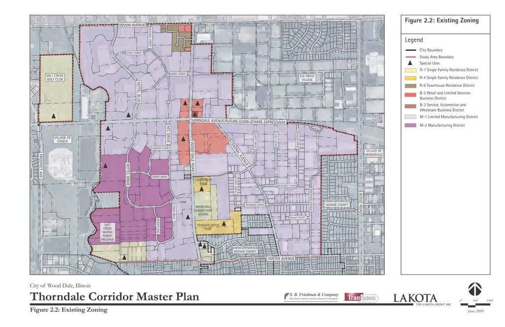
21 Section 2: Land Use + Physical Conditions Zoning The following City of Wood Dale zoning districts are located within the Study Area (also see Figure 2.2): R-1 Single Family Residence District B-2 Retail and Limited Services Business District B-3 Service, Automotive and Wholesale Business District M-1 Limited Manufacturing District M-2 General Manufacturing District Following is a general description of each zoning district and initial observations on the relevance to future redevelopment of the Study Area. The City is currently revising the zoning ordinance and will revise its requirements to follow the Thorndale Corridor Master Plan. R-1, R-4 + R-6 Residential Districts Several parcels within the Study Area are zoned for residential. However they are occupied exclusively by (non-residential uses considered as) special uses allowable under R-1 and R-4. These areas include the stormwater detention/floodplain adjacent to Salt Creek in the southwest corner of the Study Area, parcels occupied by the Fire Department and parcels occupied by the Junior High School and Franzen Grove Park. It is anticipated that these public uses will continue in use and no single-family residential development will occur within the Study Area. Residential areas within or adjacent to the Study Area are located in unincorporated DuPage County. R-1/R-4 SPECIAL USES Cemeteries, including crematories and mausoleums Colleges and universities, including dormitories, fraternities, sororities and other accessory buildings Golf course, regulation size or "par 3", but not including commercially operated driving ranges or miniature golf courses Parks, forest preserves and recreational areas, when owned and operated by any government and private recreational areas when not operated for profit Public service uses, including water pumping stations and reservoirs, sewage treatment plants, sanitary landfills, police and fire stations, telephone exchanges, electric substations, and other similar public service uses 2.5
22 Section 2: Land Use + Physical Conditions Radio and/or television towers and/or other transmitting and receiving equipment, including personal wireless telecommunications facilities Railroad rights of way and trackage Public or private swimming clubs R-1/R-4 ANALYSIS If it is the City s preference to control these uses through R-1 special use, there is no reason to modify these designations within the Study Area. However R-1 and R-4 residential uses are not envisioned for the area. R-6 ANALYSIS An R-6 townhouse Residence District is located near the southwest corner of Devon Avenue and Wood Dale Road for the townhome development. The R-6 designation may be used as part of a future transit-oriented development, or such use can be incorporated into a mixed-use zoning approach for the overall area. B-2 Retail + Limited Services Business District Several lots at the intersection of Thorndale Avenue and Wood Dale Road are zoned B-2. Permitted uses must be contained entirely within a building, except off-street parking, loading areas, and drive-through service facilities. Minimum Lot Size: 6,000 square feet (50 foot minimum width) Maximum Height: 30 feet or 3 stories Antennas: 60 feet above grade and/or 70 feet maximum antenna height above grade Building Setbacks: Front: 25 feet. Side and rear transitional yards may be required depending on adjacency to a residential district 2.6
23
24
25 Section 2: Land Use + Physical Conditions Floor Area Ratio (FAR): Includes accessory buildings or structures, concrete or paved walkways and/or driveways and/or other concrete, impermeable or paved areas FAR + Maximum Lot Coverage % % % % % or less B-2 ANALYSIS The B-2 district provides for a range of neighborhood retail and limited service uses. While this district may be a necessary designation for other commercial locations throughout the community, B-2 may not facilitate the future development that is anticipated for the Thorndale Corridor due to its restrictive nature. There is no office or hotel zoning currently in the area, and the intensity of future commercial uses will be much greater than what is currently accommodated by B-2. The height limitations of 30 feet or three stories would greatly restrict potential office and hotel users. Additionally, the FAR is similarly restrictive. Including accessory structures and paved areas in the FAR calculation limits development and makes parking structures a challenge for this zone. Additionally, FAR and maximum lot coverage is set up in a way that encourages one- to two-story buildings. To accomplish a more dense, mixed-use transit oriented development along Thorndale Avenue, a more intense business district needs to be established. This district should include increased building height with appropriate FAR. Open space and stormwater management should be independent of individual lots as accommodated in the Master Plan. 2.9
26 Section 2: Land Use + Physical Conditions B-3 Service/Automotive/Wholesale Business District The lot on the northeast corner of Thorndale Avenue and Wood Dale Road is the only B-3 District in the Study Area. Minimum Lot Size: 6,000 square feet (50 foot minimum width) Maximum Height: 30 feet or 3 stories Setback: Front: 25 feet.side and rear transitional yards may be required depending on adjacency to a residential district Floor Area Ratio (FAR): Includes accessory buildings or structures, concrete or paved walkways and/or driveways and/or other concrete, impermeable or paved areas FAR Maximum Lot Coverage % % % % % or less B-3 ANALYSIS Similar to the analysis of the B-2 District, the B-3 District will not accommodate the anticipated goals of the Master Plan. The maximum building height and FAR are the same as the B-2 District, and therefore would not provide for the recommended hotel and office uses. The B-3 district does provide additional permitted uses beyond the B-2 district, many of which may be desirable, including indoor amusement establishments. The B-3 district may be a starting point for a new zoning designation that allows increased height and FAR. 2.10
27 Section 2: Land Use + Physical Conditions M-1 Limited Manufacturing District M-1 zoning is the most common zoning designation throughout the Study Area. The business/industrial areas north of Thorndale Avenue and southeast of the intersection of Thorndale Avenue and Wood Dale Road are entirely comprised of M-1 zoned lots. Southeast of the Thorndale Avenue and Wood Dale Road intersection, M-1 zoned lots front both roadways and extend several lots south of Thorndale Road. Minimum Lot Size: 6,000 square feet (50 foot minimum width) Maximum Height: 30 feet for buildings; 20 feet for goods stored in the open. Setback: Front: 25 feet. Side: not less than 10% of the lot width but can not exceed 20 feet. Rear: not less than 20 feet in; except, inner 10 feet may be used for off-street parking. Maximum Lot Coverage: Not more than 70% of the lot area (including accessory buildings or structures, concrete or paved walkways and/or driveways and/or other concrete, impermeable or paved areas) Maximum Floor Area Ratio (FAR): 0.7 M-1 ANALYSIS The M-1 district remains a critical component of this Study Area. It provides the necessary structure for the existing business parks and new business park recommended in the Master Plan. It does not incorporate the mixed-use development recommended along Thorndale Avenue. 2.11
28 Section 2: Land Use + Physical Conditions M-2 General Manufacturing District The M-2 zoned parcels within the Study Area are limited to the industrial area southwest of the Thorndale Avenue and Wood Dale Road intersection. They are buffered from the major roadways by M-1 zoned lots. Minimum Lot Size: 2 acres (200 feet minimum width) Maximum Height: 30 feet for buildings; 20 feet for goods stored in the open Setback: Front: 40 feet. Side: not less than 10% of the lot width but need not exceed 20 feet. Rear: not less than 20 feet; except, inner 10 feet may be used for off-street parking. Maximum Lot Coverage: Not more than 80% of the lot area (including accessory buildings or structures, concrete or paved walkways and/or driveways and/or other concrete, impermeable or paved areas) Maximum Floor Area Ratio (FAR): 0.8 M-2 ANALYSIS The City should consider removing the M-2 designation from the Study Area. While the M-2 zoning provides a slight increase in FAR and coverage over the M-1 designation, it also has several permitted adult uses that are undesirable if the City s goal is to create a first class office environment. Overall, the City should consider creating a special zoning category or designation to accommodate a dense, mixed-use transit-oriented development along Thorndale Avenue. 2.12
.")
29 Section 2: Land Use + Physical Conditions Physical Conditions The physical appearance of the Thorndale Avenue Corridor is important in maintaining property values, attracting new businesses, and providing a high quality of life. Overall, the Corridor is in fair to good condition. The following is a description of the area s physical conditions (also see Figure 2.3). Northeast Quadrant (Northeast of Thorndale Avenue/ Wood Dale Road): The buildings in this quadrant are mostly in fair condition. The majority are between 10 and 30 years in age, and most of them are above 80,000 square feet in size. Southeast Quadrant (Southeast of Thorndale Avenue/Wood Dale Road): This quadrant contains the oldest development in the Study Area, with approximately 25% of the buildings over 30 years old and 75% are older than 20 years. These buildings, which are generally in fair condition, are also smaller with typical sizes around 15,000 square feet. Many of these older, smaller buildings have loading docks that face the street, creating unattractive conditions and truck crossing movements on the streets. Southwest Quadrant (Southwest of Thorndale Avenue/ Wood Dale Road): Most of the buildings in this quadrant are in fair to good condition with a few in poor condition at the south end along Pond Drive. None of the buildings are older than 30 years, with 79% of them in the 20 to 30 year range. Most buildings are around 50,000 square feet in size and few have loading docks that access directly onto adjacent streets. Northwest Quadrant (Northwest of Thorndale Avenue/ Wood Dale Road): This quadrant contains the newest buildings, with 50% being less than 20 years old. All of the buildings are in good condition. The buildings in this quadrant are larger, with the average size around 90,000 square feet. Additionally, only a few buildings have loading directly onto the adjacent street, and those are located at the cul-de-sac extension of Michael Street, which operates more as a service road. City/Corridor Identity: There is little indication for motorists on Thorndale Avenue that they are passing through Wood Dale. Additionally, there is little to no identity on Devon Avenue to direct drivers south on Wood Dale Road towards the Corridor or Downtown. The City lacks a cohesive image or identity along the major arterial roads. 2.13

30 Section 2: Land Use + Physical Conditions Business Park Identity: Of the three existing business parks in the Study Area, the Chancellory projects the strongest cohesive image. With gateway signage and planted medians at the major entrances off of Thorndale Avenue, Devon Avenue, and Wood Dale Road, the Chancellory establishes a district character. Forest Creek, in the southwest quadrant of the Study Area also has a strong character at its major entrances on Thorndale Avenue and Wood Dale Road with planted medians, but lacks the identity signage that Chancellory has. Klefstad lacks identity and character. No identity signage exists, and its street system includes five access points on Thorndale Avenue and one on Wood Dale Road. All six of these access points appear dated with minimal landscaping or signage to distinguish the Park from other access points on the Corridor. Aesthetics: The general physical character of the Study Area is good, with grass parkways, naturalized detention ponds, parking lot screening, and entry landscaping. Similar to building age and conditions, the aesthetics vary with each quadrant. The northwest and southwest quadrants have significant landscape throughout, including evergreens that provide screening of parking lots and loading. The roadways are generally wide throughout the Study Area, but the larger landscaped setbacks within these two quadrants create appropriate green edges to the buildings. Most developments provide on-site parking, which reduces the need for on-street parking. The southeast quadrant lacks entry or specialized landscape, beyond typical street trees. Additionally the wide roads in this quadrant do not have appropriate building setbacks and parkway landscaping. This quadrant does not provide much off-street parking, which leads to on-street parking, which also visually impacts the area. Signage: The Study Area lacks directional signage for visitors. Additionally, some of the street signs are small, outdated, and do not meet the federal Manual for Uniform Traffic Control Devices (MUTCD). 2.14

31
32

33 Section 2: Land Use + Physical Conditions Height Restrictions: FAA building height restrictions for areas surrounding O Hare Airport indicate that buildings up to 14 stories can be developed just west of Illinois Route 83 and buildings up to 25 stories at Wood Dale Road. Also see Figure Wood Dale Road IL Route 83 York Road (12,700 ) (7,100 ) (1,800 ) Stories Stories 2 3 Stories Figure 2.4: Height Restrictions along the Elgin O Hare Expressway Corridror 2.17
34 Land Ownership Thorndale Corridor Master Plan Section 2: Land Use + Physical Conditions The study area has approximately 190 property owners. Figure 2.5, shows the distribution of large property owners (owning 15 acres or more) within the study area. The largest landowner within the study area is AMB Property Corporation, an international industrial Real Estate Investment Trust (REIT) that develops, acquires, owns and operates industrial facilities in key distribution markets globally. AMB owns and operates over 100 acres of property within the study area. The largest property owned by AMB is the 18.6 acre Osco distribution facility along Wood Dale Road. Other large private property owners include Household Finance Corp. a subsidiary of HSBC, Morgan Stanley, and Trammell Crow Company. IDOT owns over 50 acres of land along Thorndale Avenue but this land area is reserved for the future right-of-way of the Elgin O Hare Expressway. The City owns a 23-acre school property and some park land on Wood Dale Road. The majority (over 90%) of all property owners within the study area own land that is 10 acres or fewer. The large number of private property owners presents a challenge for large scale redevelopment within the study area due to the difficulty in assembling sites of sufficient size. 2.18
35
36
37 SECTION 3 - TRANSPORTATION
38
39 Section 3: Transportation Overview One of the key strengths of the Thorndale Avenue Corridor and City of Wood Dale is the area s transportation system, which primarily consists of a widely spaced grid of arterial roads and collector streets. The condition and capacity of the existing system, as well as the potential of the extensive transportation improvements planned for the area are key to determining the Corridor s development and redevelopment opportunities. The transportation network is multi-modal in nature and includes: Roadway Network Expressways Arterial Roads Local Roads/Streets Transit Network Bus Rail Freight Network Air Rail Truck Pedestrian/Bicycle Network 3.1
40 Roadway Network Thorndale Corridor Master Plan Section 3: Transportation A roadway network is a system of roadways designed to provide mobility and access within and throughout a region. From a mobility perspective, uninterrupted traffic flow at a high continuous speed is most desirable. This contrasts with local access which warrants low speed conditions with frequent traffic interruption. Specific to the Thorndale Avenue Study Area and adjacent areas, is a high volume of truck traffic that further complicates this relationship between mobility and access. In transportation planning, the key is to have a system of different roadways which are designed to serve distinct functions. Roadways are classified by the function that they perform. Figure 3.1 identifies the classification of the roadways within the Study Area. Expressways/freeways are intended to accommodate large volumes of traffic at high speeds with controlled access through system interchanges. They do not provide direct access to abutting land uses. Principal arterials are major roads that move large volumes of traffic and provide direct access to expressways. Minor arterials are similar to principal arterials, but focus on land access rather than traffic service. Arterial roads typically accommodate higher travel speeds and longer distances. Collector roads provide some mobility and access to adjacent land uses and tend to have lower volumes and speeds. Local roads and streets provide the final access point and generally provide little to no mobility. Local streets are characterized by very low speeds/volumes and short distances. Expressways/Freeways While there are no expressways or freeways within the Study Area, the Corridor is near I-290 (2.5 miles to the west) and I-294 (3.5 miles to the south and 6 miles to the east). The closest interchange is approximately 2.5 miles to the west at the Thorndale Avenue interchange with I-290/ Illinois Route 53 and Elgin-O Hare Expressway. 3.2
41
42

 of 30,000 vehicles at Illinois Route 83 to")


43 Section 3: Transportation Arterial Roads Thorndale Avenue is a principal arterial under the jurisdiction of DuPage County. Its cross section provides two through lanes in each direction with a divided flush median that allows for protected left turn lanes throughout its 2-mile length. The speed limit on Thorndale Avenue is 45 miles per hour and has an average daily traffic (ADT) of 30,000 vehicles at Illinois Route 83 to 43,000 vehicles at Prospect Avenue according to 2008 DuPage County data. Traffic signals exist along Thorndale Avenue at Mittel Drive, Wood Dale Road, North Lively Boulevard, and Illinois Route 83. Thorndale Avenue Wood Dale Road is a minor arterial under the jurisdiction of DuPage County. The cross section provides for two through lanes in each direction with a flush median that provides for protected left turn lanes at driveways, side streets, and full intersections. The speed limit on Wood Dale Road is 40 miles per hour with an ADT of 12,000 to 17,000 vehicles according to 2008 DuPage County data. Traffic signals exist along Wood Dale Road at Mittel Drive, Thorndale Avenue, and Devon Avenue. Wood Dale Road 3.5
44 Section 3: Transportation Collector Roads Within the Study Area, the following roadways can be characterized as collectors since they collect traffic from local roads and provide connections to the arterial roads: NORTHWEST QUADRANT Mittel Boulevard Mark Street SOUTHWEST QUADRANT Mittel Drive SOUTHEAST QUADRANT Foster Avenue Central Avenue Sivert Drive Edgewood Avenue Mittel Boulevard NORTHWEST QUADRANT Mittel Boulevard has curb/gutter with a landscaped median while providing one 25-foot through lane in each direction with protected left turn lanes. Mittel Boulevard connects Devon and Thorndale Avenues. The speed limit is 30 mph and roadway lighting exists on one side of the roadway. The roadway also has a one-way striped and signed bike lane on each side to accommodate bicyclists. The route is classified as a Class II truck route and on-street parking is not permitted. The intersection of Mittel Boulevard and Devon Avenue is signalized. Mark Street has curb/gutter, roadway lighting, and a typical width of 37 feet. It connects Wood Dale Road to Mittel Boulevard. The speed limit is 30 mph. The route is classified as a Class II truck route and on-street parking is not permitted. Mark Street Mittel Drive SOUTHWEST QUADRANT Mittel Drive has the same roadway characteristics south of Thorndale Avenue. The speed limit is 30 mph and lighting exists on one side of the roadway. As mentioned previously, the Mittel Drive and Thorndale Avenue intersection is signalized. SOUTHEAST QUADRANT Foster Avenue has curb/gutter and provides one through lane in each direction with a flush median and a left turn lane. Foster Avenue connects Wood Dale Road and Illinois Route 83 (Busse Road). The speed limit is 30 mph and roadway lighting exists on one side of the roadway. Trucks are prohibited and on-street parking is not permitted. A four-way stop sign exists at the intersection of Foster and Central Avenues. As noted earlier it serves the residential blocks south of the Study Area. Foster Avenue 3.6
45 Section 3: Transportation Central Avenue is a 34-foot roadway with curb/gutter that provides one through lane in each direction with a flush median with left turn lane. It connects Foster and Thorndale Avenues. The speed limit is 30 mph and lighting exists on one side of the roadway. The route is classified as a Class II truck route and on-street parking is not permitted. Sivert Drive is a 34-foot wide with curb/gutter that provides one through lane in each direction with a flush median with left turn lane. It connects Wood Dale Road and Thorndale Avenue. The speed limit is 20 mph and lighting exists on one side of the roadway. The route is classified as a Class II truck route and on-street parking is not permitted. Edgewood Avenue is a 34-foot wide roadway with curb/gutter. It connects Foster Avenue and Wood Dale Road. The speed limit is 20 mph and lighting exists on one side of the roadway. The route is classified as a Class II truck route and on-street parking is not permitted. Central Avenue Sivert Drive Local Roads/Streets Within the Study Area, the following roadways can be characterized as local roads since they connect properties to collectors and arterials: NW QUADRANT Lewis Drive Michael Drive SW QUADRANT Bauman Court Gerry Drive Hansen Court AEC Drive Wheat Lane Pond Avenue Clayton Court SE QUADRANT Lively Boulevard Dillon Drive Richert Road Crell Drive Beinoris Drive Balm Court Haynes Drive Edgewood Avenue AEC Drive These roadways are typically 34-feet wide with curb/gutter. Speed limits for most of these roadways are low (20 mph) and lighting exists along one side of the roadway. Over the last two years the City has improved most of the local roads in the business/industrial parks. The improvements have included resurfacing and reconstruction, pavement patching, and curb/gutter removal and replacement. Dillon Drive 3.7
46 Section 3: Transportation Examples of difficult truck maneuvering Roadway Analysis The southeast quadrant of the Corridor is more constrained regarding access due to the high number of smaller properties within a dense area. As a result, more local roadways are needed in this quadrant to achieve access to properties, which in turn compromises the mobility needs of the area. When semi-trucks are making deliveries, traffic is blocked as trucks maneuver in/out of loading areas of individual properties. Additionally, these local roads create more access points onto Thorndale, which is not ideal for the planned expressway extension. In the northeast quadrant, access to the properties is currently only provided via Wood Dale Road. Since Wood Dale Road is classified as an arterial, this is not the most ideal situation. A way to improve access to this quadrant and also provide a connection to other properties outside of the Study Area would be to extend Mark Street to Wood Dale Road. The intersection of Thorndale Avenue and Wood Dale Road was noted by area business and property owners as difficult to navigate, with problematic left turns and rush hour conditions that take several signal cycles to clear the intersection. The expressway extension should act as a long term solution to these issues. Additionally, because the Study Area is divided into quadrants by major arterials, truck traffic traveling from one quadrant to another is difficult, especially because the east/west roads do not line up from quadrant to quadrant. Creating new aligned and signalized intersections will improve this condition as recommended in the Master Plan. 3.8

47 Section 3: Transportation Transit Network A full network of transit services does not exist in the study area. Transit service in and around the study area is geared primarily toward reverse commute access to jobs at the expansive business and industrial parks located in the communities west of O Hare Airport. Bus Service Three Pace bus routes provide connections to the study area from the ends of the O Hare and Forest Park branches of the Chicago Transit Authority (CTA) Blue Line to the east. Wood Dale Metra Station Route 637 Wood Dale-Rosemont CTA is a distributor that serves the west half of the Study Area including the Chancellory Business Park and Forest Creek Business Park with weekday peak period reverse commute service from the Blue Line Rosemont station just east of O Hare Airport. Route 757-Northwest Connection is also a distributor that skirts the east edge of the Study Area on Illinois Route 83. This route provides weekday peak period reverse commute service from the Blue Line Forest Park terminal past the Study Area and continuing to Woodfield Mall and Pace s Northwest Transportation Center in Schaumburg. Route 223 Elk Grove-Rosemont CTA serves the heart of the Elk Grove industrial park via Illinois Route 83, ending several blocks north of Thorndale Avenue and the Study Area. On weekdays, this route provides intensive all day service at 10 to 30 minute frequency in both the eastbound and westbound direction. Weekend service is also offered but with shorter span of service and less frequency. Rail Service The Metra Milwaukee District West line provides commuter rail service to Wood Dale with a station located approximately 1.5 miles south of Thorndale Avenue, at Illinois Route 19/Irving Park Road and Wood Dale Road. The Milwaukee District West line functions primarily to transport suburban workers to and from job locations in Downtown Chicago, Monday through Friday. Train schedules are designed to optimize travel time between the suburbs and Downtown Chicago in the morning and in the reverse direction in the evening. Week day schedules have a combination of express and local trains. Travel between intermediate stations along this line, including Wood Dale, is possible in both the eastbound and westbound direction during morning and evening peak periods as well as off-peak periods and on weekends. Currently, there is no transit connection between the Wood Dale Metra station and the Study Area to complete the trip. 3.9
48 Freight Network Thorndale Corridor Master Plan Section 3: Transportation As noted earlier, land use within the Study Area is predominantly comprised of companies located in business park settings. Most businesses have warehouse, distribution or light assembly operations oriented towards freight and cargo. From an air perspective, freight is accommodated at O Hare Airport at its South Cargo facility. The Airport s air cargo is located along Illinois Route 19/Irving Park Road, approximately 4 miles from the Study Area. Freight hauling by rail is accommodated outside the Study Area through several Class I railroads, including the Canadian Pacific, Canadian National, and Union Pacific Railroads. Spur rail lines are located within adjacent industrial parks in Elk Grove and Bensenville. The closest intermodal facility is the Bensenville Yard. All of the freight movement within the Study Area is accomplished by truck. The local roadways within the Study Area are all classified as Class II Truck Routes. O Hare Airport O Hare Airport is one of the largest and busiest airports in the world. Located less than 1.5 miles to the east of Wood Dale, it is an economic engine for the Chicago region and DuPage County. Numerous businesses within and near the Thorndale Avenue Corridor depend on the Airport s South Cargo area for their daily business operations. Opening access to the Airport from the west will provide more efficient and balanced access to the facility, and significantly change the business environment for the communities located between York Road and I- 290/Illinois Route 53. Adding new transit service to the Airport along area roads will further enhance the area s access and mobility. Improvements planned for York Road, Irving Park Road, and Thorndale Avenue, as well as local freight rail lines will also facilitate movement to the Airport, its cargo area, and local businesses. 3.10
49 Section 3: Transportation Transportation Improvements As mentioned previously, Chicago s O Hare Modernization Program (OMP) has helped drive the planning of the Elgin O Hare West Bypass Project. While IDOT is currently evaluating system alternatives for the I-294 Bypass around the west side of the Airport, one alignment is being considered for the Elgin-O Hare Expressway extension along the Thorndale Corridor. The first phase of IDOT s study, known as Tier One, is scheduled to be completed by It will result in a preferred transportation system alternative that will include concepts for all transportation modes: roadway, bus, rail, bike, and pedestrian facilities. The second phase known as Tier Two will begin in 2010 and involve detailed engineering, environmental studies, and continued public involvement for specific projects. Some of the individual projects within the new roadways could be ready for construction as early as 2013 depending on funding. During the DuPage County O Hare Airport Impact Study, local communities expressed a preference for a depressed or at-grade roadway for the Elgin-O Hare Expressway extension with cross-roads going over the facility. There was a concern that an elevated facility would create a physical and visual barrier. The new expressway will need to be elevated at I-290 to accommodate fly-over ramps that will improve capacity and safety at this major interchange. In between I-290 and Illinois Route 83 there are additional constraints that would make the depressed expressway option challenging. Salt Creek and its floodway/floodplain will need to be crossed and an elevated facility provides the least impact. Due to the proximity between Mittel Boulevard and Salt Creek, the expressway will need to be elevated at the Mittel crossing as well. Therefore, the Elgin O Hare extension along the Corridor through Wood Dale is currently envisioned in the Tier One studyas an elevated expressway with three to four lanes in each direction. (also see Figure 3.2) A frontage road system along the expresswaywill provide access to local connector streets. The Elgin O Hare would be earthed bermed to create the necessary grade separation for the cross roadways. Within Wood Dale, the conceptual alignment of the extension includes two-lane, one-way frontage roads that provide local access to north/ south arterials and local roads. The frontage roads, along with on/off ramps would provide for access points at Prospect Avenue, Wood Dale Road, and Illinois Route 83/ Busse Road. These three roads would act as grade-separated crossings under the expressway, with additional underpasses at Mittel Drive/ Boulevard and Lively Boulevard. 3.11

50 Section 3: Transportation DEVON AVENUE ILLINOIS ROUTE 83 PROSPECT AVENUE WOOD DALE ROAD ELGIN O HARE EXPRESSWAY Figure 3.2: Preliminary IDOT Alignment for Elgin O Hare Expressway The initial review of the conceptual expressway alignment indicated that the proposed frontage road located on the north side of the expressway between Prospect Avenue and Mittel Boulevard would encroach significantly on the Salt Creek Golf Club and Top Golf, a sports entertainment complex. IDOT is reviewing the frontage road alignments in this location. In addition to the expressway, frontage roads, and ramps, the existing 500 to 600 foot right-of-way will also accommodate a dedicated transit line in its median and bike trails. IDOT is also considering several alternate alignments that would provide a full or partial expressway bypass on the west side of the Airport. These bypass options contemplate connecting the Elgin O Hare expressway to I-294 and possibly I-90. IDOT has selected two final roadway options, Alternatives 203 and 402 to carry forward into the next design phase (also see Figure 3.3). 3.12
, I-290 (Full), Park Boulevard West (Partial), Prospect")
51 Section 3: Transportation Figure 3.3: Elgin O Hare Expressway & I-294 Bypass Options Interchanges for the Elgin O Hare would include Rohlwing Road/Illinois Route 53 (Partial), I-290 (Full), Park Boulevard West (Partial), Prospect Avenue (Full), Wood Dale Road (Full), Illinois Route 83 (Full), and York Road/Elmhurst Road, West Bypass (Full). For other cross roads within the Study Area, access will be modified as described below: Mittel Road: North-South access maintained under Elgin O Hare AEC Drive: Proposed cul-de-sac eliminating access N Central Drive: Maintained with eastbound frontage road Sivert Drive: Maintained with eastbound frontage road Lively Boulevard: Realigned providing continuous North-South access under the expressway Dillon Drive: Maintained with eastbound frontage road Edgewood Avenue: Maintained with eastbound frontage road 3.13
52 Section 3: Transportation Potential Transit While the Study Area is currently not served by transit, a number of major capital transit projects as well as transit network enhancements are being considered to improve mobility in and around the Thorndale Corridor. Also see Figure 3.4. Two transit systems for the Corridor that have been previously studied are described below: Metra s Suburban Transit Access Route (STAR Line) is a long term commuter rail network for the suburbs that would also affect travel in the Study Area. The STAR Line is a long circumferential commuter rail line at the periphery of the Chicago metropolitan area, with a smaller radial network focused on O Hare Airport. The primary function of the STAR Line is to serve intersuburban and reverse commute travel markets. The initial component extends from O Hare Airport along I-90 to Hoffman Estates, and then south to Joliet via the Elgin Joliet & Eastern railroad. Metra has identified this 55-mile Joliet-O Hare segment as the first priority and is currently undertaking a federal alternatives analysis in pursuit of New Starts funding from the Federal Transit Administration. Although the I-90 segment of the STAR Line is 3 to 4 miles north of Thorndale Avenue, this section of the STAR Line is likely to affect Study Area travel because of its proximity and its potential connection to the proposed O Hare west terminal. The Illinois Route 53/Elgin-O Hare Corridor has been identified as a potential future phase extension of the STAR Line that would significantly affect travel in the Study Area. DuPage J Bus Rapid Transit (BRT) is a bus based system that would run in a dedicated lane/high speed corridor. This high performance intersuburban transit service is envisioned as an important connection between the major regional travel generators and destinations of O Hare Airport, and Woodfield area of Schaumburg with DuPage County s largest concentrations of employment and retail activity (Oak Brook area) and the most populous parts of the county (Naperville/Aurora). As originally conceived in the DuPage Area Transit Plan (DuPage Mayors and Managers Conference, 2002), the DuPage J Line would operate with other local transit services as a comprehensive transit system for DuPage County. A portion of the J Line would follow Thorndale Avenue through the heart of the Study Area from I-290/Illinois Route 53 to Illinois Route 83. This segment is envisioned as possibly running on exclusive median lanes within the Elgin-O Hare Expressway Extension. Local circulators would complete the network within the Thorndale Corridor Study Area, providing service to areas not within walking distance of the high speed J Line. 3.14

53 Section 3: Transportation Currently, IDOT s Elgin-O Hare West Bypass Tier One Study is developing and evaluating a proposed future transit network in conjunction with the new highways, to help address mobility issues in a large area west of O Hare Airport, including Wood Dale. The DuPage J Line is a key element of this large network that also includes express bus, Arterial Rapid Transit, local bus, local circulators and employer shuttles as well as several park and ride facilities and intermodal transfer centers. Only the J Route and local bus service directly serve the Study Area. The DuPage J Line is envisioned as either Bus Rapid Transit or rail on dedicated right-of-way in the Elgin-O Hare Expressway and I-290/Illinois Route 53 corridors. Stations/key transfer points would be located within the Study Area at Arlington Heights Road, Lively Boulevard and Illinois Route 83. Figure 3.4: Potential Future Regional Transit Improvements 3.15
54 Section 3: Transportation 3.16
55 SECTION 4 - INFRASTRUCTURE
56

57 Section 4: Infrastructure Public Utilities Water Supply System Water is supplied to the City through an agreement with the DuPage Water Commission, which brings Lake Michigan water to the County. Distribution of water is through water mains owned and maintained by the City. All three business parks located within the Study Area were built as recently as the 1980 s, therefore ductile iron water main rather than cast iron is in place, limiting the number of water main breaks. The City reports that very few water main repairs have been made in this area. A review of the City s water main atlas shows water supply provided by the DuPage Water Commission Station 23-A in the Klefstad Business Park near Richert Road and Lively Boulevard. The water supply system in all three business parks is pressurized by Elevated Tower #2 near Allan Drive and Mark Street and pumping stations at 320 Richert and Wood Dale Roads and Mittel Boulevard. The Study Area appears to have good fire protection coverage with the exception of the unincorporated DuPage County areas in the southwest corner of the southeast quadrant, between Wood Dale Road and Central Avenue and between Hawthorne Avenue and Foster Avenue. Water main sizes range from 8 to 14 inches in diameter in the Chancellory Business Park, 8 to 12 inches in the Forest Creek Business Park, and 8 to 16 inches in the Klefstad Business Park. The City reports no deficient pressure zones within the system and adequate capacity throughout for current conditions. The water main supply and distribution system could be expected to continue to operate efficiently for existing land uses and marginal expansion if area redevelopment remains primarily industrial. If the proposed land use within the Study Area introduces a significant increased demand on the water supply, the system would need to be modeled, analyzed, and evaluated regarding the system s capacity to meet the demand. Water Commission Station 4.1
58 Section 4: Infrastructure Sanitary Sewer System With all three business parks built as recently as the 1980 s, PVC sanitary sewer rather than vitrified clay pipe is in place throughout the Study Area, limiting the damage and clogging of sewer mains from tree roots. The City s sanitary sewer system is entirely separate from its storm sewer system with no cross connections between systems. All three business parks discharge to a sanitary sewer treatment facility on the west side of Salt Creek north of Irving Park Road, outside of the Study Area. The City reports few sewer back-ups. A review of the City s sanitary sewer atlas shows the system generally discharging from north to south and from west to east. The sanitary sewers in all three parks discharge to a common location exiting the Study Area through an 18 inch sanitary sewer at School Street and Grove Avenue. The Chancellory Park discharges by gravity to a 15 inch sanitary sewer at Thorndale Avenue and Mittel Drive. The Klefstad Park discharges to a lift station on the west side of Lively Boulevard south of Thorndale Avenue, through a 10 inch force main west to Wood Dale Road and Sivert Drive, and by gravity south on Wood Dale Road. The Forest Creek Park discharges by gravity along Wood Dale Road to School Street and Grove Avenue. Businesses along Mittel Drive discharge to a lift station at the south end of Mittel, through a 6 inch force main, and by gravity south along Wheat Lane. The sanitary sewer system collects wastewater from all three business parks, not including the unincorporated DuPage County areas between Wood Dale Road and Central Avenue and between Hawthorne Avenue and Foster Avenue. The City reports that the sanitary lift station in Klefstad was replaced in November 2008 and the lift station in Forest Creek is currently being replaced. Sanitary sewer sizes range from 8 to 15 inch in diameter in Chancellory, 8 to 18 inch in Forest Creek, and 8 to 15 inch in Klefstad. The sanitary sewer system has adequate capacity for existing land uses. If new land uses within the Study Area introduce a significant increase in water demand, the load on the sanitary sewer system will similarly increase. It is likely that the 8 inch sanitary main can discharge a greater load than it does under existing conditions, but potential redevelopment should be evaluated by quantifying the increased Population Equivalent (PE) to check on the discharge capacity. The City owns and operates two sanitary treatment facilities within its municipal limits a north plant on Irving Park Road on the west side of Salt Creek and a south plant on Brookhurst Lane on the east side of Salt Creek. Information about the treatment facilities was provided by Public Works staff. 4.2
59 Section 4: Infrastructure North Sanitary Treatment Facility Maximum capacity is 3.93 million gallons per day (mgd) Average treatment volume permitted by the Illinois Environmental Protection Agency (ILEPA) is 1.97 mgd Current operating volume is approximately 1.8 mgd Operating volume has fluctuated between 1.7 and 1.8 mgd over the past several years South Sanitary Treatment Facility Maximum capacity is 2.33 mgd Average treatment volume permitted by Illinois EPA is 1.13 mgd Current operating volume is approximately 0.5 mgd The total permitted average treatment volume for the City is 3.10 mgd. The total current operating treatment volume is 2.3 mgd representing approximately 75% of the permitted volume. The two plants are interconnected, allowing sanitary discharge to be diverted to and treated at the south plant and relieving the north plant from reaching its permitted capacity. The ILEPA defines two thresholds for a sanitary treatment facility Critical Review and Restricted Status. They define each as follows: Critical review means that facilities have loadings exceeding 80 percent of the design capacity of the system and the Agency will very carefully review applications for additional loading. This includes permits for the construction of new sewers and for additional connections. Restricted status means the facilities have loadings at or above the design capacity of the system and the Agency may not issue permits for additional loadings. This includes permits for the construction of new sewers and for additional connections. The sanitary treatment system for the City of Wood Dale is currently on neither the critical review list nor the restricted status list, owed in part to the interconnection between the plants. The City realizes it is approaching critical review status and is addressing the current treatment facility status by contracting a consultant to perform a feasibility study of the system. The study will include considerations for expansion of one or both existing treatment facilities, construction of a new treatment facility, maintenance of the interconnection of the facilities, and other options to provide increased treatment capabilities. The proposed development within the Thorndale Corridor Study Area will be an important component of this feasibility study. 4.3
60 Section 4: Infrastructure Storm Sewer System The City s storm sewer system is a network of reinforced concrete storm sewer pipe discharging storm run-off to detention ponds throughout the Study Area or off-site. The more recently developed Chancellory and Forest Creek business parks discharge storm water to detention ponds out-letting to Salt Creek. The older Klefstad Park only appears to have detention facilities in the southwest part of the park and a small facility in its southeast corner. The City storm atlas indicates most of the Klefstad Park storm sewer system discharges to an open ditch at the northeast corner of the park before crossing under IL Route 83. The City reports very little flooding and adequate capacity in the storm sewer system, as well as the area s detention pond system. The storm sewer system collects storm run-off from all three business parks except for the unincorporated DuPage County areas. Storm sewer sizes range from 12 to 48 inches in diameter in Chancellory, 12 to 48 inches and an elliptical sewer 38x60 inches in Forest Creek, and 12 to 54 inches and an elliptical sewer 43x68 inches in Klefstad. The area s storm sewer system and detention ponds operate adequately for existing land uses. New development will be required to adhere to the DuPage County Stormwater and Flood Plain Ordinance. Since much of the Klefstad Park appears to have been constructed without detention facilities, redevelopment in this park will demand the construction of facilities to meet the detention requirements. Additionally, redevelopment will not be grandfathered in under the ordinance and will create the need for additional on-site detention. If detention can t be provided on-site, it needs to be provided off-site or payment must be made into a detention variance fee schedule. For Salt Creek, the detention fee schedule is $133,000 per acre-foot of storage not provided. Where possible, as part of any potential redevelopment of the Corridor, the City staff would prefer a detention facilities that are shared by several properties. 4.4

61 Section 4: Infrastructure Private Utilities Electrical System ComEd supplies the Study Area with electric power. Most electric lines are underground since the area has developed as a more modern business park environment, which typically has underground utilities. The Klefstad Business Park is approximately 30 years old and has overhead utilities. Discussions with businesses indicate there are some trouble spots within the Study Area, particularly AEC Drive, where upgrades are needed to support existing uses and reduce outages. ComEd has been contacted to determine if there are any circulation or capacity problems or any planned capital improvements to the area s electric power system. Telecommunications System Private telecommunications utilities are generally installed below grade throughout the Study Area with the exception of Central Avenue in the Klefstad Business Park where power poles and overhead utilities are evident. XO Communications has a major switch site on the east side of Edgewood Avenue between Balm Court and Beinoris Drive investing millions of dollars in equipment and electronics. Also see Figure 4.1. Fiber optic along Edgewood Avenue would need to be relocated. It is also a backup data recovery center owned by Sunguard. Replacement and installation of a fiber optic network will demand careful planning and implementation as unplanned modifications to the system would be extremely disruptive and expensive. Figure 4.1: XO Communications Conduit and Cable Map Natural Gas System Nicor supplies the Study Area with natural gas through underground lines. Nicor has been contacted to determine if there are any circulation or capacity problems or any planned capital improvements. 4.5
62
63 SECTION 5 - REAL ESTATE MARKET
64
65 Section 5: Real Estate Market A real estate market analysis was conducted to quantify the development potential of the Study Area as a key location along the Elgin-O Hare Expressway, at the future western gateway to O Hare Airport. The analysis focuses on office, hotel and supportive retail uses, which are key components of airport gateway developments. The market study involved a review of the economic profile of the Study Area, the potential airport gateway opportunities created by the proposed transportation improvements, and case studies that highlight the characteristics of airport gateway development. A detailed study of the real estate demand and supply factors of office and hotel uses was also conducted along with a review of supportive retail opportunities. Finally, the analysis was synthesized to create a supportable development program and development parameters to guide the physical planning of the Study Area. Economic Profile The Study Area contains the largest concentration of jobs in the City of Wood Dale, accounting for 82% of its total employment base. Detailed employment data by the North American Industrial Classification System (NAICS) was obtained for the Study Area through InfoUSA, a nationally recognized provider of business data. This database identifies nearly 500 businesses and over 13,800 jobs located within the Study Area. Wholesale Trade, Manufacturing, and Transportation and Warehousing are the largest employment sectors within the Study Area. Currently, the area does not have direct expressway access and lacks a direct roadway linkage to O Hare. Thorndale Avenue dead-ends into York Road at the western boundary of the airport, requiring further travel on arterial roadways and I-190 to access the Airport on its east side. North-south access is provided by Wood Dale Road, which connects to Irving Park Road which subsequently provides access to the airport via I-190. Even though the current access point from the Study Area to the Airport, especially its south cargo area, is fairly indirect, its proximity to the airport has attracted airport-related businesses. Interviews with company representatives indicate that many of the businesses in the Area need access to and from O Hare for cargo distribution or for providing other services related to the aviation industry. For example, AAR World Headquarters, one of the largest employers in the Study Area, specializes in aviation support services including parts supply, repairs, maintenance, sales, and leasing of aircraft. 5.1
66 Section 5: Real Estate Market Other large employers include Videojet, a leading manufacturer of coding, printing and laser marking products, and Tempco Electric Heater Corporation, a manufacturer of thermal components. HSBC, a financial services firm that employs approximately 1,800 people in the Study Area for back office operations, is its largest employer. While the company had announced that it planned to relocate into a new office building in nearby Itasca as part of a regional consolidation, plans for the move have recently been put on hold due to the current recession. The Study Area includes over 9.6 million square feet of industrial/ warehouse facilities. Together with the industrial space in nearby Elk Grove and Bensenville, this zone is one of the world s largest concentrations of industrial/warehouse space. The industrial uses were first developed in the 1960s within Elk Grove and Bensenville, which are located immediately west of O Hare. Over time, as the demand for air cargo and cargo capacity in O Hare expanded, industrial expansion continued west to Wood Dale. Industrial space in Wood Dale, which developed mostly in the 1980s, is generally more modern and functional in terms of loading docks, bay widths, and ceiling heights. This is demonstrated by the relatively low vacancy level of 10% for the industrial space in the Study Area. However, portions of the Study Area southeast of the Wood Dale Road and Thorndale Avenue intersection have older, denser industrial building stock and comparatively less competitive space. This area is likely to experience greater redevelopment pressures as the proposed transportation improvements change the development potential of the Study Area. Proposed Transportation Improvements O Hare International Airport is currently accessed only from the east, requiring travelers from the western side of the region to traverse around the airport to access it. The present roadway network and orientation of O Hare has enabled the Village of Rosemont, which is located immediately to the east, to capture a large portion of the region s economic activity because of its direct access and connectivity to the airport. As noted earlier, O Hare is currently undergoing a $6.6 billion capital improvement and expansion project called the O Hare Modernization Program (OMP). Once completed the OMP will increase the capacity of the airport, substantially reduce delays in all weather conditions and allow O Hare to meet the region s aviation needs well into the future. A key component of the OMP is the development of a new Western Terminal with 50 gates. Roadway access for the Western Terminal will be provided via the proposed Elgin-O Hare Expressway and, therefore, it will function as the primary gateway into the airport from the west. 5.2
67 Section 5: Real Estate Market Additionally, options for a western bypass to connect the Elgin-O Hare Expressway to I-290 and I-294 are being considered. Public mass-transit options are also being considered along the Elgin-O Hare right-ofway to further enhance the connectivity of the corridor. Once these improvements are in place, the increased access and connectivity will fundamentally change the economic position of the area along the Elgin- O Hare corridor. The Study Area, which is located at the proposed future Wood Dale Road interchange with the Elgin-O Hare Expressway just two miles west of the airport, is strategically positioned to attract airportrelated gateway development. Airport Gateway Development Case study research was conducted to identify best practices and key challenges in airport gateway developments and to provide insight about a potential development program for the Thorndale Avenue Corridor Study Area. Economic drivers, land use, site planning, and development timing were researched to form an understanding of the characteristics of airport gateway development. The case studies are presented below and profiled in Figures 5.1 and 5.2. CASE STUDY 1: ROSEMONT, ILLINOIS Rosemont, located immediately to the east of O Hare Airport, is the center of commercial activity generated by O Hare. Rosemont measures approximately two square miles (2,560 acres) in area, and contains over 5.9 million square feet of office space, 1.9 million square feet of industrial and flex space, 18 hotels with over 6,500 rooms, a major convention center and multiple entertainment venues. Construction began on office and hotel space in the 1960s, but over 51% of the current supply of office and 25% of the current supply of hotel rooms were delivered in the 1980s. Contemporary office buildings and new hotels are still being constructed, including two new office buildings (2008 and 2010) and one new hotel (2010) proposed for development over the next few years. While there are restaurants distributed throughout the area within hotels, retail exists primarily in the form of two strip malls along Higgins Road. Residential land uses account for a quarter of the Village s land area. The development pattern of Rosemont was strongly influenced by three interstate expressways trisecting the Village. Construction occurred on an incremental basis around the interchanges of I-294, I-90 and I- 190, resulting in three separate, mixed-use nodes or centers that are anchored by major developments: 5.3


68 Section 5: Real Estate Market Node 1 O HARE INTERNATIONAL AIRPORT Node 2 Node 3 Figure 5.1: Rosemont, Illinois Node 1: This area is located closest to O Hare and is centered at the interchange of I-90 and Higgins Road. The Allstate Arena, located here, was originally constructed in 1979 and underwent major reconstruction in The facility has hosted concerts and sporting events including basketball, football and hockey. Development around the Allstate Arena includes six hotels, five restaurants, a health club and 1.4 million square feet of office space. The Metra-O Hare commuter rail transfer station is also located here allowing airline travelers to connect with Metra s North Central Service line via bus shuttle. Node 2: This area is located northeast of the interchange of I-90 and I-294 and serves as the eastern gateway into Rosemont. The Village Hall is located there and surrounding development includes three hotels, eight restaurants and 2.8 million square feet of office space with high visibility and frontage along I-90. Node 3: This area is located southeast of the interchange of I-90 and I-294. The Stephens Convention Center is located here. 5.4
69 Section 5: Real Estate Market Constructed in 1975, the Center has 840,000 square feet of flexible exhibition space. A skywalk system connects the convention center to surrounding hotels and parking. The Rosemont Theatre opened in 1995 with a seating capacity of 4,300. Development around the convention center and the theatre includes seven hotels, six restaurants and 1.1 million square feet of office space. A CTA station is also located near the interchange of I-90 and River Road. Rosemont developed largely due to its location at the eastern gateway to O Hare. While the expressway interchanges were instrumental in attracting strong commercial development, they have resulted in reduced interconnectivity within the community. The three nodes outlined above are neither adjacent nor well-connected by local or arterial roadways, pedestrian paths or public transit options. As a result, wayfinding is challenging for users who are not traveling on interstate highways. Over time, entertainment and convention activities have created a stronger identity for Rosemont than office space. However, contemporary office buildings are still being constructed, including one new building proposed for As more development occurs and activity at O Hare increases, Rosemont is likely to continue to be a hub of commercial and entertainment activity along the eastern side of O Hare. LESSONS LEARNED The analysis of airport-related development at Rosemont provides the following insights applicable to the Study Area: While the specific scale of development along an airport gateway is dependent on local market conditions and physical capacity, the development in Rosemont indicates that hotel, office, convention and entertainment-related venues are highly desirable adjacent to the airport along areas with expressway access and visibility. Rosemont developed incrementally without a cohesive guiding master plan, resulting in an environment that is not pedestrianfriendly and difficult to navigate. The Wood Dale Study Area has the opportunity to distinguish itself in the market place by creating a high-quality, master-planned environment that has strong pedestrian linkages and a coherent interconnected transportation network. Rosemont has developed over nearly 50 years and continues to add new development to reposition itself for the future. This indicates that the full realization of the development potential of the gateway opportunity as it pertains to the Study Area is a longterm proposition. In addition to improved market conditions, a master planned environment with assembled properties can be expected to facilitate the timing of developments. 5.5


70 Section 5: Real Estate Market CASE STUDY 2: CRYSTAL CITY, VIRGINIA Crystal City is located in a dense, urban setting immediately west of the Ronald Reagan Washington National Airport just outside of Washington, DC. It is also located approximately 1.5 miles south of the Pentagon and 4 miles west of the U.S. Capitol. It is connected to region via public transit routes and I-395. The site was formerly composed of industrial and storage space, economy-grade motels, and a landfill prior to its redevelopment in The name Crystal City originated from the first building, called Crystal House, which featured an elaborate crystal chandelier in the lobby. Subsequent buildings added the name Crystal as a prefix, leading the entire area to be named Crystal City. Crystal City was developed as a 1.5- mile corridor containing office, retail and hospitality space along Crystal Drive. It includes approximately 11 million square feet of office space and nine hotels. Crystal City has excellent transit connections via bus, the Washington Metro Blue and Yellow Lines, and Virginia Railway Express commuter train system. There is also an extensive network of underground shopping areas and connecting corridors beneath Crystal City. Much of the underground Figure 5.2: Crystal City, Virginia 5.6
71 Section 5: Real Estate Market network was envisioned during the mid-1970s as a turn-of-the-century village containing leaded glass windows and cobblestone walkways. At that time, retail mostly included antique shops anchored by a grocery store, deli and drugstore. The original planning was considered avantgarde during the 1960s and 1970s because it formed a dense, urban superblock and offered grade-separated modes of transportation. But in the 1990s its landscape of concrete, monolithic buildings and extensive tunnel system started being perceived as outdated compared with newer, sleeker office buildings in the Washington, D.C. metro area. The office space in Crystal City had long been dominated by government agencies and their contractors because of its proximity to the Pentagon. Driven by the government-related office space demand, historical occupancies here exceeded 95%. However, in 2003, the U.S. Patent and Trade Office, one of Crystal City s largest tenants, relocated to Alexandria, vacating nearly 2 million square feet of office space. At that time, Charles E. Smith, which owns 7.5 million square feet of the 11 million square feet of office space, sought to reposition Crystal City and change its image. The company spent $40 million to convert Crystal Drive, the central connecting access street of the area, into a two-way street and added retail and restaurants at street level to generate more street life. Another major setback for the Crystal City office market occurred in November 2005 when Congress approved the Base Realignment and Closure (BRAC) Commission s recommendations to close and/or realign Department of Defense agencies and installations throughout the country. The BRAC law will result in the loss of 13,000 defense-related jobs and approximately 3.2 million square feet of associated office space will be vacated from Crystal City by September These events created the need for a plan to redevelop the area. The Arlington County Board initiated a master plan for the area, which has recently been approved, to guide the redevelopment of Crystal City over the next four decades. Key elements of the plan include: Providing a mix of uses and balancing office and residential development to create both daytime and evening populations. This involves adding significant new residential development, new Class A office space, street-level retail and shopping and cultural amenities. Creating a high-quality public realm by providing well-defined public open spaces, and vibrant, pedestrian-oriented streetscapes. This will also increase connectivity and create synergy between uses. Enhancing connectivity to, from, and within Crystal City by providing improved transit service and abundant bicycle and 5.7
72 Section 5: Real Estate Market pedestrian connections, as well as developing a hierarchy of streets. Using urban design elements and architectural features such as landscaping, building massing, and elevation elements to create a human scale and define the public realm of Crystal City. LESSONS LEARNED While the planned scale and density of development at Crystal City is significantly higher than what is likely to be appropriate within Wood Dale s Thorndale Avenue Corridor Study Area, the history of Crystal City and its plan for future development provides the following applicable insights: Creating a mix of residential, hotel, office and retail uses that creates both day-time and evening activity within the Wood Dale Study Area is critical to creating a vibrant, synergistic environment where all uses can thrive. The presence of residential and hotel uses along with office and industrial uses allow people to live and work within close proximity. The residential base helps in supporting restaurants and retail that require evening patronage, which in turn is a key amenity for office workers during the day. Creating a high-quality public realm that has an active street life and well-defined public open spaces including plazas and parks can create an employment center with a strong sense of place a key attribute that can help the Study Area distinguish itself in the region and endure as a successful place over time. While excellent vehicular access and circulation is necessary, leveraging transit opportunities and careful design for pedestrian movement will enhance the connectivity of the Study Area and its desirability as a place for businesses. New development in the Wood Dale Study Area should be well-integrated with strong pedestrian connections and planned future transit stations along the planned Elgin-O Hare Expressway extension. 5.8
73 Section 5: Real Estate Market Office Market To understand the growth dynamics of the regional office market, the historical vacancy and absorption trends of the Chicago Metro and DuPage County office markets were reviewed. More detailed analyses of future office-related employment and the supply of office space in DuPage County were also conducted to estimate the future demand for office space over the next 20 years. Based on a review of the market performance of comparable office parks in DuPage County and an understanding of the competitive position and capture potential of the Study Area, a supportable office development program was forecasted. Regional Office Market Trends As of December 2008, the six-county Chicago office market (Cook, DuPage, Lake, Kane, Will and McHenry Counties) had over 356 million square feet of occupied office space. While Cook County, which includes the Chicago Loop, O Hare and Schaumburg area office markets, accounts for the largest share of the regional office market, DuPage County is also a significant employment center with highly competitive clusters of office space. Table 5.1 shows the comparison between the Chicago Metro and DuPage County office markets. Year Occupied SF Chicago Metro DuPage County DuPage County Share Annual Absorption Vacancy Occupied SF Annual Absorption Vacancy Occupied SF ,474, % 45,395, % 14.3% Absorption ,686,974 7,212, % 46,755,290 1,360, % 14.4% 18.9% ,549,778 5,862, % 47,162, , % 14.2% 6.9% ,493,505 2,943, % 48,895,543 1,733, % 14.6% 58.9% ,530,942 4,037, % 50,070,759 1,175, % 14.8% 29.1% ,157,184 (6,373,758) 13.6% 49,816,884 (253,875) 16.0% 15.0% n/a ,269, , % 49,091,581 (725,303) 18.7% 14.8% n/a ,874,648 (2,394,803) 16.0% 47,618,917 (1,472,664) 21.6% 14.4% n/a ,081,683 4,207, % 49,082,992 1,464, % 14.7% 34.8% ,067,399 6,985, % 51,000,383 1,917, % 15.0% 27.4% ,426,859 8,359, % 52,185,325 1,184, % 14.9% 14.2% ,311,759 4,884, % 52,385, , % 14.8% 4.1% ,480,813 2,169, % 53,423,228 1,037, % 15.0% 47.9% Average Absorption ( ) Average Absorption ( ) Average Absorption ( ) Source: Costar and S. B. Friedman & Company Table 5.1: Regional Office Market Trends 3,167, , % 2,243, , % 5,321,233 1,160, % 5.9
74 Section 5: Real Estate Market As shown in Table 5.1, DuPage County s share of occupied office space in the region has been fairly steady, with a slight increase from 14.3% in 1996 to 15% in Both the regional Chicago and DuPage County office markets have broadly reflected the nationwide economic cycle of growth in the 1990s due to the high-tech boom, and decline in the early 2000s because of the nationwide recession. The strong economic growth in the late 90s was paralleled by strong net absorption (newly occupied space less newly vacated space) and relatively low vacancies. Following the nationwide recession in 2001 both the region and DuPage County experienced negative absorption and increasing vacancies. The DuPage County office market, which has a significant high-tech job base, experienced greater job losses in the high-tech-industry-related recession. This resulted in average vacancies peaking at nearly 22% in 2003 while vacancy levels in the region peaked at 16% in the same year. Following 2003, the office market in the region and DuPage County exhibited four years of strong absorption and decreasing vacancies. DuPage County s share of the regional absorption (22%) exceeded its share of occupied space (15%) during this period, indicating that the office market in the county performed better than that of the region as a whole. However, current vacancies remain high at 17% and 13% for the county and the region respectively. Because the typical stabilized vacancy rate in the regional office market is approximately 10%, the currently higher vacancy levels suggest an over-supply of office space of approximately 4 million square feet in the county and 13 million square feet in the region. Based on average absorption rates between 2000 and 2008, this square footage reflects six to ten years of supply. Given that another nationwide recession related to the housing and financial markets has been underway since December 2007, the office market is likely to remain soft in the near term. New development activity is also likely to significantly slow down due to the lower credit availability in the current market. Once the economy starts to recover, generating demand for new office space, the over-supply of office space will start to diminish, creating opportunities for new office construction. New office space in DuPage County, including the Study Area, will continue to experience the most significant competition from the office developments adjacent to the county in Rosemont and Schaumburg. One of the key advantages for new commercial developments in DuPage County is its lower property taxes for commercial space relative to Cook County. On a per-square-foot basis, property taxes in DuPage County are roughly $3.50 to $4.00 lower than Cook County. Because tenants compare prices between locations based on total occupancy costs (rent plus any passed through property taxes and operating expenses), lower taxes translate into an equivalent reduction in tenant costs. 5.10
75 Section 5: Real Estate Market Besides Cook County locations, the Study Area will compete with other office submarkets within DuPage County. To estimate the market potential for new office space in the Study Area, a detailed analysis of future demand and existing supply of office space in DuPage County was conducted. The following sections discuss employment trends in the County, estimated demand for new office space, and the absorption potential of the Study Area. DuPage County Employment Trends Demand for new office space is primarily driven by regional employment growth. Historic employment trends and future employment projections in DuPage County were obtained from the West O Hare Corridor Economic Development Study prepared by TranSystems, The Lakota Group and S. B. Friedman & Company for DuPage County. As a part of the study, S. B. Friedman & Company prepared employment forecasts by the North American Industry Classification System (NAICS) using Regional Economic Modeling, Inc. (REMI) an advanced economic modelling software. These employment forecasts incorporate the economic boost anticipated for DuPage County as a result of the O Hare Modernization Program (OMP) and the related roadway improvements. Some adjustments to the forecast data were made to account for current economic conditions. Using InfoUSA, a national database of nearly 11 million businesses, a detailed review of the various NAICS sectors prevalent in established nearby office areas such as Rosemont and Itasca was completed to determine a subset of sectors that primarily constitute the market for office space. Based on this analysis, five NAICS industry sectors were selected for further analysis of the employment-based driver of office demand in DuPage County. This group includes firms in the professional services, information (media and information technology), F.I.R.E. (finance, insurance and real estate), medical services (doctors and clinical services not located in hospitals), management of companies, and membership organizations and associations. Table 5.2 shows historical trends in total office-related employment in DuPage County, as well as future projections. 5.11
76 Section 5: Real Estate Market Source: REMI and S. B. Friedman & Company Table 5.2: Employment Trends & Forecast, Historic employment trends in DuPage County are reflective of national trends. Following the dot-com bust and the start of the nationwide recession in 2001, DuPage County lost over 5,200 office-related jobs. Over 50% of these job losses were related to internet, telecom and computer-related industries, which made up over 12% of the officerelated job base in DuPage County. From 2002 to 2007, office-related jobs are estimated to have increased from approximately 199,000 to 216,000 jobs at an annual compounded rate of approximately 1.7 percent. During this period the office market was fueled largely by employment growth in the finance and insurance sectors and the healthcare sector. With 2007 being the start of another recession related to the housing market downturn and credit crisis, job losses occurred in 2008 and are expected to continue into From 2010 onward employment trends are forecast to begin a period of recovery and grow at a modest pace of approximately 1.5 percent per year, resulting in over 52,000 new officerelated jobs by The key sectors driving office-related employment growth and office demand in the future are forecast to be professional, scientific and technical services, and healthcare-related industries. 5.12
77 Section 5: Real Estate Market Future Office Demand The future demand for office space in DuPage County was determined by synthesizing projections of future employment in office-related sectors with historical trend data on the square footage of occupied space per employee. Table 5.3 shows historical trends and future projections for the DuPage County office market in terms of office employment, occupied office space, square feet per worker and absorption. As shown in Figure 5.5, the total inventory of occupied office space and total office-related employment both grew at an average annual rate of approximately one percent over the most recent economic cycle between 2001 and With the exception of the relatively steep decline in occupied office space per office-sector worker in 2003 to 237 square feet per employee, the average DuPage County occupied office space per office-sector worker was relatively stable during this period and ranged from 240 to 247 square feet per employee. The variations in occupied office space per office-sector worker over a short term are largely due to the time lag associated with leasing or vacating space after employment levels of firms change. However, over the long term occupied office space per employee changes due to such factors as changes in space utilization and employee working habits. For the purposes of estimating future occupancy, the ratio of office space per employee was assumed to decline slightly at an assumed 0.3 percent per year, resulting in an occupancy of approximately 235 square feet per employee by This assumption reflects technological advances that are increasingly allowing workers to work remotely some or all of the time, whether in satellite offices or at home, thus reducing the need for large, central offices and allowing firms to save on real estate costs to support core operations. Future projections for occupied office space were then calculated by multiplying the projection of total DuPage County office-sector employment in each year by the projected occupied office space per employee in the county. These projections of total occupied space were in turn used to calculate annual absorption. Based on this methodology, the average annual absorption of office space in the DuPage County office market is projected to average about 538,000 per year over the next 17 years, resulting in approximately 62.6 million square feet of occupied space by
78 Section 5: Real Estate Market Historical Data Forecast Data Year Total Office- Related Employment Total Occupied Office Space* (SF) Office Space per Employee (SF/ Employee) Annual Absorption (SF) ,253 49,816, (253,875) ,033 49,091, (725,303) ,226 47,618, (1,472,664) ,273 49,082, ,464, ,003 51,000, ,917, ,809 52,185, ,184, ,250 52,385, , ,057 53,423, ,037, ,656 51,665, (1,757,343) ,786 51,360, (305,750) ,963 52,771, ,411, ,187 53,418, , ,459 54,072, , ,780 54,735, , ,150 55,406, , ,570 56,085, , ,041 56,772, , ,563 57,468, , ,138 58,172, , ,766 58,885, , ,448 59,607, , ,184 60,337, , ,976 61,077, , ,824 61,825, , ,730 62,583, ,688 CAGR** ( ) 1.0% 0.8% -0.1% N/A CAGR ( ) 1.2% 1.0% -0.3% N/A Average Annual Absorption ( ) Average Annual Absorption ( ) N/A N/A N/A 419,059 N/A N/A N/A 538,831 Source: Costar, REMI and S. B. Friedman & Company *Employment projections are shown in shaded portions from 2009 through Years prior to 2008 include actual occupancy rates. **Compound Annual Growth Rate (CAGR). Table 5.3: DuPage County Office Market: Historic Trends & Future Projections 5.14
79 Section 5: Real Estate Market Office Space Supply To assess the market position of the Study Area for office development, the characteristics of the key office submarkets within DuPage County were analyzed. The County contains the following two primary clusters of office space: East-West Corridor Submarket North DuPage Submarket New office parks and existing office parks with significant development activity within the last five years were profiled to determine the development typology and market performance of contemporary office space within these submarkets. Although a significant volume of Class C office space is distributed throughout DuPage County, this analysis focused on profiling office parks with Class A and B office space. Since Class C space tends to be older and less desirable, it is less likely to compete with new development for the same pool of prospective tenants. Additionally, only mid-rise office parks (from five to ten stories) were considered as they are most likely to generate the critical mass necessary to establish a strong office cluster that can effectively capture the opportunity generated by the O Hare expansion and related transportation improvements. Figure 5.3 illustrates the location of these submarkets and highlights the competitive office parks profiled in the study. EAST-WEST CORRIDOR SUBMARKET The East-West Corridor Office Submarket, located along Interstate 88 (I-88), has excellent visibility and connectivity to the larger Chicago Metro region. It stretches through several communities covering the entire width of DuPage County. With over 37.9 million square feet of rentable office space, it is the largest office cluster in DuPage County. Development started in the 1960s with the opening of AT&T s offices following the completion of I-88. On the far western leg, the 6,800-acre Fermi National Accelerator Laboratory, which opened in 1973, serves as a major draw for research and technology companies. Since then, this corridor has emerged as a high-tech office corridor with a strong concentration of technology companies. A key competitive advantage of this office submarket is the presence of strong regional retail centers such as the Oakbrook Shopping Center and Yorktown Shopping Center, offering a variety of shopping and dining options to office workers. Also, this area has a large population base and a highly educated and skilled workforce, making it an attractive business location. Newer, highend rental apartments have been developed in the past ten years along the Route 59 corridor just south of I-88 targeting young professional workers. These factors in combination have created an attractive environment for office development. 5.15

80 Section 5: Real Estate Market 5.16

81 Section 5: Real Estate Market The current vacancy level in the submarket of 18% is similar to the average vacancy level for office space in the county as a whole (17%), reflecting an over-supply of office space. Following the dot-com bust in 2001, the submarket, with its high concentration of technology companies, experienced three consecutive years of negative absorption and vacancy rates of up to 27%. Since then the corridor has seen strong absorption, capturing over 80% of the total office space absorption in the county. However, the current economic recession will negatively affect the performance of the submarket over the near term. It is likely that it will be several more years before the currently available office space within the submarket is absorbed. Four contemporary office developments within this corridor were profiled to understand the characteristics of new office development. These include Cantera (Warrenville), Highland Landmark (Downers Grove), Esplanade at Locust Point (Downers Grove) and CityGate Centre (Naperville). The characteristics of each development are discussed below and profiled in Figures 5.4 through 5.7. Cantera is a large, master-planned, mixed-use development located at the Winfield Road interchange with I-88 on the site of a former 650-acre limestone quarry. The master plan includes 5 million square feet of office space, 1 million square feet of high- PROFILE*: SITE AREA (Acres): 650 (75 mid-rise office) FLOOR PLATE (S.F.): 2,500 50,000 AVG. F.A.R. (developed area): 0.38 AVG. RENT ($/S.F.): $15-20 RBA (S.F.): 1,230,000 VACANCY (4Q 2008): 3% TOTAL BUILDINGS: 7 CONSTRUCTION PERIOD: *mid-rise office component only Figure 5.4: Cantera 5.17

 of 0.38. As of December 2008, approximately 1.")
82 Section 5: Real Estate Market tech research and development space, 1 million square feet of retail space, and 500 multi-family residential units. Office space was developed in four quadrants centered at the Winfield Road interchange. Building typology includes low-rise (one to three stories in height) and mid-rise (four to ten stories in height) office buildings. The majority of the parking is in surface lots and accounts for the relatively low Floor Area Ratio (FAR) of As of December 2008, approximately 1.23 million square feet of mid-rise office space has been delivered with a current vacancy rate of 4%. Gross rents for the midrise office buildings average $22 per square foot. Tenants include the headquarters of BP America, Inc., International Truck & Engine, Inc., Exelon Nuclear, and the International Brotherhood of Electrical Workers (IBEW) Local 701 of DuPage County. The retail and entertainment component of the development is located at the intersection of Winfield and Warrenville Roads and along the frontage of Diehl Road. Tenants include a 30-screen cinema, several restaurants, general retail stores and two banks. Cantera also includes three hotels, two residential complexes, a fitness center and a day-care center. Highland Landmark is located in Downers Grove at the Highland Avenue interchange with I-88. Highland Landmark is a 42-acre, single-use office park developed by Opus North PROFILE: SITE AREA (Acres): 42.0 AVG. FLOOR PLATE (S.F.): 33,100 AVG. F.A.R. (developed area): 1.0 AVG. RENT ($/S.F.): $25.45 TOTAL RENTABLE AREA (S.F.): 1,577,178 VACANCY (4Q 2008): 24.3% TOTAL BUILDINGS: 5 CONSTRUCTION PERIOD: Figure 5.5: Highland Landmark 5.18


83 Section 5: Real Estate Market Corporation. It is planned for five office buildings, a deli, fitness center and a five-acre nature preserve. The Yorktown regional shopping mall is located directly opposite of the site on the northern side of I-88, and the Oak Brook shopping mall is located four miles to the east. As of December 2008, four of the five proposed buildings have been delivered for a total of approximately 1.3 million square feet of rentable space. The buildings range from seven to ten stories in height and are all Class A. Parking is provided in four parking decks, each with approximately 1,000 stalls. Total FAR for the development is estimated at 1.0. Gross rents average $25 per square foot. Major tenants include Microsoft, Ford Motor Company, The Hub Group, and Kodak. Upon completion, The fifth building is expected to deliver an additional 251,000 square feet of office space. Esplanade at Locust Point is located on an 80-acre site near the intersection of I-88 and I-355 and is accessed via Butterfield Road. This master-planned development by Hamilton Partners includes 2.1 million square feet of Class A space in five mid- and high-rise office buildings, a 47,579 square-foot Research and Development center, a DoubleTree Suites Hotel, and amenities such as a fitness center, a day-care center, full-service restaurants, Figure 5.6: Esplanade at Locust Point PROFILE: SITE AREA (Acres): 106 (76 developed) FLOOR PLATE (S.F.): 20,000 43,000 AVG. F.A.R. (developed area): 0.6 OFFICE RBA (S.F.): 1,696,000 TOTAL RBA (S.F. all land uses): 2,993,00 AVG. RENT ($/S.F.): $20.25 VACANCY (4Q 2008): 14% TOTAL OFFICE BUILDINGS: CONSTRUCTION PERIOD: 1980s - present 5.19


84 Section 5: Real Estate Market a deli, and a retail arcade. Many of the buildings are connected via a skywalk system. The development started in The earlier buildings were high-rises more than ten stories in height. More recent buildings are mid-rises ranging from five to ten stories; the newest addition to the development was completed in Parking is provided in both surface lots and parking structures. The FAR for the development is 0.6 and rents average approximately $20 per square foot. CityGate Centre is located at the Route 59 and I-88 interchange in Naperville. Calamos Real Estate is developing this 31-acre site as a mixed-use development in a walkable, town center environment. The master plan includes approximately 1.1 million square feet of office space in five buildings, 150,000 square feet of high-end retail space, a hotel, and a 700-seat performing arts theatre. As of December 2008, two of the planned five buildings containing 359,000 square feet of Class A rentable office space had been delivered. The first 184,000 square foot building was developed as a headquarters facility for Calamos Investments, the developers parent company. The second facility built in 2008 was a multi-tenant building and is currently 34 percent leased. Office Figure 5.7: CityGate Centre 5.20 PROFILE: SITE AREA (Acres): 31.0 AVG. RENT ($/S.F.): $27.58 OFFICE FLOOR PLATE (S.F.): 31,000 34,000 TOTAL RBA DELIVERED (S.F. all land uses): 720,000 AVG. F.A.R. (developed area): 1.1 VACANCY (4Q 2008): 35% OFFICE RBA DELIVERED (S.F.): 395,000 TOTAL OFFICE BUILDINGS: 2 delivered; 5 planned CONSTRUCTION PERIOD: 2000 present
85 Section 5: Real Estate Market tenants include Citi Smith Barney, The Leaders Bank Group, Amata Corporation and Calamos. Gross rents for the multi-tenant office are among the highest in DuPage County, averaging nearly $27 per square foot. The 144-room Hotel Arista and 16,800 square feet of retail have also recently opened. The developer anticipates several different restaurant venues from fine dining to themed casual dining, as well as book and furniture retailers, business services, and personal services such as a spa, fitness center and day care. The majority of the parking is provided in parking garages and is supplemented by on-street parking. Walking paths and high quality landscaping are well integrated throughout the site. The FAR for the entire developed area is estimated to be 1.1. NORTHERN DUPAGE SUBMARKET The North DuPage Submarket is approximately defined by the county s boundary on the north, Route 64 on the south, Illinois Route 83 on the east, and County Farm Road on the west. The Study Area is located in this submarket. At 7.2 million square feet of office space, this submarket offers significantly less office space compared to the East-West Corridor. The average vacancy rate of nearly 20% is slightly higher than that of the East-West Corridor submarket. The Spring Hill and Hamilton Lakes office parks currently represent the primary concentrations of low and mid-rise office space in this submarket. Both developments are located along I-290 in Itasca. The remaining office developments are smaller and scattered throughout this submarket and tend to be low-rise construction interspersed with industrial/flex space (such as the Chancellory Business Park within the Study Area). Therefore, this submarket does not have the same critical mass of office development as the East-West Corridor submarket. Another challenge is the relative lack of strong retail clusters with dining and shopping options. Additionally, the submarket has a lower population base in the vicinity because of the presence of large areas of industrial development related to O Hare Airport. While these factors have resulted in an overall weaker office submarket, the area will have significant new opportunities with the planned completion of the O Hare expansion and Elgin- O Hare Expressway. These improvements will greatly enhance the area s connectivity to the regional transportation system and provide an opportunity for airport gateway development that could include office, hotels, apartments and supportive retail. Hamilton Lakes, which is the largest development of mid-rise office buildings in the submarket, is discussed below. Spring Hill contains mostly low-rise buildings. 5.21


86 Section 5: Real Estate Market Hamilton Lakes, shown in Figure 5.8, is located two miles west of the Study Area at the Thorndale Avenue interchange with I-290 in Itasca. This master planned development was initiated in 1979 by the Trammell Crow Company. Currently, the development is owned by Hamilton Partners and includes 3 million square feet of office space in 15 buildings ranging from single-story buildings to high-rise structures, with the majority being mid-rise buildings. The development also includes a 408-room Westin Hotel, fitness centers, a day-care center, delicatessens, dry cleaners and a florist. While most of the office buildings and hotels were built in the 1980s, new development is still occurring. The newest buildings were added to the office park in 1999 and Additionally, approximately 70 acres of land will soon be available for development. The development, which has its own storm water and sanitary sewer system, is planned for connection to the Itasca sanitary and storm sewer system, which will allow for greater capacity. Hamilton Partners estimates that this would likely result in 1.8 to 2 million square feet of new office development potential. The current average vacancy level of 27% at the office park is considerably higher than that of comparable office parks in the East-West Corridor submarket. This is primarily due to the recent loss of large tenants including Office Max and Cypress that had PROFILE: SITE AREA (Acres): 300 (178 office) FLOOR PLATE (S.F.): 7,750 58,300 AVG. F.A.R. (developed area): 0.9 AVG. RENT ($/S.F.): $20.00 RBA (S.F.): 2,993,00 VACANCY (4Q 2008): 27% TOTAL OFFICE BUILDINGS: 15 CONSTRUCTION PERIOD: present Figure 5.8: Hamilton Lakes 5.22
87 Section 5: Real Estate Market occupied approximately 200,000 square feet of space. While the Office Max move was related to a corporate down-sizing, Cypress was dissolved. Major tenants include Sprint, Jewel-Osco, and Seko. Study Area Competitive Position Based on the review of the office submarkets, comparable office parks, and demand projections it appears that the Study Area can achieve a strong competitive position within the DuPage County office market once the O Hare Modernization Plan and related transportation improvements are completed. Key competitive considerations are as follows: Infill Redevelopment Challenges: With over 500 active businesses and over 200 industrial, flex, warehouse and low-rise office buildings, the Study Area has limited vacant land available for new development. The comparable office parks discussed earlier ranged from approximately 30 to 75 acres and were all developed on greenfield land. Interviews with office developers suggest that new office development needs at least 25 to 30 acres of contiguous land to create sufficient critical mass to be viable. Assemblage of sufficient land in the Study Area at reasonable prices that make office redevelopment economically viable is likely to be a challenge. Strategies to address this include strong commitment to the Thorndale Corridor redevelopment Master Plan, City involvement through public-private partnerships with office developers and/or strategic acquisitions of key parcels by the City or the developer. The implementation section of the final plan document will address these strategies in greater detail. Office Market Presence: While the Study Area has some low-rise office developments, it is primarily recognized in the market place as an industrial-warehouse cluster serving the O Hare Airport. However, the completion of the Elgin-O Hare Expressway and Western Access will create the opportunity for airport gateway development that typically includes offices, hotels and supportive retail. The presence of Hamilton Lakes will help new office development in the Study Area by creating a larger office cluster and a stronger market presence. High Regional Vacancy/Oversupply: The analysis of the regional and DuPage County office markets demonstrated five to ten years of oversupply of office space. Additionally, the current economic recession is likely to result in further job losses and increases in vacancies. The economic downturn and the limited credit availability are also likely to significantly slow down new office development in the near term. In the year 2014, when the gateway development opportunities start to arise for the Study Area with the anticipated completion of the OMP and related transportation improvements, the economy is likely to be in a recovery mode, making new office development feasible. 5.23
88 Section 5: Real Estate Market Supportive Retail: Office developments benefit from the presence of retail and dining venues that can be patronized by office workers. The Study Area currently lacks these amenities partly because of a lower population base that is insufficient to support strong retail development. New apartment and hotel developments in the Study Area should be considered in the planning process to increase the population base and provide the round-the-clock customer base necessary to support new retail and restaurant developments. Lower Property Taxes: The lower commercial property taxes in DuPage County will make the Study Area more price-competitive than comparable office developments in Cook County, particularly those in Rosemont and Schaumburg, which are in close proximity to the Thorndale Corridor and airport. Potential Capture/Absorption To estimate the potential capture and absorption rates of new office space in Wood Dale, an analysis of the historical capture rates of new development at comparable office parks in DuPage County was conducted. The capture rate for new development in a specific office park is its absorption share of the county-wide absorption within its development time-frame. The recent absorption and capture rates of new development at four of the five comparable office parks profiled in the previous section are shown in Table 5.4 below. CityGate Center was excluded from the capture analysis because the current absorption history primarily reflects a single user headquarters development. Additionally, because the earliest Costar data goes back to 1996, the absorption analysis for the older office parks, Esplanade and Hamilton Lakes, was adjusted to only include office buildings that were completed after As shown in Figure 5.5, capture rates for the comparable office parks average approximately 8%. As previously discussed, the lower absorption and capture rate of Hamilton Lakes is partly because of the recent loss of two large tenants. Additionally, Hamilton Lakes does not have the same location advantages and agglomeration benefits of the other office parks along the East-West Tollway. Because the Study Area is likely to benefit from the OMP and related roadway improvements, it has the potential to surpass the recent capture rate experienced by new development at Hamilton Lakes. However, in light of the competitive considerations discussed earlier such as challenges associated with redevelopment, the current lack of an office market presence or associated retail amenities, and high regional office space vacancies, it appears that the 12% to 13% capture rates achieved by Highland Landmark and Cantera would be very aggressive assumptions for the Study Area. 5.24
89 Section 5: Real Estate Market Office Park Development Time-Frame Office Park Absorption (SF) For the purposes of the analysis, high and low capture scenarios were projected. Both scenarios assume that the timing of new development in the Study Area will roughly coincide with the anticipated opening of the Western Terminal at O Hare, the Western Access to the terminal, and the development of the Elgin-O Hare Expressway by This timeframe places the Study Area in a strong competitive position to realize the development opportunity from these significant transportation improvements. Additionally, it is assumed that new office development at the Study Area would have comparable visibility, access and level of quality as the profiled parks. The low capture scenario assumes a starting capture rate of 5% (similar to The Esplanade at Locust Point) in 2014, which gradually ramps upwards to 8% (the average of all parks) over the next ten years as the development achieves greater momentum and market identity. The high capture scenario assumes an initial capture rate of 9% that increases to 12%, resulting in an overall average capture rate of 10% (approximating the average capture rate of all parks without Hamilton Lakes) over a ten-year period. The application of the assumed capture rates to the projected countywide absorption to estimate the average absorption pace for the Thorndale Corridor through 2025 is shown in Table 5.5. DuPage County Absorption (SF) Annual Cumulative Annual Cumulative Office Park Capture Rates Highland Landmark ,287 1,004, ,836 8,028, % Cantera[1] , , ,794 6,667, % Esplanade[2] , , ,082 6,260, % Hamilton Lakes[2] , , ,082 6,260, % Source: Costar and S. B. Friedman & Company. [1] Includes mid-rise office development component only. Average Capture Rate All Office Parks 8.3% Average Capture Rate w/o Hamilton Lakes 10.2% [2] Due to limitations in the availability of historical Costar data, the capture analysis only includes absorption trends for new office development that occurred after Table 5.4: Comparable Office Development - Capture Rates/Absorption 5.25
90 Section 5: Real Estate Market Year Annual Absorption 2001 (265,532) 2002 (728,303) 2003 (1,461,907) ,394, ,920, ,211, , , (1,757,000) 2010 (306,000) ,411, , ,000 Low Capture Rate Study Area Capture of Office Demand High Capture Rate Low Absorption (SF) High Absorption (SF) ,000 5% 9% 33,000 60, ,000 5% 9% 35,000 62, ,000 6% 9% 38,000 64, ,000 6% 10% 40,000 67, ,000 6% 10% 43,000 70, ,000 6% 10% 46,000 72, ,000 7% 11% 49,000 75, ,000 7% 11% 52,000 78, ,000 8% 11% 56,000 81, ,000 8% 11% 59,000 84, ,000 8% 12% 60,000 88, ,000 8% 12% 61,000 91,000 Average Annual Capture/ Absorption 6.7% 10.4% 47,000 74,000 Office Space Demand ( ) 6.7% 10.4% 572, ,000 Stabilized Occupancy Level n/a n/a 95% 95% Potential Office Space Delivery ( ) n/a n/a 600, ,000 Source: S. B. Friedman & Company Table 5.5: Thorndale Corridor Projected Office Development Absorption 5.26
91 Section 5: Real Estate Market Based on the low and high capture rate scenarios, the average annual absorption of office space in the Study Area starting from 2014 is estimated to range from 47,000 to 75,000 square feet. This translates to a total office space demand of 572,000 to 890,000 square feet by Assuming a stabilized vacancy rate of 5%, it is estimated that approximately 600,000 to 935,000 square feet of new office space can be delivered within the Study Area between 2014 and In addition to this core demand, there may be a wild card development potential to attract one or two large corporations that perceive a benefit in locating along the western gateway to the airport and desire a built-to-suit facility. Successfully attracting such a business would be an additional boost to the demand projections. Potential Office Development Program The market analysis indicates market potential for new office development within the Study Area. To be competitive, the new development must have sufficient critical mass and offer contemporary Class A space ideally configured in a master planned environment with supportive amenities. The recommended program parameters for new office development are discussed below: Site Size/Building Program. Based on interviews with office developers, it is recommended that new office developments should be at least 25 to 30 acres in size to have sufficient critical mass and market presence. Assuming four to five mid-rise buildings ranging in size from 150,000 to 200,000 square feet, this would result in 600,000 to 900,000 square feet of office space, which is consistent with the absorption projections for the Study Area. The associated FARs would range from 0.55 to 0.7. Site Design. A well-designed, master-planned environment with attractive landscaping and a strong identity will be critical to the successful marketing of the future office park. Buildings should be sited and configured to maximize visibility and provide convenient access from the future reconstruction of Thorndale Avenue as the Elgin-O Hare Expressway. The site should also be designed to create a pedestrian-friendly environment with strong connections between the office buildings, to a potential future transit station (near Elgin- O Hare Expressway and Wood Dale Road interchange) and to the new hotel and retail development that is likely to occur. Interviews with developers and a review of comparable office parks indicate that parking should be provided at a rate of 4 spaces per 1,000 square feet or lower. When transit becomes a viable option in the future, the parking ratio could potentially be reduced to approximately 3.5 spaces per 1,000 square feet. The balance between structure parking and surface lots will be important in maintaining a pedestrian-friendly environment while controlling development costs to maintain economic feasibility. 5.27
92 Section 5: Real Estate Market Hotel Market Hotel market data was reviewed for the Chicago metropolitan area to assess the performance of the regional hotel market and estimate the future market potential for hotel uses within the Study Area. The following section provides an analysis of the supply and demand conditions of the regional hotel market, and quantifies the estimated future development potential generated by the OMP and related transportation improvements. Regional Supply According to Smith Travel Group data there are currently approximately 108,000 rooms in 718 hotels located within the six-county Chicago region. Hotels typically cluster close to employment centers and airports, and locate on sites along highways with excellent access and visibility. Figure 5.9 illustrates the geographic distribution of hotels in the Chicago region. The most significant clustering of hotels is observed in Downtown Chicago within the Loop and along Michigan Avenue; in Schaumburg; along the East-West Tollway in DuPage County; and around O Hare and Midway airports. These locations directly correspond with the location of major airports and/or major office markets. The highest concentration of hotels near O Hare is located on its eastern side, which currently provides the only entryway into the airport, in Rosemont and Des Plaines. The Study Area, located west of O Hare, currently contains two hotels DoubleTree and Courtyard by Marriott. While the Study Area is currently not a major hotel cluster as it lacks highway visibility and direct access to O Hare, the OMP and proposed transportation improvements will greatly enhance the attractiveness of the area for hotel development. Hotel occupancy rates in the Chicago metro area rebounded to almost 68% in 2007 after the low of 59% in Occupancy in the O Hare submarket was even stronger at 74% in The hotels in the Wood Dale-Bloomingdale submarket (including the two hotels in the Study Area) also had healthy occupancy levels of approximately 61% during The strong hotel market stimulated new hotel construction projects in the region. According to the Chicago Convention and Tourism Bureau, eight new hotels are under construction in downtown Chicago and an additional 16 hotels are in advanced stages of planning. Two new hotels (both opening in 2009) are also under construction in the O Hare area and an additional six are in the planning stages. While the current economic recession and the increasing hotel supply is likely to negatively impact the hotel market, over the longer term, demand for hotels is likely to remain strong in the region, particularly as air travel at O Hare is increased as a part of the OMP. 5.28

93 Section 5: Real Estate Market 5.29
94 Section 5: Real Estate Market Regional Demand Regional hotel demand is driven by overnight visitors travelling to the region for business or pleasure. Since a significant component of overnight visitors to the region travel by air, hotel demand for the region was estimated based on historical correlations between enplanements (passenger boardings) at O Hare and annual hotel room demand in the region. Enplanement data (historical and forecast) was obtained through the Federal Aviation Administration (FAA) while hotel room demand was obtained from Smith Travel Group. Figure 5.8 shows historical data and projections for O Hare enplanements and the regional hotel room demand. Following the nationwide slowdown in air travel after 2001, enplanements increased from a low of 30.9 million in 2002 to an estimated 36.9 million in 2008 at an average annual rate of 2.1%. Room demand also grew at an average annual rate of 1.4% in this time frame, increasing from 21.4 million in 2002 to an estimated 24 million in The ratio of enplanements to the annual hotel room demand in the Chicago metropolitan area has historically ranged from 0.64 to 0.69, and averaged The narrow range indicates a strong correlation between the two variables. Future regional demand for hotel rooms was projected by applying the average ratio of enplanements to hotel room demand between 2002 and 2008 to FAA enplanement forecasts for O Hare. The FAA forecasts assume unconstrained flight operations due to the increased capacity at O Hare following the completion of the OMP. By 2015, after the opening of the Western Terminal, the FAA forecasts that enplanements at O Hare will reach 45.2 million. By 2020 and 2025, enplanements are forecast to reach 52 million and nearly 60 million, respectively. The increased enplanements imply increased air travel to Chicago and, therefore, corresponding increases in regional hotel room demand is anticipated. By applying the average ratio of 0.67 to the enplanement forecasts, projections for room demand are generated. As shown in Table 5.6, the regional hotel room demand is estimated to be approximately 30 million in 2015, and is projected to increase to 35 and 40 million in 2020 and 2025 respectively. 5.30
95 Section 5: Real Estate Market Year FAA O Hare Enplanement Data/Forecast Chicago Market Annual Room Demand Ratio of Room Demand and Enplanements ,943,392 21,386, ,583,255 22,083, ,485,106 22,738, ,348,943 23,546, ,925,673 24,804, ,526,897 24,868, ,902,998 23,986, ,237,063 30,233, ,044,645 34,783, ,497,078 39,764, Source: FAA Dec. 07 Terminal Area Forecast, Smith Travel Research and S. B. Friedman & Company Table 5.6: Enplanement Forcast/Projected Demand of Hotel Rooms Potential Study Area Capture To estimate the potential demand and capture rate for new hotels in Wood Dale as it transforms into the western gateway to O Hare, an analysis of the recent demand and capture rates in Des Plaines and Rosemont was conducted and compared with Wood Dale. The capture rate for a hotel is its annual share of the regional demand within a specified time-frame. Because Des Plaines and Rosemont are located along the eastern gateway into O Hare, the room demand at these locations provides a benchmark capture potential for Wood Dale. Des Plaines and Rosemont, which have the highest concentration of hotels in the O Hare submarket, contain six midscale and 17 upscale hotels, accounting for approximately 7,000 rooms. Only midscale and upscale hotels were considered for this analysis as these would be most compatible with a high-quality airport gateway development that includes Class A office space. Data from Smith Travel Research was analyzed to determine the current capture rates of Des Plaines, Rosemont and Wood Dale. Total room numbers at each location were converted to annual supply and multiplied by the average occupancy rate over the past two years to estimate local annual room demand. Local demand was compared to overall regional demand in the Chicago area to arrive at a capture rate for each location. The assumptions of this analysis and the resulting capture rates are outlined in Table
96 Section 5: Real Estate Market 5.32 Des Plaines Rosemont Wood Dale Number of Hotels (Mid and Upscale) Number of Rooms 962 6, Annual Hotel Room Supply (# of Rooms x 365) 351,130 2,288, ,150 Average Occupancy Rate (Average of 2006 and 2007) 72% 72% 61% Annual Hotel Room Demand (Annual Supply x Occ. Rate) 252,814 1,647,493 69,022 Regional Hotel Room Demand (Average of 2006 and 2007) 24,868,625 24,868,625 24,868,625 Demand Capture Rate by Location 1.0% 6.6% 0.3% Source: Smith Travel Research and S. B. Friedman & Company. Table 5.7: Midscale & Upscale Hotel Analysis 2007 Comparison of local demand to regional demand indicates that Rosemont experienced the largest capture rate at 6.6% over the past two years due to its large cluster of 17 hotels. Des Plaines captured approximately 1% of the regional demand, but is likely to enhance its capture of regional demand as three new hotels that are currently in final planning stages are delivered by The Study Area s two hotels have captured approximately 0.3 % of the regional demand over the past two years. The development of the new western terminal and the Elgin-O Hare Expressway to create a direct access point to the airport from the west side will greatly increase the competitive position of Wood Dale. Because of its prime location along the proposed expressway, the Study Area will offer excellent visibility, as well as the convenience of proximity and quick access to the airport, making it a highly desirable location for new hotel development. Therefore, the estimated capture rate of Wood Dale is likely to increase from its current levels following the completion of the OMP and Elgin-O Hare Expressway and the subsequent establishment of the office market. Even though Wood Dale is likely to see a strong increase in capture rate, it is not anticipated that by 2025 the City will experience development at a scale similar to that of Rosemont, which has developed over a 50-year period and has established itself as a major regional center of commerce. Additionally, in developing new hotels the Study Area will face many of the competitive challenges similar to office uses, including difficulties associated with infill redevelopment, competition from new supply in the market, and the current lack of an established identity for mixed-use commercial development. For the purpose of the analysis, it was assumed that the Study Area capture rate would initially double to 0.6% (from its initial 0.3%) after the completion of the OMP and the Elgin-O Hare Expressway and
97 Section 5: Real Estate Market then gradually increase to 1.2% (similar to Des Plaines current capture levels) by 2025 as it establishes itself as a mixed-use employment center on the western gateway to O Hare. These capture rates were applied to the future projections of regional hotel room demand to estimate the potential development program for hotels within the Study Area. This analysis is shown in Table 5.8 below Regional Room Demand Forecast 30,233,861 34,783,659 39,764,439 Potential Study Area Capture Rate 0.6% 0.8% 1.0% Potential Future Annual Room Demand 181, , ,644 Potential Future Annual 65% Occupancy 279, , ,761 Existing/Projected Annual Supply 113, , ,107 Net New Supportable Annual Hotel Supply 165, , ,654 Average Size of Hotel (rooms) Development Potential Up to 2025 New Hotel Rooms in Wood Dale (rounded) Supportable New Hotels in Wood Dale (rounded) , Source: Smith Travel Research and S. B. Friedman & Company Table 5.8: Projection of Potential Hotel Development in Study Area As shown in Table 5.8, the potential future annual room demand within the Study Area is estimated to increase to 180,000 in 2015 and to 400,000 in The future demand was converted into a total supportable room supply by dividing by an assumed occupancy level of 65%. Existing and projected levels were then deducted to obtain the net new supportable annual hotel supply. The majority of recently developed and planned midscale (such as Holiday Inn and Ramada) and upscale hotels (such as Radisson and Wyndham) in the suburbs have ranged in size from 200 to 250 rooms respectively. Upper-scale and luxury hotels (such as Hyatt Regency, Sheraton and Peninsula) tend to be larger with 350 or more rooms. Because higher-end hotels within the Study Area will likely be attracted only after the area establishes itself, an average size range of 200 to 250 rooms, which tends to be the size of mid- to upscale hotels, was used for the analysis. Based on the average hotel size assumption and the supportable annual supply of rooms, the number of supportable hotels and corresponding room supply in the Study Area were estimated for the time period from 2015 to
98 Section 5: Real Estate Market As shown in Table 5.8, the projections indicate that approximately two hotels can be supported by 2015 and additional two hotels in each fiveyear increment between 2015 and This results in a total projection of six new hotels or 1,500 rooms in the Study Area by Potential Hotel Development Program The market analysis conclusions indicate that new hotels will be an attractive development option in the Study Area following the completion of the Western Terminal and the Elgin-O Hare Expressway. Key parameters for hotel development include: New hotels in the market area should be located to have good visual exposure from the future Elgin-O Hare Expressway and/or Wood Dale Road. Midscale and upscale hotels of 200 to 250 rooms tend to occupy 2.5 to 5 acres of land, depending on the form of parking provided. Strong automobile and pedestrian linkages to and from future office and restaurant uses will be important to provide easy access for office workers, particularly those staying in the hotels. 5.34
99 Section 5: Real Estate Market Retail Market The case study research and interviews with office developers suggest that supportive retail space is a key component for successful large-scale office developments. This section discusses the competitive position of the Study Area for retail uses. Retail tenancies at comparable office developments have been profiled to formulate the market potential for supportive retail uses within the Study Area. Competitive Position While office uses need adjacent restaurants and retail uses for office workers to have lunch and shop, the daytime population generated from office uses alone is typically insufficient to support retail uses. To survive, retail and restaurant uses need patronage from nearby residential population. Because the Thorndale Avenue Corridor Study Area and much of the surrounding area primarily consist of industrial/warehouse uses, small commercial uses, and forest preserves, the number of households residing within the vicinity is relatively low. Interviews with developers and brokers confirmed that the current under-representation of retail uses within the Study Area is primarily due to the relatively low population base in the surrounding area. Figure 5.10 on the following page illustrates the land uses within a 1.5- mile radius from the intersection of Wood Dale Road and Thorndale Avenue, which is the approximate center of the Study Area. A 1.5-mile radius is a typical market area for convenience-scale neighborhood level retail, which is the likely format for the retail supportable in the Study Area. As shown in Figure 5.10, no established retail cluster exists within the Study Area and less than one-third of the land uses within the 1.5-mile area are dedicated to residential uses. According to ESRI, a nationally recognized provider of demographic data, approximately 3,350 households currently reside in the 1.5-mile Study Area. Wood Dale Road also has a traffic volume of 12,800 vehicles per day, which is lower than the typical minimum traffic volume threshold of 20,000 for attracting larger-scale anchor retail (such as grocery or general merchandise stores). The majority of existing commercial/retail space in Wood Dale is concentrated along Irving Park Road in or near its downtown as this area has greater proximity to the existing base of residents. This cluster contains approximately 475,000 square feet of retail and includes a 250,000-square foot, Target-anchored shopping center. The proximity of an established retail cluster south of the Study Area and the relatively low population base within the Study Area and its immediate vicinity make it challenging to support new retail space within the Study Area based on current conditions. 5.35

100 Section 5: Real Estate Market 5.36
101 Section 5: Real Estate Market In the future, retail within the Study Area will get additional market support from increased traffic generated by the expanded O Hare Airport and the increased access and exposure from the planned improvement of Thorndale Avenue as the Elgin-O Hare Expressway. Future higher density office development will also increase daytime population in the area. Together these factors will likely support limited highwayoriented retail uses and commercial tenancies that provide convenience products and services supportive to office workers and are less reliant on residential population. The competitive position for retail uses could be enhanced further if a significant component of higher density residential uses, such as apartments and condominiums targeted to younger office workers, are included within the overall development program of the Study Area. The addition of residential uses would help create a base of consumers that could provide the evening patronage that is critical for supporting restaurants and other retail uses. The following section discusses the tenant types and associated square footage of supportable retail in the Study Area. Market Potential Comparable office agglomerations in Rosemont and Itasca were profiled to obtain examples of supportive retail within the context of an airport gateway and an office park. Rosemont has approximately 75,000 square feet of retail space east of I-294 within its core office, hotel and convention area at Higgins Road and River Road. The Hamilton Lakes office park in Itasca has limited retail and service uses including a florist, deli and a day-care. There is also a 25,000-square foot retail center located at the intersection of Wood Dale Road and Devon Avenue in close proximity to the office park. The retail tenancies at these sites were identified through InfoUSA and CoStar to provide information regarding the type of retail tenancies that are typically prevalent at major office centers. The tenant mix at these locations generally includes cafes, restaurants, banks, dry cleaners, copy centers, personal and health services, book stores, florists and gift shops. Future office and hotel development in the Study Area, in conjunction with the existing industrial and residential base, is likely to be able to support similar retail tenancies as Rosemont and Hamilton Lakes at a highly visible and accessible location along Wood Dale Road. However, new retail is likely to be of a smaller scale than the total retail supported at the Rosemont office cluster. The specific tenancies and associated square footage that could be supported in the Study Area are shown in Table
102 Section 5: Real Estate Market Tenant Type Example Tenant Median Size (SF) Potential Number of Tenants Potential Retail Space (SF) Sandwich Shop Potbelly Sandwich Works 1, ,800 Fast-Casual Restaurant Chipotle Mexican Grill 1, ,500 Coffee Shop Starbucks 1, ,600 Card & Gift Shop Hallmark 4, ,000 Florist Crown Florists 1, ,400 Laundry / Dry Cleaning Magic Touch Cleaners 2, ,000 Copy Center / Mailing & Packaging Services FedEx Copy Center 1, ,400 Hair Salon/Barber Shop Trio Salon 1, ,400 Pharmacy/Drug Store CVS, Walgreens 12, ,500 Estimated Total Supportable Retail : 28,600 Source: ULI Dollars and Cents 2008, S. B. Friedman & Company. Table 5.9: Potential Supportable Retail While a full-service restaurant is not included in the above program, it may be a wildcard use that a future developer is able to attract on the strength of future office and hotel development. Additionally, substantial new residential development in the Study Area (200 to 400 residential units) catering to young professionals would provide the evening population needed to support full-service restaurants and potentially a larger retail development. This would also assist the creation of a mixeduse center that allows people to work, live and shop in the same area. Business Park/Industrial Market Industrial/warehouse uses, which are the predominant existing uses in the Study Area, were not analyzed as part of the study. Due to the significance of the planned transportation improvements, the City is seeking to assess the area s potential for development that would take advantage of the City s gateway location near the Airport. It is recognized that the area will redevelop over time and a significant proportion of the existing industrial/warehouse uses will remain. Industrial/warehouse uses are likely to experience increased demand as a result of the proposed transportation improvements. The Thorndale Corridor Master Plan is intended to facilitate the operation and retention of the viable industrial uses in select areas subsequent to the new improvements. 5.38
103 Section 5: Real Estate Market Potential Development Program The market analysis indicates development potential for several land uses within the Study Area. The development potential for each use analyzed is synthesized into a potential development program as shown in Table The summary program timeline assumes that the O Hare Modernization Plan and related transportation improvements are completed by 2014 and that sufficient development-ready land can be assembled to implement the program. Table 5.10 also shows residential and convention uses which may have development potential but were not included in the scope of this market study. Because the case study research conducted as part of this analysis reveal that such uses are often commingled with large office agglomerations and/or airport gateway development they are included in the summary development program. Further research would need to be done to quantify the market potential for these uses within the Study Area. Land Use Development Potential Total Development Potential Through ,000 to 495,000 SF 600,000 to 935,000 SF Multi Tenant Office FAR 0.55 to 0.7 FAR 0.55 to 0.7 Land Area Acres Land Area Acres Primary Uses Built to Suit Office ( Wildcard ) One Regional/National Headquarters Facility (Size and Land Area depends on Business) 1 to 2 Regional/National Headquarters Facilities (Size and Land Area depends on Business) Potential Additional Uses Hotel[1] 1,000 Rooms, approx. 4 Midand Upscale Rooms per Hotel Land Area 2.5 to 5 Acres per Hotel 1,500 Rooms, approx. 6 Midand Upscale Rooms per Hotel Land Area 2.5 to 5 Acres per Hotel Retail/Service 28,000-30,000 SF 28,000-30,000 SF Residential 1-2 Full Service Restaurants ( Wildcard ) At least 200 Units Requires further study At least 200 Units Requires further study Convention Requires further study Requires further study Source: S. B. Friedman & Company. [1] Each Hotel could potentially include approximately 2,000 SF to 15,000 SF of meeting space. Table 5.10: Development Summary Program 5.39
104 Section 5: Real Estate Market The development program shown in Table 5.10 is intended to serve as a guide for the Master Plan and development phasing. To achieve the City s goal of creating a high-value office district, the master plan and ultimate development should have the following attributes: A focus on creating a high quality mixed-use airport gateway development that has a sense of place rather than just planning for an office park development with adjacent ancillary uses. Creating multiple modes of transportation linkages to and from the Study Area as well as within the Study Area. In addition to automobile linkages, the plan should seek to integrate transit options with the development. This includes linkages to a potential future transit station along the Elgin-O Hare Expressway as well as linkages to the Metra station on the Milwaukee District West line within the Wood Dale downtown. Pedestrian linkages between land uses and transit stations/stops within the Study Area are also necessary for establishing synergies between uses. Integration and organization of land uses around well-defined plazas/open spaces to create a public realm that invites workers, hotel guests and residents to walk. Careful treatment of surface parking and stormwater detention is necessary to ensure that they do not create an uninviting walking environment. The balance between surface and structured parking and the overall development economics will also be critical to creating a walkable environment. 5.40
105 SECTION 6 - CONSTRAINTS/OPPORTUNITIES
106


107 Section 6: Constraints + Opportunities Constraints/Issues Following is a summary of the issues affecting existing land uses and future development within the Thorndale Corridor: See also Figure 6.1. Several industrial buildings, particularly in the southeast quadrant, are older, have limited expansion room, limited parking, and smaller loading facilities that do not meet modern business needs. Several buildings in the southeast quadrant have loading docks that are accessed by trucks directly from the street, which can create conflicts with traffic and limits frontage landscaping. There are limited retail and restaurant support uses within the Study Area for employees and visitors, and limited residential population to support these uses outside of daytime hours. Several single-family residential blocks encroach into the southeast quadrant north of Foster Avenue, which affects access to the area for trucks and outside traffic. This quadrant is separated by residential uses from Illinois Route 83, which is a major arterial roadway. Community Park and Wood Dale Junior High School are located along Wood Dale Road, and occupy a significant stretch of business frontage. Local businesses expressed concern that Thorndale Avenue and Wood Dale Road are currently hard to navigate. Some traffic signals on Thorndale back up for several cycles, and left turning movements are difficult. One option being considered for the Thorndale Avenue improvement, is an elevated expressway. City officials have expressed concern about the visual impact of an elevated structure along the Corridor, as well as local access to the area s business parks. Park District officials have expressed concern about the potential impact of the Elgin O Hare Expressway extension on the frontage of the Salt Creek Golf Club. Business to business deliveries across Thorndale Avenue and Wood Dale Road are common, especially for the air freight industry. Local roads on the north and south sides of Thorndale, east of Wood Dale Road, do not line up, which can create difficult traffic movement. Single-family residential encroaches into the business zone along Edgewood Avenue Community Park occupies significant frontage on Wood Dale Road The Top Golf facility at the Salt Creek Golf Club may be impacted by roadway improvements 6.1


108 Section 6: Constraints + Opportunities There are limited east/west connections across Wood Dale Road, which also affects traffic movement between quadrants. Truck traffic on the local roads within the business parks can get heavy and will likely increase with increased airport activity. The Study Area lacks pedestrian connections, sidewalks, and bicycle facilities that encourage alternate means of transportation. Storage areas, loading docks, and truck parking are exposed in some areas Pedestrian connections, sidewalks, and bicycle facilities are missing in many locations The Thorndale Corridor lacks strong gateway or identity features that create a sense of arrival to Wood Dale or that define the area as a special place for business. The Corridor s main four-corner intersection of Thorndale Avenue and Wood Dale Road contains two gas stations, which are not attractive gateways into the area. Some roads, especially in the southeast quadrant, have overhead utility lines and limited landscaping. Exposed storage areas and truck parking are visible along the Corridor. Wayfinding to and through the area can be difficult as identity and directional signage is lacking. The City s zoning requirements will need to be changed to accommodate denser, mixed-use, and transit oriented development related to the airport expansion and improved area access. The lack of a master plan and clear land use strategy has affected decision making by area businesses and developers. 6.2
109 Section 6: Constraints + Opportunities Opportunities/Strengths Following is a summary of the opportunities affecting existing land uses and future development within the Thorndale Corridor: See also Figure 6.1. The O Hare Modernization Plan will bring significant activity and jobs to the area creating opportunities for a large, master planned business district. IDOT is developing plans for major transportation improvements in the area, including improved access and connections from expressways to O Hare Airport. The necessary right-of-way along Thorndale is already preserved Thorndale Avenue will be improved to an expressway profile with full interchanges at Wood Dale Road and Illinois Route 83. The new expressway through Wood Dale will be approximately 2 miles long, providing direct access and high visibility to the community and corridor. Right-of-way has been preserved for the Corridor roadway improvements, resulting in less disruption to existing businesses and increased roadway improvement potential. Initial planning for the new roadway will consider the long-range potential for transit service in the center of the right-of-way. Airport restrictions for building height would allow 14 to 25 story buildings between Route 83 and Wood Dale Road. Overall, the Thorndale Corridor is in good physical condition, with newer business park developments in the northwest and southwest quadrants of the Corridor. There are several active and interested property owners in the Corridor who would like to work with the City to facilitate area planning and development. Village Staff indicated there may be interest in expanding Franzen Grove Park to create a regional park facility with the ability to host tournaments, which would create additional demand for hotels and retail. Initial development ideas suggested by local businesses for consideration in the Thorndale Corridor Plan include: Service industries, especially cargo and freight business connected with the Airport s South Cargo area. Restaurants and banquet facilities as it was noted that there are not enough places to entertain business clients and few banquet halls. Office buildings and hotels. Support retail uses. Opportunities to work with the Park District to create regional facilities may draw additional user groups The Study Area is in good physical condition 6.3
110 Section 6: Constraints + Opportunities Redevelopment Opportunities Several development or redevelopment opportunities have been identified throughout the Corridor Study Area. These sites or blocks were identified based on sub-optimal land uses, vacant or deteriorating buildings, underutilized sites, key corner locations, and/or potential to consolidate small parcels of land to create larger sites. The entire Klefstad Business Park in the Study Area s southeast quadrant should be considered as a major development opportunity. As noted, buildings in this location are older and smaller in comparison to the other quadrants, and many have loading facilities that access directly out onto the street. While, most of the buildings appeared occupied, they are not considered modern industrial buildings. This quadrant represents the best opportunity to create a master planned mixed-use development that could incorporate office, hotel, and commercial uses with transit connections and facilities. The HSBC campus at the southwest corner of Mittel Drive and Wood Dale Road is another development opportunity. This campus is one story and occupies a key corner and frontage on Wood Dale Road. Redevelopment with more intensive uses should be considered. Other properties fronting on Wood Dale Road close to the Thorndale intersection may be candidates for redevelopment due to their close proximity to the planned expressway interchange. A large vacant site (5.4 acres) is located at the southeast corner of the intersection. The large Osco warehouse (18.8 acres) may also be a candidate for development due to its location near the future interchange. The older, one-story building at the northeast corner of Lewis Street and Mittel Drive is currently vacant. The occupied building north of it at the southeast corner of Mittel and Devon Avenue is also an older structure. In addition, the building at the southwest corner of Devon Avenue and Michael Street is much smaller in comparison to the rest of the business park. Consolidation of these properties into a single development opportunity should be considered along the frontage of Devon Avenue, which is a major arterial road serving the area. 6.4
111
112
113 SECTION 7 - CORRIDOR PLAN
114
115 Section 7: Corridor Plan Corridor Future Thorndale Avenue is a key arterial roadway within the City of Wood Dale and DuPage County. Today it serves a large number of area businesses and residents. In the future it will be transformed into a new expressway link for the Elgin-O Hare Expressway, which will be the main access route to the new Western Terminal planned for O Hare International Airport. These major transportation improvements will fundamentally change the land use character and economic position of the 407-acre Thorndale Corridor and the City of Wood Dale. As noted earlier in this report, by 2025 the area has potential for up to 935,000 square feet of new office space, 1,500 new hotel rooms, and 30,000 square feet of support retail and restaurants, as well as condominiums and apartments. The Thorndale Corridor Master Plan provides a vision of how Wood Dale can grow and develop as the Expressway is extended through the Corridor, transit service is possibly added within its right-of-way, and the Airport s new Western Terminal is opened. This future vision, which is summarized below, is based on the City s desire to improve its quality of life by taking advantage of the area s potential and planning ahead of the transportation initiatives currently being programmed. Also see Figure 7.1: Corridor Master Plan. In the next 20 years, the Thorndale Corridor is envisioned to be a thriving, first class corporate environment, directly linked to an international airport and regional transit service. By redeveloping an obsolete business park into this new environment, the City will capitalize on the Corridor s strategic location and attract a vibrant, dense mix of business uses. This one-of-a-kind Corporate Main Street would offer companies the following amenities: Direct access to an International Airport (5 minutes). Adjacent to an expressway with direct access to 2 interchanges. Highly visible buildings along 1.5 miles of expressway frontage. Potential for 16 key corner locations. Within 1.5 miles of Downtown Wood Dale s train station. Close walking distance to potential new transit center/service along the expressway. Front door access to potential bus or bus rapid transit service. Close walking distance to other businesses and hotels. Close walking distance to restaurants, shops, and apartments/condos. Close walking distance to a Regional Recreation Complex. Extensive landscaping and coordinated signage and lighting. A shared stormwater management system. A distinct corporate identity. A cutting edge, sustainable, mixed-use corporate development. 7.1
116 Section 7: Corridor Plan A Corporate Main Street concept will be the new development s foundation. Clustering synergistic business uses and amenities together along an attractive pedestrian oriented streetscape will allow corporate employees, business visitors, and local residents to walk to meetings, conferences, transit stations, plazas, restaurants, hotels, shops, and even their homes. The Master Plan includes several new office buildings and hotels along Main Street and Wood Dale Road. With 2,200 rooms and convenient access to the planned O Hare Airport Western Terminal, the hotels will serve business visitors to the office buildings, Airport travelers, and visitors attending tournaments at the Regional Recreation Center. A Modern Business Park south of the Corporate Main Street will provide opportunities for businesses that need larger facilities, especially those that serve O Hare s Airport extensive cargo operations. A technology showroom theme will attract international businesses that want to be near the Airport to show their products to the Midwest and U.S. markets. A Regional Recreation Complex, with extensive indoor facilities and outdoor sport fields, will be the south anchor of the new development. This facility, which will be an expansion of existing Wood Dale parks, will further serve area residents and provide recreation and fitness opportunities for corporate employees. It will also become a regional attraction for youth and adult sports leagues that use the facilities/fields for tournaments, while patronizing area hotels and restaurants. An efficient Multi-Modal Transportation Network that provides for the safe and easy movement of motorists, commuters, pedestrians, and bicyclists will serve the overall development. A potential Wood Dale transit station and transit service within the Elgin-O Hare Expressway and possible bus rapid transit line down the middle of the new Main Street will serve as a central hub, providing efficient, sustainable transportation to/from the Airport as well as DuPage and Cook Counties. A Shared Stormwater System with natural plantings will more efficiently manage the development s stormwater runoff, reduce land area needed for retention/detention functions, and reduce development costs. The system will also add more green space to the area and provide opportunities for walking trails and landscape buffers. To keep this future vision moving forward in the coming years, the City intends to continue to foster awareness among business owners, property owners, and developers of the Master Plan s significant development potential and the need to efficiently manage area growth so that services and infrastructure are economically provided. 7.2 The City will also continue to promote and facilitate high quality building, site, and public space design, as well as sustainable development principals that emphasize energy and water conservation, healthy buildings, and resource reuse.
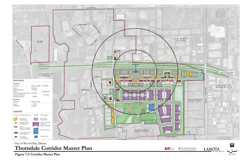
117
118


119 Section 7: Corridor Plan Figure 7.2: Corporate Main Street and Business Park looking southeast Figure 7.3: Corporate Main Street and Business Park looking northwest 7.5


120 Section 7: Corridor Plan Figure 7.4: View east along corporate Main Street from Wood Dale Road Figure 7.5: Corporate Main Street concept showing mixed-use, pedestrian oriented streetscape 7.6


121 Section 7: Corridor Plan Figure 7.6: Realigned Lively Boulevard south of the expressway extension Figure 7.7: Elgin O Hare Expressway over realigned Lively Boulevard looking south 7.7
122 Goals/Objectives Development Context: Goal Thorndale Corridor Master Plan Section 7: Corridor Plan A thriving business district with a unique Corporate Main Street, modern Business Park, and Regional Recreation Complex that serve the needs of area residents, business owners, employees, and visitors. OBJECTIVES Establish the Corridor Master Plan as a key economic development initiative of the City of Wood Dale, DuPage County, and Chicago region. Increase the Corridor s recognition as a desirable place to develop and conduct business. Set the stage for a high quality development with a real sense of place. Create a new mixed-use model for corporate facility development that is pedestrian and transit oriented. Create a distinct identity and brand for the new corporate environment. Create open spaces along and near the Corporate Main Street that serve as public gathering places and contribute to the area s identity as a special place for business. STRATEGIES Change the City s zoning ordinance to match the land uses and mixed-use corporate development defined in the Corridor Master Plan. Consider a form-based approach to zoning with design guidelines that clearly defines the desired development quality for the Corridor as well as reduces City s development review time. Craft design guidelines that address sustainable building, parking, site, and open space design, and establish a distinct green character at City gateways and along the Expressway and area roads. Prepare a marketing plan that brands and promotes the Master Plan. Prepare a developer recruitment strategy. Meet regularly with Corridor business and property owners to review expansion and relocation needs, development opportunities, potential property consolidation/packaging, and status of transportation projects. 7.8
123 Section 7: Corridor Plan Infrastructure: Goal A safe and efficient transportation network and utility system that maximizes access between the airport and area road network, and provides efficient stormwater management and sewer, water, and power services. OBJECTIVES Establish new road/utility links based on the Master Plan and Phasing Strategy. Establish the Main Street as the development s new east/west collector street and gateway. Realign Lively Boulevard as the development s north/south collector street and gateway. Extend Mittel Drive as a collector street for the Business Park and Recreation Complex. Facilitate access to the area with a comprehensive wayfinding and signage system. Establish a shared stormwater management system. Upgrade utilities where needed to accommodate the phased development of the Corridor. STRATEGIES Continue on-going coordination of land use and transportation planning with county, regional, and state agencies. Utilize access management strategies, such as limiting curb cuts and creating shared access drives, to improve traffic flow and safety along roadways. Consider the feasibility of a full intersection at Route 83 and the new Main Street based on IDOT s final placement of the Expressway. Complete the current feasibility study of the City s sanitary sewer plant/ system capacity incorporating the Corridor Master Plan s new land uses and building densities. Conduct a design/engineering study of the City s water system regarding pressure and distribution based on the new Master Plan. Conduct a design/engineering study of the shared stormwater management system based on the Plan. Update the City s capital improvement program based on the short-term and long-range needs of the Corridor Master Plan. Identify and incorporate transit use, bicycle use, and shared parking wherever feasible. Identify and pursue funding sources for infrastructure improvements. Consider financing tools like Tax Increment Financing to facilitate infrastructure improvements and property consolidation. 7.9
124 Section 7: Corridor Plan Land Use: Goal A first class corporate environment that enhances the City s economy with a wide range of business and business support uses. OBJECTIVES Put the Wood Dale Corporate Main Street on the map as a top location for corporations seeking modern office facilities. Enhance Wood Dale s extensive airport oriented business park by adding new efficient, sustainable facilities for warehouse/distribution, flex-tech operations, research and development, light industrial, product showrooms, and support services. Develop uses and amenities along and near Main Street that support businesses and reduce the need to use cars, including hotels, restaurants, shops, recreation/fitness facilities, and plazas. Also encourage infill multi-family housing along Main Street to provide walk to work opportunities for local employees and to further reduce area traffic. Prohibit big box retail, drive up or drive through retail, auto oriented stores/ services, gas stations, and industrial uses along or near Main Street. STRATEGIES Change the Corridor s zoning requirements and prepare design guidelines that allow a denser mix of uses, including business support uses and housing. Recruit office developments for 16 key corner locations along or near Main Street. Recruit middle and upper priced hotels for 11 potential locations along or near Main Street. As the area redevelops, recruit restaurants and commercial uses for infill sites between the office buildings and hotels. Encourage high quality, well-designed housing products, such as condominiums, apartments, rowhouses, and townhouses in strategic infill locations. Consider affordable workforce housing, possibly through programs with local employers. 7.10
125 Section 7: Corridor Plan Recreation/Open Space: Goal A recreation complex that expands Community and Franzen Grove Parks with new sports fields and indoor facilities, additional open space, and trails that provides a range of recreation and fitness opportunities. OBJECTIVES Provide recreation/fitness facilities that are an amenity for area businesses as well as residents. Establish a regional recreation complex that can host large sports tournaments, creating weekend demand for hotels and restaurants. Preserve and enhance the Corridor s existing natural resources and open spaces. STRATEGIES Work closely with the Park District to further assess the Regional Recreation Complex concept and potential for a regional facility for sports tournaments. Pursue public/private partnerships to attract an indoor recreation/sports complex to the area. Pursue funding sources for the purchase of properties and expansion of the parks. As the area develops, establish an interconnected trail that links the expanded park space, Junior High School, Recreation Complex, Corporate Main Street, stormwater system, and regional bike trails. 7.11

126 Master Plan Components Thorndale Corridor Master Plan Section 7: Corridor Plan CORPORATE MAIN STREET USES: Allowed Corporate/Professional Office Hotels Restaurants Retail Multi-Family Residential Open Space Industrial Prohibited Low Density Residential Auto Oriented Commercial/Service Drive Up/ Through Commercial Big Box Retail Medical/Institutional The Thorndale Corridor Master Plan delineates conceptual building massing, parking layouts, and site design to illustrate how the area could be developed in a comprehensive, coordinated manner. Actual building locations, heights, and densities, as well as landscaping and parking layouts will vary as property owners, business owners, and developers generate more detailed site plans. The following is a more specific discussion of the development components delineated in the Master Plan. Corporate Main Street The Corporate Main Street is designed as a highly visible and accessible environment for corporate and professional offices, hotels, restaurants, small retail shops, and multi-family housing. It is located along the planned Elgin- O Hare Expressway extension. Redevelopment of the overall area is focused on the new Main Street, which is parallel to the expressway frontage. This one-mile street would connect directly to Wood Dale Road on the west and Illinois Route 83 (Busse Road) on the east. The Master Plan shows Lively Boulevard realigned to create a central gateway into the development at the mid-point of Main Street. See Figure 7.8: Corporate Main Street Concept. A transit hub is placed between Wood Dale Road and Lively Boulevard to link potential transit service within the center of the Expressway directly to Main Street. Its close proximity to the planned road and Airport improvements, as well as to the Corporate Main Street will allow it to serve multiple customers : Employees from surrounding business parks and the new Business Park Visitors traveling to/from the Airport on the Expressway and transit lines Area residents Employees the new offices Business visitors in the new hotels. Figure 7.8: Corporate Main Street Concept 7.12


.")
127 Section 7: Corridor Plan New buildings are placed along Main Street in a street wall with a minimum sidewalk/streetscape width of 15 feet to facilitate walking between uses, buildings, plazas, and transit. An internal loop street system is used north and south of Main Street to provide direct access into each block and parking zone. The eastern end of the Main Street would ideally terminate with full access at Illinois Route 83, depending on the design of the Expressway extension and its interchanges. This key eastern corner of Main Street at Illinois Route 83 could accommodate a highly visible landmark focal building such as a corporate headquarters. Parking is provided for all Main Street uses and transit facilities in small surface lots for short-term parking and shared two to three-story decks for long-term parking. The decks are placed away from Main Street along the Expressway right-of-way and screened from view with berms and attractive landscaping. The parking decks are sized for standard parking ratios for office, hotel, restaurant, and retail uses, and for commuter parking near the potential transit center (250 extra spaces). As transit is added to the area, the standard parking ratios will be reassessed by the City to determine where they can be lowered based on future transit level of service in the area. Corner office building and parking structure concept Corner hotel and parking structure concept The transit facilities are envisioned to be integrated into the overall development with connections to structured parking and easy access to office, hotel, retail, and residential uses. 7.13


128 Section 7: Corridor Plan As noted earlier, the Main Street concept includes a residential component to add vitality to the district and provide walk to work housing options for employees of nearby businesses. Condominium buildings and mixeduse buildings with apartments above first floor retail would be located between corporate corners within walking distance of jobs and transit. Residents living along the street would increase transit ridership and pedestrian activity throughout the day and on weekends, making the area a more inviting place to do business, shop, and dine. Mixed-use cluster concept Comparable condominiums (top), mixed-use (center and lower left), and office (lower right) 7.14


129 Section 7: Corridor Plan DEVELOPMENT DENSITY The Corporate Main Street concept covers approximately 124 acres and can accommodate approximately 2,877,000 square feet of building space over a 25 to 30 year period. This total density includes 1,731,000 square feet of office space, 86,000 square feet of commercial infill development, 7 hotels, several mixed-use buildings with apartments above retail, and several condominium buildings. Overall, the Plan accommodates approximately 415 units of housing. Commercial space is envisioned as small-scale convenience service/retail shops and a range of restaurants catering to office workers, hotel guests, and transit users along a pedestrian-friendly streetscape. Key corners are shown with office buildings and hotels that have heights of 5 to 8 stories. Taller buildings ranging from 14 stories at Route 83 to 25 stories at Wood Dale Road can also be built along Main Street. Taller structures must also use shared parking decks that are placed away from the street, and designed and buffered to blend in with the design identity of the district and its buildings. Mixed-use corporate development Mixed-use development centered on a Main Street with transit Comparable hotel 7.15


130 Section 7: Corridor Plan Business Park BUSINESS PARK USES: Allowed Light Industrial Flex-tech Operations Assembly Research and Development Warehouse/Distribution Limited Office Product Showrooms Prohibited Corporate Office Commercial Restaurants Hotels Heavy Industrial Medical/Institutional Similar to Wood Dale s business parks located west of Wood Dale Road, the new Business Park envisioned south of the Corporate Main Street will be a modern, more sustainable environment for businesses needing larger facilities. It is designed with a grid system of streets and large, efficient blocks. Its blocks can accommodate a range of building sizes with off-street parking. See Figure 7.9: Business Park Concept. East of Wood Dale Road, Mittel Drive is extended into the Business Park to serve as its primary gateway and to route truck traffic away from the Corporate Main Street. Mittel Drive connects with the realigned Lively Boulevard and Central Avenue to provide an additional connection to the Elgin-O Hare Expressway. The new Business Park will have an attractive, green appearance with common setbacks, parkway landscaping, and screening of loading/ service areas. New buildings will be clustered to share service drives and loading/service areas where possible. Such areas will be centered within blocks away from streets to reduce visibility and truck turning movements, and maximize buildable land area. The Business Park will also include the overall development s shared stormwater detention system. The linear detention areas delineated in the Plan will also provide open space and buffers between uses. DEVELOPMENT DENSITY The Business Park covers approximately 160 acres and conceptually has a floor-area ratio of 0.38, which is consistent with nearby business parks, including the Chancellory and Forest Creek Parks. The Master Plan accommodates approximately 1.9 million square feet of building space within the new business park. Approximately 3.9 million square feet of existing industrial building space was removed for the area s overall development, including the Corporate Main Street, Business Park, and Recreation Center. Most of these industrial facilities, as noted in the State of the Corridor section of this report, are older, less efficient buildings that have limited ceiling heights, parking, and expansion room, and have loading docks that must be accessed directly from streets. Comparable modern business park buildings and layouts 7.16

131 Section 7: Corridor Plan Figure 7.9: Business Park Concept 7.17

132 Section 7: Corridor Plan Recreation Complex The Master Plan envisions a major recreation facility that can serve local businesses and residents, as well as host regional sports tournaments that will draw people to the area on weekends, helping create activity and business for restaurants and hotels. During the week, the complex s close proximity to Corporate Main Street can make it a draw for office workers. Extending Mittel Drive east of Wood Dale Road through the new Business Park will require relocation of four existing baseball fields in Community Park. Relocating these fields provides an opportunity to expand the park to the east with replacement and new fields, and to create a site for a new 120,000 square foot indoor recreation center. The overall complex would be directly linked via trails to the Park District s existing facility and Wood Dale Junior High School located along Wood Dale Road. See Figure 7.10: Regional Recreation Complex Concept. Figure 7.10: Regional Recreation Complex Concept 7.18

133 Section 7: Corridor Plan Long-Range Options There are several alternate or long-range components of the Thorndale Corridor Master Plan that have been considered to create additional development options in the future. ROUTE 83 INTERSECTION The Master Plan depicts a full or partial intersection of the new Main Street at Illinois Route 83. This intersection would create an access point for traffic accessing the new Corridor development from the east, especially for commercial vehicles barred from using Foster Avenue to the south because of weight restrictions. Currently a light industrial building is located at this corner with a right in/out driveway. This limited access driveway will need to be maintained if this business continues to remain active. The final design of the Expressway extension and its frontage roads and interchanges will determine whether a full or partial (right in/out) intersection could be established at Main Street and Illinois Route 83 if the existing business site is redeveloped. Because the final alignment is still under consideration by IDOT, three alternatives are shown to demonstrate how the potential alignment might work. The first option depicts the existing condition noted above, which is a private access driveway serving the existing industrial building located at the southwest corner of Illinois Route 83 and Thorndale Road. See Figure 7.11: Route 83 Existing Corporate Use/Driveway. Figure 7.11: Route 83 - Existing Corporate Use/Driveway 7.19


134 Section 7: Corridor Plan The second option is shown in the Corridor Master Plan whereby Main Street meets Illinois Route 83 in a right-in/right-out intersection. This would allow limited access to the new development zone with left turns would be prohibited. See Figure 7.12: Route 83 - Potential Partial Intersection. Figure 7.12: Route 83 - Potential Partial Intersection The third option of a full intersection is the preferred solution. This would allow northbound Illinois Route 83 traffic to make left-turns onto Corporate Main Street, as well as left turns from Main Street onto Illinois Route 83. Additional spacing would be needed between the new Expressway frontage road and new Main Street intersection. To accomplish this alignment it may be necessary to acquire some residential properties to the south of the existing business. See Figure 7.13: Route 83 - Potential Full Intersection Figure 7.13 Full Route 83 Intersection

135 Section 7: Corridor Plan HSBC SITE The 22 acre HSBC site at the southwest corner of Wood Dale Road and Mittel Drive currently has 4 one-story buildings that provide office space for the company. HSBC may continue to occupy the site in the future, but due to its size and high visibility along Wood Dale Road, additional options were considered. One option, as shown in the Corridor Master Plan, is a higher density office complex, with fewer and taller buildings. An alternative concept shows the potential to introduce rowhomes or townhomes into the area near job and transportation opportunities, as well as across the road from the school and park. See Figure 7.14: HSBC Site Option. The work-force housing options delineated in the Master Plan include condominiums and apartments in buildings along the Corporate Main Street near office buildings and transit lines. The HSBC site offers enough size and depth under one owner that it would be suited to provide rowhomes as an alternate housing product for the area. Main access for a residential development would be at Mittel Drive, with potential right-in/rightout access directly onto Wood Dale Road. The west side of the property would need to be buffered/screened from the light industrial uses to the west. The concept shows 168 units on the site. Figure 7.14: HSBC Site Option 7.21

136 Section 7: Corridor Plan MAIN STREET EXTENSION The western gateway of the Corporate Main Street is planned at its intersection with Wood Dale Road. A small connector street west of Wood Dale Road through an existing right-of-way would create a direct link from the new Main Street to AEC Drive and Hansen Court to the west. It is the intent of the Master Plan to establish Main Street between Wood Dale Road and Illinois Route 83 to take full advantage of the future Expressway interchanges and frontages, potential central gateway at Lively Boulevard, and possibility of transit service within the Expressway. Development efforts will be focused there to create the mixed-use business synergy envisioned with the Corporate Main Street concept. If there is long-term demand for additional office and hotel development after this core district is established, an option for the City would be to extend the Main Street concept west of Wood Dale to AEC Drive. The newly created parcels along the Main Street extension would continue the denser streetscape pattern of office, hotel, restaurant and retail uses along the street with parking facilities in the rear. This option would create a four-corner office/hotel intersection at Wood Dale Road near the interchange. See Figure 7.15: Corporate Main Street - West Extension Option. Figure 7.15: Corporate Main Street - West Extension Option 7.22
137 Section 7: Corridor Plan Design Intent The Corporate Main Street concept is envisioned as a boulevard with a more formal landscape design that includes: A center median with transit stops. Small plazas and two large central greens. Wide sidewalks with street trees, benches, planters, and outdoor cafes. Public art and water features. Wide parkways and gateways along Wood Dale Road, Lively Boulevard, and Illinois Route 83. The Business Park Concept envisions common setbacks around each block with landscaping and street trees that screen parking and loading/ service areas. Design concepts were generated to further illustrate the physical potential of the Corridor as a master planned, well-designed business place. Figures 7.16 to 7.18 provide initial guidelines for the mixed-use development clusters placed along Main Street, indicating conceptual alignment of the new street and internal loop streets, as well as land use, building, and parking zones. 7.23

138 Section 7: Corridor Plan Figure 7.16: Corporate Main Street Corner Blocks - Preliminary Guidelines 7.24

139 Section 7: Corridor Plan Figure 7.17: Corporate Main Street Mid Blocks - Preliminary Guidelines 7.25

140 Section 7: Corridor Plan Figure 7.18: New Business Park - Preliminary Guidelines 7.26

141 Section 7: Corridor Plan PRELIMINARY IDENTITY SIGNAGE Distinct identity gateway and directional signage for the overall development is considered key for establishing a high quality, highly recognizable corporate environment. Figures 7.19 to 7.21 illustrate potential concepts for identity signage that could be considered for highly visible gateways and corners, including a new central entrance at Lively Boulevard. Figure 7.19: Corporate Main Street - Gateway/Identity Signage Concept A Figure 7.20: Corporate Main Street - Gateway/Identity Signage Concept B 7.27

142 Section 7: Corridor Plan Figure 7.21: Corporate Main Street - Gateway/Identity Signage Concept C 7.28
143 Section 7: Corridor Plan Road Network A new road network is defined in the Corridor Plan for the Southeast Quadrant of Thorndale Road and Wood Dale Road to better serve the significant change in land use anticipated for the area. See Figure 7.22: Master Plan Road Network. The new network establishes a more efficient grid system that will facilitate traffic movement to/from the new expressway and future transit stations, as well as accommodate the planned uses and increased densities. This network will also improve circulation and connectivity for the Southwest and Northwest Quadrants, which contain Wood Dale s more modern business parks. The Plan also consolidates access points along the Expressway frontage road system from five locations to two between Wood Dale Road and Route 83. Specific improvements to the roadway network include: New Main Street Main Street is intended to be a super collector and spine road that would orient future development toward the new interchanges, a possible transit station in the expressway right-of-way, and potential bus rapid transit along Main Street. It would be a new east-west road connecting Wood Dale Road and Route 83, providing direct access to the office, hotel, retail, and residential uses. This new roadway would be a wide boulevard with dedicated bus lanes adjacent to designated stops within an 18-foot median. The street would accommodate two shared lanes in each direction. This street could be modeled as a Complete Street that accommodates pedestrians, bicyclists, transit service, and vehicles. Buildings would be placed along this boulevard with front door access for pedestrians and transit commuters. This road could also create important connections for DuPage County s planned bus rapid transit system. Mittel Drive Extension The Plan extends Mittel Drive to the east as a new 36-foot wide roadway lined up with existing Mittel Drive to provide improved connectivity across Wood Dale Road. The roadway would accommodate one through lane in each direction with a 12-foot center left turn lane. Mittel Drive would provide the main access to the new Business Park and Recreational Complex. Lively Boulevard/Central Avenue In IDOT s Elgin-O Hare Expressway Extension Tier One Study, a new connection is established between North Lively Boulevard and South Lively Boulevard. The Master Plan takes this alignment one step further by lining up South Lively Boulevard and Central Avenue to North Lively 7.29

144 Section 7: Corridor Plan Boulevard. This would eliminate the inefficient skewed alignment of Central Avenue and Lively Boulevard within the development zone, as well as under the expressway and at the planned frontage roads. The realigned Lively Boulevard would become the central access point and gateway into the overall development with a 48-foot roadway that provides two lanes in each direction. Alternatively, this section could accommodate one through lane in each direction with bike lanes and a center left turn lane. Straightening the Lively alignment and extending it to the future east/ west Main Street would help set the stage for future development of the area. It could also possibly reduce the cost of the expressway construction, as the Lively underpass would be built perpendicular to the expressway creating a shorter overpass with less structure needed. There are additional local and connector streets shown within the proposed roadway network for the development concept that define efficient and large development blocks. All streets would be designed to accommodate a WB-65 semi-truck vehicle. Figure 7.22: Master Plan Road Network 7.30
145 Section 7: Corridor Plan Infrastructure System The Corridor Master Plan has been prepared to a Schematic Design level and will be followed by more specific design and engineering studies of the planned development s specific infrastructure needs. Water Supply System The preferred development concept will require construction of new water mains, water service lines, fire hydrants, and fire supply lines. Water mains will need to be located within the new roadway network. The development will also need to accommodate the DuPage Water Commission (DWC) water supply line that exists along Central Avenue from Foster Avenue to north of the proposed Mittel Drive extension and east to the existing DWC Station 23-A. The Master Plan can accommodate DWC Station 23-A, and City s pump station, well, and reservoir in their current location near Lively Boulevard and Richert Road. Depending on long-range development needs, a location has also been shown in the Plan at Central Avenue a quarter mile north of Foster Avenue as an alternate location for these facilities. The future water main system will require an evaluation of pressure distribution as the newer denser mix of industrial, commercial, office and residential uses will provide a different demand on the system. Modeling of the existing pump station and reservoir capacity at DWC Station 23-A and the existing booster station performance at Mittel Drive and Wood Dale Road will be necessary. The water main system/pressure evaluation should also consider the potential incorporation of nearby residential areas into the City water system. Sanitary Sewer System The planned development will similarly require construction of new sanitary main and service lines along the new roadway network. Nearly all the sanitary sewer for the proposed development is conveyed to the existing sewer lift station east of the proposed intersection of Lively Boulevard and Main Street. The lift station discharges sewerage into a 10 force main west to Wood Dale Road to a gravity main south along that roadway. The existing force main will need to be located within the new Main Street right-of-way. The Master Plan accommodates the existing lift station in its current location. The expected increase in the sanitary load from the new development on the existing lift station and force main will need to be further evaluated. The lift station was re-constructed in November The City is currently evaluating improvements that would increase the capacity of the two wastewater treatment plants that serve the area, and is using the 7.31

146 Section 7: Corridor Plan Master Plan to model the expected sanitary load. Part of the evaluation will determine if the existing 10 force main is adequate to handle the anticipated sanitary sewer demand. Construction of the new sanitary sewer system will need to accommodate the existing areas connected to this system outside the Southeast Quadrant. The proposed sanitary sewer system should also assess potential incorporation of unincorporated residential blocks in the area. Storm Sewer System The changes anticipated in the Master Plan will require construction of new roadway catch basins, storm sewer laterals, storm sewer conveyance mains, and roadway culverts within the new roadway network. The proposed development is estimated to generate 80 acre-feet of detention needs. The shared stormwater management system defined in the Plan is a series of interconnected linear ponds ranging in storage depth from two to five feet, with an outlet near the culvert crossing at Route 83 and new Main Street. Salt Creek detention facility New development will be required to adhere to the DuPage County Storm Water and Flood Plain Ordinance. Since much of the Klefstad Business Park (Southeast Quadrant) appears to have been constructed without detention facilities, redevelopment will not be grandfathered in under the ordinance and will require on-site detention. If detention can t be provided on-site, it needs to be provided off-site or payment must be made into a detention variance fee schedule. For the Salt Creek watershed, the detention fee schedule is $133,000 per acre-foot of storage not provided. As noted earlier, the Master Plan delineates a shared storage and conveyance system as the City s preferred approach to stormwater management. A shared system would eliminate the need for individual development parcels to use land area for ponds and ditches, reduce construction and maintenance costs by using less valuable land and an engineered system for flood control, and create open spaces for use by area businesses and residents. Such a system may also be able to be designed to accommodate the stormwater needs of the new Expressway and eliminate the need to have detention/retention ponds along that roadway at key development corners. 7.32
147 Section 7: Corridor Plan Private Utilities In early 2009, J.U.L.I.E., Inc. (Joint Utility Locating Information for Excavators) was contacted to identify the private utility facilities within the Corridor Study Area. Individual companies were then contacted to request more specific information on the type and location of utilities serving the area. ELECTRICAL SYSTEM ComEd supplies the Study Area with electric power. Most electric lines are underground since the area has developed as a more modern business park environment. Discussions with businesses indicate there are some trouble spots within the Study Area, particularly AEC Drive, where upgrades are needed to support existing uses and reduce outages. ComEd has been contacted to determine if there are any circulation or capacity problems or any planned capital improvements. The Klefstad Business Park is approximately 30 years old and has overhead utilities, which will need to be placed underground as new development occurs. TELECOMMUNICATIONS SYSTEM Private telecommunications utilities are generally installed below grade throughout the Corridor Study Area with the exception of Central Avenue in the Klefstad Business Park where power poles and overhead utilities are evident. XO Communications has a major switching site on the east side of Edgewood Avenue between Balm Court and Beinoris Drive in the Southeast Quadrant. The company recently made significant investments in equipment and electronics at the site. It is also a backup data recovery center owned by Sunguard. As development occurs in the Thorndale Corridor, this site will be reevaluated regarding its potential to remain in its current location or relocate to a new site. Fiber optic lines that currently exist along Edgewood Avenue will need to be relocated when development starts near this location. Replacement and installation of a fiber optic network will require careful planning and implementation, as unplanned future modifications to the system would be disruptive and expensive. XO Communications NATURAL GAS SYSTEM Nicor supplies the Study Area with natural gas through underground lines. Nicor has been contacted to determine if there are any circulation or capacity problems or any planned capital improvements. 7.33
148
149 SECTION 8 - IMPLEMENTATION
150
151 Section 8: Implementation Implementation Strategy A major and sustained commitment will be needed by the City and business/property owners to implement the Corridor Master Plan and promote the Thorndale Corridor as a thriving, mixed-use destination for transit, corporate office, and business park development. Because not all elements of the Master Plan can be implemented at once, setting priorities based on budgets and resources according to a capital improvement program should be the first focus of the implementation stage. This will take a major commitment from City leaders, strong public/private sector cooperation, and continued coordination with IDOT and transit agencies, as well as input and assistance from Wood Dale business owners, property owners, and residents. An implementation strategy for the Thorndale Corridor Master Plan should include the following components: Communication and Coordination Redevelopment Approach Priority Projects Funding Programs Code Changes/Design Guidelines Area Branding and Marketing Streetscape/Signage Design Communication/Coordination Key participants in the implementation of the Thorndale Corridor Plan should include the following entities: CITY OF WOOD DALE The City will have the key leadership role in implementing the Plan. The City s continued active participation in promoting, coordinating, and facilitating public improvements and redevelopment within the study area will be critical for successful implementation. The City will also need to provide or identify technical and financial resources. Key roles and responsibilities will include: Coordinate with other public agencies, property owners, and developers to ensure that future development conforms to the Master Plan. Administer technical and other assistance to businesses, property owners, and developers. 8.1
152 Section 8: Implementation Assist with relocation of existing businesses, where appropriate, to other suitable locations within the City to allow for redevelopment of key sites. Assemble sites for infrastructure and new development where necessary. Initiate studies and plans for local transportation and infrastructure improvements. Seek out grants and funding sources for public improvements and property consolidations. Ensure that ordinances that govern development, including zoning, stormwater management, subdivision regulations, building codes, and design standards, support the redevelopment proposed in the Plan. OTHER AGENCIES Other public agencies that will be involved in implementing the Master Plan include: Illinois DOT As the design of the Elgin-O Hare Expressway extension moves forward, the City will need to continue to coordinate with State officials regarding local access and intersections (including at the Wood Dale Park District Golf Center), signalization, and the potential for sharing stormwater facilities. This effort should also address possible funding for the realignment of Lively Boulevard and the new Main Street. DuPage County DOT The City will also need to continue to coordinate with County officials on the final design of the Expressway extension and its local access, as well as the potential establishment of a county bus rapid transit system. RTA/Metra/Pace The City will need to continue to coordinate with the transit agencies on the placement, access, and configuration of potential transit service to and within the development area. 8.2
153 Section 8: Implementation PRIVATE SECTOR Developers, property owners, local businesses, and financial institutions can play a key role in the implementation of the Master Plan and redevelopment of the Corridor: Private Developers Developers should be recruited to develop individual projects or as master developers for larger portions of the area following the goals and objectives of the Plan. Local Business and Property Owners The City should establish a regular outreach program to business and property owners within the Corridor to determine their development needs and keep them current on the status of the Master Plan and transportation initiatives. Financial Institutions With City involvement, local lenders could provide help and facilitate redevelopment by financing projects within the Study Area. Redevelopment Approach Redevelopment of the study area will occur during a period of 20 to 25 years due to the timing of the Elgin O Hare Extension and the Airport s Western Terminal, large size of the area, multiple owners, and need to relocate some existing businesses. During that time period redevelopment is likely to occur based on one or more of the following approaches: Incremental redevelopment by owners that redevelop their own properties or sell to developers or businesses that then develop the sites. Redevelopment initiated by a group of property owners in partnership with a master developer. Redevelopment initiated on large portions of the area by a master developer that assembles properties. Strategic public acquisition of property and solicitation of a master developer for redevelopment. The four options reflect various levels of public involvement and investment. Complexities inherent in infill redevelopment typically require higher levels of public involvement, especially associated with land acquisition, bridging of financial gaps, and setting the stage with public infrastructure. 8.3
154 Section 8: Implementation The City could initially limit its involvement in the redevelopment process to active marketing of the Corridor Master Plan to businesses and developers and creating the appropriate framework by revising its development codes. However, it is likely that the City might have to play a more active role to get redevelopment going. This could involve strategic property acquisitions and forming public-private partnerships for catalytic projects that would jumpstart redevelopment. If the City wants to take a more active role, it should consider soliciting the participation of a master developer capable of executing larger sections of the Plan, particularly the Corporate Main Street, in a coordinated manner according to a sensible timeframe. The master developer could work closely with the City to develop the Corridor in accordance with Plan recommendations, as well as coordinate the recruitment of large tenants. The presence and experience of such a developer could make it easier for the City to attract desirable corporate tenants, who could be given greater assurance and specific timelines regarding funding, infrastructure, and construction. Additionally, the City should consider a land acquisition strategy focused on acquiring strategic parcels to develop the required infrastructure and initiate development. Property acquisitions could be considered for the following elements of the Plan: Public Realm Property will need to be acquired for proposed new and realigned streets and open spaces. This would likely require a combination of direct City acquisition and private acquisition followed by dedication to the City. Stormwater Management To establish the shared stormwater facilities recommended in the Plan, the City could acquire the needed land properties in advance of or in tandem with new development. Redevelopment Parcels If there are opportunities, the City could consider acquiring parcels for redevelopment that can be used for soliciting developers and initiating catalytic redevelopment projects through public-private partnerships. Priority Projects Regardless of which redevelopment strategy is used, an important early step toward Master Plan implementation should be identification of priority or catalytic projects. These are projects that are expected to spur the most activity, investment, and redevelopment in the area because of their high visibility and strategic location. In addition, these projects 8.4
155 Section 8: Implementation appear to be the most feasible given land ownership and private sector development interest, and would begin to address optimal land use and development opportunities, particularly the phased development of the Corporate Main Street. See Figure 8.1: Priority Projects. PUBLIC PROJECTS The following should be considered the City s priority or first-phase projects for implementation: Transportation The City should coordinate with transportation agencies regarding more specific timelines for roadway and transit improvements, including the potential funding of area road links. The realignment of Lively Boulevard is a critical aspect of the Plan and development of the Corporate Main Street. This catalytic project will allow direct access to the Expressway and will help spur developer interest. Because expressway construction directly impacts Lively Boulevard, funding and construction assistance for the realignment may potentially be available through IDOT. Mittel Drive/Recreation Complex The extension of Mittel Drive across Wood Dale Avenue will facilitate access into the new Business Park and Regional Recreation Complex. Since this new road link will require planning of not only the roadway but also the overall Recreation Complex, it is important that more detailed planning be started soon. Infrastructure The City should engage consultants to prepare the design/ engineering studies noted above to provide more specific information and direction regarding the infrastructure needed for Corridor development. This would include further discussions with IDOT to explore the feasibility of sharing stormwater facilities along the Expressway right-of-way. Infrastructure planning for the area should be set on a regular schedule and begun as soon as possible. Public Realm Prior to considering development proposals, the City should define key elements of the design of the public realm or roadscape/ streetscape to provide a blueprint that articulates standards for development. This step would include establishing Design Guidelines for road/street, building, parking, site, landscape, streetscape, and signage design. 8.5
156 Section 8: Implementation PRIVATE PROJECTS While new development will occur over time when property and business owners decide to change use, ownership or building size or function, there are some properties that should be considered priorities for change. To accomplish change at the sites listed below, the City and owners should begin working together to facilitate the concepts delineated in the Master Plan. The Corporate Main Street concept can be considered overall as a catalytic project and should be completed as early as possible. However, since it is unlikely that the entire street will be developed at once, several different sections could be completed as a first phase, depending on land availability, developer interest, and public infrastructure improvements. The following areas could be developed as first phase options for the Corporate Main Street (Also See Figures 8.2 to 8.4: Development Phasing Options): Lively Boulevard Frontage The realignment and reconstruction of Lively Boulevard as a catalytic public project could also set the stage for private investment along the new Main Street on either the east or west side of Lively. Private development in this location would capitalize on the prime access that will be created by the Expressway extension and its frontage roads. Similar to the Wood Dale Road frontage, this redevelopment would help establish the Corporate Main Street design template. Wood Dale Road Frontage One or several properties adjacent to Wood Dale Road are in a position to redevelop individually or as part of a master development. Redevelopment at the west end of the Main Street would set the design template for redevelopment to the east. This intersection would be a visible and important gateway for the entire district, particularly if the transit hub were developed. This location could start now and not require extensive infrastructure improvements. 8.6


157 Section 8: Implementation PRIVATE PROJECT: WOOD DALE RD FRONTAGE PRIVATE PROJECT: LIVELY BLVD. FRONTAGE INFRASTRUCTURE PROJECT: MAIN STREET WEST PRIVATE PROJECT: WOOD DALE RD FRONTAGE PRIVATE PROJECT: LIVELY BLVD. FRONTAGE INFRASTRUCTURE PROJECT: MITTEL DRIVE EXTENSION REGIONAL RECREATION COMPLEX INFRASTRUCTURE PROJECT: LIVELY BLVD. REALIGNMENT ELGIN O HARE EXPRESSWAY INFRASTRUCTURE PROJECT: MAIN STREET EAST ROUTE 83 WOOD DALE ROAD Figure 8.1: Priority Projects THORNDALE ROAD THORNDALE ROAD ELGIN O HARE EXPRESSWAY RIGHT-OF-WAY ELGIN O HARE EXPRESSWAY RIGHT-OF-WAY CENTRAL AVENUE CENTRAL AVENUE SIVERT EXISTING LIVELY SIVERT EXISTING LIVELY REALIGNED LIVELY REALIGNED LIVELY Figure 8.2: Phasing Options for Lively Boulevard Frontage 8.7
9. REZONING NO Vicinity of the northwest corner of 143 rd Street and Metcalf Avenue
 9. REZONING NO. 2002-15 Vicinity of the northwest corner of 143 rd Street and Metcalf Avenue 1. APPLICANT: Andrew Schlagel is the applicant for this request. 2. REQUESTED ACTION: The applicant is requesting
M-43 CORRIDOR OVERLAY ZONE
 ARTICLE 26.00 M-43 CORRIDOR OVERLAY ZONE Section 26.01 Findings A primary function of the M-43 state highway is to move traffic through the Township and to points beyond. As the primary east-west arterial
Section 1: US 19 Overlay District
 Section 1: US 19 Overlay District Section 1.1 Intent and Purpose The purpose of the US Highway 19 Overlay District is to manage access to land development along US Highway 19 in a manner that preserves
PLANNING COMMISSION REPORT Regular Agenda Public Hearing Item
 PC Staff Report 11/12/12 Item No. 2B- 1 PLANNING COMMISSION REPORT Regular Agenda Public Hearing Item ITEM NO. 2B: A TO GPI; 110 ACRES; E OF K-10 & N OF W 6 TH ST (MKM) : Consider a request to rezone approximately
ARTICLE 23 CONDOMINIUM STANDARDS
 ARTICLE 23 CONDOMINIUM STANDARDS Section 23.01 Intent. The intent of this Article is to provide regulatory standards for condominiums and site condominiums similar to those required for projects developed
Downtown Development Focus Area: I. Existing Conditions
 Downtown Development Focus Area: I. Existing Conditions The Downtown Development Focus Area is situated along Route 1, south of the train tracks, except for the existing Unilever property. It extends west
TASK 2 INITIAL REVIEW AND ANALYSIS U.S. 301/GALL BOULEVARD CORRIDOR FORM-BASED CODE
 TASK 2 INITIAL REVIEW AND ANALYSIS U.S. 301/GALL BOULEVARD CORRIDOR FORM-BASED CODE INTRODUCTION Using the framework established by the U.S. 301/Gall Boulevard Corridor Regulating Plan (Regulating Plan),
Jasper 115 Street DC2 Urban Design Brief
 Jasper 115 Street DC2 Urban Design Brief Greenlong Construction Ltd. Stantec Consulting Ltd. 2017 Overview The proposed rezoning application supports the development of two mixed-use high-rise buildings
City of Grande Prairie Development Services Department
 City of Grande Prairie Development Services Department COUNTRYSIDE SOUTH OUTLINE PLAN Prepared by: GPEC Consulting Ltd. #202, 10712-100th Street Grande Prairie, AB Council Resolution of August 20, 2001
Bylaw No , being "Official Community Plan Bylaw, 2016" Schedule "A" DRAFT
 Bylaw No. 2600-2016, being "Official Community Plan Bylaw, 2016" Schedule "A" Urban Structure + Growth Plan Urban Structure Land use and growth management are among the most powerful policy tools at the
Chapter 7 Riverfront District
 Chapter 7 Riverfront District Downtown Capital District Master Plan Trenton, New Jersey Riverfront District Trenton will reclaim its connection with the Delaware River to enhance the experience of living,
Draft Model Access Management Overlay Ordinance
 Draft Model Access Management Overlay Ordinance This model was developed using the City of Hutchinson and the Trunk Highway 7 corridor. The basic provisions of this model may be adopted by any jurisdiction
Planning Justification Report
 Planning Justification Report Kellogg s Lands City of London E&E McLaughlin Ltd. June 14, 2017 Zelinka Priamo Ltd. Page i TABLE OF CONTENTS Page No. 1.0 2.0 2.1 2.2 3.0 4.0 5.0 5.1 5.2 5.3 5.4 5.5 5.6
Sherwood Forest (Trinity) Housing Corporation. Urban Design Brief
 Housing Corporation. Urban Design Brief") Sherwood Forest (Trinity) Housing Corporation Sherwood Place Affordable Housing Apartments Trinity Presbyterian Church Orchard Park Nursery School 590 Gainsborough Road, London Urban Design Brief REVISED
Sherwood Forest (Trinity) Housing Corporation Sherwood Place Affordable Housing Apartments Trinity Presbyterian Church Orchard Park Nursery School 590 Gainsborough Road, London Urban Design Brief REVISED
DRAFT FOR DISCUSSION PURPOSES ONLY. Port Credit Local Area Plan Built Form Guidelines and Standards DRAFT For Discussion Purposes
 Port Credit Local Area Plan Built Form Guidelines and Standards DRAFT For Discussion Purposes 1 Local Area Plan - Project Alignment Overview Directions Report, October 2008 (General Summary Of Selected
Staff Report PLANNING DIVISION COMMUNITY & ECONOMIC DEVELOPMENT. Alley Closure
 Staff Report PLANNING DIVISION COMMUNITY & ECONOMIC DEVELOPMENT To: From: Salt Lake City Planning Commission Doug Dansie, 801-535-6182, doug.dansie@slcgov.com Date: March 23, 2016 Re: PLNPCM2015-00941
Forest Park DeBaliviere Station
 Forest Park DeBaliviere Station This station profile describes existing conditions around the Forest Park-DeBaliviere MetroLink Station. This is one of a set of profiles for each of the MetroLink System
Truax Park Apartments
 Truax Park Apartments Master Planning and Site Development Study Prepared by The Community Development Authority of the City of Madison In association with SMITH & SMITH ASSOCIATES, Inc CONSTRUCTION COST
Sec HC - Highway commercial district.
 Sec. 36-422. - HC - Highway commercial district. (1) Purpose. This district is intended for commercial uses which depend upon high visibility, generate high traffic volumes, or cater to the traveling public.
WIREGRASS RANCH DRI/MPUD MASTER ROADWAY PLAN CONDITIONS OF APPROVAL PDD DRC
 WIREGRASS RANCH DRI/MPUD MASTER ROADWAY PLAN CONDITIONS OF APPROVAL DRC 1. This Master Roadway Plan (the MRP) replaces and supersedes the Roadway Alignment and Construction Phasing Plan (File No. GM06-737)
8.5.1 R1, Single Detached Residential District
 8.5.1 R1, Single Detached Residential District The purpose of this district is to provide for residential development in the form of single detached dwellings. Dwelling, Single Detached Home Business,
PROFFER STATEMENT FAIRFAX MARBLE & GRANITE SUMMIT AT DULLES ZRTD
 PROFFER STATEMENT FAIRFAX MARBLE & GRANITE SUMMIT AT DULLES ZRTD 2016-0009 December 13, 2016 Dulles Summit LLC, the owner (hereinafter, the "Owner") of the parcel described as Loudoun County Tax Map Number
APPENDIX D: DEFINITIONS
 D APPENDIX D: DEFINITIONS Terms used throughout the 2040 Comprehensive Plan should be interpreted using the definitions provided in this appendix. For interpretation of any term not defined, defer to the
Montreal Road District Secondary Plan [Amendment #127, October 9, 2013]
![Montreal Road District Secondary Plan [Amendment #127, October 9, 2013]](/thumbs/72/66783104.jpg "Montreal Road District Secondary Plan [Amendment #127, October 9, 2013]") [Amendment #127, October 9, 2013] 1.0 General The following policies are applicable to the Montreal Road District as set out in Schedule 1. 1.1 District Objectives The objective of this Plan is to guide
[Amendment #127, October 9, 2013] 1.0 General The following policies are applicable to the Montreal Road District as set out in Schedule 1. 1.1 District Objectives The objective of this Plan is to guide
FOR LEASE. +/- 1,090 SF Office Condo West Park Professional Center St. Lucie West, FL. 540 NW University Blvd, #209-A, Port St.
 Kyle St. John (772) 288-6646 kyle@tccommercialre.com www.tccommercialre.com FOR LEASE +/- 1,090 SF Office Condo West Park Professional Center St. Lucie West, FL 540 NW University Blvd, #209-A, Port St.
APARTMENT BUILDING DEVELOPMENT ST. LAURENT BOULEVARD OTTAWA, ONTARIO TIA SCOPING FORM. Prepared for:
 APARTMENT BUILDING DEVELOPMENT 776-784 ST. LAURENT BOULEVARD OTTAWA, ONTARIO TIA SCOPING FORM Prepared for: 1252066 Ontario Inc. 231 Brittany Drive, Suite D Ottawa, ON K1K 0R8 vember 16, 2017 117-664 Scoping.doc
2015 Downtown Parking Study
 2015 Downtown Parking Study City of Linden Genesee County, Michigan November 2015 Prepared by: City of Linden Downtown Development Authority 132 E. Broad Street Linden, MI 48451 www.lindenmi.us Table of
Implementation. Approved Master Plan and SMA for Henson Creek-South Potomac 103
 Implementation Approved Master Plan and SMA for Henson Creek-South Potomac 103 104 Approved Master Plan and SMA for Henson Creek-South Potomac Sectional Map Amendment The land use recommendations in the
F O U R A D D R E S S E S, O N E G R E AT L O C AT I O N
 FOUR ADDRESSES, O N E G R E AT L O C AT I O N Welcome to the newly redeveloped Oak Brook 22. The property consists of approximately 400,000 square feet of premier office and vibrant ground floor retail
Overview. Central Street Master Plan. Appendix B: Zoning
 Central Street Master Plan Overview The City of Evanston has 36 zoning districts, of which 11 are found in the Central Street Corridor Study Area (See Figures B.1 and B.2). They include: R1: Single-Family
2.2.2 The Land Use Setting
 2-6 Planning Area pearance varies dramatically from season to season. The absence of significant topographic or man-made features within the District contributes to a very open visual character that allows
Conditional Use Permit case no. CU 14-06: Bristol Village Partners, LLC
 PLANNING AND ZONING COMMISSION STAFF REPORT August 7, 2014 Conditional Use Permit case no. CU 14-06: Bristol Village Partners, LLC CASE DESCRIPTION: LOCATION: LEGAL DESCRIPTION: EXISTING LAND USE: ZONING:
Mohave County General Plan
 63 64 65 66 67 68 69 70 71 The Land Use Diagram is not the County's zoning map. 13 It is a guide to future land use patterns. Zoning and area plan designations may be more restrictive than the land use
Evolution of the Vision for NE 181st Street Study Area
 City Council Action on NE 181 St Street Study Area Evolution of the Vision for NE 181st Street Study Area such uses to ensure neighborhood compatibility. More intense uses may be allowed through a conditional
New Millennium Senior Living Communities, LLC
 Applicant Property Owners Baylake Limited Partnership, W. Heywood Fralin 2012 Revocable Trust, W. Heywood Fralin Irrevocable Children s Trust, & Karen Holly Waldron Trust Public Hearing August 9, 2017
1061 The Queensway - Official Plan and Zoning By-law Amendment Applications - Preliminary Report
 STAFF REPORT ACTION REQUIRED 1061 The Queensway - Official Plan and Zoning By-law Amendment Applications - Preliminary Report Date: January 28, 2015 To: From: Wards: Reference Number: Etobicoke York Community
ARTICLE 383. PD 383.
 ARTICLE 383. PD 383. SEC. 51P-383.101. LEGISLATIVE HISTORY. PD 383 was established by Ordinance No. 21928, passed by the Dallas City Council on December 8, 1993. Ordinance No. 21928 amended Ordinance No.
PC Staff Report 11/18/2013 Z Item No. 1-1
 Z-13-00401 Item No. 1-1 PLANNING COMMISSION REPORT Regular Agenda - Public Hearing Item PC Staff Report 11/18/2013 ITEM NO. 1: Z-13-00401 IG (General Industrial) District TO CS (Strip Commercial) District;
c. Public Facilities: Community Center; Public Park; Religious Use; Transit Stop. [Amended Ordinance #11-07]
![c. Public Facilities: Community Center; Public Park; Religious Use; Transit Stop. [Amended Ordinance #11-07]](/thumbs/72/66882116.jpg "c. Public Facilities: Community Center; Public Park; Religious Use; Transit Stop. [Amended Ordinance #11-07]") Section 2.04. Intent The s are established to protect, promote and maintain the development of medium density single family dwellings and to provide for limited public and institutional uses that are compatible
Section 2.04. Intent The s are established to protect, promote and maintain the development of medium density single family dwellings and to provide for limited public and institutional uses that are compatible
Article 3. SUBURBAN (S-) NEIGHBORHOOD CONTEXT
 NEIGHBORHOOD CONTEXT") Article 3. SUBURBAN (S-) NEIGHBORHOOD CONTEXT this page left intentionally blank Contents ARTICLE 3. SUBURBAN (S-) NEIGHBORHOOD CONTEXT DIVISION 3.1 NEIGHBORHOOD CONTEXT DESCRIPTION...3.1-1 Section 3.1.1
Article 3. SUBURBAN (S-) NEIGHBORHOOD CONTEXT this page left intentionally blank Contents ARTICLE 3. SUBURBAN (S-) NEIGHBORHOOD CONTEXT DIVISION 3.1 NEIGHBORHOOD CONTEXT DESCRIPTION...3.1-1 Section 3.1.1
CITY PLAN COMMISSION STAFF REPORT
 CITY PLAN COMMISSION STAFF REPORT SUBJECT: Request for a Change of Zoning and Preliminary Development Plan FROM: Mara Perry, Director of Planning & Development MEETING DATE: November 6, 2017 PETITION:
Planning Department Oconee County, Georgia
 Planning Department Oconee County, Georgia STAFF REPORT REZONE CASE #: 6985 DATE: October 31, 2016 STAFF REPORT BY: Andrew C. Stern, Planner APPLICANT NAME: Williams & Associates, Land Planners PC PROPERTY
AGENDA 1. CALL TO ORDER :00 P.M.
 MUNICIPAL PLANNING COMMISSION REGULAR MEETING CITY HALL COUNCIL CHAMBERS SEPTEMBER 24, 2015 AGENDA 1. CALL TO ORDER ------------------------------------------------------------------------ 7:00 P.M. 2.
From Policy to Reality
 From Policy to Reality Updated ^ Model Ordinances for Sustainable Development 2000 Environmental Quality Board 2008 Minnesota Pollution Control Agency Funded by a Minnesota Pollution Control Agency Sustainable
ARTICLE 15. RULES, REGULATIONS AND DEFINITIONS
 ARTICLE 15. RULES, REGULATIONS AND DEFINITIONS Section 1. Interpretation and Construction: The following rules and regulations regarding interpretation and construction of the Ulysses-Grant County, Kansas,
Planning Rationale in Support of an Application for Plan of Subdivision and Zoning By-Law Amendment
 Planning Rationale in Support of an Application for Plan of Subdivision and Zoning By-Law Amendment The Kilmorie Development 21 Withrow Avenue City of Ottawa Prepared by: Holzman Consultants Inc. Land
Land Use, Transportation, and Infrastructure Committee of Denver City Council FROM: Scott Robinson, Senior City Planner DATE: December 6, 2018 RE:
 Community Planning and Development Planning Services 201 W. Colfax Ave., Dept. 205 Denver, CO 80202 p: 720.865.2915 f: 720.865.3052 www.denvergov.org/cpd TO: Land Use, Transportation, and Infrastructure
Town of Cary, North Carolina Rezoning Staff Report 14-REZ-31 Cary Park PDD Amendment (Waterford II) Town Council Meeting January 15, 2015
 Town Council Meeting January 15, 2015") Town of Cary, North Carolina Rezoning Staff Report 14-REZ-31 Cary Park PDD Amendment (Waterford II) Town Council Meeting January 15, 2015 REQUEST To amend the Town of Cary Official Zoning Map by amending
Town of Cary, North Carolina Rezoning Staff Report 14-REZ-31 Cary Park PDD Amendment (Waterford II) Town Council Meeting January 15, 2015 REQUEST To amend the Town of Cary Official Zoning Map by amending
RE: Transportation Overview Youth Services Bureau Housing First Hub for Youth 2887 Riverside Drive
 TECHNICAL MEMORANDUM TO: FROM: SUBJECT: Jasmine Tranter c/o Wes Richardson, Youth Services Bureau (YSB) Paul Tétreault, P. Eng., MCIP, MUP; Emmett Proulx, EIT RE: Transportation Overview Youth Services
CASTLES OF CALEDON URBAN DESIGN REPORT
 CASTLES OF CALEDON URBAN DESIGN REPORT PROPOSED RESIDENTIAL DEVELOPMENT CALEDON, ONTARIO 10 JULY, 2015 TABLE CONTENTS: 1.0 DEVELOPMENT 4.0 CONCLUSION 1.1 Introduction 1.2 Castles of Caledon- Urban Design
A. Land Use Relationships
 Chapter 9 Land Use Plan A. Land Use Relationships Development patterns in Colleyville have evolved from basic agricultural and residential land uses, predominate during the early stages of Colleyville
York Neighbourhood Area Structure Plan
 York Neighbourhood Area Structure Plan Office Consolidation March 2006 Prepared by: Planning and Policy Services Branch Planning and Development Department City of Edmonton Bylaw 7064 was adopted by Council
Fountain District Urban Village
 Fountain District Urban Village Planning Commission Work Session June 3, 2010 City of Bellingham, Washington Planning & Community Development Department 1 Fountain District Urban Village Planning City
Courtyards at Kinnamon Park Sketch Plan
 Courtyards at Kinnamon Park Sketch Plan Courtyards at Kinnamon Park Sketch Plan Staff Analysis PART 1: PROJECT SUMMARY Applicant: EPCON Communities Property Owner: Johnsie M. Kinnamon Heirs, Douglas and
Chapter URBAN VILLAGE ZONING DISTRICTS
 Chapter 20.16 Sections: 20.16.010 Purpose of the Urban Village Zoning Districts 20.16.020 Land Use Regulations for the Urban Village Zoning Districts 20.16.030 Development Standards & Guidelines for the
RECOMMENDATION Following the public hearing, consider Zoning Case PD14-16, with a Development Plan.
 Staff Report Zoning Case PD14-16 (Helzer Tract) Planning and Zoning Meeting Date: 12-17-14 Document Being Considered: Ordinance RECOMMENDATION Following the public hearing, consider Zoning Case PD14-16,
LAND USE AMENDMENT ITEM NO: 05
 REPORT TO CALGARY PLANNING COMMISSION LAND USE AMENDMENT ITEM NO: 05 FILE NO: LOC2012-0069 CPC DATE: 2013 February 14 COUNCIL DATE: BYLAW NO: HILLHURST (Ward 7 - Alderman Farrell) ISC: Protected Page 1
66 Isabella Street Rezoning Application - Preliminary Report
 STAFF REPORT ACTION REQUIRED 66 Isabella Street Rezoning Application - Preliminary Report Date: November 15, 2010 To: From: Wards: Reference Number: Toronto and East York Community Council Director, Community
MEMORANDUM Planning Commission Travis Parker, Planning Director DATE: April 4, 2018 Lakewood Zoning Amendments Housing and Mixed Use
 MEMORANDUM TO: FROM: Travis Parker, Planning Director DATE: April 4, 2018 SUBJECT: Lakewood Zoning Amendments Housing and Mixed Use In August 2017, the Lakewood Development Dialogue process began with
Section 4 Master Plan Framework
 Section 4 Master Plan Framework 4.1 PURPOSE The Master Plan, as an implementation tool of the SPC District, establishes the primary framework for the overall development of the Property. Detailed site
For Sale. 2,880+/- sf bldg on 3.64+/- acres. Formerly operated as Alternative Automotive. Frontage and signage on Memorial Hwy. Ample parking.
 For Sale 17530 State Route 536 Mount Vernon, WA 2,880+/- sf bldg on 3.64+/- acres Formerly operated as Alternative Automotive. Frontage and signage on Memorial Hwy. Ample parking. Furniture, Fixtures and
2 Holiday Drive - Zoning Application - Preliminary Report
 STAFF REPORT ACTION REQUIRED 2 Holiday Drive - Zoning Application - Preliminary Report Date: June 12, 2007 To: From: Wards: Reference Number: Etobicoke York Community Council Director, Community Planning,
5. Land Acquisition and Displacement
 Northern Branch Corridor SDEIS March 2017 5. Land Acquisition and Displacement 5.1. Chapter Overview 5.1.1. Introduction Implementation of the Preferred Alternative would require the acquisition of property
6 NE 130TH STREET STATION TOD POTENTIAL
 6 NE 130TH STREET STATION TOD POTENTIAL Key Findings TOD potential for the NE 130th Street Station is limited, primarily because of the predominant single-family development pattern in this area. The two
Chapter RESIDENTIAL ZONING DISTRICTS
 Chapter 18.16 RESIDENTIAL ZONING DISTRICTS Sections: 18.16.010 Purpose of Chapter 18.16.020 Purpose of Residential Zoning Districts 18.16.030 Regulations for Residential Zoning Districts 18.16.040 Residential
Be linked by an internal circulation system (i.e., walkways, streets, etc.) to other structures within the IPUD;
 to other structures within the IPUD;") 2. HALIFAX ACTIVITY CENTER A. DESCRIPTIONS OF FUTURE LAND USE DESIGNATIONS Each of the future land use designations specified by Phase I of the Halifax Activity Center Plan, and the relationship of these
2. HALIFAX ACTIVITY CENTER A. DESCRIPTIONS OF FUTURE LAND USE DESIGNATIONS Each of the future land use designations specified by Phase I of the Halifax Activity Center Plan, and the relationship of these
Chapter 1107: Zoning Districts
 Chapter 1107: Zoning Districts 1107.01 Establishment of Zoning Districts (a) Districts Established In order to carry out the purpose of this code, the City is hereby divided into the zoning districts established
ARTICLE Encourage well planned, efficient development.
 ARTICLE 14.00 PD PLANNED SECTIONS: 14.01 Intent 14.02 Procedure 14.03 Initial Development Plan 14.04 Final Development Plan 14.05 Amendments 14.06 Planned Development Districts PD-1 Willow Run PD PD-2
PLANNING COMMISSION REPORT Regular Agenda Public Hearing Item
 PC Staff Report 06/21/10 Item No. 4-1 PLANNING COMMISSION REPORT Regular Agenda Public Hearing Item ITEM NO. 4: PD-[TANGER PCD-1] TO CS; 1025 N. 3 rd STREET (SLD) : Consider a request to rezone approximately
CITY COUNCIL STUDY SESSION MEMORANDUM
 City and County of Broomfield, Colorado To: From: Prepared by: Owner Applicant Property Size Property Location: CITY COUNCIL STUDY SESSION MEMORANDUM Mayor and City Council Charles Ozaki, City and County
PLANNING AND REGULATING HOUSING OPTIONS FOR CHANGING DEMOGRAPHICS
 PLANNING AND REGULATING HOUSING OPTIONS FOR CHANGING DEMOGRAPHICS New Partners for Smart Growth Conference February 2017 HOUSING MARKETS Significant increase in rental housing Offset robust single-family
Special Use Permit #SUP , Youssef Home Fitness Studio Occoquan Magisterial District
 COUNTY OF PRINCE WILLIAM 5 County Complex Court, Prince William, Virginia 22192-9201 PLANNING (703) 792-7615 FAX (703) 792-4401 OFFICE Internet www.pwcgov.org Christopher M. Price, AICP Acting Director
CITY OF LEBANON RUSSELL DRIVE AREA MIXED USE NEIGHBORHOOD CENTER FINAL IMPLEMENTATION PLAN
 CITY OF LEBANON RUSSELL DRIVE AREA MIXED USE NEIGHBORHOOD CENTER FINAL IMPLEMENTATION PLAN TGM Contract 2G-01 #22425 Deliverable 15.5 Prepared by: Satre Associates, P.C. Planners, Landscape Architects,
EXPRESS LANES NORTHERN EXTENSION TECHNICAL REPORT SEPTEMBER 2016
 I N T E R S TAT E 3 9 5 EXPRESS LANES NORTHERN EXTENSION R I G H T O F W AY TECHNICAL REPORT SEPTEMBER 2016 INTERSTATE 395 EXPRESS LANES NORTHERN EXTENSION Right of Way Technical Report City of Alexandria,
d. DWELLING, GROUP QUARTERS (no more than sixteen [16] persons, including domestic servants and resident staff).
![d. DWELLING, GROUP QUARTERS (no more than sixteen [16] persons, including domestic servants and resident staff).](/thumbs/93/113051450.jpg "d. DWELLING, GROUP QUARTERS (no more than sixteen [16] persons, including domestic servants and resident staff).") SEC. 37-7.5. R-5 GENERAL RESIDENCE DISTRICT The R-5 General Residence District is established to provide for a range of low density residential accommodations and life styles representing a compatible
SEC. 37-7.5. R-5 GENERAL RESIDENCE DISTRICT The R-5 General Residence District is established to provide for a range of low density residential accommodations and life styles representing a compatible
2. LAND USE DESIGNATIONS AND PRINCIPLES FOR DEVELOPMENT
 2. LAND USE DESIGNATIONS AND PRINCIPLES FOR DEVELOPMENT General areas have been designated for specific types of land use on the Future Land Use Map and are described in this section. In order to satisfy
THIS INTERGOVERNMENTAL AGREEMENT is entered into this day. of, 2004 A.D., by and between the STATE OF ILLINOIS, acting by and through its
 INTERGOVERNMENTAL AGREEMENT BETWEEN THE STATE OF ILLINOIS, THE ILLINOIS STATE TOLL HIGHWAY AUTHORITY, THE COUNTY OF DUPAGE AND THE CITY OF CHICAGO CONCERNING ROADWAY IMPROVEMENTS IN THE VICINITY OF THE
Bowie Marketplace Residential Detailed Site Plan Statement of Justification January 13, 2017 Revised February 2, 1017
 Bowie Marketplace Residential Detailed Site Plan Statement of Justification January 13, 2017 Revised February 2, 1017 Submitted on behalf of: BE Bowie LLC 5410 Edson Lane, Suite 220 Rockville, MD 20852
EXHIBIT 1 PROJECT DESCRIPTION AND DESCRIPTION OF REQUESTED AREA VARIANCES REDEVELOPMENT OF 201 ELLICOTT STREET
 EXHIBIT 1 PROJECT DESCRIPTION AND DESCRIPTION OF REQUESTED AREA VARIANCES REDEVELOPMENT OF 201 ELLICOTT STREET I. PROJECT DESCRIPTION: Ciminelli Real Estate Corporation (the Applicant ) is seeking area
Development Plan DP13-3 (Arlington Lofts) Planning and Zoning Meeting Date: Document Being Considered: Ordinance
 Planning and Zoning Meeting Date: Document Being Considered: Ordinance") Staff Report Development Plan DP13-3 (Arlington Lofts) Planning and Zoning Meeting Date: 6-19-13 Document Being Considered: Ordinance RECOMMENDATION Following the public hearing, consider Development Plan
Staff Report Development Plan DP13-3 (Arlington Lofts) Planning and Zoning Meeting Date: 6-19-13 Document Being Considered: Ordinance RECOMMENDATION Following the public hearing, consider Development Plan
PLANNING COMMISSION REPORT Regular Agenda - Public Hearing Item
 Z-11-25-09; Z-11-26-09; Z-11-28-09 Item No. 2-1 PC Staff Report 3/28/11 PLANNING COMMISSION REPORT Regular Agenda - Public Hearing Item ITEM NO. 2A RM32 TO MU;.19 ACRES; 1340 TENNESSEE ST (MJL) Z-1-1-11:
Glades County Staff Report and Recommendation Unified Staff Report for Small Scale Plan Amendment and Rezoning
 Glades County Staff Report and Recommendation Unified Staff Report for Small Scale Plan Amendment and Rezoning CASE NUMBERS: COMP17-02 and RZ17-02 DATE of STAFF REPORT: May 1, 2017 CASE TYPE: Application
ARTICLE 10 SPECIAL PURPOSE DISTRICTS
 ARTICLE 10 SPECIAL PURPOSE DISTRICTS Sec. 29.1000. SPECIAL PURPOSE DISTRICTS. (1) Purpose. Each Special Purpose District will appear on the City's Zoning Map as a Base Zone. The Special Purpose Districts
ARTICLE VI. SUBDIVISION STANDARDS, PUBLIC
 ARTICLE VI. SUBDIVISION STANDARDS, PUBLIC IMPROVEMENTS, AND DESIGN REQUIREMENTS ARTICLE VI. SUBDIVISION STANDARDS, PUBLIC IMPROVEMENTS, AND DESIGN REQUIREMENTS DIVISION 1. GENERAL PROVISIONS Sec. 21-6100.
Main Street Parking Area Strategy. Borough of South River Middlesex County, New Jersey
 Main Street Parking Area Strategy Borough of South River Middlesex County, New Jersey Draft: May 29, 2018 DRAFT 5/29/2018 Page 1 Bignell Planning Consultants, Inc. 424 AMBOY AVENUE SUITE 202 WOODBRIDGE,
2.110 COMMERICAL MIXED USE (CM)
") CITY OF KEIZER DEVELOPMENT BULLETIN 2.110.01 Purpose 2.110 COMMERICAL MIXED USE (CM) The Commercial Mixed Use (CM) zone is the primary commercial zone within the City. The zone is specifically designed
CITY OF KEIZER DEVELOPMENT BULLETIN 2.110.01 Purpose 2.110 COMMERICAL MIXED USE (CM) The Commercial Mixed Use (CM) zone is the primary commercial zone within the City. The zone is specifically designed
Zoning Analysis. 2.0 Residential Use. 1.0 Introduction
 Zoning Analysis 1.0 Introduction For zoning to be an effective community development tool, it must recognize the unique land use characteristics of the various portions of the community. The Lawrence Zoning
Parking Challenges and Trade-Offs
 Parking Challenges and Trade-Offs What is the best way to balance competing interests and priorities while updating the City s off street parking regulations? Updating off street parking regulations can
1 February 8, 2012 Public Hearing APPLICANT: ERNEST D. PARRISH
 REQUEST: Conditional Use Permit (Truck and Trailer Rental) 1 February 8, 2012 Public Hearing APPLICANT: ERNEST D. PARRISH PROPERTY OWNER: ACT B LYNNHAVEN COLONY SHOPS STAFF PLANNER: Faith Christie ADDRESS
THE CITY OF RAYMORE, MISSOURI Single-Family Residential Zoning Districts
 THE CITY OF RAYMORE, MISSOURI Single-Family Residential Zoning Districts REGULATIONS COMMON TO ALL DISTRICTS: Uses permitted in each district include detached single-family dwellings, manufactured homes
SUBDIVISION DESIGN PRINCIPLES AND STANDARDS
 SECTION 15-200 SUBDIVISION DESIGN PRINCIPLES AND STANDARDS 15-201 STREET DESIGN PRINCIPLES 15-201.01 Streets shall generally conform to the collector and major street plan adopted by the Planning Commission
ARTICLE 143. PD 143.
 ARTICLE 143. PD 143. SEC. 51P-143.101. LEGISLATIVE HISTORY. PD 143 was established by Ordinance No. 17685, passed by the Dallas City Council on February 2, 1983. Ordinance No. 17685 amended Ordinance No.
SECTION 7000 LAND DEVELOPMENT REQUIREMENTS
 SECTION 7000 LAND DEVELOPMENT REQUIREMENTS 7000 LAND DEVELOPMENT REQUIREMENTS... 1 7001 LEGISLATIVE AUTHORITY... 1 7001.1 LAND DEVELOPMENT... 1 7001.1.1 Title 40, Idaho Code... 1 7001.1.2 Idaho Code 40-1415
Kingston Road - Zoning Amendment and Draft Plan of Subdivision Applications - Preliminary Report
 STAFF REPORT ACTION REQUIRED 6480-6484 Kingston Road - Zoning Amendment and Draft Plan of Subdivision Applications - Preliminary Report Date: April 19, 2016 To: From: Wards: Reference Number: Scarborough
CHAPTER 6 RESIDENTIAL DISTRICTS LOW DENSITY RESIDENTIAL DISTRICT (R-1)
") TYPE OF DISTRICT: TRADITIONAL CHAPTER 6 RESIDENTIAL DISTRICTS LOW DENSITY RESIDENTIAL DISTRICT (R-1) ARTICLE 1: LOW DENSITY RESIDENTIAL DISTRICT (R-1) SECTION 6-1.01: PURPOSE The regulations of the R-1
TYPE OF DISTRICT: TRADITIONAL CHAPTER 6 RESIDENTIAL DISTRICTS LOW DENSITY RESIDENTIAL DISTRICT (R-1) ARTICLE 1: LOW DENSITY RESIDENTIAL DISTRICT (R-1) SECTION 6-1.01: PURPOSE The regulations of the R-1
i. The only permitted uses shall be a maximum of two (2) multiple dwellings and related accessory uses;
 multiple dwellings and related accessory uses;") Presented To: Planning Committee Request for Decision Application for rezoning in order to permit 80 dwelling units, comprising two (2) six-storey multiple dwellings with 40 units, Paris Street, Sudbury
Presented To: Planning Committee Request for Decision Application for rezoning in order to permit 80 dwelling units, comprising two (2) six-storey multiple dwellings with 40 units, Paris Street, Sudbury
7. IMPLEMENTATION STRATEGIES
 7. IMPLEMENTATION STRATEGIES A. GENERAL APPROACH FOR IMPLEMENTATION Implementing the plan will engage many players, including the Municipality of Anchorage (MOA), the Government Hill Community Council,
1057 Canton RD Marietta, GA 30066
 1057 Canton RD Marietta, GA 30066 +/- 1.49 Acres Presently Zoned LI $350,000 With all utilities available. Very little lot prep necessary for most uses. Two Level steppes descending from the street level.
Burlington Unincorporated Community Plan
 Burlington Unincorporated Community Plan June 30, 2010 Meeting Page 1 of 24 Table of Contents (Page numbers to be inserted) I. Background a. Location and Community Description b. Planning of Unincorporated
Existing Land Use. Typical densities for single-family detached residential development in Cumberland County: 1
 Existing Land Use A description of existing land use in Cumberland County is fundamental to understanding the character of the County and its development related issues. Economic factors, development trends,