Forest Park DeBaliviere Station
|
|
|
- Merry Welch
- 5 years ago
- Views:
Transcription


1 Forest Park DeBaliviere Station This station profile describes existing conditions around the Forest Park-DeBaliviere MetroLink Station. This is one of a set of profiles for each of the MetroLink System s 37 light rail stations. These profiles present demographic and employment data from within a half-mile of the station, and describe the land uses and building types within a quarter-mile of the station. They also identify Metro-owned parcels that may offer opportunity to encourage new development around the station; other vacant and underutilized sites that may offer opportunity for infill development; and the physical, policy, and zoning barriers to TOD that currently exist. These profiles serve as a basis for conversation and planning with the community, elected officials, developers, financial institutions, and other stakeholders. The Forest Park-DeBaliviere Station serves a highly diverse population living in a dynamic, mixed-use neighborhood. DeBaliviere Avenue serves as the neighborhood s Main Street, running north-south through the heart of the community between the many attractions in Forest Park and the vibrant Delmar corridor. DeBaliviere Avenue hosts a range of uses, including single-story commercial strips, apartment buildings, and several community facilities. The eastern half of the neighborhood is primarily developed with three- to five-story apartment buildings, while the western half hosts two-story, single-family homes. The station area lies within three of the City s Historic Districts and has a very strong, intact architectural character. The quarter-mile station area covers 200 lots on 18 blocks, with a total assessed value of $29,379,920. Metro s 1.4- acre Park-Ride Lot near the intersection of DeBaliviere Avenue and Forest Park Parkway contains 118 spaces. Regional Accessibility by Transit From the Forest Park Station, MetroBus and MetroLink offer direct connections and timely travel to a wide range of neighborhoods, shopping districts, jobs, and other high-demand destinations: #01 Gold Line MetroBus o Washington University s Danforth Campus o Mallinckrodt Center Loop o Skinker and Forest Park Parkway MetroLink Stations o St. Louis County Government Center o Clayton MetroBus Center #03 Forest Park Trolley (seasonal, only in Summer months) o Forest Park and all its attractions/institutions #13 Union MetroBus o Union Boulevard at Florissant south to Forest Park o Central West End o Forest Park o Saint Louis Children s Hospital o Union Seventy Business Park #90 Hampton MetroBus o Hampton Avenue between North St. Louis and South St. Louis o Forest Park, Art Museum, History Museum, Zoo o Forest Park Hospital o Hampton Village o Goodfellow Federal Center o People s Health Center o Sanford Brown at Hazelwood o Riverview-Hall Transit Center o Gravois-Hampton Transit Center o Catalan Loop 1
2 #97 Delmar MetroBus o University City o Delmar Loop o St. Louis Science Center o Grand Center o Cochran Veteran s Hospital o People s Health Center o St. Louis County Government Center o Clayton MetroBus Center o Civic Center MetroBus Center and MetroLink Station MetroLink (RED LINE) o Scott Air Force Base (55 minutes) o Lambert International Airport (19 minutes MetroLink (BLUE LINE) o Clayton (7 minutes) o Richmond Heights (9 minutes) MetroLink (RED AND BLUE LINE) o Downtown (10 minutes) Table 1 below shows that the Forest Park-DeBaliviere Station is one of the most heavily utilized stations in the Metro System. Based on estimated boardings across the system, it is clear that the Forest Park Station generates a much higher-than-average level of ridership demand. Table 1: Average MetroLink Boardings Estimates* Total Monthly Average Daily Boardings Boardings Weekday Weekend METROLINK STATION AVERAGE 36,500 1, MISSOURI STATION AVERAGE 42,000 1, FOREST PARK METROLINK STATION 109,300 3,980 2,680 *M etro Fiscal Year July June 2011 Demographics, Housing, and Employment As shown in Table 2 below, the majority of residents within a half-mile of the station are adults of working age, a third of them between 35 and 64. Over half have college degrees, and more than a third hold graduate degrees. Despite this relative strength in education, household income is fairly evenly spread across the economic spectrum, with around a third of households in middle-income brackets; almost 15% making more than $100,000 per year; and a full fifth of residents living below the federal poverty level. Table 2: Demographics Population Population Income Acres Age Persons in poverty 20.1% Population % Density (persons/acre) % Household income % $0-9, % Sex % $10,000-14, % Male 47% % $15,000-24, % Female 53% $25,000-49, % Source: American Community Survey, US Census Bureau *Education statistics apply to persons age 25 or older. Education* $50,000-74, % No diploma 7.1% $75,000-99, % High school 30.5% $100, % College degree 28.2% Graduate degree 34.2% Household size % % % 4 2.0% %
3 This is an historic neighborhood roughly split between single-family homes and medium-density apartments. As shown in Table 3 below, 72% of the housing stock within one half-mile of the station was built before World-War II. Eighty-two percent of the 3,300 housing units were occupied, 33% by home owners and 67% by renters. A little more than half of the owner-occupied units are valued below $200,000, and two-thirds of rental units are priced below $750 per month. It is a fairly transit-supportive neighborhood, where 18% of households 25% of renter households don t own a car, and 16% of self-identified workers use transit, bikes, or walk to their jobs. Table 3: Housing and Transportation Housing Housing Transportation Housing units Owner-occupied housing values Vehicle availability Total units 3,298 < $100, % Zero-vehicle households 17.8% Density (DUs/acre) 8.58 $100, , % Owner-occupied 2.8% Occupied % $200, , % Renter-occupied 25.2% Owner-occupied % $300, , % Renter-occupied % $500, % Workers* 2,931 Vacant % Rental prices Means of commute* Housing age No cash rent % Drives alone (SOV) 71.7% Pre-1940s % $ % Carpool 5.9% 1940s-1990s % $ % Transit 10.6% 2000s % $ % Bicycle 1.9% Source: American Community Survey, US Census Bureau * Workers refers to persons age 16 or over who selfidentified as being employed. $ % Walk 3.7% $ Other 0.3% $ % Work at Home 5.8% Table 4 provides data on employment within the station area. There are 160 firms and agencies employing 1,675 people within a half-mile of the Forest Park-DeBaliviere Station. Nearly half of those jobs are in the health care and social assistance industry, but other sectors providing a considerable number of jobs include real estate; education; arts and entertainment; and hotels and food services. Table 4: Employment, Half-Mile Radius NAICS Industry Firms Jobs NAICS Industry Firms Jobs 23 Construction Administrative & Support, Waste Management & Remediation Services Manufacturing Educational Services Wholesale Trade Health Care & Social Assistance Retail Trade Arts, Entertainment, and Recreation Transportation & Warehousing Accommodation and Food Services Information Other Services Finance & Insurance Public Administration Real Estate, Rental & Leasing Unclassified 4 10 Professional, Scientific, Total: 163 1,675 Technical Services Source: ReferenceUSA, as accessed via the St. Louis County Library database. 3

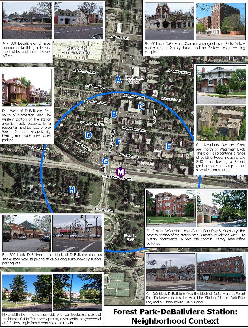
4 Neighborhood Context: Summary The Forest Park-DeBaliviere Station serves a medium-density urban neighborhood. The neighborhood is centered around DeBaliviere Avenue, a mixed-use main street that contains single-story retail, office buildings, and mediumdensity apartment buildings. Most of the station area is split between three historic districts and has a strong architectural character. The blocks west of DeBaliviere Avenue are developed mostly with two-story, single-family homes. The blocks east of DeBaliviere are primarily developed with three- to five-story apartment buildings and limited commercial uses. The map on this page illustrates the general station location and quarter-mile station area. The map on the following page provides a more detailed description of existing land uses and prevailing development patterns within that quarter-mile area. The quarter-mile station area extends from Forest Park north to Kingsbury Place, but with the potential addition of the Loop Trolley and development opportunities near the intersection with Delmar Boulevard, the entire stretch of DeBaliviere between Forest Park Parkway and Delmar has been included for further study. 4
5 5
6 6
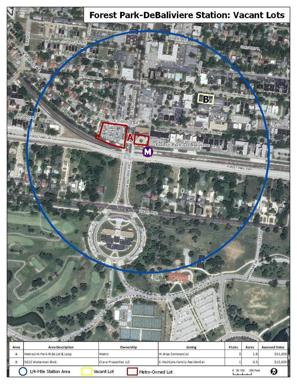
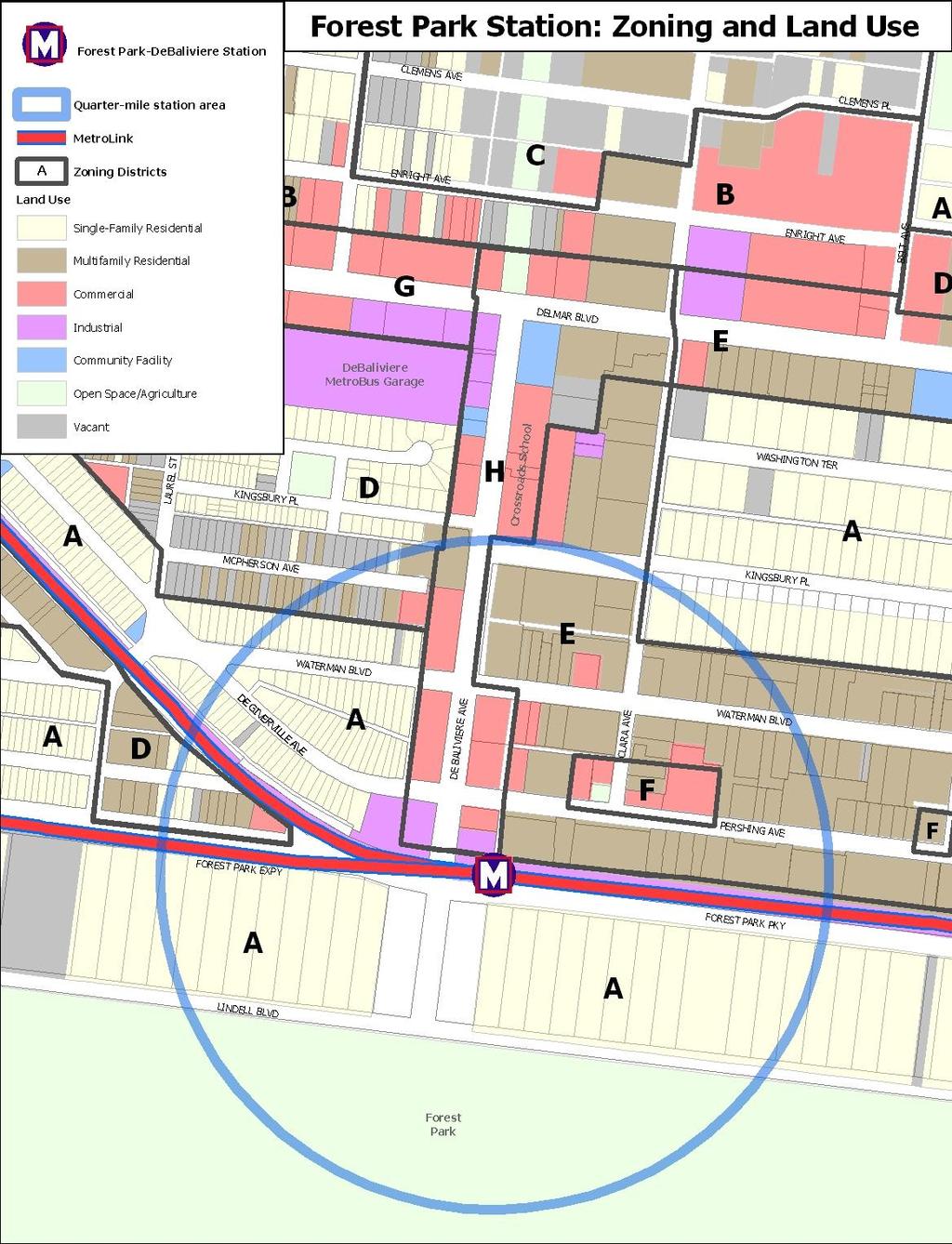
7 Zoning, Land Use Policies, and Community Plans The map and table on the following pages illustrate and explain current zoning regulations within a quarter-mile of the Delmar Station. The station area is entirely within the City of St. Louis, and all lots are covered by one of the following zoning districts: A: Single-Family Residential District D: Multi-Family Residential District E: Multi-Family Residential District F: Neighborhood Commercial District H: Area Commercial District Historic Districts: Most of the quarter-mile station area is within three City Historic Districts. Much of the western half of the station area is within the Skinker-DeBaliviere-Catlin Tract-Parkview Historic District, and most of the eastern half is inside the Central West End Historic District. A small part of the eastern portion, along Kingsbury Place, is within the Kingsbury-Washington Terrace Historic District. These districts impose special regulations on building heights, setbacks, design, and materials. Loop Trolley Transportation Development District: The Loop Trolley Transportation Development District (TDD) is pursuing federal funds to build and operate a modern streetcar line connecting the Delmar Loop to the cultural institutions in Forest Park. If built, the trolley will operate along the entire length of Delmar Boulevard and DeBaliviere Avenue between Trinity Avenue and Forest Park, connecting a vibrant commercial district to one with great potential and perhaps catalyzing new development along the route. The Loop Trolley will also improve the neighborhood s standing as a transit hub by offering connections to two MetroLink stations, a local streetcar, and five bus routes. Potential Development Opportunities and Issues Availability of land: There do not appear to be any physical barriers to growth aside from a lack of undeveloped land. There are few privately-owned vacant lots for new development in the station area, and only one is zoned for multifamily residential use. New TOD around the Forest Park-DeBaliviere MetroLink Station will largely depend on redevelopment of Metro s Park-Ride Lot, or redevelopment of underutilized commercial properties. Access/mobility: The neighborhood does contain mobility barriers that may make access to transit more difficult. A few streets end in turnabouts at DeBaliviere Avenue, making east-west travel by bike or car difficult. The MetroLink right-of-way cuts off access between the station and the 5700 block of Pershing Avenue, forcing those residents to walk or ride an extra block west and south, or to navigate difficult pedestrian crossings along Forest Park Parkway. Zoning: Existing zoning regulations within the quarter-mile station area generally match the existing development pattern, which for the most part provides a good local example of a medium-density, transit-oriented community. Existing zoning regulations in the eastern half of the station area, including DeBaliviere Avenue, would generally support a medium-density form of TOD that included mixed-use buildings up to eight stores in height. However, though buildings in this area may reach a height of eight stories, most lots east of DeBaliviere are already occupied by three-story apartment buildings. Zoning west of DeBaliviere would generally support a lower-density form of TOD consisting of two- to three-story apartment buildings and single-family homes on relatively narrow lots. However, there are ongoing planning efforts in this area that indicate greater demand for housing and retail that may support greater density. Some aspects of the existing zoning regulations may pose barriers to higher-density development: 7
8 Medium- and higher-density residential uses are limited to the eastern portion of the station area. The E and H Districts allow residential and mixed-use buildings up to eight stories or 100, but the A District west of DeBaliviere permits only two-story single-family homes and a limited set of community facilities, and the D District north of Waterman Boulevard only permits apartment buildings up to three stories. Commercial uses and mixed-use buildings are not allowed in the A District, and the D District limits such uses. Maximum building heights: Buildings west of DeBaliviere Avenue are limited to a general height of two to three stories. Buildings east of DeBaliviere may reach heights of eight stories or 100 ; however, nearly all of these lots are already developed with three-story apartments or one-story commercial uses, and the applicable historic districts may not allow taller buildings. However, the City does offer three zoning overlay districts that may permit greater development flexibility: Community Unit Plans (CUPs), Special Use Districts (SUDs), and Planned Unit Development Districts (PUDs). The CUP and SUD overlays are intended for area-wide planning and large-scale developments; PUDs apply to smaller-scale projects. These zoning overlays can provide greater flexibility in uses, housing types, and site planning in return for formal site plan review and determination of uses on-site. Historic Districts: Nearly the entire station area is covered by three City Historic Districts. These districts impose special regulations on building heights, setbacks, design, and materials. New construction must be reviewed and approved by the Historic District Review Committee and the Landmarks and Urban Design Commission. In several cases the Districts impose controls that might help foster TOD in an urban environment, such as restrictions on singlestory commercial buildings, drive-thrus, gas stations, and parking in front of buildings. However, Metro s Park-Ride Lot is located on the edge of the Skinker-DeBaliviere Historic District, which is primarily developed with single-family homes. Both the current zoning and historic district regulations may pose a significant barrier to new development on the Metro Park-Ride Lot. 8
9 9
10 Table 5: Forest Park Station: Existing Zoning Regulations A D E F H District Type Single-Family Residential Multifamily Residential Multifamily Residential Neighborhood Commercial District Area Commercial District Uses Permitted 1-family homes; 2-family homes if 40% of street developed with 2-family homes or apartments; parks and playgrounds; libraries All residential types; parks and playgrounds; libraries All residential types; hotels; parks and playgrounds; libraries All residential types; hotels; parks and playgrounds; libraries; range of locallyoriented retail and services; offices Same as G By Special Permit B&Bs; churches; cemeteries; farming and truck gardening; government buildings; hospitals; greenhouses; parking lots/garages; public museums and galleries; schools; utility substations Same as A, plus day care; hotels; nursing homes; group homes; boarding houses; offices up to 3,500 sq.ft.; and a limited set of neighborhood retail and services, only allowed on first floor and in basements Same as D, but a wider range of local retail and services allowed, limited to 3,500 sq.ft. Retail and services over 3,500 sq.ft.; bars; liquor stores; restaurants; parking lots; theaters; gas stations; drive-thrus Same as G Minimum Lot Area 4,000 sq.ft. per DU 1-family homes = 4,000 sq.ft.; 2-family homes & town houses = 850 sq.ft. per DU; apartments = 750 sq.ft. per DU 1-family homes = 4,000 sq.ft.; 2-family homes & town houses = 750 sq.ft. per DU; apartments = 250 sq.ft. per DU Residential = same lot area requirement as least restrictive adjacent residential district 1-family homes = 4,000 sq.ft.; 2-family homes & town houses = 750 sq.ft. per DU; apartments = 250 sq.ft. per DU Maximum Building Height Residential = 2.5 stories / 35'; institutions = 85' Residential = 3 stories / 45'; institutions = 85 8 stories / 100' 3 stories / 50'; institutions = 85' 8 stories / 100' Maximum F.A.R. N/A Commercial = 1.5 Commercial = 2.0 Non-residential and mixed-use = 1.5 N/A Minimum Front Yard Contextual line-up; otherwise, at least 25', no more than 50' Contextual line-up; otherwise, at least 10', no more than 25' Contextual line-up; otherwise, at least 10', no more than 25' None required, but contextual line-up if 25% or more of street frontage is developed Residential = contextual line-up; otherwise 10', no more than 25'. Other = none required, but contextual line-up if 25% or more of street is developed Minimum Side Yard 2 required; 10' total, min 4' each Residential = 1 required, min 4'; other under 3 stories/35' = 2 required, 4' Generally 1 required, min 4'; 2 deeper yards required for buildings over 35' None required. Residential buildings as per adjacent residential district None required, except 5' abutting a residential district. Mixed-use = 2 required, min 8' each Minimum Rear Yard 25' 15', unless 12' side yard provided 15' - 20' None required. Residential buildings as per adjacent residential district None required Parking Residential = 1 per DU Residential = 1 per DU; retail = 1 per 700 sq.ft. over 3,000 sq.ft.; restaurants = 1 per 200 sq.ft. over 1,000 sq.ft. Same as F, plus light industrial/wholesale/warehousing =1 per 10 employees Miscellaneous In residential districts, front-yard parking requires a special permit. In A Districts, residential building height can be increased to 3 stories / 45' with wider side yards. In D Districts, building heights may match the prevailing development pattern. In E, F, and H Districts building heights may be increased with provision of deeper side yards. Three zoning overlay districts that provide maximum flexibility for new planned developments. A Community Unit Plan (CUP) District allows a large-scale planned development for an area of at least 15 acres. Special Use Districts (SUDs) allow the same, for sites at least 2 acres. Planned Unit Development (PUD) Districts have no minimum lot area. All of these overlay districts require formal review and approval of the rezoning and a detailed site plan. *DU = dwelling unit 10
Arch-Laclede s Landing Station
 Arch-Laclede s Landing Station This station profile describes existing conditions around the Arch-Laclede s Landing MetroLink Station. This is one of a set of profiles for each of the MetroLink System
Downtown Stations: 8 th & Pine and Convention Center
 Downtown Stations: 8 th & Pine and Convention Center This station profile describes existing conditions around two MetroLink Stations in Downtown St. Louis, the 8 th & Pine and Convention Center Stations.
NOVEMBER 2016 AARP IN ST. LOUIS & CITIZENS FOR MODERN TRANSIT PLACEMAKING STRATEGIES FOR ST. LOUIS TRANSIT DRAFT
 NOVEMBER 2016 AARP IN ST. LOUIS & CITIZENS FOR MODERN TRANSIT PLACEMAKING STRATEGIES FOR ST. LOUIS TRANSIT DRAFT APPENDIX AARP IN ST. LOUIS + CMT + ARCTURIS + THE INNIS GROUP 51 APPENDIX APPENDIX A - RIDERSHIP
North Hanley Station. o Flower Valley Shopping Center o Cross Keys Shopping Cente #49 North Lindbergh MetroBus
 North Hanley Station This station profile describes existing conditions around the North Hanley MetroLink Station. This is one of a set of profiles for each of the MetroLink System s 37 light rail stations.
MONTGOMERY COUNTY RENTAL HOUSING STUDY. NEIGHBORHOOD ASSESSMENT June 2016
 MONTGOMERY COUNTY RENTAL HOUSING STUDY NEIGHBORHOOD ASSESSMENT June 2016 AGENDA Model Neighborhood Presentation Neighborhood Discussion Timeline Discussion Next Steps 2 WORK COMPLETED Socioeconomic Analysis
From Policy to Reality
 From Policy to Reality Updated ^ Model Ordinances for Sustainable Development 2000 Environmental Quality Board 2008 Minnesota Pollution Control Agency Funded by a Minnesota Pollution Control Agency Sustainable
MONROE WARD REZONING SUMMARY. October 2018
 MONROE WARD REZONING SUMMARY October 2018 WHY IS THE CITY REZONING MONROE WARD? In July of 2017 Richmond City Council adopted The Pulse Corridor Plan, a corridor-long planning document that outlines steps
PLANNING AND IMPLEMENTING TOD: KEY FACTORS FOR SUCCESS. Sujata Srivastava Knowledge Corridor TOD Workshop June 5, 2013
 PLANNING AND IMPLEMENTING TOD: KEY FACTORS FOR SUCCESS Sujata Srivastava Knowledge Corridor TOD Workshop June 5, 2013 6-year old partnership dedicated to improving practice through technical assistance,
DIVISION 7. R-6 AND R-6A RESIDENTIAL ZONES* The purpose of the R-6 residential zone is:
 Date of Draft: March 6, 2015 DIVISION 7. R-6 AND R-6A RESIDENTIAL ZONES* Sec. 14-135. Purpose. The purpose of the R-6 residential zone is: (a) To set aside areas on the peninsula for housing characterized
ATTACHMENT C. Development Requirements
 ATTACHMENT C Development Requirements Development Codes, also known as Municipal Codes, were reviewed for each station and compiled by jurisdiction. Only those zoning designations located within 0.5 mile
Appendix A: Guide to Zoning Categories Prince George's County, Maryland
 Appendix A: Guide to Zoning Categories Prince George's County, Maryland RESIDENTIAL ZONES 1 Updated November 2010 R-O-S: Reserved Open Space - Provides for permanent maintenance of certain areas of land
PLANNING COMMISSION WILLIAMSBURG, VIRGINIA WORK SESSION AGENDA Wednesday, May 23, 2012
 PLANNING COMMISSION WILLIAMSBURG, VIRGINIA WORK SESSION AGENDA Wednesday, May 23, 2012 The meeting will be called to order in the third floor Conference Room (Room 310), Williamsburg Municipal Building,
Kinzie Industrial Corridor
 Mayor Emanuel s Industrial Corridor Modernization Kinzie Industrial Corridor Fulton Market Innovation District Plan Implementation September 19, 2017 Rahm Emanuel, Mayor David Reifman, Commissioner Dept.
Planning Justification Report
 Planning Justification Report Kellogg s Lands City of London E&E McLaughlin Ltd. June 14, 2017 Zelinka Priamo Ltd. Page i TABLE OF CONTENTS Page No. 1.0 2.0 2.1 2.2 3.0 4.0 5.0 5.1 5.2 5.3 5.4 5.5 5.6
EXISTING CORRIDOR CONDITIONS CHAPTER 3
 EXISTING CORRIDOR CONDITIONS INTRODUCTION Physical, economic, and demographic conditions are constantly changing and evolving. Furthermore, what may appear to be a seemingly small change in the physical
Suburban Commercial Center ( CE-S ) Permitted Principal Uses and Structures
 Permitted Principal Uses and Structures") Division 12. Suburban Commercial Center ( CE-S ) 2.9.1 Purpose Suburban commercial centers provide regional commercial destinations with design and site elements compatible with suburban character. Dimensional
Division 12. Suburban Commercial Center ( CE-S ) 2.9.1 Purpose Suburban commercial centers provide regional commercial destinations with design and site elements compatible with suburban character. Dimensional
FOR SALE 140 N. BRENTWOOD CLAYTON, MO FOR SALE DOWNTOWN CLAYTON OPPORTUNITY LAND AVAILABLE FOR REDEVELOPMENT
 FOR SALE 140 N. BRENTWOOD CLAYTON, MO FOR SALE DOWNTOWN CLAYTON OPPORTUNITY LAND AVAILABLE FOR REDEVELOPMENT TABLE OF CONTENTS Section1 Section 2 Section 3 Section 4 Offering Summary Development Opportunity
HOUSING ELEMENT Inventory Analysis
 HOUSING ELEMENT Inventory Analysis 2.100 INVENTORY Age of Housing Stock Table 2.25 shows when Plantation's housing stock was constructed. The latest available data with this kind of breakdown is 2010.
5 ft. When adjacent to MF 9 and MF 18: 20 ft. MAXIMUM SETBACKS Frontage Ground Floor Above Ground Floor State Road 7 30 ft. N/A MINIMUM ACTIVE USES
 7 8 9 0 7 8 9 0 (ii) C MU Central Mixed Use District Development Regulations Table. C MU SR7 Central Mixed Use District Development Regulations MAXIMUM DENSITY Vertical Mixed Use Building Bonus Dwelling
EXHIBIT 1 PROJECT DESCRIPTION AND DESCRIPTION OF REQUESTED AREA VARIANCES REDEVELOPMENT OF 201 ELLICOTT STREET
 EXHIBIT 1 PROJECT DESCRIPTION AND DESCRIPTION OF REQUESTED AREA VARIANCES REDEVELOPMENT OF 201 ELLICOTT STREET I. PROJECT DESCRIPTION: Ciminelli Real Estate Corporation (the Applicant ) is seeking area
APPENDIX C CHARACTERISTICS OF THE ENERGIZE PHOENIX CORRIDOR
 APPENDIX C CHARACTERISTICS OF THE ENERGIZE PHOENIX CORRIDOR BACKGROUND ON RESIDENTIAL AND COMMERCIAL BUILDINGS IN THE EP CORRIDOR The 10-mile EP corridor (Figure G1) is a highly diverse, mixed-use L-shaped
TOD and Equity. TOD Working Group. James Carras Carras Community Investment, Inc. August 7, 2015
 TOD and Equity TOD Working Group James Carras Carras Community Investment, Inc. August 7, 2015 What is Equitable TOD? Equity is fair and just inclusion. Equitable TOD is the precept that investments in
Chapter 5: Testing the Vision. Where is residential growth most likely to occur in the District? Chapter 5: Testing the Vision
 Chapter 5: Testing the Vision The East Anchorage Vision, and the subsequent strategies and actions set forth by the Plan are not merely conceptual. They are based on critical analyses that considered how
GEORGE / GROSVENOR AREA STUDY RECOMMENDATIONS PLANNING CITY OF LONDON DEPARTMENT OF. MAY 1985 r----q
 GEORGE / GROSVENOR AREA STUDY RECOMMENDATIONS CITY OF LONDON DEPARTMENT OF PLANNING MAY 1985 r----q PREFACE On April 9, 1985, the Planning Committee held a public meeting regarding the St. George/Grosvenor
Marcel Williams, MPC Project Planner
 TO: FROM: The Planning Commission MPC Staff DATE: SUBJECT: Petition to Rezone Property Heath Shelton, Owner Jay Maupin, Agent 2026 Habersham Street Aldermanic District: 2, Bill Durrence County Commission
UrbanFootprint Place Types. Urban Mixed Use. Urban Residential. Urban Commercial. Residential 1% SF Large Lot 0%
 Urban Mixed Use Residential 18% SF Large Lot 0% Employment 16% SF Small Lot 0% Mixed Use 45% Townhome 0% Open Space/Civic 21% MultiFamily 100% Intersections per mi 2 200 Office 80% Average Floors 23 Retail
Article 04 Single Family Residential Districts
 Article 04 Article 04 Section 04.01 Intent (a) R1A Residence District. The R1A Single Family Residential District is established to include areas of low density single-family residences and limited agricultural
Salem HNA and EOA Advisory Committee Meeting #6
 Salem HNA and EOA Advisory Committee Meeting #6 Residential Land Policies Employment Land Policies Policy Discussions with the Committee Outcome of today s meeting Direction from this Committee on proposed
Route 6 Corridor Study Bristol Planning Commission Meeting #1. May 25, 2016 FITZGERALD & HALLIDAY, INC. Innovative Planning, Better Communities
 Route 6 Corridor Study Bristol Planning Commission Meeting #1 May 25, 2016 FITZGERALD & HALLIDAY, INC. Innovative Planning, Better Communities Today s Agenda 1. Introductions 2. Study overview Scope Schedule
PLANNING COMMISSION REPORT Regular Agenda - Public Hearing Item
 Z-11-25-09; Z-11-26-09; Z-11-28-09 Item No. 2-1 PC Staff Report 3/28/11 PLANNING COMMISSION REPORT Regular Agenda - Public Hearing Item ITEM NO. 2A RM32 TO MU;.19 ACRES; 1340 TENNESSEE ST (MJL) Z-1-1-11:
NEW AND REVISED. Organization, format and editing. Numbering, page layout, tables, charts, illustrations General editing and plain English voice
 NEW AND REVISED Organization, format and editing Numbering, page layout, tables, charts, illustrations General editing and plain English voice ORGANIZATION AND FORMAT Chapter 1 Introductory Provisions
Downtown Development Focus Area: I. Existing Conditions
 Downtown Development Focus Area: I. Existing Conditions The Downtown Development Focus Area is situated along Route 1, south of the train tracks, except for the existing Unilever property. It extends west
III. Housing Profile and Analysis
 III. Housing Profile and Analysis 3-1 III. Housing Profile and Analysis A. Housing Types Information on the type of housing available is important to have a clear picture of what Lacey has in its housing
THE AREA PLAN COMMISSION OF ST. JOSEPH COUNTY, IN AGENDA
 THE AREA PLAN COMMISSION OF ST. JOSEPH COUNTY, IN AGENDA Tuesday, June 20, 2017 Fourth-Floor Council Chambers 3:30 p.m. County-City Building, South Bend, IN PUBLIC HEARINGS: 1. Rezonings: A. A combined
CHAPTER 8: HOUSING. Of these units, 2011 Census statistics indicate that 77% are owned and 23% are rental units.
 CHAPTER 8: HOUSING Port Moody has traditionally been a family oriented community. Based on the 2011 Census, 64% of all census families include children. Overall the number of dwelling units in Port Moody
PLANNING AND REGULATING HOUSING OPTIONS FOR CHANGING DEMOGRAPHICS
 PLANNING AND REGULATING HOUSING OPTIONS FOR CHANGING DEMOGRAPHICS New Partners for Smart Growth Conference February 2017 HOUSING MARKETS Significant increase in rental housing Offset robust single-family
APPENDIX D: DEFINITIONS
 D APPENDIX D: DEFINITIONS Terms used throughout the 2040 Comprehensive Plan should be interpreted using the definitions provided in this appendix. For interpretation of any term not defined, defer to the
PART 3 RESIDENTIAL ZONING DISTRICTS. Designation of Residential Zoning Districts and Purpose Statements.
 PART 3 S Section 301. Designation of and Purpose Statements. See Table 3-1 herein this Section for the designations and purpose statements of the respective Residential Zoning Districts which are shown
MPN. S broad street corner development site. 701 s broad street, philadelphia, pa 19147
 S broad street corner development site 701 s broad street, philadelphia, pa 19147 1601 Walnut St, Philadelphia, PA 19102 215.413.4900 www.mpnrealty.com corner development site FOR SALE 701 s broad street
Oak Cliff Gateway District PD 468
 Oak Cliff Gateway District PD 468 August 21, 2014 2013 Authorized Hearing Authorized Hearing September, 2013 September 12, 2013 City Plan Commission expanded boundaries to represent current Oak Cliff Gateway
COUNTY OF ALBEMARLE PLANNING STAFF REPORT SUMMARY
 COUNTY OF ALBEMARLE PLANNING STAFF REPORT SUMMARY Project Name: ZMA 2010-00015, Cedar Hill Planning Commission Worksession: February 15, 2011 Public Hearing: Not scheduled Staff: Judith C. Wiegand, AICP
PLANNING ANALYSIS ZONING CASE 18-TOD-Z-026 NAK S CROSSING PUD AMENDMENT. GC-3-A (General Commercial) GC-3-A (General Commercial)
 GC-3-A (General Commercial)") PLANNING ANALYSIS ZONING CASE 18-TOD-Z-026 NAK S CROSSING PUD AMENDMENT GENERAL INFORMATION Applicant/Owner: Current Zoning: Bruce Nakfoor PUD/TOD (Planned Unit Development/Transit Oriented Development
PLANNING ANALYSIS ZONING CASE 18-TOD-Z-026 NAK S CROSSING PUD AMENDMENT GENERAL INFORMATION Applicant/Owner: Current Zoning: Bruce Nakfoor PUD/TOD (Planned Unit Development/Transit Oriented Development
Affordability. Housing that is Affordable, Not Affordable Housing. Neighborhoods NOW Conference November 10, 2016
 Housing that is Affordable, Not Affordable Housing Neighborhoods NOW Conference November 10, 2016 Prepared by Greenstreet Ltd. Greenstreet Ltd. All rights reserved 2016. At some point during the 2000s,
Generic Environmental Impact Statement. Build-Out Analysis. City of Buffalo, New York. Prepared by:
 Generic Environmental Impact Statement Build-Out Analysis City of Buffalo, New York 2015 Prepared by: TABLE OF CONTENTS 1.0 INTRODUCTION 1 2.0 METHODOLOGY 2 3.0 EXISTING LAND USE 3 4.0 EXISTING ZONING
Flatbush Rezoning and Text Amendments LR Item 3: Description of Proposal
 Project Description The New York City Department of City Planning (DCP), at the request of Community Board 14, elected officials and civic groups, proposes zoning map changes and zoning text amendments
Addressing the Impact of Housing for Virginia s Economy
 Addressing the Impact of Housing for Virginia s Economy A REPORT FOR VIRGINIA S HOUSING POLICY ADVISORY COUNCIL NOVEMBER 2017 Appendix Report 2: Housing the Commonwealth's Future Workforce 2014-2024 Jeannette
1057 Canton RD Marietta, GA 30066
 1057 Canton RD Marietta, GA 30066 +/- 1.49 Acres Presently Zoned LI $350,000 With all utilities available. Very little lot prep necessary for most uses. Two Level steppes descending from the street level.
Bylaw No , being "Official Community Plan Bylaw, 2016" Schedule "A" DRAFT
 Bylaw No. 2600-2016, being "Official Community Plan Bylaw, 2016" Schedule "A" Urban Structure + Growth Plan Urban Structure Land use and growth management are among the most powerful policy tools at the
City of Greater Dandenong Our Place
 City of Greater Dandenong Our Place 2 City of Greater Dandenong Our Place Contents Greater Dandenong 4 Economic activity clusters 7 Connectivity 8 Residential property prices 10 Value of building work
Housing. Approved and Adopted by City Council November 13, City Council Resolution City Council Resolution
 5 Housing Approved and Adopted by City Council November 13, 2018 Chapter 5 Housing 5.1 City Council Resolution 2018-096 5.2 Fontana General Plan CHAPTER 5 Housing This chapter of the General Plan Update
Missing Middle Housing Types Showcasing examples in Springfield, Oregon
 Missing Middle Housing Types Showcasing examples in Springfield, Oregon MissingMiddleHousing.com is powered by Opticos Design Illustration 2015 Opticos Design, Inc. Missing Middle Housing Study Prepared
Wheaton Sector Plan. Preliminary. Recommendations. Montgomery County Planning Board
 Sector Plan Preliminary Recommendations Montgomery County Planning Board 12-03-09 Scope of Work September 2008 Status Report June 2009 Preliminary Recommendations December 2009 1952 Process Today Community
June 22, 2005/Calendar No. 14
 CITY PLANNING COMMISSION June 22, 2005/Calendar No. 14 C 050400 ZMQ IN THE MATTER OF an application submitted by the Department of City Planning pursuant to Sections 197-c and 201 of the New York City
Montreal Road District Secondary Plan [Amendment #127, October 9, 2013]
![Montreal Road District Secondary Plan [Amendment #127, October 9, 2013]](/thumbs/72/66783104.jpg "Montreal Road District Secondary Plan [Amendment #127, October 9, 2013]") [Amendment #127, October 9, 2013] 1.0 General The following policies are applicable to the Montreal Road District as set out in Schedule 1. 1.1 District Objectives The objective of this Plan is to guide
[Amendment #127, October 9, 2013] 1.0 General The following policies are applicable to the Montreal Road District as set out in Schedule 1. 1.1 District Objectives The objective of this Plan is to guide
Metro Vancouver's 2011 Generalized Land Use by Municipality (Net Land Area - excluding dedicated road right-of-way and water bodies)
") METRO VANCOUVER Land Percent Share Land Use Category Area (ha) of METRO Total Agriculture 48,822 17.1% Airport/Airstrip 1,577 0.6% Cemetery 292 0.1% Commercial 2,980 1.0% Harvesting and Research 8,630
METRO VANCOUVER Land Percent Share Land Use Category Area (ha) of METRO Total Agriculture 48,822 17.1% Airport/Airstrip 1,577 0.6% Cemetery 292 0.1% Commercial 2,980 1.0% Harvesting and Research 8,630
ATLANTA ZONING ORDINANCE UPDATE
 CITY OF ATLANTA ZONING ORDINANCE QUICK FIXES In 2015 the City of Atlanta selected a team of consultants to conduct a comprehensive assessment of the City s Zoning Ordinance, including a review of the ability
Implementation. Approved Master Plan and SMA for Henson Creek-South Potomac 103
 Implementation Approved Master Plan and SMA for Henson Creek-South Potomac 103 104 Approved Master Plan and SMA for Henson Creek-South Potomac Sectional Map Amendment The land use recommendations in the
RAE EXCLUSIVE RESIDENTIAL ZONE A residential district exclusively for low density single family housing and accessory uses.
 KNOX COUNTY ZONING ORDINANCE DISTRICT SUMMARY REQUIREMENTS 2/11/2009 RAE EXCLUSIVE RESIDENTIAL ZONE A residential district exclusively for low density single family housing and accessory uses. 10,000 sq.
Existing Land Use. Typical densities for single-family detached residential development in Cumberland County: 1
 Existing Land Use A description of existing land use in Cumberland County is fundamental to understanding the character of the County and its development related issues. Economic factors, development trends,
THE AREA PLAN COMMISSION OF ST. JOSEPH COUNTY, IN AGENDA
 THE AREA PLAN COMMISSION OF ST. JOSEPH COUNTY, IN AGENDA Tuesday, January 17, 2017 Fourth-Floor Council Chambers 3:30 p.m. County-City Building, South Bend, IN EXECUTIVE SESSION: A. Election of Officers
6 NE 130TH STREET STATION TOD POTENTIAL
 6 NE 130TH STREET STATION TOD POTENTIAL Key Findings TOD potential for the NE 130th Street Station is limited, primarily because of the predominant single-family development pattern in this area. The two
Upcoming Apartment Projects with No On-Site Parking Frequently Asked Questions June 2012
 Upcoming Apartment Projects with No On-Site Parking Frequently Asked Questions June 2012 Recent proposals to construct apartment buildings with no on-site parking along many of Portland s commercial streets
Attachment 3. Guelph s Housing Statistical Profile
 Attachment 3 Guelph s Housing Statistical Profile Table of Contents 1. Population...1 1.1 Current Population (26)...1 1.2 Comparative Growth, Guelph and Ontario (21-26)...1 1.3 Total Household Growth (21
2.110 COMMERICAL MIXED USE (CM)
") CITY OF KEIZER DEVELOPMENT BULLETIN 2.110.01 Purpose 2.110 COMMERICAL MIXED USE (CM) The Commercial Mixed Use (CM) zone is the primary commercial zone within the City. The zone is specifically designed
CITY OF KEIZER DEVELOPMENT BULLETIN 2.110.01 Purpose 2.110 COMMERICAL MIXED USE (CM) The Commercial Mixed Use (CM) zone is the primary commercial zone within the City. The zone is specifically designed
ARTICLE 3: Zone Districts
 ARTICLE 3: Zone Districts... 3-1 17.3.1: General...3-1 17.3.1.1: Purpose and Intent... 3-1 17.3.2: Districts and Maps...3-1 17.3.2.1: Applicability... 3-1 17.3.2.2: Creation of Districts... 3-1 17.3.2.3:
Community Advisory Committee (CAC) Meeting #7 West Anaheim Youth Center May 26, 2016
 Meeting #7 West Anaheim Youth Center May 26, 2016") Community Advisory Committee (CAC) Meeting #7 West Anaheim Youth Center May 26, 2016 1 Project Team City: David Belmer Planning and Building Director Jonathan Borrego, AICP Planning Services Manager Gustavo
Community Advisory Committee (CAC) Meeting #7 West Anaheim Youth Center May 26, 2016 1 Project Team City: David Belmer Planning and Building Director Jonathan Borrego, AICP Planning Services Manager Gustavo
AUBURN BANKSTOWN BLACKTOWN HOLROYD PARRAMATTA THE HILLS. West Central District Demographic & Economic Characteristics
 AUBURN BANKSTOWN BLACKTOWN HOLROYD PARRAMATTA THE HILLS West Central District Demographic & Economic Characteristics Contents The West Central District 3 People 4 Population 4 Age Profile 6 Households
City of Golden Council Memorandum
 City of Golden Council Memorandum 911 10 th St. Golden CO 80401 TEL: 303-384-8000 FAX: 303-384-8001 WWW.CITYOFGOLDEN.NET To: The Honorable Mayor and City Council From: Rick Muriby, Planning Manager Thru:
8Land Use. The Land Use Plan consists of the following elements:
 8Land Use 1. Introduction The Land Use Plan consists of the following elements: 1. Introduction 2. Existing Conditions 3. Opportunities for Redevelopment 4. Land Use Projections 5. Future Land Use Policies
Demographics Review Multi-family Housing Data & Characteristics. Triplexes, quadplexes, and apartments. Development Potential Future Considerations
 Horizon Discussion: Arlington 2012 Multi-Family Housing Profile City Council Meeting September 17, 2013 6 Overview Demographics Review Multi-family Housing Data & Characteristics Triplexes, quadplexes,
PLANNING COMMISSION REPORT Regular Agenda Public Hearing Item
 PC Staff Report 06/21/10 Item No. 4-1 PLANNING COMMISSION REPORT Regular Agenda Public Hearing Item ITEM NO. 4: PD-[TANGER PCD-1] TO CS; 1025 N. 3 rd STREET (SLD) : Consider a request to rezone approximately
SEATTLE DEVELOPMENT OPPORTUNITY
 Seattle CBD Wallingford University Of Washington U District Light Rail Station (under construction, expected to open in 2021) 50th & I-5 Interchange NE 50th Street Roosevelt Way NE 911 NE 50th Street,
DRAFT. Amendment to the Master Plan Land Use Element for Block 5002, Lot Township of Teaneck, Bergen County, New Jersey.
 DRAFT Amendment to the Master Plan Land Use Element for Block 5002, Lot 18.01 Township of Teaneck, Bergen County, New Jersey Prepared for: Township of Teaneck Planning Board Prepared by: Janice Talley,
REQUEST STAFF RECOMMENDATION. On April 26, 2012, Signature Books Inc., represented by Dave Richards, submitted petitions for the following amendments:
 PLANNING COMMISSION STAFF REPORT Signature Books Zoning Map Amendment and an Amendment to the North Temple Area Plan Petitions PLNPCM2012-00254 PLNPCM2012-00255 July 11, 2012 Planning Division Department
POPULATION FORECASTS
 POPULATION FORECASTS Between 2015 and 2045, the total population is projected to increase by 373,125 residents to reach 2.2 million. Some areas will see major increases, while other areas will see very
Charlotte LYNX Blue Line Economic Development Impact and Land Use Patterns
 Charlotte LYNX Blue Line Economic Development Impact and Land Use Patterns National Governors Association Policy Academy on Shaping a New Approach to Transportation and Land Use Peter Zeiler Economic Development
Appendix B: Housing Element Sites Inventory and Detailed Analysis
 Appendix B: 2015-2023 Housing Element Sites Inventory and Detailed Analysis Redwood City General This page intentionally left blank. Redwood City General Site Identifier Assessor Parcel Number General
Neighborhood Conservation District Code Revisions CITY OF MIAMI PLANNING DEPARTMENT NCD-COCONUT GROVE 27 JANUARY
 Neighborhood Conservation District Code Revisions CITY OF MIAMI PLANNING DEPARTMENT NCD-COCONUT GROVE 27 JANUARY 2018 1 Neighborhood Conservation District Code Revisions CITY OF MIAMI PLANNING DEPARTMENT
Future Land Use Categories & Nodes December 23, Future Land Use Categories
 Future Land Use Categories & Nodes December 23, 2015 A note regarding nodes: Descriptions for nodes are located in the general recommendations handout. Node locations are set in part by the Auburn Interactive
Provide a diversity of housing types, responsive to household size, income and age needs.
 8 The City of San Mateo is a highly desirable place to live. Housing costs are comparably high. For these reasons, there is a strong and growing need for affordable housing. This chapter addresses the
October 17, Proposal Due Date: Friday, November 10, 2017 by 4:00 pm
 Request for Proposal (RFP) For Housing Study and Needs Assessment Lamoille County Planning Commission (LCPC) Lamoille Housing Partnership (LHP) Stowe Land Trust (Identified below as The Contracting Partners
TOWN OF SOUTHAMPTON. Workforce Housing On the East End
 TOWN OF SOUTHAMPTON Workforce Housing On the East End September 20 th, 2017 TOWN OF SOUTHAMPTON DEMOGRAPHICS According to the most recent US Census data (2015) the population for full time residents is
SJC Comprehensive Plan Update Housing Needs Assessment Briefing. County Council: October 16, 2017 Planning Commission: October 20, 2017
 SJC Comprehensive Plan Update 2036 Housing Needs Assessment Briefing County Council: October 16, 2017 Planning Commission: October 20, 2017 Overview GMA Housing Element Background Demographics Employment
Puyallup Downtown Planned Action & Code Changes. January 10, 2017
 Puyallup Downtown Planned Action & Code Changes January 10, 2017 Purpose & Location Purpose Promote economic development and downtown revitalization Tools: Municipal Code amendments Change development
P o p u l a t i o n, L a n d U s e, a n d Z o n i n g
 P o p u l a t i o n, L a n d U s e, a n d Z o n i n g The Town of Upper Marlboro is located only 15 miles southeast of the District of Columbia, in the central portion of Prince George s County in the
LONG-RANGE LAND USE PLAN
 LONG-RANGE LAND USE PLAN INTENT Completion of the I-66/Route 29 interchange and future expansion of improved telecommunication networks will substantially improve the desirability of the Gainesville area
PLANNING AND DEVELOPMENT DEPARTMENT STAFF REPORT STAFF REPORT PREMIER AUTO SERVICES, INC. VARIANCES
 PLANNING AND DEVELOPMENT DEPARTMENT STAFF REPORT Meeting Date: February 14, 2019 Item #: PZ2019-402 STAFF REPORT PREMIER AUTO SERVICES, INC. VARIANCES Project Name: Premier Auto Services, Inc. Applicant:
Town Center South End Development Area District
 175.28 ESTABLISHMENT OF DISTRICTS. In order to carry out the purpose and intent of this chapter, the area of the is hereby divided into eighteen (18) Zoning District Classifications and one overlay zoning
City of Valdosta Land Development Regulations
 Chapter 206 Section 206-1 Base Zoning Districts Standards for Uses, Structures, and Property Development (B) (C) Principal Uses and Structures. Principal uses and structures permitted in each base zoning
STAFF SUMMARY OF Z17-10 CONDITIONAL ZONING DISTRICT APPLICATION
 STAFF SUMMARY OF Z17-10 CONDITIONAL ZONING DISTRICT APPLICATION APPLICATION SUMMARY Case Number: Z17-10 Request: Conditional B-2 Zoning District in order to expand an existing retail and warehousing business
WORLD TRADE CENTER GARAGE 1245 Fifth Avenue
 AMENDED AND RESTATED RECOMMENDED ACTION 1. AB 1484 Permissible Use Category Sale of Property If permitted under SB 107, subsequent legislation, and/or DOF direction, Agency reserves right to administratively
4-900 MILITARY PARKWAY-SYCENE CORRIDOR OVERLAY DISTRICT
 4-900 MILITARY PARKWAY-SYCENE CORRIDOR 4-901 PURPOSE AND SCOPE Ord. 3846/12-18-06 The Military Parkway Scyene Corridor is positioned centrally between the Mesquite Arena and Rodeo Entertainment District,
2401 Wilson Boulevard General Land Use Plan Amendment Study
 2401 Wilson Boulevard General Land Use Plan Amendment Study Long Range Planning Committee Meeting Presentation Compendium March 29, 2011 Department of Community Planning, Housing and Development GLUP Amendment
L. LAND USE. Page L-1
 L. LAND USE 1. Purpose This section discusses current and likely future land use patterns in Orland. An understanding of land use trends is very important in determining Orland's ability to absorb future
PLANNING COMMISSION REPORT Regular Agenda Public Hearing Item
 PC Staff Report 6/20/16 Item No. 4-1 PLANNING COMMISSION REPORT Regular Agenda Public Hearing Item PC Staff Report 06/20/16 ITEM NO. 4: IG to CS 1.56 ACRES; 706 E 23 RD STREET (MKM) : Consider a request
the conditions contained in their respective Orders until January 1, 2025, at the discretion of the Director of Planning, Property and Development.
 Part 4: Use Regulations Temporary Uses and Structures Purpose the conditions contained in their respective Orders until January 1, 2025, at the discretion of the Director of Planning, Property and Development.
ARTICLE 383. PD 383.
 ARTICLE 383. PD 383. SEC. 51P-383.101. LEGISLATIVE HISTORY. PD 383 was established by Ordinance No. 21928, passed by the Dallas City Council on December 8, 1993. Ordinance No. 21928 amended Ordinance No.
Ch. 14 CAPITOL HILL. Historic Districts - Apartment and Multi-family Development
 Historic Districts - Apartment and Multi-family Development Ch. 14 CAPITOL HILL A HISTORY OF APARTMENT AND MULTI-FAMILY DEVELOPMENT The following background on the historical development of apartment and
exclusive development offering
 exclusive development offering 8 0 - U N I T P R I M E C O N D O M I N I U M D E V E L O P M E N T S I T E 1995 N. Ventura Avenue Ventura, CA Lee & Associates LA North/Ventura, Inc. Corporate ID #01191898
PLANNING COMMISSION REPORT Regular Agenda - Public Hearing Item
 Z-15-00469 Item No. 6A- 1 PLANNING COMMISSION REPORT Regular Agenda - Public Hearing Item PC Staff Report 11/16/15 ITEM NO. 6A GPI, RM12, & RS40 TO RM12; 14.756 ACRES; 5200 & 5300 CLINTON PKWY (SLD) Z-15-00469: