PLAN COMMISSION MEETING Monday, March 27, 2017 at 4:30 p.m. Council Chambers in the Municipal Building AGENDA:
|
|
|
- Naomi Jocelyn Newton
- 5 years ago
- Views:
Transcription
1 PLAN COMMISSION MEETING Monday, March 27, 2017 at 4:30 p.m. Council Chambers in the Municipal Building AGENDA: 1) 516 West Street PH CUP Request 2) 1923 Gateway Drive, 1925 Gateway Drive & 2011 Airport Road John DeWitt Preliminary CSM Review 3) N8776 County Road E Donald Kiedrowski Preliminary CSM Review 4) Site Plan Review Minutes February 27, ) Plan Commission Minutes March 13, 2017
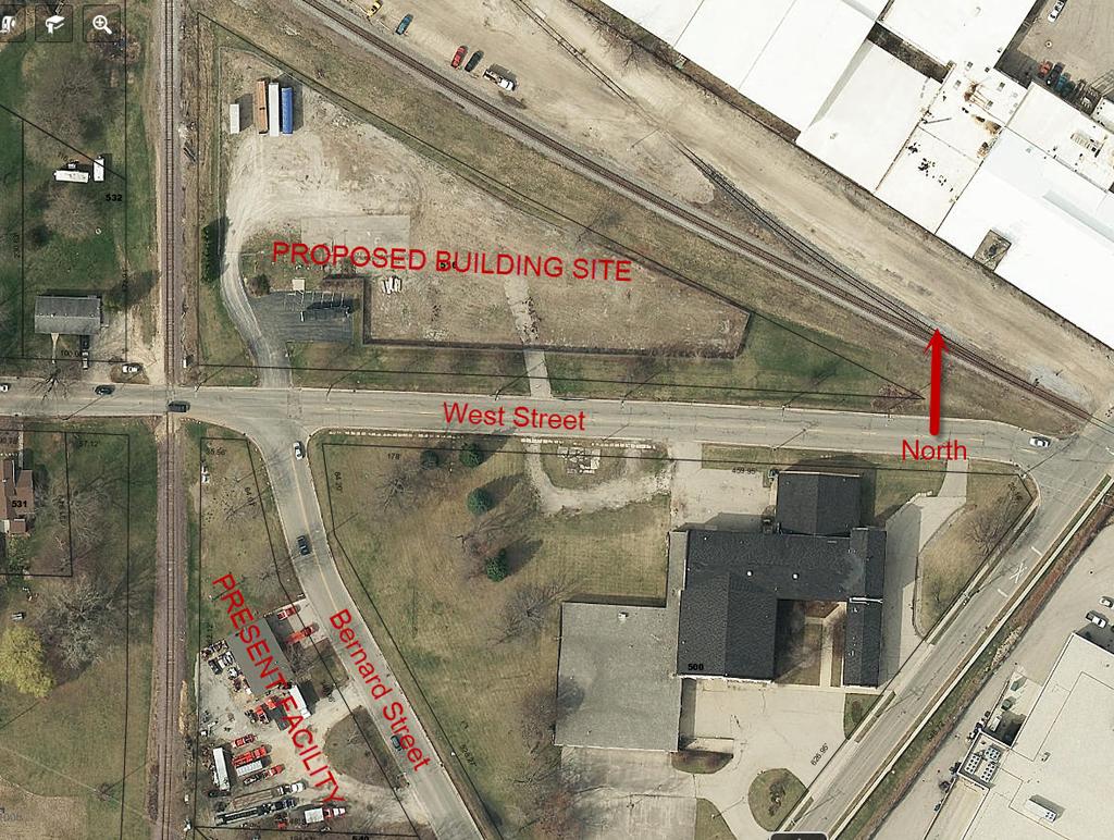
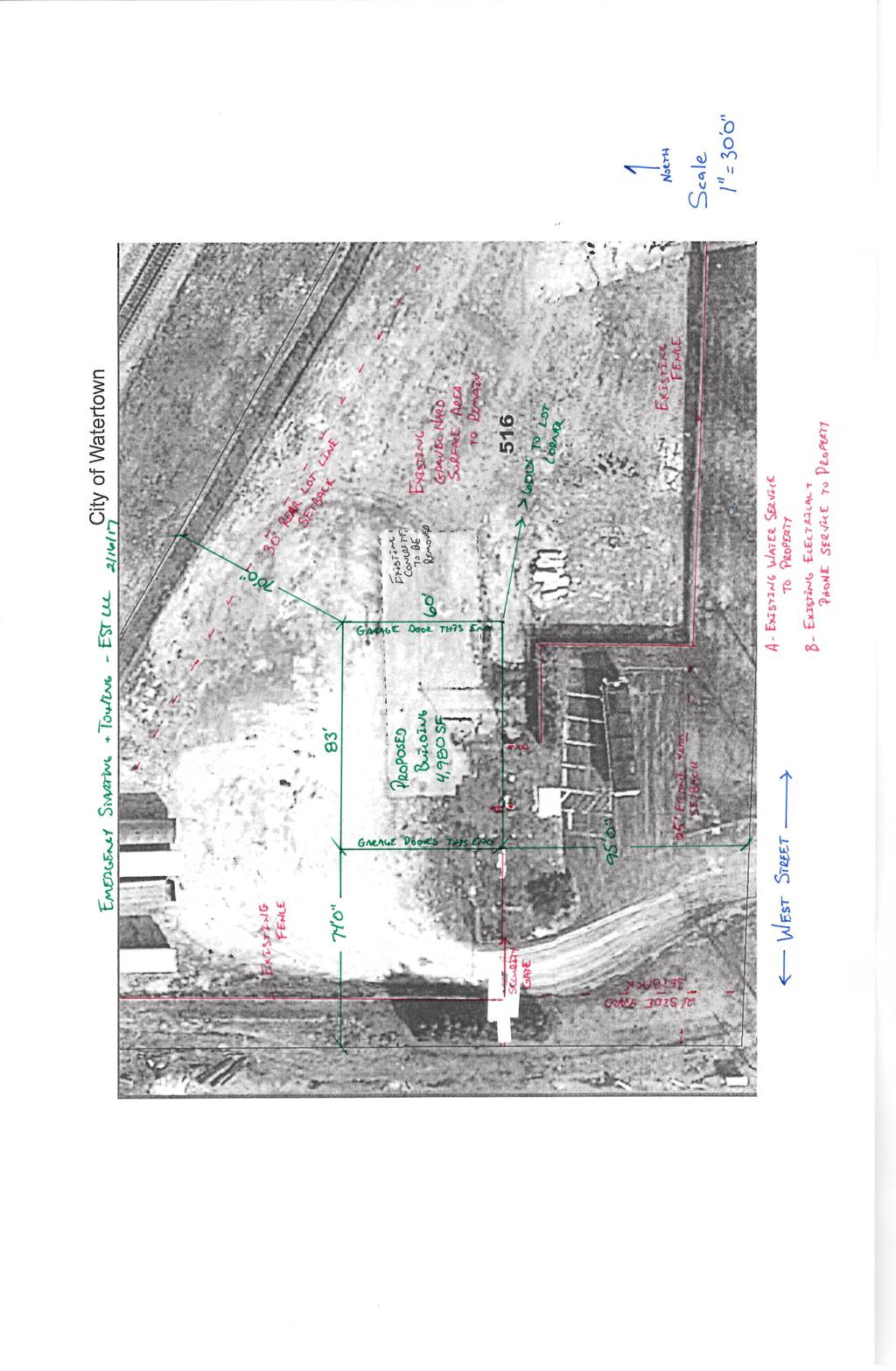
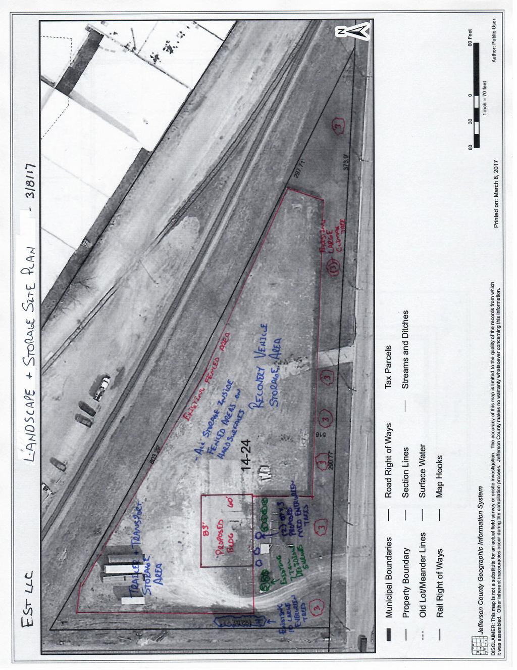
2 516 West Street Background: Andy and Ryan Tessman of Emergency Starting & Towing, LLC are requesting a Conditional Use Permit for Outdoor Storage or Wholesaling. Andy and Ryan have recently purchased this property and will be building a 4,980 square feet structure for use with their towing services. The need for an Outdoor Storage or Wholesaling Conditional Use Permit arises from the short term storage of towed/wrecked vehicles (before they are sent to a salvage yard). This site development went before the Site Plan Review Committee on February 27, 2017 (minutes attached). Issues: The following issues have been identified by the City of Watertown Zoning Administrator: 1. Per Section B: B. Outdoor storage or wholesaling. Description: Outdoor storage and wholesaling land uses are primarily oriented to the receiving, holding and shipping of packaged materials for a single business or a single group of businesses. Such a land use in which any activity beyond loading and parking is located outdoors is considered an outdoor storage and wholesaling land use. Examples of this land use include contractors' storage yards, equipment yards, lumberyards, coal yards, landscaping materials yard, construction materials yards, and shipping materials yards. Such land uses do not include the storage of inoperative vehicles or equipment or other materials typically associated with a junkyard or salvage yard (see Subsection D below). (1) Regulations: (a) All outdoor storage areas shall be completely enclosed by any permitted combination of buildings, structures, walls and fencing. Such walls and fencing shall be a minimum of eight feet in height and shall be designed to completely screen all stored materials from view from nonindustrialized areas at an elevation of five feet above the grade of all adjacent properties and rights-of-way. Said walls or fencing shall be screened from residentially zoned property by a bufferyard with a minimum opacity of (b) The storage of items shall not be permitted in permanently protected green space areas (see ). (c) The storage of items shall not be permitted in required frontage landscaping or bufferyard areas. (d) In no event shall the storage of items reduce or inhibit the use or number of parking stalls provided on the property below the requirement established by the provisions of If the number of provided parking stalls on the property is already less than the requirement, such storage area shall not further reduce the number of parking stalls already present. (e) Storage areas shall be separated from any vehicular parking or circulation area by a minimum of 10 feet. This separation shall
3 be clearly delimited by a physical separation such as a greenway, curb, fence or line of planters, or by a clearly marked paved area. (f) Materials being stored shall not interfere in any manner with either on-site or off-site traffic visibility, including potential traffic/traffic and traffic/pedestrian conflicts. (g) Inoperative vehicles or equipment, or other items typically stored in a junkyard or salvage yard, shall not be stored under the provisions of this land use. (h) Facility shall provide a bufferyard with a minimum opacity of 0.60 along all property borders abutting residentially zoned property (see ). (i) All outdoor storage areas shall be located no closer to a residentially zoned property than the required minimum setback for buildings on the subject property. (2) Parking requirements. One space for every 10,000 square feet of gross storage area, plus one space per each employee on the largest work shift 2. The Zoning Administrator asks that the Plan Commission works with Andy and Ryan to define short-term storage of vehicles. This is to prevent salvage yard complaints. Options: These are the following options, but not limited to, for the Plan Commission based on the information received by the City of Watertown Zoning Administrator: 1. Denial of the Conditional Use Permit 2. Approval of the Conditional Use Permit 3. Approval of the Conditional Use Permit with conditions identified by the Plan Commission and/or Site Plan Review Committee
4 1923 Gateway Drive, 1925 Gateway Drive & 2011 Airport Road -CSM Background: John DeWitt and Watertown Land Improvement, Inc. are looking to create 3 new lots. Lot 1 is a 1.2 acre lot created from 37 acre parent parcel. Lot 2 is a 2.1 acre lot created from the same 37 acre parent parcel. Lot 3 is a acre lot, which is combing 40 acre parcel, a 30.9 acre parcel, a 1 acre parcel (located in the Town of Watertown), the remainder of the parent parcel for Lots 1 &2, and a 32 acre parcel. Lots 1 & 2 are to be developed for residential purposes, while Lot 3 is to remain in agricultural use. Issues: The following issues have been identified by the City of Watertown Zoning Administrator: 1. The Zoning Administrator has concerns about the apparent addition of the 1 acre parcel (PIN: ). This parcel is not within the City Limits of the City of Watertown. This parcel would need to be annexed in before its inclusion into Lot 3. The Zoning Administrator doubts that annexation is even possible due to the creation of a town island of the two properties to the north. 2. Gateway Drive is identified in the 2009 City of Watertown Comprehensive Plan as having an expanded right-of-way, this means that the right-of-way should be 80 feet (40 feet from centerline) a. The Preliminary CSM does not indicate that the right-of-way has been dedicated to 40 feet from Centerline i. The Final CSM needs to dedicate right-of-way 40 feet from the centerline. 3. Airport Road is identified in the 2009 City of Watertown Comprehensive Plan as having an expanded right-of-way; this means that the right-of-way should be 100 feet (50 feet from centerline). a. The Preliminary CSM does not indicate that the right-of-way has been dedicated to 50 feet from the centerline. i. The Final CSM needs to dedicate right-of-way 50 feet from the centerline. 4. Airport Approach Protection Zone elevation limits development on the newly created lots to 968 feet above mean sea level. The City of Watertown is looking to maintain the proper height restrictions within the Airport Approach Protection Zone under Wisconsin Statute Section (1)(a) which states: POWERS OF MUNICIPALITIES. (a) Any county, city, village or town that is the owner of a site for an airport or spaceport which has been approved for such purpose by the appropriate agencies of the state and the federal government may protect the aerial approaches to such site by ordinance regulating, restricting and determining the use, location, height, number of stories and size of buildings and structures and object of natural growth in the vicinity of such site and may divide the territory to be protected into several areas and impose different regulations and restrictions with respect to each area. The provisions of such ordinance shall be
5 effective whether the site and the lands affected by such ordinance are located within or without the limits of such county, city, village or town, and whether or not such buildings, structures and object of natural growth are in existence on the effective date of the ordinance. Such regulations, restrictions and determinations are declared to be for the purpose of promoting the public safety, welfare and convenience, and may be adopted, enforced and administrated without the consent of any other governing body. Any ordinance adopted under this section may be amended from time to time in the same manner as is provided for the adoption of the original ordinance in sub. (2). The authority granted in this section shall be independent and exclusive of any other authority granted in the statutes. a. The CSM should State: i. Note: Lot 1, Lot 2 and Lot 3 have an Airport Approach Protection Zone elevation limit of 968 feet above mean sea level for all building, structures and object of natural growth; whether or not such buildings, structures and object of natural growth are in existence. Options: These are the following options, but not limited to, for the Plan Commission based on the information received by the City of Watertown Zoning Administrator: 1. Denial of the Preliminary CSM 2. Approval of the Preliminary CSM without conditions 3. Approval of the Preliminary CSM with conditions, as identified by the Plan Commission: a. Resolve the issue with the 1 acre lot (PIN: ). b. For Lot 1, Lot 2 and Lot 3 a 40 feet from centerline dedication of right-ofway needs to be indicated for Gateway Drive. c. For Lot 3, along Airport Road, a 50 feet from centerline dedication of rightof-way needs to be indicated. d. Create a note that states: i. Note: Lot 1, Lot 2 and Lot 3 have an Airport Approach Protection Zone elevation limit of 968 feet above mean sea level for all building, structures and object of natural growth; whether or not such buildings, structures and object of natural growth are in existence.
6 County Road E Extraterritorial CSM Background: Donald Kiedrowski would like to create a 1 acre parcel from 29 acre parent parcel. Issues: The following issues have been identified by the City of Watertown Zoning Administrator: 5. County Road E is identified in the 2009 City of Watertown Comprehensive Plan as having an expanded Right-of-Way, this means that the Right-of-Way should be 120 feet (60 feet from centerline) a. The Preliminary CSM indicates a right-of-way dedication of 33 feet from centerline, this needs to be amended to 60 feet from the centerline i. The Final CSM needs to indicate a right-of-way dedication of 60 feet from the centerline for County Road E. 6. Airport Approach Protection Zone elevation limits development on the newly created lot to 950 feet above mean sea level. The City of Watertown is looking to maintain the proper height restrictions within the Airport Approach Protection Zone under Wisconsin Statute Section (1)(a) which states: POWERS OF MUNICIPALITIES. (a) Any county, city, village or town that is the owner of a site for an airport or spaceport which has been approved for such purpose by the appropriate agencies of the state and the federal government may protect the aerial approaches to such site by ordinance regulating, restricting and determining the use, location, height, number of stories and size of buildings and structures and object of natural growth in the vicinity of such site and may divide the territory to be protected into several areas and impose different regulations and restrictions with respect to each area. The provisions of such ordinance shall be effective whether the site and the lands affected by such ordinance are located within or without the limits of such county, city, village or town, and whether or not such buildings, structures and object of natural growth are in existence on the effective date of the ordinance. Such regulations, restrictions and determinations are declared to be for the purpose of promoting the public safety, welfare and convenience, and may be adopted, enforced and administrated without the consent of any other governing body. Any ordinance adopted under this section may be amended from time to time in the same manner as is provided for the adoption of the original ordinance in sub. (2). The authority granted in this section shall be independent and exclusive of any other authority granted in the statutes. a. The CSM should State: i. Note: Lot 1 has an Airport Approach Protection Zone elevation limit of 950 feet above mean sea level for all building, structures and object of natural growth; whether or not such buildings, structures and object of natural growth are in existence.
7 Options: These are the following options, but not limited to, for the Plan Commission based on the information received by the City of Watertown Zoning Administrator: 4. Denial of the Preliminary CSM 5. Approval of the Preliminary CSM without conditions 6. Approval of the Preliminary CSM with conditions, as identified by the Plan Commission: a. For Lot 1, revise current dedication to a dedication of 60 feet from the centerline for County Road E. b. Create a note that states: i. Note: Lot 1 has an Airport Approach Protection Zone elevation limit of 950 feet above mean sea level for all building, structures and object of natural growth; whether or not such buildings, structures and object of natural growth are in existence.
8 NOTICE OF PUBLIC HEARING Notice is hereby given by the Plan Commission of the City of Watertown, Wisconsin, that a public hearing will be held on the 27 th day of March, 2017 in the Council Chambers of the Municipal Building, 106 Jones Street, Watertown, Wisconsin at 4:30 P.M., or shortly thereafter, to consider the request of Andy and Ryan Tessman of Emergency Starting & Towing, LLC for a Conditional Use Permit for Outdoor Storage or Wholesaling Land Use under Sections B(2) and Section B. The property zoned General Industrial (GI) and is further described as follows: L. Hubbell's Addition, Block 5, Part of Lot 1, as Described and Recorded in Volume 210, Page 570, Also Part of Section 4 and 5,T8N, R15E, as Described and Recorded in Volume 675, Page 663. Located in the City of Watertown, Jefferson County, WI, in the City of Watertown, Jefferson County, Wisconsin. (516 West Street) All persons wishing to be heard are invited to be present. CITY OF WATERTOWN Jacob A. Maas Zoning Administrator JM/nmz PUBLISH: March 13, 2017 and March 20, 2017 (BLOCK AD)
9

10 Southwest Perspective Emergency Starting and Towing EST LLC

11 Northwest Perspective Emergency Starting and Towing EST LLC

12 Southeast Perspective Emergency Starting and Towing EST LLC

13 Northeast Perspective Emergency Starting and Towing EST LLC
14 Emergency Starting and Towing EST LLC

15 Legend for Plan Designations Emergency Starting and Towing EST LLC
16
17
18 SITE PLAN REVIEW COMMITTEE February 27, 2017 The Site Plan Review Committee met on the above date at 1:30 P.M. in Room 2044 of the Municipal Building. The following members were present: John David, Jacob Maas, Jaynellen Holloway, Andrew Beyer, Jay Haberkorn, Tim Gordon, Greg Michalek, Doug Zwieg, Robert Schwerer, Kevin Freber, Rick Schultz, Mike Slavney and Curt Kleppin. Also in attendance were Secretary Nikki Zimmerman, Elizabeth LeRoy of Excel Engineering, Mark Powers of Lake Country Engineering, Ryan Tessman and Andy Tessman of Emergency Starting & Towing, Neal Wiebelhaus of Morton Buildings, Dan Shea of Maas Brothers, and Ryan Stork of Clasen Quality Chocolate. Chairperson Jacob Maas called the meeting to order & 421 E. Horseshoe Road Clasen Quality Chocolate Proposed Building Expansion This item is for a proposed expansion to the west on the north property. Plans have been submitted by Excel Engineering. The new sprinkler system will tie into the existing sprinkler system. With no concerns stated by present City staff, a motion was made and seconded to recommend approval of this project with no conditions. Unanimously approved West Street Emergency Starting & Towing Proposed Building Emergency Starting & Towing is proposing to have a 4,980 s.f. structure built on the premises to be used for storing their trucks and equipment. There will not be any sewer or water to the building at this time. Wall packs will be full cutoff fixtures. The following items were discussed: 1) An erosion control plan and permit must be submitted to the Engineering Department staff for review and approval. 2) Landscaping will be required and an updated site plan depicting the landscaping should be submitted for approval. Applicants may work with City Planner Mike Slavney to accomplish this. 3) Any items being stored outside of the structure will require a conditional use permit and should be depicted on the site plan. A list of what could potentially be stored on this property should also be submitted. 4) The revised site plan can be reviewed by staff without the necessity of this item returning to the Site Plan Review Committee. A motion was made and seconded to recommend approval of this item to the Plan Commission pending submittal of plans and the erosion control permit and plans. Unanimously approved. 3. Site Plan Review Minutes November 28, 2016 Motion was made and seconded to approve the minutes as submitted. Unanimously approved. There being no further business to come before this committee, motion was made and seconded to adjourn. So ordered. Respectfully submitted, Nikki Zimmerman, Secretary NOTE: These minutes are uncorrected and any corrections made thereto will be noted in the proceedings at which these minutes are approved.
19 516 West Street Background: Andy and Ryan Tessman of Emergency Starting & Towing, LLC are requesting a Conditional Use Permit for Outdoor Storage or Wholesaling. Andy and Ryan have recently purchased this property and will be building a 4,980 square feet structure for use with their towing services. The need for an Outdoor Storage or Wholesaling Conditional Use Permit arises from the short term storage of towed/wrecked vehicles (before they are sent to a salvage yard). This site development went before the Site Plan Review Committee on February 27, 2017 (minutes attached). Issues: The following issues have been identified by the City of Watertown Zoning Administrator: 1. Per Section B: B. Outdoor storage or wholesaling. Description: Outdoor storage and wholesaling land uses are primarily oriented to the receiving, holding and shipping of packaged materials for a single business or a single group of businesses. Such a land use in which any activity beyond loading and parking is located outdoors is considered an outdoor storage and wholesaling land use. Examples of this land use include contractors' storage yards, equipment yards, lumberyards, coal yards, landscaping materials yard, construction materials yards, and shipping materials yards. Such land uses do not include the storage of inoperative vehicles or equipment or other materials typically associated with a junkyard or salvage yard (see Subsection D below). (1) Regulations: (a) All outdoor storage areas shall be completely enclosed by any permitted combination of buildings, structures, walls and fencing. Such walls and fencing shall be a minimum of eight feet in height and shall be designed to completely screen all stored materials from view from nonindustrialized areas at an elevation of five feet above the grade of all adjacent properties and rights-of-way. Said walls or fencing shall be screened from residentially zoned property by a bufferyard with a minimum opacity of (b) The storage of items shall not be permitted in permanently protected green space areas (see ). (c) The storage of items shall not be permitted in required frontage landscaping or bufferyard areas. (d) In no event shall the storage of items reduce or inhibit the use or number of parking stalls provided on the property below the requirement established by the provisions of If the number of provided parking stalls on the property is already less than the requirement, such storage area shall not further reduce the number of parking stalls already present. (e) Storage areas shall be separated from any vehicular parking or circulation area by a minimum of 10 feet. This separation shall
20 be clearly delimited by a physical separation such as a greenway, curb, fence or line of planters, or by a clearly marked paved area. (f) Materials being stored shall not interfere in any manner with either on-site or off-site traffic visibility, including potential traffic/traffic and traffic/pedestrian conflicts. (g) Inoperative vehicles or equipment, or other items typically stored in a junkyard or salvage yard, shall not be stored under the provisions of this land use. (h) Facility shall provide a bufferyard with a minimum opacity of 0.60 along all property borders abutting residentially zoned property (see ). (i) All outdoor storage areas shall be located no closer to a residentially zoned property than the required minimum setback for buildings on the subject property. (2) Parking requirements. One space for every 10,000 square feet of gross storage area, plus one space per each employee on the largest work shift 2. The Zoning Administrator asks that the Plan Commission works with Andy and Ryan to define short-term storage of vehicles. This is to prevent salvage yard complaints. Options: These are the following options, but not limited to, for the Plan Commission based on the information received by the City of Watertown Zoning Administrator: 1. Denial of the Conditional Use Permit 2. Approval of the Conditional Use Permit 3. Approval of the Conditional Use Permit with conditions identified by the Plan Commission and/or Site Plan Review Committee
21 1923 Gateway Drive, 1925 Gateway Drive & 2011 Airport Road -CSM Background: John DeWitt and Watertown Land Improvement, Inc. are looking to create 3 new lots. Lot 1 is a 1.2 acre lot created from 37 acre parent parcel. Lot 2 is a 2.1 acre lot created from the same 37 acre parent parcel. Lot 3 is a acre lot, which is combing 40 acre parcel, a 30.9 acre parcel, a 1 acre parcel (located in the Town of Watertown), the remainder of the parent parcel for Lots 1 &2, and a 32 acre parcel. Lots 1 & 2 are to be developed for residential purposes, while Lot 3 is to remain in agricultural use. Issues: The following issues have been identified by the City of Watertown Zoning Administrator: 1. The Zoning Administrator has concerns about the apparent addition of the 1 acre parcel (PIN: ). This parcel is not within the City Limits of the City of Watertown. This parcel would need to be annexed in before its inclusion into Lot 3. The Zoning Administrator doubts that annexation is even possible due to the creation of a town island of the two properties to the north. 2. Gateway Drive is identified in the 2009 City of Watertown Comprehensive Plan as having an expanded right-of-way, this means that the right-of-way should be 80 feet (40 feet from centerline) a. The Preliminary CSM does not indicate that the right-of-way has been dedicated to 40 feet from Centerline i. The Final CSM needs to dedicate right-of-way 40 feet from the centerline. 3. Airport Road is identified in the 2009 City of Watertown Comprehensive Plan as having an expanded right-of-way; this means that the right-of-way should be 100 feet (50 feet from centerline). a. The Preliminary CSM does not indicate that the right-of-way has been dedicated to 50 feet from the centerline. i. The Final CSM needs to dedicate right-of-way 50 feet from the centerline. 4. Airport Approach Protection Zone elevation limits development on the newly created lots to 968 feet above mean sea level. The City of Watertown is looking to maintain the proper height restrictions within the Airport Approach Protection Zone under Wisconsin Statute Section (1)(a) which states: POWERS OF MUNICIPALITIES. (a) Any county, city, village or town that is the owner of a site for an airport or spaceport which has been approved for such purpose by the appropriate agencies of the state and the federal government may protect the aerial approaches to such site by ordinance regulating, restricting and determining the use, location, height, number of stories and size of buildings and structures and object of natural growth in the vicinity of such site and may divide the territory to be protected into several areas and impose different regulations and restrictions with respect to each area. The provisions of such ordinance shall be
22 effective whether the site and the lands affected by such ordinance are located within or without the limits of such county, city, village or town, and whether or not such buildings, structures and object of natural growth are in existence on the effective date of the ordinance. Such regulations, restrictions and determinations are declared to be for the purpose of promoting the public safety, welfare and convenience, and may be adopted, enforced and administrated without the consent of any other governing body. Any ordinance adopted under this section may be amended from time to time in the same manner as is provided for the adoption of the original ordinance in sub. (2). The authority granted in this section shall be independent and exclusive of any other authority granted in the statutes. a. The CSM should State: i. Note: Lot 1, Lot 2 and Lot 3 have an Airport Approach Protection Zone elevation limit of 968 feet above mean sea level for all building, structures and object of natural growth; whether or not such buildings, structures and object of natural growth are in existence. Options: These are the following options, but not limited to, for the Plan Commission based on the information received by the City of Watertown Zoning Administrator: 1. Denial of the Preliminary CSM 2. Approval of the Preliminary CSM without conditions 3. Approval of the Preliminary CSM with conditions, as identified by the Plan Commission: a. Resolve the issue with the 1 acre lot (PIN: ). b. For Lot 1, Lot 2 and Lot 3 a 40 feet from centerline dedication of right-ofway needs to be indicated for Gateway Drive. c. For Lot 3, along Airport Road, a 50 feet from centerline dedication of rightof-way needs to be indicated. d. Create a note that states: i. Note: Lot 1, Lot 2 and Lot 3 have an Airport Approach Protection Zone elevation limit of 968 feet above mean sea level for all building, structures and object of natural growth; whether or not such buildings, structures and object of natural growth are in existence.
23 County Road E Extraterritorial CSM Background: Donald Kiedrowski would like to create a 1 acre parcel from 29 acre parent parcel. Issues: The following issues have been identified by the City of Watertown Zoning Administrator: 5. County Road E is identified in the 2009 City of Watertown Comprehensive Plan as having an expanded Right-of-Way, this means that the Right-of-Way should be 120 feet (60 feet from centerline) a. The Preliminary CSM indicates a right-of-way dedication of 33 feet from centerline, this needs to be amended to 60 feet from the centerline i. The Final CSM needs to indicate a right-of-way dedication of 60 feet from the centerline for County Road E. 6. Airport Approach Protection Zone elevation limits development on the newly created lot to 950 feet above mean sea level. The City of Watertown is looking to maintain the proper height restrictions within the Airport Approach Protection Zone under Wisconsin Statute Section (1)(a) which states: POWERS OF MUNICIPALITIES. (a) Any county, city, village or town that is the owner of a site for an airport or spaceport which has been approved for such purpose by the appropriate agencies of the state and the federal government may protect the aerial approaches to such site by ordinance regulating, restricting and determining the use, location, height, number of stories and size of buildings and structures and object of natural growth in the vicinity of such site and may divide the territory to be protected into several areas and impose different regulations and restrictions with respect to each area. The provisions of such ordinance shall be effective whether the site and the lands affected by such ordinance are located within or without the limits of such county, city, village or town, and whether or not such buildings, structures and object of natural growth are in existence on the effective date of the ordinance. Such regulations, restrictions and determinations are declared to be for the purpose of promoting the public safety, welfare and convenience, and may be adopted, enforced and administrated without the consent of any other governing body. Any ordinance adopted under this section may be amended from time to time in the same manner as is provided for the adoption of the original ordinance in sub. (2). The authority granted in this section shall be independent and exclusive of any other authority granted in the statutes. a. The CSM should State: i. Note: Lot 1 has an Airport Approach Protection Zone elevation limit of 950 feet above mean sea level for all building, structures and object of natural growth; whether or not such buildings, structures and object of natural growth are in existence.
24 Options: These are the following options, but not limited to, for the Plan Commission based on the information received by the City of Watertown Zoning Administrator: 4. Denial of the Preliminary CSM 5. Approval of the Preliminary CSM without conditions 6. Approval of the Preliminary CSM with conditions, as identified by the Plan Commission: a. For Lot 1, revise current dedication to a dedication of 60 feet from the centerline for County Road E. b. Create a note that states: i. Note: Lot 1 has an Airport Approach Protection Zone elevation limit of 950 feet above mean sea level for all building, structures and object of natural growth; whether or not such buildings, structures and object of natural growth are in existence.
25
26
27
28
29
30
31 Rich Rd Gypsy Rd Hilltop Rd Welsh Rd Canadian Pacific Railroad To Columbus Quarry Rd Provimi Rd K Town of Shields Town of Emmet 100' 120' 120' Q Union Pacific Railroad Watertown Country Club Silver Creek N Water St 16 2nd Street Rd 100' Center St To Juneau & Wild Goose Trail 120' M Juneau St Existing Parks & Open Space Facilities Community Park 1. Brandt Quirk Park 2. Riverside Park 3. Washington Park 4. Reagan Park Neighborhood Park 5. Brandenstein Park 6. Clark Park 7. Deer Trail Park 8. Grinwald Park 9. Hunter Oaks Park 10. Lincoln Park 11. Mary Rose Park 12. Schaller Park 13. South Concord Estates Park Public School Facilities A. Douglas Elementary School B. Lincoln Elementary School C. Schurz Elementary School D. Webster Elementary School E. Riverside Junior High F. Watertown High School G. MATC - Watertown Campus Hancock Rd 14. Timothy Johnson Park 15. Union Park Special Use Parks 16. East Water Street 17. Fannie P. Lewis Park 18. Kalota Park 19. Pet Exercise Area 20. River Walkway 21. Senior Center Grounds 22. Silver Creek 23. Skate/BMX Park 24. Tivoli Island 25. Veterans Memorial 26. Watertown East Apartment Area Private School Facilities H. Calvary Baptist Christian School I. St. Bernard's School J. St. Henry's Catholic School K. St. John's Lutheran School L. St. Mark's Lutheran School M. Trinity-St. Luke's School - Clark St Campus N. Trinity-St. Luke's School - Western Ave Campus O. Luther Preparatory School P. Maranatha Baptist Bible College 120' N 2nd St 120' 120' R 120' 100' 120' 1 F 5 E Spaulding St 23 A N 4th St 11 EM DODGE COUNTY JEFFERSON COUNTY Canadian Pacific Railroad To Madison Horseshoe Rd 100' 120' 100' 19 T 120' Horseshoe Rd 100' 4 9 G A 120' H 8 River Rd West St 7 Milford Rd 10 B I P Jefferson Rd River Dr Water St J K 22 L S 3rd St 6 M C 80' 80' Western Ave N S 9th St Air Park Dr D S 12th St O 3 Clark St Hall St South Rd E ' 18 S Concord Ave 13 CW E E Gate Dr Summit Ave Canadian Pacific Railroad Watertown Conservation Club Windwood Country Club River Rd Gopher Hill Rd 100' 16 To Milwaukee 120' 100' 100' High Rd Beryl Dr Airport Rd 100' 120' Roc k River 100' A 120' Town of Milford Town of Watertown Rock River 120' Transportation & Community Facilities Y Union Pacific Railroad 100' Map 7 City of Watertown Comprehensive Plan City of Watertown County Boundary Town Boundary Urban Service Area Boundary State Highway County Highway Local Road Proposed Highway 26 Bypass Right of Way Railroads Existing Amtrak Passenger Rail Surface Water To Johnson Creek & Glacial Drumlin Trail ' Turf Dr Existing Facilities Airport Community Facility Land Area Public & Private Park & Recreation Land Area School Higher Education Facility Public Safety Building Hospital Library Post Office Public Works Building Waste Water Treatment Plant Water Utility Facility Water Tower Grade Separation Ebenezer Dr 120' 120' X Johnson Creek 100' Cemetery Senior/Community Center Museum Planned Facilities Proposed Bike/Ped Facility Trailhead Proposed Neighborhood Park Proposed Community Park Proposed School Site Proposed High-Speed Rail Station Proposed Bridge Enhancement Proposed Intersection Improvement Proposed Park & Ride Proposed Grade Separation Proposed Interchange xx' D E Pipersville Rd Proposed Road Proposed Street Enhancement Road Section to be Removed Proposed High-Speed Rail Passenger Line Proposed Bike/Ped Trail Proposed Riverwalk Proposed Right-of-Way Width Source: ESRI, City of Watertown, Counties of Dodge & Jefferson LIO Miles Adopted: November 17, 2009 VANDEWALLE & ASSOCIATES INC. Shaping places, shaping change
32 516 West Street Background: Andy and Ryan Tessman of Emergency Starting & Towing, LLC are requesting a Conditional Use Permit for Outdoor Storage or Wholesaling. Andy and Ryan have recently purchased this property and will be building a 4,980 square feet structure for use with their towing services. The need for an Outdoor Storage or Wholesaling Conditional Use Permit arises from the short term storage of towed/wrecked vehicles (before they are sent to a salvage yard). This site development went before the Site Plan Review Committee on February 27, 2017 (minutes attached). Issues: The following issues have been identified by the City of Watertown Zoning Administrator: 1. Per Section B: B. Outdoor storage or wholesaling. Description: Outdoor storage and wholesaling land uses are primarily oriented to the receiving, holding and shipping of packaged materials for a single business or a single group of businesses. Such a land use in which any activity beyond loading and parking is located outdoors is considered an outdoor storage and wholesaling land use. Examples of this land use include contractors' storage yards, equipment yards, lumberyards, coal yards, landscaping materials yard, construction materials yards, and shipping materials yards. Such land uses do not include the storage of inoperative vehicles or equipment or other materials typically associated with a junkyard or salvage yard (see Subsection D below). (1) Regulations: (a) All outdoor storage areas shall be completely enclosed by any permitted combination of buildings, structures, walls and fencing. Such walls and fencing shall be a minimum of eight feet in height and shall be designed to completely screen all stored materials from view from nonindustrialized areas at an elevation of five feet above the grade of all adjacent properties and rights-of-way. Said walls or fencing shall be screened from residentially zoned property by a bufferyard with a minimum opacity of (b) The storage of items shall not be permitted in permanently protected green space areas (see ). (c) The storage of items shall not be permitted in required frontage landscaping or bufferyard areas. (d) In no event shall the storage of items reduce or inhibit the use or number of parking stalls provided on the property below the requirement established by the provisions of If the number of provided parking stalls on the property is already less than the requirement, such storage area shall not further reduce the number of parking stalls already present. (e) Storage areas shall be separated from any vehicular parking or circulation area by a minimum of 10 feet. This separation shall
33 be clearly delimited by a physical separation such as a greenway, curb, fence or line of planters, or by a clearly marked paved area. (f) Materials being stored shall not interfere in any manner with either on-site or off-site traffic visibility, including potential traffic/traffic and traffic/pedestrian conflicts. (g) Inoperative vehicles or equipment, or other items typically stored in a junkyard or salvage yard, shall not be stored under the provisions of this land use. (h) Facility shall provide a bufferyard with a minimum opacity of 0.60 along all property borders abutting residentially zoned property (see ). (i) All outdoor storage areas shall be located no closer to a residentially zoned property than the required minimum setback for buildings on the subject property. (2) Parking requirements. One space for every 10,000 square feet of gross storage area, plus one space per each employee on the largest work shift 2. The Zoning Administrator asks that the Plan Commission works with Andy and Ryan to define short-term storage of vehicles. This is to prevent salvage yard complaints. Options: These are the following options, but not limited to, for the Plan Commission based on the information received by the City of Watertown Zoning Administrator: 1. Denial of the Conditional Use Permit 2. Approval of the Conditional Use Permit 3. Approval of the Conditional Use Permit with conditions identified by the Plan Commission and/or Site Plan Review Committee
34 1923 Gateway Drive, 1925 Gateway Drive & 2011 Airport Road -CSM Background: John DeWitt and Watertown Land Improvement, Inc. are looking to create 3 new lots. Lot 1 is a 1.2 acre lot created from 37 acre parent parcel. Lot 2 is a 2.1 acre lot created from the same 37 acre parent parcel. Lot 3 is a acre lot, which is combing 40 acre parcel, a 30.9 acre parcel, a 1 acre parcel (located in the Town of Watertown), the remainder of the parent parcel for Lots 1 &2, and a 32 acre parcel. Lots 1 & 2 are to be developed for residential purposes, while Lot 3 is to remain in agricultural use. Issues: The following issues have been identified by the City of Watertown Zoning Administrator: 1. The Zoning Administrator has concerns about the apparent addition of the 1 acre parcel (PIN: ). This parcel is not within the City Limits of the City of Watertown. This parcel would need to be annexed in before its inclusion into Lot 3. The Zoning Administrator doubts that annexation is even possible due to the creation of a town island of the two properties to the north. 2. Gateway Drive is identified in the 2009 City of Watertown Comprehensive Plan as having an expanded right-of-way, this means that the right-of-way should be 80 feet (40 feet from centerline) a. The Preliminary CSM does not indicate that the right-of-way has been dedicated to 40 feet from Centerline i. The Final CSM needs to dedicate right-of-way 40 feet from the centerline. 3. Airport Road is identified in the 2009 City of Watertown Comprehensive Plan as having an expanded right-of-way; this means that the right-of-way should be 100 feet (50 feet from centerline). a. The Preliminary CSM does not indicate that the right-of-way has been dedicated to 50 feet from the centerline. i. The Final CSM needs to dedicate right-of-way 50 feet from the centerline. 4. Airport Approach Protection Zone elevation limits development on the newly created lots to 968 feet above mean sea level. The City of Watertown is looking to maintain the proper height restrictions within the Airport Approach Protection Zone under Wisconsin Statute Section (1)(a) which states: POWERS OF MUNICIPALITIES. (a) Any county, city, village or town that is the owner of a site for an airport or spaceport which has been approved for such purpose by the appropriate agencies of the state and the federal government may protect the aerial approaches to such site by ordinance regulating, restricting and determining the use, location, height, number of stories and size of buildings and structures and object of natural growth in the vicinity of such site and may divide the territory to be protected into several areas and impose different regulations and restrictions with respect to each area. The provisions of such ordinance shall be
35 effective whether the site and the lands affected by such ordinance are located within or without the limits of such county, city, village or town, and whether or not such buildings, structures and object of natural growth are in existence on the effective date of the ordinance. Such regulations, restrictions and determinations are declared to be for the purpose of promoting the public safety, welfare and convenience, and may be adopted, enforced and administrated without the consent of any other governing body. Any ordinance adopted under this section may be amended from time to time in the same manner as is provided for the adoption of the original ordinance in sub. (2). The authority granted in this section shall be independent and exclusive of any other authority granted in the statutes. a. The CSM should State: i. Note: Lot 1, Lot 2 and Lot 3 have an Airport Approach Protection Zone elevation limit of 968 feet above mean sea level for all building, structures and object of natural growth; whether or not such buildings, structures and object of natural growth are in existence. Options: These are the following options, but not limited to, for the Plan Commission based on the information received by the City of Watertown Zoning Administrator: 1. Denial of the Preliminary CSM 2. Approval of the Preliminary CSM without conditions 3. Approval of the Preliminary CSM with conditions, as identified by the Plan Commission: a. Resolve the issue with the 1 acre lot (PIN: ). b. For Lot 1, Lot 2 and Lot 3 a 40 feet from centerline dedication of right-ofway needs to be indicated for Gateway Drive. c. For Lot 3, along Airport Road, a 50 feet from centerline dedication of rightof-way needs to be indicated. d. Create a note that states: i. Note: Lot 1, Lot 2 and Lot 3 have an Airport Approach Protection Zone elevation limit of 968 feet above mean sea level for all building, structures and object of natural growth; whether or not such buildings, structures and object of natural growth are in existence.
36 County Road E Extraterritorial CSM Background: Donald Kiedrowski would like to create a 1 acre parcel from 29 acre parent parcel. Issues: The following issues have been identified by the City of Watertown Zoning Administrator: 5. County Road E is identified in the 2009 City of Watertown Comprehensive Plan as having an expanded Right-of-Way, this means that the Right-of-Way should be 120 feet (60 feet from centerline) a. The Preliminary CSM indicates a right-of-way dedication of 33 feet from centerline, this needs to be amended to 60 feet from the centerline i. The Final CSM needs to indicate a right-of-way dedication of 60 feet from the centerline for County Road E. 6. Airport Approach Protection Zone elevation limits development on the newly created lot to 950 feet above mean sea level. The City of Watertown is looking to maintain the proper height restrictions within the Airport Approach Protection Zone under Wisconsin Statute Section (1)(a) which states: POWERS OF MUNICIPALITIES. (a) Any county, city, village or town that is the owner of a site for an airport or spaceport which has been approved for such purpose by the appropriate agencies of the state and the federal government may protect the aerial approaches to such site by ordinance regulating, restricting and determining the use, location, height, number of stories and size of buildings and structures and object of natural growth in the vicinity of such site and may divide the territory to be protected into several areas and impose different regulations and restrictions with respect to each area. The provisions of such ordinance shall be effective whether the site and the lands affected by such ordinance are located within or without the limits of such county, city, village or town, and whether or not such buildings, structures and object of natural growth are in existence on the effective date of the ordinance. Such regulations, restrictions and determinations are declared to be for the purpose of promoting the public safety, welfare and convenience, and may be adopted, enforced and administrated without the consent of any other governing body. Any ordinance adopted under this section may be amended from time to time in the same manner as is provided for the adoption of the original ordinance in sub. (2). The authority granted in this section shall be independent and exclusive of any other authority granted in the statutes. a. The CSM should State: i. Note: Lot 1 has an Airport Approach Protection Zone elevation limit of 950 feet above mean sea level for all building, structures and object of natural growth; whether or not such buildings, structures and object of natural growth are in existence.
37 Options: These are the following options, but not limited to, for the Plan Commission based on the information received by the City of Watertown Zoning Administrator: 4. Denial of the Preliminary CSM 5. Approval of the Preliminary CSM without conditions 6. Approval of the Preliminary CSM with conditions, as identified by the Plan Commission: a. For Lot 1, revise current dedication to a dedication of 60 feet from the centerline for County Road E. b. Create a note that states: i. Note: Lot 1 has an Airport Approach Protection Zone elevation limit of 950 feet above mean sea level for all building, structures and object of natural growth; whether or not such buildings, structures and object of natural growth are in existence.
38
39 SITE PLAN REVIEW COMMITTEE February 27, 2017 The Site Plan Review Committee met on the above date at 1:30 P.M. in Room 2044 of the Municipal Building. The following members were present: John David, Jacob Maas, Jaynellen Holloway, Andrew Beyer, Jay Haberkorn, Tim Gordon, Greg Michalek, Doug Zwieg, Robert Schwerer, Kevin Freber, Rick Schultz, Mike Slavney and Curt Kleppin. Also in attendance were Secretary Nikki Zimmerman, Elizabeth LeRoy of Excel Engineering, Mark Powers of Lake Country Engineering, Ryan Tessman and Andy Tessman of Emergency Starting & Towing, Neal Wiebelhaus of Morton Buildings, Dan Shea of Maas Brothers, and Ryan Stork of Clasen Quality Chocolate. Chairperson Jacob Maas called the meeting to order & 421 E. Horseshoe Road Clasen Quality Chocolate Proposed Building Expansion This item is for a proposed expansion to the west on the north property. Plans have been submitted by Excel Engineering. The new sprinkler system will tie into the existing sprinkler system. With no concerns stated by present City staff, a motion was made and seconded to recommend approval of this project with no conditions. Unanimously approved West Street Emergency Starting & Towing Proposed Building Emergency Starting & Towing is proposing to have a 4,980 s.f. structure built on the premises to be used for storing their trucks and equipment. There will not be any sewer or water to the building at this time. Wall packs will be full cutoff fixtures. The following items were discussed: 1) An erosion control plan and permit must be submitted to the Engineering Department staff for review and approval. 2) Landscaping will be required and an updated site plan depicting the landscaping should be submitted for approval. Applicants may work with City Planner Mike Slavney to accomplish this. 3) Any items being stored outside of the structure will require a conditional use permit and should be depicted on the site plan. A list of what could potentially be stored on this property should also be submitted. 4) The revised site plan can be reviewed by staff without the necessity of this item returning to the Site Plan Review Committee. A motion was made and seconded to recommend approval of this item to the Plan Commission pending submittal of plans and the erosion control permit and plans. Unanimously approved. 3. Site Plan Review Minutes November 28, 2016 Motion was made and seconded to approve the minutes as submitted. Unanimously approved. There being no further business to come before this committee, motion was made and seconded to adjourn. So ordered. Respectfully submitted, Nikki Zimmerman, Secretary NOTE: These minutes are uncorrected and any corrections made thereto will be noted in the proceedings at which these minutes are approved.
40 Plan Commission Minutes Monday, March 13 th, 2017 The Plan Commission met on the above date at 4:30pm in Council Chambers of Municipal Building with the following members present: Council President & Acting Mayor Fred Smith, Ken Berg, Rick Tortomasi, Tony Arnett, Augie Tietz and Jaynellen Holloway, along w/ Zoning Administrator Jacob Maas. 1: Preliminary Review of Floodplain & Shoreline Ordinance: Fred Smith asked Jacob Maas to provide a summary of this issue. Jacob noted that on October 4 th, 2016 our Council re codified & updated General Code for the City of Watertown but in doing so proposed revisions in Chapter 532 involving Floodplain & Shoreland Wetland Zoning were inadvertently omitted. Therefore, the approval process needs to be adhered to on these proposed changes, most of which are housekeeping or definitional type changes. The next step is for a public hearing for possible public comment. Augie Tietz moved to send this proposed Ordinance with changes to portions of Chapter 532 to a Public Hearing in front of our City Council on April 3 rd, 2017, seconded by Tony Arnett and approved unanimously. 2: Review PH Comments Section , Definitions & Amendments for Large Scale/Small Scale Alcoholic Beverage Production: Jacob Maas provided an update stating that the issue of reviewing public comments from our last Council meeting on proposed changes to Section of City Code resulted in no comments being hear. Jacob also noted he was attempting to be proactive by initiating some changes to allow brewpubs, micro breweries, micro distilleries outside of Heavy Industrial & Rural Holding zoning districts. Therefore, for what are defined as small scale alcoholic beverage production facilities, the above activities would be allowed by CUP in Neighborhood Office, Planned Office, Neighborhood Business, Planned Business, General Business, Central Business & Planned Industrial zoning districts. And, large scale alcoholic beverage production facilities would continue to be an allowed land use in Heavy Industrial zoning districts by right. Tony Arnett moved to recommend our Council adopt the proposed changes to Section of our City Code, having to do w/ large & small scale alcoholic beverage production, seconded by Rick Tortomasi and approved unanimously. 3: Plan Commission Minutes February 13, 2017: Motion made by Rick Tortomasi to approve Plan Commission minutes for February 13, 2017 as written, then seconded by Jaynellen Holloway and approved unanimously. There being no further business to come before the Commission, a motion to adjourn at 4:39pm was made by Augie Tietz and seconded by Jaynellen Holloway. So ordered. Respectfully Submitted, Ken Berg Alderperson
PLAN COMMISSION MEETING Monday, January 26, 2015 at 4:30 P.M. Council Chambers in the Municipal Building
 PLAN COMMISSION MEETING Monday, January 26, 2015 at 4:30 P.M. Council Chambers in the Municipal Building AGENDA: 1) 1340 N. Fourth Street Charlie Boysa Review Zoning Change Request (MR-8 to MR-10) 2) Site
ACTION FORM BRYAN CITY COUNCIL
 ACTION FORM BRYAN CITY COUNCIL DATE OF COUNCIL MEETING: July 8, 2014 DATE SUBMITTED: June 17, 2014 DEPARTMENT OF ORIGIN: Development Services SUBMITTED BY: Maggie Dalton MEETING TYPE: CLASSIFICATION: ORDINANCE:
EDMOND PLANNING COMMISSION MEETING. Tuesday, October 5, 2004
 124 EDMOND PLANNING COMMISSION MEETING Tuesday, 5:30 P.M. The Edmond Planning Commission Meeting was called to order by Chairperson David Woods at 5:30 p.m., Tuesday,, in the City Council Chambers at 20
PLANNING BOARD AGENDA
 PLANNING BOARD AGENDA Public Hearing and Administrative Meeting Wednesday, - 1:30 P.M. PLANNING OMAHA Omaha/Douglas Civic Center 1819 Farnam Street Legislative Chamber DISPOSITION AGENDA This document
DEWITT CHARTER TOWNSHIP 1401 W. HERBISON ROAD, DeWITT, MI PLANNING COMMISSION MINUTES MONDAY, APRIL 7, 2008
 DEWITT CHARTER TOWNSHIP 1401 W. HERBISON ROAD, DeWITT, MI PLANNING COMMISSION MINUTES MONDAY, APRIL 7, 2008 The regularly scheduled meeting of the DeWitt Charter Township Planning Commission was called
Report to the Plan Commission December 19, 2011
 Report to the Plan Commission Legistar I.D. #24825, Extraterritorial Certified Survey Map Requested Action: Consideration of a two-lot Certified Survey Map (CSM) of the Keryluk-Wee property located at,,
ORDINANCE NO. NOW, THEREFORE, BE IT ORDAINED BY THE CITY COUNCIL OF THE CITY OF BRYAN, TEXAS:
 LOCATION MAPS: ORDINANCE NO. AN ORDINANCE OF THE CITY OF BRYAN, TEXAS, AMENDING CHAPTER 130, ZONING, OF THE CITY OF BRYAN CODE OF ORDINANCES, BY CHANGING THE ZONING CLASSIFICATION FROM AGRICULTURAL - OPEN
PLANNING & DEVELOPMENT
 PLANNING & DEVELOPMENT STAFF REPORT Rezoning PETITION: APPLICANT: PROPERTY OWNER: TYPE OF REQUEST: SIZE OF TRACT: LOCATION: (#17-22) Rezone from A-PUD (Agri-Business Planned Unit Development) to A-PUD
May 23, 2017 Staff Report to the Board of Zoning Ad justment. C AS E # VAR I t e m #1. Location Map. Subject
 May 23, 2017 Staff Report to the Board of Zoning Ad justment C AS E # VAR 2 0 1 7-00031 I t e m #1 U N I T E D R E N TA L S O R L A N D O Location Map S U M M A R Y Owner Herbert R. Matthews, Jr. Applicant
CONDITIONAL USE PERMIT (CUP)
") CONDITIONAL USE PERMIT (CUP) LAND DEVELOPMENT APPLICATION FORM DEPARTMENT OF PLANNING 300 East Main Street, Sun Prairie, WI 53590-2227 (608)825-1107 FAX (608)825-1194 Applications will not be processed
CONDITIONAL USE PERMIT (CUP) LAND DEVELOPMENT APPLICATION FORM DEPARTMENT OF PLANNING 300 East Main Street, Sun Prairie, WI 53590-2227 (608)825-1107 FAX (608)825-1194 Applications will not be processed
SIOUX FALLS AND MINNEHAHA COUNTY PLANNING COMMISSION August 27, 2018 MEETING MINUTES
 MINUTES OF THE JOINT MEETING MINNEHAHA COUNTY & SIOUX FALLS PLANNING COMMISSIONS August 27, 2018 A joint meeting of the County and City Planning Commissions was scheduled on August 27, 2018 at 7:00 p.m.
SUBDIVISION DESIGN PRINCIPLES AND STANDARDS
 SECTION 15-200 SUBDIVISION DESIGN PRINCIPLES AND STANDARDS 15-201 STREET DESIGN PRINCIPLES 15-201.01 Streets shall generally conform to the collector and major street plan adopted by the Planning Commission
Regular Meeting and Public Hearing of the Zoning Subcommittee
 Regular Meeting and Public Hearing of the Zoning Subcommittee Tuesday, September 05, 2017 7:00 PM Council Chambers, City Hall, 2nd Floor, 27 West Main Street, New Britain, Connecticut NOTICE - The Common
Part 4, C-D Conservation District
 The Township is divided into the districts set forth by this chapter and as shown by the district boundaries on the Official Zoning District Map. The zoning districts are: C-D Conservation District A-1
City Recorder s Office
 City Recorder s Office PUBLIC NOTICE Notice is Hereby Given that the Tooele City Council & Tooele City Redevelopment Agency will meet in a Work Session, on Wednesday, September 19, 2018 at the hour of
Town of Onalaska. A scale map depicting the portion of Pineview Drive to be officially laid out as a Town highway is attached hereto as Exhibit A.
 Town of Onalaska Special Meeting Minutes for March 31, 2011 The Town Board met on site of the Pineview Road and County OT in Onalaska for the purpose of viewing the lay out of the road as required by law.
A motion was made by Casanova, seconded by Rhoades to approve the March 14, 2017 plan commission meeting minutes. Motion carried.
 Plan Commission Members present: O Connor, Yoerg, Potter, Rhoades and Casanova Others present: Klint Klaas, Rob Kheen, Doug Rowen, Marian and Jim Webber, Grant O Leary, Matt Hieb, Jason Johnson, Justin
PLANNING BOARD AGENDA Disposition Agenda
 PLANNING BOARD AGENDA Disposition Agenda Public Hearing and Administrative Meeting Wednesday,, 1:30 P.M. Omaha/Douglas Civic Center 1819 Farnam Street Legislative Chamber Planning Board Members: Greg Rosenbaum,
MINUTES CITY OF DARIEN MUNICIPAL SERVICES COMMITTEE June 23, 2014
 MINUTES CITY OF DARIEN MUNICIPAL SERVICES COMMITTEE June 23, 2014 PRESENT: Joseph Marchese - Chairperson, Alderman Tina Beilke, Alderman Joerg Seifert, Michael Griffith - Senior Planner, Dan Gombac Director;
APPLICATION PROCEDURE
 ANTRIM PLANNING BOARD P. O. Box 517 Antrim, New Hampshire 03440 Phone: 603-588-6785 FAX: 603-588-2969 APPLICATION FORM AND CHECKLIST FOR MINOR OR MAJOR SITE PLAN REVIEW File Date Received By APPLICATION
Instructions to the Applicant
 CONDITIONAL USE PERMIT APPLICATION Lake of the Woods County Land and Water Planning Office 206 8 th Avenue Southeast, Suite #290 Baudette MN 56623-2867 www.co.lake-of-the-woods.mn.us Phone: (218) 634-1945
MINUTES. January 4, 2011
 MINUTES January 4, 2011 Chairman Charles Rossi called the Planning Commission Meeting to order in the City Council Chamber at 7:05 p.m. The following Commission members were in attendance: Charles Rossi,
PLANNING BOARD AGENDA
 PLANNING BOARD AGENDA Public Hearing and Administrative Meeting Wednesday,, 1:30 P.M. Omaha/Douglas Civic Center 1819 Farnam Street Legislative Chamber DISPOSITION AGENDA This document states the disposition
ARTICLE 23 CONDOMINIUM STANDARDS
 ARTICLE 23 CONDOMINIUM STANDARDS Section 23.01 Intent. The intent of this Article is to provide regulatory standards for condominiums and site condominiums similar to those required for projects developed
Agenda Information Sheet
 Page 90 Agenda Information Sheet December 13, 2018 Agenda Item Z-18-10 - Conduct a public hearing and consider approval of an ordinance rezoning a 33.4 tract of land out of the H. Teal Survey Abstract
UPPER MOUNT BETHEL TOWNSHIP NORTHAMPTON COUNTY, PENNSYLVANIA
 UPPER MOUNT BETHEL TOWNSHIP NORTHAMPTON COUNTY, PENNSYLVANIA JOINDER DEED / LOT CONSOLIDATION TOWNSHIP REVIEW PROCESS When accepting proposed Joinder Deeds / Lot Consolidations, review the Joinder Deed
Rapid City Planning Commission Conditional Use Permit Project Report
 Rapid City Planning Commission Conditional Use Permit Project Report August 24, 2017 Item #10 Applicant Request(s) Case # 17UR017 Conditional Use Permit to allow a sexually oriented business in the General
O-I (Office-Institutional) and AG-1(Agricultural)
 and AG-1(Agricultural)") PROPERTY INFORMATION ADDRESS 3503 and 3505 Bethany Bend DISTRICT, LAND LOTS 2/1 973 and 974 OVERLAY DISTRICT State Route 9 PETITION NUMBERS EXISTING ZONING O-I (Office-Institutional) and AG-1(Agricultural)
PROPERTY INFORMATION ADDRESS 3503 and 3505 Bethany Bend DISTRICT, LAND LOTS 2/1 973 and 974 OVERLAY DISTRICT State Route 9 PETITION NUMBERS EXISTING ZONING O-I (Office-Institutional) and AG-1(Agricultural)
PLANNING AND ZONING COMMISSION AGENDA MEMORANDUM
 PLANNING AND ZONING COMMISSION AGENDA MEMORANDUM City and County of Broomfield, Colorado To: Planning and Zoning Commission From: John Hilgers, Planning Director Prepared by: Michael Sutherland, Senior
Draft MINUTES OF THE CARLTON COUNTY BOARD OF ADJUSTMENT MEETING August 21, 2018
 Draft MINUTES OF THE CARLTON COUNTY BOARD OF ADJUSTMENT MEETING August 21, 2018 (1) Chairman Ezell called the meeting to order at 7:00 p.m. (2) Members Present: Jack Ezell, John Manninen, Howard Eskuri,
MINUTES OF THE RAPID CITY ZONING BOARD OF ADJUSTMENT March 22, 2017
 MINUTES OF THE RAPID CITY ZONING BOARD OF ADJUSTMENT March 22, 2017 MEMBERS PRESENT: Erik Braun, Racheal Caesar, Mike Golliher, John Herr, Galen Hoogestraat, Mike Quasney, Kimberly Schmidt, Justin Vangraefschepe
THE AREA PLAN COMMISSION OF ST. JOSEPH COUNTY, IN AGENDA
 THE AREA PLAN COMMISSION OF ST. JOSEPH COUNTY, IN AGENDA Tuesday, June 20, 2017 Fourth-Floor Council Chambers 3:30 p.m. County-City Building, South Bend, IN PUBLIC HEARINGS: 1. Rezonings: A. A combined
PLANNING BOARD AGENDA
 PLANNING BOARD AGENDA Public Hearing and Administrative Meeting Wednesday,, 1:30 P.M. PLANNING OMAHA Omaha/Douglas Civic Center 1819 Farnam Street Legislative Chamber DISPOSITION AGENDA This document states
Committee of Adjustment Agenda. Meeting Date: Monday January 9, 2017 Woodstock City Hall, Council Chambers Regular Session: 7:00 PM
 Committee of Adjustment Agenda Meeting Date: Monday January 9, 2017 Place: Woodstock City Hall, Council Chambers Regular Session: 7:00 PM Chair: Tom Rock 1. Declaration of Conflict Of Interest 2. Approval
DIVISION 8. INDUSTRIAL DISTRICT REGULATIONS*
 36-241 ARTICLE IV. ZONING DISTRICTS Sec. 36-241. Purpose of division. DIVISION 8. INDUSTRIAL DISTRICT REGULATIONS* The provisions of this division deal with industrial use of land and structures in the
RE: 6. GILL/GREEN COMPREHENSIVE PLAN AMENDMENT, REZONING AND PRELIMINARY PLAT
 commission memo DATE: Thursday - August 9, 2018 TO: Marion Planning & Zoning Commission FROM: David N. Hockett, AICP Principal Planner RE: 6. GILL/GREEN COMPREHENSIVE PLAN AMENDMENT, REZONING AND PRELIMINARY
Planning and Zoning Commission STAFF REPORT REQUEST. DSA : Zone Change from R-3 (Multi-Family Residential) to B-4 (Community Services).
 to B-4 (Community Services).") Planning and Zoning Commission STAFF REPORT AGENDA # TO: FROM: PLANNING AND ZONING COMMISSION Joseph Horn, City Planner MEETING DATES: August 4, 2016 SUBJECT: Gino Tarantini zone change requests REQUEST
Planning and Zoning Commission STAFF REPORT AGENDA # TO: FROM: PLANNING AND ZONING COMMISSION Joseph Horn, City Planner MEETING DATES: August 4, 2016 SUBJECT: Gino Tarantini zone change requests REQUEST
AGENDA PLANNING COMMISSION
 AGENDA PLANNING COMMISSION Tuesday, November 27, 2018 5:30 PM City Council Chambers 125 E Avenue B, Hutchinson, Kansas 1. ROLL CALL Richardson Vacant Bisbee Hamilton Wells Roberts-Ropp Carr (Vice Chair)
November 9, 2016 Ponderay Planning and Zoning Commission File AX Annexation Request Thomas L. Clark. Preliminary Survey of Subject Parcel
 Ponderay - City Planning Staff Report November 9, 2016 Ponderay Planning and Zoning Commission File AX16-013 Annexation Request Thomas L. Clark Subject Parcels Preliminary Survey of Subject Parcel Project
MIDDLETOWN TOWNSHIP PLANNING COMMISSION REGULAR MEETING MIDDLETOWN MUNICIPAL BUILDING WEDNESDAY, November 2, 2016
 MIDDLETOWN TOWNSHIP PLANNING COMMISSION REGULAR MEETING MIDDLETOWN MUNICIPAL BUILDING WEDNESDAY, November 2, 2016 PRESENT: ABSENT Sandy Farry George Hyjurick Charles Parkerson Fred Thomas Robert Burnet.
CITY OF WISCONSIN DELLS MEETING AGENDA
 CITY OF WISCONSIN DELLS MEETING AGENDA Meeting Description CITY PLAN COMMISSION Date: WEDNESDAY, NOVEMBER 8, 2017 Time: 5:00PM Location: MUNICIPAL BUILDING 300 LA CROSSE STREET, WISCONSIN DELLS, WI Committee
TOWN OF CLAYTON. Town Plan Commission. Meeting Minutes. 7:00 P.M. 8:12 P.M. on Wednesday, July 10 th, 2013
 TOWN OF CLAYTON Approved 08/14/13 Town Plan Commission Meeting Minutes 7:00 P.M. 8:12 P.M. on Wednesday, July 10 th, 2013 Town Office Meeting Room, 8348 County Road T, Larsen, WI 54947 I. Call to Order:
THE AREA PLAN COMMISSION OF ST. JOSEPH COUNTY, IN AGENDA
 THE AREA PLAN COMMISSION OF ST. JOSEPH COUNTY, IN AGENDA Tuesday, January 17, 2017 Fourth-Floor Council Chambers 3:30 p.m. County-City Building, South Bend, IN EXECUTIVE SESSION: A. Election of Officers
SEC R-3 SINGLE FAMILY RESIDENCE DISTRICT
 SEC. 37-7.3. R-3 SINGLE FAMILY RESIDENCE DISTRICT The R-3 Single Family Residence District is established to preserve and maintain existing single family areas of the County and permit the continued development
Sec HC - Highway commercial district.
 Sec. 36-422. - HC - Highway commercial district. (1) Purpose. This district is intended for commercial uses which depend upon high visibility, generate high traffic volumes, or cater to the traveling public.
Planner Ken Jaworski. Approval of Minutes: A. Approval of the minutes of the Wednesday, July 8 th, 2015 Regular Plan Commission Meeting.
 Approved 09/09/2015 TOWN OF CLAYTON Town Plan Commission Meeting Minutes 7:00 P.M. on Wednesday, August 12 th, 2015 Town Office Meeting Room, 8348 County Road T, Larsen, WI 54947 I. Call to Order: A. Notice
ARTICLE VI. SPECIAL EXCEPTION REGULATIONS
 ARTICLE VI. SPECIAL EXCEPTION REGULATIONS SECTION 601. GENERAL DESCRIPTION Special exceptions are deemed to be permitted uses in their respective districts, subject to the satisfaction of the requirements
ARTICLE 143. PD 143.
 ARTICLE 143. PD 143. SEC. 51P-143.101. LEGISLATIVE HISTORY. PD 143 was established by Ordinance No. 17685, passed by the Dallas City Council on February 2, 1983. Ordinance No. 17685 amended Ordinance No.
Request Modification of Proffers Modification of Conditions (Bulk Storage Yard) Staff Recommendation Approval. Staff Planner Marchelle Coleman
 Staff Recommendation Approval. Staff Planner Marchelle Coleman") Applicant & Property Owner Public Hearing October 10, 2018 City Council Election District Princess Anne Agenda Item 6 Request Modification of Proffers Modification of Conditions (Bulk Storage Yard) Staff
Applicant & Property Owner Public Hearing October 10, 2018 City Council Election District Princess Anne Agenda Item 6 Request Modification of Proffers Modification of Conditions (Bulk Storage Yard) Staff
PLANNING BOARD AGENDA
 PLANNING BOARD AGENDA Public Hearing and Administrative Meeting Wednesday,, 1:30 P.M. Omaha/Douglas Civic Center 1819 Farnam Street Legislative Chamber DISPOSITION AGENDA This document states the disposition
1. Roll Call. 2. Minutes a. September 24, 2018 Special Joint Meeting with Clay County Planning Commission. 3. Adoption of the Agenda
 1. Roll Call City of Vermillion Planning Commission Agenda 5:30 p.m. Regular Meeting Tuesday, October 9, 2018 City Council Chambers 2 nd Floor City Hall 25 Center Street Vermillion, SD 57069 2. Minutes
MEMORANDUM. DATE: November 9, 2016 PC Agenda Item 3.B. Planning Commission Chair Thompson and Commissioners
 MEMORANDUM DATE: November 9, 2016 PC Agenda Item 3.B TO: FROM: SUBJECT: Planning Commission Chair Thompson and Commissioners Matthew Bachler, Senior Planner Planning Case #16-028 Public Hearing Required
PLANNED UNIT DEVELOPMENT & SUBDIVISION STAFF REPORT Date: November 17, 2016
 PLANNED UNIT DEVELOPMENT & SUBDIVISION STAFF REPORT Date: November 17, 2016 DEVELOPMENT NAME SUBDIVISION NAME LOCATION Autonation Ford of Mobile Autonation Ford of Mobile Subdivision 901, 909, and 925
DATE: May 16, Honorable Mayor City Council Members. Laura Holey, Planner
 DATE: May 16, 2015 TO: FROM: Honorable Mayor City Council Members Laura Holey, Planner AGENDA ITEM: 11 C. Vacation of Easement 821 Corporate Drive REQUIRED ACTION: The City Council is asked to conduct
Staff Report Zoning Amendment Case Number R #1/18
 Staff Report Zoning Amendment Case Number R #1/18 L o c at i o n m a p/a e r i a l P h o t o g r a p h NCPIN 2840747741 Right: Subject Property N Below: Street View of property Summary Public Comment:
PLANNING AND ZONING COMMISSION MARCH 19, :30 P.M. PLANNING AND ZONING MEMBERS PRESENT Chair Derek Martin COMMISSIONERS:
 PLANNING AND ZONING COMMISSION MARCH 19, 2012 5:30 P.M. PLANNING AND ZONING MEMBERS PRESENT Chair Derek Martin COMMISSIONERS: Chris Magaña Greg Rhoads Mike Pilkington David Jones Will Sears James Staats
Rapid City Planning Commission Conditional Use Permit Project Report
 Rapid City Planning Commission Conditional Use Permit Project Report September 21, 2017 Applicant Request(s) Case # 17UR020 Conditional Use Permit to allow a mini-storage facility Companion Case(s) # Item
MINNETONKA PLANNING COMMISSION June 2, A conditional use permit for 2,328 square feet of accessory structures at 4915 Highland Road
 MINNETONKA PLANNING COMMISSION June 2, 2016 Brief Description A conditional use permit for 2,328 square feet of accessory structures at Recommendation Recommend the city council adopt the resolution approving
ARTICLE 15. RULES, REGULATIONS AND DEFINITIONS
 ARTICLE 15. RULES, REGULATIONS AND DEFINITIONS Section 1. Interpretation and Construction: The following rules and regulations regarding interpretation and construction of the Ulysses-Grant County, Kansas,
SECTION CLASSIFICATION OF ZONES For the purpose of this Code the following primary land use zoning districts are hereby established:
 ARTICLE 4 ZONING DISTRICTS SECTION 4.010 CLASSIFICATION OF ZONES For the purpose of this Code the following primary land use zoning districts are hereby established: Primary Zones Abbreviated Designation
SUBJECT: CUP ; Conditional Use Permit - Telegraph Road Vehicle Sales / Storage
 2 Board of Supervisors Robert Bob Thomas, Jr., Chairman Laura A. Sellers, Vice Chairman Meg Bohmke Jack R. Cavalier Wendy E. Maurer Paul V. Milde, III Gary F. Snellings August 24, 2016 Anthony J. Romanello,
LEMOORE PLANNING COMMISSION Regular Meeting AGENDA Lemoore Council Chamber 429 C Street. May 14, :00 p.m.
 LEMOORE PLANNING COMMISSION Regular Meeting AGENDA Lemoore Council Chamber 429 C Street May 14, 2018 7:00 p.m. 1. Pledge of Allegiance 2. Call to Order and Roll Call 3. Public Comment This time is reserved
Town of Windham Land Use Ordinance Sec. 400 Zoning Districts SECTION 400 ZONING DISTRICTS
 Town of Windham Land Use Ordinance Sec. 400 Zoning Districts Sections SECTION 400 ZONING DISTRICTS SECTION 400 ZONING DISTRICTS 4-1 401 Districts Enumerated 4-2 402 Location of districts; Zoning Map 4-2
MINUTES OF THE LINCOLN COUNTY PLANNING COMMISSION June 18, 2018 COUNTY PLANNING COMMISSION MEMBERS PRESENT: Tyler Klatt, Ron Albers, Darrel Sogn,
 MINUTES OF THE LINCOLN COUNTY PLANNING COMMISSION June 18, 2018 COUNTY PLANNING COMMISSION MEMBERS PRESENT: Tyler Klatt, Ron Albers, Darrel Sogn, Monty Derousseau, Stacey Namminga, Jim Schmidt STAFF PRESENT:
CITY OF LA CROSSE, WISCONSIN CITY PLAN COMMISSION REPORT December 2, 2013
 AGENDA ITEM - PC2013-12-02-02 CITY OF LA CROSSE, WISCONSIN CITY PLAN COMMISSION REPORT December 2, 2013 Application of Turtle Stack Brewery LLC for a Conditional Use Permit allowing for a craft brewery
Village of Glenview Plan Commission
 Village of Glenview Plan Commission STAFF REPORT May 13, 2014 TO: Chairman and Plan Commissioners CASE #: P2014-037 FROM: Community Development Department CASE MANAGER: Tony Repp, Planner SUBJECT: Final
ITEM 2. APPROVAL OF MINUTES A motion was made by Larson and seconded by Sogn to approve the Minutes for November 18, The motion was unanimous.
 MINUTES LINCOLN COUNTY PLANNING AND ZONING COMMISSION December 16, 2013 7:00 P.M. Regular Meeting, Commissioners Meeting Room Lincoln County Courthouse ROLL CALL The regular meeting of the Lincoln County
Agenda Item No.: G.1 Date: August 11, 2009
 Agenda Item No.: G.1 Date: August 11, 2009 CASE NUMBER: PHG 09-0015 APPLICANT: LOCATION: TYPE OF PROJECT: PROJECT DESCRIPTION: Humberto Martinez On the eastern side of Orange Street, western side of Escondido
Dane County Planning & Development Land Division Review
 Dane County Planning & Development Land Division Review Date: June 26, 2012 To: Zoning & Land Regulation Committee From: Daniel Everson, Land Division Review Re: Revere Trails (preliminary plat) Town of
ORDINANCE NO
 ORDINANCE NO. 2016 - AN ORDINANCE OF THE BOARD OF COUNTY COMMISSIONERS OF GLADES COUNTY, FLORIDA, AMENDING THE OFFICIAL ZONING MAP OF GLADES COUNTY FROM RESIDENTIAL SINGLE-FAMILY (RS) AND AGRICULTURAL
PLANNING COMMISSION PUBLIC HEARING STAFF REPORT ZRTD FAIRFAX MARBLE & GRANITE
 Date of Hearing: PLANNING COMMISSION PUBLIC HEARING STAFF REPORT SUBJECT: ELECTION DISTRICT: ZRTD-2016-0009 FAIRFAX MARBLE & GRANITE Broad Run CRITICAL ACTION DATE: September 27, 2017 STAFF CONTACTS: APPLICANT:
CITY OF CEDARBURG. City Attorney Kaye Vance, City Planner Marty Marchek, Administrative Secretary Darla Drumel
 CITY OF CEDARBURG PLN20110906-1 A regular meeting of the Plan Commission of the City of Cedarburg was held on Tuesday, at Cedarburg City Hall, W63 N645 Washington Avenue, second floor, Council Chambers.
CITY OF PALMDALE COUNTY OF LOS ANGELES, CALIFORNIA RESOLUTION NO. CC
 CITY OF PALMDALE COUNTY OF LOS ANGELES, CALIFORNIA RESOLUTION NO. CC 2011-118 A RESOLUTION OF THE CITY COUNCIL OF THE CITY OF PALMDALE, CALIFORNIA, UPHOLDING THE PLANNING COMMISSION APPROVAL OF CONDITIONAL
ARTICLE 535. PD 535. C.F. Hawn Special Purpose District No. 3
 ARTICLE 535. PD 535. C.F. Hawn Special Purpose District No. 3 SEC. 51P-535.101. LEGISLATIVE HISTORY. PD 535 was established by Ordinance No. 23988, passed by the Dallas City Council on August 25, 1999.
Planning and Zoning Staff Report JT Ventures, LLC Staging Area, CU-PH
 Planning and Zoning Staff Report JT Ventures, LLC Staging Area, CU-PH2016-60 Hearing Date: December 15, 2016 Development Services Department Applicant: JT Ventures, LLC Jason Stewart and Tony Brown Staff:
1. Osterloh Variance* 201 NW G Street (VAR ) Rear Yard Setback Side Yard Setback
 Rear Yard Setback Side Yard Setback") BOARD OF ADJUSTMENT AGENDA November 28, 2018 I. Call to Order II. III. Approval of Minutes New Business: 1. Osterloh Variance* 201 NW G Street (VAR18-0034) Rear Yard Setback Side Yard Setback 2. Church
BOARD OF ADJUSTMENT AGENDA November 28, 2018 I. Call to Order II. III. Approval of Minutes New Business: 1. Osterloh Variance* 201 NW G Street (VAR18-0034) Rear Yard Setback Side Yard Setback 2. Church
DRAFT -- PROPOSED EXPANSION AND REVISIONS TO DIVISION 24. SPECIAL DISTRICT--COLLEGE AND UNIVERSITY NEIGHBORHOODS DISTRICT
 DRAFT -- PROPOSED EXPANSION AND REVISIONS TO DIVISION 24. SPECIAL DISTRICT--COLLEGE AND UNIVERSITY NEIGHBORHOODS DISTRICT Sec. 28-831. Purpose. The college and university neighborhoods district purposes
TOWN OF RIB MOUNTAIN
 TOWN OF RIB MOUNTAIN Application for Site Plan or Special Use Review / Approval PETITIONER: MAILING ADDRESS: TELEPHONE NUMBER: SIGNATURE DATE PROPERTY OWNER: * MAILING ADDRESS: TELEPHONE NUMBER: SIGNATURE
CHAPTER 3 PERMITS, PLANS AND ANNEXATION
 CHAPTER 3 PERMITS, PLANS AND ANNEXATION SECTION: 10-3-1: General Regulations 10-3-2: Building Permit 10-3-3: Plans 10-3-4: Certificate of Compliance and Occupancy 10-3-5: Conditional Use Permits 10-3-6:
VILLAGE OF DOWNERS GROVE PLAN COMMISSION VILLAGE HALL COUNCIL CHAMBERS 801 BURLINGTON AVENUE. January 7, :00 p.m. AGENDA
 VILLAGE OF DOWNERS GROVE PLAN COMMISSION VILLAGE HALL COUNCIL CHAMBERS 801 BURLINGTON AVENUE January 7, 2019 7:00 p.m. 1. Call to Order AGENDA 2. Roll Call a. Pledge of Allegiance 3. Approval of Minutes
CITY OF PAPILLION PLANNING COMMISSION STAFF REPORT MAY 27, 2015 AGENDA REVISE ZONING MAP MISC
 PLANNING COMMISSION STAFF REPORT MAY 27, 2015 AGENDA REVISE ZONING MAP MISC-15-0006 I. GENERAL INFORMATION A. APPLICANT: City of Papillion 122 East Third St. Papillion, NE 68046 B. REQUESTED ACTION: Approval
Initial Project Review
 Pierce County Department of Planning and Land Services, 2401 South 35th Street, Tacoma, WA (253) 798-7037 Initial Project Review Major Amendment to Preliminary Plat: Hawks Ridge Division 1 Application
ARTICLE 3 DEFINITIONS
 Sections: 3-1 Rules of Construction 3-2 Definitions ARTICLE 3 DEFINITIONS SECTION 3-1 RULES OF CONSTRUCTION 3-101. a. The language set forth in these regulations shall be interpreted in accordance with
PLANNED UNIT DEVELOPMENT & SUBDIVISION STAFF REPORT August 18, 2016
 PLANNED UNIT DEVELOPMENT & SUBDIVISION STAFF REPORT August 18, 2016 DEVELOPMENT NAME SUBDIVISION NAME Mullinax Ford Subdivision Mullinax Ford Subdivision LOCATION CITY COUNCIL DISTRICT District 6 Southeast
CITY COUNCIL AGENDA MEMORANDUM
 City and County of Broomfield, Colorado CITY COUNCIL AGENDA MEMORANDUM To: Mayor and City Council From: Charles Ozaki, City and County Manager Prepared by: Kevin Standbridge, Deputy City and County Manager
PLANNING COMMISSION REPORT Regular Agenda Public Hearing Item
 CUP-15-00474 Item No. 5-1 PC Staff Report 11/16/15 ITEM NO. 5 PLANNING COMMISSION REPORT Regular Agenda Public Hearing Item CONDITIONAL USE PERMIT FOR PUBLIC WHOLESALE WATER SUPPLY DISTRICT NO. 25; E 1300
MINUTE ORDER. BONNER COUNTY PLANNING and ZONING COMMISSION PUBLIC HEARING MINUTES APRIL 7, 2016
 MINUTE ORDER BONNER COUNTY PLANNING and ZONING COMMISSION PUBLIC HEARING MINUTES APRIL 7, 2016 CALL TO ORDER: Acting Chair Hall called the Bonner County Planning and Zoning Commission hearing to order
SPRINGETTSBURY TOWNSHIP ZONING HEARING BOARD AUGUST 6, 2015
 SPRINGETTSBURY TOWNSHIP ZONING HEARING BOARD AUGUST 6, 2015 MEMBERS IN ATTENDANCE: ALSO IN ATTENDANCE: NOT PRESENT: Dale Achenbach, Chairman Sande Cunningham David Seiler Trisha Lang, Director of Community
Time Extension Staff Report
 Time Extension Staff Report Subdivision Name Lunara Subdivision File Number SUB07-00019 Approval Time Extension for Lead Agency Boise City Certification Signature of Boise City Engineer Annexation Date
City of Howell Planning Commission July 19, E. Grand River Avenue Howell, MI 48843
 City of Howell Planning Commission July 19, 2017 611 E. Grand River Avenue Howell, MI 48843 The regular meeting of the Planning Commission was called to order by Chairman Streng at 7:00 p.m. COMMISSIONERS
ARTICLE 7. SPECIFIC USE STANDARDS
 ARTICLE 7. SPECIFIC USE STANDARDS Section 7.1 Applicability The following standards apply to specified uses in all zoning districts in which such uses are allowed. Section 7.2 Accessory Apartments (A)
City of San Juan Capistrano Supplemental Agenda Report
 City of San Juan Capistrano Supplemental Agenda Report TO: FROM: DATE: SUBJECT: Planning Commission Development Services Department... / Submitted by: Charles View, Development Services Dire ct~.. J,J._
Watertown City Council
 Request for Action Watertown City Council February 26, 2015 Agenda Item: Consider Zoning Ordinance Amendment PC DATE: 2.26.2015 Request for Action: Review Staff Presentation Department: Planning CC Date:
ORDINANCE NO. 41. PRIVATE ROAD ORDINANCE As Amended Through April 10, 2008
 ORDINANCE NO. 41 PRIVATE ROAD ORDINANCE As Amended Through April 10, 2008 An Ordinance to protect the health, safety, and general welfare of the inhabitants of Port Sheldon Township. The Township of Port
Rapid City Planning Commission Conditional Use Permit Project Report
 Rapid City Planning Commission Conditional Use Permit Project Report April 21, 2016 Item #14 Applicant Request(s) Case # 16UR006 Conditional Use Permit to allow an on-sale liquor establishment in conjunction
MINUTES OF THE JOINT MEETING MINNEHAHA COUNTY & DELL RAPIDS PLANNING COMMISSIONS August 28, 2017
 MINUTES OF THE JOINT MEETING MINNEHAHA COUNTY & DELL RAPIDS PLANNING COMMISSIONS August 28, 2017 A joint meeting of the County and City Planning Commissions was held on August 28, 2017 at 7:00 p.m. in
For office use only:
 VILLAGE OF COTTAGE GROVE SITE PLAN REVIEW APPLICATION APPLICANT: APPLICANT ADDRESS: TELEPHONE: FAX: EMAIL ADDRESS: ***************************************************** LOCATION OF SITE: PROPOSED USE OF
Department of Planning & Development Planning Unit
 Department of Planning & Development Planning Unit Website: www.cityofmadison.com Madison Municipal Building 215 Martin Luther King, Jr. Boulevard P.O. Box 2985 Madison, Wisconsin 53701-2985 TDD 608 266-4747
Approval of a conditional use to allow construction of a rehabilitation hospital at 5115 N. Biltmore Lane in the American Center.
 Department of Planning & Community & Economic Development Planning Division Katherine Cornwell, Director Madison Municipal Building, Suite LL-100 215 Martin Luther King, Jr. Boulevard P.O. Box 2985 Madison,
ARTICLE 24 SITE PLAN REVIEW
 ARTICLE 24 SITE PLAN REVIEW 24.1 PURPOSE: The intent of these Ordinance provisions is to provide for consultation and cooperation between the land developer and the Township Planning Commission in order