City of Fairfax, Virginia City Council Work Session
|
|
|
- Adelia Verity Summers
- 5 years ago
- Views:
Transcription


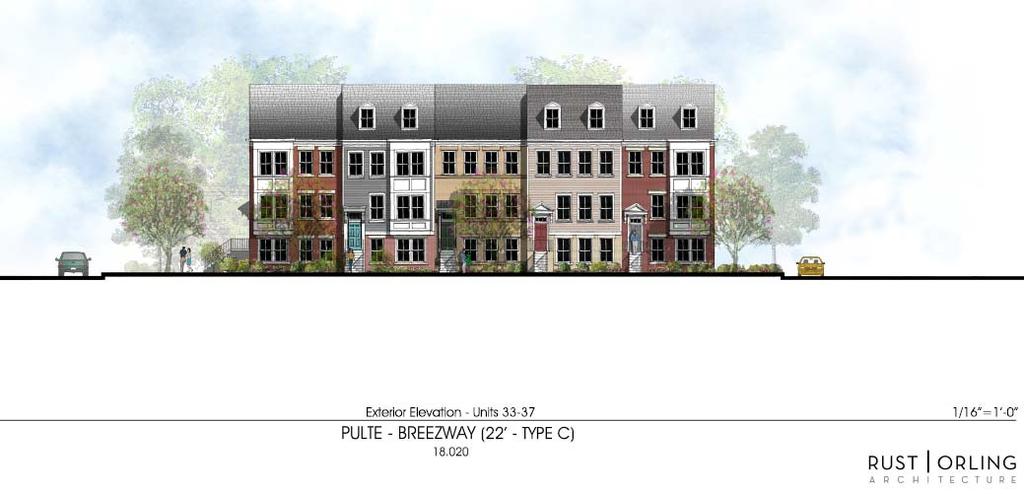
1 City of Fairfax, Virginia City Council Work Session Agenda Item # City Council Meeting 2a 7/3/2018 TO: FROM: SUBJECT: Honorable Mayor and Members of City Council Robert Sisson, City Manager iscussion of a request of Pulte Homes for a City Council work session to discuss the proposed redevelopment of the Breezeway Motel, Fairfax Gardens Apartments and several adjacent residential lots into a residential planned development. ISSUE(S): Informational Work Session of City Council to discuss a proposed residential planned development on the consolidated properties. Initial feedback is sought by City Council regarding the proposed redevelopment. The applicant has not submitted a formal land use application at this time. SUMMARY: FISCAL IMPACT: The applicant proposes to replace the existing hotel, 38 multifamily units and four single-family homes with 74 townhomes, including 8 live-work units, on the 4.63 acres of consolidated land. The application would require City Council approval of a rezoning and a Comprehensive Plan Amendment. A fiscal impact analysis has not been conducted at this time. RECOMMENATION: iscussion on proposed redevelopment. ALTERNATIVE COURSE OF ACTION: City Council may choose not to conduct the discussion or defer discussion to a future date. RESPONSIBLE STAFF/POC: Kelly O Brien, Senior Planner Jason Sutphin, Community evelopment ivision Chief Brooke Hardin, irector, Community evelopment & Planning COORINATION: Community evelopment & Planning Public Works Parks and Recreation Code Administration Historic Resources Police Human Services City Attorney ATTACHMENTS: Staff Report Preliminary Plans Architectural Elevation presented at Planning Commission Work Session Page 1

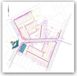
2 Background The subject site is located within the block bounded by Fairfax Boulevard, Oak Street, Second Street and Walnut Street. It consists of a consolidation of six parcels for a total of 4.63 acres as summarized in the table below: Address escription Area Current Zoning Fairfax Blvd. Breezeway Motel acres CR Commercial Retail Cedar Ave Fairfax Gardens Apts acres RMF Multifamily 3930 Oak Street Single Family acres RH Residential High 3932 Oak Street Single Family acres RH Residential High 3934 Oak Street Single Family acres RH Residential High 3937 Walnut Street Single Family acres RH Residential High Total Area: acres The parcels that are included within the consolidation for this application, along with their current zoning designations, are shown in Figure 1: Figure 1: Existing Zoning Page 2
3 The site is bordered by commercial properties to the west and north, duplexes, a day care center, and Chilcott Field (owned by The American Legion) to the east, and single family homes within Fairfax Heights to the south. The table below provides a summary of surrounding land uses. The commercial and multifamily properties are located in the city-wide Architectural Control Overlay istrict. Site Existing Zoning Existing Land Use Existing escription Future Land Use CR Commercial Retail Motel, Multifamily, Breezeway Motel, Business Commercial, RMF Multifamily Single Family Fairfax Gardens Apts, Residential High, RH Residential High Homes Single Family Homes Residential Low North CR Commercial Retail South East RH Residential High RH Residential High, CR Commercial Retail, CO Commercial Office Commercial/Retail Residential Single etached Residential, ay Care Center, Open Space West CR Commercial Retail Commercial/Office Various Commercial Establishments Fairfax Heights Residential uplexes, ay Care Center, Chilcott Field Banks, Office Building Business - Commercial Residential - Low Residential Low, Business Commercial Transitional, Open Space - Recreation Business Commercial, Transitional Existing evelopment The site is currently developed with the Breezeway Motel consisting of 50 rooms in three buildings constructed in 1951; Fairfax Garden Apartments consisting of 38 apartments in 4 buildings constructed in 1959; 3 single family homes on Oak Street built in 1957 and 1 single family home on Walnut St built in Cedar Avenue divides the apartment property. The site has access from Fairfax Boulevard, Walnut Street, Cedar Avenue and Oak Street. Proposal Summary This application includes incorporation of six parcels within the associated block, bifurcated by Cedar Avenue, with a total of 4.63 acres. The applicant, Pulte Homes, proposes to replace all of the existing uses with a community of 74 townhomes, 8 of which are identified as live-work units. The townhomes will include a mix of widths and heights ranging in widths of 20 feet, 22 feet and 24 feet and in height between three and four stories. The units marked in blue in Illustrative Layout included in the attached preliminary plans indicate the units that are proposed as three story to transition to the nearby single family homes and all other units are proposed as four story. Proposal History The Planning Commission held a work session to review the proposal on June 11, Some of the comments voiced by the commissioners included concerns about affordable housing, questions about providing a mixture of housing types instead of only townhouses and whether some could be converted to condominiums, reduction of units proposed to meet the open space requirements and concerns about how the City would be able to enforce the live-work units and what types of businesses would use those spaces. Proposal Review The purpose of the applicant s request for this work session is to gain initial feedback from the City Council on the proposed development. Staff has conducted an initial review of the development proposal and consolidated comments. In addition to general feedback on the proposed development, staff seeks input from the City Council on the items related to the categories summarized below. Page 3
4 Rezoning The applicant is requesting to rezone the properties from CR Commercial Retail, RMF Multifamily and RH Residential High to P-M Planned evelopment Mixed Use A The P-M, Planned evelopment Mixed Use istrict is intended to provide for coordinated mixed use developments which may include residential and nonresidential uses within a planned development with appropriate boundary transitional yards ( 4.5.5) and recreation and open space ( 3.8.7). The variety of land uses available in this district allows flexibility to respond to market demands and the needs of tenants, which provides for a variety of physically and functionally integrated land uses B.2. Planned development district rezoning may be approved only when the applicant demonstrates to the satisfaction of the city council that a proposed planned development project would result in a greater benefit to the city than would development under general zoning district regulations. The applicant states that the rezoning is appropriate for this transitional area between commercial and single family residential by replacing aging buildings with a vibrant, high quality community. The applicant further contends that the live-work units provide the commercial component called for along Fairfax Boulevard in the comprehensive plan. These units would be defined as upper-story mixed use in the Zoning Ordinance, which requires 75 percent of the ground floor area to be uses solely for non-residential uses. If individual owners are anticipated to have an option to use the ground floor for residential uses, a modification to the Zoning Ordinance would be required. If the single family properties included in this proposal were rezoned to Residential Multifamily to match the Fairfax Gardens property there would be no open space requirement and the maximum density would be 20 units per acre which would result in 69 townhouse units by right on the acres not including the Breezeway property. The current proposal is for 74 units on 4.63 acres including the live-work units, a proposed density of 16 units per acre. The live-work units proposed are defined as upper-story mixed use in the Zoning Ordinance and are permitted as a special use in the CR Commercial Retail district that the Breezeway property is currently zoned. The maximum height allowed in the CR district is 5 stories or 60 feet. The proposal shows 4 story units along Fairfax Boulevard. Land Use The site is located within the West Connector (generally encompassing the area between Kamp Washington and Northfax) as identified in the Fairfax Boulevard Masterplan Vision and Summary appendix of the Comprehensive Plan. Although the Comprehensive Plan does not discuss a specific vision for the West Connector, the following language pertains to Connectors in general: Connectors: Connectors should take the form of a linear, aesthetically enhanced boulevard. Most of these areas do not have the proper depth or potential for unified, coordinated development. Their focus would be on lower scale buildings (predominantly 1 to 3 stories) with emphasis on accessibility, improvements in architectural and site design, and appropriate interface between the commercial boulevard and existing neighborhoods, such as appropriate land use transitions and green space buffers. [Comprehensive Plan page 169] The applicant is seeking to build a residential development that abuts Fairfax Boulevard with part of the first floor commercial. The consolidated properties are overlaid on the Future Land Use Map from the Comprehensive Plan in Figure 2. This application would require an amendment to the Future Land Use Map Page 4
5 to designate the single family home on Walnut Street as Residential High and the Breezeway Motel property as Transitional. The Comprehensive Plan specifically addresses this scenario as follows: Residential High Generally supporting a residential density greater than 12 units per acre, this category is typically applied to apartment or condominium developments. Providence Park apartments, located between Chain Bridge Road and Providence Park, is an example of high density development. [Comprehensive Plan, Page 161] Transitional This category is established to recognize specific areas, generally along arterial corridors, that provide a transition between office and commercial uses and less densely developed residential areas. These parcels may be suited to either commercial or residential development depending on the site-specific development potential and impacts on surrounding land uses. Where commercial use is chosen, the plan calls for low profile, small-scale office development with a floor area ratio (FAR) of up to The small office buildings and generous landscaping and screening that are characteristic of this category are intended to result in suitable transitions between existing residential uses and more intensive uses or arterial streets. Where residential use is chosen, the plan calls for small infill single-family residential developments at densities approaching the midpoint of the medium density residential category. [Comprehensive Plan, Page 164] Generally, stand-alone residential uses along the [Fairfax Boulevard] corridor are not recommended, and exclusively residential uses do not appear on the Future Land Use map anywhere along the corridor. However, there are certain cases in which residential uses may be appropriate within the overall framework of the business boulevard. Such instances include: Replacement of an undesirable use: Certain current land uses within the City are considered undesirable due to an unattractive appearance or other negative externalities. In cases where the elimination of an undesirable use can be considered of primary importance, consideration should be given to supporting residential as the primary land use. However, extreme care must be taken to ensure that residential uses complement the general commercial nature of the Fairfax Boulevard corridor. [Comprehensive Plan page ] Guidance for consideration of amendments to the Comprehensive Plan Future Land Use Map is provided by the Land Use Strategy below: LU2.1 Require an applicant to submit a formal request for a Plan amendment concurrent with a requested rezoning when the rezoning would be inconsistent with the Future Land Use Map. The future land use designations contained in this Plan are based on the City s best assessment of current and projected conditions. However, unforeseen situations may develop that make amendment of the Plan necessary to ensure its integrity. Consideration of an interim Plan amendment will entail a review of criteria articulated in the City Code, including consistency with the goals and objectives established in the Comprehensive Plan. However, it is important to recognize that strict, literal adherence to each provision in the Plan is not required in development proposals, because different sections of the Plan, as applied, may compete with, rather than complement, one another. Rather, development should be evaluated based on its consistency with the guidance provided in the Plan as a whole. [Comprehensive Plan, page 155] Page 5

6 Within the area of the site proposed to be designated as Transitional, the applicant proposes residential livework type townhouse units with commercial space on the ground floor of each unit. Commercial and residential uses are both considered appropriate uses under this land use category. These units would be defined as upper-story mixed use in the Zoning Ordinance, which requires 75 percent of the ground floor area to be uses solely for non-residential uses. The proposed commercial uses are anticipated to be small in scale as described in the above language, though the specific commercial uses that would be permitted in the units has not been clarified. The live-work townhouse units would provide limited commercial presence along Fairfax Boulevard and the Comprehensive Plan envisions the connectors as predominantly commercial uses. While the existing buildings on the site may be aging, the commercial frontage would be diminished with this proposal, replacing 19,866 square feet of hotel commercial use with 5,712 square feet of unknown commercial uses. Residential uses in the Transitional land use category are described as small infill single-family residential developments at densities approaching the midpoint of the medium density residential category. This suggests a density of around 10 dwelling units per acre where an overall estimated 16 units per acre are proposed. LU-1.1 Encourage the establishment of appropriate transitions between commercial uses and residential uses. Certain land uses, such as apartments, townhouses, single-family detached homes on small lots and limited office uses, have attributes of both more intensive and less intensive uses. The City should encourage the location of such uses between commercial uses and low density residential uses, where appropriate, to establish logical transitions which minimize land use incompatibilities. Alternatively, substantial buffering may be designed to provide an effective transition between uses of different intensity without intermediate land uses. Efficient, safe and convenient pedestrian and vehicular access to commercial uses from adjacent residential areas should be encouraged. [Comprehensive Plan, page 155] Figure 2: Comprehensive Plan Future Land Use Map Open Space The Planned evelopment Mixed Use istrict requires at least 20 percent of the site designated as recreation and open space for use and enjoyment of the residents and occupants of the Planned development. The development currently proposes three areas of open space for a total of 0.73 acres or 15.7% of the property. Page 6
7 Two of the open space areas are large areas, 0.27 acres and 0.35 acres, located immediately north and south of Cedar Avenue, accessible to both the proposed development as well as the surrounding neighborhood. The third area of 0.11 acres is located in the northeastern corner behind adjacent commercial properties. This area does not meet the zoning requirement that open spaces be a minimum of 50 feet wide. The Zoning Ordinance requires at least 60% of the required open space be contiguous, however it may be bisected by a residential street which it is in this proposal. A transitional yard buffer of 15 feet is required along all site area boundaries, which it appears this proposal is providing. Also a 10 foot landscape strip is shown along all public rights of way. Scale Although the Comprehensive Plan does not specifically recommend densities for the various types of potential uses along the Fairfax Boulevard Corridor, it is generally anticipated that the highest intensity uses would occur within the three Centers and more moderate intensities would occur within the Connectors. The overall residential densities for other approved townhouse applications as compared to the subject application are provided below: Project Site Area Number of Units Residential ensity/acre Pulte/Breezeway 4.63 acres Mount Vineyard 6.10 acres 132 (38 TH + 94 MF) 21.6 Main Street Residences 4.32 acres Madison Mews 1.76 acres The townhouse unit dimensions proposed are generally similar to those in other townhouse projects in the City as shown below: Project (year built) Total # of Townhouse Unit Width TH units Pulte/Breezeway 74 Mount Vineyard (2018) 59 Mayfair (2018) 25 Canfield Village (2015) 14 Cameron Glenn (2013) 48 Main Street Residences 40 ( ) Madison Mews (2012) 26 Royal Legacy (2014) 26 Circulation The applicant proposes three entrance/exit access points into the northern section of the site from Fairfax Boulevard, Walnut Street and Cedar Avenue and only one entrance/exit for the southern section onto Cedar Avenue. Staff questions the need for three access points for the northern section. Inter-parcel connection: The Comprehensive Plan supports establishment of a connected street network and inter-parcel connectivity with new development. The Fairfax Boulevard Masterplan envisions potential slow lanes along undefined portions of Fairfax Boulevard to provide a more pedestrian scale frontage and to support this connectivity. In the absence of slow lanes, the applicant is proposing a reservation for potential inter-parcel connection with adjacent commercial properties to the east. Page 7
8 Parking: The applicant s parking tabulations give the impression of an overabundance of parking compared to what is required; however, on street parking on a City road may not be included in parking calculations for the development Location of parking Except as specified herein, required parking spaces must be located off-street, on the same lot as the building or use they are required to serve The applicant s parking tabulations use 1 space per 300 square feet for the commercial uses. Without knowing what uses are proposed in the live-work units at this time, the best course of action would be to use the 1 space per 200 square feet requirement which includes uses such as medical offices, general retail, general and personal services which are possible tenants of those spaces. Using the 1/200 calculation, the required parking for the commercial component is 29 spaces. The applicant s parking table refers to the garage and driveway spaces for those units as the designated parking for the commercial uses. It is far more likely that the garage spaces would be utilized for the upper living quarters and the nearby surface parking be used by customers for the businesses. There are 16 spaces in the driveways for the live-work units and 16 surface spaces immediately adjacent to those units for a total of 32 spaces which exceeds the 1/200 requirement of 29 spaces. Use Units Or sf Requirement Calculation Parking Spaces Required Parking Spaces Provided Residential 74 units 2 spaces/unit garage Commercial 5,712 sf 1 space/200 sf driveway 31 surface TOTAL 177 required 195 provided The residential units require 2 spaces per unit which is being met by the two garage spaces in each unit. Only the live-work units provide driveways with enough room for parking but that is dedicated to the commercial uses in the above scenario. The applicant is meeting the parking requirements for residential and commercial with an overflow of 18 spaces on site for visitors, not including on-street parking. Bicycle Parking Bicycle parking and storage facilities are required for all non-residential uses. This proposal would require 2 bicycle parking spaces. The plan does not show any proposed bicycle parking for the commercial uses at this time although there appears to be adequate space on site to incorporate it. Pedestrian circulation: The applicant is proposing a sidewalk network throughout the site that connects the surface parking to the units and existing sidewalks along the adjacent roadways. However, staff is concerned about the pedestrian circulation for the customers for the live-work units. There is no sidewalk along the access road from Fairfax Boulevard. With no break between the 8 units, it is unlikely that a visitor to the end units close to the access drive will choose the only safe option provided to walk to Walnut Street and around the corner to the fronts of those units on Fairfax Boulevard. A break between units 4 and 5 with a pedestrian walkway leading from Fairfax Boulevard to the rear parking or a walkway along the access drive would provide a safer and more convenient alternative than walking in the access drive. Page 8


9 ATTACHMENT 2
10
11
12 Proposed Redevelopment of Breezeway Motel City of Fairfax, VA Route 50

13


14 View from Oak Street towards Panther View from Walnut Street to Fairfax Place Boulevard View along Cedar Avenue View turning onto Walnut Street View turning onto Walnut Street Breezeway Motel View from Panther Place of Cedar Avenue View along Cedar Avenue Existing Site Photos Redevelopment of Breezeway City of Fairfax, VA Route 50


 SE CO N ST")


15 X FA IR FA V BL -R 0 E5 T OU L WA T EE TR 15 BUFF TS ER NU OPEN SPACE PANTHER PLACE CEA R AVEN UE VEGETATION LEGEN: APPROXIMATE LOCATION OF EXISTING TREE APPROXIMATE LOCATION OF PROPOSE TREE OPEN SPACE 22 X 40 FT FRONT LOA TOWNHOME - 20 UNITS NU TS TR OA EE T KS TRE ET SITE TABULATION: 15 WA L B UF FE R 22 X 40 FT REAR LOA TOWNHOME - 21 UNITS 20 X 40 FT REAR LOA TOWNHOME - 25 UNITS 24 X 50 FT REAR LOA TOWNHOME - 8 UNITS (GROUN FLOOR COMMERCIAL) SE CO N ST RE ET ROUTE 50 FAIRFAX CITY BY PULTE GROUP - ILLUSTRATIVE LAYOUT FAIRFAX CITY, VIRGINIA 0 Note: For illustrative purposes only. 80' 160' SCALE:1" = 80' 4/30/18
16 FILE PATH: K:\OCUMENT\ Breezeway Motel\Civil\esign\_Xref\ P-BASE_v5.dwg PLOT ATE:4/25/2018 9:58:47 AM BY: AMIR HABIBI SECON ST. PARCEL I ZONE R SECON ST. PARCEL I ZONE R SECON ST. PARCEL I ZONE R SECON ST. PARCEL I PARCEL I ZONE R-3 TOP= ZONE R-3 6 TOP= C&G CO EX. SAN 31 BLG HT-14.1' 4'WIRE FENCE SAVE EX. SAN SECON ST. PARCEL I ZONE R-3 PARCEL I FAIRFAX BLV. ZONE C SECON ST. PARCEL I FAIRFAX BLV. ZONE R SECON ST. PARCEL I ZONE R-3 25 TOP OF MH INV= "X23" INV.= PARCEL I A ZONE CR FAIRFAX BLV. TOP= OAK ST. PARCEL I AC PARCEL I OAK ST AC PARCEL I ZONE R OAK ST OAK ST. PARCEL I ZONE R-3 ECK WOO JO56 TOP= ECK WOO 20 TOP= CP CP Main Street Parcel I RBR-CAP JO85\38B\CO416 43G\C&P CO416\KPOO AUTHOR: CHECK: PROJ#: ATE: SCALE: A.A.H G.A.B /27/2018 1" = 40' SHEET CS-101 SHEET: 1 OF 1 SITE LAYOUT RT. 50 BREEZEWAY PROPERTY LOCATION: FAIRFAX CITY, VIRGINIA R 2553 ULLES VIEW RIVE, SUITE 300 HERNON, VIRGINIA (703) FAX (703) HERNON - BALTIMORE - BLACKSBURG CULPEPER - NEWPORT NEWS - RALEIGH WALORF - RICHMON - WASHINGTON, C CLIENT PULTE GROUP, INC LEE HIGHWAY, SUITE 1000 FAIRFAX, VA SUBMISSION REVISION NO. ATE NO. ATE ESCRIPTION - --/--/ /--/ /--/ /--/ /--/ /--/ /--/ /--/ /--/ /--/ /--/ /--/---- -
17

18 Conceptual Elevations Walnut Street ATTACHMENT 3

19 Conceptual Elevations Cedar Avenue

20 Conceptual Elevations Oak Street

21 Height Comparison to Adjacent Homes
Through: Jason D. Sutphin, Community Development Division Chief Brooke Hardin, Director of Community Development and Planning
 Meeting Date: 04/23/2018 Agenda Item: 7a MEMORANDUM To: From: Chairman Cunningham and Members of the Planning Commission Paul Nabti, Senior Planner Through: Jason D. Sutphin, Community Development Division
Paul VI Redevelopment
 City of Fairfax City Council and Planning Commission Joint Work Session October 3, 2017 Paul VI Redevelopment The IDI Group Companies 1 Site Background Chain Bridge Road Cedar Ave 2 Project History June-October
City of Fairfax, Virginia City Council Work Session
 City Council Work Session Agenda Item # City Council Meeting 5a 10/7/2014 TO: FROM: SUBJECT: Honorable Mayor and Members of City Council Robert Sisson, City Manager Discussion of a request by The IDI Group
Chapter URBAN VILLAGE ZONING DISTRICTS
 Chapter 20.16 Sections: 20.16.010 Purpose of the Urban Village Zoning Districts 20.16.020 Land Use Regulations for the Urban Village Zoning Districts 20.16.030 Development Standards & Guidelines for the
8.5.1 R1, Single Detached Residential District
 8.5.1 R1, Single Detached Residential District The purpose of this district is to provide for residential development in the form of single detached dwellings. Dwelling, Single Detached Home Business,
PLANNING COMMISSION STAFF REPORT
 PLANNING COMMISSION STAFF REPORT REZONING CASE: RZ-15-002 REPORT DATE: January 26, 2016 CASE NAME: Thursday Lunch Club Rezoning PLANNING COMMISSION DATE: February 17, 2016 ADDRESS OF REZONING PROPOSAL:
Project: Address: MAJOR CERTIFICATE OF APPROPRIATENESS FOR THE BOARD OF ARCHITECTURAL REVIEW
 The BAR recommended approval of the major COA with the following 10 conditions at the special meeting on March 28, 2018. Project: Address: Case Number: Applicant: ATTACHMENT 9e Paul VI Redevelopment 10675
DEPARTMENT OF COMMUNITY PLANNING, HOUSING AND DEVELOPMENT Planning Division
 DEPARTMENT OF COMMUNITY PLANNING, HOUSING AND DEVELOPMENT Planning Division #1 Courthouse Plaza, 2100 Clarendon Boulevard, Suite 700 Arlington, VA 22201 TEL 703.228.3525 FAX 703.228.3543 www.arlingtonva.us
NOTICE OF MEETING AND AGENDA FOR THE PLANNING COMMISSION OF SPRINGVILLE, UTAH... JANUARY 23, 2018
 NOTICE OF MEETING AND AGENDA FOR THE PLANNING COMMISSION OF SPRINGVILLE, UTAH............................ JANUARY 23, 2018 Notice is hereby given that the Planning Commission will hold a public meeting
DEVELOPMENT DEPARTMENT STAFF REPORT THE PARK AT 5 TH
 DEVELOPMENT DEPARTMENT STAFF REPORT ARB Meeting Date: July 3, 2018 Item #: _PZ2018-293_ THE PARK AT 5 TH Request: Site Address: Project Name: Parcel Number: Applicant: Proposed Development: Current Zoning:
PLANNING COMMISSION STAFF REPORT
 PLANNING COMMISSION STAFF REPORT REZONING CASE: RZ-16-001 REPORT DATE: March 8, 2016 CASE NAME: Trailbreak Partners Rezoning PLANNING COMMISSION DATE: March 16, 2016 ADDRESSES OF REZONING PROPOSAL: 5501
PLANNING COMMISSION WILLIAMSBURG, VIRGINIA WORK SESSION AGENDA Wednesday, May 23, 2012
 PLANNING COMMISSION WILLIAMSBURG, VIRGINIA WORK SESSION AGENDA Wednesday, May 23, 2012 The meeting will be called to order in the third floor Conference Room (Room 310), Williamsburg Municipal Building,
City of Reno October 30, 2012 Draft Midtown Zoning Text Amendments 1
 Section 18.08.405 Regional Center and Transit Corridor Overlay Districts (i) SVTC South Virginia Street Transit Corridor Overlay Zoning District. (1) Applicability. This Section 18.08.405(l)'s standards
Appendix A: Guide to Zoning Categories Prince George's County, Maryland
 Appendix A: Guide to Zoning Categories Prince George's County, Maryland RESIDENTIAL ZONES 1 Updated November 2010 R-O-S: Reserved Open Space - Provides for permanent maintenance of certain areas of land
Galloway Road and 4097 Lawrence Avenue East - Zoning Amendment Application - Preliminary Report
 STAFF REPORT ACTION REQUIRED 197-201 Galloway Road and 4097 Lawrence Avenue East - Zoning Amendment Application - Preliminary Report Date: November 29, 2013 To: From: Wards: Reference Number: Scarborough
Cover Letter with Narrative Statement
 Cover Letter with Narrative Statement March 31, 2017 rev July 27, 2017 RE: Rushton Pointe Residential Planned Unit Development Application for Public Hearing for RPUD Rezone PL2015 000 0306 Mr. Eric Johnson,
STAFF REPORT. September 25, City Council. Chief Planner and Executive Director, City Planning Division
 STAFF REPORT September 25, 2006 To: From: Subject: City Council Chief Planner and Executive Director, City Planning Division Request for Directions Report Toronto & East York Community Council, Report
50 and 52 Finch Avenue East - Official Plan and Zoning By-law Amendment Applications - Preliminary Report
 STAFF REPORT ACTION REQUIRED 50 and 52 Finch Avenue East - Official Plan and Zoning By-law Amendment Applications - Preliminary Report Date: August 16, 2016 To: From: Wards: Reference Number: North York
DRAFT Plan Incentives. Part A: Basic Discount
 DRAFT 2030 Plan Incentives July 26, 2006 Part A: Basic Discount In order for a development to be eligible for any 2030 Land Resource Management Plan Discounts it must be located in the Urban Corridor and
Midwest City, Oklahoma Zoning Ordinance
 2010 Midwest City, Oklahoma Zoning Ordinance 9/2/2010 Table of Contents Section 1. General Provisions... 5 1.1. Citation... 5 1.2. Authority... 5 1.3. Purpose... 5 1.4. Nature and Application... 5 1.5.
Urban Design Brief Dundas Street. London Affordable Housing Foundation. November Zelinka Priamo Ltd.
 Urban Design Brief 1039-1047 Dundas Street London Affordable Housing Foundation November 2017 Zelinka Priamo Ltd. TABLE OF CONTENTS Page No. INTRODUCTION... 3 SECTION 1 LAND USE PLANNING CONTEXT... 3 1.1
Glades County Staff Report and Recommendation Unified Staff Report for Small Scale Plan Amendment and Rezoning
 Glades County Staff Report and Recommendation Unified Staff Report for Small Scale Plan Amendment and Rezoning CASE NUMBERS: COMP17-02 and RZ17-02 DATE of STAFF REPORT: May 1, 2017 CASE TYPE: Application
Town of Cary, North Carolina Rezoning Staff Report 14-REZ-31 Cary Park PDD Amendment (Waterford II) Town Council Meeting January 15, 2015
 Town Council Meeting January 15, 2015") Town of Cary, North Carolina Rezoning Staff Report 14-REZ-31 Cary Park PDD Amendment (Waterford II) Town Council Meeting January 15, 2015 REQUEST To amend the Town of Cary Official Zoning Map by amending
Town of Cary, North Carolina Rezoning Staff Report 14-REZ-31 Cary Park PDD Amendment (Waterford II) Town Council Meeting January 15, 2015 REQUEST To amend the Town of Cary Official Zoning Map by amending
Watertown City Council
 City of Watertown Watertown City Council 2/14/2017 Agenda Item: Riverpointe Subdivision 2 nd Replat Request for Action: Sketch Plan Department: Planning Request for Action Request: Paxmar, LLC (Applicant)
2401 Wilson Boulevard General Land Use Plan Amendment Study
 2401 Wilson Boulevard General Land Use Plan Amendment Study Long Range Planning Committee Meeting Presentation Compendium March 29, 2011 Department of Community Planning, Housing and Development GLUP Amendment
Salem HNA and EOA Advisory Committee Meeting #6
 Salem HNA and EOA Advisory Committee Meeting #6 Residential Land Policies Employment Land Policies Policy Discussions with the Committee Outcome of today s meeting Direction from this Committee on proposed
Staff Report for Council Public Meeting
 Agenda Item 3.3 Staff Report for Council Public Meeting Date of Meeting: September 27, 2017 Report Number: SRPRS.17.134 Department: Division: Subject: Planning and Regulatory Services Development Planning
PIN , Part 1, Plan SR-713 in Lot 2, Concession 5, Township of McKim (1096 Dublin Street, Sudbury)
") STAFF REPORT Applicant: Dalron Construction Limited Location: PIN 02124-0103, Part 1, Plan SR-713 in Lot 2, Concession 5, Township of McKim (1096 Dublin Street, Sudbury) Official Plan and Zoning By-law:
STAFF REPORT Applicant: Dalron Construction Limited Location: PIN 02124-0103, Part 1, Plan SR-713 in Lot 2, Concession 5, Township of McKim (1096 Dublin Street, Sudbury) Official Plan and Zoning By-law:
PALM BEACH COUNTY PLANNING, ZONING AND BUILDING DEPARTMENT ZONING DIVISION
 PALM BEACH COUNTY PLANNING, ZONING AND BUILDING DEPARTMENT ZONING DIVISION Application No.: CA-2012-00688 Control No.: 2011-00552 Applicant: Garry Bernardo Owners: Garry Bernardo Agent: Frogner Consulting,
Planning Justification Report
 Planning Justification Report 101 Kozlov Street, Barrie, Ont. Destaron Property Management Ltd. November 2015 Revised February 2017 TABLE OF CONTENTS Page 1.0 INTRODUCTION... 1 2.0 DESCRIPTION OF SUBJECT
PLANNED UNIT DEVELOPMENT & SUBDIVISION STAFF REPORT Date: April 18, 2019
 PLANNED UNIT DEVELOPMENT & SUBDIVISION STAFF REPORT Date: April 18, 2019 DEVELOPMENT NAME SUBDIVISION NAME Springhill Village Subdivision Springhill Village Subdivision LOCATION 4350, 4354, 4356, 4358,
Request for Decision STAFF REPORT. Recommendation. Applicant: Location: Application: Proposal: Presented To: Planning Committee
 Request for Decision Application for rezoning in order to permit an automotive lube shop in the southeasterly corner of the Lasalle Court Mall property, 900 Lasalle Boulevard, Sudbury - Laurentian Shield
ARTICLE 3: Zone Districts
 ARTICLE 3: Zone Districts... 3-1 17.3.1: General...3-1 17.3.1.1: Purpose and Intent... 3-1 17.3.2: Districts and Maps...3-1 17.3.2.1: Applicability... 3-1 17.3.2.2: Creation of Districts... 3-1 17.3.2.3:
City of Lafayette Staff Report Design Review Commission
 City of Lafayette Staff Report Design Review Commission Meeting Date: January 8, 2018 Staff: Subject: Sarah Allen, Senior Planner SS14-17 Dexter & Patricia Louie, (MRA Zoning) Request for a Study Session
111 Wenderly Drive Official Plan and Zoning By-law Amendment Applications - Preliminary Report
 STAFF REPORT ACTION REQUIRED 111 Wenderly Drive Official Plan and Zoning By-law Amendment Applications - Preliminary Report Date: August 17, 2015 To: From: Wards: Reference Number: North York Community
Technology Park Planned Unit Development Technology Park PUD-IP
 Technology Park Planned Unit Development Technology Park PUD-IP Rob Anderson Community Development Director Planned Unit Development Background 2 Planned Unit Development (PUD) means a mixed use redevelopment
Overview. Review Zoning Rewrite Project Zoning Ordinance Subdivision Ordinance
 Overview Tonight s Work Session Review Zoning Rewrite Project Zoning Ordinance Subdivision Ordinance Revisions in current drafts Amendments recommended by the Planning Commission Additional amendments
City of Tacoma Planning and Development Services
 Agenda Item D-3 City of Tacoma Planning and Development Services To: Planning Commission From: Elliott Barnett, Planning Services Division Subject: Affordable Housing Planning Work Program (Phase 3) Meeting
3804 Wilson Boulevard (Staples Site) Special General Land Use Plan Study
 Special General Land Use Plan Study") 1 3804 Wilson Boulevard (Staples Site) Special General Land Use Plan Study Long Range Committee of the Planning Commission Meeting May 16, 2018 Department of Community Planning, Housing and Development
1 3804 Wilson Boulevard (Staples Site) Special General Land Use Plan Study Long Range Committee of the Planning Commission Meeting May 16, 2018 Department of Community Planning, Housing and Development
PLANNING COMMISSION STAFF REPORT. Merrimac PLNSUB Planned Development 38 West Merrimac November 9, Request. Staff Recommendation
 PLANNING COMMISSION STAFF REPORT Merrimac PLNSUB2011-00374 Planned Development 38 West Merrimac November 9, 2011 Planning and Zoning Division Department of Community and Economic Development Applicant:
GENERAL DESCRIPTION STAFF RECOMMENDATION IMPLEMENTATION REQUIREMENTS
 Application No.: 891418 Applicant: AREA-WIDE MAP AMENDMENT Rezone two parcels from Moderate Density Single Family (MSF) to Neighborhood Center (NC) and Employment Center (EC). Charles Bitton GENERAL DESCRIPTION
Indicates Council-recommended changes Introduced by: Mr. Tackett Date of introduction: June 14, 2016 SUBSTITUTE NO. 1 TO ORDINANCE NO.
 Indicates Council-recommended changes Introduced by: Mr. Tackett Date of introduction: June 14, 2016 SUBSTITUTE NO. 1 TO ORDINANCE NO. 16-067 TO AMEND NEW CASTLE COUNTY CODE CHAPTER 40 (ALSO KNOWN AS THE
1202 & 1204 Avenue Road Zoning By-law Amendment Application - Preliminary Report
 STAFF REPORT ACTION REQUIRED 1202 & 1204 Avenue Road Zoning By-law Amendment Application - Preliminary Report Date: March 17, 2017 To: From: Wards: Reference Number: North York Community Council Director,
Introduction. General Development Standards
 Introduction The development standards will set the zoning regulations for the East Park development. This section will illustrate lot standards, approximate open space locations and road standards. The
4 DEVELOPMENT STANDARDS FOR
 4 DEVELOPMENT STANDARDS FOR RESIDENTIAL MIXED-USE PROJECTS This chapter presents standards for residential mixed-use projects in the Ashland-Cherryland Business District and the Castro Valley Central Business
(H) RM-10: LOW-DENSITY MULTIFAMILY RESIDENTIAL DISTRICT 123
 RM-10: LOW-DENSITY MULTIFAMILY RESIDENTIAL DISTRICT 123") Section 23-3-2(H): RM-10: Low-Density Multifamily Residential District (H) RM-10: LOW-DENSITY MULTIFAMILY RESIDENTIAL DISTRICT 123 The Low-Density, Multifamily Residential (RM-10) District is established
Section 23-3-2(H): RM-10: Low-Density Multifamily Residential District (H) RM-10: LOW-DENSITY MULTIFAMILY RESIDENTIAL DISTRICT 123 The Low-Density, Multifamily Residential (RM-10) District is established
DEVELOPMENT DEPARTMENT STAFF REPORT STAFF REPORT DRESDEN DRIVE TOWNHOMES DCI
 DEVELOPMENT DEPARTMENT STAFF REPORT Meeting Date: September 13, 2018 Item #: PZ2018-319 STAFF REPORT DRESDEN DRIVE TOWNHOMES DCI Request: Project Name: Development of Community Compact (DCI) and six concurrent
Section 1: US 19 Overlay District
 Section 1: US 19 Overlay District Section 1.1 Intent and Purpose The purpose of the US Highway 19 Overlay District is to manage access to land development along US Highway 19 in a manner that preserves
Policy and Standards for Public Local Residential Streets And Private Streets
 Appendix A City of Toronto Development Infrastructure Policy & Standards Policy and Standards for Public Local Residential Streets And Private Streets November 2005 Policy and Standards For Public Local
O-I (Office-Institutional) and AG-1(Agricultural)
 and AG-1(Agricultural)") PROPERTY INFORMATION ADDRESS 3503 and 3505 Bethany Bend DISTRICT, LAND LOTS 2/1 973 and 974 OVERLAY DISTRICT State Route 9 PETITION NUMBERS EXISTING ZONING O-I (Office-Institutional) and AG-1(Agricultural)
PROPERTY INFORMATION ADDRESS 3503 and 3505 Bethany Bend DISTRICT, LAND LOTS 2/1 973 and 974 OVERLAY DISTRICT State Route 9 PETITION NUMBERS EXISTING ZONING O-I (Office-Institutional) and AG-1(Agricultural)
UPPER MOUNT BETHEL TOWNSHIP NORTHAMPTON COUNTY, PENNSYLVANIA
 UPPER MOUNT BETHEL TOWNSHIP NORTHAMPTON COUNTY, PENNSYLVANIA JOINDER DEED / LOT CONSOLIDATION TOWNSHIP REVIEW PROCESS When accepting proposed Joinder Deeds / Lot Consolidations, review the Joinder Deed
A. Location. A MRD District may be permitted throughout the County provided it meets the standards established herein.
 752. Multi-Residential District (MRD) The Multi-Residential (MRD) District is intended to provide opportunities for rural, suburban and urban density mixed-residential developments consistent with the
City Council Agenda Item #14_ Meeting of Oct. 8, Concept plan for Marsh Run Two Redevelopment at and Wayzata Blvd.
 City Council Agenda Item #14_ Meeting of Oct. 8, 2018 Brief Description Recommendation Concept plan for Marsh Run Two Redevelopment at 11650 and 11706 Wayzata Blvd. Continue discussion of the concept plan
Overview. Central Street Master Plan. Appendix B: Zoning
 Central Street Master Plan Overview The City of Evanston has 36 zoning districts, of which 11 are found in the Central Street Corridor Study Area (See Figures B.1 and B.2). They include: R1: Single-Family
Bylaw No , being "Official Community Plan Bylaw, 2016" Schedule "A" DRAFT
 Bylaw No. 2600-2016, being "Official Community Plan Bylaw, 2016" Schedule "A" Urban Structure + Growth Plan Urban Structure Land use and growth management are among the most powerful policy tools at the
PLANNING REPORT Gordon Street City of Guelph. Prepared on behalf of Ontario Inc. March 17, Project No. 1507
 PLANNING REPORT 1131 Gordon Street City of Guelph Prepared on behalf of 1876698 Ontario Inc. March 17, 2016 Project No. 1507 423 Woolwich Street, Suite 201, Guelph, Ontario, N1H 3X3 Phone (519) 836-7526
Director, Community Planning, North York District NNY 23 OZ and NNY 23 RH
 STAFF REPORT ACTION REQUIRED 2 & 50 Sheppard Avenue East 4841 to 4881 Yonge Street and 2 to 6 Forest Laneway Official Plan Amendment, Zoning By-law Amendment and Rental Housing Demolition Applications
TRANSIT-ORIENTED DEVELOPMENT PLAN EXISTING CONDITIONS REPORT LAWRENCE TO BRYN MAWR MODERNIZATION
 TRANSIT-ORIENTED DEVELOPMENT PLAN EXISTING CONDITIONS REPORT LAWRENCE TO BRYN MAWR MODERNIZATION March 2018- FINAL DRAFT SITE SPECIFIC DEVELOPMENT CONCEPTS SITE SPECIFIC DEVELOPMENT CONCEPTS This report
2. Rezone a portion of the lot from R2 (Small Lot Residential) to RD2 (Duplex: Housing Lane).
 to RD2 (Duplex: Housing Lane).") Public Notice September 6, 2018 Subject Property Subject Property: 337 Hastings Ave Lot 24, District Lot 1, Group 7, Similkameen Division Yale (Formerly Yale-Lytton) District, Plan 932 Application: The
Public Notice September 6, 2018 Subject Property Subject Property: 337 Hastings Ave Lot 24, District Lot 1, Group 7, Similkameen Division Yale (Formerly Yale-Lytton) District, Plan 932 Application: The
Church Street and 117 Dundas Street East - Zoning Amendment Application - Preliminary Report
 STAFF REPORT ACTION REQUIRED 215-229 Church Street and 117 Dundas Street East - Zoning Amendment Application - Preliminary Report Date: February 26, 2015 To: From: Wards: Reference Number: Toronto and
Financial Impact Statement There are no immediate financial impacts associated with the adoption of this report.
 STAFF REPORT Planning and Development Department Subject: Application by RYC Property to rezone a portion of lands on John Murray Dr. and Megan Lynn Dr. from R2 to R3 and to enter into a Development Agreement
PERMITTED USES: Within the MX-1 Mixed Use Neighborhood District the following uses are permitted:
 6.25 MX-1 - MIXED USE NEIGHBORHOOD 6.25.1 INTENT: The purpose of the MX-1 Mixed Use Neighborhood District is to accommodate the development of a wide-range of residential and compatible non-residential
Rezoning Petition Pre-Hearing Staff Analysis April 17, 2017
 Rezoning Petition 2017-041 Pre-Hearing Staff Analysis April 17, 2017 REQUEST Current Zoning: R-5 (single family residential), R-22MF (multifamily residential), and I-1 (light industrial) Proposed Zoning:
Article Optional Method Requirements
 Article 59-6. Optional Method Requirements [DIV. 6.1. MPDU DEVELOPMENT IN RURAL RESIDENTIAL AND RESIDENTIAL ZONES Sec. 6.1.1. General Requirements... 6 2 Sec. 6.1.2. General Site and Building Type Mix...
GENERAL PLAN UPDATE SPECIFIC AREAS OF THE CITY
 GENERAL PLAN UPDATE SPECIFIC AREAS OF THE CITY Background There are a total of 14 specific areas that are being reviewed as part of the update of the General Plan. Requests to review these areas came from
THE REDEVELOPMENT PLAN
 PAGE 37 THE REDEVELOPMENT PLAN FUTURE LAND USE The Silver Terrace Redevelopment Area is currently designated as Redevelopment Area #4 on the City of Delray Beach Future Land Use Map (FLUM). This designation
Truax Park Apartments
 Truax Park Apartments Master Planning and Site Development Study Prepared by The Community Development Authority of the City of Madison In association with SMITH & SMITH ASSOCIATES, Inc CONSTRUCTION COST
INFORMATION PACKET City of Tallahassee Application for PUD or UPUD Rezoning Review
 Comprehensive Plan Consistency Prerequisite INFORMATION PACKET City of Tallahassee Application for PUD or UPUD Rezoning Review Any and all amendments to the Official Zoning Map (rezoning) are required
Town of Cary, North Carolina Rezoning Staff Report 12-REZ-27 Morris Branch Town Council Public Hearing January 24, 2013
 Town of Cary, North Carolina Rezoning Staff Report 12-REZ-27 Morris Branch Town Council Public Hearing January 24, 2013 REQUEST To amend the Town of Cary Official Zoning Map to rezone approximately 9.0
4 LAND USE 4.1 OBJECTIVES
 4 LAND USE The Land Use Element of the Specific Plan establishes objectives, policies, and standards for the distribution, location and extent of land uses to be permitted in the Central Larkspur Specific
MAYOR AND CITY COUNCIL OF LAUREL DEPARTMENT OF ECONOMIC AND COMMUNITY DEVELOPMENT
 MAYOR AND CITY COUNCIL OF LAUREL DEPARTMENT OF ECONOMIC AND COMMUNITY DEVELOPMENT 8103 Sandy Spring Road Laurel, Maryland 20707 (301) 725-5300 Web: http://www.citvoflaurel.orq E-mail: ecd laurel.md.us
PUBLIC REVIEW DRAFT OF OFF-STREET PARKING PROPOSAL CITY OF OAKLAND PLANNING DEPARTMENT OCTOBER 2015
 PUBLIC REVIEW DRAFT OF OFF-STREET PARKING PROPOSAL CITY OF OAKLAND PLANNING DEPARTMENT OCTOBER 2015 1. Downtown Parking Minimums Problem: The current regulations do not prescribe a minimum amount of required
ARLINGTON COUNTY, VIRGINIA
 ARLINGTON COUNTY, VIRGINIA County Board Agenda Item Meeting of September 18, 2004 DATE: August 19, 2004 SUBJECTS: A. GP-297-04-1 GENERAL LAND USE PLAN AMENDMENT from Service Commercial (Personal and business
ARTICLE 14 PLANNED UNIT DEVELOPMENT (PUD) DISTRICT
 DISTRICT") ARTICLE 14 PLANNED UNIT DEVELOPMENT (PUD) DISTRICT Section 14.01 Intent. It is the intent of this Article to allow the use of the planned unit development (PUD) process, as authorized by the Michigan Zoning
ARTICLE 14 PLANNED UNIT DEVELOPMENT (PUD) DISTRICT Section 14.01 Intent. It is the intent of this Article to allow the use of the planned unit development (PUD) process, as authorized by the Michigan Zoning
Staff Report for Council Public Meeting
 Agenda Item 3.3 a Staff Report for Council Public Meeting Date of Meeting: February 7, 2018 Report Number: SRPRS.18.022 Department: Division: Subject: Planning and Regulatory Services Development Planning
1. Cuyler-Brownsville planned neighborhood conservation (P-N-C) districtphase I (section ). (2) Single-family semiattached dwellings;
 districtphase I (section ). (2) Single-family semiattached dwellings;") Sec. 8-3035. Planned unit development multifamily (PUD-M). A. Purpose. The PUD-M district is intended to allow a variety of residential development including single-family residential, two-family residential,
Sec. 8-3035. Planned unit development multifamily (PUD-M). A. Purpose. The PUD-M district is intended to allow a variety of residential development including single-family residential, two-family residential,
Planning Justification Report
 Planning Justification Report Kellogg s Lands City of London E&E McLaughlin Ltd. June 14, 2017 Zelinka Priamo Ltd. Page i TABLE OF CONTENTS Page No. 1.0 2.0 2.1 2.2 3.0 4.0 5.0 5.1 5.2 5.3 5.4 5.5 5.6
CITY OF ROHNERT PARK CITY COUNCIL AGENDA REPORT
 Mission Statement We Care for Our Residents by Working Together to Build a Better Community for Today and Tomorrow. CITY OF ROHNERT PARK CITY COUNCIL AGENDA REPORT ITEM NO. 12 Meeting Date: February 14,
Contributing Authors:
 chapter 10 Site/Development Plan Review Contributing Authors: Jackie Turner, AICP, LEED AP and Robert Thompson, AICP - Current Authors Robert S. Cowell, Jr., AICP - Previous Author In this chapter... Introduction
Director, Community Planning, South District
 STAFF REPORT October 21, 2002 To: Midtown Community Council From: Director, Community Planning, South District Subject: Refusal Report Applications for Amendments to the Official Plan and Zoning By-law,
Islington Avenue - Official Plan and Zoning By-law Amendment Application - Preliminary Report
 STAFF REPORT ACTION REQUIRED 3002-3014 Islington Avenue - Official Plan and Zoning By-law Amendment Application - Preliminary Report Date: Febuary 2, 2016 To: From: Wards: Reference Number: Etobicoke York
Toronto and East York Community Council. Director, Community Planning, Toronto and East York District
 STAFF REPORT ACTION REQUIRED 1481, 1491, 1501 Yonge Street, 25 & 27 Heath Street East and 30 Alvin Avenue Official Plan and Zoning Amendment Application 06 199698 STE 22 OZ Preliminary Report Date: March
CASTLES OF CALEDON URBAN DESIGN REPORT
 CASTLES OF CALEDON URBAN DESIGN REPORT PROPOSED RESIDENTIAL DEVELOPMENT CALEDON, ONTARIO 10 JULY, 2015 TABLE CONTENTS: 1.0 DEVELOPMENT 4.0 CONCLUSION 1.1 Introduction 1.2 Castles of Caledon- Urban Design
CITY COUNCIL STUDY SESSION MEMORANDUM
 City and County of Broomfield, Colorado To: From: Prepared by: Owner Applicant Property Size Property Location: CITY COUNCIL STUDY SESSION MEMORANDUM Mayor and City Council Charles Ozaki, City and County
Zoning Ordinance Amendment (ZOA) Detached Accessory Dwellings
 Detached Accessory Dwellings") DEPARTMENT OF COMMUNITY PLANNING, HOUSING AND DEVELOPMENT Housing Division 2100 Clarendon Boulevard, Suite 700, Arlington, VA 22201 TEL: 703-228-3765 FAX: 703-228-3834 www.arlingtonva.us Memorandum To:
DEPARTMENT OF COMMUNITY PLANNING, HOUSING AND DEVELOPMENT Housing Division 2100 Clarendon Boulevard, Suite 700, Arlington, VA 22201 TEL: 703-228-3765 FAX: 703-228-3834 www.arlingtonva.us Memorandum To:
5. Housing. Other Relevant Policies & Bylaws. Several City-wide policies guide our priorities for housing diversity at the neighbourhood level: Goals
 5. Housing Other Relevant Policies & Bylaws Several City-wide policies guide our priorities for housing diversity at the neighbourhood level: Goals 1. Encourage more housing diversity while maintaining
Director, Community Planning, North York District NNY 10 OZ and NNY 10 RH
 STAFF REPORT ACTION REQUIRED 847 873 Sheppard Avenue West - Official Plan Amendment and Zoning By-law Amendment and Rental Housing Demolition and Conversion Applications - Preliminary Report Date: April
PLANNING COMMISSION REPORT Regular Agenda -Public Hearing Item
 PDP-13-00518 Item No. 3B- 1 PLANNING COMMISSION REPORT Regular Agenda -Public Hearing Item PC Staff Report 2/24/14 ITEM NO. 3B PRELIMINARY DEVELOPMENT PLAN FOR HERE @ KANSAS; 1101 INDIANA ST (SLD) PDP-13-00518:
Affordable Housing Plan
 Affordable Housing Plan CORDOVA HILLS SPECIAL PLANNING AREA 1 Proposed Project Conwy LLC is the master developer ( Master Developer ) of that certain real property in the County of Sacramento ( County
P. H. Robinson Consulting Urban Planning, Consulting and Project Management
 PLANNING RATIONALE REPORT FOR SITE PLAN AND DRAFT PLAN OF CONDOMINIUM APPLICATIONS 73-75 HARVEY STREET CITY OF OTTAWA PREPARED BY: P H ROBINSON CONSULTING AUGUST 2012 1 This report has been prepared on
PLANNED DEVELOPMENT DISTRICT STANDARDS. Cadence Site
 PLANNED DEVELOPMENT DISTRICT STANDARDS Cadence Site A Planned Development District 1. Statement of General Facts, Conditions and Objectives Property Size: Approximately 57.51 Acres York County Tax Map
Staff Report: Date: Applicant: Property Identification: Acreage of Request: Current Zoning of Requested Area: Requested Action: Attached:
 Staff Report: Completed by Jeff Palmer Director of Planning & Zoning Date: November 7, 2018, Updated November 20, 2018 Applicant: Greg Smith, Oberer Land Developer agent for Ronald Montgomery ET AL Property
M E M O. September 14, 2017 Agenda Item #4. Planning Commission. David Goodison, Planning Director
 September 14, 2017 Agenda Item #4 M E M O To: From: Planning Commission David Goodison, Planning Director Re: Preliminary review of an application for a mixed-use development proposed for 870 Broadway
REVISED # Federal Drive Milestones Therapy Project Review for Planning and Zoning Commission
 REVISED #2012-111 394 Federal Drive Milestones Therapy Project Review for Planning and Zoning Commission Meeting Date: November 7, 2012 and November 19, 2012 Request: Location: Acreage: Existing Zoning:
1970 Victoria Park Avenue and 9 Clintwood Gate Zoning By-law Amendment Application Preliminary Report
 STAFF REPORT ACTION REQUIRED 1970 Victoria Park Avenue and 9 Clintwood Gate Zoning By-law Amendment Application Preliminary Report Date: September 23, 2013 To: From: Wards: Reference Number: North York
APPENDIX D: DEFINITIONS
 D APPENDIX D: DEFINITIONS Terms used throughout the 2040 Comprehensive Plan should be interpreted using the definitions provided in this appendix. For interpretation of any term not defined, defer to the
PLANNED UNIT DEVELOPMENTS (Ordinance No.: 3036, 12/3/07; Repealed & Replaced by Ordinance No.: 4166, 10/15/12)
") 159.62 PLANNED UNIT DEVELOPMENTS (Ordinance No.: 3036, 12/3/07; Repealed & Replaced by Ordinance No.: 4166, 10/15/12) A. PURPOSE 1. General. The Planned Unit Development (PUD) approach provides the flexibility
159.62 PLANNED UNIT DEVELOPMENTS (Ordinance No.: 3036, 12/3/07; Repealed & Replaced by Ordinance No.: 4166, 10/15/12) A. PURPOSE 1. General. The Planned Unit Development (PUD) approach provides the flexibility
Evolution of the Vision for NE 181st Street Study Area
 City Council Action on NE 181 St Street Study Area Evolution of the Vision for NE 181st Street Study Area such uses to ensure neighborhood compatibility. More intense uses may be allowed through a conditional
UDO Advisory Committee Meeting #3 August 18, 2011
 UDO Advisory Committee Meeting #3 August 18, 2011 Today s s Agenda Welcome Recap of Meeting #2 Overview of Strategy Statement Overview of Zoning Districts What changes and what stays the same? Break Putting
Yonge Street and 3 Gerrard Street East - Zoning Amendment Application - Preliminary Report
 STAFF REPORT ACTION REQUIRED 363-391 Yonge Street and 3 Gerrard Street East - Zoning Amendment Application - Preliminary Report Date: May 22, 2015 To: From: Wards: Reference Number: Toronto and East York