APPENDIX /21/02 council agenda item and minutes for RPUD and DRI
|
|
|
- Malcolm Little
- 6 years ago
- Views:
Transcription
1 APPENDIX /21/02 council agenda item and minutes for RPUD and DRI
2 November 21, 2002 AGENDA ITEM [ ] Ordinance [ ] Resolution [ ] Budget Resolution [ X ] Other Department: Growth and Resource Management Division: Building and Zoning File Number: VC A Subject: PLDRC Public Hearing held July 9, 2002, regarding Zoning Case PUD , Plantation Oaks Account Number(s): N/A Total Item Budget: N/A Staff Contact(s): Scott Ashley, Current Planning Manage Phone: null ext Summary/Highlights: TIME CERTAIN: 10:00 APPLICANT/OWNER: Plantation Oaks of Ormond Beach, L.C. Parker Mynchenberg and Associates, Inc. J. Doyle Tumbleson, Attorney for National Gardens Trust, Owner REQUEST: Rezoning from the RR (Rural Residential), RA (Rural Agricultural Estate), and R-3 (Urban Single-Family Residential) zoning classifications to the RPUD (Residential Planned Unit Development) zoning classification. LOCATION: The property is located on the east side of I-95 approximately 500 ft. from its intersection with U.S. Hwy. 1, near Halifax Plantation, north of the City of Ormond Recommended Motion: UPDATED STAFF RECOMMENDATION: Continue this rezoning determination until adoption of the NOPC (Notice of Proposed Change), after a finding by the County Council that the proposed change to the National Gardens DRI represents a nonsubstantial deviation. Montye Beamer, Acting Director Growth and Resource Management OMB Legal Matt Greeson County Manager's Office Mary Robinson Director Building and Zoning Approved as to Budget Requirements Approved as to Form and Legality Approved Agenda Item For: November 21, 2002 Council Action: Modification: [] Approved as Recommended [] Approved With Modifications [] Disapproved [] Continued Date:

3 Summary/Highlights Continued: Beach; LAND USE DESIGNATION: The property is designated Planned Community/Rural on the Future Land Use Map. A map amendment is not required in order to consider this request. The proposed zoning classification may be permitted under this land use designation. PARCEL SIZE: ± 1, DISTRICT #: 4 BACKGROUND/DISCUSSION: PLANNING and LAND DEVELOPMENT REGULATION COMMISSION RECOMMENDATION: APPROVAL for the reasons stated in the staff report with the recommendations that the City of Ormond Beach be the project s utility, and inclusion of language in Paragraph E., Development Standards, 1.(c) Development Requirements Manufactured Home, item (13), to reflect that the existing on-site billboard will be subject to the requirements of Sect , Nonconforming Structures, of the Zoning Ordinance. STAFF RECOMMENDATION: APPROVAL of this application for a Rezoning from RR, RA and R-3 to RPUD, subject to the attached revised development agreement and revised Preliminary Plan. Approval is also subject to a finding of non-substantial deviation of the National Gardens DRI Notice of Proposed Change. UPDATED INFORMATION: The applicant has amended the rezoning request by striking manufactured home dwellings from the list of permitted land uses for the RPUD. Further the attached development agreement has been amended to strike all references to manufactured homes as a housing type option within the proposed RPUD. Staff has proposed some additional changes to Section E, 1, (c) (Single Family Development Requirements) of the Development Agreement, such as a side yard setback standard for zero lot line villas, increased the required minimum floor area to 1,000 S.F., and reduce the maximum lot coverage to 35%. Also the utility service provider will be Volusia County. GENERAL INFORMATION: OPPOSITION: See attached Minutes and Notice of Public Hearing. ATTACHMENTS: 1. Area Location and Street Map 2. Map of Property 3. Staff Report 4. Revised Development Agreement 5. Revised Preliminary Plan 6. Memo from Jon Cheney, Traffic Engineering, dated 11/01/02 7. Memo from Saralee Morrissey, School Board, dated 10/25/02 8. Staff Comments 9. Minutes of the July 9, 2002, PLDRC meeting. 10. Notice of Public Hearing 11. Attachment 1 (EVIDENCE) Text from Mary Hansen
4 12. Attachment 2 (EVIDENCE) Petition from Mary Hansen 13. Attachment 3 (EVIDENCE) 8 Photos from Parker Mynchenberg (4 separate attachments) 14. Attachment 4 - Aerial photo of site DISTRIBUTION: Lisa Bosch, Assistant County Attorney Scott Ashley, Current Planning Manager Plantation Oaks of Ormond Beach, L.C. Parker Mynchenberg and Associates, Inc Ridgewood Avenue, Holly Hill, FL J.Doyle Tumbleson, Attorney for National Gardens Trust, Owner Kinsey, Vincent, Pyle, P.A., 150 S. Palmetto Avenue, Daytona Beach, FL Kathy Marshall for The Sierra Club 4009 Calusa Lane, Ormond Beach, FL COMMENTS SOLICITED FROM: Ron Paradise, Planner III Palmer Panton, Land Development Manager Jay D. Preston, County Development Engineer Joe Waller, Environmental Management Allen Cole, Traffic Engineering Tom Sivert, Utility Engineering Dave Griffis, Ag Center Karen Munson, Fire Services City of Ormond Beach
5
6
7 CASE NO. PUD APPLICANT (STATUS): REQUEST: Plantation Oaks of Ormond Beach, L.C., Parker Mynchenberg & Associates, Contract Purchaser J. Doyle Tumbleson, Attorney for National Gardens Trust, Attorney for Owner RPUD. The purpose and intent of the RPUD, Residential Planned Unit Development classification, is to provide for integrated developments which are consistent with the Comprehensive Plan so as to promote a mixture of housing costs and types, and economical and orderly development consisting of a single or a mixture of compatible land uses. Further, it is intended that a proposed development be sensitive to existing adjacent and future land uses as depicted by the Future Land Use Map of the Comprehensive Plan, the natural environment, and the impact upon supporting public infrastructure through such mechanisms as, but not limited to, the establishment of appropriate buffer areas between land uses, limitations upon the types of permissible uses, and structures which are to be permitted in the development. The PUD, Planned Unit Development classification has been divided into four subclassifications. These sub-classifications are Residential, Business, Industrial and Mixed Use. A Residential Planned Unit Development shall be indicated by an R. The permitted uses within an RPUD may be those found in any of the residential zoning classifications of this Ordinance, provided that said uses are listed in the Development Agreement and have been approved by the County Council. CURRENT ZONING: RR. The purpose and intent of the RR, Rural Residential classification, is to provide a transition between the agricultural and urban single family residential classifications. RA. The purpose and intent of the RA, Rural Agricultural Estate classification, is to preserve and protect unimproved agricultural areas that have become subject to increased amounts of single family residential development. These areas are unsuited generally for commercial agricultural production because of odd lot configurations, undeveloped but platted subdivisions, poor soil conditions, or lack of positive drainage outfall. Despite these facts there are some suitable sites for single family dwellings and personal agricultural production. R-3. The purpose and intent of the R-3, Urban Single Family Residential
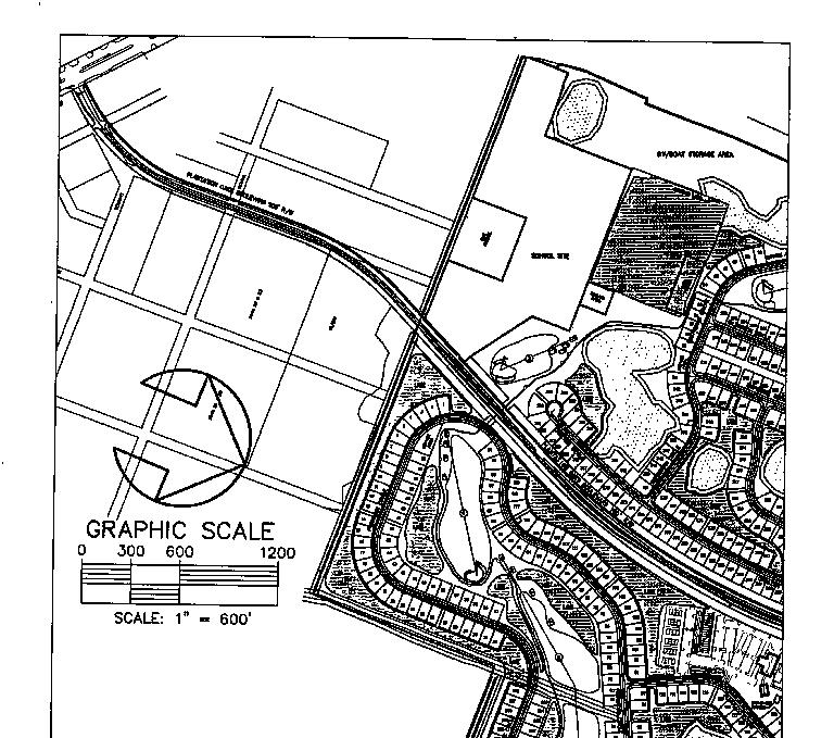
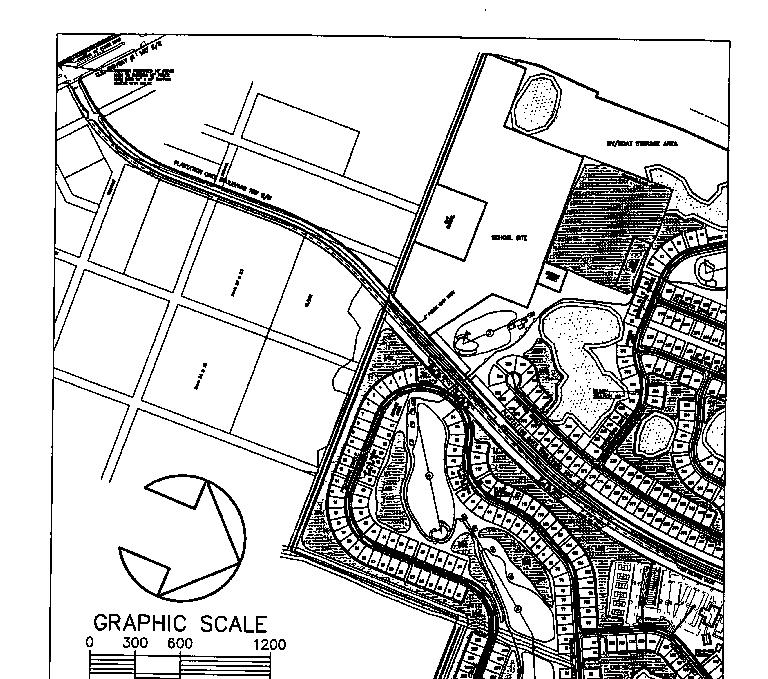
8 classification, is to provide medium-low density residential developments, preserving the character of existing or proposed residential neighborhoods. COMPREHENSIVE PLAN DESIGNATION: Rural / Planned Community PARCEL NUMBER(S): , , , , , and PARCEL CHARACTERISTICS: LOCATION: acres This property is located on the east side of I-95 approximately 500 ft. from its intersection with U.S. Hwy. 1, near Halifax Plantation, north of the City of Ormond Beach. SURROUNDING ZONING AND LAND USE: North East South property West RR. Undeveloped and wooded property R-3. Undeveloped and wooded property RR, R-4, and B-6. Undeveloped and wooded RR. I-95, then undeveloped partially wooded property ANALYSIS: The subject property is situated north of U.S. Highway 1 between the Villages of Pine Run Subdivision to the south and the Halifax Plantation DRI (Development of Regional Impact) to the north across the Strickland Canal. Most of the western boundary of the property parallels Interstate 95, while the northwest corner abuts Old Dixie Highway. The immediately adjoining development is the single family subdivision Villages of Pine Run, which consists of one acre size lots. The rest of the adjoining residential zoned lands are undeveloped paper plats. Several highway commercial uses such as motels, restaurants, and convenience stores with gas pumps, are further to the south adjacent to the Interstate 95 and U.S. Highway 1 interchange.
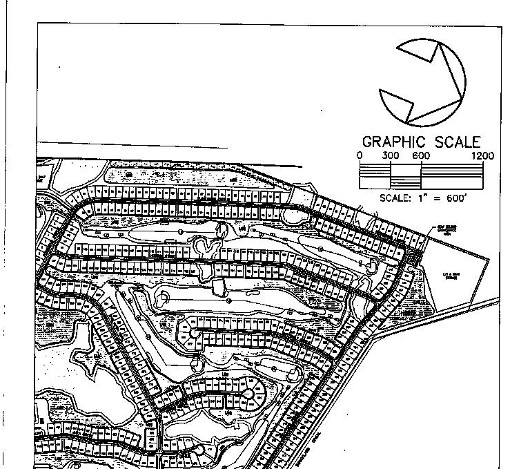
9 The requested RPUD zoning classification is consistent with the property s future land use designation of overlay of Planned Community. PUD PROPOSAL: The applicant is proposing to develop this acre collection of parcels into a 1577 unit manufactured home/mobile home retirement community to be known as Plantation Oaks. In addition to the homesites, the development will comprise an eighteen hole golf course and country club facility, a small neighborhood commercial area to serve the immediate community, and recreational vehicle and boat storage areas. The development will remain the under the ownership of Plantation Oaks, L.C. The applicant has estimated a project build-out period of 10 years. The sole development access will be a thoroughfare roadway constructed within a 100-foot wide, publicly dedicated right-of-way extending from U.S. Highway 1 to Old Dixie Highway, which will be provided by the developer. The internal roadways for each development area will private and gated. Plantation Oaks phases of development will begin on the north end of the PUD near Strickland Canal and work southward so that future construction will not interfere with existing homesites. Phase 1 will consist of the construction of the public road connecting U.S. Highway 1 to Old Dixie Highway, internal roadways, and utilities improvements for 669 dwelling units on the north end of the project area. Also, the 18-hole golf course and country club facility are to be constructed during Phase 1. This particular amenity will extend over the boundaries of all three phases of development. Phase 2 will be situated immediately south of Phase 1 and is the smallest of the three phases with 414 proposed units. The estimated construction schedule for this phase is 2004 to The final Phase 3 is planned on the eastern side of the proposed 100-foot right-of-way. A total of 494 units will be established over a six year time period, 2006 to The majority of a 100 foot power line easement that extends the entire length of the property lies within Phase 3. Each phase will be independent of one another as there will be no interconnecting roadways. The individual phases will provide for the recreational needs of their residents with separate clubhouses and facilities, such as tennis courts, shuffle board courts, and swimming pools. OTHER CONSIDERATIONS: DRI - The property is part of the National Gardens DRI, which is one of three DRIs located adjacent to Interstate 95 between U.S. Highway 1 and
10 Old Dixie Highway. National Gardens ADA (Application for Development Approval) was approved by the Volusia County Council in The project encompasses 2009 acres and the land owner has been approved to develop 3900 dwelling units. A portion of the DRI has been developed within the City of Ormond Beach as the Ormond Lakes Subdivision. This RPUD paves the way for development of the Highland and Ridgewood communities of the National Gardens as annotated on the DRI Master Plan. School Site - As part of the DRI ADA, a school site is required to be provided within National Gardens. On the DRI Master Land Use Plan, a school site has been indicated to be provided in the area of the subject development. In concert with the Volusia County School Board staff, the applicant has located a acre site at the south entrance of the PUD for a future school site. Staff has received comments from the school board staff regarding this matter. The proposed school site must be deeded to the School Board prior to the issuance of the first residential building permit. Master Development Plan Comments - Staff has reviewed the proposed written development agreement and the preliminary plan. Staff comments regarding the written development agreement have been provided within the attached BPUD document (words with strike-through type are deletions and words double underlined type are additions). Staff requested comments from other County departments and their response have been appended to the staff report. The applicant has revised the development agreement to address most of the County staff comments. Some of the summary comments are provided below. 1. A new Traffic Impact Analysis (TIA) is being required by the Traffic Engineering. The new TIA must encompass the entire proposal and not just the Phase 1 area. Based on the development s trip generations, a signal warrant analysis will be required for the Broadway Boulevard and U.S. Highway 1 intersection. 2. According to the applicant, potable water and sanitary sewer service will obtained from the City of Ormond Beach. However, County Utilities contends that this area of the Volusia County falls within county service territory and their comments reflect that utilities will be provided by the County. 3. The County Forester has indicated that more detailed information about wetlands and wetland impacts will be required at the site plan stage. Tree protection ordinance requirements will need to be addressed at the site plan stage. Also, a current biological report addressing threatened and endangered species must be provided by the applicant.
11 Reason for Recommendation - Staff recommends approval of this request because staff finds this request to be consistent with the Future Land Use Map designation and Comprehensive Plan policies. RECOMMENDATION: APPROVAL of this application for a Rezoning from RR, RA & R-3 to RPUD, subject to the staff recommended modifications to the development agreement. REZONING APPLICATIONS REQUIRE A FIRST PUBLIC HEARING BY THE PLDRC AND SECOND PUBLIC HEARING BY THE COUNTY COUNCIL. SA:dl zoning\pldrc\cases\pud Revised July 3, 2002
12 PUD DEVELOPMENT AGREEMENT IN THE COUNTY COUNCIL OF THE COUNTY OF VOLUSIA FLORIDA IN RE: Application #PUD for PLANTATION OAKS OF ORMOND BEACH L.C. RESOLUTION # ORDER AND RESOLUTION GRANTING A REQUEST FOR CHANGE OF ZONING FROM RR, RA, R-3, TO PLANTATION OAKS OF ORMOND BEACH PLANNED UNIT DEVELOPMENT (RPUD) The application of Plantation Oaks of Ormond Beach, L.C., hereinafter, Applicant, for rezoning was heard by and before the Volusia County Council, Volusia County, Florida, on September 12, Based upon the verified Application and other supporting documents, maps, charts, overlays, other evidence and instruments; the advice, report, and recommendations of the Growth and Resource Management Department, Legal Services Department, and other Service Groups Departments and agencies of Volusia County; and the testimony adduced and evidence received at the Public Hearing on this Application by the Planning and Land Development Regulation Commission on June 9, 2002, and otherwise being fully advised, the Volusia County Council does hereby find and determine as follows:
13 TABLE OF CONTENTS Description Page GENERAL FINDINGS 3 FINDINGS REGARDING ZONING 4 DEVELOPMENT AGREEMENT 6 A. Development Concept 6 B. Unified Ownership 7 C. Phases of Development 7 D. Land Uses Within the PUD 8 E. Development Standards 8 1. MH - Manufactured Home, SF - Single-Family standard or Single-Family Zero Lot Line Villas 8 2. GC - Golf Course OS - Open Space C - Conservation R-Recreation NC - Neighborhood Commercial US - Utility Service Area 23 F. Environmental Considerations 26 G. Sewage Disposal, Potable Water, and Site Irrigation 27 H. Stormwater Drainage 28 I. Access and Transportation System Improvements 28 J. Internal Roadways 30 K. Building or Property Owners Association 30 L. Underground Utilities M. Tree Surveys and Replacement Requirements 31 N. Lot Layout Preliminary/Final Plat 31 O. Impact Fees and Donations 32 P. Model Homes 33 Q. Signage R. Temporary Storage of Units 34 S R. On-Site Burning 34 T S. Removal of Excavation Material From Site 34 U T. Development Lighting 34 V U. Clubhouse and Golf Clubhouse Construction Standards 35 W V. Binding Effect of Plans; Recording; and Effective Date35 X W. Conceptual Approval 35 36
14 GENERAL FINDINGS A. That the application of Plantation Oaks of Ormond Beach L.C., was duly and properly filed herein on June 3, 2002, as required by law. B. That all fees and costs which are by law, regulation or Ordinance required to be borne and paid by the Applicant have been paid. C. That the Applicant is the Contract Purchaser of a 1, acre parcel of land which is situated in Volusia County. This parcel of land is described more particularly in the survey and legal description, a true copy of which is attached hereto as EXHIBIT A. D. That the Applicant has held a pre-application meeting as required by the Volusia County Zoning Ordinance No. 80-8, as amended. E. That the Applicant has complied with the Due Public Notice requirements of the Volusia County Zoning Ordinance No. 80-8, as amended. F. That the owner of the property, National Gardens Trust, through its authorized Agent, J. Doyle Tumbleson, agrees with the provisions of the Development Agreement.
15 FINDINGS REGARDING REZONING A. That the Applicant has applied for a change of zoning from the present zoning classification(s) of the parcel described in Exhibit A from RR, RA, R-3, to Planned Unit Development (RPUD). B. That the said rezoning to an RPUD is consistent with the National Gardens Trust Development of Regional Impact Development Order, the Volusia County Comprehensive Plan, Ordinance No , as amended, and the intent and purpose of the Volusia County Zoning Ordinance No. 80-8, as amended, and does promote the public health, safety, morals, general welfare and orderly growth of the area affected by the rezoning request. NOW, THEREFORE, BE IT RESOLVED AND ORDERED BY THE COUNTY COUNCIL OF VOLUSIA COUNTY, FLORIDA, IN OPEN MEETING DULY ASSEMBLED IN THE COUNTY ADMINISTRATION CENTER, COUNTY COUNCIL MEETING ROOM, DELAND, FLORIDA, THIS DAY OF, A.D AS FOLLOWS: C. That the Application of Plantation Oaks of Ormond Beach L.C. for the rezoning of the subject parcel is hereby granted.
16 D. That the zoning classification of the subject parcel described in Exhibit A attached hereto, is hereby amended from RR, RA, R-3 to RPUD as described in Article VII of the Volusia County Zoning Ordinance No. 80-8, as amended. E. That the Official Zoning Map of Volusia County is hereby amended to show the rezoning of said parcel to Plantation Oaks of Ormond Beach, RPUD. F. That Volusia County Zoning Ordinance No. 80-8, as amended, is consistent with the provisions of the Development Agreement as hereinafter set forth in this Order and Resolution and with respect to any conflict between Ordinance No. 80-8, as amended, and the Development Agreement, and the provisions of the Development Agreement shall govern. Volusia County Zoning Ordinance No. 80-8, as amended, shall govern with respect to any matter not covered by the Development Agreement. The Volusia County Zoning Enforcement Official will ensure overall compliance with this Order and Resolution. G. Unless otherwise provided for herein, Article VII Classifications and Article VIII, Supplementary Regulations of Volusia County Zoning Ordinance No. 80-8, as amended, shall apply to the RPUD in the same manner as the MH-7 R-5 zoning classification for the residential areas, and the B-2 zoning classification for the non-residential areas. H. Nothing in this Order and Resolution shall abridge the requirements of any Volusia County Ordinance, other than Zoning Ordinance No. 80-8, as amended. Timing and review procedures contained in this Order and Resolution may be modified to comply with the Volusia County Land Development Code, Ordinance No. 88-3, as amended. Further, nothing in the Development Agreement is intended to abridge the requirements of Ordinance No. 88-3, as amended, nor any other County Ordinances. DEVELOPMENT AGREEMENT A. DEVELOPMENT CONCEPT - The property shall be developed as an RPUD, substantially in accordance with the Master Development Plan. The Master Development Plan shall govern the development of the property as an RPUD and shall regulate the future land use of this parcel. The parcel size is acres. The maximum number of manufactured home dwellings
17 proposed is units or 1.55 DU/AC. The Development concept is based on a three phase Development with each phase divided into sub-phases. Each lot designated on the Preliminary Plan will include a manufactured single family home and accessory structures. The Development will be an adult community with a minimum of 80% of the residents 55 years or older. The I Individual lots will be leased sold to the owner of the manufactured single family home. 1. Master Development Plan. The Master Development Plan shall consist of the Preliminary Plan prepared by Parker Mynchenberg & Associates, Inc. dated March 8 July 2, 2002, and revised October 21, 2002, and this Development Agreement. The Preliminary Plan is hereby approved and incorporated in this Order and Resolution and referenced as Exhibit B. The Master Development Plan shall be filed and retained for public inspection in the Building and Zoning Division of the Growth and Resource Management Services Group Department and it shall constitute a supplement to the Official Zoning Map of Volusia County. 2. Amendments. All amendments of the Master Development Plan, other than those deemed by the Zoning Enforcement Official to be minor amendments, as set out by Section of Volusia County Zoning Ordinance No. 80-8, as amended, shall require the review and recommendation of the Planning and Land Development Regulation Commission and action by the Volusia County Council in the same manner as a rezoning of the parcel. 3. Subdivision Approval. After the Master Development Plan is recorded, the Applicant may will subdivide the parcel. The area to be subdivided shall be
18 submitted for review and approval in the manner required by Article II of the Volusia County Land Development Code, Ordinance No. 88-3, as amended. 4. Final Site and Preliminary Plat Plan Approval.After the Master Development Plan is recorded, and prior to issuance of any permits for construction, including clearing and landfill, a Final Site Plan shall be prepared and submitted for review and approval in the manner required by Article III of the Volusia County Land Development Code, Ordinance No. 88-3, as amended. B. UNIFIED OWNERSHIP - The Applicant or his successors shall maintain unified ownership of the subject parcels. Applicant may subdivide the parcel and shall maintain unified ownership until after issuance of the Final Site Plan Development Order and/or recording of a Final Plat. C. PHASES OF DEVELOPMENT - Phasing of the project is indicated on Sheet 1 of 9 6 of 34 of Preliminary Plan entitled Preliminary Phasing Plan. The following is a breakdown of the proposed phases by number of units and construction completion. PHASE # UNITS BEGIN CONSTRUCTION COMPLETE CONSTRUCTION TOTAL 1577 The above schedule is estimated. The phasing and construction may be accelerated due to market demands or concurrent construction of phases. All land use/improvements assigned to each phase as referenced on
19 the Preliminary Plan, Exhibit B:, shall be provided. D. LAND USES WITHIN THE PUD - The development of the parcel shall be consistent with the uses prescribed for each area within the proposed RPUD. The location and size of said land use areas are shown on Sheet 1 of 9 of Preliminary Plan entitled, Preliminary Zoning Plan. The following land uses shall be allowed as permitted principal uses and structures along with their customary accessory uses and structures: ITEM # LAND USE ACREAGE PERCENTAGE % 1. MH-manufactured Home SF - Single-Family Standard or Single-Family Zero Lot Line Villas GC - Golf Course OS - Open Space C - Conservation R - Recreation NC - Neighborhood Commercial US - Utility Service Plantation Oaks Boulevard TOTAL % Note: Acreages above are approximate. E. DEVELOPMENT STANDARDS. 1. MH - manufactured SF - Single Family Home Single-Family Standard, or Single-Family Zero Lot Line Villas (a) Purpose and Intent - The Manufactured Home Single Family Classification provides for Manufactured Housing and selected compatible uses. Compatible uses include RV and boat storage, temporary and permanent
20 maintenance and service areas, temporary sales offices, construction storage yards, communication and utility services and stormwater management. (b) Permitted Uses and Structures (1) Manufactured Homes, Single-Family Standard, or Single-Family Zero Lot Line Villas (2) RV, Boat and Trailer Storage (3) Contractor s Storage Yard (serving Plantation Oaks Development) (4) Maintenance Facilities (5) Temporary Sales Office (6) Manufactured Home Model Center (7) Recreational Facilities (8) Entrance Guard Pavilion (9) Gazebos, Pavilions, Docks, Bleachers and Decks. (10) Free Standing Restroom Facilities. (11) Utility Service Uses and Facilities, including treated sewage storage and disposal according to regulations of the Florida Department of environmental Protection, access roads, and water treatment and storage facilities. (12) Excavations for Lakes and Stormwater Management Facilities serving the Community. (13) Service Area may include, but not be limited to irrigation well and pump, temporary storage of setup materials and maintenance equipment.
21 (14) Communication systems, cable TV, antenna (maximum height 70 feet), and equipment. (15) Temporary Tree Farm/Plant Nursery for development use. (16) Billboards (17) School Site (c) Developmental Requirements - Manufactured Home, Single-Family Standard, or Single-Family Zero Lot Line Villas (1) Minimum Lot Area - 5,000 S.F. (2) Minimum Lot Depth 100 feet. Minimum Lot Width 50 feet (3) Minimum yard size (building) i) Front yard feet ii) Rear yard - 20 feet iii) Side yard feet, 0 feet on one side and 15 feet on the other side for zero lot-line lots iv) Waterfront yard - 20 feet (4) Minimum floor area S.F. (5) Maximum lot coverage % (6) Maximum building height - 35 feet (7) Landscape buffer requirements - Landscaping on the (MH) zoned residential lots will be consistent with the Typical 65 feet x 110 feet lot, Typical Landscape on Sheet 7 of 9 25 of 34 of the Preliminary Plan. A 15 foot project perimeter boundary shall include four (4) Group A trees per
22 100 L.F., four (4) Group B and twelve (12) Group C or D plants per 100 L.F. i) Front yard - 10 feet ii) Side yard - 5 feet iii) Rear yard - 10 feet iv) Project perimeter boundary - 15 feet (8) Perimeter building setbacks - 20 feet (9) Minimum building separation - 15 feet (10) Off-street parking requirements - Two (2) per dwelling unit, plus any additional spaces required to service additional buildings or structures per Article VIII, Section 810 of the Volusia County Zoning Ordinance No as amended. (11) Signage requirements per Article VIII, Section 822, of the Volusia County Zoning Ordinance No as amended, except as referenced in this agreement. (12) Six (6) major and four (4) minor project entrance signs are proposed and are indicated on the Preliminary Plan. Size, structure and copy area to be consistent with the Preliminary Plan, Sheet 7 of 9 24 of 34, entitled Signage and Paving Details. (13) Billboards exist onsite adjacent to Interstate 95. The existing billboard locations are to remain, but are considered non-conforming structures that shall be subject to the requirements of Section ,
23 Nonconforming Structures, of the Zoning Ordinance. Existing billboards can be replaced or upgraded at existing locations, sizes, heights, orientation, and lighting shall not be increased in scope and intensity. (d) Dimensional Requirements - Compatible Uses (1) Minimum Parcel Size acres (2) Minimum Yard Size i) Front Yard - 20 feet ii) Rear Yard - 20 feet iii) Side yard - Abutting any lot - 10 feet iv) Abutting any street - 20 feet (3) Maximum Building Height i) 35 feet ii) Antennas subject to Federal, State and other Local Ordinances shall be permitted up to 70 feet in height above ground level. (4) Maximum Lot Coverage The total maximum lot coverage with principal and accessory buildings should not exceed 45%. (e) Other Regulations in Regard to Zoning - If not covered above, refer to Volusia County Zoning Ordinance No as amended, MH-7 Zoning Information. 2. GC -Golf Course (a) Purpose and Intent - The Golf Course classification (GC) provides for the construction of a golf course and golf
24 course customary structures (clubhouse, restaurant, bar, cart barns, restrooms, maintenance facilities, starter s shed, gazebos and pavilions and stormwater retention areas as open space). (b) Permitted Principal Uses and Structures (1) Golf course, open space, and open space recreational activities and customary accessory uses and structures including clubhouse, restaurant, bar, cart barn, maintenance facilities, restrooms, gazebos, pavilions and starter s shed. (2) Utility service uses and facilities, including treated sewage effluent storage and disposal, according to the regulations of the Florida Department of Environmental Protection. (3) Excavation for lakes and stormwater management facilities serving the Golf Course area or the community. (4) Restroom Facilities (5) Maintenance Facilities (6) Temporary Tree Farms (7) Irrigation Facilities (8) Construction Equipment (c) Dimensional Requirements (1) Minimum Building Setback: From public streets providing direct access - 50 feet From private streets, drives, and parking - 15 feet (2) Maximum Building Height: The maximum building height, measured from finished grade at the building line to the eaves, shall be as follows: i) The maximum building height is 35 feet.
25 ii) Spires, belfries, cupolas, antennas, water tanks, structures customarily required to extend above the roof level, can extend for an additional 20 feet above the maximum building height. Antennas subject to federal, state and other local ordinances shall be permitted up to 70 feet in height above ground level. (3) Maximum Lot Coverage - The total lot area covered with buildings and accessory uses shall not exceed 5 % for all uses. (d) Off-Street Parking and Loading Requirements - Per Section of the Volusia County Zoning Ordinance No. 80-8, as amended. (e) (f) Landscape Buffers - Landscape Buffers are not required. Final Site Plan - A Final Site Plan approval procedure shall be required in accordance with the Land Development Code, as amended. (g) Types of Signs Permitted - The following signs shall be permitted and shall comply with Article VIII, Section 822, of the Volusia County Zoning Ordinance. (1) Ground Signs (2) Project Signs (3) Temporary Signs (4) Wall Signs
26 3. OS - Open Space (a) Purpose and Intent - The OS classification provides for areas throughout the Plantation Oaks of Ormond Beach L.C. Community to maintain open space. Open Space consists of lakes and ponds, vegetated and generally dry retention areas, vegetated buffers, vegetated strips adjacent to street ROWs, SJRWMD jurisdictional areas, lake and ribbon pond edges and access ways, and easements have been set aside for passive and active recreation and wildlife habitat, both aquatic and uplands. All property not otherwise classified or within street ROWs shall be considered as being in the Open Space classification. (b) Permitted Principal Uses (1) Passive recreation, non-motorized activities, trails, boat launching facilities, boat docks, and access roads. (2) Utility service uses and facilities, including treated sewage effluent storage and disposal according to regulations of the Florida Department of Environmental Protection, access roads, and water treatment or storage facilities. (3) Excavation for lakes and stormwater management facilities serving the golf course community.
27 (4) Temporary plant nursery and tree farm, but shall be removed and the area landscaped when the project is substantially completed. (5) Signs, including directional and informational signs, entrance signs and community signs. (6) Accessory uses to the permitted principal uses. Maintenance - Plantation Oaks of Ormond Beach, L.C. will be responsible for the maintenance and upkeep of the (OS) Open Space areas, including landscape buffers, natural areas, retention ponds, etc. except those dedicated or deeded to Volusia County or other successor government unit. Such maintenance may include supplemental landscaping, underbrushing, removal of trees which have deteriorated, thinning of trees under the protected size, for forest and habitat management, and construction of fire breaks. (d) Trees - A fifty foot (50 ft.) wide (OS) open space corridor is proposed onsite adjacent to both sides of proposed Plantation Oaks Boulevard, and adjacent to Old Dixie Highway and I-95. Landscape requirements adjacent to Plantation Oaks Boulevard on both sides are four (4) Group A trees per 100 L.F., four (4) Group B trees and eighteen (18) Group C or D plans per 100 L.F. Palms may be substituted for fifty (50) percent of the required four (4)
28 Group A trees per 100 L.F. Open space corridors adjacent to Old Dixie Highway and I-95 shall consist of existing natural vegetation. 4. C - Conservation (a) Purpose and Intent - This classification is intended to provide protection for existing onsite wetlands and upland buffers. It is further intended to protect and preserve the natural environment of selected areas such as submerged grassy areas, coastal marshes, mangrove areas, estuaries and other important habitats; marine life, and wildfowl, and sport and commercial fisheries; significant fresh water swamps and natural cypress and sawgrass areas that act as water retention areas; fishing, hunting and wildlife areas and any other unusual or unique feature or areas. (b) Permitted Principal Uses and Structures - In the C - Conservation classification, no premise shall be used except for the following uses and their customary accessory uses or structures: Coastal marshes, Mangrove Areas and Estuaries Fishing, Hunting and Wildlife Management Areas Nature Trails (c) (d) (e) Dimensional Requirements - None Off-Street Parking and Loading Requirements - None Types of Signs Permitted (1) Ground Signs
29 (2) Project Signs (3) Temporary Signs (4) Permanent Wetland or Upland Buffer Information Signage 5. R - Recreation (a) Purpose and Intent - The Recreation (R) Classification encourages the development of a full range of sport, active and passive uses. (b) Permitted Principal Uses and Structures (1) Golf course, sport and recreational facilities. (2) Convention facilities, such as meeting rooms, conference centers, display rooms, auditoriums, communication centers, and necessary administrative facilities. (3) Commercial uses related to golf courses, sports, and recreational activities and convention facilities ancillary uses, such as public and private golf clubs, lodges, nightclubs, bars, lounges, restaurants-types A and B, retail specialty sales shops, professional and personal services, exercise and health spas, swim clubs, support and maintenance facilities, gazebos, pavilions and sports facilities and clubs with indoor and outdoor facilities, including spectator facilities for activities such as racquet ball, squash,
30 shuffleboard, bocci, horseshoes, softball, tennis, handball, and basketball. (4 3) Customary accessory uses and structures to the permitted uses. (5 4) Essential utility service uses and facilities. (6 5) Real estate office and sales centers, until the Plantation Oaks of Ormond Beach L.C. Community Development Plan is 95% completed and occupied. The office or sales center may be converted to other permitted uses or be a temporary structure that would be removed. (7 6) Excavation for lakes and stormwater management facilities serving the R area or the community. (8 7) Multiple buildings and facilities on a single lot, provided a final site plan is approved. (c) Dimensional Requirements (1) Minimum Project Size - For any permitted use or combination of permitted uses and structures, the parcel size shall not be less than 1 acre. (2) Minimum Building Setback: i) From the ROW of a public street 50 feet ii) From private streets, drives, and parking 15 feet iii) From other zoning categories classifications 20 feet
31 (3) Minimum Building Separation - The distance between the front and rear of principal buildings shall be a minimum of 25 feet, and the distance between any other combination of principal building arrangements shall be a minimum of 25 feet. (4) Maximum Building Height - The maximum building height, measured from finished grade at the building line to the eaves, shall be as follows: i) The maximum building height of commercial and recreational uses is 45 feet. ii) The maximum building height of lodge uses is 45 feet. iii) The maximum building height of convention center and club house use is 55 feet. iv) The maximum building height of accessory uses is 25 feet. v) Spires, belfries, cupolas, antennas, water tanks, ventilators chimneys or other similar accessory structures customarily required to extend above the roof level, can extend for an additional 20 feet above the maximum building height prescribed for the classification in which they are located. Antennas subject to federal, state and other local ordinances shall be permitted up to 70 feet in height above ground level. (5) Maximum Lot Coverage - The total lot area covered with principle and accessory buildings shall not exceed 45% for all commercial, and recreational, and convention uses. (6) Maximum Impervious Surfaces - The total lot
32 impervious surface shall not exceed 85 80%. (d) Off-street Parking and Loading Requirements (1) Dimensional Requirements - Off-street Parking and Loading Dimensional Requirements shall be governed by Article IV, Section 408, of the Volusia County Land Development Code Ordinance No. 88-3, as amended. (2) Number of Required Spaces - Off-street parking and loading requirements shall be governed by Article VIII, Section of the Volusia County Zoning Ordinance No. 80-8, as amended. (3) Parking and Storage of Vehicles or Watercraft - Parking and Storage of Vehicles or Watercraft shall be governed by Article VIII, Section 811 of the Volusia County Zoning Ordinance No. 80-8, as amended. (4) Special Parking Areas - Mobile Recreational Shelters - Special Parking Areas shall be governed by Section of the Volusia County Zoning Ordinance No. 80-8, as amended. (5) Residential Parking - Residential Parking shall be governed by Section of the Volusia County Zoning Ordinance No. 80-8, as amended. (e) Landscape Buffer - The lot perimeter buffer shall be a minimum of twenty feet (20 ft.) and include: four (4) Group A trees per 100 L.F., four (4) Group B and eighteen (18) Group C or D plants per 100 L.F. No additional landscape buffer is required where (R) zoning abuts (OS) zoning.
33 6. NC - NEIGHBORHOOD COMMERCIAL (a) Purpose and Intent - The NC classification provides initially, a site for sales and administrative offices for Plantation Oaks of Ormond L.C. After development, the site may be used for limited commercial convenience shopping, retail, service and medical facilities and customary accessory uses and structures serving residential neighborhoods. (b) Permitted Principal Uses and Structures (1) Retail bakeries and confectionery (including preparation of products for sale on the premises). (2) Barber shops, beauty shops, shoe repair shops and similar personal service stores. (3) Book, stationery, newsstands, pharmacies, hardware and similar retail convenience stores. (4) Convenience or General Stores, offering a full range of grocery, delicatessen, and house wares, with or without gasoline pumps, (excluding the sale of distilled spirits with a higher alcoholic content than malt beverages or fermented wines). (5) Type A and B restaurants. (6) Professional, financial, administrative and medical offices. (7) Laundry and dry cleaning pickup stations and self-service establishments. (8) Child care centers, private schools, and Houses of Worship. (9) Essential utility service uses and facilities. (10) Excavation for lakes and stormwater management facilities serving the golf course or NC area. (11) Customary accessory uses and structures to the permitted uses. (c) Dimensional Requirements (1) Minimum Maximum Parcel Size: acres (2) Minimum Building Setback:
34 Front Yard Rear Yard Side Yard 25 feet 20 feet Abutting any lot: 10 feet Abutting public street R/W 25 feet, private road R/W 20 feet. (3) Maximum Building Height - The maximum building height, measured from finished grade at the building line to the eaves, shall be as follows: i) The maximum building height of principal uses is 35 feet. ii) The maximum building height of accessory uses is 15 feet. iii) The maximum building height of Churches and Houses of Worship is 55 feet. iv) Spires, belfries, cupolas, antennas, water tanks, ventilators, chimneys of other similar accessory structures customarily required to extend above the roof level, can extend for an additional 20 feet above the maximum building height prescribed for the classification in which they are located. Antennas subject to federal, state and other local ordinances shall be permitted up to 70 feet in height above ground level. (4) Maximum Lot Coverage - The total lot area covered with principal and accessory buildings shall not exceed 45%. (5) Maximum Impervious Surface - The total lot impervious surface shall not exceed 85 80%. (d) Off-street Parking and Loading Requirements - Off-
35 street parking and loading requirements shall be provided in accordance with Section 810 of the Volusia County Zoning Ordinance No. 80-8, as amended. (e) Landscape Buffer - The lot perimeter landscape buffer is to be a minimum of twenty (20 ft.) feet and include: four (4) Group A trees per 100 L.F., four (4) Group B and eighteen (18) Group C or D plants per 100 L.F. Palms may be substituted for fifty twenty-five (50 25%) percent of the required four (4) Group A trees per 100 L.F. Additional perimeter landscape buffer is not required where (NC) site abuts (OS) zoning category. (f) Final Site Plan - A Final Site Plan approval procedure per the Land Development Code, Ordinance 88-3, as amended, shall be required for each lot to be developed. (g) Types of Signs Permitted - The following signs shall be permitted and shall comply with Article VIII, Section 822, of the Volusia County Zoning Ordinance, as amended, regarding of size and location: (1) Ground Signs (2) Project Signs (3) Temporary Signs (4) Marquee Signs (5) Wall Signs 7. US - UTILITY SERVICE AREA (a) Purpose and Intent - The Utility Service Area (US) provides a secure and buffered area for power line overhead transmission line, utility treatment plants, maintenance facilities, public and private utility transmission lines and mains and similar uses.
36 (b) Permitted Principal Uses and Structures (1) Sanitary treatment plants, effluent holding facilities, effluent pumping facilities, percolation beds, and sludge drying facilities, including customary accessory uses and structures required to operate and maintain the facilities. (2) Water treatment plants, water storage tanks, and water pumping facilities, including customary accessory uses and structures required to operate and maintain the facilities. (3) Buildings, grounds and street maintenance facilities, including storage yards for material and equipment and repair facilities, including customary accessory uses and structures. (4) Excavation for stormwater management facilities serving the golf course area or US area, and for other grading required to visually screen the utilities facilities. (5) Tree farm. (6) Overhead utilities. (7) Underground utilities. (8) Communication systems. (9) Maintenance Access (10) Walking or jogging trails. (c) Dimensional Requirements (1) Minimum Building and Structure Setback - No building or structure shall be located within twentyfive (25) feet of the ROW of a public and 10 feet of a private street or drive. No building or structure
37 shall be located within thirty (30) feet of a (MH) zoned residential parcel. Setbacks from (OS) and (GC) zonings and power line easement are not required. Setbacks between multiple buildings or facilities are not required. (2) Maximum Building and Structure Height - The maximum building height, measured from finished grade at the building line to the eaves, shall be as follows: i) The maximum building height of principal uses is 45 feet. ii) The maximum building height of accessory uses is the same as the principal uses. iii) Spires, belfries, cupolas, antennas, water tanks, ventilators, chimneys or other similar accessory structures customarily required to extend above the rood level, can extend for an additional 20 feet above the maximum building height of the principle use. Antennas subject to federal, state and other local ordinances shall be permitted up to 70 feet in height above ground level. (3) Maximum Lot Coverage - Not applicable. (d) Off-Street Parking and Loading Requirements - Per Article VIII, Section 810, Volusia County Zoning Ordinance No as amended. (e) Access - The utility service areas may be accessed by a private street and do not have to abut or have direct access to a public street. (f) Landscape Buffer - A ten foot (10 ft.) wide landscape
38 buffer is required wherever structures or parking occurs. The landscape buffer shall contain a minimum of four (4) Group A trees per 100 L.F., four (4) Group B trees and eighteen (18) Group C or D plants per 100 L.F. Palms may be substituted for fifty twenty-five (50 25%) percent of the required four (4) Group A trees per 100 L.F. (g) Final Site Plan - A Final Site Plan approval procedure shall be required. (h) Types of Signs Permitted - The following signs shall be permitted and shall comply with Article VIII, Section 822, of the Volusia County Zoning Ordinance, as amended, regarding size and location: (1) Ground Signs (2) Project Signs (3) Temporary Signs (4) Wall Signs (i) Landscaping Requirements - No additional landscaping is required. F. ENVIRONMENTAL CONSIDERATIONS - The project site area is 1, acres. An environmental assessment was prepared by Lotspeich & Associates, Inc. The site contains approximately acres of jurisdictional wetlands. The proposed development will impact 1.39 acres of wetlands within the development acres of wetlands, will also be impacted outside of the development by the construction of the extension of Plantation Oaks Boulevard.
39 Mitigation for the onsite and offsite wetland impact will be mitigated onsite by enhancement of the existing wetlands and creation of a recorded conservation easement over the onsite wetland, and upland buffers onsite totaling acres. The total acres of wetlands in the conservation easement is approximately acres. The total acreage of uplands in the conservation easement is acres. No additional wetland mitigation or mitigation fees or permits are required. The onsite wetlands are to be verified by the St. Johns River Water Management District. Permits for proposed wetland impacts will be permitted prior to construction by obtained from the St. Johns River Water Management District and Volusia County prior to construction. Additionally, a report has been prepared by Southarc, Inc., the historical/archaeological consultant. A review of the site revealed one area in the proposed right-of-way of Plantation Oaks Boulevard, near the intersection of Old Dixie Highway, that was an old foundation and chimney, and has some historical value. A median is proposed in Plantation Oaks Boulevard at this location to preserve the chimney feature. The Developer further engaged Southarc, Inc., to complete Phase II of the assessment which included studying the onsite residence and Old Kings Road. The report indicates the rest of the project does not have any historical or archaeological significance. The Developer proposes to utilize status of the Old Kings Road right-of-way will be reviewed during the development review process. G. SEWAGE DISPOSAL, POTABLE WATER, AND SITE IRRIGATION - The project site is proposed to will be served by Volusia County
40 Utilities in accordance with the Comprehensive Plan, Ordinance No , as amended, the Land Development Code Ordinance No. 88-3, as amended, and State of Florida Administrative Code 64E-6 or the City of Ormond Beach. The onsite sewage collection system, water distribution system and effluent reuse system for golf course irrigation will be designed in accordance with Volusia County specifications, and will be owned and operated by Volusia County. Reuse disposal will only be required on the golf course with the (OS) zoning designation. Reuse will not be required to irrigate any lots or roadways. No d Dry lines or reuse mains will may be required anywhere in the Development except as required to irrigate the golf course. A temporary septic system may be utilized for sewage disposal for the golf course, golf and park maintenance facilities, and restrooms until municipal service central utility to that phase is available. Site irrigation will consist of two (2) separate irrigation systems. One system will irrigate the golf course and golf facilities. The system will be designed to draft irrigation from the onsite lake and ribbon pond and will be designed to accept effluent reuse as it becomes available. The second system will service all landscaped areas outside of the golf course, including but not limited to, public and private road rights-ofways, manufactured single family home lots, recreation and neighborhood commercial zoning areas. These areas will be irrigated primarily by wells and in accordance with the approved St. Johns River Water Management District Consumptive Use Permit. All irrigation mains will be purple and meet City of Ormond Beach Volusia County requirements for effluent reuse so, in the future,
41 if reuse is available in excess of the golf course demands, the irrigation mains will be plumbed to convert to reuse in the future. H. STORMWATER DRAINAGE - Provision for stormwater retention shall be in accordance with the Land Development Code, Article VIII, Ordinance No. 88-3, as amended, and Resolution No I. ACCESS AND TRANSPORTATION SYSTEM IMPROVEMENTS - All access and transportation system improvements shall be provided in accordance with the Land Development Code, as amended. The parcel shall be developed in substantial accordance with the following access and transportation system improvements. 1. Access. As part of the Phase 1 construction, Broadway Avenue, a 100 foot wide dedicated County road will be constructed from U.S. 1 to Old Dixie Highway per the Preliminary Development Plan. The 100 foot rightof-way will be renamed to Plantation Oaks Boulevard. A traffic study has been prepared by Traffic, Planning & Design, Inc. The number of driveways onsite proposed to intersect the Plantation Oaks Boulevard extension is as follows: (a) Entrance to contractor s storage and boat/rv parking school site. (b) Entrance to Phase 2. (c) Entrance to Phase 3. (d) Entrance to golf course clubhouse. (e) Entrance to Phase 1 development. (f) Entrance to power line and to the maintenance area. (g) Fire Station site
42 (h) Other required emergency access points. No other connections to U.S. 1, Old Dixie Highway, or the proposed Plantation Oaks Boulevard extension onsite are proposed. Plantation Oaks Boulevard will be designed and posted at a 45 mph design speed with the exception of the first curve east of U.S. 1 which will be designed and posted at a 35 mph design speed. 2. Transportation System Improvements. The transportation improvements to the Plantation Oaks Boulevard extension will consist of a minimum of two twelve foot travel lanes with an integral six foot wide, paved bike path along the easterly side of the pavement improvements. The roadway will include Type F Curb on both sides of the street. In areas as indicated on the Preliminary Development Plan, within the 100 foot right-of-way, there is an eleven foot wide landscape median which is proposed. In these areas, the pavement width will be fourteen feet for northbound and southbound lanes. The northbound lane will include an additional six foot paved bike path. The median and edge of pavement will include Type F curbing. Additionally proposed on the west side of Plantation Oaks Boulevard, for its entire length, is a six foot wide concrete sidewalk. Turn lanes will be provided as indicated on the Preliminary Development Plan at the golf clubhouse entrance and Phase 1, 2 and 3 entrances. The turn lanes will be designed to Volusia County and FDOT specifications, based on a 45 mph design speed. A left hand turn lane and right hand turn lane are proposed at the intersection of Old Dixie Highway and Plantation Oaks Boulevard. The
43 turn lanes will be designed in accordance with Volusia County specifications. Right and left turn lane requirements at U.S. 1 and Plantation Oaks Boulevard will be governed and permitted by the Florida Department of Transportation. No other turn lanes are proposed or required at the contractor s storage and RV/boat parking access or at the power line easement access to the maintenance area building. Traffic control devices will be provided as required by the Land Development Code. Turn lanes for the School Site will be designed and constructed by the School Board with construction of the School Site. The extension of Plantation Oaks Boulevard will be completed with the Phase 1 construction. Additionally, the Phase 1 construction will include turn lanes in Plantation Oaks Boulevard, as indicated above. Phase 1 construction will also include the construction of the entrance road to the golf clubhouse and the entrance road to Phase 1. There are two (2) golf cart pedestrian and maintenance crossings proposed to cross Plantation Oaks Boulevard. The crossings will be underground and the road grade of Plantation Oaks Boulevard will be raised at the two (2) crossings. The underground golf cart pedestrian and maintenance crossings will be a minimum of 10 feet wide by 8 feet high. J. INTERNAL ROADWAYS - The internal roadways within all phases of the development will be private and gated. The roadways will be designed to Volusia County requirements. The entrance roadways will provide two twelve foot (12 ft.) wide exit lanes, one twelve foot (12 ft.) wide entrance lane and will include F Curbs and F Curb medians. The internal subdivision streets will be a minimum of twenty foot in width (two ten foot travel lanes) and will include two foot Miami Curb and gutters on both sides of the pavement. The
44 internal sidewalks will be constructed in accordance with the Preliminary Plan. The proposed sidewalk will be six feet in width. Only the sidewalks indicated on the Preliminary Development Plan will be required. Private streets will be maintained by Plantation Oaks of Ormond Beach, L.C. K. BUILDING OR PROPERTY OWNERS ASSOCIATION - The entire project will be owned and maintained by Plantation Oaks of Ormond Beach L.C. There will not be a building or property owners association. All private improvements will be owned and maintained by Plantation Oaks of Ormond Beach L.C. If the project is subdivided and a phase is sold, that portion of the development will be owned and maintained by the purchaser. L. UNDERGROUND UTILITIES - All utilities in the Development are proposed to be underground. Overhead utilities; power, telephone, communication, and cable TV, will be permitted within the existing FP&L easement (US) Zoning. Plantation Oaks of Ormond Beach, L.C. will provide cable TV and communication utilities to the Development. At the discretion of the Applicant, cable TV and communication can be provided by a private utility. M. TREE SURVEYS AND REPLACEMENT REQUIREMENTS - The Master Development Plan has been reviewed and is in accordance with Article X, Tree Permits, of the Land Development Code. Based on a statistical survey prepared by Craig Murray, Forester, and on field inspection of existing onsite conditions, the County shall not require a complete tree survey, only a survey of
45 specimen trees. Replacement trees and calculations will be provided at Final Site Plan permitting. The manufactured home lot lines will be adjusted wherever possible to preserve the existing hardwoods. The manufactured home lot lines will be adjusted wherever possible to preserve the existing hardwoods. 126 acres or 12% of the site is designated Conservation (C). Existing trees within the C designation will remain. Based on the surveyed statistical analysis, the developed site is providing the required 15% retention of existing trees. All streets, both public (Plantation Oaks Boulevard) and private, will be required to provide street trees at a minimum spacing of thirty-five feet (35 ft.). The street trees will be hardwoods and a minimum caliper of 2 inches D.B.H. up to 50% of the street trees can be palms. Recreation (R) designated areas will require one (1) tree (2 inches D.B.H. minimum) per 2,500 S.F. of landscape area. N. LOT LAYOUT PRELIMINARY/FINAL PLAT - A Lot Layout Preliminary/Final Plat will be prepared and reviewed for each phase of Development. The Lot Layout Preliminary/Final Plat will be reviewed by the County concurrent with the Final Site Plan review per the Land Development Code for each phase. The Lot Layout Preliminary/Final Plat shall be prepared at a minimum scale of 1" = ft. and shall provide the geometry and lot number for each lot within the phase being developed. The approved Lot Layout will be maintained by Volusia County meet the requirements of Chapter 177. Adjustments can be made to the Lot Layout once approved. The
46 adjustments may consist of the relocation of side lot lines on any lot. Side lot lines may be adjusted as required to save existing hardwoods or accommodate larger dwellings; however, all lots must meet the minimum lot requirements indicated in Section (E)1. above. O. VOLUSIA COUNTY IMPACT FEES - The following impact fees will be paid to Volusia County by the Applicant, in accordance with Chapter 70 of the Volusia County Code of Ordinances. 1. Fire Impact Fees 2. Road Impact Fees 3. School Impact Fees 4. Park Impact Fees Road, School, Fire, and Park impact fees will be payable by the Applicant to Volusia County prior to issuance of a Certificate of Occupancy for the permitted structure. The applicant agrees to pay to Volusia County School Impact Fees. The applicant proposes to donate a acre school site as indicated on the Preliminary Plan, to the Volusia County School Board. The site will front on Plantation Oaks Boulevard. A twelve inch (12") potable water main and an eight inch (8") sanitary force main shall be provided by the Applicant to the site with the Phase I improvements. The appraised value of the school site at the time of donation will be credited against the Phase I and subsequent phases School Impact Fees.
47 The Applicant proposes to dedicate a one and one half (1 ) acre fire station site located west of within the project and adjacent to and easterly of proposed Plantation Oaks Boulevard. The purchase appraised price of the fire station site will be credited against the Phase I Fire Impact Fee. If Volusia County provides utilities to the site, a Master Utility Agreement will be prepared and executed between the Applicant and Volusia County for the entire development. As phases are developed, Supplemental Utility Agreements will be prepared based on the equivalent residential units (ERCs) in each phase. Due to the fact that the Applicant has agreed to pay the School Impact Fee for all dwellings, and in consideration of the magnitude of the water, sewer and reuse infrastructure improvements and associated costs, which are borne by the Applicant, the County agrees in the Master Utility Agreement, to allow dry line permitting and construction of the water, sewer and reuse improvements in Phase I prior to payment of water and sewer impact fees. Execution of phased Supplemental Utility Agreements and payment of required water and sewer impact fees are due and payable prior to requesting clearance of the facilities for service. Guaranteed revenues will commence twelve (12) months after execution of the Supplemental Utility Agreement for each phase of sub-phase. P. MODEL HOMES - Concurrent with construction and completion of the infrastructure, the Applicant may permit and construct model homes. The maximum number of models allowed cannot exceed 20% (twenty percent) of the total lots in the sub-phase under construction. Construction cannot commence until fire protection and stabilized access is provided. No model home will receive a final C.O. (Certificate of Occupancy) until the infrastructure for the phase is completed and approved by the County. Q. SIGNAGE - The Preliminary Development Plan (Sheet 7 of 9 24 of 34) includes details, size, structure, and copy area for the signage proposed for the Development. Major signs as indicated on the Preliminary Development Plan, are proposed at
48 the Entrance to Phase 1, 2 and 3. Minor signs, as indicated on the Preliminary Development Plan, are proposed at the Golf Clubhouse entrance and at the intersection of Old Dixie Highway and Plantation Oaks Boulevard. Informational signs are proposed at the sales center, and maintenance yard and contractor s storage yard; and, will be monument signs with a maximum copy area of 12 square feet. R. TEMPORARY STORAGE OF UNITS - Due to manufacturer s delivery schedules, the manufactured homes may remain on wheels, in the private road right-of-way, a maximum period of 45 days prior to set up on a lot. S. ON-SITE BURNING - On-site burning of construction debris, stumps, underbrush, trees, etc. is allowed onsite. Onsite burning will meet all Volusia County Standards. T S. REMOVAL OF EXCAVATION MATERIAL FROM SITE - The Applicant may remove excess excavated material from the site due to construction. All material trucked off site will leave the site via U.S. 1. No excess material may be trucked away from the site utilizing Old Dixie Highway. Applicant to request and be granted a permit from Volusia County prior to any excess fill being trucked off site. U T. DEVELOPMENT LIGHTING - Plantation Oaks Boulevard will have FP&L standard street lights spaced a maximum distance of 250 feet adjacent to the six foot (6') wide bike path. Additionally, ornamental lighting will be provided adjacent to the six foot (6') concrete sidewalk at a maximum spacing of 250 feet. Lighting will be provided at the three (3) gated entrances, the sales
49 and maintenance area, the golf clubhouse and the three (3) clubhouse recreation areas. Tennis courts, driving range and shuffleboard courts may be lighted. No FP&L street lighting is required will be provided within the MH (Mobile Home) residential development areas. Each lot is required to have a post lamp of uniform style and wattage to provide community lighting within the lot areas Street lights will be provided at a minimum spacing of 250 feet. V U. CLUBHOUSE AND GOLF CLUBHOUSE CONSTRUCTION STANDARDS - The Golf Clubhouse and Community Clubhouses will be built concurrently with the infrastructure of each phase and designed and constructed to withstand a 120 mph wind load in accordance with the Florida Building Code. The clubhouses may will be available to be utilized as emergency shelters during severe weather events. W V. BINDING EFFECT OF PLANS; RECORDING; AND EFFECTIVE DATE - The Master Development Plan, including any and all supplementary orders and resolutions, and the Preliminary Plan, shall bind and inure to the benefit of the Applicant and his successor in title or interest. The PUD zoning, provisions of the Development Agreement and all approved plans, shall run with the land and shall be administered in a manner consistent with Article IX of the Volusia County Zoning Ordinance No. 80-8, as amended. This Order and Resolution and all subsequent Orders and Resolutions shall be filed with the Clerk of Court and recorded within sixty (60)
50 days following execution of the document by the Volusia County Council, in the Official Records of Volusia County, Florida. One (1) copy of the document, bearing the book and page number of the Official Record in Which the document was recorded, shall be submitted to the Growth and Resource Management Department. The date of receipt of this document by the Growth and Resource Management Department shall constitute the effective date of the PUD or its subsequent amendments. The Applicant shall pay all filing costs for recording documents. X W. CONCEPTUAL APPROVAL - The parties hereto acknowledge that reductions in density and/or intensity may, and do occur; and that minor changes to roadway design, location and size of structures, actual location of parking spaces, specific locations for land uses, and locations and design of stormwater storage, landscape buffers and upland buffers may result to comply with the Volusia County Land Development Code Ordinance No. 88-3, as amended. Upon determination of the Zoning Enforcement Official, these revisions may be processed as minor amendments, as set forth in Section of the Volusia County Zoning Ordinance No. 80-8, as amended. The Applicant agrees to revise and record the revised Preliminary Plan, which reflects any such changes, with the Clerk of Court immediately following the expiration of the thirty (30) day period for appealing Development Review Committee (DRC) decisions to the County Council. A copy of the Revised Preliminary Plan, bearing the book and page number of the Official Record in which the document was recorded, shall be submitted to the Growth and
51 Resource Management Department. DONE AND ORDERED by the County Council of Volusia County, Florida, this day of (mo/yr). ATTEST: COUNCIL VOLUSIA COUNTY Ray W. Pennebaker, County Manager Ann McFall, Chair STATE OF FLORIDA COUNTY OF VOLUSIA The foregoing instrument was acknowledged before me this day of (mo/yr) by and, as Deputy County Manager and Chair, Volusia County Council, respectively, on behalf of the County of Volusia, and who are personally known to me. NOTARY PUBLIC, STATE OF FLORIDA Type or Print Name:
52 Commission No.: My Commission Expires:
53 WITNESSES: Parker K. Mynchenberg, Partner Ronnie Bledsoe, Partner Tommy Durrance, Partner J. Doyle Tumbleson, Authorized Agent The foregoing instrument was acknowledged before me this day of (mo/yr) by (NAME). FLORIDA NOTARY PUBLIC, STATE OF Type or Print Name:
54 Revised November 6, 2002 Commission No.: My Commission Expires: 2:00 p.m.
55

56
57

58

59
60
61
62
63
64
65
66

67
68
69

70

71
72

73

74

75
76
77

78
79
80
81
82

83

84
85
86
87

88

89
90
91
92
93
94
95
96
97
98
99
100
101
102
103
104
105
106
107
108
109
110
111
112
113
114
115
116
117
118
119
120
121
122
123
124 CONSIDER RESOLUTION NOTICE OF INTENTION TO NOTICE IS HEREBY GIVEN BY the County Council of Volusia County, Florida, of its intention to consider the adoption of a resolution at its regularly scheduled meeting on Thursday, August 15, 2002, at 10:00 a.m., in the County Council Meeting Room of the Thomas C. Kelly Administration Center, 123 West Indiana Avenue, DeLand, Florida, the title of which resolution shall read as follows: RESOLUTION NO A RESOLUTION OF THE COUNTY COUNCIL OF VOLUSIA COUNTY, FLORIDA, AMENDING THE OFFICIAL ZONING MAP OF VOLUSIA COUNTY, FLORIDA, BY CHANGING THE ZONING CLASSIFICATION OF CERTAIN HEREIN DESCRIBED PROPERTY FROM RR, RA, and R-3 to RPUD; PROVIDING AN EFFECTIVE DATE. This resolution is being considered pursuant to an application # PUD , filed by Plantation Oaks of Ormond Beach, L.C., Parker Mynchenberg & Associates, Contract Purchaser, J. Doyle Tumbleson, Attorney for National Gardens Trust, Kinsey, Vincent, Pyle, P.A., Owner, requesting to amend the Official Zoning Ordinance of Volusia County, Florida, by amending the Official Zoning Map Classification from the RR (Rural Residential), RA (Rural Agricultural Estate), and R-3 (Urban Single Family Residential) zoning classifications to the RPUD (Residential Planned Unit Development) zoning classification by REZONING a 1, acre parcel located on the east side of I-95 approximately 500 ft. from its intersection with U.S. Hwy. 1, near Halifax Plantation, north of the City of Ormond. This proposed resolution may be inspected by the public at the VOLUSIA COUNTY BUILDING AND ZONING DEPARTMENT, 2nd FLOOR, THOMAS C. KELLY ADMINISTRATION CENTER, 123 WEST INDIANA AVENUE, DELAND, FLORIDA. Interested parties may appear at the meeting and be heard with respect to the proposed resolution. This hearing may be continued to one or more dates. The dates, times, and places of any continuation of the above scheduled public hearing will be announced at said public hearing and no further notice regarding said continuation is required to be published. If anyone decides to appeal any decision made by the Volusia County Council with respect to any matter considered at this hearing, he or she will need a record of the proceedings, including all testimony and evidence, upon which the appeal is to be based. To that end, such person will want to ensure that
125 verbatim record of the proceedings is made. COUNTY COUNCIL VOLUSIA COUNTY, FLORIDA BY Cynthia A. Coto CYNTHIA A. COTO COUNTY MANAGER

126
127
128
129
130
131
132
133
134
135
136
137
138
139
140
141
142
143
144
145
146
147
148
149
150
151
152
153
154
155
156
157
158
159
160
161
162
163
164
165
166
167
168
169
170
171
172
173
174
175
176
177
178
179
180

181

182

183
ZONING CLASSIFICATION SUMMARY SHEET
 Growth and Resource Management Planning and Development Services 123 West Indiana Avenue Room 202 DeLand, Florida 32720-4253 Telephone (386) 943-7059 Fax (386) 626-6570 www.volusia.org ZONING CLASSIFICATION
Cover Letter with Narrative Statement
 Cover Letter with Narrative Statement March 31, 2017 rev July 27, 2017 RE: Rushton Pointe Residential Planned Unit Development Application for Public Hearing for RPUD Rezone PL2015 000 0306 Mr. Eric Johnson,
PINE RIDGE COMMONS PUD AMEND ORDINANCE NUMBER 99-94
 PINE RIDGE COMMONS PUD AMEND ORDINANCE NUMBER 99-94 Title page of the Planned Unit Development Document, previously attached as Exhibit A to the PUD document of Ordinance Number 99-94, the Pine Ridge commons
4.2 RESIDENTIAL ZONING DISTRICTS
 4.2 RESIDENTIAL ZONING DISTRICTS A. Purpose: To define regulations and standards for each residential zoning district in the City. The following sections identify uses, regulations, and performance standards
Marion County Board of County Commissioners
 Marion County Board of County Commissioners Date: 12/29/2015 P&Z: 12/28/2015 BCC: 1/12/2016 Item Number 160113Z Type of Application Rezoning Request From: A-1 (General Agriculture) To: PUD (Planned Unit
ARTICLE FIVE FINAL DRAFT
 ARTICLE FIVE 021218 FINAL DRAFT Sec. 503.6 Open Space Preservation Option Open Space Preservation Option Open Space Preservation developments may be approved in the AR, R-1, R-2 and R-3 zoning districts,
ARTICLE 14 PLANNED UNIT DEVELOPMENT (PUD) DISTRICT
 DISTRICT") ARTICLE 14 PLANNED UNIT DEVELOPMENT (PUD) DISTRICT Section 14.01 Intent. It is the intent of this Article to allow the use of the planned unit development (PUD) process, as authorized by the Michigan Zoning
ARTICLE 14 PLANNED UNIT DEVELOPMENT (PUD) DISTRICT Section 14.01 Intent. It is the intent of this Article to allow the use of the planned unit development (PUD) process, as authorized by the Michigan Zoning
Staff Report: Date: Applicant: Property Identification: Acreage of Request: Current Zoning of Requested Area: Requested Action: Attached:
 Staff Report: Completed by Jeff Palmer Director of Planning & Zoning Date: November 7, 2018, Updated November 20, 2018 Applicant: Greg Smith, Oberer Land Developer agent for Ronald Montgomery ET AL Property
EXHIBIT A FOR HAMILTON PLACE RPUD
 EXHIBIT A Regulations for development of the Hamilton Place RPUD shall be in accordance with the contents of this RPUD Document and applicable sections of the LDC and Growth Management Plan (GMP) in effect
Be linked by an internal circulation system (i.e., walkways, streets, etc.) to other structures within the IPUD;
 to other structures within the IPUD;") 2. HALIFAX ACTIVITY CENTER A. DESCRIPTIONS OF FUTURE LAND USE DESIGNATIONS Each of the future land use designations specified by Phase I of the Halifax Activity Center Plan, and the relationship of these
2. HALIFAX ACTIVITY CENTER A. DESCRIPTIONS OF FUTURE LAND USE DESIGNATIONS Each of the future land use designations specified by Phase I of the Halifax Activity Center Plan, and the relationship of these
ORANGE BLOSSOM GARDENS PLANNED UNIT DEVELOPMENT PREPARED BY: COASTAL ENGINEERING CONSULTANTS, INC.
 ORANGE BLOSSOM GARDENS A PLANNED UNIT DEVELOPMENT PREPARED BY: COASTAL ENGINEERING CONSULTANTS, INC. REVISED OCTOBER 19, 1992 BY THE COLLIER COUNTY LONG RANGE PLANNING DEPARTMENT REVISED DECEMBER, 2008
November 12, Planning and Land Development Regulation Commission (PLDRC) Destination Daytona Boulevard, Ormond Beach
 Destination Daytona Boulevard, Ormond Beach") Page 1 of 28 GROWTH AND RESOURCE MANAGEMENT DEPARTMENT PLANNING AND DEVELOPMENT SERVICES DIVISION CURRENT PLANNING ACTIVITY 123 W. Indiana Avenue, DeLand, FL 32720 (386) 943-7059 PUBLIC HEARING: CASE NO:
Page 1 of 28 GROWTH AND RESOURCE MANAGEMENT DEPARTMENT PLANNING AND DEVELOPMENT SERVICES DIVISION CURRENT PLANNING ACTIVITY 123 W. Indiana Avenue, DeLand, FL 32720 (386) 943-7059 PUBLIC HEARING: CASE NO:
Exhibit D. Tallow Ridge PUD. Written Description. Date: January 5, E. City Development Number:
 Exhibit D Tallow Ridge PUD Written Description Date: January 5, 2016 I. SUMMARY DESCRIPTION OF THE PROPERTY A. Current Land Use Designation: RR B. Current Zoning District: PUD C. Requested Zoning District:
Midwest City, Oklahoma Zoning Ordinance
 2010 Midwest City, Oklahoma Zoning Ordinance 9/2/2010 Table of Contents Section 1. General Provisions... 5 1.1. Citation... 5 1.2. Authority... 5 1.3. Purpose... 5 1.4. Nature and Application... 5 1.5.
ORDINANCE # NOW THEREFORE BE IT ORDAINED BY THE BOARD OF COUNTY COMMISSIONERS OF HERNANDO COUNTY, FLORIDA:
 ORDINANCE #2003-08 AN ORDINANCE AMENDING APPENDIX A, ZONING, ARTICLE IV, SECTION 3. COMMERCIAL DISTRICTS THROUGH MODIFICATION BY ESTABLISHING MAXIMUM DEVELOPMENT THRESHOLDS; BY AMENDING APPENDIX A, ZONING,
ARTICLE C. ZONING TEXT, DISTRICT CLASSIFICATIONS AND BOUNDARIES
 ARTICLE C. ZONING TEXT, DISTRICT CLASSIFICATIONS AND BOUNDARIES Sec. 10-2054. ZONING TEXT, DISTRICT CLASSIFICATIONS AND BOUNDARIES. In order to regulate the location of structures, the height and bulk
PLDRC HEARING: January 10, Planning and Land Development Regulation Commission (PLDRC)
") Page 1 of 39 GROWTH AND RESOURCE MANAGEMENT DEPARTMENT PLANNING AND DEVELOPMENT SERVICES DIVISION CURRENT PLANNING ACTIVITY 123 W. Indiana Avenue, DeLand, FL 32720 (386) 736-5959 PLDRC HEARING: January
Page 1 of 39 GROWTH AND RESOURCE MANAGEMENT DEPARTMENT PLANNING AND DEVELOPMENT SERVICES DIVISION CURRENT PLANNING ACTIVITY 123 W. Indiana Avenue, DeLand, FL 32720 (386) 736-5959 PLDRC HEARING: January
July 11, Planning and Land Development Regulation Commission (PLDRC)
") Page 1 of 52 GROWTH AND RESOURCE MANAGEMENT DEPARTMENT PLANNING AND DEVELOPMENT SERVICES DIVISION 123 W. Indiana Avenue, DeLand, FL 32720 (386) 943-7059 PUBLIC HEARING: CASE NO: SUBJECT LOCATION: APPLICANT:
Page 1 of 52 GROWTH AND RESOURCE MANAGEMENT DEPARTMENT PLANNING AND DEVELOPMENT SERVICES DIVISION 123 W. Indiana Avenue, DeLand, FL 32720 (386) 943-7059 PUBLIC HEARING: CASE NO: SUBJECT LOCATION: APPLICANT:
AN ORDINANCE AMENDING THE CITY ZONING ORDINANCE AND THE OFFICIAL CODE OF THE CITY OF CLARKSVILLE RELATIVE TO CLUSTER OPTION DEVELOPMENTS
 ORDINANCE 74-2012-13 AN ORDINANCE AMENDING THE CITY ZONING ORDINANCE AND THE OFFICIAL CODE OF THE CITY OF CLARKSVILLE RELATIVE TO CLUSTER OPTION DEVELOPMENTS BE IT ORDAINED BY THE CITY COUNCIL OF THE CITY
Plan nt Plan Filing and
 PARISH OF ASCENSION OFFICE OF PLANNING AND DEVELOPMENT PLANNING DEPARTMENT APPENDIX VI PLANNED UNIT DEVELOPMENT (PUD) CODE Contents: 17-601. General Purpose: Procedures... 3 17-602. General Character:...
Town of Windham Land Use Ordinance Sec. 400 Zoning Districts SECTION 400 ZONING DISTRICTS
 Town of Windham Land Use Ordinance Sec. 400 Zoning Districts Sections SECTION 400 ZONING DISTRICTS SECTION 400 ZONING DISTRICTS 4-1 401 Districts Enumerated 4-2 402 Location of districts; Zoning Map 4-2
A. Location. A MRD District may be permitted throughout the County provided it meets the standards established herein.
 752. Multi-Residential District (MRD) The Multi-Residential (MRD) District is intended to provide opportunities for rural, suburban and urban density mixed-residential developments consistent with the
PROPOSED AMENDMENTS TO THE DERBY ZONING REGULATIONS AUGUST 12, 2008
 ARTICLE II Definitions and word usage 195-7. Definitions and word usage. Modify the following: HOUSING FOR THE ELDERLY OLDER PERSONS Housing in accordance with and as defined in the United States Fair
PUBLIC HEARING: August 11, 2015 Planning and Land Development Regulation Commission (PLDRC)
") Page 1 of 15 GROWTH AND RESOURCE MANAGEMENT DEPARTMENT PLANNING AND DEVELOPMENT SERVICES DIVISION CURRENT PLANNING ACTIVITY 123 W. Indiana Avenue, DeLand, FL 32720 (386) 736-5959 PUBLIC HEARING: August
Page 1 of 15 GROWTH AND RESOURCE MANAGEMENT DEPARTMENT PLANNING AND DEVELOPMENT SERVICES DIVISION CURRENT PLANNING ACTIVITY 123 W. Indiana Avenue, DeLand, FL 32720 (386) 736-5959 PUBLIC HEARING: August
Planning Department Oconee County, Georgia
 Planning Department Oconee County, Georgia STAFF REPORT REZONE CASE #: 6985 DATE: October 31, 2016 STAFF REPORT BY: Andrew C. Stern, Planner APPLICANT NAME: Williams & Associates, Land Planners PC PROPERTY
Chapter 100 Planned Unit Development in Corvallis Urban Fringe
 100.100 Scope and Purpose. Chapter 100 Planned Unit Development in Corvallis Urban Fringe (1) All applications for land divisions in the Urban Residential (UR) and Flood Plain Agriculture (FPA) zones within
SECTION 10.7 R-PUD (RESIDENTIAL PLANNED UNIT DEVELOPMENT) ZONE
 ZONE") Article X Zones 10-20 SECTION 10.7 R-PUD (RESIDENTIAL PLANNED UNIT DEVELOPMENT) ZONE A. PURPOSE AND INTENT: The R-PUD Residential PUD Zone is intended to provide alternative, voluntary zoning procedures
Article X Zones 10-20 SECTION 10.7 R-PUD (RESIDENTIAL PLANNED UNIT DEVELOPMENT) ZONE A. PURPOSE AND INTENT: The R-PUD Residential PUD Zone is intended to provide alternative, voluntary zoning procedures
PINE RIDGE COMMONS PUD AMEND ORDINANCE NUMBER 99-94
 PINE RIDGE COMMONS PUD AMEND ORDINANCE NUMBER 99-94 Title page of the Planned Unit Development Document, previously attached as Exhibit A to the PUD document of Ordinance Number 99-94, the Pine Ridge commons
CHAPTER 1268 R-1-F (SINGLE FAMILY RESIDENTIAL, GOLF COURSE COMMUNITY)
") CHAPTER 1268 R-1-F (SINGLE FAMILY RESIDENTIAL, GOLF COURSE COMMUNITY) 1268.01 PURPOSE: The R-1-F (Single Family Residential - Golf Course Community) zoning district has been established to permit residential
CHAPTER 1268 R-1-F (SINGLE FAMILY RESIDENTIAL, GOLF COURSE COMMUNITY) 1268.01 PURPOSE: The R-1-F (Single Family Residential - Golf Course Community) zoning district has been established to permit residential
Approved 58 Unit Residential Condo Development for Sale. For Sale: Price Upon Request
 Approved 58 Unit Residential Condo Development for Sale 185 Thorpe Street Fairfield, 06824 For Sale: Price Upon Request u u u u Approved 58 Unit Residential Condo Development For Sale on 6.7 Acres in Fairfield
ZONING ORDINANCE: OPEN SPACE COMMUNITY. Hamburg Township, MI
 ZONING ORDINANCE: OPEN SPACE COMMUNITY Hamburg Township, MI ARTICLE 14.00 OPEN SPACE COMMUNITY (Adopted 1/16/92) Section 14.1. Intent It is the intent of this Article to offer an alternative to traditional
EXHIBIT D. Planned Unit Development Written Description April 13, 2016 Rouen Cove Phase II PUD
 1 EXHIBIT D Planned Unit Development Written Description April 13, 2016 Rouen Cove Phase II PUD Development # 8986.001 Developer: Curtis L. Hart Hart Resources LLC 8051 Tara Lane Jacksonville, Florida
PLANNED DEVELOPMENT DISTRICT STANDARDS. Cadence Site
 PLANNED DEVELOPMENT DISTRICT STANDARDS Cadence Site A Planned Development District 1. Statement of General Facts, Conditions and Objectives Property Size: Approximately 57.51 Acres York County Tax Map
(B) On lots less than 1.5 acres, accessory buildings shall have a maximum size of 672 square feet in area.
 On lots less than 1.5 acres, accessory buildings shall have a maximum size of 672 square feet in area.") Setbacks in Commercial Districts: (1) Downtown Business District: Setbacks from State Highways 70 and 155 shall be the lesser of a minimum of 100 feet or the footprint of the present principal building
Setbacks in Commercial Districts: (1) Downtown Business District: Setbacks from State Highways 70 and 155 shall be the lesser of a minimum of 100 feet or the footprint of the present principal building
FUTURE LAND USE. City of St. Augustine Comprehensive Plan EAR-Based Amendments
 FUTURE LAND USE City of St. Augustine Comprehensive Plan EAR-Based Amendments Future Land Use Element FLU Goal To create an environment within the City and adjacent areas in which its residents have the
ARTICLE 5.0 SCHEDULE OF REGULATIONS
 ARTICLE 5.0 SCHEDULE OF REGULATIONS Section 5.101 Table of Dimensional Standards by District. Dimensional Standards AG AG with sewer Districts Rural Residential Business Other SF SF with sewer R-1 R-1
TABLE OF CONTENTS. Township of Clyde i
 TABLE OF CONTENTS ARTICLE 1 - TITLE, PURPOSE, SCOPE, AND LEGAL BASIS... 1-1 1.01 TITLE...1-1 1.02 PURPOSE... 1-1 1.03 SCOPE AND INTERPRETATION...1-1 1.04 THE EFFECT OF ZONING... 1-2 1.05 LEGAL BASIS...1-2
ARTICLE 12 PLANNED UNIT DEVELOPMENT DISTRICTS (PUDS) Sec Intent CHARTER TOWNSHIP OF BRIGHTON ZONING ORDINANCE
 Sec Intent CHARTER TOWNSHIP OF BRIGHTON ZONING ORDINANCE") ARTICLE 12 PLANNED UNIT DEVELOPMENT DISTRICTS (PUDS) Sec. 12-01 Intent 1 2 (a) The intent of this Article is to permit the coordinated development on larger sites, protect significant natural features
ARTICLE 12 PLANNED UNIT DEVELOPMENT DISTRICTS (PUDS) Sec. 12-01 Intent 1 2 (a) The intent of this Article is to permit the coordinated development on larger sites, protect significant natural features
ARTICLE V AGRICULTURAL PRESERVATION AND RURAL RESIDENTIAL DISTRICT
 ARTICLE V AP AGRICULTURAL PRESERVATION AND RURAL RESIDENTIAL DISTRICT Section 500. PURPOSE It is the purpose of the AP, Agricultural Preservation and Rural Residential District, to foster the preservation
AGENDA. a. Carol Crews Special Exception Hair Salon (Continued from February) b. James Barber Special Exception Horse
 b. James Barber Special Exception Horse") Baker County Land Planning Agency (LPA) Thursday, April 23, 2015 Baker County Administration Building 55 North Third Street Macclenny, FL 32063 (904) 259-3354 AGENDA 5:OO P.M. LDR Mining Workshop A. Draft
Baker County Land Planning Agency (LPA) Thursday, April 23, 2015 Baker County Administration Building 55 North Third Street Macclenny, FL 32063 (904) 259-3354 AGENDA 5:OO P.M. LDR Mining Workshop A. Draft
THE REDEVELOPMENT PLAN
 PAGE 37 THE REDEVELOPMENT PLAN FUTURE LAND USE The Silver Terrace Redevelopment Area is currently designated as Redevelopment Area #4 on the City of Delray Beach Future Land Use Map (FLUM). This designation
The following regulations shall apply in the R-E District:
 "R-E" RESIDENTIAL ESTATE DISTRICT (8/06) The following regulations shall apply in the R-E District: 1. Uses Permitted: The following uses are permitted. A Zoning Certificate may be required as provided
CITY OF BONITA SPRINGS ZONING ORDINANCE NO
 CITY OF BONITA SPRINGS ZONING ORDINANCE NO. 04-16 A ZONING ORDINANCE OF THE CITY OF BONITA SPRINGS, FLORIDA; APPROVING A REQUEST BY CUSSON S CPD TO REZONE FROM AGRICULTURE (AG-2) AND COMMERCIAL PLANNED
Glades County Staff Report and Recommendation Unified Staff Report for Small Scale Plan Amendment and Rezoning
 Glades County Staff Report and Recommendation Unified Staff Report for Small Scale Plan Amendment and Rezoning CASE NUMBERS: COMP17-02 and RZ17-02 DATE of STAFF REPORT: May 1, 2017 CASE TYPE: Application
1.300 ZONING DISTRICT REGULATIONS
 1.205 VACANT LOT SPECIAL REQUIREMENTS: On lots less than 1.5 acres, only one garage allowed with a maximum size of 672 square feet in area. 1.300 ZONING DISTRICT REGULATIONS 1.301 ESTABLISHMENT OF DISTIRCTS:
Staff Planner Carolyn A.K. Smith
 Applicant Property Owner, Pamela K. & Steven A. Gray Public Hearing April 13, 2016 City Council Election District Princess Anne Agenda Item 8 Request Modification of Proffers (Modification to the proffer
PART 3 RESIDENTIAL ZONING DISTRICTS. Designation of Residential Zoning Districts and Purpose Statements.
 PART 3 S Section 301. Designation of and Purpose Statements. See Table 3-1 herein this Section for the designations and purpose statements of the respective Residential Zoning Districts which are shown
Staff Report: Date: Applicant: Property Identification: Acreage of Request: Current Zoning of Requested Area: Requested Action: Attached:
 Staff Report: Completed by Jeff Palmer Director of Planning & Zoning Date: November 7, 2018 Applicant: Greg Smith, Oberer Land Developer agent for Ronald Montgomery ET AL Property Identification: Frontage
RESOLUTION NO. RESOLUTION APPROVING ZONING PETITION 84-71, Special Exception. WHEREAS, the Board of County Commissioners, as the governing
 /. ;C- C, i RESOLUTION NO. R-@+-l2?8 RESOLUTION APPROVING ZONING PETITION 84-71, Special Exception WHEREAS, the Board of County Commissioners, as the governing body, pursuant to the authority vested in
April 19, Planning and Land Development Regulation Commission (PLDRC)
") Page 1 of 15 GROWTH AND RESOURCE MANAGEMENT DEPARTMENT PLANNING AND DEVELOPMENT SERVICES DIVISION 123 W. Indiana Avenue, DeLand, FL 32720 (386) 736-5959 PLDRC HEARING: CASE NO: SUBJECT: LOCATION: APPLICANT:
Page 1 of 15 GROWTH AND RESOURCE MANAGEMENT DEPARTMENT PLANNING AND DEVELOPMENT SERVICES DIVISION 123 W. Indiana Avenue, DeLand, FL 32720 (386) 736-5959 PLDRC HEARING: CASE NO: SUBJECT: LOCATION: APPLICANT:
Residential Project Convenience Facilities
 Standards for Specific Land Uses 35.42.220 E. Findings. The review authority shall approve a Land Use Permit in compliance with Subsection 35.82.110.E (Findings required for approval) or a Conditional
DEVELOPMENT STANDARDS
 Chapter 5 DEVELOPMENT STANDARDS 501 Residential Development Standards 502 Neighborhood Commercial Standards 503 Mixed Use Standards 504 Industrial Development Standards 505 Public Use Standards 506 Open
PALM BEACH COUNTY PLANNING, ZONING AND BUILDING DEPARTMENT ZONING DIVISION
 PALM BEACH COUNTY PLANNING, ZONING AND BUILDING DEPARTMENT ZONING DIVISION Petition No.: Z2002-051 Petitioner: Rene & Gina Tercilla Owner: Rene & Gina Tercilla Agent: Rene & Gina Tercilla Telephone No.:
Section 7.22: Multifamily Assisted Housing in AA-30 Residential Zone (MAHZ) [Note: an additional line will be added to the Table in Article 3, 3.1.
 [Note: an additional line will be added to the Table in Article 3, 3.1.") Section 7.22: Multifamily Assisted Housing in AA-30 Residential Zone (MAHZ) [Note: an additional line will be added to the Table in Article 3, 3.1.1A] 7.22.1 Purpose The purpose of this Special Regulation
Section 7.22: Multifamily Assisted Housing in AA-30 Residential Zone (MAHZ) [Note: an additional line will be added to the Table in Article 3, 3.1.1A] 7.22.1 Purpose The purpose of this Special Regulation
CITY OF BONITA SPRINGS ZONING ORDINANCE NO
 CITY OF BONITA SPRINGS ZONING ORDINANCE NO. 05-11 A ZONING ORDINANCE OF THE CITY OF BONITA SPRINGS, FLORIDA; APPROVING A REQUEST BY ROCKPOINT/RONTO NAPLES, LLC IN REFERENCE TO EAST BONITA ACTIVE ADULT
FOR SALE COMMERCIAL BEACHSIDE LOT
 FOR SALE COMMERCIAL BEACHSIDE LOT 1100 South Patrick Dr., Satellite Beach, Florida 32937.69 Acres, Zoning C-Commercial Lot is Cleared Numerous Allowable Intended Uses (see zoning on next page) High Visibility
Letter of Intent May 2017 (Revised November 2017)
") THE BEACH AT WOODMOOR LETTER OF INTENT MAY 2017 (REVISED NOVEMBER 2017) OWNER/APPLICANT: CONSULTANT: Lake Woodmoor Holdings LLC N.E.S. Inc. 1755 Telstar Drive, Suite 211 619 North Cascade Avenue Colorado
THE BEACH AT WOODMOOR LETTER OF INTENT MAY 2017 (REVISED NOVEMBER 2017) OWNER/APPLICANT: CONSULTANT: Lake Woodmoor Holdings LLC N.E.S. Inc. 1755 Telstar Drive, Suite 211 619 North Cascade Avenue Colorado
ORDINANCE NO. 208 BE IT ORDAINED BY THE CITY COUNCIL OF THE CITY OF UNIVERSITY HEIGHTS, JOHNSON COUNTY, IOWA:
 ORDINANCE NO. 208 AN ORDINANCE AMENDING ORDINANCE NO. 79 (ZONING) TO CREATE A COMMERCIAL HOTEL ZONE AND PERMIT DEVELOPMENT PURSUANT TO A COMMERCIAL HOTEL PUD BE IT ORDAINED BY THE CITY COUNCIL OF THE CITY
ORDINANCE NOW THEREFORE, BE IT ENACTED BY THE CITY COMMISSION OF THE CITY OF WINTER GARDEN, FLORIDA, AS FOLLOWS:
 ORDINANCE 12-02 AN ORDINANCE OF THE CITY OF WINTER GARDEN, FLORIDA, AMENDING ARTICLE V OF CHAPTER 118 OF THE WINTER GARDEN CODE OF ORDINANCES ENTITLED PLANNED UNIT DEVELOPMENTS CREATING URBAN VILLAGE PLANNED
CITY OF BONITA SPRINGS ZONING ORDINANCE NO
 CITY OF BONITA SPRINGS ZONING ORDINANCE NO. 06-05 A ZONING ORDINANCE OF THE CITY OF BONITA SPRINGS, FLORIDA; APPROVING A REQUEST BY NAPITA HOLDINGS, LLC IN REFERENCE TO BONITA ROAD LOCKUP CPD; TO REZONE
c. Public Facilities: Community Center; Public Park; Religious Use; Transit Stop. [Amended Ordinance #11-07]
![c. Public Facilities: Community Center; Public Park; Religious Use; Transit Stop. [Amended Ordinance #11-07]](/thumbs/72/66882116.jpg "c. Public Facilities: Community Center; Public Park; Religious Use; Transit Stop. [Amended Ordinance #11-07]") Section 2.04. Intent The s are established to protect, promote and maintain the development of medium density single family dwellings and to provide for limited public and institutional uses that are compatible
Section 2.04. Intent The s are established to protect, promote and maintain the development of medium density single family dwellings and to provide for limited public and institutional uses that are compatible
PLANNING COMMISSION REPORT Regular Agenda Public Hearing Item
 PC Staff Report 11/12/12 Item No. 2B- 1 PLANNING COMMISSION REPORT Regular Agenda Public Hearing Item ITEM NO. 2B: A TO GPI; 110 ACRES; E OF K-10 & N OF W 6 TH ST (MKM) : Consider a request to rezone approximately
A. Preserve natural resources as identified in the Comprehensive Plan.
 1370.08 Conservation Residential Overlay District. Subd. 1 Findings. The City finds that the lands and resources within the Conservation Residential Overlay District are a unique and valuable resource
SECTION 500 RURAL RESIDENTIAL DISTRICTS VERY LOW DENSITY RESIDENTIAL DISTRICTS (VLDR-5, VLDR-2 ½, VLDR-1) [Last Amended 5/24/12; Ord.
 [Last Amended 5/24/12; Ord.") This section and related information is available at www.co.yamhill.or.us/plan/planning/ordinance/zoning_toc.asp SECTION 500 RURAL RESIDENTIAL DISTRICTS 502. VERY LOW DENSITY RESIDENTIAL DISTRICTS (VLDR-5,
This section and related information is available at www.co.yamhill.or.us/plan/planning/ordinance/zoning_toc.asp SECTION 500 RURAL RESIDENTIAL DISTRICTS 502. VERY LOW DENSITY RESIDENTIAL DISTRICTS (VLDR-5,
Article 7: Residential Land Use and Development Requirements
 Article 7: Residential Land Use and Section 701: Statement of Intent (A) (B) (C) The intent of Article 7 is to develop certain land use and development requirements for the residential uses within Cumru
Permitted uses. Adult congregate living facility. Ambulance service. Animal clinics (outpatient care only and no overnight boarding)
") B-3, HIGHWAY SERVICE BUSINESS DISTRICT Intent. The B-3, Highway Service Business District is intended for application along highways carrying large volumes of traffic where establishments may locate to
B-3, HIGHWAY SERVICE BUSINESS DISTRICT Intent. The B-3, Highway Service Business District is intended for application along highways carrying large volumes of traffic where establishments may locate to
ARTICLE 23 CONDOMINIUM STANDARDS
 ARTICLE 23 CONDOMINIUM STANDARDS Section 23.01 Intent. The intent of this Article is to provide regulatory standards for condominiums and site condominiums similar to those required for projects developed
1 November 13, 2013 Public Hearing APPLICANT & PROPERTY OWNER: HOME ASSOCIATES OF VIRGINIA, INC.
 1 November 13, 2013 Public Hearing APPLICANT & PROPERTY OWNER: HOME ASSOCIATES OF VIRGINIA, INC. STAFF PLANNER: Carolyn A.K. Smith REQUEST: Conditional Change of Zoning (AG-1 & AG-2 Agricultural Districts
SECTION CLASSIFICATION OF ZONES For the purpose of this Code the following primary land use zoning districts are hereby established:
 ARTICLE 4 ZONING DISTRICTS SECTION 4.010 CLASSIFICATION OF ZONES For the purpose of this Code the following primary land use zoning districts are hereby established: Primary Zones Abbreviated Designation
Exhibit "A" have applied for a re-zoning and re-classification of that property from OPEN RURAL (OR) to that of a PLANNED UNIT DEVELOPMENT (PUD); and
 to that of a PLANNED UNIT DEVELOPMENT (PUD); and") I NSTR # 200632845 OR BK 61439 PGS 0728-0750 RECORDED 06/24/2066 12:25:50 PR JOHN Q. CRAWFOKD CLERK OF CIRCUIT COURT NASSAU COUNTY, FLORIDA RECORDING FEES 1.37.80 ORDINANCE NO. 2006-65 AN ORDINANCE AMENDING
I NSTR # 200632845 OR BK 61439 PGS 0728-0750 RECORDED 06/24/2066 12:25:50 PR JOHN Q. CRAWFOKD CLERK OF CIRCUIT COURT NASSAU COUNTY, FLORIDA RECORDING FEES 1.37.80 ORDINANCE NO. 2006-65 AN ORDINANCE AMENDING
Subchapter 5 Zoning Districts and Limitations
 Subchapter 5 Zoning Districts and Limitations 35.5.1 Rural Districts Sections: 35.5.1.1 Purpose. 35.5.1.2 Permitted Uses. 35.5.1.3 General Regulations. 35.5.1.1 Purpose. The purpose of a Rural District
Conservation Design Development Amendment to Zoning Ordinance as adopted by Town Council December 8, 2010
 Conservation Design Development Amendment to Zoning Ordinance as adopted by Town Council December 8, 2010 Definitions Add: Cluster- A site planning technique that concentrates buildings in specific areas
2.110 COMMERICAL MIXED USE (CM)
") CITY OF KEIZER DEVELOPMENT BULLETIN 2.110.01 Purpose 2.110 COMMERICAL MIXED USE (CM) The Commercial Mixed Use (CM) zone is the primary commercial zone within the City. The zone is specifically designed
CITY OF KEIZER DEVELOPMENT BULLETIN 2.110.01 Purpose 2.110 COMMERICAL MIXED USE (CM) The Commercial Mixed Use (CM) zone is the primary commercial zone within the City. The zone is specifically designed
ARTICLE 7. SPECIFIC USE STANDARDS
 ARTICLE 7. SPECIFIC USE STANDARDS Section 7.1 Applicability The following standards apply to specified uses in all zoning districts in which such uses are allowed. Section 7.2 Accessory Apartments (A)
ARTICLE 8A RPUD RESIDENTIAL PLANNED UNIT DEVELOPMENT
 ARTICLE 8A RPUD RESIDENTIAL PLANNED UNIT DEVELOPMENT SECTION 8A.01 PURPOSE The Residential Planned Unit Development (RPUD) is an optional development provision which provides a list of "overlay" zoning
CITY OF HENDERSON TABLE OF CONTENTS. Section 101: Purpose... 1 Section 102: Authority... 1 GENERAL REGULATIONS APPLIED TO ALL DISTRICTS
 TABLE OF CONTENTS ARTICLE 100: PURPOSE AND AUTHORITY Section 101: Purpose... 1 Section 102: Authority... 1 ARTICLE 200: GENERAL REGULATIONS APPLIED TO ALL DISTRICTS Section 201: Jurisdiction and Zoning
Planning Department Oconee County, Georgia STAFF REPORT
 Planning Department Oconee County, Georgia STAFF REPORT REZONE CASE #: 7332 DATE: November 28, 2017 STAFF REPORT BY: Gabriel Quintas, Planner APPLICANT NAME: Smith Planning Group PROPERTY OWNER: John Hadden
31, Township 29 South, Range 25 East, Polk County, Florida, as depicted by the Land Use Plan attached
 ORDINANCE NO. 2013-04 AN ORDINANCE AMENDING THE ZONING MAP OF THE CITY OF BARTOW, FLORIDA, REZONING APPROXIMATELY 2. 2 ACRES OF LAND OWNED BY BALA3I OF POLK COUNTY, LLC AND LOCATED IN SECTION 31, TOWNSHIP
CONDOMINIUM REGULATIONS
 ARTICLE 37 CONDOMINIUM REGULATIONS SECTION 37.01. Purpose The purpose of this Article is to regulate projects that divide real property under a contractual arrangement known as a condominium. New and conversion
PLANNING COMMISSION REPORT Regular Agenda - Public Hearing Item
 Z-15-00469 Item No. 6A- 1 PLANNING COMMISSION REPORT Regular Agenda - Public Hearing Item PC Staff Report 11/16/15 ITEM NO. 6A GPI, RM12, & RS40 TO RM12; 14.756 ACRES; 5200 & 5300 CLINTON PKWY (SLD) Z-15-00469:
DOUGLAS COUNTY ZONING RESOLUTION Section 4 LRR - Large Rural Residential District 3/10/99. -Section Contents-
 SECTION 4 LRR LARGE RURAL RESIDENTIAL DISTRICT -Section Contents- 401 Intent... 4-2 402 Principal Uses... 4-2 403 Accessory Uses... 4-3 404 Uses Permitted by Special Review... 4-4 405 Land Dedication...
City of Dade City, Florida Land Development Regulations ARTICLE 5: DENSITY, INTENSITY & DIMENSIONAL STANDARDS
 City of Dade City, Florida Land Development Regulations ARTICLE 5: DENSITY, INTENSITY & DIMENSIONAL STANDARDS ADOPTED AUGUST 12, 2014 ARTICLE 5: DENSITY, INTENSITY & DIMENSIONAL STANDARDS SECTION 5.1 DIMENSIONAL
Article Optional Method Requirements
 Article 59-6. Optional Method Requirements [DIV. 6.1. MPDU DEVELOPMENT IN RURAL RESIDENTIAL AND RESIDENTIAL ZONES Sec. 6.1.1. General Requirements... 6 2 Sec. 6.1.2. General Site and Building Type Mix...
May 12, Chapter RH HILLSIDE RESIDENTIAL ZONES REGULATIONS Sections:
 May 12, 2017 Chapter 17.13 RH HILLSIDE RESIDENTIAL ZONES REGULATIONS Sections: 17.13.010 Title, intent, and description. 17.13.020 Required design review process. 17.13.030 Permitted and conditionally
ARTICLE III: LAND USE DISTRICTS 348 AGRICULTURE AND FOREST DISTRICT (AF 5)
") ARTICLE III: LAND USE DISTRICTS III 159 348 AGRICULTURE AND FOREST DISTRICT (AF 5) 348 1 Intent and Purpose The AF 5 District is intended to retain an area s rural character and conserve the natural resources
ARTICLE III: LAND USE DISTRICTS III 159 348 AGRICULTURE AND FOREST DISTRICT (AF 5) 348 1 Intent and Purpose The AF 5 District is intended to retain an area s rural character and conserve the natural resources
FINAL DRAFT 12/1/16, Rev. to 7/18/17
 FINAL DRAFT 12/1/16, Rev. to 7/18/17 (As Adopted 8/8/17 Effective 9/1/17) SHELTON PLANNING AND ZONING COMMISSION Proposed Amendments to Zoning Regulations I. Amend Section 23 PERMITTED USES by inserting
WASHINGTON COUNTY CODE CHAPTER 21 PLANNING AND PARKS
 WASHINGTON COUNTY CODE CHAPTER 21 PLANNING AND PARKS 21.01 PUBLIC WORKS COMMITTEE 21.02 POWERS OF PUBLIC WORKS COMMITTEE 21.03 DUTIES OF PUBLIC WORKS COMMITTEE 21.04 REFERRALS TO PUBLIC WORKS COMMITTEE
NORMAN, OKLAHOMA OWNER: RCB BANK APPLICATION FOR 2025 PLAN CHANGE PLANNED UNIT DEVELOPMENT PRELIMINARY PLAT. 12 December 2011 Revised 5 January 2012
 THE VILLAGE AT OAKHURST ADDITION NORMAN, OKLAHOMA OWNER: RCB BANK APPLICATION FOR 2025 PLAN CHANGE PLANNED UNIT DEVELOPMENT PRELIMINARY PLAT 12 December 2011 Revised 5 January 2012 PREPARED BY: THE RIEGER
ARTICLE III District Regulations. A map entitled "Franklin Zoning Map" is hereby adopted as part of this chapter 1.
 ARTICLE III District Regulations ~ 305-8. Adoption of Zoning Map. A map entitled "Franklin Zoning Map" is hereby adopted as part of this chapter 1. ~ 305-9. Official Zoning Map; amendments. Regardless
Proposed Overland Park Kansas Ordinance RE-1 Residential Estates Community
 18.171 RE-1 Residential Estate Community 18.171.010 Statement of intent. The zoning of property as RE-1, (Residential Estates Community, 1 dwelling unit per Gross acre density), is intended to provide
City of Panama City Zoning Regulations. 7 feet HOUSE
 R-1 Residential-1 Single family, detached residences Public and private schools (K-12) Public or noncommercial private recreation Accessory uses or structures such as, but not limited to: - swimming pools
PERMITTED USES: Within the MX-1 Mixed Use Neighborhood District the following uses are permitted:
 6.25 MX-1 - MIXED USE NEIGHBORHOOD 6.25.1 INTENT: The purpose of the MX-1 Mixed Use Neighborhood District is to accommodate the development of a wide-range of residential and compatible non-residential
SHOPPING CENTER DISTRICT (Zone BSC)
") Sec. 3-27. SHOPPING CENTER DISTRICT (Zone BSC) (a) (b) Area. All land designated as Zone BSC is subject to the regulations of this Section and Sec. 20.3-10. Such areas are established to provide for planned
Sec. 3-27. SHOPPING CENTER DISTRICT (Zone BSC) (a) (b) Area. All land designated as Zone BSC is subject to the regulations of this Section and Sec. 20.3-10. Such areas are established to provide for planned
ARTICLE III: LAND USE DISTRICTS 304 R 9 DISTRICT
 ARTICLE III: LAND USE DISTRICTS III 23 304 R 9 DISTRICT (RESIDENTIAL 9 UNITS PER ACRE) 304 1 Intent and Purpose The R 9 District is intended to implement the policies of the Comprehensive Plan for areas
Part 4, C-D Conservation District
 The Township is divided into the districts set forth by this chapter and as shown by the district boundaries on the Official Zoning District Map. The zoning districts are: C-D Conservation District A-1
CHAPTER 14 PLANNED UNIT DEVELOPMENTS
 9-14-1 9-14-1 CHAPTER 14 PLANNED UNIT DEVELOPMENTS SECTION: 9-14-1: Purpose 9-14-2: Governing Provisions 9-14-3: Minimum Area 9-14-4: Uses Permitted 9-14-5: Common Open Space 9-14-6: Utility Requirements
> 20,102sf, two story Office/Retail space on busy corner of Poquonnock Rd. & Mitchell St. > 1.21 acre > Town Water/Sewer/Gas > Zone GC
 PEQUOT COMMERCIAL FOR SALE / FOR LEASE John Jensen, SIOR jjensen@pequotcommercial.com 349 Mitchell St., Groton (city) > 20,102sf, two story Office/Retail space on busy corner of Poquonnock Rd. & Mitchell
Appendix J - Planned Unit Development (PUD)
") Appendix J - Planned Unit Development (PUD) Intent and Purpose The purpose of the PUD is: 1. To provide development that is consistent with the Comprehensive Land Use Plan and promote the goals and objectives
Appendix J - Planned Unit Development (PUD) Intent and Purpose The purpose of the PUD is: 1. To provide development that is consistent with the Comprehensive Land Use Plan and promote the goals and objectives
ORDINANCE NUMBER 2015-
 1 1 1 1 1 1 1 1 0 0 1 ORDINANCE NUMBER 01- AN ORDINANCE OF ESCAMBIA COUNTY, FLORIDA, AMENDING PART III OF THE ESCAMBIA COUNTY CODE OF ORDINANCES, THE LAND DEVELOPMENT CODE OF ESCAMBIA COUNTY, FLORIDA;
September 10, Planning and Land Development Regulation Commission (PLDRC)
") Page 1 of 11 GROWTH AND RESOURCE MANAGEMENT DEPARTMENT PLANNING AND DEVELOPMENT SERVICES DIVISION CURRENT PLANNING ACTIVITY 123 W. Indiana Avenue, DeLand, FL 32720 (386) 736-5959 PLDRC HEARING: CASE NO:
Page 1 of 11 GROWTH AND RESOURCE MANAGEMENT DEPARTMENT PLANNING AND DEVELOPMENT SERVICES DIVISION CURRENT PLANNING ACTIVITY 123 W. Indiana Avenue, DeLand, FL 32720 (386) 736-5959 PLDRC HEARING: CASE NO: