ORANGE BLOSSOM GARDENS PLANNED UNIT DEVELOPMENT PREPARED BY: COASTAL ENGINEERING CONSULTANTS, INC.
|
|
|
- Sheryl Carpenter
- 6 years ago
- Views:
Transcription
1 ORANGE BLOSSOM GARDENS A PLANNED UNIT DEVELOPMENT PREPARED BY: COASTAL ENGINEERING CONSULTANTS, INC. REVISED OCTOBER 19, 1992 BY THE COLLIER COUNTY LONG RANGE PLANNING DEPARTMENT REVISED DECEMBER, 2008 BY ROBERT L. DUANE, A.I.C.P. HOLE MONTES, INC. 950 Encore Way Naples, Florida Date Reviewed by CCPC: Date Approved by BCC: Ordinance No. Amendments & Repeals EXHIBIT A Page 1 of 15 Words struck through are deleted; words underlined are added
2 TABLE OF CONTENTS PAGE SECTION I PROPERTY OWNERSHIP, DESCRIPTION AND 4 STATEMENT OF COMPLIANCE 1.1 Purpose 1.2 Legal Description 1.3 Property Ownership 1.4 General Description of the Property Area 1.5 Physical Description 1.6 Statement of Compliance SECTION II PROJECT DEVELOPMENT Purpose 2.2 General 2.3 Project Plan and Land Use Tracts 2.4 Maximum Project Density 2.5 Site Development Plan Approval Process 2.6 Future PUD Amendment SECTION III MULTI FAMILY RESIDENTIAL DEVELOPMENT 8 OR LIMITED NON-RESIDENTIAL USES 3.1 Purpose 3.2 Maximum Dwelling Units 3.3 Permitted Uses 3.4 Regulations for Multi-Family and its Accessory Uses Minimum Lot Area Minimum Lot Width Minimum Yards Minimum Floor Area Maximum Height 3.5 Off Street Parking Regulations for Off-Site Sales, Marketing and Administrative Facilities and Administrative Offices and/or Classrooms Ancillary to the Church 3.6 Deviations SECTION IV DEVELOPMENT STANDARDS Purpose 4.2 General 4.3 P.U.D. Master Development Plan 4.4 Clearing, Grading, Earthwork & Site Drainage Page 2 of 15
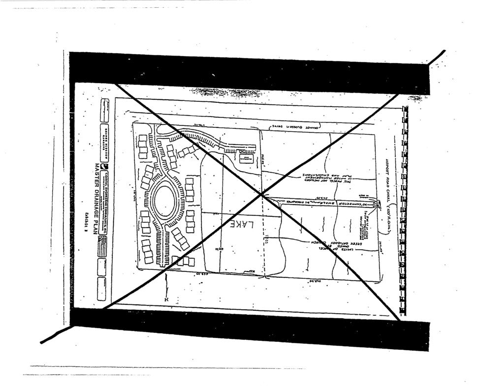
3 4.5 Street Construction 4.6 Easements for Underground Utilities 4.7 Utility Department Stipulations Solid Waste Disposal 4.8 Water Supply Other Utilities 4.9 Solid Waste Disposal Landscaping 4.10 Other Utilities Water Management 4.11 Signs Polling Places 4.12 Landscaping Platting 4.13 Water Management Environmental Stipulations 4.14 Polling Places Traffic LIST OF EXHIBITS Exhibit A (Figure 1) PUD Master Plan Exhibit B (Figure 2) PUD Master Drainage Plan Exhibit CB - Legal Description Page 3 of 15
4 SECTION I PROPERTY OWNERSHIP, DESCRIPTION AND STATEMENT OF COMPLIANCE 1.1 PURPOSE The purpose of this Section is to set forth the location and ownership, and to describe the existing condition of the property proposed to be developed under the project name of Orange Blossom Gardens. 1.2 LEGAL DESCRIPTION Being a part of Section 1, Township 49 South, Range 25 East, Collier County, Florida, and, more particularly, described in Exhibit B. 1.3 PROPERTY OWNERSHIP The subject property is currently under the ownership of St. Katherine s Greek Orthodox Church, Inc. 1.4 GENERAL DESCRIPTION OF THE PROPERTY AREA A. The project site contains 5.85 acres (+). It is located on the north side of Orange Blossom Drive approximately 671 east of Airport Road. Orange Blossom Drive intersects Airport Road approximately 1½ miles north of Pine Ridge Road. B. Current zoning is PUD. The parcel is bounded on the south by Orange Blossom Drive then land zoned PUD, Planned Unit Development (Lone Oak), on the east by private property zoned A, Rural Agricultural CPUD (Siena Lakes CCRC), and on the northwest by private property zoned A CU, Rural Agricultural, on the southwest by land zoned PUD (Longview Center), and on the north by land zoned PUD (Lakeside of Naples at Citrus Gardens). The property is within the Collier County Water and Sewer District and Collier County Water Management District # PHYSICAL DESCRIPTION The subject property has been farmed. About 60% of the 5.85 acres has been used as a borrow pit. Soil types found on the site are: Arzell sand (approx. 60%), and Immokalee fine sand (approx. 40%). (Soil characteristics are from the USDA soil survey of Collier County dated March, 1954.) 1.6 STATEMENT OF COMPLIANCE The Orange Blossom Gardens Planned Unit Development is consistent with the Collier County Growth Management Plan for the following reasons: Page 4 of 15
5 A. The project site is designated Urban Residential on the Future Land Use Map and in the Future Land Use Element. The permitted uses in this PUD are permitted in the Urban Residential Area. Properties designated Urban Residential are permitted a base density of up to 4 units per acre. Therefore, the proposed gross density of 3.42 dwelling units per acre is consistent with the FLUE. B. The project is compatible with surrounding land uses in accordance with Policy 5.4 of the Future Land Use Element. Elevations within the project site range from 10.5(+) to 11.5(+) with the average grade being 11.2.Three auger borings within the project site failed to find bedrock. The borings were discontinued at a depth of 19 feet. Vegetation consists of scattered second-growth pine trees, some small Wax Myrtle shrubs, grasses and Brazilian Pepper. The area appears to have been cleared for agricultural use. Four shallow swales run the length of the property north to south. Water management for the project will utilize a swale through property to the northwest to convey lake overflow from storm runoff to the Airport Road Canal. A baffled weir will limit the discharge rate to an amount acceptable to the Collier County Water Management Department. Page 5 of 15
6 SECTION II PROJECT DEVELOPMENT 2.1 PURPOSE The purpose of this section is to describe the general plan of development for the project including land use and density. 2.2 GENERAL A. Regulations for development of Orange Blossom Gardens shall be in accordance with the contents of this document, and any applicable sections and/or parts of the Collier County Land Development Code. B. Unless otherwise noted, the definitions of all terms shall be the same as those set forth in the Land Development Code. 2.3 PROJECT PLAN AND LAND USE TRACTS A. Exhibit A, is the P.U.D. Master Plan. The Master Plan will be amended at a future date to provide more specific details on the development envelope, access and development standards. B. In addition to the various areas and specific items shown on Exhibit A, such easements (utility, private, semi-private, semi-public, etc.) shall be established within or along the various tracts as may be necessary or deemed desirable for the service, function or convenience of the project residents. 2.4 MAXIMUM PROJECT DENSITY A maximum of 20 residential dwelling units in a multi-family configuration shall be constructed in the project area. The gross project area is 5.85 acres. The maximum gross density will be 3.42 units per acre. In addition, temporary principal uses for Siena Lakes CCRC, limited to off-site sales, marketing, and administrative offices, are allowed, and also accessory uses to St. Katherine s Greek Orthodox Church (A-Ag zoned property), such as administrative offices and/or classrooms ancillary to the church. 2.5 SITE DEVELOPMENT PLAN APPROVAL PROCESS The procedures outlined in the Land Development Code shall be followed for Site Development Plan approval. 2.6 FUTURE PUD AMENDMENT The original Orange Blossom Gardens PUD has sunset. The purpose of this PUD Page 6 of 15
7 Amendment is to remove approximately 5.85 acres from the original PUD owned by another entity. A PUD Amendment to this PUD Ordinance will be required prior to any development of this PUD including the possible amendment of the development standards in Section 3.4 and revisions to the PUD Master Plan in Exhibit A to address the future plans for development of this PUD. Page 7 of 15
8 SECTION III MULTI FAMILY RESIDENTIAL DEVELOPMENT OR LIMITED NON-RESIDENTIAL USES 3.1 PURPOSE The purpose of this section is to set forth the development plans and regulations for the project. 3.2 MAXIMUM DWELLING UNITS A maximum of 20 dwelling units will be constructed on the site. 3.3 PERMITTED USES No building, structure or part thereof, shall be erected, altered, or used, or land used, in whole or in part, for other than the following: A. Principal Uses: 1. Multi-family residences 2. Temporary Principal Uses: a. Off-site sales, marketing, and administrative offices for the Siena Lakes CCRC CPUD limited to a maximum of 5,622 SF. The authorization for this use shall be valid for five (5) years commencing with issuance of first certificate of occupancy. The temporary use may be extended for an additional five-year period through the same procedure as an insubstantial change to the PUD per LDC Section Accessory uses to St. Katherine's Greek Orthodox Church (A-Ag zoned property), such as: a. Administrative offices and/or classrooms ancillary to the church. B. Accessory Uses: 1. Accessory uses and structures, including storage facilities. 2. Recreational uses and facilities, such as swimming pools, and children s playground areas for the benefit of the multi-family residents and their guests. Such uses shall be visually and architecturally compatible with adjacent residences. 3.4 REGULATIONS FOR MULTI-FAMILY AND ITS ACCESSORY USES Minimum Lot Area: A. 1 acre Page 8 of 15
9 3.4.2 Minimum Lot Width: A. 200 feet Minimum Yards A. Setback along north, south and west side =35 B. Setback along east side = 25 C. Setback from lake = 30 D. Distance between principal structures = Minimum Floor Area: A. 900 square feet Maximum Height of Multi-Family Development: A. Two floors of living area with option of having one (1) floor of parking beneath the living area. 3.5 OFF STREET PARKING Off-street parking shall be provided as required by the Land Development Code. 3.5 REGULATIONS FOR OFF-SITE SALES, MARKETING AND ADMINISTRATION FACILITIES AND ADMINISTRATIVE OFFICES AND/OR CLASSROOMS ANCILLARY TO THE CHURCH Applicability: A. With approval of an SDP, an off-site marketing, sales and administration facility supporting the Continuing Care Retirement Community on the adjacent Siena Lakes PUD may be developed on Development Area 2, as depicted on the PUD Master Plan. Such facility shall be subject to all development standards set forth below. Access to this facility shall be from Sienna Lakes PUD, as depicted on the PUD Master Plan. B. With approval of an SDP, administrative offices and/or classrooms ancillary to, and/or other principal uses that serve as accessory uses to, St. Katherine s Greek Orthodox Church may be developed on Development Area 2. These facilities are subject to the development standards set forth below Development Standards Page 9 of 15
10 A. Maximum Building Height: 1. Principal Structures: 53 feet Zoned Height; 60 feet Actual Height 2. Accessory Structures: 30 feet Zoned Height; 35 feet Actual Height B. Setbacks: 1. Principal Structures: a. South Perimeter Boundary: 20 feet b. North Perimeter Boundary: 80 feet c. West Perimeter Boundary: 25 feet d. East Perimeter Boundary: 15 feet e. From internal drives: 10 feet f. Lake Setback: 20 feet 2. Accessory Structures: a. South Perimeter Boundary: 20 feet b. North Perimeter Boundary: 25 feet c. West Perimeter Boundary: 10 feet d. East Perimeter Boundary: 10 feet e. From internal drives: 10 feet f. Lake setback: 20 feet 3. Perimeter Landscape Buffers a. Adjacent to Orange Blossom Drive: 10 foot wide Type D Landscape Buffer b. North Perimeter Boundary: 15 foot wide Type B Landscape Buffer c. West Perimeter Boundary: 15 foot wide Type B Landscape Buffer, except as provided for in Section 4.9. Page 10 of 15
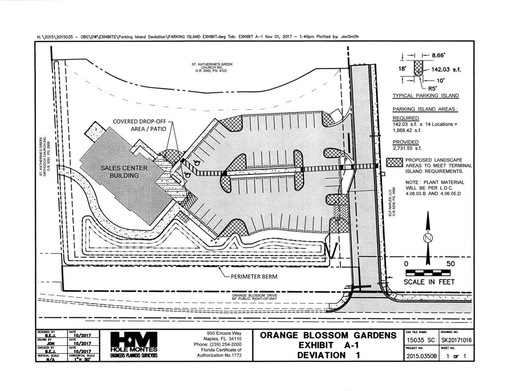
11 3.6 DEVIATIONS d. East Perimeter Boundary: 10 foot wide Type D Landscape Buffer, except as provided for in Section Minimum Distance Between Structures a. Principal Structures: 30 feet b. Accessory Structures: N/A A. Deviation 1 requests relief from LDC Section B.3. Standards for Landscaping in Vehicular Use Areas, which requires that all rows of parking spaces shall be bordered on each end by curbed landscape islands (Terminal Landscape Islands), to allow no terminal landscape islands adjacent to the building or covered drop-off areas in Development Area 2 in the location shown on the Master Plan and as depicted in Exhibit A-1. B. Deviation 2 requests relief from LDC Section , Table 2.4 Table of Buffer Requirements by Land Use Classifications, to allow no perimeter landscape buffer where shared stormwater lakes exist with adjacent properties. Page 11 of 15
12 SECTION IV DEVELOPMENT STANDARDS 4.1 PURPOSE The purpose of this section is to set forth the standards for the development of this project. 4.2 GENERAL All facilities shall be constructed in strict accordance with the final development plan and all applicable state and local laws, codes and regulations. 4.3 P.U.D. MASTER DEVELOPMENT PLAN A. Exhibit A (Figure 1), the P.U.D. Master Plan, illustrates the proposed development. However, this PUD has sunsetted and a future PUD amendment is required which will incorporate future development standards and access from Orange Blossom Drive. B. Minor site alterations to the Master Plan may be permitted in accordance with the Land Development Code. C. All necessary easements, dedications, or other instruments shall be granted to insure the continued operation and maintenance of all service utilities and project areas. 4.4 CLEARING, GRADING, EARTHWORK & SITE DRAINAGE All clearing, grading, earthwork & site drainage work shall be performed in accordance with applicable State and local codes. 4.5 STREET CONSTRUCTION The internal road will be 24 wide and 90 parking 18 feet deep, in accordance with zoning regulations. 4.6 EASEMENTS FOR UNDERGROUND UTILITIES Easements for underground utilities such as power, telephone, cable T.V., wastewater collection, water distribution, and similar uses shall be located and granted as required for those purposes. Page 12 of 15
13 4.7 UTILITY DEPARTMENT STIPULATIONS A. Water distribution, sewage collection and transmission facilities to serve the project are to be designed, constructed, conveyed, owned and maintained in accordance with Collier County Ordinance No , as amended, and other applicable County rules and regulations. B. All customers connecting to the water distribution and sewage collection facilities to be constructed will be customers of the County and will be billed by the County in accordance with the County s established rates. C. The on-site water distribution system to serve the project must be connected to the District s 12 inch water main on the west side of Airport Pulling Road consistent with the main sizing requirements specified in the County s Water Master Plan and extended throughout the project. During design of these facilities, dead and mains shall be eliminated by looping the internal pipeline network. D. The utility construction documents for the project s sewerage system shall be prepared so that all sewage flowing to the County s master pump station is transmitted by one (1) main on-site pump station. The Developer s Engineer shall meet with the County staff prior to commencing preparation of construction drawings, so that all aspects of the sewerage system design can be coordinated with the County s sewer master plan. E. The existing off-site water facilities of the District must be evaluated for hydraulic capacity to serve this project and reinforced as required, if necessary, consistent with the County s Water Master Plan to insure that the District s water system can hydraulically provide a sufficient quantity of water to meet the anticipated demands of the project and the District s existing committed capacity. F. The existing off-site sewage transmission facilities of the District must be evaluated for hydraulic capacity to serve this project and improved as required outside the project s boundary to provide adequate capacity to transport the additional wastewater generated without adverse impact to the existing transmission facilities. 4.8 WATER SUPPLY See Utility Departments Stipulations, Section SOLID WASTE DISPOSAL Arrangements shall be made with the Collier County solid waste disposal franchise holder to provide for solid waste collection to serve the project. Page 13 of 15
14 4.108 OTHER UTILITIES Utility lines for Telephone, Power, and Cable T.V. service, when available, shall be installed underground SIGNS All signs shall be in accordance with the Land Development Code LANDSCAPING All landscaping shall be in accordance with the Land Development Code. The open space area identified on the PUD Master Plan shall be grassed and landscaping shall be provided around the perimeter., except that no perimeter landscape buffer shall be required where shared stormwater lakes as referenced in 4.10 C below and approved on the SFWMD permit or permit modification cross property lines with abutting properties. (See Section 3.6). A landscaped buffer in accordance with the Land Development Code shall be provided along the north and west property lines except where the lake is located, and along the south property line except at the project entrance WATER MANAGEMENT A. Detailed site drainage plans shall be submitted to the Project Review Services Section for review. No construction permits shall be issued unless and until approval of construction in accordance with the submitted plans is granted by the Project Review Services Section. B. An Excavation Permit will may be required in accordance with the Land Development Code in order to bring the existing lake into compliance with present-day standards. C. If approved by SFWMD, shared stormwater lakes may be designed to cross the property boundaries between the Orange Blossom Gardens PUD and the St. Katherine s Greek Church (A-Agricultural zoned) property, and/or between Orange Blossom Gardens PUD and Longview PUD. The SFWMD permit or permit modification shall identify all entities responsible for maintenance of said lakes and related infrastructure. Easements necessary for such maintenance shall be established prior to SDP and/or Plat approval that includes construction of said lakes. Page 14 of 15
15 POLLING PLACES Space shall be provided within common areas for the purpose of permitting residents to vote during elections, if required by the Collier County Supervisor of Elections in accordance with the Land Development Code PLATTING Platting shall be required if units are to be sold fee simple or if the project is developed as an integrated phased SDP, in accordance with the Land Development Code ENVIRONMENTAL STIPULATIONS A. Prior to approval of an SDP, or any other Final Local Development Order for development on Development Area 1, as depicted on Exhibit C, the PUD Master Plan, if requested by Collier County, the developer shall submit the following: 1. A listed species survey; 2. Soil Testing, as required by the LDC. AB. Unless required as a condition related to Item A.1 above, Nno native vegetation is required to be preserved TRAFFIC A. The developer shall provide a fair share contribution toward the capital cost of a traffic signal and related intersection improvements should they become needed in the future. The signal will be owned, operated and maintained by the County. B. Forty-Four (44) feet shall be reserved along the southern portion of the PUD for the expansion of Orange Blossom Drive, including roadway and county utilities, and will be conveyed by easement to Collier County prior to the issuance of the first certificate of occupancy in the PUD or within 12 months of approval of this PUD, whichever comes first. C. Right-of-way dedication described in B., above, shall be eligible for road impact fee credits. Property value determinations for the purpose of impact fee credits shall be made at time of property transfer based upon fair market value determined by qualified appraisers. If all such credits cannot be applied by the property owner in the development of the PUD, the owner may sell and assign any excess credits to a third party. Page 15 of 15
16
17
18
19
PINE RIDGE COMMONS PUD AMEND ORDINANCE NUMBER 99-94
 PINE RIDGE COMMONS PUD AMEND ORDINANCE NUMBER 99-94 Title page of the Planned Unit Development Document, previously attached as Exhibit A to the PUD document of Ordinance Number 99-94, the Pine Ridge commons
PINE RIDGE COMMONS PUD AMEND ORDINANCE NUMBER 99-94
 PINE RIDGE COMMONS PUD AMEND ORDINANCE NUMBER 99-94 Title page of the Planned Unit Development Document, previously attached as Exhibit A to the PUD document of Ordinance Number 99-94, the Pine Ridge commons
Cover Letter with Narrative Statement
 Cover Letter with Narrative Statement March 31, 2017 rev July 27, 2017 RE: Rushton Pointe Residential Planned Unit Development Application for Public Hearing for RPUD Rezone PL2015 000 0306 Mr. Eric Johnson,
EXHIBIT A FOR HAMILTON PLACE RPUD
 EXHIBIT A Regulations for development of the Hamilton Place RPUD shall be in accordance with the contents of this RPUD Document and applicable sections of the LDC and Growth Management Plan (GMP) in effect
/
 Creekside West, Inc. 2600 Golden Gate Parkway Naples FL 34105 239.403.6804 dgenson@barroncollier.com D. Wayne Arnold, AICP / Richard D. Yovanovich, Esq. Q. Grady Minor and Associates, P.A. / Coleman, Yovanovich
A. Preserve natural resources as identified in the Comprehensive Plan.
 1370.08 Conservation Residential Overlay District. Subd. 1 Findings. The City finds that the lands and resources within the Conservation Residential Overlay District are a unique and valuable resource
Marion County Board of County Commissioners
 Marion County Board of County Commissioners Date: 12/29/2015 P&Z: 12/28/2015 BCC: 1/12/2016 Item Number 160113Z Type of Application Rezoning Request From: A-1 (General Agriculture) To: PUD (Planned Unit
4.2 RESIDENTIAL ZONING DISTRICTS
 4.2 RESIDENTIAL ZONING DISTRICTS A. Purpose: To define regulations and standards for each residential zoning district in the City. The following sections identify uses, regulations, and performance standards
Condominium Unit Requirements.
 ARTICLE 19 CONDOMINIUM REGULATIONS Section 19.01 Purpose. The purpose of this Article is to regulate projects that divide real property under a contractual arrangement known as a condominium. New and conversion
COLLIER COUNTY Growth Management Department
 COLLIER COUNTY Growth Management Department March 24, 2016 Tim Hancock, AICP Stntec Consulting Services Inc. 3200 Bailey Lane, Suite 200 Naples, FL 34105 EMAIL - Tim.Hancock@stantec.com RE: Planned Unit
ARTICLE 14 PLANNED UNIT DEVELOPMENT (PUD) DISTRICT
 DISTRICT") ARTICLE 14 PLANNED UNIT DEVELOPMENT (PUD) DISTRICT Section 14.01 Intent. It is the intent of this Article to allow the use of the planned unit development (PUD) process, as authorized by the Michigan Zoning
ARTICLE 14 PLANNED UNIT DEVELOPMENT (PUD) DISTRICT Section 14.01 Intent. It is the intent of this Article to allow the use of the planned unit development (PUD) process, as authorized by the Michigan Zoning
Site Plan Application
 Site Plan Application City of St. Pete Beach Community Development Department 155 Corey Avenue St. Pete Beach, Florida 33706 (727) 367-2735 www.stpetebeach.org Case Number: PROPERTY OWNER: Name: Address:
Reference: Planned Unit Development Rezone PL Collier County Resource Recovery Business Park Sufficiency Response No. 2
 Stantec Consulting Services Inc. 3200 Bailey Lane, Suite 200, Naples, FL 34105 August 16, 2016 File: 215613052 Attention: Eric Johnson Principal Planner Collier County Growth Management Division Zoning
MANDATORY HOA DISCLOSURE SUMMARY FOR LONE STAR RANCH SINGLE FAMILY HOMES
 MANDATORY HOA DISCLOSURE SUMMARY FOR LONE STAR RANCH SINGLE FAMILY HOMES The following notice is required by Florida Statue 720.401: 1. AS A PURCHASER OF PROPERTY IN THIS COMMUNITY, YOU WILL BE OBLIGATED
Application for a Public Hearing for PUD Rezone, Amendment to PUD or PUD to PUD Rezone
 GROWTH MANAGEMENT DEPARTMENT www.colliergov.net NAPLES, FLORIDA 34104 (239) 252-2400 FA: (239) 252-6358 Application for a Public Hearing for PUD Rezone, Amendment to PUD or PUD to PUD Rezone PETITION NO
Appendix A. Definitions
 Definitions 1. Terms Defined. Words contained in this are those having a special meaning relative to the purposes of this Ordinance. Words not listed in this section shall be defined by reference to: (1)
ARTICLE 8C SITE CONDOMINIUM DEVELOPMENT ORDINANCE
 ARTICLE 8C SITE CONDOMINIUM DEVELOPMENT ORDINANCE SECTION 8C.01 PURPOSE It is the purpose of this Ordinance to insure that plans for development within Oceola Township proposed under the provisions of
ARTICLE V AGRICULTURAL PRESERVATION AND RURAL RESIDENTIAL DISTRICT
 ARTICLE V AP AGRICULTURAL PRESERVATION AND RURAL RESIDENTIAL DISTRICT Section 500. PURPOSE It is the purpose of the AP, Agricultural Preservation and Rural Residential District, to foster the preservation
Box Elder County Land Use Management & Development Code Article 3: Zoning Districts
 Chapter 3-6 Mobile Homes, Mobile Home Subdivisions, & Recreational Vehicle Parks Box Elder Zoning Ordinance as Adopted October 2007 Sections. 3-6-010. Purpose and Intent. 3-6-020. Conditional Use Permit
RESOLUTION NO. RESOLUTION APPROVING ZONING PETITION 84-71, Special Exception. WHEREAS, the Board of County Commissioners, as the governing
 /. ;C- C, i RESOLUTION NO. R-@+-l2?8 RESOLUTION APPROVING ZONING PETITION 84-71, Special Exception WHEREAS, the Board of County Commissioners, as the governing body, pursuant to the authority vested in
ARTICLE 13 CONDOMINIUM REGULATIONS
 ARTICLE 13 CONDOMINIUM REGULATIONS Section 13.01 Purpose. The purpose of this Article is to regulate projects that divide real property under a contractual arrangement known as a condominium. New and conversion
610 LAND DIVISIONS AND PROPERTY LINE ADJUSTMENTS OUTSIDE A UGB
 ARTICLE VI: LAND DIVISIONS AND PROPERTY LINE ADJUSTMENTS VI-21 610 LAND DIVISIONS AND PROPERTY LINE ADJUSTMENTS OUTSIDE A UGB 610-1 Property Line Adjustments (Property Line Relocation) A property line
PALM BEACH COUNTY PLANNING, ZONING AND BUILDING DEPARTMENT ZONING DIVISION
 PALM BEACH COUNTY PLANNING, ZONING AND BUILDING DEPARTMENT ZONING DIVISION Petition No.: Z2002-051 Petitioner: Rene & Gina Tercilla Owner: Rene & Gina Tercilla Agent: Rene & Gina Tercilla Telephone No.:
SECTION 10.7 R-PUD (RESIDENTIAL PLANNED UNIT DEVELOPMENT) ZONE
 ZONE") Article X Zones 10-20 SECTION 10.7 R-PUD (RESIDENTIAL PLANNED UNIT DEVELOPMENT) ZONE A. PURPOSE AND INTENT: The R-PUD Residential PUD Zone is intended to provide alternative, voluntary zoning procedures
Article X Zones 10-20 SECTION 10.7 R-PUD (RESIDENTIAL PLANNED UNIT DEVELOPMENT) ZONE A. PURPOSE AND INTENT: The R-PUD Residential PUD Zone is intended to provide alternative, voluntary zoning procedures
GROWTH MANAGEMENT DIVISION NAPLES, FLORIDA (239) FAX: (239)
 FAX: (239)") GROWTH MANAGEMENT DIVISION NAPLES, FLORIDA 310 www.colliergov.net (239) 252-200 FAX: (239) 252-6358 Subdivision Construction Plans and Plat (PPL) Application LDC Section 10.02.0, and other provisions of
GROWTH MANAGEMENT DIVISION NAPLES, FLORIDA 310 www.colliergov.net (239) 252-200 FAX: (239) 252-6358 Subdivision Construction Plans and Plat (PPL) Application LDC Section 10.02.0, and other provisions of
Article 2 Application Type and Standards Requirements
 Article 1 Article 2 Division 1 Application Type and Standards Requirements General Provisions Sec. 2.1.1 Division 2 Division 3 Division 4 Division 5 Division 6 Division 7 Division 8 Division 9 Sec. 2.9.1
FINAL DRAFT 12/1/16, Rev. to 7/18/17
 FINAL DRAFT 12/1/16, Rev. to 7/18/17 (As Adopted 8/8/17 Effective 9/1/17) SHELTON PLANNING AND ZONING COMMISSION Proposed Amendments to Zoning Regulations I. Amend Section 23 PERMITTED USES by inserting
Staff Report: Date: Applicant: Property Identification: Acreage of Request: Current Zoning of Requested Area: Requested Action: Attached:
 Staff Report: Completed by Jeff Palmer Director of Planning & Zoning Date: November 7, 2018, Updated November 20, 2018 Applicant: Greg Smith, Oberer Land Developer agent for Ronald Montgomery ET AL Property
ELK RAPIDS TOWNSHIP ANTRIM COUNTY, MICHIGAN ORDINANCE NO
 ELK RAPIDS TOWNSHIP ANTRIM COUNTY, MICHIGAN ORDINANCE NO. 3-2011 AN ORDINANCE TO REPLACE THE SUBDIVISION CONTROL ORDINANCE WITH A NEW SUBDIVISION DEVELOPMENT ORDINANCE, IN ACCORD WITH THE LAND DIVISION
MAJOR SUBDIVISION PRELIMINARY PLAT CHECKLIST
 TOWNSHIP OF EGG HARBOR PLANNING BOARD/ZONING BOARD OF ADJUSTMENT 3515 BARGAINTOWN ROAD EGG HARBOR TOWNSHIP, NJ 08234 MAJOR SUBDIVISION PRELIMINARY PLAT CHECKLIST The following checklist is designed to
CITY OF BELLEVIEW PLANNING & ZONING BOARD AGENDA
 CITY OF BELLEVIEW PLANNING & ZONING BOARD AGENDA BELLEVIEW CITY HALL COMMISSION ROOM 5:30 PM IF A PERSON SHOULD DESIRE TO APPEAL ANY DECISION MADE BY THE BOARD, A VERBATIM RECORD OF THE PROCEEDINGS WHICH
Marion County Board of County Commissioners
 Marion County Board of County Commissioners Date: 10/29/25 P&Z: 10/26/25 BCC: 11/17/25 Item Number 151106SU Type of Application Special Use Permit Request Special Use Permit Modification to: 1. Add a secondary
Title 17 MOBILE HOMES AND RECREATIONAL VEHICLES
 17.04 General Provisions Title 17 MOBILE HOMES AND RECREATIONAL VEHICLES 17.04.010 General provisions 17.04.020 Application 17.04.030 Interpretation 17.04.040 Mobile homes and recreational vehicles--location
Letter of Intent May 2017 (Revised November 2017)
") THE BEACH AT WOODMOOR LETTER OF INTENT MAY 2017 (REVISED NOVEMBER 2017) OWNER/APPLICANT: CONSULTANT: Lake Woodmoor Holdings LLC N.E.S. Inc. 1755 Telstar Drive, Suite 211 619 North Cascade Avenue Colorado
THE BEACH AT WOODMOOR LETTER OF INTENT MAY 2017 (REVISED NOVEMBER 2017) OWNER/APPLICANT: CONSULTANT: Lake Woodmoor Holdings LLC N.E.S. Inc. 1755 Telstar Drive, Suite 211 619 North Cascade Avenue Colorado
SITE PLAN REVIEW PROCEDURES SECTION DEVELOPMENTS REQUIRING SITE PLAN APPROVAL
 SECTION 22.01 PURPOSE ARTICLE XXII PROCEDURES The purpose of this Article is to establish uniform requirements of procedure for all developments in the Township. Certain specific types of minor development
Appendix J - Planned Unit Development (PUD)
") Appendix J - Planned Unit Development (PUD) Intent and Purpose The purpose of the PUD is: 1. To provide development that is consistent with the Comprehensive Land Use Plan and promote the goals and objectives
Appendix J - Planned Unit Development (PUD) Intent and Purpose The purpose of the PUD is: 1. To provide development that is consistent with the Comprehensive Land Use Plan and promote the goals and objectives
-
 August 02, 2017 RWA, Inc - Keisha Westbrook, PE 6610 Willow Park Dr # 200 Naples, FL 34109 EMAIL - kwestbrook@consult-rwa.com; tbray@consult-rwa.com RE: Plans & Plat Construction PL20150002611 The Antilles
ARTICLE 5 GENERAL REQUIREMENTS
 5.1 SUITABILITY OF THE LAND ARTICLE 5 GENERAL REQUIREMENTS 5.1.1 Land subject to flooding, improper drainage or erosion, and land deemed to be unsuitable for development due to steep slope, unsuitable
Chapter 100 Planned Unit Development in Corvallis Urban Fringe
 100.100 Scope and Purpose. Chapter 100 Planned Unit Development in Corvallis Urban Fringe (1) All applications for land divisions in the Urban Residential (UR) and Flood Plain Agriculture (FPA) zones within
ZONING AMENDMENT, PLANNED UNIT DEVELOPMENT & SUBDIVISION STAFF REPORT Date: September 15, 2011
 ZONING AMENDMENT, PLANNED UNIT DEVELOPMENT & SUBDIVISION STAFF REPORT Date: September 15, 2011 NAME SUBDIVISION NAME LOCATION Stratford, L.L.C. Grelot Office Park Subdivision North side of Grelot Road,
ARTICLE 15 - PLANNED UNIT DEVELOPMENT
 Section 15.1 - Intent. ARTICLE 15 - PLANNED UNIT DEVELOPMENT A PUD, or Planned Unit Development, is not a District per se, but rather a set of standards that may be applied to a development type. The Planned
PALM BEACH COUNTY PLANNING, ZONING AND BUILDING DEPARTMENT ZONING DIVISION
 PALM BEACH COUNTY PLANNING, ZONING AND BUILDING DEPARTMENT ZONING DIVISION Application No.: CA-2012-00688 Control No.: 2011-00552 Applicant: Garry Bernardo Owners: Garry Bernardo Agent: Frogner Consulting,
PLANNING AND DEVELOPMENT COMMISSION (PDC) SUMMARY MINUTES September 6, 2018
 SUMMARY MINUTES September 6, 2018") PLANNING AND DEVELOPMENT COMMISSION (PDC) SUMMARY MINUTES Members Present: David Bramblett, Chair; Cheryl Phillips, 1 st Vice Chair; William Garvin, 2 nd Vice Chair; Joel Brender; and James Brooks Staff
PLANNING AND DEVELOPMENT COMMISSION (PDC) SUMMARY MINUTES Members Present: David Bramblett, Chair; Cheryl Phillips, 1 st Vice Chair; William Garvin, 2 nd Vice Chair; Joel Brender; and James Brooks Staff
Marion County Board of County Commissioners
 Marion County Board of County Commissioners Date: 6/4/217 P&Z: 9/25/217 BCC Transmittal: 1/17/217 BCC Adopt: TBD Amendment No: 217-L6 Type of Application Large-Scale Comp Plan Amendment Request: Change
PASCO COUNTY, FLORIDA INTEROFFICE MEMORANDUM. REFERENCES: Land Development Code, Development Director
 PASCO COUNTY, FLORIDA INTEROFFICE MEMORANDUM TO: Development Review Committee DATE: 11/12/08 FILE: DR09-100 SUBJECT: Class II, Commercial Development Review - Ashley Furniture Preliminary/Construction
Plans shall be drawn at a readable scale, signed, and sealed by a Florida Registered Engineer. The application package shall include:
 CHAPTER 400. SECTION 403. PERMIT TYPES AND APPLICATIONS SITE DEVELOPMENT 403.3. Preliminary Site Plans (PSP) A. Intent and Purpose PSPs are used to identify existing site conditions and demonstrate general
FORT MYERS, FLORIDA GATEWAY 54 ACRES MIXED USE PLANNED DEVELOPMENT OFFERING MEMORANDUM. Index
 FORT MYERS, FLORIDA GATEWAY 54 ACRES MIXED USE PLANNED DEVELOPMENT OFFERING MEMORANDUM Index 1. Executive Summary 2. Location Maps 3. 4. 5. 6. 7. Property Aerial Conceptual Site Plan Zoning Resolution
CITY OF BONITA SPRINGS ZONING ORDINANCE NO
 CITY OF BONITA SPRINGS ZONING ORDINANCE NO. 05-11 A ZONING ORDINANCE OF THE CITY OF BONITA SPRINGS, FLORIDA; APPROVING A REQUEST BY ROCKPOINT/RONTO NAPLES, LLC IN REFERENCE TO EAST BONITA ACTIVE ADULT
Staff Report: Date: Applicant: Property Identification: Acreage of Request: Current Zoning of Requested Area: Requested Action: Attached:
 Staff Report: Completed by Jeff Palmer Director of Planning & Zoning Date: November 7, 2018 Applicant: Greg Smith, Oberer Land Developer agent for Ronald Montgomery ET AL Property Identification: Frontage
February 6, The Antilles RPUD (fka Stillwater Bay) PUD Rezoning (PUDZ) Application Submittal #2 (PL ) Dear Mr.
 PUD Rezoning (PUDZ) Application Submittal #2 (PL ) Dear Mr.") February 6, 2017 Mr. Eric Johnson, AICP, CFM, LEED Principal Planner Collier County Growth Management Division, Planning and Regulation 2800 Horseshoe Drive North Naples, FL 34104 Subject: The Antilles
February 6, 2017 Mr. Eric Johnson, AICP, CFM, LEED Principal Planner Collier County Growth Management Division, Planning and Regulation 2800 Horseshoe Drive North Naples, FL 34104 Subject: The Antilles
CONDOMINIUM REGULATIONS
 ARTICLE 37 CONDOMINIUM REGULATIONS SECTION 37.01. Purpose The purpose of this Article is to regulate projects that divide real property under a contractual arrangement known as a condominium. New and conversion
Marion County Planning & Zoning Commission
 Marion County Planning & Zoning Commission Date: 10/1/2013 P&Z: 10/28/2013 BCC: 11/19/2013 Item Number 131106Z Type of Application Rezoning Request Zoning change from R- 1 Single-Family Dwelling to R-4
Town of Lisbon, Maine SUBDIVISION REVIEW APPLICATION
 Date Received: Fee Paid (amount): Applicant: Town of Lisbon, Maine SUBDIVISION REVIEW APPLICATION Subdivision Name/Title: This application must be received at the Town Office by close of business on the
DRAFT Resolution File No.: CU
 DRAFT Resolution A RESOLUTION OF THE ST. LUCIE COUNTY BOARD OF COUNTY COMMISSIONERS GRANTING COMPOST USA OF THE TREASURE COAST, LLC CONDITIONAL USE PERMIT APPROVAL FOR THE ESTABLISHMENT OF A BIOSOLIDS
Residential Project Convenience Facilities
 Standards for Specific Land Uses 35.42.220 E. Findings. The review authority shall approve a Land Use Permit in compliance with Subsection 35.82.110.E (Findings required for approval) or a Conditional
Proposed Overland Park Kansas Ordinance RE-1 Residential Estates Community
 18.171 RE-1 Residential Estate Community 18.171.010 Statement of intent. The zoning of property as RE-1, (Residential Estates Community, 1 dwelling unit per Gross acre density), is intended to provide
31, Township 29 South, Range 25 East, Polk County, Florida, as depicted by the Land Use Plan attached
 ORDINANCE NO. 2013-04 AN ORDINANCE AMENDING THE ZONING MAP OF THE CITY OF BARTOW, FLORIDA, REZONING APPROXIMATELY 2. 2 ACRES OF LAND OWNED BY BALA3I OF POLK COUNTY, LLC AND LOCATED IN SECTION 31, TOWNSHIP
ARTICLE FIVE FINAL DRAFT
 ARTICLE FIVE 021218 FINAL DRAFT Sec. 503.6 Open Space Preservation Option Open Space Preservation Option Open Space Preservation developments may be approved in the AR, R-1, R-2 and R-3 zoning districts,
A Minor Land Excavation Operating Permit is used to:
 CHAPTER 400. SECTION 404. PERMIT TYPES AND APPLICATIONS OPERATING PERMITS 404.1. Minor Land Excavation A. Intent and Purpose The intent and purpose of this section is to protect the public health, safety,
APPLICANT NAME SUBDIVISION NAME DEVELOPMENT NAME LOCATION. CITY COUNCIL DISTRICT Council District 4 PRESENT ZONING PROPOSED ZONING
 SUBDIVISION, PLANNED UNIT DEVELOPMENT, PLANNING APPROVAL, ZONING AMENDMENT, & SIDEWALK WAIVER REQUEST STAFF REPORT Date: February 17, 2010 APPLICANT NAME SUBDIVISION NAME DEVELOPMENT NAME LOCATION David
SECTION 16. "PUD" PLANNED UNIT DEVELOPMENT OVERLAY DISTRICT
 SECTION 6. "PUD" PLANNED UNIT DEVELOPMENT OVERLAY DISTRICT Subsection. Purpose. This district is established to achieve the coordinated integration of land parcels and large commercial and retail establishments
ORDINANCE WHEREAS, the adoption of this Ordinance shall not be construed as an admission that the aforesaid claim has merit or is correct; and
 ORDINANCE 12-24 AN ORDINANCE OF THE CITY OF WINTER GARDEN, FLORIDA, REPEALING ORDINANCE 12-02 AND REPLACING IT WITH THE AMENDMENTS TO ARTICLE V OF CHAPTER 118 OF THE WINTER GARDEN CODE OF ORDINANCES CONTAINED
CITY OF OCOEE LAND DEVELOPMENT CODE SUFFICIENCY TABLE WITH NOTES
 CITY OF OCOEE LAND DEVELOPMENT CODE SUFFICIENCY TABLE WITH NOTES The Sufficiency Table is a checklist to help identify the types of information and documentation needed for various types of projects. The
Lane Code CHAPTER 10 CONTENTS
 Lane Code CHAPTER 10 CONTENTS AGRICULTURAL LAND DISTRICT (A-2) 10.107-05 Purpose. 10.107-10 Uses. 10.107-12 Review Process. 10.107-20 Land Division Requirements. 10.107-30 Land s. 10.107-40 Setback Requirements.
Washington County, Minnesota Ordinances
 Washington County, Minnesota Ordinances Ordinance No. 153 Text Amendment to the Washington County Development Code - Chapter One, Section 2 and Chapter Two, Part 1, Part 2, Part 3, of the Development Code
(a) Commercial uses on Laurel Avenue, abutting the TRO District to the
 Commercial uses on Laurel Avenue, abutting the TRO District to the") 32X Zoning Code 150.36 TRANSITIONAL RESIDENTIAL OVERLAY DISTRICT. (A) Intent and purpose. (1) It is the intent of the Transitional Residential Overlay District (hereinafter referred to as the "TRO District")
32X Zoning Code 150.36 TRANSITIONAL RESIDENTIAL OVERLAY DISTRICT. (A) Intent and purpose. (1) It is the intent of the Transitional Residential Overlay District (hereinafter referred to as the "TRO District")
13-2 SUBDIVISION PLANS AND PLATS REQUIRED EXCEPTIONS Subdivision Plats Required To be Recorded
 ARTICLE XIII SUBDIVISIONS 13-1 INTENT AND PURPOSE 13-1-1 Intent: It is the intent of the County Commission through the adoption of this Article to more fully avail itself of the power granted under 17-27-601
This is a New Findings of Adequacy for a Recorded Plat (Plat Book 179, Page 131) LAND USE Vacant Effective Plan: Pompano Beach
 LAND USE Vacant Effective Plan: Pompano Beach") Page 1 of 11 Board of County Commissioners, Broward County, Florida Environmental Protection and Growth Management Department Planning and Development Management Division DEVELOPMENT REVIEW REPORT PROJECT
Page 1 of 11 Board of County Commissioners, Broward County, Florida Environmental Protection and Growth Management Department Planning and Development Management Division DEVELOPMENT REVIEW REPORT PROJECT
Chapter 22 PLANNED UNIT DEVELOPMENT.
 Chapter 22 PLANNED UNIT DEVELOPMENT. Sec. 22.1 INTENT. The use of land and the construction and use of buildings and other structures as Planned Unit Developments in Georgetown Township may be established
ALPINE TOWNSHIP ZONING ORDINANCE TABLE OF CONTENTS
 ALPINE TOWNSHIP ZONING ORDINANCE TABLE OF CONTENTS PAGE CHAPTER I - DEFINITIONS 1-1 CHAPTER II - GENERAL PROVISIONS 2-1 2.01 Accessory Buildings 2-1 2.02 Automobiles 2-6 2.03 Prohibited Uses and Undesignated
UPPER MOUNT BETHEL TOWNSHIP NORTHAMPTON COUNTY, PENNSYLVANIA
 UPPER MOUNT BETHEL TOWNSHIP NORTHAMPTON COUNTY, PENNSYLVANIA JOINDER DEED / LOT CONSOLIDATION TOWNSHIP REVIEW PROCESS When accepting proposed Joinder Deeds / Lot Consolidations, review the Joinder Deed
The following regulations shall apply in the R-E District:
 "R-E" RESIDENTIAL ESTATE DISTRICT (8/06) The following regulations shall apply in the R-E District: 1. Uses Permitted: The following uses are permitted. A Zoning Certificate may be required as provided
Initial Project Review
 Pierce County Department of Planning and Land Services, 2401 South 35th Street, Tacoma, WA (253) 798-7037 Initial Project Review Major Amendment to Preliminary Plat: Hawks Ridge Division 1 Application
A.3. ARTICLE 7 PLAN REQUIREMENTS FOR MINOR SUBDIVISION AND/OR LAND DEVELOPMENT
 700. 701.A.3. ARTICLE 7 PLAN REQUIREMENTS FOR MINOR SUBDIVISION AND/OR LAND DEVELOPMENT SECTION 700 PURPOSE The purpose of this Article is to set forth a streamlined set of Plan Requirements for minor
Larimer County Planning Dept. Procedural Guide for 1041 PERMITS
 - Larimer County Planning Dept. Procedural Guide for 1041 PERMITS PLEASE NOTE: A PRE-APPLICATION CONFERENCE IS REQUIRED PRIOR TO SUBMITTING THIS APPLICATION. PURPOSE: State Statutes allow local governments
5. That the Owner shall agree that all development Blocks shown within the Draft Plan will be connected to full municipal services.
 Conditions Relating to Draft Plan of Subdivision Approval East Fonthill 26T 01014 (Draft Plan dated December 1, 2013, and revised August 28, 2014), the Town of Pelham 1. This approval applies to the Draft
Guide to Preliminary Plans
 Guide to Preliminary Plans Introduction The Douglas County is committed to providing open, transparent application processes to the public. This Guide is provided to assist anyone interested in the procedures
ML-4 MULTIFAMILY RESIDENTIAL ZONE. [Added by Ord. No ]
![ML-4 MULTIFAMILY RESIDENTIAL ZONE. [Added by Ord. No ]](/thumbs/90/103301433.jpg "ML-4 MULTIFAMILY RESIDENTIAL ZONE. [Added by Ord. No ]") 55-26. ML-4 MULTIFAMILY RESIDENTIAL ZONE. [Added 2-2-98 by Ord. No. 1998-1 2] The following regulations apply in the ML-4 Zone. A. Permitted Uses. (1) Garden apartments, together with accessory structures
55-26. ML-4 MULTIFAMILY RESIDENTIAL ZONE. [Added 2-2-98 by Ord. No. 1998-1 2] The following regulations apply in the ML-4 Zone. A. Permitted Uses. (1) Garden apartments, together with accessory structures
EXHIBIT D. Planned Unit Development Written Description April 13, 2016 Rouen Cove Phase II PUD
 1 EXHIBIT D Planned Unit Development Written Description April 13, 2016 Rouen Cove Phase II PUD Development # 8986.001 Developer: Curtis L. Hart Hart Resources LLC 8051 Tara Lane Jacksonville, Florida
Plan nt Plan Filing and
 PARISH OF ASCENSION OFFICE OF PLANNING AND DEVELOPMENT PLANNING DEPARTMENT APPENDIX VI PLANNED UNIT DEVELOPMENT (PUD) CODE Contents: 17-601. General Purpose: Procedures... 3 17-602. General Character:...
ARTICLE 7 UTILITIES AND EASEMENTS
 7.1 PLACEMENT OF UTILITIES ARTICLE 7 UTILITIES AND EASEMENTS 7.1.1 All authorized public underground utilities shall be located within the right-of-way of a public street or within an easement designated
RESOLUTION NO. Z-R-93-3 RESOLUTION APPROVING ZONING PETITION CB93-22 CLASS B CONDITIONAL USE PETITION OF AMERIGROW RECYCLING, INC.
 RESOLUTON NO. Z-R-93-3 RESOLUTON APPROVNG ZONNG PETTON CB93-22 CLASS B CONDTONAL USE PETTON OF AMERGROW RECYCLNG, NC. WHEREAS, the palm Beach County Zoning Commission, pursuant t0 Article 5 (Development
ARTICLE 12 PLANNED UNIT DEVELOPMENT DISTRICTS (PUDS) Sec Intent CHARTER TOWNSHIP OF BRIGHTON ZONING ORDINANCE
 Sec Intent CHARTER TOWNSHIP OF BRIGHTON ZONING ORDINANCE") ARTICLE 12 PLANNED UNIT DEVELOPMENT DISTRICTS (PUDS) Sec. 12-01 Intent 1 2 (a) The intent of this Article is to permit the coordinated development on larger sites, protect significant natural features
ARTICLE 12 PLANNED UNIT DEVELOPMENT DISTRICTS (PUDS) Sec. 12-01 Intent 1 2 (a) The intent of this Article is to permit the coordinated development on larger sites, protect significant natural features
Article 7: Residential Land Use and Development Requirements
 Article 7: Residential Land Use and Section 701: Statement of Intent (A) (B) (C) The intent of Article 7 is to develop certain land use and development requirements for the residential uses within Cumru
TOWNSHIP OF ALGOMA. County, Michigan, held in the Algoma Township Hall, Algoma Avenue, N.E., within
 TOWNSHIP OF ALGOMA COUNTY OF KENT, MICHIGAN At a special meeting of the Township Board of the Township of Algoma, Kent County, Michigan, held in the Algoma Township Hall, 10531 Algoma Avenue, N.E., within
Initial Subdivision Applications Shall Include the Following:
 Initial Subdivision Applications Shall Include the Following: 1) Subdivision Application Form: completely filled out (12 copies) 2) Plat: The Plat must adhere to the requirements set forth in the Town
Guide to Combined Preliminary and Final Plats
 Guide to Combined Preliminary and Final Plats Introduction The Douglas County is committed to providing open, transparent application processes to the public. This Guide is provided to assist anyone interested
ARTICLE 15. RULES, REGULATIONS AND DEFINITIONS
 ARTICLE 15. RULES, REGULATIONS AND DEFINITIONS Section 1. Interpretation and Construction: The following rules and regulations regarding interpretation and construction of the Ulysses-Grant County, Kansas,
This is a New Finding of Adequacy for a Recorded Plat (Plat Book 179, Page ) Replat: LAND USE Guard House Effective Plan: Davie.
 Replat: LAND USE Guard House Effective Plan: Davie.") Page 1 of 19 Board of County Commissioners, Broward County, Florida Environmental Protection and Growth Management Department Planning and Development Management Division DEVELOPMENT REVIEW REPORT PROJECT
Page 1 of 19 Board of County Commissioners, Broward County, Florida Environmental Protection and Growth Management Department Planning and Development Management Division DEVELOPMENT REVIEW REPORT PROJECT
BEAR CREEK TOWNSHIP EMMET COUNTY, MICHIGAN. PRIVATE ROAD ORDINANCE Ordinance No. 11A-99. (to replace prior Private Road Ordinance No.
 BEAR CREEK TOWNSHIP EMMET COUNTY, MICHIGAN PRIVATE ROAD ORDINANCE Ordinance No. 11A-99 (to replace prior Private Road Ordinance No. 11-99) An Ordinance to protect the health, safety, and general welfare
DEVELOPMENT POLICY INFRASTRUCTURE GUIDELINES FOR NEW DEVELOPMENT
 CITY OF HAYS SUBJECT DEVELOPMENT POLICY INFRASTRUCTURE GUIDELINES FOR NEW DEVELOPMENT ISSUED BY LAST REVISION DATE POLICY MANUAL REVISION DATE City Commission 3-13-08 10-22-09 POLICY STATEMENT: The City
FINAL SUBDIVISION AND LAND DEVELOPMENT PLAN CHECKLIST. Plan Name. Applicant's Name:
 TOWNSHIP OF UPPER ST. CLAIR FINAL SUBDIVISION AND LAND DEVELOPMENT PLAN CHECKLIST Date Filed Plan Name PLC Applicant's Name: Phone Filing Date for Final Application Final Plat 114.22. FINAL APPLICATION
Exhibit "A" have applied for a re-zoning and re-classification of that property from OPEN RURAL (OR) to that of a PLANNED UNIT DEVELOPMENT (PUD); and
 to that of a PLANNED UNIT DEVELOPMENT (PUD); and") I NSTR # 200632845 OR BK 61439 PGS 0728-0750 RECORDED 06/24/2066 12:25:50 PR JOHN Q. CRAWFOKD CLERK OF CIRCUIT COURT NASSAU COUNTY, FLORIDA RECORDING FEES 1.37.80 ORDINANCE NO. 2006-65 AN ORDINANCE AMENDING
I NSTR # 200632845 OR BK 61439 PGS 0728-0750 RECORDED 06/24/2066 12:25:50 PR JOHN Q. CRAWFOKD CLERK OF CIRCUIT COURT NASSAU COUNTY, FLORIDA RECORDING FEES 1.37.80 ORDINANCE NO. 2006-65 AN ORDINANCE AMENDING
City of Ferndale CITY COUNCIL STAFF REPORT
 SUBJECT: Final Plat Approval DATE: January 19, 2016 FROM: Haylie Miller, Assistant Planner PRESENTATION BY: Haylie Miller City of Ferndale CITY COUNCIL STAFF REPORT MEETING DATE: January 19, 2016 AGENDA
ARTICLE SINGLE FAMILY SITE CONDOMINIUM DEVELOPMENT STANDARDS
 ARTICLE 28.00 SINGLE FAMILY SITE CONDOMINIUM DEVELOPMENT STANDARDS Section 28.01 PURPOSE The purpose of this Article is to recognize that conventional single family developments, traditionally developed
NAPLES, FLORIDA TOLLGATE COMMERCIAL CENTER COMMERCIAL/INDUSTRIAL LAND OFFERING MEMORANDUM. Index
 NAPLES, FLORIDA TOLLGATE COMMERCIAL CENTER COMMERCIAL/INDUSTRIAL LAND OFFERING MEMORANDUM Index 1. Executive Summary 2. Location Maps 3. Property Aerial 4. New Master Site Plan 5. PUD Ordinance 17-15 TOLLGATE
Watkinsville First Baptist Church Building and Parking Masterplan Norton Road & Simonton Bridge Road Oconee County Georgia
 Watkinsville First Baptist Church Building and Parking Masterplan Norton Road & Simonton Bridge Road Oconee County Georgia Special Use Approval A-1 CUP to A-1 with Special Use Approval Total Site Area
PLANNED UNIT DEVELOPMENT & SUBDIVISION STAFF REPORT Date: April 18, 2019
 PLANNED UNIT DEVELOPMENT & SUBDIVISION STAFF REPORT Date: April 18, 2019 DEVELOPMENT NAME SUBDIVISION NAME Springhill Village Subdivision Springhill Village Subdivision LOCATION 4350, 4354, 4356, 4358,
Cobb County Community Development Agency Zoning Division 1150 Powder Springs St. Marietta, Georgia 30064
 Cobb County Community Development Agency Zoning Division 1150 Powder Springs St. Marietta, Georgia 30064 Case # Z-63 Public Hearing Dates: PC: 11-06-18 BOC: 11-20-18 SITE BACKGROUND Applicant: Loyd Development
ARTICLE 9 SPECIFICATIONS FOR DOCUMENTS TO BE SUBMITTED
 ARTICLE 9 SPECIFICATIONS FOR DOCUMENTS TO BE SUBMITTED SECTION 950 GENERALLY All applications shall be properly signed and filed by the owner or, with the owner s specific written consent, a contract purchaser