CITY OF VACAVILLE PLANNING COMMISSION Agenda Item No. G.3 STAFF REPORT June 21, Staff Contact: Tricia Shortridge (707)
|
|
|
- Hannah Booth
- 5 years ago
- Views:
Transcription
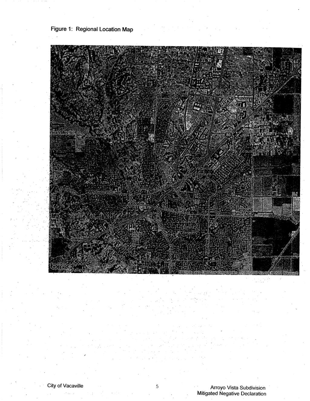
1 CITY OF VACAVILLE PLANNING COMMISSION Agenda Item No. G.3 STAFF REPORT June 21, 2011 Staff Contact: Tricia Shortridge (707) TITLE: REQUEST: RECOMMENDED ACTION: ARROYO VISTA SUBDIVISION DRAFT MITIGATED NEGATIVE DECLARATION, ZONING MAP AMENDMENT, TENTATIVE MAP, AND PLANNED DEVELOPMENT REQUESTS TO CONSTRUCT AN 8-LOT CUSTOM HOME SUBDIVISION, AT THE SOUTHWEST CORNER OF FRUITVALE ROAD AND GIBSON CANYON ROAD. RECOMMEND THAT THE CITY COUNCIL ADOPT THE DRAFT MITIGATED NEGATIVE DECLARATION, AND APPROVE THE ZONING MAP AMENDMENT, TENTATIVE PARCEL MAP, AND PLANNED DEVELOPMENT REQUESTS FOR THE ARROYO VISTA SUBDIVISION, SUBJECT TO THE CONDITIONS OF APPROVAL. APPLICATION INFORMATION APPLICATIONS AND FILE NO. APPLICANT & PROPERTY OWNER: Mitigated Negative Declaration, Zoning Map Amendment, Tentative Map, and Planned Development File No Ray Thompson PROPERTY INFORMATION LOCATION: Southwest corner of Fruitvale Road and Gibson Canyon Road SITE AREA: 3.87 acres CURRENT ZONE: RE-1 Residential Estate (Minimum one-acre lots) PROPOSED ZONE: RE-10 Residential Estate (Minimum 10,000 sq. ft. lots) GENERAL PLAN DESIGNATION: Low Density (3.1 to 5.0 units per acre) CURRENT LAND USE: Vacant orchard ADJACENT ZONING & USE: North: Fruitvale Road, unincorporated parcels South: RE-1, Single-Family Residential East: RE-20, Estate Single-Family Residential West: RL-10, Single-Family Residential
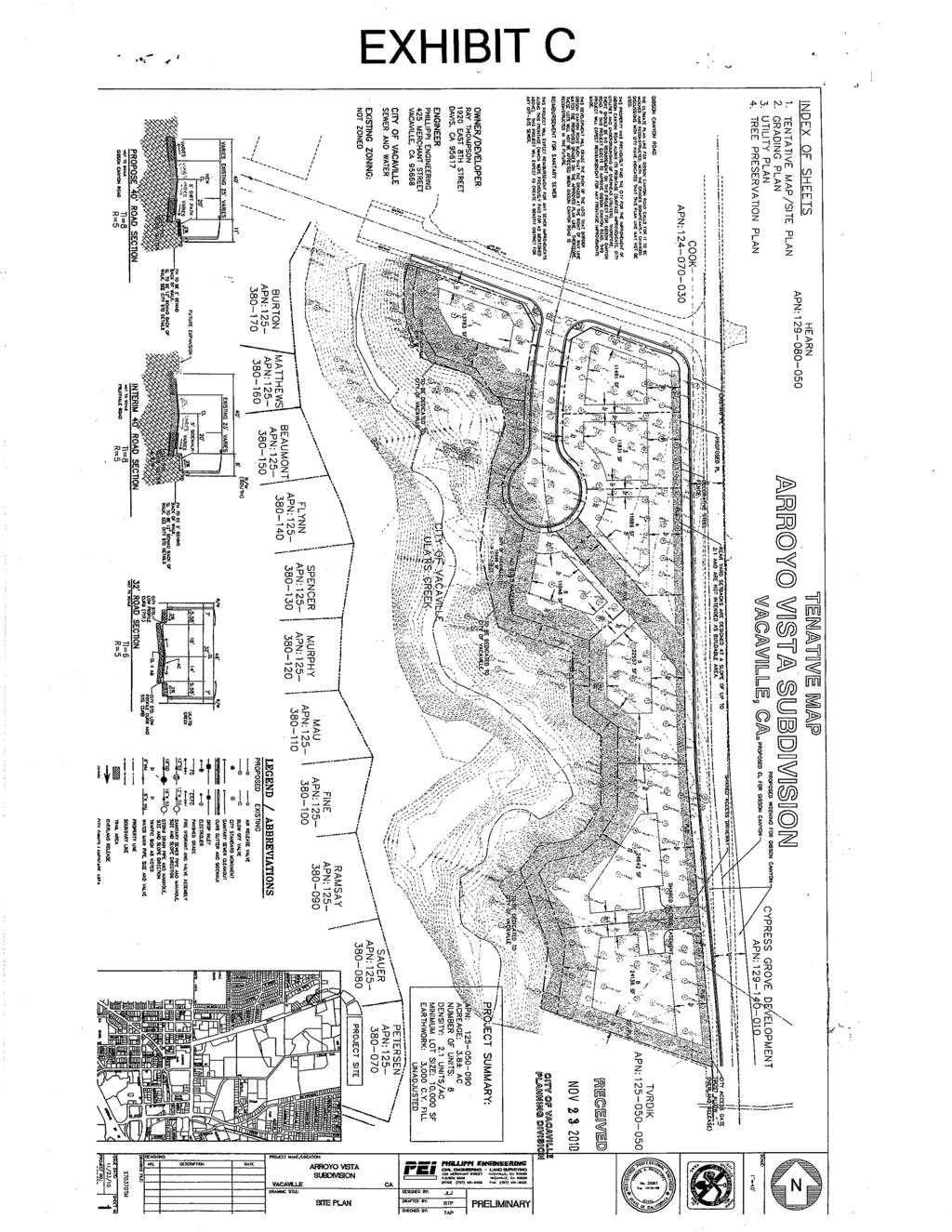
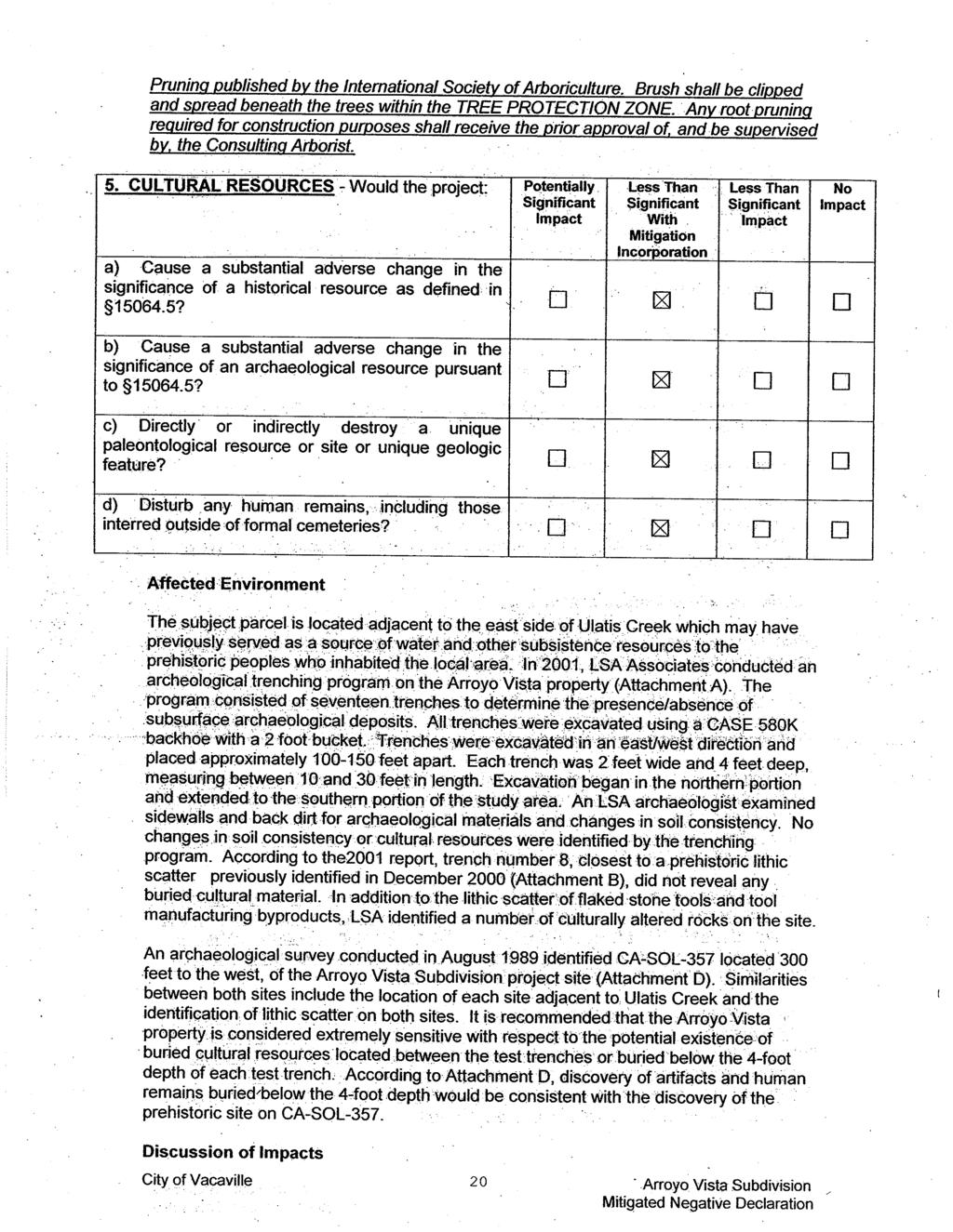
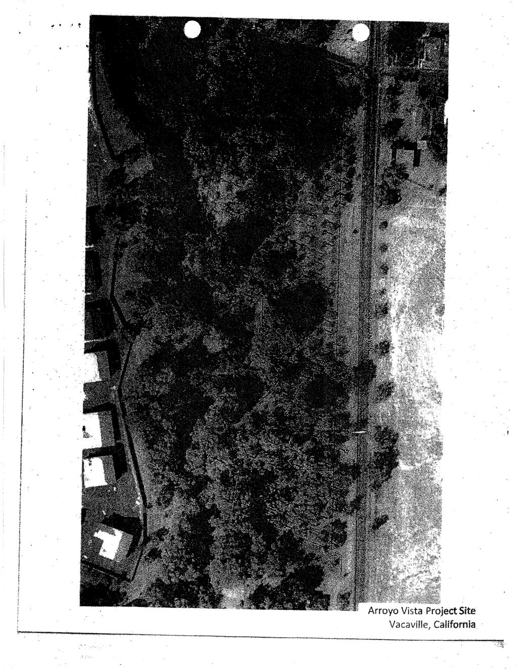
2 PROJECT SUMMARY SITE AREA: NUMBER OF DU/LOTS: PROJECT DENSITY: LOT SIZES: DWELLING UNIT TYPE: REQUIRED SETBACKS: ACCESS: Approximately 3.8 acres 8 lots Proposed: 2.1 units per acre Allowed: 3.1 to 5.0 units per acre 13,783 sq. ft. to 24,162 sq. ft. (Min. 10,000 square feet) Custom single family homes Front: 25 feet, (Min. 20 ft. to unenclosed porch) Sides: 10 feet and 10 feet Street side: 15 feet. Rear: 20 feet Via Fruitvale Road and Gibson Canyon Road PROJECT DESCRIPTION The project proposal is to create an 8-lot custom home subdivision on an approximately 3.8-acre parcel, located at the southwest corner of Fruitvale Road and Gibson Canyon Road. As part of the project proposal, the applicant is requesting approval of the following applications: (1) Rezoning - to rezone the property from RE-1 (Residential Estate - minimum 1-acre lot size) to RE-10 (Residential Estate - minimum 10,000 sq. ft. lot size); (2) Tentative Map - to subdivide the property into 8 lots (minimum 10,000 sq. ft. each) for future custom home development; and (3) Planned Development - to allow a phased development of the project site and to establish design and construction standards for future custom homes. No house plans are being proposed with this application. Individual custom homes require approval of a staff-level Design Review application. PREVIOUS ACTIONS 1900 s to Present Property utilized as an orchard. December 1989 The City Council approved a Tentative Map for the Burton Estates Subdivision, comprised of 19 acres located at the southwest corner of Gibson Canyon Road and Fruitvale Avenue and adjacent to the east and west banks of Ulatis Creek. The Tentative Map subdivided the property into 33 10,000 square foot lots adjacent to the west side of Ulatis Creek (Burton Estates Subdivision), and a 3.8 acre lot located on the east side of Ulatis Creek (Arroyo Vista Subdivision) PROJECT ANALYSIS COMPLIANCE WITH ADOPTED PLANS AND ORDINANCES 1. General Plan Density - The applicant is proposing to change the zoning designation from RE-1 to RE-10. Both RE-1 and RE-10 are have the same General Plan Density Requirement 2
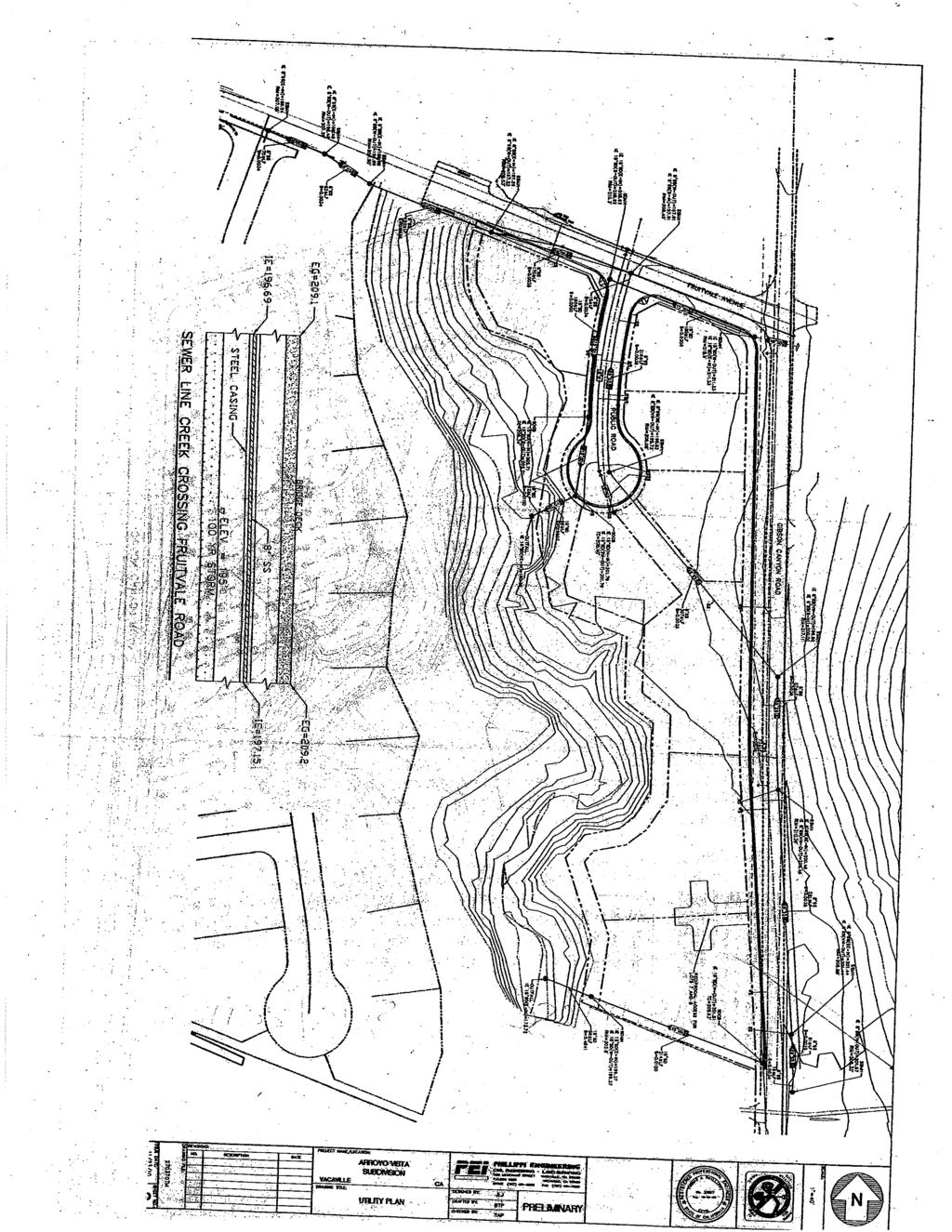
3 (0.5-3 units per acre). Therefore, the proposed RE-10 zoning designation would be consistent with the General Plan land use map. Land Use Element - Table 11-1 of the General Plan cross-references the zoning districts of the Land Use and Development Code with the land use designations of the General Plan. The requested change in zoning from RE-1 to RE-10 is consistent with the General Plan land use designation of RE (Residential Estate), with the approval of a Planned Development permit, which the applicant is seeking. Parks and Recreation Element - The applicant is dedicating a 40 foot no-build easement to the City of Vacaville, for creek maintenance purposes. The applicant is providing a no-build easement on the project site, consistent with the General Plan. Transportation Element - Table 6-1 and Figure 6-2 depict the future designation of Gibson Canyon Road as a four-lane arterial street. The Tentative Map shows a dedication of 50 feet in width for this potential widening, from a two lane arterial to a four lane arterial. However, the ultimate width of Gibson Canyon Road may change through the General Plan Update process, which is currently underway. Regardless of the ultimate width of Gibson Canyon Road, the applicant is providing sufficient dedication to provide the required bike lane. 2. Zoning Map Amendment (Rezone) The applicant is requesting a Zoning Map Amendment to rezone an approximately 3.8-acre property from RE-1 (Residential Estate - minimum one-acre lots) to RE-10 (Residential Estate - minimum 10,000 sq. ft. lots). The Burton Estates subdivision, located to the west of the project site is zoned RL-10 (Residential Low Density - minimum 10,000 sq. ft. lots), and the parcels located across the project site on Gibson Canyon Road are zoned RE-20 (Residential Estate- minimum 20,000 sq. ft. lots). Other parcels adjoining the project site along the southern and southwestern portions of the site consist of single-family residential development and are zoned RE-1 and RL-6 (Residential Low Density - minimum 6,000 sq. ft. lots). Staff believes the proposed RE-10 zoning is consistent with the surrounding zoning districts. 3. Tentative Map The proposed Tentative Map consists of the subdivision of the 3.8-acre project site into eight lots for future custom single-family homes. Lot Sizes - The proposed lots are a minimum 10,000 sq. ft., and comply with the minimum lot area, depth, and width requirements of the RE-10 Zone District. Lot sizes vary between 11,046 square feet and 24,642 square feet. Access - Access to the project site is provided via a cul-de-sac on Fruitvale Road. Specifically, the cul-de-sac provides access to Lots 1 through 6, the remaining two lots (7 and 8) are accessed via a shared access on Gibson Canyon Road. Improvements and Dedications (Gibson Canyon Road) - As conditioned (Condition No. 46), the applicant will be required to underground existing overhead utility lines along the project s frontage on Gibson Canyon Road. In addition, the applicant will be providing a crushed granite sidewalk along Gibson Canyon Road, and a bike lane. 3
4 No Build Easement - As conditioned (Condition No. 28), the applicant is required to dedicate to the City of Vacaville a 40-foot wide no build easement adjacent to the top of the Ulatis Creek bank, for creek maintenance purposes. The lots adjoining the creek will include ft. of this no-build area. Fencing - Condition No. 4 requires the installation of open, decorative steel fencing along Gibson Canyon Road and Fruitvale Road. In addition, fencing along the creek/no-build area is required to be an open-style wrought-iron fence. 4. Planned Development A Planned Development is required for this project, to maintain consistency between the General Plan and Zoning Code residential land use designations. Table 11-1 of the General Plan (Implementation) requires a Planned Development approval in order for the RE-10 zoning district to be consistent with the RE (Residential Estate) General Plan land use designation. In addition, since the Planned Development encompasses other approvals such a Design Review, design standards for the future homes can be established through the planned development process. Condition No. 5 requires the future homes in Arroyo Vista to comply with the City s Residential Design Requirements for New Single Family Development. These guidelines provide suggestions and requirements for improving the aesthetics of single-family homes. In the past, staff has been able to work with custom lot owners to approve high-quality custom homes. 5. Planned Growth Ordinance (PGO) All residential developments in the City must comply with the PGO (Section of the Land Use and Development Code). The proposed project is exempt from the PGO, because it is a subdivision map where all units within the project are custom-designed single-family homes. As such, these are no restrictions on the recordation of a final map or issuance of permits provided that the houses are individual custom homes. HOUSE DESIGN The proposed project is a custom home subdivision. The applicant is not proposing any house plans with this application. The general design themes and building materials of future homes in Arroyo Vista subdivision will be subject to the Land Use and Development Code requirements including the single-family home design requirements. The homes must also comply with the RE-10 development standards, and must be compatible with the adjoining subdivisions. As previously mentioned, custom homes require a separate staff-level Design review approval. COMMUNITY FACILITIES DISTRICT (CFD) As a condition to the approval of the Final Map for any Parcel Map, Tentative Map, or Vesting Tentative Map for any residential development with five or more residential units, City Council policy requires the developer or property owner to apply for and procure approval by the City Council of the City of Vacaville to either form a new or amend an existing Community Facilities District (CFD) to include the subject development. In this case, the property owner is required to annex into CFD 12, which is for in-fill developments such as Arroyo Vista. 4
5 The purpose of the Community Facilities District is to provide a funding mechanism to pay for the full cost of providing additional fire protection and police protection services for the subject development, including, but not limited to, the cost of public improvements, equipment, and salaries and benefits for the additional police and fire personnel required to serve said development. The assessments for the Public Safety District will increase annually at a rate corresponding to the Consumer Price Index (CPI) for the San Francisco Bay Area. Condition No. 18 requires that the property owner annex the project site into CFD 12, prior to recordation of the Final Map, the property owner has agreed to this condition. SCHOOL FACILITIES IMPACT The Vacaville Unified School District has advised staff that new students generated by future development of Arroyo Vista are not guaranteed to attend the nearest schools to the site. The development is located in the attendance areas of the following schools: (1) the southern portion of the development is in the attendance area of Hemlock Elementary School; (2) the northern portion of the development is in the attendance area of Orchard Elementary School; (3) the entire development is located within the attendance area of both Jepson Middle School and Vacaville High School. Since the houses will be custom homes, the average floor plans will be larger than normal subdivisions, this may decrease the impact of the project on nearby schools. However, the schools are at or over capacity. Therefore, condition of approval no. 8 requires the developer disclose this information to potential home buyers. NEIGHBORHOOD ISSUES Public Hearing notices regarding this project were sent out to all property owners and occupants within a 600-foot radius of the project site. No comments have been received by the Planning Division as of the preparation of this staff report. ENVIRONMENTAL REVIEW Mitigated Negative Declaration Pursuant to Sections and of California Environmental Quality Act (CEQA), an initial Study of potential impacts was prepared and circulated for this project. The Initial Study concluded that mitigation measures can be incorporated into the project to address potential impacts in the categories of aesthetics, air quality, biology, hydrology & water quality, and cultural resources, reducing potential impacts to a less than significant level, as addressed in the Draft Mitigated Negative Declaration. The details of the potential impacts and recommended mitigation measures are included in Exhibit D (Mitigated Negative Declaration) of this report. Based on the findings of the Initial Study, In addition to conducting a raptor survey no less than 30 days of proposed grading and construction, the applicant is required to obtain all necessary permits from County, State and Federal Agencies prior to obtaining any Building Permits for the project. Staff has noted that according to the Biological Resources Report, dated September 16, 2008, a number of elderberry shrubs were identified in the riparian habitat along the Ulatis Creek corridor. Any impact on the elderberry shrubs or work within 100 feet of the shrubs will require consultation with the U.S. Fish and Wildlife Service under the federal Endangered Species Act. 5
6 The circulation of the Draft Mitigated Negative Declaration for a 30-day public review period began on May 19, 2011 and will end June 20, Staff has received comments from the California Department of Fish & Game, requesting that preconstruction surveys be completed for state-listed species, prior to the start of construction, in accordance with State regulations. The applicant will be required (Condition No. 11) to comply with all State and Federal guidelines and requirements related to listed, protected and endangered species. CONCLUSION Staff is supportive of the proposed project, (1) the project will provide additional custom home housing units in the City; (2) the proposed type of residential zoning (RE-10) is compatible with the surrounding residential zones (RE-1, RE-10 and RE-20); (3) the project will include the under-grounding of overhead utility lines and landscaping along a portion of Gibson Canyon Road and a portion of Fruitvale Avenue; and (4) the project is an infill development. RECOMMENDATION By simple motion, recommend that the City Council adopt the Mitigated Negative Declaration, and approve the Zoning Map Amendment, Tentative Map and Planned Development for the Arroyo Vista subdivision. ATTACHMENTS: Exhibit A - Conditions of Approval Exhibit B - Location and Zoning Map Exhibit C - Tentative Map Exhibit D - Mitigated Negative Declaration Exhibit E - Applicable Code Sections, Mitigated Negative Declaration, Zoning Map Amendment, Tentative Map, Planned Development, and Planned Growth Ordinance 6
7 EXHIBIT A CONDITIONS OF APPROVAL ARROYO VISTA SUBDIVISION MITIGATED NEGATIVE DECLARATION, ZONING MAP AMENDMENT, TENTATIVE MAP, AND PLANNED DEVELOPMENT Southwest corner of Fruitvale Road and Gibson Canyon Road File No I. Standard Conditions of Approval: The applicant shall comply with the applicable Standard Conditions of Approval. In the event of a conflict between the Standard Conditions of Approval and these Conditions, these conditions shall prevail. II. Project-Specific Conditions: The applicant shall comply with the following Project-Specific Conditions: PLANNING 1. This action adopts a Mitigated Negative Declaration, and approves a Zoning Map Amendment, Tentative Map and Planned Development for the Arroyo Vista Residential Subdivision, which consists of an 8-lot single-family custom home subdivision, on a 3.8-acre site (APN ) located at the southwest corner of Fruitvale Road and Gibson Canyon Road, subject to the conditions of approval. 2. All Mitigation Measures listed in the Summary of Mitigation Measures of the Draft Mitigated Negative Declaration for the Arroyo Vista Subdivision are hereby included as Conditions of Approval. 3. All proposed homes shall comply with the City of Vacaville Land Use and Development Code RE-10 Residential Development Standards and the City s Residential Design Requirements for New Single Family Development. In addition, all homes shall be custom-designed single-family homes as defined in Section of the Planned Growth Ordinance: Custom designed single-family homes are single family housing plans that: a. Are not an approved production home for the residential project in which it is located; and b. Are not constructed more than once in a residential project or the project consists of single lots sold individually to purchasers who contract individually for house plans. 4. A minimum six (6) ft. high wrought-iron or equivalent quality and material, subject to review and approval by the City Planner, shall be installed along the property lines on Fruitvale Road and Gibson Canyon Road. 5. The minimum required building setbacks for homes in Arroyo Vista shall be as follows: Front - 25 ft. Sides - 10 ft. and 10 ft. Side (street side) - 10 ft. Rear - 20 ft. 7
8 6. The layout of the subdivision including the individual lot areas shall be in substantial compliance with the tentative map approved with this action, except as modified by these conditions of approval. 7. Prior to grading, the applicant shall submit a tree identification and location plan, which complies with the City s Tree Preservation Ordinance and outlines the alternative grading designs that minimize the removal of trees. The final grading plan shall incorporate provisions for the preservation of Oak trees approved to the satisfaction of the City Planner. 8. If historical resources are unearthed during ground-disturbing activities associated with project implementation, such activities shall be stopped immediately to allow a qualified archeologist to record and evaluate the resources for CRHR eligibility, in accordance with Pub. Res. Code Section If historical resources are unearthed during ground-disturbing activities associated with project implementation, such activities shall be stopped immediately to allow a qualified archeologist to record and evaluate the resources for CRHR eligibility, in accordance with Pub. Res. Code Section If the resources are found to be significant, appropriate mitigation measures shall be developed and implemented to reduce any impacts on the resources to a less-than significant level. 9. Grading plans and construction contracts involving ground displacement shall include a requirement that in the event fossils are encountered, construction shall be temporarily halted, the Planning Division shall be notified immediately, a qualified paleontologist shall evaluate the fossils, and steps needed to photodocument or to recover the fossils shall be taken. 10. In the event of the encounter of subsurface materials suspected to be of an archaeological or paleontological nature, all grading or excavation shall cease in the immediate area, and the find left untouched. The applicant shall select and provide a qualified professional archaeologist certified by the Register of Professional Archaeologists or paleontologist with a degree(s) in paleontology or geology, to evaluate and make recommendations as to disposition, mitigation and/or salvage. The recommendation shall be implemented before work may proceed. The applicant shall be liable for all costs associated with the professional investigation and implementation. 11. Prior to obtaining any building/grading permits, the applicant shall submit for review and approval by the City Planner, all documentation needed to verify compliance with all mitigation measures for the Arroyo Vista project. This documentation shall be prepared by a licensed biologist, and shall confirm that all pre-construction surveys and other surveys for State and Federally-listed species as identified in the Mitigated Negative Declaration, have been completed in accordance with State and Federal guidelines. 12. The applicant shall provide the purchaser of each lot or home within the development with the following written statement: The local schools are at student capacity. School district policy may result in the transportation of students from this development to other school facilities with adequate capacity to handle additional students. For additional information, contact the Vacaville Unified School District at (707)
9 13. The property owner shall annex the 3.8-acre project site into Community Facilities District No. 12 (CFD 12). Annexation into CFD 12 shall be finalized prior to recordation of the Final Map. 14. The Final Map shall clearly identify the no-build easement on each individual parcel. Language shall be provided on the Final Map making home owners aware of the no-build easement. 15. The property owner (Ray Thompson) and development shall comply with these conditions of approval and all applicable provisions of the Vacaville Municipal Code (Zoning, Subdivision, Building Codes, etc.), the Vacaville General Plan and any applicable policy plan or specific plan, as such provisions may be amended from time to time including, but not limited to, Vacaville Municipal Code Section , which requires, expect as otherwise provided by law (e.g. Government Code ) that the Developer shall defend, indemnify, and hold harmless the City and its officials and employees in any action, claim or proceeding brought by any person or entity to overturn, set aside, or void any permit, entitlement, or approval issued or granted by the City. The City shall promptly notify the Developer of any such action, claim or proceeding and the City shall cooperate with Developer in the defense thereof without contributing to the cost of such defense. 16. The property owner (Ray Thompson) shall indemnify, defend and hold the City of Vacaville and its officers and employees harmless against all claims, suits or actions made against them arising out of or in connection with the ownership, occupancy, use or development of the project site, or any portion thereof, including the installation or construction of improvements thereon; however, this duty to indemnify and defend shall not extend to any claim, suit or action arising solely from the City or its officers or employees' negligence or misconduct. In addition, the Applicant shall comply with the requirements of Section DEVELOPMENT ENGINEERING 17. Tentative Map. Approval of the Final Map and Improvement Plans shall be consistent with the approved Tentative Map, prepared by Phillippi Engineering, Inc. dated November 23, Unless otherwise stated in these conditions, the lots, streets, utilities, and grading must generally be in conformance with the approved Tentative Map. 18. Standard Conditions of Approval. The Developer shall comply with all applicable City of Vacaville Standard Conditions of Approval (Attachment A) for Tentative Maps. In the event of a conflict between the Standard Conditions of Approval and these conditions, these conditions shall prevail; and if there is a conflict with these Conditions of Approval and the Development Agreement, the Development Agreement shall prevail. 19. Project Improvement Plans and Grading Plans. Concurrent with the Final Map, the Developer shall submit Improvement and Grading Plans for review and approval of the City Engineer. The Development plans for this Tentative Map shall be prepared, designed, and signed by a Civil Engineer licensed in the State of California to the satisfaction of the Directors of Public Works and Community Development. The plans shall be in accordance with the Ordinances, Standard Specifications, Policies, and requirements of the City of Vacaville. 9
10 20. Internal Public Street Dedication. At the Developer s option, the Developer shall dedicate a typical 50-foot Right of Way in accordance with City Standards for the project cul-de-sac or, as shown on the Tentative Map, a 32-foot Right of Way (dedicated as Public Utilities Easement and Public Access Easement) for the short cul-de-sac which shall be a private street. 21. Gibson Canyon Road Dedication. The current right of way half width of Gibson Canyon Road is 42-feet, which is consistent with the General Plan but not the current approved plan line (50-foot half width). The Developer shall dedicate an additional 8-feet for the Gibson Canyon Road Right of Way. However, it is anticipated that the General Plan Update currently underway will narrow the current designation of Gibson Canyon Road. If the Gibson Canyon Road designation as a 4-lane arterial road changes in the General Plan, the Developer and the City may mutually agree to revise this condition to represent the new designation in the General Plan. 22. Fruitvale Avenue Dedication. The Developer shall dedicate the necessary Right of Way for a 30-foot half width for Fruitvale Avenue in accordance with collector street standards. 23. Public Utility Easement Dedications. The Developer shall dedicate a minimum 10- foot wide Public Utility Easement (PUE) behind the street Right of Way on the new cul-de-sac and a 30 foot wide Public Utility Easement from the end of the cul-desac to Gibson Canyon Road. The Developer shall also dedicate a 20-foot wide Public Utility Easement across lot 8 at its southern property line as shown on the Tentative Map. 24. Ulatis Creek Dedications. The Developer shall dedicate properties adjacent to Ulatis Creek to the City of Vacaville as shown on the Tentative Map. 25. Private Access Easement. The Developer shall dedicate reciprocal access easements on lots 7 and 8 for the benefit of lots 7 and Recorded Deeds and Dedications. The Developer shall provide a copy of current title report and copies of all recorded deeds of parties having any recorded title interest in the property at the time of Final Map and improvement plan submittal. Unless otherwise approved by the City Engineer, all dedications and abandonment s shall be completed as part of the Final Map, and improvements must be secured by bonds prior to Final Map approval. 27. Relinquishment of Abutters Rights. The Developer shall relinquish abutters rights along Gibson Canyon Road with the exception of the shared driveway access for lots seven (7) and eight (8). 28. No Build Easement. In accordance with the Tentative Map, the Developer shall dedicate a No Build Easement adjacent to the Ulatis Creek dedication to the City of Vacaville. 29. Internal Street. If the proposed internal residential street is designated as a public street, there shall be curb-to-curb width of 36 feet and include attached sidewalks on both sides of the street. If the street is designated as a private street, there shall be curb-to-curb width of 32 feet and include an attached concrete sidewalk on the same side of the street where the residences are located. The attached sidewalk 10
11 shall be 4.5-foot in width per City of Vacaville standards, and include Type A accessibility ramps at the new intersection of the internal street and Fruitvale Avenue. 30. Interim Gibson Canyon Road Improvements. The Developer shall widen Gibson Canyon Road on both sides resulting in a change of width from 24-feet to 40-feet. The Developer shall provide all necessary transitions to Gibson Canyon Road at Fruitvale Road and at the southern portion of the project. The Developer shall install decorative steel fencing at property line along Gibson Canyon Road. The road improvements to Gibson Canyon Road shall be eligible for reimbursement up to $161, of the 1991 payment for Gibson Canyon Road improvements related to the Burton Estates subdivision project. 31. Driveway access for Lots 7 and 8. The Tentative Map shows driveway access from Gibson Canyon Road to lots 7 and 8. The Developer shall demonstrate that access to and from this driveway meets current site distance standards. 32. Concrete Curb and Gutter, Decomposed Granite Path and Setback Landscaping. The Developer shall install vertical concrete curb and gutter on the west side of Gibson Canyon Road along with a 5-foot wide decomposed granite (DG) path and setback landscaping. The DG path shall include a minimum of 2.5-inches of stabilized DG over 6-inches of ¾-inch aggregate base over a geotextile fabric. 33. Street Lights. Streetlight locations shall conform to the City of Vacaville Standards on all frontage streets including Gibson Canyon Road, Fruitvale Avenue, and the new cull-de-sac. Street light design shall be in accordance with the City Standard Plans and Specifications. The street lighting on Gibson Canyon Road shall be eligible for reimbursement up to $8, of the 1991 payment for Gibson Canyon Road improvements related to the Burton Estates subdivision project Feet from Top of Stable Bank. All building pads shall be located at minimum 40- feet from the top of the stabilized Ulatis Creek embankment. Stability of the eroded portions of the eastern bank of Ulatis Creek shall be addressed in a Geotechnical Report (see below). In accordance with the Geotechnical report, rock riprap may be placed on the embankment for stabilization. 35. Geotechnical Investigation Report. The Developer shall submit a Geotechnical Investigation Report prepared by a Civil Engineer or Geotechnical Engineer licensed in the State of California to be used in the preparation of the Grading Plan. The Developer shall pay for a peer review of Geotechnical Investigation Report and Grading Plan reviewed by an independent Civil Engineer or Geotechnical Engineer licensed in the State of California. The selected consultant to perform shall be hired by the City although the Developer will be responsible for all costs associated with the peer review. 36. Grading. All grading as shown on the approved grading plan shall be performed in one continuous operation, and the plan shall indicate all existing trees, and trees that are to be removed as a result of the proposed development. 37. Retaining Walls. Where finished grade of a property is in excess of 12 inches higher or lower than the abutting property or adjacent grade, and an appropriate 2:1 slope is not feasible, a concrete or masonry block retaining wall, or other suitable solution acceptable to the Director of Public Works and Community Development, 11
12 shall be shown on the Grading Plans. Wood retaining walls are not allowed in the public right-of-way, or for walls over 12 high. All retaining walls shall be shown on the improvement plans and shall conform to Section DS11 of the City s Standard Specifications. 38. Lot Drainage. The Developer shall construct drainage swales so that the drainage from each lot will flow to the public street or private storm drain system that connects to a public storm drain system. 39. Pad Certification. Prior to the issuance of a building permit on any parcel or lot created by this Subdivision, the Developer s Civil Engineer or Land Surveyor that the pad elevations are built in accordance with the approved Grading Plan and that the parcels on the grading plan are above the 100 year flood plain. 40. Maximum Slopes of Driveways. The Developer shall show the location of all driveways on the improvement plans and show the slope of the driveway and drainage of each residential lot on final grading plans for each lot. No driveway slopes shall exceed a 14% slope unless approved by the City Engineer or Building Official. 41. Storm Drain Improvements. The Developer shall design and construct all on-site and off-site storm drains, structures, and drainage improvements needed to serve this subdivision per City Drainage Design requirements. Storm drain facilities on the west side of Gibson Canyon Road shall be built to the ultimate configuration. The storm drain improvements to Gibson Canyon Road shall be eligible for reimbursement up to $ 4, which was deposited by the Developer in 1991 as part of the Gibson Canyon Road improvements deposit for the Burton Estates Subdivision. The Developer shall design and construct all storm drain improvements including a new outfall piping at Ulatis Creek. Outfall structures shall include rock rip rap from the outfall to the bottom of the creek. 42. Overland Release. The Developer shall design the subdivision so that in the event that the storm drain pipe and inlet become plugged, or flows are above the capacity of the drainage system, that drainage will be able release overland to the next available drainage inlet or public right way without impacting any building finished floors or existing buildings. 43. On-Site Sanitary Sewer Mains. The Developer shall construct all on-site sewer lines needed to serve the project as shown on the proposed Tentative Map. Sewer Services for lots 1-6 will flow directly to the sewer main without use of individual pumps. The Developer shall install a 2-foot pup joint at the southern most manhole for future connections from the south. The 8-inch public sewer in Gibson Canyon Road shall be eligible for reimbursement up to $21, which was paid by the Developer in 1991 as part of the Gibson Canyon Road improvements deposit for the Burton Estates Subdivision. 44. Off-Site Sewer Improvements. The Developer shall construct a sewer lines along Fruitvale Avenue needed to serve the project as shown on the proposed Tentative Map. The proposed sewer shall be installed in a steel casing that is 1-foot above the 100-year Base Flood Elevation in Ulatis Creek. Additionally, the Developer shall install improvements to protect the casing from damage from debris during a 100-year storm event. The exposed casing shall be protected to prevent people from walking along the casing. 12
13 45. Water Mains. The Developer shall install a new dead-end 8-inch waterline in accordance with the Tentative Map. 46. Under Grounding Overhead Utilities. In accordance with Chapter of the Land Use and Development Code, Under grounding of Utilities, Developer shall underground all overhead utilities along Gibson Canyon Road and Fruitvale Avenue. The under grounding of overhead utilities along Gibson Canyon Road shall be eligible for reimbursement up to $130, which was paid by the Developer in 1991 as part of the Gibson Canyon Road improvements deposit for the Burton Estates Subdivision. 47. Joint Trench. The Developer shall ensure that there are no conflicts between the Improvement Plans and the Joint Trench plans. In the case of conflict between the two plans, the facilities shown on the Improvement Plans shall govern, and the joint trench facilities shall be revised and or relocated to the approval of the Director of Public Works and Community Development. 48. Joint Trench Easements. All utilities shall be located and provided within public utility easements and constructed in accordance to utility company and City standards. All above ground joint trench utility boxes shall be placed in inconspicuous locations or otherwise screened from public view. All proposed locations may be reviewed and approved by the City Engineer prior to construction. 49. Utility Service Locations. Sewer and water services shall be located on the street for which the lots are addressed. 50. Fruitvale Avenue. The Developer shall provide a striping plan for Fruitvale Avenue that provides for a protected eastbound shared thru (for driveway across Gibson Canyon Road) left turn lane and an eastbound right only turn lane onto Gibson Canyon. Provide for replacement of Stop (R1-1) Sign and limit line. (Existing All Way Stop). It is understood that these improvements would be based on an interim condition for the design of intersection of Fruitvale and Gibson Canyon Road. 51. No Parking Signs. The Developer shall provide No Parking (R26) signs spaced a maximum of 200 along both Fruitvale and Gibson Canyon Road frontages. 52. Stop Sign. The Developer shall provide a Stop (R1-1) sign for vehicles exiting proposed cul-de-sac onto Fruitvale Avenue. 53. Park Maintenance, Landscaping and Lighting Assessment Districts. The Developer shall annex into the North Orchard Park Maintenance Districts prior to the recording of the Final Map. The Developer shall also establish a Lighting and Landscaping Maintenance District for payment of street lights in City right of way, maintenance of the additional City open space adjacent to the creek, and the maintenance of future backup landscaping (along Gibson Canyon Road) prior to recordation of any Final Map. 54. Dissemination of District Information. The Developer shall prepare a plan to disseminate information to prospective homebuyers in regards to the Park Maintenance, Landscape and Lighting Districts and the HOA. Said information shall be included in model homes sales literature and as part of required Department of Real Estate disclosure documents. 13
14 55. Conditions, Covenants and Restrictions (CC&R). The Developer is required to submit CC&Rs for review and approval by the City Engineer as part of the Final Map submittal. A maintenance organization shall be established prior to the Final Map and the CC&Rs being filed with the County Recorder. 56. PGO Allocations. Per the City Planned Growth ordinance, the Developer shall not record the Final Map until he can show that he has PGO allocations for that year. 57. Project Fencing. The Developer shall prepare and submit a preliminary Project Fencing Plan showing the locations of all fences and walls, and the type of fence construction with the first submittal of the Project Improvement Plans. The Project Fencing Plan shall be part of the Landscaping Improvement Plans for the Project and is subject to the approval of the Directors of Public Works and Community Development. 58. CAD files. Developer shall submit an AutoCAD drawing file to City specifications that shows all proposed utilities and utility services, street curbs within the public streets and utility easements to the City to be used as part of the public records system prior to approval of improvement plans. 59. Conditions, Covenants and Restrictions (CC&R s) Documents. The Developer shall prepare the Covenants, Conditions and Restrictions document for the review and approval of the Directors of Community Development and Public Works at the time of Final Map submittal, and approved prior to recording of the Final Map. 60. Internal Street Names. The Developer shall prepare a street sign/naming plan for all internal streets within the subdivision for the review and approval of the City Fire and Community Development Departments. These approved street names shall be placed on the Subdivision Final Map and recorded prior to issuance of any building permits. 61. State Regional Water Quality Control Board. The Developer shall demonstrate to the City Engineer and Director of Public Works that a permit for this subdivision has been secured by the State Regional Water Quality Control Board. 62. Relocation of Existing Improvements. Any relocation of any existing improvements or public utilities shall be accomplished under the direction of the governing agency, at no expense to the City. 63. Required Environmental Permits. If required, the Developer shall obtain all necessary environmental permits required by other agencies (i.e. California Department of Fish and Game, Army Corps of Engineers wetland delineation, etc.), and shall submit copies of the permits to the Department of Public Works and Community Development prior to obtaining any site grading permits. FIRE 64. The developer shall install approved address numbers for each house. Such numbers shall contrast with their background and be readily visible from the street. Install additional numbers on each unit s rear door. CFC , NFPA 1, and Vacaville Fire Dept. Policy. 14
15 65. All work shall be in conformance with California Fire Code Chapter 14, Fire Safety during Construction and Demolition and NFPA 241 Safeguarding Construction, Alteration, and Demolition Operations. 66. All premises, upon which buildings are constructed, shall include an approved onsite water supply capable of supplying the required fire flow for onsite fire protection. Where a portion of the building is in excess of 300 feet from a water supply on a public street, as measured by an approved route around the exterior of the building, the Fire Marshal may require the developer to install on site fire hydrants and mains capable of supplying the required fire flow. 67. All fire hydrants shall be Clow 960 with two-2-1/2 and one 4-1/2 connections. Each hydrant shall have its own separate shut off valve. Paint red curbs in front of each hydrant. Each hydrant shall be a blue reflective Fire Light hydrant spotter located in the street or driveway just off the carline towards the hydrant. 68. Fire hydrants shall be installed prior to any combustible building materials can be delivered or stored on location 69. All homes shall include sprinklers. Please follow the protocol below listed under Fire Department Permits. 70. BEFORE ANY COMBUSTIBLE MATERIALS ARE ALLOWED ON THIS SITE, AN APPROVAL FOR WATER SUPPLY AND EMERGENCY VEHICLE ACCESS MUST BE COMPLETED. Contact Frank Drayton at (707) for a clearance letter prior to receiving any combustible materials at this site. 71. The developer shall install access roads with a minimum unobstructed width of 20 feet and a minimum vertical clearance of 13 feet 6 inches at the front and rear of structures. 72. In areas where the building height exceeds 30, a minimum of a 26 width is required. Access roads shall support the imposed load of the apparatus that is typically 35 tons. 73. Design of access roads shall comply with City Public Works Department Standards. 74. The developer shall install an access road within 150 feet of all exterior walls of the first floor of each building. The Fire Marshal shall approve the route of the access road. 75. Dead-end access roads in excess of 150 feet in length shall include an approved means for turning around the apparatus. The Fire Marshal shall review the final design of the turnaround for approval prior to installation. 76. Unless otherwise approved by the Fire Marshal, all private driveways shall meet the following criteria: a. Average grades shall not be more than 12.5% with no section greater than 14%. b. Sections of private driveways less than 100 feet in length may have grades of 15% if specifically approved by the Fire Marshal on a case-by-case basis. 15
16 c. Private driveways greater than 100 feet in length shall have a minimum clear width of 20 feet. d. Private driveways less than 100 in length shall have a minimum width of 15. e. Private driveways greater than 100 feet in length shall have a turn-around or turnout approved by the Fire Marshal every 100 feet and at the structure. 77. Submit three (3) complete sets of automatic fire sprinkler system plans, hydraulic calculations, and specifications to the Fire Department, conforming to NFPA 13, for review and approval prior to installation. (1001.3) CFC All concealed combustible spaces formed by composite wood joist construction shall be protected by fire sprinklers. When such spaces are allowed to be unsprinklered combustible concealed spaces, the minimum remote sprinkler design area shall not be less than 3,000 square feet. 78. Indicate in writing and on the construction plans method of compliance with Sections and (b), NFPA 13. Provide necessary diagrammatic details. 79. Submit two (2) complete sets of underground private fire hydrant and fire service water main piping plans and specifications to the Fire Department, conforming to NFPA 24, for review and approval prior to installation. Submittal shall include underground piping plan, underground trench detail showing depth of burial and type of backfill, construction installation drawing of PIV and FDC, manufacturer s specifications of piping, valves, joints and fittings, and calculated size and locations of thrust blocks. (1001.3) CFC 80. Where twenty of more sprinklers are required, the developer shall install an approved UL listed central station that will electronically monitor all water supply valves controlling automatic fire sprinkler systems including backflow prevention devices for flow and tamper. ( ) CFC / ( ) CBC 81. Submit three (3) complete sets of fire alarm system plans, and specifications conforming with NFPA 72 to the Fire Department for review and approval prior to installation indicating the following: (1007 & ) CFC a. Provide State Fire Marshal and U.L. listings of all components of fire alarm system including wiring (model numbers for all equipment, devices, and materials). b. Provide floor plan(s) showing all alarm devices and all room classifications. c. Provide a point to point wiring and alarm system riser diagram. d. Provide voltage drop and battery calculations. e. Provide supply calculations showing power consumption of all devices. f. Provide California State License stamp on plan (wet stamp) 82. Prior to occupancy, you must provide proof of maintenance agreements that meet the specifications of California Title 19, NFPA 25 and
17 83. Submit three (3) complete sets of fire extinguishing system plans, specifications, including manufacturer's specifications, for the protection of commercial-type cooking equipment (conforming to standard UL300) to the Fire Department for review and approval prior to installation. Include provisions for Class K extinguisher(s). (1005.2) CFC. Maintenance of this system, including duct cleaning, shall comply with NFPA AT NO TIME shall any site work commence until plan review fees are paid and the Fire Department completes plan review and approval. 85. AT NO TIME shall the developer install any fire service main, fire hydrant, indicating control valve or fire department connection until plan review fees are paid and the Fire Department completes plan review and approval. 86. AT NO TIME shall the developer install fire sprinkler pipe until Fire Department plan review and approval, and plan review fees are paid. 87. AT NO TIME shall the developer install fire alarm devices or materials until plan review fees are paid and the Fire Department completes plan review and approval. 88. Contact the Fire Department at (707) (minimum two working days notice required) for required inspections. Please schedule final inspection with your Building Inspector. 89. Approved plans shall be available on site at the time of inspection. 90. Additional annual permits may be required prior to occupancy. SOLANO IRRIGATION DISTRICT 91. The District shall review and place its certificate on the improvement plans submitted by the developer. 92. Plans submitted for District review shall clearly show District facilities and Right-of- Way. 93. The developer shall sign a District work order that documents all fees and charges associated with the District review staff time and/or materials. The landowner shall provide reimbursement of these fees and charges to the District. 94. Construction and placement of permanent structures within the District s 20-foot easement shall not be permitted. 95. Utility crossings of the District s 36 inch CCP pipeline shall comply with the District s Standard Details, latest revision, and the details shall be included with the plans. 96. If the development requires the relocation of District facilities, the developer shall relocate the facilities, at their cost, and grant the District the necessary easements for facility maintenance. 97. Electronic AutoCAD files are required upon the completion of the project showing as-builts for electronic archiving. 17

18
19
20
21
22
23
24
25
26
27
28
29

30
31
32
33
34
35
36
37
38
39
40
41

42
43
44
45
46
47
48
49
50
51
52
53
54
55
56
57
58
59
60
61
62
63
64
65
66
67
68
69
70

71

72
73
74
75
76
77

78

79

80
81
82
83
84

85
86
87
88

89
90
91
92
93
94
95
96
97
98
99
100
101
102
103
104
105
106
107
108
109
110
111
MEMORANDUM. TERESA McCLISH, COMMUNITY DEVELOPMENT DIRECTOR
 MEMORANDUM TO: FROM: BY: PLANNING COMMISSION TERESA McCLISH, COMMUNITY DEVELOPMENT DIRECTOR MATTHEW DOWNING, ASSISTANT PLANNER SUBJECT: CONSIDERATION OF TENTATIVE PARCEL MAP CASE NO. 14-002; SUBDIVISION
CITY OF VACAVILLE PLANNING COMMISSION Agenda Item No. G.1 STAFF REPORT September 15, 2009 Staff Contact: Peyman Behvand (707)
") CITY OF VACAVILLE PLANNING COMMISSION Agenda Item No. G.1 STAFF REPORT September 15, 2009 Staff Contact: Peyman Behvand (707) 449-5140 TITLE: REQUEST: RECOMMENDED ACTION: SONIC DRIVE-IN APPROVE A MODIFICATION
CITY OF VACAVILLE PLANNING COMMISSION Agenda Item No. G.1 STAFF REPORT September 15, 2009 Staff Contact: Peyman Behvand (707) 449-5140 TITLE: REQUEST: RECOMMENDED ACTION: SONIC DRIVE-IN APPROVE A MODIFICATION
 AS AMENDED BY THE PLANNING COMMISSION MAY 19, 2005 CONDITIONS OF APPROVAL VESTING TENTATIVE PARCEL MAP APPLICATION NO. 2005-04 SUMMIT CORPORATE CENTER Department of Public Works 1. The recorded parcel
CITY OF CITRUS HEIGHTS Planning Department 6237 Fountain Square Drive Citrus Heights, CA (916)
") CITY OF CITRUS HEIGHTS Planning Department 6237 Fountain Square Drive Citrus Heights, CA 95621 (916) 725-2448 DATE: May 17, 2005 TO: Mike Evans Mike Williams 3111 Sunset Blvd. Suite One Baker-Williams
CITY OF CITRUS HEIGHTS Planning Department 6237 Fountain Square Drive Citrus Heights, CA 95621 (916) 725-2448 DATE: May 17, 2005 TO: Mike Evans Mike Williams 3111 Sunset Blvd. Suite One Baker-Williams
Condominium Unit Requirements.
 ARTICLE 19 CONDOMINIUM REGULATIONS Section 19.01 Purpose. The purpose of this Article is to regulate projects that divide real property under a contractual arrangement known as a condominium. New and conversion
DEVELOPMENT POLICY INFRASTRUCTURE GUIDELINES FOR NEW DEVELOPMENT
 CITY OF HAYS SUBJECT DEVELOPMENT POLICY INFRASTRUCTURE GUIDELINES FOR NEW DEVELOPMENT ISSUED BY LAST REVISION DATE POLICY MANUAL REVISION DATE City Commission 3-13-08 10-22-09 POLICY STATEMENT: The City
Prepared by: Nick Lagura, Associate Planner
 CITY OF CITRUS HEIGHTS PLANNING DIVISION STAFF REPORT PLANNING COMMISSION MEETING May 25, 2016 Prepared by: Nick Lagura, Associate Planner REQUEST The applicant requests approval of a Tentative Parcel
ARTICLE 13 CONDOMINIUM REGULATIONS
 ARTICLE 13 CONDOMINIUM REGULATIONS Section 13.01 Purpose. The purpose of this Article is to regulate projects that divide real property under a contractual arrangement known as a condominium. New and conversion
CHAPTER SUBDIVISION MAPS
 CHAPTER 19.66 SUBDIVISION MAPS SUBDIVISION MAPS 19.66 Section Page 19.66.010 Purpose... IV-56 19.66.020 Application... IV-57 19.66.030 Exclusions... IV-57 19.66.040 Effect of Annexation... IV-57 19.66.050
REPORT TO PLANNING AND DESIGN COMMISSION City of Sacramento
 REPORT TO PLANNING AND DESIGN COMMISSION City of Sacramento 915 I Street, Sacramento, CA 95814-2671 www.cityofsacramento.org 9 PUBLIC HEARING December 10, 2015 To: Members of the Planning and Design Commission
CHECKLIST FOR DEVELOPMENT REVIEW
 CHECKLIST FOR DEVELOPMENT REVIEW Petitions and related documents and plans for land development or other proposals regulated by Title 16 of the Municipal Code (Development Ordinance) and Title 17 of the
TENTATIVE PARCEL MAP TIME EXTENSION
 EL DORADO COUNTY DEVELOPMENT SERVICES ZONING ADMINISTRATOR STAFF REPORT Agenda of: October 15, 2008 Item No.: Staff: 4.a. Mel Pabalinas TENTATIVE PARCEL MAP TIME EXTENSION APPLICATION FILE NO.: APPLICANT:
DIVISION 2 - CONSTRUCTION PLAN AND MISCELLANEOUS REQUIREMENTS
 DIVISION 2 - CONSTRUCTION PLAN AND MISCELLANEOUS REQUIREMENTS 2.1 Required Plan Sheets 2.2 Drawing Requirements 2.3 Graphic Standards 2.4 Easements 2.5 Utility Locations 2.6 Private Facility Locations
CHAPTER 26 PLANNING AND ZONING ARTICLE VII. MOBILE HOMES AND RECREATIONAL VEHICLE (RV) PARKS. Recreational Vehicle (RV) Park Development Standards
 PARKS. Recreational Vehicle (RV) Park Development Standards") CHAPTER 26 PLANNING AND ZONING ARTICLE VII. MOBILE HOMES AND RECREATIONAL VEHICLE (RV) PARKS. Section 26-VII-1. Section 26-VII-2. Section 26-VII-3. Section 26-VII-4. Section 26-VII-5. Purpose Permitted
CHAPTER 26 PLANNING AND ZONING ARTICLE VII. MOBILE HOMES AND RECREATIONAL VEHICLE (RV) PARKS. Section 26-VII-1. Section 26-VII-2. Section 26-VII-3. Section 26-VII-4. Section 26-VII-5. Purpose Permitted
Preliminary Subdivision Application (Minor) (Three (3) lots or less)
 (Three (3) lots or less)") Gunnison City Offices www.gunnisoncity.org 38 West Center Gunnison, Utah 84634 (435) 528 7969 Date of Application: Preliminary Subdivision Application (Minor) (Three (3) lots or less) APPLICANT INFORMATION
Gunnison City Offices www.gunnisoncity.org 38 West Center Gunnison, Utah 84634 (435) 528 7969 Date of Application: Preliminary Subdivision Application (Minor) (Three (3) lots or less) APPLICANT INFORMATION
ZONING AMENDMENT, PLANNED UNIT DEVELOPMENT & SUBDIVISION STAFF REPORT Date: September 15, 2011
 ZONING AMENDMENT, PLANNED UNIT DEVELOPMENT & SUBDIVISION STAFF REPORT Date: September 15, 2011 NAME SUBDIVISION NAME LOCATION Stratford, L.L.C. Grelot Office Park Subdivision North side of Grelot Road,
CITY OF MERCED SMALL LOT SINGLE-FAMILY HOME DESIGN GUIDELINES
 CITY OF MERCED SMALL LOT SINGLE-FAMILY HOME DESIGN GUIDELINES Development Services Department Planning and Permitting Adopted August 15, 2005 SMALL LOT SINGLE FAMILY HOME GUIDELINES A. Purpose and Applicability.
Staff Report to the North Ogden Planning Commission
 Staff Report to the North Ogden Planning Commission SYNOPSIS / APPLICATION INFORMATION Application Request: Consideration and action on an administrative application for final approval for the Legacy North
Preliminary Subdivision Application (Major) (Four (4) lots or more)
 (Four (4) lots or more)") Gunnison City Offices www.gunnisoncity.org 38 West Center Gunnison, Utah 84634 (435) 528 7969 Date of Application: Preliminary Subdivision Application (Major) (Four (4) lots or more) APPLICANT INFORMATION
Gunnison City Offices www.gunnisoncity.org 38 West Center Gunnison, Utah 84634 (435) 528 7969 Date of Application: Preliminary Subdivision Application (Major) (Four (4) lots or more) APPLICANT INFORMATION
MINOR SUBDIVISION COMMITTEE COUNTY OF MONTEREY, STATE OF CALIFORNIA
 MINOR SUBDIVISION COMMITTEE COUNTY OF MONTEREY, STATE OF CALIFORNIA RESOLUTION NO. 05010 In the matter the application GIANNINI FAMILY LIMITED PARTNERSHIP (PLN040273) APN# 113-071-006-000 FINDINGS & DECISION
CITY OF CORNING TENTATIVE MAPS
 CITY OF CORNING TENTATIVE MAPS APPLICANT S GUIDE TO PROCEDURES WHAT IS A TENTATIVE MAP? A division of land for the purpose of sale, lease, or finance requires submittal of a map for City approval showing
Chapter 100 Planned Unit Development in Corvallis Urban Fringe
 100.100 Scope and Purpose. Chapter 100 Planned Unit Development in Corvallis Urban Fringe (1) All applications for land divisions in the Urban Residential (UR) and Flood Plain Agriculture (FPA) zones within
CITY OF GROVER BEACH COMMUNITY DEVELOPMENT DEPARTMENT Tentative Map Checklist
 CITY OF GROVER BEACH COMMUNITY DEVELOPMENT DEPARTMENT Tentative Map Checklist The following list includes all of the items you must submit for a complete application. Some specific types of information
Approved 58 Unit Residential Condo Development for Sale. For Sale: Price Upon Request
 Approved 58 Unit Residential Condo Development for Sale 185 Thorpe Street Fairfield, 06824 For Sale: Price Upon Request u u u u Approved 58 Unit Residential Condo Development For Sale on 6.7 Acres in Fairfield
Section Preliminary Plat Checklist and Application Forms
 Section 201 - Preliminary Plat Checklist and Application Forms PRELIMINARY SUBDIVISION PLAT REVIEW PROCESS CHART PRELIMINARY SUBDIVISION PLAT APPLICATION PRELIMINARY PLAT REVIEW CHECKLIST CITY OF NAMPA
Prepared by: Casey Kempenaar, Senior Planner
 CITY OF CITRUS HEIGHTS PLANNING DIVISION STAFF REPORT PLANNING COMMISSION MEETING January 27, 2016 Prepared by: Casey Kempenaar, Senior Planner REQUEST The applicant requests approval of a Tentative Parcel
-MENDOCINO COUNTY PLANNING AND BUILDING SERVICES- DIVISION OF LAND REGULATIONS TITLE 17
 ARTICLE VI -- GENERAL REGULATIONS AND PROVISIONS Sec. 17-50. Sec. 17-51 General Plan. Sec. 17-52 Lot and Block Design and Configuration. Sec. 17-53 Lot Access. Sec. 17-54 Private Roads. Sec. 17-55 Water
REGULATIONS GOVERNING WATER SERVICE TO CUSTOMERS OF THE EAST BAY MUNICIPAL UTILITY DISTRICT SECTION 4 MAIN EXTENSIONS
 PAGE NUMBER 4-A A. EXTENDING MAINS In general, whenever extension of a water main within the District boundaries is required because a principal part of the premises to be served does not lie along an
ELK RAPIDS TOWNSHIP ANTRIM COUNTY, MICHIGAN ORDINANCE NO
 ELK RAPIDS TOWNSHIP ANTRIM COUNTY, MICHIGAN ORDINANCE NO. 3-2011 AN ORDINANCE TO REPLACE THE SUBDIVISION CONTROL ORDINANCE WITH A NEW SUBDIVISION DEVELOPMENT ORDINANCE, IN ACCORD WITH THE LAND DIVISION
HERON LANDING SUBDIVISION
 HERON LANDING SUBDIVISION Engineering Comments: Per FEMA guidelines, any development greater than 5 acres in size or subdivision 50 lots in size, requires a flood study. Width of drainage easement to be
ATTACHMENT A: FINDINGS
 ATTACHMENT A: FINDINGS 1.0 CEQA FINDINGS 1.1 ENVIRONMENTAL IMPACT REPORTS Findings pursuant to public resources code Section 21081 and the California Environmental Quality Act Guidelines Sections 15090
1. The reason provided for the opposing votes was that the two commissioners wanted something else to be developed on their parcel.
 Agenda Item #6.2 SUBJECT: PUBLIC HEARING - APPEAL OF PLANNING COMMISSION DECISION DENYING THE APPROVAL OF THE TENTATIVE PARCEL MAP, CONDITIONAL USE PERMIT, AND SITE AND ARCHITECTURAL REVIEW FOR THE CONSTRUCTION
Time Extension Staff Report
 Time Extension Staff Report Subdivision Name Lunara Subdivision File Number SUB07-00019 Approval Time Extension for Lead Agency Boise City Certification Signature of Boise City Engineer Annexation Date
Conditions of Approval Tentative Map Amendment -Shadowbrook January 11, 2016
 City of Manteca Community Development Department Conditions of Approval -Shadowbrook January 11, 2016 Project File Numbers: TSM 15-93 Project Name: Shadowbrook Amendment Project APN: 218-130-01, 04, 05,
ARTICLE IV: DEVELOPMENT STANDARDS
 ARTICLE IV: DEVELOPMENT STANDARDS IV-53 409 PRIVATE STREETS A private street means any way that provides ingress to, or egress from, property by means of vehicles or other means, or that provides travel
ARTICLE 15. RULES, REGULATIONS AND DEFINITIONS
 ARTICLE 15. RULES, REGULATIONS AND DEFINITIONS Section 1. Interpretation and Construction: The following rules and regulations regarding interpretation and construction of the Ulysses-Grant County, Kansas,
City of Sanibel. Planning Department STAFF REPORT
 City of Sanibel Planning Department STAFF REPORT Planning Commission Meeting: July 23, 2013 Planning Commission Agenda Item: No 7b. Application Number: 13-7438DP Applicant Name: Attorney Beverly Grady
Chapter Plat Design (LMC)
") Chapter 18.14 Plat Design (LMC) Sections: 18.14.010 Lot width 18.14.020 Right-of-way requirements 18.14.030 Pipe stem lots 18.14.040 Division resulting in minimum lot sizes 18.14.050 Flood prone and bad
Chapter 18.14 Plat Design (LMC) Sections: 18.14.010 Lot width 18.14.020 Right-of-way requirements 18.14.030 Pipe stem lots 18.14.040 Division resulting in minimum lot sizes 18.14.050 Flood prone and bad
DETAILED GRADING PLAN CHECKLIST (TEARDOWN/REDEVELOPMENT)
") GENERAL DETAILED GRADING PLAN CHECKLIST (TEARDOWN/REDEVELOPMENT) ADDRESS: PERMIT #: DATE: 1. Plan is signed and sealed by an Illinois registered professional engineer including date signed and license
GENERAL DETAILED GRADING PLAN CHECKLIST (TEARDOWN/REDEVELOPMENT) ADDRESS: PERMIT #: DATE: 1. Plan is signed and sealed by an Illinois registered professional engineer including date signed and license
SUBCHAPTER 02C - SECONDARY ROADS SECTION SECTION SECONDARY ROADS
 SUBCHAPTER 02C - SECONDARY ROADS SECTION SECTION.0100 - SECONDARY ROADS Note: The Department of Transportation publishes a volume entitled "Minimum Design and Construction Criteria for Subdivision Streets"
TENTATIVE PARCEL MAP APPLICATION GUIDE TENTATIVE PARCEL MAP APPLICATION REQUIREMENTS
 TENTATIVE PARCEL MAP APPLICATION GUIDE SISKIYOU COUNTY PLANNING DIVISION 806 South Main Street, Yreka CA 96097 Phone: (530) 841-2100 / Fax: (530) 841-4076 TENTATIVE PARCEL MAP APPLICATION REQUIREMENTS
CONDOMINIUM REGULATIONS
 ARTICLE 37 CONDOMINIUM REGULATIONS SECTION 37.01. Purpose The purpose of this Article is to regulate projects that divide real property under a contractual arrangement known as a condominium. New and conversion
Guidelines for the Approval of New Homes Sales Offices (Building Permits, Agreements, Securities)
") Guidelines for the Approval of New Homes Sales Offices (Building Permits, Agreements, Securities) ENCLOSURES: Site Plan Application Building Permit Application Grading and Drainage Approval Requirements
Guidelines for the Approval of New Homes Sales Offices (Building Permits, Agreements, Securities) ENCLOSURES: Site Plan Application Building Permit Application Grading and Drainage Approval Requirements
PLANNING & COMMUNITY DEVELOPMENT DEPARTMENT STAFF REPORT
 PLANNING & COMMUNITY DEVELOPMENT DEPARTMENT STAFF REPORT DATE: TO: Hearing Officer SUBJECT: Minor Variance #11876 LOCATION: APPLICANT: ZONING DESIGNATION: GENERAL PLAN DESIGNATION: CASE PLANNER: STAFF
APPLICATION CHECKLIST
 DEPARTMENT OF PLANNING AND COMMUNITY DEVELOPMENT 1010 10TH Street, Suite 3400, Modesto, CA 95354 Phone: 209.525.6330 Fax: 209.525.5911 Form Available Online: http://www.stancounty.com/planning/applications.shtm
Staff Report to the North Ogden City Council
 Staff Report to the North Ogden City Council SYNOPSIS / APPLICATION INFORMATION Application Request: Consideration and action on an administrative application to provide comments on the preliminary plan
CHAPTER XVIII SITE PLAN REVIEW
 CHAPTER XVIII SITE PLAN REVIEW Section 18.1 Section 18.2 Description and Purpose. The purpose of this chapter is to provide standards and procedures under which applicants would submit, and the Township
APPLICANT NAME SUBDIVISION NAME DEVELOPMENT NAME LOCATION. CITY COUNCIL DISTRICT Council District 4 PRESENT ZONING PROPOSED ZONING
 SUBDIVISION, PLANNED UNIT DEVELOPMENT, PLANNING APPROVAL, ZONING AMENDMENT, & SIDEWALK WAIVER REQUEST STAFF REPORT Date: February 17, 2010 APPLICANT NAME SUBDIVISION NAME DEVELOPMENT NAME LOCATION David
STAFF REPORT Administrative Subdivision Hearing West 150 South Street, Parcel # , and
 Petition Number: 490-06-24 STAFF REPORT Administrative Subdivision Hearing Project Name: Project Location: Project Type: Applicant: Planning Staff: Haight Industrial Subdivision 5550 West 150 South Street,
TENTATIVE MAP INFORMATION SHEET
 TENTATIVE MAP INFORMATION SHEET GENERAL INFORMATION This information sheet explains how your Tentative Map application will be processed, what fees you must pay, and what plans you must submit. If you
Medical Marijuana Special Exception Use Information
 Medical Marijuana Special Exception Use Information The Special Exception Use information below is a modified version of the Unified Development Code. It clarifies the current section 5:104 Special Exceptions
Article 7: Residential Land Use and Development Requirements
 Article 7: Residential Land Use and Section 701: Statement of Intent (A) (B) (C) The intent of Article 7 is to develop certain land use and development requirements for the residential uses within Cumru
Community Development Department Staff Report. FILE NUMBER: GPA 06-01, ZC 06-01, SPR 06-03, TPM (Boundary Line Adjustment) John Wagener
 John Wagener") Community Development Department Staff Report DATE: December 5, 2007 FILE NUMBER: GPA 06-01, ZC 06-01, SPR 06-03, TPM 06-06 (Boundary Line Adjustment) APPLICANT: TYPE OF APPLICATION: GENERAL LOCATION:
Community Development Department Staff Report DATE: December 5, 2007 FILE NUMBER: GPA 06-01, ZC 06-01, SPR 06-03, TPM 06-06 (Boundary Line Adjustment) APPLICANT: TYPE OF APPLICATION: GENERAL LOCATION:
ARTICLE 15 - PLANNED UNIT DEVELOPMENT
 Section 15.1 - Intent. ARTICLE 15 - PLANNED UNIT DEVELOPMENT A PUD, or Planned Unit Development, is not a District per se, but rather a set of standards that may be applied to a development type. The Planned
PRELIMINARY PLAT CHECK LIST
 PRELIMINARY PLAT CHECK LIST Name of Proposed Subdivision: The following items must be included with the initial submittal of a Preliminary Plat: Application, filled out completely Project Narrative Pre-application
Cover Letter with Narrative Statement
 Cover Letter with Narrative Statement March 31, 2017 rev July 27, 2017 RE: Rushton Pointe Residential Planned Unit Development Application for Public Hearing for RPUD Rezone PL2015 000 0306 Mr. Eric Johnson,
APPLICATION PROCESSING. CHECK WITH STAFF - Development Services Staff will explain the requirements and procedures to you.
 PLANNED DEVELOPMENT ZONE 1810 E. HAZELTON AVENUE, STOCKTON CA 95205 BUSINESS PHONE: (209) 468-3121 Business Hours: 8:00 a.m. to 5:00 p.m. (Monday through Friday) STEP 1 STEP 2 FEE FORM DEED SERVICES APPLICATION
CITY OF SARALAND FINAL SUBDIVISION PLAT REVIEW
 CITY OF SARALAND FINAL SUBDIVISION PLAT REVIEW Application Number: Date Plat Submitted: Name of Subdivision: Name of Owner: Owner Address: (Street or P.O. Box) Telephone #: (City) (State) (Zip) E-mail:
City of Leavenworth DEPARTMENT OF DEVELOPMENT SERVICES MAJOR SUBDIVISION APPLICATION 1
 Proposed Name of Subdivision: City of Leavenworth DEPARTMENT OF DEVELOPMENT SERVICES MAJOR SUBDIVISION APPLICATION 1 FOR PRELIMINARY SUBDIVISION APPROVAL This application must be filled out legibly, in
CITY OF FAYETTEVILLE, ARKANSAS FINAL PLAT FOR STAFF USE ONLY FINAL PLAT FEE: $ $ Date Application Submitted: Date Accepted as Complete:
 CITY OF FAYETTEVILLE, ARKANSAS FINAL PLAT FOR STAFF USE ONLY FINAL PLAT FEE: $200.00-$800.00 Date Application Submitted: Date Accepted as Complete: Project Number: Public Hearing S-T-R: PP#: Zone: Please
ZONING AMENDMENT, PLANNED UNIT DEVELOPMENT & SUBDIVISION STAFF REPORT Date: August 8, 2013
 ZONING AMENDMENT, PLANNED UNIT DEVELOPMENT & SUBDIVISION STAFF REPORT Date: August 8, 2013 NAME SUBDIVISION NAME PV-Magnolia, LLC Twelve Trees Subdivision LOCATION 2860, 2862 and 2866 Pleasant Valley Road
COMMERCIAL SITE PLAN & CONDITIONAL USE PERMIT REVIEW PROCESS & CHECKLIST
 Community Development 110 South Main Street Springville, UT 84663 COMMERCIAL SITE PLAN & CONDITIONAL USE PERMIT REVIEW PROCESS & CHECKLIST 801.491.7861 www.springville.org Prior to the issuance of a building
CHAPTER 3 PRELIMINARY PLAT
 10-3-1 10-3-3 SECTION: CHAPTER 3 PRELIMINARY PLAT 10-3-1: Consultation 10-3-2: Filing 10-3-3: Requirements 10-3-4: Approval 10-3-5: Time Limitation 10-3-6: Grading Limitation 10-3-1: CONSULTATION: Each
MINOR SUBDIVISION PLAT CHECKLIST
 MINOR SUBDIVISION PLAT CHECKLIST Project Name: Tax ID #: Project Number: Date: _ Reviewed By: Telephone: NOTES: All lots on septic systems must comply with the Fulton County Health Department requirements
Plans shall be drawn at a readable scale, signed, and sealed by a Florida Registered Engineer. The application package shall include:
 CHAPTER 400. SECTION 403. PERMIT TYPES AND APPLICATIONS SITE DEVELOPMENT 403.3. Preliminary Site Plans (PSP) A. Intent and Purpose PSPs are used to identify existing site conditions and demonstrate general
ARTICLE 900 PLAT AND PLAN REQUIREMENTS
 ARTICLE 900 PLAT AND PLAN REQUIREMENTS SEC. 900.1 ITEMS TO BE SHOWN ON PLAT OR PLAN General (1) Property lines of all property owners adjacent to the exterior boundaries of the project shall be located
Planning Commission Staff Report October 2, 2014
 Commission Staff Report October 2, 2014 Project: Stathos Cove Request: Rezone and Tentative Subdivision Map File: EG-14-001 Location: North side of Elk Grove Boulevard, approximately 1,800 feet west of
GWINNETT COUNTY CSO CONSERVATION SUBDIVISION OVERLAY DISTRICT REQUIREMENTS
 GWINNETT COUNTY CSO CONSERVATION SUBDIVISION OVERLAY DISTRICT REQUIREMENTS Section 1316. CSO Conservation Subdivision Overlay District. 1. Purposes. The purposes of this overlay district are as follows:
PLANNING COMMISSION STAFF REPORT
 PLANNING COMMISSION STAFF REPORT TO: Honorable Chair and Planning Commission DATE: March 8, 2017 FROM: PREPARED BY: SUBJECT: Bruce Buckingham, Community Development Director Cassandra Mesa, Building/Planning
 AS AMENDED BY THE PLANNING COMMISSION MAY 5, 2005 CONDITIONS OF APPROVAL VESTING TENTATIVE PARCEL MAP APPLICATION NO. 2004-31 PATTERSON FROZEN FOODS Department of Public Works 1. The recorded parcel map
RESOLUTION R
 RESOLUTION R2014-142 RESOLUTION OF THE CITY COUNCIL OF THE CITY OF NAPA, STATE OF CALIFORNIA, APPROVING A USE PERMIT TO AUTHORIZE THE USE OF SMALL LOT DEVELOPMENT STANDARDS AND FLAG LOT DEVELOPMENT STANDARDS;
COUNTY OF EL DORADO DEVELOPMENT SERVICES PLANNING COMMISSION STAFF REPORT TENTATIVE MAP
 COUNTY OF EL DORADO DEVELOPMENT SERVICES PLANNING COMMISSION STAFF REPORT Agenda of: June 27, 2013 Item No.: 9.a Staff: Mel Pabalinas TENTATIVE MAP FILE NUMBER: APPLICANT: REQUEST: LOCATION: TM10-1501/West
RESOLUTION NO. FILE NO. PT14-047
 RESOLUTION NO. A RESOLUTION OF THE COUNCIL OF THE CITY OF SAN JOSE APPROVING A VESTING TENTATIVE MAP TO SUBDIVIDE ONE (1) LOT INTO NINE (9) LOTS FOR RESIDENTIAL USES, AND ONE (1) LOT FOR COMMON USES ON
SUBDIVISION, PLANNED UNIT DEVELOPMENT, PLANNING APPROVAL, ZONING AMENDMENT, & SIDEWALK WAIVER REQUEST STAFF REPORT Date: February 17, 2010
 SUBDIVISION, PLANNED UNIT DEVELOPMENT, PLANNING APPROVAL, ZONING AMENDMENT, & SIDEWALK WAIVER REQUEST STAFF REPORT Date: February 17, 2010 APPLICANT NAME SUBDIVISION NAME DEVELOPMENT NAME LOCATION David
Subdivision Staff Report
 Subdivision Staff Report Subdivision Name Coldstream File Number SUB06-00040 Subdivision Approval Preliminary Plat Lead Agency Boise City Annexation Date December 9, 1974 Comp. Plan Complies Public Hearing
SECTION 4: PRELIMINARY PLAT
 SECTION 4: PRELIMINARY PLAT After the completion of the sketch plan process, if submitted, the owner or developer shall file with the City an application for preliminary plat. The preliminary plat stage
a. provide for the continuation of collector streets and thoroughfare streets between adjacent subdivisions;
 Section 7.07. Intent The requirements of this Section are intended to provide for the orderly growth of the Town of Holly Springs and its extra-territorial jurisdiction by establishing guidelines for:
Planning and Zoning Commission STAFF REPORT
 TO: FROM: Planning and Zoning Commission STAFF REPORT CASA GRANDE PLANNING AND ZONING COMMISSION James Gagliardi, AICP, City Planner MEETING DATE: September 1, 2016 REQUEST AGENDA # Request by Marshall
SUBDIVISION DESIGN PRINCIPLES AND STANDARDS
 SECTION 15-200 SUBDIVISION DESIGN PRINCIPLES AND STANDARDS 15-201 STREET DESIGN PRINCIPLES 15-201.01 Streets shall generally conform to the collector and major street plan adopted by the Planning Commission
géãç Éy VtÇtÇwt zât 5440 Routes 5 & 20 West Canandaigua, NY Phone: (585) / Fax: (585)
 / Fax: (585)") géãç Éy VtÇtÇwt zât 5440 Routes 5 & 20 West Canandaigua, NY 14424 Phone: (585) 394-1120 / Fax: (585) 394-9476 APPLICATION FOR LOT-LINE ADJUSTMENT The applicant is responsible for the completeness of all
géãç Éy VtÇtÇwt zât 5440 Routes 5 & 20 West Canandaigua, NY 14424 Phone: (585) 394-1120 / Fax: (585) 394-9476 APPLICATION FOR LOT-LINE ADJUSTMENT The applicant is responsible for the completeness of all
Planning Commission Staff Report August 6, 2015
 Commission Staff Report August 6, 2015 Project: Capital Reserve Map File: EG-14-008A Request: Tentative Parcel Map Location: 8423 Elk Grove Blvd. APN: 116-0070-014 Staff: Christopher Jordan, AICP Sarah
MAPLETON CITY CORPORATION. Step 7: Upon final approval and prior to plat recording the applicant shall provide the following:
 MAPLETON CITY CORPORATION Subdivision Process The City s subdivision requirements are designed to facilitate orderly, safe and efficient development and to implement the adopted General Plan. Below is
APPLICATION PROCEDURE
 ANTRIM PLANNING BOARD P. O. Box 517 Antrim, New Hampshire 03440 Phone: 603-588-6785 FAX: 603-588-2969 APPLICATION FORM AND CHECKLIST FOR MINOR OR MAJOR SITE PLAN REVIEW File Date Received By APPLICATION
ZONING AMENDMENT & SUBDIVISION STAFF REPORT Date: November 3, 2016
 ZONING AMENDMENT & SUBDIVISION STAFF REPORT Date: November 3, 2016 APPLICANT NAME SUBDIVISION NAME David Shumer 5955 Airport Subdivision CITY COUNCIL DISTRICT District 6 5955 Airport Boulevard, 754 Linlen
WRITTEN DECISION OF THE HAYDEN CITY COUNCIL REGARDING MAPLE GROVE PRELIMINARY SUBDIVISION APPLICATION (SUB-0013) HAYDEN SIGNATURE, LLC
 HAYDEN SIGNATURE, LLC") WRITTEN DECISION OF THE HAYDEN CITY COUNCIL REGARDING MAPLE GROVE PRELIMINARY SUBDIVISION APPLICATION (SUB-0013) HAYDEN SIGNATURE, LLC Application of Hayden Signature, LLC, an Idaho limited liability company,
WRITTEN DECISION OF THE HAYDEN CITY COUNCIL REGARDING MAPLE GROVE PRELIMINARY SUBDIVISION APPLICATION (SUB-0013) HAYDEN SIGNATURE, LLC Application of Hayden Signature, LLC, an Idaho limited liability company,
FENCE BUILDING PERMIT APPLICATION
 Village of Glen Ellyn Planning & Development Department 535 Duane Street Glen Ellyn, IL 60137 Phone: 630-547-5250; Fax: 630-547-5370 www.glenellyn.org FENCE BUILDING PERMIT APPLICATION Permit Number Date
Chapter Planned Residential Development Overlay
 Chapter 19.29 Planned Residential Development Overlay Sections 010 Purpose 020 Scope 030 Definitions 030 Minimum Size 040 Allowable Uses 050 Minimum Development Standards 060 Density Bonus 070 Open Space
BYRON TOWNSHIP ZONING APPLICATION
 BYRON TOWNSHIP ZONING APPLICATION Phone: (616) 878-9104 * Fax: (616) 878-3980 * Website: www.byrontownship.org This application will not be accepted if incomplete. APPLICATION FOR & REQUIRED COPIES Private
DETAILED GRADING PLAN CHECKLIST (TEARDOWN/REDEVELOPMENT) Updated: 12/12/2017
 Updated: 12/12/2017") DETAILED GRADING PLAN CHECKLIST (TEARDOWN/REDEVELOPMENT) Updated: 12/12/2017 ADDRESS: PERMIT #: DATE: Sat. Not GENERAL 1. A disposition of comments should be included in all subsequent submittals. 2. Plan
DETAILED GRADING PLAN CHECKLIST (TEARDOWN/REDEVELOPMENT) Updated: 12/12/2017 ADDRESS: PERMIT #: DATE: Sat. Not GENERAL 1. A disposition of comments should be included in all subsequent submittals. 2. Plan
CITY COUNCIL STAFF REPORT
 CITY COUNCIL STAFF REPORT TO: Honorable Mayor and City Council DATE: May 7, 2018 FROM: PREPARED BY: SUBJECT: Matthew Bronson, City Manager A. Rafael Castillo, AICP, Senior Planner Cassandra Mesa, Building
Application for Preliminary Plat Checklist
 Application for Preliminary Plat Checklist Note: No portion of an existing parcel may be sold or transferred to another party without first legally subdividing the property according to the City of Richmond
DOUGLAS COUNTY SUBDIVISION RESOLUTION Article 4 Preliminary Plan 10/13/2015
 ARTICLE 4 PRELIMINARY PLAN 401 Intent An in-depth analysis of the proposed subdivision, including a review of the design considering the ability to obtain water and sanitation, identified geologic hazards,
STAFF REPORT FOR MAJOR SUBDIVISION
 STAFF REPORT FOR MAJOR SUBDIVISION FINAL PLAT CASE NO. FA-13-001 HEARING DATE: November 6, 2013 CASE NAME: Solterra Subdivision Filing No. 14 PROCEDURE: Planning Commission ADDRESS OF MAJOR SUBDIVISION
Planning Department Permit Application
 Inyo County Planning Department 168 North Edwards Street Post Office Drawer L Independence, California 93526 Phone: (760) 878-0263 FAX: (760) 872-2712 E-Mail: inyoplanning@ inyocounty.us Planning Department
SANTA BARBARA COUNTY ZONING ADMINISTRATOR STAFF REPORT August 30, 2007
 SANTA BARBARA COUNTY ZONING ADMINISTRATOR STAFF REPORT August 30, 2007 PROJECT: Detrana Entry Gates HEARING DATE: October 22, 2007 STAFF/PHONE: Sarah Clark, (805) 568-2059 GENERAL INFORMATION Case No.:
ORDINANCE NO The Town Council of the Town of Yucca Valley does ordain as follows:
 ORDINANCE NO. 141 AN ORDINANCE OF THE TOWN COUNCIL OF THE TOWN OF YUCCA VALLEY, CALIFORNIA, AMENDING TITLE 8, DIVISION 12, CHAPTER 1 RELATING TO DEFINITIONS AND TITLE 8, DIVISION 8, CHAPTER 3, RELATING
CITY OF SONORA PLANNING COMMISSION SITE PLAN REVIEW APPLICATION
 CITY OF SONORA PLANNING COMMISSION SITE PLAN REVIEW APPLICATION APPLICANT: MAILING ADDRESS: PHONE: CELL#: EMAIL: OWNER S NAME: MAILING ADDRESS: PHONE: CELL#: EMAIL: ADDRESS OF PROPERTY INVOLVED: ASSESSOR
FOR OFFICE USE ONLY Date Submitted Received By Fees Paid $ Receipt No. Received By Application No. Application Complete Final Action Date
 COMMERCIAL, INDUSTRIAL, & MANUFACTURING SITE PLAN (CIM) APPLICATION Mariposa County Planning Department 5100 Bullion Street, P.O. Box 2039 Mariposa, CA 95338 Telephone (209) 966-5151 FAX (209) 742-5024
ARTICLE 3 DEFINITIONS
 Sections: 3-1 Rules of Construction 3-2 Definitions ARTICLE 3 DEFINITIONS SECTION 3-1 RULES OF CONSTRUCTION 3-101. a. The language set forth in these regulations shall be interpreted in accordance with
ORDINANCE NO. Be it ordained by the City Council of the City of Abilene, Texas:
 ORDINANCE NO. An ordinance repealing Chapter 23, Subpart B of the Code of the City of Abilene, Texas, entitled Mobile Homes and Vacation Travel Trailers; stating the authority; setting forth the scope