Planning and Zoning Commission STAFF REPORT
|
|
|
- Bennett Phelps
- 5 years ago
- Views:
Transcription

1 TO: FROM: Planning and Zoning Commission STAFF REPORT CASA GRANDE PLANNING AND ZONING COMMISSION James Gagliardi, AICP, City Planner MEETING DATE: September 1, 2016 REQUEST AGENDA # Request by Marshall Stahl of AZ Sourcing, LLC for the following land use approval: 1. DSA : Preliminary Condominium Plat, re-platting Lot 1 Tanger Outlets into 42 condo suites and a common tract for parking, landscaping, drainage, access, and utilities. APPLICANT/OWNER Marshall Stahl, AZ Sourcing LLC CityGate Casa Grande LLC N Northsight Blvd. Suite N Northsight Blvd. Suite 116 Scottsdale, AZ Scottsdale, AZ mstahl@azsourcing.com HISTORY April 18, 1990: June 6, 1991: June 17, 1991: July 1, 1991: Ordinance No was approved by City Council, annexing the site into the City of Casa Grande, establishing an UR (Urban Ranch) zoning designation for this parcel. Planning Commission approves CGPZ , a Major Site Plan for a retail shopping center. City Council approves CGPZ , the Final Plat for Tanger Outlet Center at Casa Grande subdivision. City Council adopts Ordinance , amending the property s zoning from UR to PAD (Tanger Outlet Center Planned Area Development). August 20, 1992: Planning Commission approves CGPZ , an amendment to the Major Site Plan, adding 17,500 sq. ft. of building. 1
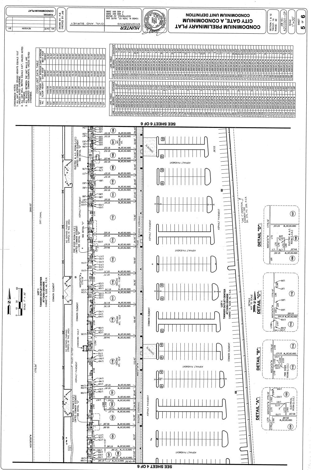
2 March 3, 1994: May 6, 2013: Planning Commission approves CGPZ , a Major Site Plan for Wendy s. As part of Lot 1 of Tanger Outlet Center at Casa Grande, this.4-acre area was sold to and developed by a different entity as the shopping center, thus becoming an unofficial outparcel. City Council adopts Ordinance No a Major amendment to the PAD, DSA , to expand the types of uses allowed including indoor and outdoor recreation and other ancillary uses, and revising the name of the PAD from Tanger Outlet Center to The Station. Site Area Current Land Use Existing Zoning Existing General Plan 2020 Land Use PROJECT DESCRIPTION 40.9 acre Lot / 189,500 sq. ft. of buildings placed into 42 condominiums. Commercial shopping center. PAD (The Station) Commerce and Business Surrounding General Plan Designation, Zoning, and Existing Land Use Direction General Plan 2020 Existing Zoning Existing Land Use Designation North Commerce and PAD (Mountain Shadows- Undeveloped land Business Commercially designated) East Rural I-10/ UR Undeveloped land South West General Discussion Commerce and Business Commerce and Business/ Community Center Jimmie Kerr Blvd./I-1 (garden and light industrial) Adjacent to north half: PAD (Lonesome Valley Farms- Residentially designated) / Adjacent to south half: PAD (Shops at Palm Courtcommercially designated) Vacant warehouse Undeveloped land Tanger Outlet Center at Casa Grande is a acre subdivision with one platted lot (Exhibit A). Upon this lot are two parcels. The first parcel, known by APN A, is 40.5-acres and owned by CityGate Casa Grande, LLC. It is comprised of the former Tanger Outlet Mall now known as CityGate. There are two buildings on this parcel. One is approximately 177,500 sq. ft. and the other is about 12,000 sq. ft.. This parcel completely encompasses the second parcel, known by APN B. This smaller piece is nearly.4-acres and is occupied by the former Wendy s Restaurant, owned by Ronald Siegel Revocable Trust. The boundaries of the existing platted lot also include the east-bound portion of Interstate 10 and exit ramp as part of an easement. CityGate 2

3 Casa Grande, LLC is requesting to convert its two buildings, made up of individual tenant suites into 42 business condominiums (Exhibit B). The replat appears to exclude the area of Interstate 10 and it would remain part of the original plat. The Wendy s parcel will not be part of this condominium replat, either. As condominiums within the buildings on CityGate s property, each suite can be separately owned, and sold. Serving these condominiums would be common areas such as the buildings exteriors, public restrooms and concession area, as well as the access, parking, landscaping, and retention areas (Exhibit C) established more clearly with CCR s to be submitted at the time of Final Plat consideration. SITE CONTEXT/AERIAL 3
4 No drainage, traffic, sewer, or water reports are required for this submittal due the fact that neither exterior alternations nor additions to the existing site are proposed. The site is within a developed parcel with infrastructure and utilities already in place. The existing tenant suites are established in a way that they can meet Building Code requirements as separately-owned condominium spaces. Due to the fact the internal spaces will be under individual ownerships, however, there are some review items from both the City Building Official and City Fire Inspector with regard building and fire safety: Building Official s review comments: 1. Provide access to electrical room #108 without entering a tenant space for 24- hour direct access. 2. Show access to electrical rooms within details A, B, and C. 3. Show fire-riser rooms 4. Specify if Fire Sprinklers are common elements or contained-in and owned by each unit. Fire Inspector review comments: 1. Provide a statement on the plat that discusses who is going to have the responsibility for the Fire Sprinkler Systems, Fire Alarm Systems and the Fire Hydrants and the fire main underground system for the property. 2. Confirm that all existing fire protection system are being tested, inspected and maintained per the NFPA requirements for each system (NFPA 72-Fire Alarm System, NFPA 25- Fire Sprinkler System, and NFPA 25 Fire Hydrants and Fire Main Underground. 3. To ensure Fire Department access to all common areas and any areas where there are fire sprinkler risers and fire alarm panels, existing Knox Boxes be used for the common areas access keys. If individual tenant owners would like to have their key in a Knox Box so that the Fire Department can gain entry, they shall purchase and install their own Knox Box. It is suggested that the master key system is controlled by an association. Updates to the preliminary plat reflecting these comments will be required for re-review prior to final approval. The proposed resubdivision is being processed in accordance with Section C. of the City Code. Pending Planning Commission s approval of the Preliminary Plat, the applicant will submit a Final Plat for staff review and final approval by the City Council. 4

5 In reviewing a Preliminary Plat, the following items are considered to assure adequacy with City development regulations and compatibility with surrounding conditions: Conformance to the General Plan; REVIEW FOR ADEQUACY The subject site is designated as Commerce & Business in the City s General Plan 2020 and all existing and proposed are in compliance. The proposal to create individual condominium suites does not conflict with the General Plan. GENERAL PLAN 2020 EXHIBIT Commerce & Business Rural Community Center Site Manufacturing & Industry The site does only have one access to a public road; however, and borders property to the north with severe access limitations. Per Policy C of the General Plan, connectivity is to be provided between developments so they are integrated into the existing community fabric. Accordingly, the plat should include an access easement to along the north property line to allow public access from property to the west and to property to the north to provide better linkage as these areas develop. 5

6 Conformance with Zoning; The proposed use is compliant with The Station PAD Zoning, which permits a variety of retail and general service uses. The permitted uses will not change, they will just be occurring within individually owned suites versus leased spaces. B-2 ZONING EXHIBIT PAD UR Site I-1 Subdivision Plat Technical Form & Design; There are technical modifications required of this preliminary plat prior to final approval: 1. This is a replat of Lot 1 of Tanger Outlets at Casa Grande recorded at cabinet 000B, page The legal description should indicate this as a replat of such. The legal description as written appears to only be for a portion for lot 1, which is true, since the Wendy s parcel within Lot 1 is to be excepted from the platting of the condominiums, but it appears that the legal description is omitting that area of the platted lot that contains Interstate 10 and its off-ramp. If this area is not to be part of the new plat, an exhibit must be provided that shows as platted v. an as replatted exhibit with a new total lot area to be provided. 2. This resubdivision should specify a specific exception of the Wendy s parcel. 6
7 This is to include its legal description that is being excepted. 3. A legal description needs to be provided for the common parking lot, landscaping and drainage elements and under a header for such. The areas of the plat depicting these common elements need to be dimensioned. 4. Provide a summary on the preliminary plat indicating the total number of acres, and total number of condominium lots, and total square footage of buildings. Indicate what percentage of the lot is open space. 5. Provide widths of canals and access drives and drive aisles. 6. Name the canals and drains on the site. 7. A statement shall be provided on the preliminary plat describing who has the responsibility for maintenance of common elements, including building exterior, common areas interior to the building, parking, access ways, drainage basins, drainage basins, signage, and landscape areas, indicating that such shall be subject to CCR s. 8. Provided that Wendy s is on a separate parcel within Lot 1, but to be excepted from this resubdivision. Within the narrative (Exhibit B) it is explained there is an agreement between Wendy s and CityGate allowing parking, access and utility service agreement across CityGate s property; however, a statement and easement shall be provided on this plat to ensure that Lot 1 can be used for utilities, parking and access for Wendy s as well as a specifying what retention basin(s) within the common area is to be used for storm run-off coming from the Wendy s parcel. Drainage Pattern/ Accommodation of Developed Flows; No additional structures or increases to impervious surface is proposed with this preliminary plat; however the existing retention basins on the site are to be placed in common areas maintained by the condominium association. CCR s will have to be provided at the time of Final Plat that clarifies the responsibility of the association and the maintenance of these drainage basins. The following are technical items required prior to final approval of this preliminary plat: 1. There is a 65 ft. wide drainage easement dedicated by the previous plat that needs to be identified on this replat. It runs along the western boundary of the subdivision. 2. Specify what basin or basins collect water for the Wendy s parcel, and provide an easement for this. 7
8 3. If any run-off from Interstate 10 runs onto the property, specify what basin accommodates for this flow and indicate an easement for such. 4. In the previously approved plat, there was a note regarding the site being subject to undefined irrigation easements. Please replicate. 5. Modify the note regarding the 100 year flood plain to state that a flood elevation certificate may be required for Tenant improvements that meet the FEMA substantial improvement criteria. Tenant improvements that meet the FEMA substantial improvement criterial shall be required to elevate their finished first floor elevation one foot from the base flood elevation or take other appropriate flood-proofing measures. Utility Access; The preliminary plat shall be updated to identify the following: 1. Show all utility service and main lines, and indicate their sizes. 2. Specifically, call out the 15 sewer line runs from the south to the north near the western edge of the lot. There is an existing sewer easement and public utility easement in this same area that needs to be identified. All existing easements need to be identified. 3. In the previously approved plat, there was a note regarding the site being subject to undefined electrical easements. Please replicate and show all other underground utilities. 4. Provide and show an easement for utilities that serve Wendy s across the common area of the adjacent parcel. Access to Public Roads; The subdivision s boundaries do not abut Jimmie Kerr Blvd, the only means of public access; but rather, Tanger Drive, a private road connects this development to Jimmie Kerr through another parcel, not a part of this subdivision. A roadway easement shall be established and stated on this plat that specifies public access to Jimmie Kerr from the subdivision. The length of the lot is approximately 3,000 ft. The 40 acres of property only has one public access point. Per Section of the City Code, the arrangement of streets shall provide for the continuation between adjacent properties when continuation is necessary for convenient movement of traffic, effective fire protection, for efficient provision of utilities and where such continuation is in accordance with the General Plan. Therefore, it shall be a condition that a public access easement be provided along the north boundary that allows connectivity to the parcel to the west and to the north for access from these parcels to Jimmie Kerr Blvd. 8
9 PUBLIC NOTIFICATION/COMMENTS Notification Public hearing notification efforts for this request meet the requirements set out by City Code. They include: A notice was published in the Casa Grande Dispatch on August 17, 2016 for the September 1, 2016 Planning and Zoning Commission public hearing. Notice was mailed to owners of property within 300 ft. of the site on the same date. The Code requires a 200 ft. notification. An affidavit verifying this mailing is in the file. By policy, a sign is posted by the applicant on the subject site ten to fifteen days prior to the public hearing for a preliminary plat. A sign template, posting instructions, and an affidavit of posting was provided to the applicant, however, a sign was not posted nor was a completed affidavit returned. The City Code and ARS statutes do not require a sign posting, however. Inquiries/Comments At the time of this writing, no inquiry or comment has been received. RECOMMENDED MOTION Staff recommends the Commission approve DSA , Preliminary Plat for the replatting of Lot 1 Tanger Outlet Center to create 42 condominium suites and common areas subject to the following: Technical Modifications to be made to the Preliminary Plat for additional review and final approval by staff: Technical Modifications: 1. Provide access to electrical room #108 without entering a tenant space for 24- hour direct access. 2. Show access to electrical rooms within details A, B, and C. 3. Show fire-riser rooms 4. Specify if Fire Sprinklers are common elements or contained-in and owned by each unit. 5. Provide a statement on the plat that discusses who is going to have the responsibility for the Fire Sprinkler Systems, Fire Alarm Systems and the Fire Hydrants and the fire main underground system for the property. 9
10 6. Confirm that all existing fire protection system are being tested, inspected and maintained per the NFPA requirements for each system (NFPA 72-Fire Alarm System, NFPA 25- Fire Sprinkler System, and NFPA 25 Fire Hydrants and Fire Main Underground. 7. To ensure Fire Department access to all common areas and any areas where there are fire sprinkler risers and fire alarm panels, existing Knox Boxes be used for the common areas access keys. If individual tenant owners would like to have their key in a Knox Box so that the Fire Department can gain entry, they shall purchase and install their own Knox Box. It is suggested that the master key system is controlled by an association. 8. This is replat of Lot 1 of Tanger Outlets at Casa Grande recorded at cabinet 000B, page The legal description should indicate this as a replat of such. The legal description as written appears to only be for a portion for lot 1, which is true, since the Wendy s parcel within Lot 1 is to be excepted from the platting of the condominiums, but it appears that the legal description is omitting that area of the platted lot that contains Interstate 10 and its off-ramp. If this area is not to be part of the new plat, an exhibit must be provided that shows as platted v. an as replatted exhibit with a new total lot area to be provided. 9. This resubdivision should specify a specific exception of the Wendy s parcel. This is to include its legal description that is being excepted. 10. A legal description needs to be provided for the common parking lot, landscaping and drainage elements and under a header for such. The areas of the plat depicting these common elements need to be dimensioned. 11. Provide a summary on the preliminary plat indicating the total number of acres, and total number of condominium lots, and total square footage of buildings. Indicate what percentage of the lot is open space. 12. Provide widths of canals and access drives and drive aisles. 13. Name the canals and drains on the site. 14. A statement shall be provided on the preliminary plat describing who has the responsibility for maintenance of common elements, including building exterior, internal common areas, parking, access ways, drainage basins, drainage basins, monument signage, and landscape areas, indicating that such shall be subject to CCR s. 15. Provided that Wendy s is on a separate parcel within Lot 1, but to be excepted from this resubdivision. Within the narrative (Exhibit B) it is explained there is an agreement between Wendy s and CityGate allowing parking, access and utility service agreement across CityGate s property; however, a statement and 10
11 easement shall be provided on this plat to ensure that Lot 1 can be used for utilities, parking and access for Wendy s as well as a specifying what retention basin(s) within the common area is to be used for storm run-off coming from the Wendy s parcel. 16. There is a 65 ft. wide drainage easement dedicated by the previous plat that needs to be identified on this replat. It runs along the western boundary of the subdivision. 17. Specify what basin or basins collect water for the Wendy s parcel, and provide an easement for this. 18. If any run-off from Interstate 10 runs onto the property, specify what basin accommodates for this flow and indicate an easement for such. 19. In the previously approved plat, there was a note regarding the site being subject to undefined irrigation easements. Please replicate. 20. Modify the note regarding the 100 year flood plain to state that a flood elevation certificate may be required for Tenant improvements that meet the FEMA substantial improvement criteria. Tenant improvements that meet the FEMA substantial improvement criterial shall be required to elevate their finished first floor elevation one foot from the base flood elevation or take other appropriate flood-proofing measures. 21. Show all utility service and main lines, and indicate their sizes. 22. Specifically, call out the 15 sewer line runs from the south to the north near the western edge of the lot. There is an existing sewer easement and public utility easement in this same area that needs to be identified. All existing easements need to be identified. 23. In the previously approved plat, there was a note regarding the site being subject to undefined electrical easements. Please replicate and show all other underground utilities. 24. Provide and show an easement for utilities that serve Wendy s across the common area of the adjacent parcel. Conditions of approval: 1. CCR s will have to be provided at the time of Final Plat submittal that clarifies the responsibility of the association and the maintenance of all elements within the common areas such as drainage basins, parking, access ways, signage, landscaping, building exteriors and internal common areas. 11
12 2. Provide a public access easement on the plat along the north boundary that allows connectivity to the parcel to the west and to the north, allowing access from these parcels to Jimmie Kerr Blvd. Exhibits Exhibit A- Existing Tanger Outlet Center at Casa Grande Plat Exhibit B- Narrative Exhibit C- Proposed Preliminary Condominium Plat 12
13 Exhibit A Existing Tanger Outlet Center at Casa Grande Plat Exhibit B- Narrative 13
14 Exhibit B - Narrative 14
15 15
16 16
17 Exhibit C Proposed Preliminary Condominium Plat 17
18 18
19 19
20 20
21 21
22 22
Planning and Zoning Commission STAFF REPORT REQUEST. DSA : Zone Change from R-3 (Multi-Family Residential) to B-4 (Community Services).
 to B-4 (Community Services).") Planning and Zoning Commission STAFF REPORT AGENDA # TO: FROM: PLANNING AND ZONING COMMISSION Joseph Horn, City Planner MEETING DATES: August 4, 2016 SUBJECT: Gino Tarantini zone change requests REQUEST
Planning and Zoning Commission STAFF REPORT AGENDA # TO: FROM: PLANNING AND ZONING COMMISSION Joseph Horn, City Planner MEETING DATES: August 4, 2016 SUBJECT: Gino Tarantini zone change requests REQUEST
Planning and Zoning Commission STAFF REPORT
 Planning and Zoning Commission STAFF REPORT AGENDA # TO: FROM: PLANNING AND ZONING COMMISSION Laura Blakeman, City Planner MEETING DATE: April 2, 2015 SUBJECT: DSA-15-00031: Zone Change request from R-1
CONCEPT PLAN APPLICATION Meeting with Staff Commercial Projects
 COMMUNITY DEVELOPMENT City of South Salt Lake Community Development Department 220 E. Morris Avenue South Salt Lake City, Utah 84115 Phone (801) 483-6011 Fax (801) 483-6060 CONCEPT PLAN APPLICATION Meeting
CHAPTER 18 SITE CONDOMINIUM PROJECTS
 15.1800 CHAPTER 18 SITE CONDOMINIUM PROJECTS 15.1801 SECTION 18.01 PURPOSE AND SCOPE GRAND HAVEN CHARTER TOWNSHIP Site condominium projects are condominium developments in which each condominium unit consists
PRELIMINARY PLANNED AREA DEVELOPMENT APPLICATION (PAD)
") PRELIMINARY PLANNED AREA DEVELOPMENT APPLICATION (PAD) Preliminary Planned Area Development Fee: Date Paid SECTION 1.9.4.1 PRELIMINARY PAD APPLICATION A Master development plan (showing general land use
PRELIMINARY PLANNED AREA DEVELOPMENT APPLICATION (PAD) Preliminary Planned Area Development Fee: Date Paid SECTION 1.9.4.1 PRELIMINARY PAD APPLICATION A Master development plan (showing general land use
ZONING AMENDMENT, PLANNED UNIT DEVELOPMENT & SUBDIVISION STAFF REPORT Date: August 8, 2013
 ZONING AMENDMENT, PLANNED UNIT DEVELOPMENT & SUBDIVISION STAFF REPORT Date: August 8, 2013 NAME SUBDIVISION NAME PV-Magnolia, LLC Twelve Trees Subdivision LOCATION 2860, 2862 and 2866 Pleasant Valley Road
CHAPTER 26 PLANNING AND ZONING ARTICLE VII. MOBILE HOMES AND RECREATIONAL VEHICLE (RV) PARKS. Recreational Vehicle (RV) Park Development Standards
 PARKS. Recreational Vehicle (RV) Park Development Standards") CHAPTER 26 PLANNING AND ZONING ARTICLE VII. MOBILE HOMES AND RECREATIONAL VEHICLE (RV) PARKS. Section 26-VII-1. Section 26-VII-2. Section 26-VII-3. Section 26-VII-4. Section 26-VII-5. Purpose Permitted
CHAPTER 26 PLANNING AND ZONING ARTICLE VII. MOBILE HOMES AND RECREATIONAL VEHICLE (RV) PARKS. Section 26-VII-1. Section 26-VII-2. Section 26-VII-3. Section 26-VII-4. Section 26-VII-5. Purpose Permitted
PLANNED UNIT DEVELOPMENT & SUBDIVISION STAFF REPORT Date: November 17, 2016
 PLANNED UNIT DEVELOPMENT & SUBDIVISION STAFF REPORT Date: November 17, 2016 DEVELOPMENT NAME SUBDIVISION NAME LOCATION Autonation Ford of Mobile Autonation Ford of Mobile Subdivision 901, 909, and 925
COMMERCIAL SITE PLAN & CONDITIONAL USE PERMIT REVIEW PROCESS & CHECKLIST
 Community Development 110 South Main Street Springville, UT 84663 COMMERCIAL SITE PLAN & CONDITIONAL USE PERMIT REVIEW PROCESS & CHECKLIST 801.491.7861 www.springville.org Prior to the issuance of a building
Conditional Use Permit / Standard Subdivision Application
 Conditional Use Permit / Standard Subdivision Application Name of Proposed Subdivision: Total Area (Acres) Is Proposed Subdivision to be built in phases? Number of Lots If yes, how many phases? Applicant/Owner
Staff Report to the North Ogden Planning Commission
 Staff Report to the North Ogden Planning Commission SYNOPSIS / APPLICATION INFORMATION Application Request: Consideration and action on an administrative application for final approval for the Legacy North
City of Sanibel. Planning Department STAFF REPORT
 City of Sanibel Planning Department STAFF REPORT Planning Commission Meeting: July 23, 2013 Planning Commission Agenda Item: No 7b. Application Number: 13-7438DP Applicant Name: Attorney Beverly Grady
CHECKLIST FOR DEVELOPMENT REVIEW
 CHECKLIST FOR DEVELOPMENT REVIEW Petitions and related documents and plans for land development or other proposals regulated by Title 16 of the Municipal Code (Development Ordinance) and Title 17 of the
LYON COUNTY COMMUNITY DEVELOPMENT DEPARTMENT
 LYON COUNTY COMMUNITY DEVELOPMENT DEPARTMENT B UILDING D EVELOPMENT E NGINEERING P LANNING 27 S. MAIN S TREET Y ERINGTON, NEVADA 89447 (775) 463-6591 F AX: (775) 463-5305 34 LAKES B OULEVARD D AYTON, NEVADA
Watertown City Council
 City of Watertown Watertown City Council 2/14/2017 Agenda Item: Riverpointe Subdivision 2 nd Replat Request for Action: Sketch Plan Department: Planning Request for Action Request: Paxmar, LLC (Applicant)
(if more than one, give square footage for each) ANNEXATION LOT LINE Adjustments PRE/FINAL PLAT SPECIAL USE PERMIT
 ANNEXATION LOT LINE Adjustments PRE/FINAL PLAT SPECIAL USE PERMIT") Planning Commission Application Building & development office 915 Third ST. Rawlins WY ph. 307-328-4599 fax. 307-328-4590 PROJECT REVIEW: GENERAL INFORMATION Project name: OFFICE USE ONLY Site address
Planning Commission Application Building & development office 915 Third ST. Rawlins WY ph. 307-328-4599 fax. 307-328-4590 PROJECT REVIEW: GENERAL INFORMATION Project name: OFFICE USE ONLY Site address
SITE PLAN REVIEW ADMINISTRATIVE REVIEW. Please Note: Once submitted to the County, all application materials become a matter of public record.
 200 W. Oak Street, 3rd Floor Fort Collins, CO 80521 (970) 498-7683 / larimer.org/planning SITE PLAN REVIEW ADMINISTRATIVE REVIEW The submittal requirements listed in this packet are intended to collect
Staff Report: Date: Applicant: Property Identification: Acreage of Request: Current Zoning of Requested Area: Requested Action: Attached:
 Staff Report: Completed by Jeff Palmer Director of Planning & Zoning Date: November 7, 2018, Updated November 20, 2018 Applicant: Greg Smith, Oberer Land Developer agent for Ronald Montgomery ET AL Property
ARTICLE 8C SITE CONDOMINIUM DEVELOPMENT ORDINANCE
 ARTICLE 8C SITE CONDOMINIUM DEVELOPMENT ORDINANCE SECTION 8C.01 PURPOSE It is the purpose of this Ordinance to insure that plans for development within Oceola Township proposed under the provisions of
Parcel Map Review Committee Staff Report
 Parcel Map Review Committee Staff Report Meeting Date: October 11, 2018 Agenda Item: 7A TENTATIVE PARCEL MAP CASE NUMBER: (Larkins) BRIEF SUMMARY OF REQUEST: Request to divide one parcel of ±1.084-acres
Site Plan Application
 Site Plan Application City of St. Pete Beach Community Development Department 155 Corey Avenue St. Pete Beach, Florida 33706 (727) 367-2735 www.stpetebeach.org Case Number: PROPERTY OWNER: Name: Address:
Annexation Procedure
 Annexation Procedure Meet with Planning Department Staff - Recommended Figure 1.9 Submit petition for Annexation, w/ majority of property owner s signature, legal description of proposed property, lot
Staff Report to the North Ogden City Council
 Staff Report to the North Ogden City Council SYNOPSIS / APPLICATION INFORMATION Application Request: Consideration and action on an administrative application to provide comments on the preliminary plan
610 LAND DIVISIONS AND PROPERTY LINE ADJUSTMENTS OUTSIDE A UGB
 ARTICLE VI: LAND DIVISIONS AND PROPERTY LINE ADJUSTMENTS VI-21 610 LAND DIVISIONS AND PROPERTY LINE ADJUSTMENTS OUTSIDE A UGB 610-1 Property Line Adjustments (Property Line Relocation) A property line
Subchapter 16 Subdivisions.
 Subchapter 16 Subdivisions. Sections: 35.16.1 Authority. 35.16.2 Purpose. 35.16.3 Jurisdiction. 35.16.4 Application. 35.16.5 Compliance and Enforcement. 35.16.6 Approval of Plat Required. 35.16.7 Lots,
TOWN OF LEWISTON PLANNING BOARD APPLICATION
 TOWN OF LEWISTON PLANNING BOARD APPLICATION DESCRIPTION OF PROPOSED REQUEST: Name of Property Owner: Phone #: Name of Applicant:Phone #: Address or Location of Proposal:_SBL# Size of Parcel or Structure:Existing
Sterling Meadow Subdivision
 Sterling Meadow Subdivision Proposal: A pre-application conference was held on November 7, 2017, with the applicant and City staff to discuss the development. The applicant took staff s recommendations
MINOR SUBDIVISION INFORMATION
 A. POINTS OF CONTACT: MINOR SUBDIVISION INFORMATION Surveyor: Address: Phone #: Fax # E-Mail Address: Representative (If different from applicant): Address: Phone #: Fax # E-Mail Address: B. GENERAL INFORMATION:
ARTICLE 24 SITE PLAN REVIEW
 ARTICLE 24 SITE PLAN REVIEW 24.1 PURPOSE: The intent of these Ordinance provisions is to provide for consultation and cooperation between the land developer and the Township Planning Commission in order
TOWNSHIP OF DOYLESTOWN APPLICATION FOR REVIEW OF SUBDIVISION OR LAND DEVELOPMENT PROPOSAL. Please PRINT; all information MUST be filled out completely
 TOWNSHIP OF DOYLESTOWN APPLICATION FOR REVIEW OF SUBDIVISION OR LAND DEVELOPMENT PROPOSAL Please PRINT; all information MUST be filled out completely Date: Name of Subdivision or Land Development: Location:
Plan and Zoning Commission Review Process
 . Village of Northfield Plan and Zoning Commission Review Process.......... Department of Community Development and Building Village of Northfield Department of Community Development and Building 361 Happ
ARTICLE 14 PLANNED UNIT DEVELOPMENT (PUD) DISTRICT
 DISTRICT") ARTICLE 14 PLANNED UNIT DEVELOPMENT (PUD) DISTRICT Section 14.01 Intent. It is the intent of this Article to allow the use of the planned unit development (PUD) process, as authorized by the Michigan Zoning
ARTICLE 14 PLANNED UNIT DEVELOPMENT (PUD) DISTRICT Section 14.01 Intent. It is the intent of this Article to allow the use of the planned unit development (PUD) process, as authorized by the Michigan Zoning
Section Preliminary Plat Checklist and Application Forms
 Section 201 - Preliminary Plat Checklist and Application Forms PRELIMINARY SUBDIVISION PLAT REVIEW PROCESS CHART PRELIMINARY SUBDIVISION PLAT APPLICATION PRELIMINARY PLAT REVIEW CHECKLIST CITY OF NAMPA
Chapter 100 Planned Unit Development in Corvallis Urban Fringe
 100.100 Scope and Purpose. Chapter 100 Planned Unit Development in Corvallis Urban Fringe (1) All applications for land divisions in the Urban Residential (UR) and Flood Plain Agriculture (FPA) zones within
E X E C U T I V E S U M M A R Y
 E X E C U T I V E S U M M A R Y CASE PLANNER: Aaron Wilson & Janet Rhoades VINE REVIEWED AND APPROVED BY: Mary McCrea BROADWAY INTERSTATE 90 INTERSTATE 90 PUBLIC HEARINGS: CC: August 22, 2011 AGENDA ITEM:
PLANNED UNIT DEVELOPMENT & SUBDIVISION STAFF REPORT Date: April 18, 2019
 PLANNED UNIT DEVELOPMENT & SUBDIVISION STAFF REPORT Date: April 18, 2019 DEVELOPMENT NAME SUBDIVISION NAME Springhill Village Subdivision Springhill Village Subdivision LOCATION 4350, 4354, 4356, 4358,
Cover Letter with Narrative Statement
 Cover Letter with Narrative Statement March 31, 2017 rev July 27, 2017 RE: Rushton Pointe Residential Planned Unit Development Application for Public Hearing for RPUD Rezone PL2015 000 0306 Mr. Eric Johnson,
Heber City Planning Commission Application
 Project Information Heber City Planning Commission Application 75 North Main Street, Heber City, UT 84032 (435) 657-7898 or (435) 654-4830 Fax (435) 657-2543 www.ci.heber.ut.us Date submitted: Zone: Number
A GUIDE TO PROCEDURES FOR: SUBDIVISIONS & CONDOMINIUM CONVERSION
 A GUIDE TO PROCEDURES FOR: SUBDIVISIONS & CONDOMINIUM CONVERSION A GUIDE TO PROCEDURES FOR: SUBDIVISIONS (TENTATIVE MAPS) PURPOSE Definition: A subdivision is defined as the division of any improved or
HERMISTON PLANNING COMMISSION. Regular Meeting May 10, 2017
 HERMISTON PLANNING COMMISSION Regular Meeting May 10, 2017 Commissioner Saylor called the meeting to order at 7:00 PM. Commissioners Caplinger, Doherty, Hamm, Flaiz, Fialka and Frederic were present. Commissioners
COUNCIL ACTION FORM. 1. The City Council can approve the Preliminary Plat for Menards Ames Subdivision
 ITEM #: 49 DATE: 03-27-18 COUNCIL ACTION FORM SUBJECT: PRELIMINARY PLAT FOR MENARDS BACKGROUND: Menards Ames Subdivision is a proposed 41-acre development on SE 16 th Street just west of the Skunk River.
ELK RAPIDS TOWNSHIP ANTRIM COUNTY, MICHIGAN ORDINANCE NO
 ELK RAPIDS TOWNSHIP ANTRIM COUNTY, MICHIGAN ORDINANCE NO. 3-2011 AN ORDINANCE TO REPLACE THE SUBDIVISION CONTROL ORDINANCE WITH A NEW SUBDIVISION DEVELOPMENT ORDINANCE, IN ACCORD WITH THE LAND DIVISION
City of Driggs PLANNING AND ZONING COMMISSION MEETING MINUTES March 14, :30PM
 City of Driggs PLANNING AND ZONING COMMISSION MEETING MINUTES March 14, 2018 6:30PM MEMBERS PRESENT: Brian Gibson, Josh Holmes, Grant Wilson, and Larry Young STAFF PRESENT: Ashley Koehler, Planning and
PRELIMINARY PLAT CHECK LIST
 PRELIMINARY PLAT CHECK LIST Name of Proposed Subdivision: The following items must be included with the initial submittal of a Preliminary Plat: Application, filled out completely Project Narrative Pre-application
ARTICLE 15 - PLANNED UNIT DEVELOPMENT
 Section 15.1 - Intent. ARTICLE 15 - PLANNED UNIT DEVELOPMENT A PUD, or Planned Unit Development, is not a District per se, but rather a set of standards that may be applied to a development type. The Planned
PRELMINARY PLAT CHECKLIST
 PRELMINARY PLAT CHECKLIST A. All preliminary plat submitted for approval shall be prepared by a Registered Professional Land Surveyor. B. Preliminary plats must be drawn to a scale of XXX with such accuracy
SUBDIVISION APPLICATION
 SUBDIVISION APPLICATION Preliminary Plat Minor Plat Final Plat Amended Plat Applicant Name: Owner (if different from applicant) Name: Company: Company: Address: Address: City, State, Zip City, State, Zip
Residential Major Subdivision Review Checklist
 Residential Major Subdivision Review Checklist Plan Submittal Requirements: 2 full sets of stamped plans Electric submittal - all plans contained in a single PDF 3 full sets if commercial kitchen or dining
Application for Preliminary Plat Checklist
 Application for Preliminary Plat Checklist Note: No portion of an existing parcel may be sold or transferred to another party without first legally subdividing the property according to the City of Richmond
UPPER MOUNT BETHEL TOWNSHIP NORTHAMPTON COUNTY, PENNSYLVANIA
 UPPER MOUNT BETHEL TOWNSHIP NORTHAMPTON COUNTY, PENNSYLVANIA JOINDER DEED / LOT CONSOLIDATION TOWNSHIP REVIEW PROCESS When accepting proposed Joinder Deeds / Lot Consolidations, review the Joinder Deed
Planning Department Oconee County, Georgia
 Planning Department Oconee County, Georgia STAFF REPORT REZONE CASE #: 6985 DATE: October 31, 2016 STAFF REPORT BY: Andrew C. Stern, Planner APPLICANT NAME: Williams & Associates, Land Planners PC PROPERTY
Agenda Item No.: G.1 Date: August 11, 2009
 Agenda Item No.: G.1 Date: August 11, 2009 CASE NUMBER: PHG 09-0015 APPLICANT: LOCATION: TYPE OF PROJECT: PROJECT DESCRIPTION: Humberto Martinez On the eastern side of Orange Street, western side of Escondido
City of Prior Lake APPLICATION FOR COMBINED PRELIMINARY AND FINAL PLAT
 Case File No. Property Identification No. City of Prior Lake APPLICATION FOR COMBINED PRELIMINARY AND FINAL PLAT Requested Action Brief description of proposed project (Please describe the proposed amendment,
PRELIMINARY PLAN CHECKLIST Major Land Development Projects. To initiate the application, the applicant shall submit to the Administrative Officer:
 PRELIMINARY PLAN CHECKLIST Major Land Development Projects To initiate the application, the applicant shall submit to the Administrative Officer: 1. The application review fee, as established by the South
Administrative Plat Application Form
 1 Administrative Plat Application Form This form shall be submitted with each application for an administrative plat. CONTACT INFORMATION Applicant Architect (if different) Property Owner (if different)
CONDOMINIUM REGULATIONS
 ARTICLE 37 CONDOMINIUM REGULATIONS SECTION 37.01. Purpose The purpose of this Article is to regulate projects that divide real property under a contractual arrangement known as a condominium. New and conversion
Staff Report: Date: Applicant: Property Identification: Acreage of Request: Current Zoning of Requested Area: Requested Action: Attached:
 Staff Report: Completed by Jeff Palmer Director of Planning & Zoning Date: November 7, 2018 Applicant: Greg Smith, Oberer Land Developer agent for Ronald Montgomery ET AL Property Identification: Frontage
Memorandum: October 13, 2008 REVISED To: Trowbridge Township Planning Commission From: P. Hudson, AICP Re: Suggested New Ordinance
 1 Memorandum: October 13, 2008 REVISED 2-11-09 To: Trowbridge Township Planning Commission From: P. Hudson, AICP Re: Suggested New Ordinance Because of changes in both the Michigan Planning Enabling Act
Community Services Department BOUNDARY LINE ADJUSTMENT APPLICATION
 Community Services Department Planning and Building BOUNDARY LINE ADJUSTMENT APPLICATION Community Services Department Planning and Building 1001 E. Ninth St., Bldg. A Reno, NV 89520 Telephone: 775.328.6100
City of East Orange. Department of Policy, Planning and Development LAND USE APPLICATION & SITE PLAN REVIEW CHECKLIST
 Department of Policy, Planning and Development LAND USE APPLICATION & SITE PLAN REVIEW CHECKLIST COMPLETE: Applicant Information: Type of Proposal: OFFICE USE ONLY: New Residential Case #: Date: New Accessory
AAR SUBMITTAL CHECKLIST
 VILLAGE OF ROYAL PALM BEACH PLANNING and ZONING 1050 Royal Palm Beach Boulevard Royal Palm Beach, FL 33411 (561) 790-5131 DEVELOPMENT APPLICATION AAR SUBMITTAL CHECKLIST Application Date Submitted: Application
Condominium Unit Requirements.
 ARTICLE 19 CONDOMINIUM REGULATIONS Section 19.01 Purpose. The purpose of this Article is to regulate projects that divide real property under a contractual arrangement known as a condominium. New and conversion
Planning Department st Avenue East Kalispell, MT Phone: (406) Fax: (406)
 Fax: (406)") Planning Department 201 1 st Avenue East Kalispell, MT 59901 Phone: (406) 758-7940 Fax: (406) 758-7739 www.kalispell.com/planning April 1, 2015 Doug Russell, City Manager City of Kalispell 201 1 st Ave
Planning Department 201 1 st Avenue East Kalispell, MT 59901 Phone: (406) 758-7940 Fax: (406) 758-7739 www.kalispell.com/planning April 1, 2015 Doug Russell, City Manager City of Kalispell 201 1 st Ave
MINUTES of the Vernal City PLANNING COMMISSION Vernal City Council Chambers 447 East Main Street August 13, 2009
 MINUTES of the Vernal City PLANNING COMMISSION Vernal City Council Chambers 447 East Main Street Members Present: Freida Parker, Shirley Wilkins, Gordon Seitz, Eric Olsen, Sonja Norton, Troy Allred Alternates
TOWN OF WATERVILLE VALLEY NEW HAMPSHIRE SITE PLAN REVIEW REGULATIONS
 TOWN OF WATERVILLE VALLEY NEW HAMPSHIRE Effective date March 17, 1981 Revised March 16, 1982 Revised March 13, 1986 Revised March 10, 1987 Revised March 14, 2013 Revised March 8, 2016 TOWN OF WATERVILLE
CITY OF NAPLES STAFF REPORT
 Meeting of 11/9/16 Subdivision/Replat Petition 16-SD3 CITY OF NAPLES STAFF REPORT To: Planning Advisory Board From: Planning Department Subject: Subdivison/Replat Petition 16-SD3 Petitioner: Matthew Grabinski,
Planning Commission Application Summary
 Planning Commission Application Summary Project Name: Ballard Property Rezone Address: 12773 & 12775 South 300 East, 415 East Pheasant View Dr. Current Zoning: RA1 (Residential 40,000 sq. ft. minimum)
ZONING AMENDMENT & SUBDIVISION STAFF REPORT Date: July 9, 2015
 ZONING AMENDMENT & SUBDIVISION STAFF REPORT Date: July 9, 2015 APPLICANT NAME 2513 Dauphin Street, Inc. SUBDIVISION NAME Audubon Place Extension No. 3, Resubdivision of Lots 1-5 LOCATION 2513 Dauphin Street
McGowin Park, LLC. B-3, Community Business District
 # 10, 11, 12 SUB2014-00024 ZON2014-00500 ZON2014-00501 SUBDIVISION, PLANNED UNIT DEVELOPMENT (East), PLANNED UNIT DEVELOPMENT (West) STAFF REPORT Date: April 3, 2014 DEVELOPMENT NAME LOCATION McGowin Park,
City of Nogales Planning & Zoning Commission Rezoning Application
 City of Nogales Planning & Zoning Commission Rezoning Application REZONING APPLICATION PROCEDURES 1450 N. Hohokam Nogales, Arizona 85621 Office (520) 285-5747 FAX (520) 287-6946 T.D.D. (520) The following
Conditional Use Sketch Plan Application Non-Residential Zone
 For Office Use Only Fees received by: Date of submittal: Amount Paid: Receipt #: Initial Review, all of the required supporting materials have been provided: Sketch Plan Meeting Date: Conditional Use Sketch
Community Development Department Council Chambers, 7:30 PM, June 7, 2018
 STAFF REPORT 2018-19P: Special Use Permit Community Development Department Council Chambers, 7:30 PM, June 7, 2018 To: From: Re: Paul Luke, Plan Commission Chairperson Carrie Haberstich, AICP, Planner/CDBG
PLANNING COMMISSION REPORT REGULAR AGENDA. PC Staff Report 08/25/10 ITEM NO 6: PRELIMINARY PLAT; HALLMARK ADDITION; ACRES; 151 MCDONALD DR (MKM)
") PP-6-6-10 Item No. 6-1 PLANNING COMMISSION REPORT REGULAR AGENDA PC Staff Report 08/25/10 ITEM NO 6: PRELIMINARY PLAT; HALLMARK ADDITION; 5.252 ACRES; 151 MCDONALD DR (MKM) PP-6-6-10: Consider a Preliminary
PP-6-6-10 Item No. 6-1 PLANNING COMMISSION REPORT REGULAR AGENDA PC Staff Report 08/25/10 ITEM NO 6: PRELIMINARY PLAT; HALLMARK ADDITION; 5.252 ACRES; 151 MCDONALD DR (MKM) PP-6-6-10: Consider a Preliminary
Individual Well Individual Septic. Community Well 19. What is the proposed method of sewage disposal? Public. None
 Please Answer the Following Questions: (attach sheet if needed). What type of facility is being proposed? Campground Recreational Vehicle (RV) Park Both 2. What is the total acreage of the proposed facility?
SITE DEVELOPMENT PLAN REQUIREMENTS CHECKLIST
 SITE DEVELOPMENT PLAN REQUIREMENTS CHECKLIST Completed DRC Application for Review Required for Application Process DRC Processing Fee 1 Commercial $2,500.00 Fire Department Review Fee 150.00 Total $2,650.00
APPLICATION for MINOR SUBDIVISION REVIEW for CONCEPT and FINAL PLAT within COALVILLE CITY. Project Name: Project Address or Area: Name of Owner:
 APPLICATION for MINOR SUBDIVISION REVIEW for CONCEPT and FINAL PLAT within COALVILLE CITY For Office Use Only: Application #: Application Date: PC Approval Date: CC Approval Date: Community Development
COUNTY OF EL DORADO DEVELOPMENT SERVICES PLANNING COMMISSION STAFF REPORT TENTATIVE MAP
 COUNTY OF EL DORADO DEVELOPMENT SERVICES PLANNING COMMISSION STAFF REPORT Agenda of: June 27, 2013 Item No.: 9.a Staff: Mel Pabalinas TENTATIVE MAP FILE NUMBER: APPLICANT: REQUEST: LOCATION: TM10-1501/West
City of Prior Lake APPLICATION FOR REGISTERED LAND SURVEY
 Case File No. Property Identification No. City of Prior Lake APPLICATION FOR REGISTERED LAND SURVEY Requested Action Brief description of proposed project (Please describe the proposed amendment, project,
SOUTH WEBER CITY SUBDIVISION DEVELOPMENT INTRODUCTION
 SOUTH WEBER CITY SUBDIVISION DEVELOPMENT INTRODUCTION This document has been prepared and compiled by South Weber City to assist developers in understanding the current ordinances and the processes whereby
PALM BEACH COUNTY PLANNING, ZONING AND BUILDING DEPARTMENT ZONING DIVISION
 PALM BEACH COUNTY PLANNING, ZONING AND BUILDING DEPARTMENT ZONING DIVISION Application No.: Z/CA-2013-00493 Application Name: Trails Charter School Control No.: 2013-00085 Applicant: MG3 ALF Military LLC
PLANNED UNIT DEVELOPMENT & SUBDIVISION STAFF REPORT Date: July 20, 2017
 PLANNED UNIT DEVELOPMENT & SUBDIVISION STAFF REPORT Date: July 20, 2017 DEVELOPMENT NAME SUBDIVISION NAME LOCATION Rangeline Crossing III Subdivision Rangeline Crossing III Subdivision 5289 Halls Mill
PLANNING COMMISSION REPORT Regular Agenda Public Hearing Item. IG TO IL;.972 ACRES; 1021 E 31st (KES)
") PC Staff Report 11/16/15 Z-15-00471 Item No. 7-1 PLANNING COMMISSION REPORT Regular Agenda Public Hearing Item PC Staff Report 11/16/15 ITEM NO. 7 IG TO IL;.972 ACRES; 1021 E 31st (KES) Z-15-00471: Consider
PC Staff Report 11/16/15 Z-15-00471 Item No. 7-1 PLANNING COMMISSION REPORT Regular Agenda Public Hearing Item PC Staff Report 11/16/15 ITEM NO. 7 IG TO IL;.972 ACRES; 1021 E 31st (KES) Z-15-00471: Consider
Level III Preliminary and Final Site Plans Development Review Application Portland, Maine Planning and Urban Development Department Planning Division
 Level III Preliminary and Final Site Plans Development Review Application Portland, Maine Planning and Urban Development Department Planning Division Portland s Planning and Urban Development Department
Jerome Street Mixed Use
 Jerome Street Mixed Use Aerial Site Map 287 N Mason St 1 «Douglas 25 Pinon St _ ^ Vine 287 Mulberry Horsetooth Timberline Drake Lemay Shields Prospect N College Ave 14 U V Taft Hill Mountain Vista Jerome
1105 SUBDIVISIONS, PARTITIONS, REPLATS, CONDOMINIUM PLATS, AND VACATIONS OF RECORDED PLATS
 1105 SUBDIVISIONS, PARTITIONS, REPLATS, CONDOMINIUM PLATS, AND VACATIONS OF RECORDED PLATS 1105.01 PURPOSE AND APPLICABILITY Section 1105 is adopted to provide standards, criteria, and procedures under
Chapter SPECIAL USE ZONING DISTRICTS
 Chapter 20.20 Sections: 20.20.010 Urban Transition (U-T) Zoning District 20.20.020 Planned Development (P-D) Zoning Districts 20.20.010 Urban Transition (U-T) Zoning District A. Purpose. The purpose of
MINOR PLAT FILING APPLICATION
 FILING APPLICATION Date of PC Meeting: Date of BCC Meeting: Fee Paid: 1. APPLICANT: DAYTIME PHONE: MAILING ADDRESS: LANDOWNER: DAYTIME PHONE: MAILING ADDRESS: AUTHORIZED AGENT: MAILING ADDRESS: RELATIONSHIP
CITY OF FORT COLLINS NATURAL AREAS AND CONSERVED LANDS EASEMENT POLICY
 CITY OF FORT COLLINS NATURAL AREAS AND CONSERVED LANDS EASEMENT POLICY Adopted January 3, 2012 PURPOSE: The purpose of the policy statement is to clarify the policies and procedures of the City of Fort
ARTICLE 13 CONDOMINIUM REGULATIONS
 ARTICLE 13 CONDOMINIUM REGULATIONS Section 13.01 Purpose. The purpose of this Article is to regulate projects that divide real property under a contractual arrangement known as a condominium. New and conversion
SITE CONDOMINIUMS OR CONDOMINIUM SUBDIVISIONS
 Article XX SITE CONDOMINIUMS OR CONDOMINIUM SUBDIVISIONS 20.0 PURPOSE The purpose of this Section is to set forth the standards for review of the site condominiums or condominium subdivisions in all Zoning
LAND USE APPLICATION
 LAND USE APPLICATION File Name: File No(s).: Receipt No.: Receipt Date: Received By: Amount.: $ Instructions for Applicants Please read and follow all instructions on your application carefully. If you
géãç Éy VtÇtÇwt zât 5440 Routes 5 & 20 West Canandaigua, NY Phone: (585) / Fax: (585)
 / Fax: (585)") géãç Éy VtÇtÇwt zât 5440 Routes 5 & 20 West Canandaigua, NY 14424 Phone: (585) 394-1120 / Fax: (585) 394-9476 APPLICATION FOR LOT-LINE ADJUSTMENT The applicant is responsible for the completeness of all
géãç Éy VtÇtÇwt zât 5440 Routes 5 & 20 West Canandaigua, NY 14424 Phone: (585) 394-1120 / Fax: (585) 394-9476 APPLICATION FOR LOT-LINE ADJUSTMENT The applicant is responsible for the completeness of all
SITE DEVELOPMENT PLAN APPLICATION PAHRUMP REGIONAL PLANNING DISTRICT
 SITE DEVELOPMENT PLAN APPLICATION PAHRUMP REGIONAL PLANNING DISTRICT AREA BETWEEN DOUBLE LINES FOR STAFF USE ONLY FOR SUBMITTAL REQUIREMENTS, PLEASE SEE REVERSE DATE FILED: APPLICATION NUMBER: SD COMMUNITY
FINAL PLAT GUIDE TO SUBDIVIDING PROPERTY. Background
 FINAL PLAT GUIDE TO SUBDIVIDING PROPERTY Background A final plat is the second step in the process of subdividing land into separate parcels for future sale or lease. Once a preliminary plat has been approved
FOR OFFICE USE ONLY Date Submitted Received By Fees Paid $ Receipt No. Received By Application No. Application Complete Final Action Date
 COMMERCIAL, INDUSTRIAL, & MANUFACTURING SITE PLAN (CIM) APPLICATION Mariposa County Planning Department 5100 Bullion Street, P.O. Box 2039 Mariposa, CA 95338 Telephone (209) 966-5151 FAX (209) 742-5024
Request for Action form is also defined as an application to be considered by the Planning Commission.
 CITY OF NORTH RIDGEVILLE INSTRUCTIONS FOR FILING REQUEST FOR ACTION APPLICATIONS WITH THE PLANNING COMMISSION (Please read the full instruction as it will help in providing a full complete application)
MIDWAY CITY Planning Office 75 North 100 West Phone: x105 Midway, Utah Fax:
 MIDWAY CITY Planning Office 75 North 100 West Phone: 435-654-3223 x105 Midway, Utah 84049 Fax: 435-654-2830 mhenke@midwaycityut.org Preliminary/ Final Application for Small Scale Subdivision Application
CITY OF SARALAND PRELIMINARY SUBDIVISION PLAT REVIEW
 PRELIMINARY SUBDIVISION PLAT REVIEW Application Number: Date Plat Submitted: Name of Subdivision: Name of Owner: Owner Address: (Street or P.O. Box) Telephone #: (City) (State) (Zip) E-mail: Name of Authorized
ZONING AMENDMENT, PLANNED UNIT DEVELOPMENT & SUBDIVISION STAFF REPORT Date: September 15, 2011
 ZONING AMENDMENT, PLANNED UNIT DEVELOPMENT & SUBDIVISION STAFF REPORT Date: September 15, 2011 NAME SUBDIVISION NAME LOCATION Stratford, L.L.C. Grelot Office Park Subdivision North side of Grelot Road,
FINAL PLAT. Community Development Department 8101 Ralston Road Arvada, Colorado 80002
 FINAL PLAT Community Development Department 8101 Ralston Road Arvada, Colorado 80002 September 2015 FINAL SUBDIVISION PLAT Final Subdivision Plat Review Applications for a Final Plat shall be submitted