Inyo County Planning Commission Staff Report Agenda Item #5
|
|
|
- Sharyl Walker
- 5 years ago
- Views:
Transcription

1 Inyo County Planning Commission Staff Report Agenda Item #5
2 Planning Department 168 North Edwards Street Post Office Drawer L Independence, California Phone: (760) FAX: (760) inyoplanning@inyocounty.us AGENDA ITEM NO. 5 (Continuation, Action Item - Public Hearing) DATE: February 27, 2013 SUBJECT: Conditional Use Permit No /Branson EXECUTIVE SUMMARY The applicant proposes to build a 30-foot tall communications tower at 1579 Indian Springs Dr., in the Alabama Hills and remove a 26-foot existing antenna attached to a garage located next door to the proposed project location at 1601 Indian Springs Dr. The proposed tower at 1579 Indian Springs Dr. will re-transmit wireless internet signals from existing towers located at 125 North Lakeview Street in Lone Pine, and 585 Alabama Drive in the Alabama Hills, making wireless internet service available to residential clients in the Alabama Hills and to a broader clientele area in the future. Staff presented the staff report and public input was given during the Planning Commission meeting held December 5, Commissioner Paul Payne moved to continue the item until the January 23, 2013 Planning Commission meeting. The motion passed 4-0 with Commissioner Corner abstaining. The notices that were mailed to property owners for the January 23, 2013 meeting were incorrect and Conditional Use Permit No /Branson was rescheduled for the February 27, 2013 Planning Commission meeting. PROJECT INFORMATION Supervisorial District: Applicant: Landowner: Addresses/ Community: Fifth Bruce Branson, Lone Pine TV Bruce Branson 1579 Indian Springs Drive, Alabama Hills, Lone Pine A.P.N.: General Plan: Parcel has two General Plan designations. The portion of the parcel the proposed project will be located is Residential Rural Medium Density (RRM).
3 Zoning: Size of Lot: Existing Use: Parcel has two zoning designations. The portion of the parcel the proposed project will be located is Rural Residential with a 2.5-acre minimum (RR-2.5) Approximately 24-acres The project site is developed with a single-family dwelling, and two garages. Surrounding Land Use: Location: Use: Gen. Plan Designation Zoning Site Residential/OpenSpace RRM/OSR RR-2.5/OS-40 North Residential RRM RR-2.5 East Vacant OSR OS-40 South Residential RRM RR-2.5 West Residential RRM RR-2.5 Recommended Action: Make Findings and Approve Conditional Use Permit No /Branson. Alternatives: Project Planner: 1.) Deny the Conditional Use Permit thereby not allowing the applicant to improve wireless internet service to the Alabama Hills and the potential to serve a broader clientele in the future. 2.) Add To or Modify the conditions of approval. 3.) Direct Planning Staff to provide specific information at a future Planning Commission hearing Cathreen Richards, Associate Planner STAFF ANALYSIS Background/Overview Mr. Branson, who represents Lone Pine Television, is applying to place a 30-foot tall communications tower at 1579 Indian Springs Drive. The goal for the project is to provide high speed cable internet access to residents of the Alabama Hills and allow the ability to provide access to wireless internet service to a broader clientele in the future. The property can be seen below. The tower will be located on the left side of the photograph to the south of the Arizona Cypress tree. The antenna on the garage located on the right side of the photograph will be removed. The photograph below has had a rendition of the communications tower (draw to scale based on the relative height of the garage, which is approximately 15 ) placed on it. 2
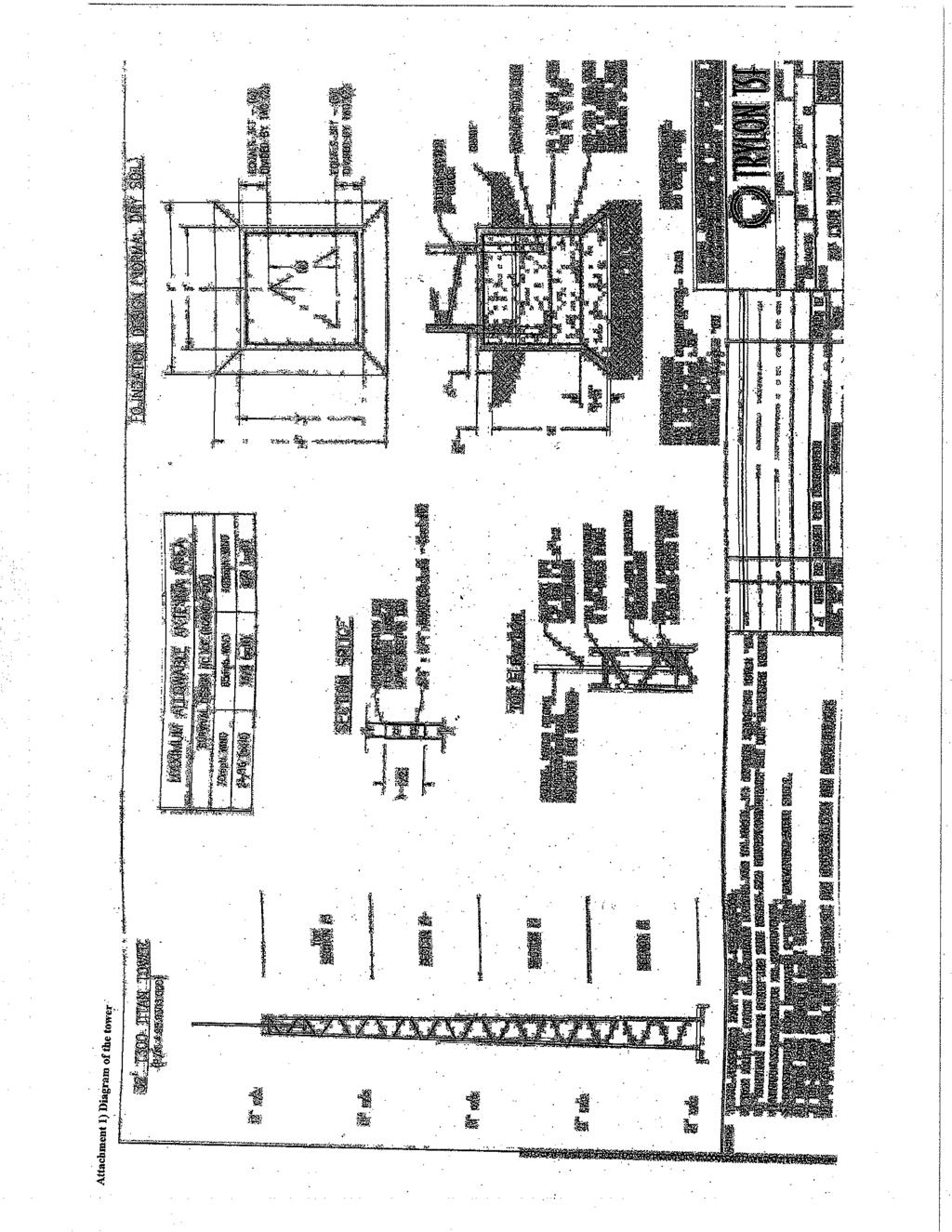
4 Current antenna and proposed tower location Current antenna and proposed tower Approx. 30 Approx Approx. 15 Attachments: 1) Diagram of the Tower 3
5 2) Mitigated Negative Declaration Staff presented the application to the Planning Commission at December 5, 2012 meeting (please see attachment A). There were 3 people from the Indian Springs neighborhood present: Zinda Edgar, Roberta Jarnigan; and, Michael Dorame, as well as, the applicant Bruce Branson and Kyle Wing, Assistant Manager of Lone Pine TV. Mr. Branson and Mr. Wing explained the technical aspects of the project and introduced the information provided in 2 additional letters (please see Attachment B) that were passed out to the Commissioners at the beginning of the meeting. One letter addressed the fact that the Indian Springs CC&Rs are invalid due to the absence of an active homeowners association and the other provided the opinion that WiFi tower/antennas can actually increase property values. Ms. Jarnigan provided an additional letter from Ms. Dorothy Alcorace (please see Attachment B) who opposes the project. During the public comment period numerous comments and questions were given by the 3 residents of the Indian Springs neighborhood regarding the application. Many of these comments were the same as those provided in the original letters (please see attachment A). Staff has provided responses to the comments/questions generated at the meeting, as follows: Comment/Question: The new tower will not will not improve internet service in the Alabama Hills. Response: Please see Response to Comments in the December 5, 2012 staff report, attachment A. Comment/Question: Existing Covenants, Conditions and Restrictions should be enforced. Response: Please see Response to Comments in the December 5, 2012 staff report, attachment A. Comment/Question: Notices were sent to only 3 neighbors due to the 300 requirement. Response: CEQA notifications were sent to the following: CEQA mailing list Name Address City State Zip LADWP 300 Mandich St. Bishop, CA USA BLM 2800 Cottage Way Sacramento, CA Robert and Sue Jaussaud PO Box 5279 Mohave Valley, CA Michale and Loretta Dorame 1564 Indian Springs Dr. Lone Pine, CA Elaine Didge 624 Seabright Lane Solana Beach, CA Robert and Gayle Frickel 297 N. Tumbleweed Road Bishop, CA Jarnagin and Roberta Barton PO Box 531 Lone Pine, CA John Replogle 1520 Indian Springs Dr. Lone Pine, CA Ila Lauten 1575 Indian Springs Dr. Lone Pine, CA Zinda Edgar 1596 Indian Springs Dr. Lone Pine, CA Lone Pine TV PO Box 867 Lone Pine, CA Lone Pine Chamber P.O. Box 749 Lone Pine, CA Lone Pine Fire Department P.O. Box 1007 Lone Pine, CA Lone Pine Paiute-Shoshone Reservation P.O. Box 747 Lone Pine, CA Bishop Public Library 210 Academy Street Bishop, CA Big Pine Public Library P.O. Box 760 Big Pine, CA Lone Pine Public Library 168 N. Edwars Street Lone Pine, CA list Tim Fox - China Lake timothy.h.fox@navy.mil Kevin Mazzu - Alabama Hills Stewardship Group kevin.mazzu@dww-inc.com Burnadette Lovato - BLM Bernadette_Lovato@blm.gov 4
6 Notices for the December 5, 2012 Planning Commission were sent to: LADWP 300 Mandich St. Bishop, CA USA BLM 2800 Cottage Way Sacramento, CA Robert and Sue Jaussaud PO Box 5279 Mohave Valley, CA Michale and Loretta Dorame 1564 Indian Springs Dr. Lone Pine, CA Elaine Didge 624 Seabright Lane Solana Beach, CA Robert and Gayle Frickel 297 N. Tumbleweed Road Bishop, CA Jarnagin and Roberta Barton PO Box 531 Lone Pine, CA John Replogle 1520 Indian Springs Dr. Lone Pine, CA Ila Lauten 1575 Indian Springs Dr. Lone Pine, CA Zinda Edgar 1596 Indian Springs Dr. Lone Pine, CA The CEQA Notice of Availability was posted by the Inyo County Clerk Recorders office on October 15, 2012 and was advertised in the Inyo County Register on Tuesday October 16, 2012; and, the Planning Commission meeting was advertised in the Inyo County Register on November 24, Comment/Question: There are 19-families in the project area and most are uncomfortable with the project. Response: Staff received letters and/or phone calls from 4 area residents. Comment/Question: The existing antenna can still be used, this project is not necessary. Response: Please see Response to Comments in the December 5, 2012 staff report, attachment A. Comment/Question: There are problems with staff using the Public/Quasi-Public use designation for this project when it is a for profit commercial business. Response: The County has consistently used the Public/Quasi-Public designation for small, neighborhood serving, utilities infrastructure, and more specifically, for other WiFi antenna towers throughout the County. Comment/Question: Utility wires serving the antenna need to be underground. Response: The applicant has stated that the electricity that is required for the antenna will be served through a metered box that will be attached to the garage on the same property as the tower. The electricity will then be sent to the antenna via underground cables. Comment/Question: Will there also be a fence around it and will it be screened? Response: The tower/antenna will have a 6-foot, chain link, safety fence built around it. The tree(s) that are required by Condition of Approval #5 will screen the fence as well as the tower since it will have to be planted outside of the fenced area. Comment/Question: How can a CUP be developed when the community was not notified? Response: The community was notified appropriately per the State s and County s regulations. Please see bullet 3 above. Comment/Question: How was a 10 x10 parcel sold when the area is zoned with a 2.5-acre minimum? 5
7 Response: The property was sold as a utility easement, not as a new or different parcel. This is a common practice where a piece of land is sold specifically for the siting of a utility s infrastructure. The easement is subject to the same zoning as the parcel that it is part of. Therefore, the antenna and tower have to meet the setback and height requirements per the RR-2.5 Zone, which they do; and, since it is located on a 24-acre parcel it does meet the 2.5-acre minimum. Comment/Question: Why didn t the County follow the Telecommunications Ordinance? Response: It was not the intent of the County when it adopted the Telecommunications Ordinance to apply it to WiFi antennas. Comment/Question: Will the property be taxed as a commercial use or as a Public/Quasi-Public use? Response: The County uses the same tax rate for Commercial and Residential uses. The easement will be valued with the tower/antenna and this will be reflected in Lone Pine TV s taxes. Comment/Question: The Negative Declaration states that the project will require little to no water. Response: Staff cannot find this statement in the Negative Declaration; however, the Conditions of Approval for this project include the planting and maintaining of Arizona Cypress trees or trees of similar height, width, and climate adaptability, at the maximum height they are available from a retailer to expedite their reaching the 30-foot height required to screen the tower. Maintaining includes watering. Comment/Question: The project will have an effect on the viewshed and could detract from property values. Response: Staff and the applicant recognize the impact the tower can have on the viewshed and have included Condition of Approval #5 to screen the tower (please see Conditions of Approval in the December 5 th staff report). It should also be noted that the tower will affect the views from 4 homes that are located on Indian Springs Drive, not the entire area. The claim that the tower will have negative effects on property values has not been supported. The applicant did, however, provided a letter (handed out at the December 5, 2012 Planning Commission meeting) indicating that WiFi towers can have a positive effect on property values. Comment/Question: Power poles do not run through the neighborhood. Response: There are power poles located to the west of the project location that is part of immediate neighborhood. Comment/Question: What will happen to service provision from now until the tower is built or if the tower is not built? Response: The applicant has stated that the new owner of the property, with the garage that currently houses the antenna, has agreed to allow it to stay if there are no better options for the applicant. Attachments: A. December 5, 2012 Staff Report. B. Letters submitted at the December 5, 2012 meeting. 6
8 Prepared By: Approved By: Cathreen Richards Associate Planner Josh Hart Planning Director, Inyo County 7
9
10
11

12
13
14
15
16
17

18

19
20
21
22
23
24
25
26
27
28
29
30
31
32
33
34

35
36
37
38
39
40
41
42
43
44
45
46
47
48
49
50
51
52
53

54

55

56
57

58

59
60
61
62
63
64
65
66
67
68
69
70
71 Inyo County Planning Commission Staff Report Agenda Item #6
72 Planning Department 168 North Edwards Street Post Office Drawer L Independence, California Phone: (760) FAX: (760) inyoplanning@inyocounty.us AGENDA ITEM NO.: 6 (Action Item and Public Hearing) PLANNING COMMISSION MEETING DATE: February 27, 2013 SUBJECT: Tentative Parcel Map No. 401 (Hughes) EXECUTIVE SUMMARY The applicant proposes to subdivide a 131-acre parcel of land into 2 parcels one consisting of 111-acres and the other 20-acres; and thereby, correcting a violation caused by a previous land division violation in The subject property is located in Pearsonville, approximately 980- feet east of Highway-395 and bordered on the southeast by the Inyo, Kern County line. The 111-acre parcel is zoned Open Space with a 40-acre minimum (OS-40) and the 20-acre parcel is zoned Rural Residential with a 10-acre minimum and Mobile Home combined (RR-10.0-MH). Both parcels currently have previously assigned assessor parcel numbers. PROJECT INFORMATION Supervisorial District: 5 Applicants: Landowners: Community: Triad/Holmes Associates on behalf of Joan Hughes Joan Hughes and Diana Jo Pearson Pearsonville A.P.N.: and Existing General Plan: Natural Resources (NR) and Residential Ranch (RR). Existing Zoning: OS-40 and RR-10.0-MH
73 Surrounding Land Use: Recommended Action: Alternatives: Vacant open space on the north, and east sides; agriculture and open space on the south; and, a wrecking/junk yard and Highway-395 are located to the west. 1. Find the proposed project exempt from the requirements of the California Environmental Quality. 2.) Make certain findings with respect to and approve Tentative Parcel Map No. 401 (Hughes), subject to Conditions of Approval. 1.) Specify modifications to the proposal and/or the Conditions of Approval. 2.) Make specific findings and deny the application. 3.) Continue the public hearing to a future date, and provide specific direction to staff regarding additional information and analysis needed. Project Planner: Cathreen Richards, Associate Planner BACKGROUND On May 27, 1981 staff presented to the Planning Commission an illegal land division LDV #81-01/Hughes and recommended that the Commission issue a Notice of Violation and that a subsequent Tentative Parcel Map (TPM) application be submitted by the applicant to clear the violation. An application for a TPM, #207, was brought to the Planning Commission and was conditionally approved on June 24, In June of 1985, after two time extensions, the final map for TPM-207 was still never submitted by the applicant and no more time extensions were given. Consequently, the two parcels that were established by the illegal land division were never legally subdivided and the Notice of Violation has continued to the present. This project is a request by the applicant Joan Hughes for a Tentative Parcel Map to legally subdivide the131-acre parcel of land into 2 parcels one consisting of 111-acres and the other 20- acres; and thereby, correcting the violation caused by the illegal land division. The subject property is located in Pearsonville, approximately 980-feet east of Highway-395 and bordered on the southeast by the Inyo, Kern County line. The 111-acre parcel is zoned Open Space with a 40-acre minimum (OS-40) and the 20-acre parcel is zoned Rural Residential with a 10-acre minimum and Mobile Home combined (RR-10.0-MH). Both parcels currently have assessor parcel numbers and the property owners have been paying taxes on the parcels as they were previously established by deed. 2
74 STAFF ANALYSIS The applicant proposes to legally subdivide the subject 131-acre parcel into two parcels (refer to Attachment A) and clear a violation of an illegal land division. The existing property configuration is already divided into the proposed parcels. Parcel 1 is 20-acres, rectangular shaped, with sides measuring approximately 660 x1330 and parcel 2 is 111-acres, 6-sided flag shaped, with sides measuring approximately 1930 x 2710 x 1314 x 665 x 658 x 2020 (refer to Attachment A). Parcel 1 currently has old cars and trucks stored on it, and Parcel 2 is vacant/open space. Existing access to Parcel 1 is provided by Hwy-395/Pearson Road/and parcel APN# , which is a dirt 40-foot access that is currently blocked by a chain-link fence on the west side were it meets Pearson Road. There is a 20-foot easement across the south end of Parcel 1 that continues to Parcel 2 and there is no on-site access within Parcel 2. A legal, unblocked, 40-foot off-site access to Parcel 1 and a 30-foot on-site legal access to and across Parcel 2 to its eastern boundary with Parcel APN , shown on the tentative map as being owned by Barker, will be required as part of this subdivision. No other physical improvements are proposed at this time. Future development permitted by the RR-10.0-MH zoning (Parcel 1) includes: one single-family dwelling, including mobile homes and orchards, vegetable and field crops nurseries and gardens; and, the OS-40 zoning (Parcel 2) includes single-family dwellings, farms, and ranches. Land Use Analysis: The property is predominantly surrounded by open space, agriculture, and has a wrecking/junk yard located to the west. Its division will not directly alter existing land use or permitted land uses. New development is not anticipated at this time, but can include residential with agricultural characteristics. Existing commercial development exists west of Parcel 1 and it is appropriately zoned for such uses. Nearby lands to the north and east permit development pursuant to the OS-40 zoning district s use regulations, such as residences, farms, and ranches. The land to the south is located in Kern County and its current use is open space and agriculture. The project is consistent with the rural character of the surrounding area. General Plan: The Land Use Element designates Parcel 1 Rural Ranch (RR). This designation allows for residential density at one dwelling unit per 10-acres and also provides for public/quasi-public uses. Parcel 2 is designated as Natural Resources (NR). This designation is applied to land that is unimproved and planned to remain open in character, and provides for the preservation of natural resources and the managed production of resources and recreational uses. The subdivision is consistent with both the RR and NR land use designations and no conflicts with the General Plan are identified. Zoning: Parcel 1, Inyo County Code (ICC) Chapter states that in the RR zone the minimum parcel size is 1-acre with a minimum width of 125-feet and requires a front yard setback of 50-feet, rear yard of 30-feet and side yards of 20-feet; and, Parcel 2, Inyo County Code (ICC) Chapter states that in the OS-40 zone the minimum parcel size is 40-acres with a minimum parcel width is 500-feet and requires setback for front, rear, and side yards of 50-feet. As illustrated on TPM-401 (Attachment A), the parcels meet the minimum size 3
75 requirements and are large enough to accommodate the required setbacks; therefore, no conflicts with the Zoning Ordinance are identified. Subdivision: ICC Title 16 and the Subdivision Map Act (Government Code Section et seq.) regulate subdivisions. The proposed lots meet the applicable lot standards and design requirements specified in ICC Chapter 16.16, and the TPM meets the applicable preparation specifications identified in ICC Section and Chapter 2, Article 3 of the Map Act. Conditions of approval are included to ensure that the final map meets the appropriate requirements specified by ICC Chapter and Chapter 2 of the Map Act. Access: Existing access to Parcel 1 is provided by Hwy-395/Pearson Road/and parcel APN# This parcel is a dirt 40-foot access, which is currently blocked by a chain-link fence on the west side. There is a 20-foot easement across the south end of Parcel 1 to Parcel 2, and there is no on-site access across Parcel 2, which is inadequate per ICC Section To remedy the lack of legal, unblocked, access, the applicant will be required to provide an irrevocable, legal, unblocked, 40-foot, off-site, access to Parcel 1; and, an irrevocable, 30-foot wide, on-site, legal, access across Parcel 1 to Parcel 2, and an irrevocable, 30-foot, on-site, legal, access across Parcel 2 to its eastern boundary with the Barker Parcel APN , per ICC The configuration of the access easements will be at the applicant s discretion. Utilities and Public Services: No utilities will be required if these properties remain undeveloped. If the proposed parcels are developed in the future, increased demands on public services and utilities will be minimal. Water will be provided by wells and wastewater will be treated with septic systems. Due to the relatively large size of the proposed lots, required setbacks between structures, wells, septic systems, and property boundaries can be easily accommodated. The area is within a Local Responsibility Area for fire protection services, and the project is not expected to increase demands on fire protection services. TPM-401 has been routed to appropriate County departments and comments have been received by the Public Works Department (see Attachment B). Due to the rural, undeveloped, nature of the area, staff recommends that the street and utility improvements required by ICC Section be waived, as permitted. A condition of approval is included to require such improvements in the future if they become necessary. ENVIRONMENTAL REVIEW Pursuant to the California Environmental Quality Act (CEQA), the proposal is covered by the General Rule 15061(b)(3) that CEQA applies only to projects which have the potential for causing a significant effect on the environment. Where it can be seen with certainty that there is no possibility that the activity in question may have a significant effect on the environment, the activity is not subject to CEQA; and Pursuant to the California Environmental Quality Act (CEQA), potential, subsequent, development to this proposal falls into the Categorical Exemption Class 3 New Construction or Conversion of Small Structures (15303)(a) One singlefamily residence, or a second dwelling unit in a residential zone.... may be constructed or converted under this exemption. 4
76 RECOMMENDATIONS Find the proposed project exempt from the requirements of the California Environmental Quality; make the findings specified below; and, approve TPM No. 401 (Hughes) subject to Conditions of Approval. Recommended Findings 1. This proposed ordinance is covered by the General Rule 15061(b)(3) (Evidence: the proposed TPM is covered by the General Rule 15061(b)(3) that states CEQA applies only to projects which have the potential for causing a significant effect on the environment. Where it can be seen with certainty that there is no possibility that the activity in question may have a significant effect on the environment, the activity is not subject to CEQA. This TPM is being conducted without plans for development and therefore will not have a significant effect on the environment. ) 2.) Potential subsequent projects following this subdivision are covered by the Categorical Exemption Class 3 New Construction or Conversion of Small Structures (15303)(a) (Evidence: projects subsequent to this ordinance will be pursuant to CEQA Guidelines Section a Categorical Exemption Class 3, One single-family residence, or a second dwelling unit in a residential zone.... may be constructed or converted under this exemption. The General Plan designation of Residential Ranch allows for 1-unit per 10-acres restricting future development to 2 units and the Natural Resources designation is intended for land that is unimproved and planned to remain open. 3.) Based on substantial evidence in the record, the Planning Commission finds that the TPM is in conformance with the Inyo County General Plan, the Inyo County Zoning Ordinance, and the Inyo County Subdivision Ordinance, and the State Subdivision Map Act. (Evidence: The proposed lot Parcel 1 is consistent with the Residential Ranch (RR) General Plan designation, as it provides for very large-lot housing in rural areas; and Parcel 2 is consistent with the NR land use designation as it will likely remain unimproved. Parcel 1 meets the RR-10-MH minimum parcel size of 1-acre and minimum width of 125-feet and requires a front yard setback of 50-feet, rear yard of 30-feet and side yards of 20-feet; and, Parcel 2 meets the OS-40 minimum parcel size of 40-acres with a minimum parcel width is 500-feet and requires setback for front, rear, and side yards of 50-feet. The proposed lots meet the applicable requirements specified in ICC Chapter 16.16, and the TPM meets the applicable requirements of ICC Section and Chapter 2, Article 3 of the Map Act. Conditions of approval are included to ensure that the final map meets the appropriate requirements specified by ICC Chapter and Chapter 2 of the Map Act.) 3.) Based on substantial evidence in the record, the Planning Commission finds that the site is physically suited for the proposed type and density of development, and finds that the existing and planned public facilities and services are adequate to meet the needs of the proposed project. 5
77 (Evidence: The project is consistent with the rural character of the surrounding area and potential future development will not increase demands on public services and utilities. Due to the relatively large size of the proposed parcels, wells and septic systems will adequately provide for potable water and wastewater treatment for potential future development. The project is not expected to increase demands for fire protection services. The TPM has been routed to appropriate County departments and the comments that were received have been addressed in the conditions of approval.) 4.) Based on substantial evidence in the record, the Planning Commission finds that the design of the subdivision or the types of improvements will not conflict with easements acquired by the public at large for access through or use of property within the proposed subdivision, or alternate easements have been provided. (Evidence: An offer-to-dedicate an irrevocable, legal, unblocked, 40-foot, off-site, access, easement to Parcel 1, illustrated on the final map; and, an offer-to-dedicate an irrevocable, 30-foot wide, on-site, access, easement across Parcel 1 to Parcel 2, illustrated on the final map; and, an irrevocable, 30-foot wide, on-site, access, easement across Parcel 2 to its eastern terminus, illustrated on the final map, are included as conditions of approval.) 5.) Based on substantial evidence in the record, the Planning Commission finds that the design or proposed improvements are not likely to cause substantial environmental damage, or substantially and avoidably injure fish, wildlife, or their habitat, or cause serious public health, welfare, or safety problems. (Evidence: As indicated by the Exemption, the project will not result in substantial impacts to the physical environment or human beings, either individually or cumulatively, or directly or indirectly. The subdivision itself will not result in any physical modifications, and no changes in permitted uses are proposed.) 6.) Based on substantial evidence in the record, the Planning Commission finds that no significant impacts to native vegetation or wildlife will result from the proposed project. (Evidence: As indicated by the Exemption, the subdivision will not result in any direct impacts. If the sites are developed in the future, the subdivision s potential indirect impacts to native vegetation and wildlife are expected be limited and the project s incremental contribution to modifying the physical environment will be insignificant.) Conditions of Approval 1.) A Final Parcel Map in substantial conformance with the approved TPM meeting applicable requirements of ICC Chapter and Chapter 2 of the Subdivision Map Act shall be filed for recordation within two years from the date of approval by the Planning Commission, unless a request for a time extension request per ICC Section is received prior to that date and approved. 6
78 2.) The applicant, landowner, and/or operator shall defend, indemnify and hold harmless Inyo County, its agents, officers and employees from any claim, action or proceeding against the County, its advisory agencies, appeal boards, or its legislative body concerning TPM No. 401 (Hughes) or applicant s failure to comply with conditions of approval. 3.) Payment of any delinquent and/or due taxes or special assessments shall be made to the satisfaction of the Inyo County Treasurer/Tax Collector prior to recordation of the Final Parcel Map. 4.) An irrevocable, 40-foot, legal, off-site, access easement from Pearsonville Road to Parcel 1, shall be created and illustrated on TPM ) An irrevocable, 30-foot wide, legal, on-site, access easement from the west boundary of Parcel 1 to and across Parcel 2 to its eastern terminus, shall be created and illustrated on TPM 401. The configuration of the access easements across Parcel 1 and Parcel 2 will be at the applicant s discretion. 6.) The applicant and its successors in interest shall improve or contribute appropriately towards the construction of all streets and utilities within and serving the subdivision per applicable standards, as may be required by the County in the future. EXHIBITS A. Tentative Map. B. Comments provided by Public Works staff. Prepared By: Cathreen Richards Associate Planner Approved By: Joshua Hart, AICP Director, Inyo County Planning Department 7
79
80
81
82 Inyo County Planning Commission Staff Report Agenda Item #8
83 Planning Department 168 North Edwards Street Post Office Drawer L Independence, California Phone: (760) FAX: (760) inyoplanning@inyocounty.us AGENDA ITEM NO.: 8 (Action Item) PLANNING COMMISSION MEETING DATE: February 27, 2013 SUBJECT: Inyo County 2012 General Plan Annual Progress Report EXECUTIVE SUMMARY Staff has drafted the County s 2012 General Plan Annual Progress Report. This report is required to be presented to local legislative bodies prior to being submitted to the State. PROJECT INFORMATION Supervisorial District: Recommended Action: Alternatives: County-wide Accept the Inyo County 2012 Annual Progress Report 1.) Recommend modifications to the report. 2.) Continue the item to a future date, and provide specific direction to staff regarding additional information and analysis needed. Project Planner: Nolan Bobroff BACKGROUND Government Code Section requires that local agencies prepare a General Plan Annual Progress Report (APR). The purpose of the document is to report on the County s progress in implementing its General Plan. The document is being provided to the Planning Commission and Board of Supervisors for their review. Subsequently, it will be submitted to the Governor s Office of Planning and Research (OPR) and the Department of Housing and Community Development (HCD).
84 STAFF ANALYSIS The draft APR is attached to this report for the Commission s review and comment. In summary, the General Plan is the County s constitution and guiding vision, and upkeep and maintenance of the General Plan is a continuous process. The County implements the General Plan s vision on a day-to-day basis in its many planning projects, and strives to include the public in the decision-making process. However, the County has encountered difficulty in making the voice of its citizens heard in some State and federal planning issues. The County provided leadership and participated in many planning activities in 2012, as identified in the attached report. It continued its project review responsibilities to further the General Plan s goals, policies, programs, and implementation measures. The Housing Element was comprehensively updated and certified by HCD in A comprehensive update to the Government Element was completed in Additional work on other General Plan and Zoning Ordinance took place in 2012, and work will continue into ENVIRONMENTAL REVIEW The APR is exempt from the requirements of the California Environmental Quality Act (CEQA) per Guidelines Section RECOMMENDATIONS Accept and provide comments on the draft APR. ATTACHMENTS Draft Inyo County 2012 General Plan Annual Progress Report 2
85 Draft General Plan Annual Progress Report 2012 County of Inyo Prepared by Inyo County Planning Department February 2013
86 2012 General Plan Annual Progress Report Table of Contents I. Introduction...2 II. Plans, Projects, and Accomplishments...3 III. General Plan Elements...16 Government Element...16 Land Use Element...17 Economic Development Element...18 Housing Element...18 Circulation Element...18 Conservation/Open Space Element...19 Public Safety Element...20 IV. General Plan and Zoning Code Update...20 V. Conclusion...21 Page Appendix A Government Code Section Appendix B Housing and Community Development Department Annual Element Progress Report Forms County of Inyo Page 1
87 2012 General Plan Annual Progress Report I. Introduction This report has been prepared pursuant to the requirements of Government Code Section Guidance for preparation of the report is provided by the Governor s Office of Planning and Research (OPR) 1. The purpose of the document is to report on Inyo County s progress in implementing its General Plan. The document has been provided to the Planning Commission and Board of Supervisors for their review and submitted to OPR and the Department of Housing and Community Development (HCD). Background The County adopted a comprehensive update to the General Plan on December 11, 2001, and has amended the Plan on certain occasions since. The planning process for the update took over four years, many public hearings and meetings, and substantial effort on the part of staff, the Board of Supervisors, the Planning Commission, local organizations and interest groups, and the general public. The Plan replaced, reformatted, and/or updated a number of older General Plan Elements and other planning documents that had been adopted over the years. In addition to the many working documents, staff reports, and outreach materials, the Plan resulted in the following major documents that are utilized on a day-to-basis in the County s planning processes: General Plan Summary Background Report Goals and Policies Report Land Use and Circulation Diagrams Environmental Impact Report (EIR) The Inyo County General Plan received awards of excellence from local chapters of the American Planning Association in The policy document and diagrams are available on the Planning Department s website at the following link: planning.org/general_plan/index.htm. Informational Document This document is a reporting document, and does not create or alter policy. The content is provided for informational purposes only, and is exempt from the requirements of the California Environmental Quality Act (CEQA) per Guidelines Section General Plan Annual Progress Report Guidance. State of California, Governor s Office of Planning and Research, State Clearinghouse and Planning Unit. Revised July 11, Refer to County of Inyo Page 2
88 2012 General Plan Annual Progress Report Organization After this Introduction, a summary of projects and issues addressed in the last year is provided, and then each General Plan element is addressed. Following these topics, the County s planned General Plan and Zoning Ordinance update are addressed. Appendix A includes Government Code Section Appendix B includes the HCD reporting forms. II. Plans, Projects, and Accomplishments During 2012 the County processed numerous projects and participated in a variety of planning programs. The following summaries provide a brief overview of these projects and programs, and are not intended to be exhaustive. Building Permits Seventy building permits were reviewed by the Planning Department for zoning and General Plan consistency issues. Building permits were issued for seven new singlefamily homes, four of which were new mobilehomes, and demolition permits were issued for one mobilehome. The resulting building permit activity indicates a net increase of six single-family dwelling units during Certificates of occupancy were issued for three residences and one miscellaneous structure throughout the County, for a total of four. There were also seven solar energy generating systems installed during 2012, both ground-mounted systems and roof-mounted systems. Additionally, there were a couple of pre-fabricated buildings installed along the Digital 395 corridor intended to protect switching and connecting equipment for the Digital 395 network. Planning Permits The Planning Department processed a variety of planning permits during 2012, including variances, conditional use permits (CUP), subdivisions, and associated environmental reviews. The breakdown in applications received is as follows: 3 Lot Line Adjustments (LLA) 4 Tentative Parcel Maps (TPM) 1 Tentative Tract Map (TTM) 4 CUPs 1 Variance 4 Reclamation Plans 5 General Plan Amendments (GPA) 6 Zoning Reclassifications (ZR) 2 Lone Pine Design Reviews 1 Development Agreement 1 Reversion to Acreage County of Inyo Page 3
89 2012 General Plan Annual Progress Report In addition, 5 zoning violations were logged and 3 Planning Commission Appeals were received. During the past year, the Planning Commission agendas included the following application types: 4 CUPs 1 TPM 1 GPA 2 ZRs 1 TTM 1 Variance 1 Reclamation Plan 1 Reversion to Acreage 1 Revocation of a CUP 1 Time Extension of a CUP Of the projects reviewed by the Planning Commission, four applications were presented to the Board of Supervisors. In addition, the Lone Pine Architectural Design Review Board heard two design review cases. No emergency ordinances or moratoria were approved in Projects Reviewed by the Planning Commission during 2012 The following applications were reviewed by the Planning Commission and/or Board of Supervisors during the past year: Conditional Use Permit # & # /Deep Rose LLC Geothermal Exploratory Well Drilling Project The Planning Commission approved both CUPS with the Finding s and Conditions of Approval. The project consisted of one CUP for geothermal exploration activities and the other CUP for water transfer activities which were needed for well drilling and dust suppression. Ordinance Extending Certain Provisions of Inyo County Code Section The Planning Commission recommended to the Board of Supervisors adopting this ordinance to allow additional time for nonconforming dwellings affected by the Big Pine fire to be reconstructed. Conditional Use Permit # /Xanterra The Planning Commission approved a CUP subject to the conditions of approval for a covered deck/entryway to encroach into the required 25-foot front yard setback for the site. The site is located at the Furnace Creek Ranch Resort within the Death Valley National Park. Zone Reclassification #2012/02/LADWP & General Plan Amendment # /LADWP The Planning Commission recommended approval to the Board of County of Inyo Page 4
90 2012 General Plan Annual Progress Report Supervisors for a Zone Reclassification and General Plan Amendment for a 1.62 acre site owned by LADWP and used for storage of construction equipment, recreational vehicles, and heavy equipment. The proposal requested a landuse designation change from Public Facility (PF) to General Industrial (GI) and a zone change from Public (P) to General Industrial (M-1). Reclamation Plan # / CR Briggs Corporation The Planning Commission approved a Reclamation Plan to expand the existing Briggs footprint by 94 acres increasing the mine life an additional five to seven years. The site is located in Panamint Valley, approximately six miles from Ballarat, on Wingate Road, within Inyo County and BLM land. Variance # /Van Nest The Planning Commission approved a variance granting a reduction in the required sideyard setbacks from twenty feet to five feet for a parcel zoned Rural Residential (RR). The variance was necessary because the lot was nonconforming with regards to width. The minimum lot width for the RR zone is 125 feet whereas this parcel was only 94 feet wide. Tentative Parcel Map 402/Roseme The Planning Commission approved a subdivision of a 1.75-acre parcel, located at 710 South Barlow Lane. The subdivision created three lots with one containing an existing home. The project site is designated as Residential Very Low (RVL) and zoned One-Family Residences (R-1), 0.5-acre minimum lots size. Zone Reclassification # /Home Occupations The Planning Commission recommended approval by the Board of Supervisors for an amendment to the Zoning Code to allow for Home Occupations as an accessory use in all residential districts. This made the zoning code compliant with the California Home Food Act (AB 1616) and the County s General Plan. General Plan Amendment # , Zone Reclassification # , Conditional Use Permit # , and Reversion to Acreage # / Crystal Geyser Roxane Cabin Bar Ranch Water Bottling Plant Project The Planning Commission recommended to the Board of Supervisors approval of the project. The applicant is proposing building and operating a spring water bottling facility on a 34-acre site adjacent to the southern border of the community of Cartago and on the east side of Highway 395. The project will pump 360 acre feet of groundwater per year. The project is asking for a General Plan Amendment to change the landuse designation from Rural Protection (RP) and Residential Rural High (RRH) to Light Industrial (LI), a Zone Reclassification to change the zoning from Open Space (OS) and Rural Residential (RR) to Light Industrial (M2), a Conditional Use Permit to allow for a bottling plant, and a Reversion to Acreage to extinguish lot lines and roads from a previously, but never constructed, residential subdivision of the property. County of Inyo Page 5
91 2012 General Plan Annual Progress Report Other Projects The following discussion summarizes other current projects regarding which the County expended substantial efforts. Zoning Code/General Plan update The County adopted a comprehensive General Plan update in One of the follow-up actions directed in the 2001 General Plan was to update the Zoning Code, which is a component of the Inyo County Code. Staff worked with Willdan in 2011 to prepare updated Zoning Code sections and incorporated their input into a comprehensive Zoning Code update and prepared a related General Plan update. These draft updates were provided for review by the Board of Supervisors and Planning Commission in a series of workshops in 2012, culminating in a joint workshop with the Planning Commission and Board of Supervisors on July 10. Additional work was directed regarding code enforcement and special event permits, and the Planning Commission provided input regarding these issues at workshops later in the year. The next steps are to incorporate comments from the workshops into the Zoning Code and General Plan update and begin public outreach and the environmental review process. Hidden Hills Solar Energy Generating Station proposed by subsidiaries of BrightSource Energy, Inc., this project, in Charleston View, proposes two approximately 750-foot towers surrounded by 85,000 heliostats each and related facilities on private lands just west of the Nevada border and north of Old Spanish Trail, with electricity and natural gas transmission to the site through Nevada. The California Energy Commission (CEC) maintains exclusive permitting jurisdiction under the Warren Alquist Act, and the County has been participating extensively in the CEC s certification process. The Final Staff Assessment completed by the CEC was released in December of 2012 and hearings are scheduled for March of Northland Power Independence Solar Generating Plant proposed project is for a photovoltaic solar power generating plant on 1,280 acres of property located southeast of Independence, CA off of Mazourka Canyon Road. The project is intended to create at least five permanent jobs over the life of the project and the energy produced will be sold to LADWP as renewable energy. Yucca Mountain Repository Assessment Office funding for development of Yucca Mountain waste site was terminated by the Obama Administration consequently eliminating the funding to all Affected Unit of Local Government (AULGs) and terminating the project for Inyo County. During 2012 Planning Staff worked to mothball the Yucca Mountain Repository Office. Staff has continued to monitor whether the Obama Administration has any intentions to start-up the Yucca Mountain again. Early in 2011 Inyo County contracted with Geoscience Consultants LLC to conduct a Rhyolite study in the Greenwater Range in Southeast Inyo County to support some of the County s volcanology contentions. Geoscience completed this work in July, County of Inyo Page 6
92 2012 General Plan Annual Progress Report Cost, Energy, and Service Efficiencies Action Plan for Southern California Edison (SCE) Inyo county was selected in 2011 by SCE to prepare a Cost, Energy, and Service Efficiencies Action Plan. Planning staff worked with a consultant and conducted various public outreach programs and a final plan was released in November, This plan outlines ways that the County can reduce their energy use, identifies goals and milestones for energy reduction, serves as an educational tool for other groups, identifies the highest and lowest energy users within the County, offers strategies that the County can use in achieving their energy reduction goals, and provides a template that other organizations can use to develop their own Action Plan. Mining pursuant to the Surface Mining and Land Reclamation Act (SMARA), the County continued its oversight activities to encourage production and conservation of minerals and minimize associated environmental impacts. Staff inspected approximately 100 mines and processed a reclamation plan for C.R. Briggs. Digital 395 the County worked with Praxis Associates, a fiber-optic network development firm, to develop and design the proposed regional network, which, upon completion, will attain broadband speeds of up to 40 Gigabits per second. During 2012 Praxis began installing the fiber optic line in the north and the south ends of the network. Praxis began installing the fiber optic line in Inyo County in the beginning of Brownfields Grant On August 9 th, 2011 Inyo County entered into a MOU with Nye, Esmeralda, Lincoln, and White Pine counties of Nevada for the Environmental Protection Agency Brownfields Coalition Assessment Grant to conduct environmental site assessments and area-wide planning in support of renewable energy, transmission and economic development in the vicinity of identified Brownfields sites. The county has identified two potential sites in the County. One is on the northwest side of the Owens Lake and the second is the Mt. Whitney Fish Hatchery. Phase 1, environmental site assessments have been completed for both and phase 2, site investigations are currently being conducted. Natural Resource Advisory Committee (NRAC) Planning Staff continued to work with the advisory committee on various natural resources projects within the county. NRAC provided input on various natural resource based projects that the County participated in during 2012 including an OHV grant, AAPL s Adventure Trails pilot program, SCE s Energy Efficiency Program, and the Forest Plan Update. Olancha-Cartago Four-Lane Project Caltrans released a draft environmental document for this project in 2010, which proposes to expand Highway 395 from just south of Olancha to north of Cartago. The Inyo County Local Transportation Commission held a meeting in Olancha to further gather public input on the environmental document. The County provided input into a preferred alternative for the project, which has not been chosen or definitively defined. County and Local Transportation Commission staff have provided continuing input regarding access and circulation issues. County of Inyo Page 7
93 2012 General Plan Annual Progress Report Independence Town Rehabilitation Project This project will reconstruct 2.2 miles of streets within the community of Independence. The environmental phase for this project was completed in 2011 and the project moved into the design phase in South Bishop Resurfacing Project This project will reconstruct Sunland Drive from US 395 to West Line Street and also Sunland Reservation Road. The County initiated the environmental phase for this project in The project has been federalized so the project will involve both CEQA and NEPA review. The County is working toward completion of the environmental document. This project is being combined with the Sunland Bicycle Lanes Transportation Enhancement project. Dehy Park Improvement Project This is the second phase of a project to construct a pathway, bridge, and to construct a visitor s center. The NEPA review of this project was completed in The project is being revised as a portion of the project (visitor s center) is no longer eligible for federal funds as a result of the federal transportation reauthorization MAP-21. Ed Power Bicycle Lanes This project will widen Ed Powers Road and install 4 wide bicycle lanes. The County initiated the environmental component for this project that was programmed in the 2012 STIP using federal Transportation Enhancement funds. This project proposes to place bicycle lanes on both sides of Ed Power Road. Sunland Bicycle Lanes This project will construct Class II or III bicycle lanes on Sunland Drive. The project has been combined with the South Bishop Resurfacing Project. The County is working with the state to complete the CEQA and NEPA review for this project. Ninemile Canyon Guardrail Project This project involved the construction of approximately one mile of guardrail on a steep narrow mountain road using Highway Safety Improvement Program funds. The construction component for this project was completed in August Lake Sabrina Bridge Replacement Project This project will replace an unsafe bridge across Bishop Creek. Construction began in the late summer and is now in winter suspension. The project will be completed in summer Lower Owens River Project (LORP) - The goals of the LORP, to establish a healthy, functioning ecosystem for the benefit of biodiversity and Threatened and Endangered species, are largely being met. The initial ecological effect of supplying water to the river were dramatic, especially the recruitment of riparian vegetation and the return of wildlife was the fifth year of monitoring of the LORP and included hydrologic monitoring of seasonal habitat flow including flood extent, rapid assessment survey, land (range) management, and saltcedar and weed control. County of Inyo Page 8
Planning Department 168 North Edwards Street Post Office Drawer L Independence, California 93526
 Planning Department 168 North Edwards Street Post Office Drawer L Independence, California 93526 Phone: (760) 878-0263 FAX: (760) 8782-2712 E-Mail: inyoplanning@inyocounty.us AGENDA ITEM NO.: 4 (Action
Planning Department 168 North Edwards Street Post Office Drawer L Independence, California 93526
 Planning Department 168 North Edwards Street Post Office Drawer L Independence, California 93526 Phone: (760) 878-0263 FAX: (760) 872-2712 E-Mail: inyoplanning@ inyocounty.us AGENDA ITEM NO.: 6 (Action
Planning Department 168 North Edwards Street Post Office Drawer L Independence, California 93526
 Planning Department 168 North Edwards Street Post Office Drawer L Independence, California 93526 Phone: (760) 878-0263 FAX: (760) 872-2712 E-Mail: inyoplanning@inyocounty.us AGENDA ITEM NO.: 6 (Action
Planning Department 168 North Edwards Street Post Office Drawer L Independence, California 93526
 Planning Department 168 North Edwards Street Post Office Drawer L Independence, California 93526 Phone: (760) 878-0263 FAX: (760) 878-0382 E-Mail: inyoplanning@ Inyocounty.us AGENDA ITEM NO.: 7 (Action
Planning Department 168 North Edwards Street Post Office Drawer L Independence, California 93526
 Planning Department 168 North Edwards Street Post Office Drawer L Independence, California 93526 Phone: (760) 878-0263 FAX: (760) 872-2712 E-Mail: inyoplanning @ inyocounty.us AGENDA ITEM NO.: 5 (Action
Planning Commission Staff Report August 6, 2015
 Commission Staff Report August 6, 2015 Project: Capital Reserve Map File: EG-14-008A Request: Tentative Parcel Map Location: 8423 Elk Grove Blvd. APN: 116-0070-014 Staff: Christopher Jordan, AICP Sarah
Project Location 1806 & 1812 San Marcos Pass Road
 SANTA BABARA COUNTY PLANNING COMMISSION Staff Report for Staal Lot Line Adjustment and Rezone Deputy Director: Dave Ward Staff Report Date: June 19, 2009 Division: Development Review - South Case Nos.:
City of San Juan Capistrano Agenda Report
 City of San Juan Capistrano Agenda Report TO: FROM: DATE: Planning Commission Development Services Department Submitted and Reviewed by,s~r9j9 Klotz, AICP, Assistant Development Services Director ~ Prepared
SANTA BARBARA COUNTY ZONING ADMINISTRATOR STAFF REPORT November 20, 2015
 SANTA BARBARA COUNTY ZONING ADMINISTRATOR STAFF REPORT November 20, 2015 PROJECT: Acquistapace Tentative Parcel Map HEARING DATE: December 7, 2015 STAFF/PHONE: Dana Eady, (805) 934-6266 GENERAL INFORMATION
1.0 REQUEST. SANTA BARBARA COUNTY ZONING ADMINISTRATOR Coastal Zone Staff Report for Vincent New Single-Family Dwelling & Septic System
 SANTA BARBARA COUNTY ZONING ADMINISTRATOR Coastal Zone Staff Report for Vincent New Single-Family Dwelling & Septic System Hearing Date: February 26, 2007 Supervisorial District: First Staff Report Date:
EL DORADO COUNTY DEVELOPMENT SERVICES ZONING ADMINISTRATOR STAFF REPORT VARIANCE
 EL DORADO COUNTY DEVELOPMENT SERVICES ZONING ADMINISTRATOR STAFF REPORT Agenda of: August 6, 2008 Item No.: Staff: 4.d. Robert Peters VARIANCE FILE NUMBER: V08-0004 APPLICANT: Joseph and Ingrid Herrick
Napa County Planning Commission Board Agenda Letter
 Agenda Date: 9/20/2017 Agenda Placement: 8C Napa County Planning Commission Board Agenda Letter TO: FROM: Napa County Planning Commission Charlene Gallina for David Morrison - Director Planning, Building
1. Adopted the required findings for the project specified in Attachment A of the staff report dated February 6, 2004, including CEQA findings;
 February 19, 2004 Joan L. Jamieson P.O. Box 741 ZONING ADMINISTRATOR Solvang, CA 93441 HEARING OF FEBRUARY 17, 2004 RE: Eubanks Lot Line Adjustment, 03LLA-00000-00013 Hearing on the request of Joan Jamieson,
292 West Beamer Street Woodland, CA (530) FAX (530)
 FAX (530)") - County of Yolo PLANNING AND PUBLIC WORKS DEPARTMENT John Bencomo DIRECTOR 292 West Beamer Street Woodland, CA 95695-2598 (530) 666-8775 FAX (530) 666-8728 www.yolocounty.org PLANNING COMMISSION STAFF
- County of Yolo PLANNING AND PUBLIC WORKS DEPARTMENT John Bencomo DIRECTOR 292 West Beamer Street Woodland, CA 95695-2598 (530) 666-8775 FAX (530) 666-8728 www.yolocounty.org PLANNING COMMISSION STAFF
COUNTY OF SONOMA PERMIT AND RESOURCE MANAGEMENT DEPARTMENT 2550 Ventura Avenue, Santa Rosa, CA (707) FAX (707)
 FAX (707)") COUNTY OF SONOMA PERMIT AND RESOURCE MANAGEMENT DEPARTMENT 2550 Ventura Avenue, Santa Rosa, CA 95403 (707) 565-1900 FAX (707) 565-1103 MEMO Date:, 1:05 p.m. To: Sonoma County Planning Commission From:
COUNTY OF SONOMA PERMIT AND RESOURCE MANAGEMENT DEPARTMENT 2550 Ventura Avenue, Santa Rosa, CA 95403 (707) 565-1900 FAX (707) 565-1103 MEMO Date:, 1:05 p.m. To: Sonoma County Planning Commission From:
ATTACHMENT A: FINDINGS
 ATTACHMENT A: FINDINGS 1.0 CEQA FINDINGS 1.1 ENVIRONMENTAL IMPACT REPORTS Findings pursuant to public resources code Section 21081 and the California Environmental Quality Act Guidelines Sections 15090
Prepared by: Casey Kempenaar, Senior Planner
 CITY OF CITRUS HEIGHTS PLANNING DIVISION STAFF REPORT PLANNING COMMISSION MEETING January 27, 2016 Prepared by: Casey Kempenaar, Senior Planner REQUEST The applicant requests approval of a Tentative Parcel
CITY OF FORT COLLINS NATURAL AREAS AND CONSERVED LANDS EASEMENT POLICY
 CITY OF FORT COLLINS NATURAL AREAS AND CONSERVED LANDS EASEMENT POLICY Adopted January 3, 2012 PURPOSE: The purpose of the policy statement is to clarify the policies and procedures of the City of Fort
812 Page Street. Item 10 June 21, Staff Report
 Item 10 Department of Planning & Development Land Use Planning Division Staff Report 812 Page Street Tentative Map #8355 to allow condominium ownership in a five (5) unit project with four (4) residential
Community Development Department Planning Division 1600 First Street + P.O. Box 660 Napa, CA Napa (707)
") Community Development Department Planning Division 1600 First Street + P.O. Box 660 Napa, CA 94559-0660 Napa (707) 257-9530 PLANNING COMMISSION STAFF REPORT JUNE 16, 2016 AGENDA ITEM # 6.B. 16-0056-EXT;
Community Development Department Planning Division 1600 First Street + P.O. Box 660 Napa, CA 94559-0660 Napa (707) 257-9530 PLANNING COMMISSION STAFF REPORT JUNE 16, 2016 AGENDA ITEM # 6.B. 16-0056-EXT;
Planning Department Permit Application
 Inyo County Planning Department 168 North Edwards Street Post Office Drawer L Independence, California 93526 Phone: (760) 878-0263 FAX: (760) 872-2712 E-Mail: inyoplanning@ inyocounty.us Planning Department
DRAFT PARK COUNTY US HIGHWAY 89 SOUTH EAST RIVER ROAD OLD YELLOWSTONE TRAIL ZONING DISTRICT REGULATIONS
 Formatting: Changes recommended by the Board and accepted by the County Commission are formatted in RED: Changes made by the Park County Commission are formatted in YELLOW highlight: and changes made by
REPORT TO PLANNING AND DESIGN COMMISSION City of Sacramento
 REPORT TO PLANNING AND DESIGN COMMISSION City of Sacramento 915 I Street, Sacramento, CA 95814-2671 www.cityofsacramento.org 9 PUBLIC HEARING December 10, 2015 To: Members of the Planning and Design Commission
CITY OF RIO VISTA PLANNING COMMISSION STAFF REPORT
 MEETING DATE: January10, 2018 CITY OF RIO VISTA PLANNING COMMISSION STAFF REPORT AGENDA ITEM #4.2 PREPARED BY: Lamont Thompson, Planning Manager SUBJECT: Vesting Tentative Tract No. 2017-001: To consider
SANTA BARBARA COUNTY ZONING ADMINISTRATOR STAFF REPORT August 30, 2007
 SANTA BARBARA COUNTY ZONING ADMINISTRATOR STAFF REPORT August 30, 2007 PROJECT: Detrana Entry Gates HEARING DATE: October 22, 2007 STAFF/PHONE: Sarah Clark, (805) 568-2059 GENERAL INFORMATION Case No.:
MINUTES OF THE PLANNING COMMISSION MEETING HELD NOVEMBER 24, 2015
 MINUTES OF THE PLANNING COMMISSION MEETING HELD NOVEMBER 24, 2015 The meeting of the Manteca City Planning Commission held on Tuesday,, was called to order by Chairman Nuño at 7:00 p.m. COMMISSIONERS PRESENT:
MONTEREY COUNTY STANDARD SUBDIVISION COMMITTEE
 MONTEREY COUNTY STANDARD SUBDIVISION COMMITTEE Meeting: May 11, 2006 Agenda Item: 1 Project Description: Standard Subdivision Amendment of recorded Markham Ranch Subdivision Map to relocate building envelope
Prepared by: Casey Kempenaar, Senior Planner
 CITY OF CITRUS HEIGHTS PLANNING DIVISION STAFF REPORT PLANNING COMMISSION MEETING September 13, 2017 Prepared by: Casey Kempenaar, Senior Planner REQUEST The applicant requests approval of a Tentative
FOR OFFICE USE ONLY Date Submitted Received By Fees Paid $ Receipt No. Received By Application No. Application Complete Final Action Date
 COMMERCIAL, INDUSTRIAL, & MANUFACTURING SITE PLAN (CIM) APPLICATION Mariposa County Planning Department 5100 Bullion Street, P.O. Box 2039 Mariposa, CA 95338 Telephone (209) 966-5151 FAX (209) 742-5024
STAFF REPORT FOR COASTAL DEVELOPMENT CDP# STANDARD PERMIT June 11, 2013 CPA-1. Victor Suarez Fern Drive Mendocino, CA 95460
 CPA-1 OWNER/APPLICANT: REQUEST: ENVIRONMENTAL DETERMINATION: RECOMMENDATION: LOCATION: APPEALABLE AREA: PERMIT TYPE: TOTAL ACREAGE: GENERAL PLAN: Victor Suarez 45130 Fern Drive Mendocino, CA 95460 Construct
Applicant Address: 3325 Longview Drive, St 311. State/Zip: Ca/ Phone: (916)
") Planning Application Form Cover Sheet This application form is required as part of any planning development request. Other required items are indicated on the accompanying instructions and checklists.
Planning Application Form Cover Sheet This application form is required as part of any planning development request. Other required items are indicated on the accompanying instructions and checklists.
HOW TO APPLY FOR A USE PERMIT
 HOW TO APPLY FOR A USE PERMIT MENDOCINO COUNTY PLANNING AND BUILDING SERVICES What is the purpose of a use permit? Throughout the County, people use their properties in many different ways. They build
STAFF REPORT. Permit Number: Porter. Kitsap County Board of Commissioners; Kitsap County Planning Commission
 STAFF REPORT Permit Number: 15 00461 Porter DATE: November 9, 2015 TO: FROM: Kitsap County Board of Commissioners; Kitsap County Planning Commission Katrina Knutson, AICP, Senior Planner, DCD and Jeff
DEPARTMENT OF CITY PLANNING. Recommendation Report. Central Area Planning Commission. Case No.: CEQA No.: Incidental Cases: Related Cases:
 DEPARTMENT OF CITY PLANNING WtoEl Recommendation Report Central Area Planning Commission Case No.: CEQA No.: Incidental Cases: Related Cases: Date: August 23, 2016 Time: After 4:30 p.m.* None Place: Los
That the Planning Commission finds and advises EBMUD that the proposed disposal of property is in conformance with the County General Plan.
 STAFF ANALYSIS JUNE 19, 2006 GPC 2006-02 DISPOSAL OF PROPERTY EAST BAY MUNICIPAL UTILITY DISTRICT PROPOSED SALE OF EAST BAY MUNICIPAL UTILITY DISTRICT S SYDNEY RESERVOIR PROPERTY: Request by the Real Estate
SISKIYOU COUNTY PLANNING COMMISSION STAFF REPORT March 21, 2018
 SISKIYOU COUNTY PLANNING COMMISSION STAFF REPORT March 21, 2018 NEW BUSINESS - AGENDA ITEM No. 2: JOANNE RICHARDSON TENTATIVE PARCEL MAP (TPM-17-04) APPLICANT: PROPERTY OWNER: PROJECT SUMMARY: GENERAL
DEPARTMENT OF FISH AND WILDLIFE ENVIRONMENTAL FILING FEES (Fish and Game Code 711.4)
") PARCEL MAP PROCESS DEPARTMENT OF PLANNING AND BUILDING SERVICES 707 Nevada Street, Suite 5 Susanville, CA 96130-3912 (530) 251-8269 (530) 251-8373 (fax) www.co.lassen.ca.us A subdivision is any division
PARCEL MAP PROCESS DEPARTMENT OF PLANNING AND BUILDING SERVICES 707 Nevada Street, Suite 5 Susanville, CA 96130-3912 (530) 251-8269 (530) 251-8373 (fax) www.co.lassen.ca.us A subdivision is any division
Application Procedures for Easements or Rights of Way on City of Fort Collins Natural Areas and Conserved Lands March 2012
 Application Procedures for Easements or Rights of Way on City of Fort Collins Natural Areas and Conserved Lands March 2012 IMPORTANT NOTE: This document was created to accompany the City of Fort Collins
CITY OF SANTA ROSA COMMUNITY DEVELOPMENT DEPARTMENT STAFF REPORT FOR PLANNING COMMISSION SEPTEMBER 10, 2015 APPLICANT FILE NUMBER MJP
 ITEM NO. 9 CITY OF SANTA ROSA COMMUNITY DEVELOPMENT DEPARTMENT STAFF REPORT FOR PLANNING COMMISSION SEPTEMBER 10, 2015 PROJECT TITLE Yogurt Time Center ADDRESS/LOCATION 3093 Marlow Road ASSESSOR S PARCEL
1. The reason provided for the opposing votes was that the two commissioners wanted something else to be developed on their parcel.
 Agenda Item #6.2 SUBJECT: PUBLIC HEARING - APPEAL OF PLANNING COMMISSION DECISION DENYING THE APPROVAL OF THE TENTATIVE PARCEL MAP, CONDITIONAL USE PERMIT, AND SITE AND ARCHITECTURAL REVIEW FOR THE CONSTRUCTION
CITY OF SANTA CLARITA PLANNING COMMISSION AGENDA REPORT. SUBJECT: Master Case No ; Tentative Parcel Map No
 Agenda Item: 1 CITY OF SANTA CLARITA PLANNING COMMISSION AGENDA REPORT PUBLIC HEARINGS PLANNING MANAGER APPROVAL: DATE: October 4, 2016 SUBJECT: Master Case No. 16-120; Tentative Parcel Map No. 74183 APPLICANT:
DRAFT. 1. Determination of Quorum Eric Young called the meeting to order at 1:31 p.m. The following members and staff were present:
 WASHOE COUNTY PARCEL MAP REVIEW COMMITTEE Meeting Minutes Parcel Map Review Committee Members Thursday, December 8, 2016 1:30 p.m. James Barnes, Planning Commission James English, Health District Tim Simpson,
EL DORADO COUNTY DEVELOPMENT SERVICES ZONING ADMINISTRATOR STAFF REPORT VARIANCE
 EL DORADO COUNTY DEVELOPMENT SERVICES ZONING ADMINISTRATOR STAFF REPORT Agenda of: August 6, 2008 Item No.: Staff: 4.a. Thomas A. Lloyd VARIANCE FILE NUMBER: V 08-0007 APPLICANT: AGENT: REQUEST: LOCATION:
LOT LINE ADJUSTMENT GENERAL INFORMATION AND
 LOT LINE ADJUSTMENT GENERAL INFORMATION AND APPLICATION Mariposa County Planning Department 5100 Bullion Street, P.O. Box 2039 Mariposa, CA 95338 Telephone (209) 966-5151 FAX (209) 742-5024 www.mariposacounty.org
BUTTE LOCAL AGENCY FORMATION COMMISSION (LAFCO) EXECUTIVE OFFICER S REPORT. LAFCo File City of Chico Extension of Services 716 Oak Lawn Avenue
 EXECUTIVE OFFICER S REPORT. LAFCo File City of Chico Extension of Services 716 Oak Lawn Avenue") Agenda Item 4.4 BUTTE LOCAL AGENCY FORMATION COMMISSION (LAFCO) EXECUTIVE OFFICER S REPORT TO: FROM: SUBJECT: Local Agency Formation Commission Stephen Betts, Deputy Executive Officer LAFCo File 15-21
Agenda Item 4.4 BUTTE LOCAL AGENCY FORMATION COMMISSION (LAFCO) EXECUTIVE OFFICER S REPORT TO: FROM: SUBJECT: Local Agency Formation Commission Stephen Betts, Deputy Executive Officer LAFCo File 15-21
CDA Combined Fees FEE / DEPOSIT APPLICATION TYPE / SERVICE. AGENCY FEES (See Resolution )
") AGENCY FEES (See Resolution 079-2016 ) APPLICATION FEES, MULTIPLE (See Resolution 079-2016 ) ADMINISTRATIVE PERMIT - General $119 $164 $283 Administrative Relief - Agricultural Setback $507 $507 Administrative
AGENCY FEES (See Resolution 079-2016 ) APPLICATION FEES, MULTIPLE (See Resolution 079-2016 ) ADMINISTRATIVE PERMIT - General $119 $164 $283 Administrative Relief - Agricultural Setback $507 $507 Administrative
RESOLUTION PC NOW THEREFORE, the Planning Commission of the City of Duarte resolves as follows:
 RESOLUTION PC 18-09 A RESOLUTION OF THE PLANNING COMMISSION OF THE CITY OF DUARTE APPROVING CONDITIONAL USE PERMIT 14-02, FOR THE USE AND OPERATION OF A WIRELESS COMMUNICATION FACILITY FOR VERIZON WIRELESS,
TENTATIVE PARCEL MAP TIME EXTENSION
 EL DORADO COUNTY DEVELOPMENT SERVICES ZONING ADMINISTRATOR STAFF REPORT Agenda of: October 15, 2008 Item No.: Staff: 4.a. Mel Pabalinas TENTATIVE PARCEL MAP TIME EXTENSION APPLICATION FILE NO.: APPLICANT:
Napa County Planning Commission Board Agenda Letter
 Agenda Date: 2/7/2018 Agenda Placement: 8C Napa County Planning Commission Board Agenda Letter TO: FROM: Napa County Planning Commission Charlene Gallina for David Morrison - Director Planning, Building
PLANNING COMMISSION STAFF REPORT June 18, 2015
 Community Development Department Planning Division 1600 First Street + P.O. Box 660 Napa, CA 94559-0660 (707) 257-9530 PLANNING COMMISSION STAFF REPORT June 18, 2015 AGENDA ITEM 7.B. PL15-0052 PM, GASSER
RESOLUTION NUMBER 4238
 RESOLUTION NUMBER 4238 A RESOLUTION OF THE CITY COUNCIL OF THE CITY OF PERRIS, COUNTY OF RIVERSIDE, STATE OF CALIFORNIA, APPROVING: (1) TENTATIVE MAP AND STREET VACATION 05-0112 (COUNTY MAP NO. 33587)
TOWN OF SAN ANSELMO PLANNING COMMISSION STAFF REPORT. For the meeting of January 11, Agenda Item 6C. Zone X (Minimal Flood Hazard Area)
") TOWN OF SAN ANSELMO PLANNING COMMISSION STAFF REPORT For the meeting of January 11, 2016 Agenda Item 6C Owner/Applicant: Daniel and Jacqueline Olson Project Address: 321 Greenfield Avenue Assessor s Parcel
TOWN OF SAN ANSELMO PLANNING COMMISSION STAFF REPORT For the meeting of January 11, 2016 Agenda Item 6C Owner/Applicant: Daniel and Jacqueline Olson Project Address: 321 Greenfield Avenue Assessor s Parcel
COUNTY OF SANTA BARBARA PLANNING AND DEVELOPMENT MEMORANDUM. Santa Barbara County Planning Commission
 COUNTY OF SANTA BARBARA PLANNING AND DEVELOPMENT MEMORANDUM TO: FROM: HEARING DATE: RE: Santa Barbara County Planning Commission Florence Trotter-Cadena, Planner III North County Development Review October
PLANNING COMMISSION REPORT Regular Agenda Public Hearing Item CONDITIONAL USE PERMIT FOR VERIZON WIRELESS; 1287 E 1200 RD (SLD)
") PC Staff Report 9/26/2016 CUP-16-00312 Item No. 5-1 PC Staff Report 9/26/2016 ITEM NO. 5 PLANNING COMMISSION REPORT Regular Agenda Public Hearing Item CONDITIONAL USE PERMIT FOR VERIZON WIRELESS; 1287
PC Staff Report 9/26/2016 CUP-16-00312 Item No. 5-1 PC Staff Report 9/26/2016 ITEM NO. 5 PLANNING COMMISSION REPORT Regular Agenda Public Hearing Item CONDITIONAL USE PERMIT FOR VERIZON WIRELESS; 1287
Chapter 10 Local Protection Measures
 The DPC fully supports the protection of private property rights and the DPC will work to ensure that there will be no negative impacts stemming from NHA activities on private property, should the designation
PENINSULA TOWNSHIP DONATION of DEVELOPMENT RIGHTS ORDINANCE (DDR, No. 45)
") PENINSULA TOWNSHIP DONATION of DEVELOPMENT RIGHTS ORDINANCE (DDR, No. 45) THE TOWNSHIP OF PENINSULA, GRAND TRAVERSE COUNTY, MICHIGAN ORDAINS: Section 101 General Provisions A. Title: This Ordinance shall
PENINSULA TOWNSHIP DONATION of DEVELOPMENT RIGHTS ORDINANCE (DDR, No. 45) THE TOWNSHIP OF PENINSULA, GRAND TRAVERSE COUNTY, MICHIGAN ORDAINS: Section 101 General Provisions A. Title: This Ordinance shall
MONTEREY COUNTY PLANNING COMMISSION
 MONTEREY COUNTY PLANNING COMMISSION Meeting: June 11, 2003 @ 9:30 AM Agenda Item: D2 Project Description: Use Permit (Associated Tagline/Sprint #PLN000669) for the construction of a 50 Ft. monopole with
VARIANCE (Revised 03/11)
") EL DORADO COUNTY PLANNING SERVICES 2850 Fairlane Court, Placerville CA 95667 (530) 621-5355 fax: (530) 642-0508 http://www.edcgov.us/planning VARIANCE (Revised 03/11) PURPOSE Each zone district establishes
EL DORADO COUNTY PLANNING SERVICES 2850 Fairlane Court, Placerville CA 95667 (530) 621-5355 fax: (530) 642-0508 http://www.edcgov.us/planning VARIANCE (Revised 03/11) PURPOSE Each zone district establishes
TREASURE COAST REGIONAL PLANNING COUNCIL M E M O R A N D U M
 TREASURE COAST REGIONAL PLANNING COUNCIL M E M O R A N D U M To: Council Members AGENDA ITEM 6A From: Date: Subject: Staff May 20, 2011 Council Meeting Local Government Comprehensive Plan Review Draft
SANTA BARBARA COUNTY ZONING ADMINISTRATOR STAFF REPORT February 15, 2013
 SANTA BARBARA COUNTY ZONING ADMINISTRATOR STAFF REPORT February 15, 2013 PROJECT: Galbraith Lot Line Adjustment HEARING DATE: March 4, 2013 STAFF/PHONE: J. Ritterbeck, (805) 568-3509 GENERAL INFORMATION
SANTA BARBARA COUNTY ZONING ADMINISTRATOR STAFF REPORT April 18, 2014
 SANTA BARBARA COUNTY ZONING ADMINISTRATOR STAFF REPORT April 18, 2014 PROJECT: Kornbluth Lot Line Adjustment HEARING DATE: May 5, 2014 STAFF/PHONE: Julie Harris, (805) 568-3518 GENERAL INFORMATION Case
Planning Commission Report
 cjly City of Beverly Hills Planning Division 455 N. Rexford Drive Beverly Hills, CA 90210 TEL. (310) 285-1141 FAX. (370) 858-5966 Planning Commission Report Meeting Date: April 28, 2016 Subject: Project
CITY OF RIALTO PLANNING DIVISION
 ENTITLEMENT APPLICATION LEGAL OWNER PROPERTY INFORMATION: I hereby certify that I am (we are) the record owner(s) for property tax assessment purposes of the property encompassed by this application. I
CITY OF RIALTO PLANNING DIVISION ENTITLEMENT APPLICATION
 ENTITLEMENT APPLICATION LEGAL OWNER INFORMATION: I hereby certify that I am (we are) the record owner(s) for property tax assessment purposes of the property encompassed by this application. I understand
STAFF REPORT. Permit Number: Lee. Kitsap County Board of Commissioners; Kitsap County Planning Commission
 STAFF REPORT Permit Number: 15 00689 Lee DATE: March 2, 2016 TO: FROM: Kitsap County Board of Commissioners; Kitsap County Planning Commission Katrina Knutson, AICP, Senior Planner, DCD and Jeff Arango,
PLANNING COMMISSION REPORT Regular Agenda Public Hearing Item
 CUP-15-00474 Item No. 5-1 PC Staff Report 11/16/15 ITEM NO. 5 PLANNING COMMISSION REPORT Regular Agenda Public Hearing Item CONDITIONAL USE PERMIT FOR PUBLIC WHOLESALE WATER SUPPLY DISTRICT NO. 25; E 1300
CITY COUNCIL STAFF REPORT
 CITY COUNCIL STAFF REPORT TO: Honorable Mayor and City Council DATE: May 7, 2018 FROM: PREPARED BY: SUBJECT: Matthew Bronson, City Manager A. Rafael Castillo, AICP, Senior Planner Cassandra Mesa, Building
TOWN OF LOS ALTOS HILLS January 11, 2018 Staff Report to the Planning Commission
 ITEM #3.2 TOWN OF LOS ALTOS HILLS Staff Report to the Planning Commission SUBJECT: FROM: REQUEST FOR APPROVAL OF A CONDITIONAL DEVELOPMENT AND SITE DEVELOPMENT PERMITS FOR A NEW 2,831 SQUARE FOOT, TWO
Resolution No. The following resolution is now offered and read:
 Resolution No. RESOLUTION OF THE BOARD OF SUPERVISORS OF IMPERIAL COUNTY CALIFORNIA, GRANTING TENTATIVE APPROVAL OF CANCELLATION OF WILLIAMSON ACT LAND CONSERVATION CONTRACT ON LAND LOCATED AT 7096 ENGLISH
City of San Juan Capistrano Agenda Report
 City of San Juan Capistrano Agenda Report TO: Zoning Administrator FROM: Reviewed by: Sergio Klotz, AICP, Assistant Development Services DirctJ. o ~ Prepared by: Laura Stokes, Housing Coordinator I Assistant
STAFF REPORT # CONDITIONAL USE PLANNING COMMISSION MEETING DATE: July 20, 2017
 STAFF REPORT #17-4000-0005 CONDITIONAL USE PLANNING COMMISSION MEETING DATE: July 20, 2017 1. APPLICATION: An application submitted by Stephanie Moye requesting a conditional use permit to allow for a
MINERAL COUNTY PLANNING STAFF FINDINGS OF FACT Proposed Elk Run at St. Regis. February 12, 2017
 MINERAL COUNTY PLANNING STAFF FINDINGS OF FACT Proposed The proposed is a five-lot subdivision and is located approximately one mile east of St. Regis on Old Highway 10 East. The property is located in
DRAFT PARK COUNTY US HIGHWAY 89 SOUTH EAST RIVER ROAD OLD YELLOWSTONE TRAIL ZONING DISTRICT REGULATIONS
 DRAFT PARK COUNTY US HIGHWAY 89 SOUTH EAST RIVER ROAD OLD YELLOWSTONE TRAIL ZONING DISTRICT REGULATIONS I. TITLE These regulations and the accompanying map(s) shall be known as, and shall be cited and
CITY OF ELK GROVE CITY COUNCIL STAFF REPORT
 CITY OF ELK GROVE CITY COUNCIL STAFF REPORT AGENDA ITEM NO. 9.3 AGENDA TITLE: A public hearing to consider a General Plan Amendment, Specific Plan Amendment, Rezone, Tentative Subdivision Map, Abandonment
COUNTY OF SAN MATEO PLANNING AND BUILDING DEPARTMENT
 COUNTY OF SAN MATEO PLANNING AND BUILDING DEPARTMENT DATE: April 16, 2015 TO: FROM: Zoning Hearing Officer Planning Staff SUBJECT: Consideration of a Coastal Development Permit and Planned Agricultural
Mohave County General Plan
 63 64 65 66 67 68 69 70 71 The Land Use Diagram is not the County's zoning map. 13 It is a guide to future land use patterns. Zoning and area plan designations may be more restrictive than the land use
COUNTY OF EL DORADO DEVELOPMENT SERVICES PLANNING COMMISSION STAFF REPORT TENTATIVE MAP
 COUNTY OF EL DORADO DEVELOPMENT SERVICES PLANNING COMMISSION STAFF REPORT Agenda of: June 27, 2013 Item No.: 9.a Staff: Mel Pabalinas TENTATIVE MAP FILE NUMBER: APPLICANT: REQUEST: LOCATION: TM10-1501/West
RESOLUTION NO xx
 Attachment 10 RESOLUTION NO. 2015-xx A RESOLUTION OF THE CITY COUNCIL OF THE CITY OF MORENO VALLEY, CALIFORNIA, APPROVING TENTATIVE PARCEL MAP 35679 (PA07-0084) FOR DEVELOPMENT OF THE 1,529,498 SQUARE
Board of Supervisors' Agenda Items
 A. Roll Call B. Closed Session COUNTY OF SAN DIEGO BOARD OF SUPERVISORS REGULAR MEETING MEETING AGENDA WEDNESDAY, SEPTEMBER 14, 2016, 9:00 A.M. BOARD OF SUPERVISORS NORTH CHAMBER 1600 PACIFIC HIGHWAY,
ORDINANCE NO. AN ORDINANCE OF THE CITY COUNCIL OF THE CITY OF DALY CITY REPEALING AND REPLACING CHAPTER RE: INCLUSIONARY HOUSING
 ORDINANCE NO. AN ORDINANCE OF THE CITY COUNCIL OF THE CITY OF DALY CITY REPEALING AND REPLACING CHAPTER 17.47 RE: INCLUSIONARY HOUSING The City Council of the City of Daly City, DOES ORDAIN as follows:
COUNTY OF SACRAMENTO CALIFORNIA ZONING ADMINISTRATOR REPORT
 COUNTY OF SACRAMENTO CALIFORNIA ZONING ADMINISTRATOR REPORT For the Agenda of: May 4, 2016 To: From: Subject: Supervisorial District(s): Zoning Administrator Department of Community Development PLNP2015-00222.
EL DORADO COUNTY PLANNING AND BUILDING DEPARTMENT ZONING ADMINISTRATOR STAFF REPORT VARIANCE
 EL DORADO COUNTY PLANNING AND BUILDING DEPARTMENT ZONING ADMINISTRATOR STAFF REPORT Agenda of: April 18,2018 Item No.: Staff: 5.a. Emma Carrico VARIANCE FILE NUMBER: APPLICANT: REQUEST: LOCATION: V17-0003/La
An Overview of California Land Use Planning and Regulation. Police Power. General Plan. Specific Plan. Zoning Ordinance Subdivision Ordinance
 An Overview of California Land Use Planning and Regulation (hierarchy of relationships) Police Power General Plan Specific Plan Zoning Ordinance Subdivision Ordinance Development Agreements Legislative
LAFCO APPLICATION NO LINDE CHANGE OF ORGANIZATION TO KEYES COMMUNITY SERVICES DISTRICT
 EXECUTIVE OFFICER S AGENDA REPORT MARCH 27, 2019 TO: FROM: SUBJECT: LAFCO Commissioners Javier Camarena, Assistant Executive Officer LAFCO APPLICATION NO. 2019-01 LINDE CHANGE OF ORGANIZATION TO KEYES
Central Lathrop Specific Plan
 Addendum to the Draft Environmental Impact Report for the Central Lathrop Specific Plan SCH# 2003072132 Prepared for City of Lathrop Prepared by December 2005 Addendum to the Draft Environmental Impact
PA Conditional Use Permit for Kumon Learning Center at 1027 San Pablo Ave.
 TO: FROM: SUBJECT: ALBANY PLANNING & ZONING COMMISSION ANNE HERSCH, AICP, CITY PLANNER PA 15-001Conditional Use Permit for Kumon Learning Center at 1027 San Pablo Ave. DATE: January 28, 2015 Property Owner
New Cingular Wireless Telecommunication Tower at County Road 48, Milner Conditional Use Permit
 New Cingular Wireless Telecommunication Tower at 39415 County Road 48, Milner ACTIVITY #: Conditional Use Permit PP2012-023 HEARING DATES: Planning Commission (PC): August 16, 2012 at 6:00pm PETITIONER:
LEMOORE PLANNING COMMISSION Regular Meeting AGENDA Lemoore Council Chamber 429 C Street. May 14, :00 p.m.
 LEMOORE PLANNING COMMISSION Regular Meeting AGENDA Lemoore Council Chamber 429 C Street May 14, 2018 7:00 p.m. 1. Pledge of Allegiance 2. Call to Order and Roll Call 3. Public Comment This time is reserved
APPLICATION PROCESSING. CHECK WITH STAFF - Development Services Staff will explain the requirements and procedures to you.
 PLANNED DEVELOPMENT ZONE 1810 E. HAZELTON AVENUE, STOCKTON CA 95205 BUSINESS PHONE: (209) 468-3121 Business Hours: 8:00 a.m. to 5:00 p.m. (Monday through Friday) STEP 1 STEP 2 FEE FORM DEED SERVICES APPLICATION
DRAFT FOR PUBLIC HEARING (rev. March, 2016)
") Chapter 200. ZONING Article VI. Conservation/Cluster Subdivisions 200-45. Intent and Purpose These provisions are intended to: A. Guide the future growth and development of the community consistent with
Chapter 200. ZONING Article VI. Conservation/Cluster Subdivisions 200-45. Intent and Purpose These provisions are intended to: A. Guide the future growth and development of the community consistent with
H.R. 2157, to facilitate a land exchange involving certain National Forest System lands in the Inyo National Forest, and for other purposes.
 STATEMENT OF GREGORY SMITH ACTING DEPUTY CHIEF OF STAFF UNITED STATES DEPARTMENT OF AGRICULTURE BEFORE THE UNITED STATES HOUSE OF REPRESENTATIVES COMMITTEE ON NATURAL RESOURCES SUBCOMMITTEE ON NATIONAL
Butte County Board of Supervisors
 Butte County Board of Supervisors PUBLIC HEARING January 12, 2016 Amendments to the General Plan and Zoning Ordinance AG-P5.3 (Agricultural Buffer) and Interim Agricultural Uses Butte County Department
TOWN OF SAN ANSELMO PLANNING COMMISSION STAFF REPORT. For the meeting of December 7, Agenda Item 5A
 TOWN OF SAN ANSELMO PLANNING COMMISSION STAFF REPORT For the meeting of December 7, 2015 Agenda Item 5A Owner: Samantha Lyman & Doug Penman Design Professional: Daniel Castor, Castor Architecture Project
After taking public testimony, staff recommends the City Council take the following course of action:
 City Council Agenda May 5, 2015 Public Hearings Agenda Item No. B.04 Reviewed by City Mgr s office: /KLM Memo to: From: Manteca City Council Erika E. Durrer, Senior Planner Date: April 22, 2015 Subject:
Planning Commission Report
 ~BER~9 Beverly Hills Planning Division 455 N. Rexford Drive Beverly Hills, CA 90210 TEL. (310) 458-1140 FAX. (310) 858-5966 Planning Commission Report Meeting Date: April 10, 2014 Subject: 1801 Angelo
TELLER COUNTY PLANNING COMMISSION STAFF REPORT
 TELLER COUNTY PLANNING COMMISSION Regular Meeting - 7:00 p.m., Tuesday November 25, 2014 City of Woodland Park Council Chambers, 220 W. South Avenue, Woodland Park, CO Agenda Item III Consider, and recommend
3. Adopt the Preliminary Use and Management Plan for the property granted to the District.
 R-13-119 Meeting 13-34 December 11, 2013 AGENDA ITEM AGENDA ITEM 8 Approval of an Agreement to Exchange Real Property Interests with Santa Clara County (County) Roads & Airports concerning County property
Board of County Commissioners Agenda Request
 Board of County Commissioners Agenda Request Date of Meeting: March 26, 2019 Date Submitted: March 19, 2019 To: From: Agenda Location: Subject: Honorable Chairman and Members of the Board Margaret Emblidge,
CITY OF SIGNAL HILL SUBJECT: PUBLIC HEARING THE COURTYARD RESIDENTIAL DEVELOPMENT OF 10 CONDOMINIUMS AND A NEW SPECIFIC PLAN
 CITY OF SIGNAL HILL 2175 Cherry Avenue Signal Hill, CA 90755-3799 AGENDA ITEM TO: FROM: HONORABLE CHAIR AND MEMBERS OF THE PLANNING COMMISSION SELENA ALANIS ASSOCIATE PLANNER SUBJECT: PUBLIC HEARING THE
REPORT TO THE SHASTA COUNTY PLANNING COMMISSION
 REPORT TO THE SHASTA COUNTY PLANNING COMMISSION PROJECT IDENTIFICATION: REGULAR AGENDA GENERAL PLAN AMENDMENT GPA18-0003 AND ZONE AMENDMENT ZA18-0004 AREA 3 - SOUTHWEST PALO CEDRO: GILBERT DRIVE CONTINUED